Embed Size (px)
Citation preview
30 May 201822/18LNM:
13Coast Guard DistrictPage 1 of 18
U.S. Departmentof Homeland Security
United StatesCoast Guard
LOCAL NOTICE TO MARINERS
ISSUED BY: COMMANDER, THIRTEENTH COAST GUARD DISTRICT (dpw)915 Second Avenue, 35th Floor, Rm 3510, Seattle, Washington 98174-1067
Telephone: (206) 220-7280; FAX: (206) 220-7265Email: [email protected]
http://www.pacificarea.uscg.mil/Our-Organization/District-13/District-Divisions/-dpw/https://www.navcen.uscg.gov/?pageName=lnmDistrict®ion=13
COMDTPUB P16502.6, Light List Volume VI, 2018 Edition and Coast Pilot Volume 7, 2018.Coast Pilots, along with corrections, are available at: www.nauticalcharts.noaa.gov/publications/coast-pilot/index.html. Print on Demand (POD)
copies are avialable for purchase at: www.nauticalcharts.noaa.gov/publications/print-agents.html#coast-pilot.
UNITED STATES COAST GUARD NAVIGATION INFORMATION SERVICE (NIS)The United States Coast Guard Navigation Information Service (NIS), operated by the USCG Navigation Center, is staffed 24 hours a day, 7 days a week. The NIS provides information on the current operational status, effective policies, and general information for GPS and DGPS. The NIS also
disseminates Safety Broadcasts / Broadcast Notice to Mariners (BNM), Local Notice to Mariners (LNM), and the latest Notice Advisory to Navstar Users (NANU). NANU notices can also be obtained via e-mail subscription through the USCG Navigation Center website:
https://www.navcen.uscg.gov/?pageName=GPS.In addition, the NIS investigates all reports of degradation or loss of GPS or DGPS service. Mariners are encouraged to report all degradation of
radio navigation services to the NIS via any of the following: Phone: (703) 313-5900 or Email: [email protected], or on the World Wide Web: https://www.navcen.uscg.gov
BROADCAST NOTICE TO MARINERS
Urgent marine navigational and weather information is broadcast over VHF channel 22A (157.1 MHZ). Broadcasts are first announced over the distress, safety and calling channel 16 before they are made. All ships in U.S. waters over 20 meters in length are required to monitor VHF channel
16, and must have radios capable of tuning to the VHF simplex channel 22A.
This section contains a range of all the significant Broadcast Notice to Mariners (BNM's) on the date of this edition.
Originating Unit Beginning BNM Ending BNM
CGD THIRTEEN D13-0440-18 D13-0469-18
ABBREVIATIONS
District: 13 Week: 22/18
A through H
ADRIFT - Buoy AdriftAICW - Atlantic Intracoastal WaterwayAl - AlternatingB - BuoyBKW - Breakwaterbl - BlastBNM - Broadcast Notice to Marinerbu - BlueC - CanadianCHAN - ChannelCGD - Coast Guard DistrictC/O - Cut OffCONT - ContourCRK - CreekCONST - ConstructionDAYMK/Daymk - DaymarkDBN/Dbn - DaybeaconDBD/DAYBD - DayboardDEFAC - DefacedDEST - DestroyedDISCON - Discontinued
I through O
I - InterruptedICW - Intracoastal WaterwayIMCH - Improper CharacteristicINL - InletINOP - Not OperatingINT - IntensityISL - IsletIso - IsophasekHz - KilohertzLAT - LatitudeLB - Lighted BuoyLBB - Lighted Bell BuoyLHB - Lighted Horn BuoyLGB - Lighted Gong BuoyLONG - LongitudeLNM - Local Notice to MarinersLT - LightLT CONT - Light ContinuousLTR - LetterLWB - Lighted Whistle BuoyLWP - Left Watching Properly
P through Z
PRIV - Private AidQ - QuickR - Red RACON - Radar Transponder BeaconRa ref - Radar reflectorRBN - Radio BeaconREBUILT - Aid RebuiltRECOVERED - Aid RecoveredRED - Red BuoyREFL - ReflectiveRRL - Range Rear LightRELIGHTED - Aid RelitRELOC - RelocatedRESET ON STATION - Aid Reset on StationRFL - Range Front LightRIV - RiverRRASS - Remote Radio Activated Sound Signals - secondsSEC - SectionSHL - Shoalingsi - silent
30 May 201822/18LNM:
13Coast Guard DistrictPage 2 of 18
AtoN - Aids to Navigation NAVCEN – U.S. Coast Guard Navigation Center S-AIS – Synthetic AIS COTP – Captain of the Port NM - Nautical Miles VTS - Vessel Traffic ServiceCPA - Closest Point of Approach ODOT – Oregon Department of Transportation WSDOT- Washington State Department of TransportationLLNR - Light List Number RM - River Mile Marker
SECTION I - SPECIAL NOTICESThis section contains information of special concern to the Mariner.
OREGON – WASHINGTON - NOAA Notice to Mariners for the discontinuation of Automotive Real Time Narrative Summaries
OREGON – YAQUINA HEAD TO COLUMBIA RIVER AND OFFSHORE – Undersea cable route survey
COLUMBIA RIVER - PASCO TO RICHLAND – LAKE WALLULA - Regulated Area for the Richland Regatta Hydroplane Races
COLUMBIA RIVER - PASCO TO RICHLAND – LAKE WALLULA - Regulated Area for the Kennewick Hydroplane Races
WILLAMETTE RIVER – PORT OF PORTLAND – Regulated Area for the Rose Fest Dragon Boat Races
Effective 31 May 18 at 0600 local (1300 UTC), the NOAA/NOS/CO-OPS Automated Real-Time Narrative Summaries (ARNS) Product will be discontinued by NOS/CO-OPS. Currently, ARNS is available through the Physical Oceanographic Real Time System (PORTS) under a link titled ‘ARNS Real-time Text Summary’. The complete Notice to Mariners is attached as enclosure (5) to this Local Notice to Mariners. For more information, please contact: NOS/CO-OPS/User Services Team, Silver Spring, MD at (240) 713-2815 and email [email protected].
The R/V Geo Resolution will conduct an undersea telecommunications cable survey from 30 May 18 through 26 Jun 18 commencing at 45-10.0N 125-33.0W near Cape Kiwanda, OR to approximate position 45-12.0N 125-59.0W. The operation will consist of a 24 hours a day cable route survey including the stern deployment of a tethered sonar towfish at varying water depths. The sonar sensor will be towed approximately 65 to 135 feet from the seafloor and up to 1.7 NM behind the vessel. The survey corridor is 1,700 yards centered on the survey centerline. The R/V Geo Resolution will monitor VHF-FM Channels 13 and 16, and display AIS MMSI 538-005-923. The R/V may also be contacted via a Bridge VSAT phone of +852-3152-1346 and email [email protected].
The Richland Regatta Hydroplane Races Regulated Area will be in effect 0800 to 1900 on 08 and 09 Jun 18. Regulated area includes all navigable waters of the Columbia River in the vicinity of Howard Amon Park, between RM 337 and 338. Non-participant persons and vessels may request authorization to enter, transit through, anchor in, or remain within the regulated area by contacting the Captain of the Port Sector Columbia River or a designated representative via VHF radio on VHF-FM Channel16. If authorization is granted by the Captain of the Port SectorColumbia River or a designated representative, all persons and vessels receiving such authorization must comply with the instructions of the Captain of the Port Sector Columbia River or a designated representative.
The Kennewick Hydroplane Races Regulated Area will be in effect from 0700 to 1700 on 27, 28 and 29 Jul 18. The Regulated area includes all navigable waters within the Columbia River in the vicinity of Columbia Park, commencing at the US-395 12 Blue Highway Bridge (LLNR 13057) andcontinuing up river approximately 2.0 NM and terminating at the northern end of Wade Island. Non-participant persons and vessels may request authorization to enter, transit through, anchor in, or remain within the regulated area by contacting the Captain of the Port Sector Columbia River or a designated representative via VHF radio on VHF-FM Channel16. If authorization is granted by the Captain of the Port SectorColumbia River or a designated representative, all persons and vessels receiving such authorization must comply with the instructions of the Captain of the Port Sector Columbia River or a designated representative.
LNM:
LNM:
LNM:
LNM:
22/18
22/18
22/18
22/18
Additional Abbreviations Specific to this LNM Edition:
DMGD/DAMGD - Damagedec - eclipseEST - Established Aidev - everyEVAL - EvaluationEXT - ExtinguishedF - Fixedfl - flashFl - FlashingG - Green GIWW - Gulf Intracoastal WaterwayHAZ - Hazard to NavigationHBR - HarborHOR - Horizontal ClearanceHT - Height
MHz - Megahertz MISS/MSNG - MissingMo - Morse Code MRASS - Marine Radio Activated Sound SignalMSLD - MisleadingN/C - Not ChartedNGA - National Geospatial-Intelligence AgencyNO/NUM - NumberNOS - National Ocean ServiceNW - Notice WriterOBSCU - ObscuredOBST - ObstructionOBSTR - ObstructionOc - OccultingODAS - Anchored Oceanographic Data Buoy
SIG - SignalSND - SoundSPM - Single Point Mooring BuoySS - Sound SignalSTA - StationSTRUCT - StructureSt M - Statute MileTEMP - Temporary Aid ChangeTMK - TopmarkTRLB - Temporarily Replaced by Lighted BuoyTRLT - Temporarily Replaced by LightTRUB - Temporarily Replaced by Unlighted BuoyUSACE - Army Corps of EngineersW - WhiteY - Yellow
18003
18543
18543
Chart
Chart
Chart
30 May 201822/18LNM:
13Coast Guard DistrictPage 3 of 18
WILLAMETTE RIVER – PORT OF PORTLAND – Regulated Area for the Big Float
WASHINGTON – LAKE WASHINGTON SHIP CANAL – LAKE WASHINGTON - Interstate 90 Highway Bridge (West Channel) construction (Revised from LNM 15/18)
CALIFORNIA AND OREGON – POINT ARENA TO CAPE LOOKOUT – Oceanographic Operations (Revised from LNM 20/18)
OREGON – CAPE SEBASTION TO HUMBUG MOUNTAIN - ROGUE RIVER – US Coast Guard Rogue River Search and Rescue Detachment and commissioning of seasonal aids to navigation delayed
The Rose Fest Dragon Boat Races Regulated Area will be in effect from 0700 to 1800 on 09 and 10 Jun 18. The regulated area will include all navigable waters of the Willamette River in the vicinity of Tom McCall Park, Portland, OR, between the Hawthorne Highway Bridge (LLNR 14955.6) and I-5 Marquam Highway Bridge (LLNR 14959.5). Non-participant persons and vessels may request authorization to enter, transit through, anchor in, or remain within the regulated area by contacting the Captain of the Port Sector Columbia River or a designated representative via VHF radio on VHF-FM Channel16. If authorization is granted by the Captain of the Port Sector Columbia River or a designatedrepresentative, all persons and vessels receiving such authorization must comply with the instructions of the Captain of the Port Sector ColumbiaRiver or a designated representative.
The Big Float Regulated Area will be in effect from 0900 to 1900 on 14 Jul 18. The regulated area will include all navigable waters of the Willamette River in the vicinity of Tom McCall Park, Portland, OR, between the Hawthorne Highway Bridge (LLNR 14955.6) and I-5 Marquam Highway Bridge (LLNR 14959.5). Non-participant persons and vessels may request authorization to enter, transit through, anchor in, or remain within the regulated area by contacting the Captain of the Port Sector Columbia River or a designated representative via VHF radio on VHF-FM Channel16. If authorization is granted by the Captain of the Port Sector Columbia River or a designated representative, all persons and vessels receiving such authorization must comply with the instructions of the Captain of the Port Sector Columbia River or a designated representative.
Kiewit-Hoffman will be performing seismic upgrades to the existing approach piers for the Interstate 90 (I-90) Highway Bridge (LLNR 18389 and 18398). The west navigation channel and east navigation channels for the I-90 Floating Bridge will have marine activities, including the moving of barges, but will stay open to mariners. At this time an aerial platform will also be working from the existing bridge structure above. The platform will not restrict the minimum vertical clearances published for the east and west navigation channels. Mariners are advised to use caution while transiting near barges within the Sound Transit E130 project area. These vessels are currently moored to columns and may present hazards. Work zones around the construction barges will be marked with steady white lights on the corners. Mariners should maintain a safe distance and minimize wake around all floating barges and other construction vessels. The eastern navigation channel will be open and will not change vertical or horizontal clearances. Two temporary mooring buoys marked with white lights flashing every 4 seconds (Fl W 4s) have been relocated near the bridge for the mooring of the barges. The positions are:
Mooring Buoy (Northwest side of I-90 Floating Bridge) 47-35-32.040N, 122-16-49.740W Mooring Buoy (Northeast side of I-90 Floating Bridge) 47-35-31.860N, 122-15-37.680W
Mariners should not deviate from these established paths through navigations channels when open to vessel traffic. Construction and operations at this site are expected to continue through 2020. For additional information contact Mr. Matt Larson at (425) 318-5296 or email [email protected].
The Scripps Institution of Oceanography R/V Roger Revelle (Call Sign KAOU) will be conducting surface to floor oceanographic operations.From 01 Jun 18 through 10 Jun 18, operations will occur in the positions listed below:
39-15.0N 131-18.0W 39-21.0N 131-18.0W 39-27.0N 131-18.0W 39-32.9N 131-18.0W 39-38.9N 131-18.0W 39-45.0N 131-18.0W 39-50.9N 131-18.0W 39-56.9N 131-18.0W 40-02.9N 131-18.1W 40-09.1N 131-18.0W 40-15.1N 131-18.0W 40-21.1N 131-18.0W 40-27.1N 131-17.9W 40-33.1N 131-17.9W 40-38.9N 131-17.9W 40-51.1N 131-17.9W 40-57.0N 131-17.9W 41-03.0N 131-17.9W 41-09.0N 131-17.9W 41-14.9N 131-18.0W 43-58.8N 124-21.5W 43-41.3N 124-21.8W 43-56.2N 124-20.1W 43-39.9N 124-23.6W
From 13 Jun 18 through 17 Jun 18, operations will occur in the positions listed below:
44-38.4N 126-00.4W 44-25.5N 125-13.0W 45-18.0N 125-12.0W 43-00.0N 125-12.0W
During over-the-side operations, the research vessel will be restricted in ability to maneuver and maritime traffic is requested to give the research vessel a wide berth and exercise caution when transiting the area. The R/V Roger Revelle will monitor VHF-FM channels 13 & 16. To submit comments or for additional information contact Mr. Eric Buck at (858) 534-5568.
LNM:
LNM:
LNM:
LNM:
22/18
22/18
22/18
21/18
18526
18526
18447
18003 18520 18580
Chart
Chart
Chart
Charts:
30 May 201822/18LNM:
13Coast Guard DistrictPage 4 of 18
COLUMBIA RIVER AND SNAKE RIVER – APPLETON DGPS SITE - DGPS off-air time
SNAKE RIVER – LOWER GRANITE LAKE – LOWER GRANITE LOCK AND DAM – Lower Granite Lockage Delays
COLUMBIA RIVER – CRIMS ISLAND TO ST. HELENS - COWLITZ RIVER – Harry Morgan Bridge notice
OREGON – WILLAMETTE RIVER – PORT OF PORTLAND – Burnside Bridge notice
IDAHO – LAKE PEND OREILLE – Burlington Northern Santa Fe Railroad Bridge 3.9 maintenance work
Due to the shallow depth of the river and of the federally maintained navigation channel at the entrance to Rogue River, the US Coast Guard's Search and Rescue Detachment (SARDET) on the Rogue River will be delayed in opening pending the completion of dredging. The dredging is scheduled for completion on or about 15 Jul 18. For all maritime emergencies in and around the Rogue River, contact the US Coast Guard on VHF-FM Channel 16. In addition, the following aids to navigation will not be seasonally commissioned on 20 May 18 as noted in the US Light List:
Rogue River Danger Rock Buoy (LLNR 8663) Rogue River Buoy 5 (LLNR 8665) Rogue River Regulated Navigation Arear Warning Sign (LLNR 8670)
The SARDET and the aids to navigation will be commissioned at the conclusion of the dredging operations. To view the bottom surveys of the channel, visit US Army Corps of Engineers web site http://www.nwp.usace.army.mil/Missions/Navigation/surveys.aspx. Rogue River is listed under the Southern Oregon coast Hydrosurveys.
The U.S. Coast Guard Navigation Center has scheduled off-air time for the Appleton, WA, DGPS site to conduct preventive maintenance from 0900 until 1300 on 07 Jun 18, with an alternate date of 0900 until 1300 on 08 Jun 18. For additional information or objections, contact the USCGNavigation Center DGPS Operations at (703) 313-5902 or https://www.navcen.uscg.gov/?pageName=dgpsSiteInfo¤tOutages.
The Lower Granite Navigation Lock at Snake River RM 107.5 may experience delays in lockage from 31 May 18 through 31 Jul 18 due to ongoing work. Delays may lengthen lockage times from 30 to 45 minutes. For additional information, contact the Lower Granite Chief Operator at (509) 843-2231 or the NWW Operations Division at (509) 527-7112 or 7364.
WSDOT will be conducting painting and preservation on the Harry Morgan Bridge (LLNR 14843) across the Cowlitz River at mile 1.6 in Longview, WA. The project will be from 04 Jun 18 to 31 Dec 18, weather pending. The working hours will be 0700 to 1600 and from 1900 to 0900 Mondayto Sunday. Scaffolding and containment will be installed that reduces the vertical clearance by 4 feet from 42 feet to 38 feet. For additional information, contact Mr. Nick Frangos at (330) 509-4535 or email [email protected].
The U.S. Coast Guard has issued a temporary deviation from the operating schedule that governs the Burnside Highway Bridge (LLNR 14955.4) across the Willamette River, mile 12.4. The bridge need to not open to marine traffic from 0700 to 1400 on 09 Jun 18. This deviation will accommodate the Spirit Mountain Casino Grand Floral Parade. The Burnside Bridge provides a vertical clearance of 64 feet above Columbia RiverDatum 0.0 in the closed-to-navigation position. The normal operating schedule is in 33 CFR 117.897(c)(3)(iii). Vessels able to pass through the bridge in the closed-to-navigation positions may do so at any time. The bridge will be able to open for emergencies, and there is no immediate alternate route for vessels to pass. In accordance with 33 CFR 117.35(e), the drawbridge must return to its regular operating schedule immediately at the end of the designated time period. For additional information on this closure, contact Mr. Matt Studer at email [email protected].
Burlington Northern Santa Fe Railroad Company will be conducting maintenance work on the BNSF Railroad Bridge 3.9 (LLNR 20087), Lake Pend Oreille mile 2.7 at Sandpoint, ID, from 01 Jun 18 through 01 Oct 18. The work includes the bearing maintenance at the existing concrete piers north of the navigation span towards Dog Beach Park. The working hours will be from 0600 until 2000 seven days a week. Tug Josephine (C.E. Kramer) will position a barge (E80 Plus) at the bridge. The work barge will be positioned in the 50 foot area between two piers, moored via cables from the barge to the piers. The barge footprint is approximately 40 feet by 90 feet, and will be centered below the BNSF bridge generally between two piers, with approximately 45 feet on either side. Temporary scaffolding will be installed under the bridge at the piers, and the vertical clearance will be reduced from 15 feet to 11 feet one span at a time. The E80 Plus barge will be moored at the work site 24 hours a day; moving from span to span until repairs have been completed. Mariners may transit under the bridge in spans where no work is occurring, but at minimum safe speed. The work barge will have navigation lights and day marks in accordance with the Navigation Rules (COLREGS-Inland). See enclosure (4) of this Local Notice to Mariners which displays the vicinity location of the proposed repair work and the navigational buoy and safety lighting for the work area. The point of contacts for the maintenance contractor, E80 Plus Constructors, LLC are Josh Baumgarten at (920) 296-0703 (on-site) and Randy Schwab at (608-772-1880 (project manager). For additional information contact Mr. Harris, P.E., BNSF at (509) 536-2485 or email [email protected].
LNM:
LNM:
LNM:
LNM:
LNM:
LNM:
21/18
21/18
21/18
20/18
20/18
20/18
18601
18548
18524
18526
18554
Chart
Chart
Chart
Chart
Chart
30 May 201822/18LNM:
13Coast Guard DistrictPage 5 of 18
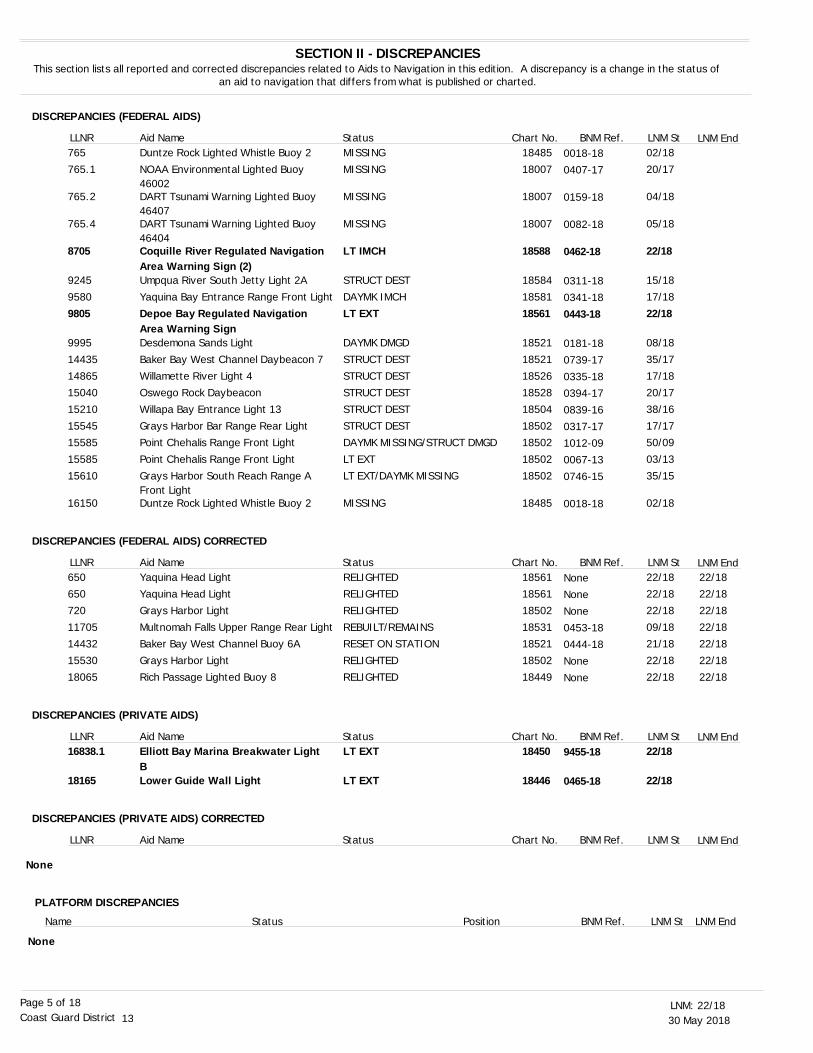
DISCREPANCIES (FEDERAL AIDS)
DISCREPANCIES (FEDERAL AIDS) CORRECTED
DISCREPANCIES (PRIVATE AIDS)
DISCREPANCIES (PRIVATE AIDS) CORRECTED
SECTION II - DISCREPANCIESThis section lists all reported and corrected discrepancies related to Aids to Navigation in this edition. A discrepancy is a change in the status of
an aid to navigation that differs from what is published or charted.
LNM End
LNM End
LNM End
LNM End
LLNR
LLNR
LLNR
LLNR
Aid Name
Aid Name
Aid Name
Aid Name
Status
Status
Status
Status
Chart No.
Chart No.
Chart No.
Chart No.
BNM Ref.
BNM Ref.
BNM Ref.
BNM Ref.
LNM St
LNM St
LNM St
LNM St
Duntze Rock Lighted Whistle Buoy 2
NOAA Environmental Lighted Buoy 46002DART Tsunami Warning Lighted Buoy 46407DART Tsunami Warning Lighted Buoy 46404Coquille River Regulated NavigationArea Warning Sign (2)Umpqua River South Jetty Light 2A
Yaquina Bay Entrance Range Front Light
Depoe Bay Regulated Navigation Area Warning SignDesdemona Sands Light
Baker Bay West Channel Daybeacon 7
Willamette River Light 4 Oswego Rock Daybeacon
Willapa Bay Entrance Light 13
Grays Harbor Bar Range Rear LightPoint Chehalis Range Front Light
Point Chehalis Range Front Light
Grays Harbor South Reach Range A Front LightDuntze Rock Lighted Whistle Buoy 2
Yaquina Head LightYaquina Head Light
Grays Harbor Light
Multnomah Falls Upper Range Rear LightBaker Bay West Channel Buoy 6A
Grays Harbor Light
Rich Passage Lighted Buoy 8
Elliott Bay Marina Breakwater Light BLower Guide Wall Light
MISSING
MISSING
MISSING
MISSING
LT IMCH
STRUCT DEST
DAYMK IMCH
LT EXT
DAYMK DMGD
STRUCT DEST
STRUCT DESTSTRUCT DEST
STRUCT DEST
STRUCT DESTDAYMK MISSING/STRUCT DMGD
LT EXT
LT EXT/DAYMK MISSING
MISSING
RELIGHTEDRELIGHTED
RELIGHTED
REBUILT/REMAINSRESET ON STATION
RELIGHTED
RELIGHTED
LT EXT
LT EXT
02/18
20/17
04/18
05/18
22/18
15/18
17/18
22/18
08/18
35/17
17/1820/17
38/16
17/1750/09
03/13
35/15
02/18
22/1822/18
22/18
09/1821/18
22/18
22/18
22/18
22/18
22/1822/18
22/18
22/1822/18
22/18
22/18
18485
18007
18007
18007
18588
18584
18581
18561
18521
18521
1852618528
18504
1850218502
18502
18502
18485
1856118561
18502
1853118521
18502
18449
18450
18446
765
765.1
765.2
765.4
8705
9245
9580
9805
9995
14435
1486515040
15210
1554515585
15585
15610
16150
650650
720
1170514432
15530
18065
16838.1
18165
None
0018-18
0407-17
0159-18
0082-18
0462-18
0311-18
0341-18
0443-18
0181-18
0739-17
0335-180394-17
0839-16
0317-171012-09
0067-13
0746-15
0018-18
NoneNone
None
0453-180444-18
None
None
9455-18
0465-18
PLATFORM DISCREPANCIES
Name Status Position BNM Ref. LNM St LNM End
None
30 May 201822/18LNM:
13Coast Guard DistrictPage 6 of 18
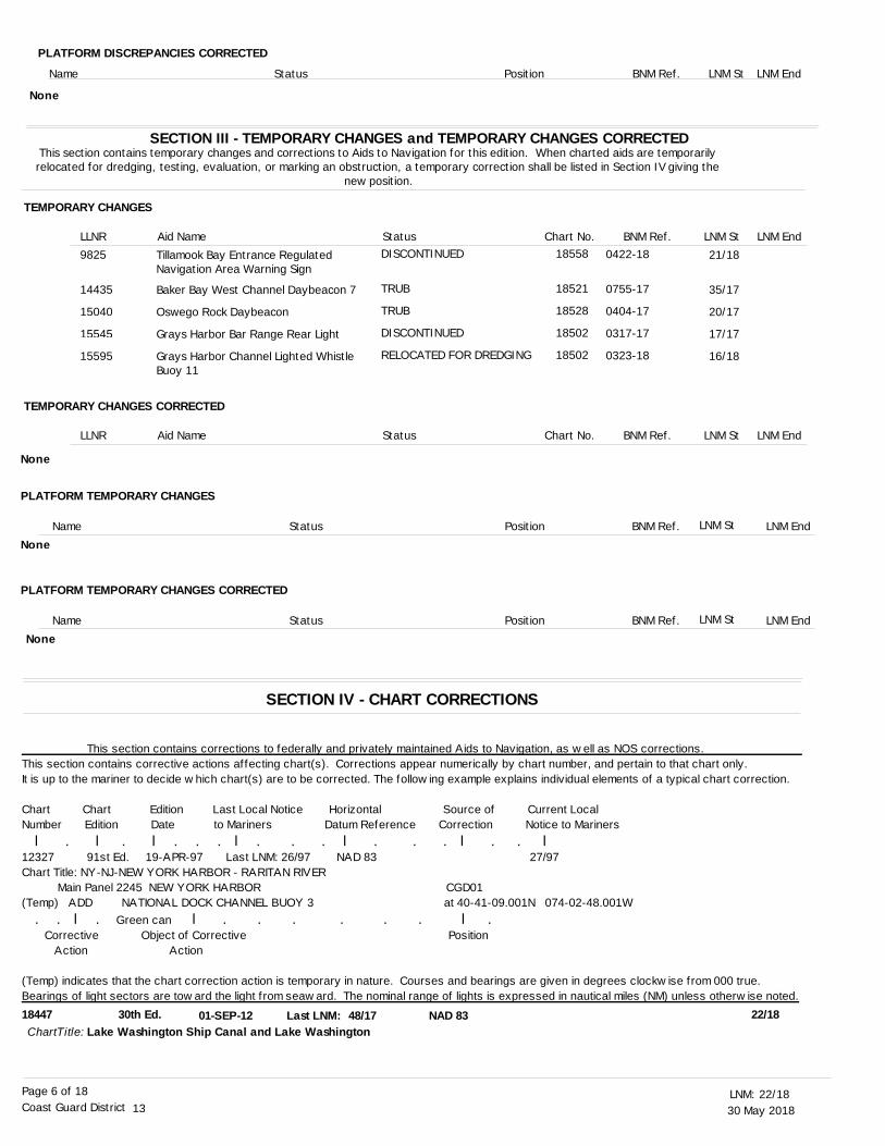
SECTION III - TEMPORARY CHANGES and TEMPORARY CHANGES CORRECTEDThis section contains temporary changes and corrections to Aids to Navigation for this edition. When charted aids are temporarily relocated for dredging, testing, evaluation, or marking an obstruction, a temporary correction shall be listed in Section IV giving the
new position.
TEMPORARY CHANGES
TEMPORARY CHANGES CORRECTED
LNM End
LNM End
LLNR
LLNR
Aid Name
Aid Name
Status
Status
Chart No.
Chart No.
BNM Ref.
BNM Ref.
LNM St
LNM St
18447 30th Ed. 01-SEP-12 48/17Lake Washington Ship Canal and Lake WashingtonChartTitle:
NAD 83Last LNM: 22/18
Tillamook Bay Entrance Regulated Navigation Area Warning Sign
Baker Bay West Channel Daybeacon 7
Oswego Rock Daybeacon
Grays Harbor Bar Range Rear Light
Grays Harbor Channel Lighted Whistle Buoy 11
DISCONTINUED
TRUB
TRUB
DISCONTINUED
RELOCATED FOR DREDGING
21/18
35/17
20/17
17/17
16/18
18558
18521
18528
18502
18502
9825
14435
15040
15545
15595
None
This section contains corrections to federally and privately maintained Aids to Navigation, as well as NOS corrections. This section contains corrective actions affecting chart(s). Corrections appear numerically by chart number, and pertain to that chart only. It is up to the mariner to decide which chart(s) are to be corrected. The following example explains individual elements of a typical chart correction.
Chart Chart Edition Last Local Notice Horizontal Source of Current LocalNumber Edition Date to Mariners Datum Reference Correction Notice to Mariners l . l . l . . . l . . . l . . . l . . l12327 91st Ed. 19-APR-97 Last LNM: 26/97 NAD 83 27/97Chart Title: NY-NJ-NEW YORK HARBOR - RARITAN RIVER Main Panel 2245 NEW YORK HARBOR CGD01(Temp) ADD NATIONAL DOCK CHANNEL BUOY 3 at 40-41-09.001N 074-02-48.001W . . l . Green can l . . . . . . l . Corrective Object of Corrective Position Action Action
(Temp) indicates that the chart correction action is temporary in nature. Courses and bearings are given in degrees clockwise from 000 true. Bearings of light sectors are toward the light from seaward. The nominal range of lights is expressed in nautical miles (NM) unless otherwise noted.
0422-18
0755-17
0404-17
0317-17
0323-18
PLATFORM DISCREPANCIES CORRECTED
Name Status Position BNM Ref. LNM St LNM End
None
PLATFORM TEMPORARY CHANGES
PLATFORM TEMPORARY CHANGES CORRECTED
Name
Name
Status
Status
Position
Position
BNM Ref.
BNM Ref.
LNM St
LNM St
LNM End
LNM End
None
None
SECTION IV - CHART CORRECTIONS
30 May 201822/18LNM:
13Coast Guard DistrictPage 7 of 18
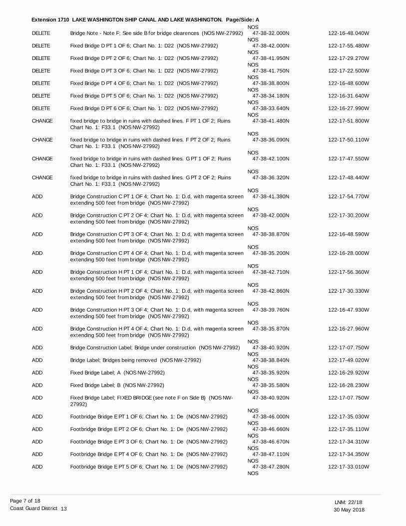
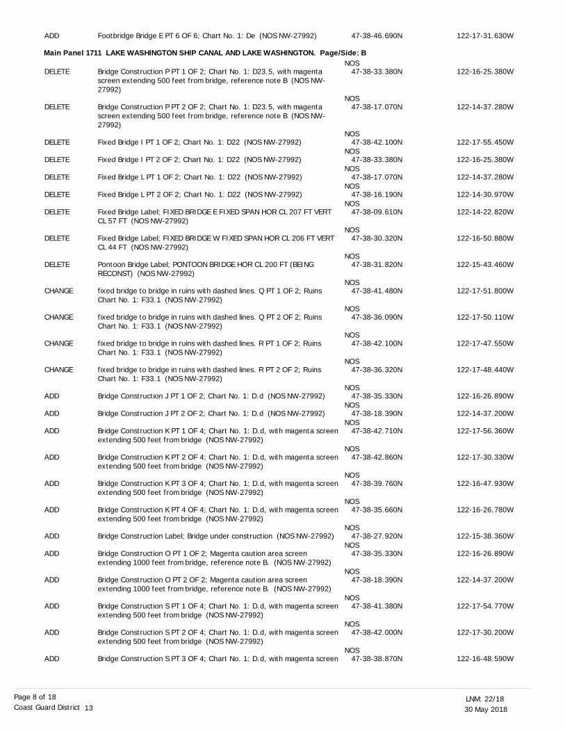
Extension 1710 LAKE WASHINGTON SHIP CANAL AND LAKE WASHINGTON. Page/Side: A
DELETE
DELETE
DELETE
DELETE
DELETE
DELETE
DELETE
CHANGE
CHANGE
CHANGE
CHANGE
ADD
ADD
ADD
ADD
ADD
ADD
ADD
ADD
ADD
ADD
ADD
ADD
ADD
ADD
ADD
ADD
ADD
ADD
Bridge Note - Note F; See side B for bridge clearences (NOS NW-27992)
Fixed Bridge D PT 1 OF 6; Chart No. 1: D22 (NOS NW-27992)
Fixed Bridge D PT 2 OF 6; Chart No. 1: D22 (NOS NW-27992)
Fixed Bridge D PT 3 OF 6; Chart No. 1: D22 (NOS NW-27992)
Fixed Bridge D PT 4 OF 6; Chart No. 1: D22 (NOS NW-27992)
Fixed Bridge D PT 5 OF 6; Chart No. 1: D22 (NOS NW-27992)
Fixed Bridge D PT 6 OF 6; Chart No. 1: D22 (NOS NW-27992)
fixed bridge to bridge in ruins with dashed lines. F PT 1 OF 2; Ruins Chart No. 1: F33.1 (NOS NW-27992)
fixed bridge to bridge in ruins with dashed lines. F PT 2 OF 2; Ruins Chart No. 1: F33.1 (NOS NW-27992)
fixed bridge to bridge in ruins with dashed lines. G PT 1 OF 2; Ruins Chart No. 1: F33.1 (NOS NW-27992)
fixed bridge to bridge in ruins with dashed lines. G PT 2 OF 2; Ruins Chart No. 1: F33.1 (NOS NW-27992)
Bridge Construction C PT 1 OF 4; Chart No. 1: D.d, with magenta screenextending 500 feet from bridge (NOS NW-27992)
Bridge Construction C PT 2 OF 4; Chart No. 1: D.d, with magenta screenextending 500 feet from bridge (NOS NW-27992)
Bridge Construction C PT 3 OF 4; Chart No. 1: D.d, with magenta screenextending 500 feet from bridge (NOS NW-27992)
Bridge Construction C PT 4 OF 4; Chart No. 1: D.d, with magenta screenextending 500 feet from bridge (NOS NW-27992)
Bridge Construction H PT 1 OF 4; Chart No. 1: D.d, with magenta screenextending 500 feet from bridge (NOS NW-27992)
Bridge Construction H PT 2 OF 4; Chart No. 1: D.d, with magenta screenextending 500 feet from bridge (NOS NW-27992)
Bridge Construction H PT 3 OF 4; Chart No. 1: D.d, with magenta screenextending 500 feet from bridge (NOS NW-27992)
Bridge Construction H PT 4 OF 4; Chart No. 1: D.d, with magenta screenextending 500 feet from bridge (NOS NW-27992)
Bridge Construction Label; Bridge under construction (NOS NW-27992)
Bridge Label; Bridges being removed (NOS NW-27992)
Fixed Bridge Label; A (NOS NW-27992)
Fixed Bridge Label; B (NOS NW-27992)
Fixed Bridge Label; FIXED BRIDGE (see note F on Side B) (NOS NW-27992)
Footbridge Bridge E PT 1 OF 6; Chart No. 1: De (NOS NW-27992)
Footbridge Bridge E PT 2 OF 6; Chart No. 1: De (NOS NW-27992)
Footbridge Bridge E PT 3 OF 6; Chart No. 1: De (NOS NW-27992)
Footbridge Bridge E PT 4 OF 6; Chart No. 1: De (NOS NW-27992)
Footbridge Bridge E PT 5 OF 6; Chart No. 1: De (NOS NW-27992)
NOS
NOS
NOS
NOS
NOS
NOS
NOS
NOS
NOS
NOS
NOS
NOS
NOS
NOS
NOS
NOS
NOS
NOS
NOS
NOS
NOS
NOS
NOS
NOS
NOS
NOS
NOS
NOS
NOS
NOS
47-38-32.000N
47-38-42.000N
47-38-41.950N
47-38-41.750N
47-38-38.800N
47-38-34.180N
47-38-33.640N
47-38-41.480N
47-38-36.090N
47-38-42.100N
47-38-36.320N
47-38-41.380N
47-38-42.000N
47-38-38.870N
47-38-35.200N
47-38-42.710N
47-38-42.860N
47-38-39.760N
47-38-35.870N
47-38-40.920N
47-38-38.840N
47-38-35.920N
47-38-35.580N
47-38-40.920N
47-38-46.000N
47-38-46.660N
47-38-46.670N
47-38-47.110N
47-38-47.280N
122-16-48.040W
122-17-55.480W
122-17-29.270W
122-17-22.500W
122-16-48.600W
122-16-31.640W
122-16-27.990W
122-17-51.800W
122-17-50.110W
122-17-47.550W
122-17-48.440W
122-17-54.770W
122-17-30.200W
122-16-48.590W
122-16-28.000W
122-17-56.360W
122-17-30.330W
122-16-47.930W
122-16-27.960W
122-17-07.750W
122-17-49.020W
122-16-29.920W
122-16-28.230W
122-17-07.750W
122-17-35.030W
122-17-35.110W
122-17-34.310W
122-17-34.350W
122-17-33.010W
30 May 201822/18LNM:
13Coast Guard DistrictPage 8 of 18
Main Panel 1711 LAKE WASHINGTON SHIP CANAL AND LAKE WASHINGTON. Page/Side: B
ADD
DELETE
DELETE
DELETE
DELETE
DELETE
DELETE
DELETE
DELETE
DELETE
CHANGE
CHANGE
CHANGE
CHANGE
ADD
ADD
ADD
ADD
ADD
ADD
ADD
ADD
ADD
ADD
ADD
ADD
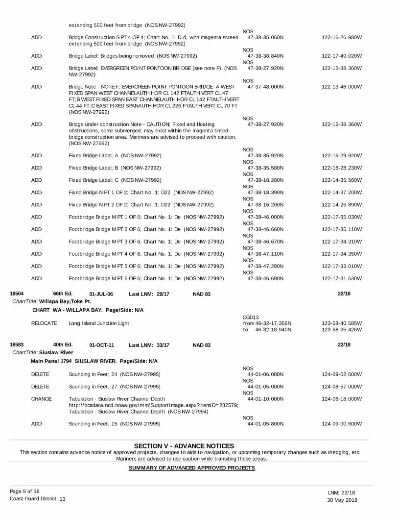
Footbridge Bridge E PT 6 OF 6; Chart No. 1: De (NOS NW-27992)
Bridge Construction P PT 1 OF 2; Chart No. 1: D23.5, with magenta screen extending 500 feet from bridge, reference note B (NOS NW-27992)
Bridge Construction P PT 2 OF 2; Chart No. 1: D23.5, with magenta screen extending 500 feet from bridge, reference note B (NOS NW-27992)
Fixed Bridge I PT 1 OF 2; Chart No. 1: D22 (NOS NW-27992)
Fixed Bridge I PT 2 OF 2; Chart No. 1: D22 (NOS NW-27992)
Fixed Bridge L PT 1 OF 2; Chart No. 1: D22 (NOS NW-27992)
Fixed Bridge L PT 2 OF 2; Chart No. 1: D22 (NOS NW-27992)
Fixed Bridge Label; FIXED BRIDGE E FIXED SPAN HOR CL 207 FT VERT CL 57 FT (NOS NW-27992)
Fixed Bridge Label; FIXED BRIDGE W FIXED SPAN HOR CL 206 FT VERT CL 44 FT (NOS NW-27992)
Pontoon Bridge Label; PONTOON BRIDGE HOR CL 200 FT (BEING RECONST) (NOS NW-27992)
fixed bridge to bridge in ruins with dashed lines. Q PT 1 OF 2; Ruins Chart No. 1: F33.1 (NOS NW-27992)
fixed bridge to bridge in ruins with dashed lines. Q PT 2 OF 2; Ruins Chart No. 1: F33.1 (NOS NW-27992)
fixed bridge to bridge in ruins with dashed lines. R PT 1 OF 2; Ruins Chart No. 1: F33.1 (NOS NW-27992)
fixed bridge to bridge in ruins with dashed lines. R PT 2 OF 2; Ruins Chart No. 1: F33.1 (NOS NW-27992)
Bridge Construction J PT 1 OF 2; Chart No. 1: D.d (NOS NW-27992)
Bridge Construction J PT 2 OF 2; Chart No. 1: D.d (NOS NW-27992)
Bridge Construction K PT 1 OF 4; Chart No. 1: D.d, with magenta screenextending 500 feet from bridge (NOS NW-27992)
Bridge Construction K PT 2 OF 4; Chart No. 1: D.d, with magenta screenextending 500 feet from bridge (NOS NW-27992)
Bridge Construction K PT 3 OF 4; Chart No. 1: D.d, with magenta screenextending 500 feet from bridge (NOS NW-27992)
Bridge Construction K PT 4 OF 4; Chart No. 1: D.d, with magenta screenextending 500 feet from bridge (NOS NW-27992)
Bridge Construction Label; Bridge under construction (NOS NW-27992)
Bridge Construction O PT 1 OF 2; Magenta caution area screen extending 1000 feet from bridge, reference note B. (NOS NW-27992)
Bridge Construction O PT 2 OF 2; Magenta caution area screen extending 1000 feet from bridge, reference note B. (NOS NW-27992)
Bridge Construction S PT 1 OF 4; Chart No. 1: D.d, with magenta screenextending 500 feet from bridge (NOS NW-27992)
Bridge Construction S PT 2 OF 4; Chart No. 1: D.d, with magenta screenextending 500 feet from bridge (NOS NW-27992)
Bridge Construction S PT 3 OF 4; Chart No. 1: D.d, with magenta screen
NOS
NOS
NOS
NOS
NOS
NOS
NOS
NOS
NOS
NOS
NOS
NOS
NOS
NOS
NOS
NOS
NOS
NOS
NOS
NOS
NOS
NOS
NOS
NOS
NOS
47-38-46.690N
47-38-33.380N
47-38-17.070N
47-38-42.100N
47-38-33.380N
47-38-17.070N
47-38-16.190N
47-38-09.610N
47-38-30.320N
47-38-31.820N
47-38-41.480N
47-38-36.090N
47-38-42.100N
47-38-36.320N
47-38-35.330N
47-38-18.390N
47-38-42.710N
47-38-42.860N
47-38-39.760N
47-38-35.660N
47-38-27.920N
47-38-35.330N
47-38-18.390N
47-38-41.380N
47-38-42.000N
47-38-38.870N
122-17-31.630W
122-16-25.380W
122-14-37.280W
122-17-55.450W
122-16-25.380W
122-14-37.280W
122-14-30.970W
122-14-22.820W
122-16-50.880W
122-15-43.460W
122-17-51.800W
122-17-50.110W
122-17-47.550W
122-17-48.440W
122-16-26.890W
122-14-37.200W
122-17-56.360W
122-17-30.330W
122-16-47.930W
122-16-26.780W
122-15-38.360W
122-16-26.890W
122-14-37.200W
122-17-54.770W
122-17-30.200W
122-16-48.590W
30 May 201822/18LNM:
13Coast Guard DistrictPage 9 of 18
SECTION V - ADVANCE NOTICESThis section contains advance notice of approved projects, changes to aids to navigation, or upcoming temporary changes such as dredging, etc.
Mariners are advised to use caution while transiting these areas.
SUMMARY OF ADVANCED APPROVED PROJECTS
18504
18583
66th Ed.
40th Ed.
01-JUL-06
01-OCT-11
29/17
33/17
Willapa Bay;Toke Pt.
Siuslaw River
ChartTitle:
ChartTitle:
NAD 83
NAD 83
Last LNM:
Last LNM:
22/18
22/18
CHART WA - WILLAPA BAY. Page/Side: N/A
Main Panel 1794 SIUSLAW RIVER. Page/Side: N/A
ADD
ADD
ADD
ADD
ADD
ADD
ADD
ADD
ADD
ADD
ADD
ADD
ADD
ADD
ADD
ADD
RELOCATE
DELETE
DELETE
CHANGE
ADD
extending 500 feet from bridge (NOS NW-27992)
Bridge Construction S PT 4 OF 4; Chart No. 1: D.d, with magenta screenextending 500 feet from bridge (NOS NW-27992)
Bridge Label; Bridges being removed (NOS NW-27992)
Bridge Label; EVERGREEN POINT PONTOON BRIDGE (see note F) (NOS NW-27992)
Bridge Note - NOTE F; EVERGREEN POINT PONTOON BRIDGE -A WEST FIXED SPAN WEST CHANNELAUTH HOR CL 142 FTAUTH VERT CL 47 FT;B WEST FIXED SPAN EAST CHANNELAUTH HOR CL 142 FTAUTH VERTCL 44 FT;C EAST FIXED SPANAUTH HOR CL 226 FTAUTH VERT CL 70 FT (NOS NW-27992)
Bridge under construction Note - CAUTION; Fixed and floating obstructions, some submerged, may exist within the magenta tinted bridge construction area. Mariners are advised to proceed with caution. (NOS NW-27992)
Fixed Bridge Label; A (NOS NW-27992)
Fixed Bridge Label; B (NOS NW-27992)
Fixed Bridge Label; C (NOS NW-27992)
Fixed Bridge N PT 1 OF 2; Chart No. 1: D22 (NOS NW-27992)
Fixed Bridge N PT 2 OF 2; Chart No. 1: D22 (NOS NW-27992)
Footbridge Bridge M PT 1 OF 6; Chart No. 1: De (NOS NW-27992)
Footbridge Bridge M PT 2 OF 6; Chart No. 1: De (NOS NW-27992)
Footbridge Bridge M PT 3 OF 6; Chart No. 1: De (NOS NW-27992)
Footbridge Bridge M PT 4 OF 6; Chart No. 1: De (NOS NW-27992)
Footbridge Bridge M PT 5 OF 6; Chart No. 1: De (NOS NW-27992)
Footbridge Bridge M PT 6 OF 6; Chart No. 1: De (NOS NW-27992)
Long Island Junction Light
Sounding in Feet; 24 (NOS NW-27995)
Sounding in Feet; 27 (NOS NW-27995)
Tabulation - Siuslaw River Channel Depth http://ocsdata.ncd.noaa.gov/ntm/SupportImage.aspx?ItemID=282579;Tabulation - Siuslaw River Channel Depth (NOS NW-27994)
Sounding in Feet; 15 (NOS NW-27995)
NOS
NOS
NOS
NOS
NOS
NOS
NOS
NOS
NOS
NOS
NOS
NOS
NOS
NOS
NOS
NOS
CGD13
NOS
NOS
NOS
NOS
47-38-35.060N
47-38-38.840N
47-38-27.920N
47-37-48.000N
47-38-27.920N
47-38-35.920N
47-38-35.580N
47-38-18.280N
47-38-18.390N
47-38-16.200N
47-38-46.000N
47-38-46.660N
47-38-46.670N
47-38-47.110N
47-38-47.280N
47-38-46.690N
from 46-32-17.356N
44-01-06.000N
44-01-05.000N
44-01-10.000N
44-01-05.800N
122-16-26.980W
122-17-49.020W
122-15-38.360W
122-13-46.000W
122-15-38.360W
122-16-29.920W
122-16-28.230W
122-14-35.560W
122-14-37.200W
122-14-25.890W
122-17-35.030W
122-17-35.110W
122-17-34.310W
122-17-34.350W
122-17-33.010W
122-17-31.630W
123-58-40.585W
124-09-02.000W
124-08-57.000W
124-06-18.000W
124-09-00.600W
to 46-32-18.940N 123-58-35.426W
30 May 201822/18LNM:
13Coast Guard DistrictPage 10 of 18
Approved Project(s) Project Date Ref. LNM
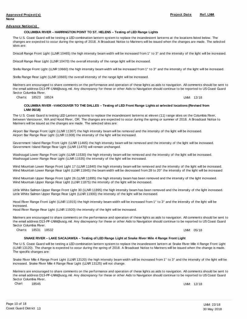
COLUMBIA RIVER – HARRINGTON POINT TO ST. HELENS – Testing of LED Range Lights
COLUMBIA RIVER –VANCOUVER TO THE DALLES – Testing of LED Front Range Lights at selected locations (Revised from LNM 05/18)
SNAKE RIVER – LAKE SACAJAWEA – Testing of LED Range Light at Snake River Mile 4 Range Front Light
The U.S. Coast Guard will be testing a LED combination lantern system to replace the incandescent lanterns at the locations listed below. The changes are expected to occur during the spring of 2018. A Broadcast Notice to Mariners will be issued when the changes are made. The selected sites are:
Driscoll Range Front Light (LLNR 10465) the high intensity beam width will be increased from 1° to 3° and the intensity of the light will be increased.
Driscoll Range Rear Light (LLNR 10470) the overall intensity of the range light will be increased.
Stella Range Front Light (LLNR 10660) the high intensity beam width will be increased from 1° to 3° and the intensity of the light will be increased.
Stella Range Rear Light (LLNR 10665) the overall intensity of the range light will be increased.
Mariners are encouraged to share comments on the performance and operation of these lights as aids to navigation. All comments should be sent tothe email address [email protected]. Any discrepancy for these or other Aids to Navigation should continue to be reported to US Coast Guard Sector Columbia River.
The U.S. Coast Guard is testing LED Lantern systems to replace the incandescent lanterns at eleven (11) range sites on the Columbia River, between Vancouver, WA and Hood River, OR. The changes are expected to occur during the spring or summer of 2018. A Broadcast Notice to Mariners will be issued as the changes are made. The selected sites are:
Airport Bar Range Front Light (LLNR 11307) the high intensity beam will be removed and the intensity of the light will be increased.Airport Bar Range Rear Light (LLNR 11308) the intensity of the light will be increased.
Government Island Range Front Light (LLNR 11465) the high intensity beam will be removed and the intensity of the light will be increased.Government Island Range Rear Light (LLNR 11470) will remain unchanged.
Washougal Lower Range Front Light (LLNR 11530) the high intensity beam will be removed and the intensity of the light will be increased.Washougal Lower Range Rear Light (LLNR 11535) the intensity of the light will be increased.
Wind Mountain Lower Range Front Light 17 (LLNR 11840) the high intensity beam will be removed and the intensity of the light will be increased.Wind Mountain Lower Range Rear Light (LLNR 11845) the beam width will be decreased from 28 to 20° the intensity of the light will be increased
Wind Mountain Upper Range Front Light 26 (LLNR 11895) the high intensity beam has been removed and the intensity of the light increased.Wind Mountain Upper Range Rear Light (LLNR 11875) the intensity of the light will be increased.
Little White Salmon Upper Range Front Light 30 (LLNR 11895) the high intensity beam has been removed and the intensity of the light increased.Little White Salmon Upper Range Rear Light (LLNR 11900) the intensity of the light will be increased.
Hood River Range Front Light (LLNR 11915) the high intensity beam width will be increased from 1° to 3° and the intensity of the light will be increased.Hood River Range Rear Light (LLNR 11920) the intensity of the light will be increased.
Mariners are encouraged to share comments on the performance and operation of these lights as aids to navigation. All comments should be sent tothe email address [email protected]. Any discrepancy for these or other Aids to Navigation should continue to be reported to US Coast Guard Sector Columbia River.
The U.S. Coast Guard will be testing a LED combination lantern system to replace the incandescent lantern at Snake River Mile 4 Range Front Light (LLNR 13120). The change is expected to occur during the spring of 2018. A Broadcast Notice to Mariners will be issued when the change is made. The specific changes are:
Snake River Mile 4 Range Front Light (LLNR 13120) the high intensity beam width will be increased from 1° to 3° and the intensity of the light will be increased. Snake River Mile 4 Range Rear Light (LLNR 13125) will not change.
Mariners are encouraged to share comments on the performance and operation of these lights as aids to navigation. All comments should be sent tothe email address [email protected]. Any discrepancy for these or other Aids to Navigation should continue to be reported to US Coast Guard Sector Columbia River.
LNM:
LNM:
LNM:
12/18
05/18
12/18Chart
Charts:
Charts:
18523 18524
18531 18532
18545
None
Advance Notice(s)
30 May 201822/18LNM:
13Coast Guard DistrictPage 11 of 18
WASHINGTON – GRAYS HARBOR AND WESTPORT – Testing of LED Range Lights in Grays Harbor
The U.S. Coast Guard will be testing a LED combination lantern system to replace the incandescent lanterns at Grays Harbor South Range A. The change is expected to occur during the summer of 2018 when repairs to the structure are complete. A Broadcast Notice to Mariners will be issued when the changes are made. The specific changes are listed below:
Grays Harbor South Reach Range A Front Light (LLNR 15610) the high intensity beam width will be increased from 1° to 3° and the intensity of the light will be increased.
Grays Harbor South Reach Range A Rear Light (LLNR 15615) the overall intensity of the range light will be increased.
Mariners are encouraged to share comments on the performance and operation of these lights as aids to navigation. All comments should be sent tothe email address [email protected]. Any discrepancy for these or other Aids to Navigation should continue to be reported to US Coast Guard Sector Columbia River.
LNM: 12/18
SECTION VI - PROPOSED CHANGESPeriodically, the Coast Guard evaluates its system of aids to navigation to determine whether the conditions for which the aids to navigation were
established have changed. When changes occur, the feasibility of improving, relocating, replacing, or discontinuing aids are considered. This section contains notice(s) of non-approved, proposed projects open for comment. SPECIAL NOTE: Mariners are requested to respond in writing to the District
office unless otherwise noted (see banner page for address).
PROPOSED WATERWAY PROJECTS OPEN FOR PUBLIC COMMENT
Proposed Project(s) Closing Docket No. Ref. LNM
SECTION VII - GENERALThis section contains information of general concern to the Mariners. Mariners are advised to use caution while transiting these areas.
The summary of Bridge Lighting Discrepancies and Corrections is listed in Enclosure (1) of this Local Notice to Mariners.
The summary of Dredging Operations is listed in Enclosure (2) of this Local Notice to Mariners.
The summary of Marine Events is listed in Enclosure (3) of this Local Notice to Mariners.
ODOT is conducting a repair project on the McCullough Bridge (LLNR 9009) at mile 9.5 over Coos Bay on Hwy. US 101. The project is expected to continue until the fall of 2018. The repairs are on the north side of Jarvis Upper Range ‘B’ Front Light (LLNR 8960) outside the main navigation channel. Two 2000 foot temporary work bridges have been constructed for the project, but will not encroach into the navigation channel. The temporary bridges will be built on steel piles placed 45 feet apart.
The US Coast Guard has approved a Temporary Final Rule (TFR) for the Isthmus Slough Bridge (LLNR 9087) near Coos Bay, OR. The new rule will allow the Oregon Department of Transportation to temporarily operate and open one half of the span, single leaf, for vessel traffic on signal if at least 24 hours notice is given, and reduce the vertical clearance with a work platform from 28 feet to 18 feet from 0600 on 26 Feb 18 through 1800 on 31 Jul 19. The TFR will be up loaded to the Federal Register, and may be read at: https://www.federalregister.gov/. To view the rule, type in the search box, uscg-2017-0868. For more information on the construction work or operation of the Isthmus Slough Bridge, contact Mr. Sam Dunnavant at (541) 957-3519.
ODOT is removing existing paint coating by sand blast and power tooling methods within engineered containments on the Astoria-Megler Bridge
LNM:
LNM:
LNM:
LNM:
LNM:
22/18
22/18
22/18
48/17
02/18
SUMMARY OF BRIDGE LIGHTING DISCREPANCIES AND CORRECTIONS
SUMMARY OF DREDGING OPERATIONS
SUMMARY OF MARINE EVENTS
OREGON – COOS BAY – McCullough (US101) Bridge repair
OREGON - COOS BAY – Isthmus Slough Bridge Notice
COLUMBIA RIVER - PACIFIC OCEAN TO HARRINGTON POINT - Astoria-Megler Bridge Special Notice
Chart 18502
Chart
Chart
18587
18587
None
None
Proposed Change Notice(s)
30 May 201822/18LNM:
13Coast Guard DistrictPage 12 of 18
(LLNR 14630/10086) at Columbia River mile 13.5. Replacement of rivets, steel repairs, and new paint will be applied until complete on 31 Aug 18. The containment system will reduce the vertical clearance beneath the bridge by six feet. The work will be during daylight hours, generally from 0630 to 1800, Monday through Friday. Weekend work is not anticipated but could occur. The containment system will be in place for the duration of the project. The containment system is movable and will occupy approximately 300 to 400 feet at any one time. The work is anticipated to be performed year round. Mariners are advised to exercise caution when navigating under the bridge and to be aware of fall hazards while containment scaffolding is being relocated. All work will be staged from the roadway deck. On scene contacts for ODOT are Mr. Jeremy Chauvin at (503) 338-8837 and Mr. Grant Hudkins at (503) 338-0574.
The Coast Guard has approved a temporary test deviation that governs the Youngs Bay Bridge (LLNR 14573), the Old Youngs Bay Bridge (LLNR 14582) and the Lewis and Clark River Highway Bridge (LLNR 14607) in Astoria. This deviation will test a change to the drawbridges operating schedule, due to infrequent drawbridge nighttime opening requests, to determine whether a permanent change to the schedule is appropriate. This deviation authorizes ODOT to open the Youngs Bay Bridge, the Old Youngs Bay Bridge and the Lewis and Clark River Highway Bridge, with a two-hour advance notice on weekends, including all Federal holidays but Columbus day, from 1700 on Friday to 0700 on Monday. At all other times, the three subject bridges shall operate per 33 CFR § 117.899. This test deviation is effective from 1700 on 16 Mar 18 through 0700 on 10 Aug 18. Please submit comments to the Federal Register at http://www.regulations.gov, and reference USCG-2018-0131.
Painting and preservation work will be conducted on the Puget Island Bridge (LLNR 10545) (aka Julia Butler Hansen Bridge) across the Cathlamet Channel (mile 2.7) from 15 Apr 18 through 31 Dec 18 during the hours of 0600 to 1700, Monday through Saturday. Work will begin on the north side and progress to the south part of the bridge. This work requires a containment platform and the vertical clearance across the main channel will be reduced from 75 feet to 72 feet and from 63 feet to 60 feet across the south channel. The platform will be marked with yellow flashing lightsand regulatory signs. Mariners should watch for falling debris. For additional information, contact Mr. Mike Saroukos at (727) 254-9925.
The U.S. Coast Guard has issued a temporary deviation from the operating schedule that governs the Steel Railroad Highway Bridge (LLNR 14955.3), RM 12.1, across the Willamette River at Portland, OR. The Steel Railroad-Highway Bridge is authorized to operate as follows:
Time/Date Action 1900 to 2359 on 02 Jun 18 Upper lift closed 0700 to 1300 on 09 Jun 18 Upper lift closed 0400 to 2359 on 23 Jun 18 Upper lift closed
This deviation is necessary to support multiple events. When the lower deck is in the closed-to-navigation position, the bridge provides 26 feet of vertical clearance above Columbia River Datum 0.0; and in open-to-navigation position, the vertical clearance is 71 feet above Columbia River Datum 0.0. The lower lift of Steel Bridge will be able to open for emergencies, and there is no immediate alternate route for vessels to pass. Vessels able to pass through the bridge with the lower deck in the closed or open-to-navigation position may do so at any time. The lower lift spanof the Steel Bridge operates in accordance with 33 CFR 117.5. In accordance with 33 CFR 117.35(e), the drawbridge must return to its regular operating schedule immediately at the end of the designated time period. For more information on this closure, contact Mr. Keith Wagner at (503) 249-3007.
Painting and abrasive sand blast operations are being conducted on the Ross Island Highway Bridge (LLNR 14959.7) across the Willamette River atRM 14.0, until 31 Jul 18. Span 1 is the west most span, Span 5 is the east most span and Span 3 is the center span. Working hours are from 0630 to 1900, Monday through Saturday. A working barge will be moored in Span 5 during non-working periods, and lighted as per the navigation rules. The maximum vertical clearance of Span 3 (center) is 120 feet at 0.0 feet Willamette River datum (WRD). The Span obstructions were shown in enclosure (4) of Local Notice to Mariners 08/18 and are as follows:
Span 3: West to Center from 25 Apr 18 to 30 July 18 - Moored barge and reduced vertical clearance up to 25 feet and the center span will be reduced by 9 feet to 111 feet.Span 3: East to Center from 01 Nov 17 to 25 Apr 18 - Moored barge and reduced vertical clearance by up to 25 feet.Span 4: From 21 Feb 17 to 30 July 18 - Moored barge and reduced vertical clearance by 5 feet, from 90 feet to 85 feet.
The scaffolding containment is marked with amber flashing lights. A safety boat will be in the water while crews are on the bridge. For additional information, please contact Mr. Jake Kreglo with Abhe & Svoboda at (360) 907-8105.
The U.S. Coast Guard has issued a temporary deviation to the operating schedule that governs the Hood Canal Bridge (LLNR 17769) from 0001 on01 May 18 until 2359 on 30 Sep 18. This deviation is necessary to accommodate replacement of the draw span operating equipment. The deviation allows the bridge to open the draw half-way, 300 feet; as opposed to a full opening, which is 600 feet. The deviation also requires the draw to open on signal if at least a four hour notice is given. Mariners are requested to use the east span (50 feet of vertical clearance) and west span (35 feet of vertical clearance) until the end of this deviation period. The bridge will be able to open half the center span for Navy and Coast
LNM:
LNM:
LNM:
LNM:
LNM:
23/16
08/18
14/18
15/18
18/18
COLUMBIA RIVER - PACIFIC OCEAN TO HARRINGTON POINT - Astoria-Megler Bridge Special Notice
COLUMBIA RIVER - PACIFIC OCEAN TO HARRINGTON POINT - YOUNGS BAY – Youngs Bay Bridges notice
COLUMBIA RIVER – HARRINGTON POINT TO CRIMS ISLAND – CATHLAMET CHANNEL – Puget Island Bridge notice (Revised from LNM 12/18)
OREGON – WILLAMETTE RIVER - PORT OF PORTLAND – Steel Railroad Highway Bridge Notice
OREGON - WILLAMETTE RIVER – PORTLAND – Bridge Notice for Ross Island Bridge painting (Revised from LNM 05/17)
WASHINGTON - PUGET SOUND - NORTHERN PART - HOOD CANAL AND DABOB DAY - Hood Canal Bridge notice
Chart
Chart
Chart
Chart
Chart
18521
18521
18523
18526
18526
30 May 201822/18LNM:
13Coast Guard DistrictPage 13 of 18
Guard vessels during emergencies, when at least a one hour notice has been given by the Department of the Navy or U.S. Coast Guard. For additional information contact Ms. Amy Amos at (360) 874-3016.
The Coast Guard has approved a temporary test deviation that governs the South Park Highway Bridge (LLNR 16888), on the Duwamish Waterway, mile 3.8, in Seattle, WA. This deviation will test a change to the drawbridge operating schedule, due to infrequent drawbridge nighttime opening requests, to determine whether a permanent change to the schedule is appropriate. This deviation allows the bridge to open between 2300 to 0700 after receiving a 12-hour advance notice. In addition, between 2300 and 0700, vessels engaged in sea-trials or waterway dredging activities may request a standby drawtender, if at least a 24-hour notice is given to the drawtender. At all other times, the South Park Highway Bridge shall operate per 33 CFR § 117.1041(a)(2). This test deviation is effective from 0600 on 22 Mar 18 to 0600 on 17 Sep 18. Please submit comments to the Federal Register at http://www.regulations.gov, and reference USCG-2018-0067.
Washington State Department of Transportation will be conducting painting and preservation operations on the George Washington Memorial Street Bridge (Aurora Avenue Bridge) (LLNR 18184). The work will be conducted from 01 Apr 18 through 31 Oct 20. Hours of work will be from 0700 to 1900, Monday through Friday. The subject bridge provides 135 feet of vertical clearance will be reduced to 125 feet for containment. Thecontainment will be marked with flashing yellow lights and signage. Half of the 150 feet of horizontal clearance will have containment. Mariners may transit under the bridge at any time, and are advised to use caution while transiting the area. For additional information, contact Mr. Dave Lindberg at (425) 225-8725 or [email protected].
The U.S. Coast Guard has issued a temporary deviation from the operating schedule that governs the Montlake Bridge (LLNR 18240) across the Lake Washington Ship Canal, mile 5.2, at Seattle, WA. This deviation is necessary to accommodate the University of Washington graduation ceremony. The draw of the Montlake Bridge need not open for vessels from 1030 to 1430 and from 1630 to 1830 on 09 Jun 18. The Montlake Bridge in the closed-to-navigation position provides 30 feet of vertical clearance throughout the navigation channel, and 46 feet of vertical clearance throughout the center 60 feet of the bridge; vertical clearance references to the Mean Water Level of Lake Washington. Vessels able to pass through the bridge in the closed-to-navigation position may do so at any time. The bridge will be able to open for emergencies, and there is no immediate alternate route for vessels to pass. The normal operating schedule for the Montlake Bridge operates in accordance with 33 CFR § 117.1051(e). For additional information contact Ms. Barbara Rasaie at [email protected].
American Bridge Company has been contracted by the Washington State Department of Transportation to replace 32 existing 2-3/8" structural anchor cables linking the two I-90 floating bridges, Lacey V. Murrow Memorial Bridge, and the Homer M. Hadley Memorial Bridge, down to various anchor types located on the bottom of Lake Washington. The project will take place within a 1000ft wide strip on both the north and south sides of the I-90 floating bridges from MP 4.28 to MP 5.89 and will be ongoing from 02 Apr 18 to 05 Sep 18. Work will be carried out during 24 hour shifts typically starting Monday morning at 0600 and finishing Friday at 1800, with some occasional additional weekend hours. A 180ft by 54ft flat deck barge outfitted with a crane and several deck winches will be used to reel up existing anchor cables and pay out new anchor cables. Deep water divers will be deployed to disconnect the old cable and reconnect the new cable at the lakebed and shallow water divers will be deployed to assist with cable handling near to and under the floating pontoons.Anchors on the lake bed and mooring brackets on the side of the bridge will used for repositioning of the barge and cables may be present just below the water line. The existing boater protection system surrounding the I-90 bridges will be locally disconnected to allow barge access to the side of the bridge, then reinstated when the barge set up is relocated to the next cable position. At all times (24/7) when the boater protection system is discontinuous, American Bridge will be present on site.Mariners are advised to use caution while transiting the area and be aware that no boater traffic is permitted between the barge and the bridge atany time during the course of the project. For additional information, contact Mr. Jared Carlson, P.E. at (412) 699-8080 or [email protected].
The St. Joe River Bridge within the town of Saint Maries, Idaho, at St. Joe River Mile 15.4 (47-19.0N 116-33.7W), is being rebuilt continuing through approximately 10 Nov 18. The working hours are 0600 to 1900, Monday through Saturday. The approaches to the bridge and the bridge area will have construction equipment and marine vessels staged. Temporary work bridges will be installed on each end of the bridge. Temporary buoys, warning signs, warning lights and flaggers will be in place marking safe transit through the construction area on the river approaches. See enclosure (5) of Local Notice to Mariners 52/17 for details. Vertical clearances of the St. Joe River Bridge will be temporarily reduced at various times during structure removal and replacement. Tug and barge assistance will be present and ongoing throughout the construction. Mariners may transit the construction zone as signaled, but with no wake at minimum safe speed. The onsite construction supervisor is Mr. Mike Tracy and may be reached at (208) 870-1906, or at email [email protected].
The Walla Walla District, U.S. Army Corps of Engineers, has implemented the 2018 summer lockage schedule for the passage of recreational vessels through the following navigation locks:
LNM:
LNM:
LNM:
LNM:
LNM:
LNM:
15/18
10/18
01/18
15/18
11/18
49/17
WASHINGTON - PUGET SOUND - NORTHERN PART - HOOD CANAL AND DABOB DAY - Hood Canal Bridge notice
WASHINGTON - PUGET SOUND - ELLIOTT BAY - DUWAMISH WATERWAY - South Park Highway Bridge notice (Revised from LNM 08/18)
WASHINGTON – LAKE WASHINGTON SHIP CANAL - George Washington Memorial Bridge Notice
WASHINGTON – LAKE WASHINGTON SHIP CANAL – UNION BAY REACH - Montlake Bridge notice
WASHINGTON - LAKE WASHINGTON - I-90 Floating Bridges Anchor Cable Replacement
IDAHO - SAINT JOE RIVER – SAINT MARIES – St. Joe River Bridge Notice
COLUMBIA RIVER – SNAKE RIVER - 2018 Summer Lockage Schedule for Recreational Vessels
Chart
Chart
Chart
Chart
Chart
18476
18450
18447
18447
18447
30 May 201822/18LNM:
13Coast Guard DistrictPage 14 of 18
McNary Lock and Dam Columbia River Mile 292 (541) 922-2231Ice Harbor Lock and Dam Snake River Mile 9.7 (509) 543-3253, x231Lower Monumental Lock and Dam Snake River Mile 41.6 (509) 282-7231Little Goose Lock and Dam Snake River Mile 70.3 (509) 399-2233 x231Lower Granite Lock and Dam Snake River Mile 107.5 (509) 843-1493 x231
The following annual recreational craft lockage schedules will be implemented for all the locks from 14 May 18 through 14 Sep 18:
Upstream Direction Times: 0900, 1201, 1500, 1800, 2100Downstream Direction Times 0930, 1230, 1530, 1830, 2130
The Corps will consider special lockages, outside the above scheduled lockage times, for flotillas or other unique activities sponsored by yacht clubs, marinas, and other groups, provided advance (at least 24-hours) arrangements have been made with the appropriate control room operator. Contact the following control room operators via VHF-FM Channel 14 or commercial telephone for scheduling of special lockages:
When a recreational vessel lockage schedule is in effect, recreational vessels will only be allowed to lock through at the times designated for such lockages and they will take precedence over commercial vessels. Commercial vessels will continue to be locked through upon arrival except during the times specified for recreational vessel lockages. At the discretion of the lock operator, recreational vessels may be allowed to lock through withcommercial craft. Everyone in the vessel must be wearing a personal floatation device throughout the duration of the lockage. All vessel owner/operators lock through at their own risk and must follow the directions of the lock operator when using the locks or operating in the vicinity of the locks. The lock operator has final authority on the suitability of a craft for lockage. Please refer to U.S. Corps of Engineers Safe Lockage Policy for Recreational Craft on the Columbia and Snake Rivers, published separately, for additional safety requirements. For additional information on this matter or copies of the Safe Lockage policy, please contact the Operations Division, at (509) 527-7112 or (509) 527-7364.
Shoaling has been observed at Rogue River between the breakwaters, near the US Coast Guard Detachment and the marina entrance, within and outside the federally maintained navigation channel. This shoaling has caused depths to be less than advertised. Mariners are advised to transit the area with caution. To view the latest bottom surveys of the channel, visit US Army Corps of Engineers web site http://www.nwp.usace.army.mil/Missions/Navigation/surveys.aspx. Rogue River is listed under the Southern Oregon coast Hydrosurveys.
Multiple parts of the submerged infrastructure attached to the National Science Foundation’s Cabled Observatory have broken free of their moorings and been dragged off station. These are large orange submerged buoyant structures approximately 10 feet x 10 feet in size trailing up to 600 meters of cable with floats attached. The last reported position was 44-21-33.00N 124-57-48.24W, 13 NM northwest of Heceta Bank. The depth of the debris is unknown but may be at the surface or up to a depth of 200 meters. Mariners are advised to transit this area using extreme caution, avoid the position by a minimum of 1 NM and avoid trailing any gear or equipment to prevent entanglement. Report any sightings to US Coast Guard Sector North Bend at (541) 756-9201 and Mr. Chuck McGuire at (206) 913-3169 or (206) 616-5834. For additional information, contact Mr. Chuck McGuire at email [email protected].
The University of Oregon has deployed scientific equipment with sub-surface moorings in various locations of Coos Bay and the South Slough. These moorings will remain on site through 15 June 18, before the commencement of seasonal dredging operations. The moorings will be deployed by the R/V Pugettia which will monitor VHF-FM Channels 13, 16 and 63. The moorings consist of a float rising 1.5 meters above the equipment on the sea bed. A weighted ground line will be run to a secondary anchor and thence to a green surface float. A diagram of the installation in additionto chartlets showing the sites is attached as enclosure (4) to Local Notice to Mariners 52/17. If the surface floats or other materials are found displaced, please contact Mr. David Sutherland of the University of Oregon at [email protected]. For additional information, contact Dr. Emily Eidam at (206) 295-0931 or email [email protected].
Scheduled repairs of the North Jetty have commenced and will continue through 2020. Current repairs are being conducted via the land access, but at a future date barges and in water equipment will be used to conduct repairs. This notice will be updated once in water work is scheduled. For additional information on this project contact Ms. Sherri Brenner at (503) 550-6743 and email [email protected] or the Project Superintendent Mr. Aaron Anderson at (503) 791- 2161 and email [email protected].
The jetties at the Columbia River Entrance have suffered severe deterioration and may no longer be correctly represented upon the nautical charts of the area. Mariners should use caution when transiting in the vicinity of the jetties and the river entrance. Repairs of the South jetty are scheduled to be conducted from 2019 through 2023. More information may be found at the USACE Portland District web site: http://www.nwp.usace.army.mil/jetties/.
LNM:
LNM:
LNM:
LNM:
LNM:
19/18
19/17
40/17
49/17
13/18
COLUMBIA RIVER – SNAKE RIVER - 2018 Summer Lockage Schedule for Recreational Vessels
OREGON – CAPE SEBASTION TO HUMBUG MOUNTAIN - ROGUE RIVER – Shoaling
OREGON – CAPE BLANCO TO YAQUINA HEAD – Submerged structure and debris adrift off Heceta Bank (Revised from LNM 38/17)
OREGON - COOS BAY – Placement of sub-surface moorings and scientific equipment
COLUMBIA RIVER – PACIFIC OCEAN TO HARRINGTON POINT - Mouth of the Columbia River Jetty System Major RehabilitationProject (Revised from LNM 31/17)
COLUMBIA RIVER – HARRINGTON POINT TO CRIMS ISLAND – WESTPORT – NOAA Fisheries barge moored off Puget Island
Chart
Chart
Chart
Chart
Charts: 18541 18545 18546 18547 18548
18601
18580
18587
18521
30 May 201822/18LNM:
13Coast Guard DistrictPage 15 of 18
NOAA Fisheries will moor a research barge off Whites Island near the eastern tip of Puget Island in approximate position 46-08-47.62N 123-20-24.40W. Deployment of the barge and anchors will commence on 23 April 18 and be removed on 6 June 18. The stern of the barge will be attached to a white mooring ball downstream and anchored to a 250 ft. mooring line upstream. The barge is 50 ft. wide, 30 ft. long and 4 ft. tall and marked with yellow flagging on all corners, a radar reflector and a yellow light flashing every 4s (Fl Y 4s). Mariners are requested to reduce wake when transiting the area and keep a safe distance. For additional information, contact Mr. Paul Bentley at (503) 791-0967 and email [email protected].
The Oregon Department of Fish and Wildlife (ODFW) is conducting a survey of juvenile sturgeon on the Columbia River in Lake Umatilla from RM 218 to RM 292 near the McNary Dam, from 08 May 18 through 30 Dec 18. The survey will consist of up to 30 yellow buoys labeled “ODPW” with concrete anchors and small receivers attached at the sinker. Enclosure (4) of Local Notice to Mariners 19/18 displays the approximate positions of these moorings, with the vast majority deployed between RM 291 and RM 292. Mariners should use caution when transiting near these buoys. Foradditional information, contact the ODFW Columbia River Sturgeon Leader, Mr. Peter Stevens at (971) 673-6025 and email [email protected].
NOAA Northwest Fisheries Science Center (NMFS) has deployed subsurface acoustic recorder moorings along the Washington Coast as of 10 Oct 17. The moorings have a subsurface float and cabling up to 125 meters from the ocean floor but may be as little as 20 meters below the surface in some locations. The moorings are expected to remain on site through 01 Oct 18. The moorings are located at:
Location Area Name Latitude - Longitude Columbia River North 46-19-37N 124-11-54W Westport 46-57-51N 124-18-09W LaPush 47-52-50N 124-40-53W Cape Flattery Offshore 48-10-33N 125-37-08W Western Strait of Juan de Fuca 48-29-30N 124-47-00W
Mariners should avoid trailing any gear or equipment to prevent entanglement when transiting in the vicinity. For additional information contact Mr.Brad Hanson at (206) 860- 3220 or email at [email protected].
US Strategic Command will conduct GPS testing encompassing an area of Pacific and Grays Harbor counties in Washington. The center point of the test will be at position 46-53-40.090N 123-28-08.181W with a radius of 29 NM. This radius will encompass portions of Willapa Bay, Willapa River, Grays Harbor and the Chehalis River. The GPS navigation signal may be unreliable due to testing on GPS frequencies used by shipboard navigation and handheld systems. Systems that rely on GPS, such as e-911, AIS and DSC, may be affected. The testing frequency will be GPS L1 and L2. Testing dates and times are as listed below, using Pacific Daylight Time as local time:
From 0001 on 14 May 18 through 2359 on 25 May 18
More information is available at the U.S. Coast Guard Navigation Center web site, https://www.navcen.uscg.gov. During this period GPS users areencouraged to report any GPS service outages that they may experience to the Navigation Information Service by calling (703) 313-5900 or by using the Navigation Center’s web site to submit a GPS problem report.
The Canadian Coast Guard is testing Virtual AIS (V-AIS) and Synthetic AIS (S-AIS) aids to navigation south of Victoria, BC until approximately 01 Jun 18.
One S-AIS is atop of Trial Islands Light (US LLNR 16265) at: 48-23-42.3N 123-18-18.6WThree V-AIS are in the following positions: 48 23-57.3N 123 18.41.2W 48 23-42.3N 123 19-03.8W 48 23-27.3N 123 18-41.2W
The four AIS positions form a diamond pattern witch is orientated to true North. The distance between the North and South, and East and West points is 0.5 NM. These test AIS are not intended to be used as navigational marks. Mariners are requested to provide comments on the AIS test bed to the email [email protected]. For further information, refer to the Canadian Notice to Mariners (NOTMAR), Western Edition 8 (#819) of 2016.
NOAA Fisheries will be deploying 13 acoustic sensors in Puget Sound, from the Port Townsend Ship Canal to Anderson Island. These deployments will be made in March 2018, with retrieval expected to occur in August 2018. Each deployment consists of an anchor and a tethered instrument
LNM:
LNM:
LNM:
LNM:
LNM:
16/18
17/18
41/17
14/18
48/17
COLUMBIA RIVER – HARRINGTON POINT TO CRIMS ISLAND – WESTPORT – NOAA Fisheries barge moored off Puget Island
COLUMBIA RIVER – LAKE UMATILLA – JOHN DAY DAM TO MCNARY DAM - Juvenile Sturgeon Survey (Revised from LNM 16/18)
WASHINGTON COAST – COLUMBIA RIVER TO THE STRAIT OF JUAN DE FUCA – Deployment of sub-surface acoustic moorings
WASHINGTON – WILLAPA BAY AND GRAYS HARBOR - GPS testing
WASHINGTON – STRAIT OF JUAN DE FUCA – EASTERN PART – VICTORIA – Canadian AIS Testing
WASHINGTON – PUGET SOUND – Deployment of acoustic sensors
Chart
Chart
Charts:
Charts:
Charts:
18523
18535 18536 18537 18539
18480 18500
18502 18504
18465
30 May 201822/18LNM:
13Coast Guard DistrictPage 16 of 18
package with a float to suspend the instrument. Each primary anchor is attached to a 100 foot ground line attached to a secondary anchor. Instrument primary anchors will be deployed at depths between 30 and 110 feet, the floating portion of the instrument is within 6 meters of the bottom. Enclosure (5) of Local Notice to Mariners 09/18 displays the positions and mooring configuration for the sensors. Mariners are requested to keep nets and underwater equipment well away from deployment areas, as sensors may damage gear, or become dislodged or displaced from deployment location. For additional information, contact Dr. Barry Berejikian at (360) 871-8315 or email [email protected] and Ms. Megan Moore at (360) 871-8315 or email [email protected].
US Strategic Command will conduct GPS testing encompassing an area of Puget Sound from Vashon Island to Olympia, WA. The center point of thetest will be at position 47-01-47.555N 122-32-58.123W with a radius of 12 NM from Joint Base Lewis-McChord, WA. The GPS navigation signal maybe unreliable due to testing on GPS frequencies used by shipboard navigation and handheld systems. Systems that rely on GPS, such as e-911, AIS and DSC, may be affected. The testing frequency will be GPS L1 and L2. Testing dates and times are as listed below, using Pacific Daylight Time as local time: From 0001 on 14 May 18 through 2359 on 25 May 18
More information is available at the U.S. Coast Guard Navigation Center web site, https://www.navcen.uscg.gov. During this period GPS users areencouraged to report any GPS service outages that they may experience to the Navigation Information Service by calling (703) 313-5900 or by using the Navigation Center’s web site to submit a GPS problem report.
The Naval Undersea Warfare Center at Keyport, WA will be continuing operations in the vicinity of the Naval Undersea Warfare Center between the Brownsville Marina and Keyport through 21 Dec 18. Operations will be conducted Monday through Friday during daylight hours. Operations will involve semi-submersible and submersible vehicles escorted by a small naval craft with a flashing red light. The small craft will monitor VHF-FM channels 12 and 16. The call sign for the small craft will be “Keyport Range Control”. All craft transiting the area are requested to exercise cautionand maintain a sharp lookout for possible semi-submerged vehicles while the range is in operation. Questions can be directed to Keyport Range Control on VHF-FM channels 12 and 16 or by contacting the Pacific Northwest Range Management and Operations Division, Range Control Branch,Keyport, WA at (360) 396-2313.
Pacific Pile and Marine, LP is conducting pier demolition and construction operations at Piers 62 and 63 in Elliott Bay, WA from 15 Jan 18 through January of 2020. The hours of operations will be 0700 to 1700, Monday through Friday though some work may be continued through the weekends.. The construction and crane barge Web and various other barges will be onscene at all times, lighted at night, and will monitor VHF-FM channels 13, 16 & 69. Construction equipment may be moored in the vicinity of Pier 62 and may restrict sections of the waterway. For additional information, contact Mr. Karl Benjamin at (206) 331-3873 or at email [email protected].
Washington State Ferries is conducting demolition and construction operations at the Colman Docks, scheduled to be completed in the summer of 2022. Operations will be conducted from 0700 to 1700, Monday through Friday. Mariners should be aware of marine construction equipment moored around the Colman Dock and regular tows up and down the Duwamish River in support of the operation. Equipment may obstruct small sections of the waterway adjacent to Colman Dock. Water quality monitoring will be taking place during construction operations. Please direct any inquiries to WSF Communications at (206) 402-8070 or email [email protected].
American Construction Company is conducting timber pile replacement at Pier 66 in the Port of Seattle. The work will commence on or about 28 Aug 17 and will be conducted for up to five days a week during daylight hours, until completion. The derrick barges Guardian or Mukilteo will be onsite alongside the barges Valor or Stilly. The derrick barges will monitor channels VHF-FM 13, 14, and 16.For additional information contact Mr. Vernon Uy at (425) 870-3217.
Orion Marine Group has commenced pile and walkway repair work at CertainTeed Corp. on the Duwamish River at RM 3 continuing through approximately 18 May 18. Work will occur during daylight hours, Monday through Friday. The vessels Rainier and Westar VII are on scene and will monitor VHF-FM Channels 9, 13 and 14. For additional information contact Mr. Ira Nelson at (253) 552-1140 or email [email protected].
The USACOE has begun Lake Washington's annual summer refill operations as of 15 Feb 18. Vessel owners should closely monitor lake elevations and adjust mooring lines as necessary. Water managers are targeting a typical annual refill of the lake to elevation 22 feet this spring. Fill rates and target elevations vary through May based on conditions. Refilling the lake to 22 feet will help meet increased summer water use, providing water necessary for fish passage, navigation and salinity control. Private and commercial maritime interests along Lake Washington Ship Canal and
LNM:
LNM:
LNM:
LNM:
LNM:
LNM:
LNM:
06/18
14/18
50/17
02/18
27/17
34/17
06/18
WASHINGTON – PUGET SOUND – Deployment of acoustic sensors
WASHINGTON – PUGET SOUND – SEATTLE TO OLYMPIA - GPS testing
WASHINGTON – PUGET SOUND – NORTHERN PART – PORT ORCHARD AND APPROACHES TO LIBERTY BAY – Submersible Vehicle testing
WASHINGTON - PUGET SOUND – ELLIOT BAY – Construction at Piers 62 and 63
WASHINGTON – SEATTLE TO BREMERTON – ELLIOTT BAY - Colman Dock construction
WASHINGTON – PUGET SOUND – ELLIOTT BAY - Pier 66 pile replacement
WASHINGTON – PUGET SOUND – ELLIOT BAY – DUWAMISH WATERWAY – Construction at CertainTeed piers
WASHINGTON – LAKE WASHINGTON SHIP CANAL – LAKE WASHINGTON – Annual Summer refill operations
Chart
Chart
Chart
Chart
Chart
Chart
Chart
18440
18448
18446
18450
18450
18450
18450
30 May 201822/18LNM:
13Coast Guard DistrictPage 17 of 18
in Lakes Washington and Union should expect a gradual rise from the winter level of 20 feet until the 22-foot target refill elevation is reached around 01 Jun 18.
The official lake level is measured at the Locks. The 22-foot target elevation is referenced to the local project datum and is equivalent to 18.75 feet referenced to the North American Vertical Datum of 1988. Lake Washington and Lake Union levels may vary due to the natural gradient between the lake and the locks or wind that can push the lake levels up for short durations. Depending on conditions, the lake may remain at the maximum target elevation through June and July. More information on Lake Washington's status is available on the Corps' Seattle District Reservoir Control Center website at https://urldefense.proofpoint.com/v2/url?u=http-3A__bit.ly_NWS-2DRCC&d=DwIFAg&c=0NKfg44GVknAU-XkWXjNxQ&r=VetlflDEFIwK0gFNf9ogPQ&m=4ReB3D7NRZ8R6PZ7kBnfwmAoHzHF8br9kwtTclXe6Xc&s=O--RBkmczLwLNVvcw-ra6WW6UIz2ULcWXi-5IT5YmjQ&e= .
Harbor Offshore Inc. is installing and recovering submarine cables in the San Juan Channel between Pear Point on San Juan Island and Fisherman’sBay on Lopez Island, within the charted cable areas. Operations are expected to continue through 13 Aug 19. The hours of operations are 24 hours a day, 7 days a week. The Cable Lay Barge HOI-1, the tugs Westrac, Flyer and Reliable and the work boat Bobbie T may be contacted on VHF-FM channels 13, 16 and 68. An anchor system will be placed in approximate position 48-31-02.58N 122-58-46.73W off of Pear Point. Marinersare requested to contact one of the vessels listed above before transiting in the vicinity. For additional information contact Mr. Cliff Center at (206) 949-7133 or Mr. Lester Garrett at (206) 391-4077.
SMRU Consulting will be conducting field testing of an acoustic CAB lighted buoy in Parks Bay on Shaw Island, from 11 Apr 18 through 11 Jun 18. The location of the buoy will be approximately 48-33-52.2N 122-59-15.0W. The buoy is a yellow can 2 feet in diameter with a small white superstructure and antennas protruding about 3 feet off the water and a yellow light flashing every 6 seconds (Fl Y 6s). The contact information islabeled on the buoy. The buoy will be monitoring underwater acoustic noise in relation to marine mammals 24 hours a day. Mariners are requested to keep a safe distance from the buoy to prevent entanglement in the sensors. For additional information, contact Mr. Jason Wood at (360) 298-0166 or email [email protected].
Two Canadian subsurface research buoys have been placed in Canadian waters in Haro Pass and Boundary Pass at approximate positions: 48-41-07.32N 123-16-26.10W 48- 30-23.68N 123-12-37.92W The buoys are set to float approximately eight meters above the seabed and are expected to be in place until further notice. For additional information contact Mr. Sean Dyble of the Canadian Hydrographic Services Office Esquimalt at (250) 363-4929 or email [email protected].
US Strategic Command will conduct GPS testing centered in the approximate position of 42-26-37.1N 115-40-37.2W with a radius of 141 NM. The GPS navigation signal may be unreliable due to testing on GPS frequencies used by shipboard navigation and handheld systems. Systems that rely on GPS, such as e-911, AIS and DSC, may be affected. Testing dates and times are as listed below. The testing frequency will be GPS L1 and L2. Proposed testing local times (Mountain Standard Time) are:
06 Jul 18 through 13 Jul 18: 1100 to 1330 and 1600 to 1900 daily
For additional information or to express concerns, contact the U.S. Coast Guard Navigation Center at (703) 313-5900 or at https://www.navcen.uscg.gov/?pageName=dgpsSiteInfo¤tOutages.
LNM:
LNM:
LNM:
LNM:
LNM:
07/18
34/17
13/18
11/17
19/18
SECTION VIII - LIGHT LIST CORRECTIONSAn Asterisk *, indicates the column in which a correction has been made to new information
(1)No.
(2)Name and Location
(3)Position
(4)Characteristic
(5)Height
(6)Range
(7)Structure
(8)Remarks
WASHINGTON – LAKE WASHINGTON SHIP CANAL – LAKE WASHINGTON – Annual Summer refill operations
WASHINGTON – STRAIT OF JUAN DE FUCA TO STRAIT OF GEORGIA – SAN JUAN CHANNEL – Submarine cable operations (Revised from 30/17)
WASHINGTON – STRAIT OF JUAN DE FUCA TO STRAIT OF GEORGIA - SAN JUAN CHANNEL – Deployment of an acoustic lighted buoy in Parks Bay
STRAIT OF JUAN DE FUCA TO STRAIT OF GEORGIA – HARO STRAIT AND BOUNDARY PASS - Placement of underwater equipment (Revised from LNM 08/16)
IDAHO – OWYHEE COUNTY – GPS testing
15435 LONG ISLAND JUNCTION LIGHT
46-32-18.940N123-58-35.426W
JG on dolphin.Fl (2+1)G 6s
*
Higher intensity beam up and down channel.
15 22/18
Chart
Chart
Chart
Chart
18447
18434
18434
18421
5
30 May 201822/18LNM:
13Coast Guard DistrictPage 18 of 18
ENCLOSURESEnclosure 1
Enclosure 2
Enclosure 3
Enclosure 4
Enclosure 5
OREGON - WASHINGTON - IDAHO - MONTANA - Summary of Bridge Lighting Discrepancies and Corrections
OREGON - WASHINGTON - COLUMBIA RIVER - Summary of Dredging Operations
OREGON - WASHINGTON - COLUMBIA RIVER - Summary of Marine Events
Lake Pend Oreille BNSF Railroad Bridge Maintenance
NOAA Notice to Mariners ARNS
22/18
22/18
22/18
20/18
22/18
LNM:
LNM:
LNM:
LNM:
LNM:
If you have any questions, comments, or need additional information concerning this or other LNMs (e.g. additions, deletions, corrections) contactthe address or phone number on the front page.
Mr. John F. MoriartyChief, Waterways Management Branch
Thirteenth Coast Guard District
(1)No.
(2)Name and Location
(3)Position
(4)Characteristic
(5)Height
(6)Range
(7)Structure
(8)Remarks
SECTION VIII - LIGHT LIST CORRECTIONS (Continued)
18065 Rich Passage Lighted Buoy 8
47-35-35.758N122-32-33.254W
Red.Fl R 2.5s
*
22/184
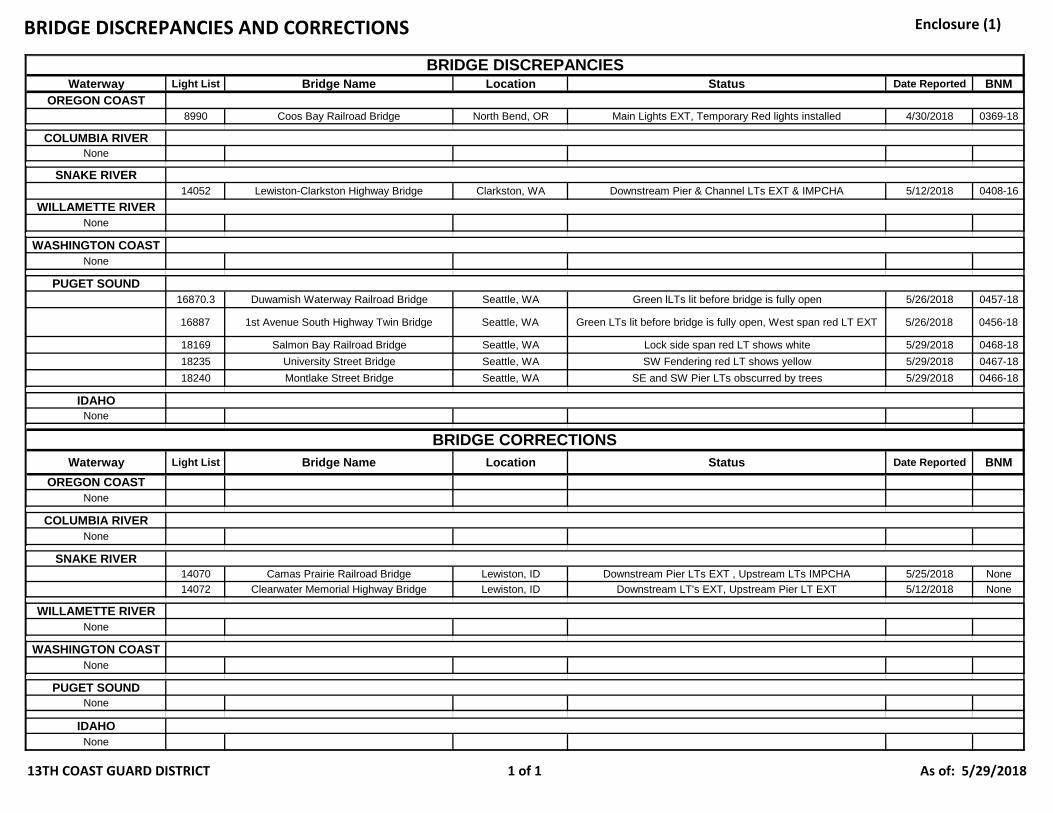
BRIDGE DISCREPANCIES AND CORRECTIONS Enclosure (1)
13TH COAST GUARD DISTRICT 1 of 1 As of: 5/29/2018
Waterway Light List Bridge Name Location Status Date Reported BNMOREGON COAST
8990 Coos Bay Railroad Bridge North Bend, OR Main Lights EXT, Temporary Red lights installed 4/30/2018 0369-18
COLUMBIA RIVERNone
SNAKE RIVER14052 Lewiston-Clarkston Highway Bridge Clarkston, WA Downstream Pier & Channel LTs EXT & IMPCHA 5/12/2018 0408-16
WILLAMETTE RIVERNone
WASHINGTON COASTNone
PUGET SOUND16870.3 Duwamish Waterway Railroad Bridge Seattle, WA Green lLTs lit before bridge is fully open 5/26/2018 0457-18
16887 1st Avenue South Highway Twin Bridge Seattle, WA Green LTs lit before bridge is fully open, West span red LT EXT 5/26/2018 0456-18
18169 Salmon Bay Railroad Bridge Seattle, WA Lock side span red LT shows white 5/29/2018 0468-1818235 University Street Bridge Seattle, WA SW Fendering red LT shows yellow 5/29/2018 0467-1818240 Montlake Street Bridge Seattle, WA SE and SW Pier LTs obscurred by trees 5/29/2018 0466-18
IDAHONone
Waterway Light List Bridge Name Location Status Date Reported BNMOREGON COAST
None
COLUMBIA RIVERNone
SNAKE RIVER14070 Camas Prairie Railroad Bridge Lewiston, ID Downstream Pier LTs EXT , Upstream LTs IMPCHA 5/25/2018 None14072 Clearwater Memorial Highway Bridge Lewiston, ID Downstream LT's EXT, Upstream Pier LT EXT 5/12/2018 None
WILLAMETTE RIVERNone
WASHINGTON COASTNone
PUGET SOUNDNone
IDAHONone
BRIDGE CORRECTIONS
BRIDGE DISCREPANCIES
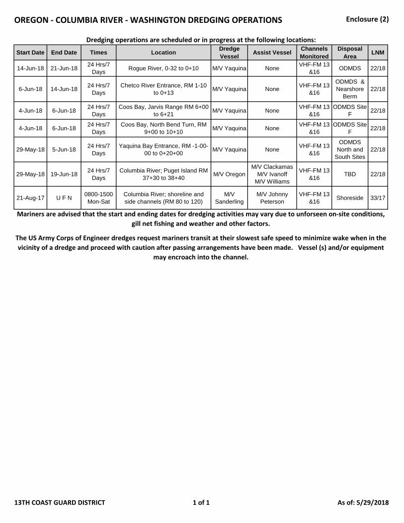
OREGON - COLUMBIA RIVER - WASHINGTON DREDGING OPERATIONS Enclosure (2)
13TH COAST GUARD DISTRICT 1 of 1 As of: 5/29/2018
Start Date End Date Times Location Dredge Vessel Assist Vessel Channels
MonitoredDisposal
Area LNM
14-Jun-18 21-Jun-18 24 Hrs/7 Days Rogue River, 0-32 to 0+10 M/V Yaquina None VHF-FM 13
&16 ODMDS 22/18
6-Jun-18 14-Jun-18 24 Hrs/7 Days
Chetco River Entrance, RM 1-10 to 0+13 M/V Yaquina None VHF-FM 13
&16
ODMDS & Nearshore
Berm22/18
4-Jun-18 6-Jun-18 24 Hrs/7 Days
Coos Bay, Jarvis Range RM 6+00 to 6+21 M/V Yaquina None VHF-FM 13
&16ODMDS Site
F 22/18
4-Jun-18 6-Jun-18 24 Hrs/7 Days
Coos Bay, North Bend Turn, RM 9+00 to 10+10 M/V Yaquina None VHF-FM 13
&16ODMDS Site
F 22/18
29-May-18 5-Jun-18 24 Hrs/7 Days
Yaquina Bay Entrance, RM -1-00-00 to 0+20+00 M/V Yaquina None VHF-FM 13
&16
ODMDS North and
South Sites22/18
29-May-18 19-Jun-18 24 Hrs/7 Days
Columbia River; Puget Island RM 37+30 to 38+40 M/V Oregon
M/V Clackamas M/V Ivanoff
M/V Williams
VHF-FM 13 &16 TBD 22/18
21-Aug-17 U F N 0800-1500 Mon-Sat
Columbia River; shoreline and side channels (RM 80 to 120)
M/V Sanderling
M/V Johnny Peterson
VHF-FM 13 &16 Shoreside 33/17
Dredging operations are scheduled or in progress at the following locations:
The US Army Corps of Engineer dredges request mariners transit at their slowest safe speed to minimize wake when in the vicinity of a dredge and proceed with caution after passing arrangements have been made. Vessel (s) and/or equipment
may encroach into the channel.
Mariners are advised that the start and ending dates for dredging activities may vary due to unforseen on-site conditions, gill net fishing and weather and other factors.
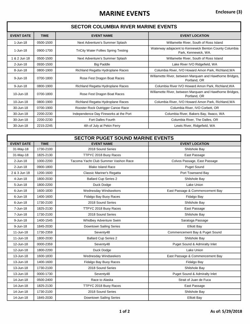
MARINE EVENTS Enclosure (3)
1 of 2 As of: 5/29/2018
EVENT DATE TIME EVENT NAME EVENT LOCATION
1-Jun-18 0500-1500 Next Adventure's Summer Splash Willamette River, South of Ross Island
1-Jun-18 0900-1700 TriCity Water Follies Spring Testing Waterway adajacent to Kennewick Benton County Columbia Park, Kennewick, WA.
1 & 2 Jun 18 0500-1500 Next Adventure's Summer Splash Willamette River, South of Ross Island
2-Jun-18 0930-1500 Big Paddle Lake River IVO Ridgefield, WA
8-Jun-18 0800-1900 Richland Regatta Hydroplane Races Columbia River, IVO Howard Amon Park, Richland,WA
9-Jun-18 0700-1800 Rose Fest Dragon Boat Races Willamette River, between Marquam and Hawthorne Bridges, Portland, OR
9-Jun-18 0800-1900 Richland Regatta Hydroplane Races Columbia River IVO Howard Amon Park, Richland,WA
10-Jun-18 0700-1800 Rose Fest Dragon Boat Races Willamette River, between Marquam and Hawthorne Bridges, Portland, OR
10-Jun-18 0800-1900 Richland Regatta Hydroplane Races Columbia River, IVO Howard Amon Park, Richland,WA
30-Jun-18 0700-1900 Rooster Rock Outrigger Canoe Race Columbia River, IVO Corbett, OR
30-Jun-18 2200-2230 Independence Day Fireworks at the Port Columbia River, Bakers Bay, Ilwaco, WA
30-Jun-18 2200-2230 Fort Dalles Fourth Columbia River, The Dalles, OR
30-Jun-18 2215-2245 4th of July at Pekin Ferry Lewis River, Ridgefield, WA
EVENT DATE TIME EVENT NAME EVENT LOCATION31-May-18 1730-2100 2018 Sound Series Shilshole Bay
31-May-18 1825-2130 TTPYC 2018 Buoy Races East Passage
2-Jun-18 1000-2200 Tacoma Yacht Club Summer Vashon Race Colvos Passage, East Passage
2-Jun-18 0900-1800 Blake Island Race Puget Sound
2 & 3 Jun 18 1200-1600 Classic Mariner's Regatta Port Townsend Bay
4-Jun-18 1800-2030 Ballard Cup Series 2 Shilshole Bay
5-Jun-18 1800-2200 Duck Dodge Lake Union
6-Jun-18 1600-1830 Wednesday Windseekers East Passage & Commencement Bay
6-Jun-18 1400-1600 Fidalgo Bay Buoy Races Fidalgo Bay
6-Jun-18 1730-2100 2018 Sound Series Shilshole Bay
7-Jun-18 1825-2130 TTPYC 2018 Buoy Races East Passage
7-Jun-18 1730-2100 2018 Sound Series Shilshole Bay
9-Jun-18 1400-1545 Whidbey Adventure Swim Saratoga Passage
9-Jun-18 1845-2030 Downtown Sailing Series Elliott Bay
11-Jun-18 1730-2359 Seventy48 Commencement Bay & Puget Sound
11-Jun-18 1800-2030 Ballard Cup Series 2 Shilshole Bay
12-Jun-18 0000-2359 Seventy48 Puget Sound & Admiralty Inlet
12-Jun-18 1800-2200 Duck Dodge Lake Union
13-Jun-18 1600-1830 Wednesday Windseekers East Passage & Commencement Bay
13-Jun-18 1400-1600 Fidalgo Bay Buoy Races Fidalgo Bay
13-Jun-18 1730-2100 2018 Sound Series Shilshole Bay
13-Jun-18 0000-1730 Seventy48 Puget Sound & Admiralty Inlet
14-Jun-18 0500-2400 Race to Alaska Strait of Juan de Fuca
14-Jun-18 1825-2130 TTPYC 2018 Buoy Races East Passage
14-Jun-18 1730-2100 2018 Sound Series Shilshole Bay
14-Jun-18 1845-2030 Downtown Sailing Series Elliott Bay
SECTOR COLUMBIA RIVER MARINE EVENTS
SECTOR PUGET SOUND MARINE EVENTS
MARINE EVENTS Enclosure (3)
2 of 2 As of: 5/29/2018
15-Jun-18 0001-1700 Race to Alaska Strait of Juan de Fuca
16-Jun-18 1030-1800 Three Buoy Fiasco Puget Sound
16-Jun-18 0800-1400 Makuakane Outrigger Race Bellingham Bay
18-Jun-18 1800-2030 Ballard Cup Series 2 Shilshole Bay
18-Jun-18 1800-2030 Summer Sailstice East Passage
19-Jun-18 1800-2200 Duck Dodge Lake Union
20-Jun-18 1600-1830 Wednesday Windseekers East Passage & Commencement Bay
20-Jun-18 1400-1600 Fidalgo Bay Buoy Races Fidalgo Bay
20-Jun-18 1730-2100 2018 Sound Series Shilshole Bay
21-Jun-18 1825-2130 TTPYC 2018 Buoy Races East Passage
21-Jun-18 1730-2100 2018 Sound Series Shilshole Bay
21-Jun-18 1845-2030 Downtown Sailing Series Elliott Bay
23-Jun-18 1100-1800 Cruise and Snooze A and B Puget Sound
23-Jun-18 0900-1900 2018 J-Fest Shilshole Bay
23-Jun-18 1000-1300 Rat Island Regatta Port Townsend Bay
24-Jun-18 1100-1800 Cruise and Snooze A and B Puget Sound
24-Jun-18 0900-1900 2018 J-Fest Shilshole Bay
25-Jun-18 1800-2030 Ballard Cup Series 2 Shilshole Bay
26-Jun-18 0600-0900 Ironman 70.3 Couer D'Alene Lake Couer D'Alene
26-Jun-18 1800-2200 Duck Dodge Lake Union
27-Jun-18 1600-1830 Wednesday Windseekers East Passage & Commencement Bay
27-Jun-18 1400-1600 Fidalgo Bay Buoy Races Fidalgo Bay
27-Jun-18 1730-2100 2018 Sound Series Shilshole Bay
28-Jun-18 1825-2130 TTPYC 2018 Buoy Races East Passage
28-Jun-18 1730-2100 2018 Sound Series Shilshole Bay
28-Jun-18 1845-2030 Downtown Sailing Series Elliott Bay
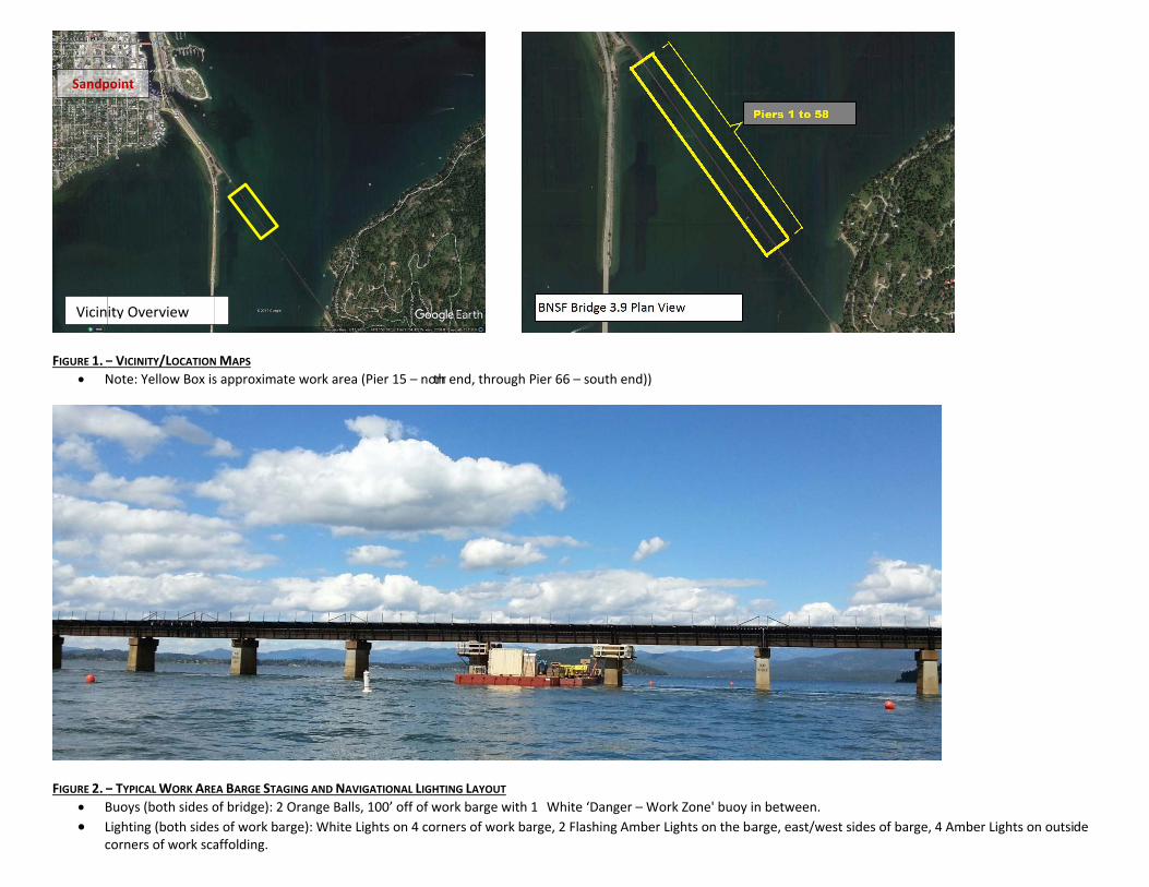
FIGURE 1. – N
FIGURE 2. – B L
c
Vicin
Sandp
– VICINITY/LOCATIONNote: Yellow Box is
– TYPICAL WORK AREBuoys (both sides oLighting (both sidescorners of work sca
ity Overview
point
N MAPS s approximate wor
EA BARGE STAGING ANof bridge): 2 Orangs of work barge): Waffolding.
ND NAVIGATIONAL LIGge Balls, 100’ off of White Lights on 4 co
k area (Pier 15 – norrth end, through P
GHTING LAYOUT work barge with 1orners of work bar
1 White ‘Danger – Work Zone' buoy in between.rge, 2 Flashing Amb
BNSF Bridge 3.9
ier 66 – south end))
ber Lights on the ba
9 Plan View
arge, east/west sid
des of barge, 4 Amber Lights on outside
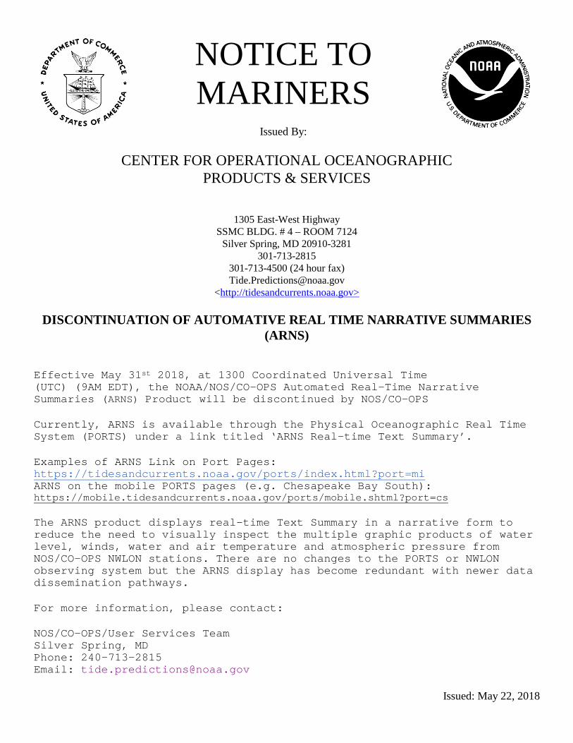
NOTICE TO MARINERS
Issued By:
CENTER FOR OPERATIONAL OCEANOGRAPHIC
PRODUCTS & SERVICES
1305 East-West Highway SSMC BLDG. # 4 – ROOM 7124
Silver Spring, MD 20910-3281 301-713-2815
301-713-4500 (24 hour fax) [email protected]
<http://tidesandcurrents.noaa.gov>
DISCONTINUATION OF AUTOMATIVE REAL TIME NARRATIVE SUMMARIES (ARNS)
Effective May 31st 2018, at 1300 Coordinated Universal Time (UTC) (9AM EDT), the NOAA/NOS/CO-OPS Automated Real-Time Narrative Summaries (ARNS) Product will be discontinued by NOS/CO-OPS Currently, ARNS is available through the Physical Oceanographic Real Time System (PORTS) under a link titled ‘ARNS Real-time Text Summary’. Examples of ARNS Link on Port Pages: https://tidesandcurrents.noaa.gov/ports/index.html?port=mi ARNS on the mobile PORTS pages (e.g. Chesapeake Bay South): https://mobile.tidesandcurrents.noaa.gov/ports/mobile.shtml?port=cs The ARNS product displays real-time Text Summary in a narrative form to reduce the need to visually inspect the multiple graphic products of water level, winds, water and air temperature and atmospheric pressure from NOS/CO-OPS NWLON stations. There are no changes to the PORTS or NWLON observing system but the ARNS display has become redundant with newer data dissemination pathways. For more information, please contact: NOS/CO-OPS/User Services Team Silver Spring, MD Phone: 240-713-2815 Email: [email protected]
Issued: May 22, 2018