Embed Size (px)
Citation preview

25 April 201817/18LNM:
17Coast Guard DistrictPage 1 of 11
U.S. Departmentof Homeland Security
United StatesCoast Guard
LOCAL NOTICE TO MARINERS
-Navigation Information Service (NIS)-Watchstander, 24 hours a day at (703) 313-5900
~Navcen Internet Address~https://www.navcen.uscg.gov
-Local Notice to Mariners-https://www.navcen.uscg.gov/?pageName=lnmMain
Issued by: Commander (DPW) Telephone: (907) 463-2269 (0800-1600) Seventeenth Coast Guard District After Hours: (907) 463-2000 (1600-0800)
PO Box 25517, Juneau, AK 99802-5517 http://www.uscg.mil/d17/D17%20Divisions/dpw/dpw.asp
Questions, comments, or additional information on this Local Notice to Mariners should be sent to the address above or by E-mail to: [email protected]. You can get the U.S. Coast Guard 17th District Local Notice to Mariners via the Internet directly from the U.S. Coast Guard
Navigation Center web site at https://www.navcen.uscg.gov/?pageName=lnmDistrict®ion=17.
REFERENCES: Light List, Vol. VI, Pacific Coast and Pacific Islands (COMDTPUB P16502.6). U.S. Coast Pilot 8, Pacific Coast Alaska: Dixon Entrance to Cape Spencer, 39th Edition.
U.S. Coast Pilot 9, Pacific and Arctic Coasts Alaska: Cape Spencer to Beaufort Sea, 35th Edition.
BROADCAST NOTICE TO MARINERSNavigation information previously promulgated by CG Sector Juneau Broadcast Notice to Mariners through J050-18
and CG Sector Anchorage Broadcast Notice to Mariners through A032-18 that are still in effect are included in this notice.
Chart Corrections https://nauticalcharts.noaa.gov/charts/chart-updates.html
Dates of Latest Editions, Nautical Charts, and Miscellaneous Mapshttps://nauticalcharts.noaa.gov/charts/list-of-latest-editions.html
Light List/ Summary of Correctionshttps://www.navcen.uscg.gov/?pageName=lightListCorrections
NOAA Chart Viewer (Posting of all up to date NOAA charts for viewing on Internet browser to be used for ready reference or planning) https://nauticalcharts.noaa.gov/
NOAA Booklet Chartshttps://nauticalcharts.noaa.gov/charts/noaa-raster-charts.html#booklet-charts
Coast Pilots, along with corrections, are available at:https://nauticalcharts.noaa.gov/publications/coast-pilot/index.html
NOAA Weather Buoy Siteshttp://www.ndbc.noaa.gov/
Tides onlinehttps://tidesandcurrents.noaa.gov/
Tides, Currents, PORTShttps://tidesandcurrents.noaa.gov/noaacurrents/Stations?g=693
Weatherhttp://www.nws.noaa.gov/om/marine/alaska.htm
Vessel Traffic System Prince William Sound (VTSPWS) Users Manualhttps://homeportr.uscg.mil/Lists/Content/DispForm.aspx?ID=2205&Source=https:
District: 17 Week: 17/18

25 April 201817/18LNM:
17Coast Guard DistrictPage 2 of 11
ABBREVIATIONS
SECTION I - SPECIAL NOTICESThis section contains information of special concern to the Mariner.
ALASKAS – SOUTHCENTRAL – COOK INLET
ALASKA – SOUTHWESTERN – ALEUTIAN PENINSULA – BECHEVIN BAY
The following seasonal navigational aids have been established for the 2018 season:Lower Cook Inlet Junction LBB CI (LLNR 26270)Middle Ground Shoal LB 3 (LLNR 26367)East Foreland B 2 (LLNR 26360)Cook Inlet LBB 6 (LLNR 26384)Knik Arm Shoal LB 7 (LLNR 26420)Questions/concerns should be directed to the Coast Guard Sector Anchorage Command Center at (907) 428-4100 or on VHF/FM channel 16.
Shoaling has been reported at the bar along the Northern entrance to Bechevin Bay by a vessel with a draft of 10 feet that reported briefly grounding in seas running 6-8 feet. Mariners should take into account their vessel's draft, charted depth of water, tides and sea state when determining an appropriate under-keel clearance for a safe transit of this waterway. Mariners are requested to report any future groundings orsignificant variations from charted depth to the Coast Guard Sector Anchorage Command Center at (907) 428-4100 or on VHF/FM channel 16.
LNM:
LNM:
17/18
17/18
Additional Abbreviations Specific to this LNM Edition:
A through H
ADRIFT - Buoy AdriftAICW - Atlantic Intracoastal WaterwayAl - AlternatingB - BuoyBKW - Breakwaterbl - BlastBNM - Broadcast Notice to Marinerbu - BlueC - CanadianCHAN - ChannelCGD - Coast Guard DistrictC/O - Cut OffCONT - ContourCRK - CreekCONST - ConstructionDAYMK/Daymk - DaymarkDBN/Dbn - DaybeaconDBD/DAYBD - DayboardDEFAC - DefacedDEST - DestroyedDISCON - DiscontinuedDMGD/DAMGD - Damagedec - eclipseEST - Established Aidev - everyEVAL - EvaluationEXT - ExtinguishedF - Fixedfl - flashFl - FlashingG - Green GIWW - Gulf Intracoastal WaterwayHAZ - Hazard to NavigationHBR - HarborHOR - Horizontal ClearanceHT - Height
I through O
I - InterruptedICW - Intracoastal WaterwayIMCH - Improper CharacteristicINL - InletINOP - Not OperatingINT - IntensityISL - IsletIso - IsophasekHz - KilohertzLAT - LatitudeLB - Lighted BuoyLBB - Lighted Bell BuoyLHB - Lighted Horn BuoyLGB - Lighted Gong BuoyLONG - LongitudeLNM - Local Notice to MarinersLT - LightLT CONT - Light ContinuousLTR - LetterLWB - Lighted Whistle BuoyLWP - Left Watching ProperlyMHz - Megahertz MISS/MSNG - MissingMo - Morse Code MRASS - Marine Radio Activated Sound SignalMSLD - MisleadingN/C - Not ChartedNGA - National Geospatial-Intelligence AgencyNO/NUM - NumberNOS - National Ocean ServiceNW - Notice WriterOBSCU - ObscuredOBST - ObstructionOBSTR - ObstructionOc - OccultingODAS - Anchored Oceanographic Data Buoy
P through Z
PRIV - Private AidQ - QuickR - Red RACON - Radar Transponder BeaconRa ref - Radar reflectorRBN - Radio BeaconREBUILT - Aid RebuiltRECOVERED - Aid RecoveredRED - Red BuoyREFL - ReflectiveRRL - Range Rear LightRELIGHTED - Aid RelitRELOC - RelocatedRESET ON STATION - Aid Reset on StationRFL - Range Front LightRIV - RiverRRASS - Remote Radio Activated Sound Signals - secondsSEC - SectionSHL - Shoalingsi - silentSIG - SignalSND - SoundSPM - Single Point Mooring BuoySS - Sound SignalSTA - StationSTRUCT - StructureSt M - Statute MileTEMP - Temporary Aid ChangeTMK - TopmarkTRLB - Temporarily Replaced by Lighted BuoyTRLT - Temporarily Replaced by LightTRUB - Temporarily Replaced by Unlighted BuoyUSACE - Army Corps of EngineersW - WhiteY - Yellow
None
169
170

25 April 201817/18LNM:
17Coast Guard DistrictPage 3 of 11
ALASKA – NORTHERN – HARRISON BAY
ALASKA – SOUTHCENTRAL – GULF OF ALASKA AND KODIAK ISLAND
ALASKA
ALASKA – SOUTHCENTRAL – COOK INLET
ConocoPhillips Alaska Inc. plans to conduct a bathymetric study near Harrison Bay, Alaska. The study will be conducted using equipment installed as early as June 18th and will be retrieved before October 15th, 2018. The equipment will consist of two tide gauges placed within 6 miles of Atigaru Point in Harrison Bay and within 100 feet from shore. Each tide gauge will consist of a pressure transducer located in a water depth of three to five feet with a cable leading to a data recorder onshore. Each gauge will be marked with a stake that sticks up above the water approximately 3 feet. In addition to the tide gauges there will be an anemometer located with both onshore data recorders and should provide a visible reference for the location of the tide gauges. Mariners are requested to minimize their wake when transiting in the vicinity of the tide gauges and maintain a distance of at least 100 feet from the stakes marking the tide gauges as well as the data recorder and anemometer located on shore. Questions/concerns should be directed to Chris Wrobel at (907) 263-4691 or by email to [email protected].
HAZARDOUS OPERATIONS: A rocket launch is scheduled from the Pacific Spaceport Complex located at Narrow Cape, Kodiak Island, Alaska with a launch window each day will from 2000-0200 UTC which is 1200-1800 Alaska Daylight Savings Time. The primary launch date is May 10th,2018. The secondary launch date is May 11th, 2018. The tertiary launch date is May 12th, 2018.
The following caution areas have been provided by Alaska Aerospace:
Caution area A (uprange): consists of a polygon defined by lines connecting the following points.A. 57°07’00”N, 152°16’00”WB. 56°56’00”N, 152°22’00”WC. 56°57’00”N, 152°37’00”WD. 57°10’00”N, 152°34’00”WE. 57°27’00”N, 152°23’00”WF. 57°28’00”N, 152°19’00”WG. 57°26’00”N, 152°15’00”WH. 57°24’00”N, 152°14’00”WI. RETURN TO POINT A
Caution Area B: Downrange impact areaA. 52°40’48”N, 156°33’36”W B. 51°57’00”N, 152°22’48”WC. 48°58’12”N, 153°25’48”WD. 50°00’00”N, 158°37’48”W E. RETURN TO POINT A
Mariners are advised to remain clear of these caution areas for the duration of operations. Questions/concerns should be directed to Mike Morton at (907) 743-3525 or by email [email protected].
1. The GPS navigation signal may be unreliable due to testing on GPS frequencies used by shipboard navigation and handheld systems. Systems that rely on GPS, such as E-911, AIS and DSC, may be affected at an approximate testing center point of 64° 18' 18.5894"N 146° 18' 00.4342"W, with a possible impact radius of 349nm from center point.2. GPS testing is scheduled to be conducted on: 26-30 APR, 1-20 MAY 2018. 3. More information is available at the Coast Guard Navigation Center web site www.navcen.uscg.gov. During this period GPS users are encouraged to report any GPS service outages that they may experience to the navigation information service (NIS) by calling (703) 313-5900 or by using the NAVCEN web site to submit a GPS problem report.
A submerged pipeline will be installed in Cook Inlet between Ladds Landing and the Tyonek Platform beginning on May 1st, 2018 and construction completed by August 31st, 2018.The tugs HAWAII and WASHINGTON will be working with the barge NINILCHIK to accomplish the work. During the construction, the barge NINILCHIK will be anchored in various configurations with the anchors marked with lighted crown buoys. Mariners are requested to minimize their wake and not transit within 2,000 yards of the tugs or barge. The tugs HAWAII and WASHINGTON will be monitoring VHF/FM channel 16 and 13. Questions/concerns should be directed to Nate Collar with Crowley Solutions at (509) 217-7440 or by email to [email protected].
LNM:
LNM:
LNM:
17/18
16/18
16/18
171
172
174
186

25 April 201817/18LNM:
17Coast Guard DistrictPage 4 of 11
ALASKA – NORTHWESTERN – CHUKCHI SEA – CAPE LISBURNE
ALASKA – ALEUTIAN ISLANDS – AKUTAN ISLAND – AKUTAN HARBOR
ALASKA – SOUTHEAST – STIKINE STRAIT
ALASKA – SOUTHCENTRAL – COOK INLET NAVIGATION CHANNEL
ALASKA – CENTRAL – KODIAK
ALASKA - PRINCE WILLIAM SOUND - PORT OF VALDEZ
Orion Marine Contractors will be conducting rock quarry operations at the north end of Cape Lisburne (approximately 1/2 mile west of the USAF runway at the Long Range Radar Site). Coordinates of the general area of quarry operations are 68°52'37.51"N, 166°9'26.41"W. Blasting operations will begin on May 1st, 2018 and continue 7 days a week until November 15th, 2018. Please avoid this area and at no time enter closer than ½ mile of the quarry operations. Orion Marine Contractors will be monitoring VHF/FM channel 16. Questions/concerns should be directed to Orion Marine Contactors at (907) 433-3536 or (907) 561-9811 or by email to [email protected].
UNKNOWN MARINE ANOMALY: An unknown marine anomaly was discovered during underwater survey operations in Akutan Harbor in position 54°07.70889’N, 165°46.38298W on the sea floor at a depth of 138 feet. This anomaly has not been positively identified. Mariners are requested to transit the area with caution. Questions/concerns should be directed to LTjg David Parker with the Coast Guard Sector Anchorage Waterways Management Branch at (907) 428-4189 or by email to [email protected].
OBSTRUCTION TO NAVIGATION: The wreck of the F/V DECEPTIVE C is partially submerged in the Stikine Strait at the approximate position 56°15’149”N 132°44’445”W, approximately 3.1 NM southwest of Round Point on Zarembo Island. Mariners are requested to use caution when transiting the area and watch for debris that may break free and drift away. Questions/concerns should be directed to the Coast Guard Sector Juneau Command Center at (907) 463-2980 or on VHF/FM channel 16.
The U.S. Army Corps of Engineers (USACE), Alaska District conducted a project condition survey for Cook Inlet Navigation Channel on 08 November, 2017 in which the following controlling depths in feet (FT) mean lower low water (MLLW) were recorded:Left Outside Quarter 61°12'01.67"N, 150°05'42.22"W at -37.0 FT MLLWLeft Inside Quarter 61°12'00.69"N, 150°05'41.19"W at -36.5 FT MLLWRight Inside Quarter 61°11'57.74"N, 150°05'39.14"W at -39.2 FT MLLWRight Outside Quarter 61°12'00.22"N, 150°05'11.60"W at -39.1 FT MLLWA chartlet of the controlling depths as well as survey data are available on the U.S. Army Corps of Engineers (USACE) Navigation Portal website at: http://navigation.usace.army.mil/Survey/Hydro The Cook Inlet Navigation Channel was dredged during the summer of 2014 to a project depth of -38 FT MLLW. At this time, no maintenance dredging is scheduled for this channel during 2017. The next project condition survey for this channel is tentatively scheduled for May 2018. BE ADVISED: The information depicted on maps, charts, drawings, navigation notices, etc., for the subject project, represents the results of a survey conducted on the date(s) indicated and can only be considered to represent the general condition existing at that time. The survey data was collected under a USACE contract for the purpose of characterizing the condition of the navigation channel, and the area for placement of dredged material for future channel maintenance operations. As such, the information is only valid for its intended use. This information can be used to supplement existing published navigation charts. The user is responsible for the results of any application of the survey data for other than its intended purpose and should consider the contents, timeframe of data collection, and accuracy specifications for survey data collection/processing. Additionally, bathymetry in Cook Inlet is subject to drastic and continuing change. Prudent mariners should not rely solely upon this information. Questions/concerns should be directed to Donna West with the USACE Anchorage office at (907) 753-2761 or by email to [email protected].
The National Wind Technology Center National Renewable Energy Laboratory (NREL) and ORPC Solutions deployed a yellow spherical Wave-Rider buoy marked with a group flash yellow (5), 20 seconds (Fl Y (5) 20s) light, approximately 29 nautical miles southeast of the City of Kodiak, Alaska. The location of the buoy is approximately 57°28.8' N, 151°42.0' W in 295 feet of water with a watch circle diameter of 1150 feet . The buoy was deployed on September 28, 2017 and will be removed by September 27, 2018. Questions/concerns should be directed to Levi Kilcher at (303) 384-7192 or by email to [email protected] or to Monty Worthington at (907)388-8639 or (207)772-7707 or by email to [email protected].
The Captain of the Port Prince William Sound has established a safety zone encompassing the navigable waters of Valdez Harbor in the vicinity of the western end of A and B dock. The safety zone is in effect during oil spill response efforts. Vessels may not transit in or out of the safety zone without permission of the Captain of the Port. Questions/concerns should be directed to the Coast Guard Sector Anchorage Command Center at (907) 428-4100 or on VHF/FM channel 16.
LNM:
LNM:
LNM:
LNM:
LNM:
LNM:
11/18
10/18
03/18
50/17
49/17
40/17
196
204
210
212
243
245

25 April 201817/18LNM:
17Coast Guard DistrictPage 5 of 11
ALASKA – WESTERN – YUKON RIVER
ALASKA – SOUTHEAST – ICY STRAIT – NORTH INIAN PASSAGE
ALASKA – GULF OF ALASKA
ALASKA – SOUTHCENTRAL – COPPER RIVER DELTA
ALASKA – SOUTHEAST – PORT CHESTER – METLAKATLA
ALASKA - CENTRAL - BETHEL
ALASKA – U.S. COAST GUARD MEDIUM FREQUENCY (MF) DISTRESS WATCHKEEPING
ALASKA – SOUTHWESTERN – BERING SEA – BOGOSLOF VOLCANO
The Yukon River South Entrance LT (LLNR 27860) has been rebuilt but the position has not been verified. Mariners are requested to transit the area with caution. Questions/concerns should be directed to Todd Buck with the Coast Guard District 17 Waterways Management Office at (907) 463-2269 or by email to [email protected].
The currents in North Inian Passage and Glacier Bay have been observed at up to 3 knots above the NOAA published current predictions. Mariners should exercise caution when transiting the area. Questions/concerns should be directed to LT Bart Buesseler at (907) 271-3327 or by email to [email protected].
NOAA DLB 46001 (LLNR 984) has been replaced with a 3-meter buoy and relocated to 56°13’56”N, 147°56’57”W. Chart and Light List corrections have been issued. The previous 6-meter buoy was not recovered due to weather and remains in position 56°19’33.962”N, 147°57’01.382”W. Mariners are requested to transit the area with caution until the previous buoy is recovered. Questions/concerns should be directed to Todd Buck with the Coast Guard District 17 Waterways Management Office at (907) 463-2269 or by email to [email protected].
OBSTRUCTION TO NAVIGATION: The 24 foot F/V BAD BOY is capsized and aground in the vicinity of Kokenhenik Bay in position 60°13.472’N, 145° 09.160’W. Mariners are requested to transit the area with caution and make sighting reports with any updated positions to the Coast Guard Sector Anchorage Command Center at (907) 428-4100 or on VHF/FM channel 16.
Gull Island LT (LLNR 22055) has been decommissioned and replaced with Gull Island LB (22055). Gull Island LB is a red lighted buoy with a flash characteristic of Fl R (2+1) every 6 seconds and is located in position 55°08’18.720’N, 131°36’28.980’W. Chart and Light List corrections will be issued once the verification process has been completed. Questions/concerns should be directed to Todd Buck with the Coast Guard District 17 Waterways Management Office at (907) 463-2269 or by email to [email protected].
OBSTRUCTION: The barge SHANKS ARK has been reported sunken and abandoned in Steamboat Slough on the Kuskokwim River, approximate position 60°47'15"N, 161°41'52"W. The vessel is marked by an all-round white light and one ball dayshape. A portion of the vessel remains visible above the level of high-tide, but the majority of the vessel remains below the waterline. The Coast Guard has actively monitored the proper marking of the vessel by the vessel's owner and operator since September 10, 2016. Coast Guard pollution investigators confirmed the vessel does not pose a substantial pollution threat to the environment. Mariners are requested to transit the area with caution and report any discrepancies with the vessel's marking to the Coast Guard. Questions/concerns should be directed to LTJG David Parker, Sector Anchorage Waterways Management, at (907) 428-4189.
Mariners are advised that calls to the U.S. Coast Guard on the international radiotelephone distress frequency 2182 kHz or the Digital Selective Calling (DSC) frequency 2187.5 kHz may not be heard or may be severely degraded. Instead of using 2182 kHz for distress calls, mariners should use high frequency (HF) radiotelephone or DSC in the 4, 6, 8, and 12 MHz distress or calling bands. Additional information concerning U.S. Coast Guard HF watchkeeping is posted on the U.S. Coast Guard's Navigation Center website (https://www.navcen.uscg.gov/?pageName=cgcommsCall).
All mariners in the region are advised that Bogoslof volcano (53.9272°N,168.0344°W) has been in a prolonged period of episodic eruptive activity since December 12, 2016. The activity is characterized by strong explosive bursts of ash and steam from a submarine vent near the center of Bogoslof Island. During eruptions, it is possible for fast-moving, water-hugging clouds of hot steam and ash, known as base surges, toextend well beyond the eruption site. The runout distance of these surges at Bogoslof is not known, but at other volcanoes where they have been observed, base surges can travel distances of 6 km (3.7 miles) or more. The Alaska Volcano Observatory (AVO) is recommending a zone 10km (6 miles) beyond the volcano in all directions as an approximate hazard zone for base surges.
LNM:
LNM:
LNM:
LNM:
LNM:
LNM:
LNM:
LNM:
39/17
37/17
36/17
35/17
22/17
13/17
11/17
08/17
254
260
261
298
334
339
352
359

25 April 201817/18LNM:
17Coast Guard DistrictPage 6 of 11
ALASKA – SOUTHEAST – SITKA SOUND
ALASKA – SOUTHCENTRAL – COOK INLET
ALASKA – WESTERN – NOME
ALASKA – SOUTHEAST
ALASKA – SOUTHCENTRAL
ALASKA – SOUTHEAST – WESTERN BEHM CANAL
Less likely, but possible is the generation of water waves associated with periods of strong eruptive activity. Seawater is being displaced by the eruption column and it is likely that the sea surface is in a temporarily agitated condition with small waves propagating from the eruption site. At this time, we have no evidence that indicates hazardous volcanic tsunamis are being generated. If the conditions of the eruption were to change, resulting in the intensity of the eruptive activity escalating significantly, it is possible that larger potentially hazardous waves could be generated. AVO considers this a remote possibility based on the observed activity to date, and what is known of historical Bogoslof eruptions.
The Bogoslof eruption has been producing primarily fine ash that has been accumulating on and around Bogoslof Island. Fine ash has been observed in the water column surrounding Bogoslof Island up to distances of about 1-2 km (0.6-1.2 miles). Although trace amounts of fine ash may be present in the water at distances greater than 1-2 km, concentrations are likely to be low. At some point in the eruption, it is possible forthe volcano to produce frothy, low density volcanic clasts that may be capable of floating beyond the eruption site. However, concentrated accumulations of floating volcanic material are not considered likely and have not been observed to date. Additional information is available at the AVO website at https://www.avo.alaska.edu. Any mariners observing signs of volcanic activity are requested to make reports to AVO via https://www.avo.alaska.edu/contact.php or by calling 907-786-7497.
The wreck of the vessel SANDRA L is partially submerged in the vicinity of Koka Island in approximate position 56°54.580’N, 135°23.970’W. The larger portion of the vessel is in approximately 18’ of water with at least one large piece of the hull secured on the beach. Mariners are requested to use caution when approaching the island and watch for debris that may break free and drift away. Questions/concerns should be directed to the Coast Guard Sector Juneau Command Center at (907) 463-2980 or on VHF/FM channel 16.
The Furie Energy JULIUS R. gas production platform is located near Middle Ground Shoal in Cook Inlet in position 60°56’10.1620”N, 151°09’31.0270”W. It is a monopod production platform and is manned 24 hours a day and 7 days a week and monitors VHF/FM channel 12. It iscurrently not charted but chart corrections will be issued as soon as the documentation has been processed. Questions/concerns should be directed to Tom Rueter with Alaska Maritime Agencies at (907) 562-8808 or by email to [email protected].
The Army Corps of Engineers (USACE) has discovered a potential obstruction in the outer entrance channel to the Nome Harbor. The obstruction was identified during the 2015 maintenance dredging operations and confirmed by multi-beam sonar equipment during a project condition survey. The approximate center location of the obstruction is 64°29'41.344"N 165°26'11.968"W. The least depth in the vicinity of the obstruction is 20.1 feet below mean lower low water. Mariners should exercise caution while navigating this area and report any strikes to Lucas Stotts, Harbormaster (907) 304-1906. The approximate obstruction location is based on preliminary survey data submitted by eTrac Inc. on 24 August, 2015 to the U.S. Army Corps of Engineers, Alaska District. The approximate dimensions of the obstruction are 7 feet long by 5 feet wide by 2.5 feet tall. USACE will update this notice as soon as additional information becomes available. Questions/concerns should be directed to Michael Teneza, Operations Project Manager (907) 753-2648 or Tom Sloan, Chief Geomatics Section (907) 753-2658.
The U.S. Coast Guard has VHF Digital Selective Calling (DSC) capability with limited coverage in Southeast Alaska. The initial coverage areas are Ketchikan, Juneau and Yakutat. Mariners are reminded to ensure that they have properly connected their GPS units to their DSC equipped marine VHF radios and registered for their Maritime Mobile Service Identity (MMSI) to utilize the DSC distress function. Additional information is available through the Alaska Outdoors Forum athttp://forums.outdoorsdirectory.com/showthread.php/142083-Digital-Selective-Calling-(DSC) or by contacting Mike Folkerts with the Coast Guard District 17 Boating Safety Office at (907) 463-2297 or by email to [email protected].
The U.S. Coast Guard has VHF Digital Selective Calling (DSC) capability with limited coverage in Southcentral Alaska. The initial coverage areas are Upper Cook Inlet, Kodiak and Valdez Arm. Mariners are reminded to ensure that they have properly connected their GPS units to their DSC equipped marine VHF radios and registered for their Maritime Mobile Service Identity (MMSI) to utilize the DSC distress function. Additional information is available through the Alaska Outdoors Forum at http://forums.outdoorsdirectory.com/showthread.php/142083-Digital-Selective-Calling-(DSC) or by contacting Mike Folkerts with the Coast Guard District 17 Boating Safety Office at (907) 463-2297 or by email to [email protected].
The U.S. Navy has established a temporary data collection buoy in Western Behm canal approximately 5,000 yards North of Betton Island within
LNM:
LNM:
LNM:
LNM:
LNM:
LNM:
05/17
47/16
19/16
34/15
15/15
15/15
368
519
637
705
707
726

25 April 201817/18LNM:
17Coast Guard DistrictPage 7 of 11
ALASKA
ALASKA
ALASKA – ALEUTIAN ISLANDS – ADAK – SWEEPER COVE
ALASKA
ALASKA – SUBSURFACE AND SURFACE BUOYS
400 yards of position 55°35.684’N, 131°46.503’W. The buoy is described as a 3 foot diameter yellow sphere, with the marking “Wave Buoy”, with an attached telemetry whip antenna and a night time warning light that flashes 5 times at 1 second intervals with a period of 20 seconds between each series, Fl(5) Y 25s. Questions/concerns should be directed to Mr. Bill Harney at (907) 247-6289.
The Alaska Marine Safety Education Association (AMSEA) will be offering AMSEA Marine Safety Instructor Training and AMSEA Drill Conductor Courses in various locations within Alaska. The specific locations, dates, and course information can be found in an enclosure to this LNM. For more information contact AMSEA at (907) 747-3287 or view their website at www.amsea.org.
U.S. Coast Guard to Test Automatic Identification System (AIS) Aids to Navigation (ATON). In the near future, the U.S. Coast Guard and other authorized agencies and organizations (i.e., U.S. Army Corps of Engineers, Marine Exchange of Alaska) will begin transmitting AIS ATON messages and marine safety information via AIS for testing and evaluation. The exact content, location, and times of these broadcasts will be announced in future Local Notices to Mariners. Additional information is included as an enclosure to this LNM. Questions/concerns should be directed to Todd Buck at the Coast Guard District 17 Waterways Management Office at (907) 463-2269 or by email to [email protected].
The East side of the Pier 5 Dock located in Sweeper Cove is closed to moorage without prior approval from the Adak Harbormaster due to loose and missing pilings. Questions/concerns should be directed to Jim Fleming at (907) 277-7527 or the Port of Adak office at (907) 592-0185. The Adak harbormaster can also be contacted on VHF/FM channel 16.
MARINE DEBRIS: With the increase in ocean debris sightings along the coastlines of the Pacific Ocean, mariners are reminded to submit debris sighting reports to the National Oceanic and Atmospheric Administration (NOAA) Marine Debris Program at [email protected]. Questionsor concerns may be directed to the Coast Guard District 17 Waterways Management Branch at (907) 463-2269 or by email to [email protected].
Locations of all subsurface and surface oceanographic moorings that have been reported to the U.S. Coast Guard District 17 Waterways Branchare included in an enclosure to the Local Notice to Mariners. The name, type, location, depth, water depth, and a Point of Contact for all data buoys, surface and subsurface, shall be reported as quickly as is practical if they are placed within the navigable waters (within 200 nm) of the United States. Data buoys placed in the Arctic region but outside of 200 nm of the United States may be reported and will be included in this compilation (for informational purposes only). This notification process is for inclusion in the Local Notice to Mariners to provide navigational information to mariners and does not supersede any permission or permitting requirements. Any notifications, corrections, additions, deletions, or comments for the Alaska region (Coast Guard District 17) or the Arctic region should submitted via e-mail to [email protected] or to Todd Buck, USCG D17(dpw), at (907) 463-2269 or by email to [email protected]. This compilation is as current as the Local Notice to Mariners (LNM) as included in an enclosure. The referenced LNM may have additional information and indicates the last time an entry was updated.
LNM:
LNM:
LNM:
LNM:
LNM:
LNM:
05/15
12/14
05/14
20/13
24/12
38/11
DISCREPANCIES (FEDERAL AIDS)
SECTION II - DISCREPANCIESThis section lists all reported and corrected discrepancies related to Aids to Navigation in this edition. A discrepancy is a change in the status of
an aid to navigation that differs from what is published or charted.
LNM EndLLNR Aid Name Status Chart No. BNM Ref. LNM StNOAA Data Lighted Buoy 46084
Cape Hinchinbrook Light
Ugamak Island LightBar Harbor North Entrance Light 2N
Wrangell Narrows Channel Light 52
LT EXT
LT EXT
STRUCT DESTLT EXT
DAYMK DMGD
34/17
11/18
08/1835/17
43/17
17320
16709
1653117430
17375
1028
1125
122522220
23125
J144-17
A020-18
A016-18J149-17
J184-15
872
889
992
995
998

25 April 201817/18LNM:
17Coast Guard DistrictPage 8 of 11
DISCREPANCIES (FEDERAL AIDS) CORRECTED
DISCREPANCIES (PRIVATE AIDS)
DISCREPANCIES (PRIVATE AIDS) CORRECTED
SECTION III - TEMPORARY CHANGES and TEMPORARY CHANGES CORRECTEDThis section contains temporary changes and corrections to Aids to Navigation for this edition. When charted aids are temporarily relocated for dredging, testing, evaluation, or marking an obstruction, a temporary correction shall be listed in Section IV giving the
new position.
TEMPORARY CHANGES
LNM End
LNM End
LNM End
LLNR
LLNR
LLNR
Aid Name
Aid Name
Aid Name
Status
Status
Status
Chart No.
Chart No.
Chart No.
BNM Ref.
BNM Ref.
BNM Ref.
LNM St
LNM St
LNM St
Keku Strait Daybeacon 10
Keku Strait Daybeacon 13Keku Strait Buoy 14
Kake Entrance Light 2
Harris Harbor Light HAurora Basin Light A
Battery Point Light
Nukdik Point Daybeacon 1Dippy Island Rock Daybeacon 3
NOAA Data Lighted Buoy 46081
NOAA Data Lighted Buoy 46081Perl Rock Light
Unga Spit Light
Moss Cape Lighted Buoy 4Chunak Point Daybeacon 2
Akutan Point Light 2
Ulakta Head LightWalrus Island Light
St. George Harbor Entrance Light 1
St. Paul Harbor Jetty Light 4
Wrangell Narrows Channel Light 38
Point Elrington Light
Bar Harbor Breakwater East LightBar Harbor Breakwater Middle Light
Bar Harbor Breakwater West Light
Port Chilkoot Mooring Dolphin Lights (2)Whittier Passenger Dock Lights (2)
Baker Oil Platform Light
Dillon Oil Platform Light
MISSING
STRUCT DESTMISSING
STRUCT DEST
LT EXTLT EXT
LT EXT
STRUCT DMGDDAYMK DMGD
LT EXT
OFF STALT EXT
DAYMK DMGD
LT EXTDAYMK DMGD
LT EXT
LT EXTSTRUCT DEST
LT EXT
LT EXT
WATCHING PROPERLY
WATCHING PROPERLY
STRUCT DESTSTRUCT DEST
STRUCT DEST
LT EXTLT EXT
REDUCED INT
LT EXT
32/13
23/1506/16
18/15
06/1813/18
51/17
48/1651/15
34/15
03/1808/18
33/17
07/1815/13
16/18
07/1742/17
02/18
01/18
03/18
10/18
47/1547/15
47/15
38/1420/10
24/17
10/16
17/18
17/18
17368
1736817372
17368
1731517315
17317
1731717321
16705
1670516606
16551
1654916535
16532
1652916363
16381
16382
17375
16702
1743017430
17430
1731716706
16662
16662
23305.7
23305.923305.95
23315
2370523710
23905
2391525355
25647
2564726095
27125
2715027300
27440
2745027560
27827
27830
23060
25980
2220122202
22203
2390825893
26361
26361.5
None
J148-13
J103-15J032-16
J086-15
J013-18J041-18
J210-17
J197-16J216-15
A139-15
A003-18A015-18
A111-17
A011-18A089-13
A028-18
A020-17A148-17
A001-18
A179-17
J050-18A028-18
J202-15
J203-15
J204-15J175-14
A031-10
A034-16
PLATFORM DISCREPANCIES
PLATFORM DISCREPANCIES CORRECTED
Name
Name
Status
Status
Position
Position
BNM Ref.
BNM Ref.
LNM St
LNM St
LNM End
LNM End
None
None

25 April 201817/18LNM:
17Coast Guard DistrictPage 9 of 11
TEMPORARY CHANGES CORRECTED
LNM End
LNM End
LLNR
LLNR
Aid Name
Aid Name
Status
Status
Chart No.
Chart No.
BNM Ref.
BNM Ref.
LNM St
LNM St
OIL RIG MOVEMENT
SECTION V - ADVANCE NOTICESThis section contains advance notice of approved projects, changes to aids to navigation, or upcoming temporary changes such as dredging, etc.
Mariners are advised to use caution while transiting these areas.
SUMMARY OF ADVANCED APPROVED PROJECTS
Approved Project(s) Project Date Ref. LNM
SECTION VI - PROPOSED CHANGESPeriodically, the Coast Guard evaluates its system of aids to navigation to determine whether the conditions for which the aids to navigation were
established have changed. When changes occur, the feasibility of improving, relocating, replacing, or discontinuing aids are considered. This section contains notice(s) of non-approved, proposed projects open for comment. SPECIAL NOTE: Mariners are requested to respond in writing to the District
office unless otherwise noted (see banner page for address).
Drill Rigs/Vessels Removed
Latitude Longitude Block Rigs/Vessel Type Status
Latitude Longitude Block Rigs/Vessel Type Status
60-44-31.000N60-05-10.200N
151-18-36.000W149-21-25.800W
--
RANDOLPH YOSTSpartan Rig 151
JACKUPJACKUP
STACKEDUNREPORTED
Chart
Chart
Drill Rigs/Vessels Established
Haines Small Boat Harbor Light 2
Danger Point Light
Tenakee Inlet Entrance Light 1
Mitchell Rock Daybeacon
Japonski Island Daybeacon 2
Channel Island Rock Light 7
DISCONTINUED
DISCONTINUED
DISCONTINUED
DISCONTINUED
DISCONTINUED
DISCONTINUED
35/17
03/17
11/17
04/17
49/16
41/16
17317
17339
17300
17327
17327
16710
23910
24045
24065
24957
25025.5
25555
None
None
SECTION IV - CHART CORRECTIONS
None
J150-17
J009-17
J047-17
J022-17
J196-16
A155-16
PLATFORM TEMPORARY CHANGES
PLATFORM TEMPORARY CHANGES CORRECTED
Name
Name
Status
Status
Position
Position
BNM Ref.
BNM Ref.
LNM St
LNM St
LNM End
LNM End
None
None
None
None
Advance Notice(s)

25 April 201817/18LNM:
17Coast Guard DistrictPage 10 of 11
PROPOSED WATERWAY PROJECTS OPEN FOR PUBLIC COMMENT
Proposed Project(s) Closing Docket No. Ref. LNM
SECTION VII - GENERALThis section contains information of general concern to the Mariners. Mariners are advised to use caution while transiting these areas.
The U.S. Army Corp of Engineers has contracted with Manson Construction Co to conduct dredging operations in the Port of Anchorage and Cook Inlet Navigation Channel. Dredging will be conducted by the suction dredge WESTPORT from the first week of April through November 1, 2018. Dredging will occur in approximate position 61°14.5’N, 149°53.3’W with disposal in approximate position 61°14.3’N, 149°56.5’W. A temporary mooring buoy will be established in position 61°13.216’N, 149°56.175’W. The dredge WESTPORT and the tug GLADYS M will be monitoring VHF/FM channels 8, 13, 16, and 66. Questions/concerns should be directed to the project manager Jeremy Cook at (904) 557-4356 or by email to [email protected]
Alaska Marine Excavation, LLC. will be conducting dredging operations in the Nome Inner Harbor and Entrance Channel commencing at the ice-out,operating 24 hours a day, 7 days a week and concluding by July 25th, 2018. The dredge ALASKAN HAWK is a 75’ cutter head suction dredge, red and black in color, with a partially submerged pipeline. The pipeline will be marked where it exits the harbor on the beach and the pipeline’s anchorswill be marked by buoys. The dredge ALASKAN HAWK and tug OOSIK will be working on VHF/FM channel 79 and monitoring VHF/FM channels 13 and 16. Questions/concerns can also be directed to Brok Shafer with Alaska Marine Excavation, LLC at (907) 399-4549/(907) 435-7920 or by emailto [email protected].
Alaska Marine Excavation, LLC. will be conducting dredging operations in the Homer Harbor Entrance and USCG Hickory berth starting April 15 2018 thru May 1st 2018 and resuming on September 1st 2018 thru October 11th, 2018. Dredging operations will continue 24 hours per day. The dredge COMMANDER is a 58’ cutter head suction dredge, red and yellow in color, with a partially submerged pipeline. The pipeline will be marked where it exits the harbor on the beach and the pipeline’s anchors will be marked by buoys. The dredge COMMANDER and tug GROWLER will be working on VHF/FM channel 79 and monitoring VHF/FM channels 13 and 16. Questions/concerns can also be directed to Brok Shafer with Alaska Marine Excavation, LLC at (907) 399-4549 or by email to [email protected].
Alaska Marine Excavation, LLC. will be conducting dredging operations in the Ninilchik Harbor commencing at the ice-out, operating 24 hours a day,7 days a week and concluding by May 15th, 2018. The dredge COMMANDER is a 58’ cutter head suction dredge, red and yellow in color, with a partially submerged pipeline. The pipeline will be marked where it exits the harbor on the beach and the pipeline’s anchors will be marked by buoys.The dredge COMMANDER will be working on VHF/FM channel 79 and monitoring VHF/FM channels 13 and 16. Questions/concerns can also be directed to Brok Shafer with Alaska Marine Excavation, LLC at (907) 399-4549 or by email to [email protected].
Alaska Marine Excavation, LLC. will be conducting dredging operations in the Dillingham Harbor commencing approximately May 10th, 2018, operating 24 hours a day, 7 days a week and concluding by June 25th, 2018. The dredge ALASKAN EAGLE and the tug LEROY will be working on VHF/FM channel 79 and will be monitoring VHF/FM channels 13 and 16. Dredging will not impair boat traffic, but mariners should use caution, operate at no-wake speeds, and contact the dredge ALASKAN EAGLE for safe passing arrangements when transiting the area. Questions/concerns can also be directed to Brok Shafer at (907) 435-7920 or by email to [email protected].
LNM:
LNM:
LNM:
LNM:
LNM:
12/18
11/18
11/18
11/18
11/18
SECTION VIII - LIGHT LIST CORRECTIONSAn Asterisk *, indicates the column in which a correction has been made to new information
PUBLICATION CORRECTIONS
(1)No.
(2)Name and Location
(3)Position
(4)Characteristic
(5)Height
(6)Range
(7)Structure
(8)Remarks
ALASKA – SOUTHCENTRAL – COOK INLET – ANCHORAGE
ALASKA – BERING SEA – NORTON SOUND – NOME HARBOR and ENTRANCE CHANNEL
ALASKA – COOK INLET – HOMER HARBOR and COAST GUARD BERTH
ALASKA – COOK INLET – NINILCHIK HARBOR
ALASKA – BRISTOL BAY – NUSHUGAK BAY – DILLINGHAM
None
184
191
192
193
194
None
None
Proposed Change Notice(s)

25 April 201817/18LNM:
17Coast Guard DistrictPage 11 of 11
ENCLOSURESALASKA
ALASKA
ALASKA
Information about USCG Test of Automatic Identification System (AIS) Aids to Navigation (ATON).
AMSEA Maritime Training
Compilation of Subsurface and Surface oceanography moorings properly reported to U.S. Coast Guard District 17.
08/17
17/18
03/18
LNM:
LNM:
LNM:
David M. SerisWaterways Management BranchSeventeenth Coast Guard District
OPERATIONAL EXCELLENCE THROUGH LEADERSHIP, TEAMWORK, AND INNOVATION.
0817 AIS ATON Announcement.pdf
1718 AMSEA.pdf
0318 Subsurface Buoys.pdf
None

U.S. Coast Guard to Test Automatic Identification System (AIS) Aids to Navigation (ATON)
In the near future, the U.S. Coast Guard and other authorized agencies and organizations (i.e., U.S. Army Corps of Engineers, Marine Exchange of Alaska) will begin transmitting AIS ATON messages and marine safety information via AIS for testing and evaluation. The exact content, location, and times of these broadcasts will be announced in future Local Notices to Mariners.
AIS is an internationally adopted radio communication protocol that enables the autonomous and continuous exchange of navigation safety related messages amongst vessels, lifeboats, aircraft, shore stations, and aids to navigation (AIS ATON). AIS ATON stations broadcast their presence, identity (9-digit Marine Mobile Service Identity (MMSI) number), position, and status at least every three minutes or as needed. These broadcasts can originate from an AIS station located on an existing physical aid to navigation (Real AIS ATON) or from another location (i.e., AIS Base Station). An AIS Base Station signal broadcasted to coincide with an existing physical aid to navigation is known as a Synthetic AIS ATON. An electronically charted, but non-existent as a physical aid to navigation, is identified as a Virtual AIS ATON. The latter two can be used to depict an existing aid to navigation that is off station or not watching properly or to convey an aid to navigation that has yet to be charted. All three variants can be received by any existing AIS mobile device, but they would require an external system for their portrayal (i.e., AIS message 21 capable ECDIS, ECS, radar, PC). How they are portrayed currently varies by manufacturer, but the future intention is for the portrayal to be in accordance with forthcoming International Standards (i.e., IEC 62288 (Ed. 2), IHO S-4 (Ed. 4.4.0)).
Mariners capable of receiving and displaying these test AIS messages are encouraged to provide feedback and report any anomalies to the USCG NAVCEN Website: https://www.navcen.uscg.gov | Contact Us Tab | Subject: AIS | Category: AIS Testing.
Example of Local Notice to Mariners Chart Corrections for AIS ATONs
Chart Correction for Real AIS ATON 12326 52nd Ed. 01-JUNE-13 Last LNM: 53/13 NAD 83 LNM/14 Chart Title: Approaches to New York
CGD ADD Magenta circle AIS Chart No. 1: S17.2 to 40-27-27.991N 073-50-12.228W
ABC Channel Lighted Whistle Buoy A and
CHANGE Characteristic to RW “A” Mo (A) WHIS
Racon (_ .
) AIS
Chart Correction for Synthetic AIS ATON 18649 68th Ed. 01-JUNE-13 Last LNM: 52/13 NAD 83 LNM/14 Chart Title: Entrance to San Francisco Bay
CGD ADD Magenta circle AIS Chart No. 1: S17.2 to 37-44-59.749N 122-41-33.940W
ABC Approach Lighted Whistle Buoy AB and
CHANGE Characteristic to RW “AB” Mo (A) WHIS Racon (- -) AIS
Chart Correction for Virtual AIS ATON 12314 33rd Ed. 01-JUNE -12 Last LNM: 51/13 NAD 83 LNM/14 Chart Title: Delaware River Philadelphia to Trenton
CGD ADD ABC Railroad Bridge South to 39-58-55.059N 075-04-06.856W
Starboard V-AIS ATON Chart No. 1: S18.2
ADD ABC Railroad Bridge South to 38-58-55.803N 076-23-04.547W Port V-AIS ATON Chart No. 1: S18.2

Virtual AIS ATON Symbology for Electronic Chart Display and Information System (ECDIS)
Port Lateral (IALA B)
A Virtual object marking the port side of a channel
Starboard Lateral (IALA B)
A Virtual object marking the starboard side of a channel
Isolated Danger A Virtual object marking an isolated danger
Safe Water A Virtual object marking safe water
Special Purpose
A Virtual object used to mark an area or feature referred to in nautical documents
AIS ATON Symbology of the International Electrotechnical Commission (IEC) and International Maritime Organization (IM0)
IEC 62288 (Ed. 1) Real or synthetic AIS ATON
IEC 62288 (Ed. 1) Virtual AIS ATON
IEC 62288 (Ed. 2) Real or Synthetic AIS ATON
Basic shape
−—————————————————
IEC 62288 (Ed. 2) Examples of Real
or synthetic AIS ATON
IEC 62288 (Ed. 2) Virtual AIS ATON
Basic shape
−—————-———————————
IEC 62288 (Ed. 2) Examples of Virtual AIS ATON

AMSEA is a 501(c)(3) non-profit educational institute. Support Organizations: Alaska Native Tribal
Health Consortium / National Institute for Occupational Safety & Health / Southeast Alaska Regional
Health Consortium / State of Alaska Chronic Disease Prevention & Health Promotion / State of Alaska
Office of Boating Safety / University of Alaska Sea Grant, Marine Advisory Program / U.S. Coast Guard
17th District
For Immediate Release Date Issued: April 23, 2018 Kill Date: May 3, 2018
AMSEA Workshops of Interest to Mariners in District 17 The Alaska Marine Safety Education Association is offering a number of classes in U.S. Coast Guard District 17 that may be of interest to mariners. Many of these workshops are offered at no cost to commercial fishermen, thanks to support from the U.S. Coast Guard, the National Institute for Occupational Safety and Health, and the Alaska Department of Commerce, Community and Economic Development. Register online at www.amsea.org or call (907) 747-3287. Fishing Vessel Drill Conductor Workshops These workshops give participants hands-on training with emergency equipment that should be onboard any commercial fishing vessel, such as PFDs, life rafts, immersion suits, EPIRBs, fire extinguishers. Participants practice emergency procedures like man overboard, abandon ship, firefighting, and flooding control. The workshops are US Coast Guard-accepted and meet the training requirements for drill conductors on documented commercial fishing vessels operating beyond the federal boundary line. The workshops are open to all mariners and are recommended for captains and crew serving on any commercial vessel.
Start Date End Date Location State 4/30/2018 4/30/2018 Seward AK 5/4/2018 5/5/2018 Twin Hills AK
9/30/2018 9/30/2018 Sitka AK
Marine Safety Instructor Training The MSIT is an intensive train-the-trainer course that prepares individuals to effectively teach cold-water survival procedures, use of marine safety equipment, and vessel safety drills. Upon completion of the course, participants will be prepared to teach AMSEA’s U.S. Coast Guard accepted Fishing Vessel Drill Conductor training, pending authorization from the Coast Guard. Topics covered during the course include:

Alaska Marine Safety Education Association
AMSEA is a 501(c)(3) non-profit educational institute. Support Organizations: Alaska Native Tribal
Health Consortium / National Institute for Occupational Safety & Health / Southeast Alaska Regional
Health Consortium / State of Alaska Chronic Disease Prevention & Health Promotion / State of Alaska
Office of Boating Safety / University of Alaska Sea Grant, Marine Advisory Program / U.S. Coast Guard
17th District
2
• Preparation for emergencies • Cold-water near drowning • Hypothermia • Cold-water survival • Survival equipment, procedures & onboard drills • Risk Assessment • Ergonomics • Methods of instructions
Start Date End Date Location State 9/24/2018 9/29/2018 Sitka AK

This is the current compilation of all subsurface and surface oceanographic moorings that have been reported to the U.S.
Coast Guard District 17 Waterways Branch. The name, type, location, depth, water depth, and a Point of Contact for all
data buoys, surface and subsurface, shall be reported as quickly as is practical if they are placed within the navigable
waters (within 200 nm) of the United States. Data buoys placed in the Arctic region but outside of 200 nm of the United
States may be reported and will be included in this compilation (for informational purposes only). This notification
process is for inclusion in the Local Notice to Mariners to provide navigational information to mariners and does not
supersede any permission or permitting requirements. Any notifications, corrections, additions, deletions, or comments
for the Alaska region (Coast Guard District 17) or the Arctic region should be submitted via e-mail to D17-PF-D17-
[email protected] or to Todd Buck, USCG D17(dpw), at (907) 463-2269 or by email to [email protected]. This
compilation is as current as the Local Notice to Mariners (LNM) included in as an enclosure. The referenced LNM may
have additional information and indicates the last time an entry was updated.
ALASKA – ARCTIC OCEAN
TYPE/NAME: POSITION: WATER DEPTH: TOP FLOAT DEPTH: Ref. LNM: POC:
N/A 72°27.655’N, 157°23.774’W 780 feet 731 feet 39/10 Ethan Roth [email protected] N/A 72° 47.939’N, 158°23.941’W 1,066 feet 1,017 feet 39/10 Ethan Roth [email protected]
N/A 72˚07.275’N, 160”29.698’W 131 feet 115 feet 35/12 Thomas Weingartner (907) 474-7993
N/A 72˚09.747’N, 159˚07.349’W 167 feet 85 feet 35/12 Thomas Weingartner (907) 474-7993 N/A 72˚10.875’N, 159˚33.117’W 184 feet 95 feet 35/12 Thomas Weingartner (907) 474-7993
N/A 72˚41.745’N, 164˚31.935’W N/A 151 feet 35/12 N/A
N/A 72˚31.517’N, 164˚05.944’W N/A 164 feet 35/12 N/A N/A 72˚16.850’N, 163˚32.034’W N/A 131 feet 35/12 N/A
CX14_AU_HS2 72°34.803'N, 161°13.075'W 177 feet 148 feet 48/14 Catherine Berchok (206) 526-6331
CX14_AU_HS1 72°25.676'N, 161°37.726'W 138 feet 109 feet 48/14 Catherine Berchok (206) 526-6331 NRS01 72°26.582'N, 156°33.101'W 3,281 feet 1,640 feet 40/15 Catherine Berchok (206) 526-6331
HARP C2 72° 48.154’N, 158°25.384’W 1,062 feet 979 feet 48/15 Josh Jones (858) 822-1836
HARP D 72° 36.925’N, 158°42.177’W 323 feet 237 feet 48/15 Josh Jones (858) 822-1836 AIM16-1 75˚06.003’N, 168˚00.004’W 535 feet 142 feet 44/16 Dr. Humfrey Melling (250) 363-6552
CANADA – BEAUFORT SEA
TYPE/NAME: POSITION: WATER DEPTH: TOP FLOAT DEPTH: Ref. LNM: POC:
ACW16-30 68˚59.173’N, 105˚53.030’W 242 feet 231 feet 44/16 Dr. Humfrey Melling (250) 363-6552 CB12 70˚33.770’N, 127˚41.710’W 125 feet 116 feet 44/16 Dr. Humfrey Melling (250) 363-6552
IBO16-1a 70˚20.031’N, 133˚44.369’W 180 feet 171 feet 44/16 Dr. Humfrey Melling (250) 363-6552
IBO16-1b 70˚20.035’N, 133˚44.452’W 180 feet 171 feet 44/16 Dr. Humfrey Melling (250) 363-6552 IBO16-2 70˚59.359’N, 133˚44.636’W 365 feet 146 feet 44/16 Dr. Humfrey Melling (250) 363-6552
IBO16-9a 70˚03.534’N, 133˚42.918’W 116 feet 106 feet 44/16 Dr. Humfrey Melling (250) 363-6552
IBO16-9b 70˚03.501’N, 133˚42.937’W 116 feet 106 feet 44/16 Dr. Humfrey Melling (250) 363-6552 SIC16-11 69˚46.483’N, 137˚02.757’W 117 feet 107 feet 44/16 Dr. Humfrey Melling (250) 363-6552
HI16 69˚39.284’N, 138˚55.279’W 134 feet 125 feet 44/16 Dr. Humfrey Melling (250) 363-6552
UAF 69˚36.426’N, 139˚42.925’W 45 feet 42 feet 44/16 Dr. Humfrey Melling (250) 363-6552 M1 69˚46.235’N, 139˚15.286’W 132 feet 50 feet 44/16 Dr. Humfrey Melling (250) 363-6552
M2 69˚54.478’N, 138˚59.925’W 573 feet 48 feet 44/16 Dr. Humfrey Melling (250) 363-6552
M3 70˚02.909’N, 138˚47.691’W 983 feet 163 feet 44/16 Dr. Humfrey Melling (250) 363-6552 M4 70˚15.101’N, 138˚47.626’W 1,443 feet 164 feet 44/16 Dr. Humfrey Melling (250) 363-6552
ALASKA – BEAUFORT SEA
TYPE/NAME: POSITION: WATER DEPTH: TOP FLOAT DEPTH: Ref. LNM: POC:
N/A 71˚35.980’N, 161˚30.3221’W 151 feet 111 feet 48/14 David Leech (907) 224-4319 AON-BS3 71˚23.659’N, 152˚03.046’W 482 feet 115 feet 49/14 Dr. Robert Pickart (508) 289-2858
BCE-17 71˚40.378’N, 155˚00.028’W 351 feet 131 feet 41/17 Motoyo ITOH +81-46-867-9488
BCC-17 71˚44.035’N, 155˚09.670’W 938 feet 131 feet 41/17 Motoyo ITOH +81-46-867-9488 BCW-17 71˚47.767’N, 155˚20.678’W 561 feet 131 feet 41/17 Motoyo ITOH +81-46-867-9488
NBC-17 72˚28.305’N, 155˚25.002’W 6,496 feet 138 feet 41/17 Motoyo ITOH +81-46-867-9488
NHC-17t 73˚18.232’N, 160˚47.023’W 1,394 feet 157 feet 41/17 Motoyo ITOH +81-46-867-9488 UPW80 71˚14.670’N, 150˚32.750’W 262 feet 236 feet 49/17 Steve Okkonen (907) 283-3234
UPW120 71˚16.000’N, 150˚41.640’W 354 feet 328 feet 49/17 Steve Okkonen (907) 283-3234 UPE80 71˚11.673’N, 148˚43.424’W 262 feet 236 feet 49/17 Steve Okkonen (907) 283-3234
UPE120 71˚12.338’N, 148˚48.018’W 400 feet 374 feet 49/17 Steve Okkonen (907) 283-3234
ALASKA – CHUKCHI SEA
TYPE/NAME: POSITION: WATER DEPTH: TOP FLOAT DEPTH: Ref. LNM: POC: WHOI-AB 70˚59.954’N, 163˚40.561’W 138 feet Surface 38/12 Kristopher Newhall (508) 989-5982
CX14_AU_WT2 71°46.900'N, 161°51.503'W 138 feet 109 feet 48/14 Catherine Berchok (206) 526-6331
AW14_AU_KZ1 67°07.413'N, 168°36.266'W 167 feet 138 feet 48/14 Catherine Berchok (206) 526-6331 AW14_AU_PH1 67°54.476'N, 168°12.130'W 223 feet 194 feet 48/14 Catherine Berchok (206) 526-6331
E. Barrow Canyon 71˚22.569’N, 156˚53.710’W 236 feet 226 feet 49/14 Steve Okkonen (907) 283-3234
MARU-14-A 71˚00.0226’N, 163˚40.9225’W 135 feet 126 feet 50/14 Frederick Channel (607) 254-2476 MARU-14-B 71˚00.0029’N, 163˚40.1865’W 135 feet 126 feet 50/14 Frederick Channel (607) 254-2476
Unnamed 71˚14.459’N, 164˚18.067’W 138 feet Surface 28/15 Noah Lawrence (206) 526-6209

ALASKA – CHUKCHI SEA (Continued)
TYPE/NAME: POSITION: WATER DEPTH: TOP FLOAT DEPTH: Ref. LNM: POC:
2015MARU_1 71˚17.936’N, 163˚16.631’W 141 feet 137 feet 40/15 Catherine Berchok (206) 526-6331 2015MARU_2 71˚29.792’N, 163˚11.449’W 144 feet 140 feet 40/15 Catherine Berchok (206) 526-6331
CEM1-16 71˚36.007’N, 161˚30.011’W 157 feet 108 feet 32/16 Peter Shipton (907) 224-4319
CEM2-16 71˚35.986’N, 161˚31.653’W 157 feet 108 feet 32/16 Peter Shipton (907) 224-4319 AL16-AU-CC1 70˚12.378’N, 167˚46.806’W 151 feet 121 feet 39/16 Catherine Berchok (206) 526-6331
ITAE-A 71˚13.157’N, 164˚15.440’W 138 feet Surface 31/17 Heather Tabisola (206) 526-4510
ITAE-C 71˚13.341’N, 164˚14.951’W 138 feet 121 feet 31/17 Heather Tabisola (206) 526-4510 SCH-17 (DBO3) 68˚01.973’N, 168˚50.169’W 194 feet 115 feet 41/17 Motoyo ITOH +81-46-867-9488
17-CKP-1A 70˚50.274’N, 163˚06.529’W 148 feet 131 feet 43/17 David Strausz (206) 526-4510
17-CKP-2A 71˚13.910’N, 164˚12.984’W 141 feet 125 feet 43/17 David Strausz (206) 526-4510 17-CKP-3A 71˚49.861’N, 166˚04.312’W 144 feet 128 feet 43/17 David Strausz (206) 526-4510
17-CKP-4A 71˚02.258’N, 160˚30.710’W 157 feet 141 feet 43/17 David Strausz (206) 526-4510
17-CKP-5A 71˚12.124’N, 158˚00.716W 154 feet 138 feet 43/17 David Strausz (206) 526-4510 17-CKP-10 70˚12.731’N, 167˚47.078’W 157 feet 138 feet 43/17 David Strausz (206) 526-4510
17-CKP-11A 70˚01.007’N, 166˚50.999’W 154 feet 138 feet 43/17 David Strausz (206) 526-4510
17-CKP-12A 67˚54.658’N, 168˚11.842’W 194 feet 164 feet 43/17 David Strausz (206) 526-4510 17-CKIP-1A 70˚50.235’N, 163˚07.382’W 148 feet 131 feet 43/17 David Strausz (206) 526-4510
17-CKIP-2A 71˚13.846’N, 164˚13.360’W 141 feet 125 feet 43/17 David Strausz (206) 526-4510
17-CKIP-3A 71˚49.692’N, 166˚04.218’W 144 feet 128 feet 43/17 David Strausz (206) 526-4510 AL17-AU-PH1 67˚54.434’N, 168˚12.118’W 190 feet 161 feet 43/17 Catherine Berchok (206) 526-6331
AL17-AU-IC3 71˚49.788’N, 166˚04.697’W 144 feet 115 feet 43/17 Catherine Berchok (206) 526-6331
AL17-AU-BF2 71˚45.090’N, 154˚28.369’W 322 feet 293 feet 43/17 Catherine Berchok (206) 526-6331 AL17-AU-BF1 71˚32.994’N, 155˚32.777’W 223 feet 194 feet 43/17 Catherine Berchok (206) 526-6331
AL17-AU-WT1 71˚02.487’N, 160˚30.902’W 157 feet 128 feet 43/17 Catherine Berchok (206) 526-6331 AL17-AU-CC2 70˚00.954’N, 166˚51.580’W 154 feet 125 feet 43/17 Catherine Berchok (206) 526-6331
AL17-AU-IC2 71˚13.748’N, 164˚12.809’W 141 feet 112 feet 43/17 Catherine Berchok (206) 526-6331
AL17-AU-IC1 70˚50.263’N, 163˚06.473’W 148 feet 119 feet 43/17 Catherine Berchok (206) 526-6331 AL17-AU-PB1 71˚12.301’N, 158˚01.136’W 154 feet 125 feet 43/17 Catherine Berchok (206) 526-6331
ALASKA – KOTZEBUE SOUND
TYPE/NAME: POSITION: WATER DEPTH: TOP FLOAT DEPTH: Ref. LNM: POC:
OTZ-N 67°6.791'N, 163°46.328'W 37 feet 27 feet 48/14 Dr. Manuel Castellote (206) 526-6866 OTZ-M 67°5.148'N, 163°48.282'W 58 feet 48 feet 48/14 Dr. Manuel Castellote (206) 526-6866
OTZ-S 67°3.365'N, 163°48.699'W 60 feet 50 feet 48/14 Dr. Manuel Castellote (206) 526-6866
OTZ-Ch 66°14.346'N, 166°51.926'W 51 feet 41 feet 48/14 Dr. Manuel Castellote (206) 526-6866
ALASKA – BERING STRAIT TYPE/NAME: POSITION: WATER DEPTH: TOP FLOAT DEPTH: Ref. LNM: POC:
N/A 65˚00.060’N, 168˚49.170’W 167 feet Surface 29/11 Donald Gibson (250) 920-9142
AOOS-AXYS 65˚00.700’N, 169˚27.23’W - - - - - - Surface 30/15 Darcy Dugan (907) 644-6718 AW15-AU-NM1 64˚50.856’N, 168˚23.386’W 144 feet 115 feet 40/15 Catherine Berchok (206) 526-6331
AW15-AU-KZ1 67˚07.416’N, 168˚36.262’W 138 feet 109 feet 40/15 Catherine Berchok (206) 526-6331
AW15-AU-PH1 67˚54.621’N, 168˚11.898’W 187 feet 158 feet 40/15 Catherine Berchok (206) 526-6331 A2-17 65˚46.880’N, 168˚34.080’W 180 feet 49 feet 28/17 Rebecca Woodgate (206) 221-3268
A3-17 66˚19.590’N, 168˚57.130’W 184 feet 49 feet 28/17 Rebecca Woodgate (206) 221-3268
A4-17 65˚44.760’N, 168˚15.780’W 157 feet 49 feet 28/17 Rebecca Woodgate (206) 221-3268 NB-17t 65˚03.884’N, 169˚38.045’W 171 feet 89 feet 29/17 Makoto Sampei +81-138-40-8844
BS-17t 66˚16.075’N, 168˚54.098’W 187 feet 105 feet 29/17 Makoto Sampei +81-138-40-8844
AL17-AU-NM1 64˚50.939’N, 168˚23.503’W 144 feet 115 feet 43/17 Catherine Berchok (206) 526-6331
ALASKA – BERING SEA TYPE/NAME: POSITION: WATER DEPTH: TOP FLOAT DEPTH: Ref. LNM: POC:
MARU 57º08.638'N, 164º30.563'W 230 feet Surface 37/09 Dr. John Kemp [email protected]
BSP-6 53˚24.480’N, 168˚51.077’W 3,346 feet 558 feet 21/14 David Strausz (206) 526-4510 NMML-70 57˚21.0302’N, 166˚22.6197’W 226 feet 194 feet 21/14 David Strausz (206) 526-4510
AW15_AU_BS1 61°35.155'N, 171°19.972'W 171 feet 142 feet 40/15 Catherine Berchok (206) 526-6331
BS15_AU_02b 56°52.705'N, 164°04.110'W 230 feet 201 feet 40/15 Catherine Berchok (206) 526-6331 AL16-AU-NS1 63°23.960'N, 166°14.162'W 75 feet 46 feet 39/16 Catherine Berchok (206) 526-6331
BS15_AU_04b 57°53.672'N, 168°52.665'W 230 feet 201 feet 40/15 Catherine Berchok (206) 526-6331
BS15_AU_05a 59°54.413'N, 171°44.007'W 223 feet 201 feet 40/15 Catherine Berchok (206) 526-6331 BS15_AU_08a 62°11.667'N, 174°41.049'W 236 feet 201 feet 40/15 Catherine Berchok (206) 526-6331
AL16_AU_BS2 59˚14.488’N, 169˚25.023’W 171 feet 141 feet 39/16 Catherine Berchok (206) 526-6331
AL16_AU_BS3 57˚40.570’N, 164˚42.981’W 171 feet 141 feet 40/16 Catherine Berchok (206) 526-6331 AL16_AU_BS4 54˚25.744’N, 165˚16.058’W 538 feet 509 feet 40/16 Catherine Berchok (206) 526-6331
AL17_AU_BS6 53˚38.020’N, 167˚24.210’W 308 feet 276 feet 19/17 Catherine Berchok (206) 526-6331
17-BS-2C 56˚52.080’N, 164˚03.280’W 238 feet 30 feet 41/17 David Strausz (206) 526-4510 17-BSP-2B 56˚52.400’N, 164˚03.240’W 238 feet 197 feet 41/17 David Strausz (206) 526-4510
17-BS-4B 57˚52.300N, 168˚53.540’W 235 feet 33feet 41/17 David Strausz (206) 526-4510
17-BSP-4A 57˚52.520’N, 168˚53.040’W 235 feet 200 feet 41/17 David Strausz (206) 526-4510 17-BS-5A 59˚54.780’N, 171˚43.640’W 230 feet 49 feet 41/17 David Strausz (206) 526-4510
17-BSP-5A 59˚54.880’N, 171˚43.110’W 230 feet 194 feet 41/17 David Strausz (206) 526-4510 17-BS-8A 62˚11.788’N, 174˚39.967’W 243 feet 66 feet 41/17 David Strausz (206) 526-4510

ALASKA – BERING SEA (Continued)
TYPE/NAME: POSITION: WATER DEPTH: TOP FLOAT DEPTH: Ref. LNM: POC:
17-BSP-8A 62˚11.920’N, 174˚40.680’W 243 feet 223 feet 41/17 David Strausz (206) 526-4510 AL17-AU-BS1 61˚35.250’N, 171˚18.690’W 177 feet 151 feet 41/17 Catherine Berchok (206) 526-6331
AL17-AU-NS1 63˚23.947’N, 166˚14.146’W 82 feet 53 feet 43/17 Catherine Berchok (206) 526-6331
ALASKA – GULF OF ALASKA – SANAK TROUGH (NORTH OF SANAK ISLAND)
TYPE/NAME: POSITION: WATER DEPTH: TOP FLOAT DEPTH: Ref. LNM: POC: TRBM-1 54˚42.606’N, 162˚37.872’W 407 feet 405 feet 48/16 Chris Wilson (206) 526-6435
TRBM-2 54˚37.151’N, 162˚35.695’W 489 feet 487 feet 48/16 Chris Wilson (206) 526-6435
ALASKA – GULF OF ALASKA – KODIAK ISLAND – CHINIAK BAY
TYPE/NAME: POSITION: WATER DEPTH: TOP FLOAT DEPTH: Ref. LNM: POC: 17CB-1A 57˚43.310’N, 152˚17.430’W 633 feet 591 feet 17/17 David Strausz (206) 526-4510
ALASKA – COOK INLET – KAMISHAK BAY
TYPE/NAME: POSITION: WATER DEPTH: TOP FLOAT DEPTH: Ref. LNM: POC:
ADCP-A 59°16’34.5168”N, 154°07’03.6837”W 16 feet 13 feet 03/18 Jason Crockett (907) 315-6513
ADCP-B 59°15’24.7255”N, 154°02’45.7066”W 43 feet 39 feet 03/18 Jason Crockett (907) 315-6513
ALASKA – GULF OF ALASKA
TYPE/NAME: POSITION: WATER DEPTH: TOP FLOAT DEPTH: Ref. LNM: POC:
UAF GAK4M 59˚24.231’N, 149˚00.731’W 656 feet 328 feet 45/16 Dr. Andrew McDonnell (907) 474-7529
ALASKA – PRINCE WILLIAM SOUND
TYPE/NAME: POSITION: WATER DEPTH: TOP FLOAT DEPTH: Ref. LNM: POC:
PST1 60°39.100'N, 146°16.682'W 154 feet 138 feet 18/09 Mary Anne Bishop (907) 424-5800 x228
PST2 60°39.338'N, 146° 17.353'W 226 feet 210 feet 18/09 Mary Anne Bishop (907) 424-5800 x228 PST3 60° 39.568'N, 146° 18.040'W 390 feet 374 feet 18/09 Mary Anne Bishop (907) 424-5800 x228
PST4 60° 39.798'N, 146° 18.726'W 427 feet 410 feet 18/09 Mary Anne Bishop (907) 424-5800 x228
PST5 60° 40.028'N, 146°19.413'W 420 feet 404 feet 18/09 Mary Anne Bishop (907) 424-5800 x228 PST6 60°40.257'N, 146°20.100'W 410 feet 394 feet 18/09 Mary Anne Bishop (907) 424-5800 x228
PST7 60°40.487'N, 146°20.786'W 295 feet 279 feet 18/09 Mary Anne Bishop (907) 424-5800 x228
PST8 60°40.717'N, 146°21.473'W 233 feet 217 feet 18/09 Mary Anne Bishop (907) 424-5800 x228 PST9 60°40.947'N, 146°22.160'W 194 feet 177 feet 18/09 Mary Anne Bishop (907) 424-5800 x228
PST10 60°41.176'N, 146°22.846'W 141 feet 125 feet 18/09 Mary Anne Bishop (907) 424-5800 x228
LHRT1 60˚22.6596’N, 147˚51.147’W 225 feet 209 feet 11/14 Mary Anne Bishop (907) 424-5800 x228 LHRT2 60˚22.6482’N, 147˚50.7522’W 364 feet 348 feet 11/14 Mary Anne Bishop (907) 424-5800 x228
LHRT3 60˚22.668’N, 147˚50.5116’W 382 feet 366 feet 11/14 Mary Anne Bishop (907) 424-5800 x228
WTRT1 60˚44.253’N, 147˚59.5596’W 504 feet 488 feet 11/14 Mary Anne Bishop (907) 424-5800 x228 WTRT2 60˚44.0994’N, 147˚59.086’W 504 feet 488 feet 11/14 Mary Anne Bishop (907) 424-5800 x228
WTRT3 60˚43.938’N, 147˚59.448’W 316 feet 300 feet 11/14 Mary Anne Bishop (907) 424-5800 x228
PWSSC-15 60˚36.791’N, 147˚11.996’W 722 feet 197 feet (Surfacing 2X per day) 15/16 R. W. Campbell (907) 424-5800 x241 H01 60°20.550'N, 146°43.824'W 98 feet 66 feet 09/17 Mary Anne Bishop (907) 424-5800 x228
HA 60°20.274'N, 146°43.248'W 591 feet 532 feet 09/17 Mary Anne Bishop (907) 424-5800 x228
H02 60°20.400'N, 146°44.520'W 879 feet 791 feet 09/17 Mary Anne Bishop (907) 424-5800 x228 HB 60°20.094'N, 146°43.974'W 830 feet 747 feet 09/17 Mary Anne Bishop (907) 424-5800 x228
H03 60°20.250'N, 146°45.246'W 886 feet 797 feet 09/17 Mary Anne Bishop (907) 424-5800 x228
H04 60°20.112'N, 146°45.966'W 886 feet 797 feet 09/17 Mary Anne Bishop (907) 424-5800 x228 H05 60°19.968'N, 146°46.710'W 886 feet 797 feet 09/17 Mary Anne Bishop (907) 424-5800 x228
H06 60°19.812'N, 146°47.418'W 896 feet 806 feet 09/17 Mary Anne Bishop (907) 424-5800 x228
H07 60°19.668'N, 146°48.138'W 909 feet 818 feet 09/17 Mary Anne Bishop (907) 424-5800 x228 H08 60°19.470'N, 146°48.954'W 935 feet 842 feet 09/17 Mary Anne Bishop (907) 424-5800 x228
H09 60°19.320'N, 146°49.782'W 1007 feet 906 feet 09/17 Mary Anne Bishop (907) 424-5800 x228
H10 60°19.188'N, 146°50.508'W 1060 feet 954 feet 09/17 Mary Anne Bishop (907) 424-5800 x228 H11 60°19.008'N, 146°51.228'W 1135 feet 1022 feet 09/17 Mary Anne Bishop (907) 424-5800 x228
H12 60°18.888'N, 146°51.930'W 1194 feet 1075 feet 09/17 Mary Anne Bishop (907) 424-5800 x228
H13 60°18.738'N, 146°52.656'W 909 feet 818 feet 09/17 Mary Anne Bishop (907) 424-5800 x228 H14 60°18.588'N, 146°53.340'W 522 feet 470 feet 09/17 Mary Anne Bishop (907) 424-5800 x228
H15 60°18.468'N, 146°53.994'W 276 feet 244 feet 09/17 Mary Anne Bishop (907) 424-5800 x228
HC 60°18.120'N, 146°53.568'W 449 feet 404 feet 09/17 Mary Anne Bishop (907) 424-5800 x228 H16 60°18.540'N, 146°54.552'W 85 feet 53 feet 09/17 Mary Anne Bishop (907) 424-5800 x228
HD 60°17.982'N, 146°54.336'W 151 feet 119 feet 09/17 Mary Anne Bishop (907) 424-5800 x228
M01 59°55.482'N, 147°48.630'W 295 feet 263 feet 09/17 Mary Anne Bishop (907) 424-5800 x228 MA 59°55.146'N, 147°49.092'W 220 feet 188 feet 09/17 Mary Anne Bishop (907) 424-5800 x228
M02 59°55.848'N, 147°49.074'W 446 feet 401 feet 09/17 Mary Anne Bishop (907) 424-5800 x228
MB 59°55.512'N, 147°49.512'W 420 feet 378 feet 09/17 Mary Anne Bishop (907) 424-5800 x228 M03 59°56.178'N, 147°49.518'W 509 feet 458 feet 09/17 Mary Anne Bishop (907) 424-5800 x228
M04 59°56.556'N, 147°49.956'W 577 feet 519 feet 09/17 Mary Anne Bishop (907) 424-5800 x228
M05 59°56.886'N, 147°50.382'W 640 feet 576 feet 09/17 Mary Anne Bishop (907) 424-5800 x228 M06 59°57.222'N, 147°50.826'W 705 feet 635 feet 09/17 Mary Anne Bishop (907) 424-5800 x228
M07 59°57.546'N, 147°51.234'W 741 feet 667 feet 09/17 Mary Anne Bishop (907) 424-5800 x228 M08 59°57.864'N, 147°51.636'W 768 feet 691 feet 09/17 Mary Anne Bishop (907) 424-5800 x228
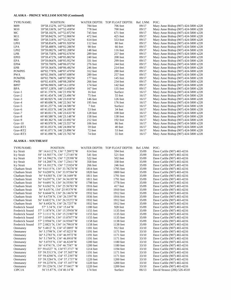
ALASKA – PRINCE WILLIAM SOUND (Continued)
TYPE/NAME: POSITION: WATER DEPTH: TOP FLOAT DEPTH: Ref. LNM: POC:
M09 59°58.152'N, 147°52.008'W 784 feet 706 feet 09/17 Mary Anne Bishop (907) 424-5800 x228 M10 59°58.536'N, 147°52.458'W 778 feet 700 feet 09/17 Mary Anne Bishop (907) 424-5800 x228
MC 59°58.182'N, 147°52.872'W 745 feet 671 feet 09/17 Mary Anne Bishop (907) 424-5800 x228
M11 59°58.842'N, 147°52.866'W 472 feet 425 feet 09/17 Mary Anne Bishop (907) 424-5800 x228 MD 59°58.518'N, 147°53.352'W 614 feet 553 feet 09/17 Mary Anne Bishop (907) 424-5800 x228
LP01 59°58.854'N, 148°01.920'W 112 feet 80 feet 09/17 Mary Anne Bishop (907) 424-5800 x228
LPA 59°58.488'N, 148°02.286'W 98 feet 66 feet 09/17 Mary Anne Bishop (907) 424-5800 x228 LP02 59°59.082'N, 148°02.208'W 148 feet 116 feet 09/17 Mary Anne Bishop (907) 424-5800 x228
LPB 59°58.758'N, 148°02.676'W 289 feet 257 feet 09/17 Mary Anne Bishop (907) 424-5800 x228
EP03 59°59.472'N, 148°05.802'W 240 feet 208 feet 09/17 Mary Anne Bishop (907) 424-5800 x228 EPA 59°59.064'N, 148°05.952'W 331 feet 299 feet 09/17 Mary Anne Bishop (907) 424-5800 x228
EP04 59°59.700'N, 148°06.072'W 276 feet 244 feet 09/17 Mary Anne Bishop (907) 424-5800 x228
EPB 59°59.364'N, 148°06.492'W 246 feet 214 feet 09/17 Mary Anne Bishop (907) 424-5800 x228 POWP05 60°02.778'N, 148°07.470'W 312 feet 280 feet 09/17 Mary Anne Bishop (907) 424-5800 x228
PWA 60°02.394'N, 148°07.698'W 289 feet 257 feet 09/17 Mary Anne Bishop (907) 424-5800 x228
POWP06 60°02.796'N, 148°07.902'W 177 feet 145 feet 09/17 Mary Anne Bishop (907) 424-5800 x228 PWB 60°02.418'N, 148°08.208'W 266 feet 234 feet 09/17 Mary Anne Bishop (907) 424-5800 x228
BP07 60°06.906'N, 148°14.118'W 174 feet 142 feet 09/17 Mary Anne Bishop (907) 424-5800 x228
BPA 60°07.128'N, 148°13.458'W 167 feet 135 feet 09/17 Mary Anne Bishop (907) 424-5800 x228 Grav-1 60˚41.370’N, 146˚23.956’W 16 feet Surface 16/17 Mary Anne Bishop (907) 424-5800 x228
Grav-2 60˚41.454’N, 146˚23.496’W 75 feet 55 feet 16/17 Mary Anne Bishop (907) 424-5800 x228
Grav-3 60˚40.925’N, 146˚23.018’W 146 feet 126 feet 16/17 Mary Anne Bishop (907) 424-5800 x228 Grav-4 60˚40.696’N, 146˚22.561’W 195 feet 176 feet 16/17 Mary Anne Bishop (907) 424-5800 x228
Grav-5 60˚41.257’N, 146˚24.580’W 7 feet Surface 16/17 Mary Anne Bishop (907) 424-5800 x228 Grav-6 60˚41.033’N, 146˚24.109’W 53 feet 34 feet 16/17 Mary Anne Bishop (907) 424-5800 x228
Grav-7 60˚40.811’N, 146˚23.633’W 128 feet 108 feet 16/17 Mary Anne Bishop (907) 424-5800 x228
Grav-8 60˚40.580’N, 146˚23.148’W 158 feet 138 feet 16/17 Mary Anne Bishop (907) 424-5800 x228 Grav-9 60˚40.362’N, 146˚22.692’W 212 feet 192 feet 16/17 Mary Anne Bishop (907) 424-5800 x228
Grav-10 60˚40.970’N, 146˚23.557’W 106 feet 86 feet 16/17 Mary Anne Bishop (907) 424-5800 x228
Grav-RT1 60˚41.053’N, 146˚24.004’W 59 feet 40 feet 16/17 Mary Anne Bishop (907) 424-5800 x228 Grav-RT2 60˚41.071’N, 146˚23.896’W 72 feet 53 feet 16/17 Mary Anne Bishop (907) 424-5800 x228
Grav-RT3 60˚41.090’N, 146˚23.765’W 74 feet 55 feet 16/17 Mary Anne Bishop (907) 424-5800 x228
ALASKA – SOUTHEAST
TYPE/NAME: POSITION: WATER DEPTH: TOP FLOAT DEPTH: Ref. LNM: POC: Icy Strait 58° 14.6112’N, 136° 7.28972’W 614 feet 594 feet 35/09 Dave Carlile (907) 465-4216
Icy Strait 58° 14.5037’N, 136° 7.27185’W 541 feet 521 feet 35/09 Dave Carlile (907) 465-4216
Icy Strait 58° 14.3962’N, 136° 7.25398’W 522 feet 502 feet 35/09 Dave Carlile (907) 465-4216 Icy Strait 58° 14.2887’N, 136° 7.23611’W 358 feet 338 feet 35/09 Dave Carlile (907) 465-4216
Icy Strait 58° 14.1812’N, 136° 7.21824’W 266 feet 246 feet 35/09 Dave Carlile (907) 465-4216
Chatham Strait 56° 9.6115’N, 134° 33.78278’W 1814 feet 1795 feet 35/09 Dave Carlile (907) 465-4216 Chatham Strait 56° 9.6209’N, 134° 33.97584’W 1820 feet 1800 feet 35/09 Dave Carlile (907) 465-4216
Chatham Strait 56° 9.6303’N, 134° 34.1689’W 1811 feet 1791 feet 35/09 Dave Carlile (907) 465-4216
Chatham Strait 56° 9.6397’N, 134° 34.36195’W 1811 feet 1791 feet 35/09 Dave Carlile (907) 465-4216 Chatham Strait 56° 9.6491’N, 134° 34.55501’W 1798 feet 1778 feet 35/09 Dave Carlile (907) 465-4216
Chatham Strait 56° 8.6362’N, 134° 25.56783’W 1916 feet 417 feet 35/09 Dave Carlile (907) 465-4216
Chatham Strait 56° 8.655’N, 134° 25.95379’W 1930 feet 1910 feet 35/09 Dave Carlile (907) 465-4216 Chatham Strait 56° 8.6644’N, 134° 26.14676’W 1932 feet 1912 feet 35/09 Dave Carlile (907) 465-4216
Chatham Strait 56° 8.6738’N, 134° 26.3397’W 1936 feet 1916 feet 35/09 Dave Carlile (907) 465-4216
Chatham Strait 56° 8.6832’N, 134° 26.53272’W 1932 feet 1912 feet 35/09 Dave Carlile (907) 465-4216 Chatham Strait 56° 8.6926’N, 134° 26.7257’W 1932 feet 1912 feet 35/09 Dave Carlile (907) 465-4216
Frederick Sound 57° 3.34’N, 134° 15.64’W 1180 feet 928 feet 35/09 Dave Carlile (907) 465-4216
Frederick Sound 57° 3.1874’N, 134° 15.35938’W 1155 feet 1135 feet 35/09 Dave Carlile (907) 465-4216 Frederick Sound 57° 3.1111’N, 134° 15.21907’W 1155 feet 1135 feet 35/09 Dave Carlile (907) 465-4216
Frederick Sound 57° 3.0348’N, 134° 15.07877’W 1155 feet 1135 feet 35/09 Dave Carlile (907) 465-4216
Frederick Sound 57° 2.9584’N, 134° 14.93847’W 1158 feet 1138 feet 35/09 Dave Carlile (907) 465-4216 Frederick Sound 57° 2.8821’N, 134° 14.79818’W 1158 feet 1138 feet 35/09 Dave Carlile (907) 465-4216
Ommaney 56° 5.4812’ N, 134° 47.0895’ W 1181 feet 912 feet 33/10 Dave Carlile (907) 465-4216
Ommaney 56° 5.3798’N, 134° 47.0233’W 1191 feet 1171 feet 33/10 Dave Carlile (907) 465-4216 Ommaney 56° 5.2783’N, 134° 46.9572’W 1191 feet 1171 feet 33/10 Dave Carlile (907) 465-4216
Ommaney 56° 5.1769’N, 134° 46.8910’W 1191 feet 1171 feet 33/10 Dave Carlile (907) 465-4216
Ommaney 56° 5.0755’N, 134° 46.8249’W 1200 feet 1180 feet 33/10 Dave Carlile (907) 465-4216 Ommaney 56° 4.9741’N, 134° 46.7587’ W 1200 feet 1180 feet 33/10 Dave Carlile (907) 465-4216
Ommaney 55° 59.6327’ N, 134°57.3717’ W 1214 feet 1194 feet 33/10 Dave Carlile (907) 465-4216
Ommaney 55° 59.5313’N, 134° 57.3057’W 1191 feet 1171 feet 33/10 Dave Carlile (907) 465-4216 Ommaney 55° 59.4298’N, 134° 57.2397’W 1191 feet 1171 feet 33/10 Dave Carlile (907) 465-4216
Ommaney 55° 59.3284’N, 134° 57.1737’W 1220 feet 1200 feet 33/10 Dave Carlile (907) 465-4216
Ommaney 55° 59.2270’N, 134° 57.1077’W 1220 feet 1200 feet 33/10 Dave Carlile (907) 465-4216 Ommaney 55° 59.1256’N, 134° 57.0417’ W 1220 feet 1200 feet 33/10 Dave Carlile (907) 465-4216
13PC1A 56˚15.87’N, 134˚40.14’W 174 feet Surface 06/13 David Strausz (206) 526-4510

ALASKA – NORTH PACIFIC OCEAN
TYPE/NAME: POSITION: WATER DEPTH: TOP FLOAT DEPTH: Ref. LNM: POC:
HARP-CB 58˚40.409’N, 148˚00.546’W 2,877 feet 2,779 feet 49/14 Josh Jones (858) 822-1836 HARP-PT 56˚14.635’N, 142˚45.431’W 3,238 feet 3,140 feet 49/14 Josh Jones (858) 822-1836
MFM-A 49˚58.60’N, 144˚14.77’W 13,540 feet 49 feet 24/15 Gabriella Chavez (858) 822-4938
MFM-B 50˚19.82’N, 144˚23.90’W 13,599 feet 49 feet 24/15 Gabriella Chavez (858) 822-4938 GHPM-1 50˚04.79’N, 144˚48.18’W 13, 842 feet 483 feet 24/15 Gabriella Chavez (858) 822-4938


![FB 75_Workshop Manual(E) [03W 2205 R1]](https://img.pdfslide.us/doc/110x75/56d6bd881a28ab30168e5b0e/fb-75workshop-manuale-03w-2205-r1.jpg)