Embed Size (px)
Citation preview

1
Urbanization, Slum Development and Security of Tenure: The Challenges of Meeting Millennium Development Goal (MDG) 7 in Metropolitan Lagos, Nigeria.
Professor Tunde Agbola Department of Urban and Regional Planning, University of Ibadan, Nigeria
Mr Elijah M. Agunbiade Department of Urban and Regional Planning, University of Lagos, Nigeria
Paper presented to the PRIPODE workshop on Urban Population, Development and Environment Dynamics in Developing Countries
Jointly organized by CICRED, PERN and CIESIN
With support from the APHRC, Nairobi
11-13 June 2007 Nairobi, Kenya

2
Urbanization, Slum Development and Security of Tenure: The Challenges of Meeting Millennium Development Goal (MDG) 7 in Metropolitan Lagos, Nigeria. Professor Tunde Agbola Department of Urban and Regional Planning University of Ibadan, Nigeria And Mr Elijah M. Agunbiade Departmant of Urban and Regional Planning, University of Lagos, Nigeria 1. Introduction Lagos, the former national capital of Nigeria, has grown from 1.4 million in 1963 to 3.5 million in 1975. It is currently over 10 million and it is projected to be 24 million by 2020. It is estimated that 606 people enter Lagos per minute but nobody seems to know the number that leaves eventually. Greater Lagos has passed through several phases in its metropolitanization process but three are distinctly discernable: the 19th Century period (extending from 1851 to 1990); the period of rapid growth (1901 to 1950); and the period of metropolitan explosion, that is, the post 1951 period. Consequent upon the population build-up, it is not unexpected, therefore, to observe unusual pressure, leading to unprecedented demand for land. Through the pressure being mounted by the demand for land, it is a common phenomenon to see most `undeveloped land' being taken over by the rural immigrants to satisfy their urban land needs. Such invasion usually lead to uncontrolled and unorganized developments, while such neighborhoods/communities lack basic infrastructural facilities. The rapid rate of development, equally results to overall planlessness of these areas. It has been argued at various quarters that the insecurity of tenure contributed largely to the poor living condition and low standard of living of such residents. Since they are squatters, they do not have any legal title to such occupied land and are thus prevented from taking any mortgage loan from any bank, thus, compounding their problems. Within a short time, such residents create serious social problems to government because it becomes so difficult to either evict them or provide facilities for them. It is against this background that the research on which this paper is based examined the urbanization processes of metropolitan Lagos, its associated festering illegal, slum and squatter settlements, the social, economic and political problems they create and the evolved measures to solving the problems. One of the measures this research examined is security of tenure, its prospects and problems, all with a view to accommodating citizens' participation, access to and security of tenure while providing enabling environment for the enhancement of standard of living of the poor majority and thereby reducing poverty. 2. Conceptual Framework and Literature Review This paper is anchored on the concept of political ecology. According to (Bryant and Bailey,

3
1997), political ecology is the study of the ‘politicised environment’. It is a multi disciplinary investigation that uses the methods of the social sciences in understanding the human processes leading to the destruction and creation of material environments. Bryant and Wilson (1998) thus defined political ecology as ‘the political economy of human-environment interactions. As a conceptual framework, political ecology argues that the outcome in environmental change is determined by the relative powers of agents with conflicting agendas. The agents reflect the scale of analysis. Dietz (1999) identifies two main modes in Third World Political ecology. First, in the eco-imperialist mode, the interests of the first world lead to the creation of environmental regimes, under the framework of ecological modernisation, and often under the label of sustainable development. He identifies eco-populism as the second major mode of thought and action. All of these have effects on how the environment is used, who uses it, when and with what effects. These necessarily entail analyses relating to those on the margins of the society and environment and how to eventually ensure environmental sustainability. For example, Jusilla et al. (1999) found that the process of marginalisation has been investigated for some 25 years although there is not yet an operational definition of the term (Jusilla et al., 1999). The concept of marginality, which can be applied to people and environments, illuminates restrictions in marginal people's options in the management of sensitive environments (Blaikie, 1985). That marginal people are condemned to make their living in marginal environments, whether rural or urban, is perhaps the essential truth of political ecology. With the exception of those who deliberately marginalise themselves through criminality, marginal people are unlikely to have access to resources needed to overcome the restrictions imposed by marginal environments and so enable themselves to live beyond the limits of subsistence. Thus, marginality reinforces and reproduces itself and further makes environmental sustainability difficult. The goal of environmental sustainability is to minimize Environmental degradation which is the damage to the biosphere as a whole due to human activity. Environmental degradation occurs when: nature's resources (such as trees, habitat, earth, water and air) are being consumed faster than nature can replenish them; when pollution results in irreparable damage done to the environment or; when human beings destroy or damage ecosystems in the process of development. An unsustainable situation occurs when natural capital (the sum total of nature's resources) is used up faster than it can be replenished. Sustainability requires that human activity, at a minimum, only uses nature's resources at a rate at which they can be replenished naturally. Theoretically, therefore, the long term final result of environmental degradation would result in local environments that are no longer able to sustain human populations to any degree. Such degradation on a global scale would, if not addressed, mean extinction for humanity. In the short-term, environmental degradation leads to declining standards of living, the extinctions of large numbers of species, health problems in the human population, conflicts, sometimes violent, between groups fighting for a dwindling resource, water scarcity and many other major problems. These have been ably captured in contemporary literature especially as they relate to urban population living at the edge of society in illegal, informal and festering slums where the urban environment is being actively degraded and urban life and urban living made increasingly precarious. The literature on informal housing and land development has grown considerably in the last decade. The research on the economic, social, and political forces that generate and sustain the formation of informal settlements or slum is abundant. These include the works of Payne (1989), Satterthwaite et al (1989), Archer (1992), Rakodi et al (1993), Kombe (1992), Rakodi et al (1993),

4
Durand- Lasserve (1996), UNCHS Habitat (1996), and Kombe and Kreibich (2000). The discussion on security of tenure, land law and illegality in the context of urban development has gathered momentum in recent years, especially since the Habitat Agenda stressed the central importance of urban land. This complex legal-political debate has serious socio-economic implications at the global, regional and local levels especially as they relate to the various tenurial systems around the world. The land tenure system, like other forms of tenure and ownership, is seated in antiquity (Acquaye, 1973). The current land tenure patterns in most parts of the world maintain most of ancient customs. Land in most of Africa, for example, has economic, religious and political connotations. Asabere (1994) points out that land as an economic asset, is the most important input in subsistence agriculture and for the production of housing . In a religious sense, the land also ties the dead to the living and to the yet unborn in a perpetual fellowship. This requires the living to honor ancestral heritage by preserving the land and so manage it for the benefit of future descendants. Politically, land expresses territorial sovereignty. It supports the chieftaincy regime economically and enjoins the chief to protecting the ancestral stool. Doebele (1983) has defined four policy objectives by which land tenure systems may be judged. These are: Efficiency (Does the system encourage a smoothly operating land market?); Equity (Does the system provide reasonable access for all income groups to land for housing and other needs?); Compatibility (Does the tenure system integrate well with other laws and policies regarding land such as planning, taxation and provision of public services?); Continuity (Does the system integrate well with the cultural, social and political heritage of the country?). Efficient functioning of land markets requires efficient and updated land registration systems which clearly indicate legal ownership of land. The market attaches great importance to legal titles to land. Hernando de Soto (1996) asserts that “during President Fujimori's administration, registered titles to over 300,000 plots of land were awarded. Production on these titled properties has risen by about 40% compared to properties which were not titled and registered. About 25% of the owners now have access to bank credit since they can use the titles to guarantee their bank loans. There have been major problems with cadastral coverage in sub Saharan Africa, which in turn, means that the land information is inadequate for land administration, planning etc., especially for informal settlement areas. A review of the cadastral and Land Information Management systems in sub Saharan Africa (UNECA,1998), using the best data available, indicates that:- There is no documentary evidence of title for up to 90 percent of the parcels in developing countries, with an estimated less than 1 per cent of sub-Saharan Africa being covered by any kind of cadastral survey (UNCHS:1991:3, 1990:4); Cadastral systems, generally in manual form, and with incomplete coverage, are supplying most of the available land information. No alternative source of comprehensive information for land management has been developed (Okpala:1992; UNCHS:1991). This means that land information is probably only available for 10 percent of the area of most developing countries, and 1 percent in Sub Saharan Africa. Available land information often relates only to the part of the city or rural area where formal legal procedures were used for planning (UNCHS:1998:4). Yet most decisions need to be made about the informal and/or customary parts of the country, which are not covered by the cadastre (Okpala,1992). It is not surprising, therefore, that most unoccupied lands are deemed to have no owners especially by the hard-pressed, land hungry poor immigrants who need to attach themselves to the city at all costs. But the key question is, why do people squat? There are two reasons for this: one is internal to

5
the squatter, and the other is external. Internal reasons include: lack of collateral assets; lack of savings and other financial assets; daily wage/low-income jobs (which, in many cases, are semi-permanent or temporary). External reasons include: high cost of land and other housing services; apathy and anti-pathy on the part of the government to assist them; high "acceptable" building standards and rules and regulations; lopsided planning and zoning legislation (Srinivas Hari,1991). In 2007, for the first time in history, the majority of people will live in urban areas. Throughout most of the developing world, this will result in larger slum populations. Sub-Saharan Africa is the world’s most rapidly urbanizing region and almost all of this growth has been in slums, where new city residents face overcrowding, inadequate housing, and a severe lack of water and sanitation. In Western Asia, as well, most of the urban growth is occurring in slums. The rapid expansion of urban areas in Southern and Eastern Asia is creating cities of unprecedented size and complexity and new challenges for providing a decent environment for the poor. Northern Africa is the only developing region where the quality of urban life is improving. In this region, the proportion of city dwellers living in slums has decreased by 0.15 per cent annually (UN-DESA, 2006) The totality of all evidences in this review with regards to informal and land occupation and or the growth and development of squatter settlements point to the problems of insecurity of tenure. Accordingly, various authors have provided information on the origin, growth of slums and squatter settlements and have also proffered measures to curtail them. One of these is security of tenure. This paper is an explanatory analysis of slums and their development in Lagos and the quest to use security of tenure to curb its growth. 3. Explanatory Profile of the Study Area Nigeria, with a land area of close to 1 million square kilometers, and a population of well over 125 million, has 43.5% of its population living in urban areas in the year 2000, up from 39% in 1985, with projections that the urban population will reach 50% by the year 2010, and 65% by 2020. The rate of urban population growth is thought to be 5.5% annually, roughly twice the national population growth rate of 2.9%. More than seven cities in Nigeria have populations that exceed 1 million, and over 5,000 towns and cities of various sizes have populations of between 20,000 and 500,000. Lagos is an African megacity which is located in southwestern Nigeria on the West Coast of Africa and situated within latitudes 6o 23′N and 6o 41′N and longitudes 2o 42′E and 3o 42′E. The State, in which the city is located, is flanged in the north and east by Ogun State, in the west by the Republic of Benin and the south by the Atlantic Ocean/Gulf of Guinea (Fig.1). The total landmass of the State is about 3,345 square kilometres, which is just about 0.4% of the total land area of Nigeria. It is physically the smallest but the most populated state in the country with an estimated population of about 10 million inhabitants which is about 10% of the total population of Nigeria, Africa’s most populous country. Water is the most significant topographical feature in Lagos State as water and wetlands cover over 40% of the total land area within the State and an additional 12% is subject to seasonal flooding. The climate is the wet equatorial type influenced by nearness to the equator and the Gulf of Guinea. There are two main seasons, namely; the rainy season and dry season, which usually lasts from April to October and October to March respectively. The city of Lagos has expanded dramatically since the colonial era, when it became the administrative headquarters of the country. Its geographical location has fostered the development of trade within its

6
hinterland as well as with the neighbouring international communities. Expectedly, the rate of growth had been spectacular in recent times. 4. Research Methodology The study adopted a case study research methodology design because it allows for the establishment of unique characteristics of the population and the ability to develop detailed profile and intensive knowledge of the study area. Most importantly, this design is adopted to further explore earlier studies conducted by the United Nations Development Programme (UNDP,1980], SNC-Lavalin [1995] and Stoveland Consult [2003] with a view to gaining richer insight into the characteristics of the squatters and their tenural status. Two principal data types – spatial and attributes – were considered for the study. These were elicited from the primary and secondary sources. An extensive reconnaissance survey of the revised 41 out of the 42 blighted areas identified by UNDP was carried out. This was complemented by the aerial photographs, topo-planning maps and photo mosaic of the study area for comprehensive trend analysis of the spatial pattern of development over time. Based on the reconnaisance survey of 41 identified areas, ten (10) areas with preponderance of squatters were identified by this study using the following indicators of urban blight: Tenancy, Availability of facilities and environmental issues. These areas are: Makoko, Badia, Ilaje, Ijora Oloye, Iwaya, Ajegunle, Sari – Iganmu, Amukoko, Okobaba (3rd Mainland Bridge) and Ogudu Village (Fig.2). Eventually, 407 questionnaires were administered in the centrally located areas and 176 in peri-linear stretch at the edge of Lagos Lagoon for a total of 583 questionnaires administered in all the selected communities. The analysis of data was greatly enhanced by the descriptive analysis as well as quantitative and inferential analyses of the data. For instance, all the attributes or indicators of urban blight were considered and analyzed for each category of the blighted areas. In addition, logical and practical reasons were adduced for the pattern of occurrence that were observed.

7
Source: SNC Lavalin Report
Alimosho
Agege
Ikeja
Somolu
Kosofe
Ifako-Ijaye
Ota
Osodi Isolo
Mushin
Emuren
Ogijo
Ikorodu Town
Igbogbo
Ojo Amuwo OdofinBadagry
Ajeromi IfelodunApapa
Lagos Island
Surulere
Lagos Lagoon
Eti Osa
Ikorodu
IjokoMowe/Ibafo
Ifo
O G U N S T A T E
O G U N S T A T E
8000m400004000
Legend
Built Up Area
Water Body
Expressway
Tarmac/ Runway
State Boundary
Railway
Local Govt. Boundary
Major Roads
40
1 19Maroko Okobaba
34
2923
12 1318
2430
1935
37
33
38
83
14415
11
222 41
1
39
28
5
19106
2
2 20Olaleye-Iponri Ayetoro
3 21Makoko Alli-Aromoko
4 22Badia Lagos Island
5 23Ilaje Ogba West
6 24Ijora-Oloye Oregun
7 25Ipodo-Ikeja Ijesatedo/Itire
8 26Iwaya Shomolu
9 27Abule-Ijesa Bariga
10 28Otto Oworonsoki
11 29Ajegunle Orile Agege
12 30Agege Olusosun
13 31Agidingbi Mile 12 Market
14 32Sari-Iganmu Ikorodu
15 33Makoko Ejigbo
16 34Mushin-Idiaraba Iju
17 35Shogunle Oshodi Market Area
18 36Alausa Village Lawanson-Ikate
31
37 Onigbongbo
38 Egbe/Bolorunpelu
39 Ogudu Village
40 Ipaja
41 Obalende
42 Marine Beach
B l i g h t e d Areas
32
L A G O S MEGA CITY REGION
27
550,000E540,000E530,000E520,000E 560,000E
750,000N
740,000N
730,000N
720,000N
710,000N
510,000E

8
5. Research Results Socio–Economic and Political Dimensions of Slum Development in the Selected Areas Based on the reconnaisance survey of 41 blighted areas, ten (10) areas with preponderance of squatters were identified by this study using the following indicators of urban blight: Tenancy, Availability of facilities and environmental issues. Four of the ten areas were then selected; Ajegunle, Ijora Oloye, Makoko and Ogudu Village for in-depth study. This section analyses the socio-economic characteristics of the selected areas. 5.1.1 Ajegunle Ajegunle is located in Ajeromi Ifelodun Local Government Area. The site is a major slum, often described as ‘jungle city’ with a multi-ethnic population of 156,000 (baseline projection of 1995). It is the most populated slum in Lagos State. Using the population growth rate of 7.5% for Lagos State, the population of Ajegunle is projected to be 258,811 in 2002 and 345,634 in 2006. However, the Local Planning Authority reworked the population estimates for Ajegunle to 500, 000 based on occupancy rates, tenement rates and rateable properties in the blighted area. Fig. 3: Topo-Planning Map of Selected Blighted Area of Ajegunle Source: SNC Lavalin Report, 2005 Ajegunle has a population density of 750 per hectare (the highest of all slums, just like Badia). The area of Ajegunle identified as slum (Fig 3) constitutes 12.8% of the total area of all 42 blighted areas as at 1995. According to Stoveland Consult, WTP Study of 1997, majority of the multi-ethnic population of Ajegunle are of school age and highly, economically productive with average household income of about N14,815, higher than six of the nine blighted areas. Table 1: Occupational Status (Ajegunle) Occupational Status Frequency Percent
Civil Service 34 9.2 Trading 199 53.8 Farming 6 1.6 Fishing 2 0.5 Others 129 34.9
Ajegunle
9
Total 370 100 As earlier observed, majority of the people occupying this place are engaged in trading as well as other informal activities, such as carpentry, brick laying and art works among others. This is not surprising, since the area is dominated by poor immigrants, characterised by the informal activities that is uniquely associated with the low income groups. Table 2: Monthly Income Level (Ajegunle) Monthly Income Frequency Percent
Less than N10000 171 47.8 N10000 - N20000 130 36.3 N20001 - N40000 33 9.2 N40001 - N60000 16 4.5 N60001 - N80000 8 2.2 Total 358 100
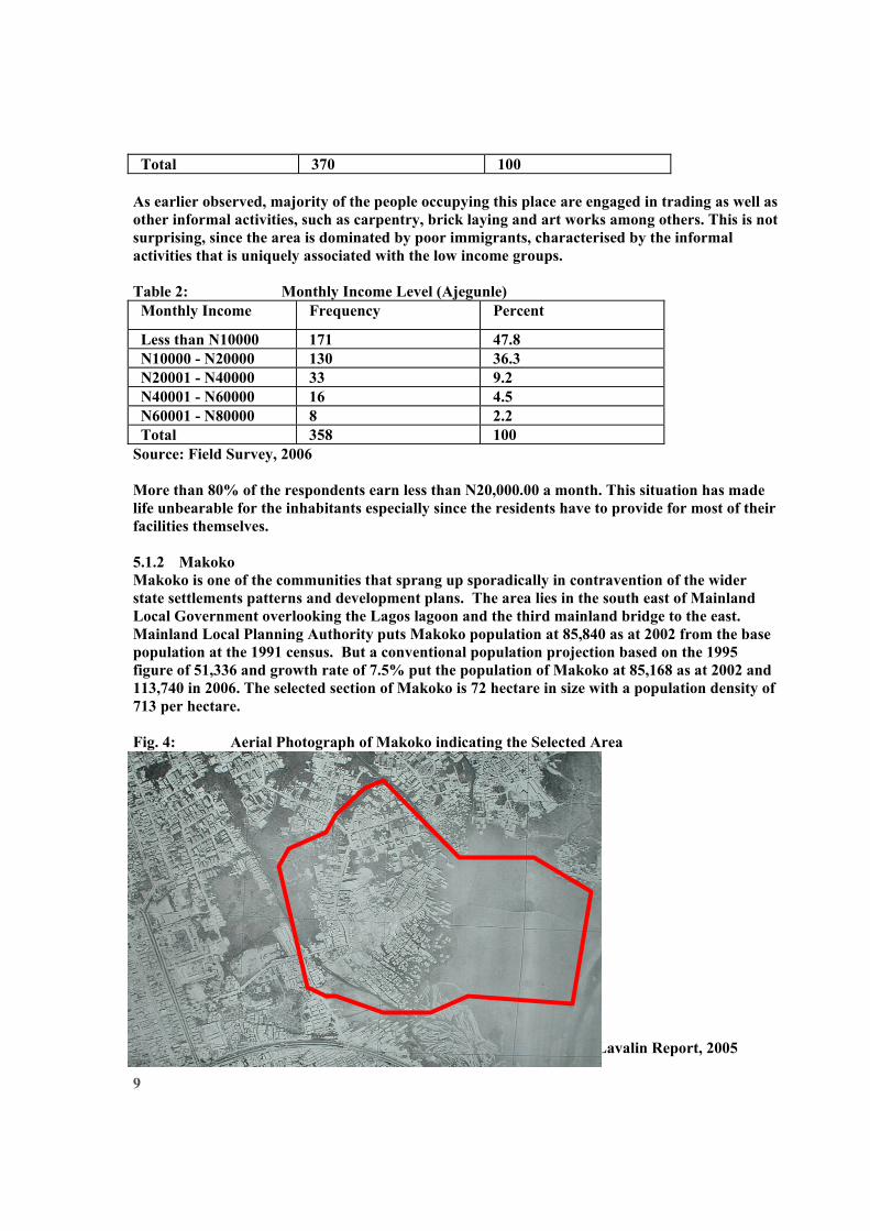
Source: Field Survey, 2006 More than 80% of the respondents earn less than N20,000.00 a month. This situation has made life unbearable for the inhabitants especially since the residents have to provide for most of their facilities themselves. 5.1.2 Makoko Makoko is one of the communities that sprang up sporadically in contravention of the wider state settlements patterns and development plans. The area lies in the south east of Mainland Local Government overlooking the Lagos lagoon and the third mainland bridge to the east. Mainland Local Planning Authority puts Makoko population at 85,840 as at 2002 from the base population at the 1991 census. But a conventional population projection based on the 1995 figure of 51,336 and growth rate of 7.5% put the population of Makoko at 85,168 as at 2002 and 113,740 in 2006. The selected section of Makoko is 72 hectare in size with a population density of 713 per hectare. Fig. 4: Aerial Photograph of Makoko indicating the Selected Area Source: Kentina Earth Sciences International Canada, 1981 in SNC Lavalin Report, 2005
10
Average household income in Makoko is N15,773 per month. It was also observed that majority of them are engaged in informal activities and are generally within the low income bracket. Table 3: Monthly Income Level (Makoko) Monthly Income Level Frequency Percent Less than N10000 55 34.0 N10000 - N20000 79 48.8 N20001 - N40000 19 11.7 N40001 - N60000 9 5.6 Total 162 100.0
Dominant occupation of Makoko residents are fishing and trading (Fig.5). There are also many unemployed persons, especially the youths who are virtually dependent on their families. Fig. 5: Occupational Status of Selected Area of Makoko
8
56
63
35
0
10
20
30
40
50
60
70
Civil Service Trading Fishing Others
Occupation
Freq
uenc
y
The community is divided into two, the northern part constituting the major part, lies an area that can be said to represent the area of “Houses on the lagoon” (Plate 1). In the south, along the southern part of the lagoon and along a collector road (Plate 2), lies a smaller area. The access to this area is different from the access to the lagoon area, and the two parts are accordingly somewhat separated. Taken together, the land and water areas will be referred to as the Makoko community.

11
Plate 1: Stilt Constructions on Lagos Lagoon at Makoko. Access is through Canoe and Footbridges. Note the Burnt Structure at the Background. This is one of the Common Hazards in the Area.
Plate 2: Panoramic View of Stilt Constructions on Lagos Lagoon at Makoko. Photograph taken from the 3rd Mainland Bridge. 5.1.3 Ijora Oloye Ijora Oloye is located in Apapa Local Government Area. The site is one of the identified slums in Lagos metropolis and ranked 15th position by SNC Lavalin in 1995 after an extensive reconnaissance survey of all the identified slums in Lagos. This ranking was based on refinement of earlier assessments of UNDP in 1985. Also included in the new ranking was the population density and area coverage.

12
Fig 5.2: Selected Part of Ijora Oloye Source: SNC Lavalin Report, 2005 Ijora Oloye has a population density of 738 per hectare. Using the population growth rate of 7.5% for Lagos State, the population of Ijora Oloye is projected to be 14,716 in 2006, from the base population of 6,642 in 1995. However, the Local Planning Authority reworked the population estimates for Ijora to 20, 000 based on occupancy rates, tenement rates and rateable properties in the blighted area. The area of Ijora identified as slum is 9.0 hectares. The dominant occupation of residents is trading. However, significant proportion of people are civil servants. This may be traceable to the location relative to Central Business District of Lagos Island and Victoria Island. 5.1.4 Ogudu The selected area of Ogudu lies in the eastern part of Kosofe Local Government area, parallel to the third mainland bridge and overlooking the Lagos lagoon to the east. SNC Lavalin’s report put Ogudu population at 5,104 in 1995. A conventional population projection based on this figure at the growth rate of 7.5% put the population of Ogudu at 11,308.468 in 2006. The selected section of Ogudu is 9.0 hectares in size with a population density of 638 per hectare.
Ijora Oloye

13
Fig. 7: Selected Blighted Area of Ogudu Source: SNC Lavalin Report, 2005 The major source of water is through deep well and few bore holes available, while the water is made available for domestic use mostly through tankers. There are few noticeable refuse collection points. Majority of the households sampled in Ogudu, especially those along the Lagoon said they use the marshes as dumping places for the refuse they generate. This, to them, is to reclaim the marshy area.
Plate 3: Refuse Dumps on Swampy Areas Source: Field Survey, 2006
Ogudu G
Ogudu
3rd Mainland

14
5.2 Land Tenure Systems in the Study Area A common landholding pattern in the identified squatter settlements is that, the land is owned by one large landowner, often a family. For instance, Olaiya Family – Makoko; Ojora Family – Ijora, Badia and Amukoko; Oloto Family – Iwaya and Okobaba. Substantial portion being occupied today were procured from these families as claimed by the residents [both landlords and tenants]. 5.3 Appraisal of Land Administration Processes 5.3.1 Land Title Registration Most of the ills of traditional tenure found in the literature can be traced to or stem from tenure insecurity due to uncertainty of ownership and litigation. The registration of title to land means the entry in the folio of the land register the various interests in the land entitled to a person. Though mere entry in the records does not guarantee title, when land registration is properly implemented, uncertainty of ownership is remedied and litigation is minimized. In Lagos State today, there are two conventional and three special approaches for someone to register his/her interest in land. The first is through Certificate of Occupation (C of O) dully signed by the governor and the second is Governor’s consent. Certificate of Occupancy The vesting of all lands in the State as stipulated by the Land Use Act (LUA) of 1978 should not be taken as meaning that private interests in land have been abrogated. The Act allows citizens to hold an interest called a Right of Occupancy, which may be statutory or customary. It is statutory when it is granted by the Governor, and customary, when it is granted by the Local Government in a rural area. Governor’s Consent According to section 22 of the LUA, “It shall not be lawful for the holder of a statutory right of occupation granted by the Governor to alienate his right of occupancy or any part thereof by assignment, mortgage, transfer of possession, sublease or otherwise howsoever without the consent of the Governor first has and obtained;” There are three categories of special title registration programmes slightly different from the conventional registration programmes in Lagos State today as discussed above. These are; Village Excision, Ratification and Private Developer Scheme. The forth category is the newly approved registration programme for the identified blighted areas, that are being declared “special district”, Village Excision Most often, the state Government embarks on massive land acquisitions, especially rural undeveloped lands, with the primary intension of making lands available to the state for future use. In the process, some smaller settlements or villages are acquired and described with the acquisition. However, most of the time, the land acquired are not put to immediate use within a reasonable period of time. The natural increase in population in such rural areas tends to increase the demand for land. In order not to encourage illegal development, government may need to excise certain portions of land within the immediate vicinity of the existing settlements so that such land will be made available for development by the villagers.

15
Ratification In some instances, the land so acquired are closer to the existing urban development and as developments extend towards the periphery, the hitherto undeveloped but acquired land is exposed to urban development, most often due to the rapid rate of urbanisation. As a result, such acquired land appreciates in value and the original land owners start to encroach by selling to prospective developers. The situation most often gets out of hand and government may not be able to reverse the trend of development. In order not to further encourage illegal development especially, when government has not committed any form of investment in terms of physical development, those who have encroached are requested to pay certain fees and such land becomes available legally. They can thus apply for legal documentations especially building plan approval. While those who have developed and could not get building approval as a consequence of the acquisition may now be free to apply for approval and the orderly development of such areas can therefore be effected. Private Developer Scheme Another form of titling is achieved through the Private Developer Scheme. Through this, certain corporate organisations, especially those with more than twenty five staff members are given large tract of land to develop in form of staff housing scheme. On the other hand, Multi national companies are allocated large parcel of land to develop on ‘site and services’ bases while some may consider the option of outright construction and sale to any interested members of the community. Special District Programme The only form of title registration applicable to the selected communities in this paper, that is the slum dwellers, is the title registration for “special district”. However, available information show that the degree of awareness of this form of titling programme is directly correlated with the level of involvement and response of the Community Development Association (CDA) at joint meetings with the Ministry of Physical Planning and Urban Development. The commissioner attested to this fact when he confirmed at one of such meetings as reported by the chairman of Makoko CDA, that some of the CDAs are not fully participating in the participatory programme geared toward the improvement of the quality of life of people living in the blighted areas. It should be noted, however, that effective implementation of this programme is subject to acquisition of these blighted areas, while due compensation is paid to the affected family. Through this, government can take possession and later allocate titles to the present occupants. 5.3.2 Land Procurement Direct interview revealed that very few of the plots in the study areas were on outright sale, but rather, it was on leasehold bases. By this arrangement, the occupants will have to pay annual rent to the land owners, in this case, the family representatives. A sizable proportion of the occupants agreed that they moved in and occupied the space without the consent of land owners (Self acquisition). This is prevalence in Makoko, especially areas on the lagoon (this portion of the site belong to the federal government) and spaces along the canal at Ajegunle. Few transfer of land from previous occupants was also observed. The present occupants claimed they got the (already occupied and developed) land from their relatives who were original occupants that had already left the neighbourhood to reside in other parts of the metropolis. There are instances where the community – in this case, the major ethnic group found in the areas has a collective leasehold title, and sub lease to their group members. This arrangement was observed in Makoko, where three major dominant groups were identified. These groups are; the Ilajes, the Eguns and the Ijaws. Table 4: Land Procurement

16
Ajegunle Makoko Ijora Ogudu How did you get the Land? f % f % f % f %
Government 4 2.1 6 7.1 - - - - Community (Major ethnic Groups)
16 8.2 8 9.5 6 75.0 2 25.0
Family (Omo Onile) 93 47.7 48 57.1 1 12.5 4 50.0 Transfer from previous Occupants
35 17.9 6 7.1 - - 1 12.5
Self Acquisition 20 10.3 10 11.9 1 12.5 - - Purchased from Vendor 27 13.8 6 7.1 - - 1 12.5 Total 195 100.0 84 100.
0 8 100.0 8 100.
0 The case of Ogudu village is, however, slightly different from that of Makoko. Despite similar characteristics, it was discovered that land value had gone up astronomically from less than N50, 000 in 1998 to about one million Naira in 2006. This may be attributed to the nearby Ogudu foreshore scheme being embarked upon by the state government. Table 5: Neighbourhood Environmental Condition at the Point of Occupation
Ajegunle Makoko Ijora Ogudu Neighbourhood Condition at the Time of Occupation f % f % f % f %
Yes 64 74.4 12 14.3 4 50.0 2 25.0 No 22 25.6 72 85.7 4 50.0 6 75.0
Accessible and Well Drained Total 86 100.0 84 100.0 8 100.0 8 100.0
Yes 75 62.0 54 64.3 6 75.0 6 75.0 No 46 38.0 30 35.7 2 25.0 2 25.0
Accessible and Marshy
Total 121 100.0 84 100.0 8 100.0 8 100.0 Yes 76 67.9 12 14.3 7 87.5 2 25.0 No 36 32.1 72 85.7 1 12.5 6 75.0
Largely Occupied
Total 112 100.0 84 100.0 8 100.0 8 100.0 Source: Field Survey, 2006 The study has revealed that; Ajegunle was largely accessible but marshy and poorly drained, while Makoko was largely inaccessible and at the same time marshy and poorly drained. However, Ijora and Ogudu were fairly accessible and drained. On the other hand, Ajegunle and Ijora were largely occupied while Makoko and Ogudu were fairly occupied, this perhaps suggests that, development at Makoko and Ogudu were more recent than that of Ajegunle and Ijora (Table 5) 5.4 Assessment of Security of Tenure

17
5.4.1 Legal Title The largest proportions of building owners in the selected settlements do not have any form of title while only very few have legal title as revealed in Table 6. Table 6: Availability of Legal Title
Ajegunle Makoko Ijora Ogudu Legal Title f % f % f % f % Yes 42 21.5 6 7.1 1 12.5 2 25.0 No 153 78.5 78 92.9 7 87.5 6 75.0 Total 195 100.0 84 100.0 8 100.0 8 100.0
Source: Field Survey, 2006 However, several factors may be attributed to this. Perhaps, the most important one being the land tenure and land administration process as earlier presented in the preceding sections of this paper. Table 7: Reasons for Not Having Legal Title
Ajegunle Makoko Ijora Ogudu Reasons for not having Legal Title f % f % f % f % Not interested 10 5.1 14 16.6
7 - 1 12.5
Will soon relocate 43 22.1 2 2.38 2 25.0 1 12.5 Not aware of the implications 52 26.7 12 14.2
9 2 25.0 2 25.0
Too expensive and laborious 90 46.2 56 66.67
4 50.0 4 50.0
Total 195 100.0
84 100.0
8 100.0
8 100.0
Most of the respondents claimed that the process of obtaining legal title is expensive and laborious. The major form of title known to most of them is the building plan and land registration and even then, most of them do not have these documents (Table 8). However, it could be inferred from the interview conducted that, most of the respondents are not just bordered about legal title, given the fact that they are conscious of the quality of the buildings and the general environment. When the process is measured against the anticipated benefits of such exercise, they perhaps consider it not worth the efforts. Table 8: Approved Building Plan as a means of Documentation of Title
Ajegunle Makoko Ijora Ogudu Approved Building Plan f % f % f % f % Yes 74 37.9 48 57.1 3 37.5 No 121 62.1 36 42.9 7 100.
0 5 62.5
Total 195 100.0
84 100.0 7 100.0
8 100.0
Some of the residents as indicated in Table 8 claimed they have approved building plans. However these claims were refuted by the government officials in the ministry. According to them, records of approved building plan in Lagos indicated that more than 65% of buildings in

18
Lagos have no building plan. The assessment of the claims and counter claims when viewed against the total number of buildings as well as the proportion of the buildings in the blighted areas of Lagos metropolis have shown that the two claims may not be absolutely correct. There are indications that records of all the approved building plans are not properly kept, just as most of the residents of the blighted areas are equally making spurious claims probably to impress observers that they have proper documentation in deliberate attempts to conceal facts of their tenure status. 5.3.2 Access to Credit Facilities The overwhelming majority of the respondents in the study area assert that they always have difficulty in accessing credit facilities especially from the banks. As shown in Fig.6, more than 75% across all the selected area have difficulty in accessing credit facilities. However, special funds are made available to assist these people by government. Unfortunately, as claimed by the residents, most often, such monies end in the pockets of government officials who are directed to disburse it. For instance, fishing nets are always procured for distribution to the peasant fish farmers for their economic empowerment. Most times, these nets do not get to the target groups. Majority perhaps get credit facilities from their privately organized Thrifts and Cooperative Societies, where their savings serve as collateral. Fig. 6: Access to Credit Facilities
154 66 67
41 18 21
0%
10%
20%
30%
40%
50%
60%
70%
80%
90%
100%
Ajegunle Makoko Ijora Ogudu
Difficulty in Accessing Credit Facilities
Freq
uenc
y
Yes No
Discussion Some of the findings of the research show that: About two-thirds of the city population currently live in slums; Most of the developable land in the selected areas have been greatly developed and urbanized, and that the residual pockets of mash and poorly drained plots are rapidly being filled and developed; Existing land registration process, which involves payment of several fees, documentation, and the engagement of professioners, is clumsy, tedious, time consuming and expensive to execute; tenure status in the study area had a major impact on poverty and the overall environmental quality as threat of forced eviction pre-disposes residents to negative attitude towards improving their environment. Insecurity of tenure deters investment, since the

19
residents do not have access to mortgage facilities from bank, because of lack of collateral security for such loans. They are thus poor because they are poor. The interplay of all these factors have perpetually kept these groups of people in a vicious circle of poverty and insecurity. 7. Recommendations and Conclusion This study is and eye opener to the policy makers and all stakeholders in the city of Lagos. It is apparent that urbanization and its attendant processes are parts of the modernization processes and thus, they may not be stopped. However, its socio-economic and other deleterious environmental consequences must be curtailed. Accordingly, all the major stakeholders in the city should be identified and brought together in a forum, to develop a vision of how to regularize the city's informal settlements and develop an inclusive city for all its citizens. This is to be preceded by a land audit in order to assess the legal status of the land that is occupied by informal settlements. It has to be ascertained whether the land is in public or private ownership or both while the legal status of ownership must be ascertained. As being recommended by the Lagos State Urban Renewal Authority, all the identified blighted area should be declared and designated as special zones or districts for regularization. Land administration should also include the creation of a land information system, shared by the community and the local authority, both to increase the individuals' security of tenure, as well as to build information for the planning and servicing of the community. In this connection, however, the importance of respecting local cultures and traditions in developing systems for registration of rights to land should be emphasized. Legislation and systems should, wherever relevant, facilitate the granting of title to groups or families as well as to individuals. Accordingly, the LUA should be reviewed to accommodate the realities of the present situations. Finally, newly commissioned automated registration scheme should be implemented in a sustainable manner, moreso that land information forms the basis for any registration or titling programme. It is believed that if the right procedures are followed by the state Ministry of Lands and Survey, it will only be a matter of time before the full impact of the land registration is realized. Even, if Land Title Registration does not result in all or most of the benefits described in the literature or anticipated in reality, ensuring certainty of title to ownership, minimizing or eliminating litigation, and reducing the number of socially disruptive land disputes will be adequate enough reason for implementing a reliable land registration in Lagos. References .Agbola, Tunde (2005) “The Opportunities and Challenges of the Millenium Development Goals (MDGs) for Lagos Megacity” Lead Paper Presented at the 2005 World Habitat Day Held at the

20
Lagos State Government Auditorium, Alausa, Ikeja on the 25th Of October. Agbola, Tunde, (2006), “Urbanization, Physical Planning and Urban Development in West Africa” Paper Presented at the Agenda Setting Workshop of the Commonwealth Association of Planners (CAP) 2006 World Planners Congress, Held Between 14th & 15th November, at the Millenium Hotel, Abuja Agbola, Tunde, (2006) “Sustainable Urbanization: Reflections of African Planning Professionals on the Growth and Devlopment of African Cities” Commissioned Paper by the Nigerian Institute of Town planners (NITP) for Presentation at the WPC/WUF in Vancouver, Canada, June. Agbola, Tunde, (2006), “Sustainable Approach to Slum Prevention in Nigeria: Opportunities, Challenges and Strategies”, Key Note Paper Presented at the Second House of Representatives’ Committee on Habitat on Sustainable Slum Upgrading in Urban Areas and Held at the Shehu Yar’adua Center, Abuja, 25-27 October Acquaye, E. and M. C. Murphy (1973). Land Use, Land Tenure and Agricultural Development in Ghana. Rome, FAO. Archer, R (1992) “Guided Land Development (GLD) in Indonesia”. TRIALOG, Vol II pp 22-25 Asabere, P. K. (1994) “Public Policy And The Emergent African Land Tenure System: The Case Of Ghana”. Journal of Black Studies 24(3): 281-290. Bryant, R.L. and Bailey,S. (1997). Third World Political Ecology, Routledge, London and New York. Bryant, R.L. and Wilson, G.A.(1998). “Rethinking Political Ecology”. Progress in Human Geography, Vol. 22, 321-343. De Soto, Hernando. (2000) The Mystery of Capital. London: Bantam Press. Dietz, T. (1999) “Political Environmental Geography of the Tropics”. Development, Vol. 42.2, 13-19. Doebele, William A., (1983) Land Readjustment . New York, D.C. Heath and Company. Doebele, William A. (1987) "Land Policy", in Rodwin, Lloyd eds., Shelter, Settlement and Development , Hemel Hempstead, United Kingdom, Unwin Hyman Ltd.pp 65-79 Durand Lasserve, A., (1998) “Trends and Issues”, in E.Fernandes and A. Varley (eds.), Illegal Cities Law and Urban Change in Developing Countries, Zed, London. Hari Srinivas(2005) “Urban Squatters and Slums Defining Squatter Settlements”. www/gdrc.org/uem/squatters/squatters.html Hernando de Soto (1996) “Securing Property Rights”. Economic Reform Today Property Rights and Democracy . Number 1, An interview with by the Center for International Private Enterprise. Jusilla, H., Leimgruber, W. and Majoral, R. (1999) Perceptions of Marginality: Theoretical Issues and Regional Perceptions of Marginality in Geographical Space. Ashgate, Aldershot.

21
Kombe, W. J (1997) “Community Based Land Regularisation-Prospects for Decentralised Planning”. TRIALOG 4, pp 27-31 Kombe, W.J and Kreibich, V (2000) “Informal Land Management in Tanzania”. SPRING Research Series 29. Dortmund. Mabogunje, Akin L (1990) “Perspective on Urban Land and Urban Management Policies in the Sub Saharan Africa”. World Bank Technical Paper No. 196, The World Bank, Washinton D C pg 33 Mabogunje, A. L. (2002) “Nigerian and the Good Urban Governance Campaign”. The Launching of the Global Campaign for Good Urban Governance in Nigeria. Federal Ministry of Works and Housing, Abuja, Nigeria. Okpala, D.C.I., (1992) “Land Survey And Parcel Identification Data For Effective Land Management”. Land Use Policy, Vol. 3, pp 92-98. Rakodi, C et al (1993) Managing Fast Growing Cities. A new Approches to Urban Planning and Management in the Developing World. Longman, New York Satterthwaite, D et al (1989) Squatter citizen, Life in the Urban Third World. Earthscan Publication. London. Srinivas, Hari (1991), "Viability of Informal Credit to Finance Low-Income Housing: Case Study of Three Squatter Settlements in Bangalore, India" Masters Thesis Report. Bangkok: Division of Human Settlements Development, Asian Institute of Technology. UNCHS (Bestpractices) (1999) www.bestpractices.org (data = base). UNCHS (Habitat Agenda) (1996) The Global Plan of Action Adopted by the International Community at The Habitat II Conference in Istanbul, Turkey. UNCHS (Habitat) (1996) An Urbanising World. Global Report on Human Settlements. Oxford University Press. London. UNCHS: United Nations Centre for Human Settlements (Habitat). www.unchs.org/govern UNCHS Global Campaign on Good Urban Governance www.unchs.org/tenure UNCHS Global Campaign for Secure Tenure. UN-DESA (2006) The Millennium Development The Millennium Development Goals Report. United Nations Department of Economic and Social Affairs UNECA (1998) “The Use of New Forms of Spatial Information, not the Cadastre, to Provide Tenure Security In Informal Settlements”. A review of the cadastral and Land Information Management systems in sub Saharan Africa. Paper Presented At Fig/Unchs International Conference On Spatial Information for Sustainable Development, Nairobi, Kenya, 2-5 October, 2001.

22
Yakubu, M. G (1985) Land Law in Nigeria. Macmillan Publishers. London


![Urban Flooding: [The Role of Urbanization & Climate Change] · Urbanization means unplanned growth. Slum culture is part of unplanned growth in urban areas, more particularly capital](https://img.pdfslide.us/doc/110x75/5ff1ff7eddde8040e9615124/urban-flooding-the-role-of-urbanization-climate-change-urbanization-means.jpg)