Embed Size (px)
Citation preview
Vision for Zone f
CITY LEVEL PROJECTS
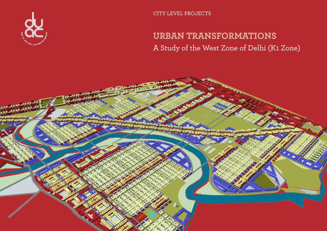
Urban TransformaTions A Study of the West Zone of Delhi (K1 Zone)

Delhi Urban art Commission
The Delhi Urban Art Commission was set up by an Act of Parliament in 1973
to “advise the Government of India in the matter of preserving, developing
and maintaining the aesthetic quality of urban and environmental design within
Delhi and to provide advice and guidance to any local body in respect of any
project of building operations or engineering operations or any development
proposal which affects or is like to affect the skyline or the aesthetic quality of
the surroundings or any public amenity provided therein”.
(An ISO 9001 : 2008 Certified Organisation)
(An ISO 9001 : 2008 Certified Organisation)(An ISO 9001 : 2008 Certified Organisation)
Delhi Urban art Commission
Prof. Dr. P.S.N. Rao Chairman
Sonali Bhagwati Member (Upto 5 October, 2017)Samir Mathur MemberSonali Rastogi MemberDurga Shanker Mishra Member & Addl. Secretary, Ministry of Housing and Urban Affairs
(Upto 10 August, 2017) Manoj Kumar Member & Addl. Secretary, Ministry of Housing and Urban Affairs
(From 11 August, 2017)Vinod Kumar Secretary
Previous CommissionRaj Rewal Former Chairman, DUACSatish Khanna Former Member, DUACEric P. Mall Former Member, DUACD. Diptivilasa Former Member DUAC & Addl. Secretary, Ministry of Urban Development
DUaC staffRajeev Kumar Gaur, Raghvendra Singh, Indu Rawat, Amit Mukherji, Uma Bhati, Manju Anjali, Siddharth Sagar,Nihal Chand
senior ConsultantArun Rewal
ConsultantsDivya Menon Nikhil (3D Visualiser )Kirti Kawale Priyadarshini GhoshRiti Samanta
DELHI URBAN ART COMMISSION with gratitude duly acknowledges the valuable contributions of the
following in making this report:
Organisations / Others
Ministry of Urban Development
Delhi Development Authority
Government of National Capital Territory of Delhi
North Delhi Municipal Corporation
East Delhi Municipal Corporation
South Delhi Municipal Corporation
New Delhi Municipal Council
Geospatial Delhi Limited
Delhi Metro Rail Corporation
Delhi Urban Shelter Improvement Board
BSES Rajdhani Power Limited
BSES Yamuna Power Limited
RWA’s and Area Councillors
Google Earth
Preface
*DISCLAIMER*
The city of Delhi, capital of this vast land of diversities, is a city laden with
layers of history, a place where civilizations have lived, prospered and perished
over centuries. The modern city today, built over and around a rich tapestry
of heritage, presents an opportunity at every turn, to allow for coexistence of
the past, present and the future. In order to understand this multidimensional
urban spectrum and attempt to plan the future, various city level studies have
been initiated by the DUAC. I hope that these studies will help the planners
of modern day Delhi to carefully articulate urban space, structure, form and
environment and sensitively address future requirements.
I convey my thanks to all the Consultants and Members of the Commission
who have tirelessly worked on this research project to bring out this document.
I also take this opportunity to place on record my sincere appreciation of
the efforts of Secretary and other staff of DUAC for providing the necessary
administrative support to make this happen.
I fondly hope that the authorities of the local, state and national government
take these studies seriously and implement, in right earnest, the suggestions given
herein.
This report is for academic purposes only and has been prepared on the basis
of information gathered from various sources, in cases without any independent
verification. The report can be adopted and utilized by any Government
Authority/Local Body in the Country and is provided free of cost. The report is
not meant to derive any kind of gain, monetary or otherwise.
Though all efforts have been made to ensure the accuracy of the information
in this report, the same should not be construed as a statement of law or
used for any legal purposes. Delhi Urban Art Commission (DUAC) accepts no
responsibility in relation to the accuracy, completeness, usefulness or otherwise,
of the information contained in the publication. Stakeholders are advised to
verify/check any information with the relevant Government Department(s) and/
or other source(s), and to obtain any appropriate advice before acting on the
information provided in the report.
While adequate measures have been taken to acknowledge the source of
the information used in the report, the nature of the process and the diverse
sources from which information is collected makes it difficult for the Commission
to ascertain whether each piece of information/data impinges upon any third
party intellectual property rights. DUAC shall consequently not be responsible
for any inadvertent and / or bonafide omission of acknowledgement of source of
information.
In no event will the DUAC be liable for any expense, loss or damage including,
without limitation, indirect or consequential loss or damage, or any expense,
loss or damage whatsoever arising out of any person/ stakeholder using or
implementing or relying on any information in this report.
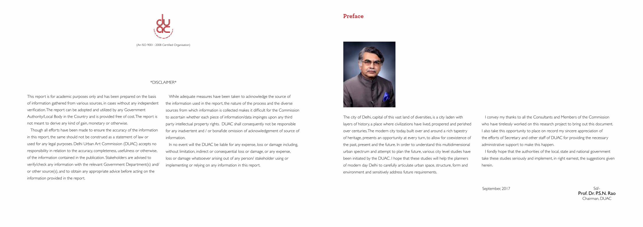
September, 2017 Prof. Dr. P.S.N. Rao Chairman, DUAC
Sd/-
(An ISO 9001 : 2008 Certified Organisation)
6 7CiTY LeVeL ProjeCT Vision for Zone f
Co
nT
enTsContents
1 Introduction 9 1.1 Challenges of K–1 Zone 10
1.2 Opportunities for K–1 Zone of Delhi 12
1.3 City Systems 14
2 Defining Area of Study 17 2.1 Introduction to K–1 Zone 17
2.2 Connectivity Map 18
2.3 Ward Map 19
2.4 Existing Features 20
3 Proposed Structure 21 3.1 Structuring Strategies 21
3.2 Structuring Elements 22
3.3 Proposed Master Plan 24
3.4 Proposed Views 25
4 Design Strategies for Settlement Elements 28 4.1 Strategy-A: Roads Connection between nodes and dense support system for neighbourhood blocks 28
4.2 Strategy–B: Built Density 36
4.3 Strategy–C: Nodes 37
4.4 Strategy–D: Structuring of Commercial Uses 38
4.5 Strategy–E: Structuring of Social Infrastructure 40
4.6 Strategy–F: Structuring Green Technologies 42
4.7 Strategy–G: Residential Structuring 44
4.8 Strategy–H: Local Structure 46
4.9 Strategy–J: Transitional Uses 50
4.10 Strategy–K: Green Structure 52
5 Design Strategies for Development Control 58 5.1 Strategy–: FAR Analysis 58
6 Resource Augmentation Strategies 64 6.1 Rainwater Harvesting Strategies 64
6.2 Solid Waste Management Strategies 66
IntR
oD
uC
tIo
n
9Vision for Zone f
Summary
This study explores the potential for redevelopment in relation to the landscape and new infrastructure within the boundaries of Delhi. Planned development schemes in Delhi have ignored informal developments that cover a large part of the city. About four-fifths of Delhi’s built form is a result of development initiated by the informal sector. The pressures of urbanization and the lack of sufficient housing has caused a socio-political nexus that is supported by the city administration to provide alternative shelter outside the formal delivery structures. This has resulted in ‘unauthorized colonies’ within the city.
Unauthorized colonies accommodate a large migrant population and others who have little hope of finding shelter within the framework of formal delivery systems. The city is unable to cope with the quantum leap in its population – which was about 6 million in 1985 – has seen an increase of over 300% in the last 30 years. This huge increase in population is largely accommodated in 3–4 storeyed unauthorized housing colonies. Buildings within these colonies are tightly packed and built edge-to-edge with extremely narrow roads in between and lack both services and infrastructure. These areas have open drains and almost no open spaces. The area comprises of haphazardly laid out small-scale manufacturing units and commercial enterprises that should not exist within the inner city. This kind of a city pattern has a negative impact on the safety, security and health of its residents and visitors. Yet, the area is an attractive alternative for a majority for whom the city cannot provide for. The city lacks both quantum stock and access to affordable housing.
More recently, the development of the Metro line towards the western fringes has linked it to the rest of the city. In the future this line will connect further west to Rohtak, adding potential value to the area. A proposed increase in the FAR to 400 will cause the area to redevelop. Hence the question is: How do we plan for these transformations?
The study demonstrates potential transformations and their impact in the K-1 zone, located in western Delhi. The area is characterized by unauthorized colonies that lack both basic infrastructure and services. The area also has a large amount of farmland. These areas have been noted in the Master Plan 2021 as urbanizable. The area is defined by the elevated Metro tracks. The Green Line aligned to Rohtak Road (NH 10) defines the northern boundary, while the Blue Line aligned to Shivaji Road marks its southern extent.
The development of the Urban Extension Road (UER 1), planned as a diagonal to the west, envisages a change in the urban pattern of the precinct. An internal Nangloi–Najafgarh Road diagonally intersects the meandering Najafgarh Nullah and connects the the northeastern part of the area to the southwest extents. The Najafgarh Nullah Basin follows the precinct’s original topography.
The focus of the study is to create an urban form that accommodates the pressure of development within the zone. It caters to the needs of city region. The impact of sensitive form making is contingent on the pedestrian-friendly environment it structures. The improvement goals of the study include: providing for higher densities of affordable housing and commercial development, creating use adjacencies, developing usable open spaces, creating wider roads that incorporate segregated functions, providing social infrastructure and generating opportunities for improving the physical infrastructure. The area improvement vision also provides for a variety of office spaces/incubation hubs for entrepreneurs. Economic and environmental development are considered in conformance to one another.
Strategies proposed consider incremental, independent redevelopment within each of the residential and commercial blocks. The study explores various redevelopment options. Alternate development scenarios have been illustrated to provide for additional development space and amenities for the ward.
Scenarios for redevelopment of the area take into consideration infrastructural improvements that are currently being implemented in the area.
Redevelopment goals include:1. Providing an elevated pedestrian corridor to connect the Blue and Green lines
of the Metro 2. Rejuvenating the Najafgarh Nullah front by significantly increasing open and green
areas in the neighbourhood and creating ‘green’ connections to the Nullah3. Creating an urban form conducive to a pedestrian-friendly environment and
providing for higher FAR and densities4. Improving organization of uses while accommodating a variety of commercial and
institutional space hierarchies5. Improving roadways and movement patterns6. Improving living conditions and creating a distinct urban character
In lieu of achieving a sustainable urban form the plan provides for mixed- use development options linking Metro stations. These corridors provide for multi-level links around vibrant typological patterns that accommodate commercial and office spaces as well as housing. The residential district development is located between the north-south corridors. Public/Semi public land use zones and new pollution free factories for technology are planned along the periphery. The sociocultural amenities proposed are dispersed around the ecological features and act as transition zones between public and private zones. Green areas have been created as usable spaces scattered through the plan.
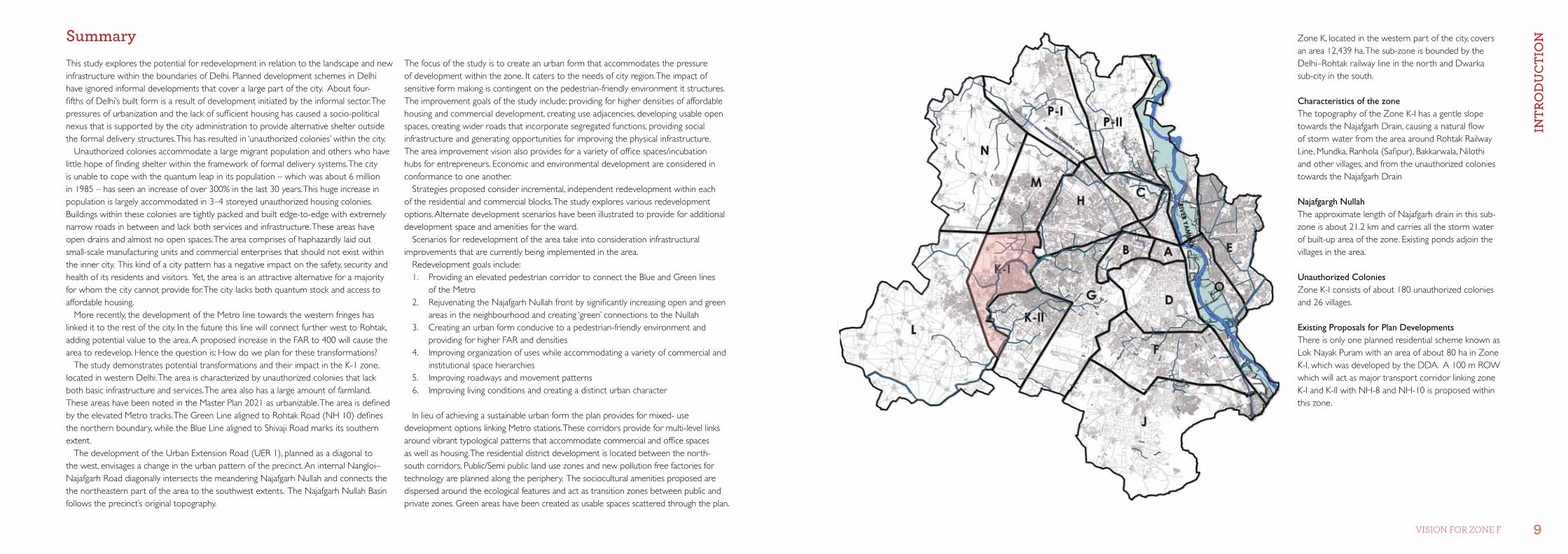
Zone K, located in the western part of the city, covers an area 12,439 ha. The sub-zone is bounded by the Delhi–Rohtak railway line in the north and Dwarka sub-city in the south.
Characteristics of the zoneThe topography of the Zone K-I has a gentle slope towards the Najafgarh Drain, causing a natural flow of storm water from the area around Rohtak Railway Line, Mundka, Ranhola (Safipur), Bakkarwala, Nilothi and other villages, and from the unauthorized colonies towards the Najafgarh Drain
Najafgargh Nullah The approximate length of Najafgarh drain in this sub-zone is about 21.2 km and carries all the storm water of built-up area of the zone. Existing ponds adjoin the villages in the area.
Unauthorized Colonies Zone K-I consists of about 180 unauthorized colonies and 26 villages.
Existing Proposals for Plan DevelopmentsThere is only one planned residential scheme known as Lok Nayak Puram with an area of about 80 ha in Zone K-I, which was developed by the DDA. A 100 m ROW which will act as major transport corridor linking zone K-I and K-II with NH-8 and NH-10 is proposed within this zone.
IntR
oD
uC
tIo
n
IntR
oD
uC
tIo
n
10 11CiTY LeVeL ProjeCT Vision for Zone f
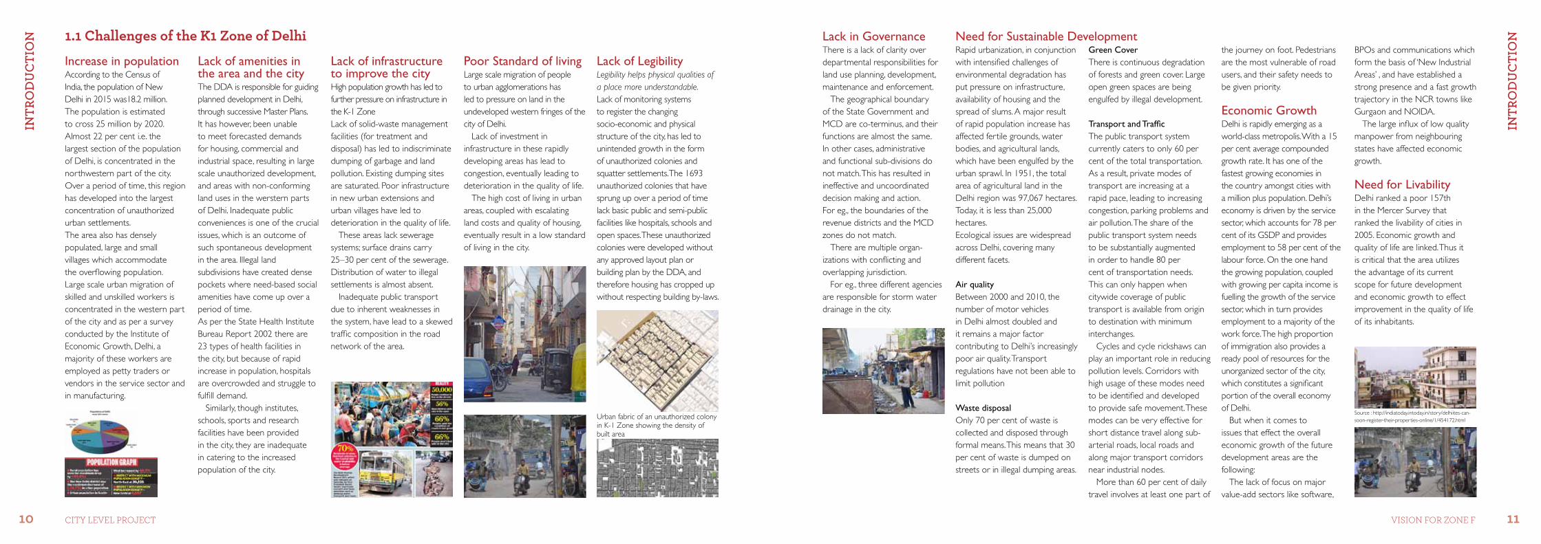
Increase in populationAccording to the Census of India, the population of New Delhi in 2015 was18.2 million. The population is estimated to cross 25 million by 2020. Almost 22 per cent i.e. the largest section of the population of Delhi, is concentrated in the northwestern part of the city. Over a period of time, this region has developed into the largest concentration of unauthorized urban settlements. The area also has densely populated, large and small villages which accommodate the overflowing population. Large scale urban migration of skilled and unskilled workers is concentrated in the western part of the city and as per a survey conducted by the Institute of Economic Growth, Delhi, a majority of these workers are employed as petty traders or vendors in the service sector and in manufacturing.
Lack of amenities in the area and the cityThe DDA is responsible for guiding planned development in Delhi, through successive Master Plans. It has however, been unable to meet forecasted demands for housing, commercial and industrial space, resulting in large scale unauthorized development, and areas with non-conforming land uses in the werstern parts of Delhi. Inadequate public conveniences is one of the crucial issues, which is an outcome of such spontaneous development in the area. Illegal land subdivisions have created dense pockets where need-based social amenities have come up over a period of time.As per the State Health Institute Bureau Report 2002 there are 23 types of health facilities in the city, but because of rapid increase in population, hospitals are overcrowded and struggle to fulfill demand.
Similarly, though institutes, schools, sports and research facilities have been provided in the city, they are inadequate in catering to the increased population of the city.
Lack of infrastructure to improve the cityHigh population growth has led to further pressure on infrastructure in the K-1 ZoneLack of solid-waste management facilities (for treatment and disposal) has led to indiscriminate dumping of garbage and land pollution. Existing dumping sites are saturated. Poor infrastructure in new urban extensions and urban villages have led to deterioration in the quality of life.
These areas lack sewerage systems; surface drains carry 25–30 per cent of the sewerage. Distribution of water to illegal settlements is almost absent.
Inadequate public transport due to inherent weaknesses in the system, have lead to a skewed traffic composition in the road network of the area.
Poor Standard of livingLarge scale migration of people to urban agglomerations has led to pressure on land in the undeveloped western fringes of the city of Delhi.
Lack of investment in infrastructure in these rapidly developing areas has lead to congestion, eventually leading to deterioration in the quality of life.
The high cost of living in urban areas, coupled with escalating land costs and quality of housing, eventually result in a low standard of living in the city.
Lack of Legibility Legibility helps physical qualities of a place more understandable. Lack of monitoring systems to register the changing socio-economic and physical structure of the city, has led to unintended growth in the form of unauthorized colonies and squatter settlements. The 1693 unauthorized colonies that have sprung up over a period of time lack basic public and semi-public facilities like hospitals, schools and open spaces. These unauthorized colonies were developed without any approved layout plan or building plan by the DDA, and therefore housing has cropped up without respecting building by-laws.
Rapid urbanization, in conjunction with intensified challenges of environmental degradation has put pressure on infrastructure, availability of housing and the spread of slums. A major result of rapid population increase has affected fertile grounds, water bodies, and agricultural lands, which have been engulfed by the urban sprawl. In 1951, the total area of agricultural land in the Delhi region was 97,067 hectares. Today, it is less than 25,000 hectares.Ecological issues are widespread across Delhi, covering many different facets.
Air qualityBetween 2000 and 2010, the number of motor vehicles in Delhi almost doubled and it remains a major factor contributing to Delhi’s increasingly poor air quality. Transport regulations have not been able to limit pollution
Waste disposal Only 70 per cent of waste is collected and disposed through formal means. This means that 30 per cent of waste is dumped on streets or in illegal dumping areas.
Lack in Governance There is a lack of clarity over departmental responsibilities for land use planning, development, maintenance and enforcement.
The geographical boundary of the State Government and MCD are co-terminus, and their functions are almost the same. In other cases, administrative and functional sub-divisions do not match. This has resulted in ineffective and uncoordinated decision making and action. For eg., the boundaries of the revenue districts and the MCD zones do not match.
There are multiple organ-izations with conflicting and overlapping jurisdiction.
For eg., three different agencies are responsible for storm water drainage in the city.
1.1 Challenges of the K1 Zone of Delhi
Urban fabric of an unauthorized colony in K-1 Zone showing the density of built area
Need for Sustainable DevelopmentGreen Cover There is continuous degradation of forests and green cover. Large open green spaces are being engulfed by illegal development.
Transport and TrafficThe public transport system currently caters to only 60 per cent of the total transportation. As a result, private modes of transport are increasing at a rapid pace, leading to increasing congestion, parking problems and air pollution. The share of the public transport system needs to be substantially augmented in order to handle 80 per cent of transportation needs. This can only happen when citywide coverage of public transport is available from origin to destination with minimum interchanges.
Cycles and cycle rickshaws can play an important role in reducing pollution levels. Corridors with high usage of these modes need to be identified and developed to provide safe movement. These modes can be very effective for short distance travel along sub- arterial roads, local roads and along major transport corridors near industrial nodes.
More than 60 per cent of daily travel involves at least one part of
the journey on foot. Pedestrians are the most vulnerable of road users, and their safety needs to be given priority.
Economic Growth Delhi is rapidly emerging as a world-class metropolis. With a 15 per cent average compounded growth rate. It has one of the fastest growing economies in the country amongst cities with a million plus population. Delhi’s economy is driven by the service sector, which accounts for 78 per cent of its GSDP and provides employment to 58 per cent of the labour force. On the one hand the growing population, coupled with growing per capita income is fuelling the growth of the service sector, which in turn provides employment to a majority of the work force. The high proportion of immigration also provides a ready pool of resources for the unorganized sector of the city, which constitutes a significant portion of the overall economy of Delhi.
But when it comes to issues that effect the overall economic growth of the future development areas are the following:
The lack of focus on major value-add sectors like software,
BPOs and communications which form the basis of ‘New Industrial Areas’ , and have established a strong presence and a fast growth trajectory in the NCR towns like Gurgaon and NOIDA.
The large influx of low quality manpower from neighbouring states have affected economic growth.
Need for LivabilityDelhi ranked a poor 157th in the Mercer Survey that ranked the livability of cities in 2005. Economic growth and quality of life are linked. Thus it is critical that the area utilizes the advantage of its current scope for future development and economic growth to effect improvement in the quality of life of its inhabitants.
Source : http://indiatoday.intoday.in/story/delhiites-can-soon-register-their-properties-online/1/454172.html
IntR
oD
uC
tIo
n
IntR
oD
uC
tIo
n
12 13CiTY LeVeL ProjeCT Vision for Zone f
Increase in population The increase of population in Delhi envisages the development of zones L, N and K-1. As per the Master Plan of Delhi 2021, within the urbanizable area, the proposed density in these zones is 250–300 persons per ha within an area of 12439 ha.
The Zone is predicted to accommodate close to 15–18 lakh people within the existing villages farmlands, large tracts of undeveloped land and unauthorized colonies.
Provision of Amenities in the Area and City The quality of life in any urban area depends upon the availability and accessibility to amenities provided by the city. The Delhi Development Authority has proposed a number of policies to improve and provide adequate amenities in urban areas to cater to the demands of an increasing population.
Zone K-1 has been defined as an urbanizable area in the Master Plan of Delhi which will house a population of 12 lakhs by 2021. Observing such a trend in increasing population, adequate and efficient amenities (healthcare and educational institutes) have been proposed.
Improved standard of livingThe basic factors that are required to improve the standard of living of the inhabitants of the area are:Access to basic infrastructure – safe drinking water, sanitation, drainage, power, healthcare and education.Establishing an image for the city, to guide initiatives for urban renewal; and undertaking these with the aim to recreate the city.Safeguarding the areas that are depleting environmental resources – groundwater, the river and the ridge. Assuring the safety and security of all segments of the population.Making provision for lower income groups, who are perceived as not having been provided for.Safe, reliable and affordable transport infrastructure, providing effective connectivity across the city.Most critically, providing a reliable, accountable, transparent, and responsive system of governance to manage the city’s infrastructure, and to conduct urban activities and business.
Improved Legibility Legibility of the area can be improved by respecting the features that enhance the overall imagability of the place.
Landscape structureLocal environmental improvement helps respect the natural systems. The area is scattered with lakes and ponds that form the natural heritage of the area. Large existing green areas along the nullah can be made approachable and thereby improve the legibility of the area. Green corridors and routes can be created along natural features to perpetuate landscape qualities.
Landmark features like significant road structures and edges can be maintained and new landmark features could be identified.
Local and informal sector needs to be incorporated into the future development to retain the memory of the place and create legible spaces in the area.
New Infrastructure and New Demands Improved SustainabilityThe concept of sustainable cities is closely interconnected with environment and economy and the protection of natural resources, which in turn leads to a minimum acceptable quality of life.1. Sustainable Urban Transport: Incorporating an efficient public transport system; pedestrian- centric development; cycle- friendly road management.2. Energy Efficient Built Environment: Encouraging developers and landowners to improve energy and water retrofits. 3. Green Energy: Initiatives to power the city completely using renewable sources. 4. Air Quality: Programs that dramatically cut CO2 emissions and air pollution through vehicles and contain urban sprawl. 5. Waste Management: Encourage a zero waste program and redirect all waste from landfill sites. 6. Intelligent City Infrastructure:Smart transportation initiatives, like real-time traffic data from GPS-equipped vehicles and an electronic road toll collection system to eventually reduce congestion of roads.
Economic GrowthThe economic growth rate and the sectoral trends as envisioned for the city of Delhi are quite in line with global trends for very large cities. But, based on the Fifth Economic Census, the Northwest District with a share of 17.33 per cent of the total number of enterprises has scope for intense development in the enterprise sector. The provision of facility corridors along major arterial roads and the Nangloi–Najafgarh road envisions growth in the commercial and retail sector.
Employment participation envisaged at the city level is 38 per cent, which has been considered while providing clean commercial, industrial and wholesale markets in the redevelopment plan.
Improved LivabilityCompact: Livable neighbourhoods conserve land and provide density to support the public transport networks and businesses that serve the neighbourhood.
Mixed-use: Livable neighbourhoods provide a mix of housing, workplaces, shops and services to serve the neighbourhood.
Diverse: Livable neighbourhoods offer a variety of housing to cater to all types of households and income groups, provide a range of jobs, shops, and services and support diverse local businesses.
Healthy: Livable neighbourhoods support the physical and mental health of residents; are clean and safe, and promote social inclusion.
Green: Livable neighborhoods are well served by parks, playgrounds, plazas, and greenways. Trees and plantings are integrated into street design. Buildings are designed to provide compact gardens, courtyards, terraces, and green roofs.
Improved GovernanceThe road ahead envisages: Clearly instituting a political and administrative nodal agency, which could provide effective governance to the NCT.Defining and delimiting areas of the city required to perform the functions of a National Capital.Undertaking institutional reforms to provide a base for the state government to implement projects in the area.
This would ensure good governance which is participatory, consensus oriented, accountable, transparent, responsive, effective and efficient, equitable and inclusive and follows the rule of law. It assures that corruption is minimized, the views of minorities are taken into account and that the voices of the most vulnerable in society are heard in decision-making. It is also responsive to the present and future needs of society.
1.2 opportunities for K-1 Zone of Delhi
The New Infrastructure improvements can be made in the following sectors:
Sewage ManagementExtension and upgradation of sewage networks to interceptsewage (abatement of pollution); Providing a sewer network in un-sewered areas; Augmentation of sewage treatment capacity.
Solid Waste ManagementMaximizing effective treatment processes for different waste streams, in order to minimize land required for landfill sites; Safeguarding the environment by ensuring well developed and sufficient landfill sites for disposal;Increasing the efficiency of service delivery.
Water SupplyProviding an improved water supply system to minimize water losses in transmission and distribution.Enhancing overall management of distribution and strengthening cost recovery mechanisms.
Drainage SystemImproving the drainage system by creating an appropriate, integrated authority to deal with sewer drains, storm water drains and the natural drainage basins of the area. Developing the Greenway Project for Najafgarh drain, as it is the largest contributor in terms of discharge into River Yamuna (51.75 per cent).
Transport systemProviding a safe and efficient public transport system; Encouraging the use of non-motorized modes of transport in local neighbourhoods; Enhancing road infrastructure and efficient parking facilities;Equitable use of space on road and priority to pedestrians and strengthening of foot-paths and FOB.
The proposed MRTS network has been acting as a development catalyst and has had a sizeable impact on the existing structure of the city.
Introducing the Urban Extension Road along the periphery envisages large scale development towards western fringes of the city.
Source : http://www.urbangreek-antriksh.com/antrikshurbangreek-delhi-l-zone-plan/
Source : http://ncrhomes.com/2011/delhi-to-have-3-new-bypass-roads/
IntR
oD
uC
tIo
n
IntR
oD
uC
tIo
n
14 15CiTY LeVeL ProjeCT Vision for Zone f
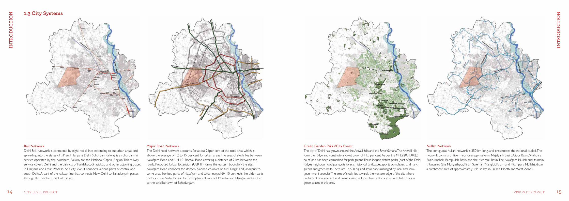
Nullah Network The contiguous nullah network is 350 km long, and crisscrosses the national capital. The network consists of five major drainage systems: Najafgarh Basin, Alipur Basin, Shahdara Basin, Kushak–Barapullah Basin and the Mehrauli Basin. The Najafgarh Nullah and its main tributaries (the Mungeshpur, Kirari Suleman, Nangloi, Palam and Pitampura Nullah), drain a catchment area of approximately 544 sq km in Delhi’s North and West Zones.
Major Road Network The Delhi road network accounts for about 21per cent of the total area, which is above the average of 12 to 15 per cent for urban areas. The area of study lies between Najafgarh Road and NH 10–Rohtak Road covering a distance of 7 km between the roads. Proposed Urban Extension (UER I1) forms the eastern boundary the site. Najafgarh Road connects the densely planned colonies of Kirti Nagar and Janakpuri to some unauthorized parts of Najafgarh and Uttamnagar. NH 10 connects the older parts Delhi such as Sadar Bazaar to the unplanned areas of Mundka and Nangloi, and further to the satellite town of Bahadurgarh.
Green Garden Parks/City ForestThe city of Delhi has grown around the Aravalli hills and the River Yamuna The Aravalli hills form the Ridge and constitute a forest cover of 11.5 per cent. As per the MPD, 2001, 8422 ha of land has been earmarked for park greens. These include district parks (part of the Delhi Ridge), neighbourhood parks, city forests, historical landscapes, sports complexes, landmark greens and green belts. There are 14,500 big and small parks managed by local and semi-government agencies The area of study lies towards the western edge of the city, where haphazard development and unauthorized colonies have led to a complete lack of open green spaces in this area.
Rail Network Delhi Rail Network is connected by eight radial lines extending to suburban areas and spreading into the states of UP and Haryana. Delhi Suburban Railway is a suburban rail service operated by the Northern Railway for the National Capital Region. This railway service covers Delhi and the districts of Faridabad, Ghaziabad and other adjoining places in Haryana and Uttar Pradesh. At a city level it connects various parts of central and south Delhi. A part of the railway line that connects New Delhi to Bahadurgarh passes through the northern part of the site.
1.3 City systems
IntR
oD
uC
tIo
n
DEf
InIn
g A
REA
of
Stu
Dy
16 17CiTY LeVeL ProjeCT Vision for Zone f
As per the Master Plan 2021, the area of demonstration has been earmarked as a future development zone, and development plans have been prepared for the same
Water BodiesThere are 611 water bodies,in Delhi of which 274 are dry, while the remaining 337 that still have water are in a terrible condition. These ponds and lakes form a part of a contiguous water system connected through surface and sub-surface drains that replenish the natural catchments, reservoirs and ground water systems. Most of the lakes in the area of study have dried up and have subsequently become unauthorized colonies. The more prominent ones are either used as dumping sites for garbage or are the essential open space of the area.
MetroDelhi Metro is a high capacity mode that will serve the main traffic corridors in Delhi. Built over 3 major phases it covers almost 130 km of the city. It connects the edges of the city to its core.
Location of the K-1 Zone in relation to neighbouring zones
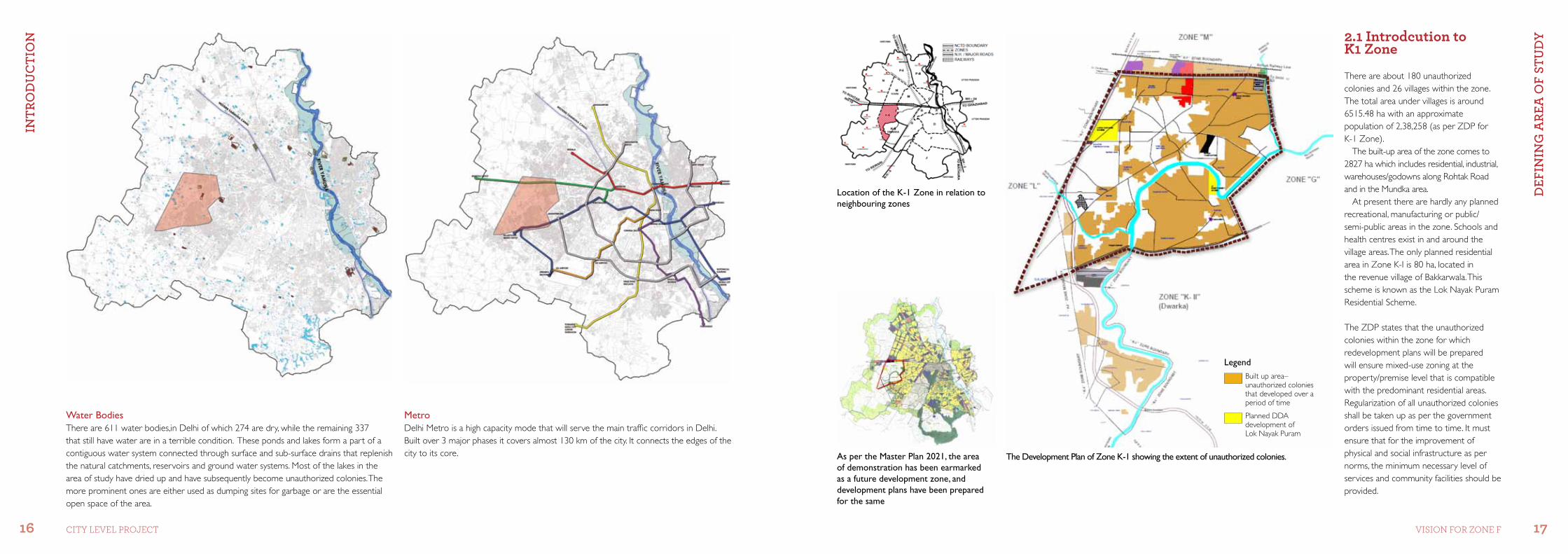
2.1 introdcution to K1 Zone
There are about 180 unauthorized colonies and 26 villages within the zone.The total area under villages is around 6515.48 ha with an approximate population of 2,38,258 (as per ZDP for K-1 Zone).
The built-up area of the zone comes to 2827 ha which includes residential, industrial, warehouses/godowns along Rohtak Road and in the Mundka area.
At present there are hardly any planned recreational, manufacturing or public/semi-public areas in the zone. Schools and health centres exist in and around the village areas. The only planned residential area in Zone K-I is 80 ha, located in the revenue village of Bakkarwala. This scheme is known as the Lok Nayak Puram Residential Scheme.
The ZDP states that the unauthorized colonies within the zone for which redevelopment plans will be prepared will ensure mixed-use zoning at the property/premise level that is compatible with the predominant residential areas. Regularization of all unauthorized colonies shall be taken up as per the government orders issued from time to time. It must ensure that for the improvement of physical and social infrastructure as per norms, the minimum necessary level of services and community facilities should be provided.
The Development Plan of Zone K-1 showing the extent of unauthorized colonies.
LegendBuilt up area– unauthorized colonies that developed over a period of time
Planned DDA development of Lok Nayak Puram
DEf
InIn
g A
REA
of
Stu
Dy
DEf
InIn
g A
REA
of
Stu
Dy
18 19CiTY LeVeL ProjeCT Vision for Zone f
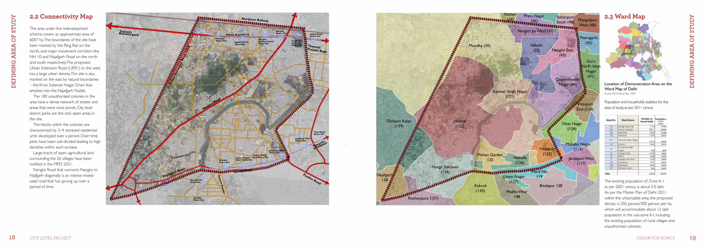
2.3 Ward map
Peeragarhi (42)
Mangolpuri West (48)
Nangloi East (43)
Quammruddin Nagar (44)
Nilothi (32)
Nangloi Jat West (31)
Prem Nagar (36)
Mundka (30)
Nithari (34)
Kanwar Singh Nagar (121)
Hastsal (122)
Nangli Sakravati (134)
Roshanpura 1(37)
Najafgarh 138
Dichaon Kalan (139)
Mohan Garden 125
Guru HarK-!shan
Nagar (41)
Vikaspuri East (116)
Vikas Nagar (124)
Nawada (126)
Vikaspuri (123)
Ward No. 119Uttam Nagar
(127)
Madhu Vihar 148
Kakroli (135)
Bindapur 128
Janakpuri West (117)
Mahabir Nagar (113)
Sultanpuri South (40)
Dwarka Mor Metro Stn.
DwarkaMetro Stn.
NawadaMetro Stn.
Uttam Nagar West Metro Stn.
Uttam Nagar East Metro Stn.
Janakpuri WestMetro Stn.
Janakpuri EastMetro Stn.
Tilak NagarMetro Stn.
Udyog Nagar Metro Stn.
TowardsPunjabi Bagh
Surajmal Stadium Metro Stn.
Nangloi Metro Stn.
Nangloi Railway Station Metro Stn. Rajdhani Park
Metro Stn.
Mundka Metro Stn.
Toward
s Naja
fgarh
Towards
Janakpuri
Najafgarh RoadShivaji Road
Towards D
warka
Northern Railway
Rohtak Road NH-10
Urb
an E
xten
sion
Roa
d (U
ER
-1)
Nangloi Road
TowardsBahadurgarh
Pankha Road
Location of Demonstration Area on the Ward Map of Delhi
Population and households statistics for the area of study, as per 2011 census
The existing population of Zone K-1 as per 2001 census is about 5.0 lakh. As per the Master Plan of Delhi 2021, within the urbanizable area, the proposed density is 250 person/300 person per ha, which will accommodate about 12 lakh population in the sub-zone K-I, including the existing population of rural villages and unauthorized colonies.
The area under the redevelopment scheme covers an approximate area of 6007 ha. The boundaries of the site have been marked by the Ring Rail on the north, and major movement corridors like NH 10 and Najafgarh Road on the north and south respectively. The proposed Urban Extension Road (UER1) to the west has a large urban density. The site is also marked on the east by natural boundaries – the Kirari Suleman Nagar Drain that empties into the Najafgarh Nullah.
The 180 unauthorized colonies in the area have a dense network of streets and areas that were once ponds. City level district parks are the only open areas in the site.
The blocks within the colonies are characterized by 3–4 storeyed residential units developed over a period. Over time, plots have been sub-divided leading to high densities within each enclave.
Large tracts of open, agricultural land surrounding the 26 villages have been notified in the MPD 2021.
Nangloi Road that connects Nangloi to Najfgarh diagonally is an intense mixed- used road that has sprung up over a period of time.
2.2 Connectivity map
Source: MCD Ward Map , 2007
DEf
InIn
g A
REA
of
Stu
Dy
PRo
PoSE
D S
tRu
Ctu
RE
20 21CiTY LeVeL ProjeCT Vision for Zone f
Green/open spacesNullahs/water bodies
Roads Metro
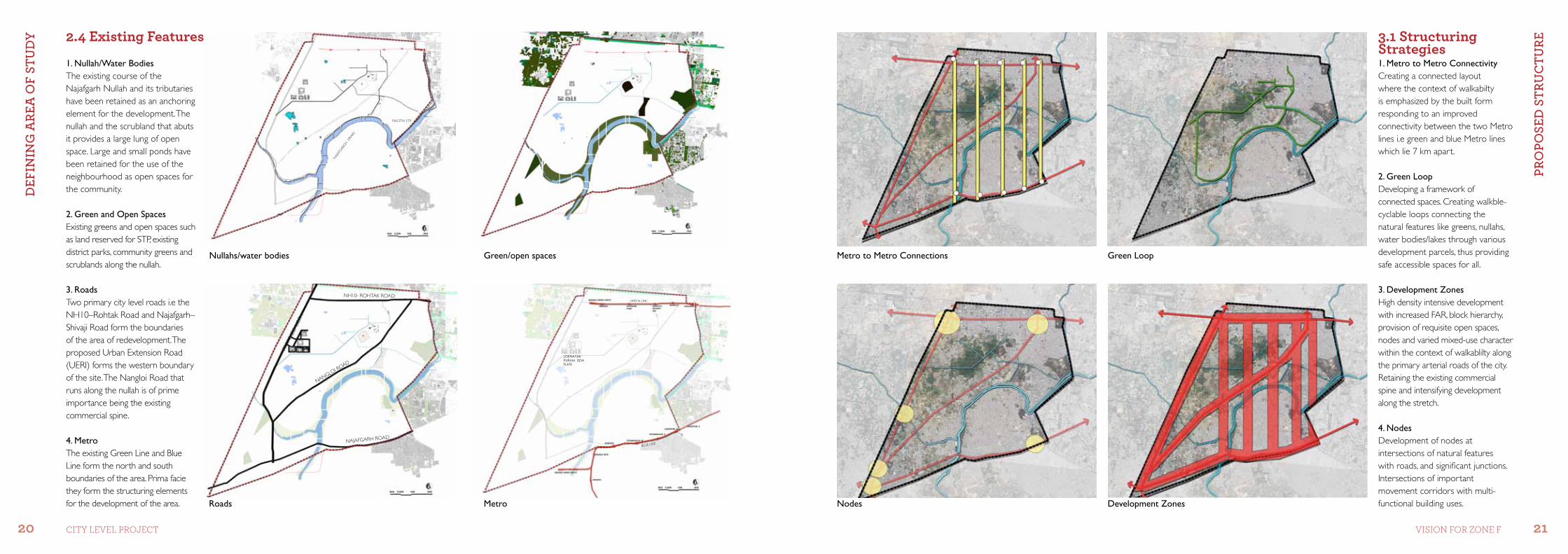
3.1 structuring strategies
1. Nullah/Water BodiesThe existing course of the Najafgarh Nullah and its tributaries have been retained as an anchoring element for the development. The nullah and the scrubland that abuts it provides a large lung of open space. Large and small ponds have been retained for the use of the neighbourhood as open spaces for the community.
2. Green and Open SpacesExisting greens and open spaces such as land reserved for STP, existing district parks, community greens and scrublands along the nullah.
3. RoadsTwo primary city level roads i.e the NH10–Rohtak Road and Najafgarh–Shivaji Road form the boundaries of the area of redevelopment. The proposed Urban Extension Road (UERI) forms the western boundary of the site. The Nangloi Road that runs along the nullah is of prime importance being the existing commercial spine.
4. Metro The existing Green Line and Blue Line form the north and south boundaries of the area. Prima facie they form the structuring elements for the development of the area.
1. Metro to Metro ConnectivityCreating a connected layout where the context of walkabilty is emphasized by the built form responding to an improved connectivity between the two Metro lines i.e green and blue Metro lines which lie 7 km apart. 2. Green Loop Developing a framework of connected spaces. Creating walkble- cyclable loops connecting the natural features like greens, nullahs, water bodies/lakes through various development parcels, thus providing safe accessible spaces for all. 3. Development ZonesHigh density intensive development with increased FAR, block hierarchy, provision of requisite open spaces, nodes and varied mixed-use character within the context of walkablilty along the primary arterial roads of the city. Retaining the existing commercial spine and intensifying development along the stretch. 4. NodesDevelopment of nodes at intersections of natural features with roads, and significant junctions. Intersections of important movement corridors with multi- functional building uses.
NILOTHI STP
NAJ
AFGAR
GH DRA
IN
NANGLOI ROAD
NH10- ROHTAK ROAD
PRO
POSE
D U
.E.R
1
NAJAFGARH ROAD
GREEN LINE
BLUE LINE
Loknayak Puram DDa FLats
Green LoopMetro to Metro Connections
Nodes Development Zones
2.4 Existing features
PRo
PoSE
D S
tRu
Ctu
RE
PRo
PoSE
D S
tRu
Ctu
RE
22 23CiTY LeVeL ProjeCT Vision for Zone f
Existing Urban Fabric Metro Lines Network
Najafgarh Road
Nangloi- N
ajafga
rh Road
NH10- Roahtak Road
Blue Line
Green Line
Arterial Roads
Links between Metro Neighbourhood and Local Roads Built-up Areas
Nullah and its Tributaries – Retaining surface nullah and rejuvenation of lakes and ponds in the area
Green/Open Areas – Hierarchical open Spaces and re-use of the nullah waterfront
Green Loop connecting the nullah and its tributaries
Institutional Periphery Infill Residential Super Blocks Linear Commercial Belts connecting Metro stations and new green along the major movement corridor
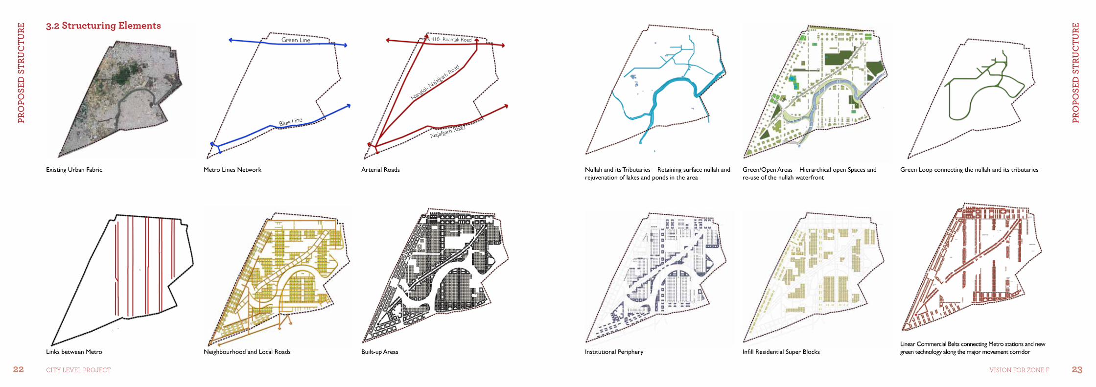
3.2 structuring Elements
PRo
PoSE
D S
tRu
Ctu
RE
PRo
PoSE
D S
tRu
Ctu
RE
24 25CiTY LeVeL ProjeCT Vision for Zone f
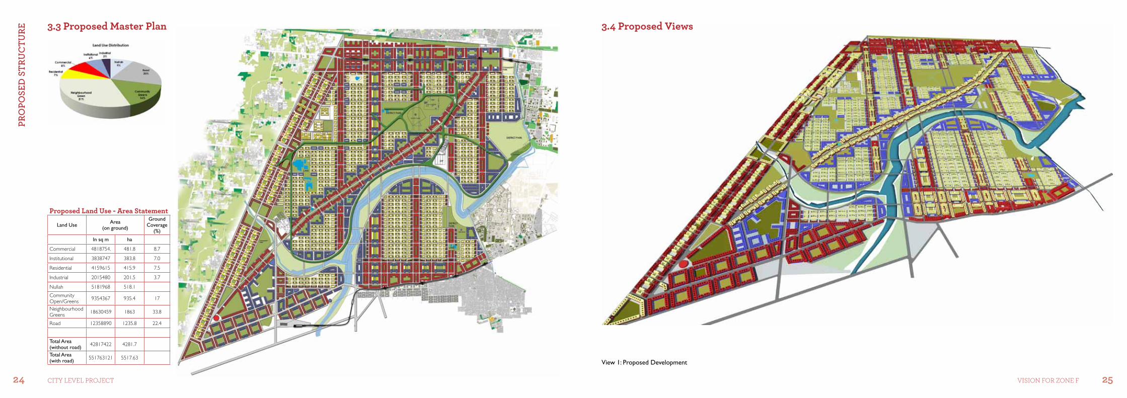
3.3 Proposed master Plan 3.4 Proposed Views
View 1: Proposed Development
Proposed Land Use - area statement
Land Use Area(on ground)
Ground Coverage
(%)
In sq m ha
Commercial 4818754. 481.8 8.7
Institutional 3838747 383.8 7.0
Residential 4159615 415.9 7.5
Industrial 2015480 201.5 3.7
Nullah 5181968 518.1
Community Open/Greens 9354367 935.4 17
Neighbourhood Greens 18630459 1863 33.8
Road 12358890 1235.8 22.4
Total Area (without road) 42817422 4281.7
Total Area (with road) 551763121 5517.63
PRo
PoSE
D S
tRu
Ctu
RE
PRo
PoSE
D S
tRu
Ctu
RE
26 27CiTY LeVeL ProjeCT Vision for Zone f
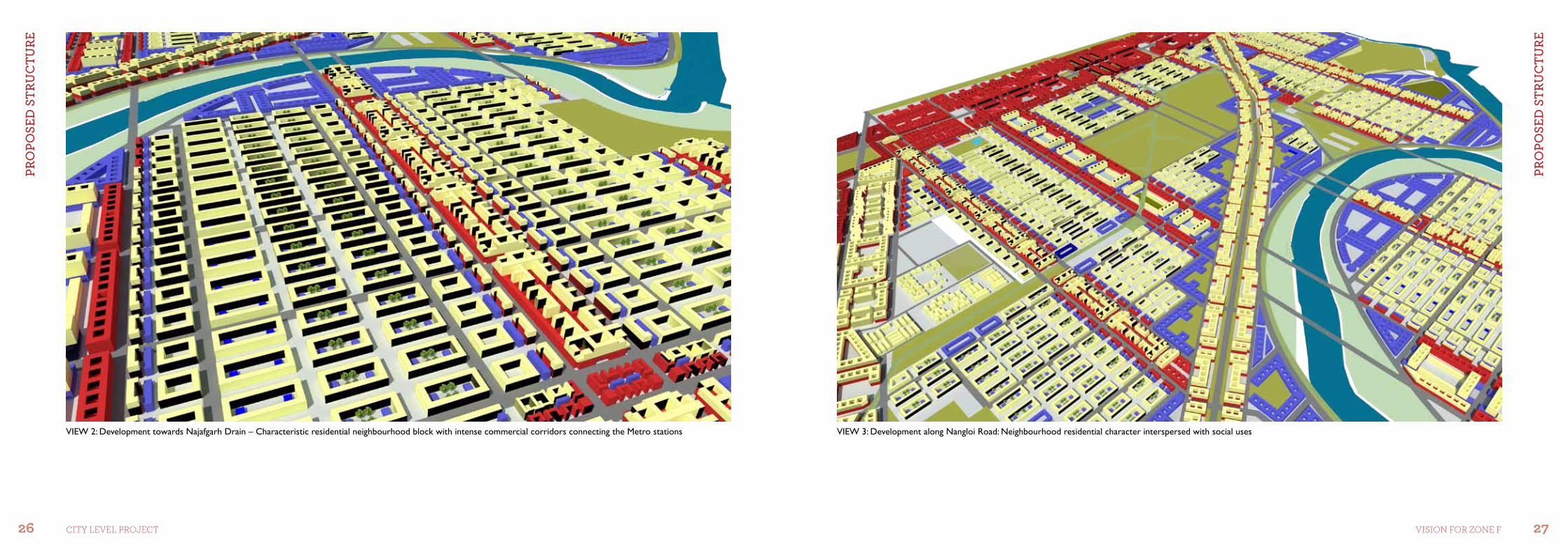
VIEW 3: Development along Nangloi Road: Neighbourhood residential character interspersed with social usesVIEW 2: Development towards Najafgarh Drain – Characteristic residential neighbourhood block with intense commercial corridors connecting the Metro stations
DES
Ign
StR
AtEg
IES
foR
SEtt
lEm
Ent
ElEm
EntS
DES
Ign
StR
AtEg
IES
foR
SEtt
lEm
Ent
ElEm
EntS
28 29CiTY LeVeL ProjeCT Vision for Zone f
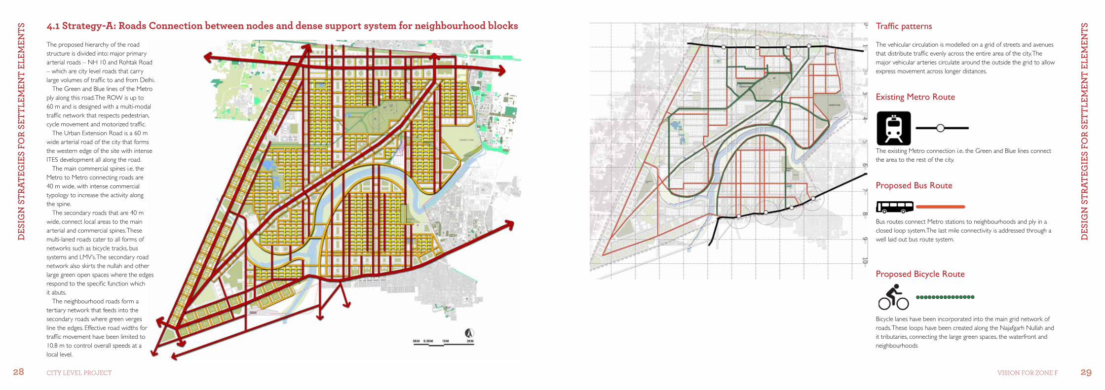
4.1 strategy-a: roads Connection between nodes and dense support system for neighbourhood blocks Traffic patterns
The vehicular circulation is modelled on a grid of streets and avenues that distribute traffic evenly across the entire area of the city. The major vehicular arteries circulate around the outside the grid to allow express movement across longer distances.
The proposed hierarchy of the road structure is divided into: major primary arterial roads – NH 10 and Rohtak Road – which are city level roads that carry large volumes of traffic to and from Delhi.
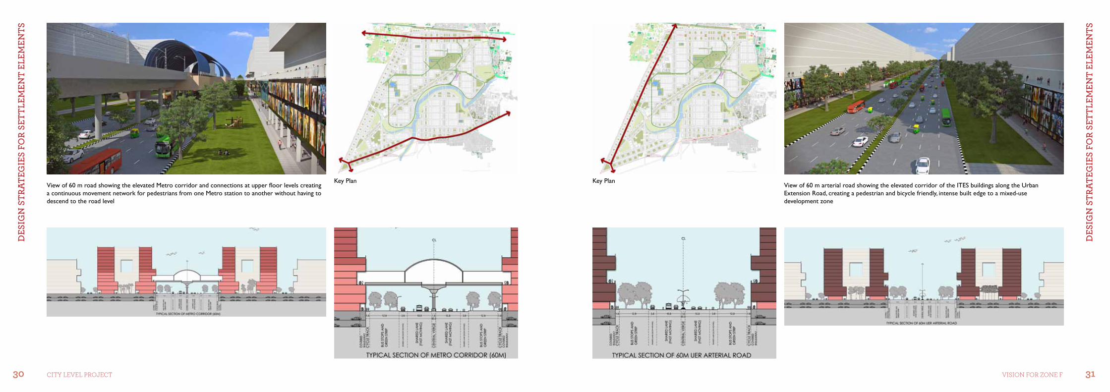
The Green and Blue lines of the Metro ply along this road. The ROW is up to 60 m and is designed with a multi-modal traffic network that respects pedestrian, cycle movement and motorized traffic.
The Urban Extension Road is a 60 m wide arterial road of the city that forms the western edge of the site with intense ITES development all along the road.
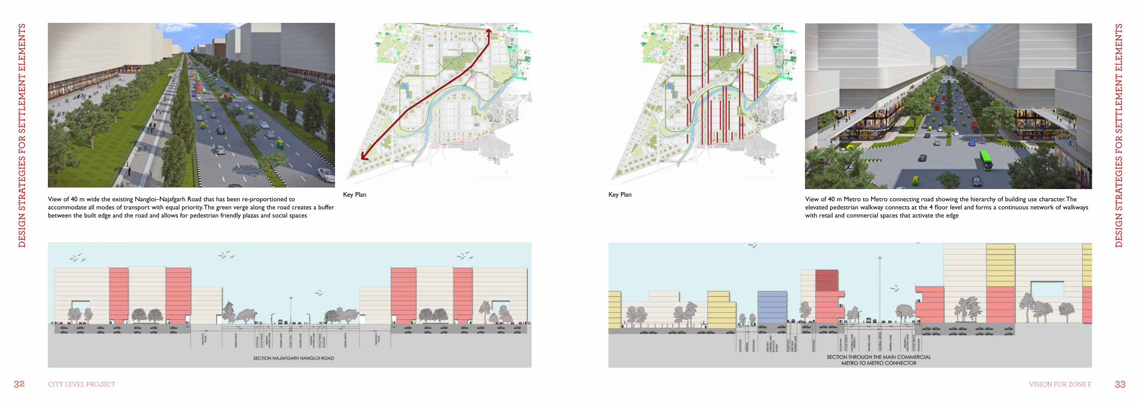
The main commercial spines i.e. the Metro to Metro connecting roads are 40 m wide, with intense commercial typology to increase the activity along the spine.
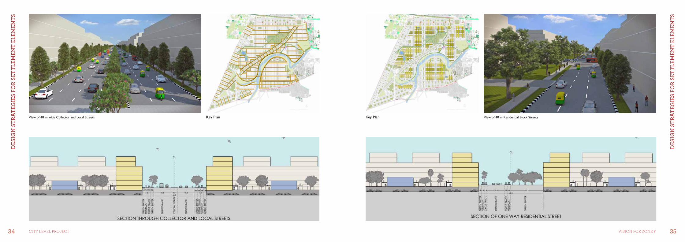
The secondary roads that are 40 m wide, connect local areas to the main arterial and commercial spines. These multi-laned roads cater to all forms of networks such as bicycle tracks, bus systems and LMV’s. The secondary road network also skirts the nullah and other large green open spaces where the edges respond to the specific function which it abuts.
The neighbourhood roads form a tertiary network that feeds into the secondary roads where green verges line the edges. Effective road widths for traffic movement have been limited to 10.8 m to control overall speeds at a local level.
The existing Metro connection i.e. the Green and Blue lines connect the area to the rest of the city.
Bus routes connect Metro stations to neighbourhoods and ply in a closed loop system.The last mile connectivity is addressed through a well laid out bus route system.
Bicycle lanes have been incorporated into the main grid network of roads. These loops have been created along the Najafgarh Nullah and it tributaries, connecting the large green spaces, the waterfront and neighbourhoods
Existing Metro Route
Proposed Bus Route
Proposed Bicycle Route
DES
Ign
StR
AtEg
IES
foR
SEtt
lEm
Ent
ElEm
EntS
DES
Ign
StR
AtEg
IES
foR
SEtt
lEm
Ent
ElEm
EntS
30 31CiTY LeVeL ProjeCT Vision for Zone f
View of 60 m arterial road showing the elevated corridor of the ITES buildings along the Urban Extension Road, creating a pedestrian and bicycle friendly, intense built edge to a mixed-use development zone
View of 60 m road showing the elevated Metro corridor and connections at upper floor levels creating a continuous movement network for pedestrians from one Metro station to another without having to descend to the road level
Key PlanKey Plan
DES
Ign
StR
AtEg
IES
foR
SEtt
lEm
Ent
ElEm
EntS
DES
Ign
StR
AtEg
IES
foR
SEtt
lEm
Ent
ElEm
EntS
32 33CiTY LeVeL ProjeCT Vision for Zone f
View of 40 m Metro to Metro connecting road showing the hierarchy of building use character. The elevated pedestrian walkway connects at the 4 floor level and forms a continuous network of walkways with retail and commercial spaces that activate the edge
View of 40 m wide the existing Nangloi–Najafgarh Road that has been re-proportioned to accommodate all modes of transport with equal priority. The green verge along the road creates a buffer between the built edge and the road and allows for pedestrian friendly plazas and social spaces
Key PlanKey Plan
DES
Ign
StR
AtEg
IES
foR
SEtt
lEm
Ent
ElEm
EntS
DES
Ign
StR
AtEg
IES
foR
SEtt
lEm
Ent
ElEm
EntS
34 35CiTY LeVeL ProjeCT Vision for Zone f
View of 40 m Residential Block StreetsView of 40 m wide Collector and Local Streets Key PlanKey Plan
DES
Ign
StR
AtEg
IES
foR
SEtt
lEm
Ent
ElEm
EntS
DES
Ign
StR
AtEg
IES
foR
SEtt
lEm
Ent
ElEm
EntS
36 37CiTY LeVeL ProjeCT Vision for Zone f
4.3 strategy-C: nodes4.2 strategy-b: built Density
1
2
3 4
5
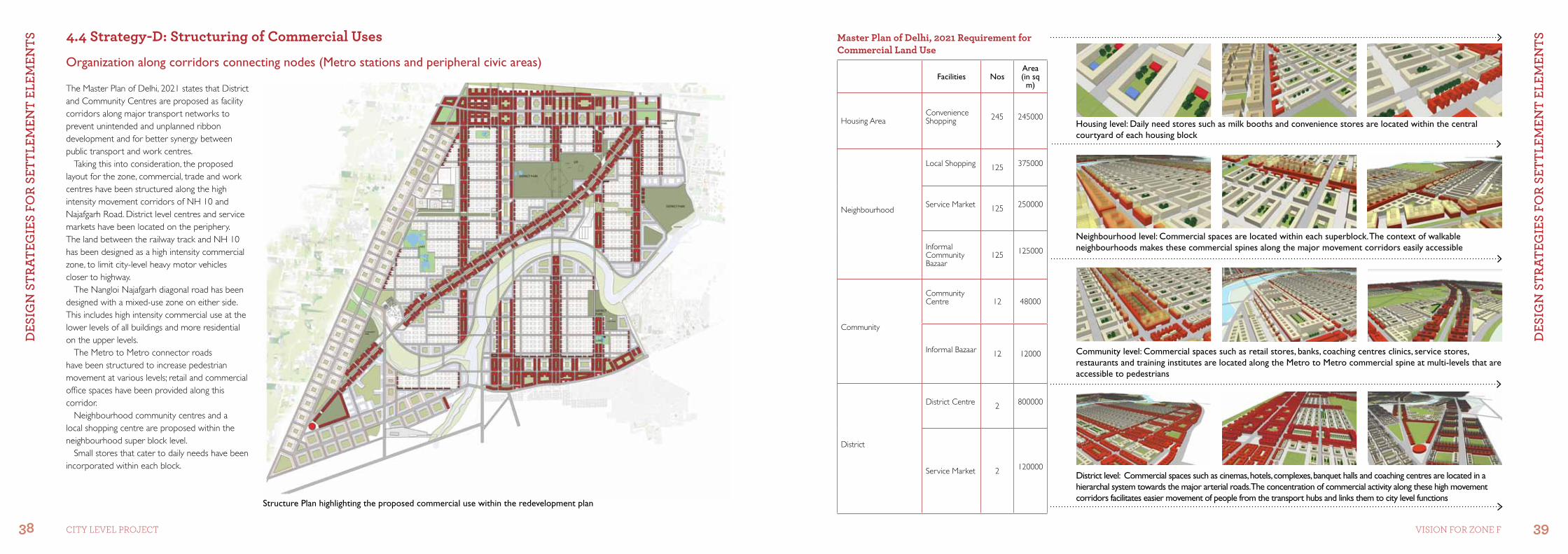
Nodes are points, the strategic spots in a city, into which an observer can enter and which are intensive foci to and from which the person is travelling, They may primarily be junction places of a break in transportation, crossing or convergence of paths, moments of shift from one structure to another. Or the nodes may be simply concentrations, which gain their importance from being the condensations of some use of physical character – Kevin Lynch, The Image of the City.
In the proposed structure plan of the area, nodes have been located at:
1. The intersection of Nangloi Najafgarh-UER1 and Shivaji Road which creates a large junction of roads and activities where the node is defined by built to edge blocks and large central open spaces.
2. The intersection of the Nullah–UER and intense development along the arterial road creates a pause point in the form of a node, where the open space responds to the Nullah.
3. The Intersection of two intense volume roads requires the node to form a large open space responding to the heavy volumes of traffic.
4. The intersection of the Metro station and movement corridors of Nangloi–Najafgarh Road and NH 10 requires a relief space for people.
5. The intersection of intense commercial development along the Metro Line and Najafgarh–Shivaji Road creates a node where the built form and activity defines the characteristics of the node.
Location of Major Nodes WRT anchoring features on the site
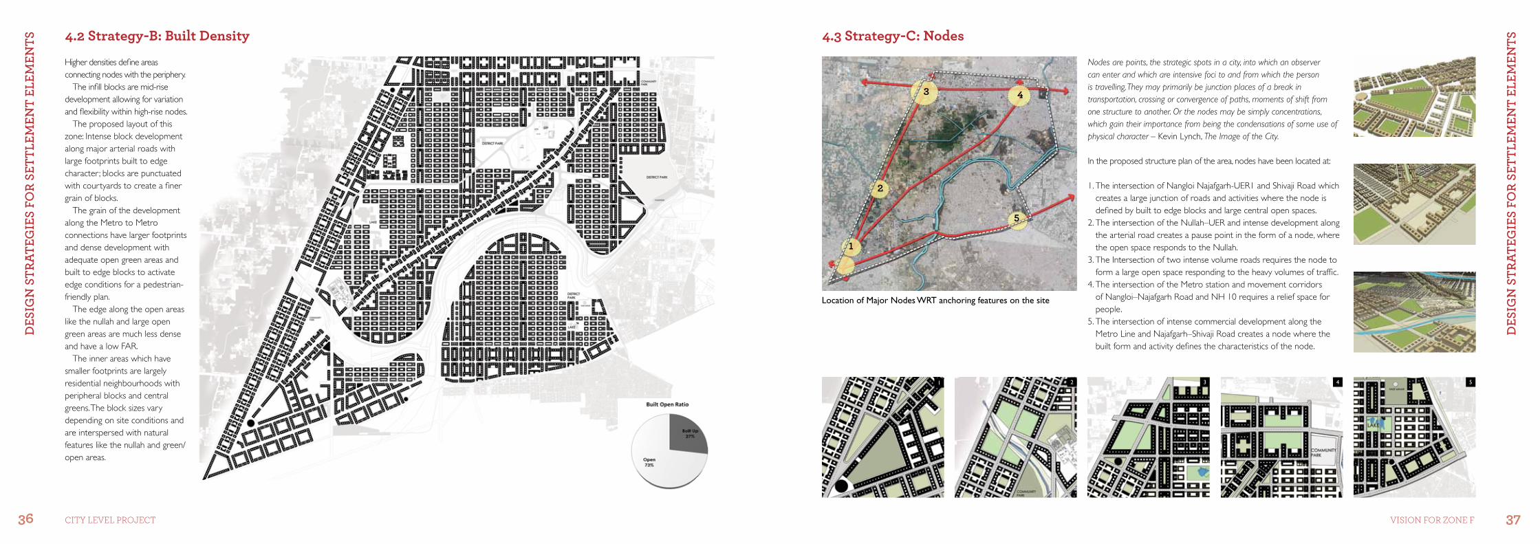
Higher densities define areas connecting nodes with the periphery.
The infill blocks are mid-rise development allowing for variation and flexibility within high-rise nodes.
The proposed layout of this zone: Intense block development along major arterial roads with large footprints built to edge character ; blocks are punctuated with courtyards to create a finer grain of blocks.
The grain of the development along the Metro to Metro connections have larger footprints and dense development with adequate open green areas and built to edge blocks to activate edge conditions for a pedestrian- friendly plan.
The edge along the open areas like the nullah and large open green areas are much less dense and have a low FAR.
The inner areas which have smaller footprints are largely residential neighbourhoods with peripheral blocks and central greens. The block sizes vary depending on site conditions and are interspersed with natural features like the nullah and green/open areas.
1 2 3 4 5
DES
Ign
StR
AtEg
IES
foR
SEtt
lEm
Ent
ElEm
EntS
DES
Ign
StR
AtEg
IES
foR
SEtt
lEm
Ent
ElEm
EntS
38 39CiTY LeVeL ProjeCT Vision for Zone f
4.4 strategy-D: structuring of Commercial Uses
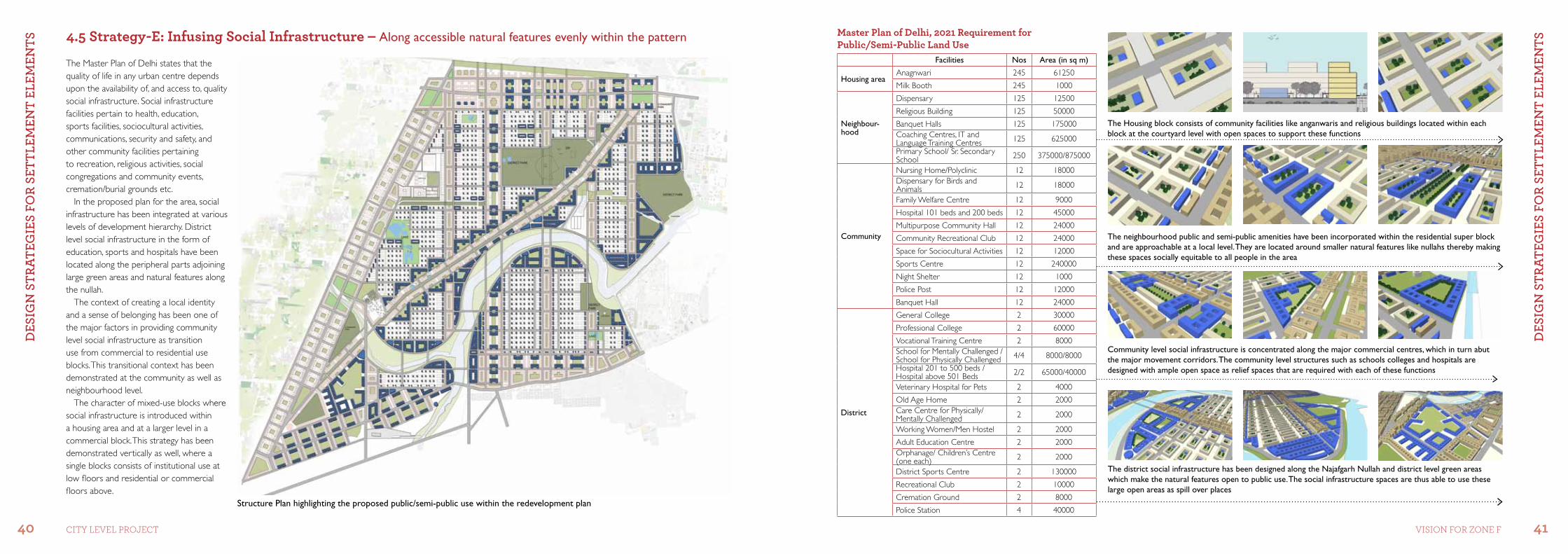
The Master Plan of Delhi, 2021 states that District and Community Centres are proposed as facility corridors along major transport networks to prevent unintended and unplanned ribbon development and for better synergy between public transport and work centres.
Taking this into consideration, the proposed layout for the zone, commercial, trade and work centres have been structured along the high intensity movement corridors of NH 10 and Najafgarh Road. District level centres and service markets have been located on the periphery. The land between the railway track and NH 10 has been designed as a high intensity commercial zone, to limit city-level heavy motor vehicles closer to highway.
The Nangloi Najafgarh diagonal road has been designed with a mixed-use zone on either side. This includes high intensity commercial use at the lower levels of all buildings and more residential on the upper levels.
The Metro to Metro connector roads have been structured to increase pedestrian movement at various levels; retail and commercial office spaces have been provided along this corridor.
Neighbourhood community centres and a local shopping centre are proposed within the neighbourhood super block level.
Small stores that cater to daily needs have been incorporated within each block.
Housing level: Daily need stores such as milk booths and convenience stores are located within the central courtyard of each housing block
Neighbourhood level: Commercial spaces are located within each superblock. The context of walkable neighbourhoods makes these commercial spines along the major movement corridors easily accessible
Community level: Commercial spaces such as retail stores, banks, coaching centres clinics, service stores, restaurants and training institutes are located along the Metro to Metro commercial spine at multi-levels that are accessible to pedestrians
District level: Commercial spaces such as cinemas, hotels, complexes, banquet halls and coaching centres are located in a hierarchal system towards the major arterial roads. The concentration of commercial activity along these high movement corridors facilitates easier movement of people from the transport hubs and links them to city level functions
master Plan of Delhi, 2021 requirement for Commercial Land Use
Facilities NosArea (in sq m)
Housing AreaConvenience Shopping 245 245000
Neighbourhood
Local Shopping 125 375000
Service Market 125 250000
Informal Community Bazaar
125 125000
Community
Community Centre 12 48000
Informal Bazaar 12 12000
District
District Centre 2 800000
Service Market 2 120000
Organization along corridors connecting nodes (Metro stations and peripheral civic areas)
Structure Plan highlighting the proposed commercial use within the redevelopment plan
DES
Ign
StR
AtEg
IES
foR
SEtt
lEm
Ent
ElEm
EntS
DES
Ign
StR
AtEg
IES
foR
SEtt
lEm
Ent
ElEm
EntS
40 41CiTY LeVeL ProjeCT Vision for Zone f
4.5 strategy-E: infusing social infrastructure – Along accessible natural features evenly within the pattern
The Master Plan of Delhi states that the quality of life in any urban centre depends upon the availability of, and access to, quality social infrastructure. Social infrastructure facilities pertain to health, education, sports facilities, sociocultural activities, communications, security and safety, and other community facilities pertaining to recreation, religious activities, social congregations and community events, cremation/burial grounds etc.
In the proposed plan for the area, social infrastructure has been integrated at various levels of development hierarchy. District level social infrastructure in the form of education, sports and hospitals have been located along the peripheral parts adjoining large green areas and natural features along the nullah.
The context of creating a local identity and a sense of belonging has been one of the major factors in providing community level social infrastructure as transition use from commercial to residential use blocks. This transitional context has been demonstrated at the community as well as neighbourhood level.
The character of mixed-use blocks where social infrastructure is introduced within a housing area and at a larger level in a commercial block. This strategy has been demonstrated vertically as well, where a single blocks consists of institutional use at low floors and residential or commercial floors above.
The neighbourhood public and semi-public amenities have been incorporated within the residential super block and are approachable at a local level. They are located around smaller natural features like nullahs thereby making these spaces socially equitable to all people in the area
The Housing block consists of community facilities like anganwaris and religious buildings located within each block at the courtyard level with open spaces to support these functions
Community level social infrastructure is concentrated along the major commercial centres, which in turn abut the major movement corridors. The community level structures such as schools colleges and hospitals are designed with ample open space as relief spaces that are required with each of these functions
The district social infrastructure has been designed along the Najafgarh Nullah and district level green areas which make the natural features open to public use. The social infrastructure spaces are thus able to use these large open areas as spill over places
master Plan of Delhi, 2021 requirement for Public/semi-Public Land Use
Facilities Nos Area (in sq m)
Housing areaAnagnwari 245 61250
Milk Booth 245 1000
Neighbour-hood
Dispensary 125 12500
Religious Building 125 50000
Banquet Halls 125 175000Coaching Centres, IT and Language Training Centres 125 625000
Primary School/ Sr. Secondary School 250 375000/875000
Community
Nursing Home/Polyclinic 12 18000Dispensary for Birds and Animals 12 18000
Family Welfare Centre 12 9000
Hospital 101 beds and 200 beds 12 45000
Multipurpose Community Hall 12 24000
Community Recreational Club 12 24000
Space for Sociocultural Activities 12 12000
Sports Centre 12 240000
Night Shelter 12 1000
Police Post 12 12000
Banquet Hall 12 24000
District
General College 2 30000
Professional College 2 60000
Vocational Training Centre 2 8000School for Mentally Challenged / School for Physically Challenged 4/4 8000/8000
Hospital 201 to 500 beds /Hospital above 501 Beds 2/2 65000/40000
Veterinary Hospital for Pets 2 4000
Old Age Home 2 2000Care Centre for Physically/ Mentally Challenged 2 2000
Working Women/Men Hostel 2 2000
Adult Education Centre 2 2000Orphanage/ Children’s Centre (one each) 2 2000
District Sports Centre 2 130000
Recreational Club 2 10000
Cremation Ground 2 8000
Police Station 4 40000Structure Plan highlighting the proposed public/semi-public use within the redevelopment plan
DES
Ign
StR
AtEg
IES
foR
SEtt
lEm
Ent
ElEm
EntS
DES
Ign
StR
AtEg
IES
foR
SEtt
lEm
Ent
ElEm
EntS
42 43CiTY LeVeL ProjeCT Vision for Zone f
4.6 strategy-f: structuring Green Technologies – Organization at Periphery with City-wide Access
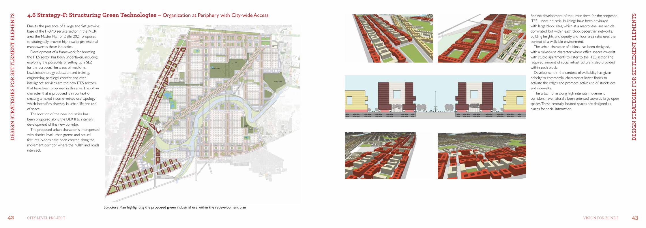
Due to the presence of a large and fast growing base of the IT-BPO service sector in the NCR area, the Master Plan of Delhi, 2021 proposes to strategically provide high quality professional manpower to these industries.
Development of a framework for boosting the ITES sector has been undertaken, including exploring the possibility of setting up a SEZ for the purpose. The areas of medicine, law, biotechnology, education and training, engineering, paralegal content and even intelligence services are the new ITES sectors that have been proposed in this area. The urban character that is proposed is in context of creating a mixed income–mixed use typology which intensifies diversity in urban life and use of space.
The location of the new industries has been proposed along the UER II to intensify development of this new corridor.
The proposed urban character is interspersed with district level urban greens and natural features. Nodes have been created along the movement corridor where the nullah and roads intersect.
For the development of the urban form for the proposed ITES – new industrial buildings have been envisaged with large block sizes, which at a macro level are vehicle dominated, but within each block pedestrian networks, building heights and density and floor area ratio uses the context of a walkable environment.
The urban character of a block has been designed, with a mixed-use character where office spaces co-exist with studio apartments to cater to the ITES sector. The required amount of social infrastructure is also provided within each block.
Development in the context of walkablity has given priority to commercial character at lower floors to activate the edges and promote active use of streetsides and sidewalks.
The urban form along high intensity movement corridors have naturally been oriented towards large open spaces. These centrally located spaces are designed as places for social interaction.
Structure Plan highlighting the proposed green industrial use within the redevelopment plan
DES
Ign
StR
AtEg
IES
foR
SEtt
lEm
Ent
ElEm
EntS
DES
Ign
StR
AtEg
IES
foR
SEtt
lEm
Ent
ElEm
EntS
44 45CiTY LeVeL ProjeCT Vision for Zone f
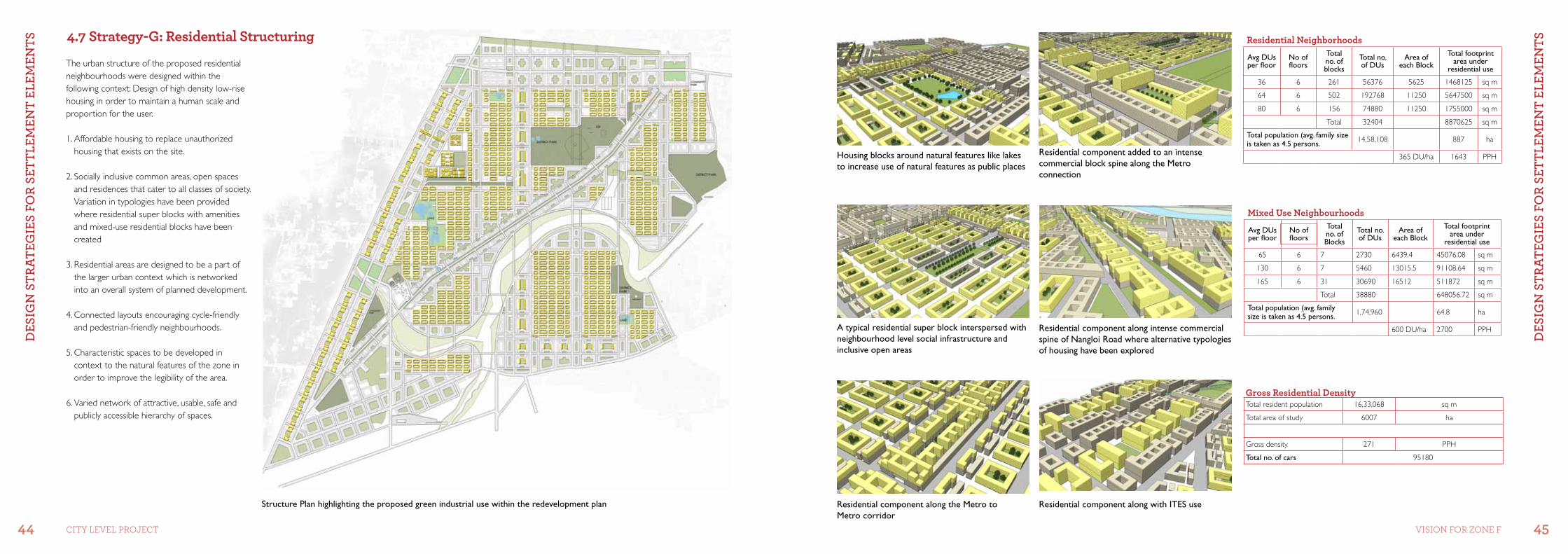
4.7 strategy-G: residential structuring
The urban structure of the proposed residential neighbourhoods were designed within the following context: Design of high density low-rise housing in order to maintain a human scale and proportion for the user.
1. Affordable housing to replace unauthorized housing that exists on the site.
2. Socially inclusive common areas, open spaces and residences that cater to all classes of society. Variation in typologies have been provided where residential super blocks with amenities and mixed-use residential blocks have been created
3. Residential areas are designed to be a part of the larger urban context which is networked into an overall system of planned development.
4. Connected layouts encouraging cycle-friendly and pedestrian-friendly neighbourhoods.
5. Characteristic spaces to be developed in context to the natural features of the zone in order to improve the legibility of the area.
6. Varied network of attractive, usable, safe and publicly accessible hierarchy of spaces.
Housing blocks around natural features like lakes to increase use of natural features as public places
Residential component added to an intense commercial block spine along the Metro connection
A typical residential super block interspersed with neighbourhood level social infrastructure and inclusive open areas
Residential component along intense commercial spine of Nangloi Road where alternative typologies of housing have been explored
Residential component along with ITES useResidential component along the Metro to Metro corridor
Gross residential DensityTotal resident population 16,33,068 sq m
Total area of study 6007 ha
Gross density 271 PPH
Total no. of cars 95180
residential neighborhoods
Avg DUs per floor
No of floors
Total no. of blocks
Total no. of DUs
Area of each Block
Total footprint area under
residential use
36 6 261 56376 5625 1468125 sq m
64 6 502 192768 11250 5647500 sq m
80 6 156 74880 11250 1755000 sq m
Total 32404 8870625 sq m
Total population (avg. family size is taken as 4.5 persons. 14,58,108 887 ha
365 DU/ha 1643 PPH
mixed Use neighbourhoods
Avg DUs per floor
No of floors
Total no. of Blocks
Total no. of DUs
Area of each Block
Total footprint area under
residential use
65 6 7 2730 6439.4 45076.08 sq m
130 6 7 5460 13015.5 91108.64 sq m
165 6 31 30690 16512 511872 sq m
Total 38880 648056.72 sq m
Total population (avg. family size is taken as 4.5 persons. 1,74,960 64.8 ha
600 DU/ha 2700 PPH
Structure Plan highlighting the proposed green industrial use within the redevelopment plan
DES
Ign
StR
AtEg
IES
foR
SEtt
lEm
Ent
ElEm
EntS
DES
Ign
StR
AtEg
IES
foR
SEtt
lEm
Ent
ElEm
EntS
46 47CiTY LeVeL ProjeCT Vision for Zone f
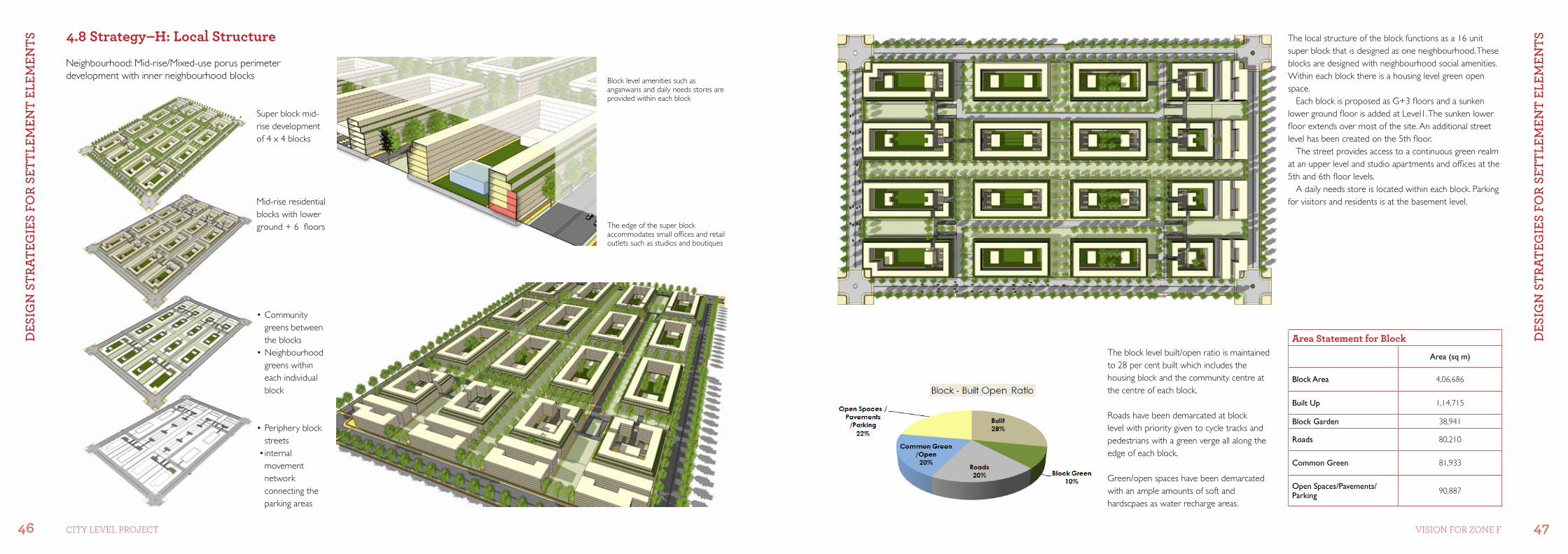
4.8 strategy–H: Local structure
•Peripheryblockstreets
•internalmovement network connecting the parking areas
•Communitygreens between the blocks
•Neighbourhoodgreens within each individual block
Mid-rise residential blocks with lower ground + 6 floors
Super block mid- rise development of 4 x 4 blocks
The edge of the super block accommodates small offices and retail outlets such as studios and boutiques
Block level amenities such as anganwaris and daily needs stores are provided within each block
The local structure of the block functions as a 16 unit super block that is designed as one neighbourhood. These blocks are designed with neighbourhood social amenities. Within each block there is a housing level green open space.
Each block is proposed as G+3 floors and a sunken lower ground floor is added at Level1. The sunken lower floor extends over most of the site. An additional street level has been created on the 5th floor.
The street provides access to a continuous green realm at an upper level and studio apartments and offices at the 5th and 6th floor levels.
A daily needs store is located within each block. Parking for visitors and residents is at the basement level.
The block level built/open ratio is maintained to 28 per cent built which includes the housing block and the community centre at the centre of each block.
Roads have been demarcated at block level with priority given to cycle tracks and pedestrians with a green verge all along the edge of each block.
Green/open spaces have been demarcated with an ample amounts of soft and hardscpaes as water recharge areas.
Neighbourhood: Mid-rise/Mixed-use porus perimeter development with inner neighbourhood blocks
area statement for block
Area (sq m)
Block Area 4,06,686
Built Up 1,14,715
Block Garden 38,941
Roads 80,210
Common Green 81,933
Open Spaces/Pavements/Parking 90,887
DES
Ign
StR
AtEg
IES
foR
SEtt
lEm
Ent
ElEm
EntS
DES
Ign
StR
AtEg
IES
foR
SEtt
lEm
Ent
ElEm
EntS
48 49CiTY LeVeL ProjeCT Vision for Zone f
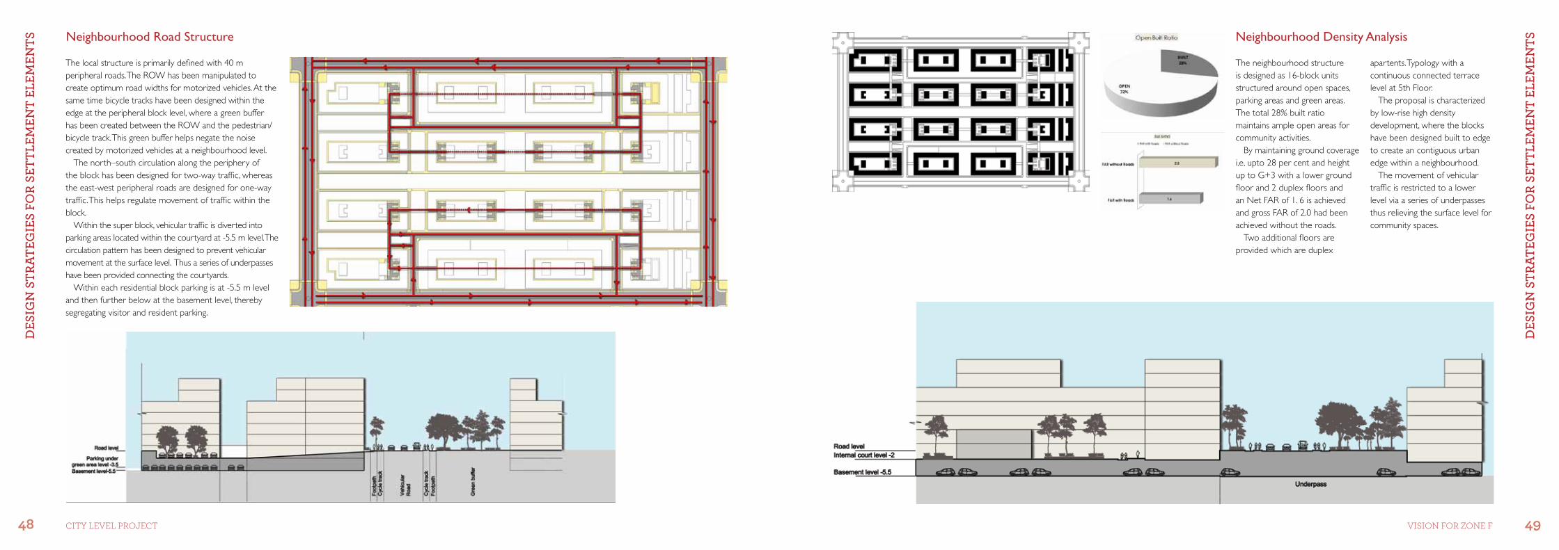
The neighbourhood structure is designed as 16-block units structured around open spaces, parking areas and green areas. The total 28% built ratio maintains ample open areas for community activities.
By maintaining ground coverage i.e. upto 28 per cent and height up to G+3 with a lower ground floor and 2 duplex floors and an Net FAR of 1. 6 is achieved and gross FAR of 2.0 had been achieved without the roads.
Two additional floors are provided which are duplex
The local structure is primarily defined with 40 m peripheral roads. The ROW has been manipulated to create optimum road widths for motorized vehicles. At the same time bicycle tracks have been designed within the edge at the peripheral block level, where a green buffer has been created between the ROW and the pedestrian/bicycle track. This green buffer helps negate the noise created by motorized vehicles at a neighbourhood level.
The north–south circulation along the periphery of the block has been designed for two-way traffic, whereas the east-west peripheral roads are designed for one-way traffic. This helps regulate movement of traffic within the block.
Within the super block, vehicular traffic is diverted into parking areas located within the courtyard at -5.5 m level. The circulation pattern has been designed to prevent vehicular movement at the surface level. Thus a series of underpasses have been provided connecting the courtyards.
Within each residential block parking is at -5.5 m level and then further below at the basement level, thereby segregating visitor and resident parking.
Neighbourhood Road Structure Neighbourhood Density Analysis
apartents. Typology with a continuous connected terrace level at 5th Floor.
The proposal is characterized by low-rise high density development, where the blocks have been designed built to edge to create an contiguous urban edge within a neighbourhood.
The movement of vehicular traffic is restricted to a lower level via a series of underpasses thus relieving the surface level for community spaces.
DES
Ign
StR
AtEg
IES
foR
SEtt
lEm
Ent
ElEm
EntS
DES
Ign
StR
AtEg
IES
foR
SEtt
lEm
Ent
ElEm
EntS
50 51CiTY LeVeL ProjeCT Vision for Zone f
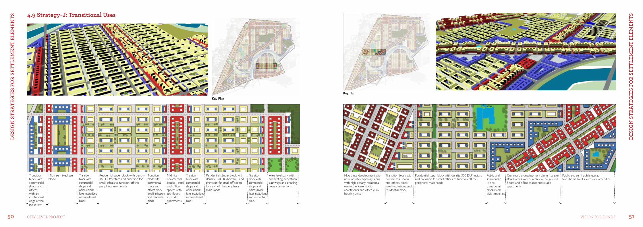
4.9 strategy-J: Transitional Uses
Area level park with connecting pedestrian pathways and creating cross connections
Residential sSuper block with density 350 DU/hectare– and provision for small offices to function off the peripheral main roads
Residential super block with density 350 DU/hectare and provision for small offices to function off the peripheral main roads
Transition block with commercial shops and offices, block level institutions and residential block
Transition block with commercial shops and offices, block level institutions and residential block
Transition block with commercial shops and offices, block level institutions and residential block
Transition block with commercial shops and offices, block level institutions and residential block
Transition block with commercial shops and offices with an institutional edge at the periphery
Mid-rise commercial blocks – retail and office spaces with top floors as studio apartments
Mid-rise mixed use blocks
Key Plan
Mixed-use development with new industry typology along with high-density residential use in the form studio apartments and office cum housing units.
Transition block with commercial shops and offices, block level institutions and residential block
Residential super block with density 350 DU/hectare and provision for small offices to function off the peripheral main roads
Public and semi-public use as transitional blocks with civic amenities
Public and semi-public use as transitional blocks with civic amenities
Commercial development along Nangloi Road with a mix of retail on the ground floors and office spaces and studio apartments
Key Plan
DES
Ign
StR
AtEg
IES
foR
SEtt
lEm
Ent
ElEm
EntS
DES
Ign
StR
AtEg
IES
foR
SEtt
lEm
Ent
ElEm
EntS
52 53CiTY LeVeL ProjeCT Vision for Zone f
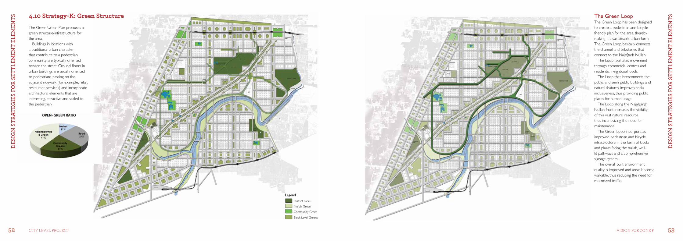
The Green Loop The Green Loop has been designed to create a pedestrian and bicycle friendly plan for the area, thereby making it a sustainable urban form. The Green Loop basically connects the channel and tributaries that connect to the Najafgarh Nullah.
The Loop facilitates movement through commercial centres and residential neighbourhoods.
The Loop that interconnects the public and semi public buildings and natural features, improves social inclusiveness, thus providing public places for human usage.
The Loop along the Najafgargh Nullah front increases the visibilty of this vast natural resource thus incentivizing the need for maintenance.
The Green Loop incorporates improved pedestrian and bicycle infrastructure in the form of kiosks and plazas facing the nullah, well-lit pathways and a comprehensive signage system.
The overall built environment quality is improved and areas become walkable, thus reducing the need for motorized traffic.
The Green Urban Plan proposes a green structure/infrastructure for the area.
Buildings in locations with a traditional urban character that contribute to a pedestrian community are typically oriented toward the street. Ground floors in urban buildings are usually oriented to pedestrians passing on the adjacent sidewalk (for example, retail, restaurant, services) and incorporate architectural elements that are interesting, attractive and scaled to the pedestrian.
Legend
District Parks
Nullah Green
Community Green
Block Level Greens
4.10 strategy-K: Green structure
DES
Ign
StR
AtEg
IES
foR
SEtt
lEm
Ent
ElEm
EntS
DES
Ign
StR
AtEg
IES
foR
SEtt
lEm
Ent
ElEm
EntS
54 55CiTY LeVeL ProjeCT Vision for Zone f
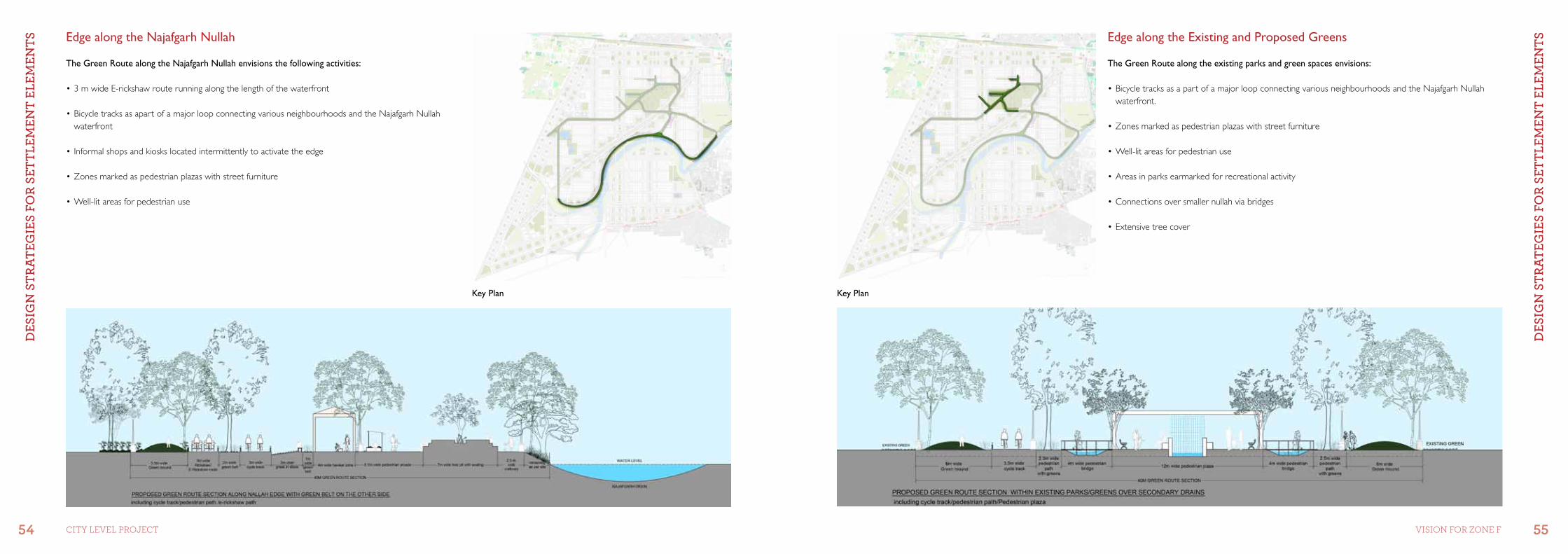
Edge along the Najafgarh Nullah Edge along the Existing and Proposed Greens
The Green Route along the existing parks and green spaces envisions:
•BicycletracksasapartofamajorloopconnectingvariousneighbourhoodsandtheNajafgarhNullahwaterfront.
•Zonesmarkedaspedestrianplazaswithstreetfurniture
•Well-litareasforpedestrianuse
•Areasinparksearmarkedforrecreationalactivity
•Connectionsoversmallernullahviabridges
•Extensivetreecover
The Green Route along the Najafgarh Nullah envisions the following activities:
•3mwideE-rickshawrouterunningalongthelengthofthewaterfront
•BicycletracksasapartofamajorloopconnectingvariousneighbourhoodsandtheNajafgarhNullahwaterfront
•Informalshopsandkioskslocatedintermittentlytoactivatetheedge
•Zonesmarkedaspedestrianplazaswithstreetfurniture
•Well-litareasforpedestrianuse
Key Plan Key Plan
DES
Ign
StR
AtEg
IES
foR
SEtt
lEm
Ent
ElEm
EntS
DES
Ign
StR
AtEg
IES
foR
SEtt
lEm
Ent
ElEm
EntS
56 57CiTY LeVeL ProjeCT Vision for Zone f
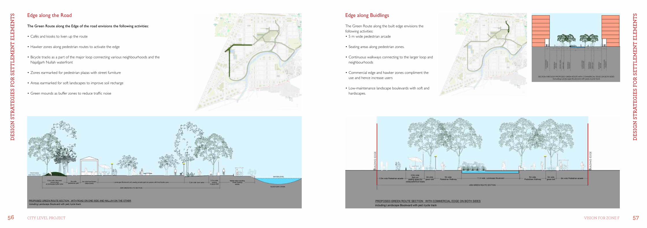
Edge along the Road Edge along Buidlings
The Green Route along the built edge envisions the following activities:•5mwidepedestrianarcade
•Seatingareasalongpedestrianzones.
•Continuouswalkwaysconnectingtothelargerloopandneighbourhoods
•Commercialedgeandhawkerzonescomplimenttheuse and hence increase users
•Low-maintenancelandscapeboulevardswithsoftandhardscapes.
The Green Route along the Edge of the road envisions the following activities:
•Cafésandkioskstolivenuptheroute
•Hawkerzonesalongpedestrianroutestoactivatetheedge
•Bicycletracksasapartofthemajorloopconnectingvariousneighbourhoodsandthe Najafgarh Nullah waterfront
•Zonesearmarkedforpedestrianplazaswithstreetfurniture
•Areasearmarkedforsoftlandscapestoimprovesoilrecharge
•Greenmoundsasbufferzonestoreducetrafficnoise
DES
Ign
StR
AtEg
y fo
R D
EvEl
oPm
Ent
Co
ntR
ol
DES
Ign
StR
AtEg
y fo
R D
EvEl
oPm
Ent
Co
ntR
ol
58 59CiTY LeVeL ProjeCT Vision for Zone f
B
C
D
F
E
G
IJ
K
H
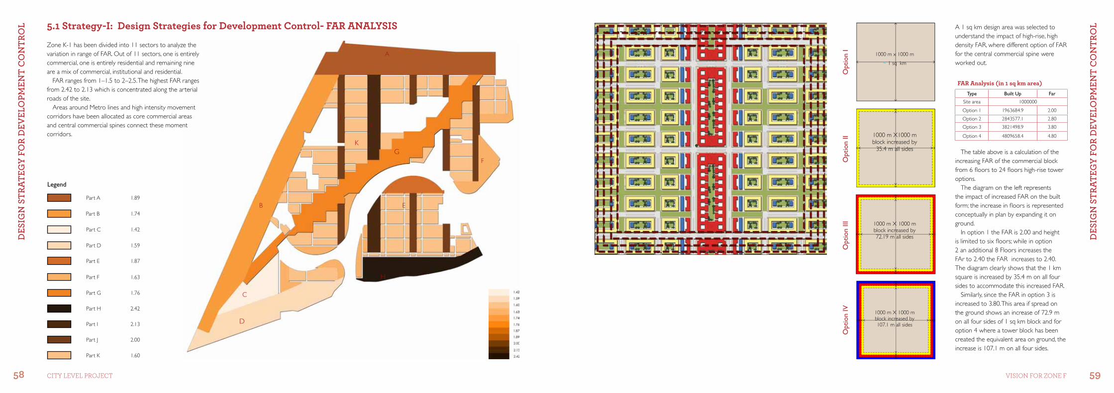
5.1 strategy-i: Design strategies for Development Control- far anaLYsis A 1 sq km design area was selected to understand the impact of high-rise, high density FAR, where different option of FAR for the central commercial spine were worked out.
The table above is a calculation of the increasing FAR of the commercial block from 6 floors to 24 floors high-rise tower options.
The diagram on the left represents the impact of increased FAR on the built form; the increase in floors is represented conceptually in plan by expanding it on ground.
In option 1 the FAR is 2.00 and height is limited to six floors; while in option 2 an additional 8 Floors increases the FAr to 2.40 the FAR increases to 2.40. The diagram clearly shows that the 1 km square is increased by 35.4 m on all four sides to accommodate this increased FAR.
Similarly, since the FAR in option 3 is increased to 3.80. This area if spread on the ground shows an increase of 72.9 m on all four sides of 1 sq km block and for option 4 where a tower block has been created the equivalent area on ground, the increase is 107.1 m on all four sides.
Legend
Part A
Part E
Part D
Part C
Part B
1.89
1.87
1.59
1.42
1.74
Part K
Part J
Part I
Part H
Part G
2.00
2.13
2.42
1.76
Part F 1.63
1.60
1000 m x 1000 m
~ 1 sq km
Opt
ion
I
1000 m X1000 m block increased by
35.4 m all sides
Opt
ion
II
1000 m X 1000 m block increased by 72.19 m all sides
Opt
ion
III
1000 m X 1000 m block increased by 107.1 m all sides
Opt
ion
IV
far analysis (in 1 sq km area)Type Built Up Far
Site area 1000000
Option 1 1963684.9 2.00
Option 2 2843577.1 2.80
Option 3 3821498.9 3.80
Option 4 4809658.4 4.80
Zone K-1 has been divided into 11 sectors to analyze the variation in range of FAR. Out of 11 sectors, one is entirely commercial, one is entirely residential and remaining nine are a mix of commercial, institutional and residential.
FAR ranges from 1–1.5 to 2–2.5. The highest FAR ranges from 2.42 to 2.13 which is concentrated along the arterial roads of the site.
Areas around Metro lines and high intensity movement corridors have been allocated as core commercial areas and central commercial spines connect these moment corridors.
A
DES
Ign
StR
AtEg
y fo
R D
EvEl
oPm
Ent
Co
ntR
ol
DES
Ign
StR
AtEg
y fo
R D
EvEl
oPm
Ent
Co
ntR
ol
60 61CiTY LeVeL ProjeCT Vision for Zone f
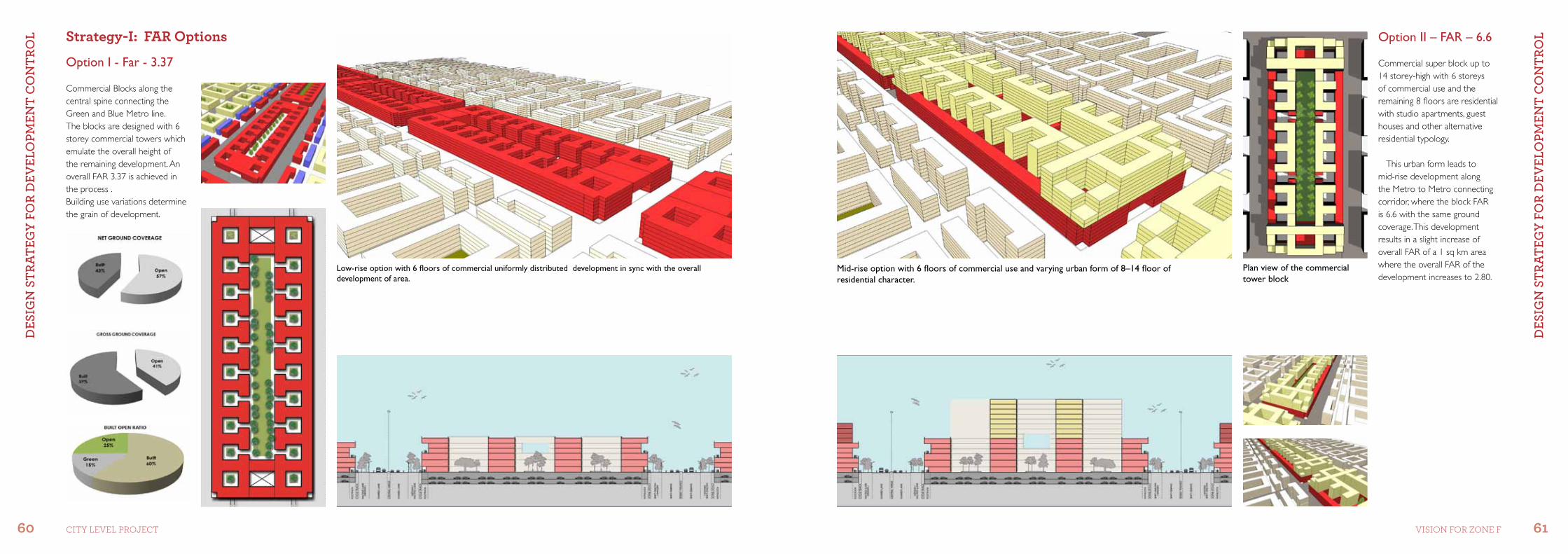
strategy-i: far options Option II – FAR – 6.6
Option I - Far - 3.37
Commercial Blocks along the central spine connecting the Green and Blue Metro line.The blocks are designed with 6 storey commercial towers which emulate the overall height of the remaining development. An overall FAR 3.37 is achieved in the process .Building use variations determine the grain of development.
Commercial super block up to 14 storey-high with 6 storeys of commercial use and the remaining 8 floors are residential with studio apartments, guest houses and other alternative residential typology.
This urban form leads to mid-rise development along the Metro to Metro connecting corridor, where the block FAR is 6.6 with the same ground coverage. This development results in a slight increase of overall FAR of a 1 sq km area where the overall FAR of the development increases to 2.80.
Plan view of the commercial tower block
Mid-rise option with 6 floors of commercial use and varying urban form of 8–14 floor of residential character.
Low-rise option with 6 floors of commercial uniformly distributed development in sync with the overall development of area.
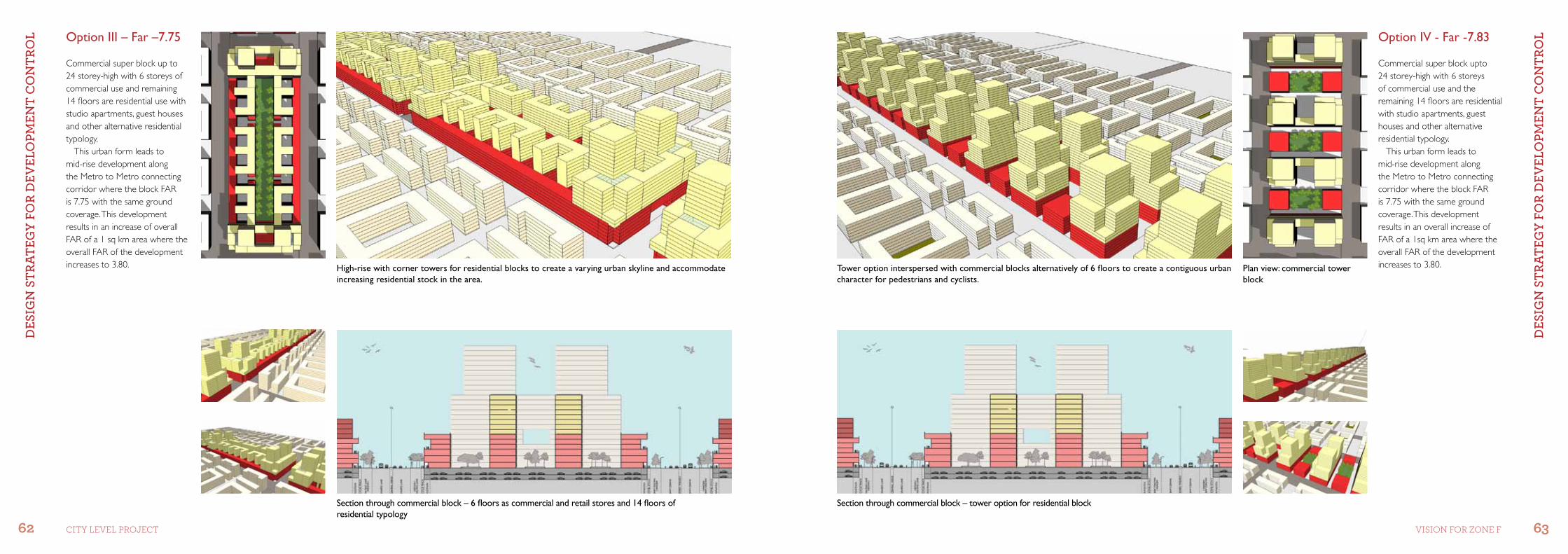
DES
Ign
StR
AtEg
y fo
R D
EvEl
oPm
Ent
Co
ntR
ol
DES
Ign
StR
AtEg
y fo
R D
EvEl
oPm
Ent
Co
ntR
ol
62 63CiTY LeVeL ProjeCT Vision for Zone f
Option III – Far –7.75 Option IV - Far -7.83
Commercial super block up to 24 storey-high with 6 storeys of commercial use and remaining 14 floors are residential use with studio apartments, guest houses and other alternative residential typology.
This urban form leads to mid-rise development along the Metro to Metro connecting corridor where the block FAR is 7.75 with the same ground coverage. This development results in an increase of overall FAR of a 1 sq km area where the overall FAR of the development increases to 3.80.
Commercial super block upto 24 storey-high with 6 storeys of commercial use and the remaining 14 floors are residential with studio apartments, guest houses and other alternative residential typology.
This urban form leads to mid-rise development along the Metro to Metro connecting corridor where the block FAR is 7.75 with the same ground coverage. This development results in an overall increase of FAR of a 1sq km area where the overall FAR of the development increases to 3.80.
Section through commercial block – 6 floors as commercial and retail stores and 14 floors of residential typology
Section through commercial block – tower option for residential block
Tower option interspersed with commercial blocks alternatively of 6 floors to create a contiguous urban character for pedestrians and cyclists.
Plan view: commercial tower block
High-rise with corner towers for residential blocks to create a varying urban skyline and accommodate increasing residential stock in the area.
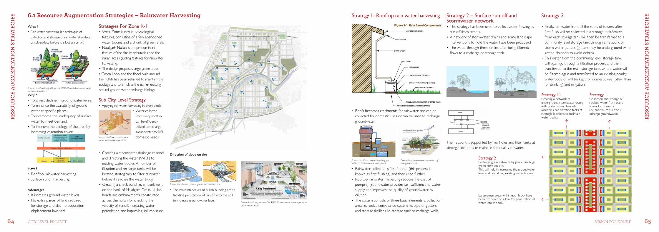
RESo
uRC
E A
ug
mEn
tAtI
on
StR
AtEg
IES
RESo
uRC
E A
ug
mEn
tAtI
on
StR
AtEg
IES
64 65CiTY LeVeL ProjeCT Vision for Zone f
Strategy 1- Rooftop rain water harvesting
• Roofs becomes catchments for rainwater and can be collected for domestic uses or can be used to recharge groundwater.
Strategy 2 – Surface run off and Stormwater network• This strategy has been used to collect water flowing as
run off from streets.• A network of stormwater drains and some landscape
interventions to hold the water have been proposed.• The water through these drains, after being filtered;
flows to a recharge or storage tank.
Strategy 3
• Rainwater collected is first filtered (this process is known as first flushing) and then used further.
• Rooftop rainwater harvesting reduces the cost of pumping groundwater, provides self-sufficiency to water supply and improves the quality of groundwater by dilution.
• The system consists of three basic elements: a collection area i.e. roof, a conveyance system i.e. pipe or gutters and storage facilities i.e. storage tank or recharge wells.
The network is supported by manholes and filter tanks at strategic locations to maintain the quality of water.
• Firstly, rain water from all the roofs of towers, after first flush will be collected in a storage tank. Water from each storage tank will then be transferred to a community level storage tank through a network of storm water gutters (gutters may be underground with grated channels to avoid debris).
• This water from the community level storage tank will again go through a filtration process and then transferred to the main storage tank, where water will be filtered again and transferred to an existing nearby water body or will be kept for domestic use (other than for drinking) and irrigation.
Strategy 1.Collection and storage of rooftop water from every tower for domesticuse and the rest left to r echarge groundwater.
Strategy 11.Creating a network of underground stormwater drains with grated open channels, manholes and filtration tanks at strategic locations to maintain water quality.
Strategy 2Recharging groundwater by proposing huge green areas on site. This will help in increasing the groundwater level and revitalizing existing water bodies.
Large green areas within each block have been proposed to allow the penetration of water into the soil.
6.1 resource augmentation strategies – rainwater Harvesting
What ?
•Rainwaterharvestingisatechniqueof
collection and storage of rainwater at surface
or sub-surface before it is lost as run off.
Strategies For Zone K-1•WestZoneisrichinphysiological
features, consisting of a few abandoned water bodies and a chunk of green area.
•NajafgarhNullahisthepredominantfeature of the site; its tributaries and the nullah act as guiding features for rainwater harvesting.
•Thedesignproposeslargegreenareas,a Green Loop, and the flood plain around the nullah has been retained to maintain the ecology and to emulate the earlier existing natural ground water recharge biology.
Sub City Level Strategy•Applyingrainwaterharvestingineveryblock.
•Watercollected
from every rooftop
can be efficiently
utilized to recharge
groundwater to fulfil
domestic needs.
•Themainobjectivesofnullah-bundingareto
facilitate percolation of run off into the soil
to increase groundwater level.
Direction of slope on site
Why ?
•Toarrestdeclineingroundwaterlevels.•Toenhancetheavailabilityofground
water at specific places.•Toovercometheinadequacyofsurface
water to meet demand.•Toimprovetheecologyoftheareaby
increasing vegetation cover.
How ?
•Rooftoprainwaterharvesting.•Surfacerunoffharvesting.
Advantages
•Itincreasesgroundwaterlevels.•Noextraparceloflandrequired
for storage and also no population displacement involved.
•Creatingastormwaterdrainagechanneland directing the water (WRT) to existing water bodies. A number of filtration and recharge tanks will be located strategically to filter rainwater before it reaches the water body.
•Creatingacheckbundi.e.embankmenton the bank of Najafgarh Drain. Nullah bunds are embankments constructed across the nullah for checking the velocity of runoff, increasing water percolation and improving soil moisture.
Source: http://medblogku.blogspot.in/2017/02/kebijakan-dan-strategi-sistem-drainase.html
Source: http://www.geocities.ws/conservationofwater/rwh.htm
Source: http://www.cpreec.org/watershedadvance.htm
Source: http://citygreen.com/2014/05/13/stormwater-harvesting-and-re-use-in-urban-areas/
Source: http://keepourearthnow.blogspot.in/2011/12/rainwater-harvesting.html
Source: http://www.wassermannlake.org/rain-gardens.html
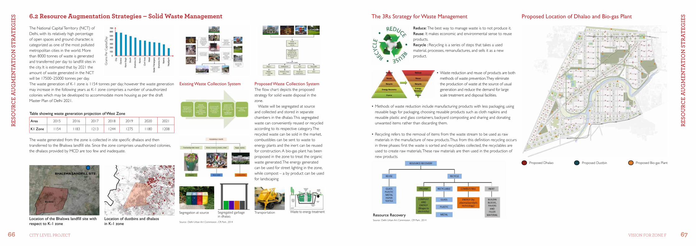
RESo
uRC
E A
ug
mEn
tAtI
on
StR
AtEg
IES
RESo
uRC
E A
ug
mEn
tAtI
on
StR
AtEg
IES
66 67CiTY LeVeL ProjeCT Vision for Zone f
Existing Waste Collection System Proposed Waste Collection SystemThe flow chart depicts the proposed strategy for solid waste disposal in the zone.
Waste will be segregated at source and collected and stored in separate chambers in the dhalao. This segregated waste can conveniently reused or recycled according to its respective category. The recycled waste can be sold in the market, combustibles can be sent to waste to energy plants and the inert can be reused for construction. A bio-gas plant has been proposed in the zone to treat the organic waste generated. The energy generated can be used for street lighting in the zone, while compost – a by product can be used for landscaping
Segregation at source Segregated garbage in dhalao.
Transportation Waste to energy treatment
The 3Rs Strategy for Waste Management
Reduce: The best way to manage waste is to not produce it.Reuse: It makes economic and environmental sense to reuse products.Recycle : Recycling is a series of steps that takes a used material, processes, remanufactures, and sells it as a new product.
•Wastereductionandreuseofproductsarebothmethods of waste prevention. They eliminate the production of waste at the source of usual generation and reduce the demand for large scale treatment and disposal facilities.
•Methodsofwastereductionincludemanufacturingproductswithlesspackaging,usingreusable bags for packaging, choosing reusable products such as cloth napkins and reusable plastic and glass containers, backyard composting and sharing and donating unwanted items rather than discarding them.
•Recyclingreferstotheremovalofitemsfromthewastestreamtobeusedasrawmaterials in the manufacture of new products. Thus from this definition recycling occurs in three phases: first the waste is sorted and recyclables collected, the recyclables are used to create raw materials. These raw materials are then used in the production of new products.
Resource Recovery
The National Capital Territory (NCT) of Delhi, with its relatively high percentage of open spaces and ground character, is categorized as one of the most polluted metropolitan cities in the world. More than 8000 tonnes of waste is generated and transferred per day to landfill sites in the city. It is estimated that by 2021 the amount of waste generated in the NCT will be 17500–25000 tonnes per day. The waste generation of K-1 zone is 1154 tonnes per day; however the waste generation may increase in the following years as K-1 zone comprises a number of unauthorized colonies which may be developed to accommodate more housing as per the draft Master Plan of Delhi 2021.
Gra
ms
Per
Cap
ita/D
ay
Table showing waste generation projection of West Zone
The waste generated from the zone is collected in site specific dhalaos and then transferred to the Bhalswa landfill site. Since the zone comprises unauthorized colonies, the dhalaos provided by MCD are too few and inadequate.
Location of dustbins and dhalaos in K-1 zone
Location of the Bhalswa landfill site with respect to K-1 zone
K1 zone
BHalSWa laNDfill SiTE
Proposed Location of Dhalao and Bio-gas Plant6.2 resource augmentation strategies – solid Waste management
Area 2015 2016 2017 2018 2019 2020 2021
K1 Zone 1154 1183 1213 1244 1275 1180 1208
Proposed Dhalao Proposed Dustbin Proposed Bio-gas Plant
Source : Delhi Urban Art Commission , CR Park , 2014Source : Delhi Urban Art Commission , CR Park , 2014

reference list
•Delhi Development Authority, 2006, ‘ Zonal Development Plan K’, Available at: http://dda.org.in/ddanew/planning.aspx#•Delhi Development Authority, March 2017, ‘Master Plan of Delhi 2021’, Available at: http://dda.org.in/tendernotices_docs/may1 MPD-2021_31.03.2003041717.pdf•Delhi Urban Art Commission, January 2014, Chittranjan park (CR Park) , Available at: http://e.duac.org/images/pdf/3%20Chittranjan%20Park-1.pdf•Delhi Urban Art Commission, January 2015, Uttam Nagar , Available at: http://e.duac.org/images/pdf/22.%20Uttam%20nagar.pdf
Secretary
Delhi Urban art CommissionCore-6A, Upper Ground Floor, India Habitat Centre, Lodhi Road, New Delhi-110003
Tel: +91-11-24618607, +91-11-24619593Email: [email protected], [email protected] Website: www.duac.org