Embed Size (px)
Citation preview

Urban sensing and Weather Prediction: Can IOT devicesbe used to improve weather prediction in cities?
N. Garg a, M. Prakash a, M. Thatcher b and R. Sankaran c
aCSIRO Data61, Goods Shed, 34 Village Street, Docklands, VIC 3008bCSIRO Oceans and Atmosphere, Station Street, Aspendale, VIC 3195
cArgonne National Lab, Chicago, USAEmail: [email protected]
Abstract: Data assimilation (DA) in numerical weather prediction (NWP) has relied on observations sourced from variety of sources like radiosondes, dropwindsondes, meteorological sensors and remote sensing through satellites. The sensors used for collecting meteorological variables such as wind speed, wind direction, tem-perature, relative humidity are designed to provide high quality observations. Additionally, a set of defined instructions must be followed for installation of such systems, with the presumption that the sensors will behave as defined in the user m anual. Due to the aforementioned r easons, firstly, these systems are expen-sive to install and operate, and secondly, they cannot be installed at a large scale within cities, thus requiring alternative ways of sensing environmental conditions within such areas.
In recent times, Internet of Things (IOT), Big Data and Cloud computing has been attracting considerable attention. This has been made possible by the availability of high speed connectivity, ease of access to high quality computing resources at pay-per-use basis and the increased emphasis on informed decision making. Due to such developments, there has been increased diffusion of smart systems equipped with miniaturized sensors allowing such systems to adapt to their environmental conditions e.g., smart air-conditioners control-ling the indoor conditions in response to the changing ambient environment. These disruptive technologies have led to the development of platforms such as Tulip1, Array of Things2 and Dryp3, that rely on alternative sensing methods and technologies.
Historically, weather and climate predictions has been carried out by the national weather agencies. These agencies use weather models together with the data from their observation networks to provide weather fore-casts for public use on time scales ranging from daily, yearly to decadal. Despite the considerable advance-ments in modelling and computing systems, the weather forecasts from agencies can only attain spatial res-olution of 1-10km. Due to the cost and computational systems needed to run such models, there has been a growing interest in combining big data and machine learning to aid in localizing the predictions performed by these models.
In the current study, we investigate the implications of combining observations from Array of Things (Catlett et al., 2017) network installed in City of Chicago with the model outputs from Conformal Cubic Atmosphere Model (CCAM). To that end, the study utilizes modelled and observed air temperature over a one month period. The preliminary results showed a good correlation between the modelled and observed air temperature. However, the sensors mounted on AOT node use different sensing techniques to measure air temperature. Due to these differences, a considerable spread exists in the air temperature observed by the different sensors mounted on a single AOT node. This observed spread in the air temperature underlines the need of caution when using data from IOT devices. Further evaluation against the data from a co-located meteorological sensor may elucidate the implications of this spread when data from IOT devices is combined with the models.
Keywords: Numerical weather prediction, Internet of things, Array of things, Bias correction
1https://www.tulipnetwork.org2https://arrayofthings.github.io/3https://www.dryp.global
23rd International Congress on Modelling and Simulation, Canberra, ACT, Australia, 1 to 6 December 2019 mssanz.org.au/modsim2019
870

N. Garg et al., Urban sensing and Weather Prediction...
1 INTRODUCTION
In last two decades, the skill of operational forecasts from NWP models have improved considerably owing tothe widespread use of ensembles of deterministic forecasts and DA. The improvements int forecast skill hasalso been due to improvements in model physics, increased grid resolution and adoption of coupled modelse.g., coupling atmosphere model with a land surface model and/or ocean model, thus allowing for betterrepresentation of small scale processes. However, the contribution of improvements in model physics havebeen lower compared to the improvements due to higher grid resolution and DA. For a detailed review onthe progress in regional climate modelling, interested readers are referred to Wang et al. (2004). Moreover,the operational weather forecasts currently produced by majority of national weather services are still limitedto a horizontal resolution of 1-10km, but there are on-going efforts at various institutions like Bureau ofMeteorology (BOM) in Australia and UK MetOffice (UKMO) in United Kingdom to increase the spatialresolution to 200-500m over major cities. Although, spatial resolution of models that are currently operationalis appropriate for producing forecasts at national and regional scale, they have limited skill in modellinglocalized microscale flow prevalent in urban areas. An illustration of various scales related to mesoscale-microscale is shown in Figure 1. The limitations of NWP models in resolving microscale flow have led tothe development of integrated modelling systems such as Chen et al. (2011), where an urban canopy model isembedded within a NWP model. However, such models are computationally expensive to run and, have onlybeen limited to research applications.
Figure 1. An illustration of urban boundary layer processes, from mesoscale to microscale. Source: Pullenet al. (2008)
Furthermore, the amount of observations and the diversity in sources of observations for use in NWP has grownconsiderably due to the improvements in connectivity. In addition to the conventional sources of observationse.g., weather station networks, satellites, buoys and weather radars, data is also being collected from un-conventional sources e.g., private weather stations (PWS;Wundergroud (2019)) and mobile devices (NetatmoSAS, 2019). Unlike these un-conventional sources, the conventional methods of observations have to adhereto the standards and methods laid out by the World Meteorological Organization (WMO, 2014), thus limitingwhere and how many of such systems can be installed. Additionally, over the last few years, sensor networkslike Tulip and Array of Things (AOT; Catlett et al. (2017)) have been developed. In contrast to PWS andmobile phones, these sensor networks use low cost sensors for increasing the density of devices measuringenvironment conditions. The installation of such networks are either led by or carried out in collaborationwith the city councils or administrations, where the local government agencies are interested in improvingthe liveability of the cities. For the sake of brevity, hereafter, data from the non-conventional sources ofobservations will be referred to as ’crowd-sourced’ data. The unprecedented growth in ’crowd-sourced’ datahave also generated interest from the national weather agencies as evidenced by Hintz et al. (2019). A numberof preliminary studies like Madaus and Mass (2017); Hintz et al. (2019) have used the barometric pressuredata from the mobile phones and this was assimilated in NWP models. These studies have demonstrated thepotential of ’crowd-sourced’ data in increasing model skill, however, they have also pointed out the various
871
N. Garg et al., Urban sensing and Weather Prediction...
steps needed for screening and quality control. In light of the foregoing discussion, we aim to investigate theimplications of combining meteorological observations collected from the AOT network installed within theCity of Chicago with the forecast generated by the CCAM model. To this end, we will examine the potentialof AOT network for correcting bias in modelled temperature field within an urban location.
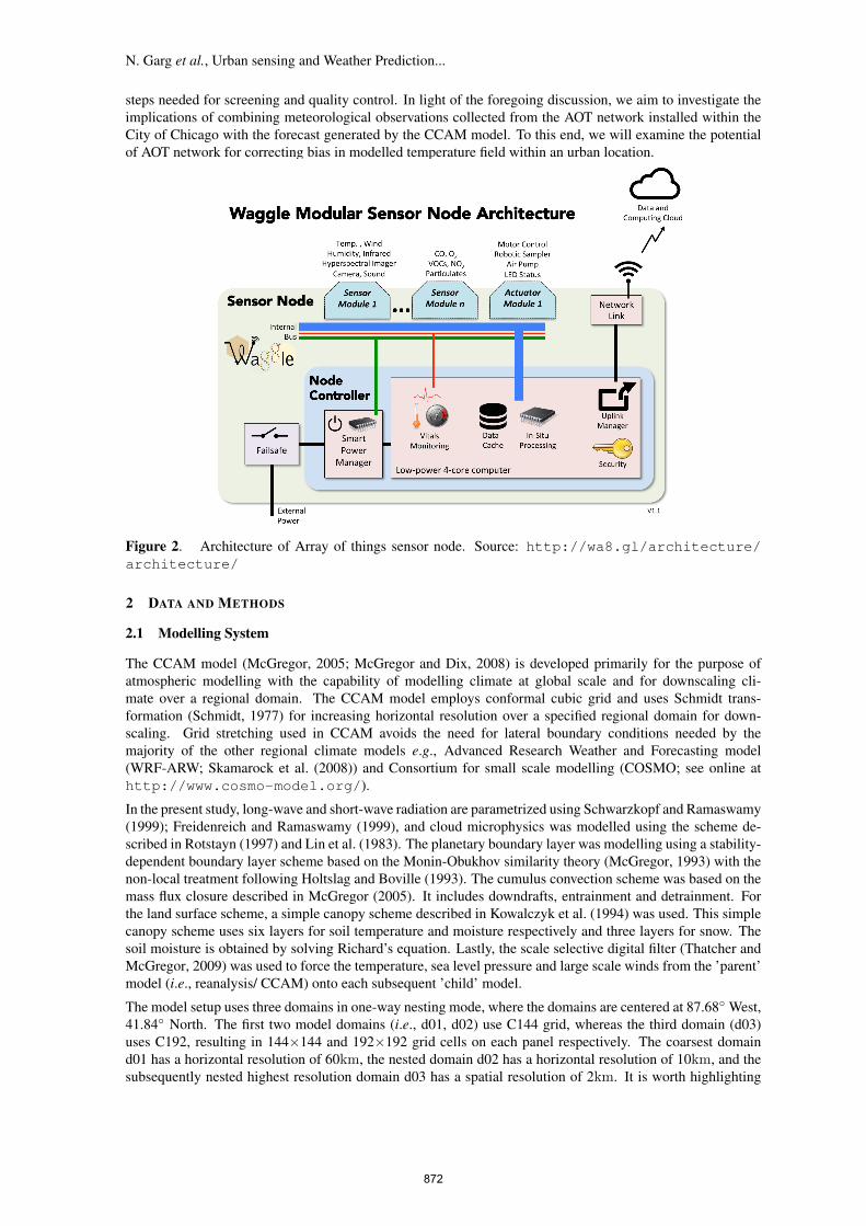
Figure 2. Architecture of Array of things sensor node. Source: http://wa8.gl/architecture/architecture/
2 DATA AND METHODS
2.1 Modelling System
The CCAM model (McGregor, 2005; McGregor and Dix, 2008) is developed primarily for the purpose ofatmospheric modelling with the capability of modelling climate at global scale and for downscaling cli-mate over a regional domain. The CCAM model employs conformal cubic grid and uses Schmidt trans-formation (Schmidt, 1977) for increasing horizontal resolution over a specified regional domain for down-scaling. Grid stretching used in CCAM avoids the need for lateral boundary conditions needed by themajority of the other regional climate models e.g., Advanced Research Weather and Forecasting model(WRF-ARW; Skamarock et al. (2008)) and Consortium for small scale modelling (COSMO; see online athttp://www.cosmo-model.org/).
In the present study, long-wave and short-wave radiation are parametrized using Schwarzkopf and Ramaswamy(1999); Freidenreich and Ramaswamy (1999), and cloud microphysics was modelled using the scheme de-scribed in Rotstayn (1997) and Lin et al. (1983). The planetary boundary layer was modelling using a stability-dependent boundary layer scheme based on the Monin-Obukhov similarity theory (McGregor, 1993) with thenon-local treatment following Holtslag and Boville (1993). The cumulus convection scheme was based on themass flux closure described in McGregor (2005). It includes downdrafts, entrainment and detrainment. Forthe land surface scheme, a simple canopy scheme described in Kowalczyk et al. (1994) was used. This simplecanopy scheme uses six layers for soil temperature and moisture respectively and three layers for snow. Thesoil moisture is obtained by solving Richard’s equation. Lastly, the scale selective digital filter (Thatcher andMcGregor, 2009) was used to force the temperature, sea level pressure and large scale winds from the ’parent’model (i.e., reanalysis/ CCAM) onto each subsequent ’child’ model.
The model setup uses three domains in one-way nesting mode, where the domains are centered at 87.68◦ West,41.84◦ North. The first two model domains (i.e., d01, d02) use C144 grid, whereas the third domain (d03)uses C192, resulting in 144×144 and 192×192 grid cells on each panel respectively. The coarsest domaind01 has a horizontal resolution of 60km, the nested domain d02 has a horizontal resolution of 10km, and thesubsequently nested highest resolution domain d03 has a spatial resolution of 2km. It is worth highlighting
872

N. Garg et al., Urban sensing and Weather Prediction...
that the larger jumps in resolution (from d01-d03) are possible because of the stretched global grid used inCCAM. Furthermore, the aforementioned spatial resolution are only applicable within the output region (i.e.,the stretched part of the model grid), whereas, the model uses a lower resolution grid outside the output region.The model simulations were initialized with the ECMWF (European Center for Medium Weather Forecast)Intermediate reanalysis (ERA-Interim) (Simmons et al., 2007). Herein, the ERA-Interim has a horizontalresolution of 0.75◦×0.75◦ (≈80km). The start date for the model simulation was 1 January, 2019 at 00 UTCand the model simulation was carried out for 30 days.
Figure 3. Illustration of CCAM model grid and the AOT sensor network within the Greater Chicago Area.
2.2 Observations
Over the last five years, the University of Chicago and the Argonne National Laboratory in collaboration withthe City of Chicago has installed a network of more than 100 Array of things (AOT; Catlett et al. (2017)) nodeswithin the Greater Chicago Area. The main purpose of these nodes is to collect a variety of real-time data onurban environment, infrastructure.
The AOT nodes are equipped with sensors for measuring meteorological variables like air temperature, baro-metric pressure, humidity, air quality variables like concentration of carbon monoxide, nitrogen dioxide,sulphur dioxide and light intensity among others. For this study, we will restrict ourselves to the data col-lected from the sensors deployed for collecting observations on meteorological variables. An exhaustive listof data collected and the sensors used for collecting the data can be found at https://arrayofthings.github.io/node.html and https://github.com/waggle-sensor/sensors.
In addition to the sensors for collecting data, the nodes also contain two on-board computers, where onecomputer is used for node operations and the other one for edge computing. The former computer is usedfor performing in-situ operations like packing data and transferring it to a server referred to as ”beehive”,whereas the latter computer designated for edge computing comes with a graphical processing unit (GPU),thus enabling the deployment of tools for performing operations related to image processing and machinelearning on the node itself before transferring processed data to the server. An illustration of the wagglemodular sensor node architecture is given in Figure 2.
2.3 Crowd-sourced data for bias correction
The climate and weather forecast generated by NWP models suffer from bias. Therefore, a number of meth-ods for correcting forecast bias have been developed. The bias in model forecasts is alleviated by using theobserved data collected through conventional methods. However, due to lack of such observations within anurban area, we will use the data collected through the AOT network in the City of Chicago to bias correct the
873

N. Garg et al., Urban sensing and Weather Prediction...
(a) (b)
(c)
Figure 4. (a) The CCAM model temperature on 5 January, 2019 at 05UTC, (b) a scatter plot of mean airtemperature from six temperature sensors mounted on the AOT node 10ba46 located at -87.63◦E, 41.88◦Nand, (c) a comparison of hourly observed and modelled air temperature at the location of node 10ba46. Theobserved air temperature in (c) also shows the spread in air temperature observed by the 6 sensors used forobserving temperature.
air temperature output from CCAM model. The various methods range from simple additive bias correction,quantile mapping (Piani et al., 2010) to kalman filter (Monache et al., 2008) based bias correction. Here, wehave described the two widely used bias correction methods.
Additive bias correction. Following Hawkins et al. (2013), the bias in raw model output xm(t) can becorrected by simply shifting the mean of the model output xm by the mean of the observed data xo.
xcorrm (t) = xm(t)− (xo − xm) (1)
In addition, it is also possible to not only shift the mean as per eq. (1), but also the temporal variability usingeq. (2).
xcorrm (t) = xo +σoσm
(xm(t)− xm) (2)
Here, the bias correction method uses the standard deviation of model output σm and the observations σo inaddition to the mean values.
Quantile Mapping. In addition to the simple additive bias correction methods, removal of bias in modeloutput can be done using quantile-quantile mapping (Piani et al., 2010). In quantile mapping, it is possible toaccount for bias in all statistical moments.
xcorrm = F−1o (Fm(xm)) (3)
In this method, the quantile mapping is carried out as per eq. (3), where the cumulative distribution function(CDF) of the observations Fo and model output Fm are used. For CDF, it is possible to either use an empirical
874

N. Garg et al., Urban sensing and Weather Prediction...
cumulative distribution function, or the CDF of a fitted continuous distribution, with the assumption that boththe model output and observations follow a continuous distribution e.g., normal distribution.
Figure 5. A comparison of empirical cumulative distribution function (CDF) obtained from observed andmodelled air temperature. The CDF of modelled air temperature after bias correction (BC) using the twoadditive BC methods and quantile-quantile mapping BC is also shown.
3 RESULTS AND DISCUSSION
The model grid points from the domain d03 and the locations of AOT nodes within the Greater Chicago areaare shown in Figure 2. It is evident that the network of AOT nodes has increased the density of observationscollected. Figure 4 shows the spatial variation of air temperature from CCAM model within the GreaterChicago area on 5 January, 2019 at 05UTC. Additionally, a comparison of air temperature from 6 differentsensors mounted on an AOT node located at -87.63◦E, 41.88◦N is also shown (see Figure 4(c). It can be notedthat the model output compares quite well with observed air temperature. However, it must be pointed outthe air temperature observed by different sensors deployed on AOT node vary considerably (see Figure 4(c)).A comparison of the empirical cumulative distribution of observed, raw modelled air temperature and biascorrected modelled air temperature is shown in Figure 5. From the preliminary results presented here, it isevident that observations collected through AOT nodes can be used for NWP modelling, however, the spread oftemperature measured by the various sensors mounted on each node does raise questions on both the reliabilityand fidelity of such observation networks. It must also be kept in mind that the preliminary results presentedhere compare observations from a single node and for a single variable. To derive any robust conclusions, theprocedure presented here will be expanded onto other nodes, both to evaluate the spatial pattern of observedtemperature and bias in model outputs.
ACKNOWLEDGEMENT
The authors would like to acknowledge the Array of Things team, the Argonne National Laboratory (ANL),the University of Chicago and the City of Chicago for providing Array of Things data collected from theCity of Chicago in public domain. The first author would also like to acknowledge Rajesh Sankaran fromMathematics and Computer Sciences (MCS) division for hosting him at ANL.
REFERENCES
Catlett, C. E., P. H. Beckman, R. Sankaran, and K. K. Galvin (2017). Array of things: a scientific researchinstrument in the public way: platform design and early lessons learned. In Proceedings of the 2nd Interna-tional Workshop on Science of Smart City Operations and Platforms Engineering - SCOPE ’17, Pittsburgh,Pennsylvania, pp. 26–33. ACM Press.
Chen, F., H. Kusaka, R. Bornstein, J. Ching, C. S. B. Grimmond, S. Grossman-Clarke, T. Loridan, K. W.Manning, A. Martilli, S. Miao, D. Sailor, F. P. Salamanca, H. Taha, M. Tewari, X. Wang, A. A. Wys-zogrodzki, and C. Zhang (2011). The integrated WRF/urban modelling system: development, evaluation,and applications to urban environmental problems. International Journal of Climatology 31(2), 273–288.
Freidenreich, S. M. and V. Ramaswamy (1999). A new multiple-band solar radiative parameterization forgeneral circulation models. Journal of Geophysical Research: Atmospheres 104(D24), 31389–31409.
875

N. Garg et al., Urban sensing and Weather Prediction...
Hawkins, E., T. M. Osborne, C. K. Ho, and A. J. Challinor (2013). Calibration and bias correction of climateprojections for crop modelling: An idealised case study over europe. Agricultural and Forest Meteorol-ogy 170, 19–31.
Hintz, K. S., K. O’Boyle, S. L. Dance, S. Al-Ali, I. Ansper, D. Blaauboer, M. Clark, A. Cress, M. Dahoui,R. Darcy, J. Hyrkkanen, L. Isaksen, E. Kaas, U. S. Korsholm, M. Lavanant, G. Le Bloa, E. Mallet, C. Mc-Nicholas, J. Onvlee-Hooimeijer, B. Sass, V. Siirand, H. Vedel, J. A. Waller, and X. Yang (2019). Collectingand utilising crowdsourced data for numerical weather prediction: Propositions from the meeting held incopenhagen, 4-5 December 2018. Atmospheric Science Letters 20(7), e921.
Hintz, K. S., H. Vedel, and E. Kaas (2019). Collecting and processing of barometric data from smartphonesfor potential use in numerical weather prediction data assimilation. Meteorological Applications, 1–14.
Holtslag, A. A. M. and B. A. Boville (1993). Local Versus Nonlocal Boundary-Layer Diffusion in a GlobalClimate Model. Journal of Climate 6(10), 1825–1842.
Kowalczyk, E. A., J. R. Garrat, and P. B. Krummel (1994). Implementation of a soil canopy scheme into theCSIRO GCM-regional aspects of the model response. Technical Report 32, Melbourne, Australia.
Lin, Y.-L., R. D. Farley, and H. D. Orville (1983). Bulk Parameterization of the Snow Field in a Cloud Model.Journal of Climate and Applied Meteorology 22(6), 1065–1092.
Madaus, L. E. and C. F. Mass (2017). Evaluating smartphone pressure observations for mesoscale analysesand forecasts. Weather and Forecasting 32(2), 511–531.
McGregor, J. L. (1993). The CSIRO 9-level atmospheric general circulation model. Technical Report 26,Melbourne. OCLC: 246798611.
McGregor, J. L. (2005). C-CAM: Geometrical Aspects and Dynamical Formulation.pdf. CSIRO Marine andAtmospheric Research Tech. Paper 70, CSIRO Marine and Atmosphere, Victoria, Australia.
McGregor, J. L. and M. Dix (2008). A updated description of conformal cubic atmospheric model. InK. Hamilton and W. Ohfuchi (Eds.), High Resolution Numerical Modelling of the Atmosphere and Ocean,pp. 51–75. New York, NY: Springer New York.
Monache, L. D., J. Wilczak, S. Mckeen, G. Grell, M. Pagowski, S. Peckham, R. Stull, J. Mchenry, andJ. Mcqueen (2008). A kalman-filter bias correction method applied to deterministic, ensemble averagedand probabilistic forecasts of surface ozone. Tellus B: Chemical and Physical Meteorology 60(2), 238–249.
Netatmo SAS (2019). Netatmo weathermap. https://weathermap.netatmo.com/. Accessed on 29July, 2019.
Piani, C., J. O. Haerter, and E. Coppola (2010). Statistical bias correction for daily precipitation in regionalclimate models over europe. Theoretical and Applied Climatology 99(1), 187–192.
Pullen, J., J. Ching, D. Sailor, W. Thompson, B. Bornstein, and D. Koracin (2008). Progress toward meetingthe challenges of our coastal urban future. Bulletin of the American Meteorological Society 89(11), 1727–1734.
Rotstayn, L. D. (1997). A physically based scheme for the treatment of stratiform clouds and precipitation inlarge-scale models. I: Description and evaluation of the microphysical processes. Quarterly Journal of theRoyal Meteorological Society 123(541), 1227–1282.
Schmidt, F. (1977). Variable fine mesh in the spectral global models. Beitraege zur Physik der Atmosphaere 50,211–217.
Schwarzkopf, M. D. and V. Ramaswamy (1999). Radiative effects of CH4, N2O, halocarbons and the foreign-broadened H2O continuum: A GCM experiment. Journal of Geophysical Research: Atmospheres 104(D8),9467–9488.
Simmons, A., S. Uppala, D. Dee, and S. Kobayashi (2007). ERA-Interim: New ECMWF reanalysis productsfrom 1989 onwards. ECMWF newsletter 110(110), 25–35.
Skamarock, W. C., J. B. Klemp, J. Dudhia, D. Gill, D. M. Barker, M. Duda, X. Y. Huang, W. Wang, and J. G.Powers (2008). A Description of the Advanced Research WRF Version 3. Technical report, National Centerfor Atmospheric Research (NCAR). NCAR/TN-475+STR.
Thatcher, M. and J. L. McGregor (2009). Using a Scale-Selective Filter for Dynamical Downscaling with theConformal Cubic Atmospheric Model. Monthly Weather Review 137(6), 1742–1752.
Wang, Y., L. R. Leung, J. L. McGregor, D. K. Lee, W. C. Wang, Y. Ding, and F. Kimura (2004). RegionalClimate Modeling: Progress, Challenges, and Prospects. Journal of the Meteorological Society of Japan.Ser. II 82(6), 1599–1628.
WMO (2014). Guide to Meteorological Instruments and Methods of Observation. Technical report, WorldMeteorological Organization, Geneva.
Wundergroud (2019). Wunderground PWS. https://www.wunderground.com/weatherstation/overview.asp. Accessed on 29 July, 2019.
876