Embed Size (px)
Citation preview

Urban Regional Identity and Traits: Delhi and its Peripheral Region
Debnath Mookherjee* Manie (H.S.) Geyer**
Eugene Hoerauf*
IGU Urban Geography CommissionCanterbury UK
Christ Church UniversityAugust 14-20, 2011
*Western Washington University, Bellingham, WA 98225, USA ** Stellenbosch University, Stellenbosch 7602, South Africa

Conceptual Background
• Core/Periphery – The Semantics of Peripheral Relevance
• Dimensions –Spatial / Aspatial• The Centricity Continuum – From Monocentric to
Polycentric• Agreements & Ambiguities – Scale, Definition,
Disciplinary Approaches, Measurements
References: Potter (2001), Copus (2001), Geyer (2006)

Agreements & Ambiguities
• Broad Consensus (Developed Countries)
-- The ‘Demise’ of Monocentricity
-- Decentralization of Economic Activities
-- Implications of Changes in the ‘Demographic Regime’
-- Mono/Polycentricity – A Continuum, Not an ‘Either /Or’
-- Morphological & Functional Dimensions

Agreements & Ambiguities (Cont.)
• Ambiguities –‘No Real Consensus,’ e.g.,
-- Definitions of Polycentricity, ‘What it Really Means’
-- Scales
-- Polycentric Forms (PUR, City Regions)
-- Measurement Criteria, Variables
References: Davoudi (2003), Kloosterman and Musterd (2001), Champion (2001), Meijers and Burger (2010)

Polycentric Urban Regions (PURs)
• Distinctive Spatial Structure: PUR
-- Clustering of Centers
-- Size, Spacing, and Size Distribution
-- Center-Specialization
-- Multi-Centered Metro Areas
-- Uniform Homogeneous Regions

Polycentric Urban Regions (PURs)
• Study Approaches/ Orientations
--Functional/ Relational and Morphological
-- Scalar Variations – Meso, Macro, Mega
Inter and Intra-Regional Perspectives• Dimensions/ Characteristics
-- Physical Forms, Political Entity, Functional Relationships, Historical/ Cultural Identity
References: Par (2004), Green (2007), Veneri & Burgalassi (2010), Davoudi (2002)

Polycentric Urban Regions (PURs) (cont.)
-- Urban System – Conforms Broadly to the Central Place Model
-- Particular Form of Nodal Region
-- Bi-Nodal City-Region
• General Agreement: Studies are More or Less Context Specific.
Reference: Par (2004), Turok & Bailey (2004), Dick & Rimmer (1998), Davoudi (2002)

Important Reminders for Us
• Most Research, Conceptualizations, and Debates are in the Context of Developed Countries
• Research is Lagging far behind in Context of the Developing World
• Context-Specific Empirical Research is Needed for Academic & Policy Purposes

An Empirical Observation: The Case of NCR in India
• The Delhi core (NCT) grew dramatically during the past five decades .
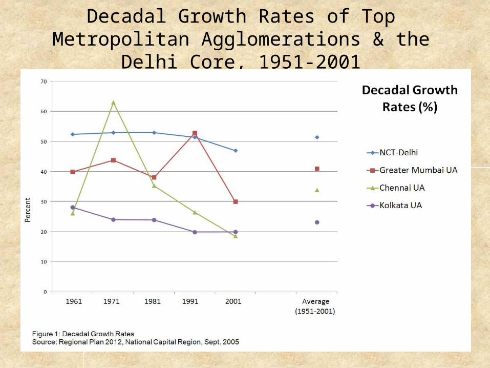
Decadal Growth Rates of Top Metropolitan Agglomerations & the Delhi Core, 1951-2001

A Regional Planning Approach
• Concerns over Delhi’s Urban Growth and Spatial Impact Prompted Action
• National Commission on Urbanization (NCOU), 1988
• National Capital Region Planning Board (NCRPB), 1985


The Constituent Areas of the NCR
• Following an act of Parliament in 1985, a National Capital Region Planning Board (NCRPB) was set up
• The NCR was delineated across parts of three adjacent states, Rajasthan, UP, and
Haryana
• The states voluntarily agreed to surrender their constitutional rights in favor of the Board
for planning development of NCR… (NCRPB, 2000, p.xix)


The NCR Policy Zones• Three concentric policy zones were formed
with the intent of development of urban centers outside of the NCT-Delhi in a polycentric fashion.
-- NCT-Delhi (1483 sq. km)
-- Delhi Metropolitan Area (DMA) excluding the NCT-Delhi (1697 sq. km)
-- The rest of the NCR (27,063 sq km).
-- Also, a ‘Highway Corridor Zone’, and a ‘Central National Capital Region’ (CNCR) based on the former Delhi Metropolitan Area (DMA), were identified.

National Capital Region: Policy Zones

Planning Objectives
• Halting the Concentration in Delhi• Redistribution of Population and Activities within
the NCR• Avoidance of “Amorphous Blobs on the
Landscape”• Postulate: Future Settlements would Emerge in
PUR forms
References: NCOU Report (1988), NCRPB Report (1985)

Research Focus • Primary Research Focus in Literature:
Resources, Management, Directions of Growth, Carrying Capacity, Infra-Structural Stress
• Focus of Our Study: To Observe the Settlement Patterns in the Peripheral Region of the NCR from the Perspective of some Morphological Elements of Polycentric Development as a Baseline Prior to the 2011 Census Reports.
References: Ahmed & Choi (2011), Bhandari et al (2007), Jain et al (2011), Banerjee (1996), Mookherjee & Geyer (2011)

Research Focus (Contd.)• Study Design:
-- The Spatial Entity: The National Capital Region (Core and Periphery)
-- The Data Set: Census data—Demographic (Population), Economic (Workers), Spatial (Distance from the Core)
-- Urban Settlements: Centers of 20,000 and Over Population Size
-- Descriptive Statistics: Core-Periphery Differentials of Population and Occupational Growth Rates, Size and Distance Patterns


Growth Rates Main Workers: Delhi Core and Peripheral Centers, 1991-2001

Growth Rates Other Workers: Delhi Core and Peripheral Centers, 1991-2001
Loni
(NP)
Behta
Haji
pur (
CT)
Bhiwad
i (CT)
Ghazia
bad
(M C
orp.
)
Bahad
urga
rh (M
Cl )
Noida
(CT)
Dadri
(MB)
Farida
bad
(M C
orp.
)
Palwal
(M C
l )
Sohna
(MC)
Mur
adna
gar (
MB)
Samalk
ha (M
C)
Hodal
(MC)
Sonipa
t (M
Cl)
Gohan
a (M
C)
Delhi C
ore
(NCTD)
0
50
100
150
200
250
Chart Title
Other Workers

Growth Rates Household Workers: Delhi Core and Peripheral Centers, 1991-2001
Loni
(NP)
Behta
Haji
pur (
CT)
Bhiwad
i (CT)
Ghazia
bad
(M C
orp.
)
Bahad
urga
rh (M
Cl )
Noida
(CT)
Dadri
(MB)
Farida
bad
(M C
orp.
)
Palwal
(M C
l )
Sohna
(MC)
Mur
adna
gar (
MB)
Samalk
ha (M
C)
Hodal
(MC)
Sonipa
t (M
Cl)
Gohan
a (M
C)
Delhi C
ore
(NCTD)
0
200
400
600
800
1000
1200
1400
Chart Title
Household Workers

Findings• Cities and Towns were concentrated within the
40 km contour line from the NCT-Delhi core
• About one-third of Urban Centers (n=51) with growth rates exceeding Delhi core growth were located within the 20 km contour line.
• Six of these Centers appear to form a Node around Ghaziabad – a large city of nearly one million population
• Distribution of the centers also varied per the state’s developmental status.

Findings (contd.)• Majority of the cities and towns in UP grew at a
very moderate pace; some showed negative growth.
• A cluster of six centers with Ghaziabad as the node in the east appear to be emerging.
• An elongated corridor-like zone of four centers extending northward from Sonipat is
noticeable. • These zones may evolve into some forms of
polycentric urban regions.

Concluding Remarks• We have to remember that this has been a glimpse
backward at the settlement status a decade ago. Only the new census data can offer us current information.
• Our observations clearly point to a trend in spatial development in the NCR at the peripheral region
of Delhi.• The trend: a predominantly higher growth rates of
population and workers at the immediate periphery of Delhi that far surpassed the growth rates of the core.
• However, such a trend, while encouraging, is not impressive.

Concluding Remarks (Contd.)
• We further detected a possible shaping of future spatial forms in the distribution of urban centers—a
‘node’ in the east and a ‘corridor’ in the north-west.
• These are among the rapidly growing centers that may be the ‘incubators’ of regional growth in the future
• Above patterns may result partly from NCR policies
• It can also be argued that in view of the wide diversity within the NCR and the influence of the Delhi core, such a trend could be inevitable and may have emerged independently.
• Answers to such queries must await new data.

Acknowledgements
We would like to thank ~
• Stephan Freelan, GIS Specialist, WWU, for drawing some of the illustrations; and,
• Jonah White, Graduate Student at WWU, for initial compilation of some Census data.


![Zoological Survey of Indiafaunaofindia.nic.in/PDFVolumes/occpapers/028/index.pdf · RA]AGOPAL & MOOKHERJEE : Molluscan fauna of India Family-TuRRITELLIDAE • Turritella acutangula](https://img.pdfslide.us/doc/110x75/5f791227eda89c30b02d00e8/zoological-survey-of-raagopal-mookherjee-molluscan-fauna-of-india-family-turritellidae.jpg)


![Sandra brown dulce manie vol 1 [ibuc.info]](https://img.pdfslide.us/doc/110x75/58f9c165760da32f4b8b5c23/sandra-brown-dulce-manie-vol-1-ibucinfo-58f9c548bce69.jpg)