Embed Size (px)
Citation preview
INDEGREE PROJECT THE BUILT ENVIRONMENT,SECOND CYCLE, 15 CREDITS
,STOCKHOLM SWEDEN 2018
Urban movers – elevated railway structures and urban life
HANS VILJOEN
KTH ROYAL INSTITUTE OF TECHNOLOGYSCHOOL OF ARCHITECTURE AND THE BUILT ENVIRONMENT
TRITA TRITA-ABE-MBT-18414
www.kth.se
32
urban movERSELEVATED RAILWAY STRUCTURESAND URBAN LIFEHans Viljoen
54
URBAN MOVERSELEVATED RAILWAY STRUCTURES AND URBAN LIFE
First published in 2018.written by Hans Viljoen.
contact: [email protected]
Final presentation: 07.06.2018Examiner: Tigran HaasSupervisor: Ryan Locke
AG218X Degree Project in Urban Studies, Second Cycle 15.0 creditsMaster’s Programme in Urbanism Studies, 60.0 creditsSchool of Architecture and the Built EnvironmentKTH Royal Institute of TechnologyStockholm, SwedenTelephone: +46 8 790 60 00
indexabstract
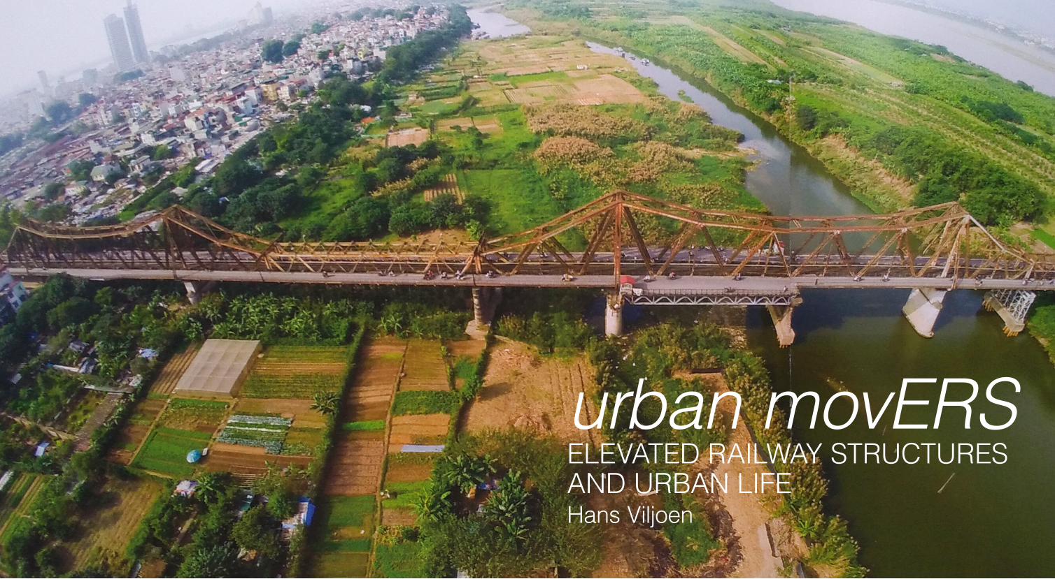
Cover image. ‘Drone views of Long Bien Bridge’, (Phillipe Lé, 2014)
Elevated railway structures (ERS) has for more than a century been evolving as an urban archetype. Pre-sent in various forms in cities across the globe, to transport the increasing number of citizens, ERS are urban in-frastructures that perform a vital role in curbing congestion and pollution that plague cities so often. In spite of their sustainable transport benefits, ERS are often viewed negatively as noisy, ugly and severing urban form, amongst other problems which will be elaborated on - problematising ERS. A theorisation of these prob-lems follows, looking at ERS as an
1. BACKGROUND
2. PROBLEMATISING ERS
3. THEORISING ERS
4. POTENTIALISING ERS
5. CONCLUSION
6. REFERENCES
7. PICTURE CREDITS
urban type, an infrastructural type and other typologies. 39 types of ERS interventions are described as the result of a global literary and ex-periential search of various instances of ERS and projects that seek their urban integration. It is a search for the potentials of ERS to contribute to urban life and urban form, beyond their main transport function - po-tentializing ERS.
#elevated railway structures, #elevated transit structures, #urban typologies, #urban infrastructures, #transport, #railways
76
FIELD SKETCH - ARRIVING IN ASIA (BANGKOK & HANOI)
Having set foot in Asia for the first time, my first experience outside one of the Bangkok airports, (after a quick encounter with the tropical, humid heat outside one of the exits) is the BTS skytrain ride into the city. At first perplexed by the queue that formed at the station, I would later come to understand that the density of people in this city requires such choreography. The air-conditioned train is a relief against the heat and I am surprised that despite this heat, there is no smell of sweat. The name Ratchapraprop sounds familiar and I head there, later doubting my memory, I got off at a station, I bat-tle myself and my luggage through the densely peopled train. Again the heat and a crowd of people at each point along the platform where the train doors will open. I am anxious about the entry squeeze and real-ize that I might have to wait for the second train to come. The view from the elevated station allows one to see across this part of the city with plenty trees and tall buildings. After a ramped exchange from one station to another, I get down to the street
background
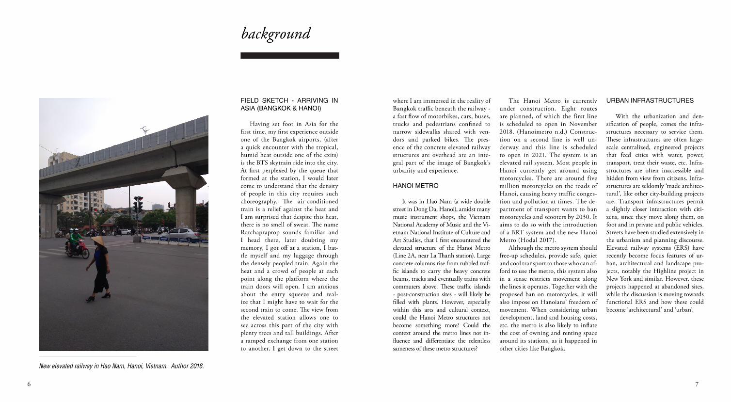
New elevated railway in Hao Nam, Hanoi, Vietnam. Author 2018.
where I am immersed in the reality of Bangkok traffic beneath the railway - a fast flow of motorbikes, cars, buses, trucks and pedestrians confined to narrow sidewalks shared with ven-dors and parked bikes. The pres-ence of the concrete elevated railway structures are overhead are an inte-gral part of the image of Bangkok’s urbanity and experience.
HANOI METRO
It was in Hao Nam (a wide double street in Dong Da, Hanoi), amidst many music instrument shops, the Vietnam National Academy of Music and the Vi-etnam National Institute of Culture and Art Studies, that I first encountered the elevated structure of the Hanoi Metro (Line 2A, near La Thanh station). Large concrete columns rise from rubbled traf-fic islands to carry the heavy concrete beams, tracks and eventually trains with commuters above. These traffic islands - post-construction sites - will likely be filled with plants. However, especially within this arts and cultural context, could the Hanoi Metro structures not become something more? Could the context around the metro lines not in-fluence and differentiate the relentless sameness of these metro structures?
The Hanoi Metro is currently under construction. Eight routes are planned, of which the first line is scheduled to open in November 2018. (Hanoimetro n.d.) Construc-tion on a second line is well un-derway and this line is scheduled to open in 2021. The system is an elevated rail system. Most people in Hanoi currently get around using motorcycles. There are around five million motorcycles on the roads of Hanoi, causing heavy traffic conges-tion and pollution at times. The de-partment of transport wants to ban motorcycles and scooters by 2030. It aims to do so with the introduction of a BRT system and the new Hanoi Metro (Hodal 2017).
Although the metro system should free-up schedules, provide safe, quiet and cool transport to those who can af-ford to use the metro, this system also in a sense restricts movement along the lines it operates. Together with the proposed ban on motorcycles, it will also impose on Hanoians’ freedom of movement. When considering urban development, land and housing costs, etc. the metro is also likely to inflate the cost of owning and renting space around its stations, as it happened in other cities like Bangkok.
URBAN INFRASTRUCTURES
With the urbanization and den-sification of people, comes the infra-structures necessary to service them. These infrastructures are often large-scale centralized, engineered projects that feed cities with water, power, transport, treat their waste, etc. Infra-structures are often inaccessible and hidden from view from citizens. Infra-structures are seldomly ‘made architec-tural’, like other city-building projects are. Transport infrastructures permit a slightly closer interaction with citi-zens, since they move along them, on foot and in private and public vehicles. Streets have been studied extensively in the urbanism and planning discourse. Elevated railway systems (ERS) have recently become focus features of ur-ban, architectural and landscape pro-jects, notably the Highline project in New York and similar. However, these projects happened at abandoned sites, while the discussion is moving towards functional ERS and how these could become ‘architectural’ and ‘urban’.
98
elevated railway structures
Within existing research, ERS are problematized in various modes: land-scapes with a negative effect on the image of the city (Hormigo & Mori-to 2004), residual or left-over spaces (Qamaruz-Zaman, et al 2013; Shi 2016), mono-functionality (Gabrielle et al 2016), urban segregation (Jensen 2007; Karis 2017)
problem 1 - Un-architectural infra-structure
Infrastructures are often engi-neered and planned with a purely functional purpose. This limits the po-tential of urban structures to contrib-ute to the positive image of the city and to support several forms of urban life. Elevated railway structures are usually very visible structures but very seldom-ly designed architecturally - to produce aesthetic effects. There are exceptions, like the ERS in Vienna and Berlin that were in a sense designed like linear buildings.
Temtem’s article (Temtem 2017) aims to decipher the urban design strategies that were used in the de-sign of the Berlin Stadbahn railway viaduct in Berlin. He sets out to find the value that architecture adds to this ‘building-viaduct’, where the role of ar-chitects in infrastructural projects are usually obscure.
problem 2 - Neglected / residual / left-over spaces
Elevated railway structures by be-ing separated from the ground, allow for a free-flow of trains without in-terruption by traffic on the ground. They also span across b o u n d a -ries like rivers and valleys or existing roads, rails and highways. The spaces beneath these elevated structures are however often neglected, left-over and residual that could be utilized by citi-zens. A study of left-over space beneath two flyovers in Kuala Lumpur was conducted in 2013 (Qamaruz-Zaman, et al). The researchers found various activities occurring here, at different times of day. They observe informal activities such as food stalls, cafes, sports and recreational activities (in-cluding chess playing, carom and ping pong), businesses and services (eg. toys and clothes stalls, as well as movers, a car wash and workshop services), a bi-weekly evening market with fresh food. Cultural activities included traditional performances with traditional musical instruments. (Qamaruz-Zaman, et al 2013:96-101)
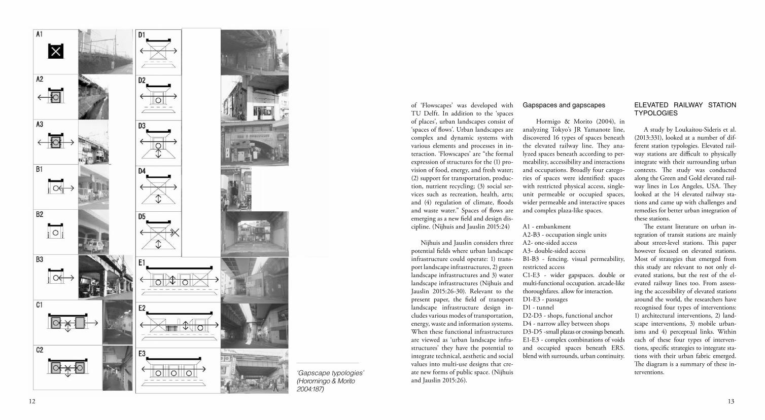
Hormigo and Morita did a study of left-over spaces in Tokyo. They invent-ed a term for such spaces. Gapspaces are defined as spaces that emerged from density-increasing processes in urban
areas were space is limited. For growth to take place in the same geographic area, activities need to happen at dif-ferent heights or at different times. The infrastructures that perform this dis-tinction cause functional separations and spatial interruptions in their sur-roundings. Gapspaces interrupt con-tinuity, either spatially, temporally or functionally. Gapscapes, in turn, are the landscapes consisting of gapspac-es. (Hormigo & Morita 2004:182). The authors construed a typology of 16 types along the JR Yamanote line in Tokyo. These types considered per-meability and interactivity between gapscapes and the city (Hormigo & Morita 2004:185-187). A detailed re-view of these typologies will follow in the following section.
problem 3 - Mono-functionality Elevated railway structures are
most often designed for a single pur-pose only - for transport. If other ac-tivities occur around these structures, these are usually unplanned for, and emergent.
A paper delivered at the World Congress on Railway Research, held Milan in 2016 (Gabrielle et al 2016) investigates how functional diversity could be incorporated into the design of elevated transit structures by de-
problematising
signing viaducts simultaneously with the spaces beneath them. The authors analyse theoretical urban planning approaches; they apply the concept of mixed-use development to elevated transport infrastructures by defining criteria for functional diversity and apply these criteria to three projects. (Gabrielle et al 2016:2). The criteria: 1) combining at least two functions at the same place; 2) physical integration, 3) functional integration, 4) construction according to a coherent masterplan (Gabrielle et all 2016:4-5). They apply these criteria in a comparative analysis of three ERS renovation projects in Europe (Issy-les-Moulineaux, Zurich and Dramen). They conclude that the integration of transport infrastructure with other urban functions could bring economic returns, be of social benefit and improved urban quality. The spac-es beneath ERS should be designed simultaneously with infrastructures in order to accommodate diverse func-tions. With functional diversity, howev-er, interested stakeholders multiply and collaboration is required for successful projects (Gabrielle et all 2016:6-7).
problem 4 - Dividing / segregating
Transport systems that use elevated railways are sometimes criticised for segregating and gentrifying communi-ties and neighbourhoods. The process of their construction often require ac-quisition of land and the landowners are not necessarily fairly compensated. The cost of using the rail system also excludes people without the means to pay regularly for tickets. The Bang-kok Skyrail is one such example that was investigated by Jensen (2007) as much more than just an infrastructure project to overcome traffic congestion and pollution. The skyrail participates in urban segregation, by dividing citi-zens along lines of economic ability. Tourists and the elite tend to use this system, while poor and immigrant workers are left behind in the dark and polluted ‘tunnels’ beneath the skyrails (Jensen 2007). The way that elevated rail systems segregate is through hav-ing expensive fares only payable by some people, by increasing property values around its stations and through connections to spaces of consumption.
Research Question
The four-pronged problema-tization of elevated railway struc-tures could show the way to better urban integration of these struc-tures. The question becomes - in what ways can elevated railway structures become better inte-grated within urban contexts and become productive to urban life? What kind of interventions can remedy the problems of mono-disciplinary design, residual spac-es, mono-functionality and segre-gation in both existing ERS and the design of new ERS.
Method
1. search for a variety and multi-plicity of ways ERS can integrate with urban environments.
2. illustrate with images, descrip-tions, case studies, personal ex-periences.
3. from these strategies/concepts emerge of how to improve existing ERS and how to better design fu-ture ones.
1110
ARCHITECTURAL / URBAN TYPOLOGIES
Elevated transit structures are an urban type, similarly to how streets, plazas, parks, etc. are urban types. More specifically they are an infra-structural type, that sometimes per-form like other urban typologies - the viaduct, the bridge, the city wall, the portal, the collonade, etc.
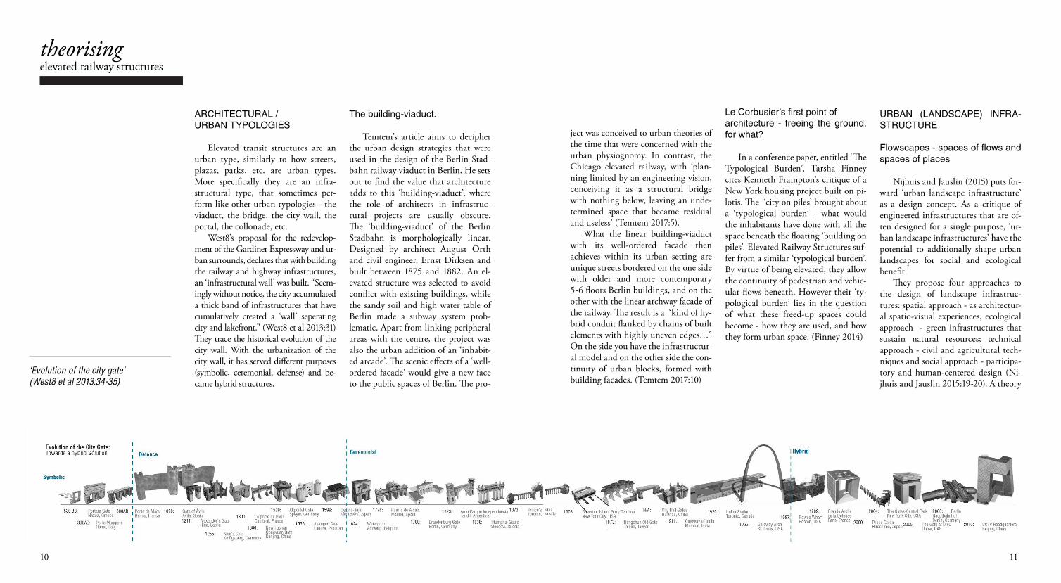
West8’s proposal for the redevelop-ment of the Gardiner Expressway and ur-ban surrounds, declares that with building the railway and highway infrastructures, an ‘infrastructural wall’ was built. “Seem-ingly without notice, the city accumulated a thick band of infrastructures that have cumulatively created a ‘wall’ seperating city and lakefront.” (West8 et al 2013:31) They trace the historical evolution of the city wall. With the urbanization of the city wall, it has served different purposes (symbolic, ceremonial, defense) and be-came hybrid structures.
The building-viaduct.
Temtem’s article aims to decipher the urban design strategies that were used in the design of the Berlin Stad-bahn railway viaduct in Berlin. He sets out to find the value that architecture adds to this ‘building-viaduct’, where the role of architects in infrastruc-tural projects are usually obscure. The ‘building-viaduct’ of the Berlin Stadbahn is morphologically linear. Designed by architect August Orth and civil engineer, Ernst Dirksen and built between 1875 and 1882. An el-evated structure was selected to avoid conflict with existing buildings, while the sandy soil and high water table of Berlin made a subway system prob-lematic. Apart from linking peripheral areas with the centre, the project was also the urban addition of an ‘inhabit-ed arcade’. The scenic effects of a ‘well-ordered facade’ would give a new face to the public spaces of Berlin. The pro-
elevated railway structurestheorising
‘Evolution of the city gate’ (West8 et al 2013:34-35)
ject was conceived to urban theories of the time that were concerned with the urban physiognomy. In contrast, the Chicago elevated railway, with ‘plan-ning limited by an engineering vision, conceiving it as a structural bridge with nothing below, leaving an unde-termined space that became residual and useless’ (Temtem 2017:5).
What the linear building-viaduct with its well-ordered facade then achieves within its urban setting are unique streets bordered on the one side with older and more contemporary 5-6 floors Berlin buildings, and on the other with the linear archway facade of the railway. The result is a ‘kind of hy-brid conduit flanked by chains of built elements with highly uneven edges…” On the side you have the infrastructur-al model and on the other side the con-tinuity of urban blocks, formed with building facades. (Temtem 2017:10)
Le Corbusier’s first point of architecture - freeing the ground, for what?
In a conference paper, entitled ‘The Typological Burden’, Tarsha Finney cites Kenneth Frampton’s critique of a New York housing project built on pi-lotis. The ‘city on piles’ brought about a ‘typological burden’ - what would the inhabitants have done with all the space beneath the floating ‘building on piles’. Elevated Railway Structures suf-fer from a similar ‘typological burden’. By virtue of being elevated, they allow the continuity of pedestrian and vehic-ular flows beneath. However their ‘ty-pological burden’ lies in the question of what these freed-up spaces could become - how they are used, and how they form urban space. (Finney 2014)
URBAN (LANDSCAPE) INFRA-STRUCTURE
Flowscapes - spaces of flows and spaces of places
Nijhuis and Jauslin (2015) puts for-ward ‘urban landscape infrastructure’ as a design concept. As a critique of engineered infrastructures that are of-ten designed for a single purpose, ‘ur-ban landscape infrastructures’ have the potential to additionally shape urban landscapes for social and ecological benefit.
They propose four approaches to the design of landscape infrastruc-tures: spatial approach - as architectur-al spatio-visual experiences; ecological approach - green infrastructures that sustain natural resources; technical approach - civil and agricultural tech-niques and social approach - participa-tory and human-centered design (Ni-jhuis and Jauslin 2015:19-20). A theory
1312
‘Gapscape typologies’ (Horomingo & Morito 2004:187)
of ‘Flowscapes’ was developed with TU Delft. In addition to the ‘spaces of places’, urban landscapes consist of ‘spaces of flows’. Urban landscapes are complex and dynamic systems with various elements and processes in in-teraction. ‘Flowscapes’ are “the formal expression of structures for the (1) pro-vision of food, energy, and fresh water; (2) support for transportation, produc-tion, nutrient recycling; (3) social ser-vices such as recreation, health, arts; and (4) regulation of climate, floods and waste water.” Spaces of flows are emerging as a new field and design dis-cipline. (Nijhuis and Jauslin 2015:24)
Nijhuis and Jauslin considers three potential fields where urban landscape infrastructure could operate: 1) trans-port landscape infrastructures, 2) green landscape infrastructures and 3) water landscape infrastructures (Nijhuis and Jauslin 2015:26-30). Relevant to the present paper, the field of transport landscape infrastructure design in-cludes various modes of transportation, energy, waste and information systems. When these functional infrastructures are viewed as ‘urban landscape infra-structures’ they have the potential to integrate technical, aesthetic and social values into multi-use designs that cre-ate new forms of public space. (Nijhuis and Jauslin 2015:26).
Gapspaces and gapscapes
Hormigo & Morito (2004), in analyzing Tokyo’s JR Yamanote line, discovered 16 types of spaces beneath the elevated railway line. They ana-lyzed spaces beneath according to per-meability, accessibility and interactions and occupations. Broadly four catego-ries of spaces were identified: spaces with restricted physical access, single-unit permeable or occupied spaces, wider permeable and interactive spaces and complex plaza-like spaces.
A1 - embankmentA2-B3 - occupation single unitsA2- one-sided accessA3- double-sided accessB1-B3 - fencing. visual permeability, restricted accessC1-E3 - wider gapspaces. double or multi-functional occupation. arcade-like thoroughfares. allow for interaction.D1-E3 - passagesD1 - tunnelD2-D3 - shops, functional anchorD4 - narrow alley between shopsD3-D5 -small plazas or crossings beneath.E1-E3 - complex combinations of voids and occupied spaces beneath ERS. blend with surrounds, urban continuity.
ELEVATED RAILWAY STATION TYPOLOGIES
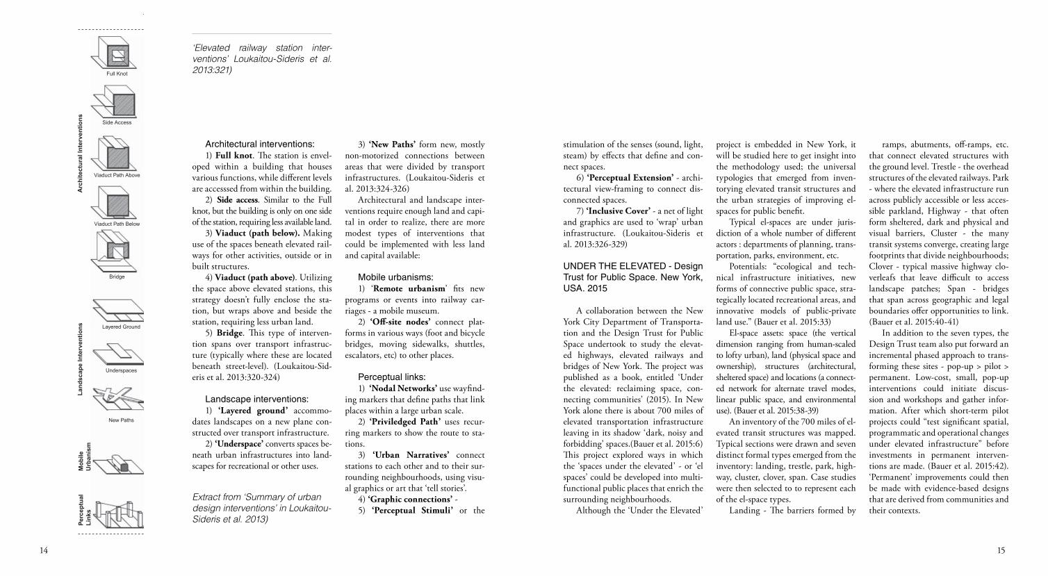
A study by Loukaitou-Sideris et al. (2013:331), looked at a number of dif-ferent station typologies. Elevated rail-way stations are difficult to physically integrate with their surrounding urban contexts. The study was conducted along the Green and Gold elevated rail-way lines in Los Angeles, USA. They looked at the 14 elevated railway sta-tions and came up with challenges and remedies for better urban integration of these stations.
The extant literature on urban in-tegration of transit stations are mainly about street-level stations. This paper however focused on elevated stations. Most of strategies that emerged from this study are relevant to not only el-evated stations, but the rest of the el-evated railway lines too. From assess-ing the accessibility of elevated stations around the world, the researchers have recognised four types of interventions: 1) architectural interventions, 2) land-scape interventions, 3) mobile urban-isms and 4) perceptual links. Within each of these four types of interven-tions, specific strategies to integrate sta-tions with their urban fabric emerged. The diagram is a summary of these in-terventions.
1514
Table 2. Summary of urban design interventions
Advantages Disadvantages Costs Land Required Density
Bridge
Viaduct Path Below
Viaduct Path Above
Side Access
Full KnotA
rchi
tect
ural
Inte
rven
tions
-Access to surrounding uses.-Increased density; Increasing ridership.-Opportunities for real estate development
-Cost of building development over existing infrastructure.-Large amount land required.-Noise
-High -High -High
-High-Development offers access only from one side.
-Access to surroundinguses.-Increased density;Increasing ridership.-Opportunities for real estate development.
-Medium to High-Medium to High
-Opportunities for real estate development.-Access to surrounding uses.-Variations in scale.-Low capital needed.
-Low to Medium-Low to Medium -Low-Excessivenolse/vibrations from rail-Height limit(one or two levels)
-Low to Medium-Low to High -Low-Can become expensive depending on its knittingwith surroundinginfrastructure.
-Use of station air rights.-Less land needed.-Access to surrounding uses.
-Low to Medium-Medium to High -High-Can span greater distances with less land for anchoring.-Access to surrounding uses.
-Limited to already dense site area.
New Paths
Underspaces
Layered Ground
Land
scap
e In
terv
entio
nsPe
rcep
tual
Link
sM
obile
Urb
anis
m
-Medium -Medium-Medium to High-Access to surrounding uses.-Span over wider set of Infrastructure.-Connect various landuses (public space,parks, amenities)-
-Significant land needed.-Significant building support needed.
-Low to High-Low-Low-Access to surrounding uses.-Low cost and maintanance.
-Noise associated with rail operations.
-Medium -Low to High-Low-Noise.-Access to surrounding uses.-Low construction costs.-Versatility in connectingsegregated amenities.
-Low to High-Low-Low-Flexibility in development location.-Versatility in servingmultiple stations.-Temporary service possible.-Low cost for implementation.
-Stationary wagon couldblock main rail line.-Secondary tracks needed for extended parking periods orsignificant distances fromstation.-Maintenance needed.
-Low to High-Low-Low-Versatile in coveringcomplex urban fabrics.
-Low cost for implementation.
-Potential misreading ofmarkers as a cohcrententity.
-Limited capacity topromote development.
Up in the Air 321
Extract from ‘Summary of urban design interventions’ in Loukaitou-Sideris et al. 2013)
Architectural interventions:1) Full knot. The station is envel-
oped within a building that houses various functions, while different levels are accesssed from within the building.
2) Side access. Similar to the Full knot, but the building is only on one side of the station, requiring less available land.
3) Viaduct (path below). Making use of the spaces beneath elevated rail-ways for other activities, outside or in built structures.
4) Viaduct (path above). Utilizing the space above elevated stations, this strategy doesn’t fully enclose the sta-tion, but wraps above and beside the station, requiring less urban land.
5) Bridge. This type of interven-tion spans over transport infrastruc-ture (typically where these are located beneath street-level). (Loukaitou-Sid-eris et al. 2013:320-324)
Landscape interventions:1) ‘Layered ground’ accommo-
dates landscapes on a new plane con-structed over transport infrastructure.
2) ‘Underspace’ converts spaces be-neath urban infrastructures into land-scapes for recreational or other uses.
3) ‘New Paths’ form new, mostly non-motorized connections between areas that were divided by transport infrastructures. (Loukaitou-Sideris et al. 2013:324-326)
Architectural and landscape inter-ventions require enough land and capi-tal in order to realize, there are more modest types of interventions that could be implemented with less land and capital available:
Mobile urbanisms:1) ‘Remote urbanism’ fits new
programs or events into railway car-riages - a mobile museum.
2) ‘Off-site nodes’ connect plat-forms in various ways (foot and bicycle bridges, moving sidewalks, shuttles, escalators, etc) to other places.
Perceptual links:1) ‘Nodal Networks’ use wayfind-
ing markers that define paths that link places within a large urban scale.
2) ‘Priviledged Path’ uses recur-ring markers to show the route to sta-tions.
3) ‘Urban Narratives’ connect stations to each other and to their sur-rounding neighbourhoods, using visu-al graphics or art that ‘tell stories’.
4) ‘Graphic connections’ - 5) ‘Perceptual Stimuli’ or the
‘Elevated railway station inter-ventions’ Loukaitou-Sideris et al. 2013:321)
stimulation of the senses (sound, light, steam) by effects that define and con-nect spaces.
6) ‘Perceptual Extension’ - archi-tectural view-framing to connect dis-connected spaces.
7) ‘Inclusive Cover’ - a net of light and graphics are used to ‘wrap’ urban infrastructure. (Loukaitou-Sideris et al. 2013:326-329)
UNDER THE ELEVATED - Design Trust for Public Space. New York, USA. 2015
A collaboration between the New York City Department of Transporta-tion and the Design Trust for Public Space undertook to study the elevat-ed highways, elevated railways and bridges of New York. The project was published as a book, entitled ‘Under the elevated: reclaiming space, con-necting communities’ (2015). In New York alone there is about 700 miles of elevated transportation infrastructure leaving in its shadow ‘dark, noisy and forbidding’ spaces.(Bauer et al. 2015:6) This project explored ways in which the ‘spaces under the elevated’ - or ‘el spaces’ could be developed into multi-functional public places that enrich the surrounding neighbourhoods.
Although the ‘Under the Elevated’
project is embedded in New York, it will be studied here to get insight into the methodology used; the universal typologies that emerged from inven-torying elevated transit structures and the urban strategies of improving el-spaces for public benefit.
Typical el-spaces are under juris-diction of a whole number of different actors : departments of planning, trans-portation, parks, environment, etc.
Potentials: “ecological and tech-nical infrastructure initiatives, new forms of connective public space, stra-tegically located recreational areas, and innovative models of public-private land use.” (Bauer et al. 2015:33)
El-space assets: space (the vertical dimension ranging from human-scaled to lofty urban), land (physical space and ownership), structures (architectural, sheltered space) and locations (a connect-ed network for alternate travel modes, linear public space, and environmental use). (Bauer et al. 2015:38-39)
An inventory of the 700 miles of el-evated transit structures was mapped. Typical sections were drawn and seven distinct formal types emerged from the inventory: landing, trestle, park, high-way, cluster, clover, span. Case studies were then selected to to represent each of the el-space types.
Landing - The barriers formed by
ramps, abutments, off-ramps, etc. that connect elevated structures with the ground level. Trestle - the overhead structures of the elevated railways. Park - where the elevated infrastructure run across publicly accessible or less acces-sible parkland, Highway - that often form sheltered, dark and physical and visual barriers, Cluster - the many transit systems converge, creating large footprints that divide neighbourhoods; Clover - typical massive highway clo-verleafs that leave difficult to access landscape patches; Span - bridges that span across geographic and legal boundaries offer opportunities to link. (Bauer et al. 2015:40-41)
In addition to the seven types, the Design Trust team also put forward an incremental phased approach to trans-forming these sites - pop-up > pilot > permanent. Low-cost, small, pop-up interventions could initiate discus-sion and workshops and gather infor-mation. After which short-term pilot projects could “test significant spatial, programmatic and operational changes under elevated infrastructure” before investments in permanent interven-tions are made. (Bauer et al. 2015:42). ‘Permanent’ improvements could then be made with evidence-based designs that are derived from communities and their contexts.
1716
ramps, abutments, off-ramps, etc. that connect elevated structures with the ground level. Trestle - the overhead structures of the elevated railways. Park - where the elevated infrastructure run across publicly accessible or less acces-sible parkland, Highway - that often form sheltered, dark and physical and visual barriers, Cluster - the many transit systems converge, creating large footprints that divide neighbourhoods; Clover - typical massive highway clo-verleafs that leave difficult to access landscape patches; Span - bridges that span across geographic and legal boundaries offer opportunities to link. (Bauer et al. 2015:40-41)
In addition to the seven types, the Design Trust team also put forward an incremental phased approach to trans-forming these sites - pop-up > pilot > permanent. Low-cost, small, pop-up interventions could initiate discus-sion and workshops and gather infor-mation. After which short-term pilot projects could “test significant spatial, programmatic and operational changes under elevated infrastructure” before investments in permanent interven-tions are made. (Bauer et al. 2015:42). ‘Permanent’ improvements could then be made with evidence-based designs that are derived from communities and their contexts.
‘Greening the elevated’ - (Green Stormwater Infrastructure GSI)
The elevated transit structures of Philadelphia was studied PennDesign City and Regional Planning Studio of Fall 2016 (PennDesign 2016:22-31). The typology was arranged according to three categories - above, below and beside. “Above refers to the function of the structure, its width, frequency of use, condition, and other character-istics of the activity occurring on the structure. Below includes aspects re-lating to the environment underneath the structure, including light levels and passage through. Beside includes the environment immediately adjacent to the structure, including the land use and density of structures.” (PennDe-sign 2016:25) The study then did an analysis of elevated transit structures based on adjacent land-use, average adjacent parcel size and elevated struc-ture type. Three sites - one at a high-way, one at a freight railway and one at a passenger railway line - were selected in areas of high environmental, eco-nomic and socio-economic vulnerabil-ity (PennDesign 2016:28-37). These three elevated transit sites then served as case studies for proposals to imple-ment green stormwater infrastructure, while also addressing neighbourhood
concerns. The strategies that were sug-gested for these sites included: 1) estab-lishing green corridors by linking new stormwater infrastructure adjacent to the elevated structure to a network of rain gardens, street trees and parks; 2) targeting large landowners and private land-owners to invest in stormwater retention schemes; 3) educating the public about GSI at transit stations through public art installations.
SUMMARY OF THEORIES
Within this section - theorising ERS - elevated railway structures was elabo-rated on as an urban type. These struc-tures are infrastructures that take part in urban form, sometimes behaving like viaducts, city walls or portals. West8 et al have shown the typological evolu-tion of the city wall from ancient for-tification to contemporary hybrid types and how elevated transit structures in Toronto embody the city-wall-type. Temtem viewed ERS in Berlin as build-ing-viaducts. These hybrid structures were integrated with the urban form through facades, while accommodating additional uses in ‘inhabited arcades’. Finney exposed the ‘typological burden’ that structures on pilotis cause - what to do with the undetermined spaces between the columns. Nijhuis & Jaus-
elevated railway structurespotentialising
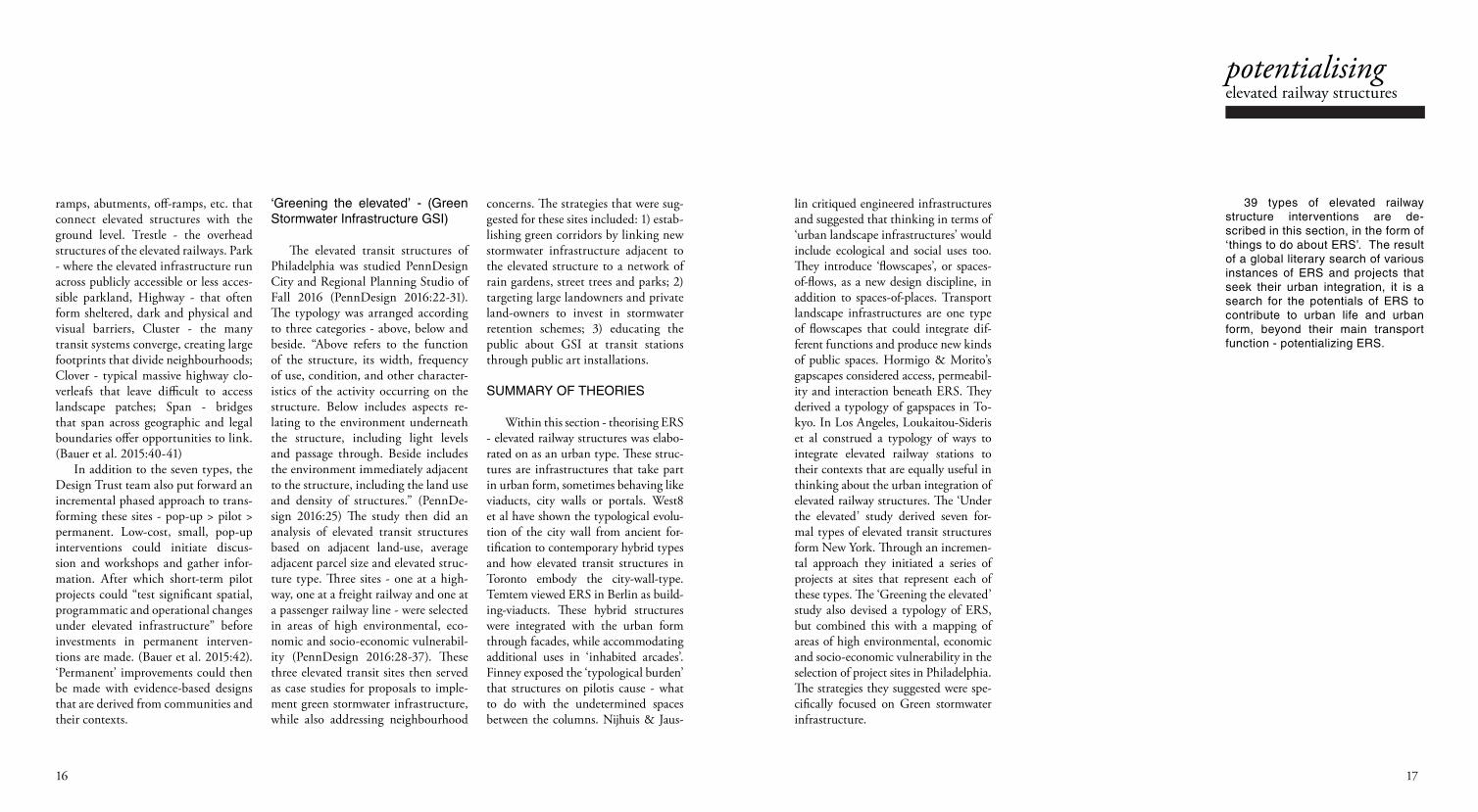
39 types of elevated railway structure interventions are de-scribed in this section, in the form of ‘things to do about ERS’. The result of a global literary search of various instances of ERS and projects that seek their urban integration, it is a search for the potentials of ERS to contribute to urban life and urban form, beyond their main transport function - potentializing ERS.
lin critiqued engineered infrastructures and suggested that thinking in terms of ‘urban landscape infrastructures’ would include ecological and social uses too. They introduce ‘flowscapes’, or spaces-of-flows, as a new design discipline, in addition to spaces-of-places. Transport landscape infrastructures are one type of flowscapes that could integrate dif-ferent functions and produce new kinds of public spaces. Hormigo & Morito’s gapscapes considered access, permeabil-ity and interaction beneath ERS. They derived a typology of gapspaces in To-kyo. In Los Angeles, Loukaitou-Sideris et al construed a typology of ways to integrate elevated railway stations to their contexts that are equally useful in thinking about the urban integration of elevated railway structures. The ‘Under the elevated’ study derived seven for-mal types of elevated transit structures form New York. Through an incremen-tal approach they initiated a series of projects at sites that represent each of these types. The ‘Greening the elevated’ study also devised a typology of ERS, but combined this with a mapping of areas of high environmental, economic and socio-economic vulnerability in the selection of project sites in Philadelphia. The strategies they suggested were spe-cifically focused on Green stormwater infrastructure.
1918
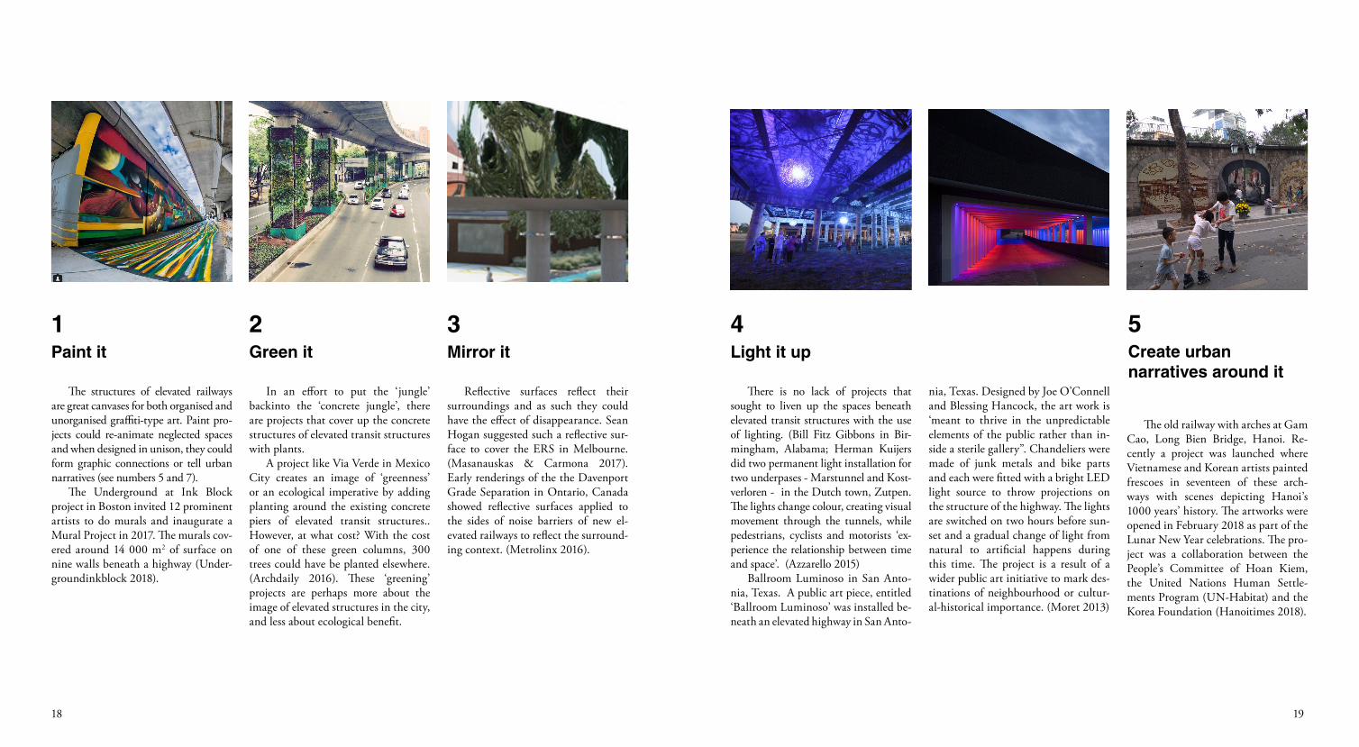
The structures of elevated railways are great canvases for both organised and unorganised graffiti-type art. Paint pro-jects could re-animate neglected spaces and when designed in unison, they could form graphic connections or tell urban narratives (see numbers 5 and 7).
The Underground at Ink Block project in Boston invited 12 prominent artists to do murals and inaugurate a Mural Project in 2017. The murals cov-ered around 14 000 m2 of surface on nine walls beneath a highway (Under-groundinkblock 2018).
In an effort to put the ‘jungle’ backinto the ‘concrete jungle’, there are projects that cover up the concrete structures of elevated transit structures with plants.
A project like Via Verde in Mexico City creates an image of ‘greenness’ or an ecological imperative by adding planting around the existing concrete piers of elevated transit structures.. However, at what cost? With the cost of one of these green columns, 300 trees could have be planted elsewhere. (Archdaily 2016). These ‘greening’ projects are perhaps more about the image of elevated structures in the city, and less about ecological benefit.
Reflective surfaces reflect their surroundings and as such they could have the effect of disappearance. Sean Hogan suggested such a reflective sur-face to cover the ERS in Melbourne. (Masanauskas & Carmona 2017). Early renderings of the the Davenport Grade Separation in Ontario, Canada showed reflective surfaces applied to the sides of noise barriers of new el-evated railways to reflect the surround-ing context. (Metrolinx 2016).
Paint it Green it Mirror it
1 2 3
There is no lack of projects that sought to liven up the spaces beneath elevated transit structures with the use of lighting. (Bill Fitz Gibbons in Bir-mingham, Alabama; Herman Kuijers did two permanent light installation for two underpases - Marstunnel and Kost-verloren - in the Dutch town, Zutpen. The lights change colour, creating visual movement through the tunnels, while pedestrians, cyclists and motorists ‘ex-perience the relationship between time and space’. (Azzarello 2015)
Ballroom Luminoso in San Anto-nia, Texas. A public art piece, entitled ‘Ballroom Luminoso’ was installed be-neath an elevated highway in San Anto-
Light it up
4
nia, Texas. Designed by Joe O’Connell and Blessing Hancock, the art work is ‘meant to thrive in the unpredictable elements of the public rather than in-side a sterile gallery”. Chandeliers were made of junk metals and bike parts and each were fitted with a bright LED light source to throw projections on the structure of the highway. The lights are switched on two hours before sun-set and a gradual change of light from natural to artificial happens during this time. The project is a result of a wider public art initiative to mark des-tinations of neighbourhood or cultur-al-historical importance. (Moret 2013)
The old railway with arches at Gam Cao, Long Bien Bridge, Hanoi. Re-cently a project was launched where Vietnamese and Korean artists painted frescoes in seventeen of these arch-ways with scenes depicting Hanoi’s 1000 years’ history. The artworks were opened in February 2018 as part of the Lunar New Year celebrations. The pro-ject was a collaboration between the People’s Committee of Hoan Kiem, the United Nations Human Settle-ments Program (UN-Habitat) and the Korea Foundation (Hanoitimes 2018).
Create urban narratives around it
5
2120
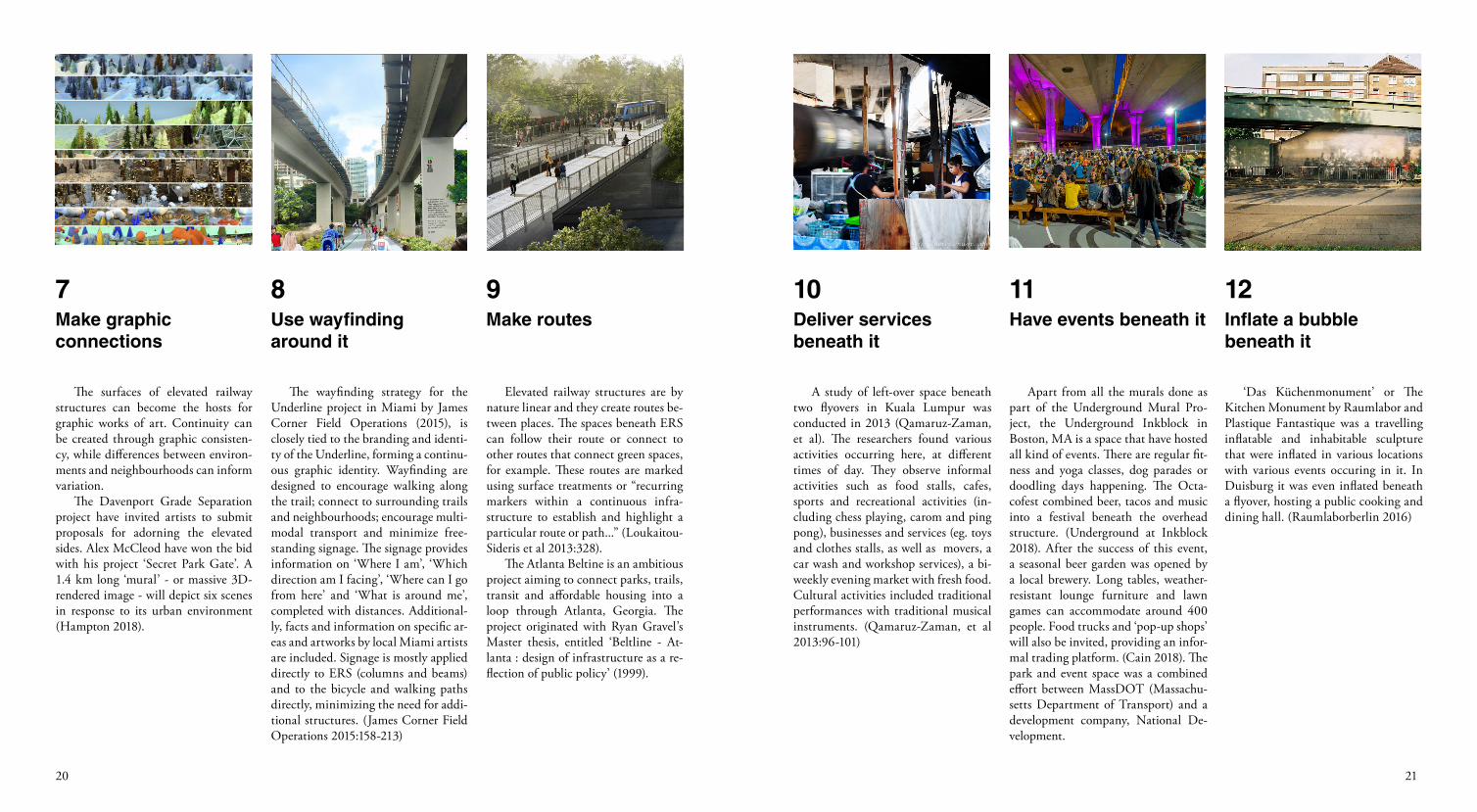
The surfaces of elevated railway structures can become the hosts for graphic works of art. Continuity can be created through graphic consisten-cy, while differences between environ-ments and neighbourhoods can inform variation.
The Davenport Grade Separation project have invited artists to submit proposals for adorning the elevated sides. Alex McCleod have won the bid with his project ‘Secret Park Gate’. A 1.4 km long ‘mural’ - or massive 3D-rendered image - will depict six scenes in response to its urban environment (Hampton 2018).
The wayfinding strategy for the Underline project in Miami by James Corner Field Operations (2015), is closely tied to the branding and identi-ty of the Underline, forming a continu-ous graphic identity. Wayfinding are designed to encourage walking along the trail; connect to surrounding trails and neighbourhoods; encourage multi-modal transport and minimize free-standing signage. The signage provides information on ‘Where I am’, ‘Which direction am I facing’, ‘Where can I go from here’ and ‘What is around me’, completed with distances. Additional-ly, facts and information on specific ar-eas and artworks by local Miami artists are included. Signage is mostly applied directly to ERS (columns and beams) and to the bicycle and walking paths directly, minimizing the need for addi-tional structures. (James Corner Field Operations 2015:158-213)
Elevated railway structures are by nature linear and they create routes be-tween places. The spaces beneath ERS can follow their route or connect to other routes that connect green spaces, for example. These routes are marked using surface treatments or “recurring markers within a continuous infra-structure to establish and highlight a particular route or path...” (Loukaitou-Sideris et al 2013:328).
The Atlanta Beltine is an ambitious project aiming to connect parks, trails, transit and affordable housing into a loop through Atlanta, Georgia. The project originated with Ryan Gravel’s Master thesis, entitled ‘Beltline - At-lanta : design of infrastructure as a re-flection of public policy’ (1999).
Make graphic connections
Use wayfinding around it
Make routes
7 8 9
Apart from all the murals done as part of the Underground Mural Pro-ject, the Underground Inkblock in Boston, MA is a space that have hosted all kind of events. There are regular fit-ness and yoga classes, dog parades or doodling days happening. The Octa-cofest combined beer, tacos and music into a festival beneath the overhead structure. (Underground at Inkblock 2018). After the success of this event, a seasonal beer garden was opened by a local brewery. Long tables, weather-resistant lounge furniture and lawn games can accommodate around 400 people. Food trucks and ‘pop-up shops’ will also be invited, providing an infor-mal trading platform. (Cain 2018). The park and event space was a combined effort between MassDOT (Massachu-setts Department of Transport) and a development company, National De-velopment.
A study of left-over space beneath two flyovers in Kuala Lumpur was conducted in 2013 (Qamaruz-Zaman, et al). The researchers found various activities occurring here, at different times of day. They observe informal activities such as food stalls, cafes, sports and recreational activities (in-cluding chess playing, carom and ping pong), businesses and services (eg. toys and clothes stalls, as well as movers, a car wash and workshop services), a bi-weekly evening market with fresh food. Cultural activities included traditional performances with traditional musical instruments. (Qamaruz-Zaman, et al 2013:96-101)
Have events beneath itDeliver services beneath it
1110
‘Das Küchenmonument’ or The Kitchen Monument by Raumlabor and Plastique Fantastique was a travelling inflatable and inhabitable sculpture that were inflated in various locations with various events occuring in it. In Duisburg it was even inflated beneath a flyover, hosting a public cooking and dining hall. (Raumlaborberlin 2016)
Inflate a bubblebeneath it
12
2322
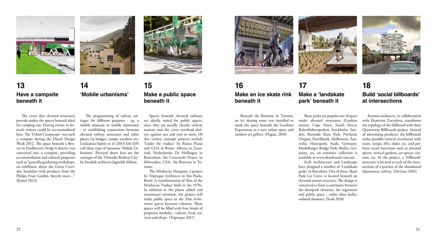
The cover that elevated structures provide makes the spaces beneath ideal for camping out. During events or fes-tivals visitors could be accommodated here. The ‘Urban Campscape’ was such a campsite during the Dutch Design Week 2012. The space beneath a flyo-ver in Eindhoven’s Strijp-S district was converted into a campsite, providing accommodation and cultural programs such as “guerrilla gardening workshops, an exhibition about the Green Corri-dor, breakfast with products from the Philips Fruit Garden, bicycle tours…” (Knitel 2012)
The programming of railway car-riages for different purposes - eg. a mobile museum or mobile classrooms - or establishing connections between elevated railway structures and other places via bridges, ramps, escaltors etc. Loukaitou-Sideris et al (2013:326-329) call these type of measures ‘Mobile Ur-banisms’. Pictured above here are the carriages of the ‘Nomadic Railway City’ by Swedish architects Jagnefalt Milton.
Have a campsite beneath it
‘Mobile urbanisms’
13 14
Spaces beneath elevated railways are ideally suited for public spaces, since they are usually closeby railway stations and the cover overhead shel-ters against sun and rain or snow. Of this variety, example projects include ‘Under the viaduct’ by Renzo Piano and G124 in Rome; A8erna in Zaan-stad, Netherlands; De Hofbogen in Rotterdam; the Crossroads Project in Milwaukee, USA; the Bentway in To-ronto.
The Minhocão Marquise, a project by Triptyque Architects in São Paulo, Brasil. A transformation of 3km of the Minhocao Viaduct built in the 1970s. In addition to the plants added and stormwater retention, the project will make public space in the 33m in-be-tween spaces between columns. These spaces will be filled with four kinds of programs modules - culture, food, ser-vices and shops. (Triptyque 2017)
Make a public space beneath it
15
Beneath the Bentway in Toronto, an ice skating route was installed to mark the space beneath the Gardiner Expressway as a new urban space and outdoor art gallery. (Hague, 2018)
Skate parks are popular use of space under elevated structures (Gardens station, Cape Town, South Africa; Ralambshovsparken, Stockholm, Swe-den; Burnside Skate Park, Portland, Oregon; Northbank, Melbourne, Aus-tralia; Hanespark, Stade, Germany; Heidelberger Bridge Park, Berlin, Ger-many, etc. an extensive collection is available at www.skateboard.com.au).
Scob Architecture and Landscape have designed a number of ‘Landskate parks’ in Barcelona. One of these, Skate Park Les Corts, is located beneath an elevated transit structure. The design is conceived to form a continuity between the skatepark elements, the vegetation and public space - rather than bulky, isolated elements. (Scob 2018)
Make an ice skate rink beneath it
Make a ‘landskate park’ beneath it
16 17
Kosmos architects, in collaboration with Ekaterina Zavyalova, transforms the typology of the billboard with their Queensway Billboards project. Instead of advertising products, the billboards make possible vertical circulation with stairs, ramps, lifts, slides, etc. and per-form social functions such as elevated sports, vertical gardens, art spaces, cin-ema, etc. In the project, a ‘billboard’ structure is located at each of the inter-sections of a portion of the abandoned Queensway railway. (Divisare 2016)
Build ‘social billboards’ at intersections
18
2524
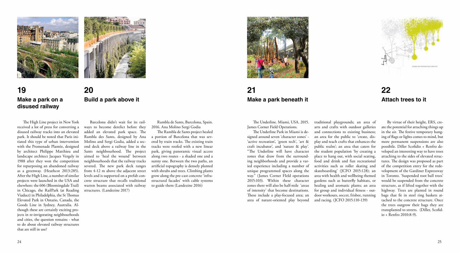
The High Line project in New York received a lot of press for converting a disused railway tracks into an elevated park. It should be noted that Paris ini-tiated this type of urban intervention with the Promenade Plantée, designed by architect Philippe Matthieu and landscape architect Jacques Vergely in 1988 after they won the competition for repurposing an abandoned railway as a greenway. (Heathcot 2013:285). After the High Line, a number of similar projects were launched in the USA and elsewhere: the 606 (Bloomingdale Trail) in Chicago, the RailPark (at Reading Viaduct) in Philadelphia, the St Thomas Elevated Park in Ontario, Canada, the Goods Line in Sydney, Australia. Al-though these are certainly exciting pro-jects in re-invigorating neighbourhoods and cities, the question remains - what to do about elevated railway structures that are still in use?
Barcelona didn’t wait for its rail-ways to become derelict before they added an elevated park space. The Rambla des Sants, designed by Ana Molino and Sergi Godia, added a sec-ond deck above a railway line in the Sants neighbourhood. The project aimed to ‘heal the wound’ between neighbourhoods that the railway tracks severed. The new park deck ranges from 4-12 m above the adjacent street levels and is supported on a prefab con-crete structure that recalls traditional warren beams associated with railway structures. (Landezine 2017)
Make a park on a disused railway
Build a park above it
19 20
Rambla de Sants, Barcelona, Spain. 2016. Ana Molino Sergi Godia
The Rambla de Sants project healed a portion of Barcelona that was sev-ered by train tracks. The existing train tracks were roofed with a new linear park, giving panoramic visual access along two routes - a shaded one and a sunny one. Between the two paths, an artificial topography is densely planted with shrubs and trees. Climbing plants grow along the pre-cast concrete ‘infra-structural facades’ with cable systems to guide them (Landezine 2016)
The Underline. Miami, USA. 2015. James Corner Field Operations.
The Underline Park in Miami is de-signed around seven ‘character zones’ - ‘active recreation’, ‘green tech’, ‘art & craft incubator’, and ‘nature & play’. “The Underline will have character zones that draw from the surround-ing neighborhoods and provide a var-ied experience including a number of unique programmed spaces along the way.” (James Corner FIeld operations 2015:103). Within these character zones there will also be half-mile ‘areas of intensity’ that become destinations. These include a play-focused area; an area of nature-oriented play beyond
Make a park beneath it
21
traditional playgrounds; an area of arts and crafts with outdoor galleries and connections to existing business; an area for the public to ‘create, dis-play and teach crafts that enhances the public realm’; an area that caters for the student population ‘by creating a place to hang out, with social seating, food and drink and fun recreational activities such as roller skating and skateboarding’ (JCFO 2015:128); an area with health and wellbeing themed gardens such as butterfly habitats, or healing and aromatic plants; an area for group and individual fitness - out-door workouts, soccer, frisbee, running and racing. (JCFO 2015:110-139)
By virtue of their height, ERS, cre-ate the potential for attaching things up in the air. The festive temporary hang-ing of flags or lights comes to mind, but more permanent suspensions are also possibile. Diller Scofidio + Renfro de-veloped an interesting way to have trees attaching to the sides of elevated struc-tures. The design was proposed as part of the competition entry for the rede-velopment of the Gardiner Expressway in Toronto. ‘Suspended root ball trees’ would be suspended from the concrete structure, as if lifted together with the highway. Trees are planted in round bags that fit in steel ring baskets at-tached to the concrete structure. Once the trees outgrow their bags they are transplanted to streets. (Diller, Scofid-io + Renfro 2010:8-9).
Attach trees to it
22
2726
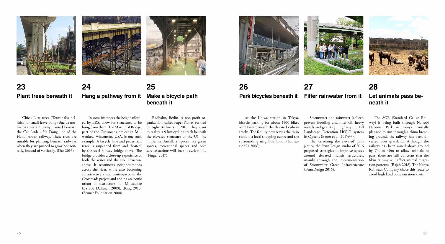
Chieu Lieu trees (Terminalia bel-lirica) or small-leave Bang (Bucida mo-lineti) trees are being planted beneath the Cat Linh - Ha Dong line of the Hanoi urban railway. These trees are suitable for planting beneath railways when they are pruned to grow horizon-tally, instead of vertically. (Dat 2016)
In some instances the height afford-ed by ERS, allow for structures to be hung from them. The Marsupial Bridge, part of the Crossroads project in Mil-waukee, Wisconson, USA, is one such example. A bicycle lane and pedestrian track is suspended from and ‘hosted’ by the steel railway bridge above. The bridge provides a close-up experience of both the water and the steel structure above. It reconnects neighbourhoods across the river, while also becoming an attractive visual centre-piece to the Crossroads project and adding an iconic urban infrastructure to Milwaukee (La and Dallman 2009), (King 2010) (Bruner Foundation 2008)
Plant trees beneath it Hang a pathway from it
23 24
Radbahn, Berlin. A non-profit or-ganization, called Paper Planes, formed by eight Berliners in 2016. They want to realize a 9 km cycling track beneath the elevated structure of the U1 line in Berlin. Ancillary spaces like green spaces, recreational spaces and bike service stations will line the cycle route. (Finger 2017)
Make a bicycle path beneath it
25
At the Koiwa station in Tokyo, bicycle parking for about 1500 bikes were built beneath the elevated railway tracks. The facility now serves the train station, a local shopping centre and the surrounding neighbourhood. (Ecosta-tion21 2006)
Stormwater and rainwater (collect, prevent flooding and filter oil, heavy metals and gases) eg. Highway Outfall Landscape Detention HOLD system in Queens (Bauer et al. 2015:33).
The ‘Greening the elevated’ pro-ject by the PennDesign studio of 2016 proposed strategies to improve spaces around elevated transit structures, mainly through the implementation of Stormwater Green Infrastructure (PennDesign 2016).
Park bicycles beneath it Filter rainwater from it
26 27
The SGR (Standard Gauge Rail-way) is being built through Nairobi National Park in Kenya. Initially planned to run through a rhino breed-ing ground, the railway has been di-verted over grassland. Although the railway has been raised above ground by 7m to 40m to allow animals to pass, there are still concerns that the 6km railway will affect animal migra-tion patterns. (Rajab 2018). The Kenya Railways Company chose this route to avoid high land compensation costs.
Let animals pass be-neath it
28
2928
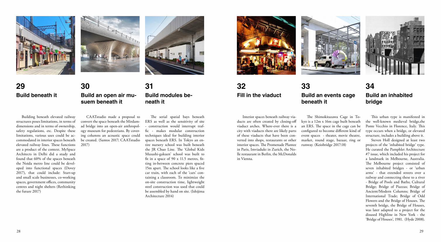
Building beneath elevated railway structures poses limitations, in terms of dimensions and in terms of ownership, safety regulations, etc. Despite these limitations, various uses could be ac-commodated in interior spaces beneath elevated railway lines. These functions are a product of the context. MySpace Architects in Delhi did a study and found that 60% of the spaces beneath the Noida metro line could be devel-oped into functional spaces (Dovey 2017), that could include: Start-up and small scale businesses, co-working spaces, government offices, community centres and night shelters (Rethinking the future 2017)
CAATstudio made a proposal to convert the space beneath the Mirdam-ad bridge into an open-air anthropol-ogy museum for pedestrians. By cover-ing columns an acoustic space could be created. (Santos 2017; CAATstudio 2017)
Build beneath it Build an open air mu-suem beneath it
29 30
The serial spatial bays beneath ERS as well as the sensitivity of site - construction would interrupt traf-fic - makes modular construction techniques ideal for building interior spaces beneath ERS. In Tokyo an en-tire nursery school was built beneath the JR Chuo Line. The ‘Global Kids Musashi-gakuen’ school was built to fit in a space of 90 x 11.5 metres, fit-ting in-between concrete piers spaced 15m apart. The school looks like a five car train, with each of the ‘cars’ con-taining a classroom. To minimize the on-site construction time, lightweight steel construction was used that could be assembled by hand on site. (Ishijima Architecture 2014)
Build modules be-neath it
31
Interior spaces beneath railway via-ducts are often created by closing-off viaduct arches. Where-ever there is a city with viaducts there are likely parts of these viaducts that have been con-verted into shops, restaurants or other interior spaces. The Promenade Plantee in Paris, Imviadukt in Zurich, the No-lle restaurant in Berlin, the McDonalds in Vienna.
The Shimokitazawa Cage in To-kyo is a 12m x 16m cage built beneath an ERS. The space in the cage can be configured to become different kind of event spaces - theater, movie theatre, market, round stage, bazaar, ring or runway. (Keiobridge 2017:18)
Fill in the viaduct Build an events cage beneath it
32 33
This urban type is manifested in the well-known medieval bridge,the Ponte Vecchio in Florence, Italy. This type occurs when a bridge, or elevated structure, includes a building above it.
Steven Holl designed at least two projects of the ‘inhabited bridge’ type. He curated the Pamphlet Architecture #7 issue, which included his project for a landmark in Melbourne, Australia. The Melbourne project consisted of seven inhabited bridges - or ‘urban arms’ - that extended streets over a railway and connecting these to a river - Bridge of Pools and Baths; Cultural Bridge; Bridge of Piazzas; Bridge of Ancient/Modern Columns; Bridge of International Trade; Bridge of Odd Flowers and the Bridge of Houses. The seventh bridge, the Bridge of Houses, was later adapted to a project for the disused Highline in New York - the ‘Bridge of Houses’, 1981. (Hyde 2008).
Build an inhabited bridge
34
3130
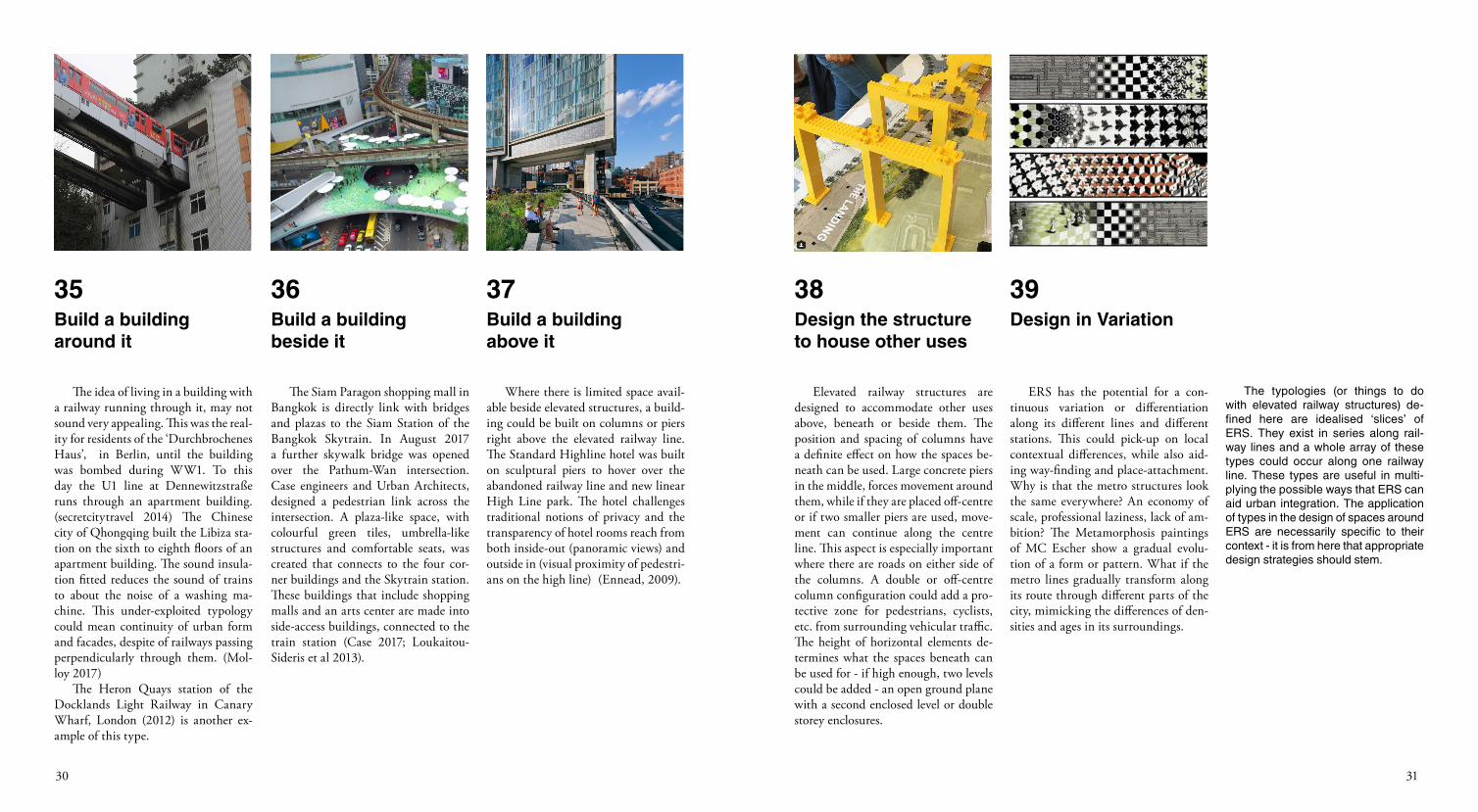
The idea of living in a building with a railway running through it, may not sound very appealing. This was the real-ity for residents of the ‘Durchbrochenes Haus’, in Berlin, until the building was bombed during WW1. To this day the U1 line at Dennewitzstraße runs through an apartment building.(secretcitytravel 2014) The Chinese city of Qhongqing built the Libiza sta-tion on the sixth to eighth floors of an apartment building. The sound insula-tion fitted reduces the sound of trains to about the noise of a washing ma-chine. This under-exploited typology could mean continuity of urban form and facades, despite of railways passing perpendicularly through them. (Mol-loy 2017)
The Heron Quays station of the Docklands Light Railway in Canary Wharf, London (2012) is another ex-ample of this type.
The Siam Paragon shopping mall in Bangkok is directly link with bridges and plazas to the Siam Station of the Bangkok Skytrain. In August 2017 a further skywalk bridge was opened over the Pathum-Wan intersection. Case engineers and Urban Architects, designed a pedestrian link across the intersection. A plaza-like space, with colourful green tiles, umbrella-like structures and comfortable seats, was created that connects to the four cor-ner buildings and the Skytrain station. These buildings that include shopping malls and an arts center are made into side-access buildings, connected to the train station (Case 2017; Loukaitou-Sideris et al 2013).
Where there is limited space avail-able beside elevated structures, a build-ing could be built on columns or piers right above the elevated railway line. The Standard Highline hotel was built on sculptural piers to hover over the abandoned railway line and new linear High Line park. The hotel challenges traditional notions of privacy and the transparency of hotel rooms reach from both inside-out (panoramic views) and outside in (visual proximity of pedestri-ans on the high line) (Ennead, 2009).
Build a building around it
Build a building beside it
Build a building above it
35 36 37
Elevated railway structures are designed to accommodate other uses above, beneath or beside them. The position and spacing of columns have a definite effect on how the spaces be-neath can be used. Large concrete piers in the middle, forces movement around them, while if they are placed off-centre or if two smaller piers are used, move-ment can continue along the centre line. This aspect is especially important where there are roads on either side of the columns. A double or off-centre column configuration could add a pro-tective zone for pedestrians, cyclists, etc. from surrounding vehicular traffic. The height of horizontal elements de-termines what the spaces beneath can be used for - if high enough, two levels could be added - an open ground plane with a second enclosed level or double storey enclosures.
ERS has the potential for a con-tinuous variation or differentiation along its different lines and different stations. This could pick-up on local contextual differences, while also aid-ing way-finding and place-attachment. Why is that the metro structures look the same everywhere? An economy of scale, professional laziness, lack of am-bition? The Metamorphosis paintings of MC Escher show a gradual evolu-tion of a form or pattern. What if the metro lines gradually transform along its route through different parts of the city, mimicking the differences of den-sities and ages in its surroundings.
The typologies (or things to do with elevated railway structures) de-fined here are idealised ‘slices’ of ERS. They exist in series along rail-way lines and a whole array of these types could occur along one railway line. These types are useful in multi-plying the possible ways that ERS can aid urban integration. The application of types in the design of spaces around ERS are necessarily specific to their context - it is from here that appropriate design strategies should stem.
Design the structure to house other uses
Design in Variation
38 39
3332
ERS ARE TRENDY
The last two decades have seen many projects arise that sought to improve residual urban spaces. The value of urban land has necessitated the better use of left-over space around elevated railway structures. Projects everywhere have come up with various ways to bring urban life to these resid-ual spaces. These typologies are mostly also applicable to other elevated urban structures, like highway structures.
ERS ARE PART OF THE URBAN LANDSCAPE
More disciplines (urbanism, ar-chitecture, landscape, events, parks, recreation) should be involved with its design - not the exclusive domain of transport departments and engineers.
ERS SHOULD BEMULTI-FUNCTIONAL
Elevated railway structures should perform more functions than only transportation. They should also con-tribute to the city in one or more of the following ways : hosting public art, forming public spaces, forming event spaces, forming landscapes, forming recreational spaces, become integrated with building fabric (beneath, beside or above).
conclusion
ERS SHOULD INTEGRATE URBAN FABRIC
ERS don’t have to sever the urban fab-ric. With careful design (and attention to ‘gapscapes’) ERS could be designed to in-tegrate urban fabric. This could be done in various ways - graphic and perceptual links, continuity and programming of the urban ground; ‘wrapping’ new build-ings around ERS, accommodating addi-tional formal and informal uses beneath the structures, The ways to integrate ERS present themselves as types.
ERS ARE HYBRID TYPES
Elevated transport infrastructures are hybrid urban types (sometimes act-ing as city walls, portals, bridges, etc). They are also a type of ‘urban land-scape infrastructure’ that form ‘flows-capes’, performing architectural, land-scape, urban and ecological functions in addition to transportation. By pay-ing attention to the type of ‘gapspaces’ these elevated structures create, urban accessibility, permeability and interac-tion could be ensured. The 39 types of interventions have multiplied the vari-ous potential ways that ERS could be-come integrated with urban life.
EARLIER THE BETTER
Although there are numerous strategies of integrating elevated railway struc-tures within urban contexts, the physi-cal limitations of specific instances, often exclude many of these strategies, especially once the structures have al-ready been built. If in the planning and design of these structures, the prob-lems of mono-function, residual space and division are considered earlier, these structures could be better inte-grated and allow for more open-ended uses around them.
ERS IN CONTEXT
The danger of a typological ap-proach to design is that it becomes a duplication of static types. The 39 types (or concepts) presented in this paper were more to open-up the mul-tiple potentials of ERS to form part of urban life. For interventions to be ap-propriate, they necessarily need to be derived from the context - physical, social, cultural, historical etc. The con-text could also become the informant for context-specific concepts to emerge.
3534
Azzarello, Nina, 2015. ‘Herman Kuijer Infills Two Tunnels in Zutphen with Immersive Light Works’, Designboom | Architecture & Design Magazine, 22 November 2015 <https://www.designboom.com/art/herman-kuijer-light-installation-underpass-zutphen-netherlands-11-22-2015/> [accessed 8 June 2018]
Bauer, Caroline, Susannah C. Drake, Rosamond Fletcher, Chat Travieso, and Douglas Woodward. 2015.Under the Elevated - Reclaiming Space, Connecting Communities. De-sign Trust for Public Space. http://www.designtrust.org/publications/under-elevated/, accessed April 17, 2018.
Bordas, David, 2005.‘Public Space: A8ernA: Zaanstadt (Netherlands), ‘ <http://www.public-space.org/en/works/d046-a8erna> [accessed 2 June 2018]
CAATstudio, 2017. ‘Caat Studio - Anthropology Open Air Museum / Under the Mirdamad Bridge’, <http://www.caatstudio.com/index.php/en/projects-en/35-under-the-mirdamad-bridge> [accessed 3 June 2018].
Cain, Jacqueline, 2018. ‘Castle Island Is Opening a Seasonal Beer Garden in Boston’, Boston Magazine, 4 May 2018 <https://
Dovey, Rachel. 2017. This Design Rethinks the Space Be-neath Train Tracks. Next City. https://nextcity.org/daily/entry/urban-design-space-under-train-tracks-in-cities, accessed April 19, 2018.
Eng, Karen Frances. 2018. In 21st-Century Korea, Shamanism Is Not Only Thriving — but Evolving. TED Fellows. https://fellowsblog.ted.com/in-21st-century-korea-shaman-ism-is-not-only-thriving-but-evolving-f1a8862a7bc8, accessed April 16, 2018.
Ennead, 2009. ‘The Standard, High Line’, <http://www.ennead.com/work/standard> [accessed 4 June 2018]
Finney, Tarsha. 2014‘The Typological Burden and the Ground’. Conference paper delivered at the ‘Types and Typologies Sympo-sium’ held in February 2014. Organ-ised by the Projective Cities Pro-gram, Royal College of Art, London.
Hague, Matthew, 2018. ‘Toronto’s Bentway Will Be a New Platform for Public Art’, The Globe and Mail, 28 February 2018 <https://www.theglobeandmail.com/news/toronto/torontos-bentway-will-be-a-new-platform-for-public-art/arti-cle38160369/> [accessed 1 June 2018]
www.bostonmagazine.com/restau-rants/2018/04/05/castle-island-ink-block-beer-garden/ > [accessed 11 June 2018]
Case, 2017. ‘BTS LINK BRIDGE SIAM PARA-GON’, <http://www.casethai.com/infrastructure_SKYWALK.php> [ac-cessed 4 June 2018]
Collings, David. 2005. Steel-Concrete Composite Bridges. Thomas Telford.
Dat, Anh, tran., 2016. ‘Planting Trees under Hanoi`s Urban Railway: Dual Benefits’, Hanoi Times, <http://www.hanoitimes.vn/my-hanoi/lifestyle/2016/12/81e0ad20/planting-trees-under-hanoi-s-urban-railway-dual-benefits/> [accessed 21 May 2018]
De Urbanisten, 2016. ‘Aquaduct010’, <http://www.urban-isten.nl/wp/?portfolio=aquaduct-010> [accessed 2 June 2018]
Divisare, 2016. ‘Kosmos Architects - Queensway Bilboards’, Divisare, 20 May 2016. <https://divisare.com/projects/318328-kosmos-architects-queensway-bil-boards> [accessed 23 May 2018]
DLANDstudio, 2014. ‘HOLD System’ <http://dlandstudio.com> [accessed 11 May 2018].
references
Keiobridge, Tokyo Pistol co. ltd, and SPEAC. 2017. Shimokitazawa Cage / Lồng Và Quán Usage Guidance.. http://s-cage.com/wp-content/uploads/2017/03/event_space.pdf, accessed April 19, 2018.
Landezine. 2016. Rambla de Sants by Sergi Godia and Ana Molino « Landscape Architec-ture Works | Landezine. Landezine. .http://www.landezine.com/index.php/2016/12/rambla-de-sants-by-ser-gi-godia-and-ana-molino/, accessed May 6, 2018.
Landezine, 2015. ‘AUREÀ CUADRADO GARDEN by SCOB Architecture & Landscape « Landscape Architecture Works | Lan-dezine’, Landezine, 2015 <http://www.landezine.com/index.php/2015/06/barcelona-skate-parks-aurea-cuadra-do-garden-by-scob-architecture-land-scape/> [accessed 1 June 2018]
Knitel, Koen. 2012. ‘Urban CampScape Pops Up At The Dutch Design Week’, Pop-Up City, 2012.10.19 <http://popupcity.net/urban-campscape-pops-up-at-the-dutch-de-sign-week/> [accessed 3 June 2018].
Grace La and James Dallman, 2009. ‘Crossroads Project, Mil-waukee, Wisconsin-Regeneration of Unused Space and Alternative Route’, Topos: European Landscape Magazine, 67 (2009), 70.
Hampton, Chris. 2018. ‘With Integrated Artwork, Alex McLe-od Polishes Metrolinx’s Davenport Diamond’, Globe and Mail, 29 March 2018 <https://www.theglobeandmail.com/arts/art-and-architecture/article-with-integrated-artwork-alex-mcleod-polishes-metrolinxs-davenport/> [accessed 1 June 2018]
Heathcott, Joseph. 2013. ‘The Promenade Plantée: Politics, Planning, and Urban Design in Postindustrial Paris’, Journal of Plan-ning Education and Research, 33 (2013), 280–91
Hodal, Kate. 2017. Hanoi Is Choking on the Fumes of 5m Motorbikes, but Can Ban Break Its Habit? The Guardian. http://www.theguardian.com/global-develop-ment/2017/jul/22/hanoi-motorcy-cles-ban-2030-pollution-transport, accessed April 23, 2018.
Hormigo, Pedro, and Takao Morita. 2004. Urban Gapscapes: Problems and Opportunities in Urban Design Analysis of Gapspaces Originated by Elevated Railways. Journal of Asian Architecture and Building Engineer-ing 3(1): 181–188.
Ishijima Architecture, 2014. ‘Global Kids Musashi-gakuen’, ồồồồồ,<http://ecg-man.com/nursery/%e3%82%b0%e3%83%ad%e3%83%bc%e
3%83%90%e3%83%ab%e3%82%ad%e3%83%83%e3%82%ba%e6%ad%a6%e8%94%b5%e5%a2%83%e5%9c%92/> [accessed 10 May 2018].
James Corner Field Opera-tions, 2015.. ‘The Underline - Framework Plan and Demonstration Projects’, 2015.12.18 <https://www.theunderline.org/wp-content/uploads/2016/02/The-Underline_Framework-Plan-and-Demonstration-Projects_screen_revised-0205_2016-FINAL.pdf> [accessed 15 April 2018]
Jensen, Ole B. 2007. City of Layers-Bangkok’s Sky Train and How It Works in Socially Seg-regating Mobility Patterns. Swiss Journal of Sociology 33(3).
Jobst, Marko. 2017. ‘Deleuze, Space and the Architectur-al Fragment’ in Constantin V. Boun-das and Vana, Tentokal. Architectural and Urban Reflections After Deleuze and Guattari. London - New York: Rowman & Littlefield.
Karis, Timothy. 2017. The Wrong Side of the Tracks: Development, Displacement and the Politics of Presence in the Shadow of Hanoi’s Urban Railway Project. City 21(5): 663–671. https://doi.org/10.1080/13604813.2017.1374780 , accessed May 06, 2018.
3736
Rory Hyde, 2008. ‘RORY HYDE PROJECTS / BLOG » Blog Archive » Melbourne Unbuilt: Steven Holl’, Rory Hyde Projects, <https://web.archive.org/web/20101222093046/http://rory-hyde.com/blog/?p=15> [accessed 10 June 2018].
Loukaitou-Sideris, Anastasia, Harrison Higgins, Dana Cuff, and Dan Oprea, 2013. ‘Up in the Air: Urban Design for Light Rail Transit Stations in Highway Medians’, Journal of Urban Design, 18 (2013), 313–39. <http://dx.doi.org/10.1080/13574809.2013.800448> [accessed 25 May 2018]
Mañes Rubio, Jorge. 2017. On Distant Objects And Hungry Gods | Seethisway, the Work of Artist Jorge Mañes Rubio. https://seethis-way.com/portfolio-item/on-distant-objects-and-hungry-gods, accessed April 16, 2018.
Masanauskas, John, and Bi-anca Carmona. 2017. ‘Covering Tracks on Overhead Rail’, Herald Sun, 2017 <http://www.heraldsun.com.au/leader/inner-south/mirror-surface-a-shining-option-for-melbournes-sky-rail-design/news-story/8892a91c6ced0fd988308949e366ecfb> [accessed 2 June 2018]
Metrolinx,.2016. Metrolinx Davenport Diamond Grade Separation. http://www.metrolinx.com/en/regionalplanning/rer/daven-port.aspx, accessed June 1, 2018.
Molloy, Mark, 2017. ‘Incredible Train “disappears” through Block of Flats in China’s “Mountain City”’, The Telegraph, 20 March 2017 <https://www.telegraph.co.uk/news/2017/03/20/incredible-train-disappears-block-flats-chinas-moun-tain-city/> [accessed 14 May 2018]
Moret, A, 2013. ‘Under the Bridge with Ballroom Lu-minoso’, Installation Magazine, issue 17, July 2013 <http://installationmag.com/ballroom-luminoso/> [accessed 8 June 2018]
Nijhuis, Steffen, and Daniel Jauslin, 2015. Urban Landscape Infrastructures. Designing Operative Landscape Structures for the Built Environment, 2015, iii <https://doi.org/10.7480/rius.3.874>
PennDesign City and Regional Planning Studio, 2016. ‘Greening the Elevated’, Issuu, <https://issuu.com/pennplanning/docs/gsi> [accessed 14 May 2018].
Raumlaborberlin, 2006. ‘Raumlabor » Das Küchenmonu-ment’ <http://raumlabor.net/kuchen-monument/> [accessed 1 June 2018]
Richard, Gabrielle, Vincent Becue, Bruno Barroca, and Pierre-Etienne Gautier. 2016. How Can the Concept of Functional Diversity Be Applied to Elevated Transport Infrastructures, to Improve Their Integration into Urban Spaces?, vol.11. Milan: Conference: World Con-gress on Railway Research (WCRR) 2016. https://www.researchgate.net/publication/305780629_How_can_the_concept_of_functional_diver-sity_be_applied_to_elevated_trans-port_infrastructures_to_improve_their_integration_into_urban_spaces, accessed April 24, 2018.
Rajab, Ramadhan, 2018. ‘Building SGR in Nairobi Park Begins despite Court Order’, The Star, Kenya, 03 March 2018 <http://www.the-star.co.ke/news/2018/03/03/building-sgr-in-nairobi-park-begins-despite-court-order_c1723049> [accessed 30 May 2018]
Rethinking the future. 2017. Below the Metro Lines | Myspace Architects. Rethinking The Future - RTF. https://www.re-thinkingthefu-ture.com/rtfa2017-transportation-terminal-concept/below-the-metro-lines-myspace-architects/, accessed April 19, 2018.
Roshan-Afshar, Navid. 2012. It’s Time to Stop Whining About Elevated Rail | InTysons. https://inty-sons.com/its-time-to-stop-whining-about-elevated-rail/, accessed April 16, 2018.
Santos, Sabrina, 2017. ‘CAAT Studio Transforms Bridge into Museum in Iran’, ArchDaily, <http://www.archdaily.com/803552/caat-stu-dio-transforms-bridge-into-museum-in-iran> [accessed 3 June 2018]
SCOB, 2017. ‘Les Corts. Barcelona’, Scob Archi-tecture and Landscape <http://www.scob.es/eng/architecture-and-land-scape/landskating/skate-park-les-corts.html> [accessed 1 June 2018]
Temtem, Filipe, 2017. ‘Building the Urban Physiognomy of Berlin through the “Well-Ordered Facade” of the Stadtbahn’, ZARCH, 2017, 104 <https://doi.org/10.26754/ojs_zarch/zarch.201782149>
Triptyque Architecture. 2017. The Minhocão Marquise: Uan Plan-ning Prot by Triptyque Architure. Triptyque Architecture, Urbanism Projects. Paris | São Paulo. https://www.triptyque.com/theminhocaomar-quise, accessed May 1, 2018.
Qamaruz-Zaman, Nurulhusna, Zalina Nurulhusna, and Nik Farhanah Nik Azhari. 2013. Under The Flyovers of Kuala Lumpur: User Centered Activities in Leftover Spaces. Journal Of Asian Behav-ioural Studies 3(10): 89–103.
Underground at Inkblock, 2018. Facebook page. <https://www.facebook.com/inkundergroundbos/ > [accessed 11 June 2018]
West8, DTAH, Cecil Balmund, AGU, ARUP, Halsall Associ-ates, and BA Group, 2013. ‘Stitching the City to Its Lakefront’ <http://www.gardinereast.ca/sites/default/files//designideas/Replace_West8%2BDTAH%2BCBAGU_Book-let.pdf> [accessed 6 May 2018]
Lé, Philippe, 2014.‘Drone views of Long Bien Bridge’, in Waibel, M. (ed.) 2015 Hà Noi: CAPITAL City. Photo Book. 1st edition. Fine Art Publishing House, Hanoi, Vietnam, 308 p
Author, 2018. ‘New elevated railway in Hao Nam, Hanoi, Vietnam.’
POTENTIALIZING ERS
1. Undergroundinkblock, 2018. ‘Spring temperatures are (finally) arriving - it’s the perfect weather to come out and explore @underground-inkblock!’, Instagram, 12 April 2018. <https://www.instagram.com/p/BheK-q0SBhWR/> [accessed 10 June 2018]
2. Verde, Via, 2017. ‘Via Verde’ <http://viaverde.com.mx/v2/wp-content/uploads/2017/06/DSC1570.jpg> [accessed 10 June 2018]
3. Metrolinx, 2016. ‘View looking east from the second floor of an Antler Street house’, under Davenport Grade Separation, 27 April 2016. <http://www.metrolinx.com/en/regionalplanning/rer/TCH_2ndFlr_Looking_South-533x166.jpg> [ac-cessed 1 June 2018]
4. Gonzales, Fred,, 2013. Under the Bridge with Ballroom Lu-minoso, 2013 <http://installationmag.com/wp-content/uploads/2013/07/3.-Gonzales_5951_2000-copy-1200x924.jpg> [accessed 8 June 2018]
picture credits
3938
Linders, Jannes, 2015. The Luminous Installations Are Set within the Historical Town of Zutphen in the Netherlands, 22 November 2015 <https://static.designboom.com/wp-content/uploads/2015/11/tunnel-light-installations-zutphen-herman-kuijer-designboom-06.jpg> [accessed 8 June 2018] 5. Author. 2018. ‘Murals at Phùng Hồng railway arches’, 29 April 2018.
8. James Corner Field Opera-tions, 2015. ‘The Underline - Framework Plan and Demonstration Projects’, p. 199.
9. Atlanta Beltline, 2014. ‘Westside Trail MLK with Tran-sit’, Westviewatlanta.com, 19 July 2014, <http://www.westviewat-lanta.com/wordpress/wp-content/uploads/2014/07/2014-06-16-westside-trail-mlk-2-300x173.jpg > [accessed 11 June 2018]
10. Coulon, Thierry, 2011. ‘Street Restaurant, on the Railway Side, Klong Toey, Bangkok,’ <http://www.thierrycoulon.com/travel/wp-con-tent/uploads/2010/10/Train-passing-by-a-street-restaurant-Klong-Toey-slum-Bangkok.jpg> [accessed 10 June 2018]
11. Underground Inkblock, 2017. Gallery. <https:/static1.squarespace.com/static/58ae0060893fc05e8bc17a72/59dfd4bde45a7cd0dd0c8d59/59f331f9652deaab952c8c38/1509110273061/_DSC2202.jpg?format=250w > [ac-cessed 04 June 2018]
12. Canevacci, Marco, 2006. Raumlabor » Das Küchenm-onument, <http:/raumlabor.net/wp-content/uploads/2006/06/02-k%C3%BCchenmonument-bild01_marco_canevacci.jpg;> [accessed 1 June 2018]
13. Knitel, Koen. 2012. ‘Urban CampScape Pops Up At The Dutch Design Week’, Pop-Up City, 2012.10.19 <http://popupcity.net/urban-campscape-pops-up-at-the-dutch-de-sign-week/> [accessed 3 June 2018].
14. Jägnefält Milton, 2010. ‘Rolling Masterplan’, < http://www.jag-nefaltmilton.se/projects/Rolling-Mas-terplan# > [accessed 11 June 2018]
15. Triptyque Architecture. 2017. The Minhocão Marquise: Uan Plan-ning Prot by Triptyque Architure. Triptyque Architecture, Urbanism Projects. Paris | São Paulo. https://www.triptyque.com/theminhocaomar-quise, accessed May 1, 2018.
16. John Hanley, 2018.‘The Bentway Skating Trail Opened Saturday in Downtown Toronto’, Globalnews.ca, 5 January 2018 <htt-ps://shawglobalnews.files.wordpress.com/2018/01/bentway-3.jpeg?quality=70&strip=all&w=670&h=439&crop=1&zoom=2> [accessed 10 June 2018].
17. SCOB, 2017. ‘Les Corts. Barcelona’, Scob Archi-tecture and Landscape <http://www.scob.es/eng/architecture-and-land-scape/landskating/skate-park-les-corts.html> [accessed 1 June 2018]
18. KOSMOS, 2014. Queensway Billboards. <https://k-s-m-s.com/cdn/rks/595a6374d1fb86010299a675/im-ages/thumb/1499095655288.jpeg> [accessed 10 June 2018].
19. Brunton, John, and Alamy, 2017. ‘A Magical, Green Walk along Paris’s Promenade Plantée | Travel | The Guardian’, 6 July 2017 <https://www.theguardian.com/travel/2017/jun/07/paris-promenade-plantee-free-elevated-park-walkway-bastille-bois-de-vincennes> [ac-cessed 10 June 2018]
20. Sardà, Adrià Goula, 2016. Rambla de Sants, 13 December 2016 <http://www.landezine.com/wp-content/uploads/2016/11/Barcelona-elevated-park-gree-roof-09-300x300.jpg> [accessed 6 May 2018]
21. James Corner Field Opera-tions, 2015. ‘The Underline - Framework Plan and Demonstration Projects’, p. 118-119.
22. Diller, Scofidio + Renfro, 2010. ‘Gardiner City’. P. 9
23. Ngoc Hai-Kinhtedothi.vn, 2016. Planting Trees under Hanoi`s Urban Railway: Dual Benefits, <http://cdn.hanoitimes.com.vn/mfiles/data/2016/12/81E0AD20/cay-hn1.jpg> [accessed 21 May 2018].
24. John Hill, 2009. A Daily Dose of Architecture: Mar-supial Bridge, Urban Plaza, and Bus Shelter, 23 February 2009 <https://2.bp.blogspot.com/-o7u-x0N_Tvw/VPImc3wkcOI/AAAAAAAAKI4/sVmSv50pO7g/s1600/image01.jpg> [accessed 10 June 2018].
25. Radbahnberlin, 2017. ‘Artist’s impression of future Rad-bahn U1’, Instagram, 10 Febru-ary, 2017. <https:/www.instagram.com/p/BQVDMCnAmys/?taken-by=radbahnberlin> [accessed 09 June 2018]
26. Googlemaps, 2017. ‘Koiwa station’. <https://www.google.co.za/maps/@35.7318123,139.8795235,3a,89.9y,162.15h,91.23t/data=!3m6!1e1!3m4!1s3cn0CzmZi0Muur_vnjh3WQ!2e0!7i13312!8i6656?hl=en> (accessed 10 June 2018)
27. DLANDstudio, 2014.‘HOLD System’ <https://freight.cargocollective.com/w/2000/q/94/i/ff25e54824948209afa76f65dd9983a-b19a0aba1485326c2edfdfd77b-71f5ab0/DLANDstudio_HOLD-Open-House.jpg > [accessed 11 May 2018].
28. Aminga, Ezekiel, 2018. Wild Beasts Seen near the Standard Gauge Railway Pillars inside the Nairobi National Park, 3 March 2018 <https://www.the-star.co.ke/sites/default/files/styles/new_full_content/public/1722825.jpg?itok=V4yqA4lr> [accessed 30 May 2018]
29. Gula_jp, 2015. ‘#hometown #underrailway #street#bar #colourful #sky #bluesky #building#himeji #japan‘, Instagram, 22 May 2015. <https://
www.instagram.com/p/29TOIYgjH6/> [accessed 13 May 2018]
30. CAATstudio, 2017. ‘Caat Studio - Anthropology Open Air Museum / Under the Mirdamad Bridge’, <https:/images.adsttc.com/media/images/587d/af63/e58e/cea2/6600/0098/slideshow/01.jpg?1484631891> [accessed 3 June 2018].
31. Ishijima Architecture, 2014. ‘Global Kids Musashi-gakuen’, ồồồồồ,<http://ecg-man.com/wp-content/uploads/musashisakai_gaikan2.jpg > [accessed 10 May 2018].
32. Halladay, 2013. ‘Under the elevated railroad tracks. Right before a three-day weekend.’ Instagram, 11 October 2013. <https://www.instagram.com/p/fU8w7Rzhjy/> [accessed 13 May 2018]
33. Keiobridge, Tokyo Pistol co. ltd, and SPEAC. 2017. Shimokitazawa Cage / Lồng Và Quán Usage Guidance, p. 5.. http://s-cage.com/wp-content/uploads/2017/03/event_space.pdf, accessed April 19, 2018.
34. Holl, Steven, 1979. ‘Bridge of Houses Melbourne, Aus-tralia. New York, NY, United States. 1979’, Hidden Architecture, 2017.03.26 <https://2.bp.blogspot.com/-E5e4_Nb-5gOA/WNgRCSPqmKI/AAAAAAAAIHA/vWYdr3T22RUpTk2JhVYz7CHxpUg6_16EACLcB/s1600/bridge_01.jpg l> [ac-cessed 10 June 2018]
35. Barcroft Images/Barcroft Media via Getty Images, 2017.
Doug, ‘Why Walk to Train? In This Building, It Comes to You’, CNN Travel, 2017 <https://dynaimage.cdn.cnn.com/cnn/q_auto,w_2279,c_fill,g_auto,h_1282,ar_16:9/http%3A%2F%2Fcdn.cnn.com%2Fcnnnext%2Fdam%2Fassets%2F170321115807-02-china-mono-rail-apartment-restricted.jpg > [ac-cessed 10 June 2018]
36. Travel Communication, 2017.Public Art Space Now Open at Pathumwan Intersection Skywalk | TravelCommunication.Net - Global Travel News and Updates, <https://travelcommunication.net/wp-content/uploads/2017/08/travel-content-marketing-travelindex-2924-380x229.jpg> [accessed 10 June 2018]
37. Ennead, 2009. ‘The Standard, High Line’, <https://d3roppooboxrdw.cloudfront.net/work-images/0417_Stand-ard/_xxl/0417_Standard_hero2.jpg?mtime=20160504143059 > [ac-cessed 4 June 2018]
38. Thebentway, 2017. ‘We had a blast at yesterday’s @openstreetsto. Thank you to our fantastic volun-teers and to all the participants for their creative contributions. Looking forward to seeing you at events in the future!’ Instagram, 21 August 2017. <https://www.instagram.com/p/BYD243CFTZB/> [accessed 10 June 2018]
39. Escher, M.C. 1939. ‘Metamor-phosis II’, Wikipedia, <https://upload.wikimedia.org/wikipedia/en/2/2c/Escher%2C_Metamorphosis_II.jpg >


![Thermophysicalpropertiesofdryandhumidair ... · range of temperature and pressure. Data on gW of compressed humid air [7], humid nitrogen, humid argon, and humid carbon dioxide [9]](https://img.pdfslide.us/doc/110x75/5e626081cfea87225a37645c/thermophysicalpropertiesofdryandhumidair-range-of-temperature-and-pressure.jpg)