Embed Size (px)
Citation preview

33
Central Riverfront Urban Design Master Plan
Urban Design Master Plan

Central Riverfront Urban Design Master Plan
the cincinnati central riverfront Urban Design Master
Plan is the result of a public participation planning process
begun in October 1996. Hamilton County and the City of
Cincinnati engaged Urban Design Associates to prepare a plan
to give direction in two public policy areas:
• to site the two new stadiums for the Reds and the Bengals
• to develop an overall urban design framework for the
development of the central riverfront which would
capitalize on the major public investment in the
stadiums and parking
A Riverfront Steering Committee made up of City and
County elected officials and staff was formed as a joint policy
board for the Central Riverfront Plan. Focus groups, inter-
views, and public meetings were held throughout the planning
process.
A Concept Plan was published in April 1997 which identi-
fied three possible scenarios for the siting of the stadiums and
the development of the riverfront. The preparation of a final
Master Plan was delayed due to a 1998 public referendum on
the siting of the Reds Ballpark.
Once the decision on the Reds Ballpark was made by the
voters in favor of a riverfront site, Hamilton County and the
City of Cincinnati in February 1999 appointed sixteen promi-
nent citizens to the Riverfront Advisors Commission who were
charged to “recommend mixed usage for the Riverfront that
guarantees public investment will create sustainable develop-
ment on the site most valued by our community.” The result of
that effort was The Banks, a September 1999 report from the
Advisors which contained recommendations on land use, park-
ing, finance, phasing, and developer selection for the Central
Riverfront.
i Urban DesignMaster Plan
34

35
Central Riverfront Urban Design Master Plan
The final plan for the Central River-
front has the following major elements:
1 Four anchor attractions (three new:
Paul Brown Stadium, Reds Ballpark,
and the National Underground Rail-
road Freedom Center; and one exist-
ing: Firstar Center).
2 Parking for approximately 6000 cars
to serve commuters, sports fans, and
festival attendees.
3 The Banks, a vibrant mixed use dis-
trict with: 900 to 1300 housing units;
400,000 to 500,000 sq. ft. of retail
and entertainment; and a hotel of
200 to 400 rooms.
4 A new, 70-acre riverfront park as a
signature front door for the City and
as a location for major festivals.
5 A narrowed, redesigned, and partially
decked Fort Washington Way, the
sunken interstate highway which
runs east-west through the City
between Downtown and the river-
front.
6 An intermodal transportation center
below grade on the south side of Fort
Washington Way for buses, service,
future on-grade light rail, and future
commuter rail.
7 A redeveloped Third Street with new
commercial office buildings and sup-
porting retail and parking.
8 A potential mixed-use development
and marina south of Mehring Way
and west of Paul Brown Stadium.
In the pages which follow, the urban
design aspects of several of these major
elements will be described in more detail.
In addition, separate documents are
available which go into even more detail
for each of the projects. These docu-
ments are listed in the Appendix chapter
at the end of this report. Below
Overall Master Plan

36
Central Riverfront Urban Design Master Plan
Development Proposed Park Ohio River
New Fort Washington Way
Theodore M Berry Way
EL. 507'
Third Street
EL. 515'
Second Street
EL. 515'
Freedom Way
EL. 515'
Mehring Way
EL. 488' Flood Plane
Aerial view of the
Master Plan
North/South
site section

37
Central Riverfront Urban Design Master Plan
ii Urban Design Initiatives the elements of the Urban Design Master Plan were devel-
oped in an integrated interactive design process in which over-
lapping and often competing ideas were accommodated in the
final plan. However, in the following pages, each of these now
complementary major elements will be described separately to
illustrate its unique aspects. The initiatives will be presented in
the following order:
Infrastructure
• Street grid
• Fort Washington Way
• Intermodal Transit Center
• Light rail transit
• Parking
Development
• Paul Brown Stadium
• Reds Ballpark
• National Underground Freedom Center
• Firstar Center
• Riverfront Park
• The Banks
• Third Street Development
38
Central Riverfront Urban Design Master Plan
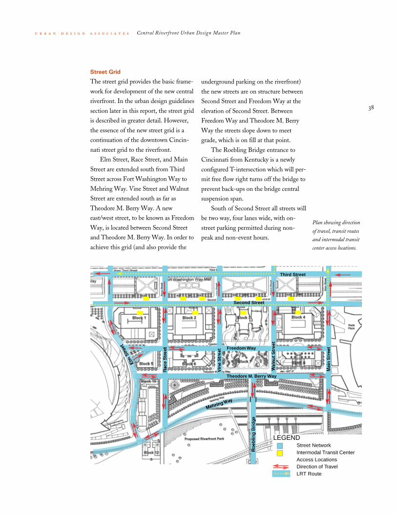
Street Grid
The street grid provides the basic frame-
work for development of the new central
riverfront. In the urban design guidelines
section later in this report, the street grid
is described in greater detail. However,
the essence of the new street grid is a
continuation of the downtown Cincin-
nati street grid to the riverfront.
Elm Street, Race Street, and Main
Street are extended south from Third
Street across Fort Washington Way to
Mehring Way. Vine Street and Walnut
Street are extended south as far as
Theodore M. Berry Way. A new
east/west street, to be known as Freedom
Way, is located between Second Street
and Theodore M. Berry Way. In order to
achieve this grid (and also provide the
underground parking on the riverfront)
the new streets are on structure between
Second Street and Freedom Way at the
elevation of Second Street. Between
Freedom Way and Theodore M. Berry
Way the streets slope down to meet
grade, which is on fill at that point.
The Roebling Bridge entrance to
Cincinnati from Kentucky is a newly
configured T-intersection which will per-
mit free flow right turns off the bridge to
prevent back-ups on the bridge central
suspension span.
South of Second Street all streets will
be two way, four lanes wide, with on-
street parking permitted during non-
peak and non-event hours.
Plan showing direction
of travel, transit routes
and intermodal transit
center access locations.
Freedom Way
Theodore M. Berry Way
Second Street
Third Street
LEGENDStreet NetworkIntermodal Transit Center Access LocationsDirection of TravelLRT Route

39
Central Riverfront Urban Design Master Plan
Fort Washington Way
Fort Washington Way is a major high-
way reconstruction project that will
improve access to downtown Cincinnati
from the interstate system and reconnect
the north/south city street network to
the riverfront. The reconstruction will
create safer traveling conditions for both
motorists and pedestrians. Access to the
city from the interstate network will be
simplified with the use of Second Street
and Third Street as collector distributors
Plan of proposed
Fort Washington Way
showing future
landscaped decks
to feed traffic to the city street grid.
Attractive bridges, generous sidewalks
and conventional street crossings will
accommodate pedestrians as they move
between the CBD and the riverfront.
Additional structural piles were
driven to support the future decking of
up to three blocks of Fort Washington
Way between Elm Street and Main
Street to create park areas.
Future Landscape Decks

40
Central Riverfront Urban Design Master Plan
Above
Aerial view of
Vine Street bridge
Below
Aerial view of
Elm Street bridge
Fort Washington Way illustrations this page courtesy Chan Kreiger & Associates and Parsons Brinckerhoff, Inc.

41
Central Riverfront Urban Design Master Plan
Intermodal Transit Center
Fort Washington Way is designed with
an intermodal transit center below newly
constructed Second Street to accommo-
date increased bus service, special event
buses, and potential commuter rail
service. This intermodal facility is strate-
gically located close to major public
venues, public parking facilities and new
riverfront development. Transit access to
Eye-level view of
Transit Center portal
the facility will be provided from Central
Avenue and Broadway. Pedestrian access
to the facility will be accommodated
from numerous street level entry points
along Second Street. Future on-grade
light rail transit on Second and Third
Streets will also interface with this
facility.

42
Central Riverfront Urban Design Master Plan
Above
Cross-section of
Second Street and the
Intermodal
Transit Center
Below
Eye-level view inside
the Transit Center
Intermodal Transit Center illustrations courtesy Wallace, Floyd, Associates, Inc. and Parsons Brinckerhoff, Inc.

43
Central Riverfront Urban Design Master Plan
Light Rail Transit
A light rail transit (LRT) system in the
I-71 corridor is being planned between
Cincinnati/Northern Kentucky Interna-
tional Airport in the south and Blue Ash
to the north. The alignment will pass
through the Fort Washington Way corri-
dor to provide light rail access to the sta-
diums and river front attractions. The
alignment will run north on Main Street
and south along Walnut Street to serve
the downtown. The preferred alignment
in the Fort Washington Way corridor is
eastbound along Second Street and west-
bound along Third Street. This align-
ment is less intrusive than pairing the
track on the southern curb of Second
Street and will allow the light rail vehi-
cles to operate in the streets with the
flow of traffic. LRT in the preferred
alignment will add value to new develop-
ment sites in the central riverfront and
north of Third Street.
Plan of the preferred
LRT alignment

44
Central Riverfront Urban Design Master Plan
Above
Second Street looking
east illustrating both
LRT tracks south of
Second Street
Below
Second street looking
east illustrating the
preferred alternative:
eastbound LRT tracks
on Second Street

45
Central Riverfront Urban Design Master Plan
Parking
New parking for the central riverfront
will total approximately 13,000 spaces
shown on the diagram below.
Central Riverfront
(Between Elm and Main,
south of Second and north of
Theodore M. Berry Way)
• 4530 spaces in
an underground garage
• 460 spaces under
Paul Brown Stadium
• 1300 spaces in three mid-block
above ground garages
• 900 on-street parking spaces
(all streets south of Second between
the stadium and ballpark)
Other locations
• 1200 net new spaces in an above-
ground garage east of Firstar Center
• 3500 spaces in above-ground
garages along Third Street
• 1400 surface lots north and west
of Paul Brown Stadium
Other than the 1300 spaces in the
three mid-block above ground garages,
which will be dedicated to residents of
the new apartments, all the other spaces
will be shared with week-day commuters,
event attendees, and shoppers.
LEGENDBelow Ground GarageAbove Ground GarageSurface Parking
Plan diagram courtesy THP Ltd.

46
Central Riverfront Urban Design Master Plan
Paul Brown Stadium
Paul Brown Stadium will anchor the
western end of the central riverfront as
the new home for the Cincinnati Ben-
gals. Located between Central and Elm,
Second and Mehring, the dramatic new
stadium will be a prominent feature of
Cincinnati’s riverfront. The stadium is
well situated to provide excellent access
for motorists and pedestrians and is adja-
cent to the new Intermodal Transit Cen-
ter and future LRT stations. The
stadium is located to take advantage of
numerous nearby parking facilities in the
downtown and will be adjacent to the
new 5000-car, below-grade parking
garage in the riverfront. Street access will
provide many approaches for fans on all
sides of the facility. The Elm Street
entrance will face a public square at Free-
dom Way. Fans will enjoy easy access
into the new riverfront district for
restaurants and entertainment. The river-
front park will accommodate pre and
post game activities. The open ends of
the stadium will provide great view corri-
dors of the river and the downtown
skyline.
Above & Below
Eye-level views of
Paul Brown Stadium

47
Central Riverfront Urban Design Master Plan
Aerial view of
Paul Brown Stadium
Paul Brown Stadium illustrations courtesy Glaser Associates and NBBJ

48
Central Riverfront Urban Design Master Plan
Cincinnati Reds Ballpark
The new Reds Ballpark will anchor the
eastern end of the central riverfront and
will be located between Main and
Broadway, Second and Mehring. The
ballpark is well situated to provide excel-
lent access for motorists and fans to take
advantage of numerous nearby parking
facilities in the downtown. The ballpark
design will incorporate below grade
parking as part of the new 5000-car,
below-grade parking garage beneath the
adjacent riverfront development blocks.
Street access will provide many
approaches for fans on all sides of the
facility. The Main Street address will
feature a generous public plaza for game
time assembly and portions of the plaza
will be open on non-game days. Pedes-
trian access is accommodated around the
whole facility with new walkways to link
the central riverfront blocks and parking
facilities to the Firstar Center. The ball-
park entrance on Broadway will also pro-
vide direct access to the Firstar Center
and upper level walkways will link both
venues to the new East Parking Garage.
The seating bowl of the ballpark will be
oriented southeast to capture views of
the Ohio River and Northern Kentucky.
Aerial view of the
Reds Ballpark

49
Central Riverfront Urban Design Master Plan
the bridge will be an integral component
of the Freedom Center and will serve as
a major public space which other devel-
opment blocks will face. The National
Underground Railroad Freedom Center
and the park are conceived as events
along a path and can with temporary clo-
sure to Freedom Way, be joined as one
large block for special events.
National Underground Railroad
Freedom Center
Located in the center of Cincinnati’s
riverfront at the head of the Roebling
Bridge, the National Underground Rail-
road Freedom Center is a national edu-
cational center that will commemorate
the historic efforts of the underground
railroad and raise the awareness of the
ongoing struggle for freedom among
people around the world.
The 170,000 sq.ft. facility will
include exhibition galleries, an audito-
rium, welcome center and cafe and
extensive support areas. Underground
parking for approximately 800 cars will
be provided on two levels and building
service access will be provided below
street level. A public park at the head of
Above
View of the
NURFC model
Left
Aerial view of the
NURFC looking north
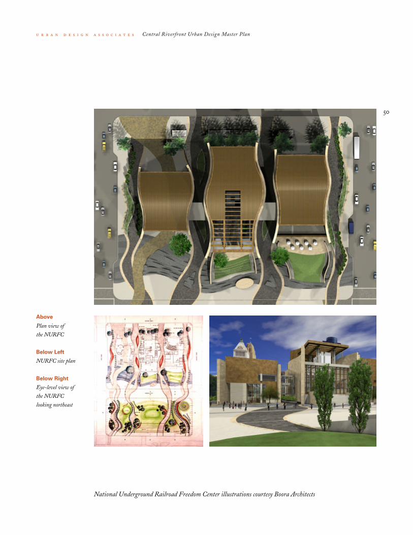
50
Central Riverfront Urban Design Master Plan
Above
Plan view of
the NURFC
Below Left
NURFC site plan
Below Right
Eye-level view of
the NURFC
looking northeast
National Underground Railroad Freedom Center illustrations courtesy Boora Architects

51
Central Riverfront Urban Design Master Plan
Firstar Center
Firstar Center, as an important existing
year round important anchor attraction,
will be impacted both by the construc-
tion of the Reds Ballpark and the new
parking
configuration. The design of the Reds
Ballpark creates new pedestrian access
points from the east at the elevated plaza
level of Firstar Center. In addition, a new
stair and elevator structure at Broadway
and Pete Rose Way will serve both the
Reds Ballpark and Firstar Center. A
1200-car parking garage will be built east
of Firstar Center and will be connected
by pedestrian bridge directly to the plaza
level of Firstar Center. Other new park-
ing facilities within one or two blocks of
Firstar Center will be the 1200-car
garage at Third and Broadway and the
5000 spaces in the central riverfront
underground garage. A new staging area
for event trucks (and circus animals) will
be located across Pete Rose Way and
under the new Fort Washington Way
ramps.
Aerial view of
Firstar Center
52
Central Riverfront Urban Design Master Plan
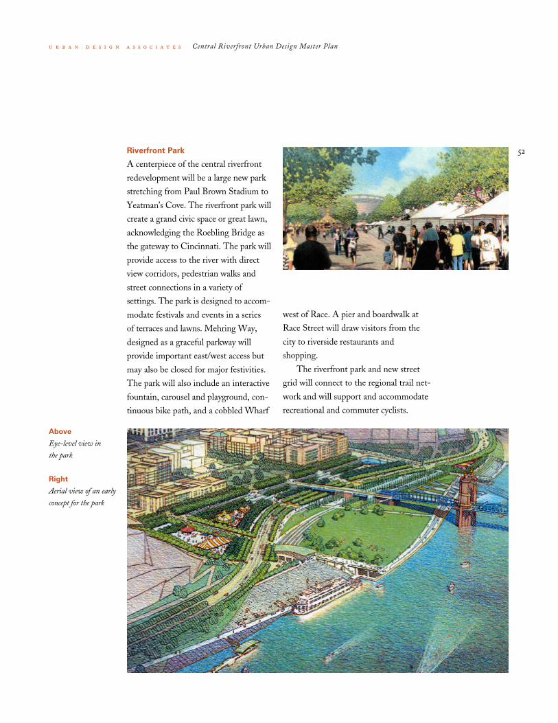
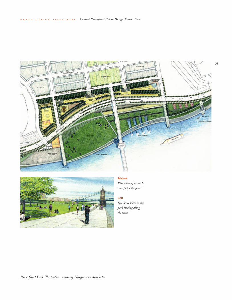
Riverfront Park
A centerpiece of the central riverfront
redevelopment will be a large new park
stretching from Paul Brown Stadium to
Yeatman’s Cove. The riverfront park will
create a grand civic space or great lawn,
acknowledging the Roebling Bridge as
the gateway to Cincinnati. The park will
provide access to the river with direct
view corridors, pedestrian walks and
street connections in a variety of
settings. The park is designed to accom-
modate festivals and events in a series
of terraces and lawns. Mehring Way,
designed as a graceful parkway will
provide important east/west access but
may also be closed for major festivities.
The park will also include an interactive
fountain, carousel and playground, con-
tinuous bike path, and a cobbled Wharf
west of Race. A pier and boardwalk at
Race Street will draw visitors from the
city to riverside restaurants and
shopping.
The riverfront park and new street
grid will connect to the regional trail net-
work and will support and accommodate
recreational and commuter cyclists.
Above
Eye-level view in
the park
Right
Aerial view of an early
concept for the park
53
Central Riverfront Urban Design Master Plan
Above
Plan view of an early
concept for the park
Left
Eye-level view in the
park looking along
the river
Riverfront Park illustrations courtesy Hargreaves Associates

54
Central Riverfront Urban Design Master Plan
The Banks
The urban design and development pro-
gram for The Banks, the private develop-
ment blocks between the stadiums, were
completed under the guidance of the
Riverfront Advisors in 1999. This
process and the program are discussed
earlier in this report (Planning Process
and Development Program). A block-by-
block description of the Banks plan and
urban design guidelines for The Banks
are in the last section of this Master Plan
(Urban Design Guidelines for The Banks).
The plan for The Banks built upon the
April 1997 Concept Plan. Below is a
summary of the recommendations of the
Riverfront Advisors Commission:
1 The Banks should create a 24-hour,
seven-day-a-week, diverse, pedes-
trian-friendly urban neighborhood.
2 The Banks should fully integrate
Central Riverfront and Third Street
development.
3 The Banks development should be
enhanced and better-connected to
the Central Business District by
adding three infrastructure and
amenity improvements:
• pedestrian plazas covering most of
Fort Washington Way
• a major new anchor attraction—the
Boardwalk at the Banks—on the
west side of the development
• exciting, usable green spaces and
amenities, particularly in the center
of the development
55
Central Riverfront Urban Design Master Plan
4 The design of the Banks neighbor-
hood should foster a diverse, wel-
coming, pedestrian- friendly urban
character.
5 The County-funded above-ground
parking garages currently planned for
the Central Riverfront Area should
be shifted to sites north of Third
Street.
6 The City and the County and private
sector should collaborate to fund the
public infrastructure and amenities
required to attract and support pri-
vate development.
7 The City, County, and private sector
(through Downtown Cincinnati, Inc)
should jointly create and interim
parking and shuttle program.
8 The Banks development should
stimulate economic inclusion among
all ages, races, and genders.
9 The Central Riverfront Area should
be developed in phases with Phase I
to be completed in 2003 and
Phase II in 2006 (see diagram).
10 The City and County should jointly
create a Riverfront Development
Commission (RDC).
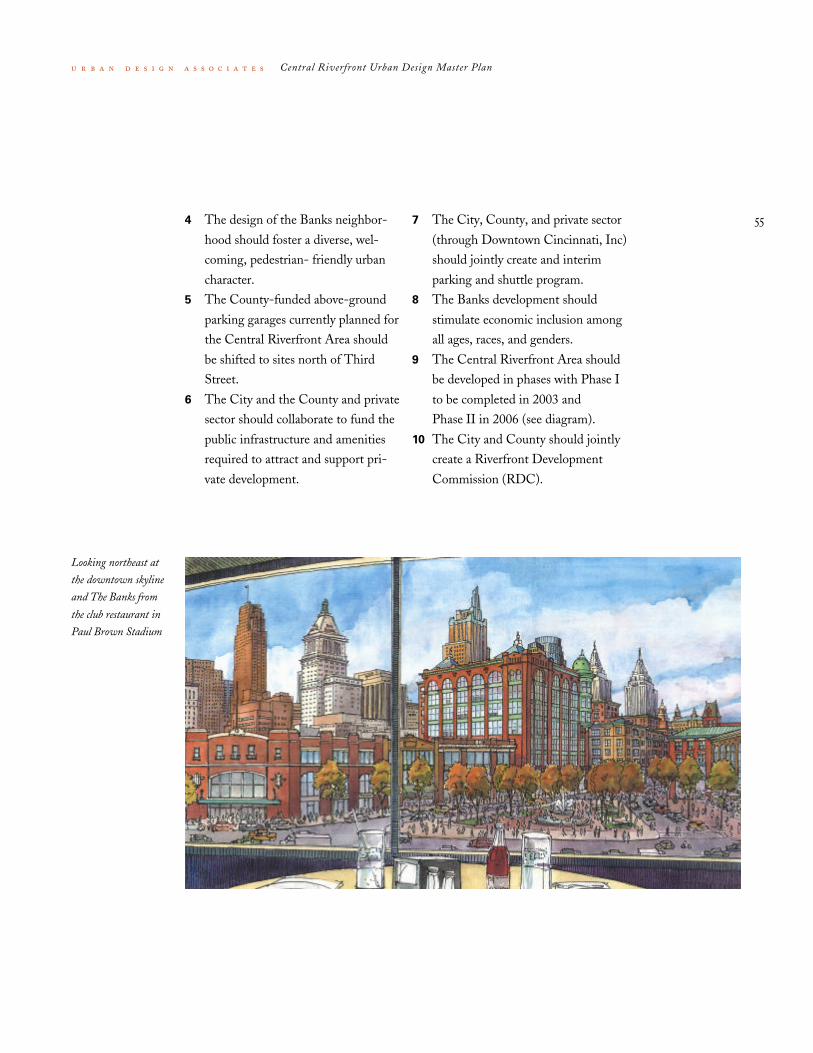
Looking northeast at
the downtown skyline
and The Banks from
the club restaurant in
Paul Brown Stadium
56
Central Riverfront Urban Design Master Plan
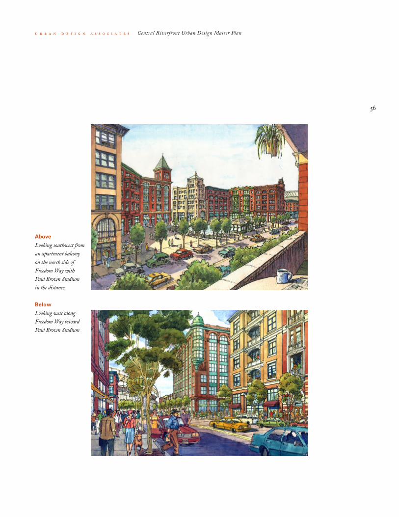
Above
Looking southwest from
an apartment balcony
on the north side of
Freedom Way with
Paul Brown Stadium
in the distance
Below
Looking west along
Freedom Way toward
Paul Brown Stadium

57
Central Riverfront Urban Design Master Plan
Third Street Development
One of the most creative ideas which
came out of the Riverfront Advisors
process was the recommendation to
move the proposed above ground County
funded parking garages north of Third
Street to stimulate private development.
By doing this, the Advisors estimate that
private development potential will be
increased from $159,000,000 to
$600,000,000. Several potential new
development sites have been identified
(Third and Race; McAlpin's site; Provi-
dent site; and Queen City site).
McAlpin's Site Provident Site Queen City SiteThird & Race

58
Central Riverfront Urban Design Master Plan
Urban Design Guidelinesfor The Banks

59
Central Riverfront Urban Design Master Plan
i Urban Design Guidelines the urban design guidelines for The Banks described in
this section were developed for Hamilton County, the City of
Cincinnati, and the Riverfront Advisors Commission by Urban
Design Associates and are intended to be attached to the
national Request for Proposals (RFP) for developers to be sent
out in Spring 2000. These guidelines delineate urban design
and architectural standards for The Banks which are consistent
with the four-year public planning process which preceded the
development of the RFP. They include broadly accepted rec-
ommendations for: land use; building massing, heights, and
setbacks; materials; color; streets, sidewalks, parks, and land-
scaping; parking; and servicing.
Developers making proposals for The Banks will be
strongly encouraged to follow these guidelines. However, the
County and the City recognize that changing market condi-
tions and other special requirements of a particular developer
may require minor modifications to these published urban
design guidelines. Developers may propose minor modifica-
tions to the guidelines with their submissions, if the developers
can demonstrate that the modifications are consistent with the
overall intent of both the guidelines and The Banks master
plan, and that they improve the viability of the project.

60
Central Riverfront Urban Design Master Plan
The Riverfront Advisors Commission
report of September 30, 1999 entitled
The Banks, recommended a diverse,
pedestrian-friendly urban neighborhood
with a mix of uses, including residential
housing, specialty-retail stores, restau-
rants and entertainment, office and bou-
tique hotel spaces. The primary focus of
the Advisors study was on the newly
created development blocks south of
Second Street between the two new sta-
dium sites. The Advisors demonstrated
that by expanding the vision to incorpo-
rate areas north, east and west of the
central development blocks and leverag-
ing public investment in new streets,
parks and garages, the city could attract
substantial private investment. The
Advisors recommended additional public
investment in landscaped decks to cover
part of Fort Washington Way, the con-
struction of a riverfront boardwalk and
construction of additional public open
space along Freedom Way. They also rec-
ommended that above grade public park-
ing garages originally planned for blocks
2 and 4 be relocated north of Third
Street. The plan is to be implemented in
two phases, however, the construction
can occur incrementally since each block
is composed of independent buildings.
The purpose of the Design Guidelines is
to describe the development program,
block by block, and the infrastructure
required to accomplish the goals as out-
lined in The Banks.
The recommendations of the
Advisors are based on extensive discus-
sions with all parties involved in the
Central Riverfront, however, continuing
discussions with the sports teams and
other stakeholders will continue as more
details emerge for individual projects.
The Riverfront
Advisors Plan for the
central riverfront
development blocks
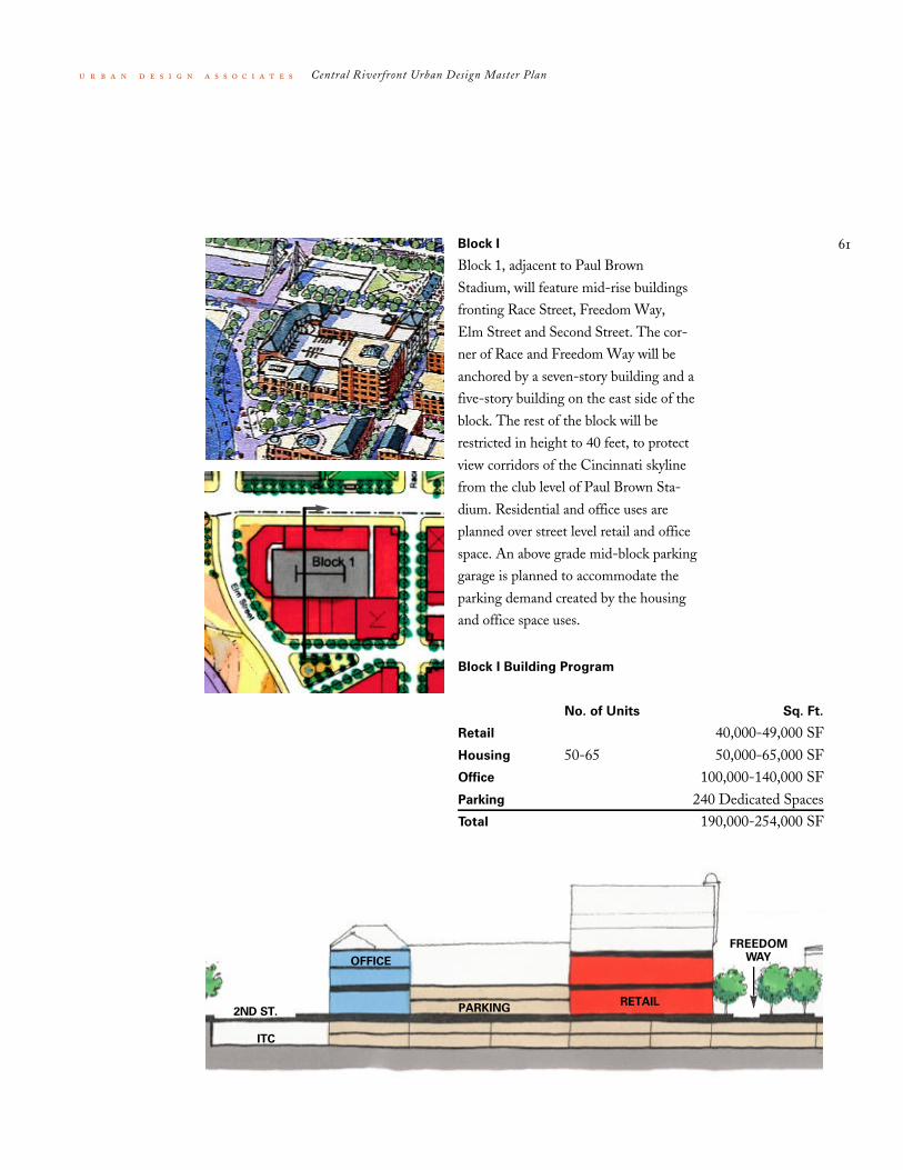
Block I Building Program
No. of Units Sq. Ft.
Retail 40,000-49,000 SFHousing 50-65 50,000-65,000 SFOffice 100,000-140,000 SFParking 240 Dedicated SpacesTotal 190,000-254,000 SF
61
Central Riverfront Urban Design Master Plan
Block I
Block 1, adjacent to Paul Brown
Stadium, will feature mid-rise buildings
fronting Race Street, Freedom Way,
Elm Street and Second Street. The cor-
ner of Race and Freedom Way will be
anchored by a seven-story building and a
five-story building on the east side of the
block. The rest of the block will be
restricted in height to 40 feet, to protect
view corridors of the Cincinnati skyline
from the club level of Paul Brown Sta-
dium. Residential and office uses are
planned over street level retail and office
space. An above grade mid-block parking
garage is planned to accommodate the
parking demand created by the housing
and office space uses.
OFFICE
PARKING2ND ST.
ITC
RETAIL
FREEDOMWAY

62
Central Riverfront Urban Design Master Plan
Block 2
Block 2 is planned to accommodate a
large number of residential units in a
series of buildings fronting Race, Second,
Vine and Freedom Way. Street level uses
will include retail, restaurants and office
space. An above grade mid-block parking
garage will accommodate residential
parking needs and will be topped with
recreational facilities for the residents.
Buildings as tall as 160 feet will front
Second Street, Race and Vine and five-
story buildings will front Freedom Way.
The buildings are located to maximize
views of the riverfront and the Freedom
Center.
HOUSING
PARKING2ND ST.
ITC
RETAIL
FREEDOMWAY
RETAIL
HOUSING
Block 2 Building Program
No. of Units Sq. Ft.
Retail 24,000-30,000 SFHousing 300-365 300,000-365,000 SFParking 549 Dedicated SpacesTotal 324,000-395,000 SF

63
Central Riverfront Urban Design Master Plan
Block 4
Block 4 will provide a mix of uses
including a boutique hotel at the corner
of Main and Second, and office space
and residential units in buildings along
Walnut and Freedom Way. Similar in
form to Block 2, the buildings will step
in height from five stories on Freedom
Way to twelve stories on Second Street.
An above-grade mid-block garage will
provide parking for the hotel and resi-
dential units and will be topped with
common amenities for the hotel and res-
idents. The first two floors of the hotel
will be dedicated to lobbies, restaurants,
meeting rooms and hotel services. Retail
and restaurant space at street level is
planned for Freedom Way.
HOUSING
PARKING
2ND ST.
ITC
RETAIL
FREEDOMWAY
HOTEL
Block 4 Building Program
No. of Units Sq. Ft.
Retail 18,000-22,000 SFHousing 140-180 140,000-180,000 SFHotel 200-250 160,000-200,000 SFOffice 40,000-60,000 SFParking 520 Dedicated SpacesTotal 358,000-462,000 SF

64
Central Riverfront Urban Design Master Plan
Block 5
Block 5 will be a two-story commercial
building providing retail and restaurant
space. Located between the triangular
park space on Freedom Way and the
riverfront park, Block 5 is situated to
take advantage of great views and pro-
vide street level activities to activate the
public spaces surrounding it. Because
Block 5 is restricted in height to 40 feet,
it is ideally suited for two commercial
floor plates of approximately 20 feet in
height. The activities in this building
should not have an inward focus but
should be designed to animate Race
Street, Freedom Way and Theodore M.
Berry Way.
PARKING
THEODORE
M BERRYWAY
RETAIL
FREEDOM WAY
RETAIL
PARKING
Block 5 Building Program
Sq. Ft.
Retail 38,000-45,000 SFTotal 38,000-45,000 SF

65
Central Riverfront Urban Design Master Plan
Block 6
Block 6 will offer four stories of prime
residential units above ground floor
restaurants and shops. The buildings are
formed to create a residential square
along Freedom Way for both blocks 6
and 2. Residents will have spectacular
views in all directions. Outdoor dining
and entertainment uses on Freedom Way
and Theodore M. Berry Way will make
use of the plaza and park space and pro-
vide street level activities in all directions.
Because of the grade change between the
two streets, ground floor uses can take
advantage of increased building volume
with a mezzanine and high ceiling
heights. A winter garden for year-round
interior public uses is planned for the
corner of Vine and Theodore M. Berry
Way. The winter garden can be used for
private events and also as an indoor
extension of public riverfront events.
PARKINGTHEODORE
M BERRYWAYRETAIL
FREEDOMWAY
RETAIL
PARKINGPARK
RESIDENTIAL
SQUARE
HOUSINGHOUSING
Block 6 Building Program
No. of Units Sq. Ft.
Retail 30,000-36,000 SFHousing 70-100 70,000-100,000 SFTotal 100,000-136,000 SF
66
Central Riverfront Urban Design Master Plan
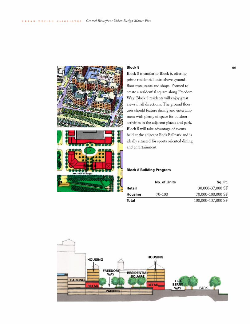
Block 8
Block 8 is similar to Block 6, offering
prime residential units above ground-
floor restaurants and shops. Formed to
create a residential square along Freedom
Way, Block 8 residents will enjoy great
views in all directions. The ground floor
uses should feature dining and entertain-
ment with plenty of space for outdoor
activities in the adjacent plazas and park.
Block 8 will take advantage of events
held at the adjacent Reds Ballpark and is
ideally situated for sports oriented dining
and entertainment.
PARKING TEDBERRY
WAYRETAIL
FREEDOMWAY
RETAIL
PARKINGPARK
RESIDENTIAL
SQUARE
HOUSINGHOUSING
Block 8 Building Program
No. of Units Sq. Ft.
Retail 30,000-37,000 SFHousing 70-100 70,000-100,000 SFTotal 100,000-137,000 SF

67
Central Riverfront Urban Design Master Plan
Block I0
Block 10 is planned to accommodate a
restaurant with prime views of both the
Ohio River and a riverfront park. A pub-
lic park will occupy the majority of the
block bounded by Elm Street, Theodore
M. Berry Way, Race Street and Mehring
Way. The restaurant, designed as a two-
story pavilion in the park, will be a major
anchor for the Race Street retail corridor
and should be planned with outdoor
dining terraces and courtyards. It will be
set back from Theodore M. Berry Way
to allow the promenade and double tree
row to extend uninterrupted from Elm to
Main. The Boardwalk will originate in
this block and proceed south to the river-
front.
THEODOREM BERRY
WAYMEHRING
WAY
PARKBEYOND
Block 10 Building Program
Sq. Ft.
Retail 56,000 SFTotal 56,000 SF

68
Central Riverfront Urban Design Master Plan
Block I2
The Boardwalk will provide restaurants,
shops, and entertainment on the river’s
edge. Connected to Race Street at
Theodore M. Berry Way, the Boardwalk
could be designed in a traditional water-
front style incorporating the imagery of
wharf buildings with an open metal
structure and will be lined with shops
and eateries with views of the park and
river below. Access for people with dis-
abilities, and services such as loading and
waste removal, will be accommodated.
The open structure of the Boardwalk will
be maximized to preserve views. The
wharf space below could also provide
some event-staging area. Elevated above
the flood plane, the Boardwalk and the
Race Street park pier below will allow
visitors to enjoy the river in all seasons.
Numerous connections to grade will link
the Boardwalk to the Race Street Pier,
wharf, park festival spaces, Mehring Way
and Race Street.
MEHRING
WAY
OHIORIVER
WHARF
Block 12 Building Program
Sq. Ft.
Retail 24,000 SFTotal 24,000 SF

69
Central Riverfront Urban Design Master Plan
Building Design
The buildings should form a rich texture which contains sur-
prises, dynamic contrasts, and varied profiles. For instance,
Block 12 with its unique mix of restaurants and shops on the
Boardwalk, and its waterfront location, will recall the imagery
of wharf buildings.
The buildings must also maintain a pedestrian scale at
street level. A great deal of emphasis will be placed on the
view of the streetscape from pedestrian eye level.
Massing
Buildings should be simple, well-proportioned volumes.
Building walls facing public streets and parks shall be termi-
nated at the top floor with a rich and varied roof scape includ-
ing sloped roofs, cornices and attic expressions. Flat roofs shall
be enclosed by parapets no less than 42 inches high or as
required to conceal equipment.
Exterior Materials
The exterior wall finish material on all facades shall be limited
to brick, stone or cast stone designed to resemble stone
masonry construction. The roof material shall be limited to
slate, tile or metal.
Perspective showing
buildings designed to
enhance round-the-
clock street level activity
at the corner of Race
Street and Freedom
Way.
ii Architectural Guidelines

70
Central Riverfront Urban Design Master Plan
Facade Treatment: Windows, Doors,
Storefronts, Awnings
Windows (other than ground-level
storefront windows) shall be vertical in
proportion, 1.5 to 2.5 times as tall as
they are wide. The glazed area of a facade
(excluding the ground level storefront)
shall not exceed 35% of the total facade
area. Doors and windows should be set-
back a minimum of three inches from
the facade.
Doors shall be vertical in proportion.
Windows and doors should appear in a
consistent and repeated pattern across
the principal facades.
Ground floor commercial uses shall
have storefronts with glazed areas equal
to at least 65% of the ground-level pro-
portion of the facade.
Color Palette
Exterior Color: The masonry colors of
buildings can range between creamy buff
colors to deep terra-cotta. Trim colors
should be contrasting tones that comple-
ment the masonry. Roofing material
should be either the natural finish of the
material or if coated, should resemble a
natural color in the palette that would
complement the exterior wall finish
color.
Doors, shopfronts, window frames,
shutters, balcony rails and awnings shall
be any color, any saturation. Glass shall
be clear or lightly tinted only. Balcony
railings and porch structures shall be
metal, stone or cast concrete.
Perspective of a
residential square
showing buildings
that form a rich
texture which contains
surprises, dynamic
contrasts, and varied
profiles.

71
Central Riverfront Urban Design Master Plan
Building Heights
Plan shows maximum
building heights by
zone.
Building Heights
The development massing will build up
from the river to the CBD, and from the
eastern and western edges of the central
riverfront as measured from the 515-foot
elevation. Permitted building heights
along the park will be 70 feet and will
climb to 160 feet along Second Street.
Blocks 1 and 5 are restricted in areas to
40 feet in height to protect view corri-
dors from Paul Brown Stadium in accor-
dance with lease provisions with the
exception of the east side of Block 1
LEGEND
Maximum Height: Midpoint ofsloped roofs or height of flat roof
555 ft above sea level585 ft above sea level675 ft above sea level
675’
585’
555’
515’
which has seven-story and five-story
buildings.

72
Central Riverfront Urban Design Master Plan
iii Streets and Parking the north/south streets of the central business district will
be extended south across Fort Washington Way to form a new
network of city streets between the two stadium sites. The
streets south of Second Street will accommodate two-way
traffic providing maximum flexibility and convenience for
motorists and pedestrians. The new street network will also
accommodate other transit modes. The Advisors are in support
of the OKI Light Rail Planning Initiative, however, the Advi-
sors strongly recommend the ‘split’ LRT alignment with east-
bound LRT stops along Second Street and westbound stops
along Third Street. Trolley bus shuttles and water taxis will also
provide transit access to the central riverfront. An intermodal
transit facility will be built underneath Second Street to
accommodate bus and future commuter rail service. This facil-
ity will be fed from an exclusive cartway between Central
Avenue and Broadway. The new Roebling Bridge landing will
become an important gateway into Cincinnati and provide a
direct connection to city streets for vehicular traffic and bus
service from Kentucky.
Light rail transit
on Second Street

73
Central Riverfront Urban Design Master Plan
Street Network
Plan showing direction
of travel, transit routes
and intermodal transit
center access locations.
Freedom Way
Theodore M. Berry Way
Second Street
Third Street
1 2 3 4
5 6 7 8
LEGENDStreet NetworkIntermodal Transit Center Access LocationsDirection of TravelLRT Route

74
Central Riverfront Urban Design Master Plan
Above-Grade
Parking and
Servicing
Locations of above
grade garages, service
areas and garage access
locations.
Above Grade Parking and Servicing
The mid-block parking garages will be
located in Blocks 1, 2 and 4. These
garages will be sized to accommodate the
needs of the residential development
blocks and are not intended for com-
muters or stadium-related events. How-
ever, the street entrances and ramping for
these garages and the below grade park-
ing system should be coordinated to pro-
vide maximum parking efficiency and
operational flexibility. Midblock parking
structures should be interior to the
blocks and lined on four sides with
buildings.
Theodore M. Berry
Second Street
Third Street
240 549 520
Freedom Way
LEGENDAbove Grade Garage/Pkg CountsGarage Access LocationsStreet Level Service LocationsOn-street Loading PermittedPossible Elevator Locations
Frequent entrances to both the upper
and lower garages are planned for the
north/south street frontage to give
motorists several options to choose from
and to take full advantage of the flexibil-
ity offered by the street grid. Pedestrian
access to the upper-level garages will be
convenient, safe, and well lit. Blocks 1, 2,
3 & 4 will be serviced underground from
the Intermodal Transit Center. Blocks 5,
6, 8, 10 & 12 will be serviced on-grade
from the streets. All dumpsters must be
located within development blocks and
out of sight.

75
Central Riverfront Urban Design Master Plan
Pedestrian Network
The central riverfront development plan
integrates pedestrian circulation into a
system of streets, squares and parks. The
Fort Washington Way project will con-
nect the CBD to the riverfront with new
pedestrian friendly bridges, extending
the street grid to the riverfront. The
Advisors recommend decking over cer-
tain blocks of the interstate to create
landscaped parks, providing diagonal
Plan of Pedestrian
Sidewalks, Squares,
and Parks
LEGENDPedestrian Plazas and CirculationBike Route
links between blocks and transforming a
noisy highway zone into a highly attrac-
tive area for redevelopment. All blocks
will provide sidewalks with a minimum
dimension of 13 feet on all streets.
Pedestrian areas will broaden out to pro-
vide outdoor activity areas for cafés and
special events. Where sidewalk cafés are
desired, sidewalk widths should be deep-
ened to accommodate outdoor seating.

76
Central Riverfront Urban Design Master Plan
INTERMODAL TRANSIT CENTER
Parking Level 490
Parking level showing
parking counts,
parking bays,
pedestrian aisles,
pedestrian access and
garage entrances.
Parking Levels 490 and 500
Two continuous parking levels below the
central riverfront streets and develop-
ment blocks will provide a major parking
reservoir for commuters, stadium events
and central riverfront commercial activi-
ties. Vehicular access to the two parking
levels will be at major entrance locations
on Central Avenue, Broadway and
Mehring Way as well as street level
entrances above on Elm, Race, Vine,
Walnut and Main. Both parking levels
will be organized with straight uninter-
rupted parking bays and drive aisles, pre-
serving open views and simple traffic
420
360
510 525 450
LEGENDLoading Docks for above grade usesParking CirculationPossible Elevator LocationsGarage Entrance LocationsIntermodal Transit CenterPedestrian Walkway
Parking Count by Blocks
(Above and Below Grade)
Total CountBlocks 1 & 5 1080
Blocks 2 & 6 1569Blocks 3 & 7 720
Blocks 4 & 8 1570Reds Ballpark 900
Total 5839
patterns. Column layouts and vertical
elements such as cores and stair towers
should be located to preserve a clear and
well organized parking system.
Reds BallPark

77
Central Riverfront Urban Design Master Plan
Parking Level 500
Parking level showing
parking counts,
parking bays, and
pedestrian aisles.
420
360
510 525 450
LEGENDParking CirculationPossible Elevator LocationsPedestrian Walkway
A well-lit and attractive east/westwalkway within the garage will help ori-ent pedestrians and provide access toseveral elevator cores and stairs. Fre-quent lobbies at street level should beprovided for pedestrian access to theparking levels. Buildings in each devel-opment block will be designed withparking below.
North of the garage beneath Second
Street is the underground Intermodal
Transit Center. Two loading dock facili-
ties are shown, servicing development
Blocks 1, 2, 4, and the Freedom Center.
Trucks will use the intermodal center
cartway to gain access to the two loading
bays.
Reds BallPark

78
Central Riverfront Urban Design Master Plan
Typical Street
A typical city street in the Central River-
front will accommodate two way traffic
flow with four 11-foot lanes which can
accommodate two lanes of travel in each
direction for rush hour and special
events. On-street parking will be permit-
ted during off peak hours with one travel
lane in each direction. The typical side-
walk depth will be 13 feet from curb to
building front. Pavers will be used in the
street and sidewalks at intersections to
help define pedestrian crossings. Pavers
will also be used behind the curb as a
collector strip. Concrete will be used for
sidewalks and streets on structure and
will require a waterproof membrane to
protect the structure and parking below.
Streets on grade will be paved in asphalt.
Street trees will be planted in boxes
below pavement level. The planter boxes
should be as large as feasible to provide
adequate soil area for root growth.
Typical street
cross-section
City streetscape drawing courtesy City of Cincinnati

79
Central Riverfront Urban Design Master Plan
Freedom Way
Freedom Way will be a unique street in
the central riverfront because it will
provide a sequence of public squares
lined with street-oriented activities.
Defined by mid-rise buildings and the
National Underground Railroad
Freedom Center, the squares will offer a
variety of outdoor activities including
pre- and post-game celebrations, outdoor
markets, ice skating and outdoor dining.
Each square should have a unique char-
acter and offer a variety of spaces from
soft shady areas to plazas with rich tex-
tures and color. The residential squares in
Blocks 6 and 8 are within the develop-
ment blocks and are the responsibility of

80
Central Riverfront Urban Design Master Plan
the developer to program, design and
build. The street in these squares may be
diverted around monuments and pavil-
ions if desired. Block 7 is a public park
developed by the National Underground
Railroad Freedom Center which will
function as an extension of the Freedom
Center programs, but also as part of the
open space network of the central river-
front. The design of Freedom Way will
be similar to the typical street in cross
section however between Vine and Wal-
nut the street design will be influenced
by the Freedom Center to respond to
unique opportunities for outdoor activi-
ties and links to the Riverfront Park.
This street may be closed to traffic on
occasion for special events.
International Court Section

81
Central Riverfront Urban Design Master Plan
Theodore M. Berry Way
Theodore M. Berry Way will become
the new riverfront street for Cincinnati,
lined with shops and restaurants to cap-
ture views of the riverfront park and
Ohio River. A promenade will run the
entire length of the southern side of the
street from Elm to Main. The 40-foot
wide promenade will be shaded by a
double row of trees and provide a contin-
uous overlook of the river and park.
MEHRING
WAY
TED BERRYWAY
FESTIVAL PARK
PARKPROMENADE
Theodore M. Berry Way will be
designed to provide a dignified landing
for the Roebling Bridge and to accom-
modate important vehicular movements
as traffic transitions from the bridge to
the city street network. The street section
of Theodore M. Berry Way will be the
standard four 11-foot lanes but will be
modified east of Vine to provide safe
turning movements at the bridge.

82
Central Riverfront Urban Design Master Plan
iv City Streetscape Standards
View of typical
downtown streetscape

83
Central Riverfront Urban Design Master Plan
Double post-top lighting fixture at corners
Special Collector Strip TreatmentConcrete Street Paving
Colored Concrete Sidewalks
Special Paving Type A
Special Paving Type B
Street Trees and Grates
Single post-top lighting fixture
spaced 66 or 44 feet on center
Intersection Paving
City Streetscape Standards Drawings courtesy City of Cincinnati
84
Central Riverfront Urban Design Master Plan
Appendix

![MASTER OF URBAN SPATIAL ANALYTICS RESUME BOOK 2012 … · MASTER OF URBAN SPATIAL ANALYTICS RESUME BOOK 2012-2013. 2 ABOUT Master of Urban Spatial Analytics [MUSA] A recent U.S. Department](https://img.pdfslide.us/doc/110x75/5f0457267e708231d40d7f34/master-of-urban-spatial-analytics-resume-book-2012-master-of-urban-spatial-analytics.jpg)