Embed Size (px)
Citation preview

Information courtesy CanyoneeringUSA.com ©2011 Imlay Canyon Gear All Rights Reserved
Upper Calf Creek Canyon • Upper Escalante Canyons 3 Different Ways: From the East, Hike and Wade From the East, A Quick Run From the West, Hike and Wade Upper Calf Creek Canyon from the East Rating: II-III Class 3 Best Season: Spring, Summer, Fall or Winter. The initial hike is exposed to the full
sun. Time: 2 to 6 hours. Access: Route starts and ends at MP 80.8 off Hwy 12. USGS 7.5’ Map: Calf Creek Permit: Not Required for day use. Equipment: Wading shoes (if wading). Drinking Water: Bring plenty, can pump the stream if needed. Flash Flood Risk: Low. Difficulties: A little downclimbing and wading. Upper Calf Creek is a wonderful, scenic, quick hike or run -‐ or can be extended into an all day wading fun fest. Much of it is exposed to the full sun, thus making it unsuitable for midday forays in the summer. The wading was really good on a sunny day in winter -‐ it may be too warm during summer. Getting There: Turn off Highway 12 at milepost 80.8. A large rock with a big white mark on it marks the spur road. Park at the trailhead register. The area is posted 'No Camping'. Descend cairned trail down slickrock toward the canyon floor and Upper Calf Creek Falls. The upper 100 feet may be a little steep for the timid, but this is the only steep part. The Goods: The trail descends to just below the Upper Falls, where the trail splits, with one branch climbing steeply down slickrock to the canyon floor and the base of the Falls; and the main trail continuing along the bench to the top of the falls. Both trails are marked with small cairns. There is a nice pool a few hundred feet above the Upper Falls, though the water may be a little green and warm. Got time? This is a great wading canyon. The stream in the bottom makes a wonderful ankle deep trail, though lush vegetation on the stream sides prevents leaving the streambed. Or hike along the bench 100 feet above the river on established social trails. There are few places to transfer from the low road to the high road, so make your choice and stick to it. The water quality near the Upper Falls is a little murky, but it improves quickly. This canyon is amazing. Try not to scare the fish too much, but enjoy the lush riparian habitat deep in the desert. After 45 minutes of wading (2/3 of the way to the Lower Falls), two side canyons come in from the west. There are several escapes/descents into the lower gorge here, but they are all kind of steep. Take your pick. (This is the Lower

Information courtesy CanyoneeringUSA.com ©2011 Imlay Canyon Gear All Rights Reserved
Junction). Got more time? Another hour and a half will get you down to the top of the Lower Falls and back to this point. The final couple hundred feet to the Falls is very dramatic, and requires a 4th class scrambling to get to the actual top of the falls. Return upstream. From the Lower Junction, it is speedier to return on the bench trail, rather than in the stream. Find an exit to the bench above (3rd class). Wind around the small canyons, and find the trail up to the rim. Upper Calf Creek Canyon from the East, A Quick Run
The East Side Trail makes a great, scenic, 20 to 40 minute run. The trail to the Upper Falls area is well established and easy to follow. Have more time? Follow somewhat thinner trails south along the bench above the canyon to the Lower Junction. Return at will.
Information courtesy CanyoneeringUSA.com ©2011 Imlay Canyon Gear All Rights Reserved
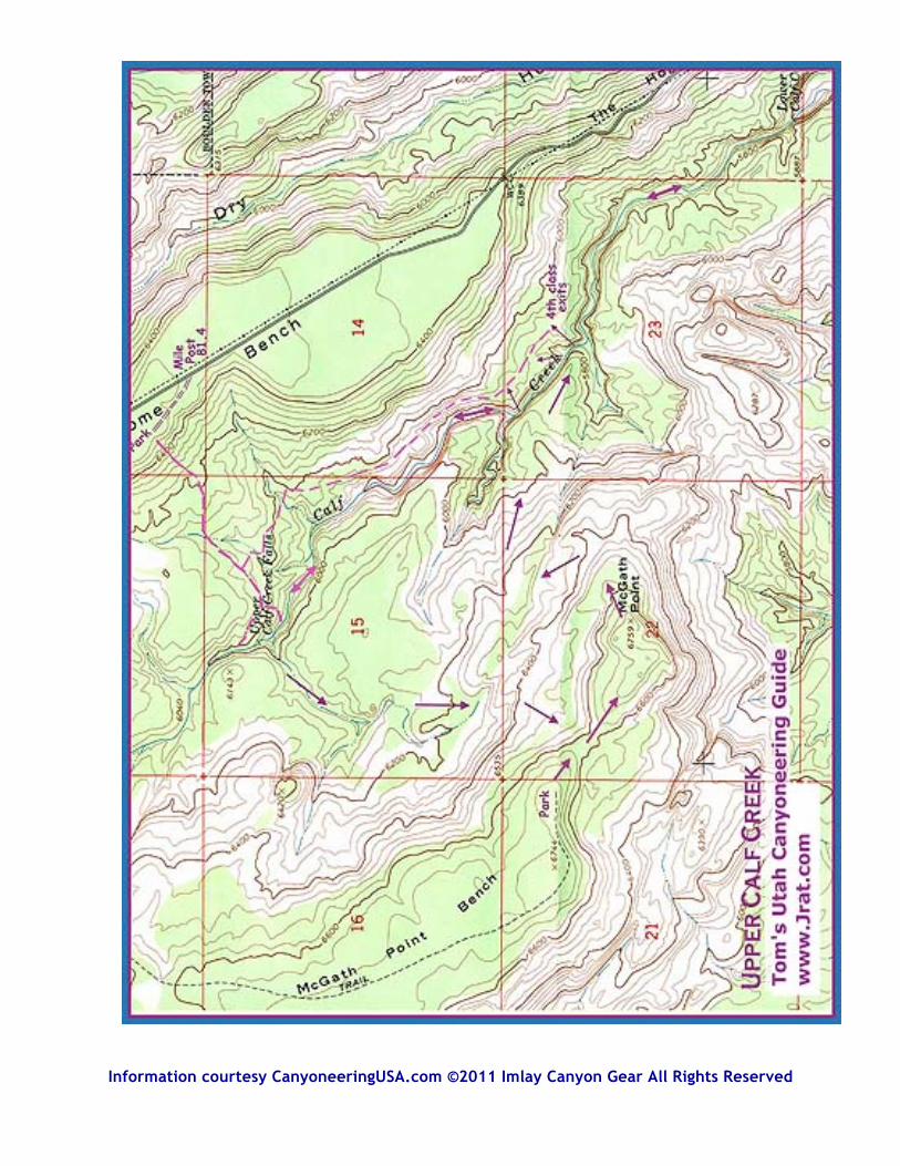
Upper Calf Creek Canyon from the West Rating: III Class 3 Best Season: Fall, Winter or Spring. Time: 4 to 8 hours. Access: Route starts and ends at the end of the McGath Point Bench Road. USGS 7.5’ Map: Calf Creek and Boulder Town. Permit: Not Required for day use. Equipment: Wading shoes. Drinking Water: Bring plenty, or be prepared to pump the stream. Flash Flood Risk: Low. Difficulties: A little downclimbing. Wading. Navigation Skills. Upper Calf Creek West is a scenic hike down slickrock to a lush canyon. A few hours of wonderful wading bring you to the top and bottom of two large waterfalls. This is a true plum. The Upper Fall area is easily approached from the other side and is popular. The rest of the canyon is uncrowded. Getting There:From Boulder, drive South on Highway 12 3.5 miles to the Hell's Backbone Road. Turn right, then immediately left onto an unmarked dirt road. Cross the Boulder Airport and UFO Landing Site (good camping here) and continue out the road towards McGath Point. The road is pretty good except for one section of soft sand about half way out. Camping available in several spots. Park all the way at the end of McGath Point Bench. The Goods: Hike Southeast across a wonderful dune-‐habitat saddle to the real McGath Point and marvelous views of the Upper Escalante. The steep canyon below you to the south is Willow Patch Creek leading into Sand Creek. Look east and take a good view of the descent. You are trying to reach the "Lower Junction", where the 5800 foot contour is labelled. Notice the cliff at 6200 feet that will need to be avoided to the north. Work your way down the cliff bands at the top then down onto the slickrock. A circuitous but reasonable route can be found with a little diligence. Descend the slickrock, then a ridge down to the creek bottom at the Lower Junction. From here it is about 1-‐1/2 hours of wading to the Lower Falls and back. The best path is to disdain the brushy shore and plunge directly down the stream. Fun, fun, fun. Return to the Lower Junction. Then wade up canyon 45 minutes to the Upper Falls. Or wimp out and climb to the bench above the gorge on the East side, and follow the bench north to the Upper Falls. There are a few 3rd/4th class exits to the bench above, should you need one. To return to McGath Point, climb out of the canyon on the East side just below the falls. Follow the trail to the head of the Upper Falls, then further upcanyon to the Upper Upper Falls, with a nice, deep pool. Cross the stream above the UU Falls and ascend the slickrock on the far side. (Or find an easier way further up canyon). Cross into a shallow wash heading toward McGath Point Bench above. Follow this interesting wash upcanyon, taking the left branch past an interesting sandstone tower, then up into a beautiful little valley with lovely Ponderosa pines. Then traipse up the slickrock towards the Dune Saddle, and find a way through the little cliff bands. Home sweet home.
Information courtesy CanyoneeringUSA.com ©2011 Imlay Canyon Gear All Rights Reserved


![Post-Wimp Interaction With Desktop Computersdragice.fr/papers/postwimp.pdfPost-WIMP sketching-based 3D modelling interface n MaggLite [Huot et al 2004] Post-WIMP UIMS based on ICON](https://img.pdfslide.us/doc/110x75/5f2b89dc6842a8400746afc9/post-wimp-interaction-with-desktop-post-wimp-sketching-based-3d-modelling-interface.jpg)