Embed Size (px)
Citation preview

1
Upper Peninsula 10-possession brook trout regulation proposal (descriptions) Alger County (page 4):
• Sucker River watershed: o Sucker River and all tributaries upstream of Old Seney Road (CR 781).
Baraga County (page 5): • Falls River watershed:
o Falls River from Blackjack Road (aka Golf Course Road) upstream to confluence with Ogema Creek and Burns Creek.
• Huron River watershed: o West Branch Huron River upstream from confluence with Robarge Creek.
• Silver River watershed: o Silver River and all tributaries upstream from Upper Silver Falls (northeast of Herman).
• Sturgeon River watershed: o Sturgeon River upstream from highway Nestoria/Herman road.
Chippewa County (page 6): • Pine River watershed:
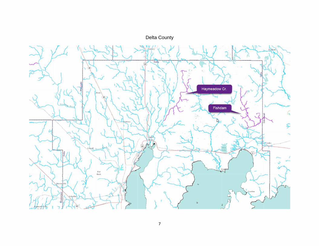
o North Branch Pine River and all tributaries upstream from H-40 (in Rudyard). Delta County (page 7):
• Whitefish River watershed: o Haymeadow Creek and all tributaries upstream from Whitefish River.
• Fishdam River watershed: o Fishdam River (Delta and Schoolcraft counties) and all tributaries upstream from County
Road 2222 Bridge. Dickinson County (page 8):
• Sturgeon River watershed: o East Branch Sturgeon River and all tributaries upstream from Leeman Road. o Fern Creek and all tributaries upstream from Pine Creek Lake Road.
Gogebic County (page 9): • Black River watershed:
o Black River upstream of South Black River Road, excluding McDonald Creek. o Powdermill Creek and all tributaries upstream from Highway US- 2.
• Ontonagon River watershed: o Tamarack River (Gogebic and Iron counties) from confluence with Middle Branch
Ontonagon River at Federal Forest Road 4500. • Presque Isle watershed:
o Little Presque Isle River and all tributaries upstream from confluence with mainstream Presque Isle River.
Houghton County (page 10): • Graveraet River watershed:
o Deer Creek upstream from confluence with Gravereat River. • Ontonagon River watershed:
o East Branch Ontonagon River (Houghton and Iron counties) upstream from confluence with Glitter Creek near Lower Dam Road crossing.
• Otter River watershed: o Sante River and all tributaries upstream from North Branch Otter River.
• Sturgeon River watershed. o Sidnaw Creek (Houghton and Baraga counties) and all tributaries upstream from
confluence with Sturgeon River. Iron County (page 11):
• Michigamme River watershed: o Deer River and all tributaries upstream from Bradley Road. o East Branch Fence River (Iron and Baraga counties) upstream from North Fence Line
River Road.

2
o Margeson Creek and tributaries upstream from Noyes Road. Keweenaw County (page 12):
• Tobacco River watershed: o Tobacco River and all tributaries upstream from Gagnon Road.
Luce County (page 13): • Sage River watershed:
o West Branch Sage River and all tributaries upstream of Highway M-28. • Two Hearted River watershed:
o North Branch Two Hearted River and all tributaries upstream of County Road 418 Bridge. Mackinac County (page 14):
• Black River watershed: o Black River and all tributaries upstream from Peters Truck Trail footbridge.
• Paquin Creek watershed: o Paquin Creek and all tributaries upstream from Lake Michigan.
Marquette County (page 15): • Dead River watershed:
o Boise Creek and all tributaries upstream from Red Road. • Michigamme River watershed:
o Trout Falls Creek and tributaries upstream from County Road LB (aka 18 Road). Ontonagon County (page 16):
• Iron River watershed: o Big Iron River and all tributaries upstream from Federal Forest Road 791 (aka Co. Rd.
360). • Ontonagon River watershed:
o Bluff Creek (Ontonagon and Gogebic counties) and all tributaries upstream from Choate Road.
• Firesteel River watershed: o West Branch Firesteel River and all tributaries upstream from Highway M-38.
Schoolcraft County (page 17): • Manistique River watershed:
o Driggs River and all tributaries upstream from Highway M-28. o Middle and South Branch Stutts Creek and all tributaries upstream from State Highway
M-94.

3
Stream sections proposed for 10-Brook Trout Bag regulation
Magenta-colored stream sections on maps show where new regulations are proposed. For each individual county map on the following pages, purple call-out labels show the names of stream sections listed for that particular county and green call-out labels show stream sections that are listed in adjoining counties for reference and perspective.

4
Alger County

5
Baraga County

6
Chippewa County
7
Delta County

8
Dickinson County

9
Gogebic County

10
Houghton County

11
Iron County

12
Keweenaw County

13
Luce County

14
Mackinac County

15
Marquette County

16
Ontonagon County

17
Schoolcraft County