Embed Size (px)
Citation preview

Common Standards Monitoring Guidance
for
Upland habitats
Version October 2006 Updated from (May 2005)
ISSN 1743-8160 (online)
CSM Guidance for Upland Habitats Issue date: October 2006
1
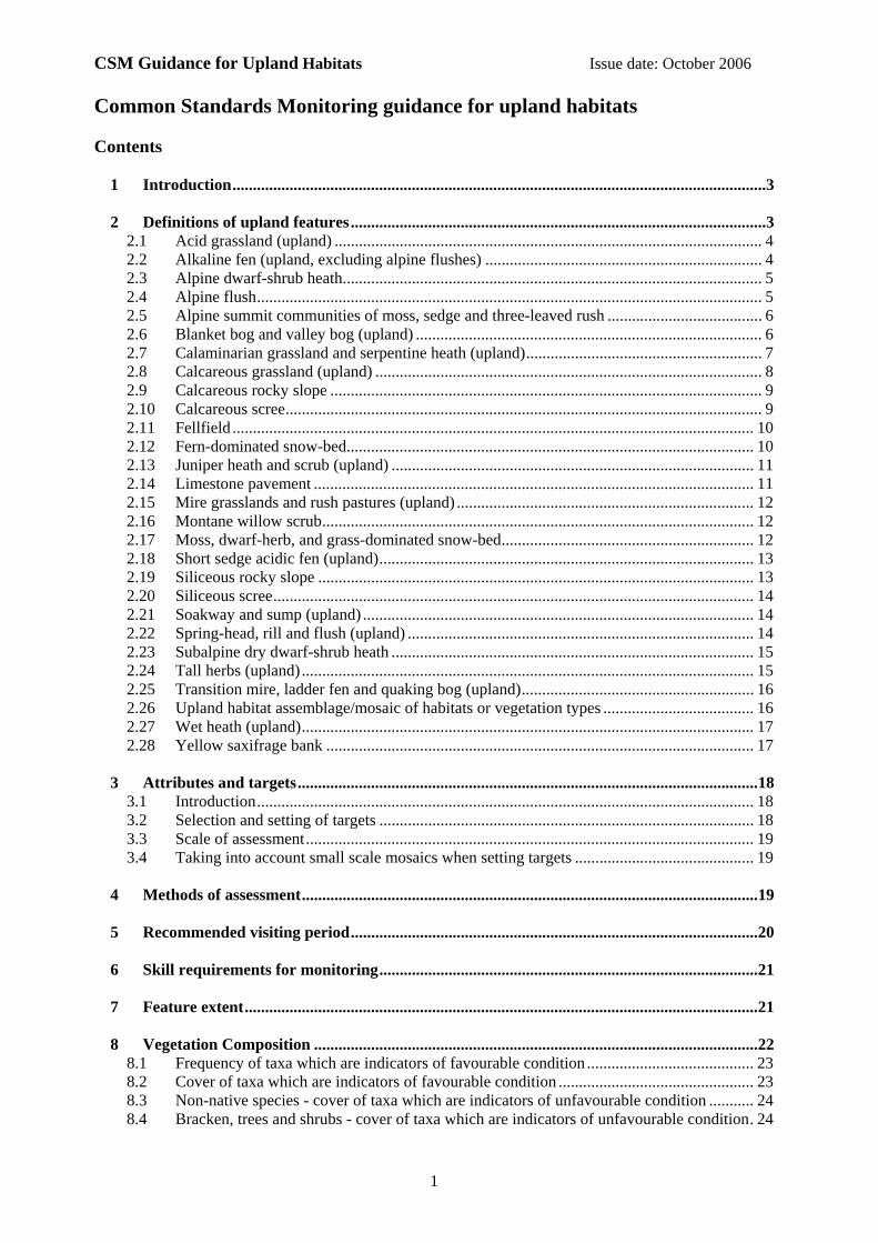
Common Standards Monitoring guidance for upland habitats Contents
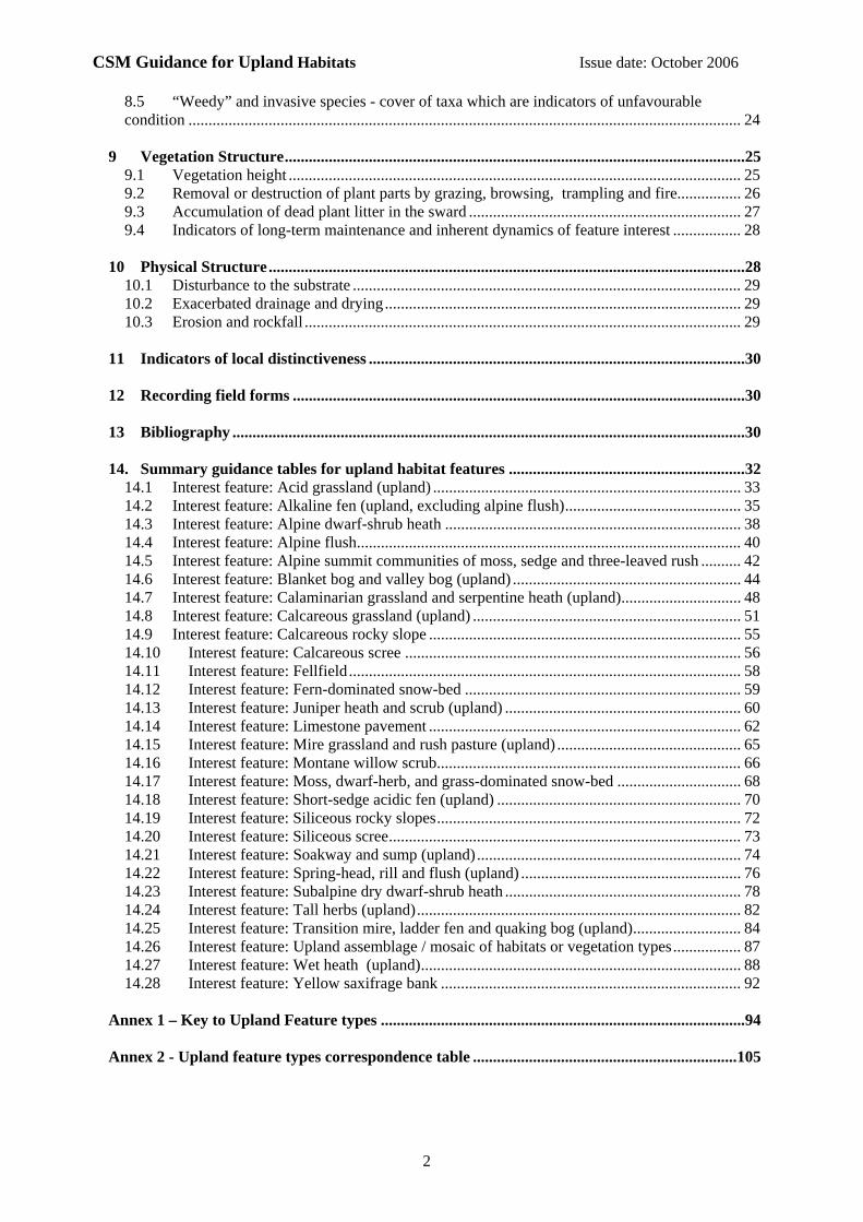
1 Introduction...................................................................................................................................3 2 Definitions of upland features......................................................................................................3
2.1 Acid grassland (upland) ......................................................................................................... 4 2.2 Alkaline fen (upland, excluding alpine flushes) .................................................................... 4 2.3 Alpine dwarf-shrub heath....................................................................................................... 5 2.4 Alpine flush............................................................................................................................ 5 2.5 Alpine summit communities of moss, sedge and three-leaved rush ...................................... 6 2.6 Blanket bog and valley bog (upland) ..................................................................................... 6 2.7 Calaminarian grassland and serpentine heath (upland).......................................................... 7 2.8 Calcareous grassland (upland) ............................................................................................... 8 2.9 Calcareous rocky slope .......................................................................................................... 9 2.10 Calcareous scree..................................................................................................................... 9 2.11 Fellfield ................................................................................................................................ 10 2.12 Fern-dominated snow-bed.................................................................................................... 10 2.13 Juniper heath and scrub (upland) ......................................................................................... 11 2.14 Limestone pavement ............................................................................................................ 11 2.15 Mire grasslands and rush pastures (upland) ......................................................................... 12 2.16 Montane willow scrub.......................................................................................................... 12 2.17 Moss, dwarf-herb, and grass-dominated snow-bed.............................................................. 12 2.18 Short sedge acidic fen (upland)............................................................................................ 13 2.19 Siliceous rocky slope ........................................................................................................... 13 2.20 Siliceous scree...................................................................................................................... 14 2.21 Soakway and sump (upland) ................................................................................................ 14 2.22 Spring-head, rill and flush (upland) ..................................................................................... 14 2.23 Subalpine dry dwarf-shrub heath ......................................................................................... 15 2.24 Tall herbs (upland) ............................................................................................................... 15 2.25 Transition mire, ladder fen and quaking bog (upland)......................................................... 16 2.26 Upland habitat assemblage/mosaic of habitats or vegetation types ..................................... 16 2.27 Wet heath (upland)............................................................................................................... 17 2.28 Yellow saxifrage bank ......................................................................................................... 17
3 Attributes and targets.................................................................................................................18
3.1 Introduction.......................................................................................................................... 18 3.2 Selection and setting of targets ............................................................................................ 18 3.3 Scale of assessment.............................................................................................................. 19 3.4 Taking into account small scale mosaics when setting targets ............................................ 19
4 Methods of assessment................................................................................................................19 5 Recommended visiting period....................................................................................................20 6 Skill requirements for monitoring.............................................................................................21 7 Feature extent..............................................................................................................................21 8 Vegetation Composition .............................................................................................................22
8.1 Frequency of taxa which are indicators of favourable condition ......................................... 23 8.2 Cover of taxa which are indicators of favourable condition ................................................ 23 8.3 Non-native species - cover of taxa which are indicators of unfavourable condition ........... 24 8.4 Bracken, trees and shrubs - cover of taxa which are indicators of unfavourable condition. 24
CSM Guidance for Upland Habitats Issue date: October 2006
2
8.5 “Weedy” and invasive species - cover of taxa which are indicators of unfavourable condition .......................................................................................................................................... 24
9 Vegetation Structure...................................................................................................................25
9.1 Vegetation height ................................................................................................................. 25 9.2 Removal or destruction of plant parts by grazing, browsing, trampling and fire................ 26 9.3 Accumulation of dead plant litter in the sward .................................................................... 27 9.4 Indicators of long-term maintenance and inherent dynamics of feature interest ................. 28
10 Physical Structure.......................................................................................................................28
10.1 Disturbance to the substrate ................................................................................................. 29 10.2 Exacerbated drainage and drying......................................................................................... 29 10.3 Erosion and rockfall ............................................................................................................. 29
11 Indicators of local distinctiveness ..............................................................................................30 12 Recording field forms .................................................................................................................30 13 Bibliography ................................................................................................................................30 14. Summary guidance tables for upland habitat features ...........................................................32
14.1 Interest feature: Acid grassland (upland) ............................................................................. 33 14.2 Interest feature: Alkaline fen (upland, excluding alpine flush)............................................ 35 14.3 Interest feature: Alpine dwarf-shrub heath .......................................................................... 38 14.4 Interest feature: Alpine flush................................................................................................ 40 14.5 Interest feature: Alpine summit communities of moss, sedge and three-leaved rush .......... 42 14.6 Interest feature: Blanket bog and valley bog (upland) ......................................................... 44 14.7 Interest feature: Calaminarian grassland and serpentine heath (upland).............................. 48 14.8 Interest feature: Calcareous grassland (upland) ................................................................... 51 14.9 Interest feature: Calcareous rocky slope .............................................................................. 55 14.10 Interest feature: Calcareous scree .................................................................................... 56 14.11 Interest feature: Fellfield.................................................................................................. 58 14.12 Interest feature: Fern-dominated snow-bed ..................................................................... 59 14.13 Interest feature: Juniper heath and scrub (upland) ........................................................... 60 14.14 Interest feature: Limestone pavement .............................................................................. 62 14.15 Interest feature: Mire grassland and rush pasture (upland) .............................................. 65 14.16 Interest feature: Montane willow scrub............................................................................ 66 14.17 Interest feature: Moss, dwarf-herb, and grass-dominated snow-bed ............................... 68 14.18 Interest feature: Short-sedge acidic fen (upland) ............................................................. 70 14.19 Interest feature: Siliceous rocky slopes............................................................................ 72 14.20 Interest feature: Siliceous scree........................................................................................ 73 14.21 Interest feature: Soakway and sump (upland).................................................................. 74 14.22 Interest feature: Spring-head, rill and flush (upland) ....................................................... 76 14.23 Interest feature: Subalpine dry dwarf-shrub heath ........................................................... 78 14.24 Interest feature: Tall herbs (upland)................................................................................. 82 14.25 Interest feature: Transition mire, ladder fen and quaking bog (upland)........................... 84 14.26 Interest feature: Upland assemblage / mosaic of habitats or vegetation types................. 87 14.27 Interest feature: Wet heath (upland)................................................................................ 88 14.28 Interest feature: Yellow saxifrage bank ........................................................................... 92
Annex 1 – Key to Upland Feature types ...........................................................................................94 Annex 2 - Upland feature types correspondence table ..................................................................105
CSM Guidance for Upland Habitats Issue date: October 2006
3
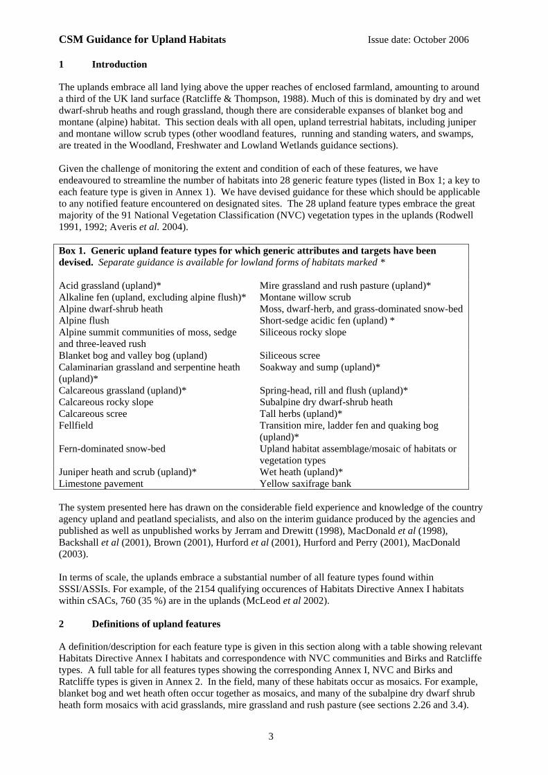
1 Introduction
The uplands embrace all land lying above the upper reaches of enclosed farmland, amounting to around a third of the UK land surface (Ratcliffe & Thompson, 1988). Much of this is dominated by dry and wet dwarf-shrub heaths and rough grassland, though there are considerable expanses of blanket bog and montane (alpine) habitat. This section deals with all open, upland terrestrial habitats, including juniper and montane willow scrub types (other woodland features, running and standing waters, and swamps, are treated in the Woodland, Freshwater and Lowland Wetlands guidance sections). Given the challenge of monitoring the extent and condition of each of these features, we have endeavoured to streamline the number of habitats into 28 generic feature types (listed in Box 1; a key to each feature type is given in Annex 1). We have devised guidance for these which should be applicable to any notified feature encountered on designated sites. The 28 upland feature types embrace the great majority of the 91 National Vegetation Classification (NVC) vegetation types in the uplands (Rodwell 1991, 1992; Averis et al. 2004). Box 1. Generic upland feature types for which generic attributes and targets have been devised. Separate guidance is available for lowland forms of habitats marked * Acid grassland (upland)* Mire grassland and rush pasture (upland)* Alkaline fen (upland, excluding alpine flush)* Montane willow scrub Alpine dwarf-shrub heath Moss, dwarf-herb, and grass-dominated snow-bed Alpine flush Short-sedge acidic fen (upland) * Alpine summit communities of moss, sedge and three-leaved rush
Siliceous rocky slope
Blanket bog and valley bog (upland) Siliceous scree Calaminarian grassland and serpentine heath (upland)*
Soakway and sump (upland)*
Calcareous grassland (upland)* Spring-head, rill and flush (upland)* Calcareous rocky slope Subalpine dry dwarf-shrub heath Calcareous scree Tall herbs (upland)* Fellfield Transition mire, ladder fen and quaking bog
(upland)* Fern-dominated snow-bed Upland habitat assemblage/mosaic of habitats or
vegetation types Juniper heath and scrub (upland)* Wet heath (upland)* Limestone pavement Yellow saxifrage bank The system presented here has drawn on the considerable field experience and knowledge of the country agency upland and peatland specialists, and also on the interim guidance produced by the agencies and published as well as unpublished works by Jerram and Drewitt (1998), MacDonald et al (1998), Backshall et al (2001), Brown (2001), Hurford et al (2001), Hurford and Perry (2001), MacDonald (2003). In terms of scale, the uplands embrace a substantial number of all feature types found within SSSI/ASSIs. For example, of the 2154 qualifying occurences of Habitats Directive Annex I habitats within cSACs, 760 (35 %) are in the uplands (McLeod et al 2002). 2 Definitions of upland features
A definition/description for each feature type is given in this section along with a table showing relevant Habitats Directive Annex I habitats and correspondence with NVC communities and Birks and Ratcliffe types. A full table for all features types showing the corresponding Annex I, NVC and Birks and Ratcliffe types is given in Annex 2. In the field, many of these habitats occur as mosaics. For example, blanket bog and wet heath often occur together as mosaics, and many of the subalpine dry dwarf shrub heath form mosaics with acid grasslands, mire grassland and rush pasture (see sections 2.26 and 3.4).
CSM Guidance for Upland Habitats Issue date: October 2006
4
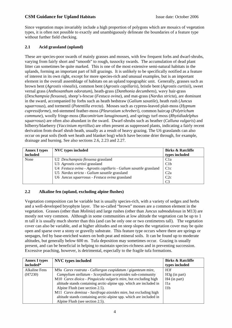
Since vegetation maps invariably include a high proportion of polygons which are mosaics of vegetation types, it is often not possible to exactly and unambiguously delineate the boundaries of a feature type without further field checking. 2.1 Acid grassland (upland)
These are species-poor swards of mainly grasses and mosses, with few frequent forbs and dwarf-shrubs, varying from fairly short and “smooth” to rough, tussocky swards. The accumulation of dead plant litter can sometimes be quite marked. This is one of the most extensive semi-natural habitats in the uplands, forming an important part of hill grazings. It is unlikely to be specifically notified as a feature of interest in its own right, except for more species-rich and unusual examples, but is an important element in the overall assemblage of habitats on an upland topographic unit. Generally, grasses such as brown bent (Agrostis vinealis), common bent (Agrostis capillaris), bristle bent (Agrostis curtisii), sweet vernal grass (Anthoxanthum odoratum), heath-grass (Danthonia decumbens), wavy hair-grass (Deschampsia flexuosa), sheep’s-fescue (Festuca ovina), and mat-grass (Nardus stricta), are dominant in the sward, accompanied by forbs such as heath bedstraw (Galium saxatile), heath rush (Juncus squarrosus), and tormentil (Potentilla erecta). Mosses such as cypress-leaved plait-moss (Hypnum cupressiforme), red-stemmed feather-moss (Pleurozium schreberi), common haircap (Polytrichum commune), woolly fringe-moss (Racomitrium lanuginosum), and springy turf-moss (Rhytidiadelphus squarrosus) are often also abundant in the sward. Dwarf-shrubs such as heather (Calluna vulgaris) and bilberry/blaeberry (Vaccinium myrtillus) are often present as suppressed plants, indicating a fairly recent derivation from dwarf shrub heath, usually as a result of heavy grazing. The U6 grasslands can also occur on peat soils (both wet heath and blanket bog) which have become drier through, for example, drainage and burning. See also sections 2.6, 2.23 and 2.27. Annex I types included
NVC types included
Birks & Ratcliffe types included
None U2 Deschampsia flexuosa grassland U3 Agrostis curtisii grassland U4 Festuca ovina - Agrostis capillaris - Galium saxatile grassland U5 Nardus stricta - Galium saxatile grassland U6 Juncus squarrosus - Festuca ovina grassland
C1a C1b C1c C2a C2c C3
2.2 Alkaline fen (upland, excluding alpine flushes)
Vegetation composition can be variable but is usually species-rich, with a variety of sedges and herbs and a well-developed bryophyte layer. The so-called “brown” mosses are a common element in the vegetation. Grasses (other than Molinia) and large rushes (other than Juncus subnodulosus in M13) are mostly not very common. Although in some communities at low altitude the vegetation can be up to 1 m tall it is usually much shorter than this (and can be only one or two centimetres tall). The vegetation cover can also be variable, and at higher altitudes and on steep slopes the vegetation cover may be quite open and sparse over a stony or gravelly substrate. This feature type occurs where there are springs or seepages, fed by base-enriched waters on both peat and mineral soils. It can be found up to moderate altitudes, but generally below 600 m. Tufa deposition may sometimes occur. Grazing is usually present, and can be beneficial in helping to maintain species-richness and in preventing succession. Excessive poaching, however, is detrimental, especially to the fragile tufa formations. Annex I types included*
NVC types included
Birks & Ratcliffe types included
Alkaline Fens (H7230)
M9a Carex rostrata - Calliergon cuspidatum / giganteum mire, Campylium stellatum - Scorpidium scorpioides sub-community
M10 Carex dioica - Pinguicula vulgaris mire, but excluding high altitude stands containing arctic-alpine spp. which are included in Alpine Flush (see section 2.5).
M11 Carex demissa - Saxifraga aizoides mire, but excluding high altitude stands containing arctic-alpine spp. which are included in Alpine Flush (see section 2.5).
H3f H3g (in part) H4 (in part) I1a I1b
CSM Guidance for Upland Habitats Issue date: October 2006
5
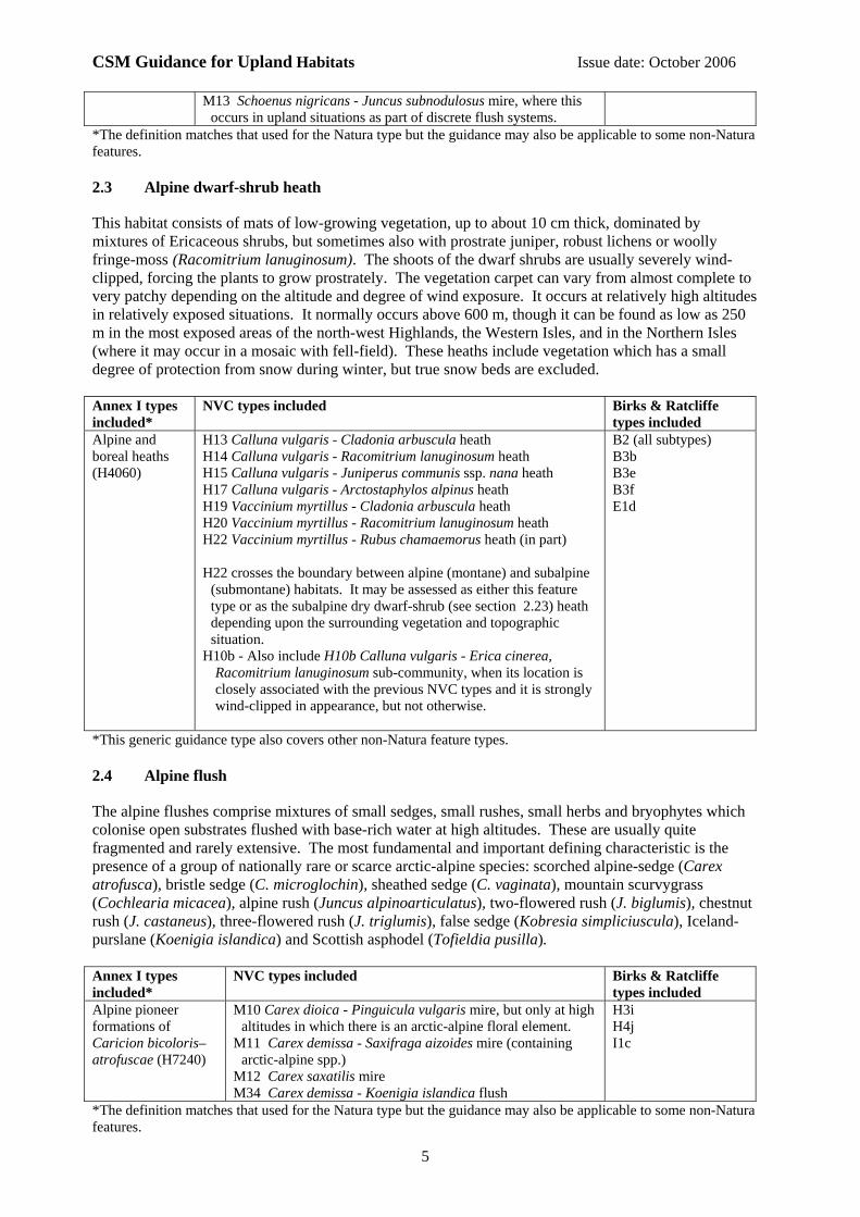
M13 Schoenus nigricans - Juncus subnodulosus mire, where this occurs in upland situations as part of discrete flush systems.
*The definition matches that used for the Natura type but the guidance may also be applicable to some non-Natura features. 2.3 Alpine dwarf-shrub heath
This habitat consists of mats of low-growing vegetation, up to about 10 cm thick, dominated by mixtures of Ericaceous shrubs, but sometimes also with prostrate juniper, robust lichens or woolly fringe-moss (Racomitrium lanuginosum). The shoots of the dwarf shrubs are usually severely wind-clipped, forcing the plants to grow prostrately. The vegetation carpet can vary from almost complete to very patchy depending on the altitude and degree of wind exposure. It occurs at relatively high altitudes in relatively exposed situations. It normally occurs above 600 m, though it can be found as low as 250 m in the most exposed areas of the north-west Highlands, the Western Isles, and in the Northern Isles (where it may occur in a mosaic with fell-field). These heaths include vegetation which has a small degree of protection from snow during winter, but true snow beds are excluded. Annex I types included*
NVC types included
Birks & Ratcliffe types included
Alpine and boreal heaths (H4060)
H13 Calluna vulgaris - Cladonia arbuscula heath H14 Calluna vulgaris - Racomitrium lanuginosum heath H15 Calluna vulgaris - Juniperus communis ssp. nana heath H17 Calluna vulgaris - Arctostaphylos alpinus heath H19 Vaccinium myrtillus - Cladonia arbuscula heath H20 Vaccinium myrtillus - Racomitrium lanuginosum heath H22 Vaccinium myrtillus - Rubus chamaemorus heath (in part) H22 crosses the boundary between alpine (montane) and subalpine
(submontane) habitats. It may be assessed as either this feature type or as the subalpine dry dwarf-shrub (see section 2.23) heath depending upon the surrounding vegetation and topographic situation.
H10b - Also include H10b Calluna vulgaris - Erica cinerea, Racomitrium lanuginosum sub-community, when its location is closely associated with the previous NVC types and it is strongly wind-clipped in appearance, but not otherwise.
B2 (all subtypes) B3b B3e B3f E1d
*This generic guidance type also covers other non-Natura feature types. 2.4 Alpine flush
The alpine flushes comprise mixtures of small sedges, small rushes, small herbs and bryophytes which colonise open substrates flushed with base-rich water at high altitudes. These are usually quite fragmented and rarely extensive. The most fundamental and important defining characteristic is the presence of a group of nationally rare or scarce arctic-alpine species: scorched alpine-sedge (Carex atrofusca), bristle sedge (C. microglochin), sheathed sedge (C. vaginata), mountain scurvygrass (Cochlearia micacea), alpine rush (Juncus alpinoarticulatus), two-flowered rush (J. biglumis), chestnut rush (J. castaneus), three-flowered rush (J. triglumis), false sedge (Kobresia simpliciuscula), Iceland-purslane (Koenigia islandica) and Scottish asphodel (Tofieldia pusilla). Annex I types included*
NVC types included
Birks & Ratcliffe types included
Alpine pioneer formations of Caricion bicoloris–atrofuscae (H7240)
M10 Carex dioica - Pinguicula vulgaris mire, but only at high altitudes in which there is an arctic-alpine floral element.
M11 Carex demissa - Saxifraga aizoides mire (containing arctic-alpine spp.)
M12 Carex saxatilis mire M34 Carex demissa - Koenigia islandica flush
H3i H4j I1c
*The definition matches that used for the Natura type but the guidance may also be applicable to some non-Natura features.
CSM Guidance for Upland Habitats Issue date: October 2006
6
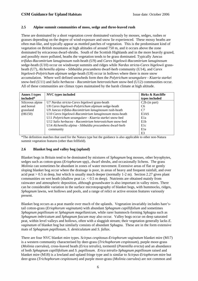
2.5 Alpine summit communities of moss, sedge and three-leaved rush
These are dominated by a short vegetation cover dominated variously by mosses, sedges, rushes or grasses depending on the degree of wind-exposure and snow lie experienced. These mossy heaths are often mat-like, and typically appear as mottled patches of vegetation. This is the predominant kind of vegetation on British mountains at high altitudes of around 750 m, and it occurs above the zone dominated by ericaceous dwarf-shrubs. South of the Scottish Highlands and in the more heavily grazed, and possibly more polluted, heaths the vegetation tends to be grass dominated. Typically Juncus trifidus-Racomitrium lanuginosum rush-heath (U9) and Carex bigelowii-Racomitrium lanuginosum sedge-heath (U10) occur on windswept summits and ridges while Nardus stricta-Carex bigelowii grass-heath (U7), Alchemilla alpina - Sibbaldia procumbens dwarf-herb community (U14), and Carex bigelowii-Polytrichum alpinum sedge-heath (U8) occur in hollows where there is more snow accumulation. Where well defined snowbeds form then the Polytrichum sexangulare - Kiaeria starkei snow-bed (U11) and Salix herbacea - Racomitrium heterostichum snow-bed (U12) communities occur. All of these communities are climax types maintained by the harsh climate at high altitude. Annex I types included*
NVC types included
Birks & Ratcliffe types included
Siliceous alpine and boreal grassland (H6150)
U7 Nardus stricta-Carex bigelowii grass-heath U8 Carex bigelowii-Polytrichum alpinum sedge-heath U9 Juncus trifidus-Racomitrium lanuginosum rush-heath U10 Carex bigelowii-Racomitrium lanuginosum moss-heath U11 Polytrichum sexangulare - Kiaeria starkei snow-bed U12 Salix herbacea - Racomitrium heterostichum snow-bed U14 Alchemilla alpina - Sibbaldia procumbens dwarf-herb
community
C2b (in part) C6 C7 E3AS E1a E1b E1c E1e E3
*The definition matches that used for the Natura type but the guidance is also applicable to other non-Natura summit vegetation features (other than fellfield). 2.6 Blanket bog and valley bog (upland)
Blanket bogs in Britain tend to be dominated by mixtures of Sphagnum bog mosses, other bryophytes, sedges such as cotton-grass (Eriophorum spp)., dwarf shrubs, and occasionally lichens. The grass Molinia can sometimes be abundant in zones of water movement. Extensive areas of flat or gently sloping blanket bog occur where the drainage is poor, in areas of heavy and frequent rainfall, and over acid peat > 0.5 m deep, but which is usually much deeper (normally 1-2 m). Section 2.27 gives plant communities on wet heath (shallow peat i.e. < 0.5 m deep). Nutrients are obtained mainly from rainwater and atmospheric deposition, although groundwater is also important in valley mires. There can be considerable variation in the surface microtopography of blanket bogs, with hummocks, ridges, Sphagnum lawns, wet hollows and pools, and a range of relict or active erosion features variously present. Blanket bog occurs as a peat mantle over much of the uplands. Vegetation invariably includes hare’s-tail cotton-grass (Eriophorum vaginatum) with abundant Sphagnum capillifolium and sometimes Sphagnum papillosum or Sphagnum magellanicum, while rarer hummock-forming Sphagna such as Sphagnum imbricatum and Sphagnum fuscum may also occur. Valley bogs occur on deep saturated peat, within level valleys and hollows, often with a sluggish stream; their vegetation generally lacks E. vaginatum of blanket bog but similarly consists of abundant Sphagna. These are in the form extensive mats of Sphagnum papillosum, S. denticulatum and S. fallax. There are four NVC blanket mire types. Scirpus cespitosus-Eriophorum vaginatum blanket mire (M17) is a western community characterised by deer-grass (Trichophorum cespitosum), purple moor-grass (Molinia caerulea), cross-leaved heath (Erica tetralix), tormentil (Potentilla erecta) and an abundance of both Sphagnum capillifolium and S. papillosum. Erica tetralix-Sphagnum papillosum raised and blanket mire (M18) is a lowland and upland fringe type and is similar to Scirpus-Eriophorum mire but deer-grass (Trichophorum cespitosum) and purple moor-grass (Molinia caerulea) are not common and

CSM Guidance for Upland Habitats Issue date: October 2006
7
Sphagnum tenellum and Odontoschisma sphagni are common. Calluna vulgaris-Eriophorum vaginatum blanket mire (M19) is the characteristic and extensive upland blanket bog type. This is usually characterised by a co-dominance of heather (Calluna vulgaris) and hare’s-tail cotton-grass (Eriophorum vaginatum) with cloudberry (Rubus chamaemorus) and hypnaceous mosses such Pleurozium schreberi. A form lacking cloudberry (R. chamaemorus) with cross-leaved heath (Erica tetralix) and deer-grass (Trichophorum cespitosum) occurs, which is transitional to Scirpus-Eriophorum blanket mire. Eriophorum vaginatum blanket and raised mire (M20) is derived from Calluna-Eriophorum blanket mire by a process of over frequent or intense burning and heavy grazing. This largely eliminates the characteristic Sphagnum species and cloudberry (Rubus chamaemorus) in Calluna-Eriophorum mire. Heather (Calluna vulgaris) is often largely removed also to give a community dominated by E. vaginatum. Bog pool communities occur in and around pools in association with blanket and valley bogs. Sphagnum auriculatum bog pool community (M1) is commonly associated with western blanket bog (Scirpus cespitosus-Eriophorum vaginatum blanket mire, M17). Sphagnum cuspidatum/recurvum bog pool community (M2) usually occurs within Erica tetralix-Sphagnum papillosum raised and blanket mire. Eriophorum angustifolium bog pool community (M3) is a species-poor community, sometimes derived from one of the other bog pool types by management impacts, but more typically associated with recolonisation or eroded areas. Human activities, primarily burning and draining, can result in changes to the hydrology and properties of the peat especially at the surface. Along with grazing, these activities can result in floristic changes to the blanket bog and valley bog communities. These floristic changes are usually regarded as degradation because they result in the loss of characteristic species of the bog communities and dominance of a few species of graminoids or dwarf-shrubs. The derived communities are poorer in species than the original communities. The table below gives a list of relevant NVC and Birks & Ratcliffe types occurring on deep peat. Bog pool communities are also listed as they also occur on the surface of the blanket and valley peat. Also listed are a number of communities that can replace the characteristic blanket and valley bog communities on deep peat due to man’s activities. Annex I types included*
NVC types included
Birks & Ratcliffe types included
Blanket bogs (H7130) Depressions on peat substrates of the Rhynchosporion (H7150)
M1 Sphagnum auriculatum bog pool community M2 Sphagnum cuspidatum / recurvum bog pool community M3 Eriophorum angustifolium bog pool community M17 Scirpus cespitosus - Eriophorum vaginatum blanket mire M18 Erica tetralix - Sphagnum papillosum raised and blanket
mire M19 Calluna vulgaris - Eriophorum vaginatum blanket mire M20 Eriophorum vaginatum blanket and raised mire M21 Narthecium ossifragum - Sphagnum papillosum valley mire Where any of the following occur on peat deeper than 0.5 m they
may indicate degraded blanket bog: H9 Calluna vulgaris - Deschampsia flexuosa heath H12 Calluna vulgaris - Vaccinium myrtillus heath M15 Scirpus cespitosus - Erica tetralix wet heath M16 Erica tetralix - Sphagnum compactum wet heath M25 Molinia caerulea - Potentilla erecta mire U6 Juncus squarrosus - Festuca ovina grassland
G1 G4 G5 H4 (in part) G2 (on deep peat) G3 (on deep peat) C4a (on deep peat) C4c (on deep peat) B1a (on deep peat) C3 (on deep peat)
*This generic guidance type also covers other non-Natura feature types. 2.7 Calaminarian grassland and serpentine heath (upland)
This feature type can be highly variable in composition and structure. A single example may include a wide range of vegetation cover and vegetation types, with mixtures of any, or all, of the following: sparsely vegetated rocky debris similar to fellfield, flushes and sedge lawns, grassland and heath dominated by dwarf-shrubs. The defining characteristic is the substrate, which must be ultra-basic. This may include mine waste, and elements such as nickel and chromium are sometimes present in toxic
CSM Guidance for Upland Habitats Issue date: October 2006
8
concentrations in the soil (rare species, or subspecies, adapted to the inhospitable soil conditions are sometimes present). Annex I types included
NVC types included
Birks & Ratcliffe types included
Calaminarian grasslands of the Violetalia calaminariae (H6130)
OV37 Festuca ovina - Minuartia verna community H5 Erica vagans - Schoenus nigricans heath H6 Erica vagans - Ulex europaeus heath (Serpentine heaths are not fully covered by NVC.) A variety of other NVC types may occur over ultra-basic substrates.
This feature type tends to be defined by substrate type as much as by vegetation type.
C1e (in some situations)
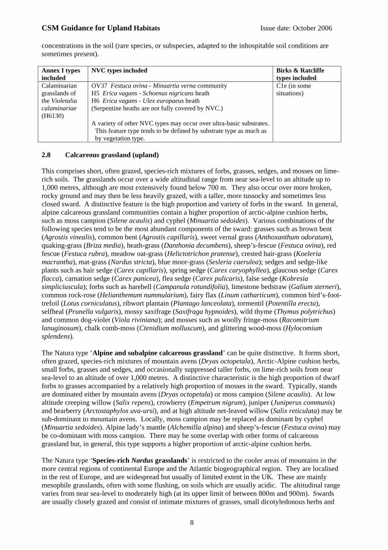
2.8 Calcareous grassland (upland)
This comprises short, often grazed, species-rich mixtures of forbs, grasses, sedges, and mosses on lime-rich soils. The grasslands occur over a wide altitudinal range from near sea-level to an altitude up to 1,000 metres, although are most extensively found below 700 m. They also occur over more broken, rocky ground and may then be less heavily grazed, with a taller, more tussocky and sometimes less closed sward. A distinctive feature is the high proportion and variety of forbs in the sward. In general, alpine calcareous grassland communities contain a higher proportion of arctic-alpine cushion herbs, such as moss campion (Silene acaulis) and cyphel (Minuartia sedoides). Various combinations of the following species tend to be the most abundant components of the sward: grasses such as brown bent (Agrostis vinealis), common bent (Agrostis capillaris), sweet vernal grass (Anthoxanthum odoratum), quaking-grass (Briza media), heath-grass (Danthonia decumbens), sheep’s-fescue (Festuca ovina), red fescue (Festuca rubra), meadow oat-grass (Helictotrichon pratense), crested hair-grass (Koeleria macrantha), mat-grass (Nardus stricta), blue moor-grass (Sesleria caerulea); sedges and sedge-like plants such as hair sedge (Carex capillaris), spring sedge (Carex caryophyllea), glaucous sedge (Carex flacca), carnation sedge (Carex panicea), flea sedge (Carex pulicaris), false sedge (Kobresia simpliciuscula); forbs such as harebell (Campanula rotundifolia), limestone bedstraw (Galium sterneri), common rock-rose (Helianthemum nummularium), fairy flax (Linum catharticum), common bird’s-foot-trefoil (Lotus corniculatus), ribwort plantain (Plantago lanceolata), tormentil (Potentilla erecta), selfheal (Prunella vulgaris), mossy saxifrage (Saxifraga hypnoides), wild thyme (Thymus polytrichus) and common dog-violet (Viola riviniana); and mosses such as woolly fringe-moss (Racomitrium lanuginosum), chalk comb-moss (Ctenidium molluscum), and glittering wood-moss (Hylocomium splendens). The Natura type ‘Alpine and subalpine calcareous grassland’ can be quite distinctive. It forms short, often grazed, species-rich mixtures of mountain avens (Dryas octopetala), Arctic-Alpine cushion herbs, small forbs, grasses and sedges, and occasionally suppressed taller forbs, on lime-rich soils from near sea-level to an altitude of over 1,000 metres. A distinctive characteristic is the high proportion of dwarf forbs to grasses accompanied by a relatively high proportion of mosses in the sward. Typically, stands are dominated either by mountain avens (Dryas octopetala) or moss campion (Silene acaulis). At low altitude creeping willow (Salix repens), crowberry (Empetrum nigrum), juniper (Juniperus communis) and bearberry (Arctostaphylos uva-ursi), and at high altitude net-leaved willow (Salix reticulata) may be sub-dominant to mountain avens. Locally, moss campion may be replaced as dominant by cyphel (Minuartia sedoides). Alpine lady’s mantle (Alchemilla alpina) and sheep’s-fescue (Festuca ovina) may be co-dominant with moss campion. There may be some overlap with other forms of calcareous grassland but, in general, this type supports a higher proportion of arctic-alpine cushion herbs. The Natura type ‘Species-rich Nardus grasslands’ is restricted to the cooler areas of mountains in the more central regions of continental Europe and the Atlantic biogeographical region. They are localised in the rest of Europe, and are widespread but usually of limited extent in the UK. These are mainly mesophile grasslands, often with some flushing, on soils which are usually acidic. The altitudinal range varies from near sea-level to moderately high (at its upper limit of between 800m and 900m). Swards are usually closely grazed and consist of intimate mixtures of grasses, small dicotyledonous herbs and
CSM Guidance for Upland Habitats Issue date: October 2006
9
bryophytes. When ungrazed or only lightly grazed a taller sward develops in which there is a greater representation of taller herb species. Typical and abundant plant species are similar to those for both the subalpine, calcareous or base-rich, species-rich grassland and acid grassland, but with the addition of herbs such as yarrow (Achillea millefolium), alpine lady’s-mantle (Alchemilla alpina), lady’s-mantle (Alchemilla glabra), wild angelica (Angelica sylvestris), melancholy thistle (Cirsium heterophyllum), meadowsweet (Filipendula ulmaria), heath bedstraw (Galium saxatile), lady’s bedstraw (Galium verum), wood crane’s-bill (Geranium sylvaticum), water avens (Geum rivale), bitter-vetch (Lathyrus linifolius), grass-of-Parnassus (Parnassia palustris), meadow buttercup (Ranunculus acris), devil’s-bit scabious (Succisa pratensis), globe flower (Trollius europaeus), and bilberry/blaeberry (Vaccinium myrtillus), and the moss springy turf-moss (Rhytidiadelphus squarrosus). Annex I types included*
NVC types included
Birks & Ratcliffe types included
Alpine calcareous grassland (H6170). Species-rich Nardus grassland (H6230). Semi-natural dry grassland and scrubland facies on calcareous substrates (Festuco - Brometalia) (H6210)
For Alpine calcareous grassland: CG12 Festuca ovina - Alchemilla alpina - Silene acaulis dwarf-herb
community CG13 Dryas octopetala - Carex flacca heath CG14 Dryas octopetala - Silene acaulis ledge community For Species-rich Nardus grassland: CG10 Festuca ovina - Agrostis capillaris - Thymus praecox grassland
(when not on limestone) CG11 Festuca ovina - Agrostis capillaris - Alchemilla alpina
grassland (when not on limestone) U4 Festuca ovina - Agrostis capillaris - Galium saxatile (species rich
types, not fully described in the NVC, with abundant taller herbs) U5c Nardus stricta - Galium saxatile grassland, Carex panicea - Viola
riviniana sub-community For other types of calcareous grassland: CG9 Sesleria albicans - Galium sterneri grassland CG10 Festuca ovina - Agrostis capillaris - Thymus praecox grassland
B4 (all subtypes) C1d C1e C1f C1g C2c D3 (all subtypes)
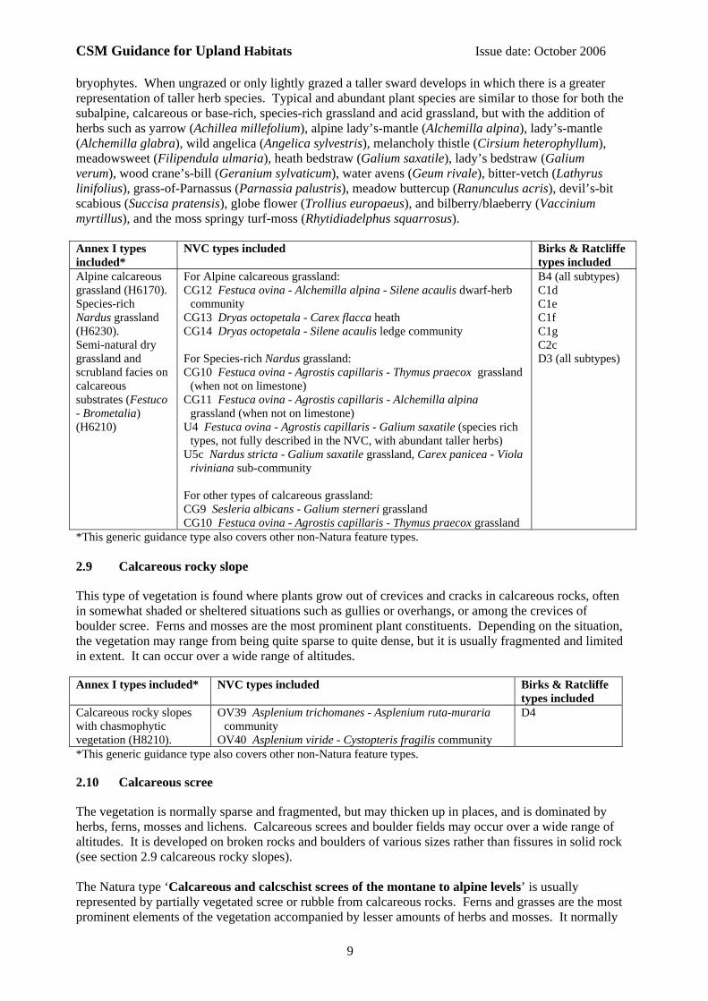
*This generic guidance type also covers other non-Natura feature types. 2.9 Calcareous rocky slope
This type of vegetation is found where plants grow out of crevices and cracks in calcareous rocks, often in somewhat shaded or sheltered situations such as gullies or overhangs, or among the crevices of boulder scree. Ferns and mosses are the most prominent plant constituents. Depending on the situation, the vegetation may range from being quite sparse to quite dense, but it is usually fragmented and limited in extent. It can occur over a wide range of altitudes. Annex I types included* NVC types included
Birks & Ratcliffe types included
Calcareous rocky slopes with chasmophytic vegetation (H8210).
OV39 Asplenium trichomanes - Asplenium ruta-muraria community
OV40 Asplenium viride - Cystopteris fragilis community
D4
*This generic guidance type also covers other non-Natura feature types. 2.10 Calcareous scree
The vegetation is normally sparse and fragmented, but may thicken up in places, and is dominated by herbs, ferns, mosses and lichens. Calcareous screes and boulder fields may occur over a wide range of altitudes. It is developed on broken rocks and boulders of various sizes rather than fissures in solid rock (see section 2.9 calcareous rocky slopes). The Natura type ‘Calcareous and calcschist screes of the montane to alpine levels’ is usually represented by partially vegetated scree or rubble from calcareous rocks. Ferns and grasses are the most prominent elements of the vegetation accompanied by lesser amounts of herbs and mosses. It normally

CSM Guidance for Upland Habitats Issue date: October 2006
10
occurs where there is some protection from grazing but it is also vulnerable to invasion by trees and shrubs. Limestone fern (Gymnocarpium robertianum) does not tolerate dense shade and is likely to disappear if a closed woodland or scrub canopy develops. Annex I types included*
NVC types included
Birks & Ratcliffe types included
Calcareous and calcschist screes of the montane to alpine levels (Thlaspietea rotundifolii) (H8120).
For calcareous and calcschist screes of the montane to alpine levels: OV38 Gymnocarpium robertianum - Arrhenatherum elatius
community. For other calcareous scree: OV39 Asplenium trichomanes - Asplenium ruta-muraria
community. OV40 Asplenium viride - Cystopteris fragilis community. CG14 Dryas octopetala - Silene acaulis ledge community may
occur in fragmentary form. A variety of other NVC communities, or communities not
described in the NVC, may occur in fragmentary form where the scree is more stable.
No specific corresponding types
*This generic guidance type also covers other non-Natura feature types. 2.11 Fellfield
This is very short and sparse vegetation, typically with less than 10% vegetation cover, in very exposed places, mostly in the north-west Highlands, the Western Isles and the Northern Isles. The feature type generally occurs above 300 m altitude, on moist, gravelly, flat to moderately sloping ground. The substrate can vary from acidic to calcareous. A variety of small, low growing herbs, fine leaved grasses and mosses can be present, although the precise species composition can be very variable, and the total number of species in any location is quite small. It may occur in a mosaic with alpine and boreal heath. Annex I types included NVC types included
Birks & Ratcliffe types included
Siliceous scree of the montane to snow levels (Androsacetalia alpinae and Galeopsietalia ladani) (H6230)
This is not described by the NVC although a provisional Festuca ovina - Oligotrichum hercynicum fell-field community has been suggested.
No specific corresponding types
2.12 Fern-dominated snow-bed
This is vegetation dominated by the ferns Alpine lady fern (Athyrium distentifolium) and parsley fern (Cryptogramma crispa), sometimes accompanied by Dryopteris spp., with a mixture of herbs (such as Alpine lady’s mantle (Alchemilla alpina), tufted hair-grass (Deschampsia cespitosa), wavy hair-grass (D. flexuosa), heath bedstraw (Galium saxatile), common dock (Rumex acetosa), starry saxifrage (Saxifraga stellaris) and marsh violet (Viola palustris), and mosses. It usually occurs on high, sheltered slopes in corries on base-poor, humic soils over rocky ground or block scree, above an altitudinal limit of 600 m. Annex I types included NVC types included
Birks & Ratcliffe types included
Siliceous scree of the montane to snow levels (Androsacetalia alpinae and Galeopsietalia ladani) (H6230)
U18 Cryptogramma crispa - Athyrium distentifolium snow-bed
D2b

CSM Guidance for Upland Habitats Issue date: October 2006
11
2.13 Juniper heath and scrub (upland)
This is a scrub formation in which juniper is very frequent, and dominant or subdominant in the vegetation. The height and density of the juniper can be quite variable, partly due to the considerable variation in growth form of individual juniper bushes from nearly prostrate to tall and bulky, often within the same stand. In well developed stands the average height is usually in the range 1 - 2m, but in some localities it can range from 0.5 m to 3 or 4 m. The associated flora can also be quite variable: in dense stands, it resembles a woodland flora, while in sparser stands it is more akin to a grassland or heath flora. The true prostate subspecies of juniper (Juniperus communis alpina = J. c. nana) does not form scrub but it is a component of alpine heaths on exposed, acid substrates, and is included within Alpine dwarf-shrub heaths. Annex I types included*
NVC types included
Birks & Ratcliffe types included
Juniperus communis formations on heaths or calcareous grasslands (H5130)
The NVC communities corresponding to the European definition is W19 Juniperus communis spp. communis – Oxalis acetosella woodland.
In the ‘juniper on heathland’ context the cover of juniper itself can be
quite variable. Some areas may have scattered but abundant juniper bushes in a much more extensive dwarf-shrub dominated vegetation. In this situation the majority of the vegetation may be described more accurately, in floristic terms, as a heath community. However, it may have the potential to develop into W19 if the juniper density increases, and it may have clearly been W19 in the past.
A1
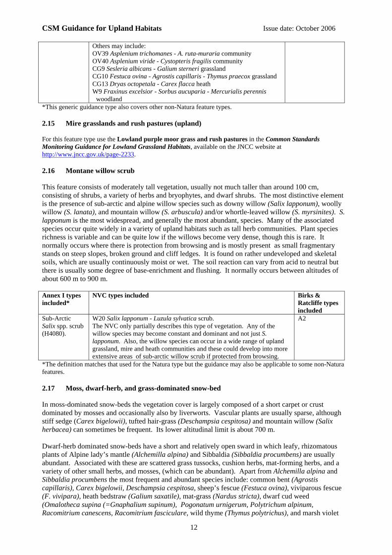
*This generic guidance type also covers other non-Natura feature types. 2.14 Limestone pavement
Limestone pavement is defined in section 34(6) of the Wildlife and Countryside Act, 1981 as ‘an area of limestone which lies wholly or partly exposed on the surface of the ground and has been fissured by natural erosion’. Pavements are typically horizontal or gently inclined, although a few are steeply inclined. The surface has been dissolved by water over thousands of years into ‘paving blocks’, known as clints, with a complex pattern of crevices, known as grikes (or grykes), between them. The distinctive feature of the limestone pavement flora is the mixture of species characteristic of rocky and woodland habitats, including woodland edge species such as Hart’s-tongue fern (Phyllitis scolopendrium) and dog’s mercury (Mercurialis perennis). The grikes provide a shady, humid environment favouring woodland plants. On the clint surfaces, or the upper walls of the grikes, there are plants of rocky habitats, such as wall-rue (Asplenium ruta-muraria) and maidenhair spleenwort (A. trichomanes). Pavements can be classified as either wooded or open. Wooded pavements have a closed canopy and clints which are cloaked by dense green mosses, whilst open pavements can have some tree cover. Structural variety is desirable to maximize transitions, shelter for invertebrates and to keep a variety of structural niches open. Many wooded pavements have natural clearings created by the clint and grike structure but in others (and in surrounding limestone woodlands) coppicing and woodland management will be the only way to ensure structural variety is maintained. Seedlings, saplings, young trees, mature trees and open space may all be present. Annex I types included*
NVC types included
Birks & Ratcliffe types included
Limestone pavements (H8240)
The NVC does not include limestone pavement vegetation per se but a number of NVC types may be present, usually in fragmentary form. The most distinctive to this habitat is probably OV38 Gymnocarpium robertianum - Arrhenatherum elatius community.
D4 C1e C1g J3
CSM Guidance for Upland Habitats Issue date: October 2006
12
Others may include: OV39 Asplenium trichomanes - A. ruta-muraria community OV40 Asplenium viride - Cystopteris fragilis community CG9 Sesleria albicans - Galium sterneri grassland CG10 Festuca ovina - Agrostis capillaris - Thymus praecox grassland CG13 Dryas octopetala - Carex flacca heath W9 Fraxinus excelsior - Sorbus aucuparia - Mercurialis perennis
woodland *This generic guidance type also covers other non-Natura feature types. 2.15 Mire grasslands and rush pastures (upland)
For this feature type use the Lowland purple moor grass and rush pastures in the Common Standards Monitoring Guidance for Lowland Grassland Habitats, available on the JNCC website at http://www.jncc.gov.uk/page-2233. 2.16 Montane willow scrub
This feature consists of moderately tall vegetation, usually not much taller than around 100 cm, consisting of shrubs, a variety of herbs and bryophytes, and dwarf shrubs. The most distinctive element is the presence of sub-arctic and alpine willow species such as downy willow (Salix lapponum), woolly willow (S. lanata), and mountain willow (S. arbuscula) and/or whortle-leaved willow (S. myrsinites). S. lapponum is the most widespread, and generally the most abundant, species. Many of the associated species occur quite widely in a variety of upland habitats such as tall herb communities. Plant species richness is variable and can be quite low if the willows become very dense, though this is rare. It normally occurs where there is protection from browsing and is mostly present as small fragmentary stands on steep slopes, broken ground and cliff ledges. It is found on rather undeveloped and skeletal soils, which are usually continuously moist or wet. The soil reaction can vary from acid to neutral but there is usually some degree of base-enrichment and flushing. It normally occurs between altitudes of about 600 m to 900 m. Annex I types included*
NVC types included
Birks & Ratcliffe types included
Sub-Arctic Salix spp. scrub (H4080).
W20 Salix lapponum - Luzula sylvatica scrub. The NVC only partially describes this type of vegetation. Any of the willow species may become constant and dominant and not just S. lapponum. Also, the willow species can occur in a wide range of upland grassland, mire and heath communities and these could develop into more extensive areas of sub-arctic willow scrub if protected from browsing.
A2
*The definition matches that used for the Natura type but the guidance may also be applicable to some non-Natura features. 2.17 Moss, dwarf-herb, and grass-dominated snow-bed
In moss-dominated snow-beds the vegetation cover is largely composed of a short carpet or crust dominated by mosses and occasionally also by liverworts. Vascular plants are usually sparse, although stiff sedge (Carex bigelowii), tufted hair-grass (Deschampsia cespitosa) and mountain willow (Salix herbacea) can sometimes be frequent. Its lower altitudinal limit is about 700 m. Dwarf-herb dominated snow-beds have a short and relatively open sward in which leafy, rhizomatous plants of Alpine lady’s mantle (Alchemilla alpina) and Sibbaldia (Sibbaldia procumbens) are usually abundant. Associated with these are scattered grass tussocks, cushion herbs, mat-forming herbs, and a variety of other small herbs, and mosses, (which can be abundant). Apart from Alchemilla alpina and Sibbaldia procumbens the most frequent and abundant species include: common bent (Agrostis capillaris), Carex bigelowii, Deschampsia cespitosa, sheep’s fescue (Festuca ovina), viviparous fescue (F. vivipara), heath bedstraw (Galium saxatile), mat-grass (Nardus stricta), dwarf cud weed (Omalotheca supina (=Gnaphalium supinum), Pogonatum urnigerum, Polytrichum alpinum, Racomitrium canescens, Racomitrium fasciculare, wild thyme (Thymus polytrichus), and marsh violet
CSM Guidance for Upland Habitats Issue date: October 2006
13
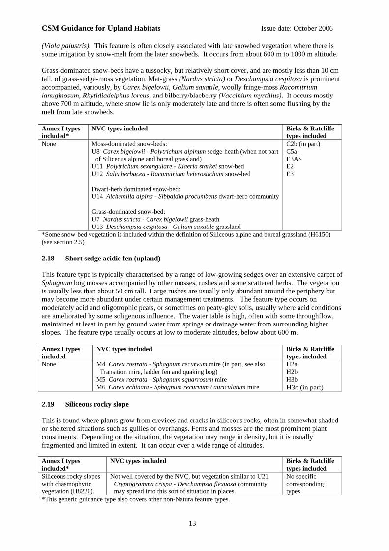
(Viola palustris). This feature is often closely associated with late snowbed vegetation where there is some irrigation by snow-melt from the later snowbeds. It occurs from about 600 m to 1000 m altitude. Grass-dominated snow-beds have a tussocky, but relatively short cover, and are mostly less than 10 cm tall, of grass-sedge-moss vegetation. Mat-grass (Nardus stricta) or Deschampsia cespitosa is prominent accompanied, variously, by Carex bigelowii, Galium saxatile, woolly fringe-moss Racomitrium lanuginosum, Rhytidiadelphus loreus, and bilberry/blaeberry (Vaccinium myrtillus). It occurs mostly above 700 m altitude, where snow lie is only moderately late and there is often some flushing by the melt from late snowbeds. Annex I types included*
NVC types included
Birks & Ratcliffe types included
None Moss-dominated snow-beds: U8 Carex bigelowii - Polytrichum alpinum sedge-heath (when not part
of Siliceous alpine and boreal grassland) U11 Polytrichum sexangulare - Kiaeria starkei snow-bed U12 Salix herbacea - Racomitrium heterostichum snow-bed Dwarf-herb dominated snow-bed: U14 Alchemilla alpina - Sibbaldia procumbens dwarf-herb community Grass-dominated snow-bed: U7 Nardus stricta - Carex bigelowii grass-heath U13 Deschampsia cespitosa - Galium saxatile grassland
C2b (in part) C5a E3AS E2 E3
*Some snow-bed vegetation is included within the definition of Siliceous alpine and boreal grassland (H6150) (see section 2.5) 2.18 Short sedge acidic fen (upland)
This feature type is typically characterised by a range of low-growing sedges over an extensive carpet of Sphagnum bog mosses accompanied by other mosses, rushes and some scattered herbs. The vegetation is usually less than about 50 cm tall. Large rushes are usually only abundant around the periphery but may become more abundant under certain management treatments. The feature type occurs on moderately acid and oligotrophic peats, or sometimes on peaty-gley soils, usually where acid conditions are ameliorated by some soligenous influence. The water table is high, often with some throughflow, maintained at least in part by ground water from springs or drainage water from surrounding higher slopes. The feature type usually occurs at low to moderate altitudes, below about 600 m. Annex I types included
NVC types included
Birks & Ratcliffe types included
None M4 Carex rostrata - Sphagnum recurvum mire (in part, see also Transition mire, ladder fen and quaking bog)
M5 Carex rostrata - Sphagnum squarrosum mire M6 Carex echinata - Sphagnum recurvum / auriculatum mire
H2a H2b H3b H3c (in part)
2.19 Siliceous rocky slope
This is found where plants grow from crevices and cracks in siliceous rocks, often in somewhat shaded or sheltered situations such as gullies or overhangs. Ferns and mosses are the most prominent plant constituents. Depending on the situation, the vegetation may range in density, but it is usually fragmented and limited in extent. It can occur over a wide range of altitudes. Annex I types included*
NVC types included
Birks & Ratcliffe types included
Siliceous rocky slopes with chasmophytic vegetation (H8220).
Not well covered by the NVC, but vegetation similar to U21 Cryptogramma crispa - Deschampsia flexuosa community may spread into this sort of situation in places.
No specific corresponding types
*This generic guidance type also covers other non-Natura feature types.

CSM Guidance for Upland Habitats Issue date: October 2006
14
2.20 Siliceous scree
The vegetation here is normally sparse and fragmented, but may thicken up in places, and is dominated by ferns and mosses, with fine-leaved grasses moderately frequent. Scattered herbs, dwarf-shrubs and patches of lichens may also occur. Siliceous screes and boulder fields can occur over a wide range of altitudes. The characteristic parsley fern (Cryptogramma crispa) may become sparse or absent at high altitudes, and in some geographical areas (e.g. Northern Ireland). Annex I types included*
NVC types included
Birks & Ratcliffe types included
Siliceous scree of the montane to snow levels (Androsacetalia alpinae and Galeopsietalia ladani) (H8110)
U18 Cryptogramma crispa - Athyrium distentifolium snow-bed
U21 Cryptogramma crispa - Deschampsia flexuosa community.
A variety of other NVC communities may occur in fragmentary form where the scree is more stable. There may be other community types not described by the NVC.
D2a D2b
*This generic guidance type also covers other non-Natura feature types. 2.21 Soakway and sump (upland)
The vegetation is composed of low mats of Hypericum and Potamogeton in nutrient-poor shallow seepages and soakways on peats and peaty mineral soils in valley mires in southern and western Britain. The bog moss (Sphagnum auriculatum) and spike-rush (Eleocharis multicaulis) are often also abundant and a variety of other sedges and herbs may be present. There is often some grazing, and this may be necessary to prevent domination by Molinia or invasion by trees and shrubs, but the community is also vulnerable to poaching. Annex I types included
NVC types included
Birks & Ratcliffe types included
None M29 Hypericum elodes - Potamogeton polygonifolius soakway. No specific corresponding types
2.22 Spring-head, rill and flush (upland)
The vegetation is dominated by mixtures of small sedges and bryophytes with the latter sometimes being completely dominant, particularly around spring-heads. Among the bryophytes, liverworts as well as mosses are often abundant. Scattered small herbs are often present. There is usually a more or less complete vegetation cover, with an input of ground water from a spring, or seepage from surrounding ground. The feature occurs at moderate to high altitudes, depending on the community type involved. In some types, where the water supply is very calcareous, there may be deposition of tufa. Annex I types included*
NVC types included
Birks & Ratcliffe types included
Petrifying springs with tufa formation (Cratoneurion) (H7220).
M7 Carex curta - Sphagnum russowii mire M8 Carex rostrata - Sphagnum warnstorfii mire (when not part of
the Natura type “Transition mires and quaking bogs” - see Transition mires, ladder fens and quaking bogs)
M31 Anthelia julacea - Sphagnum auriculatum spring M32 Philonotis fontana - Saxifraga stellaris spring M33 Pohlia wahlenbergii var. glacialis spring M34 Carex demissa - Koenigia islandica flush (when not part of the
Natura type “Alpine pioneer formations” - see Alpine flush) M35 Ranunculus omiophyllus - Montia fontana rill M37 Cratoneuron commutatum - Festuca rubra spring M38 Cratoneuron commutatum - Carex nigra spring
H3e (in part) H3h I4
*This generic guidance type also covers other non-Natura feature types.
CSM Guidance for Upland Habitats Issue date: October 2006
15
2.23 Subalpine dry dwarf-shrub heath
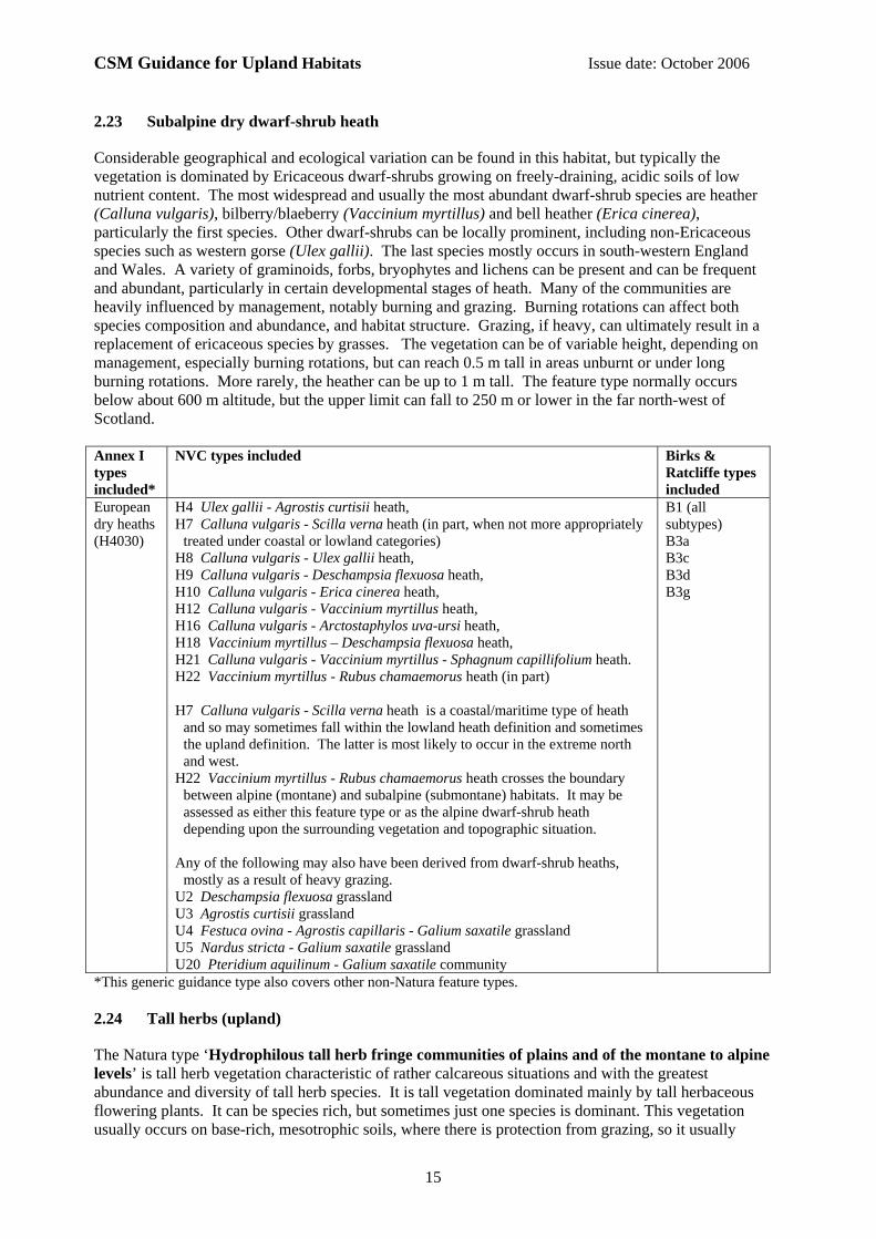
Considerable geographical and ecological variation can be found in this habitat, but typically the vegetation is dominated by Ericaceous dwarf-shrubs growing on freely-draining, acidic soils of low nutrient content. The most widespread and usually the most abundant dwarf-shrub species are heather (Calluna vulgaris), bilberry/blaeberry (Vaccinium myrtillus) and bell heather (Erica cinerea), particularly the first species. Other dwarf-shrubs can be locally prominent, including non-Ericaceous species such as western gorse (Ulex gallii). The last species mostly occurs in south-western England and Wales. A variety of graminoids, forbs, bryophytes and lichens can be present and can be frequent and abundant, particularly in certain developmental stages of heath. Many of the communities are heavily influenced by management, notably burning and grazing. Burning rotations can affect both species composition and abundance, and habitat structure. Grazing, if heavy, can ultimately result in a replacement of ericaceous species by grasses. The vegetation can be of variable height, depending on management, especially burning rotations, but can reach 0.5 m tall in areas unburnt or under long burning rotations. More rarely, the heather can be up to 1 m tall. The feature type normally occurs below about 600 m altitude, but the upper limit can fall to 250 m or lower in the far north-west of Scotland. Annex I types included*
NVC types included
Birks & Ratcliffe types included
European dry heaths (H4030)
H4 Ulex gallii - Agrostis curtisii heath, H7 Calluna vulgaris - Scilla verna heath (in part, when not more appropriately
treated under coastal or lowland categories) H8 Calluna vulgaris - Ulex gallii heath, H9 Calluna vulgaris - Deschampsia flexuosa heath, H10 Calluna vulgaris - Erica cinerea heath, H12 Calluna vulgaris - Vaccinium myrtillus heath, H16 Calluna vulgaris - Arctostaphylos uva-ursi heath, H18 Vaccinium myrtillus – Deschampsia flexuosa heath, H21 Calluna vulgaris - Vaccinium myrtillus - Sphagnum capillifolium heath. H22 Vaccinium myrtillus - Rubus chamaemorus heath (in part) H7 Calluna vulgaris - Scilla verna heath is a coastal/maritime type of heath
and so may sometimes fall within the lowland heath definition and sometimes the upland definition. The latter is most likely to occur in the extreme north and west.
H22 Vaccinium myrtillus - Rubus chamaemorus heath crosses the boundary between alpine (montane) and subalpine (submontane) habitats. It may be assessed as either this feature type or as the alpine dwarf-shrub heath depending upon the surrounding vegetation and topographic situation.
Any of the following may also have been derived from dwarf-shrub heaths,
mostly as a result of heavy grazing. U2 Deschampsia flexuosa grassland U3 Agrostis curtisii grassland U4 Festuca ovina - Agrostis capillaris - Galium saxatile grassland U5 Nardus stricta - Galium saxatile grassland U20 Pteridium aquilinum - Galium saxatile community
B1 (all subtypes) B3a B3c B3d B3g
*This generic guidance type also covers other non-Natura feature types. 2.24 Tall herbs (upland)
The Natura type ‘Hydrophilous tall herb fringe communities of plains and of the montane to alpine levels’ is tall herb vegetation characteristic of rather calcareous situations and with the greatest abundance and diversity of tall herb species. It is tall vegetation dominated mainly by tall herbaceous flowering plants. It can be species rich, but sometimes just one species is dominant. This vegetation usually occurs on base-rich, mesotrophic soils, where there is protection from grazing, so it usually
CSM Guidance for Upland Habitats Issue date: October 2006
16
occurs on steep slopes and cliff ledges. The range of occurrence is wide, from 300 m to as high as 1000 m, with differences in species composition according to altitude. Other tall herb vegetation, on more acidic substrates, tends to be less distinctive, and forms moderately tall vegetation composed of lush mixtures of dwarf-shrubs, ferns (other than bracken) and greater woodrush (Luzula sylvatica). The other tall herbs are less prevalent; the bryophytes can sometimes be moderately abundant. This feature type occurs on relatively base-poor, rather moist or slightly flushed, humic soils where there is some protection from grazing and burning. The non-Natura type is less attractive, and less heavily impacted by grazing animals, than the Natura type, and so tends to occur rather more extensively: (however, it is still largely confined to steep slopes, broken ground and cliff ledges). Some forms of CG10 and U4 may have suppressed tall herbs present (e.g. meadowsweet (Filipendula ulmaria), water avens (Geum rivale), globe flower (Trollius europaeus)) in some situations, and could have the potential to develop into this community. Annex I types included*
NVC types included
Birks & Ratcliffe types included
Hydrophilous tall herb fringe communities of plains and of the montane to alpine levels (H6430).
U16 Luzula sylvatica - Vaccinium myrtillus tall herb community. U17 Luzula sylvatica - Geum rivale tall herb community. U19 Thelypteris limbosperma - Blechnum spicant community. The following may also represent suppressed or incipient tall herb
vegetation: U4 Festuca ovina - Agrostis capillaris - Galium saxatile grassland,
provisional Filipendula ulmaria sub-community CG10 Festuca ovina - Agrostis capillaris - Thymus praecox grassland,
with suppressed tall herb species present.
C5b D1 D6a D6b C8
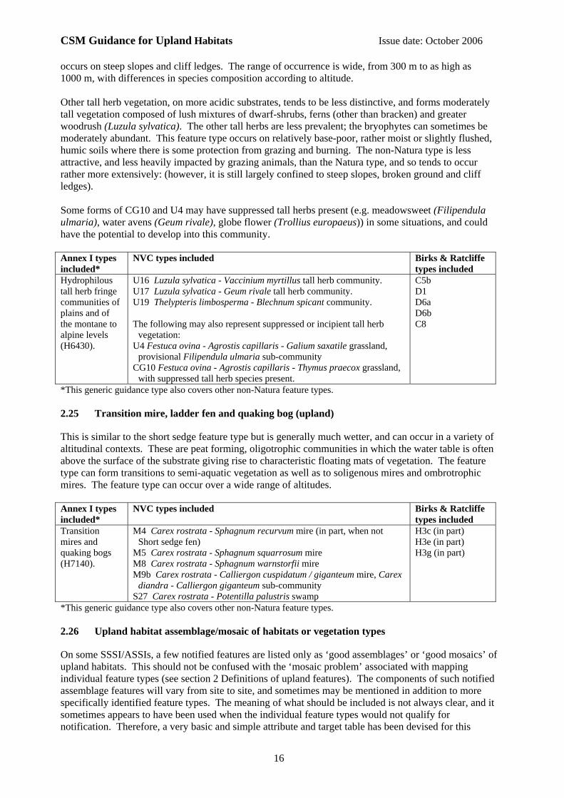
*This generic guidance type also covers other non-Natura feature types. 2.25 Transition mire, ladder fen and quaking bog (upland)
This is similar to the short sedge feature type but is generally much wetter, and can occur in a variety of altitudinal contexts. These are peat forming, oligotrophic communities in which the water table is often above the surface of the substrate giving rise to characteristic floating mats of vegetation. The feature type can form transitions to semi-aquatic vegetation as well as to soligenous mires and ombrotrophic mires. The feature type can occur over a wide range of altitudes. Annex I types included*
NVC types included
Birks & Ratcliffe types included
Transition mires and quaking bogs (H7140).
M4 Carex rostrata - Sphagnum recurvum mire (in part, when not Short sedge fen)
M5 Carex rostrata - Sphagnum squarrosum mire M8 Carex rostrata - Sphagnum warnstorfii mire M9b Carex rostrata - Calliergon cuspidatum / giganteum mire, Carex
diandra - Calliergon giganteum sub-community S27 Carex rostrata - Potentilla palustris swamp
H3c (in part) H3e (in part) H3g (in part)
*This generic guidance type also covers other non-Natura feature types. 2.26 Upland habitat assemblage/mosaic of habitats or vegetation types
On some SSSI/ASSIs, a few notified features are listed only as ‘good assemblages’ or ‘good mosaics’ of upland habitats. This should not be confused with the ‘mosaic problem’ associated with mapping individual feature types (see section 2 Definitions of upland features). The components of such notified assemblage features will vary from site to site, and sometimes may be mentioned in addition to more specifically identified feature types. The meaning of what should be included is not always clear, and it sometimes appears to have been used when the individual feature types would not qualify for notification. Therefore, a very basic and simple attribute and target table has been devised for this
CSM Guidance for Upland Habitats Issue date: October 2006
17
‘feature type’. Detailed assessment of individual habitats will only be mandatory when these have been individually notified. (see under section 3.4). 2.27 Wet heath (upland)
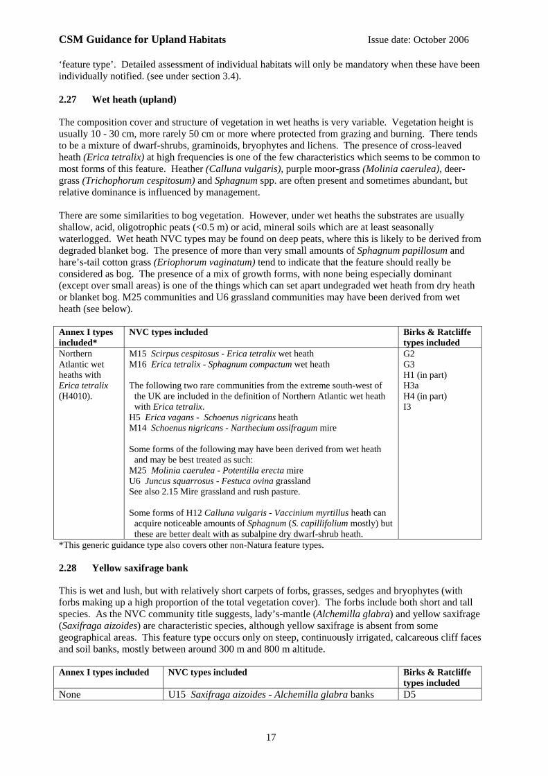
The composition cover and structure of vegetation in wet heaths is very variable. Vegetation height is usually 10 - 30 cm, more rarely 50 cm or more where protected from grazing and burning. There tends to be a mixture of dwarf-shrubs, graminoids, bryophytes and lichens. The presence of cross-leaved heath (Erica tetralix) at high frequencies is one of the few characteristics which seems to be common to most forms of this feature. Heather (Calluna vulgaris), purple moor-grass (Molinia caerulea), deer-grass (Trichophorum cespitosum) and Sphagnum spp. are often present and sometimes abundant, but relative dominance is influenced by management. There are some similarities to bog vegetation. However, under wet heaths the substrates are usually shallow, acid, oligotrophic peats (<0.5 m) or acid, mineral soils which are at least seasonally waterlogged. Wet heath NVC types may be found on deep peats, where this is likely to be derived from degraded blanket bog. The presence of more than very small amounts of Sphagnum papillosum and hare’s-tail cotton grass (Eriophorum vaginatum) tend to indicate that the feature should really be considered as bog. The presence of a mix of growth forms, with none being especially dominant (except over small areas) is one of the things which can set apart undegraded wet heath from dry heath or blanket bog. M25 communities and U6 grassland communities may have been derived from wet heath (see below). Annex I types included*
NVC types included
Birks & Ratcliffe types included
Northern Atlantic wet heaths with Erica tetralix (H4010).
M15 Scirpus cespitosus - Erica tetralix wet heath M16 Erica tetralix - Sphagnum compactum wet heath The following two rare communities from the extreme south-west of
the UK are included in the definition of Northern Atlantic wet heath with Erica tetralix.
H5 Erica vagans - Schoenus nigricans heath M14 Schoenus nigricans - Narthecium ossifragum mire Some forms of the following may have been derived from wet heath
and may be best treated as such: M25 Molinia caerulea - Potentilla erecta mire U6 Juncus squarrosus - Festuca ovina grassland See also 2.15 Mire grassland and rush pasture. Some forms of H12 Calluna vulgaris - Vaccinium myrtillus heath can
acquire noticeable amounts of Sphagnum (S. capillifolium mostly) but these are better dealt with as subalpine dry dwarf-shrub heath.
G2 G3 H1 (in part) H3a H4 (in part) I3
*This generic guidance type also covers other non-Natura feature types. 2.28 Yellow saxifrage bank
This is wet and lush, but with relatively short carpets of forbs, grasses, sedges and bryophytes (with forbs making up a high proportion of the total vegetation cover). The forbs include both short and tall species. As the NVC community title suggests, lady’s-mantle (Alchemilla glabra) and yellow saxifrage (Saxifraga aizoides) are characteristic species, although yellow saxifrage is absent from some geographical areas. This feature type occurs only on steep, continuously irrigated, calcareous cliff faces and soil banks, mostly between around 300 m and 800 m altitude. Annex I types included NVC types included
Birks & Ratcliffe types included
None U15 Saxifraga aizoides - Alchemilla glabra banks D5

CSM Guidance for Upland Habitats Issue date: October 2006
18
3 Attributes and targets
3.1 Introduction
Guidance on the selection of attributes and targets for each feature type is given in a series of tables in section 14. For the upland habitats, we have devised attributes and targets which indicate the minimum threshold for favourable condition. For each feature type there are a number of mandatory attributes, based on the following categories:
a. Feature extent (all features) b. Vegetation composition, which may include:
• frequency of taxa which are indicators of favourable condition • cover of taxa which are indicators of favourable condition, and others
which are indicators of unfavourable condition c. Vegetation structure, which may include:
• vegetation height • removal or destruction of plant parts by grazing, browsing, burning and trampling • accumulation of plant litter in the sward, dieback of typical species etc.
d. Physical structure, which may include: • excessive ground disturbance, burning, drainage or drying, indicating damage to the
habitat For each of the selected attributes, one or more targets are set, as specified in the relevant guidance table. Further background and guidance on target setting for each of these headings is given in sections 7-11 below. The attributes and targets have been devised to address the most important characteristics of feature types and to take account of spatial and temporal variation in these. For example, one would generally expect to encounter little or no serious soil erosion or invasion by exotic species in ‘favourable’ examples of feature types. In dwarf-shrub heaths or tall herb habitats, for example, one would expect to find a high frequency and cover of dwarf-shrubs and tall herbs, respectively. Most features have been notified to some extent as representative habitats for fauna and flora and not just as representative examples of particular plant communities. Therefore, the structural characteristics which are sometimes more important for particular plant or animal species, but which do not necessarily affect vegetation classification, have been taken into account when devising attributes and targets. Where important characteristics of a feature are functionally related, so that failure of one implies failure of others, then only one of the attributes has been given. For those features and sites with very site specific or relative value, the generic attributes and targets can be used as a foundation from which to develop and justify a more appropriate site-specific set of attributes and targets. For example, fewer and less stringent targets might be justifiable for a feature which has been notified because it is an edge of range example of a feature type. The agency uplands specialist(s) should be consulted for advice where applicable. 3.2 Selection and setting of targets
Most of the targets for a feature type are devised from the point of view of the structure, composition and long-term maintenance of plants and vegetation typical of the feature types. However, many of these targets will also serve to maintain the associated faunas. The number of targets for a given feature varies considerably and is dependent on the floristic/structural range within the feature, the structure of the habitat and its geographical variation. Relatively static and simple feature types, or those for which information is sparse, are treated in a less rigorous way than those that are more complex, dynamic or better understood.

CSM Guidance for Upland Habitats Issue date: October 2006
19
The generic targets given in the tables should be applicable to most of the known variation within the British uplands. However, in exceptional circumstances, if a particular target is deemed inappropriate, then a case would need to be made for a different target, and agreed with the country agency upland specialist(s). 3.3 Scale of assessment
Targets relate to a spatial scale of assessment. This is particularly important for species frequency targets. Different feature types have a different “grain” and the assessment of species presence needs to be done at different spatial scales to be both meaningful and efficient. For example, grassland swards generally show greater variation in species composition at smaller spatial scales, and less variation at larger spatial scales, than do dwarf-shrub heaths. Acid grassland, calcareous grassland, and moss, dwarf-herb and grass-dominated snow-beds, use notional 1 m2 sample sizes. These are fine-grained feature types. All other features types use 4 m2 sample sizes with the exception of montane willow scrub and limestone pavement. Montane willow scrub uses 16 m2 since montane willow bushes as they only rarely form a continuous extent of shrub growth over many square metres. For some feature types and attributes “individual patch” and “all that can be seen from sample locations” scales are considered appropriate. Some features may be small or fragmented in area. This potentially applies to montane willow scrub, tall herb vegetation, transition mires, ladder fens and quaking bogs, and yellow saxifrage banks. In these cases, it may be more appropriate to make an assessment based on individual patches or stands rather than notional 4 m2 or 16 m2 sample plots. For some particular forms of attribute (e.g. where the target is for no burning to occur within fire sensitive situations) it is justifiable to look for this while travelling between sample locations, even if the feature passes the target at all sample locations (the tables highlight this where appropriate). 3.4 Taking into account small scale mosaics when setting targets
In the uplands, mosaics of habitats occur across a wide range of spatial scales. Methods for dealing with mosaics have been devised in relation to identification of individual habitat feature types (see section 2 Definition of upland features), and for the setting of targets for the loosely defined ‘habitat assemblage’ feature type (see section 2.26). For example, within subalpine dry dwarf-shrub heath it is not unusual to find small areas of acid grassland on alluvial soils beside streams. These are often too small to map. Not only have these probably always been alluvial grassland but they can also be valuable habitats in their own right. However, if a sample location for the condition assessment of a subalpine dry dwarf-shrub heath feature landed on one of these patches of grassland it could result in a false impression of the condition of the feature. Field checking for the presence of the appropriate feature type at sample locations is the main way in which this problem will be overcome. In the case of subalpine dry dwarf-shrub heath, there is an additional safeguard: areas in which no dwarf-shrub plants are present are excluded from assessment, except where this can be shown to result from a loss of extent since notification. 4 Methods of assessment
Many upland sites support habitat features that are very extensive or fragmented and scattered across a large area. Several approaches can be adopted for monitoring in such cases, each with advantages and disadvantages. Possible strategies include random sampling, systematic sampling along transects or on a grid basis, and targeted sampling where damaging activities are known to be concentrated. Whichever method is followed, it is recommended that monitoring is based on a series of re-locatable sample points in each feature, which should be selected prior to the fieldwork to avoid bias. Sample locations, with accurate grid references, can be easily selected using GIS facilities if vegetation maps have been digitised, and can be located in the field using GPS handsets. If sample points are selected at random it is possible to assess how likely they are to be unrepresentative and, consequently, the number of samples required can be set to a limited number that meets whatever

CSM Guidance for Upland Habitats Issue date: October 2006
20
degree of certainty in the results is required to be fit for purpose. With randomly located sample points, the same number of samples can be used for each feature regardless of its extent, saving on survey costs compared to some other approaches. Targeted sampling may be more efficient for management purposes, though less robust statistically. Systematic sampling techniques may also be advantageous in some situations. At each sample point, a number of attributes will need to be assessed (covering diverse elements such as extent, species composition, frequency, cover and disturbance). Extent is the one attribute which can sometimes be obtained from a comparison of maps or aerial photographs. Each attribute has a specific target, or a range of targets, against which the sample point can be scored to pass or fail. For a given feature, all attributes must pass the stated target(s) at the sample point: if one attribute fails, then the feature fails at that particular sample point. Scoring against a target should not be time consuming and a whole sample point should not take more than a few minutes to complete. Two groups of species are often used, one for determination of cover and one for frequency (these are included at the end of the relevant tables). For all attributes except extent, each target is related to a specific scale or scales of assessment, as indicated in the guidance tables. The spatial scale varies according to the attribute being measured, from 1 m2 to the whole of the feature that can be seen from a sample location (section 3.3). This sometimes requires an assessment to be undertaken whilst walking between sample points, particularly when assessing attributes such as burning of sensitive areas. The targets are mostly specified in terms of coarse, standardised quantities, such as 10%, 25%, or 50%, which can be easily and reliably estimated in the field. For deleterious types of impact, a target of 10% of the feature area has been used as a standard in most instances. A more exacting criterion is used only if there are clearly justifiable reasons for doing so. The 10% target is sufficiently large to be regarded as significant by many, and it is large enough to be reliably assessed without great cost. Selecting a value for this target is in some respects the inverse of selecting a target for how much of a feature should be expected to pass (see below). Many upland habitat features are naturally variable in composition and structure due to variation in elements such as soils and topography. Also, many types of impact on upland features are intrinsically very patchy and dynamic. For example, even on sites with very light grazing pressure it is often possible to find some small patch that is heavily grazed with sufficiently thorough searching. It is therefore generally unrealistic or inappropriate to specify, for most attributes other than extent, that every part of a feature should pass any particular target. It may also not be feasible to confirm this by any practical or cost effective method of sampling and field assessment. For common standards reporting it is necessary to make a judgement on condition for the whole feature at a site level. As a guideline, it is recommended that when a feature is reported as favourable, it should be possible to state with a high degree of confidence that each target is met over at least 90% of the feature. The choice of this criterion is a judgement based on what is known about the ecology of impacts such as grazing or burning, the extent of impact which is likely to be regarded by ecologists and decision makers as of consequence, and the costs of sampling. A lesser or greater proportion of the feature may be appropriate for certain targets in particular situations; such decisions should always be based on careful judgement using a clear rationale, in agreement with the relevant country agency specialists and in discussion with JNCC. For the extent attribute the target should generally be for no loss of overall extent, subject to site-specific conservation objectives (see Introduction to the guidance manual, Section 8). In order to provide as accurate a picture as possible regarding the condition of a feature across a large upland site it may be feasible to make an estimate of the proportion of the feature which is in favourable condition. This could, for instance, aid determination of trends in habitat condition, or the targeting of resources for habitat management measures in specific areas. 5 Recommended visiting period
The recommended period for undertaking assessments of condition for each feature type is shown in dark grey in Box 2 below. The pale grey shows periods when assessment may still be possible, though

CSM Guidance for Upland Habitats Issue date: October 2006
21
difficult due to weather conditions or because some of the required observations are difficult to observe (e.g. indicator species having made little growth or having become senescent and difficult to identify or even see). Outwith these times the assessment of some features will be unreliable. Geographical location and seasonal variation may allow a small degree of flexibility. Box 2. Recommended visiting periods for feature types J F M A M J J A S O N D Acid grassland Alkaline fen Alpine dwarf-shrub heath Alpine flush Alpine summit communities of moss, sedge and three-leaved rush Blanket bog and valley bog Calaminarian grassland and serpentine heath Calcareous grassland Calcareous rocky slope Calcareous scree Fellfield Fern-dominated snow-bed Juniper heath and scrub Limestone pavement Mire grassland and rush pasture Montane willow scrub Moss, dwarf-herb and grass-dominated snowbed Short-sedge acidic fen Siliceous rocky slopes Siliceous scree Soakway and sump Spring-head, rill and flush Subalpine dry dwarf-shrub heath Tall herbs Transition mire, ladder fen and quaking bog Upland habitat assemblage/mosaic of habitats or vegetation types Wet heath Yellow saxifrage banks
6 Skill requirements for monitoring
Monitoring personnel should have at least a basic understanding of upland ecology and management issues. This is important in order that the surveyor can understand and interpret what is assessed in terms of the effects of management, such as grazing, burning and drainage.
7 Feature extent
The feature is favourable if there has been no measurable decline in extent since SSSI/ASSI notification. This judgement will be dependent on sufficient data being available to make comparisons. Site management objectives have a bearing on this, as they may specify the expansion of one feature at the expense of another. The assessment of extent must be based on comparison of previously mapped boundaries of features compared with data collected at the time of the monitoring visit, and/or compared to aerial photographs. The vegetation maps used will be those compiled from as near the time of notification of a SSSI/ASSI as possible. In some cases (e.g. the loss of subalpine dry dwarf-shrub heath feature area to acid grassland), it may be possible to determine loss of extent even when vegetation maps from near the time of notification are not available by using air photograph interpretation. If systems to record the extent of features have already been established on sites — for example, based on presence or absence at a large number of regular grid points throughout a feature — then this could be used instead of the comparison of map boundaries. On most sites, the sorts of mapping and observational procedures which will be

CSM Guidance for Upland Habitats Issue date: October 2006
22
practicable and cost-effective, will only be sufficiently precise and reliable to record changes greater than about 10%. For some feature types with very fragmented distributions on sites (e.g. tall herbs) it may be simpler and more reliable to record the number of locations at which the feature occurs rather than trying to define boundaries. Loss of extent can also occur within feature types, usually as a result of localised but significant changes such as severe erosion events, avalanches or rockfalls. If these affect more than 10% of the area of a feature then a loss of extent should be recorded. Localised, intense anthropogenic effects, or gradual loss by diffuse conversion of a feature into something else, will in any case be registered by failure of targets for other attributes. 8 Vegetation Composition
Both frequency and cover of plant species, or broader taxonomic groups, are important in making assessments of feature condition. They provide important information about the abundance of plant species in terms of their spatial distribution as well as their bulk or ground cover. Attributes and targets related directly to species composition can be usefully examined under the following headings: (i) frequency of taxa which are indicators of favourable condition; and (ii) cover of taxa which are indicators of favourable condition, or unfavourable condition (using non-native species, bracken, trees and shrubs; and “weedy” and invasive species). For appropriate feature types, lists of species have been selected that are not only typical of the type but also have some indicator value for of richness and diversity. It is important to note that not all typical species are included since some of these can persist, and become very dominant, in degraded situations. The selected species are widespread across the full geographical range of feature types, or are distinctively widespread within particular geographical regions. They are mainly constancy III-V in relevant NVC tables and so are likely to be present in most stands of the feature, unless damaged. Most of the species listed are vascular plants. Only a few of the commoner and more easily identified bryophytes and lichens are used. Field assessments can be made much easier and less ambiguous if certain types of exclusion or qualifier are specified. For subalpine dry dwarf-shrub heaths the occurrence of burning in some situations is important for the maintenance of biodiversity. This means that there may be some recently burned ground present at the time of assessment for which frequency and cover targets cannot sensibly be applied. The presence of bare rock can pose similar problems in many feature types and this should also be excluded when making frequency and cover assessments. The targets often specify that an assessment should be made in relation to vegetation cover, which is a way of allowing for variation in bare rock cover both within a feature type and between sites. Bare rock may increase as a result of erosion, and this would normally be regarded as a deleterious development in most feature types. However, additional attributes and targets have been specified for most feature types to help identify such situations (see Physical structure). When assessing the frequency or cover of taxa, it is important to take into account the fact that most features are likely to include small inclusions or outliers of other types of feature that occur at too small a scale to be mapped or to seriously alter the character of the feature as a whole. Thus, in dwarf-shrub heaths it is not unusual to find small patches or ribbons of grassland on alluvial soil edging small streams or flushes and indeed, such inclusions can be valuable for biodiversity. On the other hand, it is important to be able to identify situations where the dwarf-shrub component of a heath feature is being reduced and fragmented by heavy browsing or other land management practices. In order to try to accommodate these considerations areas of grassland in which there are no dwarf shrub plants present, (even very small suppressed plants), within the mapped area of the feature, should be ignored when making the assessment for these targets. This will therefore include grassland patches which have never
CSM Guidance for Upland Habitats Issue date: October 2006
23
supported heathland communities, or severely degraded heath that has no ericaceous species remaining in the sward (or seed bank) and is not considered to be restorable. 8.1 Frequency of taxa which are indicators of favourable condition
For many feature types, we would expect to see some of the typical species, spread evenly throughout, if the feature is in favourable condition. Deleterious impacts often result in increased patchiness in the distribution of species, and frequency assessment provides a way of identifying this. In some cases, broad taxonomic groupings are used in addition to, or instead of, lists of individual species. In dwarf-shrub heaths the presence of ericaceous species is obviously critical. Additional plant groupings are also used. For example, subalpine dry dwarf-shrub heath and alpine dwarf-shrub heath also have frequency targets for other taxonomic groups. Targets are set for bryophytes and lichens, for example, to reflect the important role of lower plants in these feature types. For most feature types, however, species lists have been compiled. These are presented as menu lists from which a certain number must be present. The target number varies from 1 to 6 depending on feature type and, in some cases, on the NVC community within a feature type. For some feature types, the lists of indicator species are divided into two groups where some of the species are more critically indicative of condition. An additional target is then set requiring that a proportion of the target number of species should be from the more critical group; this applies to mire grassland and rush pasture, short-sedge acidic fen, and transition mire, ladder fen and quaking bog. 8.2 Cover of taxa which are indicators of favourable condition
Attributes and targets for cover are given, and as with the frequency assessments, the indicator species are presented as menu lists of species. However, the lists are not necessarily identical to those used for frequency assessment, since frequency and cover are not perfectly correlated characteristics of vegetation. Sometimes, broader species groups are used. For example, an assessment of the cover of forbs in the sward is used for acid grassland and calcareous grassland. A target of at least 10% for the cover of forbs in the sward, within 1 m2 samples, is set for acid grassland. For calcareous grassland, which would be expected to be more species rich and diverse, a higher target of at least 33% is set. The generic targets are set at a range of standard percentage covers, for example, at 10%, 25%, 50%, 66%, or 75%. High targets are set for those feature types showing less variability . For example, for spring-head, rill and flush the target is 90% but this applies to an extensive list of widespread species (see Box 3). For those feature types where there are two groups of indicator species there is an additional target that at least 25% of the cover should come from species in the more critical group; this applies to mire grassland and rush pasture, short-sedge acidic fen, subalpine dry dwarf-shrub heath, and wet heath. Box 3. Species menu for cover assessment in spring-head, rill and flush. Any moss or liverwort species. Callitriche spp. Carex spp.
Chrysosplenium oppositifolium Cochlearia officinalis
Koenigia islandica Montia fontana
Potamogeton polygonifolius Ranunculus omiophyllus
Saxifraga spp. Small arctic-alpine rush species
For scree feature types (both calcareous and siliceous), the presence of areas free of complete vascular plant cover is important to the character of the feature type and the habitat niches provided. For these types, therefore, a target of 33% maximum of vascular plant vegetation cover has been set. Wet heaths pose some problems: they tend to support a limited numbers of species which also occur in both subalpine dry dwarf-shrub heath and blanket bog, but can also be structurally varied and have species drawn from a variety of different life forms. Accordingly, for wet heath, there is an additional cover target to ensure life form diversity. This states that neither dwarf-shrubs nor graminoids should occupy more than 75% of the vegetation cover, while native trees and shrubs should occupy no more

CSM Guidance for Upland Habitats Issue date: October 2006
24
than 20% of the vegetation cover (see the subsection on tree and shrub cover below). No upper limit is set for the cover of lower plants, which can be important (but very variably represented) in this feature type. Estimates of cover by eye are generally not very reliable. However, the targets can be used with some consistency and reliability given that we are not seeking to measure cover very precisely. Finally, fellfield offers an unusual example of dynamics and long-term maintenance of feature interest. For this feature type, the concern relates to the relative importance of the effects of a severe physical environment on the vegetation cover in comparison with other factors. Severe wind-blasting effects, and sparsity of vegetation cover, are what are most characteristic of this feature type. It is possible that for some lower altitude examples, eutrophication by grazing animals or from deposition of atmospheric nitrogen pollutants could lead to increases in vegetation and loss of the distinctive character of the feature type. 8.3 Non-native species - cover of taxa which are indicators of unfavourable condition
The presence of non-native species is generally regarded as deleterious as they tend to displace native species and can lead to an overall decline in biodiversity. Accordingly, for all feature types there is a target that non-native species should make up, collectively, less than 1% of the vegetation cover. 8.4 Bracken, trees and shrubs - cover of taxa which are indicators of unfavourable condition
Most upland feature types covered by this guidance are characteristically open habitats in which trees and shrubs make only a limited contribution. These open feature types present complementary habitat value to those provided for by the more closed woodland and scrub communities. There is some overlap for feature types such as juniper scrub and montane willow scrub where a high frequency and cover of shrubs is expected, though not always attained. A limited presence of trees and shrubs can beneficially contribute to the diversity of the habitat, and thus the biota, in many of these feature types. For example, many areas of upland heathland are characterised by limited structural diversity with few natural transitions from open heath into scrub and woodland (Thompson et al 1995a, b, English Nature 1999). Bracken can be usefully treated in the same way, since it often occurs in similar situations to where trees and shrubs already exist, or have existed in the past, or are likely to colonise. Also, when not very dense, it can provide some similar habitat benefits for both flora and fauna e.g. for the pearl-bordered fritillary and small pearl-bordered fritillary and their food plants, and for whinchats. Targets for native tree and shrub cover have been set at two different levels: generally less than 10% for native species on those feature types which characteristically have a low cover of trees and shrubs, and generally less than 20% on those feature types (other than montane willow scrub and juniper heath and scrub) where a tree and shrub component is more characteristic and beneficial. The targets refer to all of the feature which can be observed from sample locations. 8.5 “Weedy” and invasive species - cover of taxa which are indicators of unfavourable condition
Generally, a target of no more than 1% is set for the collective cover of a group of common species indicative of eutrophication and severe disturbance such as Alopecurus geniculatus, Cirsium arvense, Cirsium vulgare, Cynosurus cristatus, Epilobium hirsutum, large docks (excluding Rumex acetosa) some Juncus spp , Lolium perenne, Ranunculus repens, Sagina procumbens, Senecio jacobaea, Stellaria media, and Urtica dioica. These are not relevant to all feature types e.g. alpine features. In some feature types, some component species can become a problem if they become over-abundant. For these species and feature types, higher targets have been set: 10% for a variety of species in alpine dwarf-shrub heath, alpine summit communities, and spring-head, rill and flush; 20% for Molinia in soakways and sumps, and 25% for Bellis perennis and Ranunculus repens in acid and calcareous

CSM Guidance for Upland Habitats Issue date: October 2006
25
grasslands; 33% for Juncus squarrosus and Rhytidiadelphus squarrosus in acid grassland; and 50% for Arrhenatherum elatius in calcareous screes. Heavy grazing, trampling and manuring will reduce the occurrence of the more palatable plant species and increase the frequency of less palatable, and more grazing and trampling tolerant species. These influences can have deleterious effects on the condition of the feature. Cover targets for species indicative of such effects have been set for three feature types: acid grassland, alpine dwarf-shrub heath and alpine summit communities. For acid grassland, a target has been set for Juncus squarrosus and Rhytidiadelphus squarrosus as these two species thrive and spread in very short acid swards usually as a result of persistent heavy grazing. The target for the alpine feature types is 10% for a range of species normally present at very low cover but found to increase where there is heavy herbivore usage, and possibly also where there is eutrophication from atmospheric pollutants. These include Agrostis capillaris, A. vinealis, Anthoxanthum odoratum, Deschampsia flexuosa, Festuca ovina / vivipara, Galium saxatile, Poa spp. (other than arctic-alpine spp.), and Potentilla erecta. 9 Vegetation Structure
Where the ecology of plant communities is well understood it is often simpler to use indirect targets, based on structure and processes, to assess condition. Vegetation structure attributes and targets can be usefully examined under the following headings: • vegetation height; • removal or destruction of plant parts by burning, grazing, browsing and trampling; • accumulation of dead plant litter in the sward; • dieback of typical species; and • indicators of long-term maintenance and inherent dynamics of the feature. 9.1 Vegetation height
Targets for vegetation height have considerable value as indirect indicators of habitat condition. Since different species, of both plants and animals, tend to have different requirements the targets have been set to ensure that a wide range of stand heights is maintained. For feature types for which this appeared to be less important, targets have been set to ensure that the characteristic plant species can grow to full stature, flower and set seed, at least for part of the feature area. For these feature types, minimum vegetation height targets have been set; these targets are not set at the maximum typical species could attain, but rather at a height at which at least a substantial proportion of the typical plant species present should be able to grow to a sufficient size to flower and set seed. Targets for actual vegetation height are given for many interest features. For grasslands, there is a lot of research and practical experience indicating that species diversity is strongly determined by the accumulation of live and dead biomass (Ball 1974, Elkington 1981, Grime 1973, Hill et al 1992, Hulme et al 1999, Miller et al 1999, Rawes 1981, Rawes and Welch 1972, Virtanen et al 2002, Welch and Rawes 1964). A target for sward height is a simple but effective way of monitoring for appropriate species composition. Grazing impacts can be very variable and patchy except at very high grazing pressures. Grazing produces patches of sward of different heights but within each patch the upper surface of foliage tends to be approximately uniform, particularly when more than lightly grazed. Sward height also changes over the growing season even when herbivore numbers are constant because of the “humped” seasonal pattern of plant growth. The broad target range for sward height allows for a mixture of patches of short sward, which favours small herbs, bryophytes and lichens, and taller areas where larger herbs can persist and flower; it also allows for variation due to differing species compositions on different sites, and variation in the date of assessment. Some feature types, notably wet heath, exhibit variation in vegetation structure partly because of a range of distinctive life forms of differing stature (bryophytes and lichens, herbs, tussocky graminoids, dwarf-shrubs and shrubs). For these feature types, targets have been set to represent the presence of a range of vegetation heights.
CSM Guidance for Upland Habitats Issue date: October 2006
26
In subalpine dry dwarf-shrub heath, fire as well as grazing affects vegetation height and is probably a widespread determinant of habitat pattern and structure for this feature type. The vegetation height target in this case is a maximum height rather than a minimum, and applies only to areas outside that are identified as sensitive to disturbance. 9.2 Removal or destruction of plant parts by grazing, browsing, trampling and fire
Grazing, browsing, trampling. Herbivores can reduce the height and structural variation of vegetation and can also have negative effects through the removal or suppression of plant parts (and sometimes by lethal mechanical damage to plants). This has direct effects on the plants themselves by reducing their productive and reproductive capacity, and thus their long-term persistence in the feature type. However, it is really only for dwarf-shrub species, and in particular Calluna, that there is any research information to help set a precise target (e.g. see Palmer 1997). Lower plants, such as the liverwort species which form the scarce Atlantic hepatic mat community, can also be affected. This community may be largely ungrazed by most herbivores but can be adversely affected by trampling and the loss of shelter when the dwarf-shrubs and other plants they grow among are heavily browsed. Flowers and seeds, and shoot tips, are important food resources for many invertebrates. When these are removed by livestock or deer then food resources for invertebrates can be severely depleted. Baines et al (1994) provides an illustration of these effects for the species associated with Vaccinium myrtillus; this is one of few upland studies to demonstrate such food web effects. Targets for maximum offtake of shoots and leaves, or more generalised assessments of grazing impact, have therefore been set for many of the feature types. The targets for browsing of dwarf-shrubs, in subalpine dry dwarf-shrub heaths and wet heaths, is for no individual dwarf-shrub species (with the exception of Myrica gale and Betula nana) to have more than 33% of its last complete growing season’s shoots browsed. By last complete growing season’s shoots is meant the last complete year’s growth, so that if assessment is carried out in summer then it is the previous summer’s shoot growth that should be assessed. Since most browsing occurs over the winter half of the year, and new summer growth obscures the evidence of browsing, assessments are best made in late winter through spring. Both Myrica gale and Betula nana are palatable species which are sometimes only present in very small amounts on a site, hence the setting of a high target of 66%. Since both species seem well able to withstand quite heavy browsing, at least for a time, it seems unreasonable to fail a feature because these species are being heavily browsed. If these species are present on a site in greater amounts, so that they form a significant proportion of the feature, then one would expect lower browsing impacts. This is catered for by the collective target, which includes these two species. Very heavy grazing or browsing can produce effects on the size of plant parts, and on the shape of plants, which can be used as indicators of this kind of impact. These effects are generally deleterious as they tend to correspond with suppression of flowering and fruiting, and long-term loss of typical species from the feature type. This can apply to dwarf-shrub heath features, but an estimate of the percentage of shoots browsed provides a more reliable indicator of the impact of grazing over the previous year (e.g. if a high percentage of shoots is absent, this indicates heavy grazing). This is mostly useful for a few feature types such as juniper heath, limestone pavement (tree and shrub component), montane willow scrub, and alpine calcareous grassland (Dryas octopetala). When Dryas is subjected to moderate to heavy grazing over a long period the leaf size tends to become smaller and flowering is inhibited (the flowers themselves tend to be grazed quite assiduously). However, Dryas occurs as a range of ecotypes (see e.g. Elkington 1971), some of which have small leaves even when ungrazed. Herbivores sometimes produce specific forms of physical damage which are important in particular feature types. One of these, which can potentially be quite damaging, is the stripping of bark from trees and shrubs. This is of little relevance for most upland habitats other than juniper scrub, and limestone pavement (where trees and shrubs can make a valued contribution to habitat diversity). Damage to bryophytes can be a significant impact in some feature types, though in the UK, bryophytes (other than their spore capsules) are rarely consumed by herbivores (see e.g. Davidson et al 1990, Prins 1981). Damage is usually a consequence of trampling, pulling-out, or breakage of stems and tufts of bryophytes by herbivores as they attempt to graze vascular plants growing through bryophyte carpets

CSM Guidance for Upland Habitats Issue date: October 2006
27
and hummocks. This is particularly significant for Sphagnum mosses in blanket bogs and wet heath feature types and for all bryophytes in the case of spring-head, rill and flush features. Herbivore usage may have a wide range of impacts within some feature types. More generalised types of grazing impact assessment are then more useful. When limestone pavement is heavily used by herbivores the clint-top plants tend to be eliminated by heavy offtake and trampling, and plants become restricted to the more inaccessible parts of grikes. This tends to reduce the range of plant species which persist. The indicators for alpine summit communities allow for variation in grazing impact within a feature, and also between features (see MacDonald 2003). All the indicators will not always be applicable at every sample location within a feature, and indicator impacts are not always correlated. Fire. This is a major factor determining vegetation dynamics and the overall composition and structure of dwarf-shrub heaths. Burning can alter the vegetation composition, the pattern and age structure of plants, the carrying capacity for herbivores, and the associated fauna, and can alter the physical structure, nutrient status and even hydrology of soils and peat (e.g. MacDonald 2003, MacDonald et al 1998; Backshall et al 2001, Tucker 2003). The impacts of fire are dependent on the intensity, frequency and scale of the burns, the type of vegetation burnt, and also the weather and soil conditions at the time of the burn. Too-frequent fires, intense fires and fires covering large areas can all be environmentally damaging. Fire can both increase and reduce biodiversity interest. Effects vary according to the intensity, seasonality, frequency, and size of fires (see Anonymous 2001). Fire and other forms of disturbance regime may also be important in other feature types but little or no research has been done other than for dwarf-shrub heaths. This research has shown that: (a) post-fire heath development is strongly dependent on pre-fire vegetation characteristics; (b) most herbs flower and produce seed mainly in the first few years of post-fire vegetation development; (c) longer fire return periods (especially more than 15 years) lead to a progressive loss of herb species and dwarf-shrub species, other than heather, both from the seed bank and as vegetative plants; and (d) serially burned stands have higher plant species richness, greater herb-richness, and greater dwarf-shrub diversity, than unburned stands in similar situations (Hobbs and Gimingham 1984, Mallik et al 1984, Stevenson et al 1996). Generally, there is little hard evidence to demonstrate the existence of fire sensitive species, although there were some indications from Stevenson et al (1996) that serial burning could eliminate some species characteristic of late stages of stand development. There is anecdotal and circumstantial evidence, however, that saxicolous lichens, some mosses, and “Atlantic” liverworts can be eliminated or severely reduced by fires.
Typically, in order to maintain the diversity of typical plants in subalpine dry dwarf-shrub heaths there should be some areas completely free of burning and some areas regularly burnt as part of a environmentally sustainable rotation . Alpine dwarf-shrub heaths and alpine summit communities should not be burnt given their sensitivity to fire and the likelihood of ensuing erosion. Views on the application of burning on blanket bog are diverse and indeed often highly polarised. Some people will cite stratigraphical studies of peat deposits as providing evidence that burning has occurred at intervals throughout the development of the peat profile; fire does not inevitably result in the destruction of bog communities nor does it typically bring an end to peat accumulation. Five points should be noted: a) bogs do not need to be burnt to retain their interest; b) there should be a general presumption against burning of blanket bog; c) it is possible to burn blanket bog which is dominated by Calluna without damaging the interest; d) there should be a presumption that degraded bogs can be restored until the contrary is demonstrated; and e) inappropriate burning can lead to erosion (including organic soil and carbon losses) and the loss of peatland habitats. 9.3 Accumulation of dead plant litter in the sward
As mentioned in relation to sward height in grassland, there is a lot of research and practical experience indicating that species diversity is strongly determined by the accumulation of dead as well as living biomass (Ball 1974, Elkington 1981, Grime 1973, Hill et al 1992, Hulme et al 1999, Miller et al 1999, Rawes 1981, Rawes and Welch 1972, Virtanen et al 2002, Welch and Rawes 1964).
CSM Guidance for Upland Habitats Issue date: October 2006
28
The accumulation of plant litter occurs when there is undergrazing. In upland grasslands, the accumulation of dead plant litter generally produces a dispersed “thatch” or “felt” within the sward which is not easy to describe and quantify. For acid grassland, alkaline fen and calcareous grassland (species-rich Nardus grassland) the targets set deal with ensuring that large tussock forming graminoids (such as large rushes, Nardus stricta and Molinia caerulea) do not become over-dominant and suppress other typical species. Tussocks can include large amounts of dead material. In these feature types, less than 10% of the tussocks of such species should be contiguous, assessed at 1 m2 sample areas (or 4 m2 for alkaline fen). 9.4 Indicators of long-term maintenance and inherent dynamics of feature interest
In most features, provided that at least some plants of each of the typical species flower and produce seed then turnover of individuals can be sustained. This can be assessed by targets relating to flowering of typical species, as has been discussed above for targets relating to grazing and browsing impacts. Seed production, and seedling establishment. For some feature types, a more direct assessment of seed production is desirable, especially for rare and dioecious species. This is most pertinent to juniper, in juniper heath and scrub, and to arctic-alpine willow species in montane willow scrub. For juniper the target is that at least 10% of bushes should have fruit, while for montane willow scrub at least 1 bush of each willow species present should be producing seed at each sample locations. The latter target may seem low but quite often this feature type consists of only a handful of scattered willow bushes, sometimes with these being all of the same sex. Montane willow bushes will not set seed if all the bushes are of the same sex and are unlikely to set seed if opposite sexes are widely spaced (field experience from Ben Lawers and elsewhere indicates that pollen is unlikely to be transferred between isolated bushes more a few hundred metres apart). Seed production, and seedling establishment, may be quite variable from year to year. Long-term maintenance of features requires that sufficient young plants of the typical species establish to replace older plants which are lost. As well as assessment of seed production, it is also useful to assess the age structure of longer lived woody plants where they are significant components of an interest feature. Without very detailed, and in part destructive, monitoring this can only be done in a rather approximate fashion. Nevertheless, this can still give useful indications about the longer term prognosis for a feature. Targets have been devised, based on easily observed structural characteristics, for juniper heath and scrub, limestone pavement (tree and shrub component) and montane willow scrub. Height alone, however, cannot be used as juniper displays considerable ecotypic variation in mature height. Juniper populations often show only episodic regeneration. Even when seed production is apparently abundant this is not necessarily a guarantee that seedlings will survive and grow. A high proportion of seeds may be parasitised by insect larvae (Miles and Kinnaird 1979), seedlings may not be able to grow through a tall and thick sward or they may be consumed by slugs, small rodents and larger herbivores (Fitter and Jennings 1975, Miles and Kinnaird 1979). The most extensive and successful populations of juniper seem to occur in areas which apparently have had a history of short periods of quite intense disturbance interspersed with long periods with little or no disturbance and low grazing and browsing pressure (e.g. Falinski 1980, Gilbert 1980, Welch 1982). The target for juniper has been devised to allow for this sort of episodic behaviour. 10 Physical Structure
The maintenance of typical species and processes depends not just on vegetation structure and dynamics but also on the underlying physical structure of the substrate. This can be affected by a variety of impacts, which sometimes can be beneficial, but are generally damaging. Physical structure attributes and targets can be usefully examined under the following headings: • disturbance to the substrate; • exacerbated drainage and drying; and • erosion and rockfall.

CSM Guidance for Upland Habitats Issue date: October 2006
29
10.1 Disturbance to the substrate
Small amounts of disturbance to the substrate may be of little concern and may even be beneficial to the maintenance of species diversity by creating regeneration niches for plants. Loose plant litter, bryophytes and lichens usually provide rather poor seedbed conditions. However, ground disturbance should not be excessive as this may lead to erosion of the substrate and a permanent reduction in feature extent. Targets are set for high levels of disturbance caused by tracking or trampling by boot, hoof or machinery, or the effects of intense fires, over and above that resulting from ongoing climatic and geomorphological processes (which are part of the normal dynamics of feature types). Exposed peat or humus which has a hard, rubbery or ashed surface is indicative of the surface of the soil having been exposed to high temperatures during intense fire, and tends to be slow to stabilise and revegetate. A target of 10% has been set for scree features as these endure natural disturbance. An additional target for springs, flushes, soakway and sump, tall herb, and yellow saxifrage banks allows for up to 25% of individual stands or samples to be disturbed. For flushes, assessment is at 4 m2 because of the difficulty of clearly defining the boundaries of whole flushes. Further work is needed to refine these particular targets as so little is known about factors effecting their persistence. Separate targets have been set for well developed paths and tracks because these have a different kind of impact compared to more diffuse trampling. The target amount is usually the same (less than 10%), but the scale of assessment is for as much of the feature as is visible at each sample location. This is most likely to be important for the more extensive feature types, particularly high altitude features in popular hill walking areas, or lower altitude features across which there is much movement of livestock or deer. Some types of feature occur on relatively vulnerable substrates such as peaty podzols, peats and other wet or highly friable types of soil. This applies to feature types such as blanket bog and valley bog, subalpine dry dwarf-shrub heath, mire grassland and rush pastures, and wet heath. Intense disturbance by trampling or fire can have long-lasting and potentially widespread consequences (e.g. if soil erosion is initiated, which would be difficult to reverse once started). Juniper heath and scrub is an unusual feature type with respect to disturbance. As mentioned under vegetation structure, regeneration of juniper may require occasional quite severe disturbance, including some disturbance to the substrate, but with return periods of at least several decades. Accordingly, for juniper heath and scrub the target allows for up to 5% of the feature to be subject to severe forms of disturbance, but with the qualification that the disturbance is of a temporary nature (and is not going to kill the plant, such as physical removal). 10.2 Exacerbated drainage and drying
The drying effect caused by ditching, or drainage effects resulting from severe tracking or trampling, is an obvious and widespread impact on some mire features. It is part of the intrinsic dynamics of bog pools (e.g. see Charman 2002, Standen et al 1998) that they occasionally drain through the development of breaches in their boundary ridges, or naturally by “pipe” formation through the peat body. Indeed, the presence of some lowered or drained pool areas can provide additional habitat value e.g. as feeding areas for some waders. Overall, though, the intrinsic long-term trend in development of bogs is towards increasing surface wetness and pool formation. Usage of mire features which results in greater drainage and drying, in excess of that resulting from current climate and geomorphological processes, is likely to inhibit or reverse such processes and reduce feature condition. 10.3 Erosion and rockfall
Erosion of the substrate will normally be regarded as a serious impact that effectively destroys a proportion of the feature. This will be assessed against the extent attribute and target. Deposition can have similar effects. For example, substantial rockfalls onto stands of calcareous grassland, which is

CSM Guidance for Upland Habitats Issue date: October 2006
30
sometimes found below relatively unstable cliffs, can be treated in the same way. However, for some feature types the presence of erosion has a more ambiguous relationship with condition. On peat substrates, erosion forms and processes can sometimes contribute to the value of the feature. Nevertheless, extreme erosion, leading to large-scale removal of the vegetation and substrate, is regarded as a negative impact on condition. The target that has been devised relies on a notion of the sustainable presence of peat forming vegetation within the feature. The target states that the area of active peat loss should be less than the area of peat redeposition and revegetation for the feature as whole, as visible from all the sample locations. 11 Indicators of local distinctiveness
For a few sites, notification papers refer to locally distinctive features being significant. Indicators of local distinctiveness are characteristics of a feature on a site which make it ‘special’, forming a significant part of the reason for notification, but which are not covered by the attributes already described. This is a discretionary attribute in that it may not be applicable to every site; but where local distinctiveness has contributed to the selection of a site for an upland habitat feature it should be regarded as mandatory. Appropriate attributes and targets for indicators of local distinctiveness should be tailored to each site using relevant feature type tables (see also section 3.2). Such indicators may include the following:
• notable species which are not notified features in their own right; • structural attributes, such as pools, transitions between habitats etc., which are not notified in
their own right. In general simple targets should be set relating to presence/absence of a feature or intactness of transitions. Advice on such targets should be sought from agency upland specialists. 12 Recording field forms
Recording forms are being devised for application by each of the agencies. 13 Bibliography
Anonymous (2001). Prescribed Burning on Moorlands: Supplement to the Muirburn Code: A guide to best practice. Scottish Executive Environment and Rural Affairs Department, Edinburgh.
Anonymous (2001). The Muirburn Code. Scottish Executive Environment and Rural Affairs Department, Edinburgh.
Averis, A.B.G., Averis, A.M., Birks, H.J.B., Horsfield, D., Thompson, D.B.A. & Yeo, M. (2004). An illustrated guide to British upland vegetation. Joint Nature Conservation Committee, Peterborough.
Baines, D., sage, R.B. and Baines, M.M. (1994). The implications of red deer grazing to ground vegetation and invertebrate communities of Scottish native pinewoods. Journal of Applied Ecology 31, 776-783.
Ball, M.E. (1974). Floristic changes in grasslands and heaths on the Isle of Rhum after a reduction or exclusion of grazing. Journal of Environmental Management 2, 299 – 318.
Backshall, J., Manley, J. and Rebane, M. (2001) The upland management handbook English Nature, Peterborough.
Brown, A. (2001). Habitat Monitoring for Conservation Management and Reporting. 3: Technical Guide. Life - Nature project no LIFE95 NAT/UK/000821 Integrating monitoring with management planning: a demonstration of good practice on Natura 2000 sites in Wales. Countryside Council for Wales, Bangor.
Brunsting, A.M.H. and Heil, G.W. (1985). The role of nutrients in the interactions between a herbivorous beetle and some competing plant species of heathlands. Oikos 44, 23-26.
Charman, D. (2002). Peatlands and Environmental Change. John Wiley & Sons, Chichester. Davidson, A.J., Harborne, J.B. and Longton, R.E. (1990). The acceptability of mosses as food for
generalist herbivores, slugs in the Arionidae. Botanical Journal of the Linnaean Society 104, 99-113.

CSM Guidance for Upland Habitats Issue date: October 2006
31
Elkington, T.T. (1971). Dryas octopetala. Biological Flora of the British Isles. Journal of Ecology 59, 887-905.
Elkington, T.T. (1981). Effects of excluding grazing animals from grassland on sugar limestone in Teesdale, England. Biological Conservation 20, 25 – 35.
Falinski, J.B. (1980). Vegetation dynamics and sex structure of the populations of pioneer dioecious woody plants. Vegetatio 43, 23-38.
Fitter, A.H. & Jennings, R.D. (1975). The effects of sheep grazing on the growth and survival of seedling junipers (Juniperus communis L.). Journal of Applied Ecology 12, 637-642.
Gilbert, O.L. (1980). Juniper in upper Teesdale. Journal of Ecology 68, 1013-1024. Grime, J.P. (1973). Control of species density in herbaceous vegetation. Journal of Environmental
Management 1, 151 – 167. Hill, M.O., Evans, D.F. and Bell, S.A. (1992). Long-term effects of excluding sheep from hill pastures
in North Wales. Journal of Ecology 80, 1 – 13. Hobbs, R.J. & Gimingham, C.H. (1984). Studies of fire in Scottish heathland communities. II. Post-
fire vegetation development. Journal of Ecology 72, 585 – 610. Hulme, P.D., Pakeman, R.J., Torvell, L., Fisher, J.M. and Gordon, I.J. (1999). The effects of controlled
sheep grazing on the dynamics of upland Agrostis – Festuca grassland. Journal of Applied Ecology 36, 886 – 900.
Hurford, C. and Perry, K. (2001). Habitat Monitoring for Conservation Management and Reporting. 1: Case Studies. Life - Nature project no LIFE95 NAT/UK/000821 Integrating monitoring with management planning: a demonstration of good practice on Natura 2000 sites in Wales. Countryside Council for Wales, Bangor.
Hurford, C., Jones, M.R. and Brown, A. (2001). Habitat Monitoring for Conservation Management and Reporting. 2: Field Methods. Life - Nature project no LIFE95 NAT/UK/000821 Integrating monitoring with management planning: a demonstration of good practice on Natura 2000 sites in Wales. Countryside Council for Wales, Bangor.
Jerram, R & Drewitt, A. (1998) Assessing vegetation condition in the English Uplands. English Nature Research Reports, No. 264. Peterborough
Kennedy, K.A. and Addison, P.A. (1987). Some considerations for the use of visual estimates of plant cover in biomonitoring. Journal of Ecology 75, 151 - 157.
MacDonald, A. and Haysom, K. (1997). Heather moorland management for Lepidoptera. Information and Advisory Note No. 78. Scottish Natural Heritage, Battleby.
MacDonald, A (2003) Assessing the quality of plant communities in the uplands. J. Bot. Scotl. 55(1), 111-123.
MacDonald, A., Stevens, P., Armstrong, H., Immirzi, P. and Reynolds, P. (1998). A Guide to Upland Habitats: Surveying Land Management Impacts. Scottish Natural Heritage, Battleby.
Mallik, A.U., Hobbs, R.J. & Legg, C.J. (1984). Seed dynamics in Calluna – Arctostaphylos heath in north-eastern Scotland. Journal of Ecology 72, 855 – 871.
McLeod, C.R., Yeo, M., Brown, A.E., Burn, A.J., Hopkins, J.J., & Way, S.F. (eds.) (2002) The Habitats Directive: selection of Special Areas of Conservation in the UK. 2nd edn. Joint Nature Conservation Committee, Peterborough. www.jncc.gov.uk/SACselection
Miles, J. & Kinnaird, J.W. (1979). The establishment and regeneration of birch, juniper and Scots pine in the Scottish Highlands. Scottish Forestry 33, 102-119.
Miller, G.R., Geddes, C. and Mardon, D.K. (1999). Response of the alpine gentian Gentiana nivalis L. to protection from grazing by sheep. Biological Conservation 87, 311-318.
Palmer, S.C.F. (1997). Prediction of the shoot production of heather under grazing in the uplands of Great Britain. Grass and Forage Science 52, 408-424.
Prins, H.H.Th. (1981). Why are mosses eaten in cold environments only? Oikos 38, 374-380. Ratcliffe, D.A. & Thompson, D.B.A. (1988). The British Uplands their ecological charter and
international significance. In: Ecological Change in the Uplands (Ed. by M.B. Usher & D.B.A. Thompson). pp 9-30. Blackwell, Oxford.
Rawes, M. (1981). Further results of excluding sheep from high-level grasslands in the north Pennines. Journal of Ecology 69, 651 – 669.
Rawes, M. and Welch, D. (1972). Trials to recreate floristically-rich vegetation by plant introduction in the northern Pennines, England. Biological Conservation 4, 135 – 140.
Rodwell, J. (ed.) (1991). British plant communities, Mires and heaths. Volume 2. Cambridge University Press, Cambridge.

CSM Guidance for Upland Habitats Issue date: October 2006
32
Rodwell, J. (ed.) (1992). British plant communities. Grasslands and montane communities. Volume 3. Cambridge University Press, Cambridge.
Standen, V., Tallis, J.H. and Meade, R. (eds.) (1998). Patterned Mires and Mire Pools: Origin and Development; flora and fauna. British Ecological Society, London.
Stevenson, A.C., Rhodes. A.N., Kirkpatrick, A.H. & MacDonald, A.J. (1996) The determination of fire histories and an assessment of their effects on moorland soils and vegetation. Scottish Natural Heritage. Research, Survey and Monitoring Report. Battleby.
Sykes, J. M., Horrill, A.D. and Mountford, M.D. (1983). Use of visual cover assessments as quantitative estimators of some British woodland taxa. Journal of Ecology 71, 437 - 450.
Thompson, D.B.A., Hester, A.J. & Usher, M.B. (eds.) (1995a). Heaths and moorland: cultural landscapes. HMSO, Edinburgh.
Thompson, D.B.A., MacDonald, A.J., Marsden, J.H. and Galbraith, C.A. (1995b) Upland heather moorland in Great Britain: A review of international importance, vegetation change and some objectives for nature conservation. Biological Conservation 71, 163-178.
Tucker, G. (2003) Review of the impacts of heather and grassland burning in the uplands on soils, hydrology and biodiversity. English Nature Research Report 550. Peterborough.
Virtanen, R., Edwards, G.R. and Crawley, M.J. (2002). Red deer management and vegetation on the Isle of Rum. Journal of Applied Ecology 39, 572 – 583.
Ward, L.K. & Lakhani, K.H. (1977). The conservation of Juniper: The fauna of food-plant island sites in southern England. Journal of Applied Ecology 14, 589-626.
Welch, D. (1982). The vegetation of an abandoned shieling in Deeside, Aberdeenshire. Transactions of the Botanical Society of Edinburgh 44, 49-55.
Welch, D. and Rawes, M. (1964). The early effects of excluding sheep from high-level grasslands in the northern Pennines. Journal of Applied Ecology 1, 281 – 30.
14. Summary guidance tables for upland habitat features
Tables start on the following page.

CSM Guidance for Upland Habitats Issue date: October 2006
33
14.1 Interest feature: Acid grassland (upland)
Includes the following NVC types: U2 Deschampsia flexuosa grassland, U3 Agrostis curtisii grassland, U4 Festuca ovina – Agrostis capillaris – Galium saxatile grassland, U5 Nardus stricta – Galium saxatile grassland, U6 Juncus squarrosus – Festuca ovina grassland. For lowland stands of these types refer to the Lowland grassland guidance. In some situations, it may be judged appropriate to assess acid grasslands which are degraded heaths using the guidance table for the relevant dwarf-shrub heath type instead. U2, U3, U4 and U5 grassland may be derived as a result of heavy grazing of dwarf-shrub communities, and U6 may have been derived from intensive land management practices on wet heath or blanket bog. See below for guidance on how to assess the condition of these communities. Reporting category: Acid grassland General notes and qualifications: When assessing frequency or cover within the vegetation, exclude all bare rock from the assessment.
• Where dry dwarf shrub heath communities are being replaced by grassland types U2, U3, U4 and U5 (see above), - and providing that dwarf shrubs are still present (including suppressed shrubs) within the grassland sward, then these grassland communities should be assessed using the attributes and targets ascribed to subalpine dry dwarf shrub heath.
• Where wet heath and blanket bog communities are being replaced by acid grassland type U6, but where restoration back to wet heath and/or blanket bog is a conservation objective, then the U6 grassland community should be assessed using the attributes and targets ascribed to wet heath (on <0.5m peat) or blanket bog (on > 0.5m peat).
• When assessing frequency or cover within the vegetation, exclude all bare rock from the assessment.
Mandatory attributes Targets Method of assessment / Comments Feature extent (see Section 7 for
further guidance). (1) There should be no measurable decline in the area of the
feature. Field comparison with baseline map of features, or occurrence of feature at sample points on a systematic sample grid.
Vegetation composition — cover of non-invasive species.
(1) More than 10% of the vegetation cover should consist of forbs.
(2) Less than 1% of vegetation cover should be made up of non-native species.
(3) Less than 10% of vegetation cover should be made up of bracken and/or scattered native trees and scrub.
Target (1) assessed against visual estimate at 1 m2 scale.
Targets (2 and 3) assessed against visual estimate for as much of the feature as is visible while standing at a sample location.
Vegetation composition — cover of invasive, “weedy” species or species that are undesirable when over-abundant.
(1) The percentage of vegetation cover made up, collectively, of Bellis perennis and/or Ranunculus repens should be less than 25%.
(2) Less than 1% of vegetation cover should consist of, collectively, Arrhenatherum elatius, Cirsium arvense, Cirsium vulgare, Cynosurus cristatus, large docks (excluding Rumex acetosa), Lolium perenne, Senecio jacobaea, Urtica dioica.
(3) Less than 10% of vegetation cover should consist of Juncus effusus
Target (1) assessed against visual estimate at 1 m2 scale.
Targets (2 and 3) assessed at two scales, and should be met at both scales:
a) Against a visual estimate at 1 m2; and
b) Against visual estimate for as much of the feature as is visible while standing at a sample location
CSM Guidance for Upland Habitats Issue date: October 2006
34
Mandatory attributes Targets Method of assessment / Comments Vegetation composition —
indicators of current grazing.
(1) The percentage of vegetation cover made up of Juncus squarrosus and/or Rhytidiadelphus squarrosus should be less than 33%.
(2) At least 25% of the live leaves and/or flowering shoots of vascular plants should be more than 5 cm above the ground surface, and at least 25% should be less than 5 cm above the ground surface.
Qualifiers: For target (2) exclude grass inflorescences.
Targets (1 and 2) assessed against visual estimate at 1 m2 scale.
If a moss layer is present the height of the leaf tips should be estimated from the upper surface of the moss, otherwise from the upper surface of the soil or plant litter.
Target (2) assess sward height between any Nardus and Agrostis curtisii tussocks.
Physical structure — indicators of litter, and of ground disturbance due to herbivore and human activity.
(1) The percentage of the ground cover for which dead plant litter forms a “thatch” or “felt”, in patches more than 2 cm across, should be less than 10%.
Qualifiers: For target (1) exclude bare ground or bare rock. Exclude dead leaves which are mostly upright, and scattered litter which does not form a “thatch” or “felt”.
(2) Less than 10% of the ground cover should be disturbed bare ground*.
Target (1) assessed against visual estimate at 1 m2 scale.
Target (2 ) assessed in the following two ways:
(a) for diffuse/scattered disturbance of the ground, not on clearly defined paths or tracks, by visual estimate at 4 m2 scale; and
(b) for distinct and clearly defined paths and tracks (exclude constructed tracks) by visual estimate for as much of the feature as is visible while standing at a sample location.
* Disturbed bare ground is where a substrate of bare humus, bare peat, bare mineral soil, bare gravel, or soil covered only by an algal mat, has its surface broken and imprinted by hoof marks, wallows, human foot prints, or vehicle and machinery tracks. The emphasis is on ‘disturbed’ rather than ‘bare’.

CSM Guidance for Upland Habitats Issue date: October 2006
35
14.2 Interest feature: Alkaline fen (upland, excluding alpine flush)
Includes the following NVC types: M9a Carex rostrata – Calliergon cuspidatum / giganteum mire, Campylium stellatum – Scorpidium scorpioides sub-community, M10 Carex dioica – Pinguicula vulgaris mire, but excluding high altitude stands containing arctic-alpine spp. which are included in alpine pioneer formations of Caricion bicoloris–atrofuscae, M11 Carex demissa – Saxifraga aizoides mire, but excluding high altitude stands containing arctic-alpine species which are included in alpine pioneer formations of Caricion bicoloris–atrofuscae, M13 Schoenus nigricans – Juncus subnodulosus mire, where this occurs in upland situations as part of discrete flush systems. For lowland stands of these types refer to the Lowland wetland guidance. Includes the Annex I type: Alkaline Fen (H7230) (part) Reporting category: Fen, marsh and swamp General notes and qualifications: When assessing frequency or cover within the vegetation, exclude all bare rock from the assessment. Mandatory attributes Targets Method of assessment / Comments Feature extent (see Section 7
for further guidance). (1) There should be no measurable decline in the area of the feature. Field comparison with baseline map of feature, or occurrence
of feature at points on a systematic sample grid, or recording of location and number of individual patches if the feature is fragmented into very small patches.
Vegetation composition — frequency of indicator species.
(1) For M9a and M11 at least 2 indicator species should be present (Table 1) (Brown mosses count as one)
(2) For M13 at least 4 indicator species should be present (Table 1) (Brown mosses count as one)
(3) For M10 at least 6 indicator species should be present (Table 1). (Brown mosses count as one)
Targets (1-3) assessed against visual estimate at 4 m2 scale.
Vegetation composition — cover of indicator species.
(1) At least 75% of the vegetation cover should be made up of the indicator species for cover (Table 2).
Target (1) assessed against visual estimate at 4 m2 scale.
Vegetation composition — cover of other plants.
(1) Less than 1% of the vegetation cover should be made up of non-native species.
(2) Less than 10% of the vegetation cover should be made up of scattered native trees and scrub.
(3) Less than 1% of the vegetation cover should consist of, collectively, Anthoxanthum odoratum, Epilobium hirsutum, Holcus lanatus Ranunculus repens.
(4) Less than 10% of the vegetation cover should consist of, collectively,
Targets (1 and 2) assessed against visual estimate for as much of the feature as is visible while standing at a sample location.
Targets (3 and 4) assessed at two scales, and should be met at both scales:
(a) gainst visual estimate at 4 m2 scale; and
(b) against visual estimate for as much of the feature as is visible while standing at a sample location.
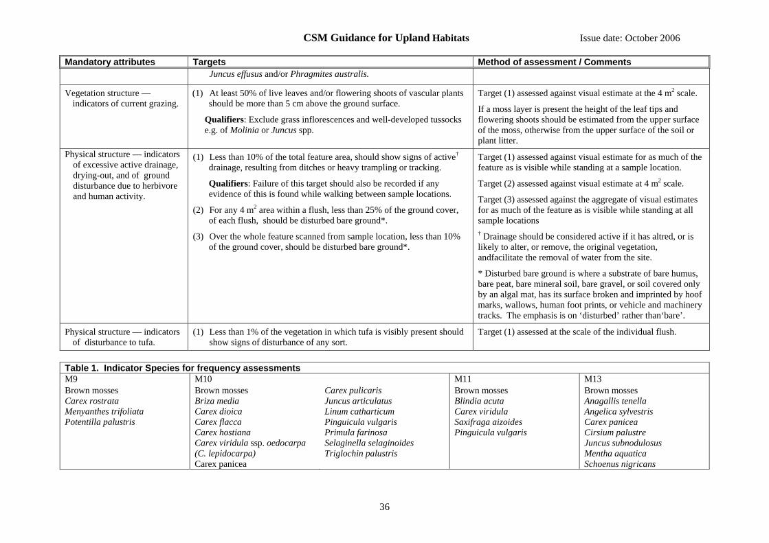
CSM Guidance for Upland Habitats Issue date: October 2006
36
Mandatory attributes Targets Method of assessment / Comments Juncus effusus and/or Phragmites australis.
Vegetation structure — indicators of current grazing.
(1) At least 50% of live leaves and/or flowering shoots of vascular plants should be more than 5 cm above the ground surface.
Qualifiers: Exclude grass inflorescences and well-developed tussocks e.g. of Molinia or Juncus spp.
Target (1) assessed against visual estimate at the 4 m2 scale.
If a moss layer is present the height of the leaf tips and flowering shoots should be estimated from the upper surface of the moss, otherwise from the upper surface of the soil or plant litter.
Physical structure — indicators of excessive active drainage, drying-out, and of ground disturbance due to herbivore and human activity.
(1) Less than 10% of the total feature area, should show signs of active† drainage, resulting from ditches or heavy trampling or tracking.
Qualifiers: Failure of this target should also be recorded if any evidence of this is found while walking between sample locations.
(2) For any 4 m2 area within a flush, less than 25% of the ground cover, of each flush, should be disturbed bare ground*.
(3) Over the whole feature scanned from sample location, less than 10% of the ground cover, should be disturbed bare ground*.
Target (1) assessed against visual estimate for as much of the feature as is visible while standing at a sample location.
Target (2) assessed against visual estimate at 4 m2 scale.
Target (3) assessed against the aggregate of visual estimates for as much of the feature as is visible while standing at all sample locations † Drainage should be considered active if it has altred, or is likely to alter, or remove, the original vegetation, andfacilitate the removal of water from the site.
* Disturbed bare ground is where a substrate of bare humus, bare peat, bare mineral soil, bare gravel, or soil covered only by an algal mat, has its surface broken and imprinted by hoof marks, wallows, human foot prints, or vehicle and machinery tracks. The emphasis is on ‘disturbed’ rather than‘bare’.
Physical structure — indicators of disturbance to tufa.
(1) Less than 1% of the vegetation in which tufa is visibly present should show signs of disturbance of any sort.
Target (1) assessed at the scale of the individual flush.
Table 1. Indicator Species for frequency assessments M9 M10 M11 M13 Brown mosses Carex rostrata Menyanthes trifoliata Potentilla palustris
Brown mosses Briza media Carex dioica Carex flacca Carex hostiana Carex viridula ssp. oedocarpa (C. lepidocarpa) Carex panicea
Carex pulicaris Juncus articulatus Linum catharticum Pinguicula vulgaris Primula farinosa Selaginella selaginoides Triglochin palustris
Brown mosses Blindia acuta Carex viridula Saxifraga aizoides Pinguicula vulgaris
Brown mosses Anagallis tenella Angelica sylvestris Carex panicea Cirsium palustre Juncus subnodulosus Mentha aquatica Schoenus nigricans

CSM Guidance for Upland Habitats Issue date: October 2006
37
Table 2. Indicator Species for cover assessments Any moss or liverwort spp. Carex spp — small to medium size spp.
Cladium mariscus Eleocharis spp.
Eriophorum spp. Juncus subnodulosus Kobresia simpliciuscula
Menyanthes trifoliata Molinia caerulea
Saxifraga aizoides Schoenus spp. Sesleria albicans
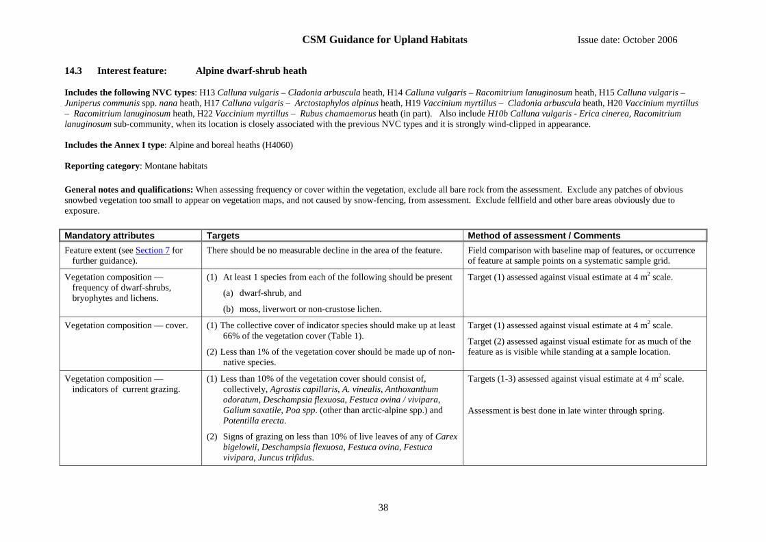
CSM Guidance for Upland Habitats Issue date: October 2006
38
14.3 Interest feature: Alpine dwarf-shrub heath
Includes the following NVC types: H13 Calluna vulgaris – Cladonia arbuscula heath, H14 Calluna vulgaris – Racomitrium lanuginosum heath, H15 Calluna vulgaris – Juniperus communis spp. nana heath, H17 Calluna vulgaris – Arctostaphylos alpinus heath, H19 Vaccinium myrtillus – Cladonia arbuscula heath, H20 Vaccinium myrtillus – Racomitrium lanuginosum heath, H22 Vaccinium myrtillus – Rubus chamaemorus heath (in part). Also include H10b Calluna vulgaris - Erica cinerea, Racomitrium lanuginosum sub-community, when its location is closely associated with the previous NVC types and it is strongly wind-clipped in appearance. Includes the Annex I type: Alpine and boreal heaths (H4060) Reporting category: Montane habitats General notes and qualifications: When assessing frequency or cover within the vegetation, exclude all bare rock from the assessment. Exclude any patches of obvious snowbed vegetation too small to appear on vegetation maps, and not caused by snow-fencing, from assessment. Exclude fellfield and other bare areas obviously due to exposure. Mandatory attributes Targets Method of assessment / Comments Feature extent (see Section 7 for
further guidance). There should be no measurable decline in the area of the feature. Field comparison with baseline map of features, or occurrence
of feature at sample points on a systematic sample grid.
Vegetation composition — frequency of dwarf-shrubs, bryophytes and lichens.
(1) At least 1 species from each of the following should be present
(a) dwarf-shrub, and
(b) moss, liverwort or non-crustose lichen.
Target (1) assessed against visual estimate at 4 m2 scale.
Vegetation composition — cover. (1) The collective cover of indicator species should make up at least 66% of the vegetation cover (Table 1).
(2) Less than 1% of the vegetation cover should be made up of non-native species.
Target (1) assessed against visual estimate at 4 m2 scale.
Target (2) assessed against visual estimate for as much of the feature as is visible while standing at a sample location.
Vegetation composition — indicators of current grazing.
(1) Less than 10% of the vegetation cover should consist of, collectively, Agrostis capillaris, A. vinealis, Anthoxanthum odoratum, Deschampsia flexuosa, Festuca ovina / vivipara, Galium saxatile, Poa spp. (other than arctic-alpine spp.) and Potentilla erecta.
(2) Signs of grazing on less than 10% of live leaves of any of Carex bigelowii, Deschampsia flexuosa, Festuca ovina, Festuca vivipara, Juncus trifidus.
Targets (1-3) assessed against visual estimate at 4 m2 scale.
Assessment is best done in late winter through spring.
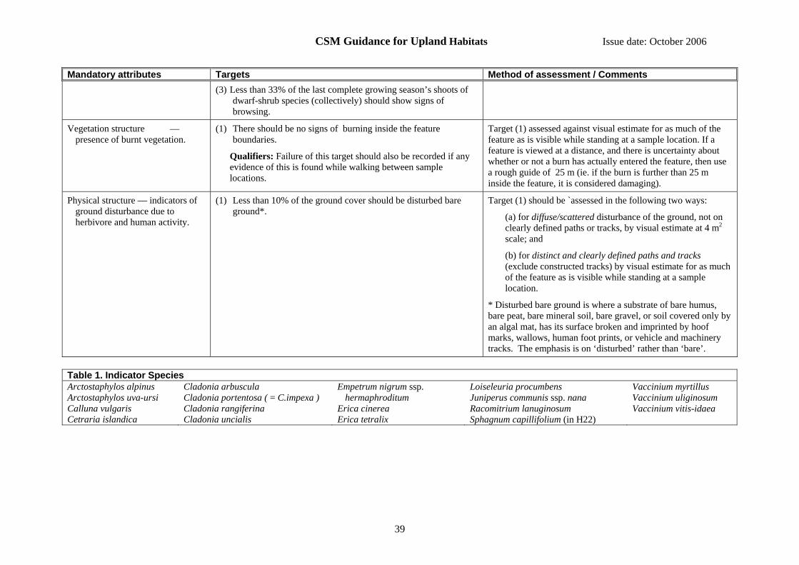
CSM Guidance for Upland Habitats Issue date: October 2006
39
Mandatory attributes Targets Method of assessment / Comments (3) Less than 33% of the last complete growing season’s shoots of
dwarf-shrub species (collectively) should show signs of browsing.
Vegetation structure — presence of burnt vegetation.
(1) There should be no signs of burning inside the feature boundaries.
Qualifiers: Failure of this target should also be recorded if any evidence of this is found while walking between sample locations.
Target (1) assessed against visual estimate for as much of the feature as is visible while standing at a sample location. If a feature is viewed at a distance, and there is uncertainty about whether or not a burn has actually entered the feature, then use a rough guide of 25 m (ie. if the burn is further than 25 m inside the feature, it is considered damaging).
Physical structure — indicators of ground disturbance due to herbivore and human activity.
(1) Less than 10% of the ground cover should be disturbed bare ground*.
Target (1) should be `assessed in the following two ways:
(a) for diffuse/scattered disturbance of the ground, not on clearly defined paths or tracks, by visual estimate at 4 m2 scale; and
(b) for distinct and clearly defined paths and tracks (exclude constructed tracks) by visual estimate for as much of the feature as is visible while standing at a sample location.
* Disturbed bare ground is where a substrate of bare humus, bare peat, bare mineral soil, bare gravel, or soil covered only by an algal mat, has its surface broken and imprinted by hoof marks, wallows, human foot prints, or vehicle and machinery tracks. The emphasis is on ‘disturbed’ rather than ‘bare’.
Table 1. Indicator Species Arctostaphylos alpinus Arctostaphylos uva-ursi Calluna vulgaris Cetraria islandica
Cladonia arbuscula Cladonia portentosa ( = C.impexa ) Cladonia rangiferina Cladonia uncialis
Empetrum nigrum ssp. hermaphroditum
Erica cinerea Erica tetralix
Loiseleuria procumbens Juniperus communis ssp. nana Racomitrium lanuginosum Sphagnum capillifolium (in H22)
Vaccinium myrtillus Vaccinium uliginosum Vaccinium vitis-idaea

CSM Guidance for Upland Habitats Issue date: October 2006
40
14.4 Interest feature: Alpine flush
Includes the following NVC types: M10 Carex dioica – Pinguicula vulgaris mire (but only at high altitudes in which there is an arctic-alpine floral element), M11 Carex demissa – Saxifraga aizoides mire (containing arctic-alpine spp.), M12 Carex saxatilis mire, M34 Carex demissa – Koenigia islandica flush Includes the Annex I type: Alpine pioneer formations of Caricion bicoloris–atrofuscae Reporting category: Fen, marsh and swamp General notes and qualifications: When assessing frequency or cover within the vegetation, exclude all bare rock from the assessment. Some stands of this feature type may be inaccessible and when this is the case an assessment at the patch scale based on what can be seen using binoculars or telescope will be acceptable. Mandatory attributes Targets Method of assessment / Comments Feature extent (see Section 7 for
further guidance). (1) There should be no measurable decline in the area of the
feature. Field comparison with baseline map of feature, or occurrence of feature at points on a systematic sample grid, or recording of location and number of individual patches if the feature is fragmented into very small patches.
Vegetation composition — frequency of indicator species.
(1) At least two indicator species should be present.
Target (1) assessed over 4 m2 quadrat.
For target (1) set maximum search time of 5 minutes per quadrat/flush.
Vegetation composition — cover of non-native species (of any life form).
(1) Less than 1% of vegetation cover should be made up of non-native species
Target (1) assessed against visual estimate for as much of the feature as is visible while standing at a sample location.
Vegetation structure — indicators of grazing.
(1) At least one flowering shoot of each species present should not be grazed (See Table 1).
Target (1) assessed against visual estimate at 4 m2 scale.
Physical structure — indicators of excessive drainage and drying-out
(1) Less than 10% of the total feature area, should show signs of drainage, resulting from ditches or heavy trampling or tracking.
Qualifiers: If there is doubt about the cause of active drainage then assume that the target fails. Failure of this target should also be recorded if any evidence of this is found while walking between sample locations.
Target (1) assessed against visual estimate for as much of the feature as is visible while standing at a sample location.
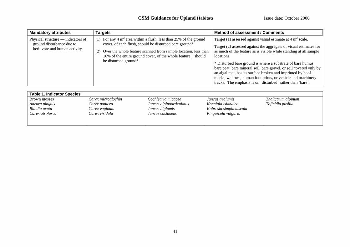
CSM Guidance for Upland Habitats Issue date: October 2006
41
Mandatory attributes Targets Method of assessment / Comments Physical structure — indicators of
ground disturbance due to herbivore and human activity.
(1) For any 4 m2 area within a flush, less than 25% of the ground cover, of each flush, should be disturbed bare ground*.
(2) Over the whole feature scanned from sample location, less than 10% of the entire ground cover, of the whole feature, should be disturbed ground*.
Target (1) assessed against visual estimate at 4 m2 scale.
Target (2) assessed against the aggregate of visual estimates for as much of the feature as is visible while standing at all sample locations.
* Disturbed bare ground is where a substrate of bare humus, bare peat, bare mineral soil, bare gravel, or soil covered only by an algal mat, has its surface broken and imprinted by hoof marks, wallows, human foot prints, or vehicle and machinery tracks. The emphasis is on ‘disturbed’ rather than ‘bare’.
Table 1. Indicator Species Brown mosses Aneura pinguis Blindia acuta Carex atrofusca
Carex microglochin Carex panicea Carex vaginata Carex viridula
Cochlearia micacea Juncus alpinoarticulatus Juncus biglumis Juncus castaneus
Juncus triglumis Koenigia islandica Kobresia simpliciuscula Pinguicula vulgaris
Thalictrum alpinum Tofieldia pusilla

CSM Guidance for Upland Habitats Issue date: October 2006
42
14.5 Interest feature: Alpine summit communities of moss, sedge and three-leaved rush
Includes the following NVC types: U7 Nardus stricta–Carex bigelowii grass-heath, U8 Carex bigelowii–Polytrichum alpinum sedge-heath, U9 Juncus trifidus–Racomitrium lanuginosum rush-heath, U10 Carex bigelowii–Racomitrium lanuginosum moss-heath, U11 Polytrichum sexangulare – Kiaeria starkei snow-bed, U12 Salix herbacea – Racomitrium heterostichum snow-bed, U14 Alchemilla alpina – Sibbaldia procumbens dwarf-herb community. Corresponds to the Annex I type: Siliceous alpine and boreal grasslands (H6150) Reporting category: Montane habitats General notes and qualifications: When assessing frequency or cover within the vegetation, exclude all bare rock from the assessment. Mandatory attributes Targets Method of assessment / Comments Feature extent (see Section 7 for
further guidance). (1) There should be no measurable decline in the area of the feature. Field comparison with baseline map of features, or
occurrence of feature at sample points on a systematic sample grid.
Vegetation composition — cover of indicator species (not U7).
(1) At least 25% of the vegetation cover should consist of indicator species (Table 1).
(2) Less than 20% of vegetation cover should consist, collectively, of Agrostis capillaris, Agrostis vinealis, Anthoxanthum odoratum, Deschampsia flexuosa, Festuca ovina / vivipara, Galium saxatile, Poa spp. (other than arctic-alpine spp.) and Potentilla erecta.
Targets (1 and 2) assessed against visual estimate at 4 m2 scale.
Vegetation composition — cover of non-native species
(1) Less than 1% of vegetation cover should be made up of non-native species
Target (1) assessed against visual estimate for as much of the feature as is visible while standing at a sample location.
Vegetation structure — indicators of current grazing.
(1) Less than 10% of grass and sedge tillers uprooted;
(2) Less than 10% of live leaves and/or flowers of any of Alchemilla alpina, Carex bigelowii, Deschampsia flexuosa, Festuca ovina, Festuca vivipara, Juncus trifidus, Nardus stricta, Sibbaldia procumbens, Thymus polytrichus, with any evidence of grazing;
(3) Less than 50% of live leaves of any of Agrostis capillaris, Agrostis vinealis, Anthoxanthum odoratum, Poa spp., with any evidence of grazing.
Targets (1-3) assessed against visual estimate at 4 m2 scale. Make final assessment based on majority of applicable targets (e.g. if the feature passes on one and fails on two then fail it).
Vegetation structure — presence of (1) There should be no signs of burning inside the feature Target (1) assessed against visual estimate for as much of the

CSM Guidance for Upland Habitats Issue date: October 2006
43
Mandatory attributes Targets Method of assessment / Comments burnt vegetation. boundaries.
Qualifiers: Failure of this target should also be recorded if any evidence of this is found while walking between sample locations.
feature as is visible while standing at a sample location. If a feature is viewed at a distance, and there is uncertainty about whether or not a burn has actually entered the feature, then use a rough guide of 25 m (ie. if the burn is further than 25 m inside the feature, it is considered damaging).
Physical structure — indicators of ground disturbance due to herbivore and human activity.
(1) Less than 10% of the ground cover should be disturbed bare ground*.
Target (1) assessed in the following two ways:
(a) for diffuse/scattered disturbance of the ground, not on clearly defined paths or tracks, by visual estimate at 4 m2 scale; and
(b) for distinct and clearly defined paths and tracks (exclude constructed tracks) by visual estimate for as much of the feature as is visible while standing at a sample location.
* Disturbed bare ground is where a substrate of bare humus, bare peat, bare mineral soil, bare gravel, or soil covered only by an algal mat, has its surface broken and imprinted by hoof marks, wallows, human foot prints, or vehicle and machinery tracks. The emphasis is on ‘disturbed’ rather than ‘bare’.
Table 1. Indicator Species Alchemilla alpina Carex bigelowii Cetraria islandica Cladonia arbuscula
Cladonia uncialis Dicranum fuscescens Empetrum nigrum ssp. hermaphroditum Gnaphalium supinum
Juncus trifidus Kiaeria starkei Nardus stricta Polytrichum alpinum
Ptilidium ciliare Racomitrium lanuginosum Rhytidiadelphus loreus Salix herbacea
Sibbaldia procumbens Vaccinium myrtillus

CSM Guidance for Upland Habitats Issue date: October 2006
44
14.6 Interest feature: Blanket bog and valley bog (upland)
Includes the following NVC types: M1 Sphagnum auriculatum bog pool community, M2 Sphagnum cuspidatum / recurvum bog pool community, M3 Eriophorum angustifolium bog pool community, M17 Scirpus cespitosus – Eriophorum vaginatum blanket mire, M18 Erica tetralix – Sphagnum papillosum raised and blanket mire, M19 Calluna vulgaris – Eriophorum vaginatum blanket mire, M20 Eriophorum vaginatum blanket and raised mire, M21 Narthecium ossifragum – Sphagnum papillosum valley mire. Some of these types may also occur on lowland raised bogs and valley mires, which are covered by the Lowland wetland guidance. The above communities can be heavily influenced by management, notably burning and grazing, leading to degradation and replacement by the following communities: H9 Calluna vulgaris – Deschampsia flexuosa heath, H12 Calluna vulgaris – Vaccinium myrtilus heath, M15 Scirpus cespitosus – Erica tetralix wet heath, M16 Erica tetralix – Sphagnum compactum wet heath, M25 Molinia caerulea – Potentilla erecta mire, U6 Juncus squarrosus – Festuca ovina grassland. See below on how to assess the condition of these communities. Includes the Annex I types: Blanket bogs (H7130), Depressions on peat substrates of the Rhynchosporion (H7150). Reporting category: Bogs General notes and qualifications:
• Where blanket bog communities are being replaced by either degraded mire communities (M15, M16, M25), drier heath communities (H8, H12) or grassland type U6, and where restoration back to blanket bog is considered to be feasible, then the degraded communities should be assessed using the attributes and targets ascribed to blanket bog.
• Rhynchosporion: given the intimate relationship between blanket bog and the Rhynchosporion, with the latter typically occurring as a minor component of the former, no specific guidance has been developed for Rhynchosporion in a blanket bog setting. It should be assumed to reflect the condition of the surrounding blanket bog. Guidance for the assessment of Rhynchosporion in a lowland setting is given in the Lowland Wetland Guidance.
• When assessing frequency or cover within the vegetation, exclude all bare rock and recently burned ground from the assessment. Recently burned areas can be recognised by the presence of loose charcoal on partially burnt stems that easily produces black marks on fingers and clothes (it takes two to three years for charcoal to be weathered from stems).
Mandatory attributes Targets Method of assessment / Comments Feature extent (see Section 7 for
further guidance). (1) There should be no measurable decline in the area of the
feature. Field comparison with baseline map of feature, or occurrence of feature at points on a systematic sample grid, or recording of location and number of individual patches if the feature is fragmented into very small patches (the last may be all that is practical for Rhynchosporion hollows).
Vegetation composition — frequency of indicator species.
(1) At least 6 indicator species should be present (Table 1).
Qualifiers: In blanket bog, Sphagnum fallax (S. recurvum p.p.) scores one if other species of Sphagnum are present, but scores zero if it is the only species of Sphagnum present.
Target (1) assessed against visual estimate at 4 m2 scale.
Score each Sphagnum sp separately.

CSM Guidance for Upland Habitats Issue date: October 2006
45
Mandatory attributes Targets Method of assessment / Comments In valley bog it scores as one.
Vegetation composition — cover of indicator species.
(1) At least 50% of vegetation cover should consist of at least 3 indicator species (Table 1).
(2) Sphagnum cover should not consist only of Sphagnum fallax (S. recurvum p.p.).
(3) Any one of Eriophorum vaginatum, Ericaceous species collectively, or Trichophorum should not individually exceed 75% of the vegetation cover.
Targets (1-3) assessed against visual estimate at 4 m2 scale.
Vegetation composition — cover of other species
(1) Less than 1% of vegetation cover should be made up of non-native species.
(2) Less than 10% of vegetation cover should be made up of scattered native trees and scrub.
Qualifiers: For target (2) exclude Betula nana and Myrica gale. Refer to Woodland guidance for Bog Woodland.
(3) Less than 1% of vegetation cover should consist of, collectively, Agrostis capillaris, Holcus lanatus, Phragmites australis, Pteridium aquilinum, Ranunculus repens.
Targets (1 and 2) assessed against visual estimate for as much of the feature as is visible while standing at a sample location.
Target (3) assessed at two scales and should be met at both scales:
(a) against visual estimate at 4 m2 scale; and
(b) against visual estimate for as much of the feature as is visible while standing at a sample location.
Vegetation structure — indicators of browsing.
(1) Less than 33% of the last complete growing season’s shoots of dwarf-shrub species (collectively but excluding Betula nana and Myrica gale) should shows signs of browsing.
(2) In pioneer stage regrowth, or where there is Betula nana or Myrica gale (at any stage of regrowth), less than 66% of the last complete growing season’s shoots of the dwarf-shrubs, (collectively) should show signs of browsing.
Targets (1 and 2) assessed against visual estimate at 4 m2 scale.
Assessment is best done in late winter through spring.
Vegetation structure — disturbance (1) There should be no observable signs of burning into the moss, liverwort or lichen layer or exposure of peat surface due to burning.
(2) There should be no signs of burning or other disturbance (e.g. mowing) in the sensitive areas defined in Table 2.
Targets (1 and 2) assessed against visual estimate for as much of the feature as is visible while standing at a sample location.
For target (2) if a feature is viewed at a distance, and there is uncertainty about whether or not a burn has actually entered the feature, then use a rough guide of 25 m (ie. if the burn is further than 25 m inside the feature, it is considered damaging).
There is a general policy in Wales and Northern Ireland of no
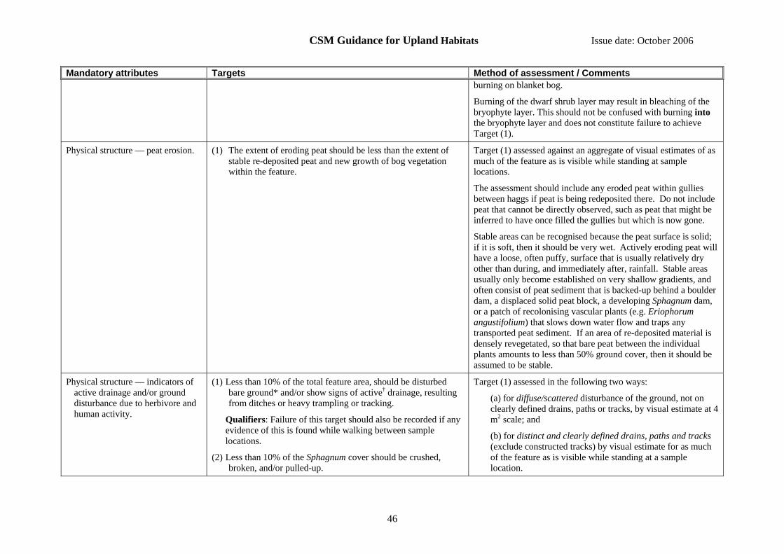
CSM Guidance for Upland Habitats Issue date: October 2006
46
Mandatory attributes Targets Method of assessment / Comments burning on blanket bog.
Burning of the dwarf shrub layer may result in bleaching of the bryophyte layer. This should not be confused with burning into the bryophyte layer and does not constitute failure to achieve Target (1).
Physical structure — peat erosion.
(1) The extent of eroding peat should be less than the extent of stable re-deposited peat and new growth of bog vegetation within the feature.
Target (1) assessed against an aggregate of visual estimates of as much of the feature as is visible while standing at sample locations.
The assessment should include any eroded peat within gullies between haggs if peat is being redeposited there. Do not include peat that cannot be directly observed, such as peat that might be inferred to have once filled the gullies but which is now gone.
Stable areas can be recognised because the peat surface is solid; if it is soft, then it should be very wet. Actively eroding peat will have a loose, often puffy, surface that is usually relatively dry other than during, and immediately after, rainfall. Stable areas usually only become established on very shallow gradients, and often consist of peat sediment that is backed-up behind a boulder dam, a displaced solid peat block, a developing Sphagnum dam, or a patch of recolonising vascular plants (e.g. Eriophorum angustifolium) that slows down water flow and traps any transported peat sediment. If an area of re-deposited material is densely revegetated, so that bare peat between the individual plants amounts to less than 50% ground cover, then it should be assumed to be stable.
Physical structure — indicators of active drainage and/or ground disturbance due to herbivore and human activity.
(1) Less than 10% of the total feature area, should be disturbed bare ground* and/or show signs of active† drainage, resulting from ditches or heavy trampling or tracking.
Qualifiers: Failure of this target should also be recorded if any evidence of this is found while walking between sample locations.
(2) Less than 10% of the Sphagnum cover should be crushed, broken, and/or pulled-up.
Target (1) assessed in the following two ways:
(a) for diffuse/scattered disturbance of the ground, not on clearly defined drains, paths or tracks, by visual estimate at 4 m2 scale; and
(b) for distinct and clearly defined drains, paths and tracks (exclude constructed tracks) by visual estimate for as much of the feature as is visible while standing at a sample location.
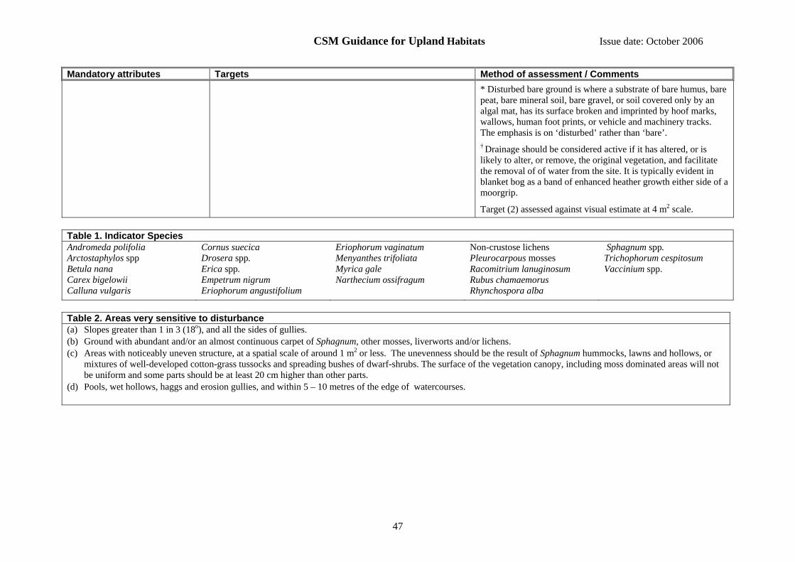
CSM Guidance for Upland Habitats Issue date: October 2006
47
Mandatory attributes Targets Method of assessment / Comments
* Disturbed bare ground is where a substrate of bare humus, bare peat, bare mineral soil, bare gravel, or soil covered only by an algal mat, has its surface broken and imprinted by hoof marks, wallows, human foot prints, or vehicle and machinery tracks. The emphasis is on ‘disturbed’ rather than ‘bare’. † Drainage should be considered active if it has altered, or is likely to alter, or remove, the original vegetation, and facilitate the removal of of water from the site. It is typically evident in blanket bog as a band of enhanced heather growth either side of a moorgrip.
Target (2) assessed against visual estimate at 4 m2 scale. Table 1. Indicator Species Andromeda polifolia Arctostaphylos spp Betula nana Carex bigelowii Calluna vulgaris
Cornus suecica Drosera spp. Erica spp. Empetrum nigrum Eriophorum angustifolium
Eriophorum vaginatum Menyanthes trifoliata Myrica gale Narthecium ossifragum
Non-crustose lichens Pleurocarpous mosses Racomitrium lanuginosum Rubus chamaemorus Rhynchospora alba
Sphagnum spp. Trichophorum cespitosum Vaccinium spp.
Table 2. Areas very sensitive to disturbance (a) Slopes greater than 1 in 3 (18o), and all the sides of gullies. (b) Ground with abundant and/or an almost continuous carpet of Sphagnum, other mosses, liverworts and/or lichens. (c) Areas with noticeably uneven structure, at a spatial scale of around 1 m2 or less. The unevenness should be the result of Sphagnum hummocks, lawns and hollows, or
mixtures of well-developed cotton-grass tussocks and spreading bushes of dwarf-shrubs. The surface of the vegetation canopy, including moss dominated areas will not be uniform and some parts should be at least 20 cm higher than other parts.
(d) Pools, wet hollows, haggs and erosion gullies, and within 5 – 10 metres of the edge of watercourses.

CSM Guidance for Upland Habitats Issue date: October 2006
48
14.7 Interest feature: Calaminarian grassland and serpentine heath (upland)
Includes the following NVC types: Calaminarian grasslands correspond to the OV37 Festuca ovina – Minuartia verna community. Other than H5 Erica vagans – Schoenus nigricans heath and H6 Erica vagans – Ulex europaeus heath, which are restricted to the Lizard in Cornwall, serpentine heaths mostly do not correspond to unique NVC community types but are represented by a variety of communities e.g. H10d, H7, made distinctive by the presence of a range of basicolous herbs. A single feature may include a wide range of vegetation cover and vegetation types with mixtures of any, or all, of the following: sparsely vegetated rocky debris similar to fellfield, flushes and sedge lawns, grassland and heath dominated by dwarf-shrubs. For lowland examples of these habitats refer to the Lowland grassland or Lowland heathland guidance. Includes the Annex I type: Calaminarian grasslands of the Violetalia calaminariae (H6130) (part) Reporting category: A variety of reporting types can occur within a single feature: fen, marsh and swamp; montane habitats; calcareous grassland; inland rock; and dwarf shrub heath. The predominant type should be used for national reporting. General notes and qualifications When assessing frequency or cover within the vegetation, exclude all bare rock from the assessment. Mandatory attributes Targets Method of assessment / Comments Feature extent (see Section 7 for
further guidance). (1) There should be no measurable decline in the area of the feature. Field comparison with baseline map of features, or occurrence
of feature at sample points on a systematic sample grid.
Vegetation composition — frequency of indicator species.
(1) At least 3 indicator species should be present (Table 1).
Qualifiers: Cochlearia spp. collectively count as one, Euphrasia spp. collectively count as one.
Target (1) assessed against visual estimate at 4 m2 scale.
Vegetation composition — cover (1) Less than 1% of vegetation cover should be made up of non-native species.
(2) Less than 1% of vegetation cover should consist of, collectively, Alopecurus geniculatus, Bellis perennis, Cirsium arvense, Cirsium vulgare, Holcus lanatus, large docks (excluding Rumex acetosa), Lolium perenne, Phalaris arundinacea, Pteridium aquilinum, Ranunculus acris, Ranunculus repens, Rubus fruticosus, Sagina procumbens, Senecio jacobaea, Stellaria media, Urtica dioica.
(3) Less than 10% of the vegetation cover should consist of Juncus effusus.
Target (1) assessed against visual estimate for as much of the feature as is visible while standing at a sample location.
Targets (2 and 3) assessed at two levels, and should be met at both scales:
(a) against visual estimate at 4 m2 scale; and
(b) against visual estimate for as much of the feature as is visible while standing at a sample location.
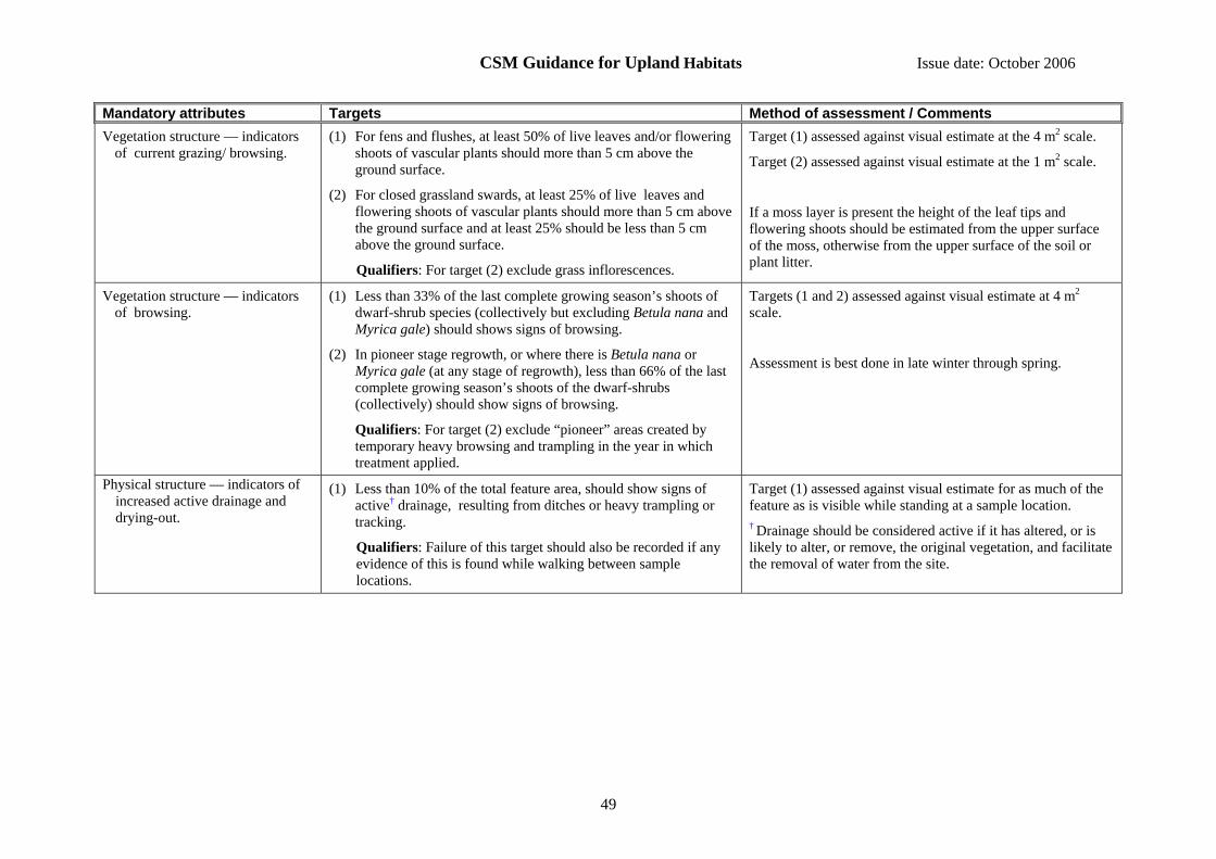
CSM Guidance for Upland Habitats Issue date: October 2006
49
Mandatory attributes Targets Method of assessment / Comments Vegetation structure — indicators
of current grazing/ browsing. (1) For fens and flushes, at least 50% of live leaves and/or flowering
shoots of vascular plants should more than 5 cm above the ground surface.
(2) For closed grassland swards, at least 25% of live leaves and flowering shoots of vascular plants should more than 5 cm above the ground surface and at least 25% should be less than 5 cm above the ground surface.
Qualifiers: For target (2) exclude grass inflorescences.
Target (1) assessed against visual estimate at the 4 m2 scale.
Target (2) assessed against visual estimate at the 1 m2 scale.
If a moss layer is present the height of the leaf tips and flowering shoots should be estimated from the upper surface of the moss, otherwise from the upper surface of the soil or plant litter.
Vegetation structure — indicators of browsing.
(1) Less than 33% of the last complete growing season’s shoots of dwarf-shrub species (collectively but excluding Betula nana and Myrica gale) should shows signs of browsing.
(2) In pioneer stage regrowth, or where there is Betula nana or Myrica gale (at any stage of regrowth), less than 66% of the last complete growing season’s shoots of the dwarf-shrubs (collectively) should show signs of browsing.
Qualifiers: For target (2) exclude “pioneer” areas created by temporary heavy browsing and trampling in the year in which treatment applied.
Targets (1 and 2) assessed against visual estimate at 4 m2 scale.
Assessment is best done in late winter through spring.
Physical structure — indicators of increased active drainage and drying-out.
(1) Less than 10% of the total feature area, should show signs of active† drainage, resulting from ditches or heavy trampling or tracking.
Qualifiers: Failure of this target should also be recorded if any evidence of this is found while walking between sample locations.
Target (1) assessed against visual estimate for as much of the feature as is visible while standing at a sample location. † Drainage should be considered active if it has altered, or is likely to alter, or remove, the original vegetation, and facilitate the removal of water from the site.
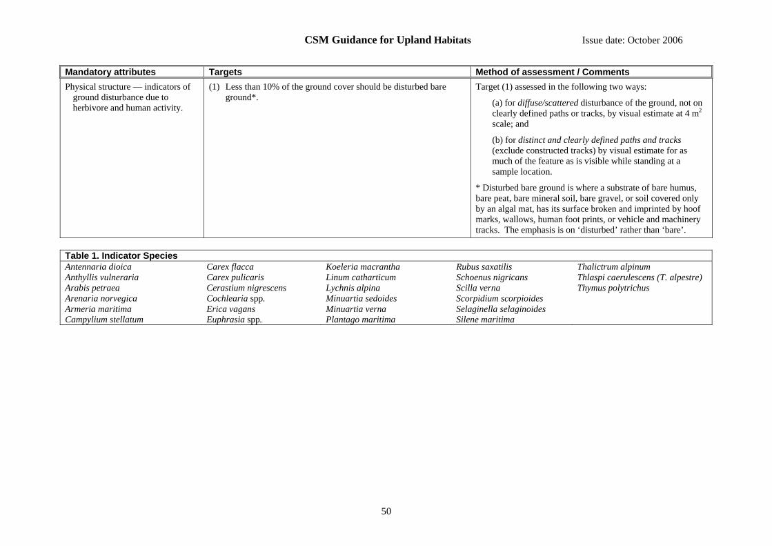
CSM Guidance for Upland Habitats Issue date: October 2006
50
Mandatory attributes Targets Method of assessment / Comments Physical structure — indicators of
ground disturbance due to herbivore and human activity.
(1) Less than 10% of the ground cover should be disturbed bare ground*.
Target (1) assessed in the following two ways:
(a) for diffuse/scattered disturbance of the ground, not on clearly defined paths or tracks, by visual estimate at 4 m2 scale; and
(b) for distinct and clearly defined paths and tracks (exclude constructed tracks) by visual estimate for as much of the feature as is visible while standing at a sample location.
* Disturbed bare ground is where a substrate of bare humus, bare peat, bare mineral soil, bare gravel, or soil covered only by an algal mat, has its surface broken and imprinted by hoof marks, wallows, human foot prints, or vehicle and machinery tracks. The emphasis is on ‘disturbed’ rather than ‘bare’.
Table 1. Indicator Species Antennaria dioica Anthyllis vulneraria Arabis petraea Arenaria norvegica Armeria maritima Campylium stellatum
Carex flacca Carex pulicaris Cerastium nigrescens Cochlearia spp. Erica vagans Euphrasia spp.
Koeleria macrantha Linum catharticum Lychnis alpina Minuartia sedoides Minuartia verna Plantago maritima
Rubus saxatilis Schoenus nigricans Scilla verna Scorpidium scorpioides Selaginella selaginoides Silene maritima
Thalictrum alpinum Thlaspi caerulescens (T. alpestre) Thymus polytrichus

CSM Guidance for Upland Habitats Issue date: October 2006
51
14.8 Interest feature: Calcareous grassland (upland)
Includes the following NVC types: CG9 Sesleria albicans – Galium sterneri grassland, CG10 Festuca ovina – Agrostis capillaris – Thymus praecox grassland, CG11 Festuca ovina - Agrostis capillaris - Alchemilla alpina grassland, CG12 Festuca ovina – Alchemilla alpina – Silene acaulis dwarf-herb community, CG13 Dryas octopetala – Carex flacca heath, CG14 Dryas octopetala – Silene acaulis ledge community, U4 Festuca ovina – Agrostis capillaris – Galium saxatile (species rich types, not fully described in the NVC, with abundant taller herbs), U5c Nardus stricta – Galium saxatile grassland, Carex panicea – Viola riviniana sub-community. For lowland stands of CG9 refer to the Lowland grassland guidance. Includes the Annex I types: Alpine and subalpine calcareous grassland (H6170) Species-rich Nardus grassland on siliceous substrates in montane areas (and submontane areas in continental Europe) (H6230) Semi-natural dry grassland and scrubland facies on calcareous substrates (Festuco-Brometalia) (H6210) (part) Reporting category: Calcareous grassland General notes and qualifications: When assessing frequency or cover within the vegetation, exclude all bare rock from the assessment. Where CG14 is involved, and is inaccessible, then an assessment at the patch scale based on what can be seen using binoculars or a telescope will be acceptable. Rockfalls and landslips can sometimes obliterate portions of this feature type and, if substantial, this should be recorded as a loss of extent. Mandatory attributes Targets Method of assessment / Comments Feature extent (see Section 7 for
further guidance). (1) There should be no measurable decline in the area of the
feature. Field comparison with baseline map of features, or occurrence of feature at sample points on a systematic sample grid.
Vegetation composition — frequency of indicator species.
(1) At least 2 indicator species should be present (see Tables 1-3).
Qualifiers: Euphrasia spp. should be counted as one species.
Target (1) assessed against visual estimate at 1 m2 scale.
Vegetation composition — cover.
(1) At least 33% of vegetation cover should consist of (a) forbs or (b) Dryas octopetala. Rich sward of CG12 or CG14 could have a higher target, set on a site specific basis.
(2) Less than 1% of vegetation cover should be made up of non-native species.
(3) Less than 10% of vegetation cover should be made up of bracken and/or scattered native trees and scrub.
(4) The percentage of vegetation cover made up collectively, of Bellis perennis and/or Ranunculus repens should be less than 25%.
(5) Less than 1% of vegetation cover should consist of,
Targets (1 and 4) assessed against visual estimate at 1 m2 scale.
Targets (2 and 3) assessed against visual estimate for as much of the feature as is visible while standing at a sample location.
Targets (5 and 6) assessed at two scales, and should be met at both scales:
a) against a visual estimate at 1 m2; and
b) against visual estimate for as much of the feature as is visible while standing at a sample location.
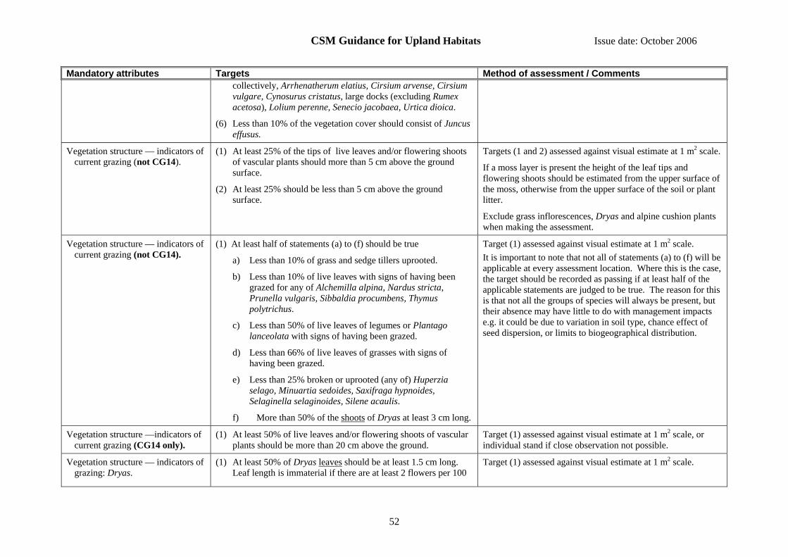
CSM Guidance for Upland Habitats Issue date: October 2006
52
Mandatory attributes Targets Method of assessment / Comments collectively, Arrhenatherum elatius, Cirsium arvense, Cirsium vulgare, Cynosurus cristatus, large docks (excluding Rumex acetosa), Lolium perenne, Senecio jacobaea, Urtica dioica.
(6) Less than 10% of the vegetation cover should consist of Juncus effusus.
Vegetation structure — indicators of current grazing (not CG14).
(1) At least 25% of the tips of live leaves and/or flowering shoots of vascular plants should more than 5 cm above the ground surface.
(2) At least 25% should be less than 5 cm above the ground surface.
Targets (1 and 2) assessed against visual estimate at 1 m2 scale.
If a moss layer is present the height of the leaf tips and flowering shoots should be estimated from the upper surface of the moss, otherwise from the upper surface of the soil or plant litter.
Exclude grass inflorescences, Dryas and alpine cushion plants when making the assessment.
Vegetation structure — indicators of current grazing (not CG14).
(1) At least half of statements (a) to (f) should be true
a) Less than 10% of grass and sedge tillers uprooted.
b) Less than 10% of live leaves with signs of having been grazed for any of Alchemilla alpina, Nardus stricta, Prunella vulgaris, Sibbaldia procumbens, Thymus polytrichus.
c) Less than 50% of live leaves of legumes or Plantago lanceolata with signs of having been grazed.
d) Less than 66% of live leaves of grasses with signs of having been grazed.
e) Less than 25% broken or uprooted (any of) Huperzia selago, Minuartia sedoides, Saxifraga hypnoides, Selaginella selaginoides, Silene acaulis.
f) More than 50% of the shoots of Dryas at least 3 cm long.
Target (1) assessed against visual estimate at 1 m2 scale. It is important to note that not all of statements (a) to (f) will be applicable at every assessment location. Where this is the case, the target should be recorded as passing if at least half of the applicable statements are judged to be true. The reason for this is that not all the groups of species will always be present, but their absence may have little to do with management impacts e.g. it could be due to variation in soil type, chance effect of seed dispersion, or limits to biogeographical distribution.
Vegetation structure —indicators of current grazing (CG14 only).
(1) At least 50% of live leaves and/or flowering shoots of vascular plants should be more than 20 cm above the ground.
Target (1) assessed against visual estimate at 1 m2 scale, or individual stand if close observation not possible.
Vegetation structure — indicators of grazing: Dryas.
(1) At least 50% of Dryas leaves should be at least 1.5 cm long. Leaf length is immaterial if there are at least 2 flowers per 100
Target (1) assessed against visual estimate at 1 m2 scale.
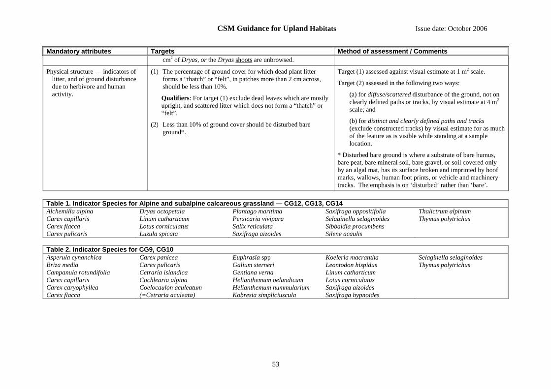
CSM Guidance for Upland Habitats Issue date: October 2006
53
Mandatory attributes Targets Method of assessment / Comments cm2 of Dryas, or the Dryas shoots are unbrowsed.
Physical structure — indicators of litter, and of ground disturbance due to herbivore and human activity.
(1) The percentage of ground cover for which dead plant litter forms a “thatch” or “felt”, in patches more than 2 cm across, should be less than 10%.
Qualifiers: For target (1) exclude dead leaves which are mostly upright, and scattered litter which does not form a “thatch” or “felt”.
(2) Less than 10% of ground cover should be disturbed bare ground*.
Target (1) assessed against visual estimate at 1 m2 scale.
Target (2) assessed in the following two ways:
(a) for diffuse/scattered disturbance of the ground, not on clearly defined paths or tracks, by visual estimate at 4 m2 scale; and
(b) for distinct and clearly defined paths and tracks (exclude constructed tracks) by visual estimate for as much of the feature as is visible while standing at a sample location.
* Disturbed bare ground is where a substrate of bare humus, bare peat, bare mineral soil, bare gravel, or soil covered only by an algal mat, has its surface broken and imprinted by hoof marks, wallows, human foot prints, or vehicle and machinery tracks. The emphasis is on ‘disturbed’ rather than ‘bare’.
Table 1. Indicator Species for Alpine and subalpine calcareous grassland — CG12, CG13, CG14 Alchemilla alpina Carex capillaris Carex flacca Carex pulicaris
Dryas octopetala Linum catharticum Lotus corniculatus Luzula spicata
Plantago maritima Persicaria vivipara Salix reticulata Saxifraga aizoides
Saxifraga oppositifolia Selaginella selaginoides Sibbaldia procumbens Silene acaulis
Thalictrum alpinum Thymus polytrichus
Table 2. Indicator Species for CG9, CG10 Asperula cynanchica Briza media Campanula rotundifolia Carex capillaris Carex caryophyllea Carex flacca
Carex panicea Carex pulicaris Cetraria islandica Cochlearia alpina Coelocaulon aculeatum (=Cetraria aculeata)
Euphrasia spp Galium sterneri Gentiana verna Helianthemum oelandicum Helianthemum nummularium Kobresia simpliciuscula
Koeleria macrantha Leontodon hispidus Linum catharticum Lotus corniculatus Saxifraga aizoides Saxifraga hypnoides
Selaginella selaginoides Thymus polytrichus

CSM Guidance for Upland Habitats Issue date: October 2006
54
Table 3. Indicator Species for Species-rich Nardus grassland — CG10 (not on limestone), CG11 (not on limestone), U4 (species rich types), U5c Alchemilla alpina Alchemilla glabra Angelica sylvestris Briza media
Campanula rotundifolia Carex caryophyllea Carex panicea Cerastium fontanum
Danthonia decumbens Filipendula ulmaria Galium verum Geum rivale
Lathyrus linifolius Lotus corniculatus Pinguicula vulgaris Persicaria vivipara
Stachys officinalis (S. betonica) Succisa pratensis Thymus polytrichus Veronica officinalis
CSM Guidance for Upland Habitats Issue date: October 2006
55
14.9 Interest feature: Calcareous rocky slope
Includes the following NVC types: OV39 Asplenium trichomanes – Asplenium ruta-muraria community, OV40 Asplenium viride – Cystopteris fragilis community and possibly other types not described by the NVC. Includes the Annex I type: Calcareous rocky slopes with chasmophytic vegetation (H8210) Reporting category: Inland rock General notes and qualifications: When assessing frequency or cover within the vegetation, exclude all bare rock from the assessment. Some stands of this feature type may be inaccessible and when this is the case an assessment at the patch scale based on what can be seen using binoculars or telescope will be acceptable. Mandatory attributes Targets Method of assessment / Comments Feature extent (see Section 7 for
further guidance). (1) There should be no measurable decline in the area of the
feature. Field comparison with baseline map of feature, or occurrence of feature at points on a systematic sample grid, or recording of location and number of individual patches if the feature is fragmented into very small patches.
Vegetation composition — frequency of indicator species.
(1) At least 4 indicator species should be present (Table 1).
Qualifiers: Hieracium spp. should be counted as one species.
Target (1) assessed against visual estimate for as much of the feature as is visible while standing at a sample location.
Vegetation composition — cover (1) Less than 1% of vegetation cover should be made up of non-native species.
(2) Less than 25% of ground cover should be made up of bracken and/or scattered native trees and scrub.
Targets (1 and 2) assessed against visual estimate for as much of the feature as is visible while standing at a sample location.
Vegetation structure — indicators of current grazing.
(1) For any single indicator species, less than 50% of live leaves (forbs) or the shoots (dwarf-shrubs) should show signs of having been grazed or browsed.
Target (1) assessed against visual estimate for as much of the feature as is visible while standing at a sample location.
Table 1. Indicator Species Alchemilla alpina Arenaria serpyllifolia Asplenium adiantum-nigrum Asplenium ruta-muraria Asplenium trichomanes
Asplenium viride Carex capillaris Carex pulicaris Ceterach officinarum Cystopteris fragilis
Dryas octopetala Helianthemum nummularium Hieracium spp. Koeleria macrantha Persicaria vivipara
Polystichum aculeatum P. lonchitis P. setiferum Saxifraga aizoides Saxifraga oppositifolia
Sedum acre Selaginella selaginoides Silene acaulis Thalictrum alpinum Thymus polytrichus

CSM Guidance for Upland Habitats Issue date: October 2006
56
14.10 Interest feature: Calcareous scree
Includes the following NVC types: OV38 Gymnocarpium robertianum – Arrhenatherum elatius community, OV39 Asplenium trichomanes – Asplenium ruta-muraria community, OV40 Asplenium viride – Cystopteris fragilis community, CG14 Dryas octopetala – Silene acaulis ledge community may occur in fragmentary form; a variety of other NVC communities, or communities not described in the NVC, may occur in fragmentary form where the scree is more stable. Includes the Annex I type: Calcareous and calcschist screes of the montane to alpine levels (Thlaspietea rotundifolii) (H8120) Reporting category: Inland rock General notes and qualifications: When assessing frequency or cover within the vegetation, exclude all bare rock from the assessment. Some stands of this feature type may be inaccessible and when this is the case an assessment at the patch scale based on what can be seen using binoculars or telescope will be acceptable Mandatory attributes Targets Method of assessment / Comments Feature extent (see Section 7 for
further guidance). (1) There should be no measurable decline in the area of the feature. Field comparison with baseline map of feature, or occurrence
of feature at points on a systematic sample grid, or recording of location and number of individual patches if the feature is fragmented into very small patches.
Vegetation composition —frequency of indicator species.
(1) For OV38: at least 2 indicator species should be present (Table 1).
For OV39, OV40 and CG14: at least 4 indicator species should be present (Table 1).
Qualifiers: Hieracium spp. should be counted as one species.
Target (1) assessed against visual estimate at 4 m2 scale, or individual stand if close observation not possible.
Vegetation composition — cover (1) Less than 1% of vegetation cover should be made up of non-native species.
(2) Less than 25% of ground cover should be made up of bracken, scattered native trees and scrub.
(3) Less than 50% of vegetation cover should be made up of Arrhenatherum elatius.
(4) Less than 1% of vegetation cover should consist of, collectively, Cirsium arvense, Cirsium vulgare, large docks (excluding Rumex acetosa), Rubus fruticosus, Senecio jacobaea, or Urtica dioica.
Targets (1 and 4) assessed against visual estimate for as much of the feature as is visible while standing at a sample location.
Vegetation structure —cover and signs of current grazing/browsing.
(1) At least 33% of ground cover should be free from overgrowth by vascular plants to allow persistence of algal/lichen/bryophyte flora on open rock surfaces .
Targets (1 and 2) assessed against visual estimate for as much of the feature as is visible while standing at a sample location.
CSM Guidance for Upland Habitats Issue date: October 2006
57
Mandatory attributes Targets Method of assessment / Comments (2) For any single indicator species, less than 50% of live leaves
(forbs) or the shoots (dwarf-shrubs) should show signs of having been grazed or browsed.
Physical structure — indicators of ground disturbance due to herbivore and human activity.
(1) Less than 10% of the ground cover should be disturbed by human or animal paths, scree running, or vehicles.
Target (1) assessed against visual estimate for as much of the feature as is visible while standing at a sample location.
This can be recognised at a distance since newly exposed material has a different colour.
Table 1. Indicator Species OV38 OV39, OV40, CG14 Geranium robertianum Gymnocarpium robertianum Mercurialis perennis Mycelis muralis Oxalis acetosella Teucrium scorodonia Alchemilla alpina Asplenium adiantum-nigrum
Arenaria serpyllifolia Asplenium ruta-muraria Asplenium trichomanes Asplenium viride Carex capillaris Carex pulicaris Ceterach officinarum Cystopteris fragilis
Dryas octopetala Geranium robertianum Gymnocarpium robertianum Helianthemum nummularium Hieracium spp. Koeleria macrantha Mercurialis perennis Mycelis muralis
Polystichum aculeatum P. lonchitis P. setiferum Persicaria vivipara Saxifraga aizoides Saxifraga oppositifolia Sedum acre Selaginella selaginoides
Silene acaulis Teucrium scorodonia Thalictrum alpinum Thymus polytrichus

CSM Guidance for Upland Habitats Issue date: October 2006
58
14.11 Interest feature: Fellfield
Includes the following NVC types: not defined Includes the Annex I type: Siliceous scree of the montane to snow levels (Androsacetalia alpinae and Galeopsetalia ladani) (H8110) Reporting category: Montane habitats General notes and qualifications: When assessing frequency or cover within the vegetation, exclude all bare rock from the assessment. Mandatory attributes Targets Method of assessment / Comments Feature extent (see Section 7 for
further guidance). (1) There should be no measurable decline in the area of the feature. Field comparison with baseline map of feature, or occurrence of
feature at points on a systematic sample grid, or recording of location and number of individual patches if the feature is fragmented into very small patches.
Vegetation composition — cover (1) Less than 1% of vegetation cover should be made up of non-native species
Target (1) assessed against visual estimate for as much of the feature as is visible while standing at a sample location.
Physical structure — indicators of ground disturbance due to herbivore and human activity.
(1) Less than 10% of ground cover should be disturbed bare ground*.
Target (1) assessed in the following two ways:
(a) for diffuse/scattered disturbance of the ground, not on clearly defined paths or tracks, by visual estimate at 4 m2 scale; and
(b) for distinct and clearly defined paths and tracks (exclude constructed tracks) by visual estimate for as much of the feature as is visible while standing at a sample location.
* Disturbed bare ground is where a substrate of bare humus, bare peat, bare mineral soil, bare gravel, or soil covered only by an algal mat, has its surface broken and imprinted by hoof marks, wallows, human foot prints, or vehicle and machinery tracks. The emphasis is on ‘disturbed’ rather than ‘bare’.

CSM Guidance for Upland Habitats Issue date: October 2006
59
14.12 Interest feature: Fern-dominated snow-bed
Includes the following NVC types: U18 Cryptogramma crispa – Athyrium distentifolium snow-bed Includes the Annex I type: Siliceous scree of the montane to snow levels (Androsacetalia alpinae and Galeopsetalia ladani) (H8110) Reporting category: Montane habitats General notes and qualifications: When assessing frequency or cover within the vegetation, exclude all bare rock from the assessment. Mandatory attributes Targets Method of assessment / Comments Feature extent (see Section 7 for
further guidance). (1) There should be no measurable decline in the area of the
feature. Field comparison with baseline map of feature, or occurrence of feature at points on a systematic sample grid, or recording of location and number of individual patches if the feature is fragmented into very small patches.
Vegetation composition — frequency of indicator species.
(1) At least one of Athyrium distentifolium or Cryptogramma crispa should be present in the vegetation cover.
Target (1) assessed against visual estimate at 4 m2 scale.
Vegetation composition — cover of non-native species.
(1) Less than 1% of vegetation cover should be made up of non-native species (of any life form).
Target (1) assessed against visual estimate for as much of the feature as is visible while standing at a sample location.
Vegetation structure — indicators of current grazing.
(1) Less than 50% of live fronds of each indicator fern species should show signs of having been grazed.
Target (1) assessed against visual estimate at 4 m2 scale.

CSM Guidance for Upland Habitats Issue date: October 2006
60
14.13 Interest feature: Juniper heath and scrub (upland)
Includes the following NVC types: W19 Juniperus communis spp. communis – Oxalis acetosella woodland, and other NVC heath and grassland types where non-prostrate juniper is abundant and frequent. For H15 and other heaths with Juniperus communis spp. alpina refer instead to the guidance for Alpine dwarf-shrub heath. Includes the Annex I type: Juniperus communis formations on heaths and calcareous grasslands (H5130) (part) Reporting category: Coniferous woodland/Broadleaved, mixed and yew woodland General notes and qualifications: When assessing frequency or cover within the vegetation, exclude all bare rock from the assessment. Bushes should be classed as “pioneer” if the plants are less than 75 cm tall except if dead wood is also present, or when they are obviously seedlings or saplings. Seedlings and saplings are usually small, sparsely branched, without a fully developed canopy, and with relatively vigorous growth. Old, ‘ailing’ or dead bushes are defined as: (a) bushes that are full-grown, well branched but losing branches, with thin or incomplete canopy, slow growth rate, usually more than 100 years old; (b) bushes that are completely dead wood, no foliage, including bushes killed by fire; (c) bushes with live foliage but also dead wood visible (branches rather than just shoots). Mandatory attributes Targets Method of assessment / Comments Feature extent (see Section 7 for
further guidance). (1) There should be no measurable decline in the area of the
feature. Field comparison with baseline map of features, or occurrence of feature at sample points on a systematic sample grid.
Vegetation composition — cover. (1) Less than 1% of vegetation cover should be made up of non-native species.
(2) Less than 1% of vegetation cover should consist of, collectively, Cirsium arvense, Cirsium vulgare, Pteridium aquilinum, Rhododendron spp., Urtica dioica.
Targets (1 and 2) assessed against visual estimate for as much of the feature as is visible while standing at a sample location.
Vegetation structure — density, age structure and % fruiting.
(1) Area of dense patches* of juniper should be 33 – 66% of the area of feature, with at least 0.4 ha of dense juniper in total.
(2) Cover of “pioneer” bushes should exceed the cover of old, ‘ailing’ or dead bushes.
(3) At least 10% of the juniper bushes should bear fruit (include fruit at all stages of ripening).
Targets (1-3) assessed against the aggregate of visual estimates for as much of the feature as is visible while standing at all sample locations. (Note: this will require much detailed recording, including an avoidance of double counting).
*Dense patches are where juniper canopy makes up at least 75% of the vegetation cover and/or the edges of the canopies of individual bushes are less than 1 m apart.
Vegetation structure — indicators of browsing.
(1) Less than 10% of bushes should show evidence of bark stripping.
(2) Less than 33% of the current year’s shoots (pale fawn to pale orange brown) should show any evidence of having been
Targets (1-3) assessed against visual estimate for as much of the feature as is visible while standing at a sample location.

CSM Guidance for Upland Habitats Issue date: October 2006
61
Mandatory attributes Targets Method of assessment / Comments browsed.
(3) Less than 33% of shoots should show any evidence of having been browsed into shoot or stem material older than the current year’s growth (mid-tone orange brown to dark brown).
Physical structure — indication of disturbance.
(1) Less than 5% of the feature area should show severe disturbance (e.g. by heavy browsing and trampling or fire).
Target (1) assessed against all visual estimates for as much of the feature as is visible while standing at all sample locations.

CSM Guidance for Upland Habitats Issue date: October 2006
62
14.14 Interest feature: Limestone pavement
Limestone Pavements are areas of limestone which lie wholly or partially exposed on the surface of the ground and have been fissured by natural erosion. They usually demonstrate a pattern of clints (blocks) and grikes (fissures) although in some sites the clints can be narrow and blade like and the grikes broad and grassy. On steeper sites, there can be a gradation into chasmophytic features. Includes the following NVC types: The NVC did not include limestone pavement vegetation but a number of NVC types may be present, usually in fragmentary form. The most distinctive to this habitat is probably OV38 Gymnocarpium robertianum – Arrhenatherum elatius community. Others may include: OV39 Asplenium trichomanes – A. ruta-muraria community, OV40 Asplenium viride – Cystopteris fragilis community, CG9 Sesleria albicans – Galium sterneri grassland, CG10 Festuca ovina – Agrostis capillaris – Thymus praecox grassland, CG13 Dryas octopetala – Carex flacca heath, W9 Fraxinus excelsior – Sorbus aucuparia – Mercurialis perennis woodland. Includes the Annex I type: Limestone pavements (H8240) Reporting category: Inland rock General notes and qualifications: When assessing frequency or cover within the vegetation, exclude all bare rock from the assessment. • In some limestone pavements the grikes may be broad and shallow, supporting vegetation that is characteristically grassy and open. In these cases the targets below,
relating to positive indicator species and emergent vegetation will not apply. Where the structure of the pavement means that it provides few niches for the characteristic plants in Table 1 it may be better to base an assessment on CSM guidance for other habitats such as limestone grassland, woodland or vascular plant assemblages.
• Limestone pavements have two characteristic forms: wooded and open. Where a dense canopy cover results in mosses covering the clint tops the pavement is considered to be wooded. Different targets apply for wooded and open pavements. In some cases a pavement feature may contain a mosaic of both types.
Mandatory attributes Targets Method of assessment / Comments Feature extent/physical structure
(see Section 7 for further guidance).
(1) There should be no measurable decline in the area of the feature, or evidence of recent damage* to the pavement.
Field comparison with baseline map or photo of features, or occurrence of feature at sample points on a systematic sample grid.
* Decline in the area of the feature will be evident by damage to the pavements and removal of pavement clints. Damaged pavement is distinctively white and lichen free, shows irregular surface features, infilled grikes and rubble or broken stone.
Vegetation composition – positive indicator species.
A site-specific target should be developed based on the presence and abundance of those species in Table 1 which were present at the time of notification/baseline recording. This target will generally be derived from the Ward and Evans surveys supplemented with any additional indicator species found in subsequent baseline surveys. Where the pavement was not visited by Ward and Evans indicator
The characteristic assemblage of ferns and vascular plants is the key interest feature of limestone pavements.
On some sites many of these species may be monitored separately as notified features in their own right, either singly or as an assemblage. Reference should also be made to the
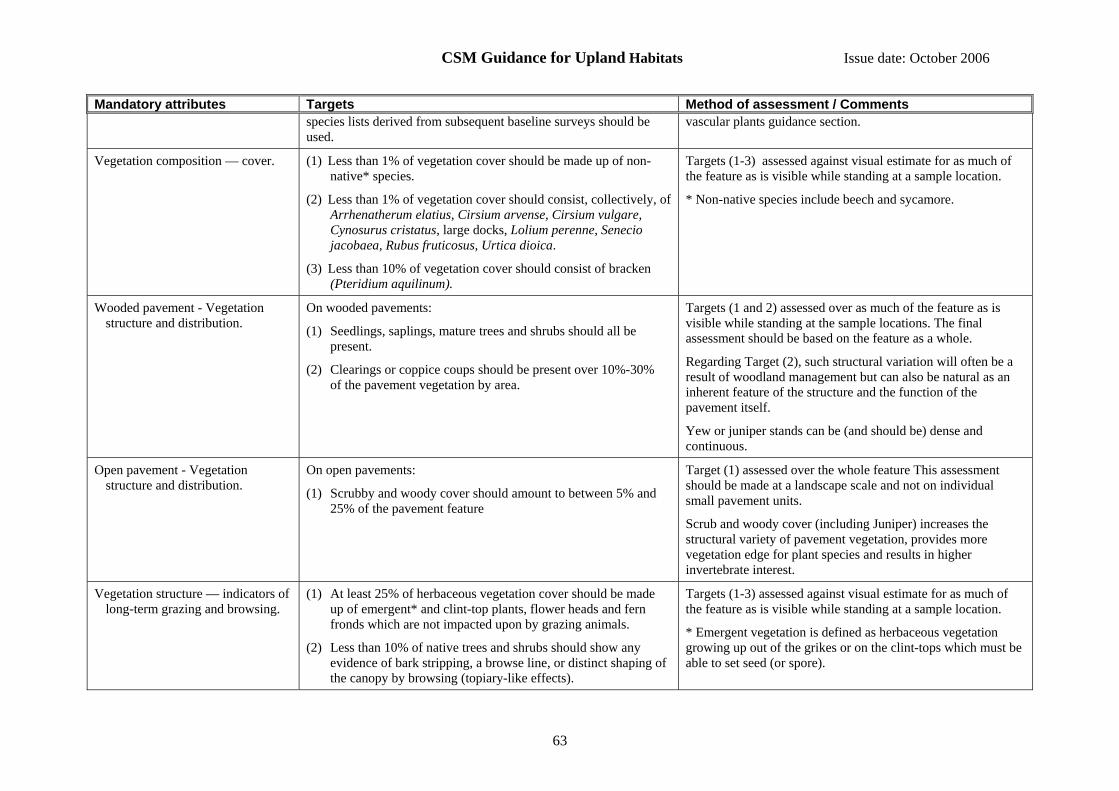
CSM Guidance for Upland Habitats Issue date: October 2006
63
Mandatory attributes Targets Method of assessment / Comments species lists derived from subsequent baseline surveys should be used.
vascular plants guidance section.
Vegetation composition — cover. (1) Less than 1% of vegetation cover should be made up of non-native* species.
(2) Less than 1% of vegetation cover should consist, collectively, of Arrhenatherum elatius, Cirsium arvense, Cirsium vulgare, Cynosurus cristatus, large docks, Lolium perenne, Senecio jacobaea, Rubus fruticosus, Urtica dioica.
(3) Less than 10% of vegetation cover should consist of bracken (Pteridium aquilinum).
Targets (1-3) assessed against visual estimate for as much of the feature as is visible while standing at a sample location.
* Non-native species include beech and sycamore.
Wooded pavement - Vegetation structure and distribution.
On wooded pavements:
(1) Seedlings, saplings, mature trees and shrubs should all be present.
(2) Clearings or coppice coups should be present over 10%-30% of the pavement vegetation by area.
Targets (1 and 2) assessed over as much of the feature as is visible while standing at the sample locations. The final assessment should be based on the feature as a whole.
Regarding Target (2), such structural variation will often be a result of woodland management but can also be natural as an inherent feature of the structure and the function of the pavement itself.
Yew or juniper stands can be (and should be) dense and continuous.
Open pavement - Vegetation structure and distribution.
On open pavements:
(1) Scrubby and woody cover should amount to between 5% and 25% of the pavement feature
Target (1) assessed over the whole feature This assessment should be made at a landscape scale and not on individual small pavement units.
Scrub and woody cover (including Juniper) increases the structural variety of pavement vegetation, provides more vegetation edge for plant species and results in higher invertebrate interest.
Vegetation structure — indicators of long-term grazing and browsing.
(1) At least 25% of herbaceous vegetation cover should be made up of emergent* and clint-top plants, flower heads and fern fronds which are not impacted upon by grazing animals.
(2) Less than 10% of native trees and shrubs should show any evidence of bark stripping, a browse line, or distinct shaping of the canopy by browsing (topiary-like effects).
Targets (1-3) assessed against visual estimate for as much of the feature as is visible while standing at a sample location.
* Emergent vegetation is defined as herbaceous vegetation growing up out of the grikes or on the clint-tops which must be able to set seed (or spore).

CSM Guidance for Upland Habitats Issue date: October 2006
64
Mandatory attributes Targets Method of assessment / Comments (3) Less than 33% of the most current shoots of native trees and
shrubs should show any evidence of having been browsed. Table 1. Positive Indicator Species Actaea spicata Arabis hirsuta Arenaria anglica Asplenium viride Ceterach officinarum Convallaria majalis
Cystopteris fragilis Carex digitata Carex ornithopoda Cardamine impatiens Cirsium heterophyllum Clematis vitalba
Crepis paludosa Dryas octopetala Dryopteris submontana Epipactis atrorubens Eupatorium cannabinum Geranium sanguineum
Gymnocarpium robertianum Hypericum montanum Melica nutans Melica unitflora Polygonatum odoratum Polystichum lonchitis
Ribes spicatum Rubus saxatilis Salix myrsinites Thalictrum minus Trollius europaeus

CSM Guidance for Upland Habitats Issue date: October 2006
65
14.15 Interest feature: Mire grassland and rush pasture (upland)
For this feature type use the Lowland purple moor grass and rush pastures in the Common Standards Monitoring Guidance for Lowland Grassland Habitats, available on the JNCC website at http://www.jncc.gov.uk/page-2233.

CSM Guidance for Upland Habitats Issue date: October 2006
66
14.16 Interest feature: Montane willow scrub
Includes the following NVC types: W20 Salix lapponum – Luzula sylvatica scrub Includes the Annex I type Sub-Arctic Salix spp. scrub (H4080) Reporting category: Montane habitats General notes and qualifications: When assessing frequency or cover within the vegetation, exclude all bare rock from the assessment. Most of the attributes and targets may be assessed using binoculars and/or telescope if the locations where the feature occurs are inaccessible. When this is the case an assessment at the patch scale will be acceptable. Rockfalls or landslides can sometimes obliterate portions of this feature type and, if substantial, this should be recorded as a loss of extent (more than 10% of total feature area or total locations of feature on site). Mandatory attributes Targets Method of assessment / Comments Feature extent (see Section 7
for further guidance). (1) There should be no measurable decline in the area of the feature. Field comparison with baseline map of feature, or
occurrence of feature at points on a systematic sample grid, or recording of location and number of individual patches if the feature is fragmented into very small patches.
Vegetation composition — cover.
(1) At least 25% of vegetation cover should consist of the indicator arctic-alpine willow spp.: Salix lapponum, S. myrsinites, S .arbuscula and/or S. lanata.
(2) Less than 1% of vegetation cover should be made up of non-native species.
Target (1) assessed against visual estimate at 16 m2, or individual stand if close observation not possible.
Target (2) assessed against visual estimate for as much of the feature as is visible while standing at a sample location.
Vegetation structure — reproduction by willow.
(1) At least 1 bush of each of the indicator arctic-alpine willow spp. present should be producing seed.
Target (1) assessed against visual estimate for as much of the feature as is visible while standing at a sample location.
Vegetation structure — age structure of willow.
(1) At least as many “young” arctic-alpine willow plants should be present as dead or dying plants.
Target (1) assessed against visual estimate for as much of the feature as is visible while standing at a sample location.
Vegetation structure — indicators of grazing/browsing.
(1) The height, or length, of at least 50% of willow stems should be at least 40 cm (or 20 cm in the case of S. myrsinites).
(2) Where stands are safely accessible and close inspection can be made, less than 33% of the most recent long-shoots should show signs of having been browsed.
Targets (1-3) assessed against visual estimate at 16 m2, or against individual stand if close observation not possible.

CSM Guidance for Upland Habitats Issue date: October 2006
67
Mandatory attributes Targets Method of assessment / Comments (3) Where stands are not safely accessible and must be assessed from a
distance, less than 10% of the shrub cover should show a distinct browse line or shaping of the canopy (topiary-like effects) by browsing.

CSM Guidance for Upland Habitats Issue date: October 2006
68
14.17 Interest feature: Moss, dwarf-herb, and grass-dominated snow-bed
Includes the following NVC types: U7 Nardus stricta – Carex bigelowii grass-heath, U8 Carex bigelowii – Polytrichum alpinum sedge-heath (when not part of Siliceous alpine and boreal grassland), U11 Polytrichum sexangulare – Kiaeria starkei snow-bed, U12 Salix herbacea – Racomitrium heterostichum snow-bed, U13 Deschampsia cespitosa – Galium saxatile grassland, U14 Alchemilla alpina – Sibbaldia procumbens dwarf-herb community. Reporting category: Montane habitats General notes and qualifications: When assessing frequency or cover within the vegetation, exclude all bare rock from the assessment. Mandatory attributes Targets Method of assessment / Comments Feature extent (see Section 7 for
further guidance). (1) There should be no measurable decline in the area of the
feature. Field comparison with baseline map of feature, or occurrence of feature at points on a systematic sample grid, or recording of location and number of individual patches if the feature is fragmented into very small patches.
Vegetation composition — frequency of indicator species.
(1) At least 1 indicator species should be present in vegetation cover. (Table 1)
Target (1) assessed against visual estimate at 1 m2 scale.
Vegetation composition — cover. (1) Less than 1% of vegetation cover should be made up of non-native species.
Target (1) assessed against visual estimate for as much of the feature as is visible while standing at a sample location.
Vegetation structure — indicators of current grazing.
(1) Less than 10% of grass and sedge tillers should be uprooted;.
(2) Less than 10% of live leaves of any of Alchemilla alpina, Nardus stricta, Sibbaldia procumbens, Thymus polytrichus, Carex bigelowii, Deschampsia flexuosa, Festuca ovina, Festuca vivipara, Juncus trifidus with any evidence of grazing.
(3) Less than 50% of live leaves of any of Agrostis capillaris, Agrostis vinealis, Anthoxanthum odoratum, Poa spp. with any evidence of grazing.
Targets (1-3) assessed against visual estimate at 1 m2 scale.
Make final assessment based on majority of applicable targets (e.g. if the feature passes on and ails on two then fail it).
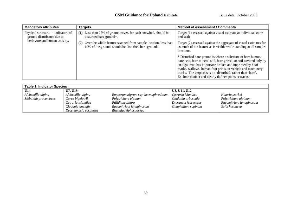
CSM Guidance for Upland Habitats Issue date: October 2006
69
Mandatory attributes Targets Method of assessment / Comments Physical structure — indicators of
ground disturbance due to herbivore and human activity.
(1) Less than 25% of ground cover, for each snowbed, should be disturbed bare ground*.
(2) Over the whole feature scanned from sample location, less than 10% of the ground should be disturbed bare ground*.
Target (1) assessed against visual estimate at individual snow-bed scale.
Target (2) assessed against the aggregate of visual estimates for as much of the feature as is visible while standing at all sample locations.
* Disturbed bare ground is where a substrate of bare humus, bare peat, bare mineral soil, bare gravel, or soil covered only by an algal mat, has its surface broken and imprinted by hoof marks, wallows, human foot prints, or vehicle and machinery tracks. The emphasis is on ‘disturbed’ rather than ‘bare’. Exclude distinct and clearly defined paths or tracks.
Table 1. Indicator Species U14 U7, U13 U8, U11, U12 Alchemilla alpina Sibbaldia procumbens
Alchemilla alpina Carex bigelowii Cetraria islandica Cladonia uncialis Deschampsia cespitosa
Empetrum nigrum ssp. hermaphroditum Polytrichum alpinum Ptilidium ciliare Racomitrium lanuginosum Rhytidiadelphus loreus
Cetraria islandica Cladonia arbuscula Dicranum fuscescens Gnaphalium supinum
Kiaeria starkei Polytrichum alpinum Racomitrium lanuginosum Salix herbacea

CSM Guidance for Upland Habitats Issue date: October 2006
70
14.18 Interest feature: Short-sedge acidic fen (upland)
Includes the following NVC types: M4 Carex rostrata – Sphagnum recurvum mire (in part, see also Transition mires and quaking bogs), M5 Carex rostrata – Sphagnum squarrosum mire, M6 Carex echinata – Sphagnum recurvum / auriculatum mire. For lowland stands of these types refer to the Lowland wetland guidance. Reporting category: Fen, marsh and swamp General notes and qualifications: When assessing frequency or cover within the vegetation, exclude all bare rock from the assessment. Mandatory attributes Targets Method of assessment / Comments Feature extent (see Section 7 for
further guidance). (1) There should be no measurable decline in the area of the feature. Field comparison with baseline map of feature, or occurrence
of feature at points on a systematic sample grid, or recording of location and number of individual patches if the feature is fragmented into very small patches.
Vegetation composition — frequency of indicator species.
(1) For M4, M6 there should be at least 2 indicator species present in the vegetation cover (Table 1).
(2) For M5 there should be at least 3 indicator species present in the vegetation cover (Table 1).
(3) For all, there should be at least 1 species from group (i) (Table 1).
Targets (1-3) assessed against visual estimate at 4 m2 scale.
Vegetation composition — cover (1) At least 50% of vegetation cover should be made up of indicator species (25% from each of groups i and ii) (Table 1).
(2) Less than 1% of vegetation cover should be made up of non-native species.
(3) Less than 1% of vegetation cover should consist of, collectively, Anthoxanthum odoratum, Epilobium hirsutum, Holcus lanatus, Phragmites australis, Ranunculus repens.
(4) Less than 10% of vegetation cover should be made up scattered native trees and scrub.
Qualifiers: For target (4) exclude Myrica gale.
Target (1) assessed against visual estimate at 4 m2 scale
Targets (2 and 4) assessed against visual estimate for as much of the feature as is visible while standing at a sample location.
Target (3) assessed at two scales, and should be met at both scales:
(a) against visual estimate at 4 m2 scale; and
(b) against visual estimate for as much of the feature as is visible while standing at a sample location.
Vegetation structure — indicators of current grazing.
(1) For fens and flushes, at least 50% of live leaves and flowering shoots of vascular plants should more than 15 cm above the ground surface.
Target (1) assessed against visual estimate at the 4 m2 scale.
If a moss layer is present the height of the leaf tips and flowering shoots should be estimated from the upper surface
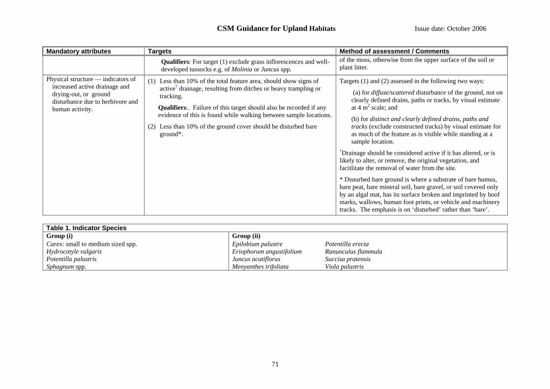
CSM Guidance for Upland Habitats Issue date: October 2006
71
Mandatory attributes Targets Method of assessment / Comments Qualifiers: For target (1) exclude grass inflorescences and well-developed tussocks e.g. of Molinia or Juncus spp.
of the moss, otherwise from the upper surface of the soil or plant litter.
Physical structure — indicators of increased active drainage and drying-out, or ground disturbance due to herbivore and human activity.
(1) Less than 10% of the total feature area, should show signs of active† drainage, resulting from ditches or heavy trampling or tracking.
Qualifiers:. Failure of this target should also be recorded if any evidence of this is found while walking between sample locations.
(2) Less than 10% of the ground cover should be disturbed bare ground*.
Targets (1) and (2) assessed in the following two ways:
(a) for diffuse/scattered disturbance of the ground, not on clearly defined drains, paths or tracks, by visual estimate at 4 m2 scale; and
(b) for distinct and clearly defined drains, paths and tracks (exclude constructed tracks) by visual estimate for as much of the feature as is visible while standing at a sample location.
†Drainage should be considered active if it has altered, or is likely to alter, or remove, the original vegetation, and facitlitate the removal of water from the site.
* Disturbed bare ground is where a substrate of bare humus, bare peat, bare mineral soil, bare gravel, or soil covered only by an algal mat, has its surface broken and imprinted by hoof marks, wallows, human foot prints, or vehicle and machinery tracks. The emphasis is on ‘disturbed’ rather than ‘bare’.
Table 1. Indicator Species Group (i) Group (ii) Carex: small to medium sized spp. Hydrocotyle vulgaris Potentilla palustris Sphagnum spp.
Epilobium palustre Eriophorum angustifolium Juncus acutiflorus Menyanthes trifoliata
Potentilla erecta Ranunculus flammula Succisa pratensis Viola palustris

CSM Guidance for Upland Habitats Issue date: October 2006
72
14.19 Interest feature: Siliceous rocky slopes
There has been little work undertaken on this habitat and it is not well defined in the NVC. Until such time as better information is available on community types, vegetation composition and indicator species, the attributes and targets are of necessity brief and aim to ensure that the habitat remains open and is impacted relatively lightly by human activities. Includes the following NVC types: U21 Cryptogramma crispa – Deschampsia flexuosa, similar communities and possibly other types not described by the NVC. Includes the Annex I type: Siliceous rocky slopes with chasmophytic vegetation (H8220) Reporting category: Inland rock General notes and qualifications: When assessing frequency or cover within the vegetation, exclude all bare rock from the assessment. Some stands of this feature type may be inaccessible and when this is the case an assessment at the patch scale based on what can be seen using binoculars or telescope will be acceptable. Mandatory attributes Targets Method of assessment /Comments Feature extent (see Section 7 for
further guidance). (1) There should be no measurable decline in the area of the
feature. Field comparison with baseline map of feature, or occurrence of feature at points on a systematic sample grid, or recording of location and number of individual patches if the feature is fragmented into very small patches.
Vegetation composition — cover.
(1) Less than 1% of vegetation cover should be made up of non-native species.
(2) Less than 25% of ground cover should be made up of bracken, scattered native trees and scrub.
Targets (1 and 2) assessed against visual estimate for as much of the feature as is visible while standing at a sample location.
Vegetation structure — indicators of current grazing.
(1) Less than 50% of live leaves (forbs) or the shoots (dwarf-shrubs) should show signs of having been grazed or browsed.
Target (1) assessed against visual estimate for as much of the feature as is visible while standing at a sample location.

CSM Guidance for Upland Habitats Issue date: October 2006
73
14.20 Interest feature: Siliceous scree
Includes the following NVC types: U18 Cryptogramma crispa - Athyrium distentifolium snow-bed ,and U21 Cryptogramma crispa – Deschampsia flexuosa community. A variety of other NVC communities, or communities not described in the NVC, may occur in fragmentary form where the scree is more stable. Includes the Annex I type: Siliceous scree of the montane to snow levels (Androsacetalia alpinae and Galeopsetalia ladani) (H8110) Reporting category: Inland rock General notes and qualifications: When assessing frequency or cover within the vegetation, exclude all bare rock from the assessment. Some stands of this feature type may be inaccessible and when this is the case an assessment at the patch scale based on what can be seen using binoculars or telescope will be acceptable. Mandatory attributes Targets Method of assessment / Comments Feature extent (see Section 7 for
further guidance). (1) There should be no measurable decline in the area of the feature. Field comparison with baseline map of feature, or
occurrence of feature at points on a systematic sample grid, or recording of location and number of individual patches if the feature is fragmented into very small patches.
Vegetation composition — cover.
(1) Less than 1% of vegetation cover should be made up of non-native species.
(2) Less than 25% of the ground cover should be made up of bracken, scattered native trees and scrub.
(3) Less than 1% of vegetation cover should consist of, collectively, Cirsium arvense, Cirsium vulgare, Pteridium aquilinum, large docks (excluding Rumex acetosa), Rubus fruticosus, Senecio jacobaea, Urtica dioica.
Targets (1-3) assessed against visual estimate for as much of the feature as is visible while standing at a sample location.
Vegetation structure — indicators of current grazing.
(1) At least 33% of ground cover should be free from overgrowth by vascular plants
(2) Less than 50% of live leaves (forbs) and/or the shoots (dwarf-shrubs) should show signs of having been grazed or browsed.
Targets (1 and 2) assessed against visual estimate for as much of the feature as is visible while standing at a sample location.
Physical structure — indicators of ground disturbance due to herbivore and human activity.
(1) Less than 10% of the ground cover should be disturbed by human or animal paths, scree running, or vehicles.
Target (1) assessed against visual estimate for as much of the feature as is visible while standing at a sample location.
This can be recognised at a distance since newly exposed material has a different colour.

CSM Guidance for Upland Habitats Issue date: October 2006
74
14.21 Interest feature: Soakway and sump (upland)
Includes the following NVC types: M29 Hypericum elodes – Potamogeton polygonifolius soakway. For lowland stands refer to the Lowland wetland guidance. Reporting category: Fen, marsh and swamp General notes and qualifications: When assessing frequency or cover within the vegetation, exclude all bare rock from the assessment. Mandatory attributes Targets Method of assessment / Comments Feature extent (see Section 7 for
further guidance). (1) There should be no measurable decline in the area of the
feature. Field comparison with baseline map of feature, or occurrence of feature at points on a systematic sample grid, or recording of location and number of individual patches if the feature is fragmented into very small patches.
Vegetation composition - cover (1) Either Hypericum elodes or Potamogeton polygonifolius should be present in the vegetation cover.
(2) At least 75% of vegetation cover should be made up of indicator species (Table 1).
(3) Less than 1% of vegetation cover should be made up of non-native species.
(4) Less than 10% of vegetation cover should be made up of scattered native trees and scrub.
(5) Less than 20% of vegetation cover should be made up of Molinia caerulea.
(6) Less than 10% of vegetation cover should be made up of other graminoids.
Qualifiers: For target (6) include Juncus acutiflorus and Juncus effusus, but exclude Molinia and sedges, in the assessment of “other graminoids”.
Targets (1 and 2), and (5 and 6) assessed against visual estimate at 4 m2 scale.
Targets (3-6) assessed against visual estimate for as much of the feature as is visible while standing at a sample location. Note: targets (5-6) are assessed at 2 scales.
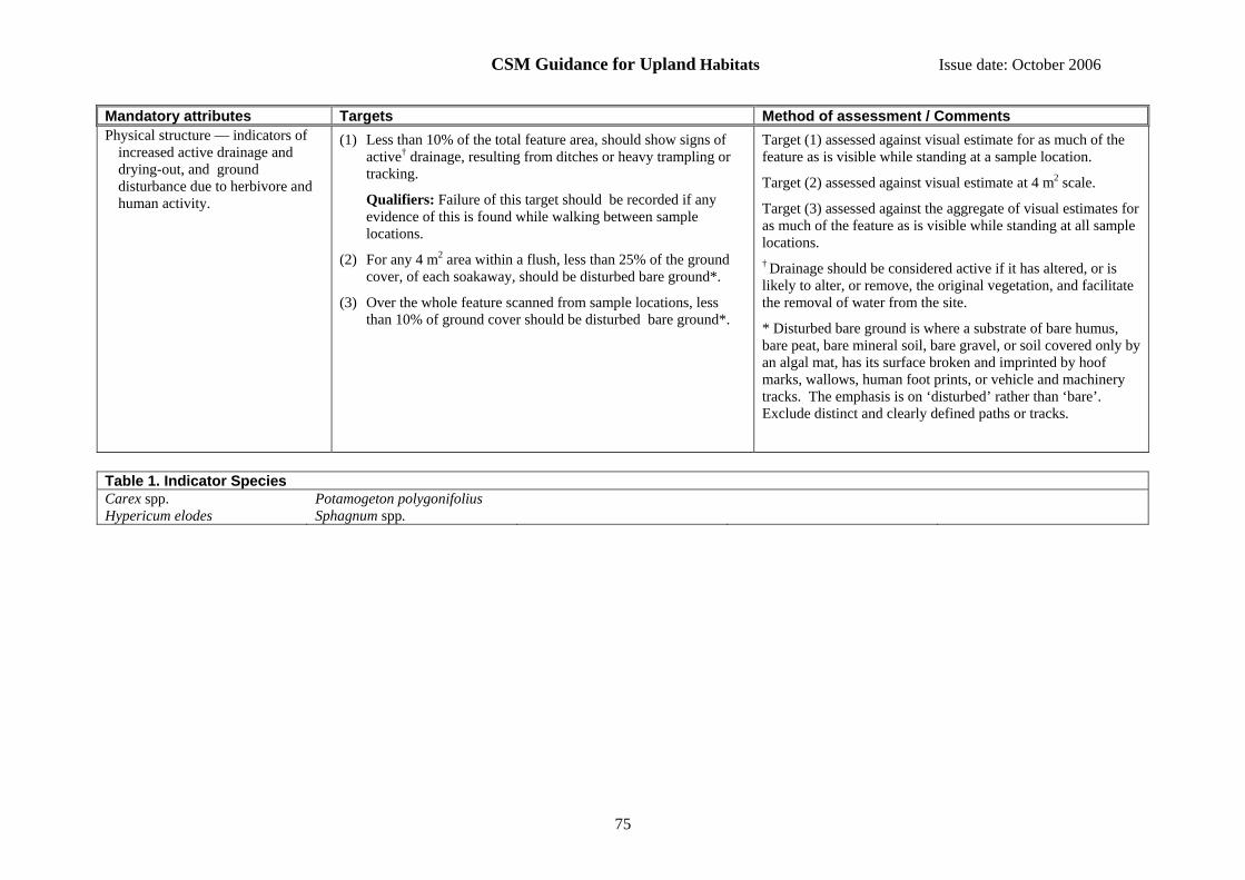
CSM Guidance for Upland Habitats Issue date: October 2006
75
Mandatory attributes Targets Method of assessment / Comments Physical structure — indicators of
increased active drainage and drying-out, and ground disturbance due to herbivore and human activity.
(1) Less than 10% of the total feature area, should show signs of active† drainage, resulting from ditches or heavy trampling or tracking.
Qualifiers: Failure of this target should be recorded if any evidence of this is found while walking between sample locations.
(2) For any 4 m2 area within a flush, less than 25% of the ground cover, of each soakaway, should be disturbed bare ground*.
(3) Over the whole feature scanned from sample locations, less than 10% of ground cover should be disturbed bare ground*.
Target (1) assessed against visual estimate for as much of the feature as is visible while standing at a sample location.
Target (2) assessed against visual estimate at 4 m2 scale.
Target (3) assessed against the aggregate of visual estimates for as much of the feature as is visible while standing at all sample locations. † Drainage should be considered active if it has altered, or is likely to alter, or remove, the original vegetation, and facilitate the removal of water from the site.
* Disturbed bare ground is where a substrate of bare humus, bare peat, bare mineral soil, bare gravel, or soil covered only by an algal mat, has its surface broken and imprinted by hoof marks, wallows, human foot prints, or vehicle and machinery tracks. The emphasis is on ‘disturbed’ rather than ‘bare’. Exclude distinct and clearly defined paths or tracks.
Table 1. Indicator Species Carex spp. Hypericum elodes
Potamogeton polygonifolius Sphagnum spp.

CSM Guidance for Upland Habitats Issue date: October 2006
76
14.22 Interest feature: Spring-head, rill and flush (upland)
Includes the following NVC types: M7 Carex curta – Sphagnum russowii mire, M8 Carex rostrata – Sphagnum warnstorfii mire (when not part of “Transition mires and quaking bogs”), M31 Anthelia julacea – Sphagnum auriculatum spring, M32 Philonotis fontana – Saxifraga stellaris spring, M33 Pohlia wahlenbergii var. glacialis spring, M34 Carex demissa – Koenigia islandica flush (when not part of “Alpine pioneer formations”), M35 Ranunculus omiophyllus – Montia fontana rill, M37 Cratoneuron commutatum – Festuca rubra spring, M38 Cratoneuron commutatum – Carex nigra spring. For lowland stands of M32, M35 and M37 refer to the Lowland wetland guidance. Includes the Annex I type: Petrifying springs with tufa formation (Cratoneurion) (H7220) (part) Reporting category: Fen, marsh and swamp General notes and qualifications: When assessing frequency or cover within the vegetation, exclude all bare rock from the assessment. Mandatory attributes Targets Method of assessment / Comments Feature extent (see Section 7 for
further guidance). (1) There should be no measurable decline in the area of the
feature. Field comparison with baseline map of feature, or occurrence of feature at points on a systematic sample grid, or recording of location and number of individual patches if the feature is fragmented into very small patches.
Vegetation composition — frequency of indicator species.
(1) At least 1 indicator species should be present for the given NVC type (Table 1).
Target (1) assessed against visual estimate at 4 m2 scale.
Vegetation composition — cover.
(1) At least 90% of vegetation cover should be made up of indicator species. (Table 2).
(2) Less than 1% of vegetation cover should be made up of non-native species.
(3) Less than 1% of vegetation cover should consist of, collectively, Agrostis stolonifera, Holcus lanatus.
(4) Less than 10% of the vegetation cover should consist of, collectively, Juncus acutiflorus and Juncus effuses.
Target (1) assessed against visual estimate at 4 m2 scale.
Target (2) assessed against visual estimate for as much of the feature as is visible while standing at a sample location.
Targets (3 and 4) assessed at two scales, and should be met at both scales:
(a) against visual estimate at 4 m2 scale; and
(b) against visual estimate for as much of the feature as is visible while standing at a sample location.
Vegetation structure — indicators of current grazing.
(1) Pulled-up mosses and other plants should make up less than 10% of vegetation cover.
(2) For M32, M35, M37, M38 less than 50% of live leaves of sedges and grasses should show any evidence of having been grazed, and for M7, M8, M31, M33, M34 less than 25% of live leaves of sedges and grasses should show any evidence of
Targets (1 and 2) assessed against visual estimate at 4 m2 scale.
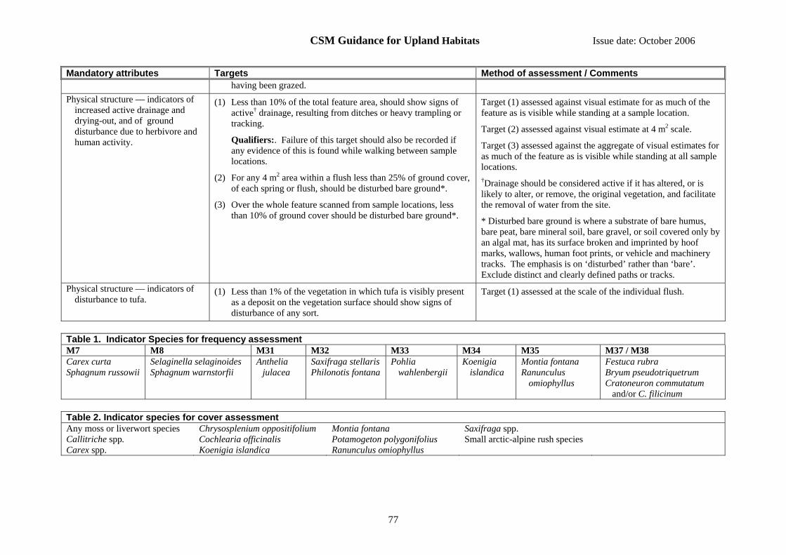
CSM Guidance for Upland Habitats Issue date: October 2006
77
Mandatory attributes Targets Method of assessment / Comments having been grazed.
Physical structure — indicators of increased active drainage and drying-out, and of ground disturbance due to herbivore and human activity.
(1) Less than 10% of the total feature area, should show signs of active† drainage, resulting from ditches or heavy trampling or tracking.
Qualifiers:. Failure of this target should also be recorded if any evidence of this is found while walking between sample locations.
(2) For any 4 m2 area within a flush less than 25% of ground cover, of each spring or flush, should be disturbed bare ground*.
(3) Over the whole feature scanned from sample locations, less than 10% of ground cover should be disturbed bare ground*.
Target (1) assessed against visual estimate for as much of the feature as is visible while standing at a sample location.
Target (2) assessed against visual estimate at 4 m2 scale.
Target (3) assessed against the aggregate of visual estimates for as much of the feature as is visible while standing at all sample locations. †Drainage should be considered active if it has altered, or is likely to alter, or remove, the original vegetation, and facilitate the removal of water from the site.
* Disturbed bare ground is where a substrate of bare humus, bare peat, bare mineral soil, bare gravel, or soil covered only by an algal mat, has its surface broken and imprinted by hoof marks, wallows, human foot prints, or vehicle and machinery tracks. The emphasis is on ‘disturbed’ rather than ‘bare’. Exclude distinct and clearly defined paths or tracks.
Physical structure — indicators of disturbance to tufa.
(1) Less than 1% of the vegetation in which tufa is visibly present as a deposit on the vegetation surface should show signs of disturbance of any sort.
Target (1) assessed at the scale of the individual flush.
Table 1. Indicator Species for frequency assessment M7 M8 M31 M32 M33 M34 M35 M37 / M38 Carex curta Sphagnum russowii
Selaginella selaginoides Sphagnum warnstorfii
Anthelia julacea
Saxifraga stellaris Philonotis fontana
Pohlia wahlenbergii
Koenigia islandica
Montia fontana Ranunculus
omiophyllus
Festuca rubra Bryum pseudotriquetrum Cratoneuron commutatum
and/or C. filicinum Table 2. Indicator species for cover assessment Any moss or liverwort species Callitriche spp. Carex spp.
Chrysosplenium oppositifolium Cochlearia officinalis Koenigia islandica
Montia fontana Potamogeton polygonifolius Ranunculus omiophyllus
Saxifraga spp. Small arctic-alpine rush species

CSM Guidance for Upland Habitats Issue date: October 2006
78
14.23 Interest feature: Subalpine dry dwarf-shrub heath
Includes the following NVC types: H4 Ulex gallii – Agrostis curtisii heath, H7 Calluna vulgaris – Scilla verna heath, H8 Calluna vulgaris – Ulex gallii heath, H9 Calluna vulgaris – Deschampsia flexuosa heath, H10 Calluna vulgaris – Erica cinerea heath, H12 Calluna vulgaris – Vaccinium myrtillus heath, H16 Calluna vulgaris – Arctostaphylos uva-ursi heath, H18 Vaccinium myrtillus – Deschampsia flexuosa heath, H21 Calluna vulgaris – Vaccinium myrtillus – Sphagnum capillifolium heath, H22 Vaccinium myrtillus – Rubus chamaemorus heath (in part). For lowland stands of H4, H7, H8, H9, H10 and H12 refer to the Lowland heathland guidance. H7 Calluna vulgaris – Scilla verna heath is a coastal/maritime type of heath and so may sometimes fall within the lowland heath definition and sometimes the upland definition. The latter is most likely to occur in the extreme north and west. H22 Vaccinium myrtillus – Rubus chamaemorus heath crosses the boundary between alpine (montane) and subalpine (submontane) habitats. It may be assessed as either this feature type or as the alpine dwarf shrub heath depending upon the surrounding vegetation and topographic situation. Heavy browsing, or heavy bracken invasion, may convert this feature into other types of vegetation such U2 Deschampsia flexuosa grassland, U3 Agrostis curtisii grassland, U4 Festuca ovina – Agrostis capillaris – Galium saxatile grassland, U5 Nardus stricta – Galium saxatile grassland, U20 Pteridium aquilinum – Galium saxatile community. See below for guidance on how to assess the condition of these communities. Includes the Annex I type: European dry heaths (H4030) (part) Reporting category: Dwarf shrub heath General notes and qualifications: • Where dwarf shrub heath communities are being replaced by grassland (see above), providing that dwarf shrubs are still present (including suppressed shrubs)
within the grassland sward, and restoration is considered to be feasible, then these grassland communities should be assessed using the attributes and targets given below.
• When assessing frequency or cover of bryophytes, lichens or dwarf-shrubs within the vegetation, exclude all bare rock, recently burned ground, and pioneer phase heath, from the assessment. Recently burned areas can be recognised by the presence of loose charcoal on partially burnt stems that easily produces black marks on fingers and clothes (it takes two to three years for charcoal to be weathered from stems).
• Areas very sensitive to disturbance (see Table 2) will need to be identified (and mapped) at the outset. • The “pioneer” stage of vegetation regrowth is when the vegetation is less than 10 cm tall and before a closed canopy of dwarf shrubs has developed. This includes areas
recently burnt, cut or heavily browsed by livestock, but does not include wind clipped short heather. Surveyors should be careful not to confuse pioneer phase areas with areas of short or sparse dwarf-shrubs resulting from failed regeneration and heavy browsing. In the latter case, the ground between dwarf-shrub plants is likely support a cover of mosses or graminoids. Dwarf shrubs in the building phase are normally 10-30cm tall. A dwarf-shrub stand in the ‘mature’ or ‘degenerate’ phase will be taller (usually more than 30 cm) with thick woody stems (often more than 1 cm diameter), with a well developed ground layer of litter and/or mosses, lichens and possibly some scattered herbs. In the mature phase, the dwarf-shrub canopy will form a mostly continuous cover, but in the degenerate phase the canopy will have gaps and there will be a scatter of dead or collapsed woody stems.
Mandatory attributes Targets Method of assessment / Comments Feature extent (see Section 7 (1) There should be no measurable decline in the area of the feature. Field comparison with baseline map of features, or
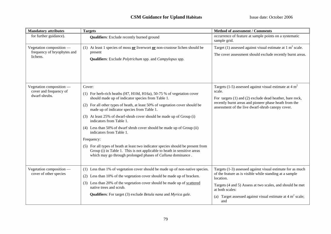
CSM Guidance for Upland Habitats Issue date: October 2006
79
Mandatory attributes Targets Method of assessment / Comments for further guidance). Qualifiers: Exclude recently burned ground occurrence of feature at sample points on a systematic
sample grid.
Vegetation composition — frequency of bryophytes and lichens.
(1) At least 1 species of moss or liverwort or non-crustose lichen should be present
Qualifiers: Exclude Polytrichum spp. and Campylopus spp.
Target (1) assessed against visual estimate at 1 m2 scale.
The cover assessment should exclude recently burnt areas.
Vegetation composition —cover and frequency of dwarf-shrubs.
Cover:
(1) For herb-rich heaths (H7, H10d, H16a), 50-75 % of vegetation cover should made up of indicator species from Table 1.
(2) For all other types of heath, at least 50% of vegetation cover should be made up of indicator species from Table 1.
(3) At least 25% of dwarf-shrub cover should be made up of Group (i) indicators from Table 1.
(4) Less than 50% of dwarf shrub cover should be made up of Group (ii) indicators from Table 1.
Frequency:
(5) For all types of heath at least two indicator species should be present from Group (i) in Table 1. This is not applicable to heath in sensitive areas which may go through prolonged phases of Calluna dominance .
Targets (1-5) assessed against visual estimate at 4 m2 scale.
For targets (1) and (2) exclude dead heather, bare rock, recently burnt areas and pioneer phase heath from the assessment of the live dwarf-shrub canopy cover.
Vegetation composition — cover of other species
(1) Less than 1% of vegetation cover should be made up of non-native species.
(2) Less than 10% of the vegetation cover should be made up of bracken.
(3) Less than 20% of the vegetation cover should be made up of scattered native trees and scrub.
Qualifiers: For target (3) exclude Betula nana and Myrica gale.
Targets (1-3) assessed against visual estimate for as much of the feature as is visible while standing at a sample location.
Targets (4 and 5) Assess at two scales, and should be met at both scales:
(a) Target assessed against visual estimate at 4 m2 scale; and
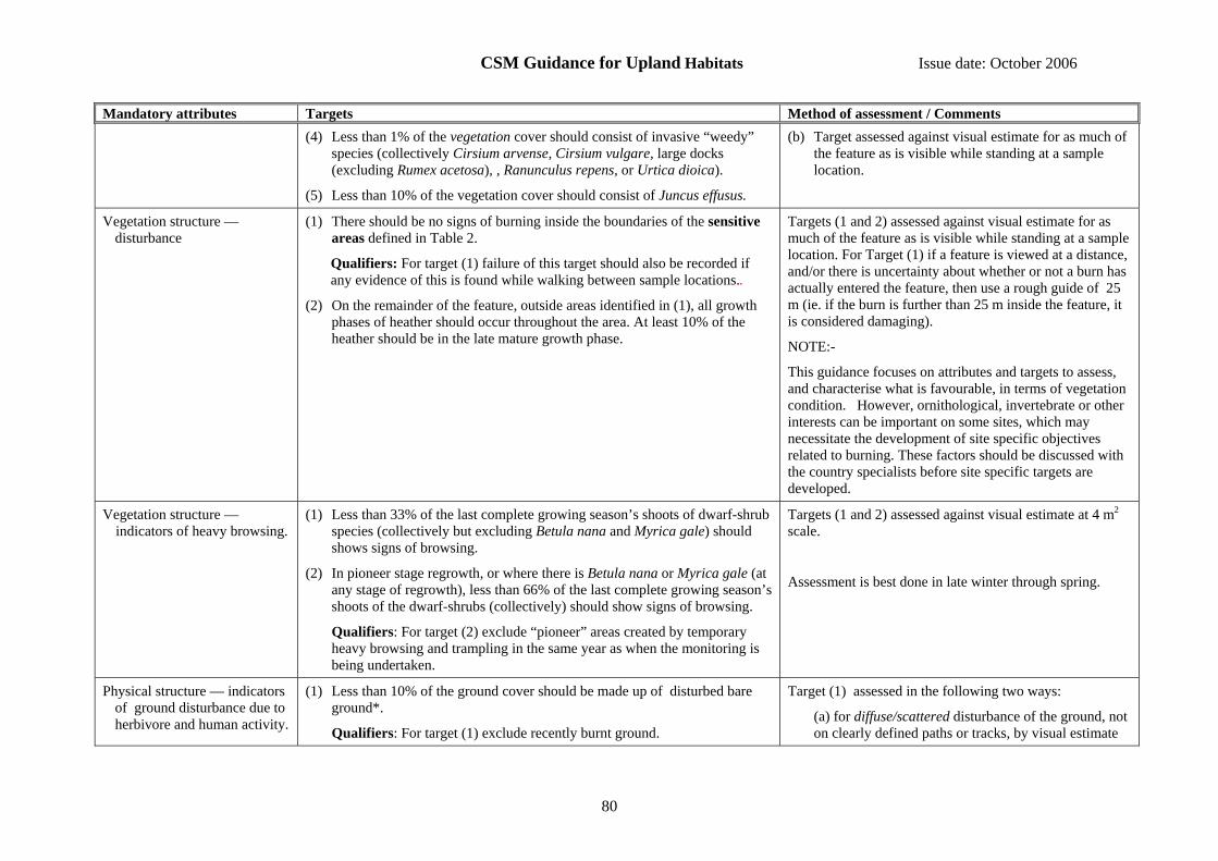
CSM Guidance for Upland Habitats Issue date: October 2006
80
Mandatory attributes Targets Method of assessment / Comments (4) Less than 1% of the vegetation cover should consist of invasive “weedy”
species (collectively Cirsium arvense, Cirsium vulgare, large docks (excluding Rumex acetosa), , Ranunculus repens, or Urtica dioica).
(5) Less than 10% of the vegetation cover should consist of Juncus effusus.
(b) Target assessed against visual estimate for as much of the feature as is visible while standing at a sample location.
Vegetation structure — disturbance
(1) There should be no signs of burning inside the boundaries of the sensitive areas defined in Table 2.
Qualifiers: For target (1) failure of this target should also be recorded if any evidence of this is found while walking between sample locations..
(2) On the remainder of the feature, outside areas identified in (1), all growth phases of heather should occur throughout the area. At least 10% of the heather should be in the late mature growth phase.
Targets (1 and 2) assessed against visual estimate for as much of the feature as is visible while standing at a sample location. For Target (1) if a feature is viewed at a distance, and/or there is uncertainty about whether or not a burn has actually entered the feature, then use a rough guide of 25 m (ie. if the burn is further than 25 m inside the feature, it is considered damaging).
NOTE:-
This guidance focuses on attributes and targets to assess, and characterise what is favourable, in terms of vegetation condition. However, ornithological, invertebrate or other interests can be important on some sites, which may necessitate the development of site specific objectives related to burning. These factors should be discussed with the country specialists before site specific targets are developed.
Vegetation structure — indicators of heavy browsing.
(1) Less than 33% of the last complete growing season’s shoots of dwarf-shrub species (collectively but excluding Betula nana and Myrica gale) should shows signs of browsing.
(2) In pioneer stage regrowth, or where there is Betula nana or Myrica gale (at any stage of regrowth), less than 66% of the last complete growing season’s shoots of the dwarf-shrubs (collectively) should show signs of browsing.
Qualifiers: For target (2) exclude “pioneer” areas created by temporary heavy browsing and trampling in the same year as when the monitoring is being undertaken.
Targets (1 and 2) assessed against visual estimate at 4 m2 scale.
Assessment is best done in late winter through spring.
Physical structure — indicators of ground disturbance due to herbivore and human activity.
(1) Less than 10% of the ground cover should be made up of disturbed bare ground*.
Qualifiers: For target (1) exclude recently burnt ground.
Target (1) assessed in the following two ways:
(a) for diffuse/scattered disturbance of the ground, not on clearly defined paths or tracks, by visual estimate
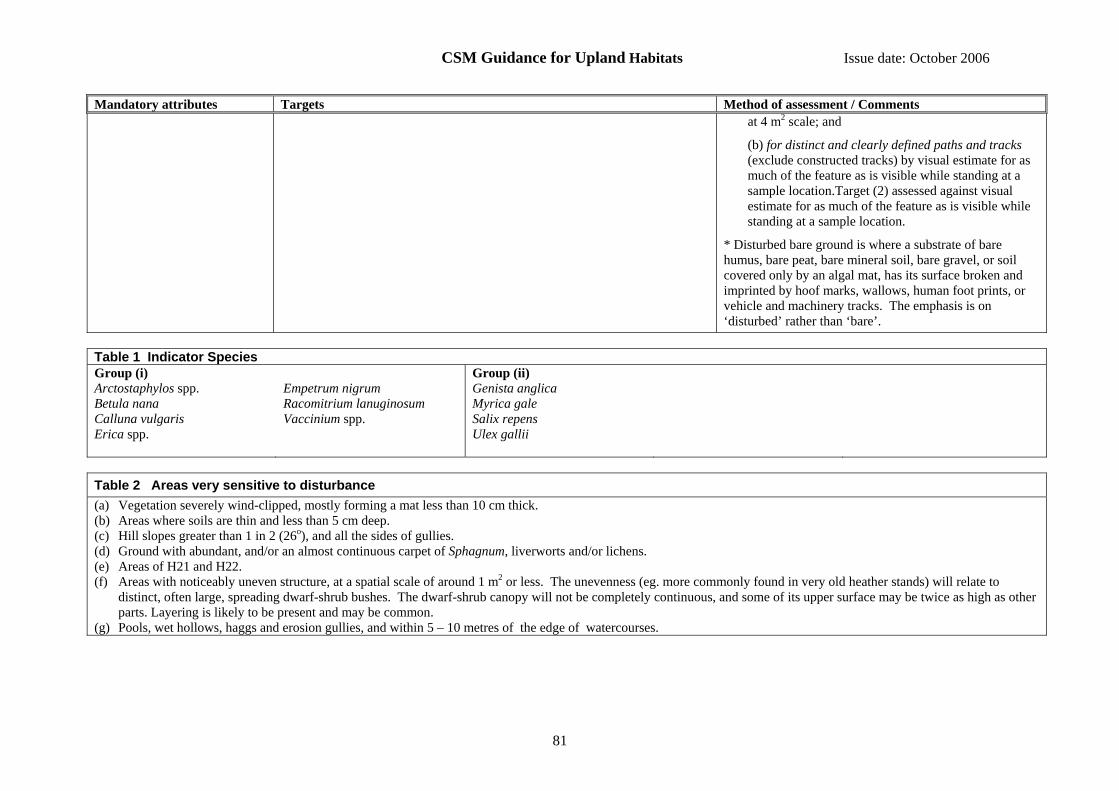
CSM Guidance for Upland Habitats Issue date: October 2006
81
Mandatory attributes Targets Method of assessment / Comments at 4 m2 scale; and
(b) for distinct and clearly defined paths and tracks (exclude constructed tracks) by visual estimate for as much of the feature as is visible while standing at a sample location.Target (2) assessed against visual estimate for as much of the feature as is visible while standing at a sample location.
* Disturbed bare ground is where a substrate of bare humus, bare peat, bare mineral soil, bare gravel, or soil covered only by an algal mat, has its surface broken and imprinted by hoof marks, wallows, human foot prints, or vehicle and machinery tracks. The emphasis is on ‘disturbed’ rather than ‘bare’.
Table 1 Indicator Species Group (i) Group (ii) Arctostaphylos spp. Betula nana Calluna vulgaris Erica spp.
Empetrum nigrum Racomitrium lanuginosum Vaccinium spp.
Genista anglica Myrica gale Salix repens Ulex gallii
Table 2 Areas very sensitive to disturbance (a) Vegetation severely wind-clipped, mostly forming a mat less than 10 cm thick. (b) Areas where soils are thin and less than 5 cm deep. (c) Hill slopes greater than 1 in 2 (26o), and all the sides of gullies. (d) Ground with abundant, and/or an almost continuous carpet of Sphagnum, liverworts and/or lichens. (e) Areas of H21 and H22. (f) Areas with noticeably uneven structure, at a spatial scale of around 1 m2 or less. The unevenness (eg. more commonly found in very old heather stands) will relate to
distinct, often large, spreading dwarf-shrub bushes. The dwarf-shrub canopy will not be completely continuous, and some of its upper surface may be twice as high as other parts. Layering is likely to be present and may be common.
(g) Pools, wet hollows, haggs and erosion gullies, and within 5 – 10 metres of the edge of watercourses.

CSM Guidance for Upland Habitats Issue date: October 2006
82
14.24 Interest feature: Tall herbs (upland)
Includes the following NVC types: U16 Luzula sylvatica – Vaccinium myrtillus tall herb community, U17 Luzula sylvatica – Geum rivale tall herb community, U19 Thelypteris limbosperma – Blechnum spicant community. The following may also represent suppressed or incipient tall herb vegetation: U4 Festuca ovina – Agrostis capillaris – Galium saxatile grassland, provisional Filipendula ulmaria sub-community and CG10 Festuca ovina – Agrostis capillaris – Thymus praecox grassland. Includes the Annex I type: Hydrophilous tall herb fringe communities of plains and of the montane to alpine levels (H6430) Reporting category: Inland rock General notes and qualifications: When assessing frequency or cover within the vegetation, exclude all bare rock from the assessment. Some stands of this feature type may be inaccessible and when this is the case an assessment at the patch scale based on what can be seen using binoculars or telescope will be acceptable. Rockfalls and landslips can sometimes obliterate portions of this feature type and, if more than 25%, this should be recorded as a loss of extent. Mandatory attributes Targets Method of assessment / Comments Feature extent (see Section 7 for
further guidance). (1) There should be no measurable decline in the area of the
feature. Field comparison with baseline map of feature, or occurrence of feature at points on a systematic sample grid, or recording of location and number of individual patches if the feature is fragmented into very small patches.
Vegetation composition — frequency and cover of indicator species.
(1) U16: At least one dwarf-shrub species and at least one fern species (both from Table 1) should be present
(2) U19: At least one fern species from Table 1 should be present.
(3) U17: At least one indicator species from the relevant part of Table 1 (excluding Luzula sylvatica) should be present.
Qualifiers: For target (3) only 1 species per species group (e.g. Alchemilla spp. is a species group) required.
(4) U16, U17, U19: At least 50% of vegetation cover should be made up of indicator species.
Qualifiers: For target (4) exclude Luzula sylvatica when assessing U17.
(5) Less than 1% of vegetation cover should be made up of non-native species.
Targets (1-4) assessed against visual estimate at 4 m2, or individual stand if close observation not possible.
Target (5) assessed against visual estimate for as much of the feature as is visible while standing at a sample location.
CSM Guidance for Upland Habitats Issue date: October 2006
83
Mandatory attributes Targets Method of assessment / Comments Vegetation structure — indicators
of current grazing. (1) At least 50% of tall herb stems should be more than 20 cm tall,
or there should be few observable signs of grazing on tall herbs or ferns, and most tall herb species should be flowering or showing signs of being able to flower.
Qualifiers: For target (1) include flowering stems, other than those of Luzula sylvatica which can be hard to see clearly from a distance and do not tend to form a distinct stratum.
(2) Less than 50% of live flowering shoots of indicator tall herbs should show evidence of grazing.
Targets (1 and 2) assessed against visual estimate at 4 m2, or individual stand if close observation not possible.
Physical structure — indicators of ground disturbance due to herbivore and human activity.
(1) Less than 25% of the ground cover, of each patch or stand, should be disturbed bare ground*.
(2) Over the whole feature scanned from sample locations, less than 10% of the ground cover should be disturbed bare ground*.
Target (1) assessed against visual estimate at individual stand scale.
Target (2) assessed against the aggregate of visual estimates for as much of the feature as is visible while standing at all sample locations.
* Disturbed bare ground is where a substrate of bare humus, bare peat, bare mineral soil, bare gravel, or soil covered only by an algal mat, has its surface broken and imprinted by hoof marks, wallows, human foot prints, or vehicle and machinery tracks. The emphasis is on ‘disturbed’ rather than ‘bare’. Exclude distinct and clearly defined paths or tracks.
Table 1. Indicator Species U17 U16, U19 Alchemilla spp. Angelica sylvestris Cirsium heterophyllum Crepis paludosa Filipendula ulmaria Galium boreale Geranium sylvaticum
Geum rivale Heracleum sphondylium Hieracium spp. Hypericum spp. Leucanthemum vulgare Luzula sylvatica Meconopsis cambrica
Mercurialis perennis Oxyria digyna Pimpinella saxifraga Potentilla crantzii Primula vulgaris Ranunculus acris Rubus saxatilis
Rumex acetosa Saussurea alpina Sedum rosea Silene dioica Solidago virgaurea Succisa pratensis Trollius europaeus
Valeriana officinalis Calluna vulgaris Empetrum nigrum Erica spp. Luzula sylvatica Ferns (excluding bracken) Vaccinium spp.

CSM Guidance for Upland Habitats Issue date: October 2006
84
14.25 Interest feature: Transition mire, ladder fen and quaking bog (upland)
Includes the following NVC types: M4 Carex rostrata – Sphagnum recurvum mire (in part, see also Short sedge fen); M5 Carex rostrata – Sphagnum squarrosum mire; M8 Carex rostrata – Sphagnum warnstorfii mire; M9b Carex rostrata – Calliergon cuspidatum / giganteum mire, Carex diandra – Calliergon giganteum sub-community; S27 Carex rostrata – Potentilla palustris swamp. For lowland stands of these types refer to the Lowland wetland guidance. Includes the Annex I type: Transition mires and quaking bogs (H7140) (part) Reporting category: Fen, marsh and swamp General notes and qualifications: When assessing frequency or cover within the vegetation, exclude all bare rock from the assessment. Mandatory attributes Targets Method of assessment / Comments Feature extent (see Section 7 for
further guidance). (1) There should be no measurable decline in the area of the feature. Field comparison with baseline map of feature, or occurrence
of feature at points on a systematic sample grid, or recording of location and number of individual patches if the feature is fragmented into very small patches.
Vegetation composition — frequency.
(1) M4, M5, S27a: there should be at least 3 indicator species present. (Table 1).
(2) M8, M9, S27b: there should be at least 6 indicator species present (Table 1).
(3) At least 1 species should be from group (i) (Table 1)
Targets (1-3) assessed against visual estimate at 4 m2, or individual stand if close observation not possible.
Vegetation composition — cover. (1) At least 25% of vegetation cover should be made up of indicator species. (Table 2)
(2) Less than 1% of vegetation cover should be made up of non-native species.
(3) Less than 1% of vegetation cover should consist of, collectively, Anthoxanthum odoratum, Epilobium hirsutum, Holcus lanatus.
Targets (1 and 3) assessed against visual estimate at 4 m2 scale, or individual stand if close observation not possible.
Targets (2 and 3) assessed against visual estimate for as much of the feature as is visible while standing at a sample location.
Note target (3) is assessed at 2 scales.
CSM Guidance for Upland Habitats Issue date: October 2006
85
Mandatory attributes Targets Method of assessment / Comments Vegetation structure — indicators
of current grazing. (1) For fens and flushes, at least 50% of the tips of live leaves and/or
flowering shoots of vascular plants should be more than 15 cm above the ground surface.
Qualifiers: For target (1) exclude grass inflorescences and well-developed tussocks e.g. of Molinia or Juncus spp. If a moss layer is present the height of the leaf tips and flowering shoots should be estimated from the upper surface of the moss, otherwise from the upper surface of the soil or plant litter.
Target (1) assessed against visual estimate at the 4 m2 scale.
Physical structure — indicators of increased active drainage and drying-out, peat erosion, and ground disturbance due to herbivore and human activity.
(1) Less than 10% of the total feature area, should show signs of active† drainage, resulting from ditches or heavy trampling or tracking.
(6) Qualifiers: Failure of this target should also be recorded if any evidence of this is found while walking between sample locations.
(2) The area of eroding peat or mineral soil should be less than the area of re-deposition and revegetation within the feature.
(3) Less than 25% of the ground cover, of each stand, should be disturbed bare ground*.
(4) Less than 10% of the ground cover, of whole feature should be disturbed bare ground*
Targets (1 and 2) assessed against visual estimate for as much of the feature as is visible while standing at a sample location.
Target (3) assessed against visual estimate at individual stand scale.
Target (4) assessed against the aggregate of visual estimates for as much of the feature as is visible while standing at all sample locations.
† Drainage should be considered active if it has altered, or is likely to alter, or remove, the original vegetation, and facilitate the removal of water from the site.
* Disturbed bare ground is where a substrate of bare humus, bare peat, bare mineral soil, bare gravel, or soil covered only by an algal mat, has its surface broken and imprinted by hoof marks, wallows, human foot prints, or vehicle and machinery tracks. The emphasis is on ‘disturbed’ rather than ‘bare’. Exclude distinct and clearly defined paths or tracks.
Table 1. Indicator Species for frequency assessments Group (i) Group (ii) Caltha palustris Carex diandra Carex nigra Carex rostrata
Epilobium palustre Equisetum fluviatile Galium palustre Mentha aquatica
Menyanthes trifoliata Phragmites australis Potentilla palustris Sphagnum spp.
Angelica sylvestris Cardamine pratensis Eriophorum angustifolium Lysimachia vulgaris Lythrum salicaria
Selaginella selaginoides Succisa pratensis Valeriana dioica Viola palustris

CSM Guidance for Upland Habitats Issue date: October 2006
86
Table 2. Indicator Species for cover assessments Carex spp.: small to medium sized spp. Equisetum fluviatile
Hydrocotyle vulgaris Hypericum elodes Mentha aquatica
Menyanthes trifoliata Potentilla palustris
Sphagnum spp.

CSM Guidance for Upland Habitats Issue date: October 2006
87
14.26 Interest feature: Upland assemblage / mosaic of habitats or vegetation types
Includes the following NVC types: In the SSSI Selection Guidelines, the selection of upland sites as good assemblages, achieved partly through the injunction to try to select entire topographic units, was given some prominence. However, this is specifically mentioned in only a small proportion of notification citations. In citations, such assemblages or mosaics are generally specified very broadly. They may include virtually all habitats present on a site, or a more limited subset may be specified in some circumstances. An upland habitat assemblage will be composed of component habitats, or vegetation types. These components should be identified from the citation for the site, and then identified with the corresponding feature types in this guidance. Each of the components should be assessed using the generic attribute and target tables for the relevant feature type, but with sampling and field assessment carried out in a quicker and more qualitative way than if the component features had been individually notified. To do this, field assessments should be done from a number of vantage points on the site, sufficient to give an overview of most of the extent of each of the components. This will probably require visits to about three to four locations per square kilometre on average, but a lower density of locations will often be sufficient on extensive features on large sites. At each vantage point the surveyor should make an assessment using the appropriate attribute and target tables of each of the component features that can be seen. For those targets that require detailed observations at close quarters, the assessment should be based on informal, notional samples of the appropriate size at both the vantage point and while walking from the previous vantage point. The final assessment should be based the surveyor’s best judgement of whether at least 90% of each component is likely to pass all the targets. If it seems likely that this will be true for all the components then the whole assemblage feature should be recorded as passing the condition assessment. General notes and qualifications: Not applicable in England

CSM Guidance for Upland Habitats Issue date: October 2006
88
14.27 Interest feature: Wet heath (upland)
Includes the following NVC types: M15 Scirpus cespitosus – Erica tetralix wet heath, M16 Erica tetralix – Sphagnum compactum wet heath, and in the extreme south-west of the UK, H5 Erica vagans –Schoenus nigricans heath and M14 Schoenus nigricans – Narthecium ossifragum mire. Where these types occur in a lowland setting refer to the Lowland heath guidance. M25 Molinia caerulea – Potentilla erecta mire and U6 Juncus squarrosus – Festuca ovina grassland on shallow peat (<0.5m) communities are likely to have been derived from wet heath (see below for guidance). Includes the Annex I type: Northern Atlantic wet heaths with Erica tetralix (H4010) (part) Reporting category: Dwarf shrub heath General notes and qualifications:
• Where wet heath communities are being replaced by mire type M25 or acid grassland type U6, and where restoration back to wet heath is considered feasible, then the M25 or U6 community should be assessed using the attributes and targets ascribed to wet heath (on <0.5 m peat).
• When assessing frequency or cover within the vegetation, exclude all bare rock and recently burned ground from the assessment. Recently burned areas can be recognised by the presence of loose charcoal on partially burnt stems that easily produces black marks on fingers and clothes (it takes two to three years for charcoal to be weathered from stems).
• Areas very sensitive to disturbance (see Table 2) will need to be identified (and mapped) at the outset. • The “pioneer” stage of vegetation regrowth is when the vegetation is less than 10 cm tall and before a closed canopy of dwarf shrubs has developed. This includes
areas recently burnt, cut or heavily browsed by livestock, but does not include wind clipped short heather. Dwarf shrubs in the building phase are normally 10-30cm tall. A dwarf-shrub stand in the ‘mature’ or ‘degenerate’ phase will be taller (usually more than 30 cm) with thick woody stems (often more than 1 cm diameter), with a well developed ground layer of litter and/or mosses, lichens and possibly some scattered herbs. In the mature phase, the dwarf-shrub canopy will form a mostly continuous cover, but in the degenerate phase the canopy will have gaps and there will be a scatter of dead or collapsed woody stems.
• In some parts of Western Britain, drier Molinia dominated western ‘humid’ heaths do not fit wet heath NVC categories and therefore this guidance can be difficult to apply. In such instances, contact country agency upland advisers for advice.
Mandatory attributes Targets Method of assessment / Comments Feature extent (see Section 7 for
further guidance). (1) There should be no measurable decline, in the area of the feature. Field comparison with baseline map of features, or
occurrence of feature at sample points on a systematic sample grid.
Vegetation composition — frequency of indicator species
(1) Erica tetralix should be present within a 20m radius of the centre of the quadrat.
Target (1) assessed against visual estimate up to 20m from centre of the quadrat.
Vegetation composition — cover.
(1) At least 50% of vegetation cover should consist of species from Table 1 and at least 20% of the vegetation cover should consist of ericoid species*.
Targets (1 and 7) assessed against visual estimate at 4 m2 scale.
Targets (2-4) assessed against visual estimate for as much of

CSM Guidance for Upland Habitats Issue date: October 2006
89
Mandatory attributes Targets Method of assessment / Comments (2) Less than 20% of vegetation cover should be made up of
scattered native trees and scrub.
Qualifiers: For target (2) exclude Betula nana and Myrica gale.
(3) Les than 10% of vegetation cover should be made up of bracken.
(4) Less than 1% of vegetation cover should be made up of non-native species.
(5) Less than 1% of vegetation cover should consist of, collectively, Agrostis capillaris, Holcus lanatus, Phragmites australis, Ranunculus repens,.
(6) Less than 10% of the vegetation cover should consist of Juncus effusus.
(7) None of the following should make up more than 75% of vegetation cover: (a) dwarf-shrubs; or (b) graminoids.
the feature as is visible while standing at a sample location.
Targets (5 and 6) assessed at two scales, and should be met at both scales:
(a) Against visual estimate at 4 m2 scale; and
(b) Against visual estimate for as much of the feature as is visible while standing at a sample location.
* For the purposes of this recording Empetrum should be regarded as ‘ericoid’.
Vegetation structure — indicators of browsing.
(1) Less than 33% of the last complete growing season’s shoots of dwarf-shrub species (collectively but excluding Betula nana and Myrica gale) should shows signs of browsing.
(2) In pioneer stage regrowth, or where there is Betula nana or Myrica gale (at any stage of regrowth), less than 66% of the last complete growing season’s shoots of the dwarf-shrubs (collectively) should show signs of browsing.
Qualifiers: For target (2) exclude “pioneer” areas created by temporary heavy browsing and trampling in the same year as when the monitoring is being undertaken.
Targets (1 and 2) assessed against visual estimate at 4 m2 scale.
Assessment is best done in late winter through spring.

CSM Guidance for Upland Habitats Issue date: October 2006
90
Mandatory attributes Targets Method of assessment / Comments Vegetation structure — disturbance
(1) There should be no observable signs of burning into the moss, liverwort or lichen layer or exposure of peat surface due to burning.
(2) There should be no signs of burning and other disturbance inside the boundaries of the sensitive areas defined in Table 2.
Qualifiers: For target (2) failure of this target should also be recorded if any evidence of this is found while walking between sample locations.
Target (1) assessed against visual estimate for as much of the feature as is visible while standing at a sample location.
Burning of the dwarf shrub layer may result in bleaching of the bryophyte layer. This should not be confused with burning into the bryophyte layer and does not constitute failure to achieve Target 1.
For Target (2) if a feature is viewed at a distance, and there is uncertainty about whether or not a burn has actually entered the feature, then use a rough guide of 25 m (ie. if the burn is further than 25 m inside the feature, it is considered damaging).
Physical structure — indicators of
increased active drainage and drying-out, and peat erosion.
(1) Less than 10% of the total feature area, should show signs of active† drainage, resulting from ditches or heavy trampling or tracking.
Qualifiers: Failure of this target should also be recorded if any evidence of this is found while walking between sample locations.
(2) The extent of eroding peat and/or mineral soil should be less than the extent of re-deposited peat and/or mineral soil and new growth of wet heath and/or bog vegetation within the feature.
Targets (1 and 2) assessed against visual estimate for as much of the feature as is visible while standing at a sample location. † Drainage should be considered active if it has altered, or is likely to alter, or remove, the original vegetation, and facilitate the removal of water from the site.
Redeposited peat/mineral soil occurs on relatively level ground at the downward slope end of erosion gullies. On peat it is often characterised by scattered shoots of Eriophorum angustifolium. Once established, further deposition and colonisation can extend up the gully floor.
CSM Guidance for Upland Habitats Issue date: October 2006
91
Mandatory attributes Targets Method of assessment / Comments Physical structure — indicators of
ground disturbance due to herbivore and human activity.
(1) Less than 10% of the Sphagnum cover should be crushed, broken, and/or pulled-up.
(2) Less than 10% of the ground should be disturbed bare ground*.
Target (1) assessed against visual estimate at 4m2 scale.
Target (2) assessed in the following two ways:
(a) for diffuse/scattered disturbance of the ground, not on clearly defined paths or tracks, by visual estimate at 4 m2 scale; and
(b) for distinct and clearly defined paths and tracks (exclude constructed tracks) by visual estimate for as much of the feature as is visible while standing at a sample location.
* Disturbed bare ground is where a substrate of bare humus, bare peat, bare mineral soil, bare gravel, or soil covered only by an algal mat, has its surface broken and imprinted by hoof marks, wallows, human foot prints, or vehicle and machinery tracks. The emphasis is on ‘disturbed’ rather than ‘bare’.
Table 1. Indicator Species Andromeda polifolia Arctostaphylos spp Betula nana Calluna vulgaris
Carex spp. Drosera spp. Empetrum nigrum Erica spp.
Eriophorum angustifolium Myrica gale Narthecium ossifragum Non-crustose lichens
Pleurocarpous mosses Racomitrium lanuginosum Rhynchospora alba Rubus chamaemorus
Salix repens Sphagnum spp. Trichophorum cespitosumVaccinium spp
Table 2. Areas very sensitive to disturbance (a) Vegetation severely wind-clipped, mostly forming a mat less than 10 cm thick. (b) Areas where soils are thin and less than 5 cm deep. (c) Slopes greater than 1 in 3 (18o), and all the sides of gullies (d) Ground with abundant, and/or an almost continuous carpet of Sphagnum, liverworts and/or lichens. (e) Areas with noticeably uneven structure, at a spatial scale of around 1 m2 or less. The unevenness (eg. more commonly found in very old heather stands) will relate to
distinct, often large, spreading dwarf-shrub bushes. The dwarf-shrub canopy will not be completely continuous, and some of its upper surface may be twice as high as other parts. Layering is likely to be present and may be common.
(f) Pools, wet hollows, haggs and erosion gullies, and within 5 – 10 metres of the edge of watercourses.

CSM Guidance for Upland Habitats Issue date: October 2006
92
14.28 Interest feature: Yellow saxifrage bank
Includes the following NVC types: U15 Saxifraga aizoides – Alchemilla glabra banks Reporting category: Montane habitats General notes and qualifications: Some stands of this feature type may be inaccessible and when this is the case an assessment at the patch scale based on what can be seen using binoculars or telescope will be acceptable. Mandatory attributes Targets Method of assessment / Comments Feature extent (see Section 7 for
further guidance). (1) There should be no measurable decline in the area of
the feature. Field comparison with baseline map of feature, or occurrence of feature at points on a systematic sample grid, or recording of location and number of individual patches if the feature is fragmented into very small patches.
Vegetation composition — frequency of indicator species.
(1) At least 4 indicator species should be present in vegetation cover. (Table 1)
Target (1) assessed against visual estimate for as much of the feature as is visible while standing at a sample location.
Vegetation composition — cover. (1) At least 50% of vegetation cover should be made up of forbs.
(2) Less than 1% of vegetation cover should be made up of non-native species.
Target (1) assessed against visual estimate at 4 m2, or individual stand if close observation not possible.
Target (2) assessed against visual estimate for as much of the feature as is visible while standing at a sample location.
Vegetation structure — indicators of current grazing.
(1) Less than 50% of live flowering shoots of forbs should show any evidence of having been grazed.
Target (1) assessed against visual estimate at 4 m2, or individual stand if close observation not possible.
Physical structure — indicators of increased drainage and drying-out, or ground disturbance due to herbivore and human activity.
(1) Less than 10% of the total feature area, should show signs of drainage, resulting from ditches or heavy trampling or tracking.
Qualifiers: For target (1) if there is doubt about the cause of active drainage then assume that the target fails. Failure of this target should also be recorded if any evidence of this is found while walking between sample locations.
(2) Less than 25% of ground cover, of each bank, should be disturbed bare ground*.
(3) Over the whole feature scanned from sample locations, less than 10% of ground cover should be disturbed bare ground*.
Target (1) assessed against visual estimate for as much of the feature as is visible while standing at a sample location.
Target (2) assessed against visual estimate at individual stand scale.
Target (3) assessed against the aggregate of visual estimates for as much of the feature as is visible while standing at all sample locations.
* Disturbed bare ground is where a substrate of bare humus, bare peat, bare mineral soil, bare gravel, or soil covered only by an algal mat, has its surface broken and imprinted by hoof marks, wallows, human foot prints, or vehicle and machinery tracks. The emphasis is on ‘disturbed’ rather than ‘bare’. Exclude distinct and clearly defined paths or tracks.

CSM Guidance for Upland Habitats Issue date: October 2006
93
Table 1. Indicator species Alchemilla alpina Alchemilla glabra
Carex pulicaris Pinguicula vulgaris
Persicaria vivipara Saxifraga aizoides
Saxifraga oppositifolia Selaginella selaginoides
Thalictrum alpinum

CSM Guidance for Upland Habitats Issue date: October 2006
94
Annex 1 – Key to Upland Feature types
KEY TO UPLAND COMMON STANDARDS MONITORING FEATURE TYPES Introduction This key is designed as a guide to upland Common Standards Monitoring (CSM) feature types and it should be used in conjunction with the description of feature types in section 2 and the accompanying list of corresponding National Vegetation Classification and Birks & Ratcliffe (1980) types (Annex 2). The aim of the key is to enable a field surveyor to recognise CSM feature types in the field. Depending on the method used, the surveyor is likely to have a series of random monitoring points to visit for each qualifying feature type. Since many habitats are mapped as mosaics the surveyor needs to know if the random location is in an appropriate habitat for monitoring and which is the relevant set of monitoring guidelines to use. The key relies on characteristics that are observable in single patches of vegetation in the field. These include dominant groups of plants or species, abundant or common species, the structure of the vegetation and habitat characteristics such as stand location, soils, snow-lie or exposure. The key splits off major habitat groups such as scrub, dwarf-shrub heaths, grasslands and so on. These are given in bold upper case. The key then successively splits off each of the feature types. These are given in bold lower case. This is a dichotomous key and each part of a couplet should be read before proceeding further. The CSM feature types are often large groupings which may encompass distinctive sub-types, often corresponding to several NVC types. Sometimes CSM features are keyed out two or more times where they encompass major groups of sub-types separable on habitat or floristic criteria. It is hoped this will help to assign stands of communities in the field to the correct feature. A few habitats widely represented on statutory upland sites are not qualifying ‘upland’ feature types and so do not figure in the list of CSM upland feature types. These are woodland and lowland scrub, Ulex europaeus-Rubus fruticosus scrub and Bracken communities. These are keyed and indicated as non-CSM types.
1 a Woodland or scrub with an abundance of tree species, tall juniper, gorse or willows including montane willows at high altitude.
2
b Dwarf-shrub, herbaceous or fern vegetation with an abundance of dwarf shrubs, prostrate juniper, grasses, Dryas octopetala, rushes, sedges, forbs, ferns or bryophytes or combinations of these.
5
2 a Woodland including pine, birch, oak, ash, alder and hazel trees or scrubby stands of hawthorn or tall willows (esp. Salix cinerea and S. aurita).
WOODLAND AND LOWLAND SCRUB (see Woodland guidance section) b Upland scrub consisting of the shrubs Ulex europaeus, Cytisus scoparius, Juniperus
communis ssp. communis or shrubby montane willows (e.g. Salix lapponum and Salix myrsinites).
3
UPLAND SCRUB 3 a Low growing willow scrub at moderate to high altitudes composed of montane willows
(combinations of Salix lapponum, S. arbuscula, S. lanata, S. reticulata and S. myrsinites) with a rich ground-flora of tall herbs. Usually in localities inaccessible to grazing animals such as on cliff ledges, on rock outcrops, on steep rocky slopes and in boulder fields.
Montane willow scrub b Sub-montane to montane scrub at low to high altitudes with a canopy of Ulex
europaeus, Cytisus scoparius or Juniperus communis ssp. communis. 4

CSM Guidance for Upland Habitats Issue date: October 2006
95
4 a Scrub dominated by Juniperus communis ssp. communis with a ground layer of dwarf-shrubs or grasses.
Juniper heath and scrub (upland) b Scrub dominated by Ulex europaeus or Cytisus scoparius with a grassy ground layer
or, in dense stands, with very little growing beneath the shrubs.
Ulex europaeus-Rubus fruticosus scrub NVC W23 (see Woodland guidance) 5 a Vegetation generally of non-rock habitats dominated by dwarf shrubs, Ulex gallii,
grass, bracken Pteridium aquilinum, Dryas octopetala, rushes, sedges, or bryophytes or combinations of these (sometimes in rock habitats such as dwarf-shrub heath in block scree and on steep rocky slopes). Usually occurs as closed vegetation.
6
b Vegetation of rock habitats: rock ledges, boulder fields, scree, fell-field, limestone pavement, open vegetation of serpentine rock, rock crevice (chasmophytic) vegetation of cliffs and steep rocky slopes. Abundant tall forbs, ferns esp. Asplenium, Luzula sylvatica, small forbs, grasses or bryophytes or combinations of these. Includes all vegetation with an abundance of Luzula sylvatica, ferns (other than bracken Pteridium aquilinum) and tall forbs (except fen vegetation on wet ground). Includes high altitude Deschampsia cespitosa grassland with forbs such as Trollius europaeus, Geum rivale, Angelica sylvestris, Geranium sylvaticum and Alchemilla glabra, which may occur on steep slopes below crags. Often occurs as open vegetation.
29
6 a Vegetation with: 1) dwarf-shrubs abundant including Calluna vulgaris, Vaccinium spp., Ulex gallii,
Empetrum nigrum, Erica cinerea, Erica tetralix, Arctostaphylos spp., Juniperus communis ssp. nana or
2) mixtures of dwarf-shrubs (typically Calluna vulgaris) with sedges and grasses (Eriophorum vaginatum, Trichophorum cespitosum and Molinia caerulea) often with Sphagnum bog mosses or
3) dominant or abundant E. vaginatum, T. cespitosum or M. caerulea (heavily grazed examples of 2), which have lost dwarf-shrubs).
Where Molinia is abundant or the overwhelming dominant with few other species present go to SEDGE, RUSH, TALL GRASS, BRACKEN AND MOSS VEGETATION (couplet 19). The ground layer of 1) to 3) may include short grasses, small forbs, bryophytes (including Sphagnum spp.) and lichens.
7
b Vegetation with an abundance of grasses, Dryas octopetala, rushes, sedges, bracken Pteridium aquilinum or bryophytes or combinations of these on dry or wet soils. Generally lacking or with only low cover of dwarf-shrubs, other than Dryas octopetala. Occurs in the submontane and montane zones.
11
7 a Dwarf-shrub rich vegetation on mineral soil or shallow peat (usually <0.5m deep), with an abundance of dwarf shrubs or mixtures of dwarf shrubs, Trichophorum cespitosum and Molinia caerulea. Grazing may reduce cover of dwarf-shrubs and favour sedges and grasses. Sphagna may be present (especially Sphagnum capillifolium and S. compactum) but Eriophorum vaginatum, S. papillosum and S. magellanicum are absent or local. Occurs on shallow peat or mineral soils. (Upland dwarf-shrub heath)
8
b Bog vegetation on deep, waterlogged peat (>0.5m) usually with much Sphagnum papillosum, S. capillifolium, sometimes Sphagnum magellanicum, and a low canopy of dwarf shrubs. Usually with Eriophorum vaginatum (absent from some valley bogs), and often Molinia caerulea or Trichophorum cespitosum. Grazing and burning may lead to dominance of E. vaginatum and absence of the Sphagna. Often with erosion and hags showing the great depth of peat. Sometimes with drier peat at the surface. Includes ombrogenous bogs on deep, wet peat, which receives most of its water from rain and topogenous or valley bogs receiving some lateral flow of water. (Bog pool communities, usually with abundant Sphagna, which form an integral part of Blanket and valley bogs and are treated as belonging to this feature type are keyed out with Fens, go to couplet 24). Occurs on deep peat (Blanket bog and valley bog).
10
CSM Guidance for Upland Habitats Issue date: October 2006
96
DWARF-SHRUB HEATHS 8 a Dry heaths with an abundance of one or more of the dwarf-shrubs (or sub-shrubs):
Calluna vulgaris, Vaccinium spp., Ulex gallii, Empetrum nigrum, Erica cinerea, Arctostaphylos spp. or prostrate Juniperus communis spp. nana, at low to high altitudes. In SW England the grass Agrostis curtisii may be common growing with Calluna vulgaris, Erica cinerea and Ulex gallii. Occurs on well-drained mineral soils or shallow humic soils over scree; occasionally on deep, dry peat but then generally lacking bog species. Ground cover of dwarf-shrubs is usually >25%, more often >50%.
9
b Wet heaths, always with Erica tetralix. With a mix of dwarf-shrubs, grasses and sedges. Typically Calluna vulgaris mixed with Erica tetralix, Molinia caerulea, Trichophorum cespitosum and sometimes Schoenus nigricans. In SW England and S Wales, there are types with, additionally, Erica vagans and Agrostis curtisii. Sphagnum denticulatum, S. capillifolium, S. tenellum or S. compactum often occur but S. papillosum is generally scarce. Eriophorum angustifolium may be common but E. vaginatum is absent or scarce. Other bog plants that commonly occur include Narthecium ossifragum, Polygala serpyllifolia and Myrica gale. A “poor-fen” form of Wet heath occurs commonly with Carex panicea, C. echinata, Pinguicula vulgaris and Sphagnum palustre which may key out as a fen type. Occurs on shallow but wet or periodically waterlogged peat.
Wet heath (upland) 9 ai Dry heaths dominated by upright growing dwarf shrubs commonly including mixtures
of Calluna vulgaris, Erica cinerea, Vaccinium spp., Arctostaphylos uva-ursi, Empetrum nigrum ssp. nigrum and Ulex gallii. Heaths dominated solely by Calluna vulgaris or Vaccinium myrtillus also occur. Heavily grazed heaths dominated by Ulex gallii are found locally. Agrostis curtisii may occur with Ulex gallii in SW England. The moss underlay may include hypnaceous mosses such as Hypnum cupressiforme, Pleurozia schreberi and Hylocomium splendens, acrocarpous mosses such as Pohlia nutans and Dicranum scoparium. Sphagnum capillifolium and oceanic leafy liverworts (commonly Herbertus aduncus) occur locally. Maritime heaths with Calluna vulgaris, Festuca ovina, Erica cinerea, Thymus polytrichus, Plantago lanceolata and maritime species such as Scilla verna, Armeria maritima and Plantago maritima are regarded as part of vegetated maritime cliff (see Martime Cliff guidance section). The grasses Agrostis curtisii and Deschampsia flexuosa are characteristic of some sub-types while Festuca ovina, Agrostis capillaris and Anthoxanthum odoratum are less common. Subalpine dwarf-shrub heath usually has a cover of dwarf-shrubs >25%, mostly >50%. Where Calluna is present at >10<25% cover the vegetation may be regarded as degraded Subalpine dwarf-shrub heath. In these stands grass cover of Agrostis curtisii or Festuca ovina, Agrostis canina, A. capillaris, Nardus stricta and Deschampsia flexuosa may exceed 50% and increase as the Subalpine dwarf-shrub heath changes to Acid grassland under sustained grazing pressure. This occurs at low to moderate altitudes (sub-montane). Occurs on free-draining but sometimes moist podsols, rankers and brown earths, usually on base-poor soils.
Subalpine dwarf-shrub heath aii Locally, Subalpine dwarf-shrub heath may be rich in small herbs such as Thymus
polytrichus, Viola riviniana, Prunella vulgaris, Linum catharticum, Plantago maritima and Thalictrum alpinum. Where these heaths occur on soils developed over serpentine (ultramafic rocks) they are referred to as serpentine heath
Calaminarian grassland and serpentine (upland) heath pp (serpentine heath) b Montane (alpine) wind-clipped, prostrate or low growing heaths either on wind-swept
CSM Guidance for Upland Habitats Issue date: October 2006
97
ground or in snow-beds with a variety of dominant or abundant dwarf-shrubs. Commonly with Calluna vulgaris or Vaccinium myrtillus and Empetrum nigrum. Characterised by montane species such as Empetrum nigrum ssp. hermaphroditum, Arctostaphylos alpinus, Loiseleuria procumbens, Juniperus communis ssp. nana, Carex bigelowii, Salix herbacea, Diphasiastrum alpinum, Cladonia arbuscula, C. rangiferina, Cetraria islandica and Ochrolechia frigida. The lichen or moss layer may be dominated by Cladonia lichens, hypnaceous mosses and Sphagnum capillifolium, or by Racomitrium lanuginosum and oceanic leafy liverworts. Occurs on humic rankers and podsols.
Commonly either:
Montane (alpine) heaths dominated by dwarf-shrubs that are wind-clipped and prostrate or short growth form (usually <5cm tall). Species include Calluna vulgaris, Vaccinium myrtillus, Vaccinium vitis-idaea, Empetrum nigrum ssp. hermaphroditum, Arctostaphylos alpinus, Arctostaphylos uva-ursi, Loiseleuria procumbens, Erica cinerea and Juniperus communis ssp. nana. Either with a conspicuous white ground layer of Cladonia arbuscula and other lichens including montane species such as Cladonia rangiferina, Cetraria islandica and Ochrolechia frigida or with a mossy ground layer dominated by Racomitrium lanuginosum. Montane vascular species such as Carex bigelowii, Salix herbacea and Diphasiastrum alpinum are commonly present. On severely wind-swept ground.
Or:
Montane heaths with low growing, upright dwarf-shrubs. Species include Calluna vulgaris and Vaccinium myrtillus either dominant or both abundant growing together, often with V. vitis-idaea, V. uliginosum, Empetrum nigrum ssp. hermaphroditum and other montane species such as Rubus chamaemorus, Cornus suecica and Carex bigelowii. With a deep mossy underlay either of Sphagnum capillifolium, large pleurocarpous mosses such as Rhytidiadelphus loreus, Hylocomium splendens, Dicranum scoparium and Pleurozium schreberi or Racomitrium lanuginosum and oceanic leafy liverworts. These include mild snow-bed heaths or montane heaths in boulder fields. Usually there is only at most a thin scattering of lichens. Occurs on more sheltered ground, often on shallow peat and often where snow accumulates.
Alpine dwarf-shrub heath BLANKET AND VALLEY BOG 10 a Blanket bogs in which the peat mantles the ground like a blanket smoothing out the
underlying topography. Vegetation with Eriophorum vaginatum and usually with Eriophorum angustifolium, growing with dwarf shrubs such as Calluna vulgaris, Erica tetralix and at higher altitudes Vaccinium and Empetrum spp. Vaccinium oxycoccos and Andromeda polifolia can occur. Trichophorum cespitosum and Molinia caerulea occur frequently in the west. The bryophyte layer contains abundant Sphagnum capillifolium and sometimes Sphagnum papillosum or Sphagnum magellanicum, while rarer hummock-forming Sphagna such as Sphagnum imbricatum and Sphagnum fuscum may also occur. Hypnaceous mosses such as Hylocomium splendens, Rhytidiadelphus loreus, Pleurozium schreberi and Plagiothecium undulatum commonly occur. Cladonia lichens are very common in the north and Racomitrium lanuginosum in the north-west. Other bog plants include Myrica gale, Drosera spp., and Narthecium ossifragum. Mainly occurring in the southern Pennines there is a virtually pure sward of tussocky E. vaginatum. Juncus squarrosus sometimes occurs on deep peat but where it dominates this is usually a degraded blanket bog (see Acid grasslands). Similarly, Molinia caerulea dominated communities with Erica tetralix and Eriophorum angustifolium on deep peat may be degraded blanket bog community (see Mire grassland and rush pasture). Also, Wet heath and Subalpine dwarf-

CSM Guidance for Upland Habitats Issue date: October 2006
98
shrub heath occurring on deep peat may be classed as degraded examples of blanket bog.
Blanket bog and valley bog (upland) pp (Blanket bog sub-type) b Valley bogs on deep saturated peat filling level glens and hollows, often with a
sluggish stream. The vegetation consists of extensive mats of Sphagnum papillosum, S. denticulatum and S. fallax under a thin sward of Narthecium ossifragum, Eriophorum angustifolium, Molinia caerulea, Erica tetralix and Calluna vulgaris. In SW England and Wales valley bogs may lack Eriophorum vaginatum and Trichophorum cespitosum but these may be present in valley mires in western Scotland where western Scirpus-Eriophorum blanket mire community (NVC M17) occurs in hollows as valley bog. As with blanket bogs, where Molinia caerulea dominated communities with Erica tetralix and Eriophorum angustifolium and few other bog plants occur they may be regarded as a degraded valley bog community. (see Mire grassland and rush pasture for other Molinia dominated communities).
Blanket bog and valley bog (upland) pp (Valley bog sub-type) 11 a Swards dominated by grasses (except for Molinia caerulea), Juncus squarrosus, Dryas
octopetala or small forbs (including Silene acaulis, Thymus polytrichus and Saxifraga aizoides) or combinations of these.
12
b Swards dominated by rushes (except Juncus squarrosus), sedges, Molinia caerulea, bracken Pteridium aquilinum or bryophytes or combinations of these. Submontane to montane, including montane moss-heaths, snowbeds, fens, rush-pasture and bryophyte springs.
19
GRASSLAND 12 a Swards dominated by Dryas octopetala or small montane forbs (especially Silene
acaulis, Alchemilla alpina, Sibbaldia procumbens and Saxifraga aizoides). Small grasses, especially Festuca and Agrostis spp., represented but do not dominate. Occurs on base-rich rocks at high altitude (including snow-beds) or at low altitude on limestone and wind-blown shell-sand in north-west Scotland.
13
b Swards dominated by grasses or Juncus squarrosus, including species-poor swards with Galium saxatile, or dominated by grasses and a varied mixture of small forbs (typically including Thymus polytrichus, Plantago lanceolata, Viola riviniana, Alchemilla alpina, Minuartia verna and Galium sterneri). Occurs in the sub-montane and montane zones (including snow-bed grasslands with Nardus stricta and Deschampsia cespitosa) on acid and base-rich rocks (including limestone and calcareous schists). Found at low to high altitude.
15
13 a Flushed banks on calcareous cliffs and rock faces, usually dominated by Saxifraga aizoides and with the other small forbs S. oppositifolia, Alchemilla glabra, A. alpina, Thalictrum alpinum and Selaginella selaginoides and calcicolous bryophytes. Occurs at moderate to high altitude.
Yellow saxifrage banks b Communities not dominated by Saxifraga aizoides and if on calcareous cliffs and rock
faces on drier soils not constantly flushed. Sometimes occurs in snow-hollows or on gentle slopes flushed by melting snow.
14
14 a Drier communities dominated by Dryas octopetala or small montane forbs (including Silene acaulis, Alchemilla alpina, Sibbaldia procumbens and Persicaria vivipara). The Dryas communities include swards in ungrazed or lightly-grazed localities at high altitude with montane calcicoles. Low altitude swards of Dryas mixed with sedges such as Carex flacca and C. panicea, small calcicolous forbs and sometimes the dwarf-shrubs Arctostaphylos uva-ursi and Empetrum nigrum are also included. Occurs on base-rich rocks at high altitude in the Highlands or at low altitude on limestone and wind-blown shell-sand in north-west Scotland.
Calcareous grassland (upland) pp (Alpine subtype and Dryas heaths) b Patches of Alchemilla alpina, Sibbaldia procumbens, Polytrichum alpinum, Carex
bigelowii and other small montane forbs set in a mat of Racomitrium spp., especially R.

CSM Guidance for Upland Habitats Issue date: October 2006
99
fasciculare. Occurs in snow beds or irrigated by snow-melt, usually on base-rich rocks, in the Scottish Highlands.
Moss, dwarf-herb and grass-dominated snowbed pp (Dwarf-herb snowbed) 15 a Sub-montane acid grasslands with an abundance of the grasses Deschampsia flexuosa,
Agrostis curtisii, Festuca ovina, Agrostis capillaris and Nardus stricta or the rush Juncus squarrosus. Species poor, with Galium saxatile, Potentilla erecta and usually with Anthoxanthum odoratum. Hypnaceous mosses usually represented, especially by Rhytidiadelphus squarrosus and Hypnum cupressiforme, sometimes with Racomitrium lanuginosum or Polytrichum commune abundant. Dwarf-shrubs, especially Vaccinium myrtillus and sometimes Calluna vulgaris, may be present, but they are usually sparse, mostly <25% cover. Rarely, Calluna and Erica cinerea occur up to around 50% cover in mixed heathy Nardus grasslands at high altitude in the Highlands, always with R. lanuginosum. Otherwise, where Calluna is present at around 10-25% cover then the vegetation may be regarded as degraded Subalpine dwarf-shrub heath. On free-draining, moist, base-poor brown soils or podsols, or sometimes (with Juncus squarrosus) on peaty gleys or deep peat. Swards in which Lolium perenne, Cynosurus cristatus and Trifolium repens occur throughout are improved pasture.
Acid grassland (upland) b These are sub-montane or montane grasslands:
1) dominated by Nardus stricta or Deschampsia cespitosa in snow-beds and on high altitude shady slopes;
2) species-rich grasslands at a range of altitudes with a varied mixture of small forbs (typically including Thymus polytrichus, Plantago lanceolata, Viola riviniana, Alchemilla alpina, Galium sterneri, Ranunculus acris, Thalictrum alpinum, Alchemilla glabra, Rumex acetosa and very locally Minuartia verna).
Deschampsia cespitosa grassland on steep, grazed slopes at high altitude where potential tall forbs (such as Geum rivale, Trollius europaeus, Angelica sylvestris and Filipendula ulmaria) occur belongs in ROCK HABITATS. Occurs in the sub-montane and montane zones, on acid and base-rich rocks.
16
16 a High-altitude grasslands occurring in areas of late-lie snow dominated by either Nardus stricta or Deschampsia cespitosa. Trichophorum cespitosum, Racomitrium lanuginosum or Rhytidiadelphus loreus can be abundant. Often with Carex bigelowii and other montane species such as Cetraria islandica, Vaccinium uliginosum, Alchemilla alpina and Diphasiastrum alpinum. Occurs in sheltered hollows, gullies and in corries where snow lies late in spring and on flushed, shaded slopes and below cliffs.
Moss, dwarf-herb and grass-dominated snowbed pp (grass-dominated snowbed) B Species-rich grasslands dominated by Festuca spp. and Agrostis spp., sometimes by
Nardus stricta, Sesleria albicans and a varied mixture of small forbs (typically including Thymus polytrichus, Plantago lanceolata, Viola riviniana, Alchemilla alpina, Galium sterneri, Ranunculus acris, Thalictrum alpinum, Alchemilla glabra and very locally Minuartia verna). Occurs on flushed acidic soils, on base-rich or calcareous substrates and on soils rich in heavy metals. Mostly in submontane but sometimes occurs in themontane zone.
17
17 A Grasslands with Minuartia verna occurring on soils rich in heavy metals. Usually with Festuca ovina, Agrostis capillaris, Campanula rotundifolia, Thymus polytrichus and often Thlaspe caerulescens, Cochlearia spp. and Armeria maritima. Some of these species and other small forbs may occur among Calluna-dominated dwarf-shrub heath developed on soils over serpentine (ultramafic) rocks where they may be referred to as serpentine heath.
Calaminarian grassland and serpentine heath (upland) pp (Calaminarian grassland)
b Species-rich grasslands lacking Minuartia verna, occurring on a range of acid to calcareous substrates.
18
18 a Submontane (subalpine) or more rarely montane grasslands on limestone or other lime-

CSM Guidance for Upland Habitats Issue date: October 2006
100
rich substrates with an abundance of Sesleria albicans and/or a mixture of Festuca ovina/vivipara and Agrostis capillaris. With many small forbs and grasses represented including Thymus polytrichus, Koeleria macrantha, Galium sterneri, Plantago lanceolata, Prunella vulgaris, Viola riviniana, Trifolium repens, Briza media, Helictotrichon pratense, Carex caryophyllea, Carex flacca, Helianthemum nummularium and Linum catharticum.
Calcareous grassland (upland) pp (subalpine Sesleria and Agrostis-Festuca subtypes)
b Submontane to montane species-rich grassland on siliceous substrates (including schists, igneous rocks, and sandstones), though usually flushed by base-rich water. With Festuca ovina/vivipara, Agrostis capillaris, Nardus stricta, Thymus polytrichus, Alchemilla alpina and other small forbs including Galium saxatile, Potentilla erecta, Plantago lanceolata, Prunella vulgaris, Viola riviniana, Trifolium repens, Ranunculus acris, Thalictrum alpinum, Alchemilla glabra, Antennaria dioica, Veronica officinalis, Gentianella campestris, Lathyrus linifolius and Carex pilulifera. Damper stands have Carex pulicaris, C. panicea, C. pallescens, Pedicularis sylvatica, Linum catharticum and Selaginella selaginoides.
Calcareous grassland (upland) pp (Species-rich Nardus grassland) SEDGE, RUSH, TALL GRASS, BRACKEN AND MOSS VEGETATION 19 a Vegetation dominated by bracken Pteridium aquilinum usually with a grassy ground
flora of Acid grassland with Galium saxatile, Potentilla erecta, Festuca ovina and Agrostis capillaris or with Vaccinium myrtillus.
Bracken communities (not included as CSM feature types) b Vegetation dominated by rushes (except Juncus squarrosus), sedges, Molinia caerulea,
montane Nardus stricta grasslands with the sedge Carex bigelowii and montane Deschampsia cespitosa grassland, sometimes with tall forbs abundant or bryophytes dominant (esp. Racomitrium lanuginosum) or combinations of these. Submontane to montane. Includes montane moss-heaths, snowbeds, fens, rush-pasture and other mires.
20
20 a Montane (alpine) vegetation of wind-swept summits, high ridges and plateaux and of sheltered hollows, gullies and corrie walls where snow lies late. Vegetation with abundant or dominant Nardus stricta, Deschampsia cespitosa, Carex bigelowii, Juncus trifidus, Salix herbacea, Silene acaulis, Sibbaldia procumbens and Alchemilla alpina, or these species and/or bryophytes abundant including Racomitrium lanuginosum, Dicranum fuscescens, Kiaeria starkei, Polytrichum sexangulare and P. alpinum.
21
20 b Vegetation dominated by rushes (except Juncus squarrosus), sedges, Molinia caerulea, sometimes with tall forbs abundant or bryophytes dominant (inc. bog moss Sphagnum) or combinations of these. Fens , rush-pasture and bryophyte springs of the submontane to montane zones.
22
MONTANE MOSS, GRASS, SEDGE AND RUSH VEGETATION 21 a Montane vegetation, characterised by Carex bigelowii, of wind-swept summits, high
ridges and plateaux and of sheltered hollows, gullies and corrie walls where snow lies late. Vegetation with abundant or dominant Nardus stricta, C. bigelowii, Juncus trifidus and Salix herbacea or these species and/or abundant bryophytes including Racomitrium lanuginosum, R. heterostichum, Dicranum fuscescens, Kiaeria starkei, Polytrichum sexangulare and P. alpinum. Swards may also have much Sibbaldia procumbens, Alchemilla alpina, Silene acaulis, Minuartia sedoides, Armeria maritima, Ranunculus acris, and Persicaria vivipara but also have abundant moss, usually R. lanuginosum.
Alpine summit communities of moss, sedge and three-leaved rush (some sub-types may also be assigned to Moss, dwarf-herb and grass-dominated snowbed see
couplet 21b below)
b Snow-bed vegetation, taking in part of the above characterised by one or more of Nardus stricta, Carex bigelowii, Deschampsia cespitosa and various bryophytes such as Kiaeria starkei, Polytrichum alpinum, Dicranum fuscescens and Racomitrium

CSM Guidance for Upland Habitats Issue date: October 2006
101
heterostichum. Subtypes include: i) Nardus snow-beds with Carex bigelowii; ii) C. bigelowii snow-beds with Dicranum fuscescens and Polytrichum alpinum; iii) moss-dominated snow beds with the mosses Dicranum fuscescens, R. heterostichum, Kiaeria starkei, Polytrichum sexangulare, P. alpinum, liverwort crusts and often Salix herbacea; iv) dwarf-herb snow beds with Alchemilla alpina and Sibbaldia procumbens; v) Deschampsia cespitosa grassland with Galium saxatile, Rhytidiadelphus loreus (which may dominate) and usually montane species such as Carex bigelowii, Alchemilla alpina and Polytrichum alpinum (see also couplets 14 b and 16 b).
Moss, dwarf-herb and grass-dominated snowbed (sub-types i), ii), iii) and iv) may also be assigned to Alpine summit communities of moss, sedge and three-leaved rush)
FENS AND RUSH-PASTURE 22 a Rush-pasture and mire grassland dominated by tall rushes (Juncus effusus and Juncus
acutiflorus) or Molinia caerulea and without a conspicuous bryophyte layer. Includes at least moderately herb-rich swards with Juncus spp., Holcus lanatus, Galium palustre and forbs such as Angelica sylvestris, Filipendula ulmaria, Ranunculus acris, Lychnis flos-cuculi, Mentha aquatica, Viola palustris, Hydrocotyle vulgaris and Cirsium palustre. Includes Molinia grasslands with either dwarf shrubs (Calluna vulgaris, Erica tetralix or Myrica gale), other grasses or mesotrophic herbs such as Angelica sylvestris, Geum rivale, Filipendula ulmaria and Ranunculus acris. Also includes almost pure, very species-poor stands of tussocky Molinia. Occur on neutral to base-poor peaty and mineral soils with impeded drainage. Stands on deep peat dominated by Molinia caerulea with Erica tetralix and Eriophorum angustifolium, but few other bog plants, may be a degraded blanket bog community (see Blanket bog and valley bog).
Mire grassland and rush pasture (upland) b Vegetation of wet ground of fens, springs, bog-pools, transition mires and quaking
bogs dominated by rushes, sedges and with a bryophyte underlay (sometimes including Sphagnum) and sometimes with a variety of forbs.
23
23 a Vegetation consisting of dense mats of Potamogeton polygonifolius, Hypericum elodes (absent to the north), Ranunculus flammula, Hydrocotyle vulgaris, Sphagnum denticulatum and often Carex panicea and C. viridula ssp. oedocarpa. At low altitudes, mainly in the west. Occurs in soakways and sumps.
Soakway and sump (upland) b Other kinds of fen or mire. 24 24 a Bog pool communities of pools on peat substrates with Sphagnum denticulatum, S.
cuspidatum, Eriophorum angustifolium, Menyanthes trifoliata, Rhynchospora alba, Utricularia minor and Drosera rotundifolia.
Blanket bog and valley bog (upland) pp (Bog pools/Depressions on peat substrates) b Other kinds of fen. 25 25 a Base-rich or alkaline small-sedge soligenous fens (fed by lateral water movement) or
topogenous fens. With Carex viridula ssp. oedocarpa, Carex panicea, Carex dioica, Carex pulicaris, Selaginella selaginoides and calcicolous “brown mosses” including Drepanocladus revolvens, Scorpidium scorpioides, Campylium stellatum, Calliergonella cuspidata, Calliergon giganteum and Bryum pseudotriquetrum. Other bryophytes may include Blindia acuta, Aneura pinguis and Scapania undulata. Less commonly Carex rostrata (sometimes with Carex diandra) is the dominant sedge occurring with Eriophorum angustifolium, Carex nigra, Menyanthes trifoliata, Potentilla palustris, Galium palustre and mesotrophic herbs.
26
b Acidic or mildly base-rich soligenous or topogenous fens with Carex rostrata, C. echinata and C. curta (sometimes dominated by Juncus effusus/acutiflorus) with acidophilous or base-tolerant Sphagna (typically Sphagnum fallax, S. squarrosum, S. denticulatum and Sphagnum warnstorfii). Also occurs as wet fens, usually with Carex
CSM Guidance for Upland Habitats Issue date: October 2006
102
rostrata growing in floating mats of Sphagnum spp. or Calliergon spp. or acid to base-rich rills and springs with small herbs and bryophytes.
27
26 a High altitude fens or flushes characterised by montane species such as Juncus triglumis, J. biglumis, J. castaneus, Kobresia simpliciuscula, Carex microglochin, Tofieldia pusilla, Saxifraga aizoides, Carex saxatilis, Thalictrum alpinum, Alchemilla alpina, Koenigia islandica and Persicaria vivipara. These fens are often open and stony and typically fed by melting snow.
Alpine flush b Base-rich or alkaline fens generally lacking the montane species of Alpine flush.
These fens usually consist of a closed sward of small sedges (usually including Carex viridula ssp. oedocarpa and Carex panicea) or Carex rostrata. Schoenus nigricans may be common. With an under-storey of calcicolous “brown mosses”. Sometimes these fens are more open and rocky.
Alkaline fen (upland) 27 a Acidic or mildly base-rich soligenous fens with mixtures of Carex species such as
Carex rostrata, Carex echinata, Carex curta and bryophytes (especially Sphagna or mildly basicolous mosses such as Calliergon cuspidatum and C. giganteum) or acidic to base-rich bryophyte-dominated springs. Also includes Juncus effusus/acutiflorus dominated fens with Sphagnum fallax and Sphagnum denticulatum and rills with Ranunculus omiophyllus and Montia fontana.
28
b Acidic or mildly base-rich topogenous “quaking” fens, neither markedly soligenous or ombrogenous, found in flood plains, valleys, basins, lagg zone of raised bogs, in Schwingmoor and Ladder fen. Consisting of swaying swards of medium or small sedges over floating carpets of Sphagnum or “brown mosses”. Characterised by Carex lasiocarpa, C. chordorrhiza, C. limosa, Scheuchzeria palustris and Hammarbya paludosa. Often with much Carex rostrata and Carex nigra, Carex vesicaria, Carex aquatilis, Eriophorum angustifolium, Potentilla palustris, Epilobium palustre, Equisetum fluviatile and Menyanthes trifoliata. Often with floating mats of Sphagna such as Sphagnum fallax, S. squarrosus, S. palustre, S. warnstorfii, S. teres and other mosses, typically Calliergon cuspidatum, S. giganteum and Aulacomnium palustre.
Transition mire, ladder fen and quaking bog (upland) 28 a Short-sedge, species-poor acidic to mildly mesotrophic soligenous fens with Carex
rostrata, Carex echinata, Carex nigra, Juncus effusus, J. acutiflorus over a carpet of acidophile bryophytes including species like Sphagnum fallax, S. denticulatum, S. palustre, S. papillosum and Polytrichum commune. Also includes types with Carex rostrata and a ground layer of more mesotrophic Sphagna such as S. squarrosum, S. teres or S. warnstorfii and some mesotrophic herbs in the sward. (Montane mires with Carex curta or C. rostrata over a ground layer of Sphagnum spp. are included in the next section.)
Short-sedge acidic fen (upland) b Acid to base-rich bryophyte springs, montane Carex-Sphagnum fens and Sphagnum-
rich rills characterised by Sphagnum denticulatum, S. warnstorfii or Cratoneuron commutatum. Subtypes include bryophyte-dominated springs, which have a variety of abundant bryophytes such as Philonotis fontana, Anthelia julacea, Pohlia wahlenbergii var. glacialis, Sphagnum denticulatum, Scapania undulata, Bryum pseudotriquetrum and Cratoneuron commutatum. Small herbs such as Saxifraga stellaris, Chrysosplenium oppositifolia, Montia fontana, Carex nigra, Carex viridula ssp. oedocarpa, Persicaria vivipara and rarely Koenigia islandica are also present. Acid to base-rich and occurring in submontane to high montane. Also included are acid, montane soligenous fens with Carex curta, Carex echinata, C. nigra, Eriophorum angustifolium with a ground layer of Sphagnum denticulatum, S. papillosum, S. russowii. Mildly base-rich fens with Carex rostrata and Viola palustris, Potentilla erecta, Selaginella selaginoides and Epilobium palustre over a ground layer of Sphagnum warnstorfii, S. teres, Rhizomnium pseudopunctatum and Aulacomnium
CSM Guidance for Upland Habitats Issue date: October 2006
103
palustre. Small-herb rills with Sphagnum denticulatum, Ranunculus omiophyllus and Montia fontana are also included.
Spring-head, rill and flush (upland) ROCK HABITATS 29 a Limestone pavement, a distinctive rock formation consisting of thick horizontal or
sloping beds of limestone with clints (dissected blocks) and grikes (deep fissures in the rock). There is a wide range of associated plant species and communities. The latter include crevice communities of the clints with Asplenium viride, A. trichomanes, A. ruta-muraria, Cystopteris fragilis, Phyllitis scolopendrium and Geranium robertianum. Many woodland plants are characteristic of the grikes including Mercurialis perennis, Allium ursinum and Sanicula europaea. Patches of Calcareous grassland can also occur on the surface of the clints.
Limestone pavement b Other rock habitats. 30 30 a Open vegetation of serpentine rock or rock debris, stable river gravels and artificial
mine workings and spoil heaps rich in heavy metals. Characteristic species include Minuartia verna, Thlaspi caerulescens, Lychnis alpina, Arenaria norvegica ssp. norvegica and Cerastium nigrescens. Grasses are frequent. These are mainly Festuca ovina, F. rubra and Agrostis capillaris. Other species commonly found include Viola lutea, Silene vulgaris, S. uniflora, Cerastium alpinum, Cochlearia officinalis agg., Arabis petraea, Saxifraga hypnoides and Armeria maritima. Lower plants include the metallophyte lichens Cladonia fragilissima, Gyalidea subscutellaris, Thelocarpon impresellum and Vezdaea acicularis and metallophyte bryophytes Cephaloziella massalongi, C. nicholsonii and Ditrichum plumbicola.
Calaminarian grassland and serpentine heath (upland) pp (open forms of Calaminarian grassland)
b Other rock habitat vegetation of ledges, rocky slopes, cliffs, scree, fell-field and boulder fields.
31
31 a Vegetation of rock ledges, rocky slopes and gullies with Luzula sylvatica and Deschampsia cespitosa, tall forbs such as Angelica sylvestris, Geum rivale, Geranium sylvaticum and sometimes with ferns such as Dryopteris spp. and Oreopteris limbosperma.
32
b Other rock habitat vegetation of scree, boulder-field, fell-field and rock crevice (chasmophytic) vegetation (other than when associated with limestone pavement) often with small forbs or bryophytes.
33
32 a Vegetation of rock ledges, of rocky slopes or gullies dominated by species-poor swards of Luzula sylvatica, sometimes with tall ferns especially Dryopteris spp., Oreopteris limbosperma and Athyrium filix-femina, but not dominated by ferns.
Tall herbs (upland) pp (species-poor with Luzula sylvatica or sometimes Oreopteris limbosperma or other ferns dominant)
b Species-rich assemblages on rock ledges with Luzula sylvatica and Deschampsia cespitosa. Characterised by an abundance of tall forbs such as Angelica sylvestris, Geum rivale, Geranium sylvaticum, Alchemilla glabra, Trollius europaeus, Sedum rosea and Filipendula ulmaria or similar communities on rocky slopes (sometimes grazed down) where smaller forbs such as Ranunculus acris, Alchemilla alpina and Rumex acetosa may also be frequent.
Tall herbs (upland) pp (species-rich swards of tall forbs) 33 a Scree vegetation of talus slopes below cliffs, fell-field and boulder-fields. 34 b Short open vegetation of rock crevices, characterised by Asplenium spp. (chasmophytic
vegetation). 38
34 a Siliceous scree (including quartzite, granite, schists and sandstone) of talus slopes below cliffs, fell-field and boulder-field.
35
b Calcareous and calcschist screes (base-rich scree of limestone, calcareous schist, calcareous basalt, calcareous sandstone).
37
CSM Guidance for Upland Habitats Issue date: October 2006
104
35 a Siliceous fell-field of summit rock detritus and talus fields of wind-swept ground in exposed places at moderate to high altitudes on gentle slopes. Vegetation with a scattered cover (usually <10%) of vascular species such as Agrostis canina, Festuca vivipara, Thymus polytrichus Galium saxatile, Vaccinium myrtillus, V. vitis-idaea, Saxifraga stellaris, Campanula rotundifolia, Viola riviniana, Plantago maritima, Salix herbacea, Alchemilla alpina, Solidago virgaurea. Bryophytes include Oligotrichum hercynicum, Polytrichum piliferum, Racomitrium ellipticum, Diplophyllum albicans, Polytrichum alpinum, Pogonatum urnigerum, Racomitrium lanuginosum, R. fasciculare, Marsupella emarginata, Nardia scalaris and Jungermannia gracillima, and the lichen Cladonia subcervicornis. Montane species may occur at higher altitudes such as Alchemilla alpina, Luzula spicata, Carex bigelowii, Diphasiastrum alpinum, Oxyria digyna, Salix herbacea, Saxifraga stellaris, Sedum rosea, Silene acaulis, Juncus trifidus and Luzula arcuata.
Fellfield b Siliceous scree of talus slopes. 36 36 a Sub-montane siliceous scree often with Cryptogramma crispa and other calcifugous
species such as Deschampsia flexuosa, Huperzia selago, Campylopus flexuosus and Diplophyllum albicans. Rocks are usually covered in lichens and bryophytes are also common in the shelter of the rocks, including patchy mats of Racomitrium lanuginosum. Occurs in areas without prolonged snow cover.
Siliceous scree pp (submontane) b Boulder fields with Cryptogramma crispa and Athyrium distentifolium and montane
bryophytes and lichens. Commonly occurring flowering plants tolerant of prolonged snow-cover include Alchemilla alpina, Saxifraga stellaris, Deschampsia flexuosa and Galium saxatile. Occurs at high altitudes where snow lies late.
Fern-dominated snowbed Siliceous scree pp (montane snow-bed)
37 a Base-rich scree on limestone at low altitudes with Arrhenatherum elatius, Gymnocarpium robertianum, Geranium robertianum, Teucrium scorodonia, Mycelis muralis and Festuca spp.
Calcareous scree pp (low altitude) b Base-rich scree at high altitude with Asplenium viride, Asplenium trichomanes,
Cystopteris fragilis, Dryas octopetala, Saxifraga oppositifolia, Polystichum lonchitis and calcicolous bryophytes and lichens.
Calcareous scree pp (high altitude) 38 a Short open vegetation of calcareous rock crevices (limestone, calcareous schists,
basalt), with species such as Asplenium viride, Asplenium trichomanes, A. ruta-muraria, Cystopteris fragilis, Polystichum lonchitis, Saxifraga nivalis, Poa glauca and calcicolous bryophytes and lichens.
Calcareous rocky slope b Short open vegetation of siliceous rock crevices (including granite, sandstone, gneiss)
with species such as Asplenium adiantum-nigrum, Carex bigelowii, Salix herbacea, Juncus trifidus, Gnaphalium norvegicum, Cryptogramma crispa, Woodsia ilvensis and various bryophytes and lichens.
Siliceous rocky slope
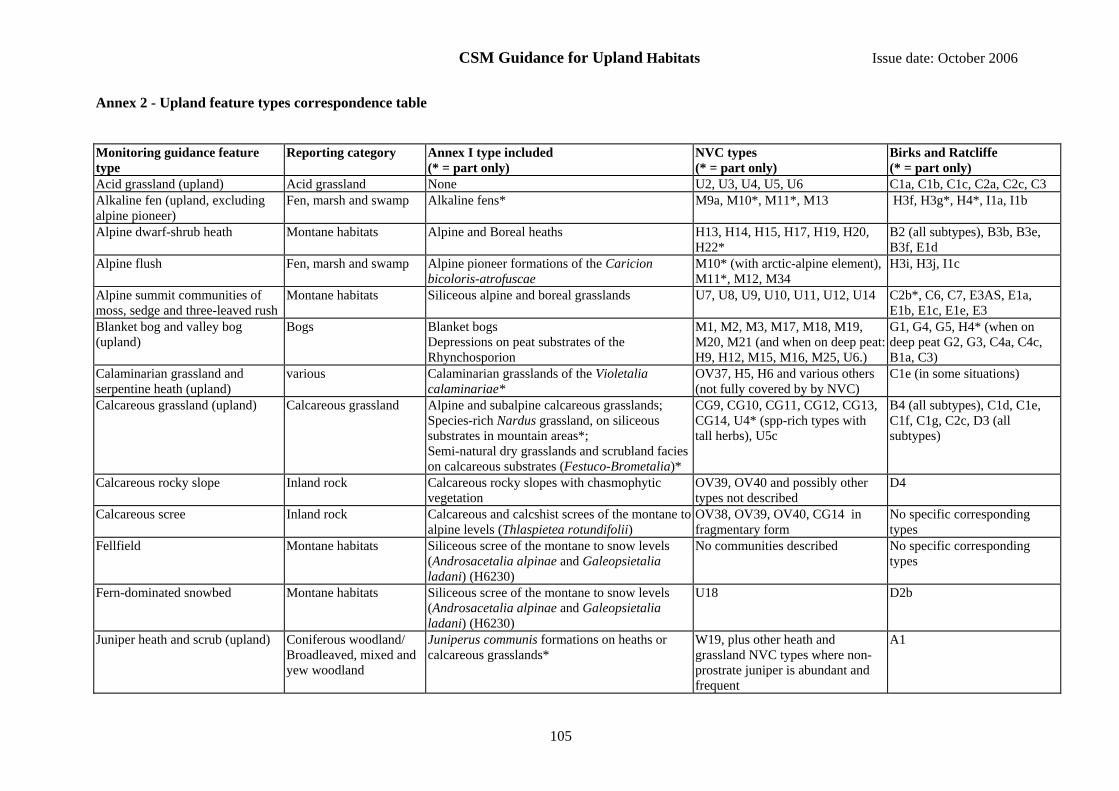
CSM Guidance for Upland Habitats Issue date: October 2006
105
Annex 2 - Upland feature types correspondence table
Monitoring guidance feature type
Reporting category Annex I type included (* = part only)
NVC types (* = part only)
Birks and Ratcliffe (* = part only)
Acid grassland (upland) Acid grassland None U2, U3, U4, U5, U6 C1a, C1b, C1c, C2a, C2c, C3 Alkaline fen (upland, excluding alpine pioneer)
Fen, marsh and swamp Alkaline fens* M9a, M10*, M11*, M13 H3f, H3g*, H4*, I1a, I1b
Alpine dwarf-shrub heath Montane habitats Alpine and Boreal heaths H13, H14, H15, H17, H19, H20, H22*
B2 (all subtypes), B3b, B3e, B3f, E1d
Alpine flush Fen, marsh and swamp Alpine pioneer formations of the Caricion bicoloris-atrofuscae
M10* (with arctic-alpine element), M11*, M12, M34
H3i, H3j, I1c
Alpine summit communities of moss, sedge and three-leaved rush
Montane habitats Siliceous alpine and boreal grasslands U7, U8, U9, U10, U11, U12, U14 C2b*, C6, C7, E3AS, E1a, E1b, E1c, E1e, E3
Blanket bog and valley bog (upland)
Bogs Blanket bogs Depressions on peat substrates of the Rhynchosporion
M1, M2, M3, M17, M18, M19, M20, M21 (and when on deep peat: H9, H12, M15, M16, M25, U6.)
G1, G4, G5, H4* (when on deep peat G2, G3, C4a, C4c, B1a, C3)
Calaminarian grassland and serpentine heath (upland)
various Calaminarian grasslands of the Violetalia calaminariae*
OV37, H5, H6 and various others (not fully covered by by NVC)
C1e (in some situations)
Calcareous grassland (upland) Calcareous grassland Alpine and subalpine calcareous grasslands; Species-rich Nardus grassland, on siliceous substrates in mountain areas*; Semi-natural dry grasslands and scrubland facies on calcareous substrates (Festuco-Brometalia)*
CG9, CG10, CG11, CG12, CG13, CG14, U4* (spp-rich types with tall herbs), U5c
B4 (all subtypes), C1d, C1e, C1f, C1g, C2c, D3 (all subtypes)
Calcareous rocky slope Inland rock Calcareous rocky slopes with chasmophytic vegetation
OV39, OV40 and possibly other types not described
D4
Calcareous scree Inland rock Calcareous and calcshist screes of the montane to alpine levels (Thlaspietea rotundifolii)
OV38, OV39, OV40, CG14 in fragmentary form
No specific corresponding types
Fellfield Montane habitats Siliceous scree of the montane to snow levels (Androsacetalia alpinae and Galeopsietalia ladani) (H6230)
No communities described No specific corresponding types
Fern-dominated snowbed Montane habitats Siliceous scree of the montane to snow levels (Androsacetalia alpinae and Galeopsietalia ladani) (H6230)
U18 D2b
Juniper heath and scrub (upland) Coniferous woodland/ Broadleaved, mixed and yew woodland
Juniperus communis formations on heaths or calcareous grasslands*
W19, plus other heath and grassland NVC types where non-prostrate juniper is abundant and frequent
A1
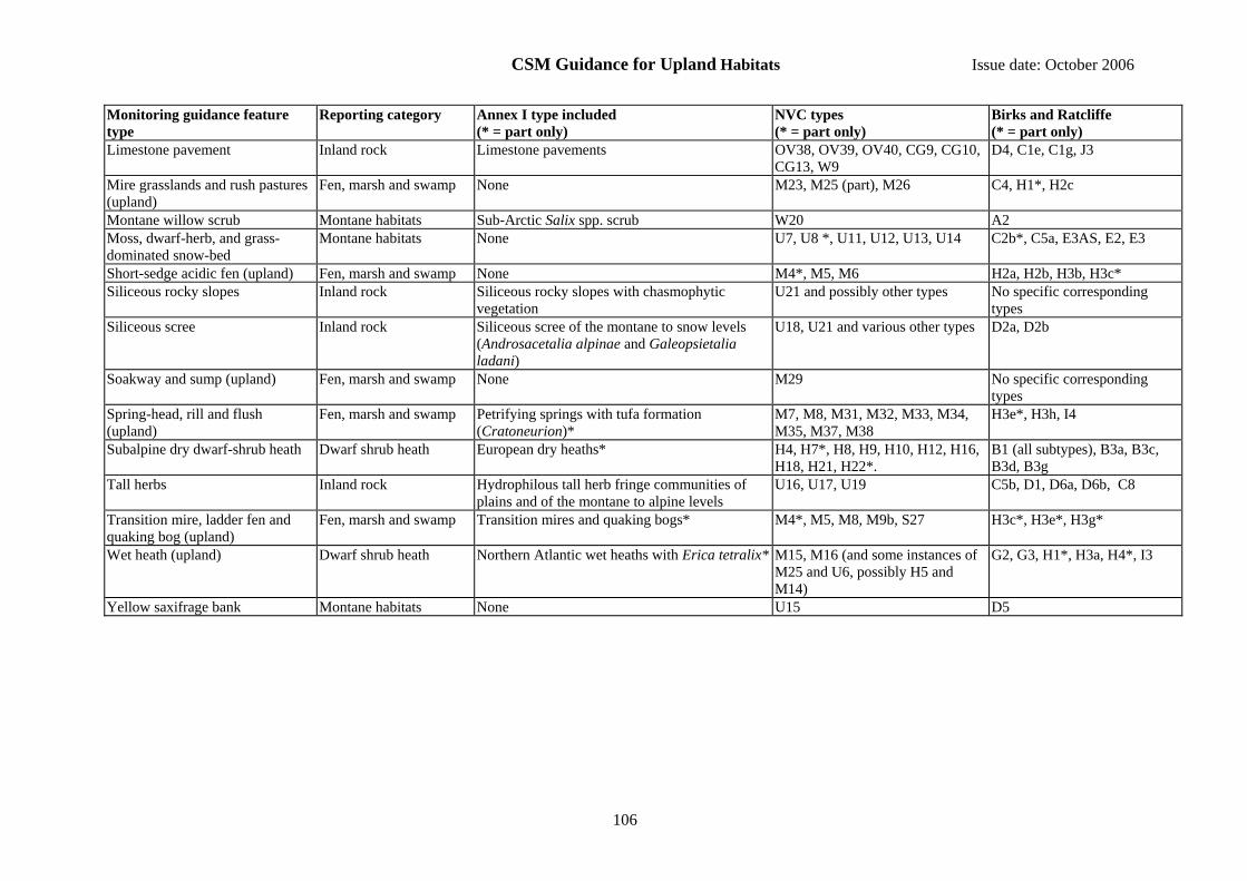
CSM Guidance for Upland Habitats Issue date: October 2006
106
Monitoring guidance feature type
Reporting category Annex I type included (* = part only)
NVC types (* = part only)
Birks and Ratcliffe (* = part only)
Limestone pavement Inland rock Limestone pavements OV38, OV39, OV40, CG9, CG10, CG13, W9
D4, C1e, C1g, J3
Mire grasslands and rush pastures (upland)
Fen, marsh and swamp None M23, M25 (part), M26 C4, H1*, H2c
Montane willow scrub Montane habitats Sub-Arctic Salix spp. scrub W20 A2 Moss, dwarf-herb, and grass-dominated snow-bed
Montane habitats None U7, U8 *, U11, U12, U13, U14 C2b*, C5a, E3AS, E2, E3
Short-sedge acidic fen (upland) Fen, marsh and swamp None M4*, M5, M6 H2a, H2b, H3b, H3c* Siliceous rocky slopes Inland rock Siliceous rocky slopes with chasmophytic
vegetation U21 and possibly other types No specific corresponding
types Siliceous scree Inland rock Siliceous scree of the montane to snow levels
(Androsacetalia alpinae and Galeopsietalia ladani)
U18, U21 and various other types D2a, D2b
Soakway and sump (upland) Fen, marsh and swamp None M29 No specific corresponding types
Spring-head, rill and flush (upland)
Fen, marsh and swamp Petrifying springs with tufa formation (Cratoneurion)*
M7, M8, M31, M32, M33, M34, M35, M37, M38
H3e*, H3h, I4
Subalpine dry dwarf-shrub heath Dwarf shrub heath European dry heaths* H4, H7*, H8, H9, H10, H12, H16, H18, H21, H22*.
B1 (all subtypes), B3a, B3c, B3d, B3g
Tall herbs Inland rock Hydrophilous tall herb fringe communities of plains and of the montane to alpine levels
U16, U17, U19 C5b, D1, D6a, D6b, C8
Transition mire, ladder fen and quaking bog (upland)
Fen, marsh and swamp Transition mires and quaking bogs* M4*, M5, M8, M9b, S27 H3c*, H3e*, H3g*
Wet heath (upland) Dwarf shrub heath Northern Atlantic wet heaths with Erica tetralix* M15, M16 (and some instances of M25 and U6, possibly H5 and M14)
G2, G3, H1*, H3a, H4*, I3
Yellow saxifrage bank Montane habitats None U15 D5