Embed Size (px)
Citation preview

Upgrade of Pacific Highway HW10, Ourimbah Street to Parsons Road, Lisarow
ROADS AND MARITIME SERVICES
Water Quality Assessment | Rev1c
22 October 2014

Water Quality Assessment
Upgrade of the Pacific Highway HW10, Ourimbah Street to Parsons Road Lisarow i
Upgrade of Pacific Highway HW10, Ourimbah Street to Parsons Road, Lisarow
Project no: NB98077 Document title: Water Quality Assessment Document no: Document No. Revision: Rev1c Date: 22 October 2014 Client name: Roads and Maritime Services Project manager: Rachel Vazey Author: Yanxi Chen, Joel Slinger File name: I:\NBIF\Projects\NB98077\Deliverables\Reports\Water Quality\Rev B Final V2
Issue\NB98077_Lisarow_REF_WQ_Final Draft_rev01c_ToIssue20141029.docx
Jacobs Group (Australia) Pty Limited ABN 37 001 024 095 100 Christie Street St Leonards NSW 2065 Australia PO Box 164 St Leonards NSW 2065 Australia T +61 2 9928 2100 F +61 2 9928 2500 www.jacobs.com
COPYRIGHT: The concepts and information contained in this document are the property of Jacobs Group (Australia) Pty Limited. Use or copying of this document in whole or in part without the written permission of Jacobs constitutes an infringement of copyright.
Document history and status
Revision Date Description By Review Approved
Draft_Rev1 04 July 2014 Water Quality REF Y Chen, J Slinger J Constandopoulos, T Daley R Vazey
Draft_Rev1a 11 July 2014 Water Quality Assessment Y Chen, J Slinger J Constandopoulos R Vazey
Final_Rev1a 11 September 2014
Water Quality Assessment Y Chen, J Slinger J Constandopoulos, Sarah Douglass
R Vazey
Final_Rev1b 12 September 2014
Water Quality Assessment Y Chen, J Slinger J Constandopoulos, Sarah Douglass
R Vazey
Final_Rev1c 22 October 2014
Water Quality Assessment Y Chen, J Slinger J Constandopoulos, Sarah Douglass
R Vazey

Water Quality Assessment
Upgrade of the Pacific Highway HW10, Ourimbah Street to Parsons Road Lisarow ii
Contents Executive Summary .............................................................................................................................................. iv 1. Introduction ................................................................................................................................................ 1 1.1 Project background ......................................................................................................................................................................... 1 1.2 Purpose of this report...................................................................................................................................................................... 3 1.3 Report structure .............................................................................................................................................................................. 3 2. Policy Setting ............................................................................................................................................. 7 2.1 Approach to this study .................................................................................................................................................................... 7 2.2 Legislative review............................................................................................................................................................................ 7 2.3 Guidelines ....................................................................................................................................................................................... 7 2.3.1 Construction phase ......................................................................................................................................................................... 7 2.3.2 Operational phase .......................................................................................................................................................................... 8 2.4 Water quality objectives and design criteria.................................................................................................................................... 8 3. Existing environment ................................................................................................................................ 9 3.1 Catchment context .......................................................................................................................................................................... 9 3.2 Existing water quality treatment .................................................................................................................................................... 15 3.3 Existing environmental values and conditions .............................................................................................................................. 16 3.4 Existing water quality data ............................................................................................................................................................ 16 3.4.1 Water quality indicators................................................................................................................................................................. 16 3.4.2 Data .............................................................................................................................................................................................. 17 4. Potential water quality impacts .............................................................................................................. 18 4.1 Construction phase impacts.......................................................................................................................................................... 18 4.1.1 Construction activities ................................................................................................................................................................... 18 4.1.2 Surface water quality .................................................................................................................................................................... 18 4.1.3 Resilience of sensitive environment sites to construction impacts ............................................................................................... 19 4.2 Operational phase impacts ........................................................................................................................................................... 19 4.2.1 Surface water quality .................................................................................................................................................................... 19 4.2.2 Accidental spills ............................................................................................................................................................................ 20 4.2.3 Extent of works in relation to operational impacts......................................................................................................................... 20 4.2.4 Resilience of downstream waterways to operational impacts....................................................................................................... 20 5. Water quality management measures ................................................................................................... 22 5.1 Construction phase mitigation....................................................................................................................................................... 22 5.1.1 Strategy ........................................................................................................................................................................................ 22 5.1.2 Procedural controls ....................................................................................................................................................................... 22 5.1.3 Site management erosion controls ............................................................................................................................................... 23 5.1.4 Physical controls ........................................................................................................................................................................... 23 5.1.5 Treatment with sediment basins ................................................................................................................................................... 24 5.1.5.1 Location of basins ......................................................................................................................................................................... 24 5.1.6 Maintenance for construction phase ............................................................................................................................................. 28 5.1.7 Monitoring for construction phase ................................................................................................................................................. 28 5.2 Operational phase mitigation ........................................................................................................................................................ 28

Water Quality Assessment
Upgrade of the Pacific Highway HW10, Ourimbah Street to Parsons Road Lisarow iii
5.2.1 Strategy ........................................................................................................................................................................................ 28 5.2.2 Physical water quality controls ...................................................................................................................................................... 29 5.2.2.1 Design criteria for water quality treatment systems ...................................................................................................................... 29 5.2.2.2 Type of treatment .......................................................................................................................................................................... 29 Water quality basins .................................................................................................................................................................................... 29 Spill basins .................................................................................................................................................................................................. 29 5.2.2.3 Location of treatment .................................................................................................................................................................... 30 5.2.2.4 Sizing operational treatment ......................................................................................................................................................... 30 Preliminary water quality modelling of basins .............................................................................................................................................. 30 5.2.3 Maintenance requirements for operational phase......................................................................................................................... 31 6. Conclusion ............................................................................................................................................... 32 7. References ............................................................................................................................................... 33
Appendix A. Additional Information

Water Quality Assessment
Upgrade of the Pacific Highway HW10, Ourimbah Street to Parsons Road Lisarow iv
Executive Summary Roads and Maritime Services (Roads and Maritime) propose to upgrade the Pacific Highway, Ourimbah Street to Parsons Road, Lisarow (the proposal). This Water Quality Design Report has been prepared as part of the Review of Environmental Factors (REF) currently being completed for the proposal and aims to identify the strategies to manage surface water quality during construction and operation. A list of the statutory requirements and guidelines for water quality management during the construction phase and the operational phase of the proposal are also included in the report.
The main features of the proposal include:
• Widening to include two additional 3.3 metre wide lanes (one northbound and one southbound).
• Widening of shoulders by up to two metres, for consistent widths along the length of the proposal.
• Maintaining a 60 kilometres per hour design and posted speed limit.
• A new rail over bridge replacing the existing bridge over the Main North Rail Line at Railway Crescent on the Pacific Highway.
• Intersection upgrades at:
- Chamberlain Road and Pacific Highway intersection: Line work and relocation of traffic lights.
- Rail maintenance access road: Relocation of the access road about 100 metres to the east, with all vehicle movements permitted at the intersection.
- Macdonalds Road and Pacific Highway intersection: Relocated around 25 metres to the south to align with Tuggerah Street and new traffic lights installed at the intersection.
- Tuggerah Street and Macdonalds Road intersection: Relocation and realignment of the intersection so that priority would be given to traffic on Tuggerah Street and traffic on Macdonalds Road is required to give way.
- Railway Crescent and Pacific Highway intersection: Providing a wider radius of the curve approaching the Pacific Highway, and traffic lights at the intersection.
- Dora Street and Railway Crescent intersection: Adjusting the intersection to the south-west by about 30 metres, and enforcing a no right turn from Dora Street to Railway Crescent.
• Raised concrete median along the length of the proposal, and at the approaches to intersections at Railway Crescent, Macdonalds Road and Chamberlain Road
• Eight retaining walls at:
- Pacific Highway, south west of Chamberlain Road, next to the southbound lane.
- Pacific Highway, south west of Macdonalds Road, next to the southbound lane.
- Pacific Highway, south of the rail overbridge, on both sides of the road.
- Corner Pacific Highway and Railway Crescent, directly north of the rail overbridge.
- Pacific Highway, north of Railway Crescent, on both sides of the road.

Water Quality Assessment
Upgrade of the Pacific Highway HW10, Ourimbah Street to Parsons Road Lisarow v
- Along the boundary of the rail corridor between the Lisarow Train Station access road and the Lisarow Rail Overbridge.
• New road surface for the length of the proposal and tie ins to existing roads.
• Shared pedestrian cycleways and footpaths throughout the proposal area. Safety fencing will be provided for pedestrians in steep areas.
• Removal of unused bus stops immediately north of Railway Crescent on the northbound carriageway and on both sides of Macdonalds Road.
• Installation of two permanent operational water quality basins that would also act as sediment control basins during construction.
• Kerb and guttering the length of the proposal.
• Use of ancillary construction facilities, including site compounds and stockpile sites and hardstands.
• Relocation of utilities.
• Property acquisition and adjustment.
The proposal involves the upgrade of the Pacific Highway to a four lane carriageway between Ourimbah Street and Parsons Road. This includes substantial road construction works. During construction of the proposal, there is potential for the works to increase the levels of pollutants to downstream waterways, particularly through activities such as vegetation clearance, topsoil stripping and cut and fill earthworks. During operation, increased impervious areas and formalised drainage systems have the potential to concentrate flows and increase levels of pollutants discharging to downstream waterways due to their proximity to the proposal. The assessment deemed that mitigation measures for both construction and operation would be required.
Mitigation of construction impacts would be in line with the strategies recommended in the Managing Urban Stormwater- Soils and Construction, Volume 1, 4th Edition (referred to as the Blue Book) (Landcom, 2004). A preliminary assessment has indicated this would include up to two sediment basins. The volumes of these sediment basins would be derived in the Concept Design in accordance with the requirements of the Blue Book (Landcom, 2004, NSW DECC 2008). Elsewhere, localised erosion and sediment controls would be provided. These controls would be part of a multi-faceted approach that would also include procedural controls, site management controls and monitoring.
The operational water quality strategy is to prevent or reduce water quality impacts to downstream waterways as a result of operation of the proposal, particularly new sections of road that would be developed. Mitigation would apply to all sections of the highway. It would be focused on locations where runoff has been concentrated into defined outlet points through the implementation of kerbs and gutters or longitudinal road pavement drainage piping systems. A preliminary assessment has indicated this would include up to two permanent water quality basins. These basin volumes have been estimated based on the requirement to satisfy Roads and Maritime water quality objectives. These two permanent basins would be converted from construction phase sediment basins.
The size and location of the water quality mitigation measures would be further investigated, and modelled using appropriate tools during the Concept Design in order to confirm these preliminary assessment findings. This would be performed in accordance with the criteria detailed in this report.

Water Quality Assessment
Upgrade of the Pacific Highway HW10, Ourimbah Street to Parsons Road Lisarow 1
1. Introduction 1.1 Project background
The Pacific Highway north of Gosford is the urban arterial road providing access to Gosford’s northern suburbs and the Pacific Motorway (M1) at Ourimbah. The highway is currently a single lane in each direction from Manns Road, Wyoming to Glen Road at Ourimbah, refer to Figure 1-1. This section of the Pacific Highway currently carries around 30,000 vehicles per day from regional and local areas. The study area is located between Ourimbah Street and Parsons Road within the Gosford local government area (LGA).
The NSW State Infrastructure Strategy outlines the progressive upgrading of the highway to four-lane urban arterial road standard between North Gosford and the motorway. The upgrade of the Pacific Highway between North Gosford and the motorway was broken down into three progressive stages by Roads and Maritime Services (Roads and Maritime). Stages 1 and 2 of the upgrade of the Pacific Highway between the M1 Pacific Motorway and Glen Road at Ourimbah are now complete. The first stage, which involved upgrading the Dog Trap Road intersection, was completed in July 2007. The second stage, which involved widening the highway between Glen Road and Burns Road at Ourimbah, was completed in January 2010. Stage 3 has been broken down into two sub-stages and includes stages 3a and 3b. The design for stage 3a between Glen Road and Ourimbah Street has been completed and is waiting for construction funding.
As part of Stage 3b Roads and Maritime Services (Roads and Maritime) are proposing to upgrade 1.6 kilometres of the Pacific Highway, between Ourimbah Street and Parsons Road, Lisarow (the proposal), refer to Figure 1-2. Key features of the proposal are outlined in Table 1-1.
Table 1-1 Key elements of the proposal
Key element Description Design speed • 60 km/h design speed and posted speed limit along the length
of the proposal.
Road width • An additional 3.3 metres wide lane in both directions on the Pacific Highway.
• Widened shoulders by up to 2.0 metres for consistent shoulder widths along the length of the proposal.
• Raised concrete median along the length of the proposal and traffic islands at the approaches to the Pacific Highway at Railway Crescent, Macdonalds Road and Chamberlain Road.
Lisarow Rail Overbridge • Demolition of the of the existing bridge and replacement with a new rail overbridge over the Main Northern Railway Line immediately south of Railway Crescent on the Pacific Highway.
Intersection upgrades • Chamberlain Road and Pacific Highway intersection: Line work and relocation of traffic lights.
• Rail maintenance access road and Pacific Highway intersection: Relocating the access road around 100 metres to the north-east, with all vehicle movements permitted at the intersection.
• Macdonalds Road and Pacific Highway intersection:
Water Quality Assessment
Upgrade of the Pacific Highway HW10, Ourimbah Street to Parsons Road Lisarow 2
Key element Description Relocated around 25 metres to the south to align with Tuggerah Street and new traffic lights installed at the intersection.
• Tuggerah Street and Macdonalds Road intersection: Relocation and realignment of the intersection so that priority would be given to traffic on Tuggerah Street and traffic on Macdonalds Road is required to give way.
• Railway Crescent and Pacific Highway intersection: Providing a wider radius of the curve approaching the Pacific Highway, and traffic lights at the intersection.
• Dora Street and Railway Crescent intersection: Adjusting the intersection to the south-west by around 30 metres and enforcing a no right turn from Dora Street to Railway Crescent.
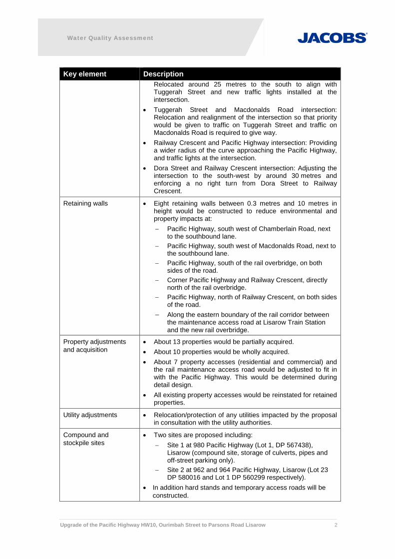
Retaining walls • Eight retaining walls between 0.3 metres and 10 metres in height would be constructed to reduce environmental and property impacts at: − Pacific Highway, south west of Chamberlain Road, next
to the southbound lane. − Pacific Highway, south west of Macdonalds Road, next to
the southbound lane. − Pacific Highway, south of the rail overbridge, on both
sides of the road. − Corner Pacific Highway and Railway Crescent, directly
north of the rail overbridge. − Pacific Highway, north of Railway Crescent, on both sides
of the road. − Along the eastern boundary of the rail corridor between
the maintenance access road at Lisarow Train Station and the new rail overbridge.
Property adjustments and acquisition
• About 13 properties would be partially acquired. • About 10 properties would be wholly acquired. • About 7 property accesses (residential and commercial) and
the rail maintenance access road would be adjusted to fit in with the Pacific Highway. This would be determined during detail design.
• All existing property accesses would be reinstated for retained properties.
Utility adjustments • Relocation/protection of any utilities impacted by the proposal in consultation with the utility authorities.
Compound and stockpile sites
• Two sites are proposed including: − Site 1 at 980 Pacific Highway (Lot 1, DP 567438),
Lisarow (compound site, storage of culverts, pipes and off-street parking only).
− Site 2 at 962 and 964 Pacific Highway, Lisarow (Lot 23 DP 580016 and Lot 1 DP 560299 respectively).
• In addition hard stands and temporary access roads will be constructed.

Water Quality Assessment
Upgrade of the Pacific Highway HW10, Ourimbah Street to Parsons Road Lisarow 3
Key element Description Water quality measures •
•
Installation of two water quality basins: − Basin A - At the southern end of Lot 1 and DP 2417
between the rail maintenance access road and the Pacific Highway in areas of Swamp Sclerophyll Forest.
− Basin B - Around 130 metres south of the Pacific Highway and Macdonalds Road intersection next to the northbound carriageway in areas of Lot 10 DP 838947 and Lot 1 DP 2417. This area is currently cleared but is next to areas of Swamp Sclerophyll Forest to the south and Freshwater Wetlands to the north.
Kerb and guttering along the length of the proposal.
Pedestrian and cyclist facilities
• Shared pedestrian cycleways and footpaths throughout the proposal area, with additional safety fencing for pedestrians in steep areas and along retaining walls.
This Water Quality Design Report has been prepared as part of the Review of Environmental Factors (REF) currently being completed for the proposal and aims to identify the strategies to manage surface water quality during construction and operation.
1.2 Purpose of this report
This report details a review of the potential impacts on surface water quality as a result of the construction and operation of the proposal. It recommends mitigation measures to address these impacts. The purpose of this report is to provide a detailed analysis for input into the Review of Environmental Factors (REF).
1.3 Report structure
This report is structured as follows:
• Section 1: Introduction.
• Section 2: Policy setting.
• Section 3: Existing environment.
• Section 4: Potential water quality impacts.
• Section 5: Water quality management measures.
• Section 6: Conclusion.
• Section 7: References.

PA
CIF
ICH
WY
WYO
NG
ROAD
AVOCA DRIVE
PACIFIC MOTORWAY
PEATSR
IDG
E
ROAD
TUGGERAHLAKE
BRISBANEWATER
NARARACREEK
CHITTAWAY
CREEK
CUT
ROCK CREEK
BERK
ELEY CREEK
FIRE
SCREEK
WYONG RIVER
ERIN
ACREEK
OU
RIM
BAH
CREEK
BANG
ALOW
CREEK
LISAROW
WOY WOY
KARIONG
KINCUMBER
ERINA
OURIMBAH
TUGGERAH
TACOMA
TUMBIUMBI
KANGYANGY
WYONG CREEK
GOSFORD
WYONG
GOSFORD CITYCOUNCIL
WYONGSHIRE
COUNCIL
WYONG STATEFOREST
OURIMBAHSTATE
FOREST
STRICKLANDSTATE
FOREST
BOUDDI NP
WAMBINA NR
WAMBERALLAGOON NR
PALMGROVE NR
TUGGERAH NR
WYRRABALONG NP
TUGGERAH SC
JILLIBY SC
BRISBANEWATER NP
FIGURE 1-1 | REGIONAL OVERVIEW
WYONG
WOY WOY
LISAROWGOSFORD
THE ENTRANCE
WATER QUALITY ASSESSMENTUpgrade of the Pacific Highway, Ourimbah Street to Parsons Road, Lisarow
0 4
Kilometres
LEGEND
Project area
Road
Railway
Waterway
Water body
State forest
NPWS Reserve
Local Government Area
DATA SOURCESImagery: AUSIMAGE 2010Contextual layers: LPMA 2014Design: RMS 2014
L:\Technical\Spatial\ArcMap\Specialist_reports\Water_quality\NB98077_WQ_F001_Regional_r1v1.mxdNewcastle Spatial Team - Prepared by : AL
Checked by : RV
Jacobs does not warrant that this document isdefinitive nor free of error and does not acceptliability for any loss caused or arising from relianceupon information provided herein.

56205640
56605680
57005720
57405760
5780
5800
5820
5840
5860
5880
59005920
59405960
59806000
60206040
60606080
6100
6120
61406160
61806200
62206240
62606280
63006320
63406360
6380
6400
6420
6440
6460
6480
6500
6520
6540
0
20
40
0
20
40
60
80
100
120
140
160
180
0
20
40
0 20 40 6080
100
CHAMBERLAIN ROADC
HAM
BER
LAIN
ROAD
PAR
SONS RO
AD
TAYLOR ROAD
BURNSIDE C LOS
E
RAILWAY CRESCENT
MACDONALDSRO AD
AWABA STREET
DP715140
Lot 1
DP563841
Lot 162
DP815279
Lot 5
DP8
7326
5Lo
t 87
DP563841
Lot 161
DP802511Lot 2
DP830074Lot 11
DP788132Lot 10
DP8
3007
4Lo
t 12
DP1
0597
17Lo
t 2
DP786843Lot 24
DP8
7326
5Lo
t 89
DP786843Lot 38
DP815279
Lot 4
DP8
3007
4Lo
t 13
DP802511Lot 1
DP786843Lot 39
DP1002210Lot 12
DP1
0597
17Lo
t 1
DP8
3452
6Lo
t 22
DP774859Lot 21
DP1022555Lot 2
SP68745Lot
DP241243
Lot 17
DP809307Lot 5
DP394596Lot A
DP826847Lot 14
DP1022555Lot 1
DP1
0225
55Lo
t 3
DP8
2684
7Lo
t 16
DP241243
Lot 1
9
DP8
3894
7Lo
t 10
DP550554
Lot 151
DP241243
Lot 18
DP6
0566
4Lo
t 51
DP241243
Lot 12
DP5
5314
6Lo
t 1
DP550554
Lot 153
DP5
8438
5Lo
t 81
DP550554
Lot 152
DP2417Lot 1
DP2417Lo
t 1
DP261064
Lot 2
DP1
0478
82Lo
t 11
DP553146Lot 2
DP403954Lot A
DP1084588Lot 3
SP76195Lot
DP1102601Lot 119
DP1
1415
51Lo
t 10
DP1
1415
51Lo
t 11
DP1155734
Lot 2
SP84
416
Lot
DP1
1721
79Lo
t 101
DP1172179
Lot 102
DP1084588Lot 2
DP11913
19
Lot 1
002
DP1191207
Lot 1001
LISAROW
WATER QUALITY ASSESSMENTUpgrade of the Pacific Highway, Ourimbah Street to Parsons Road, Lisarow
0 100
Metres
LEGEND
20% concept design
Retaining wall
Railway
Waterway
Cadastre
Water body
FIGURE 1-2a | OVERVIEW OF THE ROAD DESIGN
Newcastle Spatial Team - Prepared by : KMChecked by : RV
Jacobs does not warrant that this document is definitive nor free of error and does not accept liability for any loss caused or arisingfrom reliance upon information provided herein.
DATA SOURCESImagery: AUSIMAGE 2010Contextual layers: LPMA 2014Design: RMS 2014
L:\Technical\Spatial\ArcMap\Specialist_reports\Water_quality\NB98077_WQ_F002_Design_r1v1.mxd

6440
6460
6480
6500
6520
6540
6560
6580
6600
6620
6640
6660
6680
6700
6720
6740
6760
6780
6800
6820
6840
6860
6880
6900
6920
6940
6960
6980
7000
7020
7040
0 20 40 6080
02040
60
80
100
120
140
160
180
0
20
40WAL
LAR
AH
STR
EET
RAILW
AYCRESC
ENT
YIRIK CLOSE
FAGAN
S RO
AD
CAMBOURN DRIVE
WINTER CLOSE
LIS
AR
OW
STR
EET
B ARKALA STREET
DORA STREET
SETT
LERS
RIDG
EC
LOS
E
EAGLE CLOSE
TUGGERAH STREET
DP786843Lot 42
DP7
8684
3Lo
t 41
DP786843
Lot 8
DP713038Lot 1
DP6
0564
0Lo
t 23
DP786843Lot 37
DP786843
Lot 9
DP786843Lot 3
DP786843
Lot 34
DP788132Lot 10
DP786843Lot 4
DP786843Lot 25
DP7
8684
3Lo
t 21
DP7
8684
3Lo
t 16
DP7
8684
3Lo
t 35
DP786843Lot 48
DP786843Lot 27
DP786843
Lot 7
DP811049Lot 1
DP786843Lot 24
DP9
5149
1Lo
t 1
DP786843Lot 26
DP786843Lot 38
DP2
5513
1Lo
t 20
DP786843Lot 49
DP786843Lot 39
DP786843Lot 45
DP786843Lot 36
DP776924Lot 8
DP255131
Lot 22
DP255131Lot 21
DP255131Lot 23
DP8
3452
6Lo
t 22
DP2417Lot 25
DP2
5881
5Lo
t 16
DP2417Lot 15
DP826847Lot 18
DP774859Lot 21
DP2
417
Lot 2
1
DP2417Lot 12
DP258815Lot 20
DP2417Lot 16
DP261667Lot 14
DP2
417
Lot 7
DP2417Lot 23
DP2
5881
5Lo
t 14
DP776924Lot 7
DP2417Lot 13
DP8
2684
7Lo
t 3
DP2417Lot 26
DP776924Lot 6
DP2
5881
5Lo
t 15
DP2417Lot 22
DP826847Lot 7
DP2
417
Lot 8
DP2
5881
5Lo
t 13
DP2
417
Lot 2
4
DP2417Lot 14
DP2417Lot 24
DP776924Lot 9
DP261667Lot 13
DP2417Lot 27
DP261667
Lot 5
DP2
417
Lot 2
2DP2417Lot 14
DP261667
Lot 10
DP527318Lot 1
DP261667
Lot 1
2
DP776924Lot 10
DP2
417
Lot 2
3
DP261667Lot 15
DP2417Lot 16
DP232680Lot 4
DP605664Lot 52
DP8
3894
7Lo
t 10
DP2417Lot 28
DP456123Lot 6
DP1
0070
01Lo
t 1
DP2417Lot 21
DP456123Lot 1
DP2417Lot 15
DP2417Lot 19
DP2417Lot 18
DP536949Lot 4
DP2417Lot 20
DP2417Lot 17
DP456123Lot 3
DP1
0070
01Lo
t 2
DP241
7Lo
t 1
DP456123Lot 7
DP456123Lot 2
DP827991Lot 45
DP456123Lot 4
DP456123Lot 5
DP1084588Lot 3
DP1102601Lot 119
DP1120209Lot 2
DP11227
07Lo
t 1
DP1084588Lot 6
DP1084588Lot 4
DP1084588Lot 2
DP1084588Lot 7
DP1084588Lot 5
DP553381Lot 3
CU
TR
OC
KC
REE
K
LISAROW
WATER QUALITY ASSESSMENTUpgrade of the Pacific Highway, Ourimbah Street to Parsons Road, Lisarow
0 100
Metres
LEGEND
20% concept design
Retaining wall
Railway
Waterway
Cadastre
Water body
FIGURE 1-2b | OVERVIEW OF THE ROAD DESIGN
Newcastle Spatial Team - Prepared by : KMChecked by : RV
Jacobs does not warrant that this document is definitive nor free of error and does not accept liability for any loss caused or arisingfrom reliance upon information provided herein.
DATA SOURCESImagery: AUSIMAGE 2010Contextual layers: LPMA 2014Design: RMS 2014
L:\Technical\Spatial\ArcMap\Specialist_reports\Water_quality\NB98077_WQ_F002_Design_r1v1.mxd

Water Quality Assessment
Upgrade of the Pacific Highway HW10, Ourimbah Street to Parsons Road Lisarow 7
2. Policy Setting 2.1 Approach to this study
The primary objective of this study has been to assess and manage potential impacts to water quality and identify measures to avoid or minimise potential impacts from surface runoff on downstream waterways during construction and operation phases.
2.2 Legislative review The following NSW legislation and statutory requirements are considered in the water quality assessment:
• Protection of the Environment Operations Act 1997 (POEO Act), which sets the framework for environment protection during the construction and operation of a development or undertaking of an activity. The POEO Act consolidates key pollution statutes relating to air, water and noise pollution and environmental offences, and establishes a duty to notify either the Environmental Protection Authority (EPA) or the local council where incidents are likely to cause material harm to the environment.
• NSW Fisheries Management Act 1994 (FM Act), which provides for the protection of threatened fish and marine vegetation and is administered by the Department of Primary Industries (DPI). The FM Act, in conjunction with the Threatened Species Conservation Act 1995 (TSC Act), aims to conserve, develop and share fishery resources and conserve marine species, habitats and diversity. While no works are proposed within waterway crossings, this Act must be considered in order to preserve water quality within the downstream waterways.
• Water Management Act 2000 (WM Act). The Act provides for the protection of river and lakeside land in NSW and aims to provide for the sustainable management of the water resources throughout NSW. It identifies provisions relating to ‘controlled activities’ which includes (among other definitions) the carrying out of any activity that affects the quantity or flow of water in a water source’ or affects land fronting a waterway. However, in accordance with clause 39A(1) of the Water Management (General) Regulation 2004, Roads and Maritime is permitted to undertake works within 40 metres of a watercourse without obtaining a permit under the WM Act.
2.3 Guidelines
The following design guidelines and management procedures are relevant in determining the appropriate water quality management and mitigation measures to be implemented during the construction and operational phases of the proposed upgrade.
2.3.1 Construction phase
The following guidelines seek to minimise land degradation and water pollution from road construction sites in New South Wales. The guidelines have been used to identify appropriate management procedures during construction works and physical controls to minimise erosion and to prevent sediment moving off site during the construction phase of the works.
• NSW Department of Environment, Climate Change and Water (DECCW) 2008, Managing Urban Stormwater-Volume 2D Main Road Construction.
• Landcom 2004, Managing Urban Stormwater- Soils and Construction, Volume 1, 4th Edition (referred to as the Blue Book).

Water Quality Assessment
Upgrade of the Pacific Highway HW10, Ourimbah Street to Parsons Road Lisarow 8
• Roads and Traffic Authority (RTA) 1999, Code of Practice for Water Management - Road Development and Management.
• RTA 2003, Road Design Guideline: Section 8 Erosion and Sediment.
• RTA 2003, Guideline for Construction Water Quality Monitoring.
• RTA 2009, Erosion and Sediment Management Procedures.
• Roads and Maritime Services (Roads and Maritime) 2011, Stockpile Site Management Guideline.
• Roads and Maritime 2011, Technical Guideline: Temporary Stormwater Drainage for Road Construction.
• Roads and Maritime 2011, Technical Guideline: Environmental Management of Construction Site Dewatering.
• Roads and Maritime 2012, Environmental Direction: Management of Tannins from Vegetation Mulch.
2.3.2 Operational phase
The following documents provide guidance on water management and conservation practices related to the design, operation and maintenance of the roads and traffic system in order to protect waterways and water quality where practicable and feasible. In addition they provide guidance on designing permanent water quality treatment in a consistent and practicable manner. The design for the proposal would address the sensitivity of receiving waters and local environment along the proposal.
• RTA (2003a). Procedures for Selecting Treatment Strategies to Control Road Runoff, Roads and Traffic Authority of NSW: Sydney.
• RTA (1999). RTA Code of Practice for Water Management, Roads and Traffic Authority of NSW: Sydney.
• RTA (1997). RTA Water Policy, Roads and Traffic Authority of NSW, Sydney.
• EPA (1997). Managing Urban Stormwater: Council Handbook, NSW Environmental Protection Authority: Sydney.
• Austroads (2001). Road Runoff and Drainage: Environmental Impacts and Management Options, Austroads AP-R180.
• Austroads (2003). Guidelines for Treatment of Stormwater Runoff from the Road Infrastructure, Austroads AP-R232.
• Austroads (2010). Guide to Road Design, Part 5: Drainage Design.
• DECCW (2007). Managing Urban Stormwater, Environmental Targets Consultation Draft, Department of Environment, Climate Change and Water.
2.4 Water quality objectives and design criteria The water quality objectives for the proposal have been determined through the design criteria that aim to reduce the annual average pollutant loads from the upgraded road pavement surface area by the targets described and listed in Section 5.2.2.1 of this report.

Water Quality Assessment
Upgrade of the Pacific Highway HW10, Ourimbah Street to Parsons Road Lisarow 9
3. Existing environment 3.1 Catchment context
The study area for this development is located predominantly within the Ourimbah sub catchment, which sits in the Hunter-Central Rivers Catchment (HCRCMA) area. The Ourimbah Catchment is moderately sized, drawing from 169 kilometres square (Webb, Mckeown & Associates, 1997).
The proposal runs parallel to the upstream extent of Cut Rock Creek which is the predominant waterway within the study area, refer to Figure 3-1. The Cut Rock Creek drainage area is approximately 10 kilometres square, flowing in a general south-north direction before converging with Bangalow Creek, Ourimbah Creek and eventually the estuarine reaches of Tuggerah Lakes. Upstream of this, some small ephemeral unnamed tributaries/flowpaths flow into Cut Rock Creek, both above and within the study area. A number of water flowpaths occur within the proposal area, all of which are tributaries of Cut Rock Creek. While some of these flowpaths are natural watercourses, some flowpaths are not, for example the urban drain extending between Chamberlain Road and Macdonalds Road to the east of the Pacific Highway. A very small part of the study area buffer zone also falls within the Narara Creek Catchment however this is at the upstream limit of the study area. Narara Creek drains in a general north-south direction into Brisbane Water..
The study area incorporates a number of different landuse types, including low density residential areas, general industrial areas, nature reserves, highways and main roads, agriculture and public recreational areas (Hyder, 2011). The Cut Rock Creek interacts with most of these landuse areas as it flows adjacent to and through the study area. This creek is likely to be in moderately disturbed condition, with many potential impact sources within the catchment area.
The southern end of the proposal is within low lying and flood prone land. The Lisarow and Railway Crescent/Pacific Highway freshwater wetlands are located next to the Pacific Highway to the south of the rail overbridge and are naturally water logged and inundated (Hyder, 2009). These wetlands are sensitive ecosystems and are recognised as the Freshwater Wetlands on Coastal Floodplains of the New South Wales North Coast, Sydney Basin and South Basin and South East Corner Bioregions (Freshwater Wetlands) which are recognised as Endangered Ecological Communities (EEC) under the Threatened Species Conservation Act 1995 (TSC Act). Other sensitive vegetation located next to wetlands and in the low-lying areas includes Swamp Sclerophyll Forest on Coastal Floodplains of the New South Wales North Coast, Sydney Basin and South East Corner Bioregions (Swamp Sclerophyll Forest), which is also an EEC under the TSC Act. In addition the Swamp Sclerophyll Forest contains the threatened flora species Melaleuca biconvexa (Biconvex paperback) which is listed as vulnerable under the TSC Act and the Environment Protection and Biodiversity Conservation Act 1999 (EPBC Act). Figure 3-2 shows the location of the two EECs and Figure 3-3 shows the location of the threatened flor species Melaleuca biconvexa relative to the proposal. With respect to the proposal, it is important that the natural flow regime and hydrology is maintained to minimise impacts to these wetlands. For in depth analysis of the wetland environmental values and potential impacts and mitigation measures please refer to the Biodiversity Assessment (Section 3.11, Section 4 and Section 5).The primary flooding mechanism of the existing highway is the lack of capacity in both the existing cross drainage structures as well as the road drainage network to cope with major rainfall events (Roads and Maritime, 2012).

PAR
SON
SR
OAD
CH
AM
BER
LAIN
RO
AD
THE
VALL
EY WAY
TUGGERAH
STR
EET
BAILEYSR
OA
D
RAILWAY CRESCENT
TIMBER DRIVE
TAYLOR ROAD
BUR NS
IDE
CLO
SE
NEWLING STREET SILV
ERPL
ACE
JAN
INE
CLO
SE
CAMBOURNDRIVE
WINTER CLOSE
WAL
LARA
H S
TREE
T
OURIMBAH STREET
EXC
ELS
IOR
STR
EET
THE
RISE
LIS
ARO
WS
TREE
T
STEW
ART
BRO
UG
HAM
CLO
SE
BRA
ND
S P
LAC
E
BAR
KA
LA STREET
MANNINGS ROAD
DORA STREET
AWABA STREET
SETT
LERS
RID
GE
CLOSE
EAGLE C LOSE
FAGANS ROAD
DONNA CLOSE
MACDONALDSROAD
CUT ROCK CREEK
FIGURE 3-1 | WATERWAYS NEAR THE PROPOSAL
LISAROW
WATER QUALITY ASSESSMENTUpgrade of the Pacific Highway, Ourimbah Street to Parsons Road, Lisarow
0 260
Metres
LEGEND
20% concept design
Retaining wall
Railway
Waterway
Cadastre
Water body
DATA SOURCESImagery: AUSIMAGE 2010Contextual layers: LPMA 2014Design: RMS 2014Heritage: NSW DPI 2007
11/07/2014 | L:\Technical\Spatial\ArcMap\Specialist_reports\Water_quality\NB98077_WQ_F004_Waterways_r1v1.mxdNewcastle Spatial Team - Prepared by : KM
Checked by : RV
Jacobs does not warrant that this document is definitive nor freeof error and does not accept liability for any loss caused or arisingfrom reliance upon information provided herein.

56205640
56605680
57005720
57405760
5780
5800
5820
5840
5860
5880
59005920
59405960
59806000
60206040
60606080
6100
6120
61406160
61806200
62206240
62606280
63006320
63406360
6380
6400
6420
6440
6460
6480
6500
6520
6540
0
20
40
0
20
40
60
80
100
120
140
160
180
0
20
40
0 20 40 6080
100
CHAMBERLAIN ROADC
HAM
BER
LAIN
ROAD
PAR
SONS RO
AD
TAYLOR ROAD
BURNSIDE C LOS
E
RAILWAY CRESCENT
MACDONALDSRO AD
AWABA STREET
DP715140
Lot 1
DP563841
Lot 162
DP815279
Lot 5
DP8
7326
5Lo
t 87
DP563841
Lot 161
DP802511Lot 2
DP830074Lot 11
DP788132Lot 10
DP8
3007
4Lo
t 12
DP1
0597
17Lo
t 2
DP786843Lot 24
DP8
7326
5Lo
t 89
DP786843Lot 38
DP815279
Lot 4
DP8
3007
4Lo
t 13
DP802511Lot 1
DP786843Lot 39
DP1002210Lot 12
DP1
0597
17Lo
t 1
DP8
3452
6Lo
t 22
DP774859Lot 21
DP1022555Lot 2
SP68745Lot
DP241243
Lot 17
DP809307Lot 5
DP394596Lot A
DP826847Lot 14
DP1022555Lot 1
DP1
0225
55Lo
t 3
DP8
2684
7Lo
t 16
DP241243
Lot 1
9
DP8
3894
7Lo
t 10
DP550554
Lot 151
DP241243
Lot 18
DP6
0566
4Lo
t 51
DP241243
Lot 12
DP5
5314
6Lo
t 1
DP550554
Lot 153
DP5
8438
5Lo
t 81
DP550554
Lot 152
DP2417Lot 1
DP2417Lo
t 1
DP261064
Lot 2
DP1
0478
82Lo
t 11
DP553146Lot 2
DP403954Lot A
DP1084588Lot 3
SP76195Lot
DP1102601Lot 119
DP1
1415
51Lo
t 10
DP1
1415
51Lo
t 11
DP1155734
Lot 2
SP84
416
Lot
DP1
1721
79Lo
t 101
DP1172179
Lot 102
DP1084588Lot 2
DP11913
19
Lot 1
002
DP1191207
Lot 1001
LISAROW
WATER QUALITY ASSESSMENTUpgrade of the Pacific Highway, Ourimbah Street to Parsons Road, Lisarow
0 100
Metres
LEGEND
20% concept design
Retaining wall
EEC Swamp Sclerophyll Forest(TSC Act)
EEC Freshwater Wetland (TSC
Railway
Waterway
Cadastre
Water body
FIGURE 3-2a | VEGETATION COMMUNITIES WITHIN AND NEAR THE PROPOSAL
Newcastle Spatial Team - Prepared by : KMChecked by : RV
Jacobs does not warrant that this document is definitive nor free of error and does not accept liability for any loss caused or arisingfrom reliance upon information provided herein.
DATA SOURCESImagery: AUSIMAGE 2010Contextual layers: LPMA 2014Design: RMS 2014
L:\Technical\Spatial\ArcMap\Specialist_reports\Water_quality\NB98077_WQ_F005_Vegetation_r1v1.mxd

6460
6480
6500
6520
6540
6560
6580
6600
6620
6640
6660
6680
6700
6720
6740
6760
6780
6800
6820
6840
6860
6880
6900
6920
6940
6960
6980
7000
7020
7040
0 20 40 60
02040
60
80
100
120
140
160
180
0
20
40WAL
LAR
AH
STR
EET
RAILW
AYCRESC
ENT
YIRIK CLOSE
FAGAN
S RO
AD
CAMBOURN DRIVE
WINTER CLOSE
LIS
AR
OW
STR
EET
B ARKALA STREET
DORA STREET
SETT
LERS
RIDG
EC
LOS
E
EAGLE CLOSE
TUGGERAH STREET
DP786843Lot 42
DP7
8684
3Lo
t 41
DP786843
Lot 8
DP713038Lot 1
DP6
0564
0Lo
t 23
DP786843Lot 37
DP786843
Lot 9
DP786843Lot 3
DP786843
Lot 34
DP788132Lot 10
DP786843Lot 4
DP786843Lot 25
DP7
8684
3Lo
t 21
DP7
8684
3Lo
t 16
DP7
8684
3Lo
t 35
DP786843Lot 48
DP786843Lot 27
DP786843
Lot 7
DP811049Lot 1
DP786843Lot 24
DP9
5149
1Lo
t 1
DP786843Lot 26
DP786843Lot 38
DP2
5513
1Lo
t 20
DP786843Lot 49
DP786843Lot 39
DP786843Lot 45
DP786843Lot 36
DP776924Lot 8
DP255131
Lot 22
DP255131Lot 21
DP255131Lot 23
DP8
3452
6Lo
t 22
DP2417Lot 25
DP2
5881
5Lo
t 16
DP2417Lot 15
DP826847Lot 18
DP774859Lot 21
DP2
417
Lot 2
1
DP2417Lot 12
DP258815Lot 20
DP2417Lot 16
DP261667Lot 14
DP2
417
Lot 7
DP2417Lot 23
DP2
5881
5Lo
t 14
DP776924Lot 7
DP2417Lot 13
DP8
2684
7Lo
t 3
DP2417Lot 26
DP776924Lot 6
DP2
5881
5Lo
t 15
DP2417Lot 22
DP826847Lot 7
DP2
417
Lot 8
DP2
5881
5Lo
t 13
DP2
417
Lot 2
4
DP2417Lot 14
DP2417Lot 24
DP776924Lot 9
DP261667Lot 13
DP2417Lot 27
DP261667
Lot 5
DP2
417
Lot 2
2DP2417Lot 14
DP261667
Lot 10
DP527318Lot 1
DP261667
Lot 1
2
DP776924Lot 10
DP2
417
Lot 2
3
DP261667Lot 15
DP2417Lot 16
DP232680Lot 4
DP605664Lot 52
DP8
3894
7Lo
t 10
DP2417Lot 28
DP456123Lot 6
DP1
0070
01Lo
t 1
DP2417Lot 21
DP456123Lot 1
DP2417Lot 15
DP2417Lot 19
DP2417Lot 18
DP536949Lot 4
DP2417Lot 20
DP2417Lot 17
DP456123Lot 3
DP1
0070
01Lo
t 2
DP241
7Lo
t 1
DP456123Lot 7
DP456123Lot 2
DP827991Lot 45
DP456123Lot 4
DP456123Lot 5
DP1084588Lot 3
DP1102601Lot 119
DP1120209Lot 2
DP11227
07Lo
t 1
DP1084588Lot 6
DP1084588Lot 4
DP1084588Lot 2
DP1084588Lot 7
DP1084588Lot 5
DP553381Lot 3
CU
TR
OC
KC
REE
K
LISAROW
WATER QUALITY ASSESSMENTUpgrade of the Pacific Highway, Ourimbah Street to Parsons Road, Lisarow
0 100
Metres
LEGEND
20% concept design
Retaining wall
EEC Swamp Sclerophyll Forest(TSC Act)
EEC Freshwater Wetland (TSC
Railway
Waterway
Cadastre
Water body
FIGURE 3-2b | VEGETATION COMMUNITIES WITHIN AND NEAR THE PROPOSAL
Newcastle Spatial Team - Prepared by : KMChecked by : RV
Jacobs does not warrant that this document is definitive nor free of error and does not accept liability for any loss caused or arisingfrom reliance upon information provided herein.
DATA SOURCESImagery: AUSIMAGE 2010Contextual layers: LPMA 2014Design: RMS 2014
L:\Technical\Spatial\ArcMap\Specialist_reports\Water_quality\NB98077_WQ_F005_Vegetation_r1v1.mxd

56205640
56605680
57005720
57405760
5780
5800
5820
5840
5860
5880
59005920
59405960
59806000
60206040
60606080
6100
6120
61406160
61806200
62206240
62606280
63006320
63406360
6380
6400
6420
6440
6460
6480
6500
6520
6540
0
20
40
0
20
40
60
80
100
120
140
160
180
0
20
40
0 20 40 6080
100
CHAMBERLAIN ROADC
HAM
BER
LAIN
ROAD
PAR
SONS RO
AD
TAYLOR ROAD
BURNSIDE C LOS
E
RAILWAY CRESCENT
MACDONALDSRO AD
AWABA STREET
DP715140
Lot 1
DP563841
Lot 162
DP815279
Lot 5
DP8
7326
5Lo
t 87
DP563841
Lot 161
DP802511Lot 2
DP830074Lot 11
DP788132Lot 10
DP8
3007
4Lo
t 12
DP1
0597
17Lo
t 2
DP786843Lot 24
DP8
7326
5Lo
t 89
DP786843Lot 38
DP815279
Lot 4
DP8
3007
4Lo
t 13
DP802511Lot 1
DP786843Lot 39
DP1002210Lot 12
DP1
0597
17Lo
t 1
DP8
3452
6Lo
t 22
DP774859Lot 21
DP1022555Lot 2
SP68745Lot
DP241243
Lot 17
DP809307Lot 5
DP394596Lot A
DP826847Lot 14
DP1022555Lot 1
DP1
0225
55Lo
t 3
DP8
2684
7Lo
t 16
DP241243
Lot 1
9
DP8
3894
7Lo
t 10
DP550554
Lot 151
DP241243
Lot 18
DP6
0566
4Lo
t 51
DP241243
Lot 12
DP5
5314
6Lo
t 1
DP550554
Lot 153
DP5
8438
5Lo
t 81
DP550554
Lot 152
DP2417Lot 1
DP2417Lo
t 1
DP261064
Lot 2
DP1
0478
82Lo
t11
DP553146Lot 2
DP403954Lot A
DP1084588Lot 3
SP76195Lot
DP1102601Lot 119
DP1
1415
51Lo
t 10
DP1
1415
51Lo
t 11
DP1155734
Lot 2
SP84
416
Lot
DP1
1721
79Lo
t101
DP1172179
Lot 102
DP1084588Lot 2
DP11913
19
Lot 1
002
DP1191207
Lot 1001
LISAROW
WATER QUALITY ASSESSMENTUpgrade of the Pacific Highway, Ourimbah Street to Parsons Road, Lisarow
0 100
Metres
LEGEND
20% concept design
Retaining wall
Melaleuca biconvexa
Railway
Waterway
Cadastre
Water body
FIGURE 3-3a | LOCATION OF MELALEUCA BICONVEXA RELATIVE TO THE PROPOSAL
Newcastle Spatial Team - Prepared by : KMChecked by : RV
Jacobs does not warrant that this documentis definitive nor free of error and does notaccept liability for any loss caused or arisingfrom reliance upon information provided herein.
DATA SOURCESImagery: AUSIMAGE 2010Contextual layers: LPMA 2014Design: RMS 2014
L:\Technical\Spatial\ArcMap\Specialist_reports\Water_quality\NB98077_WQ_F006_Melaleuca_r1v1.mxd

6440
6460
6480
6500
6520
6540
6560
6580
6600
6620
6640
6660
6680
6700
6720
6740
6760
6780
6800
6820
6840
6860
6880
6900
6920
6940
6960
6980
7000
7020
7040
0 20 40 6080
02040
60
80
100
120
140
160
180
0
20
40WAL
LAR
AH
STR
EET
RAILW
AYCRESC
ENT
YIRIK CLOSE
FAGAN
SR
OAD
CAMBOURN DRIVE
WINTER CLOSE
LIS
AR
OW
STR
EET
B ARKALA STREET
DORA STREET
SETT
LERS
RIDG
EC
LOS
E
EAGLE CLOSE
TUGGERAH STREET
DP786843Lot 42
DP7
8684
3Lo
t 41
DP786843
Lot 8
DP713038Lot 1
DP6
0564
0Lo
t 23
DP786843Lot 37
DP786843
Lot 9
DP786843Lot 3
DP786843
Lot 34
DP788132Lot 10
DP786843Lot 4
DP786843Lot 25
DP7
8684
3Lo
t 21
DP7
8684
3Lo
t 16
DP7
8684
3Lo
t 35
DP786843Lot 48
DP786843Lot 27
DP786843
Lot 7
DP811049Lot 1
DP786843Lot 24
DP9
5149
1Lo
t1
DP786843Lot 26
DP786843Lot 38
DP2
5513
1Lo
t 20
DP786843Lot 49
DP786843Lot 39
DP786843Lot 45
DP786843Lot 36
DP776924Lot 8
DP255131
Lot 22
DP255131Lot 21
DP255131Lot 23
DP8
3452
6Lo
t 22
DP2417Lot 25
DP2
5881
5Lo
t 16
DP2417Lot 15
DP826847Lot 18
DP774859Lot 21
DP2
417
Lot 2
1
DP2417Lot 12
DP258815Lot 20
DP2417Lot 16
DP261667Lot 14
DP2
417
Lot 7
DP2417Lot 23
DP2
5881
5Lo
t 14
DP776924Lot 7
DP2417Lot 13
DP8
2684
7Lo
t 3
DP2417Lot 26
DP776924Lot 6
DP2
5881
5Lo
t 15
DP2417Lot 22
DP826847Lot 7
DP2
417
Lot 8
DP2
5881
5Lo
t 13
DP2
417
Lot 2
4
DP2417Lot 14
DP2417Lot 24
DP776924Lot 9
DP261667Lot 13
DP2417Lot 27
DP261667
Lot 5
DP2
417
Lot 2
2DP2417Lot 14
DP261667
Lot 10
DP527318Lot 1
DP261667
Lot 1
2
DP776924Lot 10
DP2
417
Lot 2
3
DP261667Lot 15
DP2417Lot 16
DP232680Lot 4
DP605664Lot 52
DP8
3894
7Lo
t 10
DP2417Lot 28
DP456123Lot 6
DP1
0070
01Lo
t 1
DP2417Lot 21
DP456123Lot 1
DP2417Lot 15
DP2417Lot 19
DP2417Lot 18
DP536949Lot 4
DP2417Lot 20
DP2417Lot 17
DP456123Lot 3
DP1
0070
01Lo
t2
DP241
7Lo
t 1
DP456123Lot 7
DP456123Lot 2
DP827991Lot 45
DP456123Lot 4
DP456123Lot 5
DP1084588Lot 3
DP1102601Lot 119
DP1120209Lot 2
DP11227
07Lo
t 1
DP1084588Lot 6
DP1084588Lot 4
DP1084588Lot 2
DP1084588Lot 7
DP1084588Lot 5
DP553381Lot 3
CU
TR
OC
KC
REE
K
LISAROW
WATER QUALITY ASSESSMENTUpgrade of the Pacific Highway, Ourimbah Street to Parsons Road, Lisarow
0 100
Metres
LEGEND
20% concept design
Retaining wall
Melaleuca biconvexa
Railway
Waterway
Cadastre
Water body
FIGURE 3-3b | LOCATION OF MELALEUCA BICONVEXA RELATIVE TO THE PROPOSAL
Newcastle Spatial Team - Prepared by : KMChecked by : RV
Jacobs does not warrant that this documentis definitive nor free of error and does notaccept liability for any loss caused or arisingfrom reliance upon information provided herein.
DATA SOURCESImagery: AUSIMAGE 2010Contextual layers: LPMA 2014Design: RMS 2014
L:\Technical\Spatial\ArcMap\Specialist_reports\Water_quality\NB98077_WQ_F006_Melaleuca_r1v1.mxd

Water Quality Assessment
Upgrade of the Pacific Highway HW10, Ourimbah Street to Parsons Road Lisarow 15
3.2 Existing water quality treatment
There is no formal treatment of stormwater runoff from the existing highway in the proposal area and no containment infrastructure. However, there is one approximately 25 metres vegetated swale to the north of the Lisarow shopping centre (adjacent to SP68745 and partly within Lot 33 DP1022683) that may provide some water quality treatment (refer to Plates 3-1 to 3-4). The swale will be removed under this proposal.
Plate 3-1 Looking north at the fenced vegetated swale located at Easting 348175 and Northing 6304903 on the eastern side of the Pacific highway around 120 metres from the intersection with Parsons Road
Plate 3-2 Culvert discharging into the vegetated swale
Plate 3-3 Culvert headwall
Plate 3-4 Looking south at the fenced vegetated swale

Water Quality Assessment
Upgrade of the Pacific Highway HW10, Ourimbah Street to Parsons Road Lisarow 16
3.3 Existing environmental values and conditions
Existing environmental values of the surface waters within the study area were obtained from literature (Hyder, 2011).The key environmental values within the study area include:
• Aquatic ecosystems.
• Visual amenity (aesthetics).
• Agriculture (minor aspect).
• Aquatic foods, such as fish and freshwater crustacea.
Downstream of the study area is the Tuggerah Lakes Estuary, which is an important community asset and provides an important habitat for a range of flora and fauna. It is the 5th largest commercial fishery and 9th largest recreational fishery in NSW (Bio- Analysis, 2006). Further details of the Tuggerah Lakes Estuary are provided within the Biodiversity Technical Report.
3.4 Existing water quality data
3.4.1 Water quality indicators
Recommended water quality indicators, based on concentration, applicable to waterways in the study area have been established by ANZECC/ ARMCANZ (2000). The ANZECC/ ARMCANZ guidelines provide benchmarks for assessing existing water quality according to the established environmental values.
In accordance with the ANZECC/ ARMCANZ guidelines, the assessment of existing water quality in this report is made in accordance with default trigger values for chemical and physical stressors for south-east Australia for slightly disturbed lowland river aquatic ecosystems. No current guidelines exist for comparing wetland water quality in South East Australia, so in the interest of being able to compare to a similar standard, the South Eastern Australia guidelines for lowland areas have again been implemented.
The ANZECC/ ARMCANZ (2000) guideline trigger values for water quality parameters that have been used are shown in Table 3-1.
Table 3-1 Guidelines for the Protection of Aquatic Ecosystems (ANZECC/ARMCANZ 2000)
Indicator Ecosystem Type
Lowland River (<150m) Wetland
Chlorophyll – α (µg/L)) 3 No data available
Total Phosphorus (µg/L) 25 No data available
Filtered Reactive Phosphorus (µg/L) 20 No data available
Total Nitrogen (µg/L) 350 No data available
Oxidised Nitrogen (µg/L) 40 No data available
Ammonia (µg/L) 20 No data available
Dissolved Oxygen (% saturation) 85-110 No data available

Water Quality Assessment
Upgrade of the Pacific Highway HW10, Ourimbah Street to Parsons Road Lisarow 17
Indicator Ecosystem Type
Lowland River (<150m) Wetland
pH 6.5-8.5 No data available
Electrical Conductivity (µS/cm) 125-2200 No data available
Turbidity (NTU) 6-50 No data available
Total Suspended Solids (mg/L) <50 No data available
3.4.2 Data
There is no available water quality data for creeks or tributaries within the study area, however site observations indicate that water quality is generally poor, consisting predominantly of urban runoff (stormwater) and high levels of sedimentation. Historical water quality downstream of the study area (Ourimbah Creek and Tuggerah Lakes) indicates the region is generally impacted by urban runoff with exceedances in enterococci (Wyong Shire Council 2011), and elevated nutrient concentrations resulting in algal blooms (Wyong Shire Council 2004). Further studies are required to ascertain the existing water quality within the study area.
Raw data was obtained from the Lisarow and Railway Crescent/Pacific Highway freshwater wetlands located within the southern extent of the development can give some indication of the background water quality conditions in the study area. Generally, the water quality is poor in comparison with trigger guidelines for lowland rivers in South Eastern Australia, with very high nutrient concentrations and low dissolved oxygen concentrations.

Water Quality Assessment
Upgrade of the Pacific Highway HW10, Ourimbah Street to Parsons Road Lisarow 18
4. Potential water quality impacts In this section, the potential impacts of construction and operation of the proposal are assessed.
4.1 Construction phase impacts
The construction phase of the proposal presents risk to downstream water quality if management measures are not implemented, monitored and maintained throughout the construction process.
4.1.1 Construction activities
If unmitigated, the highest risk to water quality would occur through the following construction activities applicable to this proposal:
• Construction near major waterways such as Cut Rock Creek.
• General earthworks, including stripping of topsoil, excavation or filling, particularly larger cuts and fills.
• Stockpiling of topsoil and vegetation.
• Transportation of cut and/or fill materials.
• Movement of heavy vehicles across exposed earth.
• Removal of riparian vegetation.
4.1.2 Surface water quality
The potential impact of unmitigated construction activities on receiving surface waters include:
• Increased sedimentation and elevated turbidity levels of nearby creek from exposed soil during site disturbance and movement of construction vehicles, particularly following rainfall events.
• Increased sedimentation of downstream watercourses smothering aquatic life and affecting the ecosystems of downstream waterways and floodplains.
• Increased levels of nutrients, metals and other pollutants, transported via sediment to downstream water courses.
• Chemical, heavy metal, oil and grease, and petroleum hydrocarbon spills from construction machinery directly contaminating downstream waterways.
• Increased levels of litter from construction activities polluting downstream watercourses.
• Tannin leachate from clearing and mulching (if any).
Sediment is generated when rain or runoff comes into contact with exposed areas and stockpiles, becoming suspended and transported to receiving waters located downstream. Once sediment enters waterways, it can directly and indirectly impact on the aquatic environment. Direct impacts include reduction in light penetration (limiting the growth of macrophytes), clogging fish gills, alter stream geomorphology, smother benthic organisms and reduce visibility for fish. Indirect impacts of increased sediments occur over the longer term and include accumulation and the release of attached pollutants such as nutrients and heavy metals.
Water Quality Assessment
Upgrade of the Pacific Highway HW10, Ourimbah Street to Parsons Road Lisarow 19
4.1.3 Resilience of sensitive environment sites to construction impacts
Section 3 has reviewed the existing environment and identified the locations of sensitive environmental areas. To protect these sensitive areas including the freshwater wetlands, appropriate mitigation measures should be implemented along the length of the proposal during the construction phase to minimise the impacts. The proposed construction phase mitigation measures are outlined in Section 5.1.
4.2 Operational phase impacts
During the operational phase of the proposal, the roads would be sealed and the embankments would be vegetated and stabilised. It is assumed that there would be no exposed topsoil along the highway. Hence, risks are no longer due to sediment loading but are instead due to pollutants from atmospheric deposition, vehicles and motorists.
4.2.1 Surface water quality
Once the proposal is complete and the highway is operational, the main risk to water quality is surface runoff from impervious surfaces and concentration of runoff by drains and kerbs. This can result in the build-up of contaminants on road surfaces, median areas and roadside corridors in dry weather which, during rainfall events, can be mobilised and transported to surrounding watercourses.
The contaminants of most concern relating to road runoff include:
• Suspended sediment from the paved surface and landscaped batters during the establishment period.
• Heavy metals attached to particles washed off the paved surface.
• Oil, grease and other hydrocarbon products.
• Litter from the road corridor.
• Nutrients from biological matter.
• Accidental spills.
In addition, nutrients such as nitrogen and phosphorus are also found in road runoff due to natural atmospheric deposition of fine soil particles.
The water quality of nearby creek during the operation of the highway has the potential to be affected and could result in:
• Increased sediment loads, increase turbidity, thereby reducing light penetration through the water column, impacting aquatic flora and fauna.
• Decay of organic matter and some hydrocarbons which can decrease dissolved oxygen levels affecting fish and aquatic life.
• Increased nutrients (nitrogen and phosphorus) stimulating the excessive growth of algae and aquatic plants. The excessive growth of plants and algae contributes a high organic load to the waterway which may deprive the water column of oxygen during night time respiration and through decomposition of decaying material. Some forms of algae may also release toxins into the water column, making it unsuitable for recreation and possibly lead to fish kills.
• Excessive biochemical oxygen demand as a result of the oxidation of hydrocarbons and ammonia and the reduction of metals leading to the depletion of dissolved oxygen in the water. This may cause the death of aquatic organisms and result in

Water Quality Assessment
Upgrade of the Pacific Highway HW10, Ourimbah Street to Parsons Road Lisarow 20
the release of nutrients and metals from bed sediments due to anoxic or anaerobic conditions.
• Increased levels of heavy metals (including aluminium and iron) either directly or attached to sediments which may be toxic to aquatic biota and fish.
• Silting of waterways and associated smothering of aquatic flora and fauna.
• Increased levels of litter, oils and grease reducing the visual amenity of the waterways.
Other potential effects of the operational road on water quality include:
• Increased volume of highway runoff associated with the introduction of additional impervious surfaces, which would potential increase scouring and would therefore impact on water quality.
• Alteration of the water table and changes to local hydrology, potentially leading to stagnation of a waterway or changes in levels of turbidity, nitrogen and phosphorus.
• Activities associated with maintenance practices such as herbicide use, mowing, road surface cleaning and preparation.
4.2.2 Accidental spills
There is potential for accidental spillage of hazardous materials during the operational stage of the proposal. Without satisfactory means of containment, the spillage of contaminants could pass rapidly into the drainage system and impact ecology of downstream waterways and terrestrial ecosystems.
Impacts would be acute, following a single spill incident from a road accident. However, the likelihood of a potential spill of hazardous substances would be lessened as a result of the proposal and the higher road design standards proposed. The impact of a potential spill would be reduced by any inclusion of spill containment in the proposal, compared to the current situation where there is no existing spill containment present.
4.2.3 Extent of works in relation to operational impacts
The operational phase would present two changes that may impact on water quality:
1) Increased impervious areas due to additional number of lanes.
2) Changes to operational drainage.
The concentration of flow at new drainage outlet points could lead to scour of the natural bed material, and therefore scour protection would be provided at such locations, including the new and extended culverts, batter outlets and the new pavement drainage outlet.
4.2.4 Resilience of downstream waterways to operational impacts
The existing highway currently parallels with Cut Rock Creek. Under current conditions, no formal water quality treatment is provided for runoff from the highway, refer to Section 3.2.
In order to meet the water quality objectives of the proposal, it is recommended that mitigation measures be implemented to mitigate impacts on waterway from all sections of the Pacific Highway where runoff has been concentrated into defined outlet points through the longitudinal drainage systems.

Water Quality Assessment
Upgrade of the Pacific Highway HW10, Ourimbah Street to Parsons Road Lisarow 21
In general, the likelihood of a potential spill of hazardous substances would be lessened as a result of the proposal due to the higher road design standards proposed. Operational phase mitigation measures are outlined in Section 5.2.

Water Quality Assessment
Upgrade of the Pacific Highway HW10, Ourimbah Street to Parsons Road Lisarow 22
5. Water quality management measures 5.1 Construction phase mitigation
5.1.1 Strategy
The overall erosion and sediment control design strategy for the proposal is primarily to prevent or reduce erosion and sediment impacts during construction. Where erosion does occur, the aim is to capture it as close to this source as practicable.
The erosion and sediment control measures that would be implemented during construction are based on five principles:
• Controlling the occurrence of erosion.
• Controlling the movement of sediment.
• Diverting offsite “clean” water away from construction areas.
• Diverting onsite “dirty” water towards a sediment basin.
• Capturing sediments that are transported through diversion drains in basins.
To achieve these principles, water quality during construction would be managed using:
• Procedural controls.
• Site managed erosion controls measures.
• Physical sediment control measures.
• Treatment with sediment basins.
• Monitoring.
This strategy would use the principles outlined in the Blue Book (Volume 1 and 2): Managing Urban Stormwater-Volume 2D Main Road Construction, (DECC, 2008b) and Managing Urban Stormwater-Soils and Construction, Volume 1, 4th Edition (Landcom, 2004).
This strategy would also address the management of environmental sensitivity areas, as described in Section 4.1.3.
5.1.2 Procedural controls
A Soil and Water Management Plan (SWMP) would be developed at the detailed design stage to manage disturbed excavated and imported materials and prevent erosion and sediment impact throughout construction. It would be applicable to all activities during the construction phases of the proposal. Its key objective is to ensure that impacts to soils and water quality are minimised.
A soil conservationist from the Roads and Maritime Erosion, Sediment and Soil Conservation Consultancy Services Register would be engaged during Detailed Design stage to develop an Erosion and Sediment Management Report which would inform the SWMP and would regularly inspect works throughout the construction phase.
The SWMP would be prepared and implemented in consultation with relevant government departments and councils as part of the Contractor’s Construction Environmental Management Plan (CEMP).

Water Quality Assessment
Upgrade of the Pacific Highway HW10, Ourimbah Street to Parsons Road Lisarow 23
The SWMP would include the following items relevant to water quality:
• Erosion and Sediment Control Plans (ESCPs) for all progressive stages of construction.
• Consideration of soil erodibility impacts.
• Sediment basin construction and management.
• Protection of waterways.
• Detailed consideration of measures to reduce water quality impacts.
• Management of stockpiles.
• Tannin leachate management control (if stockpiling of vegetation would occur during construction).
• Chemical water quality controls.
• Maintenance regimes for all controls.
• Water quality monitoring and checklists.
• A work method statement.
Environmental management during construction would also be undertaken in line with Roads and Maritime specifications. Those relevant to water quality include:
• RMS QA Specification G36 – Environmental Protection (Management System).
• RMS QA Specification G38 – Soil and Water Management (Soil and Water Management Plan).
• RMS QA Specification G40 – Clearing and Grubbing.
The site specific proposed safeguards consistent with the above specifications will need to be developed during the concept design stages.
5.1.3 Site management erosion controls
Construction activities would be sequenced and managed to minimise potential water quality degradation due to erosion. Management would include:
• Early installation of physical controls, including cross drainage to convey clean water around or through the site.
• Minimising the duration of exposed topsoil by retaining topsoil cover, grassed drainage lines and shrub cover on the soil surface for as long as possible minimising the extent of disturbed areas.
• Minimising stockpiling.
• Minimising the lengths of slopes through limiting the extent of excavations and the use of diversion drains to reduce water velocity over disturbed areas.
• Where possible, constructing working platforms from rock fill so that bare earth is not exposed.
• Progressive rehabilitation or sealing of works areas.
5.1.4 Physical controls
While the installation of appropriate erosion control measures would greatly reduce the quantity of soil eroded from a construction site, some erosion would inevitably occur, and

Water Quality Assessment
Upgrade of the Pacific Highway HW10, Ourimbah Street to Parsons Road Lisarow 24
measures are therefore required to ensure that eroded material is trapped and retained. Such measures may include:
• Offsite diversion drains to collect clean runoff from upstream of the construction area and divert it around or through the site without it mixing with construction runoff.
• Lining of channels and other concentrated flowpaths.
• Sediment fences and filters to intercept and filter small volumes of construction runoff.
• Rock check dams that are built across a swale or diversion channel to reduce the velocity of flow in the channel and thus reduce erosion of the channel bed, as well as trapping sediment.
• Level spreaders to convert erosive, concentrated flow into sheet flow.
• Scour protection devices such as energy dissipaters to reduce flow velocity and potential scouring, erosion and sedimentation of existing natural channels and vegetation, where required. Hard scour protection measures would be avoided wherever possible. As described in Section 4.2.3, such scour protection would be provided at all new drainage outlet points, including new and extended culverts, batter outlets and the new pavement drainage outlet.
• Onsite diversion drains that collect construction runoff and direct it to treatment facilities.
• Sediment basins to capture sediment and associated pollutants in construction runoff, along with a permanent supply of gypsum flocculent agent available on site (further information on the location of sediment basins is provided in Section 5.1.5).
These physical controls would be installed in line with the principles of the Blue Book (Landcom 2004 and DECC 2008b) and Roads and Maritime standard drawings.
5.1.5 Treatment with sediment basins
5.1.5.1 Location of basins
Sediment basins would provide treatment to construction runoff where the calculated total annual soil loss from the disturbed area is more than 150 cubic metres. This is in line with the requirement of the Blue Book, Appendix M, Clause (54) (Landcom 2004 and DECC 2008b).
The Concept Design would determine if sediment basins are required for the construction phase based on the above criteria of 150 cubic metres per annum.
An assessment has been undertaken to identify the number of sub-catchments during the construction phase and to determine the need for sediment basins for each of these sub-catchments. Four sub-catchments have been identified. The two sub-catchments at the start and at the end of the proposal would not require sediment basins. For these two sub-catchments, the contractor would need to adequately implement local erosion and sediment controls. The contractor’s Erosion and Sediment Controls Plans should be submitted to Roads and Maritime for approval prior to implementation. (Refer to Section 5.1.3).
For the remaining two sub-catchments, two temporary sediment basins have been identified for the construction phase. These two basins are listed in Table 5-1 and shown in Figure 5-1. These two construction phase sediment basins would easily be converted into permanent

Water Quality Assessment
Upgrade of the Pacific Highway HW10, Ourimbah Street to Parsons Road Lisarow 25
measures for operational mitigation (refer to Section 5.2.2.3). An approximate preliminary size of these two sediment basins has been provided in Table 5-1.
During the Concept Design the locations and sizes of the temporary sediment basins would be reviewed and confirmed based on the final road and drainage design, the construction staging and the calculated total annual soil losses from each catchment. The review would also consider integration of construction and operational phase measures.
Table 5-1 Potential temporary sediment basin locations (Refer to Figure 5-1)
Basin ID
Chainage (m)
Location Approximate size (m3)
Side of highway
(increasing chainage)
Convert to operational
basin
A 6140
At the southern end of Lot 1 and DP 2417 between the rail maintenance access road and the Pacific Highway in areas of Swamp Sclerophyll Forest.
300 m33 L Yes
B 6380
Around 130 metres south of the Pacific Highway and Macdonalds Road intersection next to the northbound carriageway in areas of Lot 10 DP 838947 and Lot 1 and DP 2417. This area is currently cleared but is next to areas of Swamp Sclerophyll Forest to the south and Freshwater Wetlands to the north.
740 m3 L Yes

56205640
56605680
57005720
57405760
5780
5800
5820
5840
5860
5880
59005920
59405960
59806000
60206040
60606080
6100
6120
61406160
61806200
62206240
62606280
63006320
63406360
6380
6400
6420
6440
6460
6480
6500
6520
6540
0
20
40
0
20
40
60
80
100
120
140
160
180
0
20
40
0 20 40 6080
100
CHAMBERLAIN ROAD
Basin B
Basin A
IN
OUT
OUT
IN
CH
AMB
ERLA
INROAD
PAR
SONS RO
AD
TAYLOR ROAD
BURNSIDE C LOS
E
RAILWAY CRESCENT
MACDONALDSRO AD
AWABA STREET
DP715140
Lot 1
DP563841
Lot 162
DP815279
Lot 5
DP8
7326
5Lo
t 87
DP563841
Lot 161
DP802511Lot 2
DP830074Lot 11
DP788132Lot 10
DP8
3007
4Lo
t 12
DP1
0597
17Lo
t 2
DP786843Lot 24
DP8
7326
5Lo
t 89
DP786843Lot 38
DP815279
Lot 4
DP8
3007
4Lo
t 13
DP802511Lot 1
DP786843Lot 39
DP1002210Lot 12
DP1
0597
17Lo
t 1
DP8
3452
6Lo
t 22
DP774859Lot 21
DP1022555Lot 2
SP68745Lot
DP241243
Lot 17
DP809307Lot 5
DP394596Lot A
DP826847Lot 14
DP1022555Lot 1
DP1
0225
55Lo
t 3
DP8
2684
7Lo
t 16
DP241243
Lot 1
9
DP8
3894
7Lo
t 10
DP550554
Lot 151
DP241243
Lot 18
DP6
0566
4Lo
t 51
DP241243
Lot 12
DP5
5314
6Lo
t 1
DP550554
Lot 153
DP5
8438
5Lo
t 81
DP550554
Lot 152
DP2417Lot 1
DP2417Lo
t 1
DP261064
Lot 2
DP1
0478
82Lo
t 11
DP553146Lot 2
DP403954Lot A
DP1084588Lot 3
SP76195Lot
DP1102601Lot 119
DP1
1415
51Lo
t 10
DP1
1415
51Lo
t 11
DP1155734
Lot 2
SP84
416
Lot
DP1
1721
79Lo
t 101
DP1172179
Lot 102
DP1084588Lot 2
DP11913
19
Lot 1
002
DP1191207
Lot 1001
LISAROW
WATER QUALITY ASSESSMENTUpgrade of the Pacific Highway, Ourimbah Street to Parsons Road, Lisarow
0 100
Metres
LEGEND
20% concept design
Retaining wall
Railway
Waterway
Cadastre
Water body
FIGURE 5-1a | PRELIMINARY INDICATIVE WATER QUALITY LOCATIONS
Newcastle Spatial Team - Prepared by : KMChecked by : RV
Jacobs does not warrant that this document is definitive nor free of error and does not accept liability for any loss caused or arisingfrom reliance upon information provided herein.
DATA SOURCESImagery: AUSIMAGE 2010Contextual layers: LPMA 2014Design: RMS 2014
L:\Technical\Spatial\ArcMap\Specialist_reports\Water_quality\NB98077_WQ_F003_WQDesign_r1v1.mxd
Proposed waterquality basin locations

6440
6460
6480
6500
6520
6540
6560
6580
6600
6620
6640
6660
6680
6700
6720
6740
6760
6780
6800
6820
6840
6860
6880
6900
6920
6940
6960
6980
7000
7020
7040
0 20 40 6080
02040
60
80
100
120
140
160
180
0
20
40
Baisn C
IN
OU
T
OUT
WAL
LAR
AH
STR
EET
RAILW
AYCRESC
ENT
YIRIK CLOSE
FAGAN
S RO
AD
CAMBOURN DRIVE
WINTER CLOSE
LIS
AR
OW
STR
EET
B ARKALA STREET
DORA STREET
SETT
LERS
RIDG
EC
LOS
E
EAGLE CLOSE
TUGGERAH STREET
DP786843Lot 42
DP7
8684
3Lo
t 41
DP786843
Lot 8
DP713038Lot 1
DP6
0564
0Lo
t 23
DP786843Lot 37
DP786843
Lot 9
DP786843Lot 3
DP786843
Lot 34
DP788132Lot 10
DP786843Lot 4
DP786843Lot 25
DP7
8684
3Lo
t 21
DP7
8684
3Lo
t 16
DP7
8684
3Lo
t 35
DP786843Lot 48
DP786843Lot 27
DP786843
Lot 7
DP811049Lot 1
DP786843Lot 24
DP9
5149
1Lo
t 1
DP786843Lot 26
DP786843Lot 38
DP2
5513
1Lo
t 20
DP786843Lot 49
DP786843Lot 39
DP786843Lot 45
DP786843Lot 36
DP776924Lot 8
DP255131
Lot 22
DP255131Lot 21
DP255131Lot 23
DP8
3452
6Lo
t 22
DP2417Lot 25
DP2
5881
5Lo
t 16
DP2417Lot 15
DP826847Lot 18
DP774859Lot 21
DP2
417
Lot 2
1
DP2417Lot 12
DP258815Lot 20
DP2417Lot 16
DP261667Lot 14
DP2
417
Lot 7
DP2417Lot 23
DP2
5881
5Lo
t 14
DP776924Lot 7
DP2417Lot 13
DP8
2684
7Lo
t 3
DP2417Lot 26
DP776924Lot 6
DP2
5881
5Lo
t 15
DP2417Lot 22
DP826847Lot 7
DP2
417
Lot 8
DP2
5881
5Lo
t 13
DP2
417
Lot 2
4
DP2417Lot 14
DP2417Lot 24
DP776924Lot 9
DP261667Lot 13
DP2417Lot 27
DP261667
Lot 5
DP2
417
Lot 2
2DP2417Lot 14
DP261667
Lot 10
DP527318Lot 1
DP261667
Lot 1
2
DP776924Lot 10
DP2
417
Lot 2
3
DP261667Lot 15
DP2417Lot 16
DP232680Lot 4
DP605664Lot 52
DP8
3894
7Lo
t 10
DP2417Lot 28
DP456123Lot 6
DP1
0070
01Lo
t 1
DP2417Lot 21
DP456123Lot 1
DP2417Lot 15
DP2417Lot 19
DP2417Lot 18
DP536949Lot 4
DP2417Lot 20
DP2417Lot 17
DP456123Lot 3
DP1
0070
01Lo
t 2
DP241
7Lo
t 1
DP456123Lot 7
DP456123Lot 2
DP827991Lot 45
DP456123Lot 4
DP456123Lot 5
DP1084588Lot 3
DP1102601Lot 119
DP1120209Lot 2
DP11227
07Lo
t 1
DP1084588Lot 6
DP1084588Lot 4
DP1084588Lot 2
DP1084588Lot 7
DP1084588Lot 5
DP553381Lot 3
CU
TR
OC
KC
REE
K
LISAROW
WATER QUALITY ASSESSMENTUpgrade of the Pacific Highway, Ourimbah Street to Parsons Road, Lisarow
0 100
Metres
LEGEND
20% concept design
Retaining wall
Railway
Waterway
Cadastre
Water body
FIGURE 5-1b | PRELIMINARY INDICATIVE WATER QUALITY LOCATIONS
Newcastle Spatial Team - Prepared by : KMChecked by : RV
Jacobs does not warrant that this document is definitive nor free of error and does not accept liability for any loss caused or arisingfrom reliance upon information provided herein.
DATA SOURCESImagery: AUSIMAGE 2010Contextual layers: LPMA 2014Design: RMS 2014
L:\Technical\Spatial\ArcMap\Specialist_reports\Water_quality\NB98077_WQ_F003_WQDesign_r1v1.mxd
Proposed waterquality basin locations
Water Quality Assessment
Upgrade of the Pacific Highway HW10, Ourimbah Street to Parsons Road Lisarow 28
5.1.6 Maintenance for construction phase
The following management and maintenance procedures for sediment basins would be adopted to ensure effective functioning:
• Inspections would be undertaken at regular intervals (e.g. weekly) and following significant rainfall events to assess available water storage capacity, water quality, structural integrity and debris levels.
• Where required, a gypsum flocculent would be applied to sediment basins as early as possible so that early mixing of flocculants occurs. An alternative flocculent should not be used without prior approval from Roads and Maritime and Office of Environment and Heritage.
• Where excessive sediment has built up in the basin to a point where greater than 30 per cent of the total capacity has been utilised, sediment would be removed and adequately disposed of.
• Water from sediment basins would be utilised for construction purposes such as dust suppression where feasible.
• When sediment basins require pumping out rather than discharge via a flow outlet, a float would be attached to the hose suction or located inside a bucket to ensure that sediment from the basin floor is not discharged.
• Records regarding water quality and functionality or erosion and sediment control devices would be kept, including details of rain events, use of flocculants, discharge, sediment removal and dewatering activities in accordance with reporting procedures and licence conditions.
• A checklist would be completed when treated water is to be discharged from the basin in accordance with the CEMP.
5.1.7 Monitoring for construction phase
Prior to construction, water quality monitoring would be undertaken at sites where the most recent sampling data is over one year old to provide assurance of compliance with regulatory requirements. This sampling is required to assess the existing conditions of waterways potentially impacted by the proposal. Sampling locations and monitoring methodology would be determined during the detailed design stage, but as a minimum be undertaken upstream and downstream of creek crossings and in accordance with the Roads and Maritime Services (RTA 2003b) Guideline for Construction Water Quality Monitoring.
5.2 Operational phase mitigation
5.2.1 Strategy
The ANZECC Guidelines (ANZECC/ ARMCANZ, 2000) indicate that several physical-chemical and toxicant parameters need to be controlled to maintain the required protection level for aquatic ecosystems. Some of these parameters include nutrients (total phosphorus and nitrogen), suspended solids, oils and greases, petroleum hydrocarbons and several heavy metals including copper, lead, zinc, cadmium and chromium which are commonly found in stormwater runoff from roads.
The operational water quality strategy is to prevent or reduce water quality impacts to downstream waterways as a result of operation of the new sections of the road that would be developed as part of the proposal. Mitigation would apply to all sections of the highway and

Water Quality Assessment
Upgrade of the Pacific Highway HW10, Ourimbah Street to Parsons Road Lisarow 29
would be focused on locations where runoff has been concentrated into defined outlet points through the longitudinal road pavement drainage systems.
Again, the management strategy would involve a multi-faceted approach for the operation phase, including treatment through water quality basins, procedural controls and monitoring. During the Concept Design this strategy would be reviewed based on the Concept Design drainage system.
5.2.2 Physical water quality controls
A high level preliminary operational water quality design has been undertaken as part of this Water Quality Assessment.
Rainfall runoff and accidental spills that are collected and concentrated through the new formalised drainage systems would be treated and contained through the provision of various water quality treatment train devices, as described in this section. The preliminary design provided in this section provides recommended locations water quality measures to mitigate operational impacts on water quality.
5.2.2.1 Design criteria for water quality treatment systems
The treatment devices that would be sized during the Concept Design would meet the proposal’s water quality objectives and load-based design criteria (EPA, 1997) approved by Roads and Maritime, which are listed in Table 5-2 . These would be applied upstream of environmental sensitive areas where possible. These criteria would apply to all surface areas of the highway where runoff has been concentrated into defined outlet points of the drainage system.
Table 5-2 Operational water quality control design criteria
Pollutant Minimum reduction of the annual average load
Total suspended solids (TSS) 80%
Total nitrogen (TN) 45%
Total phosphorous (TP) 45%
Oil and grease None visible
5.2.2.2 Type of treatment
For this preliminary design, the following treatment type has been selected. The description of water quality basins and spill basins are provided below.
Water quality basins
Water quality basins are an effective and efficient water quality control measure. Where possible, construction stage sediment basins would be located and sized so that they can be retained as water quality basins for the operational phase of the proposal.
Spill basins
Where water quality basins are required, they would be designed to incorporate emergency spill containment of 40,000 litres.

Water Quality Assessment
Upgrade of the Pacific Highway HW10, Ourimbah Street to Parsons Road Lisarow 30
5.2.2.3 Location of treatment
Indicative locations for permanent water quality treatment controls for the operational phase of the proposal have been identified for two water quality basins based on the preliminary road and drainage designs. The identified basins are presented in Table 5-3 and Figure 5-1. These two permanent basins are in locations that would be converted from construction phase sediment basins (refer also to Section 5.1.5).
5.2.2.4 Sizing operational treatment
Preliminary MUSIC water quality modelling was undertaken for the proposed water quality basins to estimate the minimum required volumes that would provide compliance with the project design criteria given in Table 5-2. The estimated basin volumes are given in Table 5-3.
Preliminary water quality modelling of basins
The MUSIC water quality model was set up using rainfall data obtained for the Peats Ridge Bureau of Meteorology pluviometer number 061351. The water quality model was set up to simulate a recorded historical rainfall period of approximately 20 years (1981 to 2010) at 30 minute intervals. Evaporation data was obtained from the SILO climate data bank which is based on historical climate data provided by the Bureau of Meteorology.
The preliminary locations and estimated sizes of the operational basins are listed in Table 5-3.
The site specific soil permeability test results for water quality basins were not available. Reasonable assumptions have been made for these parameters in the water quality model. When the soil test results are available at the Concept Design stage, revised soil permeability parameters can be used in the model.
The preliminary modelling results indicated that the required basin volume for proposed basin A (refer to Figure 5-1), located between the Lisarow Railway Station maintenance access road and the Pacific Highway, could not fit within available space. Further investigations may be required during the Concept Design stage.
The preliminary modelling results also indicated that if the operational basin B located opposite the Pacific Highway and Macdonalds Road intersection adjacent to the northbound carriageway is built to its required size that meets the design criteria in Table 5-3, there would be minor vegetation clearing required for this proposed basin shown in Figure 5-1.
The locations and sizes of the basins described in Table 5-3 and Figure 5-1 are preliminary and indicative only. Detailed modelling and calculations would be required during the Concept Design after receiving the soil permeability test results. Also, in order to balance competing environmental objectives, the final locations and types of water quality basins would need to consider property owners, designated heritage and environmental exclusion zones, existing trees and vegetation. Any changes to the road and drainage designs would also affect the size, location and number of permanent water quality basins required and may result in changes to the location of the corridor boundary. Any changes to basin size and/or location would be undertaken in consultation with the environmental team to ensure that other environmental considerations are also taken into consideration.
Following consultations with the flora/fauna environmental team to discuss the clearing of vegetation required for the two proposed basins, it is recommended that the size of basin B be reduced from 1100 m33 to 800 m33 to prevent the clearing of approximately 125 m22 of

Water Quality Assessment
Upgrade of the Pacific Highway HW10, Ourimbah Street to Parsons Road Lisarow 31
vegetation. No vegetation clearing is required for the recommended 800 m33size basins as this area has already been cleared. Another potential issue that needs to be taken into consideration during the concept design is the possible contamination of the soils in the cleared area. These soils would need to be excavated to provide the required 800 m33basin size. For the proposed basin A with a 1150 m33size, the vegetation clearing required to provide this basin is not desirable, it is therefore recommended that the volume of this basin be reduced to 300 m3 which is the minimum size required for the proposed sediment basin (construction phase) shown in Table 5-1.
For the pavement catchment located at the end of the proposal, a permanent water quality basin would not be required as this catchment does not discharge into a sensitive environment waterway.
Table 5-3 Preliminary operational water quality treatment controls
Basin ID
Chainage (m)
Side of road
(increasing chainage)
Description of location
Treatment type
Estimated treatment volume
(m3)
Converted from
Sediment Basin
A 6140 Left
At the southern end of Lot 1 and DP 2417 between the rail maintenance access road and the Pacific Highway
Basin 1150 Yes
B 6380 Left
Around 130 metres south of the Pacific Highway and Macdonalds Road intersection next to the northbound
Basin 1100 Yes
5.2.3 Maintenance requirements for operational phase
As a minimum, the maintenance requirements for the water quality controls would include:
• Regular inspections.
• Removal of rubbish and debris from the basin trash racks.
• Removal of sediment from the basins at 5 to 10 year intervals.
• Emptying of spills from the basins by emergency response team.

Water Quality Assessment
Upgrade of the Pacific Highway HW10, Ourimbah Street to Parsons Road Lisarow 32
6. Conclusion The scope of the proposal includes:
• Upgrade of the highway over a length of 1.6 kilometres to a four-lane urban arterial road, with median separation.
• Replacement of the bridge over the Main Northern Rail Line to the south of the intersection of Railway Crescent and the Pacific Highway.
• Embankment widening along the majority of the alignment.
• Upgraded intersections including:-
- New traffic control signals at the Macdonalds Road and Pacific Highway intersection
- New traffic control signals at the Railway Crescent and Pacific Highway intersection
- Upgraded traffic control signals at the Chamberlain Road and Pacific Highway intersection.
• Retaining walls and drainage structures.
The proposal involves the upgrade of the Pacific Highway to a four lane carriageway between Ourimbah Street and Parsons Road. This includes substantial road construction works. During construction, there is potential for the works to increase the levels of pollutants to downstream waterways, particularly through activities such as vegetation clearance, topsoil stripping and cut and fill earthworks. During operation, increased impervious areas and formalised drainage systems have the potential to concentrate flows and increase levels of pollutants discharging to downstream waterway, Cut Rock Creek, due to their proximity to the proposal. The assessment deemed that mitigation measures for both construction and operation would be required.
Mitigation of construction impacts would be in line with the strategies recommended in the Blue Book (Soils and Construction 2004 and 2008). This would include sediment basins upstream of Cut Rock Creek and in any other areas where calculated total annual soil loss from the disturbed area is more than 150 cubic metres. Elsewhere, localised erosion and sediment controls would be provided. These controls would be part of a multi-faceted approach that would also include procedural controls, site management controls and monitoring.
The operational water quality strategy is to prevent or reduce water quality impacts to downstream waterways as a result of operation of the new sections of the road that would be developed as part of the proposal. Mitigation would apply to all sections of the highway and would be focused on locations where runoff has been concentrated into defined outlet points through the implementation of longitudinal road pavement drainage systems.
The proposed locations of the water quality mitigation measures would be reviewed during the Concept Design and sized and modelled using appropriate tools, in accordance with the criteria detailed in this report. If these measures are correctly designed and then adequately implemented, managed and maintained on site, it is expected that the proposal would have a neutral or beneficial impact on water quality, in comparison to existing conditions.

Water Quality Assessment
Upgrade of the Pacific Highway HW10, Ourimbah Street to Parsons Road Lisarow 33
7. References • ANZECC/ARMCANZ (2000). Australian and New Zealand Guidelines for Fresh and
Marine Water Quality, National Water Quality Management Strategy Paper No 4, Australian and New Zealand Environment and Conservation Council and Agriculture and Resource Management Council of Australia and New Zealand, Canberra.
• Landcom 2004, Managing Urban Stormwater: Soils and Construction, Volume 1 (Known as the Blue Book Volume 1), Landcom, Sydney.
• NSW DECC 2008b, Managing Urban Stormwater, Soils and Construction, Volume 2, Main Road Construction (known as the Blue Book Volume 2), NSW Government, Sydney.
• NSW Department of Primary Industries (DPI) 2003, Why do Fish Need to Cross the Road? Fish Passage Requirements for Waterway Crossings, NSW Government, Sydney.
• Quilty, J., Hunt, J., Hicks, R. 1978, Soil Conservation Service Technical Handbook No. 2: Urban Erosion and Sediment Control, Ministry for Conservation and Water Resources, New South Wales.
• Roads and Maritime 2011c, Technical Guideline – Environmental Management of Construction Site Dewatering.
• Roads and Maritime 2011d, QA Specification G38 Soil and Water Management (Soil and Water Management Plan), Roads and Maritime, Sydney.
• Roads and Maritime 2011e, Technical Guideline: Temporary Stormwater Drainage for Road Construction, Roads and Maritime, Sydney.
• Roads and Maritime 2012a, Environmental Direction: Management of Tannins from Vegetation Mulch, Roads and Maritime, Sydney.
• Roads and Maritime 2012d, QA Specification G40 Clearing and Grubbing, Roads and Maritime, Sydney.
• Roads and Maritime 2013d, QA Specification G36 Environmental Protection (Management System), Roads and Maritime, Sydney.
• Roads and Traffic Authority (RTA) 1999, Code of Practice for Water Management - Road Development and Management, Roads and Maritime, Sydney.
• RTA 2001, Stockpile Site Management Procedures, Roads and Maritime, Sydney.
• RTA 2003a, Road Design Guideline: Section 8 Erosion and Sediment, Roads and Maritime, Sydney.
• RTA 2003b, Guideline for Construction Water Quality Monitoring, Roads and Maritime, Sydney.
• RTA 2009, Erosion and Sediment Management Procedures, Roads and Maritime, Sydney.
• EPA 1997, Managing Urban Stormwater, NSW Environmental Protection Authority: Sydney.
• Bio-Analysis (2006) Tuggerah Lakes Estuary Management Plan. Report prepared for Wyong Shire Council and Department of Natural Resources.
• Hyder (2009) Pacific Highway Improvements – Stage 4 – Manns Road Narara to Railway Crescent Lisarow – Preliminary Ecology Assessment. Report prepared for Roads and Traffic Authority.

Water Quality Assessment
Upgrade of the Pacific Highway HW10, Ourimbah Street to Parsons Road Lisarow 34
• Hyder (2011) HW10 Pacific Highway Lisarow to F3 Stage 3A (Lisarow to Ourimbah) Upgrade, Report prepared for Roads and Traffic Authority.
• Webb, McKeown & Associates (1997) Bangalow Creek and Cut Rock Creek Floodplain Management Plan, Report Prepared for Gosford City Council and Wyong Council
• Wyong Shire Council (2011) State of the Shire 2010-2011. Available online: http://www.wyong.nsw.gov.au/environment/state-of-the-shire/ Accessed: 03/07/2014
• Wyong Shire Council (2004) State of the Environment Report 2003-2004. Available online http://www.wyong.nsw.gov.au/environment/state-of-the-shire/ Accessed: 03/07/2014

Appendix A. Water Quality Data

Table A. 1 Water quality results (2006) Lisarow Wetland (Source: BIO-ANALYSIS & Gosford City Council).
Temperature (°C)
pH Conductivity (μS/cm)
Dissolved Oxygen (%)
Dissolved Oxygen (mg/L)
Turbidity (NTU)
Total Nitrogen (mg/L)
Oxidisable Nitrogen (mg/L)
Total Phosphorus
(mg/L) ANZECC - 6.5-8.5 125-2200 85-110 - 6-50 0.350 - 0.025
S11 29.4 6.0 220 1.9 0.1 19.2 6.33 0.13 1
S12 29.2 6.0 221 1.4 0.1 17.7 8.15 0.05 1.9
S13 28.9 6.0 222 1.1 0.1 15.5 - - -
S21 29.3 5.9 227 3.7 0.1 21.8 6.49 0.29 1.2
S22 28.9 5.9 229 1.1 0.1 21.1 7.89 0.09 1.4
S23 28.2 5.9 230 1 0.1 22.1 - - -
S31 31.1 5.8 217 3.3 0.2 28.1 9.86 0.06 1.6
S32 31.8 5.7 220 2.3 0.2 25.1 10.66 0.06 1.8
S33 31.8 5.7 221 2.5 0.2 24.8 - - -
- Indicates an exceedance of the ANZECC/ARMCANZ (2000) default trigger values for lowland waterways in South Eastern Australia