Embed Size (px)
Citation preview

UNMANNED AIRCRAFT SYSTEMS
C-ASTRAL.COM
ACCURATE REMOTE SENSING GLOBAL TOOLS NEED GLOBAL SUPPORTPrecision optics and multiple sensor options with INS data logging electronics, enabling a fast, seamless and software agnostic processing chain. ENDURING - PRECISION!
The C-ASTRAL customer service team is here to assist, support and problem solve. 24/7, 365.
C-Astral unmanned systems are much smaller than manned aircraft, easier to maintain and transport and therefore much more cost-effective, providing excellent productivity and fast return on investment.The industry leading BRAMOR UAS family is electrically powered and is able to achieve superior stability and endurance through its unique advanced Blended Wing Body airframe aerodynamics. It is capable of achieving the most precise surveying results in the small UAS category down to 0,6 cm, with a Ground Sampling Distance that starts at 0,7 cm.
C-ASTRAL Highlights
MANUFACTURED FROM ADVANCED AERODYNAMICSAerospace certified KevlarTM, VectranTM, carbon composites and honeycomb structural elements. Performance, Style and Form instead of “styrofoam”.
Blended Wing Body (BWB) airframes with large payload capacity, highest aerodynamic efficiency and long endurance resulting in better productivity. Unrivaled.

THE ULTIMATE SOLUTIONS FOR YOUR MISSION.
CLASSICAL ISR
WILDFIRE MANAGEMENT
SEARCH AND RESCUE
CIVIL DEFENSE
IED CHANGE DETECTION
FIRE CONTROL
Target tracking, coordinate estimation, tactical level observation, change detection, tactical mapping and charting, battlefield zone observation, BDA, maneuver estimation and observation, communications relay.
Video based visible light and thermal sensor based search, coordinate estimation, orbiting observation in the most extreme conditions.
Forward area infrastructure road and zone of interest mapping and charting, change detection algorithm applications.
Forward area of operations target estimation, BDA, tactical mapping and charting.
Coordinate estimation, search and rescue coordination, zone of interest orbiting, charting and mapping, damage assessment, communications relay.
Hot zone definition and fire perimeter definition, coordinate estimation, wildfire area mapping and charting, communications relay.
ppX ppX
ppX ppX C4EYE
ppXC4EYE
C4EYE ppX
C-ASTRAL Applications
RGB NDVI HYPERSPECTRALMULTISPECTRAL RGB NDVI EYE-X gASMULTISPECTRAL
SURVEYING AND REMOTE SENSING
INFRASTRUCTURE CONTROL
Point cloud derived DSM, DEM, Aero-photogrammetry, mapping, surveying, volume calculations and estimations.
Roads and railroads management and control, critical infrastructure monitoring, pipeline and well monitoring, upstream, midstream and downstream monitoring.
FLOOD MONITORING
OPEN PIT MINING
Digital terrain model derived flood simulations and real time flood control.
High precision fast revisit time volume and stockpile calculations, infrastructure and machinery control.
PRECISION AGRICULTURE
ECOLOGICAL MONITO-RING AND SENSINGPrecise ecosystems status monitoring, speciation, forest management, plant deconvolution, pollutants identification.
Vigor and health of crops, yield estimation, crop counting and volume calculations, chemical management, plant deconvolution.
NDVI MULTISPECTRAL HYPERSPECTRAL
RGB EYE-X RGB NDVI MULTISPECTRAL HYPERSPECTRAL
RGB NDVI
gAS
MULTISPECTRAL
HYPERSPECTRALEYE-X
RGB
C4EYE
C4EYE C4EYE C4EYE
C4EYE ppXppX
ppX ppX ppX
ppX
MULTISPECTRALRGB HYPERSPECTRALEYE-X RGB HYPERSPECTRAL MULTISPECTRAL RGB NDVI EYE-X
EYE-X HYPERSPECTRAL NIR RGB EYE-X HYPERSPECTRAL MULTISPECTRAL RGB EYE-X
POWERED BY
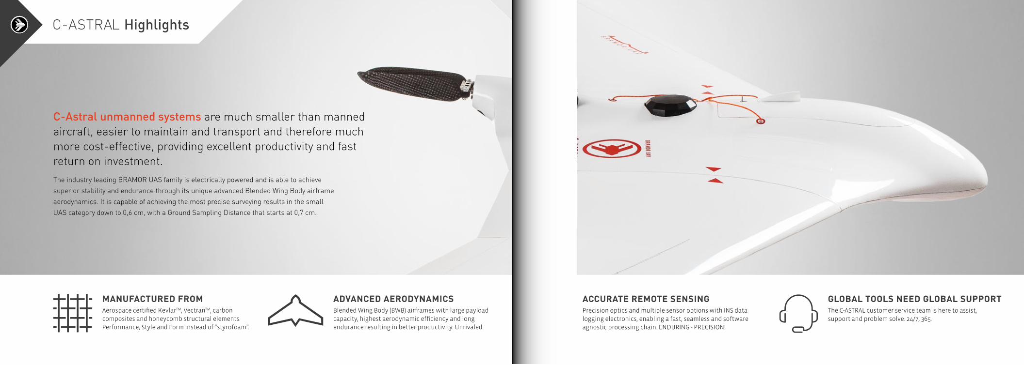
FEATURES≥ Accuracy down to 0,6 cm
≥ Fast initialization
≥ RTK datalink independent
≥ Up to 3,5 h flight time
≥ 100% Autonomous
≥ Exchangeable sensors
≥ Imaging control computer
POWERED BY
≥ Mission planning
≥ Command, Control & Communications
≥ Real-time system health monitoring
≥ Failsafes management
GNSS SURVEY GRADE RECEIVER
SURVEY GRADE IMU *OPTIONAL
BRAMOR ppX THE N
EW
ppX BASE STATION*OPTIONAL
NEW C-ASTRAL PILOT C3P
NEW SX-101 MINI BLUETOOTH GCS
The BRAMOR ppX (GNSS PPK - Post Processing Kinematic) UAS is ideally suited for surveying and remote sensing applications that need a fast high precision set of results, down to sub-centimeter GSD level also in the absence of a grid of ground control points.
≥ Post Processing Kinematic≥ Integrated IMU*OPTIONAL
≥ L1&L2 (L5 ready) GNSS receiver≥ Fast initialization≥ RTK datalink independent≥ Accuracy down to 0,6 cm
DIMENSIONS≥ Wingspan: 230 cm≥ Length: 96 cm≥ Central module length: 67 cm≥ T/O Weight: 4,7 kg
FEATURES≥ 100% Autonomous≥ Automatic parachute landing≥ Orography capable flight planning with GSD maintenance over slopes, hills and valleys≥ Safe catapult launch≥ 30mm and 19mm optics package≥ Wind resistance 30 knots≥ Operational temp -25°C to +45°C
One flight coverage estimation≥ 15 km2 / 600 m AGL / 7,8 cm GSD≥ 2 km2 / 200 m / 2,6 cm GSD
ppX Specifications≥ Absolute dataset accuracy down to 0,6 cm≥ GSD sub cm @ 70m AGL≥ Onboard survey grade L1&L2 (L5 ready) GNSS receiver≥ GPS, Glonass, Beidou, Galileo ready
ppX Survey modes≥ Known point base station≥ Unknown point base reference Station≥ Virtual Reference Station≥ Compatible with RINEX Base data
CARBON / KEVLARTM / VECTRANTM CONSTRUCTION GNSS SURVEY GRADE RECEIVER
BRAMOR ppX Sensor Options
3,5h multi 15km2150km paracatSensor
INTEGRATED SENSOR (MULTIPLE OPTIONS)
PITOT CLEANING AND OBSTRUCTION CONTROL SYSTEM LONG RANGE DATA LINK ANTENNAS
NAVIGATION LIGHTS*OPTIONAL
SINGLE RGB / CIR /NDVI
MULTISPECTRAL SENSORS
HYPERSPECTRAL gAS
“We would not have been able to map more than 300 km of a remote railway line in Ethiopia in a week without Bramor’s capability
to acquire data without a preplaced grid of ground control points.“JAN ZOREC, KOBALE SURVEYING SERVICES
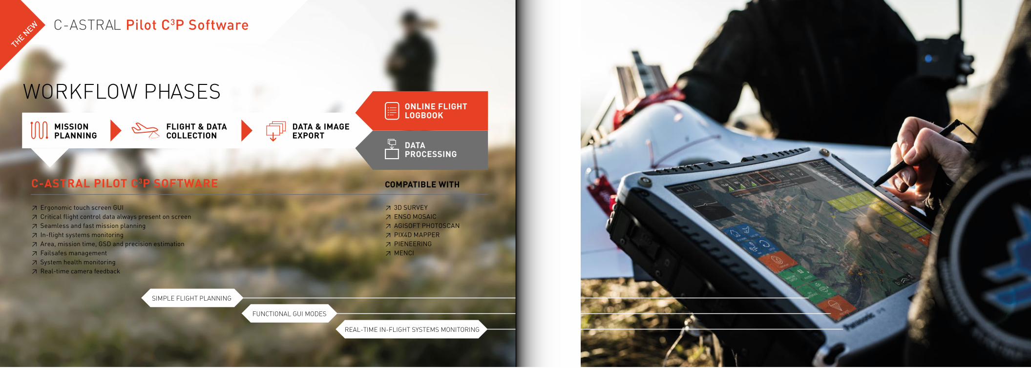
WORKFLOW PHASES
COMPATIBLE WITH
≥3DSURVEY≥ENSOMOSAIC≥AGISOFTPHOTOSCAN≥PIX4DMAPPER≥PIENEERING≥MENCI
≥ErgonomictouchscreenGUI≥Criticalflightcontroldataalwayspresentonscreen≥Seamlessandfastmissionplanning≥ In-flightsystemsmonitoring≥Area,missiontime,GSDandprecisionestimation≥Failsafesmanagement≥Systemhealthmonitoring≥Real-timecamerafeedback
MISSIONPLANNING
FLIGHT & DATA COLLECTION
DATA & IMAGE EXPORT
DATA PROCESSING
ONLINE FLIGHT LOGBOOK
C-ASTRAL PILOT C3P SOFTWARE
SIMPLE FLIGHT PLANNING
REAL-TIME IN-FLIGHT SYSTEMS MONITORING
FUNCTIONAL GUI MODES
C-ASTRAL Pilot C3P SoftwareTHE N
EW
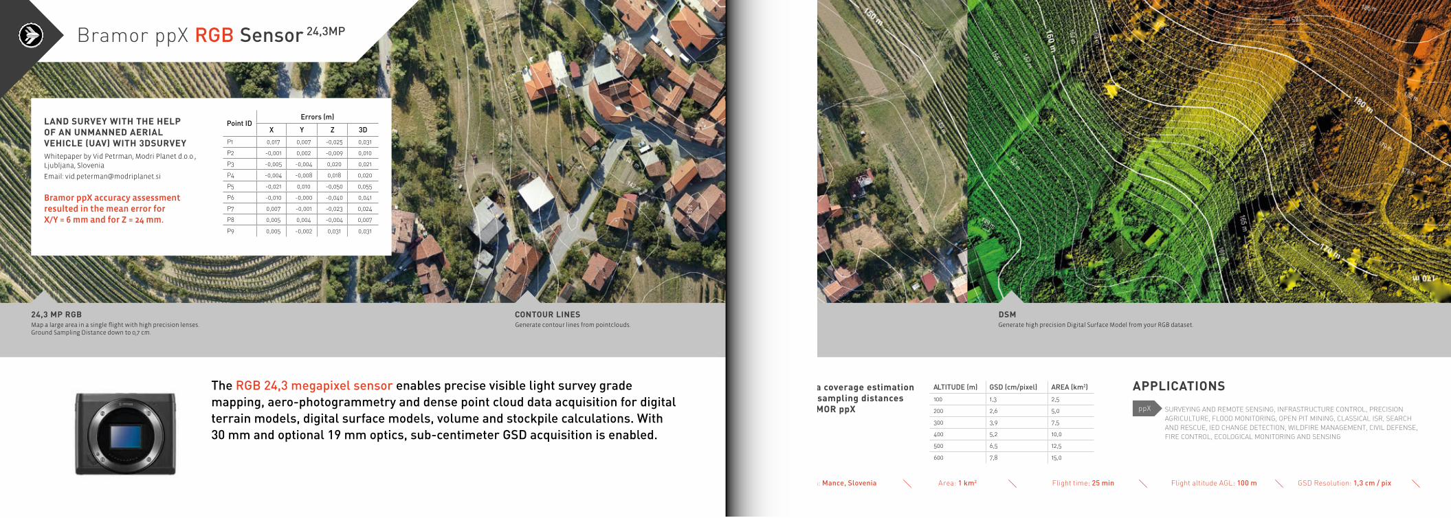
The RGB 24,3 megapixel sensor enables precise visible light survey grade mapping, aero-photogrammetry and dense point cloud data acquisition for digital terrain models, digital surface models, volume and stockpile calculations. With 30 mm and optional 19 mm optics, sub-centimeter GSD acquisition is enabled.
24,3 MP RGB CONTOUR LINESGenerate contour lines from pointclouds.Map a large area in a single flight with high precision lenses.
Ground Sampling Distance down to 0,7 cm.
DSM
ALTITUDE [m] GSD (cm/pixel) AREA [km2]
100 1,3 2,5
200 2,6 5,0
300 3,9 7,5
400 5,2 10,0
500 6,5 12,5
600 7,8 15,0
Mission area coverage estimation and ground sampling distances for the BRAMOR ppX
APPLICATIONS
SURVEYING AND REMOTE SENSING, INFRASTRUCTURE CONTROL, PRECISION AGRICULTURE, FLOOD MONITORING, OPEN PIT MINING, CLASSICAL ISR, SEARCH AND RESCUE, IED CHANGE DETECTION, WILDFIRE MANAGEMENT, CIVIL DEFENSE, FIRE CONTROL, ECOLOGICAL MONITORING AND SENSING
ppX
Generate high precision Digital Surface Model from your RGB dataset.
Bramor ppX RGB Sensor 24,3MP
LAND SURVEY WITH THE HELP OF AN UNMANNED AERIAL VEHICLE (UAV) WITH 3DSURVEYWhitepaper by Vid Petrman, Modri Planet d.o.o., Ljubljana, Slovenia
Email: [email protected]
Bramor ppX accuracy assessment resulted in the mean error for X/Y = 6 mm and for Z = 24 mm.
Point IDErrors [m]
X Y Z 3D
P1 0,017 0,007 -0,025 0,031
P2 -0,001 0,002 -0,009 0,010
P3 -0,005 -0,004 0,020 0,021
P4 -0,004 -0,008 0,018 0,020
P5 -0,021 0,010 -0,050 0,055
P6 -0,010 -0,000 -0,040 0,041
P7 0,007 -0,001 -0,023 0,024
P8 0,005 0,004 -0,004 0,007
P9 0,005 -0,002 0,031 0,031
Location: Mance, Slovenia Area: 1 km2 Flight time: 25 min Flight altitude AGL: 100 m GSD Resolution: 1,3 cm / pix
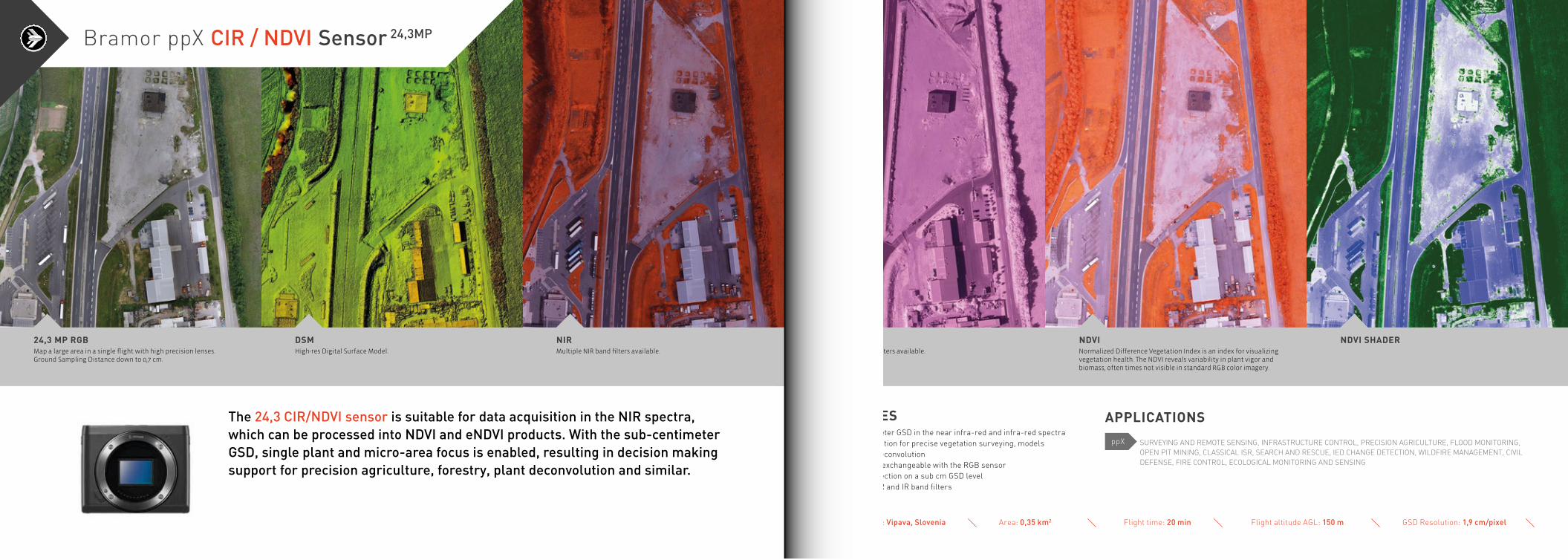
The 24,3 CIR/NDVI sensor is suitable for data acquisition in the NIR spectra, which can be processed into NDVI and eNDVI products. With the sub-centimeter GSD, single plant and micro-area focus is enabled, resulting in decision making support for precision agriculture, forestry, plant deconvolution and similar.
24,3 MP RGB DSM NIRMap a large area in a single flight with high precision lenses. Ground Sampling Distance down to 0,7 cm.
High-res Digital Surface Model. Multiple NIR band filters available.
FEATURES≥ Sub centimeter GSD in the near infra-red and infra-red spectra≥ Data acquisition for precise vegetation surveying, models and plant deconvolution≥ Completely exchangeable with the RGB sensor≥ Change detection on a sub cm GSD level≥ Multiple NIR and IR band filters
IR NDVI NDVI SHADER
APPLICATIONS
SURVEYING AND REMOTE SENSING, INFRASTRUCTURE CONTROL, PRECISION AGRICULTURE, FLOOD MONITORING, OPEN PIT MINING, CLASSICAL ISR, SEARCH AND RESCUE, IED CHANGE DETECTION, WILDFIRE MANAGEMENT, CIVIL DEFENSE, FIRE CONTROL, ECOLOGICAL MONITORING AND SENSING
ppX
Normalized Difference Vegetation Index is an index for visualizing vegetation health. The NDVI reveals variability in plant vigor and biomass, often times not visible in standard RGB color imagery.
Multiple IR band filters available.
Bramor ppX CIR / NDVI Sensor 24,3MP
Location: Vipava, Slovenia Area: 0,35 km2 Flight time: 20 min Flight altitude AGL: 150 m GSD Resolution: 1,9 cm/pixel

The BRAMOR ppX mounted MS-RE sensor simultaneously captures five discrete spectral bands, enabling the creation of tailored indices for high end vegetation mapping. The compact MS-SQ sensor can be carried simultaneously with one of C-ASTRAL’s high resolution sensors and features four narrowband filters optimized for analyzing crop health and a 16 MP RGB imager for easy digital scouting. Its irradiance sensor and integrated GPS make it an accurate, compact and calibrated tool for precision agriculture.
RGB DSM CIRRed Green Blue: This is a true color representation of the studied (field) area.
Digital Surface Model can be used to visualize changes in topography or measure the height of plant / tree above the surrounding terrain.
Color Infrared (or Near Infrared) layer helps you to visualize the amount of infrared light reflected.
MS-RE FEATURES MS-SQ FEATURES≥ 5 spectral bands: Blue, green, red, red edge, near IR≥ Calibrated for precise, repeatable measurements≥ Ground Sample Distance: 8,0 cm per pixel at 120 m AGL≥ Capture Rate: 1 per second≥ Narrowband optical filters provide full imager resolution for each band≥ 32GB Memory: Single SD card stores all images with geotags≥ Wi-Fi capable device web-based interface
NDVI NDVI2 NDRENormalized Difference Vegetation Index is an index for visualizing vegetation health. Areas with NDVI values greater than 0,5 are colored using a red/yellow/green color scale. The NDVI reveals variability in plant vigor and biomass, often times not visible in standard RGB color imagery. With NDVI2 a new color scale is applied, in which values below 0,5 are not hidden, like they are in the NDVI layer. This allows to visualize all NDVI values within the studied field.
Normalized Difference Red Edge Index can be a valuable index when collecting data and monitoring stress /health over mature plants. The advanced vegetation indices like NDRE are more sensitive to changes in leaf chlorophyll content and provide information about plant nutrient status.
≥ 4 spectral bands, 10 bits Global shutter≥ Self-calibrated using the Sunshine sensor≥ Ground Sample Distance 12,4 cm Monoband, 2,7 cm RGB≥ Capture Rate: 1 per second≥ RGB Camera 16MP Rolling shutter≥ 64GB Memory / IMU + Magnetometer + GPS≥ Configuration over Wi-Fi
APPLICATIONS
SURVEYING AND REMOTE SENSING, INFRA-STRUCTURE CONTROL, PRECISION AGRI-CULTURE, FLOOD MONITORING, OPEN PIT MINING, CLASSICAL ISR, SEARCH AND RESCUE, IED CHANGE DETECTION, WILDFIRE MANAGE-MENT, CIVIL DEFENSE, FIRE CONTROL, ECO-LOGICAL MONITORING AND SENSING
ppX
“This is a revolutionary vegetation vision instrument. We can map 1500 hectares in a single flight.”
MS-SQ MS-SQ
Bramor ppX Multispectral sensors
GSD Resolution: 12,4 cm Monoband 2,7 cm RGBFlight altitude AGL: 100 mFlight time: 20 minLocation: Vipava, Slovenia Area: 0,3 km2
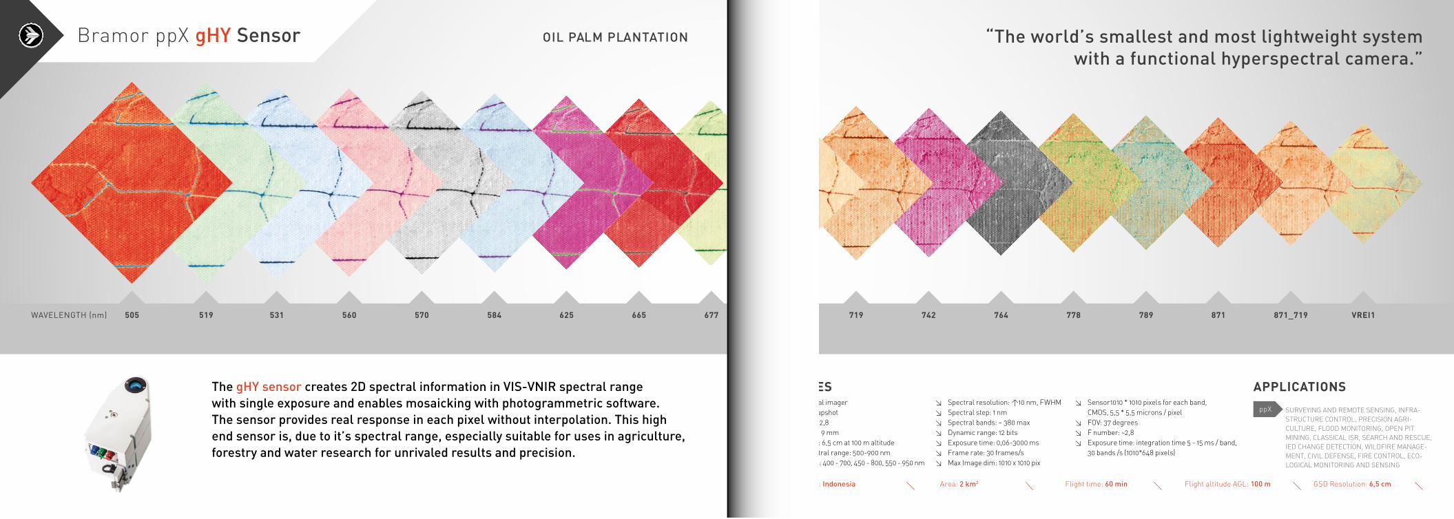
The gHY sensor creates 2D spectral information in VIS-VNIR spectral range with single exposure and enables mosaicking with photogrammetric software. The sensor provides real response in each pixel without interpolation. This high end sensor is, due to it’s spectral range, especially suitable for uses in agriculture, forestry and water research for unrivaled results and precision.
505 519 531 560 570 584 625 665 677WAVELENGTH (nm)
OIL PALM PLANTATION
700 719 742 764 778 789 871 871_719 VREI1
FEATURES≥ Hyperspectral imager≥ VIS-VNIR snapshot≥ F-number: ~ 2,8≥ Focal length: 9 mm≥ Ground pixel: 6,5 cm at 100 m altitude≥ Default spectral range: 500-900 nm Other ranges: 400 - 700, 450 - 800, 550 - 950 nm
Location: Indonesia Area: 2 km2 Flight time: 60 min Flight altitude AGL: 100 m
≥ Spectral resolution: >10 nm, FWHM≥ Spectral step: 1 nm≥ Spectral bands: ~ 380 max≥ Dynamic range: 12 bits≥ Exposure time: 0,06-3000 ms≥ Frame rate: 30 frames/s≥ Max Image dim: 1010 x 1010 pix
GSD Resolution: 6,5 cm
≥ Sensor1010 * 1010 pixels for each band, CMOS, 5,5 * 5,5 microns / pixel≥ FOV: 37 degrees≥ F number: ~2,8≥ Exposure time: integration time 5 - 15 ms / band, 30 bands /s (1010*648 pixels)
APPLICATIONS
SURVEYING AND REMOTE SENSING, INFRA-STRUCTURE CONTROL, PRECISION AGRI-CULTURE, FLOOD MONITORING, OPEN PIT MINING, CLASSICAL ISR, SEARCH AND RESCUE, IED CHANGE DETECTION, WILDFIRE MANAGE-MENT, CIVIL DEFENSE, FIRE CONTROL, ECO-LOGICAL MONITORING AND SENSING
ppX
“The world’s smallest and most lightweight system with a functional hyperspectral camera.”
Bramor ppX gHY Sensor
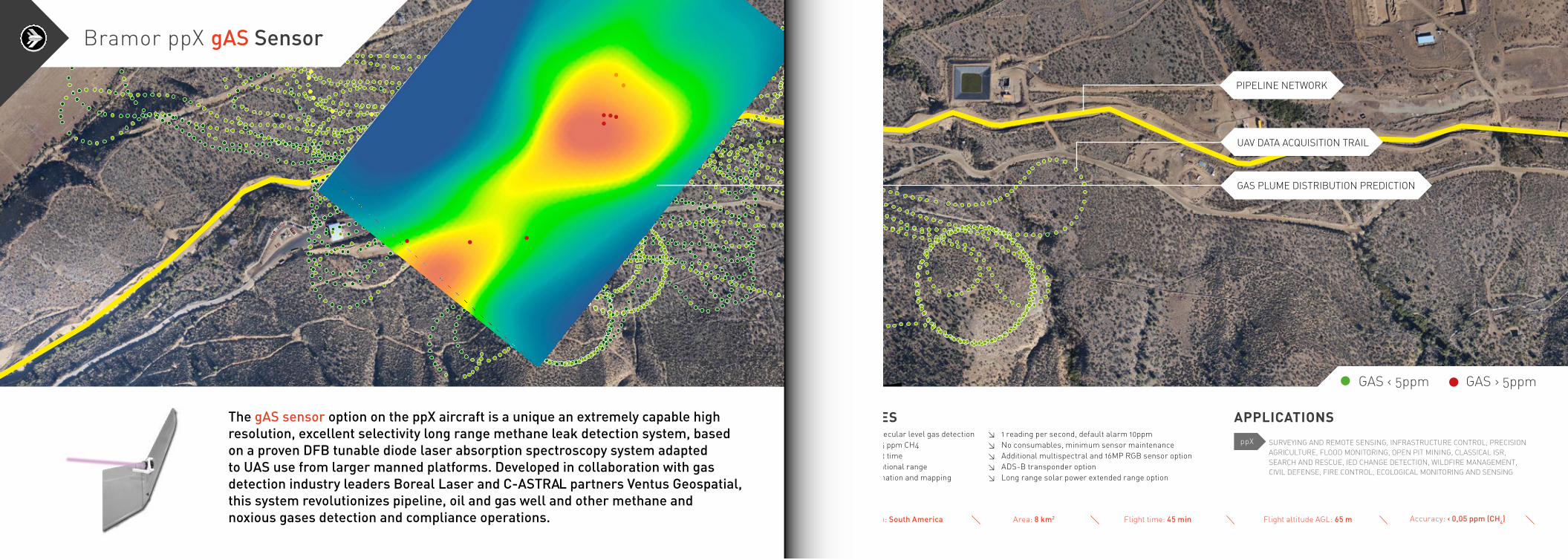
The gAS sensor option on the ppX aircraft is a unique an extremely capable high resolution, excellent selectivity long range methane leak detection system, based on a proven DFB tunable diode laser absorption spectroscopy system adapted to UAS use from larger manned platforms. Developed in collaboration with gas detection industry leaders Boreal Laser and C-ASTRAL partners Ventus Geospatial, this system revolutionizes pipeline, oil and gas well and other methane and noxious gases detection and compliance operations.
FEATURES≥ Remote molecular level gas detection down to 0,05 ppm CH4≥ 2-hour flight time≥ 110km operational range≥ Plume estimation and mapping
≥ 1 reading per second, default alarm 10ppm≥ No consumables, minimum sensor maintenance≥ Additional multispectral and 16MP RGB sensor option≥ ADS-B transponder option≥ Long range solar power extended range option
APPLICATIONS
SURVEYING AND REMOTE SENSING, INFRASTRUCTURE CONTROL, PRECISION AGRICULTURE, FLOOD MONITORING, OPEN PIT MINING, CLASSICAL ISR, SEARCH AND RESCUE, IED CHANGE DETECTION, WILDFIRE MANAGEMENT, CIVIL DEFENSE, FIRE CONTROL, ECOLOGICAL MONITORING AND SENSING
ppX
Bramor ppX gAS Sensor
GAS › 5ppmGAS ‹ 5ppm
GAS PLUME DISTRIBUTION PREDICTION
UAV DATA ACQUISITION TRAIL
PIPELINE NETWORK
Location: South America Area: 8 km2 Flight time: 45 min Flight altitude AGL: 65 m Accuracy: ‹ 0,05 ppm (CH4)
FEATURES AND APPLICATIONS≥ Wildfire management
≥ Environmental monitoring
≥ Infrastructure control
≥ Over the hill observation (LOS)
≥ Night surveillance
≥ Long range (40 km) data/video link
≥ Fire control
≥ Civil defense
≥ Target detection and tracking
≥ Low intensity conflict zone control
≥ Search and rescue missions
≥ EncryptionOPTIONAL
≥ MANET (Mobile Ad Hoc Network) and MIMO (multiple in / multiple out) optional secure digital communications
3h EO/IR/LI 150km paracat
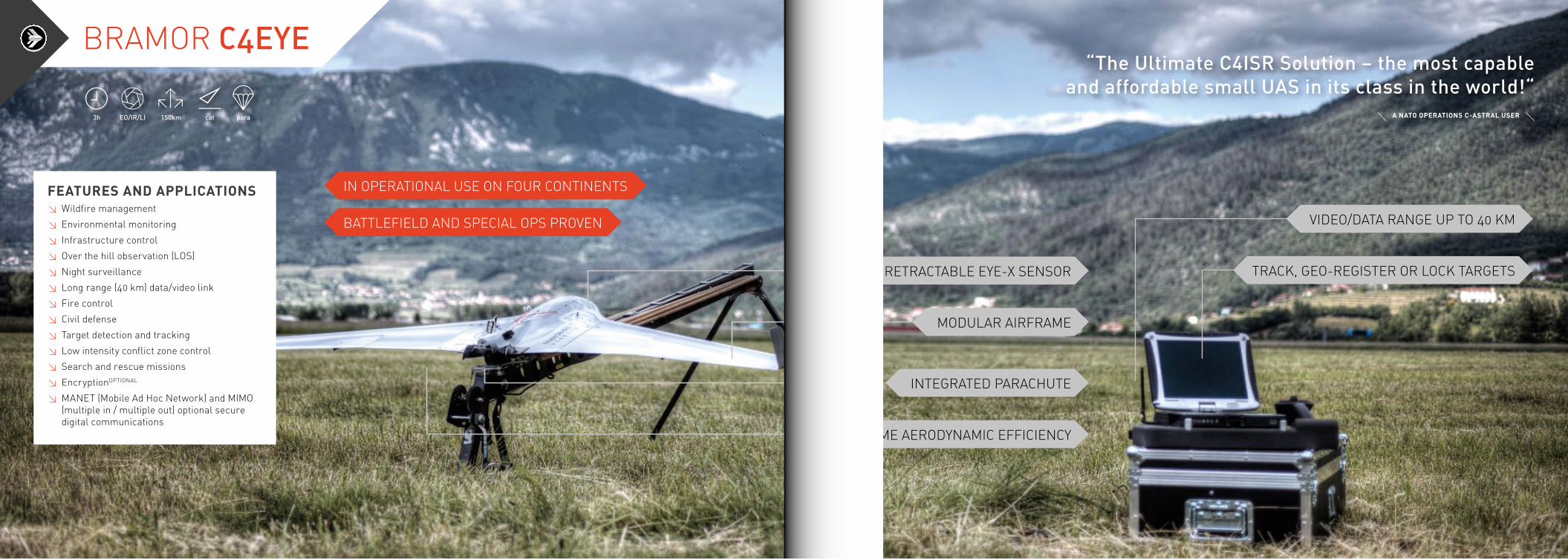
“The Ultimate C4ISR Solution – the most capable and affordable small UAS in its class in the world!“
IN OPERATIONAL USE ON FOUR CONTINENTS
BATTLEFIELD AND SPECIAL OPS PROVEN
BRAMOR C4EYE
VIDEO/DATA RANGE UP TO 40 KM
RETRACTABLE EYE-X SENSOR TRACK, GEO-REGISTER OR LOCK TARGETS
MODULAR AIRFRAME
INTEGRATED PARACHUTE
SUPREME AERODYNAMIC EFFICIENCY
A NATO OPERATIONS C-ASTRAL USER
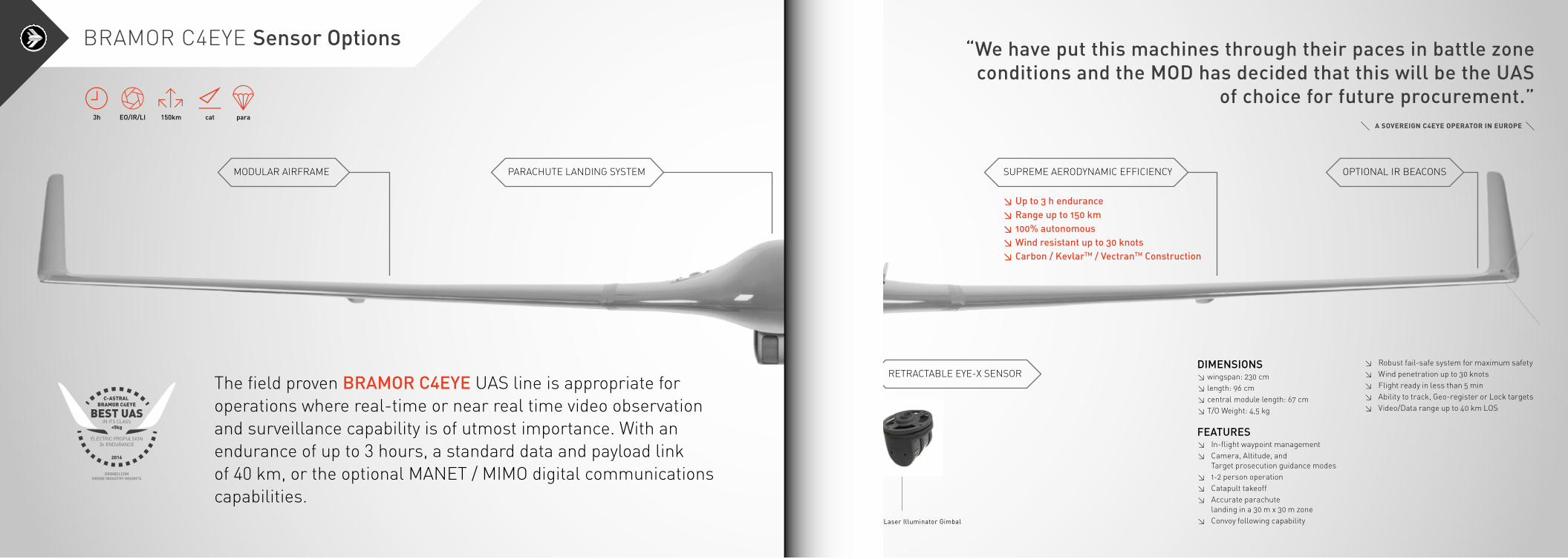
The field proven BRAMOR C4EYE UAS line is appropriate for operations where real-time or near real time video observation and surveillance capability is of utmost importance. With an endurance of up to 3 hours, a standard data and payload link of 40 km, or the optional MANET / MIMO digital communications capabilities.
3h EO/IR/LI 150km paracat
DIMENSIONS≥ wingspan: 230 cm≥ length: 96 cm≥ central module length: 67 cm≥ T/O Weight: 4,5 kg
FEATURES≥ In-flight waypoint management≥ Camera, Altitude, and Target prosecution guidance modes≥ 1-2 person operation≥ Catapult takeoff≥ Accurate parachute landing in a 30 m x 30 m zone≥ Convoy following capability
“We have put this machines through their paces in battle zone conditions and the MOD has decided that this will be the UAS
of choice for future procurement.”
≥ Robust fail-safe system for maximum safety≥ Wind penetration up to 30 knots≥ Flight ready in less than 5 min≥ Ability to track, Geo-register or Lock targets≥ Video/Data range up to 40 km LOS
≥ Up to 3 h endurance≥ Range up to 150 km≥ 100% autonomous≥ Wind resistant up to 30 knots≥ Carbon / KevlarTM / VectranTM Construction
MODULAR AIRFRAME PARACHUTE LANDING SYSTEM
BRAMOR C4EYE Sensor Options
RETRACTABLE EYE-X SENSOR
SUPREME AERODYNAMIC EFFICIENCY OPTIONAL IR BEACONS
EYE-X EO/IR/Laser Illuminator Gimbal
A SOVEREIGN C4EYE OPERATOR IN EUROPE
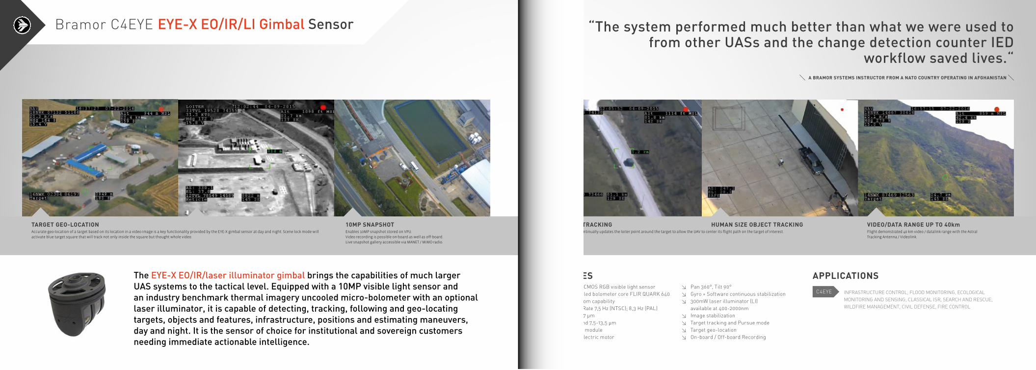
The EYE-X EO/IR/laser illuminator gimbal brings the capabilities of much larger UAS systems to the tactical level. Equipped with a 10MP visible light sensor and an industry benchmark thermal imagery uncooled micro-bolometer with an optional laser illuminator, it is capable of detecting, tracking, following and geo-locating targets, objects and features, infrastructure, positions and estimating maneuvers, day and night. It is the sensor of choice for institutional and sovereign customers needing immediate actionable intelligence.
TARGET GEO-LOCATION 10MP SNAPSHOTAccurate geo-location of a target based on its location in a video image is a key functionality provided by the EYE-X gimbal sensor at day and night. Scene lock mode will activate blue target square that will track not only inside the square but thought whole video.
Enables 10MP snapshot stored on VPU.Video recording is possible on-board as well as off-board.Live snapshot gallery accessible via MANET / MIMO radio.
“The system performed much better than what we were used to from other UASs and the change detection counter IED
workflow saved lives.“
FEATURES≥ 10 MP ePTZ CMOS RGB visible light sensor≥ LWIR Uncooled bolometer core FLIR QUARK 640≥ 2x, 4x, 8x zoom capability≥ Full Frame Rate 7,5 Hz (NTSC); 8,3 Hz (PAL)≥ Pixel Pitch 17 μm≥ Spectral band 7,5-13,5 μm≥ QUARK VPC module≥ Brushless electric motor
≥ Pan 360°, Tilt 90°≥ Gyro + Software continuous stabilization≥ 300mW laser illuminator (LI) available at 400-2000nm≥ Image stabilization≥ Target tracking and Pursue mode≥ Target geo-location≥ On-board / Off-board Recording
APPLICATIONS
INFRASTRUCTURE CONTROL, FLOOD MONITORING, ECOLOGICAL MONITORING AND SENSING, CLASSICAL ISR, SEARCH AND RESCUE, WILDFIRE MANAGEMENT, CIVIL DEFENSE, FIRE CONTROL
VIDEO/DATA RANGE UP TO 40kmVEHICLE TRACKING HUMAN SIZE OBJECT TRACKINGFlight demonstrated 40 km video / datalink range with the Astral Tracking Antenna / Videolink.
Pursue mode continually updates the loiter point around the target to allow the UAV to center its flight path on the target of interest.
Bramor C4EYE EYE-X EO/IR/LI Gimbal Sensor
A BRAMOR SYSTEMS INSTRUCTOR FROM A NATO COUNTRY OPERATING IN AFGHANISTAN
C4EYE
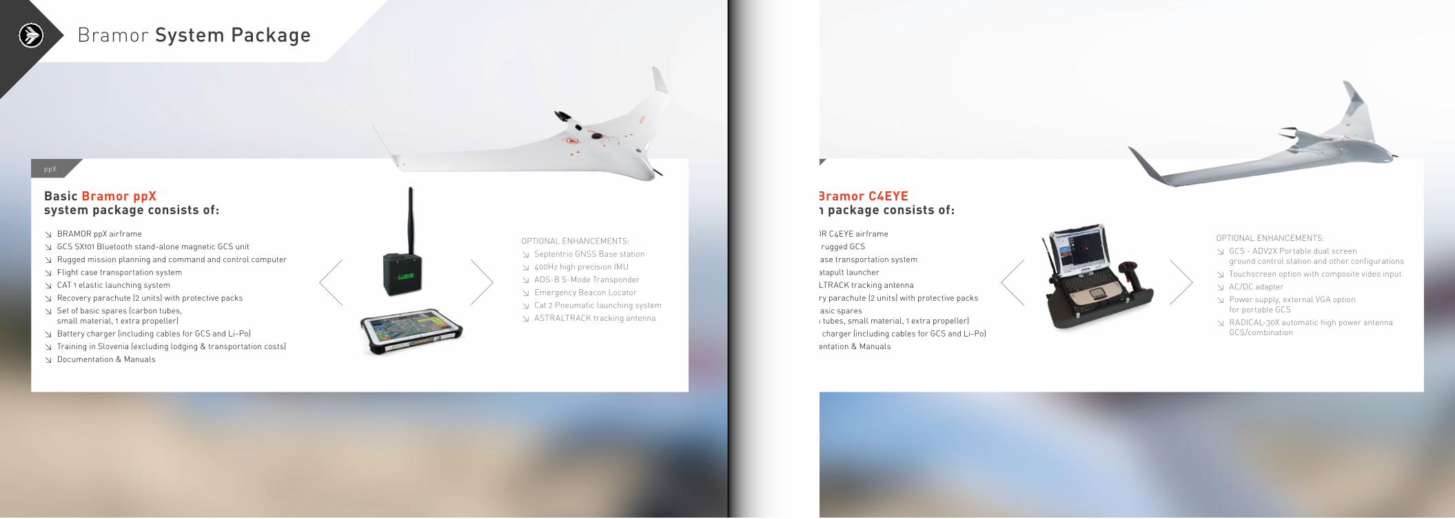
Basic Bramor ppX system package consists of:
≥ BRAMOR ppX airframe
≥ GCS SX101 Bluetooth stand-alone magnetic GCS unit
≥ Rugged mission planning and command and control computer
≥ Flight case transportation system
≥ CAT 1 elastic launching system
≥ Recovery parachute (2 units) with protective packs
≥ Set of basic spares (carbon tubes, small material, 1 extra propeller)
≥ Battery charger (including cables for GCS and Li-Po)
≥ Training in Slovenia (excluding lodging & transportation costs)
≥ Documentation & Manuals
OPTIONAL ENHANCEMENTS:≥ Septentrio GNSS Base station
≥ 400Hz high precision IMU
≥ ADS-B S-Mode Transponder
≥ Emergency Beacon Locator
≥ Cat 2 Pneumatic launching system
≥ ASTRALTRACK tracking antenna
ppX
Basic Bramor C4EYE system package consists of:
≥ BRAMOR C4EYE airframe
≥ KJ-200 rugged GCS
≥ Flight case transportation system
≥ CAT 1 catapult launcher
≥ ASTRALTRACK tracking antenna
≥ Recovery parachute (2 units) with protective packs
≥ Set of basic spares (carbon tubes, small material, 1 extra propeller)
≥ Battery charger (including cables for GCS and Li-Po)
≥ Documentation & Manuals
OPTIONAL ENHANCEMENTS:≥ GCS - ADV2X Portable dual screen ground control station and other configurations
≥ Touchscreen option with composite video input
≥ AC/DC adapter
≥ Power supply, external VGA option for portable GCS
≥ RADICAL-30X automatic high power antenna GCS/combination
C4EYE
Bramor System Package
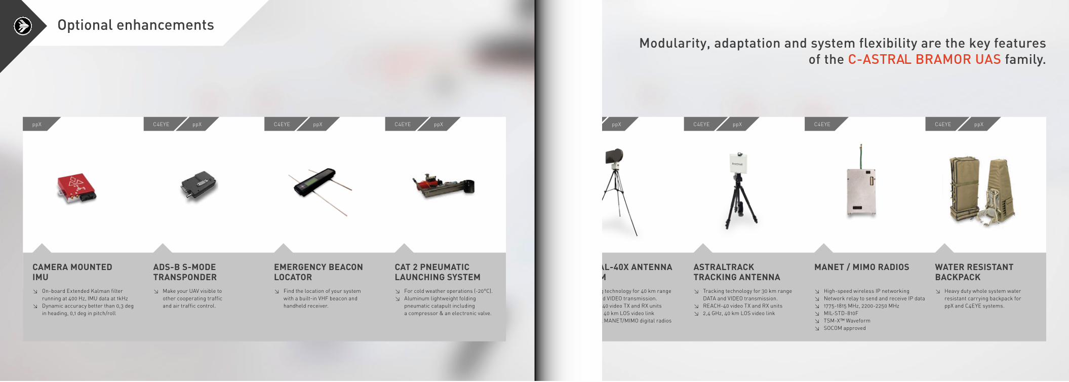
CAMERA MOUNTED IMU
ADS-B S-MODE TRANSPONDER
EMERGENCY BEACON LOCATOR
CAT 2 PNEUMATIC LAUNCHING SYSTEM
≥ On-board Extended Kalman filter running at 400 Hz, IMU data at 1kHz
≥ Dynamic accuracy better than 0,3 deg in heading, 0,1 deg in pitch/roll
≥ Make your UAV visible to other cooperating traffic and air traffic control.
≥ Find the location of your system with a built-in VHF beacon and handheld receiver.
≥ For cold weather operations (-20°C).≥ Aluminum lightweight folding pneumatic catapult including a compressor & an electronic valve.
ppX C4EYE C4EYE C4EYEppX ppX ppX
Modularity, adaptation and system flexibility are the key features of the C-ASTRAL BRAMOR UAS family.
RADICAL-40X ANTENNA SYSTEM
ASTRALTRACK TRACKING ANTENNA
MANET / MIMO RADIOS WATER RESISTANT BACKPACK
≥ Tracking technology for 40 km range DATA and VIDEO transmission.≥ REACH-40 video TX and RX units≥ 2,4 GHz, 40 km LOS video link≥ Optional MANET/MIMO digital radios
≥ Tracking technology for 30 km range DATA and VIDEO transmission.≥ REACH-40 video TX and RX units≥ 2,4 GHz, 40 km LOS video link
≥ High-speed wireless IP networking≥ Network relay to send and receive IP data≥ 1775-1815 MHz, 2200-2250 MHz≥ MIL-STD-810F≥ TSM-X™ Waveform≥ SOCOM approved
≥ Heavy duty whole system water resistant carrying backpack for
ppX and C4EYE systems.
C4EYE C4EYE C4EYEC4EYEppX ppX ppX
Optional enhancements
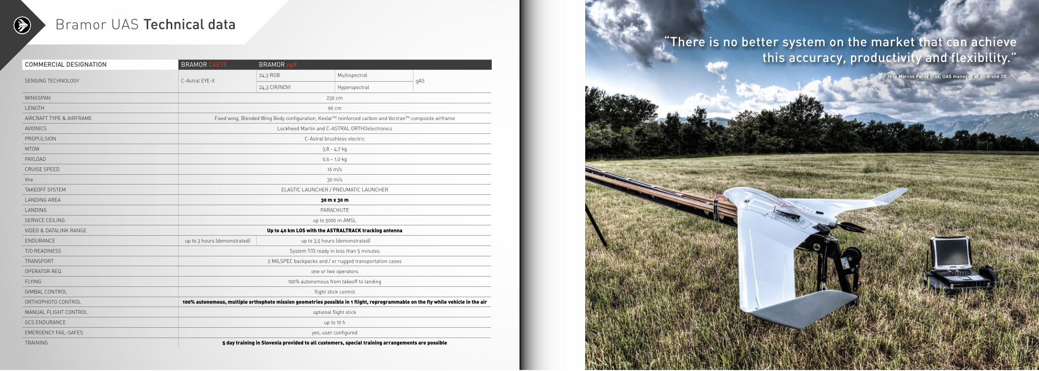
SENSING TECHNOLOGY C-Astral EYE-X24,3 RGB Multispectral
gAS24,3 CIR/NDVI Hyperspectral
WINGSPAN 230 cm
LENGTH 96 cm
AIRCRAFT TYPE & AIRFRAME Fixed wing, Blended Wing Body configuration, KevlarTM reinforced carbon and VectranTM composite airframe
AVIONICS Lockheed Martin and C-ASTRAL ORTHOelectronics
PROPULSION C-Astral brushless electric
MTOW 3,8 - 4,7 kg
PAYLOAD 0,6 – 1,0 kg
CRUISE SPEED 16 m/s
Vne 30 m/s
TAKEOFF SYSTEM ELASTIC LAUNCHER / PNEUMATIC LAUNCHER
LANDING AREA 30 m x 30 m
LANDING PARACHUTE
SERVICE CEILING up to 5000 m AMSL
VIDEO & DATALINK RANGE Up to 40 km LOS with the ASTRALTRACK tracking antenna
ENDURANCE up to 3 hours (demonstrated) up to 3,5 hours (demonstrated)
T/O READINESS System T/O ready in less than 5 minutes
TRANSPORT 2 MILSPEC backpacks and / or rugged transportation cases
OPERATOR REQ one or two operators
FLYING 100% autonomous from takeoff to landing
GIMBAL CONTROL flight stick control
ORTHOPHOTO CONTROL 100% autonomous, multiple orthophoto mission geometries possible in 1 flight, reprogrammable on the fly while vehicle in the air
MANUAL FLIGHT CONTROL optional flight stick
GCS ENDURANCE up to 10 h
EMERGENCY FAIL-SAFES yes, user configured
TRAINING 5 day training in Slovenia provided to all customers, special training arrangements are possible
COMMERCIAL DESIGNATION BRAMORC4EYE BRAMORppX
Bramor UAS Technical data“There is no better system on the market that can achieve
this accuracy, productivity and flexibility.”Jose Marcos Perez Diaz, UAS manager at Airdrone 3D
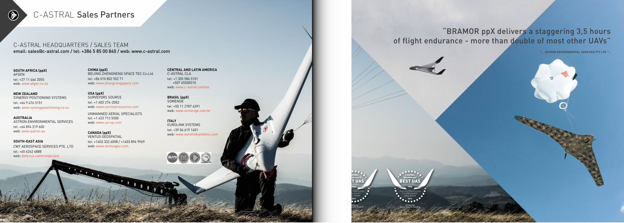
C-ASTRAL Sales Partners
SOUTH AFRICA (ppX)AFGENtel: +27 11 466 2055web: www.afgen.co.za
NEW ZEALANDSYNERGY POSITIONING SYSTEMStel: +64 9 476 5151web: www.synergypositioning.co.nz
AUSTRALIAASTRON ENVIRONMENTAL SERVICEStel: +64 894 219 600web: www.astron.au
SOUTH-EAST ASIACWT AEROSPACE SERVICES PTE. LTDtel: +65 6262 6888web: defence.cwtlimited.com
CHINA (ppX)BEIJING ZHENGNENG SPACE TEC.Co.Ltd.tel: +86 010 802 552 71web: www.zhengnengspace.com
USA (ppX)SURVEYORS SOURCEtel: +1 602 274-2052web: www.surveyorssource.com
UNMANNED AERIAL SPECIALISTStel: +1 423 713 5500web: www.ua-sp.com
CANADA (ppX)VENTUS GEOSPATIALtel: +1403 332 6058 / +1403 894 9969web: www.ventusgeo.com
CENTRAL AND LATIN AMERICAC-ASTRAL CLAtel: +1 305 586 5101 +507 65508310web: www.c-astral.com/es
BRASIL (ppX)SOMENGEtel: +55 11 2787 6391web: www.somenge.com.br
ITALYEUROLINK SYSTEMStel: +39 06 619 1401web: www.eurolinksystems.com
C-ASTRAL HEADQUARTERS / SALES TEAMemail: [email protected] / tel: +386 5 85 00 840 / web: www.c-astral.com
“BRAMOR ppX delivers a staggering 3,5 hoursof flight endurance - more than double of most other UAVs”
ASTRON ENVIRONMENTAL SERVICES PTY LTD

The company is a global market leader with established reputation in the specialized, fixed wing small Unmanned Aircraft Systems (UAS) manufacturing and services field, with a specific focus on high productivity, endurance, surveying and remote sensing. C-Astral’s customer base is diversified between the commercial UAS operators, larger institutional networks, scientific users as well as government entities. Currently, C-Astral systems are flying with six sovereign entities on force protection, border protection, fire control and surveillance operations on four continents and more than 100 commercial and scientific operators globally. C-Astral established a multidisciplinary software and hardware laboratory for aerodynamics and systems integration work and a prototyping CAD/CAM workshop facility for composite materials manufacturing and modeling. The founders of C-Astral have been active in aerospace since 1999 and have been pioneering UAS integrated solutions ahead of the market curve. C-Astral systems are now flying over all continents, including extreme environments such as high altitude open-pit mines, deserts, mountains, Antarctica, over the Arctic and global agricultural lands.
C-Astral is an aerospace solutions provider based in Ajdovscina, Slovenia, the “hub” of advanced aerospace development and integration in this part of Central Europe.
Synergy Positioning SystemsU3/17 University Drive Free Call: 1800 980 353Meadowbrook Phone: +61 7 3801 2242QLD 4131 Fax: +61 7 3801 2252Australia Email: [email protected]
© C-Astral d.o.o. // Catalogue design: Janja Gomezel / Photos: Miha Bratina / Flight datasets: C-Astral Archive / October 2016