Embed Size (px)
Citation preview
UNIVERSITY OF NIGERIA, NSUKKA
FACULTY OF THE SOCIAL SCIENCES
DEPARTMENT OF GEOGRAPHY
POSTGRADUATE PROGRAMMES IN GEOGRAPHY
PHILOSOPHY:
The Department offers postgraduate courses leading to the award of Postgraduate Diploma in
Environmental Management (PGD), Master of Science (M.Sc.) and Doctor of Philosophy
(Ph.D.) degrees in Geography. The philosophy and mission statement underlying the
postgraduate programme in Geography is to produce graduates imbued with the ability to
contribute to national, regional and global environment and development issues through their
understanding of the spatial phenomena and processes that produced them. This is achieved by
equipping the students with a broad foundation and specialized knowledge in all areas of
Geography.
OBJECTIVES:
The objectives of the PGD Programme are as follows:
1. To inculcate in the students basic training in environmental science, with particular
reference to the recognition, retrieval and analysis of environmentally significant data.
2. To provide graduates with professional preparation for work and further studies in the
broad field of Geography and other associated applied professions.
The objectives of the M. Sc. Programme are as follows:
1 To provide students with a solid theoretical knowledge in their chosen branches of
Geography through the delivery of a well-coordinated and balanced degree programme,
integrating core Geography courses with practical applications.
2 To develop in the students scientific skills in oral, written and graphical communication.
3. To provide students with sufficient materials to explore the subject, to carry out self-
organized study, and to think about issues and challenges of acquiring, analyzing and
interpreting data.
4. To provide students with a short basis to engage more quickly and effectively with the
economics and management expert of earth’s references resources.
The objectives of the Ph.D. Programme are as follows:
1. Produce globally competitive graduates equipped to pursue careers in geography as
academics, in industry, the public sector and non-government organizations.
2. Foster the acquisition and implementation of broad-based research and analytical skills
related to the geographical sources.
3. Develop new areas of teaching through research in response to the advancement in
scholarship and the needs of the community including vocational training.
4. Inculcate the attitude and develop the ability of postgraduate students to disseminate their
research findings through publications, conferences and workshops.
SCOPE:
The PGD programme is designed to update candidates’ practical knowledge to be able to meet
the challenges posed by the changing environment. The training aims at improving on the
efficiency as well as inspiring the candidates to pursue further studies in Geography and other
related disciplines. Thus, in addition to professional training in Environmental Management, the
programme also provides broad preparation for the candidates to pursue Master’s and Doctorate
degrees in the Geography and the Environmental Sciences.
The scope of the M. Sc. and Ph.D. degree programmes provides opportunities for specialization
in all areas of Geography, particularly the following: Agricultural Geography, Biogeography,
Cartography, Climatology/Physical Oceanography, Environmental Management, Geographic
Information Systems, Geomorphology, Hydrology and Water Resources, Industrial Geography,
Political Geography, Population Geography, Remote Sensing, Rural Geography, Transportation
Geography and Urban Geography.
ADMISSION REQUIREMENTS:
a. PGD Programme
In addition to satisfying the conditions for admission into the University of Nigeria,
candidates applying for the PGD in Environmental Management should hold Bachelors
degree or Higher National Diploma (HND) passed at Upper Credit Level in Geography or
related disciplines.
b. M.Sc. Programme
In addition to satisfying the conditions for admission into the University of Nigeria,
candidates applying for the M. Sc degree in Geography should hold Bachelors degree with a
minimum CGPA of 3.0 in Geography, Education/Geography or related disciplines in the
Social, Physical, Biological, Agricultural and Environmental Sciences or Engineering etc.
c. Ph.D Programme
In addition to satisfying the conditions for admission into the University of Nigeria,
candidates applying for the Ph. D degree in Geography should hold Master’s degree with a
minimum CGPA of at least 4.0 on a scale of 5.0 in a relevant area of Geography or the related
disciplines.
DURATION OF PROGRAMMES
PGD
Maximum and minimum duration of Postgraduate Diploma programme shall be:
Full-Time: A minimum of 2 Semesters
A maximum of 4 Semesters
M.Sc.
Full-Time: A minimum of 3 Semesters
A maximum of 5 Semesters
Part-Time: A minimum of 5 Semesters
A maximum of 8 Semesters
PhD
The minimum duration of programme (or the minimum residential requirement) and maximum
duration of the Ph.D. programme shall be:
(a) Duration of Master’s/Ph.D programme.
Full-time: 3 Calendar Years minimum; 5 Calendar years maximum.
Part-Time: 4 Calendar years minimum; 6 Calendar years maximum.
(b) Duration of Ph.D programme (After Master’s Degree)
Full-Time: 3 Calendar years minimum; 5 Calendar years maximum.
Part-Time: 4 Calendar years minimum; 6 Calendar years maximum.
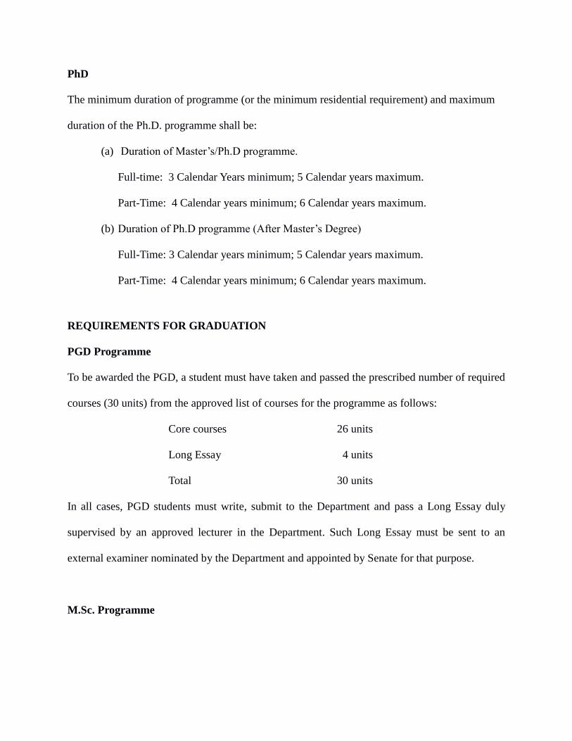
REQUIREMENTS FOR GRADUATION
PGD Programme
To be awarded the PGD, a student must have taken and passed the prescribed number of required
courses (30 units) from the approved list of courses for the programme as follows:
Core courses 26 units
Long Essay 4 units
Total 30 units
In all cases, PGD students must write, submit to the Department and pass a Long Essay duly
supervised by an approved lecturer in the Department. Such Long Essay must be sent to an
external examiner nominated by the Department and appointed by Senate for that purpose.
M.Sc. Programme
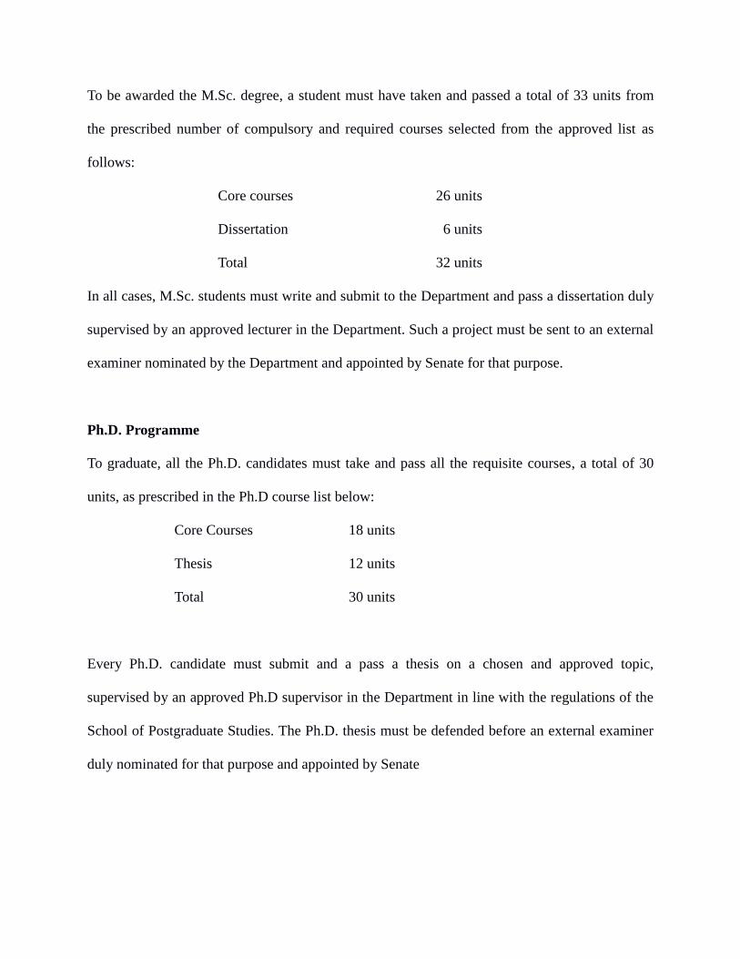
To be awarded the M.Sc. degree, a student must have taken and passed a total of 33 units from
the prescribed number of compulsory and required courses selected from the approved list as
follows:
Core courses 26 units
Dissertation 6 units
Total 32 units
In all cases, M.Sc. students must write and submit to the Department and pass a dissertation duly
supervised by an approved lecturer in the Department. Such a project must be sent to an external
examiner nominated by the Department and appointed by Senate for that purpose.
Ph.D. Programme
To graduate, all the Ph.D. candidates must take and pass all the requisite courses, a total of 30
units, as prescribed in the Ph.D course list below:
Core Courses 18 units
Thesis 12 units
Total 30 units
Every Ph.D. candidate must submit and a pass a thesis on a chosen and approved topic,
supervised by an approved Ph.D supervisor in the Department in line with the regulations of the
School of Postgraduate Studies. The Ph.D. thesis must be defended before an external examiner
duly nominated for that purpose and appointed by Senate
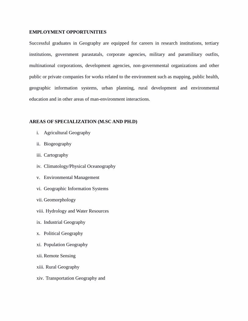
EMPLOYMENT OPPORTUNITIES
Successful graduates in Geography are equipped for careers in research institutions, tertiary
institutions, government parastatals, corporate agencies, military and paramilitary outfits,
multinational corporations, development agencies, non-governmental organizations and other
public or private companies for works related to the environment such as mapping, public health,
geographic information systems, urban planning, rural development and environmental
education and in other areas of man-environment interactions.
AREAS OF SPECIALIZATION (M.SC AND PH.D)
i. Agricultural Geography
ii. Biogeography
iii. Cartography
iv. Climatology/Physical Oceanography
v. Environmental Management
vi. Geographic Information Systems
vii. Geomorphology
viii. Hydrology and Water Resources
ix. Industrial Geography
x. Political Geography
xi. Population Geography
xii. Remote Sensing
xiii. Rural Geography
xiv. Transportation Geography and
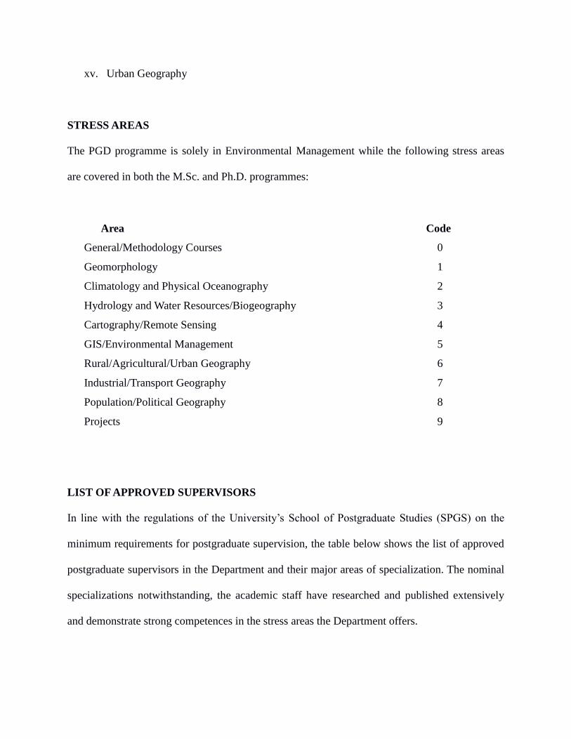
xv. Urban Geography
STRESS AREAS
The PGD programme is solely in Environmental Management while the following stress areas
are covered in both the M.Sc. and Ph.D. programmes:
Area Code
General/Methodology Courses 0
Geomorphology 1
Climatology and Physical Oceanography 2
Hydrology and Water Resources/Biogeography 3
Cartography/Remote Sensing 4
GIS/Environmental Management 5
Rural/Agricultural/Urban Geography 6
Industrial/Transport Geography 7
Population/Political Geography 8
Projects 9
LIST OF APPROVED SUPERVISORS
In line with the regulations of the University’s School of Postgraduate Studies (SPGS) on the
minimum requirements for postgraduate supervision, the table below shows the list of approved
postgraduate supervisors in the Department and their major areas of specialization. The nominal
specializations notwithstanding, the academic staff have researched and published extensively
and demonstrate strong competences in the stress areas the Department offers.
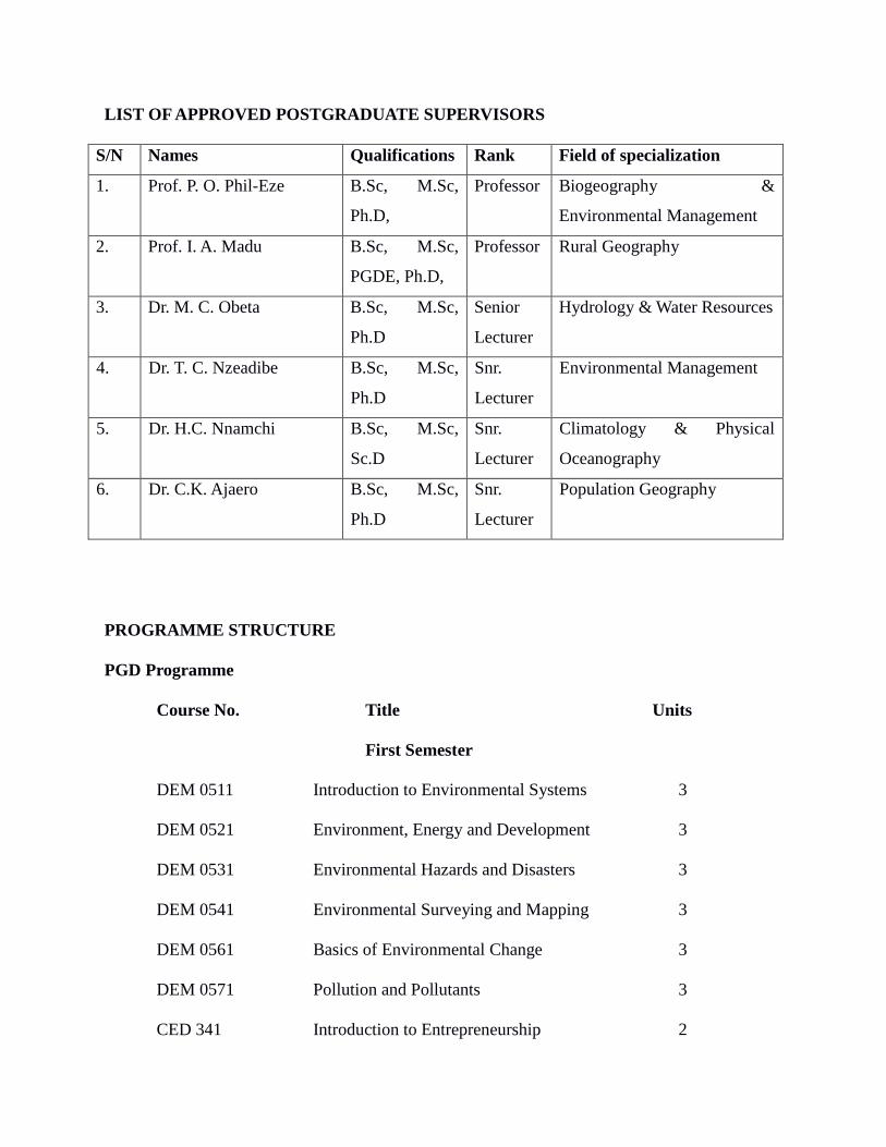
LIST OF APPROVED POSTGRADUATE SUPERVISORS
S/N Names Qualifications Rank Field of specialization
1. Prof. P. O. Phil-Eze B.Sc, M.Sc,
Ph.D,
Professor Biogeography &
Environmental Management
2. Prof. I. A. Madu B.Sc, M.Sc,
PGDE, Ph.D,
Professor Rural Geography
3. Dr. M. C. Obeta B.Sc, M.Sc,
Ph.D
Senior
Lecturer
Hydrology & Water Resources
4. Dr. T. C. Nzeadibe B.Sc, M.Sc,
Ph.D
Snr.
Lecturer
Environmental Management
5. Dr. H.C. Nnamchi B.Sc, M.Sc,
Sc.D
Snr.
Lecturer
Climatology & Physical
Oceanography
6. Dr. C.K. Ajaero B.Sc, M.Sc,
Ph.D
Snr.
Lecturer
Population Geography
PROGRAMME STRUCTURE
PGD Programme
Course No. Title Units
First Semester
DEM 0511 Introduction to Environmental Systems 3
DEM 0521 Environment, Energy and Development 3
DEM 0531 Environmental Hazards and Disasters 3
DEM 0541 Environmental Surveying and Mapping 3
DEM 0561 Basics of Environmental Change 3
DEM 0571 Pollution and Pollutants 3
CED 341 Introduction to Entrepreneurship 2
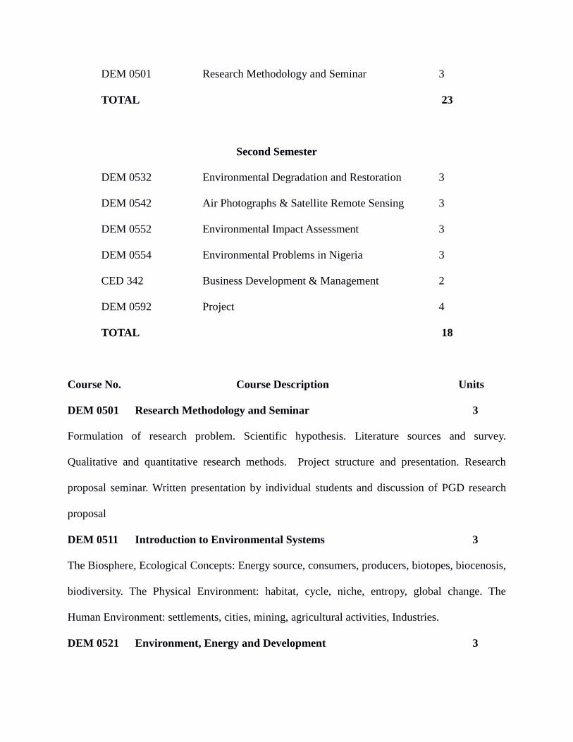
DEM 0501 Research Methodology and Seminar 3
TOTAL 23
Second Semester
DEM 0532 Environmental Degradation and Restoration 3
DEM 0542 Air Photographs & Satellite Remote Sensing 3
DEM 0552 Environmental Impact Assessment 3
DEM 0554 Environmental Problems in Nigeria 3
CED 342 Business Development & Management 2
DEM 0592 Project 4
TOTAL 18
Course No. Course Description Units
DEM 0501 Research Methodology and Seminar 3
Formulation of research problem. Scientific hypothesis. Literature sources and survey.
Qualitative and quantitative research methods. Project structure and presentation. Research
proposal seminar. Written presentation by individual students and discussion of PGD research
proposal
DEM 0511 Introduction to Environmental Systems 3
The Biosphere, Ecological Concepts: Energy source, consumers, producers, biotopes, biocenosis,
biodiversity. The Physical Environment: habitat, cycle, niche, entropy, global change. The
Human Environment: settlements, cities, mining, agricultural activities, Industries.
DEM 0521 Environment, Energy and Development 3
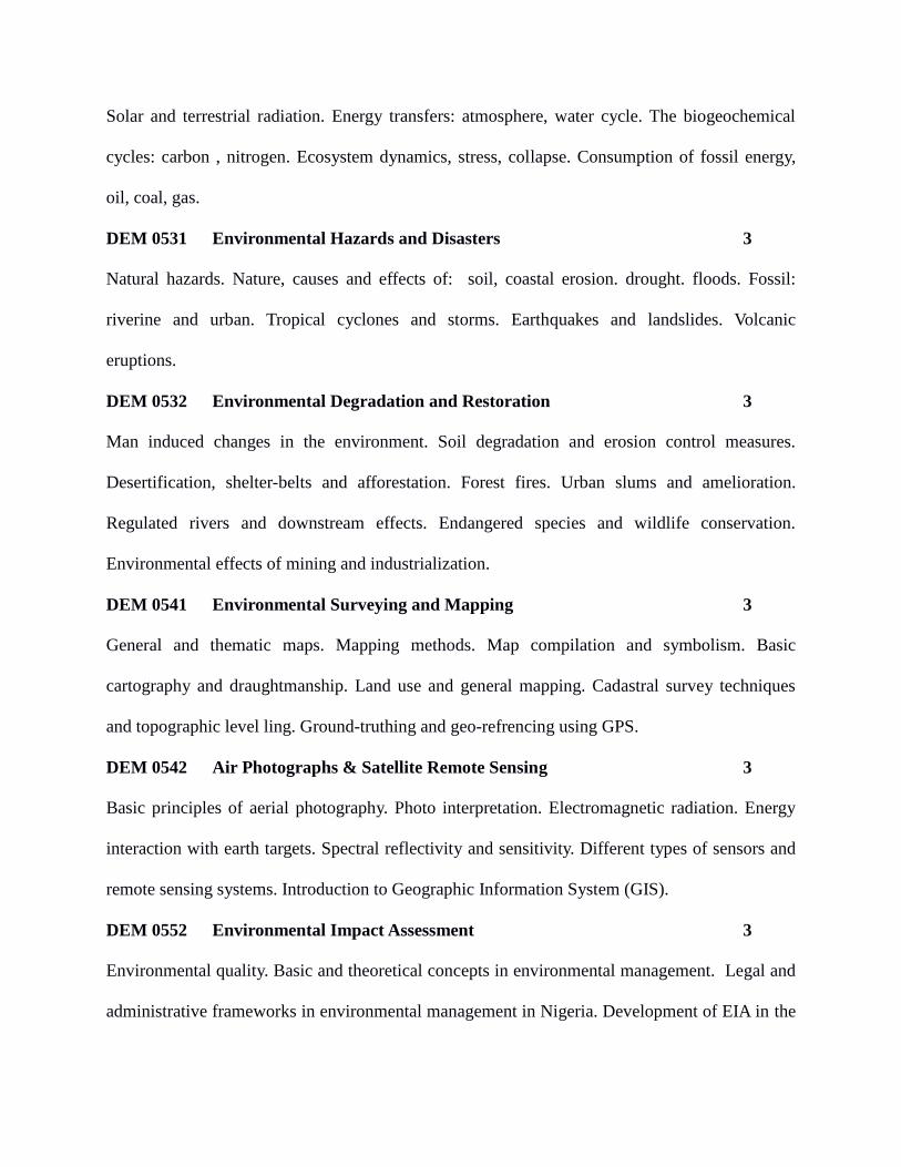
Solar and terrestrial radiation. Energy transfers: atmosphere, water cycle. The biogeochemical
cycles: carbon , nitrogen. Ecosystem dynamics, stress, collapse. Consumption of fossil energy,
oil, coal, gas.
DEM 0531 Environmental Hazards and Disasters 3
Natural hazards. Nature, causes and effects of: soil, coastal erosion. drought. floods. Fossil:
riverine and urban. Tropical cyclones and storms. Earthquakes and landslides. Volcanic
eruptions.
DEM 0532 Environmental Degradation and Restoration 3
Man induced changes in the environment. Soil degradation and erosion control measures.
Desertification, shelter-belts and afforestation. Forest fires. Urban slums and amelioration.
Regulated rivers and downstream effects. Endangered species and wildlife conservation.
Environmental effects of mining and industrialization.
DEM 0541 Environmental Surveying and Mapping 3
General and thematic maps. Mapping methods. Map compilation and symbolism. Basic
cartography and draughtmanship. Land use and general mapping. Cadastral survey techniques
and topographic level ling. Ground-truthing and geo-refrencing using GPS.
DEM 0542 Air Photographs & Satellite Remote Sensing 3
Basic principles of aerial photography. Photo interpretation. Electromagnetic radiation. Energy
interaction with earth targets. Spectral reflectivity and sensitivity. Different types of sensors and
remote sensing systems. Introduction to Geographic Information System (GIS).
DEM 0552 Environmental Impact Assessment 3
Environmental quality. Basic and theoretical concepts in environmental management. Legal and
administrative frameworks in environmental management in Nigeria. Development of EIA in the
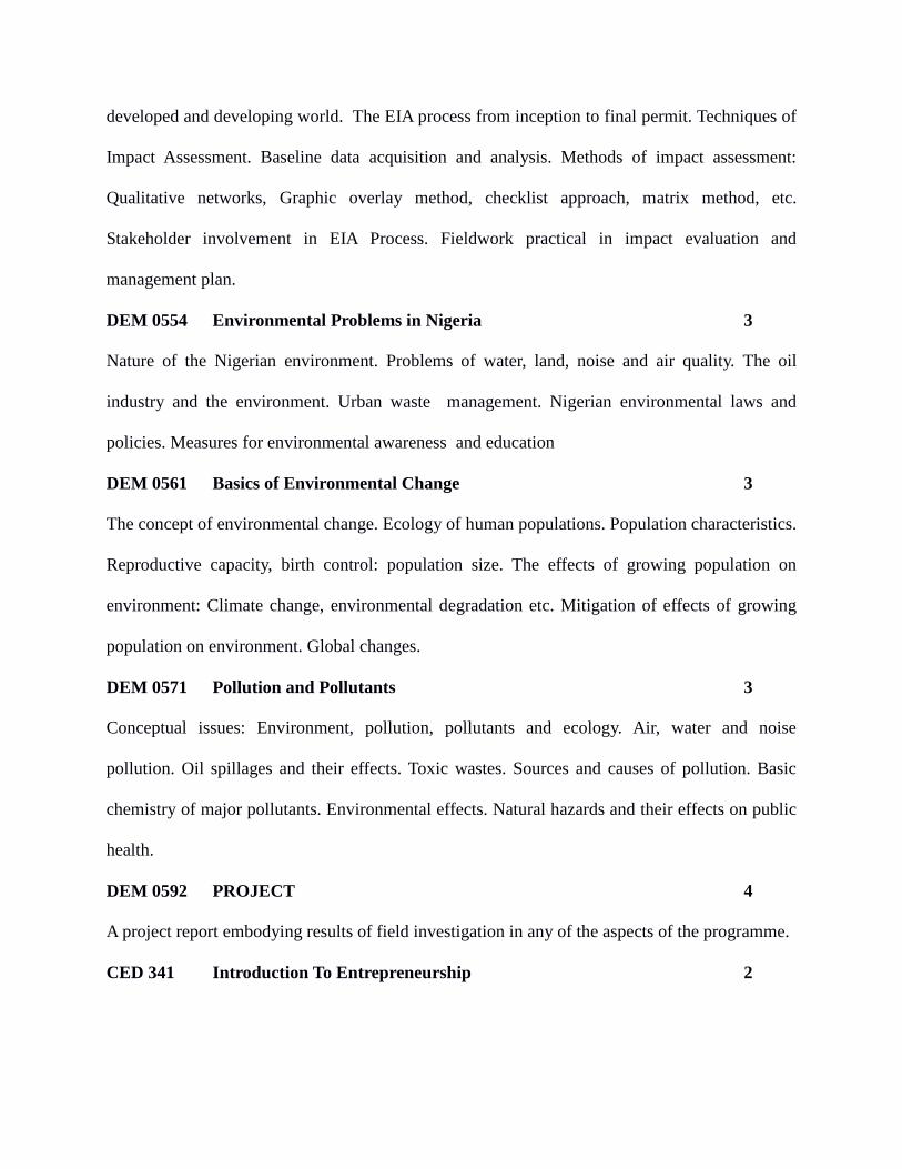
developed and developing world. The EIA process from inception to final permit. Techniques of
Impact Assessment. Baseline data acquisition and analysis. Methods of impact assessment:
Qualitative networks, Graphic overlay method, checklist approach, matrix method, etc.
Stakeholder involvement in EIA Process. Fieldwork practical in impact evaluation and
management plan.
DEM 0554 Environmental Problems in Nigeria 3
Nature of the Nigerian environment. Problems of water, land, noise and air quality. The oil
industry and the environment. Urban waste management. Nigerian environmental laws and
policies. Measures for environmental awareness and education
DEM 0561 Basics of Environmental Change 3
The concept of environmental change. Ecology of human populations. Population characteristics.
Reproductive capacity, birth control: population size. The effects of growing population on
environment: Climate change, environmental degradation etc. Mitigation of effects of growing
population on environment. Global changes.
DEM 0571 Pollution and Pollutants 3
Conceptual issues: Environment, pollution, pollutants and ecology. Air, water and noise
pollution. Oil spillages and their effects. Toxic wastes. Sources and causes of pollution. Basic
chemistry of major pollutants. Environmental effects. Natural hazards and their effects on public
health.
DEM 0592 PROJECT 4
A project report embodying results of field investigation in any of the aspects of the programme.
CED 341 Introduction To Entrepreneurship 2
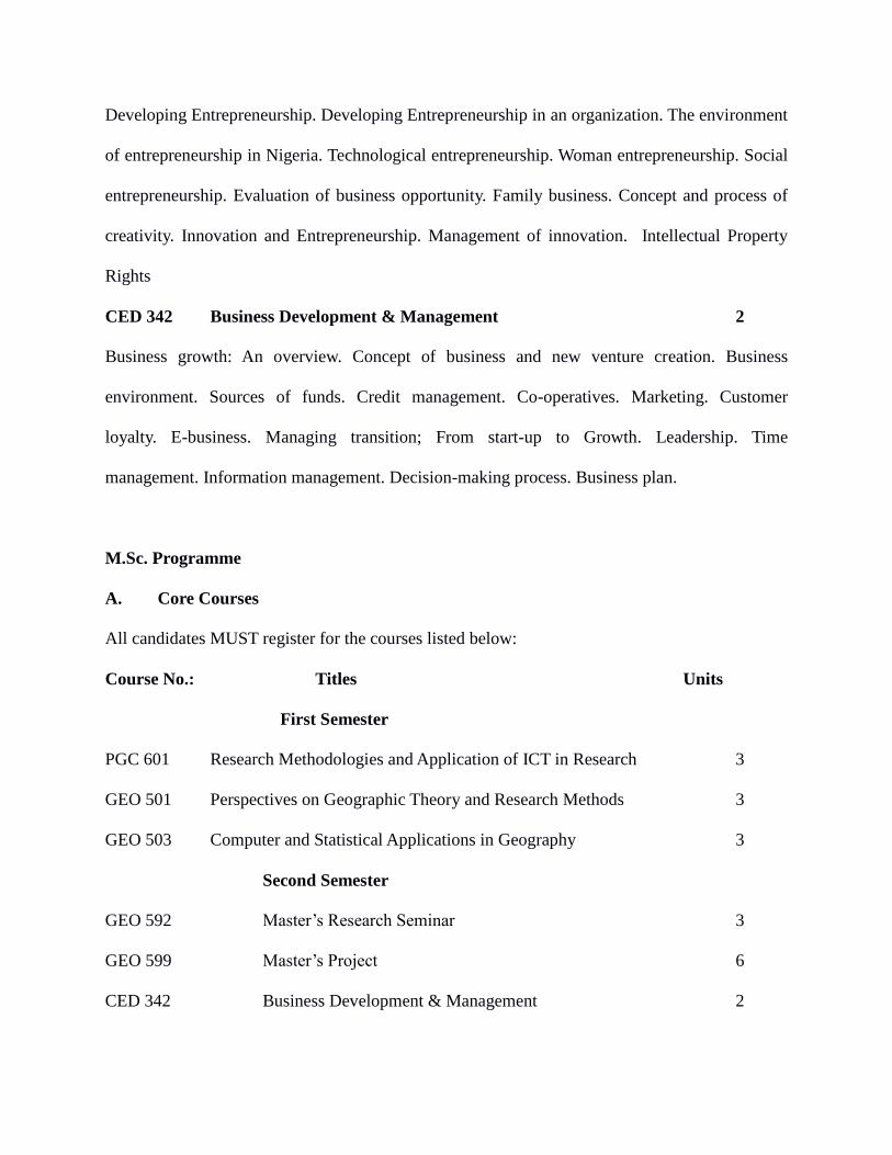
Developing Entrepreneurship. Developing Entrepreneurship in an organization. The environment
of entrepreneurship in Nigeria. Technological entrepreneurship. Woman entrepreneurship. Social
entrepreneurship. Evaluation of business opportunity. Family business. Concept and process of
creativity. Innovation and Entrepreneurship. Management of innovation. Intellectual Property
Rights
CED 342 Business Development & Management 2
Business growth: An overview. Concept of business and new venture creation. Business
environment. Sources of funds. Credit management. Co-operatives. Marketing. Customer
loyalty. E-business. Managing transition; From start-up to Growth. Leadership. Time
management. Information management. Decision-making process. Business plan.
M.Sc. Programme
A. Core Courses
All candidates MUST register for the courses listed below:
Course No.: Titles Units
First Semester
PGC 601 Research Methodologies and Application of ICT in Research 3
GEO 501 Perspectives on Geographic Theory and Research Methods 3
GEO 503 Computer and Statistical Applications in Geography 3
Second Semester
GEO 592 Master’s Research Seminar 3
GEO 599 Master’s Project 6
CED 342 Business Development & Management 2
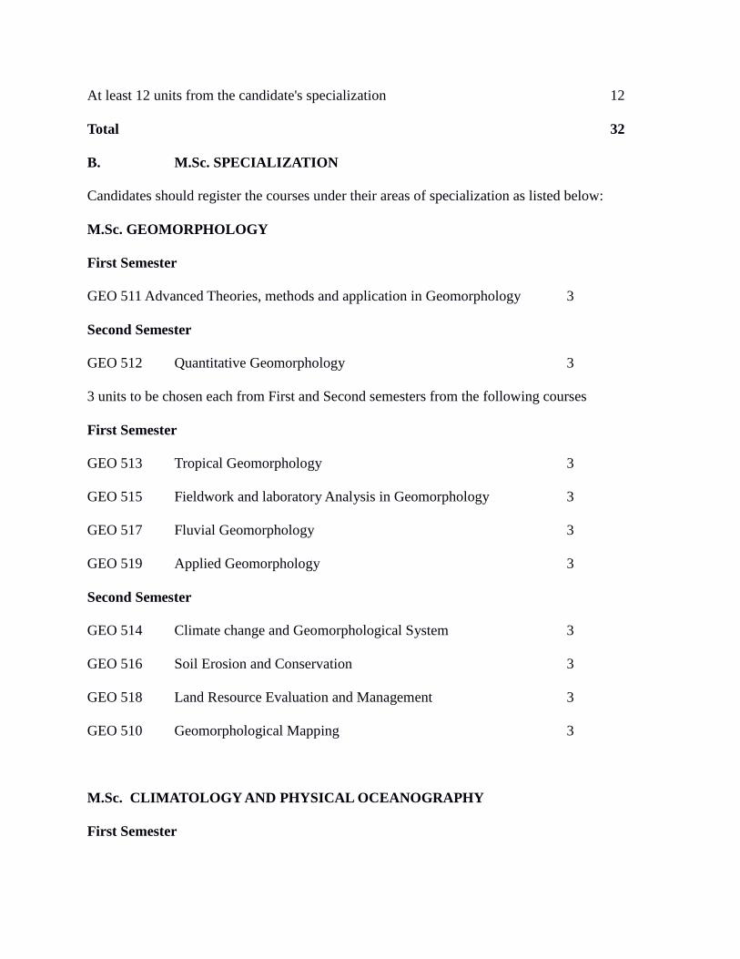
At least 12 units from the candidate's specialization 12
Total 32
B. M.Sc. SPECIALIZATION
Candidates should register the courses under their areas of specialization as listed below:
M.Sc. GEOMORPHOLOGY
First Semester
GEO 511 Advanced Theories, methods and application in Geomorphology 3
Second Semester
GEO 512 Quantitative Geomorphology 3
3 units to be chosen each from First and Second semesters from the following courses
First Semester
GEO 513 Tropical Geomorphology 3
GEO 515 Fieldwork and laboratory Analysis in Geomorphology 3
GEO 517 Fluvial Geomorphology 3
GEO 519 Applied Geomorphology 3
Second Semester
GEO 514 Climate change and Geomorphological System 3
GEO 516 Soil Erosion and Conservation 3
GEO 518 Land Resource Evaluation and Management 3
GEO 510 Geomorphological Mapping 3
M.Sc. CLIMATOLOGY AND PHYSICAL OCEANOGRAPHY
First Semester
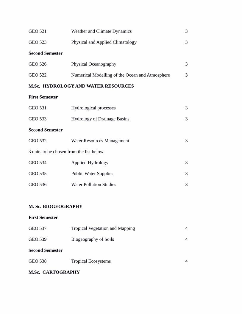
GEO 521 Weather and Climate Dynamics 3
GEO 523 Physical and Applied Climatology 3
Second Semester
GEO 526 Physical Oceanography 3
GEO 522 Numerical Modelling of the Ocean and Atmosphere 3
M.Sc. HYDROLOGY AND WATER RESOURCES
First Semester
GEO 531 Hydrological processes 3
GEO 533 Hydrology of Drainage Basins 3
Second Semester
GEO 532 Water Resources Management 3
3 units to be chosen from the list below
GEO 534 Applied Hydrology 3
GEO 535 Public Water Supplies 3
GEO 536 Water Pollution Studies 3
M. Sc. BIOGEOGRAPHY
First Semester
GEO 537 Tropical Vegetation and Mapping 4
GEO 539 Biogeography of Soils 4
Second Semester
GEO 538 Tropical Ecosystems 4
M.Sc. CARTOGRAPHY
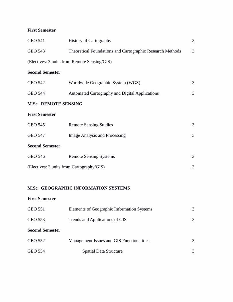
First Semester
GEO 541 History of Cartography 3
GEO 543 Theoretical Foundations and Cartographic Research Methods 3
(Electives: 3 units from Remote Sensing/GIS)
Second Semester
GEO 542 Worldwide Geographic System (WGS) 3
GEO 544 Automated Cartography and Digital Applications 3
M.Sc. REMOTE SENSING
First Semester
GEO 545 Remote Sensing Studies 3
GEO 547 Image Analysis and Processing 3
Second Semester
GEO 546 Remote Sensing Systems 3
(Electives: 3 units from Cartography/GIS) 3
M.Sc. GEOGRAPHIC INFORMATION SYSTEMS
First Semester
GEO 551 Elements of Geographic Information Systems 3
GEO 553 Trends and Applications of GIS 3
Second Semester
GEO 552 Management Issues and GIS Functionalities 3
GEO 554 Spatial Data Structure 3
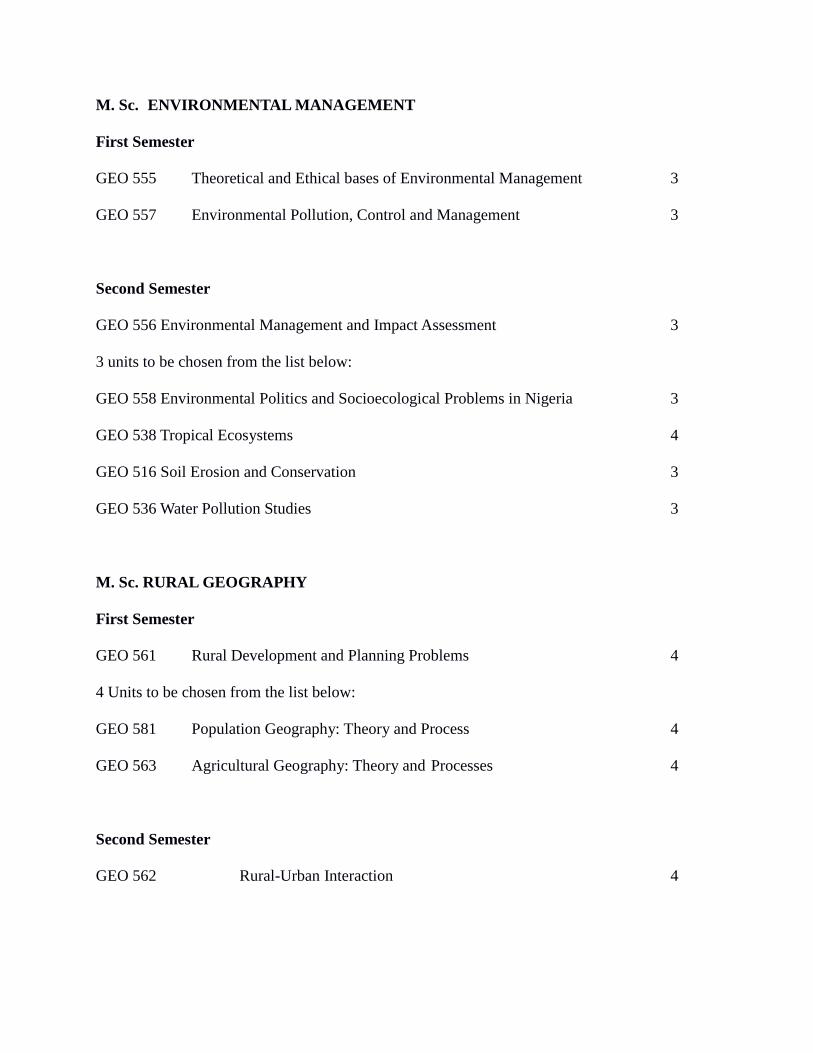
M. Sc. ENVIRONMENTAL MANAGEMENT
First Semester
GEO 555 Theoretical and Ethical bases of Environmental Management 3
GEO 557 Environmental Pollution, Control and Management 3
Second Semester
GEO 556 Environmental Management and Impact Assessment 3
3 units to be chosen from the list below:
GEO 558 Environmental Politics and Socioecological Problems in Nigeria 3
GEO 538 Tropical Ecosystems 4
GEO 516 Soil Erosion and Conservation 3
GEO 536 Water Pollution Studies 3
M. Sc. RURAL GEOGRAPHY
First Semester
GEO 561 Rural Development and Planning Problems 4
4 Units to be chosen from the list below:
GEO 581 Population Geography: Theory and Process 4
GEO 563 Agricultural Geography: Theory and Processes 4
Second Semester
GEO 562 Rural-Urban Interaction 4
M. Sc. AGRICULTURAL GEOGRAPHY
First Semester
GEO 563 Agricultural Geography: Theory and Processes 4
Second Semester
GEO 564 Models and Analytical Techniques in Agricultural Geography 4
4 units from the list below:
GEO 516 Soil Erosion and Conservation (2nd
semester) 3
GEO 561 Rural Development and Planning (1st semester) 4
M. Sc. URBAN GEOGRAPHY
First Semester
GEO 565 Urban Geography: Theory and Process 4
Second Semester
GEO 566 Urban Analytical Techniques and Urban Modelling 4
4 Units to be chosen from the list below:
GEO 568 The Process of Urban and Regional planning 4
GEO 562 Rural-Urban Interaction (2nd
semester) 4
GEO 573 Transport and Transit Systems (1st semester) 4
M. Sc. INDUSTRIAL GEOGRAPHY
First Semester
GEO 571 Industrial Geography: Theory and Process 3
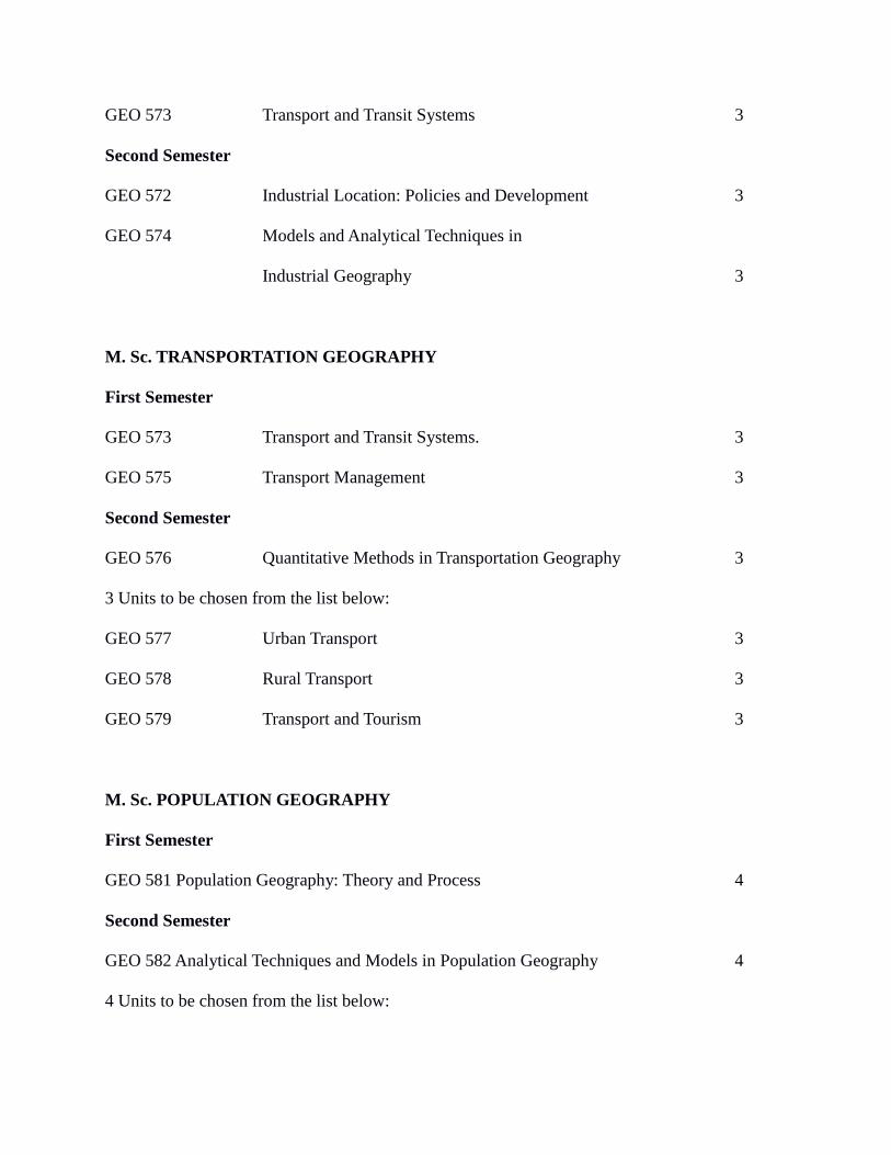
GEO 573 Transport and Transit Systems 3
Second Semester
GEO 572 Industrial Location: Policies and Development 3
GEO 574 Models and Analytical Techniques in
Industrial Geography 3
M. Sc. TRANSPORTATION GEOGRAPHY
First Semester
GEO 573 Transport and Transit Systems. 3
GEO 575 Transport Management 3
Second Semester
GEO 576 Quantitative Methods in Transportation Geography 3
3 Units to be chosen from the list below:
GEO 577 Urban Transport 3
GEO 578 Rural Transport 3
GEO 579 Transport and Tourism 3
M. Sc. POPULATION GEOGRAPHY
First Semester
GEO 581 Population Geography: Theory and Process 4
Second Semester
GEO 582 Analytical Techniques and Models in Population Geography 4
4 Units to be chosen from the list below:
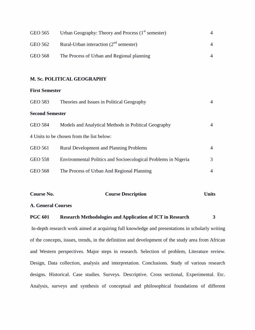
GEO 565 Urban Geography: Theory and Process (1st semester) 4
GEO 562 Rural-Urban interaction (2nd
semester) 4
GEO 568 The Process of Urban and Regional planning 4
M. Sc. POLITICAL GEOGRAPHY
First Semester
GEO 583 Theories and Issues in Political Geography 4
Second Semester
GEO 584 Models and Analytical Methods in Political Geography 4
4 Units to be chosen from the list below:
GEO 561 Rural Development and Planning Problems 4
GEO 558 Environmental Politics and Socioecological Problems in Nigeria 3
GEO 568 The Process of Urban And Regional Planning 4
Course No. Course Description Units
A. General Courses
PGC 601 Research Methodologies and Application of ICT in Research 3
In-depth research work aimed at acquiring full knowledge and presentations in scholarly writing
of the concepts, issues, trends, in the definition and development of the study area from African
and Western perspectives. Major steps in research. Selection of problem, Literature review.
Design, Data collection, analysis and interpretation. Conclusions. Study of various research
designs. Historical. Case studies. Surveys. Descriptive. Cross sectional, Experimental. Etc.
Analysis, surveys and synthesis of conceptual and philosophical foundations of different
disciplines and or hypothesis. Identification of research problems and development of research
questions and or hypotheses. Detailed treatment of methods of collecting relevant research data
and the format for presenting research results (from designing the table of content to referencing.
Bibliography and appendix). Data analysis and result presentation in different disciplines using
appropriate analytical tools methods of project/dissertation writing. Application of appropriate
advanced ICT tools relevant in every discipline for data gathering analysis and result
presentation. Essentials of spreadsheets. Internet technology and internet search engines. All
registered masters Degree students must attend a solution-based interactive workshop to be
organised by the school of Postgraduate studies for a practical demonstration and application of
the knowledge acquired from the course conducted by selected experts.
GEO 501 Perspectives on Geographic Theory and Research Methods 3
Formulation and attributes of the geographic problem. Research questions. The formulation of
scientific hypothesis in geographic research. Fieldwork. Questionnaire methods. Data collection
from published sources. Survey of published data sources in specific areas. Cartographic
techniques in the representation of geographic data. Literature sources and literature surveys.
Introduction to grant proposal writing. Research ethics and codes of conduct. Practical sessions
on conference/seminar presentation skills. Thesis writing: structure and presentationof laws and
theories in Geography. The nature of geographical models. Model building in physical and
human Geography. Systems and sytems analysis
GEO 503 Computer and Statistical Applications in Geography 3
The quantitative and computer revolutions in Geography. The Fortran and other programming
languages. The R programming language. Laboratory in Fortran. Laboratory in R. Introduction
to the SPSS package program. Applications and laboratory for GIS. ANOVA and ANCOVA.
Correlation and regression techniques. Principal components and factor analyses. Classification
in geography. Discriminant and canonical correlation analyses. Analysis of time series. Spatial
interaction. Locational analysis and allocation models.
GEO 592 Master’s Research Seminar 3
Written Presentation by individual students and discussion of the results of Master’s research.
GEO 599 MASTER’S PROJECT 6
Project report embodying results of first-hand field and/or cartographic, computer or quantitative
investigation in the candidate’s area of specialization.
CED 342 Business Development & Management 2
Business growth: An overview. Concept of business and new venture creation. Business
environment. Sources of funds. Credit management. Co-operatives. Marketing. Customer
loyalty. E-business. Managing transition; From start-up to Growth. Leadership. Time
management. Information management. Decision-making process. Business plan.
B. Specialized Courses
M. Sc .GEOMORPHOLOGY
GEO 510 Geomorphological Mapping 3
Geomorphology from Davis and after. Strahler and the departure from Davis. History of
geomorphological mapping: Polish, French, British, Dutch, Russian, American, Australian and
Nigerian schools. Contents and features of geomorphological maps from various schools. Scales
factor in geomorphological mapping and its influence on accuracy, details and expenses. The
role of the I.G.U. Commission on geomorphological survey and mapping: symbols on the
geomorphology maps. Types of geomorphological maps. Use of geomorphological maps for
development purposes. The production of geomorphological map of given area. Manual and GIS
–based approaches of producing geomorphological maps fieldwork and image analysis.
GEO 511 Advanced Theories , Methods and Application in Geomorphology 3
Meaning, nature and scope of Geomorphology from the various schools of Geomorphology.
Development of Geomorphology- Ancient, Medieval, Arabian Contributions. Geomorphology in
the Renaissance and Classical Periods: German, British, Italian, French, Swiss and American
contributions. Development of Geomorphology in modern and contemporary period; Powell,
Dutton, Gilbert, Penck, Thorbecke, Bornhardt, Budel, Crickmay, Wayland and Willis, Peltier,
King, Horton, Strahler, Schumm, Sceiddeger, Hack etc. Nature of Geomorphological problems
and research (landform, landscape and space). Problems and methods- case studies . Applications
of Geomorphological methods and techniques to geomorphological problems in other
disciplines.
GEO 512 Quantitative Geomorphology 3
Meaning, nature and scope of quantitative geomorphology. Qualitative and quantitative
geomorphology. Quantitative geomorphology in relation to Dynamic Geomorphology and the
systems approach in geomorphology. The geomorphological problem: scales of measurement,
the geomorphological data, descriptive and inferential statistics.Computer-aided analysis,
algorithms and GIS. Sampling for geomorphologic analysis. General and specific
geomorphometry: meaning, nature, andcscope. Reasons and basis of terrain sampling. Indices of
the land surface. Geomorphometry of drainage basins drainage density. Analysis of the character
of surfaces.
GEO 513 Tropical Geomorphology 3
The concept of climatic geomorphology. An overview of geomorphologic process in
various climatic zones. Delineation of the tropics; by latitude, moisture, temperature,
bioclimatology and topography. The geomorphic processes in the tropics: the roles of climate,
vegetation, geology in shaping the tropical landscape. Weathering and erosion in the tropics. The
case for and against separate tropical geomorphology. Drainage basins in the tropics: streams
patterns and other drainage basin characteristics. Characteristic landforms in the tropics. Slope
evolution models applied to tropical landscapes. Duconts and latentes. Land resources of the
tropics and their contributions to economic development. Geomorphology in tropical Africa.
GEO 514 Climate Change and Geomorphological System 3
The Earth’s physical system: atmosphere, lithosphere, hydrosphere, fauna and man. The
interrelationships between the systems. Importance of climate to living organisms. Climate as
outcome of the state of the atmospheric system. Open and closed systems. Malankovich theory
of climate change from the Mesozoic to date. Evidence of associated change sof the
geomorphological systems to the climate changes on earth. Lateritic crust and climate change in
the tropics. Present climate change and its implications for the natural resources of the tropical
lands. Climate change prediction, mapping, response and management. Natural hazards.
Geomorphological inputs in predicting and managing natural hazards and disasters.
GEO 515 Fieldwork And Laboratory Analysis In Geomorphology 3
The nature of the geomorphological problem. The paths to scientific investigations with
emphasis between the problem, the model, the hypothesis, fieldwork, experimentation, findings
and conclusion. Fieldwork: qualitative and quantitative- nature and characteristics of sampling,
sampling techniques and their application. Inadequacy and inadequacy of samples. Redundancy
of data and its effects. Successful sampling exercise. Data collection-sources, methods,
techniques, equipment. Topographic maps, aerial photographs , satellite photographs and
remotely sensed imageries as sources of data. Field study of slopes; profiling and classification.
Field study of soils. Soil properties investigation. Soil-slopes relationship. Studying streams:
cross sectional measurement, bankfull, half bank , over-bank, stream velocity and discharge,
stream flow regimes.
GEO 516 Soil Erosion and Conservation 3
The soil, its meaning and importance as a resource for mankind. Soil/land damage and
degradation. The factors, processes, stages and types of soil erosion. Models of soil erosion: their
validity and applications for correcting and ameliorating soil loss and damage. Gully erosion as a
special phenomenon in Southeastern Nigeria. Appraisal of the results of soil erosion studies in
southeastern Nigeria. Topographic, social and economic consequences of soil erosion. Soil
conservation and land rehabilitation/recovery. The need for soil/land resources conservation.
Approaches to soil/land resources conservation. Roles of individuals, groups, institutions and
organizations in soil/land conservation and protection. Critical assessment of the Land Use Act,
NESREA Act, National Policy on the Environment and EIA Acts as tools for soil/land
conservation in Nigeria. Application of GIS in soil erosion studies- mapping of erosion risk,
potential erosion and actual erosion in Nigeria.
GEO 517 Fluvial Geomorphology 3
The drainage basin as the theatre of fluvial action. Drainage basins as distinctive regions-
Bauche, Chorley and after Chorley to present times. Precipitation in the drainage basin. The
hydrological equation and hydrograph analysis. The factors of infiltration, evapotranspiration,
base flow and runoff. Runoff and surface drainage in the drainage basin. Drainage patterns:
causative factors and patterns. Drainage basin development. Horton, Dune, Schrumm. Hoerton-
Strahler laws of the drainage basin. Zones of the drainage basin and their characteristic features.
Flow mechanics and the Hjulstrom curve. Velocity, discharge and competence of streams. The
character of channels. Concepts of Grade and Base level. Channel tranverse and thalweg in
relation to the development opportunities offered for tourism, agriculture, transportation,
hydroelectric power generation etc. natural hazards in the drainage basin: prediction, response
and human attitude.
GEO 518 Land Resources Evaluation And Management 3
Land: definition or explanation from the perspective of the political scientist, surveyor,
geographer, geomorphologist, geologist, engineer, agriculturist and its meaning in Land
Evaluation. Evaluation: its meaning and application as a generic activity. Land Evaluation-
meaning, scope and content. Land Evaluation as a basic activity of man. Land evaluation for
agriculture, forestry, engineering, recreation etc. land evaluation and other tools for sustainable
use of land resources. Principles of land classification and evaluation. Models-land use capability
scheme/land suitability classification scheme. Index of potentiality- numeric, limitation and
fuzzy set methods. Farmers’ local knowledge evaluation method.
GEO 519 Applied Geomorphology 3
The concept of Applied Geomorphology as geomorphology in the service of human society.
Computer applications in geomorphology. Map analysis, GIS, Aerial photo analysis, topographic
analysis and attributes mapping. Man and landscape- global examples. EIA, National Policy on
the Environment. Elements n urban hydrology. Coastal and mountain geomorphology. Natural
hazards: prediction, mapping, response and management.
M.Sc CLIMATOLOGY AND PHYSICAL OCEANOGRAPHY
GEO 521 Weather and Climate Dynamics 3
Kinematics of atmospheric motion: Vorticity, divergence, deformation, streamlines and
trajectories. Dynamics of horizontal atmospheric motion: geostrophic, gradient and thermal
winds. Frictional and rotational effects. Primitive equations of atmospheric motion. Atmospheric
coordinate system. Atmospheric general circulation. The atmospheric boundary layer.
Atmospheric chemistry: Sources, transport and sink of trace gases. Air pollution. Tropospheric
aerosols and chemical cycles. Stratospheric chemistry. Climate dynamics: Present day climate,
climate equilibria, sensitivity and feedback. Internal, coupled and externally forced climate
variability. Climate change.
GEO 522 Numerical Modelling of the Ocean And Atmosphere 3
Components of the climate system. Hierarchical introduction to models of the atmosphere and
ocean. Energy balance models. Radiative-convective models. Limited area and regional models.
Model sensitivity, resolution and parametrization. Atmospheric general circulation models.
Ocean general circulation models. Coupling of the ocean and atmosphere. Laboratory exercises:
Linux OS. Scientific data formats and data operators: CDO, NCO. Programming in Fortran.
Interpreted programming and display languages: GrADS, R, NCL/Python. Application modelling
in health, agriculture, water resources etc.
GEO 523 Physical and Applied Climatology 3
The atmospheric boundary layer. Solar, terrestrial and net radiation. Soil temperature and heat
flux. Air temperatures and humidity in the boundary layer. Wind and turbulent transport in the
boundary layer. Evaporation and evapotranspiration. Meso systems in the atmosphere. Urban
climatology. Air pollution. Forest climatology. The atmosphere over large lakes. Meso-scale
atmospheric circulations. Surface bound meteorological instruments. Airborne and satellite
based instrumented platforms. The weather station. Meteorological agencies. Principles of
agricultural climatology. Elements of human bioclimatology. Aviation climatology. Climate
and the built environment. Weather forecasting. Advertent and inadvertent climatic
modification.
GEO 526 Physical Oceanography 3
Physical characteristics of the ocean. The cryosphere. Temperature, salinity and density:
vertical/geographical distribution and measurements. Ocean mixed layer and thermohaline
circulation. Ocean heat budget and flux. Geographical distribution of heat flux terms. Meridional
heat transport. Wind-driven ocean circulation. Wind stress and curl. Upper ocean response to the
atmosphere. Vorticity and Ekman pumping. Equations of ocean motion: conservation,
momentum and continuity equations. Geostrophic currents: hydrostatic equilibrium and
geostrophic equations. Altimetry. Deep ocean circulation: importance, theories, observations and
examples. Ocean waves: measurements and forecasting. Coastal processes and tides: Waves,
tsunamis, storm surges, tides and tidal predictions. Operational and applied oceanography.
M.Sc HYDROLOGY/WATER RESOURCES
GEO 531 Hydrological Processes 3
The hydrological Cycle, its components and relevance to key environmental and societal issues.
Collection and measurement of hydrological data, Surface runoff. Hydrograph analysis,
Hydrological mappings. Application of GIS in watershed studies
GEO 532 Water Resources Management. 3
Meaning of water resources. Water resources management. Objectives of water resources
management. Problems associated with water resources management. Modelling for watershed
planning and management. Water resources development. Water resources development in the
Tropics. Facets of water Resources development.
GEO 533 Hydrology of the Drainage Basin. 3
Mechanics of streamflow, Channel patterns. Sediment yield and solute transport. River regime,
Rriver water quality. Streamflow and soil erosion control. Uses of remote sensing in catchment
hydrology.
GEO 534 Applied Hydrology 3
Meaning of applied hydrology, flood hazards. Types of flood hazards, adjustment to flood
hazards. Water transport, water treatment, waste water management. Effects of land use and
climate on water resources. Carriers in hydrology, Water resources and/or environmental
management.
GEO 535 Public Water Supplies. Conceptual issues. Rural water supplies .Urban water
supplies. Water supply policy. Water allocation. Post construction support in the water supply
sector. Water supply systems. Water supply and human health .Water supply agencies.
Commercial water supplies .Reforms in the water supply sector. Exploitation of natural water
resources. Social and environmental impact of water resources development in the tropics.
Institutional framework for public water supplies in the tropics. Water supply and food security
in the Tropics. Water supply infrastructure.
GEO 536 Water Pollution Studies 3
Concept of water pollution, sources of water pollution, effects of water pollution, measurement
of water pollution, water pollution sampling. Water sample analysis, water pollution control,
water quality monitoring. Indices for water quality monitoring, water quality modelling.
M. Sc. BIOGEOGRAHY
GEO 537 Tropical Vegetation and Mapping 4
The environment of tropical vegetation. Plant succession and climax communities. Distribution
of tropical vegetation. Tropical forests, savannas, grasslands and deserts – their structure and
functioning. Classification of ecological systems, floristic systems and physiognomic systems.
Scale section, codification and symbolization. Tropical vegetation and climate change. Methods
of vegetation analysis. Transects, quadrats and other framework designs. Classification and
Ordination techniques. Application of Remote Sensing, GIS and Digital instruments in
vegetation mapping. Land use and land cover analysis. Utilization of vegetation maps for forest
and range conservation.
GEOG 538 Tropical Ecosystems 4
Disturbed tropical ecosystems. Tropical ecosystems and climate change. Dynamics of
biogeographical populations, Ecological carrying capacities and Ecosystem productivity.
Models in ecology. Dynamics of biogeographical conservation in tropical ecosystems.
Environmental quality indices. Cultural landscape and its deterioration. Conservation,
maintenance and management of environmental components. Environmental laws and
conventions. National and international regulatory bodies - NASREA, NOSDRA, CBD, UNEP.
GEOG 539 Biogeography of Soils 4
The soil, its meaning and importance as a resource in biogeography. Soil formation and soil
forming processes. Soil minerals, organic matter, structure and porosity. Physical, chemical and
mechanical properties of the soil. Soil colour, profiles and catenas. Methods and systems of soil
classification. Soils and man; positive and negative relations. Soils and climate change.
Laboratory and field work in soil study. Identification and sampling of soil in biogeography
studies. Handling of soil samples and chain of custody. Soil analysis – analysis of physical,
chemical and biological properties of soil. Soil disturbance and conservation.
M.Sc. CARTOGRAPHY
GEO 541 HISTORY OF CARTOGRAPHY 3
History of Cartography. Development of Cartography from ancient times to the present. The
origin of national surveys and development of mapping in Nigeria.
GEO 542 WORLDWIDE GEOGRAPHIC SYSTEM (WGS) 3
Universal and National Grid Systems . Types of projections and their benefits. Co-ordinate types
and Applications.
GEO 543 THEORETICAL FOUNDATIONS AND CARTOGRAPHIC RESEARCH 3
Diverse Map uses in geographical studies. Maps as models and model generation. Errors and
blunders in maps. Research methods in cartography.
GEO 544 AUTOMATED CARTOGRAPHY AND DIGITAL APPLICATIONS 3
The origin of computer cartography. Developments in the automation of mapping. Hardware and
their applications; as input, processing and output devices e.g mobile GPS. Digital applications
and software. Various applications of software processes. Current uses of software and their
benefits. Demerits of certain software types and implications of use.
M.SC REMOTE SENSING
GEO 545 REMOTE SENSING STUDIES 3
Basic concepts and principles of remote sensing applications. Primary concepts and primary
principles are highlighted.
GEO 546 IMAGE ANALYSIS AND PROCESSING 3
Elementary principles of manual and digital image analysis and interpretation. Manual tasks and
procedural steps in reading images. Manual aids and techniques. Digital image processing
techniques
GEO 547 REMOTE SENSING SYSTEMS
Various platforms carrying out remote sensing: aircraft, satellite, shuttle etc. All remote sensing
systems e.g Radar, aerial photography, satellite images etc.
M.Sc GEOGRAPHIC INFORMATION SYSTEMS
GEO 551 Elements of Geographic Information Systems 3
The course is designed to examine the various definitions of GIS, origin of the field, its
importance and terms of data integration, manipulation, display and accessibility to existing
spatial records uniquely differentiated from other forms of environmental data handling. It
discusses the historical evolution of Geographical and Land Information Systems, the disciplines
involved including Remote Sensing, Geodesy, Photogrammetry, Surveying, Cartography,
Statistics, Computer Science, Mathematics and Engineering along with practical applications of
the technology along with the course as a set of inter related subsystems.
GEO 552 Management Issues and GIS Functionalities 3
The course will focus on the major GIS functionalities such as the maintenance and management
of spatial and non-spatial data such as spatial data input functions. data manipulation functions
etc and output formatting. Basic management issues such as the implementation of GIS at
various levels will be reviewed. The course will also examine issues such as needs awareness
system planning, functional requirements analysis, benchmarking, system choice, pilot project
cost and benefits analysis, legal issues etc. It will also look at introduction of GIS to
organization, implementation strategy, and development of a national GIS policy.
GEO 553 Trends and Applications of GIS 3
A survey of evolutionary trends in GIS hardware and software packages including output,, input
and system peripherals. The course will look at the merits and demerits of the more packages.
operating systems, coding systems, editors, processors, spread sheets, compiles
and graphics standard. The future of GIS and the problems of its implementation in developing
countries will also be reviewed in this course. The course will equally review GIS applications
such as environmental issues of artificial projects and natural hazards, transportation, planning,
process management, public administration etc.
GEO 554 Spatial Data Structure 3
'Discussions are on basic concepts of space, Geographic Space; Geometric Model of spatial data,
Topologic Data Structures; Raster and Vector Data Structures and algorithms.
M. Sc. ENVIRONMENTAL MANAGEMENT
GEO 555 Theoretical and Ethical Bases of Environmental Management 3
Ethical models in environmental management: Strong Anthropocentrism, Ecocentrism,
Pathocentrism etc., Sustainability and Sustainable development: Issues, challenges and
contradictions., Pillars of sustainable development- environmental, economic, social and cultural
diversity . Critical analytical approaches to environmental resource and social management:
Political ecology (PE), Urban political ecology (UPE) and feminist political ecology (FPE)
frameworks; Environmental Justice (EJ) and Environmental Social Movements. Case studies
from Nigeria and Africa.
GEO 556 Environmental Management And Impact Assessment 3
Environmental quality indices. Cultural landscape and its deterioration. Conservation,
maintenance and management of environmental components. Environmental laws and the
role of UNEP. Impact assessment on the environment of various development schemes and
projects. Techniques of environmental impact assessment. Fieldwork practical on impact
evaluation and Management plans.
GEO 557 Environmental Pollution, Control and Management 3
Air, water, land and noise pollution. Criteria pollutants and their pollution significance.
Consequences of environmental pollution. Pollution measurement. Pollution abatement,
control and management. Ecological Sanitation (ECOSAN). E-waste problem and management.
Waste hierarchy and integrated solid waste management (ISWM). Handling and disposal of
hazardous wastes. Stabilization and solidification of hazardous waste. Elements of
Environmental Law and Policy. Disaster risk management.
GEO 558 Environmental Politics and Socioecological Problems In Nigeria 3
Introduction to environmental politics and governance. Nature of Nigerian political ecological
problems. Problems of the oil industry and the Nigerian environment: social, economic and
political. Political economy of petroleum in the Niger delta. Urban political ecology of solid
waste management in Nigeria. Social sustainability and Livelihoods in urban Solid Waste
Management in Nigeria. Political ecologies of Environmental degradation and Resource
Conflicts in Nigeria. Nigerian environmental policy, laws and legislation. Measures for
Environmental awareness and education. Role of National Assembly and government agencies
in environmental politics.
M.Sc RURAL GEOGRAPHY
GEO 561 Rural Development and Planning Problems 4
The rural concept; Challenge of contested discourses of rurality; Current rural conditions and
opportunities in rural areas ;Threats to rural areas-declining fiscal capital, demographic change,
climate change, etc; Climate change and food security; Innovation in the Context of Rural Areas;
Modernizing the Rural Economy- Strengthening Rural Markets, Balancing Diversification and
Specialization and skill building in rural areas; Concepts and Issues in rural development; Rural
development objectives and policies; Models and strategies of rural development ; Optimization
of rural land use and sustainable development; Empirical studies and appraisal of specific
schemes of rural development in Nigeria and other countries; Principles and components of rural
development plan; Rural development planning problems with particular reference to developing
countries.
GEO 562 Rural-Urban Interaction 4
The rural and urban concepts; Characteristics of rural population; Rural central places; Rural –
Urban links; Basis and processes of interaction; Sectoral interactions; Flows of people, goods ,
services and wastes; Measurement of interactions and spheres of influence of rural markets and
urban areas; Influence of changing rural-urban interactions on rural livelihoods; The role of
urban centres in the development of their surrounding rural region; Urban based associations and
rural transformation; Transformations in peri-urban areas, case study on rural urban interaction;
Urban- rural imbalances and disparities; Rural-urban migration and its implication on rural
development ;The need for spatial planning.
M. Sc. AGRICULTURAL GEOGRAPHY
GEO 563 Agricultural Geography: Theory and Processes 4
Scope and methodology of agricultural geography; Its position in geography and related fields;
Theoretical basis of agriculture-demand and supply factors for agricultural production; systems
of exploitation, regional analysis, and a survey of the world's major agricultural activities.
Classification of agricultural regions; The nature of tropical agriculture; Agricultural geography
of the humid and semi-arid tropics; Climate change and Agricultural production; Agriculture and
economic development – role of government policy; reforms and agricultural reforms; problems
and prospects for agricultural modernization.
GEO 564 Models and Analytical Techniques in Agricultural Geography 4
Social and economic concepts in agricultural geography; Agricultural decision-making in theory
and practice as applied to small-scale farming and agrarian sector in developing countries;
Geography of the agriculture in terms of the modern style and advanced trends in agriculture;
Greenhouses agriculture and urban agriculture; Contribution of agriculture to the development
process and the role of this development in the growth of agriculture; Location analysis and
processes of interaction of agricultural space; Methods of data collection, sampling techniques,
and analysis with relevance to specific research topics. Theories, models and problems of
explanation in agricultural geography; The role of perception and folk ecology in the analysis
and interpretation of traditional Nigerian land use systems; Application of GIS to Agricultural
production.
M.Sc. URBAN GEOGRAPHY
GEO 565 Urban Geography: Theory and Process 4
The process of urbanization. Historical evolution of cities. Theories of urban growth and urban
form. Urban population studies. Urban economics. Urban dynamics, urban blight and urban
renewal. External relations of the city: cities as central places; cities and regional development.
Urbanization and the environment. Problems of urbanization in Nigeria. Urban renewal and
urban relocation .Urban expansion and rural environment.
GEO 566 Urban Analytical Techniques And Urban Modeling 4
Models of urban form and structure. Techniques of analysis of the internal structure of
the city. Techniques of urban economic analysis. Measurement of centrality. Gravity models
and delimitation techniques of urban region, trade area, or zones of influence. Urban and
regional models and modelling.
GEO 568 The Process Of Urban And Regional Planning 4
Theory and practice in urban and urban - centered regional planning.. Case studies and readings
demonstrating the techniques used in various aspects of plan preparation within the framework
of the planning process.. Urban policies and policy making in Nigeria; analysis of local, state and
federal decision making processes as they affect public policy in urban area.. Impact of the
forces of urban growth and changes on the urban political system, centralization and
decentralization in the metropolis and inter-governmental relations.
M.Sc. INDUSTRIAL GEOGRAPHY
GEO 571 Industrial Geography: Theory and Process 3
Scope, themes and methodology of industrial geography. Industrialization process: local,
regional and global context. Distribution of industries: local, regional and international.
Changing pattern of manufacturing location: Nigeria, West Africa, Africa and global. Case
studies: Iron, Steel; Clothing, Motor vehicles, Electronics and Petrochemical and agro industries.
Production systems, value chain and globalization.
GEO 572 Industrial Location: Policies And Development Planning 3
Location and industrial development. Spatial strategy of industrial development. Industrial
policies , laws and institution (Nigeria, global). The impact of industrial activity across space.
Case studies of development plan and implication: Europe, America, Africa and Nigeria
GEO 574 Models and Analytical Techniques in Industrial Geography 3
Approaches to industrial location analysis: Behavioral, neoclassical and structuralist. Theories
and models of industrial location: least cost, profit maximization, market area, locational
dependency, industrial complex, central place theory. Analytical techniques and methods of
industrial geography. Statistical Analytical tools in geography with the aid of SPSS, Geographic
Information System.
M.Sc. TRANSPORTATION GEOGRAPHY
GEO 573 Transport and Transit Systems 3
The basis for transport interaction. Transport demand and supply. Transport costs analysis.
Transport as a spatial phenomenon; processes, structure and structural analysis. Modes and
systems of transport. The sociological, economic and strategic bases of transport as a dimension
in technology. Functionalism of transport: inter-and intra-modal competition in transportation.
The Gravity Model and traffic: transport and allocation models. Patterns of public transport
service provision. Transport development: theories and models. Empirical cases from
developing and developed countries. Transport planning in developed countries, developing
countries, and regional development strategies.
GEO 575 Transport Management 3
Concepts, principles and theories of transport management: transport and logistics management.
Planning, design, and operations of transport modes. Principles of strategic transport planning
models. Traffic and mobility management. Fiscal , administrative, safety and security issues in
public transport operations. Decision-making and government policy in issues: regulation,
financing, planning, privatization and management. Private sector participation in the
management of transport projects. Transport planning and management . overview of transport
planning , policy and management systems in developed and developing countries.
GEO 576 Quantitative Methods in Transportation Geography 3
Evaluation of the characteristics of location patterns. Analysis of patterns of spatial equilibrium.
Linkage, networks, movement and hierarchies. Normative interaction models such as
connectivity and accessibility models. The strategy of model design. Transport Systems Analysis
(TSA) using graph-theory in Transportation Geography. Matrix notion in urban and regional
analysis. The shortest path matrix, Markov Chain and input-output analysis. Application of
Linear programming to Transport problems: Linear Programming Formulations approach,
Graphic Solution to linear programs, simplex methods. The Transportation Model of Linear
Programming: approach to trip distribution, and variations of the Classical Transportation
problems. Location Allocation models. Introduction to Geographical Information System (GIS)
and Computer Programming and Application of Software in Transport Geography.
GEO 577 Rural Transport 3
Development of rural transport infrastructure; means of transport, transport infrastructure,
characteristics of rural transport. Relationship between rural transport network and regional
development. Rural dynamics and Transport planning, design and development. The traditional,
intermediate and modern sub-sectors in rural transport. Needs assessment of rural transport.
Transport and crop production. Delivery of services and information flow. Land
use/transportation interaction and personal mobility. Travel demand and transportation system
capacity. Rural transport trends and problems. Population change and transport planning. Rural
road network planning. Role of project appraisal in rural road transport planning. Intelligent
transport systems. Transport surveys in rural areas.
GEO 578 Urban Transport 3
Transport and urban form. Land use and transport interaction. Urban mobility and urban
transport problems. Intermodal transportation. Intelligent transport systems. Trafficflow and
control. Transportation management and policy. Theory and principles of sustainability in urban
transport. Urban transport planning methods and urban transport surveys. Urban dynamics and
transport planning, design and development. Principles of GIS and its applications in urban
transportation.
GEO 579 Transportation and Tourism 3
Functions of transport in tourism; tourist transport systems. Transport economics, territorial
planning or tourism and transportation. Quantitative tourism analysis. Perspectives in tourism
management. Service quality analysis in tourism. Tourism strategy, hospitality and tourism
operating systems. Overview of transport needs for tourism in developed and developing
countries.
M. Sc. POPULATION GEOGRAPHY
GEO 581 Population Geography: Theory and Process 4
Theoretical and methodological foundations of population geography; Historical and theoretical
perspectives of migration studies; Spatial patterns and consequences of migration; Migration
policies and development planning; Dynamics and consequences of urban growth ; Rural
stagnation and poverty; methodologies and relevance of Social Impact Assessment (SIA);
Quality of life and socioeconomic inequalities in population; Interrelationships of socio-
environmental factors and impacts on the dynamics of human population.
GEO 582 Analytical Techniques and Models in Population Geography 4
Techniques of population data generation and collection; Demographic and statistical methods of
analysis of population data; Theoretical and empirical analysis of population growth, decrease,
mobility and quality of life; Application of GIS in Population studies; Development of geo-
databases for population studies; exploratory spatial analysis and geospatial modeling of
population data; Models and analysis of social inequalities and livelihoods; Applications of
population data in research and development planning.
M.Sc. POLITICAL GEOGRAPHY
GEO 583 Theories and Issues in Political Geography 4
The theory of political geography. Recent trends in political geography and international
relations. Political geography and planning processes. Africa and global geopolitical strategies.
Theories of urban governance. Urban politics. Civil society in governance and state building.
The good governance agenda. Political geography in Nigeria.
GEO 584 Models And Analytical Methods in Political Geography 4
Approaches to the study of political geography. Research problems in political geography.
Models in political geography. Methods of analysis of the political organization of space in the
micro and macro context. Analytical tools in political geography.
Ph.D. Programme
Ph.D candidates may be required to register or audit any of the M.Sc Courses on the
recommendation and approval of the Departmental Postgraduate Board. In addition all Ph.D
candidates should register for a minimum of 30 units including the underlisted courses:
Course No.: Titles Units
GEO 601 Doctoral Seminar I 3
GEO 603 Doctoral Seminar II 3
GEO 699 Doctoral Thesis 12
PGC 701 Synopsis and Grant writing 3
Course No. Course Description Units
GEOG 601 DOCTORAL SEMINAR 1 3
Detailed written presentation of the candidates’ Ph.D topic proposal; to include introduction; the
research problem, aim and objectives of the research, the study area, theoretical framework,
literature review, and research methodology.
GEOG 603 DOCTORAL SEMINAR III 3
A detailed written pre-thesis presentation of the results of the candidate’s Ph.D research
GEOG 699 DOCTORAL THESIS 12
In-depth analysis and thoroughly researched and original presentation of results of extended
field, library, statistical, computer, and/or cartographic work.
PGC 701 SYNOPSIS AND GRANT WRITING 3
Identication of types and nature of grant and grant writing, mining of grants application calls on
the internet. Determining appropriate strategy for each grant application. Study of various grant
application structures and contents and writing of concept notes. Detailed project decription,
budgeting and budget defense. Study of sample grant writings in various forms and writing mock
research and other grants. Identification of University of Nigeria synopsis structure and
requirements. (Introduction, Methodology and Results). Determining the content of each sub-
unit of the synopsis. Steps in writing of synopsis from the Dessertation/Thesis document.
Structural and language issues common errors in synopsis writing and strategies for avoiding
them. The roles of the student and the supervisor in the production of a synopsis writing of mock
synopsis. All registered Ph.D students must attend a solution-based interactive workshop to be
organized by the School of Postgraduate studies for a practical demonstration and application of
the knowledge acquired from the course, conducted by selected experts.


![UNIVERSITY OF NIGERIA, NSUKKA 1 · IGBO/HAUSA], University of Nigeria Nsukka [BA/ED IGBO/LINGUISTICS], University ... Dr E.E. Mbah UNIVERSITY OF NIGERIA NSUKKA [B.A(ED)], UNIVERSITY](https://img.pdfslide.us/doc/110x75/5b8215817f8b9a2b678dcc3a/university-of-nigeria-nsukka-1-igbohausa-university-of-nigeria-nsukka-baed.jpg)