Embed Size (px)
Citation preview

UNIVERSITY OF CALIFORNIA
Stratigraphy, Tectonics, Paleoclimatology and Paleogeography of Northern Basins of Brazil
A Dissertation submitted in partial satisfaction of the requirements of the degree of
Doctor of Philosophy
in
Geology
by
Mario VicenteCaputo
Committee in charge:
Professor John C. Crowell, Chairman
Professor James R. Boles
Professor Richard Y. Fisher
Professor Knut Bjorlykke, University of Bergen, Bergen, Norway
Professor Antonio A. Rocha-Campos, University of São Paulo, Brazil
Professor Rodi A. Medeiros, Petroleo Brasileiro S.A.·
February 1984

The dissertation of Mario Vicente Caputo
Is approved:
February 1984
ii

February 15, 1984
Copyright by
Mario Vicente Caputo
1984
iii

ACKNOWLEDGEMENTS
I wish to express on, deep appreciation to all those individuals
whose suggestions, criticism, encouragement and support have made
this study possible. I am most grateful to Petróleo Brasileiro S. A.
Petrobras (Brazilian State Oil Company), especially to Carlos Walter·
Marinho Campos (member of the Board of Directors of Petrobras) for
his constant support to this research project, and for making
unpublished data from Petrobras files available for this broad study.
Appreciation is also expressed to Raul Mosmann (General Manager·of
the Department of Exploration), Raymundo Ruy Bahia (Manager·of
Exploration of the Northern Exploration District) and Jeconias
Queiroz (General Chief of Geologic Operations) who allowed me to
develop this study.
I wish to express my sincere gratitude to Dr. John C. Crowell
for his guidance and counsel which at times went above and beyond his
duty of advising Professor. Formal recognition is given to Drs.
James R. Boles, Knut Bjorlykke and Richard V. Fisher for their·
friendship and generous allocation of time whenever called upon.
I desire to express my appreciation to Frederico Waldemar Lange
for his comments and insights which improved the English text.
Finally, I wish to express my deepest gratitude to my parents,
Pedro and Zelinda and wife Maria da Glor·ia, who have ever been a
source of inspiration and renewed strength. To them this study is
dedicated.
iv

VITA
March 4, 1938 – Born – Santana do Livramento, R.S.,Brazil
1961 - B.A., Universidade Federal do Rio Grande do Sul, Brazil.
1962-1983 – Oil geologist at Petróleo Brasileiro, S.A. (Petrobras).
PUBLICATIONS Caputo,M. V., 1971. Nomenclatura estratigráfica da Bacia do
Amazonas – Histórico e atualização. Soc. Bras. Geol., An. XXXVI
Congres. Bras. Geol., V. 3, p. 35-46 (with R. Rodrigues and D. N.
N. Vasconcelos).
Caputo, M, V., and Crowell, J. C., 1984. Migration of glacial
centers across Gondwana during Paleozoic era. Geol. Soc. of Am.
Bull. (in press).
Caputo, M. V., 1984. Late Devonian glaciation in South America.
Special issue. Palaeogeography, Palaeoclimatology and
Palaeoecology (in press).
v

ABSTRACT
Stratigraphy, Tectonics, Paleoclimatology and
Paleogeography of Northern Basins of Brazil
by Mário Vicente Caputo
Paleozoic basins in northern Brazil contain thick sequences of
sedimentary rocks, including diamictites. Because several different geological environments may generate diamictites a study of tec tonism, stratigraphy, paleoclimatology and paleogeography was made in order
to deduce the processes involved in their origin. A large part of northern Brazil strata is underlain by metavolcanic and
metasedimentary sequences steeply folded and metamorphosed during
many tectonic events from about 3,600 to 1,000 m.y. ago. Northeast Brazil was also affected by the Brazilian tectonic cycle from about
700 to 450 m.y. ago. The pre-basin weak zones and resulting trends
are responsible for the shape and geometry of 3 huge intracratonic basins developed during Paleozoic time: the Solimões, Amazonas and Parnaíba basins.
The three basins had a similar geologic development during Paleozoic times; from Ordovician to Early Carboniferous time only clastic rocks were deposited, and from Late Carboniferous to Permian
time carbonate and evaporites were also laid down. Tectonism that affected basins is related to uplift and collapse
vi

that preceded the break up of Pangea and subduction activity along the
Solimões Basin, in the western side of the South American continent.
Climate· has influenced the characteristics of each formation.
Paleolatitudes based on paleoclimatic indicators such as tillites, eolian sands, coal, bauxite, red beds, evaporites, limestone, fauna and flora, changed from polar and circumpolar to equatorial during Phanerozoic times. Glaciation was recorded in Ordovician-Silurian,
Late Devonian and Early Carboniferous times.
A Late Devonian glaciation left a clear imprint as shown by
sedimentary facies. Diamictites with striated, faceted and polished pebbles; rhythmites with dropstones; erratic boulders; striated pave
ments and deformed sandstones document glacial conditions. Study of the migration of glacial centers based on the available
literature and new data from Brazil shows that they closely follow published paleomagnetic wander data and that there is a close rela tionship between all Paleozoic glaciations and the Brazilian gla ciations. Ice centers moved from northern Africa to southwestern South America from Late Ordovician to Early Silurian time. From Mid-Silurian to early Late Devonian time no record of glaciation is known. In Late Devonian time intermittent glaciation initiated again
in central South America and, from Late Devonian to Late Permian time ice centers migrated toward Antarctica across South America and South Africa. The Devonian and Ordovician-Silurian glaciations together
vii

with the Permo-Carboniferous glaciations may all have primarily resulted from the shifting position of the Gondwana continent with respect to the South Pole.
viii

TABLE OF CONTENTS
Page
ACKNOWLEDGEMENTS …………………………………..…………………………………………….iv
VITA, PUBLICATIONS…..……………………………………………………….v
ABSTRACT………………………………………………………………………….vi
LIST OF FIGURES.….……………………..………….………………………….…xiv
PHOTO CAPTIONS……….…………………………………………………………………………xix
CHAPTER 1. INTRODUCTION ………………………………………………….…………….………1 Scope and Methods of Study ………………………………………………...5
CHAPTER 2. CRITERIA FOR PALEOCLIMATIC STUDIES………..…………….8
Limestone………………………………………………………………………10 Evaporites………………………………………………………………………14 Red Beds……………………………………………………………………….18 Bauxite………………………………………………………………………….19 Coal……………………………………………………………………………..22 Aeolian Sands………………………………………………………………….24 Tilites………………………………………………………….………………...26
CHAPTER 3. CRITERIA FOR THE IDENTIFICATION OF GLACIGENIC
DEPOSITS…………………………………………….…………………..30 Direct Evidence for Glaciation………………………………………………....34
Pavement and Boulder Pavement……………………………………...36 Striations and Related Features………………………………....….36 Periglacial Deposits……………………………………………….….......37 Glacio Marine Deposts…………………………………………..............38 Dropstones………………………………………………………..............40 Patterned Ground and Other Features…………………………….…...41
Indirect Evidence for Glaciation……………………………………………….…44 Loess………………………………………………….……………….……44 Regressions and Transgressions………………………………………....46 Massive Biotic Extinction…………………………………………………...46 Paleogeographic Reconstruction……….…………………………………47 Paleomagnetic Data………………………………………………………...48
CHAPTER 4. TECTONIC DEVELOPMENT OF SOUTH AMERICA FROM
EARLY PRECAMBRIAN TO ORDOVICIAN TIME…………..……….…49 Amazonian Platform………………………………………………………….......53
Central Amazonian Province…………………………………….………...58 Maroni-Itacaiunas Fold Belt…………………………………….……….…59
ix

Central Guyana Fold Belt……………………………………….…………….62 Rio Negro –Juruena Fold Belt………………………………………………..62 Rondonian Fold Belt…………………………………………………………...63
Brazilian Platform……………………………………………………….…………....67 Araguaia Fold Belt…………………………………………………………… ..68 Araioses Fold Belt…..................................................................................72 São Luís Craton.........................................................................................74 Goiás Massif..............................................................................................75 Brasilia Fold Belt........................................................................................76 São Francisco Craton................................................................................77 Ribeira and Própria Fold Belts...................................................................78
Plate Tectonics VS. Ensialic Tectonics……………………………………….......82
CHAPTER 5. ORIGIN AND DEVELOPMENT Of NORTHERN BRAZILIAN BASINS..89 Basic Concepts……………………………………………………………….89 Origin of the basins………………..………………………………..………..91 Basin Amplification……………………………………………………….…..96
CHAPTER 6. GENERAL REMARKS ON STRATIGRAPHY………….……………….99 CHAPTER 7. PIMENTA BUENO BASIN…………..………………..……….………....110
Pimenta Bueno Formation……………………………………………….....112 Unnamed Formation..............................................................................118 Fazenda da Casa Branca Formation......................................................118 Anari Basalt............................................................................................122 Botucatu Formation................................................................................122 Parecis Formation..................................................................................124
CHAPTER 8. SOLIMÕES BASIN………………………………………………………...126 Uatumã Group…………………………........…………………………….…….....128
Prosperança Formation………….......................................................130 Jutaí Formation..................................................................................134 Juruá Formation.................................................................................138 Jaraqui Formation…………….........................................................…142 Sernambi Formation...........................................................................146 Pucá Formation..................................................................................148 Itaituba formation................................................................................151 Nova Olinda Formation ......................................................................155 Fonte Boa Formation..........................................................................157 Basic Magmatism..........................................................................................159 Alter do Chão Formation......................................................................160 Solimões Formation.............................................................................163
CHAPTER 9. AMAZONAS BASIN...............................................................................168 Prosperança Formation........................................................................170 Acari Formation....................................................................................172
x

Trombetas Group………………………….........…………………….…………...175 Autás Mirim Formation....................................................................175 Nhamundá Formation.....................................................................180 Pitinga Formation............................................................................186 Manacapuru Formation...................................................................194
Urupadi Group.................................................................................................201 Maecuru Formation.........................................................................203 Ererê Formation..............................................................................209
Curuá Group....................................................................................................215 Barreirinha Formation......................................................................215 Curiri Formation...............................................................................221 Oriximiná Formation........................................................................230
Faro Formation...................................................................................236 Tapajós Group.................................................................................................242
Monte Alegre Formation..................................................................242 Itaituba Formation............................................................................248 Nova Olinda Formation....................................................................256 Andirá Formation..............................................................................264
Penatecaua Basalt..............................................................................269 Alter do Chão Formation.....................................................................271 Almeirim Formation.............................................................................275
CHAPTER 10. PARNAÍBA BASIN..............................................................................279 Serra Grande Group.........................................................................................280
Ipu Formation...................................................................................282 Tianguá Formation...........................................................................294 Jaicós Formation..............................................................................301
Canindé Group.................................................................................................306 Itaím Formation................................................................................306 Pimenteira Formation.......................................................................314 Cabeças Formation..........................................................................323 Longá Formation..............................................................................332
Poti Formation.....................................................................................339 Piauí Formation...................................................................................348 Pedra de Fogo Formation...................................................................353 Mutuca Formation...............................................................................358 Sambaíba Formation..........................................................................362 Mosquito Formation............................................................................365 Pastos Bons Formation......................................................................368 Corda Formation.................................................................................372 Sardinha Formation............................................................................374 Areado Formation...............................................................................376 Grajaú Formation................................................................................380 Codó Formation..................................................................................383 Itapecuru Formation............................................................................386 Urucuia Formation..............................................................................389
xi

Nova Iorque Formation......................................................................392 Pirabas Formation.............................................................................393 Barreiras Formation...........................................................................394
CHAPTER 11. TECTONICS OF NORTHERN BRAZIL FROM ORDOVICIAN
TO RECENT TIMES………………………………………………………......395
CHAPTER 12. LATE DEVONIAN GLACIATION CONTROVERSY………..…....411 Background………………………………………………………..…………...411 Evidence for Late Devonian Glaciation………………...………………...…415
CHAPTER 13. MIGRATION OF GLACIAL CENTERS ACROSS
GONDWANA DURING PALEOZOIC ERA………………………….………431 Overview……………………………………………………………………......431
Late Ordovician-Early Silurian glaciations……………………………...…..…..434 Arabia and North Africa………………………………..……………..…434
Arabia..........................................................................................434 Central Sahara Region................................................................437 Tindouf Basin..............................................................................439 Taoudeni Basin...........................................................................440 Accra Basin.................................................................................443 Gabon Basin................................................................................445
South America..................................................................................447 Sergipe Alagoas Basin................................................................447 Parnaíba Basin............................................................................451 Amazonas Basin.........................................................................453 Paraná Basin..............................................................................456 Andean Region………………………………………………...……461
South Africa…………………………………………….…………….....463 Cape Ranges……………………………………………..………....463
Late Devonian glaciations…………………………………..……………………465 South America…………………………………………..………..……..466
Solimões Basin………………………………………….………..…466 Amazonas Basin…………………….……………………..……….467 Parnaíba Basin……………………………………………...………469
North Central Africa…………………………………………………….472 Tim Mersoï Basin………………………………….………...……..472 Discussion………………………………………………..……….…474
Early Carboniferous Glaciations……………....………………………….….…477 South America…………………………………………………….…….478
Bolivia and Northern Argentina…………………………………....478 Pimenta Bueno Basin, Brazil………………………………………482 Amazonas Basin, Brazil…………………………………….…..….483 Parnaíba Basin, Brazil……………………………………………..484 Chaco-Paraná Basin, Argentina……………………………..……486 Discussion……………………………………………………….…..487
Late Carboniferous and Permian Glaciations................................................488 xii

CHAPTER 14. DISCUSSION AND CONCLUSIONS……………………………..491 APPENDIX A - PALEONTOLOGICAL DATA……………………………………...500 APPENDIX B – PHOTO CAPTIONS..................................................................524 REFERENCES....................................................................................................539
xiii

LIST OF FIGURES
Figure Page
1. South-America index map………………………………………………..……....2 2. Brazilian sedimentary Phanerozoic basins index map
according to Petrobras classification………………………………....4 3. Distribution of recent marine carbonate deposits……………………………11
4. Surface mean temperatures for the present glacial
nonglacial, and interglacial periods…………………………………15
5. Provisional genetic classification of tills………………………………27 6. Provisional genetic classification of tillites……………………………..35 7. Main South American geotectonic elements…………………………………….50
8. The Parnaíba Basin is located in the gap among
Amazonian, West African and São Franciscan cratons………………………….52
9. Main South American tectonic units…………………………………………54
10. Reassembly of Africa and South America……………………………………….56
11. The Goiás massif………………………………………………………...69
12. World gravity map shows a sharp contrast between Amazonian and Brazilian platforms……………………………………71
13. Possible obduction mechanism for emplacement
of ophiolites………………………………………………………87 14. Bouguer map of Amazonas and Solimões basins…………………………………….92
15. Structural framework of Solimões, Amazonas
and Parnaíba basins………………………..…………..….………101 16. Pimenta Bueno Basin index map………………………………………………111
17. Provisional Phanerozoic stratigraphic column
of the Pimenta Bueno Basin…………………………………………113
18. Major cross-section lines throughout Brazilian Paleozoic basins…………………….……………….…...127
xiv

19. Stratigraphic column of the Solimões Basin…………………………….129
20. Structural contour map of the Precambrian basement - Solimões Basin…………………………………..……………...….131
21. Solimões Basin longitudinal cross-section……………………………….….133 22. Isopach contour map of Juruá, Jaraqui and Senambi
formations – Solimões Basin………………………………………………...….….....139
23. Isopach map of the Jaraqui Formation – Solimões Basin…………………....144
24. Isopach map of Puca, Itaituba and Fonte Boa formations – Solimões Basin………………………..…………….149
25. Isopach map of Alter do Chão and Solimões
formations – Solimões Basin……………………………….…………161 26. Stratigraphic correlation chart among Solimões,
Amazonas and Parnaíba basins……………………………………..169 27. Amazonas Basin cross-section…………………………………..…….…...…..171 28. Amazonas Basin longitudinal-section………………………………………….174 29. Isopach map of the Trombetas Group – Amazonas Basin………………...……………..176 30. Isopach map of the Autás-Mirim Formation - Amazonas Basin…………………………….…178 31. Isopach map of the Nhamundá Formation – Amazonas Basin………………...…………...181 32. Isopach map of the Pitinga Formation – Amazonas Basin……………….…….……188
33. Ordovician, Silurian and Devonian beds under the pre-Monte Alegre unconformity at the Coari high……………….…..………190
34. Well log correlation between Central-Saharan and
Amazonian basins.……...…………………………….…………..….191 35. Distribution of Early Silurian shales in western
Gondwana…….………………………………………..…193 36. Isopach map of the Manacapuru Formation – Amazonas Basin….....…195
37. Disconformity between the Manacapuru and
Maecuru formations……………………………………………….……197
xv

38. Isopach map of the Maecuru Formation – Amazonas Basin ……………….202
39. Paleogeographic map of South America during Emsian and Eifelian stages………………………………………………..208
40. Isopach map of the Ererê Formation – Amazonas Basin…………………….…..210
41. Isopach map of the Curuá Group – Amazonas Basin…………………………………...214 42. Isopach map of the Barreirinha Formation – Amazonas Basin……………………...216 43. Isopach map of the Curiri Formation – Amazonas Basin…………………………223
44. Oil accumulation model for Curiri Formation sands…………………………..228 45. Isopach map of the Oriximiná Formation – Amazonas Basin…………………………232
46. lsopach map of the Faro Formation – Amazonas Basin……………………………..237
47. Isopach map of the Tapajós Group - Amazonas Basin………………………………243 48. Isopach map of the Monte Alegre Formation – Amazonas Basin……………………..245 49. Isopach map of the Itaituba Formation – Amazonas Basin…………………………249
50. Paleogeographic map of South America during
Westphalian “D” and Stephanian stages……………………………………255
51. Isopach map of the Nova Olinda Formation – Amazonas Basin……………………….258 52. Isopach map of halite beds from Nova Olinda
Formation – Amazonas Basin…………………………………………………….260 53. Isopach map of the Andirá Formation – Amazonas Basin………………………….265
54. Isopach map of the Alter do Chão and Andirá
formations – Amazonas Basin………………………………………………..273 55. Parnaíba Basin bore holes index map……………………………………….281
56. Longitudinal-section of the Parnaíba Basin…………………………………….283 57. Structural contour map of the Precambrian basement
of the Parnaíba Basin………………………………………………………………286
58. Isopach map of the Serra Grande Group…………………………………………288
xvi

59. Isopach map of the Ipu Formation…………………………………………….290
60. Isopach map of the Tianguá Formation…………………………………………295 61. Distrfbution of the Tianguá Formation………………………………………...297 62. Stratigraphic section showing disconformity between
Ordovician-Silurian and Early Devonian beds 299
63. Isopach map of the Jaicós Formation…………………………………………302
64. Isopach map of the Canindé Group…………………………………………….307 65. Isopach map of the Itaím Formation…………………………………………...309
66. Isopach map of the Pimenteira Formation……………………………………….316 67. Isopach map of the Cabeças Formation………………………………………….324 68. Modified partial lithologic log of the Carolina well…………………………...329
69. Isopach map of the Longá Formation……………………………………………333
70. Stratigraphic section showing past continuity between Accra (Ghana) and Parnaíba (Brazil) basins from Ordovician to Early Carboniferous time…………………………………..337
71. Isopach map of the Poti Formation………………………………………….340
72. Stratigraphic framework of the Pimenteira, Cabeças, Longá and lowermost Poti formations under glacial and periglacial conditions in the Parnaíba Basin……………………………..346
73. Isopach map of the Piauí Formation………………………………………….349
74. Isopach map of the Pedra de Fogo Formation…………………………………….355 75. Isopach map of the Motuca Formation……………………………………….361
76. Isopach map of the Sambaíba Formation………………………………………..363 77. Isopach map of the Mosquito Basalt – Parnaíba Basin……………………………366 78. Isopach map of the Pastos Bons Formation………………………………………370
79. Isopach map of Jurassic beds (Corda and
Pastos Bons formations)…………………………………………………..373 xvii
80. Isopach map of the Grajaú Formation – Parnaíba Basin…………………………….381
81. Isopach map of the Codó Formation……………………………………………384
82. Isopach map of the Itapecuru Formation…………………………..……..……..387 83. Isopach map of Cretaceous and Tertiary beds (Grajaú, Codó, Itapecuru,
Alcântara, Urucuia, Limoeiro and Marajó formations…………………..…...390
84. Development of the Triassic Marajó rift due to presence of hot spot in southern Florida or in northeast Amapá Territory…………………………………...………..398
85. Tectonic framework of the area between Amazonas
and Parnaíba basins……………………………………….………….…404
86. Tectonic evolution of eastern Amazonas and Parnaíba basins……...409
87. Distribution of Late Devonian tillites in the Solimões, Amazonas and Parnaíba basins…………….…...….…..416
88. South Pole was located in the common boundary between
Argentina and Bolivia in Late Silurian time……………………………422
89. South Pole was ocated in the State of Mato Grosso do Sul in Late Devonian time…………………………...……….……424
90. Vertical distribution of bottom biocoenoses on stony and muddy
grounds under ice cover near Alexandra Land………… …………….….426
91. Relationships between large taxonomic groups in biocenosis according to their species number at Heis Islands…………………………………….………………428
92. African Paleozoic basins………………………………………..…436 93. South American Paleozoic basins…………………………………...……….……......448 94.Time – stratigraphic correlation chart of South
American Paleozoic sediments of basins……………………..………454 95. Generalized Devonian lithofacies map of north America
after Heckel and Witze……………………………….……………..……….……….476 96. Migration of main ice centers across Gondwana
throughout Paleozoic times based on tillites………..…… ..…….…495
xviii
LIST OF PHOTOS
Photo Page
1. Dark gray diamictite of the Jaraqui Formation………………………………..526 2. Dark gray diamictite of the Nhamundá Formation………………………526 3. Dark gray diamictite of the Curiri Formation………………………………526 4. Dark gray diamictite of the Curiri Formation (core)………………………….528 5. Thin-section of the Curiri Formation………………………………………528 6. Faceted and striated stone from Curiri Formation……………………………528 7. Striated clast with a flatiron shape from Curiri Formation…………………..530 8. Non-parallel glacial striae on clasts from Curiri Formation…………………530
9. Fine-grained sandstone lens with strong soft-sediment
deformation…………………………………………………......530
10. Cabeças Formation dark gray diamictite with very angular cobble................532 11. Rhythmically thin bedded varve- like sedimentary rock (Parnaíba Basin)… 532
12. Rhythmically thin bedded core (varve-like), from well 1-TM-1-MA………...…532 13. Glacially faceted, striated and polished cobble from
Cabeças Formation (Parnaíba Basin)............................................534
14. Poorly stratified sandstone beds with scattered pebbles and boulders throughout (Parnaíba Basin).……………….……..534
15. Far-travelled pre-Silurian conglomerate erratic (Parnaíba Basin)……..534 16. Glacial oriented striae, Cabeças Formation (parnaíba Basin)…………536
17. Detail of glacial striae on the Cabeças Formation
at Morro Comprido (Parnaíba Basin)……………………………….536 18. Glacial striae upon sandstone of the Cabeças Formation…………………..536
xix

19. Slumped sandstone outwash beds (Parnaíba Basin)..……………….………538 20. Channel-like sandstone beds with "load" cast structures
overlying argillaceous massive sandstone beds (Parnaíba Basin).………….….538
21. Chaotically deformed sandstone beds interpreted as a result of slumping when stagnant ice underneath melted (Parnaíba Basin)…………….538
xx

1
STRATIGRAPHY, TECTONICS, PALEOCLIMATOLOGY
AND PALEOGEOGRAPHY OF NORTHERN BASINS OF BRAZIL
CHAPTER. INTRODUCTION
The main purpose of this study is to examine the climatic
effect in the sediments deposited in the northern basins of
Brazil. This study focuses on the geology of the Pimenta Bueno,
Solimões, Amazonas and Parnaíba basins of northern Brazil in some
detail. The geology of the Marajó, Sergipe-Alagoas and Jatobá
grabens (Figures 1 and 2), are examined in the context of the
entire stratigraphic sequence and paleoclimatic setting. Although
paleoclimatic factors are not easy to evaluate, this study examines
their effects on the development of the sedimentary rocks present
in the region. Glaciation, turbidity currents, tectonism, debris
flow and other processes have been regarded as responsible for the
generation of diamictites found in northern Brazil. To understand
the diamictite genesis an in-depth study of tectonism, paleogeography,
and paleoclimatology was necessary in order to deduce which
processes were involved in their origin.
In the past, many investigators concluded that tectonism
controlled facies patterns and the introduction of coarse clastics
into the Amazonas and Parnaíba basins. However, high clastic
supply to a basin may be due to tectonic uplift, regression, or

2

3
climatic change. The highest rates of erosion occur in glacial
and periglacial regions, therefore, sediment production may be extremely high in periglacial situations, when fluvial activity
flushes debris from glaciated areas following the melting of ice;
regressive sequences due to a drop in sea level independent of tectonics are also generally composed of thick, coarse clastic suites. It is therefore unwise to consider that any increase in coarse clastic supply to a sedimentary basin is necessarily related to tectonic uplift in source areas, or tectonic activity
in the basin itself. Sedimentological, biological and paleomagnetic data are the tools that enable geologists to attempt paleoclimatic reconstruc tions. There are many lithic paleoclimatic indicators that can be used to interpret the general position of a sedimentary basin in relation to past latitudes. Lithic indicators of paleoclimatology as
well as the description of stratigraphic units will be used for such purpose.
The spatial distribution of glacial rocks through time is
important in unraveling world climatic history, and in deducing whether there have been relative motions between continents. Since the general shape and geographic position of the continents is of major importance for paleoclîmatic reconstruction, it is useful to study the effect of paleogeographic reconstruction fur-

Figure – 2. Brazilian sedimentaryPhanerozoic basins índex map according to Petrobras
4

5
nished by plate tectonics upon paleoclimatological studies
(Spjeldnaes, 1981). Intercontinental stratigraphic correlations also
offer some evidence for worldwide climatic interpretation.
This study also intends to put an end to the long debate
about the existence or non-existence of glaciation in the Late
Devonian time in northern Brazil.
Glacigenic beds of other South American and African basins
are also discussed according to their age and geographic distribution
in order to determine whether or not ice-centers migrated systematically
through time in Western Gondwana.
SCOPE AND METHODS OF STUDY
Some Paleozoic sections across the Amazonas and Parnaíba
basins were examined and described during many field surveys since
1962, when I started to work for Petrobrás. The study of this
broad area has shown that the three sedimentary basins had a simi-
lar geological evolution. Then, areas of interest were re-
examined in order to develop this study. All sections where
previous investigators had mentioned supposed glacial features were
examined in order to confirm or dispute the presence of a Devonian
glaciation. I have studied the sedimentary pile of each basin
surface and sub-surface beds in order to analyze the effect of climate
and tectonism on each formation from Early Paleozoic to Recent time.

6
Descriptions of Pimenta Bueno Basin formations as well as
Parnaíba Basin Mesozoic and Cenozoic formations should be credited to previous investigators mentioned below. I was not able to exa mine these units. They were described here because they exhibit
characteristics of paleoclimatic, paleotectonic and paleogeo
graphic importance. Environmental interpretations were made by me in order to
outline the paleogeography of north Brazil and understand the
effect of sea-level changes on the sedimentary facies. Rock and time-correlation of formations were made in order to
verify the influence of the tectonism on sedimentary rocks of this
huge area. In the second chapter I describe the most common paleoclimatic lithic indicators and in the third chapter I discuss
criteria for identification of glacigenic rocks in order to reach paleoclimatic interpretations. In the fourth chapter I discuss the tectonic development of South America from up to Early
Paleozoic time based on the available literature in order to
understand the tectonic setting of the Paleozoic basins. In the next chapter I discuss the origin and development of the basins.
In the following chapters I describe the formations of each basin based on field work, cores, cuts, sidewall samples, electri- cal logs, minor sedimentary structures of cores of more than 250

7
wells studied by me at Petrobras paleolab and at the University of
Santa Barbara. Petrographic studies of glacigenic sedimentary
rocks were also done. A study of tectonism from Ordovician to
Recent time was made based on the study of the stratigraphy and
the nature, distribution, thickness, pinch out, presence of uncon
formities, facies, facies-changes, fossil content of sedimentary rocks
and type of magmatism.
At the end of this study I discuss the Late Devonian glaciation
controversy and present evidence for this glaciation, and different
Paleozoic glaciations are reviewed here in order to recognize
any relationship between their development.
Finally, the study draws some conclusions with respect to geological
consequences on a worldwide basis related to icecap waxing,
waning and migration.
8 CHAPTER 2. CRITERIA FOR PALEOCLIMATIC STUDIES
Paleoclimatology is the study of ancient climates of the
earth, where the data come from all sources, but especially
employing geological methods. Instruments of modern climatolo
gists are useless to the paleoclimatologist, who must acquire
paleoclimatic data by studying rocks, minerals, chemical elements,
and fossils of fauna and flora. Climatological data for the
recent past are more reliable than those acquired from the remote
past. For example, plants and animals of the Tertiary age are more
similar to the present ones than those from Paleozoic times. The
absence of land plants in Early Paleozoic time probably caused
large differences in weathering and sediment transport. This
causes problems in environmental and climatic interpretation since
sediments look as if they had been formed in areas of high relief
(Spjeldnaes, 1981) or colder climates. The effect of living orga-
nisms in changing sediment characteristics on the planet has been
very important during the course of time. The absence of lateri
tes or bauxites, indicative of wet equatorial climates, in lower
Paleozoic or older rocks, may be related to the absence of land
plants in those ancient times (Spjeldnaes, 1981).
The high development of gramineous plants in Cenozoic times
may have changed weathering rates on land and the sediment supply
to the basins. The above example shows that the number of clima-

9
tic indicators become reduced with time and that paleoclimatolo-
gists therefore face considerable limitations in obtaining
reliable reconstructions.
Paleoclimatic studies were of fundamental importance in
establishing the continental drift theory at he beginning of the
twentieth century and in providing pieces of evidence for plate
tectonics studies. The position of past polar regions obtained
from lithic indicators also can furnish a reference frame for
mobilistic reconstructions of continents. Lately, geochemical and
paleomagnetic determinations have given great support in paleoclimatic
studies. Paleomagnetic data provide a reference frame which can be
matched with geological information making climatic reconstrutions more
reliable.
All methods of paleoclimatic studies have limitations, but the
integration of many sorts of evidence may converge to a single climate
for a given region at a given time (Nairn, 1961).
The climatic imprint is clearer in areas of weak tectonism
than in areas where there has been much tectonic disruption. Therefore,
paleoclimatic investigations are more fruitful in intracratonic
basins as is the case in northern Brazilian basins.
Some formations which formed under special climatic conditions, as
in a periglacial setting, may be interpreted as a result of rela
tively high tectonic activity, but a knowledge of the climate

10
during their deposition may reveal their true origin.
The inferences which may be obtained from paleoclimates, con-
cerning the latitudes of the continents in the past, are important
for a better interpretation of paleogeography and depositional
environments, and also for locating formations of economic value.
The most important indicators of paleoclimates are "cllmate sen
sitive sediment types", such as limestone, evaporites, red beds,
bauxite, aeolian sandstone, coal, tillite, and faunas and floras.
Phosphates, feldspars, micas and other minerals also have
paleoclimatic importance. In addition, the association, presence or absence of certain
climatic indicators are significant too in deciphering past clima
tes. For example, absence of limestone, dolomite evaporite and
red beds and presence of gray beds on cratonic areas may indicate
cold climatic conditions. This study will discuss the most impor
tant climatically controlled sediments.
LIMESTONE
Most limestones result from biochemical processes and, to a
lesser extent, from chemical processes, and they form in clear and
shallow marine and lagoonal environments rich in salts (Wilson,
1975). Figure 3 shows the distribution of recent marine carbonate deposits (after Fairbridge, 1964). In the past, shelf carbonate
sedimentation was regarded as being a low-latitude phenomenon.

11 Figure 3. Distribution of recent morine
carbonate depos
Figure 3. Distribution of recent marine carbonate deposits (after Fairbridge, 1964)

12
However, although .high carbonate productivity occurs
in tropical areas today, carbonate sedimentation also
takes place in mid and high latitude areas (Figure 3).
The composition of the latter sediments are distinct and can
easily be distinguished from tropical carbonates. Lees (1975)
pointed out two major associations of skeletal carbonates related
to climate: one is a warm-water assemblage (chlorozoan) in which
hermatypic corals and calcareous green algae are characteristic
components. The other is a temperate-water assemblage (foramol)
in which the main components are foraminifera, mollusca, bryozoa,
calcareous red algae, and barnacles. In tropical areas, ooids,
grapestones, peloids, reef boundstone and lime accumulations are
confined to lagoonal and marine environments. In mid-latitudes or
temperate-water, lime mud, organically derived, is rapidly
dissolved which leaves the carbonate with no micritic constituents
(very fine subcrystalline textural components). The different
textural composition of carbonates, therefore, allows one to
regard them as indicators of warm or temperate climates. It is
not always possible to tie warm-water carbonates to low latitudes
and temperate and cold-water carbonates to mid and high latitudes
because in non-glacial times the warm carbonate belt may expand to
about 55°-60º away from the equator.
Moreover, in non-glacial periods the oceanic circulation may

13
outflow from tropical restricted marginal or interior seas, may
move toward the poles beneath the normal marine water that moves
toward the equator (Brass et al., 1982). The salty bottom water
circulation induces higher water temperatures, differences in che
mical composition, pH, oxygen and CO2 content in comparison
with present bottom cold water circulation. These differences
may have a very important influence upon aquatic fauna and flora.
At times of intense glaciation, warm-water carbonate areas
may shrink to about 20-25º of latitude (Figures 4, 95) away from the
equator (Fairbridge, 1964). In marginal or interior seas close to
the poles, low temperature and low salinity due to high inflow of
fresh water is not conducive to the accumulation of carbonates,
but in the ocean, cold-water carbonates may be deposited. The presence
of dropstones and rock fragments with a wide range of sizes associated
with appropriate biota in carbonates is indicative of cold water
deposition under arctic and subarctic conditions (Rao, 1981).
Reef-forming hermatypic corals have long been considered to
be climatically controlled. Modern reef-forming corals require
temperatures above 21ºC and are presently limited to latitudes
less than 30ºC. The temperature range they tolerate is 18 to 36ºC
with optimum range between 25º and 29ºC (Habicht, 1979). However,
14
the coral belt may be enlarged, reduced or eliminated depending on
the prevailing climatic conditions (Figures 4, 95). The use of biological
indicators is based on the knowledge of the ecological requirements of
recent species. Spjeldnaes (1981) provided a useful study of
organisms for paleoclimatic reconstructions.
EVAPORITES
Evaporites are rocks resulting from the precipitation of
salts where evaporation exceeds total inflow from run-off and from
underground sources. Evaporites may be marine or non-marine in
origin. Evaporation excess causes higher surface water salinity
in the open ocean, evaporite deposition in restricted marginal or
interior seas, and deserts on land.
It is reported that evaporation exceeds precipitation over
the oceans between 5º and 35º S and between 15º and 40º N, while
precipitation exceeds evaporation between 5º S and 15º N. The
earth's thermal equator is displaced northward with respect to the
geographic equator due to the extensive ice-cap in Antarctica and
small land distribution in the southern hemisphere (Frakes, 1979).
High evaporation rates are intimately related to atmospheric
circulation in the north and south subtropical zones of high
pressure. Here, part of the dense cold and dry air sinks, whereas
part of it moves toward the equator (easterly trade winds), and

15

16
yet part moves into high latitudes (westerly trade winds}. The
dry air picks up moisture and warmth on its way toward the equator
(trade winds) where it expands, rises and then cools delivering
heavy equatorial rainfall. Part of the air which rises goes directly
to the polar region, and part goes to the tropical zones
of high pressure, thus closing a partial cycle. There are also
two belts of low pressure at about 60º latitude where the
returning cold air from the poles (polar front) forces up the
warmer air from the subtropical zones of high pressure causing
high precipitation. The front itself moves as these two air masses
push back and forth.
This is the atmospheric circulation picture of today, but
when there is an extensive monopolar or bipolar glaciation, clima-
tic belts may change. When a worldwide refrigeration occurs, both
evaporation and precipitation should be reduced in equatorial
areas where arid and semi-arid climates may predominate (Fair
bridge, 1972). In nonglacial periods, when a higher average tem
perature prevails, climatie belts are very difficult to assess,
but high evaporation and precipitation zones should be wider or
another belt of lower pressure could be established near the free-ice.polar.areas.
The studies by Gordon (1975) and Drewry et al. (1974) of pre-
sent and past evaporite distribution show bimodal frequency with

17
few evaporites in the assumed paleoequatorial zone and two belts of abundant evaporites between 10 and 50 degrees of the paleo-
equator. This equatorial evaporite minimum may help to establish
paleoequatorial zones in worldwide paleoclimatic studies. The
distribution of ancient evaporites fits better the model of plate
tectonics with lateral shifts of continents. The assumption by
Meyerhoff and Meyerhoff (1972), based on ancient evaporites, that
continents have not moved in the past makes it difficult to
interpret ancient evaporite belts (Gordon, 1975; Zharkov, 1981).
Gypsum precipitates in the sea where the brine concentration
ranges between 2 and 12 times its normal salinity and halite
starts to form after 91.7% of the original seawater is evaporated
(Borchert and Muir, 1964 in Habicht, 1979). Since 1.382 g of CaSO4
and 29.696 g of NaCl result from evaporation of one liter of seawater,
one should normally find twenty times more NaCl than CaSO4
in the evaporite deposits. The observed deficit of NaCl in most
evaporites may be due to the outflow of denser salty currents from
the basin of precipitation to open oceans, as occurs in the
Mediterranean Sea today. When the sea entrance is very narrow or
when total basin isolation takes place, NaCl predominates over
CaSO4. The volume of the evaporite deposits cannot indicate cli
matic severity or the amount of evaporated water due to the
outflow of bottom denser brines. The volume of anhydrite may fur-
.

18
nish a better idea of the minimum amount of evaporation thanhalite does. The presence of evaporites in many basins at thesame time may indicate that a large amount of heat was transferredfrom the equator to the poles as vapor.
RED BEDS
A red bed is a sandstone, siltstone or mudstone made of
detrital grains set in a reddish-brown mud matrix or cemented by
precipitated reddish-brown ferric oxide (Van Houten, 1964). Continental
red beds are found in a wide range of sedimentary environments, such as alluvial
fans, rivers, flood plains, deserts, lakes and deltas (Turner, 1980).
Conditions for red bed formation are a warm or hot climate under
semiarid, arid or humid settings It is difficult to distinguish between
red beds formed in humid dry climates, but most of them were
deposited at relatively low latitudes within 40 degrees of the equator.
In order to distinguish between dry and moist climates, Walter (1974)
stressed that dry-climate red beds are associated with aeolian
sands, desert fluvial sediments, and evaporites formed in playa
lakes and inland sabkhas, while moist-climate red beds are inter
bedded with coal strata. Some red-beds do not show direct evi-
dence of the nature of the climate, in the depositional
environment, but suggest sedimentation in hot conditions. In spe-

19
cial cases, middle latitude red beds are found, Carboniferous
tillites from Bolivian basins are red and may result from the
alteration of a thin loose unstable rock veneer left in shield
areas during the previous Late Devonian glaciation.
Red beds are especially suitable for paleomagnetic studies and
many paleomagnetic surveys have been carried out in them. Turner
(1980), however, pointed out that due to diagenesis the results
my be misleading. He recognized three general kinds of magneti
zation: type A magnetizations include essentially a single component of
magnetization and may appear with zones of either normal or reversed polarity;
type B magnetizations are multicomponent and were recorded over long time
ijntervals, encompassing at least one geomagnetic field reversal; type C
magnetizations are those in which the original magnetization was replaced,
therefore, their present magnetizations have no relation to the magnetic field
during the deposition of the red beds. Each type reflects increasing red bed
diagenesis.
BAUXITE
The aluminous (bauxite) and/or ferruginous laterites form
under pedogenic conditions controlled by a well-defined climate,
with relatively high atmospheric temperature and sufficient rainfall, occur-
ring in equatorial and tropical areas. Virtually all rocks which

20
contain aluminous silicate may be converted into bauxite. Porous
texture of the mother rock, plateau topography and, the existence
of a variable water-table favoring infiltration drainage through
the sediments, with springs near the foot of the plateau slopes,
are factors which lead to the destruction of aluminous silicates
by hydration and hydrolysis and liberation of the alkaline and
alkaline earth ions and of all or part of the silica (Nicholas and
Bildgen, 1979)
In depressions, destruction of silicates also occurs, but
inadequate drainage does not permit their removal, while in rugged
topography rock decomposition is reduced by lack of infiltration
through the sediments. Organic acids from luxuriant vegetation
may play an important role, but one known pre-Devonian deposit
exists, the Precambrian(?) bauxite of Bokson, U.S.S.R, mentioned
by Nicholas and Bildgen (1979), which may challenge the importance
of vegetation cover in bauxite genesis.
Nicholas and Bildgen (1979) have demonstrated that bauxite
distribution belts are very useful in reconstructing continental
positions on Earth. According to them the distribution of ancient bauxite
deposits is best understood in the context of lateral shifting of
the continents from Devonian time on, and when continents are
appropriately displaced the ancient bauxite deposits show notable
fit to the present-day model. However, a problem exists with

21
bauxite deposits; their age is very difficult to determine because
they represent a type of rock alteration that takes place in
substrates of any age. The time of bauxitization needs to be
limited by the ages of the underlying and overlying deposits and
other paleogeographic methods.
Nicholas and Bildgen (1979) stressed that bauxite deposits
must have a close relationship to orogenic belts and volcanism, and bauxite
mother rocks must belong to the group of under
saturated volcanic rocks (basalt, andesite, nepheline syenite, etc.). In
my opinion tectonics is not a condition in bauxite genesis
because Tertiary Amazonian bauxites are far in time and place from any
mobile belt, and almost concomitant volcanism is not necessary either
because there are no Tertiary or Late Cretaceous volcanic extrusions
in the area. Clays resulting from the erosion of the Guyana and Guaporé
shields were converted into bauxite on the Alter do Chão and mother
rock may have been very diverse because the Guyana and Guaporé
shield source areas are composed of rocks with much petrographic
variety. The huge amount and wide areas of bauxite deposits favor
the idea that kaolinitic clays, siltstone and argillaceous
sandstone strata of Alter do Chão were weathered "in situ" after
deposition under the geological conditions already explained.

22
COAL
Coal deposits resulting from land plants accumulate in swampy
areas covered with very shallow water or peat bogs with a water
level which rises into the vegetation cover. Flat topography,
abundant rainfall and poor drainage are the most important factors
in coal accumulation. Plant growth must be faster than plant
decay. Any plant remains may be converted into coal, under any
moist climate such as tropical, temperate, boreal or frigid,
except in .polar extremes where the moisture is nearly always fro
zen (Schopf, 1973). (Six months of darkness at the poles may not
be so restrictive for plant life in polar areas, but the frozen
water inhibits plant development). It is possible for plants to
grow at the poles under higher temperatures than those that exist
there at present. Therefore, polar light is adequate to sustain
plant life on the poles if the temperature is not below freezing
point all year round. If plant-bearing deposits are found above
glacigenic sedimentary deposits it means that the climate has ame-
liorated in the areas up to a level that plants can develop. At
present, in Alaska, in the wake of glacial retreat, plants are
growing nearly everywhere.
Coal should be most abundant in the wet tropical equatorial
belt and in the two high latitude humid belts, but in semi-arid
regions some coal can occur due to a high water-table, so it is

23
very difficult to tie coal deposits to the Iatitudes where they
were deposited. Regions of most extensive modern peat deposition
are in fluvial, deltaic and coastal depositional environments. In
fluvial environments peat deposition takes place in floodplains
and oxbow lakes (abandoned meanders). In delta plain environments
peat deposition occurs in interdistributary bays, lakes and in
abandoned distributary arms. In coastal environments peat deposi
tion is present in marsh fringes.
Although coal deposits have little value as paleoclimatic
indicators, floras which make up coals are good indicators because
plant distribution is primarily controlled by climate, which
varies with latitude (Schopf, 1973). The major vegetation zones and the
climate under which they grow show a symmetrical arrangement
since successive cooler zones occur at higher latitudes on opposite
sides of tropical belts (Axelrod, 1963).
Plant characteristics indicative of tropical, subtropical and
cold climates have been known for a long time (White, 1913 in
Schopf, 1973). Cold and frigid climate plants are characterized
by growth rings. Growth rings from very cold area trees are very
thin while cold temperate area trees´ growth rings are thicker due
to larger and faster wood growth in milder climates. Schopf
(1973) regarded thick growth rings found in wood incorporated in
Permian tillites from Antarctica (85º S) as an indication of a non-

24
polar position of that continent in Permian time. In my opinion,
in interglacial or non-glacial time intervals, when a general cli-
matic amelioration takes place, vegetation may advance in the wake
of the ice retreat as it presently does in the Arctic region, and
may develop on glacial sediments. AEOLIAN SANDS
At present about 36% of the earth's total land area is
located in semi-arid, arid and extremely arid regions. In the
past, sediments deposited in such regions could have formed a
significant portion of the sedimentary record (Opdyke, 1961).
However, geologists have failed, in many cases, to recognize
aeolian derived sediments in the geologic column. The widest
deserts are located along the Tropic of Cancer and the Tropic of
Capricorn, but they may occur as far north as 45º in Asia or at
the equator, where the Andean belt causes a rain-shadow on the
western South American coast.
Alluvial fans, wadis (ephemeral desert rivers), playa depo-
sits, and continental and marine evaporites are normally asso-
ciated with aeolian sands. Additional minor features are the
presence of ventifacts, pebbles with brown to black coatings
called "desert varnish" and caliche accumulations. Scattered "milled-
seed" grains may impose a bimodal character to the aeolian sands

25
which normally are well sorted, very fine, and well rounded with high
sphericity. The major criterion for identification of desert sand
is the large-scale and relatively high angle of cross-
stratification sets (Walker and Middleton, 1979). Associated interdune
deposits composed of a wide variety of sediment types
and structures reflecting deposition under wet, damp and dry con
ditions are good indicators of sand seas (Kocurek, 1981). On the
northern Brazilian coast, north of the Parnaíba Basin, a modern
coastal dune field presents a large number of interdune lakes
indicating a high water table in the area.
The average dip direction of he cross-strata of paleodunes
gives the sense of sand transport and consequently the direction
of paleowind responsible for the sand deposition (Bigarella,
1973a). The interpretation of the general paleowind circulation
pattern may indicate an area north or south in relation to the
equator. The area may be located in a region where westerly or
easterly wind patterns predominate or between them (wheel-round
wind area), although the wind belts' position and width may have
changed during glacial and non-glacial periods. For example, in
glacial periods the wet equatorial zone is reduced and the trade
wind belts advance towards the equator (Fairbridge, 1972), elimi
nating a large extent of tropical forests. In Pleistocene time a
large width of the Amazonian forest was extinguished due to the effects of
glaciation.

26
TILLITE
Tillite is a genetic term for a rock formed from lithified
till which is a nonstratified, non- or poorly sorted sediment with
particles ranging from clay- to boulder-size, carried or deposited
by a glacier. The glacial environment is characterized by domi-
nance of huge ice masses as a geologic agent, but the environment
is varied, so there are many different types of deposits.
Continental glaciers cover mountains, plateaus, and valleys,
concealing the entire country except for the highest steep peaks. About
10% of the earth's surface is presently covered by glacial ice,
but during the Pleistocene glaciation, maximum glacial extent was
about 30% (Flint, 1971) with a probable ice volume 3 times larger
than that at present. Today the glacial environment is restricted
to areas around the north and south polar regions and high moun
tains in lower latitudes above the snow line. Near the equator,
valley, glaciers occur at elevations of about 4,750 m or higher. In
Borneo, at about 6º latitude and 4,102 m elevation, Pleistocene
till deposits extended to 2,700 m, related deposits to about 1800 m
and outwash deposits to the coast (Meyerhoff and Teichert, 1971).
According to Flint (1961) a clear distinction should be made
between extensive ice-sheets and smaller glaciers discontinuously

27

28
occupying highland areas. Around highland glaciers, foothill
areas may experience continual warm temperatures. If glacial
sediments reach the sea, they accumulate in fjords, and sedimen-
tation covering extensive areas is unlikely.
Glaciers form when more snow falls during the winter than
melts and evaporates in the summer. They move both downslope and
upslope because the force of gravity is transmitted over the whole
ice body; the glacier actually spreads out slowly. In the past
many tillites were identified only on the basis of rock texture,
but since the 1950´s and 1960´s geologists have become aware that
the actual supposed tillites may not indicate a glacial origin,
because similar rocks could be formed by debris flow, proximal
turbidity currents and mass flow movement in general (Crowell,
1957). Under such circumstances, descriptive terms were created
such as diamictite (Flint and others, 1960b), mixtite (Schemerhorn,
1966) and tilloid (Pettijohn, 1957). These terms have no
genetic implication, but describe rocks with textural charac
teristics similar to those of tillites. Therefore, sedimentary units
composed of rocks considered to be tillite on the basis of their texture
had to be re-studied, mainly because they did not have
any significance in documenting climatic history and related
paleogeography. The figure 5 shows a provisional genetic classi
fication of tillites and related sediments, illustrating the rela-

29
tionship of debris in transport in the glacier and the process of
deposition prepared by Hambrey and Harland (1981).
Investigators such as Harlan and others (1966), Crowell
(1957, 1964, 1983), Schwarzbach (1963, 1964), Schemerhorn (1966),
Frakes and Crowell (1967), Spencer (1971), Hambrey and Harland
(1979, 1981) have established criteria for identifying a glacial
origin. Ancient glaciations are recognized by identifying both
glacial geomorphic forms and associated sedimentary features
related to the glacial activity. Since glaciation has a worldwide
influence in the geologic process, indirect evidence found away
from the glaciated area may also aid in establishing glacial activity
at a given time.
Tillites record the advance and retreat of ice-sheets that
result from climatic change in high and moderate latitudes. They
do not define a distinct and permanent and climatic zone and their
lateral extent depends on the intensity of the glaciation with
which they are associated (Drewry and others, 1974). Therefore,
it is desirable to determine its full extent in order to infer the
severity of climate at a given time.

30
CHAPTER 3. CRITERIA FOR THE IDENTIFICATION OF GLACIGENIC DEPOSITS
Till-like deposits can form under diverse circumstances.
However, their field relationships may allow discrimination between
various origins. Crowell (1964) explained the possible ori
gins for till-like deposits, as summarized below:
(1) deposition by glaciers as till; (2) downslope movement or slumping in marine and nonmarine
environments;
(3,) debris-flows, both subaqueous and subaerial; • (4) mixing and down-current movement caused by the impact of
strong turbidity currents;
(5) milling and mixing within and beneath giant slide blocks
which grade continuously in size up to immense thrust plates;
(6) volcanic mud flows (lahars);
(7) talus debris along escarpments, both subaqueous and subaerial;
(8) selective weathering or alteration of conglomerate in
place; and it may be added; (9) tectonic melanges from subduction zones, diapirs, and
Broad fault zones.
As seen above, sediments covering the entire gravel- to clay
size range are of importance as climatic, tectonic and sedimentary

31
environmental indicators (Schermerhorn, 1966). Because tillites display a texture that is common in rocks from diverse environ-
ments, other features must be observed in order to establish the
rocks´ glacial nature. In many cases, large areas are covered by
diamictites (or mixtites) but, because critical features for iden
tification are not observed, the glacial origin of such sediments
cannot be demonstrated. Before the nature of the beds is known it
is therefore better to make use of descriptive terms rather than
genetic ones. Two descriptive terms are currently widely accepted.
The first term, diamictite, was proposed by Flint and others
(1960a,b) for an indurated rock formed from an essentially non-
sorted, non-calcareous, terrigenous deposit composed of sand
and/or larger particles immersed in a muddy matrix. They did not
specify the amount of muddy matrix in diamictite, meaning that
graywackes may be included and sandy rocks or sandy tillites free
of a muddy matrix are excluded. The second term, mixtite, was
coined by Schermerhorn (1966) for mixed coarse- to fine-sediments
with a wide range of grain sizes, and characterized by a sparse to
subordinate coarser fraction composed of clasts of all sizes and
shapes, immersed in a matrix made up of varying proportions of
sand, silt and clay. The term diamictite has been more widely used
although mixtite is more inclusive in describing non-sorted

32
clastic sedimentary rocks that are made up of a wide range of
fragment sizes, and generated in variable environments.
The term diamictite is widely used in Brazil and has
priority, therefore it is here used for encompassing those rocks
that are made up of a wide .range of particle sizes.
The genetic term till was first defined by Geikie (1863) to
describe a "stiff clay full of stones varying in size up to
boulders produced by abrasion and carried on by the ice-sheet as it
moved over the Iand". Till was also defined by Francis (1975) as
a sediment deposited by or from glacial ice without the interven-
tion of running water. Penck (1906 in Du Toit, 1953) was the
first geologist who used the word tillite to describe lithified till
or boulder clay of a glacial origin, occurring in the Karoo Basin, South
Africa. Since tillite is a genetic term it should only be used
when the glacial nature of the formation under discussion has been established
According to Hambrey and Harland (1981) the term tillite may include the
lithified equivalents of: (1) Terrestrially deposited till of various types;
(2) Till deposited by a grounded ice-sheet or glacier in a marine environment;
(3) Material deposited by a floating ice-sheet or glacier; (4) Material resulting from deposition by floating icebergs into
marine sediments of other sources (excluded by many

33
authors);
(5) Material deposited from ice floes and obtained from
beaches or rivers (excluded by many authors);
(6) Material deposited by stranded icebergs; (7) Material deposited by ice in marine environment and
subjected to large-cale mass movements.
Tillite deposits are normally non- to poorly sorted, with a
great range of fragment sizes. The clasts may be rounded, sub
rounded, angular or faceted or “flatiron shaped”, and some may carry
striations. Tillites from a continental glaciation should cover a
great areal extent and contain far-travelled clasts. A charac-
teristically high variety of clast types is consistent with broad
source areas. Some clasts may be of fragile stones, such as shale
pieces (Boulton and Deynoux, 1981). The matrix may contain any
proportion of sand-, silt- and clay-particles. The particles may
be picked up directly from the substrate or may result from rock
material mechanically reduced to sand-, silt- and clay-sizes.
This material is originally made up of unstable minerals (rock
flour), so fine grained that it is hard to identify under the
petrographic microscope.
If the glacier substrate consists of clay, the corresponding
tillite may contain much muddy matrix, whereas if the glacier sub
strate consists of sand-sized grains, the resulting tillite may

34
have a sandy matrix as was observed in Ordovician tillites from
northern Africa (Fairbridge, 1969, 1970a,b). Moreover, when ice
sheets reach the shoreface and offshore areas rich in muddy sedi-
ments, which are exposed because of sea water withdrawal due to
ice build-up on land, tillites may change from having a sandy to a
muddy facies. A subsequent fast transgression due to ice melting
may protect the glacial rocks in the basin area from erosion,
while tillites exposed in shield high regions may be removed by
weathering agents.
Hambrey and Harland (1981) developed a table which includes
all kinds of recognizable tillites. This table is presented in Figure 6.
Although this classification may be useful, it is very
hard to identify the different glacial subenvironments in the
geological record.
In this study, the size of the area (three huge sedimentary
basins and large grabens) and the nature of the investigation
allows one to study only some critical features. These may enable
the recognition of a glacial origin for some formations and to
establish a Devonian ice age. Limited data and exposures do not
permit discrimination between minor glacial subenvironments.
DIRECT EVIDENCE FOR GLACIATION
Direct evidence for glaciation may be based on the presence
of boulder pavements, striations and related features, periglacial

35

36
glaciolacustrine and glaciomarine deposits and loess, patterned ground and other
features. A discussion of certain of these critical features follows:
STRATA AND BOULDER PAVEMENT
In some places older rocks or strata and also boulder beds
previously deposited in front of a glacier may constitute the ice-sheet
substrate, so during a new glacial advance, or readvance, the top of the boulder
bed is levelled by the ice motion, resulting in striated boulder pavements
(Harland and others, 1966).
STRIATIONS AND RELATED FEATURES
Glaciers commonly scour into bedrock beneath them, leaving
striations upon it which are due to attrition between clasts
included in the ice body and the glacier rock substrate. In general,
where the bedrock consists of soft material, grooves and striations
have high relief, but where the bedrock consists of hard rock,
striations are less visible and grooves less common. In some pla-
ces, low hills are abraded by glacial action resulting in features
known as "roches moutonnées". Chatter marks and crescentic gouges
are common features on striated pavements. Striated pavements may
also result from a tectonic or mass-flow origin, but the pattern
is more uniform and a layer of gouge-like material is probably

37
present. Glacially striated pavements if they are overlain by
diamictite deposits, a tectonic origin is excluded and if the mix
tite deposits contain striated clasts, and show great extent, a
glacial origin is likely. Moreover, if the substrate is horizon
tal over a large area, tectonic or debris-flow origin is unlikely.
Striated pavements and "roches moutonnées" overlain by tillites
with striated clasts furnish irrefutable evidence for terrestrial
glaciation (Crowell, 1983). PERIGLACIAL DEPOSITS
The peripheral zone to the glacial ice, where mean annual
temperatures are below 0º C, is called the periglacial zone. The
term periglacial was introduced by Lozinsky (1908 in Washburn,
1979) to designate the climate and the climatically controlled
features adjacent to the Pleistocene ice-sheets. Subsequently,
the term was extended to areas adjacent to older ice-sheets.
Large amounts of sediment are commonly carried beyond the ice
by rivers and wind. Sediments are laid down in wide plains in
coalescent fans. In this environment braided streams predominate
due to high loads, seasonally variable discharges, steep slopes
and coarse sediment (Fahnestock, 1963). Glaciofluvial outwash
deposits lose their glacial imprint, and striations on clasts are
rarely preserved. These sediments are generally composed of gra-

~ .
38
vels and sands, and may be poorly- to moderately-sorted or even
well-sorted (Francis, 1975). In North America, Quaternary outwash
deposits extend from the outer limit of related ice-sheets to the
Gulf of Mexico, more than 1,000 km downstream along the Mississippi
River (Flint, 1975). Similarly, in the Soviet Union, Quaternary
periglacial outwash deposits extend comparable distances via the
Volga River to the Caspian Sea (Flint, 1975).
Flint (1975) also pointed out that the presence of fresh pla-
gioclase feldspar and biotite, pebble- and cobble-sized erratics
with glaciated shapes, and the high proportion of angular sand-
sized grains of quartz, as well as grains with specific surface
microtextures, are all indicative of glaciation. As enlarged upon below,
in the Parnaíba Basin, Kegel (1953) described faceted stones and large
amounts of angular sand-sized quartz and feldspar grains in conglomerate
and sandstone beds of the Lower Serra Grande Formation (Group).
These sediment characteristics are consistent with a glaciofluvial origin
for part of the Serra Grande Group of the Parnaíba Basin.
GLACIOLACUSTRINE DEPOSITS
Lakes are frequently developed in periglacial areas, for many
reasons: damming of river courses by glacial bodies or debris, reversal of
regional slope due to the peripheral isostatic depression caused

39
by ice loading and development of irregular topography by glacially
deposited or eroded landforms (Flint, 1971). Deltaic depo-
sits may be formed at lake margins and varved sediments are laid
down in the centers of glacial lakes. A varve is a type of rhyth
mic sedimentary deposit which is laid down mechanically under the
influence of seasonal changes during one year. It consists of
couplets: a lower coarse member made up of silt and very fine
sand and an upper member made chiefly of clay. The clay member is
usually dark and rich in organic content. This makes a charac
teristic contrast between light and dark bands. The thickness of
each varve ranges from less than 1 cm to, rarely, 75 cm (Flint,
1975). The coarser member itself is composed of many graded lami
nae. The fine member is normally graded but the contact with the
underlying member is commonly sharp. Dropstones, ranging from
sand-size upwards may occur in the section. According to Edwards
(1980), varves are a consequence of two mechanisms: (1) Sediment-laden stream water is denser than lake water,
so the coarse sediment is transported as a density underflow (Gustavson, 1975). The occasional development of ripple cross-lamination in the coarser layer indica tes deposition by a bottom traction current. These may or may not be related to turbidity currents.
(2) Strong seasonal variations in run-off and winter ice

40
cover on lakes lead to the deposition of coarse sediment
during the summer and fine sediments from suspension
during the winter.
Varves are formed in fresh water lakes; in general, clay floc-
culation in salt water prevents the formation of marine varves.
DROPSTONES
The presence of dropstones in varves, if striated and
faceted, indicates glacial origin without the need for microscopic
examinatión (Flint, 1975). Stones falling from an ice raft will
puncture the laminae beneath and even splash up fragments of the
substrate as they penetrate (Crowell, 1983). Later sediment then drapes
over the top of the stones. In the sea, glacial debris can be
rafted by an ice shelf, sea ice or by icebergs.
Three distinct types of sediments may develop around glaciers
which reach the sea (Boltunov, 1970; Edwards, 1980). Beneath the
extremity of the glacier a large amount of debris (unstratified
till) is laid down on the sea floor without reworking. Beyond
this, a region develops with little coarse material dropped under
the glacier or carried away by icebergs (stratified till). In an outer zone
normal marine sedimentation occurs with sporadic dropstone
released from floating ice. In a marine environment the
presence of dropstones indicates the existence of glaciation,

41
although the ice centers may be far away, whereas in a lacustrine
environment dropstones indicate that the margins of ice-sheets
were nearby at the time of varve deposition. Dropstone may also
be deposited by beach or river ice of middle latitudes.
PATTERNED GROUND AND OTHER FEATURES
The presence of fossil patterned ground, ice wedges
sandstone, sandstone dikes, and cast involutions characterize
periglacial conditions, where the ground is continuously or periodically
frozen. Permanent frozen ground, or permafrost, was defined by
Müller (1947) as a thickness of soil or other superficial deposit,
or even of bedrock, at a variable depth beneath the surface of the
earth in which a temperature below freezing point exists con
tinually for a long time.
Patterned ground is a group term for more or less symmetrical
forms such as circles, polygons, nets, steps, and stripes deve-
loped under intensive frost action. The large tundra polygons or
ice-wedge polygon formed by processes of contraction in extremely
cold conditions are only found in permafrost regions (King, 1976,
p. 15). Frost cracking in a permafrost milieu is commonly accom
panied by growth of ice wedges. The ice wedge grows as a result
of surface water or groundwater filling the fissure and freezing.
Later the ice melts and cracks may be filled with extraneous

42
material resulting in silt, sand or pebbe wedges or dikes.
Washburn (1979) stressed the importance of ice wedges when
they are found in fossil form as paleoclimatic indicators. Con
traction cracking on a small scale may form in areas where winter
conditions are severe and freeze-thaw activity is common. The
crack pattern tends to be polygonal hexagonal similar to that
occurring in volcanic rocks with a dominant angular intersection
of 120º.
Periglacial involutions are contortions of bedding and inter-
penetration of one layer by another. This type of penecontem-
poraneous deformation structure comprises disturbed, distorted, or
deformed sedimentary layers. Penecontemporaneous deformation may
arise in a variety of ways such as ice shove, mass movement, tur-
bidity currents, differential loading, ice undermelt and tectonism
(Embleton and King, 1975). Although most of these structures are
not typically periglacial in origin, it is important to know their
genesis in order to identify their depositional deformation. Some
deformational structures may be incorrectly identified, damaging a
good environmental interpretation. This task is not easy. Load
structures, for example, are sole markings generally preserved on
the lower side of the sand overlying a mud layer. On the surface,
they appear as swellings, varying in shape from slight bulges, to
deep or shallow rounded knobby bodies, to highly irregular protu-

43
berances (Reineck and Singh, 1980). Generally, such bulge load structures vary in size from a few millimeters to several decime- ters (Potter and Pettijohn, 1963).
The structures' size is very important, because some large
deformation structures, considered as load structures by many investigators, may not be so. Other interesting features are con-
volute bedding or convolute folding that in the past were regarded
as distinctive of turbidity currents. Convolute bedding is a structure showing marked crumpling or complicated folding of the laminae of a rather well-defined sedimentation unit (Potter and
Pettijohn, 1963). Even though layers may be strongly folded they are remarkably continuous; faulting and slippage are not normally
associated with convolutions (Reineck and Singh, 1980). These characteristics are important for recognizing convolute structures.
In turbidites, in the division C of the Bouma sequence
(Bouma, 1962), ripples, wavy or convolute laminae may be present. Because of the presence of convolute bedding in the Bouma
sequence, it was early regarded as typical of turbidite sequences,
but convolute bedding has also been identified in tidal flat,
river, delta and lacustrine environments (Reineck and Singh, 1980).
Undermelt structures occur when stagnant ice, before melting,

44
is covered by sediments. Sediments collapse over an irregular
surface showing deformation structures. In this case a similar
type of sediment may occur above and below the irregular surface,
suggesting that the structure is not due to loading.
Distorted bedding, showing decollement-like folding and
small-scale faulting, is a widespread feature in glaciolacustrine
and glacio fluvial sediments (Reineck and Singh, 1980). This may
be produced by an overriding mass of ice causing the sediment to slump. The identification of these main glacial and periglacial cri-
teria discussed above may indicate the presence of widespread gla
cial activity at a determined time in the geological record of a
basin.
INDIRECT EVIDENCE FOR GLACIATION LOESS
Loess is a nonconsolidated sediment, commonly nonstratified,
consisting chiefly of quartz silt with subordinate fine sand and
clay, deposited primarily by wind (Flint, 1975). Loessite, or
lithified loess, is siltstone with at least two-thirds of its par
ticles silt sized.
Due to high temperature gradients in glaciated areas anti-
cyclonic winds are very vigorous. During the winter, river beds

45
are exposed to wind activity, so ventifacts, sand dunes and loess
deposits may develop around the ice-sheets. Sand dune deposits
commonly occur relatively close to source areas, but loess material
may be found far away from the ice-margins. Loess deposits
mantle topographic highs and lows and decrease in grain-size and
thickness downwind away from the source (Smith, 1942). According
to Flint (1975), Pleistocene loess covers a total area of about
3.5 million square kilometers in Europe and North America. Wide
areas are also covered by loess in South America (Patagonia) and
Asia. Older loess deposits are seldom recognized in the geologi-
cal record, but may have covered large areas during glacial events
as they did during the Pleistocene glacial episode.
Edwards (1979) recognized Late Precambrian glacial loessites in
north Norway. In western New York State, the Late Devonian Portage
shale shows a loess-like section which attracted the attention of
Twenhofel (1932, pp. 81, 175). He suggested that the marine
mudstone (Nunda Shale) could be wind-derived. (lt would be
interesting to date the Nunda Shale more precisely in order to
determine whether it is correlative with the Mid-Famennian glacial
event in northern South America.) Black carbonates rich in silt-
size particles may be formed in temperate regions in times of
widespread glaciation as a result of strong wind activity
generated in glaciated areas.

46
REGRESSIONS AND TRANSGRESSIONS
Indirect evidence of glaciation and cold temperatures inclu
des rapid sea-level changes due to the exchange of water between
ice-sheets and oceans. Sea-level changes due to glacial episodes
are difficult to recognize in Phanerozoic times, but during Late
Ordovician and late Cenozoic times widespread regressions and high
clastic supply correlate with glacial events. Sea-level fluc
tuations as recorded by Permo-Carboniferous cyclothems have also
been related to glacial and interglacial episodes. Eustatic
changes in sea level may be caused by many different phenomena and
have been frequently discussed in the literature (Hallam, 1977;
Crowell, 1978, 1983).
MASSIVE BIOTIC EXTINCTION
Massive biotic extinctions have been attributed to a great
number of diverse causes, and different extinctions may have dif-
ferent causes, but the Late Ordovician-Early Silurian and Eocene
Early Olgocene extinctions (Herman, 1981) may correlate with
glacial episodes. In Eocene-Early Oligocene time, Antarctic ice
caps reached the shore as deduced from glaciomarine sediments
around Antarctica (Frakes, 1978). The Late Devonian mass extinc
tion may correlate with a cooling event in South America (Copper,
1977). Even the Late Cretaceous biotic extinction could somehow

47
be related to a sharp climatic deterioration. The Permo-Triassic
extinction could correlate with reversal of oceanic circulation
due to a general warming up of the planet and widespread
regression induced by the Hercynian orogeny that increased the
oceanic capacity. That is, the subduction of oceanic ridges and
the formation of mountains (orogenesis) in areas where previously
existed continental shelves increased the oceanic capacity causing
regression. Cold bottom water (approximately 3ºC at the present
time) in polar and sub-polar marginal seas probably did not exist
at the end of the Permo-Carboniferous glaciation; instead warm
salty water, formed by high evaporation in low latitude marginal seas,
may have played a fundamental role (Brass and others, 1982). In
Late Permian time, 42 % of the total Paleozoic evaporites were laid
down (Zharkov, 1981). This large amount of evaporites suggests an
abundant production of warm salty water at that time. Low oxygen
and CO2 content, different chemical composition and bottom water
temperature (possibly as high as 15ºC in Permo-Triassic time as
it was in the Cretaceous) may have had an important role in
causing faunal extinctions. PALEOGEOGRAPHIC RECONSTRUCTION
During the Pleistocene glaciation, glaciers reached middle
latitude areas and narrowed the warm climatic belt (Figure 4),

48
while during times of low or nonglacial development the warm cli-matic belt may have reached high latitudes, as deduced from the
presence of tropical plants at 60 degrees N in Miocene times
(Frakes, 1979). These latitudinal changes in climatic belts may
be determined from lithic and biologic climatic indicators. The
presence of supposed glacigenic sediments in high latitude areas
may confirm the glacial origin of such rocks.
PALEOMAGNETIC DATA
During the past few decades paleomagnetic data have become
more accurate and reliable and they are now a powerful tool
for paleocontinental reconstructions. If paleomagnetic paleopole
positions are consistent with paleogeographic reconstructions
based on lithic and biologic climatic indicators, times of gla
ciation may be determined under the premise that tillites are
found in high latitudes. This model seems to work well for
Phanerozoic glacial events, but not for many of the Precambrian
glacial events. Precambrian tillites appear to exist in both low and high latitudes (Harland, 1964a,b). In this case, it may be
found either that the low latitude Precambrian tillites are
related to altitude, or that the paleomagnetic poles were not
coincident with paleogeographic poles, or that the magnetic have
been misinterpreted.

49
CHAPTER 4. TECTONIC DEVELOPMENT OF SOUTH AMERICA
FROM EARLY PRECAMBRIAN TO ORDOVICIAN TIME
South America has three major geotectonic elements: (1) the
western Andean orogenic belt, (2) the South American platform, and
(3) the foreland depression between the orogenic belt and the
platform (Figure 7).
The South American platform may be subdivided into the
Amazonian, Brazilian and Patagonian (Argentinan) platforms, and
the platforms may comprise more than one shield (De Almeida and
others, 1973).
The Brazilian platform is subdivided into the Atlantic
shield, in the coastal area and the Brazilian central shield, in
the center of the country; while the Amazonian platform is sub
divided into the Guyana shield, north of the Amazonas river valley
and the Guaporé shield, south of the Amazonas river valley.
Similar rock successions, radiometric ages and structural
behavior between the Guyana and Guaporé shields support the view
that they have long been a single tectonic unit.
The Amazonian and Brazilian platforms show distinct tectonic
histories. These two units may have collided during latest
Precambrian-Cambrian time during the Brazilian cycle along the
Paraguay-Araguaia fold belt or geosuture when the here named Goiás
ocean may have closed.

50

51
The presence of basic and ultrabasic serpentinized rocks (De
Almeida, 1967) over a distance of 500 km along the Araguaia fold
belt suggests the existence of an ophiolite complex in this geosu
ture. This ophiolite complex probably represents fragments of an
older oceanic floor that was tectonically emplaced (obducted) into
the Araguaia metamorphic belt. The ophiolite is about 1,000 m.y.
old (De Almeida, 1967); its age represents the time of the genera
tion of oceanic crust, and has little relation to the time of oro
geny or subduction.
The Amazonian platform has not undergone a geosyncline-type
deformation since 1,100 m.y. ago, whereas the Brazilian platform is
probably the result of a series of ocean openings and closings
from long ago up to 500-450 m.y. ago, when multiple continental
collisions occurred. During this early Paleozoic interval several
small oceans closed in eastern South America and Africa. The
Brazilian geosynclinal seas and the Brazilian platform were inti
mately connected to the Pan-African geosynclinal seas; actually
the Brazilian and Pan-African tectonic cycles correspond to the
same tectonism that resulted in the closing of several oceans
(Figure 8), and consolidation of the huge Pangea 1 continent.
Between the coastal Ribeira and the Araguaia fold belts a small
continent existed, made up of the Goiás block and the São
Francisco craton.

52

53
Brazil is Iocated almost entirely on the Amazonian and Brazilian
platforms, except close to the Peruvian and Bolivian borders where it is situated in the Andean foreland depression (Acre Basin). The nation is underlain by four flat-lying, large Paleozoic intra cratonic basins named: Paraná, Parnaíba, Amazonas and Solimões (Figure 2).
AMAZONIAN PLATFORM
The Amazonian platform or craton is made up of the Guyana and
Guaporé shields (Figures 8 and 9). The Guyana shield is
surrounded on the west by the Subandean-Colombian basins; on the
north by the Orinoco River (Venezuela) and Atlantic Ocean; on the
south by the Solimões and Amazonas basins and on the east by the
Amapá Atlantic coastal plain.
In the north Andean areas, in Venezuela, isolated old
Precambrian rocks are believed by Cordani and others (1979) to
belong to the Guyana shield. This shield embraces the Guyana
Republic, Suriname, French Guyana, and parts of Venezuela,
Colombia and Brazil. It is drained by a dense network of Amazon
and Orinoco River tributaries and it is covered by a thick tropi
cal forest and large savannah patches. Many of the rocks of the
Guyana shield have only been studied on a reconnaissance level and
only a limited number of radiometric age determinations exist
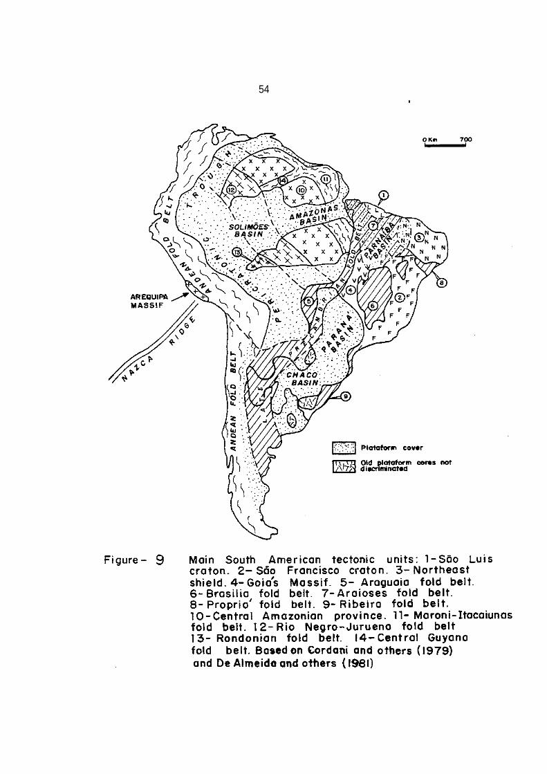
54
• c

55
Two tectonic events are well known in the most part of Brazil.
The Transamazonian Cycle (2,100-1,800 m.y. old) and the Brazilian
Cycle (750-450 m.y. old); other tectonic events are less known (De
Almeida and others, 1981).
Rb-Sr whole-rock isochron work (Torquato and Cordani, 1981)
suggests that at least three major tectonic cycles occurred in the
Guyana shield, at about 3,600-3,000 m.y., 2,800-2,700 m.y. and
2100-1800 m.y. ago. The areas corresponding to each of these tec
tonic cycles are not fully mapped so events older than 2,100-1,800
m.y. (Transamazonian Cycle) are poorly recognized in Brazil, but
are better identified in the neighboring countries. It is believed that the central area of the Brazilian part of the Guyana
Shield is made up of very old rocks, some of them reworked in the
Transamazonian Cycle.
The Guaporé Shield has an area over 1,600,000 km2 and is
covered by a tropical forest and savannah patches with an altitude
averaging about 600 m. It is bounded on the north by the Solimões
and Amazonas basins, on the south, southeast and east by the
Araguaia fold belt (geosuture), over 3,300 km long that is located
in the Brazilian platform.
The Araguaia belt (Figure 9), oriented roughly N-S in the
northern part is, on a Gondwana reconstruction, in direct con-
tinuity with the Rokelide fold belt (Figure 10) of Sierra Leone,

56

57
Africa (Torquato and Cordani, 1981; Hurley, 1973; Smith and Hallam, 1970).
The south extremity of the Araguaia fold belt reaches
La Plata (Argentina), at the Atlantic Ocean (Aceñolaza and
Miller, 1982). On the west, the Guaporé shield is bounded by the
Pericratonic Acre (Brazil), Beni (Bolivia) and Chaco (Paraguay)
basins. However, in the substrate of the Andean area, Precambrian
rocks are present and may belong to the Guaporé shield. The 2,000 m.y.
old Arequipa massif of the coastal Cordillera of southern
Peru may also have been part of the Guapore shield since the
Rondonian orogeny (1,400 to 1,100 m.y. ago).
Shackleton and others (1979) reported an Rb-Sr whole rock age
of 1,980 m.y. for the metamorphism of granulite gneisses from the
Arequipa massif. These dates suggest that a contact may exist
between the Arequipa massif, when the Brazilian thermotectonic
overprint is removed, and the Brazilian platform which carries the
Brazilian overprint, toward the south of the massif. The Arequipa
Massif underwent several Paleozoic thermotectonic events (Shackleton
and others, 1979) related to subduction of the Paleopacific
ocean floor and is overlain by Paleozoic sediments with a typical
South American biota. The Amazonian shield may have constituted
ancestral South America which collided with present eastern South America and northwestern Africa (Figure 9) during the Brazilian
cycle, as dealt with further below.

58
CENTRAL AMAZONIAN PROVINCE The oldest formations found in the Guyana shield (Figure 9),
composed of igneous and metamorphic rocks of amphibolite and gra
nulite facies, yield Rb-Sr reference isochrones of about 2,700-2,800
m.y. as well as isolated age values within the 3,000-3,600 m.y.
interval (Torquato and Cordani, 1981) in the Imataca complex of
Venezuela on the north side of the Guri fault zone.
Old rocks that comprise the Guyana complex in Brazil are widely
distributed and make up the basement upon which younger rocks lie
on the Guyana craton (Issler and others, 1974).
The complex displays amphibolitic to granulitic metamorphic facies
consisting of granulite, a great variety of gneisses, amphiboli-
tes, migmatites, anatextic and metasomatic granites, diorites,
gabbros and ultramafic rocks (De Montalvão, 1976). These rocks are
intensively folded with axes oriented in NW-SE and WNW-ESE direc-
tions. Strong granitization and migmatization is common everywhere
in the complex.
The presence of older granulitic enclaves suggests that most
of the Guyana complex is older than the Transamazonian cycle
rocks, but was isotopically rejuvenated or remobilized during this
latter orogenic cycle (Issler and others, 1974).
The oldest rocks occurring in the Guaporé craton comprise the.
Xingu complex (Silva and others, 1974) which is widely distributed

59
and makes up the basement upon which younger rocks lie. The
complex is composed of granulite, gneiss, migmatite, granite, gra
nodiorite, diorite, trondhjemite, syenite, amphibolite, metavolca
nic rocks, schist and quartzite (Issler, 1977).
The complex exhibits an amphibolitic to granulitic meta
morphic facies and is older than 2,500 m.y. Amphibolite relicts
from the Tapiragé hill have furnished an age as old as 3,280 m.y.
and in northeast Goiás some crystalline rocks were dated as 3,000
m.y. old (Suszczynski, 1981). Several tectonothermal episodes
have caused remobilization and isotopic rejuvenation of these
rocks. The structural trends of this basement terrane are
approximately parallel to that of the Guyana complex (NW-SE).
MARONI ITACAIUNAS FOLD BELT
Along the eastern side of the Amazonian platform, metamorphic
volcanic sedimentary sequences overlie the Guyana and Xingu
complexes with regional angular unconformity (Figure 9). This
rock assemblage makes up part of an extensive metamorphic belt
named Maroni-Itacaiunas (Cordani and others, 1979). This rock
assemblage (Vila Nova Group) is composed of schist, quartzite,
itabirite (ironstone), amphibolite and serpentinite displaying
greenschist to amphibolite metamorphic facies (De Almeida and
others, 1981). Important manganese deposits are included in the

60
group. Ectinites belonging to the group have a radiometric age of
2,090 m.y. (Cordani and others, 1973). In many places older base-
ment remains occur in the area of exposure of the Vila Nova Group.
In the Guaporé shield the Xingu complex is overlain by the
Grão-Pará Group which is composed of quartzite, phyllite, mica
schist, jaspilite, itabirite and basic metavolcanic rocks (Issler,
1977). This group is equivalent to the Vila Nova Group and it
contains economic iron ore formations in the middle part of the sec
tion. The fold axes trend NNW and the metamorphic grade ranges in age of
greenschist to amphibolite facies. Mafic rocks yield an age of about
2000 m.y., corresponding to the Transamazonian cycle. Molasse
marking the end of the cycle is represented by the Rio
Fresco Formation that was intruded by granitic plutons about 1,850
m.y. ago (De Almeida and others, 1981).
The Vila Nova Group is a metasedimentary, metasomatic and
magmatic product of the evolution of a geosynclinal complex deve
loped during the Transamazonian cycle.
Choudhuri (1980) pointed out that the combination of basic to
acid volcanism with submarine extrusion and sedimentation strongly
suggests a back-arc-basin environment with subduction zones at the
greenstone belt of the northern Guyana shield. Verhofstad (1970)
also suggested that the main effects of orogeny and metamorphism

61
in the greenschist facies, and the marginal acid volcanism resulted from plate descent off the pré-Transamazonian craton. These
data are consistent with plate collision during the Transamazonian cycle.
In the northern portion of the Guyana shield, at the end of
the Transamazonian event, about 1,850 m.y. ago, widespread
volcanic-plutonic activity produced rocks of acid and intermediate
composition represented by the Surumu and Iricoume formations. In
the Guaporé shield important volcanism also took place.
After the magmatic activity, a continental molasse named
Roraima Group was deposited in the area of the common boundary
between the Republic of Guyana, Venezuela, Brazil and in Suriname.
The rocks of the Roraima Group make up a flat-lying plateau where
the sequence starts with polymictic conglomerate, sandstone and
arkose, overlain by sandstone, shale and siltstone, and finally a
thick sequence of sandstone and arkose is present at the top. It
appears to have covered, originally, an area more than 1,200,000 km2, and
the main source region was towards the NW, where the Atlantic Ocean
is today (Singh, 1974).
After deposition of the Roraima Group a very important pheno
menon occurred that may be related to continental distension in
the region close to the Roraima Basin. Widespread basic magmatism
took place with the development of thick diabase sills and dikes,

62
dated as 1,700-1,600 m.y. old (Prien and others, 1973). The Pedra
Preta D·iabase may be related to continental break up similar to
that that occurred in Mesozoic. Before the use of radiometric age determinations
these basic rocks were confused with Mesozoic ones related to Gondwana rupture.
CENTRAL GUYANA FOLD BELT
Lima and others (1982 in Caputo and others, 1983) redefined
the Guyana central fold belt which may be an arm of the
Maroni-Itacaiunas fold belt or may be an independent fold belt
reworked during the Transamazonian cycle. This geotectonic unit
extends from the Uraricoera River to the city of Paramaribo, Suriname.
RIO NEGRO JURUENA FOLD BELT
In the western side of the Guyana shield and western-central
part of the Guaporé shield a fold belt named Rio Negro-Juruena is
present (Cordani and others, 1979). This belt may contain many geosuture
zones and may have developed between 1,750 and 1,400 m.y ago.
This area underwent extensive volcanic-plutonic magmatism
producing rhyolite, rhyodacite, andesite, dacite, tuff, ignimbrite
rocks and lahar deposits. Associated sediments and granodioritic,

63
granitic and syenitic subvolcanic, circular intrusive rocks also
occur. This rock assemblage may suggest that accretion continen
tal was due to ocean-continent collision (Teixeira, 1978).
RONDONIAN FOLD BELT
In the southwestern part of the Amazonian platform, Cordani
and others (1979) mentioned the presence of a younger fold belt
named Rondonian. Its tectono-magmatism lasted from 1,400 to 1,100
m.y. ago and may be related to continent-continent collision with
intense compressive deformation. This tectonism was responsible
for faulting, granite and granodiorite intrusions and rhyolite,
andesite, trachyte and basalt extrusions in the Rio Negro-Juruena
fold belt area. The Arequipa massif may have been part of the
continent that collided with Western Amazonian platform about
1,200 m.y. ± 100 m.y. ago.
About 1,200 m.y. ± 100 m.y. ago rocks of the whole Amazonian
platform underwent a tectono-magmatic activation producing intense
regional shearing and cataclasis with the formation of mylonite,
pseudotachylite, tilted blocks, and dynamic metamorphism. Mag
matic processes were active along the faults with intrusion of
granitic rocks. This disturbance is known in the Brazilian part
of the Guyana shield as the Jari-Falsino episode. In the Guaporé shield this
same event is named the Madeira episode.
64
All of. these processes, observed in the Amazonian platform, seem to be related to continental collision with intense compres
sive deformation in the Rondonian fold belt area. Following the
Jari-Falsino episode, tholeiitic magmatism developed outside and
on the southern limit of the Guyana craton where stocks and dikes
yielded ages between 1,050 and 850 m.y. ago (Teixeira, 1978). This
magmatismis perhaps related to new continental break up elsewhere
in the craton.
Stewart (1972) claims that the Pacific Ocean opened about 850
rn.y. ago in the western United States, and Matsumoto (1977) states
that the Pacific Ocean opened at about the same time in Asia.
Shackleton and others .(1979), in studying Peruvian rocks, agreed
with the opening of the Pacific Ocean at about that time. This period
(around 850 m.y.) seems to be one of worldwide fragmentation.
Possibly, many new oceans formed, synchronously with tholeiitic
intrusions and extrusions.
During the final decline of the volcano-plutonism of the
Amazonian platform, several sedimentary formations associated with
minor basic volcanism, were laid down in distinct isolated basins.
Presently, insufficient geological data, makes correlation between
the formations in these basins difficult.
According to Issler (1977) the sedimentary cover overlies
wide areas and is generally made up of non-mature lithic sand-

65
stone, lithofeldspathic sandstone, arkose, shale, siltstone and
polymictic conglomerate. Such rocks are rich in unstable
minerals, suggesting that they resulted from a first or second
depositional cycle and originated in rugged source areas. The
different formations are non-fossiliferous and occur in large iso
lated areas, making correlation difficult.
The Beneficente Group, overlain by the Caiabis and
Guajará-Mirim groups and the Gorotire and Prosperança formations,
(still in almost subhorizontal position) appear to be the oldest
sedimentary Precambrian cover, slightly folded without signs of regional
metamorphism.
The Beneficente Group, exposed in the north-central part of
the craton is composed of sandstone, arkose, siltstone, shale,
stromatolitic limestone, glauconitic sandstone with quartzite and
quartz-mica schist restricted to fault zones (De Montalvão and
others, 1979). It was deposited in continental and marine environ
ments and the sea possibly invaded the area from the south. The
general trend of the Beneficente folding is E-W with N-S inflec
tions. De Montalvão and others (1979) dated the group as 1,400
m.y. old, based on Rb-Sr determinations on sediments.
Silva and others (1974) attributed the origin of the folding
observed in the group to orogenic movements, but it seems that the
depositional and structural milieu was epicontinental instead of
66
geosynclinal, and the disturbance may have been caused by the
Madeira shearing event related to stresses originated in the
Rondonian fold belt which in turn are interpreted as due to
continent-continent collision.
The Caiabis Group was laid down in a graben located at the
southwest of the shield and is composed of conglomerate and sand-
stone with intercalated basalt. The upper clastic beds are
designated Dardanelos Formation. The lower and upper basalts
yielded ages of 1,416 ± 14 m.y. and 1,225 ± 20 m.y. respectively (De
Montalvão and others, 1979).
The Guajará-Mirin Group is situated in the western area of the shield and is located in two grabens named Pacaás Novas and Uopione, separated by a basement high. The sections are composed of arkose and sandstone underlain by basalt 1,038-967 m.y. old (Leal and others, 1978).
The Gorotire Formation occurs in the eastern part of the
Guaporé craton and comprises arkose, sandstone, chert and siltstone with stromatolitic structures and conglomerate beds.
The Gorotire fold axes are oriented approximately NW-SE. Its age Is unknown, but it underlies unconformably the Prosperança Formation. The paleogeographic situation at the time of deposition of this unit is unknown but the sea communication probably was located at the south (Suszczynski, 1981).

67
The Acari Formation made up of limestone, chert and red beds
overlies the Prosperança Formation. The Prosperança Formation is
composed of red, pink, cream and white sandstone, siltstone,
conglomerate and arkose beds. In some regions, both units are the
basement of the Amazonas Basin Paleozoic sequence, and they also
crop out in the Guaporé and Guyana shield areas. De Montalvão and
others (1979) questioned the correlation of the Prosperança
Formation with the Prainha Formation made by Caputo and others
(1971) and considered the Prainha Formation older and equivalent
to the Dardanelos Formation of the Caiabis Group. Diabase dikes
in the Prosperança and Dardanelos formations are 1,400 and 1,100
m.y. old (Montalvão and others, 1980) indicating that the
Prosperança Formation may also not be correlated with the Dardanelos Formation.
BRAZILIAN PLATFORM
The Brazilian platform is composed of several structural
units trending roughly N-S in Brazil (Figure 9). The westernmost
structural unit is a long fold belt, named Araguaia, that
stretches from the Amapá shelf in the Atlantic Ocean close the French Guyana
up to La Plata (Argentina), again in the Atlantic Ocean. Radiometric dates of
granulite facies metamorphism of the Arequipa massif (Peru)
correspond to those from the Transamazonian cycle (Shackleton and

68
others, 1979). Shackleton and others (1979) .did not report
Brazilian orogenic cycle activity in the 2,000 m.y. old Arequipa
massif. This observation suggests that the massif is connected
with the Amazonian shield. To the south, in the Sierras Pampeanas
of northwestern Argentina, radiometric ages indicate that the
imprint of the Brazilian orogenic cycle may have extended as far
west as Salta Province (McBride and others, 1976). The northern limit of
the effects of the Brazilian cycle is not known but it probably
lies southeast of the Arequipa massif. Important tectonic units
observed in the Brazilian platform comprise the Goiás massif, São
Francisco and São Luis cratons, Araguaia, Araiosis, Brasília,
Propriá and Ribeira fold belts.
ARAGUAIA FOLD BELT
The Araguaia fold belt represents a geosuture that separates
the Amazonian domain from terrane affected by the Brazilian oroge-
nic cycle and is here interpreted as recording a continental
collision in Late Precambrian-Cambrian times between na Amazonian
passive continental margin and a Brazilian active continental
margin, along a probable subduction zone dipping towards the east
(Figure 11). The Araguaia fold belt is viewed as an area of
crustal impact and collision between two crustal plates. This
very impressive geosuture can be deduced in the world gravity map (Figure 12).
'

69
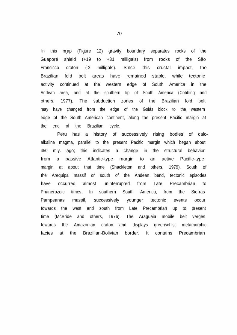
70
In this m_ap (Figure 12) gravity boundary separates rocks of the
Guaporé shield (+19 to +31 milligals) from rocks of the São
Francisco craton (-2 milligals). Since this crustal impact, the
Brazilian fold belt areas have remained stable, while tectonic
activity continued at the western edge of South America in the
Andean area, and at the southern tip of South America (Cobbing and
others, 1977). The subduction zones of the Brazilian fold belt
may have changed from the edge of the Goiás block to the western
edge of the South American continent, along the present Pacific margin at
the end of the Brazilian cycle.
Peru has a history of successively rising bodies of calc
alkaline magma, parallel to the present Pacific margin which began about
450 m.y. ago; this indicates a change in the structural behavior
from a passive Atlantic-type margin to an active Pacific-type
margin at about that time (Shackleton and others, 1979). South of
the Arequipa massif or south of the Andean bend, tectonic episodes
have occurred almost uninterrupted from Late Precambrian to
Phanerozoic times. In southern South America, from the Sierras
Pampeanas massif, successively younger tectonic events occur
towards the west and south from Late Precambrian up to present
time (McBride and others, 1976). The Araguaia mobile belt verges
towards the Amazonian craton and displays greenschist metamorphic
facies at the Brazilian-Bolivian border. It contains Precambrian

71

72
trench deposits represented by flysch sediments, unconfonnably
overlain by conglomerate and glacial marine deposits (De Almeida
and others, 1981). Above an angular unconformity, stromatolitic
carbonates followed by pelites were deposited (De Almeida and
others, 1981). In the north part of the Araguaia fold belt in the Tocantins
arch (which separates the Parnaíba from the Matajó Basin), the
basement is made up of phyllite, schist and quartzite. In the
western Parnaíba Basin region, gneiss, amphibolite, schist and quartzite
occur at the base of the section, followed by diamictite and
phyllite with quartzite intercalations, itabirite and metavolcanic
rocks of the Tocantins Group. The fold axes are oriented N-S and
before the break up of Gondwana this rock assemblage had direct
connection with the Rokel Series (north west Africa) which compri
ses tillite, phyllite with quartzite and limestone intercalations,
itabirite and metavolcanic rocks (Torquato and Cordani, 1981). ARAIOSES FOLD BELT
Beneath the Parnaíba cover, one arm of the Araguaia fold
belt, named here Araioses fold belt, may continue northeast in the
direction of the Dahomeydes fold belt that is located on the
eastern side of the West African Craton.
In wells RP-1, RP-2 (Rio do Peixe one and two), MO-1 (Mocambo) and

73
JU-1 (Jerusalém) drilled by Petrobras, close to the Ferrer Arch,
in the São Luís Basin (Figure 2), more than 2,000 m of metamudstone
and phyllite occur with diamictite of possible glacial origin at
the base of the section preserved in the Araioses fold belt. The
glacial nature of the diamictite was here interpreted on the basis of its texture: a gray clay matrix supports angular and rounded
clasts of great petrographic variety up to 15 cm across as
observed in cores. Metamorphism of the diamictite occurred about
483 ±38 m.y. ago, based on a Rb-Sr age determination (Thomaz
Filho, 1981, written communication), therefore at the end of the
Brazilian cycle. This indicates that these diamictites have no
relation to the Late Ordovician glacial rocks of northern Brazil
and northwestern Africa, but may be as old as Late Precambrian.
Late Precambrian glacigenic rocks have been recorded over
much of Africa, particularly in the Rokelides, Dahomeydes, and
Pharusian fold belts and in the Taoudeni and Volta basins of north
West Africa (Culver and others, 1980). The presence of Late
Precambrian glacial sediments in the same stratigraphic position
strengthens the validity of lithological correlations between
north west Africa and north east South America. The uplift which
preceded the opening of the Pan-African, Brazilian and other
oceans at low latitudes may have caused formation of
highlands where ice developed in times of general refrigeration.

74
For example, Late Precambrian tilllites in western North America are
found at the bottom of a thick section deposited after rifting
that gave origin to a new ocean (Stewart, 1972). At that time,
low latitude rift shoulders could have been glaciated due to
strong upwarping and the glacial products could have been depo
sited in the foothill basins. Another important conjecture is
that in the area of the Parnaíba Basin a triple junction may have
existed between the Amazonian, West African and São Franciscan
convergent plates when Brazilian and Pan-African oceans were being
closed.
SÃO LUÍS CRATON
Beyond the northern-northwestern limit of the Parnaíba Basin,
in the São Luís area, gneiss, schist, amphibolite and metavolca
nics rocks occur intruded mainly by granite and diorite. These rocks
have been folded, metamorphosed and granitized during the Trans
amazonian tectono-thermal event, 2,000 ± 200 m.y. ago (Hurley and
others, 1967; Kovach and others, 1976). In a pre-drift Gondwana
reconstruction the São Luís cratonic area appears to have direct
connection with the West African craton where sediments deposited
in old geosynclinal basins have been folded, metamorphosed and
invaded by granites. This constitutes evidence of a major event
2,000 ± 200 m.y. ago, referred as the Eburnean event in Africa
(Bonhomme, 1962).
75
GOIAS MASSIF
East of the Araguaia fold belt, a long massif made up of
migmatite, granulite and ultrabasic rocks occurs with ages as old
as 3,700 m.y., 2,600 m.y. and 2,000 m.y. (Marini and others, 1977).
This massif is part of the São Francisco craton. The Brazilian
tectono-thermal imprint is shown by a K/Ar age determination on
biotite from a granite, which yielded 530 ± 16 m.y. (Hasui and De
Almeida, 1970). These rocks may be interpreted as diapiric grani-
tes formed during the Brazilian cycle. Cordani and others (1973)
think that some of the granitic rocks may actually have been
formed during the Brazilian cycle, but the same granite also
yields whole rock ages as old as 1,330 m.y. and 2,000 m.y. (Marini
and others, 1977) so more work is needed to determine the correct time of formation of these granites. Field relationships seem to
indicate that the Bambui Group metamorphosed at 600 m.y. ago
(Thomaz Filho, 1981), has been disturbed and metamorphosed by N-S
elongated granite bodies in this area. The rocks of the Goiás
Massif show evidence of polymetamorphism, isotopic rejuvenation
and intense fracturing (De Almeida and others, 1981). The extre-
mities of the Goiás Massif are covered by the Parnaíba and Paraná
Paleozoic basin sediments.

76
Satellite low gravity values found in the Goiás Massif and
São Francisco craton suggest thickening of the continental crust, perhaps
due to subduction of part of the Guaporé craton under the Goiás massif
(Figure 11).
The central part of the Goiás Massif and the Araguaia mobile
belt were probably pushed against the Guaporé shield during the
Brazilian Orogeny, since the tectonic transport is towards the
west. The Goiás Massif may have been a leading edge of the São
Francisco plate (Figure 9). The massif is here envisaged as an
unroofed magmatic arc above the subduction zone of the Araguaia
geosyncline, possibly analogous to the 2,000 m.y. old Arequipa
Massif in central Andes today. The 800 km long and 100 km wide
Arequipa Massif, is located within the present day magmatic arc
trench gap, and the arc volcanoes are situated beyond its NE side,
but in Paleozoic, Mesozoic and Tertiary times calc-alkaline pluto
nism and volcanism occurred within the massif, indicating the
former position of the magmatic arc (Shackleton and others, 1979).
Batholiths of various Phanerozoic ages intruded the Arequipa
Massif indicating an active subduction zone beneath it. BRASILIA FOLD BELT
The Brasflia fold belt (De Almeida, 1967) occurs east of the
Goiás magmatic arc; it trends roughly N-S and is 1,100 km long. with

77
vergence towards the east.
From bottom to top the rock section comprises shale,
sandstone and shale with limestone and dolomite intercalations,
followed by red clastic sedimentation at the end of the tectonic
episode. Andesitic lavas in the north and subvolcanic granitic
intrusions in the south constitute the main magmatic activity (De
Almeida and others, 1981). This belt is here seen as a backarc
foldthrust belt according to Dickinson´s model (1977) shown in the
Figure 11. On the east margin of the Brasília belt a retroarc
foreland basin developed, that covers part of the so-called São
Francisco craton.
The area between the Araguaia and Brasília fold belts is named the
Tocantins province by De Almeida and others, (1981).
SÃO FRANCISCO CRATON
The São Francisco craton is an old structural block that lies
In the eastern part of Brazil, close to the coast (De Almeida,
1977). According to De Almeida and others (1981) the craton is
made up of granitic-gneiss complexes migmatized and metamorphosed
to high-grade amphibolite and granulite facies. Granitoid, mafic
and ultramafic rocks occur throughout the craton. Radiometric
determinations have yielded ages of about 3,100 m.y., 2,600 m.y.,
2,000 m.y., 1,200 m.y. and also reveal an imprint of the Brazilian

78
cycle on its edges.
The northwest part of the craton is overlain by sediments of
the Parnaíba Basin. Several Precambrian sedimentary covers
overlie the craton, including the Macaúbas Group which records
continental glaciation in Late Precambrian time (Rocha-Campos and
Hasui, 1981). These cratonic tillites could be equivalent to gla
cial sediments found in Brazilian and north Pan-African fold
belts. Widespread carbonate sedimentation represented by the
Bambui Group followed the tillites. Metamorphism of the Bambui
Group was dated as old as 600 m.y. (Thomaz Filho, 1981).
In its central area, the Espinhaço mobile belt was deformed
and metamorphosed in greenschist metamorphic facies about 1,200
± 100 m.y. ago (De Almeida ·and others, 1981). Sedimentation,
producing deposits 4,000 m thick, lasted from 1,700 m.y. to about
1,100 m.y. ago in the Espinhaço belt, and may have begun after a
phase of continental break up. The São Francisco craton makes up
the São Francisco Province of De Almeida and others (1981). RIBEIRA AND PROPRIÁ FOLD BELTS
Northeast, east and southeast of the São Francisco craton
near the present coast is another mobile belt named Propriá in the north
and Ribeira in the south (Cordani and others, 1968). This area
has been so deeply eroded that alternated bands of the old rejuve-

79
nated basement and Brazilian cycle rocks are present. Because of
such intense erosion, old reactivated basement crops out in
faulted or folded structures, while Brazilian rocks are preserved
in synclines and structural lows. The basement, remobilized
during the Brazilian cycle, is composed of gneissic-migmatic
complexes of Early to Middle Precambrian age (De Almeida and
others, 1981). The Brazilian cycle rocks comprise phyllite, schist, quart
zite and carbonate rock a thousand meters thick (De Almeida,
1968). This sequence may have constituted an old carbonate shelf
around the São Francisco craton. The metamorphism ranges from
greenschist to amphibolite facies; magmatism lasted from 650 m.y.
to 540 m.y. and is composed of stocks and batholiths of granitic
rock. Molasse deposits were laid down between 510 and 470 m.y.
ago (De Almeida and others, 1981). I believe that the Propriá fold belt may have been connected
to the Dahomeydes and Araguaia fold belts and then separated by
another triple junction between the West African, São Franciscan
and Nigerian plates. These mobile belts record another line of
continental collision between the eastern sides of the West
African and São Franciscan cratons and the northeast and central
African cratons (Figure 10). The Ribeira belt comprises a basal sequence of sandstone, siltstone,

80
shale with carbonate lenses near the top and an upper sequence
composed of shale, mudstone and turbidites. The rocks show
greenschist to amphibolite facies metamorphism, and granitic plu
tons intruded the section from 650 to 540 m.y. ago. Post orogenic
deposits, with andesitic and rhyolitic lavas extruded between 500
and 450 m.y. ago, filled small deep basins in which thick sedimen-
tary sequences over 5,000 m thick were laid down. The final
cooling of the belt took place about 450 m.y. ago (Torquato and
Cordani, 1981).
In northeast Brazil, at the end of Brazilian collision, brittle
deformation characterized mainly by dextral strike-slip faulting
took place. The fault system has severely disrupted the
fold belt; and erosion was so active that at present it is dif
ficult to determine the original position of the different blocks.
The E-W trending Pernambuco and Patos faults are the best deve
loped ones onshore, while N-S trending conjugate faults are less
well developed. Several faults can be traced across the margins
of South America and Africa in a pre-split reconstruction. The
E-W faults are parallel to the Saint Paul, Romanche, Chain and
other oceanic fracture zones. For example, the Romanche fracture
zone links the São Luís area to Ghana in a pre-drift reconstruc
tion. The Pernambuco fault zone runs into the 27°5 fracture zone
and into the Ngaoundire fault and the Patos fault runs into

--
81
Cameroon (Allard, 1969). This suggests that Brazilian and
Pan-African tectonisms were very important in controlling the
break up of Gondwana during Mesozoic times. The NE trending mylo-
nite zones, probably corresponding to thrust fault planes, deve
loped perpendicular to major stresses and are cut by the E-W
strike-slip faults. Some investigators consider that this fault
system is very old, but it was probably established at the end of
the Brazilian cycle as a direct result of continental collision
between the eastern part of South America and central and western
part of eastern Africa.
In Africa the same brittle deformation system cuts 586 m.y.
old granites and 530 m.y. old ignimbrites (Ball, 1980), so the
Pernambuco strike-slip fault event may be younger than 530 m.y.
The equivalent of the Pernambuco faulting event was interpreted by
Ball (1980) in Africa as similar to that which took place when
Tibet and China were indented by the Indian block during the
Himalayan orogeny (Tapponier and Molnar, 1976). These faults
extend over 1,000 km in Africa (Ball, 1980), but if the Brazilian
continuation is considered they extend to about 2,000 km in length.
In Asia, the Altyn Tagh strike-slip fault, more than 3,000 km long
is attributed to continental collision between India and Asia.
It is commonly said that the break up of Gondwana did not
follow basement trends in northeast Brazil. The basement in that

82
area has actually split apart along the E-W and N-S
Brazilian-Pan-African strike slip fault system directions,
although in the south, the Ribeira metamorphic belt has split
apart mainly along directions of the Brazilian cycle thrust fault
system.
From Ordovician time on, the thrust and strike-slip faults
acted as normal faults with vertical displacements. These faults
were of considerable importance in controlling the shape, position
and structural behavior of the sedimentary intracratonic and rifted coastal
basins. In Cambro-Ordovician time, a large land mass named
Pangea 1, made up of parts of present configuration
South America, North America, Africa, India, Antarctica and
Australia formed, although some parts were accreted in Paleozoic
and Mesozoic times by late orogenic events (Aceñolaza, 1982). PLATE TECTONICS VS. ENSIALIC TECTONICS
It is appropriate here to discuss a relevant subject which is
under much debate: The question is to what extent the concept of
plate tectonics may be applied to the development of the
Precambrian-Early Paleozoic Brazilian and Pan-African orogenies.
In South Africa and Brazil, the concept of an "in situ"
ensialic or intracratonic orogeny without significant sea floor
spreading has been developed as an alternative to plate tectonics.

83
Hurley and Rand (1969, 1973) and Hurley (1973) presented geologi-
cal evidence for ensialic mobile belts which may have rifted apart
slightly, accumulated sediments and were later intruded by grani
tic rocks, as if a craton were split by rising hot material with
out being separated for great distances. Hurley and others (1967),
Hurley (1968, 1973) and Hurley and Rand (1973) correlated the
Amazonian cratonic rocks and tectonic events with those of the
West African craton and suggested that the Rokelide fold belt bet-
ween both cratons was formed "in situ" with little or no oceanic
seaways. I regard the tectonic and rock correlations correct,
but do not agree with the concept that during the folding both
cratons reunited with the same original position and orientation as they had
before rifting apart.
The Transamazonian and older rock fold axes are oriented NW
in the eastern Guyana shield whereas the Eburnian (2,000 ± 200 m.y.
old) and pre-Eburnian rock fold axes are oriented NE in the West
African craton. The almost orthogonal structural orientation of
the cratons suggests that they reassembled with a position and
orientation different from the original one, during the
Brazilian-Pan-African orogeny. Only the Brazilian-Pan-African
trends, corresponding to the Rokelides and Araguaia fold belts
line up. The boundary drawn by Hurley (1973) between Eburnean and
pre-Eburnean rocks in the West African craton and between the

84
Transamazonian and pre-Transamazonian rocks in the Guyana craton
is no longer correct because pre-Transamazonian granulites occur
in eastern Amapá (De Almeida and others, 1981).
Hurley (1973) also pointed out that there was no paleomagne
tic evidence showing that the cratons had been split apart by
oceanic distances, but Morel and Irving (1978) based on paleomag
netic data from North America and South Africa, proposed a
reconstruction where a large ocean existed between South Africa
and North America 800 to 675 m.y. ago and, that at about 600 m.y.
ago, these oceanic distances were consistent with North America
welded to the West African craton. An ocean may therefore have
surrounded the West African craton. In the Rokelide and Dahomeyde
fold belts, the existence of ultrabasic and basic rocks of ophiolitic
character, normally interpreted as pieces of oceanic crust, also suggests
the presence of a paleoocean in the region (Burke
and Dewey, 1973; Black and others, 1979; and Burke and
others, 1977).
In Brazil, the Brazilian mobile belts have previously been
considered as having formed in an ensialic milieu, without deve-
lopment of oceanic crust during its evolution. De Almeida and
others (1973) explained that the substrate of the southeastern
Brazilian Ribeira mobile belt was formed by rocks cratonized in
Transamazonian or earlier cycles and then regenerated during the
Brazilian cycle. They considered the abundance of acid plutonism

85
and vulcanism and the scarcity of basic and ultrabasic vulcanism
to indicate that the fold belt had a continental sialic
nature. They pointed out that there was no evidence of an oceanic
basin in the area occupied by the South Atlantic Ocean, genera
lizing this view to all South American Late Precambrian-Cambrian
mobil belts.
In my opinion a model based on plate tectonics explains
better the structural behavior, the distribution of igneous and
metamorphic rocks, and the paleomagnetic and gravimetric data. . The opening and closing of an ocean, named the Wilson cycle (Dewey
and Burke, 1974), is the most powerful means of interpreting the
evolution of an orogenic belt. Wilson (1968) analyzed geotectonic
cycles in terms of oceanic evolution from youth (continental break
up) to old age (continental collision) when the ocean floor disap
pears by subduction. Therefore, only fragments of oceanic crust
may be preserved. The subduction zone is converted into a suture
belt where the fragments of older oceanic crust may be tectonically
emplaced and may rest on the continental orogenic belt. The
obducted fragments are named ophiolites and are interpreted as
outcrops of the ocean floor (Figure 13).
Ophiolites comprise the following rock types in order of
descending stratigraphic position (Moores and Vine, 1971):

86
a. Carbonate or siliceous abyssal sedimentary rocks. Low-K
tholeiite, commonly pillowed. b. Low-K tholeiitic gabbros and diabase commonly exhibiting
cumulus texture (stratification), interpreted as formed in a magmatic chamber, at sea-floor spreading centers.
c. Ultramafic rocks usually exhibiting a metamorphic
fabric This rock sequence may be complete or incomplete. The gabbro
ultramafic contact in ophiolite complexes is usually interpreted
as the fossil Mohorovicic (Moho) discontinuity.
Ophiolitic complexes have been described in the Pan-African
fold belts around the African Taoudeni Basin (Rokelide, Dahome and
Pharusian mobile belts) by Burke and Dewey (1973) and in the
Brazilian fold belts (Araguaia and Ribeira mobile belts) by De
Almeida and others (1973, 1981) which are the South American con
tinuation of the Pan-African fold belts of Africa.
The coastal South African Damara orogenic belt, corresponding
in a pre-drift reconstruction to the eastern part of the Brazilian
Ribeira orogenic belt, has been regarded in the past, as an
ensialic orogene, but was recently interpreted by Porada (1979) in
terms of a closing ocean and continental collision. He suggests
the presence of a former ocean in the place now occupied by the
South Atlantic Ocean. Most of the Damara fold belt is located on

_
---- ··-·---
87
Figure 13. Possible obduction mechanisms for emplacement of ophiolites (after Dewey and Bird, 1971)

88
the continental shelves of the South Atlantic Ocean. Another arm of the same Damara mobile belt, occurring across South Africa, was similarly described as formed in an intracratonic environment (Martin and Porada, 1978) and is now envisaged by Barnes and Sawyer (1980) as resulting from ocean crust subduction and con- tinental convergence, on the basis of geochemical, structural and petrographic studies. These interpretations suggest that plate tectonic activity existed in Late Precambrian time. Thus, the Brazilian and Pan-African cycles are here interpreted in terms of
Plate interaction.
Beloussov and others (1979) discussed the data which contra-
dict past mobilistic reconstructions of the position of continents
(plate tectonics). They stressed that north Africa and north
South America have had a completely different geologic history in
their development, and they do not recognize that the Guinean,
Ghanaian (and Saharan) basins were the northern continuation of
the Amazonas and Parnaíba basins. However, there is a very good
correlation between north African and north South American coeval
sediments as it can be concluded from lithologic, biologic, tec
tonic and paleoclimatic similarities shown in this study. These
similarities are considered by many investigators and by me as
evidence of a close connection between northwestern Africa and
northeastern South America from Late Precambrian to Early
Cretaceous times.

89 CHAPTER 5. ORIGIN AND DEVELOPMENT OF NO·RTHERN .BRAZILIAN BASINS
The origin of the northern Brazilian intracratonic basins is
poorly understood. This qualitative discussion analyzes the gene
sis and epeirogenesis of these basins based on the geologic
record, as well as on the concepts of isostasy and plate tec
tonics
BASIC CONCEPTS
According to Menard (1980, in Bird, 1980), the causes of
epeirogenesis may be (1) external loading and unloading, (2)
bending of plates plunging into subduction zones, (3) internal
density changes, and (4) dynamic effects of mantle motion.
External loading depresses the crust due to the earth's
elasticity and plasticity. The elastic deformation is immediate
and quickly recovered when the force causing the deformation is
removed. Under an extensive load over a prolonged period, the
mantle flows and the crust depresses plastically (Daly, 1934).
Beyond the loading an uplift should develop. The load can
be sediments, thrust fault plates, volcanic rocks, water or ice.
Unloading can be caused by erosion, evaporation (dissection of a
basin), ice melting and removal of water (regression). Unloading
has the opposite effect on earth's crust. In ice-covered regions,
because the loading process is fast in geological terms, a

90
peripheral depression forms and beyond it a well developed fore- bulge. The forebulge is concentrated in front of loading because
the mantle viscosity is too great to allow unifonn spreading of
asthenospheric material widely over the surface of the Earth. The
forebulge hypothesis proposed by Daly (1934) demands pure broad
bending of the crust without localized zones of vertical fracturing.
The total change in sea level from a stage free of ice on
land to one corresponding to maximum widespread Pleistocene gla
ciation is more than 150 m. The glacio-isostatic rebound of some
Pleistocene ice-covered areas is on the order of 300 m and the
forebulge lowering is approximately 80-100 m with an assumed width
of 3,000 km (Newman and others, 1971, p. 796). When an ice sheet
expands, the proglacial depression and forebulge migrate outward.
When the ice sheet retreats, the forebulge migrates inward and
collapses while the peripheral depression migrates inward and
becomes shallower as a result of isostatic rebound. A stable ice
cap generally does not occupy the peripheral depression, as water
does, due to ice viscosity. At the terminus of glaciers, evapora
tion and melting take place, causing deposition in lakes and
depressions. The transfer of water from sea to land and vice-versa
causes worldwide regressions and transgressions, with correspond
ing facies changes in the geologic record. Sedimentary loading

91
also produces a forebulge but it is imperceptible because its
growth may be in balance with erosion.
ORIGIN OF THE BASINS
The origin of the Parnaíba Basin as discussed here is specu-
lative. The Parnaíba Basin lies in the gap between the São Luís
craton (continuation of West African craton) in the north and the Goiás massif
and São Francisco craton in the south (Figure 8). Due to its position
protected between both cratons, the area of the basin may not have
been subject to strong deformation during the general convergence
of the Amazonian, north West African and São Francisco cratons with the
Eastern African craton, so that folded mountains did not
form. Probably, after the multiple collision, general cooling in
the low folded area contributed to subsidence of the basin.
The origin of the Solimões Basin is not yet known and may be
a foredeep basin related to Andean tectonics since the Late
Ordovician time. The Amazonas Basin presents physical features
that may indicate its origin. Gravity surveys made by Petrobras
show that the depositional axis of the basin is characterized by
an E-W belt of gravity highs that are more than 1,300 km long. The
belt is interrupted by a broad gravity low in the western extre
mity of the basin at the Purus high. Each gravity anomaly has a
broad circular or elliptical shape varying from +50 to +95 milli-

92

93
gals. On each basin flank there is a belt of gravity lows with
some scattered small gravity highs (Figure 14). One of these
marginal highs was drilled (well 1-CM-1-PA) by Petrobrás and a
pyroxenite was cored. The coincidence of gravity highs with the
basin axis suggests an intimate connection between the heavy
masses and the formation of the basin. In the eastern Amazonas
Basin, the chain of gravity highs bifurcates.
Linsser (1958), based on gravity surveys and presence of ultrabasic
rocks, developed the following hypothesis for the origin of the
Amazonas Basin:
1. Tencion forces in the crust opened it
2. The cracks were filled with magma up to a hydrostatic level.
3. The cracks were filled with sediments from the top of the magmatic rock to the
surface. This load caused a disturbance in mass equilibrium, and further
sinking.
4. And finally, the earth's crust was rifted or downwarped forming a shallow
basin that was filled with more sediments.
On the other hand, Porto (1972) proposed the same explanation used
by McGinnis (1970) for the origin of Illinois and Michigan basins.
In those basins, it is thought that initial deposition was caused
by collapse of incipient rift systems due to the load of high den-

94 sity crustal intrusives.
I propose here, in addition to drawing on earlier works, that
a combination of two mechanisms may be responsible for the origin
of the Amazonas Basin: (1) A thermal event may have produced ini
tial uplift of the lithosphere and volcanism followed by erosion,
rifting, and cooling, causing subsidence, and (2) subsequent
bending of the basin floor in response to sedimentary loading.
The Amazonas Basin is regarded as a rift valley, that is, "an
elongate depression overlying places where the entire thickness of
the lithosphere has ruptured in extension" (Burke, 1980). It was
a rift that failed to develop into a new ocean, and is inferred
that the Amazonas rift was connected to the opening or to the
closing of the Goiás Ocean. During closing of the Goiás Ocean,
the rift may have been formed or reactivated, resulting in accumu-
lation of a thick Paleozoic sedimentary sequence. The connection
(triple junction) between the Amazonas rift and Araguaia-Rokelide
fold belt is presently located to the east of the Amazonas River
mouth.
Geophysical surveys in Amazonas River Mouth Basin (offshore)
has revealed a gravimetric anomaly associated with a fracture
zone. Rezende and Ferradaes (1972) considered this anomaly as
caused by intrabasement extrusion of tholeiitic basalt related to
Early Cretaceous tectonism and magmatic activity. Ponte and Asmus

95
(1978) pointed out that the anomaly may be c.onsidered as an
offshore extension of those old gravimetric highs that are present
in the Amazonas Basin or the anomaly could have been caused by
180-220 m.y. old basic intrusions related to widespread volcanic acti-
vity in the interior Amazonas Basin.
Another possibility exists. The gravity anomaly in front of
the Amazonas River mouth may have been caused by the presence of
ophiolites in the Araguaia-Rokelide fold belt which is beneath the
continental shelf in the Amazonas River Mouth Basin. The time of
Amazonas Basin rifting is not known because the pyroxenite gave
dates as old as 622 ± 30% on the basis of Rb-Sr method (Thomaz
Filho, 1982, written communication). If the age of the pyroxenite
is about 800 m.y., it may correspond to the time of opening of he Goiás
Ocean, but if the age is about 450 m.y., it may correspond
to the time of closing of the Goiás Ocean. In this case, the
rift would be classified as an impactogen (Burke, 1980). An Early
Paleozoic age is favored because first sedimentary rocks were laid
down in Ordovician time.
Before rifting, uplift may have occurred, along with simulta-
neous erosion of volcanic, sedimentary and basement rocks in the
domed area and deposition in peripheral depressions. When the
area started to subside, the lighter acidic rocks around the
ultrabasic stocks may have subsided together with the denser ones,

96
as suggested by the gravity lows on the basin flanks and
gravity lows (lighter rocks) among the gravity highs corresponding
to the ultrabasic stocks. BASIN AMPLIFICATION
During downwarping, interconnection and widening of these
depressions may have taken place as a result of stream con
centration and activity. The depression probably drained to the
Theic Ocean (ocean between Gondwana and ancestral North America before
the Acadian orogeny (McKerrow and Ziegler, 1972). Erosion may have
removed local base levels and temporary sediment storage sites so
that the Amazonas Basin was invaded by the sea in Early or Middle
Ordovician time when a rise in sea level may have triggered a new
stage of basin subsidence. Although the age of the lowermost
strata is not known in the region, due to a lack of fossils in the
section, they correlate with Ordovician rocks of northern Africa
(Taoudeni Basin). After thermal subsidence, the underlying
lithosphere may have responded to the sediment and water load by
bending. The actual deformation may have extended beyond the ori
ginal rift as a result of the lithosphere's rigidity, therefore
causing basin broadening (Beaumont and Sweeney, 1978).
The sedimentary record shows that the basin grew by con
tinuous onlap; younger beds covered older ones on the margins as

97
the basin broadened. At times of moderate sea level lowering,
sedimentary coarse fill was deposited in the central parts of the
depression. For example, a load of a 50 m column of water over a
few thousand years causes subsidence of approximately 17 m (Burke,
1979). Such initial subsidence would continue as long as the sea
occupies the area. This mechanism allows for deposition of a
thick sequence of shallow marine sediments in the Amazonas Basin.
Outside the basin, a small forebulge may have formed due to
outflow of asthenospheric material from beneath the basin floor.
However, the elevation of the ground may have been imperceptible
because of the balance between uplift and erosion.
The first sedimentary cycle in the Amazonas Basin may have
begun in the Early or Mid Ordovician and stopped in late Early or
early Mid-Silurian times when sea water removal from the basin
brought an end to sedimentation and subsidence.
The second sedimentary cycle began in late Early Devonian
(Emsian Stage) and ended in the Mid Early Carboniferous (Visean
Stage).
Devonian sediments overlap Silurian ones, indicating greater
transgression in Devonian than Silurian times and basin amplifica-
tion.
The third sedimentary cycle began in Late Carboniferous time
(Westphalian D Stage) and ended in the Late Permian time.

98
The fourth sedimentary cycle began in, the Cenomanian Stage
and ended in the Senonian Stage, and the fifth sedimentary cycle
began in Paleocene time and ended in the Recent time.

99
CHAPTER 6. GENERAL REMARKS ON STRATIGRAPHY
There is still some confusion in the literature about the
designation of northern Brazilian intracratonic basins. In the
past, almost any geological reference about the Paleozoic Amazonas
Basin dealt with the area between the Purus Arch and the coast,
which encompasses half the eastern part of the Amazonas region.
Since the fifties the Brazilian Amazonas Basin name has been
extended toward the western border of the country and subdivided into upper (western part), middle and lower Amazonas basins. Since
then, each investigator has considered different areas as
Lower and Middle Amazonas basins. For some people, the Lower Amazonas
Basin is considered as only the area close to the Amazonas River mouth
where there is a Mesozoic rift (Marajó Graben or Basin). For
others the region between the Purus Arch and Gurupá Arch has had
its western side called the Middle Amazonas Basin and its eastern
side called Lower Amazonas Basin, although in my view there is no
evidence to support the recognition of two distinct basins between the Purus and
Gurupá arches. Other workers have considered only the upper and
middle basins without a lower basin, or, they see the upper and lower
basins as only one basin.
An additional source of confusion is that many Subandean basins
are also called upper Amazonas basins, although there is a ten
dency to be given for them different designations. Loczy (1963)

100
distinguished the following upper Amazonas basins: (1) Upper Amazonas Basin in western Brazil (states of Acre
and Amazonas)
{2) Upper Amazonas Basin in northeastern Bolivia (Rio Beni
and Caupolican regions)
(3) Upper Amazonas Basin in eastern Peru (Montaña region) (4) Upper Amazonas Basin in eastern Equador (El Oriente) (5) Upper Amazonas Basin in southeastern Colombia (Potumayo
and Caquetá regions)
Due to the overuse of the designation of “Upper Amazonas Basin”, it is
proposed here to designate the western (upper) basin as Solimões Basin and the
eastern basin simply as Amazonas Basin, dropping the words upper, middle and lower
in Brazil (figure 15).
The graben occurring at the Amazonas River mouth has long been known as Marajó
Basin. This graben should not be called lower Amazonas Basin
(Figure 2).
The Parnaíba Basin is also known as Maranhão, Piauí-Maranhão, and Meio Norte (Middle North). The most used designation is Parnaíba Basin, and other names should not be encouraged. The Solimões Basin (700,000 km2) has its designation derived from the Solimões River (name of the Amazonas River upstream of Manaus) and comprises the area from the Peruvian-Colombian border to the west of the city of Manaus. It has a section as thick as 3500 m.

101

102
This basin is situated in the most remote region of the
South American tropical forest. It is located between 2 and 8
degrees south latitude and 63 and 69 degrees west longitude and
its shape is fan-like with the major width developed at the west
and its depositional axis oriented NE-SW.
The Solimões Basin is bounded on the west by the Jutaí arch,
on the east by the Purus high, on the north by the Precambrian
Guyana shield and on the south by the Precambrian Guaporé shield.
The Jutaí arch separates the Solimões Basin from the Subandean
basins of 'Pastaza, Acre, and Madre de Dios.
.In the past, Morales (1957, 1959, 1960) postulated that the
Iquitos arch separated the Solimões Basin (upper Amazonas Basin)
from the Subandean foreland basins. In the Iquitos area,
Peru, however, there is a small high instead of an arch. The separa
tion or division is formed near the town of Jutaí far away from
the Iquitos region. Therefore in this study the Jutaí “Arch’’ is
used instead of “Iquitos arch” for the divide between the
Solimões and Andean pericratonic basins. The Purus high, in the
eastern end of the Solimões Basin, separates it from the Amazonas
Basin.
The geology of the Solimões Basin is poorly known and its
stratigraphic column is not well established, thus the same column
of the Amazonas Basin is used for it up to the present time.

103
However, there is no agreement concerning the formation and facies
within both basins. It is of significance to revise the sedimen
tary succession in the Solimões Basin in order to erect an inde-
pendent stratigraphic column for it, which can best fit the
available geological data. Because the Paleozoic Solimões sedi-
ments are covered by Cenozoic strata, the proposed changes in the
stratigraphic nomenclature are based only on subsurface data obtained
from new wells drilled by Petrobras. Because geological studies
are under way in order to locate more hydrocarbon, the geological
framework of this remote basin will be better understood in the
near future.
It is not possible to state whether or not all names used
here will be those finally adopted. The first phase of oil exploration began in the late 1950´s, when gravity terrestrial surveys and stratigraphic drilling were carried out. A second exploration phase
began after the late 1970's, when seismic reflection and
exploratory wells succeeded in finding economic hydrocarbon accu-
mulations.
In summary, the Siluro-Lower Carboniferous section in some
parts of the Solimões Basin is different from and less complete
than the section of the Amazonas Basin. The Permo-Carboniferous
section is similar to that of the latter. The maximum sediment
thickness, including Paleozoic, Mesozoic and Cenozoic rocks is

104
about 3500 m. All transgressions came from the Andean area.
The Amazonas Basin (500,000 km2) has its name derived from
the Amazonas River and extends for 1400 km from the west
of Manaus to near the town of Gurupá. The basin is elongate in shape, trending approximately in an east-northeast direction. It is
about 300-500 km wide with the narrow part situated at the
eastern end. It is located between 1 and 8 degrees south latitude
and between 51º and 63º west longitude. The basin is bounded on
the west by the Purus arch, on the east by the Gurupá arch, on the
north by the Precambrian Guyana shield and on the south by the
Precambrian Guaporé shield. The Gurupá arch separates this basin
from the Marajó rift which originated possibly in Triassic-Jurassic times. Farther
to the east Early and Mid-Paleozoic rocks are preserved in some
down-faulted blocks inside the Marajó rift, indicating that the old Paleozoic
Amazonas Basin originally extended beyond the Marajó Basin and the coast.
Two Paleozoic outcrop belts are present within the basin.
The northern belt is 50-60 km wide and reaches about 1,000 km in
length. The southern belt is 40-50 km wide and 700 km long.
The sedimentary column ranges in thickness from 6,000 m in the
central axial parts to 800-1400 m in the outcrop belts. The Paleozoic
section is covered by Mesozoic and Cenozoic continental red beds
on the flanks and central areas. The geology of the Amazonas Basin is better known than that

105
of the Solimões Basin and almost all available geological infor-
mation from the entire Amazonas area was obtained from this
region. The humid tropical climate of the area has generated a
very thick soil and a dense forest, so that most of the field work
has been done along river banks and river floors, where the
outcrops show little alteration.
The Amazonas Basin has been studied since the early 1860´s,
but more intensively since the early 1950´1s by the Conselho
Nacional do Petróleo (National Petroleum Council) and Petrobras
when systematic field geology and geophysical surveys were carried
out and many boreholes were ·drilled. Considerable knowledge has
been accumulating since then concerning the surface and subsurface
geology.
From Late Ordovician to early Middle Silurian times, seas
transgressed the region from the east. The Early Silurian benthonic and
pelagic fauna has affinities with the North American and
West-Saharan (Taoudeni Basin) faunas (Caster, 1952). The second
great transgression took place in the late Early Devonian (Emsian
Stage) and simultaneously brought to the Amazonas and southwest
Taoudeni basins a fauna rich in North American elements (Hollard,
1967; Boucot, 1975). From the Late Carboniferous to Early Permian time
the sea transgressed the area from the west, bringing a rich
fauna with Andean affinities.

..
106
The current Amazonas Basin stratigraphic .column was erected
by Caputo and others (1971, 1972), but some modifications introduced
since then are incorporated here in this study.
The Parnaíba Basin (600,000 km2), has its name derived from
the principal river of the region, and is situated southeast of
the mouth of the Amazonas River. At the present it is more or
less circular or saucer-like in outline, and covers the greater
parts of the states of the Maranhão, Piauí and smaller parts of
the states of Pará, Goiás and Ceará. Many Paleozoic sedimentary
remnants occur in grabens and in down-faulted areas between its
eastern outcrop belt and the eastern tip of the South American
continent near the Atlantic Ocean (Ghignone, 1972; Mabesoone,
1977, 1978). These remnants are situated in the states of Ceará,
Paraíba, Pernambuco, Alagoas, Sergipe and Bahia. Some wells also
detected Paleozoic sedimentary rocks in offshore and onshore rift
basins along the north and northeast coast of Brazil. This indi-
cates that the former basin, at least, was twice or three times as
large as it is now and that its area probably extended to Africa
in a pre-drift reconstruction of the Gondwana supercontinent.
The continuous part of the Parnaíba Basin is located between
approximately 3º and 11ºS latitude and 40º and 48ºW longitude. It
is separated from the Marajó graben on the northwest by the
Tocantins arch, from the coastal São Luís and Barreirinhas grabens

107
on the north by the Ferrer arch, and from the Paraná Basin by the
São Francisco arch. The western and eastern margins are located
on the Brazilian shield, by some named central and coastal shields
respectively.
The Parnaíba Basin has a flat-lying stratigraphic section
with a thickness of about 2,500 m of Paleozoic sediments and 500 m
of Mesozoic beds in its central parts. The Paleozoic outcrop area
is about 100 km wide along the western flank and about 300 km
wide along the eastern side. The south, northwest and north edges are
overlain by Mesozoic and Cenozoic beds.
The Marajó Basin, also called Marajó Graben, is considered as
a single tectonic unit but it is composed of minor horsts and gra-bens such as the Mexiana, Limoeiro and Badajós grabens. The
Marajó Graben lies to the east of the Gurupá arch close to the Amazonas
River mouth and it is bounded by normal faults which developed in
Late Paleozoic, Mesozoic and Cenozoic times. The Siluro-Devonian
stratigraphic section is the same as that of the Amazonas Basin, but incomplete.
Permo-Carboniferous rocks were found in small parts of the basin due to
previous uplift of the area before rifting. The Mesozoic and
Cenozoic sequence is about 4,000 to 5,000 m thick.
The rifted São Luís and Barreirinhas basins are located at the
north of the Parnaíba Basin and the Urbano Santos and Ferrer
arches separate the Parnaíba Basin from the northern coastal

108
rifts. Paleozoic rocks may exist in the lower secttons of the
Barreirinha and São Luís basins, but the basal sediments have not
yet been drilled in deeper parts of these basins.
On the northeast coast of Brazil, a rifted basin named
Sergipe-Alagoas is located between 9º and 12ºS latitude and 35º
and 37ºW longitude. This coastal basin has a onshore area of 20,000
km2 and a offshore area of about the same size. Its basal sequence
is composed of Ordovician-Silurian and Permo-Carboniferous sedi
ments, but most of the section is composed of Mesozoic and
Cenozoic sediments deposited during phases of the opening and
development of the Atlantic Ocean.
The Jatobá, Tucano and Recôncavo basins are also failed rifts
which have not evolved to an oceanic phase. They are located in
the continent close to the coast. The Jatobá and Tucano basins
contain Paleozoic rocks in its basal section. Preserved sediments
of Paleozoic age in the coastal rifted basins strongly suggests
that the Parnaíba Basin may have extended beyond the present South
American Atlantic shorelines.
At the south of the Solimões Basin, in the Ji-Paraná River
headwaters, a graben occurs called Pimenta Bueno, oriented WNW-ESE
with about 220 km in length and 40 km in width. This area is
located about 800 km southward from the Solimões Basin center, in
the State of Rondônia, close to the Bolivian border. Paleozoic

109
rocks, some with glacial imprint and Mesozoic beds are present in
the Pimenta Bueno Graben.
In this study the stratigraphy of the Solimões, Pimenta
Bueno, Amazonas and Parnaíba basins is discussed in some detail.
Some Paleozoic sections of the Sergipe-Alagoas and Jatobá basins
are treated briefly in order to build up a paleoclimatic,
paleogeographic and paleotectonic picture of northern Brazil.

110
CHAPTER 7. PIMENTA BUENO BASIN
In the Ji-Paraná River headwaters a graben called Pimenta
Bueno trends NNE-SSW. It is about 40 km in width and 230 km in
length, is located in a very remote area, in the State of
Rondônia, close to the Bolivian border.
The stratigraphic column of sediments within this graben and
its vicinity is here described based on the available literature
because many of the formations exhibit characteristics of paleo
climatic and paleogeographic importance (Figure 16). The stra
tigraphic units were identified along a strip of about 230 km by
about 35 or 40 km, between latitude 10ºS to 12ºS and longitude
60º 30`W to 62º 45´W (Carvalho and others, 1975).
In the State of Mato Grosso do Norte, south of the Pimenta
Bueno graben, a similar rock succession is also present with the
same characteristics and age as those of the Pimenta Bueno Basin
(Olivatti and Ribeiro, 1973, 1976). The strata were identified in
the Jauru valley extending over an area of about 600 km2. The
location is approximately latitude 16º S and longitude 59º W. If
both outcrop areas in the states of Rondônia and Mato Grosso do
Norte are connected, the distribution of these formations is over
700 km in length. The stratigraphic descriptions are based on
the literature, but some tectonic, paleogeographic and paleoclima
tic interpretations are made by me. The stratigraphic column of the Pimenta
Bueno Basin is shown in the figure 17.

111
112 PIMENTA BUENO FORMATION
The Pimenta Bueno Formation, up to 150 m thick, was proposed
by Leal and others (1978) to describe a section of supposed Late
Precambrian-Early Paleozoic age occurring in the Pimenta Bueno
Graben, composed of shale, conglomerate, sandstone, diamictite, and
coal lenses. However a Late Precambrian-Early Paleozoic age is
incompatible with the presence of plant remains and coal, because land
plants are not known to exist before Paleozoic times. According to Pinto Filho
and others (1977) the Pimenta Bueno Formation consists of
chocolate brown, brown red and greenish-gray laminated commonly,
fissil, hard, micaceous shale at the base of the section.
In the middle part of the section subrounded, micaceous,
feldspathic brown to cream, fine- to medium-grained sandstone beds
are present with slump structures and clay balls. Disseminated
pyrite and vegetal remains occur throughout the unit. The
sandstone beds are relatively rich in pollen, while the shale beds
are generally barren. Fossil patterned polygonal ground is widespread
on the sandstone beds.
The upper section is composed of mudstone, diamictite, rhyth
mite, conglomeratic arkoses and sandstone beds. The diamictites
are nonsorted and structureless, and carry red to brown supporting

113

114
clasts, inserted in a clay-sandy matrix. Many of the clasts are
faceted, polished and striated, and range from cobble- to boulder-
size (up to 1.5 m in diameter). Several clasts are surrounded by
a calcite veneer and some small ones display a flatiron shape.
The clasts are composed of quartzite, acid volcanic rocks, gneiss,
metabasite, metasiltstone, rnetasandstone, limestone and granite.
Laminated, red to light gray claystone beds, with slump struc
tures, also contain dropstones which disturb the bedding beneath
them. Alternated brown claystone and green siltstone with an
average Iamina thickness of about 2 mm have been interpreted as
varves. Some calcite laminae are associated with rhythmite beds.
Despite the presence of Carboniferous palynomorphs and plant
remains, Leal and others (1978), De Montalvão and others (1979)
and De Montalvão and Bezerra (1980) assigned a Late Precambrian to
Early Paleozoic age to the sediments corresponding to the Pimenta
Bueno Formation.
Pinto Filho and others (1977) attributed a Permo-Carboniferous age
age to the unit, based on palynomorphs identified by Palma
(in Pinto Filho and others, 1977). Lima (1982, written
communication), from the Petrobras paleolab analyzed the
palynological content listed by Palma and concluded that the age
of the section is Early Carboniferous. The palynoforms identified are the following:

115
Retialetes sp., Raistrickia sp. Azonotriletes sp. Cristalisporites sp
Monoletes sp., Convolutispora sp., Acantho-
Triletes sp., Verrucosisporites sp., Punctatisporites sp., Pilas
Porites sp., and Plicatipollenites sp.
In the Amazonas and Parnafba basins some diamictitic beds in
the Visean Stage (mid-Early Carboniferous) are present with a simi-
lar palynological content. If these beds do indeed correlate, a
Visean age would be assigned to the Pimenta Bueno glacial depo
sits.
Nahass and others (1975) first raised the hypothesis that the
Lower Pimenta Bueno section was deposited under glacial con-
ditions. Pinto Filho and others (1977) also interpreted the sec
tion that is informally named Permo-Carboniferous II (upper part
of the Pimenta Bueno Formation) as glaciogenic. Leal and others
(1978) rejected a glacial origin for the unit and favored the
deposition of the Pimenta Bueno Formation during the tectonism
that generated the graben in Precambrian time.
Away from the graben, in the State of Mato Grosso do Norte
and in the south of the State of Rondônia, a unit, named Jauru
Formation, with the same characteristics as those of the Pimenta
Bueno Formation was identified at the top of the section. The
upper part of the Jauru section, up to 50 m thick, is considered
to have been deposited in the Early Carboniferous time by Olivatti

116
and Ribeiro (1973, 1976}. Rocha-Campos (1981a) also supports a
glacial nature of the Jauru and Pimenta Bueno formations.
The upper portion of the Pimenta Bueno Formation was undoub
tedly laid down in a glacial environment represented by tillites
with striated and faceted clasts, and in a proglacial environment
represented by claystone with dropstones and varves, periglacial
and outwash deposits. The direction of ice flow was determined by
Pinto Filho and others (1977) as being from northeast to
southwest; however, these authors did not explain how these
measurements were made.
The presence of widespread sediments of a glacial nature, in
the states of Rondônia and Mato Grosso do Norte, suggests that the
Early Carboniferous glaciation covered large areas of northern
Argentina and Bolivia (Frakes and Crowell, 1969; Amos, 1972;
Ayaviri, 1972; and Reyes, 1972) and the Guaporé shield. There is
also some evidence that the Amazonas and Parnaíba basins were gla-
ciated. The idea that the Early Carboniferous glaciation in
Bolivia and northern Argentina was exclusively of mountain-type is
no longer supported because the glacial sediments were laid down
in shield areas and in low-lying intracratonic sedimentary basins.
The Early Carboniferous Brazilian glacial rocks have the same
characteristics as those of the Bolivian formations. The red
color and smooth veneer of light gray calcite is common to both

117
areas. In Bolivia, the red color observed in tillites was attri-
buted to climate diagenesis (Helwig, 1972). The calcite veneer on
some Pimenta Bueno tillite clasts from the basin are similar to
the calcite veneer found in Antarctic till clasts (Nicholson,
1964). If the area of Rondônia was glaciated, the Sernambi
Formation of the Solimões Basin may be a result of glaciofluvial
activity at the periphery of glaciers.
The general idea is that the Pimenta Bueno graben was formed
just prior to (Pinto Filho and others, 1977) or simultaneously
with (De Montalvão and others, 1979; Leal and others, 1978) the
deposition of the Pimenta Bueno Formation. However, I envisage
the Pimenta Bueno graben as forming during Mesozoic time when old
weak basement zones were reactivated during the rupture of the
Pangea continent. The Pimenta Bueno Formation shows many joints
in the same direction as those of bounding faults, that is, E-W,
WNW-ESE, with dips as high as 90º. A joint system trending N40ºW
and N50ºE is also present. The Pimenta Bueno beds are faulted
against the Precambrian Uatumã Group; but the faults obviously
should be younger than these lower Early Carboniferous beds. The
presence of the Early Carboniferous glacial rocks outside the gra
ben indicates that the coarse diamictites were deposited not only
in the area of the graben, but also on the Guaporé shield. The graben did
not exist when the tillites were deposited.
118
UNNAMED FORMATION
A fusulinid-bearing limestone unit overlies the Pimenta Bueno
Formation, but its thickness and extent are unknown. This unit is
tentatively correlated with the Itaituba (Amazonas Basin) or Tarma (Peru)
formations of Late Carboniferous age.
FAZENDA DA CASA BRANCA FORMATION
The term Fazenda da Casa Branca Formation was proposed by
Leal and others (1978) to designate Permo-Carboniferous sandstone
beds which overlie the Pimenta Bueno Formation and the fusulinid-
bearing formation. The unit was first described by Padilha and
others (1974) in the states of Rondônia and Mato Grosso do Norte.
They named it Eopaleozóico Indiviso (Undivided Eopaleozoic).
Later, when Permo-Carboniferous plant remains were found in the
unit, it was renamed Permo-Carboniferous I unit (Olivatti and
Ribeiro Filho, 1976) or Permo-Carboniferous III unit (Pinto Filho
and others, 1976). Here the unit is designated Fazenda da Casa
Branca Formation following Leal and others (1978).
According to Pinto Filho and others (1976) the unit, up to
210 m thick, consists of sandstone, feldspathic sandstone,
graywacke, siltstone, mudstone, diamictite and conglomerate beds.
The lower part of the section contains pink, white, yellow, poorly
sorted, subangular cross-bedded sandstone beds, with sparse granu-

119
les and cobbles. Tabular cross-bedding and cut. and fill struc-
tures are also common.
Upwards the sandstone is more feldspathic, and in some places, the unit is a brown-
red greywacke with angular grains that are poorly sorted and conglomeratic. Brick-red siltstone
and mudstone beds also occur, together with red to violet diamictite interbeds. The
diamictite has a clayey matrix, supporting granite, quartzite, gneiss, and quartz pebbles.
The top of the section consists of variegated and red mudstone
with green and small quartz and chert pebbles.
The Fazenda da Casa Branca Formation was considered by Pinto
Filho and others (1977) as lying conformably over the Pimenta
Bueno Formation, but Leal and others (1978) stressed that it
overlies unconformably the Pimenta Bueno Formation and older
rocks. The presence of Psaronius sp. Indicates a Latest
Carboniferous-Early Permian age for the unit, which suggests the
existence of an unconformity between the Early Carboniferous
Pimenta Bueno Formation and the Fazenda da Casa Branca Formation.
Pinto Filho and others (1977) correlated the Fazenda da Casa
Branca Formation with the Aquidauana Formation of the northwestern
part of the Paraná Basin because both formations show similar rock
characteristics. The age of the Aquidauana Formation was deter
mined by Daemon and Quadros (1970) as Stephanian (late Late Carboniferous on the basis of palynological studies
120
(Biostratigraphic interval G of the Paraná Basin). The Aquidauana
Formation is synchronous to and interfingers with the basal part
of the glacial Itararé Group (Campo do Tenente Formation) accord
ing to Schneider and others (1976).
The Fazenda da Casa Branca Formation may have been deposited
in glacial and periglacial environments. The presence of Psaronius sp. (plant)
in the unit indicates that a climatic amelioration occurred
after the deposition of tillite beds.
The paleoclimatology of western Brazil in Latest
Carboniferous time can now be interpreted. From the northeastern
part of the State of São Paulo southwards, glacial conditions
prevailed; from northeastern São Paulo northward to the State of
Rondônia glacial, and mainly periglacial conditions predominated;
and in the northern Solimões and Amazonas basins, arid dry con-
ditions dominated with significant cyclic evaporitic deposition
(Nova Olinda Formation). The ice-cap edges apparently migrated
from the Solimões Basin to the northern Paraná Basin from Late
Devonian to Late Carboniferous time.
The existence of carbonate rocks of Late Carboniferous-Early
Permian age overlying Early Carboniferous glacial rocks in extreme
northwest Bolivia and Peru (Helwig, 1972) and the presence of Late
Carboniferous-Early Permian glacial rocks in the Paraná Basin

121
reinforces the idea of southeastward intermittent migration.
It is appropriate to introduce here the concept of paragla
cial activity, first defined by Ryder (1971a, b), to designate
nonglacial processes that are directly conditioned by glaciation.
It refers both to proglacial processes, and to those processes
occurring around and within the margins of a former glacier
(Church and Ryder, 1972). The paraglacial period encompasses the
time during which periglacial processes occur. For example, gla
ciation produces a large amount of detrital material (Corbel,
1964) which is stable in the glacial environment, but is not
stable with respect to the succeeding fluvial environment. The
removal of the material will continue after the ice melts. The
sediment yield in this case has no relation to the production of
weathered material.
The great amount of river load under these conditions is able
to build alluvial cones and fans, and ultimately, to provide
coarse clastics to the depositional basins. If the climatic ame-
lioration in the area is strong, unstable drift material exposed
to weathering processes may be easily eroded and oxidized in broad
shield areas. If a new glacial episode develops in the area, the
debris incorporated in the ice-caps may be red beds. This process may
explain the presence of red tillites in Carboniferous times as originating from
the alteration of debris left by earlier glaciations in shield areas.
122
ANARI BASALT Pinto Filho and others (1977) proposed the name Anari Basalt
for basic rocks occurring in the Pimenta Bueno Basin. These rocks were first described by Moritz (1916). The basalt is black to gray, fine-grained to aphanitic with brecciated and fluidal tex tures and shows fractures trending N50ºW. The age of the basalt is a controversial issue. It may be as old as 208 ± 14 m.y.
•(Triassic) or, according to another dating, as old as 111 ± 8 rn.y. (Early Cretaceous) based on the K/Ar method (Pinto Filho and others, 1977). There is even the possibility of two basalt flows
of distinctly different ages occurring in the area. Triassic basalts are present in the Acre Basin and about the north Brazilian coast, and Cretaceous basalts are common in the Paraná Basin.
The Anari basalt overlies unconformably the Fazenda da Casa Branca Formation and the Uatumã Group and it is probably underlain by the Botucatu Formation sandstone. The age of the basalts may mark the time of the Pimenta Bueno graben tectonism.
BOTUCATU FORMATION
In the State of Rondônia, Pinto Filho and others (1977)
mapped a sandstone unit with the same aeolian characteristics as

123
those of the Botucatu Formation of the Paraná Basin. Due to this
similarity they decided to maintain the name Botucatu Formation
for the aeolian sandstones.
The unit is up to 90 m in thickness and consists of fine- to
medium-grained, feldspathic, subrounded to rounded, well sorted,
large-scale cross-stratified, red to yellow sandstone beds with
some frosted grains. Red clayey sandstone beds are common and
ventifacts were observed in some sandstone units.
The Botucatu Formation overlies unconformably the Fazenda da
Casa Branca Formation, but its stratigraphic relationship with the
Anari basalt is not known. The Botucatu Formation underlies
unconformably the Parecis Formation. This unit shows very sparse
fractures without a defined trend. The presence of poorly
oriented joint sets may indicate that the Botucatu Formation was
laid down after (?) the Anari basalt extrusions, that is, after a
period of tectonic calm.
The age of the unit was inferred on the basis of the age of the
Botucatu Formation in the Paraná basin as Late Jurassic/Early
Cretaceous.
The environment of deposition of the Botucatu Formation in
the Pimenta Bueno Basin is aeolian, as deduced by large-scale
cross-bedding (2-4 m high or more) and ventifacts. A fluvial
contribution is also identified due to the presence of cross-

124 bedded medium-grained sandstone beds rich in argillaceous matrix.
The presence of Aeolian sandstone in the area suggests that it was
laid down in the trade wind belt of high evaporation in low lati
tudes. PARECIS FORMATION
De Oliveira (1915) proposed the term Parecis Formation to
describe a Cretaceous section composed of sandstone and conglo-
merate beds. The unit consists of fine- to coarse-grained,
sandstones with well rounded grains. Their beds are cross- and
parallel-stratified, silicified, and are red, white and yellow
with conglomerate interbeds occurring primarily at the base of the
succession. Some conglomerate beds contain basalt pebbles, pro
bably derived from the Anari Formation (De Oliveira, 1936).
The Parecis Formation overlies unconformably the Anari,
Botucatu and Casa Branca formations and Precambrian Uatumã Group
and is overlain by Cenozoic lateritic crusts. De Oliveira (1915)
assigned a Late Cretaceous age to the unit on the basis of the
presence of dicotyledon stems. In the past, many rock formations
overlying the Uatumã Group were correlated with the Parecis
Formation, but this correlation was proven to be incorrect because
most of these rocks were laid down in Precambrian times. The unit
represents a fluvial environment of deposition under moist conditions.

125
Petri and Campanha (1981) pointed out that paleocurrent
measurements in the Parecis Formation indicates a northward
drainage which may have been connected to Cretaceous drainage
in the Solimões Basin. The formation thickness also increases
northward in the direction of this basin.
In Cretaceous times, a climatic amelioration, due to the pre-
sence of intervening oceans after the break up of Gondwana pro
bably favored rainfall in areas that prior to continental rupture
were far away from the sources of moisture. In Cenozoic time, due
to the equatorial position of the area, intense laterization took
place with the formation of lateritic crusts as thick as 30 m on
the Parecis Formation surface. This lateritic deposit is a con
sequence of extremely moist conditions prevailing in the climate
of equatorial Cenozoic forests.

126
CHAPTER 8. SOLIMÕES BASIN
The Solimões Basin was first studied on a regional scale by
Morales (1957). He combined both gravity and seismic information
from the area with geological data from the Andean and Amazonas
basins available at that time in order to predict its stra
tigraphy. He proposed three wells in order to establish the sedi
mentary sequence of the basin and its oil possibilities. Later,
after the wells had been drilled, Morales (1959) presented the
rock succession of the basin at the 5th World Geological Congress (New York). Bouman and others (1960) studied the Amazonas and the
Solimões basins, and on the basis of stratigraphic information
acquired from more test wells they reported on the geology of the
area. They retained the same column prepared by Morales (1959), which
was based on the Amazonas sedimentary succession. By this time,
the geological outline of the basin was established.
The exploratory efforts diminished in the area in the 1960´s
due to the discovery of more promising new areas for oil exploration.
Renewed exploratory efforts started in the late 1970's, when more
wells and geological knowledge provided the means for a better
definition of the formations.
Many stratigraphic sections were described by me based on bore
holes drilled by Petrobras. Cenozoic and Mesozoic cover does not
allow to observe the section ABC on surface. Figure 18 shows cross-

127

128
section lines of northern Brazilian basins; figure 19 shows the
stratigraphic column proposed for the Solimões Basin; figure 20
shows the contour map of the Precambrian basement and figure 21
shows a cross-.section along the ·Solimões Basin.
The stratigraphy of the sedimentary rocks are here described
by me in the following section on the basis of bore hole cores,
cuttings and electrical logs.
UATUMÃ GROUP
De Oliveira and Leonardos (1943) gave the name Uatumã Series
to an assemblage of basement volcanic rocks, described by
Albuquerque (1922), which is exposed along the Uatumã River, 65
km upstream from the Balbina Falls, in the north of the Amazonas Basin.
These rocks were cored in Solimões Basin bore holes. For some time, the
Uatumã Group was considered as a sequence of sandstone and
siltstone beds (Bouman and others, 1960). This sedimentary
sequence was later recognized by Caputo and others (1971) as the
Prosperança Formation of De Paiva (1929) which overlies unconfor
mably the Uatumã Group considered the basement of the Amazonas
Basin. Barbosa (1967) changed the name for the volcanic rocks
from Uatumã Series to Uatumã Group. Caputo and others (1971) also
used the name Uatumã Group to describe volcanic and plutonic
rocks that are found in the Guyana and Guaporé shields as well as in

129

130
some Amazonas and Solimões basement well cores.
The Uatumã Group is defined as a widespread volcano-
sedimentary sequence containing andesites, dacites, rhyolites,
rhyodacites, ignimbrites, crystal tuffs, lithic tuffs, vitric
tuffs and flow breccias, as well as associated granitic, grano
dioritic and syenitic subvolcanic circular cratogenic intrusions.
Detailed descriptions of each of these rock types occurring in the
Guaporé and Guyana shields are provided by De Montalvão (1976),
Issler (1977), and Rangrab and Santos (1976).
The Uatumã Group crops out in topographic and structural lows
of the crystalline complex, and its rock succession and thickness
change from place to place.
Few of the many bore holes drilled in the basin, have reached
the deep Uatumã Group. The cores of the Uatumã Group from the stra-
tigraphic wells 2-FG-1-AM, 2-JA-1-AM, 2-JT-1-AM, 2-RE-1-AC and
2-BT-1-AM have yielded an average age of 1,560 m.y., which correla
tes with age data obtained on granitic rocks located at the Guyana
and Guaporé shields (Kovach and others, 1976).
PROSPERANÇA FORMATION
The Prosperança Formation comprises assemblages of sandstone,
siltstone, shale, mudstone and conglomerate. It crops out
in the eastern part of the Solimões Basin and in the western

131
132
part of the Amazonas Basin. De Paiva (1929) named .the unit while
studying it in the Igarapé Prosperança (Prosperança Creek) and
Negro River area. Later, several occurrences of these sandstone
and siltstone beds were given different designations. Caputo and
others (1971) reviewed the Amazonas Basin stratigraphic column,
correlated the different rock exposures, and formally redefined
the Prosperança Formation to encompass all occurrences with the
same appearance and stratigraphic position. The formation is sub
divided here into three main units.
In the lower sequence, at the base of the section, occur
conglomerate beds, composed of quartz, rhyolite and quartzite
pebbles. The best exposures are found along the south flank of
the Amazonas Basin. The conglomeratic section is followed by cross-
bedded, yellowish white, hard, fine- to coarse-grained, subangular to
subrounded, partially silicified sandstone. The second unit is
comprised of red and cream-colored shale and siltstone beds with
sandstone interbeds. The upper unit is composed of cross-bedded
white and red brown fine- to coarse-grained sandstone, followed by
a red shale and a siltstone sequence, with some limestone interbeds
near the top and middle of the unit.
The Prosperança Formation overlies unconformably the Uatumã
Group, as observed in the outcrop area. In the Solimões Basin, a
major erosional unconformity separates the Prosperança Formation

133

134
from the overlying Devonian and Carboniferous formations. Its
maximum thickness is not known in the Solimões Basin, but is esti-
mated to be over 1,000 m in the Purus high. The Prosperança
Formation reflects a fluvial environment with several fining
upward sequences. Fine-grained sandstone and siltstone with dolo
mitic limestone interbeds may indicate marine conditions of
deposition.
The age of the formation is not known. It is intruded by
1,400 and 1,100 m.y. old diabase dikes (De Montalvão and Bezerra,
1980) and overlies the Uatumã Group. No fossils are recorded in
the unit, but structures like trace fossils were recorded by Caputo and Sad
(1974) close to the basement, in the Negro River area. JUTAÍ FORMATION
The name Jutaí Formation is proposed here to describe a rock
assemblage composed of light-gray sandstone and dark-gray
siltstone beds and shale beds of Silurian age. Its name is
derived from the well 2-JT-1-AM (Jutaí stratigraphic well number
1, Amazonas State), and its type-section is located at the
1,483-1,573 m interval with a thickness of 90 m. It was previously
called Trombetas Formation (Rodrigues and others, 1971) under the
assumption that it was connected with the upper half part of the
Trombetas Formation (now Trombetas Group) of the Amazonas Basin.
•
135
However, the supposed connection may have not existed.
I describe the section based on bore holes; no outcrops are
present.
The base of the section consists of 15 m of thickly bedded
white, fine-grained, hard, laminated sandstone, overlain by 27 m
of dark gray to black carbonaceous, thinly bedded shaley siltstone
with fine-grained sandstone interbeds. Stratigraphically upward
one encounters an 18 m thick white to dark, hard pyritic fine-
grained quartzite, followed by 15 m of thick dark-gray to
black laminated soft, pyritic, carbonaceous shale with arenaceous
laminations. The top of the section consists of white to light-
gray, fine- to very fine-grained, moderately indurated, laminated
sandstone beds. It should be pointed out that there are only
three wells serving as control points, and consequently, the
environmental interpretation in this unit is very tentative. The
age of the Jutaí Formation was determined to be Early Llandoverian
(local Biostratigraphic interval III) by palynological studies made by
Daemon and Contreiras (1971a,b). No macrofossils were found in
the formation. The Jutaí Formation, which is the lowermost of the
Paleozoic section, rests unconformably on the Uatumã Group and
older rocks. The Prosperança Formation is absent in the area of
occurrence of the Jutaí Formation. The Jutaí Formation is uncon
formably overlain by the Juruá Formation of Devonian age, and the
136
Puca Formation of Late Carboniferous age.
It is difficult to determine the initial geometry of the
Basin, in which the Jutaí Formation was deposited because the unit
has only been identified in three wells. Seismic lines made for
Petrobras has revealed many reflectors below the Cretaceous cover
towards the southwest (Acre Basin) where the unit may occur and
become thicker. The formation is absent in wells drilled about
200 km to the east. It is difficult to specify the nature of the
paleogeographic setting elsewhere in the Solimões Basin, during
Jutaí time because there is a general lack of sedimentary data in
the east part of the basin for this time. In addition, this suggests that
prior to the deposition of Devonian sediments, the eastern part of
the basin was mainly an area of erosion, and therefore, elevated land.
I believe that only the western part of the basin was invaded by
the sea during the peak of the worldwide Llandoverian (Early
Silurian) transgression, in contrast to the Trombetas Group of the
Amazonas Basin where the sedimentary cycle started earlier and was
more complete.
The graptolite-bearing Pitinga Formation (lower unit III),
which records the peak of the Early Silurian transgression in the
Amazonas Basin, pinches out at the Purus high eastern flank (Figure 16),
reflecting a westward facies-change in the Amazon Basin from a shallow marine
environment to littoral and continental environments. At that time, the

137
Purus high apex, named Coari high, was located at least 100
Km to the west (De Boer, 1964; Rodrigues and others, 1971), so it
may have constituted a barrier to the invasion of the sea from the
Amazonas Basin into the Solimñes Basin. If this view holds, it
can be inferred that the Jutaí Formation was laid down by a sea
connected only to the Andean basins (Paleopacific Ocean).
On the other hand, Szatmari and others (1975) argued that
sediments of the same Carboniferous age were found in the Solimões and
Amazonas basins, which suggests that these basins should have been
invaded by the same sea. They also stressed that the deepest part of the
basin, where Silurian sediments could be found, had not been tested
by drilllng.
Nevertheless, since 1977, several wells have been drilled in
the present deepest parts of the basin. Such wells demonstrate
the absence of any Silurian sediments in its central and eastern
areas. This fact weakened the idea suggested by Szatmari and
others (1975). It seems that the marine transgression only
reached the western and central parts of the Solimões Basin, and
later an uplift in its western side (Jutaí arch) generated a
structural deep beyond the eastern edges of the former Silurian
depositional area. During Early Silurian time, a wide sea
portal opened across Ecuador and northern Peru (Harrington, 1962),
close to the Jutaí deposits. Therefore, there are indications of a possible
sea connection between the Solimões Basin and Andean troughs.

138
JURUÁ FORMATION
I propose the term Juruá Formation in this study to describe
a sandstone formation occurring at the base of the Devonian section in
the Solimões Basin. The figure 22 shows the isopach contour map
of the Devonian-Early Carboniferous section (Juruá, Jaraqui and
Sernambi formations). The unit consists of white and light gray,
hard, well cemented, subangular, cross-bedded and laminated fine-
grained sandstone with few thin shale and siltstone interbeds.
Its name originates from the stratigraphic well Juruá number 1
(2-JA-1-AM) in the State of Amazonas, and its type-section is
found at the 2,788-2,916 m interval with a thickness of 128 m. It
was previously named Maecuru Formation (Morales, 1959; Bouman and
others, 1960) or Ererê (Rodrigues and others, 1971) because it was
considered to be connected with the lower or middle Devonian sedi-
ments of the Amazonas Basin which occur 350 km further east.
The Juruá Formation rests unconformably on the Uatumã Group
and older rocks in the north and south edges of the basin, and
overlies the Prosperança Formation with low angular unconfor
mity in the eastern part of the basin, as determined by dipmeter
logs. It also overlies unconformably the Jutaí Formation in the

139

140
western side of the basin. It has been shown that, after sedimentation had
commenced, younger horizons of the unit were deposited
successively further east, overlapping the Jutaí Formation and
older Juruá beds.
The basin in which the Juruá Formation accumulated was larger
than the Jutaí Basin. A regional reconstruction of the deposi
tional basin of the Juruá sequence involves wide extrapolation
because the control points are widely spaced and frequently inade
quately distributed.
From Mid-Silurian to Early Devonian time a worldwide marine
regression took place (Hallam, 1977) which caused a break in the
sedimentation in the Solimões Basin which lasted for more than 50
m.y. The regression lasted from Late Llandoverian (Early Silurian)
to Eifelian (Mid-Devonian) time and its peak occurred at the end
of the Mid-Silurian time, when the Andean troughs were also aban
doned by the sea (Harrington, 1962).
The general sedimentological picture suggested by these sediments
Is of a transgressive situation in which alternation between
beach-type, deltaic, and shallow marine sedimentation took place.
It seems that the rate of downwarping in the present basin center
was low, about 130 m, if deposition took place between the
Eifelian and Late Frasnian times.
The sea's transgression in the Amazonas Basin began earlier

141
(Emsian Stage - late Early Devonian) than it did in the Solimões
Basin (Eifelian Stage-early Middle Devonian). The unit started
its deposition in Eifelian and terminated in Late Frasnian times
(early Mid-Devonian to early Late Devonian).
The Juruá Formation is synchonous with the Ererê and
Barreirinha formations of the Amazonas Basin. At the present Purus high,
in the Amazonas Basin, the Ererê Formation is made up of littoral
and shoreface sediments which thin towards the arch. This margi-
nal environment indicates the proximity of the western limit of
the Amazonas Basin during Eifelian and Givetian times
(Mid-Devonian). The Coari arch seems to have remained emergent
during Eifelian and Givetian times, preventing any connection bet
ween the Amazonas and Solimões basins.
Whether the Barreirinha Formation, which records the maximum
Devonian transgression in the Amazonas Basin had any connection
with the Solimões Basin is a moot point.
The Juruá Formation shows a decreasing sand-grain-size
upwards, suggesting a progressive increase in the water depth
during deposition. Only in Peru, close to the Brazilian border,
there is a deep water radioactive Devonian shale similar to the
Barreirinha radioactive shale of the Amazonas Basin preserved
(well Texaco 110). It seems that the Solimões Basin was a shallow
water platform of the deeper water Subandean basins. In such con-

142
ditions, the Devonian sea that flooded the Amazonas Basin was
linked to the Phoibic Ocean (old ocean between Gondwana-Laurasia
before the Hercynian orogeny (McKerrow and Ziegler, 1972),
whereas the sea that invaded the Solimões Basin was linked to
a western ocean. The Phoibic Ocean was connected to the Paleopacific
Ocean through the northern margin of South America. This explains
the differences between Parnaíba and Amazonas faunas and those of
Bolivia and the Paraná basins which were linked to Paleopacific
Ocean under colder climatic conditions during the Mid-Devonian. JARAQUI FORMATION
I propose the Jaraqui Formation to designate a unit as much as
110 m thick composed of black diamictite, mudstone, siltstone
and shale beds. Its name is derived from the Jaraqui stra-
tigraphic well number 1 (1-JI-1-AM) drilled in the State of
Amazonas. Its type-section is found in the 2,743-2,768 m interval.
It was previously called Curuá Formation due to its similarities
with the radioactive shales which occur in the Curuá Group
(Barreirinha Formation) of the Amazonas Basin (Rodrigues and
others, 1971). The figure 23 shows the isopach contour map of the
Jaraqui Formation.
The Jaraqui Formation is a very important stratigraphic
marker in the basin, and it has yielded much significant paleocli-
143
matic and paleogeographic information. The unit.´s lithology is
strikingly uniform across the basin. The formation is mainly com-
posed of diamictite. It is made up of a hard, dark-greyish,
structureless massive clay matrix, supporting coarse-grained sand
grains, granules and pebbles of quartz, quartzite, shale and
crystalline rocks. These clasts vary considerably in size and
roundness as observed in bore hole cores (Photo 1).
Dark-gray mudstone and laminated shale also occur in this
formation along with minor amounts of siltstone. In the top of
the section, hard, coarse-grained to conglomeratic, white, pale
gray, cross-bedded sandstone beds with some dispersed quartzite
clasts are intercalated in the section. The uppermost section is
composed of black shale as thick as 10-20 m.
The Jaraqui Formation rests unconformably on the Juruá
Formation, and is conformably overlain by the Sernambi Formation
and unconformably by the Pucá Formation along the basin margins.
If continental diamictites of the Jaraqui Formation were found
resting directly over the Prosperança Formation in the eastern
part of the basin, this relationship would definitively prove the
absence of a marine connection between the Solimões and Amazonas
basins during Devonian and Silurian times. The onlap of the continental
Jaraqui Formation over the Prosperança Formation would indicate
land towards the east where the Coari arch was located. However,

144

145
this stratigraphic relationship has not yet been found. The
easternmost well (2-SR-1-AM) shows that the Juruá Formation
pinches out between the Prosperança Formation, which is the base
ment for Paleozoic rocks and the Jaraqui diamictites, suggesting
that the diamictites may overlie the basement towards the
northeast.
The age of the unit was determined by Lima (1978) of the
Petrobras paleolab, who ascribed a Late Devonian age (Famennian
Stage) to this unit, based on palynological data. This corresponds
to the local biostratigraphic zone VII established by Daemon and
Contreiras (197la,b). Only unidentified brachiopods were found at
the top of the unit.
The rock characteristics and intimate age correlation with glacigenic
formations of the Amazonas and Parnaíba basins, support a
glacial origin for most of the Jaraqui Formation.
It is interesting to note that Famennian marine deposits are
not found in South America in the Subandean pericratonic basins.
This gap in marine sedimentation is currently interpreted by many
investigators as due to orogenic tectonism in Andean areas.
A break in sedimentation revealed by facies changes, or disconformities is
seen everywhere in the world in Famennian time. Here this
break in the sedimentation is regarded as being caused by a
sea level fall due to the Late Devonian glaciation. Uplift on the

146
periphery of the ice cap due to the growth of a forebulge may have
contributed to the non-deposition in the Subandean foreland basins.
SERNAMBI FORMATION
I propose the Sernambi Formation to designate a sandstone
unit occurring above the Jaraqui Formation. Its name comes from
the Sernambi exploratory well number 1 in the State of Amazonas
(1-SB-1-AM). Its type-section is found in the 2,761-2,800 m inter-
val. Earlier the unit was named Oriximiná in bore hole final
reports, because it occupies the same stratigraphic position of
the Oriximiná Formation in the Amazonas Basin. However, it is
very different from the Oriximiná section, which consists of an
intercalation of shale, siltstone, sandstone and diamictites. The
Sernambi Formation comprises sandstone with conglomerate beds and
shale interbeds at the top of the section, and encompasses a wide
age span. The upper part of the section was confused with the
lower part of the overlying Puca Formation, (a Late Carboniferous unit) in
some final well reports.
The unit consists of a succession of about 65 m in maximum
thickness of white to light gray, poorly-sorted, subangular, sili
cified, parallel to cross-bedded fine to very coarse and conglo
meratic sandstone beds with some dark-gray micaceous shale

147
interbeds. The unit is petrographically immature with scattered
quartz granules and feldspar grains. The silty shale and siltstones
commonly have abundant organic material. The beds are
lenticular and difficult to correlate The Sernambi Formation.
apparently rests conformably on the Jaraqui Formation and it is unconformably
overlain by the Pucá Formation.
The age of the unit was established by Daemon and Contreiras
(1971a,b) and Lima (1982, written communication) from Petrobras
paleolab as Latest Devonian (Late Famennian) to mid Early Carboni-
ferous (Visean) on the basis of palynological data. No macro
fossils were found in the formation. Breaks in the sedimentation
may occur in the unit, but the data are very poor to detect them.
The Sernambi Formation was correlated in time with the Oriximiná
and Faro formations of the Amazonas Basin.
After the melting of Late Devonian ice-sheets, the Solimões,
Amazonas and Parnafba basins were encroached by the sea. This
transgression was followed by a general regression when the
Sernambi Formation was laid down. This unit represents the end of
the sedimentary cycle that began in the early Middle Devonian
(Eifelian) and terminated in the Early Carboniferous time (Visean
Stage). The Sernambi Formation was deposited in a continental environment.
Some upward fining sequences were identified in electrical logs at

148
the top of the section, suggesting a fluvial environment of deposition.
Part of the unit may have been laid down in a glaciofluvial
environment. This last inference was made considering
paleogeographic and paleoclimatic conditions in the Andean area
and Pimenta Bueno graben as well as in the Amazonas and Parnaíba
basins where evidence of Mississipian glaciation also exists.
PUCÁ FORMATION
I propose the name Pucá Formation here to designate a forma-
tion composed of an intercalation of predominant sandstone and shale
beds of Late Carboniferous age. Its name originated from the exploratory
Igarapé (Creek) Pucá well number 1 (1-IP-1-MA) where its type-section is
found in the 2,709-2,761 m interval. The formation displays
variable thicknesses within the basin. It was previously named
Monte Alegre Formation in final well reports, because its stra
tigraphic position was similar to that of the Monte Alegre Forma
tion in the Amazonas Basin. However, the Monte Alegre Formation
consists mainly of sandstone beds while the Pucá Formation con
sists of sandstone and silty shale interbeds. The figure 24 shows
the isopach contour map of the Permo-Carboniferous section (Pucá,
Itaituba, Nova Olinda and Fonte Boa formations).
The unit is composed of white, friable, massive or cross-

149

150
bedded, fine- to coarse-grained sandstone beds with basal conglo-
merates in almost every sandstone body. Finer upward sequences
are commonly developed in the sandy section together with an
increase in clay content. There are some fine- to medium-grained,
large-scale cross-stratified bodies in which an alternation of
fine- and medium-grained strata are present. Fine- to very fine
grained argillaceous sandstone beds are also common throughout the
section and red-brown to dark-gray shale beds occur intercalated
in the sequence with some scattered plant remains.
The lower contact of this unit is disconformable above the
Sernambi Formation in the central parts of the basin and above
older units at the basin edges. This contact is difficult to
locate because the top of the Sernambi Formation and the base of
the Pucá Formation have similar electric log characteristics.
The contact is best determined by palynology. Outside of the area of
occurrence of Early Carboniferous beds, the Pucá Formation is very
thin and discontinuous, disappearing in many places. In this
case, the overlying Itaituba Formation rests directly on the
Uatumã basement or Prosperança Formation. The uppet contact is conformable
and it is placed where clastic sediments are overlain by
anhydrite or carbonate beds of the overlying Itaituba
Formation. No macrofossils were found in the unit. Its age was
determined by Daemon and Contreiras (197la,b) as Mid-Pennsylvanian

151
(Westphalian) on the basis of palynological studies. According to
correlation with the Amazonas basin the deposition of the Pucá
Formation began earlier than the Monte Alegre Formation. A Westphalian "C" age
Is inferred.
According to Terra and others (1980) the unit here designated
Pucá Formation represents continental deposition under desert con-
ditions where fluvial, aeolian and lacustrine, both marginal and
central, deposits were cyclicly laid down. The basal sediments of
this unit, in the concept of Terra and others (1980), also includes
the upper part of the Sernambi Formation of mid Early Carboni-
ferous age (Visean Stage). Therefore, Terra's section presents a
gap in the sedimentation corresponding to the Namurian (late Early
Carboniferous) and the Early Westphalian (earliest Late Carboni-
ferous) stages. In the Solimões Basin it is noted that from
Ordovician to Early Carboniferous time no carbonate or other warm
climate sediments were deposited. The high clastic supply asso
ciated with a weak tectonic background may suggest that severe
climatic conditions controlled the nature of sedimentation during
Ordovician to Early Carboniferous time.
ITAITUBA FORMATION
The name Itaituba Series was introduced by Hartt (1874) to
designate Carboniferous limestone, dolomite, shale, siltstone and
152
sandstone interbeds. This same rock assemblage occurs continually
from the Amazonas to the Solimões Basin. The Itaituba Formation
began its deposition earlier in the Solimões Basin than in the
Amazonas Basin as observed in bore hole correlation. There is a
basal section in the Solimões Basin not found in the Amazonas
Basin. The Monte Alegre Formation of the Amazonas Basin and the
Pucá Formation are in the same stratigraphic position underlying
evaporitic rocks but differ a little in age and may not be continuous.
Along the Purus arch, the Monte Alegre Formation is missing in some wells;
the Itaituba Formation overlies Devonian to Precambrian formations.
The Itaituba Formation in wells is mainly composed of limestone, dolo-
mite, anhydrite, shale, sandstone and siltstone deposited in numerous
well defined sedimentary cycles which are mostly separated by
shale beds. Each cycle started with marine carbonates, first
bioclastic then stromatolitic, overlain and partially replaced by
anhydrite, that in some rare cases is overlain by low-bromine coarse
halite, such as that precipitated frequently in wide lagoons today
(Szatmari and others, 1975). It is important to remember that any
sedimentary rock may constitute the substrate for crystallization
of anhydrite crystals below the ground surface in Sabkha deposits.
Thus many carbonates are almost entirely replaced and displaced by
nodular anhydrite crystals.
Detrital land-derived material contributed to siltstone, shale

153
and fine-grained sandstones in the central regions of the
basin and shale and medium-grained sandstones at the basin edges.
Salt beds are also developed in the section at the end of some
cycles. Brachiopods, pelecypods, crinoids, corals, foraminifera,
bryozoans, trilobites and other fossils comprise the rich fauna of
the formation. A Mid-Pennsylvanian age was established by Petri
(1952), on the basis of fusulinids of the Amazonas Basin. Daemon
and Contreiras (1971) pointed out that the unit started its depo
sition in Westphalian O Stage and terminated in the Stephanian
Stage (local biostratigraphic intervals XIII and XIV) ·in the Amazonas
Basin. In the Solimões Basin, Itaituba basal deposits may have
been deposited earlier in the Westphalian C Stage.
The deposition of the Itaituba Formation first took place in
the western side of the Solimões Basin and the transgression
progressed slowly eastward (Caputo and Vasconcelos, 1971),
reaching the Coari arch when about 300 m of sediments had been
deposited in the central parts of the Solimões Basin (Szatmari and
others, 1975). The Coari arch was a barrier to the eastward
marine advance to the Amazonas Basin, but a general downwarping in
the area, associated with subsidence caused by the increasing
sedimentary loading in the Solimões Basin, pushed the divide
(Coari arch) between both basins eastward to the position where
the Purus arch now exists.

154
At first no marine water crossed the Coari high. However,
after deposition of a considerable thickness (about 300 m) in the
Solimões Basin, some marine water crossed the divide, thereby
invading the Amazonas Basin flats, forming some minor and local
fossiliferous carbonate interbeds in the Monte Alegre sandstone.
Thus, that part of the Itaituba Formation in the Solimões Basin is
synchronous to the upper Monte Alegre Formation in the Amazonas
Basin and to the Middle Piauí Formation in the Parnaíba Basin, as
shown by the common fossil content in the three basins. It is also
correlated with the Tarma Formation of Peru (Mendes, 1961).
The Permo-Carboniferous Solimões Basin was larger than the
Siluro-Devonian Solimões Basin. In the north, east and south edges of the Solimões Basin, the Itaituba Formation covered
unconformably the Prosperança Formation and the Uatumã Group.
The Itaituba Formation is a very important paleoclimatic
indicator, as it records a shift from a circumpolar belt in Early
Carboniferous to a subtropical belt of high evaporation in Late
Carboniferous time. It should be noted that during Stephanian
(Late Carboniferous) time the Paraná Basin and some portions of
the Andean basins were covered by ice. In Late Carboniferous
time, the Solimões Basin area was not under the influence of gla-
ciation. The cyclic evaporitic sedimentation may indicate that
the sediments were controlled by sea-level changes and climatic conditions.

155
NOVA OLINDA FORMATION
The Nova Olinda Group was named by Kistler (1954) to
designate a sequence composed of Permo-Carboniferous evaporites in
the Amazonas Basin. Later, the unit was considered as a formation
and was also identified in the Solimões Basin, but with minor
development of halite.
The unit is characterized by a wide lithologic heterogeneity
and a cyclic pattern in the sedimentation. It consist of anhydrite, limestone,
dolomite, shale, siltstone, sandstone, and halite with much bed variation
in thickness. In the Solimões Basin, the Nova Olinda
Formation has much less halite and sandstone than the Itaituba
Formation.
Its lower contact is conformable with the Itaituba Formation
and is placed at the base of radioactive shale beds. It is also
conformable with the overlying clastic Fonte Boa Formation which is pre-
sent only in the central parts of the basin. The Nova Olinda Formation
is unconformably overlain by the Cretaceous part of the Alter do Chão unit.
The unit is less rich in macrofossils than the Itaituba Formation, which
have not been studied in the Solimões Basin. The same fossil groups as those of

..
156
the Itaituba Formation are found. Daemon and Contreiras (1971a,b) placed the
unit in part of the local biostratigraphic interval XIV and in
the biostratigraphic intervals XV and XVI (Stephanian to
Sakmarian stages) ranging from Late Pennsylvanian to Mid-Permian
age. Dwarf forms and Lioestheridae specimens as well as salt
deposits are indicative of large changes in the water salinity
during deposition of the Nova Olinda Formation. At the time of
its deposition, the Solimões Basin behaved as a platform with more
communication with the sea than that of the Amazonas Basin
which was environmentally more restricted.
Morales (1959) stressed that the Iquitos arch had
its origin in Devonian time and culminated its development in
the Permian. Since Devonian, it was supposed that oscillations of the
Jutaí arch strongly influenced the cyclic evaporitic sedimentation
of the Amazonas and Solimões basins and at the end of the Permian
:Period its final uplift was responsible for the isolation and clo-
sure of the evaporitic basin. However, according to De Boer
(1964), the upper Carboniferous evaporites (Itaituba Formation)
thicken over the Jutaí arch, indicating a subsidence rather than
arching, and isopach maps from each evaporite cycle do not show
any differential tectonism in the Jutaí area (Szatmari and others, 1975)
during evaporite sedimentation. In light of such evidence, evaporite deposition
in the Solimões Basin was controlled by worldwide
sea-level changes, climate, and paleogeography rather than

157
by tectonic oscillations. Evaporitic as well as clastic
cyclothems are widespread from Devonian (House, 1975) to Permian
times. Many of these cycles may be a result of glacial and
interglacial stages in the Gondwana Continent. FONTE BOA FORMATION
The term Fonte Boa Formation is proposed here to designate a
Late Permian sequence mainly composed of variegated siltstone beds
with minor shale and sandstone interbeds. The name is derived
from the Fonte Boa stratigraphic well number ·1 (2-FB-1-AM) and
located in the 538 and 663 m interval.
This section was called Andirá Formation by Szatmari and
others (1975) on the basis of its similar stratigraphic position
to that of the Andirá Formation in the Amazonas Basin, but these sections.
are separated by the Purus arch. The siltstone beds are greenish-gray, red, brown, and cream-
colored, calcareous, and are commonly massive, hard, and at places silicified. Some red-brown and brown-gray, calcareous, laminated shale beds occur grading to siltstone. Fine to very fine, light
gray to light cream-colored hard sandstone beds rarely occur in
the section.
The Fonte Boa Formation overlies conformably the Nova Olinda
Formation. Its lower contact is placed at the top of the lime
stone or anhydrite beds of the Nova Olinda Formation. It is
158
unconformably overlain by the Cretaceous part of the Alter do Chão Formation.
In most places, diabase sills often occur in its upper contact.
Its age is inferred as Late Permian on the basis of its stra
tigraphic position and because the strata are similar to those of
the Andirá Formation of the Amazonas Basin whose age was deter-
mined by Daemon and Contreiras (1971a,b) on the basis of palynolo
gical data.
The Fonte Boa Formation represents the end of the sedimentary
cycle that lasted from Mid-Pennsylvanian to Late Permian (or
Earliest Triassic) in which warm climate prevailed. The com-
position of the Fonte Boa Formation is unique in the basin,
because it consists mainly of siltstone beds which are generally
subsidiary lithology rather than the main sediments of any formation in the
geological record. Massive calcareous siltstone beds with lami
nated shale interbeds may indicate aeolian and lacustrine deposi-
tion. Their source may have been loess deposits formed under arid
conditions.
The Fonte Boa Formation was previously interpreted as depo
sited in an isolated basin due to the uplift of the Jutaí arch to
the west; however, in Peru the Upper Permian Mitu Formation also
consists of regressive continental red beds, so that both for-
mations are interpreted as a result of a major worldwide regres
sion without important tectonic activity in the Jutaí arch.

159
The total marine withdrawal from the Solimões Basin under
arid climatic conditions, may have transformed the flat area into
widespread deserts. It seems likely that during Paleozoic times,
fast transgressions and regressions observed in the Solimões and
Amazonas basins are related to global tectonism and sea-level changes and gla-
cial activity rather than to local tectonism. BASIC MAGMATISM
From Carboniferous to Jurassic times, the Paleozoic sequence was
intruded by diabase which formed dikes and sills. Only in the
western part of the basin, effusion of basic magma took place in
Carboniferous and Triassic times. Outside the basin, in the
northern Guyana shield, Amaral (1974) observed the Taiano diabase
dike whose age is 360 m.y. (early Late Devonian-Frasnian Stage).
In the foreland basins, basic igneous activity is not
manifested. In these areas, acid magmatism and widespread tec
tonic activity took place. No Carboniferous to Jurassic diabase
intrusions are known in the area west of the Jutaí arch at pre-
sent. It seems that a cratonic tensional regime east of the
arch has changed to a compressional one to the west.
In the Solimões Basin, the load caused by 6,604 km3 of
heavy diabase may have induced an outflow of asthenospheric material from
beneath the central parts of the basin toward its margins,

160
including the Carauari area which was uplifted after the magmatic
activity. The stacking of the first Andean folded chains and
thrust fault plates may have contributed to subsidence of the
foreland basins and as a consequence to the uplift of marginal
regions, including the Jutaí arch, also due to the outflow of asthe
nospheric material from beneath the Andean chain towards the Jutaí
arch in Early Cretaceous time.
ALTER DO CHÃO FORMATION
The name Alter do Chão Formation was first used by Kistler
(1954) to describe red beds that overlie the Paleozoic section in
the Amazonas Basin. This Cretaceous formation is continuously developed from
the Amazonas to the Solimões Basin. The name originated
from the Alter do Chão stratigraphic well number 1 and the
Alter do Chão hill where the type-section is located.
The figure 25 shows the isopach contour map of the Cretaceous
and Tertiary section (Alter do Chão and Solimões formations).
The unit consists of poorly consolidated fine- to coarse-grained and
conglomeratic sandstone with minor claystone interbeds and local
siltstone and shale intercalations.
Cross-stratified red to variegated, clayey, soft, poorly
sorted very coarse- to medium-grained sandstone beds with minor
brick red massive or laminated claystone beds comprise the prin-
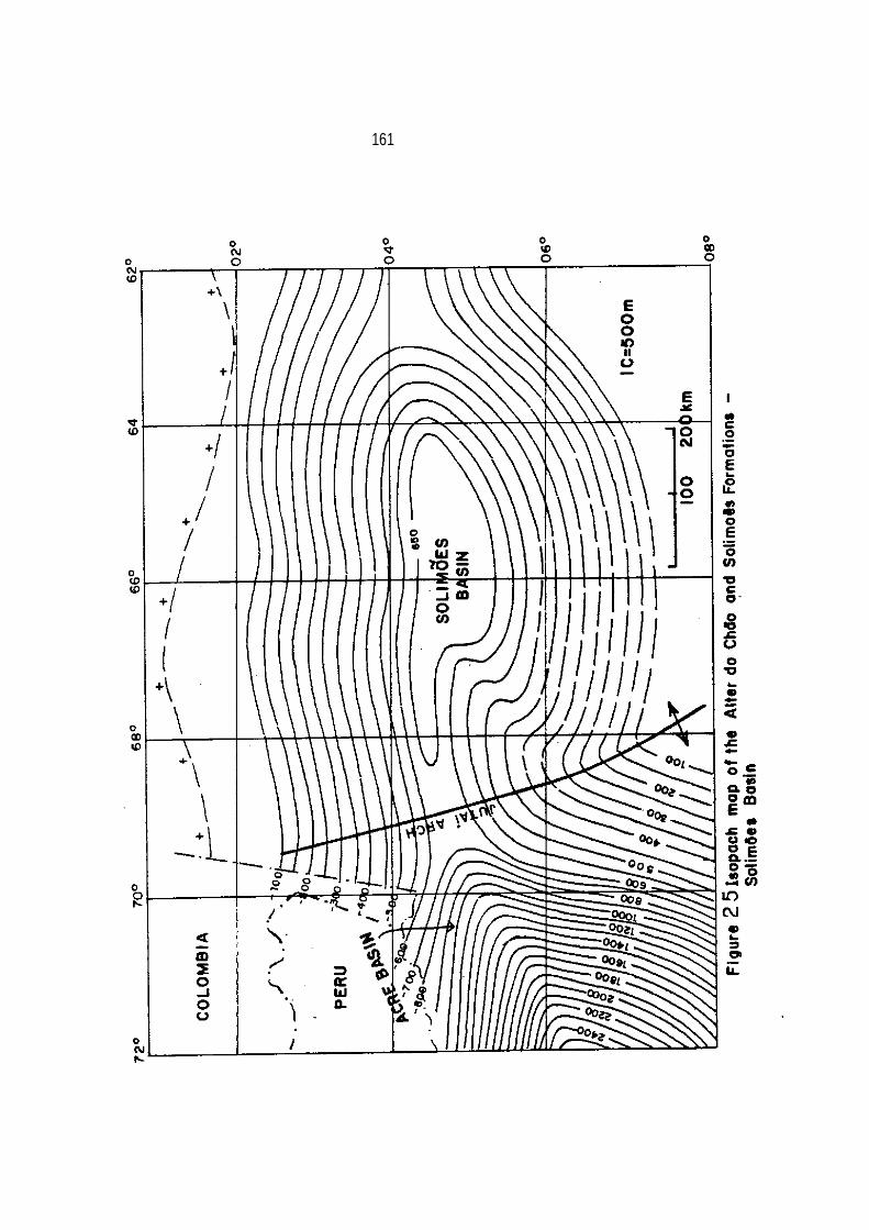
161

162
cipal sedimentary bodies. Conglomerate beds have quartz, quart
zite, sandstone cobbles and pebbles occurring in many levels
in the section. This unit overlies unconformably all older for-
mations of the basin and is unconformably overlain by the Tertiary
Solimões Formation.
The Alter do Chão Formation correlates with the Jaquirana
Group comprising the Moa, Rio Azul and Divisor formations of the
Acre Foreland Basin (Caputo and others, 1979). In the Amazonas
Basin, Price (1960) dated this unit as Late Cretaceous on the
basis of a Theropoda (dinosaur) teeth. The same sequence was dated
by Daemon (1975) as Middle Albian, Cenomanian and Turonian based
on palynological studies. In the Acre Basin, the unit increases
in thicknes and probably in age range.
Close to the Brazilian-Peruvian border a thin marine glauconitic
sandstone intercalation occurs in the Jaquirana Group (Caputo, 1974) which
is predominantly continental in origin.
Fluvial and lacustrine related environments of deposition
under humid tropical conditions predominated throughout the accu
mulation of these sediments. The presence of terrestrial ver-
tebrate bones and teeth remains and plant fossils, both wood and
leaves, confirm the continental milieu of sedimentation.
The Cretaceous drainage system of the Solimões Basin was directed
westward where its overall coarseness gradually decreases and its

163
thickness increases.
It is interesting to notice that the Alter do Chão Formation
was deposited and preserved during the time of the major transgression in the
foreland Pastaza Basin, Peru.
The transgression might have induced the Solimões Basin rivers to
change their regime from erosional to depositional. At the end of
Cretaceous and Tertiary times the Andean belt may have continued
to rise and its load may have depressed the area between the
Andean belt and the Amazonian shield, making room for thick
Tertiary sedimentation in the foreland area. This concept of
loading of the lithosphere was invoked by Price (1971) in order to
explain the subsidence of the Canadian Rocky Mountains foreland.
While the Andean belt was being uplifted, the peripheral
depression was being deepened and amplified by more sediment
loading so that the overlying Solimões Formation may have over-
stepped the Jutaí arch, covering an area of about 1,000,000 km2 of
Brazilian territory.
SOLIMÕES FORMATION
The name Solimões Series was first used by Rego (1930) to
designate a Cenozoic argillaceous section along the Solimões
River. In the Acre and Solimões basins, this unit had many local
names, so Caputo and others (1971, 1972) correlated the various

164
sections and gave them the name Solimões Formation.
In the Solimões Basin, the unit is up to 450 m thick and is
mostly composed of soft, light gray, gray and greenish gray,
massive to laminated clay with lignite interbeds from 2 to 10 mm
up to 90 cm in thickness. Subangular to subrounded, fine- to coarse-grained,
soft, white sandstone interbeds are present in the upper part of
the section.
The Solimões Formation overlies unconformably the Alter do
Chão Formation. It seems that the unconformity time span
increases from the Acre Basin to the Soltmões Basin and to the
Purus arch. In the foreland Andean basins the
Cretaceous-Tertiary section is probably continuous. The formation
contains abundant terrestrial fauna and flora which consist of
nonmarine ostracodes, fish scales, vertebrate teeth and bones,
gastropods, bivalves, charophita algae, plant remains, both leaves
and stems, and sporomorphs. Detailed fossil collection references
are provided by De Oliveira and Leonardos (1943}, and Francisco
and Loewenstein (1968).
In the central part of the Solimões Basin, the lower section
is probably Eocene or Oligocene in age on the basis of poor paly
nological data (Lima, 1982, oral communication). The age of the
lignite beds, which are located about 3,000 km from the source of
moisture (Atlantic Ocean), ranges from Miocene to upper Pliocene

.•
165
(Kokis, 1970) based on ostracodes. The upper part .of the section
may be Pleistocene or Holocene.
Some geologists who have mapped the Solimões Formation con
sidered it as having been deposited in Pliocene and Pleistocene
times. This age assignment corresponds only to its upper part,
without considering the age of lower strata drilled for coal and oil.
In Peru, in the Andean foothills, many conglomerate (alluvial
fan deposits), sandstone and tuff beds were laid down during
Tertiary times, their facies change eastward to sandstone and clay
beds. In the Acre Basin, in Brazil, some tuff beds are also pre-
sent. The Tertiary section is a typical molasse deposit generated
by the Andean Orogeny. Paleocurrent directions deduced from
cross-bedding indicate that the source area of the Solimões Formation was
located in the Andean belt (Mason and Caputo, 1964),
but Cretaceous source areas were located in the Amazonian shield.
The Solimões Formation represents a distal molasse sedimen-
tation characterized by alluvial and paludal fine-grained clastics
which overstepped the Jutaí arch and Purus high, covering the
entire Solimões Basin and the western edge of the Amazonas Basin
where the upper part of the unit was probably laid down, also
during Holocene time (Santos, 1974).
The depositional environment of the upper part of the unit is

166
also tnterpreted on the basis of radar imageries. Despite the
vegetation cover, the surface of the Solimões Formation is crowded
with a multitude of meandering paleochannel scars, indicating that
the unit was a result of a fluvio-lacustrine aggradation.
In Oligocene time, a marine incursion (Pozo Formation) took
place in Peru, in the foreland Pastaza Basin (Kummel, 1948).
This may indicate that up to Oligocene time the drainage system
was directed towards the Pacific Ocean, but in Miocene time a more
intense tectonism closed the western portal, changing the fore
land basins drainage to the Atlantic Ocean.. During the Pleistocene, the glacio-eustatic sea-level falls
may have interrupted its sedimentation many times. At present,
sedimentation is taking place again in lakes, and along river
banks and broad flood plains, indicating that subsidence is still
effective. Agassiz, who in 1840 had developed the hypothesis of
Alpine and continental glaciation in Europe and in the United
States, also visited the Amazonas valley in 1866. In his trip along
the Amazonas River and some tributaries, he interpreted the sur
ficial sediments (Solimões Formation) as drift resulted from gla-
cial activity. Agassiz envisaged the ice-sheets encompassing a
vast area from the Andes to the northeastern coastal area of
Brazil.
Glacial activity in equatorial flat areas caused wide

167
discussion .in scientific centers all over the world, but the pre
sence of warm water mollusk fossils, similar to recent ones in the
supposed drift, allowed Orton (1870), Hartt (1870) and Branner
(1919) to refute Agassiz' interpretation. The existence of alli
gator fossils of warm water habitat also militates against glacial
activity in the area during Pleistocene times.

168
CHAPTER 9. AMAZONAS BASIN
Pioneer geological surveys carried out in the Amazonas Basin
date from 1862, when Chandless traversed the Tapajós River, and
1863 when Coutinho (in Agassiz, 1866) found Carboniferous fossils
in the Cupari River (Tapajós River tributary). Important geologi
cal contributions were next provided by Agassiz (1866), Hartt
(1870, 1874), Derby (1878), Katzer (1903), Albuquerque (1922), De
Carvalho (1926), De Paiva (1929), Rego (1930), De Moura (1932,
1938), De Oliveira and Leonardos (1943), .Petri (1952), Oddone
(1953) and De Oliveira (1956) who built the basis of the Amazonas
Basin stratigraphy.
From 1954 on, many research projects involving the geology of
the area were carried out by the geologists of Petrobras. De Oliveira
and Leonardos (1943), De Oliveira (1956), Bouman and
others (1960), De Boer (1964, 1965, 1966), Lange (1967) and
Bigarella (1973) made significant regional studies and provided
important reference lists. Ludwig (1964), Rodrigues and others
(1971) and Carozzi and others (1972, 1973) studied the sedimen
tology of the basin.
The historical development of the stratigraphic column was
summarized by Caputo and others (1971, 1972) who made the last
overall revision of the basin stratigraphy. Some modifications
made since then are incorporated in this study. Figure 18 pre-
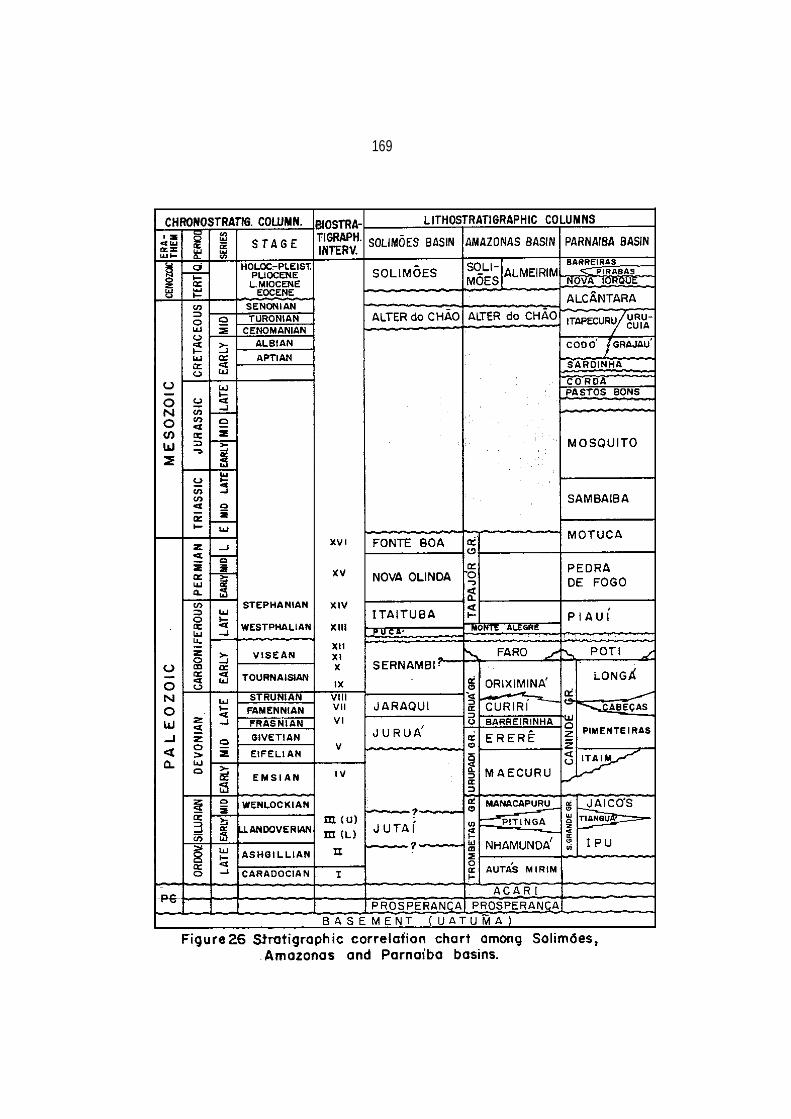
169

170
sents a cross section of the basin.
The stratigraphy of the basin is described by me in the
following sections based on surface and subsurface data. The main
purpose of this study is to examine the climatic effect on sedi-
mentary rocks, and tectonic and paleogeographic development of the
area. Figure 26 shows the stratigraphic chart of northern basins of
Brazil; figure 27 shows a cross-section across the Amazonas Basin
and figure 28 shows a cross-section along the Amazonas Basin.
PROSPERANÇA FORMATION
The Prosperança Formation, of probable Precambrian age, is
common to both Solimões and Amazonas basins and it was described
under the Solimões Basin section. It is present in outcrop and
subsurface in the western side of the Amazonas Basin and in the
subsurface in the eastern and central parts of the Solimões Basin.
In the deepest and central parts of the Amazonas Basin, eastward
from the boundary between the states of Amazonas and Para there is
no bore hole control, and for this reason the eastern extent of
the Prosperança Formation is not yet known. Its maximum thickness
is estimated to be over 1,000 m in the Purus arch.
The Prosperança Formation separates the pre-Late Carboni
ferous rocks of the Solimões Basin from those of the Amazonas Basin
along the Purus arch, making up a significant geologic divide.

171

~
172
The age of the formation is not known, but it is intruded by
1400 and 1100 m.y. old diabase (De Montalvão and Bezerra, 1980)
and overlies the Uatumã Group · -(basement). This stratigraphic
relationship suggests that the unit was deposited around 1500 m.y ago.
The Formation could be correlated on the basis of rock lithology
with the Sete Quedas Formation (Geomineraçâo, 1972) and
with many other formations overlying the Uatumã Group along the
Aripuanã, Sucunduri and Tapajós rivers (Caputo and others, 1971).
ACARI FORMATION
Hoyling (1957) used the designation Acari Formation for a carbonatic
sequence occurring in the southwest flank of the basin
in the stratigraphic bore hole Acari number 1 (2-CA-1-AM), at the
195-595 m interval. The unit consists of limestone and dolomite
beds with mudstone and siltstone intercalations. It partly overlies
the Prosperança Formation. The limestone and dolomite
beds make up bodies tens of meters thick. These are highly sili-
cified, variegated, hard, stylolitic and as compact as marble.
The mudstone and shale beds are normally brick-red and dark brown,
hard, compact, and calcareous. Some subordinate cream-colored,
pink, and red calcareous, fine- and medium-grained sandstone beds

173
are present in the section.
The Acari Formation overlies unconformably the Prosperança
Formation, but the red-color of the Acari Formation could indicate
that it is, in part, a continuation of the red beds of the
Prosperança Formation because fine red clastics of both units are very
similar. The upper contact with the Autas-Mirim, Monte Alegre,
Itaituba and Alter do Chão formations is definitely unconformable
with a very low angle.
The Acari Formation has not yielded fossils. However, geo-
chronologic dating based on the K/Ar method assigns a Late Pre-
Cambrian age (1,360 m. y.) (Thomaz Filho, 1983, oral communication).
The red beds and limestones of the Acari Formation indicate
warm depositional conditions. The presence of scattered sand-
grains in the mudstone and shale beds suggests strong wind acti
vity. In the Late Precambrian time, the absence of vegetation
probably allowed intense aeolian transport in dry as well as in
humid climates. Only six bore holes reach the formation, so its
complete geographic distribution is not known. These wells are
found in the Purus arch and vicinities. In the Solimões Basin the
unit has not been well characterized due to a poor sampling.

174

175
TROMBETAS GROUP
Here it is proposed to raise the Trombetas Series, of
Ordovician-Silurian age introduced by Derby (1878), to the rank of
group and its subdivisions to the rank of formations. Its maximum thickness
is estimated to be over 800 m in the central parts of
the basin. The Trombetas Group then consists of the Autás-Mirim,
Nhamundá, Pitinga and Manacapuru formations. The Trombetas Group
was deposited after the rifting of the Amazonas Basin. This sec
tion is considered here as the first sedimentary deposit of the
Amazonas Basin. Figure 29 shows the isopach contour map of the
Trombetas Group.
AUTÁS-MIRIM FORMATION
The Autás-Mirim Member was defined by Caputo and others
(1971) as a section of presumed Ordovician age composed of
sandstone beds with subordinate siltstone and shale interbeds
which occur at the base of the Trombetas Formation. Here the
Autás-Mirim section is raised to the category of a formation and
the Trombetas Formation is raised to the rank of group. Figure 30
shows the isopach contour map of the Autás-Mirim Formation. The
unit consists of micaceous, feldspathic sandstone beds which are
mainly fine-grained, commonly well rounded, red, pink, light green and
brown at the base of the section, and predominantly white in the

------- ---
176

177
mid, and upper parts. The beds are mainly cross-bedded at the
base and top of the section and chiefly parallel laminated at the
middle of the section. A kaolinitic matrix predominates and the
beds are well indurated. The siltstone beds are light green, greenish
gray, highly micaceous and feldspathic, well indurated,
and laminated. Minor bioturbations are common. The shale beds
are micaceous dark gray, with few biogenic structures, and are
well indurated.
The maximum thickness known of the formation is about 350 m. It
overlies unconformably the Uatumã Group and the Prosperença and
Acari formations at different places. Eastward of the Santarém City, the subsurface
distribution of the Autás-Mirim Formation is unknown, but its presence is
extrapolated. The unit is present only in the subsurface; it is probably overlain
conformably by the Nhamundá Formation.
In some sections, the unit contains ill-preserved quitinozoans
and skolithos, trace-fossils, indicating a very shallow marine
environment during part of its sedimentation. The Autás-Mirim Formation
represents a continental-marine-continental depositional cycle, which
slowly onlapped the basin flanks. It was deposited
under fluvial-estuarine conditions on the margins of the
basin as indicated by cross-bedding, pink sediments, absence of
trace fossils, kaolinitic matrix, and fine and medium grain size
alternations. The beach deposits are characterized by fine-

178

179
grained laminated sandstone beds, skolithos, and well rounded
fine-sized sand grains. Its grain modal class between O.125 and
O.177 mm (Rodrigues and others, 1971) measured in thin-sections
and well rounded grains may indicate a strong aeolian contribu
tion. Sea level fluctuations may have allowed intense aeolian
reworking of sediments previously laid down, mainly because the
loose material was not protected by vegetation in pre-Silurian
times. Along the basin flanks, laminated and very fine-grained sand
stones, as well as silty sandstones, are interpreted as shoreface deposits
(up to the fair-weather base wave). The horizontal lamination
suggests deposition of sand from air suspension during storms
(Reineck and Singh, 1980). Offshore deposits are inferred to be
present in the central parts of the basin.
The age of the formation is unknown, but as it underlies an
Late Ordovician formation and was not probably affected by the
Brazilian tectonic event in the Marajó Basin, a Late Ordovician
age is inferred (Caradocian Stage?).
The climate may have been cold at the time of the deposition
of the Autas-Mirim Formation, as evidenced by the lack of warm
climate indicators and the abundance of feldspars and micas. The
very fine sandstone and sandy siltstone are highly radioactive as
seen in gamma-ray logs, probably due to the high feldspar content.
180
Previously, Rodrigues and others (1971) interpreted the sedi
ments in the western part of the basin as tidal-originated, but
the distance from the Theic ocean deep water (ocean between
Gondwana and ancestral North America before the Acadian orogeny-
McKerrow and Ziegler, 1972), the probable small oceanic connec-
tion, and the shallow nature of the sea, point out for a tideless,
or only weakly tidal sea. The environment energy may have come
from wind-induced processes, with a negligible tidal influence (Johnson, 1978).
The sea encroached upon the Amazonas Basin from the east, and
sediment deposition occurred all the way up to the eastern flanks
of the Coari arch.
NHAMUNDÁ FORMATION
The Nhamundá Member was proposed formally by Lange (1967) to
designate a sandstone unit which occurs at the base of the
Trombetas Formation. Here the Nhamundá Member is raised to the
category of formation because it can be mapped throughout the
basin. Figure 31 shows the isopach contour map of the Nhamundá
Formation.
The Nhamundá Formation, up to 450 m thick, crops out only
in the northwestern outcrop belt from the Negro to the Pitinga rivers and
the best exposures are found along the Urubu River.

181

182
The lowermost part of the section is not exposed in the outcrop
area but it is present in the subsurface throughout the basin.
The outcrops of the Urubu River were subdivided here into
three units:
(1) In the lower part of the section a micaceous cream
colored silty sandstone 2 m thick is overlain by sediments, 25 m in thickness, that consist of pink, fine-, and medium-grained, angular, kaolinitic and highly cross-bedded sandstone beds.
(2) The mid-part consists of light gray, hummocky, cross
stratified and ripple cross-laminated sandstone with skolithos and scattered medium and coarse rounded quartz grains and minor gray organic shale interbeds.
(3)· JIn the upper part, the beds are silty and increasingly argillaceous sandstone with marked development of thin, gray, silty shale interbeds (Swan, 1957), stylolites and other trace-fossils. This upper section contains three diamictite horizons (Carozzi and others, 1973). Two of them were observed in wells by Caputo and Vasconcelos (1971) and Rodrigues and others (1971) (Photo 2). The upper diamictite horizons was mapped by Caputo and Sad (1974) in the Carabinani River, a tributary of the Negro River. They display a clayey and silty matrix with dispersed sand-sized grains,granules and cobbles In the upper part of the section, sideri- tic, hematitic and chamositic strata are common. The uppermost beds
183
of the Nhamundá Formation consist of thin, greenish-gray, medium
and coarse- grained, subrounded sandstone beds containing pyrite,
green sandy clay partings and siliceous bands or beds.
The Nhamundá Formation is probably resting conformably over
the Autás-Mirim Formation. Its upper contact may be diastemic at
the basin margins and conformable in the central parts. Although
periods of non-deposition are suspected to have preceded and post
dated deposition of the diamictite horizons, no macrofossils or
any other indication have been found in the unit to document this.
Daemon and Contreiras (1971a,b) and Lange (1967) dated the
Trombetas Group (Autás-Mirim, Nhamundá, Pitinga and Manacapuru
formations) as Early Silurian based on graptolites found in the
Pitinga Formation shale which overlies the Nhamundá Formation.
Here the age of the Nhamundá Formation is infered as ranging
from Late Ordovician to Earliest Silurian because the unit is con-
sidered as too thick to be deposited entirely in the Early
Silurian together with the Pitinga and Manacapuru formations and
because it has diamictite horizons correlatable to Ordovician-Silurian glacigenic beds of northwest Africa.
The unit records a general transgression, during which basal
sediments, characterized by fine- and medium-grained sizes, cross-
stratified sandstone beds with bioturbated sandstone interbeds,
may have been laid down on the upper shoreface. Deltaic as well as

184
tidal deposits, were not identified. Storm swells, and fair weather waves
at a smaller scale, may have been the dominant wind-
induced physical processes shaping the shoreline deposits, which
caused reworking of preexisting aeolian dunes and back shore depo
sits during the transqression. Minor internal structures charac
teristic of intertidal deposits (foreshore) were not found,
perhaps due to a poor connection with open ocean and to a circum-
polar position of the area where tides perhaps were weak.
The middle section represents lower shoreface sedimentation
where hummocky cross-stratification points out high storm activity
(Harms and others, 1975). It is supposed that in circumpolar
regions anticyclonic winds acted with great vigor as they do at
present in high latitude periglacial areas.
The upper section is interpreted as representing an alter
nation between lower shoreface and subareal deposits, with fast
fall in sea level during glacial expansions resulting in con-
sequent exposure of sediments previously deposited. The diamic
tite horizons are interpreted by Caputo and Vasconcelos (1971),
Caputo and others (1971), Rodrigues and others (1971), and
Rocha-Campos (1981d) as a result of glacial activity, on the basis
of rock texture, similar stratigraphic position to that of the
confirmed glacial rocks of northwest Africa and Sahara region
(Beuf and others, 1971, Rognon and others, 1968) and paleogeo-

185
graphic considerations. Basement clasts were found resting on a subhorizontal substrate (dip of one-half degree) in wells 150 km away from the present position of the basement.
In the center, and in the eastern side of the basin, there is
no well control, but it is assumed that offshore conditions predo- minated during interglacial and pre-glacial episodes in these areas.
In the western part of the basin, towards the Coari arch, bioturbated beds are rare and pink and green beds appear, indi- cating an increasing estuarine and continental influence throughout the section.
The climate during the deposition of the Nhamundá Formation
may have 'been very cold to arctic as evidenced by the absence of warm climatic indicators and the presence of intercalated rocks of glacial nature in the upper part of the section, characterized by repeated alternations of marine and continental glacial and gla- ciofluvial deposits.
The lower diamictites are in part correlated with the
Tamadjert Formation tillites of the Algerian Sahara. The base of the Tamadjert Formation consists of tillites and its top comprises glaciofluvial, glaciomarine and marine deposits (Bennacef and others, 1971). It seems that the upper main diamictites were deposited later in the Amazonas Basin (Earliest Llandoverian) than

186
in the Sahara region (Late Ashgill).
It is interesting to note that prior to the Ashgill Stage, in the pre-Cordillera of San Juan, Argentina, Pacific Realm rocks rich in limestone were laid down (Boucot and Gray, 1978) suggesting a warmer gradient from northwest Africa to Argentina.
PITINGA FORMATION
The Pitinga Member was formally proposed by Lange (1967) to
designate a section, belonging to the Trombetas Formation, com
posed of shale, siltstone and sandstone beds with some iron oolites throughout. Caputo and others (1971) subdivided the section into
two members: the Pitinga Member consisting of the basal shale
with siltstone and minor sandstone interbeds and the Manacapuru
Member consisting of sandstone, with some siltstone interbeds. Here both members are raised to the rank of formations belonging
to the Trombetas Group.
The Pitinga Formation is a good marker with a known maximum
thickness of about 280 m, being easily recognizable throughout the
basin. Figure 32 shows the isopach contour map of the Pitinga
Formation. It consists of green-gray to dark gray, micaceous,
laminated, soft, carbonaceous, pyritic, partly sideritic shale
with interbedded shaley siltstone. Toward its top, and near basin
margins, very fine-to fine-grained thin sandstone beds are pre-

I
187
sent, as well as some chert interbeds which occur on the northern
flank. Hematite interbeds are present at the base, and siderite
interbeds and nodules are found throughout the unit.
The unit rests conformably on the Nhamundá Formation, and
onlaps it at the basin edges·. The Pitinga Formation onlaps the
underlying units and rests directly over the Prosperança Formation
or Uatumã Group on the basin flanks. In the southern basin
margin, the Pitinga black shales overlie directly the Uatumã basement with no intervening sandstone or basal conglornerate beds between
them at several places. This suggests a very fast transgression under
low energy conditions. Towards the Coari high the unit pinches
out between the Nhamundá and Manacapuru formations (Figure 33).
Its upper rcontact is conformable with the Manacapuru Formation and
at different places along the basin edges is disconformable with
the Maecuru (Devonian), Monte Alegre (Carboniferous), Alter do
Chão (Cretaceous), and Solimões and Almeirim (Tertiary) forma-
tions.The Pitinga Formation has yielded graptolites, chitinozoans,
algae, sponge spicules, brachiopods, mollusks, scolecodonts, fora-
minifera, crustaceans and other fossil groups. The graptolites
were observed at the base of the section (Caputo and Andrade,
1968).
The graptolite Climacograptus innotatus Nicholson var. brasiliensis

188

189
Ruedemann assigns an Early Silurian age. In Scotland, the
Climacograptus innotatus is found associated in zone of
Monograptus gregarious of the Lower Birkhill Shale of the late
Early Llandoverian to Middle Llandoverian age (Harrington,
In Berry and Boucot, 1973). A late Early Llandoverian to Mid-
Llandoverian age is also assigned to the Pitinga Formation.
The presence of Anabaia paraia, Tentaculites trombetensis,
Heterorthella sp. and Climacograptus innotatus Nicholson var. bra
siliensis in the Trombetas and Caacupe (Paraguay) groups indicates
close correlation between both lithologic groups.
The Pitinga Formation is interpreted as a result of predomi
nantly muddy shoreface and offshore deposition during the trans
gression resulting from melting of widespread ice caps in north
Africa and South America. The well-developed lamination and
fine-scale bedding are suggestive of relatively quiet water.
Some thin sandstone beds in the lower part of the formation con
tain Lingula and Arthrophycus, suggesting a shallow nearshore to
paralic deposition. Some sporadic shale-pebble horizons up to
5 cm in thickness are present in the section and are interpreted
as intraformational conglomerate resulting from glacial activity or episodic storms in
a normally quiet environment. The melting of ice sheets may have
slowed the anticyclonic wind in the area, reducing the environment
energy.

190

191

192
It is interesting to note that in northern Africa the rock
equivalent to the Pitinga Formation (graptolitic shales) has its
base dated as early Mid-Llandoverian in the Adrar (Trompette,
1973) and Mid-Llandoverian in Zemmon (Sougy, 1964). Figure 34
presents a good borehole correlation between Amazonas and Sahara basins.
A Middle Llandoverian age is assigned to transgressive shales
in the eastern Coari high flank corresponding to the climax of
the Llandoverian transgression in the world. In the Algerian
Sahara the Early Silurian "argiles a graptolites" are named
Imirhou Formation (Bennacef and others, 1971). Figure 35 presents
the distribution of the Early Llandoverian shales in South America
and Africa.
The climatic warming may have enhanced chemical weathering
which produced a large amount of clay minerals. Transgression may
have caused the deposition of coarse clastic sediments in
estuaries and river valleys, resulting in important sedimentation
of silt and clay in the starved seas during the Pitinga time.
In the basal part of the Pitinga Formation illite predominates while
in the middle and upper parts kaolinite dominates (Rodrigues and
others, 1971) indicating that a change in land weathering from
glacial to post-glacial climate may have occurred during its depo
sition. The clay minerals contain a low boron content (Carozzi
and others, 1973) indicating low salinity compatible with great
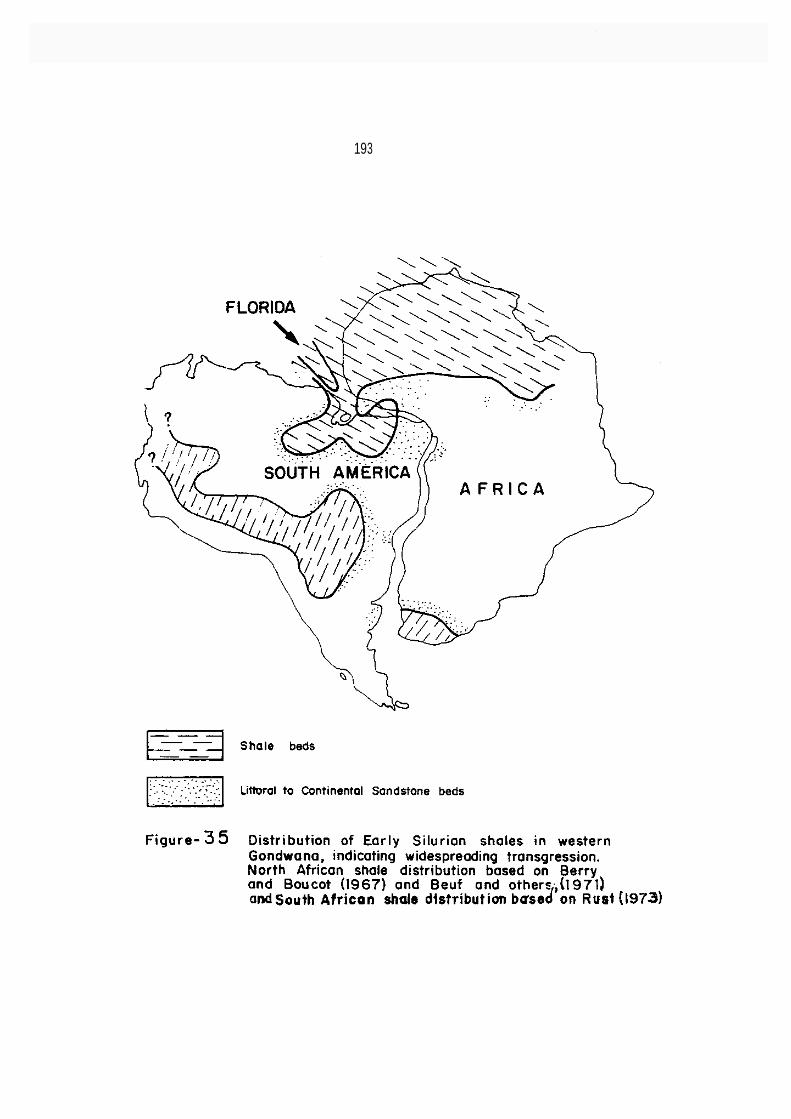
193

194
fresh water -influx into the basin.
Spjeldnaes (1961) and Berry and Boucot (1967) proposed Ordovician
and Silurian paleogeographic reconstructions for Europe and northern Africa based on fauna suggesting very cold climate in
the Saharan region and northwest Africa. The Amazonas Basin which
may have been linked to northwest Africa may certainly have
experienced the same cold climatic conditions. Lange (1970, in
Cramer, 1971) also pointed out the similarity between the Silurian
chitinozoans of Florida, northern Brazil and northwestern Africa,
suggesting close paleogeographic relationship between these areas
in Silurian times. At that time, Florida may have been located in
Gondwana in the cleft between Africa and South America (Cramer,
1971).
MANACAPURU FORMATION
The Manacapuru Member was proposed by Caputo and others
(1971) to designate the upper unit of the Trombetas Formation.
Here this member is raised to the category of formation belonging
to the Trombetas Group. Its maximum thickness is estimated to be
over 200 m in central parts of the basin. The unit is exposed in
the northwestern outcrop belt and was uplifted there in Carboni
ferous time. In the south outcrop belt the Manacapuru Formation
is unexposed because is overlapped by Devonian sandstones.

195

196
Figure 36 shows the isopach contour map of the Manacapuru Formation. The Manacapuru Formation consists of sandstone beds with
shale, siltstone and ironstone interbeds. In the exposures, the
formation comprises white and buff fine- to very fine-grained well sorted, friable, highly cross bedded sandstone beds with brownish gray very soft argillaceous shale and siltstone interbeds. In the subsurface, the sandstones are mainly parallel laminated, fine, micaceous, bioturbated, with beds 5 to 20 cm in thickness, interrupted by siltstone interbeds. Three mai-n sandstone bodies separated by shale-siltstone bodies are present in many wells.
In the westernmost part of the basin fine- and medium-grained
cross-stratified sandstone beds are present in many places. Sand stone beds with a clay-ferruginous matrix and oolitic ironstone beds (siderite, chamosite, hematite) are well developed in the margins and western part of the basin. Small white peloids of cellophane and kaolinite-chamosite are scattered through the ooli
tes. The upper third of the Manacapuru Formation consists of as much as 20 m of bioturbated brown sideritic mudstone with a few layers of ferruginous micaceous siltstone containing scattered, white phosphatic kaolinite peloids.
The Manacapuru Formation rests apparently conformably on the Pitinga
Formation and is unconformably overlain, with low angle, by the

197
198
Maecuru Formation (Figure 37), in the entire basin and by the Monte Alegre and Alter do Chão formations in basin extremities.
At the base of the Manacapuru Formation, the presence of
Arthrophycus sp. and Lingula sp. (Lange, 1967) suggests shallow, sometimes brackish, nearshore water environment. The unit was dated as Early Llandovery by Lange (1967) and Daemon and Contreiras (1971a,b) based on palynological studies. However, they did not find any guide fossil for a detailed dating of the section overlying the graptolitic Pitinga shale. Here, on the basis of its regressive character and correlation with northwest African and Saharan sections, which were relatively contiguous to that of the Amazonas Basin in Silurian time, the Manacupuru Formation is inferred as deposited in the Late Llandoverian time at its base. The top of the unit may have been deposited in the Early Wenlockian time (early Mid-Silurian). Worldwide regression continued from the Late Llandoverian up to the Devonian, by which time the shorelines had retreated about 1,500 km from southern Algeria to northern Morocco (Berry and Boucot, 1973).
The Manacapuru Formation records a general regression in the
basin with some transgressive oscillations. In the westernmost part of the basin, fine-grained, cross- and parallel laminated, micaceous argillaceous, bioturbated (skolithos) sandstones are interpreted as deposited in a littoral environment.

199
Medium-grained, cross-stratified sandstone beds are considered as depo
sited in deltaic distributary channels and carbonaceous shales may
have been deposited in interdistributary lakes and bays. At the
north and south flanks, deltaic and fluvial deposits were weakly
preserved; only fine-grained, mcaceous, cross-stratified and
cross-laminated sandstone beds and shale interbeds were deposited
in a low energy shore face environment. In the central parts of
the basin there is no well control but an offshore environment is
postulated. The presence of ironstones suggests deposition in shallow
water at the margins of the basin. Distributary delta abandonment
or the onset of transgressive cycles may have inhibited clastic
supply resulting in the concentration of ironstones in sand-
starved environments. During regressive phases the ironstones may
have been remobilized and redeposited together with sandstones in
the high energy regressive environment.
According to Hallam and Bradshaw (1979) vegetation and warm
humid climate were important factors in the formation of Mesozoic
ironstones. However, in northern South America and northwest
Africa, where no land plants existed at that time, the Lower
Silurian and Lower Devonian ironstone deposits were laid down in
high latitude under cold climate. In Northwest Territories,
Canada, Young (1976) also reported the presence of Precambrian

200
iron-formations intimately associated with glacigenic deposits. This is a strong indication that ironstones may be deposited in cold as well as warm climates, and that tropical land vegetation is not required for ironstone formation. For many investigators, the limestone-type texture of iron formations points out to an origin of iron formations by limestone replacement (Kimberley, 1974; Dimroth, 1979). However, there is no evidence for such a replacement in the Siluro-Devonian ironstones of Brazil, but it seems that clay may have been originally replaced by siderite or chamosite. Many isolated clay chips in sandstone beds now are fully sideritized.
The Manacapuru Formation is correlated lithologically with
the Atafaitafa Formation (Bennacef and others, 1971) of the Algerian Sahara. The Atafaitafa unit also contains three sandstone bodies and two intercalated shale bodies and a number of ironstone interbeds, some of which were interpreted as paleosols
(Bennacef and others, 1971).
The climate at that time was cold periglacial as indicated by the presence of ice-caps in the Guaporé shield (Paraná Basin, Maack, 1947; Andean Basin, Crowell and others, 1980, 1981; South Africa, Cape Basin, Rust, 1973). The Andean tillites of the Cancañari Formation were dated as Late Llandoverian by Berry and Boucot (1972) on the basis of graptolites and brachiopods and as
201
Early Wenloçkian by Crowell and others (1981) on the basis of
stratigraphic position and acritarchs, so the Andean tillites may be as old as the Manacupuru Formation beds.
According to Cramer (1971) the acritarch component of Florida formations and the Amazonas Trombetas Group, as well as lithologi- cal content, are almost identical. The large geologic dissimi larities between the currently contiguous Appalachians and Florida suggest that Florida may have been attached to the Guyana shield and to the northwestern African craton, ins·tead of the North
American craton, in Silurian times. The simil.arity of the sedi- mentation of the Trombetas Group with coeval deposits in the Taoudini and Central Sahara basins (Figure 34) is certainly not fortuitous and may result from their having been in juxtaposition as is shown in figure 35.
URUPADI GROUP
Santos and others (1975) proposed the name Urupadi Group to include the Trombetas, Maecuru and Ererê formations. I do not agree with this subdivision because there is an unconformity bet- ween the Trombetas and Maecuru units. Here, the Trombetas Formation was raised to the category of group, and considering the unconformity between Silurian and Devonian rocks the Urupadi Group encompasses only the Maecuru and Ererê formations.
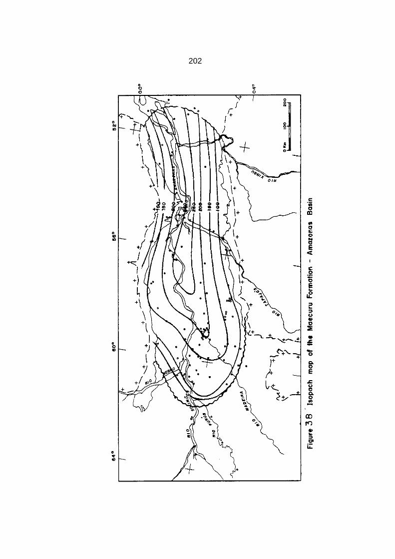
202

.J
203
MAECURU FORMATION
The Maecuru designation was proposed by Derby (1878) to refer to sediments of Devonian age situated above the Trombetas Group.
Lange (1967) formally subdivided the formation into the lower Jatapu Member and the upper Lontra Member. Its maximum thickness is estimated to be over 250 m in central parts of the basin. The Jatapu Member interfingers laterally and grades upward to the Lontra Member. The Lontra Member of Caputo and others (1971) includes a basal section of the overlying Ererê Formation as defined by Lange (1967). Figure 38 shows the isopach contour map of the Maecuru Formation.
The Jatapu Member, as much as 200 m thick, is characterized by gray, highly micaceous, fine-grained, thin-bedded, sideritic, highly bioturbated sandstone beds locally with regular and irregu- lar shale and siltstone interbeds. Some medium-grained sandstone beds as well as ferruginous shale, hematite and siderite beds are mainly present in the basal part of the sequence. Ironstones and
bioturbation occur throughout the section indicating a low sedi mentation rate during deposition of the Maecuru Formation.
The Lontra Member, as much as 150 m thick, consists of white
to light gray, strongly cross-stratified fine-grained to conglo meratic sandstone beds with a few siltstone interbeds.
The Maecuru Formation overlies unconformably the Trombetas

•
204
Group and is conformably overlain by the Ererê Formation and in
the Coari arch flanks unconformably by the Monte Alegre Formation and in
the western and eastern basin flank extremities by Alter do Chão
and Almeirim formations.
The unconformity between the Trombetas Group and the Maecuru
Formation is a paraconformity and was discovered with the aid of
fossils and regional well log correlation. Several geologists
have not detected the unconformity in the field due to the absence
of basal conglomerates, erosional surfaces or dffferent dips at the
Silurian-Devonian contact. However, correlation among several
boreholes and surface rocks as well as paleontological and palyno
logical data establishes the presence of a very low angle
(one and half degree) regional unconformity (Figure 37).
Derby (1878) assigned the Maecuru Formation to the Early
Devonian based on the brachiopods Amphigenia elongate and Spirifer
duodenaria. The presence of Tropidoleptus indicates a Middle
Devonian age. Lange (1967) reviewed the fossil content and the
pertinent literature, concluding that the Lontra Member was laid
down in the Late Emsian and Early Eifelian stages, that is, during
late Early Devonian and earliest Middle Devonian. The basal
Jatapu Member may be somewhat older than Late Emsian, and it is
characterized by soft-body fauna. Up to the present, no shelly
fauna have been found in the Jatapu Member. Lange (1967) placed

205
the Maecuru Formation in the local biostratigraphic interval IV and in part of the V, considering its age as ranging from Emsian to Earliest Eifelian. A striking characteristic of this biota is its North American mid-continent rather than Appalachian affinities (Caster, 1952; Copper, 1977).
The Maecuru Formation records the initial Devonian deposition
in the Amazonas Basin, as it took place in southern northwest Africa and southern Sahara after a hiatus of about 20 m.y. between
(Wenlockian) middle Silurian and Emsian (late Early Devonian). From the southern flank of the Amazonas Basin, facies of the
lower part of the Lontra Member grade into the Jatapu Member facies towards the central parts and the northern flank of the basin. The Jatapu Member consists of almost fully structureless, strongly bioturbated, micaceous sandstone beds with fine-laminated micaceous sandstone interbeds, suggesting low current activity and very low rates of deposition, perhaps below fair-weather wave base. A few subhorizontal stratified coarser sandstone beds may
indicate sporadic storm activity. In the eastern outcrop belt, the Jatapu Member consists of bioturbated gray silt-shale beds indicating a deeper water environment than that in the western part of the basin. This is in agreement with an important epeiro genic uplift in the eastern side of the basin since Carboniferous times. Such uplift may have triggered the removal of shallow

206
water sediments far away from present basin margins, resting deeper water sediments
in that region. The presence of intense bioturbation in the section, rich in
siderite matrix, indicates low sedimentation rates. This, as well
as its paleogeographic setting, rules out the possible action of
tidal or oceanic currents. According to Stewart and Walker (1980)
meteorological currents, probably storm-generated bottom-return flows,
seem to be the most likely process for the occasional
introduction and more rapid deposition of coarser sand in environ-
ments normally dominated by bioturbation. In the northern outcrop
belt, the Jatapu Member shows deeper water deposits, suggesting
that shoreline sediments, deposited far away from the present
outcrop belt area, may have been removed by erosion..
The Lontra Member consists of very coarse- to medium-grained
sandstone beds and represents a major fan delta system prograda-
tion interrupted by a fast, short-lived transgression followed by
another fan-delta system progradation. The fan-delta concept was
developed by Fisher and McGowen (1967), Fisher and others (1969),
Fisher and Brown (1972) and Brown (1973). The fan-delta consists
of an accumulation of coarse debris brought down by braided rivers
which debouch in the sea, with a proximal deposition of essen
tially sandy-conglomeratic material grading basinward into medial
and distal sandstone and shale beds.
In the southern outcrop belt medium-grained to conglomeratic

207
cross-stratified sandstone beds with paleocurrents of toward N60ºW (Caputo and Andrade, 1968) are interpreted here as derived from a braided fluvial system. The coarse delta-fan sediments change to fine- to medium-grained fan-delta front sandstone toward the depo
sitional axis of the basin and progressively to highly bioturbated siltstone and shale profan and offshore beds. A fast transgression caused the deposition of thin beds of bioturbated marine shale in the
fan-delta and fan-delta front. Renewed progradation caused the deposition of another fan delta, displaced basinward. The fan- deltas are river-dominated, suggesting low energy in the marine
depositional milieu.
In the upper part of the formation, fan-delta front and fan
delta deposits encroached the northwestern and the south flanks of
the basin as a result of sea-level fall. Only in the north flank marine fossils were found in fan-delta front sandstone beds. These fossils make up the entire fauna described in the formation.
During the deposition of the Maecuru Formation the climate may have been cold, suggested by the lack of carbonates, evapori- tes, red beds, reefs, and aeolian desert sands. The Maecuru marine fauna
suggests cold climate, but not so cold as in the Paraná Basin, which was classified as subarctic by Copper (1977). No glacial- derived beds were observed during the deposition of the Maecuru
Formation. In the Lontra Member the presence of coarser sediments
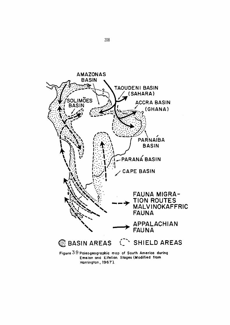
208

~
209
is due to a -general sea-level fall rather than to tectonism in the source areas as interpreted by Carozzi and others (1973).
In the Solimões Basin the oldest Devonian rocks, presently
found in the deepest parts of the basin, were deposited in the Givetian Stage (early Mid-Devonian), while in the Amazonas Basin, the oldest Devonian sediments were deposited in the Emsian Stage. This has a great paleogeographic significance because this indicates that the Amazonas sea did not transgress from the Andean area to the Amazonas Basin as previously suggested ·by paleogeographic
reconstructions (Harrington, 1962, 1968). In ·the Amazonas Basin
the Devonian transgression may have entered by the east side of the basin. The fauna of the basin is related to that of North America and northwest Africa (Caster, 1947a,b, 1952).
According to Hollard (1967), in the Taoudini Basin an inva-
sion of North American fauna occurred in Emsian and Givetian stages. This may indicate that the Amazonas and southwest Taoudini basins were contiguous because they were colonized by the same North American biota (Figure 39).
ERERÊ FORMATION The name Ererê was proposed by Derby (1878) to designate a
Devonian section composed of siltstone with shale and sandstone interbeds situated between the Maecuru Formation and the Curuá

210

211
black shale. Bischoff, in 1957, called this section the Ariramba
Member of the Maecuru Formation, but Lange (1967) established it as an independent formation. Its maximum thickness is estimated to be over 250 m in the eastern side of the basin. Figure 40 shows an isopach contour map of the Ererê Formation.
The unit comprises greenish-gray, micaceous, carbonaceous, thin-bedded, moderately bioturbated, shaley siltstones which have thin interbeds of light-gray very fine-grained, argillaceous, and minor very thin calciferous sandstone beds. Upwards the sandstone interbeds become more frequent and coarser-grained. In the southern outcrop belt some fine- to very coarse-grained sandstone bodies are well developed. Very thin and sporadic lime-dolomite
beds (10 cm in thickness) are present in the northern flank, but sideritic beds or siderite-cemented sediments are rare.
The unit overlies conformably the Maecuru Formation and is
conformably overlain by the Curuá Formation. In the Purus arch
area, the Ererê Formation is unconformably overlain by the Monte Alegre
Formation (Late Carboniferous) and in the outcrop belt extremities it
Is overlain by Mesozoic and Cenozoic red beds.
The Ererê fauna is composed of brachiopods, gastropods, trilo-
bites, pelecypods, ostracodes, scolecodonts, and conodonts, most
of them collected in the Monte Alegre area. This area is located
in a basin flank that was uplifted in Mesozoic times, so the

212
strata show offshore characteristics with a much deeper water fauna than that of the Maecuru Formation that was collected in the north outcrop shallow water area. Several new faunal and floral elements entered the Amazonas Basin, while many components of the earlier Maecuru biota disappeared (Copper, 1977).
The formation was first dated by Rathbun (1874) as Middle
Devonian. Its fauna was intimately compared with that of the New York Hamilton sediments due to the presence of about six common species. Lange (1967) and Daemon and Contreiras (1971a,b) posi tioned the Ererê Formation in the biostratigraphic interval V, based on palynological data and fossil content, corresponding to the Eifelian and Givetian stages.
The Ererê Formation records a larger transgression and deepening in its lower part, and a moderate regression in its upper part, and in the Paleozoic outcrop area the Ererê beds show deeper water conditions than those of the Maecuru Formation. The formation was deposited in river-dominated delta front environ ments with no significant contemporaneous reworking by marine pro cesses in the south margin. In the southern outcrop belt and in the eastern Coari arch fluvio-deltaic deposits are present, con sisting of very-coarse cross-stratified sandstone bodies which may be distributary paleochannels. These change laterally to sandy siltstone of possible bay environment. This rock assemblage

I 213
changes basinward to massive, bioturbated, fine-and very fine- grained sandstone beds interpreted as delta front deposits. In the middle of the basin, little-bioturbated shale and siltstone beds are considered as deposited in prodelta and offshore environ- ments.
In the western side of the northern outcrop belt, shoreface and delta front facies are developed, while in the eastern side, offshore sediments predominate. In the northern outcrop belt
shoreline and proximal deltaic deposits may have been eroded following uplift of the Guyana shield (Rio Branco arch of Amaral, 1974) after sedimentation. In the eastern area of the basin, the Guyana and Guaporé shields uplift was more intense than in other
parts of the basin.
The absence of some fossil groups in the Ererê Formation was
explained by Copper (1977) as related to either cold climatic con ditions or to poor sampling. The presence of very thin dolomite beds, and some calcitic cementation in Ererê sediments, as well as
the deposition of limestone beds for the first time in the
Taoudeni Basin since the Ordovician Period, point to a climatic warming in the area in the Mid-Devonian time, although the Paraná Basin was under colder conditions. At Mid-Devonian time, the tem- perature gradient was opposite to that of the Late Ordovician time
when the colder area was located in the southern Sahara.


215
The presence of rocks deposited in fluvial and deltaic environments in the Coari arch suggests that land existed west- ward, preventing a marine connection between the Amazonas and Solimões basins.
CURUÁ GROUP
The name Curuá Group was proposed by Derby (1878) to refer to
Devonian black shales overlying the Ererê Formation. Later the
Curuá Group was considered as the Curuá Formation, and was sub
divided into several members. Here the Curuá unit is again considered as
a group subdivided into three formations, from the bottom upwards:
Barreirinha, Curiri and Oriximiná.
The Barreirinha Formation is the best marker within the basin because of its high radioactivity, as detected in gamma ray logs. Its maximum thickness is estimated to be over 1,100 m in the eastern
part of the basin. Figure 41 shows the isopach contour map of the Curuá Group.
BARREIRINHA FORMATION
The name Barreirinha was informally used at first by De Carvalho (1926) to encompass Devonian black shale beds cropping out along the Tapajós River banks. Figure 42 shows the isopach con- tour map of the Barreirinha Formation. The unit is present in
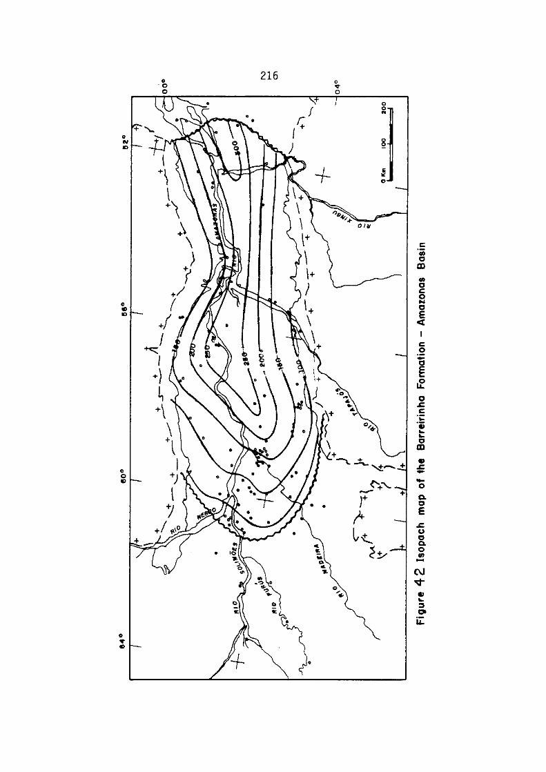

217
both outcrop belts and in the subsurface. It consists of uni-
formly strongly micaceous, pyritic, carbonaceous, bituminous, fissile (at the base), laminated dark gray to black shale beds with minor thin, silicified siltstone and very fine-grained sandstone interbeds 5-15 cm in thickness. The unit shows a high radioactive level in the lowermost part as well as two horizons with large concretions composed of Ca, Fe and Mn carbonates. Some concretions are about 2 m across. Approximately 280 m in thickness, the formation is extrapolated to the central parts of the basin, and in the subsurface the unit thins towards the Coari high flank more steeply than it does toward the marginal outcrops. The lower radio- active zone has the highest content of organic matter in the basin (up to 10%) as well as high contents of base metals such as S, Cu, Mo and V (Rodrigues, 1971). The most prevalent clay minerals are Kaolinite and illite.
In the well 2-LC-1-AM, the upper part of the Barreirinha
Formation was considered as being composed of siltstone and medium-grained sandstone beds. These beds were interpreted by Carozzi and others (1973) as subaquatic channels filled by the action of turbidity currents. A new well (l-LC-2-AM) has shown that the coarse-grained massive section belongs to the overlying Curiri Formation, so that the Barreirinha Formation thins as it approaches the Coari high flanks without changing its facies. At

218
least for the time being, no such coarse sediments were detected
in the Barreirinha Formation. This sedimentary unit shows the same characteristics as those of the Chattanooga Shale of the interior basins of the United States.
The Barreirinha Formation rests conformably on the Ererê Formation and it is conformably overlain by the Curiri Formation. On the Coari arch flank, and in both western outcrop belt extremi- ties, the unit is disconformably overlain by the Monte Alegre For mation (Upper Carboniferous) and in the eastern outcrop belt extremities, it is overlain by the Almeirin Formation (Tertiary).
The Barreirinha Formation is very poor in macrofossil, and
bioturbation is absent because the black shale environment is not conducive to a normal benthic marine biota (Copper, 1977). The unit has yielded a very few brachiopods, conodonts, scolecodonts, and mollusks, fish teeth and spines, but it is rich in palyno- morphs such as chitinozoans, acritarchs and sporomorphs.
Important early Late Devonian (Frasnian Stage) fossils which date the formation are the brachiopods Orbiculoideia lodensis Hall and Schizobolus truncates Hall, also common to the Genesee Formation of New York State. The overlying basal Curiri Formation has yielded Early Famennian (mid-Late Devonian) plant fossils which could con- firm the Frasnian age for the Barreirinha Formation. Palynological data also validate an early Late Devonian age (Daemon

219
and Contreiras, 1971a,b).
The Barreirinha Formation, composed of black laminated sha les, records the deepest water environment in the history of the basin. The black shales represent a sediment-starved anoxic basin related to a major worldwide transgression that may have swamped vast areas of deltas and coastal plains. During this transgressive phase, deposition of terrigenous coarse clastic sedi ments was at a minimum, that laid down was emplaced in drowned estuaries and river valleys. Coarse sediments may have been trapped in river valleys and were not able to reach the basin. lt is possible that the Barreirinha shorelines were relatively muddy, similarly to the present Black Sea. In the Amazonas Basin outcrop area, the black shale sediments represent an offshore environment.
The Barreirinha transgression correlates very closely with
the Taghanic onlap observed by Johnson (1970) in several basins in the United States or with the Frasnian transgression (Lunulicosta zone transgression) across Russian platform (House, 1975) and across northern Africa (Hollard, 1967).
Shaley transgressive deposits of the same age are registered
in the Parnaíba (Andrade and Daemon, 1975), Paraná (Lange, 1967; Daemon and Quadros, 1970) and elsewhere in Gondwana (Figure 94). This is contrary to the idea suggested by Johnson (1979) that Gondwana was not extensively flooded by the sea due to epeiro-

220
genesis as the Euramerican platforms were flooded during
Givetian and Frasnian times. The paucity of benthonic fossils is
Interpreted as due to a high stress anoxic environment in the
Amazonas and Solimões basins, lethal to most macroorganisms.
In the Solimões Basin, from Middle Devonian to early Late Devonian times, a sandy transgressive unit (Juruá Formation) was laid down with char.acteristics very distinct from those of the Barreirinha black shales. It is presently unknown whether the Solimões and Amazonas basins were connected during the Frasnian Stage. The Barreirinha Formation thins very sharply toward the Coari high, suggesting no communication between the Amazonas and Solimões basins. However, if any marine communication has existed between the Amazonas and Solimões basins it may have occurred during the Frasnian time when the transgression reached its maximum.
The upper part of the Barreirinha Formation is richer in
silt-sized particles and less radioactive and bituminous than its
lower part. The more abundant silt-sized particles may be attri-
buted to an increase in aeolian activity in the source areas
during a general increase in gradient temperature which could have
promoted strong winds, or to an increase in bottom water cir-
culation caused by the sinking of colder and dense oxygenated
less saline water in the basin margins in response to a climatic
deterioration. High influx of poor saline water, low evaporation and probable
221
narrow connection to the ocean may explain the low content in
boron in the Barreirinha illite clay minerals (Carozzi and others, 1973). The
relatively low salinity environment is consistent with a very cold
climate. The same kind of large Ca, Fe and Mn carbonate concre
tions (1 to 2 m across) found in the cold water Saharan grap
tolitic Silurian shales (Beuf and others, 1971) are present in the
Late Devonian Barreirinha Formation.
If it is considered that the climate was glacial-arctic
during the deposition of the overlying Curiri Formation, the upper
part of the Barreirinha Formation may have been subarctic cold.
CURIRI FORMATION
The term Curiri Member was proposed by Lange (1967) for a
Devonian section composed of diamictite, shale, and siltstone beds
occurring at Igarapé Curiri (Curiri Creek). As much as 350 m in
thickness is extrapolated to the deepest parts of the basin. In
this stuy the Curiri Member is raised to the category of for
mation. At the time that Lange (1967) proposed the Curiri unit,
its beds were only known in the type-section and in the subsur-
face. Caputo and Andrade (1968) mapped all the southwestern
outcrop belt area, where they found that the unit is exposed eastward
from the Nambi River up to the Cupari River. Exposure descrip
tions provided by Bemerguy (1964) and Macambira (1977) indicate

222
the presence of this formation in the southeastern outcrop belt, so
it is exposed in a belt of about 500 km in length in the south
flank of the basin.
In the north margin, the unit is recognized along a few
rivers, but possibly more exposures exist and they will be found
with more detailed mapping. The diamictite beds are found in most
boreholes which reached the underlying Barreirinha Formation, but
in some wells, mainly in the central parts of the basin, the for
mation is only represented by shale and siltstone beds, most of
them rich in Spirophyton trace fossils. Figure 43 shows the iso-
pach contour map of the Curiri Formation.
At the base, the Curiri section is composed of dark gray to
light gray, brown or buff silty shale alternating with light gray
highly micaceous siltstone and very fine-grained argillaceous
sandstone beds, strongly bioturbated by a trace fossil named
Spirophyton. These bioturbated beds mark the base of the for
mation. In the central parts of the basin, the same section is
composed of micaceous dark gray bioturbated shale. The basal
Curiri beds are also characterized by an algae, or primitive
land plant, called Protosalvinia sp., which marks a well defined zone
in the section. For example, the Tracoá River bank outcrops, for a
long reach, consist of very fine-grained, micaceous, clayey, cross-laminated
sandstone beds with more than 50% of the rock com-


224
posed of Protosalvinia remains, which seem to be a kind of shoal
concentration.
Above the Protosalvinia zone, a micaceous light to dark gray massive diamictite section with scattered sand-sized grains, gra- nules, cobbles and pebbles is present (Photo 3). In the subsur face, some diamictite intervals (Photo 4) change basinward to laminated shale with rafted granules and cobbles and to laminated shale free of clasts. Shale, rhyolite, quartz, quartzite, chert sandstone, basalt, and limestone are the most common clasts found. Some striated pebbles were recovered from the subsurface (Bouman and others, 1960; Rodrigues and others, 1971) and are also found in outcrop (Macambira and others, 1977; Caputo and Andrade, 1968; Caputo and Crowell, in press).
Lenticular bodies composed of very fine- to fine-grained,
cross-laminated and cross-bedded sandstone beds are generally deformed and mixed with diamictite masses. The sandstone shows scattered pebbles, microfolds and microfaults. The microfaults place sandstone and diamictite beds in irregular contact. Ludwig (1964) interpreted the diamictite beds as a result of turbidity currents and deformations in sandstone beds as convolute folds related to turbidity currents too. However, according to Reineck and Singh (1980) convolute bedding is remarkably continuous, in spite of the intensively folded internal laminae, so that faulting

225
and slippage are not normally associated with convolutions. Deformations observed in these lenticular sandstones are not here interpreted as convolute folds. The deformed sandstone beds also show cross- stratification that are incompatible with a turbiditic origin as interpreted by Ludwig (1964). No graded beds were found in the Curiri Formation suggesting turbidity current activity.
The Curiri diamictite beds are present in two horizons and
are separated by sandstone and shale beds. Diamictites together with sandstone bodies change laterally and upwards to shale with pebbles or to shale, free of clasts, but in some places rich in the trace-fossil Spirophyton in the flanks and central parts of the basin.
Thin sections show fairly fresh, angular grains, many
are corroded, and ranging in size from silt to coarse sand. They "float" in a silty and clayey matrix and are rarely in direct contact with each other (Photo 5). Most quartz grains are composite, show normal extinction within silica overgrowths, and some are hematite stained. K-feldspar grains may comprise 5 to 10 percent, pla gioclase 5 percent, rock fragments 15 to 20 percent, biotite 1 to 3 percent and siderite one percent. Sericite, muscovite and chlorite are the most common minerals in the matrix, which has locally been recrystallized to muscovite. Common heavy minerals are green tourmaline and yellow zircon.

,
226
Illite is the main clay mineral found in the subsurface (flanks and in
central parts of the basin), followed by kaolinite in the margins (Carozzi and others, 1973).
The Curiri Formation overlies conformably the Barreirinha
Formation and it is conformably overlain by the Oriximiná Formation. Along the eastern Coari arch flank, the Curiri Formation is unconformably overlain by the Monte Alegre Formation and also by the Alter do Chão Formation. In the eastern part of the basin the Almeirim Formation overlies unconformably the Curiri Formation. The upper part of the Curiri Formation is also truncated by the
Monte Alegre Formation in the outcrop belt, so that the unit is only complete in the basin flanks.
The age of the Curiri Formation was determined on the basis
of palynological data and algae fossils. The genus Protosalvinia is dated as mid-Late Devonian (Early Famennian) by Phillips and others (1972), Niklas and Phillips (1976) and Niklas and others (1976) and considered as restricted to the Famennian Stage by Gray and Boucot (1979). The forms of Protosalvinia arnoldii, P. ravena and P. furcata are found in the Amazonas and Appalachian interior
basins, while Protosalvinia braziliensis and P. bilobata have only
been found in the Amazonas Basin up to the present. Protosalvinia arnoldii was also found in the Parnaíba Basin (Niklas and others, 1976).

227
In the Protosalvinia zone the trace-fossil Spirophyton is
also present, and characterizes the basal beds of the Curiri Formation. Daemon and Contreiras (1971a,b) dated the section corresponding to the Curiri Formation as Famennian based on the spores Hystrichosporites and Ancyrospora and forms of Hymenozono- triletes lepidophytus Kedo (= Rotispora lepidophyta (Kedo)
Playford (1976) new combination) that characterize the biostratigraphic interval VII. The presence of the Convolutispora, Vallatisporites and Reticulatisporites genera and the disap- pearance of earlier forms characterize the biostratigraphic inter- val VIII (Late Famennian) corresponding to the Upper part of the Curiri Formation. Daemon and Contreiras (1971a,b) supported their age determinations by reference to Lanzoni and Magloire's (1969) work. Lanzoni and Magloire (1969) studied the Algerian Sahara Late Devonian-Early Carboniferous palynomorphs, linking their
palynological intervals to marine macrofossil zones. Owens and Streel (1967) also pointed out that the spore Hymenozonotriletes lepidophytus Kedo indicates a Famennian age.
The Curiri Formation records glacial and interglacial periods
in the area. Ice-sheets reached the basin in the Mid-Famennian time, but the development of ice-caps may have commenced earlier in highlands. The presence of nearshore very fine sands rich in Protosalvinia sp, may record the beginning of a regressive phase


229
in the basin. Continental tillites (Photo 3) with striated clasts (Photos 6, 7, 8) were deposited along the outcrop Paleozoic belt area, and in some zones of the basin flanks. Subglacial and engla cial channels (eskers) represented by lenticular deformed sandstone bodies were developed in the region (Photo 9). The channels are directed
from its edges toward the basin axis, as determined by many wells along basin flanks. It is possible that the subglacial and englacial streams built submarine fans in the central parts of the basin (Fig-
ure 44). In the flank areas, glacial and shallow glaciomarine sediments may have been deposited around glacial lobes and in central areas glaciomarine sediments may have been laid down in an offshore environment.
The relatively low salinity environment that started during
deposition of the upper Barreirinha Formation persisted during the
deposition of the Curiri Formation (Carozzi and others, 1973). The shield area and the basin may have been depressed by ice-
loading, so that the regression was not so pronounced in the Amazonas Basin as elsewhere, although outside the Brazilian basins a fast and large worldwide regression took place. Along the periphery of ice-sheets, a forebulge, supposedly formed due to the outflow of asthenospheric material from beneath the ice sheets, may have also contributed to the non-deposition of sediments during Famennian times in the Andean foreland basins.

230
In the Sahara region, at that time, a great amount of
regressive ferruginous and chloritic oolites as well as hematite
beds were deposited (Freulon, 1964). No limestone beds were laid down,
probably due to a strong climatic deterioration. In the Late
Frasnian and probably in the Famennian stages, in the Taoudeni and
Saharan basins, many siltstone beds were laid down which may be
interpreted as loess deposits although Nahon and Trompette (1982)
considered them as a result of tropical weathering.
In the Sahara region, the Famennian sea retreated more than
1,500 km in relation to the Frasnian sea. Along the western side
of northwestern Africa, the Famennian sea retreated about 500 km
in a northward direction according to present coordinates
(Freulon, 1964) due to the worldwide regression tied up to the
Famennian glaciation in South America and Africa (Accra Basin). The Amazonas Basin was situated close to the Appalachian
interior basins during Late Devonian times, because the strong
faunal similarities imply a close geographic proximity between
these two areas separated by only a narrow ocean Any paleore
construction of Gondwana and Laurasia has to take into account the
faunal relationship between both areas in the Late Devonian time.
ORIXIMINÁ FORMATION
The Oriximiná Member was proposed by Caputo and others (1971,
1972) for a section composed of thick interbedded light gray, very fine-

231
to coarse-grained sandstone blankets and dark to black shale beds,
with subordinate diamictite beds in the lower part of the section. In this work the Oriximiná Member is raised to the category of formation. The upper part of the Curiri Formation interfingers with the lower part of the Orximiná Formation, as the Oriximiná marginal sandstone bodies pinch out toward the center of the basin where Curiri offshore or lagoonal siltstone and shale predominate.
Carozzi and others (1973) considered the lower Oriximiná section composed of shale, sandstone and diamictite beds, as belonging to the Curiri Formation, but here the Curiri Formation (with
sandstone lenses) and the Oriximiná Formation (with sandstone blankets) are considered as originally defined. Despite the con venience in assembling the Oriximiná section in one unit, I feel that several genetic units are present. Unfortunately it is dif ficult to subdivide this part of the section because there are only few wells and cores in the central part of the basin. Figure 45 shows the isopach contour map of the Oriximiná Formation.
The Oriximiná Formation, up to 430 m in thickness, consists
of white to light gray, pyritic, argillaceous, fine- to coarse
grained laminated or cross-bedded sandstone bodies with biotur bation at the top of the coarse-grained sandstone beds and with widespread bioturbation in the fine-grained sandstone beds. The sandstone bodies show variable thickness. The shales are dark


•
233
gray to black, fissile, micaceous, little bioturbated, with gray
siltstone interbeds.
The diamictite is similar to those of the Curiri Formation,
but in the Oriximiná Formation they occur only above the lowermost
sandstone of the section.
The Formation is not exposed in the outcrop belt, except in
The Monte Alegre dome where diamictites were not found. The
Oriximiná Formation is present in the subsurface in the entire
basin. It overlies conformably the Curiri Formation and it is
conformably overlain by the Faro Formation in the central parts of
the basin. But, on the basin flanks it is unconformably overlain
by the Faro and Monte Alegre formations.
Few macrofossils were recovered from cores. The borehole
1-UA-1-AM at the depth of 3,017 m yielded the fossils Orbiculoidea sp.,
Chonetes sp., Lingula sp., and Strophomenaceae genus and spe-
cies undetermined. All these fossils are not suitab.le for dating
but they provide some indications about environmental conditions.
Strata defined as Oriximiná Formation were dated as Late
Devonian to Early Carboniferous (Late Famennian to Late
Tournaisian stages) by Daemon and Contreiras (1971a,b), based
on palynology, corresponding to the upper part of the biostratigraphic
interval VIII to X, as their paper indicates.
The formation consists of an alternation of restricted shallow-

234
marine or lagoonal, deltaic, and fluvial deposits, with at least one glacial advance recorded in its lower part. Fine- to medium-grained feldspathic quartzitic arenite predominates. It comprises many coarsening-upward sequences 5 to 40 m thick, each of which is thinner and finer-grained toward the basin center. In the lower part of the section, the sandstone bodies grade into siltstones and shales toward the center of the basin where Estheriae were recovered. These fossils indicate a fresh to brackish water environment in the central part of the basin. The rarity of acritarchs, some of which could be reworked older forms, is indicative of some intervals with non-marine deposition in the western part of the basin. In the eastern part there is no fossil control, but transitional and restricted marine conditions may have prevailed. The upper several meters of a coarsening-upward cycle consist of fine-grained ripple-bedded sandstone with shallow-marine to brackish fossils such as Lingula and Orbiculoidea in the central deep parts of the basin.
These sediments are overlain by cross-bedded, coarse grained
quartz arenites with coal debris which are interpreted as deltaic distributary channel deposits. Several river systems were deve- loped on the basin flanks. Braided river systems, charac terized by thick sand bodies, and also the meander river systems characterized by thin argillaceous sandstone bodies; siltstone and

235
shale interbeds were developed.
At least one glacial advance took place in the basal part of the sequence that can be documented by diamictites overlying flu- vial cross-bedded and cross-laminated fine- to medium-grained sandstone beds. The diamictites in the central part of the basin overlie and underlie siltstone and shale beds of the Curiri
Formation.
During the deposition of the Barreirinha Formation, plant debris were supplied to the basin, and this supply increased during the deposition of the Oriximiná Formation. In the middle part of the • section its regressive character increased; the western part of the basin was probably covered by a meandering fluvial system. The upper part of the section records a general retreat of the fluvial and delta systems in the basin and marine or lagoonal sha- les were deposited in the inner flanks and central parts. At the Devonian-Carboniferous boundary regressive sandstone beds are present in the Oriximiná Formation.
The lower and middle sections of the Oriximiná Formation
correlate with the Longá Formation of the Parnaíba Basin and the upper section correlates with the Lower Poti Formation of the same basin.
The climate during deposition of the lower part of the sec
tion may have been arctic glacial, but the appearance of plant
236
debris in the middle section indicates climatic warming and the
development of land plants in the basin periphery. The end of the Strunian Stage (uppermost Famennian) in the
Sahara region is also characterized by regressive beds (Conrad and others, 1970), but in the early beginning of Carboniferous time a new worldwide transgression took place.
FARO FORMATION
The Faro Member was proposed by Lange (1967) to designate a thick section located at the top of the Curuá Formation. Caputo and others (1971, 1972) raised the unit to the rank of a formation independent with a boundary above that indicated by Lange (1967). The Faro Formation, up to 330 m thick, consists mainly of two thick sandstone bodies and two shale bodies. Locally, the lower shale body may pinch out, forming a lower very thick sandstone body and an upper very persistent shale body. Figure 46 shows the iso- pach contour map of the Faro Formation.
The sandstone beds are of mainly fine-grained but locally
medium- and coarse-grained, white to light gray, parallel or cross-stratified, and sometimes with thin carbonaceous shale and siltstone interbeds.
The lower shale unit is composed of dark gray to black car
bonaceous laminated pyritic shale with interbeds of rich mica-


238
ceous sandstone. In this lower shale unit, a diamictite bed, with sand-, granule- and pebble- sized clasts dispersed in a massive, micaceous, silty and clayey groundmass was described in the well 1-MA-1-PA, core 21. The upper shale unit is mostly composed of black car bonaceous, pyritic, laminated shale with some gray siltstone and thin fine-grained sandstone interbeds.
In the middle of the basin and towards its northern flank the
Faro Formation overlies conformably the Oriximiná Formation, but along the southern flank, the Faro Formation covers the Oriximiná Formation disconformably and records a period of subaerial
exposure and erosion.
Sedimentation continued along the central parts of the basin while erosion took place in its margins for a long time. The Faro Formation is unconformably covered by the Monte Alegre Formation of Late Carboniferous age in the whole basin, except in the Monte Alegre dome, where Mesozoic basic intrusions have uplifted the area and erosion has exposed the Faro Formation.
The age of the formation was determined from data obtained by Daemon and Contreiras (1971a,b) on palynological grounds.
The section comprising the Faro Formation was deposited in part of the
local biostratigraphic interval XI and in XII corresponding to the Early Carboniferous time (Visean Stage). The base of the Faro Member of Lange (1967) is older (Tournaisian ?) than the base of the Faro Formation of Caputo and others (1971, 1972). Some degree of interfingering

239
exists between the base of the Faro Formation and the top of the
Oriximiná Formation.
The Faro Formation represents a generalized regression during
a sedimentary cycle that began in the Emsian Stage (late Early
Devonian) and finished in the Visean Stage (mid-Early
Carboniferous). These regressive deposits correlate very well
with a worldwide drop in the sea level which culminated in the
subsequent Namurian Stage (Late Mississippian).
According to Daemon and Contreiras (1971a,b) the acritarchs
found in the biostratigraphic intervals Xl to XlI are reworked.
The Faro Formation contains a large quantity of carbonized
plant debris as well as coal films and streaks.
The section is interpreted as having been deposited on a proximal
alluvial plain in the western part of the basin and around
its periphery, where bed-load channel deposits (braided
systems) predominate. In the eastern side of the basin, mixed
load channels carried significant amounts of fine sediment and
interbedded sandstone bodies dominate the section. In this same side of
the basin, the shale fraction increases, indicating the development
of suspended-load channel deposits associated with broad flood plains
and lakes. Fluctuations in the depositional environment are attributed
to changes in base-level of erosion.
The large amount of coarse clastic sediments may be related

'
240
to the erosion produced by ice-caps in the shield area as well as to the worldwide regression. Much of the Faro Formation may represent periglacial outwash deposits.
The lower shale unit with diamictite beds very similar to
those of the Curiri Formation may have resulted from a glacial advance in the Amazonas Basin in Visean time. The upper carbonaceous shale unit is interpreted as lake deposits which onlapped the Faro Formation itself. The shale unit covers part of the Oriximiná Formation at the basin flancs. The apparent absence of a gap in the sedimentation between the Oriximiná and Faro formations in wells in the north flank (well 2-NA-1-Pa) suggests that the northern basin edge was located far away from its present northern boundary in comparison with its present southern boundary where there is a gap corresponding to the top of the Oriximiná Formation. This stratigraphic relationship suggests that the northern Guyana shield area was uplifted some time after the depo sition of the Faro Formation. This uplift resulted in removing a large part of the north margin of the basin. The north basin edges extended beyond its present margin.
The drainage to the Phoibic Ocean (ocean between Laurasia and
Gondwana formed after the Acadian Orogeny and closed during the Hercynian Orogeny, McKerrow and Ziegler, 1972) may have been interrupted due to an uplift beyond the eastern boundary of the

241
present Amazonas Basin. This uplift may have generated a lake at
the end of the Faro Formation sedimentation. The continued uplift
in the eastern extremity of the basin directed the drainage system
westwards during the Middle Carboniferous time (Namurian Stage),
when a widespread erosion occurred in the basin.
The great amount of mica in the sediments suggests mechanical
weathering in the source areas, and this is compatible with dry cli-
mate. The presence of diamictites of possible glacial origin
suggests an arctic to subarctic climate. Moreover glacial rocks
in the State of Rondônia and Bolivia in Early Carboniferous
(Visean) time hints at the presence of ice-sheets in the Guaporé shield,
and that some ice lobes may have extended into the Solimões and
Amazonas basins at times of glacial maxima. In interglacial times
outwash clastic sediments may have reached these basins. The poor
coal development in the unit may suggest that the climate was not
humid enough for a good development of coal in the basin, because
high moisture is the primary requirement for growth of luxuriant
vegetation in either cold or warm climates.
In northern Brazil, the sediments laid down from Late
Ordovician to middle Early Carboniferous are deprived of all the
generally accepted warm climatic indicators. This suggests that
the climate was predominantly cold during the mentioned time.

.-
242
TAPAJÓS GROUP
The Tapajós Group includes the Monte Alegre, Itaituba and
Nova Olinda formations (Dos Santos and others, 1975). I propose to include the Andirá Formation in the Tapajós Group. Therefore, the Tapajós Group consists of the Monte Alegre, Itaituba, Nova Olinda and Andirá formations.Its maximum thickness is estimated to be over 2500 m in central parts of the basin. Figure 47 shows
the isopach contour map of the Tapajós Group.
MONTE ALEGRE FORMATION
The name Monte Alegre was informally used at first by Freydank (1957) to describe a Carboniferous section mainly com- posed of sandstone beds and since then the designation has been accepted by most geologists. Figure 48 shows the isopach contour map of the Monte Alegre Formation. The unit commonly consists of a basal conglomerate composed of granules and cobbles with great petrographic variety. Where the conglomerate is missing the unit is made up of white, cream to light green, with small- and large- scale cross-bedding, kaolinitic, friable, subrounded to rounded, frosted and pitted grains, bimodal, mainly medium-grained sandstone beds. Fine-grained sandstone beds are more common in the subsurface and coarse-grained sandstone beds are sometimes· observed in outcrops. In the subsurface, the unit up to 140 m

---·--
•
---··---
--
244

244
thick, contains red, brown to gray shale, white to cream-colored limestone and dolomite interbeds at the top of the formation. The Monte Alegre Formation truncates unconformably all underlying units with an angle of about 7 m per km, as determined in the outcrop area by Caputo and Andrade (1968) but the angle is smaller in the subsurface. In some parts of the basin, the lower contact with the sandy section of the Faro Formation is difficult to determine.
The upper contact is conformable, transitional in many places or abrupt with the Itaituba Formation. In subsurface the
upper contact is normally placed below an anhydrite bed very constant across the basin. The subsurface contact may be a little displaced
in relation to the contact seen in outcrop, but this difference seems insignificant.
The basal sandstone beds of the formation are generally
unfossiliferous. The shale beds may contain Lingula, fish and plant remains and the limestone and dolomite interbeds in the central parts of the basin at places contain brachiopods, bryozoans, foraminifera and conodonts. Especially interesting is
the presence of the conodont Streptognathodus which suggests that the unit
is not older than early Late Carboniferous (Bouman and others, 1960).
The genus Millerela indicates an age between Late


246
Mississippian and Late Pennsylvanian (Daemon and Contreiras,
1971a.,b). Petri (1952, 1956, 1958), on the basis of fusulina-
ceans, recognized a Middle Pennsylvanian age for the overlying
ltaituba Formation.
According to Daemon and Contreiras (1971a,b) the presence of
saccite spores which are significant from the Westphalian C/D
onwards (late Middle Pennsylvanian), and the absence of disaccite
spores, which are important from the Stephanian (Late Pen
nsylvanian) onwards, indicates that the age of the formation is
Westphalian C/D. It is possible that its lower portion may have
been laid down during the Westphalian C.
In most of the outcrop area the Monte Alegre Formation was
.deposited in a fluvio-aeolian environment as can be interpreted from large-
scale cross-stratification, bimodal sand-grain distribution and fine
grain-size.
On the flanks and central parts of the basin, in the upper
part of the section, the presence of unbroken shells of
brachiopods and entire fronds of Fenestella and other bryozoans is
indicative of a quiet shallow-water marine environment (Bouman and
others, 1960). The marine transgression which entered the basin
from the west is characterized by a low energy milieu. This sea
may have been very shallow and tideless. In Peru and Bolivia, the
sea first occupied a back arc basin, and later it ingressed in the

,
247
Solimões Basin. From the Solimões Basin it invaded the Amazonas Basin,
and at the maximum of high-stands of sea-level, flooded the
Parnaíba Basin, reaching distances of more than 3,000 km from the
open sea.
From Ordovician to Earliest Carboniferous times sedimentation
was mainly controlled by sea level and climatic changes, framed in
a weak tectonic background. In the Late Visean time, while the Marajó
area (arch) was being uplifted the Coari arch was being down-
warped, the drainage systems were directed towards the west,
giving way to the new transgression of the sea from the west. This tectonism was very important in eastern South America from
Early Carboniferous to Mesozoic time and it may have been related to the
uplift the Gurupá arch that preceded the rupture of western Gondwana.
The presence of limestone, dolomite, red beds, aeolian
sandstone and correlation with evaporites in the Solimões Basin
suggest a warm and dry climate in the region.
At Westphalian D time, the Amazonas Basin area may have been
located in the trade wind belt of high evaporation, far distant
from polar zones, as can be deduced by its rock record. At that
time the northwestern edge of Gondwana ice-sheets may have reached
only the Paraná and southern part of Andean basins. The climate
changed radically in the area, from Late Carboniferous time on.
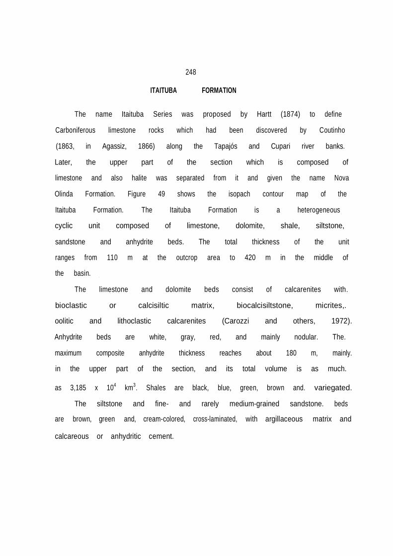
I
248
ITAITUBA FORMATION
The name Itaituba Series was proposed by Hartt (1874) to define
Carboniferous limestone rocks which had been discovered by Coutinho (1863, in Agassiz, 1866) along the Tapajós and Cupari river banks. Later, the upper part of the section which is composed of limestone and also halite was separated from it and given the name Nova Olinda Formation. Figure 49 shows the isopach contour map of the Itaituba Formation. The Itaituba Formation is a heterogeneous
cyclic unit composed of limestone, dolomite, shale, siltstone, sandstone and anhydrite beds. The total thickness of the unit ranges from 110 m at the outcrop area to 420 m in the middle of the basin.
The limestone and dolomite beds consist of calcarenites with.
bioclastic or calcisiltic matrix, biocalcisiltstone, micrites,.
oolitic and lithoclastic calcarenites (Carozzi and others, 1972). Anhydrite beds are white, gray, red, and mainly nodular. The. maximum composite anhydrite thickness reaches about 180 m, mainly. in the upper part of the section, and its total volume is as much. as 3,185 x 104 km3. Shales are black, blue, green, brown and. variegated.
The siltstone and fine- and rarely medium-grained sandstone. beds
are brown, green and, cream-colored, cross-laminated, with argillaceous matrix and calcareous or anhydritic cement.


250
The limestone b_eds predominate in the lower half of the unit and
anhydrite beds in its upper part. The anhydrite beds are rarely
exposed due to present moist conditions in the area, so that only
clastic and rare carbonate sediments crop out. Slump structures are
common in the unit as well as in the overlying Nova Olinda
Formation due to anhydrite solution.
In the southern outcrop belt the Itaituba Formation comprises
thick limestone beds, while in the northern outcrop belt clastic
intercalations are common.
The Itaituba Formation overlies conformably the Monte Alegre
Formation and its basal contact is placed below its lowermost
anhydrite bed. ln the Coari arch, in some pla
ces the Monte Alegre Formation is missing, so that the ltaituba
Formation may overlie unconformably older formations, including
the Precambrian Prosperança Formation. The upper contact is con
formable and it is placed at the base of a clastic section of the
overlying Nova Olinda Formation. On the extremities of the
outcrop area, the ltaituba Formation is unconformably overlain by
the Alter do Chão and Almeirim formations.
The Coari arch migrated eastward in Late Triassic to the
present position of the Purus arch. (See the section of the Itaituba
Formation in the Solimões Basin, figure 21.).
The Itaituba Formation limestone beds contain, by far, the
richest biota fossil found in the Amazonas Basin formations. It has

251
Andean affinities (Mendes, 1959, 1961). The most frequently found
fossils are brachiopods, gastropods, bryozoans, ostracodes, cono- donts, foraminifera, trilobites, corals, cephalopods and fish remains. The most frequently found fossils in shales are the thin-shelled crustaceous Estheriae and plant remains which indi cate fresh to brackish water (Bouman and others, 1960). The pre- sence of the foraminifer genus Plectogira and conodont genera Streptognathus and Ideognathodus suggested to Bouman and others (1960) an Early Pennsylvanian age for the section. Fusulinaceans found in the basal part of the unit were used by Petri (1952) to date the formation as Middle Pennsylvanian. According to Daemon
and Contreiras (1971a,b) the basal beds are considered as laid down in the Westphalian D Stage and the upper beds in the Stephanian Stage on the basis of palynological and micropaleon tological data as discussed in the Monte Alegre Formation section.
The unit was placed in the biostratigraphic intervals XIII
and XIV by Daemon and Contreiras (1971a,b).
The Itaituba Formation records a general transgression with many
sea-level fluctuations which began during the deposition of the upper Monte Alegre Formation, and general regressions represented by the thick anhydrite beds capped by the basal continental clastics of the Nova Olinda Formation.
The Late Carboniferous sea came from the west, at a time when

252
the east end of the basin had been uplifted during the Hercynian Orogeny. This region started to collaps in Jurassic-Cretaceous times generating the Marajó graben.
Carozzi and others (1973) and Carozzi (1979) interpreted the
section as deposited mainly in intertidal and supratidal environ
ments, and only a small part of it as deposited in a shallow sub-
tidal environment along the basin axis. The extent of the area,
of about more than 3,000 km in length from the back arc Andean belt
(Tarma Formation) to the Parnaíba Basin (Piauí Formation) makes
the tidal model unlikely. If the shallow water covering the supposed huge
intertidal area had to be removed from the entire basin during low tides
it would be improbably to evacuate the basin in a few hours. lt
would be impossible to achieve the required high velocities con
sidering that the limestone beds were generally laid down in a low
energy milieu.
Here the environment of deposition is envisaged simply as a
result of sea-level changes and seasonal and climatic fluc-
tuations. Each normal cycle started with lagoonal and lacustrine
clastic deposition in the greater part of the basin and aeolian
and fluvial clastic deposition at its basin margins. Then, the
sea transgressed across wide areas of the flats depositing
limestone beds. In addition, the thickness of limestone beds
depends on the degree of permanence of sea water in the basin and

253
climatic conditions. In the summer, when evaporation exceeds pre- capitation the water level may drop considerably generating a
steady sea water inflow to the basin. At times, the degree of
evaporation may have reached such high levels that it triggered
the precipitation of anhydrite beds. The thicknesses of the anhydrite beds may have been a function of the degree of sulfate concentration in the water, since many limestone beds may have been replaced by anhydrite bodies (Szatmari and others, 1975).
During the deposition of the Itaituba Formation, sedimentary
cycles ended with the deposition of subareal and subaqueous gypsum and anhydrite beds. The scarce deposits of halite found in the unit (only a few centimeters thick) show that there is a deficit of halite deposits, because sea water normally contains about 20 times more NaCl than CaSO4 when in solution. This suggests that a denser salty water outflow took place during Itaituba deposition. Small transgressions and regressions are observed in a few meters of limestone beds (Szatmari and others, 1975) which indicates fre- quent sea-level fluctuations.
Clastic intercalations are thicker and more abundant in the
eastern part of the Amazonas Basin as well as in the western part of the Parnaíba Basin, whereas carbonate and anhydrite beds, respectively, are dominant from the western Amazonas Basin to the Andean basins (Figure 50). Quartz-silt particles in

254
the carbonates suggest aeolian activity rather than aqueous
current activity as mentioned by Carozzi and others (1972).
During the deposition of the ltaituba Formation continental
sediments tended to crowd out marine deposits in the easternmost
portion of the basin because the area was being uplifted. The
major facies changes of the ltaituba Formation is the change from
carbonate to clastics toward the east end of the basin.
The restricted connection with the Paleopacific Ocean at the west of the
continent was probably through a chain of islands since the Tarma Formation
from Peru, shows considerable amounts of anhydrite intercalations (Benavides, 1968)
which also suggests an environment with occasional restrictions.
The Late Carboniferous Amazonas Basin was intermittently con
nected with the Parnaíba Basin. The time equivalent section laid
down in the Parnaíba Basin is largely continental with only few
thin tongues of marine fossilifreous limestone.
The climate during deposition of the Itaituba Formation may
have been arid and the area of the Amazonas Basin may have been
located in the belt of trade winds of high evaporation. The edges
of ice-sheets centralized in South Africa (Crowell and Frakes,
1972) were also present in the Paraná Basin, during the deposition
of the Itaituba Formation evaporites.

255
.-

256
NOVA OLINDA FORMATION
The Nova Olinda Group was proposed by Kistler (1954) to
designate an evaporite sequence occurring above the Itaituba Formation. Later the unit was considered as a formation. The lower portion of this unit occurs along the outcrop belt, but most of it is covered, occurring only in the subsurface. The total thickness of the sequence reaches about 1,650 m in the central parts of the basin. In the outcrop area the thickness measured is incomplete due to the cover of the Alter do Chão and Almeirim formations, but thicknesses of about 250 m (Urupadi and Cupari
rivers) were measured by Caputo and Andrade (1968). Figure 51 shows the isopach contour map of the Nova Olinda Formation.
The unit is composed of halite beds and the same type of
cyclic rocks which occur in the underlying Itaituba Formation. The halite beds range in color from pink to red, sometimes Interlaminated with anhydrite and shale interbeds. Each halite bed has a variable thickness from centimeters up to 100 m. The major concentration of halite is in the upper part of the unit. The composite total thickness of the salt beds is about 505 m in the central parts of the basin (Figure 52), making up about 30% of the total thickness of the formation. The total volurne of halite was
calculated with the aid of a computer to be as much as 3.282 X 10⁴ km3.

257
The anhydrite beds are white to light gray, nodular, massive or interlaminated with halite or shale. The anhydrite beds show a variable thickness, but for the most part they range from 5 to 40 m, but their total composite thickness is about 280 m, making up about 17% of the total section. The total volume calculated is as much as 3.623 x 10⁴ km3. The difference in volume bet- ween anhydrite and halite beds, despite the presence of thicker halite beds, is due to the larger extent of the anhydrite strata than that of halite beds as well as facies-changes from halite to anhydrite beds toward the basin edges. The limestone beds are finer-grained and poorer in fossils than those of the underlying Itaituba Formation.
The sandstone beds are mainly fine-grained, cross-laminated,
variegated, argillaceous and the medium-grained sandstone beds are cross-bedded with regular sorting.
The shale and siltstone beds are black, gray, green, brown
and mainly red in the upper part of the section. In the upper third of the section potash salt occurs in two central areas of the basin with deposits comparable to those of Saskatchewan, Canada (Szatmari and others, 1975).
The Nova Olinda Formation overlies conformably the Itaituba
Formation and the contact is placed below a clastic section of about 25-35 m in thickness, which overlies anhydrite or limestone

•
258

259
beds of the ltaituba Formation. Its upper contact is apparently confor-
mable with the overlying Andirá Formation red beds. In the basin flanks and outcrop area this unit is unconformably overlain by the Alter do Chão and Almeirim formations.
The fossil content of the marine limestone beds consists of
brachiopods, mollusks, foraminifera, conodonts, crinoids, corals, and crustaceans. Some dwarf fossils were observed in the unit. The shale horizons contain plant remains and Estheriae suggesting fresh or brackish water deposition. The age of the unit was determined as Latest Carboniferous to Middle Permian by Daemon and Contreiras (1971a,b) on the basis of palynological studies. The for mation was placed in the upper part of the biostratigraphic inter- val XIV and in the biostratigraphic interval XV.
Most of the fossiis identified in the Nova Olinda Formation
were obtained from wells, but a few fossils from outcrops were studied.
In the Nova Olinda depositional time a rather steady current of
sea water must have moved eastward through the Solimões and Amazonas basins.
The Nova Olinda Formation records many evaporitic cycles with
several subcycles beginning with continental beds at the base, overlain by limestone and ending with salt beds covered by con- tinental beds of another major cycle. Several minor incomplete


261
cycles were also recorded in the unit. The formation is charac- terized by development in stages, which led from marine or non marine carbonate sedimentation to sulphate and from sulphate to chlorine deposition. The deposition of thick halite beds in the Nova Olinda Formation suggests a larger restriction than that occurring during deposition of the underlying Itaituba Formation. The large amount of halite also indicates that the outflow of denser solu- tions was smaller than that which took place during deposition of the Itaituba Formation. The presence of potash deposits indicates that a great volume of water may have been trapped in the basin and may have evaporated without significant dense water outflow. The sill of the basin is inferred to have become very shallow or narrow due to widespread sea-level fall.
The basin was subsiding in the western part and rising in the
eastern part, and the thickest and purest salt deposits were depo sited far from the rising area. Towards the Marajó highs, clastic material appears in the form of impurities and farther east in the form of clay and sandstone beds where the thickness and frequency of carbonate and anhydrite beds decrease and coarse-grained sandstone beds as well as shale and siltstone beds increase.
The halite beds were confined to the western half of the
basin and clastic deposition took place with the growth of the Marajó arch. Rivers may have transported a large amount of

262
clastic material into the eastern side of the Amazonas Basin, freshening the water and preventing chemical precipitation near the shore. The maximum anhydrite and halite thicknesses are found in the western part of the basin where broad downwarping was caused by salt loading. This widespread downwarping may have
concentrated brines and may have caused a basin amplification in its width
increasing the evaporation surface. While the uplift of the eastern part may have caused erosion, and a reduction in its width. This may explain the fan-like shape of the basin.
The distribution of salt and clastic deposits indicates thatthe basin was supplied with sea water only from its western end. The strata of highest salinity are found farthest from the areas where solutions entered the system of basins from the Andean area to the Parnaíba Basin. Equivalent evaporites of the Solimões Basin are free of halite deposits indicating a lower brine concentration
than that of the western Amazonas Basin. The equivalent Copacabana Group section of Peru is almost free of anhydrite and halite deposits (Reyes, 1972), suggesting a proximity to normal marine
water. During deposition of the lowermost Itaituba Formation in the
Solimões Basin, salt deposits were accumulated in it. At this time the Coari arch was the eastern boundary of the Solimões Basin and the site of highest degree of salinity was located in the

•
263
eastern Solimões Basin, that is, in the part farthest from where saline solutions ingressed the basin. However, when the Coari arch was transgressed by the sea, the zone of maximum salt concentration migrated to the western Amazonas Basin where thick halite deposits accumulated in the Nova Olinda Formation.
During deposition of the Itaituba and Nova Olinda formations
the northern flank received more clastics than the southern flank. Moreover, the position of the depocenter was displaced about 70 km southwards. Carozzi and others (1973) interpreted this displace- ment as due to transcurrent movements in a NE-SW direction. It is unlikely that during the Early Permian time transcurrent faults occurred in the Amazonas Basin because from Carboniferous to Jurassic times diabase intrusions took place in the area suggesting distension rather than shearing. A probable explana tion for the depocenter displacement and larger clastic supply in
the northern flank could be an epeirogenetic uplift in the Rio Branco arch (Amaral, 1974) located in the Guyana shield that gave origin to the Takutu rift.
Contrary to a rather widely held opinion that the climate of the Amazonas Pennsylvanian to Permian times must have been cold because of glaciation during these periods in south Brazil (Paraná Basin), the direct evidence of the thick-shelled, profuse fauna and extensive carbonate and halite deposition indicates a dry and warm climate

264
throughout the northern Brazilian basins. Evaporation of water in Solimões and Amazonas basins caused a continental inflow of the less saline waters of the Paleopacific Ocean.
The Amazonas Basin during deposition of the Nova Olinda
Formation was located in a trade wind belt of high evaporation. It is interesting to notice that the major halite and silvinitic accumulation took place in the Mid-Permian time when in the Paraná
Basin ice caps had already evacuated the basin. In that time, only in Australia and probably in Antarctica, glaciation was active in Gondwana (Crowell and Frakes, 1971). In Early Permian
times the halite deposits were less developed.
ANDIRÁ FORMATION
The name Andirá Formation was introduced by Caputo and others.
(1971) to describe a section composed of red beds located at the
top of the Paleozoic sequence. A thickness of 645 meters was
measured in the well 1-AD-1a-AM (Andira). Its maximum thickness is
estimated to be about 720 m in central parts of the basin. Figure 53 shows the isopach contour map of the Andirá Formation.
The Andirá Formation comprises red, brown, light green, light gray to dark gray and black, micaceous, soft siltstone, shale and mudstone beds with intercalations of chert and limestone beds.
Subordinate sandstone beds are fine-grained, argillaceous,


266
calcareous, laminated and micaceous with parallel- and cross
stratification. Towards the east of the basin, a change to a dominantly sandy facies is present.
In the middle of the section there are light gray, white or brown,
argillaceous, pyritic limestone which grade to dolomite and chert beds and also are present two pink or black anhydrite beds, very characteristic in the section.
The Andirá Formation overlies conformably the Nova Olinda
Formation and is unconformably overlain by the Alter do Chão and Almeirim Formations with a low angle of as much as 20 minutes (5m/km) ).
This unit is only present in the subsurface in the flanks and central portions of the basin. It is absent in most parts of the eastern side of the basin where it was uplifted and eroded.
No index macrofossils have been found in the Andirá Formation and the biota comprises some Estheridae, fish scales and ostraco des, which suggest fresh or brackish water environment (Bouman and
others, 1960).
The age of the formation was determined by Daemon and Contreiras (1971a,b), on the basis of palynological data, as Late Permian, corresponding to the biostratigraphic interval XVI. The spores are similar to those found in Late Permian sediments of the Paraná Basin. It is inferred here that sedimentation may have ended in the earliest Triassic time. The most common sporomorphs

267
found are according to Lima (1982,· written communication):
Sporomorphs: Protohaploxypinus sp., Vittatina sp., Punctatosporites cf.
rotundus Bhardwaj, Lueckisporites cf. virkkiae (Pot. and Kl.), Hamiapollenites.
From Late Permian to Middle Triassic time a major regression
took place on Earth resulting in a worldwide sea withdrawal from
the shelves and from interior basins (Hallam, 1977).
The Andirá Formation records the transformation of an eva-
poritic marine to a continental basin where sedimentation took place
without a marine influence. Lake and playa deposits in the
central parts of the basin may have existed at the base of
the formation as indicated by Estheridae and black shales and fresh
water limestone beds. On the periphery of the basin fluvio-
aeolian sediments and mud and debris flows may have predominated.
Much of the edges of the formation were removed by later erosion.
Loess sediments in the source areas may have been important as
suggested by the great amount of siltstone beds in the section.
In the upper beds, lacustrine conditions may have graded eastward
into fluvial and aeolian conditions as suggested by larger grain
size sediments in the eastern edge of the basin.
The Amazonas Basin began to shrank during the deposition of the Andirá
Formation, so that some previously deposited Paleozoic formations,
may have been eroded at its edges and redeposited in its flanks and central

'
268
parts. During deposition of the Andirá Formation the eastern end of the basin was rising as indicated by the development of medium- grained sandstone beds and small thickness of the section in that direction, while the western portion was subsiding. The sea
receded towards the west abandoning also the eastern Andean belt where the Andean Late Permian Mitu Group composed of red beds and halite was deposited above the Early to Mid-Permian Copacabana
Group.
Szatmari and others (1975) pointed out that the Paleozoic post-evaporitic sequence of the Solimões (Fonte Boa Formation) and Amazonas basins (Andirá Formation) is a distal molassic deposit resulting from erosion of the Andean ranges during and immediately succeeding the Tardihercynian orogenic phase which lasted from 265 to 260 m.y. ago. This orogeny is important in Chile, Argentina·, Bolivia and Peru where post-tectonic Late Permian molasse units overlie folded rocks with angular unconformity.
In northern Bolivia the deformations are less Intense and in
northern Peru the deformation phase is not recognized and upper Permian strata rests conformably on the lower Permian sediments {Dalmayrac and others, 1980). In Colombia, in the eastern Andes, the Late Hercynian orogeny is not important, and correlative molasse deposits as old as Triassic-Jurassic were laid down far away from the Solimões Basin (Cediel, 1972). Drainage from the

..
269
Solimões and Amazonas basins was directed toward the Andean area,
so it is more likely that the source areas of the Andirá Formation
were not located in the Andes. Probably, source areas of the
Andirá Formation were situated in the Guyana and Guaporé shields
as well as in the Marajó region in Late Permian time.
The climatic conditions during deposition of the unit may
have been the same as those prevailing during the accumulation
of the Nova Olinda Formation. Deposition of this unit is viewed as located
in the trade wind belt of high evaporation, as suggested by the
presence of anhydrite, limestone, red beds and aeolian deposits.
During Late Permian time, world warm and hot climatic belts may
have expanded due to the shrinkage of the polar ices. In the
early Late Permian (Kazanian Stage) evidence for limited glaciation exists
in Tasmania (Crowell and Frakes, 1971), but there
is no evidence for glaciation in Gondwana in late Late Permian
time.
PENATECAUA DIABASE
The name Penatecaua diabase was proposed by Issler and others
(1974) to designate tholeiitic magmatic rocks which were emplaced
in the Amazonas Basin from Permian to Jurassic times. The diabase
rocks are made up mainly of plagioclase, pyroxene, ilmenite and magnetite
minerals displaying an ophitic texture. The Paleozoic and older

270
sediments were intruded by diabase dikes and sills, with thicknesses that range from a few meters to more than 200 m. The composite sill thickness reaches more than 700 m. The dike
thicknesses range from about 5 to 25 m in the outcrop area, but seismological surveys have shown dikes as thick as 1 km or more. Dikes which exceed 20 km in length were mapped in the southern outcrop belt by Caputo and Andrade (1968). The dikes follow N25ºE and N40ºE trends in the southern outcrop belt and a few dikes follow an E-W direction (Caputo and Andrade, 1968). In the northern outcrop belt a N25º-35ºE trend is the most common, but
also N10º-30ºW, N55º-65ºW and N70º-85ºE trends were observed (Bischoff, 1963). No extrusive rocks are known related to the Penatecaua event in the Amazonas Basin.
The analysis of these rocks by radiometric determinations
allowed Thomaz Filho and others (1974) on the basis of K/Ar method to establish the beginning of the magmatism in Early Permian and the end of it in the Jurassic time. They recognized at least 2 cycles of magmatic activity; the first from Early Permian to Late Triassic time and the second in the Jurassic time. No Cretaceous basic igneous activity was observed in the Amazonas Basin, although it was observed in the Parnaíba and Paraná basins.
The first magmatic cycle of the Amazonas Basin is correlated
with tectonic events related to the opening of the North Atlantic

.
271
Ocean and the second is correlated with the opening of the South Atlantic Ocean (Thomaz Filho and others, 1974). The long-lasted magmatic activity may have elevated the ground surface preventing sedimentary deposition during the igneous activity when erosion took place. The drainage system may have continued towards the Andean belt area during that time and perhaps when isostatic equilibrium was achieved, subsidence began again in the Cretaceous Period.
ALTER OO CHÃO FORMATION The name Alter do Chão Formation was first used by Kistler
(1954) to define red beds that overlie the Paleozoic section of the Amazonas Basin. The term Barreiras derived from Late Tertiary sediments occurring in the eastern Brazilian coast has erroneously been applied to this formation. I favor the name Alter do Chão in order to designate the Cretaceous red beds section that are separated from Tertiary red beds by an unconformity. Figure 54 shows the isopach contour map of the Alter do Chão and Almeirim formations.
The formation, up to 600 m thick in the middle of the basin,
consists of sandstone, siltstone and mudstone beds with some conglomerate interbeds. The sandstone beds are fine- to medium- grained, red, variegated, kaolinic, argillaceous, soft and generally cross-bedded with cut and fill structures. Subordinate,
272
compact, silicified, white to cream-colored and yellow sandstone beds
(Manaus Sandstone, Albuquerque, 1922; Travessões Sandstone, De Carvalho, 1926)
with scattered quartz granules and pebbles are also present in the section. Mudstone and siltstone beds are soft, brick red and variegated. The conglomerates fill paleochan nels in the other types of sediments of the formation. Many limo nitic bands occur throughout the section, which is generally massive. At the top of the unit, in plateaus, bauxite deposits are present.
The Alter do Chão Formation partly overlies Paleozoic sedi-ments disconformably. On the western side of the basin it is unconformably overlain by the Solimöes Formation and eastward from
the Monte Alegre dome the unit is truncated by the Almeirim Formation.
The Alter do Chão Formation is relatively poor in fossils.
Plant remains were found in the Paituna hill, in the Monte Alegre area and fish and dinosaur teeth and vertebrate bone fragments were found in wells drilled by Petrobras. Dicotyledonous plants
indicate, at least, an age as old as Late Cretaceous. Price (1960) identified a large Theropoda tooth (Carnivorous reptile dinosaur) from the borehole 1-N0-1-AM (Nova Olinda), indicating a Late Cretaceous age for the lower part of the section.
Some core samples from wells that I gave to Daemon and

p
"'

274
Contreiras (1971a,b) furnished a Late Cretaceous age and later Daemon (1975) assigned a Middle Albian to Turonian age to the Alter do Chão Formation on the basis of palynological grounds.
The nature of the sediments, red color and continental
fossils indicate that the Alter do Chão was deposited in alluvial fans and alluvial plains.
The source areas for the Alter do Chão clastics were located
in the Guyana and Guaporé shields as well as the estern Marajó rift shoulder (Gurupá arch). The proximal conglomerate beds seen in the outcrop area suggest that basement was the primary source of sediments,
although part of the Paleozoic section also may have furnished some detrital material to the Alter do Chão Formation. The ele vated area of the Gurupá arch was under erosion while the Marajó rift was being filled with sediments. Part of the western flank of the Gurupá high is now the western shoulder of the Marajó graben and is called Gurupá arch separating the Amazonas Basin from the marginal rifted Marajó Basin. In the western Marajó basin shoulder and in part of the eastern Amazonas Basin, the Alter do Chão Formation is absent with only Tertiary sediments overlying Paleozoic and basement rocks. This suggests that the Marajó area was uplifted and the deposition of the Alter do Chão Formation took place westward from the western side of the Marajó Basin. The drainage system continued toward the Solimões, Acre

275
and Andean basins.
The uplift of the Gurupá arch may have blocked the main
drainage system from the Parnaíba Basin, since Permian to Early Cretaceous time, so its drainage system may have been directed northtward to the Marajó Basin and Atlantic Ocean. This conclusion is contrary to Petri and Campanha's (1981) view who stressed the idea that the river system responsible for the deposition of the Alter do Chão Formation may have drained towards the coastal Barreirinha Basin, north of
the Parnaíba Basin. The Amazonas river headwater was located in the Gurupá area. The Alter do Chão Formation was laid down under tropical
conditions. The absence of anhydrite in the red beds may suggest humid conditions during their deposition, and the absence of coal may indicate that the enviroment was not sufficiently moist for its development. Some iron bands may indicate periods of laterite formation under seasonal, more moist conditions.
ALMEIRIM FORMATION
The Almeirim Formation is here proposed to designate a thick Tertiary section composed of red beds occurring in the eastern Amazonas Basin. The name is derived from the borehole Almeirim
(2-AL-1-AM) in the eastern side of the basin where 1250 m of Tertiary sediments were drilled and the section may be completed with outcrops occurring in the Almeirim hills area. The Almeirim

276
beds appear similar to the Alter do Chão beds, but are separated
by a disconformity. The individualization of this unit is
justified due to its paleotectonic and paleogeographic signifi-
cance.
The formation consists of poorly consolidated sandstone, siltstone
and claystone red beds. The sandstone beds are mainly
coarse-grained to conglomeratic, cross-bedded, poorly sorted, red
stained, kaolinitic and friable with most grains subangular. The
siltstone and shale beds are generally red and brown, massive or
poorly laminated and soft with some kaolinitic clay interbeds.
The Almeirim Formation overlies unconformably all older sedi-
ments and represents the last wide cover of the eastern Amazonas Basin.
The boundary with the Alter do Chão Formation is not
clear; some faulting may have been involved during its deposition
as was observed in seismic lines made by Petrobras, but the Almeirim
Formation also may onlap westward the Alter do Chão Formation.
Laterally, the unit is synchronous with the Marajó Formation and
the Pará Group of the Marajó Basin and in the Pará and Amapá
shelves offshore. The section grades into marine sediments from
the western shoulder of the Marajó Basin (Gurupá arch) to
the offshore Pará and Amapá areas.
Cores from wells located above 50 m from the base of the for-
mation yielded palynomorphs which were determined by Daemon and
-~
277
Contreiras (1971a,b) to be as old as Paleocene to Eocene.
Possibly in the central and eastern part of the basin the Almeirim
sedimentation may have started earlier.
Sporomorphs: Spinizonocolpites echinatus Muller and
Bombacacidites sp.
The Almeirim Formation represents deposition in alluvial
plain environments in which the rivers may have been predominantly
braided. Part of the drainage system, after the collapse of the Marajó Graben
may have been directed toward the marginal rifted Marajó Basin and
the source area may have been located in the Guyana and Guaporé shields
as well as the western Amazonas Basin.
From Oligocene or Miocene times onwards, the Andean belt may have
also contributed with large amounts of sediments due to the total
reversal of the drainage system to the Atlantic Ocean.
The sustained uplift in the Marajó area which probably began
in Carboniferous time is interpreted as resulting from
uplift doming which preceded the rifting that opened the North
Atlantic Ocean.
According to a model proposed by Kinsman (1975) an early
domal uplift occurs over a deep mantle plume which ruptures and
forms an extensional fault system with grabens and horsts. The
crustal elevated areas are thinned due to erosion and extension and
when cooled they subside below sea level forming the continental

278
shelves and slopes. Both early features exist above sea level, as the underlying lithosphere continues cooling, the con- tinental shelves and slope subside below sea level. The break in the continental slope may mark the boundary between continental and oceanic crust. Due to a great supply of sediment to the Mouth of Amazon River in Tertiary time, the eastern Amazonas Basin was not invaded by the sea due a peripheral bulge during subsidence as a result of the cooling of the lithosphere.
Thus, the Almeirim Formation records the subsidence that took
place when the lithosphere was cooling. While the eastern side of the Amazonas Basin was subsiding the western side of the Amazonas Basin was rising, so that there is Alter do Chão Formation sedi- ments occurring in uplifted plateaus as high as 250 m in the
Tapajós area.
In Tertiary time, the Amazonas Basin enjoyed a moist tropical
climate as evidenced by red beds without evaporites. However, the Tertiary Solimões Formation of the Solimões Basin contains some anhydrite crystal that suggests a drier climate towards the west (Acre Basin) prior to Pliocene times.

279
CHAPTER 10. PARNAÍBA BASIN
Pioneer geological surveys carried out in the Parnaíba Basin
date from 1870 (Rodrigues, 1967), but systematic works started in
1913 and 1914 by Small with reconnaissance surveys. Paleonto- logical and geological studies were carried out by Lisboa (1914), Duarte (1936), De Paiva (1937), Caster (1947a,b, 1952), Plummer (1948), Campbell and others (1948), Campbell (1949) and Albuquerque and Dequech (1950), Kegel (1951, 1953, 1956), Santos (1945, 1953), Blankennagel (1952) and Blankennagel and Kremer (1954). Regional works were conducted by Kegel (1953), Mesner and Wooldridge (1964), Bigarella and others (1965), Beurlen (1965), Barbosa and others (1966), Rodrigues (1967), Aguiar (1969, 1971), Carozzi and others (1975), Mabesoone (1977), Lima and Leite (1978), Schneider and others (1979), and Carozzt (1980).
From 1954 to 1967 many detailed stratigraphic and structural
field surveys were carried out by geologists and by me working for Petrobras. Recently, geological surveys are being undertaken by public institutions (Departamento Nacional da Produção Mineral, Campania de Pesquisas de Recursos Minerais, and Universities).
Different lithostratigraphic subdivisions have been advocated
by pioneer investigators, but, unfortunately, other researchers have discarded them, pointing out that some rock assembages are not extensive mapping units. However, these local facies dif-

280
ferences are important to understand the overall basin stra
tigraphic framework and should be considered. Other problems are that some investigators do not take into account subsurface data
when mapping, while other geologists disregard field work when studying subsurface data. The stratigraphic column of the basin is shown in Figure 26, beginning with the Serra Grande Group depo-
sited during Ordovician-Silurian time. Figure 55 shows the Parnaíba Basin boreholes index map; figure 56 shows a cross
section along the Parnaíba Basin and figure 57 shows the basement
contour map the Parnaíba Basin.
SERRA GRANDE GROUP The term Serra Grande was proposed by Small (1914) to
describe a section as much as 900 m thick composed of sandstone, conglomerate and limestone. The underlying folded limestone beds were
excluded by Kegel (1953) due to the presence of an angular uncon formity between the sandstone and limestone beds. The Serra Grande
section is one of the most controversial units of the stra
tigraphic column of the Parnaíba Basin; many subdivisions are far from being unanimously accepted and different age assignments have been proposed for it. Here the unit is considered as a group and
is subdivided into three formations which are from bottom upwards:: Ipu, Tianguá and Jaicós Formations. All three are

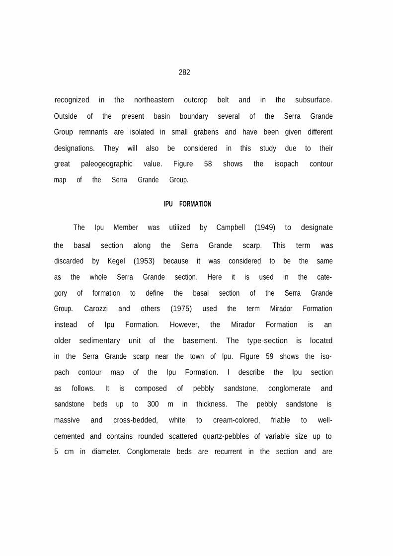
282
recognized in the northeastern outcrop belt and in the subsurface. Outside of the present basin boundary several of the Serra Grande
Group remnants are isolated in small grabens and have been given different designations. They will also be considered in this study due to their
great paleogeographic value. Figure 58 shows the isopach contour map of the Serra Grande Group.
IPU FORMATION The Ipu Member was utilized by Campbell (1949) to designate
the basal section along the Serra Grande ·scarp. This term was
discarded by Kegel (1953) because it was considered to be the same as the whole Serra Grande section. Here it is used in the cate- gory of formation to define the basal section of the Serra Grande
Group. Carozzi and others (1975) used the term Mirador Formation instead of Ipu Formation. However, the Mirador Formation is an older sedimentary unit of the basement. The type-section is located
in the Serra Grande scarp near the town of Ipu. Figure 59 shows the iso-
pach contour map of the Ipu Formation. I describe the Ipu section as follows. It is composed of pebbly sandstone, conglomerate and
sandstone beds up to 300 m in thickness. The pebbly sandstone is massive and cross-bedded, white to cream-colored, friable to well- cemented and contains rounded scattered quartz-pebbles of variable size up to
5 cm in diameter. Conglomerate beds are recurrent in the section and are

283
,,
284
composed mainly of white to light-gray quartz and quartzite
boulders with a sandy and clayey matrix. At several places,
rounded boulders over 20 cm in diameter are observed in the sec-
tion. In the Serra Vermelha area, diamictite beds as thick as
6 meters contain quartz, quartzite, fine-grained sandstone and
crystalline clasts within a massive sandy and clayey matrix, and
in the Serra da Capivara area these diamictite beds are as thick
as 20 m.
The sandstone beds are fine- to coarse-grained, massive to
strongly cross-bedded, poorly sorted, argillaceous and micaceous,
white to light gray.
White grains, considered as of kaolinitic nature, are
actually agglutinated micro-quartz grains according to sedimen-
tological analysis (Beurlen, 1965).
Kegel (1953) described some faceted pebbles from the section,
but he did not observe striated pebbles in it.
In the subsurface, the coarse clastic rocks change to predo
minantly fine- to medium-grained, light-gray to light-green
sandstone beds with some micaceous sandstone interbeds. The unit
thins westward to Tocantins arch, whereas it thickens in a north-
eastern direction (Ipu area). On the north side of the basin gray
diamictite beds occur at the top of the section in wells, as for example,
the 1-CI-1-MA (Cocalinho stratigraphic well number 1) drilled by Petrobras.

285
The eastern outcrop belt of the basin is located 600 km away
from the northeastern Brazilian coast. In the area between the coast and the Parnaíba Basin outcrop belt several remnants of the Serra Grande Group have been described by Mabesoone (1977) in downfaulted depressions as at the Mirandiba, Rio do Peixe, Cariri
valley, Jatobá and Sergipe-Alagoas Basin areas.
In the Cariri valley part of the Serra Grande conglomerate described by Mabesoone (1977) is considered as a true diamictite composed of dispersed rounded and angular pebbles and cobbles derived from igneous and metamorphic rocks of the base- ment, supported by a sandy and clayey groundmass.
At the margins of the Jatobá Basin the basal section also contains thick conglomerate beds comprising the Tacarutu Formation which is equivalent to the Serra Grande Group. In the Sergipe-Alagoas coastal Basin, the lowermost section comprises the Atalaia and the Mulungu members of the Batinga Formation. The Mulungu Member consists of gray or red-maroon sandy diamictites
with inclusions of chaotically dispersed fragments of quartz, quartzite, granite, phyllite, gneiss, micaschist and other metase- dimentary rocks in a silty and sandy groundmass (Schaller, 1969; Rocha-Campos, 1981a) with some shale interbedded beds. It grades upwards and laterally into finely-stratified pebbly sandstone or
tillite and rhythmite (Rocha-Campos, 1981) crowded with

286

287
centimeter-sized clasts. The tillite has abundant and unoriented clasts; some are faceted and striated, particularly those clasts of soft constitution (Rocha-Campos, 1981a).
Despite the wide extent and thickness of the Ipu and its
equivalent formations outside the Parnaíba Basin, the unit shows a remarkable facies everywhere in the outcrop area, characterized by
fining upwards coarse clastics, and some diamictite beds.
There is a difference in elevation in the basement of more
than 300 m along the basin margins, which suggested to Kegel (1953) that the basement surface was not planar. However, I find that the basement was an almost plane surface when deposition started; the elevation differences are due to differential sub sidence in the depocenter, now exposed (Figure 59). A broad uplift in the eastern and northern sides of the basin from Carboniferous to Mesozoic times, removed a large part of the section of the basin exposing its northeastern trending depositional axes (Figure 58) in the Ipu area, where the basement shows the lowest elevation and the Ipu Formation the largest thickness. The deep erosional retreat has removed a large part of the basin, so that a roughly N-S cross-section of the Serra Grande Group is displayed along the eastern basin escarp- ments.
In the Sergipe-Alagoas basin, close to the northeast coast of
Brazil, underlying the Mulungu Formation, the basement surface is

288

/
289
irregular and ondulating, showing parallel elongated, polished and
finely striated low bosses, trending N45ºW (Rocha-Campos, 1981a).
The Ipu Formation rests unconformably on Precambrian to Early
Ordovician igneous, metamorphic and sedimentary rocks. In most of
the Parnaíba Basin the Ipu Formation is overlain conformably by
the Tianguá Formation.
Only one fossil was found and tentatively identified as
Arthrophycus sp. by Moore (1963), which would indicate an
Ordovician-Silurian age. Age assignments for the unit were
Cretaceous (Small, 1914); Carboniferous (Plummer, 1946, 1948);
Early Devonian (Blankennagel, 1952; Kegel, 1953); Silurian-Devon
ian (Aguiar, 1971); Late Silurian (Mabesoone 1977; Mesner and Wooldridge, 1964
and Quadros, 1982); Ordovician Brito (1969) and
Bigarella (1973b,c). Modern palynological studies proved that the
overlying Itaím Formation is Emsian (late Early Devonian) to
Eifelian (early Mid-Devonian) so the Ipu Formation cannot be
younger than Emsian.
This study considers the Ipu Formation as old as Late
Ordovician to Earliest Silurian. This is so because there is an
unconformity between the Serra Grande Group and the Itaim
Formation of Devonian age. In addition, the Ipu Formation is con-
formably overlain by transgressive Early Silurian shales of the
Tianguá Formation. Finally, the diamictites of supposed glacial

290

,,
291
origin in top of the unit can be correlated with glacial diamictites, located in an equivalent stratigraphic position, existing in northwest Africa. This hints as well at a Late
Ordovician to Early Silurian age.
In he Sergipe-Alagoas Basin, there is also controversy over the age of the Mulungu tillites. They have been considered as
Late Carboniferous in age on the basis of spores (Florinites) found in the overlying shales of the Boacica Member of the Batinga Formation. However, in the adjacent Jatobá and Parnaíba basins,
Late Carboniferous limestone, anhydrite, aeolian sandstone and red beds may have been deposited in low-middle latitude areas under arid con- ditions as suggested by its rock assemblage. These hot arid con-
ditions are very distinct from those indicated by the cold environment Mulungu Member of the Sergipe-Alagoas Basin. An unconformity should exist between the Mulungu tillites and the
overlying Batinga Formation. The correlation between the upper Ipu Formation of the Parnaíba Basin and the Mulungu Member of the Sergipe-Alagoas Basin is here proposed due to their sedimentary
affinities. The Mulungu Member should be raised to the category of an independent formation whose age may be Late Ordovician to earliest Silurian (Figures 2, 94).
The Ipu Formation correlates in age with the Nhamundá
Formation of the Amazonas Basin, although the general facies of
.
292
both units are different in their respective outcrop areas.
However, towards the Tocantins arch electric well logs of the Ipu Formation show good correlation with those of the Nhamundá Formation of the Amazonas Basin. The Ipu Formation also probably correlates with the Asemkaw and Ajua formations (described in the 13th chapter) of the Accra Basin of Ghana (Talbot, 1981) close to Volta Basin.
Kegel (1953) and Beurlen (1970) interpreted the deposits of
the Ipu Formation (Lower Serra Grande Group) as being of fluvial origin. Bigarella and others (1965) regarded the unit as laid down in a nearshore environment. It is unlikely that the Ipu Formation was deposited in a single environment because its great thickness, width (more than 600 km) in the outcrop area and wide grain-size range. Carozzi and others (1975) interpreted its depo- sitional environment as a result of sedimentation in coalescent deltas, whereas Mabesoone (1977) envisaged the Serra Grande Group (of which the Ipu Formation is the basal unit) as laid down in a submarine fan environment with relatively strong relief, at sites where escarpments and cliffs decrease in steepness. Mabesoone (1978) also viewed the Serra Grande as formed in a marine shallow water milieu in the outcrop area. Schneider and others (1979) regarded the basal Serra Grande clastics as deposited in alluvial and delta fan environments.
Taking into account the broad areal extent, the cratonic

293
setting of the basin, the abundant cross-bedding, the scarcity of the clay fraction and lack of graded beds it is unlikely that the Ipu Formation was laid down in a submarine-fan environment according to Mabesoone (1977).
The lithological features of the Ipu Formation from the
northeast Brazilian coast down to the basin suggest a wide environmental range from proximal glacial and glaciofluvial (outwash or sandur deposits) in the outcrop eastern flank and delta fan and delta fan front environments in the central parts of the Parnaíba Basin. The volume of sediments laid down in the eastern side of the basin and the ice load was so large that it induced strong
subsidence in the present eastern outcrop area of the Parnaíba basin. The thickness of the Ipu Formation decreases toward the central part of the basin as observed in wells drilled in the area. In the western part of the basin the diamictite pinches out before reaching the outcrop area on the other side of the basin.
The formation also includes deposits possibly originating from the
wearing down of highlands in Africa. In a Gondwanan reconstruc tion, South America has to be rotated 45º counterclockwise in order to fit Africa, so that any common trend to both continents found in South America is rotated 45 in relation to Africa. The ice striations trending N45ºW (Rocha-Campos, 1981a) in the Sergipe-Alagoas Basin correspond to supposed Late Ordovician-Early

294
Silurian ice striations trending N90W in Gabon (Micholet and
others, 1971), Africa. The striation trend in the Sergipe-Alagoas basin is in good agreement with the well established glacial center in a region south of Sahara.
Ice striations are trending outward from a glacial center in
a northern direction in the Sahara region and in a northwest direction in South America. The general westward trending
paleocurrents (Bigarella and others, 1965) also suggest a source
of sediments to the Parnaíba Basin from the southeast (east in relation to Africa).
TIANGUÁ FORMATION
The Tianguá Member of the Serra Grande Formation was proposed
by Rodrigues (1967) to designate a section composed o gray shale and fine-grained sandstone beds occurring in the subsurface and in the
northeastern outcrop belt. Carozzi and others (1975) raised it to the category of formation. Figure 60 shows the isopach map of the Tianguá Formation.
The Tianguá Formation was subdivided into three members from bottom to top which consist of (1) dark-grey, bioturbated, mica- ceous, sideritic, and carbonaceous mudstone beds with dark-gray shale and siltstone intercalations followed by (2) light-gray,
feldspathic fine- to medium-grained sandstone beds and
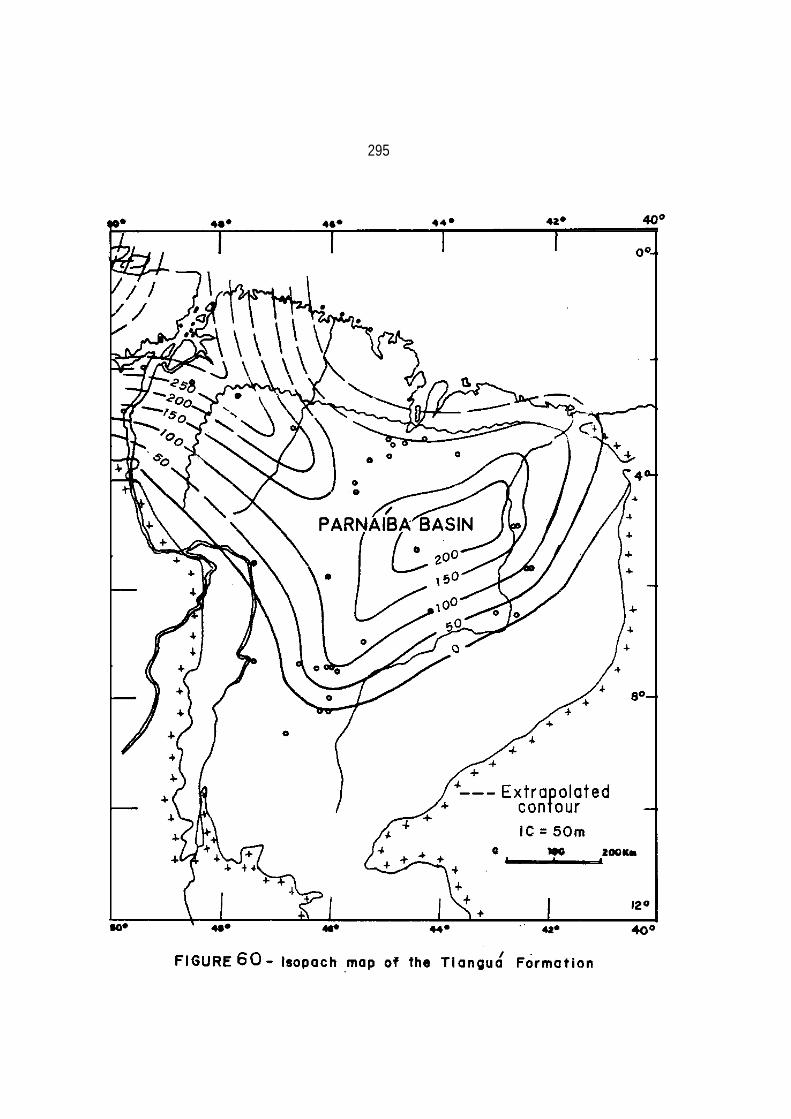
295

296
(3) dark-gray to greenish dark-gray, micaceous, sideritic, bioturbated
shale with sand grain inclusions (glaciomarine ?) and siltstone intercalations.
The formation overlies conformably the Ipu Formation and it is in turn conformably overlain by the Jaicós Formation. It crops
out only in a small area from Tianguá to Ipueiras towns in the northeastern outcrop belt, while it changes its facies to sandstone towards the eastern and southern outcrop belts.
In the Tianguá area, the Tianguá Formation occurs 91 m above the base of the group and is about 22 m thick, consisting of interlayered siltstone and very fine sandstone. In the Ipu area,
a covered interval occurring 233 m above the base of the Serra Grande Group is considered to be the Tianguá Formation with a pro- bable thickness of about 25 m. In the subsurface its thickness increases up to 270 m toward a northwest direction. The unit is truncated northward towards the coast, where the shales do not show marginal facies as observed in Figure 61, suggesting a con
tinuity toward Ghana.
Apart from track and trail fossils, no macrofossils were found. Mesner and Wooldridge (1964) assigned a Late Silurian age to their upper Serra Grande Member which corresponds here to the Tianguá Formation based on palynological studies carried out by Müller (1962). New studies carried out by Carozzi and others (1975) considered the Tianguá Formation as Early Silurian to Early

..
297

298
Devonian (Early Emsian). They pointed out that no sedimentary break had been observed corresponding to the Late Silurian because of active sedimentation process and they stressed that the
apparent chronostratigraphic gap in the Amazonas Basin was pro bably due to lack of cores, or to inadequate preservation of pollen since in both basins lithostratigraphic contacts are
clearly gradational.
I do not agree with this explanation. An in-depth palynolo gical study was carried out by Daemon and Contreiras (1971a,b) in order to determine the stratigraphical relationship between the Trombetas Group and the Maecuru Formation. No macrofossils or microfossils indicate a Late Silurian (Ludlovian) or Early
Devonian (Gedinian and Siegenian) stages. The only Early Devonian stage represented is the Late Emsian. The unconformable contact between the Trombetas Group and the Maecuru Formation is well marked on the basis of palynological and paleontological data in the Amazonas Basin.
In the chronostratigraphic and lithostratigraphic column of
the Parnaíba Basin presented by Carozzi and others (1975), Wenlockian, Ludlovian, Gedinian and Siegenian stages (from Mid Silurian to mid Early Devonian) are missing. This clearly suggests a gap in the sedimentation not explained by Carozzi and
others (1975). The Tianguá Formation yielded similar palynomorphs

299

300
to those of the Amazonas Basin biostratigraphic interval III of
Daemon and Contreiras (1971a,b) according to Carozzi and others (1975), corresponding to the Early to the Midle Llandoverian stages (Early Silurian). Its palynological content is very similar to that of the Pitinga Formation of the Amazonas Basin. So, this suggests a same age assignment for both formations.
The Tianguá Formation is considered to have been deposited
during the maximum worldwise transgression which occurred after the melting of most of the Late Ordovician-Earliest Silurian African and South American ice-caps, during late Early to Middle Llandoverian stages (Figure 61). It onlaps the Ipu Formation in the western side of the basin. In these conditions the Tianguá Formation is corre- lated with the Pitinga Formation of the Amazonas Basin and both
units record the same transgressive event. The Tianguá Formation
may also correlate with the Ajua Formation of Ghana, Accra Basin (Crow, 1952) and it pinches out toward most of the outcrop area (Figure 62). The lower member of the Tianguá Formation is a result of fine clastic deposition in an offshore, pro-fan and lower shoreface milieu. The lateral equivalent environment may be fan delta front and fan delta recorded by fine-grained parallel laminated and coarse-grained sandstone beds respectively of the Ipu Formation.

301
The middle member may represent a fan delta front prograda- tion resulting from a minor regression. The upper member shale probably records a deepening in the depositional environment. Ice retreat and advance may have played an important role in the transgressive and regressive units of the Tianguá Formation. Part of the Ipu Formation and part of the overlying Jaicós Formation represent lateral and marginal facies of the Tianguá Formation in most of the outcrop area, where shale beds are replaced by sandstone beds. Some thin sandstone interbeds in
the Tianguá Formation may represent storm-derived deposits.
The presence of a large number of bioturbations in the shales
indicates a low rate of deposition. The climate may have changed from glacial arctic to subarctic. The absence of limestones and other warm climatic indicators also corroborate the predominance of a very cold climate.
JAICÓS FORMATION
The name Jaicós Formation was proposed by Plummer (1946, 1948) to designate sandstone and conglomerate beds occurring in the Serra Grande escarpments, but because the designation Serra Grande (Small, 1914) had priority the term Jaicós became useless. Rodrigues (1967) revalidated it to designate the same section of Plummer, but Carozzi and others (1975) redefined the unit to
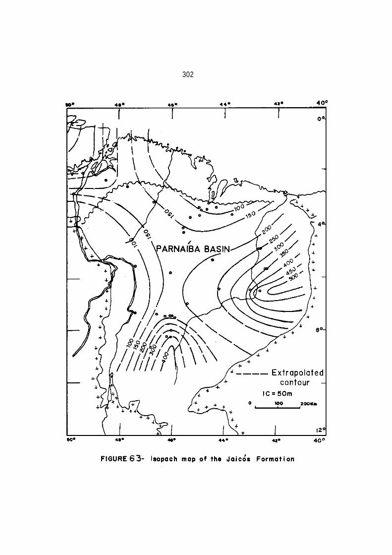
302

303
describe the section above the Tianguá Formation. Here Carozzi´s definition
is maintained, although the position of its upper boun dary is controversial. This section corresponds to the lower part
of the ltaím Member of the Pimenteira Formation as considered by Mesner and Wooldridge (1964).
Its maximum thickness is estimated to be over 500 m in the
eastern border of the Parnaíba Basin. Figure 63 shows the isopach contour map of the Jaicós Formation.
The unit is made up of gray, light-gray, cream-colored, brown
and buff, angular to subangular coarse-grained and gravely sandstone with dispersed pebbles from 2 to 6 cm in diameter. The sandstone is massive or cross-bedded and lenticular, poorly sorted, and friable. Basal cross-bedded conglomerates are common, and the unit is mineralogically and texturally immature.
The Jaicós Formation rests conformably on the Tianguá
Formation and is disconformably overlain by the Devonian ltaím or
Pimenteira formations or by the Cretaceous Urucuia Formation. The disconformity between the Jaicós and ltaím formations is very
difficult to identify, because both units are sandy, so many
geologists do not recognize it.
Kegel (1953) indicated one place where the contact could be disconformable based on field criteria. The unconformity is
better seen between the Pimenteira shales and Jaicós Formation

304
when the Ita·ím Formation is missing.
No macrofossils were detected in the Jaicós Formation, but some sporomorphs determined in shale interbeds found in the sub surface indicate a Silurian age for the unit (Müller, 1962, 1964).
Carozzi and others (1975) considered the Jaicós Formation as depo sited in Early and Mid-Emsian times, but overlying conformably the Llandoverian Tianguá Formation. Obviously, this stratigraphic relationship should be incorrect because a large time gap exists between Llandoverian and Emsian stages.
Here, on the basis of its sporomorphs, regressive character
and correlation with Amazonian (Manacapuru Formation) and North African Atafaitafa Formation (Bennacef and others, 1971) of the Algerian Sahara,
a Late Llandoverian to Earliest Wenlockian (late Early Silurian to early Mid-Silurian) age is indicated for the Jaicós Formation. This is in agreement with a worldwide regression which ·took place from Late Llandoverian to late Early Devonian. During this time shorelines migrated northward more than 1,000 km in Africa from southern Algeria to northern Morocco {Berry and Boucot, 1973), when the sea retreated from the Amazonas and Parnaíba basins.
For some time a Late Devonian diamictite section named the
Cabeças Formation was confused with the Jatcós Formation, so that Devonian diamictites of the top of the Cabeças Formation were regarded as located at the top of the Jaicós Formation (Serra

305
Grande Group) (Blankennagel and Kremer, 1954; Malzahn, 1957; Bigarella, 1973). Actually, the Serra Grande diamictites are
located at the top of Ipu Formation. In the outcrop area, the Jaicós Formation was considered as deposited in a fluvial (Kegel, 1953,
Beurlen, 1965), shallow marine, (Bigarella and others, 1965; Bigarella 1973a,b,c, Mabesoone, 1978), submarine fan environment (Mabesoone, 1977). In a regional study it was considered as depo- sited in upper deltaic distributary, lower deltaic distributary
and delta front by Carozzi and others (1975), or alluvial fan,
delta fan and delta fan front by Schneider and others (1980). Here the sedimentation of the Jaicós Formation in the outcrop area is also considered as a result of deposition in alluvial and delta fan areas and also in delta fan and delta fan front in the subsurface. Some delta fan front deposits may occur in sections
of the outcrop area, resulting from fluctuations in the sea-level. Part of the pro-fan and offshore deposits are represented by the Tianguá shales and siltstones. Some periglacial influence in the sedimentation is also inferred because ice-sheets were present in South America in the Andean area (Crowell, 1980, 1981) during Late Llandoverian time).
The general absence of warm climate indicators suggests a
cold climate in the area during the deposition of the Jaicós Formation. Mabesoone (1975) also interpreted that the deposition

306
of the Serra Grande Group occurred under cold conditions. The
presence of abundant mica in the Tianguá lateral shales also suggests a poor chemical weathering regime in the source area com- patible with a very cold climate.
CANINDE GROUP
The Canindé Group includes the Pimenteira, Cabeças and Longá
formations (Rodrigues, 1967). The Itaím section was placed in the
Serra Grande Group by Rodrigues (1967), but because it is more
related to the Devonian section than to the Silurian it is here included in
the Caninde Group.
Its maximum thickness is estimated to be over 1,000 m in the eastern side of the basin. Figure 64 shows the isopach contour map of the Canindé Group.
ITAÍM FORMATION
The Itaím Member of the Pimenteira Formation was proposed by
Kegel (1953) to describe Devonian micaceous sandstone and silty
sandstone beds occurring in the eastern side of the basin.
Blankennagel and Kremer (1954) did not recognize the Itaím Member, mapping it together with the Serra Grande Group. Mesner and Wooldridge (1964) considered as Itaím the section here considered as Jaicós and the section mapped as Itaím by Kegel (1953).

.
307

308
Rodrigues (1967), followed by Carozzi and others (1975), con sidered the Itaím Formation as belonging to the upper .part of the Serra Grande Group.
Here the Itaím section is mapped as an independent forma
tion, belonging to the Canindé Group, because it is more related to the Devonian section than to the Silurian Serra Grande Group. Figure 65 shows the isopach map of the Itaím Formation.
The Itaím Formation, up to 250 m in thickness, consists of
friable, moderately cross-bedded, cross-laminated and parallel bedded fine- to coarse-grained yellow, light gray, brown, purple or red, micaceous, sandstone beds with red, brown or purple shale and siltstone interbeds. Most of the oxidation colors are secon- dary due to the weathering of sideritic shales and nodules. Upwards, the degree of sorting, roundness, finer grained sandstone, number of shale beds and thicknesses increase, but at the top of the unit a well-sorted medium-grained sandstone body, almost free of shale, is present.
In the subsurface, the unit consists of sandstone beds and
bioturbated shale and siltstone beds with fine- to medium-grained sandstone interbeds. The sandy intercalations increase toward the southeastern and eastern margins of the basin. Gray silty shale beds are frequent in the middle of the section. At the upper part of the section sandstone interbeds increase again as I observed in bore

309
309

310
is holes. Sideritic shale beds as well as oolitic, hematitic and chloritic shale beds are common in the section.
Small (1914) proposed an unconformity between the Serra
Grande Group and overlying sediments. Kegel (1953) also commented that some observed features could be due to an unconformity at the base of the section, but because of the lack of more data, he con-
sidered there was no time gap in the stratigraphic column between Serra Grande and Itaím. He placed the Serra Grande Group in the Devonian Period, but also predicted that if an unconformity exist
at the base of the section, the underlying Serra Grande Group (Formation) could have been laid down in Silurian times.
Beurlen (1965) pointed out that from the town of Picos south-
ward, the Itaím beds pinchout so that the overlying Pimenteira
shales are resting unconformably over the Serra Grande Group. In the western outcrop belt the Itaím Formation overlaps the Serra
Grande Group and is overlapped by the overlying Pimenteira Formation. The contact between the Itaím sandstone beds with the Serra Grande sandstone beds is very difficult to detect as it
also occurs between the Maecuru Formation and Trombetas Group in the Amazonas Basin. This is so because the lower Itaím Formation and the Jaicós Formation are very similar. The lower contact is
placed in the section where sandstone beds with micaceous siltstone interbeds appear. A good characteristic of the uni

311
its evidence of biological activity. The upper contact of the
unit is either transitional where fine grained sandstone beds give way to shale beds of the Pimenteira Formation or is abrupt where medium-grained sandstone is capped by shales.
Few fossils are known in the outcrops, although the trace
fossil Spirophyton sp. and bioturbated beds are common. Spirophyton sp. is known in North America from late Early Devonian to Pennsylvanian (Caster, 1952). Kegel (1953) listed some fossils from the Carolina well (1-Cl-1-Ma) that he supposed to be located at the top of the Cabeças Formation, which is placed higher in the column instead of at the top of the Itaím Formation, as I deter mined by well correlation. For age determination, important forms are: Amphigenia sp., (late Early Devonian and Mid-Devonian), Eodevonaria sp. (Early and Mid-Devonian), Conularia undulata Conrad (Mid-Devonian of the United States or late Early Devonian of Bolivia) and Tentaculites stubeli Clarke, also known in the
Maecuru Formation of the Amazonas Basin (Kegel, 1953).
The presence of plant· remains and Spirophyton sp. does not sup- port a Silurian or Ordovician age for the ltaím Formation as suggested by Brito and Santos (1964, 1965) and Brito (1969) on the basis of palynological data. This palynologically based dating could indicate a simple case of misidentification (with perhaps
the Serra Grande Group being mistakenly identified as the ltaim Formation.

312
In the Carolina well (1-CI-1-Ma) at the top of the Itaím Formation, considered as the top of the Cabeças Formation by Kegel (1953), the fossil assemblage suggests a late Early Devonian to Middle Devonian age. In the subsurface, the section yielded sporomorphs which place it in the biostratigraphic interval IV (Emsian and lowermost part of the Eifelian Stage). This corresponds to late Early Devonian to early Mid-Devonian age (Daemon and Contreiras, 1971a,b).
The Itaím Formation correlates with the Maecuru Formation of
the Amazonas Basin. Both units indicate a simultaneous transgression in the area in late Early Devonian as occurred in
the southern Sahara region, in the Tafassaset, where Early Devonian sandstone lies on top of the lower part of the Early Silurian shales (Biju-Duval and others, 1969). This transgression did not reach most of the present basin margins. Southward from the town of Picos the Itaím Formation thins. Its equivalent unit was not identified in the Accraian Series.
I interpret the ltaím Formation as representing a new deposi tional cycle in the Parnaíba Basin with two regressive phases at its upper part. The presence of abundant bioturbated beds and siderite enrichment under the form of oolites, nodules, and beds indicates low clastic supply and low reworking in profane and basin environ-

313
ments. Only during the regressive phases are a higher clastic
supply and degree of noticeable reworking. The section seen at the surface suggests fan delta and fan delta front environment alternations. In the subsurface toward the west, pro-fan deposits
are represented by shales. The two regressive sandstone bodies at the top of the unit may represent fan delta front environments. Some thin sandstone strata intercalated in pro-fan shales may
indicate storm induced beds. The good sorting and roundness displayed by the sandstones may indicate that the unit was not a result of a first erosional cycle. The northeastern, eastern and southeastern regions were the main source of sediments for the basin. Toward the northwest the sandstone beds become thinner and
less abundant and have a smaller grain size, increasing shale beds.
Although marine invasions occurred simultaneously in the Parnaíba,
Amazonas and Paraná basins, no sea connection existed between the Paraná and Parnaíba basins, because Givetian sediments onlapped the Emsian-Early Eifelian ltaím Formation, part of the Serra Grande Group, and the basement, particularly in the western and southwestern parts of the basin. In the southwestern side of the basin, the overlying Pimenteira Formation is presently onlapping the Itaím and part of the Serra Grande Group. In the
Paraná Basin, Emsian and Eifelian (late Early Devonian and early

314
Mid-Devonian) sediments are onlapping the basement and they are onlapped by Givetian (late Mid-Devonian) beds toward the northern basin margin (Northfleet and others, 1969). This stratigraphic relationship conflicts with the concept that during Emsian and Eifelian times the fauna could migrate from the Parnaíba to the Paraná Basin or vice-versa (Grabert, 1970). No confirmed equiva- lent Emsian and Eifelian marine fossiliferous rocks were found in the area between the Parnaíba and Paraná basins, only some sand-
stone beds precariously correlated with the Serra Grande Group
continental beds were found.
The presence of plant remains may indicate that the Parnaíba
Basin had a slightly warmer climate than that of the Paraná Basin area (Copper, 1977), where no plant remains were found in Emsian and Eifelian times. The climate in the Paraná and Parnaíba basins may have been subarctic as can be deduced from the poor fauna diver- sity and absence of warm climatic indicators. At this time, however, no glacial sediments have been identified in Gondwana. The ice-caps, if they existed, should have been restricted to highlands far from the mentioned depositional basins.
PIMENTEIRA FORMATION
The name Pimenteira was introduced by Small (1914) to designate shales of about 20 M in thickness in the village of Pimenteira.

315
Plummer (1948) considered the Pimenteira Formation as composed
of a lower shale member and an upper sandy member. Kegel
(1953) named the shale section the Picos Member and a lower sec
tion not considered by Plummer (1948) the Itaím Member. Blanken
nagel and Kremer (1954) designated only the predominant shale
section as Pimenteira (Kegel´s Picos Member) and this procedure
has been followed by most geologists and by me. The lower
Passagem Member of the overlying Cabeças Formation of Kegel (1953)
is here considered as the upper part of the Pimenteira Formation
following Beurlen (1965) and Campanha and Mabesoone, 1976).
Its maximum thickness is estimated to be over 500 m in
a new depocenter of the basin. Figure 66 shows the isopach contour map
of the Pimenteira Formation with a different depocenter of the Serra Grande Group.
At the outcrop area, the Pimenteira Formation consists of
variegated, but mainly gray and black siltstone, mudstone, shale
and ironstone beds with yellow and red fine- to medium-grained
sandstone interbeds. In the northeastern portion of the basin the
unit is made up of gray silty shale beds and very fine- to fine
grained sandstone beds. In the western part, sandstone and iron-
stone beds interlayered with shale and siltstone beds are present
with conglomerates at the base.
In the subsurface, the formation comprises gray, black, dark
gray and greenish dark gray, micaceous, commonly sideritic shale,

316 ao

317
silty shale and siltstone beds. Thin fine-grained sandstone beds,
sometimes with small shale fragments, are also present in the sec- tion as observed in well cores. Several shale and siltstone horizons are bioturbated and rich in siderite. Where these beds are exposed they acquire red and purple oxidation colors.
The Pimenteira Formation rests conformably on the Itaím
Formation or unconformably on the Serra Grande Group and on older basement sedimentary, metamorphic and igneous rocks. It overlies conformably as well as grading laterally into the Cabeças Formation. The Pimenteira Formation is also overlain by the Cretaceous Urucuia Formation. The isopach contour map show that the Pimenteira Formation may have been developed beyond the northern Brazilian coast.
Most of the Devonian fossils found in the basin come from the
Pimenteira Formation. The richest horizon is located at its
base. The unit also contains large plant remains (Kräuse and Dolianiti, 1957).
The mid-part of the Pimenteira Formation yielded Burmeisteri
sp., Metacryphaeus sp., and Tropidoleptus sp. which suggests a
Middle Devonian age. Metacryphaeus sp. (Asteropyge) is similar to one found in the Ererê Formation of the Amazonas Basin. Tropidoleptus sp and Chonetes cf. systalis are also found in North America in Middle Devonian rocks (Kegel, 1953).

.
-
318
In the western side and in the subsurface, the upper part of the unit is younger due to facies changes with the Cabeças Formation and its age is based on palynological content and on plant fossils. Because the Devonian-Carboniferous section in the
western part is chiefly composed of siltstone, shale and diamic- tite, an arbitrary upper boundary is placed at the base of the diamictite beds because the diamictites are intimately connected with the overlying Cabeças Formation. The uppermost beds of the Pimenteira Formation contain the trace fossil Spirophyton, and
algae or land plant Protosalvinia sp. (Carozzi and others, 1975) in some places, indicating an Early Fammenian age. Considering this boundary, the age of the Pimenteira Formation ranges from the Eifelian to Early Fammenian (early Mid-Devonian to mid-Late
Devonian). This corresponds to the biostratigraphic intervals V, VI and VII.
In the eastern portion of the Parnaíba Basin, the Pimenteira
Formation correlates with the Ererê Formation and part of the Barreirinha Formation of the Amazonas Basin. In the western part
of the Parnaíba Basin, the Pimenteira Formation correlates with
the Ererê and Barreirinha formations and the lower part of the Curiri Formation (Protosalvinia zone) of the Amazonas Basin.
The unit also correlates with the Accra shale of Ghana and
with the lowermost part of the Takoradi beds of Ghana where the

319
Devonian palynomorphs are similar to those occurring in the Pimenteira Formation (Bär and Riegel, 1974). According to these investigators the Devonian beds of Ghana should be interpreted as a direct continuation of the northeastern Brazilian Devonian beds (Pimenteira beds) because of their striking similarity.
Campanha and Mabesoone (1976), and Mabesoone (1977) inter-
preted the formation as a regressive unit deposited mainly in
tidal flats and shallow lagoons separated by barrier bars under cold conditions. Ribeiro and Dardenne (1978) stressed that the genesis of the Pimenteira Formation as well as the ironstones corresponds to that of a tidal flat zone under tropical con ditions.
Here the Pimenteira Formation is interpreted as a record of
a worldwide Late Devonian transgression with sea-level oscillations. In the Frasnian Stage, laminated shale beds with high-level radioactivity indicate the maximum sea-level high-stand.
In the northeastern side of the Parnaíba Basin a silty shale
section overlain by a fine- to very fine-grained sandstone section occurs twice. The shale sections, up to 70 m in thickness each represent pro-fan deposits and the sandy section represent fan delta front deposits. According to Fuzikawa and Souza Filho (1970) these deposits are good examples of large cyclothems. ln the southeastern outcrop belt, coarse sandstone beds may record

•
320
minor delta fan lobes. Probably the inland Pimenteira sea was non-tidal as can be inferred by extensive bioturbation, which indicates poor current activity. In early stages of transgression over the craton, as was the case along the western Parnaíba Basin margins, the area under tidal action would be narrow and the domi- nant mode of deposition would be shoreface and storm-dominated
(klein, 1982).
Extensive siderite precipitation and bioturbations suggests a starved basin where the clastic supply was very low in the inter- fan and shoreface areas. Although no deltaic bodies occur in the western part of the basin, where ironstones are thicker, Carozzi and others (1975) pointed out that in the Parnaíba Basin a chamo- site matrix, partially replaced by siderite, occurs in delta front situations at times of progradation. In addition, it also occurs at an equivalent depth at times of destruction of deltas during
transgressions under tropical conditions as reported by Porrenga
(1967) in the Niger delta.
The "chemostte" name given by Porrenga (1967) for poorly organized clay is somewhat misleading according to Kimberley (1979) because it has a typically greater magnesium percentage than true chamosite, the abundant iron mineral in iron formations. The "chamosite" has formed diagenetically within tropical and also non-tropical sediments rich in decaying fecal matter (Porrenga, 1967).

321
It is interesting to notice that the Amazonas River yields
0.03 ppm Fe, while the European rivers yield about 0.8 ppm Fe (Kimberley, 1979), that is, more than 25 times, indicating that cold climate rivers deliver more iron to the sea than tropical ones. Iron minerals are forming today in tropical shelves as well as in basins with restricted circulation such as fjords, the Black Sea, poorly drained and recently glaciated regions or areas of older iron-rich rocks (Blatt and others, 1980), so the genesis of ironstones is not restricted to tropical environments because Fe solubility is to a large extent a function of high pH values. The pH of water is about 4 and 5 in tropical areas. The presence of vast economic Precambrian iron-formation areas to provide sources,
which drain toward the Parnaíba Basin with cold climate and low clastic supply, may explain the higher iron content in Paleozoic sediments in western than in eastern Parnaíba Basin.
There is a gradual facies change basinward from limonite and
goethite at the basin margins to siderite-clay ironstone with inclusions of oolitic goethite ironstone and from this to pure siderite-clay ironstone. Oolite chamosite ironstones increase basinward but they are present in all ironstone facies (Kimberley, 1979).
The energy of the environment may have been provided by wind-.
driven waves and occasional storms where nearshore oolites are

322
generated. During minor sea-level lowstands, Iarge areas covered by iron-rich sediments may have been exposed, and siderite and
chamosite oolites may have been subjected to oxidation in place, which resulted in iron crusts. The erosion of these iron deposits produced cross-bedded goethite oolite, sandstone, conglomerate
beds with broken fossils (Ribeiro and Dardenne, 1978) which may have accumulated in new depositional sites. Sandstone beds with clay chips are suggestive of resedimentation processes.
The climate during the deposition of the lower part of the
Pimenteira Formation may have been arctic or subarctic as interpreted from the nature of the fauna (Copper, 1977), scarcity of limestone and absence of red beds, reefs and evaporites. The presence of plant remains, calcareous cement and very thin len ticular clayey limestone beds suggest warmer conditions in Middle
Devonian time than in early Late Devonian time (Frasnian Stage). During the Frasnian Stage, the area may have been under perigla cial (subarctic) conditions as inferred from the presence of
overlying tillites of the Cabeças Formation.
Meyerhoff and Meyerhoff (1972) used the faunas found in Ghana as an argument against the new global tectonics. They stressed that the similar Early Devonian faunas in North America, Bolivia, South Africa, Amazonas, North Africa and Ghana indicate widespread open-marine conditions throughout the length and breadth of the

323
present Atlantic region. However, the distribution of the
Devonian related faunas may be explained without the presence of the supposed Atlantic Ocean. Considering Gondwana separated from Laurasia by a small ocean (Phoibic Ocean), a marine communication from North America across Venezuela, Colombia, Peru, Bolivia, Argentina, South Africa and Paraná Basin is feasible and the com- munication of North America across Taoudeni, Amazonas, and Accra basins through the Parnaíba Basin is also possible, without invoking the presence of the Atlantic Ocean. According to Caster (1952), Ghanaian Devonian fossils have more affinities with the
Amazonas Basin ones than with those of other North African basins. The Devonian outcrops of Ghana are probably marginal deposits of the Brazilian Parnaíba Basin (Petters, 1979).
CABEÇAS FORMATION
The term Cabeças Formation was introduced by Plummer (1948)
to designate a Devonian section composed of medium- to coarse grained sandstone beds. Plummer (1948) divided the formation into three members, but according to Beurlen (1965) the lowermost part of the lower Passagem Member has more affinities with the Pimenteira Formation and its upper part has the same charac teristics as the middle Oeiras Member. The upper lpiranga Member was included in the overlying Longá Formation by Aguiar (1971).

324 Photo

325
Here the subdivisions of Beurlen and Aguiar are also followed so that the Cabeças Formation is made up of the upper sandstone beds
of the Passagem Member and the whole Oeiras Member of Kegel (1953). Figure 67 shows the isopach contour map of the Cabeças Formation, with a depocenter in the eastern region.
The Cabeças Formation consists of about 100 to 400 m of
medium- to coarse-grained, hard, cross-bedded to massive, light gray to white sandstone beds with some conglomerate and pebbly sandstone interbeds. In the cross-bedded strata, coarser and finer grains are commonly alternated along the stratification pla- nes. The main characteristic of the sandstone is that in many horizons it is massive and in some places it displays slump struc- tures. In addition, its surface may be broken into polygonal blocks by a joint system. This polygonal pattern is a charac- teristic of the unit in the entire basin where it is exposed. The stratified horizons are commonly made up of giant sand waves bed- forms 10 to 15 m high and 100-200 m long. The unit is also typified by ruinform erosional features. The Lower Cabeças Formation is rich in trace fossils (skolithos). At the upper part of the unit, some striated surfaces occur below diamictite horizons
(Photo 10).
In the southwestern region, of the basin the Cabeças consists of lower and upper sandstone beds separated in some areas by a zone of diamic-

326
tites. The lower sandstone unit is composed of sandstone beds, light-gray to white, fine grained, well sorted, subangular to fairly rounded, micaceous, with sucrosic texture and medium-
bedding. The diamictite zone consists of polygenic unsorted clasts included in an unstratified clayey and sandy matrix, and is highly polygonally jointed and exfoliated. The material is easily
weathered.
The clasts, from sand-grain size up to 1 m in diameter comprise gneiss, schist, phyllite, siltstone, and iron oolite
fragments from the underlying Pimenteira Formation. The upper part consists of medium- to coarse-grained poor- to fairly well- sorted, angular grains, kaolinitic matrix, micromicaceous cross- bedded, and medium bedding. Each unit varies in thickness, but the general trend is a thinning northwards. In the southeastern margin, the total thickness is about 80 m.
South of the town of Carolina, in the western side of the
basin, the most part of the unit, up to 70 m in thickness, is com posed of diamictite and mudstone. At the base (15 m in thickness)
cross-bedded, fine- to medium-grained sandstone with scattered granules (0.5 cm across) change laterally to diamictite. This section is followed by 5 m in thickness of diamictite with soft
sediment deformation structures containing clasts, up to 5 cm across, "floating" in an argillaceous matrix. Upwards, up to 15 m

327
in thickness, fine- to very fine-grained, clayey, micaceous
sandstone beds with scattered coarse-sized quartz grains are pre- sent.
The upper 40 m of the section consist of diamictite con-
taining clasts of siltstone, sandstone, shale, oolitic ironstone and micaschist, up to 50 cm across, some striated, and supported within a micaceous silty and clayey matrix. This section shows many soft sediment structures. Thus, in the western portion of the basin glacial deposits are predominant and in the eastern side of the basin glaciofluvial sediments are most abundant.
In the subsurface, the Cabeças Formation divides into half a
dozen sandstone bodies, separated by shale, siltstone, varve-like sediments (Photo 11), and diamictite beds, and it pinches out northward as it interfingers with the Pimenteira and Longá formations.
No macrofossils were identified in the Cabeças
Formation up to date. The fossils listed by Kegel (1953) as belonging to his Ipiranga Member are actually located in the upper part of the ltaím Formation in the Carolina well (1-Cl-1-MA). When this well was drilled, Kegel (1953) did not know that the Cabeças sandstone pinched out or was eroded in that well. He considered the first thick sandstone beds found in the well to be the upper member of the Cabeças Formation which yielded many fossils of
Early to Middle Devonian age. This sandstone belongs to the ltaím

328
Formation. Since then, this mistake has been perpetuated in the literature. Figure 68 shows the lithologic log of the Carolina bore hole. The ages are based on palynological studies (Andrade
and Daemon, 1974; Lima, 1983, written communication).
It is interesting to note that the diamictite beds drilled in that well were placed by Kegel (1953) in the Longá Formation, because this formation should be located above the supposed Cabeças Formation, but the Longá is above the Cabeças Formation diamictites. Field geologists who have mapped the western outcrop belt considered the diamictite beds as pertaining to the Pimenteira Formation. Thus, diamictite beds were supposed to be present in three different formations (Pimenteira, Cabeças and Longá formations) also with distinct ages. Palynological data and rock corrélation suggest, however, the presence of an unconformity below the diamictite beds which truncates different older formations.
The Cabeças Formation is located in the biostratigraphic
Interval VII and in the lower part of the VIII (Famennian Stage) on the basis of palynomorphs corresponding to mid-Late Devonian to late Late Devonian. The Cabeças Formation started its deposition
in the uppermost part of the biostratigraphic interval VI in the eastern outcrop area.
The Cabeças Formation is correlated with the middle and upper
Curiri Formation and lowermost Oriximiná Formation of the Amazonas Basin. The Protosalvinia zone is located in the lower part of the

329

330
Curiri Formation (Amazonas Basin) and in the upper part of the Pimenteira Formation.
The Cabeças Formation also correlates with the Ibimirim
Formation of the rifted Jatobá basin in northeast Brazil. It correlates as well with the upper sandstone beds of the Accraian Series and with the Takoradi sandstone beds of the Sekondian Series of the Accra Basin of Ghana (Crow, 1952; Bär and Riegel,
1974). Some geologists have interpreted the Cabeças diamictites as a
result of mass flow or turbidity currents associated with synchro- nous faulting or volcanism. As far as can be determined to date,
however, no Devonian volcanic rocks or volcanogenic sediments
exist in the Parnaíba Basin. In addition, it seems that no flysch-like sediments exists in this intracratonic basin.
The Cabeças Formation represents a regressive progradation
and fast retrogradation of alluvial fan, fan delta and fan delta front systems and glacial lobes. At the base of the unit in the
eastern outcrop area it contains sandstone beds with skolithos characteristic of very shallow marine environment, while in some western areas the basin was probably covered by ice sheets. Upwards, in the eastern area, the formation is composed of very coarse to conglomerate cross-bedded and massive sandstone beds· with scattered quartzite pebbles and boulders (Photo 14).

331
The top of the sandstone is capped by diamictites, which in
turn are covered by shales of the overlying Longá Formation. Shoreface, pro-fan and basinal environments correspond to the Pimenteira and Longá formations composed of shales and siltsto- nes. At places between the uppermost diamictite and the Longá shales, sandstone beds of possible fluvial origin are present.
Most of the massive and cross-bedded sandstone beds developed
in the eastern part of the basin may have been laid down under periglacial conditions. Slumped structures so common in the unit
may have been produced by ice undermelting, and possibly fossil patterned grounds may have been generated in association with very low arctic temperatures. Diamictite horizons represent true tillites because Kegel (1953) described striated pebbles in wells, Barbosa (1966) also documented striated pebbles in outcrops and Malzahn (1957) and Bigarella (1973a,b) described a striated pavement overlain by diamictite interpreted as tillite and rhythmites with
dropstones interpreted as varves. Carozzi and others (1975) reported dropstones in varves in cores from oil wells (Photo 12). I have revised these sections in the field and bore hole cores and I confirm their glacial evidences and nature. The presence of glacial and periglacial features in the sediments indicates an arctic and subarctic climate during the deposition of the Cabeças Formation in the
Parnaíba Basin.
332
In many places marine shales are covering either the tillites or the uppermost sandstone beds of the Cabeças Formation,
suggesting a very fast transgression after ice melting. In the eastern and southeastern margins of the basin, during most of Ordovician and Silurian times normal sedimentation was composed of coarse clastics; only when major sea transgressions took place the sedimentation of finer clastic predominated. During the sedimen
tation of the Cabeças Formation, the predominant coarse-grained
diamictite source-areas were located at the south and west sides of the basin. The distribution of the upper part of the Cabeças
Formation diamictites and striated pavements suggests that the entire basin was once covered by ice-caps.
LONGÁ FORMATION The Longá Formation was established by Albuquerque and
Dequech (1950) to designate a section essentially composed of shale. This practice was followed by many subsequent investiga tors, but Rodrigues (1967), Aguiar (1971) and Lima and Leite (1978) and many other geologists included the Ipiranga Member of the Cabeças Formation in the Longá Formation (Plummer, 1948; Kegel, 1953). Figure 69 shows the isopach contour map of the Longá Formation. The formation may be subdivided into three units and I describe

333 •

334
as follows: The lower unit comprises micaceous, sideri- tic, well laminated greenish gray shale, that is also bioturbated, dark gray, micaceous, and in part contains sideritic shale and siltstone interbeds with thin conglomerate lenses and conglomera- tic sandstone beds. The middle unit consists of white or yellow ferruginous, sideritic in part, micaceous, argillaceous, cross- laminated and cross-stratified very fine- to medium-grained sandstone beds. Coarse-grained to conglomeratic sandstone beds
are also present. The upper unit consists of greenish gray, dark, bituminous, sideritic, pyritic, micaceous, fissil, parallel and cross-laminated shale and, at places, bioturbated shale, silty shale
and siltstone beds. Some thin clayey and sandy carbonate layers are present in the upper part of the unit. At the upper part of the sec tion a conglormerate bed 30 cm thick may be present composed of quartz clasts up to 15 cm across with a sandy matrix. It is like a diamictite.
Some clasts seem to be carried by ice. Upwards thin fine- to medium-grained sandstone interbeds become thicker and more frequent. Some thin fairly coarse sandstone interbeds are present throughout the entire formation.
The thickness of each member varies and the middle unit may
pinch out completely. The total thickness of the formation is about 150 m. It overlies conformably the Cabeças Formation, but a small hiatus may exist at the basin edges where iron stained sur-

.
335
faces of the Cabeças Formation, interpreted here as palesoils or
hardgrounds, are overlain by the Longá Formation. The upper con-
tact is conformable in the central parts of the basin, but in the
outcrop and flank areas it is disconformable with the overlying
Poti Formation. This unconformity represents a period of subareal
exposure and erosion along the margins and flanks of the basin as
occurred at the top of the Oriximiná Formation of the Curuá Group
of the Amazonas Basin.
Kegel (1953) assigned a Late Devonian age to the Longá Formation
based on the presence of marine Devonian fossils and its position
below Early Carboniferous sediments of the Poti Formation.
Later Müller (1962) based on palynological data con-
sidered the Longá Formation as laid down in Late Devonian and
Early Carboniferous times. The unit is located in the upper part
of the biostratigraphic interval VIII, IX and in the lower part of
the biostratigraphic interval X, corresponding to the Late
Famennian to Late Tournaisian stages.
It is interesting to note that the boundary between Devonian
and Carboniferous sediments is probably located within the lower
part of the biostratigraphic interval IX, as deduced by Daemon and
Contreiras (1971a,b).
The Longá Formation carrelates with the Oriximiná Formation
of the Curuá Group of the Amazonas Basin. Probably the uppermost

336
Oriximiná Formation correlates with the overlying lower Poti Formation.
The unit also correlates with the stratigraphic section bet
ween about 2,585-2,677 m depth interval of the well Ibimirim (2-IM-1-Pe) drilled in the Jatobá Basin, northeastern Brazil. This section composed of a black shale with fine sandstone interbeds is provi
sionally considered here as Jaçu Formation. A Late Famennian-Early
Tournaisian (Latest Devonian-Earliest Carboniferous) age was assigned to the Jaçu beds by De Quadros (1980) on the basis of palynological studies.
The isopach contour map shows that the Longá Formation was developed
beyond the present northern Brazilian coast. In Ghana, in the Accra Basin, the Takoradi Shale of the Sekondian Series shows a striking similarity and a good age correlation with the Longá Formation (Mensah and Chaloner, 1971; Bär and Riegel, 1974; Crow, 1952). The upper part of the Takoradi Shale contains plant remains and sporomorphs of Early Carboniferous age. Taking into account the
correlatable sediments in the Jatobá and Accra basins (Figure 70), the maximum water depth of the basin during deposition of the Longá Formation may have been limited in view of its enormous area
and small thickness of about 50 to 150 m. Probably the original basinward slope was much less than one meter per kilometer.
The basal unit of the Longá Formation represents a fast

337

338
transgression, perhaps resulting from ice-melting, where shore-
face and basinal deposits are present above fluvial sediments of the Cabeças Formation.
The shorelines of the unit may have fluctuated over a wide
belt during sea-level oscillations due to the flatness of the depositional basin. This can be deduced by the presence of correlative basinal sediments in the Jatobá and Accra basins and proximal ferruginous conglomerate and coarse sandstone interbeds with indications of exposure in the Parnaíba outcrop area. Also, thin coarse- to fine- grained, at places, graded sandstone interbeds suggest storm-derived
deposits.
The lower unit grades laterally into the Cabeças Formation. The middle unit suggests delta front and shallow marine sandstone deposits which may have resulted from an episodic regressive interval, but the cause of this fast regressive interval is not known. It may be glacio-eustatic in origin. In areas where the middle unit is not present, lateral interdeltaic bay and shoreface sedimentation may have occurred. The upper unit indicates a new transgressive shale deposition with more restricted circulation than that occurring in the lower unit. The presence of some thin clayey and sandy limestone layers may indicate a slight climatic amelioration during the deposition of the upper unit, and the cli mate might have been subarctic.

339
POTI FORMATION
The name Poti was first mentioned by Lisboa (1914) to
describe sandstone beds cropping out in the Poti River Valley. In 1937, Paiva and Miranda established the Poti Formation to describe a section occurring between 219 and 566 m depth in water well No. 125, in the city of Terezina, but Campbell (1949) limited the Poti Formation to the depth interval of 219-423 m of the same well, excluding 143 m of section which belongs to the Longá Formation.
Later, palynological studies made by Müller (1962), Ludwig
and Müller (1964, 1968) and Andrade and Daemon (1974) revealed an unconformity between the Poti and the underlying Longá Formation in the edges and flanks of the basin. They also observed that the Poti Formation incorporates more section in its central parts
where no breaks exists. Ludwig and Müller (1964, 1968) proposed the Imperatriz Formation to designate the section of about 10 m thick in the Imperatriz well (2-IZ-1-Ma) below the typical Poti sandstone. However, in this marginal well, that section is also incomplete. Only in the central parts of the basin is the section
complete. Note that the rock interval defined by Campbell (1949) as Poti Formation includes a more complete basal section, so the Imperatriz Formation is here included in the Poti Formation.
Figure 71 shows the isopach contour map of the Poti Forma-


341
tion. The Poti Formation, up to 300 m thick, may be subdivided
into four units as I have observed in bore holes and the surface. The lower unit is composed of pink, friable, kaolinic fine- to medium-grained, in part, massive or with low angle cross-bedding, sandstone beds with scattered pebbles and boulders consisting of siltstone, quartz, sandstone, gneiss, and pegmatite rocks up to 30 cm across. In some horizons polymictic conglomerates occur with
subrounded to rounded clasts. Siltstone interbeds are common close to its lower boundary. The second unit is composed of siltstone or silty shale, pink, micaceous parallel laminated, soft, and ferruginous. The third unit consists of pink fine- to medium- grained, massive sandstone beds with dispersed and unoriented quartzite, quartz, claystone, gneiss, granite and sandstone clasts up to 60 cm across. The upper and last shale unit is composed of variegated, mainly greenish light gray micaceous siltstone and
shale beds which interfinger with pinkish purple massive diamic
tite with dispersed sand- and pebble-sized rockk fragments, within a massive silty and clayey matrix. The diamictite shows a peculiar ferruginous black alteration. Some very fine calcareous sandstone interbeds with plant remains are also present. The uppermost part of this unit is composed of some calcareous sandstone beds with siltstone and shale interbeds, with plant remains and very thin coal beds (1 mm to a few centimeters thick). The lower shale unit

342
is not persistent throughout the basin, but it can be seen in the
western and southwestern outcrop belt (Moore, 1963; Andrade, 1968) and in bore hole cores.
In the eastern part of the basin, Mabesoone (1977) pointed out
that the entire Poti Formation consists only of sandstone beds. However, in some eastern regions the Poti Formation shows a thin shaly unit with sandy limestone interbeds at its upper part (Aguiar, 1971). Massive coarse- to very coarse-grained conglo meratic sandstone beds with abundant sandy and silty matrix occur throughout the lower section. The sandstone bodies contain subangular to subrounded quartz pebbles. In many sections, the formation shows soft-sediment deformation (Kegel, 1955) and in the upper unit Ojeda and Bembom (1966) recordered the presence of sandstone dikes and veins 3 cm thick and 20 m long. These dikes and veins I interpret as fossil ice-wedges filled with sand after the ice-melting in a periglacial environment.
The Poti Formation overlies conformably the Longá Formation
in the central parts of the basin, but in the basin flanks and outcrop belt the upper part of the Longá Formation may be absent.
The Poti Formation is unconformably overlain by the Piauí
Formation. In many places, basement boulders up to 1 m across are observed in ·the upper contact zone in the western part of the basin. This means that quite large basement boulders were transported to

343
the basin, more than 100 km away from the present basin edge. It seems that the boulders are residual from the Poti Formation rather than transported by Piauí paleorivers. The Poti Formation yielded some marine fossils in its lowermost section and continen- tal plant remains in its uppermost unit.
The lower part of the formation contains marine strata with
Edmondia and Lingulidiscina (Mesner and Wooldridge, 1964; Duarte, 1936) which led Kegel (1953; 1954) to consider it as deposited in Early Carboniferous time. The upper shaly unit yielded a rich flora of Adiantites, Sphenopteris, Triphylopteris, Rhodeopteridium
(Rhodea), Lepidodendropsis, Cyclostigma, etc. (Dolianiti, 1972 in Rocha-Campos, 1972). The plants, which compose the Poti
Adiantites flora, are found in the Lower Mississippian beds of North America. They show indisputable boreal characteristics with Euramerican affinities that are quite different from the Gondwana
Glossopteris flora (Dolianiti, 1972, in Rocha-Campos, 1972). On the basis of palynological studies, Andrade and Daemon
(1974) placed the Poti formation in local biostratigraphic intervals X,
XI and XII, which corresponds from Late Tournaisian to Visean stages (Early Carboniferous). The Poti Formation contains the same palynomorphs as those of the Faro Formation of the Amazonas
Basin, but its deposition may have begun earlier.
The Poti Formation correlates with the Faro Formation of the

---- -----
344
Amazonas Basin, based on palynological and lithological similari
ties. Both units record a similar depositional history. The for mation also corrrelates with the Moxotó Formation in Jatobá and Tucano basins. Correlation was found with the uppermost beds
of Takoradi beds of the Accra Basin.
At the end of the Longá Formation deposition (Latest Tournaisian Stage) a very sudden regression took place in the basin. The sea was then restricted to the central part of the basin where sedimentation continued with no apparent gap while the basin flanks were being exposed. The regression was so quick that no regressive coarse sediments were deposited in the top of the Longá Formation in the basin flanks and edges, and if they were deposited, they were readily removed before the new sedimentary cover was laid down.
The lower portion of the Poti section, in the central part of the
basin, records a general coarsening upwards texture. The lower- most section may represent fan delta front and shoreface environ- ments followed by alluvial fan deposits under periglacial conditions. It seems that much glacial sediment was reworked in periglacial outwash streams in source areas near the edge of ice- caps. Massive sandstone with scattered pebbles, soft sediment deformation structures and ruinform topography are the only indi- cations of a periglacial environment in the lowermost unit of the

345
Poti Formation. Figure 72 shows the stratigraphic framework of
the uppermost Pimenteira, Cabeças, Longá and lowermost Poti for
mations under glacial and periglacial conditions.
The second unit composed of shale and siltstone interbeds may
represent isolated lakes, because in many sections the shales
disappear giving way to a continuous sandy section. The third
unit may represent outwash deposits and sandy diamictites. The
fourth unit, composed of siltstone and diamictite, may record gla-
cial and lacustrine environments. The presence of sand dikes
suggests fossil polygonal patterned grounds and ice wedges. The uppermost
part of the Poti Formation, with some coal thin beds and films, may record a
fluvial environment with flood plain deposits. The deposition
of diamictites, lacustrine and fluvial sediments in the
Poti Formation, as well as in the Faro Formation of the Amazonas Basin,
at the same time that tillites were being laid down in the Pimenta
Bueno graben and Subandean belt basins, reinforces the idea that all
these sediments were deposited under glacial and periglacial con
ditions.
The amount of sandstone deposited in the Chorro (Bolivia),
Sernambi (Solimões Basin), Faro (Amazonas Basin}, Poti (Parnaíba
Basin) and Moxotó (Jatobá Basin) formations under glacial and
mainly periglacial conditions is very impressive. The climate may
have been arctic and subarctic. Red diamictite beds occur in the

..
.
346

347
Poti, Pimenta Bueno and Early Carboniferous glacial formations of
the Andes. Some plant remains, calcareous sandstone, sandy
limestone and red beds may indicate a climate amelioration during
the deposition of the uppermost beds of the Poti Formation. The
deposition of the Cabeças Formation occurred under colder cli
mate than that of the Longá and Poti formations. The relatively poor deve-
lopment of coal beds (films) may indicate a somewhat dry and warmer climate
at the end of the deposition of the Poti Formation.
The regression that preceded the Poti deposition may have been
related to water removal of the oceans due to the growth of ice caps in
the Gondwana continent. After the deposition of the Poti
Formation in Namurian time worldwide regression provoked erosion
in the Parnaíba Basin.
A fundamental change in basin climate and tectonics started to
occur in the Middle Carboniferous time. The Marajó arch started to uplift,
cutting off communication with the Phoïbic Ocean. The Ferrer arch,
which was a continuation of the Marajó arch into the Parnaíba
Basin and the coastal Brazilian shield started to rise
while the basin axis of greater subsidence shifted 500 km toward
the west (Mesner and Wooldridge, 1964). In the western and north-
western parts of the basin, where argillaceous sediments had been
deposited since the Early Silurian, a greater compaction may have

348
occurred contributing also to the westward shift of the depositional axis.
PIAUÍ FORMATION
Small (1914) first used the name Piauí Series to include the
whole Paleozoic roks of the Parnaíba Basin. Oliveira and
Leonardos (1943) redefined the term Piauí Formation as
corresponding to the rock interval located above 219 m depth in the well no. 125 drilled in the city of Terezina.
Mesner and Wooldridge (1964) and Aguiar (1971) considered the
unit as made up of two members. The lower member is composed
mainly of sandstone bodies and the upper member of sandstone
bodies separated by shale, siltstone and chert intercalations.
The chert beds originated from replacement of limestone beds.
Mabesoone (1977) recognized three members in the unity, where the lower member
consists of sandstone beds, the middle limestone beds, and the upper,
sandstone beds. Figure 73 shows the isopach contour map of the Piauí Formation.
The Piauí Formation, up to 330 m in thickness, is made up of
sandstone, brick-red or pink and white, with well- sorted and rounded grains,
frequently frosted, slightly micaceous, kaolinic, and commonly highly cross-
bedded. It is polygonally jointed at the base.
Fine- to coarse-grained sandstone beds with conglomeratic


350
lenses .are also present. Red maroon, hard, at places sili
cified shale and siltstone beds with limestone or chert interbeds are intercalated mainly in the upper part of the section. Large scale cross-bedding is a characteristic of the unit.
In the subsurface, toward the northwest part of the Parnaíba Basin,
shale, limestone and anhydrite beds dominate, however, in the lowermost and uppermost parts of the section, sandstone beds pre dominate. In the northwest part of the basin the unit presents similar cyclic characteristics as those of the Itaituba Formation of the Amazonas Basin. Scattered sand grains are included in rhythmic lacustrine shales and ventifacts are dispersed in cross- bedded sandstone beds in some sections.
The Piauí Formation rests unconformably on the Poti Formation
and is conformably overlain by the Pedra de Fogo Formation. It is also unconformably overlain by the Mesozoic Sambaíba, Pastos Bons, Urucuia and Areado formations (Lima and Leite, 1978). The Piauí
Formation thins toward the southeastern and eastern regions, indi- cating a reduction in the size of the basin in those directions. In the northern area deposition may have been restricted to iso-
lated basins.
In the limestone intercalations a fairly rich marine fauna and flora are present, indicating a Late Carboniferous age. The
fossil content suggests Amazonian and Andean affinities. Mesner

..
351
and Wooldridge (1964) based on palynological studies made by Müller (1962) stressed that the unit was deposited from Westphalian to Stephanian stages.
The Piauí Formation correlates on the basis of macrofossils,
palynomorphs and lithology with the Monte Alegre and ltaituba formations, although its lower beds could be somewhat older than the Monte Alegre Formation. It correlates with the lower Efia Nkwanta beds (Crow, 1952) of the Accra Basin of Ghana. The lower Efia Nkwanta beds are composed of aeolian and fluvial sandstones beds.
In most parts of the outcrop area, the Piauí Formation was
deposited in continental aeolian and fluvial environments. Interbedded wind- and water-transported sediments are evidenced in the field by fine-grained sandstone with large-scale cross-bedding and reworked ventifacts included in coarse-grained to conglomera- tic sandstone beds. The sea ingressed many times in the area
during the deposition of the unit. The marine, lagoonal and
lacustrine intercalations are represented by very fine-grained sandstone, shale, limestone and anhydrite beds. These marine
intercalations characterize cyclic deposition. The sparse sand grains included in rhythmic shale beds are interpreted as air- transported into lakes isolated from the sea during drier seasons.
It is striking that thin marine limestone tongues were accu- mulated close to the eastern tip of South America, more than 4,000

352
km from the Paleopacific Ocean. The Late Carboniferous sea
ingressed the northern Brazilian basins throughout the Andean, Solimões and Amazonas basins. Only the highest sea-level stands were recorded in the eastern outcrop area of the Parnaíba Basin, but in the subsurface in the northwest side, the marine inter- calations are more frequent while the continental intercalations
are less common. This marine environment was certainly non-tidal and very shallow. Anhydrite beds mark the regressional phase of
each cycle. The presence of anhydrite, limestone, aeolian sandstone and red beds suggests that the area was localized in the zone of trade
winds of high evaporation during the deposition of the Piauí
Formation.
Here it is appropriate to discuss briefly a paper written by Meyerhoff and Meyerhoff (1972) in which in their Figure 8 a large area appears in the Parnaíba Basin with coal beds. Considering the area covered with coal beds it seems that more coal exists in
the Parnaíba Basin than in the easternmost part of North America !
The Late Carboniferous and Permian coal present in the Parnaíba Basin
occurs beneath gypsum beds with a thickness measured in millimeters (Barbosa and Gomes, 1957). This may indicate a short- lived algal mat development before dry seasons. In fact the cli- matic conditions may have been adverse for production and
353
accumulation of significant coal. Although a great number of sur
veys were made in the basin, with the objective of finding coal deposits,
the results were discouraging. Only coal films and coal beds,
less than 5 cm thick, are present in the eastern side of the basin
in the Early Carboniferous Poti Formation (De Paiva and Miranda,
1937), thus, the existence of thick coal deposits in the Parnaíba
Basin is a myth.
PEDRA DE FOGO FORMATION
The name Pedra de Fogo was first introduced by Plummer (1948)
to define a sequence of shale and chert beds containing petrified
wood (Psaronious) located between the towns of Pastos Bons and
Nova Iorque. Figure 74 shows the isopach contour map of the Pedra
de Fogo Formation.
The Pedra de Fogo Formation, up to 240 m in thickness, is
characterized by a great variety of sedimentary rocks. It is com
posed of shale, siltstone, sandstone, anhydrite, chert and
limestone beds. According to Aguiar (1971) these rocks form
cyclothems. He was able to recognize four major cycles, on the
field, each with 20 to 30 m in thickness, but small cycles also
exist. In a composite cycle the following rocks are present, from
the bottom upwards: maroon calcareous shale; light green siltstone;
yellow to green, calciferous sandstone with wood

,,
354
remains; ye.llow to green siltstone; green shale or whitish-pink
limestone or chert with concretions; greenish gray shale with
plant remains; oolitic limestone or limestone with dark gray to
green shale interbeds; pink to green shale with wood remains; and
purple, blue or green laminated shales.
In the upper cycle, Aguiar (1971) described thin coal beds (a
few millimeters thick) below the sandstone beds. In the subsur-
face anhydrite beds up to 20 m thick (volurne 2,150 km3) and
thicker limestone beds are present. In the outcrop area,
the anhydrite beds may have been later dissolved so that post-sedimentation
slump and collapse structures are present. In the western
and northwestern portions of the basin some marine inter-
calations were observed in bore holes.
The Pedra de Fogo Formation overlies conformably the Piauí
Formation, although in the outcrop area some diastemic contacts
were observed by Aguiar (1971) and by me during detailed field
work for Petrobras. The Pedra de Fogo Formation is conformably
overlain by the Motuca Formation and unconformably by the Sambaíba
and Pastos Bons formations. Many isolated lacustrine basins may
have developed during the deposition of the formation.
Price (1948) assigned an Early Permian age to the Pedra de
Fogo Formation based on the fossil amphibian Prionosuchus sp. The
presence of plant stems Psaronius also indicate a Permian age for

355

356
the formation. Sporomorphs found in the unit suggest an Early to Middle Permian age.
The Pedra de Fogo Formation correlates with the Nova Olinda
Formation and perhaps with the uppermost part of the Itaituba Formation of the Amazonas Basin. In the northwestern portion of the basin, in the subsurface, the unit shows a similarity with the Nova Olinda Formation but without halite beds. The unit also
correlates with the Batinga (Boacica Member) and Aracaré formations of the Sergipe-Alagoas Basin, Middle and Upper Efia Nkwanta beds of the Accra Basin (Crow, 1952) and with the Agoula
Series of Gabon (Africa). All these formations are composed of heterogeneous sediments with chert interbeds. The sediments may
represent restricted basins where the deposition was controlled by similar climatic conditions.
Some investigators have interpreted most of the outcrops of
the Pedra de Fogo Formation as deposited in tidal flats or in marine environments, but it is unlikely that tides could develop in such a geographic setting. At that time, few short-lived marine ingressions reached the northwestern area of the Parnaíba Basin. In the outcrop area the unit is envisaged as deposited mainly in lacustrine, fluvial and aeolian environments under arid conditions.
The unit is mainly pelitic associated with continental

357
fossils and with interbeds of limestone, dolomite, pisolitic dolo mite, porcelanite (chert) and anhydrite. Pisolitic and oolitic dolomite beds may indicate lacustrine beaches. Flat circular concretions known by the name "bolachas" (flat biscuit) similar to those found in arid playa deposits of the Tertiary of the western United States, are present in the unit. Chert nodules with surface cracks (Magadi lake-type nodules) and tepee deposits are also found in the formation (Della Favera and Uliana, 1979). In central areas of high water table vegetation of Psaronius developed, where trunks as much as 50 cm in diameter were found.
Large-scale cross-stratified sandstone beds as well as trough
and festoon cross-bedding suggest fluvio-aeolian activity during times of lake regression.
Collapsed and brecciated beds are regarded as a result of
solution of anhydrite beds which are common in the subsurface but almost absent in outcrops. Under arid conditions, siliceous epige netic replacement was common and intense, so fossils were sili- cified and limestone beds were changed to chert beds. Petrified Psaronius trunks are characteristics of the unit. The climate during the deposition of the Pedra de Fogo Formation was arid, suggesting that the area was situated in the belt of trade winds of high evaporation. At the beginning of its deposition, gla- ciation was taking place in southern Paraná Basin and other areas

358
of the Gondwana continent (Crowell and Frakes, 1972). The subarc tic belt may have been located in the northern Paraná Basin.
A problem raised by Meyerhoff and Meyerhoff (1972) was that,
in the supposed Gondwana supercontinent huge ice-caps could not have existed because they would have been too far inland to have been reached by adequate amount of moisture. The presence of a large amount of evaporites in the Andean, Solimões, Amazonas, Parnaíba and north African basins suggests that interior seas may have contri buted much moisture for building up the Permo-Carboniferous Gondwana ice-caps. They discussed the Permo-Carboniferous gla ciation as a synchronous event, although King (1958) and Crowell and Frakes (1975) have shown that its distribution changes in time and space. Crowell (1978) concluded that as the Gondwana super continent moved across the south rotational pole, an intermittent glacial imprint followed its course in Permo-Carboniferous time. This behavior can be extended into the past as shown by the pre sence of glacigenic rocks of Devonian, Silurian and Ordovician age in different places of Gondwana (Caputo and Crowell, in press).
MOTUCA FORMATION
The name Motuca Formation was introduced by Plummer (1948) to
designate sandstone and shale beds with limestone and anhydrite

•
359
interbeds, occurring in the central parts of the basin. According to Aguiar (1971) the formation may be grossly subdivided into three units: the lower member consists of sandstone beds, the middle member mainly of shale, limestone and anhydrite beds and the upper member of sandstone beds. The maximum thickness of the unit is estimated to be over 200 m in the central part of the basin. Figure 75 shows the isopach contour map of the Motuca Formation.
The lower unit consists of friable, subrounded- to rounded-
grains, pitted and frosted, in fine- to medium-grained sandstone beds. In some places, the basal unit is replaced by calcareous brick-red siltstone and shale beds, poorly laminated. The middle unit is composed of red siltstone and shale beds with calcite and gypsum lenses and tepee structures. In this unit two anhydrite beds as thick as 30 m are present. The upper part of the unit is more persistent. It is composed of pink, red fine- to medium-grained, cross-stratified sandstone beds with rounded and
frosted grains displaying bimodal distribution. Continental sabkha, tepees, adhesion ripples, convex-upward cross-bedding and large-scale cross-bedding, cyclic sedimentation, collapsed struc tures due to evaporite solution are characteristic features of the formation.
The Motuca Formation rests conformably on the Pedra de Fogo
Formation and is conformably overlain by the Sambaíba Formation.

360
Some conglomerates with chert clasts, from the Pedra do Formation, were found locally at the base of the formation (Lima and Leite, 1978).
The gastropod Pleurotomaria sp. and fish forms similar to the
Permian fish Paleoniscus sp. and Elonichty sp. make up the only fossil record known to date from the unit (Mesner and Wooldridge, 1964). Pleurotomaria sp. is also found in the Permian of Peru. Based on its stratigraphic position and this poor fossil
evidence, a Late Permian age has been assigned to the Motuca Formation, but it probably spans from Late Permian to Earliest Triassic. The unit correlates with Andirá and Fonte Boa formations
of the Amazonas and Solimões basins and with the Lower Sekondi Sandstone of Accra. The Lower Sekondi Sandstone is composed of a lower sandy unit, a middle shaly unit and an upper sandy unit with sparse chert fragments.
The Motuca Formation is interpreted as a result of flu-
viatile, aeolian and lacustrine deposition under arid conditions, with accumulation of continental evaporites. The paleotopography
of most of the basin may have been very flat and during wetter periods, huge lakes may have existed, and during dryer periods, fluvial and aeolian progradation towards the center of the
lake may have taken place. Some geologists have regarded the pre- sence of two very persistent anhydrite beds as a result of marine deposition; however, the erosion and solution of older gypsum beds from the Pedra de Fogo Formation, in the northwestern side of the basin may have furnished sulphate

362
which was redeposited in the central parts of the Motuca Basin in
a continental environment. A similar present-day tectonic and climatic model may be Lake
Chad which shrinks three times during the present dryer seasons, and in the past, during dryer epochs, dunes encroached a great part of it and now the sand dunes are covered with lacustrine sediments and water. The Chad area is presently undergoing sub sidence related to the uplift of the eastern African rift valley (Burke, 1976).
•
In Late Permian and Early Triassic times, a major worldwide
regression took place on earth, when huge areas emerged. At these times, no significant glacial rocks have been recorded anywhere, so the regression should perhaps be related to tectonic causes, as
for example, the final collision of Gondwana with Laurasia making up the supercontinent Pangea II. At this time, the equatorial and tropical climatic belts may have expanded considerably in com parison with times of huge polar ice-caps. The combination of broadly exposed areas, the formation of Pangea, and wide warm cli- matic belts, may have resulted in the generation of widespread
deserts in many areas of this supercontinent. SAMBAÍBA FORMATION
The name Sambaíba Formation was first applied in 1948 by
Plummer to describe a sandstone interval which forms tableland near


364
the locality of the same name. Figure 76 shows the isopach con
tour map of the Sambaíba Formation. The section, as much as 400 m thick, consists of yellow, pink, cream-colored, red and white, cross-stratified fine-to medium grained and bimodal sandstone beds with large number of scattered frosted subrounded, rounded and spheri- cal grains. Large-scale cross-bedding is common throughout the unit.
In the central parts of the basin, in bore holes, the
Sambaíba Formation rests conformably on the Motuca Formation where brick red siltstone, shale and very fine-grained sandstone beds of the Motuca Formation change to white and pink fine- to medium- grained sandstone beds of the overlying Sambaíba Formation.
The formation also rests unconformably on the Pedra de Fogo
and Piauí formations, suggesting a previous period of erosion before deposition and a larger area of deposition than that of the Motuca Formation in the southern part of the basin (Kegel, 1956).
The upper contact of the Sambaíba Formation is conformably overlain by basalts and intertrap sediments of the Mosquito Formation. In some areas the unit is also unconformably overlain by Cretaceous Corda, Urucuia and Itapecuru formations.
The Sambaíba Formation up to date has not yielded fossils, so
that its age is based on stratigraphic position, since it is located between the Earliest Triassic (Upper Motuca Formation) and Middle Triassic (age of Lower Mosquito Basalt Formation). The unit has no

365
correlation with units of the Amazonas Basin. The Sambaíba Formation is partly correlative with the Rosário do Sul Formation (Middle to Upper Triassic age) of the Paraná Basin and it may correlate with the upper Secondi beds of the Accra Basin in Ghana.
The Sambaíba Formation represents deposition under aeolic and
fluvial conditions. It is characterized by repetition of cosets of large-scale cross-strata and thin horizontal deposits repre senting both dune and interdune environments. Wadi (river) deposits con- sist of medium-grained sandstone beds which interfinger with the aeolian deposits. The climate was dry, hot, and desertic and probably located in the zone of trade winds belt of high evapora- tion.
MOSQUITO FORMATION
The Mosquito Formation was introduced by Aguiar (1971) to define a section composed of intercalated basalts and sediments.
This name was first used by Northfleet and Neves (1967) in a Petrobras internal report. It was described and subdivided into five members from bottom to top by Northfleet and Neves (1966):
Lower Basalt, Macapá, Middle Basalt, Tingui and Upper Basalt.
Its maximum thickness is estimated to be over 200 m in the western part of the basin. Figure 77 shows the isopach contour
map of the Mosquito Formation.

366

367
The basalts are dark gray to red brown (weathered), massive
aphanitic, amygdaloidal and composed of mainly labradorite or andesine, augite and opaque minerals. The Macapá Member, up to 30 m thick, consists of pink to white, fine- to medium-grained, cross- laminated or parallel-stratified, well sorted sandstone beds. The upper part is composed of interbeds of fine-grained, pink sili cified sandstone and pink and red siltstone with pisolitic chert lenses. The Tingui Member, up to 15 m thick, is composed of pink siltstone beds with chert interbeds. No fossils were found in the
formation.
The intertrap sediments indicate aeolian and lacustrine
environments of sedimentation during the accumulation of the Mosquito Formation. This formation is restricted to the central parts of the basin where subsidence and extrusion took place. Arid and hot climate was present during the deposition of the Mosquito Formation.
Igneous basic rocks were formed at different times called
stages. The first stage corresponds to basalts as old as 215 m.y. (Middle Triassic); the second or main stage corresponds to basalts extruded from ± 180 to ± 150 m.y. ago and the last stage is characterized by diabase rocks intruded between ± 150 to ± 120 ± 10 m.y. ago (Caldasso and Hana, 1978). The oldest basalts correlate with diabase dikes occurring in the Amapá State area. The main

368
stage basalts correlate with the Penatecaua Diabase of the
Amazonas Basin and to the beginning of the basic igneous activity at the Paraná Basin. The late stage, consisting only of diabase, is correlated with the main flows of the Paraná Basin (Serra Geral Formation).
Thomaz Filho and others (1974) recognized two magmatic cycles
in the Amazonas Basin, while Caldasso and Hana (1978) recognized three stages in the Parnaíba Basin. According to Caldasso and Hana (1978) the first (early) stage would be related to the opening of the North Atlantic Ocean, the main stage would be related to a transition between the opening of the North and South Atlantic Oceans (Equatorial Atlantic Ocean) and the last stage would be related to the opening of the South Atlantic Ocean. The early stage is not registered in the Paraná Basin and the late stage is not known in the Amazonas Basin. Therefore, the basic
igneous activity lasted longer in the Parnaíba Basin than in other Brazilian intracratonic basins.
PASTOS BONS FORMATION
The name Pastos Bons was first applied in 1914 by Lisboa to define a variegated shale and sandstone section which is present at the town of Pastos Bons. A great deal of re-definition and re description of the Pastos Bons Formation has taken place since then. Melo

369
and Prade (1968), Aguiar (1971) and Lima and Leite (1978) provided comprehensive studies of the unit. Figure 78 shows the isopach contour map of the Pastos Bons Formation.
The sequence consists of about 80 m of white and greenish,
yellowish and whitish, fine- to medi-um-grained, subrounded argillaceous, generally parallel stratified sandstone beds with local limestone lenses. Above the sandstone beds, gray to green sandy mudstone beds with scattered medium- sized sand grains are present. The mudstones are interbedded with green and white fine- to medium-grained sandstone beds. The upper section consists of red to pink fine-grained sandstone to siltstone beds with shale interbeds; black and fissile shales occur locally.
The Pastos Bons Formation overlies unconf'ormably the Poti,
Piauí, Pedra de Fogo and Motuca formations (Aguiar, 1971) and is
conformably overlain by the Corda Formation. The unconformity surface beneath the Pastos Bons Formation is important because it indicates that a great part of the basin margins were exposed when its deposition began. This stratigraphic relationship also shows that the depositional site changed in relation to the underlying unit. The regions flooded with basalts may have become high for some time, and younger Pastos Bons deposition started to take place in the basin flanks which were free from basaltic lavas.
The unit yielded fish remains and ostracodes. The fossil fish genus


371
Semionotus .and the species Lepidotus piauhiensis were identified by Roxo and
Lofgren (1936, in Aguiar, 1971). The fish Macrossemidae and Pleuropholidae suggest a Middle to Late Jurassic age for the unit (Santos, 1974). The ostracode Macrolimnadiopsis sp. studied by Pinto and Purper (1974) indicates a Late Jurassic to Early Cretaceous age. Based on this poor fossil record a Late Jurassic age is attributed to it.
The Pastos Bons Formation was deposited in lacustrine and fluvial environments as a result of a drainage reorganization in northeast Brazil. The western, northwestern (Tocantins arch) and
northern (Ferrer arch) sides of the basin were being uplifted, so that the drainage system was toward the east and southeast areas, outside the Parnaíba Basin. The drainage system was dammed toward the Amazonas Basin as can be observed in the isopach contour map (Figure 78) of the Pastos Bons Formation.
In depressions, inside and outside the Parnaíba Basin,
small to large lakes may have originated along the rivers. River and lacustrine sediments were deposited in small basins over crystalline rocks as well as over Paleozoic sediment remnants occurring between the reduced Parnaíba Basin and the present coastal area. The drainage system may have continued toward Africa following some downfaulted areas somewhere in states
of Espírito Santo or Rio de Janeiro. The presence of limestone beds in the
Pastos Bons Formation suggests a warm climate during its deposition.

372
CORDA FORMATION
The term Corda Formation was originally used by Lisboa (1914)
to describe red sandstone beds intercalated between basalts. Its maximum thickness is estimated to be over 70 m in the southeast
side of the basin. Figure 79 shows the isopach contour map of Pastos Bons and Corda formations. This unit has occupied several stratigraphic positions, but Melo and Prade (1968) were able to place it in a proper position conformably over the Pastos Bons Formation. This stratigraphic relationship was followed by Aguiar (1971), Lima and Leite (1978) and by me.
The unit overlies conformably the Pastos Bons Formation and
disconformably the Mosquito, Sambaíba, Motuca, Pedra de Fogo, Piauí,
Poti, Longá and Cabeças formations. The depositional site
was shifted toward the southeast during its deposition. According to Aguiar (1971) the unit is unconformably overlain by the Sardinha Basalt and younger formations.
Lima and Leite (1978) reported the presence of the conchostracans, Lioestheria sp. and Macrolimnadiopsis sp. and ostracods of the Candona genus. Macrolimnadiopsis was also found in the underlying Pastos Bons Formation (Pinto and Pupper, 1974). Lima and Leite (1978) dated as Late Jurassic on the basis of fish and conchostracans

373

374
fossils. Based on this poor evidence, a Late Jurassic age is
attributed to the unit.
The Corda Formation may correlate with the Sergi Formation of the Recôncavo Basins as well as with the Serraria Formation of the Sergipe-Alagoas Basin. Its environment of deposition may have been alluvial fan, alluvial plain and desertic. Before the deposition of the Corda Formation a large part of Paleozoic strata were exposed. At this time, in the Parnaíba Basin and in the northeastern part of Brazil, a drainage system was established directed east and southeastward, and reaching the Araripe,
Tucano and Recôncavo basins.
The climate may have been semi-arid as interpreted by the presence of red beds, chert beds, aeolian and alluvial fan deposits. Although the climate was arid to semi-arid, the environment of deposition of the Corda Formation was not conducive to the deposition and preservation of evaporites.
SARDINHA FORMATION
Aguiar (1971) formalized the name Sardinha Formation to describe Cretaceous basalts occurring at the village of Sardinha. The formation is about 20 m thick and its areal extent is very limited.
He correlated the Sardinha Basalt with other basalts occurring southeast of the
town of Natal and the town of Lizarda. This last basalt is as thick as 50 m.
.

375 According to Aguiar (1971) the basalt is black and amyg
daloidal but it is normally altered to purplish gray and brown colors. Due to its high degree of alteration, no geochronologic dating has been possible up to the present, but a nearly fresh basalt from Lizarda was tentatively dated as Early Cretaceous (Cordani, 1967), that is, the same age as that of the youngest intrusive diabase rocks found in the Paraná Basin. The stra- tigraphic position of the Sardinha Formation is controversial. According to Caldasso and Hana (1978) it may be the same as the Mosquito Basalt, but they recognized the presence of diabase dikes in the Corda Formation which overlies the Mosquito basalts. These
, diabase dikes could produce lava over the Corda Formation.
Lima and Leite (1978) considered that the Sardinha Basalt is
underlying the Grajaú Formation but they also admitted that
the Sardinha Formation is overlying (!) the Grajau Formation. Here, the Sardinha Formation is considered as overlying the Corda Formation and underlying the Grajaú and Codó formations, because basalts or diabase were never found affecting these two formations. After the Sardinha magmatism the tectonism in the basin changed. The northern and eastern coastal areas began to subside, then a pre-Late Aptian unconformity was developed so that the beds are now gently dipping northward. The dips of the units beneath the

J
376
unconformity surface are still directed toward the basin center (Figure 56), but the dips of the units above the unconformity are directed toward the coast.
This stratigraphic-structural relationship is important
because it reflects the same behavior as that which occurred in
the Amazonas Basin, where the uplifted Marajó arch and coastal areas subsided in the Late Cretaceous. In the Amazonas Basin the subsidence of the coast may have begun in Late Cretaceous time. Rezende and Pamplona (1970) concluded that the Ferrer arch started to rise after the
Cretaceous magmatic activity (120 ± 10 m.y. ago) but the inference has no support. After the magmatic phase, the Ferrer arch area, together with the coastal region, started to subside when the sea ingressed from the Equatorial Atlantic Ocean and
encroached downfaulted coastal areas in Late Aptian to Late Albian times.
AREADO FORMATION The term Areado sandstone was first applied by Rimann (1917
in Lima and Leite, 1978) to describe red sandstones occurring in the State of Minas Gerais. The unit was described by Lima and
Leite (1978) and is discussed here due to its paleotectonic impor- tance.
In the Parnaíba Basin, the unit is about 70 m thick and is

377
restricted to its southern corner. Its major development occurs
southward in the São Francisco Basin with a distribution of about 1,000 km in length in a N-S direction and 500 km in an E-W direc tion, with a maximum thickness of about 230 m.
In the Parnaíba Basin, the Areado Formation at the base, is
made up of conglomerate and red conglomeratic sandstone beds with a red clayey matrix. The clasts are composed of quartz (up to
6 cm across), quartzite (up to 35 cm across) chert (up to 20 cm across). Many quartz pebbles are true ventifacts with several truncated
surfaces.
The middle part of the formation consists of calcareous,
micaceous, laminated, reddish brown siltstone beds with variegated fine- to medium-grained calciferous sandstone beds. In the upper
section micaceous, pink, fine- to medium-grained, parallel- stratified and cross-laminated sandstone beds predominate.
Basalts over 1,500 m in thickness laid down in the Paraná
Basin, and extensive volcanic activity in the Rio de Janeiro and Espirito Santo state regions, may have changed the previous southeastward direction of the drainage system, partly damming the drainage system for an interval, so that deposition took place up-river.
The formation overlies disconformably the Piauí and older
formations and is conformably overlain by the Urucuia Formation. Outside the basin boundaries, in the southern side of the São

378
Francisco Basin, the unit is overlain by volcanoclastic rocks.
Lima and Leite (1978) listed the conchostracan fossils Liostheria cardoense Cardoso, Pseudograpta brauni Cardoso, Bairdestheria and Paleolimnadiopsis and sporomorphs Inaperturo pollenites and Verrutriletes, indicating an Aptian-Albian age. According to Barcelos and Suguio (1980) the lower age limit of the unit is Barremian in the São Francisco Basin, although those investigators did not present any substantial evidence for the age assignment.
The Areado Formation is partly the time-equivalent of the
Bahía Series of the Recôncavo Basin. The formation may have been deposited in alluvial fans, alluvial plain, lacustrine and desertic environments under semi-arid conditions. It may include deposits of the old São Francisco river system which drained towards the Parnaíba Basin and northeast Brazil.
The deposition of the Areado Formation, over older basement
rocks of the São Francisco Basin, indicates that subsidence was
taking place in that area and coastal regions while the central Parnaíba area was being uplifted. Regions of maximum upwarping, as the Recôncavo basin collapsed in Jurassic time, producing large interior lakes such as those in eastern Africa. Sedimentation took place in the rift zone and in back basins of the cratonic interior in the São Francisco Basin. The
São Francisco Basin is an intracratonic basin active in Cretaceous time

379
as a result of subsidence marginal to a long-lasted coastal uplift.
The same structural behavior also took place in the Amazonas
Basin where the coastal area was being raised while the western interior basin was being downwarped. In the Amazonas and Parnaíba basins, the subsidence was observed far inland in flat regions which had been almost at sea level since the Carboniferous time, while in the São Francisco Basin, where some ancient relief still existed, the area was able to retain sediments, only in the Cretaceous time.
Until the pre-Aptian time, northeastern Brazil and central
western Africa, had land continuity as is indicated by similar rock and fossil content between the Recôncavo and Sergipe-Alagoas
. Basins and all African rifted marginal basins from Senegal to Angola.
Meyerhoff and Meyerhoff (1972) contested the existence of land continuity between South America and Africa up to the Early Cretaceous time. They argued that the presence of identical spe- cies of ostracodes in Brazil and Gabon could be due to ostracodes transportation across both sides of the Atlantic Ocean in migrating birds' feet. It is interesting to mention that the fresh water Early Cretaceous Congo Basin, 150 km apart, the ostra codes are completely different from those of the Gabon and Reconcavo basins (Franks and Nair, 1973).
For a long time, the Brazilian Early Cretaceous stratigraphic

380
zoning is based on ostracodes, consequently, these fossils are much better known in Brazil than in the Gabon Basin. Over 2,000 wells were drilled in the Recôncavo and Sergipe-Alagoas basins, so
that up to 1967 Petrobras paleontologists were able to determine over 150 species in Brazil, whereas only over 30 species were determined (Grekoff and Krommelbein, 1967) in the Gabon Basin.
Further studies certainly will increase the number of common ostracodes species in both sides of the Atlantic Ocean.
On the other hand, the presence of the non-marine Early
Cretaceous crocodilian Sarchosuchus in both Brazil (Bahia State) and Niger provides additional evidence of the land continuity between South America and Africa (Buffetaut and Taquet, 1977). It seems that transportation of giant crocodilian Sarchosuchus eggs in migrating birds' feet is quite unlikely. The arguments presented by Meyerhoff and Meyerhoff (1972) are untenable.
GRAJAÚ FORMATION
The name Grajaú sandstone was first used by Lisboa (1914) to describe a Cretaceous section supposed to occur under the Codó Formation. The stratigraphic position of the unit, up to 100 m thick, was not well known, when Carneiro (1974), based on pho tointerpretation and field work, demonstrated that the Grajaú and Codó formations interfinger with each other and are synchronous.

381
o,
/

382
Lima and Leite (1978) agreed with Carneiro's (1974) observations. Figure 80 shows the isopach contour map of the Grajaú Formation.
According to Lima and Leite (1978) in the lower part, the
Grajaú Formation normally consists of a polymictic conglomerate composed of quartz, chert, basalt, and sandstone pebbles and cobbles of subjacent rocks. The bulk of the unit consists of white, cream-colored, pink and rarely purple, feldspathic, fine- grained to conglomeratic sandstone beds that contain low- to high angle cross-stratified or parallel-stratified units. The grains are frosted or bright, clean, and subangular to rounded. Some interbeds up to 2 m thick of dark red, brown, or purple, partly silicified mudstone beds are present. The top of the section is silicified in many places (Lima and Leite, 1978).
The Grajaú Formation overlies unconformably the Corda,
Mosquito and Sambaíba formations. Its upper contact is uncon- formable with the ltapicuru Formation.
No fossils were found in the Grajaú beds. However, due to
its stratigraphic relationship with the Codó Formation, a Late Aptian to Late Albian age is attributed to it. The Grajaú For- mation represents fan delta and fan-delta front environments deve- loped around lagoons and lakes. The climatic conditions are the same as those of the Codó Formation.

383
CODÓ FORMATION
The term Codó was first used by Lisboa (1914) to describe shale and limestone interbeds occurring in the Itapecuru Valley. Carneiro (1974) demonstrated that the Grajaú and Codó formations interfinger with each other and that they have the same age. Figure 81 shows the isopach contour map of the Codó Formation. The Codó Formation, up to 400 m thick, was subdivided into 3 units in subsurface work (Rezende and Pamplona, 1974). They described the section as
follows: The lower unit consists of a basal conglomerate followed by
black and greenish-gray laminated bituminous shale beds with thin limestone interbeds overlain by a gypsum bed as thick as 10 m. The middle section is composed of a polymictic conglomerate overlain by ostracoidal shales at the base and marls with ostraco- des, gastropods and lamellibranchs at the top. The upper unit comprises calcareous, micaceous, gray sandstone and siltstone interbeds with plant remains, ostracodes and gastropods. At the surface, the lower or the middle units may pinch out towards the west and south sides of the basin (Lima and Leite, 1978).
The Codó Formation overlies disconformably older sedimentary
rocks and the basement in the northern part of the basin where


385
basement (Ferrer arch) was exposed. The formation dips towards
the coast, making a gentle angular unconformity with the pre-Codó
rocks which are dipping in the opposite direction. The Codó
Formation interfingers with the Grajaú Formation (Carneiro, 1974)
and both units are conformably overlain by the Itapecuru
Formation.
Sporomorphs and fresh water ostracodes Cypridea sp.; Darwin-
ulidae sp.; and Paraschileridea sp. and marine gastropods
Turritella sp. and Nerinea sp. are mentioned by Lima and others
(1978) and Anomia sp., Arca sp., Corbula sp. and Turritella sp. by
Mesner and Wooldridge (1964).
On the basis of the fossil content Lima (1981, written
communicat'ion), assigned to the Codó Formation a Late Aptian to
Late Albian age. The unit correlates on the basis of palynomorphs
with the Barro Duro and Arpoador formations of the rifted marginal
Barreirinha Basin and with the Santana Formation of the Araripe
plateau, located as far as 400 km eastward from the eastern Codó outcrop edge.
It also correlates with the Riachuelo Formation of the
rifted marginal Sergipe-Alagoas Basin, located on the eastern
Brazilian coast.
The lower part of the Codó Formation was laid down in a
lagoonal shallow water environment. A narrow connection with the
sea ended with a regression which caused the precipitation of eva-

386
porite beds. The middle part records a new transgression ending with lagoonal and lacustrine brackish water environment rich in ostracodes. The upper part of the section may have been deposited
in deltaic lobes in a lacustrine-lagoonal environment. During the deposition of the Codó Formation, a thick sequence
of evaporites was also being deposited in rifted marginal Atlantic basins.
At that time, the region of the Parnaíba Basin continued to be located in the trade winds belt of high evaporation. The presence of the first marine sediments along the eastern South American coast indicates that the Proto-Atlantic Ocean had deve- loped between South America and Africa before Late Aptian times.
ITAPECURU FORMATION The name Itapecuru Formation was first applied by Campbell
(1949) to describe variegated sandstone, siltstone and shale beds
of Cretaceous age. Its maximum thickness is estimated to be over 2,000 m in the São Luís Basin. Figure 82 shows the isopach contour map of the Itapecuru Formation.
The formation, described by Lima and Leite (1978), consists of variegated, mainly red, pink and white cross- and parallel- stratified, fine- to coarse-grained sandstone beds with conglo- merate, red and green siltstone and mudstone interbeds. Lateritic and bauxitic crusts are present at the top of the unit in the

•

388
northwestern part of the basin. Its overall coarseness increases
westward and easternward while its thickness increases gradually
northward from the middle of the basin to the coast.
The isopach map shows that the formation overlies unconformably
the Codó Formation, but beyond the limits of the Codó Formation it
overlies unconformably Mesozoic, Paleozoic and Precambrian rocks.
It pinches out toward the Tocantins arch where it is overlain by
Tertiary rocks. In the coastal area, the Itapecuru is overlain by
the Cretaceous Alcântara Formation and also by unnamed Tertiary
sediments.
In most parts of the basin, the unit is located at the top of
of the sedimentary pile. No fossils were found in the Itapecuru strata,
but in the coastal area, the overlying Alcântara Formation
limestone yielded fossils as old as Coniacian to Maestrichtian
(Aguiar, 1971). In this area the Itapecuru Formation may have
been laid down from latest Albian to Turonian times. It perhaps
interfingers with part of the Alcântara Formation, so that in some
areas it may be somewhat younger than Turonian age.
I found that the Itapecuru Formation correlates with part of the
Preguiças and Bonfim Formations of the rifted marginal
Barreirinha Basin and with part of the Alter do Chão Formation of
the Amazonas Basin. It is equivalent to the Urucuia Formation
occurring in the south part of the basin.
389
I consider that the Itapecuru Formation may have been depo- sited in an alluvial plain system in which the fine and medium sandstone beds represent channel environments and the shale and siltstone represent flood plain environments. The absence of eva- porite minerals in the red bed shale may indicate a predominant moist tropical climate.
During the deposition of the Itapecuru Formation, the coastal
area of the São Luís Basin was downfaulted. Almost all sedimen- tary fill is made up of the Itapecuru Formation in the rifted marginal São Luis Basin which was controlled by major normal fault zones bounding it. The bounding faults of the rifted Marajó Basin may have extended towards the Tocantins River, forming narrow gra
bens in the western part of the Parnaíba Basin, along the old Araguaia metamorphic belt weak zones. Along the Tocantins River, fault displacements range between 200 and 300 m and are affecting the Codó and Itapecuru formations, close to the Marabá region.
URUCUIA FORMATION
The Urucuia Formation was first described by Hartt (1870) and Dodt (1872), but it was first named by De Oliveira (in De Oliveira and Leonardos, 1943) to describe cliff-forming sandstone beds occurring along the watershed between the Tocantins and Parnaíba
rivers. Figure 83 shows the isopach contour map of Cretaceous and


391
Tertiary beds (Grajaú, Codó, Itapecuru, Alcântara, Urucuia, Limoeiro and Marajó formations). The Limoeiro and Marajó forma tions were laid down in the Marajó graben. The Urucuia Formation was described by Lima and Leite (1978).
It consists of light gray, reddish brown, fine- to medium- grained, cross-stratified, medium- to thick-bedded sandstone beds with well rounded grains showing, fair sorting, frosted grain sur- faces, slight1y argillaceous, kaolinitic. At the top of the unit
silicified sandstone beds and chert bands are also present. The unit is almost free of shale and siltstone beds.
The Urucuia Formation, as much as 500 m thick in the south
corner of the basin, covers conformably the Areado Formation. Most of it is present in the São Francisco Basin overlying the Areado Formation or old basement rocks. Northward from the São Francisco Basin, the Urucuia Formation oversteps on to progressively the Serra Grande, Pimenteira, Cabeças, Longá, Poti, Piauí and Pedra de Fogo formations. No Urucuia outcrops are present north of the town of Lizarda where the unit pinches out. The Urucuia Formation is located at the top of the Parnaíba Basin stra- tigraphic column in the southern portion of the basin.
Only Dodt (1872) mentioned the presence of Dicotyledonous
wood in the formation. The Urucuia Formation was considered as equivalent to the Itapecuru Formation (Northfleet and Neves, 1967)

392
because both units are overlying Late Albian formations (Areado
and Codó) and are located at the top of the sedimentary column in
different areas of the Parnaíba Basin.
In the State of Minas Gerais, the Urucuia Formation overlies
lavas and volcanoclastic sediments dated as old as 80 m.y.
(Santonian). An age as old as Campanian is inferred for its upper
part.
The formation occurs between the Paraná and Parnaíba basins
and its paleodrainage system was directed towards the northeastern
Brazilian coast. It may represent deposits of the old São
Francisco river system reworked by wind activity.
The absence of flood plain shales and the presence of large
scale cross-bedding suggest a braided river environment of deposi-
tion and strong wind reworking. The Urucuia Formation may have
been deposited in an area where the climate was warm and moist.
NOVA IORQUE FORMATION
The name Nova Iorque beds was first used by Plummer (1946) to
describe gray siltstone and shale beds occurring in a limited area
at the Parnaíba river valley. No detailed studies have been made
in the formation to date.
Its stratigraphic relationship is not known, although it is
inferred that the Nova Iorque strata overlies disconformably the

393
Itapecuru Formation. The unit has yielded some plant and fish remains dated by Aguiar (1971) as Eocene. These beds correlate with the basal sediments of the Almeirim Formation of the Amazonas
Basin. The Nova Iorque Formation may have been deposited in a
coastal plain environment. Since the Late Cretaceous along the coast, subsidence was occurring while in the central part of the basin uplift was taking place. This was a process opposite to that which occurred during the coastal uplift before the break up
of the Gondwana continent.
PIRABAS FORMATION
The name Pirabas was first used by Maury (1924) to describe a
Miocene rich fossiliferous limestone section occurring in the coastal area of the State of Pará. Later it was known that the formation is also present at the north part of the Parnaíba Basin in the State of Maranhão. The formation was described by Ferreira (1964).
The unit, over 20 m thick, consists of argillaceous limestones
with shale interbeds. It lies unconformably over the igneous and metamorphic basement in some places. Although its stra-
tigraphic relationship with other sedimentary units is not known, it probably overlies several Paleozoic and Mesozoic sedimentary

394
rocks. It is overlain by red beds of the Barreira Formation and it is found only on a fringe close to the coast. The unit is very fossiliferous. Gastropods and pelecypods are the most common fossils, but echinoids, crustaceans, bryozoans and fish also are present in a large number. An Early Miocene age was assigned to it by Maury (1924) and Ferreira (1964) based on its abundant fauna.
The unit may have been deposited in a tidal and shoreface
environment and its fauna indicates a deposition under warm clima- tic conditions.
BARREIRAS FORMATION
The Barreiras Formation overlies the Pirabas Formation along the
coast of the states of Pará and Maranhão. It consists of variegated claystone, mudstone, sandstone and conglomerate beds up to 80 m in thickness.
This unit is known since the discovery of Brazil (Pedro Vaz
de Caminha´s letter to the king of Portugal). It is assigned a Plio- Pleistocene age based on its stratigraphic position.

395
CHAPTER 11. TECTONICS OF NORTHERN BRAZIL
FROM ORDOVICIAN TO RECENT TIMES
The sedimentary record shows that basins grew by intermittent
onlap. Younger beds covered older ones on the margins as basins broadened.
The initial subsidence may have been related to thermal decay
(Kinsman, 1975) and the subsequent subsidence may have been related to sediment, volcanic lava, ice and water loading.
The Guyana, Guaporé, Brazilian and North African shields were
probably covered by wide-spread ice sheets during Late Ordovician Early Silurian times, causing subsidence and uplift (glacial and interglacial stages) in the area as well as world-wide rapid regressions and transgressions with corresponding facies changes in the geological record.
During the glacial event in the Late Ordovician-Earliest
Silurian, only the area of the Solimões and other northern Andean cratonic basins were located outside the ice-caps. Only in the Late Llandovery (late Early Silurian) did glacial sedimentation take place in the southern Andean area (Crowell and others, 1980).
The unconformity between Silurian and Devonian rocks has not
been seen at the outcrop level but it was seen on regional evi-
dence. Ludwig (1964) did not recognize the unconformity; he placed Devonian and Silurian strata together in the same "Trombetas

--------
396
Group". Carozzi and others (1975) working on cores of wells of the Parnaíba Basin, also admitted the absence of this sedimentation break in both the Amazonas and Parnaíba basins. However, with the
aid of data from drilled oil wells and paleontological studies this unconformity (Figure 13) can be traced across the basin (Lange, 1967, p. 240; Daemon and Contreiras, 1971a,b). This disconformity represents a gap of 40-50 m.y. in sedimentation, possibly indicating great tectonic stability in the basin during that time because angular unconformity was not observed in the entire basin. Only minor faults along basin axis may have formed. It is striking that exactly the same stratigraphic relationship exists in the Sahara region basins (Tassili peri-Hoggar, Beuf and others, 1971) where Emsian rocks rest on Llandoverian or Wenlockian depo- sits.
Evidence presented in Chapter 12, indicates the presence of
icecaps on the Guyana, Guaporé and Brazilian shields in Late Devonian and Early Carboniferous times. It is speculated here that one of the remarkable effects of the Late Devonian (Famennian Stage) glaciation was the lack of deposition of Famennian (late Late Devonian) rocks over all ice-free South American pericratonic basins. This is interpreted as due to withdrawal of the sea and growth of a considerable forebulge where erosion took place. In early Early Carboniferous time (Tournaisian Stage) some interrup-

397
tions in sedimentation took place, but in the late Early Carboni
ferous (Namurian Stage) a major break in sedimentation occurred. This interruption in sedimentation was probably related to tec- tonism in the basins and ice build up in western Gondwana.
The Parnaíba and Amazonas basins lost communication with the sea during the Visean time, causing deposition of fluvial and lacustrine sediments in both basins. These deposits suggest that either the east side of the Amazonas Basin was being uplifted or that a collision between Gondwana and Laurasia closed the Phoibic Ocean (ocean between these mentioned continents before the Hercynian orogeny – McKerrow and
Ziegler, 1972).
A hot spot developed in the north coast of the Amapá terri tory (Figure 84) that uplifted the coastal area in Permo-Triassic
time. A swarm of dikes is present in the area suggesting the existence of a hot spot. It corresponds to the hot spot iden tified by Smith (1982) in the State of Florida, U.S.A. An exami- nation of several basins in eastern South America and Western Africa has shown that the present coastal area began to be uplifted since the Carboniferous time. Such an almost simultaneous uplift along the entire coast of Western Africa and eastern South America strongly suggests that this major epeirogenetic movement may have been caused by the initial stages of opening of the pre
sent Atlantic Ocean. In the Parnaíba Basin, as Mid-Pennsylvanian


399
deposition commenced, a fundamental change in basin tectonics occurred. The eastern Brazilian coastal shield and northern Ferrer Arch had risen, shifting the axis of greatest basin subsidence 500 km towards the west (Mesner and Wooldridge, 1964, p. 1505).
In the study of marginal Atlantic basins of eastern Brazil, Estrela (1972, p. 30) concluded that during the stage of pre-rift development, upwarping occurred in Paleozoic times. He observed that some Precambrian limestones were eroded from areas of major upwarp before deposition of Juro-Triassic continental sediments. In the Paraná Basin, the present eastern limit of Devonian outcrops does not correspond with the original margin of the basin.
It has attained its present shape by erosion. The Devonian sea probably covered the present coastal shield; only the later uplift of the Ponta Grossa arch and the successive rises of the eastern Brazilian shield, account for the fast and final ero- sion of Devonian sediments, which originally covered that eastern part of the Paraná Basin (Sanford and Lange, 1960, p. 1352). When the ice-sheets came from South Africa (Crowell and Frakes, 1972), they may have found the shield uplifted, but they could override the elevated area. The Permo-Carboniferous Itararé tillites show a large number of reworked Devonian palynomorphs as mentioned by Eglemar C. Lima (1983, written communication) indicating erosion

400
of Devonian terranes due to the glacial activity.
In the Karoo Basin, on the southern tip of Africa, depocen-
ters show a shift from west to the east from Devonian to Permo-
Carboniferous time (Theron and Blignault, 1973, p. 354). On the
southernmost tip of South Africa, the Cape orogeny occurred in
Permian time, but De Villiers (1944) has suggested that a western
tectonic episode predates the main southern event.
Furthermore, the Congo Basin, in central western Africa,
where only continental sediments have been deposited since the
Permian (Frakes and Crowell, 1970a), shows thinning in the sedi-
mentary section on its western margin and thickening on its
eastern margin, indicating uplift on the coastal side of the
basin and larger subsidence in its eastern side.
In the Taoudeni, Iullemmeden and Chad basins of northwest
Africa, more than 1,000 m of Permian-Jurassic continental beds,
called the "Continental Intercalaire" were laid down. The
"Continental intercalaire" Group is thickest in the Chad and
Iullemmeden basins in the east and thinnest in the Taoudeni in the
west where a thin veneer of Carboniferous rocks is present
(Petters, 1979). The structural geometry of these intracratonic
basins was substantially modified by this major event from
Carboniferous time onward. I conclude that the general uplift of
the Atlantic coastal areas of South America and Africa from

•
401
Carboniferous to Jura-Cretaceous times indicates that tectonism
associated with the break-up of Gondwana started long before rifting and sea floor spreading.
Tilting of the east side of the South American continent occurred up to approximately 800 km away from the present coastal areas as can be observed in Carboniferous isopach maps. During this
uplift, from about 800 km to 1,500-2,000 km away from coastal areas, general downwarping occurred not only in South America but also in Africa. The bulk of the sediments in the Congo Basin, entirely continental, were deposited during this period of coastal uplift and interior subsidence. This process of downwarping of the cra ton could be responsible for the genesis of that intracratonic
Basin, as well as the intensification of subsidence in pre- existent ones as the Amazonas Basin. The subsidence may make room not only for marine but also for continental sediments.
Gentle upwarping on the north flank of the Amazonas Basin may
be attributed to doming that preceded the genesis of the Takutu rift (Rio Branco arch of Amaral, 1974). On the northern flank of the Amazonas Basin, the exposed and preserved sediments are thicker, older, and deposited in a deeper water environment than along the southern flank as discussed in the stratigraphy of the basin. This suggests that shallower water sediments, comparable to those on the southern flank, were removed by erosion which

402
indicates deeper erosion on the northern flank due to uplift of
the area. Carozzi and others (1972) noticed a 70 km shift of the depositional axis from the north to the south in the western part of the Amazonas Basin, during Permo-Carboniferous time, which
possibly reflects the uplift formed before the collapse of the Takutu rift. Isopach countour maps show the truncation of many formations in northern part of the basin. Figure 85 shows the tectonic framework of the area
between Amazonas and Parnaíba basins.
The Purus arch, the divide between the Solimões and Amazonas
basins, was also downwarped during Permo-Carboniferous time.
The subcrop belt of pre-Pennsylvanian formations in the Purus arch
area became wider because subsidence reduced the dips as observed in bore holes correlation. In the Purus arch area, in the western side of the Amazonas Basin, although the formation thicknesses are small, the subcrop belt area is nearly 8 times wider than that on the northern or southern flanks. Subsidence of the western Amazonas Basin is related to the uplift of the eastern Amazonas Basin. Isopach contour maps are parallel to the western margin of the basin. In the eastern basin margin, isopach maps show contour truncated due to an uplift and erosion.
General uplift of the east side of the Amazonas Basin from
Permian time on directed drainage to the west toward the Paleopacific Ocean. The eastern side of the basin, where the Atlantic
Ocean is today, was a source area for continental clastics. Red
403
sandstone beds are intercalated in the Itaituba and Nova Olinda formations indicating a source of continental sands in the eastern side of the Amazonas Basin. Hot and dry desert conditions prevailed resulting in a thick section of evaporite and limestones in the Solimões and Amazonas basins when a new sea transgressed from the Paleopacific Ocean in Mid-Pennsylvanian time as evidenced by the Andean
fauna (Mendes, 1959, 1961). During the eastward sea advance, the Coari high, due to a large sedimentary loading in the Solimões Basin, migrated eastward allowing the sea to reach the Amazonas and
Parnaíba basins intermittently. The new position of the high
corresponds to the present position of the Purus arch. A large amount of salt concentrated in the deeper parts of the Solimões
and Amazonas basíns, resulted in large differential subsidence between the two basins and across the shallow Purus high. The raw material for carbonate and salt came in solution, adding to the normal detrital load derived from the watersheds. Only in the eastern half of the Amazonas Basin salt deposits are absent, reflecting continuous upwarping of that area. The evaporitic sedimentation was cyclic as a result of sea level changes which may have been caused by fluctuations of ice volume on ice covered areas of Gondwana. Despite the disintegration of the ice- caps in Permian times, one of the largest regressions on the earth took place (Hallam, 1977), carrying the sea entirely out of the


405
northern basins. I postulate that this long-lasting regression may have been linked to subduction of oceanic ridges, and to the orogeny that made up Pangea, and built mountain chains in many places in the world, and so increased the volumetric capacity of the oceans.
From Permian to Jurassic times (Thomaz Filho and others (1974), much basic igneous activity took place in the Solimões and Amazonas basins in the form of diabase dikes and sills. In the Amazonas Basin, the main dike directions seen on surface and radar imageries are N and N25ºE to N45ºE, and the main magmatic activity occurred in sedimentary areas while minor dike intrusions also occurred on shield areas.
I have calculated the volume of diabase in the Solimões
(6,604 km3) and Amazonas (7,489 km3) basins with the aid of Petrobras computers. Some Solimões Basin wells present a total diabase sill thickness of 925 m and Amazonas Basin wells 750 m. These figures are very impressive; diabase rocks may constitute one-third or one-fourth of the entire stratigraphic section.
In some central areas, dikes, as interpreted from seismic
surveys made by Petrobras, are a few kilometers thick making approxi- mately 5% or more of the surficial rocks. The crust probably extended during the tholeiitic activity. When the magmatism ended, the emplacement of the diabase dikes produced an enlarge-
406
ment of the continental crust. The successive diabase sills may also have elevated the land above the level of intrusions, but afterwards this igneous load may have depressed the crust. The greatest thickness of diabase was located at the basin axis, so this considerable load on central parts of the basin may have contributed to uplift of the basin flanks.
In areas of compressive stress, as in the Andean basins,
stratigraphic sections are free of diabase, but in areas of tensile stress, as in the Solimões Basin, much diabase was intruded into the section from Permian to Jurassic times.
During the magmatic activity, the area was under erosion; streams of the Amazonas and Solimões basins probably drained toward the Andean foreland basins where a thick section of red beds and evapori tes were deposited from Permian to Jurassic times (Benavides, 1968). In contrast, streams of the Parnaíba Basin may have drained toward eastern Brazil, from Triassic to Jurassic times.
The eastern Amazonas Basin area, originally most elevated,
was rifted in Jurassic times (Caputo and others, 1983) forming the Cassiporé and Marajó rifts related to the opening of the North Atlantic Ocean. Away from the coastal area, many faults were reactivated, forming new rifts in the Amazonian platform along weakness zones. The shoulders around the coastal rifts remained uplifted and fed the rifts with coarse sediments which were in

407
part mixed with basalt flows. In Early Cretaceous time
compressive stress predominated in the Amazonian platform pre- venting basic magmatic activity. In Late Cretaceous time, while the marginal Marajó rift was being filled with fanglomerates and coarse clastics, the eastern part of the Amazonas Basin (Marajó Shoulder) was being eroded, but the western Amazonas and Solimões basins were being filled with the Alter do Chão continental red beds. This is observed in the cross-sections along the Solimões and Amazonas basins. Towards the Andean basins, in Peru, Cretaceous continental sediments changed laterally to marine strata (Caputo, 1974).
During the Late Cretaceous, the coastal uplifted Brazilian areas
together with rifted areas started to subside due to general cooling of the crust and loading of sediments. The coastal ther- mal uplift started to decay; the crust, thinned by erosion or extension, subsided and started to receive sediments. This mecha- nism was invoked by Kinsman (1975) for subsidence of rifted basins. The sediment load continued to cause more subsidence in the Marajó Basin and offshore, while the Marajó shoulder remained uplifted.
In the Parnaíba Basin, coastal subsidence started in the Late Cretaceous when the basin tilted northward due to cooling similar to that which takes place in areas away from the hot spreading centers of middle ocean ridges as explained by Kinsman (1975).
Figure 86 shows the tectonic evolution of eastern Amazonas
..
408
and Parnaíba basins since Late-Ordovician to Recent time.
Strong compressive episodes related to the Andean orogeny reached the Solimões Basin in Early Cretaceous and Tertiary times (Caputo, 1984; Caputo and others, 1983). The high Andean chain was being built up and the load of the mountain belt may have depressed the foreland basin areas which were filled with marine and continental beds. Beyond the peripheral sink the Jutaí arch was uplifted. Close to the eastern Andes, molassic sedimentation was almost con tinuous with many conglomerate layers. Areas near the Solimões Basin and Brazilian shield regions received fine elastics (Mason and
Caputo, 1964, Caputo and others, 1979). All areas around the Andes were slowly depressed, so that part of the Jutaí arch itself became a portion of the peripheral depression. The Jutaí arch apex migrated eastward. In Miocene times, the Andean belt pro- bably blocked all drainage of the foredeep toward the Pacific Ocean, causing reorientation of the drainage toward the Atlantic Ocean. The last marine deposition in the Subandean belt occurred in Oligocene time (Caputo and others, 1979). The high clastic supply disturbed the thick carbonate shelf deposition in the Atlantic Ocean at the Amazonas River mouth as observed in bore
holes drilled by Petrobras. Finally, Late Tertiary and Quaternary sedimentation continued in the Solimões and Amazonas river valleys, and coastal areas


410
This study has shown that during Devonian time tectonism was
not active, so diamictites deposited in north Brazilian basins are not related to tectonic disruptions.

411
CHAPTER 12. LATE DEVONIAN GLACIATION CONTROVERSY
BACKGROUND
Following the description and correlation of stratigraphic
units of northern Brazilian basins it is appropriate to discuss
the genesis of the Late Devonian diamictites observed in many pla-
ces. Due largely to the sedimentary cover, as well as to the
inaccessibility of the Solimões Basin (previously named Upper
Amazonas Basin), Late Devonian diamictites were not detected there
until 1978, when Caputo and Vasconcelos recognized them as resulting
from glacial activity based on rock texture and correla-
tion with similar glacigenic beds of the Amazonas and Parnaíba
basins.
In the Amazonas Basin, in the Curuá Formation (now Curuá
Group), De Moura (1938) first interpreted Devonian diamictites as
deposited under glacial conditions, based only on rock characteristics
observed in borehole cores. Later, Bouman and others (1960) men-
tioned that some clasts from cores of the unit were striated and
called the section containing them as the "rafted pebble member"
of the Curuá Formation. Ludwig (1964) refuted the glacial nature
of these sediments based on the supposed absence of glacial
features and considered them as turbidites.
Caputo and Vasconcelos (1971), as well as Rodrigues and

412
others (1971), Carrozi and others (1972, 1973), reinterpreted the diamictites as a result of glacial activity based on rock texture, pebble striae and wide extent. Later on Macambira and others (1977) described outcrops with diamictites bearing some striated clasts and laminated shales with sparse clasts in the Curiri Formation of the Curuá Group. Esteves and Carneiro (1977) concluded that the Curiri glacial deposits were related to high altitude rather than to high latitude environment. Rocha-Campos (1981b) pointed out that the glacial nature of the Curiri sediments could not be definitively established on the basis of available published data. Consequently, in Hambrey and Harland book (1981) the Curiri sediments were classified as diamictites of unknown origin.
In the Parnaíba Basin Kegel (1953) recognized diamictites with striated clasts in examining cores from the Carolina well (1-Cl-1-Ma). He supposed that the diamictites were included in the Longá Formation, interpreting them as a result of glacial depo sition. Malzahn (1957) mapped tillite-like and varve-like sedi- ments overlying a striated surface at the top of the supposed
Serra Grande Formation (now Serra Grande Group) but later it was shown by Aguiar (1971) that the glacial beds lay at the top of the Cabeças Formation of Late Devonian age (Andrade and Daemon, 1974) instead of at the top of Serra Grande Group of Ordovician-Silurian age. The Ipu Formation has some diamictite

•
413
beds seen in the Cocalino well (1-CI-1-MA) and regional mapping (Mabesoone, 1978; and Lima and Leite, 1977), but not in the upper
Jaicos Formation of the Serra Grande Group.
Ludwig (1964) implicitly also contested the glacial origin
for the Parnaíba Basin diamictites in Petrobras unpublished reports. Bigarella and others (1965) studying the true Serra Grande Group denied the presence of glacial features at its top.
Barbosa and others (1966) mapped diamictites with striated
clasts in the supposed Pimenteira Formation in the western part of the basin considering them as of glacial origin.
Rodrigues (1967) argued that the diamictites could be a
result of either mud flows or glacial activity.
Later on, Bigarella (1973a) re-examined striated pavements,
tillites and varve-like sediments, described by Malzahn (1957) in the State of Piauí, confirming their glacial nature, but again misplacing them at the top of the Serra Grande Group, as Malzahn
(1957) had previously done. Andrade and Daemon (1974) contested both the glacial origin and the turbidity currents deposition for the Parnaíba Basin Devonian diamictites. They argued that the fauna of the Cabeças Formation was incompatible with a glacial environment, and, in addition, that the depositional environment was too shallow for turbidity currents to develop. However,
Copper (1977) stressed that differences in faunal composition of

'
414
contemporary Devonian marine communities in Brazilian Paleozoic
sedimentary basins suggested variation because of climatic gra-
dients, and that a drastic cooling in South America might have
been responsible for the Frasnian-Famennian world massive biotic
extinction. Carozzi and others (1975) documented the presence of
diamictite and varve-like sediments with dropstones in cores of
the Cabeças Formation of the Tem Medo well (1-TM-1-Ma), and Lima
(1978) envisaged the Devonian diamictites as resulting from syn
sedimentary faulting along the western border of the Parnaíba Basin.
Frakes (1979), based on Bigarella's (1973) studies, cited
glacial activity at the top of the Serra Grande Group
(Silurian-Ordovician age) instead of at the top of the Cabeças
Formation (Late Devonian age).
Heckel and Witzke (1979) pointed out that during Devonian
time no glaciation developed on the Gondwana continent.
Rocha-Campos (1981c) favored a glacial genesis for diamictites of
the Cabeças Formation, but the evidence presented did not convince
Hambrey and Harland (1981) who classified the Cabeças tillites as
diamictites of unknown origin.
Many investigators do not recognize glaciation during
Devonian times because they have not seen evidence anywhere in the
world for such glaciation. They argued, had these rocks been
deposited under glacial conditions there whould be two

415
possibilities: a) either their age are not Devonian; or b) they could have been deposited under alpine conditions (Esteves and Carneiro, 1977). Had the rocks been deposited under alpine con- ditions, they would not imply the existence of a true ice age nor a worldwide climatic refrigeration.
This brief review shows that the genesis of the Devonian
diamictites of northern Brazil has been controversial. The main reason for this controversy is that several different geological environments may develop many features in common, and rocks having a superficial resemblance to glacial sediments may have been depo- sited by non-glacial processes and may, on detailed investigation, contain uncertain inprint even of distant glaciation (Crowell,
1964). These unusual strata have been examined here, in outcrop and in cores, in order to determine their mode of origin.
EVIDENCE FOR THE LATE DEVONIAN GLACIATION
The age of the diamictites of northern Brazil has been con- tested by some investigators, because the macrofossils found in beds above the diamictites are not index-fossils. However, in the Amazonas and Parnaíba basins the diamictites overlie directly several spe- cies of Protosalvinia, a plant or algae dated as Early Famennian by Niklas and others (1976). This same stratigraphic relationship in two separated huge basins indicates that there is

417
a normal succession between the Protosalvinia zone and the glacial beds in both basins.
Palynomorphs found in the Curiri and Cabeças formation diamictites were
dated as Early to Mid-Famennian and sedimentary rocks above the tillites were dated as Late Famennian by Daemon and Contreiras (1971a,b). In these conditions the main glacial activity is bracketed between Early Famennian and Late Famennian. Therefore, a Mid-Famennian age is here attributed to these tillites.
Because diamictite itself does not indicate under which cli-
matic conditions it was generated it is necessary to use many cri- teria (previously discussed here) as evidence of the presence of a former glaciation. There is strong evidence that the Late Devonian diamictites are tillites in northern Brazil, some of these evidences are: 1. Presence of characteristic flat-lying diamictites (Photos 1, 3, 4, 5, 10), with great petrographic variety deposited over a distance of 3,500 km in diff'erent huge intracratonic basins, in the same time interval, rules out a tectonic origin for these rocks (Figure 87). In contrast, although pseudotillites may be fre- quent, they appear at irregular intervals and are localized (Harland and others, 1966). Underlying and overlying sandy and shaley conformable formations show the same characteristics
over wide areas, indicating no tectonic disturbance during the Late

418
Devonian time in northern Brazil.
2. The dip of the glacigenic formations and striated pavements were lower than half a degree when they were formed, indicating
the existence of a flat substrate not adequate for large-scale debris flows and graded beds, characteristic of turbidity currents, were not recognized in the studied sections.
The maximum dip found in wells in the Curiri Formation is 1º 30'. This larger dip is due to the additional Permo-Carboniferous, Mesozoic and Cenozoic subsidence. The present dip of the Cabeças Formation diamictites is
lower than half a degree. There is no indication of alpine-like teetonism around the Amazonas and Parnaíba basins since Early Ordovician time as can be observed in the tectonic development of the Amazonian and Brazilian platforms.
Basement clasts and erratics, found more than 100 km from
their sources, favor a glacial origin. Debris flow and slides can transport large blocks, but generally not over long distances in a shallow sea or lake. 3. By analogy with the Pleistocene tills faceted and striated stones should not be abundant in older glacial sequences, although some should be observed.
I found in the Amazonas and Parnaíba basins, striated,
faceted and some polished clasts (Photo 13), in respective outcrop areas and in the subsurface. Some clasts have a flatiron shape

r
419
(Photo 7). Von Engeln (1930) suggested, qualitatively, that a
striated and flatiron form was unique to stones transported by
glaciers. Glacial striae are most conspicuously developed on flat
surfaces where they form intersecting or subparallel sets while
tectonic striae are parallel. Mass flow processes are less effec-
tive in scratching hard than soft rocks, and such striae are
therefore less marked than those on glacial facets. According to
Thornbury (1969), stones striated by mud flow, usually lack
facets. In view of their overall characteristics the striated clasts
observed in Curiri and Cabeças formations are regarded as a
result of glacial abrasion.
4. The relative poverty in volcanic clasts in the Amazonas and
Parnaíba basins diamictites suggests that volcanic mud flows
and lahars were not playing any role in the diamicton deposition.
5. Glacial abrasion produces characteristic polished rock pave-
ments with striations, grooves and crescentic fractures. Thus,
the presence of extensive grooved and striated pavements may indi-
cate glacial abrasion especially if they are overlain by diamictites.
At about 49 km from Canto do Buriti town, on the old road to são
Raimundo Nonato town, Malzahn (1957) and Bigarella (1973a) documented a
section composed of cross-bedded sandstone, diamictite and varve-
like sediments with dropstones at the top. There is a horizontal

420
striated surface between the sandstone and the diamictite beds. The orientation of parallel striae is not coincident with cross-bedding strike, indicating that lineations are not the result of intersec tion between cross-bedding and the striae in ground surface, nor with joint sets. The striated pavement is located close to the top of Cabeças Formation
which is not tectonically deformed. The striated pavement was probably frozen during the glacier motion allowing striae for mation on a sand substrate. On the road to Santa Iria, about
4.5 km from Canto do Buriti town, striated pavements cover areas of about 200 m across (Photo 18). Irregular width is observed between lineations and grooves which shows a relief of about 1 to 10 mm
in depth, and they cut through the cross bedding strike in a variable angular fashion. Striae follow N15ºE, N25ºE and N40ºE directions. I found other striated pavement in the upper Cabeças Formation at Morro Comprido. It is located about 26 km from the town of Canto do Buriti on the old road to São Raimundo Nonato (Photos 16, 17). 6. At Morro Comprido a silicified conglomerate boulder 1.4 m across derived from the basement lies on the ground. It appears to be a far travelled erratic left by glaciers. The existence of
striated pavements overlain by diamictites and or erratics indicates that glaciers were at work in north Brazil during Famennian time. 7. Icebergs are capable of rafting and releasing coarse rock frag-

421
ments into finer well-sorted sediments. In the Parnaíba Basin,
Carozzi and others (1975) documented the presence of rhythmic varve-like sediments which contain small pebbles (Photo 12) in cores from the "Tem Medo" well (1-TM-1-Ma) and Malzahn (1957) and Della Piazza and others (1966) also described varve-like beds with scattered pebbles overlying diamictites. These oversized clasts are interpreted as dropstones because they are isolated in a much
finer grained matrix. They were apparently rafted on the surface of lakes. The known dropstones are 1 to 9 cm across and show disruption of laminations at the bottom and draping of sediment over their tops. I observed that the varve-like section overlies and underlies diamictes in the Tem Medo well (1-TM-1-MA). Dropstones could be ice-rafted or plant-rafted, but the rhythmic banding typical of glacial lake varves and the presence of diamictites strongly suggests that these dropstones are ice-rafted. At the least they indicate very cold climate environment.
In the Amazonas Basin, small pebbles and granules included in
marine laminated shales have been observed by me and other investigators (Schneider and others, 1975; Macambira and others, 1977; Carozzi and others, 1973), suggesting the presence of ice- bergs in the Curiri Formation in the Amazonas Basin in Late Devonian time. 8. Deformed and structureless sandstone beds are present
everywhere over the Cabeças Formation (Photos 19, 20, 21). All

422

423
geologists who have mapped the unit have observed extensive
"slumped beds", "convolute folds" or "load cast" features. The deformed sandstone beds may extend over an irregular surface and show undulating shapes; or in other places, massive sandstones may overlie a parallel or cross-bedded sandstone body. These deformed and massive sandstone beds are here interpreted as a result of colapse and fabric destruction when stagnant ice underneath and ice cement melted. Some water-escape structures are seen in many outcrops. Plummer (1948) described sandstone dikes and veins. Possibly the sand may have filled patterned ground cracks from above in a permafrost environment.
The multiple lines of direct evidence presented in this study
confirm a glacial event in the Late Devonian time. Although some of these features can be attributed to different environments, all of them have a factor in common: a glacial and periglacial ori- gin.
Furthermore, other lines of evidence, though indirect, may be cited: 9. One of the causes of the fall and rise of sea level is the
change of amount of ice tied up in continental glaciers. Eustatic changes in sea level may be produced by several other causes (Crowell, 1983), but glacioeustatic changes are typically very
fast geologically speaking. Regressive beds or unconformities on

•
424
/

425
the world geological record should be expected during times of
extensive glaciation. Transgression-regression curves, presented to date for the Paleozoic Era, are not precise enough; they are too generalized to show short, but extensive sea-level changes. In the Solimões, Amazonas and Parnaíba basins, the Famennian sedi- ments are regressive. In Andean basins Famennian beds are not
known, therefore, a gap occurs between Devonian and Carboniferous beds. In northern Africa, Famennian sediments are typically regressive (Freulon, 1964). Basset and Stout (1968) documented a through-going unconformity between the Frasnian and the Famennian stages in Canada. The Euramerican record for the Frasnian (and Early Famennian) is strongly transgressive, but Mid-Famennian is regressive in all nearshore locales (Johnson, written communica- tion to Professor Crowell, 1983). The progressively regressive spread of red beds and conglomerates in the New York State in the immediately post-Frasnian is normally attributed to Acadian oroge nic movements (House, 1975), but glacioeustatic regression may also be involved. Regressive sandstone deposition and important facies-changes have been recorded in the British Isles at the Late Devonian time. The Mid-Famennian saw general regressional con-
ditions in Russian platform (House, 1975).
The above mentioned examples suggest that the Mid-Famennian regression was worldwide and it correlates very well with the cli-

,·
426
Figure 90. Vertical distribution of bottom biocoenoses on stony and muddy grounds under ice cover near Alexandra Land.
427
max of glaciation in South America. Before the end of the Devonian Period, glaciation ended and a new worldwide transgression occurred. The overlying Longá, Lower Oriximiná and Upper Jaraqui
formations document this transgressive event in north Brazil. 10. Loess deposits may indicate periglacial reworking. In Famennian time ice-caps reached the shores and flanks of the Solimões,
Amazonas and Parnaíba basins, but in Frasnian times ice-caps were
less developed. Beyond them glaciofluvial and aeolian sedimen- tation may have taken place. In the Amazonas Basin, beneath
diamictite beds silty shale beds are present in the Upper Barreirinha and Lower Curiri formations. The great amount of silt might have originated from strong wind activity upon glacially
derived material.
Siltstone deposits as thick as 300-400 m were deposited in Adrar of Mauretania, Northwest Africa, in Frasnian time (Nahon and
Trompette, 1982). These sediments are interpreted by me as loess resulting from glacial grinding during the Late Devonian in northern South America and probably in central Africa. This
conclusion is contrary to that of Nahon and Trompette (1982) who
explain these siltstone as generated in tropical zones where weathering processes are very active.
11. Continental reconstruction, based on new paleomagnetic data, shows northern Brazil at high latitudes from Late Ordovician to

-------------
428

J
429
Early Carboniferous time (Smith and others, 1981). Particularly
during Silurian (Figure 88) and Devonian (Figure 89) Periods, the
Bolivia-Argentine border area and the central part of Brazil was
respectively located at the South Pole. The paleomagnetic evi-
dence is consistent with the existence of glacigenic beds since
Late Ordovician to Early Carboniferous time in northern Brazil,
however, the best glacial imprint was left during the Late
Devonian time when central Brazil was located closer to the South
Rotational Pole.
It seems necessary that the Earths pole must be sufficiently inland
before ice sheets can be developed, and when, the pole lies only on the
edge of a continental block oceanic circulation is adequate to main-
tain equable conditions on that continent (Tarling, 1978).
12. Continental reconstruction based on lithic data suggests that
South America was located at a high latitude in Devonian time.
The absence of warm and hot lithic climatic indicators in the
diamictite units, as well as in adjacent formations suggests that
deposition occurred in cold climate.
Andrade and Daemon (1974) alleged that the biologic content
of the diamictite-bearing formation is incompatible with gla
ciation in the Parnaíba Basin in Late Devonian time. However,
Golikow and Averincev (1977) investigated present organism distri
bution in polar oceans. They observed the presence of a great

430
number and low diversity of adapted invertebrates directly living in contact with and beneath ice packs (Figures 90, 91).
Copper (1977) stressed that the fossil assemblage found in the Amazonas and Parnaíba basins are depleted in tropical taxono- mic groups due to very cold climatic conditions in Early to Late Devonian time. He recognized a climatic deterioration in Brazil in approaching the Late Devonian time as being responsible for the worldwide Famennian biotic massive extinction. The Malvinokaffric
cold fauna was dominated by groups of organisms that survived the worldwide Late Devonian mass extinction. Invertebrate groups restricted to Devonian equatorial belts of North America, Eurasia
and Australia were decimated in the Late Devonian (Copper, 1977). Growing cold spells may have eliminated organism communities in tropical areas. Subsequent repopulation of the Carboniferous seas was accomplished by hardy, eurythermal (tolerant of considerable difference in temperature) invertebrate taxa present in cold and as well as tropical regions (Copper, 1977). Therefore, some mem-
bers are adaptable, and can survive and flourish under the new range of environmental conditions. So the arguments presented by Andrade and Daemon (1974) that the fossil record of the diamictite-bearing formation is incompatible with the presence of glaciation are untenable.

431
CHAPTER 13. MIGRATION OF GLACIAL CENTERS ACROSS
GONDWANA DURING PALEOZOIC ERA OVERVIEW
Different Paleozoic glaciations upon Gondwana are reviewed here in order to recognize any relationships between their deve- lopment. Because Paleozoic glacial strata occur in different places at different times the question arises as to why these glacial centers change with time. Paleozoic glacigenic beds of other
Gondwanan basins are therefore here reviewed according to their age and geographic distribution in order to understand the pattern of ice-center changes and to relate the Brazilian glacigenic rocks to this pattern.
Much new information has been obtained recently concerning
the depositional environment and age of Paleozoic strata occurring in separate areas across the wide reaches of Gondwana. Since con tinental glaciation was first documented in India (Blanford and others, 1856), enough stratigraphic and tectonic information has now accumu lated so that generalizations concerning Paleozoic world geography and climate are feasible.
Moreover, with the acceptance of the concept of the drift of
Gondwana and its later fragmentation beginning in the Mesozoic Era, reconstructions of the huge Gondwana supercontinent and the
432
distribution of sedimentary facies upon it and around its margins
are meaningful (Crowell, 1981). Any satisfactory reconstruction of past geography, however, depends upon fitting together data of many types from many sources, and applied to a limited time inter-
val, so that correlation precision lies at the heart of such efforts. Glacial sedimentary facies are both useful in correla- tion and provide much information of paleogeographic and paleocli
matological significance. This study adds new observations and interpretations pertaining to Late Devonian glaciation and reviews Paleozoic stratigraphy related to glacial rocks with an emphasis
on Early and Middle Paleozoic strata of South America and Africa.
Time designations used for the Paleozoic glacial facies tra-.
ditionally depend on sparse fossils (both marine and nonmarine), correlation based on physical properties, and on stratigraphic sequence and position. Only rarely are there dates available from geochronology, magnetostratigraphy, seismostratigraphy and other methods. In the absence of near continuous outcrops and corro- borated ages, judgments are needed to date the beds at many pla ces. What is a reasonable rate of facies change within a sedimentary basin, both laterally and vertically? How long did it take to deposit a given stratigraphic section? In order to eluci date the earth's past history one can only work with the data
available and employ applicable methods, although one must be on

433
guard against circular reasoning in regard to both age and facies assignment. In examining the glacial and periglacial deposits and their geographic distribution through time it is concluded that glacial centers migrated systematically.
In brief, Late Precambrian and Cambrian tillites and asso-
ciated glacigenic sediments have been described in northwest Africa, in small basins around the northeastern margin of the Western African craton, although their precise age based in geochronologic data is controversial (Deynoux, 1980; Deynoux and others, 1978; Caby and Fabre, 1981a,b). Late Ordovician to Early Silurian glaciation has been well documented in North Africa, South Africa and South America (Beuf and others, 1971; Rust, 1981; Crowell and others, 1981). Evidence of the Late Devonian gla- ciation is now confirmed in northern South America and Early
Carboniferous glaciation proved in western South America is now also considered as established in northern South America. Late Carboniferous to Mid-Permian glaciation is widely preserved on all of the continents that once constituted Gondwana (Crowell and Frakes, 1975). In this study the Late Ordovician-Early Silurian and Late Devonian-Early Carboniferous glaciations in northern Brazil are primarily dealt with because new data are added by me. Only secondary attention is given to the Cambrian and to the Late Carboniferous to Middle Permian glacial records because they have been treated elsewhere.

434
LATE ORDOVICIAN-EARLY SILURIAN GLACIATIONS
Ordovician-Silurian glaciation was first identified in the Table Mountain Group, Cape Ranges, South Africa (Rogers, 1902, 1904; Rust, 1973, 1981). In North Africa, Debyser and others (1965) presented incontestable evidence of a glacial event in the Sahara region although Lulubre (1952, in Freulon, 1964) had already suggested glaciation on the basis of rock texture in Ordovician-Silurian strata. The paper by Debyser and others (1965) was followed by several publications documenting glaciation in north and northwest Africa. More recently, complete reports have been provided by Beuf and others (1971), Fairbridge (1974), Deynoux (1980), and Biju-Duval and others, (1981). In South America, beginning with Schlagintweit (1943), a glacial imprint within Silurian strata has been recognized (Crowell and others, 1980, 1981). On the following pages some of these stratigraphic sections in Africa and South America are commented upon briefly.
ARABIA AND NORTH AFRICA
Arabia. Upper Ordovician glacial strata lying upon the
northeastern side of the Precambrian Arabian craton, have recently been described by McClure (1978) and McClure and Young (1981).

435
Here diamictites are present in the Tabuk Formation at the top of
the Ra'an Shale Member, and occur as discontinuous bodies up to 3 m thick. The diamictite is poorly sorted and contains sedimen- tary, igneous and metamorphic clasts, supported in a clayey and sandy matrix, with some clasts striated, faceted and polished. An unconformity is recognized between the shale and overlying coarse sandstone beds where paleovalleys filled with sandstone beds are preserved, some of which interfinger with the diamictite beds. Paleovalleys also contain rhythmites with isolated stones and sandstone bodies that are interpreted as varves and kettle hole deposits, respectively.
Striations on boulders embedded in the diamictite, which may
constitute a boulder pavement, show a NNE orientation. According to McClure (1978) the diamictite beds are tillites and the sandstone beds were probably laid down as glaciofluvial outwash deposits. Such evidence for glaciation extends for more than 150 km along the NW trending strike of the formation.
On the basis of graptolites, trilobites and chitinozoans, the
Ra´an Shale underlying the tillite is considered to be Late Caradocian (early Late Ordovician) in age, although an Early Ashgillian (late Late Ordovician) age cannot be ruled out. The sandstone unit overlying unconformably the tillite is inferred as
deposited in early Early Llandovery (Earliest Silurian) time

•
436

437
because the Qusaiba shale overlying the sandstone beds contains
graptolites, chitinozoans and acritarchs of Mid-Llandovery age (Idwian substage) (Early Silurian). Late Ashgillian (Uppermost Ordovician) beds are missing.
The presence of rocks of the basement and the striation direc
tions on boulder pavements suggest that ice movement was in a general NNE direction from the craton towards a shallow continental
shelf or sea. The unconformity at the Ordovician-Silurian transition may have resulted when oceanic waters receded during glaciation or to the formation of a forebulge in the area related
to a major ice load during glaciation maxima in southern Saharan region. Figure 92 shows African Paleozoic basins as discussed in the text.
Central Sahara Basin. Descriptions of Ordovician glaciation
in the Saharan region are presented by Beuf and others (1971), Bennacef and others (1971), and Biju-Duval and others (1981). The
Tamadjert Formation, including glacial deposits, occurs over a large area in the Central Sahara region, around the margins of the Hoggar and Tibesti massifs (Touareg and Toubou shields respectively).
These beds crop out in Algeria, Mali, Libya and Chad at the top of a Cambro-Ordovician clastic sequence which overlies unconformably Pan-African fold-belt rocks.
The Tamadjert Formation ranges in thickness from 10 to 450 m

438
and has at its base either an angular unconformity or a disconfor mity. Its upper limit is also unconformable. The unit consists of diamictite, siliceous shale and siltstone containing striated quartzite boulders and basement pebbles that fill U-shaped paleovalleys, with polished and striated floors at places. Intraformational erosion surfaces are exposed at several stra tigraphic levels. Features supporting a periglacial origin for some of the facies include deformed sandstone bodies and varve- like clays with rhythmic bedding containing dropstones.
Glacially striated pavements are exposed for many kilometers
and at many places displaying chatter marks, crescentic gouges and crescentic fractures and showing ice motion from south to north. These pavements are overlain by diamictite with a sandy matrix, considered to be tillite. The deformed sandstone beds are
interpreted as collapsed outwash sandstone beds overlying bodies of stagnant and melting ice. Patterned ground is locally pre served where former ice wedges are now filled with sand
(Biju-Duval and others, 1981). A northward slope into the basin is suggested by an increase in sediment thickness and also by the facies distribution where massive tillites change laterally into probable glaciomarine deposits.
Boucot (1982, personal communication to J. Crowell), upon examining graptolites and brachiopods, stressed that the earliest

439
part of this glaciation is recorded in the Caradocian (early Late
Ordovician) of Libya and its latest part occurs in the Middle Llandoverian (Mid-Early Silurian) of Algeria with a maximum in the Ashgillian (late Late Ordovician). The present known extent of the former Saharan ice-sheet stretches 4,000 km from near the Red Sea to the Spanish Sahara on the west and 2,000 km from the Anti-Atlas in the north to southern Mauritania on the south
(Tucker and Reid, 1973). The main ice spreading centers may have been located in a region south of the Saharan area and moved towards a broad shelf to the north and northwest and also on the Arabian craton where ice moved toward the northeast.
Tindouf Basin. Upper Ordovician sediments of possible gla
cial origin have been described by Destombes (1968, 1976, 1981) in
the Anti-Atlas region, although he stresses that as yet no detailed studies have been carried out. Along the length of the Anti-Atlas chain and towards the south, the possible glacigenic Upper Second Bani Sandstone Formation up to 50 m thick rests unconformably on Precambrian rocks and strata that range in age from Arenigian to Ashgillian (Middle to Late Ordovician). it underlies disconformably Lower Silurian deposits.
The formation consists of white and pink massive and cross-
stratified sandstone beds with conglomerate interbeds charac-
terized by chaotic and heterogeneous structure. Diamictite

440
containing pebbles of limestone, granite, rhyolite and bryozoan
fragments occurs at the base and at the top of the section. Evidence for glaciation is based on the rock texture and on a single striated pavement underlying diamictites. The diamictites
may be tillites, and conglornerate and cross-stratified sandstone beds may constitute periglacial outwash deposits.
Destombes (1981) considers the age of the diamictites, based
on brachiopods, as Latest Ordovician (Late Ashgill: Hirnantian Stage) and the age of the overlying Ain Deliouine Formation, based on graptolites, as Early Llandoverian (Earliest Silurian). A slight time gap exists between the Upper Second Bani and the Ain Deliouine Formation. Taoudeni Basin. Uppermost Ordovician glacial beds are widely exposed in the Taoudeni Basin and in the Upper Paleozoic West African mobile belt (Mauritanides). Deynoux and Trompette (1981) proposed the name Tichit Group as a general designation for the
Upper Ordovician glacial formations to encompass several local names in use in the Taoudeni Basin. The Tichit Group rests uncon- formably on Cambro-Ordovician rocks and underlies conformably the
Aratane Group composed mainly of marine shale of Siluro-Devonian age (Deynoux, 1980).
Lower units of the Tichit Group consist mainly of massive
sandstone, clayey sandstone, and poorly sorted argillaceous
441
conglomeratic sandstone and diamictite beds that fill deep paleovalleys. Upper units consist mainly of well-stratified fine to medium-grained feldspathic sandstone and diamictite interbedded with clay-rich fine-grained sandstone. A distinctive laminated shale with scattered sand- to boulder-sized clasts, some striated,
occurs at the top of the section and contains graptolites (Deynoux and Trompette, 1981).
Beds interpreted as tillites consist of green or purple,
clayey, poorly sorted, massive sandstone with scattered sand- stone and granite boulders, some striated. Many tillites are bedded and carry a higher percentage of clay and mica and a lower percentage of clasts.
According to Deynoux and Trompette (1981), sandy tillites are terrestrial, whereas those that are muddy and lami- nated, are generally laid down in water. Most of the deposits consist of cross-stratified or regularly bedded sandstone layers filling paleochannels. These are interpreted as periglacial sedi- ments or outwash fans similar to Icelandic sandur formed when stream waters rework glacigenic deposits. Several glaciated pave- ments and "roches moutonées" (sheepback) underlying tillites occur but periglacial features such as polygonal structures with sandstone wedges are unknown.
The age of the base of the Tichit Group is not known because
its lower part is unfossiliferous and it rests unconformably on

442
Upper Cambrian-Lower Ordovician rocks (Deynoux and Trompette, 1981). The age of its upper part is as old as Late Ashgillian on the basis of graptolites (Deynoux, 1980).
Striated pavements and "roches moutonées" indicate a NW or
WNW direction of ice movement in the Taoudeni Basin (Deynoux and Trompette, 1981). In the entire area from the Arabian craton to the Taoudeni Basin, ice movement directions spread out almost 180º in northerly directions, suggesting the presence of major spreading centers on the south near the Gulf of Guinea (Deynoux and Trompette, 1981) or near the eastern tip of South America in a pre-drift reconstruction of Gondwana.
Tucker and Reid (1973) described laminated rhythmic clay with
dispersed clasts interpreted as ice rafted dropstones in the Waterfall Formation of Sierra Leone. Although they were convinced of glacial origin for the beds, no striated surfaces or boulders were discovered, nor were fossils found.
A Middle to Late Ordovician age was assigned solely on litho-
logic correlations with strata occurring in Guinea and Senegal
where the beds are given an age of Middle to Late Ordovician. Turbidite features within units of the Waterfall Formation have not been observed elsewhere in Upper Ordovician glacial units of Waterfall Firmation, and so more studies are needed to determine the
true depositional environment as well as their age.

443
Accra Basin. In comparison with the huge Taoudeni Basin
(more than 2,000,000 km2) the Accra Basin as now exposed is quite small (200 km2). As a consequence it is difficult to find sedi- mentary features sufficient for paleoclimatic interpretation.
Within the basin, Paleozoic strata comprising the Asemkaw, Ajua and Elmina formations lie in small isolated areas along the coast of Ghana and may have been deposited in glacial and periglacial
environments as suggested by Junner (1939) and Crow (1952), but disputed by Anderson (1961) and Talbot (1975, 1981).
The Asemkaw Formation consists of a basal bed up to 4 m
thick, composed of large rounded or subangular boulders derived from the underlying basement immersed in a matrix ranging from clay- to granule-size. Above this there are cross-laminated and cross
stratified sandstone beds with some conglomerate interbeds. The Ajua Formation consists of finely interlaminated, ripple-marked, micaceous feldspathic sandstone and siltstone, fissile shale, and diamictite. The Elmina Formation, the youngest unit, consists of coarse-grained sandstone with conglomerate and mudstone interbeds. At the top of the section there is a breccia horizon with clasts up to several feet in diameter (Crow, 1952). In some places, the Elmina Formation has cut through the underlying formations and rests directly on basement rocks. It is not known whether the Asemkaw and Ajua formations pinch out against basement or whether

444
the Elmina Formation fills large paleovalleys.
Scattered pebbles and boulders up to 30 cm across occur throughout the Ajua Formation, but no striated clasts have been identified. The clasts are composed of granite, quartzite, quartz, tuff, diorite, lava, sandstone and conglomerate
(Crow, 1952). Primary sedimentary structures are commonly disrupted by soft sediment deformation (Crow, 1952; Talbot, 1981).
Crow (1952) stressed that beds are disturbed beneath large
pebbles and boulders, but Talbot (1981) pointed out that the deformation is only the result of compaction. On the other hand, Talbot (1981) interpreted blade-shape structures 1-5 cm long and O.1-0.3 cm wide filled with sand and developed in silt laminae as ice crystal pseudomorphs. He interpreted the Asemkaw formation as deposited by braided streams, where with periodic aereal expo- sures, the dry river sediments were redeposited by wind and the Ajua Formation as deposited in a shallow marine environment in which river or beach ice rafting took place. The overlying Elmina clastics is regarded as deposited in delta front fans and delta fans.
The Elmina sandstone was dated by Bär and Riegel (1980) as Latest
Ordovician or Earliest Silurian on the basis of palynological studies. Its palynological content is similar to that of the Serra Grande Group of the Parnaíba Basin (Tianguá and Jaicós formations).

445
In a pre-fragmentation reconstruction of Gondwana, the
Ghanaian outcrops of the Asemkaw, Ajua and Elmina formations fit against the Brazilian outcrops of the Serra Grande Group of the northern Parnaíba Basin. The Accra Basin may therefore have been a piece of the northern Parnaíba Basin of Brazil. Paleocurrent determinations suggest a generally north to south direction of sediment transport and soft sediment deformation features suggest a south or south-easterly paleoslope (Talbot, 1981). These direc tions agree with those for source areas for the northern Parnaíba Basin basal sediments.
Gabon Basin. For more than 100 km along the eastern margin
of the coastal Gabon Basin, within a graben formed during Mesozoic times, the N'Khom Series of glacigenic deposits of possible Late Ordovician-Early Silurian age is resting unconformably on Precambrian and Early Paleozoic basement.
According to Micholet and others (1971) the N'Khom Series, 10 to 55 m thick, consists of a basal reddish brown diamictite with abundant clasts of gneiss, granite, and sandstone immersed in a sandy and clayey matrix. Some striated boulders lie within
paleovalleys where "roches moutonées" and pavements with E-W striae are exposed. Overlying these beds, interpreted as tillite,
are clay layers with rhythmic bedding and with dispersed angular

446
or rounded rock fragments. At places clay beds display slump structures, and above and laterally sandstone and conglomerate strata show fluvial characteristics.
The presence of diamictite with striated clasts overlying
striated pavement and their association with rhythmites containing outsized rafted pebbles are the main arguments for interpreting the N´Khom diamictites as glacigenic (Rocha-Campos, 1980).
The Bekang Member overlies the N´Khom Series and consists of
cross-stratified, poorly sorted, coarse-grained sandstone and conglomerate beds interpreted as deposited in outwash streams, overlain in turn by black shale of the Agoula Series (Hambrey, 1981).
Micholet and others (1971), because the overlying Agoula Series has a Late Carboniferous or Early Permian age, based on palynological grounds, suggested a similar age for the N´Khom Series. This age determination may be incorrect, however, because there is an implied great difference between the cold climatic indicators for the unfossiliferous N'Khom Series as suggested by the tillites, varve-like sediments with dropstones and outwash deposits and warm climatic indicators for the overlying Agoula Series, such as black and red shale, dolomite, gypsum, anhydrite and cherty limestone. There may be an unrecognized unconformity between them.

447
In Gondwanan reconstruction, the pull-apart Gabon Basin fits
next to the pull-apart Sergipe-Alagoas Basin of Brazil (Schaller, 1969). The N'Khom Series correlates with the Brazilian Mulungu Formation of the Sergipe-Alagoas Basin and the Ipu Formation of the Serra Grande Group (Parnaíba Basin) based on lithologie simi- larities and stratigraphic position. The Agoula Series of Gabon correlates with the upper Batinga Formation (Boacica Member) of the Sergipe-Alagoas Basin based on lithologic similarities and palynological data. Moreover, surface striations and paleovalley directions measured by Micholet and others (1971) indicate an east
to west direction of glacier transport, a direction in agreement with the projected directions to the source areas for the lower- most sediments of the Sergipe-Alagoas Basin.
SOUTH AMERICA
Sergipe-Alagoas Basin. Probable Late Ordovician to Early
Silurian deposits crop out over an extent of 70 km by about 10 km in the Sergipe-Alagoas Basin of northeastern Brazil, (Schaller,
1969; Rocha Campos, 1981a).
The stratigraphic section consists of the Batinga Forma- tion, composed of three members. The basal Atalaia Member up to 25 m thick fills paleovalleys and is made up of feldspathic, imma- ture, white, coarse-grained cross-bedded sandstone. The overlying

. . .
448

449
Mulungu Member consists of gray or maroon sandy diamictite with clasts of dispersed fragments of quartzite, quartz, granite and mica-schist, some of which are faceted and striated (Rocha-Campos,
1981a) and with shale interbeds. These beds grade upwards and laterally into finely-stratified pebbly sandstone or tillite and rhythmically bedded strata charged with centimeter-sized clasts.
The Precambrian and Lower Paleozoic basement beneath the Batinga Formation shows parallel elongate, polished and finely striated low bosses (Roche moutonée), oriented 135º (Rocha-Campos, 1981a). The uppermost Boacica Member consists of laminated siltstone and sandstone beds up to 170 m in thickness.
The existence of tillites with striated clasts and associated
rhythmites directly overlying polished and striated basement surfaces are the main evidences supporting a glacial origin for the Mulungu Member (Rocha-Campos, 1981a). The Atalaia Member may have been
deposited in proglacial or outwash streams occupying paleovalleys before expansion of glaciation or during previous interglacial stages.
Controversy over the age of these strata exists. The unit
was considered to be of Late Carboniferous or Early Permian age on the basis of spores Florinites found in the upper Boacica Member of the Batinga Formation (Uesugui and Santos, 1966).
In the adjacent Jatobá and Parnaíba basins, Late Carboniferous

,J
450
sediments (Curituba and Piauí formations) are interpreted as deposited in warm and hot climate as indicated by red fluvio-aeolian, marine limestone and evaporite interbeds. Although these beds are not yet satisfactorily dated it is speculated here that the Brazilian units (basal Atalaia and Mulungu members) correlate with the lower part of the Sekondi Series (Asemkaw and Ajua formations) of Ghana, and with the N'Khom Series of Gabon. These, in turn, may correlate with the Ipu Formation of the Serra Grande Group, Parnaíba Basin, Brazil. The overlying rocks are dated as Middle
Devonian for Ghana (Accra Basin), Late Carboniferous for Brazil (Sergipe-Alagoas Basin) and Early Permian for Gabon. If the Atalaia and Mulungu members of the Batinga Formation are as old as Ordovician-Silurian they should be separated from the Boacica Member and raised to the rank of formation.
In a Gondwanan reconstruction, South America has to be
rotated 45º counterclockwise with respect to Africa in order to fit properly. If this rotation is taken into account, the 135ºN orientation determined by Rocha Campos (1981a) for striae on the basament of the Sergipe-Alagoas Basin changes to an E-W direction; that is, the same direction as that found by Michelet and others (1971) on the floor of the Gabon Basin paleovalleys. Although the sense of glacier movement is not known in Brazil, paleovalleys draining westward from the Gabon Basin would account for the great

451
volume of sediments laid down in the Parnaíba trough. Figure 93
shows South American Paleozoic basins as discussed in the text and Figure 94 shows the stratigraphic columns of these basins.
Parnaíba Basin. The Late Ordovician to Early Silurian Serra
Grande Group (200 to 900 m thick) is exposed in the outcrop belt marginal to the Parnaíba Basin, Brazil, and in the area between the eastern Parnaíba outcrop belt and the eastern Atlantic coast.
In this area 600 km wide, several small patches of the Serra Grande Group are apparently preserved within down-faulted blocks as at Jatobá, Mirandiba, Rio do Peixe, and in the Cariri Valley, all areas located in the states of Maranhão, Ceará and Pernambuco (Mabesoone, 1977, 1978). The Serra Grande Group rests unconfor-
. mably on Precambrian and Lower Paleozoic rocks and is composed of three formations.
The lower (Ipu Formation) is mainly made up of coarse-
grained, massive and cross-bedded sandstone, conglomeratic sand-
stone, conglomerate and diamictite at the top, with soft sediment deformation structures in some places. In the Cariri Valley the unit is in part composed of dispersed rounded and angular pebbles and cobbles, derived from igneous and metamorphic terranes, and supported by a sandy and clayey matrix (Mabesoone, 1977, 1978). The clasts found in the outcrop belt consist mainly of quartz and quartzite
along with some blocks of granite, gneiss and slate. Some clasts are faceted
452
but striated fragments were not noted (Kegel, 1953). In the outcrop belt diamictite horizons with striated boulders cap coarse sandstones, conglomeratic sandstones and conglomerates in the region of Ipueiras. It was inferred a Late Ordovician to Earliest Silurian age to the Ipu Formation because it is overlain by apparently conformable Early Silurian beds.
The middle formation of the Serra Grande Group (Tianguá
Formation) consists of interbedded marine shale, siltstone and fine-grained sandstone. The unit exposed only in the northeast part of the basin, but in the subsurface may reach about 250 m in thickness and wide distribution. The upper unit (Jaicós Forma tion) is composed of cross-bedded sandstone, a few conglornerate beds and infrequent shale beds. Its upper boundary is difficult to locate due to lithological similarities with overlying Devonian strata.
The tillite-like rocks make up a small percentage of the
total thickness of the Ipu Formation, and the major part of the section probably consi.sts of glacigenic deposits reworked by periglacial outwash streams. The presence of faceted and striated stones
in diamictite beds, a huge number of clasts, a high proportion of angular sand-sized quartz and feldspar grains, and low proportions of shale beds intercalated in sandstone beds, is consistent with a fluvioglacial origin. I found several boulders 20 to
453
30 cm in diameter in the outcrop belt of the Ipu Formation. These
may be stones left behind by strong floods, perhaps jokulhlaups, when glacial erratics were carried from a wasting ice front out upon an outwash plain, such as a sandur (Bluck, 1974).
The Tianguá Formation was deposited under marine conditions
following the Early Silurian transgression, interpreted as due to
glacier melting. The Silurian age of the Tianguá Formation was determined by Müller (1962) and Carozzi and others (1975) on paly- nological grounds (chitinozoans and acritarchs).
Schermerhorn (1971) contested the presence of ice sheets in
northwest Africa in Late Ordovician time. Among questions he raised was: Why did no corresponding glacial centers develop in the originally adjoining parts of the Americas that also were situated in polar zones? This study tentatively concludes that
ice sheets did develop in adjoining northeastern South America. Amazonas Basin. The Nhamundá Formation, of the Upper Ordovician-Lower
Silurian Trombetas Group of the Amazonas Basin, northern
Brazil, contains diamictites which are interpreted as glacigenic (Caputo and Vasconcelos, 1971 (Photo 2); Caputo and others, 1971, 1972, and Rodrigues and others, 1971). The Trombetas Group is composed of four formations, from bottom to top: Auta's-Mirim, Nhamundá, Pitinga and Manacapuru.
In regard to age, the Pitinga Formation is dated as late

454

455
Early Llandovery to Middle Llandovery based on graptolites such as
Climacograptus innotatus Nicholson var. brasiliensis Ruedemann. An early Early Llandovery age is assigned to the uppermost Nhamundá diamictite and an Ashgillian age is inferred for the two lower ones.
The ,Nhamundá Formation consists of white and light gray, fine-
grained sandstone with three diamictite horizons (Rocha-Campos, 1981d). The widespread unit crops out in the northwest part of the western Amazonas Basin, but it subcrops the entire basin and is cored in wells more than 150 km from the present surface outcrop position of basement.
The upper diamictite, 10 to 15 m thick, is best known and
contains coarse sand grains and rounded or angular clasts of rhyolite, quartzite, and sandstone up to 6 cm in diameter, sup- ported within a massive micaceous, sandy, silty, and clayey matrix, gray to brown in color. Chlorite is dominant over illite in the matrix. Since information concerning it comes primarily from few well cores such features as striations and facets are difficult to recover, but in geological surveys they were found (Caputo and Sad, 1974).
The widespread Nhamundá Formation has a dip of about 1/2º
after removal of post-Silurian deformation due to subsidence, and available isopachs show regular thicknesses suggesting no tectonic activity, only restricted to subsidence after its deposition. Bioturbated

·'
456
horizons in the formation suggest a shallow marine environment, but the diamictite beds occur between cross-stratified fluvial beds above and below. The absence of graded beds and related sedimentary structures suggests that turbidity currents played no role in the diamictite deposition and ice becomes the most likely mechanism for carrying such a range of clast immersed in a fine matrix, in flat terrains for distances as great as 150 km.
The stratigraphic units above and below the diamictites, also
deposited at times of tectonic calm, are free of warm climatic indicators and contain abundant mica, chlorite, illite, and feldspar minerals indicative of deposition under cold and dry climate.
Biological climatic indicators also suggest high latitudes of
cold climate for North Africa during Late Ordovician (Spjeldnaes, 1961) and Early Silurian (Berry and Boucot, 1967) times, as well as the adjoining parts of northern South America.
In the Amazonas Basin as well as in the Saharan basins, Lower
Silurian shale transgresses across marine sandstone beneath which glacial beds occur. The glacial horizons were deposited on both the northern and southern flanks of the Amazonas Basin so glaciers may have been developed on both the Guyana and Brazilian shields.

457
Paraná Basin. The unfossiliferous lapó and Furnas formations
of probable Early Silurian age overlie unconfonnably the Precambrian to Mid-Ordovician basement in the Paraná Basin,
southern Brazil, and are considered to be of glacial and periglacial origin respectively. The age of both formations is constrained by Late Ordovician rhyolites of the Castro Group below (450 ± 25 m.y.) (Bigarella, 1964, 1970) and by overlying late Early Devonian beds (Emsian) of the Ponta Grossa Formation which contain trilobites, brachiopods, pelecypods and chitinozoans.
In the State of Paraná, the Iapó Formation is about 16 m
thick along its outcrop belt (Rocha-Campos, 1981e), but it is more than 70 m thick in the subsurface where I have identified in a half-dozen wells (for example, well JT-1-PR). The unit, red diamictite in the outcrop area, but gray in the subsurface, is crowded with
angular and subangular clasts, up to 25 cm in diameter, supported by a structureless sandy, silty and clayey matrix. Pebbles com- monly consist of granite, gneiss, rhyolite and quartzite, derived from the underlying igneous and metamorphic basement.
Other clasts, such as sedimentary rocks, quartz, chert and
phyllite appear in smaller percentages (Bigarella and Salamuni, 1967b). Some are faceted and striated (Maack, 1947).
Maack (1947, 1964) considered the lapó Formation to be a glacial
deposit based on rock texture, the occurrence of faceted and striated pebbles, and because it has the same stratigraphic position as

458
that of the South African glacial deposits in the Cape Ranges.
Moreover, he also gave it a possible Silurian age in view of the same suspected correlation. Caster (1952), Rich (1953), Buerlen
(1955), Martin (1961), Ludwig and Ramos (1965), also interpreted the lapó Formation as glacial, but this interpretation was challenged by Bigarella and others (1966), who held that the sequence was deposited by successive subaerial mudflows, each several decimeters thick. Later Bigarella (1973a,b) suggested that the diamictites might be reworked periglacial deposits. This study considers the Iapó Formation diamictites to be tillites deposited
directly from ice sheets.
The poorly fossiliferous Furnas Formation was traditionally
considered as Devonian due to its position beneath the Devonian Ponta Grossa Formation, but du Toit (1927), Bigarella and others (1961, 1966), Bigarella and Salamuni (1967a,b), Bigarella (1973a,b) and Ludwig and Ramos (1965) suggested that this unit or part of it may be separated from the overlying Ponta Grossa Formation.
The Furnas Formation consists of fine-, medium- and coarse-
grained, cross-bedded, feldspathic, white sandstone and conglomeratic sandstone with interbedded conglomerate at several levels. Angular to subrounded clasts may be as large as 20 cm across. Shale and siltstone intercalations are rare.
Maack (1947, 1964) studied the Furnas Formation and pointed

459
out that sparsely distributed faceted and grooved quartzite clasts
occur over a distance of 50 km from basement. The formation probably formed as periglacial outwash, but detailed studies of the unit are still lacking. The Furnas Formation may correlate with the uppermost Nardouw Formation of the Table Mountain Group of South Africa.
In the State of Goiás, central Brazil, north of the Paraná Basin,
the Vila Maria Formation of Silurian age (De Faria, 1982) lies at the base of the Paleozoic section along the northern outcrop belt of the huge Paraná Basin. It consists of diamictite, shale, siltstone and sandstone, with diamictite and shale predominating at the base.
Diamictite beds are greenish gray, unsorted, with poly
mictic coarse clasts ranging from granule- to boulder-size (1 m across). The smaller clasts are mainly angular and the larger ones are chiefly subrounded. These clasts consist of granite, gneiss, quartz, quartzite, rhyodacite, phyllite, metamorphosed tuff and basic rocks that are supported by a sandy or silty and clayey matrix. Interbeds of fossiliferous, laminated, micaceous greenish shale up to 1 m in thickness also occur.
The diamictite section is overlain by laminated, micaceous,
fossiliferous, greenish gray shale beds up to 30 m thick, with some siltstone interbeds. The upper part of the shale section is characterized by laminated siltstone with some sparse granule sized quartz and fine-grained sandstone beds up to 10 m thick.

460
The shales contain brachiopods, pelecypods, gastropods, grap tolites and the worm Arthrophycus sp. that indicate an Early Silurian age (De Faria, 1982). The large size of the gastropod genus Plectonotus may indicate very cold water milieu. The shale section underlying the Ponta Grossa Formation, described by De Faria (1982) was observed in many boreholes to thicken toward the well Known Paraguayan Silurian outcrops, in the western side of the Paraná Basin.
This study restricts to the part of the section consisting of the Vila Maria Formation shales and diamictites. The basal diamictites
probably correlate with the Iapó Formation in the State of Paraná, with the Nhamundá Formation (Amazonas Basin) and with the Ipu Formation (Parnaíba Basin). The shale beds are viewed as correlating with the Pitinga (Amazonas Basin) and Tianguá (Parnaíba Basin) formations. The Furnas Formation correlates with the Manacapuru (Amazonas Basin) and Jaicós (Parnaíba Basin) formations. In Paraguay, a thicker similar stratigraphic section exists in the Caacupe Group, although diamictite or tillite have not been recognized yet.
De Faria (1982) interpreted the sedimentary sequence as depo-
sited in a shallow sea influenced by tides and invaded periodi- cally by debris flows. The transitional contact of the Vila Maria Formation with the overlying Furnas Formation suggested to him an

461
evolution from coastal to fluviatile conditions. However, the
diamictite beds are interpreted here as a result of glacial acti vity on the Brazilian and Guaporé shields. This is suggested by their stratigraphic position involving correlation with quite well established tillites in other mentioned basins. Stone types within the diamictites apparently match those within the shield regions.
The diamictite beds of the Vila Maria Formation are inter-
calated with shale of Llandoverian age, suggesting that the gla- ciation is largely Silurian in age, and also glaciomarine. Perhaps the shale beds were laid down during a marine transgression following ice melting also in central Africa. This Early Silurian transgres sion may have reached the Paraná Basin from the Paleopacific Ocean because the shales thicken toward Paraguay and paleocurrent stu dies of the overlying non-marine Furnas Formation suggest that supposed rivers emptied into a general western direction (Bigarella, 1973a,b), probably Paleopacific Ocean during a general regression that began in the Late Llandoverian time (late Early Silurian) in South America and Africa (McKerrow, 1979).
Andean Region. In the eastern Andes and Andean foothills,
glacigenic units of Early Silurian age crop out along a belt about 1,500 km long from northern Argentina across Bolivia to Peru (Crowell and others, 1980, 1981). Names applied to these units include Zapla (Schlangtweit, 1943), Cancañiri or Sacta in Bolivia, San
462
Gaban in Peru, and Mecoyita in Argentina. Beds containing the
glacial sequence overlie unconformably several different levels of the Ordovician system. They include structureless micaceous diamictite up to 60 m thick, intercalated with sandstone, conglo
merate and marine black shale.
The diamictite varies from sparse-stoned to very stone- charged and it is highly fractured with incipient cleavage.
Crowell and others (1981) report oversized stones up to 150 cm across, but in most exposures none is larger than 15 cm. The subangular to sub-rounded clasts consist of vein-quartz, granite,
gneiss, quartzite, pink granite, grey pebble conglomerate, slate, sandstone and black shale. Some faceted pebbles and a few that are striated have been recovered. Slump structures are common in the central parts of the basin.
Glacial origin for some of these sediments rests primarily
upon the occurrence of striated and faceted clasts and the wide
extent of diamictites at the same stratigraphic level, and upon the inferred distant source for the stones which could most suc- cessfully be transported by ice. It is postulated that ice
locally rimmed a marine basin, and that glaciers on the Brazilian shield to the east and on basement highlands to the south and west contributed debris (Crowell and others, 1980, 1981).
Overlying conformably marine deposits containing sparse grap-

463
tolites as old as Late Llandovery, may indicate a Late Llandovery
age (Berry and Boucot, 1972) for the diamictites. Underlying beds, at places, unconformably beneath the presumed glacigene strata, are mainly Caradocian, and the Ashgillian is largely missing. The glaciation here is therefore largely Silurian in age, and may not include the latest Ordovician.
SOUTH AFRICA
Cape Ranges. Glacigene beds occur in the Pakhuis Formation,
Table Mountain Group, in the western part of the Cape Fold Belt
and northward into the Cedarberg Mountain Range (Rust, 1981). This ice age has been named the Winterhoek Glaciation by Rust (1973). Immediately underlying the Pakhuis Formation, within the top of the Peninsula Sandstone Formation, complex soft-sediment folds are interpreted as the result of glaciers riding over uncon- solidated strata. Discontinuous masses of the Sneeukop Tillite are lodged within the synclines and form pod-like cores, and clastic dikes and patterned ground are associated (Daily and Cooper, 1976). The Oskop Sandstone, 2 to 3 m thick, lies above
these deformed beds and the patches of Sneeukop Tillite. The top of the Oskop displays a distinctive glacial pavement, which, in turn is overlain by the Steenbras Tillite. This tillite unit thickens irregularly to the south and grades laterally into the

464
Kobe Tillite. The Cedarberg Shale caps the tillite, and consists of fine-grained carbonaceous shale carrying isolated sand grains that are interpreted as ice rafted. A laminated sequence, varve- like in aspect, has been observed at one place.
An assemblage of marine brachiopods, bryozoans, trilobites,
and crinoids of Llandoverian age has been recovered from part of the Cedarberg Shale (Berry and Boucot, 1973). The overlying Nardouw Formation caps the sequence and has the same charac- teristics as those of the Peninsula Formation.
Stones within the diamictite units range in size up to 50 cm and
consist of many lithologic types, including chert, stromatolitic chert, sandstone, limestone, and shale that are probably derived from the Nama Group in Namaqualand and Namibia. One granitic clast, a few volcanic stones, white quartzite and vein quartz have also been recovered. Stones contained within the Kobe Tillite are notably angular to subangular and are commonly polished, faceted, and striated (Rust, 1973, 1981).
The underlying Peninsula Formation, depleted in mudstone
beds, is interpreted as consisting of shallow shelf, littoral (Hobday and Tankard, 1978), and possibly fluvial deposits. Perhaps it was derived from the reworking of glacigenic material generated around the southern rim of huge ice-sheets occupying central West Africa during Late Ordovician time. Groove and striations, and kinematic interpretations from the shapes of soft-sediment folds, suggest flow of ice from the north and east.

465 LATE DEVONIAN GLACIATIONS
Documentation of Devonian glaciation comes largely from northern Brazil. Principal evidence for glaciation is very widespread diamictites in the Solimões, Amazonas and Parnaíba
basins of northern Brazil. In each basin, sedimentary textures, structures, and depositional setting support interpretation
that the diamictites are of glacigenic origin. De Moura (1938) first
interpreted diamictites as deposited under glacial conditions in borehole cores from the Amazonas Basin, and Kegel (1953) those from cores from Carolina well (1-Cl-1-MA) from the Parnaíba Basin.
Other areas where probable Late Devonian glacial and perigla-
cial deposits may have been laid down include the
following: a) Famennian sediments of the deepest parts of the Jatobá Basin (Brazil); b) The Takoradi beds of Accra Basin, Ghana from which Bär and Riegel (1974) recovered diamictite of suspected glacial origin; c) The Teragh Formation of probable Late Devonian age of the Tim Mersoï Basin, Republic of Niger, that Hambrey and Kluyver (1981) demonstrated its glacial genesis; d) The Miller Diamictite Formation of the Kommadagga Subgroup of the Witteberg Group (Karoo Basin, South Africa) of possible glacial nature (Swart and Hille, 1982).

466
SOUTH AMERICA
Solimões Basin. Late Devonian (Famennian) diamictites of
the Jaraqui Formation up to 100 m thick occur only in the subsur face of the Solimões Basin (Upper Amazonas Basin) because Paleozoic formations are concealed and overlapped by Mesozoic and Cenozoic cover. Close to the margins of the Paleozoic basin, the Jaraqui Formation is truncated by a pre-Pennsylvanian unconformity. The diamictite unit lies between a lower sandstone unit and an upper
shaley unit and appears conformable with them. It is hard, medium gray to dark gray and is non-stratified and very poorly or non- sorted, and contains angular to sub-rounded clasts ranging up to about 6 cm across as seen in a few borehole cores (Photo 1). gray The clasts consists of quartz, quartzite,igneous, metamorphic and sedimen- tary rocks and show no preferred orientation. The structureless matrix is composed mainly of quartz, feldspar and mica of silt size, and particles of clay-size. Clay minerals are chlorite and illite, and the rock is generally rich in organic matter, pyrite and siderite. In the lowermost part of the stratigraphic section, gray conglomeratic sandstone beds are intercalated with the diamictites and in the upper part black shale as thick as 20 m is
present. Some of the sandstone beds display soft sediment defor-
mational features.

467
According to Lima (1982, personal communication) from Petrobras paleolab the age of the diamictite based on palynologi- cal data is Mid-Famennian. That is the same as that determined for Devonian diamictites in the Amazonas and Parnaíba basins.
Amazonas Basin. Upper Devonian glacial strata have been
described in the Curuá Group (Caputo and Vasconcelos, 1971). Two diamictite horizons were identified in subsurface in the Curiri Formation up to 300 m in thickness and one in the lowermost part of Oriximiná Formation (Photo 3). These formations dipped at about 7 m per km, or at about 1/3º when they were deposited.
The diamictite consists of massive micaceous clay with sand
grains, granules and pebbles chaotically dispersed throughout (Caputo and Andrade, 1968). Some striated clasts were described from cores (Bouman and others, 1960; Rodrigues and others, 1971) and faceted and striated as well as polished clasts recovered from surface outcrops by me (Photos 3, 6, 7, 8, 13) and Macambira and others (1977). The clasts are angular to rounded, and consist of quartzite, vein quartz, shale, siltstone, diabase, rhyolite, igneous rocks and carbonates. Faceted and striated clasts were also dispersed in laminated shale in the southern outcrop belt (Macambira and others,1977) and in cores. Sandstone lenses intercalated within diamictite display folded and disrupted structures (Rocha-Campos, 1981b) and fine- to medium-

,,
468
grained sandstone sheets are intercalated between diamictite layers.
A glacial origin for the Late Devonian diamictites in the Amazonas
Basin was first proposed by De Moura (1938) based upon the rock texture. Ludwig (1964) interpreted them as resulting from submarine slump- ing and turbidity currents, and explained the deformed sandstone bodies as convolute folds (Photo 9). Volcanic rock fragments and supposed volcanic glass-derived material in thin section led him to propose that volcanism may have caused submarine slumping and turbidity currents, but he did not document the existence of graded beds.
Caputo and Vasconcelos (1971) and Rodrigues and others (1971) reinterpreted the diamictites as a result of glacial activity, and regarded the Curiri and Oriximiná diamictites as both terrestrial tillites and glaciomarine sediments. Striated and faceted clasts occur more than 150 km distant from present basement sources and very gentle dips, and include dropstones in marine laminated shale. Sparse volcanic fragments and volcanic-derived material may have originated from older Precambrian rhyolites within the basement (Uatumã Group) that was then transported by glaciers into the basin.
The age of the Curiri Formation, previously discussed, is Mid-Famennian
on the basis of palynological studies.

469
Diamictite-bearing strata are spread over a distance of more than 2,000 km in the Solimões and Amazonas basins from close to the Brazilian-Colombian border to the rifted Marajó basin near the
Atlantic Ocean. Parnaíba Basin. Three Devonian formations (P-imenteira,
Cabeças and Longá) within the Parnaiba Basin have been considered as in part glacigenic. Because the Devonian Cabeças Formation is lithologically similar to the Serra Grande Group, it was confused by Blankennagel and Kremer (1954) with this group of Ordovician- Silurian age. As a result Malzahn (1957), who correctly interpreted the beds as of glacial and periglacial origin, misplaced them stratigraphically; these diamictites actually belong to the upper part of the Cabeças Formation of Late Devonian age and not to the upper part of the Serra Grande Group of Ordovician-Silurian age. The Cabeças Formation sandstone pinches out between the underlying Pimenteira Shale and the overlying Longá Shale, but its diamictite beds continue at the same level and truncate major formation boundaries.
I found striated, faceted and polished clasts in the south of the town of São Francisco do Piauí and in the western part of the basin in the Tocantins River cutbanks (down and up river from the
town of Pedro Afonso). In this region Barbosa and others (1966) had previously observed tillites intercalated in the supposed Pimenteira Formation.

470
The diamictite is composed of unoriented rounded to angular clasts of quartz, quartzite, sandstone, shale, granite, gneiss, and other rocks, some of which are striated and polished, supported in a mica- ceous silty and clayey matrix (Photo 5) or supported in a massive sandy matrix. Striations on a pavement show a N15ºE trend (Malzahn, 1957; Bigarella, 1973b; Rocha-Campos, 1981c) and faceted, striated, and polished stones occur within diamictite layers. I found a pavement located about 26 km from the town of Canto do Buriti (Photos 16, 17, 18) on the old road to são Raimundo Nonato and in the same place a silicified conglomerate boulder (Photo 15) derived from the basement is present. It appears to be a far travelled erratic left by glaciers.
In areas where the underlying sediments are sandstone beds,
the diamictite tends to be sandy and massive. Rhythmically bedded siltstone and shale with scattered dropstones was recorded by Malzahn (1957) from field outcrops and by Carozzi and others (1975) (Photos 11, 12) from borehole cores. The dropstones show disruption of laminations at the bottom and draping of sediment over the top of stones. In addition, sands and deformed sandstone bodies are extensive in the Cabeças Formation, perhaps due to collapse when ice underneath melted.
The glacial horizons are situated in the biostratigraphic

471
intervals VII and VIII (Famennian of the Upper Devonian)
based on palynological data (Andrade and Daemon, 1974).
Data from many wells drilled by Petrobras, supplemented by mapping and palynological studies, demonstrate that supposed dif- ferent diamictites occurring in three formations are actually situated at the same stratigraphical level because the tillites cross major formation boundaries. The tillites of the Parnaíba Basin correlate with the Devonian tillites of the Amazonas Basin.
Within the small rifted Jatobá Basin, located close to the northeast Brazilian coast, marine Paleozoic sediments indicate that strata of the Parnaíba Basin previously extended beyond the area of the Jatobá Basin and have been preserved in downfaulted areas. In addition, Late Famennian (upper Upper Devonian) sedi ments of the Ibimirim Formation (Juatobá Basin), which is equivalent to the Cabeças Formation, consist of conglomerate and sandstone with a clayey matrix. Some coarse-grained sandstone beds contain slump structures. The character and age of the strata in the well 2-IM-1-PE
drilled in Ibimirim in State of Pernambuco (Ludwig, 1964; De Quadros, 1980), suggest that they were deposited under glacial and periglacial conditions. If this is correct, 1,500 km more can be added to the glaciated area, so that it extends from the rifted Marajó Basin, at the mouth of the Amazon River to the rifted Jatobá Basin, close to the eastern Brazilian coast.

472 NORTH CENTRAL AFRICA
Tim Merso´i Basin. Along the eastern margin of the Tim Merso´i
Basin the probable Late Devonian Teragh Formation with glacial characteristics overlies Precambrian igneous and metamorphic base ment of the Aïr, north of the city of Agadès, northern Niger. The glacial origin of these sediments was demonstrated by Valsardieu and Dars (1971) and described by Hambrey and Kluyver (1981) upon whose papers this summary is based. The stratigraphic section consists of the Terada Series with the· Téragh
Formation at the base, which carries the glacial imprint, and overlain with a slight unconformity by the Talach Shale. The Téragh Formation is about 200 m thick in the north, but it thins considerably southward. From the base upwards, it consists of polymictic conglomerate, with clasts of the basement, supported within a sandy and pelitic matrix (3 m thick), mudstone or diamictite with boulders up to 50 cm in diameter (2-3 m thick),
rhythmically bedded siltstone and shale with dropstones (5 m thick), siltstone and brown mudstone beds with traces of plants (3 m thick), and cross-stratified, feldspathic, muddy sandstone carrying angular
clasts.In the area beneath the Téragh, the basement displays
polished surfaces of quartzite and with "roches moutonnées", some
with cirque forms and stepped troughs as the result of glacial

473
plucking. Paleo-valleys several meters deep are filled with
conglomerate beds of irregular thicknesses. Clasts within the
Téragh Formation, ranging in size from granules to boulders, con-
sist of many shapes and lithologic types such as granite, quart-
zite, quartz, rhyolite, metamorphic rocks, and silts·tone. Some
pebbles possess an alteration veneer and display concave angular
depressions where they have been pressed together. These units
are interpreted as lodgement tillite, overlain by glacial marine
or lacustrine beds as shown by mudstone with outsized clasts and
rhythmites with dropstones, and capped by glaciofluvial deposits
at the top of the section. Synsedimentary deformation structures
are explained as due to undermelting of ice bodies and glacial
shoving.
Unfortunately, the exact age of the Téragh Formation is
questionable. The overlying Talach Shale indicate, on the basis
of brachiopods and bryozoans, an Early Visean age (mid Early
Carboniferous) (Valsardieu and Dars, 1971). The question involves
the time interval represented by the slight angular unconformity
beneath it. Plant remains recovered from the Téragh Formaton
suggests that it is younger than the Ordovician-Silurian glacial
sediments of northern Africa because land plants are unknown in
Silurian time. The formation is therefore of either Visean or Tournaisian age
(if the unconformity represents a short time lapse), or it may be

474
of Late Devonian age and correlates with the Cabeças Formation from Brazil. Moreover, there are unconfirmed indications of simi- lar glacial sediments of possible Late Devonian age about 100 km to the north (Hambrey and Kluyver, 1981). If future investigations show that the Téragh Formation is Late Devonian in age, more than 1,500 km may be added to the width of the Late Devonian glaciated area.
DISCUSSION
If all known and suspected Devonian glaciated areas are con-
sidered, extending from the Peru-Brazil border and Bolivia to northern Niger, the diameter of the region may have been more than 5,000 km. If the probable extension to Niger is excluded, it is about 3500 km wide (Figure 87).
Silurian and Devonian paleomagnetic poles (Figures 88, 89) were
located in the Bolivia-Argentina border and in the Brazilian shield respectively (Smith and others, 1981) and world paleogeo- graphic reconstructions based on lithic and biological climatic indicators suggest that western Gondwana was positioned in very high latitude areas (Ziegler and others, 1979).
In Late Devonian (Famennian) time glaciation may have had a
significant worldwide effect. Perhaps glaciation was responsible for the rapid Mid-Famennian sea-level regression around the world

,,
475
and for massive biotic extinction (Copper, 1977) similar to the large extinction that occurred in the Late Ordovician. In addi- tion, in the Late Devonian less intensive evaporation due to worldwide refrigeration may have reduced the formation of large quantities of saline water and as a consequence reduced the amount of evaporite deposition on platform interiors. Perhaps the sali- nity also changed in restricted environments due to low evapora- tion rates in times of general refrigeration. The warm carbonate belt extending to 40º latitude away from the equator was reduced
to about 20º (Figures 4, 95) from Middle Devonian to Late Devonian (Heckel and Witzke, 1979, text-figure 3) (Figure 95). This shrinkage in the carbonate belt (Figure 4,) would be expected when a worldwide
refrigeration occurs (Fairbridge, 1964).
At times following a glacial maximum a shale-siltstone maxi- mum may occur due to the power of the winds in front of ice-sheets
to sort out clay and siltstone from coarse material. As ice melts in one place and accumulates in another, large quantities of loess are picked up by the wind and delivered elsewhere.
At many places over the world at this time shale succeeded carbonates and evaporites, as for example the Chattanooga shale (Conant and Swanson, 1961) of southeastern United States, referred to as enigmatic by Heckel and Witzke (1979). These associations are here interpreted as due to climatic change and transgression and an

476

477
increase in the amount of clay and loess in the world ocean.
The North African black limestones (Hollard, 1967, p. 239) and siltstones (Nahon and Trompette, 1982) of Late Devonian age may have been caused by a similar association of events, including the presence of an ice-sheet in northern Brazil and part of west central Africa. The abundant North American shales of Late
Ordovician age referred to by Dott and Batten (1976) as an oddity for the craton may also have the same origin.
EARLY CARBONIFEROUS GLACIATIONS
Documentation of Early Carboniferous glaciation is also controversial. Up to the present, Lower Carboniferous glacial sediments have been identified in western South America in Argentina and Bolivia (Frakes and Crowell, 1969a), and in Brazil, in areas adjacent to Bolivia in the Pimenta Bueno Basin (Pinto Filho and others, 1977). Farther east in Brazil, in the Amazonas and Parnaíba basins, Lower Carboniferous sediments show some charac- teristics of glacial deposits, but the data are poorly known and require
further investigation.
In Africa, glacial sediments at the base of the section within the Congo Basin, and within the Zambezi block (Chappel and Humphreys, 1970) may have been deposited in Early Carboniferous time (Frakes and Crowell, 1970a). Glaciation in the Karoo Basin

478
may have begun, according to present data, in either the Late
Devonian or Early Carboniferous (Plumstead, 1964). SOUTH AMERICA
Northern Argentina and Bolivia. A sequence over 2,000 m thick
of sandstone, diamictite, shale, and siltstone deposited in both marine and continental environments crops out discontinuously in a belt about 1,300 km in length and 100 to 350 km in width within and along the eastern Andes and extending eastward beneath the Gran Chaco and Beni plain. The strata lie unconformably upon older Paleozoic and Precambrian rocks, and are involved in strong Andean deformation. The section is more complete in the southern Sub- andean Zone than to the north where most of the Upper Carboniferous (Pennsylvanian) section is missing (Reyes, 1972).
Five formations of primarily Early Carboniferous (Mississip
pian) age are recognized in both the southern Subandean Zone and the Altiplano area in the high Andes to the west. To the north the upper units are Late Carboniferous (Early Pennsylvanian) in age. From bottom to top the five formations are the following: Itacua, Tapambi, Itacuami, Tarija, and Chorro. The Itacua Formation, up to 50 m thick, consists of purple and gray diamic tite associated laterally with variegated quartzitic sandstone, gray and red shale and sandy shale (Reyes, 1972). It was laid

479
down upon an irregular surface between topographic highs where it
was not deposited. According to Ayaviri (1972) the basal unit records a transgression with glacial influence, and the local development of diamictites may have been related to montain gla ciation, where glaciers emptied into fjords.
The overlying Tupambi Formation, up to 450 m thick, consists
mainly of sandstone with conglomerate in the basal part and clay shale, siltstone and diamictite in its upper part. The sandstone beds are both massive and cross-stratified and the diamictites have a sandy to clayey matrix with a dispersed coarser fraction
composed of a variety of metamorphic, sedimentary and igneous
clasts, some striated (Reyes, 1972).
The next unit, the Itacuami Formation is up to 300 m thick and consists mainly of dark-gray to dark-red clay-shale and siltstone, which change laterally to sandstone. Diamictite inter- beds may dominate locally (Reyes, 1972).
The Tarija Formation up to 600 m thick consists of grey to
dark green mudstone containing dispersed clasts of sand- and gravel-size (Mingramm and others, 1979). Thick sandstone inter
beds and lenses are characteristic, including a 50 m thick bed near the base (Frakes and Crowell, 1969a). At places diamictites constitute more than 90 per cent of the formation but normally
only about 50 per cent. The clasts are composed of volcanic, plu-

480
tonic, sedimentary and metamorphic rocks of variable sizes, some of them faceted and striated.
The Tarija Formation overlies the Itacuami Formation or the
upper member of the Tupambi Formation, suggesting an unconformity beneath it, and an unconformity probably surmounts it, at the base of the overlying formations (Taiguati, Escarpment, or Las Peñas formations). The Chorro Formation, a lateral sandstone facies of the Tarija Formation (Reyes, 1972) is up to 600 m thick, and con sists of pink, dark red and light violet, and massive to poorly stratified sandstone. It is interbedded with diamictite con-
taining striated and faceted clasts and is interpreted as gla ciofluvial.
Although the age of these formations is somewhat problematic,
the Itacua Formation is considered Tournaisian (early Early Carboniferous)
based on palynological studies (Leiozonotriletes zone) (Reyes, 1972). The age of the Tupambi Formation is also Tournaisian, based on palynological grounds (Leizonotriletes and Baltisphaeridium zones) and the overlying Itacuami is also con sidered to be Early Carboniferous (Mississippian). The palynolo- gical content of the Tarija Formation suggested a
Namurian-Westphalian age to Russo (1977), but Salas (1978), on the basis of palynomorphs, assigned a Late Namurian to Westphalian age to the unconformably overlying Las Peñas Formation and equivalent

481
formations. If the unconformity beween the Tarija and Las Peñas
formations represents a considerable time interval, a large part of the Tarija Formation may be as old as Visean (mid-Early
Carboniferous).
In the Andean Cordillera and Altiplano region near Lake Titicaca, two possible Early Carboniferous units are present: the Cumaná and Kasa formations. The basal Cumaná Formation, up to 1,850 m thick, consists of greenish gray and light pink, cross-bedded, fine- to coarse-grained sandstone, interbedded with greenish- and blackish-gray micaceous shale, and diamictite. The diamictites are restricted to two levels, one near the base (Calamarca Tillite) and the other near the top. The basal diamictite con-tains white and red granitic clasts and overlies conformably a predominantly shale section 360 m thick (Reyes, 1972). The Kasa Formation, free of diamictites, overlies the Cumaná Formation con- formably and consists of variegated sandstone, siltstone and shale with a 5 m thick carbonaceous horizon at the top containing Lepidodrendon sp., Calamites sp., and Neuropteris sp.
In regard to age, the strata underlying the Calamarca Tillite
are assigned to the Baltisphaeridium zone (Tournaisian Stage of the Early Carboniferous) and the Calamarca Tillite to the Micro reticulatisporites and Densosporites zones (Visean of the mid-Early Carboniferous). Some investigators assign the Kasa

,.
482
Formation to the late Early Carboniferous, while others consider
it as deposited in Westphalian to Early Stephanian time (Early to Late Pennsylvanian), based on Bothrychlopsis sp. and Sphenopteris sp. (Aceñolaza and others, 1972).
Pimenta Bueno Basin. Brazil. According to Pinto Filho and
others (1977), glacial rocks of Early Carboniferous age lie within a graben in westernmost Brazil, close to the Bolivian border, be- tween 10º and 12ºS latitude and 60°30' and 62º45'W longitude. The basal unit, the Pimenta Bueno Formation, is composed of shale, sandstone and diamictite, overlain by variegated shale and brown fine- to medium-grained sandstone.
The upper part of the section is composed of mudstone,
diamictite, rhythmically bedded shale and sandstone, and conglo- meratic sandstone. The diamictites contain cobbles and boulders up to 1.5 m across, some of which are polished and striated embedded in a massive matrix. Clasts, of great petrographic variety, are commonly encased within a calcite veneer. Some lami- nated claystone beds contain dropstones that disturbed the underlying laminations. Sandstone and claystone beds show slump structures, and fossil patterned grounds were identified. These features support a glacial and periglacial origin for the unit.
The age of the Pimenta Bueno Formation, previously discussed (p 114),
Is considered as Early Carboniferous (Visian) on the basis of palynological

483
data provided by Pinto Filho and others, (1977).
The presence of Mississipian spores as well as the glacial nature of the rocks suggest correlation with presumed glacial rocks of the Faro (Amazonas Basin) and Poti (Parnaíba Basin) formations of Visean age (mid-Early Carboniferous). Similar glacial rocks from the Jauru Valley, 600 to 700 km southeast of the Pimenta Bueno graben also contain palynomorphs of Early Carboniferous age (Olivatti and Ribeiro Filho, 1976; Rocha Campos, 1981a). Shales related to the Jauru tillite in Mato Grosso contain Reticulatisporites sp., Convolutispora sp., Acanthotriletes sp., Cristatisporites sp., Verrucosisporites sp., Lycospora sp., Lophozonotriletes sp., and Vestispora sp. A gla cial influence during deposition of the Jauru strata is shown by typical glacial striae and facets on clasts from diamictites.
Amazonas Basin, Brazil. In the subsurface of the central
Amazonas Basin, the Faro Formation contains diamictite close to its base that may be glacigenic. The formation, up to 350 m thick, is composed of two sandstone and two argillaceous units.
The lowermost unit consists of fine- to coarse-grained, white
to light gray sandstone that is parallel or cross-stratified and interbedded with thin shale and siltstone. The overlying unit is composed of dark gray to black carbonaceous shale with diamictite horizons that contain sand- to pebble-sized stones immersed in a

484
gray micaceous silty to argillaceous matrix consisting mainly of kaolinite or illite.
The diamictites display a characteristic massive texture with
"floating" clasts of great petrographic variety. Some diamictites are found
about 60 km away from present basement position, but Paleozoic outcrops before erosion since their deposition were located about 150 km away from the basement. The dip of the diamictite-bearing beds at the time of deposition was about 1/4º, a depositional slope much too gentle for mass flow. Graded beds and other sedi- mentary structures associated with turbidity currents have not been recognized, nor has evidence of local tectonism. According to electrical log studies, the argillaceous interval with the diamic tites is widely distributed, but only a few cores are available, so it is difficult to determine the total extent of the diamictites.
Parnaíba Basin, Brazil. In the Parnaíba Basin, the Poti
Formation of Early Carboniferous age contains beds interpreted as laid down under glacial conditions. The formation is up to 170 m thick in surface section, where it consists of two sandstone and two argillaceous units previously described in this study.
In the upper shaley unit, variegated shale and siltstone beds
change laterally to purple and pink diamictite in which clasts up to pebble-size are disseminated in a massive, micaceous, silty and clayey matrix, at places, calcareous. Massive sandstones are

485
locally interbedded and at the top the section is capped with some
thin limestone lenses. The eastern part of the basin contains coal laminae and finer sandstone beds. The Poti Formation is underlain and overlain by erosional unconformities, but its
regional dip is less than 1º and was less at the time of deposi- tion as can be observed in bore holes correlation.
The Poti Formation weathers to a ruinform topography at its
base along the eastern side of the basin (Lima and Leite, 1978) and sandstone dikes up to 3 cm in thickness and 20 m in length occurs in its upper part (Ojeda and Bembom, 1966). These dikes
are tentatively interpreted as fossil ice wedges filled by sand. Rafted quartzite stones up to 25 cm across were identified by
,Della Favera and Uliana (1979) associated with what they
interpreted as suspension deposits, and Kegel (1953) noted that Poti beds display soft-sediment deformation.
Coarser material is found in the western and southwestern
parts of the Parnaíba Basin, suggesting that the Central Brazilian shield was the most important source for the Poti Formation diamictites. This is in contrast to source areas of the Ordovician-Silurian strata, which were located at the eastern and southeastern sides of the basin. The source areas for Late Devonian and Early Carboniferous coarser material were located at the southwestern and western sides of the basin.

486
The reddish diamictites and massive sandstones with dispersed
and unoriented clasts of the Poti Formation contain some car- bonate, similar to beds in the Pimenta Bueno Formation and in strata of the Subandean basins. Although no striated pavements or clasts were found, a large part of the Poti Formation may have been deposited under glacial and periglacial conditions as can be inferred from the texture and wide distribution of the diamic- tites. Aguiar (1971), on the other hand, considered the diamic tites as deposited by turbidity currents, although no sedimentary structures characteristic of turbidites were identified by me. The cored black diamictite beds are very similar to those found in the underlying Devonian Cabeças section, but their age, previously discussed, is Carboniferous (Biostratigraphic local Intervals XI, XII; Visean-Mid Early Carboniferous) (Daemon and Contreiras, 1971a,b) based on sporo- morphs and fossil plants.
Chaco-Paraná Basin, Argentina. The western continuation of
the Paraná Basin of Brazil, the Chaco Paraná Basin, has a surface area of about 700,000 km2. Inasmuch as Paleozoic strata are covered by Mesozoic rocks, information comes only from boreholes. Within it, the stratigraphic section is subdivided into three units. The lower formation named Sachayoj by Padula and Mingram (1967) is 1,200 m thick and is composed of pyritic black shale with two sandstone intercalations. A diamictite layer underlies each

487
sandstone member characterized by dispersed clasts "floating" in a silty and clay groundmass derived from Precambrian and lower Paleozoic terranes. The age of the unit is considered as late Early Carboniferous (Namurian Stage) based on palynological stu dies (Amos, 1972). Only the texture of the diamictites and their extent argue for glaciation so far as is now known.
DISCUSSION Information suggesting centers of Early Carboniferous gla-
ciations are sparse and dating of the strata is still unsatisfac- tory. Some strength is added to both environmental interpretation
and age assignment by extending correlations from basin to basin.
For example, the Poti Formation of the Parnaíba Basin and the Faro Formation of the Amazonas Basin appear to correlate with glacial strata of the Pimenta Bueno graben and southward into the Jauru section and far to the west to the beds in the Subandean basins. In the Solimões Basin, at the same age level, a "breccia" horizon with a sandy and silty matrix has been cored in a well. As more wells are drilled and sampled, Early Carboniferous glaciations may also be better documented for this region. During Visean time a signifi
cant amount of sand was delivered to basins around the Brazilian shield, and the Chorro (Subandean basins), upper Sernambi (Solimões Basin), Faro, (Amazonas Basin) and Poti (Parnaíba Basin) formations are interpreted as deposited

488
under glacial and periglacial conditions. This study suggests that in Gondwana cratonic areas the reworking of glacial sediments and regressions furnished coarse clastics to the sedimentary basins, and that coarse material derived from tectonic uplift forms a minor propor- tion.
LATE CARBONIFEROUS AND PERMIAN GLACIATIONS
An incontrovertible record of continental glaciation during the Late Paleozoic occurs on all Gondwana continents. It was
first recognized India (Blanford and others, 1856), in Australia (Selwyn, 1859),
in Africa (Sutherland, 1870), in South America (Derby, 1888a,b), in Madagascar (Hirtz, 1950) and in Antarctica (Long, 1962). Over the years since discovery, the record has been extended and re-investigated by many geologists, including Leinz (1937), Rocha-Campos, 1967; Rocha-Campos and dos Santos (1981), Farjallat (1970), Crowell and Frakes (1970a,b; 1971, 1972, 1975) and Frakes and Crowell (1967, 1969a,b; 1970a,b; 1972) and by Frakes and others (1971, 1975). In view of these previous publications, here focus is upon some new discoveries and problems.
The time and place of ending of the vast Late Paleozoic gla
ciations is reasonably well known and documented (Crowell and Frakes, 1975) and occurred in Australia and perhaps also in then

489
adjoining Antarctica in Mid-Permian time (Early Kazanian Stage). The culmination and region most widely affected by the glaciation was southern Africa, where huge ice sheets coalesced during the transition between Carboniferous and Permian times. The location and timing of the inception of the Late Paleozoic glaciations is less clear, however, probably largely because later advances of ice sheets reworked and even obliterated earlier records (Crowell, 1978, 1981). As described above, Early Carboniferous glaciations are recorded in the Subandean region and in Brazil in the western part of the Gondwana supercontinent. The inception of glacial sedimentation in the Karoo Basin of southern Africa may go back as far as the Visean Stage (middle Lower Carboniferous) (Plumstead, 1964). Whether the climatic refrigeration came on gradually after inception, or whether there was an interval of warmer climate before the onset of the culmination toward the end of the Carboniferous Period remains to be documented.
In recent years, evidence has come in suggesting that Late
Paleozoic glaciations were more widespread than previously
recognized. In central Arabia and Oman, boulder beds and other facies, dated by palynology as Permo-Carboniferous, document a glacial environment (McClure and Young, 1981; Braakman and others, 1982), and widespread pebbly mudstone beds in Malaya, Thailand, and Burma, which are poorly fixed in time between Early Carboni-

490
ferous and Late Permian, may have been deposited around the
margins of Gondwana, and may have had a glacial contribution (Stauffer and Mantajit, 1981). A glacial interpretation for Upper Carboniferous and Permian beds in parts of Antarctica has been strengthened but their extent and age range has not been signifi cantly expanded as the result of recent investigations (Nelson, 1981; Barrett and McKelvey, 1981; Laird and Bradshaw, 1981; Ojakangas and Matsch, 1981).

491 CHAPTER 14. DISCUSSION AND CONCLUSIONS
The long debate about existence or·non-existence of the Late Devonian glaciation should come to an end. Plate tectonics causes wor·ld climatic changes because tectonism can bring land to poles producing worldwide refrigeration (Crowell and Frakes, 1970;
Fairbridge, 1973) or it can bring ocean to poles gener·ating world- wide heating. Important consequences of this glaciation are observed where interaction among climate, biota and tectonism play
a role in facies changes in the wor·ld geological record.
Glaciation and associated events which occurred in Late Devonian (Mid-Famennian) time might have had a significant effect wor·ldwide. For example, it was responsìble for the rapid sea level regression around the wor·ld, as well as for the inception of massive biotic extinction (Cooper, 1977). This extinction was ver·y similar· to the one that occurred in the Late Ordovician. In Late Devonian time less intensive evaporation, due to a worldwide refr-igeratton, might have reduced the formation of large amounts of evaporites on
platfor·m inter·ior·s. The war·m carbonate belt extending to 40-50º of latitude away from the Equator was reduced to about 20º (Figur·e 95) fr·om Middle Devonian to Late Devonian time (Heckel and Witzke, 1979). An increase in the amount of clay and loess deposits in the world ocean might also have taken place. Glacial rather than non-glacial climates prevailed over Gondwana during the Paleozoic

492
Era, and the Mid-Famennian regression and unconformity may have been caused by the glaciation recognized in northern Brazil.
Over sixty years ago du Toit (1921, p. 223; 1927) and Wegener (1929) recognized that Permo-Carboniferous ice of united Gondwana first grew in the west and then migrated eastward with
time. King (1958), with more data in hand, showed that the gla- ciation waxed in Argentina before it began in Australia, and that when Australia was cooling, western Gondwana was warming. Crowell and Frakes (1975) and Crowell (1978) added details to reconstruc- tions of Late Paleozoic geography and climatology in Gondwana, and concluded that as the supercontinent moved across the south rota tional pole, an intermittent glacial imprint followed its course.
Late Paleozoic glaciation began in western South America
during Tournaision or Visean time (Early Carboniferous) and disappeared in eastern Australia and Antarctica during Early Kazanian time (early Late Permian). The ice age lasted for about 90 m.y., from about 330 m.y. ago until about 240 m.y. ago but at no time was there a single huge ice cap. Instead, ice centers waxed and waned across different sites during this long interval. The path of intermit tent glacial centers across Gondwana has been traced and briefly documented back into early Paleozoic time, and compared with published data from paleomagnetic investigations (Crowell, 1981; Crowell, 1983).

493
This study documents the ice-center migration during early and middle Paleozoic times, with special emphasis on the Devonian record. Unfortunately, the direct stratigraphic record is fragmentary, and much glacial evidence has been eroded away and lost forever. At some places, glaciation is established in the vicinity, but the dating may be questionable; at others, the age of the sediments may be reasonably well known, but the glacial input controversial. At several places, however, both age and glacial environment are now known, and these are the data stressed in this synthesis. Using the stratigraphic data alone, this study has constructed a wide swath showing the path of ice centers as they migr·ated across the united Gondwana from Late Ordovician to Late Permian times.
In review, at the beginning of the Paleozoic Era, continental glaciation affected the northwestern African sector of Gondwana, apparently as the result of waning influences of Late Proterozoic glaciations in that region (Deynoux and others, 1978; Kroner, 1977}. From the Middle Cambrian to the Late Ordovician, there is no record of glaciation. From near the end of the Ordovician Period in Africa and migrating across adjoining South America into the Early Silurian, glaciations were marked, and the record is uncontestable. No glaciation is then recognized until the Late Devonian when the record is clear again in Brazil. Whether small ice caps developed in highlands during this long interval is
494
unknown. From the Late Devonian onward in time glacial centers waxed and waned irregularly until the early Late Permian time when they disappeared. No further large ice sheets have grown upon Gondwana until the onset of the Late Cenozoic Ice Age, when the Antarctic fragment began to develop an ice cap in the Eocene or Oligocene (Harland, 1981; Barrett, 1981).
The drift of the united supercontinent across the Earth´s
rotational axis during the Paleozoic Era is independently established by paleomagnetic data (Morel and Irving, 1978; Brock, 1981; Vilas, 1981; Pal and Bhimasankaran, 1972; McElhinny and others, 1974; Smith and others, 1981). Figure 96 shows the apparent polar wander path based on the premise that glacial cen- ters develop on land in high latitudes. Published paleomagnetic apparent wander paths show similar patterns. The similarity suggests that Paleozoic glaciations, like those in the Late Cenozoic, are sited in high latitudes or polar regions, that the magnetic pole was dipolar and approximately coaxial with the rota tional axis, and that the angle between the rotational axis and the plane of the ecliptic was not very different from what it is today. In contrast during the Late Proterozoic a body of data from paleomagnetism suggests that continental glaciation took place also in low latitudes (Harland, 1964a,b; Tarling, 1974, 1978; Williams, 1975; McWilliams and McElhinny, 1980; and Hambrey and

495

496
Harland, 1981, p. 944-947; 982-984).
From these two types of apparent wander paths, two obser vations may help to explain the intermittent history of continen- tal glaciation during the Paleozoic upon Gondwana. First, during most of the Cambrian and Ordovician, when glaciation is not recorded, the supercontinent was not in a near-polar position. The apparent polar wander path determined in this study (Figure 96) shows an entry into north Africa in Late Cambrian and Ordovician time. Paleomagnetic paths also show a departure from Africa in Early Cambrian time, a time when glacial centers waned on that part of Gondwana. During the Late Cambrian, continents were located in middle and low latitudes and the poles in oceanic
,regions (Ziegler and others, 1979, ·Fig. 2; Scotese and others, 1979). Second, from Mid-Silurian time until Late Devonian (when there is another long break in the history of Gondwanan glacia tion) the apparent wander path had moved from South America into the Paleopacific Ocean coast. This is also a time of gradual increase in the number of coral reefs and associated organisms and an increase in evaporites (Boucot, 1975). A sharp regression in sea level, detected by Johnson (1974) and Isaacson (1978), an abrupt decline in reefs (Boucot, 1975), a reduction in evaporites (Frakes, 1979) and biotic mass extinction (Copper, 1977) predated the Late Devonian glaciation. Between Late Devonian and

497
Mid-Permian time, the south pole always lay somewhere on the
supercontinent. By Early Triassic time Gondwana had glided away from the pole and rotated so that the huge elongate continent was oriented latitudinally instead of longitudinally (Smith and
Briden, 1977, Map 39; Crowell, 1978, p. 1363).
To understand the causes of continental glaciation, several additional factors will eventually need appraisal. Eustatic sea- level changes and CO2 content markedly influence climate, along with other terrestrial changes such as the arrangement of continents which affect the flow of ocean currents and in turn the air. Feedbacks
in the climate system are complex (Crowell and Frakes, 1970a; Crowell, 1978). During an ice age worldwide sea-level is lowered in view of the quantities of water contained in glaciers. On the
other hand, factors, such as changes in sea-floor spreading rates and tectonics, may also bring about eustatic changes, and lower sea level and so reinforce a glaciation. At the climax of the Late Devonian worldwide regression, glaciation took place and during the Mid Silurian-Early Devonian regression a glacial record is unknown. At other times these same tectonic processes may operate oppositely and cause wide flooding of continental margins, and bring on climate amelioration. Among this mix of processes I speculate that the warm Cambrian and Early and Mid-Ordovician
interval, and the end of glaciation in the Permian, may in part be

498
related to the movement of the Gondwana supercontinent out of high latitudes and at the margin of the Pole and into a new orientation so that it no longer provided sites for glacier accumulation.
In Early Silurian time the ice-sheets changed their path and
from Late Devonian to Late Permian times completed –an angle of
about 90º with the Ordovician-Silurian path. This means a change in the direction of the motion of Gondwana. The ice-sheet path makes a loop, so that northwestern Gondwana was reoriented and moved toward the tropics and eastern Gondwana toward the South Pole. This change may have resulted in collision with Laurasia in
Permian times, a collision (Hercynian Orogeny) that finally welded Gondwana to Laurasia making up the gigantic Pangea continent and
resulting a worldwide climatic change.
In conclusion, glacial rather than non-glacial climates largely prevailed over wide reaches of Gondwana during the Pale
ozoic Era. Moreover, continental glaciation took place in high latitudes and was apparently controlled by complex terrestrial factors similar to those that operate today and during Late Cenozoic time. As the huge united continent drifted across the South Pole, and from time to time changed its latitudinal orien- tation, and polar regions no longer were oceanic, ice ages ensued. But many other factors guided climate change and challenge the historical geologist to document them and to explain how they

499
operated. Among extraterrestrial factors, geometrical arrangement between the earth and sun (Milankovich effect), bolide events, and oscillation in solar output may also contribute to changes in the intensity of earth's heat budget and consequently in the genera tion of glacial, interglacial and non glacial times.

500 APPENDfX A
PALEONTOLOGICAL DATA
Fossils found in several formations of the Amazonas and Parnaíba basins are listed below for biostratigraphic studies.
PITINGA FORMATION
The following fossils were identified in the Pitinga Forma-
tion of the Trombetas Group. Paleontological data were
obtained from Bouman and others (1960), Mendes and Petri (1971)
Daemon and Contreiras (1971a,b) and Da Costa (1974): Algae: Tasmanite euzebioi Sommer, T. Lamegoi Sommer,
T. mourai Sommer, T. salustianoi Sommer.
Acritarchs: Baltisphaeridium sp., Dictyotidium sp., Leiofusa sp., Micrhystridium sp., Polyedrixium sp., Veryhachium sp.
Foraminifera: Arenaceous form, genera and species undeter-
mined.
Chitinozoa: Ancyrochitina erichseni Sommer and Van Boeckel,
Ancyrochitina swani Lange,~·aff. filosa Eisenack, A. onniensis major Costa, Clathrochitina Eisenack, C. striata elongata Benoit and Taugourdeau, Conochitina brevis Taugourdeau and Jekhowsky, C. brevis conica Taugourdeau and Jekhowsky, C. djalmai Sommerand Van
Boeckel, C. Pellucida Taugourdeau, C. caudata Lange, C cf. dactylus

'
501
Coll and Schw., C. filamentosa Lange, C. hadrocephala Lange,
C. inflata Lange, C. oblata Lange, C. cf. proboscifera Eisenack,
C. cf. simplex Eisenack, C. conulus Eisenack, C. lava herculi
Eisenack, C. decipiens Taugourdeau and Jekhowsky, C. simmilis
Costa, C. dolosa Laufeld, C. dolosa patula Costa, C. intermedia
Eisenack, C. lagenomorpha Eisenack, C. lepida Jenkins, C. micra
cantha Eisenack, C. parvicolla Taugourdeau, C. seriespinosa
Jenkins, C. trombetensis Costa, C. vasculiformis Eisenack,
Cyatochitina conica Taugourdeau, C. baculosa Costa, C. cam-
panulaeformis Eisenack, C. cylindrica Taugourdeau and Jekhowsky,
C. dispar Benoit and Taugourdeau, C. dispar verrucata Taugourdeau,
C. fistulosa Taugourdeau and Jekhowsky, C. granulata Taugourdeau,
C. tenella Costa, C. costulata Lange, C. Rhabdomorpha, Desmochitina
cingulata Eisenack, D. minor Eisenack, D. andrei Lange,
D. balanomorpha Lange, D. diadema Lange, D. digitiformis
Lange, D. cf. errata Eisenack, D. cf. sommeri Lange, D. spongiosa
Lange, D. lata Schallrenter, D. minor amphorea Eisenack, D. urna,
Hoegisphaera complanata Jansonius, Illichitina cuspidata Lange,
Lagenochitina brevicolis Taugourdeau, L. cylindrica Eisenack,
L. exigua Lange, L. esthonica Eisenack, L. ovoidea Benoit and
Taugourdeau, L. sp., Linochitina cingulata Eisenack, L. erratica
Eisenack, Pogonochitina spinifera inornata Costa, Pterochitina
perivelata Eisenack, P. symetrica Lange, Rhabdochitina clavi-

502
formes Taugourdeau, R. magna Eisenack, R. truncata Taugourdeau,
R. turgida Jenkins, R. virgata Taugourdeau, R. usitata Jenkins, Sphaerochitina lepta Jenkins, S. annulata Lange, S. setosa Lange,
S. sphaerocephala Eisenack, Tanuchitina bergstroemi Laufeld.
Worms(?): Arthrophycus harlani Conrad.
Annelids: Gen. Et sp.undetermined. Scolecodonts: Gen. Et sp undetermined.
Brachiopods: Lingula cf. oblata Hall, Lingula sp., Lingulops derbyi Clarke, Pholidops trombetana Clarke, Orbiculoidea hartti
Clarke, Orbiculoidea sp.; Chonetes cf. novascotica Hall, Orthis callactis var. amazonica Clarke, Heterorthella freitana Clarke,
Dalmanella smithi Clarke, Anabaia paraia Clarke, Austrocoelia sp. Gastropods: Plectonatus trilobata Conrad var. viramundo,
Murchisonia sp. Scyphozoa: Tentaculites trombetensis Clarke, Conularia
amazônica Clarke. Pelecypods: Anodontopsis austrina Clarke, A. putilla Clarke,
Clidophorus brasilianus Clarke, Tellinomya pulchella Clarke, T.
subrecta Clarke. Cephalopods: Cyrtoceras? sp., Orthoceras sp.
Ostracodes: Bollia lata var. Brasiliensis Clarke, Primitia minuta Eichwald.
Radiolaria: Gen. and sp. undetermined.

,.
503
Sponges: Hexactinellids, gen. and sp. undetermined. Graptolites: Climacograptus innotatus Nicholson, var. brasi-
liensis Ruedemann, Climacograptus sp. Monograptus sp.,
Graptolites, gen. and sp. undetermined. MAECURU FORMATION
Caster (1952), Bouman and others (1960), Lange (1967), ·Mendes
and Petri (1971) have contributed to the list of fossils referred below:
Acritarchs: Baltisphaeridium sp., Leiofusidae sp., Micr-
hystridium sp., Veryhachium sp.
Chitinozoa: Ancyrochitina ancyrea Eisenack, Angochitina devonica Eisenack, Conochitina edjelensis Taugourdeau,
Desmochitina erratica Eisenack, D. Margaritana Eisenack, Lagenochitina sp., Cyathochitina sp.
Sporomorphs: Spizonotriletes sp., Leiotriletes sp., Azono- triletes sp., Retusotriletes sp.
Antozoa: Chaetetes carvalhoanus Katzer, Pleurodictyum amazo- nicum Katzer.
Crinoids: Ctenocrinus sp.
Bryozoa: Fenestella paralela Hall, Fenestella sp., Reptaria stolanifera Rolle, Rhombopora ambigua Katzer, Stictopora sp.
Annelids: Hicetes cf. Inexatus Clarke.

504
Scolecodonts: Gen. And sp. undetermined. Brachiopods: Amphigenia elongata Hall, Anoplia nucleata
Hall, A. sp., Anoplotheca flabellites Conrad, Australospirifer
buarquianus Rathbun, A. laurosodrianus Katzer, Brachyspirifer pedroanus Katzer, B. sp., Camarotoechia cf. Sappho Hall C. cf.
dotis Hall, Centronella wardiana Hartt and Rathbun, C. jamesiana Hartt and Rathbun, Chonetes comstockei Hartt and Rathbun, C. curuaensis Rathbun, C. freitasi Rathbun, C. herbertsmithi Rathbun, Cyrtospirifer sp.; Cyrtina maecuruensis Rathbun, Dalmanella net toana Rathbun, Gypidula sp., Oriskania navicella Hall and Clark,
Orthothetes agassizi Hartt and Rathbun, Orthothetes sp.,
Productella maecuruensis Rathbun, Protoleptostrophia perplana
Conrad, Pustulina pustulosa Hall, Rhipidomelea hartti Rathbun, R.
musculosa Hall, Schellwienella agassizi Hartt and Rathbun,
Spirifer derbyi Rathbun, S. duodenarius Hall, S. hartti Rathbun, S. clarkei Katzer, S. laurosodreanus Katzer, S. buarquianus
Rathbun, var. alata and var. contracta, S. coelhoanus Katzer, S. cf. granulosa Conrad, S. valenteanus Hartt, Stropheodonta cf. con
cava Hall, S. perplana Conrad, S. hoeferi Katzer, Terebratula
rathbuni Clarke, Tropidoleptus carinatus Conrad, var. maecuruensis Katzer, Tropidoleptus carinatus Conrad, Vitulina pustulosa Hall.
Pelecypods: Actinopteria eschwegei Clarke, A. humboldti
Clarke, Aviculopecten coelhoanus Katzer, Cimitaria karsteni

505
Clarke, Cimitaria sp., Cypricardella hartti Clarke, C pohli
Clarke, Grammysia gardneri Clarke, G. lundi Clarke, G. pissisi Clarke, G. burmeisteri, Guerangeria (or Nyassa) ortoni Clarke,
Leiopteria browni Clarke, L. sankinsi, Modiomorpha helmreicheni Clarke, M. sellowi Clarke, Nucula bellistriata Conrad, Nuculites smithi Clarke, Palaeoneilo orbignyi Clarke, Sphenotus bodenbenderi
Clarke, Toechomya freitasi Clarke, T. rathbuni Clarke.
Gastropods: Bellerophon stelzneri Clarke, Bellerophon sp., Bucaniella reissi Clarke, Bucania freitasi Clarke, Diaphorostoma (?)
agassizi Clarke, Diaphorostoma darwini Clarke, Murchisonia
sp., Platyceras coutoanus Katzer, P. gracilis Katzer, P. hartti
Clarke, P. hussaki Clarke, P. meerwarthi Katzer, P. steinmanni Clarke, P. subconicum Katzer, P. symmetricum Hall var.
maecuruense Clarke, P. tschernyschewi Katzer, P. whitei Clarke,
P. (?) agassizi Clarke, Plectonotus derbyi Clarke, P. sp., P. (?)
salteri Clarke, Ptomatis forbesi Clarke, Strophostylus varians Hall.
Pteropods: Styliolina clavulas Barrande, Tentaculites crota
linus Salter (?), T. eldregianus Hartt and Rathbun, T. stubeli
Clarke, T. tenellus Katzer, T. osseryi Clarke. Trilobites: Anchiopella australis Clarke, A. goeldii Katzer,
Metacryphaeus galea Clarke, Dalmanites gemellus Clarke, D. infractus Clarke, D. maecurua Clarke, D. paituna Hartt and

506
Rathbun, D. tumilobus Clarke, Homalonotus (Calymene) acanthurus
Clarke, H. derbyi Clarke, Phacops brasiliensis Clarke, P. goeldii
Katzer, P. (Dalmanites) macropyge Clarke, P. menurus Clarke, P. (?) pullinus Clarke, P. scirpeus Clarke.
Ostracodes: Beyrichia sp.
Conodonts: Ozarkodina (?) or Trichognathodus.
ERERÊ FORMATION The following fossils were listed in the Ererê Formation
(De Oliveira and Leonardos, 1943; Mendes and Petri, 1971; Bouman
and others, 1960; Caputo and Andrade, 1968; Daemon and Contreiras, 1971a,b):
Sporomorphs: Archaeotriletes sp., Archaeozonotriletes sp.,
Auroraspora sp., Biharisporites sp., Calyptosporites sp., Dictyotriletes sp. Emphanisporites sp., Leiotriletes sp. Retusotriletes sp., Samarisporites sp., Spinozonotriletes cf. echinatus Benoit, Zonotriletes sp., Hymenozonotriletes, Calamospora sp Calyptosporites.
Acritarchs: Baltisphaeridium sp. Cymatiosphaera sp.
Dictyotidium sp., Leiofusa sp., Micrhystridium sp., Navifusa bacillum, Polyedryxium sp., Veryhachium sp.
Alga: Tasmanites ericheseni Sommer and Van Boekel
Chitinozoa: Alpenachitina sp., Ancyrochitina sp., A. cf.

507
multiramosa, A. tumida Taugourdeau and Jek, Angochitina bifurcata,
A. capillata Eisenack, A. devonica Eisenack, Lagenochitina
sphaerica Coll., Sphaerochitina collinsoni Dunn, S. cuvillieri
Taugourdeau, S. vitrea.
Brachiopods: Anoplotheca (?) sp. Brachyspirifer pedroanus
Hartt, Camarotoechia cf. dotis Hall, Centronella jamesiana Hartt and Rathbun, C. wardiana Hartt and Rathbun, Chonetes comstockei
Hartt, C. Freitasi Rathbun, C. herbertsmithi Hartt and Rathbun,
C. onettianus Rathbun, Cyrtina (?) curupira Rathbun, Dalmanella nettoana Rathbun, Derbyina jamesiana Hart_t and Rathbun, D. sp. Lingula ererensis Rathbun, L. gracana Rathbun, L. rodriguesi
Rathbun, L. cf. spatulata Hall, L. stautoniana Rathbun, Mucrospirifer sp., Orbiculoidea lodiensis Hall, Orthis sp., Pustulatia pustulosa Hall, Rhynchonella ererensis Rathbun,
Schellwienella agassizi Hartt and Rathbun, Schuchertella agassizi
Hartt, Spirifer (Acrospirifer) pedroanus Hartt and Rathbun, S. cf.
pedroanus Hartt and Rathbun, S. cf. granulosus Conrad, S. valen-
teanus Hartt, Terebratula derbyana Hartt and Rathbun,
Tropidoleptus carinatus Conrad. Pelecypods: Edmondia sylvana Hartt and Rathbun, Goniophora
woodwardi Clarke, Grammysia ulrichi Clarke, Nuculana diversa Hall,
Modiomorpha pimentana Hartt and Rathbun, Nucula kayseri Clarke,
Nuculites branneri Clarke, N. ererensis Hartt and Rathbun,

508
N. nyssa Hall var. majora Clarke, Palaeoneilo (?) pondiana Hartt
and Rathbun, P. sulcata Hartt and Rathbun, P. (?) simplex Hartt and Rathbun, Pholadela parallela Hall, Sphenotus gorceisei Clarke.
Gastropods: Bellerophon morganianus Hartt and Rathbun,
Bucaniella coutinhoana Hartt and Rathbun, Platyceras furmanianum Hartt and Rathbun, Diaphorostoma darwini Clarke, Pleurotomaria
rochana Hartt and Rathbun.
Pteropoda: Tentaculites eldregianus Hartt and Rathbun. Trilobites: Asteropyge paituna Hartt and Rathbun, Dalmanites
Ulrichi Katzer, Homalonotus sp., Homalonotus oiara Hartt and
Rathbun. Ostracodes: Beyrichia sp.
BARREIRINHA FORMATION
The fossils found in the formation are listed below,
According to De Oliveira and Leonardos (1943) Mendes and Petri
(1971); Bouman and others (1960) Caputo and Andrade (1968) and Macambira and others (1977).
Plants: Lycopodites amazonica Dolianiti, Lepidodrendales sp. Tasmanaceae: Tasmanites avelinoi Sommer, T. derbyi Sommer,
T. euzebioi Sommer, T. finkii Sommer, T. hartti Sommer, T. lamegoi Sommer,.T. mourai Sommer, T. roxoi Sommer, T. salustianoi
Sommer, T. sommeri Van Boeckel, T. tapajoensis, T. mosesi, T. sp.

509
Sporomorphs: Samarisporites sp., Calyptosporites sp.,
Biharisporites sp., Hymenozonotriletes lepidophytus, H. sp. Spinozonotriletes cf. echinatus, Ancyrospora sp., Hystricho
Sporites cf. corystus, Reticulatisporites sp., Acanthotriletes sp., Densosporites sp., Nikitinsporites sp., Verrucosisporites
sp., Azonotriletes sp., Apicularella sp., Brochotriletes sp.,
Liotyotriletes sp., Emphanisporites sp., Apiculatisporites sp.,
Grandispora sp., Convolutispora sp., Geminospora sp., Punctatisporites sp., Archaeotriletes sp., Lophotriletes sp.,
Retusotriletes sp.; Endosporites sp., Calamospora sp., Pustulatisporites sp., Retraletes sp.,
Acritarchs: Baltisphaeridium sp., Cymatiosphaera sp.,
Hystrichosphaeridium sp., Navifusa bacillum, Leiofusa sp., Polyedrixium sp., Pterospermopsis sp., Pulvinosphaeridium sp., Veryhachium octoaster, Duvernaysphaera radiata, Maranhite brasi-
liensis, Gorgonisphaeridium sp., Synsphaeridium sp. Chitinozoans: Alpenachitina eisenacki, Angochitina gracana
A capillata, A. devonica, A. crumena, A. mourai, Ancyrochitina
spinosa, A. tumida, A. ancyrea, A. langei Sommer and Van Boeckel, A. torentosa, A. cf. multiramosa, A. striata, Cladochitina sp. Conochitina sp., Cyatochitina sp., Desmochitina someri Lange,
Hablochitina glabra, H. cumdonlensis, Illichitina sp.; Lagenochitina avelinoi Lange, L. cf. avelinoi, L. sommeri,

510
Linochitina sp., Plectochitina tapajonica, Ramochitina ramosi,
Sphaerochitina collinsoni, S. cuvillieri, S. cf. setosa, S. vitrae
Taugourdeau, Urochitina bastosi.
Brachiopods: Lingula gracana Rathbun, L. stautoniana Rathbun, Orbiculoidea lodensis Hall, Orthotes agassizi
Schizobolus truncatus Hall, Spirifer sp. Pelecypods: Nuculites parai Clarke, Palaeoneilo scuptilis
Clarke
Gastropods: Loxonema (?) sp.
Trilobites: Phacops menurus Clarke.Conodonts: Hindeodella sp., Lonchodus sp., Trichognathus sp.
ORIXIMINÁ FORMATION
The palynomorphs found (Daemon and Contreiras, 1971a,b) in the
unit are the following:
Sporomorphs: Reticulatisporites sp., Vallatisporites sp.,
Convolutispora cf. vermiformis Hugues and Playford, Acanthotriletes sp., Ancyrospora sp., Pterospermopsis sp., Hymenozonotriletes sp.,
Densosporites sp., Maranhites brasiliensis Brito, Hystrichos porites cf. corystus Richard, Biharisporites sp., Samarisporites sp., Calyptosporites, Spizonotriletes cf. echinatus Bernort,
Duvernaysphaera radiata Brito.

511
Acritarchs: Veryhachum sp. FARO FORMATION
The main palynomorphs identified by Daemon and Contreiras
(1971a,b) in the interval are the following:
Hymenozonotriletes sp., Reticulatisporites magnidictyus Play
and Hel, Cristatisporites sp., Acanthotriletes sp., Vallati sporites sp., Raistrickia cf. baculosa Hacquebard, Densosporites sp., Waltzispora, Reticulatisporites, Convolutispora cf. vermiformis
Hughes and Playford. MONTE ALEGRE FORMATION
The following fossils are known in the Monte Alegre Formation, according to Bouman and others (1960):
Foraminifera: Ammovertella or Calcitornella sp.,
Globivalvulina sp., Millerella sp., Paramillerella sp.,
Plectogyra sp., Tetrataxis sp. Linoproductus sp., Neospirifer sp. Orbiculoidela sp.
Briozoans: Fenestella sp. Brachiopods: Brasilioproductus chandlessi Derby,
Buxtonicides cf. amazonicus Katzer, Composita sp., Cleiothyridina sp., Dictyoclostus sp. Kiangsiella sp. Lingula sp., Linoproductus sp., Neospirifer sp. Orbiculoideia sp. Puncto-
spirifer sp., Spirifer oliverai Mendes, Spirifer sp.

512
Conodonts: Cavusgnatus sp., Hindeodella sp., Streptognathodus sp.
ITAITUBA FORMATION
The following list of fossils is based on Petri (1952, 1956,
1958), Caster and Dresser (1955), Mendes (1956a, 1956b, 1956c,
1957a, 1957b, 1959, 1961), Bouman and others (1960), Fulfaro
(1965) and Caputo and Andrade (1968):
Foraminifera: Ammovertella or Calcitornella sp., Crib
rospira (?) sp., Cribrostomum sp., Boschubertella sp., Endothyra sp.,
Fusulinella sp., Globivalvulina sp., Glomospira sp., Hyporam
minoies sp., Millerella cf. marblensis Thompson, Millerella sp.,
Paleotextulana sp., Paramillerella cf. cooperi Zeller, Paramilerella derbyi
Petri, Paramillerella sp., Plectogyra cf. pandoral
Zeller, Plectogyra sp., Profusulinella silvai Petri,
Pseudostaffela sp., Spirillina sp., Staffella sp., Tetratis sp.,
Wedakindellina sp.
Corals: Aulopora (?) sp., Campophyllum (?) sp., Fistulipora
nodulifera Meek (?), Lithostrotion (?) sp., Lophophyllum (?) sp.,
Michenilea (?) sp., Monticulipora (?) sp., Policoela (?) sp.,
Stenopora (?) sp., Zaphrentis sp., Clisiophyllum sp., Londsdaleia
rudis White, Rugosa sp., single corals, gen. and sp. undetermined.
Echinoderms: Archaeocidaris sp., Cyathocrinus sp., Eocidaris

,.
513
hallianus Geinitz (?), Erisocrinus loczyi Katzer, Erisocrinus (?)
sp., Holothurian plates, genus and species undetermined.
Brachiopods: Athyris subtilita Hall, Athyris cf. pectimifera Sowerby, Avonia derbyi Reed, Avonea rhomeana Derby, Brasilia-
productus chandlessi Derby, B. chronici Mendes, B. cf. chandlessi Derby, Buxtonioides amazonicus Katzer, Buxtonioides aff. amazo- nicus Katzer, B. sp., Camarophoria sp., Chonetes sp.,
Cleiothyridina casteri Dresser, C.·derbyi Dresser, C. aff. hirsuta Hall, C. sp., Composita subtilita Hall, Composita cf. subtilita
Hall, C. reedi Mendes, C. trilobata Dumbar and Condra, Composita
sp., Craneana (?) sp., Crania sp., Crurithyris granularis Dresser, C. sp., Derbyia cf. crassa Meek and Hayden, D. buchi D'Orbignyi,
Derbyoides tapajotensis Derby, D. sp., Derbyina sp., Dictyoclostus
cf. burtingtonensis Hall, D. inflatus McChesney, D sp., Dielasma itaitubensis Derby, Discina cf. missouriensis Shumard, D. sp.,
Duartea batesiana Derby, Echinoconchus katzeri Mendes, Eumetria punctulifera Shumard, Heteralosia cornelliana Derby, Hustedia mor
moni Marcou, H. amarali Mendes, H. sp., Harttina (?) coutinhoana
Derby, Juresania amazonensis Mendes, J. cf. nebrascaensis Owen,
J. paraensis Reed, J. sp., Kiangsiella halliana Derby, K. sp.,
Neospirifer sp., Orbiculoidea sp., Orthotichia morganiana Derby,
Phricodothyris mourai Mendes, P. sp., Productus clarkeanus Derby, P. nebrascensis Owen, P. punctatus Martin (?), P. sp. Puncto-

.
514
spirifer leinzi Mendes, Koslowskia petrii Me,ndes, Krotovia walla
ciana Derby, K. Derbyi Reed, Lingula sp. Linoproductus derbyi Mendes, L. aff. Derbyi Mendes, L. sp., Lissochonetes amazonicus Derby, L. sp.; Marginifera oddoni Mendes, Neospirifer dresseri
Mendes, Rhipidomella penniana Derby, R. sp., Rhynchonella pipira Derby, Seminula argentea Shepard, Spirifer cf. increbescens Hall, Spirifer oliverai Mendes, S. cf. oliveirai Mendes, S. piracanensis
Katzer, S. sp., Spiriferella sp., Spiriferina spinoza Norwood
and Pratten, Spirigera sp., Streptorhynchus correanus Derby, S. aff. correanus Derby, S. sp., Waldheimia coutinhoana Derby.
Bryozoans: Fenestella intermedia Prout, F. Shumardi Prout (?), Fenestella sp., Glauconome trilineata Meek(?), Monticulipora
brasiliensis Barbosa, Polypora submarginata Meek (?), P. derbyi
Barbosa, Ptilodicta carbonaria Meek (?), Rhombopora lepido dendroides Meek (?), Septopora katzeri Barbosa, Synocladia biserialis Swallow(?), Trepostomata sp.
Pelecypods: Acanthopecten sp., Allorisma subcuneata Meek
and Worthen, A. sp., Astartella (?) sp., Avicula cf. longa Geinitz, Bakewellia bicarinata King, Bakewellia parva Meek and Worthen, Aviculopecten carboniferous Stevens, A. cf. carboniferus Stevens, A. coxanus Meek and Worthen, A. hertzer Meek, A. lyelli Dawson, A. neglectus Geinitz, A. occidentalis Shumard, A. subquadratus Bell, A. sp., Aviculopinna americana Meek,

515
Bithophagus sp., Chaenomya (?) sp., Conocardium sp., Edmondia rudis McCoy, Edmondia (?) sp., Entolium aviculatum Swallow, Euniorotis hawni Meek and Worthen (?), Leptodesma occidentalis Girty (?), Lima retifera Shumard, L. cf. retifera Shumard, Lithophagus poolii Dawson, Macrodon tenuilineatus Meek and Worthen, Macrodon sp., Modiola sp. Myalina kansasensis Shumard, Myalina keckuki Worthen, M. swalloni MacChesney (?), M. wyomingensis Lee (?), M. sp., Nuculana sp., Nuculites (?) sp., Palaeoneilo (?) sp. Pinna peracuta Shumard, Pleurophorus tropi dophorus Meek (?), P. sp., P. subcostalus Meek and Worthen, P. similis Girty, Posidonomya (?) sp., Pseudomussium (?) sp., Pseudosonotis aff. aequistriata Beede, Pseudomonctis sp., Pteria
sp., Pteronites (?) sp., Schizodus rossicus De Verneuil (?), S. wheeleri sp Swallow, S. sp., Sedgwickia sp., Solenomya sp., Solenopsis sp., Volsella (?) sp., Yoldia (?) sp.
Gastropods and Scaphopods: Aclis sp., Bellerophon car-
bonarius Cox, B. crassus Meek and Worthen, B. (?) sp., Capulus sp., Dentalium sp., Euomphalus luxus White (?), E. sulcifer Girty, E. sp., Loxonema sp., Murchisonia sp., Naticopsis nana Meek and Worthen, N. sp., Pharkidonotus sp., Platyceras nebrascensis Meek, Pleurotomaria conoides Meek and Worthen, P. cf. depressa Cox, P. marconana Geinitz, P. speciosa Meek and Worthen, P. cf. subdecussata Geinitz, Polyophemopsis sp.

516
Cephalepods: Orthoceras cf. cribrosum Geinitz.
Trilobites: Griffithides tapajotensis Katzer, G. (?)
Phillipsia (Amerura) duartei Kegel, P. (Ameura) plummeri Kegel.
Pisces: Ctenacantideae.
Ostracodes: Gavollina sp., Gytherellina sp.
Conchostraca: Asmussia sp. Cycloosthericides sp.
Lioestheria sp., Estheriae genus and species undetermined.
Conodonts: Cavusgnathus cf. lanta Gunnel, Cavusgnathus sp.
Euprioniodina sp., Gnathodus sp. Hindiodella sp.,
Ideognathodus sp., Ligonodina sp., Lonchodus sp., Ozarkodina
cf. delicatula Tauffer and Plummer, Polygnathodella sp.,
sp., Pteronites (?) sp., Schizodus rossicus De Verneuil (?), S.
Streptognathodus sp. Symprioniodina (?) sp.
Scolecodonts: genus and species undetermined. NOVA OLINDA FORMATION
The following fossils list is based on Bouman and others
(1960), Caputo and Andrade (1968) and Lima (1982, written communication) from the Petrobras paleolab. The fauna of the Nova
Olinda Formation shows some similarities to that of the Capacabana Group of Peru and Bolivia and both formations seem to have a simi-
lar derivation (Mendes, 1959):
Sporomorphs: Plicatipollenites indicus Lele, Protohap-
Loxypinus sp., Striomonosaccites sp., Potonieisporites norvicus

517
Bhardwaj, Hamiapollenites sp., Guthaerlisporites sp., Taeniae sporites sp., Laevigatosporites sp., Striatosporites major Bhardwaj.
Foraminifera Ammovertella or Calcitornella sp.,
Globivalvulina sp., Millerella sp., Paramillerella sp., Fusulinella sp., Plectogyra sp., Tetrataxis zelleri Petri, Wedekindellina sp.
Corals: Syringopora sp.
Brachiopods: Derbyoides (?) sp., Duartea cf. batesiana Derby, Lingula sp., Linoproductos derbyi Mendes, Orbiculoidea sp.,
Productus sp., Rhipidomella penniana Derby, Rhipidomella sp., Spirifer sp., Streptorhynchus correanus Derby, S. sp.
Pelecypods: Allorisma sp., Aviculopecten sp., Myalina (?)
sp., Pleurophorus (?) sp., Pteria sp., Pteronites sp., Volsella sp. Crustaceans: Asmussia sp., Estheriina sp., Estheriae genus
and species undetermined. Conodonts: Cavusgnatus sp., Gnathodus sp.,
Hindeodella sp., Idiognathodus sp., Prioniodina sp., Strepto- gnathodus.
Sphenophyta: Calamites sp.
ALTER DO CHÃO FORMATION
The palynomorphs mentioned by Daemon (1975) are the
following:

r
518
Gnetaceaepollenites diversus Stover, Incertae sedis sp. (?),
Elaterosporites protensus Stover, Classopoleis classoides Pflug, Chomotriletes sp., Ephedrites irregularis Herngreen,
Elaterocolpites castelaini Jardine and Magloire, Elateroplicites africaensis Herngreen, Steevesipollenites binodosus Stover.
ITAIM FORMATION
The following fossils were reported by Kegel (1953), Mesner
and Wooldridge (1964) and Moore (1963).
Plants: Psilofitale, Psilopsid. Conidaria: Conularia undulate Conrad, Conularia sp.
Cephalopods: Bellerophon sp.
Pelecypods: Pterinopecten sp., Nuculites sp., Tentaculites cf. eldredgianus Hartt and Rathbun, T. stubeli Clarke, T. sp.
Brachiopods: Amphigenia sp., Chonetes sp.; Derbyina smithi
Derby, Eodevonaria sp., Spirifer sp., Orbiculoidea sp. Ostracodes: Bairdia sp., Bythocypris sp., Primitia sp. Crinoids: Genus and species undetermined.
PIMENTEIRA FORMATION
The following list of fossils found in the Pimenteira
Formation is based on Caster (1952), Kegel (1953), Kräuse and
Dolianiti (1957), Mesner and Wooldridge (1964), Moore (1963),

519
Mendes and Petri (1971), Beurlen (1970) and Campanha and Mabesoone, (1976).
Plants: Psilopsids, Archaeosigillaria picosensis Krausel and
Dolianiti, Haplostigma sp., Palaeostigma Seward Krausel and Dolianiti, Protolepidodendron Kegeli Krausel and Dolianiti, Spongiophyton sp.
Cnidaria: Mesoconularia cf. africana Sharpe. Brachiopods: Acrospirifer sp., Amphigenia aff. curta, A.
sp., Athyris aff. spiriferoides, Atrypa sp., Brachyspirifer sp.,
Camaratoechia sp., Chonetes arcey Ulrich, C. cf. syrtalis Conrad,
C. falklandicus Morris and Sharpe, C. sp., Clarkeia antisiensis
d'Orbigny, C. sp., Criptonella sp., Cyrtina sp., Cyrtopirifer sp., Derbyina smithi Derby, D. whitiorum Clarke, D. aff. whitiorum Clarke, D. sp., Frimbrispirifer sp., Leptocoelia aff. flabellites,
Leptostrophia sp., Lingula keideli Clarke, Orbiculoidea sp., Paranaia sp., Schizobolus sp., Schuchertella agassizi Hartt and
Rathbun, S. sancticrucis Clarke, S., sp., Russelaria (?) sp.,
Rhipidomella (?) sp., Rhyncospirina formosa (?), Spirifer aff.
inheringi, S. aff. clarkei, S. aff. subcuspidatus Schnur, S. sp.,
Tropidoleptus cf. carinatus Conrad. Gastropods: Bucanella cf. derbyi Clarke, B. direisi Knod, B.
sp., Diaphorostoma allardycei Clarke, Hyolithus sp., Tentaculites sp.

520
Pelecypods: Grammysia oviformis Knod, G. rara Kozlowski, G. sp., Modiophorma sp., Nuculites cf. branneri Clarke, Nuculites sp., Nucula sp., Palaeoneilo magnifica Clarke, P. sancticrucis
Clarke, P. sp., Panenka sp., Solenomya (?) sp. Conularids: Mesocunularia aff. africana, Conularia aff.
huntiana.
Trilobites: Euripterideae, Burmeisteria notica Clarke, B.
sp., Mecryphaeus australis Clarke, Asteropyge cf. paituna Hartt
and Rathbun. Ostracodes: Bairdia sp., Kloedenia sp. Chitinozoans: Alpenachitina, Angochitina, Ancyrochitina
ancyrea Eisenack, A. langei Sommer and Van Boekel, Cladochitina
, sp., Cladochitina sp., Ramochitina ramosi Sommer and Van Boekel, Sphaerochitina, Lagenochitina.
Acritarchs: Duvernaysphaera tesela Deunf, Evittia sommeri
Brito, Dictyotidium aff. polygonium Staplin, D. sp., Maranhites brasiliensis Brito, M. Mosesi Sommer, M. pulcher Brito, Navifusa brasiliensis Brito and Santos, N. cylindrica Brito and Santos, N. eisenacki Brito and Santos, N. multistriata Brito, Polydrixium sp.,
A, P. sp., B, P.·sp. C, P. sp., D, Pseudolunulidia imperatrizensis
Brito and Santos. Sporomorphs: Tasmanites mourae Sommer and Van Boekel, T. cf.
roxoi Sommer and Van Boekel, T. sp., Tapajonites cf. roxoi Sommer

521
and Van Boekel, Grandispora sp., Samarisporites sp., Bihari
sporites sp., Auroraspora sp., Nikintioporites sp.
LONGÁ FORMATION
According to Sommer and Van Boeckel (1964), Mendes and Petri
(1971), Lima and Leite (1978) the fossils found in the Longá Formation
are: Chitinozoans: Ancyrochitina langei Sommer and Boeckel, A.
ancyrea Eisenack, Lagenochitina sp., Angochitina sp., Conochitina
sp., Sphaerochitina sp., Ramochitina ramosi Sommer and Boeckel. Acritarchs: Maranhites brasiliensis, M. mosesi, M. pulcher,
Duvernaysphaera sp., Veryhachium sp., Umbellasphaeridium sp.
Sporomorphs: Hymenozonotriletes sp., Vallatisporites sp., Convolutispora sp., Acanthotriletes sp., Knoxisporites sp.,
Reticulatisporites sp., Ancyrospora sp., Samarisporites sp.,
Waltzispora sp.
Plants: Undetermined fragments. Equinoids: Protaster sp.
Brachiopods: Chonetes sp., Lingula sp., Orbiculoidea sp., Schellwienella sp., Clarkeia antisiences.
Pelecypods: Janeia sp., Tentaculites sp., Palaeonelus sp. Trilobites: Metacryphaeus sp.
Ostracodes: Kloedenia , sp., Primitia sp. Fish: Undetermined fragments.

•
522
POTI FORMATION The following fossil list is based on Kegel (1954), Dolianiti
(1954), Mesner and Wooldridge (1964), and Lima and Leite (1978):
Palynomorphs: Reticulatisporites absimilis, Reticulati-
sporites cf. magnidictyus Play and H., Hymenozonotriletes dolianitii, Knoxisporites sp., Convolutispora sp., Phyllothecotriletes sp.
Pelecypods: Edmondia index, Edmondia celebris, Edmondia
acclina, Edmondia obliquata, Edmondia dequechi, Edmondia cor- pulenta, Edmondia sp., Aviculopecten sp.
Brachiopods: Derbyoides sp. Plants: Adiantites gothanica, A. oliveiranus, A. santosi, A.
alvaro-albertoi, Cardioperidium sp., Sphenopteridium Kegelidium sp., Paulophyton sp., Rhodia.
PIAUÍ FORMATION
According to Mabesoone (1977) and Oliveira and Leonardos (1943)
The fossil s found in the unit are:
Trilobites: Phillipsia plummeri Kegel, P. duartei Kegel.
Cephalopods: Genera and species undetermined. Brachiopods: Linoproductus sp., Spirifer sp., Orbiculoidea
sp., Lingulidiscina cf. missouriensis, Lingula sp., Lingula cf.

523
carbonaria, Spirifer cf. opimus Hall, Productus sp., Productus cf.
americanus, Orbiculoidea sp., Derbyoides sp., Derbya sp. Pelecypods: Astartella sp., Edmondia sp., Nucula sp.,
Aviculopecten sp., Leiopteria sp., Allorisma sp., Schizodus sp., Pleurophorus sp.
Gastropods: Bellerophon sp.
Plant: Genera and species undetermined. PEDRA DE FOGO FORMATION
In the unit the following fossils were found (Mabesoone,
1977), Mesner and Wooldridge (1964), and Lima and Leite (1978). Sporomorphs: Laevigatosporites sp., Punctatisporites sp.,
Virkkipollenites sp., Vestigisporites sp., Verrucosiporites sp.
Plants: Psaronius brasiliensis, P. arrojadoi,
(Pecopteris and Gymnosperms).
Fish: Ctenacanthus sp., Pleuracanthus sp. Anphibian (labirinthodont): Prionosuchus sp. Conchostracans: Estheria sp.
Pelecypods, ostracodes and algae were also recovered.

524
APPENDIX B
PHOTO CAPTIONS

525
Photo1. Dark gray diamictite containing an- gular sand-, granule- and pebble-sized clasts of great petrographic variety. Core from the well 1-RBB-1-AM (Jaraqui Formation) of Late Devonian age (Mid Famennian Stage), Solimões Basin Photo 2. Dark gray diamictite containing sub- rounded and angular sand-, to cobble-sized clasts of great petrographic variety. Core from the bore hole 1-AM-1-AM (Nhamundá Formation) of Earliest Silurian age (Earliest Llandoverian Stage), Amazonas Basin. Photo 3. Dark gray diamictite containing angu- lar to subrounded sand grains, granules, pebbles and cobbles.Upper Devonian (Mid-Famennian Stage), Curiri Formation. At Cuiabá-Santarém Highway, about 7 km northward from the intersec tion with the TransAmazonian highway, Amazonas Basin

526

527
Photo 4. Dark gray diamictite, compact, mica- ceous rock with incipient bedding and with spar sely distributed sand-, granule- and
•
pebble- sized clasts floating in a silty and clayey matrix. Core 18, bore hole 1-AM-7-AM. Curiri Formation (Mid-Famennian age), Amazonas Basin.
Photo 5. The thin-section from core 44 of the bore hole 2-PC-1-AM shows fairly fresh angular grains, many are corroded, and ranging from silt to coarse sand in size. They "float" in a silty and clayey matrix and are rarely in contact with each other. Curiri Formation (Mid-Famennian Stage), Amazonas Basin.
Photo 6. Faceted and striated stone composed of dark carbonate rock found within the Curiri Formation, Upper Devonian (Mid-Famennian Stage), Cuiabá- Santarém highway, about 7 km northward from intersection with the Trans- Amazonian highway.

528

529
Photo 7. Striated clast composed of dark car bonate rock with a flatiron shape from Curiri Formation, Upper Devonian. Cuiaba~Santarém highway, about 7 km northward from the intersection with the Trans-Amazonian highway
Photo 8. Non-parallel glacial striae on clasts from the Curiri Formation, Upper Devonian. Located at the Cuiabá-Santarém highway, about 7 km northward from the intersection with the Trans-Amazonian highway. Amazonas Basin Photo 9. Fine-grained sandstone lens with strong soft-sediment deformation. It was possibly deposited in englacial channels (eskers). Bore hole 1-AM-1-M (Core 7). Curiri Formation Upper Devonian (Mid-Famennian Stage), Amazonas Basin.

3 1
530
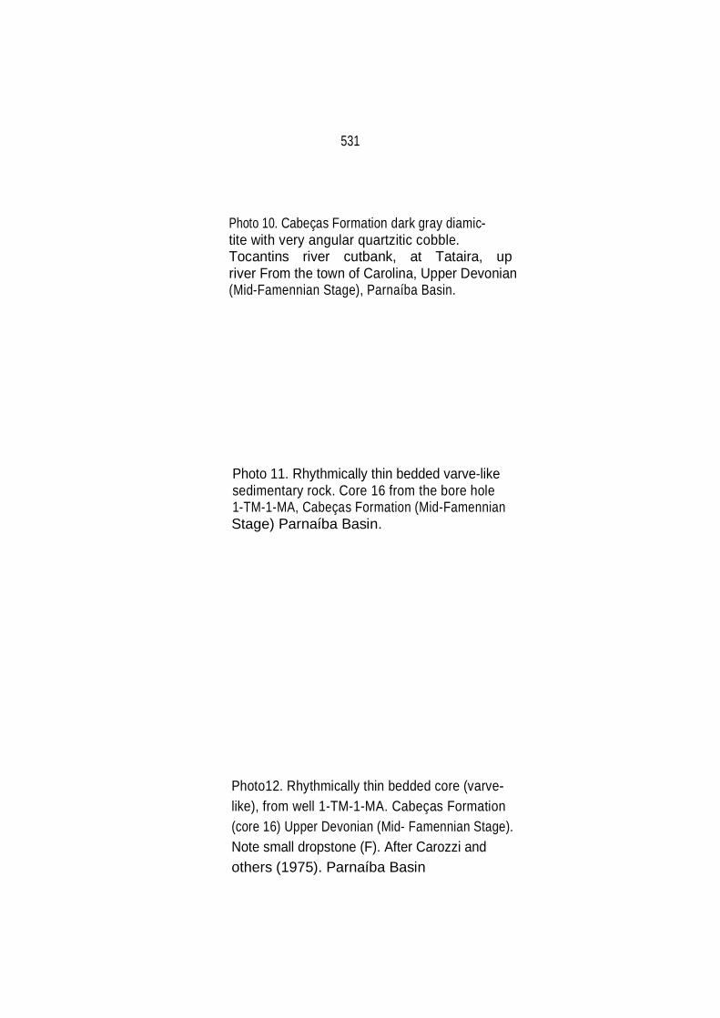
531
Photo 10. Cabeças Formation dark gray diamic tite with very angular quartzitic cobble. Tocantins river cutbank, at Tataira, up river From the town of Carolina, Upper Devonian (Mid-Famennian Stage), Parnaíba Basin.
Photo 11. Rhythmically thin bedded varve-like sedimentary rock. Core 16 from the bore hole 1-TM-1-MA, Cabeças Formation (Mid-Famennian Stage) Parnaíba Basin. Photo12. Rhythmically thin bedded core (varve like), from well 1-TM-1-MA. Cabeças Formation (core 16) Upper Devonian (Mid- Famennian Stage). Note small dropstone (F). After Carozzi and others (1975). Parnaíba Basin


533
Photo 13. Glacially faceted, striated and polished cobble from Cabeças Formation (Upper Devonian, Mid-Famennian Stage), Western Parnaíba Basin, from diamictite in cutbank of the Tocantins River, about 20 km N of the town of Pedro Afonso. Coin is 2.5 cm in diameter.
Photo 14. Poorly stratified sandstone beds with scattered pebbles and boulders throughout, interpreted as deposited under glaciofluvial conditions. From Retiro, 5 km northward from the town of São Francisco do Piauí, in the Cabeças Formation, Parnaíba Basin.
Photo 15. Far-travelled pre-Silurian silicified conglomerate erratic 1.25 m long left by glaciers, at Morro Comprido, close to a striated pavement on the Cabeças Formation, observed in the next

534

535
Photo 16. Glacial striations oriented N27ºE on the Cabeças Formation sandstone beds at Morro Comprido, at about 26 km from the town of Canto do Buriti, on the old road to the town of São Raimundo Nonato in the Piauí State. Parnaíba Basin
Photo 17. Detail of glacial striations on the Cabeças Formation at Morro Comprido, Parnaíba Basin
Photo 18. Glacial striae (oriented N15ºE) upon sandstone of the Cabeças Formation, Upper Devonian (Mid-Famennian Stage), Parnaíba Basin. Outcrop located about 1 km SE of road in the field and about 4.3 km along the E-W road from Canto do Buriti to Santa Iria.

~
,,• • .:.
-
- --
...
...
-':,
-
\
.........
.
.
•• ..
.. ,,-
•
-·
• ;:,
• ·-
·-
~ . -
536
--~----- --
4
..• •
• •• •
• •
•

537
Photo 19. Slumped sandstone outwash beds. They may have resulted from collapse when ice under neath melted. In the middle level of the outcrop, a diamictite bed is present. These deformed features are characteristics of the Cabeças Formation. Two kilometers north of Oeiras, Piauí. Parnaíba Basin
Photo 20. Channel-like sandstone beds with "load" cast structures overlying argillaceous massive sandstone beds. These features are com mon in the Cabeças Formation. Road from Gaturiano to Valença (Piauí), Parnaíba Basin.
Photo 21. Chaotically deformed sandstone beds interpreted as a result of slumping when stagnant ice underneath melted. Cabeças Formation, Upper Devonian. Tocantins River cutbank in front of the town of Pedro Afonso, Parnaíba Basin.

538

539
REFERENCES
Aceñolaza, F. G., 1982, Early Paleozoic Orogeny in Southern South America: Precambrian Research, v. 17, p. 133 – 146.
Aceñolaza, F. G . , Benedetto, J L . , and Salfity, J. A. , 1972, El
Neopaleozoico de la puma Argentina: su fauna y relación com áreas vecinas, in Simpósio Internacional sobre os sistemas Carbonífero e Permiano na América do Sul: Anais da Academia Brasileira de Ciências, v . 44 (Supl.), p. 5-20.
Agassiz, L., 1866, Physical History of the Amazon Valley: Atlantic Monthly No.
49–60, p. 113–122. Aguiar, G. A., 1971, Revisão Geológica da Bacia Paleozóica do Maranhão:
Soc. Bras. Geol. , Anais XXV Congr. Bras. Geol., São Paulo, V. 3, p. 113 - 122.
Albuquerque, R., 1922, Reconhecimentos geológicos no vale do Amazonas:
Soc. Bras. Geol. Min., Boletin No. 3, 84 p., Rio de Janeiro, Brazil. Albuquerque, O. R., and Dequech, V., 1950, Contribuição para a geologia do
Meio –Norte, especialmente Piauí e Maranhão, Brasil: II Cong. Panam. Eng. Minas e Geol., Anais, v. 3, p. 69-109.
Allard, G. O., 1969, The Propriá geosyncline, a key tectonic element em the
continental drift puzzle of the South Atlantic: Soc. Bras. Geol. Anais XXIII Congr. Bras. Geol., Salvador, p., 47–59.
Amaral, S. E. , 1954, Nota sobre a Série Barreiras no Vale do Tapajós, in
SBG, Núcleo de São Paulo, Boletim 3(1): 29–50. Amaral, G., 1974, Geologia Pre–Cambriana da região Amazônica: São
Paulo, Universidade de São Paulo, Instituto de Geociências, 212 p., (Doctoral Thesis).
Amos, A. J., 1972, Las Cuencas Carbónicas y Pérmicas de Argentina: Anais
da Academia Brasileira de Ciências, v. 44, (Supl .), p. 21 – 36. Anderson, M. M., 1961, The Late Paleozoic glaciation of Gondwanaland in
relation to West Africa and to north South America during Carboniferous time: Geol . Magazine, London, v. 44, (Supl.), p. 231 – 36.
Andrade, S. M., 1968, Geologia do Sudeste de Itacajá: Petrobras Internal
Report No. 293, Belém, Brazil.

540
Andrade, S. M., and Daemon, R. F. 1974, Litoestratigrafia e Bioestratigrafia do flanco sudeste da Bacia do Parnaíba (Devoniano e Carbonífero): Soc. Bras. Geol., Anais XXVIII Congr. Bras. de Geol. Pôrto Alegre, v. 1, p. 129–137.
Axelrod, D. I., 1963, Fossil floras suggest stable, no drifting, continents: J.
Geophys. Res., v. 68 (10), p. 3257–3263. Ayaviri, A., 1972, El sistema Carbónico em el sureste Boliviano, in
Simpósio International sobre os sistemas Carbonífero e Permiano na América do Sul: Anais da Academia Brasileira de Ciências, v. 44 (Supl.), p. 51 – 60.
Ball, E., 1980, An example of very consistent brittle deformation over a
wide intracontinental area: The Late Pan–African. Frature system of the Tuareg and Nigerian shields: Tectononophysics, v. 61, p. 363 – 379.
Bär, P. and Riegel, W., 1974, Les microflores des séries Paleozoïques du
Ghana (Africa Occidentale) et leurs relations paleofloristiques: Sci. Geol. Bull. Strasbourg, v. 27, 1-2, p. 39–58
Bär, P. and Riegel, W., 1980. Mikroflotrn des hochsten Ordovzium bis
tiefen Silurs aus der Unteren Secondi-Serie von Ghana (Westafrika) und ihre Beziehung Zu den Itaim – Schichten des Maranhão – Beckens in NE-Brasilien: N. Jb Geol. Palaont. Abh., v. 160, (1), p. 42-60, Stuttgart.
Barbosa, O., 1967, Tectônica na Bacia Amazônica, Atas do Simpósio
sobre a Biota Amazônica: Geociências, v. l, p. 83–86. Barbosa, O. and Gomes, F. A., 1957, Carvão mineral na Bacia Tocantins–
Araguaia: Dept. Nac. Prod. Min., Div. Geol. Min., Boletim No 174, 40 p.
Barbosa, O., De Ramos, J. R. A., Gomes F. de A , and Hembold, R.,
1966, Geologia estrutural e econômica da área do ‘‘projeto Araguaia’’: Dept. Nac. Prod. Min., Div. Geol. Miner., Monogr. no 19, 94 p.
Barcelos, J. H., and Suguio, K., 1980, Ambiente de Sedimentação da
Formação Areado, Cretáceo Inferior da Bacia Sãofranciscana, MG: Rev. Bras. Geociências, v. 10, p. 237 – 242.
Barnes, S. J., and Sawyer, E. W., 1980, An alternative model for the
Damara mobile belt: Ocean crust subduction and continental convergence: Precambrian Research, v. 13, p. 297 – 336.

541
Barret, P. J., 1981, Late Cenozoic glaciomarine sediments of the Ross Sea, Antarctica, in Hambrey, M. J. and Harland, W. B., Editors, Earth‘s pre-Pleistocene Glacial Record: Cambridge Univ. Press., p. 208 – 211.
Barret, P. J., and Mcklelvey, B. C., 1981, Permian tillites of South
Victoria Land, Antarctica, in Hambrey, M. J., and Harland, W. B. Editors, Earth´s pre–Pleistocene Glacial Record: Cambridge Univ. Press, p. 233 – 236.
Basset, H. G., and Stout, J. G., 1968, Devonian of Western Canada, in
Oswald, D. H. Editor, International Symposium on the Devonian System, Calgary, l, 1055 pp.
Beaumont, C., and Sweeney, J. F., 1978, Graben generation of major
sedimentary basins: Tectonophysics, v. 50, p. T19 – T23. Beloussov, V. V., Ruditch, E. M., and Shapiro, M. N., 1979,
Intercontinental structural ties and mobolistic reconstructions: Geolog. Rundschau, Bd. 68 , Heft 2, p. 393 – 427.
Benavides, V. V., 1968, Saline deposits of South America in saline
deposits: Geol. Soc. Am. Spec. paper No. 88, p. 249 – 290. Bemerguy, I., 1964, Geologia da área Central do Flanco Sul da Bacia do
Médio Amazonas: Petrobras Internal Report No. 546 – A, 84 p., Belém, Brazil.
Bennacef, A., Beuf, S., Biju – Duval, B., De Charpal, O., Gariel, O., and
Rognon, P., 1971, Example of Cratonic Sedimentations: Lower Paleozoic of Alegerian Sahara: AAPG Bull., v. 55, p. 2225 – 2245.
Berry, W. B., and Boucot, A. J., 1967, Pelecypod–Graptolite association
in the Old Word Silurian: Geol. Soc. Am. Bull., v. 78, p. 1515 – 1522.
Berry, W. B. N., and Boucot, A. J., 1972, Correlation of the South
American Silurian rocks: Geol. Soc. Am. Spec. Paper 133, 53 p. Berry, W. B. N., and Boucot, A. J., 1973, Correlation of the African
Silurian rocks: Geol. Soc. Am. Spec. Paper, v. 147, 83 p.
Beuf , S., Biju–Duval, B., De Charpal, O., Rognon, P., Gariel, O., and Bennacef, A. 1971, Les grès Du Paleozoïque Inférieur au Sahara Sédimentation et discontinuités, Évolution Structurale D'un Craton: Institut Francais du Petrole, Science et Technique du Petrole, no. 18, 464 p.

542 Beurlen, K. 1955 As formações Gondwânicas do Sul do Estado do
Paraná: Dept. Nac. Prod. Min., Div. Geol. Min., Bol. no. 153, 52 p., Rio de Janeiro, Brazil.
____1965, Observações no Devoniano do Estado do Piauí: An. da
Acad. Bras. de Ciências, v. 37, No 1, p. 61-67. ____1970, Geologie von Brasilien, Beitrage zur Regionalen Geologie
der Erde 9, Gebruder Borntraeger, Berlin, 444 p. Bigarella, J. J., 1964, Paleogeographic and paleoclimatologic features of
the Southern Brazilian Devonian, in Nairn, A. E. M., Editor, Problems in Paleoclimatology: Univ. of Newcastle upon-Tyne, Interscience Publishers, p. 293-303.
____1970 Continental drift and paleocurrent analysis: Proceedings 2nd
Gondwana Symposium, South Africa CSIR, Pretoria, p. 73-97. ____1973a, Paleocorrentes e deriva continental: Boletim Paranaense de
Geociências, no. 31, p. 141-224, Curitiba, Brazil. ____1973b, Paleocurrents and the problem of continental drift: Geol.
Rundschau, v. 62, p. 447-477. ____1973c, Geology of the Amazon and Parnaíba basins, in Nairn, A.
E. M. and Stehly, F. G., Editors, The Ocean Basins and Margins, Plenum Publ. Co. New York, v. 1, p. 25-86
Bigarella, J. J., and Salamuni, R., 1967a, Some paleogeographic
features of the Brazilian Devonian: Boletim Paranaense de Geociências, no. 21/22, p. 133-151, Curitiba, Brazil.
Bigarella, J. J., and Salamuni, R., 1967b, Some paleogeographic and
paleotectonic features of the Paraná Basin, in Bigarella, J. J., Becker, R. D., and Pinto, I. D., Editors, Problems in Brazilian Gondwana Geology: Roesner Curitiba, Brazil, p. 235-301.
Bigarella, J. J., Salamuni, R., Marques Filho, P. L., 1961, Considerações
sobre a Formação Furnas: Boletim Paranaense de Geografia, (45), p. 53-70, Curitiba, Brazil.

543 Bigarella, J. J., Salamuni, R.,Marques Filho, P. L.,1966, Estruturas e
texturas da Formação Furnas e sua significação paleogeográfica: Bol. Univ. Fed. Par. Geol v. 18, 114 p., Curitiba, Brazil.
Bigarella, J. J., Mabesoone, J. M., Lins, J. C. C., and Mota Filho, F. O.
1965, Paleogeographic features of the Serra Grande and Pimenteiras formations (Parnaíba basin, Brazil) Palaeogeography, Palaeoclimatology, Palaeoecology, v. 1, p. 259-296.
Biju–Duval, B., Deynoux, M., and Rognon, P., 1981, Late Ordovician
tillites of the Central Sahara, in Hambrey, M. J., and Harland, W. B., Editors, Earth's pre-Pleistocene Glacial Record: Cambridge Univ. Press, p. 99 -107.
Biju-Duval, B., De Charpal O., Beuf, S., and Bennacef, A., 1968,
Lithostratigraphie du Devonien inférieur dans l'Ahnet et Mouydir (Sahara Central): Publ. Sev. Carte Geol. Algerie, Bull. No. 38, p. 83-104.
Bird, J. M., 1980, Plate Tectonics: Selected papers from publications of
the American Geophysical Union. Bischoff, G. O., 1957, Geology of the Erepecuru, Trombetas, Obidos and
Mamuru areas: Petrobras internal Report No. 161, Belém, Brazil. ____1963 Zur Geologie des Amazonbeckens: Geol. Jb., v. 80, p. 777-
794. Black, R., Caby R., Moussine-Pouchkine, R., Bayer, R., Bertrand, J. M,
Boullier, A. M., Fabre, J., and Lesquer, A., 1979, Evidence for Late Precambrian plate tectonics in West Africa: Nature, V. 278, p. 223-226.
Blanford, W. Tg, Blanford, H. F., and William, T., 1856, On the geological
structure and relations of the Talcheer Coal Field, in the District of Cuttack: India Geol. Survey, Mem. 1, Pt. 1, p. 33-89.
Blankennagel, R. N., 1952, Report on the eastern margin of tie
Maranhão Basin: Petrobras Internal Report No. 27, Belém, Brazil. Blankennagel, R. K., and Kremer, G. A., 1954, Geological report on the
southeastern margin of the Maranhão basin: Petrobras Internal Report No. 44, Belém, Brazil.

544 Blatt, H., Middleton, G., and Murray, R., 1980, Origin of Sedimentary
Rocks, 2nd edition: Prentice-Hall. Bluck, B. J., 1974, Structure and divisional properties of some valley
sandur deposits in southern Iceland: Sedimentology, v. 21, p. 533-554.
Boltunov, V. A., 1970, Certain earmarks distinguishing glacial and
moraine-like glacial marine sediments, as in Spitsbergen, International Geology Review, v. 12, p. 204-211.
Bonhomme, M., 1962, Comparaison a l´étude geóchronologique de la
plateforme de l'ouest Africain: Clermont-Ferrand Ann. Fac. Sci., 25, Ser. Geol. 8, Études Geochronologiques I.
Boucot, A. J., 1975, Evolution and extinction rate controls:
Developments in paleontology and stratigraphy: Elsevier Scientific Publ. Co., 427 p.
Boulton, G. S., and Deynoux, M., 1981, Sedimentation in glacial
environments and the identification of tills and tillites in ancient sedimentary sequences: Precambrian Research, v. 15, p. 397-422.
Bouma, A. H., 1962, Sedimentology of some flysch deposits. A graphic
approach to facies interpretation: Elsevier Publ., Amsterdam, 168 p. Bouman, Q. C., Mesner, J. C., and Padden, M., 1960, Amazon basin
study: Petrobras Internal Report No. 454-A, Belém, Brazil, 4 volumes, 1102 p.
Braakman, J. H., Levell, B. K., Martin, J. H., Potter, T. L., and van Vliet,
A., 1982, Late Palaeozoic Gondwana glaciation in Oman: Nature, v. 299, p. 48-50.
Branner, J. C., 1919, Outlines of the geology of Brazil to accompany the
geological map of Brazil: Geol. Soc. Amer. Bull., 30, p. 189-338, New York.
Brass, G. W., Southam, J. R., and Peterson, W. H., 1982, Warm saline
water in the ancient oceans: Nature, v. 296, p. 620-623. Brito, I. M., 1969, Os acritarcha e sua utilização na estratigrafia Siluriana
e Devoniana do Brasil: Inst. Geocienc., Univ. Fed. Rio de Janeiro, (Thesis).

545 Brito, I. M., and Santos, A. da S., 1964, Acritarcha do Siluriano e do
Devoniano da Bacia do Maranhão: An. Acad. Bras. Cienc., v. 36, No. 4, p. 570.
Brito, I. M., and Santos, A. da S., 1965, Contribuição ao conhecimento
dos microfosseis Silurianos e Devonianos da Bacia do Maranhão, Parte I, Os Netromorphitae, Dept. Nac. Prod. Min., Div. Geol. Min., Notas Preliminares e estudos, No. 129, p. 28.
Brock, A., 1981, Paleomagnetism of Africa and Madagascar, in
McElhinny, M. W., and Valencio, D. A., Editors, Paleoreconstruction of the Continents: Geodynamics Series, v. 2., p. 65-76.
Brown, L. F., Jr., 1973, Cratonic basins: terrigenous clastic models, in
Brown, L. F., et al., Pennsylvanian Depositional Systems North-Central Texas: Bur. Econ. Geol., Univ. Texas, Guidebook 14, p. 10-30.
Buffetaut, E., and Taquet, P., 1977, The giant crocodilian Sarcosuchus
in the Early Cretaceous of Brazil and Niger: Palaeontology, v. 20, Pt. 1, p. 203-208.
Burke, K., 1976, Development of graben associated with the ruptures of
the Atlantic Ocean: Tectonophysics, v. 36, p. 93-112. _____1980, Intracontinental rifts and Aulacogens, In Continental
Tectonics, Geophysics Study Committee, National Academy of Sciences, Washington, p. 42-49.
Burke, K., and Dewey, J. F., 1973, An outline of Precambrian plate
development, in Tarling, D. H., and Runcorn, S. K., Editors, Implications of Continental Drift to the Earth Sciences: Academic Press, London and New York.
Burke, K., Dewey, J. P., and Kidd, W. S. F., 1977, World distribution of
sutures-the sites of former oceans: Tectonophysics, v. 40, p. 69-99. Caby, R., and Fabre, J., 1981a, Late Proterozoic to Early Paleozoic
diamictites, tillites and associated glacigenic sediments in the Serie Pourprée of Western Hoggar, Algeria, in Hambrey, M. J., and Harland, W. B., Editors, Earth's pre-Pleistocene Glacial Record: Cambridge Univ. Press, p. 140-145.
546
Caby, R., and Fabre, J., 1981b, Tillites in the Latest Precambrian strata of the Touareg Shield (Central Sahara), in Hambrey, M. J., and Harland, W. B., Editors, Earth's pre-Pleistocene Glacial Record: Cambridge Univ. Press, p. 146-149.
Caldasso, A. L. da S., and Hana, M., 1978, Posicionamento estratigráfico
das rochas básicas da Bacia do Parnaíba: Soc. Bras. Geol., An. do XXX Congresso Bras. de Geol., v. 2, p. 567-581.
Campanha, V. A., and Mabesoone, J. M., 1976, Paleoambiente e
Paleoecologia do Membro Picos, Formação Pimenteiras (Devoniano do Piauí): Soc. Bras. Geol., An. do XXVIII Congresso Bras. de Geol., v. 2, p. 221-235.
Campbell, D. F., 1949, Revised report on the reconnaissance geology of
the Maranhão Basin: Petrobras Internal Report No. 7. Campbell, D. F., Silva, S. 0, and Almeida, L. A., 1948, Preliminary report
on the geology of the Maranhão Basin: Petrobras Internal Report No. 5.
Caputo, M. V., 1974, Interpretação ambiental do Sistema Cretáceo nas
bacias do Acre, Ucayall e Pastaza: Petrobras Internal Report No. 680-A, Belém, Brazil.
_____1984, A origen do "trend" Juruá e o Arco Jutaí, 18 p., Petrobras
Internal Report, No. 437-G, Belém, Brazil. Caputo, M. V., and Andrade, F. G., 1968, Geologia em Semidetalhe do
Flanco Sul da Bacia Amazônica, entre os rios Cupari e Abacaxis, 149 p: Petrobras Internal Report No. 589-A, Belém, Brazil.
Caputo, M. V., and Crowell, J. C., in Press, Migration of glacial centers
across Gondwana during Paleozoic Era: Geol. Soc. Am. Bull. Caputo, M. V., and Sad, A. R. E., 1974, Geologia do Baixo Rio Negro e
trecho da estrada Br-174: Petrobras Internal Report No. 675-A, Belém, Brazil.
Caputo, M. V., and Vasconcelos, D. N. N., 1971, Possibilidades de
Hidrocarbonetos no Arco Purus, Petrobras Internal Report No. 644-A, 21 p., Belém, Brazil.

547
Caputo, M. V., and Vasconcelos, E. P., 1978, Relátorio final do Poço 1-JR-1-AM: Petrobras Internal Report, Belém, Brazil.
Caputo, M. V., Jucá, G., and Brazil, I., 1979, Bacia do Acre-
Possibilidades de Petróleo na seção Pré-Cretácea: Petrobras Internal Report, No. 744-A, 51 p., Belém, Brazil.
Caputo, M. V., Marques, L. F. P., and Carvalho, L. C., 1983,
Desenvolvimento Tectônico das Bacias do Amazonas e Parnaíba: Petrobras Internal Report No. 436-G, 60 p., Belém, Brazil.
Caputo, M. V., Rodrigues, R., and Vasconcelos, D. N. N., 1971,
Litoestratigrafia da Bacia do Amazonas: Petrobras Internal Report No. 641-A, Belém, Brazil.
Caputo, M. V., Rodrigues, R., and Vasconcelos, D. N. N., 1972,
Nomenclatura estratigráfica da Bacia do Amazonas-Histórico e atualização: Soc. Bras. Geol., An. XXVI Congr. Bras. Geol., Belém, v. 3, p. 35-46.
Carneiro, R. G., 1974, Mapeamento estrutural da area de Grajaú-
Imperatriz: Petrobras Internal Report No. 358, 45 p., Belém, Brazil. Carozzi, A. V., 1979, Petroleum exploration of the Paleozoic clastics of
the Middle Amazon Basin: J. Petrol. Geol., v. 2, (1), p. 55-74. _____1980, Tectonic control and petroleum geology of the Paleozoic
clastics of the Maranhão basin, Brazil: J. Petrol. Geol., V. 2, (4), p. 389-410.
Carozzi, A. V., Alves, R. J., and De Castro, J. C., 1972, Controle
tectônico sinsedimentar dos carbonatos Permo-Carboníferos das formações Itaituba e Nova Olinda da Bacia do Amazonas: Soc. Bras. Geol. An. do XXVI Congresso Bras. de Geol., Belém, v. 3, p. 47-64.
Carozzi, A. V., Pamplona, H. R. P., De Castro, J. C., and Contreiras, C.
J. A., 1973, Ambientes deposicionais e evolução tecto-sedimentar da seção clastica Paleozóica da Bacia do Médio Amazonas: An. do XXVII Congr. Bras. Geol., Aracaju, p. 279-314.
Carozzi, A. V., Falkenhein, F. V. H., Carneiro, R. G., Esteves, F. R., and
Contreiras, C. J. A., 1975, Análise Ambiental e Evoluçao Tectônica sinsedimentar da Seção Siluro-Eocarbonífera da Bacia do Maranhão: Ciência-Técnica-Petróleo, Seção Exploração de Petróleo, Publicação no. 7, 89 p.

548
Caster, K. E., 1947a, Expedição geológica em Goiás e Mato Grosso: Mineração e Metalurgia, v. 12, No. 69, p. 126-127.
_____1947b, Excursão geológica ao Estado do Piauí: Mineração e
Metalurgia, v. 12, No. 72, p. 271-272. _____1952, Stratigraphic and paleontologic data relevant to the problem
of Afro-American ligation during the Paleozoic and Mesozoic, in Symposium: The problem of land connections across the--South Atlantic, etc.: Bull. Am. Museum Nat. Hist., (99), Art. 3, p. 105-152.
Caster, K. E., and Dresser, H., 1955, Contributions to knowledge of the
Brazilian Paleozoic No. 1: Bull. Amer. Paleont., v. XXXV, No. 149, p. 67-130.
Cediel, F., 1972, Movimientos tectonicos en el intervalo Paleozoico-
Mesozoico em Colombia y su influencia en reconstruciones paleogeograficas: An. Acad. Bras. Cienc. 44 (Supl.), p. 87-93.
Chandless, W., 1862, Notes on the river Arinos, Juruena and Tapajós: J.
Royal Geographical Society, London, v. 32, p. 268-280. Chappell, J., and Humphreys, M., 1970, Glacial sedimentation in the
Lower Karroo, Mid-Zambezi Valley, Rhodesia. Choudhuri, A., 1980, The Early Proterozoic Greenstone Belt of the
Northern Guiana Shield, South America: Precambrian Research, v. 13, p. 363-374.
Church, M., and Ryder, J. M., 1972, Paraglacial sedimentation: A
consideration of fluvial processes conditioned by glaciation: Geol. Soc. Am. Bull., v. 83, p. 3059-3072.
Cobbing, E. J., Ozard, J. M., and Sneliing, N. J., 1977, Reconnaissance
geochronology of the crystalline basement rocks of the coastal Cordillera of southern Peru: Geol. Soc. Am. Bull., v. 88, p. 241-246.
Conant, L. C., and Swanson, V. E., 1961, Chattanooga shale and related
rocks of central Tennessee and nearby areas: Geol. Survey Prof. Paper 357.

549
Conrad, J., Pareyn, M. M. C., and Weyant, M., 1970, Mise en evidence du Tournaisian inferieur dans la vallee de la Saoura (Sahara nord-occidental) et consequences paleogeographiques: C. R. Acad. Sc., Paris, v. 271, Serie D., p. 900-903.
Copper, P., 1977, Paleolatitudes in the Devonian of Brazil and the
Frasnian-Famennian mass extinction: Palaeogeography, Palaeoclimatology, Palaeoecology, v. 21, p. 165-207.
Corbel, J., 1964, L'erosion terrestre, étude quantitative: Ann. Geogr., v.
73, p. 385-412. Cordani, U. G., Amaral, G., and Kawashita, K., 1973, The Precambrian
evolution of South America: Geologische Rundschau, Bd. 62, p. 309-317.
Cordani, U. G., Melcher, G. C., and De Almeida, F. F. M., 1968, Outline
of the Precambrian geochronology of South America: Can. J. Earth Sci., v. 5, p. 629-632.
Cordani, U. G., Tassinari, C. G., Teixeira, W., Basei, M. A. S., and
Kawashita, K., 1979, Evolução Tectônica da Amazônia com base nos dados geocronológicos. Actas do 11 Congresso Geológico Chileno, v. 4, p. 137-148, Arica, Chile.
Cramer, F. H., 1971, Position of the north Florida Lower Paleozoic block
in Silurian time. Phytoplankton evidence: J. Geophys. Research, v. 76, p. 4754-4757.
Crow, A. T., 1952, The rocks of the Sekondi Series of the Gold Coast:
Gold Coast Geol. Survey Bull., no. 18, 65 p. Crowell, J. C., 1957, Origin of pebbly mudstones: Geol. Soc. Am., v. 68,
p. 993-1010. _____1964, Climatic significance of sedimentary deposits containing
dispersed megaclasts, in Nairn, A. E. M., Editor, Problems in Palaeoclimatology: Interscience Publishes, p. 86-99.
_____1978, Gondwanan glaciation, cyclothems, continental positioning,
and climate change: Am. J. of Science, v. 278, p. 1345-1372. _____1981, Early Paleozoic glaciation and Gondwana drift, in
Paleoreconstructions of the Continents: Geodynamics Series, v. 2, p. 45-49.

550
_____1983, The recognition of ancient glaciations: Geol. Soc. Am. Memoir 161.
Crowell, J. C., and Frakes, L. A., 1970a, Phanerozoic glaciation and the
causes of ice ages: Am. J. Sci., v. 268, p. 193-224. Crowell, J. C., and Frakes, L. A., 1970b, Ancient Gondwana glaciations,
in Haughton, S. H., Editor, Proc. Papers 2nd Gondwana Symp., South Africa CSIR,Pretoria, p. 469-476.
Crowell, J. C., and Frakes, L. A., 1971, Late Paleozoic glaciation: Part
IV, Australia: Geol. Soc. of Am. Bull., v. 82, p. 2515-2540. Crowell, J. C., and Frakes, L.A., 1972, Late Paleozoic glaciation: Part
V, Karroo Basin, South Africa: Geol. Soc. of Am. Bull., v. 83, p. 2887-2912.
Crowell, J. C., and Frakes, L. A., 1975, The Late Palaeozoic glaciation,
in Campbell, K. S. W., Editor, Gondwana Geology: Aust. Univ. Press (Canberra), p. 313-331.
Crowell, J. C., Rocha-Campos, A. C., and Suarez-Soruco, R., 1980,
Silurian glaciation in Central South America, in Cresswell, M.M., and Vela, P., Editors, Gondwana-Five selected Papers and Abstracts of Papers Presented at the Fifth International Gondwana Symposium: A. A. Balkem, p. 105-110.
Crowell, J. C., Suarez-Soruco, R., and Rocha-Campos, A. C., 1981, The
Silurian Cancañari (Zapla) Formation of Argentina, Bolivia and Peru, ín Hambrey, M. J. and Harland, W. B., Editors, Earth's pre-Pleistocene Glacial Record: Cambridge Univ. Press, p. 902-907.
Culver, S. J., Williams, H. R., and Bull, P. A., 1980, Late Precambrian
glacial deposits from the Rokelide Fold Belt, Sierra Leone: Palaeogeography, Palaeoclimatology, Palaeoecology, v. 30, p. 65-81.
Da Costa, N. M. M., 1975, Distribuição estratigráfica e biocronologia de
Quitinozoários da Formação Trombetas, Estado do Pará: Soc. Bras. Geol. An. do XXVII Congresso Bras. Geol.
Daemon, R. F., 1975, Contribuição à datação da Formação Alter do
Chão, Bacia do Amazonas: Revista Brasileira de Geociências, v. 5, p. 78-84.

551 Daemon, R. F. And Contreiras, C. J. A., 1971a, Zoneamento
Palinologico da Bacia do Amazonas: Petrobras Internal Report No. 635-A, Belém, Brazil.
Daemon, R. F., and Contreiras, C. J. A., 1971b, Zoneamento
Palinológico da Bacia do Amazonas: Soc. Bras. Geol., An. XXV Congr. Bras. Geol., São Paulo, v. 3, p. 79-92.
Daemon, R. F., and Quadros, L. P., 1970, Bioestratigrafia do
Neopaleozoico da Bacia do Paraná: Soc. Bras. Geol. An. XXIV Congr. Bras. Geol., Brasília, p. 359-412.
Daily, B., and Cooper, M. R., 1976, Clastic wedges and patterned
ground in the Late Ordovician-Early Silurian tillites of South Africa: Sedimentology, v. 23, p. 271-283.
Dalmayrac, B., Laubacher, G., Marocco, R., Martinez, C., and Tomasi,
P., 1980, La chaine hercynienne d'Amérique du Sud-structure et evolution d'un orogene intracratonique: Geol. Rundschau, v. 69, Pt. 1, p. 1-21.
Daly, R. A., 1934, The changing world of the Ice Age: Hafner Publishing
Co., New York. De Almeida, F. F. M., 1967, Origem e evolução da plataforma brasileira:
Dept. Nac. Prod. Min., Div. Geol. Min., Bol. 241, 36 p. _____1968, Precambrian geology of Northeastern Brazil and Western
Africa and the theory of continental drift: Proc. Symp. on the Granites of West Africa, UNESCO, Nat. Resourc. Res., v. 4, p. 151-162.
_____1977, O craton do São Francisco: Rev. Bras. Geocienc., v. 7, p.
349-364. De Almeida, F. F. M., Amaral, G., Cordani, U. G., and Kawashita, K.,
1973, The Precambrian evolution on the South American cratonic margin south of the Amazon River, in Nairn, A. E. M. and Stehli, F. G., Editors,The Ocean Basins and Margins, 1: Plenum Press, New York, N. Y.
De Almeida, F. F. M., Hasui, Y., Neves, B. B. de B., and Fuck, R. A.,
1981, Brazilian structural provinces: An introduction: Earth-Science Reviews, v. 17, p. 1-29.
552
De Boer, N. P., 1964, Report on the geology of northern Brazil:
Petrobras Internal Report No. 2020, Rio de Janeiro, Brazil. _____1965, Geologia e prospectos das Bacias Paleozóicas do
Amazonas: Petrobras Internal Report No. 2317, Rio de Janeiro, Brazil.
_____1966, The tectonic framework and history of the sedimentary
basins of northern Brazil. An. VI Conferência Geológica das Guianas, Dept. Nac. Prod. Min., Div. Geol. Min., Boletim No. 223.
Debyser, J., De Charpal, O., and Merabet, O., 1965, Sur le caractère
glaciaire de la sedimentation de l'Unite IV au Sahara Central: C. N. Acad. Sci. Fr., v. 261, p. 5575-5576.
De Carvalho, L. M., Brito, F. F., and Pinto Filho, F. P., 1975, Projeto
sudeste de Rondônia relatório preliminar: Comp. Pesq. Rec. Min., CPRM Internal Report.
De Carvalho, P. F., 1926, Reconhecimentos geologicos e sondagens na
Bacia do Amazonas: Serv. Geol. Min. Bras., Bol. No. 15, 28 p., Rio de Janeiro.
De Faria, A., 1982, Formação Vila Maria: Nova unidade litoestratigráfica
siluriana da Bacia do Paraná: Ciências da Terra, v. 3, p. 12-15. Della Favera, J. C., and Uliana, M. A., 1979, Bacia do Maranhão-
Possibilidades para treinamento em facies e ambientes sedimentares: Petrobras Internal Report (Brazil).
Della Piazza, H. D., Santos, D. B., and Mainguê, E., 1966, Geologia da
área de Floriano: Petrobrás Internal Report No 261, Belém, Brazil. De Montalvão, R. M. G., 1976, Esboço geologico-tectônico do craton
Guianês: Revista Brasileira de Geociências, v. 6, p. 230-245, São Paulo.
De Montalvão, R. M. G., and Bezerra, P. E. L., 1980, Geologia e
tectônica da Plataforma (craton) Amazônica (parte da Amazônia Legal Brasileira): Revista Brasileira de Geociências, v. 10, p. 1-27.
De Montalvão, R. M. G., and Fernandes, P. E., 1975, Grupo Tunui,
Projeto Radam: Internal Report Radam No. 38-G, Brazil.

553
De Montalv-ab, R. M. G., Silva, G. H., Bezerra, P. E. L., and Pimenta, O. N. dos S., 1979, Coberturas sedimentares e vulcano-sedimentares Precambrianas das Folhas SB.20 Purus, SC.20 Pôrto Velho e SC.21 Juruena (Plataforma Amazônica): Rev. Bras. de Geocienc., v. 9, p. 27-32.
De Moura, P., 1938, Geologia do Baixo Amazonas: Serviço Geológico e
Mineralógico, Boletim No. 91, 94 p., Rio de Janeiro, Brazil. De Oliveira, A. I. and Leonardos O. H., 1943, Geologia do Brasil, 2nd
edition: Min. Agr. Serv. Informação Agrícola. De Oliveira, A. I., 1956, Brazil in Handbook of South American Geology,
Geol. Soc. Am. Mem. No. 65, p. 1-62. De Oliveira, E. P., 1915, Reconhecimento geológico do Noroeste do
Mato Grosso, in Expedição Científica Roosevelt-Rondon. Comissão de Linhas Telegráficas de Mato Grosso, No. 50 Anex., Rio de Janeiro, p. 58-78.
De Paiva, G., 1929, Vale do Rio Negro-Physiografia e Geologia: Serv.
Geol. Min. do Brazil, Boletim. 40, 60 p. _____1937, Estratigrafia da Sondagem No. 125, Anexo No. 6, Brazil:
Serviço Fomento Mineral, Boletim 18, p. 107. De Paiva, G., and Miranda, J., 1937, Carvão mineral do Piauí: Serv.
Fom. Prod. Min., Bol. No. 20, Rio de Janeiro. De Quadros,,L. P., 1980, Ocorrência de Palinomorfos em Sedimentos
Paleozoicos da Bacia de Jatobá (Pernambuco): Revista Brasileira de Geociências, v.10, p. 68-72.
Derby, O. A., 1978, Contribuições para a geologia da região do Baixo
Amazonas: Arquivo do Museu Nacional II, Rio de Janeiro, v. 2, p. 77-104.
_____1888a, Uber Spuren einer carbonen Eiszeit in Sudamerika: Neues
Jahrs. Mineral., Geol. Palaontol., v. 2, p. 172-176. _____1888b, Briefliche Mitteilung (Veroffentlicht durch W. Wagen):
Neues Jahrb. Mineral., v. 2. Destombes, J., 1968, Sur la nature glaciaire des sediments du Groupe
du 2eme Bani, Ashgill superieur de l'Anti-Atlas: Morocco, C. R. hebd. Seanc. Acad. Sci. Paris 267, Serie D, p. 684-686.

554 _____1976, The Ordovician of the Moroccan Anti-Atlas, in Basset, M.
G., Editor, The Ordovician System, Birmingham 1174: Proc. Paleont. Assoc. Symp., p. 411-413.
_____1981, Hirnantian (Upper Ordovician) tillites on the north flank of
the Tindouf Basin, Anti-Atlas, Morocco, in Hambrey, M. J., and Harland, W. B., Editors, Earth's pre-Pleistocene Glacial Record: Cambridge Univ. Press, p. 84-88.
De Villiers, J., 1944, A review of the Cape Orogeny: Ann. Univ. Stell., v.
22 A, p. 183-208. Dewey, J. F., and Bird, J. M., 1971, Origin and emplacement of the
ophiolite suite: Appalachian ophiolites in Newfoundland: Journal of Geophysical Research, v. 76, No. 14, p. 3179-3206.
Dewey, J. F., and Burke, K., 1974, Hot spots and continental break up:
some implications for collisional orogeny: Geology, v. 2, p. 57-60. Deynoux, M., 1980, Les Fomations Giaciaires du Précambrien Terminal
et de la fin de l'Ordovicien en Afrique del'Ouest, Deux exemples de glaciation d'inlandsis sur une plate-forme stable: Travaux des Laboratoires des Sciences de la Terre, St. Marseille, (B), No. 17, 554 p.
Deynoux, M., and Trompette, R., 1981, Late Ordovician tillites of the
Taoudeni basin, West Africa, in Hambrey, M. J., and Harland, W. B., Editors, Earth's pre-Pleistocene Glacial Record: Cambridge Univ. Press, p. 89-96.
Deynoux, M., Trompette, R., Clauer, M., and Sougy, J., 1978, Upper
Precambrian and lowermost Paleozoic correlations in West Africa and in the western part of Central Africa. Probable diachronism of Late Precambrian tillite: Geol. Rundschau, v. 67, p. 615-630.
Dickinson , W. R., 1977, Tectonostratigraphic evaluation of subduction-
controlled sedimentary assemblages, in Talwani, M., and Pitman III, W. C., Editors, Island Arc, Deep Sea Trenches and Back-Arc Basins: Maurice Ewing Series I, Amer. Geophys. Un., p. 33-40.

555
Dimroth, E., 1979, Facies Models 16. Diagenetic facies of iron formation,
in Walker, R. G., Editor, Facies Models: Geol. Assoc. of Canada, p. 183-189, Geosci. Canada.
Dodt, L. G., 1872, "Relatório acerca da exploração do Rio Parnaíba por
ordem da presidência da Província do Piauí"-Anexo 0. Rel. de Repartição dos Negócios da Agricultura, Rio de Janeiro.
Dolianiti, E., 1954, A Flora do Carbonífero inferior de Terezina, Piauí:
Dept. Nac. Prod. Min., Div. Geol. Min., Bol. 148, 56 p., Rio de Janeiro.
Dos Santos, D. B., Fernandes, P. E. C. A., Dreher, A. M., Da Cunha, F.
M. B., Basei, M. A. J., and Teixeira, J. B. G., 1975, Geologia in Dept. Nac. Prod. Min., Projeto Radam, Folha SB.21, Tapajós, -Rio de Janeiro (Levantamento de Recursos Naturais 7).
Dott, R. H. Jr., and Batten, R. G., 1976, Evolution of the Earth: McGraw-
Hill, Inc., Second Edition, 504 p. Drewry, G. E., Ramsay, A. T. S., and Smith, A. G., 1974, Climatically
controlled sediments, the geomagnetic field and trade wind belts in Phanerozoic time: J. Geology, v. 82, p. 531-553.
Duarte, A., 1936, Fósseis da Sondagen de Terezina, Estado do Piauí,
Brazil, Serviço Geológico e Mineralógico, Notas Preliminares e Estudos, No. 2, p. 1-3, Rio de Janeiro.
Du Toit, A. L., 1921, The Carboniferous glaciation of South Africa: Trans.
Geol. Soc. South Africa, v. 24, p. 188-277. _____1927, A geological comparison of South America and South
Africa: Carnegie Inst. Washington Publ., no. 381, 157 p., Washington.
_____1953, Geology of South Africa in Haughton, S. A., Editor, Hafner
Publishing Co., New York. Edwards, M. B., 1979, Late Precambrian glacial loessites from North
Norway and Svalbord: J. Sediment. Petrol., v. 49, p. 85-92. _____1980, Glacial environments, in Reading, H. G., Editor, Sedi-
mentary environments and facies: Elsevier, New York, p. 416-438. Embleton, C., and King, C. A. M., 1975, Glacial and periglacial
geomorphology, Second Edition, v. 2, Edward Arnold.

556
Esteves, F. R., and Carneiro, R. G., 1977, Projeto Curiri - Prospecto
estratigrífico: Petrobrás Internal Report. Estrella, G. O., 1972, O estágio "rift" nas bacias Marginais do leste
brasileiro: Anais XXVI Congresso Brasileiro de geologia da S. B. G., v. 3, p. 29-34, Belém.
Fahnestock, R. K., 1963, Morphology and hydrology of a glacial stream:
U. S. Geol. Surv. Prof. Papers, 422-A, I-70. Fairbridge, R. W., 1964, The importance of limestone and its Ca/Mg
content to paleoclimatology, in Nairn, A. E. M., Editor, Problems in Paleoclimatology: Interscience, London, p. 431-478.
_____1969, Early Palaeozoic South Pole in northwest Africa: Geol. Soc.
Amer. Bull., v. 80, p. 113-114. _____1970a, South Pole reaches the Sahara: Science, v. 168, p.878-
881. _____1970b, An ice age in the Sahara: Geotimes, v. 15, July/August, p.
18-20. _____1972, Climatology of a glacial cycle: Quaternary Research, v. 2, p.
283-302. _____1973, Glaciation and plate migration, in Tarling, D. H., and
Runcorn, S. K., Editors, Implication of Continental Drift to the Earth Sciences: Academic Press, London and New York.
_____1974, Glacial grooves and periglacial features in the Saharan
Ordovician, in Coates, D. R., Editor, Glacial Geomorohology: Binghampton,--N. Y., Suny Publ., p. 315-327.
Farjallat, J. E. S., 1970, Diamictitos Neopaleozóicos e sedimentos
associados do Sul de Mato Grosso: Dept. Nac. da Prod. Min., Div. Geol. Min., Boletim No. 250, 52 p.
Ferreira, C. S., 1964, Contribuição à geologia e Paleontologia do baixo
Parnaíba no Estado do Piauí (Formação Pirabas, Mioceno Inferior): Bol. Mus. Par. Emilio Goeldi, Geologia 9, 51 p.
Fisher, W. L., and Brown, L. F., Jr., 1972, Clastic depositional systems-
A genetic approach to facies analysis-Annotated outline and bibliography: The University of Texas at Austin, Bur. Econ. Geology.

557
Fisher, W. L., and McGowen, J. H., 1967, Depositional systems in the
Wilcox Group of Texas and their relationship to occurrence of oil and gas: Gulf Coast Assoc., Geol. Soc. Trans., v. 17, p. 105-125.
Fisher, W. L., Brown, J. R., Scott, A. J., and McGowen, J. H., 1969,
Delta systems in the exploration for oil and gas: a research colloquium: Univ. Texas, Bur. Econ. Geology, Spec. Publ., 212 p.
Flint, R. F., 1961, Geological evidence of cold climate, in Nairn, A. E. M.,
Editor, Descriptive Palaeoclimatology: Interscience Publishers, Inc., New York.
_____1971, Glacial and Quaternary geology, John Wiley & Sons, New
York. _____1975, Features other than diamictites as evidence of ancient
glaciations, in Wright, A. E., and Moseley, F., Editors, Ice Ages: Ancient and Modern: Geol. Journal Special Issues, Seel House Press, Liverpool.
Flint, R. F., Sanders, J. E., and Rogers, J., 1960a, Symmictite: A name
for nonsorted terrigeneous sedimentary rocks that contain a wide range of particle sizes: Geol. Soc. Am. Bull., v. 71, p. 507-510.
Flint, R. F., Sanders, J. E., and Rogers, J., 1960b, Diamictite, a
substitute term for symmictite: Geol. Soc. Am. Bull., v. 71, p. 1809-1810.
Frakes, L. A., 1976, The long-term climatic record, in Pittock, A. B. and
Frakes, L. A., Editors, Climatic Change and Variability-A Southern Perspective, Cambridge Univ. Press.
_____,1979, Climates throughout geologic time: Elsevier, Amsterdam,
310 p. Frakes, L. A., and Crowell, J. C., 1967, Facies and paleogeography of
Late Paleozoic diamictites, Falkland Islands: Geol. Soc. Amer. Bull., v. 78, p. 37-58.
Frakes, L. A., and Crowell, J. C., 1969a, Late Paleozoic glaciation: Part
I, South America: Geol. Soc. of Am. Bull., v. 80, p. 1007-1042.

558
Frakes, L. A., and Crowell, J. C., 1970a, Late Paleozoic glaciation: Part
II, Africa, exclusive of the Karroo Basin: Geol. Soc. of Am. Bull., v. 81, p. 2261-2286.
Frakes, L. A., and Crowell, J. C., 1970b, The position of Antarctica in
Gondwanaland, in Quam, L. O., Editor, Research in the Antarctic: Am. Assoc. Adv. Sci. Pub. No. 93, p. 731-745.
Frakes, L. A., and Crowell, J. C., 1972, Late Paleozoic glacial geography
between the Paraná basin and the Andean geosyncline: An. Acad. Bras. Cienc. 44 (Supl.), p. 347-405.
Frakes, L. A., Kemp, E. M., and Crowell, J. C., 1975, Late Paleozoic
glaciation: Part VI, Asia: Geol. Soc. of Am. Bull., v. 86, p. 454-464. Frakes, L. A., Matthews, J. L., and Crowell, J. C., 1971, Late Paleozoic
glaciation: Part III, Antarctica: Geol. Soc. of Am. Bull., v. 82, p. 1581-1604.
Francis, E. A., 1975, Glacial sediments: a selective review, in Wright, A.
E., and Moseley, F., Editors, Ice Ages: Ancient and Modern: Geol. Journal Special Issues, No. 6, Seel House Press, Liverpool.
Francisco, B. H. R., and Loewenstein, P., 1968, Léxico estratigráfico da
região Norte do Brasil: Inst. Nac. Pesq. da Amazônia: Publicação Avulsa No. 9.
Franks, S., and Nairn, A. E. M., 1973, The Equatorial marginal basins of
West Africa, in Nairn, A. E. M. and Stehli, F. G., Editors, The Ocean Baisins and Margins. The South Atlantic Ocean, v. 1: Plenum Press, New York, London.
Freulon, J. M., 1964, Étude géologique des séries primaires du Sahara
central (Tassili n'Ajjer et Fezzan). Publication du Centre de recherches sur les zones Aride. Centre Nacional de la Recherche Scientifique Série: Geologie, No. 3, 198 p.
Freydank, H. G., 1957, Geology of the Rio Jatapu and Rio Capucapu:
Petrobras Internal Report No. 156-A, Belém, Brazil. Fálfaro, J. V., 1965, Conodontes do Calcário Itaituba do Carbonífero do
Rio Tapajós, Estado do Pará: Bol. Soc. Bras. Geol. São Paulo, v. 14, (1-2), p. 29-39.

559
Fuzikawa, K., and Souza Filho, J. G. C., 1970, Contribuição ao Estudo
do Membro Itaím da Formação Pimenteiras na região de Padre Vieira, Município de Viçosa, Ceará, in Congresso Brasileiro de Geologia, 24 Brasília: Soc. Bras. Geol., Boletim Especial No. 1, p. 41-42.
Geikie, A., 1863, On the phenomena of the glacial drift of Scotland:
Geol. Soc. Glasgow Trans., v. 1, Pt. 2, p. 190. Geomineração LTDA, 1972, Projeto Mapuera: Reconhecimento geoló-
gico/geoquímico, S 1/ICOMI, 101 p. Ghignone, J. I., 1972, Ensaio de Paleogeologia do Nordeste e as
sequências sedimentares, Soc. Bras. Geol., An. XXVI Congr. Bras. Geol., v. 3, p. 21-28.
Golikow, A. N., and Averincev, V. G., 1977, Distribution patterns of
benthic and ice biocoenoses in the high latitudes of the polar basin and their part in the biological structure of the world ocean, in Dunbar, M. J., Editor, Polar Ocean: Proc. of the Polar Oceans Conference held at McGill University, Montreal, May, 1974.
Gordon, W. A., 1975, Distribution by latitude of Phanerozoic evaporite
deposits: J. Geol., v. 83, p. 671-684. Grabert, H., 1970, Facies and climate in the Devonian Gondwana beds
of Brazil, in Second Gondwana Symposium South Africa, Proceedings and Papers, p. 189-192.
Gray, J., and Boucot, A. J., 1979, The Devonian land plant Protosalvinia:
Lethaia, v. 12, p. 57-63, Oslo. Grekoff, N., and Kroemmelbein, K., 1967, Étude comparée des ostra-
codes mesozoïques continentaux des bassins Atlantique: Série de Cocobeach et Série de Bahia, Rev. Inst. Fr. Petrol., v. 22, No. 9, p. 1307-1353.
Gustavson, T. C., 1975, Sedimentation and limnology in proglacial
Malaspina Lake, southeastern Alaska, in Jopling, A. V., and McDonald, B. C., Editors, Glaciofluvial and Glaciolacustrine Sedimentation: Soc. Econ. Palaeontologists Mineralogists, Spec. Publ. No. 23, p. 249-263.
Habicht, J. K. A., 1979, Paleoclimate, paleomagnetism and continental
drift: AAPG Studies in Geology No. 9. Published by Am. Assoc. Petroleum Geologists.

560 Hallam, A., 1977, Secular changes in marine inundation of USSR and
North America through the Phanerozoic: Nature, v. 269, p. 769-772.
Hallam, A., and Bradshaw, M. J., 1979, Bituminous shales and oolitic
ironstones as indicators of transgression and regressions: Q. J. Geol. Soc., London, v. 136, p. 157-164.
Hambrey, M. J., 1981, Late Palaeozoic Karoo tillites in Gabon, in
Hambrey, M. J., and Harland, W. B., Editors, Earth´s pre-Pleistocene Glacial Record: Cambridge Univ. Press, p. 41-42.
Hambrey, M. J., and Harland, W. B., 1979, Analysis of Pre-Pleistocene
glacigenic rocks: Aims and problems, in Schluchter, Ch., Editor, Moraines and Varves – Origin - Genesis - Classification: A. A. Balkema, Rotterdam.
Hambrey, M. J., and Harland, W. B., 1981, Earth's pre-Pleistocene
glacial record: Cambridge Univ. Press, 1003 p. Hambrey, M. J., and Kluyver, H. M., 1981, Evidence of Devonian or
Early Carboniferous glaciation in the Agades region of Niger, in Hambrey, M. J., and Harland, W. B., Editors, Earth's pre-Pleistocene Glacial Record: Cambridge Univ. Press, p. 188-190.
Harland, W. B., 1964a, Critical evidence for a great infra-Cambrian
glaciation: Geol. Rdsch., v. 54, p. 45-61. Harland, W. B., 1964b, Evidence of Late Precambrian glaciation and its
significance, in Nairn, A. E. M., Editor, Problems in Palaeoclimatology: interscience, London, p. 119-149, 179-184.
_____1981, Palaeogene ice-rafted quartz grains in the sub- Antarctic
Pacific,in Hambrey, M. J., and Harland, W. B., Editors, Earth's pre-Pleistocene Glacial Record: Cambridge Univ. Press, p. 217.
Harland, W. B., Herod, K. N., and Krinsley, D. H. 1966, The definition
and identification of tills and tillites: Earth-Sci. Review, v. 2, p. 225-256.
Harms, J. C., Spearing, D. R., Southard, J. B., and Walker, R. G., 1975,
Depositional environments as interpreted from primary sedimentary structures and stratification sequences, Short Course 2: Soc. Econ. Paleont. and Miner., Tulsa, Oklahoma, 161 p.

561
Harrington, H. J., 1962, Paleogeographic development of South
America: Am. Assoc. Petroleum Geologists Bull., v. 46, No. 10, p. 1773-1814.
_____1967, Devonian of South America, in Oswald, D. H., Editor,
International Symposium on the Devonian System, p. 651-671. _____1968, Desarrollo Paleogeográfico de Sudamerica, Miscelanea No.
26, Univ. Nac. Tucuman, Argentina. Hartt, C. F., 1870, Geology and physical geography of Brazil: Boston,
Fields Esgood, 620 p. _____1874, Contributions to the geology and physical geography of the
Lower Amazonas: Buffalo Soc. of Nat. Sci. Bull., Buffalo, v. I, p. 201-235.
Hasui, Y., and De Almeida, F. F. M., 1970, Geocronologia do centro-oeste Brasileiro: Boletim Soc. Bras. Geol., v. 19, p. 5-26.
Heckel, P. H., and Witzke, B. J., 1979, Devonian world palaeogeography
determined from distribution of carbonates and related lithic palaeoclimatic indicators, In The Devonian System: Special Papers in Palaeontology, 23, Univ. Press, Oxford, England, p. 99-123.
Helwig, J., 1972, Stratigraphy, sedimentation, paleogeography, and
paleoclimates of Carboniferous ("Gondwana") and Permian of Bolivia: Am. Assoc. Petroleum Geologists Bull., v. 56, No. 6, p. 1008-1033.
Herman, Y., 1981, Causes of massive biotic extinctions and explosive
evolutionary diversification throughout Phanerozoic time: Geology, v. 9, p. 104-108.
Hirtz, P., 1950, Phénomènes glaciaires Gondwaniens a Madagascar:
Bull. Soc. Geol. France, v. 20, p. 91-92. Hobday, D. K., and Tankard, A. J., 1978, Transgressive-barrier and
shallow-shelf interpretation of the lower Paleozoic Peninsula Formation, South Africa: Geol. Soc. Am. Bull., v. 89, p. 1733-1744.

562 Hollard, H., 1967, Le Devonien du Maroc et du Sahara Nord-Occidental,
in Oswald, D. H., Editor, International Symposium on the Devonian System, Calgary, p. 203-244.
House, M. R., 1975, Facies and time in Devonian tropical areas: Proc.
Yorkshire Geological Society, v. 40, Pt. 2, No. 16, p. 233-288. Hoyling, N., 1957, Petrobras well 1-N0-2-AM final report. Hurley, P., 1968, The confirmation of continental drift: Sci. Am., v. 218,
p. 52-64. Hurley, P. M., 1973, On the origin of 450 ± 200 m.y. orogenic belts, in
Tarling, D. H., and Runcorn, S. K., Editors, Implications of Continental Drift to the Earth Sciences: Academic Press, London and New York.
Hurley, P. M., and Rand, J. R., 1969, Predrift continental nuclei: Science,
v. 164, p. 1229-1242. Hurley, P. M., and Rand, J. R., 1973, Outline of Precambrian
geochronology in land bordering the South Atlantic, exclusive of Brazil, in Nairn, A. E. M., and Stehli, F. G., Editors, The Ocean Basins and Margins, 1, South Atlantic: Plenum Press, New York, N. Y., p. 391-410.
Hurley, P. M., De Almeida, F. F. M., Melcher, C. C., Cordani, U. G.,
Rand, J. R., Kawashita, K., Vandoros, P., Pinson, W. H. Jr., and Fairbairn, H. W., 1967, Test of continental drift by comparison of radiometric ages: Science, v. 157, p. 495-500.
Isaacson, P. A., 1978, Paleolatitudes in the Devonian of Brazil and the
Frasnian-Famennian mass extinction - Comments: Palaeo-geography, Palaeoclimatology, Palaeoecology, v. 24, p. 359-365.
Issler, R. ,S., 1977, Esboço geológico-tectônico do cráton do Guaporé:
Revista Brasileira de Geociências, v. 7, p. 177-238. Issler, R. S., Andrade, A. R. F., De Montalvão, R. M. G., Guimarães, G.,
Silva, G. G., and Lima, M. I. C., 1974, Geologia da Folha SA.22, Dept. Nac. Prod. Min., Prod. Min., Projeto Radam, 1. (Levantamento de Recursos Naturais, 5).

563
Johnson, H. D., 1978, Shallow siliciclastic seas, in Reading, H. G., Editor, Sedimentary Environments and Facies: Elsevier, New York.
Johnson, J. G., 1970, Taghanic onlap and the end of North American
Devonian provinciality: Geol. Soc. of Am. Bull., v. 81, p. 2077-2106. _____1974, Extinction of perched faunas: Geology, v. 2, p. 479-482 _____1979, Devonian Brachiopod biostratigraphy, in The Devonian
System, Special Papers in Palaeontology No. 23: University Press, Oxford, England, p. 291-306.
Junner, N. R., 1939, Sekondian system: Rept. Gold Coast Geol. Survey,
1938-39, p. 13-15. Katzer, F., 1903, Grundzuge des geologie des Unteren Amazonas
gebietes (des staates Para) in Brasilien, Leipzig, M. Weg., 296 p. Kegel, W., 1953, Contribuição para o estudo do Devoniano da Bacia do
Parnaíba: Rio de Janeiro, Brazil, Dept. Nac. Prod. Min., Div. de Geol. e Min., Boletim No 135, 38 p.
Kegel, W., 1954, Lamelibrânquios da Formação Poti (Carbonífero
Inferior) do Piauí: Dept. Nac. Prod. Min., Div. Geol. Min., Notas Preliminares e Estudos, No. 88, Rio de Janeiro.
Kegel, W.,1956, As inconformidades na Bacia do Parnaíba e zonas
adjacentes: Dept. Nac. Prod. Min., Div. Geol. Min., Bol. No 160, 59 p.
Kimberley, M. M., 1974, Origin of iron ore by diagenetic replacement of
calcareous oolite (Ph.D. thesis): Princeton Univ., 2 vols., 345 p. and 386 p.
_____1979, Geochemical distinctions among environmental types of iron
formations: Chemical Geology, v. 25, p. 185-212. King, C. A. M., 1976, Editor's comments on papers 1 through 14, in King,
C. A. M., Editor, Periglacial Processes, Benchmark Papers in Geology, v. 27, Dowden, Hutchinson and Ross, Inc.
King, L., 1958, Basic palaeogeography of Gondwanaland during the Late
Palaeozoic and Mesozoic eras: Q. J. Geol. Soc. London, v. 104, p. 47-70.
Kinsman, D. J. J., 1975, Rift valley basins and sedimentary history of
trailing continental margins, in Fischer, A. G., and Judson, S., Editors, Petroleum and Global Tectonics: Princeton Univ. Press

564 Kistler, P., 1954, Historical resume of the Amazon Basin: Petrobras
Internal Report No. 104-A, Brazil. Klein, G. de V., 1982, Probable sequential arrangement of depositional
systems on cratons: Geology, v. 10, p. 17-22. Kocurek, G., 1981, Significance of interdune deposits and bounding
surfaces in aeolian dune sands: Sedimentology, v. 28, p. 753-780. Kokis, R., 1970, Encontro de Araxá: Geologia, p. 372-419. Ministério de
Minas e Energia. Kovach, A., Fairbairn, H. W., and Hurley, P. M., 1976, Reconnaissance
geochronology of basement rocks from the Amazonas and Maranhão basins in Brazil: Precambrian Research, v. 3, p. 471-480.
Kräusel, R., and Dolianiti, E., 1957, Restos vegetais das Camadas
Picos, Devoniano Inferior do Piauí: Dept. Nac. Prod. Min., Div. Geol. Min., Bol. 173, 19 p.
Kroner, A., 1977, Non-synchroneity of Late Precambrian glaciations in
Africa: Jour. of Geol., v. 85, p. 289-300. Kummel, B., 1948, Geological reconnaissance of the Contamana
Region, Peru: Geol. Soc. of Am. Bull., v. 50, p. 1217-1266. Laird, M. G., and Bradshaw, J. D., 1981, Permian tillites of North Victoria
Land, Antarctica, in Hambrey, M. J., and Harland, W. B., Editors, Earth's pre-Pleistocene Glacial Record: Cambridge Univ. Press, p. 237-240.
Lange, F. W., 1967, Subdivisão bioestratigráfica e revisão da coluna
Siluro-Devoniana da Bacia do Baixo Amazonas: Atas do Simpósio sobre a Biota Amazônica, v. 1, Geociências, p. 215-326.
Lanzoni, E., and Magloire, L., 1969, Associations Palinologiques et leurs
"Applications Stratigraphiques dans le Devonian Superieur et Carbonifère du Grand Erg Occidental (Sahara Algerien)": Revue de L'Institut Français du Pétrole, v. 24, No. 4, p. 441-469.
565
Leal, J. W. L., Silva, G. H., dos Santos, D. B., Teixeira, W., de Lima, M.
I. C., Fernandes, C. A. C., Pinto, A. do C., 1978, Geologia, in Brazil, Dep. Nac. Prod. Min., Projeto Radam Brasil, Folha SC. 20 Pôrto Velho: Rio de Janeiro, Levantamento de Recursos Naturais, v. 16, 184 p.
Lees, A., 1975, Possible influence of salinity and temperature on modern
shelf carbonate sedimentation: Marine Geology, v. 19, p. 159-198. Lees, A., and Buller, A. T., 1972, Modern temperate-water and warm-
water shelf carbonate sediments: Marine Geology, v. 13, p. M67-M73.
Leinz, V., 1937, Estudos sobre a glaciação Permo-Carbonífera do Sul
do Brasil: Dept. Nac. Prod. Min., Serv. Fom. Prod. Min., Bol. No. 21, 47 p.
Lima, E. C., 1978, Idade das camadas do poço Juruá No. 1, Petrobras
Internal Communication. Lima, E. de A. M., 1978, Relacionamento geológico dos supostos
diamictitos glaciais com falhamentos sindeposicionais da Bacia do Meio Norte: Soc. Bras. Geol. An. XXX Congr. Bras. de Geol. Bol. No. 1, Resumos das Comunicações, p. 153.
Lima, E. de M., and Leite, J. F., 1978, Projeto Estudo global dos
recursos Minerais da Bacia Sedimentar do Parnaíba, Companhia de Pesquisas de Recursos Minerais, CPRM, Pernambuco, Brazil, v. I and II.
Linsser, H., 1974, Interpretação das anomalias gravimetricas regionais
na área Amazônica: Bol. Tec. da Petrobras, Rio de Janeiro, 17 (I), p. 3-15.
Lisboa, M. A. R., 1914, The Permian geology of northern Brazil:
American Journal of Sciences, Series 4, v. XXXVII (W. N. CLXXVII), No. 221, p. 425-442, New Haven.
Loczy, L., 1963, Paleogeography and history of the geological
development of the Amazonas basin: Jahrbuch Geol. B. A., v. 106, p. 449-502.
Long, W. E., 1962, Sedimentary rocks of the Buckeye Range, Horlick
Mountains, Antarctica: Science, v. 136, p. 319-321.

566 Ludwig, G., 1964a, Nova Divisão estratigráfico-faciológica do Paleozóico
da Bacia Amazônica: Petrobras/Cenap. Monografia I, Brazil. _____1964b, Notas sobre depósitos Paleozóicos nas Bacias de Tucano
(Bahia) e Jatobá (Pernambuco): Petrobras Internal Report 37-G, Belém, Brazil.
Ludwig, G., and Müller, H., 1964, A formação Imperatriz "Devoniano
Superior (?) a Mississippiano" no norte do Brazil: Petrobras Internal Report No. 38-G.
Ludwig, G., and Müller, H., 1968, Zur Frage der prakarbonischen
Diskordanz im Maranhão, Tucano und Jatoba-Becken (Brasilien): Geol. Jb., v. 85, p. 497-516.
Ludwig, G., and Ramos, A. N., 1965, Estudo das Formações Iapó,
Furnas e Ponta Grossa do Paleozóico Inferior da Bacia do Paraná: Petrobras Internai Report DESUL/SETEX, No. 292, Curitiba, Brazil
Maack, R., 1947, Breves noticias sobre a geologia dos Estados do
Paraná e Santa Catarina: Arq. Biol. Tecnol., Curitiba, Brazil, v. 2, p. 63-154.
_____1964, Characteristic features of the Palaeogeography and.
stratigraphy of the Devonian of Brazil and South Africa, in Nairn, A. E. M., Editor, Problems in Palaeoclimatology: Univ. of Newcastle-upon-Tyne, Interscience Publishers, p. 285-293.
Mabesoone, J. M., 1975, Desenvolvimento paleoclimático do Nordeste
brasileiro: Bol. Núcleo Nordeste Soc. Brasil, Geol., v. 5, p. 75-93. Mabesoone, J. M., 1977, Paleozoic-Mesozoic deposits of the Piaui-
Maranhão syneclise (Brazil): Geological history of a sedimentary basin: Sedim. Geol. v, 19, p. 7-38.
_____1978, Origem dos conglomerados da Formacão Serra Grande e
unidades equivalentes (Siluriano Superior-Devoniano Inferior, Nordeste do Brasil) Soc. Bras. Geol. Anais XXX Congr. Bras. Geol., Recife, v. 2, p. 799-808.
Macambira, E. M. B., Nélio, G. A. M. R., Calderaro, R. C. B., and de
Assis, N. P., 1977, Projeto sulfetos de Altamira-Itaituba: Companhia de Pesquisa de Recursos Minerais-CPRM Internal Report, Brazil, 772 p.

567
Malzahn, E.,1957, Devonisches Glazial im Staate Piauí Brasilien), ein neuer (Beitrag zur Eiszeit des Devons: Beihefte zum Geologischen Jahrbuch, v. 25, p. 1-30.
Marini, O. J., Fuck, R. A., Dardenne, M. A., and De Faria, A., 1977,
Contribuição à geologia do Pre-Cambriano da Porção Central de Goiás: Rev. Bras. Geocienc., v. 7, p. 304-324.
Martin, H., 1961, The hypothesis of continental drift in the light of recent
advances of geological knowledge in Brazil and Southwest Africa: Geol. Soc. S. Afr. A. L. Du Toit, Mem. Lect 7, p. 1-47.
Martin, H., and Porada H., 1977, The intracratonic branch of the Damara
orogen in South West Africa. I. Discussion of geodynamic models. II. Discussion of relationships with the Pan-African mobile belt system: Precambrian Research., v. 5, p. 331-357.
Mason, H. C., and Caputo, M. V., 1964, Reconhecimento e semi-detalhe
geológico do centro oeste do Estado do Acre: Petrobras Internai Report No. 553-A, Belém, Brazil.
Matsumoto, T., 1977, Timing of geological events in the Circun-Pacific
region: Can. J. Earth Sci., v. 14, p. 551-561. Maury, C. J., 1924, Fósseis terciários do Brasil com descrição de novas
formas cretáceas: Serviço Geológico e Mineralógico do Brasil, Série Monografia No. 4, 431 p.
McBride, S. L., Caelles, J. C., Clark, A. H., and Farrar, E., 1976,
Palaeozoic radiometric age provinces in the Andean basement, latitudes 25°-30°S: Earth and Planetary Sci. Letters, v. 29, p. 373-383.
McClure, H. A., 1978, Early Paleozoic glaciation in Arabia:
Palaeogeography, Palaeoclimatology, Palaeoecology, v. 25, p. 315-326.
____1980, Permian-Carboniferous glaciation in the Arabian Peninsula:
Geol. Soc. of Am. Bull., vol. 91, Pt. I, p. 707-712.

568
McClure, H., and Young, G. M., 1981, Late Palaeozoic glaciation in the Arabian Peninsula, in Hambrey, M. J., and Harland, W. B., Editors, Earth's pre-Pleistocene Glacial Record: Cambridge Univ. Press, p. 275-277.
McElhinny, M. W., Giddings, J. W., and Embleton, B. J. J., 1974,
Paleomagnetic results and Late Precambrian glaciations: Nature, v. 248, p. 557-561.
McGinnis, L. D., 1970, Tectonics and the gravity field in the continental
interior: Jour. of Geophysical Research, v. 75, No. 2, p. 317-331. McKerrow, W. S., 1979, Ordovician and Silurian changes in sea level:
Jour. Geol. Soc. London, v. 136, p. 137-145. McKerrow, W. S., and Ziegler, A. M., 1972, Paleozoic oceans: Nature
Physical Science, v. 2, p. 92-94. McWilliams, M. O., and McElhinny, M. W., 1980, Late Precambrian
paleomagnetism of Australia, The Adelaide geosyncline: Jour. of Geology, v. 88, p. 1-26.
Melo, M., and Prade, G. O., 1968, Geologia da região sudeste de São
Raimundo das Mangabeiras-Maranhão: Petrobras Internal Report No. 257, 36 p.
Mendes, J. C., 1956a, Spiriferacea Carboníferos do Rio Tapajós (Série
Itaituba), Estado do Para, Brasil: Bol. Fac. Fil. Ci. Letras USP, 193 (Ser Monogr. 7).
_____1956b, Orthotacea de Dalmanellacea do Carbonífero do Rio
Tapajós (Série Itaituba): Bol. Soc. Bras. Geol., v. 5 (1), p. 11-31. _____1956c, Pennsylvanian brachiopods from the Amazonian region
(Brazil), An. 20th Geol. International Congress, Mexico. _____1957a, Das Karbon des Amazonas-Beckens: Geol. Rdsch., v. 45
(3), p. 540. _____1957b, Rynchonellacea, Rostrospiracea e Terabratulacea do
Carbonífero do Rio Tapajós, Brazil: Bol. Soc. Bras. Geol., v. 6 (1), p. 15-34.
_____1959, Chonotacea e Productacea carboniferos da Amazônia: Bol.
Fac. Fil. Ci. Letras USP. No. 236 (Geologia 17), p. 1-83. _____1961, Notas suplementares sobre os brachiopodes Carboníferos
da Amazônia: Bol. Soc. Bras. Geol., v. 10 (1), p. 5-24.
569
Mendes, J. C., and Petri, S., 1971, Geologia do Brasil: Instituto Nacional do Livro, Rio de Janeiro, Biblioteca Universitária, Geociências/Geologia, 207 p.
Mensah, M., and Chaloner, W., 1971, Lower Carboniferous lycopods
from Ghana: Paleontology, v. 14, p. 357-369. Mesner, J. C., and Wooldridge, L. C. P., 1962, Maranhão Basin study
revision: Petrobras Internal Report No. 205. Mesner, J. C., and Wooldridge, L. C. P., 1964, Maranhão Paleozoic
Basin and Cretaceous Coastal Basins, North Brazil: Am. Assoc. Petr. Geol. Bull., v. 48 (9), p. 1475-1512.
Meyerhoff, A. A. and Meyerhoff, H. A., 1972, "The new global tectonics":
Major inconsistencies: Am. Assoc. Petrol. Geol. Bull., v. 56, No. 2, p. 269-336.
Meyerhoff, A. A., and Teichert, C., 1971, Continental drift, III: Late
Paleozoic glacial centers, and Devonian-Eocene coal distribution: J. Geol., v. 79, p. 285-321.
Micholet, J., Molinas, E., and Penet, B., 1971, Le systeme du Karroo au
Gabon: Second Gondwana Symposium, p. 371-380, Pretoria, South Africa.
Mingramm, A. G., Pozo, A., Russo, A., and Cazau, L. B., 1979, Sierras
Subandinas, 2nd Simp. Geol. Reg. Argent.: Acad. Nac. de Cienc., v. 1, p. 95-137.
Moore, B., 1963, Geological reconnaissance of the south-west corner of
the Maranhão Basin: Petrobras Internal Report No. 210. Moores, E. M., and Vine, F. J., 1971, The Troodos Massif Cyprus and
other ophiolites as oceanic crust: evaluation and implications: Royal Soc. (London), Philos. Trans., v. 268a, p. 443-466.
Morales, L. G., 1957, A study of the Upper Amazonas and its oil
possibilities: Petrobras Internal Report No. 218-A, Brazil, 22 p. ______1959, General geology and oil possibilities of the Amazon basin,
Brazil: Proc. 5th World Petroleum Congress, Section 7, Paper 51, p. 925-942.

570
_____1960, Geologia geral e possibilidades petrolíferas da Bacia Amazônica no Brasil: Bol. Inst. Bras. Petr., v. 1, No. 2, p. 2-13.
Morel, P., and Irving, E., 1978, Tentative paleocontinental maps for the
Early Phanerozoic and Proterozoic: Jour. of Geology, v. 86, p. 535-561.
Moritz, F., 1916, Relatório de Expedição dos Grupos Comemoração de
Floriano ao Rio Guaporé: Comissão de Linhas Telegráficas Estratégicas de Mato Grosso ao Amazonas, Rio de Janeiro, 21p.
Müller, H., 1962, Report on Palynological results of samples examined
from wells in Maranhão: Petrobras Internal Report No. 500. _____1964, Resultados palinológicos de amostras dos sedimentos
devonianos e silurianos da Bacia do Maranhão e da Bacia Amazônica, examinados durante os meses de Janeiro ate julho 1964: Petrobras (RPBA) Interna] Report No. 784.
Muller, S. W., 1947, Permafrost or permanently frozen ground and
related engineering problems, in Edwards, J. M., Editor, Ann Arbor, Michigan, 231 p.
Nahass, S., and others, 1974, Programa de reuniões para a integração
geológica Regional. II Reunião, Dept. Nac. Prod. Min./Comp. Pesq. Rec. Nat., Rio de Janeiro, Brazil, 44 p.
Nahon, O., and Trompette, R., 1982, Orígin of siltstones: Glacial grinding
versus weathering: Sedimentology, v. 29, no. 1, p. 25-35. Nairn, A. E. M., 1961, The scope of palaeoclimatology, in Nairn, A. E.
M., Editor, Descriptive Palaeoclimatology: Interscience Publishers, Inc., New York, p. 7-8.
Nelson, W. H., 1981, The Gale mudstone: A Permian (?) tillite in the
Pensacola Mountains and neighbouring parts of the Transantarctic Mountains, in Hambrey, M. J., and Harland, W. B., Editors, Earth's pre-Pleistocene Glacial Record: Cambridge Univ. Press, p. 227-229.
Newman, W. S., Fairbridge, R. W., and March, S., 1971, Marginal
Subsidence of glaciated areas : United States, Baltic and North Seas: Étude Sur le Quaternaire dans le Monde, p. 795-801.

571 Nicholas, J., and Bildgen, P., 1979, Relations between the location of the
Karst Bauxites in the Northern Hemisphere, the global tectonics and the climatic variations during geological time: Palaeogeography, Palaeoclimatology, Palaeoecology, v. 28, p. 205-239.
Niklas, K. J., and Phillips, T. L., 1976, Morphology of Protosalvinia from
the Upper Devonian of Ohio and Kentucky: Amer. Jour. Bot., v. 63, p. 9-29.
Niklas, K. J., Phillips, T. L., and Carozzi, A. V., 1976, Morphology and
paleoecology of Protosalvinia from Upper Devonian (Famennian) of the Middle Amazon basin of Brazil: Palaeontographica Bd. 155, Abt. B., p. 1-30.
Northfleet, A. A. and Neves, S. B., 1966, Semi-detalhe na região de Alto
Parnaíba: Petrobras Internal Report No. 259, 60 p. Northfleet, A, A., Medeiros, R. A., and Muhlmann, H., 1969, Reavaliação
dos dados geológicos da bacia do Paraná: Boletim Técnico da Petrobras, v. 12, no. 3, p. 291-346.
Oddone, D. S., 1953, Oil prospects in the Amazon region: C. R. 19th
Internat. Geol. Congr., Sec. 14, fasc. 16, p. 247-272. Ojakangas, R. W., and Matsch, C. L., 1981, The Late Palaeozoic
Whiteout conglomerate: A glacial and glaciomarine sequence in the Ellsworth Mountains, West Antarctica, in Hambrey, M. J., and Harland, W. B., Editors, Earth's Pre-Pleistocene Glacial Record: Cambridge Univ. Press, p. 241-244.
Ojeda, H. Y. O., and Bembom, F. da C., 1966, Mapeamento geológico
em semi-detalhe do sudoeste de Riachão: Petrobras Internal Report No. 260, 72 p.
Olivatti, O., and Ribeiro Filho, W., 1973, Nota sobre a ocorrência de
sedimentação glacial no vale do rio Jauru, Mato Grosso. Soc. Bras. Geol., XXIX Congr. Bras. Geol., Sumários p. 30.
0livatti, O., and Ribeiro Filho, W., 1976, Notas sobre a ocorrência de
sedimentação glacial no vale do rio Jauru, Mt., Companhia, de Pesquisas de Recursos Minerais, Goiânia, 6 p.
Opdyke, N. D., 1961, The palaeoclimatological significance of desert
sandstone, in Nairn, A. E. M., Editor, Descriptive Palaeoclimatology: Interscience Publishers, New York.

572
Orton, I., 1870, The Andes and the Amazon: Harper Brothers, New York. Owens, B., and Streel, M., 1967, "Hymenozonotriletes Lepidophytus
Kedo, its distribution and significance in relatfon to the Devonian-Carboniferous Boundary": Rev. Palaeobotan. Palynol., v. 1, p. 141-150.
Padilha, A. V., Montes, A. de S. L., Lemos, D. B., Frota, G. B., Luz, J. da
S., Moreira, J. M. P., Moreno, J. J. P., Montes, M. L., Menezes Filho, N. R. M., Cardoso, O. R. F., Lima, P. F. C., De Almeida, W. J., Abreu Filho, W., Silveira, W. P., and Santana, W. R. R., 1975, Projeto centro-Oeste de Mato Grosso: Final Report, Dept. Nac. Prod. Min., Comp. Pesq. Recurs. Min. No. 2220, v. 2.
Padula, E. L., and Mingramm, A. 1967, Subsurface Carboniferous beds
of the Chaco-Mesopotamian Region, Argentina and their relatives in Uruguay, Paraguay and Brazil, Gondwana Stratigraphy: IUGS Symposium., Bs. As.
Pal, P. C., and Bhimasankaran, V. L. S., 1972, Paleomagnetic polar
wandering during Late Palaeozoic glaciation in Gondwanaland: Jour. of the Indian Acad. of Geoscience, v. 14, p. 75-80.
Petri, S., 1952, Fusulinidae do Carbonífero do Rio Tapajós: Soc. Bras.
Geol. Boletim. I, São Paulo, Brazil, p. 30-45. _____1956, Foraminíferos do Carbonífero da Amazônia: Bol. Soc. Bras.
Geol., v. 5, (2), p. 17-30. _____1958, Sobre os fosseis de evaporitos do Carbonífero da
Amazônia: Bol. Soc. Bras. Geol., v. 7, (1), p. 35-47. Petri, S., and Campanha, V. A., 1981, Brazilian continental Cretaceous:
Earth-Science Reviews, v. 17, p. 69-85. Petters, S. W., 1979, West African cratonic stratigraphic sequences:
Geology, v. 7, p. 528-531. Pettijohn, F. J., 1957, Sedimentary rocks, 2nd edition: Harper Brothers,
New York. Phillips, T. L., Niklas, K. J., and Andrews, H. N., 1972, Morphology and
vertical distribution of Protosalvinia (Foerstia) from the New Albany Shale (Upper Devonian): Rev. Palaeobot. Palynol., v. 14, p. 171-196.

573
Pinto Filho, F. P., de Freitas, A. F., de Melo, C. F., and Romanini, S. J., 1977, Projeto sudeste de Rondônia: Compania de Pesquisa de Recursos Minerais, v. 1, 169 p.
Playford, G., 1976, Plant microfossils from the Upper Devonian and
Lower Carboniferous of the Canning Basin, Western Australia: Palaeontographica, v. 158-B, p. 1-17.
Plummer, F. D., 1946, Report on Maranhão-Piauí (geosyncline:
Petrobras Internal Report No. 2. _____1948, Report on Maranhão-Piauí (geosyncline in relatório de
1946, do Conselho Nacional do Petróleo, p. 87-134. Plumstead, E. P., 1964, Gondwana floras, geochronology and glaciation
in South Africa: 22nd International Congress Geology, India, Pt. 9, Proc. Sec. 9, p. 303-319.
Ponte, F. C., and Asmus, H. E., 1978, Geological framework of the
Brazilian continental margin: Geol. Rundschau, Bd 67, Seite p. 201-235.
Porada, H., 1979, The Damara-Ribeira Orogen of the Pan-African-
Brasiliano cycle in Namibia (South West Africa) and Brazil as interpreted in terms of continental collision: Tectonophysics, v. 57, p. 237-265.
Porrenga, D. H., 1967, Glauconite and chamosite as depth indicators in
the marine environment: Marine Geology, v. 5, p. 495-501. Pôrto, R., 1972, Um modelo para a origem da Bacia do Médio e Baixo
Amazonas: Petrobras Internal Report, Rio de Janeiro, Brazil. Potter, P. E., and Pettijohn, F. J., 1963, Palaeocurrents and basin
analysis: Berlin-Gottingen-Heidelberg: Springer, 296 p. Price, L. I., 1948, Um anfíbio labirintodonte da Formaçáo Pedra de
Fogo, Estado do Maranhão: Dept. Nac. Prod. Min., Div. Geol. Min., Boletim No. 124, 32 p.
_____1960, Dentes de Theropoda num testemunho de sonda no Estado
do Amazonas: An. Acad. Bras. Cienc., v. 31, (1), p. 79-84. Price, R., 1971, Gravitational sliding and the foreland thrust and fold belt
of the North American Cordillera, discussion: Geol. Soc. of Am. Bull., v. 82, p. 1133-1138.

574
Prien, H. N. A., 1973, Provisional isotope geochronological framework for some major events in the geologic column of Suriname: Suriname Geol. Mijnsb. Dienst. Mededd., v. 22, p. 9-16.
Quadros, L. P., 1982, Distribuição Biostratigráfica dos Chitinozoa e
Acritarchae na Bacia do Parnaíba, Rio de Janeiro, Petrobras SINTEP, 1982. Série Ciência - Técnica - Petróleo. Seção: Exploração de Petroleo No. 12, 76 pp.
Rangrab, G. E., and Santos, J. O. S., 1976, O Grupo Uatumã: SBG..
XXVIII Congr. Bras. Geol., An., Pôrto Alegre, v. 2, p. 87-94. Rao, C. P., 1981, Criteria for recognition of cold-water carbonate
sedimentation: Barriedale Limestone (Lower Permian), Tasmania, Australia: J. Sed. Petrol., v. 51, No. 2, p. 491-506.
Rathbun, R., 1874, On the Devonian Brachiopoda of Ererê, Province of Pará, Brazil: Buffalo Soc. Nat. Sci. Bull. No. 1, p. 236-261.
Rego, L. F. M., 1930, Notas sobre a geologia do Territorio do Acre e da
bacia do Javari, Manaus, 45 p., Cezar, Cavalcante e Cia. Reineck, H.-E., and Singh, I. B., 1980, Depositional sedimentary
environments, Second Edition: Springer-Verlag, Berlin, Heidelberg, New York.
Reyes, F. C., 1972, On the Carboniferous and Permian of Bolivia and
North-western Argentina, in Simpósio Internacional sobre os Sistemas Carbonífero e Permiano na América do Sul: Anais da Acad. Bras. de Cienc., v. 44 (Supl.), p. 261-277.
Rezende, W. M., and Ferradaes, J. O., 1971, Integração Geológica
Regional da Bacia Sedimentar da Foz do Amazonas: Soc. Bras. Geol. An. XXV Congr. Bras. Geol., São Paulo.
Rezende, W. M., and Pamplona, H. R. P., 1970, Estudo do
desenvolvimento do Arco Ferrer-Urbano Santos: Bol. Tec. Petrobrás, v. 13, 1/2, p. 5-14.
Ribeiro, C. C., and Dardenne, 1978, O minério de Ferro da Formacão
Pimenteiras na Borda SW da Bacia do Maranháo (Goiás): Soc. Bras. Geol., An. XXX Congr. Bras. Geol., Recife, v.4, p. 1583-1595.

575
Rich, J. M., 1953, Problems in Brazilian geology and geomorphology
suggested by reconnaissance in summer of 1951: Univ. São Paulo, Fac. Fil. Ci Letras, Boletim No. 146, Geol. 9, p. 1-80, São Paulo, Brazil.
Rocha-Campos, A. C., 1967, The Tubarão Group in the Brazilian portion
of the Paraná basin, in Bigarella, J. J., Becker, R. D., and Pinto, I. D., Edítors, Problems in Brazilian Gondwana: Geology, p. 27-102, Curitiba, Brazil.
_____1972, Editor Simpósio Internacional sobre os Sistemas
Carbonífero e Permiano da América do Sul. Anais. Academia Brasileira de Ciências, 44 (Suplemento).
_____1980, Tillite from the Late Paleozoic N'Khom Series of Gabon,
Western Africa, in contributions to the IGCP Project No. 38 "Pre-Pleistocene Tillites", p. 170-174.
_____1981a, Late Palaeozoic tillites of the Sergipe-Alagoas basin,
"Rondônia and Mato Grosso, Brazil, in Hambrey, M. J., and Harland, W. B., Editors, Earth's pre-Pleistocene Glacial Record: Cambridge Univ. Press, p. 838-841.
_____1981b, Late Devonian Curuá Formation, Amazon Basin, Brazil, in
Hambrey, M. J., and Harland, W. B., Editors, Earth's pre-Pleistocene Glacial Record: Cambridge Univ. Press, p. 888-891.
_____1981c, Middle-Late Devonian Cabeças Formation, Parnaíba
Basin, Brazil, in Hambrey, M. J., and Harland, W. B., Editors, Earth's pre-Pleistocene Glacial Record: Cambridge Univ. Press, p. 892-895.
_____1981d, Late Ordovician(?)-Early Silurian Trombetas Formation,
Amazon Basin, Brazil, in Hambrey, M. J., and Harland, W. B., Editors, Earth's pre-Pleistocene Glacial Record: Cambridge Univ. Press, p. 896-898.
_____1981e, The early Paleozoic Iapó Formation of Paraná Basin,
Brazil, in Hambrey, M. J., and Harland, W. B., Editors, Earth's pre-Pleistocene Glacial Record: Cambridge--Univ. Press, p. 908-909.
Rocha-Campos, A. C., and dos Santos, P. R., 1981, The Itararé
Subgroup, Aquidauana Group and San Gregorio Formation, Paraná basin, Southeastern South America, in Hambrey, M. J., and Harland, W. B., Editors, Earth's pre-Pleistocene Glacial Record: Cambridge Univ. Press, p. 842-852.

576
Rocha-Campos, A. C., and Hasui, Y., 1981, Tillites of the Macaúbas
Group (Proterozoic) in central Minas Gerais and southern Brazil, in Hambrey, M. J., and Harland, W. B., Editors, Earth's pre-Pleistocene Glacial Record: Cambridge Univ. Press.p. 933-938
Rodrigues, R., 1967, Estudo sedimentológico e estratigráfico dos
depósitos Silurianos e Devonianos da Bacia do Parnaíba: Petrobras Internal Report No. 273, 63 p., Belém, Brazil.
_____1971, Relatório de Estágio na França: Petrobrás Internal Report
No. 239-G, Belém, Brazil. Rodrigues, R., Vasconcelos, D. N. N., and Caputo, M. V., 1971,
Sedimentologia das formações Pré-Pensilvanianas da Bacia do Amazonas: Petrobras Internal Report No. 643, 91 p., Belém, Brazil.
Rogers, A. W., 1902, On a glacial conglomerate in the Table Mountain
Series: Trans. S. Afr. Philos. Soc. 2 (4), p. 236-242. _____1904, The glacial conglomerate in the Table Mountain Series near
Clanwilliam: Trans. S. Afr. Philos. Soc., v. 16, p. 1-8. Rognon, P., De Charpal , O., Biju-Duval, B., and Gariel, O., 1968, Les
glaciations "Siluriennes" dans l'Ahnet et le Mouydir (Sahara Central): Publ. Serv. Carte Geol. Algerie Bull. 38, p. 53-81.
Russo, A., 1977, Informe comision de servicios a Santa Cruz de la
Sierra (Bolivia): Inf. Yacimientos Petroliferos Fiscales, Buenos Aires.
Rust, I. C., 1973, The evolution of the Paleozoic Cape Basin, Southern
margin of Africa, in Nairn, A. E. M., and Stehli, F. G., Editors, The Ocean Basins and Margins: Plenum Publ. Co., New York, p. 247-276.
_____1981, Early Palaeozoic Pakhuis tillite, South Africa, in Hambrey,
M. J., and Harland, W. B., Editors, Earth´s pre-Pleistocene Glacial Record: Cambridge Univ. Press, p. 113-117.
577
Ryder, J. M., 1971a, The stratigraphy and morphology of paraglacial
alluvial fans in south-central British Columbia: Can. Jour. Earth Sci., v. 8, p. 279-298.
_____1971b, Some aspects of the morphometry of paraglacial alluvial
fans in south-central British Columbia: Can. Jour. Sci., v. 8, p. 1252-1264.
Salas, A., 1978, Estudio palinologico perfil rio Carapari, Provincia de
Salta: Inf. Yacimientos Petroliferos Fiscales, Buenos Aires. Sanford, R., and Lange, F. W., 1960, Basin study approach to oil
evaluation of Paraná miogeosyncline, South Brazil: Am. Assoc. Petroleum Geol. Bulletin, v. 44, No. 8, p. 1316-1370.
Santos, J. O. S., 1974, Considerações sobre a bacia cenozóica
Solimões: Soc. Bras. Geol., Anais XXVIII Congr. Bras. de Geol., Pôrto Alegre, v. 3, p. 3-11.
Santos, R. da S., 1945, Estudo Morfológico do Lepidotus piauienses,
Brasil:Div. Geol. Min., Notas Preliminares e Estudos, No. 28, Rio de Janeiro, 18 p.
_____1953, Peixes Triássicos do folhelho da fazenda Muzinho, Estado
do Piauí: Div. Geol. Min., Notas Preliminares e Estudos, No. 70, Rio de Janeiro, 4 p.
_____1974, A idade geológica da Formação Pastos Bons: An. Acad.
Bras. Cienc., v. 46, No. 3/4, p. 589-592. Schaller, H., 1969, Revisão estratigráfica da bacia Sergipe/Alagoas: Bol.
Tec. Petrobras, v. 12, (1), p. 21-86. Schermerhorn, L. J. G., 1966, Terminology of mixed coarse-fine
sediments: Jour. Sediment. Petrol., v. 36, p. 831-835. _____1971, Upper Ordovician glaciation in Northwest Africa?
Discussion: Geol. Soc. of Amer. Bull., v. 82, p. 265-268. Schlangtweit, 0., 1943, La position estratigrafica del Yacimiento del
hierro del Zapla y su difusion del Horizonte Glacial Zapla en la Argentina y en Bolivia: Rev. Min. Geol. Miner., 13 (4), p. 115-127.
Schneider, R. L., Porto, R., and Brito, C. G., 1975, Reavaliação das
possibilidades petrolíferas do Membro Curiri na área de Autás-Mirim - Bacia do Médio Amazonas, Relatório de Progresso: Petrobras Internal Report, Belém, Brazil.

578 Schneider, R. L., Sad, A. R. E., Fischer, W. L., and Brown, L. F., Jr.,
1979, Depositional systems and potential mineral fairways, Parnaíba Basin, Brazil: Petrobras Mineração S. A., Petromin, 52 p.
Schneider, R. L., Muhlmann, H., Tommasi, E., Medeiros, R. A., Daemon,
R. F., and Nogueira, A. A., 1976, Revisão estratigráfica da Bacia do Paraná: Soc. Bras. Geol. Anais do XXVIII Congr. Bras. Geol., v. 1, p. 41-65.
Schopf, J. M., 1973, Coal, climate and global tectonics, in Tarling, D. H.,
and Runcorn, S. K., Editors, Implications of Continental Drift to the Earth Sciences: Academic Press, London and New York.
Schwarzbach, M., 1963, Climates of the past: London, Van Nostrand. _____1964, Criteria for the recognition of ancient glaciations, in Nairn, A.
E. M., Editor, Problems in Palaeoclimatology, Interscience Publishers.
Scotese, C. R., Bambach, R. K., Barton, C., Van Der Voo, R., and
Ziegler, A. M., 1979, Paleozoic base maps: J. Geol. Chicago, v. 87, p. 217-277.
Selwyn, A. R. C., 1859, Geological notes of a journey in South Australia
from Cape Jervis to Mount Serle: Parliamentary Paper, Adelaide, Australia.
Shackleton, R. M., Ries, A. C., Coward, M. P., and Cobbold, P. R., 1979,
Structure, metamorphism and geochronology of the Arequipa massif of coastal Peru: Q. J. Geol. Soc. (London), v. 136, p. 195-214.
Silva, G. H., Leal, J. W. L., Salum, O. A. L., Dall'Agnol, R., and Basei, M.
A., S., 1974, Geologia de parte da Folha SC.21 Juruena, Belém, Brazil: Projeto Radam, Radam Internai Report 18-G.
Singh, S., 1974, The tectonic evolution of that portion of the Guiana
shield represented in Guyana - An evaluation of present status of investigations and correlations across the Guiana shield: Revista Brasileira de Geociências, v. 4, p. 41-49.

579
Small, H. L., 1913, Geologia e suprimento d'água subterrânea no Ceará e parte do Piauí: Divisão de Geologia e Mineralogia, Notas preliminares e Estudos No. 70, Rio de Janeiro, 4 p.
_____1914, Geologia e suprimento d'água subterrânea no Piauí e parte
do Ceará, Brasil: Instituto e Obras Contra Secas, Série I.D., Publicação No. 32, Rio de Janeiro, 146 p.
Smith, A. G., and Briden, J. C., 1977, Mesozoic and Cenozoic
paleocontinental maps: Cambridge Univ. Press, 63 p. Smith, A. G., and Hallam, A., 1970, The fit of the southern continents:
Nature, v. 225, p. 139. Smith, A. G., Hurley, A. M., and Briden, J. C., 1981, Phanerozoic
paleocontinental world maps: Cambridge Univ. Press, 102 p. Smith, D. L., 1982, Review of the tectonic history of the Florida
basement: Tectonophysics, v. 88, p. 1-22. Smith, G. D., 1942, Illinois loess - variations in its properties and
distribution: A pedologic interpretation: Illinois Agr. Exper. Sta. Bull., 490.
Sougy, J., 1964, Les formations paleozoïques du Zemmour noir
(Mauritanie Septentrionale), Étude stratigraphique, petrographique et paleontologique: Thesis Doct. Etat Univ. Nancy, 679 p.
Spencer, A. M., 1971, Late Pre-Cambrian glaciation In Scotland:
Memoirs of the Geological Society of London, No. 6. Spjeldnaes, N., 1961, Ordovician climatic zones: Norsk Geol. Tidsskr., v.
41, 45 p. _____1981, Lower Palaeozoic Palaeoclimatology, in Holland, C. H.,
Editor, Lower Palaeozoic of the Middle East, Eastern and Southern Africa, and Antarctica with Essays on Lower Palaeozoic Trace Fossils of Africa and Lower Palaeozoic Palaeoclimatology: John Wiley and Sons.
Stauffer, P. H., and Mantajit, N., 1981, Late Palaeozoic tilloids of Malaya,
Thailand and Burma, in Hambrey, M. J., and Harland, W. B., Editors, Earth's pre-Pleistocene Glacial Record: Cambridge Univ. Press, p. 331-335.

580
Stewart, J. H., 1972, Initial deposits in the Cordilleran geosyncline: Evidence of a Late Precambrian (850 m.y.) continental separation: Geol. Soc. of Am. Bull., v. 83, p. 1345-1360.
Suszczynski, E., 1981, South America, in Hunter, D. R., Editor,
Precambrian of the southern Hemisphere: Elsevier Scientific Publishing Co., Amsterdam-Oxford-New York, p. 835-873.
Sutherland, P. C., 1870, Notes on an ancient boulder clay in Natal:
Africa, Quart. J. Geol. Soc., London, v. 26, p. 514-517. Swan, A. G., 1957, Geology of the Paleozoics on Urubu River: Petrobras
Internal Report No. 197-A, Belem, Brazil. Swart, R., and Hiller, N., 1982, Soft sediment deformation of sandstone
related to the Dwyka glaciation in South Africa: Sedimentology, v. 29, p. 749-751.
Szatmari, P., Simões, I. de A., De Carvalhp, R. S., 1975, Evaporitos da
Bacia do Amazonas: Petrobras Internal Report No. 738-A, Belém, Brazil, 128 p.
Talbot, M. R., 1975, Evidence for the Late Ordovician glaciation in
Ghana?: 19th Ann. Rep. Res. Inst. Afr. Geol., University of Leeds, p. 15-18.
_____1981, Early Palaeozoic (?) diamictites of southwest Ghana, In
Hambrey, M. J., and Harland, W. B., Editors, Earth's pre-Pleistocene Glacial Record: Cambridge Univ. Press, p. 108-112.
Tapponier, P., and Molnar, P., 1976, Slip line field theory and large-scale
continental tectonics: Nature, v. 264, p. 319-324. Tarling, D. H., 1974, A palaeomagnetic study of Eocambrian tillites in
Scotland: Geol. Soc. of London Journal, v. 130, p. 163-177. _____1978, The geological-geophysical framework of ice ages, in
Gribbin, J., Editor, Climate Change: Cambridge Univ. Press, 280 p. Teixeira, W., 1978, Significação tectônica do magmatismo anorogénico
precambriano básico e alcalino na região amazônica: Soc. Bras. Geol. An. XXX Congr. Bras. Geol., v. 1, p. 491-506.

581
Terra, G. J. S., Soares, J. A. M., Della Favera, J. C., Da Costa, M. das G. F., De Cesero, P., Neves, C. A. De O., and De Lima, M. P., 1980, Estudo sedimentológico da Formação Monte Alegre - Area do Juruá - Bacia do Alto Amazonas: Petrobras Internai Report, Brazil, 12 p.
Theron, J. N., and Blignault, H. J., 1973, A model for the sedimentation
of the Dwyka glacials in the south-western Cape, in Campbell, K. S. W., Editor, Gondwana Geology - Papers Presented at the Third Gondwana Symposium, Camberra, Australia, p. 347-356.
Thomaz Filho, A., Cordani, U. G., and Marino, O., 1974, Idades K-Ar de
rochas basálticas da bacia Amazônica e sua significação tectônica regional: Soc. Bras. Geol. An. XXVIII Congr. Bras. Geol., Pôrto Alegre, v. 6, p. 273-278.
Thornbury, W. D., 1969, Principles of Geomorphology. 2nd edition: John
Wiley, New York, 594 pp. Torquato, J. R., and Cordani, H., 1981, Brazil-Africa geological links:
Earth-Science Reviews, v. 17, p. 155-176. Trompette, R., 1973, Le Précambrien supérieur et le Paleozoïque
inférieur de l'Adrar de Mauritanie (bordure occidentale du basin de Taoudeni, Afrique de l'Ouest). Un example de sédimentation de craton - Etude stratigraphique e sédimentologique: Thesis Doct. Etat Univ. Aix-Marseille. Trav. Lab. Sci. Terre, St.-Jerôme, Marseille (B), No. 7, 3 Vol., 702 p.
Tucker, M. E., and Reid, P. C., 1973, The sedimentology and context of
Late Ordovician glacial marine sediments from Sierra Leone, West Africa: Palaeogeography, Palaeoclimatology, Palaeeocology, v. 13, p. 289-307.
Turner, P., 1980, Continental red beds, developments in sedimentology:
Elsevier Scientific Publishing Company. Twenhofel, W. H., 1932, Treatise on sedimentation. Second Edition,
Baltimore: The Williams and Wilkins Company. Uesugui, N., and Santos, A. S., 1966, Distribuição dos esporomorfos do
Permocarbonífero da Bacia Sergipe-Alagoas: Petrobras Internal Report.

582
Valsardieu, C., and Dars, R., 1971, Presence de Moraines sur la
Bordure occidentale de L'aïr a la limite entre le Devonien et le Carbonifère. Region d'Agadès (Republique do Niger): Bull. Serv. Geol. Als. Lorr., v. 24 (4), p. 269-276, Strasbourg.
Van Houten, F. B., 1964, Origin of red beds - some unsolved problems,
in Nairn, A. E. M., Editor, Problems in Palaeoclimatology: Interscience Publishers.
Verhofstad, J., 1970, The geology of the Wilhelmina Mountains in
Suriname with special reference to the occurrence of ash-flow tuffs: Meded. Geol. Mijnb. Dienst., Suriname, v. 21, p. 9-97.
Vilas, J. F. A., 1981, Paleomagnetism of South American rocks and the
dynamic processes related to the fragmentation of western Gondwana, in McElhinny, M. W., and Valencio, D. A., Editors, Paleorecontruction of the continents: Geodynamics Series, v. 2, p. 106-114.
Von Engeln, O. D., 1930, Type form of faceted and striated glacial
pebbles: American Journal of Science, v. 19, p. 9-16. Walker, R. G., and Middleton, G. V., 1979, Eolian sands, in Walker, R.
G., Editor, Facies Models: Geoscience Canada, Reprint Series 1, Second Printing.
Walter, T. R., 1974, Formation of red beds in moist tropical climates: A
hypothesis: Geol. Soc. of Am. Bull., v. 85, p. 633-638. Washburn, A. L., 1979, Geocryology - A survey of periglacial processes
and environments: Edward Arnold, 406 p. Wegener, A., 1929, The origin of continents and oceans (English
translation of Die Entstehung der Kontinent und Ozeome, 4th Edition by John Bivram): Dover Publ. Inc., New York, 1966, 246 pp.
Williams, G. E., 1975, Late Precambrian glacial climate and the Earth's
obliquity: Geol. Magazine, v. 112, p. 441-465. Wilson, J. L., 1975, Carbonate facies in geologic history: Springer-
Verlag, New York, Heidelberg, Berlin. Wilson, J. T., 1968, Static or mobile earth, the current scientific
revolution, in Gondwanaland Revisited: Am. Philos. Soc. Proc. 112, p.

583
Wright, M. E., and Warker, R. G., 1981, Cardium formation (U.
Cretaceous) at Seebe, Alberta - storm-transported sandstones and conglomerates in shallow marine depositional environments below fair-weather wave base: Can. J. Earth Sci., v. 18, p. 795-809.
Young, G. M., 1976, Iron-formation and glacigenic rocks of the Rapitan
Group, Northwest Territories, Canada: Precambrian Research, p. 137-158.
_____1981, Early Palaeozoic tillites of the northern Arabian Peninsula,
in Hambrey, M. J., and Harland, W. B., Editors, Earth's pre-Pleistocene Glacial Record: Cambridge Univ. Press, p. 338-340.
Zharkov, M. A., 1981, History of Paleozoic salt accumulation: Springer-
Verlag, Berlin, Heidelberg, New York. Ziegler, A. M., Scotese, C. R., McKerrow, W. S., Johnson, M. E., and
Bambach, R. K., 1979, Paleozoic paleogeography: Ann. Rev. Earth Planet. Sci., v. 7, p. 473-502.
View publication statsView publication stats