Embed Size (px)
Citation preview
Carpathian Journal of Earth and Environmental Sciences, October 2009, Vol. 4, No. 2, p. 5 - 24
REVIEW OF THE BAUXITE-BEARING FORMATIONS IN THE NORTHERN APUSENI MTS. AREA (ROMANIA) AND SOME ASPECTS OF THE ENVIRONMENTAL IMPACT OF
THE MINING ACTIVITIES
Ovidiu DRAGASTAN, Răsvan DAMIAN, Zoltán CSIKI, Iuliana LAZĂR Department of Geology and Paleontology, Faculty of Geology and Geophysics, Universiy of
Bucharest,1 N. Bălcescu Blvd., 010041 Bucharest, Romania, [email protected], [email protected]
Mihai MARINESCU Department of Hydrogeology and Engineering Geology, Faculty of Geology and Geophysics,
Universiy of Bucharest,6 T. Vuia St.., 020956 Bucharest, Romania, [email protected]
Abstract: The study perimeter is located in the Pădurea Craiului Massif from the northern Apuseni Mts., in the Bihor Autochtonous Domain. The Pădurea Craiului Massif is built up of Jurassic-Cretaceous limestone deposits, corresponds to the Bihor Carbonate Platform, a Mesozoic shelf unit. Several bauxite levels were identified within the Upper Jurassic-Lower Cretaceous carbonatic succession; the stratigraphic position and the main features of these are reviewed here. In the Pădurea Craiului Massif, the mining activities were focused especially on the extraction of the bauxites localised around the Jurassic-Cretaceous boundary. After ceasing of the mining activities, most of the quarries and mines were left behind. The study was aimed to track the environmental impact during the bauxite mining activities and especially after their cessation, while also suggesting potential remediation strategies.
Keywords: Apuseni Mts., Upper Jurassic, Lower Cretaceous, stratigraphy, bauxite, mining, environmental impact
1. INTRODUCTION
The study perimeter is located in the northwestern Romania, being represented by the Bihor Autochtonous Domain, respectively the Pădurea Craiului Massif from the northern Apuseni Mts (Fig. 1). The Pădurea Craiului Massif is bordered to the north and south by two major hydrographic basins, those of the Crişul Repede, and the Crişul Negru rivers, respectively.
The Pădurea Craiului Massif, built up of Mesozoic limestone deposits, corresponds to the Bihor Carbonate Platform as defined by Patrulius in Ianovici et al. (1976). The Bihor Carbonate Platform, a Mesozoic shelf unit, was bordered (in present
5
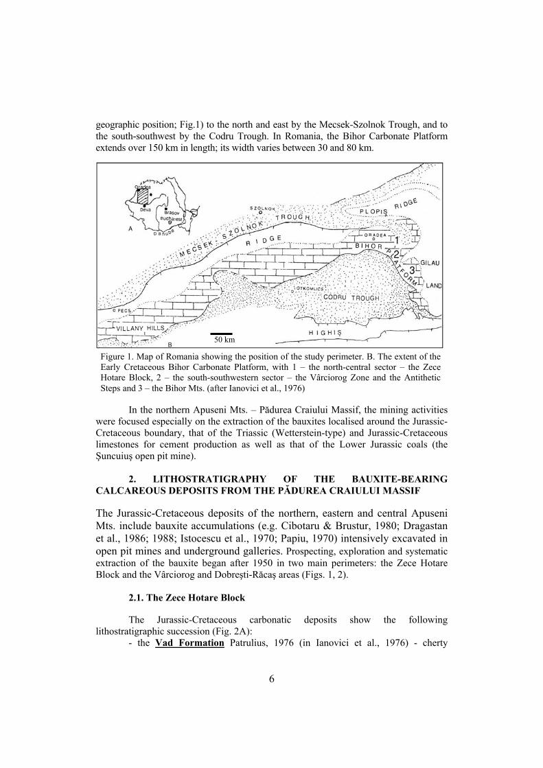
geographic position; Fig.1) to the north and east by the Mecsek-Szolnok Trough, and to the south-southwest by the Codru Trough. In Romania, the Bihor Carbonate Platform extends over 150 km in length; its width varies between 30 and 80 km.
50 km
Figure 1. Map of Romania showing the position of the study perimeter. B. The extent of the Early Cretaceous Bihor Carbonate Platform, with 1 – the north-central sector – the Zece Hotare Block, 2 – the south-southwestern sector – the Vârciorog Zone and the Antithetic Steps and 3 – the Bihor Mts. (after Ianovici et al., 1976)
In the northern Apuseni Mts. – Pădurea Craiului Massif, the mining activities were focused especially on the extraction of the bauxites localised around the Jurassic-Cretaceous boundary, that of the Triassic (Wetterstein-type) and Jurassic-Cretaceous limestones for cement production as well as that of the Lower Jurassic coals (the Şuncuiuş open pit mine).
2. LITHOSTRATIGRAPHY OF THE BAUXITE-BEARING CALCAREOUS DEPOSITS FROM THE PĂDUREA CRAIULUI MASSIF The Jurassic-Cretaceous deposits of the northern, eastern and central Apuseni Mts. include bauxite accumulations (e.g. Cibotaru & Brustur, 1980; Dragastan et al., 1986; 1988; Istocescu et al., 1970; Papiu, 1970) intensively excavated in open pit mines and underground galleries. Prospecting, exploration and systematic extraction of the bauxite began after 1950 in two main perimeters: the Zece Hotare Block and the Vârciorog and Dobreşti-Răcaş areas (Figs. 1, 2). 2.1. The Zece Hotare Block The Jurassic-Cretaceous carbonatic deposits show the following lithostratigraphic succession (Fig. 2A): - the Vad Formation Patrulius, 1976 (in Ianovici et al., 1976) - cherty
6
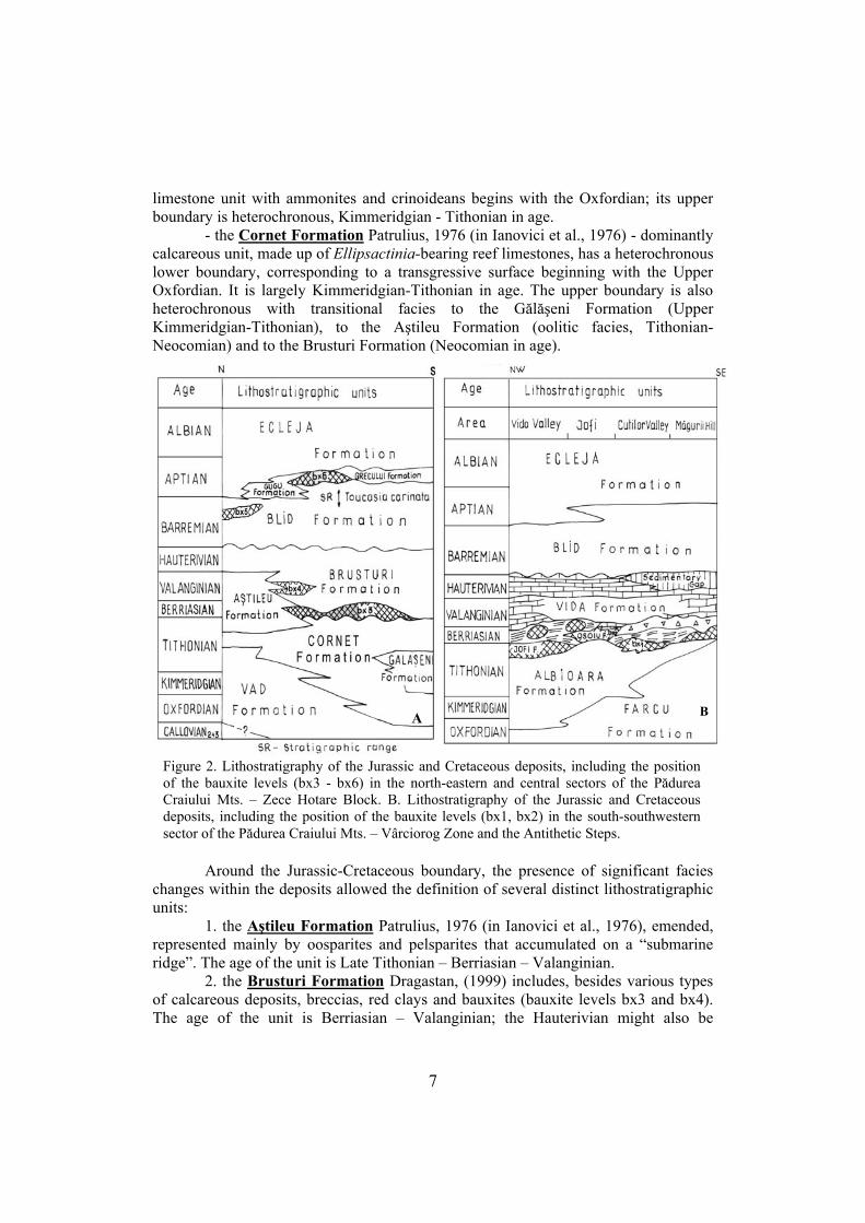
limestone unit with ammonites and crinoideans begins with the Oxfordian; its upper boundary is heterochronous, Kimmeridgian - Tithonian in age. - the Cornet Formation Patrulius, 1976 (in Ianovici et al., 1976) - dominantly calcareous unit, made up of Ellipsactinia-bearing reef limestones, has a heterochronous lower boundary, corresponding to a transgressive surface beginning with the Upper Oxfordian. It is largely Kimmeridgian-Tithonian in age. The upper boundary is also heterochronous with transitional facies to the Gălăşeni Formation (Upper Kimmeridgian-Tithonian), to the Aştileu Formation (oolitic facies, Tithonian-Neocomian) and to the Brusturi Formation (Neocomian in age).
B A
Figure 2. Lithostratigraphy of the Jurassic and Cretaceous deposits, including the position of the bauxite levels (bx3 - bx6) in the north-eastern and central sectors of the Pădurea Craiului Mts. – Zece Hotare Block. B. Lithostratigraphy of the Jurassic and Cretaceous deposits, including the position of the bauxite levels (bx1, bx2) in the south-southwestern sector of the Pădurea Craiului Mts. – Vârciorog Zone and the Antithetic Steps.
Around the Jurassic-Cretaceous boundary, the presence of significant facies changes within the deposits allowed the definition of several distinct lithostratigraphic units: 1. the Aştileu Formation Patrulius, 1976 (in Ianovici et al., 1976), emended, represented mainly by oosparites and pelsparites that accumulated on a “submarine ridge”. The age of the unit is Late Tithonian – Berriasian – Valanginian. 2. the Brusturi Formation Dragastan, (1999) includes, besides various types of calcareous deposits, breccias, red clays and bauxites (bauxite levels bx3 and bx4). The age of the unit is Berriasian – Valanginian; the Hauterivian might also be
7
represented. The bx3 bauxite level (type section defined in the main gallery from Cornet) is Late Berriasian in age, occurring as lenses or beds within the basal part of the unit, caught between the limestones of Cornet and the Brusturi formations. An interesting feature of the bx3 level is the occurrence of vertebrate fossil remains, including those of dinosaurs, preserved within the bauxites (Patrulius et al., 1983a). Bx3 has a pelitomorph – detritic composition made up of boehmite and hematite. The basal part of the level is mainly massive bauxite, while in the upper, oolitic-detritic part bedding is also present. It is a secondary bauxite accumulation with an Al2O3 content ranging from 24 to 30% (Tab. 1). The individual lenses of bx3 vary between 10-30 m in length and from 10 cm to possibly 1 m in thickness. The bx4 bauxite level appears intercalated in the middle part of the Brusturi Formation; its age is estimated to be Early Valanginian. It is also residual bauxite with a lower Al2O3 content (less than 28%; Tab. 1); the length of the individual bodies does not exceed 15 m, and their thickness is less than 50 cm. - The Blid Formation Dragastan et al., (1988) follows transgressively and unconformably over the Brusturi Formation. It is a mainly carbonatic unit that includes 2 or 3 levels of pachyodont coquinas with Toucasia carinata and Requienia species. The faunal assemblages suggest a Barremian-Early Aptian age. The bauxite level bx5 is intercalated within the deposits of the Blid Formation, being assigned to the Upper Barremian. It is represented by brick-red coloured bauxite clays with a granular-peletal structure; the peloids are subspherical, suggesting its origin from a paleosol of terra rossa type. The bauxite bodies have a reduced thickness (under 1 m) and lateral development (less than 10 m); locally, it has a bedded appearance. The Al2O3 content of bx5 is about 30% (Tab. 1).
At the Baremian – Aptian boundary several siliciclastic deposits can be recognised. These include: - the Gugu Formation Patrulius, 1976 (in Ianovici et al., 1976). Also known as the Gugu Breccia, this unit was formerly considered of tectonic origin; recent studies had shown that it is of sedimentary origin, having a Latest Bedoulian – Gargasian age. This unit interfingers laterally with the deposits of - the Grecului Formation Dragastan, (1999), intra-Aptian in age. The unit can be recognized between the Vadu Crişului and Şuncuiuş localities. The Grecului Formation contains peloidal-ooidal bauxite lenses corresponding to the level bx6, dominated by boehmite and goethite. The stratotype of the unit is described in the eastern part of the Zece Hotare block, in the mining gallery that crosses the Grecului Hill. The bauxite level covers a paleokarst surface cutting into a lumachelle limestone with large-sized pachyodonts including Toucasia carinata (Matheron); the microfossil content of the underlying pachyodont limestones supports a Early Aptian (earliest Bedoulian) age (Dragastan et al., 1989) suggesting that bauxite formation occurred probably during the Middle Aptian (Gargasian). The bx6 bauxite represents a primary accumulation forming a lens of almost 40 m in length and a maximum thickness of 4 m; in the middle part, the lens thins to about 10 cm, suggesting that the bauxite body moulds a pre-existing paleokarst surface. The Al2O3 content of bx6 is relatively high (47%; Tab. 1), comparable with that of bauxites bx1-bx2 from the Jurassic-Cretaceous boundary. - the Ecleja Formation Patrulius, 1976 (in Ianovici et al., 1976) concludes the
8
Lower Cretaceous limestone sequence. The unit is represented by siltites with interbedded sandstones; its ammonite fauna and foraminiferal assemblages support an Aptian to Early-Middle Albian age. The Ecleja Formation covers transgressively the underlying Blid, Gugu and Grecului formations, representing the onset of a regional transgressive event during the Aptian. 2.2. The Vârciorog and Dobreşti-Răcaş (Antithetical Steps) zones
The western and southwestern parts of the northern Apuseni Mts. correspond to the Vârciorog – Răcaş – Dobreşti – Roşia area. The lithostratigraphy of the Jurassic – Cretaceous boundary deposits show marked facies and depositional environment changes when compared to the Zece Hotare Block. This area was also subjected to bauxite mining activities in open pit mines and underground galleries.
The following lithostratigraphic units were separated (Fig. 2B): - the Farcu Formation Patrulius, 1976 (in Ianovici et al., 1976), represented by reef limestones with corals that support an Oxfordian – Kimmeridgian – Tithonian age. This unit corresponds to a barrier reef developed in the outer shelf area, with transition (especially during the Tithonian) to inner shelf or back reef lagoon environments and patch-reefs. - the Albioara Formation Patrulius, 1976 (in Ianovici et al., 1976) is a heterochronous unit overlying transgressively the Farcu Formation. It is Late Oxfordian – Kimmeridgian – Tithonian in age and includes several oncomicritic limestone levels deposited within a large inner shelf reef lagoon (Pl. 1, Fig. 1).
At the Jurassic – Cretaceous boundary several lithostratigraphic units were defined:
1. the Jofi Formation Dragastan, (1999) includes the bauxite level bx1 within a succession with red clays, whitish limestone and bauxite breccias, fenestral micrites, clays with limestone blocks; the succession ends with micrites and dolomicrites. The age of this unit is Late Tithonian. Type section of the unit is in the Jofi Gallery 130. The bx1 bauxite level represents a primary (ferro-ferric) accumulation, appearing as lenses with a length of 10-20 m and thicknesses ranging from 20 cm up to 3.0 m; its Al2O3 content varies between 47-48% (Tab. 1).
Table 1. Chemical composition of the bx1-bx6 bauxite levels from the Pădurea Craiului Mts.,
Bihor Carbonate Platform (from Papiu et al., 1970, Dragastan et al., 1989).
Content % Bauxite level Al2O3 Fe2O3 SiO2 TiO2
Age
bx1 (Jofi Fm.) 47-48 8-10 25 2.4 Late Tithonian bx2 (Osoiu Fm.) 50-57 20-24 20 2.0-2.2 Early Berriasian bx3 (Brusturi Fm.) 28-30 7-8 28 2.2 Late Berriasian bx4 (Brusturi Fm.) 24-27 6-8 25-28 2.0 Early Valanginian bx5 (Blid Fm.) 30-32 9-10 27-28 2.7 Late Barremian bx6 (Grecului Fm.) 45-47 8-9 27 3.4 Middle Aptian
2. the Osoiu Formation Dragastan, (1999), Early Berriasian in age, includes the bauxite level bx2; type section was defined in the Lens 31/45 in the southern part of the
9
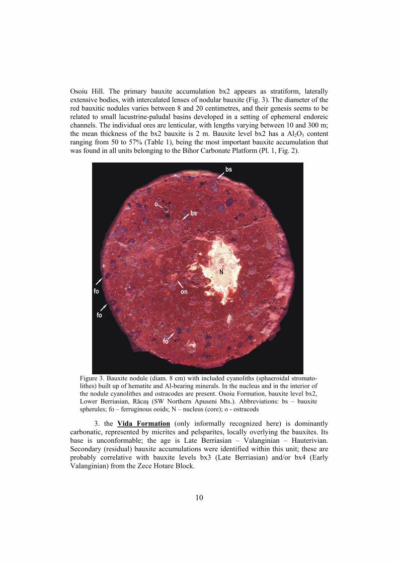
Osoiu Hill. The primary bauxite accumulation bx2 appears as stratiform, laterally extensive bodies, with intercalated lenses of nodular bauxite (Fig. 3). The diameter of the red bauxitic nodules varies between 8 and 20 centimetres, and their genesis seems to be related to small lacustrine-paludal basins developed in a setting of ephemeral endoreic channels. The individual ores are lenticular, with lengths varying between 10 and 300 m; the mean thickness of the bx2 bauxite is 2 m. Bauxite level bx2 has a Al2O3 content ranging from 50 to 57% (Table 1), being the most important bauxite accumulation that was found in all units belonging to the Bihor Carbonate Platform (Pl. 1, Fig. 2).
Figure 3. Bauxite nodule (diam. 8 cm) with included cyanoliths (sphaeroidal stromato-lithes) built up of hematite and Al-bearing minerals. In the nucleus and in the interior of the nodule cyanolithes and ostracodes are present. Osoiu Formation, bauxite level bx2, Lower Berriasian, Răcaş (SW Northern Apuseni Mts.). Abbreviations: bs – bauxite spherules; fo – ferruginous ooids; N – nucleus (core); o - ostracods
3. the Vida Formation (only informally recognized here) is dominantly carbonatic, represented by micrites and pelsparites, locally overlying the bauxites. Its base is unconformable; the age is Late Berriasian – Valanginian – Hauterivian. Secondary (residual) bauxite accumulations were identified within this unit; these are probably correlative with bauxite levels bx3 (Late Berriasian) and/or bx4 (Early Valanginian) from the Zece Hotare Block.
10
Similar to the situation reported in the Zece Hotare Block, the Neocomian deposits are transgressively and unconformably overlain by the Barremian – Lower Aptian Blid Formation and the Aptian – Lower-Middle Albian Ecleja Formation
To conclude, the following primary bauxite levels were excavated in the calcareous succession deposited at the Jurassic – Cretaceous boundary from the Pădurea Craiului Mts.: - bauxite bx1 – Latest Tithonian in age - bauxite bx2 – Berriasian in age; this level is the most widespread and most intensively excavated bauxite level in the northern Apuseni Mts. and - bauxite bx6 – intra-Aptian in age.
Besides these primary bauxites, the secondary bauxite bx3 (Latest Berriasian-Valanginian) was also excavated. The two other residual bauxite levels (bx4 and bx5) represent low-quality residual bauxites reworked or re-mobilized from the older bauxites (especially from the levels bx2 and bx3); these were less intensely excavated or were of no economic importance.
The genesis of the primary bauxite levels from the study area can be attributed to the low-Ph stabilization of the initial-ionic or colloidal-dissolved material originating from dessilicated or lateritic rocks followed by precipitation due to mixing with the bicarbonated waters of the successive Late Jurassic and Early Cretaceous paleokarsts (Mantea, 1988).
The lower bauxite units of the Bihor Carbonate Platform, discussed here, belong to the third bauxite group defined for the northern continental margin of the Tethys (d´Argenio & Mindszenty, 1987), characterized by small stratigraphic gaps (representing 1-2 M.y.), corresponding to the bauxites from Hungary (Villány Mts.), Sardinia, France and Spain. They are also comparable to the middle bauxite levels separated in the Parnassus zone of Greece (Carras & Tselepidis, 2001): bauxite levels bx1 and bx2 are largely synchronous with the bauxite level b2 from the Distomon Limestone Formation, while bx4 (possibly also bx3) might be correlated with the bauxite horizon b2-3 from the Neocomian-Barremian Amphissa Limestone Formation. Finally, the uppermost bauxite level bx6 is comparable with the Upper Gargasian Bauxite series from Combé de Lé from the French Eastern Pyrinees (Combes, 1984).
3. SHORT HISTORICAL OVERVIEW OF THE BAUXITE MINING AND ALUMINIUM INDUSTRY IN ROMANIA
In the past, in absence of a significant bauxite extraction and domestic aluminium production, Romania imported aluminium. This aluminium import was insignificant, with an amount of only 33 tons between 1928-1937, representing a total of 419 millions of lei (less than 1% of the total imports during the same time period).
Bauxite ores were known at that time only in the Northern Apuseni Mts., in the Pădurea Craiului Mts.; between 1914-1918, several companies held concessions on the bauxite excavation in this area.
After 1918, bauxite mining in the Northern Apuseni Mts. was overtaken by Romanian companies such as “Alumina” (1921) or “Bauxita” (1922). The “Societatea Industria Română de Aluminiu” (Romanian Aluminium Industry Society) was founded in 1937. The first results, obtained in the “Nitrogen” plant from Târnăveni, were the
11
production of aluminium bars. The regular and systematic prospecting, then exploration and excavation of the
bauxite started after 1950, allowing the Romanian aluminium industry to reach in 1965 a production level of 86 tons.
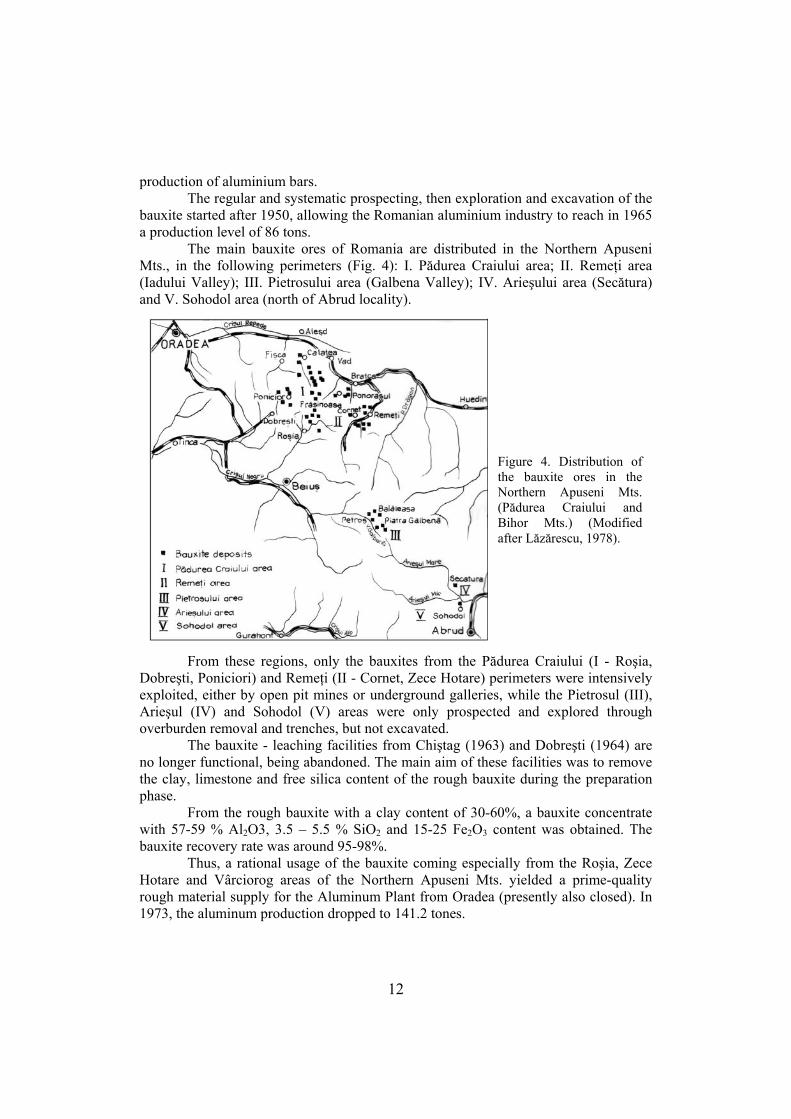
The main bauxite ores of Romania are distributed in the Northern Apuseni Mts., in the following perimeters (Fig. 4): I. Pădurea Craiului area; II. Remeţi area (Iadului Valley); III. Pietrosului area (Galbena Valley); IV. Arieşului area (Secătura) and V. Sohodol area (north of Abrud locality).
Figure 4. Distribution of the bauxite ores in the Northern Apuseni Mts. (Pădurea Craiului and Bihor Mts.) (Modified after Lăzărescu, 1978).
From these regions, only the bauxites from the Pădurea Craiului (I - Roşia, Dobreşti, Poniciori) and Remeţi (II - Cornet, Zece Hotare) perimeters were intensively exploited, either by open pit mines or underground galleries, while the Pietrosul (III), Arieşul (IV) and Sohodol (V) areas were only prospected and explored through overburden removal and trenches, but not excavated.
The bauxite - leaching facilities from Chiştag (1963) and Dobreşti (1964) are no longer functional, being abandoned. The main aim of these facilities was to remove the clay, limestone and free silica content of the rough bauxite during the preparation phase.
From the rough bauxite with a clay content of 30-60%, a bauxite concentrate with 57-59 % Al2O3, 3.5 – 5.5 % SiO2 and 15-25 Fe2O3 content was obtained. The bauxite recovery rate was around 95-98%.
Thus, a rational usage of the bauxite coming especially from the Roşia, Zece Hotare and Vârciorog areas of the Northern Apuseni Mts. yielded a prime-quality rough material supply for the Aluminum Plant from Oradea (presently also closed). In 1973, the aluminum production dropped to 141.2 tones.
12
4. IMPACT OF THE MINING ACTIVITIES IN THE NORTHERN APUSENI MTS. AREA
As the mining activities for bauxites in the Northern Apuseni Mts. ended in 1996, in the present the mining areas (open pit mines, galleries, boreholes) represent abandoned land, although there are several studies concerning the bauxite reserves in the sectors already excavated, as well as the reserves (not yet excavated) in the Bihor Mts., that suggest these might have economic value.
There are several specific environmental problems related to the former mining activities in the Apuseni Mts., concerning waste minimization and management as well as the re-opening of the bauxite excavation in the area, such as: - the mapping and detailed understanding of the impact of the mining activities upon the study area, as well as that of the relevant issues concerning ecology and environmental protection, in order to reduce the effects of environmental destruction and pollution; - optimisation of land usage and reintegration of the already excavated areas in the natural/social cycle; this also refers to those areas that might represent focus of future excavation activities in case private companies will be interested in the exploitation of the bauxite resources (e.g. the Bihor Mts.). Actually, beginning with 2006 a small private company was reactivated aiming to continue the bauxite extraction. - decrease of the water pollution, including acid waters (e.g. Diaconu & Lungu, 1994), thus improving soil quality and the supported flora and fauna; - inventory of the sources of pollution from the mining areas, identification of possible modes of recycling and re-usage of the specific waste left in the field (iron tools and machinery, rails, wooden sleepers etc.).
Finally, solutions for minimising or reducing the effects of all the above-mentioned impact sources connected to the former (and possibly future) mining activities must be sought and implemented, especially since the Northern Apuseni Mts. area has became a National Natural Park and will be integrated in the framework of the already existing European Natural Parks. 4.1. Landscape and subsurface modifications related to the mining activities in the Northern Apuseni Mts.
The underground (galleries, working shafts, air shafts etc.) and surface (open pit) mining activities has generated a large number of cavities of different sizes and dimensions with unstable slopes that are susceptible to mixed landslides (involving soils, clays, detritus and limestone fragments). These, in turn, directly influence local microclimate and vegetation.
After the end of large-scale excavation activities and abandonment of the excavation sites in 1996, extended areas of the Northern Apuseni Mts. were left affected: 97 km2 in the Zece Hotare Block, 15 km2 in the Dobreşti area and over 6 km2 in the Roşia area, summing up to a total of over 120 km2 (see maps of the original distribution of the bauxite accumulations in Patrulius et al., 1983b, Bordea et al., 1986).
The galleries and working shafts, associated with the karstic fissures and holes
13
(that, especially in the Crişul Repede Basin, are strongly developed, resulting in caves with lengths of several kilometres, as well as avens (vertical cave shafts) with heights of 10 to 200 metres) led to breakdowns reaching 100 to 500 metres. This process was further favoured by surface and underground water circulation, leading to severe water inflow through the usually massively fissured and high-porosity limestones.
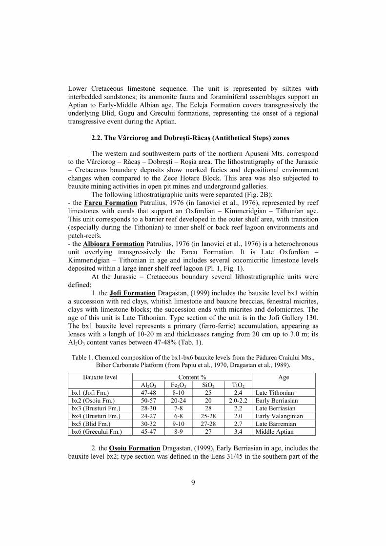
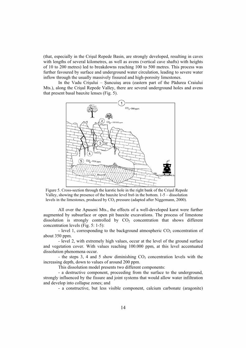
In the Vadu Crişului – Şuncuiuş area (eastern part of the Pădurea Craiului Mts.), along the Crişul Repede Valley, there are several underground holes and avens that present basal bauxite lenses (Fig. 5).
Figure
levels in
5. Cross-section through the karstic hole in the right bank of the Crişul Repede Valley, showing the presence of the bauxite level bx6 in the bottom. 1-5 – dissolution
the limestones, produced by CO2 pressure (adapted after Niggemann, 2000).
All over the Apuseni Mts., the effects of a well-developed karst were further augmented by subsurface or open pit bauxite excavations. The process of limestone dissolution is strongly controlled by CO2 concentration that shows different concentration levels (Fig. 5: 1-5): - level 1, corresponding to the background atmospheric CO2 concentration of about 350 ppm. - level 2, with extremely high values, occur at the level of the ground surface and vegetation cover. With values reaching 100.000 ppm, at this level accentuated dissolution phenomena occur. - the steps 3, 4 and 5 show diminishing CO2 concentration levels with the increasing depth, down to values of around 200 ppm. This dissolution model presents two different components: - a destructive component, proceeding from the surface to the underground, strongly influenced by the fissure and joint systems that would allow water infiltration and develop into collapse zones; and - a constructive, but less visible component, calcium carbonate (aragonite)
14
deposition in karstic holes and fissures below the dissolution level. However, this component, through its cementation and consolidation effects, does not represent a real “repairing” counterpart of the first component.
Besides the underground water circulation, strongly acidic in the mining areas, the variation of the differential pressure of the CO2 concentration from the surface into depth led to important underground collapses within the limestone “body” of the Northern Apuseni Mts.
In both studied sectors of the Northern Apuseni Mts. – Zece Hotare in the east and Vida-Roşia-Dobreşti in the west – the individual mining excavations reach dimensions varying from 20-50 m to up to 300-400 m in length; sometimes, the individual excavated lenses “chain up” to form depressions exceeding 1 km in length. The result of these excavations are elongated depressions with a depth varying from 2 to 6 m and even more (Pl. 1, Fig. 2), in which advanced degradation of the soil and vegetal cover (including bushes and trees) took place. Indirectly, these excavations led to the pollution of the underground and surface waters that has became strongly acidic and presenting large variations in the values of pH (acidity). A survey showed that in pH values varying from 5 to 7 (slightly acidic), the ground cover vegetation resisted and even was able to regenerate itself in the affected areas. However, in areas where water acidity drops to values of 3-4, the high acidity level affects severily the development of vegetation, even to the degree of stopping its growth; this happens e.g. in the Stîlpului Hill area, where the underground galleries became confluent with the surface depressions, leading to especially active acide water circulation.
The highly acidic areas can be difficult to regenerate, even sometimes they preserve the strongly affected, acidic soil, but in time (5 years), due to changes of rainfall pattern and to the “erosional” dissolution, a certain level of natural “healing” of the affected areas became obvious. In the past 5 years the rainfall humidity patterns in the Northern Apuseni area witnessed important changes: - the value of the annual amount of evapo-transpiration increased from 600-650 mm/year (Florea, 2003) to values around or above 700 mm/year, up to 800 mm/year, especially in the western part of the area. - the soil humidity is deficitary and decreasing; if in 2000 the value of this parameter (humidity deficit) was 100 mm, now it reaches values of 200-300 mm.
According to a model – not yet completely implemented with respect of the volume/area relationship -, in three perimeters of the Zece Hotare area (S1, S2, S3), amounting for a total of 50 km2, over 300 bauxite lenses were exploited. Considering an average value of 2 m thickness for the bauxite lenses and 2 m thickness for the limestone overburden, the total amount of the excavated material was estimated to about 300.000 m3; this estimate regards the eastern part of the Northern Apuseni Mts. and the 1985-1996 excavation period, in 1996 the mining activities ceasing. Although this value must be reconsidered, based on exact measurements concerning the excavation areas, it is considered a reliable estimate.
This intense excavation produced a high level of differential erosion in the Northern Apuseni Mts., from moderate rates of erosion of 10-15 tons/ha/year to elevated rates of 15-20 tons/ha/year (Florea, 2003).
15
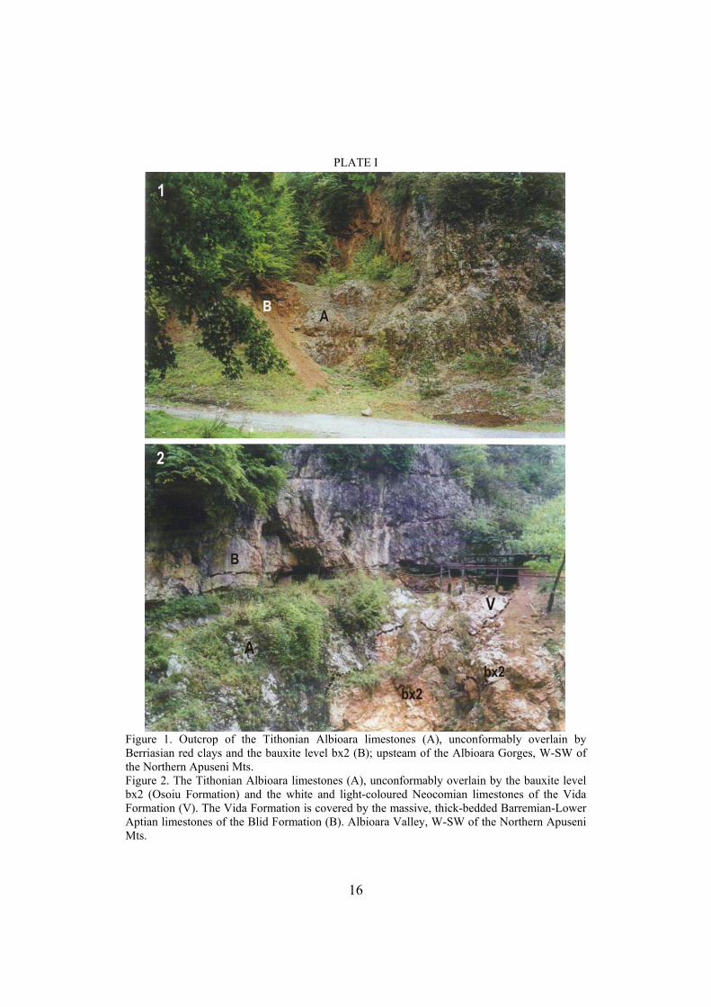
PLATE I
Figure 1. Outcrop of the Tithonian Albioara limestones (A), unconformably overlain by Berriasian red clays and the bauxite level bx2 (B); upsteam of the Albioara Gorges, W-SW of the Northern Apuseni Mts. Figure 2. The Tithonian Albioara limestones (A), unconformably overlain by the bauxite level bx2 (Osoiu Formation) and the white and light-coloured Neocomian limestones of the Vida Formation (V). The Vida Formation is covered by the massive, thick-bedded Barremian-Lower Aptian limestones of the Blid Formation (B). Albioara Valley, W-SW of the Northern Apuseni Mts.
16
Although no exact data is available, it seems probable that the denudation process is dominated by chemical dissolution, promoted by soil erosion and vegetation cover destruction in the excavated areas, associated with increasing acidity of the water. The mechanical denudation is probably less important, excepting some local areas (e.g. Roşia Plateau, a plateau with high endorheic or internal drainage). 4.2. Effects affecting the soils of the Northern Apuseni Mts. Soil erosion
Soil erosion occurs when the rate of removal of soil by water exceeds the rate
of soil formation. Soil formation is generally a very slow process with rates ranging around 1 cm/100-400 years.
Proneness to soil erosion is a measure of the soil resistance to detachment and transport. It depends on soil texture, organic content, structure and permeability. Generally, soils with low contents of clay and organic matter are more readily eroded than soils with a higher content of the same components.
Erosion induced by human activities depends also upon various factors such as land use, deforestation and mining activities. In the Northern Apuseni Mts. area, management and remediation of man-induced soil erosion can be achieved through the following soil conservation strategies: - agricultural and forestation techniques: their aim is to minimize the period of barren soil exposure by encouraging the cultivation of dense vegetation cover - mechanical techniques: these concern the reduction of the energy and impact of the eroding agent(s) through modifying the soil topography, using techniques such as terracing, diversionary spillway construction to direct water away from areas susceptible of high rates of erosion
Chemical degradation of soils is achieved primarily through acidification. Acidification has an important anthropogenic dimension, especially in areas with massive impact of human activity such as the bauxite mining areas of the Northern Apuseni Mts.
Pollution is defined as the introduction by man into the environment of substances or energy forms liable to cause hazards to human health, harm to loving resources and ecological systems, damage to structures or amenity or interference with legitimate uses of environment; a major source of pollution is releasing pollutants to the soil. Soil pollutants are generally classified into two main types. These are macropollutants, which normally occur or are introduced into the soil in great amounts and micropollutants, usually occurring or introduced in small or trace quantities, but whose effects on the key biochemical reactions of the soil biota is important.
In the Northern Apuseni Mts., macropollutants are largely introduced by acid rain and acid mine waters.
Micropollutants are represented by heavy metals (the group of metals and metalloids with an atomic density greater than 6 g/cm3) occurring in the soils in amounts higher than their normal background values. While most of these elements are essential for plant and animal nutrition and metabolism (such as iron, manganese, silicon, among others), and consequently both their excess and deficiency are
17
potentially leading to imbalance, usually excess concentration of heavy metals in soils is dangerous and might be toxic.
From other inorganic compounds, elements like aluminium are considered as environmental pollutants if they occur in excessive quantities in soils. Aluminium oxide is used in water treatment; the World Health Organization set a tolerance level of 200 μg/l for the concentration of aluminium in drinking water.
In the Zece Hotare and Vida-Roşia-Dobreşti areas, important processes include the remobilization of different elements (Fe, Al, Si, Mn, Mg) from the subsurface (represented by limestones, clays and bauxites) and subsequent fixing of the different carbonates. These processes led to landscape modifications through development, in the excavation areas, of mm to cm-thick superficial calcareous crusts (calcrets). These represent a proto-soil on which soil and ground vegetation cover can develop, both of which are subject of important acidic vulnerability.
In the mentioned excavation areas, with open pits and galleries left all over, are characterised by high values of the acidic vulnerability of the soils, the degree of contamination varying from 4 (strong) to 5 (very strong) and even 6 (soils with predominantly anoxic conditions due to different types of sulphide combinations).
The soils are affected both in composition and in structure by chemical and rainfall erosion. Rainfall erosion is defined as soil loss related to unitary rainfall aggressiveness index, defined in standard soil, relief and utilisation conditions; it is entered as a coefficient in the formula that allows calculation of mean annual soil loss through surface erosion. It is especially high in the January to end-spring period, with mean values of the erosion rates varying from 0,132 (medium) to over 0,167 (high), being followed by a prolonged period of drought related to the important climate changes affecting the western part of Romania.
The classical well-developed soil profile, with complex developmental history, includes 4 different horizons: - O horizon – composed mostly of organic matter like leaves, twigs, roots etc.; - A horizon – composed of mineral and organic matter; it is zone of leaching by rain- or groundwater or other fluids from the mining area, that move clays and dissolved elements (e.g. Fe, Ca, Mg, Mn or Al) to the underlying B horizon, a phenomenon known as eluviation or washing; - B horizon – composed of earth materials enriched in clays, Fe oxyhidroxyds, Al, Mg, CaCo3, constituents leached from the overlying horizons; B horizon represents a place of accumulation or illuviation and - C horizon – composed of disintegrated – decomposed parental rock, partially weathered and mostly destroyed substratum
The Northern Apuseni Mts. area, affected by bauxite excavation, is characterised by several “white spots”, i.e. soil-less areas, after the shutting down of the mining activities during 1996. These usually present only the C horizon; slightly developed A and O horizons might also be present, due to the appearance of a vegetal cover on the weathered base-rock in the years following the cease of the mining activities and accumulation of an organic litter.
The main problem is represented by the absence of the tree vegetation over hundreds of acres of excavated areas; these damaged zones can be reintegrated into the
18
forest areas only through terracing and tree planting, according to the corresponding altitudinal vegetation type. In some western areas, such as Dobreşti and Roşia, tree planting and forest regeneration was done by the Beiuş Forest Department.
The main pollution agents are represented by the now-ended bauxite mining activities, as well as the ongoing excavation of different limestone types (especially for cement, at Aleşd); these human activities led to the accumulation of large quantities of polluting compounds in the ecosphere, with strong impact on the environment. The main soil types from the eastern part of the Northern Apuseni Mts. are represented by acid brown soils (with pH values of 2-4), associated with podzols and litho-soils (terra rossa, calcisoils, compact base-rock covered by organic litter – O horizon); in the south-western part, the acid brown soils are associated with luvic brown soils and redzina soils.
In every area with open pit mines, the calcareous base-rock is covered by elluvial vertisoil, results of slides and slumps; these vertisoils yield partial covers with the dislocated alumino-ferro-calcic material.
Another type of soil occurring frequently in the former excavation areas is represented by the erodisoils, profile-less soil covers grafted on the B and C (sometimes also lower A) horizons.
The main processes leading to soil degradation in the former mining areas are: • physical: structure destruction; compaction; crust forming; heavy metal
pollution (Fe, Al, Mg, Mn) • chemical: acidic vulnerability (levels 2-3-4) due to dissolution and large-scale
circulation of contaminated soil and underground waters • biological: reduction of the microorganisms, meso- and macrofauna • removal through intense erosion by surface and underground waters,
landslides, excavation, covering with dumped sterile or waste. The processes of soil rigidity development are especially frequent on slightly
stable types of substratum as the bauxite-clay (kaolinite) associations or the luvic, humus-poor, lutitic brown soils.
Chemical degradation of the soils, associated with the increase of acidity, is probably related to the decrease of the soil reactivity, leading to the mobilisation of the Al, a toxic element for the largest part of crop plants, as well as for herbs, bushes and trees in general, especially conifers (Abies, Picea, Pinus; the last taxon becoming extremely rare in or even almost disappearing from the area, due to both Al toxicity and excessive tree-cutting activities).
In the pedogeographic maps of Romania (Florea, 2003) the Northern Apuseni Mts. represent a specific area included in the eco-region 1 that interferes with eco-regions 2, 3 and 4. Eco-region 1 is represented by mountain pedo-domains with moderate-wet climate and diverse forest and secondary lawn ecosystems (to the exclusion of the primary, alpine lawn ecosystems, characteristic for the altitudes of 1800-2000 meters).
It is noteworthy that the last several years are characterised in the Northern Apuseni Mts. by drought periods, especially during summer-fall; the existence of these droughts might be linked also to the existence of the “white spots” produced by mining activities.
19
In the Northern Apuseni Mts., several problems related to soil management are to be solved. These include soil remediation in the affected areas, polluted with pollutants such as Al, Fe, Mn through: - ex situ bio remedial methods: these, carried out away from the pollution site, are normally faster than the in situ methods; - composting – an aerobic process during which organic matter is decomposed by microorganisms producing heat, carbon dioxide, water vapor and humus. In the composting technique, biodegradable waste or contaminated soil is mixed with bulking materials such as straw to facilitate circulation of air and water required for the biological activities of the organisms. - phyto-remediation (vegetation-assisted bioremediation) - a passive soil remediation technology, using plants to remove, break down or stabilize contaminants in moderately shallow polluted sites, the polluting heavy metals being taken up by plants. Two main processes are known: 1. phyto-extraction: absorbing of the metals through the plant roots, transported to other plant parts where they may be accumulated. Plants known to be able to absorb certain metals or their salts are planted in the polluted area; afterwards, these are harvested and incinerated or recycled (e.g. composting). 2. rhiso-filtering: filtering of the metals through well-developed root systems. The filtering process is more effective in water; consequently, this is used primarily to remove metal pollutants from water. As metals are accumulated in the roots, only these are harvested and incinerated or recycled. There is a two-step process, implying first growing the plants in greenhouses until a well-developed root system forms, followed by planting them into the polluted water reservoir. Rehabilitation of mine wastes and mine sites
The most important impact of mining activities are creating wastes, disturbing proportions of land and areas of existing vegetation and fauna, creating distinct changes in topography, hydrology and stability of the landscape. After the ceasing of the mining activities in some areas of the Northern Apuseni Mts., the mined land and its waste repositories must be rehabilitated, this aspect being an integral part of mine planning, development and final closure. This procedure usually starts before the final closure, as small-scale (as allowed by operational constrains) progressive rehabilitation of areas of the mining site are usually required/undertaken (such as re-vegetation, contouring).
The general aspects of mine rehabilitation include: 1. removal of mine facilities; these (including processing facilities as well) must be dismantled and removed, re-used or recycled 2. sealing and securing the mine workings; open pits might be fenced 3. ensuring long-term stability of waste repositories 4. modeling future water quality and quantity in pit lakes 5. modeling future water quality in underground workings and aquifers, including assessment of the potential contamination of shallow ground waters and especially drinking waters 6. construction of suitable landscape forms (shaping of the remaining waste dumps to
20
ensure minimal water and wind erosion, of the mining area and dumps to create adequate drainage 7. development of a suitable plant growth medium to re-vegetate the waste repositories and disturbed mining areas, as usually these sites are not or less favorable to sustained vegetation development 8. establishment of vegetation cover 9. addressing generic mine waste issues, for example treatment of acid mine waters.
Mine site rehabilitation returns mine land to future land use, which can be highly site specific, according to local climatic, geological, pedological, agricultural aspects as well as type of mines and mine wastes. Experimental rehabilitation activities of former bauxite quarry sites were designed and implemented recently, including re-vegetation of the disturbed land area and long-term monitoring of the soil properties (Brejea et al., 2008). According to their results, the life-supporting properties of the disturbed soils are severely reduced compared to the neighboring undisturbed forest areas. Consequently, settling of new vegetation (both grassy: Poa pratensis, Allium ursinum and wooden: Robinia pseudoacacia) was shown to be heavily enhanced by fertilization; this observation indicates that this kind of supporting activities should represent the norm in the early phases of rehabilitation. It is noteworthy however, that spontaneous wooden vegetation growth (Salix, Betula, Fagus) was also recorded in the marginal areas of the studied quarry site, suggesting that the natural recovery potential of the local vegetation would represent an important factor of the rehabilitation activities in the absence of further human interferences.
In sparsely populated areas, such as in the Northern Apuseni Mts., rehabilitation usually is expected to reach a standard which may allow limited grazing; however, as the area is included in the boundaries of a National Natural Park, rehabilitation must proceed further, especially in issues concerning landscape rehabilitation, reforestation and removal of mine facilities. Open pits might be converted to water storage facilities, wetland/wildlife habitats or to repositories for mining or domestic waste; underground mines can be used as storage facilities. In case of old and closed mines, especially those with acid mine drainage, these can only be monitored in order to assess and restrict contamination to the mined area. In these cases, collection and treatment of the acid mine drainage waters in perpetuity represents the only viable option.
Mine wastes are unwanted, with no current economic value; some are benign and pose no environmental threat, or even can use to rehabilitate mining area, but the majority of them represent problematic wastes at least, as they contain pollutants and impact on the environment, ecosystem and humans.
According to Lottermoser (2003; p. 29), the “(r)ehabilitation of mine sites is an integral part of modern mine planning, development and mine closure. Several issues have been addressed in the successful rehabilitation of a mine site, including: removal of all mine facilities; sealing and securing of the mine workings; ensuring long-term stability of waste repositories; modeling of future water quality and quantity in pit lakes, underground workings and aquifers; construction of suitable landforms; development of a suitable plant growth medium; establishment of vegetation cover; and addressing generic mine waste issues. Every mine produces its own unique waste
21
and this waste requires its very own characterization, prediction, monitoring, treatment and secure disposal.”
5. CONCLUSIONS
In conclusion, this study revealed that the Northern Apuseni Mts. area (Bihor
sector) might represent a future mining area for the excavation of the bauxite, clays and different types of limestones, but with respect to the regulations concerning the environmental protection. Existing studies on the Northern Apuseni Mts. show that it represents a moderately polluted area (heavy metal pollution), with large areas destroyed by surface excavations and underground galleries and contaminated surface and underground waters. All these aspects require further investigations and implementing measures in order to assure the rehabilitation of the affected areas by the mining activities. Another issue that seeks urgent remedial is represented by the specific wastes (iron barracks, rails, wooden sleepers, machinery), that must be removed and recycled.
In the future, special attention will be given to environmental issues as follows: 1. The study of the bioindicators and biomonitors from the flora (especially), which incorporate toxic metals in high proportions in the different vegetative organs (roots, bark, ramii, leaves) and development of environmental solutions based on them; 2. The effects of the mining and mine wastes on the forest ecosystem, evidencing the decline in frequency and occurrence of the medium-high elevation (Abies, Picea, Pinus) and of the moderate altitude (Fagus, Quercus) plants. In the Northern Apuseni Mts. a strong tendency toward extinction of the genera Pinus and Quercus was identified, as well as the areal reduction of the Picea excelsa and that of the mixed forests (with common oak). 3. The problems related to landscape ecology, protection and rehabilitation, within the framework of the Apuseni Mts. National Park; 4. The recycling and re-usage of the specific metallic and wooden mining waste that exists in the former mining areas, through public auction, jointly with local and departmental authorities and agencies; 5. The identifcation and implementing of strategies in order to minimize the effects of the pollutant agents in Bihor County and in the Northern Apuseni Mts., known to have been affected by pollution and 6. Studies regarding the social impact of the ceasing of the mining activities, using the “metapopulation” concept (viability of the local communities depending on emigration rates due to the lack of job opportunities), identification of practical solutions concerning the rehabilitation of the fragmented vegetation and inhabited areas (villages).
ACKNOWLEDGMENTS The authors wish to acknowledge the help of the ANRM (National Agency for Mineral Resources) and the European Union - NESMI Project, especially to the Project Coordinator Dr. Horst Hejny (Dinslaken, Germany), for their help and support to conduct this study. Two anonymous reviewers and the editor Prof. Dr. Gheorghe Damian are also thanked for their
22
constructive comments and suggestions.
REFERENCES Bordea, S., Bordea, J., Mantea, G. & Costea, C., 1986. Harta geologică a României – foaia 40b
(Zece Hotare), sc. 1:50.000. Inst. Geol. Geofiz., Bucureşti. Brejea, R., Domuţa. C., Şandor, M., Samuel, A. D., Bara, V., Ciobanu, G., Sabău, N. C.,
Ciobanu, C., Bara, C., Domuţa, C., Bara, L., Borza, I., Gâtea, M. & Vuşcan, A., 2008. The study of physical, chemical and enzymatical properties of the land from a former bauxite quarry in the Pădurea Craiului Mountains in the context of ecological reconstruction. Carpathian Journal of Earth and Environmental Sciences, Baia Mare, 3, 2, 49-63.
Carras, N. & Tselepidis, V., 2001. Stratigraphy of the Alpine formations of the Parnassus zone and of some allochtonous sequences in the Distomon area (Boeotia, Greece). In Solakius, N. & Kati. M. (eds.), The Parnassus Zone, Central Greece, Meddelanden Fran Lunds Universitets, Geografiska Institutioner, 139, 17-36.
Cibotaru, T. & Brustur, T., 1980. Contributions a la connaisance de la géologie de la zone de Meziad (Monts Pădurea Craiului) avec considérations spéciales sur la bauxite. Rev. roum. géol., géophys, géogr., Géologie, Bucureşti, 24, p. 127-137.
Combes, J. P., 1984. Regards sur la géologie des bauxites; aspects récents sur la genèse des quelques gisements à substratum carbonaté. Bull. Centres Res.-Explor.-Prod. Elf-Aquitane, Pau, 8, 1, 251-274.
d'Argenio, B. & Mindszenty, A., 1987. Cretaceous bauxites in the tectonic framework of the Mditerranean. Rend. Soc. Geol. Ital., Roma, 9, 257-262.
Diaconu, M. & Lungu, P., 1994. Vulnerabilitatea la poluare a acviferelor situate în zone faliate. Zona Oradea – România. Int. Hydrogeol . Symp., IAH, RAH, Constanţa, p. 112-122
Dragastan, O., 1999. Jurassic-Cretaceous calcareous algae of the Transylvanides, Inner Dacides and Moesian Platform. Revista Espanola de Micropaleontologia, Madrid, 21, 1, p. 5-65
Dragastan, O., Purecel, R. & Brustur, T., 1986. The Upper Jurassic and Lower Cretaceous formations from the Bihor Mts. – central-southern sector (Northern Apuseni). An. Univ. Buc., Geologie, 35, Bucureşti, p. 57-70
Dragastan, O., Coman, M. & Ştiucă, E., 1988. Bauxite-bearing formations and facies in the Pădurea Craiului Mountains (Northern Apuseni). Rev. Roum. Geol. Geophys. Geogr., Geologie, Bucureşti, 32, p. 67-81
Dragastan, O., Marinescu, M., Gheorghe, D. & Tinteanu, C., 1989. Upper bauxite sensu D. Patrulius and some new algae of Pădurea Craiului Mountains (Northern Apuseni – Romania). Rev. Roum. Geol. Geophys. Geogr., Geologie, 33, p. 55-67
Florea, N., 2003. Degradarea, protecţia şi ameliorarea solurilor şi terenurilor. Ed. Bucureşti, Bucureşti, 309 pp.
Ianovici, V., Borcoş, M., Bleahu, M., Patrulius, D., Dimitrescu, R. & Savu, M., 1976. Geologia Munţilor Apuseni. Ed. Acad. RSR, Bucureşti, 631 pp.
Istocescu, D., Aurică, M., Diaconu, M. & Istocescu, F., 1970. Studiul geologic al regiunii cuprinse între Crişul Repede şi Crişul Negru. D. S. Inst. Geol., 60 (1967-1968), Bucureşti, p. 49-58
Lăzărescu, I., 1978. Aluminiul. Ed. Tehnică, Bucureşti, 222 pp. Lottermoser, B., 2003. Mine wastes. Springer Verlag, Berlin, Heidelberg, New York, 277 pp. Mantea, G., 1988. Biostratigraphic and structural characteristics of the Neojurassic and
Eocretaeous formations from the foot-wall and hanging-wall of the bauxite deposits of the Bihor Mountains. Travaux Inst. Géol., Bucharest, 16-17 (1986-1987), 101-116.
Papiu, C. V., 1970. Litologia calcarelor mezozoice asociate bauxitelor din Masivul Pădurea
23
24
Craiului (Munţii Apuseni). D. S. Inst. Geol., Bucureşti, 55 (1968-1069), 1, p. 187-208. Papiu, C. V., Mânzatu, S., & Iosof, V., 1970. Genetische Typen der Karst-Bauxite in den
rumänischen Kreide-Formationen. Ann. Inst. Geol. Publ. Hung., Budapest, 3, 241-264. Patrulius, D., Marinescu, F. & Baltreş, A., 1983a. Dinosauriens ornithopodes dans les bauxites
neocomiens de l’unité de Bihor (Monts Apuseni). An. Inst. Géol. Géophys., Bucureşti, 59, p. 109-140.
Patrulius, D., Bordea, S., Bordea, I. & Mantea, G., 1983b. Harta geologică a Munţilor Pădurea Craiului, sectorul sudic. Sc. 1:25.000. Institutul de Geologie şi Geofizică, Bucureşti.
Received at 16. 12. 2008 Revised at. 19. 03. 2009 Accepted for publication: 06. 05. 2009 Published online: 28. 07. 2009