Embed Size (px)
Citation preview

United States Geological Survey
Earthquake Hazards Program
External Research Support
http://earthquake.usgs.gov/research/external
Proposals for Grants – Fiscal Year 2008
Program Announcement 08HQPA0001
Closing Date: May 16, 2007
APPLICATIONS MUST BE SUBMITTED ELECTRONICALLY VIA
http://www.grants.gov
SEE INSTRUCTIONS

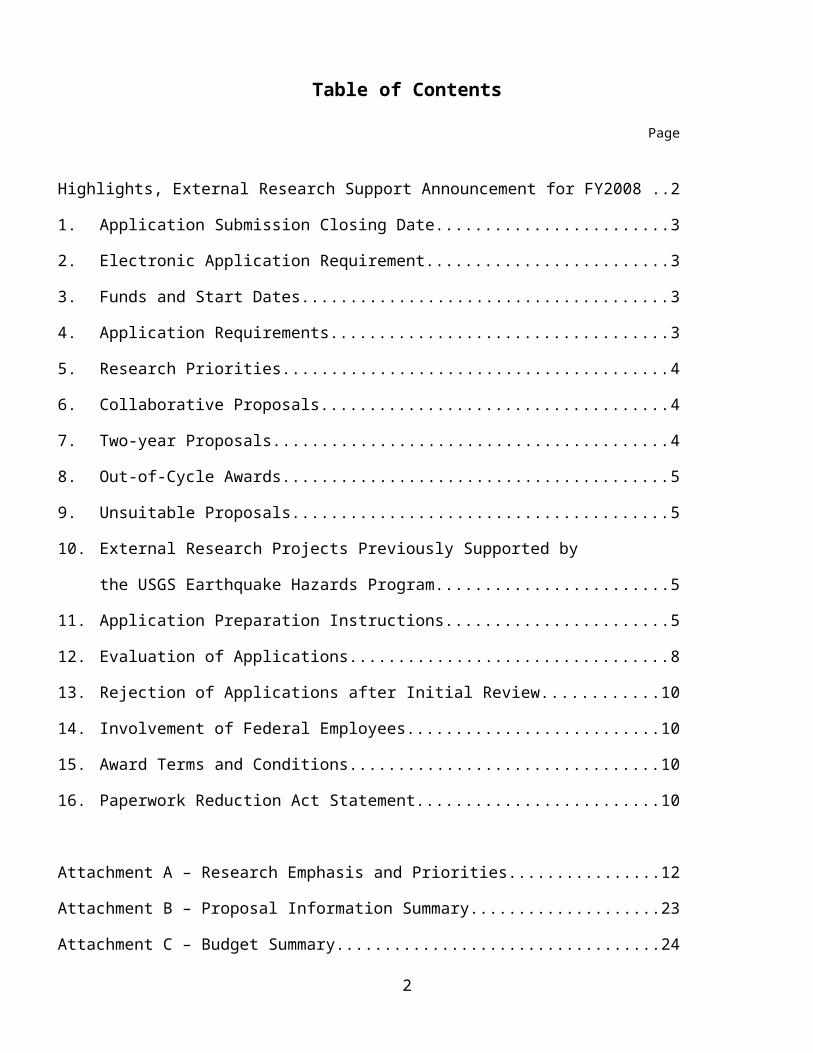
Table of Contents
Page
Highlights, External Research Support Announcement for FY2008 ............................................2
1. Application Submission Closing Date................................................................................3
2. Electronic Application Requirement..................................................................................3
3. Funds and Start Dates........................................................................................................ 3
4. Application Requirements.................................................................................................. 3
5. Research Priorities............................................................................................................. 4
6. Collaborative Proposals..................................................................................................... 4
7. Two-year Proposals........................................................................................................... 4
8. Out-of-Cycle Awards......................................................................................................... 5
9. Unsuitable Proposals.......................................................................................................... 5
10. External Research Projects Previously Supported by
the USGS Earthquake Hazards Program............................................................................5
11. Application Preparation Instructions..................................................................................5
12. Evaluation of Applications................................................................................................. 8
13. Rejection of Applications after Initial Review.................................................................10
14. Involvement of Federal Employees..................................................................................10
15. Award Terms and Conditions..........................................................................................10
16. Paperwork Reduction Act Statement................................................................................10
Attachment A – Research Emphasis and Priorities.....................................................................12
Attachment B – Proposal Information Summary........................................................................23
Attachment C – Budget Summary.............................................................................................. 24
Attachment D – Special Terms and Conditions..........................................................................25
Attachment E – General Provisions............................................................................................ 37
1
Highlights
USGS Earthquake Hazards Program External Research Support Announcement for Fiscal Year 2008
Electronic Application Requirement All applications shall be submitted electronically using Grants.gov: http://www.grants.gov Be sure to read the instructions carefully. Paper copies will NOT be accepted.
Funds and Start Dates The earliest start date for new grants is December 1, 2007 and the latest start date is
September 1, 2008.
Research Priorities for Fiscal Year 2008 (see Attachment A) Attachment A, Research Priorities has been revised--please read carefully. Regional and Topical research areas have been changed. Please choose the correct new category for your proposal. NOTE: All proposed work must indicate how the expected results could be applied to reducing losses from earthquakes in the United States. This application of the proposed research should be clearly stated in a separate paragraph of the proposal.
Collaborative Proposals Please read the instruction concerning what constitutes a collaborative proposal. Each collaborator must submit a complete proposal.
Application Preparation Instructions Page limit and type size limits WILL be enforced. These limits must be adhered to or the
proposal will be rejected. Lists of previously supported projects are located on the External Research Support web page
http://earthquake.usgs.gov/research/external
Award Terms and Conditions Final technical reports are required in both hard copy and in digital form, including all figures, photographs, and maps in their original digital format. It is a USGS expectation that the results of funded research be published in a peer-reviewed form and that all data products and computer codes be made readily available. Please read the technical and financial reporting requirements section carefully as several changes have been made.
Questions?
For Grants.gov issues, see: http://www.grants.gov/applicants/applicant_help.jsphttp://www.usgs.gov/contracts/grants/grantsgov.html
For Contracting Officer issues, contact Maggie Eastman, (703) 648-7366, [email protected]
For External Research Support Manager issues, contact Elizabeth Lemersal, (703) 648-6701, [email protected]
2

Announcement 08HQPA0001
1. Application Submission Closing Date: May 16, 2007, 4 pm Eastern Daylight Time
2. Electronic Application Requirement
For the FY 2008 funding cycle all proposals shall be submitted electronically via Grants.gov (http://www.grants.gov). Hard/paper submissions will NOT be accepted. All proposals must be submitted electronically on or before:
May 16, 2007, at 4 pm, Eastern Daylight Time
Please be aware that the electronic submission process requires first time users to register using an e-Authentication process. This registration process can be somewhat complex and can take up to 3 weeks to complete. Be advised that it is virtually impossible to begin the process of electronic submission for the first time if you start just a few weeks before the due date. If you are from a university, contact your Office of Sponsored Programs. They may already have completed the registration process and should work with you to submit the application.
For more information on the Grants.gov registration and submission process, please see http://www.usgs.gov/contracts/grants/grantsgov.html
See Section 9, Application Preparation Instructions, which describes requirements for the proposal and other application components.
3. Funds and Start DatesApproximately $7 million will be available for support of research grants and cooperative agreements in FY2008. Based on awards in recent years, 90 to 100 new grants are funded each fiscal year. In general, grants do not exceed $100,000, with the majority of grants between $15,000 and $75,000. This estimate does not bind the USGS to a specified number of awards or to the amount of any award unless that amount is specified by statute or regulation. Congress has not appropriated FY 2008 funds for this program. All projects must propose start dates between December 1, 2007 and September 1, 2008.
4. Application RequirementsA. The majority, greater than 50 percent, of research activities must be conducted by the Applicant. The
Applicant must retain administrative and technical control of project activities.B. Proposals for geologic investigations shall be clearly oriented toward earthquake hazard research and
assessment. Research Priorities are described in Attachment A. C. USGS personnel are prohibited from assisting any organization in preparing its proposal for
competitive funding under External Research Support.D. Proposals submitted for funding to the Southern California Earthquake Center may not also be
submitted to the USGS Earthquake Hazards Program (EHP) External Research Support for funding. E. Proposals to fund research in foreign countries will be considered when the research will provide
knowledge or new techniques transferable to a U.S. seismogenic zone.F. Proposals to fund research in foreign countries must be based on cooperation with scientific groups
in the host countries, with host country personnel being used for operational functions, and host countries providing financial support for such personnel. Proposals for cooperative efforts with agencies of foreign governments may be subject to additional approvals within the U.S. Government.
3

G. Applications submitted by foreign organizations must be submitted in English and in U.S. dollars. Awards involving foreign governments may require additional coordination and approval by the U.S. Department of State.
5. Research Priorities
See Attachment A.
6. Collaborative Proposals
Two types of collaborative proposals are acceptable: Collaboration between two or more external organizations that are seeking funding from the USGS/EHP External Research Support and collaboration between an external organization seeking such funding and a USGS/EHP internal project. Collaborative proposals are not instances where persons from a second organization are hired as consultants or other contractual agreements to conduct work on behalf of the grant or cooperative agreement recipient.
Please note that collaborative research between a USGS internal project and external investigator(s) must be structured such that neither project could succeed without the other being funded. While many external research projects either directly or indirectly support or cooperate with ongoing internal USGS projects, these projects are not considered collaborative projects because their research objectives can be pursued with or without the existence of the internal USGS research.
A. For collaborative proposals that propose work by two or more separate institutions or organizations, each individual organization must accept responsibility for specific parts of the work proposed. A separate proposal must be submitted from each external organization involved in collaborative studies. Major sections of each proposal shall be identical and each proposal must clearly define the tasks to be performed by each organization, and each institution shall submit a separate budget, which clearly reflects their tasks and responsibilities.
B. Each Principal Investigator and his/her institution that is recommended for funding will receive a separate grant or cooperative agreement and shall accept financial responsibility for administering the grant and technical responsibility for submitted required technical reports.
C. Collaborative proposals must be clearly identified in the proposal title. The application title shall read “Proposal Title: Collaborative Research with First Institution name, and Second Institution name.”
D. USGS reserves the right to fund only some of the Applicants involved in a collaborative study.E. In the case of collaborative proposals involving external organizations and USGS scientists, two
separate proposals must be prepared. The external proposal must describe the degree of collaboration and must include a letter of support from the internal USGS collaborator(s), attached to the external proposal. The USGS project chief will include the part of the proposed work being done by the USGS in his or her internal proposal for the appropriate fiscal year, and will include a description of the nature of the collaborative work being done with the external institution.
7. Two-year Proposals
Most proposals are funded for one year; all work that can be completed in one year should be proposed as a one-year project. However, if the proposed work is such that two years are required to complete the research, then a two-year proposal is appropriate and should be submitted. Applicants should carefully consider their time commitments and request the required grant duration and funding to accomplish the project goals. The peer review panel may recommend funding only the first year of a two-year proposal
4

when the proposed research is easily divided into two, one-year projects or when they feel that results from the first year’s proposed work will need to be evaluated before a second year of research can be considered.
The second year of funding of a two-year grant is contingent upon the availability of funds and satisfactory progress by the Recipient. Progress will be determined through technical review of a Progress Report by the External Research Support Manager and his or her agent. The Progress Report shall be submitted by the Recipient, in accordance with grant award Special Terms and Conditions (see Attachment D).
8. Out-of-Cycle Awards
The USGS may accept proposals outside of the normal competitive cycle under limited circumstances:A. Research proposals may be accepted and approved out-of-cycle (after the closing date) only in cases
where there is compelling circumstance or emergency (e.g., seismic event), which must be acted on before the next competitive review cycle. Proposers should contact the appropriate Regional or Topical Coordinator prior to submitting out-of-cycle proposals.
B. Congress mandates directed awards to support activities that evaluate earthquake hazards and losses. In this case, the USGS will solicit applications.
9. Unsuitable Proposals
The following proposals are ineligible for consideration under this Announcement:A. Proposals for regional seismic monitoring or establishing Data Centers.B. Proposals for long-term operation of geodetic networks or instruments.C. Proposals from U.S. Government agencies or U.S. Government employees.D. Proposals from Federally Funded Research and Development Centers (FFRDC).E. Proposals in which there is a real or apparent conflict of interest.F. Proposals principally involving the direct procurement of a product, equipment, or service.G. Proposals having subcontracts for 50 percent or greater of total direct costs.
10. External Research Projects Previously Supported by the USGS Earthquake Hazards Program
Lists of currently supported projects may be obtained from the External Research Support web site: http://earthquake.usgs.gov/research/external
11. Application Preparation Instructions
Your electronic submission will consist of forms SF-424, SF-424a, and SF-424b, plus the items described below. To obtain hard copies of the required forms, or to view complete forms instructions, please visit the Grants.gov Forms Repository at http://www.grants.gov/agencies/aapproved_standard_forms.jsp#1
Items A through F as described below shall be combined together, in the order noted below, and submitted through Grants.gov in either MS Word or PDF format. The application shall not exceed 25 single-spaced pages (including figures, tables, references, appendices, curriculum vitae, etc.), and the type size shall not be smaller than 11 point. All pages of the application shall be numbered. All text, figures, and tables shall be sized to fit on 8½" by 11" paper. The SF forms do not count toward the 25-page limit. The application shall be in color as needed for review by peer review panel members.
At the top of the application package window in Grants.gov, you will find several “help” related items.
5

Click on the Help Mode button to receive field by field instructions. You can also click on the Check Package for Errors button to check the entire application for validation errors (incomplete fields, etc.)
The application submitted (in MS Word or PDF format) through Grants.gov shall be assembled in the following order:
A. Proposal Information Summary . This summary is mandatory for all proposals and shall follow the same format as shown in Attachment B. The two- or three-letter panel designation shall be indicated in Item 1.
B. Abstract . The abstract shall be no longer than one single-spaced page. It shall include identification of the problem, a summary of the approach, project objectives, anticipated results, and the implications of the project results.
C. Budget Summary. The proposed budget shall be presented in two parts: a one-page summary, which shall be in the format shown in Attachment C. The detailed budget is described item E below.
D. Table of Contents .E. Detailed Budget . The detailed proposed budget shall be keyed to the Budget Summary. Non-federal
funds available to support the project may be reflected in the detailed budget or the SF 424, as appropriate. The detailed budget must include the amount proposed for each of the following items in this order:
1) Salaries and wages . Identify individuals or categories of salaries and wages, estimated hours or percent of time, and the rate of compensation proposed for each person or category. Include an explanation of the amounts included for projected increases if the rate of pay shown is higher than the current rate of pay. Identify each person with a task in the project. Tuition remission and other forms of compensation paid as, or in lieu of, wages to students performing necessary work are allowable; provided that the tuition or other payments are reasonable compensation for the work performed and are conditioned explicitly upon the performance of the work.
2) Fringe benefits/labor overhead . Indicate the rates/amounts in conformance with normal accounting procedures. Explain what costs are covered in this category and the basis of the rate computations. Indicate whether rates are used for proposal purposes only or whether they are also fixed or provisional rates for billing purposes.
3) Equipment . Show the cost of all special-purpose equipment necessary for achieving the objectives of the project. "Special-purpose equipment" means scientific equipment having a useful life of more than 1 year and having an acquisition cost of $5,000 or more per item. Each item should be itemized and include a full justification and a dealer or manufacturer quote, if available. General-purpose equipment must be purchased from the applicant's operating funds. Title to non-expendable personal property shall be vested solely with the Recipient. Under no circumstances shall property title be vested in a sub-tier recipient.
4) Supplies . Enter the cost for all tangible property. Include the cost of office, laboratory, computing, and field supplies separately. Provide detail on any specific item, which represents a significant portion of the proposed amount. If fabrication of equipment is
6

proposed, list parts and materials required for each and show costs separately from the other items.
5) Services or consultants . Identify the tasks or problems for which such services would be used. List the contemplated sub-recipients by name (including consultants), the estimated amount of time required, and the quoted rate per day or hour. If known, state whether the consultant's rate is the same as she/he has received for similar services or under Government contracts or assistance awards.
6) Radiocarbon or other dating . Include number of samples and cost per sample.7) Travel . State the purpose of the trip and itemize the estimated travel costs to show the
number of trips required, the destinations, the number of people traveling, the per diem rates, the cost of transportation, and any miscellaneous expenses for each trip. Calculations of other special transportation costs (such as charges for use of applicant-owned vehicles or vehicle rental costs) should also be shown.
8) Publication costs . Show the estimated cost of publishing the results of the research, including the final report. Include costs of drafting or graphics, reproduction, page or illustration charges, and a minimum number of reprints. If not included under direct labor or other direct costs, the cost of manuscript typing shall be included.
9) Other direct costs . Itemize the different types of costs not included elsewhere; such as, shipping, telemetry, computing, equipment-use charges, age dating, or other services. Provide breakdowns showing how the cost was estimated; for example, computer time should show the type of computer, estimated time of use, and the established rates.
10) Total direct costs . Total items 1 through 9.11) Indirect cost/general and administrative (G&A) cost . Show the proposed rate, cost base, and
proposed amount for allowable indirect costs based on the cost principles applicable to the Applicant's organization. If the Applicant has separate rates for recovery of labor overhead and G&A costs, each charge should be shown. Explain the distinction between items included in the two cost pools. The Applicant should propose rates for evaluation purposes, which they are also willing to establish as fixed or ceiling rates in any resulting award. A copy of the indirect negotiated cost agreement with the Federal Government must be included. If one is not established, a letter from a Certified Public Accountant must be included to support the cost.
12) Amount proposed . Total items 10 and 11.13) Total project cost . Total Federal and non-Federal amounts, if any.14) Two-year projects. The Applicant shall provide summary information (see Attachment C) as
well as a detailed budget for the second year. The SF 424, however, shall reflect support for the one year only.
F. Proposal: The description of the proposed research shall consist of the following parts:1) Significance of the project . Discuss the specific problem addressed and its importance.
Include a discussion of the significant contribution the project will make to the USGS/EHP goals. Each proposal must include a description of how the expected results could be applied to reducing losses from earthquakes in the U.S.; this description must be included in a separate paragraph of the proposal.
2) Project plan . Discuss the specific hypotheses or research questions, the conceptual framework or model to be used, as well as the data collection and analysis plans, and continuing efforts. Plans should also include procedures to be used to insure objectivity and balance in the project.
3) Final report and dissemination . The USGS considers dissemination of research data and results to potential users of those results to be an integral and crucial aspect of projects it
7

funds. Beyond the requirements for a final technical report, describe your plan for dissemination of project data and results and the planned users of those results that will result in the greatest possible benefit to earthquake hazards reduction.
4) Related efforts . Describe significant, related studies conducted by members of the research team and discuss any planned coordination with other workers in the field. Include descriptions of current and recent USGS/EHP External Research Support grants or cooperative agreements, the relationship of those to this proposal (if any), and relevant results from previous grants or cooperative agreements.
5) Project personnel and bibliography of directly related work . Provide one-page curriculum vitae for the professional staff, summarizing education, experience, and the last five years’ bibliographic information related to the proposed work. Curriculum vitae for post-doctoral researchers, who contribute significantly to the project, must also be included.
6) Institutional qualifications . State the resources available at, and the relevant experience of, the institution. Resources include personnel, computer and library facilities, and ties to both sources of data and potential users of the results.
7) Project management plan . Include project milestones and related due dates for the proposed work and required reports (see Attachment D, Sections 3 and 4). Time allocations and responsibilities for the project staff members should also be described.
8) Current support and pending applications . List all sources of support (in addition to the proposed effort) to which the senior research members have committed a portion of their time for the period covered by the proposal. The information should account for 100 percent of the work time of each investigator and include titles, annual budget levels, period of the awards, and the person-months committed in each case. This section must also list research being considered by, or that will be submitted to, other possible sponsors. This information will not affect the evaluation of the proposal; however, if identical or similar work is also proposed to another institution (e.g., National Science Foundation), an explanation of the relationship of such work to this proposal should be provided.
9) Continuation projects . List the total amount of funding per year for which support was provided by the USGS, as well as the duration of each increment (including no-cost extensions), and the total number of person-months committed by each Principal Investigator each year.
12. Evaluation of Applications
A. Proposals pertinent to one of the seven research areas will be evaluated by multi-disciplinary peer review panels. The panelists read all the proposals assigned to their panel prior to their meeting and at the panel meeting discuss each proposal according to the evaluation criteria. The panel members are scientists and engineers drawn from Federal, State, local, and regional agencies, including the USGS/EHP; universities; non-profit organizations; and private industry. The panels will evaluate the technical merit of the proposals especially in the context of development of an integrated program of investigations for that region with attention to the research priorities (see Attachment A). The peer review panel's decisions on ranking of proposals are final within each panel. The panels include five regional panels (including international proposals) and a panel for earthquake physics and earthquake effects. Applicants shall indicate in the Proposal Information Summary the panel that is most appropriate for their proposal. The USGS will reassign proposals to a more appropriate panel if necessary.
The panels and their designations are as follows:
8

Designation Panel Name
CEU Central and Eastern United StatesEE Earthquake Effects ResearchEP Earthquake Physics ResearchNC Northern CaliforniaNIW National and Intermountain WestPNA Pacific Northwest and AlaskaSC Southern California
Applications can be directed to only one panel. If unsure of which panel is most appropriate, contact the External Research Support Manager or applicable Regional or Topical coordinator (see Attachment A).
B. Following the peer panel reviews, the USGS will make funding decisions and will notify applicants of one of three possible decisions: the proposal has been recommended for funding in FY2008, subject to appropriations; the proposal is being declined and will not be funded in FY2008; or the proposal is on hold, and may be funded in FY2008 if sufficient funds become available. The USGS intends to provide these notifications by the end of October 2007. For proposals that are placed on hold, secondary notification regarding funding will be provided in or before April 2008.
C. All proposals are considered in accordance with the criteria set forth below:1) Relevance and timeliness . This factor considers the relevance and timeliness of the proposed
research activities as they relate to the USGS Earthquake Hazards Program goals, including regional emphasis where appropriate (see Attachment A).
2) Technical quality of the proposal . This factor considers the scientific merit of the proposed approach and the probability of achieving positive results within the designated period.
3) Competence and recent research performance of Principal Investigator (PI) and research team. This factor considers experience and competence of the PI and coworkers and the promptness with which the research results were disseminated to the scientific community from previous funding. This factor includes performance records and capability to provide the necessary facilities and support that will ensure satisfactory completion of the proposed work. The recent performance aspect is primarily concerned with the timely publication of project results and data in peer-reviewed scientific or technical journals, the impact of the report, and whether reporting requirements from previous USGS awards have been satisfied.
4) Appropriateness and reasonableness of the budget . This factor considers whether the proposed budget is commensurate with the level of effort needed to accomplish the project objectives and whether the cost of the project is reasonable relative to the value of the anticipated results.
D. The peer review panels make recommendations and provide advice by ranking proposals into priority groupings based on the scores related to the criteria described above. The results of the peer review will assist the USGS in making final award determinations under this Announcement.
13. Rejection of Applications after Initial Review
If an application does not meet all requirements specified in the Announcement, as determined by the
9

Contracting Officer in consultation with the External Research Support Manager, the proposal will be promptly returned to the applicant indicating the reason for its return.
14. Involvement of Federal Employees
Federal employees, including USGS employees, are prohibited from serving in any capacity (paid or unpaid) on any application submitted under this Announcement. Proposals that have a real or apparent conflict of interest related to Federal employees will not be processed for evaluation. This does not prohibit cooperation or collaboration between USGS and non-USGS scientists once a grant or cooperative agreement is in place. Section 6 describes collaborative proposals.
15. Award Terms and Conditions
Award Recipients must comply with grant award Special Terms and Conditions and General Provisions (see Attachment D).
A. No pre-award costs are authorized .B. No-Cost Extensions to the Project Period : No-cost extensions are discouraged. The USGS/EHP
awards grants and cooperative agreements for research that extends or supplements the ongoing research within the USGS. The timely conduct of funded projects is of great importance to the achievement of the goals of the program. Applicants should consider their time commitments at the time of applying for a grant. Requests for no-cost extensions will be considered on a case-by-case basis. Applicants should supply documentation supporting their request for an extension, as described in Attachment D, Section 5.
C. Supplemental Funds : Increases in funds beyond the amount awarded are also discouraged. The peer review panels recommend funding at a rate commensurate with their judgment of the scientific merit of a proposal and their expert knowledge of the expenses likely to be incurred in the conduct of the research. The USGS is aware that the course of any research cannot always be predicted. However, the bulk of the funds available for grants and cooperative agreements are expended early in the fiscal year and little is retained for expenses beyond emergencies or special opportunities for the program. Requests for increased funding will be considered on a case-by-case basis. Applicants should supply documentation supporting their request for increased funding.
D. Dissemination of Results : When award recipients have completed their studies, a final Technical report must be submitted within 90 days; these reports will be posted at http://earthquake.usgs.gov/research/external. PIs must also publish results in a peer-reviewed form. All data resulting from the research must be made available within the public domain in a timely manner.
16. Paperwork Reduction Act Statement
This information is being collected to determine the eligibility of the applicant and as a basis for approval or disapproval of the proposed research. The purpose of the program is to support research in earthquake hazards and earthquake prediction to provide earth science data and information essential to mitigate earthquake losses. Response to this request is required to obtain and retain a grant, under the Earthquake Hazards Reduction Act of 1977, Public Law 95-124. Public report burden for this collection is estimated to average 30 hours per grant application and 40 hours to prepare a final technical report (OMB No. 1028-0051, renewal pending.) Direct comments regarding the burden estimate or any other aspect of this collection to: Bureau Clearance Officer, USGS, 807 National Center, Reston, VA 20192.
10

Attachment AResearch Priorities: FY2008
The Research Priorities presented here reflect the mission of the USGS Earthquake Hazards Program (EHP). Proposers are encouraged to review the high-priority targets listed below for each region in addition to the four major program elements described below as each is applicable for research done through external grants.
Element I. National and regional earthquake hazards assessments. The EHP prepares national and regional assessments, digital maps of the expected degree of ground shaking over various exposure times. These studies are the basis of the seismic safety elements of the model building codes upon which most local codes are based. The EHP also prepares long-term forecasts of future earthquake occurrences, and the shaking and ground deformation they may cause. These products are essential for development of cost-effective mitigation measures and practices in structure design, construction, and planning. The USGS is particularly interested in supporting research that contributes to improvements in the national hazards maps and to assessing earthquake hazards and reducing losses in urban areas. Other things being equal, preference will be given to qualified proposals addressing these interests.
Element II. Earthquake information, monitoring, and notification. Carried out under a separate solicitation that funds seismic and geodetic network operations with three-year cooperative agreements.
Element III. Research on earthquake occurrence, physics, and effects. With the goal of improving hazard assessments, earthquake forecasts, and earthquake monitoring products, the EHP supports research on earthquake processes and effects. This work is increasingly focused on developing models of earthquake and tectonic processes and of earthquake effects. Because large earthquakes occur infrequently, models have a central role in allowing lessons from one area to be applied in other areas and time frames. One important focus is the development of comprehensive, dynamic models of tectonic and earthquake processes and of the effects of earthquakes, e.g., ground shaking (linear and non-linear), ground failure, and structural response. The EHP also supports efforts to improve algorithms and processes to provide information about earthquakes in near real time, including early warning, finite fault estimation, and refined seismic moment determinations.
Element IV. Earthquake safety policy. The EHP produces a significant quantity of data and information on earthquakes and related hazards. Experience has shown that production of data and reports is not enough, and that the Program must take an active role with the “user community” in the application and interpretation of Program results. Additionally, active engagement with our user community provides opportunities for dialogue on modifications to our existing products and new products that make our work and results more relevant and applicable. Opportunities for engaging the user community take place at both the national and regional levels.
These Elements are cast in seven areas: five regional and two topical areas, listed below. The EHP places high priority on investigations in the five geographic areas where large populations are exposed to significant seismic risk: Southern California, Northern California, the Pacific Northwest and Alaska, the Intermountain West, and the Central and Eastern United States.
The seven Research Areas are:1. Central and Eastern United States (CEU): The United States east of the Rocky Mountains, including
Puerto Rico and the U.S. Virgin Islands
11

2. Earthquake Effects (EE): Basic and applied geographically broad research on the effects of earthquakes
3. Earthquake Physics (EP): Basic and applied geographically broad research on the physics of earthquakes
4. Northern California (NC): From Cape Mendocino to the central creeping section of the San Andreas fault and the adjacent Coast Ranges, with particular emphasis on the greater San Francisco Bay Area
5. National and Intermountain West (NIW): This panel is focused on seismically active regions of the Intermountain West and also addresses proposals specific to the National Seismic Hazards Maps and to the National Earthquake Information Center (NEIC)
6. Pacific Northwest and Alaska (PNA): Washington, Oregon, Idaho, California north of Cape Mendocino (Cascadia), and Alaska
7. Southern California (SC): From the Carrizo Plain south to the international border with Mexico.
Proposals for research on earthquake occurrence and effects applicable to a specific region should be directed to the relevant regional panel. Proposals for research on generic earthquake occurrence and effects and for research related to the experiments at Parkfield, California should be directed to the EP panel. Proposals for short-term geodetic research or for research using the data from long-term studies should be submitted to the appropriate regional or topical panel. Proposals addressing earthquake research that is national in scope or in support of the National Seismic Hazard Maps should be directed to the NIW panel. Proposals for research to improve algorithms and processes to provide information about earthquakes in near real time should be directed to either the NIW or the SC panel. Proposals for research on foreign earthquakes should be directed to the regional panel for the U.S. seismogenic zone that will most benefit from the study’s knowledge or new techniques transferable. Proposers are encouraged to discuss such proposals with the relevant regional coordinator in advance of submission.
External support for regional seismic network operations and for geodetic monitoring done in response to Element II, Earthquake Information, Monitoring, and Notification, is carried out under a separate program announcement that funds these network operations with three-year cooperative agreements.
Proposals submitted in response to this Program Announcement must indicate both the program elements and the regional or topical area the proposed research addresses. Regional and topical coordinators are available to assist applicants by describing related work being done internally within the USGS, identifying existing relevant data sets, and helping applicants establish contacts with USGS researchers working in similar areas. Coordinators are listed below.
Descriptions of USGS internal projects can be found at: http://earthquake.usgs.gov/researchIt is strongly recommended that the applicant contact the appropriate regional or topical coordinator to ascertain how their proposed work can complement and help support the goals and objectives of these projects and efforts. Applicants targeting the NC panel should also note additional points of contact within the NC priorities section, below.
Proposers are encouraged to use seismic monitoring data, including structural monitoring data, from the Advanced National Seismic System (ANSS). Specific ANSS coordination needs are included in several of the regional or topical priority areas, below. Proposals for research using ANSS data should explicitly state data needs and uses. For example, within the area of earthquake effects research, the mission of earthquake response monitoring within the ANSS is to provide data and information products that will contribute to earthquake safety through improved understanding and predictive modeling of the earthquake response of engineered civil systems, or to aid in post-earthquake response and recovery.
12

The EHP strongly encourages proposals for collaborative research making use of the National Science Foundation’s (NSF) Major Research Equipment Facilities, EarthScope and the George E. Brown Network for Earthquake Engineering Simulation (NEES), as long as these proposals address EHP goals and objectives. This is particularly true for proposals addressing structural engineering topics. Such proposals should address specific Program Elements and the appropriate regional or topical area. Proposals for EarthScope- or NEES-related projects that are not directly related to EHP goals and objectives should be directed to NSF.
Following are priority tasks for the EHP Program Elements for each geographical and topical area. We emphasize that this listing of Priority Tasks is not intended to discourage submission of proposals to accomplish other important tasks.
1. Priorities in the Central and Eastern United States (CEU)Coordinator: Buddy Schweig, [email protected] Projects that will directly improve the quality and usefulness of newly completed and developing urban
seismic hazard maps for high-risk urban areas in the Central and Eastern US are encouraged. Studies involving the USGS, working groups, professional organizations, and regional consortia are especially encouraged that:
o Characterize regional wave propagation, particularly using seismic data from ANSS stations.o Develop region–specific relationships for inferring seismic wave velocities from lithologic and
other types of data.o Locate and characterize seismogenic faults.o Conduct experiments to provide ground motion, geophysical, and geotechnical data to investigate
site response, particularly soil non-linearity and sedimentary basin effects. Develop products that transfer results of Central and Eastern U.S. (CEUS) Earthquake Hazards Program
research to potential user groups. Conduct collaborative studies to incorporate information generated by the CEUS Earthquake Hazards
Program into HAZUS (Hazards U.S.: http://www.fema.gov/plan/prevent/hazus/index.shtm) loss estimates.
Infer source characteristics of damaging CEUS earthquakes using instrumental recordings of large intraplate earthquakes in analog regions and of small, local earthquakes in the CEUS.
Conduct paleoseismological investigations to estimate the times, locations, and ground motion characteristics of large prehistoric earthquakes, particularly in highly populated, eastern U.S. urban areas for which there is geologic or other evidence of such events and within and peripheral to the New Madrid and Wabash Valley seismic zones..
Collect direct measurements of the physical properties of deep sediments of the Mississippi embayment and Coastal Plain and of ground motions affected by them. High-quality direct and/or laboratory measurement of the dynamic properties (modulus and damping) of soils at high strains using undisturbed samples is particularly encouraged. Conduct a comprehensive modeling study of nonlinear processes appropriate to such thick sedimentary columns.
Develop synoptic, physical models of long-term deformation in intraplate areas. Proposals for such development should include strategies for using existing or collecting new data to constrain and validate models. Coordination with EarthScope research projects is particularly encouraged.
Develop tools needed for accurate, rapid portrayal of shaking (e.g., ShakeMap) appropriate to sparsely recorded earthquakes in the CEUS. Quantified measures of hazard that are meaningful to the public need to be developed, both for rapid assessments and for more static hazard maps.
13

Systematically evaluate the temporal and spatial distributions of foreshocks and aftershocks of intraplate earthquakes, particularly in the CEUS.
2. Priority Topics in Research on Earthquake Effects (EE)Coordinator: Art Frankel, [email protected] Develop and improve methods for producing broadband (0.1-20 Hz) synthetic seismograms for large
earthquakes, including near-source directivity pulses, fault fling, 3D basin effects, nonlinear soil response, scattering, and frequency-dependent radiation pattern. Develop and apply methods of combining dynamic simulations of complex rupture with wave propagation in 3D heterogeneous crustal models. These methods should be validated in the time and frequency (spectral response) domains by comparison with observed strong-motion records.
Improve observations relevant to the shaking behavior of near-surface materials in high-risk urban areas. Characterize relevant soil parameters, conduct observational experiments to provide ground motion data, and study non-linear processes relevant to the behavior of thick sediments.
Improve site characterization for building code and other applications. In particular, develop recommendations for improving soil classification methods and code site amplification factors; revise ground-motion prediction equations for use in engineering design and probabilistic seismic hazard analysis; and develop regional ground motion attenuation models and investigate the causes of regional variations. Develop quick and inexpensive methods to determine the shear-wave velocity profile at a site to a depth of about 200m.
Improve relationships between ground shaking and damage in buildings and other structures. Develop tools and design guidelines to account for the effects of soil-structure interaction, low-frequency long-duration surface waves, and near-field and impulsive ground motions; develop tools to use data from instrumented structures to predict earthquake response, monitor structural health, and assess level of damage. Develop probabilistic methods to describe building performance in response to strong shaking. We encourage the use of data from ANSS instrumented structures.
Document the occurrence, research the process, and determine the cause of earthquake-triggered ground failures including landslides and liquefaction, and improve techniques for ground-failure susceptibility and hazard assessment. Develop and apply methods for probabilistic mapping of liquefaction and other types of failure, using the results of probabilistic ground-motion mapping.
Develop and test computer programs for calculating nonlinear response of soils, by comparing predicted seismograms with recorded data. Develop and test computer programs for two- and three-dimensional nonlinear wave propagation in soils.
Evaluate the variability and upper-bound limit of ground-motion distributions used in probabilistic seismic hazard assessment.
3. Priority Topics in Research on Earthquake Physics and Occurrence (EP)Coordinator: Michael Blanpied, [email protected] described in the 2003 National Research Council report Living on an Active Earth: Perspectives on Earthquake Science, continued progress toward understanding earthquake phenomena and evaluating earthquake hazards will increasingly require integrative, physics-based research involving theoretical studies of processes controlling earthquake phenomena, sophisticated numerical modeling, field observations, and laboratory studies. The EHP will pursue such research on earthquake processes for application to improved hazard assessment and risk-mitigation products throughout the Nation. Of particular interest are studies that make use of data collected by USGS and its partner organizations, including the ANSS, geodetic networks, surface and borehole instruments in the San Andreas fault system in central California, and the USArray, the Plate Boundary Observatory (PBO) and the San Andreas Fault Observatory at Depth (SAFOD) components of the EarthScope facility (see www.earthscope.org). Current funding levels permit a small number of
14

efforts to be supported across the many priority topic areas described below.
Develop and test reliable, predictive models of earthquake occurrence, failure, time-to-failure, and clustering, and the observational data sets needed to test such models.
Develop and test methods for evaluating the hazard posed by subduction zones for producing giant (magnitude 8.5 or greater) interplate thrust earthquakes that have the potential for launching trans-oceanic tsunamis. Emphasis is placed on using physics-based criteria for evaluating such hazard.
Refine and evaluate empirical approaches for modeling earthquake occurrence, including those for fault segmentation, the characteristic earthquake hypothesis, and shape of the recurrence probability density function.
Develop strategies for estimating time-dependent earthquake probabilities and shaking hazard, to include the time of the last earthquake on a fault, and reflecting complex phenomena such as non-uniform earthquake slip, fault interactions, transient deformation, cascading ruptures, and changeable or non-existent fault segment boundaries. Investigators are encouraged to contact Ned Field of the USGS Pasadena office, chair of the Working Group on California Earthquake Probabilities (WGCEP), a group exploring research on these topics.
Quantify processes controlling fault stress accumulation, transfer, and release. Apply findings to reconcile deformation rates inferred from geodetic, geologic, and seismicity observations.
Refine and test fault constitutive laws, both at quasi-static and rapid fault slip rates, through laboratory, field, and seismic observations, heat flow studies, and numerical modeling. Use samples, core cutting analyses, downhole measurements and monitoring results from SAFOD and other fault-zone drilling projects, where possible.
Develop improved data sets on past earthquakes and test frequency-magnitude relationships with respect to empirical models and data. Improve methods for combining instrumental, historical and paleoseismic catalog data, and for assessing the quality, completeness, accuracy and magnitude completeness of earthquake catalogs.
Assess the predictability of large earthquakes by focusing on the underlying physical processes and continue fault-monitoring experiments in search of possible earthquake precursors. Develop reliable time-dependent, intermediate-term earthquake forecasting techniques; where possible, validate and test such techniques in coordination with the Collaboratory for the Study of Earthquake Predictability (CSEP) http://scecdata.usc.edu/csep.
Develop and test models of large or small earthquake occurrence at Parkfield using monitoring data, laboratory measurements on fault samples, and crustal property observations from SAFOD, borehole seismic networks, and other geophysical techniques. Proposals for geophysical monitoring in central California should be justified in light of the 2004 M6 Parkfield earthquake.
Conduct field and laboratory studies to ascertain the mechanisms (e.g., fluid flow or fault rheology) responsible for episodic tremor and slip (ETS) as observed in subduction zones and on the San Andreas fault. Determine whether such phenomena may act as triggers for large earthquakes.
Augment PBO strain and GPS networks by developing and/or improving creepmeter technology. Priority will be given for systems offering improvements in cost, maintenance, reliability, long-term stability, and length of baseline, without sacrificing short-term precision.
4. Priorities for Northern California (NC)Regional Coordinator: Tom Brocher, [email protected] current funding levels, emphasis in the Northern California hazards program will be on the highly urbanized, greater San Francisco Bay region, extending from Gilroy in the south and Santa Rosa to the north, and from the Coast Range-Central Valley boundary on the east to the Pacific coast on the west. This region constitutes the greatest population density in Northern California and more than 25% of the nation’s
15

annualized risk (FEMA-366, February 2001: HAZUS99 Estimated Annualized Earthquake Loss for the United States, http://www.fema.gov/hazus/li_pubs.shtm). Seismic hazard assessment in the rapidly urbanizing San Joaquin-Sacramento delta region and the Sacramento River Delta levee system is a new priority. Please contact either the Regional Coordinator or the individuals cited below to learn more about the status of internally supported projects.
Validate and improve community 3D geologic and seismic velocity models for northern California. Contact: Brad Aagaard ([email protected]) or Bob Jachens [email protected]). This model is being used for ground motion simulations, seismic event locations, source mechanism determinations, sedimentary basin response calculations, and the calculation of probabilistic hazard maps. Refinement of the velocity model in the San Joaquin-Sacramento delta and development of models integrating tomographic methods with geologic rule-based methods are of high priority.
Contribute to a community Quaternary fault database that includes 3D information on fault locations and slip histories. Contact: Russ Graymer ([email protected]). Highest-priority will be given to known Holocene-active faults in or near urban centers and the Sacramento River delta that have not yet been restudied for the Northern California Quaternary Fault Map Database (NCQFMD) (e.g., Greenville Fault, southern Maacama Fault, Southern Midland Fault). Priority will also be placed on areas of complex fault connection (e.g. Greenville-Concord Faults, Calaveras-Hayward Faults, Rodgers Creek-Maacama Faults).
Conduct paleoseismological and geological investigations of the behavior and source character of active faults in northern California. Contact: David Schwartz ([email protected]). A primary focus is an integrated effort to develop the earthquake recurrence history of the northern San Andreas fault (San Juan Bautista to Pt. Arena), especially of the Peninsula segment of the San Andreas fault and the northern segment of the Hayward fault, which dominate the seismic hazard of northern California. An additional priority is development of slip rate and recurrence information on faults in the eastern part of the Bay Area, which is seeing the largest population growth and where large earthquakes have potential to damage the Sacramento River Delta levee system.
Use crustal deformation measurements to constrain the regional deformation rates, fault slip rates, role of fault creep, fault mechanics, strain transients, and models of stress evolution for northern California. Contact: Jessica Murray ([email protected]). Analysis of deformation along the Hayward and Rodgers Creek faults and the Peninsula segment of the San Andreas fault is of high priority, as is the application of new methods for analyzing high-rate GPS data both for real-time earthquake response and to obtain more accurate post-processed positions for use in earthquake source modeling in the San Francisco Bay Area. A new priority is the refinement of deformation rates in the San Joaquin-Sacramento delta region, including the region containing the Greenville-Green Valley Faults and the Coast Range-West Great Valley boundary.
Develop NEHRP hazard products for Northern California. Contact: Jack Boatwright ([email protected]). These products have the long-term goal of producing probabilistic hazard maps (shaking, liquefaction, and landslide) that include source directivity, 3D velocity effects, non-linearity, and complete recurrence models for faults. Although these products will be published by the USGS, research is needed on methodology development and validation. Simulations of ground motions produced by earthquakes on the Hayward fault, and using the 3D seismic velocity model, are a high priority. Simulations of ground motions in the Sacramento River Delta levee system produced by other East Bay faults, also based on the 3D seismic velocity model, are of high priority.
Capitalize on the acquisition of new information relevant for earthquake hazard analysis by the NSF-funded EarthScope program. These include data acquired by the EarthScope MRE facility and GeoEarthscope acquisition of Lidar ([email protected]) and InSar (contact GeoEarthscope, [email protected]) data in Northern California. Proposals supporting the analysis of these data from
16

an earthquake hazard perspective are encouraged.
5. Priorities Nationally and in the Intermountain West (NIW)Coordinator: Mark Petersen, [email protected] West Priorities Convene multi-institutional workshops to organize sub-discipline working groups or to obtain consensus
information that validates or reevaluates fault slip-rate and/or recurrence-interval distributions and ground motion characterization for different regions of the Intermountain West region for use in future updates of the U.S. National Seismic Hazard Maps (NHSM).
Collect shear-wave velocity, density, or attenuation data for inclusion in community velocity models and to characterize liquefaction potential. We encourage use of ANSS data to calibrate the relationship of these velocity models to site response. Along the Wasatch Front, Utah, we encourage proposals targeting shear wave velocities in the 30- to 500-m depth range. Priority will be given to projects in urban areas along the Wasatch front region of Utah; Reno, NV; and Las Vegas, NV.
Conduct Quaternary geologic, geomorphic, and paleoseismic investigations to characterize segmentation and estimate the recurrence, locations, and magnitudes of large prehistoric earthquakes. Uncertainties of these parameters should be defined. Faults should generally have slip rates of at least 0.1 mm/yr near urban areas or 0.2 mm/yr in other areas. In Utah, priority will be given to structures that have been identified by the Utah Quaternary Fault Parameters Working Group as priority features that need study to better characterize Utah’s seismic hazard (document available at: http://earthquake.usgs.gov/research/external/reports/03hqgr0033.pdf). Other urban areas in the Intermountain West are also considered to be priorities for study, including the Reno-Carson City corridor and the Las Vegas urban area in Nevada.
Prepare accurate and precise, digital Quaternary fault data sets for the eastern and western margins of the Great Basin as a step toward developing a three-dimensional Community Fault Model (CFM) and eventually an integrated geodetic/geologic model.
National Priorities Develop methods that use geodetic data for estimating slip rates along faults or across regions and
recurrence of earthquakes that can be applied to seismic hazard analysis. Develop or improve attenuation relations that are needed for the U.S. National Seismic Hazard map and
ShakeMaps. We encourage proposals to improve attenuation relations for Hawaii using observations from the recent Hawaiian earthquakes.
Define uncertainties of parameters and equations used in developing the U.S. National Seismic Hazard map. In particular, conduct studies to evaluate the relations between earthquake magnitude and fault rupture area or length from geological and seismological perspectives. Develop models to integrate seismic, geologic and geodetic measures of deformation in kinematically self-consistent models of crustal deformation from which hazard estimates can be derived. Develop procedures for testing the hazard maps.
Develop and implement practical methods for improving global earthquake location accuracy and integrate with routine National Earthquake Information Center (NEIC) operations. In consultation with NEIC personnel, develop creative data processing to improve NEIC¹s global detection and association algorithms, including detection and identification of important secondary phases like pP and sP, and recovery and relative relocation of early aftershock distributions for major earthquakes.
Develop practical methods for rapid source characterization for major earthquakes, including robust magnitude determination, source finiteness, and slip distribution that can be readily implemented and integrated into NEIC operations. Research on accurate early magnitude/moment/energy determinations is encouraged.
17

Develop new products and procedures allowing USGS to deliver rapid and/or more accurate post-earthquake information for emergency response purposes. Desired focus is on global earthquake shaking-induced casualty and losses for events, as well as impacts from secondary effects (including landslide, liquefaction, and likelihood of surface rupture potential)
Nevada and Utah State Priorities: Priority research activities have been developed by the states of Nevada (Bureau of Mines and Geology, University of Nevada) and Utah (Utah Geological Survey and University of Utah) for earthquake hazard studies in those regions. These priorities maybe viewed at the web sites noted below.Nevada priorities: http://www.nbmg.unr.edu/eq/priorities.pdfUtah priorities: http://geology.utah.gov/ghp/workgroups/pdf/priorities2008.pdf
6. Priorities in the Pacific Northwest and Alaska (PNA) Coordinators: Craig Weaver, [email protected]
Thomas Pratt, [email protected]
Subduction-zone earthquakes Conduct field investigations to determine if paleo-tsunami inundation areas and other tsunami effects on
land can be determined for the Cascadia earthquake of 1700. Improve the vertical (elevation) accuracy and resolution of geologic estimates of land level changes from
great Holocene plate boundary earthquakes in Cascadia or Alaska. Use existing monitoring data, particularly new observations from Earthscope seismometers, strainmeters,
tiltmeters, and GPS stations, to better understand the recently discovered episodic tremor and slip (ETS), and to determine its influence on earthquake hazards. Proposals are encouraged in both the Cascadia and/or Alaska subduction zones. Develop tools for providing constraints in near-real-time on rupture parameters of moderate to very large earthquakes. These may use current seismic monitoring data and develop new capabilities for including high-sample rate GPS data (e.g., from the new Plate Boundary Observatory stations).
Active crustal faults Conduct field work to develop, date, and map evidence of strong ground shaking, coseismic uplift,
ground failure, surface faulting, or tsunami deposits likely associated with late Holocene earthquakes on faults throughout the Puget Sound region. Studies that seek to examine the possible extension of known fault systems and to constrain the timing of past earthquakes on those faults are particularly encouraged. The use of existing lidar data to help guide geological or paleoseismological field studies is strongly encouraged.
Use geologic, topographic, or geophysical data to identify and characterize major faults that pose a significant earthquake hazard in eastern Washington, particularly in the Columbia basin and along the eastern flanks of the Cascade Range.
Conduct geological field studies that will help define the regional tectonic framework of the Portland and Tualatin basins, particularly with respect to the presence of the Columbia River basalts. The relation of the Portland Hills to the Portland and Tualatin basins is one topic of interest.
Earthquake effects and monitoring Develop models to predict strong ground motions in western Oregon and Washington. The inclusion of
the effects of long duration codas and long periods expected from plate-boundary earthquakes in Cascadia are encouraged.
18

Conduct fieldwork to continue characterizing site conditions at stations of the Advanced National Seismic System (ANSS), the National Strong Motion Program, and the National Tsunami Hazard Mitigation Program in Oregon and Washington. Coordination with the Pacific Northwest ANSS region must be shown.
Improve and analyze the regional earthquake catalog, applying new earthquake location methods to waveform and parameter data. Results should better delineate the relationship between current seismicity and models of faulting and active deformation in the region.
Develop quantitative models that combine geologic and geodetic slip rate and seismicity observations to test regional models of fault geometries, slip partitioning, and fault interactions. These should emphasize constraining fault geometries at depth and the distribution of regional loading among the faults. Models may also include interactions between subduction-zone, Benioff-zone, and crustal-zone faults to evaluate the potential coupling between these.
For Oregon and Washington determine relations useful for reporting near-real time aftershock probabilities for crustal and Benioff zone earthquakes. Because the number of crustal earthquake sequences with mainshocks greater than magnitude 4 is very limited and larger Benioff zone events have very few aftershocks, possible uncertainties and limitations in any relations developed should be carefully noted. Similar, but separate examinations are encouraged for Alaska, where potential investigations should discuss catalog completeness on the reliability of results.
Develop and apply new tests for validating both time-dependent (e.g., ShakeMap) and time-independent (e.g., Poissonian probabilistic urban ground motion maps) hazard assessments. This may include 2- and 3-dimensional modeling of hypothetical earthquakes in the Pacific Northwest.
Benioff-zone earthquakes Improve our understanding of seismic hazards posed by Benioff-zone earthquakes. Topics of interest
include determining whether large, Nisqually-type in-slab earthquakes are possible beneath southwestern Washington and the western Portland metropolitan area, efforts to explain the absence of significant aftershocks and/or the possibility of triggering activity in the overlying crust from these events, and studying the effects of the thermal structure and bending stresses of the subducted slabs on seismogenesis. Proposals are encouraged in both Cascadia and Alaska.
Priorities in AlaskaCoordinator: Rob Wesson, [email protected]
Conduct studies utilizing data from the Advanced National Seismic System, the National Strong Motion Project, regional networks, and other data sources to improve the characterization of strong ground motion at free-field sites and within buildings and other structures from large earthquakes in Alaska, including the phenomena of source effects, attenuation, site effects, soil-structure interaction, and structural response. Improve understanding of potential ground shaking and ground deformation associated with the Alaska-Aleutian megathrust zone.
Improve the paleoseismic record of large to great earthquakes and related tsunamis on the Alaska-Aleutian megathrust. Conduct studies aimed at understanding whether individual large earthquake ruptures are controlled by persistent segment boundaries or tend to overlap in a random fashion.
Conduct geodetic field studies and/or modeling of geodetic data aimed at resolving the amount of aseismic slip occurring as a function of position along the Alaska-Aleutian megathrust and the affect of aseismic slip on the potential for, and/or recurrence time, of large earthquakes and tsunamis.
Improve the understanding of active faulting and the paleoseismic record of large earthquakes on major faults in Alaska, including the Denali, Totschunda, Fairweather, Queen Charlotte, Castle Mountain, Tintina, Kaltag faults, and on subsidiary and related faults such as the Northern Foothills Fold and
19

Thrust Belt. Improve understanding of the relation of recorded earthquakes and zones of high earthquake activity (such as the Fairbanks and Salcha seismic zones) to geologic structure and active faulting.
Conduct studies to determine the seismic potential and/or record of past earthquakes along the Transition fault in the Gulf of Alaska.
Conduct geologic, seismologic and/or geodetic studies to understand the active faults, earthquake history and seismic potential of the regions of south-central and upper-southeast Alaska within the Yakataga seismic gap and between the currently mapped Totschunda and Fairweather faults.
Evaluate the potential for improving seismic monitoring in Alaska through the use of seismic array data, focusing on accuracy in location, depth and magnitude estimate.
Evaluate and map of earthquake-induced ground-failure potential (liquefaction, landslides, etc.) in urban areas and along the principal transportation corridors.
7. Priorities in Southern California (SC)Coordinator: Susan Hough, [email protected] our estimates of fault characteristics, including: Determine the activity of faults in southern California using paleoseismology, geomorphology, geologic
mapping, and new dating techniques to develop long chronologies of past earthquakes and fault slip rates. Of particular interest are investigation of the San Andreas and San Jacinto faults, fault zones in the Transverse ranges, and fault zones whose role in regional tectonics is not well understood. Establish baselines for post-earthquake investigations. Investigate evolution of faults in space and time. We encourage proposals that synthesize field observations with remote sensing data such as Lidar. We also encourage proposals focused on a synoptic understanding of the San Andreas-San Jacinto fault system and its associated hazard.
Characterize the behavior of fault segments and clarify the roles of seismic and aseismic processes; evaluate seismogenic thickness and/or the percentage of aseismic slip. The Los Angeles, San Bernardino, and Ventura basins are of particular interest.
Improve our understanding of fault properties and/or earthquake processes by developing models that can be tested with geological or seismological observations.
Improved characterization of the earthquake source and wave propagation that will lead to improve predictions of ground shaking from future earthquakes in southern California. Such investigations include: Use of seismic data to determine earthquake source parameters and crustal structure and the state of
stress in the crust, including further development and testing of 2- and 3-D structural models. Compilation of seismic, structural, geotechnical, and geologic data from surface and drill-hole
observations necessary to predict regional ground motions and development of models to estimate variations in expected ground motions, accounting for bedrock excitation, local geological structure, topography, and soil-structure interaction.
Development of credible earthquake scenarios for the Los Angeles and San Bernardino regions. Utilization of data from recent large earthquakes in Alaska and foreign countries to improve our
understanding of the earthquake source and wave propagation, and other issues relevant to quantification of hazards in southern California.
Development of methods to calculate time histories of strong ground motion, with close attention to the quantification and propagation of both modeling and parametric uncertainties.
Develop regional models of velocity structures and improve our understanding of fault and earthquake interactions: Examine intermediate-term (months to years) variations in deformation and seismicity rates.
20

Improve statistical quantification of earthquake sequences and regional seismicity. Develop regional models of active deformation and fault and earthquake interactions. Contribute to the development of regional likelihood models. Conduct geodetic and modeling studies, with particular emphasis on interpretation of the Southern
California Earthquake Center (SCEC) Crustal Motion Map and interferometric SAR (InSAR) data, as well as modeling to optimize placement of future plate Boundary Observatory (PBO) instruments.
Develop methods for improved analysis and modeling of precise geodetic data such as continuous GPS data, InSAR data, and airborne laser swath mapping data.
Develop tools to translate research products into tools to help emergency managers, planners, and the public prepare for future earthquakes. Compile and provide access to geotechnical, structural, and seismic databases that will provide useful
information for mitigation and emergency response efforts Collaborate with the USGS and university-based seismic and geodetic networks to enhance tools needed
for accurate and rapid portrayal of the severity and geographical distribution of strong ground shaking, surface rupture, and ground deformation. Develop software and pilot studies for seismic alert systems.
21

Attachment BProposal Information Summary
Use the format below for the required Proposal Information Summary
1. Panel Designation: Use two or three letter code as listed in Section 12 and in Attachment A
2. Project Title: If a collaborative proposal, the title of the proposal must appear as follows: "Title of Proposal: Collaborative Research with First Institution Name, and Second Institution Name".
3. Principal Investigator(s): (Name)(Institute/Organization Name)(Street Address/P.O. Box)(City, State, Zip Code)
(Telephone Number), (FAX Number), (E-mail Address)
4. Authorized Institutional (Name)Representative: (Institute/Organization Name)
(Organizational Unit)(Street Address/P.O. Box)(City, State, Zip Code)
(Telephone Number), (FAX Number), (E-mail Address*)
5. Program Element Designation Enter one of the 4 Program Elements listed in Attachment A
6. Amount Requested: (List amount requested for Fiscal Year 2008 support)(Two year projects list requests for FY 2008 and 2009)
7. Proposed Start Date: (The date you would like to start work; between December 1, 2007 and September 1, 2008)
8. Proposed Duration: (12 or 24 months, No awards are issued for less than 12 months)
9. New Proposal (If submitting a proposal for renewed funding of a current USGSRenewed Funding grant, indicate current USGS award number) andProposal is a continuation of: (Title of Prior Year Proposal) Such Proposals must retain the
same Title as the Previous Grant
10. Active Earthquake-related (List project title and funding source for all active awards)Research Grants, and Level of Support:
11. Has this proposal been submitted (List name of agency, and program or division to whichto any other agency for funding, this proposal was submitted)if so, which?
* Please provide an email address for an individual (not for an office)
22

Attachment CBUDGET SUMMARY 1
Project Title:
Principal Investigator(s):
Proposed Start Date:
Proposed Completion Date:
COST CATEGORY FederalFirst Year
FederalSecond Year2
TOTALBoth years2
1. Salaries and Wages
Total Salaries and Wages
$
$
$
$
$
$
2. Fringe Benefits/Labor Overhead $ $ $
3. Equipment $ $ $
4. Supplies $ $ $
5. Services or Consultants $ $ $
6. Radiocarbon or other Dating $ $ $
7. Travel $ $ $
8. Publication Costs $ $ $
9. Other Direct Costs $ $ $
10. Total Direct Costs (items 1-9) $ $ $
11. Indirect cost/General and Administrative (G&A) cost $ $ $
12. Amount Proposed (items 10&11) $ $ $
13. Total Project Cost (Total of Federal and non-Federal amounts)
$ $ $
1 Use this format for the required Budget Summary. The detailed budget must be keyed directly to the Budget Summary page.
2 These Columns only for two-year projects
23

Attachment D
24

Special Terms and Conditions
1. Method of Payment
The U.S. Geological Survey (USGS) is using the Department of Health and Human Services (DHHS) Payment Management System (PMS) to provide electronic invoicing and payment for assistance award recipients. The Recipient either must have or will establish an account with PMS. With the award of each grant/cooperative agreement, a sub-account will be set up from which the Recipient can draw down funds. The sub-account number will be shown in block 4 of the face page of each award or modification.
Payments will be made available through the PMS. The PMS is administered by the DHHS, Division of Payment Management of the Financial Management Service, Program Support Center. The DHHS will forward instructions for obtaining payments to the recipients. Inquiries regarding payment should be directed to:
Division of Payment Management Department of Health and Human ServicesP.O. Box 6021Rockville, MD 20852
The Division of Payment Management web address is www.dpm.psc.gov. Problems or questions with electronic draw down procedures should be directed to the help desk at (877) 614-5533 or email to [email protected].
Payments may be drawn in advance only as needed to meet immediate cash disbursement needs.
2. Definitions
A. Grant Agreement
A grant agreement is the legal instrument reflecting a relationship between the Federal Government and a State or local government or other recipient whenever:
(1) the principal purpose of the relationship is the transfer of money, property, services, or anything of value to the State or local government or other recipient in order to accomplish a public purpose of support or stimulation authorized by Federal statute, rather than acquisition, by purchase, lease, or barter, of property or services for the direct benefit or use of the Federal Government; and
(2) no substantial involvement is anticipated between the executive agency, acting for the Federal Government, and the State or local government or other recipient during performance of the contemplated activity.

B. Cooperative Agreement
A cooperative agreement is the legal instrument reflecting a relationship between the Federal Government and a State or local government or other recipient whenever:
(1) the principal purpose of the relationship is the transfer of money, property, services, or anything of value to the State or local government or other recipient to accomplish a public purpose of support, or stimulation authorized by Federal statute, rather than acquisition, by purchase, lease, or barter, of property or services for the direct benefit or use of the Federal Government; and
(2) substantial involvement is anticipated between the executive agency, acting for the Federal Government, and State or local government or other recipient during performance of the activity.
C. Grantee / Cooperator
Grantee or cooperator means the nonprofit corporation or other legal entity to which a grant or cooperative agreement is awarded and which is accountable to the Federal Government for the use of the funds provided. The grantee or cooperator is the entire legal entity even if only a particular component of the entity is designated in the award document. For example, a grant or cooperative agreement award document may name as the grantee one school or campus of a university. In this case, the granting agency usually intends, or actually requires, that the named component assume primary or sole responsibility for administering the grant-assisted project or program. Nevertheless, the naming of a component of a legal entity as the grantee or cooperator in a grant or cooperative agreement award document shall not be construed as relieving the whole legal entity from accountability to the Federal Government for the use of the funds provided.
The term “grantee” or “cooperator” does not include secondary recipients such as sub grantees, contractors, etc., who may receive funds from a grantee pursuant to a grant.
D. Recipient
Recipient means grantee or cooperator.
E. Principal Investigator
The Principal Investigator is the individual designated by the Recipient (and approved by the USGS) who is responsible for the technical direction of the research project. The Principal Investigator cannot be changed or become substantially less involved than was indicated in the Recipient's proposal, without the prior written approval of the Contracting Officer.
F. Grants Program Manager
26
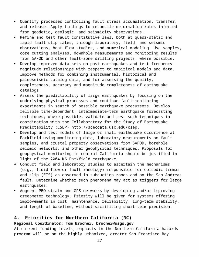
(1) The Grants Program Manager will work closely with the Principal Investigator to ensure that all technical requirements are being met. The Grants Program Manager's responsibilities include, but are not limited to, providing technical advice on the accomplishment of the proposal's objectives; reviewing the technical content of reports and the other information delivered to the USGS; determining the adequacy of technical reports; and conducting site visits, in coordination with the Regional Coordinator and the Contracting Officer, as frequently as practicable.
(2) The Grants Program Manager is Elizabeth Lemersal, External Research Support Manager, U.S. Geological Survey, 905 National Center, 12201 Sunrise Valley Drive, Reston, VA 20192. The Grants Program Manager does not have the authority to issue any technical direction which constitutes an assignment of additional work outside the scope of the award; in any manner causes a change in the total cost or the time required for performance of the award; or change any of the terms, conditions, or general provisions of the award.
G. Regional Coordinator
(1) Regional Coordinators are in charge of conducting the peer review panels to evaluate both internal USGS and external research proposals in their region or area of expertise. A Regional Coordinator will work closely with the Grants Program Manager and the Principal Investigator to ensure coordination with other appropriate Principal Investigators and appropriate USGS project scientists working in the same region for overall conformance with USGS program goals and objectives within that region. The Regional Coordinator's responsibilities include, but are not limited to, providing technical advice on the accomplishment of the proposal's objectives; reviewing the technical content of reports and other information delivered to the USGS; determining the adequacy of the technical reports; and conducting site visits, in coordination with the Grants Program Manager and contract personnel, as frequently as practicable.
(2) The Regional Coordinator does not have the authority to issue any technical direction which constitutes an assignment of additional work outside the scope of the award; in any manner causes a change in the total cost or the time required for performance of the award; or changes any of the terms, conditions, or general provisions of the award.
H. Contracting Officer (CO)
Contracting officers are individuals who have been delegated in writing by the USGS Office of Acquisition and Grants as the sole authority designated to obligate Federal funds and create terms and conditions of awards. They are the only individuals who have authority to negotiate, enter into, and administer awards resulting for this program. Contracting officers have responsibility to ensure the effective use of Federal funds.
Functions of the contracting officer include but are not limited to:
(1) Issuing the grant program announcement in coordination with the grants program manager.
27

(2) Receiving grant proposals and related documents in response to a grant program announcement. The contracting officer as receiving official shall mark all proposals with a control number and the date officially received. He shall notify each applicant of the receipt of its proposal.
(3) Approving the grant program manager’s Technical Evaluation Plan, which describes in detail the evaluation process for a competitive grant/cooperative agreement program. The contracting officer shall ensure the openness and fairness of the evaluation and selection process.
(4) Serving in an advisory capacity at peer review panel meetings. He shall interpret grant management policies to panel members.
(5) Notifying grant program applicants whether or not they were selected for funding or of any other disposition of their application.
(6) Negotiating, as necessary, the final grant/cooperative agreement budget.
(7) Issuing grant/cooperative agreement awards and revisions to awards.
(8) Approving invoice payments.
(9) Receiving all requests for changes to an award. The contracting officer shall serve as the mandatory control point for all official communications with the grantee which may result in changing the amount of the grant/cooperative agreement, the grant/cooperative agreement budget, or any other terms and conditions of the grant.
(10) Receiving financial reports required by the terms and conditions of the award.
(11) Closing out grant/cooperative agreement awards when all applicable award requirements have been complied with.
3. Dissemination of Results and Reporting Requirements
The Principal Investigator is strongly encouraged to disseminate research results promptly to the scientific community and appropriate professional organizations; local, state, regional and federal agencies; and the general public. The Recipient must publish project reports in scientific or technical journals, in a peer-reviewed form. The Government may publish, reproduce, and use all technical data developed as a result of this award in any manner and for any purpose, without limitation, and may authorize others to do the same.
Data generated as a part of work funded under this program is not subject to proprietary period of exclusive data access. Any data generated must be made available to the USGS as soon as it is available. The USGS reserves a royalty-free, nonexclusive and irrevocable license to reproduce, publish, or otherwise use, and to authorize others to use the data for Government purposes. Any
28

project funded in whole or part with funds obtained under this program shall fall under this clause. The USGS Contracting Officer is the sole person to decide which data falls in this category should any question arise.
A. Required reports/documents. The Principal Investigator or Director, Sponsored Research Office is required to submit the following reports or documents:
Report/Document
No. of Copies and Method of Transmittal
Submit To When Due
(1)Publication*
3 reprints Grants Program Manager
Immediately following publication. See Section B(1) below.
(2)Final Technical Report (with Abstract)
1 bound original plus 2 bound copies. Also, send Adobe Acrobat PDF file as an email attachment; Maximum size: 10 MB
Grants Program Manager
Within 90 calendar days after the end of each 12-month budget period. See details of formatting in section B(2) below.
(3)SF 272Federal CashTransactions Report
Electronic submission USGS via PMS Electronic 272 System[see Section 3.B(3)]
See Section 3.B(3)
(4)SF 269 Financial Status Report
See Section 3.B(4) See Section 3.B(4) See Section 3.B(4)
(5) Final SF 269 Financial Status Report
See Section 3.B(5) See Section 3.B(5)
See Section 3.B(5)
* Publication means any book, report, photograph, map, chart, or recording published or disseminated to the scientific community. Preprints of articles submitted for publications will be accepted as final reports.
B. Report preparation instructions . The Recipient shall prepare the reports/documents in accordance with the following instructions:
Note: Paper copies of all Summaries and Technical Reports should be submitted on paper
29

containing at least 50% recycled waste paper materials.
(1) Publications. All publications that contain work performed during the project period shall include the following statements:“Research supported by the U.S. Geological Survey (USGS), Department of the Interior, under USGS award number (Recipient, insert award number). The views and conclusions contained in this document are those of the authors and should not be interpreted as necessarily representing the official policies, either expressed or implied, of the U.S. Government.”
(2) Final Technical Report. Final Technical Reports shall describe in detail the work performed and results obtained during the grant period. Final Technical Reports are due 90 days after the conclusion of the project period.
(a) Prepare the Final Technical Report as an Adobe Acrobat PDF file with all figures, photographs, maps, and illustrations embedded. Submit the report in both hard copy and via email (10 MB maximum size). Send all hard copies and electric formatted media to:
External Research-Final ReportU.S. Geological Survey905 National Center12201 Sunrise Valley DriveReston, VA 20192
Send electronic files as follows:
Email attachments: [email protected]
(b) The original copy of the report and two copies shall be bound.
(c) Final Technical reports shall consist of the following sections:
(1) Cover page with the following information:Award NumberTitle. For collaborative projects the title should be in the form "Title: Collaborative Research with First Institution name, and Second Institution name.”Author and Affiliation with Address and zip codeAuthor's Telephone numbers, fax numbers and E-mail addressTerm covered by the award (start and end dates)
(2) Abstract(3) Main body of the report. The main body of the report shall be single-spaced
on 8 ½" x 11" paper. The main body of the report shall be printed double-sided, including figures and bibliography (described below). Oversized pages should be used only if they are critical to convey data or conclusions. Electronic versions of oversized illustrations are also required to be sent with the electronic version of reports.
(4) Bibliography of all publications resulting from the work performed during
30

each 12-month period and at the conclusion of the project. Copies of publications are required if the Recipient has not previously submitted them to the Grants Program Manager.
(3) SF 272, Federal Cast Transactions Report is required quarterly for each PMS sub-account. Quarterly reports are due 45 working days after the end of each fiscal quarter and will be submitted via the Electronic 272 system at PMS. Instructions for submitting the SF272 can be found at the following website:
http://www.dpm.psc.gov/grant_recipient/psc_272_reports/psc_272_reports.aspx?explorer.event=true
If after 45 days, recipient has not submitted a report, the account will be placed in a manual review status. Funds may be withheld for accounts with delinquent reports.
(4) SF 269, Financial Status Report (original and 1 copy). The standard form 269 is required annually and is due 90 calendar days after the end of the annual budget period and will be submitted to the Contracting Officer. Instructions are on the back of the SF 269.
(5) Final SF 269, Financial Status Report. The recipient will liquidate all obligations incurred under the award and submit a final SF 269 Financial Status Report due no later than 90 calendar days after the grant completion date and will be submitted to the Contracting Officer. Recipient will promptly return any unused federal cash advances or will complete a final draw from PMS to obtain any remaining amounts due. Once 120 days has passed since the grant completion date, the PMS subaccount for this award may be close by USGS at any time.
(6) Subsequent revision to the final SF269, Financial Report, will be considered only as follows: (i) When the revision results in a balance due to the Government, the recipient must submit a revised SF 269 and refund the excess payment whenever the overcharge is discovered, no matter how long the lapse of time since the original due date of the report.
(ii) When the revision represents additional reimbursement costs claimed by the recipient, a revised SF 269 may be submitted to the Contracting Officer with an explanation. If approved, the USGS will either request and pay a final invoice or re-establish the PMS subaccount to permit the recipient to make a revised final draw. Any revised final report representing additional reimbursable amounts must be submitted no later than 1 year from the due date of the original report, i.e., 15 months following the agreement completion date. USGS will not accept any revised SF 269 report covering additional expenditures after that date and will return any late request for additional payment to the recipient.
C. Adherence to reporting requirements. A Recipient's failure to submit the required reports/documents, in a timely manner, may result in withholding of payment, termination of the award, or delay or non-issuance of new awards.
4. Continuation Proposal for Second-Year Funding
Required Continuation proposal documents. The Recipient, approved for two-year funding, shall submit the following documents for continued funding in year 2:
31

Document No. of Copies Submit To Due DateProgress Report Send Adobe
Acrobat PDF file as an email attachment
Grants Program Manager
At least 60 calendar days prior to the end of the budget period.
Revised SF 424 Original + 1 Contracting Officer At least 60 calendar days prior to the end of the budget period.
Proposed Budget Original + 1 Contracting Officer Submit with the SF 424.
Negotiated Indirect Cost Rate Agreement(send only if newrate is negotiated)
Original + 1 Contracting Officer Submit with the SF 424.
Changes, if any, inProposed Technical Program
Original + 1 Contracting Officer Submit with the SF 424.
Progress Report. Recipients of two-year awards shall submit a report that summarizes the progress of the project during the first funding period. Work that was proposed for the first year should have been completed in that year. The Progress Report should be 2 to 5 pages in length and shall consist of accomplishments, unanticipated problems encountered, plans for solving unanticipated problems, and any other information pertinent to the progress of the project. Funding expended by the Recipient during year one must also be detailed in the Progress Report. Submit the Adobe Acrobat PDF file with embedded graphics as an E-mail attachment to:
[email protected]. Maximum file size: 10 MB. The subject of your emailshould be “Progress Report - insert your grant / project number here”.
Format the Progress Report as follows: Format for 8 ½" x 11" pages for text and figures
(do not submit format for A4 paper) Leave a 1" margin at top, bottom, and sides All text single spaced Embed figures in the PDF file Figure captions directly under figures 2 to 5 pages.
At the top of the first page the heading should be centered and include: Title of the project, as stated on the original proposal External Grant award number (see your award documents) Investigator(s) name(s) Institution Address Telephone number, FAX number, E-mail address, and URL Term covered by the report.
32

The body of the report should consist of the following: Investigations undertaken Results Reports published Include a statement describing the availability of seismic, geodetic, or processed
data, along with the name, phone number, and e-mail address of the contact person, and the format in which the data are available
Funding expended for the term covered by the report.
5. Adherence to Original Research Objective and Budget Estimate
A. Any commitments or expenditures incurred by the Recipient in excess of the funds provided by this award shall be the responsibility of the Recipient. Expenditures incurred prior to the effective date of this award cannot be charged against award funds.
B. The following requests for change require advance written approval by the Contracting Officer shown on your award. Your request must be submitted to the Contracting Officerat least 45 calendar days prior to the requested effective date of the change:
(1) Changes in the scope, objective, or key personnel referenced in the Recipient's proposal.
(2) Request for supplemental funds.
(3) Transfer of funds between direct cost categories when the cumulative amount of transfers during the project period exceeds 10 percent of the total award.
(4) Foreign travel not approved at time of award.
(5) Acquisition of nonexpendable personal property (equipment) not approved at time of award.
(6) Creation of any direct cost line item not approved at time of award.
(7) Any other significant change to the award.
(8) No-cost Extensions to the Project Period. No cost extensions are discouraged. The Earthquake Hazards Program (EHP) awards grants and cooperative agreements for research that extends or supplements ongoing research within the USGS. The timely conduct of funded projects is of great importance to the achievement of EHP goals. Applicants should consider their time commitments at the time of application for a grant. Requests for no cost extensions will be considered on a case-by-case basis. The USGS reserves the right to limit the length of time and number of no-cost extensions. Please note that no-cost extensions are not intended to be used merely for the purpose of expending unobligated balances. Applicants must supply documentation supporting their request for an extension.
33

The Recipient shall include in the request the cause of the needed extension, a description of the remaining work to be completed, the proposed date of completion, the amount of funds remaining, and a revised budget for the remaining funds. If all funds have been disbursed to the Recipient, this must be indicated in the request. A request for an extension that is received by the Contracting Officer after the expiration date shall not be honored.Requests for no-cost extensions shall be submitted to the Contracting Officer at least 45 days before the grant end date.
C. The Contracting Officer will notify the Recipient in writing within 30 calendar days after receipt of the request for revision or adjustment whether the request has been approved.
6. Nonexpendable Personal PropertyThe recipient shall comply with 2 CFR Part 215, Section 215.34. Title to nonexpendable personal property acquired wholly or in part with Federal funds shall be vested in the Recipient unless otherwise specified in the award document. The Recipient shall retain control and maintain a property inventory of such property as long as there is a need for such property to accomplish the purpose of the project, whether or not the project continues to be supported by Federal funds. When there is no longer a need for such property to accomplish the purpose of the project, the Recipient shall use the property in connection with other Federal awards the Recipient has received. Under no circumstances shall title to such property be vested in a sub-tier recipient. Disposal of nonexpendable personal property shall be in accordance with the applicable OMB circular.
34

The following equipment shall be vested: N/A
7. Record Retention PeriodUnless a longer period is requested by the award, a Recipient shall retain all records for 3 years after the end of the project period for which it uses USGS award funds.
8. Pre-agreement CostsPre-agreement costs are not authorized under this program. Costs must be obligated during the project period.
9. Site VisitsSite visits may be made by USGS representatives to review program accomplishments and management control systems and to provide technical assistance, as required.
10. Metric Conversion RequirementsAll progress and final reports, other reports, or publications produced under this award shall employ the metric system of measurements to the maximum extent practicable. However, the recipient may use non-metric measurements to the extent the recipient has supporting documentation that the use of metric measurements is impracticable or is likely to cause significant inefficiencies or loss of markets to the recipient, such as when foreign competitors are producing competing products in non-metric units.
11. Violation of Award Terms
If a Recipient materially fails to comply with the terms of the award, the Contracting Officer may suspend, terminate, or take such other remedies as may be legally available and appropriate in the circumstances.
12. Award Closeout
Awards will be closed out once all requirements have been met. Technical and financial reports must be submitted on time as specified in section 3, above. Failure to adhere to the reporting requirements may result in no future awards.
13. Partnership with Grantees/Cooperators
The USGS, through its federal grant/cooperative agreement awards, will collaborate with universities, federal state, local and tribal governments, and private organizations and businesses to provide relevant, timely, objective knowledge and information on natural resources, hazards, and the environment.
14. Buy American Act RequirementsNotice: Pursuant to Section 307(b) of the Department of the Interior (DOI) and Related Agencies Appropriations Act, FY 2000, Public Law 106-113, please be advised on the following:

In the case of any equipment or product that may be authorized to be purchased with financial assistance provided using funds made available in FY 2000 and thereafter, it is the sense of the Congress that entities receiving the assistance should, in expending the assistance, purchase only American-made equipment and products.
15. Anti-Lobbying RequirementsRecipient shall not use any part of the Department of the Interior funds provided hereunder for any activity or the publication or distribution of literature that in any way tends to promote public support or opposition to any legislative proposal on which Congressional action is not complete.
16. Seat Belt ProvisionRecipient of grants/cooperative agreements and/or sub-awards are encouraged to adopt and enforce on-the-job seat belt use policies and programs for their employees when operating company-owned, rented, or personally owned vehicles. These measures include, but are not limited to, conducing education, awareness, and other appropriated programs for their employees about the importance of wearing seat belts and the consequences of not wearing them.
17. Endorsement ProvisionRecipient shall not publicize or otherwise circulate, promotional material (such as advertisements, sales brochures, press releases, speeches, still and motion pictures, articles, manuscripts or other publications) which states or implies governmental, Departmental, bureau, or government employee endorsement of product, services, or position which the recipient represents. No release of information relating to this award may state of imply that the Government approves of the recipient’s work products, or considers the recipient’s work product to be superior to other products or services.
End of Special Terms and Conditions
36

Attachment E
GENERAL PROVISIONSThe Recipient shall be subject to the following OMB circulars/regulations, as amended, which are incorporated herein by reference:1. Educational Institutions
A. OMB Circular A-21, Cost Principles for Educational Institutions.B. OMB Circular A-110, Uniform Administrative Requirements for Grants and other Agreements with Institutions of Higher Education, Hospitals and Other Non-Profit Organizations. C. OMB Circular A-133, Audits of States, Local Governments, and Non-Profit Organizations.
2. State and Local GovernmentsA. OMB Circular A-87, Cost Principles for State, Local and Indian Tribal
Governments.B. OMB Circular A-102, Grants and Cooperative Agreements With State and Local
Governments.C. OMB Circular A-133, Audits of States, Local Governments, and Non-Profit
Organizations.3. Nonprofit Organizations
A. OMB Circular A-110, Uniform Administrative Requirements for Grants and other Agreements with Institutions of Higher Education, Hospitals and Other Non-Profit Organizations.
B. OMB Circular A-122, Cost Principles for Nonprofit Organizations.C. OMB Circular A-133, Audits of States, Local Governments, and Non-Profit
Organizations.4. Profit - Making Organizations
A. General administrative requirements will be in accordance with the Federal Acquisition Regulations (FAR), subchapter E, parts 28, 29, and 30.
B. Principles for determining the allowability of cost will be in accordance with the FAR, subchapter E, part 31.2.
5. Patents--Small Businesses and Nonprofit OrganizationsSubject to the provisions set forth in 37 CFR 401 and 35 U.S.C. 203, a Recipient may retain the entire right, title, and interest throughout the world to each subject invention. With respect to any subject invention in which the Recipient retains title, the Federal Government will have a nonexclusive, nontransferable, irrevocable, paid-up license to practice or have practiced for or on behalf of the United States the subject invention throughout the world.
6. Code of Federal Regulations (CFR)A. 2 CFR Part 215 (new location for OMB A-110 Uniform Administrative
Requirements for Grants and other Agreements with Institutions of Higher Education, Hospitals and Other Non-Profit Organizations)
B. 43 CFR Part 12, Subpart A: Admin, Audit and Cost PrinciplesC. 43 CFR Part 12, Subpart D: Government Debarment and Suspension (Nonprocurement) and Government wide Requirements for Drug Free Workplace.D. 43 CFR Part 12, Subpart E: Buy American Requirements for Assistance Programs
37

E. 43 CFR Part 12, Subpart F: Admin – Higher Education Hospitals, and Other Non-Profit Organizations
F. 43 CFR Part 17, Subpart A: Nondiscrimination of the Basis of Race, Color, or National Origin.
G. 43 CFR Part 17, Subpart B: Nondiscrimination of the Basis of Handicap.H. 43 CFR Part 17, Subpart C: Nondiscrimination of the Basis of Age.I. 43 CFR Part 18, Lobbying
38