Embed Size (px)
Citation preview
United States Department ofthe Interior
Stephen Brooks Chief, Regulatory Branch U.S. Army Corps of Engineers P.O. Box 17300 Fort Worth, Texas 76102-0300
Dear Mr. Brooks:
FISH AND WILDLIFE SERVICE 10711 Burnet Road, Suite 200
Austin, Texas 78758 512 490-0057
FAX 490-0974
SEP t 0 2U13
SWF 2012-00319 Consultation No. 02ETAU00-2013-F-0028
This transmits the U.S. Fish and Wildlife Service's (Service) final biological opinion for the U.S. Army Corps of Engineers (USACE) proposed authorization under section 404 of the Clean Water Act (33 U.S.C. 1251-1376) for a City of Round Rock (City) Segment 3 water pipeline project (project). The City proposes to construct a 2.25 mile long and 48-inch diameter water main in Round Rock, Williamson County, Texas.
In accordance with section 7 of the Endangered Species Act of 1973, as amended (16 U.S.C. 1531 et seq.)(Act), the USACE has determined this project may affect three listed endangered species: (1) Bone Cave harvestman (Texella reyesi) (BCH), (2) Coffm Cave mold beetle (Batrisodes texanus)(CCMB), and golden-cheeked warbler (Dendroica [ =Setophaga] chrysoparia)(GCW A). No federally designated critical habitat is associated with the project. The USACE is the Federal agency authorizing this project and has provided a biological assessment (BA) of the project prepared by the City. The City has proposed to address the effects of the project on the listed species by participating in the Williamson County Regional Habitat Conservation Plan {WCRHCP)(Permit No. TE-181840-0). The USACE requested concurrence that the project may affect but is not likely to adversely affect the subject species on June 24, 2013. Subsequently, the Service and USACE discussed potential effects of the project. The USACE agreed to formal consultation, which was initiated with the ·service's May 10,2013 receipt of the revised biological assessment.
The findings and recommendations in this consultation are based on: (1) electronic mail correspondence, meetings, site visits, and telephone conversations between USACE, the City of Round Rock's consultant, and Service; (2) the May 2013 revised BA; and (3) other sources of information available to the Service.
Biological Opinion USACE Round Rock Water Main, Segment 3 Page2
July 18, 2012 September 26, 2012 November 4, 2012 December 3, 2012 February 28, 2013 May10, 2013 June 24, 2013 July23, 2013 August 28, 2013 September 4, 2013
Consultation History
USACE issues Section 404 NWP 12 Pre-Construction Notice ACI Consulting sends a BA to USACE Service visits project site with ACI Consulting Service sends letter to USACE with comments on July 2012 BA Service hosts meeting with ACI Consulting Service receives revised BA USACE request concurrence with its determination Service informs USACE of formal consultation time line Service provides draft biological opinion USACE provides comments on draft biological opinion
BIOLOGICAL OPINION
1. Description of the Action
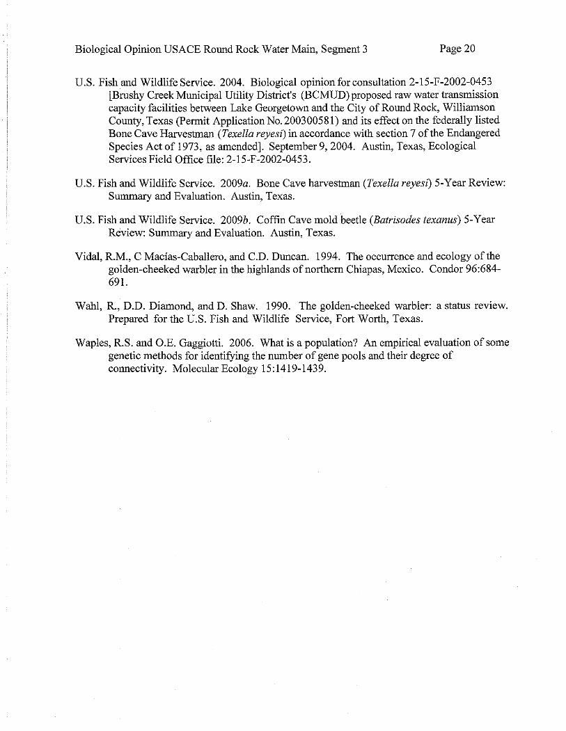
The City proposes as part of its municipal water supply network to connect a water main from the Brushy Creek Regional Utility Authority pipeline to the Round Rock water line near RM 1431 and Sam Bass Road. The proposed 2,25 mile long water pipeline is known as the Round Rock Segment 3 Transmission Main. In addition to open trenching and installation of this 48 inch diameter pipeline, the City plans to build a metering and chemical dosing station. The pipeline has a 40-ft permanent easement and an adjacent 50-ft temporary easement The trench depth is estimated at 12 to 15ft below grade and the trench width will be about 7ft. The project, which includes a permanent access road, crosses two intermittent creeks. The City has applied to the USACE for section 404 authorization to address impacts to less than OJ acre of waters of the United States.
Action Area
The regulations implementing section 7(a)(2) of the Act define the action area as all areas affected directly or indirectly by the Federal action and not merely the immediate area affected by the project (50 CFR § 402.02).
The project occurs in Round Rock, Williamson County, Texas. From the eastern terminus, the pipeline generally follows County Highway 175 northeasterly for 0.5 mile, then turns southwest for about 1.75 miles partially along County Road (CR) 272 to the western terminus near CR 272 and Farm to Market Road (FM) 734 (Ronald Reagan Blvd.).
For the purposes of this biological opinion, the action area is that portion of Williamson County that includes: (1) the permanent and temporary right-of-way for the project, (2) the karst terrain in and near the pipeline alignment, and (3) the oak-juniper woodland blocks constituting GCW A habitat in and near the pipeline alignment The action area is defined by roadways (with a 100 m outside buffer) encompassing the general project area, namely: FM 1431 on the south, FM 734 and FM272 on the west, CR 179 on the north, and County Highway 175 on the east (see Figure 1).
Biological Opinion USACE Round Rock Water Main, Segment 3 Page 3
Proposed Conservation Measures
The City plans to provide for the recovery of the affected species, in part, by minimizing the footprint of construction and supporting establishment of regional habitat conservation preserves that meets the Service's recovery standards. The City proposes to acquire participation certificates for the three species (BCH, CCMB, and GCW A) from the Williamson County Regional Habitat Conservation Plan commensurate with the impacts of the project.
The project is estimated to: (l) permanently destroy 7.03 acres of karst habitat (Karst Zone 1) for the BCH and CCMB; (2) directly impact about 0.62 acres of GCWA habitat; and, (3) indirectly impact 2.29 acres of GCW A habitat. The WCRHCP can provide take coverage for the BCH and CCMB inNorth Williamson County and McNeil-Round Rock Karst Fauna Region (KFR). Additionally, WCRHCP can provide take coverage for the GCWA by supporting permanent protection of GCW A in Service-approved conservation banks.
2. Status of the Species
2. a. Bone Cave Harvestman
Species Description and Life History
The endangered BCH is a troglobitic harvestman restricted to Travis and Williamson counties, Texas (Ubick and Briggs 1992, 2004). Troglobites are species absolutely dependent on environmental conditions present only in caves. They carmot survive on the surface.
Ubick and Briggs (1992) described the species when it was taxonomically separated from another species, the Bee Creek Cave harvestman (Texella reddelli). The Bee Creek Cave harvestman was placed on the endangered species list September 16, 1988 (53 FR 36029), and with the subsequent taxonomic revision, BCH was considered listed on August 18, 1993 (58 FR 43818).
At maturity, the BCH is pale orange with a total body length ranging from 0.06 to 0.11 inches (1.41 to 2.67 mm). Retinas are absent and corneal development varies from well-developed to absent (Ubick and Briggs 1992). BCH likely feed on microarthropods, such as springtails (Collembola spp.)(Rudolph 1979). Ubick and Briggs (1992) also state that most specimens of BCH have been observed in the deep cave environment, past the twilight zone.
Population Dynamics, Status, and Distribution
No population size estimates are available for caves supporting BCH and virtually nothing is known about reproductive rates or age-specific survival within populations.
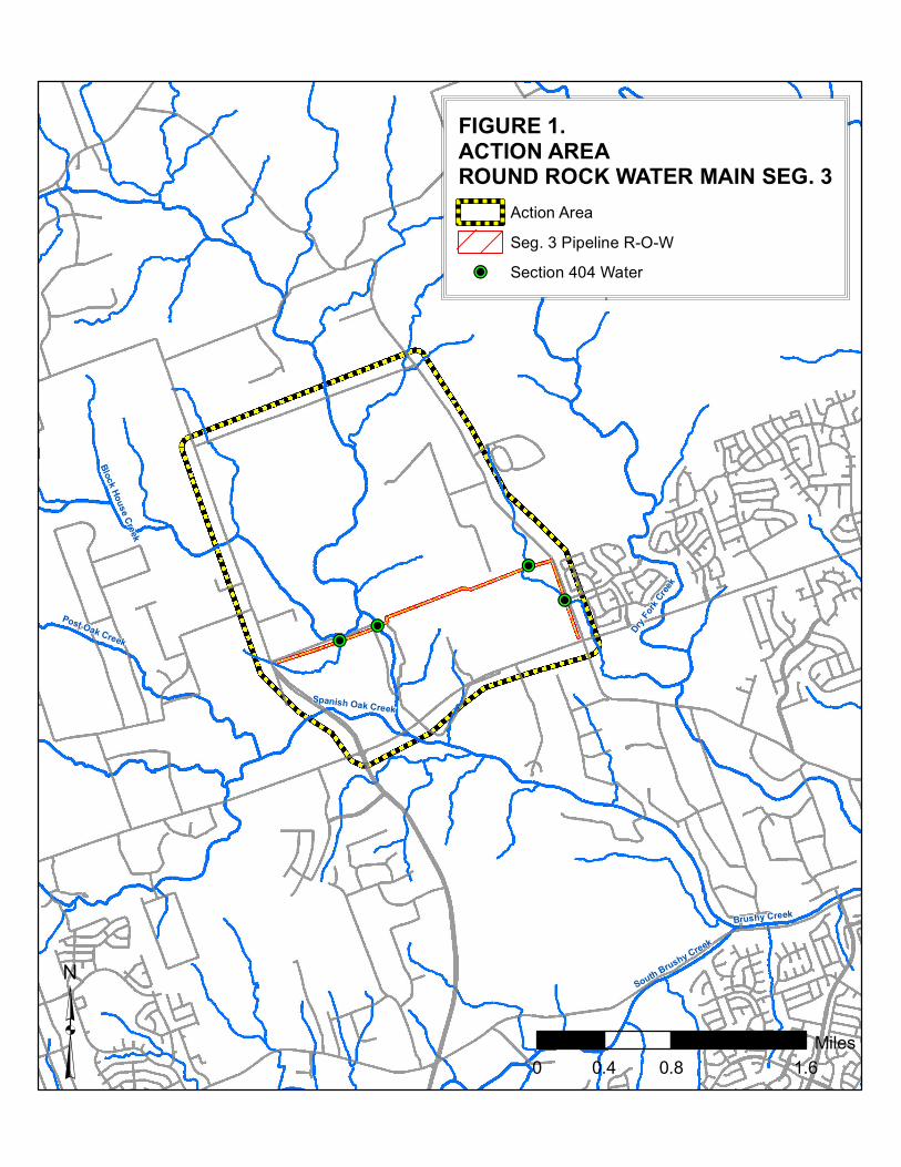
The BCH has a wider distribution than other Texella species. As of2009, BCH is known from the five Karst Fauna Regions (KFRs) north of the Colorado River (Figure 2). BCH is found in about 168 caves throughout its range across portions of Williamson and Travis counties, of which 138 caves are in Williamson County (Ubick and Briggs 1992, 2004). Since 2009, there have been collections from an unknown number of caves in Williamson County, not all of which
Biological Opinion USACE Round Rock Water Main, Segment 3 Page4
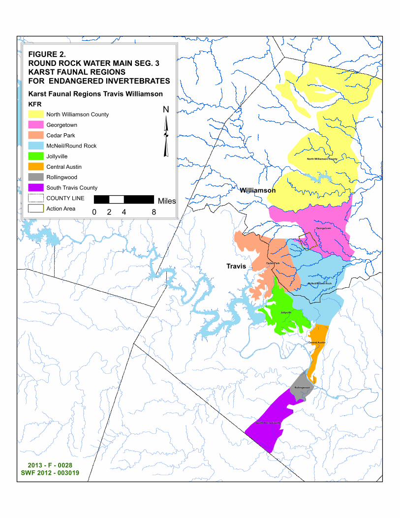
have been publicly reported (Service 2009a). A current estimate of caves occupied by the BCH therefore, remains unknown. In 2007, George V eni updated his karst zone maps based on newly discovered occupied caves. Figure 3 shows these karst zones in and near the proposed pipeline and action area.
KFRs are regions delineated based on geologic continuity, hydrology and the distribution of rare obligate cave-dwelling species. Four KFRs are located in Williamson County: North Williamson County, Georgetown, McNeil -Round Rock, and Cedar Park.
The recovery plan for this species (Service 1994) calls for the protection of at least three Karst Fauna Areas (KFAs) within each KFR in order to achieve recovery of the species. Since 2009, the Priscilla's Well KFA, Twin Springs KFA, Tooth Cave KFA, and Cobbs Cavern KFA have been established. The Service has verified that those KF As meet the current recovery criteria. Also, the Karanakawa KF A is in the process of being established. While many other karst conservation areas have been established in Williamson and Travis counties and some level of protection has been afforded the species in the established conservation areas, we have not reviewed those areas to verity that they meet the recovery criteria. At present, 18 existing and proposed karst conservation areas that protect the BCH are located in Williamson County. Eleven of these conservation areas (five within the North Williamson County KFR, three in the Georgetown KFR, and three in the McNeil-Round Rock KFR) appear to be suitable for designation as Service-approved KF As for the protection of the Bone Cave harvestman.
Reasons for Decline and Threats to Survival
The Service's Five Year Review (Service 2009a) listed the following threats to BCH: (1) habitat loss to development; ( 2) cave collapse or filling; (3) alteration of drainage patterns; ( 4) alteration of surface plant and animal communities, including the invasion of exotic plants and predators (e.g. the red-imported fire ant (RIF A), Solenopsis invicta), changes in competition for limited resources and resulting nutrient depletion, and the loss of native vegetative cover leading to changes in surface microclimates and erosion; ( 5) contamination of the habitat, including groundwater, from nearby agricultural disturbance, pesticides, and fertilizers; (6) leakages and spills of hazardous materials from vehicles, tanks, pipelines, and other urban or industrial runoff; and (7) human visitation, vandalism, and dumping; mining; quarrying (limestone); or, blasting above or in caves. There are 168 caves known to contain BCH in Travis and Williamson Counties, Texas. Currently, BCH faces the same threats that it did at the time it was listed.
2. b. Coffin Cave Mold Beetle
Species Description and Life History
The genus Batrisodes lies within the family of mold beetles or ant-like litter beetles. As of 2001, eight other genera of mold beetles were known to occur in Texas, including Texamaurops (Chandler and Reddell 2001 ). The endangered CCMB was first described as a new species by Chandler (1992), when it was separated from Kretschmarr Cave mold beetle (Texamaurops reddelli).
Biological Opinion USACE Round Rock Water Main, Segment 3 Page 5
Kretsclunarr Cave mold beetle was placed on the Federal endangered species list on September 16, 1988, (53 FR 36029-36033), and with the subsequent taxonomic revision, CCMB was listed as an endangered species on August 18, 1993 (58 FR 43818).
Mature CCMB are 0.10 to 0.11 inches (2.60 to 2.88 mm) in length. This species lacks eyes (Chandler 1992). The CCMB is considered to be troglobitic because most individuals have been observed past the twilight zone in total darkness. This predatory species eats other invertebrates including mites (Service 1994).
Population Dynamics, Status and Distribution
No population size or trend data are available for the CCMB. The CCMB is known to inhabit at least 23 caves in Williamson County. Nineteen of the caves are in the North Williamson County KFR, and three are within the Georgetown KFR (Chandler and Reddell2001; D.S. Chandler, e-mail to K. White, 2006). No records for the CCMB are confirmed from either Cedar Park KFR or McNeil-Round Rock KFR.
The proposed pipeline will be laid primarily within the Georgetown KFR. The recovery plan for the CCMB (Service 1994) calls for the protection of at least three KF As within each occupied KFR in order to achieve recovery of the species. At present, nine existing and proposed karst conservation areas that protect the Coffin Cave mold beetle are located within the North Williamson County KFR. Five of these conservation areas appear to be suitable for designation as KF As for the protection of the Coffin Cave mold beetle.
As troglobites, both the BCH and the CCMB require environmental conditions present only in caves. These conditions include stable temperatures close to the mean surface temperature, constant near-saturation humidity, low evaporation rates, and the absence of photosynthetic nutrient production (Barr 1968, Culver 1982). Because they lack photosynthesis and primary producers, cave ecosystems rely on nutrient input from the surface. Nutrients are introduced into the subsurface in the form of plant detritus washed in by surface waters, micro- and macroorganisms that enter caves under their own power, and the eggs and waste of trogloxene species such as cave crickets (Ceuthophilus spp.). Trogloxenes are species that have adapted to the cave environment sufficiently that they complete part of their life cycle in caves, but must return to the surface to feed and thus retain adaptations for surface life.
Cave crickets use cave systems for shelter, as a daytime roost, and to complete their reproductive cycle. Cave cricket eggs, feces, and dead bodies provide a source of nutrient input to the cave ecosystem on which troglobitic species depend (Service 2003). At night, cave crickets forage on the surface, eating a variety of plant and animal materials.
Taylor et al. (2005) studied cave cricket foraging distances from a cave in central Texas, and determined that the majority of cave crickets (99 percent) are located within 333 feet (1 05 meters) of the entrance. This cricket foraging distance is assumed to be an important factor in determining the amount of above-ground habitat required for maintaining the nutrient base in the below-ground cave environment (Taylor et al. 2005, Service 2004).
Biological Opinion USACE Round Rock Water Main, Segment 3 Page6
Reasons for Decline and Threats to Survival
The Service's five year review summarized the threats to Batrisodes texanus as: (1) habitat loss to development; (2) cave collapse or filling; (3) alteration of drainage patterns; (4) alteration of surface plant and animal communities, including the invasion of exotic plants and predators (e.g., the red-imported fire ant (RIF A), Solenopsis invicta), changes in competition for limited resources and resulting nutrient depletion, and the loss of native vegetative cover leading to changes in surface microclimates and erosion; ( 5) contamination ofthe habitat, including groundwater, from nearby agricultural disturbance, pesticides, and fertilizers; (6) leakages and spills of hazardous materials from vehicles, tanks, pipelines, and other urban or industrial runoff; and (7) human visitation, vandalism, and dumping; mining, quarrying (limestone), or blasting above or in caves.
At present, CCMB is known from 23 caves in Williamson County, Texas, and faces the same threats it did at the time it was listed.
2. c. Golden-cheeked Warbler
Species Description and Life History
The GCWA was emergency listed as endangered on May 4, 1990 (55 FR 18844). The final rule listing the species was published on December 27, 1990 (55 FR 53160). No critical habitat is designated for this species. For more information regarding the biology of the golden-cheeked warbler, please see the 1992 Golden-cheeked Warbler Recovery Plan.
The GCW A is a small, insectivorous songbird, 4.5 to 5 inches long with a wingspan of about 8 inches (Pulich 1976, Oberholser 1974). Golden-cheeked warblers breed exclusively in the mixed Ashe juniper/deciduous woodlands of the central Texas Hill Country west and north of the Balcones Fault (Pulich 1976). Golden-cheeked warblers require the shredding bark produced by mature Ashe junipers for nest material. Typical deciduous woody species include Texas oak (Quercus buckleyi), Lacey's oak (Q. laceyi), escarpment live oak (Q. fosiformis), Texas ash (Fraxinus texensis), cedar elm (Ulmus crassifolia), hackberry (Celtis occidentalis), bigtooth maple (Acer grandidentatum), sycamore (Platanus occidentalis), Arizona walnut (Juglans major), and pecan (Carya illinoinensis) (Pulich 1976, Wahl et al. 1990). Breeding and nesting GCW A feed primarily on insects, spiders, and other arthropods found in Ashe junipers and associated deciduous tree species (Pulich 1976).
Male GCW A arrive in central Texas around March 1" and begin to establish breeding territories, which they defend against other males by singing from visible perches within their territories. Females arrive a few days later, but are more difficult to detect in the dense woodland habitat (Pulich 1976). Three to five eggs are generally incubated in April, and unless there is a second nesting attempt, nestlings fledge in May to early June (Pulich 1976). If there is a second nesting attempt, it is typically in mid-May with nestlings fledging in late June to early July (Pulich 1976). By late July, GCWA begin their migration south (Chapman 1907, Pulich 1976, Rappole et al. 2000). Golden-cheeked warblers winter in the highland pine-oak woodlands of southern Mexico and northern Central America (Krolll980, Vidal et al. 1994, Rappole et al. 1999, King et al. 2012).
•
Biological Opinion USACE Round Rock Water Main, Segment 3 Page 7
Historic and Current Distribution
The GCWA's entire breeding range occurs on the Edwards Plateau and Lampasas Cut Plain of central Texas. Golden-cheeked warblers have been confirmed in 39 counties: Bandera, Bell, Bexar, Blanco, Bosque, Burnet, Coma!, Coryell, Dallas, Eastland, Edwards, Erath, Gillespie, Hamilton, Hays, Hill, Hood, Jack, Johnson, Kendall, Kerr, Kimble, Kinney, Lampasas, Llano, Mason, McLennan, Medina, Menard, Palo Pinto, Real, San Saba, Somervell, Stephens, Tom Green, Travis, Uvalde, Williamson, and Young. However, many of the counties where it is known to occur, now or in the past, have only small amounts of suitable habitat (Pulich 1976, Service 1996, Lasley et al. 1997). Diamond (2007) estimated that the amount of suitable GCW A habitat across the species' range was about 4.2 million acres, much of this habitat occurring on private lands. As a result, the population status for the GCWA on private lands remains undocumented throughout major portions of the breeding range.
Reasons for Decline and Threats to Survival
Before 1990, the primary reason for GCW A habitat loss was juniper clearing to improve conditions for livestock grazing. Since then, habitat loss has occurred as suburban developments spread into prime GCWA habitat. Groce et al. (2010) summarized the rates of expected human population growth within the range of the GCWA and found by 2030 the growth rate ranges from 17 percent around the Dallas-Fort Worth area to over 164 percent around San Antonio. As the human population continues to increase, so do associated roads, single and multi-family residences, and infrastructure, resulting in further habitat destruction, fragmentation, and increased edge effects (Groce et al. 2010).
Fragmentation is the reduction of large blocks of a species' habitat into smaller patches. While GCWA have been found to be reproductively successful in small patches of habitat (less than 50 acres), there is an increased likelihood of occupancy and abundance as patch size increases (Coldren 1998, Butcher et al. 2010, DeBoer and Diamond 2006). Increases in pairing and territory success are also correlated with increasing patch size (Arnold et al. 1996, Coldren 1998, Butcher et al. 201 0). In addition, while some studies have suggested that small patches that occur close to larger patches are likely to be occupied by GCWA, the long-term survival and recovery of the GCWA is dependent on maintaining the larger patches (Coldren 1998, Peterson 2001, Texas Nature Conservancy 2002).
As GCW A habitat fragmentation increases, edges are created where two or more different vegetation types meet. For the GCW A, an edge is where woodland becomes shrubland, grassland, a subdivision, etc., and depending on the type of edge, it can act as a barrier for dispersal; act as a territory boundary; favor certain predators; increase nest predation; and/or reduce reproductive output (Johnston 2006, Arnold et al. 1996). Canopy breaks (the distance between tree top foliage) of as little as 36 feet have been shown to be barriers to GCWA movement (Coldren 1998). Territory boundaries have not only been shown to stop at edges, but GCW A will often avoid nesting near habitat edges (Beardmore 1994, DeBoer and Diamond 2006, Sperry 2007).
Other threats to GCW A include the clearing of deciduous oaks upon which the GCW A forage, oak wilt infection in trees, nest parasitism by brown headed cowbirds (Engels and Sexton 1994),
Biological Opinion USACE Round Rock Water Main, Segment 3 Page 8
drought, fire, stress associated with migration, competition with other avian species, and particularly, loss of habitat from urbanization (Ladd and Gass 1999). Human activities have reduced GCW A habitat throughout the species' range, particularly areas associated with the I-3 5 corridor between the Austin and San Antonio metropolitan areas.
Range-wide Survival and Recovery Needs
The recovery strategy outlined in the Golden-cheeked Warbler Recovery Plan (Service 1992), divides the breeding range of the GCW A into eight regions, or units, and calls for the protection of sufficient habitat to support at least one self-sustaining viable population in each unit. These recovery units were delineated based primarily on watershed, vegetation, and geologic boundaries (Service 1992).
According to the Golden-cheeked Warbler Population and Habitat Viability Assessment Report (Service 1996) and Alldredge et al. (2002), a viable GCW A population needs to consist of more than 3,000 breeding pairs. This and other population viability assessments on GCW A have indicated the most sensitive factors affecting their continued existence are population size per patch, fecundity (productivity or number of young per adult), and fledgling survival (Service 1996, Alldredge eta!. 2002). These assessments estimated one viable population will need a minimum of 32,500 acres of prime unfragmented habitat to reduce the possibility of extinction of that population to less than five percent over 100 years (Service 1996). Further, this minimum carrying capacity threshold estimate increases with poorer quality habitat (e.g., patchy habitat resulting from fragmentation).
Mathewson et al. (2012) recently estimated the range-wide GCWA male population at 263,339 (95 percent confidence interval: 223,927- 302,620). Morrison et al. (2012) concluded that the GCW A exists as a single population across its breeding range. Waples and Gaggiotti (2006) reviewed the varied use of the term population and described the difficulties and paradigms associated with defining a 'population'.
Based on the Golden-cheeked Warbler Recovery Plan (Service 1992), protection and management of occupied habitat and minimization of degradation, development, or environmental modification of unoccupied habitat necessary for buffering nesting habitat are necessary to provide for the survival of the species. Habitat protection must include elements of both breeding and non-breeding habitat (i.e., associated uplands and migration corridors). Current and future efforts to create new and protect existing habitat will enhance the GCWA's ability to expand in distribution and numbers. Efforts to protect existing viable populations is critical to the survival and recovery of this species, particularly when rapidly expanding urbanization continues to result in the loss of prime breeding habitat.
Several State and federally owned lands occur within the breeding range of the GCW A, but the overriding majority of the species' breeding range occurs on private lands (Service 1992). Currently there are four GCWA populations receiving some degree of protection: those at the Balcones Canyonlands Preserve in Travis County; the nearby Balcones Canyonlands National Wildlife Refuge (NWR) in Travis, Burnet, and Williamson counties; Camp Bullis Military Installation in Bexar County; and the Fort Hood Military Reservation in Coryell and Bell counties. There are also several conservation banks (CB) whose goal is to protect GCW A
Biological Opinion USACE Round Rock Water Main, Segment 3 Page9
habitat (acres presented are the total if all bank credits are sold): Hickory Pass CB (3,003 acres) in Burnet County, Majestic Ranch CB (495 acres) in Kendall County, and Bandera Corridor CB (4,363 acres) in Bandera and Real counties.
3. Environmental Baseline
3. a. Bone Cave Harvestman
Status of BCH in Action Area
The action area includes about 722 acres of karst zone 1 and the project is expected to adversely affect about seven acres of karst zone 1. The action area occurs primarily in the Georgetown KFR, which is estimated to contain about 20,165 acres of karst zone 1 and 2,122 acres of karst zone 2. There are no known caves supporting BCH in the action area. However, there are at least six caves within one mile of the project that are confirmed habitat for the BCH. While the occurrence and status of BCH in and near the project are unknown, the real potential exists for development in the area to disturb and adversely impact karst features supporting BCH (and CCMB).
Factors Affecting Species Environment in the Action Area
Factors affecting BCH in the action area are similar to those affecting the species range-wide. The action area is a mosaic of agricultural, suburban - residential, and commercial development. Based on the apparent availability of open space, we expect some development to convert farm lands in the action area in the next ten years.
Land use surrounding the proposed project area is mostly rural with scattered commercial and residential properties. A quarry or rock operation is located in the action area and adjacent to the proposed pipeline within karst zone 1. Surrounding pressures include earth moving activities such as quarrying operations and construction of residential developments. These actions may result in destruction of habitat or permanent alteration of available habitat in the vicinity of the project through collapse or filling of caves, alteration of drainage patterns and surface plant and animal communities, and invasion of RIF A.
3.b. Coffin Cave Mold Beetle
Status of Species in Action Area
The action area includes about 722 acres of karst zone 1 and the project is expected to adversely affect about seven acres of karst zone 1. The Georgetown KFR is estimated to contain about 20,165 acres of karst zone 1 and 2,122 acres of karst zone 2. There are no known caves supporting CCMB in the action area. However, there are at least six caves within about one mile of the project, which may support CCMB.
Biological Opinion USACE Round Rock Water Main, Segment 3 Page 10
Factors Affecting Species Environment in the Action Area
Factors affecting CCMB in the Action Area are similar to those affecting the BCH and CCMB range-wide. As discussed above, land use changes in the next ten years are expected to reduce farm land. The action area has major roads on its boundaries and a few small two lane roads internally. The availability of the Williamson County Regional Habitat Conservation Plan will help ensure activities affecting CCMB are considered and mitigated.
3.c. Golden-cheeked Warbler
Status of Species in Action Area
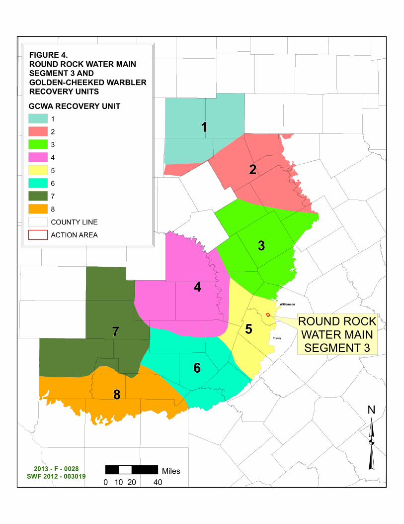
As described in the Golden-cheeked Warbler Recovery Plan (Service 1992), the breeding range of the GCWA in Texas is divided into eight recovery units and Round Rock is located in recovery unit 5 (Figure 4). The action area constitutes a very small fraction of recovery unit 5. In determining the amount of GCW A habitat affected by a project, the Service uses (and directs others to use) the habitat descriptions in Texas Parks and Wildlife Department's 2003 management guidelines for the GCWA. Woodlands with tree canopy cover exceeding 35 percent containing a mix of Ashe juniper, oaks, and other hardwoods are considered potential GCW A habitat. The Service considers contiguous woodland habitat patches (having the hallmarks ofTPWD's GCWA habitat guidance) as occupied if any portion of the woodland patch has been found to be occupied by GCW A during a current or previous survey.
Relatively large blocks ofGCWA habitat in Travis and Williamson counties outside of the action area are located at Balcones Canyonlands Preserve and Balcones Canyonlands National Wildlife Refuge. Threats within the action area include a lack of oak recruitment due to herbivory from native and non-native animals, death of mature oaks from oak wilt, and wildfires (Pulich 1976, Armstrong eta!. 1991, Texas Forest Service 2008, USDA and DOl 2001). Further, as large blocks of good quality habitat become developed, opportunities to meet recovery goals become more limited due to increased development pressure, increased land prices, and fragmentation.
According to our consultations tracking database, there have been about 60 formal section 7 consultations on the GCW A range-wide (excluding more than 129 formal consultations on habitat conservation plans and incidental take permits). The action area these consultations covered was over 70.8 million acres. Four of these consultations were on Fort Hood; therefore, we have only counted that action area once in the total area covered by formal consultations. One consultation covered almost half of Texas at 60 million acres. Over 60,290 acres of GCW A habitat were authorized to be affected by these consultations. Several large consultations make up the majority (over 52,000) of this acreage: (1) over 33,000 acres were associated with Fort Hood activities; (2) over 14,000 acres were associated with brush control projects throughout the GCWA's 35 county range; and (3) 5,000 acres were for activities on Camp Bullis. The result of these consultations is over 63,000 acres of GCWA habitat maintained on DOD land and over 68,000 acres of private land preserved and/or maintained for the benefit of the GCW A.
Additionally, we have issued 132 individual section lO(a)(l)(B) incidental take permits covering about 69,600,000 acres (note: this is the permit area, not the actual acres of affected habitat). The majority of this acreage comes from five large (regional) HCPs: (1) Balcones Canyonlands
': i
Biological Opinion USACE Round Rock Water Main, Segment 3 Page 11
Conservation Plan (BCCP) at 561,000 acres (Balcones Canyonlands Preserve or BCP in Travis County); (2) Williamson County at 316,800 acres; (3) Hays County at 433,900 acres; (4) Lower Colorado River Authority (LCRA) Competitive Renewable Energy Zone (CREZ) Program at more than 5,350,000 acres across seven counties; and (5) Oncor Electric Delivery Company at 63,000,000 across 100 counties. In total, all permits authorized effects to over 43, 010 acres of GCW A habitat. Mitigation for these effects resulted in preservation of over 52,000 acres of GCW A habitat. Additionally, the BCP has another 20,000 acres of land as part of their preserve, some of which supports GCW A; and if Williamson County exercises their entire take authorized, an additional 5,000 acres will be conserved in perpetuity for the GCW A.
Since 2008, there has been one section 7 formal consultation on the GCWA in the action area, which was for the WCRHCP incidental take permit.
4. Effects of the Proposed Action
BCHandCCMB
It is anticipated that seven acres of karst zone 1 will be directly affected by open trenching (Figure 3). It is not known whether the trenching will intersect any karst features or if karst features are affected, if they are occupied by either BCH or CCMB. The City's participation in the WCRHCP will support the protection and maintenance ofBCH and CCMB occupied karst features. These karst species will benefit as WCRHCP acquires and manages karst preserves in perpetuity. The preserves, funded by WCRHCP participation, will be in the Georgetown KFR, which will help protect habitat ofBCH and CCMB.
GCWA
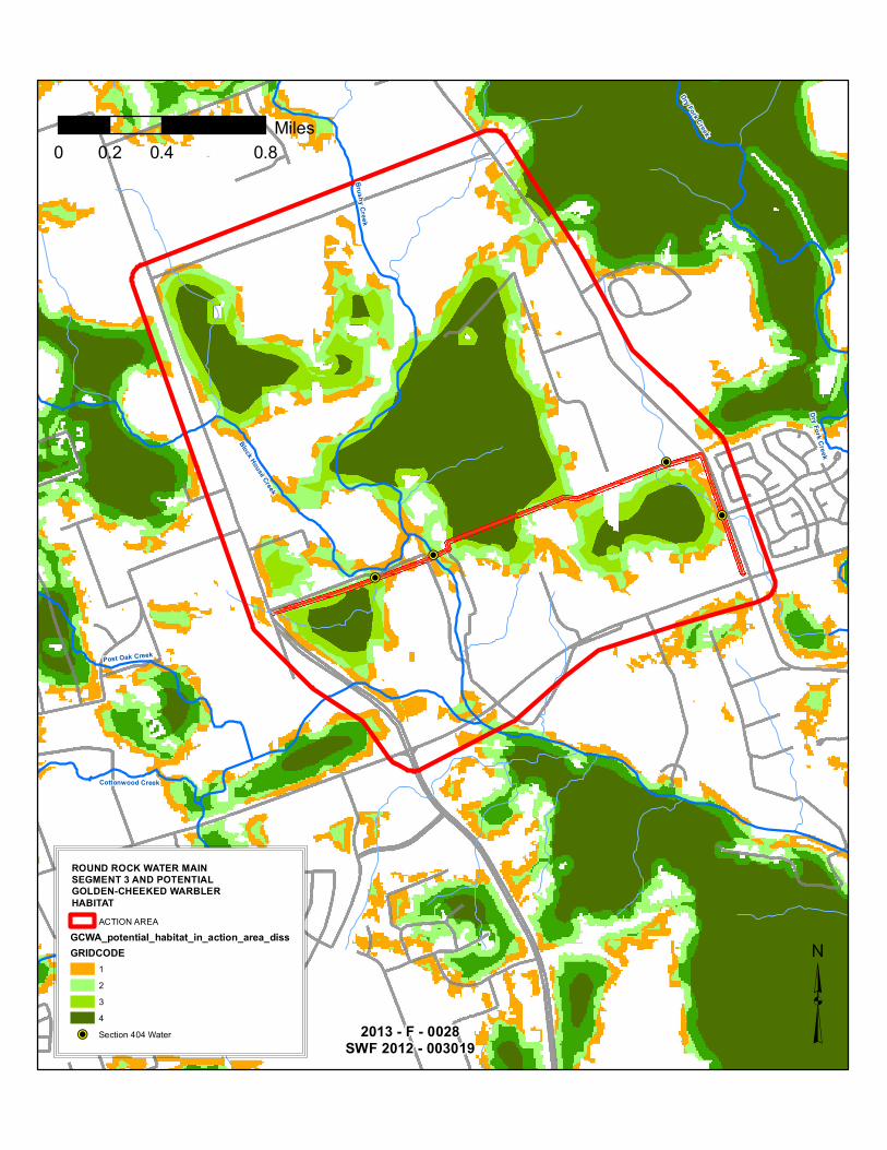
It is anticipated that up to three acres of golden-cheeked warbler habitat will be destroyed or degraded due to the proposed pipeline construction and its maintenance based on the BA and our review of the pipeline right-of-way and GCWA habitat (Figures 5 and 6). The BA estimates that 0.62 acres will be directly impacted and 2.29 acres will be indirectly impacted. The pipeline will affect GCWA habitat by destroying the edge of a relatively large (greater than 400 acres) oak-juniper woodland block.
Using habitat as an alternative for take of individual golden-cheeked warblers is consistent with the previous consultations and incidental take permits. Estimation of take of individual goldencheeked warblers is difficult and this biological opinion uses acres of habitat for the goldencheeked warbler that will be affected, directly or indirectly, by proposed activities. Butcher et al. (2010) estimated the minimum patch size (of oak-juniper woodlands) for reproductive success in the GCWA is between 37 and 50 acres. Based on a 50 acre territory size, the 400 ac woodland affected by the pipeline is estimated to support about 8 territories. The project is not expected to eliminate an entire breeding territory but would affect the patch presumably used by GCW A in the woodland on the north side of the pipeline. A three acre loss of woody vegetation on the southside of the woodland block may decrease feeding and potentially breeding opportunities for one pair of GCW A and we estimate the project will result in the take of one breeding pair of GCWA.
Biological Opinion USACE Round Rock Water Main, Segment 3 Page 12
The City will support the permanent preservation of GCW A habitat through participation the WCRHCP, which mitigates the impacts of its participants through the purchase of credits in a habitat conservation bank. Woodland clearing associated with projects will not occur between March 1 and August 31, which will likely avoid direct take of individual birds.
5. Cumulative Effects
Cumulative effects include the effects of future State, local, or private actions that are reasonably certain to occur in the action area considered in this biological opinion. Future Federal actions that are unrelated to the proposed action are not considered in this section because they require separate consultation pursuant to section 7 of the Act.
An undetermined number of future land use conversions and routine agricultural practices are not subject to Federal authorization or funding and may alter the habitat or increase incidental take of warblers and are, therefore, cumulative to the proposed project. These additional cumulative effects include: (1) unpredictable fluctuations in habitat due to urbanization; (2) increase in impervious cover due to urbanization (roads, parking lots, buildings, etc.); (3) use of pesticides on and near karst and oak-juniper woodland habitat; (4) contaminated runofffrom agriculture and urbanization; ( 5) nest parasitism; and, ( 6) predation by feral animals and pets.
6. Conclusion
After reviewing the current status of the BCH, CCMB, and the GCW A, the environmental baseline for the action area, the effects of the proposed action, and the cumulative effects, it is the Service's biological opinion that the pipeline project is not likely to jeopardize the continued existence of the BCH, CCMB, or GCWA. This is based primarily on: (1) the limited areal extent of the proposed pipeline impacts relative to the overall habitats occupied by BCH, CCMB, and GCWA, and (3) support for the conservation of these species through permanent preserves administered by the WCRHCP or a Service-approved habitat conservation bank. We also anticipate that participation in the WCRHCP will support protection of caves supporting BCH and CCMB. The Service anticipates that the GCW A habitat protected in conservation banks will be of better quality that that which is cleared by the pipeline project.
INCIDENTAL TAKE STATEMENT
Section 9 of the Act and Federal regulation pursuant to section 4(d) of the Act prohibit the take of endangered and threatened species, respectively, without special exemption. Take is defined by the Service as to harass, harm, pursue, hunt, shoot, wound, kill, trap, capture or collect, or to attempt to engage in any such conduct. Harass is defined by the Service as an intentional or negligent act or omission which creates the likelihood of injury to a listed species by annoying it to such an extent as to significantly disrupt normal behavioral patterns, which include, but are not limited to, breeding, feeding and sheltering (50 CFR §17.3). Harm is defined by the Service to include significant habitat modification or degradation that results in death or injury to listed species by impairing behavioral patterns, including breeding, feeding, and sheltering. Incidental take is defined by the Service as take that is incidental to, and not the purpose of, the carrying out of an otherwise lawful activity. Under the terms of section 7(b )( 4) and section 7( o )(2), taking that is incidental to and not intended as part of the agency action is not considered to be
Biological Opinion USACE Round Rock Water Main, Segment 3 Page 13
prohibited taking under the Act, provided that such taking is in compliance with this Incidental Take Statement.
The measures described below are nondiscretionary and must be implemented by the City so that they become binding conditions of any authorization issued to implement a project covered by this progranunatic opinion, as appropriate, in order for the exemption in section 7( o )(2) to apply. The USACE has a continuing duty to regulate the activity covered by this incidental take statement. IfUSACE (1) fails to adhere to the terms and conditions of the incidental take statement through enforceable terms that are added to the authorizations, and/or (2) fails to retain oversight to ensure compliance with these terms and conditions, the protective coverage of section 7( o )(2) may lapse. In order to monitor the impact of incidental take, the USACE must report the progress of the action and its impact on the species to the Service as specified in the incidental take statement [50 CFR 402.14(i)(3)].
Amount or Extent of Take
The Service is uncertain as to the number of BCH and CCMB that will be taken by the project. The pipeline may intersect and destroy multiple karst features. Alternatively, although the project will trench in karst zone 1, it may not encounter any karst features. It is not always practicable to estimate the number of individuals taken for a variety of factors. The BCH and CCMB are small and occur in habitat difficult to survey. Local population sizes of (or carrying capacities for) BCH and/or CCMB are not known even for caves that have been surveyed multiple times. Seven acres of potential BCH and CCMB habitat (karst zone 1 with an unknown number of karst features) will be affected. In short, we are unable to estimate with any confidence the number of individuals ofBCH or CCMB that may be taken by the project. We have a potential habitat metric (area of karst zone 1) that is measurable and through the WCRHCP incidental take permit, real habitat in the form of caves known to be occupied by BCH and CCMB will be protected. In setting up karst preserves, the focus has been occupied caves with an intact surface community. The focus has been on the occupied cave as a unit of conservation, not the number of individuals of listed species within the cave. Cave populations likely vary over time, in part due to unpredictable and somewhat stochastic factors like nutrient input and weather.
The Service estimates three acres of GCWA habitat will be lost due to the project and anticipates incidental take of golden-cheeked warblers will occur as a result of the proposed project. The Service anticipates the following amount of incidental take from the water pipeline construction:
1. Williamson County karst invertebrates: an unknown number of individuals of BCH and CCMB will be taken by the project. No more than seven acres of karst zone 1 may be permanently destroyed over a five year period beginning September 1, 2013.
2. Golden-cheeked warblers: No more than one breeding pair may be taken by the project. No more than three acres of golden-cheeked warbler habitat may be permanently destroyed over a five year period beginning September 1, 2013.
•
Biological Opinion USACE Round Rock Water Main, Segment 3 Page 14
Effect of the Take
The Service has determined that this level of anticipated take is not likely to result in jeopardy to the BCH, CCMB, or GCW A due to the long-term beneficial effects associated with the proposed mitigation strategy and the commitment to participate in the WCRHCP. Participation agreements will be secured prior to the initiation of clearing activities. No critical habitat has been designated for the subject species, therefore, none will be affected.
Reasonable and Prudent Measures
The Service believes the following reasonable and prudent measure is necessary and appropriate to minimize incidental take ofBCH, CCMB, and GCWA:
1. Minimize habitat impacts to karst features potentially supporting BCH and CCMB by keeping the area affected by construction to minimum practicable.
2. Minimize harassment and harm of GCW A during activities associated with project actions (e.g., clearing of woody vegetation); and,
3. Conservation measures in the form of participation in the WCRHCP will occur prior to project-related adverse effects to habitat. The amount of conservation bank credits acquired to the area affected by the project will be commensurate with or exceed the seven acres of karst zone 1 and three acres of GCW A habitat.
Terms and Conditions
In order to be exempt from the prohibitions of section 9 of the Act, the City must comply with the following terms and conditions that implement the reasonable and prudent measures described above and outline required reporting/monitoring requirements. These terms and conditions are non-discretionary.
The following terms and conditions implement reasonable and prudent measure number one:
A. To the greatest extent practicable, clearing and construction activities will be kept to the minimum area as described in the BA.
B. If karst features are discovered, protocols ofWCRHCP and Service will be followed.
The following terms and conditions implement reasonable and prudent measure number two:
C. Authorized activities within GCW A habitat should be conducted between September 1 and February 28th. This is the non-nesting period for golden-cheeked warblers. Activities outside the breeding season that impact GCW A habitat may still result in indirect take of GCWA (in the form of harassment). Planning for projects should avoid GCW A habitat, when possible and minimize impacts when habitat cannot be avoided;
Biological Opinion USACE Round Rock Water Main, Segment 3 Page 15
D. This biological opinion will expire in five years. All personnel involved in any authorized activity covered by this biological opinion shall be informed of these terms and conditions prior to the construction of the pipeline;
The following terms and conditions implement reasonable and prudent measure number three:
E. Prior to clearing and construction activities, the City shall obtain a WCRHCP participation certificate.
Reporting Requirements
The USACE and Austin Ecological Services Field Office shall be notified by letter or e-mail of: (I) acquisition ofWCRHCP participation certificates and (2) the commencement of construction. The Service contact person for this is Patrick Connor, Fish and Wildlife Biologist at (512) 490-0057, ext. 227.
Review Requirements
The reasonable and prudent measures, with their implementing terms and conditions, are designed to minimize the effects of incidental take that might otherwise result from the proposed action. With implementation of these measures, the Service believes that no more than seven acres of karst zone I and three acres of golden-cheeked warbler habitat will be permanently lost from the project.
If, during the course of the authorized activities, this level of incidental take is exceeded, such incidental take represents new information requiring review of the reasonable and prudent measures provided. The USACE must provide an explanation of the causes of the taking and review with the Service the need for possible modification of the reasonable and prudent measures. This biological opinion will expire five years from the date of issuance.
Conservation Recommendations
Section 7(a)(l) of the Act directs Federal agencies to utilize their authorities to further the purposes of the Act by carrying out conservation programs for the benefit of endangered and threatened species. Conservation recommendations are discretionary agency activities to minimize or avoid adverse effects of a proposed action on BCH, CCMB, and GCW A, to help implement recovery plans, or to develop information.
The recommendations provided here relate only to the proposed action and do not necessarily represent complete fulfillment of the agency's section 7(a)(l) responsibilities for these species.
1. The City should promote surveys when feasible for karst features in Round Rock and if karst features have the appropriate hallmarks, have faunal surveys performed;
2. The City should promote and support surveys for GCWA in Round Rock whenever feasible.
Biological Opinion USACE Round Rock Water Main, Segment 3 Page 16
In order for the Service to be kept informed of actions minimizing or avoiding adverse effects or benefiting BCH, CCMB, GCW A or other listed species, the Service requests notification of the implementation of any conservation recommendations.
Reinitiation Notice
This concludes formal consultation on the Round Rock Water Main 3. As provided in SO CFR Sec. 402.16, reinitiation of formal consultation is required where discretionary Federal agency involvement or control over the action has been retained (or is authorized by law) and if: (1) the amount or extent of incidental take is exceeded; (2) new information reveals effects of the agency action that may affect listed species or critical habitat in a manner or to an extent not considered in this consultation; (3) the agency action is subsequently modified in a manner that causes an effect to the listed species or critical habitat not considered in this biological opinion; or, (4) a new species is listed or critical habitat designated that may be affected by the action. In instances where the amount or extent of incidental take is exceeded, any operations causing such take must cease pending reinitiation.
If you have any questions regarding this biological opinion, please contact Tanya Sommer or Patrick Connor at (512) 490-0057, extensions 222 and 227 respectively.
cc: Gary Boyd, WCRHCP
~dam~e~er eld'Supervisor
Biological Opinion USACE Round Rock Water Main, Segment 3 Page 17
Literature Cited
ACI Consulting. 2013. Revised biological assessment for Round Rock segment 3 transmission main, Williamson County, Texas. Prepared for the U.S. Army Corps of Engineers by Environmental and Planning Associates, Inc. (Austin) and ACI Consulting (Austin). USACE Project No. SWF 2012-00319. May 2013.
Alldredge, M.W., J.S. Hatfield, D.D. Diamond, and C.D. True. 2002. Population viability analysis of the golden-cheeked warbler. Final Report to U.S. Fish and Wildlife Service, Region 2, Albuquerque, New Mexico.
Arnold, K., C. Coldren, and M. Fink. 1996. The interaction between avian predators and golden-cheeked warblers in Travis County, Texas. Sponsored by the Texas Department of Transportation. Research report 1983-2, Study Number 7-1983, Texas Transportation Institute, Texas A&M University. College Station, Texas.
Barr, T.C. 1968. Cave ecology and the evolution oftroglobites. Evolutionary Biology 2:35-102.
Beardmore, C.J. 1994. Habitat use of the golden-cheeked warbler in Travis County, Texas. Thesis, Texas A&M University, College Station.
Butcher, J.A., M.L. Morrison, D. Ransom, Jr., R.D. Slack, and R.N. Wilkins. 2010. Evidence of a minimum patch size threshold of reproductive success in an endangered songbird. Journal of Wildlife Management 74(1):133-139.
Chapman, F.M. 1907. The warblers of North America. D. Appleton & Co., New York, New York.
Chandler, D.S. 1992. The Pselaphidae of Texas caves (Coleoptera). Texas Memorial Museum, Speleological Monographs 3:241-254.
Chandler, D.S. and J.R. Reddell. 2001. A review of the ant-like litter beetles found in Texas caves (Coleoptera: Staphylinidae: Pselaphinae). Texas Memorial Museum, Speleological Monographs 5:115-128.
Chapman, F.M. 1907. The warblers of North America. D. Appleton & Co., New York, New York.
Coldren, C.L. 1998. The effect of habitat fragmentation on the golden-cheeked warbler. PhD Dissertation. Texas A&M University, College Station, Texas.
Culver, D.C. 1982. Cave life; evolution and ecology. Harvard University Press, Cambridge, Massachusetts.
DeBoer, T.S. and D.D. Diamond. 2006. Predicting presence-absence of the endangered golden cheeked warbler (Dendroica chrysoparia ). Southwestern Naturalist 51 (2) 181: 190.
Biological Opinion USACE Round Rock Water Main, Segment 3 Page 18
Diamond, D. 2007. Range-wide modeling ofGCWA habitat. Project Final Report to Texas Parks and Wildlife Department. Missouri Resource Assessment Partnership, University of Missouri, Columbia.
Engels, T.M. and C.W. Sexton. 1994. Negative correlation of blue jays and golden-cheeked warblers near an urbanizing area. Conservation Biology 8(1 ):286-290.
Groce, J.E., H.A. Mathewson, M.L. Morrison, and R.N. Wilkins. 2010. Scientific evaluation for the 5-year status review of the golden-cheeked warbler. Texas A&M UniversityInstitute of Renewable Natural Resources, College Station, Texas. Report to U.S. Fish and Wildlife Service.
Johnston, M.M. 2006. A survey for potential predators of the golden-cheeked warbler (Dendroica chrysoparia) in relation to different edges at the Balcones Canyonlands Preserve. Masters of Science thesis, Texas State University-San Marcos.
King, D.I., C. C. Chandler, J.H. Rappole, R.B. Chandler, and D.W. Mehlman. 2012. Establishing quantitative habitat targets for a 'critically endangered' neotropical migrant (golden-cheeked warbler Dendroica chrysoparia) during the non-breeding season. Bird Conservation Intemational22(2):213-221.
Kroll, J.C. 1980. Habitat requirements of the golden-cheeked warbler: management implications. Journal of Range Management 33:60-65.
Ladd, C. and L. Gass. 1999. The Birds of North America: Golden-cheeked warbler (Dendroica chrysoparia). No. 420.
Lasley, G.W., C.W. Sexton, W. Sekula, M. Lockwood, and C. Shackleford. 1997. Texas region, spring migration, Mar 1 -May 31, 1997. National Audubon Society Field Notes 51:892-897.
Mathewson, H.A., J.E. Groce, T.M. McFarland, M.L. Morrison, J.C. Newnam, R.T. Snelgrove, B.A. Collier, and R.N. Wilkins. 2012. Estimating breeding season abundance of goldencheeked warblers in Texas, USA. Journal of Wildlife Management 76(6)1117-1128.
Morrison, M.L. B.A. Collier, H.A. Mathewson, J.E. Groce, and R.N. Wilkins. 2012. The prevailing paradigm as a hindrance to conservation. Wildlife Society Bull. Special Section 1-7.
Oberholser, H. C. 1974. The bird life of Texas (Edgar Kincaid, editor). Austin: The University of Texas Press.
Peterson, C.E. 2001. Golden-cheeked warbler (Dendroica chrysoparia: Parulidae) territory and non-territory habitat choice in fragmented ashe-juniper patches on the Kerr Wildlife Management Area. Masters of Science thesis, Southwest Texas State University, San Marcos, Texas.
Biological Opinion USACE Round Rock Water Main, Segment 3 Page 19
Pulich, W.M. 1976. The golden-cheeked warbler: a bioecological study. Texas Parks and Wildlife Dept., Austin.
Rappole, J.H., D.I. King, and W.C. Barrow, Jr. 1999. Winter ecology of the endangered goldencheeked warbler. Condor 101:762-770.
Rappole, J.H., D.I. King, and P. Leimgruber. 2000. Winter habitat and distribution of the endangered golden-cheeked warbler (Dendroica chrysoparia). Animal Conservation 2:45-59.
Rudolph, D.C. 1979. Final report on the status of the Melones cave harvestman in the Stanislaus River drainage. Contract No. 14-16-0009-79-009. U.S. Fish and Wildlife Service, Washington, D.C.
Sperry, C.M.H. 2007. Influences of borders on golden-cheeked warbler habitat in the Balcones Canyonlands Preserve, Travis County, Texas. Masters of Science thesis. Texas State University - San Marcos.
Taylor, S.J., J.K. Krejca, and M.L. Denight. 2005. Foraging range and habitat use of Ceuthophilus secretus (Orthoptera: Rhaphidophoridae ), a key trogloxene in central Texas cave communities. American Midland Naturalist 154:97-113.
Texas Nature Conservancy. 2002. A range-wide assessment of potential breeding habitat for the golden-cheeked warbler. Final report submitted to Natural Resources Management Branch, Fort Hood, Texas.
Ubick, D. and T.S. Briggs. 1992. The harvestman family Phalangodidae. 3. Revision of Texella Goodnight and Goodnight. Texas Memorial Museum, Speleological Monographs 3:155-240.
Ubick, D. and T.S. Briggs. 2004. The harvestman family Phalangodidae. 5. New records and Species of Texella Goodnight and Goodnight. Texas Memorial Museum, Speleological Monographs 6:101-142.
U.S. Fish and Wildlife Service. 1992. Golden-cheeked warbler (Dendroica chrysoparia) Recovery Plan. Albuquerque, New Mexico.
U.S. Fish and Wildlife Service. 1994. Recovery plan for endangered karst invertebrates in Travis and Williamson counties, Texas. Albuquerque, New Mexico. 154 pp.
U.S. Fish and Wildlife Service. 1996. Golden-cheeked warbler population and habitat viability assessment report. Austin, Texas. U.S. National Biological Service Grant No. 80333-1423.
U.S. Fish and Wildlife Service. 2003. Endangered and threatened wildlife and plants; designation of critical habitat for seven Bexar County, Texas, invertebrate species. April 8, 2003. Federal Register68(67):17156-17231.
Biological Opinion USACE Round Rock Water Main, Segment 3 Page 20
U.S. Fish and Wildlife Service. 2004. Biological opinion for consultation 2-15-F-2002-0453 [Brushy Creek Municipal Utility District's (BCMUD) proposed raw water transmission capacity facilities between Lake Georgetown and the City of Round Rock, Williamson County, Texas (Permit Application No. 200300581) and its effect on the federally listed Bone Cave Harvestman (Texella reyesi) in accordance with section 7 of the Endangered Species Act of 1973, as amended]. September 9, 2004. Austin, Texas, Ecological Services Field Office file: 2-15-F-2002-0453.
U.S. Fish and Wildlife Service. 2009a. Bone Cave harvestman (Texella reyesi) 5-Year Review: Summary and Evaluation. Austin, Texas.
U.S. Fish and Wildlife Service. 2009b. Coffin Cave mold beetle (Batrisodes texanus) 5-Year Review: Summary and Evaluation. Austin, Texas.
Vidal, R.M., C Macias-Caballero, and C.D. Duncan. 1994. The occurrence and ecology of the golden-cheeked warbler in the highlands of northern Chiapas, Mexico. Condor 96:684-691.
Wahl, R., D.D. Diamond, and D. Shaw. 1990. The golden-cheeked warbler: a status review. Prepared for the U.S. Fish and Wildlife Service, Fort Worth, Texas.
Waples, R.S. and O.E. Gaggiotti. 2006. What is a population? An empirical evaluation of some genetic methods for identifying the number of gene pools and their degree of connectivity. Molecular Ecology 15:1419-1439.
!P!P
!P
!P
Dry Fo
rk Cree
k
Chandler Branch
Brushy Creek
Post Oak Creek
South Brushy Creek
Block House Creek
Spanish Oak Creek
0 0.8 1.60.4Miles³
FIGURE 1.ACTION AREAROUND ROCK WATER MAIN SEG. 3
Action AreaSeg. 3 Pipeline R-O-W
!P Section 404 Water
Williamson
Travis
North Williamson County
Georgetown
Cedar Park
McNeil/Round Rock
Jollyville
South Travis County
Rollingwood
Central Austin
2013 - F - 0028SWF 2012 - 003019
FIGURE 2.ROUND ROCK WATER MAIN SEG. 3KARST FAUNAL REGIONSFOR ENDANGERED INVERTEBRATESKarst Faunal Regions Travis WilliamsonKFR
North Williamson CountyGeorgetownCedar ParkMcNeil/Round RockJollyvilleCentral AustinRollingwoodSouth Travis CountyCOUNTY LINEAction Area
³0 4 82
Miles
Williamson
Travis
Brushy Creek
Lake Creek
Mason C
reek
Rattan C
reek
Cluck Creek
Spanish Oak Creek
Buttercup Creek
South Fork Brushy Creek
South Brushy Creek
Post Oak Creek
2013 - F - 0028SWF 2012 - 003019
FIGURE 3.ROUND ROCK WATER MAIN SEG. 3KARST ZONESFOR ENDANGERED INVERTEBRATES
COUNTY LINEAction Area
TRAVIS WILLIAMSON KARST ZONE1 - KNOWN TO OCCUR2 - HIGH PROBABILITY3 - LOW PROBABILITY
PIPELINE_CENTERLINE ³0 1 20.5Miles
Williamson
Travis
ROUND ROCKWATER MAINSEGMENT 3
7
4
3
2
68
1
5
2013 - F - 0028SWF 2012 - 003019
FIGURE 4.ROUND ROCK WATER MAINSEGMENT 3 ANDGOLDEN-CHEEKED WARBLERRECOVERY UNITSGCWA RECOVERY UNIT
12345678COUNTY LINEACTION AREA
³0 20 4010
Miles
Williamson
Travis
ROUND ROCKWATER MAINSEGMENT 3
2013 - F - 0028SWF 2012 - 003019
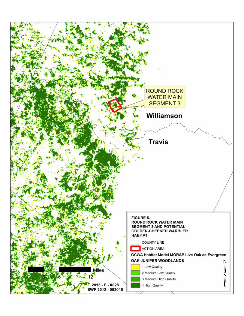
FIGURE 5.ROUND ROCK WATER MAINSEGMENT 3 AND POTENTIALGOLDEN-CHEEKED WARBLERHABITAT
COUNTY LINEACTION AREA
GCWA Habitat Model MORAP Live Oak as EvergreenOAK JUNIPER WOODLANDS
1 Low Quality2 Medium Low Quality3 Medium High Quality4 High Quality ³0 6 123
Miles
!P
!P
!P
!PBrushy Creek
Dry Fork Creek
Block House Creek
Post Oak Creek
Cottonwood Creek
Dry Fork Creek
2013 - F - 0028SWF 2012 - 003019
ROUND ROCK WATER MAINSEGMENT 3 AND POTENTIALGOLDEN-CHEEKED WARBLERHABITAT
ACTION AREAGCWA_potential_habitat_in_action_area_dissGRIDCODE
1234
!P Section 404 Water ³
0 0.4 0.80.2Miles