Embed Size (px)
Citation preview

(August 2007) UNITED STATESDEPARTMENT OF THE INTERIOR u .BUREAU OF LAND MANAGEMENT ULU HoC)Cis
jrkdRS OCBjndry notices and reports on wells
Do not use this form for proposals to drill or to re-enter an abandoned well. Use form 3160-3 (APD) for such proposals.
FORM APPROVEDOMB NO. 1004-0135Expires: July 31, 2010
5. Lease Serial No.
NMNM128928
6. If Indian, Allottee or Tribe Name
SUBMIT IN TRIPLICATE - Other instructions on reverse side.—.i ten
7. If Unit or CAJ Agreement, Name and/or No.
NMNM125386X
l.*□ Oil Well a Gas Well □ Other
8. Well Name and No.
RED HILLS WEST UNIT 14H .✓
2. Name of Operator Contact: JACKIE LATHANMEWBOURNE OIL COMPANY * E-Mail: [email protected]
9. API Well No.
30-025-43136-00-X1
3a. Address
HOBBS, NM 88241
3b. Phone No. (include area code)
Ph: 575-393-590510. Field and Pool, or Exploratory
RED HILLS
4. Location of Well (Footage, Sec., T„ R„ M„ or Survey Description)
Sec 9 T26S R32E SWSW 200FSL 690FWL ^
11. County or Parish, and State
LEA COUNTY, NM
12. CHECK APPROPRIATE BOX(ES) TO INDICATE NATURE OF NOTICE, REPORT, OR OTHER DATA
TYPE OF SUBMISSION TYPE OF ACTION
a Notice of Intent□ Acidize □ Deepen □ Production (Start/Resume) □ Water Shut-Off
□ Alter Casing □ Fracture Treat □ Reclamation □ Well Integrity□ Subsequent Report □ Casing Repair a New Construction □ Recomplete □ Other
□ Final Abandonment Notice □ Change Plans □ Plug and Abandon □ Temporarily Abandon
□ Convert to Injection □ Plug Back □ Water Disposal
13. Describe Proposed or Completed Operation (clearly state all pertinent details, including estimated starting date of any proposed work and approximate duration thereof. If the proposal is to deepen directionally or recomplete horizontally, give subsurface locations and measured and true vertical depths of all pertinent markers and zones. Attach the Bond under which the work will be performed or provide the Bond No. on file with BLM/BIA. Required subsequent reports shall be filed within 30 days following completion of the involved operations. If the operation results in a multiple completion or recompletion in a new interval, a Form 3160-4 shall be filed once testing has been completed. Final Abandonment Notices shall be filed only after all requirements, including reclamation, have been completed, and the operator has determined that the site is ready for final inspection.)
Mewbourne would like to install 5,386.37' of 4" buried steel gas line following existing disturbances from the Red Hills West Unit #014H in the SWSW of Sec 9, T26S, R32E to a Western tie-in point in the NENW of Sec 9, T26S, R32E. See map. Approx, pressure is 625 psi. Traditional trenching and clearing equipment will be used for installation. The line is staked and includes additional footage from the separation equipment to the edge of the pad rather than from the pad edge. While the additional footage would be on the pad, Mewbourne will file the PA/MOA showing the additional footage from what was submitted previously with an additional $27.66 to cover the additional 106.37'. Please contact Ben Sturgill for questions at 575-390-2030.
Bond on file: NM1693 nationwide & NMB000919
14. I hereby certify that the foregoing is true and correct.Electronic Submission #355091 verifiejd by the BLM Well Information System
For MEWBOURNE OIL CO /IPANY, sent to the Hobbs Committed to AFMSS for processing by PRISCILLA PEREZ on 10/20/2016 (17PP0089SE)
Name (Printed/Typed) JACKIE LATHAN Title AUTHORIZED REPRESENTATIVE
Signature (Electronic Submission) Date 10/18/2016
THIS SPACE FOR FEDERAL OR STATE OFFICE USE
Approved By __v'd * ^
Conditions of approval, if any//hre attached.^Approval of this notice does not warrant or
certify that the applicant holds legal or equitable title to those rights in the subject lease which would entitle the applicant to conduct operations thereon.
Title 757 FIELD MANAGER
Office
CARLSBAD FIELD OFFICE
Title 18 U.S.C. Section 1001 and Title 43 U.S.C. Section 1212, make it a crime for any person knowingly and willfully to make to any department or agency States any false, fictitious or fraudulent statements or representations as to any matter within its jurisdiction.
BLM REVISED ** BLM REVISED ** BLM REVISED ** BLM REVISED ** BLM REVISED **

CALCULATED Ss. CORNER Y
MEWBOURNE OIL COMPANY
PROPOSED 4” BURIED GAS PIPELINE FOR THE RED HILLS WEST UNIT #014H
SECTION 9, T26S, R32E N. M. P. M., LEA COUNTY, NEW MEXICO
(5 89'52‘ W - GLO - 5330.16')N 89‘29’59" E 5332.77'
j6BO.OS- fne)
53+86.37 END 4" GAS BPL 53+41.23 I P. I. OF 46*4B‘53" RT.
53+10.03 P. I. OF e^’Acr LT.
-N-
2675.66'(S 89‘56' W - GLO
7+61.317+09.976+91.756+79.876+31.414+98.894+54.41
1+21.200+27.250+18.58
0+00
5 89'33'21"
5344.68)
P. I. OF 14‘03’26"
LEASE ROAD MEWBOURNE BPL MEWBOURNE BPL FRONTIER BPL P. I. OF 90'14'53" LEASE ROAD P. I. OF 90'37’IT P. I. OF 89’03'39"
EDGE OF PAD BEGIN 4" CAS BPL
2672.52'
§^ CN
♦ FBC “1939"
LINE TABLE
LINE BEARING LENGTHL1 N 89*59’37" E 27.25’L2 N 00'55’58’’ E 93.95’LJ N 89*41 ’13“ W 377.69’
L4 N 00’33’40” E 262.42’
L5 N 14'37’06” E 4,548.72’
L6 N 48’49’34" W 31.20’
L7 N 02’00’4r W 45.14'
0 500’ 1000’
BEARINGS ARE GRID NAD 27 NM EAST
DISTANCES ARE HORIZ GROUND.
( )
♦
LEGEND
RECORD DATA
FOUND MONUMENT AS NOTED
PROPOSED 4" GAS BPL
I, R. M. Howett, a N. M. Professional Surveyor, hereby certify that I prepared this plat from an actual survey made on the ground under my direct supervision, said survey and plat meet the Min. Stds. for Land Surveying in the State of N. M. and are true and correct to the best of my knowledge and belief.
Firm No.. TX 10193838 NM 4655451
^obeli' M,. -{douo&U "
Robert M. Howett NM PS 19680
NO. REVISION DATE
JOB NO.: LS1610315
DWG. NO.: 1-1610315
Copyright 2016 — AH Rights Reserved
308 W. BROADWAY ST., HOBBS, NM 882*0 (575) 964-8200
SCALE: 1 = 1000
DATE: 10-17-2016
SURVEYED BY: ML/CG
DRAWN BY: CMJ
APPROVED BY: RMH
SHEET: 1 OF 2
MEWBOURNE OIL COMPANY
PROPOSED 4” BURIED GAS PIPELINE FOR THE RED HILLS WEST UNIT #014H
SECTION 9, T26S, R32E N. M. P. M., LEA COUNTY, NEW MEXICO
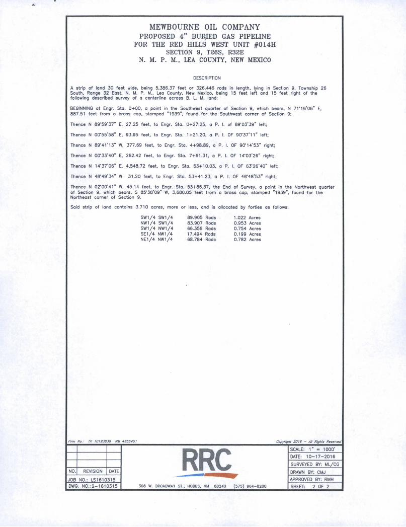
DESCRIPTION
A strip of land 30 feet wide, being 5,386.37 feet or 326.446 rods in length, lying in Section 9, Township 26 South, Range 32 East, N. M. P. M., Lea County, New Mexico, being 15 feet left and 15 feet right of the following described survey of a centerline across B. L. M. land:
BEGINNING at Engr. Sta. 0+00, a point in the Southwest quarter of Section 9, which beors, N 71‘16'06" E,887.51 feet from a brass cap, stamped ”1939”, found for the Southwest corner of Section 9;
Thence N 89’59’37” E, 27.25 feet, to Engr. Sta. 0+27.25, a P. I. of 89-03’39” left;
Thence N 00‘55'58" E, 93.95 feet, to Engr. Sta. 1+21.20, a P. I. OF 90'37'H” left;
Thence N 89'41’13” W, 377.69 feet, to Engr. Sta. 4+98.89, a P. I. OF 90'14'53” right;
Thence N 00'33’40” E. 262.42 feet, to Engr. Sta. 7+61.31, a P. I. OF 14'03’26” right;
Thence N U-37’06" E, 4,548.72 feet, to Engr. Sto. 53+10.03, a P. I. OF 63'26'40” left;
Thence N 48'49'34" W 31.20 feet, to Engr. Sta. 53+41.23, a P. I. OF 46'48'53” right;
Thence N 02'00’41” W, 45.14 feet, to Engr. Sto. 53+86.37, the End of Survey, a point in the Northwest quarterof Section 9, which beors, S 85'38'09” W. 3,680.05 feet from a brass cap, stamped ”1939”, found for the Northeast corner of Section 9.
Said strip of land contains 3.710 acres, more or less, and is allocated by forties os follows:
SW1/4 SW1/4 89.905 Rods 1.022 AcresNW1/4 SW1/4 83.907 Rods 0.953 AcresSW1/4 NW1/4 66.356 Rods 0.754 AcresSE1/4 NW1/4 17.494 Rods 0.199 AcresNE1/4 NW1/4 68.784 Rods 0.782 Acres
Firm No.: TX 10193838 NM 4655451
NO. REVISION DATE
JOB NO.: LS1610315
DWG. N0.:2-1610315
Copyright 2016 - All Rights Reserved
308 W. BROADWAY ST., HOBBS. NM 88240 (575) 964-8200
SCALE: 1” = 1000’
DATE: 10-17-2016
SURVEYED BY: ML/CG
DRAWN BY: CMJ
APPROVED BY: RMH
SHEET: 2 OF 2
BLM LEASE NUMBER:
COMPANY NAME:
ASSOCIATED WELL NAME:
BURIED PIPELINE STIPULATIONS
A copy of the application (Grant, APD, or Sundry Notice) and attachments, including conditions
of approval, survey plat and/or map, will be on location during construction. BLM personnel may
request to you a copy of your permit during construction to ensure compliance with all
stipulations.
Holder agrees to comply with the following stipulations to the satisfaction of the Authorized
Officer:
1. The Holder shall indemnify the United States against any liability for damage to life or
property arising from the occupancy or use of public lands under this grant.
2. The Holder shall comply with all applicable Federal laws and regulations existing or hereafter
enacted or promulgated. In any event, the holder shall comply with the Toxic Substances Control
Act of 1976 as amended, 15 USC 2601 et seq. (1982) with regards to any toxic substances that
are used, generated by or stored on the right-of-way or on facilities authorized under this right-of-
way grant. (See 40 CFR Part 702-799 and especially, provisions on polychlorinated biphenyls,
40 CFR 761.1-761.193.) Additionally, any release of toxic substances (leaks, spills, etc.) in
excess of the reportable quantity established by 40 CFR Part 117 shall be reported as required by
the Comprehensive Environmental Response, Compensation, and Liability Act, section 102b. A
copy of any report required or requested by any Federal agency or State government as a result of
a reportable release or spill of any toxic substances shall be furnished to the authorized officer
concurrent with the filing of the reports to the involved Federal agency or State government.
3. The holder agrees to indemnify the United States against any liability arising from the release
of any hazardous substance or hazardous waste (as these terms are defined in the Comprehensive
Environmental Response, Compensation and Liability Act of 1980, 42 U.S.C. 9601, et seq. or the
Resource Conservation and Recovery Act, 42 U.S.C.6901, et seq.) on the Right-of-Way (unless
the release or threatened release is wholly unrelated to the Right-of-Way holder’s activity on the
Right-of-Way), or resulting from the activity of the Right-of-Way holder on the Right-of-Way.
This agreement applies without regard to whether a release is caused by the holder, its agent, or
unrelated third parties.
4. If, during any phase of the construction, operation, maintenance, or termination of the
pipeline, any oil or other pollutant should be discharged from the pipeline system, impacting
Federal lands, the control and total removal, disposal, and cleaning up of such oil or other
pollutant, wherever found, shall be the responsibility of holder, regardless of fault. Upon failure
of holder to control, dispose of, or clean up such discharge on or affecting Federal lands, or to
repair all damages resulting therefrom, on the Federal lands, the Authorized Officer may take
such measures as he deems necessary to control and clean up the discharge and restore the area,
including where appropriate, the aquatic environment and fish and wildlife habitats, at the full
expense of the holder. Such action by the Authorized Officer shall not relieve holder of any
responsibility as provided herein.
1

5. All construction and maintenance activity will be confined to the authorized right-of-way.
6. The pipeline will be buried with a minimum cover of 36 inches between the top of the
pipe and ground level.
7. The maximum allowable disturbance for construction in this right-of-way will be 30 feet:
• Blading of vegetation within the right-of-way will be allowed: maximum width of
blading operations will not exceed 20 feet. The trench is included in this area. (Blading
is defined as the complete removal of brush and ground vegetation.)
• Clearing of brush species within the right-of-way will be allowed: maximum width of
clearing operations will not exceed 30 feet. The trench and bladed area are included in
this area. (Clearing is defined as the removal of brush while leaving ground vegetation
(grasses, weeds, etc.) intact. Clearing is best accomplished by holding the blade 4 to 6
inches above the ground surface.)
• The remaining area of the right-of-way (if any) shall only be disturbed by compressing
the vegetation. (Compressing can be caused by vehicle tires, placement of equipment,
etc.)
8. The holder shall stockpile an adequate amount of topsoil where blading is allowed. The
topsoil to be stripped is approximately___ 6___ inches in depth. The topsoil will be segregated
from other spoil piles from trench construction. The topsoil will be evenly distributed over the
bladed area for the preparation of seeding.
9. The holder shall minimize disturbance to existing fences and other improvements on public
lands. The holder is required to promptly repair improvements to at least their former state.
Functional use of these improvements will be maintained at all times. The holder will contact the
owner of any improvements prior to disturbing them. When necessary to pass through a fence
line, the fence shall be braced on both sides of the passageway prior to cutting of the fence. No
permanent gates will be allowed unless approved by the Authorized Officer.
10. Vegetation, soil, and rocks left as a result of construction or maintenance activity will be
randomly scattered on this right-of-way and will not be left in rows, piles, or berms, unless
otherwise approved by the Authorized Officer. The entire right-of-way shall be recontoured to
match the surrounding landscape. The backfilled soil shall be compacted and a 6 inch berm will
be left over the ditch line to allow for settling back to grade.
11. In those areas where erosion control structures are required to stabilize soil conditions, the
holder will install such structures as are suitable for the specific soil conditions being encountered
and which are in accordance with sound resource management practices.
12. The holder will reseed all disturbed areas. Seeding will be done according to the attached
seeding requirements, using the following seed mix.
( ) seed mixture 1 ( ) seed mixture 3
(X) seed mixture 2 ( ) seed mixture 4
( ) seed mixture 2/LPC ( ) Aplomado Falcon Mixture
2

13. All above-ground structures not subject to safety requirements shall be painted by the holder
to blend with the natural color of the landscape. The paint used shall be color which simulates
“Standard Environmental Colors” - Shale Green, Munsell Soil Color No. 5Y 4/2.
14. The pipeline will be identified by signs at the point of origin and completion of the right-of-
way and at all road crossings. At a minimum, signs will state the holder’s name, BLM serial
number, and the product being transported. All signs and information thereon will be posted in a
permanent, conspicuous manner, and will be maintained in a legible condition for the life of the
pipeline.
15. The holder shall not use the pipeline route as a road for purposes other than routine
maintenance as determined necessary by the Authorized Officer in consultation with the holder
before maintenance begins. The holder will take whatever steps are necessary to ensure that the
pipeline route is not used as a roadway. As determined necessary during the life of the pipeline,
the Authorized Officer may ask the holder to construct temporary deterrence structures.
16. Any cultural and/or paleontological resources (historic or prehistoric site or object)
discovered by the holder, or any person working on his behalf, on public or Federal land shall be
immediately reported to the Authorized Officer. Holder shall suspend all operations in the
immediate area of such discovery until written authorization to proceed is issued by the
Authorized Officer. An evaluation of the discovery will be made by the Authorized Officer to
determine appropriate actions to prevent the loss of significant cultural or scientific values. The
holder will be responsible for the cost of evaluation and any decision as to proper mitigation
measures will be made by the Authorized Officer after consulting with the holder.
17. The operator shall be held responsible if noxious weeds become established within the areas
of operations. Weed control shall be required on the disturbed land where noxious weeds exist,
which includes associated roads, pipeline corridor and adjacent land affected by the establishment
of weeds due to this action. The operator shall consult with the Authorized Officer for acceptable
weed control methods, which include following EPA and BLM requirements and policies.
18. Escape Ramps - The operator will construct and maintain pipeline/utility trenches [that are
not otherwise fenced, screened, or netted] to prevent livestock, wildlife, and humans from
becoming entrapped. At a minimum, the operator will construct and maintain escape ramps,
ladders, or other methods of avian and terrestrial wildlife escape in the trenches according to the
following criteria:
a. Any trench left open for eight (8) hours or less is not required to have escape ramps;
however, before the trench is backfilled, the contractor/operator shall inspect the trench
for wildlife, remove all trapped wildlife, and release them at least 100 yards from the
trench.
b. For trenches left open for eight (8) hours or more, earthen escape ramps (built at no more
than a 30 degree slope and spaced no more than 500 feet apart) shall be placed in the
trench.
3