Embed Size (px)
Citation preview
UNITED NATIONS ENVIRONMENT PROGRAMME
GLOBAL PROGRAMME OF ACTION FOR THE PROTECTION OF THE MARINE ENVIRONMENT FROM LAND BASED ACTIVITIES
A COMPARATIVE REVIEW OF COASTAL LEGISLATION IN SOUTH ASIA
GPA Coordination Office, The Netherlands and
International Ocean Institute, India May 2003
2
This review was carried out under the Physical Alterations and Destruction of Habitats (PADH) programme of the UNEP/GPA Coordination Office. UNEP gratefully acknowledges the financial contribution of the Government of Belgium (Project Number: GPL 3010-00-35) for the PADH Programme through which this review study was undertaken.
3
ACKNOWLEDGEMENTS
The International Ocean Institute, Operational Centre (India) thanks the United Nations Environment Programme, GPA Coordination Office, the Netherlands, for commissioning the Study “A Comparative Review of Coastal Legislation in South Asia” under the Physical Alterations and Destruction of Habitats (PADH) Project. We acknowledge the financial contribution of the Government of Belgium for this project. We thank Dr. Veerle Vandeweerd, Coordinator and Deputy Director, Division of Environmental Policy Implementation, UNEP-GPA and Dr. Anjan Datta, Programme Officer, UNEP-GPA, for their support and encouragement. Our thanks are also to Mr. Joe Schittone, former Programme Officer, UNEP-GPA, who initiated this study. We also thank Dr.B.R.Subramanian, Department of Ocean Development, Government of India; Mr. Mahboob Elahi, Director General, and Mr. Pradyumna Kumar Kotta, Project Coordinator, SENRIC at the South Asia Co-operative Environment Programme, Colombo, Sri Lanka; Dr. Faathin Hameed, Director, Ministry of Fisheries, Agriculture and Marine Resources, and Mr. Hassan Maaz Shareef, Legal Officer of the Government of Maldives for their valuable input to the project. We acknowledge with thanks the help rendered by the International Collective in Support of Fishworkers, Chennai, especially their Documentation Section. We are grateful to the staff of the International Ocean Institute, Operational Centre (India) for their secretarial assistance. Since this report is based on information collected from a variety of sources, errors and omissions are likely. We urge that the users of this report to send us their comments and any corrections or additions (email address: [email protected]). Chennai, India Ahana Lakshmi February 26, 2003 R.Rajagopalan Address for communication: Prof.R.Rajagopalan Dr Ahana Lakshmi Centre Director Project Co-ordinator International Ocean Institute Email: [email protected] Operational Centre (India) Foundation for Sustainable Development (India) IC&SR Building (III Floor) Indian Institute of Technology Madras Chennai – 600036, India Tel: +91-44-22570338 / 22578805 Fax: +91-44-22570559 E-mail: [email protected]

4
UNEP / GPA-LBA Physical Alterations and Destruction of Habitats (PADH) Project
A Comparative Review of Coastal Legislation in South Asia
Contents ACKNOWLEDGEMENTS EXECUTIVE SUMMARY
1. INTRODUCTION
1.1 The Five Countries 1.2 Main features of the South Asian Coasts 1.3 Key Environmental Issues and Causes in South Asia 1.4 The Study 1.5 References
2. SUMMARY RESULTS OF THE STUDY
2.1 Country Information 2.2 Overall Environmental Legislation 2.3 Tourism 2.4 Fisheries and Aquaculture 2.5 Coastal Mining 2.6 Ports 2.7 Land use
3. GENERAL REPORT
3.1 Introduction 3.2 Limitations of the Study 3.3 The South Asian Seas Region 3.4 Activities leading to PADH 3.4.1 Tourism
3.4.2 Shrimp Aquaculture 3.4.3 Sand Mining 3.4.4 Ports 3.4.5 Other Activities
5
3.5 Legislation 3.5.1 Introduction
3.5.2 Customary Rights and Community Management 3.5.3 Evolving Legislation 3.5.4 Environmental Legislation 3.5.5 Environmental Impact Assessment (EIA) 3.5.6 Coastal Legislation 3.5.7 Legislation for Tourism, Shrimp Aquaculture, Sand Mining and Ports
3.6 Environment and the Judiciary 3.7 References
4. COUNTRY REPORT: BANGLADESH
4.1 Basic Information 4.2 Coastal Landforms
4.2.1 Mangroves 4.2.2 Beaches 4.2.3 Coral Reefs 4.2.4 Tidal flats 4.2.5 Estuaries, Deltas, Rivers and Sediment Transport 4.3 National Environmental Policy
4.4 Note about PADH for the Country 4.5 Umbrella Environmental Legislation 4.6 Focus on the Coast 4.7 Major Coastal Activities causing habitat alteration
(with policies and legislation)
4.7.1 Shrimp Aquaculture 4.7.2 Tourism 4.7.3 Coastal Mining 4.7.4 Ports and infrastructure facilities 4.7.5 Other Activities/Resources 4.7.6 Land Use 4.8 References
6
5. COUNTRY REPORT: INDIA
5.1 Basic Information 5.2 Coastal Landforms 5.2.1 Mangroves 5.2.2 Beaches 5.2.3 Coral Reefs 5.2.4 Tidal Flats
5.2.5 Estuaries, Deltas, Rivers and Sediment Transport 5.2.6 Coastal Lagoons
5.3 National Environmental Policy 5.4 Note about PADH for the Country 5.5 Umbrella Environmental Legislation 5.6 Focus on the Coast 5.7 Major Coastal Activities causing habitat alteration (with policies and legislation) 5.7.1 Shrimp Aquaculture 5.7.2 Tourism 5.7.3 Coastal Mining 5.7.4 Ports and infrastructure facilities 5.7.5 Other Activities/Resources 5.7.6 Land Use 5.8 References
6. COUNTRY REPORT: MALDIVES 6.1 Basic Information
6.2 Coastal Landforms 6.2.1 Mangroves 6.2.2 Beaches 6.2.3 Coral Reefs 6.3 National Environmental Policy 6.4 Note about PADH for the Country 6.5 Umbrella Environmental Legislation 6.6 Focus on the Coast 6.7 Major Coastal Activities causing habitat alteration (with policies and legislation)
7
6.7.1 Tourism 6.7.2 Coastal Mining 6.7.3 Ports and infrastructure facilities 6.7.4 Other Activities/Resources 6.7.5 Land Use 6.8 References
7. COUNTRY REPORT: PAKISTAN 7.1 Basic Information
7.2 Coastal Landforms 7.2.1 Mangroves 7.2.2 Beaches 7.2.3 Coral Reefs 7.2.4 Tidal Flats 7.2.5 Estuaries, Deltas, Rivers and Sediment Transport 7.2.6 Coastal Lagoons 7.3 National Environmental Policy 7.4 Note about PADH for the Country 7.5 Umbrella Environmental Legislation 7.6 Focus on the Coast 7.7 Major Coastal Activities causing habitat alteration (with policies and legislation) 7.7.1 Shrimp Aquaculture 7.7.2 Tourism 7.7.3 Coastal Mining 7.7.4 Ports and Infrastructure Facilities 7.7.5 Other Activities/Resources 7.8 References
8. COUNTRY REPORT: SRI LANKA
8.1 Basic Information 8.2 Coastal Landforms 8.2.1 Mangroves 8.2.2 Beaches 8.2.3 Coral Reefs 8.2.4 Tidal flats (Salt marshes) 8.2.5 Estuaries, Deltas, Rivers and Sediment Transport 8.2.6 Coastal Lagoons

8
8.3 National Environmental Policy 8.4 Note about PADH for the Country 8.5 Umbrella Environmental Legislation 8.6 Focus on the Coast 8.7 Major Coastal Activities causing habitat alteration (with policies and legislation) 8.7.1 Shrimp Aquaculture 8.7.2 Tourism
8.7.3 Coastal Mining (Beach and river sand, coral) 8.7.4 Ports and Infrastructure Facilities 8.7.5 Other Activities / Resources 8.7.6 Land Use
8.8 References
9. CONCLUSIONS AND RECOMMENDATIONS
9.1 Introduction 9.2 Legislation 9.3 Enforcing Legislation 9.4 Recommendations 9.5 References
9
UNEP / GPA-LBA Physical Alterations and Destruction of Habitats (PADH) Project
A Comparative Review of Coastal Legislation in South Asia
EXECUTIVE SUMMARY Background It is estimated that some 80% of the pollutant load in the oceans originates from land-based activities. Alteration and destruction of habitats and ecosystems is considered one of the most serious problems affecting the quality of the marine and coastal environment. Direct threats include reclamation of land for various purposes, changes in land use, felling of forests, mining of sand and minerals and building on coasts. Important coastal habitats include mangroves, tidal flats, sandy beaches and coral reefs. UNEP initiated the Regional Seas Programme in 1974 as a global programme implemented through regional components. The South Asian Seas Region includes the seas bordering South Asian countries, namely, Bangladesh, India, Maldives, Pakistan, and Sri Lanka and comprises the Northern part of the Indian Ocean, along with the Bay of Bengal and the Arabian Sea. Bangladesh, India and Pakistan are part of the Indian subcontinent while Sri Lanka is an island just off the subcontinent and the Maldives are a group of coral islands in the Indian Ocean. High populations and low income characterize all the five countries. The majority of the populations, even today, are heavily dependent on a natural resource base. The Study The mandate of the PADH (Physical Alterations and Destruction of Habitats) Project of the GPA-LBA (Global Programme of Action for the Protection of the Marine Environment from Land-Based Activities) is to focus on sediment mobilization effects by four economic sectors that potentially pose a threat to such habitats, namely: tourism, ports, aquaculture, and mining (sand and aggregate extraction). This Study is a descriptive and comparative review of current environmental and coastal legislation (where available) in the five countries of the South Asian region with a focus on PADH caused by the four identified economic sectors. The Study includes country reports as well as a comparative table of the legislative measures taken by the five countries. Main Findings and Recommendations Many points of commonality exist among the coastal laws of four of the countries: Bangladesh, India, Pakistan and Sri Lanka. This is because of their common colonial heritage, in which the British had politically and economically unified them before the countries became independent in the middle of the 20th century. This legacy is found in some of the old laws such as the Land Acquisition Act and the Forest Act that are still in force (with amendments or modifications) in the four countries. The Maldives have always been an independent nation and had, till recently, a unique system of governance whereby each atoll had a major role to play in managing its immediate resources.

10
Subsequent to the 1972 UN Conference on the Environment at Stockholm, all the countries have enacted laws to protect the environment. All the countries have also adopted requirements of Environmental Impact Assessment (EIA) as part of their environmental protection law. EIA is supposed to enforce better management practices and control environmental destruction. Sri Lanka was the first country in the region to enact a national level legislation for coastal management (The Coast Conservation Act No. 57, 1981). The Act defines the coastal zone and calls for a coastal management plan to be formulated and updated every four years by the Coast Conservation Department. India issued the Coastal Regulation Zone Notification in 1991, under its 1986 Environmental Protection Act. The ‘Coastal Regulation Zone’ is defined and activities falling within this zone are controlled. Coastal Zone Management Authorities have been constituted at the national and state levels to help in protection and conservation of coastal areas. Each coastal state was directed to draw up its own Coastal Zone Management Plan. The entire country of the Maldives falls within the purview of the coastal zone, as the islands are very small. Their major concern is global warming and the consequent sea level rise, which threatens to engulf the islands. Tourism has brought in significant earnings in the last 30 years, but has also resulted in environmental degradation, and their laws reflect this aspect. In 1999, Bangladesh’s Ministry of Water Resources announced the government’s intention to develop an Integrated Coastal Zone Management (ICZM) policy. A programme development office has been set up financed by the governments of Bangladesh and the Netherlands. In Pakistan, an International Workshop on Integrated Coastal Zone Management was organized by the Ministry of Science and Technology in October 1994 in Karachi, which suggested definitions for the coastal zone apart from discussing other pertinent issues. Coastal management comes under the provincial governments and subsequent to the workshop, the Sind Coastal Development Authority Act was enacted in 1994 and the Balochistan Coastal Development Authority Act was passed in 1998. In all the countries, a Forest Act (or Ordinance) is the general legislation that provides for the protection of (notified/reserved) forest areas. Typically, activities such as mining that can cause habitat destruction are not permitted in reserved forest areas. Mangroves are considered coastal forests and governed by this law. Permission of the forest department is generally mandatory for any clearance of forests or conversion to other use. Corals usually come under wildlife protection legislation. This legislation also usually has the power to declare marine reserves. There are no specific regulations for protecting habitats such as sand dunes except in Sri Lanka and India, where they fall in the coastal regulation zones, where activities are strictly controlled. For example, sand mining within the defined coastal areas is prohibited and there are regulations in force dealing with
11
constructions for tourism. While some wetlands may enjoy special protection (at different scales/levels), it is the activity - primarily fishing - in the wetlands (including lakes, lagoons, estuaries etc.) that is controlled. Provincial or state governments usually control fishing near the coast (territorial waters) while fishing in the EEZ usually comes under the central/federal authorities. As for activities in the PADH list, only Sri Lanka and Maldives have specific laws for regulating tourism. In these two countries coastal tourism forms a significant part of foreign-exchange earnings and has also been the cause of extensive environmental destruction. In the case of aquaculture (mainly shrimp aquaculture), only India and Sri Lanka have enacted legislation to control the industry. Sand mining comes under minor minerals and it is the state/provincial governments, which are responsible for controlling this activity. Maldives has coral mining as a major problem as it has no other source of building material, and coral extraction has been a main cause of coastal erosion. Hence a number of laws have been enacted to prohibit/control mining of coral and aggregates from coastal areas in the Maldives. Ports and harbours have their own regulatory authorities set up by specific acts in each country. In most cases, the development of a port requires an EIA. Relatively little information is available for dredging activities and the consequence of dumping of dredged spoils. Over time and with globalisation, there has been a shift in the dominance of different activities. One way is to look at changes that have occurred in the way the different activities contribute to the GDP of a country. Maldives, for example, has changed from a fisheries-dominated economy into a tourism-dominated one. In the other countries, the policy of industrialization as the only way to improve the standard of living for a larger majority has resulted in ignoring long-term sustainability aspects. This, along with focus on ‘export-oriented activities’ that are likely to bring in substantial foreign exchange, has resulted in strong competition amongst the different activities that directly or indirectly involve or result in PADH. For instance, conversion of mangrove forests into shrimp farms; building of large tourist resorts along beaches, changes in practices that convert the traditional alternating paddy agriculture-shrimp farming system into a wholly export-oriented shrimp farming system and such other events have been reported. Activities in the hinterland such as dams on rivers as well as poor implementation of town planning laws that allow urban sprawl can be very detrimental. Several points have emerged from analysis of information collected for this project. One clear pointer is the need for integrating management of both land and sea areas. This is essential as it would help in identifying the effect that activities in one area can have on others (e.g., land based activities on the marine environment; ocean based activities like drilling for gas on the coastal environment), keeping in mind the principles of sustainable development. The second point is that there needs to be integration of management – both vertically and horizontally. This calls for inter-department and inter-agency cooperation at various levels. The sectoral nature of various activities has resulted in many governmental departments/agencies acting in the same space, sometimes with conflicting requirements/ interests in mind. The third point is that it is not a lack of legislation that is hampering the control of undesirable activities in coastal areas as much
12
as the lack of enforcement of legislation. This lack of enforcement has resulted in the Judiciary becoming actively involved in environmental protection (as in India). Environmental Impact Assessment procedures have to be strengthened to ensure that development activities proceed with acceptable environmental impacts. Involving stakeholders including the local community in the management of resources is likely to be more effective for sustainable development.
13
CHAPTER 1
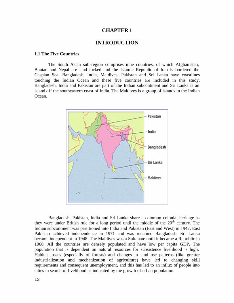
INTRODUCTION 1.1 The Five Countries The South Asian sub-region comprises nine countries, of which Afghanistan, Bhutan and Nepal are land- locked and the Islamic Republic of Iran is bordered the Caspian Sea. Bangladesh, India, Maldives, Pakistan and Sri Lanka have coastlines touching the Indian Ocean and these five countries are included in this study. Bangladesh, India and Pakistan are part of the Indian subcontinent and Sri Lanka is an island off the southeastern coast of India. The Maldives is a group of islands in the Indian Ocean.
Bangladesh, Pakistan, India and Sri Lanka share a common colonial heritage as they were under British rule for a long period until the middle of the 20th century. The Indian subcontinent was partitioned into India and Pakistan (East and West) in 1947. East Pakistan achieved independence in 1971 and was renamed Bangladesh. Sri Lanka became independent in 1948. The Maldives was a Sultanate until it became a Republic in 1968. All the countries are densely populated and have low per capita GDP. The population that is dependent on natural resources for subsistence livelihood is high. Habitat losses (especially of forests) and changes in land use patterns (like greater industrialization and mechanization of agriculture) have led to changing skill requirements and consequent unemployment, and this has led to an influx of people into cities in search of livelihood as indicated by the growth of urban population.
14
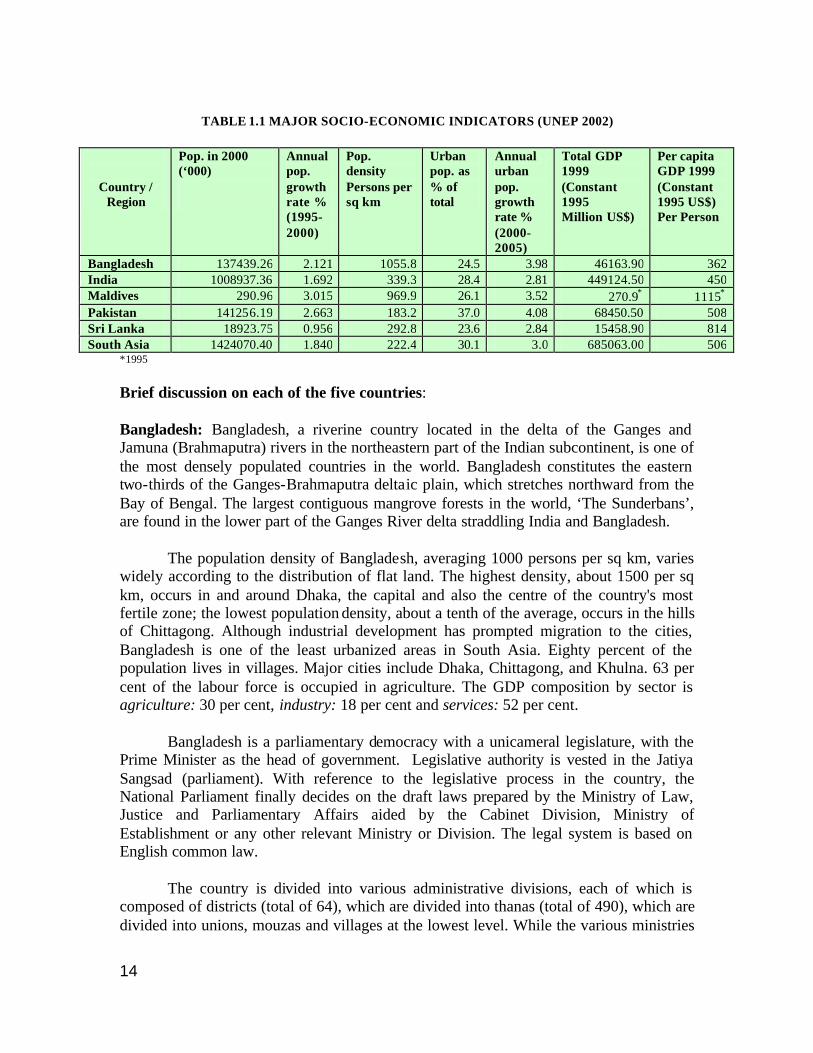
TABLE 1.1 MAJOR SOCIO-ECONOMIC INDICATORS (UNEP 2002)
Country / Region
Pop. in 2000 (‘000)
Annual pop. growth rate % (1995-2000)
Pop. density Persons per sq km
Urban pop. as % of total
Annual urban pop. growth rate % (2000-2005)
Total GDP 1999 (Constant 1995 Million US$)
Per capita GDP 1999 (Constant 1995 US$) Per Person
Bangladesh 137439.26 2.121 1055.8 24.5 3.98 46163.90 362 India 1008937.36 1.692 339.3 28.4 2.81 449124.50 450 Maldives 290.96 3.015 969.9 26.1 3.52 270.9∗ 1115∗ Pakistan 141256.19 2.663 183.2 37.0 4.08 68450.50 508 Sri Lanka 18923.75 0.956 292.8 23.6 2.84 15458.90 814 South Asia 1424070.40 1.840 222.4 30.1 3.0 685063.00 506
∗1995
Brief discussion on each of the five countries: Bangladesh: Bangladesh, a riverine country located in the delta of the Ganges and Jamuna (Brahmaputra) rivers in the northeastern part of the Indian subcontinent, is one of the most densely populated countries in the world. Bangladesh constitutes the eastern two-thirds of the Ganges-Brahmaputra deltaic plain, which stretches northward from the Bay of Bengal. The largest contiguous mangrove forests in the world, ‘The Sunderbans’, are found in the lower part of the Ganges River delta straddling India and Bangladesh. The population density of Bangladesh, averaging 1000 persons per sq km, varies widely according to the distribution of flat land. The highest density, about 1500 per sq km, occurs in and around Dhaka, the capital and also the centre of the country's most fertile zone; the lowest population density, about a tenth of the average, occurs in the hills of Chittagong. Although industrial development has prompted migration to the cities, Bangladesh is one of the least urbanized areas in South Asia. Eighty percent of the population lives in villages. Major cities include Dhaka, Chittagong, and Khulna. 63 per cent of the labour force is occupied in agriculture. The GDP composition by sector is agriculture: 30 per cent, industry: 18 per cent and services: 52 per cent.
Bangladesh is a parliamentary democracy with a unicameral legislature, with the Prime Minister as the head of government. Legislative authority is vested in the Jatiya Sangsad (parliament). With reference to the legislative process in the country, the National Parliament finally decides on the draft laws prepared by the Ministry of Law, Justice and Parliamentary Affairs aided by the Cabinet Division, Ministry of Establishment or any other relevant Ministry or Division. The legal system is based on English common law.
The country is divided into various administrative divisions, each of which is composed of districts (total of 64), which are divided into thanas (total of 490), which are divided into unions, mouzas and villages at the lowest level. While the various ministries
15
perform regulatory policy-making functions at the national level, the numerous subordinate offices execute these at the field level.
The regulatory regime is 'sectoralised' under various Ministries, and this has resulted in the development of uncoordinated, competing and often adversarial approaches unfriendly to sustainable management of resources and ecological governance. The Bangladesh Environmental Lawyers' Association (BELA) has so far identified about 182 laws (excluding rules and by- laws) relevant to environment (Hossain 1999). A court ruling in 1996 (48 DLR 1996) declared the right to a healthy environment as a fundamental right of the citizens of Bangladesh. According to this ruling, “Articles 31 and 32 of our Constitution protect right to life as fundamental right. It encompasses within its ambit, the protection and preservation of environment, ecological balance free from pollution of air and water, sanitation without which life can hardly be enjoyed. Any act or omission contrary thereto will be violative of the said right to life”. India: In area, India ranks as the seventh largest country in the world, covering just slightly more than two percent of the Earth's total land surface. With more than one-sixth of the world's total population, India is the second most populous country, after China. Much of India's territory lies within a large peninsula, bounded by the Arabian Sea on the west and the Bay of Bengal on the east. Kanyakumari (Cape Comorin), the southernmost point of the Indian mainland is at the confluence of the two seas and the Indian Ocean. India has two union territories composed entirely of islands: Lakshadweep, in the Arabian Sea, and the Andaman and Nicobar Islands, which lie between the Bay of Bengal and the Andaman Sea. About 47 per cent of the population lives in the coastal states. Chains of mountains run parallel to the eastern and western coasts. While the strip between the coastline and the mountains is relatively narrow on the west coast, it is wider on the east coast. Some parts of the coast are heavily industrialized and they have been showing up as ‘hot spots’ in recent environmental quality studies. The coast also has some of the largest and most dense urban agglomerations such as Mumbai (Bombay), Kolkata (Calcutta), Chennai (Madras), Kochi (Cochin) and Visakhapatnam. 60 per cent of the labor force is occupied in agriculture. The GDP contribution by sector is agriculture: 25 per cent, industry: 26 per cent and services: 49 per cent. India is a Federal Republic divided into 28 states and 7 union territories. The legislative consists of a bicameral Parliament or Sansad, which consists of the Council of States or Rajya Sabha and the People's Assembly or Lok Sabha. The Rajya Sabha has about 250 members, serving six-year terms. Up to 12 members are appointed by the President, while the remainder are chosen by the elected members of the state and territorial assemblies. The Lok Sabha has 545 seats - 543 elected by popular vote and 2 appointed by the President; members serve five-year terms.
16
Protection of the environment is enshrined in the Indian constitution. Article 21 of the Constitution is a fundamental right, which reads as “No person shall be deprived of his life or personal liberty except according to procedure established by law”. Though environment is not explicitly mentioned, the Supreme Court held that right to environment is a fundamental right of every citizen of India and is included in the “right to life” (AIR 1991 SC 420). In the 42nd Amendment to the Constitution of India made in 1976, the addition of Article 48-A said that “The State shall endeavour to protect and improve the environment and to safeguard the forests and wildlife of the country”, while the addition of Article 51-A held that “It shall be the duty of every citizen of India to protect and improve the natural environment including forests, lakes, rivers and wildlife and to have compassion for living creatures”. The Seventh Schedule (Under Art. 246) of the Constitution of India gives three lists: (1) Union list containing 97 subjects in which the Union government has exclusive authority; (2) State List containing 66 subjects which are under the exclusive authority of the State Governments and (3) Concurrent List containing 47 subjects where the Union and the States have concurrent powers. The Union enjoys primacy over the States and the Parliament has residuary powers to legislate on any matter not covered in the three lists. Powers and responsibilities of municipalities have been included subsequent to the 73rd and 74th amendments to the Constitution in 1992. Subjects covered include land improvement and consolidation of land reforms, roads, culverts, bridges, waterways and other means of communication; maintenance of community assets and town planning. Subject to the provisions of the Constitution, the legislature of a state will endow the Panchayats and Municipalities with such powers and authority as may be necessary to enable them to function as institutions of self government. Maldives: Maldives is an independent island nation consisting of a chain of about 1,190 small coral islands and sandbanks (198 of which are inhabited) grouped in clusters, or atolls, in the Indian Ocean. The islands extend more than 820 km from north to south and 130 km from east to west. The northernmost atoll is about 600 km south-southwest of the Indian mainland, and the central area, including the capital island of Malé, is about 645 km southwest of Sri Lanka. There are 26 natural geographic atoll formations, which have been divided into 20 separate administrative units. Malé, the Capital, forms the 21st administrative component. Malé and Hulhulé (the island of the international airport) are geographically in Kaafu Atoll but are treated as a separate administrative identity. Local administration of every atoll is headed by an atoll chief ‘atholhu veriyaa’ and each inhabited island has an island chief, ‘katheeb’ who is the government representative. Both the atoll chiefs and island chiefs are appointed by the Central government.
The Republic is governed under a Constitution promulgated in 1968. Executive power is vested in a president, nominated by the unicameral People's Council or Majlis (Citizens' Council), and then elected every five years. The President is both the Chief of State and Head of Government. The Majlis is composed of 42 members elected by popular vote and 8 appointed by the President. The legal system is based on Islamic law with admixtures of English common law primarily in commercial matters. The Ministry
17
of Justice administers the law in accordance with the Islamic Sharia’a code. The judicial system is under the authority of the President, who is empowered to reverse its rulings. A Bill passed by the parliament becomes law on the signature of the President. Management of reef resources in the Maldives is quite complex, mainly due to the dual legal system of ownership, which was put in place after the system of government was changed from a sultanate to a republic in 1968. Earlier, the system was based on the communal system of “Vaaru” whereby each atoll had a major role to play in managing its immediate resource, thus enabling the atoll chief advised by the elders of the community to control the resources as a common property of that atoll (Maniku 1996). The population of the Maldives was 270,101 in 2000. In the Maldives, the geographic distribution of population is unequal and density among the atolls and the islands differs greatly across the country. At present, over a quarter of the population (74,069) live in Malé, the capital, which has a density of approximately 383.77 persons/ha (UNEP-SoE). Since soils are poor and land for agriculture is scarce in the Maldives, agricultural production is low, with the most widely grown agricultural product being the coconut. During the last three decades, the tourism industry has been the main contributor to the economic development of the country, with the major attractions being beaches, diving, water sports, recreational fishing, sailing and excursions. Over 80 per cent of the area of these islands is less than 1 metre above mean sea level. Hence, sea level rise due to global warming is a matter of prime concern. Also of concern is beach erosion because of the extensive mining of coral. Tourism, Maldives largest industry, accounts for 20 per cent of GDP and more than 60 per cent of the Maldives' foreign exchange receipts. Over 90 per cent of government tax revenue comes from import duties and tourism-related taxes. The GDP contribution by sector is agriculture: 20 per cent, industry: 18 per cent and services: 62 per cent. The main industries are fish processing, tourism, shipping, boat building, coconut processing, garments, woven mats, rope, handicrafts, coral and sand mining. Pakistan: Pakistan lies to the west of India and was created during the partition of India in 1947. Karachi was (and is) the principal port and centre of commerce and industry, and was also the national capital until 1959. Regional distribution of the population is uneven. The population is dense in the fertile Indus Valley, especially in the extreme northeast, around Lahore. By contrast, in the vast region of Balochistan, the population densities are relatively low. A trend toward urbanization has been accompanied by a faster rate of growth of the larger cities as compared to the smaller ones, reflecting the influence of the location of industry on the pattern of urban growth. Pakistan is a Federal Republic divided into 4 provinces namely, Balochistan, North-West Frontier Province, Punjab and Sind; Islamabad Capital Territory and the Federally Administered Tribal Areas. The Chief of State is the President, with the additional title of Chief Executive. An eight-member National Security Council functions as Pakistan's supreme governing body. Before the military takeover of 1999, the legislative was a bicameral Parliament or Majlis-e-Shoora consisting of the Senate (87
18
seats; members indirectly elected by provincial assemblies to serve six-year terms; one-third of the members up for election every two years) and the National Assembly (217 seats - 10 represent non-Muslims; members elected by popular vote to serve five-year terms). The legal system is based on English common law with provisions to accommodate Pakistan's status as an Islamic state. Agriculture is the occupation of about 44 per cent of the labour force. The sector wise GDP contribution is agriculture: 26 per cent, industry: 24 per cent, and services: 50 per cent.
Sri Lanka: Formerly known as Ceylon, it is an island country in the Indian Ocean separated from the southeastern coast of peninsular India by the Palk Strait. Sri Lanka has had a continuous record of settled and civilized life for more than two millennia. Because of geographic proximity, the Indian subcontinent has shaped the content and direction of this civilization. Sri Lanka was a meeting point for Eastern and Western trade. With the coming of the Europeans, the strategic importance of Sri Lanka increased, and Western maritime powers (Portuguese, Dutch and British) fought to control its shores. The country attained independence in 1948. The population is estimated to be about 19 million, distributed unevenly with nearly 60 per cent concentrated in the wet zone, the more developed part of the country. The coastal area accounts for about 25 per cent of the land area, 32 per cent of the population and 65 per cent of the urban population. It is the first country in the region and one of the few in the world to have enacted comprehensive coastal zone management legislation. In Sri Lanka, the President is Head of State and the Prime Minister is Head of Government. The unicameral Parliament has 225 seats; the members are elected by popular vote on the basis of a modified proportional representation system by district to serve six-year terms. The country is divided into 8 administrative provinces; Central, North Central, North Eastern, North Western, Sabaragamuwa, Southern, Uva and Western Province. The legal system is a highly complex mixture of English common law, Roman-Dutch, Muslim, Sinhalese, and customary law. Article 27(14) of the Sri Lankan Constitution says, “The State shall protect, preserve and improve the environment for the benefit of the community”. Section 28(f) emphasizes the need “to protect nature and preserve its riches”. Environment is currently a concurrent subject, shared by both the Government and Provincial Councils. However, only the North Western Provincial Council has passed an environment statute to date, whereby a separate environment authority has been established, superceding the functions of the Central Environment Authority (CEA) within the province. The GDP contribution by sector is agriculture: 21 per cent, industry: 27 per cent and services: 52 per cent; 38 per cent of the labour force is occupied in agriculture.
19
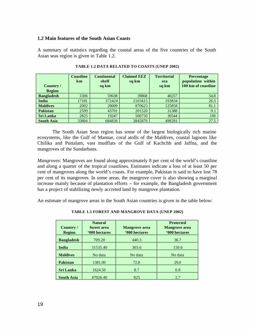
1.2 Main features of the South Asian Coasts A summary of statistics regarding the coastal areas of the five countries of the South Asian seas region is given in Table 1.2.
TABLE 1.2 DATA RELATED TO COASTS (UNEP 2002)
Country / Region
Coastline km
Continental shelf sq km
Claimed EEZ sq km
Territorial sea
sq km
Percentage population within 100 km of coastline
Bangladesh 3306 59638 39868 40257 54.8 India 17181 372424 2103415 193834 26.3 Maldives 2002 29609 870623 125858 81.1 Pakistan 2599 43701 201520 31388 9.1 Sri Lanka 2825 19247 500750 30544 100 South Asia 33804 684836 3845876 498281 27.5 The South Asian Seas region has some of the largest biologically rich marine ecosystems, like the Gulf of Mannar, coral atolls of the Maldives, coastal lagoons like Chilika and Puttalam, vast mudflats of the Gulf of Kachchh and Jaffna, and the mangroves of the Sundarbans. Mangroves: Mangroves are found along approximately 8 per cent of the world’s coastline and along a quarter of the tropical coastlines. Estimates indicate a loss of at least 50 per cent of mangroves along the world’s coasts. For example, Pakistan is said to have lost 78 per cent of its mangroves. In some areas, the mangrove cover is also showing a marginal increase mainly because of plantation efforts – for example, the Bangladesh government has a project of stabilizing newly accreted land by mangrove plantation. An estimate of mangrove areas in the South Asian countries is given in the table below:
TABLE 1.3 FOREST AND MANGROVE DATA (UNEP 2002)
Country /
Region
Natural forest area
‘000 hectares
Mangrove area ‘000 hectares
Protected Mangrove area ‘000 hectares
Bangladesh 709.20 440.3 36.7
India 31535.40 303.6 150.6
Maldives No data No data No data
Pakistan 1381.00 72.8 29.0
Sri Lanka 1624.50 8.7 0.8
South Asia 47026.40 825 2.7
20
These estimates give a rough idea of the extent and protection available to mangroves and also clearly indicate that, considering the trends in mangrove deforestation, more areas of mangroves need to be brought under protection. Studies also indicate that with the high dependence on mangroves for subsistence in many areas and an increased understanding of the diverse ecological functions of mangroves, protection of mangroves is essential. Towards this, participatory management by involving local communities is likely to be more successful in protecting and restoring lost areas. Coral Reefs: Information on coral reefs is fairly widespread. Coral reef degradation is of great concern especially to nations that depend on coral reefs to attract tourists. The major coral reefs in South Asia are in the Maldives and the Lakshadweep Islands (India). Many offshore and fringing reef patches are found in Sri Lanka and the Gulf of Mannar region between India and Sri Lanka. Most coral reefs in South Asia were affected by the coral bleaching incident of mid-1998. In addition, coral mining, increased sedimentation, destructive fishing methods, capture of reef fish for the aquarium trade, uncontrolled harvesting and increased pressure from tourism and trade have led to considerable decline in the extent of coral reefs. Beaches and tidal flats: The Indian subcontinent has the most extensive beach area (more than half of its coastline). Beaches are also found in the other countries. Many beaches are known as turtle nesting sites, but few of them enjoy any degree of protection. The fishing community has traditionally used the beaches to berth craft, land fish and dry nets. Now, however, the tourism industry, shrimp farms and the beach sand mining industry are competing for this resource, considered till recently as open access/common property resource. The most extensive saline marshes in this region are the Rann of Kachchh on the western Indian coast. In addition, tidal flats occur in many places and have been traditionally worked as saltpans. In recent times, many such saltpans have been converted into shrimp farms. Deltas, estuaries and coastal lagoons: Almost all of Bangladesh lies in the active delta of three of the world’s major rivers: Ganga, Brahmaputra and Meghna (GBM system). The major part of the Gangetic floodplain is located in India. The high sediment load carried by the rivers has led to the continuous formation of new islands off the coast of Bangladesh, which the government is reclaiming by planting mangroves. Other major rivers with deltas on the eastern Indian coast include those formed by the Mahanadi, Godaveri-Krishna, Kaveri and Tambraparani rivers. The Indus flows through most of Pakistan and at the mouth are the remnants of the largest mangrove systems in arid zones. The Mahaveli is the largest river in Sri Lanka. The Maldives does not have any rivers. The coast of the other countries is dotted with estuaries, which sometimes form lagoons or backwaters. Such areas are important for fishing. Major lagoons include the Pulicat and Chilika lagoons in India and Puttalam, Hikkaduwa and Rekawa in Sri Lanka.
21
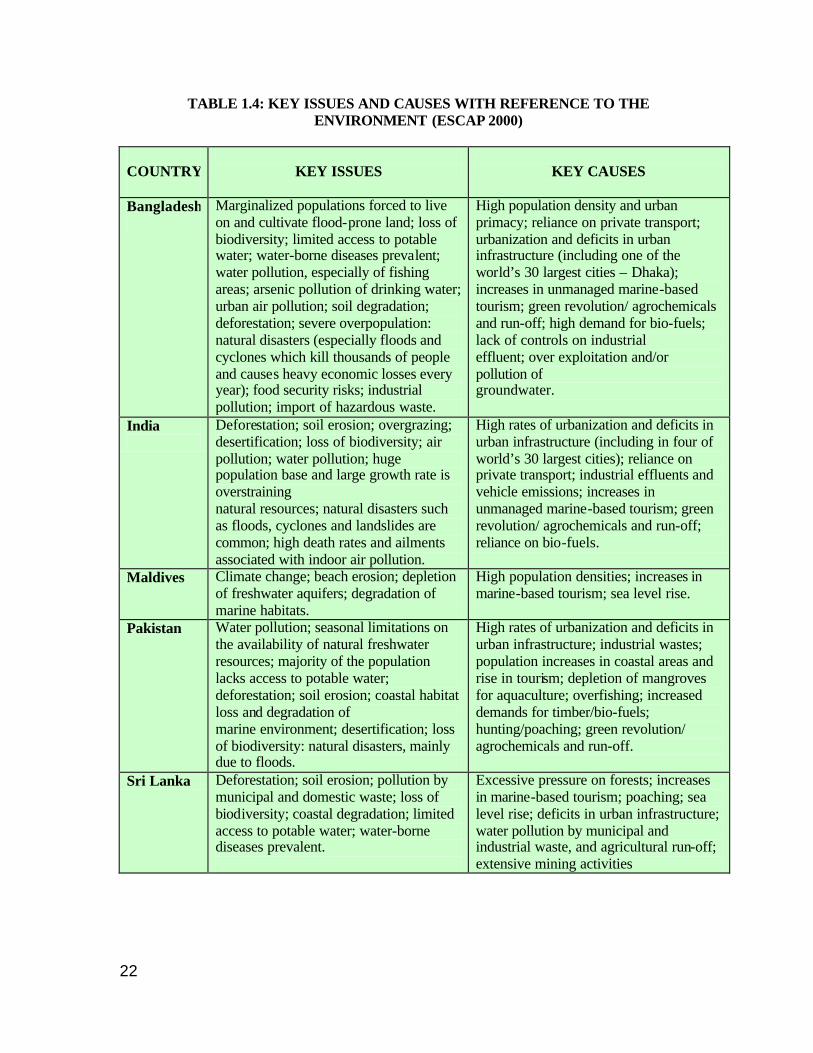
1.3 Key Environmental Issues and Causes in South Asia A summary of the key environmental issues as well as the key causes are provided in tabular form for easy reference. Almost all countries in the region have similar problems of large populations, high growth rates and with a significant proportion of the population dependent on natural resources for their subsistence. Infrastructure development is usually skewed with cities showing rapid growth compared to the hinterland. 1.4 The Study The mandate of the PADH (Physical Alteration and Destruction of Habitats) Project of the GPA-LBA (Global Programme of Action for the protection of the marine environment from Land Based Activities) is to focus on sediment mobilization effects by four economic sectors that potentially pose a threat to such habitats, namely: tourism; ports; aquaculture; and mining (sand and aggregate extraction). This Study is a comparative review of current coastal legislation in the five countries of the South Asian region with a focus on PADH. Following this introduction, the report includes a comparative table of the legislative measures in the five countries and detailed country reports. The country reports follow a similar format:
• Basic information about the country • Coastal landforms • National environmental policy • Note about PADH for the country • Umbrella environmental legislation (including requirement of EIA) • Focus on the coast and specific coastal legislation • Major coastal activities causing habitat alteration (with relevant policies and
legislation) • References
22
TABLE 1.4: KEY ISSUES AND CAUSES WITH REFERENCE TO THE ENVIRONMENT (ESCAP 2000)
COUNTRY
KEY ISSUES
KEY CAUSES
Bangladesh
Marginalized populations forced to live on and cultivate flood-prone land; loss of biodiversity; limited access to potable water; water-borne diseases prevalent; water pollution, especially of fishing areas; arsenic pollution of drinking water; urban air pollution; soil degradation; deforestation; severe overpopulation: natural disasters (especially floods and cyclones which kill thousands of people and causes heavy economic losses every year); food security risks; industrial pollution; import of hazardous waste.
High population density and urban primacy; reliance on private transport; urbanization and deficits in urban infrastructure (including one of the world’s 30 largest cities – Dhaka); increases in unmanaged marine-based tourism; green revolution/ agrochemicals and run-off; high demand for bio-fuels; lack of controls on industrial effluent; over exploitation and/or pollution of groundwater.
India
Deforestation; soil erosion; overgrazing; desertification; loss of biodiversity; air pollution; water pollution; huge population base and large growth rate is overstraining natural resources; natural disasters such as floods, cyclones and landslides are common; high death rates and ailments associated with indoor air pollution.
High rates of urbanization and deficits in urban infrastructure (including in four of world’s 30 largest cities); reliance on private transport; industrial effluents and vehicle emissions; increases in unmanaged marine-based tourism; green revolution/ agrochemicals and run-off; reliance on bio-fuels.
Maldives Climate change; beach erosion; depletion of freshwater aquifers; degradation of marine habitats.
High population densities; increases in marine-based tourism; sea level rise.
Pakistan Water pollution; seasonal limitations on the availability of natural freshwater resources; majority of the population lacks access to potable water; deforestation; soil erosion; coastal habitat loss and degradation of marine environment; desertification; loss of biodiversity: natural disasters, mainly due to floods.
High rates of urbanization and deficits in urban infrastructure; industrial wastes; population increases in coastal areas and rise in tourism; depletion of mangroves for aquaculture; overfishing; increased demands for timber/bio-fuels; hunting/poaching; green revolution/ agrochemicals and run-off.
Sri Lanka Deforestation; soil erosion; pollution by municipal and domestic waste; loss of biodiversity; coastal degradation; limited access to potable water; water-borne diseases prevalent.
Excessive pressure on forests; increases in marine-based tourism; poaching; sea level rise; deficits in urban infrastructure; water pollution by municipal and industrial waste, and agricultural run-off; extensive mining activities
23
The report ends with a chapter giving some conclusions and recommendations. The focus of the Study is the compilation and descriptive review of legislation relevant to tourism, shrimp farming, sand mining and ports in coastal areas. Since the concern is with the environmental impact of these activities, and since all countries have passed framework environment laws, these are discussed first. Environmental Impact Assessment (EIA) is a requirement under the framework environmental law in all the countries included in this study. This was perceived to be of maximum importance to the PADH component as EIA includes a variety of components to anticipate and proactively manage any likelihood of habitat destruction. With respect to the four specified activities, in many cases, only a reference or a summary of the law is available in English. The available texts of laws, policies and guidelines quoted in this report have been included in the annexure (CD-ROM). As the study progressed, it was apparent that in addition to the framework environmental law and the laws regulating the specific activities, information regarding land use planning was important and hence this aspect was also included.
24
1.5 References AIR 1991 SC420. Subas Kumar V. State of Bihar. ESCAP 2000. State of the Environment in Asia and the Pacific 2000. Hossain, Khondaker Showkat, 1999. Role of Criminal Law in the protection of the Environment: Bangladesh context. Maniku M.H., 1996. Existing legal systems and institutional structures in the Maldives: Opportunities and challenges for IIRM coordination. In Nickerson, D.J. and M.H. Maniku (Eds.). Report and Proceedings of the Maldives/FAO National Workshop on Integrated Reef Resources Management in the Maldives. Male, March 16-20, 1996 Madras, BOBP, Report No. 76. Pgs. 250+VI. UNEP 2002a. Global Environment Outlook 3. GEO-3 Data Compendium. UNEP 2002b. Maldives, State of the Environment, 2002, UNEP. 48 DLR 1996. Dr. Mohiuddin Farooque v. Bangladesh, represented by the Secretary, Ministry of Irrigation, Water resources & Flood control and others cited in “Compendium of Summaries of Judicial Decisions in Environment Related Cases (with special reference to countries in South Asia)”. http://206.67.58.208/uneproap/html/doc/compendium-south%20asia.doc
25
CHAPTER 2
SUMMARY RESULTS OF THE STUDY 2.1 Introduction For a quick comparison of coastal legislation in the five South Asian countries, a series of
comparative tables have been prepared:
• Table 2.1 Country Information
• Table 2.2 Environmental and Coastal Legislation
• Table 2.3 Tourism
• Table 2.4 Fisheries and Aquaculture
• Table 2.5 Coastal Mining
• Table 2.6 Ports
• Table 2.7 Land Use
Table 2.1 provides data on land, coastline, shelf, EEZ, territorial sea, and population (extracted from UNEP GEO-3 data compendium). Table 2.2 gives a comparative picture of environmental and coastal legislation in the five countries. This includes information on umbrella environmental legislation, specific coastal legislation, management of coastal resources, regulatory authorities and EIA requirements. The further tables provide the available information on specific laws, policy and/or guidelines for the four PADH sectors, namely, tourism, fisheries and aquaculture, mining and ports. The final table covers land use regulation and policy. All efforts have been made to locate relevant legislation and associated information. Wherever information is not available, it is marked n.a.

26
Table 2.1 Country Information
Item Bangladesh India Maldives Pakistan Sri Lanka
Land area (‘000 ha) 13017 297319 30 77088 6463
Coastline (km) * Country data: UNEP GEO 3 data:
710
3306
8118
17181
644
2002
1046 2599
1585 2825
Shelf area upto 200m depth (sq km)
59638 372424 29609 43701 19247
Claimed EEZ (sq km) 39868 2103415 870623 201520 500750
Territorial sea (sq km) 40257 193834 125858 31388 30544
Total population (‘000) 137439.26 1008937.36 290.96 141256.19 18923.75
Density Population Density
1055.8 339.3 969.9 183.2 292.8
Population
within 100 km of coast (% of total)
54.8 26.3 81.1 9.1 100

27
Table 2.2 Environmental and Coastal Legislation
Item Bangladesh India Maldives Pakistan Sri Lanka
Umbrella Environment Act
Bangladesh Environment Protection Act, 1995
Environment (Protection) Act, 1986
National Environment Protection and Preservation Act, 1993
Pakistan Environment Protection Act 1997
National Environmental Act, No. 47 of 1980
Regulatory Authority Department of Environment
Ministry of Environment and Forests
Ministry of Home Affairs, Housing and Environment (MHAHE)
Ministry of Environment, Local Govt. and Rural Development
Ministry of Environment and Natural Resources Central Environmental Authority
EIA EIA stipulated in the 1997 Environmental Conservation rules under EPA 1995
EIA Notification, 1994 (under EPA 1986)
Implemented through the EPPA of Maldives
Pakistan Environment Protection Act 1997
Part IV C under the National Environmental Act of 1980
Coastal Legislation
Bangladesh Coastal Policy, 2001
CRZ Notification 1991 (under EPA 1986)
no specific coastal legislation
Provincial Coastal Development Authority Acts: Sind, 1994 Balochistan, 1998
Coast Conservation Act No. 57 (1981
Definition of coastal areas
Bangladesh Coastal Policy, 2001
CRZ Notification, 1991 (Under EPA 1986)
the total land area of each island, its surrounding lagoon extending over the reef flat to the outer edge of its reef
not available Coast Conservation Act No. 57 (1981)
Regulatory Authority Ministry of Water Resources
Ministry of Environment and Forests
Atoll administration/ MHAHE
Provincial Coastal Development authority
Coast Conservation Department

28
Table 2.2 Environmental and Coastal Legislation (contd.)
Item
Bangladesh India Maldives Pakistan Sri Lanka
Marine Pollution Marine Pollution Ordinance, 1989
Environment (Protection) Act, 1986
National Environment Protection and Preservation Act, 1973
Pakistan Environment Protection Act 1995
Marine Pollution Prevention Act No.59 (1981)
Coastal forests, mangroves
Forestry Act, 1927; Forest (Amendment) Ordinance, 1989
Indian Forest Act, 1927 Forest (Conservation) Act, 1980
National Environment Protection and Preservation Act, 1973
Forest Act 1927 The Forest Ordinance No. 3 (1945), Amendment No. 13 (1966) and Act No. 13 (1988)
Flora/fauna/wildlife (incl. Corals)
Bangladesh Wildlife (Preservation) (Amendment) Act 1974; Marine Fisheries Ordinance, 1983
Wildlife (Protection) Act, 1972; EPA 1986
National Environment Protection and Preservation Act, 1973; Fisheries Act
State Wildlife Protection Ordinances of 1972 in Balochistan and Sind
Fauna and flora Protection (Amendment) Act, 1993
29
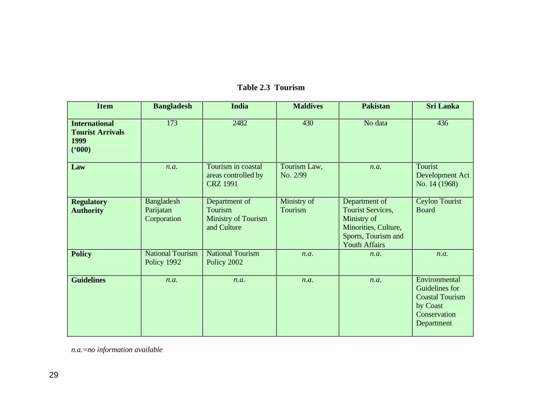
Table 2.3 Tourism
Item Bangladesh India Maldives Pakistan Sri Lanka
International Tourist Arrivals 1999 (‘000)
173 2482 430 No data 436
Law n.a. Tourism in coastal areas controlled by CRZ 1991
Tourism Law, No. 2/99
n.a. Tourist Development Act No. 14 (1968)
Regulatory Authority
Bangladesh Parijatan Corporation
Department of Tourism Ministry of Tourism and Culture
Ministry of Tourism
Department of Tourist Services, Ministry of Minorities, Culture, Sports, Tourism and Youth Affairs
Ceylon Tourist Board
Policy National Tourism Policy 1992
National Tourism Policy 2002
n.a. n.a. n.a.
Guidelines n.a. n.a. n.a. n.a. Environmental Guidelines for Coastal Tourism by Coast Conservation Department
n.a.=no information available
30
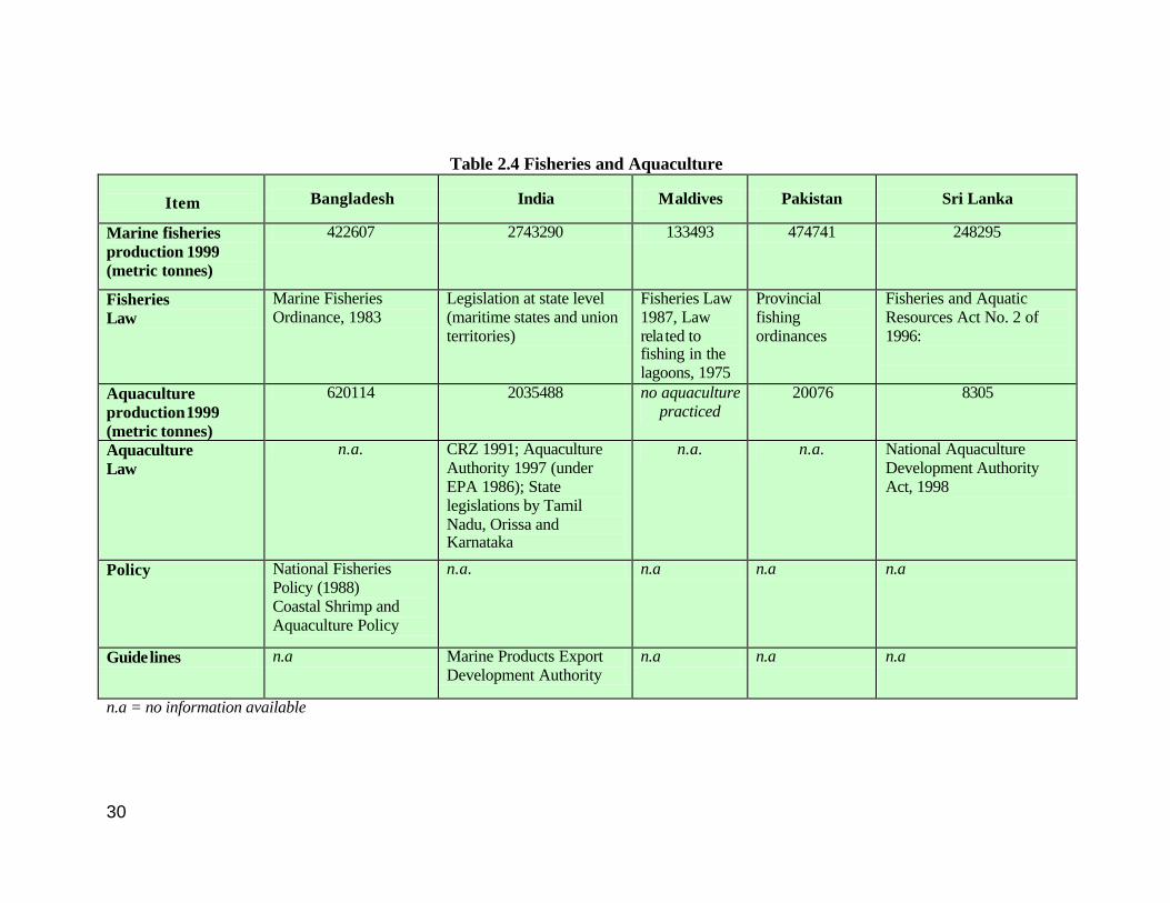
Table 2.4 Fisheries and Aquaculture
Item Bangladesh India Maldives Pakistan Sri Lanka
Marine fisheries production 1999 (metric tonnes)
422607 2743290 133493 474741 248295
Fisheries Law
Marine Fisheries Ordinance, 1983
Legislation at state level (maritime states and union territories)
Fisheries Law 1987, Law related to fishing in the lagoons, 1975
Provincial fishing ordinances
Fisheries and Aquatic Resources Act No. 2 of 1996:
Aquaculture production 1999 (metric tonnes)
620114 2035488 no aquaculture practiced
20076 8305
Aquaculture Law
n.a. CRZ 1991; Aquaculture Authority 1997 (under EPA 1986); State legislations by Tamil Nadu, Orissa and Karnataka
n.a. n.a. National Aquaculture Development Authority Act, 1998
Policy National Fisheries Policy (1988) Coastal Shrimp and Aquaculture Policy
n.a. n.a n.a n.a
Guidelines n.a Marine Products Export Development Authority
n.a n.a n.a
n.a = no information available
31
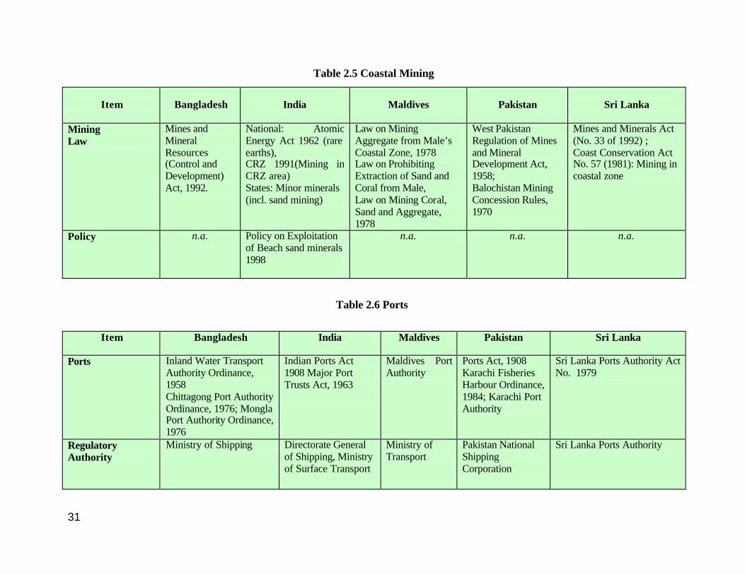
Table 2.5 Coastal Mining
Item Bangladesh India Maldives Pakistan
Sri Lanka
Mining Law
Mines and Mineral Resources (Control and Development) Act, 1992.
National: Atomic Energy Act 1962 (rare earths), CRZ 1991(Mining in CRZ area) States: Minor minerals (incl. sand mining)
Law on Mining Aggregate from Male’s Coastal Zone, 1978 Law on Prohibiting Extraction of Sand and Coral from Male, Law on Mining Coral, Sand and Aggregate, 1978
West Pakistan Regulation of Mines and Mineral Development Act, 1958; Balochistan Mining Concession Rules, 1970
Mines and Minerals Act (No. 33 of 1992) ; Coast Conservation Act No. 57 (1981): Mining in coastal zone
Policy n.a. Policy on Exploitation of Beach sand minerals 1998
n.a. n.a. n.a.
Table 2.6 Ports
Item
Bangladesh India Maldives Pakistan Sri Lanka
Ports Inland Water Transport Authority Ordinance, 1958 Chittagong Port Authority Ordinance, 1976; Mongla Port Authority Ordinance, 1976
Indian Ports Act 1908 Major Port Trusts Act, 1963
Maldives Port Authority
Ports Act, 1908 Karachi Fisheries Harbour Ordinance, 1984; Karachi Port Authority
Sri Lanka Ports Authority Act No. 1979
Regulatory Authority
Ministry of Shipping Directorate General of Shipping, Ministry of Surface Transport
Ministry of Transport
Pakistan National Shipping Corporation
Sri Lanka Ports Authority
32
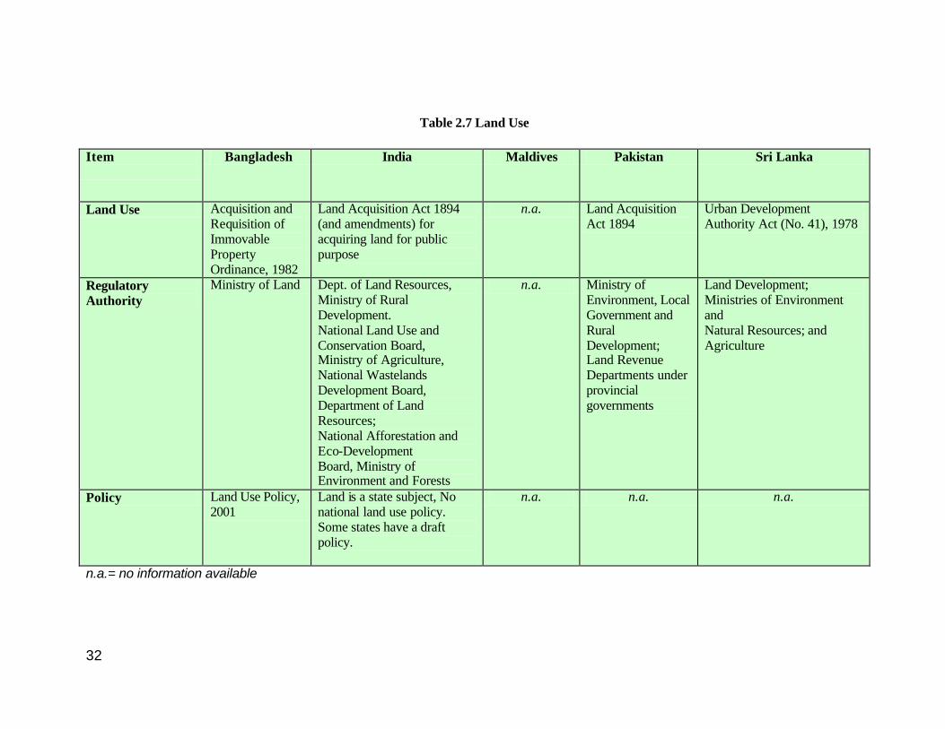
Table 2.7 Land Use
Item
Bangladesh India Maldives Pakistan Sri Lanka
Land Use Acquisition and Requisition of Immovable Property Ordinance, 1982
Land Acquisition Act 1894 (and amendments) for acquiring land for public purpose
n.a. Land Acquisition Act 1894
Urban Development Authority Act (No. 41), 1978
Regulatory Authority
Ministry of Land Dept. of Land Resources, Ministry of Rural Development. National Land Use and Conservation Board, Ministry of Agriculture, National Wastelands Development Board, Department of Land Resources; National Afforestation and Eco-Development Board, Ministry of Environment and Forests
n.a. Ministry of Environment, Local Government and Rural Development; Land Revenue Departments under provincial governments
Land Development; Ministries of Environment and Natural Resources; and Agriculture
Policy Land Use Policy, 2001
Land is a state subject, No national land use policy. Some states have a draft policy.
n.a. n.a. n.a.
n.a.= no information available
33
CHAPTER 3
GENERAL REPORT 3.1 Introduction Direct Physical Alteration and Destruction of Habitats (PADH) is now viewed as the most important threat to the coastal environment. It is estimated that 80 per cent of the pollutant load in the oceans originates from land-based activities. The major threats to the health, productivity and biodiversity of the marine environment result from human activities in coastal areas as well as in the hinterland. The following are considered the most serious problems affecting the quality and uses of the marine and coastal environment (GESAMP 2001):
o Alteration and destruction of habitats and ecosystems; o Effects of sewage on human health; o Widespread and increased eutrophication; o Decline of fish stocks and other renewable resources; and o Changes in sediment flows due to hydrologic changes.
Environmental degradation is often the result of the convergence of factors such as a limited resource base, an accelerating rate of economic and demographic growth, inadequate knowledge of resource management and poor enforcement of regulations. In the case of physical alterations and destruction of habitats, the driving force is the poorly planned and rapid social and economic development in coastal areas, which in turn results from such increasing pressures like population, urbanization and industrialization, maritime transport and tourism.
The term ‘habitat’ refers to the space occupied by an organism or a community of organisms and includes the abiotic environment as well. The coast is an area straddling the sea and land, and the coastal habitat varies depending on a variety of physiographic factors. Important coastal habitats include mangroves, tidal flats, sandy beaches and coral reefs. The majority of the world’s known economically important marine species live within near-shore zones or depend upon coastal habitats such as mangroves and coral reefs for a part of their life cycle. Traditional resource based activities along the coast include fisheries, aquaculture, forestry and agriculture. A list of the principal coastal and ocean related activities is given in Box 3.1.
BOX 3.1 PRINCIPAL COASTAL AND OCEAN ACTIVITIES
(adapted from Cicin-Sain and Knecht 1998)
Navigation and Communication
Living Marine Resources Mineral and Energy Resources
Tourism and Recreation Coastal Infrastructure Development
Waste Disposal and Pollution Prevention
Ocean and Coastal Environmental Quality Protection
Beach and Shoreline Management Military Activities
Research
34
With convergence of commercial activities in urban centres, traditional activities get squeezed out of existence, when land is “developed’ for port development (shipping and allied activities), building or expansion of settlements, and the construction of industrial facilities. There has also been a sharp rise in the population density of coastal areas in general and coastal urban agglomerations in particular, because of immigration from smaller coastal hamlets as well as the hinterland in search of better employment options and infrastructure facilities.
An index of potential threats to coastal ecosystems due to development related activities has shown that more than half of the world’s coasts are under “moderate’ or “high’ threat from development (Bryant et al 1995). The direct threats include reclamation of land for various purposes (settlements, building ports), felling forests, mining and building on coasts (large industrial estates, townships, tourist marinas).
Habitat destruction can affect a variety of activities. For example, destruction of mangroves can hit fisheries, since mangroves serve as breeding areas and nurseries for many commercially important fish, molluscs and crustaceans (including the shrimps and prawns that are cultivated whose stock is often from the wild). Mangrove destruction can result in an increase in coastal erosion because of the absence of sediment-trapping mangrove roots. Mangrove forests act as buffers against cyclones and tidal waves and their destruction also increases vulnerability to such natural hazards. This is apart from the loss of livelihood to those who subsist on mangrove produce (timber as well as non timber produce such as honey, fruits, nuts etc.). Habitat destruction can also be caused by a variety of activities. For example, aquaculture farms, extensions of rice paddies, settlements, industries, tourism, and upstream dams have been implicated in mangrove destruction in different places.
GPA-LBA: In November 1995, the Washington Intergovernmental Conference adopted the Global Programme of Action for the protection of the marine environment from Land-Based Activities (GPA-LBA). The GPA is designed to be a source of conceptual and practical guidance to be drawn upon by national and/or regional authorities in devising and implementing sustained action to prevent, reduce, control and/or eliminate marine degradation from land-based activities. (UNEP/ GPA 1999). Currently, the GPA-LBA is undertaking a project, which aims at supporting the efforts of stakeholders in protecting coastal and marine habitats against physical alterations and destruction. The focus is on sediment mobilization effects by four economic sectors that form a potential threat to such habitats. Those sectors include: tourism; ports; aquaculture; and mining (sand and aggregate extraction). The geographical scope of the programme is global, with a focus on the Eastern African, Wider Caribbean and the South Asian regions. This Report is a comparative review of current coastal legislation in the five countries of the South Asian region with a focus on the PADH component.

35
3.2 Limitations of the Study
The limitations of this study need to be emphasized. Environmental concerns are of relatively recent origin, post 1972 in most cases. Prior to that, environmental aspects were merely part of other laws, like those governing resources such as forests and laws that controlled or penalized ‘nuisance’. India, for example, has over 200 laws that have an environmental bearing though the law may have been enacted for a totally different purpose. Similarly, specific legislation for protecting the coast is also a new concept but there exist a number of legislations that have a bearing on different activities/resources of the coastal areas. Legislation with reference to environmental protection is also being revised frequently because it is still evolving. Every effort has been made to gather the most complete and detailed information available concerning national legislation with respect to the activities chosen for study under the PADH component and coastal zone management in the five South Asian countries. Because of the complexity of the situation and the large number of laws enacted by each country, reference to some laws may have been inadvertently left out. In addition, complete texts of some laws are not available and also, not all laws are available in English translations (especially for Bangladesh and Maldives). References to jurisprudence developments are few, because the Study focused only on a compilation of the available legislation. 3.3 The South Asian Seas Region UNEP initiated the Regional Seas Programme in 1974 as a global programme implemented through regional components. The Programme at present includes 13 Regions and has over 140 coastal States and Territories participating in it. The South Asian Seas Region includes the seas bordering South Asian countries, namely, Bangladesh, India, Maldives, Pakistan, and Sri Lanka, and comprises the Northern part of the Indian Ocean, along with the Bay of Bengal and the Arabian Sea. The South Asian Seas Action Plan was adopted in March 1995 and the secretariat is located at the South Asia Cooperative Environment Programme (SACEP) in Sri Lanka. The Indian subcontinent that projects itself into the Indian Ocean dominates South Asia’s geography. Continental shelves vary in width from a few hundred to several thousand kilometres. Seasonal monsoons and cyclones routinely swamp the low-lying coasts inundating the land. Topsoil loss (due to poor agricultural practices) and deforestation in the watershed regions lead to the formation of islands in the large rivers. Some parts of this region are regularly sub jected to devastating floods during monsoons while drought conditions prevail at other times. Three of the five South Asian countries with a coastline lie in the Indian subcontinent with Sri Lanka just off shore. The Himalayas effectively cut off the sub-continent from the rest of Asia. Between the Himalayas and the Deccan Peninsula lies the Indo-Gangetic Plain (also called the North Indian Plain) stretching from the Pakistani provinces of Sind and Punjab in the west, to the Brahmaputra valley in the east. The
36
plains can be divided into two systems – the Indus and its tributaries (western region) and Ganga, Brahmaputra and their tributaries (central and eastern region). Rainfall patterns show an increasing trend towards the east. This fertile plain, watered by numerous large and small rivers, has been the centre for agriculture for millennia and consequently has high population density. The Indus Valley Civilization (from about 2600 to 2000 BC) is the earliest known urban culture of the Indian subcontinent, and perhaps the most extensive amongst the early civilizations extending in its heyday from the Indus River (in present day Pakistan) southward down the west coast as far as the Gulf of Cambay, 800 km southeast of Karachi, and as far east as the Yamuna basin 50 km north of Delhi. For most of India’s past, the North Indian plains have seen waves of invaders come in from the west and have often been under unified rule.
In contrast, the history of the peninsular region is quite different and can be attributed to its many distinct geographical sub-regions. The peninsular region is washed by the Arabian Sea on the west and the Bay of Bengal on the east, with the Eastern and Western Ghats (chains of mountains) running parallel to the coastline. The east coast plains (between the mountain and the coast) are broad and include deltas of many rivers, which have supported high population densities for many thousands of years. The west coast has a relatively narrow plain for the most part with short swift rivers forming estuaries, except for much of coastal Gujarat which lies to the northwest of the Western Ghats, extending around the Gulf of Khambhat (Cambay) and into the salt marshes of the Kathiawar and Kachchh (Kutch) peninsulas.
The west coast of India has always been known for trade especially with ports in the Persian Gulf and East Africa. In fact, the Portuguese, the Dutch and the British came into India as traders in search of spice, arriving first on the west coast. This entry started off a process that culminated in the absorption of the subcontinent within the British Empire. The British rule ended with Pakistan (East and West) being carved out of India in 1947 and Sri Lanka achieving independence in 1948. East Pakistan became an independent nation as Bangladesh in 1971. Sri Lanka, an island nation, has been extensively influenced by mainland India, but evolved a culture and identity of its own. A meeting point for the eastern and western trade; it has been fought over by the maritime nations of the west. For a long time, Sri Lanka’s population was mostly concentrated in the hinterland. In recent years, however, there has been a migration towards the coastal towns and cities. The fifth country, the Maldives, became a republic in 1968. Being on the crossroads linking the sea trade routes between Southeast Asia/China and the East African coastline, it was an important halt for seafarers. Skills in repairing seagoing craft were highly developed due to the repairs done on these vessels by the craftsmen of the atolls. The archipelagic nature of the atolls led to the structuring of a unique system of governance with well-developed local resource management methods.
37
3.4 Activities leading to PADH 3.4.1 Tourism
Tourism is one of the fastest growing industries in the world. Statistics from the World Tourism Organization (WTO) indicate that the industry has grown at a very accelerated pace over the latter half of the past century. Projections for continued growth make it an important sector of the world economy. In 2000, international tourist arrivals totaled 698 million globally generating US$ 476 billion in receipts. Tourist arrivals in South Asia reached 6.3 million in 2000 (a growth rate of 9.0 per cent over 1999). South Asia is expected to experience growth in tourism arrivals and receipts much greater than the world average thus firmly establishing the region on the tourism map of the world (WTO 2000).
TABLE 3.1 INTERNATIONAL TOURIST ARRIVALS (In Thousands)
Year Country 1980 1985 1990 1995 1999
South Asian Region
2242 2499 3158 4200 5627
Bangladesh 57 146 115 156 173 India 1194 1259 1707 2124 2482 Maldives 42 115 195 315 430 Pakistan 299 441 424 378 No Data Sri Lanka 322 257 298 403 436
Source: (UNEP 2002) While coasts are increasingly the preferred destinations of tourists, statistics are as yet unavailable regarding the number of visitors to coastal areas. Coastal tourism has been perceived as a quick route to economic development by many countries. Expected outcomes include increase in local incomes, inflow of foreign exchange, and creation of infrastructure like coastal roads, hotels and resorts (also useful for the country’s economic development). Coastal tourism is an attractive choice for small coastal countries and islands with limited development options; for areas which earlier were dependent almost entirely on fishing that has now collapsed; and for places where prices of traditional exports have fallen. There are a number of problems associated with the rapid and unplanned development of coastal tourism. For example, one of the basic requirements for attracting tourists is good access and the availability of suitable accommodation. Destruction of mangroves and wetlands to make way for coastal infrastructure has been widespread. There has also been an increase in pollution due to increased transport, litter on the beaches and increased volume of sewage dumped into the sea. In addition, dredging, reclamation and similar activities have affected inshore ecosystems.
38
Other negative effects of tourism include environmental degradation such as damage to unique and fragile ecosystems like coral reefs; destruction of habitats of shore birds and turtles, increased dependence on foreign money and a displacement of traditional occupations and loss of skills; subversion of the indigenous culture and the import of a culture of unsustainable consumption including the preference towards disposables, branded soft drinks and fast food or canned food rather than local cuisine. Another major problem is that the benefits do not always reach the local people, because of the entry of outsiders with special skills required by the tourism industry. Sometimes, the tour promoters collect the money in the country of origin of the tourists and most of the revenue does not reach the locals at all. Construction of beach resorts in areas close to fishing communities may result in denial of access to the sea for the traditional fishers and other users.
BOX 3. 3 CHANGES IN TOURISM PERSPECTIVES
(TERI 2001) § It is not the numbers of tourists, but the quantity and type of resources used to service the needs of the
tourists that brings about changes in coastal ecosystems § High budget tourists consume more than the mixed and low budget tourists and hence land use and
land cover changes are more § Out migration and host-population are also responsible for land use and cover change along with in-
migrants § Laws have contributed to land use change § Mature tourist destinations reveal a greater awareness and concern for the environment, especially
among the youth, than other tourist destinations § Tourism is also an important driver for land use and land cover change because:
o It provides the opportunity to alienate land profitability o It also creates a dissociation between production and consumption of coastal resources
There are also problems due to cruise ships, since these require special berthing facilities. Cruise tourists do not spend on accommodation and rarely on food. Hence while the resources are used, they do not bring in an appreciable income to the locals.
BOX 3.2: SUGGESTED PRINCIPLES FOR
PLANNING COASTAL TOURISM
o Plan coastal tourism only as ecotourism
o Do not exceed the carrying capacity of the area (physical, physiological, social and economic)
o Promote and maintain only the natural, local
environment (no artificial facilities like golf links)
o Ensure zero or minimum impact on the
environment (Environmental impact assessment and environmental management systems should be in place; visitor management techniques should be practiced)
o Ensure local participation in tourism
development projects (involving local stakeholders in planning, development and maintenance)
o Build coastal tourism into the CZM Plan
39
There have been changes in the perspective of tourists also. Till not so long ago, tourism was mainly restricted to pilgrimages especially in countries like India. There has been a shift now to recreational and educational aspects rather than pilgrimage. 3.4.2 Shrimp Aquaculture Aquaculture is of great importance to local fish consumption in many countries in this sub-region. Freshwater fisheries dominate South Asian aquaculture production (94.2 per cent in 1995). The remainder is nearly all from brackish water with production from the marine environment being relatively insignificant (48 million tonnes in 1995) (Subasinghe 1997). Aquaculture products fall into two distinct groups: high-valued species such as shrimp and salmon that are frequently grown for export, and lower-valued species such as carp and tilapia that are consumed primarily locally. In addition, small-scale aquaculture offers farmers a ready source of both subsistence food and cash. In traditional shrimp aquaculture, fish and shrimp were the summer crop in paddy fields adjoining estuaries and creeks along the coast. Natural tidal action was used to maintain the required salinity levels and there was no selective stocking or feeding and the production was consequently low. In contrast, current aquaculture practices monoculture with year-round cropping of shrimp in excessively artificial conditions. Export oriented shrimp aquaculture grew rapidly in the 1980s fueled by the growing demand for seafood in wealthy countries, with simultaneous depletion of wild ocean shrimp stocks. Cash strapped economies were attracted by the possibilities of earning large amounts of foreign exchange in a short time frame. The governments and international aid agencies encouraged, promoted, and subsidized the production of shrimp for exports. The high investments with equally high profits attracted multinationals. From a small-scale subsistence production system, it was catapulted into a mega money-spinner and termed the ‘blue revolution’. In the process, environmental and social costs were ignored. Shrimp aquaculture is competing for space that was once regarded as common property and open access, and believed (wrongly) to be of ‘no use’. This is especially so in coastal areas where the edge of the sea has been traditionally used by fishermen, and in coastal forests such as mangroves which provided livelihood to thousands of people living nearby. There has been extensive conversion of mangroves into shrimp farms all over Asia. Table 3.2 gives an idea of the extent of conversion of mangrove areas for shrimp culture. TABLE 3.2: CONVERSION OF MANGROVES INTO SHRIMP FARMS IN ASIA (Macintosh 1996)
Type of Farm Total area in region (ha)
Area situated on ex-mangrove
Mean conversion
Extensive 691,303 3-90% 43%
Semi -Intensive 132,935 7-91% 45%
Intensive 85,768 3-88% 31%
40
Conversion of commons land into shrimp farms is reported to be extensive. For instance, in Andhra Pradesh where commercial shrimp farms proliferated in specific sections of the coast (especially Nellore and Prakasam districts), they came up first in what was considered to be “barren” or “wastelands” which are often common grazing land.
Conversion of such land into shrimp farms has resulted in loss of traditional passageways for fishermen trying to reach the coast or space utilized for beaching craft, drying nets or catch (AIR 1997:SC 811S). In one village insect infestation shot up because of buffaloes having to be tethered within the village areas: keeping them away from the village area on commons land resulted in the insects accompanying buffaloes also keeping away from human habitation (Bonora). Common property resources (which includes beaches, pasture land, forests etc used by local communities) rarely have formal legal status, and it is difficult to establish customary rights. Hence, those traditional users of such lands have been easily dispossessed, often without compensation. In a recent seminar
(Frankenberger 2001), it was pointed out that in Bangladesh, previously under-exploited common property resources had become more valuable to better-off households because of technological advances in irrigated agriculture and shrimp farming. These better-off households seek long-term leases to these common property resources from local government officials who rent them unofficially. As a result, the common property resources that are available to the poor tend to be overexploited because there are too many users. Transformation of common property regimes into private property regimes is undermining access of CPRs to the poor (e.g., Rahman 1995, Rashid 2002). A brief discussion on CPR is provided in Section 3.5.2.
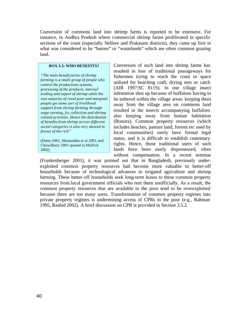
BOX 3.3: WHO BENEFITS? “The main beneficiaries of shrimp farming is a small group of people who control the productions systems, processing of the products, internal trading and export of shrimp while the vast majority of rural poor and marginal people get some sort of livelihood support from shrimp farming through wage earning, fry collection and shrimp related activities. Hence the distribution of benefits from shrimp across different social categories is also very skewed in favour of the rich” (Datta 2001, Mainuddin et al 2001 and Chowdhury 2001 quoted in Mallick 2002)
41
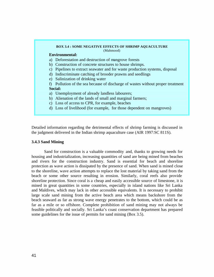
BOX 3.4 : SOME NEGATIVE EFFECTS OF SHRIMP AQUACULTURE
(Mahmood) Environmental: a) Deforestation and destruction of mangrove forests b) Construction of concrete structures to house shrimps. c) Pipelines to extract seawater and for waste production systems, disposal d) Indiscriminate catching of brooder prawns and seedlings e) Salinization of drinking water f) Pollution of the sea because of discharge of wastes without proper treatment Social: a) Unemployment of already landless labourers; b) Alienation of the lands of small and marginal farmers; c) Loss of access to CPR, for example, beaches d) Loss of livelihood (for example, for those dependent on mangroves)
Detailed information regarding the detrimental effects of shrimp farming is discussed in the judgment delivered in the Indian shrimp aquaculture case (AIR 1997:SC 811S). 3.4.3 Sand Mining Sand for construction is a valuable commodity and, thanks to growing needs for housing and industrialization, increasing quantities of sand are being mined from beaches and rivers for the construction industry. Sand is essential for beach and shoreline protection as wave action is dissipated by the presence of sand. When sand is mined close to the shoreline, wave action attempts to replace the lost material by taking sand from the beach or some other source resulting in erosion. Similarly, coral reefs also provide shoreline protection. Since coral is a cheap and easily accessible source of limestone, it is mined in great quantities in some countries, especially in island nations like Sri Lanka and Maldives, which may lack in other accessible equivalents. It is necessary to prohibit large scale sand mining from the active beach area which means backshore from the beach seaward as far as strong wave energy penetrates to the bottom, which could be as far as a mile or so offshore. Complete prohibition of sand mining may not always be feasible politically and socially. Sri Lanka’s coast conservation department has prepared some guidelines for the issue of permits for sand mining (Box 3.5).
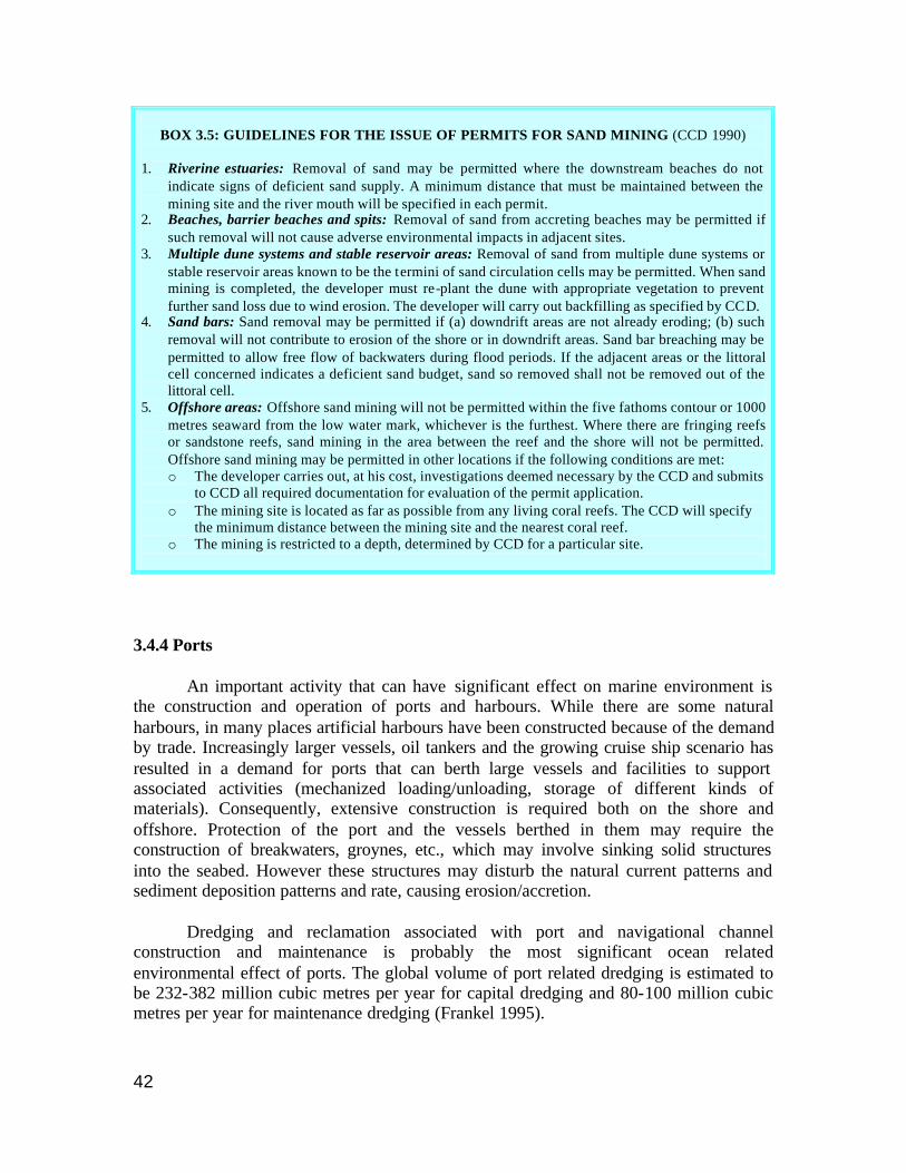
42
BOX 3.5: GUIDELINES FOR THE ISSUE OF PERMITS FOR SAND MINING (CCD 1990)
1. Riverine estuaries: Removal of sand may be permitted where the downstream beaches do not
indicate signs of deficient sand supply. A minimum distance that must be maintained between the mining site and the river mouth will be specified in each permit.
2. Beaches, barrier beaches and spits: Removal of sand from accreting beaches may be permitted if such removal will not cause adverse environmental impacts in adjacent sites.
3. Multiple dune systems and stable reservoir areas: Removal of sand from multiple dune systems or stable reservoir areas known to be the termini of sand circulation cells may be permitted. When sand mining is completed, the developer must re-plant the dune with appropriate vegetation to prevent further sand loss due to wind erosion. The developer will carry out backfilling as specified by CCD.
4. Sand bars: Sand removal may be permitted if (a) downdrift areas are not already eroding; (b) such removal will not contribute to erosion of the shore or in downdrift areas. Sand bar breaching may be permitted to allow free flow of backwaters during flood periods. If the adjacent areas or the littoral cell concerned indicates a deficient sand budget, sand so removed shall not be removed out of the littoral cell.
5. Offshore areas: Offshore sand mining will not be permitted within the five fathoms contour or 1000 metres seaward from the low water mark, whichever is the furthest. Where there are fringing reefs or sandstone reefs, sand mining in the area between the reef and the shore will not be permitted. Offshore sand mining may be permitted in other locations if the following conditions are met: o The developer carries out, at his cost, investigations deemed necessary by the CCD and submits
to CCD all required documentation for evaluation of the permit application. o The mining site is located as far as possible from any living coral reefs. The CCD will specify
the minimum distance between the mining site and the nearest coral reef. o The mining is restricted to a depth, determined by CCD for a particular site.
3.4.4 Ports An important activity that can have significant effect on marine environment is the construction and operation of ports and harbours. While there are some natural harbours, in many places artificial harbours have been constructed because of the demand by trade. Increasingly larger vessels, oil tankers and the growing cruise ship scenario has resulted in a demand for ports that can berth large vessels and facilities to support associated activities (mechanized loading/unloading, storage of different kinds of materials). Consequently, extensive construction is required both on the shore and offshore. Protection of the port and the vessels berthed in them may require the construction of breakwaters, groynes, etc., which may involve sinking solid structures into the seabed. However these structures may disturb the natural current patterns and sediment deposition patterns and rate, causing erosion/accretion.
Dredging and reclamation associated with port and navigational channel construction and maintenance is probably the most significant ocean related environmental effect of ports. The global volume of port related dredging is estimated to be 232-382 million cubic metres per year for capital dredging and 80-100 million cubic metres per year for maintenance dredging (Frankel 1995).
43
Most dredging spoils are dumped at sea. About 15-18 per cent is used for reclamation and construction of artificial islands. In addition about 50 million cubic metres per year are dredged directly for reclamation, port construction or other needs for fill. Information on dredging activities and dumping of dredged spoils has been difficult to locate for South Asian countries.
3.4.5 Other Activities A participatory rural appraisal and socio-economic benchmark survey (UNDP/GEF) conducted in India near a marine biosphere reserve revealed that the livelihood of people in villages up to 10 km away from the coastline is at least partly dependent upon coastal and marine resources. Villages over 10 km from the coast have little interaction with the coast and are largely dependent upon agriculture and allied activities. Coastal agriculture is often closely associated with fisheries. On the western Indian coastal states of Karnataka, Kerala and Goa, shrimp culture alternating with paddy cultivation has been in existence for many hundreds of years. Coconut, cashew and casuarina plantations are a common feature on the Indian coast. These are however giving way to settlements, tourist resorts and aquaculture farms. With fierce competition for coastal land, agricultural and related activities are being replaced with non-agricultural activities or those requiring less land albeit with higher capital inputs. Often smallholders are the hardest hit, because they are unable to invest and intensify, or stand their ground; and thus tend to lose their land and migrate to coastal towns in search of alternate occupations and may end up as unskilled construction labour. The other activities on the coast include industries and settlements. With the thrust on industrialization in almost all countries, the coast has been a preferential location for industries for many reasons such as the proximity to cheap transport systems which can bring in raw materials and take finished products (shipping), established trade centres (many major towns and cities on the coast were established for this reason), disposal of wastes (into the sea), access to coolant water (for power plants etc.) and a relatively milder climate regime. Coasts were also considered ‘backward’ areas for the reason that they often had no apparent resources since mangrove forests, tidal flats etc. were considered wasteland, under government control (being open access/CPR and hence not privately owned) and hence available for “development”. 3.5 Legislation 3.5.1 Introduction Management of coastal resources and controlling the effect of land based activities on the marine environment includes a number of practices ranging from land use planning, legal, administrative and institutional execution, to issuing of concessions for resource extraction and safe-guarding the rights of different interest groups. Legislative processes are traditionally top-down activities. They have often not proved very effective in regulating competing interests and addressing conflicts concerning natural resources and the environment because they act only when violations have
44
become too obvious to ignore. However, they remain the first step in regulating activities. With increasing conflict amongst the growing numbers of stakeholders vying for resources of the coastal zone, the reaction has been to increase regulations, which are of no use if there is poor enforcement. Hence, it would seem desirable to move towards a cooperative rather than a regulatory paradigm, while strengthening surveying institutions (Kullenberg 1998). 3.5.2 Customary Rights and Community Management Access to and utilization of resources is based on property rights, which are mainly of the following kinds: private, state-owned, common property and open access. While private property rights as well as state property rights are usually clearly documented, common property and open access regimes are not. Local management of resources is an age-old phenomenon prevalent in areas where the local population is highly dependent on natural resources for subsistence. Community rights over resources and community management practices have been documented especially for usage of forest resources and fisheries. Usually regulated by a complex system of “norms, institutions and culture”, this body of law is va riously defined as customary law, traditional law or local law-ways. Contrary to State law, customary laws emerge from the community, and command social acceptance and observance or compliance (Vani 2002). Unfortunately, the understanding of the importance of community rights and common property resources is often poor, and the people dependent on such resources are easily marginalized and exploited. Customary rights in certain areas in India, especially with reference to fishing rights of particular communities, have existed for long, though few are exhaustively documented (Mammen 1995). Since there is no written proof, it is difficult to prove the existence of such rights. These rights helped maintain resources since the community’s livelihood depended on them. These were developed and implemented by localized social institutions usually based on kinship and caste. For example, Gadgil and Iyer (1989) have shown that in a cluster of villages, specific groups are identifiable. These groups have exclusive access to certain resources and the only socially acceptable way of life is to follow the traditional occupations of his or her group. For instance, only three groups can do fishing from boats and the fishing territory is divided among them, so that one group will fish in the river, another group in the estuary and the third on the seacoast. Once the resources are harvested, they link the groups in a network of reciprocal exchange and mutual obligations.
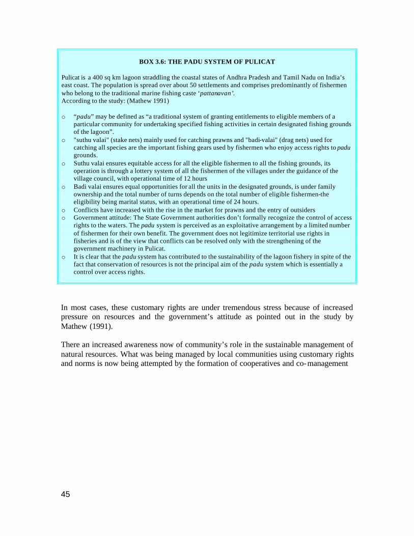
45
BOX 3.6: THE PADU SYSTEM OF PULICAT
Pulicat is a 400 sq km lagoon straddling the coastal states of Andhra Pradesh and Tamil Nadu on India’s east coast. The population is spread over about 50 settlements and comprises predominantly of fishermen who belong to the traditional marine fishing caste ‘pattanavan’. According to the study: (Mathew 1991) o “padu” may be defined as “a traditional system of granting entitlements to eligible members of a
particular community for undertaking specified fishing activities in certain designated fishing grounds of the lagoon”.
o "suthu valai" (stake nets) mainly used for catching prawns and "badi-valai" (drag nets) used for catching all species are the important fishing gears used by fishermen who enjoy access rights to padu grounds.
o Suthu valai ensures equitable access for all the eligible fishermen to all the fishing grounds, its operation is through a lottery system of all the fishermen of the villages under the guidance of the village council, with operational time of 12 hours
o Badi valai ensures equal opportunities for all the units in the designated grounds, is under family ownership and the total number of turns depends on the total number of eligible fishermen-the eligibility being marital status, with an operational time of 24 hours.
o Conflicts have increased with the rise in the market for prawns and the entry of outsiders o Government attitude: The State Government authorities don’t formally recognize the control of access
rights to the waters. The padu system is perceived as an exploitative arrangement by a limited number of fishermen for their own benefit. The government does not legitimize territorial use rights in fisheries and is of the view that conflicts can be resolved only with the strengthening of the government machinery in Pulicat.
o It is clear that the padu system has contributed to the sustainability of the lagoon fishery in spite of the fact that conservation of resources is not the principal aim of the padu system which is essentially a control over access rights.
In most cases, these customary rights are under tremendous stress because of increased pressure on resources and the government’s attitude as pointed out in the study by Mathew (1991). There an increased awareness now of community’s role in the sustainable management of natural resources. What was being managed by local communities using customary rights and norms is now being attempted by the formation of cooperatives and co-management
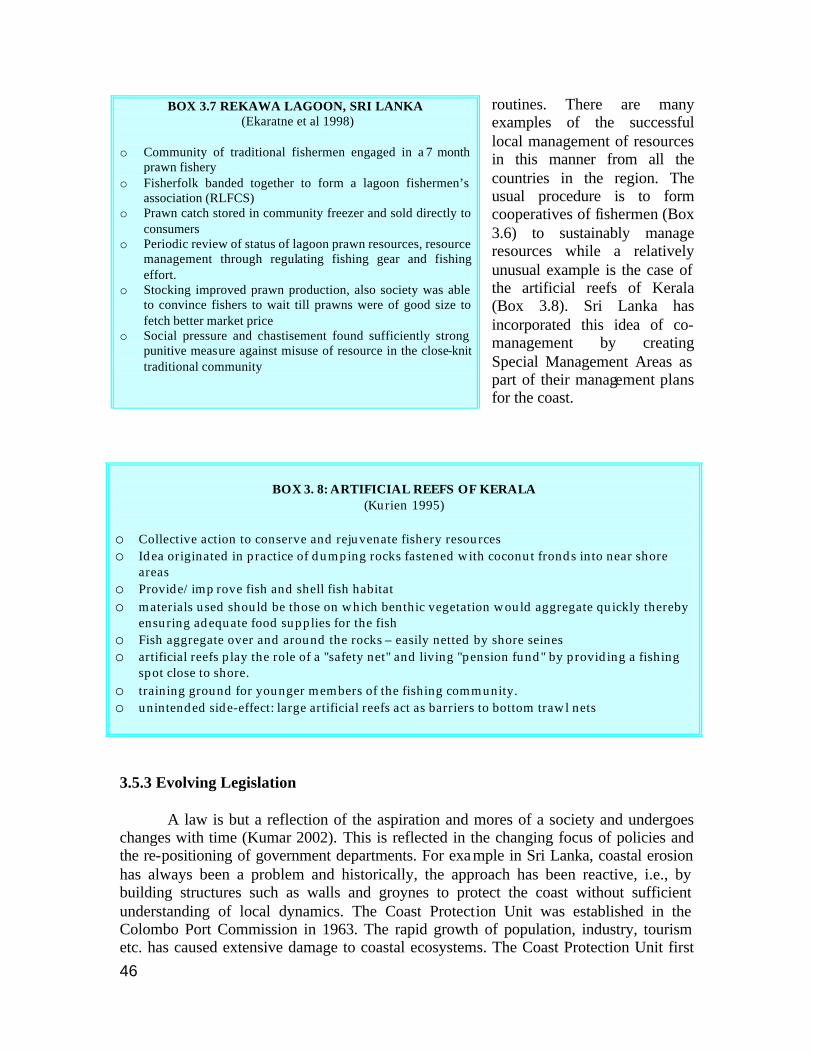
46
routines. There are many examples of the successful local management of resources in this manner from all the countries in the region. The usual procedure is to form cooperatives of fishermen (Box 3.6) to sustainably manage resources while a relatively unusual example is the case of the artificial reefs of Kerala (Box 3.8). Sri Lanka has incorporated this idea of co-management by creating Special Management Areas as part of their management plans for the coast.
BOX 3. 8: ARTIFICIAL REEFS OF KERALA
(Kurien 1995)
o Collective action to conserve and rejuvenate fishery resources o Idea originated in practice of dumping rocks fastened with coconut fronds into near shore
areas o Provide/imp rove fish and shell fish habitat o materials used should be those on which benthic vegetation would aggregate quickly thereby
ensuring adequate food supplies for the fish o Fish aggregate over and around the rocks – easily netted by shore seines o artificial reefs play the role of a "safety net" and living "pension fund" by providing a fishing
spot close to shore. o training ground for younger members of the fishing community. o unintended side-effect: large artificial reefs act as barriers to bottom trawl nets 3.5.3 Evolving Legislation A law is but a reflection of the aspiration and mores of a society and undergoes changes with time (Kumar 2002). This is reflected in the changing focus of policies and the re-positioning of government departments. For example in Sri Lanka, coastal erosion has always been a problem and historically, the approach has been reactive, i.e., by building structures such as walls and groynes to protect the coast without sufficient understanding of local dynamics. The Coast Protection Unit was established in the Colombo Port Commission in 1963. The rapid growth of population, industry, tourism etc. has caused extensive damage to coastal ecosystems. The Coast Protection Unit first
BOX 3.7 REKAWA LAGOON, SRI LANKA (Ekaratne et al 1998)
o Community of traditional fishermen engaged in a 7 month
prawn fishery o Fisherfolk banded together to form a lagoon fishermen’s
association (RLFCS) o Prawn catch stored in community freezer and sold directly to
consumers o Periodic review of status of lagoon prawn resources, resource
management through regulating fishing gear and fishing effort.
o Stocking improved prawn production, also society was able to convince fishers to wait till prawns were of good size to fetch better market price
o Social pressure and chastisement found sufficiently strong punitive measure against misuse of resource in the close-knit traditional community
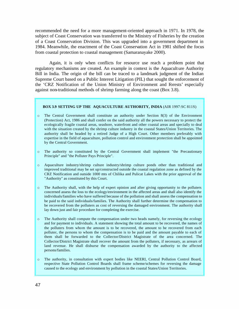
47
recommended the need for a more management-oriented approach in 1971. In 1978, the subject of Coast Conservation was transferred to the Ministry of Fisheries by the creation of a Coast Conservation Division. This was upgraded into a government department in 1984. Meanwhile, the enactment of the Coast Conservation Act in 1981 shifted the focus from coastal protection to coastal management (Samaranayake 2000). Again, it is only when conflicts for resource use reach a problem point that regulatory mechanisms are created. An example in context is the Aquaculture Authority Bill in India. The origin of the bill can be traced to a landmark judgment of the Indian Supreme Court based on a Public Interest Litigation (PIL) that sought the enforcement of the ‘CRZ Notification of the Union Ministry of Environment and Forests’ especially against non-traditional methods of shrimp farming along the coast (Box 3.8).
BOX 3.9 SETTING UP THE AQUACULTURE AUTHORITY, INDIA (AIR 1997:SC 811S)
o The Central Government shall constitute an authority under Section 8(3) of the Environment
(Protection) Act, 1986 and shall confer on the said authority all the powers necessary to protect the ecologically fragile coastal areas, seashore, waterfront and other coastal areas and specially to deal with the situation created by the shrimp culture industry in the coastal States/Union Territories. The authority shall be headed by a retired Judge of a High Court. Other members preferably with expertise in the field of aquaculture, pollution control and environment protection shall be appointed by the Central Government.
o The authority so constituted by the Central Government shall implement "the Precautionary
Principle" and "the Polluter Pays Principle". o Aquaculture industry/shrimp culture industry/shrimp culture ponds other than traditional and
improved traditional may be set up/constructed outside the coastal regulation zone as defined by the CRZ Notification and outside 1000 mts of Chilika and Pulicat Lakes with the prior approval of the "Authority" as constituted by this Court.
o The Authority shall, with the help of expert opinion and after giving opportunity to the polluters
concerned assess the loss to the ecology/environment in the affected areas and shall also identify the individuals/families who have suffered because of the pollution and shall assess the compensation to be paid to the said individuals/families. The Authority shall further determine the compensation to be recovered from the polluters as cost of reversing the damaged environment. The authority shall lay down just and fair procedure for completing the exercise.
o The Authority shall compute the compensation under two heads namely, for reversing the ecology
and for payment to individuals. A statement showing the total amount to be recovered, the names of the polluters from whom the amount is to be recovered, the amount to be recovered from each polluter, the persons to whom the compensation is to be paid and the amount payable to each of them shall be forwarded to the Collector/District Magistrate of the area concerned. The Collector/District Magistrate shall recover the amount from the polluters, if necessary, as arrears of land revenue. He shall disburse the compensation awarded by the authority to the affected persons/families.
o The authority, in consultation with expert bodies like NEERI, Central Pollution Control Board,
respective State Pollution Control Boards shall frame scheme/schemes for reversing the damage caused to the ecology and environment by pollution in the coastal States/Union Territories.
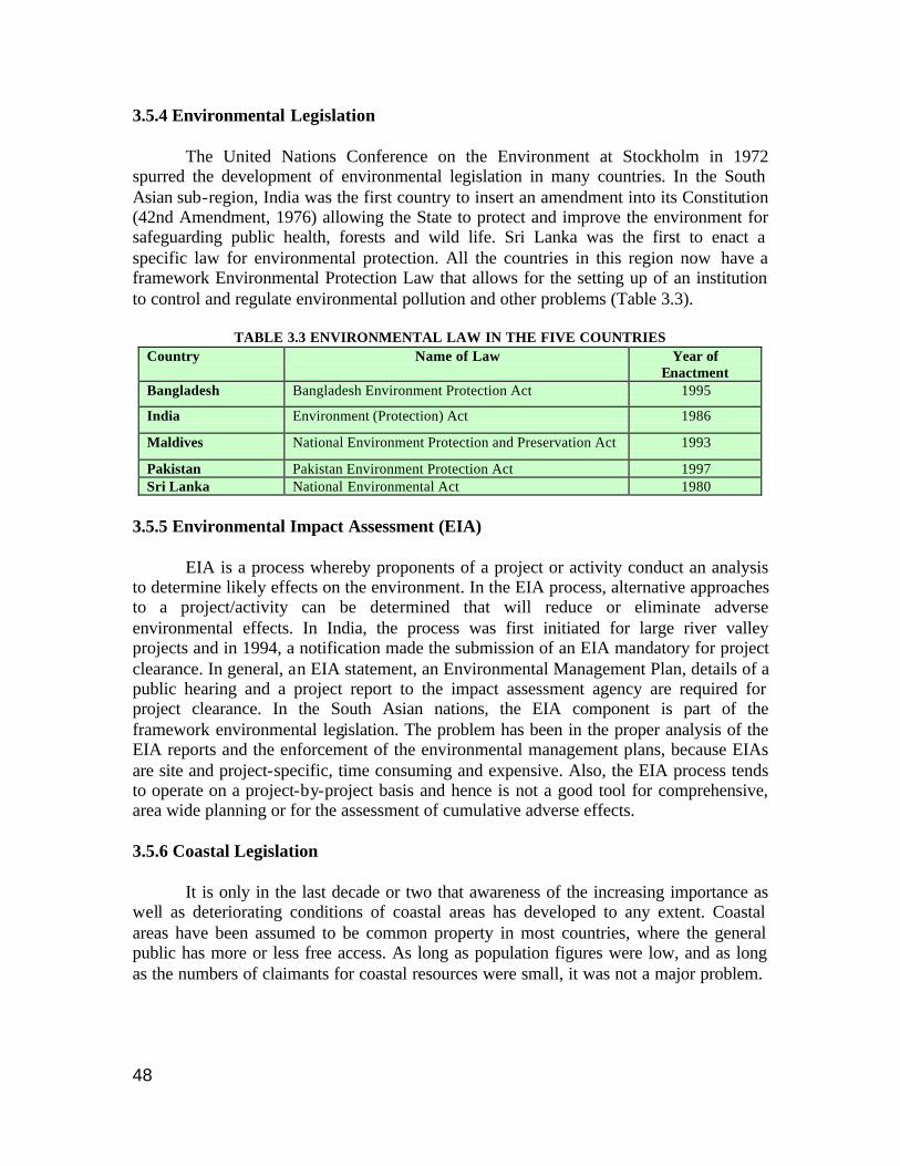
48
3.5.4 Environmental Legislation The United Nations Conference on the Environment at Stockholm in 1972 spurred the development of environmental legislation in many countries. In the South Asian sub-region, India was the first country to insert an amendment into its Constitution (42nd Amendment, 1976) allowing the State to protect and improve the environment for safeguarding public health, forests and wild life. Sri Lanka was the first to enact a specific law for environmental protection. All the countries in this region now have a framework Environmental Protection Law that allows for the setting up of an institution to control and regulate environmental pollution and other problems (Table 3.3).
TABLE 3.3 ENVIRONMENTAL LAW IN THE FIVE COUNTRIES Country Name of Law Year of
Enactment Bangladesh Bangladesh Environment Protection Act 1995
India Environment (Protection) Act 1986
Maldives National Environment Protection and Preservation Act 1993
Pakistan Pakistan Environment Protection Act 1997 Sri Lanka National Environmental Act 1980
3.5.5 Environmental Impact Assessment (EIA) EIA is a process whereby proponents of a project or activity conduct an analysis to determine likely effects on the environment. In the EIA process, alternative approaches to a project/activity can be determined that will reduce or eliminate adverse environmental effects. In India, the process was first initiated for large river valley projects and in 1994, a notification made the submission of an EIA mandatory for project clearance. In general, an EIA statement, an Environmental Management Plan, details of a public hearing and a project report to the impact assessment agency are required for project clearance. In the South Asian nations, the EIA component is part of the framework environmental legislation. The problem has been in the proper analysis of the EIA reports and the enforcement of the environmental management plans, because EIAs are site and project-specific, time consuming and expensive. Also, the EIA process tends to operate on a project-by-project basis and hence is not a good tool for comprehensive, area wide planning or for the assessment of cumulative adverse effects. 3.5.6 Coastal Legislation It is only in the last decade or two that awareness of the increasing importance as well as deteriorating conditions of coastal areas has developed to any extent. Coastal areas have been assumed to be common property in most countries, where the general public has more or less free access. As long as population figures were low, and as long as the numbers of claimants for coastal resources were small, it was not a major problem.

49
TABLE 3.4 INFORMATIO N ON THE EIA REQUIREMENTS OF THE FIVE COUNTRIES
Country EIA Laws and Regulations Remarks
Bangladesh EIA is stipulated in the Environmental Conservation Rules 1997, framed under EPA 1995; industries and projects are categorized into four groups based on level of pollution
The Department of Environment is responsible for EIA. Decision making process: The proponent initiates the procedure. EIA is necessary for the environmental clearance of a project and is granted by the DoE India
Environmental Impact Assessment Notification, 1994
The Ministry of environment and Forests (MoEF) is responsible for EIA. Decision making process: The project proponent submits the EIA in the prescribed form and this is reviewed and accepted/rejected by the impact assessment agency (here, the MoEF). Schedule 1 of the Notification gives list of projects requiring environmental clearance from the Central Government. Schedule 2 gives the detailed application form.
Maldives Under Article 5 of the Environment Protection and Preservation Act of Maldives, 1993
Ministry of Home Affairs, Housing and Environment (MHAHE) has the authority to specify rules, procedures and standards. Also determines whether a project is likely to have environmental impact etc. Takes counsel of other agencies and concerned parties
Pakistan
Under the Pakistan Environmental Protection Act, 1997
Federal EPA has jurisdiction over projects located on federal land, military projects and those that may have trans-country impacts. Provincial EPAs are responsible for the other projects. Decision making process: The project proponent has to apply for environmental approval. Conditional approval is granted by the respective EPAs prior to project commencement. Proponents signify their understanding and acceptance of conditions by signing an environmental agreement.
Sri Lanka
Under National Environment Act, 1980 and amendment, 1988. Part IV C deals with approval of projects; Order under 23Z with list of prescribed projects; Order under 23Y with list of project approving agencies; National Environmental Regulations No. 1, 1993 deals with procedure for approval of projects Also under Coast Conservation Act, 1981 comes the list of projects located wholly or partly outside coastal zone
Central Environmental Authority is responsible for EIA. Decision making process: The project proponent starts the EIA process by submitting preliminary information to the Project Approving Authority who in turn authorize the EIA and approve the final project proposal. If the project is allowed, the PAA must also decide under what conditions the project must be carried out. If approval is refused, reasons for doing so have to be provided.
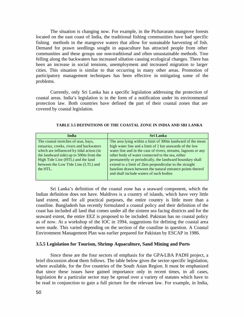
50
The situation is changing now. For example, in the Pichavaram mangrove forests located on the east coast of India, the traditional fishing communities have had specific fishing methods in the mangrove waters that allow for sustainable harvesting of fish. Demand for prawn seedlings sought in aquaculture has attracted people from other communities and these groups use non-traditional and often unsustainable methods. Tree felling along the backwaters has increased siltation causing ecological changes. There has been an increase in social tensions, unemployment and increased migration to larger cities. This situation is similar to that occurring in many other areas. Promotion of participatory management techniques has been effective in mitigating some of the problems. Currently, only Sri Lanka has a specific legislation addressing the protection of coastal areas. India’s legislation is in the form of a notification under its environmental protection law. Both countries have defined the part of their coastal zones that are covered by coastal legislation.
TABLE 3.5 DEFINITIONS OF THE COASTAL ZONE IN INDIA AND SRI LANKA
India Sri Lanka The coastal stretches of seas, bays, estuaries, creeks, rivers and backwaters which are influenced by tidal action (in the landward side) up to 500m from the High Tide Line (HTL) and the land between the Low Tide Line (LTL) and the HTL.
The area lying within a limit of 300m landward of the mean high water line and a limit of 2 km seawards of the low water line and in the case of rivers, streams, lagoons or any other body of water connected to the sea, either permanently or periodically, the landward boundary shall extend to a limit of 2km perpendicular to the straight baseline drawn between the natural entrance points thereof and shall include waters of such bodies
Sri Lanka’s definition of the coastal zone has a seaward component, which the Indian definition does not have. Maldives is a country of islands, which have very little land extent, and for all practical purposes, the entire country is little more than a coastline. Bangladesh has recently formulated a coastal policy and their definition of the coast has included all land that comes under all the sixteen sea facing districts and for the seaward extent, the entire EEZ is proposed to be included. Pakistan has no coastal policy as of now. At a workshop of the IOC in 1994, suggestions for defining the coastal area were made. This varied depending on the section of the coastline in question. A Coastal Environment Management Plan was earlier prepared for Pakistan by ESCAP in 1986. 3.5.5 Legislation for Tourism, Shrimp Aquaculture, Sand Mining and Ports Since these are the four sectors of emphasis for the GPA-LBA PADH project, a brief discussion about them follows. The table below gives the sector-specific legislation, where available, for the five countries of the South Asian Region. It must be emphasized that since these issues have gained importance only in recent times, in all cases, legislation for a particular sector may be spread over a variety of statutes which have to be read in conjunction to gain a full picture for the relevant law. For example, in India,
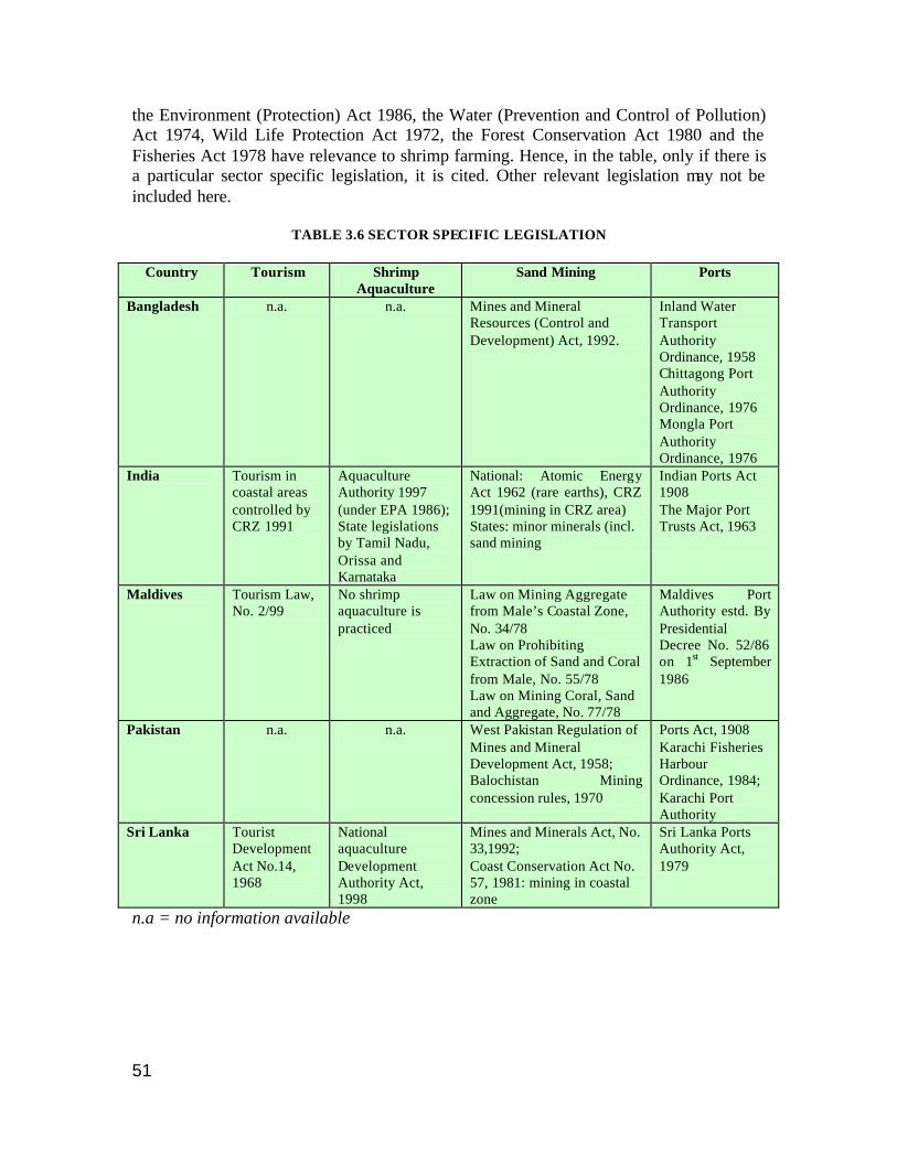
51
the Environment (Protection) Act 1986, the Water (Prevention and Control of Pollution) Act 1974, Wild Life Protection Act 1972, the Forest Conservation Act 1980 and the Fisheries Act 1978 have relevance to shrimp farming. Hence, in the table, only if there is a particular sector specific legislation, it is cited. Other relevant legislation may not be included here.
TABLE 3.6 SECTOR SPECIFIC LEGISLATION
Country Tourism Shrimp Aquaculture
Sand Mining Ports
Bangladesh n.a. n.a. Mines and Mineral Resources (Control and Development) Act, 1992.
Inland Water Transport Authority Ordinance, 1958 Chittagong Port Authority Ordinance, 1976 Mongla Port Authority Ordinance, 1976
India Tourism in coastal areas controlled by CRZ 1991
Aquaculture Authority 1997 (under EPA 1986); State legislations by Tamil Nadu, Orissa and Karnataka
National: Atomic Energy Act 1962 (rare earths), CRZ 1991(mining in CRZ area) States: minor minerals (incl. sand mining
Indian Ports Act 1908 The Major Port Trusts Act, 1963
Maldives Tourism Law, No. 2/99
No shrimp aquaculture is practiced
Law on Mining Aggregate from Male’s Coastal Zone, No. 34/78 Law on Prohibiting Extraction of Sand and Coral from Male, No. 55/78 Law on Mining Coral, Sand and Aggregate, No. 77/78
Maldives Port Authority estd. By Presidential Decree No. 52/86 on 1st September 1986
Pakistan n.a. n.a. West Pakistan Regulation of Mines and Mineral Development Act, 1958; Balochistan Mining concession rules, 1970
Ports Act, 1908 Karachi Fisheries Harbour Ordinance, 1984; Karachi Port Authority
Sri Lanka Tourist Development Act No.14, 1968
National aquaculture Development Authority Act, 1998
Mines and Minerals Act, No. 33,1992; Coast Conservation Act No. 57, 1981: mining in coastal zone
Sri Lanka Ports Authority Act, 1979
n.a = no information available
52
All countries have a law governing activities at ports because they are major import and export points and hence, a source of revenue. Maintenance of the port area by dredging navigational channels is usually built into the Port Act or is specified as a duty of the port authority. However, no mention is made of the methods for disposing dredged spoils. India has a specific EIA requirement for the construction of new ports and the expansion of older ones. Similarly, all countries have some kind of regulation in place with respect to mining. Sand and aggregates come under ‘minor minerals’ and often come under the jurisdiction of the provincial or state governments. Sri Lanka and India have laws that forbid or regulate sand mining in the defined coastal zone. Maldives has many laws and regulations especially regarding coral mining and is promoting the import of cheaper substitutes for construction in a bid to halt sand and coral mining for construction purposes. Tourism has been a major income earner for Sri Lanka and Maldives and these two countries are the only ones that have a specific act governing tourism. As with most activities, the setting up of a beach resort or tourist area involves extensive construction activity that contributes a great deal to the PADH component. Towards addressing some of the problems here, the 1991 Coastal Regulation Zone (CRZ) Notification of India contains as an annexure, guidelines for development of beach resorts/hotels. Specifically, these include a ban on flattening of sand dunes, ensuring that construction activities will not adversely affect free flow of ground water and a ban on extraction of sand, levelling or digging of sandy stretches except for structural foundation of building and swimming pool within 500 metres of the High Tide Line. The Maldives and Sri Lanka have detailed guidelines for location and construction of coastal tourist resorts. Shrimp aquaculture has been seen as a means to earn quick foreign exchange by many countries in this region. In a landmark judgment (AIR 1997:SC 811), the Indian Supreme Court ruled that shrimp farms caused serious environmental damage, that shrimp aquaculture was not a waterfront industry and that all shrimp farms operating within the Coastal Regulation Zone, that is, within the 500 meters of the coast, be demolished. Subsequently, an Aquaculture Authority was established and an aquaculture bill to regulate the industry is yet to be approved by the government. In Sri Lanka, the National Aquaculture Development Authority Act No. 53 of 1998 provided for the establishment of the National Aquaculture Development Authority of Sri Lanka, to develop aquatic resources and the aquaculture industry. Earlier, the Government introduced the Aquaculture Management Regulations of 1996, to be read with Section 40 of the Fisheries and Aquatic Resources Act, 1996. These regulations direct that no one can set up or operate an aquaculture enterprise without a licence and all units greater than the specified size require an EIA.

53
In the case of Bangladesh, hundreds of acres of mangroves have been converted intro shrimp farms especially in the Chakoria Sunderbans area but no specific legislation appears to exist to control this activity. The National Fisheries Policy 1998 deals with a policy for culture of shrimps in coastal regions. Pakistan does not yet have any legislation/policy in place though studies are supposed to have indicated the potential of shrimp aquaculture in certain areas. Marine Protected Areas include nature reserves, national parks, sanctuaries etc. Designating marine protected areas is usually done to conserve specific ecosystems or to protect and conserve species richness. Many types of protected areas can be distinguished – usually the levels are designated based on access/usage by local people for subsistence/livelihood. Countries designate marine protected areas under their wildlife laws or fisheries laws. In addition, several wetlands of international importance have been designated, especially under the Ramsar Convention. 3.6 Environment and the Judiciary How does one take action against a polluter? Without a clear knowledge of the appropriate laws the common man frequently does not have an idea of what to do. There are procedures for this (Box 3.8), but it is not always easy or quick to obtain a remedy. In India, the judiciary has been of late assuming an activist role in environmental matters. In fact, it has been pointed out that “…the development of environmental law in the 1990s is largely a story of India’s judiciary responding to the complaints of its citizens against environmental degradation and administrative sloth” (Divan and Rosencranz 2001). For easy and quick redressal of public grievances relating to environmental degradation, the system of “Pub lic Interest Litigation” (PIL) was introduced in 1985 (SoE India 1999). Under this scheme, aggrieved parties could approach the court, in public interest, for intervention, at no cost. This was a dramatic change from earlier times when only an aggrieved person/party could file a case and the judiciary was supposedly to play a neutral role. PIL are mostly writ petitions filed in public interest (sometimes even as a letter to the court identifying a problem has been treated as such), are activist in nature and usually for the violation of basic rights for the poor and helpless or about government policy.
BOX 3.10 FILING COMPLAINTS AGAINST
POLLUTION (INDIA) (Sahasranaman)
If there is any pollution from any industry or infringement of pollution laws, complaints can be made to the following authorities: § The President/Secretary – local
Panchayat/municipality § Revenue Divisional Officer of the concerned
area. If he refuses, file appeal to District Collector and then to State Government
§ Local office of the State Pollution Control Board, if he refuses, then to the State Pollution Control Board
§ In the case of a public nuisance, the local Executive magistrate can be approached with a petition under Sec. 133 of the Criminal Procedure Code
§ For infringement of Coastal regulation zone, file complaint with coastal zone management authority of the state
§ File writ petition Under Art.226 of the Constitution of India before the High Court
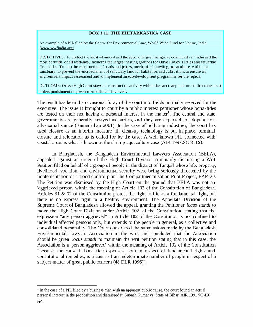
54
BOX 3.11: THE BHITARKANIKA CASE An example of a PIL filed by the Centre for Environmental Law, World Wide Fund for Nature, India (www.wwfindia.org) OBJECTIVES: To protect the most advanced and the second largest mangrove community in India and the most beautiful of all wetlands, including the largest nesting grounds for Olive Ridley Turtles and estuarine Crocodiles. To stop the construction of roads and jetties, mechanised trawling, aquaculture, within the sanctuary, to prevent the encroachment of sanctuary land for habitation and cultivation, to ensure an environment impact assessment and to implement an eco-development programme for the region. OUTCOME: Orissa High Court stays all construction activity within the sanctuary and for the first time court orders punishment of government officials involved.
The result has been the occasional foray of the court into fields normally reserved for the executive. The issue is brought to court by a public interest petitioner whose bona-fides are tested on their not having a personal interest in the matter1. The central and state governments are generally arrayed as parties, and they are expected to adopt a non-adversarial stance (Ramanathan 2001). In the case of polluting industries, the court has used closure as an interim measure till clean-up technology is put in place, terminal closure and relocation as is called for by the case. A well known PIL connected with coastal areas is what is known as the shrimp aquaculture case (AIR 1997:SC 811S). In Bangladesh, the Bangladesh Environmental Lawyers Association (BELA), appealed against an order of the High Court Division summarily dismissing a Writ Petition filed on behalf of a group of people in the district of Tangail whose life, property, livelihood, vocation, and environmental security were being seriously threatened by the implementation of a flood control plan, the Compartmentalisation Pilot Project, FAP-20. The Petition was dismissed by the High Court on the ground that BELA was not an 'aggrieved person' within the meaning of Article 102 of the Constitution of Bangladesh. Articles 31 & 32 of the Constitution protect the right to life as a fundamental right, but there is no express right to a healthy environment. The Appellate Division of the Supreme Court of Bangladesh allowed the appeal, granting the Petitioner locus standi to move the High Court Division under Article 102 of the Constitution, stating that the expression "any person aggrieved" in Article 102 of the Constitution is not confined to individual affected persons only, but extends to the people in general, as a collective and consolidated personality. The Court considered the submissions made by the Bangladesh Environmental Lawyers Association in the writ, and concluded that the Association should be given locus standi to maintain the writ petition stating that in this case, the Association is a 'person aggrieved' within the meaning of Article 102 of the Constitution "because the cause it bona fide espouses, both in respect of fundamental rights and constitutional remedies, is a cause of an indeterminate number of people in respect of a subject matter of great public concern (48 DLR 1996)".
1 In the case of a PIL filed by a business man with an apparent public cause, the court found an actual personal interest in the proposition and dismissed it. Subash Kumar vs. State of Bihar. AIR 1991 SC 420.
55
In Pakistan, the Supreme Court took cognizance of a report published in a newspaper and issued an order requiring Chief Secretary of Balochistan to provide the Court with full information on the allocation or the receipt of applications for allocation of coastal land in Balochistan or any area within the territorial waters of Pakistan. Apart from other points, the Court held that “The Government functionaries, particularly the Authorities which are charged with the duty to allot the land in coastal areas should insert a condition in the allotment letter/license/lease that the allotee/tenant shall not use the land for dumping, treating, burying or destroying by any device, waste of any nature including industrial or nuclear waste in any form” (UNEP/ROAP).
56
3.7 References 48 DLR 1996. Dr. Mohiuddin Farooque v. Bangladesh, Supreme Court of Bangladesh. Appellate Division (Civil). In Compendium of Summaries of Judicial Decisions in Environment Related Cases (with Special Reference to Countries in South Asia). http://206.67.58.208/uneproap/html/doc/compendium-south%20asia.doc AIR 1997:SC 811S. Jagannath Vs Union of India and Others, Writ Petition (C) No. 1994 (Kuldip Singh, S. Saghir Ahmed JJ). 11.12.1996. JUDGMENT Bryant, D, E Rodenburg, T Cox, and D Nielsen, 1995. Coastlines at Risk: An Index of Potential Development-Related Threats to Coastal Ecosystems. World Resources Institute, Washington D.C. CCD 1990. Coastal Zone Management Plan, Sri Lanka Coast Conservation Department, Colombo, Sri Lanka, 110 pp, 1990. Chowdhury, Z.H., N Islam, S Bhuiyan, and M Hasan . 2001. Network/Political Analysis Study, Bangladesh. Centre for Advanced Studies, Dhaka, Bangladesh. Quoted in Mallick, 2002 Cicin-Sain, B and R W Knecht 1998. Integrated Coastal and Ocean Management. Island Press, 1998. Adapted from Table 1.2. p21-22 CPREEC 2000. Environmental Laws of India: An Introduction, CPR Environmental Education Centre, India, 2000. Datta, A. 2001. “Who benefits at what costs? Expanded shrimp culture in Bangladesh, in Grassroots Voice, A journal of indigenous knowledge and development. Vol III, Issue 4, Bangladesh. Quoted in Mallick, 2002. Divan, Shyam and Armin Rosencranz, Environmental Law and Policy in India. Second Edition”. OUP, New Delhi, 2001. Ekaratne, S.U.K., John Davenport, D. Lee and R.S. Walgama, “Communities protecting coastal resources: Rekawa Lagoon, Sri Lanka. Pp 481-491 in Kothari, A., N. Pathak, R.V. Anuradha and B. Taneja (Eds.) Communities and Conservation. Sage Publications, 1998. Frankel E G.1995, Ocean Environmental Management, Prentice Hall, New Jersey, 1995 Frankenberger, Tim. ‘Theme 1: Summary: The Changing Face of Livelihoods in Asia: Shifting Entry Points’. DFID Regional Livelihoods Workshop, Dhaka, Bangladesh, May 8-10, 2001. Gadgil, Madhav and Prema Iyer. On the Diversification of Common Property Resource Use by Indian Society. In Fikret Berkes (ed.) Common Property Resources. Ecology and Community-Based Sustainable Development. pp. 240-255, Belhaven Press, London, 1989. GESAMP 2001. (IMO/FAO/UNESCO-IOC/WMO/IAEA/UN/UNEP Joint Group of Experts on the Scientific Aspects of Marine Environment Protection). 2001. Protecting the oceans from land-based activities – Land-based sources and activities affecting the quality and uses of the marine, coastal and associated freshwater environment. Rep. Stud GESAMP No. 71, 162 pp Kullenberg G. 1998, Making the Links, Our Planet 9(5), June 1998. Kumar A, 2002. The laws that protect wildlife in India. Terragreen, 15 August, 2002.
57
Kurien, J. 1995. Collective Action for Common Property Rejuvenation: The Case of People’s Artificial Reefs in Kerala State, India. Human Organization, 54(2): 160-168 Mainuddin, K. Mallick, D, Alam, M, Ahmed S.A. and Alam, S.S., 2001. Village level participatory Census, Bangladesh Centre for Advanced Studies, Dhaka, Bangladesh. Quoted in Mallick, 200. Mallick, D. 2002. “Cost-Benefit of Shrimp Farming in Bangladesh”. Bangladesh Environment Newsletter, Vol. 13, No. 2, September 2002. Mammen, K. John. “Traditional systems of fisheries management”. The Hindu, March 16, 1995. Maniku, M H. 1996. Existing legal systems and institutional structures in the Maldives: Opportunities and challenges for IIRM coordination. In Nickerson, D.J. and M.H. Maniku (Eds.). Report and proceedings of the Maldives/FAO National Workshop on Integrated Reef Resources Management in the Maldives. Malé March 16-20, 1996 Madras, BOBP, Report No. 76. Pgs. 250+VI . Mathew, Sebastian 1991. Study of territorial use rights in small scale fisheries: traditional Systems of Fisheries Management in Pulicat Lake, Tamil Nadu, India. FAO Fisheries Circular 839, FAO, Rome. Macintosh, D.J. Mangroves and coastal aquaculture: Doing something positive for the environment”. Aquaculture Asia. Vol 2, October-December 1996. Rahman, M. Mokhlesur (1995) Wetlands and Biodiversity: A Case Study of Common Property Resources in Bangladesh. Presented at "Reinventing the Commons," the fifth annual conference of the International Association for the Study of Common Property, May 24-28, 1995, Bodoe, Norway. Ramanathan, Usha. “Business and Human Rights: The India Paper”. IELRC Working Paper No. 2001-2 Part I. www.ielrc.org Rashid, S. 2002. Inland fishers and the management of Common Property Resources: The Case of the Hindu Kaibartta of Bangladesh. Asian Studies Conference 2002. Abstract. Sahasranaman, P.B. http://personal.vsnl.com/sahasram/remedy.htm accessed 31 January, 2002. Samaranayake, R.A.D.B. Sri Lanka’s Agenda for Coastal Zone Management. EEZ Technology. www.sustdev.org/journals/others/iczm/05.d.pdf State of the Environment Report: India 1999. Dehradun-Mussorie limestone mining case. Subasinghe R. 1997, South Asia. FAO Inland Water Resources and Aquaculture Service, Fishery Resources Division. Review of the state of world aquaculture. FAO Fisheries Circular. No. 886, Rev.1. Rome, FAO. 1997. 163 p. TERI 2001, Population, consumption, and environment: a tourist spot scenario. A project for MacArthur Foundation, Chicago, USA. TERI Western Regional Centre, Goa. http://www.teriin.org/teri-wr/projects/pce.htm accessed August 14, 2001 UNDP/GEF. “Conservation and Sustainable-use of the Gulf of Mannar Biosphere Reserve’s Coastal Biodiversity”. UNDP Project IND/99/G31. www.gefweb.org UNEP/GPA1999, UNEP:Partners in implementing the Global Programme of Action for the protection of the marine environment from land based activities. Regional Seas. UNEP/GPA Coordination Office, issue 1, September 1999.
58
UNEP/ROAP. “Human Rights Case No: 31-K/92(Q). Environment Pollution In Balochistan in Compendium of Summaries of Judicial Decisions in Environment Related Cases (with Special Reference to Countries in South Asia). http://206.67.58.208/uneproap/html/doc/compendium-south%20asia.doc UNEP 2002. Global Environment Outlook 3. GEO 3 Data Compendium. Vani, M.S. Customary Law and Modern Governance of Natural Resources in India – Conflicts, Prospects for Accord and Strategies. Paper Submitted for the Commission on Folk Law and Legal Pluralism XIIIth International Congress , to be held in Chiang Mai University, Thailand, April 2002. WTO 2000. “WTO in the Asia-Pacific 2000”. www.world-tourism.org/asia_pacific_2000.pdf accessed March 10, 2002
59
COUNTRY REPORT: BANGLADESH
4.1 Basic Information Bangladesh is located between 20° 34' to 26° 38' North and 88° 1' to 92° 42' East with an area of 147,570 sq km and a population of about 137 million and a high population density of 1056 inhabitants per sq km. It has a coastline approximately 710 km long and a continental shelf area of over 59,600 sq km. The territorial sea (12 nm) extends to 40,257,000 sq km and the claimed EEZ is 39,868 sq km.
The coastline can be divided into three parts. The eastern region from the Big Feni River to Badar Mokam (southern tip of the mainland) along Chittagong is regular and unbroken and is protected along the sea by mud flats and submerged sands. A continuous strip of sand runs from Cox’s Barn to Badar Mokam and forms a long sea beach of about 145 km. The Central Region from the Big Feni River to the Tetulia Estuary includes the mouth of the Meghna River. This region is characterized by heavy sediment input, formation of chars (new lands) and bank erosion. The coastline is highly broken and consists of a series of islands formed by sediment deposits. Westward from the Tetulia River to the international border located at the Hajrabhanga River is the Western region of the coast. This is a stable region and is mostly covered with dense mangrove forests that reduce bank erosion (ICZMP1). Cyclonic storms are an important feature of the Bangladesh climate. Two different types of cyclones form in the bay – the tropical and the monsoon. Tropical cyclones which occur before and after the monsoon seasons are highly destructive because of storm surges, flooding due to heavy rain and high wind blowing away ships
60
and homes, thus causing land degradation. Intrusion of saline water in the dry season is attributed to the low flow in the river systems. Presently, shrimp cultivation occurs almost throughout the year contributing to soil salinity. Bangladesh has been described as an extraordinarily rich country in terms of land, water, climate and people, and a poor country in terms of utilization of these resources (ESCAP 1987). The ‘Sunderbans’ is the single largest stretch of productive mangrove forest. Commercially important minerals such as monazite, ilmenite, rutile, zircon and caesium have been found in the sandy beaches along Cox’s Bazar. More recently, coastal areas have received international attention due to the high potential for in-shore and off-shore natural gas. The country is still predominantly agricultural with a topography dominated by a vast network of rivers. In the coastal areas, land use can be divided into two broad categories – natural and human. The mangroves form part of the natural forest vegetation while agriculture is the dominant human activity. Reforestation of accreted land is also an important activity. The focus of coastal environmental management has been on building embankments to protect against flooding and saline water intrusion. The Coastal Embankment Project (CEP) has built a complex series of dykes and drainage sluices for flood protection in the coast over a gross area of 14,100 sq km. An estimated 488 km of embankment with 926 sluices were constructed between 1961 and 1992. The CEP has changed the hydrological regime of the whole coastal area. A huge volume of water flowing onto the polders has been stopped. As a result, the remaining channels receive reduced flows and are getting silted up. It has also resulted in the rise of high tide levels in the rivers and the estuary with an increasing menace of the intensity of tidal bores in the area (ICZMP1). The natural nursery and grazing grounds of many marine and estuarine fish and prawn have been eliminated by these enhancements. 4.2 Coastal Landforms
4.2.1 Mangroves The mangrove forests of Bangladesh fall under two broad categories: natural mangrove forests in the south-west of Bangladesh known as the ‘Sunderbans’ and the mangrove plantations that have been established along the coast and in the newly accreted off shore islands of the Bay of Bengal. 'Sundarban' means 'beautiful forest' in the Bangla language, and is named after the major species found in the area called ‘sundri’ (Heritiera fomes). Within the mangrove forest, there are three distinct belts: Heritiera fomes and Excoecaria agallocha are the dominant species in the slightly saline and moderately saline zone. In the strongly saline zone, the forest consists mainly of Excoecaria agallocha and Ceriops decandra (UNEP 2001). The Sunderbans cover an area of 6,00,383 ha of which 4, 11,227 ha is land and the remaining 1,89,159 ha are bodies of water. Since 1966, 1,38,740 ha of newly accreted land have been planted with mangrove species. The Sunderbans receive large volumes of
61
freshwater from inland rivers flowing from the north and saline water from tidal incursions from the sea. The freshwater carries a high sediment load and is also important for maintaining the salinity for survival of mangroves. Dams upstream have reduced the flow into the rivers, which are mainly tributaries of the Ganges. Only two, the Baleshwar and Passur systems, still have direct connections with the Ganges and thus are the main source of continuous fresh water to the mangroves (ESCAP 1987). There is an overall movement of the mangroves towards the sea because they occupy the mud and silt deposited by the river systems, causing an increase in vegetation above tidal influence on the landward side. The Sunderbans support a total of 425 species of recorded fauna including 150 species of fish and 24 of shrimp. 90 per cent of commercial fish and 35 per cent of all fish in the Bay of Bengal rely on this area as a nursery (Rouf and Jensen 2001). The Sunderbans constitute about 44 per cent of the forest area of Bangladesh and supply about 45 per cent of the country’s requirement of timber and firewood. Declared as a World Heritage Site by the UNESCO in 1997, the Sunderbans are under increasing threat due to numerous human activities such as logging, reclamation of marshes, oil spills from tankers, expansion of settlements, building of embankments and shrimp culture (Islam 2002a). For example, the Chakoria Sunderbans in the delta of the Matamuhiri River covering an area of 5071.4 ha have been totally denuded to make room for shrimp aquaculture. This has been shown by recent field observations and satellite image interpretation (Hossain). Clearance of mangroves is not only causing loss of coastal habitat, aquatic resources and biodiversity, but is also increasing soil erosion and causing changes in sedimentation patterns and shoreline configuration. Increase in vulnerability to cyclonic storms and tidal bores, and loss of feeding, breeding and nursery grounds for various marine, estuarine and fresh water fishery resources are also seen. As a result natural shrimp fry as well as shrimp brood production have been greatly reduced. The exploitation of resources from the Sunderbans is managed through a system of auctions, licences and permits, by the Forest Department. 4.2.2 Beaches Most beaches in the south-central and southeastern regions have casuarina plantations. A long sandy beach of about 145 km runs from Cox’s Bazar to Badar Mokam. An 18 km sandy stretch in Kuakata is another important beach. About 2 km on St. Martin's Island in the Cox’s Bazar district and mainland beaches in the Teknaf Peninsula are sea turtle nesting sites. Since the Bangladesh Wildlife (Preservation) (Amendment) Act 1974 merely gives overall blanket protection to all wildlife species and does not include sea turtles in its list of protected species, there are legal difficulties in trying to protect turtle nesting sites. Most nesting sites are found on the western coast, while the northern nesting sites are threatened by local people and even dogs, being closer to the main business center and fish processing zone of St. Martin's. In comparison, the beaches of the Cheradia Islands have characteristics more suited to turtle

62
nesting, with higher slopes and wide sandy areas above the high tide mark even during high tides. Most significantly, the beaches are almost free from disturbance by domestic dogs. Threats to sea turtles in Bangladesh also include manmade physical alterations such as barriers around the beach. Artificial rock barriers, which impede the emergence of nesting females, were first erected in Konapara and Golachera but are now prevalent in several nesting areas. Threats from tourism were negligible before 1995 but at least 6 cases are known of Olive Ridley turtles being frightened away by tourists and dogs in the 2000-2001 season (Islam 2002b). 4.2.3 Coral Reefs St Martin’s Island, also known as "Narikel Jinjira Island", is the only coral reef area in Bangladesh. Coral cover is generally low (4–10 per cent). Reef conditions are poor due to high level of sedimentation, cyclones and storm surges, and fluctuations in salinity caused by freshwater input from major rivers. In addition, human activities cause physical damage to living sections of the reef. Among these, coral mining for construction is the main cause of reef damage (Rajasuriya and White 1998). Furthermore, destructive fishing methods, collection of souvenirs, boat anchoring, and pollution and tourist activities threaten the survival of corals around St Martin’s Island. However, some undisturbed areas have been identified for maximum protection (Rajasuriya et al 1999). 4.2.4 Tidal flats Most of the country has a flat terrain and the criss-crossing of the rivers forming the delta have resulted in a vast flood plain. Agriculture, shrimp farming and salt production are the main occupations. For example, in Cox’s Bazar, extended muddy shores with flat and gentle slopes are seen. The coastal soil is mostly silty-clay- loam that promotes solar salt production. In this area alone, some 20,000 ha are used for salt production, which is mainly a seasonal activity, taking place in summer (November to April). Agriculture is practiced during the monsoon months when the rains wash away the salt and soil salinity is reduced sufficiently to enable cultivation of rice. 4.2.5 Estuaries, Deltas, Rivers and Sediment Transport Almost all of Bangladesh lies in the active delta of three of the world’s major rivers: Ganga, Brahmaputra and Meghna (GBM system). While flowing through the country on the way to the Bay of Bengal, the system carries an estimated annual sediment load of about 2.4 billion tonnes. These sediments are subjected to coastal dynamic processes generated mainly by river flow and tidal wind actions, leading to accretion and erosion in the coastal area of Bangladesh.
63
4.3 National Environmental Policy (1992) Information on the National Environmental Policy has been extracted from an analysis of policy documents made in preparation for the national coastal policy (ICZMP2). Policy declarations that have particular bearing on the coast include:
- Sustainable use of coastal and marine resources and preservation of coastal ecosystem
- Prevention of national and international activities causing pollution in coastal and marine environment
- Strengthening research in protection and development of coastal and marine resources and environment
- Exploitation of coastal and marine fisheries to a maximum sustainable limit The policy document has indicated the activities in relation to coastal and marine environment (extracted from ICZMP2):
- Establish a special Cell to co-ordinate and monitor development activities to protect coastal and marine environment (Ministry of Environment and Forests, Department of Forests, Department of Environment and Forest Research Institute)
- Transfer newly accreted land to the Department of Forests on a priority basis to stabilize and protect from erosion (Ministry of Land, Department of Forests)
- Mobilize resources and undertake local and national contingency plan to handle accidental pollution of coastal waters; co-ordinate with regional plans (Ministry of Shipping, Ministry of Defence, Bangladesh Navy)
- Undertake measures to technically handle waste and polluted oils from ships at both Chittagong and Mongla ports (Ministry of Shipping)
- Establish a special Cell within the Ministry of Shipping to determine level of pollution parameters before dumping at sea and issue required permit (Ministry of Shipping, Department of Environment)
- Raise on a priority basis a ‘Coast Guard’ regiment within the Ministry of Shipping to provide security to coastal resources and assist in environmental protection (Ministry of Shipping)
- Undertake necessary steps to prevent pollution of coastal water, protect newly accreted land and preservation and proper utilization of all coastal resources (Ministry of Defence, Bangladesh Navy, Ministry of Shipping, Department of Forest, SPARSSO)
In addition, Bangladesh Navy is expected to oversee and prevent pollution in territorial waters of Bangladesh and Ministry of Shipping will monitor the activity. The policy document also makes statements regarding agriculture, land and flood control.
64
4.3.1 National Conservation Strategy (NCS) The aim of the NCS is to incorporate environmental considerations into the development planning process. The NCS provided the overall framework whereby alternative uses, including conservation and protection of habitat and biodiversity, and their effects on both economy and livelihood now and in the future and impacts on the local and external environments can be assessed a rationalized in relation to its overall conservation and sustainable development objective. 4.3.2 National Environment Management Action Plan (NEMAP) (1995) Initiated through the Ministry of Environment and Forest, its objectives are very close to that of the NCS. The key difference is full participation of the common people, interest groups, resource users and environmental stockholders, NGOs and lobbyists in all phases of planning and implementation of its policies, programmes and projects. 4.4 Note about PADH for the Country Land-based activities affecting oceans and coasts and needing to be implemented by Bangladesh include: (i) finding alternatives for pesticides and insecticides for agriculture; (ii) providing industries with waste recycling equipment; (iii) designing new industrial machineries for producing minimum wastes; (iv) building facilities for storage, recycling and treatment of harmful wastes. Sea based activities include: (a) building waste reception facilities in ports; (b) equipping Coast Guard ships with pollution detection and fighting equipment; (c) training of personnel for functions indicated in items (a) and (b) above (JoBurgBGD 2002) . While large quantities of sediment are transported by the rivers into the sea allowing for accretion and formation of new land, regular cyclonic storms in the Bay of Bengal cause extensive destruction of land and life. High poverty levels in the country coupled with high populations mean that the dependence on natural resources at subsistence levels is also high. In Bangladesh, the most important cause fo r concern is the destruction of mangroves. Direct clear cutting of mangroves to set up intensive aquaculture farms has resulted in the disappearance of complete stands of mangroves as in the Chakoria Sunderbans area. Death of mangroves due to increased salinity levels because of reduction in freshwater flow in the rivers due to damming upstream is another cause for concern. Water pollution due to various activities ranging from human settlements to industries dumping untreated waste into the waterbodies and ship breaking on the beaches is an increasing problem.
65
The Governments of Bangladesh and The Netherlands are currently working towards the development of a policy towards integrated coastal management (ICZMP1). The different policies in different sectors have been taken into consideration in the development of a draft coastal policy. In addition, there are various legislations and institutional arrangements available to address the different activities such as tourism, mining, and aquaculture development. 4.5 Umbrella Environmental Legislation The Environmental Pollution Control Ordinance 1977 (Ordinance XIII of 1977) was the first official regulatory framework to provide for the control, prevention and abatement of pollution of the environment of Bangladesh. This was repealed in 1995 with the enactment of the Environmental Protection Act, 1995. This Act led to the creation of the Department of Environment (DoE) headed by a Director General. The Ministry of Environment and Forests was formed in 1989. It is a permanent member of the Executive Committee of the National Economic Council, which is the major decision-making body for economic policy issues and also approves major public investment projects. The National Environment Committee, the Executive Committee of the National Economic Council (ECNEC) and the Ministry of Environment and Forests take decisions regarding integration of development and environmental issues. The National Environment Committee, headed by the Prime Minister, provides policy guidelines and directives for ensuring environment-friendly development activities in the country. Bangladesh Environmental Protection Act, 1995 The focus of the Act is to protect the environment and environmental quality and to control environmental pollution. It established a Department of Environment (DoE) headed by a Director General whose powers and duties include prevention of accidents, which may cause environmental deterioration or pollution; and collection, publication and dissemination of information regarding environmental pollution. The Act provides for the declaration of ecologically critical areas and also deals with direct or indirect damage to the ecosystem. No industrial enterprise can be established without clearance from the Director General. Provision has been made for the framing of environmental guidelines for the control and abatement of environmental pollution and for the protection and improvement of the environment. The Act is a “Command and Control” type of regulation with no economic incentives for compliance. According to a report (Quader 2002) applications for impact assessment require extensive paperwork. The DoE is not yet fully equipped with personnel and laboratory facilities to undertake its assigned responsibilities with technical competence, causing delays in project implementation. Environmental Conservation Rules 1997 (ECR 1997) stipulate Environmental Impact Assessment (EIA). Guidelines for specific categories of industries are to yet be developed and most guidelines currently use World Bank Guidelines for inspiration. ECR 1997
66
categorizes industries and projects into four groups based on the level of pollution (green, orange-A, orange-B and red). The EIA Guidelines for Industries covers significant water sector interventions, including flood control embankments, polders, dykes, water supply and sewage treatment, as well as roads and bridges. All these water sector interventions fall under the ‘red’ category, with the exception of bridges less than 100 m long, and feeder and local roads. The red category requires the most stringent EIA process to be followed for proposed project construction, re-construction and extension. The responsibility for following the environmental assessment procedure lies with the project proponent or developer. The procedures are different, depending upon the categorization of the proposed intervention. The two most stringent classes, orange/amber B and red, are required to have an Initial Environmental Examination (IEE), with an Environmental Management Plan (EMP). Once the Department of Environment approves these documents, a Site Clearance Certificate is issued, provided the developer has obtained a ‘No Objection Certificate’ from the local authority. 4.6 Focus on the Coast Bangladesh signed the UNCLOS in 1982 and is a party to CITES, Ramsar and CBD conventions. With respect to matters regarding Oceans and Coasts, decisions are made by the Cabinet and also by the Ministry of Shipping in consultation with other concerned ministries, divisions, and agencies (JoBurgBGD 2002). The government agencies dealing with coastal and marine affairs include the Department of Forests, the Department of Fisheries, the Bangladesh Fisheries Development Corporation, the Department of Science and Technology, the Bangladesh Navy, the Directorate of Shipping etc. In December 1999, the Ministry of Water Resources announced the Government’s intention to develop an Integrated Coastal Zone Management (ICZM) policy (ICZMP1). A team of senior officials consisting of the Principal Secretary to the Prime Minister, the Secretaries of the Ministry of Water Resources, Planning, Fishery and Livestock, Land, the Chairman of the Bangladesh Water Development Boards and the Chief Conservator of Forests produced a Policy Paper entitled “Integrated Coastal Management: Concepts and Issues”. This was later approved as the Policy Note on ICZM of the Government of Bangladesh. A Project Development Office (PDO) has been set up in the Ministry of Water Resources. The PDO-ICZM is constituted as a separate and independent unit under the mandate of Inter-Ministerial Steering Committee and Technical Committee. The Ministry of Water Resources is the lead Ministry. PDO-ICZM is responsible for:
− Developing a common vision for the coastal zone and a strategy to achieve this. − Preparing a framework for a comprehensive and multi-sectoral ICZM Program. − Identification, formulation and appraisal of activities as building blocks for the
CZMP. − Pro-actively interacting with activities along with harmonization where needed.

67
− Initiating a stakeholder's consultation and the set up of a coastal resources database. − Co-ordination and facilitation of the exchange of data and information. − Generating and integrating relevant information into the ICZM Program.
The PDO-ICZM is financed by the Governments of The Netherlands and Bangladesh. The Policy Note described the coastal zone to be an area of transition where terrestrial and marine environments interact to form unique environmental conditions. The coastal zone is described as “The land area of the coastal zone (42,154 sq km.) covering all 16 sea- and estuary-facing administrative districts: Barguna, Barisal, Bhola, Bagerhat, Chittagong, Cox’s Bazar, Chandpur, Feni, Jhalakhati, Khulna, Lakshipur, Noakhali, Pirojpur, Patuakhali, Satkhira and Shariatpur”. It is proposed to designate the whole of EEZ as also part of the coastal zone. The Law Ministry has cleared a proposal to declare the entire area as a ‘Marine Reserve’. 4.7 Major Coastal Activities causing habitat alteration (with policies and legislation)
4.7.1 Shrimp Aquaculture The Activity Shrimp exports are a major source of foreign exchange for Bangladesh. Out of about 2.5 m ha of brackish water, 0.13 m ha is under shrimp culture (Ahmed 1995). Penaeus monodon (brackish-water prawn) and Macrobrachium rosenbergii (freshwater prawn) are mainly cultured in ponds, beels, and paddy fields. According to an FAO study (Mahmood), the tidally inundated lands of Bangladesh were cleared of their mangroves over large areas though the history of this clearing is not well known. The tracts of Khulna and Chakoria Sundarbans are the only the large natural mangrove swamps remaining. In all cases, seeding is by wild post larval and juvenile shrimps, or fish fry, which are trapped in the ponds during tidal exchanges or which are gathered from the estuaries in the vicinity and used to stock the ponds.
BOX 4.1: TYPES OF SHRIMP AQUACULTURE
(Mahmood) • Salt extraction alternating with shrimp/fish culture: during
the 1960s, coastal aquaculture in the Chittagong region was mostly in salt pans where salt producers grew shrimp and fin fish during the monsoon and post monsoon months in their salt pans for subsistence and for additional income
• Mixed shrimp/fish ponds: dedicated shrimp/finfish culture – majority of Bangladesh farms today are of this type sited in low lying areas within coastal embankment constructed by the government, or as in Khulna and Chittagong, outside this embankment, and also in the mangrove areas of Teknaf and the Chakoria Sunderbans. These farms operate virtually throughout the year.
• Bheri culture (in which rice is cultivated alternately with fish). In Khulna, 50 per cent of the farms are of the Bheri type – areas impounded by earthen dykes with facilities for the tidal exchange of water managed alternately for rice production from August to December and shrimp/finfish culture from January to July.
• Intensive shrimp monoculture of Penaeus monodon .
68
Environmental and other impacts may be summarized as follows (Mahmood): § Bheri type and salt pans gradually converted for dedicated shrimp culture § More people into seed gathering from wild § Sedimentation within bheris affects transplanted rice production § Increase in salinity levels in the network of tidal channels where there is a lot of
shrimp culture § Reduction in the area of grazing land and a decline in the numbers of livestock in
Khulna area - rice stubble and other grasses are now unavailable for cattle as the area is now constantly submerged
§ Decline in freshwater resources Legislation The Protection and Conservation of Fish Act, 1950 includes prawn and shrimp in the list of fish but does not have a separate section for shrimp aquaculture. Similarly, the Bangladesh Fisheries Corporation Development Act, 1973 does not specifically refer to shrimp aquaculture though it is supposed to regulate different aspects of fisheries where fish include both aquatic animals and plants. Shrimp Culture Users Tax Ordinance, 1992 says that shrimp cultivation areas developed by the Government by construction of embankments, excavation of canals or other water management structures, shall be liable to payment of taxes. The National Fisheries Policy (1998) (ICZMP2) deals with a policy for culture of shrimps in coastal regions and has 23 features. Of these, those that are related to the PADH component are as follows:
1. There will be a thana, district, division and national committee. This committee will take care of the development of shrimp production, implement laws related to shrimp culture and mitigate other concerned problems. This committee will be run by the policies of the government.
2. Measures will be taken to conserve biodiversity in the coastal region and necessary steps will be taken to culture fish/shrimp along with rice crop, either in rotational or concurrent phases.
3. Arrangements will be established within the polders (embankment) and flood control projects to conserve wild life. Each polder will be coupled with arrangements for fish/shrimp culture with rice either in concurrent or in rotational system.
4. Improved –extensive culture will be encouraged. However, semi- intensive culture systems may be encouraged in controlled and feasible areas. Expansion of shrimp culture in mangrove forest will be completely banned in order to ensure ecological balance; tree plantation will be encouraged in shrimp culture areas.
5. Shrimp harvesting during shrimp breeding season will be banned. Some selected breeding grounds of the sea will be declared as shrimp sanctuaries.
69
6. Coastal areas will be selected for shrimp farming. 7. Combined efforts with other foreign countries will be made to achieve
environment friendly semi- intensive shrimp culture The central government is responsible for implementation of policy matters for shrimp farming and is also responsible for infrastructure development and the provision of training through development projects. Although specialized research bodies are provided for, these have no regulatory powers. Provision is being made for compulsory registration of shrimp farms with the Department of Fisheries. Restrictions are imposed upon the establishment of shrimp farms in forest and mangrove areas and conflicts are acknowledged to exist between shrimp farming and paddy farming, but it is not clear what mechanisms exist for the resolution of such disputes. No provision is made for environmental assessment. Illegal occupants of coastal lands for shrimp culture will be evicted on requirement from the Department of Fisheries, the Department of Forestry or the Land Administration Department (Howarth et al 2001). 4.7.2 Tourism The Activity There are many excellent tourism locations with beaches, islands and lakes but tourism in Bangladesh has not yet fulfilled its potential. There are some facilities in Cox’s Bazar, Rangmati and Kuakata, but the existing infrastructure is less than adequate to support even domestic tourism (ICZMP2). Four areas of potential tourism development are described by IUCN (Pernatta 1993). Bangladesh received 200,000 tourists in 2000, an increase of 15 per cent over 1999 (WTO 2002). Legislation No specific legislation could be found. A tourism master plan was prepared in 1991 with assistance from the UNDP and the ILO and the National Tourism Policy was framed in 1992. While the National Tourism Council and an Advisory Committee on Tourism have been formed at the highest level, resource constraints have prevented effective investment, marketing and promotion. Policy: The 1992 National Tourism Policy (ICZMP2) recognizes tourism as an industry and coastal beaches are considered as one of the attractions. Some of the principles of the National Tourism Policy are: § Development of infrastructure facilities at and connecting tourism sites § Wildlife conservation with tourism master plan for Bangladesh § Development of Cox’s Bazar sea beach § Development of Kuakata and sea beaches in Southern Bangladesh § Development of riverine tourism
70
Rules and guidelines for environmental management have been updated and strengthened towards preserving and developing the environment in relation to tourism development. EIA is a prerequisite for planning and designing new projects as well as upgrading old ones. It is understood that currently, the tourism sector is not seen as having any major negative impact on the environment given the present scale of tourism and lack of overcrowding at tourist sites (ESCAP 2001). The aim is to promote sustainable preservation of the biodiversity of Bangladesh’s forests, coastal areas and islands. It is recognized that private investment is much needed to develop tourist facilities, and that private investors have been showing increased interest. 4.7.3 Coastal Mining The Activity Mining of sand and gravel from agricultural land is common along the eastern side of the Dhaka-Chittagong road. Farmers often do it for the immediate monetary benefit it offers. First, two to three feet of topsoil is removed and then sand is extracted. Once sand extraction becomes unprofitable, it is abandoned. The damage is twofold – the land from which sand is extracted becomes unproductive for many years, and secondly, the land on which the initially extracted topsoil is dumped also remains unproductive. Legislation The Mines and Mineral Resources (Control and Development) Act, 1992 includes under its purview all mineral resources such as clay, sand, stone, coal etc. Full text of the act is not available in English. 4.7.4 Ports and infrastructure facilities There are two seaports in Bangladesh – Chittagong and Mongla - that support most of the international trade of Bangladesh. Bangladesh’s main exports are garments, jute and jute goods, leather, frozen fish and seafood. Imports include capital goods, textiles, food and petroleum products. Chittagong is the main port of Bangladesh and has special oil berths as well as other terminals for containers, food/grain, fertilizer and general cargo (Meyer 2000). These two ports are governed by their respective port authorities (Chittagong Port Authority Ordinance, 1976 and the Mongla Port Authority Ordinance, 1976). In addition, The Inland Water Transport Authority carries out river conservancy works including regulation of river flow for navigational purposes. It also maintains hydrographic surveys, carries out dredging programmes, develops ports and develops rural water transport.
71
4.7.5 Other Activities/Resources i. Agriculture Over 60 per cent of the total land area in Bangladesh is cultivated. The vast majority of the population depends on agriculture and natural resources for a large part of their food and income. As a result agricultural resources are under severe pressure. There are also competing demands on land for non-agricultural uses. Modernization of agriculture has led to extensive use of fertilizers and pesticides. It is reported that fish populations in the rivers and other water bodies have drastically decreased due to water pollution by chemicals, including fertilizers and pesticides (UNEP 2001). The National Agriculture Policy (1999) does not distinguish the coastal zone separately but all 18 specific objectives are applicable to the development of coastal zone agriculture (ICZMP2). The policy recognizes ‘water logging and salinity as serious problems in coastal areas which is not only a threat to the agricultural activities but also can cause a great damage to the overall environment’. The steps to be taken by the government in this respect are:
• Measures to resist water logging and motivation of farmers to follow appropriate crop rotation as well as to practice crop and fish culture by turns.
• Developing salt tolerant crop varieties along with possible measures to resist salinity.
• Taking realistic steps to tackle the salinity problems caused by shrimp farming
ii. Fisheries Fisheries is second to agriculture in the agro-based economy of Bangladesh contributing 2.9 per cent to the nation’s foreign exchange earnings and providing 80 per cent of the per capita animal protein. Approximately 8 million people derive their livelihood from fishing and related activities. Coastal aquaculture and marine fisheries come under the jurisdiction of the Ministry of Fisheries (Bashirullah et al 1989). Fishing is practiced under a system of lease/auction from government/government agencies. The Protection and Conservation of Fish Act, 1950 is implemented by the Protection and Conservation of Fish Rules, 1985 and amended by the Protection and Conservation (Amendment) Ordinance 1982. The act provides for the conservation and protection of fish in Bangladesh. Fish includes all cartilaginous and bony fishes, prawns, shrimp, amphibians, tortoises, turtles, crustacean animals, molluscs, echinoderms and frogs. The act provides the government with the power to make rules to prohibit destruction of fish by explosives, poisoning and depletion by pollution. The National Fisheries Policy (1998) also deals extensively with coastal and marine fisheries. The Territorial Waters and Maritime Zone Act, 1974 was adopted for the management of maritime activities within territorial waters, with limits to be determined by the government. The Act provides for the conservation, land use and exploitation of marine resources, as well as for the control of marine pollution. According
72
to the provisions of this act, conservation zones may be established to protect marine resources from indiscriminate exploitation, depletion or destruction. iii. Forests
Forests are governed by the Forest Act, 1927. The National Forestry Policy (NFoPo) was brought out in 1994. The overall objective is to meet the basic needs of the present and future generations and to ensure greater contribution of the forestry sector in economic development. The overall policy goal is for approximately 20 per cent of the area of Bangladesh to be afforested. The NFoPo realizes the need for massive and planned tree plantation, maintenance and preservation in the coastal areas to reduce the velocity and intensity of cyclones, tornadoes and tidal bores. The NFoPo mentions that ‘because of limited amount of forest land, effective measures will be taken for afforestation in the newly accreted char in the coastal areas’. A multiple use policy is adopted for the Sunderbans, covering forest, water and fish. Eco-tourism, related to forest and wildlife, is recognized as forestry related activity, which will be promoted taking into consideration the carrying capacity of nature (ICZMP2). iv. Industry, Settlements etc. Industrial units and industrial estates usually buy up more land than is required by them, even when it is prime agricultural land. This can be seen in all the district industrial estates along the Dhaka-Chittagong road. In Khulna, a big area has been acquired for industrialization of which only a part has been used (UNEP 2001). The prime objectives of the Industrial Policy (1999) (ICZMP2) are to accelerate industrial growth led by private sector investment and production. Other objectives are to diversify and expand exports, disperse medium and small-scale industries throughout the country through suitable ways, to build up indigenous capacity and to rehabilitate deserving sick industries. Agro-based industries, frozen food and tourism are some of ‘thrust sector industries’ more relevant to the coastal zone. The policy emphasizes enforcement of Environmental Protection Act 1995 to control industrial pollution of environment. The policy also encourages industries to obtain ISO-14000 certification. However, no mention is made of industries in the coastal zone nor is a scheme for industrial zoning suggested in the land use policy (draft 1999). The process of urbanization is also a contributor to PADH concerns. For example, the city of Dhaka has been growing at the expense of what were dense jackfruit and mango orchards in Savar, Gulshan, Banani and Uttara areas. In the case of Khulna, it is the coconut plantations of Phultala and Abhayanagar that have been lost. Land Acquisition Act of 1894 was originally used to acquire land for various public purposes. This was repealed with the enactment of the Acquisition and Requisition of Immovable Property Ordinance, 1982.
73
4.7.6 Land Use
The Zamindari system created by the British during colonial times for revenue generation was abolished under the State Acquisition and Tenancy (SAT) Act, 1950. According to this Act, ‘Land’ includes land that goes under inundation daily or seasonally. Currently, the water bodies (fishery) and forest resources are public property (state owned) and maintained by the government. Some of them are retained as open access while others (beyond a set area) are leased for harvesting of resources. There are rules which say that water bodies for fisheries may be leased only to fishermen. Forests are managed by the Department of forest under the provision of Forest Act 1927. Land Ministry regulates the management of land tenure and revenue system under the Land Management Manual (LLM) 1991. The generalized tenure and property right practices are also applicable to the coastal resources. Because of higher soil salinity, crop production is low and is supplemented by harvesting from mangroves. Accreted land that is reclaimed by mangrove plantation is supposed to belong to the government to be settled on the landless but usually land grabbers and establishment of fake cooperatives ensure that few of the genuinely landless get any such accreted land (DFID). Scarcity of land and the increasing conflicts due to multiple user competition is the reasoning behind the National Land Use Policy (2001). The draft National Land Use Policy (NLUP) (ICZMP2) indicates that afforestation (mangroves), salt production and shrimp culture are among the major uses of land in coastal areas. Recognizing conflicts in coastal zone land use, the objectives of the policy are to:
i. Ensure proper use of land and prevent indiscriminate use/ misuse of land; ii. Determine which land would be used for what purposes, so as to ensure the
most appropriate use of land; iii. Exercise utmost economy in acquisition of land for implementation of
development projects and for urbanization and other uses of land; iv. Determine which land would be used now and which land (especially
Government land) would be used in the future; v. Prevent use of land for speculative purposes; and vi. Ensure that the use of land is environmentally friendly
For achieving the objectives of the ‘National Land Use Policy’ and for its implementation, 12 different strategies have been proposed; three are directly related to coastal zone:
74
a. Zoning of land b. Resolution of Land Use Conflict Issues in general and Coastal Zone Land Use
Conflicts in particular c. Reclamation of Land and Prevention of Erosion.
The creation of National Land Use Planning Authority (NLUPA) is proposed to replace the existing Land Reforms Board. The NLUA would be responsible for zoning of the land. The policy recognizes that land in the coastal zone has alternative uses and can be used for different types of economic activities.
75
4.8 References Ahmed A.T.A., 1995, Impact of shrimp culture on the coastal environment of Bangladesh quoted in State of the Environment – Bangladesh, UNEP 2001. Bashirullah, A.K.M, N. Mahmood and A.K.M.A. Matin, 1989. Aquaculture and coastal zone management in Bangladesh. Coastal Management 17: 119-127. ESCAP 1987. Coastal Environment Management Plan for Bangladesh. Vol 1. Summary. UN-ESCAP, ST/ESCAP/618. DFID. Integrated Coastal Zone Management in Bangladesh: A Policy Review. Livelihood Policy Relationships in South Asia, Working Paper 1. DFID, UK. ESCAP 2001. Based on a country report prepared by Bangladesh Parjatan Corporation, National Tourism Organization, Dhaka, Bangladesh quoted in “Plan of Action for Sustainable Tourism Development in the Asian and Pacific region (1999-2005): A progress report. UN-ESCAP 2001. Hossain, Md. S. The Terrible Fate of the Chakaria Sunderban Must Not Be Repeated. http://www.earthis land.org/map accessed 31 May 2002. Howarth, W., R E. Hernandez and A Van Houtte 2001. Legislation governing shrimp aquaculture. Legal issues, national experiences and options. FAO legal papers online June 18, 2001. http://www.fao.org accessed May 17, 2002 ICZMP1. Integrated Coastal management: Concepts and Issues. http://www.iczmpbangladesh.com accessed May 29, 2002. ICZMP2. Integrated Coastal Zone Management Program (ICZMP). Coastal Zone Management: An Analysis of Different Policy Documents. PDO-ICZM Discussion Paper No. 1 http://www.iczmpbangladesh.com accessed July 7, 2002. Islam, T 2002a, Environment – Bangladesh: Great Forest in Great Danger, www.ips.org accessed May 31, 2002. Islam, Md Z, 2002b. Marine Turtle Nesting at St. Martin's Island, Bangladesh. Marine Turtle Newsletter 96:19-21. JoBurgBGD 2002. Bangladesh, Country Profile submitted for the Johannesburg Summit http://www.un.org/esa Mahmood N, Effects of shrimp farming and other impacts on mangroves of Bangladesh. FAO Fish Rep. 370 (Suppl.): 46-66. Meyer T A Cdr (Ret.). 2000, Report on IMO/SACEP Assessment Mission on Port Reception Facilities in Bangladesh, India, Maldives, Pakistan and Sri Lanka . April 12-June 30, 2000. Pernatta, J.C. (Ed.). 1993. Marine Protected Area Needs in the South Asian Region. Volume 1: Bangladesh. A Marine Conservation and Development Report. IUCN. Gland Switzerland. vii+42pp. Quader, A.K.M.A, 2002. “Environmental Rules and Regulations of Bangladesh”. http://www.alochana.org/magazine/2002/february/TOTM4.htm accessed 1 June 2002.
76
Rajasuriya A and A White, Status of coral reefs in South Asia . In C. Wilkinson, Status of the coral reefs of the World, GCRMN, 1998. Rajasuriya A, M.H. Maniku, BR Subramanian and J Rubens. Status Reports From Different Regions : Coral Reef Ecosystems in South Asia . In O. Linden and N. Sporrong, “Coral Reef Degradation in the Indian Ocean Status report and project presentations 1999”. CORDIO, SAREC Marine Science Program, Department of Zoology, Stockholm University, 106 91 Stockholm, Sweden. Rouf, M A and K R. Jensen 2001. Coastal fisheries Management and Community Livelihood-Possible strategy for the Sunderbans, Bangladesh, ITCZM Monograph No. 4, 24 pp. AIT, Thailand, 2001. UNEP 2001. State of the Environment – Bangladesh, UNEP, 2001. WTO 2002. Bangladesh:Background. http://www.world-tourism.org accessed August 2, 2002.

77
CHAPTER 5
COUNTRY REPORT: INDIA 5.1 Basic Information India is the largest of the South Asian countries with a total population of 1,014 million (2001) and average population density of 340 per sq km. The triangular shaped peninsula projects into the Indian Ocean and is bounded by the Bay of Bengal in the east and Arabian Sea on the west. Out of the total landmass of about 3.28 million sq km, nearly 0.15 million sq km of coastal land-belt (considering 25 km landward distance) girdles three sides of the country's sea front. The seabed up to the territorial limit covers about 0.13 million sq km. The country has 14 major, 44 medium and 55 minor rivers, which discharge annually about 1566 thousand million cubic metres of water through land drainage into the seas, transporting a wide range of pollutants generated by land-based activities. Nine out of fourteen major rivers meet the sea in the east coast (Brahmaputra through Bangladesh) and the remaining five in the west coast (Indus through Pakistan).
India has a coastline of about 7,500 km and 2.02 million sq km of Exclusive Economic Zone. The coastline of the eastern (Bay of Bengal) coast differs from the western (Arabian Sea) coast. The east coast is characterized by a narrow continental shelf. The rivers are long, slow moving and with extensive delta formation. In addition to the monsoon regime, the east coast is subjected to severe storm surges which cause extensive coastal damage and flooding of low-lying areas. An apparent calm condition prevails thorough most of the year except during the monsoons. The currents reverse directions
78
with the change of monsoon. The varied physical habitats have resulted in a wide variety of coastal flora and fauna, especially in the pelagic zone. The west coast and the north east coast receive rainfall during the southwest monsoon. The south coastal state of Tamil Nadu falls in the rain shadow region of this monsoon and receives some rainfall during the returning (north-east) monsoon between October and December. In addition, cyclonic storms are common especially in the Bay of Bengal, often striking the Orissa and Andhra Pradesh coast causing severe damage. The east coast has four major deltas formed by the Kaveri, Krishna, Godavari and Mahanadi rivers. The Indian Sunderbans falls in the state of West Bengal. The west coast has a broad continental shelf and short swift flowing rivers with little delta formation. The wind and current pattern together with the heavy runoff from several rivers flowing into the Arabian Sea cause a nutrient-replenishing coastal upwelling and account for the high productivity of the waters along the west coast. There is also the unique phenomenon of mud-bank formation, an area of extreme calm where fishes and shrimps aggregate in large numbers. Until about 50 years ago, the major coastal activities were agriculture, shipping and fishing. Some of the port towns have been in existence for many hundreds of years. India has thirteen coastal states and union territories. The total population of these states and union territories is a little less than half a billion, (CensusIndia 2001) accounting for 47 per cent of the total population. 36 per cent of the population of these maritime states lives in districts with a coastline. The population density in the coastal states ranges from 43 per sq km (Andaman and Nicobar Islands) to 2,029 per sq km (Pondicherry). The coast also includes some of the largest and most dense urban agglomerations, which includes the cities of Mumbai or Bombay (population of 16 million plus, density 21190 per sq km), Kolkata or Calcutta (population of 13 million plus, density 24,760), Chennai or Madras (population of 6 million plus, density 24,231), Kochi and Visakhapatnam (population of 1 million plus each).
5.2 Coastal Landforms 5.2.1 Mangroves In India, the area under mangroves is about 4,900 sq km constituting about 7 per cent of the world’s mangroves and about 8 per cent of India’s coastline. There are three types of mangroves in India: deltaic (east coast), backwater estuarine (west coast) and insular (Andaman and Nicobar Islands). Gangetic Sunderbans (418,888 ha), Andaman and Nicobar Islands (115,000 ha), Krishna, Kaveri, Godavari and Mahanadi deltas have significant mangrove formation. Mangroves in India comprise of 60 species including 33 true mangrove species (MSSRF 2002). The dominant genera include Rhizophora, Avicennia, Bruiguiera, Sonneratia, Canocarpus, Heretiera, Xylocarpus, Ceriops, and Exoecaria.
79
The Sunderbans are the world’s largest contiguous mangroves spread across India and Bangladesh. In India, the Sunderbans are located entirely in the state of West Bengal. The Sunderbans Biosphere Reserve (SBR) was established in 1989. Covering an area of 9630 sq km, SBR has 4246 sq km under reserved forest, the rest being inhabited. Over 300 species of marine and freshwater fish, prawns and crabs occur in this region of which the tiger prawn (Penaus monodon) is economically most important – collected in the wild and reared in farms. Indiscriminate exploitation of fishery resources and unregulated use of nets of small mesh size for the collection of tiger prawn seeds have resulted in biodiversity losses. The semi- intensive and intensive shrimp farms adjacent to the estuaries of SBR have also caused reduction in biodiversity both because of direct mangrove cutting and inflow of pollutants. The Farakka Barrage in the upper reaches as well as other dykes and bunds arrest the normal flow of water and interfere with the natural equilibrium of the ecosystem and thereby pose a threat to faunal diversity (Das and Nandi 1999). On the west coast, Gujarat’s coastline includes a broad continental shelf with two gulfs, the Gulf of Khambat (Cambay) and the Gulf of Kachchh (Kutch). This region ranks first in the marine fish production contributing 20 per cent of the total. The mangroves in the Gulf of Kachchh directly influence the fisheries. In early 20th century, the Kachchh and Saurashtra coastline had thick mangroves forests but recent studies show that these have now been sharply reduced. The annual rate of degradation is estimated at around 11 per cent. The principal reasons for degradation are dependence of coastal population on mangroves for domestic fuel needs, decreased freshwater discharge into the Little Rann of Kachchh and increased salinity and unchecked expansion of salt works along the coast (Chhaya). Mumbai, one of the world’s megalopolises, is located in the neighbouring state of Maharashtra. Mumbai was originally a group of islands, which have been interconnected, and many creeks along the coastline there have been filled in to reclaim land. About 45 sq km of mangroves are still standing strong around the city, protecting the land from the wave action of the sea surrounding the city. Mangroves are numerous in the creeks but a small population also exists along the open sea front at some places like Carter Road, Cuffe Parade and Worli Seaface. In 1985, Godrej, a multi-product company that owns large tracts of land in Mumbai announced the Mangrove Project covering 1750 acres. The multi-disciplinary project involved conservation, protection, management, research and development, education and awareness aspects. It is probably the first privately managed wetland in Asia (Kulkarni). 5.2.2 Beaches The west and east coasts have both long sandy beaches. The west coast is more famous as the beaches in Kerala and Goa are well known as international tourist destinations. Beaches are mainly used by the fishing community to land craft and to dry nets and catch. The destruction of sand dunes by levelling them for locating beach resorts and industries is well documented in the case of Goa. It is reported to have caused increased shoreline erosion as well as harsher impact of cyclones.
80
Beach sands are also known for extensive mineral deposits of rare earths. In Kerala, the Indian Rare Earths has been operating at Chavara for many years. Recently, the Andhra Pradesh government is reported to have granted a lease to Transworld Garnet for sand mining over a 95-hectare area in Srikurmam, at the confluence of the Nagavali River, in Srikakulam district. The beaches in northern Andhra Pradesh are rich in minerals such as ilmenite, garnet, silvanite, monazite and zircon. Authorities claim that the licence to Transworld was sanctioned only after a clearance was granted from the Government of India and Shore Area Development Authority, as required under the Coastal Regulation Zone rules. There are fears that this spate of mining leases will result in coastal erosion and pollution and adversely impact marine life and fish catches (Anon 2002). Tamil Nadu and Orissa also have plants that mine beach sand. The 35 km long Gahirmatha coast in Orissa is the world's largest rookery for the Olive Ridley turtles, which come in hundreds of thousands from as far as the south of the Pacific Ocean every year to nest there. The Gahirmatha nesting beach is the only one in India, which is a classified as a sanctuary. Shrimp trawlers and gill-netters (which operate in nearshore coastal waters despite a ban on doing so) are the primary cause of mortality of nesting turtles. There are other such nesting sites all along the coastline including parts of Andhra Pradesh and Tamil Nadu. 5.2.3 Coral Reefs Coral reefs occur along the coast of Gulf of Mannar, Gulf of Kachchh and the Andaman, Nicobar and Lakshadweep islands. The number of coral species known so far in Indian reefs is 206. The total area of various reef features (as deduced from satellite images) is about 2,300 sq km, but the extent of coralline shelves below one optical length (detection limit of satellite-borne sensors) could be several times higher, as in the shelves of the Andaman and Nicobar reefs (Wafar 1999). In the Gulf of Mannar (east coast), fringing reefs occur around a chain of 20 islands from Rameswaram in the north to Tuticorin in the south. The reefs at the northern and southern ends of the chain are partially degraded due to human activities (mining, fishing and industrial development) whereas those in the middle, because of their location away from human settlements, are in a relatively better condition. These reefs form part of the Gulf of Mannar Biosphere Reserve. The Andaman and Nicobar Islands in the Bay of Bengal number around 500 and all of them have fringing reefs. Most of them have healthy reefs with high biodiversity. However, impacts are readily visible near human settlements such as Port Blair. A serious natural threat to these reefs in the last two decades has been infestation by the crown-of-thorns starfish (INCRI). In the Gulf of Kachchh on the West coast, the reefs are also of the fringing type around a chain of islands from Jodhiya in the north to Port Okha in the south. These are the northernmost reefs in the Indian subcontinent. Because of the extreme environmental conditions, the reefs are relatively less developed and harbour a low biodiversity compared to other Indian reefs. The Gulf of Kachchh is also a region of high industrial

81
development and this has been responsible for large-scale mortality of reef corals in the recent past. The entire Gulf of Kachchh reefs have now been declared as a Marine National Park. The Lakshadweep islands consist of 10 atolls with 36 islands of which 10 are inhabited. The atolls, with the lagoon and islands cover areas ranging from 30 to 300 sq km. The islands, however, range from less than a km to about 9 km in length. The maximum width does not exceed two km. The health of the reefs is generally excellent, especially in the uninhabited atolls whereas in the inhabited islands, human impacts are significant. In the early eighties, reefs in the Gulf of Kachchh were utilized for commercial mining of coral sand (up to 1 million tons per year). Though commercial mining has come to an end, clandestine removal of coral debris is still a practice in some reef areas in the Gulf of Mannar (Wafar 1999). Coral reefs off the mainland coast continue to be exploited for extraction of lime, reef fishes and collection of ornamental shells, sea fans, seaweed, sea cucumbers, spiny lobsters and sea horses. Agricultural and industrial run-off, pesticides and oil pollution add to the degradation of mainland reefs. Sedimentation probably has the most significant impact on coral degradation. 5.2.4 Tidal flats
There are many tidal flats both on the east and the west coast. Many of them have traditionally been worked as saltpans with salt production and shrimp farming, or agriculture and shrimp farming alternating with the seasons. During the aquaculture boom in the late eighties and early nineties, some of them were converted into aquaculture ponds as in Andhra Pradesh and Tamil Nadu. This is now prohibited under the Aquaculture Authority Act. On the west coast of India, the Rann of Kachchh, a unique salt desert and wetland ecosystem lies at the end of the Luni River, which drains the Aravalli Hills and flows southward to dissipate into the dry, arid salt flats. Geographically, this ecoregion extends across the northwestern Indian State of Gujarat and southern Pakistan's Sind Desert region. The July to September monsoon rains flood the vast, flat area to a depth of about 0.5 m. Several rivers such as the Bhambhan, Kankavati, Godhra, and Umai from the south, the Rupen and Saraswati from the east, and Banas from the northeast, drain into the Rann during the monsoon. Three protected areas cover more than three-fourths of this ecoregion (Rawat and Wickramanayake). The primary threats to this ecoregion's habitat are from cattle grazing even within the protected areas, vehicular traffic that damages the fragile ecosystem, and cutting of trees to make charcoal. The proposed expansion of the commercial salt extraction operations may result in disturbances to wildlife.

82
5.2.5 Estuaries, Deltas, Rivers and Sediment Transport In India the average annual precipitation is nearly 4000 cubic km and the average flow in the river systems is estimated to be 1869 cubic km. Because of concentration of rains only in the three monsoon months, the utilizable quantum of water is about 690 cubic km. Six of the 20 major river basins in India suffer from water scarcity. In peninsular India, rivers flowing westwards into the Arabian Sea are short and swift compared with most of those that flow east into the Bay of Bengal. The narrow coastal plain on the west coast has favoured the formation of estuaries. In Kerala and southern Karnataka, partial closure of estuary outlets to the sea has resulted in the well-known ‘backwaters’. The salt lakes swamp of Calcutta was formed by the inter-distributary system of the river Ganga. Over the years, land reclamation and sewage disposal have completely transformed the salt lakes ecosystem. The entire domestic sewage of the city is discharged into these wetlands, which serve as oxidation ponds. Fish culture is practiced here and the effluents are used in horticulture. Reclamation of the swamp, which had its beginnings in 1865 when the municipality acquired a 2.6 sq km area as a landfill, is today a major threat. Deltas formed by the rivers Kaveri, Godavari, Krishna and Mahanadi on the east coast are the traditional rice bowls of the country. Damming of the rivers upstream has led to reduction in flow in the downstream areas and often the water reaching the delta areas is insufficient for irrigation. This has resulted in a number of inter-state disputes. 5.2.6 Coastal Lagoons Pulicat (Tamil Nadu-Andhra Pradesh) and Chilika (Orissa) are large coastal lagoons on the east coast. Chilika is a shallow water body with an average depth of just two metres and is separated from the Bay of Bengal by a narrow strip of land. It is the largest brackish water lake in India. Chilika was designated as a Ramsar site in 1981. Over a hundred thousand fishermen from 114 villages depend on the lake for their subsistence. Seasonal changes in the water salinity are well marked and influence the abundance and distribution of fish in the lagoon. Rapid siltation, decreasing salinity and explosive growth of weeds are of major concern. The area of the lake has been diminishing by about 1.5 sq km every year due to natural siltation processes, reclamation of marginal land for agriculture, prawn farms, saltpans and construction. Pulicat Lake faces similar problems. 5.3 National Environmental Policy / National Conservation Strategy The Indian Government adopted The National Conservation Strategy and Policy Statement on Environment and Development (IndiaAgenda21) in June 1992. It lays down approaches and actions for integration of environmental considerations in the

83
development activities of various sectors of the country. With specific reference to wetlands, mangroves and coral reefs, a number of activities are being formulated. A National Level Committee constituted to advise the Government on appropriate policies and measures to be taken for conservation and management of the wetlands, has so far identified 20 wetlands for conservation and management on a priority basis. The concerned State governments have set up Steering Committees where representatives of State government departments, universities and research institutions are included. Nodal research/academic institutions have been identified for each of the selected wetlands. Management action plans have been drawn up for most of the identified wetlands. A directory has been published which gives information on location, area and ecological categorization of wetlands in different parts of the country. India is a signatory to the Convention on Wetlands of International Importance, especially as Waterfowl Habitat (Ramsar Convention). Of the six Indian wetlands listed as Ramsar sites, Chilika in Orissa is a coastal lagoon. Under the scheme on Conservation and Management of Mangroves, fifteen mangrove areas have been identified for intensive conservation and management purposes: Northern Andaman and Microbar, Sunder bans (West Bengal), Bhitarkanika (Orissa), Coringa, Godavari Delta and Krishna Estuary (Andhra Prudish), Maharani Delta (Orissa), Pichavaram and Point Calimere (Tamil Nadu), Goa, Gulf of Kachchh (Gujarat), Kundapur (Karnataka), Achra/ Ratnagiri (Maharashtra) and Vembanad (Kerala). Management action plans for all the fifteen mangrove areas have been sanctioned. Four coral reef areas, Gulf of Mannar, Andaman and Nicobar Islands, Lakshadweep Islands and Gulf of Kachchh, have been identified for conservation and management. State-level steering committees have been constituted for the formulation and implementation of management action plans. Such action plans have been drawn up for Andaman and Nicobar and Gulf of Mannar coral reefs so far. 5.4 Note about PADH for the Country India is the largest among the South Asian nations in terms of population, land area and coastline. Three seas – the Bay of Bengal, The Indian Ocean and the Arabian Sea - border the Indian peninsula. The east coast and the west coast are different in many aspects mainly influenced by the physiographic features. Both coasts have been populated for millennia and a number of important harbours, commercial centres and cities have existed on the coast. Agriculture has been the mainstay for most coastal areas while fishing has been concentrated in small pockets or been the prerogative of a few classes of people. Fishing, till the 1950s, was small-scale, artisanal and mainly for local consumption. Since independence in 1947, the focus has been on industrialization as the way to achieve higher standards of living. Coasts were believed to be ‘backward’, not offering much by way of employment opportunities and industrialization of the coastal areas proceeded at a rapid pace. However, in the last three decades, it has become increasingly
84
obvious that haphazard industrialization has led to extensive environmental degradation – directly because of pollution, and indirectly because of changes in land use. Poor connectivity with the hinterland has meant the concentration of industries and settlements in some areas on the coast close to large ports, which now have earned the reputation of being environmental hot spots. The recent boom in aquaculture has also been the cause of conversion of paddy fields, saltpans and mangroves into shrimp farms. Tourism in Goa and Kerala, beach sand mining in Kerala, Tamil Nadu and Andhra Pradesh for commercially important minerals has also resulted in destruction of habitat. Some of the largest urban agglomerations are situated on the coast and are industrial hubs apart from having high population density. 5.5 Umbrella Environmental Legislation The Ministry of Environment and Forests, Government of India is the nodal agency responsible for the environmental management and protection. Along with the Central Pollution Control Board and the State Pollution Control Boards, it forms the regulatory and administrative core. In addition, there is a network of government and non-governmental institutions, organizations and laboratories involved in the monitoring, reporting and studying of environmental pollution and management. Among these, of importance is the National Environment Engineering Research Institute (NEERI) located at Nagpur. The National Environment Appellate Authority (NEAA) was set up in 1997 to act as a vigilant body to deal with the representations, complaints and appeals made against the decisions of competent authorities established under the Environment Protection Act (EPA) granting environmental clearance under the EIA notification. NEAA is also expected to avoid delays arising out of protracted litigation involving development projects and affected people. Environment (Protection) Act (1986): The Environment (Protection) Act of 1986 is an umbrella legislation designed to provide a framework for coordination by the Central Government of the various central and state authorities created under previous environment related laws. As an enabling law, it has provided powers to the executive to frame various rules and regulations. The Act defines terms such as environment, environmental pollutant and hazardous substance. According to the Act, the general powers of the Central Government include
• Power to take measures to protect and improve environment (which includes measures to coordinate actions by the state governments, officers and other authorities which fall under the purview of this act or under any law that is in force which is relatable to the objects of this Act)
• Power to give directions (such as to close/prohibit/regulate any industry / operation/ process)
• Power to make rules to regulate environmental pollution (air, water quality standards; prohibition/restriction in handling hazardous materials, siting of industry etc.)
85
The Chapter on the prevention, control, and abatement of environmental pollution includes controlling discharge of environmental pollutants, enforcing compliance with procedural safeguards, power of entry and inspection, and power to take samples (including procedures to be followed), setting up of environmental laboratories, appointing environmental analysts, prescription of penalties for contravening the Act.
The Environment (Protection) Rules, 1986 set the standards for emission or discharge of environmental pollutants that are specified in the Schedules attached to this notification. In addition, it is made clear that more stringent standards may be specified for relevant parameters with respect to specific industry or locations. Prohibition and restriction on the location of industries and
the carrying on of processes and operations in different areas is prescribed. Factors to be taken into consideration include topographic and climatic features of an area, environmentally compatible land use, the net adverse impact likely to be caused by an industry, proximity to areas protected under various other laws, proximity to human settlements etc. Submission of an environmental statement to the concerned State Pollution Control Board is an annual requirement. Environmental Impact Assessment (EIA) was made mandatory in 1994. The Environmental Impact Assessment Regulations of 1994 notification requires the project proponent to submit an EIA report, an environmental management plan, details of the public hearing and a project report to the impact assessment agency for clearance (here, the Ministry of Environment), with further review by a committee of experts in certain cases. Schedule I lists projects that require an EIA. These include 30 projects such as nuclear power and related projects, river valley projects, ports, harbours (except minor ports and harbours), all tourism projects between 200 and 500 m of the High Water Line and at locations with an
BOX 5.1: PUNITIVE ACTION “Whoever fails to comply with or contravenes any of the provisions of this Act, or the rules made or orders or directions issued thereunder, shall, in respect of each such failure or contravention, be punishable with imprisonment for a term which may extend to five years or with fine which may extend to one lakh rupees, or with both, and in case the failure or contravention continues, with additional fine which may extend to five thousand rupees for every day during which such failure or contravention continues after the conviction for the first such failure or contravention. If the failure or contravention referred to in Sub-section (1) continues beyond a period of one year after the date of conviction, the offender shall be punishable with imprisonment for a term which may extend to seven years”. EPA 1986, Section 15
BOX 5.2 SUMMARY OF DOCUMENTS FOR
OBTAINING ENVIRONMENTAL CLEARANCE (www.tidco.com/tn_policies/SIPB/enviro_clear.PDF) o Feasibility/Project Report; o Site clearance (only for site-specific projects
mentioned in the EIA Notification); o No Objection Certificate from the State Pollution
Control Boards and other local authorities; o Environment Appraisal Questionnaire and/or
Application Form as prescribed in Schedule II of the EIA Notification;
o Environment Impact Assessment Report/Environmental Management Plan;
o Risk Analysis/Emergency Preparedness Plan, (only in the case of projects involving hazardous substances);
o Rehabilitation plans where large-scale displacement of people is anticipated
86
elevation of more than 1000 m with investment of more than Rs. 50 million, thermal power plants, mining projects (major minerals with leases more than 5 ha), highway projects and thermal power plants. The application is to be made in the prescribed format and should include a project report with an detailed impact assessment (which should have a detailed environment management plan and a report on the public hearing) prepared in accordance to guidelines issued by the government from time to time and is to be submitted to the Ministry of Environment and Forests. In case of site specific projects such as mining, ports, hydro-power etc, the project authorities are to intimate the location of the project site to the Ministry of Environment and Forests while initiating any investigation and surveys.
BOX 5.3: CHECKLIST FOR ECOLOGICAL IMPACT ASSESSMENT (GoI 2000) o The general character of the existing site in terms of fauna and flora; landscape and geological
features, lakes, creeks, marsh, mangroves, coral, forest and bush, sand dunes, mud flats, breeding and spawning grounds, habitats, flight paths, migratory paths and aesthetics.
o The consistency of the proposed development with any relevant statutory instruments, planning policies, heritage orders, measures under tribal or native people legislation, or international conventions (protecting, say, wetlands and migratory birds, or threatened or endangered species).
o Alternative sites for the proposed development, or alternative designs or techniques, which might pose reduced ecological risks. Reasons why this site is clearly preferable to all others.
o In that event, an ecological inventory of at least the most endemic and endangered species with major plant and animal habitats, particularly habitats critical to the preservation of threatened or endangered species. The geographical relationship of species on the site.
o Artificial features of the site as existing, such as roads, railways, buildings and other facilities relating current uses to the local ecology: agricultural activities.
o A history of tribal activity on the site, with reference to archaeological, cultural, and heritage items. o Outstanding individuals such as the oldest or largest of the trees; rare or uncommon species, races,
variants, and populations; unique or scarce habitats. Communities threatened or endangered. o Plants or animals that could affect public health or safety: allergenic plants, poisonous and venomous
species, pest or nuisance population; populations that might expand dramatically if the immediate environment were changed.
o The possible effects of the proposed development on terrestrial species (plants and animals); on aquatic species (fauna, fish, coral); on habitats; on the aesthetics of the site; on natural resources such as soil, geological formations, dunes, beaches, lakes, forest (including rain forest), coral reefs, mangroves, swamps, outcrops, and the atmosphere; including the possible effects of noise.
o The implications of clear felling or selective logging for timber and other forest products; the effects of road-building, drainage of wet areas, and the skidding, hauling of logs; the possibility of replacement by mono culture plantations; the danger of forest fragmentation causing genetic isolation of animal populations.
o The possibility of upsetting the species composition by excessive harvesting of fish, molluscs, crustaceans, seaweed, and other creatures and organisms.
o The possibility of the mining of coral for cement, lime, road-building and construction purposes; and other damage to coral.
o The threat to mangroves from clearing and development, and from pollutants. o Other related developments in the area, which might have a cumulative ecological impact. o Primary and secondary impacts, temporary and long-term, unavoidable impacts and risks; synergism;
trans boundary effects; possible irreversible changes. o The possible mitigation of effects by technical, or financial measures, by redesigning. o Proposed post project monitoring. In sum the ecological significance of the site for the community and the potential for genuine loss due to the project.
87
The decision regarding suitability or otherwise is to be intimated within a
maximum period of 30 days and the site clearance would be valid for a sanctioned capacity for 5 years (for commencing the construction, operation or mining). The Ministry’s Impact Assessment Agency evaluates the EIA reports. The assessment is to be completed within 90 days from receipt of the requisite documents and data from the Project Authorities and completion of public hearing and decision conveyed within thirty days thereafter. The clearance granted would be valid for a period of five years from the commencement of the construction or operation of the project. 5.6 Coastal legislation India signed the UNCLOS in 1995 and ratified it in 1996. India has also ratified the International Convention for the Prevention of Pollution from Ships (MARPOL Convention 73/78) and adopted the provisions in the Merchant Shipping Act. Fisheries are regulated under the Marine Fishing Regulation Act (MFRA). The Ministry of Environment and Forests (MoEF), New Delhi and Department of Ocean Development are responsible for decision-making in the area of oceans and seas. The management of resources in high seas is with Department of Ocean Development, while management of resources in the Coastal Waters lies with the MoEF. To specifically address integrated coastal zone management and sustainable development, a notification was made in 1991 under the Environment Protection Act 1986. It is known as the Coastal Regulation Zone Notification. In addition the following are also in force namely, Forest Conservation Act, 1980; The Maritime Zones of India (Regulation of fishing by Foreign Vessels) Act, 1981 and The Marine Fishing Regulation Acts enforced by the coastal States of India. Standards for discharging effluents are listed in the Environmental Protection Act 1986. CRZ NOTIFICATION The notification defines the Coastal Regulation Zone or CRZ as follows: The coastal stretches of seas, bays, estuaries, creeks, rivers and backwaters which are influenced by tidal action (in the landward side) up to 500 m from the High Tide Line (HTL) and the land between the Low Tide Line (LTL) and the HTL. In this notification, the High Tide Line is ‘the line on the land up to which the highest water line reaches during the spring tide’. The notification required the uniform demarcation of the High Tide Line in all parts of the country by an authorized body. The distance from the High Tide Line applies to both sides in the case of rivers, creeks and backwaters and may be modified on a case-by-case basis. The Ministry of Environment and Forests (MoEF) is the administrative ministry for all legislations relating to the control of land-based sources of marine pollution.
88
Section 2 of the CRZ notification describes the prohibited activities in the CRZ. Broadly, these include:
• a ban on setting up of new industries and expansion of existing industries, except those directly related to water front or directly needing foreshore facilities and projects of the Department of Atomic Energy; dumping of any wastes;
• a ban on land reclamation, bunding or disturbing the natural course of seawater except those required for construction or modernization or expansion of ports etc., or for control of coastal erosion.
• no reclamation for commercial purposes such as shopping and housing complexes, hotels and entertainment activities
• no mining of sands, rocks and other substrata materials, except those rare minerals not available outside the CRZ areas, and exploration and extraction of Oil and Natural Gas.
A special provision in the case of the Union Territory of the Andaman and Nicobar islands has been made whereby a Committee constituted by the Lieutenant Governor may permit mining of sands. Permission may be accorded for mining of sand from non-degraded areas for construction purposes from selected sites, in a regulated manner on a case-to-case basis, till the end of September 2002.

89
Construction activities except for certain specific structures are not allowed in CRZ nor are dressing or altering of sand dunes, hills, natural features including landscape changes for beautification, recreational and other such purpose, allowed. Clearance would be given for any activity within the Coastal Regulation Zone only if it requires waterfront and foreshore facilities. A list of activities that require environmental clearance from the MEF is provided in the Notification. Coastal Zone Management Plans identifying and classifying the CRZ areas within their respective territories in accordance with the guidelines given in Annexures I and II of the Notification have been prepared by the coastal states and union territories and approved by the MEF. Within the framework of such approved plans, all development and activities within the CRZ other than those covered earlier are regulated by
the State Government, Union Territory Administration or the local authority as the case may be in accordance with the guidelines given in Annexures I and II of the Notification. Section 6 defines four types of zones based on their ecological quality (Box 5.4). CRZ-I (i) Areas that are ecologically sensitive and important, areas rich in genetic-diversity,
areas likely to be inundated due to rise in sea level consequent upon global warming and such other areas as may be declared -by the Central Government or the concerned authorities at the State/Union Territory level from time to time.
(ii) Area between the Low Tide Line and the High Tide Line.
BOX 5.4: THE FOUR ZONES
CRZ-I : 1.Areas that are ecologically sensitive and important, areas rich in genetic-diversity, areas likely to be inundated due to rise in sea level consequent upon global warming and such other areas as may be declared -by the Central Government or the concerned authorities at the State/Union Territory level from time to time. 2.Area between the Low Tide Line and the High Tide Line. CRZ-II : This includes the areas that have already been developed up to or close to the shoreline: areas that are substantially built up and provided with drainage and approach roads and other infrastructure facilities, such as water supply and sewerage mains. CRZ-III: Areas that are relatively undisturbed and those, which do not belong to either Category I or II. These will include the coastal zone in the rural areas (developed and undeveloped) and also areas within Municipal limits or in other legally designated urban areas, which are not substantially built up. CRZ-IV: Coastal stretches in the Andaman and Nicobar, Lakshadweep and small islands except those designated as CRZ -I, CRZ-II or CRZ-III.
90
Norms for regulation: New construction is not permitted in CRZ- I except for (a) Projects relating to Department of Atomic Energy and (b) Pipelines, conveying systems including transmission lines and (c) facilities that are essential for activities permissible under CRZ-I. CRZ-II This includes the areas that have already been developed up to or close to the shoreline: areas that are substantially built up and provided with drainage and approach roads and other infrastructure facilities, such as water supply and sewerage mains. Norms for regulation: (i) Buildings are permitted only on the landward side of the existing road (or roads
approved in the Coastal Zone Management Plan of the area) or on the landward side of existing authorized structures. Buildings permitted on the landward side of the existing and proposed roads/existing authorized structures shall be subject to the existing local Town and Country Planning Regulations (including the existing norms of Floor Space Index/Floor Area Ratio.
(ii) Reconstruction of the authorized buildings to be permitted subject to the existing FSI/FAR norms and without change in the existing use.
(iii) The design and construction of buildings shall be consistent with the surrounding landscape and local architectural style.
CRZ-III Areas that are relatively undisturbed and those, which do not belong to either Category I or II. These will include the coastal zone in the rural areas (developed and undeveloped) and also areas within Municipal limits or in other legally designated urban areas, which are not substantially built up. Norms for regulation: (i) The area up to 200 metres from the High Tide Line is to be earmarked as ‘No
Development Zone’. No construction shall be permitted within this zone except for repairs of existing authorized structures not exceeding existing FSI, existing plinth area and existing density, and for permissible activities under the notification including facilities essential for such activities. An authority designated by the State Government/Union Territory Administration may permit construction of facilities for water supply, drainage and sewerage for requirements of local inhabitants. However, the following uses may be permissible in this zone – agriculture, horticulture, gardens, pastures, parks, play fields, forestry and salt manufacture from sea water.
(ii) Development of vacant plots between 200 and 500 metres of High Tide Line in designated areas of CRZ-III with prior approval of Ministry of Environment and

91
Forests (MEF) permitted for construction of hotels/beach resorts for temporary occupation of tourists/visitors subject to the conditions as stipulated in the guidelines at Annexure-II.
(iii) Construction/reconstruction of dwelling units between 200 and 500 metres of the
High Tide Line permitted so long it is within the ambit of traditional rights and customary uses such as existing fishing villages and gaothans. Building permission for such construction/reconstruction will be subject to the conditions that the total number of dwelling units shall not be more than twice the number of existing units; total covered area on all floors shall not exceed 33 percent of the plot size; the overall height of construction shall not exceed 9 metres and construction shall not be more than 2 floors ground floor plus one floor. Construction is allowed for permissible activities under the notification including facilities essential for such activities. An authority designated by State Government/Union Territory Administration may permit construction of public rain shelters, community toilets, water supply, drainage, sewerage, roads and bridges. The said authority may also permit construction of schools and dispensaries, for local inhabitants of the area, for those panchayats the major part of which falls within CRZ if no other area is available for construction of such facilities.
(iv) Reconstruction/alterations of an existing authorized building permitted subject to (i) to (iii) above.
CRZ-IV Coastal stretches in the Andaman and Nicobar, Lakshadweep and small islands except those designated as CRZ-I, CRZ-II or CRZ-III. Norms for regulation: Andaman and Nicobar Islands: (i) No new construction of buildings shall be permitted within 200 metres of the
HTL; (ii) The buildings between 200 and 500 metres from the High Tide Line shall not have
more than 2 floors (ground floor and first floor), the total covered area on all floors shall not be more than 50 per cent of the plot size and the total height of construction shall not exceed 9 metres;
(iii) The design and construction of buildings shall be consistent with the surrounding landscape and local architectural style.
(iv) (a) corals from the beaches and coastal waters shall not be used for construction and other purposes. (b) sand may be used from the beaches and coastal waters, only for construction purpose up to the 30th day of September 2002 and thereafter it shall not be used for construction and other purposes.
(v) Dredging and underwater blasting in and around coral formations shall not be permitted; and
92
(vi) However, in some of the islands, coastal stretches may also be classified into
categories CRZ-I or II or III with the prior approval of Ministry of Environment and Forests and in such designated stretches, the appropriate regulations given for respective Categories shall apply.
Lakshadweep and small islands: (i) For permitting construction of buildings, the distance from the High Tide Line
shall be decided depending on the size of the islands. This shall be laid down for each island, in consultation with the experts and with approval of the Ministry of Environment and Forests, keeping in view the land use requirements for specific purposes vis-à-vis local conditions including hydrological aspects, erosion and ecological sensitivity;
(ii) The buildings within 500 metres from the HTL shall not have more than 2 floors (ground floor and 1st floor), the total covered area on all floors shall not be more than 50 per cent of the plot size and the total height of construction shall not exceed 9 metres;
(iii) The design and construction of buildings shall be consistent with the surrounding landscape and local architectural style;
(iv) Corals and sand from the beaches and coastal waters shall not be used for construction and other purposes;
(v) Dredging and underwater blasting in and around coral formations shall not be permitted; and
(vi) However, in some of the islands, coastal stretches may also be classified into categories CRZ-I or II or III, with the prior approval of Ministry of Environment and Forests and in such designated stretches, the appropriate regulations given for respective Categories shall apply.
Annexure II details the guidelines for development of beach resorts/hotels in the designated areas of CRZ-III for temporary occupation of tourist/visitors, with prior approval of the ministry of environment and forests. (See section on tourism later) Annexure III provides a List of Petroleum Products Permitted for Storage in Coastal Regulation Zones except CRZ-I. Several amendments to the CRZ regulations have been issued, some of them hotly contested. The best known is the reduction of the distance from HTL for rivers, creeks and backwaters to 50m. The Supreme Court struck this down in its judgment, and also directed all the coastal states to file their coastal zone management plans by September 1996. Coastal Zone Management Authority: (CZMA): The Government of India has notified Coastal Zone Management Authorities at the national and state/UT levels. Each authority functions for three years from the date of notification in the gazette. Their duties are stipulated and include identification and preparation of an Integrated Coastal

93
Zone Management Plan for ecologically important stretches. The Authority has the powers to take measures for protecting and improving the quality of the coastal environment and preventing, abating and controlling environmental pollution in the coastal areas of the respective states/UT, inquire into alleged cases of violations of the provisions of the EPA or the rules made under it, identify ecologically sensitive areas in the CRZ and formulate area specific management plans for such identified areas. For infringement of the CRZ notification, a complaint can be made to the respective state Coastal Management Authority. If they refuse to take the complaint, it can be made to the National Coastal Management Authority, Ministry of Environment and Forests, New Delhi. 5.7 Major Coastal Activities causing habitat alteration 5.7.1 Shrimp Aquaculture The Activity Traditional shrimp aquaculture (shrimp alternating with paddy cultivation) has been practiced on a significant scale in the states of West Bengal and Kerala. Shrimp aquaculture production increased from 30,000 tonnes in 1990 to 102,000 tonnes in 1999, made possible by rapid increase in the area under semi–intensive farms. The expansion was driven by the high profitability of shrimp farming and it attracted a wide range of investors ranging from individual farmers converting paddy fields to multinational companies investing in large-scale semi- intensive and intensive shrimp farming. The fast development of the shrimp sector required the conversion of flat, coastal lands to shrimp ponds. Part of the shrimp pond construction took place in mangroves, and shrimp aquaculture has, in the last decade, accounted for about 80 percent of the conversion of mangrove land. Mangrove conversion has been undertaken by both small-scale extensive farms and by larger-scale semi- intensive and intensive farms. From remote sensing images it is estimated that in the Godavari delta area, about 14 percent of the aquaculture farms have been constructed on mangrove lands. Shrimp ponds are often located in sparse mangrove forests. The decrease in the area of sparse mangrove cover is partly reversed by the conversion of dense into sparse mangroves, probably through fuel wood collection and grazing. The rate of conversion of mangroves into shrimp ponds increased in the period 1997 to 1999, suggesting that shrimp pond construction started in fallow and croplands but then encroached on mangroves in the absence of suitable fallow land. Policy regulations banning the conversion of mangroves to shrimp ponds and the protected status of the Godavari forest have not been able to prevent the conversion of mangroves into shrimp ponds (Hein). Legislation The problem regarding shrimp aquaculture shot into prominence in 1994 after a writ petition in public interest was filed by S. Jagannathan, Chairman, Gram Swaraj Movement, a voluntary organization working for the upliftment of the weaker sections of
94
society. The petition sought the enforcement of Coastal Zone Regulation Notification of 1991 and stoppage of intensive and semi- intensive type of prawn farming in the ecologically fragile coastal areas, prohibition from using the wastelands/wetlands for prawn farming and the constitution of a National Coastal Management Authority to safeguard marine life and coastal areas. The Supreme Court heard the petition and directed the government to set up an authority to look into the problems. The Aquaculture Authority was first notified in February 1997. The duties included:
• taking steps to ensure the closure, demolition and removal of all the existing aquaculture activities by 31st March 1997 from the Coastal Regulation Zone areas as demarcated in the Coastal Zone Management Plans prepared in accordance with the CRZ 1991 notification by the concerned Coastal States and Union Territories, and up to 1000 m in respect of Chilika Lake and Pulicat lake, except the traditional and improved traditional types of technologies which are practiced in the coastal low lying areas;
• ensuring that no shrimp culture pond can be constructed or setup within the Coastal Regulation Zone and up to 1000 m of Chilika lake and Pulicat lake (including bird sanctuaries namely, Yadurapattu and Nelapattu);
• helping farmers operating traditional and improved traditional systems of aquaculture for adoption of improved technology for increased production;
• ensuring that the agricultural lands, saltpan lands, mangroves, wetlands, forest lands, land for village common purposes and the land meant for public purposes shall not be used or converted for construction of shrimp culture ponds;
• regulating the shrimp culture activities outside the Coastal Regulation Zone areas and beyond 1000m from the Pulicat lake and Chilika lake and also give the necessary approvals / authorization by the 30th April, 1997;
• and dealing with any other relevant environment issues pertaining to coastal areas with respect to shrimp culture farming, including those, which may be referred to it by the Central Government in the Ministry of Environment and Forests.
The jurisdiction of the Authority covered all the coastal States and Union territories and the Schemes framed by the Authority for reversing the damage caused due to the pollution in the coastal States and Union Territories were to be executed by the respective State Governments and Union Territory Administrations under the supervision of the Central Government. Subsequently, in 2000, the activities of the Authority were modified omitting the point on ensuring closure of all aquaculture activities in the CRZ and moving the headquarters from Delhi to Chennai (Tamil Nadu).
State-wise legislation has been enacted in the states of Tamil Nadu, Orissa and Karnataka. For example, The Tamil Nadu Aquaculture Regulation Act 1995 applies to all coastal aquaculture units and institutes a general authorization system for the establishment of such units. It prohibits the location of aquaculture units in specified areas including wetlands, breeding grounds, sanctuaries, mangroves and areas committed to community conservation or production forestry. For the promotion of environmentally friendly sustainable aquaculture activities, the regulation has a zoning system and prohibits the diversion of certain drainage channels without consent. Farms must also be

95
equipped with an effluent settlement pond and use chemicals and drugs in a limited manner so that the resulting effluent is under the level of detection at the point of discharge. A licence for shrimp farming under the regulation is valid for five years and is renewable. However it can be suspended in the event of breach of any of the conditions to which it is subject and penalties are provided for contravention of rules. A feature of the Tamil Nadu regulation is the establishment of an eco-restoration fund to be supported by payments made by fish farmers for use in correcting imbalances to the environment caused by aquaculture. In the event of cessation of aquaculture activities, for any reason, eco-restoration works may be carried out at an aquaculture unit and repayment of 75 per cent of any payment made to the fund will be allowed to the farmer. Alternatively, the Director of the Eco-Restoration Fund may fund works from deposits paid in relation to a farm (Howarth et al 2001). Guidelines The Marine Products Exports Development Agency (GoI/MPEDA) has prepared guidelines for sustainable aquaculture in India. The activities commonly associated with shrimp farming and their likely impacts on the environment are listed followed by the norms to be adopted by the shrimp aquaculturists in particular and the regulatory agencies in general in the country. With reference to the impact of mangrove clearance and adverse effect of their destruction, the guideline says that Government permission should not be given for any construction activity within natural mangroves areas or ecologically sensitive wetlands and swamps. Diversion of agriculture land for aquaculture is to be avoided and construction of shrimp ponds on marginal land not fit for cultivation alone should be permitted. Shrimp culture units with a net water area of more than 40 ha should incorporate an Environment Monitoring Plan and Environment Management Plan covering impacts on water sources, ground water, drinking water, agricultural activity, soil and salinization and waste water treatment. For aquaculture farms that are 10 ha or bigger, a statement is required to be given in the detailed plans. The State Pollution Control Boards should ensure that clearances for such projects are given only after the aquaculture units seeking No Objection Certificate have carried out such an EIA. On the social side, access to the sea front and other common resources to the coastal communities by the aquaculture units should be ensured and the interests of the communities and organizations in the area should be safeguarded.
5.7.2 Tourism The Activity Coastal tourism in India is currently restricted to a few locations, mainly on the west coast. The states of Goa and Kerala lead in coastal tourism. Goa is India's first state to extensively develop beach tourism and water sports activities. Its ties to the Portuguese, who in 1961 became the last of the Europeans to leave the region, endears Goa to international visitors. Goa has 77 percent of the hotels and 73 percent of the bed supply in its coastal area with some 275,000 visitors to the state in 1999. Next to mining, tourism ranks highest in importance among local industries, generating US$30 million in
96
foreign-exchange earnings (Mathews, 2000). In addition to these two states, coastal towns that are also pilgrim centres such as Puri in Orissa, Dwaraka in Gujarat and Rameshwaram in Tamil Nadu and heritage sites such as Poompuhar and Mamallapuram in Tamil Nadu are important tourist destinations. Increasingly, theme parks developed close to coastal cities such as Chennai and Mumbai are a major attraction.
The impacts of tourism in coastal areas arise from the construction of infrastructure (for example, hotels and transport systems) and of late, from recreation (golf courses, thematic parks, beach access and parking, etc.). The main attraction of tourist resort development is the sea front. But uncontrolled and haphazard development can result in large-scale beach and dune erosion, which becomes both an economic and an ecological problem.
Problems due to coastal tourism have been well documented for Goa in a number of publications, especially in a citizen’s report on the Goan environment (Alvares 1993). With the government’s drive to attract international tourists, a number of star hotels were allowed to come up on various Goan beaches. Restriction of public access to beaches and the seas and curbs on freedom to exercise traditional professions such as toddy-tapping, drying of fish and fishing for local citizens has probably been the principal source of conflict. In addition, the demands on the local ecosystem are high: for example, the water demands of five star hotels, particularly for air conditioning, swimming pools and lawns are so heavy that they are met by compromising access to public water for local citizens. Legislation All tourism projects between 200-500 metres of High Tide Line and at locations with an elevation of more than 1000 metres and involving an investment of Rs.5 crores and above are required to obtain environmental clearance from the Central Government. Hotels, beach resorts and other tourism projects have to comply with certain conditions detailed in the 1991 CRZ Notification. The Notification stipulates that the construction of Hotels and Beach Resorts has to be 200-500 metres away from the High Tide Line depending on the ecological sensitivity of the area. The total covered area should not exceed 33 per cent of the plot area and the maximum height should not be more than 9 metres and only two floors are permitted. Many tourism projects are in areas demarcated as CRZ-III. Section 7(1) of the Coastal Zone Regulation Notification provides directions for beach tourism. Construction of beach resorts/hotels with prior approval of MEF in the designated areas of CRZ-III for temporary occupation of tourists/visitors is subject to various conditions with respect to the extent and type of construction, and fencing of properties. It prohibits flattening of sand dunes and the erection of permanent structures for sports etc. Extraction of sand, levelling or digging of sandy stretches except for structural foundation of buildings, swimming pool is not permitted within 500 metres of the High Tide Line. If the project involves diversion of forest land for non-forest purposes, clearance as required under the Forest (Conservation) Act, 1980 has to be obtained. The requirements of other Cent ral and State laws as applicable to the project are to be met.

97
In ecologically sensitive areas (such as marine parks, mangroves, coral reefs, breeding and spawning grounds of fish, wildlife habitats and such other areas as may notified by the Central/State Government/Union Territories) construction of beach resorts/hotels is not permitted.
Policy: National Tourism Policy 2002, Ministry of Tourism and Culture, Department of Tourism, Government of India
Basic Principle V of the National Tourism Policy 2002 (GoI 2002) says that ‘Sustainability should serve as a guiding star for the new policy’. The development and management strategies should be so worked out as to ensure that tourism largely acts as a smokeless industry and its ecological footprints remain as soft as possible. No one engaged directly or indirectly in the tourism industry should be allowed to secure short-term gains by resorting to what has been called the darker side of tourism. Neither over-exploitation of natural resources should be permitted nor the carrying capacity of the tourist-sites ignored.
Section 3.4 is on Improving and Expanding Product Development. Two points of relevance here include:
• Development of sustainable beach and coastal tourism resort products based on a more flexible approach to developments in the coastal zone. There is a need for identifying a series of government sites on the West Coast of India, free of encroachments, for the development of beach resorts by the private sector, with sites to be offered on long-term lease at preferential terms. These sites should primarily be in the regions of Goa, Kerala, and North Karnataka, for reasons of air access.
• Development and positioning the Cochin and Andaman and Nicobar Islands as international cruise destination. This positioning is supported by their proximity to international cruise routes, their exotic appeal and the need for high quality, low impact eco-tourism activities in the islands, and developing a dedicated cruise terminal.
5.7.3 Coastal Mining
The Activity
Mining of minerals: India has large reserves of beach sand minerals, such as ilmenite, rutile, leucoxene, zircon, monazite, sillimanite and garnet. These deposits are mostly located in the coastal stretches of peninsular India, with the exception of a few inland placer deposits. Ilmenite is the largest constituent of the Indian beach sand deposits, followed by sillimanite and garnet. In 1965, Indian Rare Earths (IRE), owned by the Indian Government, took over the minerals sands industry at Chavara in Kerala and Manavalakurichi in Tamil Nadu and commenced production after refurbishing the old

98
plants. IRE has also commissioned an integrated mining, minerals separation and synthetic rutile plant at Chatrapur, Orissa in 1986. In addition to the Government of India’s mineral separation industries, the Government of Kerala also established mineral separation plant at Chavara during early 60's. Recently, the Government of Andhra Pradesh has granted a lease for sand mining over a 95-hectare area at the confluence of the Nagavali River, in Srikakulam district. Mining of sand: River-Sand is used in construction to make reinforced concrete, land filling, paving and land reclamation. While removal of certain quantities of sand can be done without serious damage to the riverine ecology, indiscriminate quarrying can result multiple problems. The Campaign for the Protection of Water Resources-Tamil Nadu (Viswanathan 2002) has identified 15 adverse consequences of sand mining. They include depletion of groundwater; lesser ava ilability of water for industrial, agricultural and drinking purposes; destruction of agricultural land; loss of employment to farm workers; threat to livelihoods; human rights violations and damage to roads and bridges. For example, in the Tambiraparini river basin in Tamil Nadu, 100,000 coconut trees were destroyed due to sand quarrying affecting the livelihood of 50,000 people. Because of its proximity to Chennai, a major coastal metropolis, the Palar riverbed has earned the dubious reputation of being the most exploited river basin in the state of Tamil Nadu. Restrictions in sand mining in the neighbouring state of Kerala since 1994 have led to a spurt in sand mining in Kanyakumari district of the neighbouring state of Tamil Nadu. In Ramanathapuram district, mining is done to a depth of six metres within ten metres from the High Tide Line. This has robbed fisherfolk of traditional landing grounds and also resulted in seawater intrusion causing salinization of well water. The disappearance of sand dunes owing to indiscriminate mining has also made the interior land vulnerable to storms and cyclones. In Kerala, under the Minor Minerals Act, permits are issued to quarry 100 tonnes at a time from a particular point. But this stipulation is often not enforced for want of manpower. Apart from threatening bridges, sand mining had transformed the riverbeds into large and deep pits. As a result the underground water level had dropped, drying up the drinking water wells on the embankments of these rivers. To add to these, the fall in riverbed levels has resulted in sliding of the embankments and poses a threat to the residential buildings on these areas (Nair 2001). Legislation CRZ 1991: Mining of sands, rocks and other substrata materials is prohibited under CRZ 1991 except (a) those rare minerals not available outside the CRZ areas and (b) exploration and extraction of Oil and Natural Gas. In the area outside the purview of the CRZ, regulations framed by the local state governments apply. The CRZ provides for mining of sand in the Union Territories of Andaman and Nicobar Islands to be permitted by a committee from non-degraded areas for construction purposes from selected sites on a case-by-case basis. However, it is made clear that corals from the beaches and coastal waters shall not be used for construction and other purposes nor is dredging and underwater blasting in and around coral formations permitted.
99
Atomic Energy Act, 1962: Minerals other than garnet and sillimanite have been classified as "prescribed substance" under the Atomic Energy Act, 1962. It is mandatory to obtain a licence from the designated competent authority in the Department of Atomic Energy for working of any mines and minerals from which prescribed substances can be obtained as well as for acquisition, production, possession, use, disposal, export or import of prescribed substances (GoI1998). State Acts: Kerala: the State Government has framed the Kerala Minor Mineral Concession Rules 1967, to regulate the extraction of all minor minerals such as the river sand in the State. The removal of sand and the licensing procedure are handled by the local panchayats. On the directions of the High Court to take appropriate steps regarding indiscriminate sand mining, the Kerala government issued an order in June 1993 taking over control from the local panchayats of nine rivers which pass through more than one panchayat area. The explanatory note says that the “Government considers that there should be a new approach altogether to the whole question of managing and exploiting this natural resource in a sustainable way with a view to protecting that river system. As a first step towards this, Government have decided that nine major rivers in the state may be excluded, from the control of the Panchayats, so that these rivers and riverbeds will become the property of the Government to which provisions of Land Conservancy Act will apply. The notification is intended to achieve the above object” (Sahasranaman 2001). Subsequently, the state government issued a number of orders based on expert committee reports regarding sand mining. The Government’s Local Self Government Department issued a circular in July 2001 imposing a number of conditions such as banning of pole scooping or any mechanized method, restricting mining to only during the daylight hours (8 AM to 4 PM), and banning sand mining from within 10 m from the river bank. Since no proper steps were taken to implement the conditions, the court issued additional directions to the District Collector saying that: “After the period of sand mining holiday from 1st July to 30th September is over, no sand mining shall be allowed by the Panchayats, unless and until the District Collector on inspection is satisfied that kadavus” are maintained as per the direction given by this Court and that the “Karmasamhitis” are constituted functional in each Panchayat.”(KHC) Tamil Nadu: Sand mining comes under the Tamil Nadu Mines and Minerals (Regulation and Development) Act, 1957 and Tamil Nadu Minor Mineral Concession Rules 1959. In 1999, the Madras High Court directed the State Government to take certain measures to preserve the river systems while granting licenses for sand quarrying. It directed the government to specify the normal sandbed level for each river and after such demarcation, mark the level on the river bank with some permanent benchmark for the purpose of quarrying. The government was directed to ban the removal or extraction of sand from such rivers where the sandbed level was below the level fixed by the government (Viswanathan 2002).
100
In Andhra Pradesh, the Andhra Pradesh Water, Land and Trees Act, 2002 provides for the setting up of an authority which is to frame guidelines for sand mining from water bodies wherever sand mining is environmentally harmful both in private and Government lands. Sand mining is not to be permitted in over-exploited basins as identified by the Authority. 5.7.4 Ports and infrastructure facilities The Activity India has 12 major and 139 minor/intermediate ports (Anon). The distinction between major and minor is one of control and does not necessarily indicate size of the port. Among the major ports, Kandla Port Trust handles maximum traffic, with 40.6 MT during 1998-99, out of a total of 251 for all major ports. India’s major exports include textile goods, engineering goods, chemicals and leather goods. Imports include crude oil and petroleum, machinery, fertilizers and chemicals. The Andaman and Nicobar islands are near the shipping lanes approaching the Malacca straits while the Lakshadweep islands lie across the 9-degree channel. On an average, 40 supertankers pass each day. Indian ports on the west and east coasts handle about 3,810 tankers carrying about 84 tonnes of oil annually. In addition, over 100 commercial fishing vessels of 20 m or more use the fishing ports that also handle smaller fishing vessels. The Chennai seaport is an artificially constructed structure conceived way back in 1872. The port was reconstructed after 1881 when the sea swept over the breakwater and also due to rapid siltation of the port. The Chennai port is a good example of the problems created by coastal structures. The shoreline has receded by about 500m with respect to the original shoreline in 1876. Seawalls have been constructed to mitigate this erosion but have resulted in undermining of the seabed thus facilitating large waves to access the coast. Loss of land has led to the need for rehabilitation of fisher families along this stretch. For the construction of a port at Ennore, north of Chennai, a total volume of 14 million cubic metres of material had to be dredged to create an access channel, a small-craft harbour, a cool water outlet and the inner and outer port basins (Luypaert 2000) while 3 million tonnes of rock were required for the construction of the breakwaters (Bijen 2000). Great concern has been expressed at the construction of the Ennore Port as it is feared that it will lead to the closure of the mouth of the Pulicat lake, the second largest brackish-water lake on the coast and hence to the loss of employment of hundreds of fishermen and others whose livelihood depends on the fish and prawn caught in that area (Krishnakumar, 2000; Warrier, 2000). The two ports in Chennai (Chennai Port and Ennore Port) are reportedly the cause of formation of sandbars along the Ennore creek mouth and Adyar estuary thus reducing water exchange between sea and river causing pollutant build up in the estuary.

101
Legislation Indian Ports Act 1908 The Indian Ports Act confers the power of administering major ports to the Central Government. Others, that is, minor ports are the responsibility of the state governments, excluding matters pertaining to public health. The Act lays down rules for safety of shipping and conservation of ports. Besides, it regulates matters pertaining to the administration of port dues, fees and other charges. The Major Port Trusts Act, 1963 This Act provides for the constitution of port authorities for certain major ports in India and to vest the administration, control and management of such ports in such authorities. Environmental clearance from the Ministry of Environment and Forests, Government of India, is required for operational constructions for ports and harbours and lighthouses and constructions for activities such as jetties, wharves, quays and slipways. EIA 1994: Guidelines For Environment Clearances (S.O. No.(E) Dated 9th July, 1997) Any agency desiring to undertake any new project or the expansion or modernization of any existing project including reclamation and facilities for handling petroleum products as specified in the above notification is required to submit an application to the Secretary, Ministry of Surface Transport, New Delhi. These guidelines will apply to all port projects within existing port limits. 5.7.5 Other Activities/Resources 1. Agriculture Agriculture is the largest sector of economic activity in India employing over 60 per cent of the workforce. Though the share of the agriculture sector to the GDP decreased from 50 per cent in 1950/51 to 27.6 per cent in 1996/97 (at 1980/81 prices), agricultural production increased. The net sown area has increased from 119 mha in 1950/51 to 142 mha in 1995/96 mostly through reclamation of old fallow and cultivable wasteland. The area under irrigation has increased over time. This has been made possible by the major, medium and minor irrigation projects, which include construction of dams, reservoirs and canals. Coastal wetland agriculture (east coast especially) was practiced more during the northeast monsoon to raise paddy and during the dry season to raise crops such as ragi and some vegetables using ground water for irrigation. Construction of many large canals since independence have helped in improving irrigation in many dry areas but are also reported to have caused salinisation of soil and water logging, especially in parts of Rajasthan. Dams across rivers have been usually seen as essential for improvement of agriculture especially in a country dominated by seasonal rainfall. The impoundment of water and the creation of barriers by dam construction and the erection of embankments (14,511 km of embankments was built up to March 1987) for flood control and other benefits have had other consequences on the floodplain ecology. Dams and embankments
102
reduce, or eliminate, downstream flooding cycles thereby preventing the deposition of fertile silt on agricultural land in the floodplains. Alteration of water chemistry leads to salinity and water logging occurs. The migration of certain fishes such as Hilsa has been blocked (Pramanik 1993). It is reported that after the construction of the Farakka barrage, Hilsa landings in Allahabad and Buxar fell by 94 per cent and 98 per cent respectively (WWF/INDIA 1992) 2. Fisheries Fisheries play an important role in the Indian economy and support about 6.0 million full time or occasional fishermen. In the 3600 plus fishing villages situated along the coastline, about 1 million are employed full time in marine capture fisheries. The largest fish production comes from the coastal capture fisheries, which contribute, on an average, 62 per cent of the total fish production (including freshwater fish production). The fishing sector, which is dominated by small scale and semi- industrial operations, supports several ancillary industries such as boat building yards and processing plants. Fisheries continue to be a thrust area of India's development programmes due to its vital contributions to employment generation, food security and foreign exchange earnings. Fish production in India reached a level of about 5.40 million tonnes in 1998 and the country is now the sixth largest producer of fish in the world. Out of this, 2.90 million tonnes is from the marine sector. The earnings from export of fish and fishery products crossed US$1.30 billion in 1998. While fish production form 0-50 m. zone has been harvested to maximum sustainable yield levels, the zone beyond 50-200 m and 200-500 m has been harvested up to about 50 per cent levels. Maritime Zones of India (Regulation of Fishing by Foreign Vessels) Act, 1981, which provides fishing regulations for foreign fishing vessels for operation in Indian waters, has authorized the Coast Guard and the State/UT Police to apprehend and prosecute unauthorized foreign fishing vessels/crew for fishing/poaching in Indian waters. The Government of India constituted a Committee in March, 1995 to review the Deep-Sea Fishing Policy. On the basis of the recommendations of this Committee, the Deep-Sea Fishing Policy of 1991 was a rescinded and no new permits, extensions or renewal of the permits under the above policies has been given. The Government has also constituted a National Level Review Committee in 1996 to assess the area-wise requirements of different categories of fishing vessels below 20 m. and conservation of fishery resources, etc. A number of measures have also been taken by the government to conserve marine fishery resources and over-exploitation as per the provisions made in the Central/State Acts/Rules. Measures have also been taken to introduce resource-specific fishing vessels for oceanic fisheries (JoBurgIndia 2002). The Indian Fisheries Act, 1897 is probably the oldest to regulate this activity. However, since fisheries is a state subject, maritime states have enacted their laws for this. State laws include Kerala Marine Fishing Regulation Act 1980, Maharashtra Marine Fishing Regulation Act 1981, Karnataka Marine Fishing Regulation Act 1981, Goa, Daman and Diu Marine Fishing Regulation Act 1982, Tamil Nadu Marine Fishing Regulation Ac 1983, West Bengal Marine Fishing Regulation, 1993, Orissa Marine
103
Fishing Regulation Act, 1981 and Andhra Pradesh Marine Fishing regulation act 1994. Marine Fishing Regulation Acts enforced by the coastal States provide for regulating fishing and conservation measures in the territorial waters, including: regulation of mesh size to avoid catching of juvenile fish, regulation of gear to avoid over-exploitation of certain species, reservation of zones for various fishing sectors to provide exclusive rights to traditional fishermen to fish unhindered in near shore areas and also for declaration of closed seasons during fish breeding period to avoid catching of young juvenile fish. 3. Forests India’s forest policy dates back to 1894. It was revised in 1952 and again in 1988. The main thrust of the Forestry Policy of 1988 is protection, conservation and development of forests. Its aims are: (i) maintaining of environmental stability through preservation and restoration of
ecological balance; (ii) conserving of natural heritage; (iii) checking soil erosion and denudation in catchments area of rivers, lakes and
reservoirs; (iv) checking extension of sand dunes in desert areas of Rajasthan and along coastal
tracts; (v) promoting substantial increase in forest tree cover through afforestation and social
forestry programmes; (vi) taking steps to meet requirements of fuel wood, fodder, minor forest produce and
soil timber of rural and tribal populations; (vii) increase in productivity of forest to meet the national needs;
(vii) encouraging of efficient utilization of forest produce and optimum substitution of wood and
(viii) taking steps to create massive people’s movement with involvement of women to achieve the objectives and minimize pressure on existing forests.
To operationalize the National Forest Policy 1988, a National Forestry Action Programme (NFAP) is being prepared. As a part of this exercise State Forestry Action Programmes are also being prepared for each State. The Forest (Conservation) Act of 1980 initiated a process by which India's forests were treated as an environmental and social resource rather than as a revenue or commercial resource. The strictest controls have been placed on the diversion of forestland to other uses. In the rare cases when this is permitted for developmental purposes, compensatory afforestation is a prior requirement. Under the provisions of the Forest (Conservation) Act, 1980, prior approval of the Central government is required for diversion of forest lands for non-forest purposes. Since the enactment of the Act, the rate of diversion of forest land has come down to around 25,000 hectares per annum from 0.143 million hectares per annum, before1980.
104
4. Industries and Settlements Though India is still predominantly rural, there has been an upswing in the urbanization process in the last half century concomitant with rapid industrialization. Many industries have been located on the coast most often for easy access to cheap transportation (shipping) for both imports and exports. Power plants, petrochemical complexes and other large industries have often been located on the coast for easy access to coolant water and for the discharge of wastes. With the development of large industries, there has been a development of smaller (ancillary) industries. Industrial estates and export processing zones have been set up in many places, mainly by the government or with participation of private investment. Over the years, the pattern that appears to have emerged is one of concentrated industrialization: poor infrastructure facilities such as roads and railways linking the hinterland have led to the expansion of a handful of urban centres alone, many of which are developing into megalopolises. Thus it is not surprising that while in general, the Indian coastline is not highly polluted, the MoEF has identified about 30 potential hotspots along the Indian coast and most of them are centres of industry such as Mumbai, Trombay, Okha, Mangalore, Chennai, Tuticorin, Paradip and Visakhapatnam. The Land Acquisition Act, 1894 (and its amendments) empowers the Union and State Governments to acquire land for public purposes including river valley projects, power plants and industrial estates.
With the development of industries on the coast, the influx of people required to work in industry has also skyrocketed. Poor transport systems mean that they need to find living-places relatively close to work. This has resulted in the increasing numbers of apartments in the larger cities and towns and the swallowing up of villages in the vicinity. 5.7.6 Land Use Under India’s Federal structure, land is a State subject, and there is so far no National legislation. All States have been requested to prepare a Policy for Land Use for enactment. So far, only UP and Kerala have prepared a Draft Land Use policy. Since land comes under the control of the state governments, local authorities are charged with Town and Country Planning. Reclassification of land (agricultural lands to housing) is increasingly common with the growing demand for land for industries and settlements. While the town and country planning laws do have zoning procedures built into them, these are often observed in the breach because of poor enforcement. Cash strapped local governments often “regularize” illegal constructions on payment of fines. In the case of land falling within the CRZ (CRZ 1991), with regard to building constructed in the area, there are restrictions on height, plinth area, withdrawal of groundwater disturbing the landform, disposal of waste, etc. Further, construction of buildings is prohibited in the sensitive areas within Coastal Regulation Zone.

105
The National Land Use and Conservation Board (NLCB) is considering the enactment of a composite Land Resources Management Act encompassing various aspects of land use. National Land Use Policy Outlines (NLPO), which was established in 1986, takes into account environmental, social, demographic, economic, and legal issues. Its development objective follows the stated underlying principle that aims at the transition from resource use to resource management. The policy has been circulated to all concerned for its adoption and implementation. State Governments are responsible for policy implementation and the formulation of laws to conserve and manage land resources with encouragement to local communities, Panchayats, and district authorities. Some of the State Governments have taken initiatives to enact suitable legislation in this regard. It has generally been the policy of the State to conserve good agricultural lands and this is reflected in guidelines under the Land Acquisition Laws. Diversion of agricultural lands to non-agricultural use is also regulated under the land revenue codes.

106
5.8 References Alvares, C. (Ed.). Fish, Curry and Rice. Goa Foundation, India,1993. Anon 2002. “Sand Mining Leases granted in Andhra Pradesh”. News, 29 July 2002. http://www.sanctuaryasia.com/news Anon., Sea Ports of India. http://maps-india.com/overview/seaports.htm accessed Sep 3, 2002 Bijen, H. Ennore Breakwater Construction. Terra et Aqua # 79, June 2000. CensusIndia2001. Census of India, 2001. http://www.censusindia.net accessed August 29 2001 Chhaya N D, Gujarat: Mangroves. http://www.pcedindia.com accessed August 26 2002. Das, A K and N C Nandi, 1999 Fauna of Sundarban Biosphere Reserve. http://sdnp.delhi.nic.in/casestudy accessed July 17, 2002. GoI 1998. Policy on Exploitation of Beach Sand Minerals . Government of India, Department of Atomic Energy No. 8/1(1)/97-PSU, Mumbai, the October 06, 1998. GoI 2000. Environmental Impact Assessment: A Manual. Ministry of Environment and Forests, Government of India. GoI 2002. National Tourism Policy 2002. Ministry of Tourism & Culture, Department of Tourism, Government of India. GoI/MPEDA. Marine Products Export Development Authority (MPEDA). Guidelines for Sustainable Aquaculture. http://www.mpeda.com accessed on October 24, 2002. Hein L, Impact of shrimp farming on mangroves along India’s east coast. http://www.fao.org/docrep/x8080e/x8080e08.htm accessed July 2, 2002 Howarth W, R E. Hernandez and A Van Houtte 2001. Legislation governing shrimp aquaculture. Legal issues, national experiences and options. FAO legal papers online June 18, 2001. http://www.fao.org INCRI:Indian Coral Reef Regions. http://www.reefindia.org/accessed Aug 26, 2002 India Agenda21. Natural Resource Aspects of Sustainable Development in India. Agenda21 report to the United Nations. http://www.un.org/esa/agenda21 accessed Sep 3, 2002. JoBurgIndia 2002. India, Country Profile submitted for the Johannesburg Summit. http://www.un.org/esa KHC 2001 (Kerala High Court) O .P. No. 16272/2000-K, dated 21st June 2001. Hon’ble Chief Justice K.K.Usha and Justice Kurian Joseph, Quoted in Sahasranaman, P.B. 2001. Krishnakumar, A. Pulicat in Peril. Frontline, 10 June 2000. Kulkarni, V. Mangrove Project of Godrej--first privately managed wetland in Asia. http://www.earthisland.org/map/ltfrn_96.htm accessed May 31, 2002. Luypaert, A 2000. Ennore Coal Port Project: Port Basin and Entrance Channel. Terra et Aqua #79, 2000. Mathews, N. 2000. India aims upscale. www.andersen.com accessed 10 May, 2002.

107
MSSRF 2002. The Mangrove Decade and Beyond. MS Swaminathan Research Foundation, April 2002 Nair G.K. 2001, Illegal sand mining poses threat to Kerala bridges. Business Line Internet Edition. March 13, 2001. http:/www.blonnet.com. Pramanik, S.K. Fishermen community of West Bengal. Rawat Publications, Jaipur, 1993. Rawat G S. and E D. Wikramanayake. Rann of Kutch seasonal salt marsh. http://www.worldwildlife.org/wildworld/profiles/terrestrial/im/im0901_full.html accessed August 28, 2002. Sahasranaman P.B., Sand Mining: The Law, Science and Environment, Swamy Law House, Ernakulam, India, 2001. Viswanathan S. 2002, Mining Dangers, Frontline, 19: May 11-24. Wafar, M.V.M. Status Reports from Different Regions: Status report India. In O. Linden and N. Sporrong, “Coral Reef Degradation in the Indian Ocean Status report and project presentations 1999”. CORDIO, SAREC Marine Science Program, Department of Zoology, Stockholm University, 106 91 Stockholm, Sweden. Warrier, G. 2000. “A Park…but where’s the green?” Business Line, 14 August, 2000. WWF/INDIA 1992. India’s Wetlands, Mangroves and Coral Reefs . WWF India 1992.
108
CHAPTER 6
COUNTRY REPORT: MALDIVES 6.1 Basic Information The Maldives consists of a chain of coral atolls, 80-120 km wide and 860 km long, located on the Laccadive-Chagos submarine ridge in the Indian Ocean. There are altogether 26 natural atolls and the land is divided between 1190 islands of which 198 are inhabited.
A shallow lagoon, enclosed by a coral reef, surrounds each of the islands. Most of them have poor, sandy soil, which limits agricultural production. None of the islands rises beyond ten feet (3 metres) above sea level. Over 80 per cent of the land area of these islands is less than 1 metre above mean sea level. Management of reef resources in the Maldives is quite complex, mainly due to the dual legal system of ownership, which was put in place after the system of government was changed from a sultanate to a republic in 1968. Earlier, the system was based on the communal system of “Vaaru” whereby each atoll had a major role to play in managing its immediate resource, thus enabling the atoll chief advised by the elders of the community to control the resources as a common property of that atoll. The present framework laws on fisheries and the protection of the environment offer some opportunities for streamlining and delegating some of the customary rights which different atolls have been practicing. An institutional structure now exists within the atolls administration
109
structure to provide advice to the concerned government departments responsible for establishing a more comprehensive legal system (Maniku 1996). The economy is based on tourism and fishing and their complementary service sectors of transport, construction and government. As in the case of other atoll countries, the high ratio of coastline to land area, high population density, and low level of adaptive capacity renders the country physically vulnerable to sea- level rise. It is not sea- level rise per se, as much as increases in sea-surface temperature that pose the greatest risk to atoll morphology. Raised sea surface temperature events cause coral bleaching and the death of reef and motu building corals (Barnett and Adger 2001). Since the country is land-starved, and has a high population density, especially in the capital, Malé (population 65,000), land reclamation schemes are mainly based on creation of new land by pumping sand from the atoll lagoon floor onto reef flats. The shallow waters around Malé Island are being reclaimed coupled with annexation of the adjoining former resort island of Villinghili to alleviate the acute housing shortage in the city. Such activity can directly destroy reef flat communities and adversely affect neighbouring coral reef communities through increase in the level of suspended sediments. By changing the shape of the island, wave refraction patterns are altered with consequent changes to local wave and current regimes, and can result in enhanced rates of coastal erosion. The construction of piers, wharves, seawalls, groynes, breakwaters and jetties, to prevent erosion of beaches, improve facilities for tourists and improve access to the islands for both tourists and fishing boats has caused severe local disturbance to some fringing reefs and hence, erosion (Pernatta 1993). 6.2 Coastal Landforms
6.2.1 Mangroves Lagoon beaches of Feladhoo, Kelaa and Kuludhuffushi have been colonized by some mangrove species including Avicennia marina, Bruguiera cylindrica, Rhizophora mucronata etc.
6.2.2 Beaches Individual island beaches are generally highly dynamic and sands shift around the perimeter of the island under the influence of the opposing monsoon wind directions. Changes to beach and island form occur both naturally under the influence of episodic events and as a consequence of coastal construction and attempts to stabilize beach form, particularly on tourist resort islands. Beaches are customarily used for boat building and maintenance, warehousing, other economic activities, and as a source of sand for building houses. Major issues with beach management are inappropriate construction of coastal structures such as breakwaters, jetties and groynes; sand and coral mining; cutting of
110
beach vegetation; and the improper disposal of waste on beaches and wetland areas (Hameed and Ali).
6.2.3 Coral Reefs The entire Maldives is built on a coralline submarine ridge and the varied distribution of underwater mountains along the ridge has formed atolls within which interspersed coral islands and cays are found all around and inside. These islands are encircled with coral reefs, which represent strategic natural off shore sea-defence (Naseer 1996). They are also important as habitat for baitfish and a primary source of building material. Coral blocks have been historically used for buildings and road construction. The coral blocks are extracted from shallow reef flats at 1-2 m depth. It is a labour intensive industry, since iron bars are used to break up the living coral. Massive corals are crushed by manual labour and used to build walls. Another major use of corals is to make lime, which is cheaper than buying imported cement. As mechanization of the fishing industry brought in more money, houses built of coral - earlier a luxury - became a sign of prestige and good living. With the introduction of tourism and the increased development of Malé, the construction industry grew at a tremendous pace with consequent increase in mining activities.
6.3 National Environmental Policy
The First National Environmental Action Plan (NEAP) was formulated in 1989 and addressed environmental planning and management needs of the country. NEAP-II (GoM1), released by the Ministry of Home Affairs, Housing and Environment in 1999, is the comprehensive framework that will be used for the next six years to ensure environmental protection and sustainable development. The aim of NEAP-II is to Protect and preserve the environment of the Maldives, and to sustainably manage its resources for the collective benefit and enjoyment of present and future generations. The following are the principal and immediate issues identified in the consultations for NEAP - II
• Climate change and sea level rise • Coastal zone management • Conservation of biological diversity • Integrated reef resources management • Integrated water resources management resources • Management of solid wastes and sewage • Pollution control and managing hazardous wastes • Sustainable tourism development • Land resources management and sustainable agriculture • Human settlements and urbanization
111
The main strategies forming the framework of the Second National Environment Action Plan are:
• continuous assessment of the state of the environment in the Maldives, including the impacts of human activities on land, atmosphere, freshwater, lagoons, reefs and the ocean; and the effects of these activities on human well bring;
• development and implementation of management methods suited to the natural and social environment of the Maldives, and maintenance or enhancement of environmental quality and protection of human health, while at the same time utilizing resources on a sustainable basis;
• consultation and working with all relevant sectors of society to ensure stakeholder participation in decision making;
• preparation and implementation of comprehensive national environmental legislation in order to provide for responsible and effective management of the environment
• adhering to international and regional environmental conventions and agreements and implementation of commitments embodied in such conventions;
• strengthening of national capabilities, including institutional arrangements and human resource development for effective public participation, management and administration;
• financial support, co-operation and commitment to enable the action plan to be implemented in an efficient and cost effective manner.
6.4 Note about PADH for the Country Since the country is made up of tiny atoll islands, it is entirely coastal in nature and all land-based activities can have an effect on the marine ecosystem. A prime concern for Maldives is the possibility of sea level rise due to global warming, since the atolls are situated a few metres above mean sea level. Mining of coral for construction has been an ancient activity, as the atolls do not have other resources. With the development of tourism in the last three decades, the demand for construction material has shot up, as has demand for living space. Reclamation of land around the capital Malé has been done by means of land filling. Increased influx of tourists as well as sharply increased local population numbers can exert pressure on the general environment. In general, the causes for concern are: loss of environmental health and biological diversity due to harbour development and land reclamation, land clearance, improper waste disposal practices, coral and sand mining for construc tion of buildings and coastal protection structures, over-exploitation of highly valued reef resources, and the potential effect on coral reef health of increased sea temperatures due to global warming. Population expansion, rapid economic progress and changing consumption patterns are major drivers of such developments. The lack of alternative income earning opportunities in the outer islands leads to dependence on exploitation of biological resources, and marine resources in particular (Hameed and Ali).
112
There is no aquaculture or inland fishery in the Maldives.
6.5 Umbrella Environmental Legislation The first Environment Affairs Unit was created by the Government in 1984, in the Ministry of Home Affairs and Social Services. In late 1988, environment was given elevated status, being combined with the then Ministry of Planning and Development to form "Ministry of Planning and Environment". Responsibility for environmental affairs was transferred to the Ministry of Home Affairs, Housing and Environment in November 1998. The National Commission for the Protection of the Environment (NCPE), which was appointed by the President in 1989, advises the Minister of Environment. The mandate of the NCPE include: involvement in assessment, planning and implementation of activities of the Maldives that affect the environment and activities to protect the environment, advising on tackling environmental problems, and ensuring that the environmental protection component is included in development projects. The Commission is composed of high-level representatives from relevant government departments. At present the Commission has 12 members. (http://www.environment.gov.mv). Law No: 4/93: Environmental Protection and Preservation Act made the Ministry of Planning, Human Resources and Environment responsible for formulating policies, rules and regulations regarding the environment in areas that do not already have a designated government authority to carry out such functions. The Ministry of Planning, Human Resources and Environment has since been renamed as the Ministry of Home Affairs, Housing and Environment (MHAHE). The Ministry is responsible for designation of protected areas as well as for drawing up rules and regulations regarding them. Environmental Impact Assessment studies have to be submitted to the MHAHE before implementing any development project that may have a potentially impact on the environment. It is the Ministry’s duty to formulate guidelines for projects. Protected areas: There has been a recent development in designating 14 Marine Protected Areas (MPAs) (Zuhair 1997) in the central atolls of Maldives covering an approximate area of 12.55 sq km. These areas are protected mainly due to their outstanding diversity of corals, reef fish, sharks, rays, eels and other organisms ranging from sponges to and bivalves. Also, these areas are banned from all anthropogenic activities such as coral and sand mining, fishing, collecting, netting, anchoring except baitfish fishing which is important for the local tuna fishery. Baitfish can only be collected in these areas by using methods that do not damage or harm any living organism.
113
The existing MPAs are: North Male Atoll Makunudhoo Kandu, H.P Reef, Banana Reef, Kuda Haa, Lions Head, Hans Hass Place South Male Atoll Embudhoo Kandu, Guraidhoo Kandu Ari Atoll Maya Thila, Orimas Thila, Fish Head, Kudarah Thila, Felidhoo A toll, Devana Kandu, Faadhippholhu Atoll Fushifaru Thila 6.6 Coastal Legislation The concept of ‘coast’ in the Maldives includes the total land area of each island, its surrounding lagoon extending over the reef flat to the outer edge of its reef. Within this ‘coastal’ area, while individual home and agriculture plots are delineated, the rest of the land area, the beach, lagoon and reef are community wealth and used by all. Access to and from beaches is not a major issue as individual land plots are set back from the beach slope. Coastal stewardship in these islands includes managing the use of resources in the coastal area (Hameed and Ali). 6.7 Major Coastal Activities causing habitat alteration
6.7.1 Tourism The Activity Since the first tourist resort opened in 1972, the tourism sector has grown rapidly. The Maldives Association of Tourism Industry (MATI) estimates that tourism investment in the Maldives amounted to US$ 220 million by the end of 1996. As of May 1999, there were 81 resorts and hotels in operation, offering over 14,400 beds. A group of 14 additional islands were targeted for resort development in 1997 (USDS 2000). Tourism now brings in about US$325 million a year. Tourism and related services contributed 33 per cent of GDP in 2000. The number of tourists (mainly from Europe) visiting the Maldives increased from 1,100 in 1972 to 280,000 in 1994. In 2000, tourist arrivals exceeded 466,000. The average occupancy rate is 68 per cent, with the average tourist staying 8 days and spending about US$755. Tourism is highly controlled to minimize adverse effect on traditional Muslim communities. Resorts are located on uninhabited islands and while tourists can make short, guided visits to fishing villages, they have to

114
return to their resort. To stay longer or to travel to atolls outside the tourist zone requires a good reason, a special permit, and a local person to sponsor the visitor. Legislation Tourism Law, Law No. 2/99 This Act provides for the determining zones and islands for tourism development in the Maldives. This includes leasing of islands for development as tourist resorts, the leasing of land for development as tourist hotels and tourist guesthouses, the leasing of places for development as marinas, the management of all such facilities; and the operation of tourist vessels, diving centers and travel agencies, and the regulation of persons providing such services. According to Section 15 a, “Felling of coconut palms and trees on an island or land leased for development as a tourist resort, dredging of the lagoon of such an island, reclamation of land, or any other activity determined by the Ministry of Tourism as may be likely to cause a permanent change to the [natural] environment of such places, may only be carried out after obtaining written permission from that Ministry and in accordance with relevant regulations made by it”. The law requires that all tourism related activities such as tourist hotels, guest houses, marinas, diving sites, tourist vessels etc. register with the Ministry of Tourism and operate only after being licensed to do so. With the coming into force of this Act, Act No. 15/79 (Law on Tourism in the Maldives) and Act No. 3/94 (Law on Leasing of Uninhabited Islands for the Development of Tourist Resorts) were repealed. EIA is required for tourism developments and is to be submitted to the MHAHE. The Ministry of Tourism governs tourism activities and imposes strict regulations and guidelines for resort construction and operation. It is particularly concerned with the carrying capacity of the islands and has suggested measures to limit the number of people in a resort island below the environment threshold level. With reference to construction, the regulations in place include (Firaag 1996):
a) Limiting the maximum built up area to 20 per cent of the total land area b) The maximum height of the building has been limited to two storeys provided that
there is vegetation in the island to conceal these buildings c) In construction of tourist accommodation, all rooms should face the beach and 5
linear metres of beach line have to be allocated to each tourist in front of their rooms. Only 68 per cent of the beach length can be allocated to guest rooms, as 20 per cent has to be allocated to public use and 12 per cent left as open space; and
d) Constructions on reef flats and lagoons are discouraged. However, as over-water bungalows are very popular among tourists they are permitted construction provided equal open space is left on the land developed on the lagoon.
Environmental controls are also specified. Removal of indigenous vegetation, disruption of marine ecology, redirection of original current patterns, and distortion of the wave

115
patterns within the lagoon by construction of structures is discouraged. Environmental regulations include:
a) Control and mandatory replacement for each tree that is cut down (certain rare and large trees have to be avoided when constructing a building). All buildings have to be located well away from the peripheral vegetation – at least 5 metres away from the shoreline to ensure that the peripheral vegetation most important for coastal protection is preserved.
b) Allocating space for vegetation between each building. This is to ensure that substantial areas of indigenous vegetation are left untouched
c) All coastal works and larger projects have to be commenced after a thorough environmental impact assessment. Hard engineering solutions for dynamic coastlines are discouraged.
d) Construction of rock filled jetties and groynes are controlled. Design of boat piers and jetties should be in such a way that they do not obstruct the original flow of currents or disrupt the wave climate within the lagoon
e) Construction of seawalls, detached and submerged breakwaters are restricted. Instead, promotion of greater coral colonization on the peripheral reefs and other natural methods to promote shorelines are encouraged.
f) Coral and sand mining from resorts and inhabited islands from their house reefs are strictly prohibited. More recently, specific locations have been allocated for sand and coral mining. Construction of structures with coral is now being controlled.
g) Spear, poison and dynamite fishing are strictly prohibited. Net and trap fishing are controlled and confined to certain areas. Removal of shells, fishing of turtles and tortoise, and juvenile and gravid lobsters are strictly prohibited.
h) All resorts are required to have incinerators, bottle crushes and compactors. Solid waste has to be burnt, metals cans compacted and bottles crushed before disposal. Some of the resorts are now using organic wastes as fertilizers.
i) Sewage disposal through soak pits into the aquifer is discouraged (permission to do so is determined by the size of the island and amount and use of the aquifer). Sewage disposal should be below government approved standard of BOD 20 mg/l, ammonia nitrogen 2-4 mg/l and suspended solids 20 mg/l; and
j) Other environmental regulations include architectural controls. To preserve the aesthetic integrity of resort islands, height of buildings is restricted to the height of the foliage of the vegetation. They have to be well integrated into the island; hence use of local materials is encouraged.
6.7.2 Coastal Mining The Activity Maldivians have traditionally been mining live coral as a major source for construction of houses, buildings and other structures. The introduction of tourism industry has led to about 20 per cent increase in coral mining. However, the government is currently taking appropriate measures to minimize coral mining activities by reducing

116
tariffs on imported building material and by developing building aggregates and promoting the use of hollow blocks in construction. Coral mining is also reported to be declining in some areas in favour of sand mining for the manufacture of construction blocks. Dredging is regulated but has caused siltation in some areas. Legislation Law on Extraction of Aggregate (Akiri) from Malé’s coastal zone, Law No. 34/78: The aggregate (akiri) can be mined from Malé's coastal zone after obtaining permission. Law Prohibiting Extraction, Sale and Giving of Sand and Coral from state-owned properties and land in Malé, Law No. 55/78: it is prohibited to extract, give or sell to another party, sand and coral from state-owned properties or land that have been given to various parties. Law on extraction of Coral, Sand and Aggregate from Inhabited Islands, Law No. 77/78: extraction of coral, sand and aggregate from inhabited islands must be made after obtaining permission from the authority set by the Ministry of Atolls Administration. Extraction of Aggregate for the purpose of uvadhavan by the people of that island is excluded from this.
6.7.3 Ports and infrastructure facilities Commercial ships – including loaded oil tankers – pass the very fragile environments between the islands following international traffic patterns, through the Eight degrees, the One and a half degree, the Kaashidhoo and the Equatorial Channels. Malé is the main commercial port serving the islands and is regulated by the Maldives Port Authority which was established under a presidential decree No. 52 / 86 on 1st September 1986 with the objective of developing Malé Port operations and other ports that may be declared within the Maldives. Container ships dominate the traffic. Gan is a small harbour in the southern part of the archipelago. Most fishermen keep their boats in the islands that they reside in (Meyer 2000). 6.7.4 Other Activities/Resources I. Agriculture Since the soils found in the Maldives are coralline, poor in condition and infertile, the agricultural production is very low. The total cultivable land area is around 46,766 acres. Agricultural production accounted for about 7.7 per cent in 1995 (Zuhair 1997). On some islands, available arable land is used to grow produce for supplementary income. Main crops include banana, breadfruit, coconut and papaya. Some islands grow bamboo, banana, betel nut, chilli, mangoes, millet, pandanus, taro, sweet potato and yam. On very few islands it is possible to grow citrus fruits and pineapples (Dana and Dana 1998). II. Fisheries
117
The fisheries sector employs about 20 percent of the workforce of the Maldives and contributes 10 per cent of GDP. The use of nets is illegal; so all fishing is done by line and pole, the method traditionally used for centuries. The fishing fleet consists of some 1,140 small, flat-bottomed boats (dhonis). Since the dhonis have shifted from sails to outboard motors, the annual tuna catch per fisherman has risen from 1.4 metric tons in 1983 to 5.6 in 1999. Law related to fishing in the lagoons of the Maldives, 1975 and Fisheries Law 1987 are two important fisheries related laws of the Maldives. The Ministry of Fisheries and Agriculture is responsible for implementing the Fisheries Law and the relevant regulations and for developing sectoral policies for fisheries development. Under the Fisheries Law, many species have been protected from exploitation, trade or export. These include Baitfish, Bigeye Scad, Parrot fish, Puffer fish, Dolphins, Whales, Rays, Eels and Sea Turtles (Baer 2001). III. Forestry Maldives has little by way of forests. Currently some fuel wood plantations are being promoted.
IV. Industry and Settlements
Traditional industry consists of boat building and handicrafts while modern industry is limited to tuna canning, the manufacture of soap, furniture and food products. Legislation Law prohibiting Disposal of Waste into Northern harbour/lagoon area of Malé, Law No. 33/78: it is prohibited to dispose waste into the northern harbour/lagoon area of Malé. The northern harbour/lagoon area shall mean the lagoon area between Henveiru dhoni repair site and Maafannu dhoni repair site. 6.7.5. Land Use Land is extremely scarce in the Maldives and this is a severe constraint on the development of the country. According to a recent country presentation at a UN conference (GoM 2001), the present land allocation policy of assigning a plot of land for each eligible individual, creates numerous social and environmental problems, and needs to be reviewed. Such a review must reduce the burden of the excessive costs of establishing the basic infrastructure on the islands. These objectives are to be pursued by taking measures along the following lines.
• Reforming the land use policy to encourage the establishment of a robust real estate business sector;
118
• Providing resources to support real estate business, which among others should include housing finance;
• Enacting a comprehensive construction and housing code; • Developing land use planning taking into consideration the industrial policies in
establishing light and heavy industries in populated areas of the regions; Improving infrastructure to cater to internal as well as external land, sea and air transportation needs;
• Establishing base load power generation capacity making use of alternative energy sources;
• Developing and adopting physical and social infrastructure and servicing guidelines for residential development;
• Commissioning of harbours and jetties.
119
6.8 References Baer, Anton, 2001. Aquatic Biodiversity in the National Biodiversity Strategy and Action Plans of Signatories to the Convention on Biological Diversity Part 2: Country Thematic Reviews 1 : Congo to Maldives. World Fisheries Trust, Victoria BC, CANADA. Barnett, J and N. Adger, 2001. Climate Change and Atoll Countries, Tyndall Centre Working Paper No. 9, October 2001. Dana, Leo Paul, and Teresa E. Dana. The Maldives: Islands over Troubled Waters, 1998, Nanyang Business School, Singapore 639798 Firaag I, Tourism and the environment: Current issues for management, In Nickerson, D.J. and M.H. Maniku (Eds.). Report and proceedings of the Maldives/FAO National Workshop on Integrated Reef Resources Management in the Maldives. Malé March 16-20, 1996, Madras, BOBP, Report No. 76. Pgs. 250+VI GoM 2001. Country presentation by the Government of Maldives:” Action Programme For The Development Of Maldives 2001 - 2010 Third United Nations Conference on The Least Developed Countries, Brussels, May 14-20, 2001. A/CONF.191/CP/46 GoM, Government of Maldives. National Environment Action Plan-2. http://www.presidencymaldives.gov.mv/v2/body.phtml?ID=15&Table=Head2&PTID=5 Hameed, Faathin and Mohamed Ali. An Overview of Coastal Stewardship in the Maldives. Environment and development in coastal regions and in small islands. Dominica Workshop Papers. http://www.unesco.org/csi Maniku M.H., 1996. Existing legal systems and institutional structures in the Maldives: Opportunities and challenges for IIRM coordination. In Nickerson, D.J. and M.H. Maniku (Eds.). Report and proceedings of the Maldives/FAO National Workshop on Integrated Reef Resources Management in the Maldives. Malé March 16-20, 1996 Madras, BOBP, Report No. 76. Pgs. 250+VI. Meyer T A Cdr (Ret.). 2000, Report on IMO/SACEP Assessment Mission on Port Reception Facilities in Bangladesh, India, Maldives, Pakistan and Sri Lanka. April 12-June 30, 2000. Naseer A. Status of coral mining in the Maldives: Impacts and Management Options. In Nickerson, D.J. and M.H. Maniku (Eds.). Report and proceedings of the Maldives/FAO National Workshop on Integrated Reef Resources Management in the Maldives. Malé 16-20 March, 1996, Madras, BOBP, Report No. 76. Pgs. 250+VI Pernatta J.C. (Ed). Marine Protected Areas Needs in the South Asian Seas Region. Volume 3: Maldives, IUCN, 1993. Shareef, Hassan Maaz, Legal Officer, Government of Maldives, Personal communication by email, November 19, 2002. Tourism Law 2/99. Information extracted from http://www.maldiveslaw.org accessed 9 February 2003. USDS 2000. U.S. Department of State FY 2000 Country Commercial Guide: Maldives Zuhair Md, Biodiversity Conservation in Maldives, Interim Report to the Convention on Biological Diversity, December 1997.
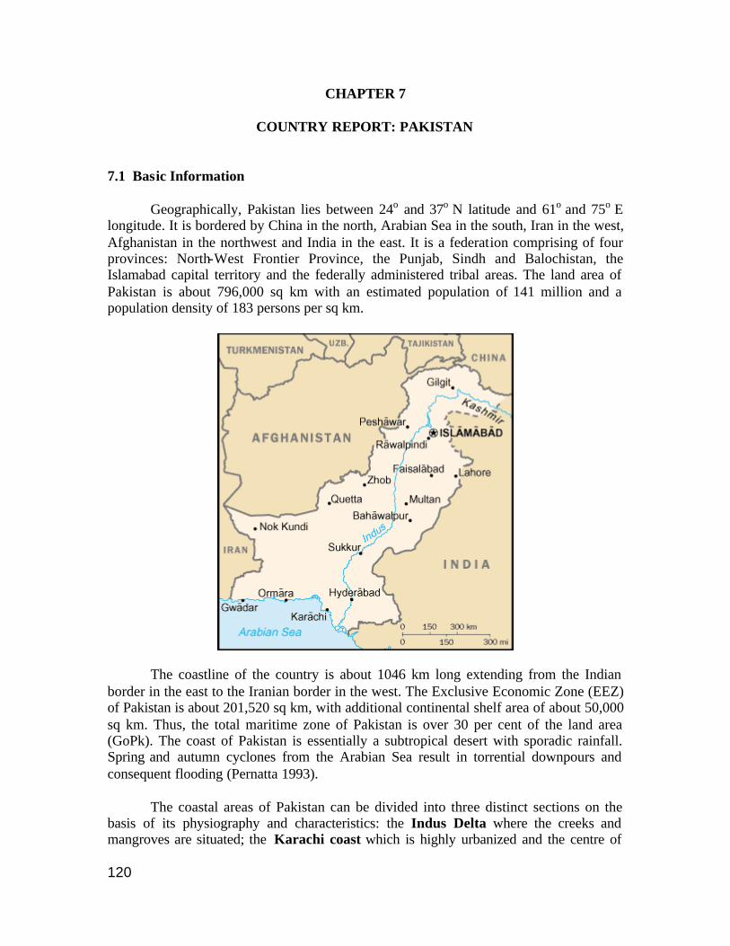
120
CHAPTER 7
COUNTRY REPORT: PAKISTAN 7.1 Basic Information Geographically, Pakistan lies between 24o and 37o N latitude and 61o and 75o E longitude. It is bordered by China in the north, Arabian Sea in the south, Iran in the west, Afghanistan in the northwest and India in the east. It is a federation comprising of four provinces: North-West Frontier Province, the Punjab, Sindh and Balochistan, the Islamabad capital territory and the federally administered tribal areas. The land area of Pakistan is about 796,000 sq km with an estimated population of 141 million and a population density of 183 persons per sq km.
The coastline of the country is about 1046 km long extending from the Indian border in the east to the Iranian border in the west. The Exclusive Economic Zone (EEZ) of Pakistan is about 201,520 sq km, with additional continental shelf area of about 50,000 sq km. Thus, the total maritime zone of Pakistan is over 30 per cent of the land area (GoPk). The coast of Pakistan is essentially a subtropical desert with sporadic rainfall. Spring and autumn cyclones from the Arabian Sea result in torrential downpours and consequent flooding (Pernatta 1993). The coastal areas of Pakistan can be divided into three distinct sections on the basis of its physiography and characteristics: the Indus Delta where the creeks and mangroves are situated; the Karachi coast which is highly urbanized and the centre of
121
industrial activities and the Balochistan coast which constitutes about 75 per cent of the coastline and which is sparsely populated and under developed. The Balochistan coast consists largely of sandy beaches only a few yards wide at high water backed by high vertical cliffs or occasionally by sandy plains or dunes. The Sind (Indus delta) coast is relatively shallow and flat-bottomed (Pernatta 1993). More than half of the coastal population of 180,000 lives in the coastal fishing towns of Ormara, Pasni, Gwadar and Jiwani. There is uneven distribution of development in the coastal zones. For example, the Karachi coast is heavily urbanized and industria lized having good infrastructural facilities and is under severe threat of over utilization of resources. In Balochistan, the coastal population subsists on primitive means of support (ESCAP 1995). The main industrial activity along the coast is concentrated mostly along the coast of Karachi in Sind and extends to the adjacent coasts of Hub and Gadani in southern Balochistan (Amjad and Rizvi 2000). Traditional coastal agriculture that included production of red rice has declined with increased seawater intrusion making the coastal land too saline. Hence the local populace survives mainly on subsistence catch of marine fish and shrimp for their food. They also consume wheat and rice from upcountry, products from mangrove forests and wild life. The coastal and marine areas of Pakistan produce about 596,980 mt of marine fish and 25,000 mt of shrimp while it exports about 131,000 mt of fish worth Rs. 7.272 billions (MFD). Pakistan is a net exporter of shrimps, lobsters, crabs, molluscs, fish and fishing products. The total landing for small pelagics, large pelagics, demersal fish and shellfish in 1998 accounted for 433,456 mt. 7.2 Coastal Landforms 7.2.1 Mangroves The mangrove forest ecosystem of Pakistan is the largest in arid climates with 97 per cent of it (about 160,000 ha) located in the Indus Delta of the Sind province, and the remaining three per cent on the Makran coast in Balochistan. Only 16 per cent of Pakistan’s mangroves are considered healthy. Until the early 1980s, mangroves grew all along the 240 km coastline, occupying an area estimated at 600,000 acres covering approximately 40 per cent of the entire tidal belt and 10 per cent of the Indus Delta fan. The rate of degradation in the Indus delta has been estimated at 6 per cent in thirteen years. Others - like Dr.Shahid Amjad of the National Institute of Oceanography - see this as a gross underestimation. According to Dr. Amjad, more than half of the Indus Delta mangroves have disappeared since the early 1980s. Eight mangrove tree species are reported to have existed in Pakistan, however only four can be found now. Of these, Avicennia marina occupies 95 per cent of the total mangrove area. Ceriops and Rhizophora are the other important species but are fast disappearing because of the uncontrolled cutting of trees for firewood and fodder needs that has accelerated the degradation of swamp forests. The Outer Indus Delta is considered as a wetlands area of international importance as it is the main fish and shrimp nursery on which Pakistan’s fishing industry depends.
122
The presence of Avicennia marina along the shore is reported to ensure the firm and stable formation of shorelines and creeks (Khalil 1999). The location of Port Qasim, Pakistan's second largest port in the vicinity of the Korangi/Phitti creek system, may be attributed in large measure to the natural protection it gets from mangroves. Also, the mangroves play an important role in absorbing the pollutants (industrial and domestic) generated by Karachi.
7.2.2 Beaches Southwest of Karachi, a 20 km beach (Hawkes Bay and Sandspit beaches) stretches west from Manora point at the mouth of the Karachi harbour. It is backed by creeks and shallow tidal lagoons with mudflats and mangroves. The beaches of Hawkes Bay and Sandspit host the nesting of the green turtle (Chelonia mydas) and the olive ridley turtle (Lepidochelys olivacea). In 1979, a conservation project was initiated at these sites to protect the nesting females, their eggs and hatchlings from predators (mainly feral dogs) and poachers. In addition, marine turtles have been declared 'endangered' and are legally protected under the Sind Wildlife Protection Ordinance (1972) and the Sind Wildlife Protection Act (1993). Many threats exist in the region including: beach development, fishing activities, noise from neighbouring villages, pollution from a nearby harbour and exploitation of turtle products (Asrar 1999).
7.2.3 Coral Reefs In Pakistan, the environmental conditions are not favourable for coral growth, and only isolated, small patches of living coral colonies are found on hard substrates. Live corals have been recorded at several locations along the coast, to a depth of 20 m. Land based pollution, sewage, industrial effluents, sedimentation and dredging are the main problems for reefs in Pakistan’s coastal waters. Corals are also collected by local fishermen for use in traditional Islamic medicine. Near Churna Island, destructive fishing methods contribute to the degradation of the marine environment (Kazmi and Kazmi 1997). Parts of Balochistan’s coastal and offshore areas contain coral communities in patches at Astola Island and Gwadar, where a vast fossilized coral reef is present. The Gwadar area is being excavated for construction material for various development projects and it is feared that the unique features of the Makran coast will be destroyed if the present scale of excavation is continued (Amjad and Rizvi 2000). 7.2.4 Tidal flats Part of the Rann of Kutch, a coastal tidal salt desert is located in Pakistan. Here salt production is the main activity during the dry season, since the area is inundated during the rains. 7.2.5 Estuaries, Deltas, Rivers and Sediment Transport The Indus is the main river discharging about 200 cubic km of water and 450 million tones of suspended sediment annually. It is about 2,900 km long with a catchment

123
area of about 963,500 sq km. The river and its tributaries are used extensively in irrigation. Dams upstream have slowed the movement of sediment. It is estimated that barely a fifth of the sediment flow of the year 1940 reaches the Indus estuary today and this may lead to coastal erosion (Pernatta 1993). According to another estimate, annual alluvial flow has decreased from 200 million tons in 1955 to a current flow of less than 50 million tons at the Kotri. Lack of sediment also affects the mangroves negatively (Khalil 1999). It is likely that flushing of harbours and ports may be ineffective leading to build up of some contaminants. Damming of the Indus River upstream at several places for agricultural irrigation and power generation has virtually cut off the flow of water to the delta region. According to an estimate the mangroves in the delta region of the Indus require a minimum 10 million acre feet (MAF) of water to support the mangrove vegetation and the mangrove system as a whole and this is met only in the southwest monsoon season. During the dry periods, the coastal Indus deltaic region has higher water salinity, which has resulted in a shift from estuarine fauna to salt-water fauna. Seawater intrusion has also increased with reduced freshwater flow in the Indus River rendering coastal lands unfit for agriculture.
7.2.6 Coastal Lagoons Miani Hor at Sonmian Bay and Khor Kalmat located along Balochistan coast are two tidal lagoons. Miani Hor is large lagoon with a narrow and shallow connection with the open sea which restricts the water exchange. Two seasonal rivers fall into this lagoon and help in maintaining a good growth of mangrove forest and also support good fisheries particularly of white jumbo prawns. Khor Kalmat supports mangroves and a variety of marine organisms endemic to Balochistan coast. Oil pollution from the open sea is currently the only threat (Amjad and Rizvi 2000).
7.3 National Environmental Policy Pakistan’s Environmental Policy (GoPk) is based on a participatory approach for achieving the objectives of sustainable development through legally, administratively and technically sound institutions. The National Conservation Strategy of Pakistan (NCS) was adopted in 1992. The NCS provides a broad framework for addressing environmental concerns in the country. It comprises 14 core areas, namely, integrating population and environment programmes, supporting institutions for the common resources, preserving cultural heritage, preventing and abating pollution, conservation of bio-diversity, increasing energy efficiency, restoring range land and improving livestock, maintaining the soil in croplands, increasing irrigation efficiency, protecting watersheds, supporting forestry and plantations and protecting water bodies and sustaining fisheries, developing and deploying renewable, and managing urban waste. The Balochistan Conservation Strategy (BCS 2000) was prepared by the government of Balochistan with the technical assistance of the IUCN. The BCS focuses on an action programme to be implemented over the next 10 years. An Integrated Coastal Zone Management Plan (ICZMP) to address the socio-economic aspects as well as biodiversity conservation is proposed.
124
7.4 Note about PADH for the Country The greater part of the Pakistani coastline is sparsely inhabited lacking in essential infrastructure such as roads, drinking water and sanitation, education and health care facilities and power supply. Only a few coastal towns have some limited civic facilities. The megalopolis of Karachi is an exception. Reduction in freshwater reaching the delta regions of the Indus resulting in alteration of Pakistan’s mangrove forests and the effects of the city of Karachi appear to be major coastal problems. Mangrove forests are destroyed by overgrazing, clear-cutting and also because of the reduced sediment and water flow in the Indus River. Such alteration and/or destruction of habitats can have livelihood implications on the local populace. For example increased salinity in the river has caused a shift towards marine fauna from the original estuarine species, and salinizaton of land has rendered it unfit for cultivation. 7.5 Umbrella Environmental Legislation The Ministry of Environment, Forestry and Wildlife was established in 1994 and later renamed as Ministry of Environment, Local Government and Rural Development. A Federal Minister heads the Ministry while the Secretary holds the administrative charge. An Additional Secretary is responsible for different sections dealing with environment, forestry, local government and urban affairs. A National Conservation Unit is responsible for coordination of implementation of the country’s Conservation Strategy. The Local Government Wing of the Ministry comprises of Local Government and Rural Development sections. The Local Government wing deals with the matters pertaining to new local government system introduced on 14th August 2001. The Rural Development side deals with the infrastructure development programmes primarily in rural areas such as Khushhal Pakistan and donor-assisted rural roads projects. The Pakistan Environmental Protection Council (PEPC) was first constituted in 1984 under section 3 of the Pakistan Environmental Protection Ordinance, 1983 with the President as its Chairman. In 1994, an amendment was made in the Ordinance to provide for the Prime Minister or his nominee to be the head of the Council. The Council was reconstituted after enactment of the new law, i.e., Pakistan Environmental Act 1997. The Pakis tan Environmental Protection Council is an apex statutory body with the Chief Executive as the Chairperson, the Federal Environment Minister as its Vice Chairperson and Governors of all the provinces as its members. Trade and industry, leading NGOs, educational institutions, experts, journalists and concerned ministries are also represented in the Council. (Anon. 2001) The Pakistan Environmental Protection Act was enacted on 6th December 1997 to provide for the protection, conservation, rehabilitation and improvement of environment, for the prevention and control of pollution, and promotion of sustainable development. The Act extends to the whole of Pakistan and its territorial waters and EEZ. The Act particularly focuses on implementation of the policies of the Pakistan Environment Protection Council, delegation of powers to government agencies,
125
enforcement of National Environmental Quality Standards, introduction of EIA/IEE (Environmental Impact Assessment/Initial Environmental Examination) review procedures/system, regulatory regime for hazardous substances/wastes, resource generation through establishment of Provincial Sustainable Development Fund and levy of Pollution Charge and providing appellant forum for environmental cases. The Act defines the various terms including “EIA”, “IEE”, local authority, project and standards. “Project” means any activity, plan, scheme, proposal or undertaking involving any change in the environment and includes
a) Construction or use of building or other works b) Construction or use of roads or other transport systems c) Construction or operation of factories or other installations d) Mineral prospecting, mining, quarrying, stone crushing, drilling and the like e) Any change of land use or water use; and f) Alteration, expansion, repair, decommissioning or abandonment of existing
buildings or other works, roads or other transport systems, factories or other installations.
The Act reconstituted the Pakistan Environment Protection Council, and the Pakistan Environmental Protection Agency. This agency administers and implements this Act and the rules and regulations made. Each province has an environmental protection agency and the heads and the Director Generals of these agencies are members of the National Environmental Coordination Committee. The section about IEE and EIA says: (1) No proponent of a project shall commence construction or operation unless he has filed with the Government Agency designated by the Federal Environmental Protection Agency or Provincial Environmental Protection Agencies, as the case may be, or where the project is likely to cause an adverse environmental effect, an environmental impact statement, and has obtained from the Government Agency Approval in respect thereof. (3)Every review of an environmental impact assessment shall be carried out with public participation (with some defined exceptions) (7)The Government Agency shall maintain separate registers for IEE and EIA projects, which shall contain brief particulars of each project and a summary of decisions taken thereon, and which shall be open to inspection by the public at all reasonable hours and the disclosure of information in such registers shall be subject to the restrictions specified in subsection 3 Some rules and regulations notified under this law include the following: i) National Environmental Quality Standards (Self-monitoring and Reporting by
Industries) Rules, 2001 ii) Environmental Samples Rules, 2001 iii) Pollution Charge for Industry (Calculation and Collection) Rules, 2001
126
iv) Hazardous Substances Rules, 2000 v) National Environmental Quality Standards (Environmental Laboratories
Certification) Regulations, 2000 vi) Pakistan Environmental Protection Agency (Review of IEE/EIA Regulations,
2000) The Ministry of Environment, Local Government and Rural Development had delegated its functions and powers and those of the Federal Environmental Protection Agency to the Provincial Governments. The Provincial Governments have further delegated these powers and functions to provincial environmental protection agencies and are also planning to sub-delegate selected powers to the local governments. The Pakistan EPA has developed the following sector specific EIA guidelines to facilitate project proponents:
o Major thermal power stations o Major roads o Major chemical and manufacturing plants o Oil and gas exploration and production o New township development o Water supply projects o Industrial estates o Municipal waste disposal o Sewerage schemes
7.6 Focus on the Coast The Ministry of Environment, Local Government and Rural Development is responsible for overall policy, planning, coordination and implementation/execution of various activities in this sector. Protection of High Seas, territorial waters and Port related matters; respective Port authorities are responsible for administration and management. A Marine Pollution Control Board has been established to handle matters, which are related to marine life and environment and resources at risk; to provide advisory services to relevant organizations; and to review monthly progress in combating and controlling marine pollution (JoBurgPk 2002). Concern about the coastal zone has increased over the years. The coastal areas except for Karachi have remained undeveloped because of their desolateness and relative non-availability of resources. An International Workshop on Integrated Coastal Zone Management was organized by the Ministry of Science and Technology in October 1994 in Karachi (IOC 1994). The Workshop evaluated the impact of socio-economic development in coastal areas of Pakistan and drafted guidelines for the integrated coastal zone management planning process so as to ensure sustainable development of marine resources and adequate protection of the marine environment for future generations. Apart from paper presentations, working groups deliberated on defining the coastal zone, the problems in the coastal zones and the need for capacity building. The following
127
section is taken from the report of the working group which discussed the definition of the coastal zone. Definition of Coastal Zone: The Working Group defined the landward boundary of the coastal zone as follows:
(i) Balochistan: 5 km inland from the highest astronomical tide (HAT) mark; (ii) Karachi city: the entire inhabited part of the city to be included within the
coastal zone. This landward boundary was considered to be an especially dynamic boundary, which would be reviewed periodically (perhaps every five years) to include new areas that should come under the purview of ICZM;
(iii) Sind (except Karachi city): 5 km inland from the highest astronomical tide (HAT) mark. This definition would include all areas that are variously influenced by the sea, as discussed above.
For the seaward limit of the coastal zone, since fisheries and fishing practices would become important elements of an ICZM plan, the present fishing limits - extending 35 miles seaward -was considered a convenient boundary for management purposes on the Balochistan coast. The seaward boundary on the Sind coast can be placed more conveniently at the shelf edge at 200 m water depth, since much of this shelf may come under the direct influence of commercial use in fisheries and hydrocarbon exploitation in the near future. Subsequent to the workshop, the Sind Coastal Development Authority Act was enacted in 1994 and the Balochistan Coastal Development Authority Act was passed in 1998. The Balochistan Conservation Strategy has proposed an ICZMP to address the socio-economic sufferings of the local people as well as conservation of vulnerable coastal biodiversity. Balochistan is the largest province of Pakistan with the maximum coastal area but is only now being developed in parts (Gwadar and Makran) (BCS 2000). 7.7 Major Coastal Activities causing habitat alteration 7.7.1 Shrimp Aquaculture The Activity A considerable part of Indus delta, 192,000 hectares, is shown to be suitable for shrimp farming, based on the surveys and results of experimental shrimp farming undertaken by the National Institute of Oceanography (NIO). Through semi- intensive shrimp farming it is possible to produce a crop of shrimp Penaeus merguinsis of the order of about 800 million kg/year from an area of about 92,000 hectares, and through practicing extensive shrimp farming technique some 81 million kg/year on an area of 100,000 hectares. It is estimated that the shrimp farming in the Indus delta has the potential of generating 20 million US dollars of shrimp exports per year on a two crop basis (IOC 1994).

128
Legislation No information available. 7.7.2 Tourism The Activity Beach tourism is not much developed and the local population goes to the beach mainly only on holidays. A number of beach huts were built during the 1960s and 1970s along the coasts of Sandspit, Hawksbay and Paradise Point but many have fallen into disrepair. Legislation No information available. Policy The tourism policy recognizes tourism as an industry but does not specify coastal tourism. Apart from tax incentives, the policy states “On the recommendations of the Ministry of tourism, land for hotels, motels, recreation parks, fun lands, athletic clubs, cultural centres etc., is to be provided at non-commercial rates and on long lease basis by the development authorities at the Federal and Provincial Levels. 7.7.3 Coastal Mining The Activity Sand mining on the riverbed appears to be a localized and reportedly “illegal” though not much information is available. Illegal sand mining from the riverbeds of the River Malu was a major problem contributing to the desertification of the area. The Society for the Conservation and Protection of the Environment (SCOPE) undertook scientific surveys and organized a series of public hearings and press briefings to attract the attention of government, media and NGOs. These efforts helped in halting sand mining (Arif). Legislation Mining regulations include West Pakistan Regulation of Mines and Mineral Development Act, 1958 and Balochistan Mining Concession Rules, 1970.

129
7.7.4 Ports and Infrastructure Facilities The Activity Pakistan has two major operating Ports – Karachi and Port Muhammad Bin Qasim (PQA). The dredging activities for the navigational channels of Port Qasim and Karachi Port have changed the hydraulic regime, water circulation and water exchange patterns in the affected areas within the port and in the adjacent coastal area under their influence. The Karachi Port is mostly polluted by non-port-related activities. An estimated 90,000 tons of oil products from vessels and the port’s terminals are dumped every year in the port’s water. To address the problem, a green belt around Karachi Port is being implemented. The project includes planting 150,000 mangroves and 350,000 various other plants. An allocation of Rs.350 million was distributed among Marine Pollution Control Centre which handles emergency oil spills and Marine Environment Unit to monitor water, air, sediment and biota quality. PQA is an Industrial deep-sea port having 12000 acres of Industrial land and 64,000 hectares of mangroves. The Coastal area within PQA’s jurisdiction is cleaner as compared to Karachi Port, but it has inherent threat of marine and air pollution from its Industrial estate and surrounding areas. Large area of Islands and mangroves have been washed away and need to be protected (JoBurgPk 2002). A deep sea port is being constructed in Gwadar in Balochistan, with Chinese help. The Phase I of the Gwadar port project, after completion, will have 3 multipurpose berths and related facilities will be constructed to accommodate 50,000 DWT vessels (Anon 2002a). All types of construction works and property deals in and around Gwadar port have been banned and a master plan for the Gwadar Port Project and the Karachi-Gwadar Coastal Highway is being prepared so that unplanned construction does not take place in the area (Anon 2002b). Legislation Karachi Port Authority governs activities of the port. Discharges that can cause pollution are governed by the PEPA. 7.7.5 Other Activities/Resources I. Agriculture Of the 79.6 million hectares land area, only about 22 million hectares (23 per cent) are available for cultivation of which 18 million hectares are irrigated and 4 million hectares are rain-fed. The cropped area has increased from 14.6 million hectares in 1947-48 to about 22.15 million hectares in 1993-94: a hefty increase of about 52 per cent (UNEP/ICIMOD). Pakistan being a land of subsistence agriculture, the main emphasis is on the production of food crops and that accounts for about 70 per cent of the cropped area. Some cash crops (cotton, sugarcane, tobacco, etc.) are grown to meet other needs.
130
Coastal agriculture is negligible and has gone down in recent times because of the increasing salinity of the soil due to seawater intrusion and declining water levels in the rivers because of upstream dams. II. Fisheries Fisheries provide employment to about 300,000 fishermen directly and to about 400,000 people in ancillary industries. The Federal Government is responsible for marine fisheries beyond the provincial jurisdiction limits of 12 miles from the coast. Freshwater and estuarine fisheries come under provincial jurisdiction. The existing laws prohibit the capture of certain species of fish below a prescribed size and the use of poison or explosives, regulate fishing craft and fishing gear, and empower the government to designate any water body as a sanctuary. These measures, both in terms of coverage and enforcement, appear inadequate for affording protection to Pakistan’s aquatic biodiversity. III. Forests Near and on the coast, mangrove forests are a primary natural resource of direct value to the economy, and are also important in the protection and sustenance they offer to other key coastal resources. Mangroves are used for construction timber, firewood (both for domestic and for fish/shrimp drying), and for fodder, mainly for camels. It is estimated that in the Thatta coastal belt alone in the Indus delta, 6000 camels and 3,200 buffaloes used the resources of this ecosystem and consumed 67 million kg of leaves and 9.5 million kg of grass till 1998 (Anon 2002c). Mangroves also provide shelter and nurseries for commercial fishery species and some coastal species such as shrimps (Khalil 1999). The current draft National Forest Policy of Pakistan 2001, highlights the need to conserve and develop the renewable natural resources, such as forests and biodiversity of Pakistan. This draft policy seeks to initiate a process for eliminating the fundamental causes of the depletion of renewable natural resources through participation of all the concerned agencies and stakeholders, to enable the sustainable development of the resources in the form of an umbrella policy which guides the provincial and district level policy processes. IV. Industry and Settlements: Land Use
The Karachi area is highly industrialized and the effects of industrialization are evident in the quality of the ecosystems around. Power generation plants (mainly thermal and nuclear) are built along the coast because of the need for intake of large amounts of coolant water and the discharge of waste water at higher temperatures. It is estimated that about 20 million cubic metres of water per day is sucked in by the power plants which appears to be a major environmental concern (Amjad and Rizvi 2000). Ship breaking, till recently, was another major industry but heavy duties and other levies have currently led to its decline.
131
Land reclamation seaward has been restricted to coastal urban cities mainly for housing. Approximately 4000 ha have been reclaimed along the coast of Clifton in Karachi and reclamation of an additional 3000 acres of land reclamation is planned by a housing society. Much of the sediment for land-filling is obtained by dredging nearby sediments from the coastal area. This alters the near shore bathymetry which in turn disturbs the hydraulic regime resulting in increased rates of coastal sediment erosion or accretion. This happens especially during the south west monsoon causing seawater spillover on the land side affecting the coastal private and public properties. Contaminants get re-suspended because of transportation of sediments from one site to another and this also results in smothering of benthos. Tidal drains and weirs constructed to drain excess water have resulted in the drying up of some creeks and the development of new creeks and have also caused changes in salinity levels and the erosion/accretion levels (Amjad and Rizvi 2000). The Ministry of Environment, Local Government and Rural Development is responsible for the planning and management of land resources in terms of environment protection and conservation. However, the Land Revenue Department under the administrative control of the provincial governments is responsible for management and administration of the land tenure system in Pakistan. The provincial Forests Departments has got ownership right over most of the state control forests areas and is also responsible for administration of community forests in Pakistan (JoBurgPk 2002). The Land Acquisition Act of 1894 has been the most commonly used law for acquisition of land and other properties for development projects. It lays down detailed procedures for the acquisition of private properties for public purposes and their compensation. Laws of the provincial governments and others such as the CDA 1960 which provides legal cover to the Capital City, govern urbanization and settlements.

132
7.8 References Amjad, S and S H N Rizvi 2000, Pakistan’s National Programme Of Action For The Protection Of The Marine Environment From Land-Based Activities (Under The Global Programme Of Action). Draft submitted to SACEP. Anon. 2001. Environmental Challenges and Responses. http://www.environment.gov.pk Anon 2002a. Work in full swing on Gwadar Port, coastal highway projects . The Nation, 5 June, 2002. Anon 2002b. Construction around Gwadar port banned. The Dawn, 23 June, 2001. Anon 2002c. Thatta:Livelihood of coastal people threatened. The Dawn, 12 August, 2002. Arif T, Implementing Agenda 21 locally: Pakistan http://ngls.tad.ch/english/pubs/21/21_15.html accessed August 14, 2002. Asrar, F F 1999. Decline of Marine Turtle Nesting Populations in Pakistan. Marine Turtle Newsletter 83:13-14 . BCS 2000. Balochistan Conservation Strategy. http://www.bcs.sdnpk.org/overview2.htm accessed Aug 13, 2002. ESCAP 1995. ESCAP Activities in Coastal and Marine Environmental Management, Paper no.6, ESCAP/ADB/UNEP Workshop on Coastal and Marine Environmental Management, March 27-29, 1995, Bangkok. GoPk, National Institute of Oceanography, Introduction. http://www.niopk.gov.pk/intro-1.html accessed 3 July 2002 IOC 1994. Intergovernmental Oceanographic Commission Workshop Report No. 114 International Workshop on Integrated Coastal Zone Management (ICZM), Pakistan. Organized in Co-operation with the National Institute of Oceanography. Ministry of Science and Technology, Government of Pakistan. Karachi, Pakistan October 10-14 1994. JoBurgPk 2002. Pakistan. Country Profile submitted for the Johannesburg Summit. www.un.org/esa Kazmi & Kazmi, 1997. quoted in Rajasuriya A, M.H. Maniku, BR Subramanian and J Rubens. Status Reports From Different Regions : Coral Reef Ecosystems in South Asia. In O. Linden and N. Sporrong, “Coral Reef Degradation in the Indian Ocean Status report and project presentations 1999”. CORDIO, SAREC Marine Science Program, Department of Zoology, Stockholm University, 106 91 Stockholm, Sweden. Khalil, S 1999, Economic Valuation Of The Mangrove Ecosystem Along The Karachi Coastal Areas. In Joy E. Hecht, ed., The Economic Value of the Environment: Cases from South Asia, IUCN 1999. Available at http://www.iucnus.org/publications.html. MFD Statistics quoted in Amjad and Rizvi 2000. Pernetta, J. C.(Ed.) 1993, Marine protected area needs in the South Asian Seas Region. Volume 4: Pakistan. A Marine Conservation and Development Report. IUCN Gland, Switzerland. vii+42 pp. UNEP/ICIMOD 1998. Land Cover Assessment and Monitoring: Pakistan. Volume 10-A. International Centre for Integrated Mountain Development (ICIMOD) and UNEP Environment Assessment Programme for Asia and the Pacific, Bangkok, 1998.

133
CHAPTER 8
COUNTRY REPORT: SRI LANKA
8.1 Basic Information Sri Lanka is an island state situated off the southeastern coast of the Indian peninsula in the Indian Ocean. Nearly 20 million people live on a land area of 65,610 sq km. The country has a coastline of 1,562 km. The coastline itself consists of a wide range of geomorphologic features such as headlands, bays, lagoons, peninsulas, spits, bars, and islets. It encompasses a variety of tropical habitats including wetlands; lagoons and estuaries; mangroves, salt marshes, and sea grass beds; coral reefs; and coastal sand dunes, barrier beaches, and spits.
The coastal area accounts for about 25 per cent of the land area, 32 per cent of the population and 65 per cent of the urban population. 90 per cent of its industrial units and 80 per cent of tourist infrastructure are located in the coastal zone leading to depletion of coastal resources (UNEP 2001). The nation’s principal transportation structure is located within the coastal zone. The country can be divided into two climatic zones – wet and dry. Population is unevenly distributed with greater concentration in the wet zone, thus showing extensive variation in density with 46 people per sq km in the northeast to almost 2900 per sq km in Colombo district on the west coast. The habitats critical for sustained production of fisheries, coral reefs, brackish wetlands and some of the richest bio-diversity reserves are located in the coastal zone.

134
The country is surrounded by a continental shelf about 22 km wide except along the north west and northern coasts opposite the Indian subcontinent. A large number of river basin estuaries and lagoons, many of which are lined with mangroves, cover about 160,000 ha. Sri Lanka has 103 main river basins and 93 coastal watersheds. The total extent of coastal wetlands is about 200,000 ha (SL/RAMSAR). A key coastal problem for Sri Lanka is coastal erosion. The beaches remain stable through a natural process of rivers carrying sand into the sea and the returning waves replenishing this sand. This balance is disturbed when large quantities of sand are extracted from the rivers (Olsen et al 1992). Thus, in addition to natural causes of coastline erosion, an added problem of sand not being available for beach replenishment makes the problem worse. Coastal erosion in Sri Lanka is most severe along the western and southwestern coasts and results in damage to or loss of houses, hotels and other coastal structures, undermines roads, contributes to the loss of land and disrupts fishing, navigation, recreation and other activities. About 175,000 to 285,000 square metres of coastal land in the south, southwest and the west coast are lost each year (Senaviratne). The principal causes of erosion include both natural process due to monsoon generated wave attacks and anthropogenic changes due to extraction of sand and corals from the coastal zone and improperly sited buildings and maritime structures. Control of coastal erosion has been an integral part of the CZMP. The 1989 Master Plan for Coastal Erosion revealed that more than 49,000 metres of revetment and 6,360 metres of groynes have been constructed. However, many of these have been constructed on an ad hoc basis and are believed to have increased erosion.
8.2 Coastal Landforms 8.2.1 Mangroves There are 14 species of true mangroves and 12 species of mangrove associates. The most extensive mangroves occur in Puttalam-Kalpitiya area in association with estuaries. Dense localized stands also occur in association with estuaries in the southern, southwestern and northeastern coasts, for example, Koggala lagoon, Kalametiya lagoon, and Kokilai lagoon (CCD-Mangroves). Estimates of mangrove cover in Sri Lanka range from a low of 6000 ha to a high of 13000 ha. The Coast Conservation Department inventory estimated a total of 12,189 ha of mangroves (CCD 1990). Mangroves support various activities. Non-extractive uses include: coastal stabilization; role as nurseries and feeding grounds for many fish species; and for research and education at various levels (schools to universities). Mangrove harvest is sold as firewood at urban centres (for example, Jaffna), and for firing of bakeries (for example, Puttalam), kilns (Batticaloa) and illicit distilleries (for example, Chilaw). Mangroves are also harvested for construction, as green-leaf manure, brush pile fishing etc. Land reclamation by clearing mangrove patches for coconut and paddy cultivation, settlements and coastal aquaculture is also increasing.
135
8.2.2 Beaches Dunes, barrier beaches and spits play an important role in coastal protection and sand supply. Prominent spits occur along the western and eastern coasts forming in the direction of longshore drift. Some of these beaches as in Kosgoda serve as nesting areas for sea turtles. Despite being fully protected under Sri Lankan and international law (Sri Lanka is a member of CITES) sea turtles are seriously threatened with extensive exploitation and habitat destruction especially along the southwestern coast (Richardson 2001). An action plan for marine turtle conservation has been prepared by Sri Lanka. The main parties involved in preparation were National Aquatic Resources Agency (NARA), Department of Wild Life Conservation, Turtle Conservation Programme (TCP) and IUCN. NARA has prepared a grading system based on turtle nesting density, nesting rate and nesting diversity for the sea turtle nesting beaches of the island. It was recommended that beaches of grade 1 and 2 be declared as protected areas as critical sea turtle nesting habitats. These beaches were Kosgoda, Rekawa and Welipatanwila. Studies revealed that the good nesting beaches are mainly located in the district of Galle and Hambantota (Amarasooriya 2000). Extensive dune systems occur along portions of the southern, northeastern and northwestern coasts as between Mullaithivu and Point Pedro, and Ambakandawila, Kalpitiya, Kirinda and Sangamakande Points (CCD 1997). Beaches have been traditionally used by fisherfolk for landing of fishing craft, drying of fish and gear, defecation and housing. Current and rapidly emerging uses include coastal tourism and recreation. Mining of beach sand is a major use with construction being an expanding activity in several locations. 8.2.3 Coral Reefs Fringing reefs occur along an estimated 2 per cent of the Sri Lankan coastline while offshore reefs occur in places like Silavathurai and Vankalai in the Gulf of Mannar and along the east coast. Corals have also colonized many sandstone and rocky shallow areas, particularly in the southeast. There are 183 coral species in 68 genera and over 300 species of reef fish in 62 families. The healthiest reefs are the offshore patch and sandstone reefs, where live coral cover on some reefs (including a few undamaged nearshore reefs) is over 50 per cent. Most of the nearshore reefs have low coral cover. Most of these reefs are reported to have suffered extensive bleaching and coral death during the major bleaching event of mid-1998, with losses in coral cover of approximately 80–90 per cent on some fringing reefs along the southern coast (Rajasuriya and White 1998). Coral reefs are important for the spatial heterogeneity they provide and this is lost when corals are broken or removed. Human activities are a major cause of reef damage. These activities include direct destruction by coral mining as well as indirect effects such as flow of sediments due to deforestation, poor agricultural practices, tourism and urban
136
development. In addition, northwest and east coast reefs are under persistent attack from the crown-of-thorns starfish, and large areas of the coast are naturally eroding because of monsoon waves from the Indian Ocean. Rock and concrete structures have been built to protect beaches, vegetation, and human development, and the threat of sea level rise is a major concern. An estimate of the minimum economic value of coral reefs in Sri Lanka was placed at USD 140,000-7,500,000 per sq km of reef over a 20-year period (Berg et al 1998). Cost benefit analysis indicated that economic costs exceeded net benefits by as much as USD 6,610,000 per sq km of reef in tourist areas. However, in rural areas the incentive for coral mining was high as in the short term, being more profitable than fishing or agriculture.
8.2.4 Tidal flats (Salt marshes) Salt marshes in northern Sri Lanka occur on exposed tidal flats and in the south, largely in the shelter of sand dunes. The major functions include nutrient supply to nearshore coastal waters, provision of bird habitat, supply of seed fish for coastal aquaculture and as a discharge area that absorb storm runoff. Major extractives uses are the construction of salt pans (Hambantota, Trincomalee and Puttalam districts), and for coastal aquaculture (Puttalam district).
8.2.5 Estuaries, Deltas, Rivers and Sediment Transport The average annual river flow is about 40,680 million cubic metres. 103 distinct river basins cover 90 per cent of the land. There are 93 coastal watersheds. The Mahaweli is the longest river draining about 16 per cent of the country. 8.2.6 Coastal Lagoons The Coastal Management Plan has identified 44 major estuaries or lagoons. These often serve as nurseries and support many commercially important aquatic organisms. The Rekhawa and Negumbo lagoons are important shrimp nursery areas. With many lagoons close to urban areas, the threats include changes in sedimentation patterns and salinity regimes, waterborne pollutants, destruction of submerged or fringing vegetation and inlet modifications.
8.3 National Environmental Policy
In 1988, the Sri Lankan Government adopted the National Conservation Strategy as the National Policy in relation to conservation of natural resources in Sri Lanka. A separate Ministry for Forestry and Environment was set up in 1990. Subsequently, a National Environment Action Plan was prepared in 1994 and updated in 1998 to identify the issues and necessary policy interventions relating to land and water, forest and
137
biodiversity, coastal and marine resources, industrial and urban pollution and the energy and mineral sectors. 8.4 Note about PADH for the country Coastal erosion has always been a major cause for concern with natural processes such as storm surges causing erosion mainly along the southwestern coast. To this, anthropogenic causes have been added. Industries (since the 1950s), beach tourism (since the 1960s), a rapidly growing population and the consequent demand for resources, increase in construction activities requiring sand and coral – all these have been implicated in unregulated use of coastal resources and hence their degradation. The need for better coastal management practices became evident especially after the 1970s. Until the Coast Conservation Act was put in place in 1981, the emphasis was on coastal protection by means of planned engineering works. Subsequently the focus has been on coastal zone management in its entirety. 8.5 Umbrella Environmental Legislation In 1990, a separate Ministry (Ministry of Environment and Natural Resources) was established to formulate policies and to address and coordinate all matters relating to the environmental management. The NEAP is the basic guidance document and is regularly updated by the Ministry through a consultative process involving all stakeholders. The overall approach of the government is to use a combination of policies and strategies. These include regulation, adjustment of macro economic policies, and establishment of a dialogue with the private sector in order to strike the right balance between economic development and environmental protection. The provision of incentives to industry to adopt environmentally friendly technologies, the integration of environmental concerns into projects and programmes and the adoption of the concept of “real value” of natural resources are important components of the overall environmental protection framework for the country (UNEP 2001). National Environmental Act No. 47 of 1980. This act established a Central Environmental Authority (CEA); made provision with respect to the powers, functions and duties of the authority; and made provision for the protection, management and enhancement of the environment and for the prevention, abatement and control of pollution. The Act defines terms such as environment, environmental impact assessment report, pollutant and local authority. The CEA is specifically charged with the formulation of schemes for effective utilization of land, natural resources, wildlife, forests, soils etc, keeping in mind sustainable development and encouraging citizen participation in conservation activities. The Act also provides for various environmental standards for punitive action against violators.
138
The National Environmental Act (NEA) as amended by Act No. 56 of 1988 is the basic law containing EIA. Part IV C deals with the approval of projects. A number of orders have been made under the NEA.
o Order Under 23Z, list of prescribed projects o National Environmental Regulations No. 1 of 1993, procedure for approval of
projects o Order Under Section 23Y, list of Project Approving Agencies
♦ Part I lists the projects and undertakings if located wholly or partly outside the coastal zone s defined by the CCA of 1981. These include all river basin development and irrigation projects, reclamation of land, conversion of forest areas into non forest uses, mining and mineral extraction, and infrastructure including transportation, port and harbour, fisheries, hotels (exceeding 99 rooms or 40ha).
Sectoral guidelines for implementation of EIA have also been published. The Project Approving Agencies (PAA) are responsible for EIA in concurrence with the PEA (Provincial Environmental Authority). The EIA Process is administered through an inter-agency coordinating committee.
Public participation is contained in the NEA with 30 days allowed for public review. The public comments received are to be sent back for review and response by the proponent who has to respond appropriately by making every effort to modify alternatives including the proposed action, develop and evaluate alternatives not provided etc.
8.6 Focus on the Coast Coastal legislation § Coast Conservation Act No. 57 of 1981. This act was to make provision for a survey
of the coastal zone and the preparation of a Coastal Zone Management Plan, to regulate and control development activities within the coastal zone and to make provision for the formulation and execution of schemes of work for coast conservation within the coastal zone
The Act defines the Coastal Area as follows:
The area lying within a limit of 300 m landward of the mean high water line and a limit of 2 km seawards of the low water line and in the case of rivers, streams, lagoons or any other body of water connected to the sea, either permanently or periodically, the landward boundary shall extend to a limit of 2 km perpendicular to the straight baseline drawn between the natural entrance points thereof and shall include waters of such bodies.
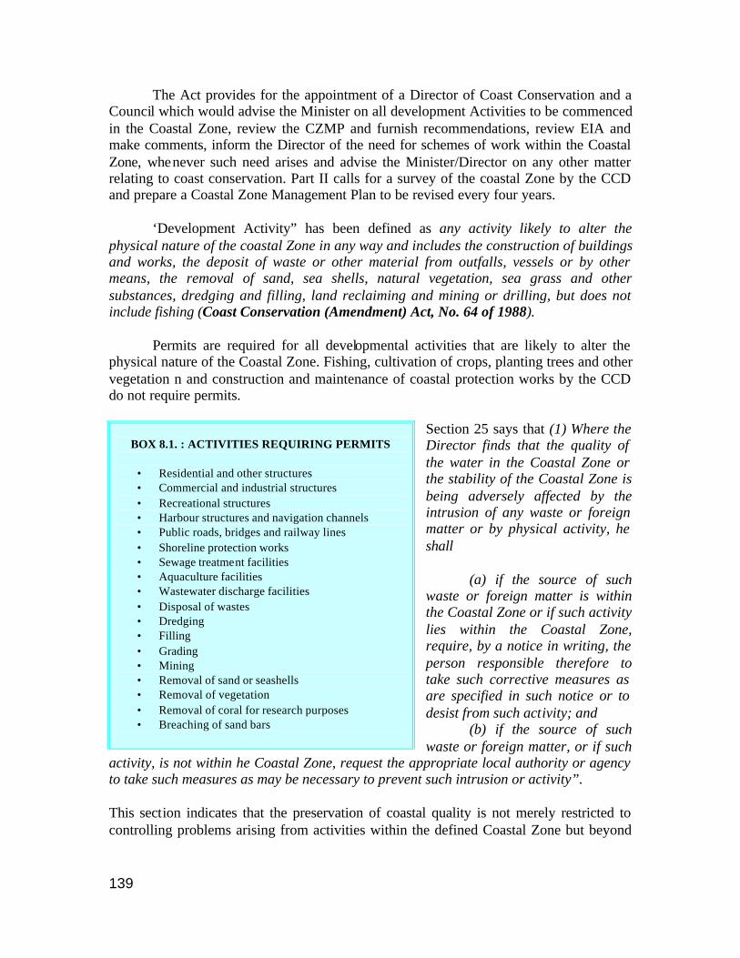
139
The Act provides for the appointment of a Director of Coast Conservation and a Council which would advise the Minister on all development Activities to be commenced in the Coastal Zone, review the CZMP and furnish recommendations, review EIA and make comments, inform the Director of the need for schemes of work within the Coastal Zone, whenever such need arises and advise the Minister/Director on any other matter relating to coast conservation. Part II calls for a survey of the coastal Zone by the CCD and prepare a Coastal Zone Management Plan to be revised every four years. ‘Development Activity” has been defined as any activity likely to alter the physical nature of the coastal Zone in any way and includes the construction of buildings and works, the deposit of waste or other material from outfalls, vessels or by other means, the removal of sand, sea shells, natural vegetation, sea grass and other substances, dredging and filling, land reclaiming and mining or drilling, but does not include fishing (Coast Conservation (Amendment) Act, No. 64 of 1988). Permits are required for all developmental activities that are likely to alter the physical nature of the Coastal Zone. Fishing, cultivation of crops, planting trees and other vegetation n and construction and maintenance of coastal protection works by the CCD do not require permits.
Section 25 says that (1) Where the Director finds that the quality of the water in the Coastal Zone or the stability of the Coastal Zone is being adversely affected by the intrusion of any waste or foreign matter or by physical activity, he shall (a) if the source of such waste or foreign matter is within the Coastal Zone or if such activity lies within the Coastal Zone, require, by a notice in writing, the person responsible therefore to take such corrective measures as are specified in such notice or to desist from such activity; and
(b) if the source of such waste or foreign matter, or if such
activity, is not within he Coastal Zone, request the appropriate local authority or agency to take such measures as may be necessary to prevent such intrusion or activity”.
This section indicates that the preservation of coastal quality is not merely restricted to controlling problems arising from activities within the defined Coastal Zone but beyond
BOX 8.1. : ACTIVITIES REQUIRING PERMITS
• Residential and other structures • Commercial and industrial structures • Recreational structures • Harbour structures and navigation channels • Public roads, bridges and railway lines • Shoreline protection works • Sewage treatment facilities • Aquaculture facilities • Wastewater discharge facilities • Disposal of wastes • Dredging • Filling • Grading • Mining • Removal of sand or seashells • Removal of vegetation • Removal of coral for research purposes • Breaching of sand bars
140
the defined Coastal Zone as well. In brief, activities within the coastal zone prohibited by the CCD are: • Removal of coral other than for research purposes • Mining of sand except in areas identified by the CCD • Development within 200m of designated archaeological sites • Any development activity that will degrade the quality of designated natural areas of
exceptional value For any ‘development activity’ in the coastal zone, the Director may call for an Environmental Impact Assessment (EIA) with respect to the development activity. EIA is defined in the CCA as “a written analysis of the predicted environmental consequences of a proposed development activity, and includes a description of the avoidable and unavoidable adverse environmental effects of the proposed development activity, a description of alternatives to the activity which might be less harmful to the environment of the Coastal Zone, together with the reasons why such alternatives were rejected, and description of any irreversible or irretrievable commitments of resources required by the proposed development activity”. The CCD has also provided guidelines for EIA in coastal areas. 8.7 Major Coastal Activities causing habitat alteration 8.7.1 Shrimp Aquaculture
The Activity
Shrimp farming began in Sri Lanka in the early 1980s (Carlo, Kapetsky and Profeti 1999). After an initial profitable development, disease outbreaks and lack of planning acted as significant constraints on shrimp farming. The locations in the northwest, where almost all shrimp farms are located, were almost saturated. Since small farms (< 4ha) are exempted from EIA, most of the farms are 2-3 ha and encroach into reserved areas. The vegetation existing prior to the development of shrimp farms is reported in the 1984 topographic maps as being mainly composed of low forest, grassland and mangroves; the main agricultural crops were rice and coconuts. The most recent estimate (1999) of shrimp pond surface area based on ERS-SAR satellite data in North-western Sri Lanka is 8846.05 ha ± 885 ha (Carlo, Kapetsky and Profeti 1999). All the shrimp farms developed in Sri Lanka are located in the North Western Province and use Chilaw Lagoon, Dutch Canal, Mundal Lagoon system and Puttalam Lagoon as the water source. More than 70 per cent of the developments are concentrated along the Dutch Canal and Mundal Lagoon system. Most of the established farms do not have the infrastructure and water of required quality to conform to the recommended water exchange rates (Jayasinghe, Corea and Wijegunawardana 1994).
141
Legislation
Fisheries and Aquatic Resources Act No. 2 of 1996: A section of this act deals with the leasing of state lands for aquaculture and calls for licensing of operations. The term “aquaculture” is described to mean “the husbanding of aquatic plants and organisms ranging from the propagation of aquatic organisms under human control to the manipulation of at lest one stage of an aquatic organism’s life for the purpose of increasing production”. Aquaculture enterprise refers to “any area, enclosure, pond, impoundment, premises or structure set up or used for the cultivation of aquatic plants or organisms for commercial purposes and includes any cultivated pearl oyster or other shellfish bed, or raft or other structure used for cultivation of pearl oyster or other shellfish”. Aquaculture Management Regulations of 1996 were made under Section 61 to be read with Section 40 of the Fisheries and Aquatic Resources Act cited above. These regulations direct that no one can set up or operate an aquaculture enterprise without a licence. The number of licences issued in any area may be limited with regard to interests of economy and environment. No irreversible damage to man or environment or any nuisance may result from such enterprises and adequate steps for environmental protection need be taken. The application for aquaculture management licence requires the submission of an environmental protection licence issued under part 4(a) of the NEA and an Initial Environmental Examination (initial EIA) approval, approval from the CCD if applicable and approval from the relevant local authority. The licence has to be renewed every year. National Aquaculture Development Authority Act No. 53 of 1998: Provided for the establishment of the National Aquaculture Development Authority of Sri Lanka, to develop aquatic resources and the aquaculture industry. Technical guidance for shrimp farmers has been prepared and codes of practice for shrimp farming are being prepared. The Central Environment Authority had earlier issued ‘Environmental Guidelines for the Aquaculture Developer’. Amongst other things, the Guidelines covered approval requirements for aquaculture projects, site selection considerations such as the avoidance of mangrove and wildlife conservation areas, pond design and operational considerations including the management of effluent and waste, and monitoring requirements. Significantly, the Guidelines also required that, in the event of abandonment of an aquaculture installation, the operator would be bound to meet the cost of any restoration requirements imposed by the project approving agency (Howarth et al 2001). In shrimp farms, Land rights are enforced by Ministry of Lands’ and Coast Conservation Department, and use of prohibited chemicals enforced under Cosmetics and Drugs Act. Incentives are provided for in respect of credit facilities, relief packages and duty free import of feeds, but it is not clear how these serve as incentives to regulatory conformity (Howarth et al 2001).
142
8.7.2 Tourism The Activity Coastal tourism is recognized to be the most rapidly growing sector of tourism worldwide. The coral reefs fringing the island attract many tourists. For people around the area, this means a variety of business opportunities ranging from setting up hotels to working as tour guides. For example, Hikkaduwa on the south west coast had 300,000 guest nights in 1992. According to the Ministry of Tourism, tourist arrivals in 2000 were 400,414 with 203 hotels and 12,989 rooms. In June 2001 alone, the number of tourists was 28,323 (CTB 2002). Tourism has both discrete and continuous components that cause physical alteration of habitat. The discrete events are the construction of hotels and support facilities along the beaches. Land is cleared for construction while sand and coral mined off the coast are used for construction. Snorkelling, scuba diving and viewing corals through glass-bottomed boats are popular tourist activities. Snorkelling on the coral reefs causes damage to corals with branching species being the most susceptible. Snorkelers and divers often stand on reefs or walk over corals in the shallows. Reef walking at low tide is very popular among the tourists. This causes a lot of damage to corals in areas with a highly developed cover of fragile reefs. Sometimes reef walkers move over or turn over boulders to view animals beneath them. This can cause death of the species. In the case of boats, careless anchoring on live coral patches can break and damage live corals. Collecting coral and shell specimens for tourism is another important source of coral damage (Monagurusamy and Dhanasiri 2001).
Legislation The Tourist Development Act No. 14 (1968) was to provide for the promotion of tourist development and for carrying out tourist development projects. This also amended the Ceylon Tourist Board Act, No. 10 of 1966. Under this act, land could be acquired under the Land Acquisition Act for the purpose of any tourist development project (Part I, Chapter I). This act also had the power to vest administration etc of any part of the foreshore in the Ceylon Tourist Board (Sections 7 & 8). These two sections were repealed with the enactment of the CCA in 1981. Under Section 74, regulations may be made prescribing a code containing provisions for promotion of the safety and recreational value of public travel and for the preservation of natural and scenic beauty. Schedule 3, Section 5(b) prohibits the erection or alteration of any building or any other structure in any such (scenic) reserve, or the planting or felling of trees or other foliage in any such reserve. The Tourist Development (Amendment) Act No. 2 of 1987 requires that within a tourist development area, unauthorized construction, conversion of existing building or carrying out any business for providing tourist facilities, be not allowed. The Coast Conservation Act of 1981 and the National Environmental Act of 1980 and their amendments also play a role in this sector since permits are required for construction of hotels, resorts etc. The Central Environment Authority has designated the
143
Ceylon Tourist Board as the Project Approving Agency for tourist hotels where such projects are to be located outside the Coastal Zone. Within the Coastal Zone, the Coast Conservation Department is the controlling authority in traditional fishing areas, the Ministry and Department of fisheries and aquatic resources development is the regulating authority while in urban areas, it is the Urban Development Authority.
Guidelines The Coastal Resources Management Project and Coast Conservation Department have brought out the Environmental Guidelines for Coastal Tourism Development as a guide to tourism developers. It provides detailed information on the coastal regions and their problems followed by guidelines on site development as well as on water supply and waste disposal. A summary of potential negative impacts of all aspects of tourism as well as mitigation measures are included. For example, loss of “free” environmental services from natural systems and degradation of air, water and land resources is sought to be mitigated by defining carrying capacity so that target tourist population can be sustained by improving existing infrastructure and resources. 8.7.3 Coastal Mining (Beach and river sand, coral)
The Activity
Mining of sand from riverbeds and along the coast is mainly concentrated on the southwestern coast between Puttalam and Dondra. River sand is preferred for construction activities while sea sand extraction is on the rise, 94 per cent of it coming from outside the CCD’s jurisdiction. A study in 1991 estimated that approximately 1,633,700 cubic metres of sand were mined from the coastal region (CCD 1997). Sand is used mainly for construction purposes and also for land filling for reclamation and infrastructure development such as construction of highways. In 1991, an expressway project designed to cut across the Muthurajawela marsh, the wetland closest to Colombo (capital of Sri Lanka), was launched. Central Environment Authority approved the route in 2000 after it was significantly altered to run between Colombo and Katunayake. It is estimated that the road needs 4.7 million cubic metres of sea sand. It is reported that the sand dredging is destroying the breeding grounds of fish in the shallow waters and is also forcing fish to move 10 - 15 kilometres in to the deep sea, which is beyond the range of small-scale fishermen of the area (ACPP). Coral is the principal source of lime for Sri Lanka’s construction industry, and is also used as inexpensive material to reduce acidity in agricultural lands. Traditionally only relic reefs were mined. Subsequent growth of the construction industry has led to mining of living reefs. It was estimated that 18,000 tonnes of coral was extracted in the coastal reach of Ambalangoda and Dickwella in 1984. By 1993, sea coral removal decreased to an estimated 4,020 tonnes per annum, mainly because of the enforcement of the CCA (Monagurusamy and Dhanasiri 2001).

144
Legislation Sand mining and coral mining in the coastal areas without permits are now expressly forbidden. The Coast Conservation (Amendment) Act No. 64 of 1988 states that mining, collecting, processing, storing, burning and transporting in any form whatsoever of coral, without a permit, is forbidden nor are any kilns allowed to operate in the coastal zone. The enforcement of this has led to a 50 per cent reduction in the number of sea corals removed from the southwestern coast. Limekilns have also been removed from the designated coastal zone (Samaranayake 2000). Mines and Minerals Act (No. 4 of 1973) provides for the vesting of absolute ownership of certain minerals with the Government and regulates the mining of, prospecting, processing, sale and export of minerals. Mining and prospecting are to be done only under licence and no licence may be issued without the approval of the minister in the foreshore areas (Section 13(1)(i)f), without the concurrence of the minister in charge of local government to mine or prospect for any mineral upon any land vested in any local authority (Section 13(1)(iii)) and without the approval of the Minister in charge of Coast Conservation to mine or prospect for any mineral upon land situated within the coastal zone as defined in the CCA, 1981 (Section 40 of the CCA, 1981). The Director of Geological Surveys is the designated officer in charge for administration of this law. Under Section 24, the Director has the authority to prevent wasteful mining. The Fisheries and Aquatic Resources Act No. 2 of 1996 prohibits the use of dynamites on reefs and causing their break up.
8.7.4 Ports and Infrastructure Facilities The Activity There are three main ports, Colombo, Galle and Trincomalee. The Sri Lanka Ports Authority manages these ports. Improperly planned fishery harbour constructions have produced almost continuous silting of these harbours like at Kirinda. The Hikkaduwa National Marine Reserve area outside the Hikkaduwa harbour that is being constructed is already becoming silted (UNEP 2001). Legislation Sri Lanka Ports Authority Act No. 51 of 1979 established the ports authority to develop, maintain, operate and provide port and other services to major ports in Sri Lanka. Various sections deal with dredging and maintenance, and the maintenance of breakwaters and piers.
145
8.7.5 Other activities/Resources I. Agriculture The total extent of agricultural land is 31 per cent with a per capita land availability of 0.38 ha. Agriculture contributes 20 per cent of the GNP. Large irrigation projects, like the Mahaveli Programme have been implemented to increase food production and employment opportunities for the rural poor. The Ministry of Agriculture is the key decision making body. Action plans include The National Policy Framework for Agriculture, Lands and Forestry 1995, Agriculture Policy 1996, National Programme Document on Food Security 1997 and update 2000. II. Fisheries The marine fisheries sector contributes 90 per cent of the total fish production (205,600 mt), of which over 72 per cent (149,000 mt) comes from the coastal fisheries. Until the mid 1950’s, when traditional, non-mechanized crafts such as canoes with or without sails, wooden rafts, and traditional fishing gear such as beach seine, hook and line, gill nets and traps were used, the total marine fish production was about 39,600 mt. Thereafter, mechanization and other technological advances continued to put this resource under increasing pressure with catches first increasing and then declining. Presently, emphasis has shifted from coastal to deep-sea fisheries. The contribution from the inland fisheries and aquaculture sub-sector has dropped since 1990, possibly because of the withdrawal of the State patronage to the sector. However, this was rectified in 1994 and presently the production is recovering. The fishing fleet consists of about 26,600 fishing vessels, of which about 13,000 (48 per cent) are motorized. The majority of the vessels are traditional dug out canoes and log crafts. Individual fishermen and Fishermen’s Cooperative Societies own these. The infrastructure needed for the fishing industry such as harbours as well as other fishery-related activities also create pressure on the proper functioning of coastal ecosystems and coastal resources. These include pollution from boats, anchor damage, unsustainable fisheries such as catching small sized fish, the use of dynamite and “light course” fisheries and the poor design and maintenance of fishery harbours (UNEP 2001). The Fisheries and Aquatic Resources Act No. 2 of 1996 is an act to provide for the management, regulation, conservation and development of Fisheries and aquatic resources in Sri Lanka. The Director of Fisheries and Aquatic Resources administers the Act. The act also provides for the setting up of a fisheries and aquatic resources advisory council. It provides for the licensing of fishing operations in Sri Lankan waters including the mandatory registration of local boats. It also deals with the protection of fish and aquatic resources, prohibits the use or possession of poisonous or explosive substances and provides for fisheries management areas and fisheries management authorities in those areas to control/monitor fishing activity.
146
III. Forests The forests still provide a considerable amount of biomass-based fuel apart from other products, which have been traditionally collected from forests. The Forest Ordinance No. 16 of 1907 and various amendments thereafter provide for protection of forest areas. In reserved forests, human and cattle trespass, hunting, mining, felling of trees, burning lime or charcoal, house construction and such activities are prohibited and punishable. IV. Industries and Settlements The Urban Development Authority Act No. 41 of 1978, established an Urban Development Authority to promote integrated planning and implementation of economic, social and physical development of certain areas. Section 23 indicates that it supersedes other enactments in this area that come into conflict with it except in cases where orders are published in the gazette. Urban Development Projects (Special Provisions) Act No. 2 of 1980 provides for the declaration of lands urgently required for carrying out urban development projects. The Town and Country Planning Ordinance No. 13 of 1946 authorized planning and development, provided for the protection of natural amenities, and the preservation of buildings and objects of interest or beauty, and to facilitate the acquisition of land for such giving effect to such schemes. The CCA 1981 added under Section 29 the following amendment: ”The Minister shall not under Section 25 or Section 28 provisionally approve or sanction any draft scheme which contains any provision relating to any area of land which is situated within the coastal zone, except after consultation with the Minister in charge of the subject of Coast Conservation.” 8.7.6 Land Use The Ministry of Lands has a land use planning unit for planning development in a sustainable manner and conserving natural resources. This Unit identifies different types of soil for agricultural purposes. The Development Authority has undertaken a zoning exercise to decide on where to place various development projects. The ministry provides guidance in the form of policy formulation and plan preparation. At the national level policies and plans are translated into action by the relevant line departments and agencies. At the sub-national level the management of lands is in the hands of the Provincial Councils. In each province the Provincial Land Commissioner under the Provincial Minister of Lands is responsible for the administration, protection, alienation and development of lands within the province guided by the main Acts and Ordinances pertaining to the administration of land. In the past most policies and programmes pertaining to land resources management have been determined by the state sector but in recent years efforts have been made to consult with other stakeholders such as NGOs, the private sector, academics and land users (JoBurgSL).
147
8.8 References ACPP. Sand Dredging Stopped but Consequences Remained 29 July 2002. www.acpp.org/appeals accessed July 16, 2002 Amarasooriya, P.D.K.D 2000. “A report from National Aquatic Resources Agency (NARA)”. Kachhapa, Issue No. 2, January 2000. Berg, H., M.C. Öhman, S. Troëng and O. Lindén. Environmental Economics of Coral Reef Destruction in Sri Lanka. Vol. 27, No. 8, Dec. 1998. Abstracted in http://www.ambio.kva.se/1998/Nr8_98/dec98_5.html accessed July 21, 2002 Carlo T, J M Kapetsky and G Profeti, Inventory and monitoring of shrimp farms in Sri Lanka by ERS SAR data, Part 4. Environment and Natural Resources Working Paper No.1. FAO, Rome, 1999. CCD 1997. Revised Coastal Zone Management Plan, Sri Lanka, 1997, Coast Conservation Department. CCD-Mangroves. Coast Conservation Department, Sri Lanka. CTB. 2002. Sri Lanka Tourist Board. Information on Tourist Industry. http://www.lanka.net/ctb accessed July 30, 2002 CCD 1990. Coastal Zone Management Plan, Coast Conservation Department, 1990. Howarth W, R E. Hernandez and A Van Houtte 2001. Legislation governing shrimp aquaculture. Legal issues, national experiences and options. FAO legal papers online June 18, 2001. http://www.fao.org accessed May 17, 2002 Jayasinghe J.M.P., S.L. Corea, P.K.M. Wijegunawardana, Deterioration of sanitary conditions in coastal waters. 20th WEDC Conference on Affordable Water Supply and Sanitation, Colombo, Sri Lanka, 1994 JoBurgSL. 2002 . Sri Lanka, Country Profile submitted for the Johannesburg Summit. www.un.org/esa Monagurusamy, P. and A Dhanasiri 2001, Corals at Risk: The need for protection in Sri Lanka. http://www.elaw.org accessed June 22, 2002. Olsen, S., D. Sadacharan, J.I.Samarakoon, A.T. White, H.J.M. Wickremaratne, and M.S. Wijeratne, editors. 1992. Coastal 2000: Recommendations for A Resource Management Strategy for Sri Lanka’s Coastal Region, Volumes I and II. CRC Technical Report No. 2033, Coast Conservation Department, Coastal Resources Management Project, Sri Lanka and Coastal Resources Center, The University of Rhode Island. Rajasuriya A and A White, Status of coral reefs in South Asia . In C. Wilkinson, Status of the coral reefs of the World, GCRMN, 1998. Richardson P, 2001. Care for the Wild in Sri Lanka”. Marine Turtle Newsletter 67:16-19. Samaranayake, R.A.D.B., 2000, Sri Lanka’s Agenda for Coastal Zone Management . EEZ Technology. www.sustdev.org/journals/others/iczm/05.d.pdf Seneviratne, C. Coastal Zone Management in Sri Lanka: Current Issues and Management Strategies. http://www.rabbitgraph.de/cdg/p_senev.htm accessed July 20 2002 SL/RAMSAR. National Report prepared for the 7th Meeting of the Conference of the Contracting Parties to the Convention on Wetlands 1995. www.ramsar.org accessed July 20, 2002 UNEP 2001. Sri Lanka, State of the Environment, 2001, UNEP.
148
CHAPTER 9
CONCLUSIONS AND RECOMMENDATIONS
No man is an island, entire of itself; everyman is a piece of the continent, a part of the main… John Donne (Devotions )
9.1 Introduction The need to control land-based activities has become a priority matter worldwide. It does not really matter whether we live far inland that the nearest coastline seems as far as the moon. The complex and elaborate drainage system of rivers and streams that spells life to us ultimately reaches the oceans and affects the marine ecosystem. At the recent Johannesburg summit, among the list of some of the agreements reached and initiatives announced in the Implementation Plan adopted by governments at the close of the summit, under the Biodiversity and Ecosystem Management section, a commitment was made to “undertake initiatives by 2004 to implement the Global Programme of Action for the Protection of the Marine Environment from Land Based Sources of Pollution”. Until recently, the coast was the choice of only those who depended heavily on the seas: the fishermen, the salt makers and the overseas traders. Land-based activities such as agriculture often formed an alternate livelihood to fishers and salt manufacturers depending on the season. Of late, coastal areas have been targeted by a variety of stakeholders because the coast has traditionally been treated as ‘open access commons’. The combined effect of multiple stakeholders has resulted in the rapid deterioration of most of the coastal areas around the world. Tourism, sand mining, shipping and industry, which earlier formed a very small percentage of the coastal activities, have now become the dominant dramatis personae on the scene. Traditional fishers, small-scale salt manufacturers, small agriculturists, those dependent on coastal forests for subsistence – all are being slowly but inexorably being pushed out of the picture. In addition, activities in the hinterland such as deforestation and damming of rivers are also taking their toll on coastal and marine systems. 9.2 Legislation Integrated management of the coastal areas is a continuous process involving both top-down and bottoms-up management methods to achieve a set of desired goals and objectives. One of the many components of integrated coastal zone management is legislation. There are a variety of laws focusing on resources or activities on land, or at sea. In other words, there exists a kind of ‘administrative’ boundary that separates the landward and seaward side. It is only now that attempts are being made to holistically manage the area straddling the land and sea. Recognition of the need for legislation to promote, control or regulate any activity often first translates into the creation of a policy document. An Act or Law (and associated regulations) is usually the expression of a legislative or parliamentary process.

149
This is considered as a more permanent and long-term approach than mere policy because enforcement of legislation is typically irrespective of the political party in power. Under the 1982 Convention on the Law of the Sea, most nations have staked claim to ocean space adjacent to their country up to a 12 nautical mile distance as measured from the coastline as ‘territorial sea’, and up to a distance of 200 nautical miles as ‘Exclusive Economic Zone’. Table 2.1 gave the extent of claimed EEZ and territorial sea of each of the five South Asian Countries. In general, governance of the territorial sea is by the local state/provincial authority. The inter-tidal area as well as portions of the coast immediately adjacent to the sea (such as beaches) has often been treated as open access. Till recently, the only stakeholders for this area were the fishermen who used the beaches for landing craft and other fishing-related activities, small scale/seasonal shrimp farmers and salt producers; and others who were directly dependent on the waterfront for their activities, such as the shipping trade. With the increase in the number of stakeholders and the changing demands placed on these ‘critical’ areas, some change in their management has to be effected. Keeping this in mind, in some countries a narrow exclusionary zone that includes the inter-tidal areas as well as some portion of the land (also some distance
BOX 9.1 : UNCLOS: LAW OF THE SEA
The United Nations Convention on the Law of the Sea (UNCLOS) establis hes numerous rights and obligations for conservation of marine living resources and protection of the marine environment. UNCLOS was opened for signature in 1982 and came into force on November 16, 1994. Under UNCLOS, coastal States' jurisdictional rights extend to a set of maritime zones, including inland waters, the territorial sea, the contiguous zone, and the exclusive economic zone (EEZ). For each of these zones, UNCLOS establishes a set of rights and obligations for the coastal State. Coastal States have sovereign jurisdiction in inland waters, and (subject to rights of other States) over their territorial seas, which extend twelve nautical miles from a baseline that is approximately equivalent to the coastline. Within their EEZs, which can extend up to 200 nautical miles from their coastline, coastal States have exclusive jurisdictional rights, as defined in the UNCLOS, over all living resources. In contrast to the territorial sea and internal waters, these rights are counterbalanced by obligations to conserve those resources. Coastal States also have exclusive rights over sedentary species and nonliving resources found on the bottom and in the subsoil of the continental shelf, which is defined to extend out to 200 nautical miles or to the outer edge of the geological continental margin, whichever is farther from the coast. WESITE http://www.nmfs.noaa.gov/prot_res/PR/fpweb/icri/images/world_f.jpg There are six main sources of ocean pollution addressed in the Convention: land-based and coastal activities; continental-shelf drilling; potential seabed mining; ocean dumping; vessel-source pollution; and pollution from or through the atmosphere. The Convention urges all States to cooperate on a global and regional basis in formulating rules and standards and otherwise take measures for the same purpose. Coastal States are empowered to enforce their national standards and anti-pollution measures within their territorial sea. Every coastal State is granted jurisdiction for the protection and preservation of the marine environment of its EEZ. Such jurisdiction allows coastal States to control, prevent and reduce marine pollution from dumping, land-based sources or seabed activities subject to national jurisdiction, or from or through the atmosphere. With regard to marine pollution from foreign vessels, coastal States can exercise jurisdiction only for the enforcement of laws and regulations adopted in accordance with the Convention or for "generally accepted international rules and standards". Such rules and standards, many of which are already in place, are adopted through the competent international organization, namely the International Maritime Organization (IMO). WEBSITE: www.un.org/Depts/los/convention_agreements/ texts/unclos
150
into the sea in some countries) comes under special jurisdiction where certain activities may be strictly controlled. In this project, an attempt was made to document legislation in connection with coastal zone management in the 5 South Asian countries, namely Bangladesh, India, Maldives, Pakistan and Sri Lanka. Of the five South Asian countries studied in this project, only Sri Lanka and India have specific legislation focusing on a defined section of the coast. This does not mean that in those areas of the coast not regulated by coastal legislation or in countries without any specific coastal legislation, activities are not regulated. On the contrary, there are a variety of laws that regulate the various activities and the use of resources found in coastal areas. For example, environmental laws control discharge of pollutants and setting up of industries while forest laws contain provisions for their protection and wildlife laws have requirements enabling protection of coral reefs. All the five countries in the South Asian Seas Region have framework environmental protection laws that have enabled the creation of an appropriate authority to control environmental pollution and for enforcing compliance with procedural safeguards. Environmental impact assessment procedures, which are part of the framework environment laws, are supposed to help in mitigation of adverse environmental effects because of any industrial activity or any activities that involve changes in the environment. Apart from the documentation of the framework environmental laws of each of the five countries, with the focus of the GPA-LBA being the four economic sectors of tourism, ports, aquaculture and mining (sand and aggregate extraction), attempts were made to locate legislation pertaining to these sectors with specific reference to any management procedures with respect to the PADH component. Tourism: Coastal and marine tourism is one of the largest and fastest-growing sectors of the global economy (GESAMP 1998). Areas attractive for tourism are often highly vulnerable and impacts can be especially severe, because developers often build tourist facilities too close to the water and other attractions. Lack of control over carrying capacity in any area can lead to rapid destruction of resources and may lead to the collapse of the industry as the attractions fade away. Maldives and Sri Lanka have specific legislation for tourism while in India, tourism in the ‘coastal regulation zone (CRZ)’ is regulated. Specific guidelines/directives on development of coastal tourism are available for these three countries. Bangladesh and Pakistan are yet to develop any laws relating to tourism in coastal areas. Shrimp aquaculture has been a boom industry in many parts of Asia. The idea was to be able to increase the production capacity of the local areas. Unfortunately this has been done at the cost of the environment. Productive mangroves, paddy fields and saltpans were converted into shrimp farms in Bangladesh, Sri Lanka and India. Poor environmental practices and poor housekeeping practices have led to the collapse of the industry in many areas. Coastal shrimp aquaculture is controlled by legislation only in Sri Lanka and India.
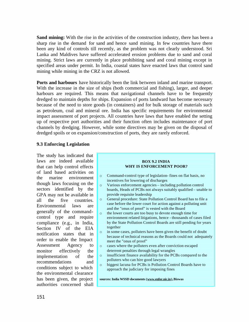
151
Sand mining: With the rise in the activities of the construction industry, there has been a sharp rise in the demand for sand and hence sand mining. In few countries have there been any kind of controls till recently, as the problem was not clearly understood. Sri Lanka and Maldives have suffered accelerated erosion problems due to sand and coral mining. Strict laws are currently in place prohibiting sand and coral mining except in specified areas under permit. In India, coastal states have enacted laws that control sand mining while mining in the CRZ is not allowed. Ports and harbours have historically been the link between inland and marine transport. With the increase in the size of ships (both commercial and fishing), larger, and deeper harbours are required. This means that navigational channels have to be frequently dredged to maintain depths for ships. Expansion of ports landward has become necessary because of the need to store goods (in containers) and for bulk storage of materials such as petroleum, coal and mineral ore. India has specific requirements for environmental impact assessment of port projects. All countries have laws that have enabled the setting up of respective port authorities and their function often includes maintenance of port channels by dredging. However, while some directives may be given on the disposal of dredged spoils or on expansion/construction of ports, they are rarely enforced. 9.3 Enforcing Legislation The study has indicated that laws are indeed available that can help control effects of land based activities on the marine environment though laws focusing on the sectors identified by the GPA may not be available in all the five countries. Environmental laws are generally of the command-control type and require compliance (e.g., in India, Section IV of the EIA notification states that in order to enable the Impact Assessment Agency to monitor effectively the implementation of the recommendations and conditions subject to which the environmental clearance has been given, the project authorities concerned shall
BOX 9.2 INDIA
WHY IS ENFORCEMENT POOR?
o Command-control type of legislation- fines on flat basis, no incentives for lowering of discharges
o Various enforcement agencies – including pollution control boards, Heads of PCBs not always suitably qualified – unable to provide requisite leadership
o General procedure: State Pollution Control Board has to file a case before the lower court for action against a polluting unit and the "onus of proof" is vested with the Board
o the lower courts are too busy to devote enough time for environment related litigations, hence - thousands of cases filed by the State Pollution Control Boards are still pending for years together
o in some cases, polluters have been given the benefit of doubt because of technical reasons as the Boards could not adequately meet the "onus of proof"
o cases where the polluters even after conviction escaped deterrent penalties through legal wrangles
o insufficient finance availability for the PCBs compared to the polluters who can hire good lawyers
o biggest lacuna for PCBs is Pollution Control Boards have to approach the judiciary for imposing fines
sources: India WSSD documents (www.enfor.nic.in), Biswas
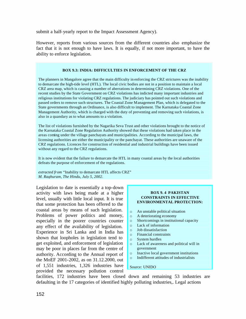
152
submit a half-yearly report to the Impact Assessment Agency). However, reports from various sources from the different countries also emphasize the fact that it is not enough to have laws. It is equally, if not more important, to have the ability to enforce legislation.
BOX 9.3: INDIA: DIFFICULTIES IN ENFORCEMENT OF THE CRZ
The planners in Mangalore agree that the main difficulty in enforcing the CRZ strictures was the inability to demarcate the high-tide level (HTL). The local civic bodies are not in a position to maintain a local CRZ area map, which is causing a number of aberrations in determining CRZ violations. One of the recent studies by the State Government on CRZ violations has indicted many important industries and religious institutions for violating CRZ regulations. The judiciary has pointed out such violations and passed orders to remove such structures. The Coastal Zone Management Plan, which is delegated to the State governments through an Ordinance, is also difficult to implement. The Karnataka Coastal Zone Management Authority, which is charged with the duty of preventing and removing such violations, is also in a quandary as to what amounts to a violation. The list of violations furnished by the Nagarika Seva Trust and other violations brought to the notice of the Karnataka Coastal Zone Regulation Authority showed that these violations had taken place in the areas coming under the village panchayats and municipalities. According to the municipal laws, the licensing authorities are either the municipality or the panchayat. These authorities are unaware of the CRZ regulations. Licences for construction of residential and industrial buildings have been issued without any regard to the CRZ regulations. It is now evident that the failure to demarcate the HTL in many coastal areas by the local authorities defeats the purpose of enforcement of the regulations. extracted from “Inability to demarcate HTL affects CRZ” M. Raghuram, The Hindu, July 5, 2002.
Legislation to date is essentially a top-down activity with laws being made at a higher level, usually with little local input. It is true that some protection has been offered to the coastal areas by means of such legislation. Problems of power politics and money, especially in the poorer countries counter any effect of the availability of legislation. Experience in Sri Lanka and in India has shown that loopholes in legislation tend to get exploited, and enforcement of legislation may be poor in places far from the centre of authority. According to the Annual report of the MoEF 2001-2002, as on 31.12.2000, out of 1,551 industries, 1,326 industries have provided the necessary pollution control facilities, 172 industries have been closed down and remaining 53 industries are defaulting in the 17 categories of identified highly polluting industries,. Legal actions
BOX 9. 4 PAKISTAN
CONSTRAINTS IN EFFECTIVE ENVIRONMENTAL PROTECTION:
o An unstable political situation o A deteriorating economy o Shortcomings in institutional capacity o Lack of information o Job dissatisfaction o Financial constraints o System hurdles o Lack of awareness and political will in
government o Inactive local government institutions o Indifferent attitudes of industrialists Source: UNIDO
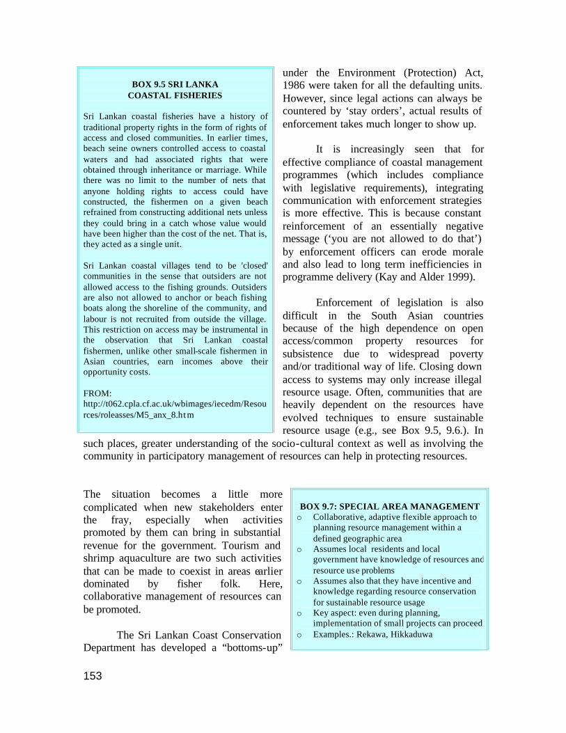
153
under the Environment (Protection) Act, 1986 were taken for all the defaulting units. However, since legal actions can always be countered by ‘stay orders’, actual results of enforcement takes much longer to show up. It is increasingly seen that for effective compliance of coastal management programmes (which includes compliance with legislative requirements), integrating communication with enforcement strategies is more effective. This is because constant reinforcement of an essentially negative message (‘you are not allowed to do that’) by enforcement officers can erode morale and also lead to long term inefficiencies in programme delivery (Kay and Alder 1999). Enforcement of legislation is also difficult in the South Asian countries because of the high dependence on open access/common property resources for subsistence due to widespread poverty and/or traditional way of life. Closing down access to systems may only increase illegal resource usage. Often, communities that are heavily dependent on the resources have evolved techniques to ensure sustainable resource usage (e.g., see Box 9.5, 9.6.). In
such places, greater understanding of the socio-cultural context as well as involving the community in participatory management of resources can help in protecting resources. The situation becomes a little more complicated when new stakeholders enter the fray, especially when activities promoted by them can bring in substantial revenue for the government. Tourism and shrimp aquaculture are two such activities that can be made to coexist in areas earlier dominated by fisher folk. Here, collaborative management of resources can be promoted. The Sri Lankan Coast Conservation Department has developed a “bottoms-up”
BOX 9.5 SRI LANKA
COASTAL FISHERIES Sri Lankan coastal fisheries have a history of traditional property rights in the form of rights of access and closed communities. In earlier times, beach seine owners controlled access to coastal waters and had associated rights that were obtained through inheritance or marriage. While there was no limit to the number of nets that anyone holding rights to access could have constructed, the fishermen on a given beach refrained from constructing additional nets unless they could bring in a catch whose value would have been higher than the cost of the net. That is, they acted as a single unit. Sri Lankan coastal villages tend to be 'closed' communities in the sense that outsiders are not allowed access to the fishing grounds. Outsiders are also not allowed to anchor or beach fishing boats along the shoreline of the community, and labour is not recruited from outside the village. This restriction on access may be instrumental in the observation that Sri Lankan coastal fishermen, unlike other small-scale fishermen in Asian countries, earn incomes above their opportunity costs. FROM: http://t062.cpla.cf.ac.uk/wbimages/iecedm/Resources/roleasses/M5_anx_8.ht m
BOX 9.7: SPECIAL AREA MANAGEMENT o Collaborative, adaptive flexible approach to
planning resource management within a defined geographic area
o Assumes local residents and local government have knowledge of resources and resource use problems
o Assumes also that they have incentive and knowledge regarding resource conservation for sustainable resource usage
o Key aspect: even during planning, implementation of small projects can proceed
o Examples.: Rekawa, Hikkaduwa
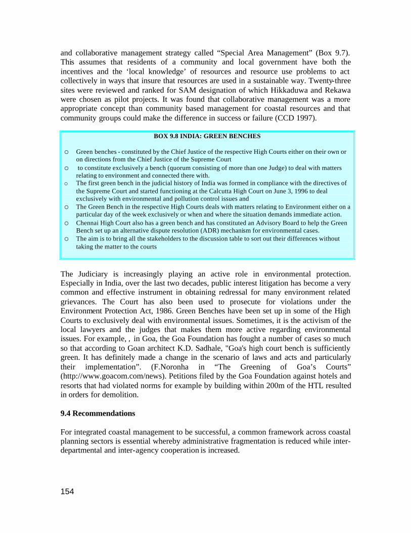
154
and collaborative management strategy called “Special Area Management” (Box 9.7). This assumes that residents of a community and local government have both the incentives and the ‘local knowledge’ of resources and resource use problems to act collectively in ways that insure that resources are used in a sustainable way. Twenty-three sites were reviewed and ranked for SAM designation of which Hikkaduwa and Rekawa were chosen as pilot projects. It was found that collaborative management was a more appropriate concept than community based management for coastal resources and that community groups could make the difference in success or failure (CCD 1997).
BOX 9.8 INDIA: GREEN BENCHES o Green benches - constituted by the Chief Justice of the respective High Courts either on their own or
on directions from the Chief Justice of the Supreme Court o to constitute exclusively a bench (quorum consisting of more than one Judge) to deal with matters
relating to environment and connected there with. o The first green bench in the judicial history of India was formed in compliance with the directives of
the Supreme Court and started functioning at the Calcutta High Court on June 3, 1996 to deal exclusively with environmental and pollution control issues and
o The Green Bench in the respective High Courts deals with matters relating to Environment either on a particular day of the week exclusively or when and where the situation demands immediate action.
o Chennai High Court also has a green bench and has constituted an Advisory Board to help the Green Bench set up an alternative dispute resolution (ADR) mechanism for environmental cases.
o The aim is to bring all the stakeholders to the discussion table to sort out their differences without taking the matter to the courts
The Judiciary is increasingly playing an active role in environmental protection. Especially in India, over the last two decades, public interest litigation has become a very common and effective instrument in obtaining redressal for many environment related grievances. The Court has also been used to prosecute for violations under the Environment Protection Act, 1986. Green Benches have been set up in some of the High Courts to exclusively deal with environmental issues. Sometimes, it is the activism of the local lawyers and the judges that makes them more active regarding environmental issues. For example, , in Goa, the Goa Foundation has fought a number of cases so much so that according to Goan architect K.D. Sadhale, "Goa's high court bench is sufficiently green. It has definitely made a change in the scenario of laws and acts and particularly their implementation”. (F.Noronha in “The Greening of Goa’s Courts” (http://www.goacom.com/news). Petitions filed by the Goa Foundation against hotels and resorts that had violated norms for example by building within 200m of the HTL resulted in orders for demolition. 9.4 Recommendations For integrated coastal management to be successful, a common framework across coastal planning sectors is essential whereby administrative fragmentation is reduced while inter-departmental and inter-agency cooperation is increased.
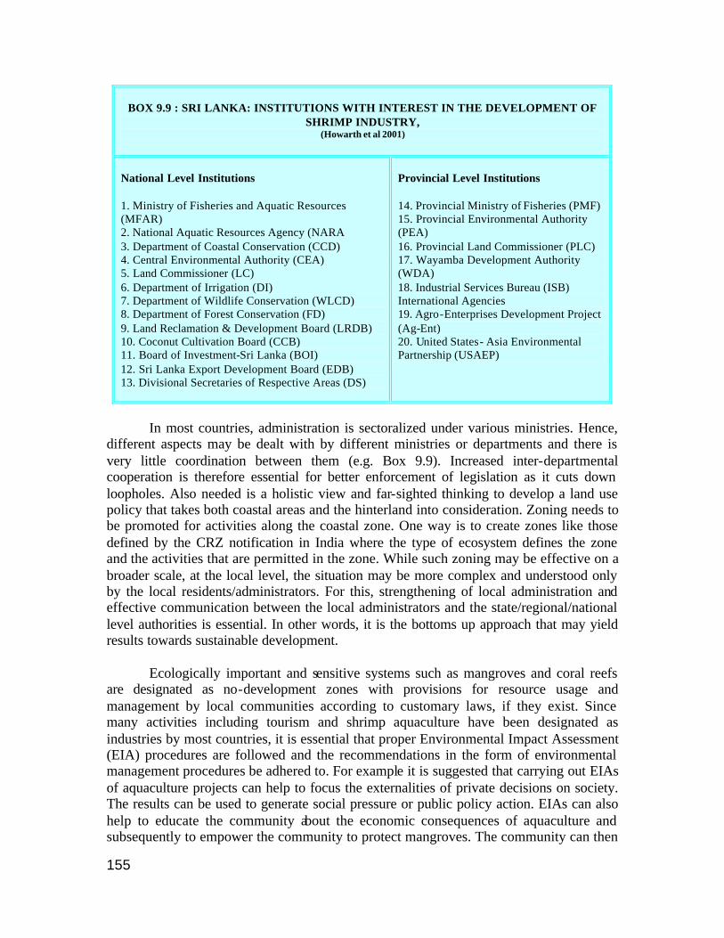
155
BOX 9.9 : SRI LANKA: INSTITUTIONS WITH INTEREST IN THE DEVELOPMENT OF
SHRIMP INDUSTRY, (Howarth et al 2001)
National Level Institutions 1. Ministry of Fisheries and Aquatic Resources (MFAR) 2. National Aquatic Resources Agency (NARA 3. Department of Coastal Conservation (CCD) 4. Central Environmental Authority (CEA) 5. Land Commissioner (LC) 6. Department of Irrigation (DI) 7. Department of Wildlife Conservation (WLCD) 8. Department of Forest Conservation (FD) 9. Land Reclamation & Development Board (LRDB) 10. Coconut Cultivation Board (CCB) 11. Board of Investment-Sri Lanka (BOI) 12. Sri Lanka Export Development Board (EDB) 13. Divisional Secretaries of Respective Areas (DS)
Provincial Level Institutions 14. Provincial Ministry of Fisheries (PMF) 15. Provincial Environmental Authority (PEA) 16. Provincial Land Commissioner (PLC) 17. Wayamba Development Authority (WDA) 18. Industrial Services Bureau (ISB) International Agencies 19. Agro-Enterprises Development Project (Ag-Ent) 20. United States- Asia Environmental Partnership (USAEP)
In most countries, administration is sectoralized under various ministries. Hence, different aspects may be dealt with by different ministries or departments and there is very little coordination between them (e.g. Box 9.9). Increased inter-departmental cooperation is therefore essential for better enforcement of legislation as it cuts down loopholes. Also needed is a holistic view and far-sighted thinking to develop a land use policy that takes both coastal areas and the hinterland into consideration. Zoning needs to be promoted for activities along the coastal zone. One way is to create zones like those defined by the CRZ notification in India where the type of ecosystem defines the zone and the activities that are permitted in the zone. While such zoning may be effective on a broader scale, at the local level, the situation may be more complex and understood only by the local residents/administrators. For this, strengthening of local administration and effective communication between the local administrators and the state/regional/national level authorities is essential. In other words, it is the bottoms up approach that may yield results towards sustainable development. Ecologically important and sensitive systems such as mangroves and coral reefs are designated as no-development zones with provisions for resource usage and management by local communities according to customary laws, if they exist. Since many activities including tourism and shrimp aquaculture have been designated as industries by most countries, it is essential that proper Environmental Impact Assessment (EIA) procedures are followed and the recommendations in the form of environmental management procedures be adhered to. For example it is suggested that carrying out EIAs of aquaculture projects can help to focus the externalities of private decisions on society. The results can be used to generate social pressure or public policy action. EIAs can also help to educate the community about the economic consequences of aquaculture and subsequently to empower the community to protect mangroves. The community can then

156
levy an appropriate tax on aquaculture or insist on sustainable practices that do not damage the mangroves (ESCAP 2002). Participatory and collaborative management should become the norm where all stakeholders find a place and more importantly, where stakeholders are prepared to enforce legislative compliance that will ensure sustainable development. Above all, for legislation to be effective in coastal management, education of the enforcers at the local level as well as the proponents of the activities apart from extensive inter-departmental and inter-sectoral cooperation is a must for ensuring sustainable development.
157
9.5 References CCD 1997. Revised Coastal Zone Management Plan, Sri Lanka, Coast Conservation Department, 1997 Biswas, Dilip “Environmental Legislation : Challenges of Enforcement”. http://www.cleantechindia.com/eicnew/environment.html. ESCAP 2002. Environmental Governance for Sustainable Development in Asia and the Pacific. ST/ESCAP/2218. GESAMP 1998. (IMO/FAO/UNESCO-IOC/WMO/WHO/IAEA/UN/UNEP Joint Group of Experts on the Scientific Aspects of Marine Environmental Protection). 1998. Report of the Twenty-Eighth Session, Geneva, Switzerland, 20-24 April 1998. Rep. Stud. GESAMP No. 66. Kay R. and J Alder. Coastal Planning and Management. E&FN Spon, London, 1999. Kurien, J. Factoring social and cultural dimensions into food and livelihood security issues of marine fisheries: A Case Study of Kerala State, India. Working Paper No. 299, Centre for Development Studies, Trivandrum, Kerala. February 2000 UNIDI. Industrial Policy and the Environment In Pakistan, UNIDO, NC/PAK/97/018, draft report, 11.12.2000. www.unido.org