Embed Size (px)
Citation preview
1 | P a g e
United Nations Development Program
Project title: Securing livelihoods, conservation, sustainable use and restoration of high range Himalayan ecosystems (SECURE)
Country: India Implementing Partner: Ministry of Environment, Forests and Climate Change
Management Arrangements: National Implementation Modality (NIM)
UNDAF/Country Program Outcome: Environmental Sustainability
UNDP Strategic Plan Output: Output 1.3: Solutions developed at national and sub-national levels for sustainable management of natural resources, ecosystem services, chemicals and waste.
Output 2.5: Legal and regulatory frameworks, policies and institutions enabled to ensure the conservation, sustainable use, and access and benefit sharing of natural resources, biodiversity and ecosystems, in line with international conventions and national legislation.
UNDP Social and Environmental Screening Category: Moderate
UNDP Gender Marker: 2
Atlas Project ID/Award ID number: 00101020 Atlas Output ID/Project ID number: 00103730
UNDP-GEF PIMS ID number: 3298 GEF ID number: 9148
Planned start date: April 1, 2017 Planned end date: March 30, 2024
LPAC date: August 17, 2017
Brief project description: Briefly (no more than 200 words) describe the overall development challenge and the expected results of the project. Despite the immense biological, socio-cultural and hydrological values of the Himalayan ecosystems, these natural ecosystems are under severe threat from high dependence of local communities on natural resources, pressures from economic development, selective removal of medicinal and aromatic plants, and the emerging threat of illegal wildlife trade and wildlife crime. To address these threats, the project will adopt a landscape approach to conservation and management, by ensuring that key biodiversity areas, buffer zones, corridors and areas outside traditional protected areas that are critically important for conservation of endangered snow leopard, wild prey and their associated and threatened species and habitats are managed in tandem with the sustainable use of these resources and improvement and diversification of the livelihoods of a large number of local communities living in this region. The project’s incremental value lies in promoting the sustainable management of alpine pastures and forests in the high range Himalayan ecosystems to secure conservation of globally significant wildlife, including endangered snow leopard and their habitats and ensure sustainable livelihoods and community soci-economic benefits in the four high altitude landscapes in the Trans- and Greater Himalayan region (that consists of alpine pastures, sub-alpine forests and critical watersheds). The four inter-related components of the project are aimed at Improved management of high Himalayan landscapes for conservation of snow leopard and other endangered species and their habitats and sustaining ecosystem services, improved and diversified sustainable livelihood for communities to reduce pressure on fragile ecosystems, enhanced enforcement, monitoring and cooperation to reduce wildlife related threats, and improved knowledge and information systems for landscape conservation approaches. These actions are aimed at conserving the snow leopards, wild prey and associated species and habitats contained within these landscapes, maintaining their ecosystem values and ameliorating climate change impacts, enhancing surveillance, monitoring and trans-boundary cooperation to reduce wildlife crime and related threats, and improving knowledge and communications.
FINANCING PLAN
GEF Trust Fund or LDCF or SCCF or other vertical fund USD 11,544,192
UNDP TRAC resources 0
Cash co-financing to be administered by UNDP 0
(1) Total Budget administered by UNDP USD 11,544,192
DRAFT
2 | P a g e
PARALLEL CO-FINANCING (all other co-financing that is not cash co-financing administered by UNDP)
UNDP USD 1,000,000
Government USD 59,820,000
(2) Total co-financing USD 60,820,000
(3) Grand-Total Project Financing (1)+(2) USD 72,364,192
SIGNATURES
Signature: print name below
Agreed by Implementing Partner
Date/Month/Year:
Signature: print name below
Agreed by UNDP Date/Month/Year:
DRAFT
3 | P a g e
Acronyms
ATREE Ashoka Trust for Research in Ecology and the Environment
BADP Border Areas Development Program
BDC Bio-diversity Committee
BMC Biodiversity Management Committees
CAMPA Compensatory Afforestation Fund Management and Planning Authority
CAZRI Central Arid Zone Research Institute
CBD Convention on Biological Diversity
CBO Community Based Organization
CCR Community Conservation Reserve
CDR Cell Details Record
CEE Center for Environment Communication
CIGS Common Interest Group
CITES Convention on International Trade in Endangered Species
CMS Convention on Migratory Species
CSIR Council of Scientific and Industrial Research
DAVP Department of Audio Visual Publicity
DST Department of Science and Technology
ECOSS Ecotourism and Conservation Society of Sikkim
EDC Ecodevelopment Committee
ESA Eco-sensitive Areas
FAO Food and Agriculture Organization
FRI Forest Research Institute
GBPIHED G B Pant Institute of Himalayan Environment and Development
GEF Global Environmental Fund
GIS Geographic Information System
GOI Government of India
GRM Grievance Redressal Mechanism
GSLEP Global Snow Leopard & Ecosystem Protection Program
HAREC Highland Agricultural Research and Extension Center
HCVF High Conservation Value Forests
HFRI Institute of Himalayan Bio-Resources Technology
HWC Human Wildlife Conflict
ICAR Indian Council for Agricultural Research
ICCR Indian Council for Cultural Relations
ICIMOD International Centre for Integrated Mountain Development
IFAD International Fund for Agricultural Development
IHR Indian Himalayan Region
IMI Integrated Mountain Initiatives
ITBP Indo Tibetan Border Police
IUCN International Union for the Conservation of Nature
DRAFT
4 | P a g e
IWMP Integrated Water Management Plan
IWS International Whaling Commission
IWT Illegal Wildlife Trade
JFMC Joint Forest Management Committee
KCC Khangchendzonga Conservation Committee
KLCDI Khangchendzonga Landscape Conservation and Development Initiative
KSLCDI Kailash Sacred Landscape Conservation and Development Initiative
KVK Kendriya Vigyan Kendra
LCDC Landscape Conservation and Development Committees PCCF
LDPE Low Density Polyethylene Tanks
LEDeG Ladakh Ecological Development Group
LTDC Lachen tourism development committee
LPIT Landscape Planning and Implementation Team
MGNREGA Mahatama Gandhi National Rural Employment Guarantee Act
MAP Medicinal and Aromatic Plants
MIS Management Information System
MNRE Ministry of New and Renewable Energy
MOA Memorandum of Agreement
MOEFCC Ministry of Environment, Forests and Climate Change
MORD Ministry of Rural Development
MOU Memorandum of Understanding
MYRADA Mysore Resettlement and Development Agency
NABARD National Bank for Agriculture and Rural Development
NABFINS NABARD Financial Services Ltd
NAPCC National Action Plan for Climate Change
NBA National Biodiversity Authority
NCDC National Cooperative Development Corporation
NCF Nature Conservation Foundation
NGO Non-government organization
NMPB National Medicinal Plant Board
NMSHE National Mission on Sustaining the Himalayan Ecosystem
NP National Park
NPM National Project Manager
NRLM National Rural Livelihoods Mission
NRM Natural Resource Management
NSLEP National Snow Leopard Ecosystem Priority Protection
NTFP Non Timber Forest Produce
PA Protected Area
PAO Project Administrative Officer
PCCF Principal Chief Conservator of Forests
PLMP Participatory Livelihood Management Plan
PoWPA Program of Work on Protected Areas
PPMU State Project Planning and Management Unit
DRAFT
5 | P a g e
PRA Participatory Rural Appraisal
PRI Panchayati Raj Institutions
PSBT Public Service Broadcast Trust
PSL Project Snow Leopard
RET Rare, Endangered and Threatened
RO Range Officer
RSTV Rajya Sabha Television
SAWEN South Asia Wildlife Enforcement Network
SCA Special Central Assistance
SECMOL Students' Educational and Cultural Movement of Ladakh
SHG Self Help Group
SKUAST Sher-e-Kashmir University of Agricultural Science & Technology
SL Snow Leopard
SLM Sustainable Land Management
SMPB State Medicinal Plant Board
SLT Snow Leopard Trust
SSB Sashastra Seema Bal
TMI The Mountain Institute
TORs Terms of Reference
UNDP United Nations Development Program
UNESCO United Nations Education, Scientific and Cultural Organization
USAID United States Agency for International Development
VCDC Village Conservation Committee
WB World Bank
WCCB Wildlife Crime Control Bureau
WS Wildlife Sanctuary
WWF World Wildlife Fund
DRAFT
6 | P a g e
I. TABLE OF CONTENTS
I. Table of Contents ................................................................................................................... 6
II. Development Challenge ......................................................................................................... 7
III. Strategy ................................................................................................................................ 17
IV. Results and Partnerships ..................................................................................................... 24
V. Feasibility ............................................................................................................................. 55
VI. Project Results Framework .................................................................................................. 62
VII. Monitoring and Evaluation (M&E) Plan ............................................................................... 68
VIII. Governance and management Arrangements .................................................................... 73
IX. Financial Planning and Management................................................................................... 78
X. Total Budget and Work Plan ................................................................................................ 81
XI. Legal Context ....................................................................................................................... 88
XII. ANNEXES .............................................................................................................................. 89
DRAFT
7 | P a g e
II. DEVELOPMENT CHALLENGE The high range Himalayan ecosystem in India is of critical importance for the biodiversity and ecosystems of global significance that it harbors and forms an important life-support system for a large number of remote and agro-pastoral communities that depend on it. The Himalayan ecosystem provides a number of essential ecosystem services – a source of freshwater, maintains hydrological functions, reduces erosion and sedimentation downstream, provides food security and maintains land races of food crops grown in much of northern India. Hundreds of millions of people depend on these ecosystems for water for hydropower and agriculture, forage for livestock and food for themselves, mineral resources, medicinal and aromatic plants and their products, cultural traditions and spiritual values, and inspiration that draws increasing number of people from around the globe to experience these places. A rapid estimate of the economic value of some prominent services generated from snow leopard habitats in India is nearly $4 billion a year, the bulk of which comes from hydropower and generated electricity (US$3 billon), followed by livestock and agriculture (US$0.5 billion), and tourism (US$0.4 billion)1.
The Himalayan region represents a mosaic of pluralistic diversity – a composite of myriad human cultures and linguistic diversity including a number of tribal communities – and their relative seclusion and remoteness that has made them the last bastions of globally significant indigenous knowledge and cultural heterogeneity. Around 65.57 million people belonging to different ethnic groups reside in this region. Likewise, the high altitudinal variations and associated climate regimes in the region have given rise to corresponding numerous unique ecosystems and biological communities of global significance. The region accounts for nearly 50% of the total flowering plants of India, of which nearly 30% are endemic to the region; there are also over 816 tree species, 675 edibles and nearly 1,743 species of medicinal value. There are about 350 species of Himalayan medicinal plants that are used in the entire Indian drug industry, which comprises around 50% of the total number of medicinal plants used by the industry. Most of these species are collected from the wild, and thus, the conservation of these is key to the survival of their species. Fauna in the region presents one of the richest assemblages in the Indian subcontinent – out of the total mammalian species in India, 65% are recorded in the Himalayas; 50% of the total bird species occur in the region and likewise 35% reptiles, 36% amphibians and 17% fishes are documented from the mountain ecosystem. Moreover, 29 out of 428 species of reptiles from India, 35 species of amphibians (out of 200) and 36 species of freshwater fishes (out of 1,300) are endemic to the Himalayan region.2
This region is the center of the globally endangered snow leopard (Uncia uncia) range that extends from the mountain of Central and Southern Asia across twelve range countries. The snow leopard is listed under Appendix I (i.e. species threatened with extinction) of the Convention on International Trade in Endangered Species of Wild Fauna and Flora (CITES). It is also listed under Appendix I of the Convention on Migratory Species of Wild Animals (CMS), and was later elevated to ‘requiring Concerted Action’ in 2002 (Resolution 7.1). It is also listed as Endangered in the IUCN red list. The snow leopard occupies the high mountains of twelve countries extending from the Hindu Kush in eastern Afghanistan and the Syr Darya through the mountains of Pamir, Tian Shan, Karakorum, Kashmir, Kunlun, and the Himalaya to southern Siberia, as well as the Russian Altai, Sayan and Tannu Ola mountains covering a total area of
1 http://www.globalsnowleopard.org/wp-content/uploads/2016/05/India_NSLIP.pdf
2 http://www.globalsnowleopard.org/wp-content/uploads/2016/05/India_NSLIP.pdf
DRAFT
8 | P a g e
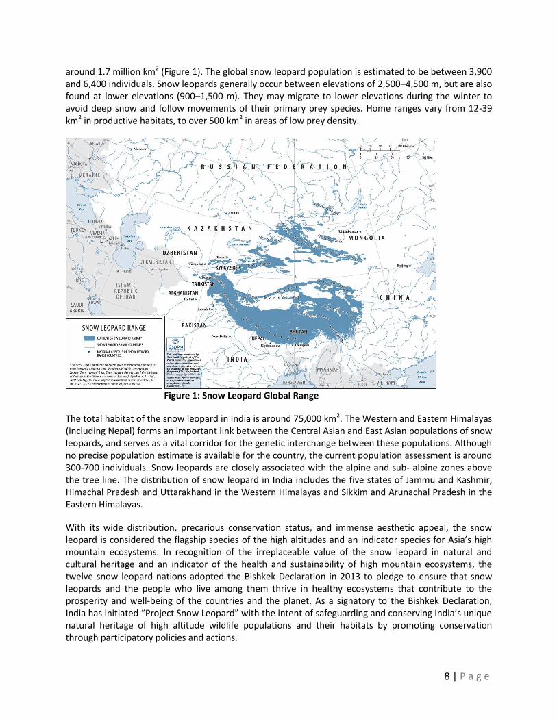
around 1.7 million km2 (Figure 1). The global snow leopard population is estimated to be between 3,900 and 6,400 individuals. Snow leopards generally occur between elevations of 2,500–4,500 m, but are also found at lower elevations (900–1,500 m). They may migrate to lower elevations during the winter to avoid deep snow and follow movements of their primary prey species. Home ranges vary from 12-39 km2 in productive habitats, to over 500 km2 in areas of low prey density.
Figure 1: Snow Leopard Global Range
The total habitat of the snow leopard in India is around 75,000 km2. The Western and Eastern Himalayas (including Nepal) forms an important link between the Central Asian and East Asian populations of snow leopards, and serves as a vital corridor for the genetic interchange between these populations. Although no precise population estimate is available for the country, the current population assessment is around 300-700 individuals. Snow leopards are closely associated with the alpine and sub- alpine zones above the tree line. The distribution of snow leopard in India includes the five states of Jammu and Kashmir, Himachal Pradesh and Uttarakhand in the Western Himalayas and Sikkim and Arunachal Pradesh in the Eastern Himalayas.
With its wide distribution, precarious conservation status, and immense aesthetic appeal, the snow leopard is considered the flagship species of the high altitudes and an indicator species for Asia’s high mountain ecosystems. In recognition of the irreplaceable value of the snow leopard in natural and cultural heritage and an indicator of the health and sustainability of high mountain ecosystems, the twelve snow leopard nations adopted the Bishkek Declaration in 2013 to pledge to ensure that snow leopards and the people who live among them thrive in healthy ecosystems that contribute to the prosperity and well-being of the countries and the planet. As a signatory to the Bishkek Declaration, India has initiated “Project Snow Leopard” with the intent of safeguarding and conserving India’s unique natural heritage of high altitude wildlife populations and their habitats by promoting conservation through participatory policies and actions.
DRAFT
9 | P a g e
The proposed project area encompasses both the Greater Himalayas and Trans-Himalayan ranges of the snow leopard in India. The Greater Himalaya is represented by sub-alpine forests and scrub, alpine meadows, vast areas under permafrost, glaciers and rock faces, while the Trans-Himalayan cold deserts primarily consist of sparsely vegetated steppes, small patches of moist sedge meadows near water bodies and vast areas that are barren and under glaciers. These areas are the headwaters of many major rivers of Northern India, and form part of the high range Himalayan ecosystem, which have unique assemblages of flora and fauna. The Eastern Himalayas in the high range Himalayan Ecosystem are recognized as one of the 35 global biodiversity hotspots by Conservation International and is among the 200 WWF global ecoregions in the world. In addition to the snow leopard, these areas also harbor several other IUCN-listed endangered large mammals. The associated species found in this region include the Himalayan tahr (Hemitragus jemlahicus), Himalayan musk deer (Moschus chrysogaster), blue sheep (Pseudois nayaur), Asiatic black bear (Selenarctos thibetanus), Tibetan wolf (Canis lupus chanco), Tibetan wild ass (Equus kiang) and many others. High altitude lakes and bogs provide breeding grounds for a variety of avifauna including the black-necked crane (Grus nigricollis), bar-headed goose (Anser indicus), brahminy duck (Tadorna ferruginia), and brown-headed gull (Larus brunnicephalus). The key medicinal plant species of this region are Nardostachys jatamansi, Aconitum heterophyllum, Picorrhiza kurroa, Dactylorhiza hatagirea, Swertia chirata, Angelica glauca, Arnebia benthamii, Podophyllum hexandrum, Trillidium govanianum, Berginia ciliate, Saussurea costus and caterpillar mushroom (Ophiocordyceps sinensi plas).
Threats and Impacts Despite the immense biological, socio-cultural and hydrological values of the Himalayan ecosystems, especially the high altitude ranges have not received adequate attention in terms of natural resources management and conservation from local and national governments. In many high altitudinal areas, the threat to snow leopards, wild prey3 and their ecosystems face a variety of direct and indirect threats that vary in intensity and prominence. Habitat degradation and fragmentation is increasing due to unsustainable livestock grazing, high dependence of local communities on natural resources, pressures from economic and infrastructure development (unplanned development), selective removal of medicinal and aromatic plants, and emerging threat of illegal wildlife trade and wildlife crime.4,5 Since the harsh climate and topography of the area are relatively less conducive to agriculture and other developmental options such as industry, most of the region is largely dependent on pastoralism. Livestock grazing in this highly fragile and dynamic region is the most pervasive land-use, in the absence of better livelihoods options for most local communities. The intensity and occurrence of grazing threats varies from throughout the region, but is still the single-most important threat to snow leopard habitat (Figure 2).
The degradation and loss of natural alpine meadows and sub-alpine habitats due to anthropogenic pressures, in particular the intensive use by domestic livestock outcompetes the wild herbivore species
3 The main wild prey of snow leopard is blue sheep (Pseudois nayaur), musk deer (Moschus crysogaster), Argali (Ovis ammon hodgsomi), and marmots (Marmota spp.). Other prey might include Tibetan antelope (Pantholops hodgsonii), Himalayan tahr (Hemitragus jemlahicus), ibex (Capra ibex), Markhor (Capra falconeri), wild yak (Bos gruniens), pika (Ochotona spp.) and hare (Lepus spp.) 4 Ning, Wu, Rawat, G.S., Joshi, S., Ismail, M. and Sharma, E. (Eds.) 2013. High Altitude Rangelands and their Interfaces in the Hindu Kush
Himalayas. Kathmandu. ICIMOD 5 Mishra, C.D. et al. (2010). Multiple Use of Trans-Himalayan Rangelands: Reconciling Human Livelihoods with Wildlife Conservation. Pp. 1-
12. In Wild Rangelands: Conserving Wildlife While Maintaining Livestock in Semi-Arid Ecosystems, 1st edition.
DRAFT
10 | P a g e
with corresponding decline in their populations. In Uttarakhand and Himachal Pradesh 68.1% of the high alpine areas are under heavy grazing by domestic livestock,6 and these areas coincides with the habitat of prey species such as blue sheep and Asiatic ibex. This is leading to an increased dependence of wild predators such as the snow leopard and the wolf on livestock, as natural prey species populations decline, causing increasing human-wildlife conflicts. Surveys in the high altitude protected areas in Uttarakhand reveals that domestic animals (mule, goat and sheep) now contribute 36% of the diet of snow leopard.7 Livestock depredation is emerging as a significant problem across the snow leopard range in the Himalayas. The increasing snow leopard-human conflicts is likely a manifestation of habitat degradation due to over-grazing and over-harvesting of natural resources by humans and their livestock. This predation on livestock has resulted in retaliatory killing and has adverse impacts on snow leopard and other wildlife species especially in and around key wildlife migration corridors. It is estimated that around 66% of snow leopards killed in India are retaliatory in nature and another 17% is due to non-targeted “accidental” death. 8 Local villagers In the Upper Spiti landscape report that livestock depredation by snow leopard and wolf during a two-year period (2009-2010) was 194 and 173 individuals respectively.9 In a survey in Govind Pashu Vihar and Askot Wildlife Sanctuary in Uttarakhand, the maximum livestock loss from snow leopard in 2007 was estimated at USD 59,535 and USD 31,329 respectively.10 Such economic loss to local herdsmen can be significant as more than 40% of the people living in the snow leopard ranges live below the poverty line, so such losses represent a significant loss of income, when few other options to animal husbandry are available.11 The relationship between livestock depredation by snow leopard and the relative abundance of wild prey suggests that human-snow leopard conflicts are likely to get more intense unless successful conservation and alternative livelihood programs lead to increases in wild-prey abundance from the low densities typical of multiple use, livestock-grazed landscapes.
In addition, the collection of firewood and timber, and wild medicinal and aromatic plants for local as well as commercial use is also creating pressures on the forest ecosystems when they are not following sustainable harvesting practices. Usually medicinal and aromatic plants and products are sold unprocessed and mountain collectors and producers seldom benefit from any value addition to these products, thereby causing excessive exploitation12. A large number of agro-pastoral and pastoral communities depend on biomass in the Himalayan region and centuries of livestock grazing and associated fuel wood collection by herders around the timberline have led to the degradation of alpine habitats.13 Limited planning and lack of controls (enforcement of safe practices) pertaining to tourism and recreation activities such as trekking, camping and skiing (on the increasing trend) and intrusive developmental activities such as construction of road in several places also damages natural habitats of snow leopard, other endangered and prey species14. Climate change is also expected to affect this landscape significantly that may influence both local livelihoods and biodiversity value of the region. The future impacts of climate change on these ecosystems that are also snow leopard habitats are not
6 Maheshwari, A. and Sharma, D (2010), WII-India
7 Maheshwari, A., Sharma, D. and Sathyakumar, S. (2013). Snow leopard surveys in Western Himalayas, India, Journal of Ecology and Natural Environment 8 Nowell, K., Li, J., Paltysn, M., and Sharma, R.K (2016) An Ounce of Prevention: Snow Leopard crime revisited. Traffic Report 9 Kulbhushansingh, R., Suryawanshi, Bhatanagar, Y.V., Redpath, S. and Mishra, C. People, Predators and Perceptions – patterns in Livestock Depredation by snow leopards and wolves 10 Maheshwari, A. and Sharma, D (2010), WII-India 11 Global Snow leopard and ecosystem protection program, 2013 12 IUCN (2008) India’s wild medicinal plants threatened by over exploitation 13 Ning, Wu, Rawat, G.S., Joshi, S., Ismail, M. and Sharma, E. (Eds.) 2013. High Altitude Rangelands and their Interfaces in the Hindu Kush Himalayas. Kathmandu. ICIMOD 14 SLN (2014) Snow Leopard Survival Strategy
DRAFT
11 | P a g e
certain, and will vary across the range; however, it seems certain that there will be impacts.15 For instance, melting glaciers are likely to affect water availability and increase the risk of droughts. Decreases in water availability and increases in temperature may affect pasture production, reducing food availability for both wild prey and domestic livestock. A recent study found that as much as 30 percent of snow leopard habitat in the Himalayas could disappear due to upslope vegetation changes, that is, woody vegetation replacing alpine grasslands. The projected consequences will be loss, degradation, and fragmentation of habitat; reduction in natural prey; potential for increased competition with other predators such as common leopards; and, with increasing proximity to human activities (including livestock), increased conflict, and retaliatory killings.16 The lack of awareness and institutional mechanism to address climate change constraints action to proactive manage such impacts.
Although, there is limited information to validate the extent of poaching in the high Himalayas, it is understood that the major faunal species that are threatened due to illegal trading of wildlife parts are mainly the Himalayan black bear, Tibetan antelope, musk deer and to some extent the snow leopard. The plant species that are threatened by trade are Saussurea costus, Dactylorhiza hatagirea, Aconitum heterophyllum, Picrorhiza kurrooa, Trillidium govanianum, Paris polyphylla, Arctium lappa, Ophiocordyceps sinensi plas and lichens. It is also understood that 85% of the trade in medicinal plants is illegal. In addition, some of the major trading routes for illegal wildlife trade in India are through border areas in the high Himalayan range. Weak law enforcement, prosecution and lack of staff for anti-poaching makes wildlife crime prevention challenging that is further compounded by the remoteness and harshness of the Himalayan region.
Table 1 provides an assessment of threats to protected areas and key biodiversity areas within the Himalayan region.
Table 1: Threats to Protected Areas and Key Biodiversity Areas17 Protected Areas and Key Biodiversity Areas (outside PA network)
Threats
Habitat Degradation due to unregulated livestock grazing
Harvest of fuelwood /and timber
NTFP collection
Human-wildlife conflicts
Unregulated Tourism and encroachment in meadows
Climate change and shortage of water
Changthang WS H H L H H H
Seichu Tuan WS H M M H L L
Govind NP & WS H H M M H L
Gangotri WS L L L L L L
Khangchendzonga NP L L L L L L
Shingba Rhododendron Sanctuary
M L L M L L
Tso Lhamu (Proposed CCR)
H L L L M M
Gya Meru H H M H L H
Rong Valley M M M H L H
Upper Sural Valley M M M M L M
Myar Valley H M M L L M
15 Bellard C., Bertelsmeier C., Leadley P., Thuiller W., Courchamp, F. (2012) Impacts of climate change on the future of biodiversity. Ecology Letters 15 16 Forrest, Jessica L. et al (2012). Conservation and climate change: Assessing vulnerability of snow leopard habitat to treeline shift in the Himalaya. Biological Conservation. Volume 150. 17 Covers protected areas and already identified key biodiversity areas

DRAFT
12 | P a g e
Hanuman Ganga H M H L L L
Kyarkoti H M M L L L
Dzongu M M H L L L
Note: Threat levels are H =high, M = medium and L = low
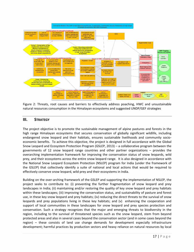
Given the above threats, challenges and gaps in conservation responses currently implemented, it is pertinent that a long-term strategy is put in place to secure the snow leopard and other globally significant biodiversity, land and forest resources in the high range Himalayan region while enhancing lives and livelihoods of local communities that are dependent on these ecosystems. Three inter-related barriers as described hereunder currently impede the emergence of such a strategy (Figure 2).
Barrier 1: Limited options of alternative livelihoods and current practices of unsustainable land and forest uses in wider landscape: Given the lack of livelihood options and alternatives for local communities in this harsh landscape, most of the protected areas and areas outside them are often intensively used for livestock grazing and other forms of resource extraction as part of the local economy. Competition for alpine meadows, is leading to the depletion of wild prey species of snow leopard, resulting in increased dependence of snow leopard on livestock and consequently increased human-wildlife conflict. This is further compounded by the fact that the harsh, remote, and marginal landscape provides few opportunities for alternate livelihood sources for the local communities. Traditional practices of pastoralism and sustainable use of natural resources has declined, resulting in a more open grazing regime, high livestock density18 and increased collection of non-timber forest products for commercial purposes that is undermining the sustainability of the resource. Further, the difficult terrain, small and under-developed markets, poor connectivity and inadequate general infrastructure is compounded by limited capacities and skills and governance19 deficits entailing a high cost of delivery of public services, thereby acting as a constraint for improving the lives and livelihoods of local communities. In addition, business approaches and opportunities to enhance and mobilize funds (tourism, sustainable hunting, production of local crafts, catering, etc.) in a more systematic manner that would enhance local revenues are limited. All these factors act as barriers for development of sustainable alternative livelihood options for local communities, thereby making them further dependent on natural resources, while Protected Area authorities and other government agencies are left with few options in formulating strategies for conservation of snow leopard, wild prey and habitat, and local livelihoods.
The small size of land holdings (less that 1 hectare) in the high Himalayas results in a high dependency on sheep and goat herding and collection of non-timber forest products. An analysis of number and area of operational land holdings of marginal farmers in selected landscapes as a proportion to all holdings (percent) reveals that in Jammu & Kashmir and Uttarakhand, 83.3 % and 82.2 % respectively in the category of marginal farmers have 46.5% and 52.5 % of the total area of operational landholdings. Similarly, in Himachal Pradesh and Sikkim 69.7% and 53.3% marginal farmers respectively hold only 28.5% and 14% area of all operational landholdings20. This shows that a very high percentage of people living in high range Himalayan region have limited land holdings thus constraining their ability to develop more sustainable and environmental friendly livelihood practices. The situation in the selected landscapes of these states is severe as these areas are located in the high range and rugged Himalayan
18 Mishra, C. Prins, H.H.T. and Warren, S.E. van (2001). Overstocking in the trans-Himalayan rangelands of India. Environmental Conservation, 28 (3) 19 Report to the Committee to Study Development in Hill States Arising from Management of Forest Lands with Special Focus on Creation of Infrastructure, Livelihood and Human Development 2013 (B.K. Chaturvedi Committee Report). Planning Commission of India 20 Agriculture Census 2010-11, Ministry of Agriculture, Government of India
DRAFT
13 | P a g e
region. Despite these constraints, many valley areas in the Himalayan highlands provide unique opportunities for in-situ (on-farm) management of agro-biodiversity because of the preponderance of locally developed traditional crop varieties (and associated wild and weed species) in cultivation systems based on traditional knowledge and skills, high agro-climatic heterogeneity and local socio-cultural integration. However, over the last two decades, the diversity of traditional agricultural crops and vegetables in the Himalayan region has suffered as a consequence of erosion, introduction of hybrid varieties, shift towards cash crop cultivation which has led to the decline of some of the most useful varieties of crops considered to be part of the cultural heritage of traditional societies of the Himalayas. Opportunities for promotion of ecotourism also exists, but efforts so far have been small and ad-hoc, because of dearth of capacities and information that has prevented mountain communities from maximizing such benefits. Only two areas of the Indian Himalayas were visited by substantial number of tourists in 2012 and extensive opportunities exists for promoting community-based ecotourism in other areas in the Indian Himalayas.21
Barrier 2: Limited capacity, knowledge and proven models for conserving wildlife species especially beyond protected areas
While the region has an extensive protected area network this covers only a relatively small and fragmented area of the unbroken and contiguous snow leopard habitat and is often not fully representative of the wide variety habitat types and ecosystems. Local and migratory pastoral communities continue to use these protected areas for livestock grazing and collection of fuelwood and other bio-resources, competing for habitat and resources with snow leopard, wild prey and associated species. In many areas outside protected areas, the trend is increased pace of development – development interventions supported by various government and non-governmental agencies have resulted in rapid socio-economic development, expanded transportation networks and changes in cropping patterns (e.g. adoption of cash crops in limited arable land against traditional subsistence crops). All of these have far-reaching impacts such as changes in pattern of land use, degradation of alpine pastures and forests and fragmentation of natural areas.22 This is particularly relevant for the snow leopard as its home ranges are extensive (500-800 km2) and protection of migration corridors, that are usually outside the protected area network is key to the survival of the species. These adverse changes undermine the potential for protected areas to safeguard snow leopards and ecological processes – indicative of the need to enhance connectivity and protect biological corridors that lie outside the protected area network. Compounding the situation is the lack of adequate number of protected area staff while existing staff has limited opportunities to update their knowledge and skills, and several protected areas do not have adequate budget to fund conservation programs such as surveys and biodiversity monitoring activities.
There are often a variety of different kinds of heterogeneity that can be recognized in large landscapes beyond the realms of protected areas that are necessary for the conservation of the snow leopard. State forest and wildlife agencies lack the skills, capacity and mandates to manage such wider heterogeneous areas. Other government agencies such as rural development, animal husbandry and agriculture do not have a presence within these landscapes. As a consequence, there are currently no formal multi-sector and multi-stakeholder landscape-scale plans and mechanisms being developed and implemented to: (i)
21 Kala, C.P. (2012). Ecotourism and Sustainable Development in Mountain Ecosystems. Science and Education Journal
22 Radotra et al. (2015). Pasture and forages in North Western Himalayan Region: Current Status and Strategies
DRAFT
14 | P a g e
safeguard dispersal corridors between adjacent but separate core snow leopard populations; (ii) maintain the genetic variations of snow leopard populations; (iii) secure the conservation status of key prey species; and (iv) ensure the resilience of ecosystems to the effects of climate change. While the NSLEP seeks to promote landscape level approaches to conservation of snow leopards, wild prey and their habitats, the lack of effort to implement landscape scale level conservation represents a huge missed opportunity for Himalayan region. This is constrained by the fact that government agencies have little experience in developing strategic plans to mainstream biological considerations when planning and undertaking their respective sector activities and there is limited opportunity for multi-sectoral and multi-stakeholder cooperation and collaboration and decision-making processes. Similarly local communities lack economic incentives, along with awareness, capacity and support in the planning and sustainable management of forests and meadows for biodiversity conservation and climate change mitigation. Recognizing the role of local communities and sufficiently according the importance of their engagement in protected area management and mechanisms for sharing of responsibility and benefits with local communities require testing and further development.
A significant portion of the snow leopard’s range is located around the international borders of four other range countries –China, Pakistan, Nepal and Bhutan. There is a real need for knowledge-sharing and exchange of skills and experience, including cooperative research and information management. Poaching and illegal trade across boundaries needs to be better controlled, including through joint patrols and border inspections to stem illegal wildlife trafficking. Although there are many opportunities to collaborate with the four adjacent range countries to create trans-boundary landscapes or conservation areas, these opportunities have not materialized. While there has been some progress – with the support of local and international NGOs – in planning a transfrontier ‘Kanchenjunga Landscape’ (between India, Nepal and Bhutan) and ‘Kailash Sacred Landscape’ (between China, India and Nepal) the initial efforts have not been effective due to capacity and resource constraints. The scientific and management institutions in India are often working in relative isolation from their counterparts from other home range countries as a result of the low levels of inter-governmental cooperation in snow leopard conservation.
Barrier 3: Limited wildlife monitoring, wildlife crime and wildlife-livestock related deterrent systems: Given the difficult terrain (and the fact that much of the area remains snowbound and relatively inaccessible during winters), the limited coverage of protected areas and inadequate capacities of inspectors, there is limited application of effective and integrated wildlife crime detection, monitoring and prosecution systems. The long international border with neighboring counties of about 14,000 kilometers, a significant part of which falls in the high Himalayan region with extremely difficult terrain, where enforcement of wildlife laws or general surveillance and guard against illegal wildlife trade is extremely challenging. The State Forest Department is the only agency currently mandated to protect and conserve the rare and endangered, and legally protected species. There is a scanty presence of Forest department establishments on the ground in the above sectors and limited presence of the field personnel. In addition, staff are inadequately trained for combating wildlife crimes, lack skills in identifying species and specimens, lack adequate knowledge of laws and legal procedures and have limited or no knowledge in intelligence collection and processing (Annex 1 provides a review of laws pertaining to natural resource management in the Himalayan range). The infrastructure of the forest department at higher altitude is extremely poor with a very weak force in command. It is hence unclear to what extent poaching, trapping, sale of pelts and other wildlife parts, and other wildlife related offences occur in this region. Owing to poor coordination between state authorities (such as those in charge of Protected Area management) and local self-governments, it is likely that
DRAFT
15 | P a g e
incidence of wildlife crime goes un-addressed; and there is limited involvement of local communities in monitoring wildlife populations, patrolling, and other wildlife protection related activity. Further, the lack of adequate technical knowledge and skills and equipment to control wildlife-livestock conflicts results in significant retaliatory killings of snow leopard and other species. There is also limited trans-boundary cooperation between state governments in the region on conservation and wildlife protection. An important aspect of tackling wildlife crime is monitoring prosecutions and convictions. TRAFFIC’s research over a period of ten years from 2000 to 2010, noted that of the 481 seizure cases, only 207 (or 43%) were followed by arrest and/or prosecution. It must be noted, however, that for many of the seizures compiled for this report there is no information on arrests, prosecutions or sentencing and, therefore, it is not possible to draw quantitative conclusions from them about the incidence of prosecution (Traffic 2010). There is also a gap in analyzing the exact number of poaching cases that are prosecuted and convicted due to the lack of proper evidence collection and systematic investigation measures using Call Details Record (CDR) analysis and cyber tracking in effective prosecution and conviction. Convictions pronouncing higher punishments have to be institutionalized and replicated in other cases for creating greater deterrence values. Baseline Scenario and Associated Baseline Projects
The National Biodiversity Strategy and Action Plan (NBSAP) and the Addendum to the NBSAP 2008 prepared in 2014 are indicative of the strong commitment of the Government of India to biodiversity conservation. The NBSAP Addendum (2014) also promulgated 12 National Biodiversity Targets (NBTs) in line with the 20 Aichi Global Targets. To achieve these goals, the Government expends large sums of money every year through both central and state level investments. For instance in 2013-2014, the Government of India invested around US$ 1,482.68 million on biodiversity conservation related efforts and actions. The National Mission on Himalayan Studies (NMHS) covering all the Himalayan region of the country has a total budget allocation of around US$ 50 million during the current 5-year plan (2012-2017) with proposal to allocate an additional US $16.6 million during the next 5-year plan (2017-2022). The overall vision of NMHS is to support innovative studies and related knowledge interventions towards the sustenance and enhancement of the ecological, natural cultural, and socio-economic capital assets and values of the Indian Himalayan Region. NMHS works towards: (i) fostering conservation and sustainable management of natural resources; (ii) enhancement of supplementary and/or alternative livelihoods of IHR peoples and overall economic well-being of the region; (iii) control and prevention of pollution in the region; (iv) fostering increased/augmented human and institutional capacities and the knowledge and policy environments in the region; and (v) strengthening, greening, and fostering development of climate resilient core infrastructure and basic services assets.
Further, India’s commitment is also reflected in a network of more than 700 protected areas across different ecosystems and bioregions of the country, including a significant number of high profile protected areas in the Trans and Greater Himalayan Regions. Under its support to Protected Areas, the Government of India invests around US $3 million over a 5-year period in the operations and effective management of these Protected Areas. Likewise, MOEFCC is also providing targeted support to the Wildlife Crime Control Bureau 23 estimated at around US 3.7 million over five years towards strengthening the control and monitoring of wildlife crimes. The GEF project also builds on the Global
23
The Wild Life Crime Control Bureau has been created under Section 38Y of the Wild Life (Protection) Act, 1972. The mandate includes collection, collation of intelligence and its dissemination, establishment of a centralized Wild Life crime databank, coordination of the actions of various enforcement authorities towards the implementation of the provisions of the Act, implementation of the international Conventions, capacity building for scientific and professional investigation, assistance to authorities in other countries for a coordinated universal action towards control of Wild Life crime and to advise the government on various policy and legal requirements.
DRAFT
16 | P a g e
Snow Leopard and Ecosystem Conservation Program (GSLEP). At the national level, as part of the GSLEP, India has the National Snow Leopard and Ecosystem Protection (NSLEP) Priorities. The NSLEP is consistent with and complementary to the country’s Project Snow Leopard, designed for all biologically important habitats within the snow leopard’s range, irrespective of their ownership (e.g. protected areas, common land, etc.). The Government of India will spend around US$9 million on the GSLEP in the next five years.
At the state level, the Government of India has invested in several developmental programs in the region. These include, programs of Departments of Animal Husbandry and Livestock Production, Forests and Wildlife Protection, Hill Area Development Program of the Planning Commission, Rural Development, and Border Areas Development Program (BADP – designed to meet the special developmental needs of the people living in remote and inaccessible areas situated near the international border) and several national missions – National Missions on Sustainable Agriculture, Rural Livelihoods, National Livestock Program, Special Programs for Rural Development etc., in addition to initiatives of district and local administrations. A modest estimate of these investments is approximately US $10 million/year (approximately US $50 million over 5 years) that contributies to securing sustainable livelihoods, improving land productivity and improving rural incomes. The Program for recovery of 16 Critically Endangered Species, including Hungul (Cervus elaphus hanglu), Markhor (Capra falconeri), and Snow Leopard launched in 2009 by the MoEFCC24 is implemented in the five Himalayan States. The project focuses on enhancing partnerships with local communities and devising appropriate coordination mechanisms that involve all key stakeholders at the local, state and national levels. This national initiative has a total estimated budget of US$ 1 million per year. State funding for protected areas and forests through CAMPA, Green India and others schemes during the next five years, would likely amount to around US$7.5 million.
At the district and border areas, development programs for rural development, livelihood improvement and related socio-economic activities will spend around US$118 million between 2017 and 2021, and schemes for tourism, horticulture and animal husbandry (US$44 million) provide additional resources for community development. At the local level, programs of non-government organizations such as WWF, ATREE, TMI, ECOSS and GBPIHED on high Himalayan conservation research (US$0.7 million), USAID/WWF Mountain project (US$0.4 million) for conservation of snow leopard, black bear, red panda, etc., SKUAST and KVK program for highland pastoral system research and extension (US$0.3 million), the Snow Leopard Conservancy program in the Leh and Rong landscape for baseline information, human-wildlife conflict resolution, ecotourism and environmental education (US$0.7 million), the Youth Association for Conservation and Development program for development of home stays and ecotourism in the Hemis National Park (US$ 0.2 million), CAZRI program for development of sustainable production practices, climate change risk management and soil productivity and nutritional studies in Ladakh (US$ 0.4 million) and the Ladakh Cooperatives program for Pashmina Growers marketing network (US$ 0.4 million) are some of the other initiatives in project landscape areas that provide complementary and supplementary programs, on which the GEF alternative can build and expand on.
24 Other species include Bustard (including Floricans), Dolphin, Hangul, Nilgiri Tahr, Marine Turtles, Dugongs, Edible Nest Swiftlet, Asian Wild Buffalo, Nicobar Megapode, Manipur Brow-antlered Deer, Vultures, Malabar Civet, Indian Rhinoceros, Asiatic Lion, Swamp Deer and Jerdon’s Courser
DRAFT
17 | P a g e
Figure 2: Threats, root causes and barriers to effectively address poaching, HWC and unsustainable natural resources consumption in the Himalayan ecosystems and suggested UNDP/GEF strategies
III. STRATEGY The project objective is to promote the sustainable management of alpine pastures and forests in the high range Himalayan ecosystems that secures conservation of globally significant wildlife, including endangered snow leopard and their habitats, ensures sustainable livelihoods and community socio-economic benefits. To achieve this objective, the project is designed in full accordance with the Global Snow Leopard and Ecosystem Protection Program (GSLEP, 2013) – a collaborative program between the governments of 12 snow leopard range countries and other partner organizations – provides the overarching implementation framework for improving the conservation status of snow leopards, wild prey, and their ecosystems across the entire snow leopard range. It is also designed in accordance with the National Snow Leopard Ecosystem Protection (NSLEP) program for India (under the framework of the GSLEP) that collectively identify a suite of national and local actions that would be required to effectively conserve snow leopard, wild prey and their ecosystems in India.
Building on the over-arching framework of the GSLEP and supporting the implementation of NSLEP, the project seeks to contribute to: (i) preventing the further fragmentation of snow leopard and prey landscapes in India; (ii) maintaining and/or restoring the quality of key snow leopard and prey habitats within these landscapes; (iii) improving the conservation status, and sustainability of pasture and forest use, in these key snow leopard and prey habitats; (iv) reducing the direct threats to the survival of snow leopards and prey populations living in these key habitats; and (v) enhancing the cooperation and support of local communities in these landscapes for snow leopard and prey species protection and conservation. Such a strategy recognizes that the major and emerging threats to biodiversity in the region, including to the survival of threatened species such as the snow leopard, stem from beyond protected areas and also in several cases beyond the conservation sector (and in some cases beyond the region) – these consists of land use change demands for development especially infrastructure development; harmful practices by production sectors and heavy reliance on natural resources by local
DRAFT
18 | P a g e
communities; and emerging threats of illegal wildlife trade and wildlife crime etc. It recognizes the importance of a landscape approach to conservation and management of important areas in the Indian Himalayan region, by ensuring that key biodiversity areas, buffer zones, corridors and other high biodiversity areas are sustainably managed in tandem with the sustainable use and management of areas that are contingent to these conservation areas or outside of it in the wider landscape. Further, the project recognizes the fact that these landscapes and ecosystems underpin the lives and livelihoods of a large number of local communities and that implementation of coherent strategy to promote alternative livelihood options that are biodiversity friendly is an integral part of the solution.
The project will be implemented over a 7-year period within the high Himalayan ranges and based on the following principles:
Adopting a landscape approach to resource governance as against the exclusive protected area centric approach to facilitate the maintenance of the ecological integrity of the snow leopard landscape and its constituent parts.
Supporting and implementing a participatory/consultative bottom-up project planning and implementation approach that focuses on community priorities and decisions that are linked to conservation and livelihood outcomes;
Supporting decentralized planning and management by strengthening the role of communities, local government institutions, and community based organizations, increasing their potential for becoming agents of change for promoting sustainable natural resource management;
Ensuring that community decisions on resource and various livelihood options are guided by appropriate knowledge and information about alternatives to existing unsustainable resource uses;
Strengthening capacities of all stakeholders for the effective promotion and management of value chains to enhance conservation and sustainable use and improve livelihood benefits and provide sustainable incomes;
Adopting an integrated multi-sectoral approach as a strategy for improving the management of snow leopard habitat within the landscape; and
Building an effective knowledge base that builds on successful lessons and experiences from the previous and on-going programs.
Ensuring an adaptive management approach to address threats to snow leopard, wild prey and biological diversity and associated challenges, including those related to ecological, demographical, market, technological and economic factors in the landscape.
Selectivity in terms of interventions and locations to serve as a demonstration model on account of the vastness and ruggedness of the landscape, nature of challenges and the limited resources available under the project.
In particular, the project aims at implementation of four inter-related and mutually complementary Components (project strategies) that are focussed at addressing the barriers relating to unsustainable use of land and forests and limited options for alternative livelihoods, inadequate protection and management of areas outside protected area networks and limited wildlife monitoring and wildlife crime related deterrent systems (Figures 2 and 4).
Thus, Component 1 Conservation of key biodiversity areas amd their effective management to secure long-term ecosystem resilince, habitat connectivity and conservation of snow leopard and other endangered species and their habitats will address the barrier related to limited capacity, knowledge and proven models for conservation of wildlife species, such as snow leopard beyond protected areas.
DRAFT
19 | P a g e
Component 2 Securing sustainable community livelihoods and natural resource management in high range Himalayan ecosystems will support a three-pronged strategy to enhance existing livelihoods, promote alternate and new options of livelihood, support skill-based employment opportunities and improve community natural resources management so as to reduce direct pressures emanating from unsustainable resource use and promote community stewardship and partnership.
Under Component 3 Enhancing enforcement, monitoring and cooperation to reduce wildlife crime and related threats the project will seek to develop and demonstrate effective wild life surveillance, monitoring, prevent retaliatory killings, prosecution and other deterrent systems and increase international cooperation through establishing cohesive linkages with global and regional conservation initiatives and networks (such as GSLEP, SAWEN).
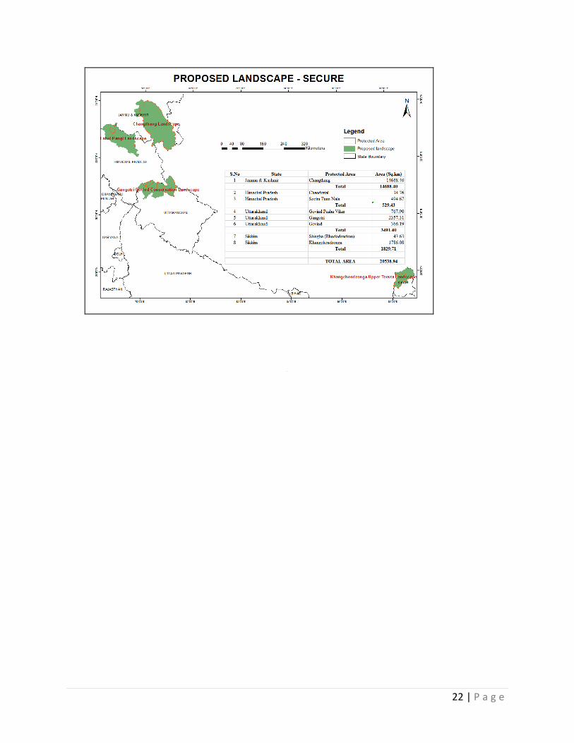
Component 4. Gender Mainstreaming, Monitoring, evaluation and knowledge management will ensure improved understanding and participation of key target groups from government agencies (decision makers and staff from key sectors), non-governmental organizations, farmer associations, water use associations and community groups, researchers and others, including in particular women and the most vulnerable segments of the population in the project management. The suggested strategy directly contributes to the Global Partnership on Wildlife Conservation and Crime Prevention for Sustainable Development Program (GWP)25 components 1 Reduce Poaching and Improve Community Benefits and Co-management; 2 Reduce Wildlife Trafficking; and 4 Knowledge, Policy Dialogue and Coordination. The details of suggested Theory of Change is shown in Figure 4. The project design was developed based on lessons learned from other projects, such as: The UNDP-GEF India high range Landscape Project - Developing an effective multiple-use management framework for conserving biodiversity in the mountain landscape of the high ranges, the Western Ghats, India; World Bank-GEF “Integrated Biodiversity Conservation and Ecosystem Services Improvement Project” UNDP project “Mainstreaming conservation and sustainable use of medicinal and aromatic plants in three Indian States, UNDP project “Biodiversity Conservation through Community Based Natural Resource Management’, World Bank/GEF Ecodevelopment Project and other nationally supported initiatives. The suggested project strategy was approved by a number of key national and state-level stakeholders at four well-attended validation workshops that were conducted during project preparation. Project Areas The target conservation landscapes (Figure 3) have been selected to conserve as much of the range of the snow leopard and where opportunities exists to improve community stewardship and partnership, based on the following criteria:
Landscapes dominated by high altitude rangelands under agro-pastoral or pastoral production systems between 3,000 – 6,000 meters in Western Himalayas and 3,000 – 7,000 meters in Eastern Himalayas
25 See https://www.thegef.org/gef/project_detail?projID=9071 for the comprehensive Program Framework Document (PDF). The included TOC of the Global Programme focuses on strengthening the conservation of globally threatened species and reducing wildlife crime by ensuring that local communities feel the value of preserving healthy natural resources and populations of wildlife species in order to secure their own livelihoods.
DRAFT
20 | P a g e
Landscapes of critical importance to snow leopard and prey species and those supporting rich and unique assemblages of flora and fauna, and natural vegetation types, and representing rich socio-cultural value
Landscapes containing a mosaic of protection, production and community use areas
Landscapes with potential for sustainable livelihood improvement
Accessibility and marketing potential for value addition services and products
Level of government and community interest and support for conservation and livelihood improvement
Landscapes that have not received much financial support in the past
The target landscape areas include state-owned and managed protected areas and reserved forests as well as community agricultural and grazing lands, etc. The target biological landscapes comprise of the following geographical, biological and socio-economic features (Table 2 and Annex 2):
Table 2: Geographical, Biological and Socio-economic Features of Selected Landscapes26
Landscape Geographic and Biological Features of Landscape Socio-Economic Features of Landscape
Changthang (J and K) 15,907 km
2 Changthang Plateau in the Upper Indus Landscape in Biogeographic Province 1B (Eastern Ladakh), with elevations ranging from 4,400 – 6,000 m. Consists of alpine dry scrub, desert steppe, marsh meadows and water bodies. The landscape is contiguous with Tibetan plateau. Key faunal assemblage comprises snow leopard, blue sheep, Argali, Tibetan gazelle, and Tibetan wolf.
Historically used as rangelands by the nomadic pastoral community (Changpas) who rear yaks and pashmina goats. Tibetan refugees (herders) occupy some areas. Tourism in some lake basins has degraded wildlife habitat and natural pastures. Climate change and extreme climatic events have caused mortality of livestock during severe winters and resulted in scarcity of drinking water in many areas.
Lahul-Pangi (Himachal Pradesh) 8,058km
2
This landscape forms the upper catchment of Chandrabhaga (Chenab) river and is flanked by Pir Panjal and Greater Himalayas in the south and north respectively. The mean elevation ranges from 3,000 – 5,500 m. The landscape area harbors scattered sub-alpine conifer forests dominated by Juniperus semi-globosa, Pinus wallichiana, Cedrus deodara and Betula utilis. Alpine dry and moist scrub and Alpine mixed pastures also occur in the landscape. The snow leopard, brown bear, Asiatic black bear, blue sheep, Himalayan ibex, Himalayan tahr and Himalayan musk deer are the characteristic mammalian fauna. The higher altitudes of Kinnaur district especially the alpine areas adjacent to Spiti and Raksham Chitkul represent important wildlife habitat, bio-corridors and junctions of biogeographic provinces 1a, 2a and 2b will be included in the baseline monitoring, conservation awareness and community based monitoring activities.
Heavy livestock grazing by local pastoralists (Pangwals) and migratory pastoralists (Gaddi), excessive collection of high value medicinal plants and human-wildlife conflicts especially crop raiding by Asiatic black bear are serious problems. There is considerable dependence of local communities on the bio-resources of Seichu – Tuan Wildlife Sanctuary. The lack of alternate livelihood opportunities for the local communities is a key issues.
Gangothri-Govind (Uttranchal) 7,143km
2
This landscape lies in the upper catchments of river Ganges and Yamuna. Upper parts of Gangotri National Park lies in the cold arid region while outer flanks of Gangotri as well as Govind represent cool temperate and sub-alpine forests, alpine moist meadows and glaciated, extremely
Major land use practices in this landscape include religious pilgrimage and tourism in Gangotri – Gaumukh area, seasonal grazing by migratory livestock in parts of Gangotri and Govind National Parks, commercial extraction of high value medicinal plants, extraction of timber and fuel
26 Refer Annex 2 for more detailed description of the four landscapes
DRAFT
21 | P a g e
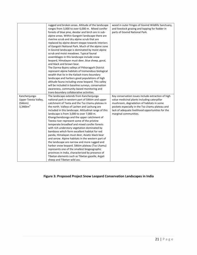
rugged and broken areas. Altitude of the landscape ranges from 3,000 to over 6,000 m. Mixed conifer forests of blue pine, deodar and birch are in sub-alpine areas. Within Gangotri landscape there are riverine scrub and dry alpine scrub that are replaced by alpine desert steppe towards interiors of Gangotri National Park. Much of the alpine zone in Govind landscape is dominated by moist alpine scrub and moist meadows. Typical faunal assemblages in this landscape include snow leopard, Himalayan must deer, blue sheep, goral, and black and brown bear. The Darma-Byans valleys of Pithoragarh District represent alpine habitats of tremendous biological wealth that lie in the Kailash trans-boundary landscape and harbors good populations of high altitude fauna including snow leopard. This valley will be included in baseline surveys, conservation awareness, community-based monitoring and trans-boundary collaborative activities.
wood in outer fringes of Govind Wildlife Sanctuary, and livestock grazing and lopping for fodder in parts of Govind National Park.
Kanchenjunga- Upper Teesta Valley, (Sikkim) 3,346km
2
The landscape extends from Kanchenjunga national park in western part of Sikkim and upper catchment of Teeta and the Tso Lhamu plateau in the north. Valleys of Lachen and Lachung are included in this landscape. Altitudinal range of this landscape is from 3,000 to over 7,000 m. Khangchendzonga and the upper catchment of Teesta river represent some of the pristine temperate broadleaf and mixed conifer forests with rich understory vegetation dominated by bamboos which form excellent habitat for red panda, Himalayan must deer, Asiatic black bear and serow. Alpine habitats in the western part of the landscape are narrow and more rugged and harbor snow leopard. Sikkim plateau (Tso Lhamu) represents one of the smallest biogeographic provinces in India, characterized by presence of Tibetan elements such as Tibetan gazelle, Argali sheep and Tibetan wild ass.
Key conservation issues include extraction of high value medicinal plants including caterpillar mushroom, degradation of habitats in some pockets especially in the Tso Lhamu plateau and lack of adequate livelihood opportunities for the marginal communities.
Figure 3: Proposed Project Snow Leopard Conservation Landscapes in India
DRAFT
22 | P a g e
23 | P a g e
Figure 4: Theory of Change
24 | P a g e
IV. RESULTS AND PARTNERSHIPS
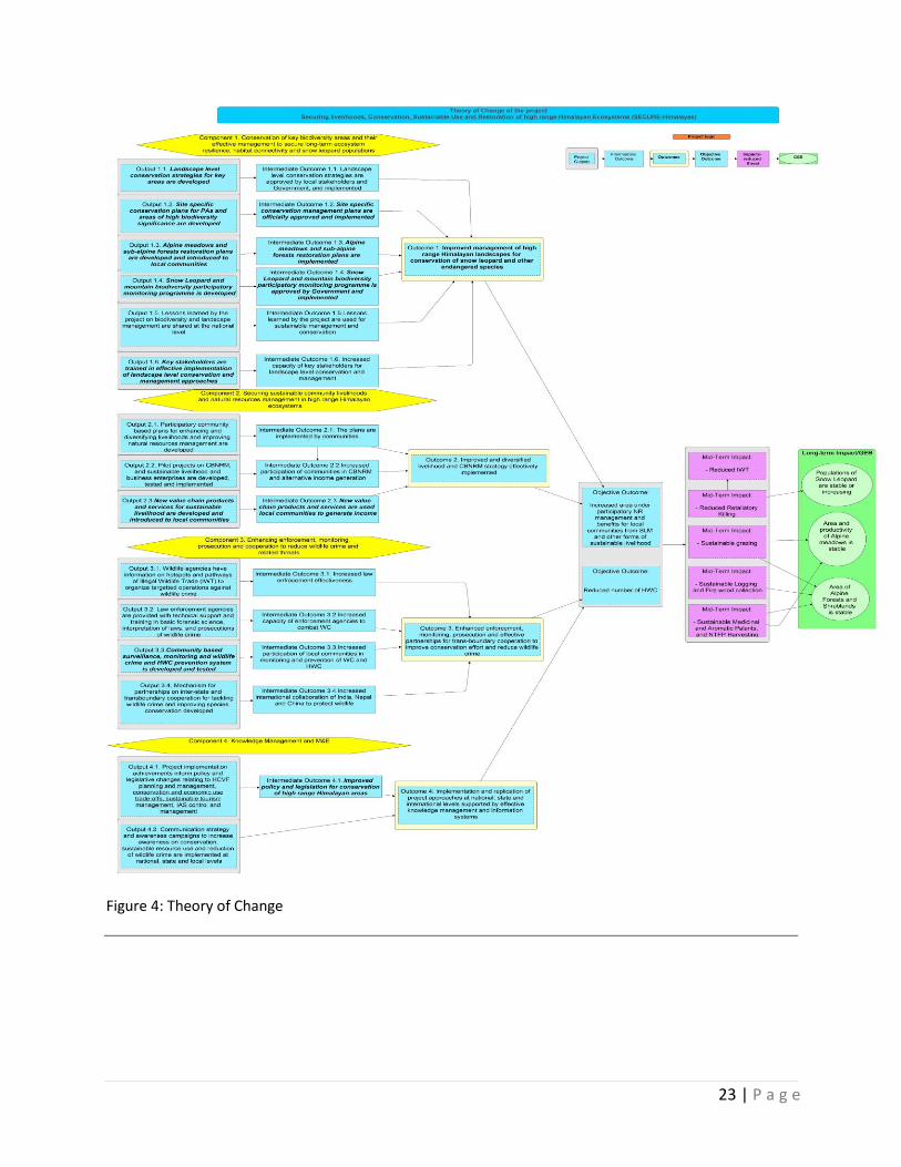
i. Expected Results (see Figure 4):
The project is designed to achieve the following long-term impacts or Global Environment Benefits (GEBs); Population of snow leopard is stable or increasing: Area and productivity of alpine meadows are stable; and Area of sub-alpine forests is stable. The long-term impact will be achieved through reduction of direct threats and following Mid-Term Impacts: Decreased IWT, Reduced HWC, Sustainable grazing practices, Sustainable logging and firewood collection, and Sustainable medicinal and aromatic plant and NTFP harvesting. Reduction of ditrect threats will be posisble through the following Project Objective Outcomes: Increase area under participatory natural resource management and increased benefits to local communitires form sustainable land management and other forms of sustainable livelihood practices and reduced human-wildlife conflicts and retaliatory killing of wildlife species.
The project’s incremental value lies in demonstrating, using the case of the selected four high elevation landscapes27 (alpine pastures, forests and critical watersheds) to develop participatory natural resources management practices and enterprise based sustainable livelihoods for local communities while concurrently conserving the snow leopard and prey habitats, maintaining the ecosystem values of these landscapes, and ameliorating climate change impacts. A GIS database and maps will be developed for each of these conservation landscapes, listing areas of high snow leopard, wild prey and biodiversity conservation significance, socio-cultural value and climate mitigation, grazing management, and community resource use. These layers will allow for defining which ecosystems can be sustainably used and which should be conserved in order to retain snow leopard habitat and ecosystem integrity and ensure productivity of rangelands in the long term. It will also help develop capacities and required enabling frameworks through "learning-by-doing" approaches in the selected target landscapes. Sustainable pasture and forest management approaches will be based on assessments of key snow leopard and wild prey habitats, ecosystem services and will build on capacities and concepts established during the interventions of earlier projects in India, as well as globally. The project will be able to develop and demonstrate a matrix of best practices of high range Himalayan ecosystem and snow leopard conservation for scaling up and replication in other landscapes nationally and globally. A series of publications and workshops will be launched to accomplish this. They GEF increment supports four inter-linked outcomes that are aimed at achieving the Objective Outcomes:
Outcome 1: Improved management of high range Himalayan landscapes for conservation of snow leopard and other endangered species and their habitats and sustaining ecosystem services
Outcome 2: Improved and diversified livelihood strategies and improved capacities of community and government institutions for sustainable based natural resources management and conservation to reduce pressure on fragile ecosystems
Outcome 3: Enhanced enforcement, monitoring, prosecution and effective trans-boundary cooperation to reduce wildlife crime and related threats
27 A biological landscape is defined as a system of interacting and myriad of ecosystems within a defined broader area that serves as a functional unit of productivity, protection and socio-economic benefit.
25 | P a g e
Outcome 4: Lessons learned by the project through participatory M&E, including gender mainstreaming practices, are used to fight poaching and IWT and promote community-based conservation at the national and international levels
Outcome 1: Improved management of high range Himalayan landscapes for conservation of snow leopard and other endangered species and their habitats and sustaining ecosystem services
Under this Outcome, the GEF increment will support landscape level conservation outcomes in the broader landscape, that include biodiversity rich areas and corridors outside protected areas through promotion of sustainable agro-pastoral, pastoral, natural resource use and conservation practices in the four multiple us landscapes, three in the Western Himalayas and one in the sub-tropical Eastern Himalayas. In particular, this would entail the strengthening of multi-level governance frameworks and capacities for management of the four multiple use landscapes to enable the convergence of planning, manpower and financial resources. Site-specific participatory natural resources management plans especially for buffer zones of high altitude protected areas, key biodiversity areas, including high conservation value forests (HCVFs), Biodiversity Heritage Sites (BHSs), and critical snow leopard corridors will be developed for the four conservation landscapes, ensuring optimal allocation of land resources to generate development benefits and critical environmental benefits (including avoided degradation, conflict reduction, snow leopard conservation, climate change mitigation and adaptation and community sustainable use and livelihoods) in tandem.
On-going and proposed government and non-government programs that would complement the GEF increment will include: (i) the Centrally Sponsored Scheme for PA Management in support of wildlife habitat improvement, eco-restoration in buffer zones and outside PAs, etc. (ii) State funding for management of PAs and forests through CAMPA, Green India and related schemes for habitat improvement, management of tourism and pilgrimages, and medicinal plant conservation areas; (iii) National Mission on Sustaining Himalayan ecosystems for research on policy, sustainable resource use, socio-economic impacts and opportunities, and illegal wildlife trade; (iv) USAID Asia High Mountain project and WWF programs in Sikkim for capacity building of communities forest staff in long-term monitoring of Rare, Endangered and Threatened (RET) species and habitats; (v) WWF wetland conservation program for supporting assessment and identification of high altitude wetlands for conservation and restoration in Changthang (Ladakh); and (vi) national and local NGO (WWF, TMI, ATREE, ECOSS and GBPIHED) programs for conservation of high altitude wetland habitat, soil and water conservation measures and capacity building of community groups for natural resources management. This Outcome would be achieved through six outputs, which will contribute to achieving the overall goal of developing working models of sustainable natural resource management at the landscape level to conserve snow leopard, wild prey and associated species and their habitats and in establishing capacity for planning, implementation and monitoring of the landscape management plans. Annex 3 provides a discussion of the objectives and outcomes, and step-by-step guide to the design and implementation of conservation landscape level conservation approaches. Output 1.1 Landscape level management strategies that integrates biodiversity, ecosystem services, climate mitigation, sustainable community resource use and socio-economic considerations are developed, discussed with stakeholders and supported. Under this output, the GEF increment will support the preparation of landscape level conservation and development strategies for four representative conservation areas (covering between 0.33 to 1.5 million
26 | P a g e
hectares in each of the four landscapes), including their surrounding areas. The management strategies at the landscape level will reconfirm a shift from the current emphasis on traditional protected area management to a more holistic and participatory approach of management of broader landscapes (including areas outside protected areas) for multiple benefits, such as for snow leopard and their wild prey habitat conservation, climate amelioration, provision of ecosystem services, water retention and soil erosion control, sustainable management of pastures and non-timber forest products, and community benefit sharing and livelihood improvement. Developed landscape level strategies will be agreed with key stakeholders, approved by relevant agencies and implemented for the four multiple use landscapes (Intermediate Outcome 1.1) This Output would be achieved through the following range of actions in the four landscapes, such as:
Establishment of multi-sector, multi-stakeholder coordination and governance institutional mechanisms to ensure coordination and convergence of planning, manpower and financial resources to integrate conservation, ecosystem services, sustainable meadow and forest management, water management, sustainable community natural resource management and use, and socio-economic considerations in four multiple use landscapes
Mapping and zoning of the biological and socio-economic aspects of each landscape to identify and prioritize: (i) areas for conservation of biodiversity, in particular for snow leopard and other endangered species and their habitats and dispersal corridors, such as high conservation value forests (HCVFs), Biodiversity Heritage Sites (BHSs), buffer areas around protected areas and others; (ii) areas for sustainable community natural resources management and use, including sustainable harvesting and extraction (NTFP and medicinal plant collection), community-based conservation and forest management, watershed conservation and climate risk management; (iii) degraded areas of alpine meadows and sub-alpine forests for assisted natural regeneration; and (iv) areas for sustainable agricultural development and improvement.
Based on the mapping and zoning exercise, the negotiation of a shared vision or strategy for each landscape among the different stakeholders facilitated by the multi-sector, multi-stakeholder coordination and governance institutional arrangement.
Institution of training programs for improving capacity of (i) conservation agencies to strengthen management of protected areas, HVCFs, BHSs, and other categories of conservation areas and improve rehabilitation of degraded meadows and forests; (ii) development agencies to facilitate integration of conservation and sustainable use practice into their sector planning plans and programs; and (iii) community and local institutions to improve planning and management of community-based conservation and forest initiatives, sustainable natural resource use, and sustainable agricultural and livelihood practice.
Supporting development and adoption of guidelines and procedures of GSLEP and as per the NSLEP strategies for conservation of the snow leopard landscapes and for delineating community livestock grazing and extractive use areas;
Defining institutional and coordination arrangements for management of conservation, sustainable natural resource use and agricultural areas, monitoring compliance and adapting to changes; and
Providing technical support and on-the-ground training in sustainable pasture and forest use, livelihood improvement measures to forest staff, community groups and other stakeholders.
Output 1.2 Site specific participatory management plans for Protected Areas, and other Key Biodiversity Areas, including High Conservation Value Forests, Biodiversity Heritage Sites and
27 | P a g e
biological corridors, and sustainable natural resource use areas designed and tested under community governance, management and enforcement regimes Under this Output, the GEF increment will facilitate the development and improvement of management plans for protected areas (Table 1), key biodiversity areas, including buffer zones, HCVFs, BHSs, and biological corridors (Annex 4 identifies potential HCVFs and corridors), and community managed areas and develop guidelines for improved conservation, natural pasture and forest management, medicinal and aromatic plant harvest and monitoring protocols for management of such resource uses, integration of conservation and livelihood options at the village microplanning level, and modification of sector agency plans to integrate conservation considerations. Developed management and integrated conservation and development plans will be agreed by key stakeholders, approved by government agencies and implemented (Intermediate Outcome 1.2) This Output will be achieved through the following actions:
Preparation of conservation management plans for existing protected areas, KBAs, HCVFs, BHSs and biological corridors within landscapes that are designed and tested under various governance, management and enforcement regimes;
Preparation of site-specific plans for soil and water conservation, sustainable pasture and natural resources use, natural resource based livelihoods, sustainable harvest of high value medicinal and aromatic plants, and restoration of degraded alpine pastures and sub-alpine forests through assisted natural regeneration, within and outside protected areas;
Development of protocols for conservation of snow leopard, endangered species and wild prey habitats;
Development of management prescriptions for areas for community-based conservation, sustainable natural resource management and sustainable harvest of forest resource and use to extend the range of conservation practice;
Extensive consultation with key stakeholders, including local communities on their expected needs and services from these natural areas and alternative livelihood options;
Facilitating the improvement of sector development plans to integrate conservation and sustainable natural resources management outcomes; and
Supporting the implementation of conservation and sustainable natural resources management interventions within the different parcels of land within the landscape to enhance conservation, livelihood and ecosystem benefits within the framework of the overall landscape vision or strategy.
A range of conservation management interventions that will be supported under the project is provided in Annex 5. These management interventions would be defined following the development of the landscape level management strategy (Output 1.1), site-specific planning process (Output 1.2) and be informed by its overall vision or strategy. Output 1.3 Alpine meadows and sub-alpine forest restoration plans are developed and introduced to local communities to improve biological connectivity and habitat productivity As a complementary activity to enhanced protection and management of biodiversity rich areas and corridors and other high conservation value forests (Output 1.2) and defined through the mapping exercise (Output 1.1), this Output will target on-the-ground interventions in and around 40,000 ha of
28 | P a g e
degraded alpine pastures and around 2,000 ha of degraded sub-alpine forests to enhance density and quality of the pastures and forests, and manage pressures on snow leopard and wild prey species from over-grazing and other anthropogenic factors. Activities for this Output will be implemented in all four landscapes with the intent of demonstrating a viable regime for pasture and forest restoration through a combination of controlled and rotational grazing, soil conservation, corralling, better herding practices, weed eradication, improved pastures through seeding, natural regeneration and their protection. In heavily degraded pastures, a suite of sustainable land management practices such as terracing, contour bunds, vegetative measures, soil fertility measures and bioengineering can be implemented. Degraded lands for pasture and forest restoration will be defined following inventory and mapping exercise (Output 1.1) and validated through a participatory consultative process with local communities and other stakeholders. To the extent feasible, the sites for rehabilitation would be selected in areas critical for wild prey and maintaining connectivity of home ranges for snow leopard and associated key species. Developed restoration plans implemented by local communities to improve grazing areas and sub-alpine forests for sustainable resource use is Intermediate Outcome 1.3.
The specific activities that would be undertaken to achieve this Output will include:
Review of national and regional best practices in restoration of alpine pasture and sub-alpine forests for snow leopard and wild prey to determine best practice;
Preparation of rehabilitation and restoration plans for the identified sites, including assessment of best silvicultural and soil conservation practices and working methodologies, and community protection and maintenance measures;
Establishment and maintenance of a suitable mix of protection, herding and other sustainable measures such as social fencing to reduce grazing, wood collection and forest product extraction pressures;
Support implementation and monitoring of grazing and forest restoration plans;
Documentation and dissemination of successes and failures of the restoration efforts; and
Preparation of a manual that describes restoration approaches for different pasture and forest types.
Output 1.4 Biodiversity participatory monitoring for Snow leopard and associated species is developed and tested
Under this Output, State Forest and Wildlife Departments and local community based organizations will partner in baseline surveys (including validation of existing snow leopard numbers) and monitor changes in status of snow leopard, wild prey and associated species and habitats that will help guide and inform future management of the landscapes. Presently, the baseline established of snow leopard populations in India is 516 individuals, with 474 estimated in the four project states (Himachal Pradesh - 90, Jammu and Kashmir – 285, Sikkim – 13 and Uttarakhand - 86)28, but estimates of population numbers of prey species and other endangered species are limited, and there are hardly any institutional arrangements for longer-term monitoring. A framework of participatory long-term monitoring and adaptive research will be developed for each landscape based on priority conservation and development priorities. Developed monitoring program will be approved by the State Forest and Wildlife Departments and implemented with project and government support (Intermediate Outcome 1.4).
28 Bhantagar, Y.V et al. 2016. South Asia: India. In the book: Nyhus, P.J, MacCarthy, T., Mallon., D. 2016. Snow Leopards. Biodiversity of the World: Conservation from Genes to Landscapes. ELSEVIER
29 | P a g e
The Wildlife Institute of India (WII) will be responsible for design and overseeing the monitoring that which will be complemented by a program to involve local communities in broader surveillance, monitoring and enforcement at the landscape level through:
Design of monitoring framework and implementation plan to conduct baseline surveys and monitor changes in status of snow leopard, wild prey and associated species and habitats that will help guide and inform future management of the landscapes. This plan will define methodology, monitoring frequency, and staffing and financial resource requirements.
Assessment of the training needs of field staff and local volunteers in basic tools and techniques of recording bio-physical and socio-economic parameters;
Training programs for improving capacity of field staff and communities to collect relevant baseline and monitoring data;
Organization and training of community groups for documenting local biodiversity (in biodiversity registers) and participating in monitoring;
Developing linkages between the NSLEP and other national programs to monitor changes in vegetation, land use and climate parameters;
Initiation of programs to validate existing snow leopard populations in the four project states, access baseline of prey species and other key threatened species, monitor population changes and documentation of results and findings; and
Establishment and monitoring of permanent monitoring plots for accessing impacts of resource use, improved conservation practice and retrogressive factors such as climate change impacts on the integrity, sustainability and resilience of fragile mountain ecosystems.
Parallel to the participatory monitoring program, the project will provide support for establishing baselines in terms of snow leopard and wild prey population numbers and density, poaching and wildlife trade, wildlife-human and wildlife-livestock conflict, etc. in each of the four landscapes. This would entail, design of a monitoring program, hiring of research and field assistant staff, travel and equipment costs and training of community data collectors to enable the establishment of baselines for a longer-term monitoring program, as well as to feed into the monitoring of the project outcomes and impacts, update of tracking tools, and mapping of wildlife trade routes, conflict zones and threats. The project will also support short-term action-based adaptive research to better understand the ecological, ecosystem, socio-economic, resource extraction and illegal wildlife related impacts on the landscape. A needs assessment workshop will be conducted in each landscape to determine relevant topics for action oriented research and arrangements for conduct of these research activities. A list of indicative action research topics is presented in Annex 6. In addition, at the beginning of the project, international expertise would be obtained for detailed calculation of climate change carbon benefits to validate the current estimates.
Output 1.5 Lessons learned on biodiversity and multiple use landscape management approaches are developed
Landscape conservation is not new to India, however it has limited application in the country. In view of this, wider knowledge dissemination on wise practice is extremely important to apply, scale up, replicate and promote the landscape concept more widely in the country. Lessons learned are used for further scaling-up of sustainable management of conservation landscapes (Intermediate Outcome 1.5). The project will make use of the websites of the MOEFCC and state agencies for online information dissemination and carry out the following activities to develop and disseminate knowledge emanating from landscape conservation sites in India:
30 | P a g e
Analysis of best practices and lessons from snow leopard conservation, sustainable pasture and participatory natural resource management, innovative natural resources-based livelihood related activities, etc.;
A national seminar at the end of the project to take stock of the experiences of landscape conservation management and to disseminate best practices and lessons learned, and deliberate way to replicate and scale-up. The proceedings would be published and disseminated online by MOEFF, and the state forest and/or wildlife departments
A national consultant would be recruited to undertake the analysis and documentation of the lessons learned and experiences from the landscape sites, including snow leopard and wild prey conservation practice, management of human-wildlife conflict and community sustainable natural resources initiatives. Briefs, papers and other communication tools would be used to disseminate the lessons for potential scaling up and replication elsewhere in the country. India’s project partners will showcase lessons emanating from the project at international and regional meetings and conferences so as to inform the global community. The lessons from this Ouput will feed into the dissemination and awareness activities under Outcome 4 to build a community of practice that would encourage replication of successful practices outside of the project areas. Output 1.6 Capacity development for key government staff and community members for long-term effective conservation of biodiversity developed and implemented Output 1.6 will help build capacity of the key stakeholders, including staff of the respective forest and wildlife departments, and other stakeholders to manage respective components of the landscape for snow leopard, wild prey and associated species and habitat conservation, sustainable pasture and forest management and sustainable livelihood improvement to evolve workable management models. Trainings for forest and wildlife staff will also focus on methods of spatial planning and mapping and planning, implementation and monitoring landscape levels plan and development coordination. In terms of key biodiversity area, HCVFs and BHSs and biological corridor management, training would focus on methodology for monitoring of indicator species (snow leopard and wild prey), evaluation of effectiveness of sustainable pasture and forest management, forest and pasture rehabilitation activities, interpretation and application of laws related to wildlife, protected areas, biodiversity and surveillance, monitoring and prosecution of wildlife-related crime. Training programs and curricula would be developed with, and integrated into regular training programs of institutions such as WII, ICFRE and others. After the training programs are implemented, the key stakeholders would participate in the design, implementation and participatory monitoring of landscape conservation and management plans (Intermediate Outcome 1.6).
Outcome 2: Improved and diversified livelihood strategies and improved capacities of community and government institutions for sustainable natural resource management and conservation In order to reduce the impact and burden of resource use in snow leopard habitat, the project would support a three-pronged strategy to enhance existing livelihoods, promote alternate and new options of livelihood and support skill-based employment opportunities, and sustainable natural resources management. Under this Outcome, the project would support assessment and mapping of current resource uses, location, type, production and intensity of use (e.g. timber, firewood, NTFP, and medicinal and aromatic plant extraction, and grazing and fisheries) as well as non natural resource based livelihoods. The mapping of the socio-economic (production and livelihoods), would be conducted as a rapid assessment using secondary information and broad village level consultations that would be subsequently revised and updated as more information becomes available from the landscape, grazing
31 | P a g e
and forest management planning processes and comprehensive socio-economic baseline and analysis, particularly in the community used areas. This exercise would help validate and confirm the current baseline of the socio-economic, geographical and occupational livelihood resource use and dependence in the landscape.
Under the GEF alternative, the project will support a number of activities aimed at improving and diversifying local livelihoods. GEF resources would support (i) mapping of community resource use; (ii) rapid assessment of condition and trends of natural resources exploitation, including methods of harvest and collection to evaluate if these methods are environmentally sound and sustainable; (iii) consultations with resource users to assess resource use and livelihood needs, extent of delegation of management responsibilities over parts of the landscape, assessment of impacts by changes in land use, and stakeholder willingness to participate in conservation action and livelihood improvement; (iv) participatory planning at the village level to determine alternative livelihood, income generation, sustainable natural resource management and value addition investments; and (v) provide technical support, training and skills development and financial support for enhancing existing and developing new livelihood and sustainable natural resources management programs. An indicative list of training activities developed during project preparation (Annex 12) would be further discussed during community consultation in the village microplanning exercises and prioritized. The project will seek to proactively align the GEF investments with the ongoing and proposed incremental activities for livelihood and micro-enterprise development in the project landscapes so that these serve as channels for mainstreaming sustainable measures identified under the landscape-level management strategies. These on-going and proposed incremental activities include: (i) Project Snow Leopard for improvement in livestock herding practices; (ii) National Missions on Sustaining the Himalayan Ecosystems and Renewable Energy to support interventions for improved land use practice, improved and energy efficient ovens and alternative sources of energy and climate risk management; (iii) District and Border Area Rural Development Plans to support renovation of communication infrastructure and community centers, supply of improved vegetable seeds, subsidies for cow and sheep, and compensation for damage or loss of property from weather-related events; (iv) State sponsored schemes for horticulture, agriculture, animal husbandry and tourism development; (v) MGNREG and NRLM programs of MORD to support livelihood initiatives and knowledge, skills and investments for revolving funds, vulnerability reduction, community investment funds and interest subvention for SHGs; (vi) Livestock Insurance Schemes of MOA; (vii) NGO programs of SKUAST and KVK in Changthang (Ladakh) for improving agro-techniques for high altitude rangelands, veterinary care, fodder production, vegetable production and plantation of willow and poplar in low-lying areas; (ix) Ladakh Amchis Association for development of sustainable harvesting methods for medicinal and aromatic plants; (x) Youth Association for Conservation and Development in Hemis National Park in support of homestay and other ecotourism activities; (xi) Cold Arid Network Program in Ladakh for improved agriculture production support, demonstration plots for sustainable agriculture practice, studies on seabuckthorn potential for soil productivity, nutrition, micro-enterprises for health foods and climate change risk management through training; (xii) All Changthang Pashmina Growers Cooperative Society to support cooperatives for pashmina growers and supporting alternative livelihood programs for poorer families; and (xiii) Snow Leopard Conservancy programs for promotion of local handcrafts and improvement of corral enclosures for livestock. In order to address the issue of Human Wildlife Conflict (HWC) appropriately in the project landscapes, the project will explore and pilot a range of management strategies. These will depend upon the terrain,
32 | P a g e
state of habitats, life forms involved and socio-economic way of life of people concerned. Financial compensation or insurance could work in some areas while replacing killed cattle with a new one or supply of necessary food grains/ material for damaged crops may be more useful in other areas with different socioeconomic conditions. Technology and approaches for avoiding the conflict and community action for organized cattle rearing/ land use including crop planning may also be useful. The project will consider all these along with the local wisdom for planning HWC management. Besides the Global Snow Leopard Ecosystem Protection Programme and national efforts across the country for HWC management can provide best practices that the project can build on. Furthermore, the Indian government delegation participated in the global joint learning meeting among the GEF Global Wildlife Programme participating countries last month with the theme of human wildlife conflict management, where many experiences with different approaches and lessons were shared. During the inception phase of the project, thorough review of best practices will be conducted for developing feasible HWC management plans for the target landscape. Output 2.1 Participatory community based village plans for enhancing and diversifying livelihoods and improving natural resources management are developed
A bottom-up participatory community planning process will be established that complements existing planning processes at the local level (Annex 7) to help improve existing, and develop new and diversified livelihood options and test and promote community-based natural resources co-management strategies as a means to diversify governance arrangements.
The following activities will be supported under this Output:
Bio-physical and socio-economic resource mapping (Annex 8 provides a social assessment of the community groups in the landscapes) at the village level to delineate scale of resource use (pasture, forest, water, NTFP, etc.); existing dependencies, their sustainability and opportunities for improving these practices and diversification and expansion of farm and non-farm based livelihoods, rights and/or overlapping conflicts in water and resource use, etc. Such an exercise would enable the identification of causes and incidence of degradation to identify “hot-spots” and to assess the presence or absence of incentives that currently guide unsustainable practice and inform community decisions.
Institution of a participatory community-based village level micro-planning process to define options for improving and diversifying community agriculture, improving sustainable livestock and NTFP productivity, enhancing service-based livelihoods and improving conservation and ecosystem benefits.
The multi-year action planning process will result in the preparation of participatory livelihood management plans (PLMPs and herewith referred to as “microplans”) at the village level. The microplans will serve as the basis for funding under the project.
Grant allocation for village microplan implementation that will be determined in consultation with the landscape planning and implementation teams (LPITs) based on level of socio-economic vulnerability, number of farmers participating, extent of degradation of agriculture and pasture assets, opportunities for diversification of livelihoods, promotion of sustainable natural management, community-based forest management and development of effective value chain products and services. Besides microplans, sub-sector plans based on existing and new value chains will be promoted and strengthened at the landscape level.
33 | P a g e
The GEF project would support landscape level planning teams with additional technical support from specialized agencies and experts, training (in microplanning and PRA techniques, group dynamics, gender mainstreaming and conflict resolution), consultation workshops and investment support for implementation of microplans. The LPITs, with technical support from NGOs and contractual technical
experts will guide the village microplanning process.
About 37,000 – 40,000 farmers and pastoralists (belonging to around 8,000 – 10,000 households) will directly benefit from on-the-ground training during the village level planning and implementation exercise and grant funding for implementation of microplan activities. The microplans would include a range of options agreed with communities to enhance agriculture and livestock productivity, improve livelihood and incomes, improve sustainable natural resource management, reduce their vulnerability, increase resilience and enhance the adaptive capacity to environmental and climate related risks and impacts. The microplans will reconfirm a shift from the current emphasis on investment in agricultural production to more holistic approach of management of agricultural and natural resource landscapes for multiple benefits.
A total of around 100 -120 villages will be supported in the four project landscapes through the village microplanning process. An indicative list of villages within the fringe and buffer zones of the landscape, but are dependent on the landscape for various livelihoods is provided in Annex 9. These villages and others that are not listed (a total of between 25-30 villages in each landscape) will be supported through intensive investments, but additional villages would be considered for less intensive or targeted support to ensure volume aggregation and viability for specific value chains products and services (covered under Output 2.3). In addition, a number of additional villages would be taken up for microplanning and investment support from non-GEF sources of funding (Central and State Government Schemes). Finalization of the villages for microplanning and intensive investments will be undertaken during early project implementation by the respective State agencies, following the landscape mapping exercise and the following criteria:
Proximity to, or located near protected areas, biodiversity rich areas and biological corridors within the landscape;
High poverty levels and high dependency on biomass resources within the landscape;
Limited financial support from government development agencies;
Located within valleys, where there is substantial human populations and human-wildlife conflict; and
Villages where political and social support is conducive for investment planning.
While specific investments within each village would be defined through the microplanning process, these would likely fall within the following an indicative list of investments, including improved water, soil and energy conservation activities, livestock management, post-harvest management, sustainable NTFP collection, ecotourism investments, human-wildlife conflict management, income generation activities and sustainable community forest, pasture and conservation management activities (Annex 10). Additional site-specific review would be required during the village microplanning process to determine which of the investment options meet the specific requirements of the local communities and the expected conservation objectives. The outcome of this Output would be the formalization of at least 100-120 village based microplan/livelihood plans. The project will provide technical assistance (Annex 11), training (Annex 12) and grants for implementation of the village microplan actions. The specific investments, technical support, training, benefit sharing and reciprocal commitments would be
34 | P a g e
laid out in each village microplan, that would become the instrument for approval of funding from the project. A typical content of a microplan is provided in Annex 7. The developed livelihood plans will be used by local communities to improve and diversify livelihoods will be the Intermediate Outcome 2.1.
Given the potential of low intensity community-based ecotourism29 to contribute to biodiversity conservation and improvement of local people’s livelihoods, the project will in addition, the project will also support the development of 2-3 site-specific community-based ecotourism plans that will among others, include mechanisms/interventions to foster responsible tourist behavior, conservation of important wildlife habitats and ecosystems, appreciation of local cultures and traditional lifestyles, and provision of sustainable forms of livelihood for people living in remote areas and clear mechanisms for sharing benefits decision-making related to governance, control, and regulations. Identification of environmental and social safeguards will be integral to the design of tourism products and designation of ecotourism sites while strategies to mitigate any environmental and social impacts will form part of the plans. In the development of these strategies, a review of successful initiatives in similar biogeographical context such as those in Nepal’s high range mountains (e.g. in the Sagarmatha National Park) will be undertaken and lessons learnt applied. Moreover, such strategies will take cognizance of existing initiatives and build on them (e.g. experiences from Sikkim30). The project will employ highly participatory approaches in the formulation of these plans so that local communities’ interests, concerns and aspirations are fully captured and the resulting plans to ensure maximum community ownership.
Output 2.2 Pilot projects on sustainable community based natural resources management, and sustainable livelihood activities are supported Based on the participatory community village microplanning (and value-chain initiatives) outlined in Output 2.1 and 2.3, the GEF increment will support sustainable livelihood improvement and diversification practices that would entail improved access to basic goods and technical services, and technology and practices (on-farm agro-biodiversity management, integrated pest management, home garden and vegetable and fruit production, shift from extensive low nutrition agricultural productive systems to intensive high nutrition ones, etc.) and sustainable community-based natural resources management practices. As part of this activity, the project will also support innovative strategies for risk management at the micro-level to maximize benefits and opportunities, improve processing and storage facilities, support seed improvement and high value chain development activities, support testing of new technologies for improving incomes and up-scaling, including alternate energy (micro-hydro, solar, etc.) for community based processing, drying and cooking, gravitational irrigation, improved village storage, packing, better transport methods to markets to reduce damage, as well as microfinance, etc. In terms of vegetable and fruit production, the project will promote better primary level processing and handling at the farm level to reduce labor costs, improve and introduce better livestock breeds and fodder management and improved feeding methods, and sustainable harvest methods to reduce damage to fodder trees. It will also support skills development for non-farm employment in the tourism and related sectors and improving the use and harvest of natural resources through community governance mechanisms. To achieve this outcome, the project will provide technical support, training
29
Low intensity community-based ecotourism will adequately integrate elements such as promoting the experience of close contact with nature and people from different cultures, maximize revenues for poorer people rather than large companies and reducing the overall environmental impact
30
http://www.sikkimforest.gov.in/Reports%20and%20Publications/100years/100%20Years%204.pdf
35 | P a g e
and project grant funding to local communities, the latter based on partial sharing of costs. Increased participation of communities in natural resource management and alternative income generation activities will be achieved (Intermediate Outcome 2.2).
Grant financing for livelihood activities would be performance-based and designed on basis of ensuring transparency and extensive consultations with local and district entities and other relevant stakeholders, be well coordinated and promoted through effective technical support, regular review of implementation arrangements and the use of monitoring and evaluation information to adjust and refine the system in consultation with the stakeholders (Refer Annex 7 for further details regarding micro-grants for village activities). Grants would be typical cash for work payments that would be based on the following principles: (i) competitive assessment to selected village institutions/beneficiaries; (ii) selection of beneficiaries in accordance with transparent criteria (to be defined early in the project); (iii) upfront payment (percentage of payment to be defined in consultation with stakeholders); and (iv) balance payment on successful completion and verification of work. Efforts will be made to try to identify additional funding support for this activity from existing government and local development programs. The Output would support enhanced incomes to farmers and pastoralists from alternative livelihood activities to supplement existing earnings. This Output will also promote microfinance by facilitating linkages with rural banks and microfinance institutions. Based on initial assessment of alternative livelihood options during the preparation phase of the project, a menu of possible alternative livelihood options is presented in Annex 13. While, the key livelihood investments will be supported under the project, the investments for other village microplans investments would sought through district livelihood and other sector plans supported by the state governments to ensure broader financial support and long-term commitment to improving the economic well-being of local communities. The convergence of government resources would be sought through the support of the State Level Steering Committees and by co-opting block, district and sector agency staff into Landscape Planning and Implementation teams during the village microplanning process.
Output 2.3 New and enhanced value chain products and services providing ecologically sustainable livelihood are developed and implemented by local communities In each of the four project landscapes, two or more value chains have been identified based on their potential to develop new products and services or scale up existing products and services for the benefit of a larger group of people. Some value chains identified have relevance across more than one landscape (Annex 14). In selected clusters within the four landscapes, the GEF project will design and implement interventions to pilot and scale-up products and services having commercial potential, promote credit, marketing and cooperative agreements. This will be done in partnership with specialized agencies such as line departments, NGOs, research institutions and individual experts. Wherever needed, the project will strengthen existing community based organizations and village level entrepreneurs to address gaps in the value chain. New and improved value chain products and services are implemented by local communities to increase incomes and reduce unsustainable resource uses is the Intermediate Outcome 2.3. The following actions are planned under this Output:
Selection of Value Chain: While, a number of key value chains have been identified for the landscapes, selection is flexible to allow additional value chains to be added during project implementation, as new opportunities can arise and market dynamics change rapidly. Two sets of criteria should be considered when undertaking a preliminary value chain selection, namely:
36 | P a g e
(i) Value chain growth potential (current/potential unmet market demand, competitive advantages etc.) and (ii) Livelihood development potential (e.g. percentage of the village that can be engaged in the value chain, and additional income that can be generated from value chain).
Mapping and Analysis of Value Chain: Based on the list of preselected value chains, mapping and analysis of value chains would be undertaken during early project implementation, including in-depth market and feasibility analysis. The value chain analysis will be market led, meaning it would start by mapping (i) the market potential of the product/service, (ii) the customer requirements and (iii) the challenges faced by marketers/customers. Based on the market data the existing value chain (stakeholders, role of the stakeholders, infrastructure availability, practices and processes, value extracted at each step, etc.) gaps in the value chain will be assessed. The objective of this is to identify value chains where rural producers and service providers have a competitive advantage and can establish sustainable livelihoods. Based on the gaps identified above, interventions will be designed and implemented in the project. Project interventions will be designed to complement and enhance ongoing interventions by other stakeholders such as the government, other donor agencies, etc.
Implementation: Project interventions will be in the following five areas, namely: o Capacity building of stakeholders in the value chain: Training and skill development will be
provided to producers and service providers to (a) help them understand customer requirements, (b) increase productivity, (c) learn necessary business skills and (d) other specific needs as per the value chain, including developing new products and services. Systems and processes will be developed to capture adequate data and monitor the functioning of the value chain;
o Infrastructure: In case of lack of infrastructure the project will work with relevant stakeholders and collaborate with national, state and private sector institutions to provide producers and service providers with both technical and infrastructure (small processing, storage and marketing facilities). When needed technical institutes will be approached to develop appropriate technology to address the gaps identified.
o Branding and Marketing: To allow producers and service providers to gain maximum value for their goods and services a Branding and Marketing strategy will be developed and implemented. This would entail building a brand, communication material, communication strategy, identifying several distribution channels, partnering with relevant stakeholders, etc.
o Research: Assessing the feasibility and commercialization of specific products, such as hazelnut, barley, Himalayan Rajma (red kidney beans) and buckwheat value chains; and
o Geographical Indication31 (GI) registration: Assessing the products that are unique for GI registration and implementation of GI registration process, and meeting post-registration requirements for enforcing correct use of GI labeling, consumer awareness and motivating producers and producer groups to participate in the GI registration process
The interventions will be designed and implemented in a manner to ensure self-sustainability of the value chain by the end of the project period. This will allow the activity to continue beyond the life of the project reducing the risk of dependence on other forms of funding. In conjunction with Outputs 2.1
31
A “geographical indication” (GI) is a specific name of a product that can apply if it has characteristics or reputation due to its origin.

37 | P a g e
and 2.2, primary and secondary level informal or formal organizations/collectives will be encouraged to participate in these livelihood activities. To the extent feasible, the project will attempt to link new investments to national, state and private sector programs. Support, under this Output would be extended to intensive microplan villages that are covered in Outputs 2.1 and 2.2, as well as villages not covered under the intensive microplanning investments to facilitate volume aggregation and processing.
Outcome 3: Enhanced enforcement, monitoring and cooperation to reduce wildlife crime and related threats
Under this Outcome, the project will seek to develop and demonstrate effective wild life surveillance, monitoring, prosecution and other deterrent systems and increase international cooperation through establishing cohesive linkages with global and regional programs. The project will support institutional mechanisms to assess hotspots and pathways for illegal trade and to help curb illegal trade in wildlife parts and products, minimize poaching, including retaliatory killing of carnivores. This would entail the involvement of local communities, volunteers and other groups in anti-poaching and surveillance, as well as efficient and effective information sharing and management systems to reduce incidences of wildlife poaching and illegal trade, and measures to reduce or manage wildlife-livestock/crop conflicts. The project will also focus on enhancement of enforcement capacities of anti-poaching cells of State Forest and Wildlife departments, police, and border guards (including the ITBP, Indian army, customs officers, etc.) through trainings on integrated wildlife law enforcement (e.g., identification and prosecution of wildlife crime; inter-agency cooperation; risk management; investigative procedures etc.) and also strengthen the implementation of CITES, in close cooperation with the Wildlife Crime Control Bureau (WCCB) of the MOEFCC and Security Agencies. The project will also seek to draw on international best practice and experience to foster the implementation of integrated models of wildlife crime reduction (including building awareness of wildlife laws, reducing demand through behavior change campaigns, and strengthened enforcement of wildlife laws including supporting fast prosecution of wildlife crimes). The project will also actively co-opt local communities for wildlife monitoring and crime control through capacity building and other appropriate mechanisms.
This effort will be complemented by improved partnership in trans-boundary cooperation for conservation and information sharing. This will involve of partnerships (inter-state in India) and with neighboring countries (Nepal, Bhutan and China) including linkage with international and regional conservation initiatives and networks (such as GSLEP, SAWEN, WEM). In particular, the project will utilize SAWEN network of wildlife agencies and partners in the region will enable the information between member countries on all aspects of wildlife crime control and illegal trade monitoring. Information generated through the project, including identified illegal wildlife trade hotspots, implementation experiences and intelligence will be integrated into training materials and communication tools under the project. Lessons and best practices on wildlife crime management (including community-based wildlife crime surveillance and monitoring practices) will be shared at the regional level.
Output 3.1 Wildlife Agencies have information on hotspots and pathways of illegal trade to organize targetted operations against wildlife crime.
The high Himalayan ranges pose specific challenges for law enforcement on account of natural factors such as difficult terrain and poor connectivity. However, factors such as adequacy of enforcement staff, mobility, effectiveness of communications, understanding of the crime, skills for identification of species
38 | P a g e
and the specimens used in illegal trade, understanding of illegal trade connectivity and poaching and trade hubs, routes, networks, protection laws and legal procedures, enforcement operation systems, trade through cyber space, efficiency and efficacy of data collection and creation of data bases, efficiency and ethics of data collation, methods of analysis of data to understand temporal and spatial aggregations, development of joint surveillance system and enforcement are critical deterrents for combating wildlife crime. Such capacity, skills and enforcement systems are currently lacking in this region.
The project will undertake a detailed investigation of the past and current trends in illegal trade in wildlife parts and products within the project States in general, and within the districts in the landscapes, more comprehensively in mapping of hotspots and pathways of such activities. This will be done by the state Anti-poaching cells in close collaboration with TRAFFIC India, WCCB and state intelligence agencies. Data on poaching and illegal wildlife trade will be used by law enforcement agencies (Police, Customs, Revenue and Paramilitary Forces) for targeted intelligence gathering and information sharing, coordination, reporting and effective IWT prevention operations (Intermediate Outcome 3.1). This exercise will provide enforcement agencies with information on poaching and illegal wildlife trade tht would enable the organization of surveillance and monitoring operations against wildlife crime. Information generated through the project, including identified illegal wildlife trade hotspots, implementation experiences and intelligence will be integrated into training materials and communication tools under the project.
Output 3.2. Law enforcement agencies are provided with technical support and training to increase capacity for combating wildlife crime
The project would support the development of a deterrent enforcement system. Use and efficacy of use of modern tools and techniques in wildlife law enforcement could be examined and applied. It would also explore the potential for use of modern tools and techniques to detect trafficking and illegal trade in wildlife and wildlife parts. Creation of a common platform for multiple enforcement agencies and border forces can be an effective force multiplier. Such a strategy will require comprehensive approach for collaboration and capacity building. Increased capacity of enforcement agencies in combating wildlife crime is the Intermediate Outcome 3.2.
Under the GEF alternative, the following activities are planned:
Development of intelligent information gathering system for collection of information on poaching and wildlife trade within the landscapes and developing close liaison with police, security and custom personnel and others for regular review and enforcement;
Training of wildlife, army and local police staff to improve capabilities for crime scene investigation and basic forensic science (using existing State Forensic Science Laboratories, to the extent relevant), reporting and record keeping;
Training of staff of wildlife department, police, security and legal personnel, custom officials, representatives of Wildlife Crime Control and Traffic, India to develop intelligent based information management systems using modern tools and techniques to minimize wildlife related crime and improve prosecutions of wildlife crime; and
Investigation of existing routes of illegal wildlife trade, middle men involved and elements dealing with sale of illegal arms, snares, traps etc. and development of strategies for deterring such activities.
39 | P a g e
The project will provide technical support, training, equipment and operational costs for this Output. Complementing the GEF alternative would be following programs, (a) Project Snow Leopard to mitigate wildlife-human conflicts, including corrals and improved livestock herding practices; (b) WWF’s Conservation Program that would support efforts to mitigate loss of livestock by snow leopard predation; and (c) speedy disposal of wildlife crime cases pending in the courts. Output 1.4, would complement Output 3.2, the former providing information in terms of population numbers and density, poaching and wildlife trade, wildlife-human and wildlife-livestock conflict, etc. for snow leopard and key prey species in each of the four landscapes, and for mapping of wildlife trade routes, conflict zones and threats. SAWEN’s network of wildlife agencies and partners in the region will enable the sharing of information sharing between member countries on all aspects of wildlife crime control and illegal trade monitoring.
Output 3.3. Community based surveillance, monitoring and wildlife crime and conflict prevention system developed and tested
This Output will support the design of a surveillance, data collection and database management system for smart patrols in the four landscapes, and establish core teams of trained, equipped and dedicated community members to implement a smart patrol system, particularly in vulnerable border areas and transit locations within the four landscapes. Options for establishing special task forces involving local community members and enforcement agencies could also be considered. It would also support improved measures for reduction of wildlife-livestock/crop related conflicts to reduce retaliatory killing of wildlife (this activity is particularly included in Outcome 3 as it has direct relevance to reduce of killing of wildlife). Increased participation of local communities in monitoring and prevention of wildlife crime and HWC is Intermediate Outcome 3.3. The key activities to be implemented under this Output will include:
Design of community surveillance, monitoring and crime detection plans for each landscape; Selection and mobilization of community groups to undertake surveillance and monitoring; Provision of training, field and surveillance equipment and limited stipend to participating
community members of the surveillance teams; Development of communication and reporting formats and communication systems for
information flow and management; Design of a long-term program for sustaining the community surveillance and monitoring
system beyond the life of the project; Establishment of secret funds for sting operation and rewards; and Community grants to design and implement improved measures for reduction and management
of wildlife-livestock/crop conflict such as improved corrals, better herding practices, wildlife deterent measures, crop fencing, etc.
The GEF alternative will provide technical assistance for design of a community surveillance, monitoring and crime detection program, training support, field and surveillance equipment and limited stipend for participating members of the surveillance team, and community grants to design and implement improved measures for reduction and management of wildlife-livestock/crop conflict such as improved corrals, better herding practices, wildlife deterent measures, crop fencing, etc.
40 | P a g e
Outcome 3.4 Mechanisms for partnerships on inter-state and transboundary cooperation for tackling wildlife crime and improving species conservation in Himalayan ecosystem are developed and implemented This Output will not be exclusively confined to the landscapes, but would have geographical coverage throughout each of the States, in particular to cover hotspots of illegal wildlife trade especially along state and national boundaries. The eastern part of Uttarakhand that is flanked by Nepal in the east and Tibetan Autonomous Region (TAR) of China in the north is known to be one of the hotspots of illegal wildlife trade including high value caterpillar mushroom (Sinocordyceps sinensis). Establishing coordination between the forest, police, defense, revenue and customs department for intelligence gathering is necessary to control illegal trade on wildlife in this area. Similarly, trans-boundary cooperation is needed between India, Nepal and China in similarly curbing illegal activities. These three countries have developed a regional cooperation framework or ‘Kailash Sacred Landscape Conservation and Development Initiative (KSLCDI)’ under the aegis of International Centre for Integrated Mountain Development (ICIMOD). This initiative aims to establish institutional mechanisms for trans-boundary cooperation to reduce ecosystem vulnerability and threats to biodiversity and improve livelihoods. The GEF project would complement this program by initiating dialogue with state and inter-state players/stakeholders, including key local institutions and civil society organizations and also establish baseline information on current levels of harvest of various bio-resources from high altitude areas including those that are used locally or traded nationally and internationally. The project will work through SAWEN to build partnerships for trans-boundary cooperation.
The Kangchenjunga Landscape Conservation and Development Initiative (KLCDI) is a trans-boundary conservation and development program between Bhutan, India and Nepal facilitated and supported by ICIMOD. This initiative recognizes the importance of establishing habitat linkages among the protected areas, managing the ecosystems in entirety, and supporting the livelihoods of communities living in the landscape. A Regional Cooperation Framework exists as the basis for implementing KLCDI. One specific objective of KLCDI is to promote collaboration in long-term monitoring. The GEF increment would support meetings and technical workshops for PA and police staff from Nepal, India and Bhutan to share and update information of illegal wildlife trade and trafficking. It would also train government agencies in morphometric and DNA-based identification of wildlife parts and products. The project would also seek cooperation in DNA-based scat analysis to better understand population dynamics and distribution of snow leopards in the trans-boundary landscape. Another area of potential collaboration is the orientation of laws, policies and procedures pertaining to wildlife trade and strategies for curbing cross-border trafficking. Development of international agreements and plans to combat IWT and protect trans-boundary areas would be operational (Intermediate Outcome 3.4). Outcome 4: Lessons learned by the project through participatory M&E, including gender mainstreaming practices, are used to fight poaching and IWT and promote community-based conservation at the national and international levels
The goal of Outcome 4 is to improve knowledge and information systems, gender mainstreaming to enhance awareness of benefits of conservation of high Himalayan ecosystems and improve policies that support conservation and sustainable use. To achieve such an objective requires the improved understanding and participation of key target groups (decision makers and staff from key sectors), non-governmental organizations, farmer associations, water use associations and community groups, researchers and others, including in particular women and the most vulnerable segments of the population. The revision of policy and implementation of a communication and outreach strategy is
41 | P a g e
intended to promote meaningful stakeholder participation in biodiversity conservation, livelihood and wildlife crime prevention as well as scale up successful lessons in resource conservation more widely in the landscape and beyond.
The GEF alternative would support: (i) review of existing policies to identify gaps that hinder promotion of a more holistic approach to conservation, socio-economic development and wildlife crime prevention; (ii) development of tools and mechanisms for effective advocacy at national, landscape and local level; (iii) building capacities of key stakeholders for continuing documentation and communication processes beyond the project period; and (iv) support the implementation of communication strategy to improve awareness and support for the conservation of the high Himalayan ranges. Project Snow Leopard, NMSHE (Climate change awareness and policy interventions), and SECMOL’s Student Educational and Cultural Movement of Ladakh (conservation education through schools and engagement of youth in conservation action) would complement the GEF increment; and (v) support the implementation of the gender strategy and its use to guide project implementation, monitoring and reporting.
Output 4.1. Project implementation achievements inform policy and legislative changes for conservation of high range Himalayan areas
Promotion of landscape conservation management practices, as well as innovative approaches to sustainable pasture and forest management, sustainable livelihoods and wildlife crime will be facilitated through a set of recommendations that can guide and influence future national level policies and regulations. Consultations with stakeholders from government, research organizations and others would be conducted to assess needs and gaps in policy outreach and advocacy. Some of the potential policy gaps that have been identified so far, are lack of: (i) procedures and processes for identification, setting aside and management of biodiversity rich areas and wildlife corridors outside of traditional protected areas; (ii) methodology for integrating community participatory grazing or sustainable NTFP and agro-forestry-pastoral systems into the protected area and forest management planning process; (iii) procedures for assessment of trade-offs between conservation and economic use: (iv) guidelines for management of mass tourism in conservation areas; and (v) identification and supporting value addition products and services as incentives for conservation, management of feral dogs, etc. The project would also support documentation and development of policy recommendations, conduct of policy-level workshops and seminars, provide technical assistance support to sector agencies, etc. Suggested policy and legislative improvements under consideration by government (Intermediate Outcome 4.1)
Output 4. 2 Communication and gender strategies and awareness campaigns to increase awareness on conservation, sustainable resource use and reduction of wildlife crime, and mainstream gender in promotion of community-based conservation developed and implemented at national, state and local levels A communication, gender and knowledge management strategy (Annexes 15 and 16) will be key to the overall goal of creating bridges between the stakeholders from the grass-root to the national and global level, for flow of information, exchange of ideas and combined implementation and mainstreaming gender in community-based conservation and IWT prevention. The communication strategy is aimed at making “SECURE HIMALAYAS” a national priority that will help build visibility to the conservation needs of the landscape and connecting policy makers, media, research and academic institutes, private sector, NGO’s and general public - through a comprehensive program, from consultations, brand building to
42 | P a g e
outreach and awareness. Annex 15 also provides a list of indicative communications tool for the project. It is also intended on developing among the stakeholders an ownership to the goals of the project – shared knowledge, experiences, inputs and ideas for effective action. The intent is to create systems that facilitate and generate a common vision for “SECURING HIMALAYAS” and supporting a horizontal and vertical exchange of information and knowledge to strengthen decision support systems available to agro-pastoral or local communities and facilitate knowledge exchange through field visits and awareness trainings, identify promising and good practice adaptive mechanism relevant to landscape conservation approaches, sustainable land and pasture management, promote establishment of model demonstrations by involving local communities to showcase such best practices, and document and disseminate and share results of adaptive approaches for up-scaling. Improved knowledge and information for promotion of landscape conservation approach (Intermediate Outcome 4.2). The intent of the gender mainstreaming strategy and action plan (Annex 16) is to enhance the role of women in conservation-based actions and reduction of IWT, that provides a voice for women in the local decision making process related to conservation, sustainable resource management, livelihood and other local level activities. This Output would also support through the following activities:
Development of communication strategies and plans for each landscape and the conduct of awareness and outreach activities for a variety of stakeholders at the national, state and local levels such as information centers, competitions, website, mass media, video and film, festivals and branding of the Himalayan product (Annex 15)
Implementation of a gender mainstreaming action plan (Annex 16) for each landscape and the conduct of awareness and outreach activities to enhance the role of women in local decision making processes and project-related activities.
National and regional workshops to facilitate dissemination of field lessons and help inform legal and policy reform relevant to landscape conservation practice. Specific topics of learning and success that might evolve from the pilot sites might include the participatory livelihood planning, outcomes or impacts of specific actions in agriculture, water and sustainable pasture management, livelihood diversification, resilient agriculture development, and participatory monitoring, as well integration of livelihood development planning, soil, land and water management, etc. The initial documentation of these lessons will be included as part of the participatory monitoring process, that would be complemented by additional national technical support to distil and document lessons and experiences. The project will support regular workshops at the regional level (Year 3 onwards) to share lessons and experiences and a national workshop at the end of Year 6 to facilitate the sharing of lessons more widely, but importantly to be able to further develop and refine successful approaches for replication nationally.
Efforts would be made to institutionalize some of the best practices through promotion of sectoral and/or national regulatory instruments in order to secure sector/nation-wide replication and up-scaling. In order to expand access to finance for replication and up-scaling the project will collaborate with the private and public sector financial institutions to support farmer associations, landowners and other land users.
ii. Partnerships: The proposed project will coordinate with a range of on-going GEF-financed Biodiversity projects in the country which are described below:
43 | P a g e
The UNDP-GEF implemented India high range Landscape Project - Developing an effective multiple-use management framework for conserving biodiversity in the mountain landscape of the high ranges, the Western Ghats, India that will build effective collaborative governance framework for multiple use management of forest landscapes will generate lessons on land use planning and permitting framework that considers both ecological/environmental priorities and development objectives. The current project can benefit from this in particular in the design of measures to reduce conflicting land use demands at the landscape level in the fragile snow leopard landscapes; in addition, the current project will complement the work under the former project in areas of development of guidelines/tools for integrating biodiversity into production sector practices; and also share lessons with each other for cross-fertilization of ideas and approaches to promote sustainable use and management of wild resources by local communities.
Similarly, the recently approved World Bank-GEF project “Integrated Biodiversity Conservation and Ecosystem Services Improvement Project” will also build capacities in relevant government agencies at the central and state level to mainstream biodiversity conservation into development plans and policies while also demonstrating means and strategies to improve conservation status of forest ecosystems including development models for enhancing and measuring carbon stocks and carbon sequestration in production and other types of forests in tandem with development of models for sustainable use of biodiversity for increased incomes and improved livelihoods. The current project will directly complement efforts under the project and will make use of the models for carbon stock improvement and measurement in promoting sustainable forest management practices in the wider landscapes in the snow leopard ranges.
Learning and good practices from two Himalayan States of Uttarakhand and Arunachal Pradesh in a GEF, Government of India and UNDP project entitled “Mainstreaming conservation and sustainable use of medicinal and aromatic plants in three Indian States” will form the basis for engaging local communities in inventory and monitoring of medicinal plants and adding value to select medicinal and aromatic plants using their traditional knowledge and validation and commercial use of this traditional knowledge. In-situ measures for conservation of medicinal plants adopted in this project could be replicated in the other Himalayan states. Outstanding lessons derived from another Government of India and UNDP project “Biodiversity Conservation through Community Based Natural Resource Management’ would be used to enhance community capacities in resource management and securing livelihood opportunities from initiatives related to ecotourism, community conserved areas and enrichment plantations of degraded forest lands through indigenous and endemic high value medicinal plant.
The GEF project will also ensure coordination with the global UNDP-GEF project Trans-boundary Cooperation for Snow Leopard and Ecosystem Conservation. This global project designs tools, methods and guidelines for identification of snow leopard landscapes; enhances enforcement capacities of local protection agencies through training; puts in place unified mapping and monitoring protocols; supports cross-country coordination and dialogue and private sector engagement.
The project will build collaborative partnerships with ICIMOD, WWF, research institutions and other non-traditional partners in particular in support of trans-boundary conservation efforts in Kanchenjunga and Kailash Sacred Conservation landscapes. In addition, a number of international donors are active in the Himalayan landscapes, that will provide an opportunity to share lessons and build on the learning and best practices emanating from these donor programs. In particular, these include the (i) USAID funded “Asia High Mountain” Project (2012-2017) that promotes climate smart management of high
44 | P a g e
mountain landscapes and snow leopard habitat, and improves transnational collaboration on climate change adaptation; (ii) German Federal Ministry of Economic Cooperation (BMZ) funded “Promotion of Transboundary Management of Natural Resources in the Himalayas” project (2013-2017) as a platform for regional cooperation; (iii) the German Federal Ministry of Environment, Nature Conservation, Building and Nuclear Safety (BMUB) funded “Developing and Using Experiences for Implementing REDD+
in the Himalayas” project (2013-2019) that focuses on development of national actions plans and strengthening institutional and technical capacities and provide an economic motivation for the conservation of Himalayan forests; and (iv) the German Development Bank (KFW) funded “North East Climate Adaptation” project (2013-2017) that supports integrated village based participatory land use planning, planning and implementation of climate change adaptation measures, and supporting policy mainstreaming for climate change adaptation methodology and measures, including the state of Sikkim. The India SECURE project will participate in workshops and meetings either in those organized by the international donors or by the project itself to build cooperation and share lessons and experiences and seek opportunities for promotion and replication of such best practices and methodologies, including those relating to promotion of climate change adaptation mitigation and resilient measures through the village microplanning process. Finally, the project will link with and share lessons across the portfolio of GEF financed biodiversity projects within the country including on community based natural resource management, implementing measures to change production sector practices so that these practices are biodiversity friendly and so on. To do so, the project will take proactive steps to document and disseminate lessons through national and regional fora.
As stated earlier, the project will contribute significantly to the Global Snow Leopard and Ecosystem Protection Program (GSLEP) and the India National Snow Leopard and Ecosystem Program (NSLEP) via development of sustainable management practices in the key snow leopard landscapes in India’s Himalaya, introduction of snow leopard-herder conflicts resolution practices and developing of participatory snow leopard monitoring system. The project is also designed to be complementary to the ongoing global UNDP/GEF Project “Transboundary Cooperation for Snow Leopard and Ecosystem Conservation” for Central Asia and will contribute to the following Outputs of the UNDP/GEF global initiative via direct collaboration: Output 1.1: Tools, methods and guidelines for effective transboundary cooperation developed, tested and made available to stakeholders via development of mechanisms for partnerships on inter-state and transboundary cooperation for tackling wildlife crime (including snow leopard rilling and trade) and improving species conservation in Himalayan ecosystem between India, Nepal and China (Output 3.4 of the India project)
Output 1.3: Effective enforcement mechanisms developed and introduced to enforcement agencies via increasing capacity of law enforcement agencies in Himalaya to combat wildlife crime (including snow leopard retaliatory killing and trade) (Output 3.2 of India project) Output 2.1: Common monitoring indicators and methods for snow leopard landscapes and populations developed, tested and disseminated via development of participatory monitoring for Snow leopard in Himalaya that will be aligned with global snow leopard monitoring program (Output 1.4 of India project). Output 2.3: Sustainable landscape management measures are identified and presented to stakeholders for implementation via developing sustainable landscape management practices and sharing lessons learned from the project in the snow leopards landscapes in Himalaya among all countries of current snow leopard range through GSLEP implementation (Components 2 and 4 of India project).
45 | P a g e
It will also similarly collaborate with the neighbouring countries of Pakistan and Afghanistan (and other range countries) via the Outputs described above, who are both preparing UNDP/GEF funded snow leopard conservation projects, that provide a contiguous chain of GEF investments across snow leopard ranges extending from India, through Pakistan and Afghanistan to the Central Asian countries. The GLSEP provides the overarching implementation framework for improving the conservation status of snow leopards while concrete actions by range countries are espoused under the National Snow Leopard Ecosystem Protection (NSLEP) program. The current project will fully complement the GSLEP priorities and specifically the NSLEP for India to implement a suite of national and local actions identified as required to effectively conserve snow leopard, wild prey and their ecosystems in India. The project will also apply the GSLEP Secretariat developed “Standard Management System for Information Sharing” so that experiences and lessons from India can be shared with other range countries. This may involve for example sharing lessons on implementation of the NSLEPs, designing and implementation of plans to secure snow leopard landscapes, integration of climate change concerns into snow leopard landscape management plans and promotion of community-based management of snow leopard landscapes and generating conservation benefits for local people (e.g. ecotourism, development of nature-based enterprises). The project is also designed to act collectively to shift the cost-benefit calculus in relation to the participation by a wide range of actors across the illegal supply chain – both increasing the costs of participation in the illegal trade, and increasing and more equitably sharing the benefits of tightly enforced sustainable management and use of wildlife resources, under the framework of CITES and other multilateral environmental agreements. Particularly the project will contribute to better implementation of CITES in India via capacity building for wildlife crime enforcement agencies dealing with poaching, retaliatory killing and trade on snow leopards, tigers and other CITES species (Outputs 3.1-3.2). Other interventions include strengthening international collaboration between India, Nepal and China to fight organized wildlife crime by supporting programs that target the enforcement along the entire supply chain, such as through ICCWC (International consortium to combat wildlife crime comprised of CITES) and SAWEN (Output 3.4). All that project contributions are particularly in line with recent decisions of the 17th Conference of the Parties of CITES to strengthen combat with wildlife crime, corruption, and cybercrime. iii. Stakeholder engagement:
The project included a wide range of consultations during the PPG stage. Initial stakeholder analysis during the PIF stage was followed up with consultation during the PPG stage in terms of the design of the project. During the PPG stage, the stakeholder analysis was updated and elaborated following consultations undertaken by national consultants at the four landscape sites and with the state governments addressing both institutional stakeholders in the context of their statutory involvement in the project, and more broadly for non-governmental stakeholders including natural resource dependent communities. A number of stakeholder workshops were conducted in the landscape sites to obtain the perspective of the different stakeholders. Four validation workshops were held during the months of July through September 2016 (with participation of over 200 persons), to discuss the project design and reach general consensus on project outcomes, outputs, activities and institutional arrangements for the project. The list of stakeholders consulted has been downloaded in PIMS.
The purpose of Stakeholder Involvement Plan (SIP) for the project is the long-term sustainability of the project achievements, based on transparency and the effective participation of the key stakeholders.
46 | P a g e
The objectives include the following: (a) to identify the main stakeholders of the project and their basic roles and responsibilities in relation to the project; and (b) to take advantage of the experience and skills of the main stakeholders and safeguard their active participation in different activities of the project to reduce obstacles in its implementation and sustainability after completion of the project. The approach is based on the principles of fairness and transparency in selection of stakeholders, ensuring consultation, engagement and empowerment of relevant stakeholders comprehensively for better coordination between them from planning to monitoring and assessment of project interventions; access of information and results to relevant persons; accountability of stakeholders; implementing grievances redress mechanism and ensuring sustainability of project interventions after its completion.
Stakeholder involvement is guided by the objective of the project to promote the sustainable management of alpine pastures and forests in the high range Himalayan ecosystems that secures conservation of globally significant wildlife, including endangered snow leopard and their habitats, ensures sustainable livelihoods and community soci-economic benefits. MOEFCC will be instrumental in establishing collaborative links with central and state forest and wildlife departments and other stakeholders. State Forest Departments and Wildlife departments will coordinate with state level stakeholders, may hire the services of local NGOs/Rural Support experts in consultation with MOEFCC, and coordinate with local level NGOs and community based organizations.
Identification of Potential Stakeholders
The SIP was prepared through the identification of the stakeholders that would be involved as partners in the project. Stakeholders at national, state, district and local levels including relevant federal ministries; state agencies, local communities (livestock herders, forest communities and nomadic pastoralists), forest research institutions, NGOs, community based organizations (CBOs) and others would be partners in project implementation.
Role and responsibilities of key stakeholders and their Involvement Mechanisms and Strategies
Mechanisms and strategies for stakeholder involvement will ensure that the relevant shareholders receive and share information and provide their inputs in the planning, design, implementation, monitoring and evaluation of project initiatives and play a role in sustaining the initiatives during and after the closure of the project. Roles and responsibilities of main stakeholders of the project are summarized in Table 3 below.
Table 3: Stakeholder Involvement Plan
Key Stakeholder Role and responsibilities Potential role in the project and involvement mechanism
A. Government Agencies
Ministry of Environment, Forests and Climate Change (MOEFCC) and its constituent departments/wings/ agencies
MOEFCC is the focal point for implementation of the Convention on Biological Diversity in India. Responsible for wildlife, forestry and climate change policy in the country and for coordination across State Governments in these areas. The units under MOEFCC are the Mountain, Biodiversity and the Wildlife Divisions. MoEFCC supports the climate change resilience and adaptation risk management with the relevant state departments and with the National Biodiversity Authority
Representation in the steering committee. Involvement in the communication strategy Facilitating wildlife crime controls. Establishment of coordinative and collaborative links with central and state forest and wildlife departments and international collaboration
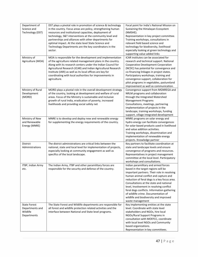
47 | P a g e
Department of Science and Technology (DST)
DST plays a pivotal role in promotion of science & technology in the country. Focus areas are policy, strengthening human resources and institutional capacities, deployment of technology, S&T interventions at the community level and partnerships and alliances with other departments for optimal impact. At the state level State Science and Technology Departments are the key coordinators in the sector.
Focal point for India’s National Mission on Sustaining the Himalayan Ecosystem (NMSHE). Representation in key project committee. Training workshops, consultations in relevant field based science and technology for biodiversity, livelihood especially looking at green technology and supporting value added links
Ministry of Agriculture (MOA)
MOA is responsible for the development and implementation of the agriculture related management plans in the country. Along with its research centers under the Indian Council for Agricultural Research (ICAR) and Indian Agricultural Research Institute (IARI) as well as its local offices are key for coordinating with local authorities for improvements in agriculture.
ICAR institutes can be associated for research and technical support. National Cooperative Development Corporation (NCDC) has potential for convergence and co-financing linkages in project states. Participatory workshops, training and convergence support, collaboration for pilot programs in vegetables, pastureland improvement as well as communication.
Ministry of Rural Development (MORD)
MORD plays a pivotal role in the overall development strategy of the country, looking at development and welfare of rural areas. Focus of the Ministry is sustainable and inclusive growth of rural India, eradication of poverty, increased livelihoods and providing social safety net
Convergence support from MGNREGA and NRLM programs and collaboration through the Integrated Watershed Management Programs Consultations, meetings, partnering implementation of projects in the landscape, training workshops, funding support, village integrated development
Ministry of New and Renewable Energy (MNRE)
MNRE is to develop and deploy new and renewable energy for supplementing the energy requirements of the country.
MNRE programs on solar energy and hydro energy can facilitate convergences for solar-based products used in livelihood and value addition activities. Training workshops, dissemination and implementation of renewable energy projects. Knowledge partner
District Administrations
The district administrations are critical links between the national, state and local level for implementation of projects, especially looking at community engagement as well as specifics of the local landscape.
Key partners to facilitate coordination at state and landscape levels and ensure convergence of programs and resources. Representatives in project management committee at the local level. Participatory workshops and consultations.
ITBP, Indian Army etc.
The Indian Army, ITBP and other paramilitary forces are responsible for the security and defense of the country.
Indian paramilitary and armed forces based in the target regions will be important partners. Their role in resolving human animal conflict and capture and reduction of feral dogs is a key focus area. Consultations at the state and national level, Involvement in resolving conflict feral dogs conflicts. Information gathering of wildlife crime. Documentation of wildlife and biodiversity and improved waste management
State Forest Departments and Wildlife Departments
The State Forest and Wildlife departments are responsible for all forest and wildlife protection related activities and the interface between National and State level programs.
Key implementing entities at the state level. Coordinate with state level stakeholders and NGOs, hire local NGOs/Rural Support Programs in consultation with MOEFCC, coordinate with local level NGOs and Community based organizations. Representation in key committees.
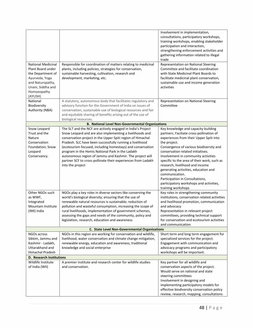
48 | P a g e
Involvement in implementation, consultations, participatory workshops, training workshops, enabling stakeholder participation and interaction, strengthening enforcement activities and gathering information related to illegal trade
National Medicinal Plant Board under the Department of Ayurveda, Yoga and Naturopathy, Unani, Siddha and Homoeopathy (AYUSH)
Responsible for coordination of matters relating to medicinal plants, including policies, strategies for conservation, sustainable harvesting, cultivation, research and development, marketing, etc.
Representation on National Steering Committee and facilitate coordination with State Medicinal Plant Boards to facilitate medicinal plant conservation, sustainable use and income generation activities
National Biodiversity Authority (NBA)
A statutory, autonomous body that facilitates regulatory and advisory function for the Government of India on issues of conservation, sustainable use of biological resources and fair and equitable sharing of benefits arising out of the use of biological resources.
Representation on National Steering Committee
B. National Level Non-Governmental Organizations
Snow Leopard Trust and the Nature Conservation Foundation; Snow Leopard Conservancy.
The SLT and the NCF are actively engaged in India’s Project Snow Leopard and are also implementing a livelihoods and conservation project in the Upper Spiti region of Himachal Pradesh. SLC have been successfully running a livelihood (ecotourism focused, including homestays) and conservation program in the Hemis National Park in the Ladakh autonomous region of Jammu and Kashmir. The project will partner SCF to cross-pollinate their experiences from Ladakh into the project
Key knowledge and capacity building partners. Faciliate cross-pollination of experiences from their Upper Spiti into the project. Convergence of various biodiversity and conservation related initiatives. Involvement in community activities specific to the area of their work, such as research, livelihood and income generating activities, education and communication. Participation in Consultations, participatory workshops and activities, training workshops
Other NGOs such as WWF, Integrated Mountain Institute (IMI) India
NGOs play a key roles in diverse sectors like conserving the world's biological diversity; ensuring that the use of renewable natural resources is sustainable; reduction of pollution and wasteful consumption, increasing the scope of rural livelihoods, implementation of government schemes, assessing the gaps and needs of the community, policy and legislation, research, education and awareness
Key roles in strengthening community institutions, conservation related activities and livelihood promotion, communication and advocacy Representation in relevant project committees, providing technical support for conservation and ecotourism activities and communication
C. State Level Non-Governmental Organizations
NGOs across Sikkim, Jammu and Kashmir - Ladakh, Uttarakhand and Himachal Pradesh
NGOs in this region are working for conservation and wildlife, livelihood, water conservation and climate change mitigation, renewable energy, education and awareness, traditional knowledge and social enterprise
Short term and long term engagement for specialized services for the project. Engagement with communication and advocacy programs and participatory workshops will be important.
D. Research Institutions
Wildlife Institute of India (WII)
A premier institute and research center for wildlife studies and conservation.
Key partner for all wildlife and conservation aspects of the project. Would serve on national and state steering committees Involvement in designing and implementing participatory models for effective biodiversity conservation policy review, research, mapping, consultations
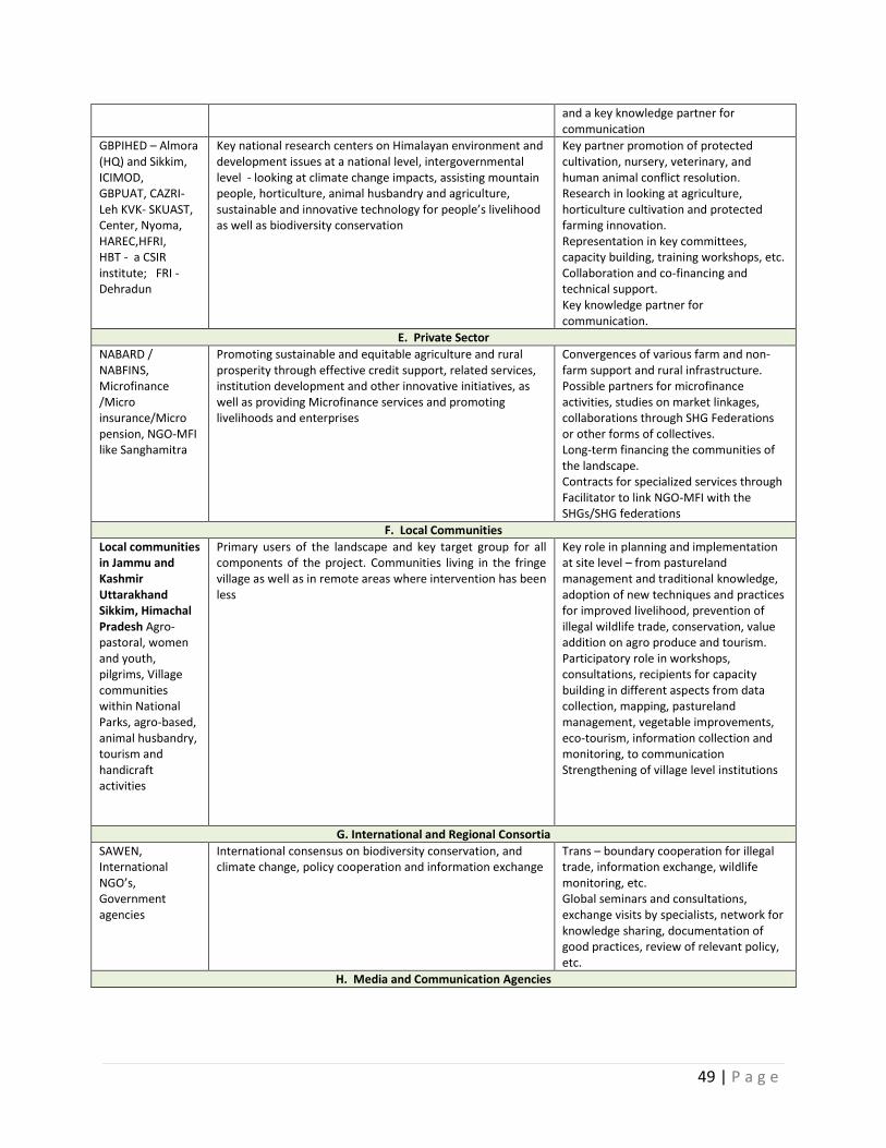
49 | P a g e
and a key knowledge partner for communication
GBPIHED – Almora (HQ) and Sikkim, ICIMOD, GBPUAT, CAZRI- Leh KVK- SKUAST, Center, Nyoma, HAREC,HFRI, HBT - a CSIR institute; FRI - Dehradun
Key national research centers on Himalayan environment and development issues at a national level, intergovernmental level - looking at climate change impacts, assisting mountain people, horticulture, animal husbandry and agriculture, sustainable and innovative technology for people’s livelihood as well as biodiversity conservation
Key partner promotion of protected cultivation, nursery, veterinary, and human animal conflict resolution. Research in looking at agriculture, horticulture cultivation and protected farming innovation. Representation in key committees, capacity building, training workshops, etc. Collaboration and co-financing and technical support. Key knowledge partner for communication.
E. Private Sector
NABARD / NABFINS, Microfinance /Micro insurance/Micro pension, NGO-MFI like Sanghamitra
Promoting sustainable and equitable agriculture and rural prosperity through effective credit support, related services, institution development and other innovative initiatives, as well as providing Microfinance services and promoting livelihoods and enterprises
Convergences of various farm and non-farm support and rural infrastructure. Possible partners for microfinance activities, studies on market linkages, collaborations through SHG Federations or other forms of collectives. Long-term financing the communities of the landscape. Contracts for specialized services through Facilitator to link NGO-MFI with the SHGs/SHG federations
F. Local Communities
Local communities in Jammu and Kashmir Uttarakhand Sikkim, Himachal Pradesh Agro- pastoral, women and youth, pilgrims, Village communities within National Parks, agro-based, animal husbandry, tourism and handicraft activities
Primary users of the landscape and key target group for all components of the project. Communities living in the fringe village as well as in remote areas where intervention has been less
Key role in planning and implementation at site level – from pastureland management and traditional knowledge, adoption of new techniques and practices for improved livelihood, prevention of illegal wildlife trade, conservation, value addition on agro produce and tourism. Participatory role in workshops, consultations, recipients for capacity building in different aspects from data collection, mapping, pastureland management, vegetable improvements, eco-tourism, information collection and monitoring, to communication Strengthening of village level institutions
G. International and Regional Consortia
SAWEN, International NGO’s, Government agencies
International consensus on biodiversity conservation, and climate change, policy cooperation and information exchange
Trans – boundary cooperation for illegal trade, information exchange, wildlife monitoring, etc. Global seminars and consultations, exchange visits by specialists, network for knowledge sharing, documentation of good practices, review of relevant policy, etc.
H. Media and Communication Agencies

50 | P a g e
Ministry of Information and broadcasting, Ministry of External Affairs, National Television and Radio network, Private Communication Agencies, Media – Print and TV at state and national level
Dissemination of information and awareness about the project at national and regional level through mainstream channels, television, print, festivals, press and direct institutional arrangements, and addressing communication gaps related to stakeholders as well as general public.
Key Partner for information dissemination at global, regional and national levels. Collaboration for festivals and international, national workshops and seminars, training and capacity building in communication, press meets, consultations and field visits
The following initiatives would be taken to ensure participation of stakeholders in project activities:
Project inception workshop
Project stakeholders would participate in the multi-stakeholder inception workshop within three months of the start of the project. The purpose of this workshop would be to create awareness amongst stakeholder of the objectives of the project and to define their individual roles and responsibilities in project planning, implementation and monitoring. The stakeholders would be acquainted with the most updated information (objectives, components, activities, roles and responsibilities of stakeholders, financial information, timing of activities and expected outcomes) and the project work plan. The workshop will be the first step in the process to build partnership with the range of project stakeholders and ensure that they have ownership of the project. It will also establish a basis for further consultation as the project’s implementation commences. The inception workshop will address a number of key issues including: assisting all partners to fully understand and take ownership of the project; detail the roles, support services and complementary responsibilities of the government agencies like the MOEFCC, Forest Departments and other line departments, UNDP, local administration and local governing bodies like the Panchayat Raj institutions, BMC and other ground level bodies, local communities – agro pastoral, including youth, women and children, NGOs in terms of implementation of sustainable landscape planning and management; and discussion of the roles, functions, and responsibilities within the project structure, including reporting and communication lines, monitoring and conflict resolution mechanisms.
Stakeholder Participation and Communication Strategy
Communication agencies will be engaged for each state to facilitate awareness, review and informing of policy, stakeholder participation and documentation of best practices related to the project. The project will implement and maintain a communications and knowledge management strategy (Annex 15) to ensure that all stakeholders are informed on an ongoing basis about: the project’s objectives; the projects activities; overall project progress; and the opportunities for involvement in various aspects of the project’s implementation. This strategy will ensure the use of communication techniques and approaches that appropriate to the local contexts such as appropriate languages and other skills that enhance communication effectiveness. The project will develop and maintain a web-based platform for sharing and disseminating information on biodiversity conservation, landscape and grazing management, human- animal conflict, livelihood and marketing, especially looking at value addition chains and marketing, and wildlife crime management. A policy consultant/specialist will be engaged to work on reviewing the policies through a participatory approach with all stakeholders and across the 4 states.
51 | P a g e
Quarterly Meetings with key stakeholders
On quarterly basis, State Implementation Units will organize individual meetings with the main stakeholders including groups of local communities (CBOs, interest groups, Village Organizations, pastoralists, landscape level organizations etc.) with the aim of discussing achievements, challenges faced, corrective steps taken and future corrective actions needed for the implementation of planned activities. It would be ensured that the groups of local communities have the participation of women and vulnerable persons among the local communities. Result based management and reporting would consider inputs taken from stakeholders during such meetings.
Sharing Progress reports and work-plans
Copies of the annual and quarterly progress reports and work plans would be circulated to main stakeholders to inform them about project implementation and planning and outcomes.
Participatory approach for involving local communities
A participatory approach will be adopted to facilitate the involvement and participation of local communities through their CBOs, including the vulnerable and marginalized members of the community (including women) in the planning and implementation of the project activities. The members of CBOs residents (particularly natural resource dependents) would be trained in the participatory approach. To ensure participation of local communities, state Wildlife/Forest Department would develop terms of partnership in consultation with the MOEFCC and sign the same with the local CBOs and other groups of local communities before implementation of main activities of the project.
Agreements with Private Organizations
Contractual agreements will be made with any private company who is ready to support and contribute to the project initiatives, in particular relating the value chain aspects of the project.
Stakeholder consultation and participation in project implementation
An extensive stakeholder consultation and participation process will be developed and implemented for the project.
Grievance Redressal Procedures In line with UNDP standard procedures, the Project will set up and manage a grievance redress mechanism (GRM) as recommended by UNDP (2014) that would address the grievances of various stakeholders of the project. The GRM will be managed and regularly monitored at SMUs/PMU level. GRS strategy will have following key components: Multiple locations and channels from grassroots level up to the State Project Planning and Management Unit (PPMU) and State Steering Committee: A simplified system of informing about the grievance redress system and also actual management of grievances will be developed under the project. Multiple ways (manual as well as virtual) of submitting complaints or suggestions at various levels will be provisioned in the project. Grievances and suggestions will reach the PPMU or members of State Steering Committee in person, via mail, email, via special page of the Project web-site, and phone. These channels will be locally-appropriate, widely accessible and publicized in written and verbal forms on all project communication materials, and in public locations in the project areas.
Since the project will be dealing with small farmers, natural resources based small entrepreneurs and producers of non-farm products and services at the field level, they will be facilitated to communicate
52 | P a g e
their problems through their collectives like Van Panchayats, JFMCs, EDCs, BMCs, SHGs, SHG- Federations and Panchayats. They will also be able to communicate directly to the Landscape Planning and Implementation Teams (LPITs). The Landscape Facilitation Officer will be responsible for the functioning as an interface for the grievance redress mechanism. The Multi-purpose information and marketing centers (Interpretation centers) proposed in the project will also be utilized to receive the grievances and also inform the results. System of directly informing about the problem or grievance will also be made within the system.
Process of informing and registering grievances at various levels: All the grievances whether received through LPITs and State PPMUs or to a member of the Steering Committee, will be registered by PPMU. The complaint will be assigned a unique tracking number upon its submission. PPMU will maintain a database with full information on all submitted complaints, responses taken and solutions of the problems.
Complaint Resolution System: A clear system of complaint resolution will be developed to ensure timely resolution of grievances of the stakeholders. The grievances of the stakeholders will be of different types therefore the grievance will be classified into three types -
Local level problems related to compensation/payments etc. (Landscape level)
Project implementation related problems (State PPMU level)
Grievances / Problems that require policy decisions/ decisions (State PPMU/State Steering committee level)
Procedures will be developed and observed, and personnel at each level (landscape and state levels) will be assigned to handle the grievances. State PPMUs will develop clear and strict grievance redress procedures, and assign responsibilities. Difficult situations and conflicts will be brought to the attention of State Steering Committee and UNDP CO if the State PPMU is unable to find appropriate solution.
Repository of grievances and solutions and sharing it on the project website: A repository of all the grievances received from the different stakeholders will be maintained at the PPMU level for monitoring and evaluation purposes and also for learning. The grievances and their solutions will be shared through the project website so that one landscape will be able to learn from the other. This aspect will be facilitated through Outcome 4 relating to communication and knowledge sharing. Further, this information will be used to assess trends and patterns of grievances across the project landscapes and for monitoring and evaluation purposes.
System of giving feedback about the compliance of grievances: A system of giving feedback will be developed to give response to all registered grievances. State PPMUs will provide feedback by contacting the complainant directly or through the LPITs so that complainants are aware about the status of their complaint. Once some decisions/actions are taken on the complaint, the complainant will be informed about the same. If complainants are not satisfied with the State PPMU response to their grievance, they will be able to appeal the PMU decision to members of State Steering Committee and UNDP CO via mail, e-mail or the Project website.
Monitoring and evaluation: The performance of the GRM will be regularly monitored. All information about the grievances and their resolution will be recorded and monitored. This data will be used to
53 | P a g e
conduct in-depth analyses of complaint trends and patterns, identify potential weaknesses in the Project implementation, and consider improvements. Environmental and social grievances will be reported to the GEF in the annual PIR. The full SESP screening report is included in Annex 18. iv. Mainstreaming gender:
The project recognizes that people living in the high altitude Himalayan Ecosystems have adopted a combination of livelihood options to ensure their survival. This survival system requires strong collaboration between women and men, but the differentiated roles of men and women generate different constraints and challenges in their daily life. Women and men also have different skill sets and knowledge and different patterns of resource ownership and capacities for use of natural resources and for livelihood options and practice. Women spend a large part of their time collecting fuel for energy – up to a third in some areas and collecting water. In addition to household-related tasks, women also play a significant role in livestock care and agriculture – cutting grass and fodder, milking, processing milk and animal products, ploughing with hand hoes, tilling, applying manure, weeding, watering, harvesting, threshing, winnowing, and processing the products for consumption. They generally have limited technology to help them in these tasks. Men are usually responsible for grazing the animals, trading animals and animal products, ploughing with draught animals, sowing seeds, harvesting, threshing, and trading food surpluses. Successful programs to improve rangeland management, reduce degradation, and enhance livelihoods, must take these different roles into account. The project recognizes that the best way to raise awareness of the gender issue, and to support incorporation of a gender perspective in planning is to develop – and implement – a gender mainstreaming strategy listing the steps to be taken in program planning and management.
During project preparation a gender analysis and action plan (Annex 16) was developed define measures to ensure that the intervention design incorporates and recognizes the differences between men and women in the context of labor, knowledge, needs, and priorities. The project incorporates several measures to reduce the burden on women (and men), and includes the promotion of fodder plots development and fodder banks, supporting other initiatives of providing LPGs, cooker, solar cooker, solar lamps; promoting eco-tourism; rejuvenating grasslands and supporting arrangements for water lifting, water conservation; introduction of innovative machines and tools and a system of custom service centres for providing small machines and implements on rent; technological interventions like solar based spinning machines, carding machines, etc. Special mechanisms are envisaged under the project to enhance the role of women in various conservation and livelihood activities, such as:
Strengthening women based SHGs and participation in village conservation committees so that women leadership is enhanced.
Studies to identify the issues related to gender so that capacity building and policy interventions can be planned.
Capacity building activities related to biodiversity and conservation for village level conservation and development committees (VCDCs), including specifically women;
Efforts to encourage women’s participation in VCDCs (preferably 30% representation) and actively attend the meetings and participate in various project initiatives.
Traditional culinary practices of women will be further promoted so that women continue their interest in conservation of various species of plants that are used in making food preparations.
To the extent feasible, State landscape planning and implementation teams will have local women community mobilizers who would be involved in social mobilization to encourage greater participation of women from local communities.
54 | P a g e
Special investment activities encourage women empowerment, including women-dominant livelihood and value chain activities (weaving and stitching of handloom and Yak wool based products, ecotourism/home stays and associated local products development, organic vegetable growing, carpet and blanket weaving, etc.), use of fuel-efficient stoves and capacity building of women in various sectors related to natural resource management and livestock improvement.
Awareness and communication campaigns with a specific gender focus.
Skills development programs will include training women to function as amchis (practitioner of traditional medicinal/Tibetan medicine system).
Promote women collectives such as SHGs and SHG-federations through knowledge products that make women aware about their entitlements.
Capacity building programs for the Landscape Planning and Implementation teams on gender equality and gender analysis
Periodic reviews of the portfolio and highlight of best practices in mainstreaming gender in the project.
Documentation of gender roles in the management of resources in the region and in particular in the rangelands
Use of gender-sensitive indicators and collection of sex-disaggregated data for monitoring project outcomes and impacts.
Encouragement of qualified women applicants for positions, including social mobilizers under the project as per UNDP rules and regulations.
v. South-South and Triangular Cooperation (SSTrC):
The project is part of a multi-agency, multi-sector, multi-country partnership on wildlife conservation and wildlife crime prevention. Being part of this partnership, allows for extensive and continued information exchange amongst the different countries on forensics, status of key species, law enforcement and wildlife crime, and the exchange of “good practice” and capacity building efforts. Project staff will participate in conferences, workshops and virtual knowledge management sessions organized by the partnership program, to share information on the program and explore potential South-South collaboration (between Africa and Asia) on opportunities related to illegal wildlife trade related issues, including reducing trans-boundary transport of illegal wildlife products. Such a South-South collaboration will help India to learn from other countries on successes in involving the police and trade and customs authorities to prevent, deter and interdict wildlife crime, as well in sharing information on trans-boundary smuggling operations, arrests and prosecutions of criminal networks including kingpin individuals. Through the global partnership, India will seek opportunities for exchange visits to learn lessons from individual project interventions from within and outside the Program, help foster intergovernmental cooperation, use M&E tools and geospatial services, apply best practices and peer review and develop portfolio-wide training and communication strategies.
India’s continued participation in GSLEP, provides an opportunity for collective action that would help coordinate and unify the efforts among the snow leopard countries and the global community to achieve a shared vision and goal. It would provide a forum for sharing of good practices and lessons in conservation, community involvement and wildlife crime and trade prevention that can be scaled up and implemented in a wider context. The project will provide valuable monitoring information that would be widely shared to help bring a high-level of attention towards meeting the goals of GSLEP. It would help in efforts to enable countries (some of which are already implementing or formulating GEF
55 | P a g e
projects for snow leopard conservation), international and national partners and donors to adjust and improve efforts to reflect new knowledge and experiences.
V. FEASIBILITY
i. Cost efficiency and effectiveness:
The project is designed primarily to ensure that investments are the most cost-effective so that project approaches and institutional mechanisms can be easily replicated and scaled up using existing budgetary constraints that operate within the states and country. Removing the barriers that impede sustainable and efficient conservation of high Himalayan areas will increase the conservation dividend of the resources and provide a real incentive for local communities to engage in sustainable management and conservation of the resource. A number of options were considered in determining the most cost efficient approach that would be the most viable and socially acceptable. Declaring and managing the majority of the snow leopard landscape as protected areas would provide the most conservation dividend, but this was considered neither practical nor cost effective given the large dependency on grazing and NTFP collection, as well as the remoteness and accessibility for effective management. Similarly, given the limited budgetary and manpower resources, it would have been impractical to develop sustainable livelihoods and natural resources management interventions in all villages that are located in the landscape within the allocations of the project. The alternative was to seek a balanced approach to conservation and livelihood development in a limited and manageable number of villages through a multi-stakeholder and multi-sectoral institutional coordination mechanism that sought to facilitate a convergence of planning, manpower and financial resources as a cost-effective and demonstration approach with replication potential using existing state and national level budgetary resources. This cost effective approach is ensured through the design features of the project.
At the community village, the project will work through existing local institutions to the extent feasible, but will institute a local level planning process to plan and deliver activities that are related to community natural resource use, grazing and livestock management and community livelihood investments, as well as help coordinate other socio-economic development investments available at the state, district and local level (Annex 17 provides a list of on-going Central and State Government and NGO programs that are relevant to the project) and facilitate convergence through the landscape and state level coordinating committees. The planning process will be instituted through administrative approaches that are envisaged under existing government policy rather that create new systems that are not cost-effective. It would work with sectors and partners outside the conservation sector to effectively reduce threats to globally significant biodiversity, through enhancing incomes and diversifying livelihoods of people who current either depend on biological resources in the landscape or use them in an unsustainable manner. The intent of the project is to demonstrate the viability of a multi-sectoral and integrated approach to conservation and resource use, and in the process help develop and demonstrate the tools and techniques and enhance capacity to participatory conservation. This is a very cost effective approach, because it does not add significant additional resources to conservation, but intends to use existing national, state, private sector and community resources to demonstrate a new approach to conservation that meets both conservation and local community needs and aspirations.
ii. Risk Management:
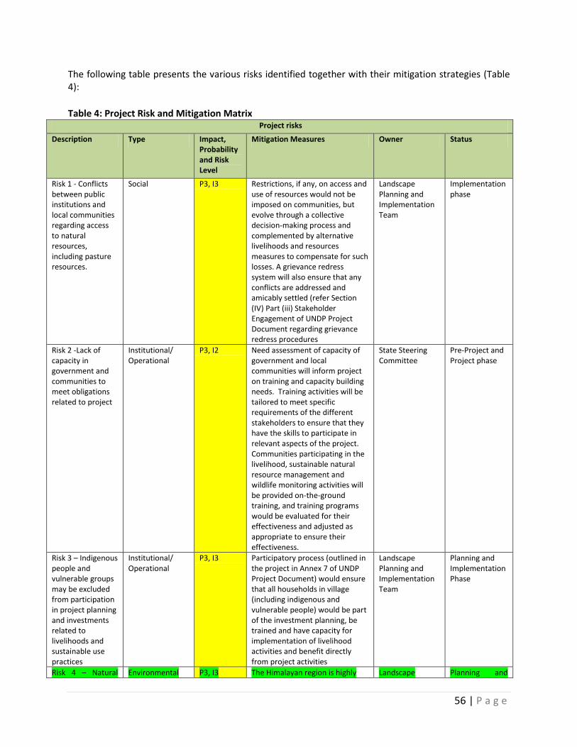
56 | P a g e
The following table presents the various risks identified together with their mitigation strategies (Table 4):
Table 4: Project Risk and Mitigation Matrix
Project risks
Description Type Impact, Probability and Risk Level
Mitigation Measures Owner Status
Risk 1 - Conflicts between public institutions and local communities regarding access to natural resources, including pasture resources.
Social P3, I3 Restrictions, if any, on access and use of resources would not be imposed on communities, but evolve through a collective decision-making process and complemented by alternative livelihoods and resources measures to compensate for such losses. A grievance redress system will also ensure that any conflicts are addressed and amicably settled (refer Section (IV) Part (iii) Stakeholder Engagement of UNDP Project Document regarding grievance redress procedures
Landscape Planning and Implementation Team
Implementation phase
Risk 2 -Lack of capacity in government and communities to meet obligations related to project
Institutional/ Operational
P3, I2 Need assessment of capacity of government and local communities will inform project on training and capacity building needs. Training activities will be tailored to meet specific requirements of the different stakeholders to ensure that they have the skills to participate in relevant aspects of the project. Communities participating in the livelihood, sustainable natural resource management and wildlife monitoring activities will be provided on-the-ground training, and training programs would be evaluated for their effectiveness and adjusted as appropriate to ensure their effectiveness.
State Steering Committee
Pre-Project and Project phase
Risk 3 – Indigenous people and vulnerable groups may be excluded from participation in project planning and investments related to livelihoods and sustainable use practices
Institutional/ Operational
P3, I3 Participatory process (outlined in the project in Annex 7 of UNDP Project Document) would ensure that all households in village (including indigenous and vulnerable people) would be part of the investment planning, be trained and have capacity for implementation of livelihood activities and benefit directly from project activities
Landscape Planning and Implementation Team
Planning and Implementation Phase
Risk 4 – Natural Environmental P3, I3 The Himalayan region is highly Landscape Planning and
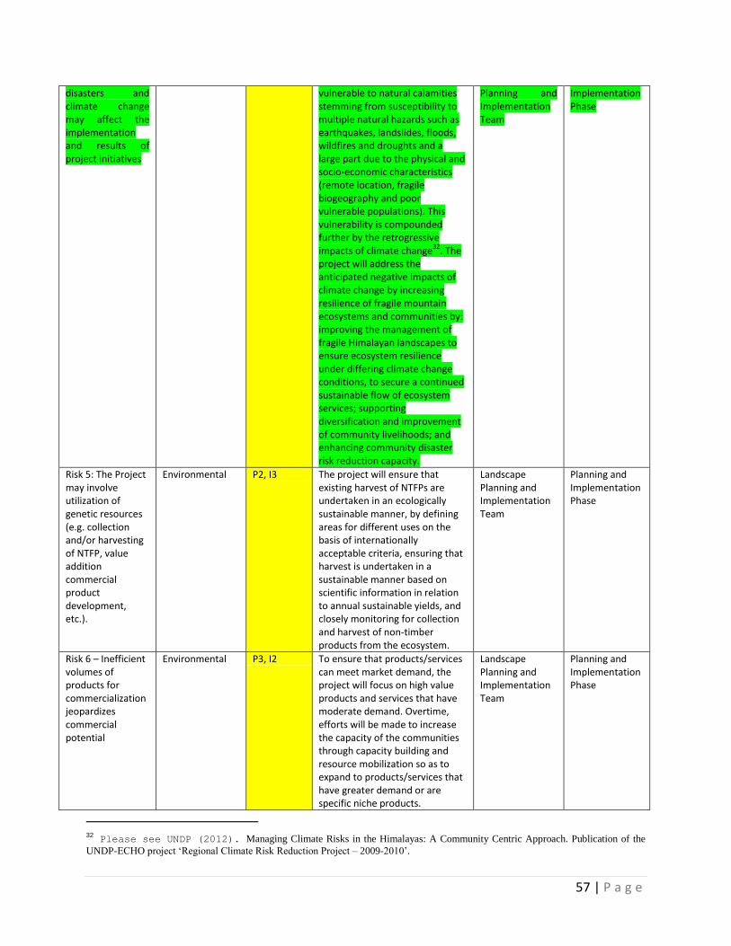
57 | P a g e
disasters and climate change may affect the implementation and results of project initiatives
vulnerable to natural calamities stemming from susceptibility to multiple natural hazards such as earthquakes, landslides, floods, wildfires and droughts and a large part due to the physical and socio-economic characteristics (remote location, fragile biogeography and poor vulnerable populations). This vulnerability is compounded further by the retrogressive impacts of climate change
32. The
project will address the anticipated negative impacts of climate change by increasing resilience of fragile mountain ecosystems and communities by: improving the management of fragile Himalayan landscapes to ensure ecosystem resilience under differing climate change conditions, to secure a continued sustainable flow of ecosystem services; supporting diversification and improvement of community livelihoods; and enhancing community disaster risk reduction capacity.
Planning and Implementation Team
Implementation Phase
Risk 5: The Project may involve utilization of genetic resources (e.g. collection and/or harvesting of NTFP, value addition commercial product development, etc.).
Environmental P2, I3 The project will ensure that existing harvest of NTFPs are undertaken in an ecologically sustainable manner, by defining areas for different uses on the basis of internationally acceptable criteria, ensuring that harvest is undertaken in a sustainable manner based on scientific information in relation to annual sustainable yields, and closely monitoring for collection and harvest of non-timber products from the ecosystem.
Landscape Planning and Implementation Team
Planning and Implementation Phase
Risk 6 – Inefficient volumes of products for commercialization jeopardizes commercial potential
Environmental P3, I2 To ensure that products/services can meet market demand, the project will focus on high value products and services that have moderate demand. Overtime, efforts will be made to increase the capacity of the communities through capacity building and resource mobilization so as to expand to products/services that have greater demand or are specific niche products.
Landscape Planning and Implementation Team
Planning and Implementation Phase
32 Please see UNDP (2012). Managing Climate Risks in the Himalayas: A Community Centric Approach. Publication of the
UNDP-ECHO project ‘Regional Climate Risk Reduction Project – 2009-2010’.
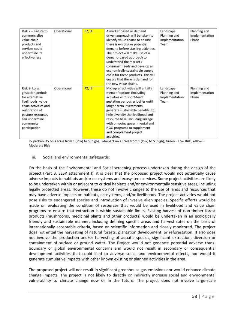
58 | P a g e
Risk 7 – Failure to commercialize value chain products and services could undermine its effectiveness
Operational P2, I4 A market based or demand driven approach will be taken to identify value chains to ensure there is existing or potential demand before starting activities. The project will make use of a demand-based approach to understand the market / consumer needs and develop an economically sustainable supply chain for these products. This will ensure that there is demand for the new value chains.
Landscape Planning and Implementation Team
Planning and Implementation Phase
Risk 8- Long gestation periods for alternative livelihoods, value chain activities and restoration of pasture resources can undermine community participation
Operational P2, I2 Microplan activities will entail a menu of options (including activities with short-term gestation periods as buffer until longer-term investments generate sustainable benefits) to help diversify the livelihood and resource base, including linkage with on-going governmental and NGO programs to supplement and complement project activities.
Landscape Planning and Implementation Team
Planning and Implementation Phase
P= probability on a scale from 1 (low) to 5 (high), I =Impact on a scale from 1 (low) to 5 (high); Green – Low Risk, Yellow –Moderate Risk
iii. Social and environmental safeguards: On the basis of the Environmental and Social screening process undertaken during the design of the project (Part B, SESP attachment I), it is clear that the proposed project would not potentially cause adverse impacts to habitats and/or ecosystems and ecosystem services. Some project activities are likely to be undertaken within or adjacent to critical habitats and/or environmentally sensitive areas, including legally protected areas. However, these do not involve changes to the use of lands and resources that may have adverse impacts on habitats, ecosystems, and/or livelihoods. The project activities would not pose risks to endangered species and introduction of invasive alien species. Specific efforts would be made on evaluating the condition of resources that would be used in livelihood and value chain programs to ensure that extraction is within sustainable limits. Existing harvest of non-timber forest products (mushrooms, medicinal plants and other products) would be undertaken in an ecologically friendly and sustainable manner, including defining specific areas and harvest rates on the basis of internationally acceptable criteria, based on scientific information and closely monitored. The project does not entail the harvesting of natural forests, plantation development, or reforestation. It also does not involve the production and/or harvesting of aquatic species, significant extraction, diversion or containment of surface or ground water. The Project would not generate potential adverse trans-boundary or global environmental concerns and would not result in secondary or consequential development activities that could lead to adverse social and environmental effects, nor would it generate cumulative impacts with other known existing or planned activities in the area. The proposed project will not result in significant greenhouse gas emissions nor would enhance climate change impacts. The project is not likely to directly or indirectly increase social and environmental vulnerability to climate change now or in the future. The project does not involve large-scale
59 | P a g e
infrastructure development. The project will not involve support for employment or livelihoods that may pose a potential risk to health and safety of communities and/or individuals or to biodiversity and ecosystem functions. The project would not potentially involve temporary or permanent physical displacement, nor will there be the need for land acquisition or access restrictions – even in the absence of physical relocation. It would not exacerbate land tenure arrangements and/or community based property rights/customary rights to land, territories and/or resources. Any restrictions on access and use of natural resources would not be imposed by the forestry department, but would evolve through a collective decision-making process amongst the community members and be supported by alternative livelihood and resource measures that adequately compensate for any loss of income or resources. Grievance redress mechanisms will facilitate the resolution of any conflict related to resource use and access. Tribal and vulnerable groups in the landscape would be fully involved in decision-making in terms of resource use, livelihood and income generation investments and conservation action through specific institutional and administrative arrangements that encourages active participation of all households in a village and capacity building programs. For further information on social and environmental aspects and management measures refer UNDP SESP in Annex 18.
iv. Sustainability and Scaling Up:
a) Innovative aspects:
The establishment of four landscape scale target areas, which demonstrate the integration of biodiversity conservation, sustainable resource use and a three-pronged strategy to enhance existing livelihoods, promote alternate and new options of livelihood and support skill-based employment opportunities through integrated and participatory planning approaches will be highly innovative for India, and will provide a benchmark for future roll-out. Participatory and integrated planning for the establishment of landscape management strategies, involving both key public and private sector partners as well as local communities would also be a new approach, as would the development of business plans identifying sustainable livelihood and value chain products and services. Furthermore, piloting model community governance and management of natural pasture and forest lands would be operated through suitable incentive mechanisms to ensure community involvement in planning, decision making and management, selecting and working on potential options for income generation through sustainable NTFP harvesting, processing and value addition, and availing opportunity of alternative income generation activities. In addition, the project will support innovative community-based enforcement models as a means to supplement the lack of adequate government enforcement staff in the inaccessible high Himalayan regions. The project will build on, and try to replicate proven “best practices” from the region (Annex 19).
b) Financial and Institutional Sustainability:
The project will build the capacity of existing public (particularly the Forest and Wildlife Departments) and private sector bodies and the local communities to work in participatory and integrated ways. By involving these stakeholders in conservation and livelihood investment planning, and clearly defining their roles and responsibilities, the project will help build alliances for conservation and sustainable use of the high Himalayan resources that will be expected to continue to operate after the end of the project. This work at landscape level is aimed at ensuring environmental and socio-economic sustainability through improved institutional capacity, policies and legislation. The project will endure to develop new business models for landscape conservation, livelihood and value chains recognize the full range of environmental ecosystem services provided by India’s high Himalayan ecosystems. Implementation of such models through carefully developed business plans could lead to a diversification of funding based on sources such ecotourism, NTFPs and other mechanisms, when these
60 | P a g e
become available. This will result in far higher sustainability for India’s Himalayan ecosystems that current rely on government and international donor support. The financial and institutional sustainability of PAs are better ensured when the focus is on management of threats at the broader landscape level, particularly those that emanate from outside PA boundaries. Sustainability of training and capacity building measures are improved by integrating these programs into regular training institutes curricula for in-service training.
Value chain products and services have been selected in the landscapes that are linked to unique resources available in these locations. The project intends creating marketable products and solutions that are not only economically sustainable, but also ecologically sustainable and do not over-exploit natural resources. The centerpiece of the approach is to develop new entrepreneurs and work with existing entrepreneurs, ensuring economic sustainability as the heart of the project. In addition, the project’s pro-active and specific focus on aligning the baseline investments as vehicle to deliver majority of the livelihood improvement and diversification interventions will ensure the sustainability of these approaches as well as through the creation of market and credit linkages for the value chain programs. This is to be achieved by the following support systems that would be provided through the project and complementary funding:
Carefully tailored training and capacity building to enhance the skills of the producers
Initial seed capital for setting up basic tools and equipment
Developing market linkages, programs and channels
Identification and training of local entrepreneurs and enterprises, and
Developing and supporting village level institutions and implementation plans
c) Potential for scale-up:
The project is designed to provide demonstration models for up-scaling in India. In particular, the capacity building and the development of guidelines and regulations for each aspect of the project will strongly support up-scaling. By ensuring that activities, impacts and lessons learnt are disseminated widely in India helps generate a bottom-up demand for similar activities throughout the country. The involvement of NGOs and the private sector can lead to further up-scaling of the project learning. Improvement in capacity, awareness and regulatory frameworks ensures post-project sustainability and encourages investments from public and private sector and hence can contribute to up-scaling.
The practicability of replicating landscape conservation and livelihood models, governance and capacity building programs will be the basis for the success of this project. The project’s approach of integrated conservation and livelihood planning and management and the introduction of new planning and monitoring guidelines specifically for sustainable pasture and forest management under the project will provide the basis for application in other regions of the country as well. The project introduces participatory development of community livelihood, sustainable pasture and forest management plans based on locally acceptable models by directly involving community members in the planning process. The participatory planning process test a locally based approach that can be replicated elsewhere in the country affected by increasing degradation of land and natural resources due to inappropriate practices and climate change impacts.
To this end, the project is expected to provide strong justification of the benefits of mainstreaming conservation at a larger policy and planning levels. This will require facilitating an understanding at the national level amongst decision makers that natural resource degradation is a constraint to economic development and poverty alleviation. Through various communications mediums, the project will serve to provide targeted support to planning at various levels to facilitate mainstreaming of conservation
61 | P a g e
issues at the local and landscape levels. Successful implementation of this component will create an enabling framework for replication throughout the country.
The Project’s investment component will seek to develop synergies among rural development actors and programs with an objective of raising additional investments that will fund and expand models of resource use and alternative livelihood activities within and outside of the targeted landscapes. This component will also seek to catalyze a process whereby regional and local NGOs, CBOs and forest development agencies seek to obtain commitments from state budgets for sustainable resource management and related community actions.
In summary, it can be clearly stated that the viability of long-term sustainability of these approaches is assured given the existing and planned level of Government commitment, programs and resources that are available for the high Himalayan landscapes). The promotion of value chains and market driven approach to create sustainable solutions can outlive the life of the project. The project focuses on developing business models that allow local farmers and other inhabitants to participate and benefit from the economic systems that facilitates productive enhancement and marketing, promotes local entrepreneurs, and development of ecotourism benefits have potential to become tourist hubs and use local resources to develop products such as handlooms, crafts, etc.
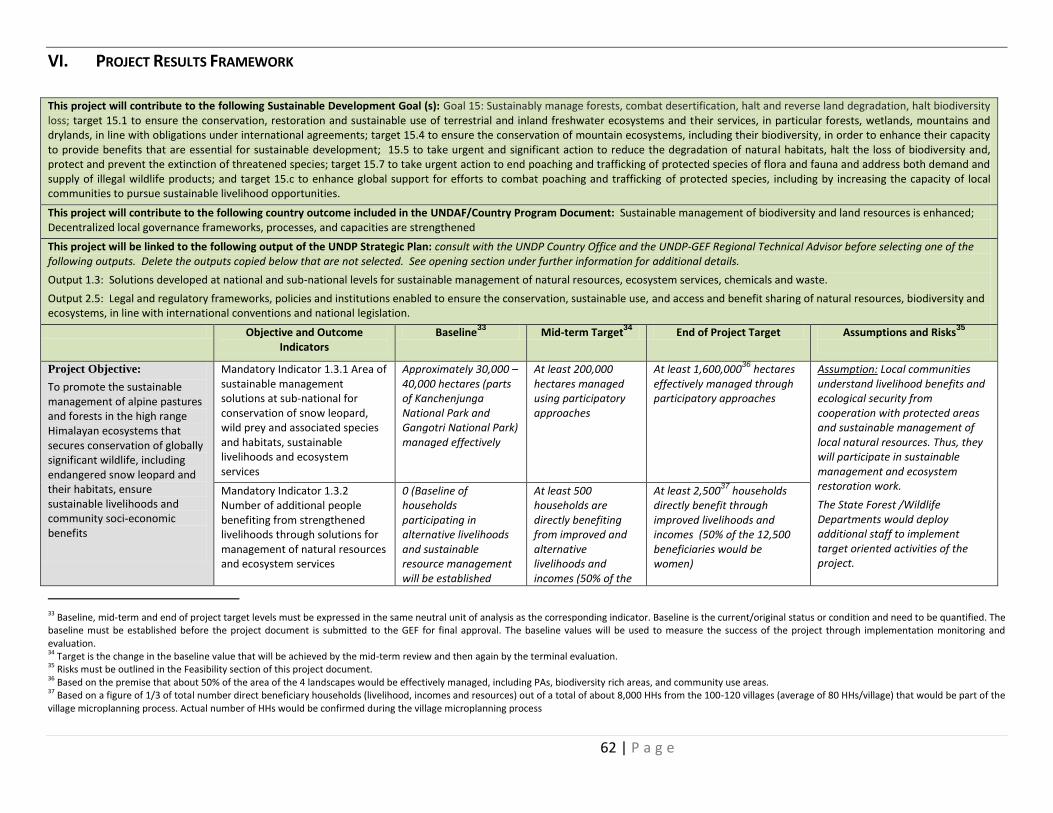
62 | P a g e
VI. PROJECT RESULTS FRAMEWORK
This project will contribute to the following Sustainable Development Goal (s): Goal 15: Sustainably manage forests, combat desertification, halt and reverse land degradation, halt biodiversity loss; target 15.1 to ensure the conservation, restoration and sustainable use of terrestrial and inland freshwater ecosystems and their services, in particular forests, wetlands, mountains and drylands, in line with obligations under international agreements; target 15.4 to ensure the conservation of mountain ecosystems, including their biodiversity, in order to enhance their capacity to provide benefits that are essential for sustainable development; 15.5 to take urgent and significant action to reduce the degradation of natural habitats, halt the loss of biodiversity and, protect and prevent the extinction of threatened species; target 15.7 to take urgent action to end poaching and trafficking of protected species of flora and fauna and address both demand and supply of illegal wildlife products; and target 15.c to enhance global support for efforts to combat poaching and trafficking of protected species, including by increasing the capacity of local communities to pursue sustainable livelihood opportunities.
This project will contribute to the following country outcome included in the UNDAF/Country Program Document: Sustainable management of biodiversity and land resources is enhanced; Decentralized local governance frameworks, processes, and capacities are strengthened This project will be linked to the following output of the UNDP Strategic Plan: consult with the UNDP Country Office and the UNDP-GEF Regional Technical Advisor before selecting one of the following outputs. Delete the outputs copied below that are not selected. See opening section under further information for additional details.
Output 1.3: Solutions developed at national and sub-national levels for sustainable management of natural resources, ecosystem services, chemicals and waste.
Output 2.5: Legal and regulatory frameworks, policies and institutions enabled to ensure the conservation, sustainable use, and access and benefit sharing of natural resources, biodiversity and ecosystems, in line with international conventions and national legislation.
Objective and Outcome Indicators
Baseline33
Mid-term Target34
End of Project Target Assumptions and Risks35
Project Objective:
To promote the sustainable management of alpine pastures and forests in the high range Himalayan ecosystems that secures conservation of globally significant wildlife, including endangered snow leopard and their habitats, ensure sustainable livelihoods and community soci-economic benefits
Mandatory Indicator 1.3.1 Area of sustainable management solutions at sub-national for conservation of snow leopard, wild prey and associated species and habitats, sustainable livelihoods and ecosystem services
Approximately 30,000 – 40,000 hectares (parts of Kanchenjunga National Park and Gangotri National Park) managed effectively
At least 200,000 hectares managed using participatory approaches
At least 1,600,00036
hectares effectively managed through participatory approaches
Assumption: Local communities understand livelihood benefits and ecological security from cooperation with protected areas and sustainable management of local natural resources. Thus, they will participate in sustainable management and ecosystem restoration work.
The State Forest /Wildlife Departments would deploy additional staff to implement target oriented activities of the project.
Mandatory Indicator 1.3.2 Number of additional people benefiting from strengthened livelihoods through solutions for management of natural resources and ecosystem services
0 (Baseline of households participating in alternative livelihoods and sustainable resource management will be established
At least 500 households are directly benefiting from improved and alternative livelihoods and incomes (50% of the
At least 2,50037
households directly benefit through improved livelihoods and incomes (50% of the 12,500 beneficiaries would be women)
33 Baseline, mid-term and end of project target levels must be expressed in the same neutral unit of analysis as the corresponding indicator. Baseline is the current/original status or condition and need to be quantified. The baseline must be established before the project document is submitted to the GEF for final approval. The baseline values will be used to measure the success of the project through implementation monitoring and evaluation. 34 Target is the change in the baseline value that will be achieved by the mid-term review and then again by the terminal evaluation. 35 Risks must be outlined in the Feasibility section of this project document. 36 Based on the premise that about 50% of the area of the 4 landscapes would be effectively managed, including PAs, biodiversity rich areas, and community use areas. 37 Based on a figure of 1/3 of total number direct beneficiary households (livelihood, incomes and resources) out of a total of about 8,000 HHs from the 100-120 villages (average of 80 HHs/village) that would be part of the village microplanning process. Actual number of HHs would be confirmed during the village microplanning process
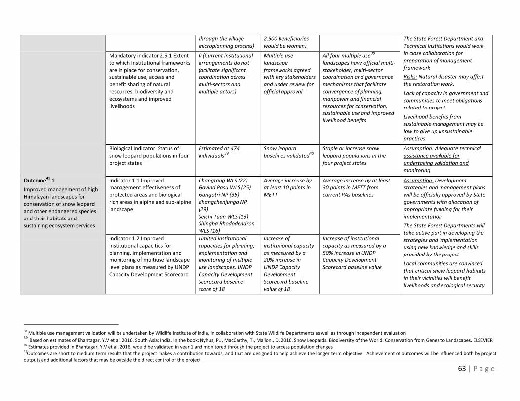
63 | P a g e
through the village microplanning process)
2,500 beneficiaries would be women)
The State Forest Department and Technical Institutions would work in close collaboration for preparation of management framework
Risks: Natural disaster may affect the restoration work.
Lack of capacity in government and communities to meet obligations related to project
Livelihood benefits from sustainable management may be low to give up unsustainable practices
Mandatory indicator 2.5.1 Extent to which Institutional frameworks are in place for conservation, sustainable use, access and benefit sharing of natural resources, biodiversity and ecosystems and improved livelihoods
0 (Current institutional arrangements do not facilitate significant coordination across multi-sectors and multiple actors)
Multiple use landscape frameworks agreed with key stakeholders and under review for official approval
All four multiple use38
landscapes have official multi-stakeholder, multi-sector coordination and governance mechanisms that facilitate convergence of planning, manpower and financial resources for conservation, sustainable use and improved livelihood benefits
Biological Indicator. Status of snow leopard populations in four project states
Estimated at 474 individuals
39
Snow leopard baselines validated
40
Staple or increase snow leopard populations in the four project states
Assumption: Adequate technical assistance available for undertaking validation and monitoring
Outcome41
1
Improved management of high Himalayan landscapes for conservation of snow leopard and other endangered species and their habitats and sustaining ecosystem services
Indicator 1.1 Improved management effectiveness of protected areas and biological rich areas in alpine and sub-alpine landscape
Changtang WLS (22) Govind Pasu WLS (25) Gangotri NP (35) Khangchenjunga NP (29) Seichi Tuan WLS (13) Shingba Rhododendron WLS (16)
Average increase by at least 10 points in METT
Average increase by at least 30 points in METT from current PAs baselines
Assumption: Development strategies and management plans will be officially approved by State governments with allocation of appropriate funding for their implementation
The State Forest Departments will take active part in developing the strategies and implementation using new knowledge and skills provided by the project
Local communities are convinced that critical snow leopard habitats in their vicinities will benefit livelihoods and ecological security
Indicator 1.2 Improved institutional capacities for planning, implementation and monitoring of multiuse landscape level plans as measured by UNDP Capacity Development Scorecard
Limited institutional capacities for planning, implementation and monitoring of multiple use landscapes. UNDP Capacity Development Scorecard baseline score of 18
Increase of institutional capacity as measured by a 20% increase in UNDP Capacity Development Scorecard baseline value of 18
Increase of institutional capacity as measured by a 50% increase in UNDP Capacity Development Scorecard baseline value
38 Multiple use management validation will be undertaken by Wildlife Institute of India, in collaboration with State Wildlife Departments as well as through independent evaluation 39 Based on estimates of Bhantagar, Y.V et al. 2016. South Asia: India. In the book: Nyhus, P.J, MacCarthy, T., Mallon., D. 2016. Snow Leopards. Biodiversity of the World: Conservation from Genes to Landscapes. ELSEVIER 40 Estimates provided in Bhantagar, Y.V et al. 2016, would be validated in year 1 and monitored through the project to access population changes 41Outcomes are short to medium term results that the project makes a contribution towards, and that are designed to help achieve the longer term objective. Achievement of outcomes will be influenced both by project outputs and additional factors that may be outside the direct control of the project.
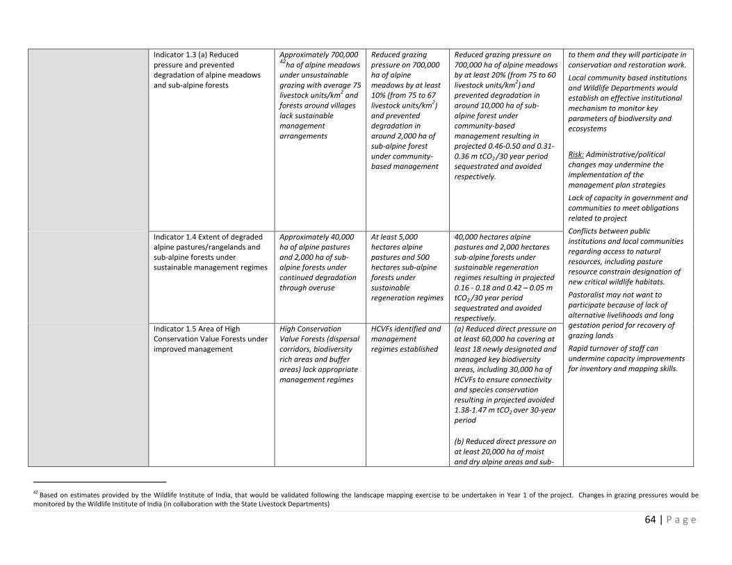
64 | P a g e
Indicator 1.3 (a) Reduced pressure and prevented degradation of alpine meadows and sub-alpine forests
Approximately 700,000 42
ha of alpine meadows under unsustainable grazing with average 75 livestock units/km
2 and
forests around villages lack sustainable management arrangements
Reduced grazing pressure on 700,000 ha of alpine meadows by at least 10% (from 75 to 67 livestock units/km
2)
and prevented degradation in around 2,000 ha of sub-alpine forest under community-based management
Reduced grazing pressure on 700,000 ha of alpine meadows by at least 20% (from 75 to 60 livestock units/km
2)
and
prevented degradation in around 10,000 ha of sub-alpine forest under community-based management resulting in projected 0.46-0.50 and 0.31-0.36 m tCO2 /30 year period sequestrated and avoided respectively.
to them and they will participate in conservation and restoration work.
Local community based institutions and Wildlife Departments would establish an effective institutional mechanism to monitor key parameters of biodiversity and ecosystems
Risk: Administrative/political changes may undermine the implementation of the management plan strategies
Lack of capacity in government and communities to meet obligations related to project
Conflicts between public institutions and local communities regarding access to natural resources, including pasture resource constrain designation of new critical wildlife habitats.
Pastoralist may not want to participate because of lack of alternative livelihoods and long gestation period for recovery of grazing lands
Rapid turnover of staff can undermine capacity improvements for inventory and mapping skills.
Indicator 1.4 Extent of degraded alpine pastures/rangelands and sub-alpine forests under sustainable management regimes
Approximately 40,000 ha of alpine pastures and 2,000 ha of sub-alpine forests under continued degradation through overuse
At least 5,000 hectares alpine pastures and 500 hectares sub-alpine forests under sustainable regeneration regimes
40,000 hectares alpine pastures and 2,000 hectares sub-alpine forests under sustainable regeneration regimes resulting in projected 0.16 - 0.18 and 0.42 – 0.05 m tCO2 /30 year period sequestrated and avoided respectively.
Indicator 1.5 Area of High Conservation Value Forests under improved management
High Conservation Value Forests (dispersal corridors, biodiversity rich areas and buffer areas) lack appropriate management regimes
HCVFs identified and management regimes established
(a) Reduced direct pressure on at least 60,000 ha covering at least 18 newly designated and managed key biodiversity areas, including 30,000 ha of HCVFs to ensure connectivity and species conservation resulting in projected avoided 1.38-1.47 m tCO2 over 30-year period
(b) Reduced direct pressure on at least 20,000 ha of moist and dry alpine areas and sub-
42 Based on estimates provided by the Wildlife Institute of India, that would be validated following the landscape mapping exercise to be undertaken in Year 1 of the project. Changes in grazing pressures would be monitored by the Wildlife Institute of India (in collaboration with the State Livestock Departments)
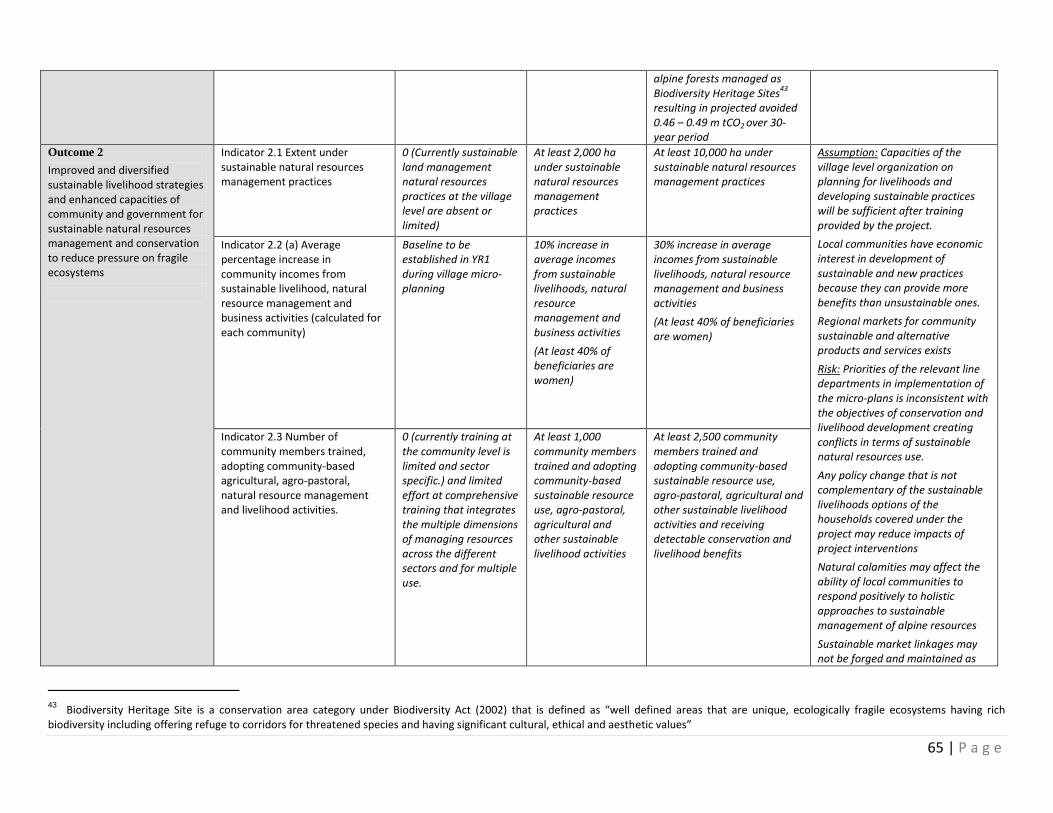
65 | P a g e
alpine forests managed as Biodiversity Heritage Sites
43
resulting in projected avoided 0.46 – 0.49 m tCO2 over 30-year period
Outcome 2
Improved and diversified sustainable livelihood strategies and enhanced capacities of community and government for sustainable natural resources management and conservation to reduce pressure on fragile ecosystems
Indicator 2.1 Extent under sustainable natural resources management practices
0 (Currently sustainable land management natural resources practices at the village level are absent or limited)
At least 2,000 ha under sustainable natural resources management practices
At least 10,000 ha under sustainable natural resources management practices
Assumption: Capacities of the village level organization on planning for livelihoods and developing sustainable practices will be sufficient after training provided by the project.
Local communities have economic interest in development of sustainable and new practices because they can provide more benefits than unsustainable ones.
Regional markets for community sustainable and alternative products and services exists
Risk: Priorities of the relevant line departments in implementation of the micro-plans is inconsistent with the objectives of conservation and livelihood development creating conflicts in terms of sustainable natural resources use.
Any policy change that is not complementary of the sustainable livelihoods options of the households covered under the project may reduce impacts of project interventions
Natural calamities may affect the ability of local communities to respond positively to holistic approaches to sustainable management of alpine resources
Sustainable market linkages may not be forged and maintained as
Indicator 2.2 (a) Average percentage increase in community incomes from sustainable livelihood, natural resource management and business activities (calculated for each community)
Baseline to be established in YR1 during village micro-planning
10% increase in average incomes from sustainable livelihoods, natural resource management and business activities
(At least 40% of beneficiaries are women)
30% increase in average incomes from sustainable livelihoods, natural resource management and business activities
(At least 40% of beneficiaries are women)
Indicator 2.3 Number of community members trained, adopting community-based agricultural, agro-pastoral, natural resource management and livelihood activities.
0 (currently training at the community level is limited and sector specific.) and limited effort at comprehensive training that integrates the multiple dimensions of managing resources across the different sectors and for multiple use.
At least 1,000 community members trained and adopting community-based sustainable resource use, agro-pastoral, agricultural and other sustainable livelihood activities
At least 2,500 community members trained and adopting community-based sustainable resource use, agro-pastoral, agricultural and other sustainable livelihood activities and receiving detectable conservation and livelihood benefits
43 Biodiversity Heritage Site is a conservation area category under Biodiversity Act (2002) that is defined as “well defined areas that are unique, ecologically fragile ecosystems having rich biodiversity including offering refuge to corridors for threatened species and having significant cultural, ethical and aesthetic values”
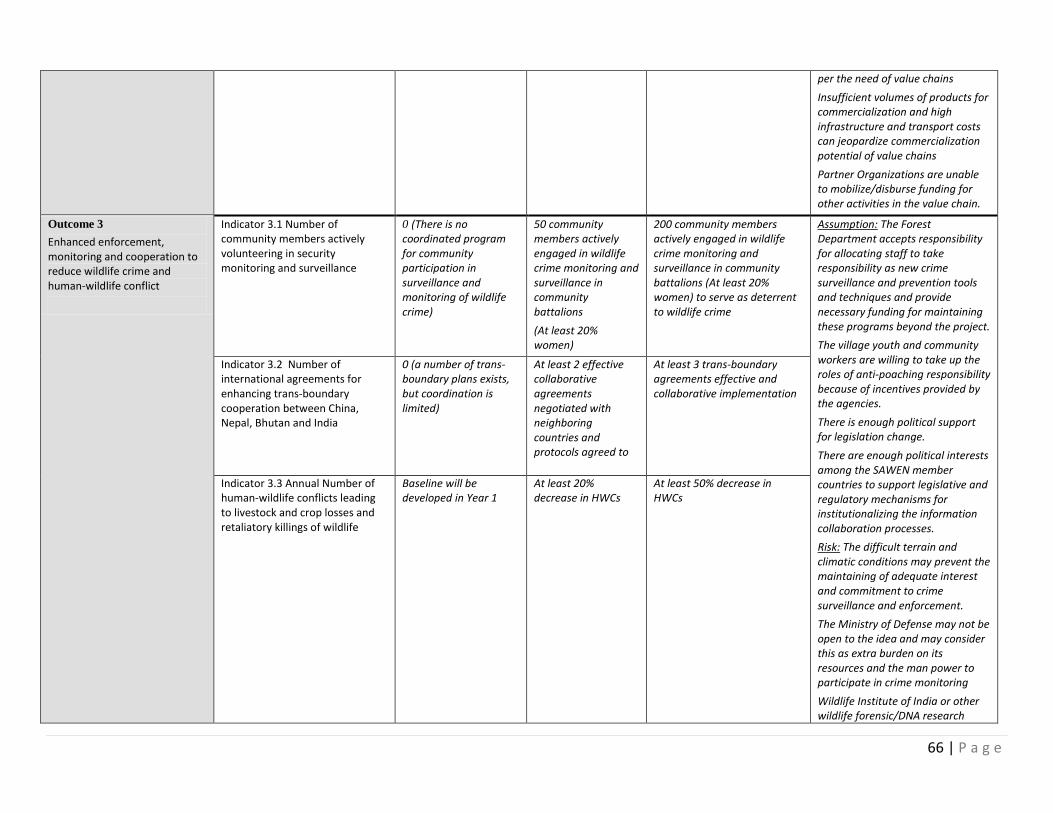
66 | P a g e
per the need of value chains
Insufficient volumes of products for commercialization and high infrastructure and transport costs can jeopardize commercialization potential of value chains
Partner Organizations are unable to mobilize/disburse funding for other activities in the value chain.
Outcome 3
Enhanced enforcement, monitoring and cooperation to reduce wildlife crime and human-wildlife conflict
Indicator 3.1 Number of community members actively volunteering in security monitoring and surveillance
0 (There is no coordinated program for community participation in surveillance and monitoring of wildlife crime)
50 community members actively engaged in wildlife crime monitoring and surveillance in community battalions
(At least 20% women)
200 community members actively engaged in wildlife crime monitoring and surveillance in community battalions (At least 20% women) to serve as deterrent to wildlife crime
Assumption: The Forest Department accepts responsibility for allocating staff to take responsibility as new crime surveillance and prevention tools and techniques and provide necessary funding for maintaining these programs beyond the project.
The village youth and community workers are willing to take up the roles of anti-poaching responsibility because of incentives provided by the agencies.
There is enough political support for legislation change.
There are enough political interests among the SAWEN member countries to support legislative and regulatory mechanisms for institutionalizing the information collaboration processes.
Risk: The difficult terrain and climatic conditions may prevent the maintaining of adequate interest and commitment to crime surveillance and enforcement.
The Ministry of Defense may not be open to the idea and may consider this as extra burden on its resources and the man power to participate in crime monitoring
Wildlife Institute of India or other wildlife forensic/DNA research
Indicator 3.2 Number of international agreements for enhancing trans-boundary cooperation between China, Nepal, Bhutan and India
0 (a number of trans-boundary plans exists, but coordination is limited)
At least 2 effective collaborative agreements negotiated with neighboring countries and protocols agreed to
At least 3 trans-boundary agreements effective and collaborative implementation
Indicator 3.3 Annual Number of human-wildlife conflicts leading to livestock and crop losses and retaliatory killings of wildlife
Baseline will be developed in Year 1
At least 20% decrease in HWCs
At least 50% decrease in HWCs
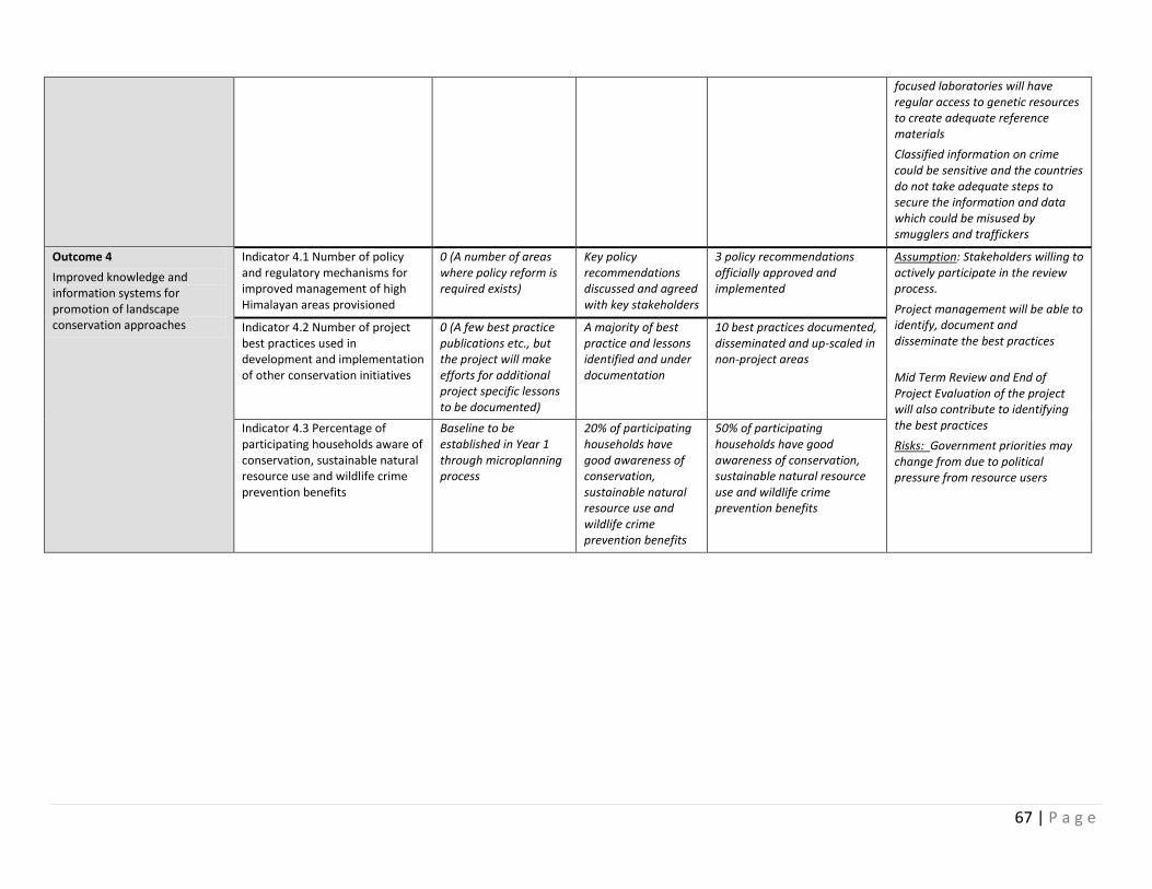
67 | P a g e
focused laboratories will have regular access to genetic resources to create adequate reference materials
Classified information on crime could be sensitive and the countries do not take adequate steps to secure the information and data which could be misused by smugglers and traffickers
Outcome 4
Improved knowledge and information systems for promotion of landscape conservation approaches
Indicator 4.1 Number of policy and regulatory mechanisms for improved management of high Himalayan areas provisioned
0 (A number of areas where policy reform is required exists)
Key policy recommendations discussed and agreed with key stakeholders
3 policy recommendations officially approved and implemented
Assumption: Stakeholders willing to actively participate in the review process.
- Project management will be able to identify, document and disseminate the best practices
Mid Term Review and End of Project Evaluation of the project will also contribute to identifying the best practices
Risks: Government priorities may change from due to political pressure from resource users
Indicator 4.2 Number of project best practices used in development and implementation of other conservation initiatives
0 (A few best practice publications etc., but the project will make efforts for additional project specific lessons to be documented)
A majority of best practice and lessons identified and under documentation
10 best practices documented, disseminated and up-scaled in non-project areas
Indicator 4.3 Percentage of participating households aware of conservation, sustainable natural resource use and wildlife crime prevention benefits
Baseline to be established in Year 1 through microplanning process
20% of participating households have good awareness of conservation, sustainable natural resource use and wildlife crime prevention benefits
50% of participating households have good awareness of conservation, sustainable natural resource use and wildlife crime prevention benefits
68 | P a g e
VII. MONITORING AND EVALUATION (M&E) PLAN
The project results as outlined in the project results framework will be monitored annually and evaluated periodically during project implementation to ensure the project effectively achieves these results. Supported by Component/Outcome Four: Knowledge Management and M&E, the project monitoring and evaluation plan will also facilitate learning and ensure knowledge is shared and widely disseminated to support the scaling up and replication of project results. Project-level monitoring and evaluation will be undertaken in compliance with UNDP requirements as outlined in the UNDP POPP and UNDP Evaluation Policy. While these UNDP requirements are not outlined in this project document, the UNDP Country Office will work with the relevant project stakeholders to ensure UNDP M&E requirements are met in a timely fashion and to high quality standards. Additional mandatory GEF-specific M&E requirements (as outlined below) will be undertaken in accordance with the GEF M&E policy and other relevant GEF policies44. In addition to these mandatory UNDP and GEF M&E requirements, other M&E activities deemed necessary to support project-level adaptive management will be agreed during the Project Inception Workshop and will be detailed in the Inception Report. This will include the exact role of project target groups and other stakeholders in project M&E activities including the GEF Operational Focal Point and national/regional institutes assigned to undertake project monitoring. The GEF Operational Focal Point will strive to ensure consistency in the approach taken to the GEF-specific M&E requirements (notably the GEF Tracking Tools) across all GEF-financed projects in the country. This could be achieved for example by using one national institute to complete the GEF Tracking Tools for all GEF-financed projects in the country, including projects supported by other GEF Agencies.45 M&E Oversight and monitoring responsibilities:
Project Manager: The Project Manager is responsible for day-to-day project management and regular monitoring of project results and risks, including social and environmental risks. The Project Manager will ensure that all project staff maintain a high level of transparency, responsibility and accountability in M&E and reporting of project results. The Project Manager will inform the Project Board, the UNDP Country Office and the UNDP-GEF RTA of any delays or difficulties as they arise during implementation so that appropriate support and corrective measures can be adopted. The Project Manager will develop annual work plans based on the multi-year work plan (Annex 21), including annual output targets to support the efficient implementation of the project. The Project Manager will ensure that the standard UNDP and GEF M&E requirements are fulfilled to the highest quality. This includes, but is not limited to, ensuring the results framework indicators are monitored annually in time for evidence-based reporting in the GEF PIR, and that the monitoring of risks and the various plans/strategies developed to support project implementation (e.g. gender strategy, KM strategy etc.) occur on a regular basis.
44
See https://www.thegef.org/gef/policies_guidelines 45
See https://www.thegef.org/gef/gef_agencies
69 | P a g e
Project Board: The Project Board will take corrective action as needed to ensure the project achieves the desired results. The Project Board will hold project reviews to assess the performance of the project and appraise the Annual Work Plan for the following year. In the project’s final year, the Project Board will hold an end-of-project review to capture lessons learned and discuss opportunities for scaling up and to highlight project results and lessons learned with relevant audiences. This final review meeting will also discuss the findings outlined in the project terminal evaluation report and the management response. Project Implementing Partner: The Implementing Partner is responsible for providing any and all required information and data necessary for timely, comprehensive and evidence-based project reporting, including results and financial data, as necessary and appropriate. The Implementing Partner will strive to ensure project-level M&E is undertaken by national institutes, and is aligned with national systems so that the data used by and generated by the project supports national systems. UNDP Country Office: The UNDP Country Office will support the Project Manager as needed, including through annual supervision missions. The annual supervision missions will take place according to the schedule outlined in the annual work plan. Supervision mission reports will be circulated to the project team and Project Board within one month of the mission. The UNDP Country Office will initiate and organize key GEF M&E activities including the annual GEF PIR, the independent mid-term review and the independent terminal evaluation. The UNDP Country Office will also ensure that the standard UNDP and GEF M&E requirements are fulfilled to the highest quality. The UNDP Country Office is responsible for complying with all UNDP project-level M&E requirements as outlined in the UNDP POPP. This includes ensuring the UNDP Quality Assurance Assessment during implementation is undertaken annually; that annual targets at the output level are developed, and monitored and reported using UNDP corporate systems; the regular updating of the ATLAS risk log; and, the updating of the UNDP gender marker on an annual basis based on gender mainstreaming progress reported in the GEF PIR and the UNDP ROAR. Any quality concerns flagged during these M&E activities (e.g. annual GEF PIR quality assessment ratings) must be addressed by the UNDP Country Office and the Project Manager. The UNDP Country Office will retain all M&E records for this project for up to seven years after project financial closure in order to support ex-post evaluations undertaken by the UNDP Independent Evaluation Office (IEO) and/or the GEF Independent Evaluation Office (IEO). UNDP-GEF Unit: Additional M&E and implementation quality assurance and troubleshooting support will be provided by the UNDP-GEF Regional Technical Advisor and the UNDP-GEF Directorate as needed. Audit: The project will be audited according to UNDP Financial Regulations and Rules and applicable audit policies on NIM implemented projects.46 Additional GEF monitoring and reporting requirements:
46
See guidance here: https://info.undp.org/global/popp/frm/pages/financial-management-and-execution-modalities.aspx
70 | P a g e
Inception Workshop and Report: A project inception workshop will be held within three months after the project document has been signed by all relevant parties to, amongst others: a) Re-orient project stakeholders to the project strategy and discuss any changes in the overall context that influence project strategy and implementation; b) Discuss the roles and responsibilities of the project team, including reporting and communication lines and conflict resolution mechanisms; c) Review the results framework and finalize the indicators, means of verification and monitoring plan; d) Discuss reporting, monitoring and evaluation roles and responsibilities and finalize the M&E budget; identify national/regional institutes to be involved in project-level M&E; discuss the role of the GEF OFP in M&E; e) Update and review responsibilities for monitoring the various project plans and strategies, including the risk log; Environmental and Social Management Plan and other safeguard requirements; the gender strategy; the knowledge management strategy, and other relevant strategies; f) Review financial reporting procedures and mandatory requirements, and agree on the arrangements for the annual audit; and g) Plan and schedule Project Board meetings and finalize the first year annual work plan. The Project Manager will prepare the inception report no later than one month after the inception workshop. The inception report will be cleared by the UNDP Country Office and the UNDP-GEF Regional Technical Adviser, and will be approved by the Project Board. GEF Project Implementation Report (PIR): The Project Manager, the UNDP Country Office, and the UNDP-GEF Regional Technical Advisor will provide objective input to the annual GEF PIR covering the reporting period July (previous year) to June (current year) for each year of project implementation. The Project Manager will ensure that the indicators included in the project results framework is monitored annually in advance of the PIR submission deadline so that progress can be reported in the PIR. Any environmental and social risks and related management plans will be monitored regularly, and progress will be reported in the PIR. The PIR submitted to the GEF will be shared with the Project Board. The UNDP Country Office will coordinate the input of the GEF Operational Focal Point and other stakeholders to the PIR as appropriate. The quality rating of the previous year’s PIR will be used to inform the preparation of the subsequent PIR. Lessons learned and knowledge generation: Results from the project will be disseminated within and beyond the project intervention area through existing information sharing networks and forums. The project will identify and participate, as relevant and appropriate, in scientific, policy-based and/or any other networks, which may be of benefit to the project. The project will identify, analyse and share lessons learned that might be beneficial to the design and implementation of similar projects and disseminate these lessons widely. There will be continuous information exchange between this project and other projects of similar focus in the same country, region and globally. GEF Focal Area Tracking Tools: The following GEF Tracking Tool(s) will be used to monitor global environmental benefit results: list the required GEF Tracking Tool(s), as agreed with the UNDP-GEF Regional Technical Advisor. The baseline/CEO Endorsement GEF Focal Area Tracking Tool(s) – submitted as Annex D to this project document – will be updated by the Project Manager/Team (not the evaluation consultants hired to undertake the MTR or the TE) (indicate other project partner, if agreed)
71 | P a g e
and shared with the mid-term review consultants and terminal evaluation consultants before the required review/evaluation missions take place. The updated GEF Tracking Tool(s) will be submitted to the GEF along with the completed Mid-term Review report and Terminal Evaluation report. Independent Mid-term Review (MTR): An independent mid-term review process will begin after the second PIR has been submitted to the GEF, and the MTR report will be submitted to the GEF in the same year as the 3rd PIR. The MTR findings and responses outlined in the management response will be incorporated as recommendations for enhanced implementation during the final half of the project’s duration. The terms of reference, the review process and the MTR report will follow the standard templates and guidance prepared by the UNDP IEO for GEF-financed projects available on the UNDP Evaluation Resource Center (ERC). As noted in this guidance, the evaluation will be ‘independent, impartial and rigorous’. The consultants that will be hired to undertake the assignment will be independent from organizations that were involved in designing, executing or advising on the project to be evaluated. The GEF Operational Focal Point and other stakeholders will be involved and consulted during the terminal evaluation process. Additional quality assurance support is available from the UNDP-GEF Directorate. The final MTR report will be available in English and will be cleared by the UNDP Country Office and the UNDP-GEF Regional Technical Adviser, and approved by the Project Board.
Terminal Evaluation (TE): An independent terminal evaluation (TE) will take place upon completion of all major project outputs and activities. The terminal evaluation process will begin three months before operational closure of the project allowing the evaluation mission to proceed while the project team is still in place, yet ensuring the project is close enough to completion for the evaluation team to reach conclusions on key aspects such as project sustainability. The Project Manager will remain on contract until the TE report and management response have been finalized. The terms of reference, the evaluation process and the final TE report will follow the standard templates and guidance prepared by the UNDP IEO for GEF-financed projects available on the UNDP Evaluation Resource Center. As noted in this guidance, the evaluation will be ‘independent, impartial and rigorous’. The consultants that will be hired to undertake the assignment will be independent from organizations that were involved in designing, executing or advising on the project to be evaluated. The GEF Operational Focal Point and other stakeholders will be involved and consulted during the terminal evaluation process. Additional quality assurance support is available from the UNDP-GEF Directorate. The final TE report will be cleared by the UNDP Country Office and the UNDP-GEF Regional Technical Adviser, and will be approved by the Project Board. The TE report will be publically available in English on the UNDP ERC. The UNDP Country Office will include the planned project terminal evaluation in the UNDP Country Office evaluation plan, and will upload the final terminal evaluation report in English and the corresponding management response to the UNDP Evaluation Resource Centre (ERC). Once uploaded to the ERC, the UNDP IEO will undertake a quality assessment and validate the findings and ratings in the TE report, and rate the quality of the TE report. The UNDP IEO assessment report will be sent to the GEF IEO along with the project terminal evaluation report. Final Report: The project’s terminal PIR along with the terminal evaluation (TE) report and corresponding management response will serve as the final project report package. The final project report package shall be discussed with the Project Board during an end-of-project review meeting to discuss lesson learned and opportunities for scaling up.
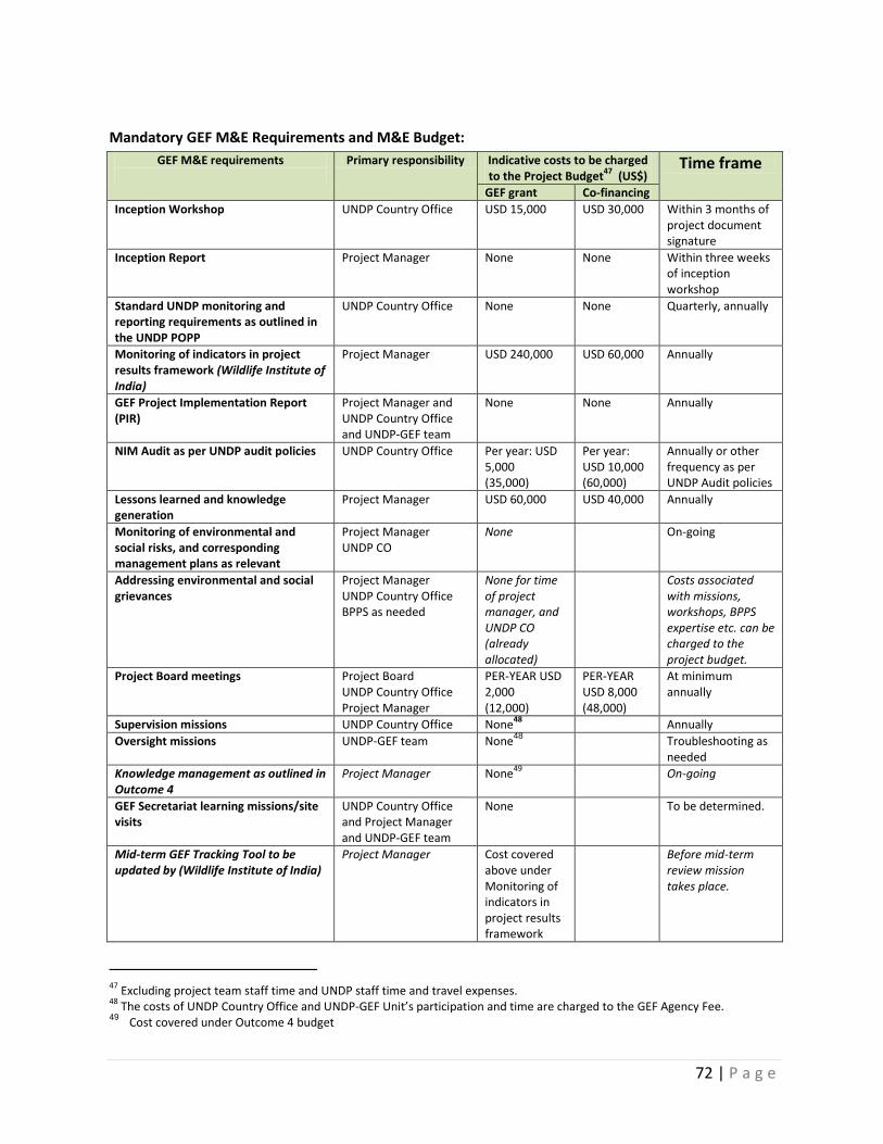
72 | P a g e
Mandatory GEF M&E Requirements and M&E Budget:
GEF M&E requirements
Primary responsibility Indicative costs to be charged to the Project Budget
47 (US$)
Time frame
GEF grant Co-financing
Inception Workshop UNDP Country Office USD 15,000 USD 30,000 Within 3 months of project document signature
Inception Report Project Manager None None Within three weeks of inception workshop
Standard UNDP monitoring and reporting requirements as outlined in the UNDP POPP
UNDP Country Office
None None Quarterly, annually
Monitoring of indicators in project results framework (Wildlife Institute of India)
Project Manager
USD 240,000 USD 60,000 Annually
GEF Project Implementation Report (PIR)
Project Manager and UNDP Country Office and UNDP-GEF team
None None Annually
NIM Audit as per UNDP audit policies UNDP Country Office Per year: USD 5,000 (35,000)
Per year: USD 10,000 (60,000)
Annually or other frequency as per UNDP Audit policies
Lessons learned and knowledge generation
Project Manager USD 60,000 USD 40,000 Annually
Monitoring of environmental and social risks, and corresponding management plans as relevant
Project Manager UNDP CO
None On-going
Addressing environmental and social grievances
Project Manager UNDP Country Office BPPS as needed
None for time of project manager, and UNDP CO (already allocated)
Costs associated with missions, workshops, BPPS expertise etc. can be charged to the project budget.
Project Board meetings Project Board UNDP Country Office Project Manager
PER-YEAR USD 2,000 (12,000)
PER-YEAR USD 8,000 (48,000)
At minimum annually
Supervision missions UNDP Country Office None48
Annually
Oversight missions UNDP-GEF team None48
Troubleshooting as needed
Knowledge management as outlined in Outcome 4
Project Manager None49
On-going
GEF Secretariat learning missions/site visits
UNDP Country Office and Project Manager and UNDP-GEF team
None To be determined.
Mid-term GEF Tracking Tool to be updated by (Wildlife Institute of India)
Project Manager Cost covered above under Monitoring of indicators in project results framework
Before mid-term review mission takes place.
47
Excluding project team staff time and UNDP staff time and travel expenses. 48
The costs of UNDP Country Office and UNDP-GEF Unit’s participation and time are charged to the GEF Agency Fee. 49 Cost covered under Outcome 4 budget
73 | P a g e
GEF M&E requirements
Primary responsibility Indicative costs to be charged to the Project Budget
47 (US$)
Time frame
GEF grant Co-financing
Independent Mid-term Review (MTR) and management response
UNDP Country Office and Project team and UNDP-GEF team
USD 30,000 USD 50,000 Between 2nd
and 3rd
PIR.
Terminal GEF Tracking Tool to be updated by (Wildlife Institute of India)
Project Manager Cost covered above under Monitoring of indicators in project results framework
Before terminal evaluation mission takes place
Independent Terminal Evaluation (TE) included in UNDP evaluation plan, and management response
UNDP Country Office and Project team and UNDP-GEF team
USD 40,000 USD 50,000 At least three months before operational closure
Translation of MTR and TE reports into English
UNDP Country Office Nil As required. GEF will only accept reports in English.
TOTAL indicative COST Excluding project team staff time, and UNDP staff and travel expenses
USD 432,000 USD 338,000
______________________________________________________________________________
VIII. GOVERNANCE AND MANAGEMENT ARRANGEMENTS Roles and responsibilities of the project’s governance mechanism: The project will be implemented following UNDP’s national implementation modality, according to the Standard Basic Assistance Agreement between UNDP and the Government of India, and the Country Program. The Implementing Partner for this project is the Ministry of Environment, Forest and Climate Change. The Implementing Partner is responsible and accountable for managing this project, including the monitoring and evaluation of project interventions, achieving project outcomes, and for the effective use of UNDP resources. Governance mechanism in the Project Project Board/National Steering Committee
The Project Board will be establishment and chaired by the Inspector General of Forests of the MOEFCC. The Board will have high level, cross-sectoral representation including of representatives of the MOEFCC, as the key governmental agency in charge of natural resources and environment and will ensure that other governmental agencies are duly consulted and involved as per their mandate (such as the Ministry of Agriculture, Science and Technology, Rural Development, Water Resources, Defense and Finance), NMPB, NBA and WII. The Board may also include representatives of other national or participating state representatives, non-government organizations, experts and community representatives. Other participants can be invited into the Board meetings at the decision of the Board, as and when required to enhance its efficacy. It will meet at least twice a year or as needed. The Project Management Unit will serve as the Secretariat of the Project Board and the National Project Director (NPD) will take responsibility for calling its meetings, preparation of agenda, documentation and
74 | P a g e
distribution of minutes and ensuring that decisions of the Board are implemented in letter and spirit. Specific responsibilities of the Project Board would include the following:
Provide strategic direction and guidance for implementation of the project;
Review project’s progress, review and evaluation reports and make and ensure for follow-up actions for timely and quality implementation;
Approve annual work-plans and budgets and any essential deviations (above 50% of budget reduction from one of the four components) from the original plans and budgets;
Provide coordination and conflict resolution forum for implementing agencies and key stakeholders i.e. concerned ministries, provincial line departments, and relevant research institutions;
Oversee and support the commitment and funding and other support for the project;
Oversee prudent and efficient use of project budgets and other resources;
Decide on conceptual and design changes and other recommendations of external mid-term review; and
Provide guidance on post-project sustainability, institutional and financial arrangements, keeping in view the recommendations of external reviews.
A program officer hired by UNDP will function as a National Project Manager to run the project on a day-to-day basis on behalf of the National Implementing Partner within the constraints laid down by the Board. The National Project Manager function will end when the final project terminal evaluation report and corresponding management response, and other documentation required by the GEF and UNDP, has been completed and submitted to UNDP (including operational closure of the project. Project Assurance will be provided through an assigned Program Manager within the UNDP Country Office. Additional quality assurance is to be provided by the UNDP Regional Technical Advisor, as and when needed.
National Project Management Unit
The Project Management Unit (PMU) will be established in MOEFCC. It will comprise of a National Project Manager (NPM), Project Administrative Officer (PAO), Project Finance and Human Resources specialist and other technical and administrative staff as relevant. The PMU, in collaboration with the MOEFCC and state coordinating committees will have overall management and administrative responsibility for facilitating stakeholder involvement and ensuring increased provincial level ownership of the project. The PMU staff will be located in Delhi to ensure coordination among key stakeholders at the federal level and with state Forest and Wildlife departments supported by the State Coordinating Committees during the project period.
Project Governance and Management at the State level
State Steering Committees
In order to govern the project, a steering committee at the state level, under the chairmanship of Chief Secretary/Additional Chief Secretary (except in the case of Ladakh, where the Chief Executive Councillor of the Ladakh Autonomous Hill Council will serve as the Chairman) will be formed. The Chief Warden Wildlife/Project Director will be the Member Convener of the Committee. This committee will be composed of - PCCF and a senior member from the Wildlife/Forest department (2); Chairman of Biodiversity Board (1); representatives from relevant line departments (depending upon the key livelihood areas of the landscape); (4); and members from participating NGOs and research (including WII) and development Institutions (2) and individual experts on conservation and livelihoods (2). Overall the committee will be comprised of around 11 members. The key function of the committee
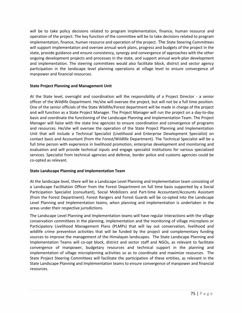
75 | P a g e
will be to take policy decisions related to program implementation, finance, human resource and operation of the project. The key function of the committee will be to take decisions related to program
implementation, finance, human resource and operation of the project. The State Steering Committees will support implementation and oversee annual work plans, progress and budgets of the project in the state, provide guidance and ensure consistency, synergy and convergence of approaches with the other ongoing development projects and processes in the state, and support annual work-plan development and implementation. The steering committees would also facilitate block, district and sector agency participation in the landscape level planning operations at village level to ensure convergence of manpower and financial resources.
State Project Planning and Management Unit At the State level, oversight and coordination will the responsibility of a Project Director - a senior officer of the Wildlife Department. He/she will oversee the project, but will not be a full time position. One of the senior officials of the State Wildlife/Forest department will be made in charge of the project and will function as a State Project Manager. The Project Manager will run the project on a day-to-day basis and coordinate the functioning of the Landscape Planning and Implementation Team. The Project Manager will liaise with the state line agencies to ensure coordination and convergence of programs and resources. He/she will oversee the operation of the State Project Planning and Implementation Unit that will include a Technical Specialist (Livelihood and Enterprise Development Specialist) on contact basis and Accountant (from the Forest/Wildlife Department). The Technical Specialist will be a full time person with experience in livelihood promotion, enterprise development and monitoring and evaluation and will provide technical inputs and engage specialist institutions for various specialized services. Specialist from technical agencies and defense, border police and customs agencies could be co-opted as relevant. State Landscape Planning and Implementation Team At the landscape level, there will be a Landscape Level Planning and Implementation team consisting of a Landscape Facilitation Officer from the Forest Department on full time basis supported by a Social Participation Specialist (consultant), Social Mobilizers and Part-time Accountant/Accounts Assistant (from the Forest Department). Forest Rangers and Forest Guards will be co-opted into the Landscape Level Planning and Implementation teams, when planning and implementation is undertaken in the areas under their respective jurisdictions.
The Landscape Level Planning and Implementation teams will have regular interactions with the village conservation committees in the planning, implementation and the monitoring of village microplans or Participatory Livelihood Management Plans (PLMPs) that will lay out conservation, livelihood and wildlife crime prevention activities that will be funded by the project and complementary funding sources to improve the management of the Himalayan landscapes. The State Landscape Planning and Implementation Teams will co-opt block, district and sector staff and NGOs, as relevant to facilitate convergence of manpower, budgetary resources and technical support in the planning and implementation of village microplanning activities so as to coordinate and maximize resources. The State Project Steering Committees will facilitate the participation of these entities, as relevant in the State Landscape Planning and Implementation teams to ensure convergence of manpower and financial resources.
76 | P a g e
Project Assurance
UNDP
Project Board/National Project Steering Committee
Senior Beneficiary
Ministry of Environment, Forests and Climate Change
Executive
Wildlife Division/MOEFCC
Senior Supplier
UNDP
National Project Management Unit
National Project Director National Project Manager
Accounts Officer
State Project Planning and Management Units
State Project Director State Project Manager
Technical Specialist Accounts Officer
State Level Project Steering Committee
Secretary/ACS/Chief Executive Councillor
PCCF/CWW Representative/Biodiversity
Board Representatives/Sector
Agencies NGOs/Research Institutes
Institutes/WII
State Landscape Planning and Implementation Teams
Landscape Facilitation Officer Social Participatory Specialist, Social Mobilizers, Forest
Rangers and Guards Part-time Accounts Assistant, Block/District/Sector Officers
(co-opted)
Village Conservation and Development Committees [Gram Sabhas/Village Councils and/or Specific Village Committees
established under auspices of Village Panchayat Institution]
Village Implementing Bodies
[SHGs, Primary Cooperatives, Dairy Groups, JMC, EDC, BMC, Ecotourism Groups, Producer Groups, etc.]
77 | P a g e
Village Conservation and Development Committees
Site specific interventions and annual plans of operations (APOs) would be executed through the well established democratic institutions, i.e., Gram Sabhas (village councils) in close coordination with other community based organizations such as Van Panchayat (VP), Eco-development Committees (EDCs), Joint Forest Management Committees (JFMCs), Women’s Self Help Groups (WSHGs), etc. as appropriate depending upon their compatibility and strengths. All livelihood and natural resource management planning would be coordinated through the State Landscape Planning and Implementation Team under the supervision and guidance of State Project Manager, involving various stakeholders and mobilizers. Community level activities agreed through bottom up planning process and as outlined in the APO will then be funded and operationalized under this project. Mechanism for fund flow under this project would be similar to that of Mahatma Gandhi National Rural Employment Guarantee Scheme (MNREGS). For each village council where the project would be piloted, a separate bank account would be maintained and operated jointly by the Head of the Council (Pradhan) and a representative of Forest/ Wildlife Departments. At each pilot site, two types of activities are visualized under the project, viz., activities dealing with generation of innovative livelihoods especially for the households who are highly dependent on the biomass resources, and participatory natural resource management/eco-restoration activities. The VCDCs would be encouraged to create assets and revolving funds from the savings made through contributory labor for various activities which would be used for ancillary community based welfare activities such as maintenance of fodder banks, livestock insurance scheme, water harvesting structures etc. All payments would be made through checks and accounts would be audited annually. Microplanning will be undertaken at an individual village level. To the extent feasible and relevant, the village conservation committees (comprising all members of households in the village) will be directly involved in the microplanning activities for conservation, sustainable natural resources use and livelihood improvement. Other village associations such as Self Help Groups, BDC/BMCs, Dairy Groups, Ecotourism groups, producer groups and similar other entities would be directly involved in the implementation of relevant activities within the village microplans. The microplans will take congruence of other programs and activities of the different groups, and will support skills development, technology improvements, product development, marketing, product branding, linkages with financial institutions and other available government and non-government programs and resources, etc.
Role of NGOs, research and training Institutions, Individual experts, private institutions, line departments, financial institutions, cooperative institutions and civil society organizations: A range of organizations and experts will be engaged in the project to get specialized services for technical support; financial support; capacity building; R&D Services, value chain management, sub-projects implementations, etc. as needed. These institutions and experts will be engaged as specialized institutions for specific assignments or subprojects in their area of specialization. As per the requirement of the project, institutions will be engaged on contract basis with clear Terms of Reference for the tasks assigned to them.
UNDP COUNTRY OFFICE
The UNDP Country Office (UNDP-CO) will be responsible for Project Assurance that supports the Project Board by carrying out objective and independent project oversight and monitoring functions. The project is to be nationally executed (NEX), in line with the Standard Basic Assistance Agreement between the UNDP and the Government of India and with the Country Program Action Plan (CPAP). The proposed Project will be executed in accordance with the rules and procedures laid down under the
78 | P a g e
National Implementation Modality (National Implementation of the UNDP Supported Projects). A UNDP staff member will be assigned the responsibility for the day-to-day management and control over project finances. The following aspects need to be checked by the Project Assurance throughout the project:
Maintenance of liaison throughout the project between the donors and project implementers;
Beneficiary needs and expectations are being met or managed;
Risks are being controlled;
Adherence to the Project Justification;
Providing financial and audit services to the project through appointment of independent financial auditors and evaluators;
Overseeing financial expenditures against project budgets approved by the Project Board;
Ensuring that all activities including staff and equipment procurement and financial services are carried out in strict compliance with UNDP/GEF procedures
The project remains viable, so that the scope of the project is not “creeping upwards” unnoticed;
Internal and external communications are working;
Applicable standards are being used and followed;
Any legislative constraints are being observed; and
Adherence to quality assurance standards.
Detailed Terms of Reference for key project positions is provided in Annex 20.
UNDP Direct Project Services as requested by Government: The UNDP, as GEF Agency for this project, will provide project management cycle services for the project as defined by the GEF Council. In addition the Government of India may request UNDP direct services for specific projects, according to its policies and convenience. The UNDP and Government of India acknowledge and agree that those services are not mandatory, and will be provided only upon Government request. If requested, the services would follow the UNDP policies on the recovery of direct costs. These services (and their costs) are specified in the Letter of Agreement (Annex 28). As is determined by the GEF Council requirements, these service costs will be assigned as Project Management Cost, duly identified in the project budget as Direct Project Costs. Eligible Direct Project Costs should not be charged as a flat percentage. They should be calculated on the basis of estimated actual or transaction based costs and should be charged to the direct project costs account codes: “64397- Services to Project – Staff” and “74596- Services to Project – General Operating Expenses (GOE)”.
IX. FINANCIAL PLANNING AND MANAGEMENT
The total cost of the project is USD 72,364,192. This is financed through a GEF grant of USD 11,544,192, and USD 60,820,000 in parallel co-financing. UNDP, as the GEF Implementing Agency, is responsible for the execution of the GEF resources and the cash co-financing transferred to UNDP bank account only. Parallel co-financing: The actual realization of project co-financing will be monitored during the mid-term review and terminal evaluation process and will be reported to the GEF. The planned parallel co-financing will be used as follows:
Co-financing source
Co-financing type
Co-financing amount
Planned Activities/Outputs Risks Risk Mitigation Measures
79 | P a g e
Government (national and state)
Grant and In- kind
59,820,000 (e.g. Program investment support, staff and office space, operation and maintenance costs, etc.)
Potential risk of funds being unavailable to project landscapes because of remoteness and lack of political commitment
The co-financing from existing government programs, and efforts will be made through the steering committees to direct resources to project areas
UNDP Grant 1,000,000 Planned investments under on-going programs such as: Biodiversity Conservation through Community Based Natural Resource Management; Climate Risk Management; Disha: Creating Employment and Entrepreneurship Opportunities for Women in India; Conservation and Sustainable Use of Medicinal plants by strengthening eco-system based livelihood and marketing strategies.
The proposed alignment between the activities and plans under the before mentioned programs and the current project prove difficult
As the lead agency, UNDP will ensure viable cross-fertilization of ideas, replication of lessons and best practices between the project and implementation of these prorgams including joint contribution to national policy improvements and effective application of a diverse governance framework to natural resource management at the local level.
Total (USD) 60,820,000
Budget Revision and Tolerance: As per UNDP requirements outlined in the UNDP POPP, the project board will agree on a budget tolerance level for each plan under the overall annual work plan allowing the project manager to expend up to the tolerance level beyond the approved project budget amount for the year without requiring a revision from the Project Board. Should the following deviations occur, the Project Manager and UNDP Country Office will seek the approval of the UNDP-GEF team as these are considered major amendments by the GEF: a) Budget re-allocations among components in the project with amounts involving 10% of the total project grant or more; b) Introduction of new budget items/or components that exceed 5% of original GEF allocation. Any over expenditure incurred beyond the available GEF grant amount will be absorbed by non-GEF resources (e.g. UNDP TRAC or cash co-financing). Refund to Donor: Should a refund of unspent funds to the GEF be necessary, this will be managed directly by the UNDP-GEF Unit in New York.
80 | P a g e
Project Closure: Project closure will be conducted as per UNDP requirements outlined in the UNDP POPP.50 On an exceptional basis only, a no-cost extension beyond the initial duration of the project will be sought from in-country UNDP colleagues and then the UNDP-GEF Executive Coordinator. Operational completion: The project will be operationally completed when the last UNDP-financed inputs have been provided and the related activities have been completed. This includes the final clearance of the Terminal Evaluation Report (that will be available in English) and the corresponding management response, and the end-of-project review Project Board meeting. The Implementing Partner through a Project Board decision will notify the UNDP Country Office when operational closure has been completed. At this time, the relevant parties will have already agreed and confirmed in writing on the arrangements for the disposal of any equipment that is still the property of UNDP. Financial completion: The project will be financially closed when the following conditions have been met: a) The project is operationally completed or has been cancelled; b) The Implementing Partner has reported all financial transactions to UNDP; c) UNDP has closed the accounts for the project; d) UNDP and the Implementing Partner have certified a final Combined Delivery Report (which serves as final budget revision). The project will be financially completed within 12 months of operational closure or after the date of cancellation. Between operational and financial closure, the implementing partner will identify and settle all financial obligations and prepare a final expenditure report. The UNDP Country Office will send the final signed closure documents including confirmation of final cumulative expenditure and unspent balance to the UNDP-GEF Unit for confirmation before the project will be financially closed in Atlas by the UNDP Country Office.
50
see https://info.undp.org/global/popp/ppm/Pages/Closing-a-Project.aspx
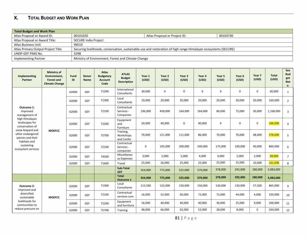
81 | P a g e
X. TOTAL BUDGET AND WORK PLAN
Total Budget and Work Plan
Atlas Proposal or Award ID: 00101020 Atlas Proposal or Project ID: 00103730
Atlas Proposal or Award Title: SECURE India Project
Atlas Business Unit IND10
Atlas Primary Output Project Title Securing livelihoods, conservation, sustainable use and restoration of high range Himalayan ecosystems (SECURE)
UNDP-GEF PIMS No. 3298
Implementing Partner Ministry of Environment, Forest and Climate Change
Implementing Partner
Ministry of Environment,
Forest and Climate Change
Fund ID
Donor Name
Atlas Budgetary Account
Code
ATLAS Budget
Description
Year 1 (USD)
Year 2 (USD)
Year 3 (USD)
Year 4 (USD)
Year 5 (USD)
Year 6 (USD)
Year 7 (USD)
Total (USD)
See Budget Note:
Outcome 1: Improved
management of high Himalayan landscapes for conservation of
snow leopard and other endangered species and their
habitats and sustaining
ecosystem services
MOEFCC
62000 GEF 71200 International Consultants
30,000 0 0 0 0 0 0 30,000 1
62000 GEF 71300 Local Consultants
10,000 20,000 20,000 20,000 20,000 20,000 50,000 160,000 2
62000 GEF 72100 Contractual Services -Companies
196,000 458,000 164,000 164,000 84,000 72,000 30,000 1,168,000 3
62000 GEF 72200 Equipment and Furniture
20,000 40,000 0 40,000 0 0 0 100,000 4
62000 GEF 75700 Training, Workshops and Confer
70,000 121,000 111,000 86,000 70,000 70,000 48,000 576,000 5
62000 GEF 72100 Contractual Services -companies
0 105,000 200,000 240,000 175,000 100,000 40,000 860,000 6
62000 GEF 74500 Miscellaneous Expenses
3,000 5,000 5,000 4,000 4,000 5,000 2,000 28,000 7
62000 GEF 71600 Travel 25,000 26,000 25,000 25,000 25,000 25,000 10,000 161,000 8
Sub-Total GEF
354,000 775,000 525,000 579,000 378,000 292,000 180,000 3,083,000
Total Outcome 1
354,000 775,000 525,000 579,000 378,000 292,000 180,000 3,083,000
Outcome 2: Improved and
diversified sustainable
livelihoods for communities to
reduce pressure on
MOEFCC
62000 GEF 71300 Local Consultants
115,500 132,000 150,000 150,000 130,000 130,000 57,500 865,000 9
62000 GEF 72100 Contractual services-com
16,000 52,000 60,000 72,000 72,000 44,000 4,000 320,000 10
62000 GEF 72200 Equipment and furniture
16,000 40,000 40,000 40,000 30,000 25,000 9,000 200,000 11
62000 GEF 75700 Training 48,000 66,000 62,000 52,000 28,000 8,000 0 264,000 12
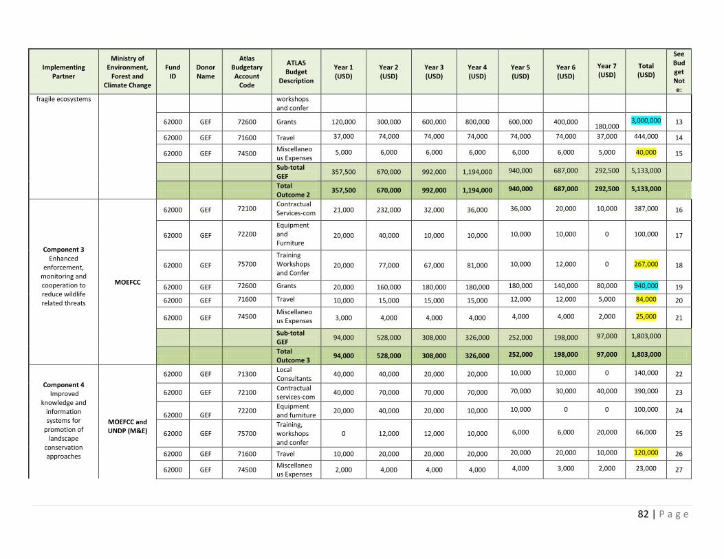
82 | P a g e
Implementing Partner
Ministry of Environment,
Forest and Climate Change
Fund ID
Donor Name
Atlas Budgetary Account
Code
ATLAS Budget
Description
Year 1 (USD)
Year 2 (USD)
Year 3 (USD)
Year 4 (USD)
Year 5 (USD)
Year 6 (USD)
Year 7 (USD)
Total (USD)
See Budget Note:
fragile ecosystems
workshops and confer
62000 GEF 72600 Grants 120,000 300,000 600,000 800,000 600,000 400,000
180,000 3,000,000 13
62000 GEF 71600 Travel 37,000 74,000 74,000 74,000 74,000 74,000 37,000 444,000 14
62000 GEF 74500 Miscellaneous Expenses
5,000 6,000 6,000 6,000 6,000 6,000 5,000 40,000 15
Sub-total GEF
357,500 670,000 992,000 1,194,000 940,000 687,000 292,500 5,133,000
Total Outcome 2
357,500 670,000 992,000 1,194,000 940,000 687,000 292,500 5,133,000
Component 3 Enhanced
enforcement, monitoring and cooperation to reduce wildlife related threats
MOEFCC
62000 GEF 72100 Contractual Services-com 21,000 232,000 32,000 36,000 36,000 20,000 10,000 387,000 16
62000 GEF 72200 Equipment and Furniture
20,000 40,000 10,000 10,000 10,000 10,000 0 100,000 17
62000 GEF 75700 Training Workshops and Confer
20,000 77,000 67,000 81,000 10,000 12,000 0 267,000 18
62000 GEF 72600 Grants 20,000 160,000 180,000 180,000 180,000 140,000 80,000 940,000 19
62000 GEF 71600 Travel 10,000 15,000 15,000 15,000 12,000 12,000 5,000 84,000 20
62000 GEF 74500 Miscellaneous Expenses 3,000 4,000 4,000 4,000 4,000 4,000 2,000 25,000 21
Sub-total GEF
94,000 528,000 308,000 326,000 252,000 198,000 97,000 1,803,000
Total Outcome 3
94,000 528,000 308,000 326,000 252,000 198,000 97,000 1,803,000
Component 4 Improved
knowledge and information systems for
promotion of landscape
conservation approaches
MOEFCC and UNDP (M&E)
62000 GEF 71300 Local Consultants
40,000 40,000 20,000 20,000 10,000 10,000 0 140,000 22
62000 GEF 72100 Contractual services-com
40,000 70,000 70,000 70,000 70,000 30,000 40,000 390,000 23
62000
GEF
72200 Equipment and furniture
20,000 40,000 20,000 10,000 10,000 0 0 100,000 24
62000 GEF 75700 Training, workshops and confer
0 12,000 12,000 10,000 6,000 6,000 20,000 66,000 25
62000 GEF 71600 Travel 10,000 20,000 20,000 20,000 20,000 20,000 10,000 120,000 26
62000 GEF 74500 Miscellaneous Expenses
2,000 4,000 4,000 4,000 4,000 3,000 2,000 23,000 27
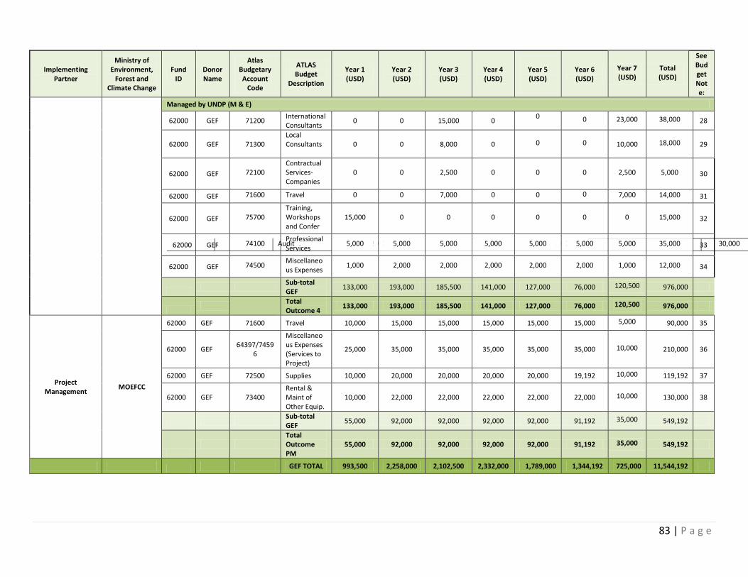
83 | P a g e
Implementing Partner
Ministry of Environment,
Forest and Climate Change
Fund ID
Donor Name
Atlas Budgetary Account
Code
ATLAS Budget
Description
Year 1 (USD)
Year 2 (USD)
Year 3 (USD)
Year 4 (USD)
Year 5 (USD)
Year 6 (USD)
Year 7 (USD)
Total (USD)
See Budget Note:
Managed by UNDP (M & E)
62000 GEF 71200 International Consultants
0 0 15,000 0 0 0 23,000 38,000 28
62000 GEF 71300 Local Consultants
0 0 8,000 0 0 0 10,000 18,000 29
62000 GEF 72100 Contractual Services-Companies
0 0 2,500 0 0 0 2,500 5,000 30
62000 GEF 71600 Travel 0 0 7,000 0 0 0 7,000 14,000 31
62000 GEF 75700 Training, Workshops and Confer
15,000 0 0 0 0 0 0 15,000 32
62000 Audit 5,000 5,000 5,000 5,000 5,000 5,000 30,000 34
GEF 74100 Professional Services
5,000 5,000 5,000 5,000 5,000 5,000 5,000 35,000 33
62000 GEF 74500 Miscellaneous Expenses
1,000 2,000 2,000 2,000 2,000 2,000 1,000 12,000 34
Sub-total GEF
133,000 193,000 185,500 141,000 127,000 76,000 120,500 976,000
Total Outcome 4
133,000 193,000 185,500 141,000 127,000 76,000 120,500 976,000
Project Management
MOEFCC
62000 GEF 71600 Travel 10,000 15,000 15,000 15,000 15,000 15,000 5,000 90,000 35
62000 GEF 64397/7459
6
Miscellaneous Expenses (Services to Project)
25,000 35,000 35,000 35,000 35,000 35,000 10,000 210,000 36
62000 GEF 72500 Supplies 10,000 20,000 20,000 20,000 20,000 19,192 10,000 119,192 37
62000 GEF 73400 Rental & Maint of Other Equip.
10,000 22,000 22,000 22,000 22,000 22,000 10,000 130,000 38
Sub-total GEF
55,000 92,000 92,000 92,000 92,000 91,192 35,000 549,192
Total Outcome PM
55,000 92,000 92,000 92,000 92,000 91,192 35,000 549,192
GEF TOTAL 993,500 2,258,000 2,102,500 2,332,000 1,789,000 1,344,192 725,000 11,544,192
84 | P a g e
Budget Summary:
Donor
Amount Year 1 (USD)
Amount Year 2 (USD)
Amount Year 3 (USD)
Amount Year 4 (USD)
Amount Year 5 (USD)
Amount Year 6 (USD)
Amount Year 7 (USD)
Total (USD)
Grant – GEF 993,500 2,258,000 2,102,500 2,332,000 1,789,000 1,344,192 725,000 11,544,192
Co-finance – Government and UNDP
7,470,000 10,470,000 10,470,000 10,470,000 10,470,000 9,470,000 2,000,000 60,820,000
TOTAL 8,463,500 12,728,000 12,572,500 12,802,000 12,259,000 10,814,192 2,725,000 72,364,192
Budget notes:
1 Fees for international consultants/expert by MOEFCC To undertake carbon stock estimate to validate existing baseline (Outcome 1) (approx. 1.5 months) = USD 30,000
2 Cost of hiring national consultants for: (i) Monitoring support for (Outcome 1) MOEFCC at USD 20,000/yr. x 7 years (starting QTR3, YR1 and ending QTR 2, YR7) = USD 120,000 (ii) Documentation consultant to document best practices (Output 1.5) at USD 10,000/state x 4 during Year 7 = USD 40,000
3
Contractual service to institutions or firms as follows: (i) Conservation mapping of 4 landscapes (Output 1.1) at USD 100,000/landscape in Year 1 and 2 (contracting costs to WII for staff time, travel, GIS mapping, map production, etc.) = USD 100,000 x 4 = USD 400,000 (ii) Preparation of site–specific management plans in each landscape (Output 1.2) spread through Year 2, 3 and 4 (WII or other research agency) at USD 60,000/landscape = USD 240,000 (iii) Preparation of alpine meadow and forest restoration strategies and plans (Output 1.3) for each landscape in Year 2 at USD 10,000/landscape = USD 40,000 (iii) Design and implementation of baseline monitoring program (Output 1.4) spread through 7 years at 4 landscapes (WII or other research agency) at USD 60,000/landscape =USD 240,000 (iv) Development of participatory monitoring protocols (Output 1.4) for all 4 landscapes in Year 1 (WII or other research agency) at USD 5,000/landscape = USD 20,000 (v) Training of communities in participatory monitoring techniques (Output 1.4 with WII or other research agency) spread through years 2 through 5 at USD 5,000/landscape = USD 20,000 (vi) Needs assessment for short-term action research (Output 1.4) (WII or other research agency) in Year 1 at USD 2,000/landscape = USD 8,000 (vii) Implementation of short-term action research (Output 1.4) (research institutions/individuals) Year 2 through 6 at USD 50,000/landscape = USD 200,000
4 Field and technical equipment for staff and research work (Outputs 1.2 through 1.4) (e.g. camping gear, binoculars, computer, software and accessories, etc.) at USD 20,000/landscape and USD 20,000 for MOEFCC at USD 20,000 = USD 100,000
5
Training and workshops as follows: (i) Stakeholder workshops for consultation and presentation of draft landscape conservation maps (Output 1.1) in Year 1 and 2 at USD 5,000/landscape (USD 2,500/workshop) = USD 20,000 (ii) Stakeholder workshops for presentation of final landscape conservation maps (Output 1.1) in Year 1 and 2 at USD 5,000/landscape (USD 2,500/workshop) = USD 20,000 (iii) Stakeholder workshops for consultations regarding site-specific management plans (Output 1.2) in Year 2, 3 and 4 at USD 6,000/landscape (one meeting/year/landscape at USD 2,000)= USD 24,000 (iv) Stakeholder workshops for finalization site-specific management plans (Output 1.2) in Years 2, 3 and 4 at USD 6,000/landscape (USD 2,000/workshop) = USD 24,000 (v) Stakeholder workshops for dissemination of best practices (Output 1.5) in Year 3 and 7 at USD 5,000/landscape = USD 20,000 (vi) In-country Training and capacity building workshops (Output 1.6) at USD 70,000/landscape spread through 7 years (capacity building for staff, NGOs and community leaders on topics such as conservation mapping, zoning, forest/grassland rehabilitation, tourism management, monitoring, PA management, etc. with 3 workshops /year/state costing USD 2,500 each) = USD 210,000 (vii) Training of community members in conservation related topics (Output 1.6) at USD 27,000/landscape spread through 7 years (on topics such as participatory monitoring, habitat management measures, social fencing, etc. at approx. 2 workshops/year/state at approx. USD 2,000 each) = USD 108,000
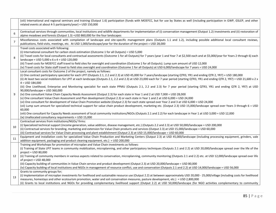
85 | P a g e
(viii) International and regional seminars and training (Output 1.6) participation (funds with MOEFCC, but for use by States as well (including participation in GWP, GSLEP, and other related events at about 4-5 participants/year) = USD 150,000
6 Contractual services through communities, local institutions and wildlife departments for implementation of (i) conservation management (Output 1.2) investments and (ii) restoration of alpine meadows and forests (Output 1.3) =USD 860,000 for the four landscapes
7 Miscellaneous costs associated with compilation of landscape and site-specific management plans (Outputs 1.1 and 1.2), including possible additional local consultant reviews, publications, field visits, meetings, etc. At USD 1,000/landscape/year for the duration of the project = USD 28,000
8
Travel costs associated with following: (i) International consultant for carbon stock estimation (Outcome 1 for all Outputs) = USD 5,000 (ii) Travel costs for local consultants and contractual assessments (Outcome 1 for all Outputs) for 7 years (year 1 and Year 7 at $2,500 each and at $5,000/year for Years 2 through 6) each landscape = USD 5,000 x 6 x 4 = USD 120,000 (iii) Travel costs for MOEFCC staff travel to field sites for oversight and coordination (Outcome 1 for all Outputs). Lump sum amount of USD 12,000 (iv) Travel costs for State staff travel to field sites oversight and coordination (Outcome 1 for all Outputs) at USD 6,000/landscape for 7 years = USD 24,000
9
Local consultant costs for Outcome 2 of the project, namely as follows: (i) One contract participatory specialist for each LPIT (Outputs 2.1, 2.2 and 2.3) at USD 45,000 for 7 years/landscape (starting QTR3, YR1 and ending QTR 2, YR7) = USD 180,000 (ii) At least two social mobilizers for LPIT at each landscape (Outputs 2.1, 2.2 and 2.3) at USD 23,000 each for 7 year period (starting QTR3, YR1 and ending QTR 2, YR7) = USD 21,600 x 2 x 4 = USD 184,000 (iii) One Livelihood, Enterprise and Monitoring specialist for each state PPMU (Outputs 2.1, 2.2 and 2.3) for 7 year period (starting QTR3, YR1 and ending QTR 2, YR7) at USD 90,000/landscape = USD 360,000 (iv) One consultant Value Chain Capacity Needs Assessment (Output 2.3) for each state in Year 1 and 2 at USD 7,000 = USD 28,000 (v) One consultant Value Chain Assessment and Plan development (Output 2.3) or each state in Year 1 and 2 at USD 6,000 = USD 24,000 (vi) One consultant for development of Value Chain Promotion website (Output 2.3) for each state spread over Year 2 and 3 at USD 6,000 = USD 24,000 (vii) Lump sum amount for specialized technical support for value chain product development, marketing etc. (Output 2.3) USD 15,000/landscape spread over Years 3 through 6 = USD 60,000 (viii) One consultant for Capacity Needs assessment of local community institutions/NGOs (Outputs 2.1 and 2.2) for each landscape in Year 1 at USD 3,000 = USD 12,000 (ix) Unallocated consultancy requirements = USD 15,000
10
Contractual services from institutions/NGOs/ firms: (i) Specialized technical support (income generation, value addition, disease management, etc.) (Outputs 2.2 and 2.3) at USD 50,000/landscape = USD 200,000 (ii) Contractual services for branding, marketing and extension for Value Chain products and services (Output 2.3) at USD 15,000/landscape = USD 60,000 (iii) Contractual services for Value Chain processing and plant establishment (Output 2.3) at USD 15,000/landscape = USD 60,000
11 Equipment and installation costs for specialized Value Chain Production and Marketing Centers (Output 2.3) at USD 45,000/landscape (including processing equipment, grinders, vale addition equipment, packaging and product cleaning equipment, etc.) = USD 200,000
12
Training and Workshops for promotion of microplan and Value Chain investments as follows: (i) Training of State LPIT teams in community mobilization, microplanning, and other participatory techniques (Outputs 2.1 and 2.2) at USD 20,000/landscape spread over the life of the project = USD 80,000 (ii) Training of community members in various aspects related to conservation, microplanning, community monitoring (Outputs 2.1 and 2.2) etc. at USD 12,000/landscape spread over life of project = USD 48,000 (iii) Capacity building of communities in Value Chain service and product development (Output 2.3) at USD 20,000/landscape = USD 80,000 (iv) Capacity building of local institutions and NGOs in management of resource conflict, use and conservation (Outputs 2.1 and 2.2) at USD 14,000/landscape = USD 56,000
13
Grants to community groups for; (i) Implementation of microplan investments for livelihood and sustainable resource use (Output 2.2) at between approximately USD 20,000 - 25,000/village (including costs for livelihood measures, homestays and other ecotourism promotion, water and soil conservation measures, pasture development, etc.) = USD 2,800,000 (ii) Grants to local institutions and NGOs for providing complementary livelihood support (Output 2.2) at USD 50,000/landscape (for NGO activities complementary to community
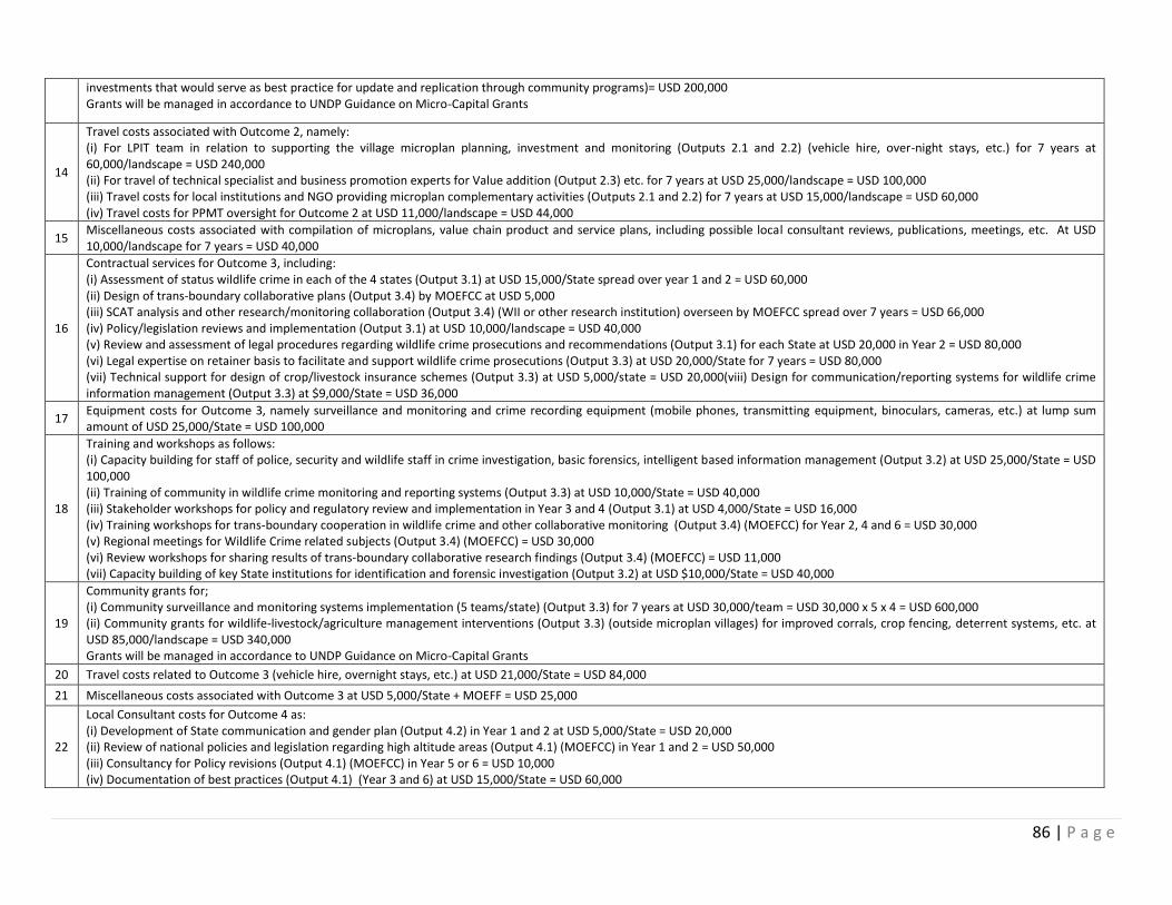
86 | P a g e
investments that would serve as best practice for update and replication through community programs)= USD 200,000 Grants will be managed in accordance to UNDP Guidance on Micro-Capital Grants
14
Travel costs associated with Outcome 2, namely: (i) For LPIT team in relation to supporting the village microplan planning, investment and monitoring (Outputs 2.1 and 2.2) (vehicle hire, over-night stays, etc.) for 7 years at 60,000/landscape = USD 240,000 (ii) For travel of technical specialist and business promotion experts for Value addition (Output 2.3) etc. for 7 years at USD 25,000/landscape = USD 100,000 (iii) Travel costs for local institutions and NGO providing microplan complementary activities (Outputs 2.1 and 2.2) for 7 years at USD 15,000/landscape = USD 60,000 (iv) Travel costs for PPMT oversight for Outcome 2 at USD 11,000/landscape = USD 44,000
15 Miscellaneous costs associated with compilation of microplans, value chain product and service plans, including possible local consultant reviews, publications, meetings, etc. At USD 10,000/landscape for 7 years = USD 40,000
16
Contractual services for Outcome 3, including: (i) Assessment of status wildlife crime in each of the 4 states (Output 3.1) at USD 15,000/State spread over year 1 and 2 = USD 60,000 (ii) Design of trans-boundary collaborative plans (Output 3.4) by MOEFCC at USD 5,000 (iii) SCAT analysis and other research/monitoring collaboration (Output 3.4) (WII or other research institution) overseen by MOEFCC spread over 7 years = USD 66,000 (iv) Policy/legislation reviews and implementation (Output 3.1) at USD 10,000/landscape = USD 40,000 (v) Review and assessment of legal procedures regarding wildlife crime prosecutions and recommendations (Output 3.1) for each State at USD 20,000 in Year 2 = USD 80,000 (vi) Legal expertise on retainer basis to facilitate and support wildlife crime prosecutions (Output 3.3) at USD 20,000/State for 7 years = USD 80,000 (vii) Technical support for design of crop/livestock insurance schemes (Output 3.3) at USD 5,000/state = USD 20,000(viii) Design for communication/reporting systems for wildlife crime information management (Output 3.3) at $9,000/State = USD 36,000
17 Equipment costs for Outcome 3, namely surveillance and monitoring and crime recording equipment (mobile phones, transmitting equipment, binoculars, cameras, etc.) at lump sum amount of USD 25,000/State = USD 100,000
18
Training and workshops as follows: (i) Capacity building for staff of police, security and wildlife staff in crime investigation, basic forensics, intelligent based information management (Output 3.2) at USD 25,000/State = USD 100,000 (ii) Training of community in wildlife crime monitoring and reporting systems (Output 3.3) at USD 10,000/State = USD 40,000 (iii) Stakeholder workshops for policy and regulatory review and implementation in Year 3 and 4 (Output 3.1) at USD 4,000/State = USD 16,000 (iv) Training workshops for trans-boundary cooperation in wildlife crime and other collaborative monitoring (Output 3.4) (MOEFCC) for Year 2, 4 and 6 = USD 30,000 (v) Regional meetings for Wildlife Crime related subjects (Output 3.4) (MOEFCC) = USD 30,000 (vi) Review workshops for sharing results of trans-boundary collaborative research findings (Output 3.4) (MOEFCC) = USD 11,000 (vii) Capacity building of key State institutions for identification and forensic investigation (Output 3.2) at USD $10,000/State = USD 40,000
19
Community grants for; (i) Community surveillance and monitoring systems implementation (5 teams/state) (Output 3.3) for 7 years at USD 30,000/team = USD 30,000 x 5 x 4 = USD 600,000 (ii) Community grants for wildlife-livestock/agriculture management interventions (Output 3.3) (outside microplan villages) for improved corrals, crop fencing, deterrent systems, etc. at USD 85,000/landscape = USD 340,000 Grants will be managed in accordance to UNDP Guidance on Micro-Capital Grants
20 Travel costs related to Outcome 3 (vehicle hire, overnight stays, etc.) at USD 21,000/State = USD 84,000
21 Miscellaneous costs associated with Outcome 3 at USD 5,000/State + MOEFF = USD 25,000
22
Local Consultant costs for Outcome 4 as: (i) Development of State communication and gender plan (Output 4.2) in Year 1 and 2 at USD 5,000/State = USD 20,000 (ii) Review of national policies and legislation regarding high altitude areas (Output 4.1) (MOEFCC) in Year 1 and 2 = USD 50,000 (iii) Consultancy for Policy revisions (Output 4.1) (MOEFCC) in Year 5 or 6 = USD 10,000 (iv) Documentation of best practices (Output 4.1) (Year 3 and 6) at USD 15,000/State = USD 60,000

87 | P a g e
23
Contractual services for Outcome 4 including: (i) Design and preparation of communications materials for audio, video and print (Output 4.2) of lump sum amount of USD 15,000/State = USD 60,000 (ii) Implementation of communication and gender strategy (Output 4.2) for 7 years at USD 42,000/State = USD 168,000 (iii) National Communications plan development (Output 4.2) in Year 1 (MOEFCC) = USD 12,000 (iv) Development of communication materials (Output 4.2) for national program (MOEFCC) = USD 45,000 (v) Implementation of Communication plan (Output 4.2) (MOEFCC) = USD 50,000 (vi) Website and social media promotion (Output 4.2) (MOEFCC) = USD 35,000 (vii) Branding and mascot (Output 4.2) (MOEFCC) USD 5,000 (viii) Publication of best practices (Output 4.2) costs (MOEFCC) = USD 15,000
24 Equipment for Outcome 4, namely Output 4.2 for communications such as cameras, projectors, TVs, screens, computers, etc. at USD 25,000/State = USD 100,000
25
Training and workshops, as follows: (i) Capacity building for local youth groups and NGOs on awareness raising and conservation communication methods (Output 4.2) at USD 3,000/State in Year 2 and 3= USD 24,000 (ii) Regional stakeholders policy review (Output 4.1) workshops = USD 10,000 (iii) National stakeholder policy review workshops (Output 4.1) (MOEFCC) in Year 4 = USD 10,000 (iv) National workshop on lessons learned (Output 4.2) (MOEFCC) in Year 7 = USD 10,000 (v) Capacity building and training for government staff on communication and awareness raising at USD 3,000/state = USD 12,000
26
Travel costs for delivery of Outcome 4: (i) Travel costs for national consultants and contractual services at USD 25,000/State for 7 years in relation to implementation of communication and awareness raising activities= USD 100,000 (ii) Travel costs and overnight stay for delivery of communications (Output 4.2) and policy efforts (Output 4.1) (MOEFCC) = USD 20,000
27 Miscellaneous costs associated with Outcome 4 for printing communication, policy review documents etc. at USD 5,000/State + USD 3,000 for MOEFCC = USD 23,000
28 International consultants for Mid-term and Terminal evaluations (UNDP managed) at USD 15,000 for mid-term and USD 25,000 for terminal evaluation
29 Local consultants to support Mid-term and terminal evaluations (UNDP managed) at USD 8,000 for mid-term and USD 10,000 for terminal evaluation
30 Contractual services for printing mid-term and terminal evaluation reports (UNDP managed) at USD 5,000
31 International and domestic travel costs and per-diem for international consultants and local consultants for mid-term and terminal evaluations (UNDP managed) = USD 14,000
32 Costs of launch workshops at national and state levels in Year 1 = USD 15,000
33 Audit costs (managed by UNDP) at USD 5,000/year = USD 35,000
34 Costs associated with conduct of Board meetings (managed by UNDP) at USD 2,000/year (USD 1,000 for Year 1 and 7) = USD 12,000
35
Travel costs associated with Project Management at: (i) State Project Management for 7 year period at USD 18,000/state (to coordinate and oversee project implementation for 7 years including air travel to Delhi and other state sites to ensure consistency of approaches)= USD 72,000 (ii) National Project Management for 7 year period at USD 18,000
36 UNDP Services to project = USD 210,000. Refer to draft LOA (Annex 28) for itemized services and their associated costs.
37 Operating costs (stationery, telephone, etc.) as follows: (i) For state project management at USD 25,000 for 7 year period = USD 100,000 (ii) National level project management for 7 year period = USD 19, 192
38
Vehicle O&M for project management as follows: (i) USD 30,000/state for 7 year period = USD 120,000 (in particular, for vehicle hire for project management unit to coordinate state level work, in light of government policy discouraging purchase of new vehicles and also as most existing state agency vehicles are limited in number) (ii) USD 10,000 for national project management
88 | P a g e
XI. LEGAL CONTEXT
Consistent with the Article III of the Standard Basic Assistance Agreement (SBAA), the responsibility for the safety and security of the Implementing Partner and its personnel and property, and of UNDP’s property in the Implementing Partner’s custody, rests with the Implementing Partner. To this end, the Implementing Partner shall: a). Put in place an appropriate security plan and maintain the security plan, taking into account the security situation in the country where the project is being carried; and b). Assume all risks and liabilities related to the implementing partner’s security, and the full implementation of the security plan. UNDP reserves the right to verify whether such a plan is in place, and to suggest modifications to the plan when necessary. Failure to maintain and implement an appropriate security plan as required hereunder shall be deemed a breach of the Implementing Partner’s obligations under this Project Document [and the Project Cooperation Agreement between UNDP and the Implementing Partner][1]. The Implementing Partner agrees to undertake all reasonable efforts to ensure that none of the UNDP funds received pursuant to the Project Document are used to provide support to individuals or entities associated with terrorism and that the recipients of any amounts provided by UNDP hereunder do not appear on the list maintained by the Security Council Committee established pursuant to resolution 1267(1999). The list can be accessed via http://www.un.org/sc/committees/1267/aq_sanctions_list.shtml. This provision must be included in all sub-contracts or sub-agreements entered into under/further to this Project Document”. Note that any designations on maps or other references employed in this project document do not imply the expression of any opinion whatsoever on the part of UNDP concerning the legal status of any country, territory, city or area or its authorities, or concerning the delimitation of its frontiers or boundaries.
89 | P a g e
XII. ANNEXES
Annex 1: Review of Policies and legal frameworks for natural resource management in the high Indian Himalayas
Annex 2: Brief Profile of project landscapes
Annex 3: Framework for Participatory Landscape Conservation
Annex 4: Key Conservation Areas (Outside Protected Area Network) in Landscapes
Annex 5: Indicative List of Conservation Management Investments Annex 6: Preliminary List of Action-Oriented Research Topics
Annex 7: Project Participatory Framework for Community consultation and participation in planning, implementation and Monitoring of village level landscape activities
Annex 8: Social Assessment of Key Communities within Landscapes
Annex 9: Indicative list of villages for microplanning within the Landscapes
Annex 10: Indicative List of Possible Village Investments
Annex 11: Indicative List of Technical Support for Livelihood Programs
Annex 12: Capacity building and skills training for local level community institutions
Annex 13: Menu of Key Alternative Livelihood Options
Annex 14: Pre-selected Value Chain Products and Services for Landscapes
Annex 15: Communication and Knowledge Management Strategy
Annex 16: Gender Analysis and Action Plan
Annex 17: List of ongoing Government and Non-Government Programs Relevant to SECURE
Annex 18: UNDP Environmental and Social Screening
Annex 19: Best Practices relevant to the SECURE Project
Annex 20: Terms of Reference for key project staff
Annex 21: Multi-year work plan
Annex 22: Monitoring Plan
Annex 23: Evaluation Plan
Annex 24: Capacity Development Scorecard
Annex 25: Project QA Assessment: Design and Appraisal
Annex 26: Carbon Benefits from Eco-restoration and Protection
Annex 27: Co-financing Letters
Annex 28: Draft Letter of Agreement
Annex 29: Stakeholder Consultation Details
90 | P a g e
Annex 1
Review of Policies and legal frameworks for natural resource management in the high Indian Himalayas
A plethora of policies and acts cover natural resource use in the high ranges of Himalayan region. Of these, the most prevalent act is the Indian Forest Act (1878) and Indian Forest Policy (1894) passed and implemented during pre-independence period which initiated ‘Forest Administration’ and designation of various classes such as ‘reserved’, ‘village/community’ and ‘protected forests’ with a view to regulate access to various forest resources and also generate revenue for the Governments. After independence, a number of acts and policies came into being from various sectors including agriculture, livestock husbandry, water and environmental protection and biodiversity conservation. Notable among them are Wildlife (Protection) Act (1972), Forest Conservation Act (1980), the Environment (Protection) Act (1986), National Forest Policy (1988) and National Environmental Policy (2006) to name a few. Simultaneously several other policies came into being at the national level, such as National Land use Policy (1988), Panchayati Raj Act 1992 (73rd amendment), National Livestock Policy (1996), National Agricultural Policy (2000), National Water Policy (2002), National Biodiversity Act (2002), Schedule Tribes and other Traditional Forest Dwellers Act (2006), National Policy for Farmers (2007), National Rehabilitation and Resettlement Policy (2007) and Centrally Sponsored Fodder and Feed Development Scheme (2010).
The intricate relationship between local communities and forests, based on the principle of co-existence, is integral to the conservation and sustainability of ecological systems. The people living in and around forests and natural areas have been dependent on forests for their sustenance and livelihoods and have traditionally played a significant role in the conservation of forests. The National Forest Policy (1988) recognizes this symbiotic relationship between the tribal people and forests and advocates association of communities living in and around forests, including tribal groups, towards the protection, regeneration, and development of forest as well providing gainful employment to local people. It endorses rights and concessions, including grazing rights to the local communities and promotes participatory management of forest resources. This policy encouraged local communities to protect and develop the forests from where they derive benefits. It prescribed and supported creation of Joint Forest Management Committees (JFMCs) in case of reserved and protected forests and Eco-development Committees (EDCs) in case of protected areas (PAs). The Wildlife (Protection) Act (1972), focusing on the protection of threatened species of flora, fauna and their habitat is applicable uniformly throughout the country except in the state of Jammu and Kashmir. The latter has promulgated a similar Act, the Jammu and Kashmir Wildlife Protection Act (1978). Both acts emphasize ecological integrity and promote the setting up of PA network. All ecologically sensitive areas outside the PA network are largely governed by the Environment (Protection) Act (1986). This Act aims at preservation of environment through a set of rules and also legitimizes declaration of Eco-Sensitive Areas (ESAs) in the vicinity of PAs. In support of this Act, there exists National Environmental Policy (2006) that prescribes sustainable conservation and development of critical ecosystems and the associated natural resources through equitable access, integration of environment and development, good governance, and multi-stakeholder partnerships. Most of the high altitude rangelands and valleys are inhabited by different Scheduled Tribes. Thus, these areas attract the recently promulgated Schedule Tribes and Other Traditional Forest Dwellers Act (2006). This Act recognizes the importance of minimizing the conflicts between the forest department and forest dependent tribes and communities. It also recognizes the rights of forest dwellers and tribes and prescribes co-management of forest resources. The act recognizes grazing rights and traditional seasonal resource access of the nomadic and pastoralists communities. It vests the rights to occupy forest and with forest dwellers with a view to address their tenure insecurity and access rights. The act recognizes customary institutions, ensures equitable access to
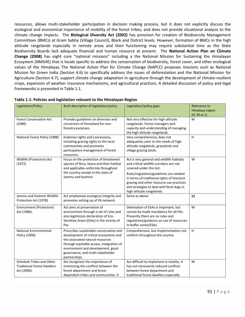
91 | P a g e
resources, allows multi-stakeholder participation in decision making process, but it does not explicitly discuss the ecological and economical importance of mobility of the forest tribes, and does not provide situational analysis to the climate change impacts. The Biological Diversity Act (2002) has provision for creation of Biodiversity Management Committees (BMCs) at Gram Sabha (Village Council), Block and District levels. However, formation of BMCs in the high altitude rangelands especially in remote areas and their functioning may require substantial time as the State Biodiversity Boards lack adequate financial and human resource at present. The National Action Plan on Climate Change (2008) has eight core “national missions” including a the National Mission for Sustaining the Himalayan Ecosystem (NMSHE) that is locale specific to address the conservation of biodiversity, forest cover, and other ecological values of the Himalayas. The National Action Plan for Climate Change (NAPCC) proposes missions such as National Mission for Green India (Section 4.6) to specifically address the issues of deforestation and the National Mission for Agriculture (Section 4.7), support climate change adaptation in agriculture through the development of climate-resilient crops, expansion of weather insurance mechanisms, and agricultural practices. A detailed discussion of policy and legal frameworks is presented in Table 1.1.
Table 1.1: Policies and legislation relevant to the Himalayan Region
Legislation/Policy Brief description of legislation/policy Legislation/policy gaps Relevance to Himalaya region (H, M or L)
Forest Conservation Act (1980)
Provides guidelines on diversion and conversion of forestland for non-forestry purposes.
Not very effective for high altitude rangelands. Forest managers lack capacity and understanding of managing the high altitude rangelands.
M
National Forest Policy (1988) Endorses rights and concessions, including grazing rights to the local communities and promotes participatory management of forest resources.
Very comprehensive, does not adequately cater to the needs of high altitude rangelands, grasslands and village grazing lands.
H
Wildlife (Protection) Act (1972)
Focus on the protection of threatened species of flora, fauna and their habitat and applicable uniformly throughout the country except in the state of Jammu and Kashmir
Act is very general and wildlife habitats and critical wildlife corridors are not covered under this Act.
Rules/regulation/guidelines are needed in terms of traditional rights of livestock grazing and other resource use practices and strategies to deal with feral dogs in high altitude rangelands.
M
Jammu and Kashmir Wildlife Protection Act (1978)
Act emphasizes ecological integrity and promotes setting up of PA network
Same as above
M
Environment (Protection) Act (1986).
Act aims at preservation of environment through a set of rules and also legitimizes declaration of Eco-Sensitive Areas (ESAs) in the vicinity of Pas
Delineation of ESAs is important, but cannot be made mandatory for all PAs. Presently there are no rules and regulations/guidance on use of resources in buffer zones/ESAs.
M
National Environmental Policy (2006)
Prescribes sustainable conservation and development of critical ecosystems and the associated natural resources through equitable access, integration of environment and development, good governance, and multi-stakeholder partnerships.
Comprehensive, but implementation not uniform throughout the country
H
Schedule Tribes and Other Traditional Forest Dwellers Act (2006).
Act recognizes the importance of minimizing the conflicts between the forest department and forest dependent tribes and communities. It
Act difficult to implement in totality. It has not necessarily reduced conflicts between forest department and traditional forest dwellers especially
M
92 | P a g e
also recognizes the rights of forest dwellers and tribes and prescribes co-management of forest resources.
when it comes to administration of PAs.
Panchayati Raj Act, 1992 Promotes people’s participation and their empowerment in the country. Act provides land related subjects to the Panchayati Raj institutions at the village, block and district levels, to ensure participatory planning and decision-making.
It assumes that all the citizens of India in remote areas are equally aware of their rights and legislation. There is a danger of politically powerful classes of the society exploiting the poorer sections.
H
Biological Diversity Act (2002)
Empower the Biodiversity Management Committees (BMCs) at Gram Sabha, Block and District Levels.
Currently there is very little awareness regarding the Act, and likely will take a long time before it can be successfully applied across the country. The Act is silent on the ways to deal with invasive alien species (IAS) in and around protected areas.
M
National Action Plan on Climate Change (2008).
The NAPCC proposes missions such as National Mission for Green India (Section 4.6) to specifically address the issues of deforestation and the National mission for Agriculture (Section 4.7), support climate change adaptation in agriculture through the development of climate-resilient crops, expansion of weather insurance mechanisms, and agricultural practices.
Although, the Action Plan is timely, there is no coordinated effort to bridge the gaps between policy and practice.
M
Global Snow Leopard and Ecosystem Conservation Program (GSLEP).
Unites Governments, UN Agencies, NGOs and Researches of the Snow Leopard range in the effort to conserve this species.
Very comprehensive, but implementation experiences are limited
H
National Snow Leopard and Ecosystem Protection Program (NSLECP).
Engages local communities & works towards reducing Human-Wildlife Conflict, Strengthening Capacity of National & Local Institutions; (iii) Transboundary Management and Enforcement
Explicit rules and regulations for dealing with human-wildlife conflict in areas adjacent and outside PAs are needed
H
Jammu & Kashmir State Forest Policy (2010)
Livestock grazing (Jammu and Kashmir Kha-charai Act, 2011) address the issues of high range ecosystems and alpine pastures
Similar function as that of National Policy. However, its implementation in the state especially in remote areas has been a challenge
L
Himachal Pradesh Forest Settlement Report of 1886
Allowed migratory herders such as Gaddis and Gujjars to graze their sheep and goats in un-demarcated areas of the forests.
Outdated L
Uttaranchal Panchayati Rules (2001)
Major drive to form and notify Van Panchayats in all parts of the state and presently there are over 12,000 Van Panchayats in the country. One of the amendments to this rule was mandatory representation of women and low castes in Van Panchayats
In many areas, Van Panchayats have been just formed, but their capacity to manage the forests in participatory manner is questionable.
M
Sikkim Forests, Water Courses and Road Reserve (Preservation and Protection) Act (1988)
Ensures protection of critical watersheds and helps protection of water bodies / stream courses
- H
Sikkim Forests Cattle Tress States that grazing should be allowed Very useful and has been effective in H
93 | P a g e
Pass Rules (2000) only up to the carrying capacity of the pastureland and grazing rights should be in accordance to the carrying capacity
preventing the degradation of forests
Ladakh Autonomous Hill Development Act (1995)
Provides the Ladakh region with status equivalent to a Union Territory due to its socio-cultural identity. Authority rests with Chief Executive Council and Councilors who oversee hill area development in a challenging environment, with sustainability embedded in ecological protection, cultural heritage and human development.
Relevant for promoting livelihood and economic development measures in the areas of agro-pastoral, pastoral, tourism, information and technology, urban infrastructure, and cottage industry
H
Constitution of GOI, Fifth Schedule of 1975
Accordingly, the hill areas of Himachal Pradesh receive Special Central Assistance (SCA) from the Tribal Affairs Ministry (Government of India) as well as from the State Plans.
Provides special assistance for improving livelihoods, including in Agriculture, Horticulture, Animal Husbandry, and Cottage Industry.
H
Challenges
Despite the existence of a large number of policies and rules in the project landscapes, there are quite a few challenges and issues when it comes to their implementation and smooth natural resource governance. Some of the issues are as follows:
Lack of inter-sectoral coordination: Most of the Indian Himalayan states suffer due to lack of coordination between various sectors leading to policy failures. For example, blanket ban on green felling above 1000 m in all the Himalayan states by order of Apex Court of India has had its own repercussion in terms of gaining local communities’ support to conservation. This rule alienated local communities from the forest management as it denied access to timber and fuelwood. In the absence of local communities’ cooperation in prevention and fighting forest fires, regulated livestock grazing in the reserved forests thereby leading to degradation, loss of regeneration of fodder species and proliferation of alien invasive plants, this ruling has not yielded desired effects on conservation of forests. Thus, lack of inter-sectoral coordination among conservation and development agencies, local communities and civil society organizations have created a classic case of policy failure in many parts of IHR. In Eastern Ladakh (Jammu & Kashmir), a considerable portion of the landscape has been notified as Changthang wildlife sanctuary without settling the grazing rights of the Changpa herders. This has resulted in a peculiar situation for the Ladakh Autonomous Hill Development Council (LAHDC) which is responsible for development of the region such as increase in road network, boosting of production of pashmina wool by promoting sheep husbandry, promotion of tourism, plantation of fuel wood species and improved agricultural practices at the same time implement the conservation programme. A positive administrative reforms has been tried in the recently established state of Uttarakhand where Forest and Rural Development sectors have been brought under one Department headed by Forest and Rural Development Commissioner (FRDC) who is expected to balance between the two sectors and integrate conservation with development.
Lack of clear policy for alpine rangelands: Alpine rangelands are currently influenced by four sectoral policies viz., forests, agriculture, livestock husbandry and rural development. All the sectors treat these as ‘common lands’ or sometimes as ‘wastelands’. Though, several community institutions have been using these areas following their traditional and customary laws, these traditional institutions and practices have been disintegrating in recent years due to rapid changes in socio-economic conditions. Although, at the national level,
94 | P a g e
there exists a draft Grazing and Livestock Management Policy (1994) that prescribes establishment of large blocks of land as grazing reserves and participatory management of pastures. However, there is a lack of clear policy for alpine rangelands which include ecologically sensitive sites such as high altitude wetlands, glacial forelands, and other sites. In the absence of any regulation on free grazing in public lands, high altitude forests have degraded rapidly in many parts of Western Himalaya. For example, in many districts of Uttarakhand, local communities drive their scrub cattle to the high altitude forests during summer and monsoon seasons that leads to degradation of high altitude forests and soil erosion. Better management of village grazing lands, enhance fodder production and protection of critical watersheds and sensitive habitats from unregulated grazing would be essential for the long term conservation of high altitude forests. In the absence of any policy there is no provision to stop degradation and encroachment of common property resources, equitable sharing of pastures, and decentralized decision making process. Other issues such as integration of interstate policies on natural resource sharing and management including issues of migratory livestock grazing remain unresolved in the absence of national livestock grazing policy. It is interesting to note that neighboring countries such as Nepal, Bhutan and Pakistan have already promulgated the Rangeland Policies for the effective management of high altitude rangelands.
Emerging policy issues that need mainstreaming: The upper catchments of Himalayan rivers provide numerous ecosystem services to the mankind living within and downstream areas. These services include provisioning services in the form of biomass resources such as fodder, high value medicinal and aromatic plants, firewood, fibre (e.g., pashmina wool), meat, skin and milk products; regulating services such as water regulation, flood mitigation, erosion regulation and carbon sequestration; and cultural services. The primary producers and collectors of these products receive a relatively low share of the returns due to insufficient knowledge of market chains, lack of processing facilities, inadequate quality control (Choudhary et al., 2011; Hoermann et al., 2010). There is significant scope to generate more income locally by supporting mountain people to generate new livelihood options and adding value to the existing high value products and services. The low return from harvesting/producing products from these areas results in overharvesting and increased grazing pressure, that can be minimized by having value chain analysis of these products, policy measures to support sustainable mountain value chains and goods and services and policy solutions to improve stakes of the mountain producers and service providers in an economic and environmentally sustainable way. This is an emerging need across various regions of the world and appropriate policies are needed to mainstream the ecosystem services in development planning and also for making the provisions for payment for ecosystem services from the high ranges of Himalayan region.
Lack of holistic planning: The IHR is under increasing pressure from demands od infrastructure development such as hydropower projects, roads, tourism, and mining leading to loss of natural habitats, forests and pasturelands. In the state of Uttarakhand, alone 157 dams of varying capacities (from 1 MW to 500 MW) have been proposed and many are under construction. There is a lack of strategic environmental planning and proper mitigation plans for the larger dams. Under the wake of rapid economic development, many Himalayan states have opened tourism in hitherto ‘closed’ areas. Since, most of the high ranges have accessibility only during a short summer season, the tour operators tend to maximize the tourism during this period. For example, Changthang region of Ladakh opened tourism for foreign nationals in 1994 and there has been a sudden rise in number of tourists in this area affecting the rangelands in the form of camping in wetlands, spread of non-biodegradable waste, degradation of pastures due to off-road driving (personal communication, J. Takpa, Regional Wildlife Warden, Ladakh). It has been observed that the number of tourists visiting Changthang region of Ladakh has doubled during last three years, the number reaching up to 70,000 during 2015. Such an unregulated tourism is likely to affect the basic ecological setting and aesthetics of the landscape that forms the basis of nature based tourism.

95 | P a g e
Recommendations
Currently the MOEFCC is in the process of revising the existing forest policy (National Forest Policy, 1988) to integrate the vision of sustainable forest management based on the principles of ecosystem approach, landscape level planning and the learning from participatory forest management while building on our rich cultural heritage of co-existence and eco-centrism. The revised National Forest Policy 2016 should also take into consideration the issues pertaining to ‘non-forested’ alpine environments of the Himalaya which are marginal, low in primary productivity and critical for the sustenance of numerous ecosystem services.
All the Himalayan states need to integrate various sectoral policies and come up with a comprehensive land use policy for the high alpine rangelands and mainstream ecosystem services from these areas into development planning. Currently there is a lack of coordination among various policies and there are gaps between existing policies and practices especially in the remote mountain areas. The state governments in the Himalayan region need to empower the local communities and community based organizations in implementing the revised policies and programs.
Given the limited livelihood options available for the local communities at high range Himalayan ecosystems, comprehensive policies on community based eco-tourism, sustainable mountain farming system, subsidies on snow and water harvesting, energy (for cooking and heating) and rural housing need to be evolved. Policies are also needed for conservation, development of mountain specific niche products such as medicinal and aromatic plants, rangeland products and development of value chains based on such products so as to enhance resilience of local communities.
The traditional institutions such as Van Panchayats, Dzumsas, and recently created institutions such as Eco-development Committees (EDCs), Joint Forest Management Committees (JFMCs), Biodiversity Management Committees (BMCs) and Women’s Saving and Credit Groups (WSCGs) in the IHR have great potential to boost conservation programs and develop their on participatory natural resource management plans. The central and state governments, therefore, need to initiate a special drive for capacity building of such institutions especially in the interior, less accessible areas of the Himalaya by promoting equitable benefit sharing mechanisms, settling tenure rights and decentralization of resource management.
Several policies and acts formulated during 1980’s and 1990’s such as Forest Conservation Act (1980), Environmental Protection Act (1986) and ‘Draft Grazing and Livestock Management Policy (1994) including state level rules dealing with conservation and development at high range Himalayan ecosystems need to be revised and updated keeping the current issues of climate change, environmental degradation, increased human-wildlife conflicts and changing socio-economic aspirations of the local communities.
All the Himalayan states have recently developed their respective climate change action plans. However, none of these plans have addressed the needs for enhancing climate resilience of pastoral communities and high altitude rangelands. Therefore, there is a need to revisit these plans and suggest appropriate measures.
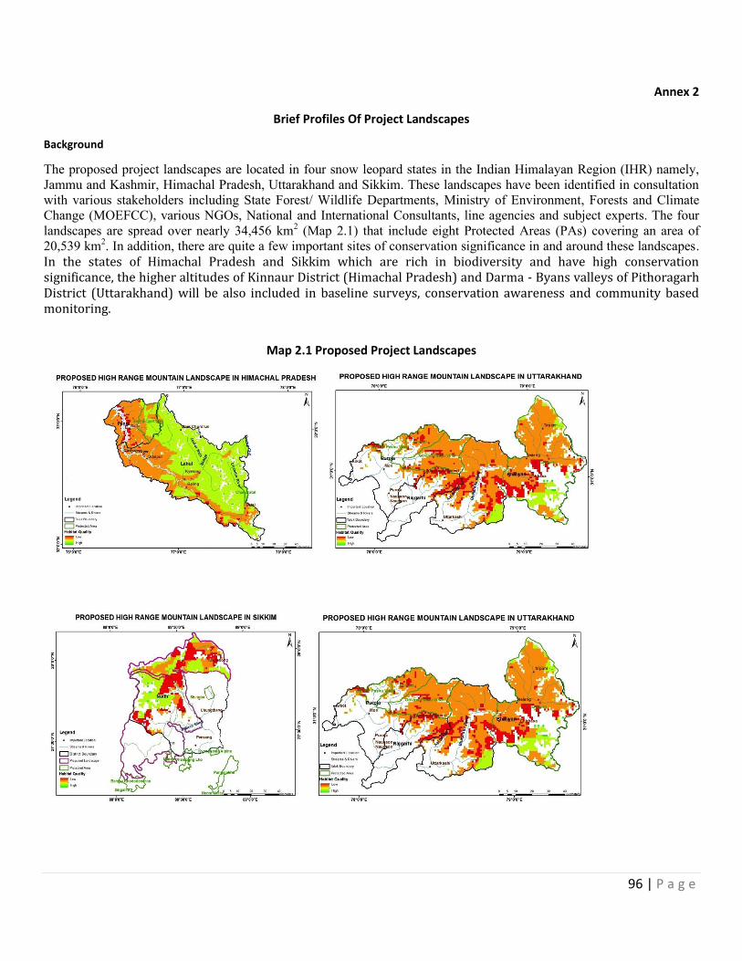
96 | P a g e
Annex 2
Brief Profiles Of Project Landscapes
Background
The proposed project landscapes are located in four snow leopard states in the Indian Himalayan Region (IHR) namely,
Jammu and Kashmir, Himachal Pradesh, Uttarakhand and Sikkim. These landscapes have been identified in consultation
with various stakeholders including State Forest/ Wildlife Departments, Ministry of Environment, Forests and Climate
Change (MOEFCC), various NGOs, National and International Consultants, line agencies and subject experts. The four
landscapes are spread over nearly 34,456 km2 (Map 2.1) that include eight Protected Areas (PAs) covering an area of
20,539 km2. In addition, there are quite a few important sites of conservation significance in and around these landscapes.
In the states of Himachal Pradesh and Sikkim which are rich in biodiversity and have high conservation significance, the higher altitudes of Kinnaur District (Himachal Pradesh) and Darma - Byans valleys of Pithoragarh District (Uttarakhand) will be also included in baseline surveys, conservation awareness and community based monitoring.
Map 2.1 Proposed Project Landscapes
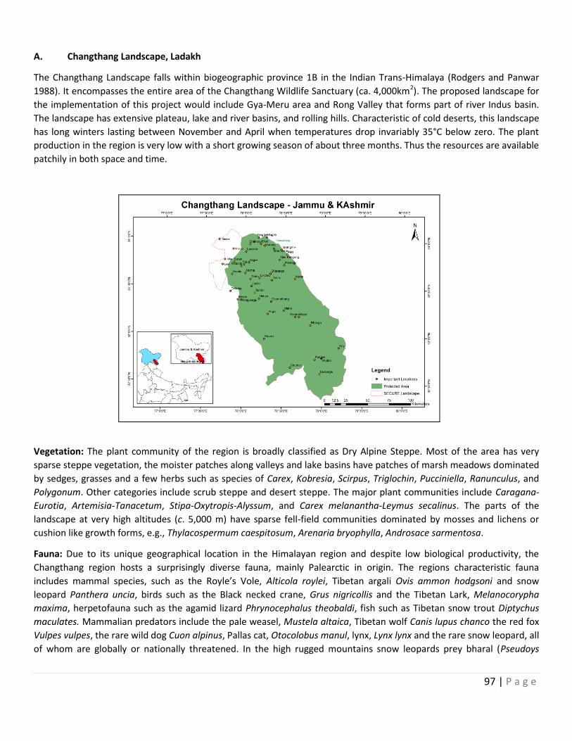
97 | P a g e
A. Changthang Landscape, Ladakh
The Changthang Landscape falls within biogeographic province 1B in the Indian Trans-Himalaya (Rodgers and Panwar
1988). It encompasses the entire area of the Changthang Wildlife Sanctuary (ca. 4,000km2). The proposed landscape for
the implementation of this project would include Gya-Meru area and Rong Valley that forms part of river Indus basin.
The landscape has extensive plateau, lake and river basins, and rolling hills. Characteristic of cold deserts, this landscape
has long winters lasting between November and April when temperatures drop invariably 35°C below zero. The plant
production in the region is very low with a short growing season of about three months. Thus the resources are available
patchily in both space and time.
Vegetation: The plant community of the region is broadly classified as Dry Alpine Steppe. Most of the area has very
sparse steppe vegetation, the moister patches along valleys and lake basins have patches of marsh meadows dominated
by sedges, grasses and a few herbs such as species of Carex, Kobresia, Scirpus, Triglochin, Pucciniella, Ranunculus, and
Polygonum. Other categories include scrub steppe and desert steppe. The major plant communities include Caragana-
Eurotia, Artemisia-Tanacetum, Stipa-Oxytropis-Alyssum, and Carex melanantha-Leymus secalinus. The parts of the
landscape at very high altitudes (c. 5,000 m) have sparse fell-field communities dominated by mosses and lichens or
cushion like growth forms, e.g., Thylacospermum caespitosum, Arenaria bryophylla, Androsace sarmentosa.
Fauna: Due to its unique geographical location in the Himalayan region and despite low biological productivity, the
Changthang region hosts a surprisingly diverse fauna, mainly Palearctic in origin. The regions characteristic fauna
includes mammal species, such as the Royle’s Vole, Alticola roylei, Tibetan argali Ovis ammon hodgsoni and snow
leopard Panthera uncia, birds such as the Black necked crane, Grus nigricollis and the Tibetan Lark, Melanocorypha
maxima, herpetofauna such as the agamid lizard Phrynocephalus theobaldi, fish such as Tibetan snow trout Diptychus
maculates. Mammalian predators include the pale weasel, Mustela altaica, Tibetan wolf Canis lupus chanco the red fox
Vulpes vulpes, the rare wild dog Cuon alpinus, Pallas cat, Otocolobus manul, lynx, Lynx lynx and the rare snow leopard, all
of whom are globally or nationally threatened. In the high rugged mountains snow leopards prey bharal (Pseudoys
98 | P a g e
nayaur), urial (Ovis orientalis vignei) and argali but are rare in the region compared to areas further west. Recently the
Tibetan sand fox (Vulpes ferrilata) has been confirmed to occur throughout eastern parts of Changthang, including areas
such as the Pangong Tso basin, Chushul, Parma Valley, Anlay and Chumur (Namgail et al. 2005). Predator abundance and
basic aspects of their ecology are poorly understood and much needs to be done to understand this along with the
emerging intensification of conflicts with herders.
Community Based Groups/ Committees in Changthang Landscape Dedicated for Biodiversity/ Wildlife: Currently, there are no exclusive CBOs in the Changthang dedicated to biodiversity conservation except Self Helped Groups (SHGs)/ Women Alliance developed by the Rural Development Dept. and running locally and engaged in some local livelihood activities such as yak/ sheep wool handicrafts. There is one Youth Associate for Conservation and Development of Hemis NP based in Leh and has 40 members and engaged in various activities such as home stays, wildlife surveys, combating illegal trade etc in Hemis NP, such association may be replicated in Nyoma, Pangong Tso, Hanle, Korzok, Tso Kar and Rong Valley with similar functions of Youth Association in Hemis NP.
Conservation issues and Opportunities: Major issues of conservation and opportunities in this landscape include:
(a) Grazing competition between wild and domestic herbivores: The land use in entire Changthang is pastoral with
some areas (Gya-Meru lower slopes and Rong Valley) being agro-pastoral. Livestock population in this landscape has
been fluctuating with steady increase in recent decades. Excessive grazing by a burgeoning population of livestock
(about 200,000), mostly the Pashmina producing goats, has had an impact on the decline of wild ungulates (Namgail
et al., 2008). In the wake of Pashmina wool development and aided by the Government of Jammu and Kashmir,
most of the pastures are overstocked. This has resulted in competition between livestock and wild herbivores, and
many wild herbivore populations have consequently got depleted and even gone locally extinct (Bhatnagar et al.
2006a, Namgail et al. 2006a).
Therefore, it is very important to restore the degraded pasturelands with participatory approach of local
communities. Sher-e-Kashmir University of Agricultural Sciences and Technology (SKUAST) and Krishi Vigyan Kendra
(KVK) are working together to improve fodder production of the region and provide fine health care to domestic
livestock in the area. They also aim towards introducing vegetable production under protected environment and
impart training to women on animal care. It is proposed to strengthen SKUAST-KVK activities in Chanthnag to reduce
dependency of local communities on natural resources, restore degraded pasturelands, engage Changpas in the
restoration activities and promote fodder cultivation in lower elevation areas such as Rong Valley, Upshi and Leh.
(b) Human-wildlife conflicts: Livestock depredation by wild carnivores is an emerging serious conservation issue in this
landscape. Livestock rearing constitutes an important part of the local economy and lifestyle, and any loss to
livestock results in a direct monetary loss to the herders particularly, in case of Pashmina goats. In some pockets of
Rong Valley, crop damage by blue sheep has been reported. However, extent of damage has not been assessed.
Dept. of Wildlife Protection, J&K and Leh based NGO, Snow leopard Conservancy-India Trust (SLC-IT) are working
closely with the local communities to support the predator proof corrals in the Rong Valley and SLC-IT recently
initiated the livestock insurance schemes in Gya-Meru areas. It is proposed to strengthen and supplement Wildlife
Dept. and SLC-IT activities of predator proof livestock corrals and livestock insurance schemes in other parts of
Changthang to provide better livestock husbandry practices and minimize HWC.
(c) Habitat degradation: Overstocking of rangelands by domestic livestock, uncontrolled tourism during summer and
off-road driving by the tourists has led to severe soil erosion and degradation of wildlife habitat in many parts of
Changthang. There is a common perception among the Changpa herders that Tibetan wild ass and blue sheep are
99 | P a g e
overgrazing in the pastures leading to depletion of forage in winter grazing grounds, thereby compromising
pashmina production in Changthang. Further, there is lacking of scientific information on carrying capacity of high
altitude wetlands, which are key tourist hot spots. Therefore, it is proposed to carryout some site-specific carrying
capacity studies at Tso Kar, Korzok and Pangong Tso. As mentioned above point ‘a- Grazing competition between
wild and domestic herbivores’ restoration exercises with engagement of the Changpas may also be proposed in the
project.
(d) Lack of zonation plan and landscape level conservation planning: The Changthang Landscape lacks clear cut
zonation plan and landscape level conservation strategy. In the absence of participatory planning among various
conservation and development agencies critical wildlife habitats and populations of threatened species continue to
suffer. This has led to considerable alienation of herders and their participation in conservation program is minimal.
Keeping this in view, strategy for preparing the management plan for Changthang through participatory approach
may be proposed in the project.
(e) Acute shortage of wildlife protection staff, infrastructure and funds for PA management: Currently there is an
acute shortage of wildlife protection staff in Changthang area. The staff does not have any incentive to work in
harsh conditions. Moreover, they are expected to manage tourism, compensation schemes for livestock and crop
losses to wildlife, and organize nature education activities. Most park staff lacks the necessary clothing, equipment,
housing, and training necessary for effective work in the region. Thus, proper training in wildlife monitoring,
combating illegal wildlife trade and associated skills, field gears and other support for the front-line staff may also
be proposed in the project.
(f) Water crisis in Changthang: There is an acute problem of availability of water for pasturelands and cultivation. In
the Rong areas, where water is available but there is no cultivable land due to topography of the area whereas in
the Plateau there is vast rolling uplands available but water is very scarce. Therefore, it is proposed to engage
Changpas to improve irrigation arrangements and site-specific LDPE Tanks (Low Density Polyethylene tanks) and
drip water irrigation systems may be proposed at Nyoma, Korzok, Tso Kar, Sumdho, Thazangkaru, Chushul,
Demchok, Durbuk, Tangtse, Mahe and other areas of Changthang.
(g) Limited scientific knowledge on wildlife: There have been some studies conducted on wildlife in the vast area of
Changthang almost a decade back, except a few on-going studies on Tibetan wolf, black necked crane, there are
not much continuing studies on wildlife. It eventually restricts our knowledge on current status and distribution of
flagship species and also any change in their population over time. Similarly, Rong Valley has potential for snow
leopards but there is very poor information available on the occurrence of snow leopard and associated species.
Keeping this all in view, base-line surveys on flora and fauna of Changthang to identify key promising sites where
site-specific camera trapping, non-invasive genetic analysis and radio collaring of large carnivores may be proposed
to investigate population structure and ranging pattern of wildlife in the region. It may also establish and highlight
trans-boundary corridors in Changthang.
(h) Disparity and opportunity in wildlife eco-tourism: Rumbak valley in Hemis National Park, Leh-Ladakh is one of
famous snow leopard eco-tourism site in the world. Similarly, The region is an important tourist destination in India
and a large number of tourists visit high altitude lakes like Pangong, Tsokar and Tsomoriri to see wildlife; this
creates important additional income generating opportunities for the local communities and now it seems that
wildlife eco-tourism has concentrated and has become overabundant across these four sites. Whereas, Rong valley
has potential for snow leopards and may replicate Rumbak model. In addition, ecotourism is an option that may be
explored in Rong Valley and other areas of Changthang such as Nyoma, Sumdho, Hanle to conserve the wildlife of
Changthang in future.
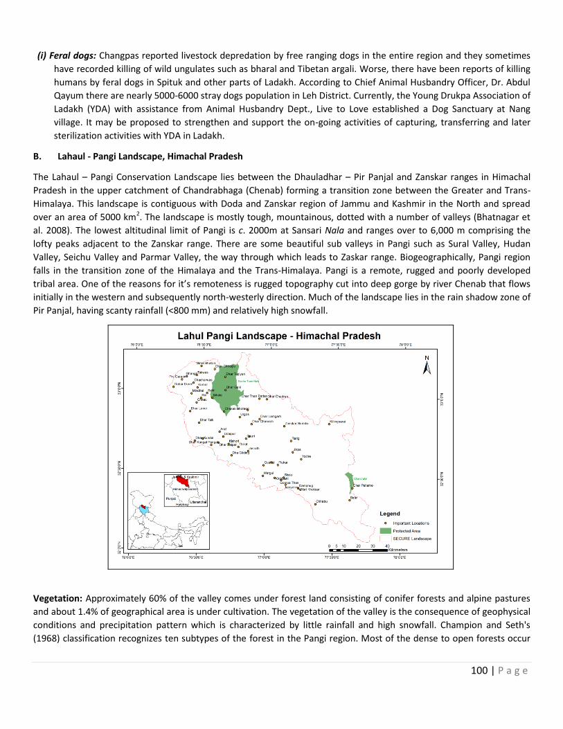
100 | P a g e
(i) Feral dogs: Changpas reported livestock depredation by free ranging dogs in the entire region and they sometimes
have recorded killing of wild ungulates such as bharal and Tibetan argali. Worse, there have been reports of killing
humans by feral dogs in Spituk and other parts of Ladakh. According to Chief Animal Husbandry Officer, Dr. Abdul
Qayum there are nearly 5000-6000 stray dogs population in Leh District. Currently, the Young Drukpa Association of
Ladakh (YDA) with assistance from Animal Husbandry Dept., Live to Love established a Dog Sanctuary at Nang
village. It may be proposed to strengthen and support the on-going activities of capturing, transferring and later
sterilization activities with YDA in Ladakh.
B. Lahaul - Pangi Landscape, Himachal Pradesh
The Lahaul – Pangi Conservation Landscape lies between the Dhauladhar – Pir Panjal and Zanskar ranges in Himachal
Pradesh in the upper catchment of Chandrabhaga (Chenab) forming a transition zone between the Greater and Trans-
Himalaya. This landscape is contiguous with Doda and Zanskar region of Jammu and Kashmir in the North and spread
over an area of 5000 km2. The landscape is mostly tough, mountainous, dotted with a number of valleys (Bhatnagar et
al. 2008). The lowest altitudinal limit of Pangi is c. 2000m at Sansari Nala and ranges over to 6,000 m comprising the
lofty peaks adjacent to the Zanskar range. There are some beautiful sub valleys in Pangi such as Sural Valley, Hudan
Valley, Seichu Valley and Parmar Valley, the way through which leads to Zaskar range. Biogeographically, Pangi region
falls in the transition zone of the Himalaya and the Trans-Himalaya. Pangi is a remote, rugged and poorly developed
tribal area. One of the reasons for it’s remoteness is rugged topography cut into deep gorge by river Chenab that flows
initially in the western and subsequently north-westerly direction. Much of the landscape lies in the rain shadow zone of
Pir Panjal, having scanty rainfall (<800 mm) and relatively high snowfall.
Vegetation: Approximately 60% of the valley comes under forest land consisting of conifer forests and alpine pastures
and about 1.4% of geographical area is under cultivation. The vegetation of the valley is the consequence of geophysical
conditions and precipitation pattern which is characterized by little rainfall and high snowfall. Champion and Seth's
(1968) classification recognizes ten subtypes of the forest in the Pangi region. Most of the dense to open forests occur
101 | P a g e
along the Chenab gorge and in the Seichu nala and occupies a relatively small proportion of Pangi’s geographical area.
The Chenab valley is dominated by deodar (Cedrus deodara) with some blue pine (Pinus wallichiana) and fir (Abies
pindrow) stands at upper elevations. Most valleys on the right bank of the Chenab are east-west flowing presenting a
clear north and south face. The north-facing slopes are dominated mostly by birch (Betula spp.) forests up to an
elevation of 3,800m, which are at times interspersed with willow (Salix daphnoides) and Lonicera purpurascens. In the
entire valley, above the birch and willows, are alpine meadows with relatively high cover of forbs and graminoids.
Fauna: Due to the transitional nature of the valley, the fauna exhibit an assortment of elements from both Trans-
Himalaya (predominantly Palearctic) and the Himalaya (predominantly Oriental). Species pertaining to eight faunal
groups has been documented (Sidhu et al 2013) from the region. These include 41 species of Protozoa, 16 species of
Orthoptera, 36 species of butterflies, 20 species of moths, 5 species of Heteroptera, 7 species of reptiles, 75 species of
birds and 19 species of mammals (Sidhu et al. 2013). Major ungulates reported from here are Asiatic ibex (Capra
sibirica), Himalayan tahr (Hemitragus jemlahicus), Himalayan musk deer (Moschus chrysogaster) and Himalayan serow
(Capricornis thar). Among the carnivores, snow leopard, common leopard (Panthera pardus), Himalayan brown bear
(Ursus arctos isabellinus), Asiatic black bear (Ursus thibetanus) and red fox (Vulpes vulpes) has been reported (Bhatnagar
et al 2008). Rodents such as long tailed marmot (Marmota caudata) are present in this area. Snow leopards are present
in all areas above 3,500m up till the snow line (close to 5000m) on both banks of the Chenab. The potential habitat for
snow leopard and its major prey ibex in Pangi spans c. 479.1 km2 and 450 km2 respectively (Bhatnagar et al 2008).
Conservation issues and Opportunities: Major issues of conservation and opportunities in this landscape include:
(a) Chronic stress on wildlife habitats:
High altitude pastures and sub-alpine forests in this landscape are under chronic stress due to anthropogenic
activities in the form of fuel wood and timber extraction and uncontrolled livestock grazing. The migratory herders
from Chamba visit this landscape along with large flocks to graze during summer months. Although, most parts of
the landscape are under the control of state forest department, local people enjoy unrestricted access to non-
timber forest products and grazing rights that has resulted in the degradation of habitats.
Similar to Changthang, site-specific habitat restoration activities may be carried out with participatory approach of
local communities and Forest/ Wildlife Dept. and other line departments.
(b) Mismatch between conservation and development: Pangi was the most inaccessible region of Himachal Pradesh
till a few years ago, which has now opened up to development. The state government is also putting huge effort to
the development of the region by infusing large amount of money to infrastructural projects. Presently, there is a
pressing demand for motor road for all remote villages including those located with the wildlife sanctuary (e.g.,
Seichu Tuan WS). Opening all natural areas for motorable roads without consideration of important wildlife
habitats and eco-sensitive zones is a sensitive issue that requires judicious policy decision.
(c) Plants: Recent wildlife surveys in Pangi and remote parts of Lahaul (Bhatnagar et al, 2008) and discussion with the
local informers reveal that remote parts of Lahaul and Pangi are vulnerable to illegal hunting and over exploitation
of commercially important medicinal plants. Reportedly, migratory laborers and outside professional hunters are
involved in such activities. Most traded wildlife parts are musk and bear gall. The front-line staff of the Wildlife
Dept. may be trained in identifying such material, appropriate actions to be taken and equipped with field gears to
combat poaching in the landscape in the project.
(d) Lack of scientific management strategy: In this landscape, especially Pangi area has remained neglected in terms
of comprehensive conservation and development planning. The only wildlife sanctuary in this landscape, i.e.,
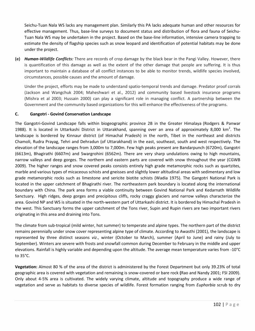
102 | P a g e
Seichu-Tuan Nala WS lacks any management plan. Similarly this PA lacks adequate human and other resources for
effective management. Thus, base-line surveys to document status and distribution of flora and fauna of Seichu-
Tuan Nala WS may be undertaken in the project. Based on the base-line information, intensive camera trapping to
estimate the density of flagship species such as snow leopard and identification of potential habitats may be done
under the project.
(e) Human-Wildlife Conflicts: There are records of crop damage by the black bear in the Pangi Valley. However, there
is quantification of this damage as well as the extent of the other damage that people are suffering. It is thus
important to maintain a database of all conflict instances to be able to monitor trends, wildlife species involved,
circumstances, possible causes and the amount of damage.
Under the project, efforts may be made to understand spatio-temporal trends and damage. Predator proof corrals
(Jackson and Wangchuk 2004; Maheshwari et al., 2012) and community based livestock insurance programs
(Mishra et al 2003; Hussain 2000) can play a significant role in managing conflict. A partnership between the
Government and the community based organizations for this will enhance the effectiveness of the programs.
C. Gangotri - Govind Conservation Landscape
The Gangotri-Govind Landscape falls within biogeographic province 2B in the Greater Himalaya (Rodgers & Panwar
1988). It is located in Uttarkashi District in Uttarakhand, spanning over an area of approximately 8,000 km2. The
landscape is bordered by Kinnaur district (of Himachal Pradesh) in the north, Tibet in the northeast and districts
Chamoli, Rudra Prayag, Tehri and Dehradun (of Uttarakhand) in the east, southeast, south and west respectively. The
elevation of the landscape ranges from 3,000m to 7,000m. Few high peaks present are Bandarpunch (6720m), Gangotri
(6613m), Bhagirathi (6607m) and Swargrohini (6562m). There are very sharp undulations owing to high mountains,
narrow valleys and deep gorges. The northern and eastern parts are covered with snow throughout the year (CGWB
2009). The higher ranges and snow covered peaks consists entirely high grade metamorphic rocks such as quartzites,
marble and various types of micaceous schists and gneisses and slightly lower altitudinal areas with sedimentary and low
grade metamorphic rocks such as limestone and sericite biotite schists (Wadia 1975). The Gangotri National Park is
located in the upper catchment of Bhagirathi river. The northeastern park boundary is located along the international
boundary with China. The park area forms a viable continuity between Govind National Park and Kedarnath Wildlife
Sanctuary. High ridges, deep gorges and precipitous cliffs, rocky craggy glaciers and narrow valleys characterize the
area. Govind NP and WS is situated in the north-western part of Uttarkashi district. It is bordered by Himachal Pradesh in
the west. This Sanctuary forms the upper catchment of the Tons river, Supin and Rupin rivers are two important rivers
originating in this area and draining into Tons.
The climate from sub-tropical (mild winter, hot summer) to temperate and alpine types. The northern part of the district
remains perennially under snow cover representing alpine type of climate. According to Awasthi (2001), the landscape is
represented by three distinct seasons viz., winter (October to March), summer (April to June) and rainy (July to
September). Winters are severe with frosts and snowfall common during December to February in the middle and upper
elevations. Rainfall is highly variable and depending upon the altitude. The average mean temperature varies from -10°C
to 35°C.
Vegetation: Almost 80 % of the area of the district is administered by the Forest Department but only 39.23% of total
geographic area is covered with vegetation and remaining is snow-covered or bare rock (Rao and Nandy 2001; FSI 2009).
Only about 4-5% area is cultivated. The widely varying climate, altitude and topography produce a wide range of
vegetation and serve as habitats to diverse species of wildlife. Forest formation ranging from Euphorbia scrub to dry
103 | P a g e
alpine scrub makes district unique habitat for different forest types. According to Champion and Seth’s (1968) forest
categories viz., Subtropical Pine Forest, Himalayan Moist Temperate Forest, Himalayan Dry Temperate Forest, Sub-
Alpine Forest, Moist and Dry Alpine Scrub and Alpine Meadows (Bugyals), are found in the study area.
Fauna: High ridges, deep gorges and precipitous cliffs, rocky craggy glacier and narrow valleys characterize the landscape. There is a high variation in the elevation gradients from 1,800 to 7,083m, which in turn reflects in the diverse biomes, from subtropical communities to alpine meadows. So far 15 species of mammals and 150 bird species have been documented in the park (Paramanand et al. 2000). This includes some of the rare and charismatic species such as snow leopard, Asiatic black bear, Himalayan brown bear, musk deer (Moschus chrysogaster), blue sheep or bharal (Pseudois nayaur), Himalayan tahr (Hemitragus jemlahicus), Himalayan monal (Lophophorus impejanus), Koklass (Pucrasia macrolopha) and Himalayan snowcock (Tetraogallus himalayensis). Recent camera trap studies have revealed the presence of Tibetan wolf, stone marten (Martes foina) and Tibetan sand fox (Vulpes ferrilata) in this landscape (Wildlife Institute of India, unpublished work). Till date, 34 species of butterflies and 784 morphospecies of moths have been described from this landscape (Uniyal et al. 2013).
Community Based Groups/ Committees in Gangotri-Govind Landscape Dedicated for Biodiversity/ Wildlife: Currently, there are Van Panchayats, SHGs, BMCs and EDCs in Govind-Ganotri landscape. But their current functionality is doubtful. Therefore, in this project their revival, strengthening and monitoring for biodiversity conservation may be proposed. There are some Watershed Committees in Govind NP and WS that may also be further strengthened for the similar purpose. Such CBOs and particularly Van Panchayats are excellent example of state-people partnership that has been relatively successful in managing natural resources in the region. This project may play more active role in keeping these institutions alive by bringing the communities to the center stage of decision-making.
Conservation issues and Opportunities: Major issues of conservation and opportunities in this landscape include:
(a) Human-wildlife conflicts: Most of the areas in this landscape are utilized as grazing pastures by migratory as well as
local livestock herders. Loss of livestock owing to snow leopard attack is not a very rare event. Interview of
shepherds in Govind NP and WS, indicated that the maximum livestock loss from snow leopard was 6.25% but it
104 | P a g e
averaged 1.6% for four herds (Maheshwari and Sharma 2010). All depredations occurred in summers when
shepherds visited the higher ranges of snow leopard habitat in this landscape. The shepherds are primarily
concerned about the livestock depredation and there is a very few permanent human settlement in the snow
leopard habitats (>3,000 m elevation) in this landscape. The other species involved in conflicts with humans were
Asiatic black bear, common leopard, wolf and brown bear. To reduce livestock depredation by large carnivores
possibility of retaliation can’t be ruled out which may have some link with the illegal trade to sell the skin or other
body parts of the imperial carnivores. Therefore, it is necessary to mitigate HWC in the region. Hemis NP, Ladakh
and Spiti, HP may be selected as learning site to implement mitigation tools such as predator proof livestock corrals
and livestock insurance schemes in Govind NP and WS. Also, conservation education awareness programs may help
in enhancing the understanding of the value of sustainable use of natural resources and importance of wildlife and
help in mitigating conflicts.
(b) Habitat fragmentation and demands of infrastructural development: As in other parts of inner Himalayan range,
the local communities and defense personnel in this landscape have only and main demand that is the access to
motorable road to all remote localities and border posts. Developmental activities such as road construction, influx
of large unsupervised labour force from outside in eco-sensitive habitat are major causes for concern. This project
may advocate some existing policy interventions that while roads are planned, care should be taken to minimize
habitat destruction. Furthermore, there may be provision of strong security and checkpoints to curtail wildlife crime
in Gangotri-Govind landscapes.
(c) Unsettled rights of pastoral communities: Settlement of rights for pastoral communities in parts of Gangotri NP
(Nilang Valley) is awaited. Similarly, livestock grazing by local as well as migratory pastoral communities in Govind
WS continues to remain a major challenge for the PA managers. Currently over 80,000 sheep and goats and over 40
Gujar families with their buffaloes graze within Govind WS during summer. In addition, several families from Tons
valley drive their unproductive livestock to sub-alpine and alpine areas for unsupervised grazing during the snow
free period (May to October) in Govind NP and WS.
(d) Feral dogs: It has been reported that several packs of feral dogs hang around labor and security force camps in parts
of Gangotri NP (Nelang valley). These dogs are potential threats to snow leopard and prey base. This needs to be
tackled strategically and may learn from Dog Sanctuary in Leh with some exchange learning programs for the
Wildlife Dept.
(e) Inadequate staff and poor infrastructure in the remote locations: Infrastructure (chowkis and basic facilities for
field staff) and strength of field staff is inadequate in the remote localities of Gangotri-Govind landscape. Therefore,
it may be proposed that chowkis be constructed and basic facilities such as field gear and medical facilities be
provided and staff be posted in these localities. It is important to deploy well-trained staff in the required strength in
the PAs. Continued on-job training is needed on numerous fronts such as: wildlife monitoring (for correct
identification of wildlife evidence), wildlife law and legislation (for taking appropriate steps when recording wildlife
crime).
D. Khangchendzonga – Upper Teesta Landscape
The Khangchendzonga – Upper Teesta Landscape falls within biogeographic province 2C and 1C of India (Rodgers &
Panwar 1988), located in North Sikkim District. This landscape spans over an area of about 3600 km2. In the north, the
landscape forms international boundary with Tibetan Autonomous Region of China while in the east and west it is
bordered by Bhutan and Nepal respectively. The landscape includes Khangchendzonga National Park and Singba
Rhododendron Sanctuary as Protected Aras and also the Tso-Lhamu Plateau in the northern Trans-Himalayan zone as a
105 | P a g e
proposed conservation area. Mount Khangchendzonga, the third highest peak in the world, and adjacent Singalila range
strongly govern the relief features on the western part of the landscape while Chola range plays prominent role in
determining physiography on the eastern part. The entire landscape is above 4000m and the highest point is the summit
of Mount Khangchendzonga at 8586m. The chief ridge of Khangchendzonga range is aligned in north-south inclination
with west-east running transverse spurs (Tambe et al 2012). The major valleys in the southern and south-eastern part of
the park are oriented north-south thereby creating east and west aspects. On the other hand, the valleys in the central
and northern portions of the park are east west oriented having mostly north and south aspects. The landscape is the
major catchment of river Teesta that originates from Tso Lhamu lake in the north. Together, these ranges strongly
influence the atmospheric circulation and regional climate in the region but also affect the climate of adjacent regions.
The varying aspects and slopes have led to the occurrence of different climatic zones in Sikkim, however, the
predominant features of this landscape are only alpine (4,000-5,000m) and cold deserts (>5,000m). The rainy season
extends from May to September in the summers and from November to March in the winters. Spring and autumn occur
for a very short time during the months of April and October respectively. The successive west-east ridge formations
obstruct the monsoon winds blowing from the southwesterly direction causing heavy precipitation and as a result the
amount of rainfall decreases towards the north. The annual precipitation decreases from 2,750 mm to the southeastern
part to 750 mm in the north with the average being 2,143 mm (Anon 2000). While the southern part of the landscape
represents the wet part that is the Outer Himalaya, central part represents the transitional inner Himalaya, and the high
valley of trans-Himalaya falls in the rain-shadow with desert like Tundra and barely receives 1000mm of annual rainfall.
Vegetation: According to Champion & Seth (1968) there are 18 forest types in the State, among which 10 are present in
the landscape mainly comprising sub-alpine and alpine vegetation such as East Himalayan dry juniper/birch forest,
Hippophae / Myricaria scrub, East Himalayan sub-alpine birch/fir forest, sub-alpine pasture, Birch/Rhododendron scrub,
dwarf Rhododendron scrub, alpine pastures, dry alpine scrub and dwarf juniper scrub. Study on ecology of alpine
vegetation in the landscape revealed the presence of total 585 species of angiosperms belonging to 67 families and 243
genera (Tambe and Rawat 2010). There are 36 species of Rhododendrons present in Sikkim Himalaya and
Khangchendzonga Biosphere Reserve, particularly the subalpine and alpine area of western part has been identified as
important distribution zone of Rhododendrons (Singh et al. 2003).
106 | P a g e
Fauna: The faunal wealth of Sikkim consists of about 144 species of mammals, 550 species of birds, 600 species of butterflies, 33 species of reptiles, 16 species of amphibians and 48 species of freshwater fishes (Hajra and Verma 1996, Lachungpa et al. 2003, Tambe 2007). Khangchendzonga Biosphere Reserve being the largest protected area in the state harbors a significant portion of this faunal diversity. Mammals include carnivores, their prey (ungulates) and many other species. Camera trap studies recorded presence of 42 mammals belonging to seven orders and 16 families (Sathyakumar et al. 2011) including endangered carnivores such as snow leopard (Panthera uncia), Tibetan wolf (Canis lupus chanco) and wild dog (Cuon alpinus) in this landscape. In northern part of the landscape, the Tso-Lhamu plateau supports populations of four of the eight ungulate species (Chanchani et al. 2010) of the Tibetan plateau: Tibetan argali (Ovis ammon hodgsoni), Tibetan gazelle (Procapra picticaudata), southern kiang (Equus kiang polyodon) and blue sheep (Pseudoys nayaur). Tso Lhamo is home to India’s only population of the southern kiang (Shah, 1994) and supports one of the country’s largest populations of Tibetan gazelle, a species on the verge of extinction in India (Namgail et al., 2008).
Community Based Groups/ Committees in Sikkim Dedicated for Biodiversity/ Wildlife:
Himal Rakshak: In the western part of Sikkim Himal Rakshaks are the community-based volunteers very instrumental for information generation and high altitude wildlife monitoring. Himal Rakshaks are formed exclusively in the KNP/KBR and Dept. and other NGOs engage and compensate them to conduct wildlife surveys and data collection in KNP/ KBR.
Biodiversity Management Committee (BMC): BMCs have been constituted in the PAs and non-PAs for the purpose of promoting conservation, sustainable use and documentation of biological diversity including preservation of habitats, conservation of land races, folk varieties and cultivars, domesticated stocks and breeds of animals and organism and chronicling of knowledge related to biodiversity.
Eco-Development Committee (EDC): EDCs have been constituted across the PAs covering all the buffer villages with a view of participatory mode of protection and conservation of bio-resources of the region. In lieu of protection they are being compensated with other eco-development activities like income generation devices to generate income to sustain their livelihood, so that their dependency upon the bio- resources could possibly be minimized or diverted from the forest resource.
Joint Forest Management Committee (JFMC): JFMCs have been constituted exclusively for the non-PAs in Sikkim with a view of similar exercise of EDCs such as preparation of micro-plans, plantation, awareness programs etc.
Dzumsa: In the North Sikkim in Lachen and Lachung villages, a typically traditional system of governance called the Dzumsa (Dzum-meeting, Sa-place) is existent which is the legally recognized local self government by the Government of Sikkim (India), instead of the Panchayati Raj Institutions which are the local self governments in Gram Panchayat Units in other parts of the state. Dzumsa is a socio-political and socio-cultural institution that has survived the socio- policital changes in 1975, when Sikkim became an integral part of India. It has been successfully functioning since centuries, adapting to all changing situations and circumstances. The movement of livestock (yak, sheep, horses, and cows) is regulated by traditional local bodies. Every year, the seasonal movement calendar is developed by Dzumsa, based on the Tibetan lunar calendar. The communities abide by the rules and regulations of the Dzumsa. Dates are fixed by Dzumsa for seasonal movement of herds, thus all herders are asked to move on the same date. Thus, Dzumsa is very important stakeholder to carry out any activity in this landscape.
Conservation issues and Opportunities: Major issues of conservation and opportunities in this landscape include:
(a) Habitat degradation: Although more than 70% area in this landscape is relatively free from anthropogenic
pressures, most of the fringe villages suffer due to degradation of pastures and forests as a result of continued
unmanaged use. Villages such as Thangu, Lachen, Chungthang, Menshithang, Yumthang, Selep, Lalong and Lachung
107 | P a g e
would need focused community based intervention for restoration of village pastures. Presently there is a lack of
participatory approaches for the restoration and management of village pastures and control of fire. In some areas
especially in Shingba Rhododendron Sanctuary there is a seasonal livestock grazing during the transit to high altitude
area. This practice seems to sustainable at present but construction of permanent camps within sanctuary should
not be allowed.
(b) Human-wildlife conflicts: Fringe area villages of Khangchendzonga NP and Lachen, Lachung and in the western part
invariably complain about damage of crops and horticultural crops by Asiatic black bear, Langurs and Wild pigs. Also,
the shepherds in North Sikkim have also reported livestock depredation by snow leopard, Tibetan wolf and more
importantly feral dogs. However, the extent of damage and hotspots of damage have not been assessed. Therefore,
an intensive assessment and appropriate mitigation tools such as fencing of crop fields, alternative livelihood
activities, livestock insurance schemes may be implemented in the project.
(c) Lack of adequate field staff: At present both Khangchendzonga NP as well as Shingba Rhododendron sanctuary are
understaffed. In order to overcome this issue, the Govt. of Sikkim has initiated a system of engaging ‘Himal
Rakshaks’ to monitor the wildlife populations and illegal activities if any. The system of Himal Rakhshk can be
extended to north-eastern fringes of KNP, Shingba and Tso Lhamu Plateau areas.
(d) Lack of comprehensive Management Plans: Management plan periods for KNP as well as Shingba Rhododendron
WS are about to be completed in 2-3 years. Moreover the management recommendations in these plans are
generic rather than specific. It is recommended that these management plans be revised following the latest PA
guidelines prepared by WII, Dehradun.
(e) Lack of coordination among line agencies and defense for conservation of critical wildlife habitat: The northern
portion of the landscape harbours populations of a few highly threatened mammalian fauna such as Tibetan argali,
Tibetan gazelle and southern kiang. This area has also been the historical range of Tibetan antelope (Pantholops
hodgsonii). The plateau is also used extensively by the native Dokpa herders for livestock (yak and sheep) grazing.
These populations are susceptible to decline due to heavy human influx and livestock grazing (Chanchani 2007).
Given the strategic location of this area for national security and stake of local communities for pastures, also
considering its conservation significance, this area deserves a status Conservation Reserve. However, this has not
materialized due to lack of continued dialogue and coordination among conservation agencies and defense
ministry.
108 | P a g e
Annex 3
Framework for Participatory Landscape Conservation
Introduction
The concept of landscape has emerged primarily out of the recognition that conservation activities that focused exclusively on protected areas, would not be sufficient to conserve much of the biodiversity that is of value in a biogeographic region. This is because protected areas can only effectively protect some elements of biodiversity and contribute to the conservation of nature and that strict protection is not possible over sufficient large areas within an individual biogeographic area, particularly in the Himalayan region (and India in general) where human occupation and resource use is extensive and widespread. Therefore an increase or extension of the scale of conservation activities is needed to address threats that originate from beyond the boundaries of protected areas. This calls for a landscape approach to conservation that tries to link people with resource conservation by empowering local communities who live within and outside the protected areas in the broader landscape to manage their resources and receive the benefits of conservation. Effective biodiversity conservation must therefore integrate use and protection across the entirety of the landscape.
A landscape approach to conservation is intended to ensure that the ecological integrity of a particular area is ensured. In a landscape approach to conservation it is necessary to try to manage the biological, social and economic factors that impinge on the ecological integrity of that area. This requires strategies that succeed in a mosaic of different land uses that not only conserve biodiversity and allows people living in these landscapes to make a living. These conservation strategies must therefore integrate land and resource uses in a myriad of diverse components within the landscape such as protected areas, forest production areas, agricultural zones, grazing lands, indigenous management areas and human habitations and other land uses.
Intent of Landscaping Conservation Planning
Because the Himalayan landscapes are spatially heterogeneous areas that are extensive in area, there is an inherent need to define the kinds of heterogeneity that most directly influence the parts of the landscape that are under threat. The goal of the landscape planning exercise and the particular features of the landscape, such plans need to focus on geographic or ecological distinctions within the landscape such as climate, topography or vegetation types. This approach must emphasize patterns of biodiversity over the landscape with the focus on conserving the most species rich places, such as specific habitats, vegetation types and ecological units, as well as enhance ecosystem services and the economic viability of local communities as a means towards biodiversity and ecosystem conservation. It must also ensure representation of species, communities and ecological aspects in the landscape. The approach of using a landscape species approach (e.g. Snow leopard) to conservation is based on the premise that meeting their needs will achieve the conservation of other species and ecosystems in the landscape and of the landscape as a whole.
The landscape framework is intended to provide a step-by-step guide for designing and implementing a conservation landscape.
Landscapes dominated by high altitude rangelands under agro-pastoral or pastoral production systems between 3,000 – 6,000 meters in Western Himalayas and 3,000 – 7,000 meters in Eastern Himalayas
Landscapes supporting rich and unique assemblages of flora and fauna, and natural vegetation types, and representing rich socio-cultural value
Landscapes containing a mosaic of protection, production and community use areas
Landscapes with potential for conservation and livelihood improvement
Accessibility and marketing potential for value addition services and products
Level of government and community interest and support for conservation and livelihood improvement
Landscapes that have not received much financial support in the past
109 | P a g e
Formalizing the Priority Landscape
The four landscapes are portions of the trans- and greater Himalayan ecoregions that have already been defined for project interventions, but is part of a much larger landscape that stretches across India, Nepal, Bhutan, China, Pakistan and Afghanistan. In delimiting or defining the priority landscape, a number of factors were considered. This include the following: (i) landscapes dominated by high altitude rangelands under agro-pastoral or pastoral production systems between 3,000 – 6,000 meters in Western Himalayas and 3,000 – 7,000 meters in Eastern Himalayas; (ii) landscapes supporting rich and unique assemblages of flora and fauna, and natural vegetation types, and representing rich socio-cultural value; (iii) landscapes containing a mosaic of protection, production and community use areas; (iv) landscapes with potential for conservation and livelihood improvement; and other socio-economic and political factors. While, it would not be possible to conserve and manage all of the biological and ecological processes within the defined landscapes, project planning would require the identification of specific areas or zones within the priority landscape which are critical for conservation of species, ecological process, community sustainable use and livelihood improvement. A spatial planning or zoning approach within the priority landscape is required to ensure that critical conservation objectives are met, while at the same time addresses socio-economic needs of the local population.
The next sections of this document provides a step by step guide to the defining a zoning plan that would meet the ecological requirements of the biodiversity in a priority landscape, that also takes into consideration the socio-economic needs of the local people living in and around the area.
Method for Prioritizing Landscapes
This outlines the process in characterizing the landscape for identifying priority target or focal areas where conservation, sustainable resource use and livelihood interventions are required. The mapping exercise is intended to help identify critical areas for biodiversity conservation within the landscape, key dispersal corridors, locations of high pressure and vulnerability, options for rationalizing and refining land use and protected area boundaries to improve ecological viability and conservation management, areas for sustainable resource use and restoration and locations of community livelihood and income activities. In particular, this would involve the definition of the biological landscape for either the landscape species or the landscape land cover 51types, the identification of the human resource use and impact that occurs in these areas, and overlaying them to identify those places and times where human activity is more likely to threaten the landscape species population or the landscape land cover types and then defining parts of the landscape that meets the needs of the landscape species populations or the protection of landscape land cover types given necessary conservation actions.
1. Defining and zoning the biological landscape: The four priority landscape areas have already been selected for conservation through a first stage filtering process. The next step is to define the biological elements within the general landscape that are important for the conservation of landscape species or landscape land cover types. In the case of the use of a single or multi-species approach, this would involve the characterization of the habitats for the life requisites of the target species, such as breeding areas, feeding areas, water sources, dispersal corridors, etc. In the case of the land cover based approach this would result in the identification of biological values in terms of species richness, endemism, protected species (IUCN red list, Indian Wildlife Protection Act, or any other relevant protocols), human value and use, etc. This would then able the prioritization of sites within the landscape that are critical or important for either the conservation of the landscape species population or the conservation of representative landscape land cover types. WWF (2004) provides a set of questions to facilitate the definition of targets and goals for each focal biological/ecological element in the landscape (Attachment 1).
5151 Would include the spatial units within distinct natural and human-modified vegetation types that process unique biodiversity elements
110 | P a g e
Geographic Information Systems when coupled with a decision support system is an important tool to help make decisions in prioritization of the biological elements within the landscape. The priority biological elements could include both intact and potentially restorable habitat and land cover areas, and human dominated areas if relevant. The priority biological elements should include all the important bio-geographical features for which the general landscape was selected for conservation support. In the case of the four landscapes, the Snow leopard represents the key landscape and the area required for its conservation and its prey base, along with maintaining connectivity of habitats becomes important criteria for delineating the biological landscape. Maintaining connectivity allows the Snow Leopard and other species access to habitats they require to complete their life cycles, allows the movement of individuals among populations and the colonization of areas following disturbance, and permits the flow of water, nutrients and other materials across the system. The final output of this step would be a map (preferably 1:25000) depicting the spatial and temporal distribution of the biological elements and priority status of the habitats required for the survival of the landscape species or the minimum set of landscape cover types and their spatial distribution necessary to conserve the maximum amount of biological diversity within the landscape and maintain the integrity of the landscape itself.
2. Defining the human resource use or socio-economic landscape: As a simultaneous exercise, it would be necessary to collect socio-economic data on current and planned land and resource uses, and undertake an analysis of the stakeholder groups associated with them. It would define the location, type and intensity of resource use, production (crop, agriculture, grazing, etc.), livelihood and resource dependencies and development activities that occur within the landscape. This would provide an overall landscape baseline that would summarize the socially, geographically and occupational (livelihood) disaggregated overview of the state of resource use and dependence in the landscape. This information would subsequently help in identifying areas where human activity significantly threaten the survival of the Snow leopard and associated species population or the critical land cover types and the integrity of the landscape unit as a whole. This would entail the mapping of village locations within the general landscape along with attributes such as demography, agronomic and livelihood patterns, human development elements, and resource use dependencies. The resource use patterns would include information on types of resources extracted, quantity and method of extraction, use purpose (subsistence or commercial), periodicity and seasonality of resource use, etc. In addition, this exercise should identify existing and proposed development activities that may adversely impinge or impact on the long term sustainability of the biological values and well-being of the people in the landscape. As with the case of the biological characterization of the landscape, this information should be expressed spatially, so that it could be used in subsequent steps towards zoning of the landscape. A list of possible socio-economic parameters that would be useful for landscape planning is provided in Attachment 2. The mapping of the socio-economic (production and livelihoods) and development activities could be a rapid assessment using secondary information and broad village level consultations) that would be subsequently revised and updated as more information becomes available through the community microplanning process and other more comprehensive socio-economic analysis. Stakeholder needs and interests are closely interrelated with land use activities. The analysis of stakeholder groups provides information on who will need to be engaged later in negotiations and decision making and on what issues in subsequent steps. It is therefore necessary during this step to elicit the perspective of local communities within the landscape, and to ensure that they are later represented in the planning process. At this stage it is important to get an idea of the needs and interests of all stakeholders with regard to land and resource use, who has management responsibility over parts of the landscape, which stakeholders are affected by changes in land use and management, which stakeholders are likely to be willing to support conservation actions, and which stakeholders might be unwilling to support conservation goals. This would provide an
111 | P a g e
assessment of how and when stakeholders might be interested in conservation, and what specific measures and incentives might be necessary build interest amongst all stakeholders in support of conservation.
3. Intersecting the biological landscape with the human resource use and socio-economic landscape: Maps created with the biological and socio-economic attributes should be over-laid to recognize areas within the landscape where human use or development activities intersect with the prioritized habitats and land cover types. This allows for the identification of the relationship between conservation and development oriented land use and livelihood activities and for analyzing options for integration of conservation with other land uses as well as trade-offs between them.
4. Identification of the Target Areas for Intervention with the Landscape: The intent of this step is to prioritize the areas within the landscape to where the threats from human resource use and development activities significantly compete with the biological and ecological needs of the Snow leopard and other key species or the conservation of the prioritized or critical landscape land cover types. This would enable the identification of focal areas within the landscape where conservation action is necessary to reduce the intensity and impact of human resource use and development impacts that would otherwise significantly compromise the sustainability of species, ecosystems and land cover types within the landscape, and ultimately the ecological integrity of the landscape as a whole. It would also help in identifying opportunities for conservation. All human activities may not be incompatible with biodiversity conservation, so this would help to sieve out those areas of the landscape where conservation actions might not be priority. The greatest challenge in prioritizing areas within the priority landscape for conservation is in reaching agreement on areas required for maintaining biological and ecological values, while addressing human needs for land and resource use. It would require an analysis of options for integration of conservation with other land uses as well as trade-offs between them. Stakeholder consultation would be a critical step in defining the trade-offs. The zoning exercise would entail defining (i) priority areas for conservation (Pas, HCVFs, BHSS, etc.) where threats are small or manageable and where the conservation potential is the greatest; (ii) zones where there is a conflict between development and conservation interests, and where further assessment and analysis is required; and (iii) low priority areas for conservation with intensive or semi-intensive human use. The outcome of this step would be characterization of the landscape by zones of varying conservation and resource use potential.
5. Identification of threats in each of the target areas in landscape: Once the focal areas or zones for conservation intervention have been selected, an analysis should be undertaken to evaluate how each human use in the given focal area threatens the landscape species population requirements or of the conservation of the priority land cover types within the landscape. One way of addressing the threats would be to undertake a root cause analysis that then could be used to leverage support as part of the later negotiations process with stakeholders. Root cause analysis is founded on the recognition that biodiversity loss is often driven by underlying factors at some distance in space or time from the actual incidence of biodiversity loss. Such underlying root causes may include policies, especially economic development policies that may compete with conservation goals. It might also include governance, particularly processes by which decisions regarding resource use are made and enforced. It might also include market trends in global, regional and local demand for resources. This would be complemented by an institutional analysis that defines the institutional roles and responsibilities and coordination arrangements for development and conservation work in the landscape, identifies gaps in coordination, institutional capacity and expertise.
112 | P a g e
The final outcomes of the mapping exercise would likely be: (a) a map or series of maps showing landscape zones or focal landscape areas characterized by degrees of conservation potential, compatible development potential and presence of competing or conflicting interests based on threats and opportunities; and (b) recommendations regarding land uses and livelihood activities suitable for different areas of the landscape based on threats and opportunities analysis. In additional, there would be an outcome relating to recognition of institutional and coordination needs, capacity building and training required to enable convergence in planning and implementation of activities at the landscape level.
The participatory mapping exercise would require an inter-disciplinary team comprising of wildlife biologists, social scientists, geographers, land record officers, village representatives, GIS specialists, and other relevant experts based on the specific land uses and resource threats within the individual landscapes. The Wildlife Institute of India has the capacity and expertise to undertake this exercise.
Planning and Implementation for Landscape Conservation
The series of next steps in the landscape planning process entails developing a shared vision and identification of strategies for mitigating threats to the biological elements within the landscape, improving opportunities for conservation, and supporting conservation friendly interventions to improve livelihoods and incomes of local communities living within the landscape.
6. Negotiation of a shared vision for the landscape. The intent of this step is to obtain broad agreement with the stakeholders (including local communities) for conservation or compatible development action within the landscape. While the stakeholders would vary from one landscape to another, it would need to include in the negotiation process landowners, resource users (including migrant graziers) and government agencies with management authority over priority areas in the landscape. The outcome of the negotiation process is to ensure that critical biological requirements developed through the biological assessment process (step 2) are maintained. This has to be achieved through a negotiation process that would require compromise, given that it may not always be possible to find complete agreement on a single plan with all stakeholders or development sector representatives that operate within the landscape. As reconciliation of land use options into a conservation landscape design is often difficult and tedious given the conflicting demands, it will require the skills in conflict resolution. The negotiated landscape vision statement will provide:
A decision support (multi-sectoral, multi-stakeholder coordination and governance) framework for landscape level planning for biodiversity objectives;
A platform for integration of multiple landscape level objectives for biodiversity conservation;
An understanding of the trade-offs between conservation, resource use and socio-economic development objectives; and
Definition of roles and responsibilities of key stakeholders within the landscape.
During the formulation of the participatory landscape vision, the following key steps that are felt relevant:
(A) Undertaking a number of sub-landscape or community level workshops to develop the common vision. During the workshops the following activities are entailed:
i. Information generated through the mapping exercise are presented to the stakeholders using charts and maps;
ii. A participatory situation analysis is conducted;
113 | P a g e
iii. Stakeholder negotiation and agreements are reached on compromises and trade-offs for
conservation actions within the sub-landscape. This process should transparent and reflect the interests, expectations, needs, priorities, strengths and weaknesses of each stakeholder group so as to lay the foundation for achieving broad consensus.
iv. An agreement on zonation of the sub-landscape;
v. Identification of uses within each of the zones within the sub-landscape, its intensity and extent; and
vi. Identification of broad approaches for each of the zones for management of land uses within the sub-landscape.
(B) Compilation of agreements on zonation, land uses and approaches from each of the sub-landscape workshops to provide a composite map of zonation and land use for the entire landscape; and
(C) Develop a vision statement for the landscape based on the agreements and information emanating from the sub-landscape level workshops and decisions.
7. Identification of strategies for Implementation: The desired output of this step is a conservation landscape
design or landscape perspective plan that has multi-stakeholder support regarding appropriate management options for different priority areas of the landscape (PA management, forest working plans, SEA/EIA, village-level microplanning, etc.). The intent of these strategies is to secure effective management options for conservation in the protected areas and other conservation lands, and ensure compatible land use and livelihood development actions in areas outside the protected areas. The strategy for areas outside of the designated protected areas is to alleviate threats (direct and indirect) on species and habitats both within and outside of the protected areas. The outcome of this step would be (i) a flexible landscape conservation design, with maps, and indicating agreements with each of the stakeholders regarding land use and conservation practice for the different zones or parts of the landscape; and (ii) identification of clear and measurable actions/activities to mitigate or manage threats within each zone.
8. Implementation of strategies and actions in the landscape: Depending on the classification of the different zones within the landscape, management plans would be formulated for each zone. The management actions for each zone would depend on the primary objectives for which each individual zone has to be managed. Production forests would be managed to provide timber, NTFPs and other products to meet domestic needs; protected areas would be managed for conservation and tourism benefits, agricultural lands would be managed for providing products and livelihoods for local farmers, etc. However, within the broad vision statement for the landscape as a whole, strategies for management of the individual parcels of land or zones within the landscape would be modified, to the extent feasible to support the broader conservation agenda as well, without compromising too much on the social, economic and development needs of the local communities and regional development needs. Specific implementation actions might include the:
(i) Revision and development of management plans for protected areas and high biological areas (HCVFs, BHSs, community-based conservation areas) with the purpose of incorporating better ecological and sustainability considerations for these areas, that might possibly entail rationalization of protected
114 | P a g e
area boundaries, improving connectivity with better corridor management, and broadening the focus of conservation from species to cover ecosystems and ecosystem functions as well. (ii) Revision of forest working plans to better integrate species and ecosystem considerations in forest production plans; (iii) Defining management options for conservation zones, including corridors and other biologically important areas outside of the boundaries of the protected areas; (iv) Sectoral environmental assessments and land use planning to assess opportunities for integration of development and conservation objectives; (v) Village level microplanning to identify livelihood and resource management opportunities for local communities living within the landscape, etc.
Annex 7 provides guidance on key relevant steps for involving local communities in the planning and implementation of community based resource management and livelihood improvement activities. The actions for implementation might include a range of environmentally friendly measures within the landscape that would also ensure human occupation and well-being and economic benefits to local communities. That is, these activities must add up to fulfill the ecological requirements for conservation of the biodiversity of the landscape. Some of the potential actions might include:
(a) Strengthened protected area (including HCVFs, BHSs and community-managed conservation areas) management;
(b) Strengthened and effective land management in forests, community managed lands in non-protected areas;
(c) Changes in designated land uses (extension of protected areas, recognition of biologically rich areas or linking corridors, etc.);
(d) Agricultural practices that are compatible with conservation and livelihood practices that are not
detrimental to conservation;
(e) Viable community resource use and income generation practices;
(f) Changes in tourism programs to support community managed ecotourism approaches and facilities; and
(g) Improved protection, enforcement and enforcement and governance of natural resources; etc. Implementation of such strategies and activities is complex and requires capacity building of staff in all relevant agencies that operate in the landscape, policy advocacy, community participation, improved management, as well as financial resources and coordination.
9. Monitoring of impacts or performance: In order to assess if the strategies that are being implemented in the landscape are working, it is necessary to be able to monitor if the threats and pressures on the biological resources within the landscape are decreasing, and if it is improving the landscape’s biodiversity. This would

115 | P a g e
require the establishment of a monitoring program either just prior, or at a very early stage in project implementation. For this purpose it is important to know what the current state of the biodiversity elements in the landscape and to be able to document progress throughout the life span of the project on how these elements are changing. Monitoring indicators should focus on a few parameters that would provide information to guide future decision-making on management of the landscape. A landscape results framework of monitoring framework should identify relevant and monitorable indicators, which specific targets that are to be achieved in the short, medium and long-term. The impact indicators should monitor reduction in threats or pressures and state of biodiversity, sustainable harvest of resources, etc. Attachment 3 provides a list of a few possible indicators that can be modified and used.
116 | P a g e
Annex 3: Attachment 1 Defining Targets and Goals for Mapping of Biological Landscape
(WWF Conservation Science Program 2004)
Conservation of ecologically viable populations of focal or landscape species:
What are the ecologically viable population levels for focal or landscape species in the conservation landscape?
How much area, and of what habitats, is needed to conserve an ecologically viable population of each focal species identified in the landscape? (In aquatic habitats this may involve breeding habitats of fish)
Which areas support the focal area or landscape populations?
How much of this area has already been protected?
Are the protected areas large enough, or provide adequate habitat to maintain viable populations of the focal or landscape species?
What are the connectivity needs and dispersal characteristics between them for the focal species? (This should include connectivity along riparian habitats and stream and river courses).
Can conservation areas be linked to manage a meta-population of focal or landscape species?
Conservation of ecological processes:
What are the important ecological processes in the conservation landscape?
Is there a need to restore critical ecological processes?
Where are large areas of intact habitat that will allow persistence of ecological processes identified previously?
What design and planning options are necessary to conserve and maintain important ecological processes, and where?
What is the connectivity needs for these processes (both within this conservation landscape and to other parts of the ecoregion)?
Representation of all habitats:
Which and what rare habitat types are found in the priority area?
How much of each habitat in the priority area needs to be conserved to meet the representation goals of the biodiversity vision for the ecoregion? (This will have to be assessed at the ecoregion level)
Are any of these habitats found only, or primarily, within the priority area?
Are aquatic habitats (and aquatic biodiversity) represented?
What special elements were identified in this priority area by the biodiversity vision?
Are any special elements unique to this conservation landscape?
Is there a need to restore critical habitats?
Maintaining the conservation landscape’s resilience to change
Is the priority area large enough to maintain size, distribution and connectivity to maintain the focal species and ecological processes to respond to changing environments?
What management design options are necessary to mitigate short and long term threats of habitat loss or change?
117 | P a g e
Annex 3: Attachment 2
Socio-Economic Parameters
Land and Resource Uses:
Current land and resource uses
Resource and livelihood dependencies
Existing and proposed development plans in land and resource use
Existing zonation regulation
Existing and planned infrastructure developments in and around landscape
Existing and proposed protected areas and other reserves
Demographic Information:
Population density and growth
Indigenous and disadvantaged groups
Migration patterns
Social characteristics including income, indigenous areas, etc.
Economic Information:
Economic growth and patterns
Land prices and speculation
Potential values and opportunities for ecological services
Access (roads, rivers, energy corridors, railways, etc.)
Trends in habitat conversion
Governance and Ownership:
District, sub-district and international boundaries
Land tenure (private, public and communal areas)
Management responsibilities for parts of the landscape (e.g. forest, agriculture, irrigation, highway, railway agencies).
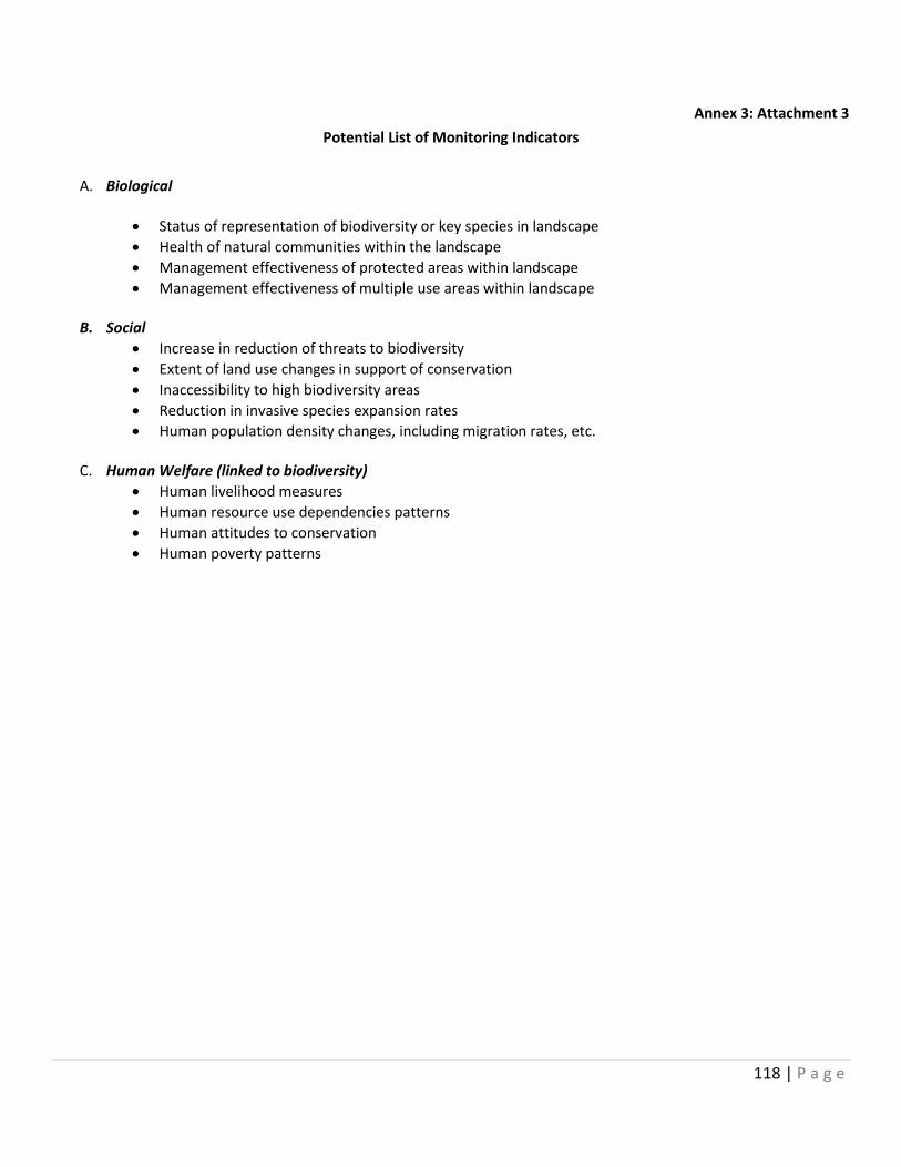
118 | P a g e
Annex 3: Attachment 3
Potential List of Monitoring Indicators
A. Biological
Status of representation of biodiversity or key species in landscape
Health of natural communities within the landscape
Management effectiveness of protected areas within landscape
Management effectiveness of multiple use areas within landscape
B. Social
Increase in reduction of threats to biodiversity
Extent of land use changes in support of conservation
Inaccessibility to high biodiversity areas
Reduction in invasive species expansion rates
Human population density changes, including migration rates, etc.
C. Human Welfare (linked to biodiversity)
Human livelihood measures
Human resource use dependencies patterns
Human attitudes to conservation
Human poverty patterns
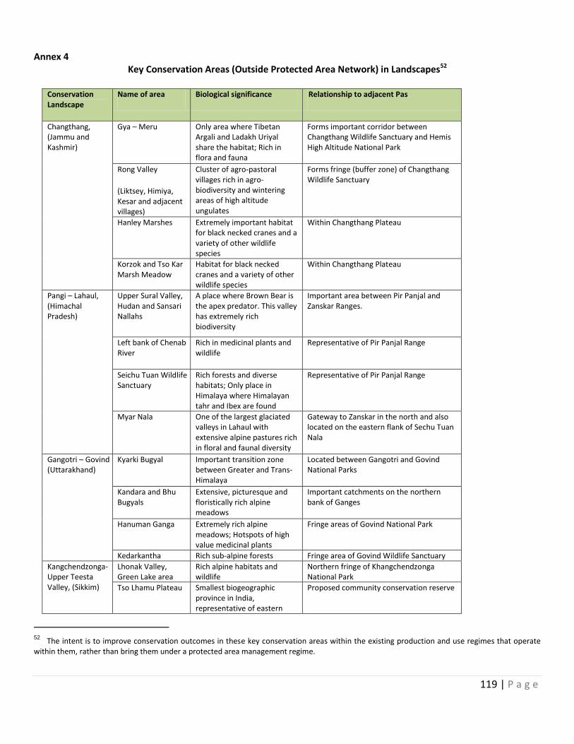
119 | P a g e
Annex 4 Key Conservation Areas (Outside Protected Area Network) in Landscapes52
Conservation Landscape
Name of area Biological significance Relationship to adjacent Pas
Changthang, (Jammu and Kashmir)
Gya – Meru Only area where Tibetan Argali and Ladakh Uriyal share the habitat; Rich in flora and fauna
Forms important corridor between Changthang Wildlife Sanctuary and Hemis High Altitude National Park
Rong Valley
(Liktsey, Himiya, Kesar and adjacent villages)
Cluster of agro-pastoral villages rich in agro-biodiversity and wintering areas of high altitude ungulates
Forms fringe (buffer zone) of Changthang Wildlife Sanctuary
Hanley Marshes Extremely important habitat for black necked cranes and a variety of other wildlife species
Within Changthang Plateau
Korzok and Tso Kar Marsh Meadow
Habitat for black necked cranes and a variety of other wildlife species
Within Changthang Plateau
Pangi – Lahaul, (Himachal Pradesh)
Upper Sural Valley, Hudan and Sansari Nallahs
A place where Brown Bear is the apex predator. This valley has extremely rich biodiversity
Important area between Pir Panjal and Zanskar Ranges.
Left bank of Chenab River
Rich in medicinal plants and wildlife
Representative of Pir Panjal Range
Seichu Tuan Wildlife Sanctuary
Rich forests and diverse habitats; Only place in Himalaya where Himalayan tahr and Ibex are found
Representative of Pir Panjal Range
Myar Nala One of the largest glaciated valleys in Lahaul with extensive alpine pastures rich in floral and faunal diversity
Gateway to Zanskar in the north and also located on the eastern flank of Sechu Tuan Nala
Gangotri – Govind (Uttarakhand)
Kyarki Bugyal Important transition zone between Greater and Trans-Himalaya
Located between Gangotri and Govind National Parks
Kandara and Bhu Bugyals
Extensive, picturesque and floristically rich alpine meadows
Important catchments on the northern bank of Ganges
Hanuman Ganga Extremely rich alpine meadows; Hotspots of high value medicinal plants
Fringe areas of Govind National Park
Kedarkantha Rich sub-alpine forests Fringe area of Govind Wildlife Sanctuary
Kangchendzonga- Upper Teesta Valley, (Sikkim)
Lhonak Valley, Green Lake area
Rich alpine habitats and wildlife
Northern fringe of Khangchendzonga National Park
Tso Lhamu Plateau Smallest biogeographic province in India, representative of eastern
Proposed community conservation reserve
52 The intent is to improve conservation outcomes in these key conservation areas within the existing production and use regimes that operate within them, rather than bring them under a protected area management regime.

120 | P a g e
Tibetan plateau
Shingba Rhododendron Sanctuary
Important area for floristic diversity in subalpine – alpine ecotone. Also rich in faunal diversity
Rich in diversity of high value medicinal plants including caterpillar mushroom (Sinocordyceps sinensis)
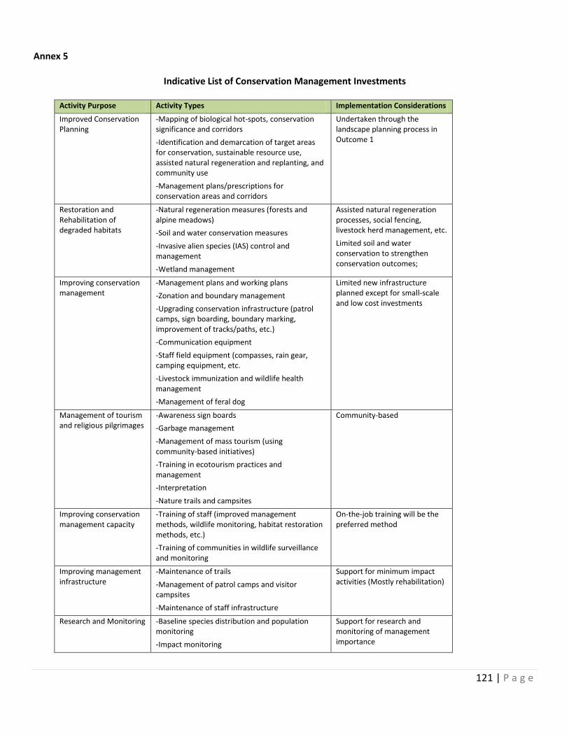
121 | P a g e
Annex 5
Indicative List of Conservation Management Investments
Activity Purpose Activity Types Implementation Considerations
Improved Conservation Planning
-Mapping of biological hot-spots, conservation significance and corridors
-Identification and demarcation of target areas for conservation, sustainable resource use, assisted natural regeneration and replanting, and community use
-Management plans/prescriptions for conservation areas and corridors
Undertaken through the landscape planning process in Outcome 1
Restoration and Rehabilitation of degraded habitats
-Natural regeneration measures (forests and alpine meadows)
-Soil and water conservation measures
-Invasive alien species (IAS) control and management
-Wetland management
Assisted natural regeneration processes, social fencing, livestock herd management, etc.
Limited soil and water conservation to strengthen conservation outcomes;
Improving conservation management
-Management plans and working plans
-Zonation and boundary management
-Upgrading conservation infrastructure (patrol camps, sign boarding, boundary marking, improvement of tracks/paths, etc.)
-Communication equipment
-Staff field equipment (compasses, rain gear, camping equipment, etc.
-Livestock immunization and wildlife health management
-Management of feral dog
Limited new infrastructure planned except for small-scale and low cost investments
Management of tourism and religious pilgrimages
-Awareness sign boards
-Garbage management
-Management of mass tourism (using community-based initiatives)
-Training in ecotourism practices and management
-Interpretation
-Nature trails and campsites
Community-based
Improving conservation management capacity
-Training of staff (improved management methods, wildlife monitoring, habitat restoration methods, etc.)
-Training of communities in wildlife surveillance and monitoring
On-the-job training will be the preferred method
Improving management infrastructure
-Maintenance of trails
-Management of patrol camps and visitor campsites
-Maintenance of staff infrastructure
Support for minimum impact activities (Mostly rehabilitation)
Research and Monitoring -Baseline species distribution and population monitoring
-Impact monitoring
Support for research and monitoring of management importance
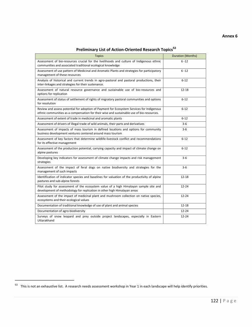
122 | P a g e
Annex 6
Preliminary List of Action-Oriented Research Topics53
Topics Duration (Months)
Assessment of bio-resources crucial for the livelihoods and culture of Indigenous ethnic communities and associated traditional ecological knowledge
6 -12
Assessment of use pattern of Medicinal and Aromatic Plants and strategies for participatory management of these resources
6 -12
Analysis of historical and current trends in agro-pastoral and pastoral productions, their inter-linkages and strategies for their sustenance.
6-12
Assessment of natural resource governance and sustainable use of bio-resources and options for replication
12-18
Assessment of status of settlement of rights of migratory pastoral communities and options for resolution
6-12
Review and assess potential for adoption of Payment for Ecosystem Services for Indigenous ethnic communities as a compensation for their wise and sustainable use of bio-resources.
6-12
Assessment of extent of trade in medicinal and aromatic plants 6-12
Assessment of drivers of illegal trade of wild animals, their parts and derivatives 3-6
Assessment of impacts of mass tourism in defined locations and options for community business development ventures centered around mass tourism
3-6
Assessment of key factors that determine wildlife-livestock conflict and recommendations for its effective management
6-12
Assessment of the production potential, carrying capacity and impact of climate change on alpine pastures
6-12
Developing key indicators for assessment of climate change impacts and risk management strategies
3-6
Assessment of the impact of feral dogs on native biodiversity and strategies for the management of such impacts
3-6
Identification of indicator species and baselines for valuation of the productivity of alpine pastures and sub-alpine forests
12-18
Pilot study for assessment of the ecosystem value of a high Himalayan sample site and development of methodology for replication in other high Himalayan areas
12-24
Assessment of the impact of medicinal plant and mushroom collection on native species, ecosystems and their ecological values
12-24
Documentation of traditional knowledge of use of plant and animal species 12-18
Documentation of agro-biodiversity 12-24
Surveys of snow leopard and prey outside project landscapes, especially in Eastern Uttarakhand
12-24
53 This is not an exhaustive list. A research needs assessment workshop in Year 1 in each landscape will help identify priorities.
123 | P a g e
Annex 7 Project Participatory Framework for
Community consultation and participation in planning, implementation and Monitoring of village level landscape activities
The Framework outlines the procedures and mechanism that should be followed to ensure that participation of local communities in the activities of the project so that a self-managed and governed system sustains even after completion of the project and people own the project.
In the project landscapes there are various types of community institutions that can be grouped into three categories in relation to the project. These are:
Biodiversity Conservation and Forestry related institutions: Eco-development Committees, Van Panchayats (Uttarakhand), Joint Forest Management Committees, Bio-diversity Management Committees (BMCs), Natural Resource Management Committees, etc.
Livelihood related institutions: Self Help Groups, SHG-Federations, Cooperatives, Eco-Tourism Societies (undertaking trekking, home stays, bird watching activities).
Social, Cultural and conservation related institutions: Mahila Mangal Dal (Women groups in Villages) and Yuvak Mangal Dals (Youth Societies in Villages), Local NGOs etc.
Besides these institutions, Gram Panchayats institutions will also function in the villages that undertake overall planning and development activities in villages.
Both conservation and livelihood institutions at the village level have very specific roles under the project in order to develop and maintain a balance between conservation and use of natural resources and livelihood diversification, making it important that these institutions work in consonance with each other.
This framework, more specifically describes the participatory process by which: (a) specific components of activities at the village level will be implemented; (b) the criteria for determining eligibility of investments are to be determined; (c) the measures to assist local community members improve conservation and sustainable natural resource management practices and (d) Appropriate and non-exploitative use of natural resources for livelihoods activities in real terms. It also more specifically incorporates details of the institutional arrangements for planning of village conservation, sustainable resource use and livelihood investments, the association and relationship of various community institutions and relationship with various government and non-government institutions in the planning, implementation and monitoring of the village investments and reciprocal commitments to conservation.
Institutional arrangements for integration of local communities into landscape conservation activities
For each of the four landscapes, a ‘Landscape Planning Team’, consisting of Project Facilitation Officer (full-time officer delegated from the Forest Department, contract Social Participation Specialist and social mobilizers) will be constituted to provide technical and planning inputs for implementation of project activities. Technical specialists from line departments, NGOs and research and development institutions will be contracted as and when required to provide specialized technical support in livelihood, value-chain and capacity building support. The core planning team will be responsible for: (i) undertaking situational analysis in the context of conservation and livelihoods, information dissemination, social mobilization, strengthening of local or village level institutions and if required formation of new collectives/ institutions; (ii) designing and conducting biological field surveys as well as social and resource utilization surveys; (iii) mapping of existing user rights and facilitation of dialogue to resolve or manage use rights; (iv) formulation of management strategies for conservation and livelihood improvement at village level in conjunction with local communities; (v) formulation of sustainable natural resources management practices in conjunction with local communities; (vi) formulation of community development, livelihood and value chain strategies; (vii) supporting
124 | P a g e
participatory monitoring of community and conservation activities; (viii) facilitating resolution of conflicts over resource use; (ix) and planning for any infrastructural facilities for the community proposed in the project. With the help of State PPMUs, especially the Technical Support Specialist, the LPITs will facilitate in providing planning, capacity building and technical support for livelihood development activities. The LPITs will also coordinate with NGOs, line departments, private institutions, research and development organizations, various specialists and service providers to provide specialized services in the area of conservation or livelihoods promotion. In addition, the LPITs will coordinate with other development sector partners such as NGOs, line department, private institutions, research and development organizations etc. under the guidance of State PPMUs to facilitate integration and convergence of development support within the landscapes. All management arrangements and community livelihood investments at the local level will be detailed in a legally binding Memorandum of Understanding between the local institutions (such as the Village Council, Gram Panchayat, Van Panchayat or similar active institution, as appropriate depending on the situation within each of the landscape sites). The LPITs will also ensure that social and environmental screening and mitigation action are planned and implemented at the village level and ensure that local communities have access to technical support and capacity development in the implementation of livelihood or resource management strategies
Planning and implementation of reciprocal commitments to conservation and investments at the village level will be implemented through existing community institutions, such as the Village Council, Gram Panchayat, Van Panchayat or similar active institution (referred to as “Village Conservation and Development Committees or VCDCs”), depending on conditions within the landscape site. While the community institutions will be responsible for participatory planning, they will be facilitated by the LPITs. Households at each village will be organized into user groups; such groups will be collectively responsible for formulation of community-level microplans, prioritizations of investments, ensuring community reciprocal commitments and participatory monitoring of biodiversity and socio-economic impacts. Specific eligibility criteria would help prioritize community level investments and ensure their direct linkage with conservation objectives and reciprocal commitments to conservation. Local and national NGOs with appropriate expertise would be contracted to assist with microplanning, and capacity building at the community level as well as for independent monitoring of social and economic impacts of the project interventions. Overlapping or conflicting claims to resources and rights are likely to surface during the participatory resource and social mapping and planning exercises. If such disputes cannot be settled by the PLITs and concerned VCDCs, the project will pursue resolution through the PPMUs and State Steering Committees, as relevant or arbitration under an arrangement that closely resembles customary conflict resolution. In terms of rights, the LPITs and respective government institutions will initiate action with the concerned agencies for settlement of these rights, within the context of existing mechanisms that are available for this purpose
Planning and Implementation of village-based activities
The planning and implementation of the village level activities will be holistic involving conservation, livelihood and value chain activities. The village microplanning process will be undertaken in a staggered fashion in the landscape sites beginning with a few communities that are most adversely affected by lack of resources or existing resource restrictions, and later extending to other villages, building on experience and learning from the initial set of villages. The key steps that constitute the process framework for participation of local communities in project activities comprise:
Step -1: Community orientation and mobilization: As a first step, the project objectives and approach will be disseminated by the LPITs to all the local communities in the landscapes. In addition to dissemination of the project objectives and approach, orientation meetings would seek to more accurately identify the perceptions of the local communities and other stakeholders regarding existing resource management practices, options for their better management, opportunities for livelihood and income improvements, and identify key representatives of the community or resource user groups for participation in subsequent resource mapping. In these meetings, the environmental, biodiversity and socio-economic profiles of the village should be obtained from the stakeholders in a format that can be easily retrieved for doing analytical review. This information will be quantitative as well as
125 | P a g e
qualitative. The quantitative information will be further validated from various line departments and other relevant research institutions.
Step-2: Mapping of conservation value of community resources: A village level landscape conservation mapping exercise should be carried out to identify and assign conservation values to individual components of the village landscape so as to help determine appropriate management options for these individual components. The mapping exercise will help identify critical areas of biodiversity around the village and locations of high pressure and vulnerability. This mapping would provide the basis for defining options for management of resources within the village landscape, as well as options for sustainable resource management, livelihood improvement and diversification and value chain products and services that are relevant for development or enhancement.
Step-3: Mapping of community resources and resource utilization and community rights: The participatory resource mapping will constitute an input to the planning of activities within the village landscape and will help establish the baseline for future monitoring. The socio-economic mapping will include the mapping of rights and resource dependencies of communities in the surrounding forests and natural habitats around the village. Information generated through this participatory mapping exercise will be used to facilitate the formulation of village-level plans and the initiation of a process for settlement of such rights. The mapping will draw on PRA techniques, site inspections, observations, transect walk etc. and provide information on (a) scale and seasonality of specific forms of resource utilization within the landscape including the protected areas (e.g. agriculture, grazing, fuel wood collection, non-timber forest resource collection, etc.); (b) the number, location and circumstances of the stakeholders utilizing specific resources, and (c) customary rights and conflicts in resource use by different stakeholders within the landscapes. In terms of customary rights the mapping would provide information on: (i) location and size of the area and condition of resource; (ii) primary users, including those belonging to vulnerable group, that currently use or depend on these common lands; (iii) secondary users and types of uses. This would provide the basis for initiation of settlements of rights within the landscape units on the basis of existing government legislation and regulations.
Step -4: Strengthening/ Formation relevant local community organizations: During the orientation meetings and community mobilization process, the interest, capacity and skills of the communities and their institutions would be accessed. This will give opportunity to prepare a socio-economic profile that may later help in the social and environmental screening of projects proposed. The project would provide training in resource mapping, natural resource management evaluation, planning, construction supervision, maintaining of minutes of community meetings and basic account keeping, and monitoring of resource access restriction agreements will be provided. Basically, most training will be on the job training as well as exchange visits to other sites where relevant solutions to problems have been implemented.
Step -5: Development of village level conservation and sustainable use and livelihood strategies: Meetings will be held with individual villages to review the results of the community resource utilization mapping undertaken as a second step of this process framework and to agree on its implications regarding natural resource and conservation strategies, resource access, mitigation and/or compensatory measures. Community participation and contributions to conservation, sustainable resource use and livelihood diversification and development activities, including value chain products and services / activities that are selected for project support must comply with the following pre-requisites:
All village investments must be based on some minimum level of cost sharing by/involving local communities
Preferably, a clear and transparent linkage must exist between improving conservation and sustainable resource use and the proposed investment, so that the village project agreements between communities and local governmental institutions support sustainable practices by creating adequate incentives for local communities to take measurable action that supports conservation of natural resources and their sustainable use
126 | P a g e
All village investments, including restrictions on resource access (if any) must evolve through a common understanding and consensus amongst the local communities.
To be eligible for inclusion in the village investment plans for funding, activities should comply with the following criteria:
Conserve and sustainably use land and other natural resources either directly or indirectly by creating sufficient incentives to commit local people to specific, measurable actions that improve the sustainability of resource use.
Provide equitable share of benefits to local communities and mitigate any negative impacts to women, poor and disadvantaged groups who are currently most dependent on the land
Be socially sound and institutionally feasible ensuring that associated activities are culturally acceptable and do not impose an unnecessary heavy burden on individuals and that local institutional capacity is adequate to organize resource management, distribute benefits from common resources, provide physical maintenance, meet community agreements to resource use and access restrictions, ensure alternative livelihood benefits to affected members and monitor project impacts
Be low cost and financially feasible so that costs are within local norms, returns are sufficient to compensate for resource use limitations, and, for all investments intended to produce cash revenue or benefits that can be monetized, market linkages are adequate, cash flow requirements are viable, and returns compare favorably with alternative investment options.
Be technically feasible and innovative so that inputs and technical advice are adequate, physical conditions are suitable and the activity is technically sound.
Be environmentally sustainable in support of global environmental objectives
Be selected and owned by local communities as ensured by a budgetary constraint mechanism, community contribution or co-financing requirement, and a commitment by the community to bear maintenance costs of any infrastructure component
Be supported by training and capacity development for strengthening all households.
Be supplemental or incremental in nature to ensure that activities supported under the project are not a substitution for what should be supported by the government as part of their development responsibilities or not of global benefit.
The MoUs/MoAs will be developed with various institutions in the project for different type of activities and services will have some or all the above-mentioned criteria articulated well in the contracts.
Lessons learned from other participatory conservation/development initiatives has validated the importance of requiring some form of cost sharing for investments intended to benefit local people, including extremely poor households, since it builds commitment and ownership on the part of stakeholders and strengthens the likelihood of sustainability. Therefore, the project would establish clear and transparent contribution requirements and will also promote creation of a ‘Village Common Fund’. To this end, the following norms are suggested:
Local people would contribute to the costs of regular village micro-plan investments, including community oriented activities, to be deposited in a Village Common Fund (VCF);
There will be no upper limit to the amount a community can contribute and deposit in the VCF;
Village contributions will be matched up to a given amount per community, with the upper limit being decided at the initiation of the program;
The total investment cost would be calculated as the sum of all resources, cash and non-cash; the value of labor, and other in-kind contributions would be calculated on the basis of local market value;
To build ownership and long-term sustainability, all village investments would flow through the VCF or other relevant community institution, thereby encouraging the beneficiary community to seek co-
127 | P a g e
financing and leverage funds through the provision of loans for approved community investments and other needs. Over time, this financing management system can continue to build and sustain community fiscal resources.
The LPITs, with the help of State PPMUs, will come out with various norms of contribution of community in various support activities provided under the project. This will enhance the ownership of the people in the project initiatives. These practices are already being used by various ongoing internationally funded projects in the selected landscapes.
Procedures should be established to screen requested resource development or income generating investments to ensure that they are technically feasible, have positive environmental impact and are part of a holistic approach to the local ecosystem management, likely to generate supplementary income, comply with sound social and environmental principles and are sustainable. The LPITs should be primarily responsible for such screening. Decisions regarding the priority investments will be made by mutual consent of the LPITs, local community institutions and the community, with subsequent endorsement PPMUs, if relevant. If required by budgetary or implementation capacity constraints, proposed activities will be prioritized based on their expected positive impact on global environmental objectives, the conservation and sustainable utilization of the land and sustainable livelihood activities. The activities also need to be implemented in such a way that they create a learning situation and results that are of policy relevance. Examples of appropriate land management and livelihood activities might include: improved agricultural practices, improved livestock and pasture management, forest management and rehabilitation, including community forestry, environmentally friendly minor infrastructure rehabilitation (village irrigation and drinking water supply systems, minor erosion control structures, etc.), medicinal and non-timber product development, processing of agricultural practices, alternative livelihood options (handicrafts/ handlooms enterprises, agricultural product processing and development, mushroom cultivation, marketing support, skills development, etc.) and natural resource conflict management.
Implementation of Village Investment Plans: Activities discussed and agreed with the community would form the basis of the village level plans. Once approved, an agreement would be signed with the relevant village committees for carrying out the proposed activities. With technical support from the LPITs and state agency extension staff, and NGOs, the villages will implement the activities in their individual villages. The LPITs will convene periodic meetings (quarterly) to review implementation progress (including social and environmental compliance and action) and resolve any specific issues arising from project implementation and monitor implementation outcomes and impacts. In each village, VCDCs will be playing key role in overseeing implementation and monitoring of the activities.
Monitoring and Evaluation: A Monitoring and Evaluation Framework will be developed for the Project. A monitoring system will also be designed to provide for continuous learning and adjustment of approach, and will involve participatory monitoring based on self-defined indicators (by community groups, LPITs, etc.), input and output monitoring data from the LPITs. A framework for monitoring will be developed and will include description of the institutional arrangements and processes incorporating participatory monitoring and learning systems, selection of indicators, sampling methods, interval and intensity of sampling and mechanisms for feedback and project improvement. The tools of monitoring the activities and outputs of the project will be formed so that both quantitative and qualitative information is captured regularly.
Three areas of significance for monitoring and achievement of project objectives will (i) the ecological aspects of field activities for biodiversity conservation and landscape management; (ii) community participation in conservation, sustainable use and livelihood improvement, community compliance with conservation and resource use agreements, and outcome of livelihood activities; and (iii) institutional aspects at the landscape levels and modalities for conflict resolution and new community-based agreements on resource use.
Since mobile connectivity is a problem in all the four landscapes in one way or the other, therefore the MIS and M&E systems in the projects will be developed keeping this fact in mind. Hence a system of Manual and IT based (online and off line) MIS and monitoring will be developed for the project. This will be done keeping in view the sustainability and withdrawal strategy of the project.
128 | P a g e
Arrangements for micro-grant allocation for village investments: Specific criteria and grant management mechanisms are proposed under the project. In particular, grant financing for livelihood activities would be performance-based and designed on basis of ensuring transparency and extensive consultations with local and district entities and other relevant stakeholders, be well coordinated and promoted through effective technical support, regular review of implementation arrangements and the use of monitoring and evaluation information to adjust and refine the system in consultation with the stakeholders.
Grants would be typically based on the following principles:
(i) Competitive assessment and tender to selected beneficiaries, in particular village level institutions (those institutions that represents the interests of the village and its households);
(ii) Village level institutions would be those that have legal status either as BMCS, JFMs, EDCs, Panchayat Raj institutions and others that are registered under the societies Act
(iii) Village investments should evolve through a transparent village participatory process that have a clear and transparent linkage with improving conservation and sustainable resource use and must benefit a majority of the people in the village
(iv) All village investments must be based on some minimum level of cost sharing by involving local communities;
(v) Village investments must be meet criteria as discuss earlier in this Annex to be eligible for funding under the project
(vi) Village investments must be included in a microplan that is approved by the State Steering Committee
(vii) All village institutions must establish a village fund in a banking institution with clearing designated signatories to the fund, including a representative from the forest or wildlife department and specific rules and regulations for operation of the fund
(viii) All members will pay a token amount of registration fee
(ix) The project will support the strengthening of the institutional capacity of the village institution in financial management, book-keeping and financial reporting
(x) A MOU would be signed between the village institution and the forest/wildlife department that lays out (a) responsibilities of each party; (b) activities that are eligible for funding under the project; (c) outputs to be produced; (d) performance criteria for release of future grant tranches; (e) reporting arrangements for activities and expenditure
(xi) The Department of Forests/Wildlife will be responsible for (a) ensuring the approval of the village microplan and individual annual plans by the state steering committee; (b) establishing the MOU with the village institution; (c) managing the release of funds into the village funds; and (d) monitoring and reporting on the implementation of grant activities and results
(xii) Initial release of funds or upfront payment as a percentage of payment will be defined in consultation with stakeholders
(xiii) Balance or subsequent payments would be made on successful completion and verification of work by the Forest/Wildlife departments
(xiv) Efforts will be made to try to identify additional funding support for this activity from existing government and local development programs. The convergence of government resources would be sought through the support of the State Level Steering Committees and by co-opting block, district and sector agency staff into Landscape Planning and Implementation teams during the village microplanning process.
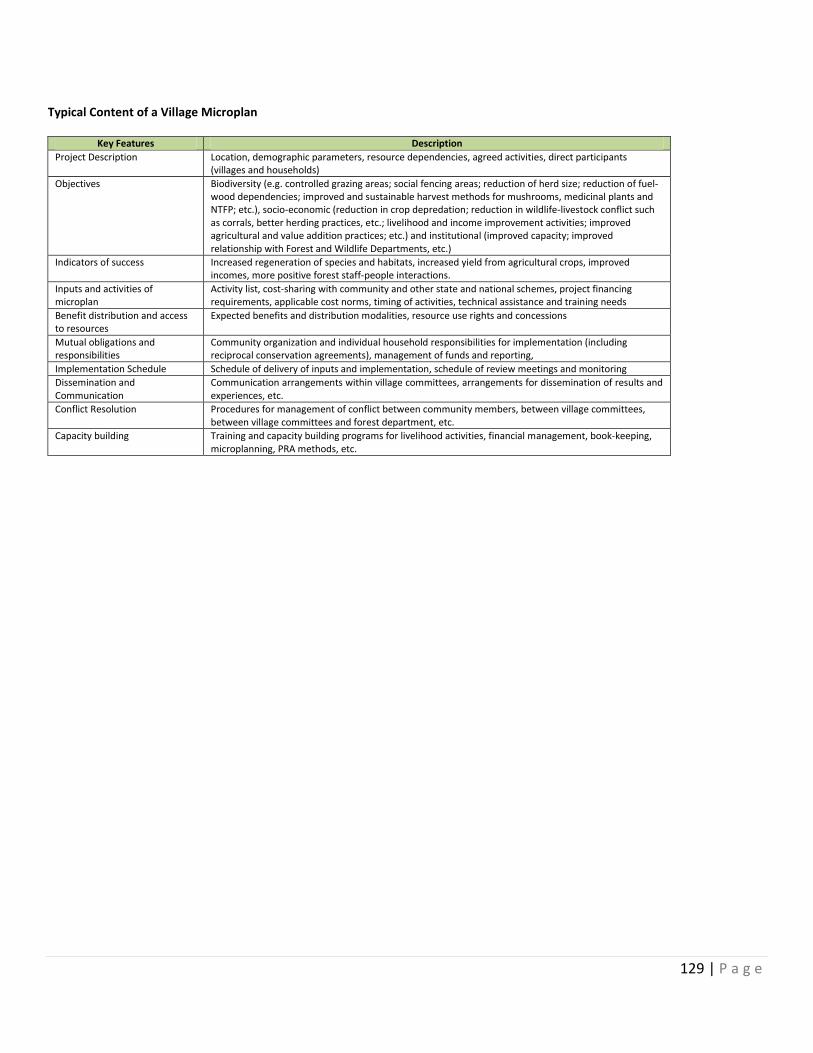
129 | P a g e
Typical Content of a Village Microplan
Key Features Description
Project Description Location, demographic parameters, resource dependencies, agreed activities, direct participants (villages and households)
Objectives Biodiversity (e.g. controlled grazing areas; social fencing areas; reduction of herd size; reduction of fuel-wood dependencies; improved and sustainable harvest methods for mushrooms, medicinal plants and NTFP; etc.), socio-economic (reduction in crop depredation; reduction in wildlife-livestock conflict such as corrals, better herding practices, etc.; livelihood and income improvement activities; improved agricultural and value addition practices; etc.) and institutional (improved capacity; improved relationship with Forest and Wildlife Departments, etc.)
Indicators of success Increased regeneration of species and habitats, increased yield from agricultural crops, improved incomes, more positive forest staff-people interactions.
Inputs and activities of microplan
Activity list, cost-sharing with community and other state and national schemes, project financing requirements, applicable cost norms, timing of activities, technical assistance and training needs
Benefit distribution and access to resources
Expected benefits and distribution modalities, resource use rights and concessions
Mutual obligations and responsibilities
Community organization and individual household responsibilities for implementation (including reciprocal conservation agreements), management of funds and reporting,
Implementation Schedule Schedule of delivery of inputs and implementation, schedule of review meetings and monitoring
Dissemination and Communication
Communication arrangements within village committees, arrangements for dissemination of results and experiences, etc.
Conflict Resolution Procedures for management of conflict between community members, between village committees, between village committees and forest department, etc.
Capacity building Training and capacity building programs for livelihood activities, financial management, book-keeping, microplanning, PRA methods, etc.
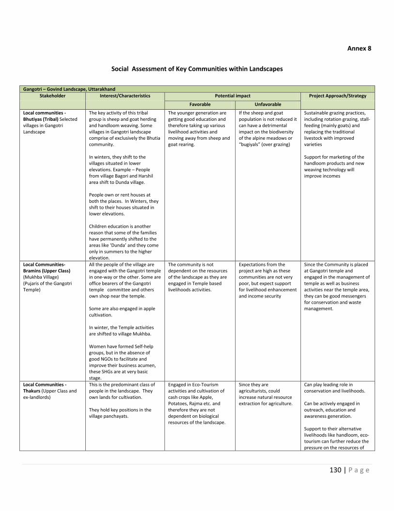
130 | P a g e
Annex 8
Social Assessment of Key Communities within Landscapes
Gangotri – Govind Landscape, Uttarakhand
Stakeholder Interest/Characteristics Potential impact Project Approach/Strategy
Favorable Unfavorable
Local communities - Bhutiyas (Tribal) Selected villages in Gangotri Landscape
The key activity of this tribal group is sheep and goat herding and handloom weaving. Some villages in Gangotri landscape comprise of exclusively the Bhutia community. In winters, they shift to the villages situated in lower elevations. Example – People from village Bagori and Harshil area shift to Dunda village. People own or rent houses at both the places. In Winters, they shift to their houses situated in lower elevations. Children education is another reason that some of the families have permanently shifted to the areas like ‘Dunda’ and they come only in summers to the higher elevation.
The younger generation are getting good education and therefore taking up various livelihood activities and moving away from sheep and goat rearing.
If the sheep and goat population is not reduced it can have a detrimental impact on the biodiversity of the alpine meadows or “bugiyals” (over grazing)
Sustainable grazing practices, including rotation grazing, stall-feeding (mainly goats) and replacing the traditional livestock with improved varieties Support for marketing of the handloom products and new weaving technology will improve incomes
Local Communities- Bramins (Upper Class) (Mukhba Village) (Pujaris of the Gangotri Temple)
All the people of the village are engaged with the Gangotri temple in one-way or the other. Some are office bearers of the Gangotri temple committee and others own shop near the temple. Some are also engaged in apple cultivation. In winter, the Temple activities are shifted to village Mukhba. Women have formed Self-help groups, but in the absence of good NGOs to facilitate and improve their business acumen, these SHGs are at very basic stage.
The community is not dependent on the resources of the landscape as they are engaged in Temple based livelihoods activities.
Expectations from the project are high as these communities are not very poor, but expect support for livelihood enhancement and income security
Since the Community is placed at Gangotri temple and engaged in the management of temple as well as business activities near the temple area, they can be good messengers for conservation and waste management.
Local Communities - Thakurs (Upper Class and ex-landlords)
This is the predominant class of people in the landscape. They own lands for cultivation. They hold key positions in the village panchayats.
Engaged in Eco-Tourism activities and cultivation of cash crops like Apple, Potatoes, Rajma etc. and therefore they are not dependent on biological resources of the landscape.
Since they are agriculturists, could increase natural resource extraction for agriculture.
Can play leading role in conservation and livelihoods. Can be actively engaged in outreach, education and awareness generation. Support to their alternative livelihoods like handloom, eco-tourism can further reduce the pressure on the resources of
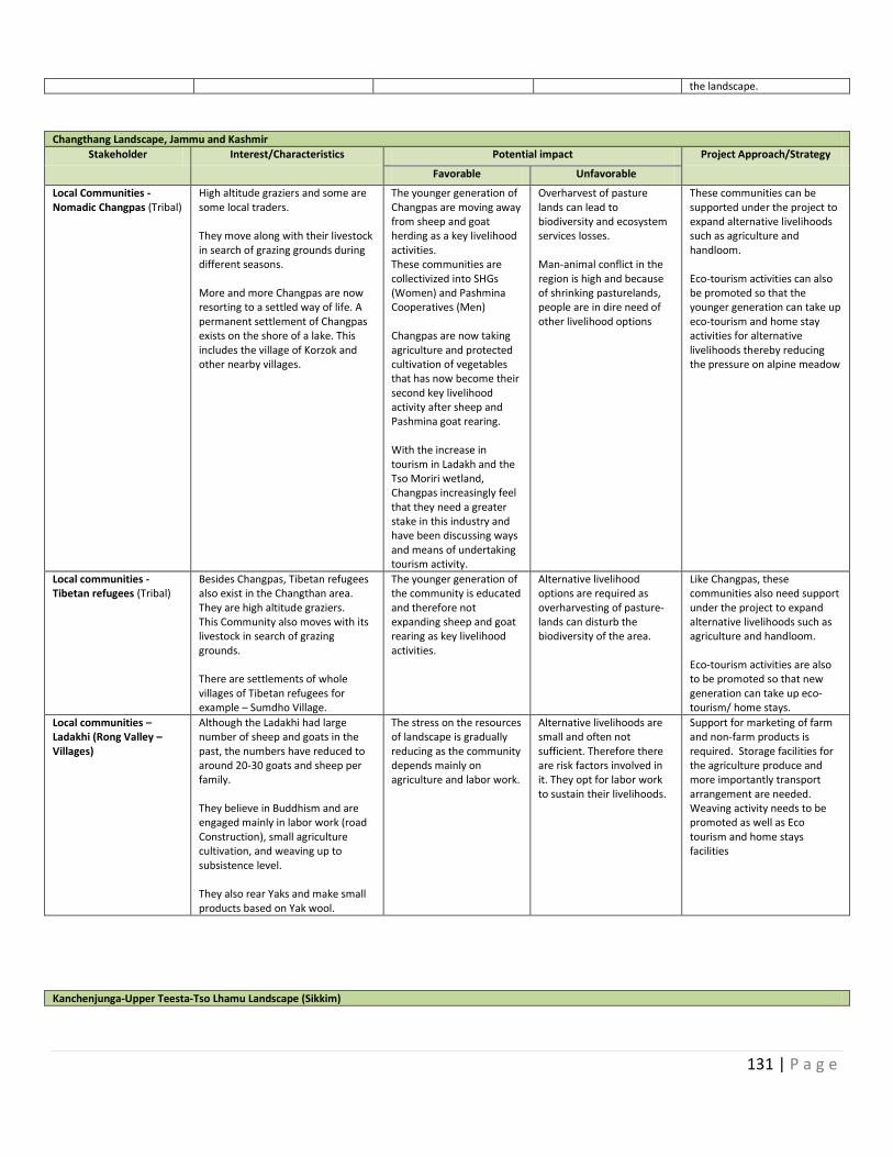
131 | P a g e
the landscape.
Changthang Landscape, Jammu and Kashmir
Stakeholder Interest/Characteristics Potential impact Project Approach/Strategy
Favorable Unfavorable
Local Communities - Nomadic Changpas (Tribal)
High altitude graziers and some are some local traders. They move along with their livestock in search of grazing grounds during different seasons. More and more Changpas are now resorting to a settled way of life. A permanent settlement of Changpas exists on the shore of a lake. This includes the village of Korzok and other nearby villages.
The younger generation of Changpas are moving away from sheep and goat herding as a key livelihood activities. These communities are collectivized into SHGs (Women) and Pashmina Cooperatives (Men) Changpas are now taking agriculture and protected cultivation of vegetables that has now become their second key livelihood activity after sheep and Pashmina goat rearing. With the increase in tourism in Ladakh and the Tso Moriri wetland, Changpas increasingly feel that they need a greater stake in this industry and have been discussing ways and means of undertaking tourism activity.
Overharvest of pasture lands can lead to biodiversity and ecosystem services losses. Man-animal conflict in the region is high and because of shrinking pasturelands, people are in dire need of other livelihood options
These communities can be supported under the project to expand alternative livelihoods such as agriculture and handloom. Eco-tourism activities can also be promoted so that the younger generation can take up eco-tourism and home stay activities for alternative livelihoods thereby reducing the pressure on alpine meadow
Local communities - Tibetan refugees (Tribal)
Besides Changpas, Tibetan refugees also exist in the Changthan area. They are high altitude graziers. This Community also moves with its livestock in search of grazing grounds. There are settlements of whole villages of Tibetan refugees for example – Sumdho Village.
The younger generation of the community is educated and therefore not expanding sheep and goat rearing as key livelihood activities.
Alternative livelihood options are required as overharvesting of pasture- lands can disturb the biodiversity of the area.
Like Changpas, these communities also need support under the project to expand alternative livelihoods such as agriculture and handloom. Eco-tourism activities are also to be promoted so that new generation can take up eco-tourism/ home stays.
Local communities – Ladakhi (Rong Valley – Villages)
Although the Ladakhi had large number of sheep and goats in the past, the numbers have reduced to around 20-30 goats and sheep per family. They believe in Buddhism and are engaged mainly in labor work (road Construction), small agriculture cultivation, and weaving up to subsistence level. They also rear Yaks and make small products based on Yak wool.
The stress on the resources of landscape is gradually reducing as the community depends mainly on agriculture and labor work.
Alternative livelihoods are small and often not sufficient. Therefore there are risk factors involved in it. They opt for labor work to sustain their livelihoods.
Support for marketing of farm and non-farm products is required. Storage facilities for the agriculture produce and more importantly transport arrangement are needed. Weaving activity needs to be promoted as well as Eco tourism and home stays facilities
Kanchenjunga-Upper Teesta-Tso Lhamu Landscape (Sikkim)
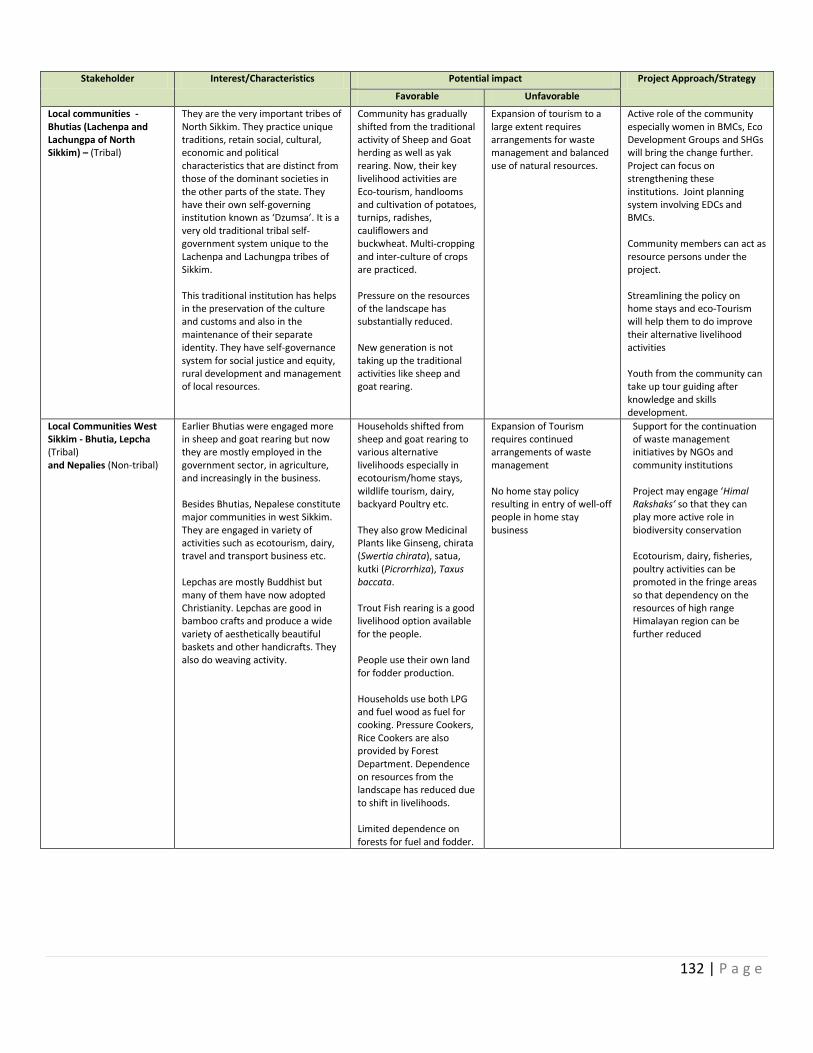
132 | P a g e
Stakeholder Interest/Characteristics Potential impact Project Approach/Strategy
Favorable Unfavorable
Local communities - Bhutias (Lachenpa and Lachungpa of North Sikkim) – (Tribal)
They are the very important tribes of North Sikkim. They practice unique traditions, retain social, cultural, economic and political characteristics that are distinct from those of the dominant societies in the other parts of the state. They have their own self-governing institution known as ‘Dzumsa’. It is a very old traditional tribal self-government system unique to the Lachenpa and Lachungpa tribes of Sikkim. This traditional institution has helps in the preservation of the culture and customs and also in the maintenance of their separate identity. They have self-governance system for social justice and equity, rural development and management of local resources.
Community has gradually shifted from the traditional activity of Sheep and Goat herding as well as yak rearing. Now, their key livelihood activities are Eco-tourism, handlooms and cultivation of potatoes, turnips, radishes, cauliflowers and buckwheat. Multi-cropping and inter-culture of crops are practiced. Pressure on the resources of the landscape has substantially reduced. New generation is not taking up the traditional activities like sheep and goat rearing.
Expansion of tourism to a large extent requires arrangements for waste management and balanced use of natural resources.
Active role of the community especially women in BMCs, Eco Development Groups and SHGs will bring the change further. Project can focus on strengthening these institutions. Joint planning system involving EDCs and BMCs. Community members can act as resource persons under the project. Streamlining the policy on home stays and eco-Tourism will help them to do improve their alternative livelihood activities Youth from the community can take up tour guiding after knowledge and skills development.
Local Communities West Sikkim - Bhutia, Lepcha (Tribal) and Nepalies (Non-tribal)
Earlier Bhutias were engaged more in sheep and goat rearing but now they are mostly employed in the government sector, in agriculture, and increasingly in the business. Besides Bhutias, Nepalese constitute major communities in west Sikkim. They are engaged in variety of activities such as ecotourism, dairy, travel and transport business etc. Lepchas are mostly Buddhist but many of them have now adopted Christianity. Lepchas are good in bamboo crafts and produce a wide variety of aesthetically beautiful baskets and other handicrafts. They also do weaving activity.
Households shifted from sheep and goat rearing to various alternative livelihoods especially in ecotourism/home stays, wildlife tourism, dairy, backyard Poultry etc. They also grow Medicinal Plants like Ginseng, chirata (Swertia chirata), satua, kutki (Picrorrhiza), Taxus baccata. Trout Fish rearing is a good livelihood option available for the people. People use their own land for fodder production. Households use both LPG and fuel wood as fuel for cooking. Pressure Cookers, Rice Cookers are also provided by Forest Department. Dependence on resources from the landscape has reduced due to shift in livelihoods. Limited dependence on forests for fuel and fodder.
Expansion of Tourism requires continued arrangements of waste management No home stay policy resulting in entry of well-off people in home stay business
Support for the continuation of waste management initiatives by NGOs and community institutions Project may engage ‘Himal Rakshaks’ so that they can play more active role in biodiversity conservation Ecotourism, dairy, fisheries, poultry activities can be promoted in the fringe areas so that dependency on the resources of high range Himalayan region can be further reduced
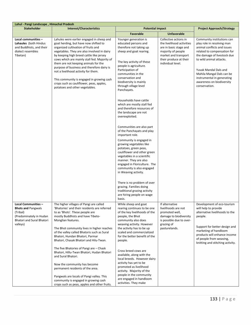
133 | P a g e
Lahul - Pangi Landscape , Himachal Pradesh
Stakeholder Interest/Characteristics Potential impact Project Approach/Strategy
Favorable Unfavorable
Local communities – Lahaules (both Hindus and Buddhists, and their dialect resembles Tibetan)
Lahules were earlier engaged in sheep and goat herding, but have now shifted to organized cultivation of fruits and vegetables. They are also involved in dairy by keeping high breed cattle like jersey cows which are mainly stall fed. Majority of them are not keeping animals for the purpose of business and therefore dairy is not a livelihood activity for them. This community is engaged in growing cash crops such as cauliflower, peas, apples, potatoes and other vegetables.
Younger generation is educated persons and therefore not taking up sheep and goat rearing.
The key activity of these people is agriculture. Participation of communities in the conservation and biodiversity is mainly through village level Panchayats.
Households have cattle which are mostly stall fed and therefore resources of the landscape are not overexploited.
Communities are also part of the Panchayats and play important role.
Community is engaged in growing vegetables like potatoes, green peas, cauliflower and other green vegetables in a scientific manner. They are also engaged in Floriculture. The community is also engaged in Weaving activity.
There is no problem of over grazing. Families doing traditional grazing activity are hiring people on wage basis.
Collective actions in the livelihood activities are in basic stage and majority of people market and transport their produce at their individual level.
Community institutions can play role in resolving man animal conflicts and issues related to compensation for the damage of livestock due to wild animal attacks.
Yuvak Mandal Dals and Mahila Mangal Dals can be instrumental in generating awareness on biodiversity conservation.
Local Communities – Bhots and Pangwals (Tribal) (Predominately in Hudan Bhatori and Sural Bhatori valleys)
The higher villages of Pangi are called 'Bhatories' and their residents are referred to as 'Bhots'. These people are mostly Buddhists and have Tibeto-Monglian features. The Bhot community lives in higher reaches of the valley called Bhatoris such as Sural Bhatori, Hundan Bhatori, Parmar Bhatori, Chasak Bhatori and Hilu-Twan. The five Bhatories of Pangi are – Chask Bhatori, Hillu-Twan Bhatori, Hudan Bhatori and Sural Bhatori. Now the community has become permanent residents of the area. Pangwals are locals of Pangi valley. This community is engaged in growing cash crops such as peas, apples and other fruits.
While sheep and goat rearing continues to be one of the key livelihoods of the people, the Bhot community also does weaving activity. However the activity has to be up scaled and commercialized for the better benefit of the people.
Cross breed cows are available, along with the local breeds. However dairy activity has yet to be promoted as livelihood activity. Majority of the people in the community are engaged in handloom activities. They make
If alternative livelihoods are not promoted well, damage to biodiversity is possible due to over-grazing of pasturelands.
Development of eco-tourism will help to provide alternative livelihoods to the people.
Support for better design and marketing of handloom products will enhance income of people from weaving, knitting and stitching activity.

134 | P a g e
This community is also engaged in collection of NTFPs. They also cultivate Mithi Pathish (Chaerophyllum villosum) in their own fields.
blankets, shawls, caps, muffler and patties (woollen cloth for making garments).
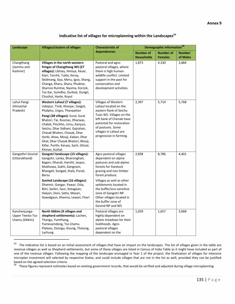
135 | P a g e
Annex 9
Indicative list of villages for microplanning within the Landscapes54
Landscape Villages/clusters of villages Characteristic of dependencies
Demographic Information55
Number of Households
Number of Females
Number of Males
Changthang (Jammu and Kashmir)
Villages in the north-western fringes of Changthang WS (27 villages): Liktsey, Himiya, Kesar, Kiari, Tarchit, Tukla, Keray, Skidmang, Gya, Meru, Igoo, Shang, Changa, Kharu, Shara, Phuktse, Sharnos Rumtse, Nyoma, Korzok, Tso Kar, Sumdho, Durbuk, Dungti, Chushul, Hanle, Koyul
Pastoral and agro-pastoral villages, where there is high human-wildlife conflict. Limited support in the past for conservation and development activities.
1,873 4,330 3,884
Lahul-Pangi (Himachal Pradesh)
Western Lahaul (7 villages): Udaipur, Tindi, Khanjar, Gaigot, Phalphu, Urgos, Thanpattan
Pangi (28 villages): Sural, Sural Bhatori, Tai, Rusmas, Dharwas, Chaloli, Pinchho, Urnu, Kanyun, Seichu, Dhar Sidhani, Gajrahan, Chasak Bhatori, Chasak, Dhar Harbi, Ahao, Mouji, Kaban, Dhar Ghal, Dhar Chasak Bhatori, Mouji, Killar, Purthi, Karyas, Sach, Ghisal, Khinan, Kuthal
Villages of Western Lahaul located on the eastern flank of Seichu Tuan WS. Villages on the left bank of Chenab have potential for restoration of pastures. Some villages in Lahaul are progressive in farming.
2,397 5,714 5,768
Gangothri-Govind (Uttarakhand)
Gangotri landscape (15 villages): Gangotri, Lanka, Bhaironghati, Bagori, Dharali, Harshil, Jaspur, Mukhuwa, Sukhi, Gangnani, Bhangeli, Songad, Jhala, Purali, Barsu
Govind Landscape (16 villages): Dhatmir, Gangar, Pawar, Osla, Bitri, Sankri, Saur, Kotagoan, Halyari, Doni, Satta, Masari, Gawalgaun, Khanna, Lewari, Fitari
Agro-pastoral villages dependent on alpine pastures and sub-alpine forests for livestock grazing and non-timber forest produce.
Villages as well as other settlements located in the buffer/eco-sensitive zone of Gangotri NP. Other villages located in the buffer zone of Govind NP and WS
2,838 8,786 4,401
Kanchenjunga-Upper Teesta-Tso Lhamu (Sikkim)
North Sikkim (9 villages and shepherd settlements): Lachen, Thangu, Yumthang, Yumesamdong, Tso Lhamu Plateau, Dzongu, Kisung, Tholung, Lachung
Pastoral villages are highly dependent on alpine meadows for their livelihoods. Agro-pastoral villages dependent on the
1,059 1,657 3,068
54 The indicative list is based on an initial assessment of villages that have an impact on the landscapes. The list of villages given in the table are revenue villages as well as Shepherd settlements, but some of these villages are listed in Census of India Table as it might have included as part of one of the revenue villages. Following the mapping of the landscape envisaged in Year 1 of the project, the finalization of villages for intensive microplan investment will selected by respective States, and could include villages that are not in the list as well, provided they can be justified based on the agreed selection criteria. 55 These figures represent estimates based on existing government records, that would be verified and adjusted during village microplanning

136 | P a g e
West Sikkim (5 villages): Yuksum, Labdang, Rimbi, Uttarey, Mangta Bong
forests for various resources. Villages located in the buffer zone of Khangchendzonga NP and Shngba Rhododendron Sanctuary
Total 8,157 20,487 17,121
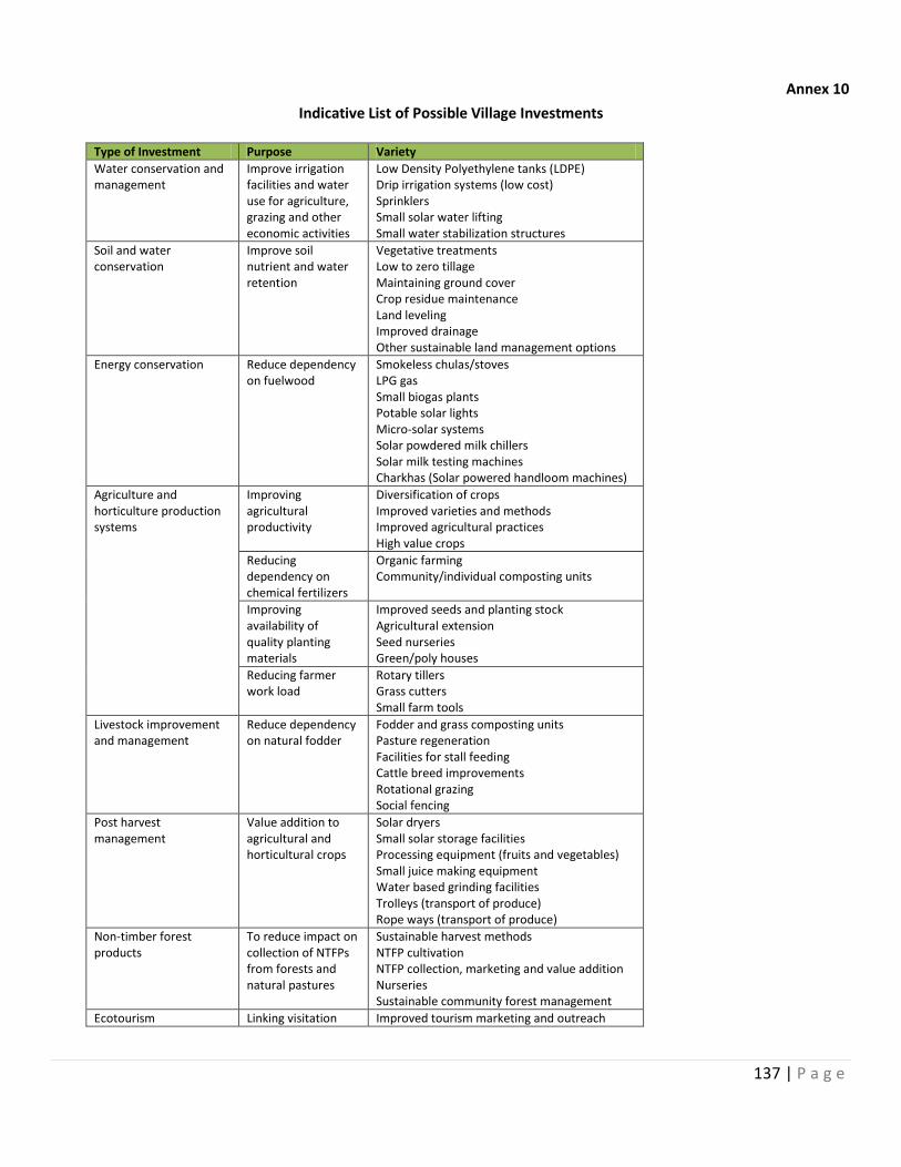
137 | P a g e
Annex 10
Indicative List of Possible Village Investments
Type of Investment Purpose Variety
Water conservation and management
Improve irrigation facilities and water use for agriculture, grazing and other economic activities
Low Density Polyethylene tanks (LDPE) Drip irrigation systems (low cost) Sprinklers Small solar water lifting Small water stabilization structures
Soil and water conservation
Improve soil nutrient and water retention
Vegetative treatments Low to zero tillage Maintaining ground cover Crop residue maintenance Land leveling Improved drainage Other sustainable land management options
Energy conservation Reduce dependency on fuelwood
Smokeless chulas/stoves LPG gas Small biogas plants Potable solar lights Micro-solar systems Solar powdered milk chillers Solar milk testing machines Charkhas (Solar powered handloom machines)
Agriculture and horticulture production systems
Improving agricultural productivity
Diversification of crops Improved varieties and methods Improved agricultural practices High value crops
Reducing dependency on chemical fertilizers
Organic farming Community/individual composting units
Improving availability of quality planting materials
Improved seeds and planting stock Agricultural extension Seed nurseries Green/poly houses
Reducing farmer work load
Rotary tillers Grass cutters Small farm tools
Livestock improvement and management
Reduce dependency on natural fodder
Fodder and grass composting units Pasture regeneration Facilities for stall feeding Cattle breed improvements Rotational grazing Social fencing
Post harvest management
Value addition to agricultural and horticultural crops
Solar dryers Small solar storage facilities Processing equipment (fruits and vegetables) Small juice making equipment Water based grinding facilities Trolleys (transport of produce) Rope ways (transport of produce)
Non-timber forest products
To reduce impact on collection of NTFPs from forests and natural pastures
Sustainable harvest methods NTFP cultivation NTFP collection, marketing and value addition Nurseries Sustainable community forest management
Ecotourism Linking visitation Improved tourism marketing and outreach
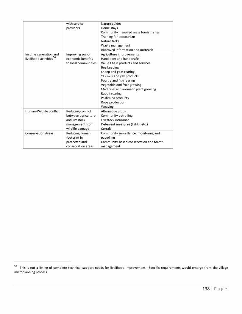
138 | P a g e
with service providers
Nature guides Home stays Community managed mass tourism sites Training for ecotourism Nature treks Waste management Improved information and outreach
Income generation and livelihood activities
56
Improving socio-economic benefits to local communities
Agriculture improvements Handloom and handicrafts Value Chain products and services Bee keeping Sheep and goat rearing Yak milk and yak products Poultry and fish rearing Vegetable and fruit growing Medicinal and aromatic plant growing Rabbit rearing Pashmina products Rope production Weaving
Human-Wildlife conflict Reducing conflict between agriculture and livestock management from wildlife damage
Alternative crops Community patrolling Livestock insurance Deterrent measures (lights, etc.) Corrals
Conservation Areas Reducing human footprint in protected and conservation areas
Community surveillance, monitoring and patrolling Community-based conservation and forest management
56 This is not a listing of complete technical support needs for livelihood improvement. Specific requirements would emerge from the village microplanning process
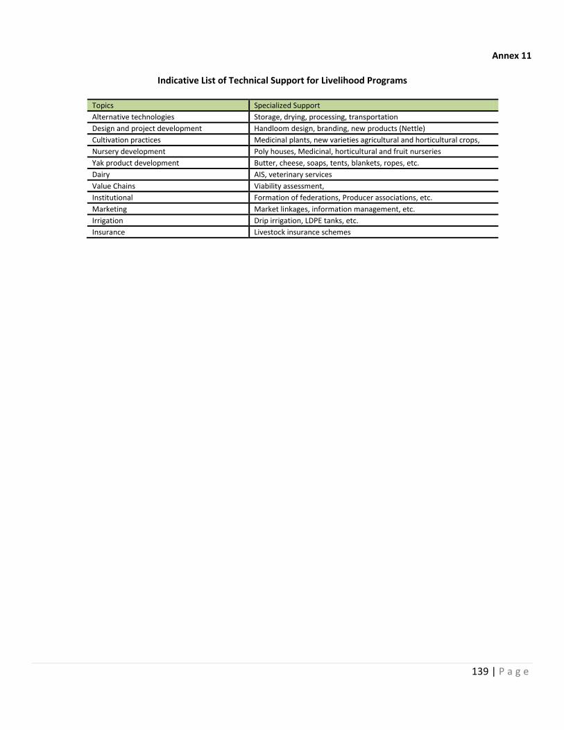
139 | P a g e
Annex 11
Indicative List of Technical Support for Livelihood Programs
Topics Specialized Support
Alternative technologies Storage, drying, processing, transportation
Design and project development Handloom design, branding, new products (Nettle)
Cultivation practices Medicinal plants, new varieties agricultural and horticultural crops,
Nursery development Poly houses, Medicinal, horticultural and fruit nurseries
Yak product development Butter, cheese, soaps, tents, blankets, ropes, etc.
Dairy AIS, veterinary services
Value Chains Viability assessment,
Institutional Formation of federations, Producer associations, etc.
Marketing Market linkages, information management, etc.
Irrigation Drip irrigation, LDPE tanks, etc.
Insurance Livestock insurance schemes
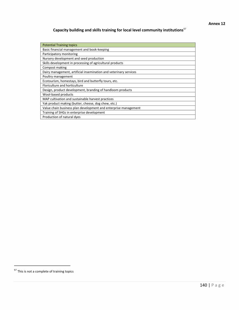
140 | P a g e
Annex 12
Capacity building and skills training for local level community institutions57
Potential Training topics
Basic financial management and book-keeping
Participatory monitoring
Nursery development and seed production
Skills development in processing of agricultural products
Compost making
Dairy management, artificial insemination and veterinary services
Poultry management
Ecotourism, homestays, bird and butterfly tours, etc.
Floriculture and horticulture
Design, product development, branding of handloom products
Wool-based products
MAP cultivation and sustainable harvest practices
Yak product making (butter, cheese, dog chew, etc.)
Value chain business plan development and enterprise management
Training of SHGs in enterprise development
Production of natural dyes
57
This is not a complete of training topics
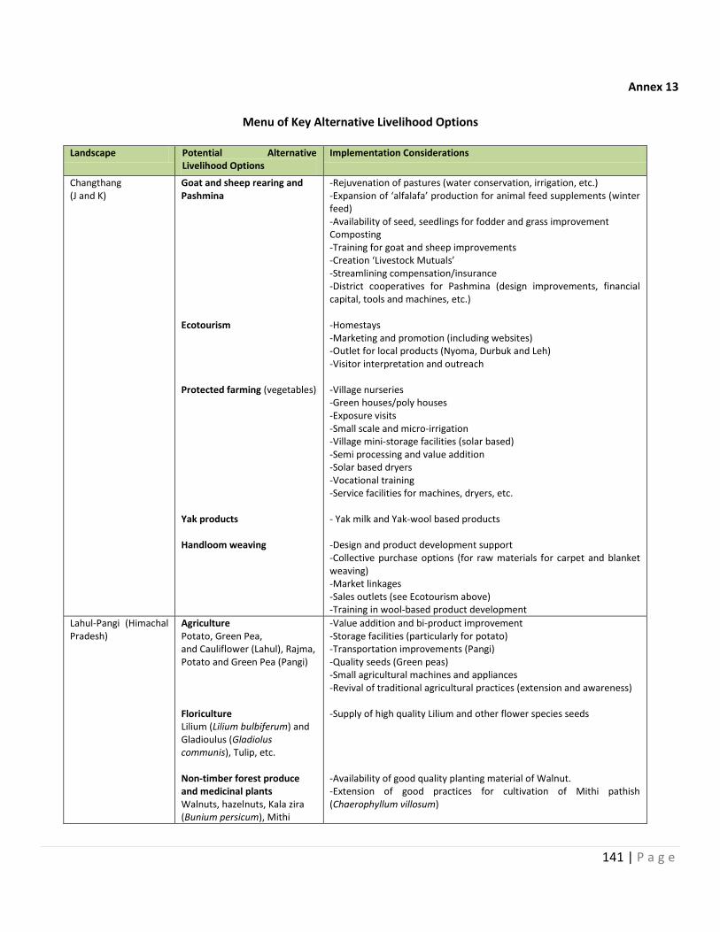
141 | P a g e
Annex 13
Menu of Key Alternative Livelihood Options
Landscape Potential Alternative
Livelihood Options Implementation Considerations
Changthang (J and K)
Goat and sheep rearing and Pashmina Ecotourism Protected farming (vegetables) Yak products Handloom weaving
-Rejuvenation of pastures (water conservation, irrigation, etc.) -Expansion of ‘alfalafa’ production for animal feed supplements (winter feed) -Availability of seed, seedlings for fodder and grass improvement Composting -Training for goat and sheep improvements -Creation ‘Livestock Mutuals’ -Streamlining compensation/insurance -District cooperatives for Pashmina (design improvements, financial capital, tools and machines, etc.) -Homestays -Marketing and promotion (including websites) -Outlet for local products (Nyoma, Durbuk and Leh) -Visitor interpretation and outreach -Village nurseries -Green houses/poly houses -Exposure visits -Small scale and micro-irrigation -Village mini-storage facilities (solar based) -Semi processing and value addition -Solar based dryers -Vocational training -Service facilities for machines, dryers, etc. - Yak milk and Yak-wool based products -Design and product development support -Collective purchase options (for raw materials for carpet and blanket weaving) -Market linkages -Sales outlets (see Ecotourism above) -Training in wool-based product development
Lahul-Pangi (Himachal Pradesh)
Agriculture Potato, Green Pea, and Cauliflower (Lahul), Rajma, Potato and Green Pea (Pangi) Floriculture Lilium (Lilium bulbiferum) and Gladioulus (Gladiolus communis), Tulip, etc. Non-timber forest produce and medicinal plants Walnuts, hazelnuts, Kala zira (Bunium persicum), Mithi
-Value addition and bi-product improvement -Storage facilities (particularly for potato) -Transportation improvements (Pangi) -Quality seeds (Green peas) -Small agricultural machines and appliances -Revival of traditional agricultural practices (extension and awareness) -Supply of high quality Lilium and other flower species seeds -Availability of good quality planting material of Walnut. -Extension of good practices for cultivation of Mithi pathish (Chaerophyllum villosum)
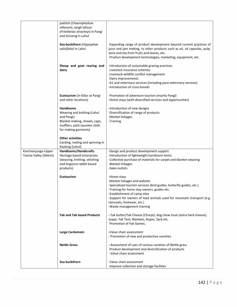
142 | P a g e
pathish (Chaerophyllum villosum), Jangli lahsun (Fritellarias stracheyi) in Pangi and Ginseng in Lahul Sea-buckthorn (Hippophae salicifolia) in Lahul Sheep and goat rearing and dairy Ecotourism (in Killar at Pangi and other locations) Handlooms Weaving and knitting (Lahul and Pangi) Blanket making, shawls, caps, mufflers, patti (woolen cloth for making garments) Other activities Carding, reeling and spinning in Keylong (Lahul)
-Expanding range of product development beyond current practices of juice and jam making, to other products such as oil, oil capsules, pulp, wine and tea from fruits and leaves, etc. -Product development technologies, marketing, equipment, etc. -Introduction of sustainable grazing practices -Livestock insurance schemes -Livestock-wildlife conflict management -Dairy improvements -A1 and veterinary services (including para-veterinary services) -Introduction of cross breeds -Promotion of adventure tourism (mainly Pangi) -Home stays (with diversified services and opportunities) -Introduction of new designs -Diversification of range of products -Market linkages -Training
Kanchenjunga-Upper Teesta Valley (Sikkim)
Handlooms/Handicrafts Heritage based enterprises (weaving, knitting, stitching and Angoora rabbit based products) Ecotourism Yak and Yak based Products Large Cardamom Nettle Grass Sea buckthorn
-Design and product development support -Introduction of lightweight handloom items -Collective purchase of materials for carpet and blanket weaving -Market linkages -Sales outlets -Home stays -Market linkages and website -Specialized tourism services (bird guides, butterfly guides, etc.) -Training for home stay owners, guides etc. -Establishment of camp sites -Support for owners of load animals used for mountain transport (e.g. raincoats, footwear, etc.) -Waste management training - Yak butter/Yak Cheese (Churpi); dog chew treat (extra hard cheese); soaps; Yak Tent, Blankets, Ropes, Sack etc. -Promotion of Yak Games. -Value chain assessment - Promotion of new and productive varieties - Assessment of uses of various varieties of Nettle grass -Product development and diversification of products -Value chain assessment -Value chain assessment -Improve collection and storage facilities
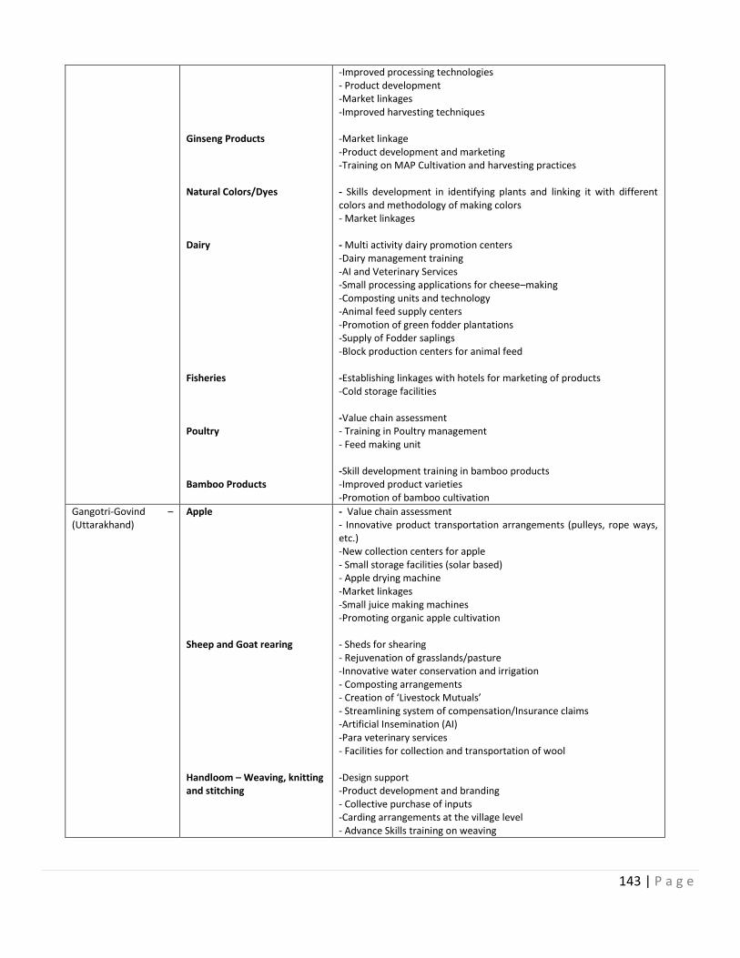
143 | P a g e
Ginseng Products Natural Colors/Dyes Dairy Fisheries Poultry Bamboo Products
-Improved processing technologies - Product development -Market linkages -Improved harvesting techniques -Market linkage -Product development and marketing -Training on MAP Cultivation and harvesting practices - Skills development in identifying plants and linking it with different colors and methodology of making colors - Market linkages - Multi activity dairy promotion centers -Dairy management training -AI and Veterinary Services -Small processing applications for cheese–making -Composting units and technology -Animal feed supply centers -Promotion of green fodder plantations -Supply of Fodder saplings -Block production centers for animal feed -Establishing linkages with hotels for marketing of products -Cold storage facilities -Value chain assessment - Training in Poultry management - Feed making unit -Skill development training in bamboo products -Improved product varieties -Promotion of bamboo cultivation
Gangotri-Govind – (Uttarakhand)
Apple Sheep and Goat rearing Handloom – Weaving, knitting and stitching
- Value chain assessment - Innovative product transportation arrangements (pulleys, rope ways, etc.) -New collection centers for apple - Small storage facilities (solar based) - Apple drying machine -Market linkages -Small juice making machines -Promoting organic apple cultivation - Sheds for shearing - Rejuvenation of grasslands/pasture -Innovative water conservation and irrigation - Composting arrangements - Creation of ‘Livestock Mutuals’ - Streamlining system of compensation/Insurance claims -Artificial Insemination (AI) -Para veterinary services - Facilities for collection and transportation of wool -Design support -Product development and branding - Collective purchase of inputs -Carding arrangements at the village level - Advance Skills training on weaving
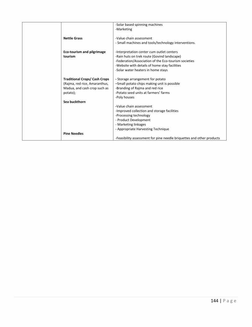
144 | P a g e
Nettle Grass Eco-tourism and pilgrimage tourism Traditional Crops/ Cash Crops (Rajma, red rice, Amaranthus, Madua, and cash crop such as potato); Sea buckthorn Pine Needles
-Solar based spinning machines -Marketing -Value chain assessment - Small machines and tools/technology interventions. -Interpretation center cum outlet centers -Rain huts on trek route (Govind landscape) -Federation/Association of the Eco-tourism societies -Website with details of home stay facilities -Solar water heaters in home stays - Storage arrangement for potato –Small potato chips making unit is possible -Branding of Rajma and red rice -Potato seed units at farmers’ farms -Poly houses -Value chain assessment -Improved collection and storage facilities -Processing technology - Product Development - Marketing linkages - Appropriate Harvesting Technique -Feasibility assessment for pine needle briquettes and other products
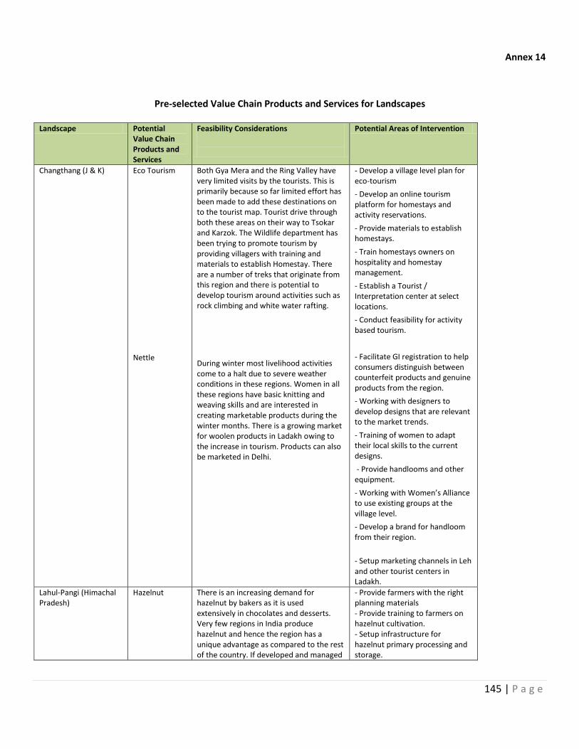
145 | P a g e
Annex 14
Pre-selected Value Chain Products and Services for Landscapes
Landscape Potential Value Chain Products and Services
Feasibility Considerations
Potential Areas of Intervention
Changthang (J & K) Eco Tourism Nettle
Both Gya Mera and the Ring Valley have very limited visits by the tourists. This is primarily because so far limited effort has been made to add these destinations on to the tourist map. Tourist drive through both these areas on their way to Tsokar and Karzok. The Wildlife department has been trying to promote tourism by providing villagers with training and materials to establish Homestay. There are a number of treks that originate from this region and there is potential to develop tourism around activities such as rock climbing and white water rafting.
During winter most livelihood activities come to a halt due to severe weather conditions in these regions. Women in all these regions have basic knitting and weaving skills and are interested in creating marketable products during the winter months. There is a growing market for woolen products in Ladakh owing to the increase in tourism. Products can also be marketed in Delhi.
- Develop a village level plan for eco-tourism
- Develop an online tourism platform for homestays and activity reservations.
- Provide materials to establish homestays.
- Train homestays owners on hospitality and homestay management.
- Establish a Tourist / Interpretation center at select locations.
- Conduct feasibility for activity based tourism.
- Facilitate GI registration to help consumers distinguish between counterfeit products and genuine products from the region.
- Working with designers to develop designs that are relevant to the market trends.
- Training of women to adapt their local skills to the current designs.
- Provide handlooms and other equipment.
- Working with Women’s Alliance to use existing groups at the village level.
- Develop a brand for handloom from their region.
- Setup marketing channels in Leh and other tourist centers in Ladakh.
Lahul-Pangi (Himachal Pradesh)
Hazelnut
There is an increasing demand for hazelnut by bakers as it is used extensively in chocolates and desserts. Very few regions in India produce hazelnut and hence the region has a unique advantage as compared to the rest of the country. If developed and managed
- Provide farmers with the right planning materials - Provide training to farmers on hazelnut cultivation. - Setup infrastructure for hazelnut primary processing and storage.
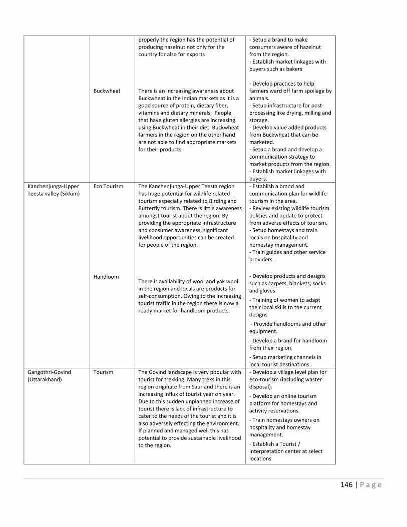
146 | P a g e
Buckwheat
properly the region has the potential of producing hazelnut not only for the country for also for exports There is an increasing awareness about Buckwheat in the Indian markets as it is a good source of protein, dietary fiber, vitamins and dietary minerals. People that have gluten allergies are increasing using Buckwheat in their diet. Buckwheat farmers in the region on the other hand are not able to find appropriate markets for their products.
- Setup a brand to make consumers aware of hazelnut from the region. - Establish market linkages with buyers such as bakers - Develop practices to help farmers ward off farm spoilage by animals. - Setup infrastructure for post-processing like drying, milling and storage. - Develop value added products from Buckwheat that can be marketed. - Setup a brand and develop a communication strategy to market products from the region. - Establish market linkages with buyers.
Kanchenjunga-Upper Teesta valley (Sikkim)
Eco Tourism
Handloom
The Kanchenjunga-Upper Teesta region has huge potential for wildlife related tourism especially related to Birding and Butterfly tourism. There is little awareness amongst tourist about the region. By providing the appropriate infrastructure and consumer awareness, significant livelihood opportunities can be created for people of the region. There is availability of wool and yak wool in the region and locals are products for self-consumption. Owing to the increasing tourist traffic in the region there is now a ready market for handloom products.
- Establish a brand and communication plan for wildlife tourism in the area. - Review existing wildlife tourism policies and update to protect from adverse effects of tourism. - Setup homestays and train locals on hospitality and homestay management. - Train guides and other service providers.
- Develop products and designs such as carpets, blankets, socks and gloves.
- Training of women to adapt their local skills to the current designs.
- Provide handlooms and other equipment.
- Develop a brand for handloom from their region.
- Setup marketing channels in local tourist destinations.
Gangothri-Govind (Uttarakhand)
Tourism
The Govind landscape is very popular with tourist for trekking. Many treks in this region originate from Saur and there is an increasing influx of tourist year on year. Due to this sudden unplanned increase of tourist there is lack of infrastructure to cater to the needs of the tourist and it is also adversely effecting the environment. If planned and managed well this has potential to provide sustainable livelihood to the region.
- Develop a village level plan for eco-tourism (including waster disposal).
- Develop an online tourism platform for homestays and activity reservations.
- Train homestays owners on hospitality and homestay management.
- Establish a Tourist / Interpretation center at select locations.
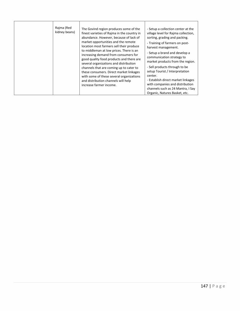
147 | P a g e
Rajma (Red kidney beans)
The Govind region produces some of the finest varieties of Rajma in the country in abundance. However, because of lack of market opportunities and the remote location most farmers sell their produce to middleman at low prices. There is an increasing demand from consumers for good quality food products and there are several organizations and distribution channels that are coming up to cater to these consumers. Direct market linkages with some of these several organizations and distribution channels will help increase farmer income.
- Setup a collection center at the village level for Rajma collection, sorting, grading and packing.
- Training of farmers on post-harvest management.
- Setup a brand and develop a communication strategy to market products from the region.
- Sell products through to be setup Tourist / Interpretation center. - Establish direct market linkages with companies and distribution channels such as 24 Mantra, I Say Organic, Natures Basket, etc.
148 | P a g e
Annex 15
Communication and Knowledge Management Strategy
The communication strategy is designed to create bridges between the stakeholders from the grass-root to the national and global level, for flow of information, exchange of ideas; knowledge management and implementation. It will also help build visibility to the conservation needs of the landscape by helping connect policy makers, media, research and academic institutes, private sector, NGOs and general public, through a comprehensive program, from consultations, brand building to outreach and awareness.
The core intent of the communication strategy is to instill within the stakeholders, an ownership to the goals of the project – shared knowledge, experiences, inputs and ideas for effective action. The idea would be to create systems that facilitate and generate a common vision for SECURING HIMALAYAS for the future.
The communication strategy for SECURE HIMLAYAS will focus on strengthening, as well as creating the links that pertain to different dimensions of the project. The two primary areas of operation will be the Internal circle – which includes the key stakeholders who are directly associated with the project, and the Outer Circle which includes stakeholders who need to be included, involved and made aware of the significance of protecting the Himalayan Landscape, and how it is critical for the nation.
Internal Circle: Specific to landscape and within key stakeholders
Internal links between the key stakeholders from the local to the national level (refer Stakeholder Involvement Matrix)
Enabling an interface for a balanced approach to conservation and livelihood improvement
Creating platforms for constructive exchange of information between science and traditional knowledge, leading to participatory action
Building capacities at local level for sustained work on communication
Creating participatory and consultative spaces for reviewing policy and legislation
Collaborating with communication departments and specialists at a regional level for promotion of the values of the project
Outer Circle: Outreach to other stakeholders, branding and general public connect
Embedding the core idea of Himalayas as the source of life/water for rest of India
Giving SECURE Himalayas landscape a visibility at a national and global level
Creating a brand for SECURE HIMALAYAS as a landscape
Mainstreaming the idea of conserving the HIMALAYAS among general public
Engaging and building a consortium of communication specialists for the project

149 | P a g e
Approach to Developing Strategy
The approach to develop and implement the communication strategy will be step by step (i) developing insights (ii) developing intervention and tools and (iii) plan and implementation of communication strategy.
Developing insight for assessment of communication needs
A baseline will be established with regard to different aspects of communication and advocacy.
Communication gaps between stake-holders (both internal and outer circles)
Awareness of the concerns and needs from the local to national level
Communication mediums available in the landscapes and at the outer scope
This baseline will help to design the intervention and set up markers for monitoring and evaluation of the strategy, and also measure to some degree the change in attitude, adoption of methodology, awareness about the different components and the extent of involvement among the stakeholders.
Some of the physical challenges across the landscapes are common such as accessibility, erratic communication network, vulnerability to natural disasters, water crisis and climate variability. In addition, to the physical barriers, the communication needs, specific to regions and stakeholders was also considered, such as the relationship between departments and communities, perceptions of conservation linked livelihood, presence of active NGOs or community collectives during the design of the strategy.
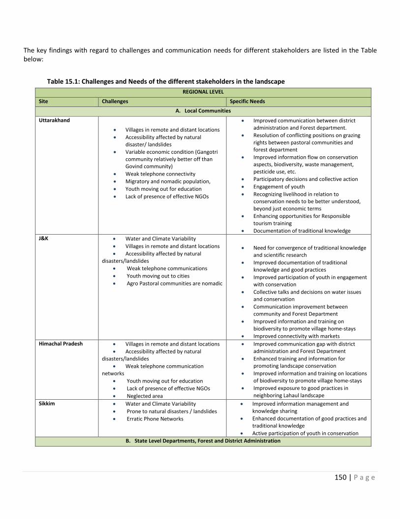
150 | P a g e
The key findings with regard to challenges and communication needs for different stakeholders are listed in the Table below:
Table 15.1: Challenges and Needs of the different stakeholders in the landscape
REGIONAL LEVEL
Site Challenges Specific Needs
A. Local Communities
Uttarakhand
Villages in remote and distant locations
Accessibility affected by natural disaster/ landslides
Variable economic condition (Gangotri community relatively better off than Govind community)
Weak telephone connectivity
Migratory and nomadic population,
Youth moving out for education
Lack of presence of effective NGOs
Improved communication between district administration and Forest department.
Resolution of conflicting positions on grazing rights between pastoral communities and forest department
Improved information flow on conservation aspects, biodiversity, waste management, pesticide use, etc.
Participatory decisions and collective action
Engagement of youth
Recognizing livelihood in relation to conservation needs to be better understood, beyond just economic terms
Enhancing opportunities for Responsible tourism training
Documentation of traditional knowledge
J&K Water and Climate Variability
Villages in remote and distant locations
Accessibility affected by natural disasters/landslides
Weak telephone communications
Youth moving out to cities
Agro Pastoral communities are nomadic
Need for convergence of traditional knowledge and scientific research
Improved documentation of traditional knowledge and good practices
Improved participation of youth in engagement with conservation
Collective talks and decisions on water issues and conservation
Communication improvement between community and Forest Department
Improved information and training on biodiversity to promote village home-stays
Improved connectivity with markets
Himachal Pradesh Villages in remote and distant locations
Accessibility affected by natural disasters/landslides
Weak telephone communication networks
Youth moving out for education
Lack of presence of effective NGOs
Neglected area
Improved communication gap with district administration and Forest Department
Enhanced training and information for promoting landscape conservation
Improved information and training on locations of biodiversity to promote village home-stays
Improved exposure to good practices in neighboring Lahaul landscape
Sikkim Water and Climate Variability
Prone to natural disasters / landslides
Erratic Phone Networks
Improved information management and knowledge sharing
Enhanced documentation of good practices and traditional knowledge
Active participation of youth in conservation
B. State Level Departments, Forest and District Administration
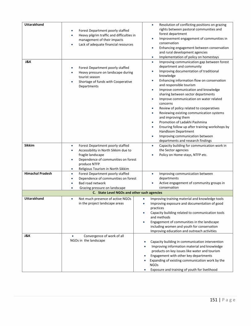
151 | P a g e
Uttarakhand
Forest Department poorly staffed
Heavy pilgrim traffic and difficulties in management of their impacts
Lack of adequate financial resources
Resolution of conflicting positions on grazing rights between pastoral communities and forest department
Improvement engagement of communities in conservation
Enhancing engagement between conservation and rural development agencies
Implementation of policy on homestays
J&K
Forest Department poorly staffed
Heavy pressure on landscape during tourist season
Shortage of funds with Cooperative Departments
Improving communication gap between forest department and community
Improving documentation of traditional knowledge
Enhancing information flow on conservation and responsible tourism
Improve communication and knowledge sharing between sector departments
Improve communication on water related concerns
Review of policy related to cooperatives
Reviewing existing communication systems and improving them
Promotion of Ladakhi Pashmina
Ensuring follow up after training workshops by Handloom Department
Improving communication between departments and research findings
Sikkim Forest Department poorly staffed
Accessibility in North Sikkim due to fragile landscape
Dependence of communities on forest produce NTFP
Religious Tourism in North Sikkim
Capacity building for communication work in the Sector agencies
Policy on Home-stays, NTFP etc.
Himachal Pradesh Forest Department poorly staffed
Dependence of communities on forest
Bad road network
Grazing pressure on landscape
Improving communication between departments
Active engagement of community groups in conservation
C. State Level NGOs and other such agencies
Uttarakhand Not much presence of active NGOs in the project landscape areas
Improving training material and knowledge tools
Improving exposure and documentation of good practices
Capacity building related to communication tools and methods
Engagement of communities in the landscape including women and youth for conservation Improving education and outreach activities
J&K Convergence of work of all NGOs in the landscape
Capacity building in communication intervention
Improving information material and knowledge products on key issues like water and tourism
Engagement with other key departments
Expanding of existing communication work by the NGOs
Exposure and training of youth for livelihood
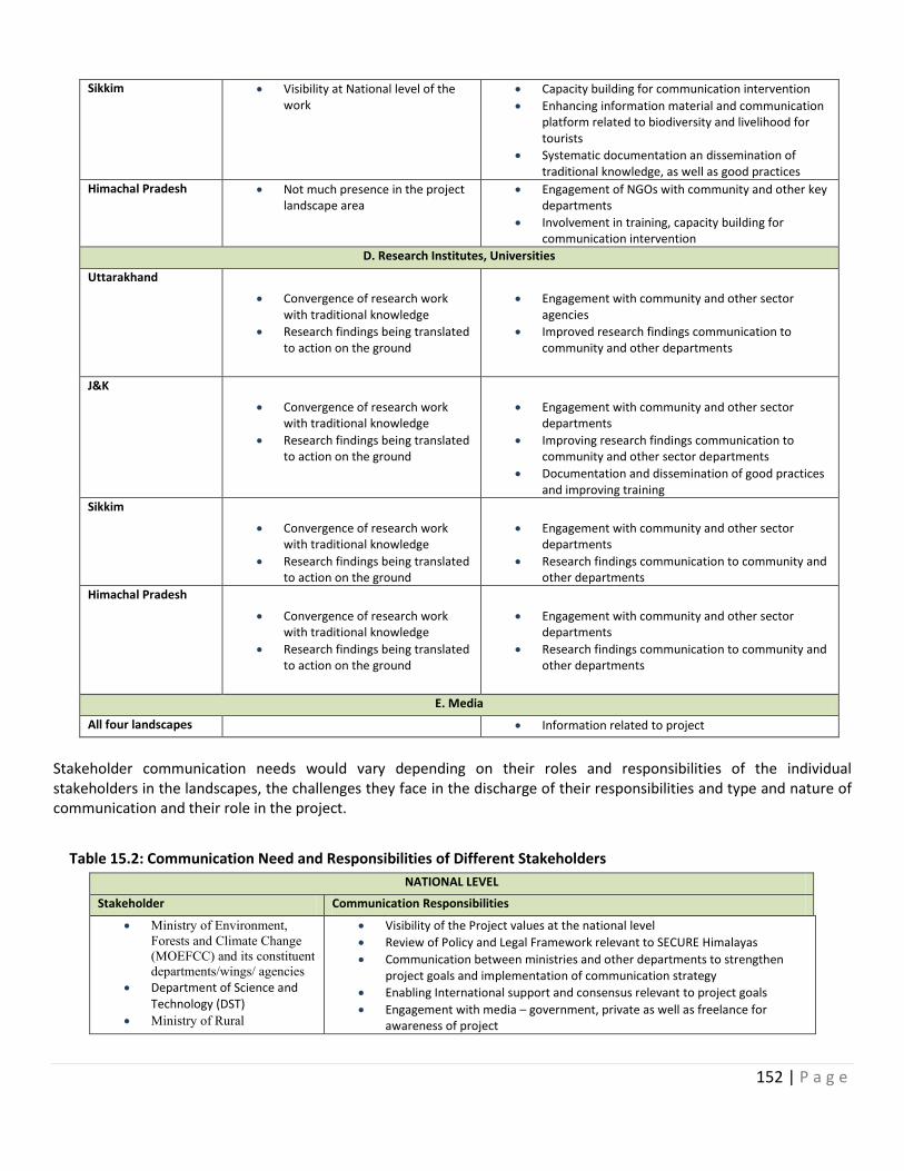
152 | P a g e
Sikkim Visibility at National level of the work
Capacity building for communication intervention
Enhancing information material and communication platform related to biodiversity and livelihood for tourists
Systematic documentation an dissemination of traditional knowledge, as well as good practices
Himachal Pradesh Not much presence in the project landscape area
Engagement of NGOs with community and other key departments
Involvement in training, capacity building for communication intervention
D. Research Institutes, Universities
Uttarakhand
Convergence of research work with traditional knowledge
Research findings being translated to action on the ground
Engagement with community and other sector agencies
Improved research findings communication to community and other departments
J&K
Convergence of research work with traditional knowledge
Research findings being translated to action on the ground
Engagement with community and other sector departments
Improving research findings communication to community and other sector departments
Documentation and dissemination of good practices and improving training
Sikkim
Convergence of research work with traditional knowledge
Research findings being translated to action on the ground
Engagement with community and other sector departments
Research findings communication to community and other departments
Himachal Pradesh
Convergence of research work with traditional knowledge
Research findings being translated to action on the ground
Engagement with community and other sector departments
Research findings communication to community and other departments
E. Media
All four landscapes Information related to project
Stakeholder communication needs would vary depending on their roles and responsibilities of the individual stakeholders in the landscapes, the challenges they face in the discharge of their responsibilities and type and nature of communication and their role in the project.
Table 15.2: Communication Need and Responsibilities of Different Stakeholders
NATIONAL LEVEL
Stakeholder Communication Responsibilities
Ministry of Environment,
Forests and Climate Change
(MOEFCC) and its constituent
departments/wings/ agencies
Department of Science and Technology (DST)
Ministry of Rural
Visibility of the Project values at the national level
Review of Policy and Legal Framework relevant to SECURE Himalayas
Communication between ministries and other departments to strengthen project goals and implementation of communication strategy
Enabling International support and consensus relevant to project goals
Engagement with media – government, private as well as freelance for awareness of project
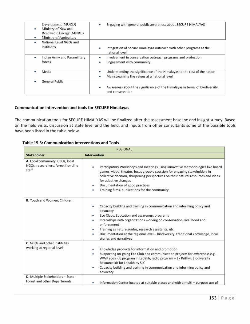
153 | P a g e
Development (MORD)
Ministry of New and
Renewable Energy (MNRE)
Ministry of Agriculture
Engaging with general public awareness about SECURE HIMALYAS
National Level NGOs and Institutes
Integration of Secure Himalayas outreach with other programs at the national level
Indian Army and Paramilitary forces
Involvement in conservation outreach programs and protection
Engagement with community
Media Understanding the significance of the Himalayas to the rest of the nation
Mainstreaming the values at a national level
General Public
Awareness about the significance of the Himalayas in terms of biodiversity and conservation
Communication intervention and tools for SECURE Himalayas
The communication tools for SECURE HIMALYAS will be finalized after the assessment baseline and insight survey. Based on the field visits, discussion at state level and the field, and inputs from other consultants some of the possible tools have been listed in the table below.
Table 15.3: Communication Interventions and Tools
REGIONAL
Stakeholder Intervention
A. Local community, CBOs, local NGOs, researchers, forest frontline staff
Participatory Workshops and meetings using innovative methodologies like board games, video, theater, focus group discussion for engaging stakeholders in collective decision, sharpening perspectives on their natural resources and ideas for adaptive changes
Documentation of good practices
Training films, publications for the community
B. Youth and Women, Children
Capacity building and training in communication and informing policy and advocacy
Eco Clubs, Education and awareness programs
Internships with organizations working on conservation, livelihood and enforcement
Training as nature guides, research assistants, etc.
Documentation at the regional level – biodiversity, traditional knowledge, local stories and narratives
C. NGOs and other institutes working at regional level
Knowledge products for information and promotion
Supporting on-going Eco Club and communication projects for awareness e.g. - WWF eco club program in Ladakh, radio program – Ek Prithvi; Biodiversity Resource kit for Ladakh by SLC
Capacity building and training in communication and informing policy and advocacy
D. Multiple Stakeholders – State Forest and other Departments,
Information Center located at suitable places and with a multi – purpose use of
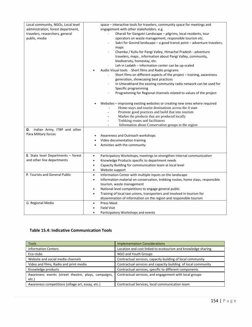
154 | P a g e
Local community, NGOs, Local level administration, forest department, travelers, researchers, general public, media
space – interactive tools for travelers, community space for meetings and engagement with other stakeholders. e.g.
- Dharali for Gangotri Landscape – pilgrims, local residents, tour operators on waste management, responsible tourism etc.
- Sakri for Govind landscape – a good transit point – adventure travelers, maps
- Chamba / Kullu for Pangi Valley, Himachal Pradesh - adventure travelers, maps , information about Pangi Valley, community, biodiversity, homestay, etc.
- Leh in Ladakh – information center can be up-scaled
Audio Visual tools - Short films and Radio programs - Short films on different aspects of the project – training, awareness
generation, showcasing best practices - In Uttarakhand the existing community radio network can be used for
Specific programming - Programming for Regional channels related to values of the project
Websites – improving existing websites or creating new ones where required - Home-stays and tourist destinations across the 4 state
- Promote good practices and build that into tourism
- Market the products that are produced locally
- Trekking routes and facilitators
- Information about Conservation groups in the region D. Indian Army, ITBP and other Para Military forces
Awareness and Outreach workshops
Video documentation training
Activities with the community
E. State level Departments – forest and other line departments
Participatory Workshops, meetings to strengthen internal communication
Knowledge Products specific to department needs
Capacity Building for communication team at local level
Website support
F. Tourists and General Public Information Center with multiple inputs on the landscape
Information material on conservation, trekking routes, home stays, responsible tourism, waste management
National level competitions to engage general public
Training of local taxi unions, transporters and involved in tourism for dissemination of information on the region and responsible tourism
G. Regional Media Press Meet
Field Visit
Participatory Workshops and events
Table 15.4: Indicative Communication Tools
Tools Implementation Considerations
Information Centers Location and cost linked to ecotourism and knowledge sharing
Eco-clubs NGO and Youth Groups
Website and social media channels Contractual services, capacity building of local community
Video and films, Radio and print media Contractual services and capacity building of local community
Knowledge products Contractual services, specific to different components
Awareness events (street theatre, plays, campaigns, etc.)
Contractual services, and engagement with local groups
Awareness competitions (village art, essay, etc.) Contractual Services, local communication team
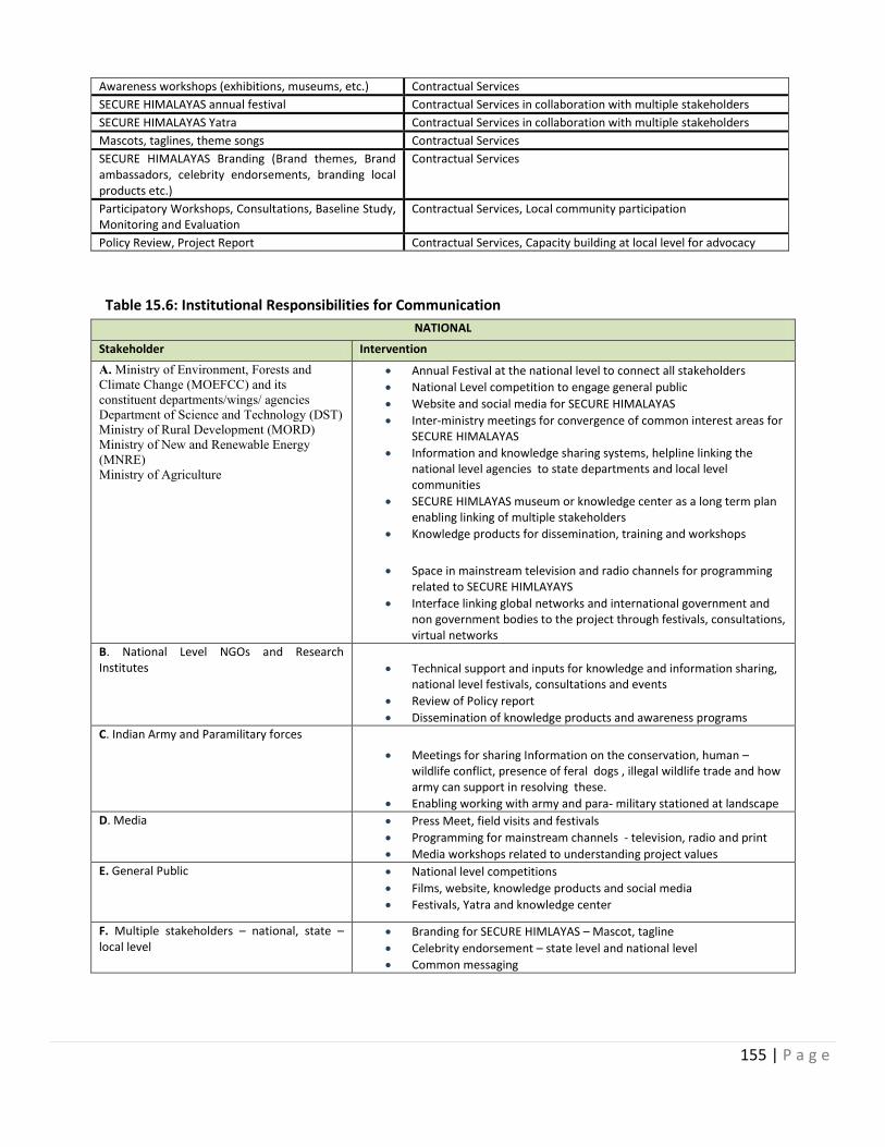
155 | P a g e
Awareness workshops (exhibitions, museums, etc.) Contractual Services
SECURE HIMALAYAS annual festival Contractual Services in collaboration with multiple stakeholders
SECURE HIMALAYAS Yatra Contractual Services in collaboration with multiple stakeholders
Mascots, taglines, theme songs Contractual Services
SECURE HIMALAYAS Branding (Brand themes, Brand ambassadors, celebrity endorsements, branding local products etc.)
Contractual Services
Participatory Workshops, Consultations, Baseline Study, Monitoring and Evaluation
Contractual Services, Local community participation
Policy Review, Project Report Contractual Services, Capacity building at local level for advocacy
Table 15.6: Institutional Responsibilities for Communication
NATIONAL
Stakeholder Intervention
A. Ministry of Environment, Forests and
Climate Change (MOEFCC) and its
constituent departments/wings/ agencies
Department of Science and Technology (DST)
Ministry of Rural Development (MORD)
Ministry of New and Renewable Energy
(MNRE)
Ministry of Agriculture
Annual Festival at the national level to connect all stakeholders
National Level competition to engage general public
Website and social media for SECURE HIMALAYAS
Inter-ministry meetings for convergence of common interest areas for SECURE HIMALAYAS
Information and knowledge sharing systems, helpline linking the national level agencies to state departments and local level communities
SECURE HIMLAYAS museum or knowledge center as a long term plan enabling linking of multiple stakeholders
Knowledge products for dissemination, training and workshops
Space in mainstream television and radio channels for programming related to SECURE HIMLAYAYS
Interface linking global networks and international government and non government bodies to the project through festivals, consultations, virtual networks
B. National Level NGOs and Research Institutes
Technical support and inputs for knowledge and information sharing, national level festivals, consultations and events
Review of Policy report
Dissemination of knowledge products and awareness programs
C. Indian Army and Paramilitary forces
Meetings for sharing Information on the conservation, human – wildlife conflict, presence of feral dogs , illegal wildlife trade and how army can support in resolving these.
Enabling working with army and para- military stationed at landscape
D. Media Press Meet, field visits and festivals
Programming for mainstream channels - television, radio and print
Media workshops related to understanding project values
E. General Public National level competitions
Films, website, knowledge products and social media
Festivals, Yatra and knowledge center
F. Multiple stakeholders – national, state – local level
Branding for SECURE HIMLAYAS – Mascot, tagline
Celebrity endorsement – state level and national level
Common messaging
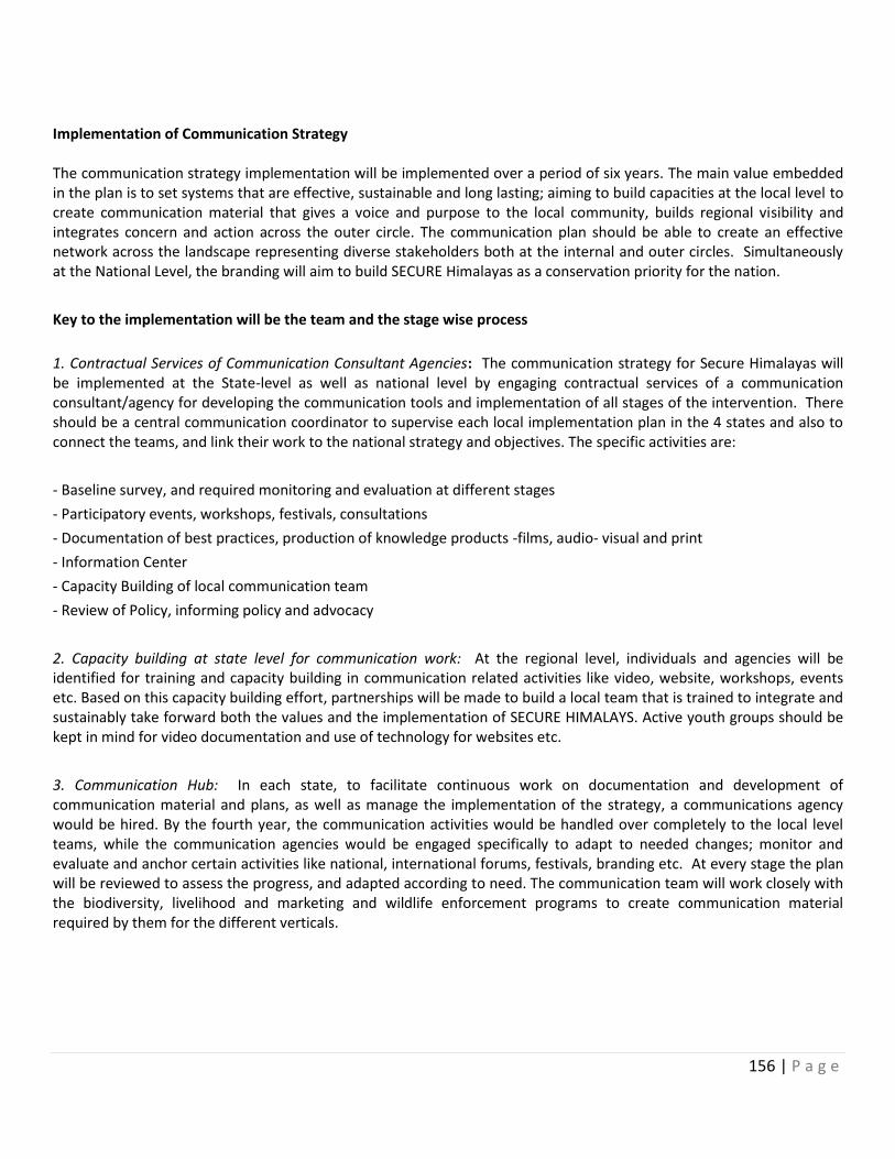
156 | P a g e
Implementation of Communication Strategy The communication strategy implementation will be implemented over a period of six years. The main value embedded in the plan is to set systems that are effective, sustainable and long lasting; aiming to build capacities at the local level to create communication material that gives a voice and purpose to the local community, builds regional visibility and integrates concern and action across the outer circle. The communication plan should be able to create an effective network across the landscape representing diverse stakeholders both at the internal and outer circles. Simultaneously at the National Level, the branding will aim to build SECURE Himalayas as a conservation priority for the nation.
Key to the implementation will be the team and the stage wise process
1. Contractual Services of Communication Consultant Agencies: The communication strategy for Secure Himalayas will be implemented at the State-level as well as national level by engaging contractual services of a communication consultant/agency for developing the communication tools and implementation of all stages of the intervention. There should be a central communication coordinator to supervise each local implementation plan in the 4 states and also to connect the teams, and link their work to the national strategy and objectives. The specific activities are:
- Baseline survey, and required monitoring and evaluation at different stages
- Participatory events, workshops, festivals, consultations
- Documentation of best practices, production of knowledge products -films, audio- visual and print
- Information Center
- Capacity Building of local communication team
- Review of Policy, informing policy and advocacy
2. Capacity building at state level for communication work: At the regional level, individuals and agencies will be identified for training and capacity building in communication related activities like video, website, workshops, events etc. Based on this capacity building effort, partnerships will be made to build a local team that is trained to integrate and sustainably take forward both the values and the implementation of SECURE HIMALAYS. Active youth groups should be kept in mind for video documentation and use of technology for websites etc.
3. Communication Hub: In each state, to facilitate continuous work on documentation and development of communication material and plans, as well as manage the implementation of the strategy, a communications agency would be hired. By the fourth year, the communication activities would be handled over completely to the local level teams, while the communication agencies would be engaged specifically to adapt to needed changes; monitor and evaluate and anchor certain activities like national, international forums, festivals, branding etc. At every stage the plan will be reviewed to assess the progress, and adapted according to need. The communication team will work closely with the biodiversity, livelihood and marketing and wildlife enforcement programs to create communication material required by them for the different verticals.
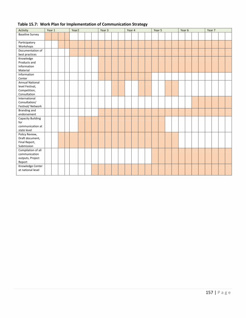
157 | P a g e
Table 15.7: Work Plan for Implementation of Communication Strategy
Activity Year 1 Year2 Year 3 Year 4 Year 5 Year 6 Year 7
Baseline Survey
Participatory Workshops
Documentation of best practices
Knowledge Products and Information Material
Information Center
Annual National level Festival, Competition, Consultation
International Consultation/ Festival/ Network
Branding and endorsement
Capacity Building for communication at state level
Policy Review, Draft document, Final Report, Submission
Compilation of all communication outputs, Project Report
Knowledge Center at national level
158 | P a g e
Annex 16
Gender Analysis and Action Plan Gender equality is one of 17 Global Goals that make up the 2030 Agenda for Sustainable Development. An integrated approach is crucial for progress across the multiple goals. According to the Global Gender Gap Report released by the World Economic Forum (WEF) in 2011, India was ranked 113 on the Gender Gap Index (GGI) among 135 countries polled. Since then, India has improved its rankings on the World Economic Forum's Gender Gap Index (GGI) to 105/136 in 2013. Gender inequality in India persists despite high rates of economic growth, and is particularly apparent among marginalized groups. Women participate in employment and decision making much less, than men. India’s poor performance on women’s empowerment and gender equality is reflected in many indicators, particularly, the low sex ratio. The government has launched several commendable schemes to save and educate the girl child and the national average has risen from 943 females per 1000 males. However, in many parts of India it continues to remains low. Gender inequality is also reflected in India’s low rank on UNDP’s Gender Inequality Index. In 2014, the country ranked 127 out of 146 countries with a value of 0.563. Women play a crucial role in mountain societies as a very significant proportion of the work force in food production (FAO, 2011) and as key players in managing and sustaining their natural resources and environments. Development reports have increasingly acknowledged that there is a need for women to participate in proportionate numbers in the management of land and trading opportunities in the local markets. In the context of growing feminization of agricultural work and the informal sector, women need appropriate skills and unmediated control of land and related production inputs in order to successfully manage their lives and increase agricultural productivity. An UNWomen survey report (2014) reveals that several improved cook stove interventions, in China, India and Kenya, have simultaneously improved household air pollution and potentially improved women’s respiratory health, though the latter has been challenging to measure.
A FAO study reveals an interesting fact about land ownership by women - “In Asia, women carry out a disproportionate amount of agricultural, income-generating, household, care, and community work, yet they own no more than about 11% of the land, which is far below the global average of 20% of land owned by women (FAO 2010). Women’s ownership of land does not only lead to higher and better quality production. It can enable them to control the use of household income for the well-being of themselves and other members of the household. A growing number of econometrically robust studies show that land and asset ownership by women has significantly better outcomes for their agency as well as for child survival, education and health, than those owned only by men (Agarwal 1994, Kelkar 1992, Government of India 2004). (http://lib.icimod.org/record/26861/files/attachment_704.pdf)
A paper on Gender Equality from ICIMOD in the journal Mountain Research and Development reveals that “Mountain women—especially those living in remote rural areas—face a number of challenges, including limited access to development services, information, credit, opportunities, governance institutions, and productive resources such as land, livestock, inputs, income, and culturally appropriate technologies. Their work burden is often extremely heavy because of their multiple responsibilities in farming, livestock herding, water and forest management, and household and community life. Yet they continue to be underrepresented in decision making forums and institutions, and they experience numerous and sometime insidious forms of gender inequality, including outright gender based violence.”(http://www.bioone.org/doi/pdf/10.1659/MRD-JOURNAL-D-14-00064)
Gender situation in the selected landscapes
159 | P a g e
The labor force participation data of male and females in the selected states of the project reveals the fact that while the labor force participation of females in Himachal Pradesh and Sikkim is quite close to Males however it is quite low in case of Uttarakhand and Jammu and Kashmir (31.5: 46.6 in Uttarakhand) and (26.3: 55.9 in Jammu and Kashmir). The State-wise average Wage/Salary received per day by Regular Wage/Salaried Employees reveals the fact that in Sikkim rural women gets more or less similar amount per day (in Indian Rupees) as men whereas it is much less in case of Uttarakhand (IR 392.71: 457.89), Himachal Pradesh (IR 250.69 :434.72) and Jammu Kashmir (IR 222.37:453.56). National Sample Survey Office,68th Round, July 2011 - June 2012) (http://mospi.nic.in/Mospi_New/upload/man_and_women/Chapter%204.pdf) An analysis of sex ratio in the selected six districts of the four states reveals that fact that while sex ratio in Chamba (1000:989), Uttarkashi (1000:959) West Sikkim (1000:941), and Lahul Spiti (1000:916) is quite satisfactory, it is quite low in North Sikkim (1000:769) and Leh (1000:583). Analysis of Gender issues in the landscapes on various parameters Role and participation of men and women in biodiversity conservation In the selected four landscapes of the project, Gender is a key dimension in sustainable conservation, management, livelihoods and use of biodiversity resources. Women and men have complementary knowledge and perceptions of their natural environment and the biodiversity around them as a result of gender differences in functions, responsibilities, needs, social relations, behaviors, resource accessibility, ownership, and awareness. Gender and social differences, which are location-specific and socially constructed and can be changed, strongly influence the way women and men experience environmental and socioeconomic changes.
It is essential therefore to incorporate gender perspectives into the ecosystem based conservation and livelihood approach. Assimilating g ender perspectives into the ecosystem approach makes us more conscious of the impact of gender in defining roles and responsibilities, the division of labor, needs, knowledge, and inequalities, and the differences inherent in the unequal power relations between men and women in terms of resource use and access. This can help to improve the livelihoods of resource dependent social groups and results in improved gender positive impacts from interventions related to biodiversity resource management.
Gender integration provides a way to acknowledge the different roles that women and men play in resources planning and management, and to create opportunities that enhance women’s exposure, networking, knowledge, and skills and give them a platform to share their concerns, needs, and indigenous and other knowledge. Ultimately it facilitates gender responsive policy solutions to promote equitable ecosystem-based adaptation and improvement of livelihoods.
Biodiversity conservation and management practices are social processes in which women and men across various classes, castes, ages, occupations, and power groups are important actors in helping to conserve, manage, and use biodiversity in a sustainable way. Therefore, diverse elements of gender analysis such as gender roles, responsibilities, division of labor, gender relations of power, and rights, ownership, access to, and control over, biodiversity are useful in analyzing the gender dynamics embedded in biodiversity conservation and management practices.
Men and women undertake different roles, responsibilities and task in biodiversity conservation, management and livelihoods in the project landscapes. Women play a critical role in maintaining and sustaining local-level biodiversity, including the domestication of wild plants, genetic manipulation of plants and animals, and seed management. Despite their lack of representation in local village committees and decision-making, women are more involved in natural resource management than men. Both women and children are involved in the collection of wild species, but more girls are involved than boys because they accompany their mothers while doing farm work. In Govind landscape
160 | P a g e
Uttarakhand, women and children especially girls collect nettle grass from nearby areas and therefore they are conscious about maintaining and expanding the species in the areas.
Status and Project Interventions
As far as involvement of women and men in biodiversity conservation initiatives are concerned, formation of Biodiversity Management Committees is seen in Sikkim and also in Gangotri – Govind Landscape of Uttarakhand. In Uttarakhand these societies are formed with the support of Samvedi (NGO) and training was provided to the committee members wherein issues of biodiversity and wildlife were covered. The committees have three women members. In Sikkim, the Wildlife department has initiated the formation of BMCs and participation of women is being ensured.
Eco Development Committees functioning in Sikkim and also in Uttarakhand have participation of women in the committees. Under the project, strengthening of EDCs with focus on the participation of women will be taken up through various capacity building programs.
Keeping in view the important role being played by the women in biodiversity conservation activities and also their presence in Biodiversity management committee (Seen in Sikkim and Uttarakhand landscapes), capacity building activities related to biodiversity and conservation are proposed in the project for village level conservation committees (VCDCs).
Under the project, the provision of funding for more students to undertake graduate research fieldwork on gender issues of biodiversity would enhance support for making biodiversity research and knowledge products more gender inclusive.
Studies conducted among mountain communities of the Himalayas show that 80 to 90 per cent of the seed requirements of all farm-household crops are met through indigenous seed management and exchange practices, in which the role of women is crucial (Shrestha 1998; Kerkhoff and Sharma 2006). Women’s efforts to preserve, conserve, process, and manage high-quality agricultural seeds are significant. The greater involvement of women in tasks related to biodiversity conservation (such as seed management, the collection of wild edibles, fruit processing, and harvesting) is because of socially constructed gender roles in which women are primarily responsible for food production. In comparison, men are generally responsible for off-farm and cash-oriented activities such as contract work, daily wage labor, employment, and the marketing of high-value agriculture and forest products. This has been observed in all the landscapes while discussing with women stakeholders. For example – in villages along the Rong valley men are more engaged in labour work of road and construction and women do agriculture activities and weaving related activities besides the household works. Seed management is also done by women.
Village Conservation Committees with their livelihood related to alpine ecosystems and rangelands would have at least 30 per cent female members who would actively attend the VCDCs meetings and would be involved in various project initiatives. To the extent feasible, landscape-planning teams will have local women community mobilizers who would be involved in social mobilization to encourage greater participation of women from local communities. Women’s preferences for various forest species are based on their multipurpose household uses, whereas men’s preferences are more focused on timber production for cash and construction purposes (Observed in the Bitri Village, Govind landscape). It was found that women were more likely to describe wood species based on specific fuel wood characteristics such as heat and light producing capacity and the time taken to burn, while men’s knowledge of wood species tended to be structured around their suitability for furniture making, thatching, and making sheds and shelters.
These differences demonstrate that women and men prefer to use rangeland and forest resources and agricultural crops for different purposes, and these purposes are often influenced by their gender roles. Indigenous knowledge associated with plant resources is also gendered, with men and women having different knowledge about species and their uses (UNDP 2007).
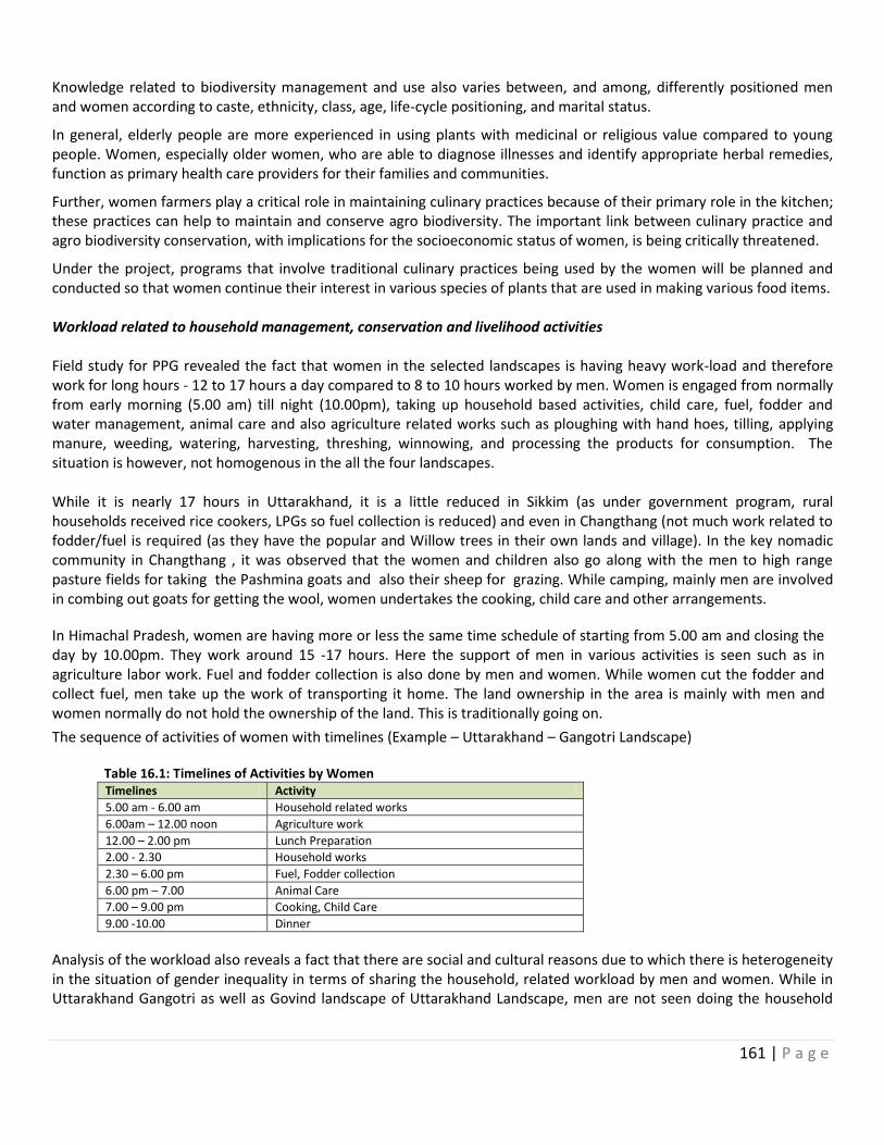
161 | P a g e
Knowledge related to biodiversity management and use also varies between, and among, differently positioned men and women according to caste, ethnicity, class, age, life-cycle positioning, and marital status.
In general, elderly people are more experienced in using plants with medicinal or religious value compared to young people. Women, especially older women, who are able to diagnose illnesses and identify appropriate herbal remedies, function as primary health care providers for their families and communities.
Further, women farmers play a critical role in maintaining culinary practices because of their primary role in the kitchen; these practices can help to maintain and conserve agro biodiversity. The important link between culinary practice and agro biodiversity conservation, with implications for the socioeconomic status of women, is being critically threatened.
Under the project, programs that involve traditional culinary practices being used by the women will be planned and conducted so that women continue their interest in various species of plants that are used in making various food items. Workload related to household management, conservation and livelihood activities Field study for PPG revealed the fact that women in the selected landscapes is having heavy work-load and therefore work for long hours - 12 to 17 hours a day compared to 8 to 10 hours worked by men. Women is engaged from normally from early morning (5.00 am) till night (10.00pm), taking up household based activities, child care, fuel, fodder and water management, animal care and also agriculture related works such as ploughing with hand hoes, tilling, applying manure, weeding, watering, harvesting, threshing, winnowing, and processing the products for consumption. The situation is however, not homogenous in the all the four landscapes. While it is nearly 17 hours in Uttarakhand, it is a little reduced in Sikkim (as under government program, rural households received rice cookers, LPGs so fuel collection is reduced) and even in Changthang (not much work related to fodder/fuel is required (as they have the popular and Willow trees in their own lands and village). In the key nomadic community in Changthang , it was observed that the women and children also go along with the men to high range pasture fields for taking the Pashmina goats and also their sheep for grazing. While camping, mainly men are involved in combing out goats for getting the wool, women undertakes the cooking, child care and other arrangements.
In Himachal Pradesh, women are having more or less the same time schedule of starting from 5.00 am and closing the day by 10.00pm. They work around 15 -17 hours. Here the support of men in various activities is seen such as in agriculture labor work. Fuel and fodder collection is also done by men and women. While women cut the fodder and collect fuel, men take up the work of transporting it home. The land ownership in the area is mainly with men and women normally do not hold the ownership of the land. This is traditionally going on.
The sequence of activities of women with timelines (Example – Uttarakhand – Gangotri Landscape) Table 16.1: Timelines of Activities by Women
Timelines Activity
5.00 am - 6.00 am Household related works
6.00am – 12.00 noon Agriculture work
12.00 – 2.00 pm Lunch Preparation
2.00 - 2.30 Household works
2.30 – 6.00 pm Fuel, Fodder collection
6.00 pm – 7.00 Animal Care
7.00 – 9.00 pm Cooking, Child Care
9.00 -10.00 Dinner
Analysis of the workload also reveals a fact that there are social and cultural reasons due to which there is heterogeneity in the situation of gender inequality in terms of sharing the household, related workload by men and women. While in Uttarakhand Gangotri as well as Govind landscape of Uttarakhand Landscape, men are not seen doing the household
162 | P a g e
works as well as managing fodder and fuel from the forest, whereas in Sikkim men are seen doing these activities. In Changthang area of Leh, wherein majority of people follow Buddhism, it was observed during the field visits that in most of the cases, men and women are equally sharing the load of work either it is household related or livelihood with some differentiation of work. In Himachal Pradesh, fuel and fodder collection is done by both men and women. While women cut the fodder and collect fuel, men take up the work of transporting it home. Hence, the responsibility of collecting fuel and fodder is shared equally between men and women. The participation in the Panchayat meetings by the project team reveals the fact that the participation of the women in such meetings is not more than 20 percent so this needs to be increased. Table 16.2 Various activities and role of men and women
Activities/ Tasks
Present status/Observations from the landscapes of the project Project intervention
Fodder management
Managing fodder for livestock is primarily the responsibility of women. This seems to be the case in Uttarakhand, where women are fully involved with the task. In West Sikkim men help in fodder collection. In Changthang, collecting fodder from the forest is almost non-existent. In Himachal Pradesh, fodder is cultivated largely in their own fields and dependency on forest is not high (based on field observations) In Himachal Pradesh, for sheep and goat rearing and taking the livestock to the grazing fields, households have made arrangements to engage people on wage basis and do not go themselves with their animals. Each household owns cows, but these animals are mainly stall-fed. They prefer to grow green peas and maize because the residue is used as a fodder for animal. Hence, women in Himachal are involved much less time in hardship tasks related to management of their livestock than in other landscapes.
The will promote fodder plots and fodder banks so as to reduce the burden of fuel wood collection to some extent. In Changthang, Alfalfa (a high value fodder plant) can be promoted to reduce the burden of getting fodder in winter from far off places.
Fuel management Wood collection for fuel has reduced to a large extent after various efforts were made by the government to provide LPGs and innovative smokeless Chulhas. In Changthan, Willow and Popular trees grown by the people in the nearby areas, so fuelwood collection by women from the long distances is not observed. Moreover there is limited forest in Changthang. People use Yak dung to make fuel brickets. Women do engage in making and drying yak dung brickets. In other landscapes, women forest wood for use as fuel. In Himachal Pradesh, dependency on forest for fuel is limited. People use LPG for cooking, but in winters, they collect fuel wood from nearby forest areas. In Lahul area, fuelwood is collected nearby areas so women do carry loads long distances. Moreover, in Lahul area wherein land holdings are slightly bigger and households have fuel wood trees on their own lands or nearby areas, women spend less time collecting fuel and fodder.
Distribution of LPGs, cookers, solar cookers, solar lamps under government programs has reduced the dependency on forest for fuel. The project will promote this through convergence with line department programs and awareness generation initiatives. This will further reduce the workload of women.
Water for drinking and Irrigation
Irrigation for the agriculture is mainly the responsibility of men. In some of the landscapes, one family in the village is given charge of managing the distribution of water. There are no conflicts reported. For drinking water, in some cases women do collect water from available sources (Govind landscape, Uttarakhand). In Himachal Pradesh, in the Lahul area water arrangements for irrigation and drinking water are good. Sprinklers are widely used by the farmers that reduce the need and wastage of water. In the
The Project proposes the rejuvenation of grasslands and therefore arrangement for water lifting, tanks for water conservation (LPDE) tanks and solar water lifting arrangements will be necessary.
163 | P a g e
villages in Pangi, arrangements for irrigation are not very appropriate
Food Preparation
The scenario is not totally homogenous in all the landscapes. While in Uttarakhand and Sikkim landscapes, it is more women and girls taking the responsibility of food preparation, however in Changthang Men are seen helping in cooking. Ecotourism activity is changing the scenario of men sharing and supporting in cooking. Wherever, the home stay or restaurant is the key activity of the household, men are seen sharing the responsibility. It is also observed in the homestay of Uttarakhand. (Sankari/ Saur village Govind Landscape) In Himachal Pradesh, preparation of food in the house is responsibility of women. Men sharing the responsibility of preparing food were not observed anywhere.
Eco-tourism related activities are promoted through the project that will promote changing of trend. Men will start sharing the workload related to food preparation.
Child Care Child-care is an activity that is primarily taken care of by women. Even at the work places, women are seen carrying the child and working. In several landscapes like North Sikkim Male also take care of children. Here, labour is also engaged for the purpose.
Work in farm land and post harvesting activities
Women are engaged in field-based activities especially sowing and harvesting. Field preparation i.e. ploughing is being done by men in all the landscapes wherein in agriculture activity is going on. Men also share workload in marketing of the produce. In Himachal Pradesh, Women and men both equally share the responsibility of field-work in the farm land. Women undertake field development, sowing and harvesting activities while men do the work of ploughing, taking care of spraying insecticides/ Pesticides, transport and marketing of produce.
Project promotes introduction of innovative machines and tools. Custom service centrefor providing small machines and implements is also proposed in the project. Convergence with agri. universities and KVKs for providing farm implements and giving small tractors and machines on custom service basis will reduce the manual work of the women. (Example - KVK centre Nyoma, Changthang)
Non-farm – Handloom Weaving / Stitching activity
Weaving is an activity seen in the all the four landscapes. It has become the culture of the part people in the landscape. The first few activities of the handloom value chain involves cleaning, carding and spinning, and weaving, and is usually done by women. In stitching work, men and women both are engaged (All the landscapes especially - Govind landscape, Uttarakhand; Gangotri landscape; North Sikkim (Lachen area); Changthang landscape). A large number of women are engaged in the activity of weaving in almost all the landscapes. In Himachal Pradesh, women and men both do the weaving work, however men are also doing specialised work of carding and stitching.
Technological interventions suggested in the project like solar based spinning machines, carding machines for nettle grass and such other interventions will reduce the burden of the women in the handloom activity. More involvement of men in the activity will also reduce women’s time and workload/
Animal Care
Women also contribute and taking care of the cattle. This is more in case of Dairy sector/ Yak. In case of sheep and goat, shepherds are more men however, it is seen that women go along with men to camps for taking animals for grazing. In Himachal Pradesh, animal care is usually undertaken by women.
Participation of Men and Women in Livelihood and Microfinance activities It has also been observed that women also do weaving activities during the gap period of other essential works. Here men also join in weaving activity and do stitching work as well as marketing of the products. While some reduction in the fuel collection and water is seen due to some recent initiatives of providing LPG gas, Chulas and innovative stoves
164 | P a g e
under different programs and projects. Gradually, water arrangements are also being made under various schemes and programs, however water for irrigation is still an issue. Wherever, home stays are operational, women contribution in the management of home stay is high, which is an additional responsibility for her. Men are usually responsible for grazing the animals, trading animals and animal products, ploughing with draught animals, sowing seeds, harvesting, threshing, and trading food surpluses.
In the project landscapes it has been observed that women participation and role in biodiversity conservation and livelihoods is critical in the places where in the collectives of women are strong. The situation found to varying in different landscapes. In Uttarakhand, the Govind landscape and some parts of Gangorti landscape (Barsu – Rathel and adjoining villages in Bhatwari block) the SHGs movement is very strong and federations of SHGs exist. In these areas, women are playing pivotal role livelihood activities, biodiversity conservation and demand for their entitlements. Contrast to this situation, in North Sikkim the SHG movement is negligible and therefore women role is not very prominent in all conservation and livelihood activities. In Changthang area, women SHGs are formed and functional therefore women participation in livelihood activities and also conservation initiatives is high.
In Himachal Pradesh, women are actively participating in SHG activities. In one village of Pangi, two SHGs have purchased transport vehicle and running the vehicle successful as a collective activity.
Moreover, almost every village is having “Mahila Mangal Dal” (Women social and cultural groups). These groups are taking up sanitation related, cultural and social activities. In the recent Panchayat elections several women candidates have become the Pradhan of the Village Panchayats.
The project will strengthen the women based SHGs and also women participation in village conservation committees so that women leadership is enhanced.
Under the project it will be essential that gender issues, outcomes, gaps, and the perspectives of both women and men are integrated into ecosystem-based research, management, and policy interventions. Such integration will help to in enhancing understanding of the elements of gender differences such as access, control, use, and benefits of the resources, and to realize the contribution of women to sustainable biodiversity management and sustaining ecosystem services and food security for the family.
The project will have component of research to identify the issues related to gender so that capacity building and policy interventions can be planned.
In Uttarakhand, Sikkim West and Chagthang, women who are associated with SHGs and having their own savings and income generating activities with the help of SHGs that provides them more recognition and decision taking power as they are part of the business. By virtue of being the members of the SHGs these women also participate in decision making process of inter loaning.
Further, in Uttarakhand landscape, women are also having their share capital in the federations of SHGs and therefore participate in the activities beyond the village level. This has also better position to participate and influence the empowered them to take decisions at the household as well as institution level. The scenario of federations is only observed in Uttarakhand due the presence of IFAD supported Integrated Livelihood Support Project. The project will facilitate the women associated with the project activities to become part of one or the other federation that covers the villages of the landscape.
A process of community orientation and mobilization will be undertaken under the project by involving both genders with the intent of dissemination of the project information and objectives, and to seek to accurately identify the perceptions of the local communities and other stakeholders regarding existing resource management practices, options for their better management, opportunities for sustaining livelihood through improvement of income and ecosystem services.
165 | P a g e
The project would also focus on special activities for women empowerment, including women-dominant livelihood and value chain activities (weaving and stitching of handloom and Yak wool based products, ecotourism, particularly homestays and associated local product development, organic vegetable growing, carpet and blanket weaving, etc.), use of fuel-efficient stoves and capacity building of women in various sectors related to natural resource management and livestock improvement. The awareness and communication campaigns under the project will also have a specific gender focus. The project includes gender specific indicators.
Access and ownership of land and other productive resources
A recent FAO report informs that closing the gender gap in agriculture with women’s access and ownership of land and productive assets could increase yields in the women run farms by 20-30 %. This “could raise total agricultural output in developing countries by 2.5 – 4%, which could in turn reduce the number of hungry people in the world by 12 – 17%" (FAO, 2011: 5).
Women lack equal authority regarding decisions on land use. It is often argued that women who have land documents in their name are likely to be in a stronger bargaining position vis-à-vis their husbands than women who do not formally own land. Women face many disadvantages, even if they belong to a household that has land documents. Those without land in their name, however, are less likely to be involved in the decision making process. Realizing the importance of land ownership by women, the 12th Five-Year Plan says: “Where new land is being distributed or regularized, individual titles in women’s name only, rather than joint titles with husbands could be considered. States may also want to consider group titles to women’s groups and recognize such groups as a valid category of land owners.” In cases where joint pattas were issued in the past to occupants of government land, “such pattas would be made partitionable so that wives if they so desire, can have half the share of land in their single names” (paragraph 23.25). In India, land is governed by state law, rather than by national law. Several states in the country have implemented programs that suggest that secure land rights of women, with full control and ownership, can improve women’s economic empowerment and increase productivity or investment in agriculture.
Status and Project Interventions:
As far as ownership of land in the name of women is concerned, there are different scenarios in different landscapes – In Changthang, Jammu and Kashmir, it was informed that there are cases wherein land is in the name of both men and women. Even there is a practice that father gives land to both daughter and son. In Uttarakhand landscape, the ownership of land is mainly with men however women contribution to work on farm fields is much higher than men.
The project initiatives in terms of capacity building programs and also policy advocacy will facilitate the ownership of the land and other resources for the women.
Through the collectives of women like SHGs and SHG-federations the issue will taken up in an organized manner such as by coming out with knowledge products that makes women about their entitlements.
Migration and women workload The increased out-migration of men from rural farming households to urban areas in some parts of the landscapes has led to changes in gender roles, with women taking on an additional range of tasks. Men’s out-migration has also meant that many rural women are becoming increasingly involved in subsistence and commercial production, as well as taking on much of the community and environmental management work which was formerly shared by women and men (IDRC 1997).
The project recognizes that men and women play different roles in the selected landscapes of the project states in the context of biodiversity conservation, livelihoods and their day-to-day life. This survival system in the landscapes requires strong collaboration and joint efforts of women and men, but their differentiated roles generate different constraints and challenges in their daily life. The scenario of different landscape in terms of the role of women and men is not

166 | P a g e
homogenous due to socio-economic and cultural differences in each landscape, however there are common factors in all the four landscapes.
Women and men also have different skill sets and knowledge and different patterns of ownership of resources and capacities to use of natural resources. One of the major issues for women of the Himalayan ecosystem is their heavy work-load and long hours of work - 12 to 17 hours a day compared to 8 to 10 hours worked by men. Women is engaged from normally from early morning (5.00 am) till night (10.00pm), taking up household based activities, child care, fuel, fodder and water management, animal care and also agriculture related works such as ploughing with hand hoes, tilling, applying manure, weeding, watering, harvesting, threshing, winnowing, and processing the products for consumption.
Under the GEF project, providing of innovative tools and implements for the livelihood and other household activities taken up by the women will reduce the drudgery of the women thereby enhancing the equality in terms of workload. Field visits and interactions with women revealed the fact that women who are associated with the Self-help groups/ Producer groups and wherever the SHGs movement is good, the awareness of women, communication level and participation in various social and business activities is high. While the project will promote all the women in the landscape to associate with one or the other groups, the biodiversity conservation awareness will also be taken up utilizing SHGs and their federations.
Men’s dominance is also common in customary institutions dealing with indigenous medicinal practices. For instance, in the greater Himalayas, indigenous healers such as the amchis and the dhamis are mostly men (Ghimire et al. 2004). Yet, as Momsen (2007b) points out, women play a primary role in providing low-cost medical care to poor households.
Under the project, skills development programs will include training more and more women to function as amchis. The system of Amchis is widely practiced in Changthang landscape, Sikkim and even in Lahaul). In Uttarakhand traditional ayurvedic healers are functional.
Other proposed initiatives for Gender mainstreaming
Capacity building of the Project Team on Gender
Biodiversity and gender analysis is incomplete without understanding the complex relationships between development and environmental conservation. This argument highlights the importance of understanding the dynamic relationships between people and the environment in a context as highly complex as the greater Himalayas.
Strengthening of gender analytical capacity at organizational levels would go far in furthering understanding and building research capacity in gender issues of biodiversity at the local level (UNFP and FAO 2001).
Tailor-made training on gender and social analysis would prove useful to conservation actors, including researchers, communities, and policy-makers. Gender balanced training is an important strategy to promote gender equality in skills and knowledge sharing.
The project recognizes that the best way to raise awareness of the gender issue, and to support incorporation of a gender perspective in planning is to develop – and implement – a gender mainstreaming strategy listing the steps to be taken in program planning and management. Project will use gender-sensitive indicators and collect sex-disaggregated data and this will be systemically recorded, reported and integrated into adaptive management responses. In addition, projects will use the GEF gender mainstreaming core indicators, which will be aggregated for portfolio level monitoring and reporting purposes.
Periodic review and monitoring of gender streamlining and engagement of Human Resource
Finally, given that the knowledge base on gender and biodiversity management is still evolving and being codified, UNDP will undertake periodic reviews of the portfolio and highlight best practices in mainstreaming gender in the project. In
167 | P a g e
addition, the project will indicatively seek to document gender roles in the management of resources in the region and in particular in the rangelands; raise awareness of the institutions working in the region about the different issues women and men may face and the benefits of mainstreaming gender, promote technologies and practices to address women’s practical needs, support women’s empowerment, and influence policy makers on gender issues.
Finally, to ensure equal opportunity for employment, UNDP will encourage qualified women applicants for positions, including social mobilizers under the project as per UNDP rules and regulations.
Strategy/Action Plan for Gender Mainstreaming in project
Special mechanisms are envisaged under the project to promote the role of women in various activities. These include
in particular the following:
Gender Mainstreaming Objective Gender Mainstreaming Activity Gender mainstreaming Target
To strengthen women based institutions and ensure women’s participation and leadership
Support to strengthen SHGs, JFMCs/EDCs, BMCs, Van Panchayats and Village Level Conservation Committees (VCDCs) ensuring women participation
At least 50% of women in the target households are associated with community based institutions and participate in the project initiatives
Improve understanding of gender issues, capacity building needs of women and policy issues
Support action research to identify the issues related to gender so that capacity building and policy interventions can be planned in a specific manner.
Specific gender related issues and capacity gaps are identified and taken up as a part of the planning process in all the four landscapes of the project
To enhance capacity, skills and competence of women in technical aspects related to conservation and livelihood promotion
Technical training programs, study tours/ Exposure visits and other skills development activities involving women
At least 50% of technical and front-line staff and women leaders of grassroots institutions are trained
To reduce drudgery of the women and enhance conservation through technological interventions
Promote fodder plots and fodder banks, support programs on distribution of LPGs, Cooker, Solar cooker, Solar lamps, rejuvenation of grassland, and irrigation arrangements such as construction of LPDE tanks etc.
Drudgery of at least 40% women reduced due to project interventions
To promote pro-women livelihood activities, alternative technologies to improve environment, biodiversity and health of women
Focus on women-dominant livelihoods and value chain activities like handloom and ecotourism activities. Introduction of innovative agriculture machines and tools and alternative technologies for Non-Farm livelihoods. Skills development programs for women to function as Amchis (practitioner of traditional medicinal/Tibetan medicine system) and promotion of traditional culinary practices being used by the women
At least 5 alternative technologies introduced to reduce the workload of women and improve environment
To monitor and evaluate women’s participation and their empowerment through the project interventions
Incorporating gender-sensitive indicators and collection of sex-disaggregated data for monitoring and evaluating project results
Gender disaggregated data included in Results Framework and other monitoring and evaluation formats at various levels
168 | P a g e
To enhance role of women in implementation of the project
Engaging local women community mobilizers for social mobilization to encourage greater participation of women from local communities
At least 40% of the community Mobilisers engaged in the project are local women
To enhance awareness about access and ownership of land and other productive resources by women
Interventions to enhance awareness related to policy issues through communication strategy and knowledge sharing initiatives
At least 40 % women of the target households are aware about their rights and contribute in the policy issues
To ensure high participation of women in project activities though innovative communication strategy and methods
Including specific efforts to encourage women’s role in outreach and communication strategy of the project Keeping gender focus in awareness and communication campaigns
At least 50 % of the communication methods used in the project will be focused towards women
Improve women’s role in decision-making
Promote adequate representation and active participation of women decision-making bodies.
At least 30% women representation in project specific committees at the state, landscape level and also grassroots level

169 | P a g e
Annex 17
List of ongoing Government and Non-Government Programs Relevant to SECURE
Program Level and Responsible Organization
Estimated Budget for Project Period USD
Activities relevant to SECURE
Project Snow Leopard Currently funded under Integrated Wildlife Habitat Improvement Scheme
National MoEFCC
10 million -Mitigation of human-wildlife conflicts -Improvement of livestock herding practices -Conservation awareness programs
Centrally sponsored schemes for PA Management
National MoEFCC
3 million -Improvement of wildlife habitat -Micro-planning for buffer zone villages -Eco-restoration of buffer zones
National Mission on Sustaining Himalayan Ecosystems / National Mission on Renewable Energy under NAPCC
National DST, DBT
25 million - Policy level interventions for better land use practices based on climate change adaptations -Improved ovens for fuel saving -Supply of alternate sources of energy -Climate change awareness
State funding for management of PAs/ Forests through CAMPA, Green India Mission and Other schemes
State Forest & Wildlife Department/ MoEFCC
8 million -Fuelwood and fodder plantation in fallow fields (except alpine areas) -Habitat improvement activities - Management of tourism / pilgrimage in other areas - Maintenance of nature trails - Establishment of medicinal plant conservation areas
Mahatma Gandhi National Rural Employment Guarantee Scheme (MGNREG)
MORD
NA -Livelihood initiatives wherein basic infrastructure is required such as creation of fish tank, shed for the livestock, and other commitment towards livelihood security in rural areas
National Rural Livelihood Mission
(NRLM)
MORD NA -Support to the SHGs of poor is in terms of knowledge, skills, funds, bank linkages and interest subvention.
-Revolving Funds to support SHGs tide over unfavorable periods
-Vulnerability Reduction Fund to SHG Federations at the village level in the intensive blocks to address vulnerabilities in terms of food security, health security etc. -Community Investment Support Fund to Cluster Level Federations for developing Micro-credit Plan/Micro-plans -Interest subvention to cover difference between the lending rates for women SHGs
District /Border Area Rural Development Plans
National/ State Governments
120 million -Renovation of bridges, bridle paths, schools and community centers -Supply of vegetable seeds, planting materials - Subsidies on cow, sheep / goats - Compensation in case there is a damage /loss of properties due to inclement weather
Skill Empowerment and Employment in J&K (SEE J&K) ‘Himayat’
MORD NA -Youth skills training for school dropout, under graduate etc.
Livestock Insurance MOA NA -Protection measures, including insurance for farmers and
170 | P a g e
Scheme
cattle owners
-Genetic up-gradation of cattle and buffaloes by artificial insemination and purchase of proven indigenous animals
Namami Ganga Program MOWR 2,500 million
-Rehabilitation and up-gradation of existing STPs along Ganga - sewerage infrastructure in identified town alongside Ganga In situ sewage treatment in open drains Support for preparation of DPRs River Front Management for Ghat’s developments in selected cities and towns Industrial pollution abatement at Kanpur on priority Action Plan for Char Dham Yatra – Public amenities, waste disposal and sanitation Capacity building of urban local bodies Afforestation – Conservation of Flora Conservation of Aquatic life – special attention on Dolphin, Turtles and Ghariyals etc. Disposal of flowers and other puja material Ganga Vahini GIS data and Spatial Analysis for Ganga basin Study of communities depending on Ganga for their traditional livelihood National Ganga Monitoring Centre Special guidelines for sand mining in Ganga Assessment of Special Properties of Ganga Water Communication and Public Outreach Activities
State sponsored schemes for the sectors of Tourism, Horticulture, Animal Husbandry, etc.
State Governments. 50 million -Supply of better livestock breeds at subsidized prices -Veterinary services -Shearing, weaving and knitting facilities
Externally aided project for Forestry and Rural Livelihoods /Biodiversity Conservation and Rural Livelihoods
State Governments/JICA
30 million -Capacity building of CBOs in PNRM planning -Eco-restoration of degraded areas -Establishment of micro-enterprises for income generation based on sustainable resource use practices, -Soil and water conservation measures
Other research and conservation programs
National and Local NGOs, viz., WWF, TMI, ATREE, ECOSS, GBPIHED,
8 million - Pastoral production systems -Conservation of wetland habitats - Extension and conservation education - Ex-situ conservation of RET species - Environmental and socio-economic monitoring
Asia High Mountain Project-USAID and WWF on Snow leopard, black bear, red panda, climate change
Sikkim WWF-India
0.5 million - Capacity building of CBOs and frontline staff in long term monitoring of RET species and habitats - Conservation education
Highland Pastoral System Research and Extension Station on Agriculture, Vegetable, Rangeland, Veterinary
Changthang SKUAST and KVK
0.4 million -Improvement of agro-techniques for high altitude rangelands especially vegetable production -Veterinary care -Plantation of willow and poplar for low-lying areas -Fodder production (winter feed)
Tibetan medicinal system: Medical practitioners in the Tibetan medical system and expertise in medicinal plants
Ladakh Amchis Association
0.03 million - Development of sustainable harvesting methods for medicinal and aromatic plants
171 | P a g e
Wetland Conservation Program: WWF-India, snow leopard-human conflicts: WWF-India Black necked crane, education awareness Snow leopard-human conflicts
All three high altitude wetlands in Changthang Leh and Kargil WWF-India
0.02 million - Identification of important high altitude wetlands for conservation and restoration - Mitigation of livestock loss due to predation by snow leopard
Snow leopard Conservation: SLC-IT Snow leopard base-line information, snow leopard-human conflicts, eco-tourism, handicrafts, home stays
Ladakh, Hemis NP and other parts SLC-IT
0.08 milion - Promotion of local handicrafts for income generation - Improvement of corrals
Home Stays and eco-tourism in Hemis National Park: Home stays, eco-tourism, conservation awareness
Hemis NP Youth Association for Conservation and Development of Hemis NP
0.14 million - Support for homestay facilities - Nature education program - Activities for conservation of soil and water
Cold Arid Network Program, Productivity and Energetics of Agricultural Production System in Leh
Ladakh CAZRI
0.28 million -Support to farmers in agricultural production system -Establishment of demonstration plots for sustainable agricultural practices -Studies on sea buckthorn potential for soil productivity and its nutritional value, Soil resource and traditional technologies, Sensitizing farmers about sustainable production practices -Climate change through trainings and exhibitions knowledge inventory, -Demonstrations of proven technology
The Students' Educational and Cultural Movement of Ladakh Education, youth empowering through education, education reform movement in Ladakh
Leh SECMOL
0.03 million -Conservation education mainly through schools -Engaging rural youth in conservation activities
All Changthang Pashmina Growers Marketing Cooperative Society Pashmina, Sea buck thorn
Changthang Ladakh Cooperatives
0.3 million -Development of cooperatives for pashmina growers -Generating alternate livelihood for the poorer families
172 | P a g e
Annex 18
UNDP ENVIRONMENTAL AND SOCIAL SCREENING
The completed template, which constitutes the Social and Environmental Screening Report, must be included as an annex to the Project Document. Please refer to the Social and Environmental Screening Procedure for guidance on how to answer the 6 questions.]
Project Information
Project Information
1. Project Title Securing livelihoods, conservation, sustainable use and restoration of high range Himalayan ecosystems (SECURE)
2. Project Number (PIMS) 3298
3. Location (Global/Region/Country) Asia and the Pacific/India
Part A. Integrating Overarching Principles to Strengthen Social and Environmental Sustainability
QUESTION 1: How Does the Project Integrate the Overarching Principles in order to Strengthen Social and Environmental Sustainability?
Briefly describe in the space below how the Project mainstreams the human-rights based approach
Human rights, as laid down in the Universal Declaration of Human Rights and other international human rights instruments, have been considered in the project. Equal opportunities for vulnerable segment of society like minorities, disabled persons, poorest of the poor or destitute, and elderly persons among the local community is ensured to mainstream human rights based approach in the project. Vulnerable people can join a community based organization; will have the equal opportunity to become the executive members of the relevant Village Conservation and Development Committees (VCDCs); be trained in different capacity building initiatives and get other benefits from project initiatives and benefit economically from project interventions in agriculture, livestock and income generation activities The VCDCs would involve all members of a village, including vulnerable groups, who will be involved in the planning, implementation, monitoring and evaluation of project interventions. The project interventions would ultimately sustain the livelihood of local communities that would result in poverty alleviation, improvement of living conditions of beneficiaries and sustainable development of natural resources. In this way it will improve the economic and social rights of the local communities and will also took care of cultural values of the local communities. It will consider the right to habitat and economic security. Improved employment opportunities will facilitate right to work. Interventions to resolve tenure issues will facilitate right to land. The project impacts would expedite right to environmental protection. Grievance redressal mechanisms will be instituted to address any conflicts in resource use or benefit sharing (refer Section IV Part III). The Landscape Planning and Implementation teams will help negotiate any grievances at the local level, and if these are not resolved at this level, then the State Project Planning and Management Units and finally the State Project Steering Committee would be the negotiate resolutions. The project will institute specific procedures for grievance redress and publicly make these procedures available through the village microplanning process and communication strategy.
Briefly describe in the space below how the Project is likely to improve gender equality and women’s empowerment
A process of community orientation and mobilization will be undertaken under the project by involving both genders with the intent of dissemination of the project information and objectives, and to seek to accurately identify the perceptions of the local communities and other stakeholders regarding existing resource management practices, options for their better management, opportunities for sustaining livelihood through improvement of income and ecosystem services. VCDCs with their livelihood related to alpine ecosystems and rangelands would have at least 30 per cent female members who would actively attend the VCDCs meetings and would be involved in various project initiatives. To the extent feasible, landscape-
173 | P a g e
planning teams will have local women community mobilizers who would be involved in social mobilization to encourage greater participation of women from local communities. The project would also focus on special activities for women empowerment, including women-dominant livelihood and value chain activities (weaving and stitching of handloom and Yak wool based products, ecotourism, particularly homestays and associated local product development, organic vegetable growing, carpet and blanket weaving, etc.), use of fuel-efficient stoves and capacity building of women in various sectors related to natural resource management and livestock improvement. The awareness and communication campaigns under the project will also have a specific gender focus. The project includes gender specific indicators. More non-timber forest products can be collected if alpine forests and ecosystems are sustainably managed, this can reduce the women time and energy to collect these products. The project will ensure that both women and men are able to participate meaningfully and equitably, have equitable access to project resources, and receive comparable social and economic benefits. A gender assessment and action plan has been prepared for the project.
Briefly describe in the space below how the Project mainstreams environmental sustainability
The purpose of the project is secure livelihoods and sustainably use the high range Himalayan ecosystems for biodiversity conservation, mitigation of climate change and securing of
ecosystem goods and services that it provides to society, so the project will mainstream environmental sustainability. The global environmental benefits will include improved
conservation of globally significant biodiversity, such as Snow Leopard (Uncia uncial), wild prey and associated species such as the Himalayan Tahr (Hemitragus jemlahicus), Himalayan
Musk Deer (Moschus chrysogaster), Blue Sheep (Pseudois nayaur), Asiatic Black Bear (Selenarctos thibetanus), Tibetan Wolf (Canis lupus chanco), Tibetan Wild Ass (Equus kiang) and a
variety of avifauna including the Black-necked Crane (Grus nigricollis), Bar-headed Goose (Anser indicus), Brahminy Duck (Tadorna ferruginia), and Brown-headed Gull (Larus
brunnicephalus) as well as about 350 species of Himalayan medicinal plants are used by the Indian drug industry. This will ensure a transformation shift towards a low emission and
resilient development path. Well-functioning eco-system services will improve water quality and reduce extent and severity of floods and other natural disasters. Environment and
economic considerations suggest that 20-25 per cent of the country‘s land area should be under naturally functioning ecosystems. The conversion from current practices of management
of alpine forests and pastures to a more sustainable management regime would result in increasing the land area under natural ecosystems and derive other benefits of biodiversity
conservation and carbon sequestration which will have positive effects on sustainable provision of non-timber forest products, availability of water, and improvement of climate change
impacts. The investment proposals in the village microplans would be assessed for their social and environmental impact before investments are deemed acceptable for project
financing. Staff involved in the microplanning exercise will be trained to identify and assess any potential environmental and social impacts and to determine if these activities should be
funded or not, and what specific management actions are necessary to manage any potential impacts. A social and environmental questionnaire will be used to identify potential
environmental and social impacts of any investments and mitigation measures, before these activities are funded.
174 | P a g e
Part B. Identifying and Managing Social and Environmental Risks
QUESTION 2: What are the Potential Social and Environmental Risks?
Note: Describe briefly potential social and environmental risks identified in Attachment 1 – Risk Screening Checklist (based on any “Yes” responses).
QUESTION 3: What is the level of significance of the potential social and environmental risks?
Note: Respond to Questions 4 and 5 below before proceeding to Question 6
QUESTION 6: What social and environmental assessment and management measures have been conducted and/or are required to address potential risks (for Risks with Moderate and High Significance)?
Risk Description Impact and Probability (1-5)
Significance
(Low, Moderate, High)
Comments Description of assessment and management measures as reflected in the Project design. If ESIA or SESA is required note that the assessment should consider all potential impacts and risks.
Risk 1: Conflicts and misunderstandings between public institutions, NGOs and local communities regarding access and use of forest and pasture resources may preclude the involvement of VCDCs in sustainable management interventions
I = 3
P = 3
Moderate The development of landscape conservation management plans for the four landscapes might cause some restrictions on the access and use of the alpine forests and pastures by local communities.
Referred to SESP Attachment 1: Principle 1, Questions 3 and 5
Management Measures: The Landscape Planning and Implementation Teams at each landscape will include specific social development and social expertise that will facilitate and support community decision-making on project livelihood, sustainable resource use and conservation interventions. Agreements/Terms of Partnership will be signed with VCDCs for effective participation of local communities during and after the implementation of schemes. Capacity of stakeholders would be built in different fields related to managerial and technical, governance and conflict resolution. Any restrictions on access and use of natural resources would not be imposed by the forest department or other public institutions, but would evolve through a collective decision-making process amongst the community members and be supported by alternative livelihood and resource measures that adequately compensate for any loss of access to resources. Grievance redress mechanisms (as described in Section IV, Part iii) would be established to facilitate the resolution of any conflicts related to resource access and use. ESIA or SESA will be conducted for each village microplan to assess any potential risks.
Risk 2: Government officials and community organizations do not have the capacity to meet their full obligations related to the project
I = 3
P = 2
Low Project preparation reveals that state government entities and local communities may not have the capacity to ensure the twin benefits of conservation and livelihoods are adequately met. No ESIA or SESA required during project implementation.
Management Measures: Need assessment for capacity building of state officials of government and local community organizations would be undertaken in each landscape. A training program to enhance capacities would be designed and developed early during project implementation. On the job training programs will assist them to meet their obligations as required in the project. Specific technical support would be obtained to facilitate the conduct of the training programs. Training programs would be regularly evaluated for their effectiveness and adjusted to meet the needs.
175 | P a g e
Referred to SESP Attachment 1: Principle 1, Question 6
Risk 3: The vulnerable groups among the local community may not be fully involved in planning, implementation and monitoring of project interventions and getting benefits from such initiatives, rather owners of private forests, politicians and other influential persons at the local level have more control on local level decision making
I = 3
P = 3
Moderate Project preparation suggested the need to ensure that all segments of the local population are adequately engaged and benefit equitably from project interventions. No ESIA or SESA required during project implementation.
Referred to SESP Attachment 1: Principle 1, Question 4
Management Measures: At start up of the project, the landscape planning and implementation teams would be trained on participatory processes and techniques that ensure the participation of vulnerable groups including women, elderly, disabled persons, minorities, poorest of the poor, and landless people as members of the VCDCs. The landscape planning and implementation team will engage women social mobilizers from the villages who would work directly with the disadvantaged groups to train and build their capacity for participation in VCDC activities. They would be encouraged to be among the executive members of the VCDCs. Training programs would be conducted to enhance the capacity of vulnerable members to take an active part in the planning and decision making process at the village level. The landscape planning and implementation teams would monitor and ensure that there is adequate representation of disadvantaged members in the decision-making and planning process. If required, specialized technical support would be obtained to facilitate capacity building and support planning initiatives that benefit vulnerable groups.
Risk 4: Implementation of project initiatives within or near critical habitats in the landscapes; e.g. protected forests and national parks may threaten biodiversity conservation.
I = 2
P = 1
Low Project interventions in terms of biodiversity conservation, sustainable harvest of non-forest products, pasture management, livelihood improved and ecotourism are likely to occur within and adjacent to protected areas and critical habitats. Limited screening would be undertaken during project implementation to ensure that critical habitats are excluded from project interventions that might have a negative impact.
Referred to SESP Attachment 1: Principle 3, Standard 1, Question 1.2 and 1.6
Management Measures: The primary objective is to conserve biodiversity within the Himalayan landscape and hence is likely to improve conservation outcomes, water conservation and sustainable resource use as opposed to existing unsustainable practices. Specific attention would be focused on evaluating the condition of resources that would be used in livelihood and value chain programs to ensure that the extraction is within sustainable limits, and non-destructive harvest practices are instituted. To the extent feasible, efforts would be made to introduce specific plant species into home gardens and agricultural lands, to reduce collections from the wild. When domestication is not feasible, sustainable harvest limits would be established and extraction monitored. Specific actions would be taken to ensure that critical species and habitats are excluded from any livelihood activity. Core conservation areas and high biodiversity areas would be left inviolate. No large-scale investments are envisaged for the protected areas that would have an impact on its ecology and biodiversity. Livelihood options would be evaluated for their impacts on biodiversity and the environment before these activities are funded.
Risk 5: Natural disasters and climate change may affect implementation and results of project initiatives.
I = 3
P = 2
Low While, this is very unlikely, efforts would be made to identify and manage such
Management Measures: The project is designed to increase resilience of natural ecosystems to disasters and climate impacts. Measures to reduce impacts of climate change would be considered while formulating village microplans so as to ensure that
176 | P a g e
risks. Limited screening would be undertaken during project implementation to ensure that climate change risks and managed.
Referred to SESP Attachment 1: Principle 3, Standard 2, Question 2.2
climate resilient livelihoods and natural resource management practices are promoted, including ensuring that community members and their livelihood options are selected and managed in a manner to adapt to cli mate variations. Specific attention would be focused on diversification of income and livelihood sources, improving the efficient management of water, soil and production systems, ensure adequate storage of crop products and transport to avoid losses, improving crop disease management and providing adequate extension services and training to manage climate risks. Improving the sustainable management of pastures and agricultural systems will mitigate flooding risks downstream.
Risk 6: Soil disturbance or plantation of unsuitable pasture and sub-alpine forest species may have some negative effects on sustainable pasture and forest management and biodiversity conservation.
I = 2
P = 2
Low Project preparation indicates that these impacts can be easily managed by simple and practical management measures. Limited screening would be undertaken during project implementation to ensure that negative impact is minimal.
Referred to SESP Attachment 1: Standard 1, Question 1.6
Management Measures: Forest and pasture restoration will be largely undertaken through support for natural assisted regeneration process rather than through reforestation or reseeding. Even natural forest and pasture regeneration would be implemented in such a manner that either minimum soil disturbance takes place or soil is managed in such a way that it has very small catchment areas for harvesting rainwater and supporting regeneration. The indigenous sub-alpine forest and pasture species most suitable for the area would be selected for assisted natural regeneration and biodiversity conservation would also be considered.
Risk 7: The Project may involve utilization of genetic resources (e.g. collection and/or harvesting of NTFP, value addition commercial product development, etc.).
I = 3
P = 2
Low Project preparation indicates that these impacts can be easily managed by simple and practical management measures. Limited screening would be undertaken during project implementation to ensure that utilization of genetic resources is sustainable.
Referred to SESP Attachment 1: Standard 1, Question 1.9
Management Measures: The intent of the project is not to enhance genetic resource utilization, but ensure that existing harvest of non timber forest products are undertaken in an ecologically friendly and sustainable manner, by firstly introducing landscape management planning to define areas for different uses on the basis of internationally acceptable criteria, secondly ensure that harvest is undertaken in a sustainable manner based on scientific information in relation to annual sustainable yields, and thirdly to closely monitor operations for collection and harvest of non timber products from the ecosystem.
Risk 7: Indigenous peoples present in the Project area (including Project area of influence) may not be included in project benefits
I = 3
P = 3
Moderate Project preparation indicates that there are indigenous people who live in the project areas and may be affected by
Management Measures: See response under Risk 3 above.
177 | P a g e
the project, unless specific actions are taken to include them in the benefits of the project. Limited screening would be undertaken during project implementation to ensure that indigenous people participate and benefit from livelihood, value addition and sustainable harvest and grazing practices.
Referred to SESP Attachment 1: Principle 3, Standard 6, Question 6.1
QUESTION 4: What is the overall Project risk categorization?
Select one (see SESP for guidance)
Comments
Low Risk ☐
Moderate Risk X Social and environmental screening of all village investments will be required to determine if there are any impacts. If the impacts are considered significant or cannot be managed by simple and practical mitigation measures that can be implemented within the capacity of the communities, these activities will be avoided. When impacts are easily manageable, the village microplans would include specific mitigation measures, responsibilities for ensuring oversight for these measures and monitoring of its implementation. The Landscape Level Planning and Implementation Teams would oversee and evaluate the village level microplans to access if social and environment screening has been adequate. Implementation of any social and environmental mitigation measures will be monitored by the Landscape Level Planning and Implementation Teams and reported annually, including actions taken.
High Risk
☐
QUESTION 5: Based on the identified risks and risk categorization, what requirements of the SES are relevant?
178 | P a g e
Check all that apply Comments
Principles 1: Human Rights X
Referred to SESP Attachment 1: Principle 1. Question 3, 4, 5 and 6.
Principle 2: Gender Equality and Women’s Empowerment
Principle 3: Environmental Sustainability: X
Referred to SESP Attachment 1: Principle 3. Standard 1, Question 1.2, 1.6 and 1.9
Standard 1: Biodiversity Conservation and Sustainable Natural Resource Management X
Referred to SESP Attachment 1: Principle 3. Standard 1, Question 1.2, 1.6 and 1.9
Standard 2: Climate Change Mitigation and Adaptation X Referred to SESP Attachment 1: Principle 3: Standard 2, Question 2.2
Standard 3: Community Health, Safety and Working Conditions
Standard 4: Cultural Heritage
Standard 5: Displacement and Resettlement
Standard 6: Indigenous Peoples X
Referred to SESP Attachment 1: Principle 3, Standard 6, Question 6.1
Standard 7: Pollution Prevention and Resource Efficiency
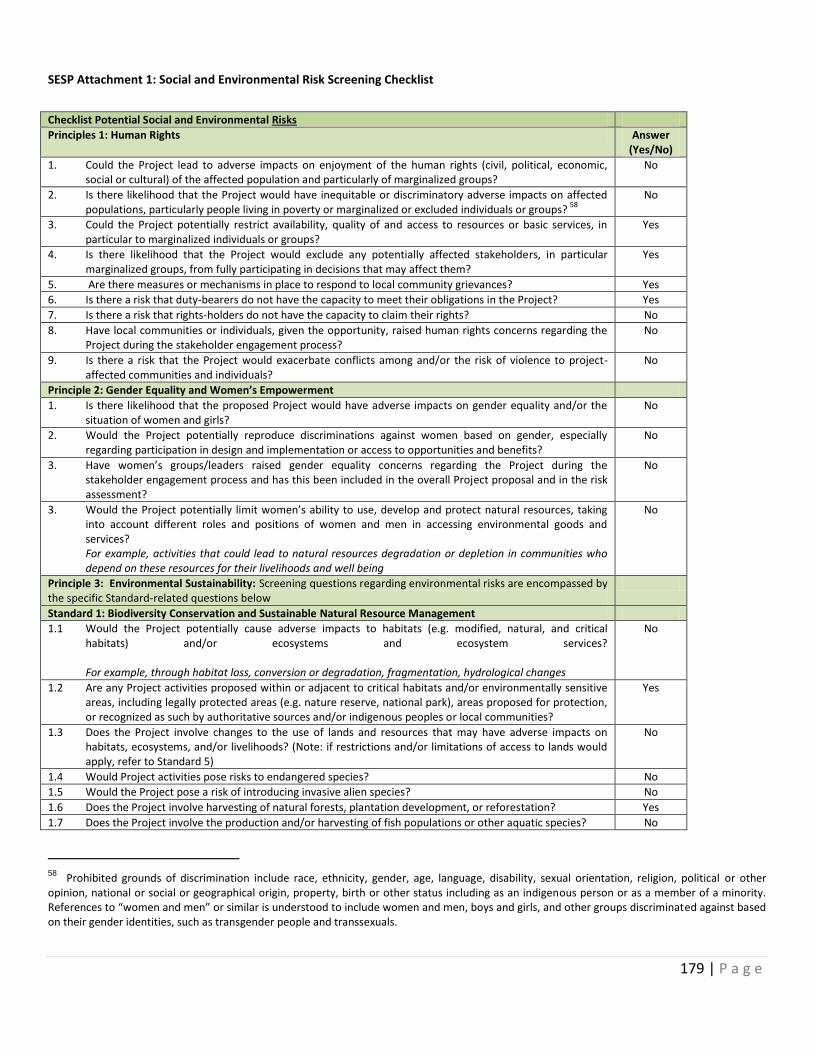
179 | P a g e
SESP Attachment 1: Social and Environmental Risk Screening Checklist
Checklist Potential Social and Environmental Risks
Principles 1: Human Rights Answer (Yes/No)
1. Could the Project lead to adverse impacts on enjoyment of the human rights (civil, political, economic, social or cultural) of the affected population and particularly of marginalized groups?
No
2. Is there likelihood that the Project would have inequitable or discriminatory adverse impacts on affected populations, particularly people living in poverty or marginalized or excluded individuals or groups?
58
No
3. Could the Project potentially restrict availability, quality of and access to resources or basic services, in particular to marginalized individuals or groups?
Yes
4. Is there likelihood that the Project would exclude any potentially affected stakeholders, in particular marginalized groups, from fully participating in decisions that may affect them?
Yes
5. Are there measures or mechanisms in place to respond to local community grievances? Yes
6. Is there a risk that duty-bearers do not have the capacity to meet their obligations in the Project? Yes
7. Is there a risk that rights-holders do not have the capacity to claim their rights? No
8. Have local communities or individuals, given the opportunity, raised human rights concerns regarding the Project during the stakeholder engagement process?
No
9. Is there a risk that the Project would exacerbate conflicts among and/or the risk of violence to project-affected communities and individuals?
No
Principle 2: Gender Equality and Women’s Empowerment
1. Is there likelihood that the proposed Project would have adverse impacts on gender equality and/or the situation of women and girls?
No
2. Would the Project potentially reproduce discriminations against women based on gender, especially regarding participation in design and implementation or access to opportunities and benefits?
No
3. Have women’s groups/leaders raised gender equality concerns regarding the Project during the stakeholder engagement process and has this been included in the overall Project proposal and in the risk assessment?
No
3. Would the Project potentially limit women’s ability to use, develop and protect natural resources, taking into account different roles and positions of women and men in accessing environmental goods and services?
For example, activities that could lead to natural resources degradation or depletion in communities who depend on these resources for their livelihoods and well being
No
Principle 3: Environmental Sustainability: Screening questions regarding environmental risks are encompassed by the specific Standard-related questions below
Standard 1: Biodiversity Conservation and Sustainable Natural Resource Management
1.1 Would the Project potentially cause adverse impacts to habitats (e.g. modified, natural, and critical habitats) and/or ecosystems and ecosystem services? For example, through habitat loss, conversion or degradation, fragmentation, hydrological changes
No
1.2 Are any Project activities proposed within or adjacent to critical habitats and/or environmentally sensitive areas, including legally protected areas (e.g. nature reserve, national park), areas proposed for protection, or recognized as such by authoritative sources and/or indigenous peoples or local communities?
Yes
1.3 Does the Project involve changes to the use of lands and resources that may have adverse impacts on habitats, ecosystems, and/or livelihoods? (Note: if restrictions and/or limitations of access to lands would apply, refer to Standard 5)
No
1.4 Would Project activities pose risks to endangered species? No
1.5 Would the Project pose a risk of introducing invasive alien species? No
1.6 Does the Project involve harvesting of natural forests, plantation development, or reforestation? Yes
1.7 Does the Project involve the production and/or harvesting of fish populations or other aquatic species? No
58 Prohibited grounds of discrimination include race, ethnicity, gender, age, language, disability, sexual orientation, religion, political or other opinion, national or social or geographical origin, property, birth or other status including as an indigenous person or as a member of a minority. References to “women and men” or similar is understood to include women and men, boys and girls, and other groups discriminated against based on their gender identities, such as transgender people and transsexuals.
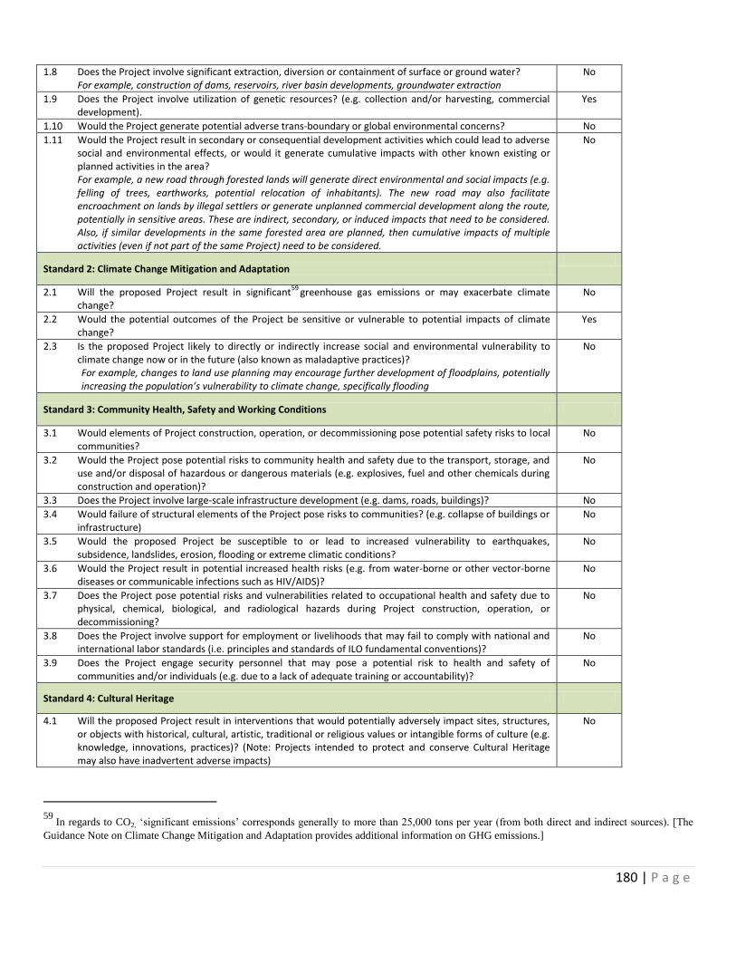
180 | P a g e
1.8 Does the Project involve significant extraction, diversion or containment of surface or ground water? For example, construction of dams, reservoirs, river basin developments, groundwater extraction
No
1.9 Does the Project involve utilization of genetic resources? (e.g. collection and/or harvesting, commercial development).
Yes
1.10 Would the Project generate potential adverse trans-boundary or global environmental concerns? No
1.11 Would the Project result in secondary or consequential development activities which could lead to adverse social and environmental effects, or would it generate cumulative impacts with other known existing or planned activities in the area?
For example, a new road through forested lands will generate direct environmental and social impacts (e.g. felling of trees, earthworks, potential relocation of inhabitants). The new road may also facilitate encroachment on lands by illegal settlers or generate unplanned commercial development along the route, potentially in sensitive areas. These are indirect, secondary, or induced impacts that need to be considered. Also, if similar developments in the same forested area are planned, then cumulative impacts of multiple activities (even if not part of the same Project) need to be considered.
No
Standard 2: Climate Change Mitigation and Adaptation
2.1 Will the proposed Project result in significant59
greenhouse gas emissions or may exacerbate climate change?
No
2.2 Would the potential outcomes of the Project be sensitive or vulnerable to potential impacts of climate change?
Yes
2.3 Is the proposed Project likely to directly or indirectly increase social and environmental vulnerability to climate change now or in the future (also known as maladaptive practices)? For example, changes to land use planning may encourage further development of floodplains, potentially increasing the population’s vulnerability to climate change, specifically flooding
No
Standard 3: Community Health, Safety and Working Conditions
3.1 Would elements of Project construction, operation, or decommissioning pose potential safety risks to local communities?
No
3.2 Would the Project pose potential risks to community health and safety due to the transport, storage, and use and/or disposal of hazardous or dangerous materials (e.g. explosives, fuel and other chemicals during construction and operation)?
No
3.3 Does the Project involve large-scale infrastructure development (e.g. dams, roads, buildings)? No
3.4 Would failure of structural elements of the Project pose risks to communities? (e.g. collapse of buildings or infrastructure)
No
3.5 Would the proposed Project be susceptible to or lead to increased vulnerability to earthquakes, subsidence, landslides, erosion, flooding or extreme climatic conditions?
No
3.6 Would the Project result in potential increased health risks (e.g. from water-borne or other vector-borne diseases or communicable infections such as HIV/AIDS)?
No
3.7 Does the Project pose potential risks and vulnerabilities related to occupational health and safety due to physical, chemical, biological, and radiological hazards during Project construction, operation, or decommissioning?
No
3.8 Does the Project involve support for employment or livelihoods that may fail to comply with national and international labor standards (i.e. principles and standards of ILO fundamental conventions)?
No
3.9 Does the Project engage security personnel that may pose a potential risk to health and safety of communities and/or individuals (e.g. due to a lack of adequate training or accountability)?
No
Standard 4: Cultural Heritage
4.1 Will the proposed Project result in interventions that would potentially adversely impact sites, structures, or objects with historical, cultural, artistic, traditional or religious values or intangible forms of culture (e.g. knowledge, innovations, practices)? (Note: Projects intended to protect and conserve Cultural Heritage may also have inadvertent adverse impacts)
No
59
In regards to CO2, ‘significant emissions’ corresponds generally to more than 25,000 tons per year (from both direct and indirect sources). [The
Guidance Note on Climate Change Mitigation and Adaptation provides additional information on GHG emissions.]

181 | P a g e
4.2 Does the Project propose utilizing tangible and/or intangible forms of cultural heritage for commercial or other purposes?
No
Standard 5: Displacement and Resettlement
5.1 Would the Project potentially involve temporary or permanent and full or partial physical displacement? No
5.2 Would the Project possibly result in economic displacement (e.g. loss of assets or access to resources due to land acquisition or access restrictions – even in the absence of physical relocation)?
No
5.3 Is there a risk that the Project would lead to forced evictions?60
No
5.4 Would the proposed Project possibly affect land tenure arrangements and/or community based property rights/customary rights to land, territories and/or resources?
No
Standard 6: Indigenous Peoples
6.1 Are indigenous peoples present in the Project area (including Project area of influence)? Yes
6.2 Is it likely that the Project or portions of the Project will be located on lands and territories claimed by indigenous peoples?
No
6.3 Would the proposed Project potentially affect the rights, lands and territories of indigenous peoples (regardless of whether Indigenous Peoples possess the legal titles to such areas)?
No
6.4 Has there been an absence of culturally appropriate consultations carried out with the objective of achieving FPIC on matters that may affect the rights and interests, lands, resources, territories and traditional livelihoods of the indigenous peoples concerned?
No
6.4 Does the proposed Project involve the utilization and/or commercial development of natural resources on lands and territories claimed by indigenous peoples?
No
6.5 Is there a potential for forced eviction or the whole or partial physical or economic displacement of indigenous peoples, including through access restrictions to lands, territories, and resources?
No
6.6 Would the Project adversely affect the development priorities of indigenous peoples as defined by them? No
6.7 Would the Project potentially affect the traditional livelihoods, physical and cultural survival of indigenous peoples?
No
6.8 Would the Project potentially affect the Cultural Heritage of indigenous peoples, including through the commercialization or use of their traditional knowledge and practices?
No
Standard 7: Pollution Prevention and Resource Efficiency
7.1 Would the Project potentially result in the release of pollutants to the environment due to routine or non-routine circumstances with the potential for adverse local, regional, and/or trans boundary impacts?
No
7.2 Would the proposed Project potentially result in the generation of waste (both hazardous and non-hazardous)?
No
7.3 Will the proposed Project potentially involve the manufacture, trade, release, and/or use of hazardous chemicals and/or materials? Does the Project propose use of chemicals or materials subject to international bans or phase-outs? For example, DDT, PCBs and other chemicals listed in international conventions such as the Stockholm Conventions on Persistent Organic Pollutants or the Montreal Protocol
No
7.4 Will the proposed Project involve the application of pesticides that may have a negative effect on the environment or human health?
No
7.5 Does the Project include activities that require significant consumption of raw materials, energy, and/or water?
No
60 Forced evictions include acts and/or omissions involving the coerced or involuntary displacement of individuals, groups, or communities from homes and/or lands and common property resources that were occupied or depended upon, thus eliminating the ability of an individual, group, or community to reside or work in a particular dwelling, residence, or location without the provision of, and access to, appropriate forms of legal or other protections.
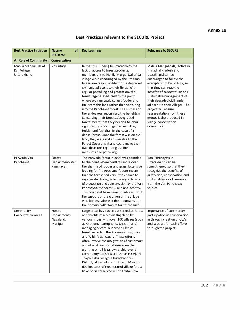
182 | P a g e
Annex 19
Best Practices relevant to the SECURE Project
Best Practice Initiative Nature of Initiative
Key Learning Relevance to SECURE
A. Role of Community in Conservation
Mahila Mandal Dal of Kail Village, Uttarakhand
Voluntary In the 1980s, being frustrated with the lack of access to forest products, members of the Mahila Mangal Dal of Kail village were encouraged by the Pradhan to assume responsibility for the degraded civil land adjacent to their fields. With regular patrolling and protection, the forest regenerated itself to the point where women could collect fodder and fuel from this land rather than venturing into the Panchayat forest. The success of the endeavour recognized the benefits in conserving their forests. A degraded forest meant that they needed to labor significantly more to gather leaf litter, fodder and fuel than in the case of a dense forest. Since the forest was on civil land, they were not answerable to the Forest Department and could make their own decisions regarding punitive measures and patrolling.
Mahila Mangal dals, active in Himachal Pradesh and Uttrakhand can be encouraged to follow the example from Kail village, so that they can reap the benefits of conservation and sustainable management of their degraded civil lands adjacent to their villages. The project will ensure representation from these groups is the proposed in Village conservation Committees.
Parwada Van Panchayat
Forest Department- Van Panchayat
The Parwada forest in 2007 was denuded to the point where conflicts arose over the sharing of fodder and grass. Extensive lopping for firewood and fodder meant that the forest had very little chance to regenerate. Today, after nearly a decade of protection and conservation by the Van Panchayat, the forest is lush and healthy. This could not have been possible without the support of the women of the village who like elsewhere in the mountains are the primary collectors of forest produce.
Van Panchayats in Uttarakhand can be strengthened so that they recognize the benefits of protection, conservation and sustainable use of resources from the Van Panchayat forests
Community Conservation Areas
Forest Departments Nagaland, Manipur
Large areas have been conserved as forest and wildlife reserves in Nagaland by various tribes, with over 100 villages (such as Khonoma, Luzuphuhu, Chizami and) managing several hundred sq.km of forest, including the Khonoma Tragopan and Wildlife Sanctuary. These efforts often involve the integration of customary and official law, sometimes even the granting of full legal ownership over a Community Conservation Areas (CCA). In Tokpa Kabui village, Churachandpur District, of the adjacent state of Manipur, 600 hectares of regenerated village forest have been preserved in the Loktak Lake
Importance of community participation in conservation in through creation of CCAs and support for such efforts through the project.
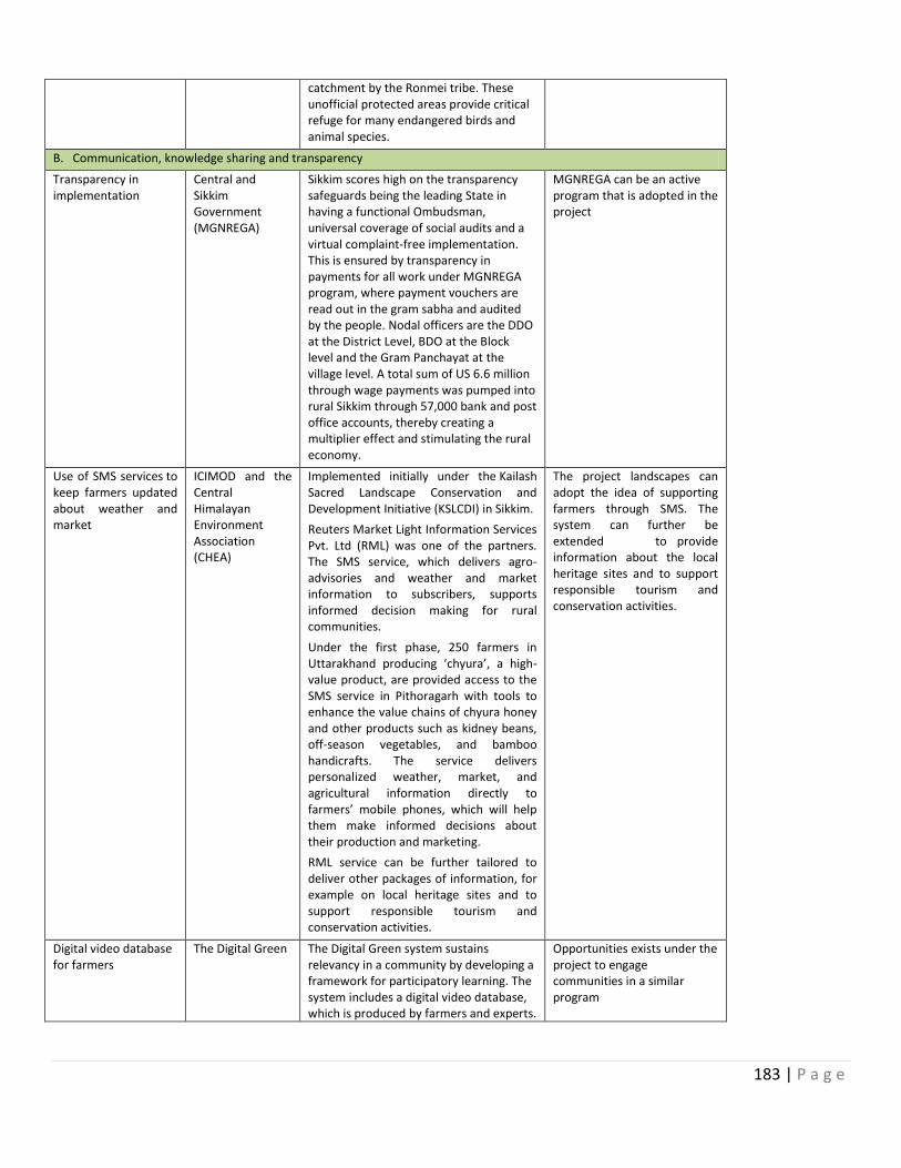
183 | P a g e
catchment by the Ronmei tribe. These unofficial protected areas provide critical refuge for many endangered birds and animal species.
B. Communication, knowledge sharing and transparency
Transparency in implementation
Central and Sikkim Government (MGNREGA)
Sikkim scores high on the transparency safeguards being the leading State in having a functional Ombudsman, universal coverage of social audits and a virtual complaint-free implementation. This is ensured by transparency in payments for all work under MGNREGA program, where payment vouchers are read out in the gram sabha and audited by the people. Nodal officers are the DDO at the District Level, BDO at the Block level and the Gram Panchayat at the village level. A total sum of US 6.6 million through wage payments was pumped into rural Sikkim through 57,000 bank and post office accounts, thereby creating a multiplier effect and stimulating the rural economy.
MGNREGA can be an active program that is adopted in the project
Use of SMS services to keep farmers updated about weather and market
ICIMOD and the Central Himalayan Environment Association (CHEA)
Implemented initially under the Kailash Sacred Landscape Conservation and Development Initiative (KSLCDI) in Sikkim.
Reuters Market Light Information Services Pvt. Ltd (RML) was one of the partners. The SMS service, which delivers agro-advisories and weather and market information to subscribers, supports informed decision making for rural communities.
Under the first phase, 250 farmers in Uttarakhand producing ‘chyura’, a high-value product, are provided access to the SMS service in Pithoragarh with tools to enhance the value chains of chyura honey and other products such as kidney beans, off-season vegetables, and bamboo handicrafts. The service delivers personalized weather, market, and agricultural information directly to farmers’ mobile phones, which will help them make informed decisions about their production and marketing.
RML service can be further tailored to deliver other packages of information, for example on local heritage sites and to support responsible tourism and conservation activities.
The project landscapes can adopt the idea of supporting farmers through SMS. The system can further be extended to provide information about the local heritage sites and to support responsible tourism and conservation activities.
Digital video database for farmers
The Digital Green The Digital Green system sustains relevancy in a community by developing a framework for participatory learning. The system includes a digital video database, which is produced by farmers and experts.
Opportunities exists under the project to engage communities in a similar program
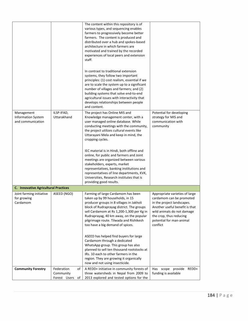
184 | P a g e
The content within this repository is of various types, and sequencing enables farmers to progressively become better farmers. The content is produced and distributed over a hub and spokes-based architecture in which farmers are motivated and trained by the recorded experiences of local peers and extension staff.
In contrast to traditional extension systems, they follow two important principles: (1) cost realism, essential if we are to scale the system up to a significant number of villages and farmers; and (2) building systems that solve end-to-end agricultural issues with interactivity that develops relationships between people and content.
Management Information System and communication
ILSP-IFAD, Uttarakhand
The project has Online MIS and Knowledge management center, with a user managed online database. While conducting meetings with the community, the project utilizes cultural events like Uttarayani Mela and keep in mind, the cropping cycles.
IEC material is in Hindi, both offline and online, for public and farmers and Joint meetings are organized between various stakeholders, experts, market representatives, banking institutions and representatives of line departments, KVK, Universities, Research institutes that is providing good results.
Potential for developing strategy for MIS and communication with community
C. Innovative Agricultural Practices
Joint farming initiative for growing Cardamom
ASEED (NGO) Farming of large Cardamom has been taken up by 99 households, in 15 producer groups in 8 villages in Jakholi block of Rudraprayag district. The groups sell Cardamom at Rs 1,200-1,300 per Kg in Rudraprayag, 40 km away, on the popular pilgrimage route. Tilwada and Rishikesh too have a big demand of spices.
ASEED has helped find buyers for large Cardamom through a dedicated WhatsApp group. This group has also planned to sell ten thousand rootstocks at IRs. 10 each to other farmers in the region. They are growing it organically now and not using insecticide.
Appropriate varieties of large cardamom can be promoted in the project landscapes. Another useful benefit is that wild animals do not damage the crop, thus reducing potential for man-animal conflict
Community Forestry
Federation of Community Forest Users of
A REDD+ initiative in community forests of three watersheds in Nepal from 2009 to 2013 explored and tested options for the
Has scope provide REDD+ funding is available
185 | P a g e
Nepal (FECOFUN) and the Asia Network for Sustainable Agriculture and Bio-resources (ANSAB), ICIMOD with Norwegian financial support
governance and financial transparency of community-based REDD+ initiatives. It provided local communities with necessary training and incentives for the conservation and the enhancement of local forest through the establishment of a community-managed Forest Carbon Trust Fund (FCTF).
Involving the local people in the sustainable management of forests and linking incentive mechanisms with livelihood options, this project has been successful in making significant contributions to poverty reduction for target groups, especially Dalits, women and indigenous people. Figures from 2012 show that more than half of the REDD+ payment has been spent on livelihood improvement activities (51%) benefiting mostly poor and marginalized households.
Off- Season vegetable growing
HARC – Himalayan Action Research Center
Farmers in Jaunsar area of Dehradun District in Uttarakhand are now growing off-season vegetables like pea, tomato, ginger and arvi. They realized that hybrid seeds give bigger outputs, but require fresh seeds in the every cropping cycle. They had previously grown apple in the higher orchards, which has failed in last few years, because of poor snowfall. Poor rain has been a big constraint, even for the OSVs cropped in the fields lower down in the valley.
As of today, 101 (out of 254 in the state) OSV producer groups are from Chakrata block alone. This is a big change and a significant trend. They are also exploring other markets nearby and special crops like Broccoli and exotic fruits like Kiwi.
SECURE project Landscape - district Uttarkashi has already opted for the Off-season vegetable growing and these and other farmers can be supported for growing off- season vegetables.
High-tech nursery with poly house and LDPE Tank
ILSP-IFAD Project A farmer from Chopriyalgaon, near Chamba Tehri, Uttarakhand is promoting the idea of raising a poly house nursery to sustain income during lean winter months. He uses Perlite, Vermiculite and Coco-peat in the plastic cups – insulating the sapling from the ground. He is able to sell cucumber seedlings for IRs 100, while the government nursery offers it for IRs 50. The secret is the quality. He is using high tech farming principles, where a single seedling is grown in a special micro-environment (Vermiculite, Perlite, Coco peat) till it has viable roots. This ensures very high success rate on transplantation.
Progressive farmers from the project landscapes can be identified for promoting such high-tech nurseries
Pomotion of the Appropriate Ma Jagdamba Producer Group/SHG is State Government’s
186 | P a g e
products of Rhododendron
Technology India (ATI)
sellis Soya badi and Burans (Rhododendron) juice in the winter festival - Magh mela, held in Uttarkashi. Buran festival is organized in summers, during which the group collected Rhododendron flowers, separate the petals, clean and boil it, to make juice for selling. Appropriate Technology India (ATI), the Technical Agency, for this region, has already got them an order for 500 bottles at IRs 80 each. Hari Maharaj federation is provided with a rent-free shop at Uttarkashi, by DRDO (State Government). It sells Soya Badi, Burans Juice, handmade Incense sticks, Honey etc.
infrastructure can be utilized for opening outlets for selling the products of SHGs associated with the project. Convergences of resources and ideas can be promoted through the project
Pre-sowing technology helps in reducing risks
Himalayan Action Research Centre
(HARC)
The Technical Agency of IFAD - HARC in Chakrata block of District Dehradun has emphasized pre–sowing technologies such as - promotion of pre-sowing solarisation – covering the land with clear plastic, which traps the heat and kills the disease producing germs and weeds; Farmers training in seed treatment; promoting light traps to reduce Kurmula (white grub) without using insecticides., as well as promoting organic pesticide made from cow's urine, jaggery etc. Matrishakti producer group in Semog village, Jaunsar valley, Dehradun adopted these new ideas and weres able to double the farm area sown with the same amount of tomato seed.
The project can replicate this approach through provision of technical support and training in pre-sowing technology to farmers in the project areas
Bay Leaf Value Chain
Himalayan Action Research Centre - HARC
(Supported by ICIMOD)
Herbal Research and Development Institute (HRDI)
ICIMOD, with support from the Oversees Development Institute (ODI), implemented a pilot value chain action research project in the district, which educated and trained villagers on the benefits of cultivating bay leaf trees and potential value additions. After the ICIMOD intervention, the price of bay leaf increased from INR 3 - 22 per kg in 2010 to INR 39 in 2011.
Madan Singh a farmer in Nizmullah village of Chamoli District of Uttarakhand started his nursery around 1999, primarily selling fruit trees (peach and Malta). Through the initiative of HARC, Madan Singh was able to participate in training on the appropriate techniques of collecting and keeping a nursery of bay leaf trees. His income from selling the saplings in 2013 was INR 38,000. He has created new employment opportunities in Nizmullah each year, hiring five to six labourers to work in his nursery, each earning INR 250 per day.
Progressive farmers can be identified to participate in a similar venture.
187 | P a g e
D. Agro-processing Initiatives
Linking weavers groups with a export company
ILSP-IFAD, Uttarakhand
A SHG Federation – Nari Ekta Cooperative, Mangalta, block Bhasiyachanna, Almora Uttarakhand has set up a comprehensive rural industry, consisting of grain mill, spice mill, oil expeller, paddy polisher, paddy dehusker, grading machine, packaging machines etc. at the building owned by the federation in a central village – Jamradi.
Nari Ekta SRC Jamradi as a nodal federation, also supported Dev Mahima weaving Producers Group and a Delhi based exports company ‘Village Ways’ has given orders for 2,000 shawl, 2,000 Chindi (small pieces) and 500 Muffler. Fthe ederation has achieved a turnover of $33,000, with a and net profit of $30,000
The project can have a multi-purpose processing unit for value addition of the produce of farmers and providing better benefits.
Existing Federations can be utilised in promotion of products of the SHGs coming in Uttarakhand. Good promotion of Eco tourism can benefit weavers to get export orders. Project can also help link tourism with handlooms promotion.
E. Marketing
Canopy Marketing Inter- Federation Business,
Buyer – Seller Meets
ILSP-IFAD Canopy Marketing is a new marketing concept introduced in Almora District by ILSP-IFAD project. Through canopy marketing in Vikas Bhawan, officer’s colony, ITBP camp and local markets, sale of packed and fresh local produces with Brand HILLANS is undertaken jointly by the SHGs through its Federations.
Promotion of Buyer Seller Meets - Businessmen and traders from various places are invited. Other livelihood experts, Bank representatives, line department officers from Agriculture, Horticulture, Animal husbandry departments of the state government are also invited. Decisions on product purchase and supply are taken on the spot due due to the presence of all relevant players.
Inter federation sale – Facilitates links between one federations and inter-federations sales.
Project can also undertake multiple options of marketing the produce in the landscapes and system of aggregation of produce, transportation and collective marketing.
Natural dyes for handloom sector
Avani (NGO) Tripuradevi,
Via. Berinag Pithoragarh, Uttarakhand
Avani launched a craft and livelihood program focussing specifically on utilizing skills of the local people in weaving. Avani created a cooperative called Kumaon Earthcraft Cooperative (KEC) that operates from four centers and employs people from fifty villages. Avani works with spinning, weaving and natural dyeing of natural fibres like silk, wool and linen. Avani uses appropriate technology for processing of textiles. Solar
Natural dye production is possible in areas where handloom activities are prevalent
188 | P a g e
water heaters for pre-heating of water for natural dyes and development of models of solar powered spinning wheels. All the water used in natural dyeing is recycled for irrigation. All the products are hand woven and naturally dyed. The range of products includes: tweed jackets, carpets, shawls, mufflers, blankets, bedcovers and durries.
All of the materials, dyes, and textile products manufactured by KEC are natural or derived from local plants. The growth strategy seeks to diversify revenue streams by adding products such as natural dyes, crayons, watercolors, and soap-nut powder (natural detergent) while preserving Avani’s commitment to conservation.
Sale of innovative agriculture instruments, light weight water cans, baskets and solar lights
Himmothan Project and ILSP –IFAD
Through the consumer shops promoted by the projects, sickle (Unnat Daranti), plastic water can, baskets, solar lights are marketed. It has a direct bearing on women’s workload, by reducing drudgery of women and enhancing convenience
The Project can promote sale of innovative products through the ecotourism information centers cum community stores
F. Non-farm Initiatives
Indira Amma Canteen IFFDC in Chamoli Parvatiya Krishi Vipanan Federation, a group of 51 producer groups in Chamoli block is running an “Indira Amma Canteen”. This activity is giving a profit of IRs. 20,000 ($300) per month. The activity has twin benefits – It has become a business for the federation and employment for four to five people. It helps poor people to get good and nutritious food at low cost.
Under alternative livelihoods program, this low cost food business for SHG Federations can be promoted.
Eco-Tourism Himalayan Homestay Programme of Snow Leopard Conservancy, The Mountain Institute, and the United Nations Educational, Scientific and Cultural Organization (UNESCO).
The community based eco-tourism in Hemis National Park helps to reduce poverty, improve livelihoods and mitigate seasonality. The Himalayan Homestay Program was initiated in 2001 in the eastern part of the cold desert of Ladakh.
Training and support was provided to village women co-operatives in Ladakh to offer foreign tourists traditional Himalayan accommodation (‘homestays’) and to run a small restaurant during the tourist season.
Emphasis is placed on environmentally friendly practices, including good waste management, the use of natural gas and kerosene for cooking and the sale of pressure-boiled, filtered water to minimize use of plastic mineral water bottles. Solar cookers and solar water
The Hemis National Park case study can serve as an approach for experimentaing and replication in the project landscapes where there is potential for promotion of ecotourism.
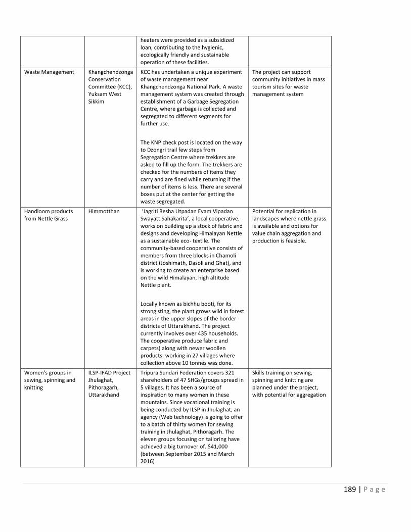
189 | P a g e
heaters were provided as a subsidized loan, contributing to the hygienic, ecologically friendly and sustainable operation of these facilities.
Waste Management Khangchendzonga Conservation Committee (KCC), Yuksam West Sikkim
KCC has undertaken a unique experiment of waste management near Khangchendzonga National Park. A waste management system was created through establishment of a Garbage Segregation Centre, where garbage is collected and segregated to different segments for further use.
The KNP check post is located on the way to Dzongri trail few steps from Segregation Centre where trekkers are asked to fill up the form. The trekkers are checked for the numbers of items they carry and are fined while returning if the number of items is less. There are several boxes put at the center for getting the waste segregated.
The project can support community initiatives in mass tourism sites for waste management system
Handloom products from Nettle Grass
Himmotthan ‘Jagriti Resha Utpadan Evam Vipadan Swayatt Sahakarita’, a local cooperative, works on building up a stock of fabric and designs and developing Himalayan Nettle as a sustainable eco- textile. The community-based cooperative consists of members from three blocks in Chamoli district (Joshimath, Dasoli and Ghat), and is working to create an enterprise based on the wild Himalayan, high altitude Nettle plant.
Locally known as bichhu booti, for its strong sting, the plant grows wild in forest areas in the upper slopes of the border districts of Uttarakhand. The project currently involves over 435 households. The cooperative produce fabric and carpets) along with newer woollen products: working in 27 villages where collection above 10 tonnes was done.
Potential for replication in landscapes where nettle grass is available and options for value chain aggregation and production is feasible.
Women's groups in sewing, spinning and knitting
ILSP-IFAD Project Jhulaghat, Pithoragarh, Uttarakhand
Tripura Sundari Federation covers 321 shareholders of 47 SHGs/groups spread in 5 villages. It has been a source of inspiration to many women in these mountains. Since vocational training is being conducted by ILSP in Jhulaghat, an agency (Web technology) is going to offer to a batch of thirty women for sewing training in Jhulaghat, Pithoragarh. The eleven groups focusing on tailoring have achieved a big turnover of. $41,000 (between September 2015 and March 2016)
Skills training on sewing, spinning and knitting are planned under the project, with potential for aggregation
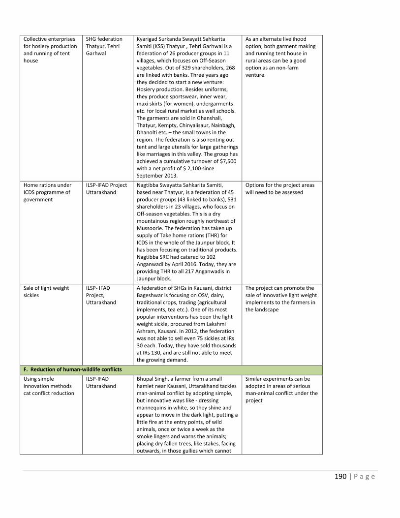
190 | P a g e
Collective enterprises for hosiery production and running of tent house
SHG federation Thatyur, Tehri Garhwal
Kyarigad Surkanda Swayatt Sahkarita Samiti (KSS) Thatyur , Tehri Garhwal is a federation of 26 producer groups in 11 villages, which focuses on Off-Season vegetables. Out of 329 shareholders, 268 are linked with banks. Three years ago they decided to start a new venture: Hosiery production. Besides uniforms, they produce sportswear, inner wear, maxi skirts (for women), undergarments etc. for local rural market as well schools. The garments are sold in Ghanshali, Thatyur, Kempty, Chinyalisaur, Nainbagh, Dhanolti etc. – the small towns in the region. The federation is also renting out tent and large utensils for large gatherings like marriages in this valley. The group has achieved a cumulative turnover of $7,500 with a net profit of $ 2,100 since September 2013.
As an alternate livelihood option, both garment making and running tent house in rural areas can be a good option as an non-farm venture.
Home rations under ICDS programme of government
ILSP-IFAD Project Uttarakhand
Nagtibba Swayatta Sahkarita Samiti, based near Thatyur, is a federation of 45 producer groups (43 linked to banks), 531 shareholders in 23 villages, who focus on Off-season vegetables. This is a dry mountainous region roughly northeast of Mussoorie. The federation has taken up supply of Take home rations (THR) for ICDS in the whole of the Jaunpur block. It has been focusing on traditional products. Nagtibba SRC had catered to 102 Anganwadi by April 2016. Today, they are providing THR to all 217 Anganwadis in Jaunpur block.
Options for the project areas will need to be assessed
Sale of light weight sickles
ILSP- IFAD Project, Uttarakhand
A federation of SHGs in Kausani, district Bageshwar is focusing on OSV, dairy, traditional crops, trading (agricultural implements, tea etc.). One of its most popular interventions has been the light weight sickle, procured from Lakshmi Ashram, Kausani. In 2012, the federation was not able to sell even 75 sickles at IRs 30 each. Today, they have sold thousands at IRs 130, and are still not able to meet the growing demand.
The project can promote the sale of innovative light weight implements to the farmers in the landscape
F. Reduction of human-wildlife conflicts
Using simple innovation methods cat conflict reduction
ILSP-IFAD Uttarakhand
Bhupal Singh, a farmer from a small hamlet near Kausani, Uttarakhand tackles man-animal conflict by adopting simple, but innovative ways like - dressing mannequins in white, so they shine and appear to move in the dark light, putting a little fire at the entry points, of wild animals, once or twice a week as the smoke lingers and warns the animals; placing dry fallen trees, like stakes, facing outwards, in those gullies which cannot
Similar experiments can be adopted in areas of serious man-animal conflict under the project
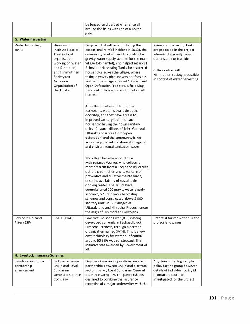
191 | P a g e
be fenced; and barbed wire fence all around the fields with use of a Bolter gate.
G. Water-harvesting
Water harvesting tanks
Himalayan Institute Hospital Trust (a local organisation working on Water and Sanitation) and Himmotthan Society (an Associate Organisation of the Trusts)
Despite initial setbacks (including the exceptional rainfall incident in 2013), the community worked hard to construct a gravity water supply scheme for the main village tok (hamlet), and helped set up 11 Rainwater Harvesting Tanks for scattered households across the village, where taking a gravity pipeline was not feasible. Further, the village attained 100-per cent Open Defecation Free status, following the construction and use of toilets in all homes.
After the initiative of Himmothan Pariyojana, water is available at their doorstep, and they have access to improved sanitary facilities, each household having their own sanitary units. Gawana village, of Tehri Garhwal, Uttarakhand is free from ‘open defecation’ and the community is well versed in personal and domestic hygiene and environmental sanitation issues.
The village has also appointed a Maintenance Worker, who collects a monthly tariff from all households, carries out the chlorination and takes care of preventive and curative maintenance, ensuring availability of sustainable drinking water. The Trusts have commissioned 200 gravity water supply schemes, 573 rainwater harvesting schemes and constructed above 5,000 sanitary units in 129 villages of Uttarakhand and Himachal Pradesh under the aegis of Himmothan Pariyojana.
Rainwater harvesting tanks are proposed in the project wherein the gravity based options are not feasible.
Collaboration with Himmothan society is possible in context of water harvesting.
Low cost Bio-sand Filter (BSF)
SATHI ( NGO) Low cost Bio-sand Filter (BSF) is being developed currently in Pachaad block, Himachal Pradesh, through a partner organization named SATHI. This is a low cost technology for water purification around 60 BSFs was constructed. This initiative was awarded by Government of HP.
Potential for replication in the project landscapes
H. Livestock Insurance Schemes
Livestock Insurance partnership arrangement
Linkage between BASIX and Royal Sundaram General Insurance Company
Livestock insurance operations involve a partnership between BASIX and a private sector insurer, Royal Sundaram General Insurance Company. The partnership is designed to combine the insurance expertise of a major underwriter with the
A system of issuing a single policy for the group however details of individual policy id maintained could be investigated for the project
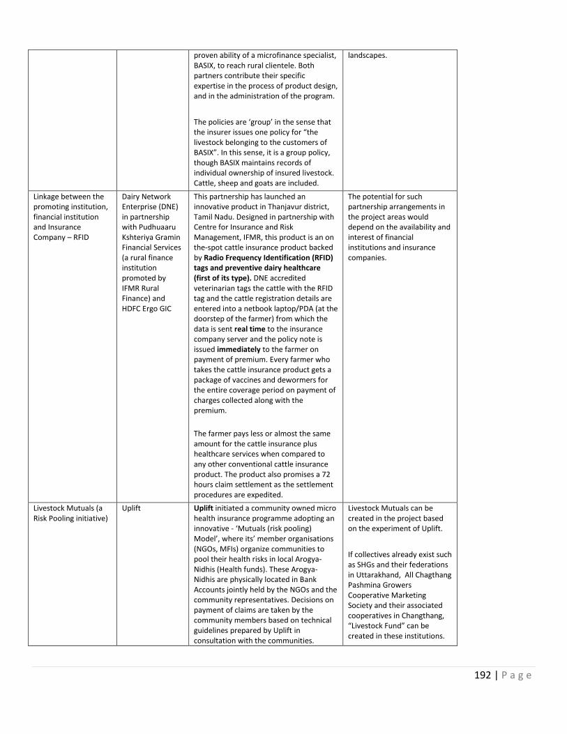
192 | P a g e
proven ability of a microfinance specialist, BASIX, to reach rural clientele. Both partners contribute their specific expertise in the process of product design, and in the administration of the program.
The policies are ‘group’ in the sense that the insurer issues one policy for “the livestock belonging to the customers of BASIX”. In this sense, it is a group policy, though BASIX maintains records of individual ownership of insured livestock. Cattle, sheep and goats are included.
landscapes.
Linkage between the promoting institution, financial institution and Insurance Company – RFID
Dairy Network Enterprise (DNE) in partnership with Pudhuaaru Kshteriya Gramin Financial Services (a rural finance institution promoted by IFMR Rural Finance) and HDFC Ergo GIC
This partnership has launched an innovative product in Thanjavur district, Tamil Nadu. Designed in partnership with Centre for Insurance and Risk Management, IFMR, this product is an on the-spot cattle insurance product backed by Radio Frequency Identification (RFID) tags and preventive dairy healthcare (first of its type). DNE accredited veterinarian tags the cattle with the RFID tag and the cattle registration details are entered into a netbook laptop/PDA (at the doorstep of the farmer) from which the data is sent real time to the insurance company server and the policy note is issued immediately to the farmer on payment of premium. Every farmer who takes the cattle insurance product gets a package of vaccines and dewormers for the entire coverage period on payment of charges collected along with the premium.
The farmer pays less or almost the same amount for the cattle insurance plus healthcare services when compared to any other conventional cattle insurance product. The product also promises a 72 hours claim settlement as the settlement procedures are expedited.
The potential for such partnership arrangements in the project areas would depend on the availability and interest of financial institutions and insurance companies.
Livestock Mutuals (a Risk Pooling initiative)
Uplift Uplift initiated a community owned micro health insurance programme adopting an innovative - ‘Mutuals (risk pooling) Model’, where its’ member organisations (NGOs, MFIs) organize communities to pool their health risks in local Arogya-Nidhis (Health funds). These Arogya-Nidhis are physically located in Bank Accounts jointly held by the NGOs and the community representatives. Decisions on payment of claims are taken by the community members based on technical guidelines prepared by Uplift in consultation with the communities.
Livestock Mutuals can be created in the project based on the experiment of Uplift.
If collectives already exist such as SHGs and their federations in Uttarakhand, All Chagthang Pashmina Growers Cooperative Marketing Society and their associated cooperatives in Changthang, “Livestock Fund” can be created in these institutions.
193 | P a g e
Contributions received from members are divided on a 60:20:20 basis among the claim fund, administrative cost to the Member NGOs and Technical support-back-office-software charge to Uplift.
Uplift provides technical support, risk management services and other benefits to its’ member organisations under ‘Health Mutuals Program’, through a network of more than 130 Health Care Providers, a well trained technical team and in-house database management software. Uplift has created a multilevel access for its members by creating a preferred provider network, a 24X7 helpline managed by doctors.
In case of non-existence of SHGs or any federation then new groups/cooperatives can be formed.
Insurance System with revolving Fund at federation level
IFAD’s “ Tejaswini” project
In IFAD’s project in Madhya Pradesh “Tejaswini”, an insurance system was developed and run by Federation of Goat rearing groups (Khajuraho federation of Goat Rearing). The life insurance of goats covered losses suffered by the owner in the event of the goat’s death. Under the scheme, if the goat owner insures his goat with premium amount of IRs. 100, then he gets IRs. 1,000 as claim in the event of animal’s death. The compensation amount is IRs. 2,000 if the premium is IRs. 200. In case of any causality, the owner of the animal informs Pashu Sakhi (person functioning as Animal’s Friend). Pashu Sakhi submits the claim form to Para-vet and claim amount is paid within 3 to 15 days. The training and system was supported by Goat India Trust based in Lucknow. This is purely an in-house insurance system wherein claims are settled at the federation level itself.
Potential for similar schemes needs to be investigated
194 | P a g e
Annex 20
Terms Of Reference For Key Project Staff
The following are the indicative TORs for the project management staff to be recruited under the project TORs for these positions will be further discussed with UNDP so that roles and responsibilities and UNDP GEF reporting procedures are clearly defined and understood.
NATIONAL IMPLEMENTING PARTNER AND NATIONAL PROJECT DIRECTOR
The Ministry of Environment, Forests and Climate Change will serve as National Implementing Partner for the project. As a representative of the Government, the National Implementing Partner has the main responsibility to ensure that the project is executed in accordance with Government priorities, as well as with the Project Document and the UNDP guidelines. Expectations for the National Implementing Partner include:
Assurance of compatibility between the themes of the UNDP/GEF project and the authority of the leading Ministry;
Integration of the project into the plans and operations of the leading Ministry and State entities;
Taking the lead in solving problems and challenges for the project when they arise;
Establishment of a mechanism by which Ministry staff could be assigned to the project;
Taking the lead in helping the UNDP team in designing and implementing the project;
Over-see effective operation of the Project Management Unit to be established under the project
Provision of office space for the project team during implementation, such that Ministry staff and UNDP project staff can work closely and effectively together;
Provide leadership on project development and implementation, ensuring coordination and consistency of approaches across project States
Ensuring monitoring of project implementation across the four participating States, and sharing lessons and best practices
Provide guidance and help to the NPM, as necessary, to over-come constraints, mitigate risks and resolve implementation problems;
Represent the Project at meetings with key partners/stakeholders including line ministries, provincial governments, national institutions, NGOs and donors;
Approve on behalf of the Government quarterly work plans and reports, including quarterly progress reports, expenditure plans and financial report(s) of the Project;
Provide assistance in the coordination of the Project activities that involve other agencies of Government both federal and provincial;
Assist in out-sourcing implementation of studies/activities of the Project through sub-contracts to line agencies, research institutions, and NGOs, companies and individual experts
195 | P a g e
Serve as Member/Secretary to the Project Board. A senior staff member of MOEFCC will serve as National Project Director to personally oversee the work of the Ministry as National Implementing Partner. The National Project Director will work closely with UNDP and project staff in all aspects of planning and management of the project.
NATIONAL PROJECT MANAGER
The National Project Manager (NPM) will work under the supervision and guidance of the National Project Director (NPD) of the Ministry of Environment, Forests and Climate Change, and look after day to day management of National Project Management Unit, its staff and consultants; including general and financial administration, work planning, progress reporting, monitoring and quality control of Project inputs and delivery of its outputs. The NPM will be responsible for the following technical, administrative and managerial tasks: Operational project management in accordance with the Project Document and the UNDP guidelines and procedures for implementation of project activities, including:
Management and supervision of project implementation and evaluation across all components. Assurance of successful completion of the project in accordance with the stated outcomes and performance indicators summarized in the Project Results Framework.
Regular communication and coordination with the National Implementing Partner, members of the Project Board, and all other partners and interested stakeholders, with regard to all project activity. Organization of Project Board meetings at least once, or ideally twice, per year, subject to availability of members.
Regular communication with senior UNDP management with regard to all project activity. Assurance of coordination with other UNDP projects and broad strategic initiatives.
Preparation of Annual Work Plans, including monthly targets and deliverables as well as annual spending targets in accordance with the Project Document. Tracking of work outputs throughout the year in light of these Annual Work Plans.
Tracking and managing of project spending in accordance with the project budget, as well as UNDP rules and procedures, to ensure transparency, responsibility, and timely fulfilment of both program targets and budget targets.
Preparation and submittal of annual Project Implementation Reviews and other required progress reports to the Project Board, UNDP, and GEF in accordance with applicable requirements, in all required languages (English and Hindi needed).
Supervision of the experts working for the project, including both Project Specialists as well as international and national consultants.
Supervision of regular data collection and analysis, as well as reporting and public outreach via the mass media, events, and other means, to disseminate the results of the project and to promote water use efficiency, sustainable water and agriculture management, and sustainable pasture management as part of a national strategy to address climate risks in India.
Oversight of the overall administration of the project office.
Regular travel within India to organize and monitor project activity; possible travel outside the country for participation in directly relevant international meetings.
196 | P a g e
Support of independent Midterm and Terminal Evaluations of the project.
Expected Qualifications:
University degree in natural resource management, biodiversity conservation or another field with direct relevance to the project
At least 10 years of experience in managing large-scale projects on natural resource management, biodiversity conservation or social development in India
Close familiarity with the roles, activities, and priorities of the Government of India, and particularly the Ministry of Environment, Forests and Climate Change and other national partners, with regard to natural resource management, biodiversity conservation, agriculture, sustainable land management and/or wildlife crime management
Basic technical understanding of natural resources management
Demonstrated ability to work effectively with a broad range of stakeholders
Demonstrated ability to work effectively under close supervision, as well as under minimal supervision
Superior skills in organization and management, including past experience with planning, tracking, evaluation, and supervision of consultants and/or employees
Strong skills in financial tracking and budget management
Close familiarity with the operations and rules of UNDP is not a requirement but will be viewed with favor
Fluency in Hindi and English, in reading, writing, and speaking.
STATE IMPLEMENTING PARTNER AND STATE PROJECT DIRECTOR
The State Wildlife/Forestry Departments will serve as State Implementing Partners for the project. As a representative of the State Governments, the State Implementing Partner has the main responsibility to ensure that the project is executed in accordance with National and State Government priorities, as well as with the Project Document and the UNDP guidelines. Expectations for the State Implementing Partners include:
Integration of the project into the plans and operations of the leading State entities;
Taking the lead in solving problems and challenges for the project when they arise;
Establishment of a mechanism by which State Implementing Partner could be assigned to the project;
Taking the lead in helping the UNDP/MOEFCC team in designing and implementing the project;
Provision of office space for the project team during implementation, such that Department staff and ensuring that they work closely with MOEFCC National Project Management Unit and UNDP project staff;
Providing leadership of a Working Groups/Committees on project planning and management, which would include all other interested agencies of the State Governments, including calling and chairing periodic meetings.
197 | P a g e
A senior staff member of State Wildlife/Forestry Department will serve as State Project Director to personally oversee the work of the State Implementing Partner. The State Project Director will work closely with MOEFCC and UNDP and project staff in all aspects of planning and management of the project.
STATE PROJECT MANAGER
The State Project Manager (SPM) will work under the supervision and guidance of the State Project Director (NPD) of the Department of Forests/Wildlife, and look after day to day management of State Project Planning and Management Unit (PPMU), its staff and consultants; including general and financial administration, work planning, progress reporting, monitoring and quality control of project inputs and delivery of its outputs. The SPM would be an Official from the State Wildlife/Forest Department and will work on a full time basis in this capacity. The SPM will be responsible for the following technical, administrative and managerial tasks: Operational project management in accordance with the Project Document and the UNDP guidelines and procedures for implementation of project activities, including:
Management and supervision of project implementation and evaluation across all components within the State. Assurance of successful completion of the project in accordance with the stated outcomes and performance indicators summarized in the Project Results Framework.
Regular communication and coordination with the State Implementing Partner, State Project Steering Committee, the National Project Management, and all other partners and interested stakeholders, with regard to all project activity. Organization of State PSC meetings at least once, or ideally twice, per year, subject to availability of members.
Regular communication with the National Project Management with regard to all project activity. Assurance of coordination with other UNDP projects and broad strategic initiatives.
Preparation of Annual Work Plans, including monthly targets and deliverables as well as annual spending targets in accordance with the Project Document. Tracking of work outputs throughout the year in light of these Annual Work Plans.
Tracking and managing of project spending in accordance with the project budget, as well as UNDP rules and procedures, to ensure transparency, responsibility, and timely fulfilment of both program targets and budget targets.
Preparation and submittal of annual State Project Implementation Reviews and other required progress reports to the State PSC, and National Project Management Unit, in accordance with applicable requirements, in all required languages (English and Hindi needed).
Supervision of the experts working for the project, including both Project Specialists as well as international and national consultants.
Supervision of regular data collection and analysis, as well as reporting and public outreach via the mass media, events, and other means, to disseminate the results of the project and to promote conservation, sustainable livelihoods and resource management, sustainable pasture management and wildlife crime prevention as part of a national strategy to address conservation of the Himalayan ecosystems.
Oversight of the overall administration of the project office.
198 | P a g e
Regular travel within India to organize and monitor project activity; possible travel outside the country for participation in directly relevant international meetings.
Support of independent Midterm and Terminal Evaluations of the project.
Act as the focal point for the project to ensure successful implementation of project in the province;
Serve as Member/Secretary to the Provincial Management Committee
Keep close contact with the provincial and district government agencies and NGOs for ensuring smooth implementation of project interventions and convergence of programs and resources
Expected Qualifications:
University degree in natural resource management, biodiversity conservation, socio-economic development or another field with direct relevance to the project
At least 10 years of experience in managing large-scale projects on natural resource management, biodiversity conservation or social development in India
Close familiarity with the roles, activities, and priorities of the State Forest/Wildlife Departments and other State partners, with regard to natural resource management, biodiversity conservation, agriculture, sustainable land management and/or wildlife crime management
Basic technical understanding of natural resources management and socio-economic development
Demonstrated ability to work effectively with a broad range of stakeholders
Demonstrated ability to work effectively under close supervision, as well as under minimal supervision
Superior skills in organization and management, including past experience with planning, tracking, evaluation, and supervision of consultants and/or employees
Strong skills in financial tracking and budget management
Close familiarity with the operations and rules of UNDP is not a requirement but will be viewed with favor
Fluency in Hindi and English, in reading, writing, and speaking.
STATE TECHNICAL SUPPORT SPECIALIST (Livelihoods, Enterprise Development and Monitoring and Evaluation)
The State Livelihoods, Enterprise Development and Monitoring and Evaluation Specialist will serve as the State project’s leading expert on improving livelihoods, supporting value chain and enterprise promotion and monitoring and evaluation. Under the supervision of the Project Manager and with the assistance of various national and international consultants as well as project partners, the Technical Support Specialist will guide the project activities related to livelihoods, value chain product and services, enterprise development and monitoring and valuation, as elaborated in the Project Document, and will be responsible for timely and complete fulfillment of the related outputs.
Specific duties and responsibilities:
199 | P a g e
Guiding and providing oversight for the planning, implementation and monitoring of livelihood, value chain and enterprise development activities of the project
Participation in design, and then direct oversight and quality control over the implementation of village livelihood activities, including regular site visits
Oversight of the technical content and design parameters of all project activity related to livelihood, value addition and community enterprise development.
Very frequent communication with project partners and interested stakeholders to ensure mutual support, coordination, and timely fulfilment of all steps needed to complete activities for related livelihood activities.
Collaboration with state level agencies, NGOs and state and district entities to ensure convergence of government, donor and NGO programs and resources and provision of extension services for livelihood, value chain and enterprise development.
Regular data collection and analysis, as well as reporting and public outreach via the mass media, events, seminars, in-field training, and other means, to disseminate the results of the project and to promote sustainable biodiversity conservation, livelihood improvement and sustainable grazing management in the Himalayan areas.
Expected Qualifications:
Technical expertise in agriculture and grazing management, including both and non-irrigated agriculture and alpine pasture management, value chain development, etc.
Advanced university degree in agriculture and/or land management
At least 10 years of working experience on agriculture and land management in Himalayan region, including some previous experience working with UNDP or other international agencies
Basic technical understanding of energy efficiency, water management, and climate change mitigation, grazing management, etc.
Close familiarity with the institutional processes and organizations involved with water management, agriculture, and pasture management in India
Demonstrated ability to work effectively under close supervision, as well as under minimal supervision, and to meet deadlines
Strong abilities in writing, as well as delivery of presentations and classroom instruction
Fluency in English and Hindi, in reading, writing, and speaking.
LANDSCAPE FACILITATION OFFICER
The Landscape Facilitation Officer (Full-time officer delegated from the Forest/Wildlife Department) will work under the supervision and guidance of State Project Manager with additional reporting line to the State Planning and Management Unit. He/she will be responsible for day-to-day management of planning, implementation and monitoring of village level microplans, landscape management plans, value chain and livelihood plans, crime prevention plans, etc. at the pilot landscapes, including general and financial administration, work planning, progress reporting and monitoring of implementation of the project activities.
200 | P a g e
The Landscape Facilitation Officer will liaise with Technical Specialists and entities working in the landscapes to ensure convergence of programs and funding within the landscapes. The
LANDSCAPE LEVEL SOCIAL PARTICIPATION SPECIALISTS
Specific duties and responsibilities:
Major responsibilities of the Landscape level social participation specialist will be as follows:
Mobilize communities, organizations and partners for management of the village level biodiversity and natural resources, community resources and livelihoods
Facilitate formation of appropriate village conservation organizations for planning and implementation of microplan investments
Collect and compile baseline information on social, economic and ecological parameters of the village area and come up with accredited profiles;
Lead and facilitate the landscape planning and implementation team in conducting field surveys, resource need assessments and participatory appraisals in the villages
Facilitate conduct of PRA exercises, identify appropriate village investments and community benefit sharing and reciprocal commitments
Keep close coordination and liaison with landscape planning and implementation team, communities and partners and assist all in data collection from the field;
Help the Landscape Facilitation in organizing community meetings, workshops and campaigns
Take lead in resolution and management of the relevant community conflicts over common resource utilization in the project area;
Help build linkages of the project community and local institutions with partner organizations, donor agencies and development players, working both in and outside the landscape to builkd convergence of programs and resources.
Organize training and exposure to improve knowledge and skill of the project communities and partners in sustainable natural resource management and livelihood improvement;
Document and share lessons learnt, achievements and successes from the filed.
201 | P a g e
Expected Qualifications:
Technical expertise in social-economic development, agriculture or related field
Advanced university degree in social sciences, agriculture and/or land management
At least 10 years of working experience on livelihood and enterprise development issues at the local or village level
Basic technical understanding of participatory
Close familiarity with the institutional processes and organizations involved with rural and village development in India, preferably in the Himalayan regions
Demonstrated ability to work effectively under close supervision, as well as under minimal supervision, and to meet deadlines
Strong abilities in writing, as well as delivery of presentations and classroom instruction
Fluency in Hindi or other required local languages, in reading, writing, and speaking. Fluency in English will be viewed as an asset.
LANDSCAPE LEVEL SOCIAL MOBILIZERS
The landscape Social mobilizers would be recruited from educated youth within the project landscape to work directly with local village communities to facilitate community mobilization, village microplanning, livelihood and conservation activities, grievance redressal and related activities. There will likely be a minimum of two social mobilizers in each landscape who will work as part of the Landscape Planning and Implementation Teams, but whose roles would be to directly interact and support the activities at the village level. At least one of the social mobilizers would be a women. Major responsibilities of the social mobilizers would be the following:
Social mobilization, strengthening of local or village level institutions and formation of new primary collectives/institutions;
Undertaking village level social and resource utilization surveys
Helping strengthen/ formation of Village Conservation Committees and other relevant village level organizations
Mapping of existing user rights and facilitation of dialogue to resolve or manage user rights
Facilitate in the formulation of community-level micro plans and their implementation
Ensure community commitments and participation in monitoring of biodiversity and socio-economic impacts;
Facilitate development of Village Common Fund and support in its management and monitoring
Facilitating resolution of conflicts over resource use; and planning for any infrastructural facilities for the community proposed in the project
Facilitating coordination with block level entities to ensure convergence of development programs and resources at the village level
Contribute to Knowledge Management at the primary level (case studies, village surveys innovative experiments etc.)
202 | P a g e
Expected Qualifications:
At least high school level education certificate
At least three years experience in working in village/block level development activities
Hands on experience in conducting village level meetings, reporting and village resource planning activities
Apptitude for community work and group management
Dynamic working skills and ability to work under long and difficult work conditions.
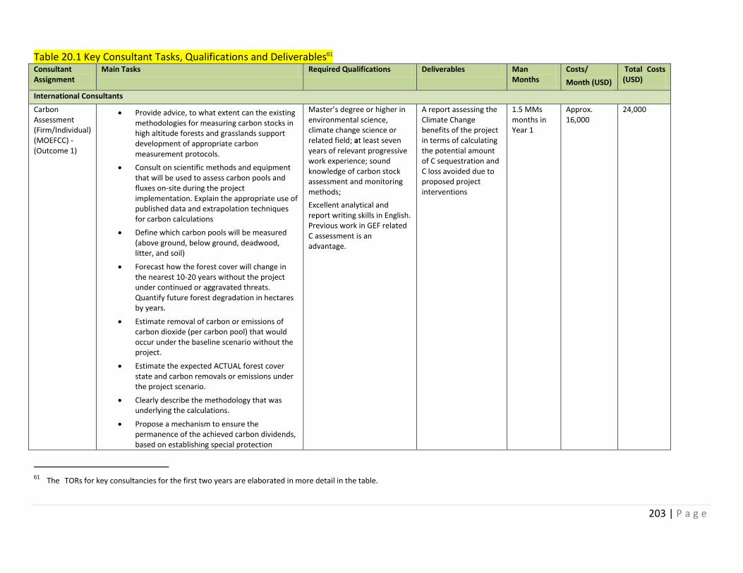
203 | P a g e
Table 20.1 Key Consultant Tasks, Qualifications and Deliverables61 Consultant Assignment
Main Tasks Required Qualifications Deliverables Man Months
Costs/
Month (USD)
Total Costs (USD)
International Consultants
Carbon Assessment (Firm/Individual) (MOEFCC) - (Outcome 1)
Provide advice, to what extent can the existing methodologies for measuring carbon stocks in high altitude forests and grasslands support development of appropriate carbon measurement protocols.
Consult on scientific methods and equipment that will be used to assess carbon pools and fluxes on-site during the project implementation. Explain the appropriate use of published data and extrapolation techniques for carbon calculations
Define which carbon pools will be measured (above ground, below ground, deadwood, litter, and soil)
Forecast how the forest cover will change in the nearest 10-20 years without the project under continued or aggravated threats. Quantify future forest degradation in hectares by years.
Estimate removal of carbon or emissions of carbon dioxide (per carbon pool) that would occur under the baseline scenario without the project.
Estimate the expected ACTUAL forest cover state and carbon removals or emissions under the project scenario.
Clearly describe the methodology that was underlying the calculations.
Propose a mechanism to ensure the permanence of the achieved carbon dividends, based on establishing special protection
Master’s degree or higher in environmental science, climate change science or related field; at least seven years of relevant progressive work experience; sound knowledge of carbon stock assessment and monitoring methods;
Excellent analytical and report writing skills in English. Previous work in GEF related C assessment is an advantage.
A report assessing the Climate Change benefits of the project in terms of calculating the potential amount of C sequestration and C loss avoided due to proposed project interventions
1.5 MMs months in Year 1
Approx. 16,000
24,000
61 The TORs for key consultancies for the first two years are elaborated in more detail in the table.
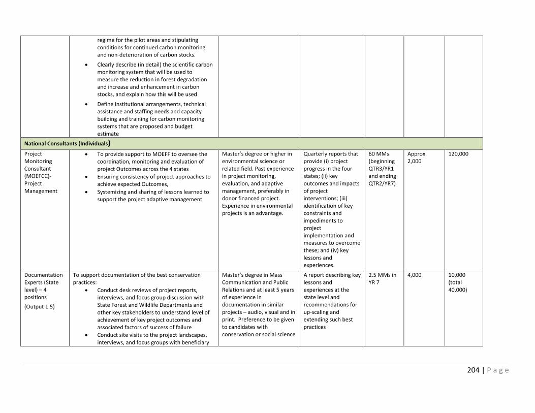
204 | P a g e
regime for the pilot areas and stipulating conditions for continued carbon monitoring and non-deterioration of carbon stocks.
Clearly describe (in detail) the scientific carbon monitoring system that will be used to measure the reduction in forest degradation and increase and enhancement in carbon stocks, and explain how this will be used
Define institutional arrangements, technical assistance and staffing needs and capacity building and training for carbon monitoring systems that are proposed and budget estimate
National Consultants (Individuals)
Project Monitoring Consultant (MOEFCC)- Project Management
To provide support to MOEFF to oversee the coordination, monitoring and evaluation of project Outcomes across the 4 states
Ensuring consistency of project approaches to achieve expected Outcomes,
Systemizing and sharing of lessons learned to support the project adaptive management
Master’s degree or higher in environmental science or related field. Past experience in project monitoring, evaluation, and adaptive management, preferably in donor financed project. Experience in environmental projects is an advantage.
Quarterly reports that provide (i) project progress in the four states; (ii) key outcomes and impacts of project interventions; (iii) identification of key constraints and impediments to project implementation and measures to overcome these; and (iv) key lessons and experiences.
60 MMs (beginning QTR3/YR1 and ending QTR2/YR7)
Approx. 2,000
120,000
Documentation Experts (State level) – 4 positions
(Output 1.5)
To support documentation of the best conservation practices:
Conduct desk reviews of project reports, interviews, and focus group discussion with State Forest and Wildlife Departments and other key stakeholders to understand level of achievement of key project outcomes and associated factors of success of failure
Conduct site visits to the project landscapes, interviews, and focus groups with beneficiary
Master’s degree in Mass Communication and Public Relations and at least 5 years of experience in documentation in similar projects – audio, visual and in print. Preference to be given to candidates with conservation or social science
A report describing key lessons and experiences at the state level and recommendations for up-scaling and extending such best practices
2.5 MMs in YR 7
4,000 10,000 (total 40,000)
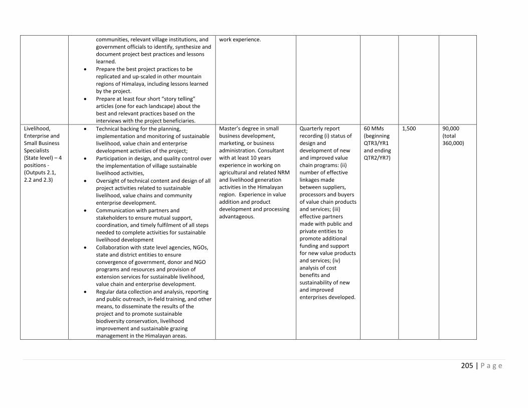
205 | P a g e
communities, relevant village institutions, and government officials to identify, synthesize and document project best practices and lessons learned.
Prepare the best project practices to be replicated and up-scaled in other mountain regions of Himalaya, including lessons learned by the project.
Prepare at least four short “story telling” articles (one for each landscape) about the best and relevant practices based on the interviews with the project beneficiaries.
work experience.
Livelihood, Enterprise and Small Business Specialists (State level) – 4 positions - (Outputs 2.1, 2.2 and 2.3)
Technical backing for the planning, implementation and monitoring of sustainable livelihood, value chain and enterprise development activities of the project;
Participation in design, and quality control over the implementation of village sustainable livelihood activities,
Oversight of technical content and design of all project activities related to sustainable livelihood, value chains and community enterprise development.
Communication with partners and stakeholders to ensure mutual support, coordination, and timely fulfilment of all steps needed to complete activities for sustainable livelihood development
Collaboration with state level agencies, NGOs, state and district entities to ensure convergence of government, donor and NGO programs and resources and provision of extension services for sustainable livelihood, value chain and enterprise development.
Regular data collection and analysis, reporting and public outreach, in-field training, and other means, to disseminate the results of the project and to promote sustainable biodiversity conservation, livelihood improvement and sustainable grazing management in the Himalayan areas.
Master’s degree in small business development, marketing, or business administration. Consultant with at least 10 years experience in working on agricultural and related NRM and livelihood generation activities in the Himalayan region. Experience in value addition and product development and processing advantageous.
Quarterly report recording (i) status of design and development of new and improved value chain programs: (ii) number of effective linkages made between suppliers, processors and buyers of value chain products and services; (iii) effective partners made with public and private entities to promote additional funding and support for new value products and services; (iv) analysis of cost benefits and sustainability of new and improved enterprises developed.
60 MMs (beginning QTR3/YR1 and ending QTR2/YR7)
1,500 90,000 (total 360,000)
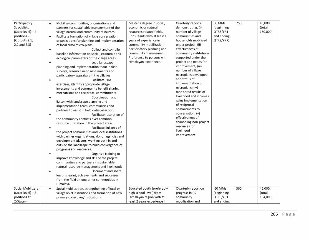
206 | P a g e
Participatory Specialists (State level) – 4 positions - (Outputs 2.1, 2.2 and 2.3)
Mobilize communities, organizations and partners for sustainable management of the village natural and community resources
Facilitate formation of village conservation organizations for planning and implementation of local NRM micro-plans
Collect and compile baseline information on social, economic and ecological parameters of the village areas;
Lead landscape planning and implementation team in field surveys, resource need assessments and participatory appraisals in the villages
Facilitate PRA exercises, identify appropriate village investments and community benefit sharing mechanisms and reciprocal commitments
Coordination and liaison with landscape planning and implementation team, communities and partners to assist in field data collection;
Facilitate resolution of the community conflicts over common resource utilization in the project areas;
Facilitate linkages of the project communities and local institutions with partner organizations, donor agencies and development players, working both in and outside the landscape to build convergence of programs and resources.
Organize training to improve knowledge and skill of the project communities and partners in sustainable natural resource management and livelihood;
Document and share lessons learnt, achievements and successes from the field among other communities in Himalaya.
Master’s degree in social, economic or natural resources related fields. Consultants with at least 10 years of experience in community mobilization, participatory planning and community management. Preference to persons with Himalayan experience.
Quarterly reports demonstrating: (i) number of village communities and households mobilized under project; (ii) effectiveness of community institutions supported under the project and needs for improvement; (iii) number of village microplans developed and status of implementation of microplans; (iv) monitored results of livelihood and incomes gains implementation of reciprocal commitments to conservation; (v) effectiveness of channeling non-project resources for livelihood improvement
60 MMs (beginning QTR3/YR1 and ending QTR2/YR7)
750 45,000 (total 180,000)
Social Mobilizers (State level) – 8 positions at 2/State -
Social mobilization, strengthening of local or village level institutions and formation of new primary collectives/institutions;
Educated youth (preferably high school level) from Himalayan region with at least 2 years experience in
Quarterly report on progress in (I0 community mobilization and
60 MMs (beginning QTR3/YR1 and ending
360 46,000 (total 184,000)
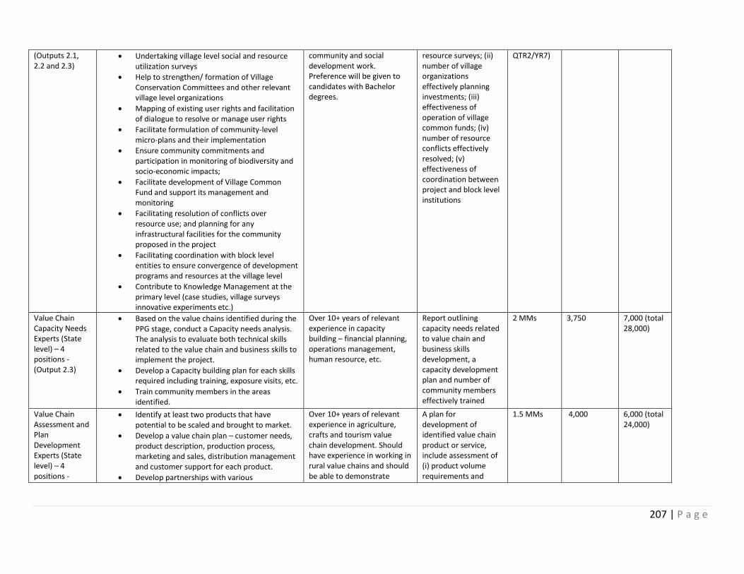
207 | P a g e
(Outputs 2.1, 2.2 and 2.3)
Undertaking village level social and resource utilization surveys
Help to strengthen/ formation of Village Conservation Committees and other relevant village level organizations
Mapping of existing user rights and facilitation of dialogue to resolve or manage user rights
Facilitate formulation of community-level micro-plans and their implementation
Ensure community commitments and participation in monitoring of biodiversity and socio-economic impacts;
Facilitate development of Village Common Fund and support its management and monitoring
Facilitating resolution of conflicts over resource use; and planning for any infrastructural facilities for the community proposed in the project
Facilitating coordination with block level entities to ensure convergence of development programs and resources at the village level
Contribute to Knowledge Management at the primary level (case studies, village surveys innovative experiments etc.)
community and social development work. Preference will be given to candidates with Bachelor degrees.
resource surveys; (ii) number of village organizations effectively planning investments; (iii) effectiveness of operation of village common funds; (iv) number of resource conflicts effectively resolved; (v) effectiveness of coordination between project and block level institutions
QTR2/YR7)
Value Chain Capacity Needs Experts (State level) – 4 positions - (Output 2.3)
Based on the value chains identified during the PPG stage, conduct a Capacity needs analysis. The analysis to evaluate both technical skills related to the value chain and business skills to implement the project.
Develop a Capacity building plan for each skills required including training, exposure visits, etc.
Train community members in the areas identified.
Over 10+ years of relevant experience in capacity building – financial planning, operations management, human resource, etc.
Report outlining capacity needs related to value chain and business skills development, a capacity development plan and number of community members effectively trained
2 MMs 3,750 7,000 (total 28,000)
Value Chain Assessment and Plan Development Experts (State level) – 4 positions -
Identify at least two products that have potential to be scaled and brought to market.
Develop a value chain plan – customer needs, product description, production process, marketing and sales, distribution management and customer support for each product.
Develop partnerships with various
Over 10+ years of relevant experience in agriculture, crafts and tourism value chain development. Should have experience in working in rural value chains and should be able to demonstrate
A plan for development of identified value chain product or service, include assessment of (i) product volume requirements and
1.5 MMs 4,000 6,000 (total 24,000)
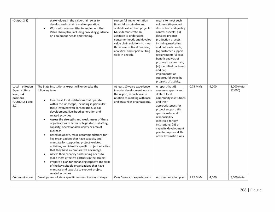
208 | P a g e
(Output 2.3)
stakeholders in the value chain so as to develop and sustain a viable operation.
Work with communities to implement the Value chain plan, including providing guidance on equipment needs and training.
successful implementation financial sustainable and scalable value chain projects. Must demonstrate an aptitude to understand consumer needs and develop value chain solutions to meet those needs. Good financial, analytical and report writing skills in English.
means to meet such volumes; (ii) product description and quality control aspects; (iii) detailed product production process, including marketing and outreach needs; (iv) customer support requirement; (v) cost benefit analysis of proposed value chain; (vi) identified partners; and (vii) implementation support, followed by progress of activity.
Local Institution Experts (State level) – 4 positions - (Output 2.1 and 2.2)
The State institutional expert will undertake the following tasks:
Identify all local institutions that operate within the landscape, including in particular those involved with conservation, social development, livelihood generation and related activities
Assess the strengths and weaknesses of these organizations in terms of legal status, staffing, capacity, operational flexibility or area of outreach
Based on above, make recommendations for key organizations that have capacity and mandate for supporting project –related activities, and identify specific project activities that they have a comparative advantage
Assess their capacity and training needs to make them effective partners in the project
Prepare a plan for enhancing capacity and skills of the key suitable organizations that have mandate and capacity to support project related activities
At least 10 years experience in social development work in the region, in particular in relation to working with local and grass root organizations.
A report that (i) assesses capacity and skills of local community institutions and their appropriateness for project support; (ii) specific roles and responsibility identified for key institutions; (iii) a capacity development plan to improve skills of the key institutions
0.75 MMs 4,000 3,000 (total 12,000)
Communication Development of state specific communication strategy, Over 5 years of experience in A communication plan 1.25 MMs 4,000 5,000 (total
209 | P a g e
Specialists (State level) – 4 positions - (Output 4.2)
communication tools and implementation plan. This will include the following tasks:
Identification of the target audiences (Line Ministries, CSO, regional and local government; general public, communities located in landscapes, including communities in agricultural and meadow areas, etc.);
Identification of the communication objective for each targeted audience (stakeholder mapping and positioning conservation in the state development context, creating awareness on conservation at state and local levels, sharing knowledge on conservation and sustainable natural resource use with stakeholders; etc.).
Identification of the communication products and activities tailored to each audience, building on already produced national and state communication material when possible, for each target audience.
Development a guide for all communications on conservation and sustainable natural resource use
developing communication strategies and tools relating to biodiversity, natural resource management and similar projects.
at the state level, that identifies target audiences, key communication messages and communication tools to be employed, and a step-by-step guide on communication to local communities on resource use.
20,000)
Policy and legislation expert/firm MOEFCC - (Output 4.1)
In consultation with key counterparts, identify specific constraints and impediments in existing policy and legislation to achieve desired conservation outcomes in the Himalayan region
Review and development of policy and legislation specific recommendation for mountain ecosystem for submission to MoEFCC.
Develop advocacy, training and awareness tools at state and local level for building consensus and capacities to implement the policies;
Assessing gaps and needs of government agencies in terms of policy and legislation development.
Conduct workshops at national and regional
Environment and development lawyer or firm, with past experience in policy and advocacy related to similar projects – natural resource management, forest rights, wildlife, mountain eco system, protected areas etc.
A report that (i) identifies key gaps in policy and legislation for the Himalayan region in relation to key objectives for the project; (ii) detailed recommendations for addressing these gaps in policy and legislation, including specific needs for policy and legislation revision or for new instruments; (iii) assesses responsiveness of
12.5 MMs spread over Year 1 and 2
4,000 50,000
210 | P a g e
level to build consensus on desired changes to legislation and policy
national and regional policy makers for change in policy and legislation; and (iv) a timeline and process for making such changes
Documentation experts (State level) – 4 positions - (Output 4.1)
Conduct of desk reviews of relevant documents, interviews, focused group discussion with key stakeholders to identify best practices for conservation, improved livelihood, sustainable natural resources management, and wildlife crime prevention measures at the state level
Document such good practices and other lessons relevant to the state environmental issues.
Training local teams in video and photo documentation of the key areas of the project for building resource materials for use by different stakeholders, and
Capacity building of local youth and community in communication and documentation of the best practices and lessons learned.
Master’s degree in Mass Communication and over 5 years of experience in documentation and community training similar projects – audio - visual and print
A report (i) documenting key lessons and experiences; (ii) development of video, photo and media materials for dissemination of such lessons; and (iii) guidelines and training of youth and community members for additional documentation and dissemination practice
4 MMs in Year 7
3,750 15,000 (total 60,000)
National (Contractual Services – Firms)
Landscape Conservation Mapping Experts (State level) – 4 positions - (Output 1.1)
Development thematic maps for the landscapes (1:50,000) that depict the spatial and temporal distribution of threatened species, biodiversity hotspots, hydrology, land use, land cover, bio-corridors and critical wildlife habitats for further analysis and preparation of comprehensive landscape level conservation plans
Identification of Biological Indicators for Assessing Conservation Values, including rapid assessment of distribution of key species and potential indicator species for monitoring changes and prepare inventory of species in different vegetation types and habitats; develop baseline inventories of the key
Institutions/Firms with extensive experience in GIS, remote sensing, resource mapping, conservation planning, wildlife management, training capability and preferably having in-house expertise in biological, social, wildlife, and forestry.
A series of thematic maps of the landscapes
characterized by degrees of conservation values and potential, compatible development potential and presence of competing or conflicting interests based on threats and opportunities; and recommendations
25 MMs (spread over Year 1 and 2)
4,000 100,000 (total 400,000)
211 | P a g e
indicator species and distribution maps and define standardized tools and techniques and monitoring protocols; develop a training package with modules to train staff and local communities in monitoring these indicators; define fixed sampling points; and development of within the landscape that can be monitored over the next years to quantify abundance and change in species. Monitoring protocol to be used for monitoring of the landscape condition, with indicators, baseline and monitoring and reporting arrangements.
Mapping of the socio-economic parameters including demography, production, dependencies and livelihoods and development activities through rapid assessment
Based on above features, map options and opportunities for Sustainable Resource Use and Livelihood and Conservation of Biodiversity.
The final outcomes of the mapping exercise would likely be: (a) a map or series of maps (1:50,000) showing landscape zones or focal landscape areas characterized by degrees of conservation values and potential, compatible development potential and presence of competing or conflicting interests based on threats and opportunities; and (b) recommendations regarding land uses suitable for different areas of the landscape based on threats and opportunities analysis
regarding land uses suitable for different areas of the landscape based on threats and opportunities analysis
Management Planning (State level) – 4 positions - (Output 1.2)
Management plans will be prepared for the protected areas or updated (if already exist) which will include the plans for buffer zones, wildlife corridors and areas of high biodiversity significance outside protected areas following principles of landscape / project snow leopard approach. Strengthen institutional capacity and skills for effective implementation of landscape level conservation and management plans through
Preparation of site specific participatory natural resource management plans including
Institutions/Firms with extensive experience in protected area management and conservation planning, documentation of wildlife and natural resources, environmental management, etc.
Management plans for the protected areas with proposals for buffer zones, wildlife corridors and areas of high biodiversity significance outside protected areas
15 MMs (spread over Year 2,3 and 4)
4,000 60,000 (total 240,000)
212 | P a g e
soil and water conservation activities to be implemented by the local communities with support from conservation and development agencies, improvement and protection of ecosystem functions, mitigation of the impacts of grazing on sensitive habitats and species, institutionalizing sustainable use of natural resources and livelihood enhancement options by the community, wise and sustainable harvesting of high value medicinal and aromatic plants and restoration of degraded habitats; exploiting the potential of natural and assisted natural pasture regeneration; (b) Documentation of traditional ecological knowledge related to sustainable management of natural resources and integrating into site specific plans;
Collation and review of key environmental information required maintaining species and habitats, ensuring ecosystem services, managing threats to biodiversity and ecosystem services, environmental risks of climate change, environmental hazards and the state of forest, grazing and land degradation;
Extensive consultation with key stakeholders, including local communities on their expected needs and services from these natural areas;
Revision or development of new protocols to ensure provision of guidance on assessing trade-offs between different natural resource uses. The outcome of this activity would be a set of protocols and guidelines that would help forest and wildlife managers and land-use planners on the use of ecosystem-based planning approaches in the preparation of natural resource use management plans.
Habitat Restoration (State level) – 4 positions - (Output 1.3)
Provide technical support in identification of degraded sites for eco-restoration that would be undertaken through a participatory process. The project will trigger restoration of degraded pastures and forests to less disturbed conditions. The specific activities that would
Institutions/Firms with extensive experience in resource rehabilitation and restoration planning, implementation and
Rehabilitation and restoration plan for the identified sites and manual that describes rehabilitation and
2.5 MMs in Year 2
4,000 10,000 (total 40,000)
213 | P a g e
be undertaken in this output will include the:
Review of national and regional best practices in restoration of alpine pasture and sub-alpine forests;
Preparation of a rehabilitation and restoration plan for the identified sites, including assessment of best silvicultural and soil conservation practices and working methodologies, and protection and maintenance measures;
Establishment and maintenance of a suitable mix of protection and social fencing measures to reduce grazing, wood collection and forest product extraction pressures;
Support the implementation and monitoring of grazing and forest rehabilitation plans;
Documentation and dissemination of successes and failures at each of the rehabilitation sites; and
Preparation of a manual that describes rehabilitation and restoration approaches for different pasture and forest types.
monitoring of resource improvement works
restoration approaches for different pasture and forest types.
Baseline Monitoring (State level) – 4 positions - (Output 1.4)
Develop scientific frameworks for comprehensive surveys to identify biologically important landscapes and landscape units, and associated socio-economy and human-wildlife interactions
Based on base-line surveys, determine population status of snow leopard and associated species in the landscape
Based on scientific surveys, identify important landscapes for monitoring key species and habitats (including but not restricted to protected areas)
Landscape zonation will be planned within and outside protected areas based on wildlife values, conservation potential, alternate land use requirements, and conservation prioritization of each landscape unit
Management planning guidelines will be developed that promote key species
Institutions/firms with extensive experience in habitat mapping survey and assessment of habitat values and suitability, as well as good understanding of land and pasture restoration and silvicultural practices.
Monitoring framework for landscapes, identifying key indicators species and baselines, and annual and final reports of population and distribution of snow leopard, key prey species and endangered species
20 MMs (spread over YR1 through YR7)
3,000 60,000 (total 240,000)
214 | P a g e
conservation as well as localized management strategies
Participatory Monitoring (State level) – 4 positions - (Output 1.4)
Following tasks are planned under this output:
Assess the training needs of the line agencies and local volunteers in basic tools and techniques of recording bio-physical and socio-economic parameters;
(b) Develop curricula / courses for their capacity building and involving them in collection of data;
(c) Organizing the community based organizations in lines of Biodiversity Management Committees as prescribed under National Biodiversity Act (2002) so that they are given the responsibility of documenting the local biodiversity (in biodiversity registers) and take part in its monitoring;
(d) Develop linkages between the Government of India’s Project Snow leopard and other national programs such as the National Mission for Sustaining the Himalayan Ecosystem (NMSHE) and National Mission on Himalayan Studies (NMHS) to address the emerging challenges of climate change and human-wildlife conflicts in the IHR and conservation issues.
Institutions/firms with extensive on-the-ground experience and expertise in monitoring and conduct of training. Institutions already conducted similar training activities with training facilities will have an advantage.
Report outlining training needs, curricula for enhancing community capacity in monitoring; assessment of effectiveness of training programs, and community organization and capacity for participatory monitoring
1.25 MMs in YR1
4,000 5,000 (total 20,000)
Participatory Monitoring Training - (Output 1.4)
Identify specific needs for participatory monitoring at the local level, determine key topics and audiences to be trained
Conduct capacity building workshop for the volunteers and frontline staff of the project landscapes and involve them in baseline data collection and repeat observations in mutual consultation with the state Wildlife Department.
Prepare training material and user-friendly data sheets, patrol diaries for the staff.
Institutions/firms extensive on-the-ground experience and expertise in monitoring and conduct of training. Institutions already conducted similar training activities with training facilities will have an advantage.
Report assessing effectiveness of training of communities in monitoring, identifying additional long-term capacity needs and training materials
1.25 MMs 4,000 5,000 (total 20,000)
Value Chain Branding, Marketing and
The task would entail the following:
Over 10+ years of relevant experience in FMGC branding and marketing. Should be able to demonstrate ability to
Branding and marketing plans for selected products, training curriculum
4 MMs 3,750 15,000 (total 60,000)
215 | P a g e
Extension (State level) – 4 positions - (Output 2.3)
Develop and design a branding and marketing plan for selected products.
Train and work with the communities on implementing the plan.
Develop collateral and communication material to communicate with customers
Develop and implement a brand communication strategy.
Key areas – Market Research, Target Customer, Competitive Analysis, Customer Acquisition Strategy, Budget.
conceptualize, designing and create a brand though past experience. Good financial, analytical and report writing skills in English.
and program materials, brand communication strategy and report assessing effectiveness of capacity building implementation efforts
Value Chain Processing (State level) – 4 positions - (Output 2.3)
Where applicable develop a processing plan for selected value chain products and services.
Work with communities to train and implement the plan.
Identify specific equipment and processing needs and options for obtaining such equipment, either through the project or alternative sources of funding
Key areas – plant layout, processes and flows, budget, raw material planning, HR plan, quality control to be supported.
Over 10+ years of relevant experience in designing, building and running a processing plant. Should have relevant supply chain expertise and technical skills relevant to the processing plant in question. For example food technology skills for a food processing plant. Good financial, analytical and report writing skills in English.
Processing plans for selected value chain products and services, training curriculum and program, and report specifying equipment and processing needs etc.
4 MMs 3,750 15,000 (total 60,000)
Communication Material production (State level) – 4 positions - (Output 4.2)
Development and design of communication material – print, audio and video, for use at state level, specific to communication plan and also relevant to other key focus areas of the project – livelihood, conservation and illegal trade, including development of user-friendly and high quality Information, Education and Communication material (such as handouts, posters, brochures, video documentary films and photo documentation, success stories booklet etc.) in local languages and English for communication of the project activities to the public and stake holders.
Extensive (at least 5 years) experience in preparation of awareness materials (print, video and audio), including in local languages.
Communication materials in English and local languages (brochures, posters, video, documentary films, etc.)
4 MMs 3,750 15,000 (total 60,000)
Communication Plan implementation
Dissemination of the communication material
Development and design of information center
Over 10 years of experience in developing and implementing
Quarterly reports assessing effectiveness of implementation of
YR 2 to YR 7 (total 60
Lump Sum Contract
42,000 (total
216 | P a g e
support (State level) – 4 positions - (Output 4.2)
Implementation of communication tools developed for engaging the different stakeholders – local to state level – like workshops, theater, community screenings etc.
Training and capacity building of local team for long term communication strategy
communication strategies and tools relating to biodiversity, natural resource management and similar projects.
communication plans, number of events conducted, number of beneficiaries, etc.
MMs) 168,000
National Communication Plan (MOEFCC) – (Output 4.2)
Identification of the target audiences (Line Ministries, CSO, national and regional government; political decision makers, general public, etc.
Identification of the communication objective for each targeted audience (stakeholder mapping and positioning conservation in national development context, creating awareness on conservation at national and regional levels, sharing knowledge on conservation and sustainable natural resource use with stakeholders; etc.).
Identification of the communication products and activities tailored to each audience, building on already produced national and regional communication material when possible, for each target audience.
Development a guide for all communications on conservation and sustainable natural resource use
Development and implementation of a national level communication plan in collaboration with the state level teams.
Engaging communication agencies and specialists for relevant areas of communication plan – mascot branding,
Engagement of icons, events and festival
Over 10 years of experience in developing and implementing communication strategies and tools relating to biodiversity, natural resource management and similar projects.
National Communication plan, identifying target audiences, training tools and methods, etc.
3 MMs 4,000 12,000
National Communication Material Production (MOEFCC) - (Output 4.2)
Development and design of communication material – print, audio and video, for use at national level, specific to communication plan and also relevant to other key focus areas of the project – livelihood, conservation and illegal trade,
Development of user-friendly and high quality Information, Education and Communication
Communication Agency with over 10 years of experience in similar projects
Range of communication materials, including audio and video products, posters, booklets, stories, etc.
15 MMs 3,000 45,000

217 | P a g e
material (such as handouts, posters, brochures, video documentary films and photo documentation, success stories booklet etc.) in Hindi and English for communication of the project activities to the public and stakeholders.
National Communication Plan implementation support (MOEFCC) - (Output 4.2)
Dissemination of the communication material.
Development of communication tools to give the project a national identity and implementation of the tools developed such as Mascot, Brand, events, festivals, conference, knowledge and resource Center.
Connecting the stakeholders from local to national level
Communication Agency with over 10 years of experience in similar projects
Quarterly reports assessing effectiveness of implementation of communication plans, number of events conducted, number of beneficiaries, etc.
10 MMs 3,500 35,000
Website Development (MOEFCC) - (Output 4.2)
Development, update and maintenance of the project website, and strong social media connection for the project.
Creating a window for the project on the MoEFCC website.
Individual Expert or Communication Agency with over 5 years of experience in similar projects
Dedicated website for project and guidelines for update and access
10 MMs 3,500 35,000
218 | P a g e
Annex 21:
Multi Year Work Plan
Task Responsible
Party Year
0 Year 1 Year 2 Year 3 Year 4 Year 5 Year 6 Year 7
Q1
Q2
Q 3
Q4
Q1
Q2
Q3
Q4
Q1
Q2
Q3
Q4
Q1
Q2
Q3
Q4
Q1
Q2
Q3
Q4
Q1
Q2
Q3
Q4
Q1
Q2
Q3
Q4
Pre-Planning Phase (PPG Phase)
Constituting of Central (Project Board) and State Steering Committees
MOEFCC and State Forest and Wildlife Departments
Constituting of Central and State Institutions (Central PMU, State PPMU and LPIT)
MOEFCC and State Forest and Wildlife Departments
Hiring of Contractual Staff for State PPMU and LPIT)
State Forest and Wildlife Departments
Establishment of Project Special Accounts and Fund Flow Arrangements
MOEFCC and State Governments and UNDP
Planning Phase (First Year of Project)
Participatory mapping of conservation values of landscapes
State PPMUs and WII
Mapping of community resources, rights and utilization status
State PPMUs and WII
Defining landscape level vision and objectives
State PPMUs and WII
Development of broad strategies and actions for landscapes
State PPMUs and WII
Conservation management plans for PAs and biodiversity rich areas
State PPMUs and WII
Identification of degraded grazing lands and forest areas for assisted natural regeneration
State PPMUs and WII
Identification of areas for HCVFs, BHSs, community-based conservation and forest management, restoration, etc.
State PPMUs and WII
Defining monitoring indicators and baselines for species and habitat monitoring
WII
Training of State Landscape Planning and State PPMUs and
219 | P a g e
Implementation Teams (LPIT) technical support
Identification of villages for staggered implementation throughout project period
State LPITs
Community orientation and mobilization with informed consultation (including tribal communities)
State LPITs
Capacity building for local institutions/bodies
State LPITs
Initiation of microplanning for FIRST batch of priority villages (25% of villages)
State LPITs
Completion of analysis of pre-selected value chains and action plan developed for implementation
State LPITs with technical support
Establishment and training of community groups for surveillance and crime monitoring
State PPMUs
Design of communication program and preparation of communication materials
State PPMUs with technical support
Carbon estimation calculation MOEFCC
Implementation Phase (Year 2-6)
Site specific management plans for PAs, HCVFs, BHSs, etc.
State Forest and Wildlife Departments and WII
Implementing conservation activities for PAs, HCVFs, BHSs, community managed forests, etc.
State Forest and Wildlife Departments
Implementing conservation activities in production areas outside PAs
State Forest and Wildlife Departments
Capacity building for conservation management (staff and communities)
State PPMUs
Preparation of restoration plans for degraded alpine pastures and sub-alpine forests
State PPMUs and State Forest and Wildlife Departments
Implementation of restoration plans for degraded alpine pastures and sub-alpine forests
State Forest and Wildlife Departments
Development of participatory monitoring protocols
State LPITs with technical support
Training of communities on participatory monitoring techniques
State LPITs with technical support
Monitoring of key conservation WII
220 | P a g e
parameters against baselines
Staff training for implementation of landscape conservation outcomes
WII
Community training for microplan development and implementation
State PPMUs
Implementation of microplanning investments for FIRST batch of priority villages (25% of villages)
State PLITs
Initiation of microplanning for SECOND batch of priority villages (35% of villages)
State PLITs
Implementation of microplanning investments for SECOND batch of priority villages (35% of villages)
State PLITs
Initiation of microplanning for THIRD batch of priority villages (40% of villages)
State PLITs
Implementation of microplanning investments for THIRD batch of priority villages (40% of villages)
State PLITs
Capacity building for value chain development
State PPMUs
Value chain activities under implementation (technical support, materials, production and processing equipment and extension)
State PLITs
Assessment of hotspots, pathways and status of wildlife crime
MOEFCC and States
Capacity building for forest and security personal in wildlife crime prevention
MOEFCC and States
Community surveillance and monitoring State PPMUs
Review of policies and legislation on trade and poaching
MOEFCC and States
Assessment of legal procedures relating to prosecutions
MOEFCC and States
Capacity building for identification and forensics
MOEFCC and States
Design of insurance schemes for wildlife-livestock conflict management
State PPMUs
Wildlife-livestock conflict management investments
State PPMUs
Trans-boundary cooperation MOEFCC and States
Developing communication program and materials
State PPMUs and MOEFCC
Implementation of communication State PPMUs and
221 | P a g e
strategy MOEFCC
Implementation of gender mainstreaming strategy
State PPMUs and MOEFCC
Documentation of best practices MOEFCC and States
National workshop for sharing best practices
MOEFCC and States
Supervision, Monitoring and Evaluation
Monitoring social and environmental risks
PPMUs and MOEFCC
Supervision UNDP
MTR tracking tool update WII
Final tracking tool update WII
Audits UNDP
MTR Independent Review UNDP
Final Project Review UNDP
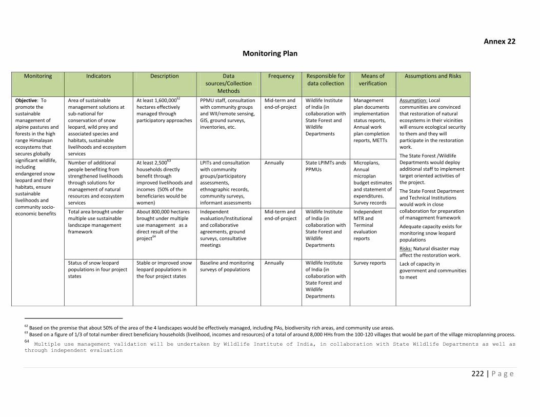
222 | P a g e
Annex 22
Monitoring Plan
62 Based on the premise that about 50% of the area of the 4 landscapes would be effectively managed, including PAs, biodiversity rich areas, and community use areas. 63 Based on a figure of 1/3 of total number direct beneficiary households (livelihood, incomes and resources) of a total of around 8,000 HHs from the 100-120 villages that would be part of the village microplanning process. 64 Multiple use management validation will be undertaken by Wildlife Institute of India, in collaboration with State Wildlife Departments as well as through independent evaluation
Monitoring Indicators Description Data sources/Collection
Methods
Frequency Responsible for data collection
Means of verification
Assumptions and Risks
Objective: To promote the sustainable management of alpine pastures and forests in the high range Himalayan ecosystems that secures globally significant wildlife, including endangered snow leopard and their habitats, ensure sustainable livelihoods and community socio-economic benefits
Area of sustainable management solutions at sub-national for conservation of snow leopard, wild prey and associated species and habitats, sustainable livelihoods and ecosystem services
At least 1,600,00062 hectares effectively managed through participatory approaches
PPMU staff, consultation with community groups and WII/remote sensing, GIS, ground surveys, inventories, etc.
Mid-term and end-of-project
Wildlife Institute of India (in collaboration with State Forest and Wildlife Departments
Management plan documents implementation status reports, Annual work plan completion reports, METTs
Assumption: Local communities are convinced that restoration of natural ecosystems in their vicinities will ensure ecological security to them and they will participate in the restoration work.
The State Forest /Wildlife Departments would deploy additional staff to implement target oriented activities of the project.
The State Forest Department and Technical Institutions would work in close collaboration for preparation of management framework
Adequate capacity exists for monitoring snow leopard populations
Risks: Natural disaster may affect the restoration work.
Lack of capacity in government and communities to meet
Number of additional people benefiting from strengthened livelihoods through solutions for management of natural resources and ecosystem services
At least 2,50063 households directly benefit through improved livelihoods and incomes (50% of the beneficiaries would be women)
LPITs and consultation with community groups/participatory assessments, ethnographic records, community surveys, informant assessments
Annually
State LPIMTs ands PPMUs
Microplans, Annual microplan budget estimates and statement of expenditures. Survey records
Total area brought under multiple use sustainable landscape management framework
About 800,000 hectares brought under multiple use management as a direct result of the project64
Independent evaluation/Institutional and collaborative agreements, ground surveys, consultative meetings
Mid-term and end-of-project
Wildlife Institute of India (in collaboration with State Forest and Wildlife Departments
Independent MTR and Terminal evaluation reports
Status of snow leopard populations in four project states
Stable or improved snow leopard populations in the four project states
Baseline and monitoring surveys of populations
Annually Wildlife Institute of India (in collaboration with State Forest and Wildlife Departments
Survey reports
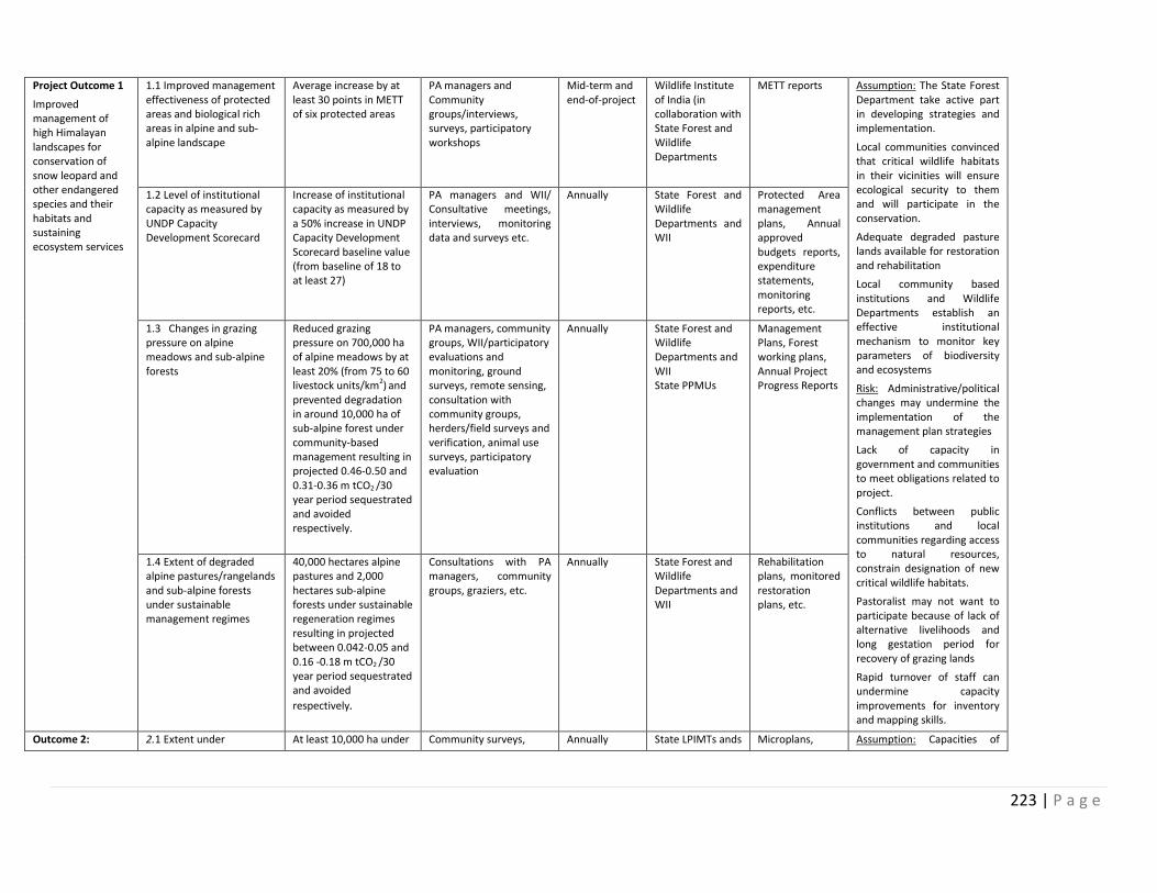
223 | P a g e
Project Outcome 1
Improved management of high Himalayan landscapes for conservation of snow leopard and other endangered species and their habitats and sustaining ecosystem services
1.1 Improved management effectiveness of protected areas and biological rich areas in alpine and sub-alpine landscape
Average increase by at least 30 points in METT of six protected areas
PA managers and Community groups/interviews, surveys, participatory workshops
Mid-term and end-of-project
Wildlife Institute of India (in collaboration with State Forest and Wildlife Departments
METT reports Assumption: The State Forest Department take active part in developing strategies and implementation.
Local communities convinced that critical wildlife habitats in their vicinities will ensure ecological security to them and will participate in the conservation.
Adequate degraded pasture lands available for restoration and rehabilitation
Local community based institutions and Wildlife Departments establish an effective institutional mechanism to monitor key parameters of biodiversity and ecosystems
Risk: Administrative/political changes may undermine the implementation of the management plan strategies
Lack of capacity in government and communities to meet obligations related to project.
Conflicts between public institutions and local communities regarding access to natural resources, constrain designation of new critical wildlife habitats.
Pastoralist may not want to participate because of lack of alternative livelihoods and long gestation period for recovery of grazing lands
Rapid turnover of staff can undermine capacity improvements for inventory and mapping skills.
1.2 Level of institutional capacity as measured by UNDP Capacity Development Scorecard
Increase of institutional capacity as measured by a 50% increase in UNDP Capacity Development Scorecard baseline value (from baseline of 18 to at least 27)
PA managers and WII/ Consultative meetings, interviews, monitoring data and surveys etc.
Annually State Forest and Wildlife Departments and WII
Protected Area management plans, Annual approved budgets reports, expenditure statements, monitoring reports, etc.
1.3 Changes in grazing pressure on alpine meadows and sub-alpine forests
Reduced grazing pressure on 700,000 ha of alpine meadows by at least 20% (from 75 to 60 livestock units/km2) and prevented degradation in around 10,000 ha of sub-alpine forest under community-based management resulting in projected 0.46-0.50 and 0.31-0.36 m tCO2 /30 year period sequestrated and avoided respectively.
PA managers, community groups, WII/participatory evaluations and monitoring, ground surveys, remote sensing, consultation with community groups, herders/field surveys and verification, animal use surveys, participatory evaluation
Annually
State Forest and Wildlife Departments and WII State PPMUs
Management Plans, Forest working plans, Annual Project Progress Reports
1.4 Extent of degraded alpine pastures/rangelands and sub-alpine forests under sustainable management regimes
40,000 hectares alpine pastures and 2,000 hectares sub-alpine forests under sustainable regeneration regimes resulting in projected between 0.042-0.05 and 0.16 -0.18 m tCO2 /30 year period sequestrated and avoided
respectively.
Consultations with PA managers, community groups, graziers, etc.
Annually State Forest and Wildlife Departments and WII
Rehabilitation plans, monitored restoration plans, etc.
Outcome 2: 2.1 Extent under At least 10,000 ha under Community surveys, Annually State LPIMTs ands Microplans, Assumption: Capacities of
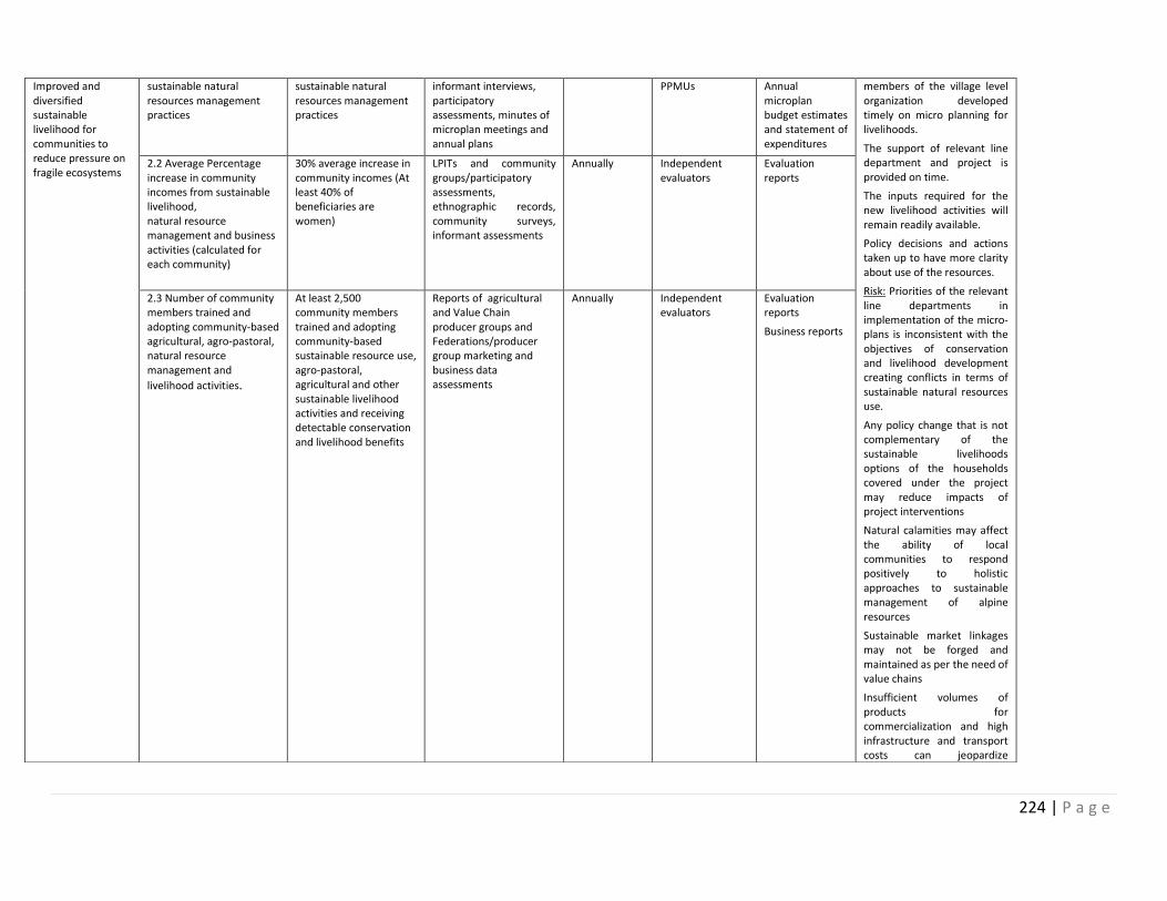
224 | P a g e
Improved and diversified sustainable livelihood for communities to reduce pressure on fragile ecosystems
sustainable natural resources management practices
sustainable natural resources management practices
informant interviews, participatory assessments, minutes of microplan meetings and annual plans
PPMUs Annual microplan budget estimates and statement of expenditures
members of the village level organization developed timely on micro planning for livelihoods.
The support of relevant line department and project is provided on time.
The inputs required for the new livelihood activities will remain readily available.
Policy decisions and actions taken up to have more clarity about use of the resources.
Risk: Priorities of the relevant line departments in implementation of the micro-plans is inconsistent with the objectives of conservation and livelihood development creating conflicts in terms of sustainable natural resources use.
Any policy change that is not complementary of the sustainable livelihoods options of the households covered under the project may reduce impacts of project interventions
Natural calamities may affect the ability of local communities to respond positively to holistic approaches to sustainable management of alpine resources
Sustainable market linkages may not be forged and maintained as per the need of value chains
Insufficient volumes of products for commercialization and high infrastructure and transport costs can jeopardize
2.2 Average Percentage increase in community incomes from sustainable livelihood, natural resource management and business activities (calculated for each community)
30% average increase in community incomes (At least 40% of beneficiaries are women)
LPITs and community groups/participatory assessments, ethnographic records, community surveys, informant assessments
Annually Independent evaluators
Evaluation reports
2.3 Number of community members trained and adopting community-based agricultural, agro-pastoral, natural resource management and
livelihood activities.
At least 2,500 community members trained and adopting community-based sustainable resource use, agro-pastoral, agricultural and other sustainable livelihood activities and receiving detectable conservation and livelihood benefits
Reports of agricultural and Value Chain producer groups and Federations/producer group marketing and business data assessments
Annually Independent evaluators
Evaluation reports
Business reports
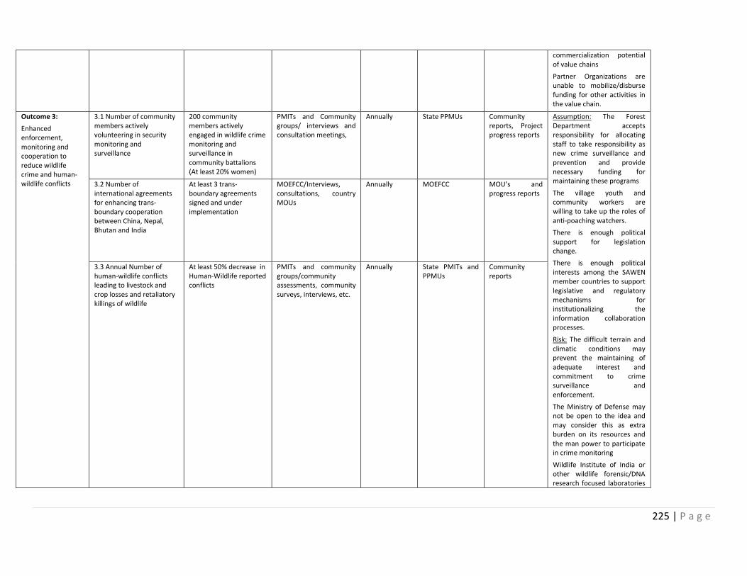
225 | P a g e
commercialization potential of value chains
Partner Organizations are unable to mobilize/disburse funding for other activities in the value chain.
Outcome 3:
Enhanced enforcement, monitoring and cooperation to reduce wildlife crime and human-wildlife conflicts
3.1 Number of community members actively volunteering in security monitoring and surveillance
200 community members actively engaged in wildlife crime monitoring and surveillance in community battalions (At least 20% women)
PMITs and Community groups/ interviews and consultation meetings,
Annually State PPMUs Community reports, Project progress reports
Assumption: The Forest Department accepts responsibility for allocating staff to take responsibility as new crime surveillance and prevention and provide necessary funding for maintaining these programs
The village youth and community workers are willing to take up the roles of anti-poaching watchers.
There is enough political support for legislation change.
There is enough political interests among the SAWEN member countries to support legislative and regulatory mechanisms for institutionalizing the information collaboration processes.
Risk: The difficult terrain and climatic conditions may prevent the maintaining of adequate interest and commitment to crime surveillance and enforcement.
The Ministry of Defense may not be open to the idea and may consider this as extra burden on its resources and the man power to participate in crime monitoring
Wildlife Institute of India or other wildlife forensic/DNA research focused laboratories
3.2 Number of international agreements for enhancing trans-boundary cooperation between China, Nepal, Bhutan and India
At least 3 trans-boundary agreements signed and under implementation
MOEFCC/Interviews, consultations, country MOUs
Annually MOEFCC MOU’s and progress reports
3.3 Annual Number of human-wildlife conflicts leading to livestock and crop losses and retaliatory killings of wildlife
At least 50% decrease in Human-Wildlife reported conflicts
PMITs and community groups/community assessments, community surveys, interviews, etc.
Annually State PMITs and PPMUs
Community reports
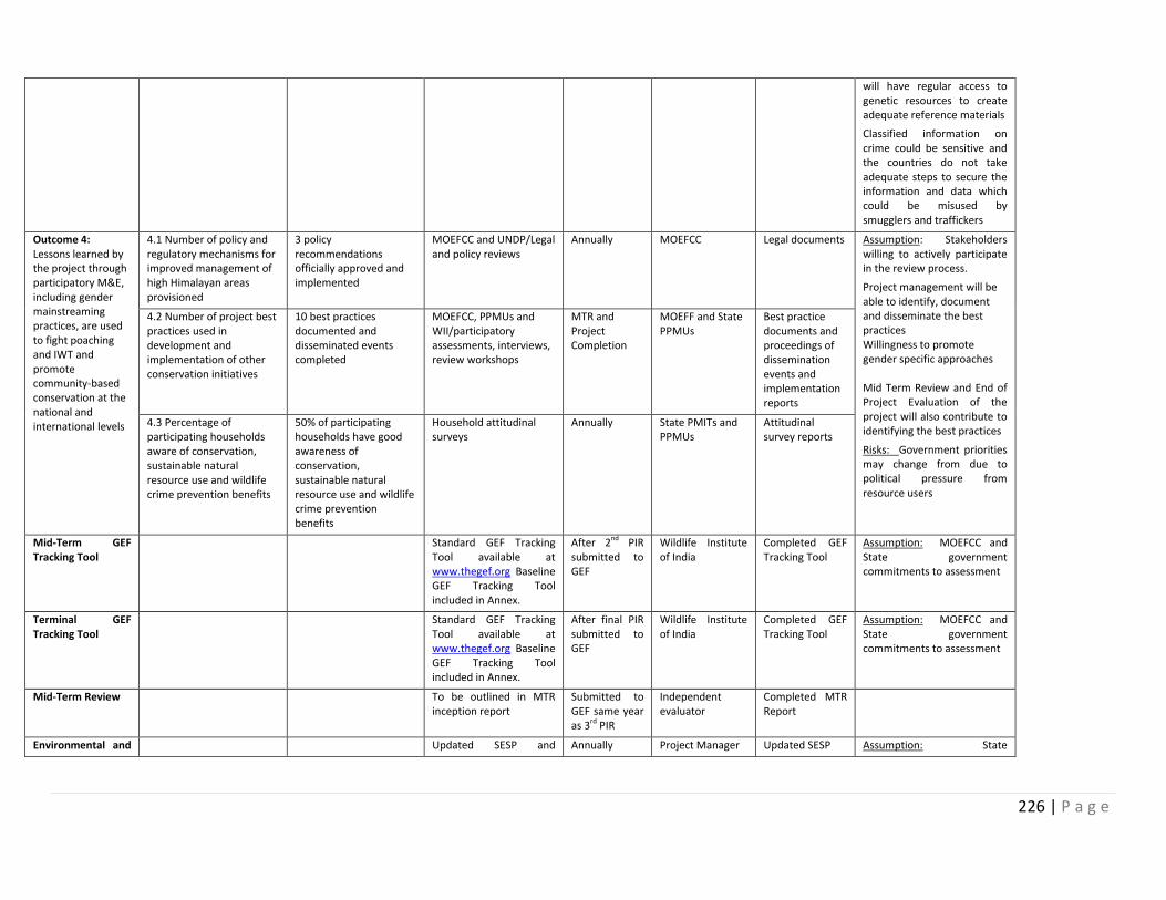
226 | P a g e
will have regular access to genetic resources to create adequate reference materials
Classified information on crime could be sensitive and the countries do not take adequate steps to secure the information and data which could be misused by smugglers and traffickers
Outcome 4: Lessons learned by the project through participatory M&E, including gender mainstreaming practices, are used to fight poaching and IWT and promote community-based conservation at the national and international levels
4.1 Number of policy and regulatory mechanisms for improved management of high Himalayan areas provisioned
3 policy recommendations officially approved and implemented
MOEFCC and UNDP/Legal and policy reviews
Annually MOEFCC Legal documents Assumption: Stakeholders willing to actively participate in the review process.
- Project management will be able to identify, document and disseminate the best practices
- Willingness to promote gender specific approaches
- Mid Term Review and End of Project Evaluation of the project will also contribute to identifying the best practices
Risks: Government priorities may change from due to political pressure from resource users
4.2 Number of project best practices used in development and implementation of other conservation initiatives
10 best practices documented and disseminated events completed
MOEFCC, PPMUs and WII/participatory assessments, interviews, review workshops
MTR and Project Completion
MOEFF and State PPMUs
Best practice documents and proceedings of dissemination events and implementation reports
4.3 Percentage of participating households aware of conservation, sustainable natural resource use and wildlife crime prevention benefits
50% of participating households have good awareness of conservation, sustainable natural resource use and wildlife crime prevention benefits
Household attitudinal surveys
Annually State PMITs and PPMUs
Attitudinal survey reports
Mid-Term GEF Tracking Tool
Standard GEF Tracking Tool available at www.thegef.org Baseline GEF Tracking Tool included in Annex.
After 2nd PIR submitted to GEF
Wildlife Institute of India
Completed GEF Tracking Tool
Assumption: MOEFCC and State government commitments to assessment
Terminal GEF Tracking Tool
Standard GEF Tracking Tool available at www.thegef.org Baseline GEF Tracking Tool included in Annex.
After final PIR submitted to GEF
Wildlife Institute of India
Completed GEF Tracking Tool
Assumption: MOEFCC and State government commitments to assessment
Mid-Term Review To be outlined in MTR inception report
Submitted to GEF same year as 3rd PIR
Independent evaluator
Completed MTR Report
Environmental and Updated SESP and Annually Project Manager Updated SESP Assumption: State
227 | P a g e
Social risks and management plans as relevant
management plans UNDP CO governments recognize and committed to manage social and environmental risks
Terminal Evaluation Independent evaluator
Implementation Completion Report
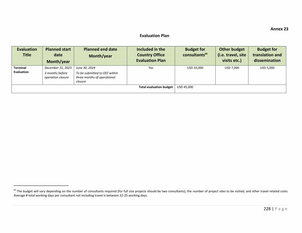
228 | P a g e
Annex 23
Evaluation Plan
Evaluation Title
Planned start date
Month/year
Planned end date
Month/year
Included in the Country Office Evaluation Plan
Budget for consultants65
Other budget (i.e. travel, site
visits etc.)
Budget for translation and dissemination
Terminal Evaluation
December 31, 2023
3 months before operation closure
June 30, 2024
To be submitted to GEF within three months of operational closure
Yes
USD 33,000 USD 7,000 USD 5,000
Total evaluation budget USD 45,000
65
The budget will vary depending on the number of consultants required (for full size projects should be two consultants); the number of project sites to be visited; and other travel related costs. Average # total working days per consultant not including travel is between 22-25 working days.
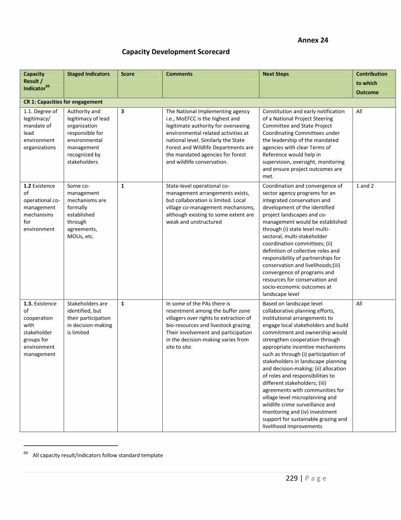
229 | P a g e
Annex 24
Capacity Development Scorecard
Capacity Result / Indicator
66
Staged Indicators Score Comments Next Steps Contribution
to which
Outcome
CR 1: Capacities for engagement
1.1. Degree of legitimacy/ mandate of lead environment organizations
Authority and legitimacy of lead organization responsible for environmental management recognized by stakeholders
3 The National Implementing agency i.e., MoEFCC is the highest and legitimate authority for overseeing environmental related activities at national level. Similarly the State Forest and Wildlife Departments are the mandated agencies for forest and wildlife conservation.
Constitution and early notification of a National Project Steering Committee and State Project Coordinating Committees under the leadership of the mandated agencies with clear Terms of Reference would help in supervision, oversight, monitoring and ensure project outcomes are met.
All
1.2 Existence of operational co-management mechanisms for environment
Some co-management mechanisms are formally established through agreements, MOUs, etc.
1 State-level operational co-management arrangements exists, but collaboration is limited. Local village co-management mechanisms, although existing to some extent are weak and unstructured
Coordination and convergence of sector agency programs for an integrated conservation and development of the identified project landscapes and co-management would be established through (i) state level multi-sectoral, multi-stakeholder coordination committees; (ii) definition of collective roles and responsibility of partnerships for conservation and livelihoods;(iii) convergence of programs and resources for conservation and socio-economic outcomes at landscape level
1 and 2
1.3. Existence of cooperation with stakeholder groups for environment management
Stakeholders are identified, but their participation in decision-making is limited
1 In some of the PAs there is resentment among the buffer zone villagers over rights to extraction of bio-resources and livestock grazing. Their involvement and participation in the decision-making varies from site to site.
Based on landscape level collaborative planning efforts, institutional arrangements to engage local stakeholders and build commitment and ownership would strengthen cooperation through appropriate incentive mechanisms such as through (i) participation of stakeholders in landscape planning and decision-making; (ii) allocation of roles and responsibilities to different stakeholders; (iii) agreements with communities for village level microplanning and wildlife crime surveillance and monitoring and (iv) investment support for sustainable grazing and livelihood improvements
All
66 All capacity result/indicators follow standard template
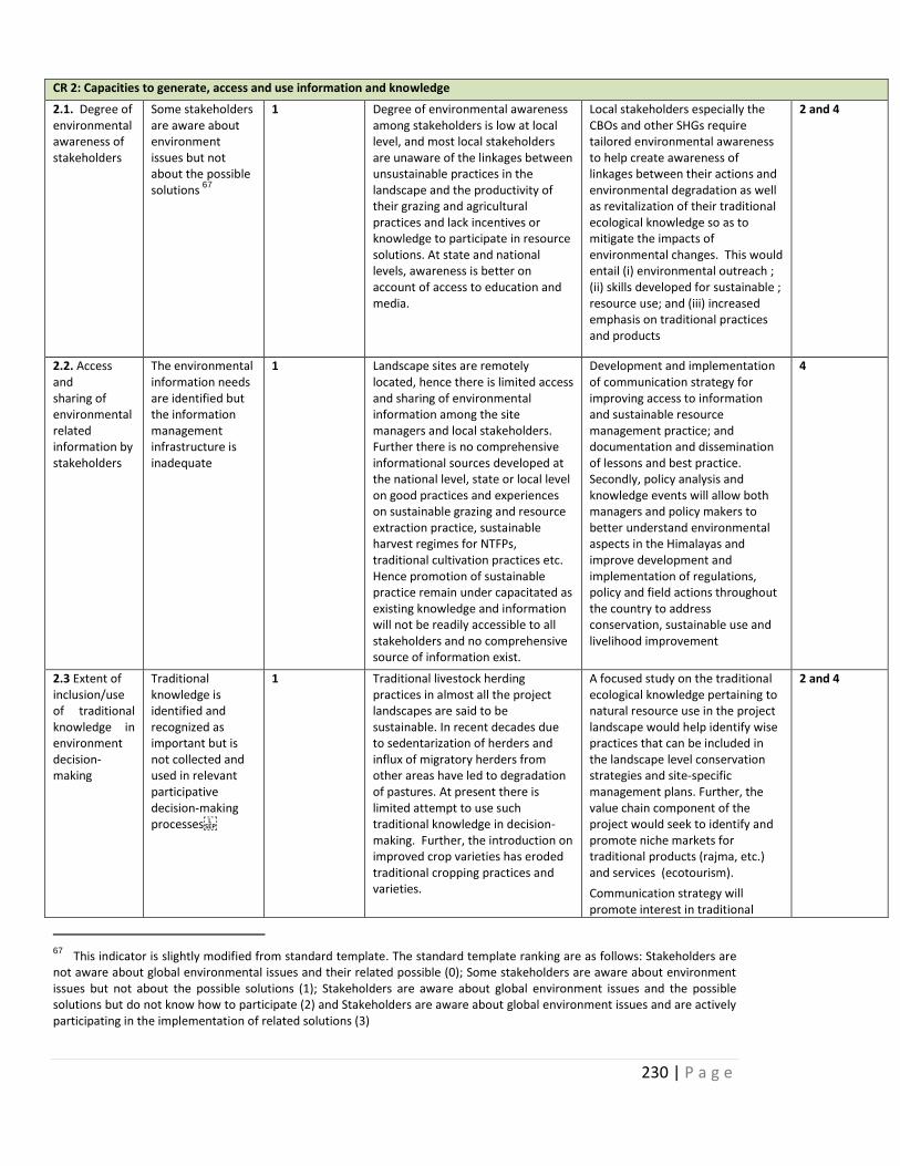
230 | P a g e
CR 2: Capacities to generate, access and use information and knowledge
2.1. Degree of environmentalawareness of stakeholders
Some stakeholders are aware about environment issues but not about the possible solutions
67
1 Degree of environmental awareness among stakeholders is low at local level, and most local stakeholders are unaware of the linkages between unsustainable practices in the landscape and the productivity of their grazing and agricultural practices and lack incentives or knowledge to participate in resource solutions. At state and national levels, awareness is better on account of access to education and media.
Local stakeholders especially the CBOs and other SHGs require tailored environmental awareness to help create awareness of linkages between their actions and environmental degradation as well as revitalization of their traditional ecological knowledge so as to mitigate the impacts of environmental changes. This would entail (i) environmental outreach ; (ii) skills developed for sustainable ; resource use; and (iii) increased emphasis on traditional practices and products
2 and 4
2.2. Access and sharing of environmental related information by stakeholders
The environmental information needs are identified but the information management infrastructure is inadequate
1 Landscape sites are remotely located, hence there is limited access and sharing of environmental information among the site managers and local stakeholders. Further there is no comprehensive informational sources developed at the national level, state or local level on good practices and experiences on sustainable grazing and resource extraction practice, sustainable harvest regimes for NTFPs, traditional cultivation practices etc. Hence promotion of sustainable practice remain under capacitated as existing knowledge and information will not be readily accessible to all stakeholders and no comprehensive source of information exist.
Development and implementation of communication strategy for improving access to information and sustainable resource management practice; and documentation and dissemination of lessons and best practice. Secondly, policy analysis and knowledge events will allow both managers and policy makers to better understand environmental aspects in the Himalayas and improve development and implementation of regulations, policy and field actions throughout the country to address conservation, sustainable use and livelihood improvement
4
2.3 Extent of inclusion/use of traditional knowledge in environment decision-making
Traditional knowledge is identified and recognized as important but is not collected and used in relevant participative decision-making processes
1 Traditional livestock herding practices in almost all the project landscapes are said to be sustainable. In recent decades due to sedentarization of herders and influx of migratory herders from other areas have led to degradation of pastures. At present there is limited attempt to use such traditional knowledge in decision-making. Further, the introduction on improved crop varieties has eroded traditional cropping practices and varieties.
A focused study on the traditional ecological knowledge pertaining to natural resource use in the project landscape would help identify wise practices that can be included in the landscape level conservation strategies and site-specific management plans. Further, the value chain component of the project would seek to identify and promote niche markets for traditional products (rajma, etc.) and services (ecotourism).
Communication strategy will promote interest in traditional
2 and 4
67 This indicator is slightly modified from standard template. The standard template ranking are as follows: Stakeholders are not aware about global environmental issues and their related possible (0); Some stakeholders are aware about environment issues but not about the possible solutions (1); Stakeholders are aware about global environment issues and the possible solutions but do not know how to participate (2) and Stakeholders are aware about global environment issues and are actively participating in the implementation of related solutions (3)
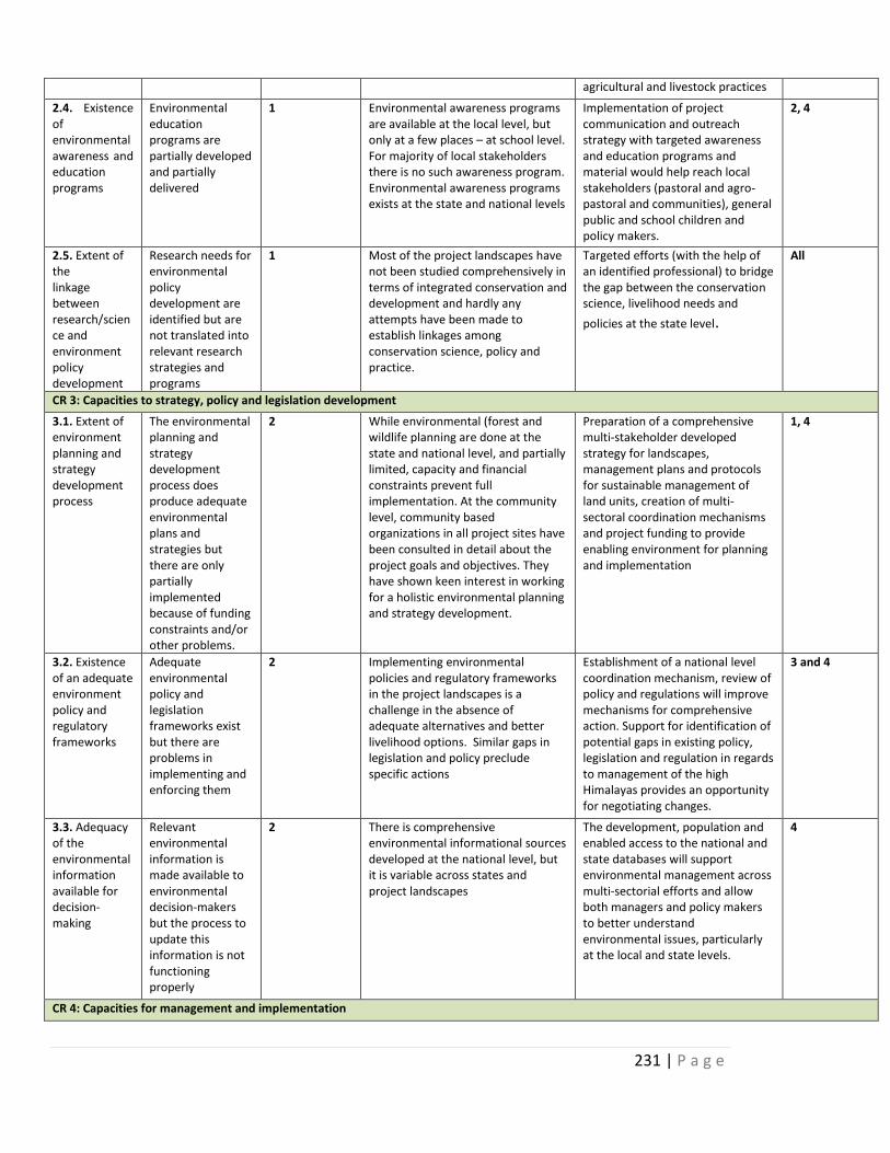
231 | P a g e
agricultural and livestock practices
2.4. Existence of environmentalawareness and education programs
Environmental education programs are partially developed and partially delivered
1 Environmental awareness programs are available at the local level, but only at a few places – at school level. For majority of local stakeholders there is no such awareness program. Environmental awareness programs exists at the state and national levels
Implementation of project communication and outreach strategy with targeted awareness and education programs and material would help reach local stakeholders (pastoral and agro-pastoral and communities), general public and school children and policy makers.
2, 4
2.5. Extent of the linkage between research/science and environment policy development
Research needs for environmental policy development are identified but are not translated into relevant research strategies and programs
1 Most of the project landscapes have not been studied comprehensively in terms of integrated conservation and development and hardly any attempts have been made to establish linkages among conservation science, policy and practice.
Targeted efforts (with the help of an identified professional) to bridge the gap between the conservation science, livelihood needs and
policies at the state level.
All
CR 3: Capacities to strategy, policy and legislation development
3.1. Extent of environment planning and strategy development process
The environmental planning and strategy development process does produce adequate environmental plans and strategies but there are only partially implemented because of funding constraints and/or other problems.
2 While environmental (forest and wildlife planning are done at the state and national level, and partially limited, capacity and financial constraints prevent full implementation. At the community level, community based organizations in all project sites have been consulted in detail about the project goals and objectives. They have shown keen interest in working for a holistic environmental planning and strategy development.
Preparation of a comprehensive multi-stakeholder developed strategy for landscapes, management plans and protocols for sustainable management of land units, creation of multi-sectoral coordination mechanisms and project funding to provide enabling environment for planning and implementation
1, 4
3.2. Existence of an adequate environment policy and regulatory frameworks
Adequate environmental policy and legislation frameworks exist but there are problems in implementing and enforcing them
2 Implementing environmental policies and regulatory frameworks in the project landscapes is a challenge in the absence of adequate alternatives and better livelihood options. Similar gaps in legislation and policy preclude specific actions
Establishment of a national level coordination mechanism, review of policy and regulations will improve mechanisms for comprehensive action. Support for identification of potential gaps in existing policy, legislation and regulation in regards to management of the high Himalayas provides an opportunity for negotiating changes.
3 and 4
3.3. Adequacy of the environmental information available for decision-making
Relevant environmental information is made available to environmental decision-makers but the process to update this information is not functioning properly
2 There is comprehensive environmental informational sources developed at the national level, but it is variable across states and project landscapes
The development, population and enabled access to the national and state databases will support environmental management across multi-sectorial efforts and allow both managers and policy makers to better understand environmental issues, particularly at the local and state levels.
4
CR 4: Capacities for management and implementation
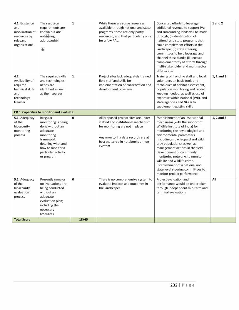
232 | P a g e
4.1. Existence and mobilization of resources by relevant organizations
The resource requirements are known but are notbeing addressed
1 While there are some resources available through national and state programs, these are only partly resourced, and that particularly only for a few PAs.
Concerted efforts to leverage additional revenue to support PAs and surrounding lands will be made through; (i) identification of national and state programs that could complement efforts in the landscape; (ii) state steering committees to help leverage and channel these funds; (iii) ensure complementarity of efforts through multi-stakeholder and multi-sector efforts, etc.
1 and 2
4.2. Availability of required technical skills and technology transfer
The required skills and technologies needs are identified as well as their sources
1 Project sites lack adequately trained field staff and skills for implementation of conservation and development programs.
Training of frontline staff and local volunteers on basic tools and techniques of habitat assessment, population monitoring and record keeping needed, as well as use of expertise within national (WII), and state agencies and NGOs to supplement existing skills
1, 2 and 3
CR 5: Capacities to monitor and evaluate
5.1. Adequacy of the biosecurity monitoring process
Irregular monitoring is being done without an adequate monitoring framework detailing what and how to monitor a particular activity or program
0 All proposed project sites are under-staffed and institutional mechanism for monitoring are not in place
Any monitoring data records are at best scattered in notebooks or non-existent
Establishment of an institutional mechanism (with the support of Wildlife Institute of India) for monitoring the key biological and environmental parameters (including snow leopard and wild prey populations) as well as management actions in the field. Development of community monitoring networks to monitor wildlife and wildlife crime. Establishment of a national and state level steering committees to monitor project performance
1, 2 and 3
5.2. Adequacy of the biosecurity evaluation process
Presently none or no evaluations are being conducted without an adequate evaluation plan; including the necessary resources
0 There is no comprehensive system to evaluate impacts and outcomes in the landscapes
Project evaluation and performance would be undertaken through independent mid-term and terminal evaluations
All
Total Score 18/45
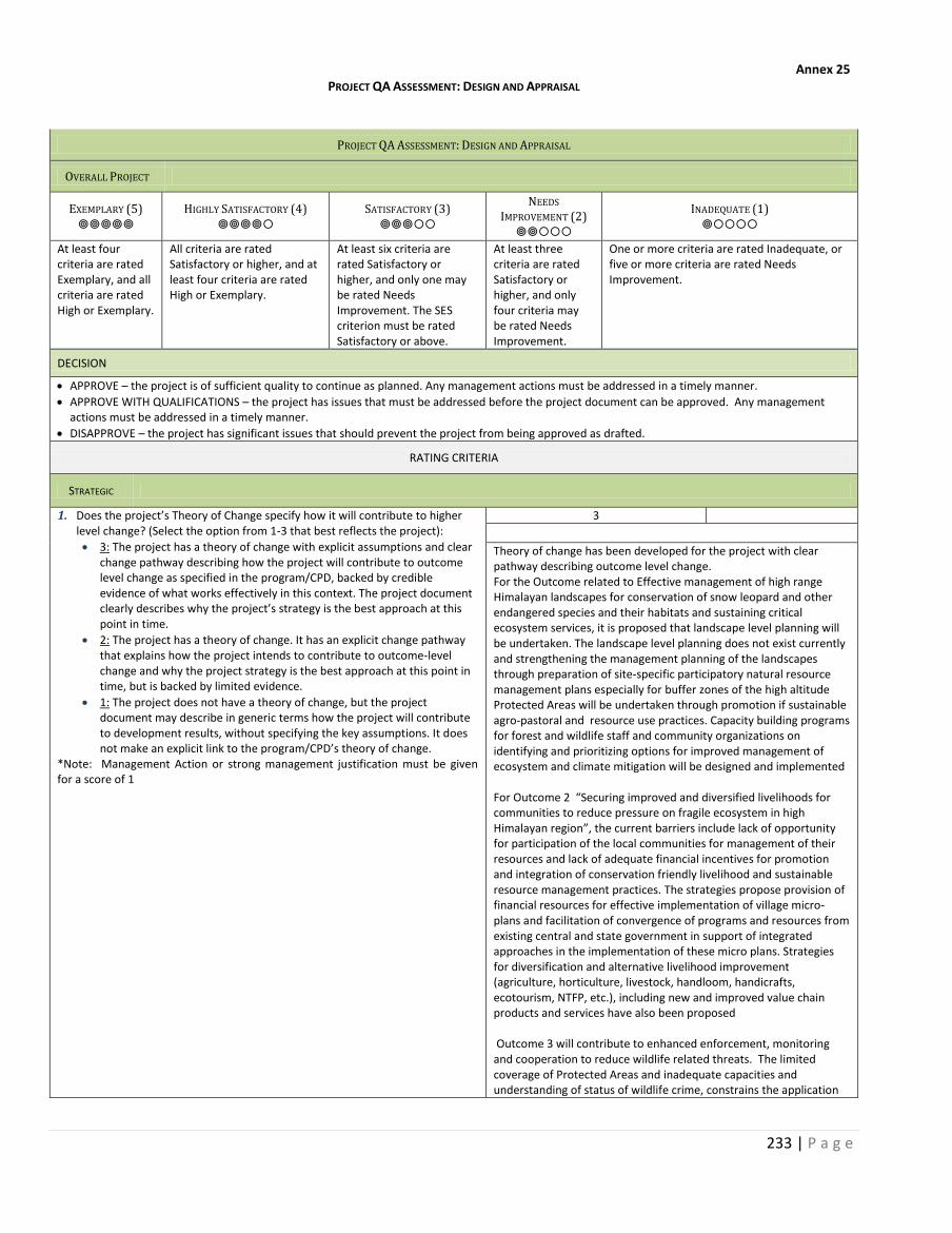
233 | P a g e
Annex 25 PROJECT QA ASSESSMENT: DESIGN AND APPRAISAL
PROJECT QA ASSESSMENT: DESIGN AND APPRAISAL
OVERALL PROJECT
EXEMPLARY (5)
HIGHLY SATISFACTORY (4)
SATISFACTORY (3)
NEEDS
IMPROVEMENT (2)
INADEQUATE (1)
At least four criteria are rated Exemplary, and all criteria are rated High or Exemplary.
All criteria are rated Satisfactory or higher, and at least four criteria are rated High or Exemplary.
At least six criteria are rated Satisfactory or higher, and only one may be rated Needs Improvement. The SES criterion must be rated Satisfactory or above.
At least three criteria are rated Satisfactory or higher, and only four criteria may be rated Needs Improvement.
One or more criteria are rated Inadequate, or five or more criteria are rated Needs Improvement.
DECISION
APPROVE – the project is of sufficient quality to continue as planned. Any management actions must be addressed in a timely manner.
APPROVE WITH QUALIFICATIONS – the project has issues that must be addressed before the project document can be approved. Any management actions must be addressed in a timely manner.
DISAPPROVE – the project has significant issues that should prevent the project from being approved as drafted.
RATING CRITERIA
STRATEGIC
1. Does the project’s Theory of Change specify how it will contribute to higher level change? (Select the option from 1-3 that best reflects the project):
3: The project has a theory of change with explicit assumptions and clear change pathway describing how the project will contribute to outcome level change as specified in the program/CPD, backed by credible evidence of what works effectively in this context. The project document clearly describes why the project’s strategy is the best approach at this point in time.
2: The project has a theory of change. It has an explicit change pathway that explains how the project intends to contribute to outcome-level change and why the project strategy is the best approach at this point in time, but is backed by limited evidence.
1: The project does not have a theory of change, but the project document may describe in generic terms how the project will contribute to development results, without specifying the key assumptions. It does not make an explicit link to the program/CPD’s theory of change.
*Note: Management Action or strong management justification must be given for a score of 1
3
Theory of change has been developed for the project with clear pathway describing outcome level change. For the Outcome related to Effective management of high range Himalayan landscapes for conservation of snow leopard and other endangered species and their habitats and sustaining critical ecosystem services, it is proposed that landscape level planning will be undertaken. The landscape level planning does not exist currently and strengthening the management planning of the landscapes through preparation of site-specific participatory natural resource management plans especially for buffer zones of the high altitude Protected Areas will be undertaken through promotion if sustainable agro-pastoral and resource use practices. Capacity building programs for forest and wildlife staff and community organizations on identifying and prioritizing options for improved management of ecosystem and climate mitigation will be designed and implemented For Outcome 2 “Securing improved and diversified livelihoods for communities to reduce pressure on fragile ecosystem in high Himalayan region”, the current barriers include lack of opportunity for participation of the local communities for management of their resources and lack of adequate financial incentives for promotion and integration of conservation friendly livelihood and sustainable resource management practices. The strategies propose provision of financial resources for effective implementation of village micro-plans and facilitation of convergence of programs and resources from existing central and state government in support of integrated approaches in the implementation of these micro plans. Strategies for diversification and alternative livelihood improvement (agriculture, horticulture, livestock, handloom, handicrafts, ecotourism, NTFP, etc.), including new and improved value chain products and services have also been proposed Outcome 3 will contribute to enhanced enforcement, monitoring and cooperation to reduce wildlife related threats. The limited coverage of Protected Areas and inadequate capacities and understanding of status of wildlife crime, constrains the application
234 | P a g e
68 1. Sustainable development pathways; 2. Inclusive and effective democratic governance; 3. Resilience building for the
69 sustainable production technologies, access to modern energy services and energy efficiency, natural resources
management, extractive industries, urbanization, citizen security, social protection, and risk management for
resilience
of effective and integrated wildlife crime detection, monitoring and prosecution measures. To address these issues, it is proposed that the project will facilitate the assessment of the status of wildlife crime including poaching of wildlife, smuggling of timber and illegal trade in wildlife parts and identification of key hotspots thereof. The project will also support strengthening of intelligence and information gathering system within the landscapes by involving the local communities and developing close liaison with police, customs and security personnel for regular review and enforcement; Mapping of hotspots and pathways of illegal trade on wildlife and wildlife parts will be undertaken with capacity building program for field level functionaries and local stakeholders Improved knowledge, advocacy and information systems for promotion of landscape conservation approaches is the proposed fourth outcome To increase awareness and reach out to various stakeholders, strategies include preparation of a communication and outreach strategy to promote meaningful stakeholder participation in the adaptation action, and communicate adaptation implementation activities and outcomes to the broader public. Further this will also contribute to Policy recommendations for high range Himalayan areas [see section barrier (page 11-14) and Outcomes (page 21-33) (Refer to Theory of change)
2. Is the project aligned with the thematic focus of the UNDP Strategic Plan? (select the option from 1-3 that best reflects the project):
3: The project responds to one of the three areas of development work68
as specified in the Strategic Plan; it addresses at least one of the proposed new and emerging areas
69; an issues-based analysis has been
incorporated into the project design; and the project’s RRF includes all the relevant SP output indicators. (all must be true to select this option)
2: The project responds to one of the three areas of development work1
as specified in the Strategic Plan. The project’s RRF includes at least one SP output indicator, if relevant. (both must be true to select this option)
1: While the project may respond to one of the three areas of development work
1 as specified in the Strategic Plan, it is based on a
sectoral approach without addressing the complexity of the development issue. None of the relevant SP indicators are included in the RRF. This answer is also selected if the project does not respond to any of the three areas of development work in the Strategic Plan.
3
The project priorities are consistent with the UNDP Strategic Plans and outcomes (Growth and development are inclusive and sustainable, incorporating productive capacities that create employment and livelihoods for the poor and excluded). The project’s incremental value lies in demonstrating, in the four high altitude landscapes in the Trans- and Greater Himalayan region (that consists of alpine pastures, sub-alpine forests and critical watersheds) through four inter-related components, participatory natural resources management practices and enterprise based sustainable livelihoods for local communities while concurrently conserving the biodiversity contained within these landscapes, maintaining their ecosystem values and ameliorating climate change impacts, enhancing surveillance, monitoring and trans-boundary cooperation to reduce wildlife crime and related threats, and improving knowledge and communications. The four outcomes of the project include:
Improved management of high range Himalayan landscapes for conservation of snow leopard and other endangered species and their habitats and sustaining critical ecosystem services
Securing improved and diversified livelihoods for communities to reduce pressure on fragile ecosystems
Enhanced enforcement, monitoring and cooperation to reduce wildlife related threats
Improved knowledge and information systems for promotion of landscape conservation approaches
Therefore the project directly contributes to the sustainable development pathways especially for the high range Himalayan ecosystem that is critical to life and livelihood of the Indian sub-continent, build resilience for the vulnerable communities in these region. Further the institutional mechanisms proposed to work with community institutions to promote participation in planning and implementation of conservation and livelihood activities. The communities
235 | P a g e
again include the tribal and the agro pastoral communities who are also the marginalized groups. The project will contribute to inclusive and effective democratic governance by working with the community institutions and enhancing their capacity in biodiversity management and increase livelihood options. Further convergence with other sectoral programs in this region will also help communities get access to basic facilities.
RELEVANT
3. Does the project have strategies to effectively identify, engage and ensure the meaningful participation of targeted groups/geographic areas with a priority focus on the excluded and marginalized? (select the option from 1-3 that best reflects this project):
3: The target groups/geographic areas are appropriately specified, prioritizing the excluded and/or marginalized. Beneficiaries will be identified through a rigorous process based on evidence (if applicable.) The project has an explicit strategy to identify, engage and ensure the meaningful participation of specified target groups/geographic areas throughout the project, including through monitoring and decision-making (such as representation on the project board) (all must be true to select this option)
2: The target groups/geographic areas are appropriately specified, prioritizing the excluded and/or marginalized. The project document states how beneficiaries will be identified, engaged and how meaningful participation will be ensured throughout the project. (both must be true to select this option)
1: The target groups/geographic areas are not specified, or do not prioritize excluded and/or marginalized populations. The project does not have a written strategy to identify or engage or ensure the meaningful participation of the target groups/geographic areas throughout the project.
*Note: Management Action must be taken for a score of 1
2
Evidence The areas/ geographic locations selected are all high altitude remote Himalayan region. Mostly the target communities are tribal/ agro pastoral communities with very little access to basic needs. The project primarily focuses to work with these communities and strengthen their institutions and livelihood interventions. A number of stakeholders have been identified which also consist of the field level functionaries of various government agencies. There is a serious need to capacitate the frontline functionaries for conservation related activities. The project has designed strategies to capacitate the frontline officials of the forest department combating wildlife trade, surveillance and monitoring as well as work with the other line departments to address the issues related to conservation and protection of the landscape and design programs and schemes suitable for sustainable livelihood in the region
4. Have knowledge, good practices, and past lessons learned of UNDP and others informed the project design? (select the option from 1-3 that best reflects this project):
3: Knowledge and lessons learned (gained e.g. through peer assist sessions) backed by credible evidence from evaluation, corporate policies/strategies, and monitoring have been explicitly used, with appropriate referencing, to develop the project’s theory of change and justify the approach used by the project over alternatives.
2: The project design mentions knowledge and lessons learned backed by evidence/sources, which inform the project’s theory of change but have not been used/are not sufficient to justify the approach selected over alternatives.
1: There is only scant or no mention of knowledge and lessons learned informing the project design. Any references that are made are not backed by evidence.
*Note: Management Action or strong management justification must be given for a score of 1
2
UNDP has significant experience across the globe working on mountain eco-systems and number of ongoing in different countries that will serve as good practices. Further UNDP in India has also worked in different projects in the Himalayan states and the best practices related to conservation, NRM, Livelihood market and enterprise will be useful. The Project Document has further listed (Page 168-180) various other best practices in different fields such as role of community in conservation, innovative agriculture practices, reduction in human wildlife conflicts ,water harvesting etc. Further the project also builds on the Global Snow Leopard and Ecosystem Conservation Program (GSLEP). At the national level, as part of the GSLEP, India has the National Snow Leopard and Ecosystem Protection (NSLEP) Priorities. The NSLEP is consistent with and complementary to the country’s Project Snow Leopard, designed for all biologically important habitats within the snow leopard’s range, irrespective of their ownership (e.g. protected areas, common land, etc.). The project will incorporate the best practices from these ongoing programs
5. Does the project use gender analysis in the project design and does the project respond to this gender analysis with concrete measures to address gender inequities and empower women? (select the option from 1-3 that best reflects this project):
3: A participatory gender analysis on the project has been conducted. This analysis reflects on the different needs, roles and access to/control over resources of women and men, and it is fully integrated into the project document. The project establishes concrete priorities to address gender inequalities in its strategy. The results framework includes outputs and activities that specifically respond to this gender analysis, with indicators that measure and monitor results contributing to gender equality. (all must be true to select this option)
2
Preliminary Gender Analysis on the project has been conducted. Further assessment of women’s groups and their role in conservation and bio diversity has also been assessed in this project. The gender roles have been identified. The project outcomes especially the livelihood outcomes which include value- addition and marketing have been proposed keeping in mind the involvement of women’s groups and natural resource based activities that they are engaged in. Given that women are also involved in collection of Non timber Forest Produce (NTFP) and medicinal plants, the project strategies and activities have already mentioned that emphasis will be given on
236 | P a g e
2: A gender analysis on the project has been conducted. This analysis reflects on the different needs, roles and access to/control over resources of women and men. Gender concerns are integrated in the development challenge and strategy sections of the project document. The results framework includes outputs and activities that specifically respond to this gender analysis, with indicators that measure and monitor results contributing to gender equality. (all must be true to select this option)
1: The project design may or may not mention information and/or data on the differential impact of the project’s development situation on gender relations, women and men, but the constraints have not been clearly identified and interventions have not been considered.
*Note: Management Action or strong management justification must be given for a score of 1
village level planning where women can play an important decision making role. Various activities planned including innovative agricultural implements in partnership with line departments, as well as using alternate source of energy to reduce drudgery of women.
6. Does UNDP have a clear advantage to engage in the role envisioned by the project vis-à-vis national partners, other development partners, and other actors? (select from options 1-3 that best reflects this project):
3: An analysis has been conducted on the role of other partners in the area where the project intends to work, and credible evidence supports the proposed engagement of UNDP and partners through the project. It is clear how results achieved by relevant partners will contribute to outcome level change complementing the project’s intended results. If relevant, options for south-south and triangular cooperation have been considered, as appropriate. (all must be true to select this option)
2: Some analysis has been conducted on the role of other partners where the project intends to work, and relatively limited evidence supports the proposed engagement of and division of labour between UNDP and partners through the project. Options for south-south and triangular cooperation may not have not been fully developed during project design, even if relevant opportunities have been identified.
1: No clear analysis has been conducted on the role of other partners in the area that the project intends to work, and relatively limited evidence supports the proposed engagement of UNDP and partners through the project. There is risk that the project overlaps and/or does not coordinate with partners’ interventions in this area. Options for south-south and triangular cooperation have not been considered, despite its potential relevance.
*Note: Management Action or strong management justification must be given for a score of 1
3
The National Implementation partner is the Ministry of Environment, Forest and Climate Change (MoEFCC) and the State Forest Departments. UNDP’s partnership with the Ministry of Environment, Forests and Climate Change is one of its longest in India. Starting in 1985, UNDP has support the Ministry in its efforts to meet India’s environmental commitments. MOEFCC is the focal point for implementation of the Convention on Biological Diversity in India. Responsible for wildlife, forestry and climate change policy in the country and for coordination across State Governments in these areas. UNDP has been engaging with relevant divisions in the MOEFCC in many programs for the past over 2 decades. The relevant divisions are the Mountain, Biodiversity and the Wildlife Divisions. MoEFCC supports the climate change resilience and adaptation risk management with the relevant state departments and with the National Biodiversity Authority. Since MOEFCC is the nodal Government agency for all policy related to forest and wildlife, they will steer the process and play a key role in establishing coordination and collaborative links with central and state forest and wildlife departments. UNDP has links with other international agencies and through its offices in neighboring countries will also strengthen transboundary cooperation in conservation work. India GEF SECURE project is part of a global program, which helps secure multi-country partnership on wildlife conservation and wildlife crime prevention. This partnership allows for extensive and continued information exchange amongst the different countries on forensics, status of key species, law enforcement and wildlife crime, and the exchange of “good practice” and capacity building efforts Through the global partnership, India will seek opportunities for exchange visits to learn lessons from individual project interventions from within and outside the Program, help foster intergovernmental cooperation, use M&E tools and geospatial services, apply best practices and peer review and develop portfolio-wide training and communication strategies. India’s continued participation in GSLEP, provides an opportunity for collective action that would help coordinate and unify the efforts among the snow leopard countries and the global community to achieve a shared vision and goal. It would provide a forum for sharing of good practices and lessons in conservation, community involvement and wildlife crime and trade prevention that can be scaled up and implemented in a wider context. The project will provide valuable monitoring information that would be widely shared to help bring a high-level of attention towards meeting the goals of GSLEP. It would help in efforts to enable countries (some of which are already implementing or formulating GEF projects for snow leopard conservation), international and national partners and donors to adjust and improve efforts to reflect new knowledge and experiences. Moreover, UNDP has directly supported over 35 projects in the areas of climate change, sustainable natural resource management and chemical management. Further UNDP has worked in these states in the past and has good working relations with the State Governments of J&K, Himachal Pradesh, Uttarakhand and Sikkim.
237 | P a g e
UNDP through its existing programs working with the private sector, will provide strong support in developing market linkages and skills development in the remote Himalayan villages. A stakeholder analysis has also been done and various important agencies, government and non-government, community institutions have been identified and the roles that there likely to play. Annexed with the Project document. Gender analysis plan has also been prepared
Evidence
SOCIAL & ENVIRONMENTAL STANDARDS
7. Does the project seek to further the realization of human rights using a human rights based approach? (select from options 1-3 that best reflects this project):
3: Credible evidence that the project aims to further the realization of human rights, upholding the relevant international and national laws and standards in the area of the project. Any potential adverse impacts on enjoyment of human rights were rigorously identified and assessed as relevant, with appropriate mitigation and management measures incorporated into project design and budget. (all must be true to select this option)
2: Some evidence that the project aims to further the realization of human rights. Potential adverse impacts on enjoyment of human rights were identified and assessed as relevant, and appropriate mitigation and management measures incorporated into the project design and budget.
1: No evidence that the project aims to further the realization of human rights. Limited or no evidence that potential adverse impacts on enjoyment of human rights were considered.
*Note: Management action or strong management justification must be given for a score of 1
2
Equal opportunities to vulnerable segment of society such as the tribal communities, women, migratory groups, poor and landless, will be provided under the project to mainstream human rights based approach in the project. The Gram Sabha or the village council is a decision making body in the local governance structure and all adults in the village have right to participate and voice their opinion. The project has strategized to work with these institutions and democratic decision-making is one of the vital components in the success of the project. The communities will be trained in different capacity building initiatives and get other benefits from project initiatives. The village level institutions would be involved in the planning, implementation, monitoring and evaluation of project interventions. The project interventions are designed to address and ultimately sustain the livelihood of these local communities that would result in poverty alleviation, improvement of living conditions and sustainable development of natural resources. In this way it will improve the economic and social rights of the local communities and will also take care of cultural values of the local communities. It will consider the right to habitat and economic security. Improved employment opportunities will facilitate right to work. Interventions to resolve tenurial issues will facilitate right to land. The project impacts would expedite right to environmental protection.
8. Did the project consider potential environmental opportunities and adverse impacts, applying a precautionary approach? (select from options 1-3 that best reflects this project):
3: Credible evidence that opportunities to enhance environmental sustainability and integrate poverty-environment linkages were fully considered as relevant, and integrated in project strategy and design. Credible evidence that potential adverse environmental impacts have been identified and rigorously assessed with appropriate management and mitigation measures incorporated into project design and budget. (all must be true to select this option).
2: No evidence that opportunities to strengthen environmental sustainability and poverty-environment linkages were considered. Credible evidence that potential adverse environmental impacts have been identified and assessed, if relevant, and appropriate management and mitigation measures incorporated into project design and budget.
1: No evidence that opportunities to strengthen environmental sustainability and poverty-environment linkages were considered. Limited or no evidence that potential adverse environmental impacts were adequately considered.
*Note: Management action or strong management justification must be given for a score of 1
3 2
1
The proposed project is not likely to cause any adverse impacts. Some project activities will be undertaken in areas adjacent to critical habitats and/or environmentally sensitive areas, including legally protected areas. However, these do not involve changes to the use of land and resources that may have adverse impacts on habitats, ecosystems, and/or livelihoods, rather the project is designed to improve the ecological health of the landscape. All project activities are geared towards conservation of endangered and threatened species. Specific efforts would be made on evaluating the condition of resources that would be used in livelihood and value chain programs to ensure that extraction is within sustainable limits. Review of existing practices of non-timber forest products (mushrooms, medicinal plants and other products) harvest would be undertaken to ascertain ecologically friendly and sustainable nature. This would include defining specific areas and harvest rates on the basis of internationally acceptable criteria, based on scientific information and closely monitored. The project will not directly or indirectly increase social and environmental vulnerability to climate change now or in the future. The project does not involve large-scale infrastructure development. The project will not involve support for employment or livelihoods that may pose a potential risk to health and safety of communities and/or individuals or to biodiversity and ecosystem functions. The project will not involve any temporary or permanent physical displacement, nor will there be the need for land acquisition or access restrictions – even in the absence of physical
238 | P a g e
relocation. It would not exacerbate land tenure arrangements and/or community based property rights/customary rights to land, territories and/or resources. Any restrictions on access and use of natural resources would not be imposed by the forest department, but would evolve through a collective decision-making process amongst the community members and be supported by alternative livelihood and resource measures that adequately compensate for any loss of income or resources. Refer to Annex 18 SESP
9. Has the Social and Environmental Screening Procedure (SESP) been conducted to identify potential social and environmental impacts and risks? The SESP is not required for projects in which UNDP is Administrative Agent only and/or projects comprised solely of reports, coordination of events, trainings, workshops, meetings, conferences and/or communication materials and information dissemination. [if yes, upload the completed checklist. If SESP is not required, provide the reason for the exemption in the evidence section.]
Yes
SESP has been conducted (Refer to the Annex 18 SESP (pg 158-167)
MANAGEMENT & MONITORING
10. Does the project have a strong results framework? (select from options 1-3 that best reflects this project):
3: The project’s selection of outputs and activities are at an appropriate level and relate in a clear way to the project’s theory of change. Outputs are accompanied by SMART, results-oriented indicators that measure all of the key expected changes identified in the theory of change, each with credible data sources, and populated baselines and targets, including gender sensitive, sex-disaggregated indicators where appropriate. (all must be true to select this option)
2: The project’s selection of outputs and activities are at an appropriate level, but may not cover all aspects of the project’s theory of change. Outputs are accompanied by SMART, results-oriented indicators, but baselines, targets and data sources may not yet be fully specified. Some use of gender sensitive, sex-disaggregated indicators, as appropriate. (all must be true to select this option)
1: The results framework does not meet all of the conditions specified in selection “2” above. This includes: the project’s selection of outputs and activities are not at an appropriate level and do not relate in a clear way to the project’s theory of change; outputs are not accompanied by SMART, results-oriented indicators that measure the expected change, and have not been populated with baselines and targets; data sources are not specified, and/or no gender sensitive, sex-disaggregation of indicators.
*Note: Management Action or strong management justification must be given for a score of 1
2
Refer to Project Results Framework (page 48-52) Outputs are accompanied by SMART, results-oriented indicators, but baselines, targets and data sources may not yet be fully specified as lot of baseline studies will be commissioned during the initial years of project inception.
11. Is there a comprehensive and costed M&E plan in place with specified data collection sources and methods to support evidence-based management, monitoring and evaluation of the project?
Yes (3) No (1)
12. Is the project’s governance mechanism clearly defined in the project document, including planned composition of the project board? (select from options 1-3 that best reflects this project):
3: The project’s governance mechanism is fully defined in the project composition. Individuals have been specified for each position in the governance mechanism (especially all members of the project board.) Project Board members have agreed on their roles and responsibilities as specified in the terms of reference. The ToR of the project board has been attached to the project document. (all must be true to select this option).
2: The project’s governance mechanism is defined in the project document; specific institutions are noted as holding key governance roles, but individuals may not have been specified yet. The prodoc lists the most important responsibilities of the project board, project director/manager and quality assurance roles. (all must be true to select this option)
1: The project’s governance mechanism is loosely defined in the project document, only mentioning key roles that will need to be filled at a later date. No information on the responsibilities of key positions in the
2
The project will be implemented following UNDP’s national implementation modality, according to the Standard Basic Assistance Agreement between UNDP and the Government of India, and the Country Program There will be a Project Board (also called Project Steering Committee) which will function as a national level governing body of the project.A program officer hired by UNDP will function as a National Project Manager to run the project on a day-to-day basis on behalf of the National Implementing Partner within the constraints laid down by the Board. A steering committee at the state level, under the chairmanship of Chief Secretary/Additional Chief Secretary will be formed. Project Management Committees would also be established at the state levels to facilitate the engagement of relevant provincial stakeholders like the Forest and wildlife departments, sector agencies, key service providers like NGOs, CBOs and the private sector; and representatives from various community institutions from the landscape
239 | P a g e
governance mechanism is provided. *Note: Management Action or strong management justification must be given for a score of 1
In order to have participation of the target groups in different landscapes of the project, the representatives of the community institutions will be part of the Management Committees formed in each of the four states State Project Planning and Management Unit At the State level, project planning, implementation and oversight will be provided by a Project Director who will be a senior officer of the Wildlife Department At the landscape level, there will be a Landscape Level Planning and Implementation team consisting of a Landscape Facilitation Officer from the Forest Department on full time basis supported by a Social Participation Specialist (consultant), Social Mobilizers and Part-time Accountant/Accounts Assistant (from the Forest Department). Forest Rangers and Forest Guards will be co-opted into the Landscape Level Planning and Implementation teams, when planning and implementation is undertaken in the areas under their respective jurisdictions. Village level Site specific interventions and annual plans would be executed through the well-established democratic institutions at the village level in close coordination with other community based organizations such as Van Panchayat (VP), Eco-development Committees (EDCs), Joint Forest Management Committees (JFMCs), Women’s Self Help Groups (WSHGs) Terms of reference for the key project staff have been developed
13. Have the project risks been identified with clear plans stated to manage and mitigate each risks? (select from options 1-3 that best reflects this project):
3: Project risks related to the achievement of results are fully described in the project risk log, based on comprehensive analysis drawing on the theory of change, Social and Environmental Standards and screening, situation analysis, capacity assessments and other analysis. Clear and complete plan in place to manage and mitigate each risk. (both must be true to select this option)
2: Project risks related to the achievement of results identified in the initial project risk log with mitigation measures identified for each risk.
1: Some risks may be identified in the initial project risk log, but no evidence of analysis and no clear risk mitigation measures identified. This option is also selected if risks are not clearly identified and no initial risk log is included with the project document.
*Note: Management Action must be taken for a score of 1
2
A risk log has been prepared as part of the project document. * risks pertaining to operational, financial, environment, social and institutional has been identified and risk mitigation strategies suggested
EFFICIENT
14. Have specific measures for ensuring cost-efficient use of resources been explicitly mentioned as part of the project design? This can include: i) using the theory of change analysis to explore different options of achieving the maximum results with the resources available; ii) using a portfolio management approach to improve cost effectiveness through synergies with other interventions; iii) through joint operations (e.g., monitoring or procurement) with other partners.
Yes (3)
15. Are explicit plans in place to ensure the project links up with other relevant on-going projects and initiatives, whether led by UNDP, national or other partners, to achieve more efficient results (including, for example, through sharing resources or coordinating delivery?)
Yes (3)
16. Is the budget justified and supported with valid estimates?
3: The project’s budget is at the activity level with funding sources, and is specified for the duration of the project period in a multi-year budget. Costs are supported with valid estimates using benchmarks from similar projects or activities. Cost implications from inflation and foreign exchange exposure have been estimated and incorporated in the budget.
2: The project’s budget is at the activity level with funding sources, when possible, and is specified for the duration of the project in a multi-year budget. Costs are supported with valid estimates based on prevailing rates.
1:
2
Evidence The activities have been formulated after extensive consultation at each of the project area with various stakeholders. Based on the indicative activities that have emerged, budget has been prepared for each of the project landscape and compiled into Outputs for 6 years. This is again an estimated budget and each years work-plan will be firmed up after the approval of the project.
240 | P a g e
The project’s budget is not specified at the activity level, and/or may not be captured in a multi-year budget.
17. Is the Country Office fully recovering its costs involved with project implementation?
3: The budget fully covers all direct project costs that are directly attributable to the project, including programme management and development effectiveness services related to strategic country programme planning, quality assurance, pipeline development, policy advocacy services, finance, procurement, human resources, administration, issuance of contracts, security, travel, assets, general services, information and communications based on full costing in accordance with prevailing UNDP policies (i.e., UPL, LPL.)
2: The budget covers significant direct project costs that are directly attributable to the project based on prevailing UNDP policies (i.e., UPL, LPL) as relevant.
1: The budget does not reimburse UNDP for direct project costs. UNDP is cross-subsidizing the project and the office should advocate for the inclusion of DPC in any project budget revisions.
*Note: Management Action or strong management justification must be given for a score of 1
2
Evidence The budget covers significant direct project costs that are directly attributable to the project based on prevailing UNDP policies. This includes charges for hiring Human Resources, Procurement, Finance (direct payment), Logistics-Travel support to technical staff. This amounts to around USD 210,000 that is around 2% of the total project cost.
EFFECTIVE
18. Is the chosen implementation modality most appropriate? (select from options 1-3 that best reflects this project):
3: The required implementing partner assessments (capacity assessment, HACT micro assessment) have been conducted, and there is evidence that options for implementation modalities have been thoroughly considered. There is a strong justification for choosing the selected modality, based on the development context. (both must be true to select this option)
2: The required implementing partner assessments (capacity assessment, HACT micro assessment) have been conducted and the implementation modality chosen is consistent with the results of the assessments.
1: The required assessments have not been conducted, but there may be evidence that options for implementation modalities have been considered.
*Note: Management Action or strong management justification must be given for a score of 1
3
Capacity development assessment has been undertaken using the UNDP Capacity Development Scorecard and option for implementation modality have been thoroughly considered (refer to Annex 24 (page 198-201)
19. Have targeted groups, prioritizing marginalized and excluded populations that will be affected by the project, been engaged in the design of the project in a way that addresses any underlying causes of exclusion and discrimination?
3: Credible evidence that all targeted groups, prioritising marginalized and excluded populations that will be involved in or affected by the project, have been actively engaged in the design of the project. Their views, rights and any constraints have been analysed and incorporated into the root cause analysis of the theory of change which seeks to address any underlying causes of exclusion and discrimination and the selection of project interventions.
2: Some evidence that key targeted groups, prioritising marginalized and excluded populations that will be involved in the project, have been engaged in the design of the project. Some evidence that their views, rights and any constraints have been analysed and incorporated into the root cause analysis of the theory of change and the selection of project interventions.
1: No evidence of engagement with marginalized and excluded populations that will be involved in the project during project design. No evidence that the views, rights and constraints of populations have been incorporated into the project.
3
Evidence A number of consultations have been done during the PPG phase, from identification of the landscapes, formulation of activities and seeking inputs on the project document where the communities have been involved. Consultants engaged under the project have travelled to the remote corners of each of the landscapes and held meetings in the villages, specifically with agro-pastoral communities, tribal communities, women to seek their inputs and suggestions to plan the livelihood and other interventions in the project. The people’s representatives, the elected members at the district and Panchayats have also been consulted to seek their inputs. Village level planning has been identified as one of the core areas where the inputs from the most marginalized and vulnerable communities will be incorporated. Further the institutional mechanisms suggested in the project has identified important decision making role for the Gram Sabha (village assembly) and other institutions at the village level such as JFMcs, EDCs, Women self-help groups etc. Strategies have also been identified to involve people in conservation related activities and planning for its sustainable use since the most poor and marginalized communities are largely dependent on the natural
241 | P a g e
resources. Livelihood strategies have focused on market linkages and value addition to the local products that are collected by these communities and specially women.
20. Does the project conduct regular monitoring activities, have explicit plans for evaluation, and include other lesson learning (e.g. through After Action Reviews or Lessons Learned Workshops), timed to inform course corrections if needed during project implementation?
Yes (3)
21. The gender marker for all project outputs are scored at GEN2 or GEN3, indicating that gender has been fully mainstreamed into all project outputs at a minimum. *Note: Management Action or strong management justification must be given for
a score of “no”
Yes (3)
Evidence
22. Is there a realistic multi-year work plan and budget to ensure outputs are delivered on time and within allotted resources? (select from options 1-3 that best reflects this project):
3: The project has a realistic work plan & budget covering the duration of the project at the activity level to ensure outputs are delivered on time and within the allotted resources.
2: The project has a work plan & budget covering the duration of the project at the output level.
1: The project does not yet have a work plan & budget covering the duration of the project.
3
Landscape wise activities have been identified and budgeted and institutional and monitoring mechanisms laid out for realistic budgeting and delivery of outputs
SUSTAINABILITY & NATIONAL OWNERSHIP
23. Have national partners led, or proactively engaged in, the design of the project? (select from options 1-3 that best reflects this project):
3: National partners have full ownership of the project and led the process of the development of the project jointly with UNDP.
2: The project has been developed by UNDP in close consultation with national partners.
1: The project has been developed by UNDP with limited or no engagement with national partners.
3
National Partner, The Ministry of Environment, Forest and Climate Change has been leading the process for development of the project from the beginning. The Ministry has played key role along with UNDP to identify the key areas that the project should focus on. They have taken the lead to bring the State Governments on board and have coordinated with the States for all the visits for the initial studies that the consultants have undertaken. Ministry has also led the process by participating in all the landscape level consultations to seek inputs from the stakeholders. Further inputs have also been provided in preparation of the document
24. Are key institutions and systems identified, and is there a strategy for strengthening specific/ comprehensive capacities based on capacity assessments conducted? (select from options 0-4 that best reflects this project):
3: The project has a comprehensive strategy for strengthening specific capacities of national institutions based on a systematic and detailed capacity assessment that has been completed. This strategy includes an approach to regularly monitor national capacities using clear indicators and rigorous methods of data collection, and adjust the strategy to strengthen national capacities accordingly.
2.5: A capacity assessment has been completed. The project document has identified activities that will be undertaken to strengthen capacity of national institutions, but these activities are not part of a comprehensive strategy to monitor and strengthen national capacities.
2: A capacity assessment is planned after the start of the project. There are plans to develop a strategy to strengthen specific capacities of national institutions based on the results of the capacity assessment.
1.5: There is mention in the project document of capacities of national institutions to be strengthened through the project, but no capacity assessments or specific strategy development are planned.
1: Capacity assessments have not been carried out and are not foreseen. There is no strategy for strengthening specific capacities of national institutions.
2.5
Capacity assessment has been conducted for different stakeholders that include field level functionaries of government agencies, local communities and other stakeholders in the landscape. Adequate budgetary provisions have also been made. Special focus will also be on combating wildlife trafficking and illegal trade. Towards this comprehensive capacity building on different aspects such as identification, detection, surveillance and intelligence sharing will be undertaken for different set of officials. For livelihood related interventions and landscape level planning, specific areas / assessment for capacity building has been provided in the project document for the local communities Capacity building for other line agencies for convergence with conservation related activities have also been identified.
25. Is there is a clear strategy embedded in the project specifying how the project will use national systems (i.e., procurement, monitoring, evaluations, etc.,) to the extent possible?
Yes (3)
26. Is there a clear transition arrangement/ phase-out plan developed with key stakeholders in order to sustain or scale up results (including resource mobilization strategy)?
Yes (3)
242 | P a g e
Annex 26
Carbon Benefits from Eco-restoration and Protection
Very few estimates are available on the rates of C sequestration for the high altitude forests and alpine meadows. It is estimated that the Himalayan forests sequester about 6-7 tonnes of C ha-1 yr-1 (Rana et al., 1989). However, rate of sequestration and storage varies considerably depending upon the degree of slope, aspect and altitude. For example, silver fir (Abies pindrow) and brown oak (Quercus semecarpifolia) forests in the Greater Himalaya can sequester up to 9 and 10 tonnes of C ha-1 yr-1 respectively (Adhikari et al., 1995; Rai 2013). Rate of C sequestration decreases with increasing altitude and aridity. Yan and Lu (2015) found that after 6-8 years of grazing exclusion and restoration in Tibetan plateau alpine meadows, alpine desert steppe, grasslands and scrub steppe accumulated up to 403, 156, 320 and 277 kg C ha-1 yr-1 respectively. These categories of vegetation are comparable to dry and moist alpine meadows of high altitude rangelands in the Indian Himalayan region. In Kedarnath WS, Uttarakhand (similar to lower parts of Govind WS), Rai (2013) estimated that grazed meadows near alpine treeline sequestered 564 – 992 kg C ha-1 yr-1 while ungrazed meadows had the sequestration potential upto 1460 kg C ha-1 yr-1. Dingpeng et al., (2014) found that after 6 years of protection from livestock grazing, alpine sedge meadows in Northern Tibet, there was 25-69% increase in aboveground biomass. Sedge meadows form an important habitat for a variety of wetland birds and wild ungulates in the Trans-Himalaya. Annexure 1 gives summary of C sequestration potential for various ecosystems in the Himalayan region based on published information.
For the SECURE-Himalaya Landscapes (SHLs) the following classes of vegetation have been taken into consideration to project the rate of C sequestration:
i. Sub-alpine forests of Greater Himalaya, dominated by birch (Betula utilis), fir (Abies
spectabilis), Deodar (Cedrus deodara) and brown oak (Quercus semecarpifolia). These classes of forests are found in lower parts of Khangchendzonga NP, Gangotri NP, Govind NP, and Sechu Tuan WS.
ii. Moist alpine meadows of Greater Himalaya represented by Danthonia grasslands and mixed herbaceous communities. Moist meadows are mostly found in Govind WS and surrounds, especially between this sanctuary and western fringes of Gangotri NP, parts of Khangchendzonga and Shingba WS in Sikkim.
iii. Alpine arid pastures (dry alpine steppe) of Trans-Himalaya, especially in Changthang WS (Ladakh) and Tso Lhamu plateau in north Sikkim.
The project visualizes eco-restoration of highly degraded sub-alpine forests and meadows following participatory approaches. With increased production of fodder and fuelwood around community land and reduction in number of scrub cattle in the high altitude pastures, a considerable area would be brought under eco-restoration. In addition, with better zonation and improved protection from livestock grazing and fuelwood collection by migratory pastoral communities a large chunk of existing protected areas would become free from livestock grazing. Following these interventions, it can be safely assumed that there would be a steady accumulation of biomass at a sigmoidal rate. The proposed areas to be brought under eco-restoration and protection under various categories of vegetation are given in the following table (Table 1).
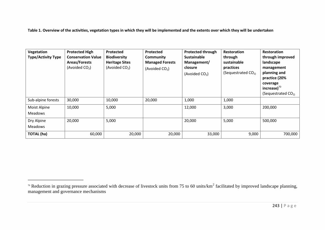
243 | P a g e
Table 1. Overview of the activities, vegetation types in which they will be implemented and the extents over which they will be undertaken
Vegetation Type/Activity Type
Protected High Conservation Value Areas/Forests (Avoided CO2)
Protected Biodiversity Heritage Sites (Avoided CO2)
Protected Community Managed Forests
(Avoided CO2)
Protected through Sustainable Management/ closure
(Avoided CO2)
Restoration through sustainable practices (Sequestrated CO2)
Restoration through improved landscape management planning and practice (20% coverage increase)70 (Sequestrated CO2)
Sub-alpine forests 30,000 10,000 20,000 1,000 1,000
Moist Alpine
Meadows
10,000 5,000 12,000 3,000 200,000
Dry Alpine
Meadows
20,000 5,000 20,000 5,000 500,000
TOTAL (ha) 60,000 20,000 20,000 33,000 9,000 700,000
70 Reduction in grazing pressure associated with decrease of livestock units from 75 to 60 units/km
2 facilitated by improved landscape planning,
management and governance mechanisms
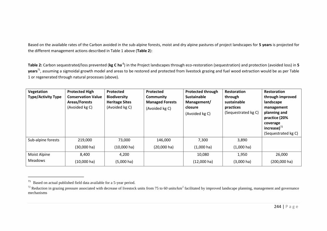
244 | P a g e
Based on the available rates of the Carbon avoided in the sub-alpine forests, moist and dry alpine pastures of project landscapes for 5 years is projected for
the different management actions described in Table 1 above (Table 2):
Table 2: Carbon sequestrated/loss prevented (kg C ha-1) in the Project landscapes through eco-restoration (sequestration) and protection (avoided loss) in 5
years71, assuming a sigmoidal growth model and areas to be restored and protected from livestock grazing and fuel wood extraction would be as per Table
1 or regenerated through natural processes (above).
Vegetation Type/Activity Type
Protected High Conservation Value Areas/Forests (Avoided kg C)
Protected Biodiversity Heritage Sites (Avoided kg C)
Protected Community Managed Forests
(Avoided kg C)
Protected through Sustainable Management/ closure
(Avoided kg C)
Restoration through sustainable practices (Sequestrated kg C)
Restoration through improved landscape management planning and practice (20% coverage increase)72 (Sequestrated kg C)
Sub-alpine forests 219,000
(30,000 ha)
73,000
(10,000 ha)
146,000
(20,000 ha)
7,300
(1,000 ha)
3,890
(1,000 ha)
Moist Alpine
Meadows
8,400
(10,000 ha)
4,200
(5,000 ha)
10,080
(12,000 ha)
1,950
(3,000 ha)
26,000
(200,000 ha)
71 Based on actual published field data available for a 5-year period.
72 Reduction in grazing pressure associated with decrease of livestock units from 75 to 60 units/km
2 facilitated by improved landscape planning, management and governance
mechanisms
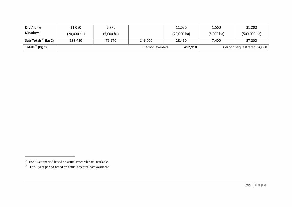
245 | P a g e
Dry Alpine
Meadows
11,080
(20,000 ha)
2,770
(5,000 ha)
11,080
(20,000 ha)
1,560
(5,000 ha)
31,200
(500,000 ha)
Sub-Totals73 (kg C) 238,480 79,970 146,000 28,460 7,400 57,200
Totals74 (kg C) Carbon avoided 492,910 Carbon sequestrated 64,600
73
For 5-year period based on actual research data available 74 For 5-year period based on actual research data available
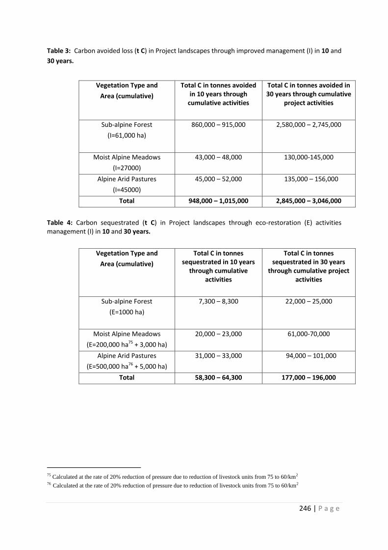
246 | P a g e
Table 3: Carbon avoided loss (t C) in Project landscapes through improved management (I) in 10 and
30 years.
Vegetation Type and
Area (cumulative)
Total C in tonnes avoided in 10 years through
cumulative activities
Total C in tonnes avoided in 30 years through cumulative
project activities
Sub-alpine Forest
(I=61,000 ha)
860,000 – 915,000 2,580,000 – 2,745,000
Moist Alpine Meadows
(I=27000)
43,000 – 48,000 130,000-145,000
Alpine Arid Pastures
(I=45000)
45,000 – 52,000 135,000 – 156,000
Total 948,000 – 1,015,000 2,845,000 – 3,046,000
Table 4: Carbon sequestrated (t C) in Project landscapes through eco-restoration (E) activities management (I) in 10 and 30 years.
Vegetation Type and
Area (cumulative)
Total C in tonnes sequestrated in 10 years
through cumulative activities
Total C in tonnes sequestrated in 30 years
through cumulative project activities
Sub-alpine Forest
(E=1000 ha)
7,300 – 8,300 22,000 – 25,000
Moist Alpine Meadows
(E=200,000 ha75 + 3,000 ha)
20,000 – 23,000 61,000-70,000
Alpine Arid Pastures
(E=500,000 ha76 + 5,000 ha)
31,000 – 33,000 94,000 – 101,000
Total 58,300 – 64,300 177,000 – 196,000
75 Calculated at the rate of 20% reduction of pressure due to reduction of livestock units from 75 to 60/km2
76 Calculated at the rate of 20% reduction of pressure due to reduction of livestock units from 75 to 60/km2
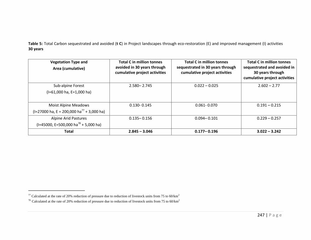
247 | P a g e
Table 5: Total Carbon sequestrated and avoided (t C) in Project landscapes through eco-restoration (E) and improved management (I) activities 30 years
Vegetation Type and
Area (cumulative)
Total C in million tonnes avoided in 30 years through cumulative project activities
Total C in million tonnes sequestrated in 30 years through
cumulative project activities
Total C in million tonnes sequestrated and avoided in
30 years through cumulative project activities
Sub-alpine Forest
(I=61,000 ha, E=1,000 ha)
2.580– 2.745 0.022 – 0.025 2.602 – 2.77
Moist Alpine Meadows
(I=27000 ha, E = 200,000 ha77 + 3,000 ha)
0.130- 0.145 0.061- 0.070 0.191 – 0.215
Alpine Arid Pastures
(I=45000, E=500,000 ha78 + 5,000 ha)
0.135– 0.156 0.094– 0.101 0.229 – 0.257
Total 2.845 – 3.046 0.177– 0.196 3.022 – 3.242
77 Calculated at the rate of 20% reduction of pressure due to reduction of livestock units from 75 to 60/km2
78 Calculated at the rate of 20% reduction of pressure due to reduction of livestock units from 75 to 60/km2
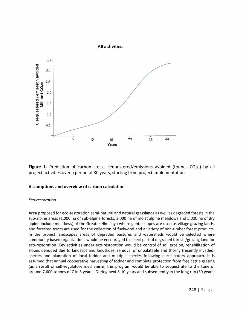
248 | P a g e
Figure 1. Prediction of carbon stocks sequestered/emissions avoided (tonnes CO2e) by all project activities over a period of 30 years, starting from project implementation
Assumptions and overview of carbon calculation
Eco-restoration
Area proposed for eco-restoration semi-natural and natural grasslands as well as degraded forests in the sub-alpine areas (1,000 ha of sub-alpine forests, 3,000 ha of moist alpine meadows and 5,000 ha of dry alpine include meadows) of the Greater Himalaya where gentle slopes are used as village grazing lands, and forested tracts are used for the collection of fuelwood and a variety of non-timber forest products. In the project landscapes areas of degraded pastures and watersheds would be selected where community based organizations would be encouraged to select part of degraded forests/grazing land for eco-restoration. Key activities under eco-restoration would be control of soil erosion, rehabilitation of slopes denuded due to landslips and landslides, removal of unpalatable and thorny (recently invaded) species and plantation of local fodder and multiple species following participatory approach. It is assumed that annual cooperative harvesting of fodder and complete protection from free cattle grazing (as a result of self-regulatory mechanism) this program would be able to sequestrate to the tune of around 7,600 tonnes of C in 5 years. During next 5-10 years and subsequently in the long run (30 years)
249 | P a g e
other areas can be taken up for eco-restoration on rotational basis and overall productivity of the village pastures, forests can be improved.
About 200,000 ha of degraded alpine meadows in the Greater Himalaya and at least 500,000 ha of degraded pastures in the Trans-Himalaya in the pilot sites (outside the protected area) will be taken up for eco-restoration through pastoral communities with a sequestration of about 57,000 tonnes of C in 5 years. Major assumptions are the community based organizations (CBOs) in each landscape will agree and feel necessity to restore the degraded and neglected areas in their village surrounds and take a collective decision to set aside smaller parcels of degraded meadows for temporary closure on 5 year rotation and reduce the number of livestock by 20%. Albeit this would require very intensive support from the livestock husbandry department, incentives for reducing the number of scrub cattle.
Improved management and protection
Except some areas of Khangchendzonga and Gangotri NP, all other PAs in the proposed project landscapes are under heavy influence of livestock grazing. It is assumed that as part of Component 1 (Biodiversity Conservation), all PA managers will identify critical wildlife habitats such as nesting sites of migratory birds, wintering ranges of ungulates, and work out an appropriate plan for regulation of livestock grazing following participatory process. It is proposed that at least 60,000 ha of sub-alpine forest, 27,000 ha moist alpine meadows and 25,000 ha of dry alpine meadows would be freed from intensive livestock grazing within the PAs selected for SECURE Himalaya program as high conservation value forests and meadows. In addition about 10,000 ha of ha of sub-alpine forest, 27,000 ha moist alpine meadows and 25,000 ha of dry alpine meadows will be established as Biodiversity Heritage Sites and freed from intensive livestock grazing and forest disturbances. Under the community participatory process another 20,000 ha is planned for community management and conservation. A further 1,000 ha of sub-alpine forest, 12,000 ha moist alpine meadows and 20,000 ha of dry alpine meadows would be brought under sustainable management regimes. The total expect C to be avoided in a 5-year period would be around 492,910 tonnes from the above-mentioned activities.
It is estimated that as a result of 5 years eco-restoration and protection at all project sites, the C ton avoided and sequestrated may result in all three vegetation times may result in 492,910 and 64,600 tons respectively (Table 2)
Other activities contributing to cumulative Carbon gains:
In addition to eco-restoration, better zonation planning and protection, SECURE Himalaya project visualizes the following activities during the implementation of the project:
(a) Increased production of fuel wood, fodder and agriculture so as to engage the high altitude farmers within their villages and private lands.
(b) Eco-restoration of community land in the buffer zone of PAs so that most of the biomass requirements of the local communities are met from those lands and in the long run the human dependence on PAs is minimized.
250 | P a g e
(c) Minimize anthropogenic pressures such as livestock grazing, forest fires, extraction of non-timber forest products (NTFPs), encroachment and infrastructure development in the sensitive habitats and critical corridors within the larger landscape.
(d) Other eco-development activities, participatory planning and enterprise based livelihood enhancement activities in the landscape.
It is assumed that within five to 10 years the local CBOs would begin to benefit from eco-restoration and conservation activities from the enhanced flow of services and overall quality of life will improve in these landscapes. Based on the simulation model for predicting carbon stocks sequestered/emissions avoided (tonnes CO2e) by all project activities over a period of 30 years (Figure 1), starting from project implementation it is estimated that there would be a net gain of 3.022 – 3.242 million tonnes of C from entire project area in 30 years. The sigmoid curve showing C sequestration potential has been derived and adapted from the scientific literature. However, it would need to be validated and refined during the first phase of project implementation. A more rigorous C estimation from varying ecosystems is planned for the first quarter in project implementation.
References
Hamburg, S.P. 2000. Simple rules for measuring changes in ecosystem carbon in forestry– offset projects. Mitigation and Adaptation Strategies for Global Change 5:25-37.
Brown, S. 2001. Measuring and monitoring carbon benefits for forest-based projects: experience from pilot projects, can carbon sinks be operational? Resources for the Future (RFF) workshop proceedings, Washington DC, pp. 1-19
Yu-Qiang Tian, Xing-Liang Xu, Ming-Hua Song, Cai-Ping Zhou, Qiong Gao and Hua Ouyang. 2009. Carbon Sequestration in Two Alpine Soils on the Tibetan Plateau. Journal of Integrative Plant Biology 2009, 51 (9): 900–905
Yan Yan and Xuyang Lu, 2015, Is grazing exclusion effective in restoring vegetation in degraded alpine grasslands in Tibet, China? PeerJ 3:e1020; DOI 10.7717/peerj. 1020.
Xiong Dingpeng et al. 2014. Effects of grazing exclusion on plant productivity and soil carbon, nitrogen storage in alpine meadows in northern Tibet, China. Chinese Geographical Science 24 (4) 488-498
Zhanhuan Shang et al. 2014. Effect of enclosure on soil carbon, nitrogen and phosphorus of Alpine desert rangeland, Land Degradation and Development DOI: 10.1002/ldr.2283
Rai I D 2013, Ecological Attributes of Timberline Vegetation with Special Reference to Climatic Variability in Kedarnath Wildlife Sanctuary, Western Himalaya. Ph.D. Thesis Kumaun University, Nainital.
Rana B.S.; Singh R.P.; Singh S.P., 1989: Carbon and energy dynamics of seven central Himalayan forests. Tropical Ecology. 30(2): 253-264
Ram,J, J. S. Singh and S. P. Singh, 1989. Plant Biomass, Species Diversity and Net Primary Production in aCentral Himalayan High Altitude Grassland, Journal of Ecology, Vol. 77, 2, 456-468.
Rawat, G.S. 2007. Ecology of alpine vegetation in Western Himalaya D. Sc. Thesis. Kumaun University, Nainital. Unpublished Thesis.
J. Sun, G. W. Cheng, and W. P. Li. 2013. Meta-analysis of relationships between environmental factors and above-ground biomass in the alpine grassland on the Tibetan Plateau Bio-geosciences. 10, 1707–1715.
251 | P a g e
Wenhong Ma1, Jin-Sheng He, Yuanhe Yang, Xiangping Wang,Cunzhu Liang, Mohammat, 2010. Environmental factors covary with plant diversity–productivity relationships among Chinese grassland sites, Global Ecology and Biogeography, (Global Ecol. Biogeogr, 19, 233–243.50 Garkoti, S. C. and S. P. Singh 1995. Variation in net primary productivity and biomass of forests in the high mountains of Central Himalaya, Journal of Vegetation Science, 6:23-28.
Ni, J., X. S. Zhang, J. M. O. Scurlock 2001. Synthesis and analysis of biomass and net primary productivity in Chinese forests Ann. For. Sci. 58:351-384
Adhikari, B. S., Y. S. Rawat and S. P. Singh 1995a. Structure and function of high altitude forests of Central Himalaya I. Dry matter Dynamics Annals of Botany, 72:237-248
Subedi, M. N. and P. R. Shakya 1988. Above-ground bio-mass and productivity studies of Quercus semecarpifolia Sm. forest at Phulchoki in Lalitpur district. In: Proceedings of the First National Conference on Science and Technology. Kathmandu: RONAST. P 381.
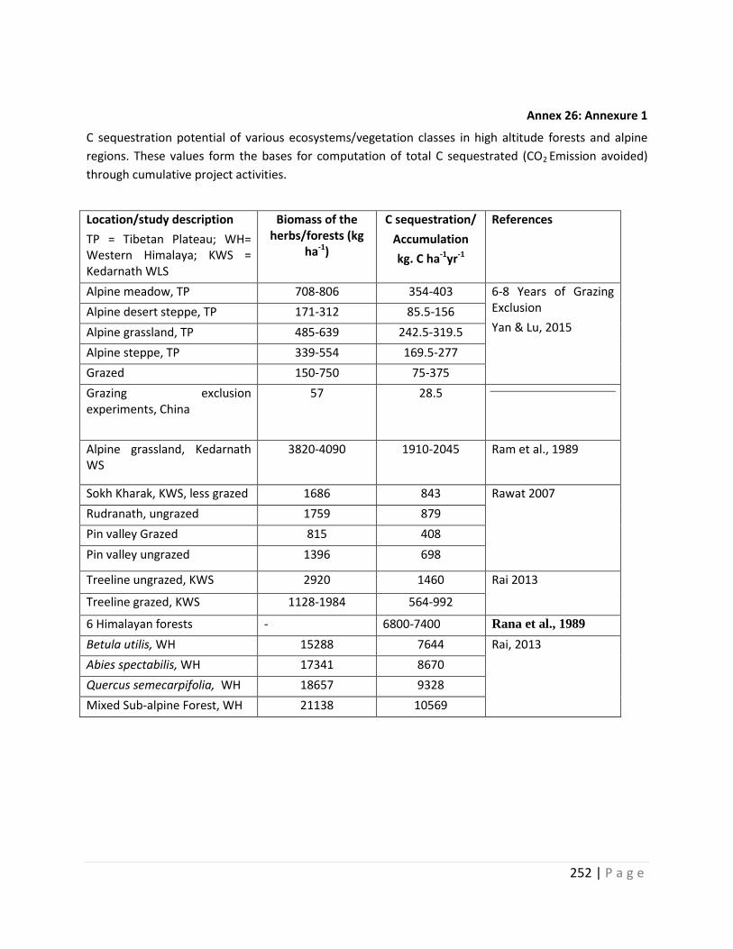
252 | P a g e
Annex 26: Annexure 1
C sequestration potential of various ecosystems/vegetation classes in high altitude forests and alpine
regions. These values form the bases for computation of total C sequestrated (CO2 Emission avoided)
through cumulative project activities.
Location/study description
TP = Tibetan Plateau; WH= Western Himalaya; KWS = Kedarnath WLS
Biomass of the herbs/forests (kg
ha-1)
C sequestration/
Accumulation
kg. C ha-1yr-1
References
Alpine meadow, TP 708-806 354-403 6-8 Years of Grazing Exclusion
Yan & Lu, 2015 Alpine desert steppe, TP 171-312 85.5-156
Alpine grassland, TP 485-639 242.5-319.5
Alpine steppe, TP 339-554 169.5-277
Grazed 150-750 75-375
Grazing exclusion experiments, China
57 28.5
Alpine grassland, Kedarnath WS
3820-4090 1910-2045 Ram et al., 1989
Sokh Kharak, KWS, less grazed 1686 843 Rawat 2007
Rudranath, ungrazed 1759 879
Pin valley Grazed 815 408
Pin valley ungrazed 1396 698
Treeline ungrazed, KWS 2920 1460 Rai 2013
Treeline grazed, KWS 1128-1984 564-992
6 Himalayan forests - 6800-7400 Rana et al., 1989
Betula utilis, WH 15288 7644 Rai, 2013
Abies spectabilis, WH 17341 8670
Quercus semecarpifolia, WH 18657 9328
Mixed Sub-alpine Forest, WH 21138 10569
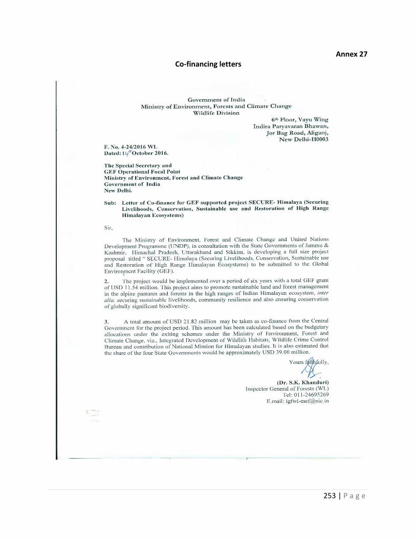
253 | P a g e
Annex 27 Co-financing letters
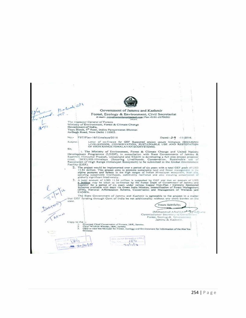
254 | P a g e
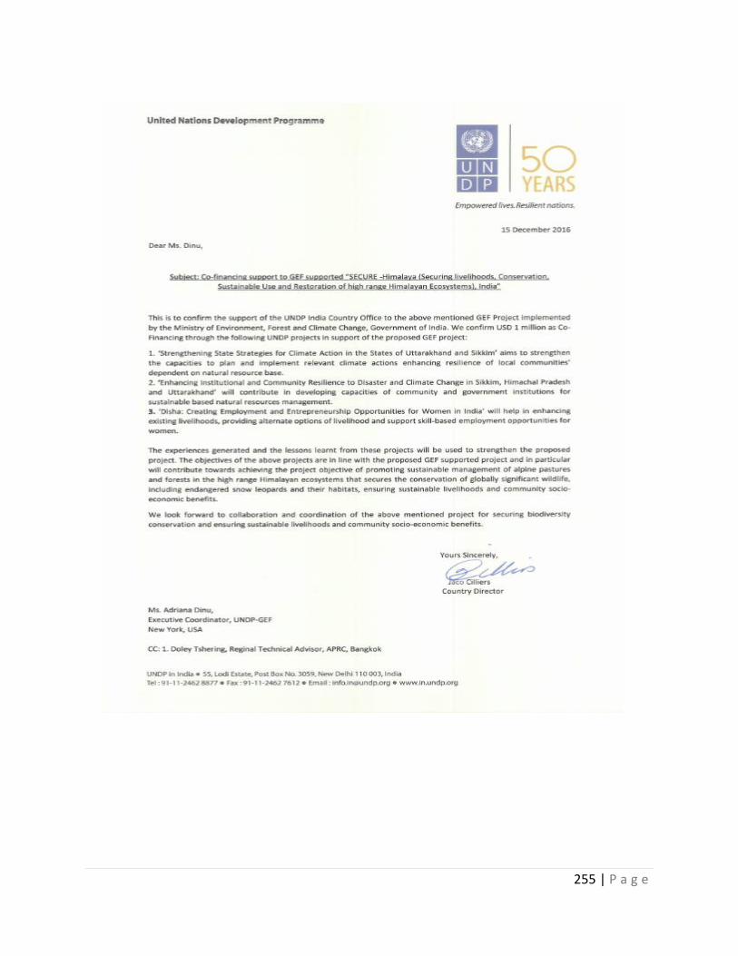
255 | P a g e
256 | P a g e
257 | P a g e
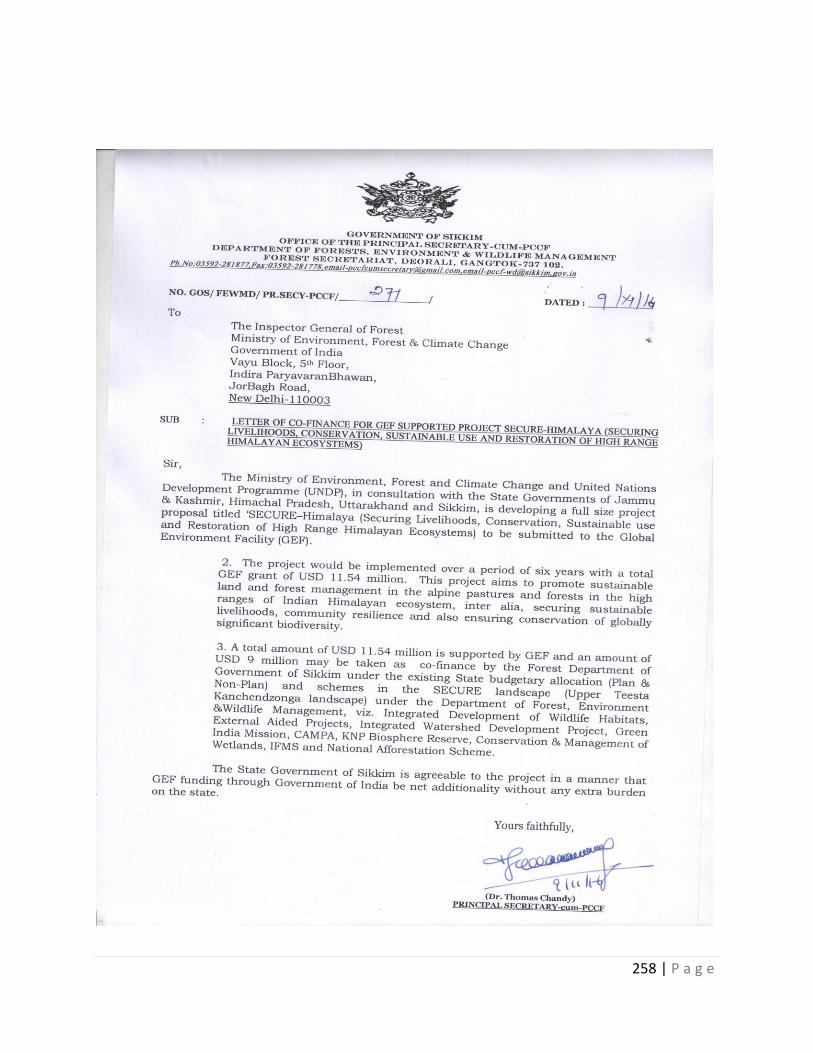
258 | P a g e
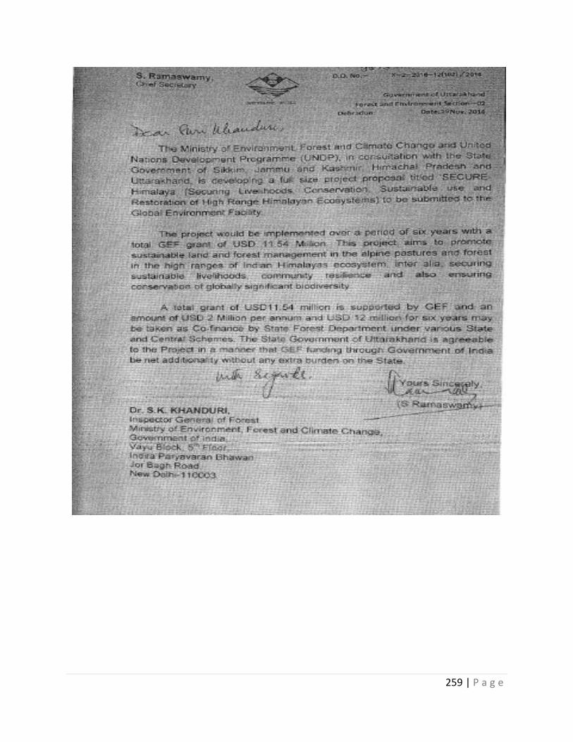
259 | P a g e
260 | P a g e
Annex 28
Letter of Agreement
STANDARD LETTER OF AGREEMENT BETWEEN UNDP AND THE GOVERNMENT FOR THE PROVISION OF SUPPORT SERVICES
For GEF-GOI-UNDP SECURE-Himalaya (Securing Livelihoods, Conservation, Sustainable use and Restoration of High Range Himalaya Ecosystems) project (2017-2024)
Dear Mr. Dasgupta,
1. Reference is made to consultations between officials of the Ministry of Environment, Forest and Climate Change (MoEFCC), Government of India (hereinafter referred to as “the Government”) and the officials of UNDP with respect to the provision of support services by the UNDP country office for SECURE-Himalaya (Securing Livelihoods, Conservation, Sustainable use and Restoration of High Range Himalaya Ecosystems) (2017-2024) project. UNDP and the Government of India hereby agree that the UNDP country office may provide such support services at the request of the MoEFCC designated in the relevant project document, as described below.
2. The UNDP country office may provide support services for assistance with reporting requirements and direct payment. In providing such support services, the UNDP country office shall ensure that the capacity of the MoEFCC is strengthened to enable it to carry out such activities directly. The costs incurred by the UNDP country office in providing such support services shall be recovered from the administrative budget of the office.
3. The UNDP country office may provide, at the request of the MoEFCC, the following support services for the activities of the GEF-GoI -UNDP SECURE-Himalaya (Securing Livelihoods, Conservation, Sustainable use and Restoration of High Range Himalaya Ecosystems) project:
(a) Human Resources-Identification and/or recruitment of project and programme personnel including international consultants to include sourcing, contracting and payment.
(b) Procurement- Identification and facilitation of training activities and awarding contracts to selected agencies;
(c) Financial reporting requirement and-Direct payments;
(d) Logistics-Travel support to technical staff;
4. The procurement of goods and services and the recruitment of the project personnel by the UNDP country office shall be in accordance with the UNDP regulations, rules, policies and procedures. Support services described in paragraph 3 above shall be detailed in an annex to this document, in the form provided in the Attachment hereto. If the requirements for support services by the country office change during the life of the project, the annex to the project document will be revised with the mutual agreement of the UNDP Country Director and the MoEFCC.
5. The relevant provisions of the technical assistance agreement defined in “Basis of relationship” in CPAP (2013-17) signed with Government of India, including the provisions on liability and privileges and immunities, shall apply to the provision of such support services. The MoEFCC shall retain overall responsibility for the nationally
261 | P a g e
managed project through its designated institution. The responsibility of the UNDP country office for the provision of the support services described herein shall be limited to the provision of such support services detailed in the annex to the project document.
6. Any claim or dispute arising under or in connection with the provision of support services by the UNDP country office in accordance with this letter shall be handled pursuant to the relevant provisions of the technical assistance agreement.
7. The manner and method of cost-recovery by the UNDP country office in providing the support services described in paragraph 3 above shall be specified in the project document of GEF- GoI- UNDP SECURE-Himalaya (Securing Livelihoods, Conservation, Sustainable use and Restoration of High Range Himalaya Ecosystems) project.
8. The UNDP country office shall submit progress reports on the support services provided and shall report on the costs reimbursed in providing such services, as may be required.
9. Any modification of the present arrangements shall be effected by mutual written agreement of the parties hereto.
10. If you are in agreement with the provisions set forth above, please sign and return to this office two signed copies of this letter. Upon signature, this letter shall constitute an agreement between Ministry of Environment, Forests, and Climate Change and UNDP on the terms and conditions for the provision of support services by the UNDP country office for GEF- GoI-UNDP SECURE-Himalaya (Securing Livelihoods, Conservation, Sustainable use and Restoration of High Range Himalaya Ecosystems) project.
.
Yours sincerely,
________________________
Signed on behalf of UNDP
Marina Walter
Country Director a.i.
_____________________
For the Government of India
Mr. Soumitra Dasgupta
Inspector General of Forest (Wild Life)
Ministry of Environment, Forest and Climate Change
Indira Paryavaran Bhawan
Date……………………………………..
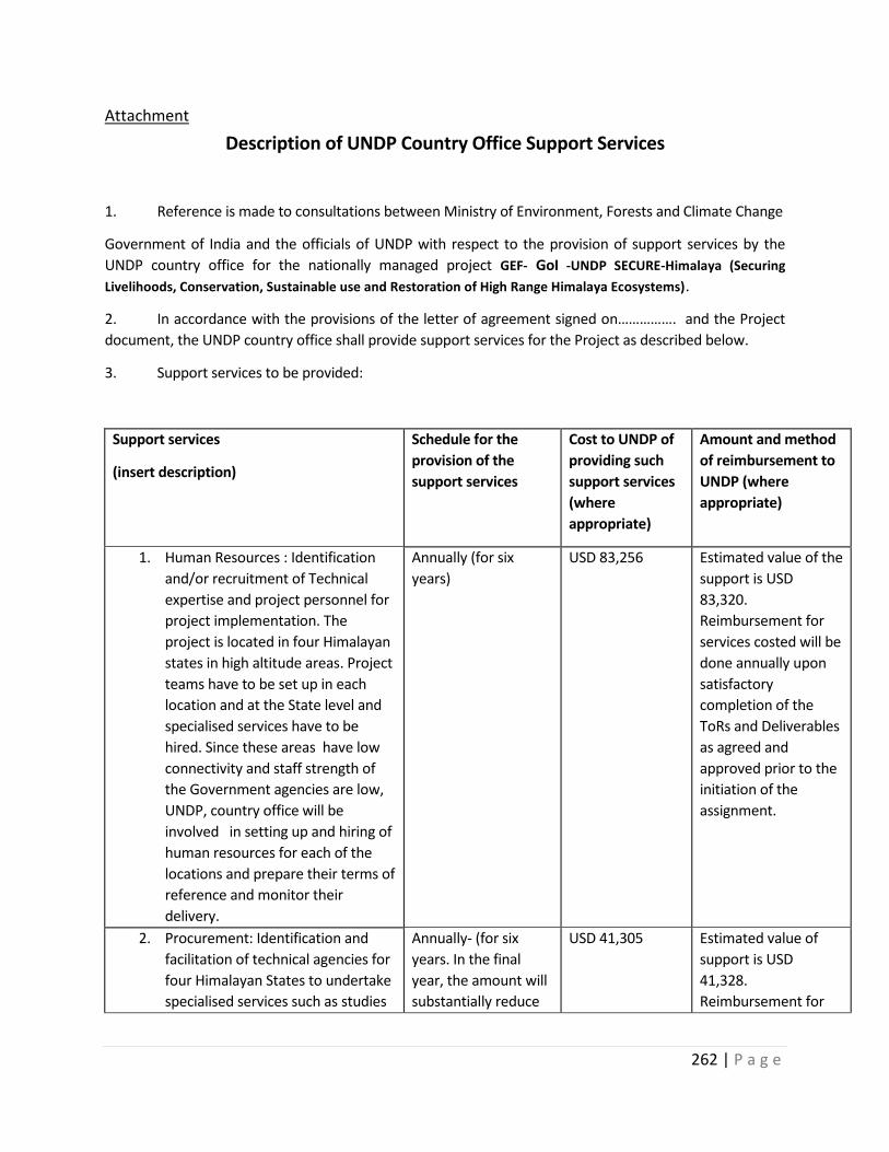
262 | P a g e
Attachment
Description of UNDP Country Office Support Services
1. Reference is made to consultations between Ministry of Environment, Forests and Climate Change
Government of India and the officials of UNDP with respect to the provision of support services by the
UNDP country office for the nationally managed project GEF- GoI -UNDP SECURE-Himalaya (Securing
Livelihoods, Conservation, Sustainable use and Restoration of High Range Himalaya Ecosystems).
2. In accordance with the provisions of the letter of agreement signed on……………. and the Project
document, the UNDP country office shall provide support services for the Project as described below.
3. Support services to be provided:
Support services
(insert description)
Schedule for the
provision of the
support services
Cost to UNDP of
providing such
support services
(where
appropriate)
Amount and method
of reimbursement to
UNDP (where
appropriate)
1. Human Resources : Identification
and/or recruitment of Technical
expertise and project personnel for
project implementation. The
project is located in four Himalayan
states in high altitude areas. Project
teams have to be set up in each
location and at the State level and
specialised services have to be
hired. Since these areas have low
connectivity and staff strength of
the Government agencies are low,
UNDP, country office will be
involved in setting up and hiring of
human resources for each of the
locations and prepare their terms of
reference and monitor their
delivery.
Annually (for six
years)
USD 83,256 Estimated value of the
support is USD
83,320.
Reimbursement for
services costed will be
done annually upon
satisfactory
completion of the
ToRs and Deliverables
as agreed and
approved prior to the
initiation of the
assignment.
2. Procurement: Identification and
facilitation of technical agencies for
four Himalayan States to undertake
specialised services such as studies
Annually- (for six
years. In the final
year, the amount will
substantially reduce
USD 41,305 Estimated value of
support is USD
41,328.
Reimbursement for
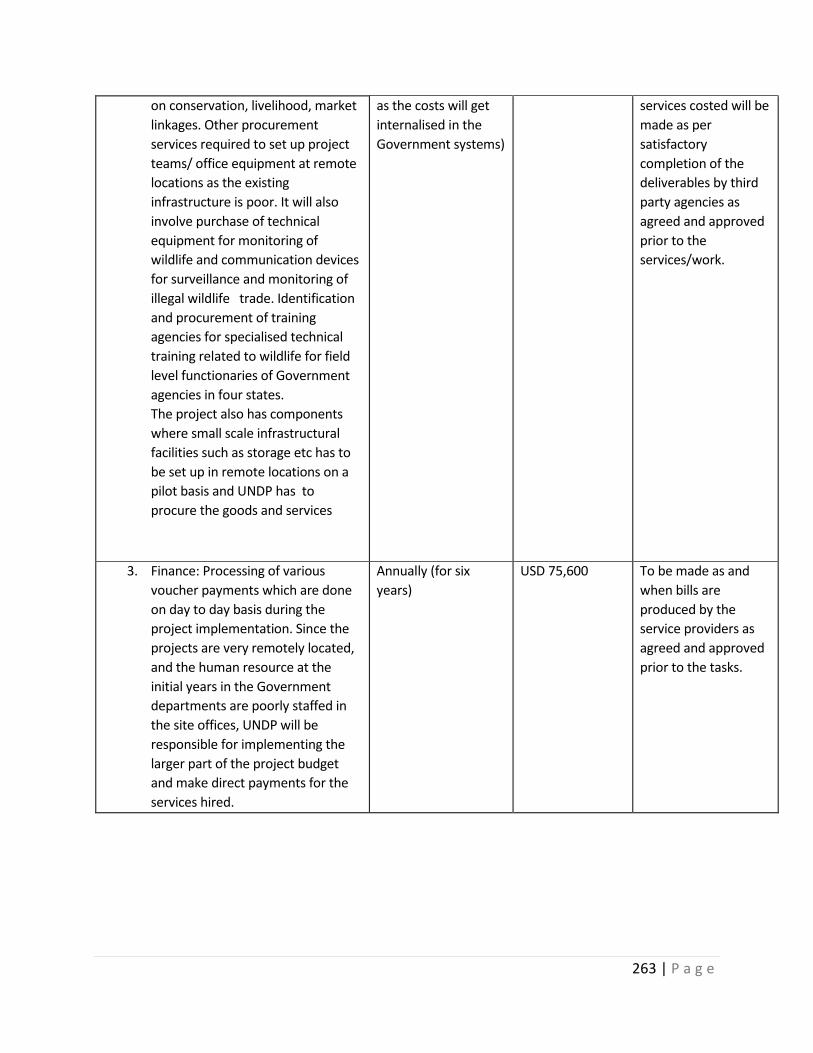
263 | P a g e
on conservation, livelihood, market
linkages. Other procurement
services required to set up project
teams/ office equipment at remote
locations as the existing
infrastructure is poor. It will also
involve purchase of technical
equipment for monitoring of
wildlife and communication devices
for surveillance and monitoring of
illegal wildlife trade. Identification
and procurement of training
agencies for specialised technical
training related to wildlife for field
level functionaries of Government
agencies in four states.
The project also has components
where small scale infrastructural
facilities such as storage etc has to
be set up in remote locations on a
pilot basis and UNDP has to
procure the goods and services
as the costs will get
internalised in the
Government systems)
services costed will be
made as per
satisfactory
completion of the
deliverables by third
party agencies as
agreed and approved
prior to the
services/work.
3. Finance: Processing of various
voucher payments which are done
on day to day basis during the
project implementation. Since the
projects are very remotely located,
and the human resource at the
initial years in the Government
departments are poorly staffed in
the site offices, UNDP will be
responsible for implementing the
larger part of the project budget
and make direct payments for the
services hired.
Annually (for six
years)
USD 75,600 To be made as and
when bills are
produced by the
service providers as
agreed and approved
prior to the tasks.
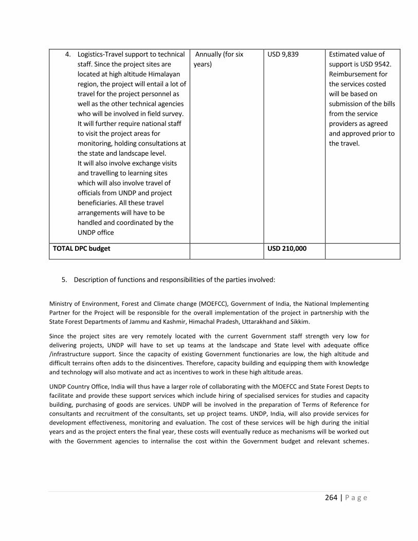
264 | P a g e
4. Logistics-Travel support to technical
staff. Since the project sites are
located at high altitude Himalayan
region, the project will entail a lot of
travel for the project personnel as
well as the other technical agencies
who will be involved in field survey.
It will further require national staff
to visit the project areas for
monitoring, holding consultations at
the state and landscape level.
It will also involve exchange visits
and travelling to learning sites
which will also involve travel of
officials from UNDP and project
beneficiaries. All these travel
arrangements will have to be
handled and coordinated by the
UNDP office
Annually (for six
years)
USD 9,839 Estimated value of
support is USD 9542.
Reimbursement for
the services costed
will be based on
submission of the bills
from the service
providers as agreed
and approved prior to
the travel.
TOTAL DPC budget USD 210,000
5. Description of functions and responsibilities of the parties involved:
Ministry of Environment, Forest and Climate change (MOEFCC), Government of India, the National Implementing
Partner for the Project will be responsible for the overall implementation of the project in partnership with the
State Forest Departments of Jammu and Kashmir, Himachal Pradesh, Uttarakhand and Sikkim.
Since the project sites are very remotely located with the current Government staff strength very low for
delivering projects, UNDP will have to set up teams at the landscape and State level with adequate office
/infrastructure support. Since the capacity of existing Government functionaries are low, the high altitude and
difficult terrains often adds to the disincentives. Therefore, capacity building and equipping them with knowledge
and technology will also motivate and act as incentives to work in these high altitude areas.
UNDP Country Office, India will thus have a larger role of collaborating with the MOEFCC and State Forest Depts to
facilitate and provide these support services which include hiring of specialised services for studies and capacity
building, purchasing of goods are services. UNDP will be involved in the preparation of Terms of Reference for
consultants and recruitment of the consultants, set up project teams. UNDP, India, will also provide services for
development effectiveness, monitoring and evaluation. The cost of these services will be high during the initial
years and as the project enters the final year, these costs will eventually reduce as mechanisms will be worked out
with the Government agencies to internalise the cost within the Government budget and relevant schemes.
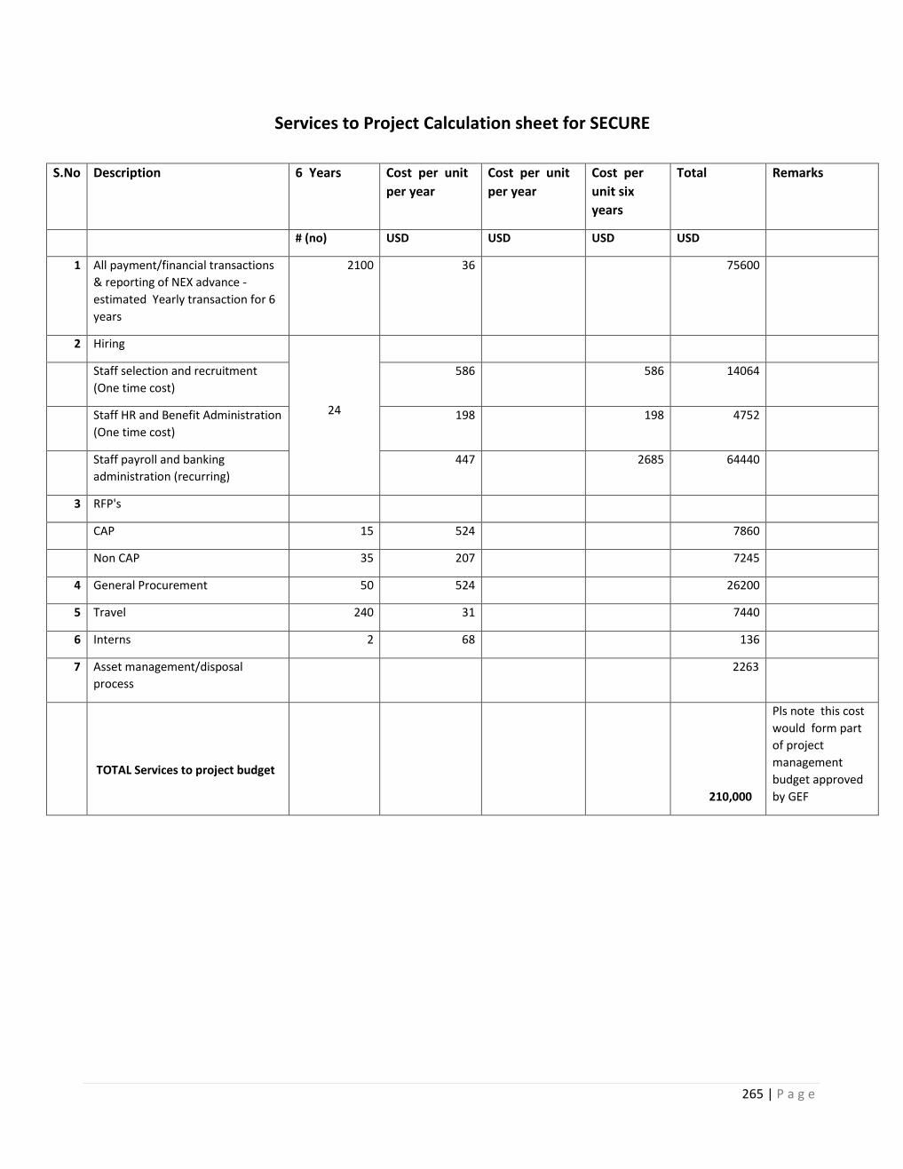
265 | P a g e
Services to Project Calculation sheet for SECURE
S.No Description 6 Years Cost per unit
per year
Cost per unit
per year
Cost per
unit six
years
Total Remarks
# (no) USD USD USD USD
1 All payment/financial transactions
& reporting of NEX advance -
estimated Yearly transaction for 6
years
2100 36 75600
2 Hiring
24
Staff selection and recruitment
(One time cost)
586 586 14064
Staff HR and Benefit Administration
(One time cost)
198 198 4752
Staff payroll and banking
administration (recurring)
447 2685 64440
3 RFP's
CAP 15 524 7860
Non CAP 35 207 7245
4 General Procurement 50 524 26200
5 Travel 240 31 7440
6 Interns 2 68 136
7 Asset management/disposal
process
2263
TOTAL Services to project budget
210,000
Pls note this cost
would form part
of project
management
budget approved
by GEF
266 | P a g e
Annex 29
Stakeholder Consultation Details
National Stakeholder Consultation
On
SECURE HIMALAYA
December 22, 2016
(Securing livelihoods, conservation, sustainable use and restoration of high range Himalayan ecosystems)
The National Stakeholder Consultation on the review and finalization of the project document of GoI-UNDP/ GEF project titled
SECURE HIMALAYA (Securing livelihoods, conservation, sustainable use and restoration of high range Himalayan
ecosystems) was held under the Chairmanship of Additional Director General of Forests (Wildlife), MoEFCC on December 22,
2016 from 11:00 am to 01:00 pm at Narmada Hall, Ministry of Environment, Forest and Climate Change, New Delhi. The
agenda and the list of participants is attached. (Annexure 1 and 2).
Welcome and Purpose of the Consultation: Dr. Preeti Soni, Assistant Country Director & Head, Energy and Environment
Unit, UNDP welcomed the participants on behalf of UNDP and outlined the importance of the consultation for getting inputs for
finalizing the project document.
She apprised the participants that the SECURE HIMALAYA project is of critical significance for biodiversity and ecosystems in
the Indian Himalayan region; thanked the MoEFCC and the state government for their guidance and support in the design of the
project. She also thanked the consultants in developing the project document.
The Chairman in his opening remarks spoke about the process involved in the design of the project; the involvement of the
senior officials of the ministry and the state governments in the state and landscape level consultations and the extensive field
work conducted by the consultants. He appreciated the involvement of all stakeholders in the development of the project.
Presentation of the Key components and Results Framework for SECURE Himalaya project:
Dr. G.S Rawat, Dean, Wildlife Institute of India, Dehradun thanked all the consultants for providing valuable inputs while
designing the project document. He said that after extensive research, surveys, consultations and field visits, the project
document was prepared and submitted to UNDP in the end November 2016. He presented the significance of the project, the
major components, project interventions, implementation strategies, the management arrangements and the fund flow
arrangements. (Presentation attached as Annexure 3)
Following are component - wise key suggestions/ recommendations received after the presentation:
Component 1:
The Chair referred to the landscape level consultation held in Uttarakashi where it was agreed that the project will also include
Johar valley in the Pithoragarh landscape.
Chief Wildlife Warden, Uttarakhand highlighted that these areas are used for transhumance and reference to this should be added
to the project. He also mentioned that these areas form part of inter-state and international boundaries, hence, there should be
some focus on activities on transboundary cooperation.
Chief Wildlife Warden, Jammu and Kashmir, suggested that the document should be more comprehensive. The Chief
Conservator of Forest, Leh, added that the funding in the project is limited and the landscape is huge and hence, the project
should have a focussed approach and may consider reducing the time lines of the project.
Advisor, Mountain division, MoEFCC, felt that funds in the project are limited and proposed the use of funds from National
Mission on Himalayan Studies to implement certain pilots in the project areas.
The Chair and IGF (WL) suggested that the project activities should not overlap with other similar projects being implemented
in the same region. Rather the project should try to converge with these projects and introduce innovative and dynamic
interventions in the project areas.
The Chairperson, National Biodiversity Authority, suggested that while working in such fragile ecosystems, the project should
focus on natural habitat restoration and climate change issues. And also focus on developing curriculum for high schools,
colleges and doctoral programmes should be encouraged. She further suggested that aquaculture could be added as a livelihood
option as it cheap source for protein. Small water bodies in high altitude areas could be used for such activities.
The Additional Director, Wildlife Crime Control Bureau, MoEFCC, proposed to link some of the research required in the region
be linked with doctoral programmes of Universities in these project states.
267 | P a g e
Representative, Institute of Advanced Sustainability Studies, Berlin, highlighted the importance of cultural and spiritual
dimension in biodiversity conservation as this can help achieve long term sustainability of the project.
Component 2:
Dean, Wildlife Institute of India, felt that there is potential for more research in some of the snow leopard range areas and some
of this could be supported under the NMHS.
The Chair said that community farming should be promoted to address the issue of fragmented and scattered landholdings in the
project areas. He further added that establishing Community reserves should be encouraged for raising enthusiasm amongst the
community to engage them in conservation work.
IGF (WL) emphasised developing integrated micro plan in the project which would incorporate all aspects such as resource
conservation, sustainable use and livelihoods promotion. He further added that instead of diversifying the livelihood options, the
project should strengthen and enhance the existing livelihoods options.
Deputy CEO, NMPB highlighted the need for cultivation of some of the RET (Rare, endangered and threatened species) in the
project areas and sustainable foraging. She further offered support from NMPB schemes for the same and buyer- seller meets.
She apprised the group of the existing online marketing portal which can be used by the med plant cultivators and collectors.
UNDP representative suggested the need for access to finance to improve livelihood opportunities through micro-finance
options.
Representative from GB Pant National Institute on Himalayan Environment and Sustainable Development proposed to include
intervention on Germ plasm repository to the project.
The PCCF, Govt. of Kerala and former IGF (WL) cautioned the project to look at the sustainability of resources and
sustainability of the action which should become a part of the micro-planning exercise.
CCF, J&K, suggested incorporating Sea buckthorn as a livelihood option for Jammu and Kashmir region.
Component 3:
Additional Director, WCCB, suggested continuous training and sensitisation programmes for the border and army forces.
Strengthening enforcement and surveillance mechanisms should be undertaken.
The Char highlighted the need for enhanced reporting on wildlife crime in the project areas.
CCF, Leh highlighted the need to sensitise the Army to address the problem of feral dogs in the project areas which have been
harming the endangered wildlife such as the Black necked crane and the Tibetan Antelope.
PCCF, Govt. of Kerala and former IGF (WL) suggested that enabling environment and institutional arrangements need to be
developed and strengthened. He suggested working with the Army on exploring ways to integrate wildlife friendly provisions in
the SoPs.
Consultant, UNDP, suggested building partnership with the Army for better surveillance and monitoring of biodiversity and
wildlife in the project areas, which would also enable access to their satellite technologies and raise awareness.
Component 4:
PCCF, Govt. of Kerala and former IG (WL) suggested that the Communication strategy should include working with elected
representatives and senior government officials and advocacy events should be held on a periodic basis.
Implementation Arrangements:
There were diverse views on this aspect. While some felt that the Chief Secretary should be chairing the State level steering
committee that will be held once a year to allow convergence with the government programmes and related departments, some
states were of the view that such an arrangement may lead to delays in project related decisions.
Finally, it was agreed that the Steering committee will be chaired by the Chief Secretary at the highest level which will enable
convergence of various departments in the state. It was further agreed that there will be a Working or Executive Committee
chaired by the Chief Wildlife Warden which will be empowered to take decisions related to the project and the committee will
have representation from all line departments, elected representatives, experts and other relevant stakeholders.
Fund flow arrangements:
It was agreed that the project will follow the guidelines provided by the Ministry of Finance for such externally aided projects.
The Chair suggested that UNDP prepares a list of different approaches for the same.

268 | P a g e
Under secretary, International Cooperation Division, MoEFCC highlighted the importance of including replication and scaling
up opportunities in the document. He further requested the team to incorporate suggestions received in the meeting within the
document and submit it to the GEF office at the earliest.
UNDP also worked with the State governments to review and finalize the indicators and tracking tools of the project. Minor
changes were suggested by the States and were incorporated in the final document.