Embed Size (px)
Citation preview
NEW YORK STATE
Department of Environmental Conservation DIVISION OF LANDS & FORESTS
Kaaterskill Wild Forest
Unit Management Plan Amendment
Towns of Catskill and Hunter - Greene County
Town of Saugerties - Ulster County
ANDREW M. CUOMO JOE MARTENS
Governor Commissioner
For Further Information Contact:
New York State Department of Environmental Conservation 65561 State Highway 10, Suite One Stamford, NY 12167-9503 (607) 652-7365 [email protected] May 2013

This page intentionally left blank

_____________________________________________________________________________________
M E M O R A N D U M
TO: The Record
SUBJECT: Kaaterskill Wild Forest
DATE:
The Final Amendment to the Kaaterskill Wild Forest Unit Management Plan has been completed.
The Final UMP Amendment is consistent with the State Constitution, Environmental Conservation Law, and Department Rules, Regulations and Policies and is hereby approved and adopted.
_______________________________________ Joseph J. Martens

This page intentionally left blank
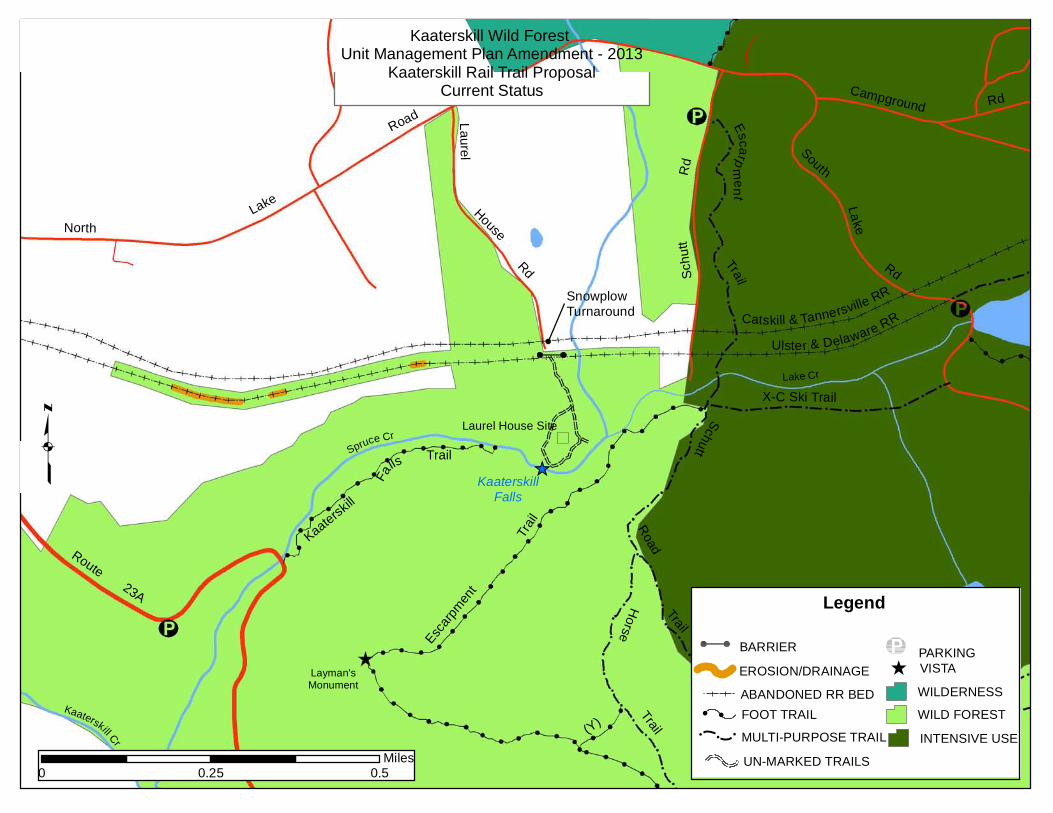
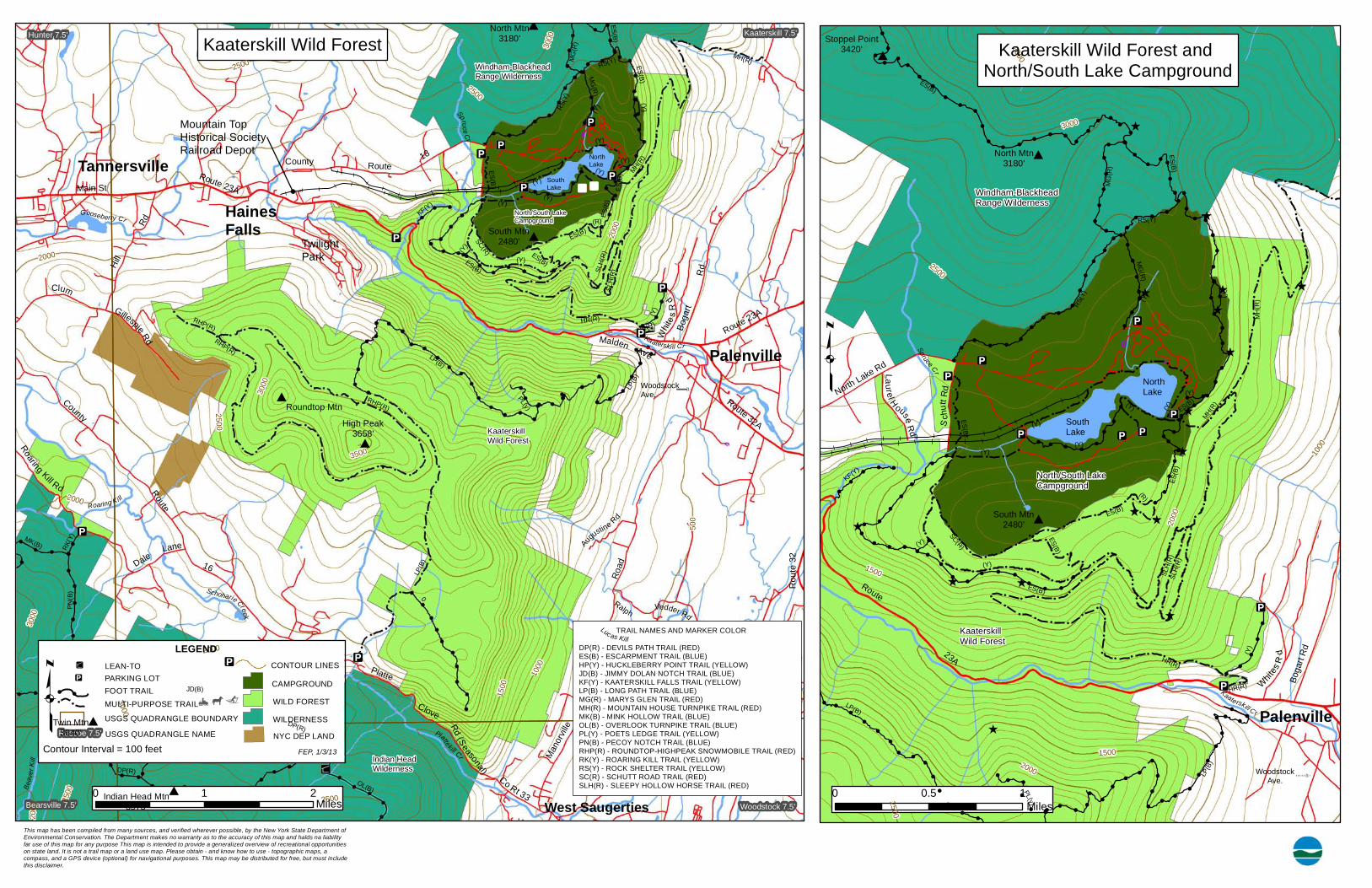
Background The Kaaterskill Wild Forest and North/South Lake Campground are located in the Town of Hunter, Greene County. Within the two areas, a year‐round recreational trail network has been established for decades, and is currently used by both local residents and visitors. Many of the trails are old carriage roads or foot trails that were constructed during the nineteenth century to serve the Catskill Mountain House, Hotel Kaaterskill and The Laurel House. Today, some of these old roads link the communities of Tannersville, Haines Falls, and Palenville to the diverse trail system in the campground and Wild Forest, many of which were constructed later by the Department of Environmental Conservation (DEC), or former Conservation Department.
Railroads entered the Town of Hunter during the latter part of the 19th century and spur lines were built, providing access to the hotels near North Lake and South Lake after passing through Tannersville and Haines Falls. In the late 1990’s, portions of the old Ulster and Delaware Railroad bed, proceeding west of Haines Falls and passing through private land, were designated by the Town of Hunter as a multi‐use recreational trail and named the Huckleberry Trail. For years, the Town of Hunter and its partners have pursued the extension of the trail east of Haines Falls, with the ultimate goal of connecting to the existing state land trail network in the vicinity of North/South Lake.
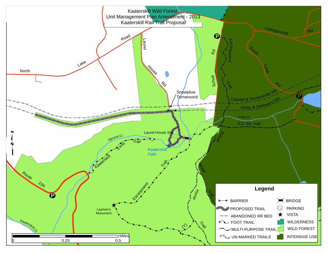
New Trail Proposal The Kaaterskill Rail Trail Committee (KRT) is sponsoring an initiative to complete a 1.8‐mile trail connection between the community of Haines Falls and the existing trail system in the Kaaterskill Wild Forest and North/South Lake Campground. The primary component to this linkage is an abandoned Ulster and Delaware railroad bed between Haines Falls and Laurel House Road, of which 0.6 miles are in the Kaaterskill Wild Forest. An additional 0.2 miles of trail on an abandoned town road and a new bridge crossing over Spruce Creek would complete the connection to the existing Escarpment Trail. In addition to the connector trail, another 0.2 mile loop trail near the Spruce Creek crossing would provide access to the site of the former Laurel House. In all, one mile of newly designated trails in Kaaterskill Wild Forest are proposed for multiple‐use, open to non‐motorized recreation such as hiking, running, bicycling, snow‐shoeing, and cross‐country skiing.
This initiative has broad community support, with partners and supporters including the Town of Hunter, the Mountain Top Historical Society (MTHS), The New York‐New Jersey Trail Conference, and the Greene County Soil and Water Conservation District. The Mountain Top Historical Society owns the former Ulster and Delaware Railroad Depot in Haines Falls, which would serve as a trailhead for the proposed trail.
This proposal is also supported by the Catskill Forest Preserve Access Plan which was completed by DEC in 1999. Proposed actions within the Access Plan include the pursuit of trail linkages from communities to Forest Preserve lands, including those along Catskill rail corridors.
A Unit Management Plan (UMP) was completed for the Kaaterskill Wild Forest in 1987. The proposals summarized above are being put forth as an amendment to the UMP, as described on the following pages.
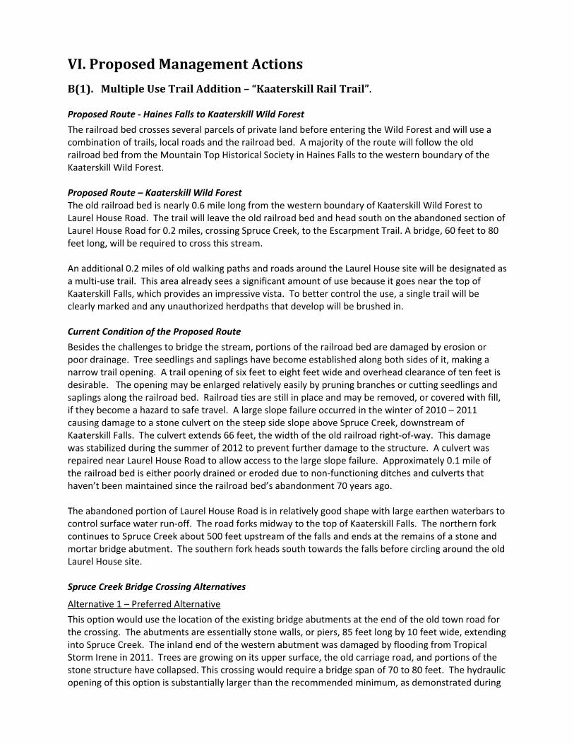
VI. Proposed Management Actions
B(1). Multiple Use Trail Addition – “Kaaterskill Rail Trail”.
Proposed Route ‐ Haines Falls to Kaaterskill Wild Forest
The railroad bed crosses several parcels of private land before entering the Wild Forest and will use a combination of trails, local roads and the railroad bed. A majority of the route will follow the old railroad bed from the Mountain Top Historical Society in Haines Falls to the western boundary of the Kaaterskill Wild Forest.
Proposed Route – Kaaterskill Wild Forest The old railroad bed is nearly 0.6 mile long from the western boundary of Kaaterskill Wild Forest to Laurel House Road. The trail will leave the old railroad bed and head south on the abandoned section of Laurel House Road for 0.2 miles, crossing Spruce Creek, to the Escarpment Trail. A bridge, 60 feet to 80 feet long, will be required to cross this stream.
An additional 0.2 miles of old walking paths and roads around the Laurel House site will be designated as a multi‐use trail. This area already sees a significant amount of use because it goes near the top of Kaaterskill Falls, which provides an impressive vista. To better control the use, a single trail will be clearly marked and any unauthorized herdpaths that develop will be brushed in.
Current Condition of the Proposed Route
Besides the challenges to bridge the stream, portions of the railroad bed are damaged by erosion or poor drainage. Tree seedlings and saplings have become established along both sides of it, making a narrow trail opening. A trail opening of six feet to eight feet wide and overhead clearance of ten feet is desirable. The opening may be enlarged relatively easily by pruning branches or cutting seedlings and saplings along the railroad bed. Railroad ties are still in place and may be removed, or covered with fill, if they become a hazard to safe travel. A large slope failure occurred in the winter of 2010 – 2011 causing damage to a stone culvert on the steep side slope above Spruce Creek, downstream of Kaaterskill Falls. The culvert extends 66 feet, the width of the old railroad right‐of‐way. This damage was stabilized during the summer of 2012 to prevent further damage to the structure. A culvert was repaired near Laurel House Road to allow access to the large slope failure. Approximately 0.1 mile of the railroad bed is either poorly drained or eroded due to non‐functioning ditches and culverts that haven’t been maintained since the railroad bed’s abandonment 70 years ago.
The abandoned portion of Laurel House Road is in relatively good shape with large earthen waterbars to control surface water run‐off. The road forks midway to the top of Kaaterskill Falls. The northern fork continues to Spruce Creek about 500 feet upstream of the falls and ends at the remains of a stone and mortar bridge abutment. The southern fork heads south towards the falls before circling around the old Laurel House site.
Spruce Creek Bridge Crossing Alternatives
Alternative 1 – Preferred Alternative
This option would use the location of the existing bridge abutments at the end of the old town road for the crossing. The abutments are essentially stone walls, or piers, 85 feet long by 10 feet wide, extending into Spruce Creek. The inland end of the western abutment was damaged by flooding from Tropical Storm Irene in 2011. Trees are growing on its upper surface, the old carriage road, and portions of the stone structure have collapsed. This crossing would require a bridge span of 70 to 80 feet. The hydraulic opening of this option is substantially larger than the recommended minimum, as demonstrated during
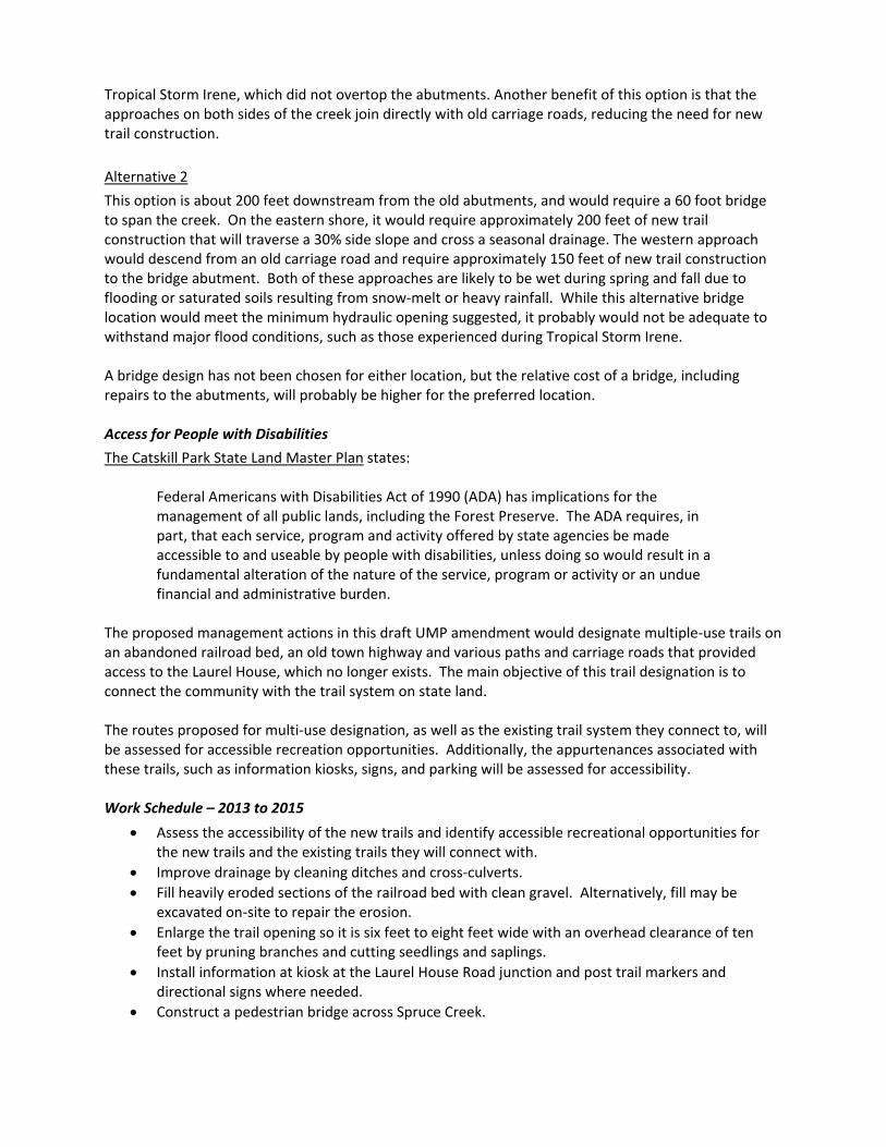
Tropical Storm Irene, which did not overtop the abutments. Another benefit of this option is that the approaches on both sides of the creek join directly with old carriage roads, reducing the need for new trail construction.
Alternative 2
This option is about 200 feet downstream from the old abutments, and would require a 60 foot bridge to span the creek. On the eastern shore, it would require approximately 200 feet of new trail construction that will traverse a 30% side slope and cross a seasonal drainage. The western approach would descend from an old carriage road and require approximately 150 feet of new trail construction to the bridge abutment. Both of these approaches are likely to be wet during spring and fall due to flooding or saturated soils resulting from snow‐melt or heavy rainfall. While this alternative bridge location would meet the minimum hydraulic opening suggested, it probably would not be adequate to withstand major flood conditions, such as those experienced during Tropical Storm Irene.
A bridge design has not been chosen for either location, but the relative cost of a bridge, including repairs to the abutments, will probably be higher for the preferred location.
Access for People with Disabilities
The Catskill Park State Land Master Plan states:
Federal Americans with Disabilities Act of 1990 (ADA) has implications for the management of all public lands, including the Forest Preserve. The ADA requires, in part, that each service, program and activity offered by state agencies be made accessible to and useable by people with disabilities, unless doing so would result in a fundamental alteration of the nature of the service, program or activity or an undue financial and administrative burden.
The proposed management actions in this draft UMP amendment would designate multiple‐use trails on an abandoned railroad bed, an old town highway and various paths and carriage roads that provided access to the Laurel House, which no longer exists. The main objective of this trail designation is to connect the community with the trail system on state land.
The routes proposed for multi‐use designation, as well as the existing trail system they connect to, will be assessed for accessible recreation opportunities. Additionally, the appurtenances associated with these trails, such as information kiosks, signs, and parking will be assessed for accessibility.
Work Schedule – 2013 to 2015
• Assess the accessibility of the new trails and identify accessible recreational opportunities for the new trails and the existing trails they will connect with.
• Improve drainage by cleaning ditches and cross‐culverts. • Fill heavily eroded sections of the railroad bed with clean gravel. Alternatively, fill may be
excavated on‐site to repair the erosion. • Enlarge the trail opening so it is six feet to eight feet wide with an overhead clearance of ten
feet by pruning branches and cutting seedlings and saplings. • Install information at kiosk at the Laurel House Road junction and post trail markers and
directional signs where needed. • Construct a pedestrian bridge across Spruce Creek.

This page intentionally left blank
Appendix 1 – Summary of Public Comment
A fifteen‐day public comment period was held for the Draft UMP Amendment. Ten comments were received; all supporting the draft Unit Management Plan amendment for the Kaaterskill Wild Forest.
The comments are summarized in bold.
1. A historic link between the hamlet and the sites of the old hotels and their scenic setting will be reopened. Prior to the railroad, a foot path was located approximately on the same route. It was mentioned in two Guides to the Catskill Mountains published during the 19th century.
Response: The Kaaterskill Wild Forest and North/South Lake Campground are located on land that was once occupied by the Catskill Mountain House, Hotel Kaaterskill and the Laurel House; noted for their settings of scenic beauty from the 19th to the 20th centuries.
2. The trail will enhance tourism for both visitors and the community.
Response: The trail links business establishments in the hamlet with the recreational opportunities of the rail trail.
3. The rail trail complements the recent designation of local roads and highways as part of the Mountain Cloves Scenic Byway.
Response: The scenery of Kaaterskill Clove and the Forest Preserve inspired the Hudson River School of Landscape Painting.
4. The trail will make the trail network surrounding the North/South Lake Campground more usable and inviting.
Response: This is especially relevant for visitors or area residents who wish to hike to the Forest Preserve. Hikers must travel the county highway for nearly two miles between Haines Falls and the nearest trailhead.
5. The rail trail and associated interpretive material will help educate visitors about the cultural history of the area.
Response: Interpretive material may enhance the visitor experience to the Kaaterskill Wild Forest.
6. The designation of the trail on Forest Preserve builds partnerships with DEC, the community and private property owners.
Response: The concept of this trail was supported by DEC prior to initiating this draft amendment. The support by all parties is imperative for its success.
7. The trail provides an alternate route to visit Kaaterskill Falls; may reduce pressure at the parking area in Kaaterskill Clove.
Response: Hikers who travel from the Mountain Top Historical Society will park vehicles at that location rather than on the parking area on Rte. 23A. Kaaterskill Falls is located close to the proposed trail routes surrounding the Laurel House site. While the head of the falls and the steep ravine formed by it are easily accessed there isn’t a safe, designated route to the bottom
of the falls. The safest route to the base of Kaaterskill Falls is on the Kaaterskill Falls Trail from Route 23A.
8. The trail will provide recreational opportunities for persons of all abilities.
Response: The grade of the railroad bed is very gentle but the current walking surface isn’t firm and smooth enough for universal accessibility. The department will assess the accessibility of the new trails and identify accessible recreational opportunities for the new trails and the existing trails they will connect with.
9. A comment was received from an individual who promoted and established a rail trail in a Delaware County community. “The trail has been a wonderful addition to our town and has been a good experience for all landowners that gave permission”.
Response: Thank you for the encouragement on this proposal.
10. One comment encouraged improving wildlife habitat along the trail by cutting mature trees; create early stages of forest succession along the rail corridor. “Habitat diversity beyond rocks and mature trees would help not only wildlife but also help control water run‐off and enhance water quality”.
Response: Tree cutting is permitted in Forest Preserve for some purposes, such as hazard tree removal in campgrounds or near parking areas, but not for wildlife habitat improvement.
11. Two comments were received endorsing the preferred alternative site of the bridge across Spruce Creek.
Response: This location has the largest hydraulic opening and offers a direct connection to the Escarpment Trail.
12. One comment discussed the enhancement to cross‐country skiing the trail proposal is likely to have in the Kaaterskill Wild Forest. Part of the discussion noted the potential conflict with cross‐country skiing and snowmobiles.
Response: There will be expanded opportunities for both cross‐country skiing and snowshoeing on the new trails. No expansion of the snowmobile trail system is proposed in this draft amendment to the Unit Management Plan; it’s illegal to operate snowmobiles on trails that aren’t marked for their use. Forest Rangers and Forest Preserve Management will discourage unauthorized uses on the trails.
_̂
Laurel House Site
Spruce Cr )
Lake
North
as
ll
Kaater
r
sk
e
ill Cr
i
Kt
k
aRoute
23A
Road
Campground Rd
Lau re l
Rd
Escarpm
e
South
t
House
Lake
Rd Schu
tt
Trail
Rd
Catskill & Tannersville RR
Ulster & Delaware RR
Lake Cr
X-C Ski Trail
lls
Fa
Schutt
l iarT
Road
t nempracsEH
orse
Trail
) Y(
Trail
q
Layman's Monument
Kaaterskill Wild Forest Unit Management Plan Amendment - 2013
Kaaterskill Rail Trail Proposal Current Status
n Snowplow Turnaround
Trail
KaaterskillFalls
0 0.50.25 Miles
Legend
! ! FOOT TRAIL
UN-MARKED TRAILS
^ VISTA
WILDERNESS
WILD FOREST
INTENSIVE USE
EROSION/DRAINAGE
ABANDONED RR BED
BARRIER
MULTI-PURPOSE TRAIL!
! !
PARKING
_̂
Laurel House Site
Spruce Cr (
Lake
North
as
ll
Kaater
r
s
e
kill Cr
i
Kt
k
aRoute
23A
Road
Campground Rd
Lau re l
Rd
Escarpm
e
South
t
House
Lake
Rd Schu
tt
Trail
Rd
Catskill & Tannersville RR
Ulster & Delaware RR
Lake
X-C Ski Trail
lls
Fa
Schutt
l iarT
Road
t nempracsEH
orse
Trail
) Y(
Trail
q
Layman's Monument
Kaaterskill Wild Forest Unit Management Plan Amendment - 2013
Kaaterskill Rail Trail Proposal
n Snowplow Turnaround
Cr
Trail
KaaterskillFalls
0 0.50.25 Miles
Legend
! ! FOOT TRAIL
UN-MARKED TRAILS
^ VISTA
WILDERNESS
WILD FOREST
INTENSIVE USE
PROPOSED TRAIL
ABANDONED RR BED
MULTI-PURPOSE TRAIL!
! !
BARRIER à BRIDGE
PARKING
0
!
! !
3000
!
Rd
!
!
!
!
!
!
2500
2000
Hill
!
ES
MG
(R)
! (
Clum
B
ES(B
)
) !
!
G
!
RS(Y)
! 3000 !
Gooseberry Cr
ill
!
!
!
F
!
e
! !
)
! !
s
!
K
!
!
!
p
!
Y
!
!
i
!
(
!
!
MG
(R)
(Y)
e
!
ES(B
) !
ES(B
)
!
!
!
(R)
!
!
R
!
!
)
!
!
d
!
2000
!
!
!
C
Y
RS(Y)
!
!
S
!
o
!
!
(
!
!
u
! !
C
!
n
!
!
ES(B) !
!
t
!
2000
! !
!
(
y
!
2 !
R
!
500
)
!
Ro
MG
(R)
! E !
!
a
!
S
! !!!
!
r
(
!
!
RS(Y
)
(Y)
)
i
!
Y!
E
n
!
(
!
S
!
g
(Y) !
(
!
!
!
B
! ! M
H(R
)
K
B
!
!
! !
)
i
!
! !
)
Spr
ll
! !
SLH
(R)
!
!
!!
SLH
(R)
u
!
c
Rd
RHP(R)
e !
R
!
HR(R)
!
! Cr
(Y)
o
! !
!
HR(R)
!
u
!
!
RHP
!
!
t
!
(
!
! !
e
!
R
! !
(Y)
)
d
!
!
!
Kaaterski ll Cr
!
e
(Y
L
!
)
l
!
P
(Y) )
Lane
EB
(
!
!
g
!
B
!
(!
)
i
ES(B
)
!
!
3000
!
ust
!
S
B)
! )
R
!
R
LP(
!
(
!
2500
! H
!
e
RHP(R)
(Y)
! !
P
!
n
! M
L
!
!
u
!
!
(
!
A
!
!
y
! !
Da
!
)
!
!
!
16
2000
!
! !
Roaring Ki ll
!
Roa
d
(Y) !
!
MK(B)
(Y)
R
! !
RK(Y
)
!
!
a
!
LP(B
)
! !
F
lPN(B
)
) K
Y
Schoharie
(
ph
! ! !
Route
! !
!
C
!
18
!
!
0
! !
Rd
ES(B
)
3000
!
!
!
t
reek
!
!
(
!
L
i
!
!
R
u
!
Malden Ave
!
!
cas Kill
)
!
Wh
!
2000
!
!
!
Boga
rt
1000
!
! ES(B)
e s
!
JD(B)
! !
!
1500
Rd
! !
!
3000
!
Route 23A
!
2000
DP(R)
!
!
dder R
!
P
!
!
!
d
!
l
! ! !
Platte
att
) Y(
e!
Cl
SC
k
! !
ove
!
i
!
!
Rd (Se
!
(
ll
!
R
e
!
) !
!
Beav
er Ki l
l
ill
! !
ES(B)
C
!
rv
!
!
r
!
!
a
! !
DP(R)
!
!
s
1500
2500
!
! (Y)
o
2500
!
! !
OL(B)
!
n
! !
!
MH(R)
Man
o
!
! !
2
!
a
! !
5
!
!
l
!
0
! !
!
)
0
!
! !
SLH
(R)
S
C
!
! !
RS(Y
)
SLH
(R)
o
!
!
MG
(R)
!
!
!
ES(B)
!
ES(B)
!
R
)
! !
!
t
!
Y
! ! !
(
!
!
!
(Y)
!
33
!
!
pruce Cr
! !
No
!
(Y)
!
!
!
Rd
!
i
!
!
!
(Y)
!
!
!
)
!
t
!
!
R
! (Y)
r
!
Ma
0 00
Lake
1
i
HR(R)
!
h
!
n St
!
!
!
Route 23A
Laurel
!
! !
ES(B
)
K
H
! HR(R)
(Y)
!
a
o
!
LP(
(Y)
a!
u
t
(
Be rsk
!
se Rd
H
)
!
Sch
utt R
d
i
Rou
ES(B
)
te
l l
23A
W
Rd
setih Boga
rt R
d
!
M
! !
(Y)
Cr
Rout
!
e 32A
2000
!
! !
!
!
! 1500
!
!
!
!
2000 ! !
) B
!
! ! !
! LP
(!
!
!
2500
!
PL(y)
! !
! !
!
!
!
!! ! ! !
! !
!
!
! ! !
North Mtn# 3180'
Mountain Top Historical Society Railroad Depot
Twilight Park
Woodstock
Kaaterskill 7.5' Hunter 7.5' Kaaterskill Wild Forest
Windham-Blackhead Range Wilderness
Tannersville North Lake
South Lake
HaiFa
neslls
North/South Lake Campground
Palenville
Kaaterskill Wild Forest
County
!i South Mtn
#2480'
!i
!i
# Roundtop Mtn
High Peak
3658'
350#0
!i
Ave.
Ve
LEGEND ! LEAN-TO CONTOUR LINES0
! PARKING LOTi CAMPGROUND
q FOOT TRAIL MULTI-PURPOSE TRAIL WILD FOREST
USGS QUADRANGLE BOUNDARY WILDERNESS
Roscoe 7.5' USGS QUADRANGLE NAME NYC DEP LAND
Contour Interval = 100 feet FEP, 1/3/13
TRAIL NAMES AND MARKER COLOR
DP(R) - DEVILS PATH TRAIL (RED) ES(B) - ESCARPMENT TRAIL (BLUE) HP(Y) - HUCKLEBERRY POINT TRAIL (YELLOW) JD(B) - JIMMY DOLAN NOTCH TRAIL (BLUE) KF(Y) - KAATERSKILL FALLS TRAIL (YELLOW) LP(B) - LONG PATH TRAIL (BLUE) MG(R) - MARYS GLEN TRAIL (RED) MH(R) - MOUNTAIN HOUSE TURNPIKE TRAIL (RED) MK(B) - MINK HOLLOW TRAIL (BLUE) OL(B) - OVERLOOK TURNPIKE TRAIL (BLUE) PL(Y) - POETS LEDGE TRAIL (YELLOW) PN(B) - PECOY NOTCH TRAIL (BLUE) RHP(R) - ROUNDTOP-HIGHPEAK SNOWMOBILE TRAIL (RED) RK(Y) - ROARING KILL TRAIL (YELLOW) RS(Y) - ROCK SHELTER TRAIL (YELLOW) SC(R) - SCHUTT ROAD TRAIL (RED) SLH(R) - SLEEPY HOLLOW HORSE TRAIL (RED)
Woodstock 7.5'
!i!i
Twin Mtn# 3640'
Indian Head Wilderness
0 1 2 Bearsville 7.5' Miles
!0
#Indian Head Mtn 3573'
50
!i
!i !i
!
!i ii !!
!i
Rou
te32
This map has been compiled from many sources, and verified wherever possible, by the New York State Department ofEnvironmental Conservation. The Department makes no warranty as to the accuracy of this map and halds na liabilityfar use of this map for any purpose This map is intended to provide a generalized overview of recreational opportunities on state land. It is not a trail map or a land use map. Please obtain - and know how to use - topographic maps, a compass, and a GPS device (optional) for navigational purposes. This map may be distributed for free, but must includethis disclaimer.
Stoppel Point 3420'
# Kaaterskill Wild Forest and North/South Lake Campground
^
North Mtn# 3180'
Windham-Blackhead Range Wilderness
^
^ ^ ^
^ !i
q ^ !i
!i North Lake
!i ^ South Lake
North/South Lake Campground
!i !i !i
^
^ South Mtn# ^
^ 2480'
^ ^
!
^ !i
!
Kaaterskill Wild Forest
!
!i
Palenville
Woodstock Ave.
0 0.5 1
^
West Saugerties Miles