Embed Size (px)
Citation preview
Chapters 14-19, 6
PLO’s P, Q, R, S, D 1
Unit 2 Workbook Name:
Questions to Section P: Surficial Processes (Weathering and Erosion) 1. Distinguish between weathering and erosion 2. Describe the processes and effects of physical (mechanical), chemical, and biological weathering. 3. Relate Bowen's reaction series to a mineral's susceptibility to chemical weathering. 4. Identify types and causes of mass wasting. 5. Design or evaluate methods to control mass wasting.
Use the following list of processes to answer question 6
• Ice wedging • Root wedging • Exfoliation
6. All of the processes above can be classified as a) hydrolysis. b) lithification. c) mass wasting. d) mechanical weathering.
7. An igneous rock contains the following minerals:
amphibole, potassium feldspar, sodium feldspar, quartz. The mineral that would weather the fastest is
a) quartz. b) amphibole. c) sodium feldspar. d) potassium feldspar.
Chapters 14-19, 6
PLO’s P, Q, R, S, D 2
8. According to the Bowen Reaction Series, the mineral most resistant to chemical weathering is
a) biotite b) olivine c) pyroxene d) muscovite
9. Silicate minerals that are most susceptible to chemical weathering at the Earth’s surface a) must not be very dense b) form under conditions of high temperature and pressure, very different from conditions at the
surface c) form at the surface by means of other weathering processes d) are all of the silicate minerals containing any iron or magnesium
10. Some buildings are particularly susceptible to atmospheric chemical weathering, especially in cities. This is because buildings are made of
a) slate b) granite c) quartzite d) limestone
11. Which of the following is not characteristic of chemical weathering?
a) Iron minerals oxidize b) Carbonate minerals dissolve c) Feldspar forms clay d) Granite rock exfoliates
12. Which of the following is an example of physical weathering?
a) The combining of pyrite and oxygen b) The breaking of rock by freeze – thaw c) The change from feldspar to clay d) The dissolving of rock by acid
13. Mechanical weathering accelerates the rate of chemical weathering by increasing the
a) amount of surface area exposed to air and water b) amount of volume the rock occupies c) mass of the individual particles d) temperature of the rock
14. A granite outcrop weathers fastest in a climate that is
a) cold and dry b) temperate and moist c) hot and moist d) warm and dry
15. Which of the following human activities is least likely to cause the failure of a steep slope?
a) Installing perforated drainage pipes b) Excavating a road cut across the slope c) Cutting a homesite into the base of the slope d) Allowing septic drain waters into the slope sediments
16. A common result of poor logging techniques on steep slopes in British Columbia is a fast-moving,
chaotic flow of water, soil, rock and trees that may travel for many kilometres. Flows of this type are a) rock falls. b) soil creep.
Chapters 14-19, 6
PLO’s P, Q, R, S, D 3
c) nuée ardentes. d) debris avalanches.
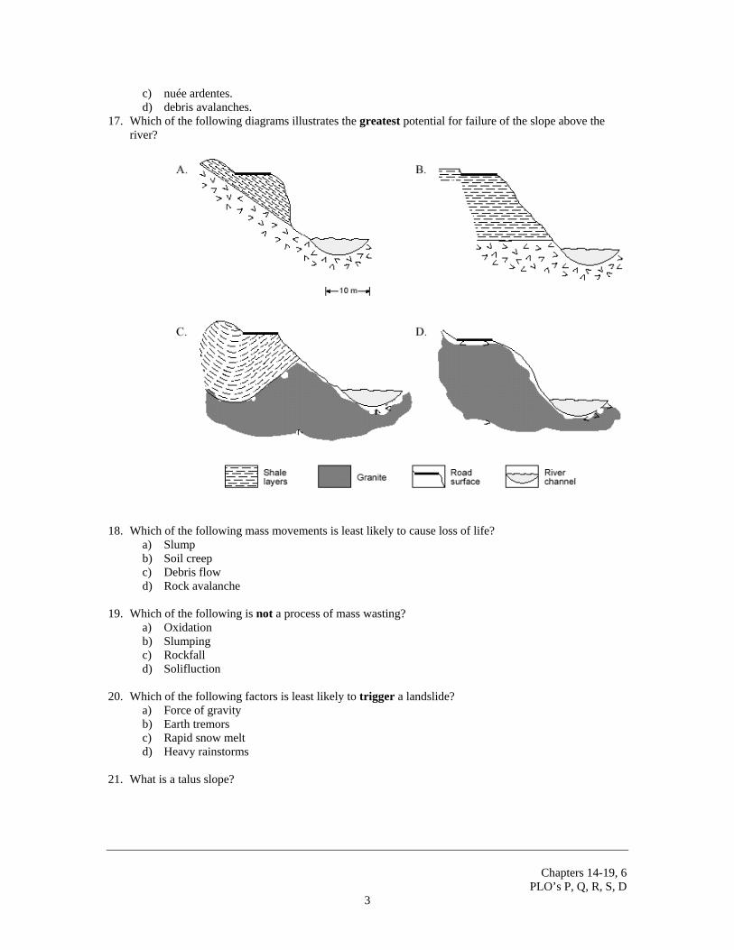
17. Which of the following diagrams illustrates the greatest potential for failure of the slope above the river?
18. Which of the following mass movements is least likely to cause loss of life?
a) Slump b) Soil creep c) Debris flow d) Rock avalanche
19. Which of the following is not a process of mass wasting?
a) Oxidation b) Slumping c) Rockfall d) Solifluction
20. Which of the following factors is least likely to trigger a landslide?
a) Force of gravity b) Earth tremors c) Rapid snow melt d) Heavy rainstorms
21. What is a talus slope?
Chapters 14-19, 6
PLO’s P, Q, R, S, D 4
22. What is soil and how is it formed? 23. Why are landslides in B.C. most likely to occur in the springtime than other times of the year? 24. A real estate agent is trying to sell you a hillside house in B.C. Describe some disturbing warning
signs of slope instability that you may encounter as you tour the property.
Chapters 14-19, 6
PLO’s P, Q, R, S, D 5
Questions for Section Q: Surficial Processes (Running Water) 1. Identify the three types of stream load (solution, suspension, bedload) and describe how each moves in
a stream. 2. Relate stream velocity to sediment sorting. 3. Relate such factors as load, gradient, discharge, channel shape, sediment composition, and human
activities to erosion and deposition by streams. 4. Contrast particle size and shape, degree of sorting and sedimentary structures of stream, glacial, and
wind deposits.
5. What is a meander and how does it form? 6. What are oxbow lakes and how do they form? 7. Describe why and where deltas form.
Chapters 14-19, 6
PLO’s P, Q, R, S, D 6
8. Describe the stages along a river’s length from the source to its mouth at an ocean. 9. It has been suggested that human activities have increased the severity of many floods. Describe some
of these activities and how they have actually made flooding worse. 10. A river is likely to pick up more sedimentary material where it
a) enters a lake. b) flows into a wider channel. c) flows around the outside of a meander. d) flows from a high gradient to a low gradient.
11. A major river flowing into a lake forms multiple channels as a result of
a) an increase in velocity. b) an increase in gradient. c) a decrease in water volume. d) a decrease in sediment-carrying capacity.
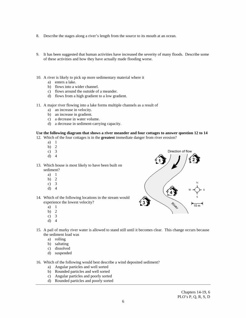
Use the following diagram that shows a river meander and four cottages to answer question 12 to 14 12. Which of the four cottages is in the greatest immediate danger from river erosion?
a) 1 b) 2 c) 3 d) 4
13. Which house is most likely to have been built on
sediment? a) 1 b) 2 c) 3 d) 4
14. Which of the following locations in the stream would
experience the lowest velocity? a) 1 b) 2 c) 3 d) 4
15. A pail of murky river water is allowed to stand still until it becomes clear. This change occurs because
the sediment load was a) rolling b) saltating c) dissolved d) suspended
16. Which of the following would best describe a wind deposited sediment?
a) Angular particles and well sorted b) Rounded particles and well sorted c) Angular particles and poorly sorted d) Rounded particles and poorly sorted
Chapters 14-19, 6
PLO’s P, Q, R, S, D 7
17. The load of sediments in a stream that moves in intermittent contact with the stream bed moves by
a) solution b) saltation c) diffusion d) suspension
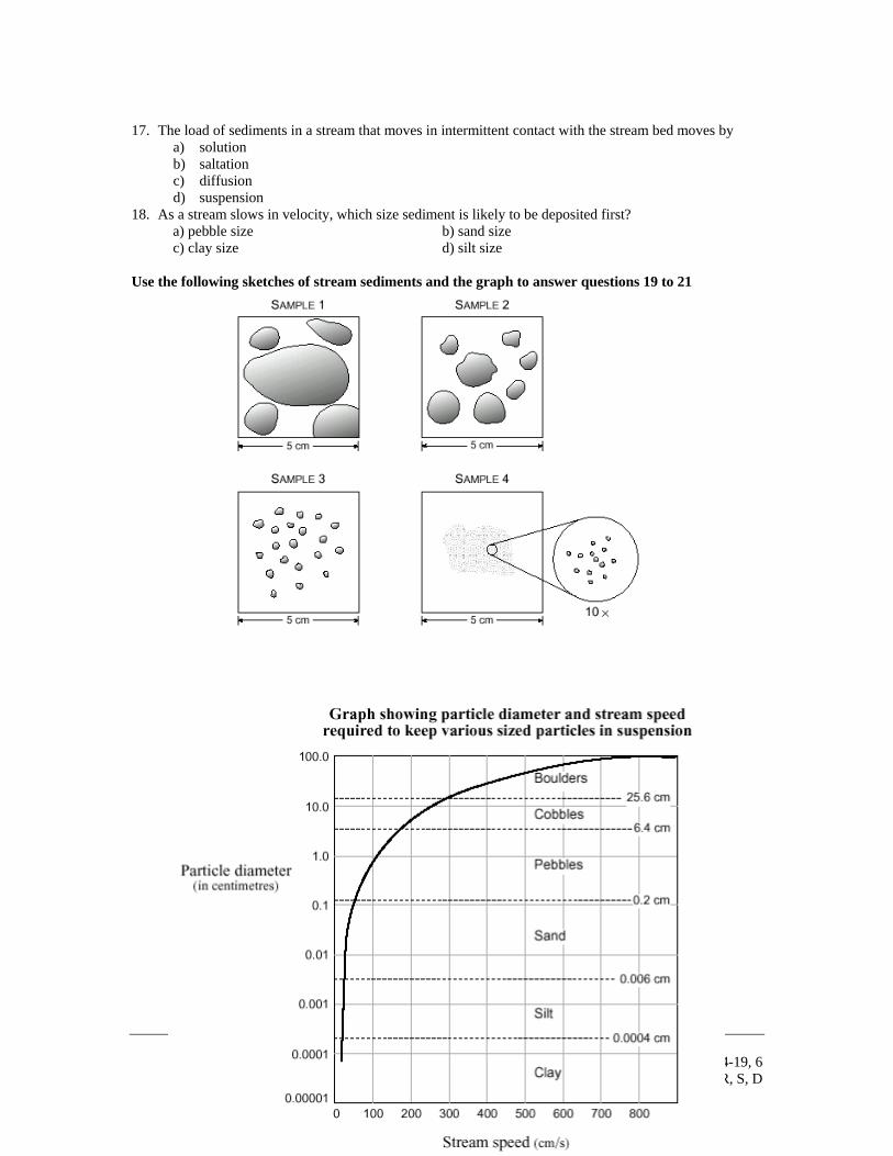
18. As a stream slows in velocity, which size sediment is likely to be deposited first? a) pebble size b) sand size c) clay size d) silt size Use the following sketches of stream sediments and the graph to answer questions 19 to 21
Chapters 14-19, 6
PLO’s P, Q, R, S, D 8
19. The largest particle that could be moved in suspension by a stream flowing at 150 cm/s is a) silt. b) sand. c) a pebble. d) a cobble.
20. A sample of sediment taken from the stream bottom where the stream velocity was less than 20 cm/s
would most likely look like sample a) 1 b) 2 c) 3 d) 4
21. Compared to the stream sediment samples shown, a sample taken from glacial till would contain
sediment which is a) less rounded and well-sorted. b) well-rounded and well-sorted. c) less rounded and poorly-sorted. d) well-rounded and poorly-sorted.
22. At a given point along its course, a stream has a cross sectional area of 10 m2. Water flows past this
point at a rate of 2 m/s. What is the discharge of this stream? a) 20 m3/s b) 10 m3/s c) 10 m2 d) 2 m/s
23. Which of the following rock types would cause the greatest dissolved load in a stream?
a) Shale b) Basalt c) Sandstone d) Marble
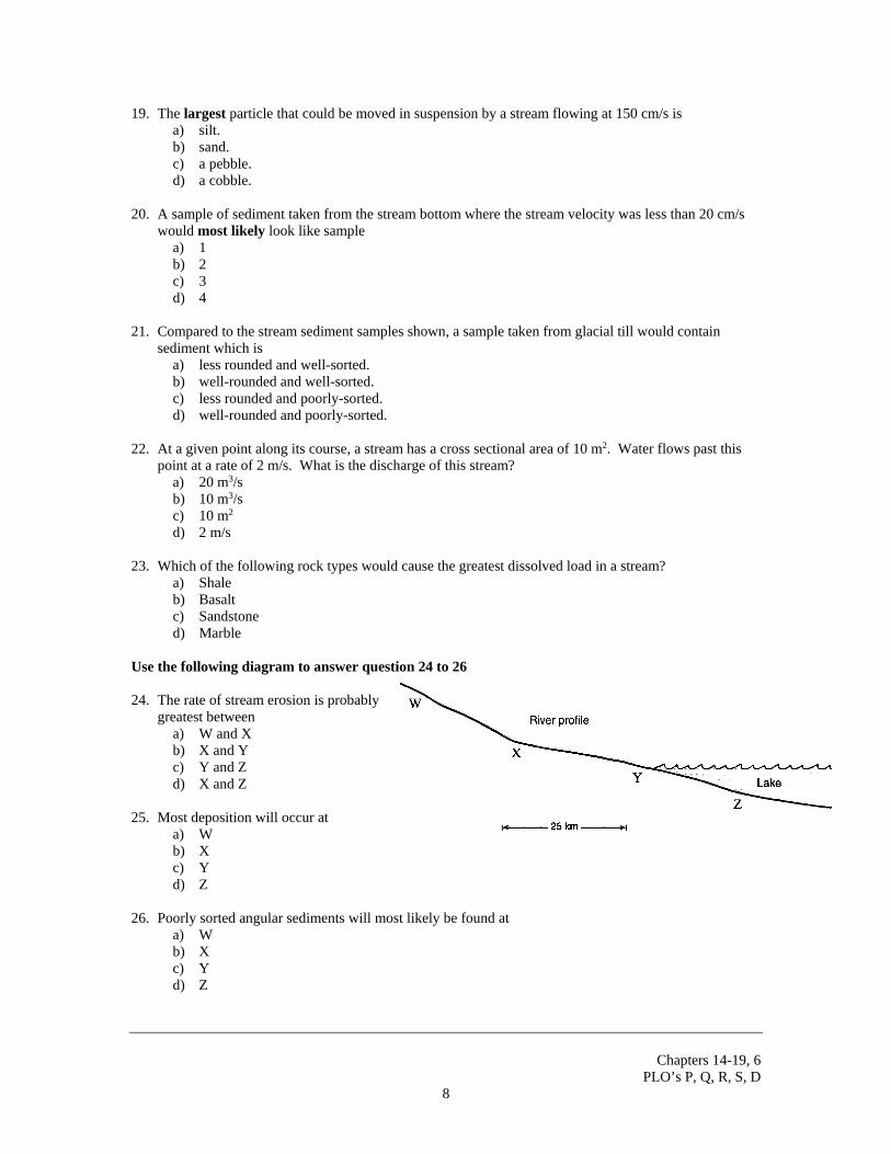
Use the following diagram to answer question 24 to 26 24. The rate of stream erosion is probably
greatest between a) W and X b) X and Y c) Y and Z d) X and Z
25. Most deposition will occur at
a) W b) X c) Y d) Z
26. Poorly sorted angular sediments will most likely be found at
a) W b) X c) Y d) Z
Chapters 14-19, 6
PLO’s P, Q, R, S, D 9
Questions to Section R: Surficial Processes (Glaciers)
1. Describe how each of the following erosional and depositional glacial features form:
erosional features: • U-shaped valley
• hanging valley
• cirque
• horn
• arete
• glacial striations
depositional features:
• glacial erratic • moraines
• ground
• recessional
• terminal
• lateral
• medial
• drumlin
• kame
• kame terrace
• esker
2. What are some clues that you could look for using erosional and depositional features to determine
which direction a glacier flowed in an area? 3. Describe a typical glacial deposit (in terms of sorting, roundedness.) 4. Where do icebergs come from?
Chapters 14-19, 6
PLO’s P, Q, R, S, D 10
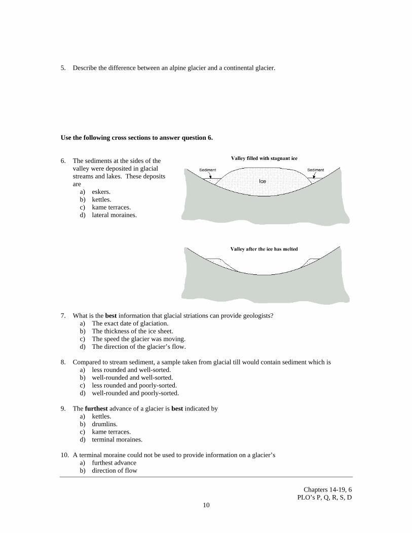
5. Describe the difference between an alpine glacier and a continental glacier. Use the following cross sections to answer question 6. 6. The sediments at the sides of the
valley were deposited in glacial streams and lakes. These deposits are
a) eskers. b) kettles. c) kame terraces. d) lateral moraines.
7. What is the best information that glacial striations can provide geologists?
a) The exact date of glaciation. b) The thickness of the ice sheet. c) The speed the glacier was moving. d) The direction of the glacier’s flow.
8. Compared to stream sediment, a sample taken from glacial till would contain sediment which is
a) less rounded and well-sorted. b) well-rounded and well-sorted. c) less rounded and poorly-sorted. d) well-rounded and poorly-sorted.
9. The furthest advance of a glacier is best indicated by
a) kettles. b) drumlins. c) kame terraces. d) terminal moraines.
10. A terminal moraine could not be used to provide information on a glacier’s
a) furthest advance b) direction of flow
Chapters 14-19, 6
PLO’s P, Q, R, S, D 11
c) rate of ice formation d) maximum size and shape
11. Which of the following is not a feature of glacial deposition?
a) Kame b) Esker c) Cirque d) Moraine
12. The name given to a narrow ridge between two glacial valleys is a(n)
a) esker b) tarn c) arête d) cirque
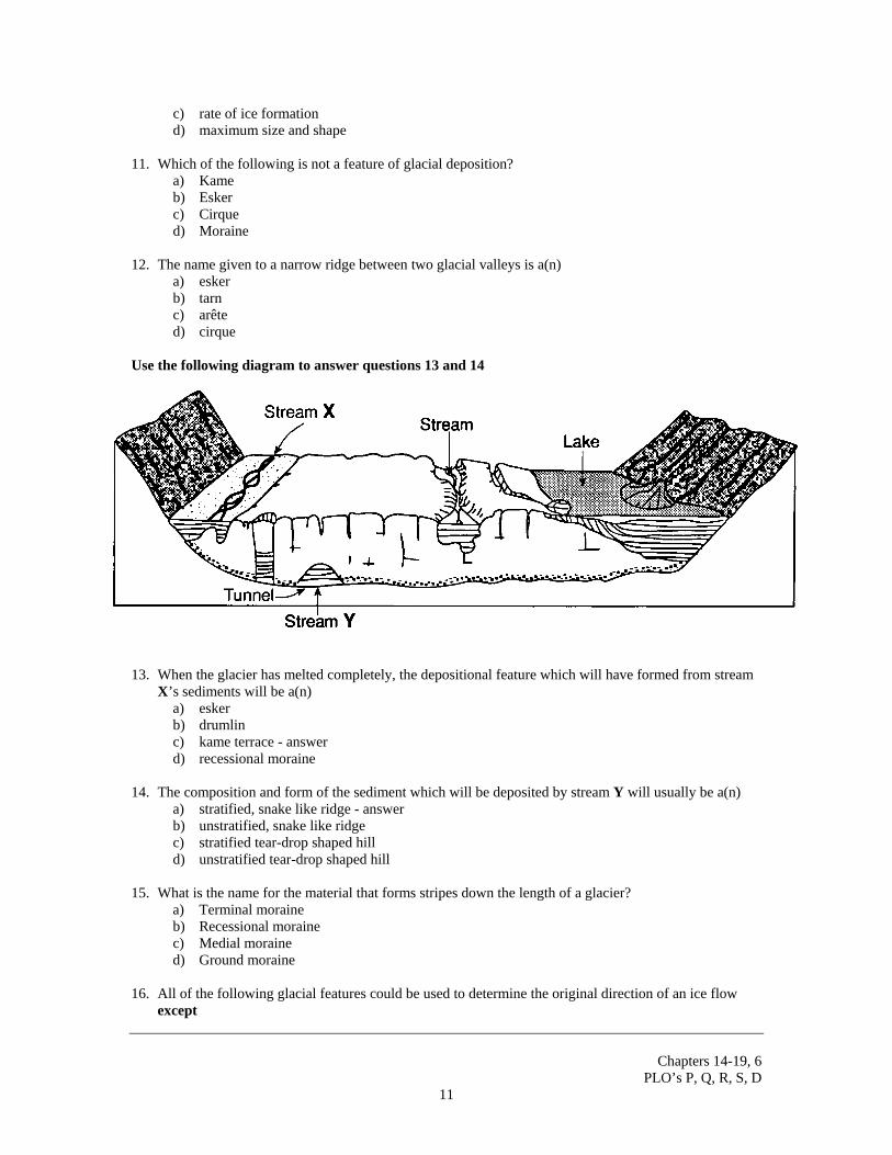
Use the following diagram to answer questions 13 and 14
13. When the glacier has melted completely, the depositional feature which will have formed from stream
X’s sediments will be a(n) a) esker b) drumlin c) kame terrace - answer d) recessional moraine
14. The composition and form of the sediment which will be deposited by stream Y will usually be a(n)
a) stratified, snake like ridge - answer b) unstratified, snake like ridge c) stratified tear-drop shaped hill d) unstratified tear-drop shaped hill
15. What is the name for the material that forms stripes down the length of a glacier?
a) Terminal moraine b) Recessional moraine c) Medial moraine d) Ground moraine
16. All of the following glacial features could be used to determine the original direction of an ice flow
except
Chapters 14-19, 6
PLO’s P, Q, R, S, D 12
a) drumlins b) striations c) eskers d) kettles
17. A bowl shaped depression at the head of a glacier valley is called a) a kettle b) an arête c) a cirque d) an oxbow
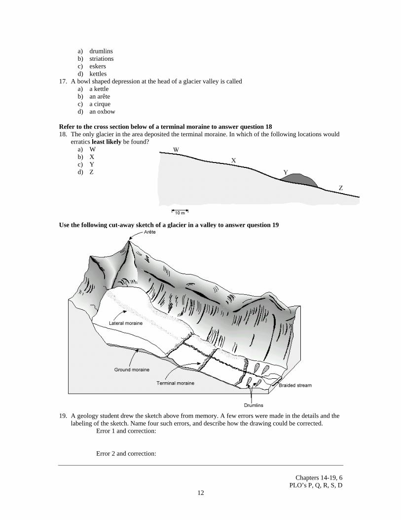
Refer to the cross section below of a terminal moraine to answer question 18 18. The only glacier in the area deposited the terminal moraine. In which of the following locations would
erratics least likely be found? a) W b) X c) Y d) Z
Use the following cut-away sketch of a glacier in a valley to answer question 19
19. A geology student drew the sketch above from memory. A few errors were made in the details and the labeling of the sketch. Name four such errors, and describe how the drawing could be corrected.
Error 1 and correction: Error 2 and correction:
Chapters 14-19, 6
PLO’s P, Q, R, S, D 13
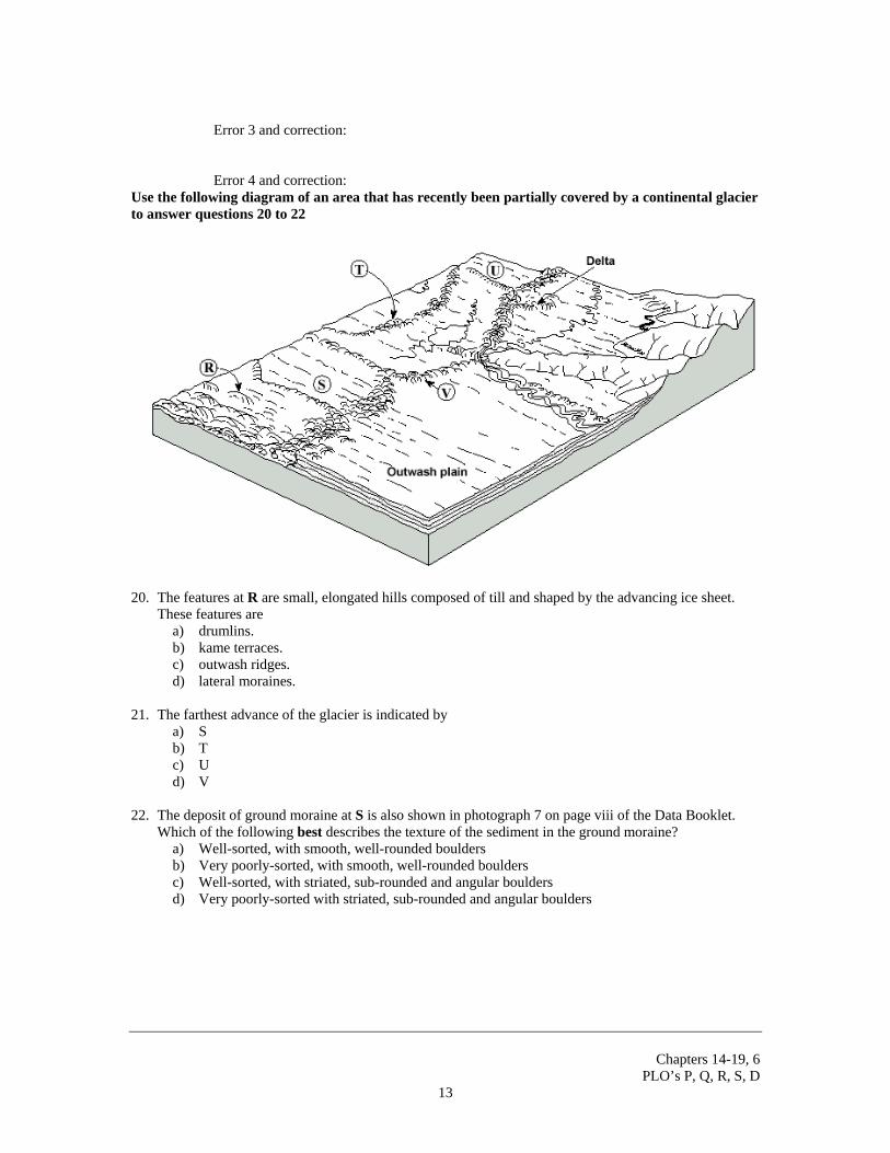
Error 3 and correction: Error 4 and correction: Use the following diagram of an area that has recently been partially covered by a continental glacier to answer questions 20 to 22
20. The features at R are small, elongated hills composed of till and shaped by the advancing ice sheet.
These features are a) drumlins. b) kame terraces. c) outwash ridges. d) lateral moraines.
21. The farthest advance of the glacier is indicated by
a) S b) T c) U d) V
22. The deposit of ground moraine at S is also shown in photograph 7 on page viii of the Data Booklet.
Which of the following best describes the texture of the sediment in the ground moraine? a) Well-sorted, with smooth, well-rounded boulders b) Very poorly-sorted, with smooth, well-rounded boulders c) Well-sorted, with striated, sub-rounded and angular boulders d) Very poorly-sorted with striated, sub-rounded and angular boulders
Chapters 14-19, 6
PLO’s P, Q, R, S, D 14
Questions to Section S: Surficial Processes (Ground Water) 1. Describe the nature and constituents of subsurface water, including:
o water table o zone of saturation o zone of aeration o perched o confined water tables o aquifers o impermeable layers.
2. Demonstrate how the abundance, availability, and movement of subsurface water are directly related to
the porosity and permeability of geologic materials 3. Draw a subsurface water profile including all the terms you described in #1. 4. Describe how the following human activities affect the quality and quantity of groundwater:
• urbanization • waste disposal
• agriculture
• conservation and reclamation
5. Where does ground water come from? How does it get into the ground?
Chapters 14-19, 6
PLO’s P, Q, R, S, D 15
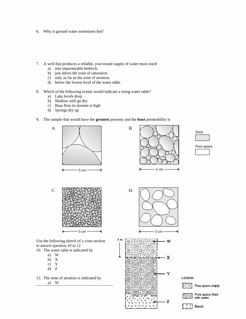
6. Why is ground water sometimes hot? 7. A well that produces a reliable, year-round supply of water must reach
a) into impermeable bedrock. b) just above the zone of saturation. c) only as far as the zone of aeration. d) below the lowest level of the water table.
8. Which of the following events would indicate a rising water table?
a) Lake levels drop b) Shallow well go dry c) Base flow in streams is high d) Springs dry up
9. The sample that would have the greatest porosity and the least permeability is
Use the following sketch of a cross section to answer question 10 to 12 10. The water table is indicated by
a) W b) X c) Y d) Z
11. The zone of aeration is indicated by
a) W
Chapters 14-19, 6
PLO’s P, Q, R, S, D 16
b) X c) Y d) Z
12. The zone of saturation is indicated by
a) W b) X c) Y d) Z
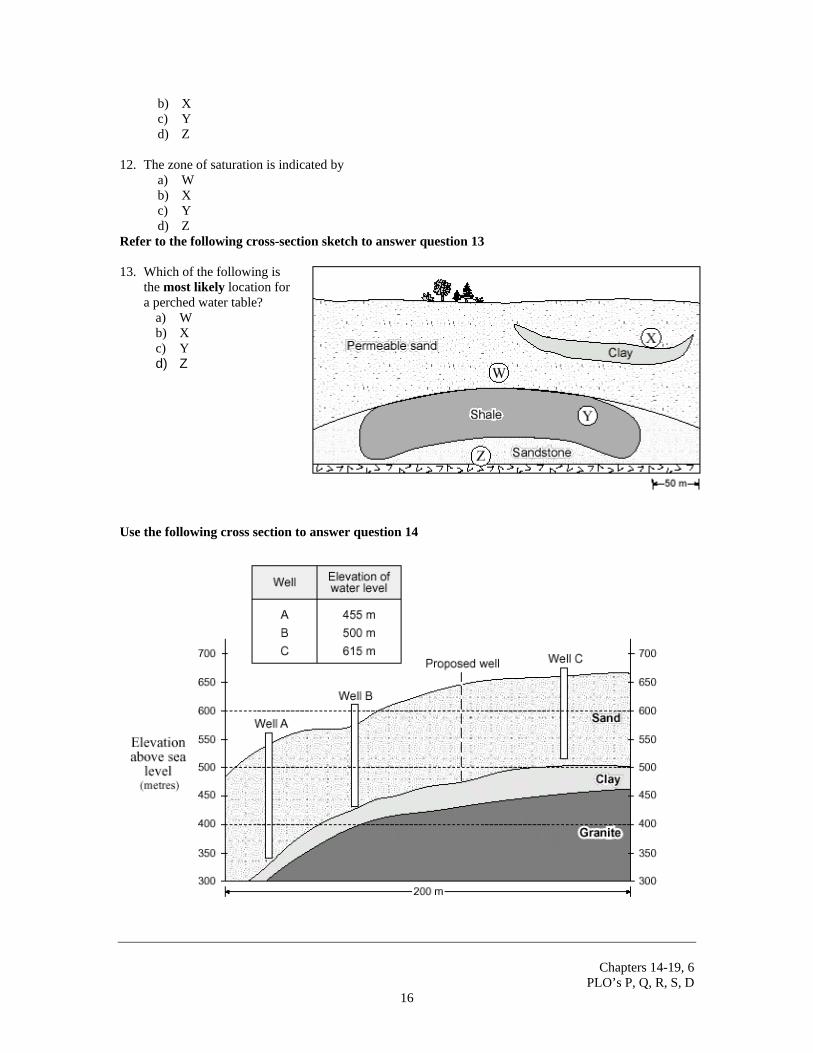
Refer to the following cross-section sketch to answer question 13 13. Which of the following is
the most likely location for a perched water table?
a) W b) X c) Y d) Z
Use the following cross section to answer question 14
Chapters 14-19, 6
PLO’s P, Q, R, S, D 17
14. a) Use a solid line to sketch on the cross section the level of the water table. Clearly label the water table on the diagram.
b) At what elevation (in metres) will the proposed well likely strike water? c) It is proposed that water be drawn from Well B at a very high rate for industrial use for a period of
five years. Use a dotted line to sketch on the cross section the change in the total water table of the area that would result from this heavy extraction. Clearly label the change in the water table on the diagram.
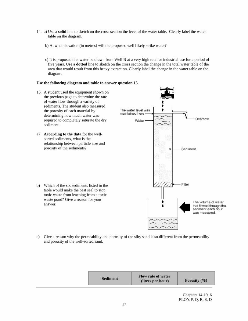
Use the following diagram and table to answer question 15 15. A student used the equipment shown on
the previous page to determine the rate of water flow through a variety of sediments. The student also measured the porosity of each material by determining how much water was required to completely saturate the dry sediment.
a) According to the data for the well-
sorted sediments, what is the relationship between particle size and porosity of the sediments?
b) Which of the six sediments listed in the
table would make the best seal to stop toxic waste from leaching from a toxic waste pond? Give a reason for your answer.
c) Give a reason why the permeability and porosity of the silty sand is so different from the permeability
and porosity of the well-sorted sand.
Sediment Flow rate of water (litres per hour) Porosity (%)
Chapters 14-19, 6
PLO’s P, Q, R, S, D 18
Well-sorted gravel 3000 30
Well-sorted sand 250 40
Well-sorted silt 0.5 45
Well-sorted clay 0.0001 55
Silty sand 5 20
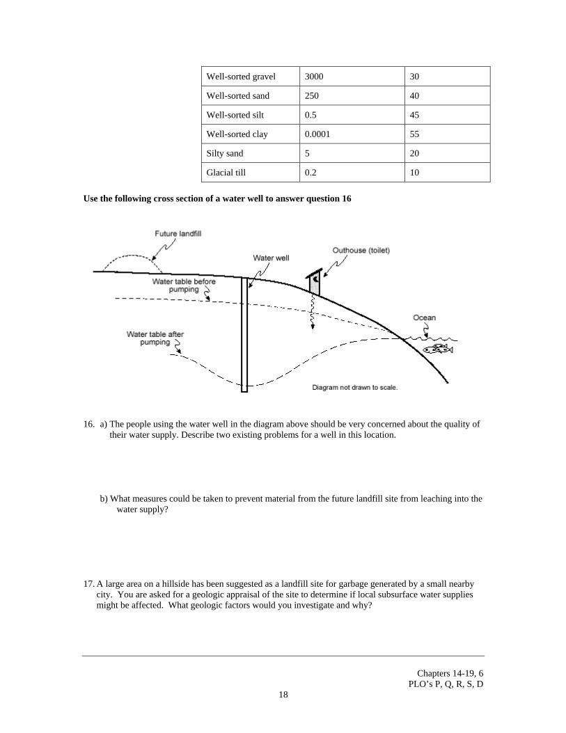
Glacial till 0.2 10 Use the following cross section of a water well to answer question 16
16. a) The people using the water well in the diagram above should be very concerned about the quality of
their water supply. Describe two existing problems for a well in this location.
b) What measures could be taken to prevent material from the future landfill site from leaching into the water supply? 17. A large area on a hillside has been suggested as a landfill site for garbage generated by a small nearby
city. You are asked for a geologic appraisal of the site to determine if local subsurface water supplies might be affected. What geologic factors would you investigate and why?
Chapters 14-19, 6
PLO’s P, Q, R, S, D 19
Questions for Section D: Earth Materials (Sedimentary Rocks and Processes) 1. Outline the origin and process of formation of sedimentary rocks (clastic, chemical and biochemical.) 2. Describe the features of and identify the following sedimentary rocks:
• conglomerate • breccia • sandstone
• shale
• limestone
• chert
• gypsum
• rock salt (halite)
• coal
3. Diagram and/or describe the following sedimentary features and describe a sedimentary environment
where each might be found: • sedimentary structures
• stratification • crossbedding • ripple marks • mud cracks • graded bedding • varves
• well or poorly sorted sediment
• fossils and organic structures
4. Where in your own area would you look for rounded and sorted sediment?
Chapters 14-19, 6
PLO’s P, Q, R, S, D 20
5. Explain why almost all sedimentary rocks are layered or bedded. 6. Sedimentary rock makes up a) about 5% of the Earth’s mantle b) less than 5% of the Earth’s crust c) 50% of the Earth’s crust d) 12% of the Earth’s core 7. The conversion of loose sediment to hard rock is called a) compaction b) precipitation c) lithification d) metamorphism 8. A clastic sedimentary rock has angular clasts ranging in size from 2 mm to over 100 mm. What is the
name of this rock? a) Breccia b) Sandstone c) Conglomerate d) Shale 9. In which of the following environments would chemical sedimentary rocks likely form? a) Coastal deltas b) Restricted bays of warm, shallow water c) High energy beaches d) Deep sea floor 10. Which of the following characteristics of clastic rocks would provide the most useful information for
determining the source area of the rocks? a) Rock name. b) Presence of mud cracks c) Composition of clasts d) Thickness of bedding 11. Which of the following is most likely to decrease during the lithification of sediment? a) Density b) Porosity c) Grain size d) Cementation 12. Which of the following sedimentary rocks would most likely contain fossils? (Why?)
a) breccia b) gypsum c) limestone d) conglomerate
13. The best sedimentary classification of rock salt is a) clastic b) detrital c) organic d) evaporite
Chapters 14-19, 6
PLO’s P, Q, R, S, D 21
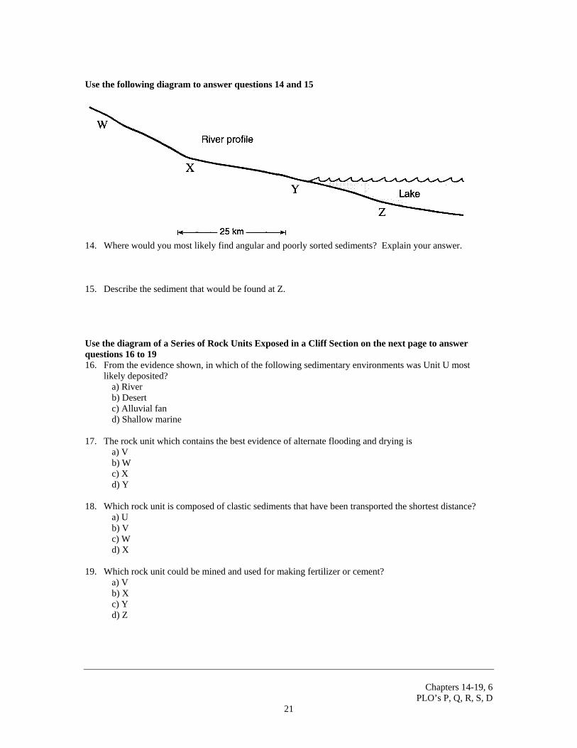
Use the following diagram to answer questions 14 and 15
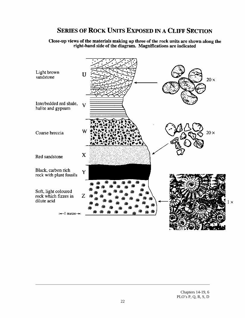
14. Where would you most likely find angular and poorly sorted sediments? Explain your answer. 15. Describe the sediment that would be found at Z. Use the diagram of a Series of Rock Units Exposed in a Cliff Section on the next page to answer questions 16 to 19 16. From the evidence shown, in which of the following sedimentary environments was Unit U most
likely deposited? a) River b) Desert c) Alluvial fan d) Shallow marine 17. The rock unit which contains the best evidence of alternate flooding and drying is a) V b) W c) X d) Y 18. Which rock unit is composed of clastic sediments that have been transported the shortest distance? a) U b) V c) W d) X 19. Which rock unit could be mined and used for making fertilizer or cement? a) V b) X c) Y d) Z
Chapters 14-19, 6
PLO’s P, Q, R, S, D 22
Chapters 14-19, 6
PLO’s P, Q, R, S, D 23
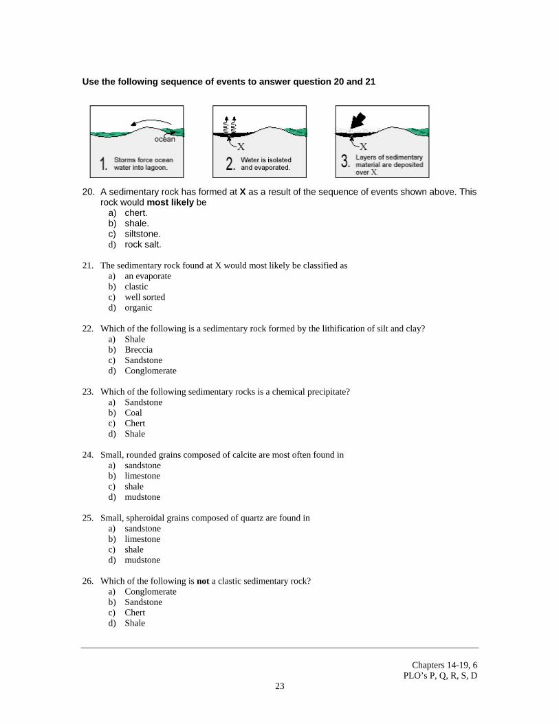
Use the following sequence of events to answer question 20 and 21
20. A sedimentary rock has formed at X as a result of the sequence of events shown above. This rock would most likely be
a) chert. b) shale. c) siltstone. d) rock salt.
21. The sedimentary rock found at X would most likely be classified as
a) an evaporate b) clastic c) well sorted d) organic
22. Which of the following is a sedimentary rock formed by the lithification of silt and clay?
a) Shale b) Breccia c) Sandstone d) Conglomerate
23. Which of the following sedimentary rocks is a chemical precipitate?
a) Sandstone b) Coal c) Chert d) Shale
24. Small, rounded grains composed of calcite are most often found in
a) sandstone b) limestone c) shale d) mudstone
25. Small, spheroidal grains composed of quartz are found in
a) sandstone b) limestone c) shale d) mudstone
26. Which of the following is not a clastic sedimentary rock?
a) Conglomerate b) Sandstone c) Chert d) Shale
Chapters 14-19, 6
PLO’s P, Q, R, S, D 24
27. A biochemical sediment consists largely of coral and shell debris. If this sediment were lithified, it
would become a) coal b) chert c) limestone d) conglomerate
28. In which environment would coal deposits most likely form?
a) River bed b) Coastal swamp c) Beach environment d) Deep ocean environment
29. If a beaker of seawater were left to evaporate and dry out, the minerals left present in the container
would most likely be a) biotite and quartz b) gypsum and halite c) fluorite and galena d) calcite and chalcopyrite
See next page for last question.
Chapters 14-19, 6
PLO’s P, Q, R, S, D 25
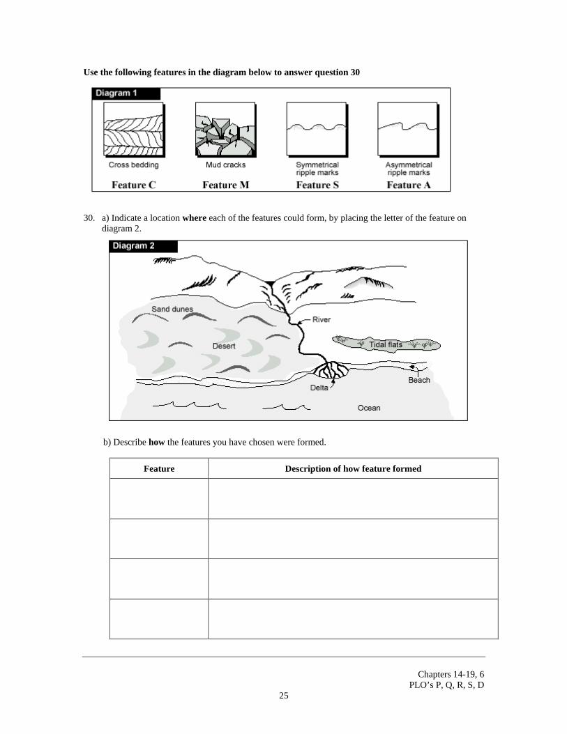
Use the following features in the diagram below to answer question 30
30. a) Indicate a location where each of the features could form, by placing the letter of the feature on
diagram 2.
b) Describe how the features you have chosen were formed.
Feature Description of how feature formed

Chapters 14-19, 6
PLO’s P, Q, R, S, D 26