Embed Size (px)
Citation preview
DISASTER MANAGEMENT www.reavan.com
UNIT TWO : APPLICATION OF TECHNOLOGY IN DRR
As per the Syllabus According to our Omnibus
Application of various technologies Data bases – RDBMS Management Information systems Decision support system and other
systems Geographic Information systems Intranets and extranets Video teleconferencing Trigger mechanism Remote sensing-an insight Contribution of remote sensing and
GIS Case study.
Technologies in Disaster Management DBMS & RDBMS MIS DSS GIS Remote Sensing Intranets, Internets and Extranets Video Tele Conferencing
TECHNOLOGIES IN DISASTER MANAGEMENT
1. Technology is the practical application of knowledge in a particular area wherein scientific tools are used to ease human work in terms of rapidity and accuracy.
2. From the Stone Age to the industrial revolution to now, humans have always shown a fascination towards technology and its enhancement.
3. Today, the human mankind is almost at the helm of technology enhancement with IT(Information Technology), ICT (Information and Communication Technology) & ICST(Information Communication and Space Technology)
4. We know that disaster = hazard + vulnerability. The role of technology in disaster can be envisioned in such a way that it minimizes the hazard and helps in reduction of vulnerability.
5. The wide spectrum of technologies used in all four phases of disaster management - preparedness, mitigation, response and recovery are
• Remote sensing;• Geographical Information System (GIS);• Global Positioning System (GPS);
DISASTER MANAGEMENT www.reavan.com
• Satellite navigation system;• Satellite communication;• Amateur and community radio;
• Television and radio broadcasting;• Telephone and fax;• Cellular phones;• VideoConferencing• Networking Technologies• Internet, e-mail;• On-line management databases,• disaster information systems and networks• Robotics
6. The application of all these technologies in disaster management can be listed as follows
Setting up disaster early warning system Quick processing and analysis of disaster system Database construction; Information integration and analysis Disaster mapping and scenario simulation; hazard assessment and monitoring; disaster trend forecasting; vulnerability assessment; emergency response - decision support; planning of disaster response, reduction, and relief ; logistics preparation for disaster relief; search and rescue teams risk investigation and assessment;
7. The application of technologies are more vital and need to be more creative in the disaster P phases of prevention(mitigation) and preparedness than in the disaster R phases – response and recovery.
DBMS & RDBMS
* Definition *Technical Information *Applications *Case Studies
1. DEFINITION
DBMS (Database Management System) is a computer based system that is used to store, manipulate and retrieve data.
In any DBMS, there are three types of data models used to store and retrieve data namely hierarchical, network and relational models.
DISASTER MANAGEMENT www.reavan.com
A DBMS that is based on relational model is called as RDBMS (Relational Database Management Systems). In RDBMS, data is stored in the form of a table, with relations between data in rows and data in columns of the table.
RDBMS has lead to the evolution of DBMS. All Database systems that are sold in the market, now- a-days, have either complete or partial implementation of relational model.
2. TECHNICAL INFORMATION
1. Data Manipulation - While the words store and retrieve associated with DBMS are well understood, the word Manipulation of data means (a) adding new data (b) deleting unwanted data and (c) modifying the data
2. Features/Functions of DBMS – Any DBMS should have the following general features or perform the following functions
(a)Support for large amount of data - Each DBMS is designed to support large amount of data. They provide special ways and means to store and manipulate large amount of data. Also some of this data will have to be online. The DBMS should be able to store terabytes of data.
(b)Data sharing, concurrency and locking - DBMS also allows data to be shared by two or more users. The same data can be accessed by multiple users at the same time – data concurrency. However when same data is being manipulated at the same time by multiple users certain problems arise. To avoid these problems, DBMS locks data that is being manipulated to avoid two users from modifying the same data at the same time.
(c) Data Security - While DBMS allowing data to be shared, it also ensures that data in only accessed by authorized users. DBMS provides features needed to implement security at the enterprise level. By default, the data of a user cannot be accessed by other users unless the owner gives explicit permissions to other users to do so.
(d)Data Integrity - DBMS provides means to implement rules to maintain integrity of the data. Once we specify which rules are to be implemented, then DBMS can make sure that these rules are implemented always. Three integrity rules– domain, entity and referential are always supported by DBMS.
(e)Data Recovery - DBMS also allows recovery in the event of failure. For instance, if data on the disk is completely lost due to disk failure then also data can be recovered to the point of failure if proper back up of the data is available.
(f) Support for Languages - DBMS supports a data access and manipulation language. The most widely used data access language for RDBMS (relational database management systems) is SQL (Structured Query Language).
DISASTER MANAGEMENT www.reavan.com
3. DBMS Software1. Microsoft Access2. Microsoft SQL3. Oracle4. My SQL5. Open Office Base6. IBM DB27. Filemaker8. ExtremeDB
4. ACID Rules – It is one of the fundamental rules of any DBMS/RDBMS. It is an acronym for four attributes Atomicity, Consistency, Isolation and Durability. For a reliable database all this four attributes should be achieved i.e. data written in a database should conform to four attributes.
Atomicity - Atomicity requires that each data transaction is "all or nothing" i.e. if one part of the transaction fails, the entire transaction fails and the database state is left unchanged. Consistency - The consistency property ensures that any transaction never leaves the database in a half-finished state.Isolation - Isolation refers to the requirement that no transaction should be able to interfere with another transaction. Durability - Durability means that once a transaction has been committed, it will remain so, even in the event of power loss, crashes, or errors.
5. Data processing MethodsIn a database, Data Processing means retrieving data and deriving information from data. Depending upon where it is done and how it is done, there are three methods.Centralized data processingDe-centralized data processingDistributed data processing
6. Data ModelsData model is a way of storing and retrieving the data. Data models differ in the way they allow users to view and manipulate the data. There are three different data models namely Hierarchical (data is stored in the form of a tree)Network (data is stored along with pointers)Relational (data is stored in the form of table)Needless to say, Relation data model is most successful of all three models. Designed
7. Fundamental Terms in Databases/RDBMS
DISASTER MANAGEMENT www.reavan.com
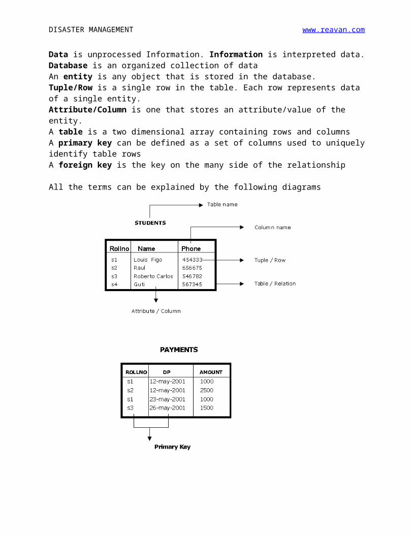
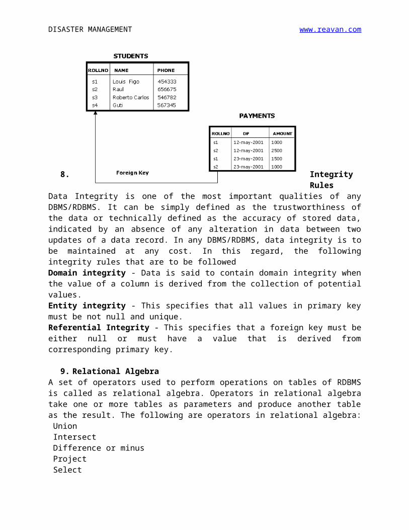
Data is unprocessed Information. Information is interpreted data.Database is an organized collection of dataAn entity is any object that is stored in the database. Tuple/Row is a single row in the table. Each row represents data of a single entity.Attribute/Column is one that stores an attribute/value of the entity. A table is a two dimensional array containing rows and columnsA primary key can be defined as a set of columns used to uniquely identify table rows A foreign key is the key on the many side of the relationship
All the terms can be explained by the following diagrams
DISASTER MANAGEMENT www.reavan.com
8. Integrity RulesData Integrity is one of the most important qualities of any DBMS/RDBMS. It can be simply defined as the trustworthiness of the data or technically defined as the accuracy of stored data, indicated by an absence of any alteration in data between two updates of a data record. In any DBMS/RDBMS, data integrity is to be maintained at any cost. In this regard, the following integrity rules that are to be followedDomain integrity - Data is said to contain domain integrity when the value of a column is derived from the collection of potential values. Entity integrity - This specifies that all values in primary key must be not null and unique.Referential Integrity - This specifies that a foreign key must be either null or must have a value that is derived from corresponding primary key.
9. Relational AlgebraA set of operators used to perform operations on tables of RDBMS is called as relational algebra. Operators in relational algebra take one or more tables as parameters and produce another table as the result. The following are operators in relational algebra: Union Intersect Difference or minus Project Select Join
10. Structured Query Language (SQL)Almost all relational database management systems use SQL (Structured Query Language) for data manipulation and retrieval.
SQL is the standard, non-procedural language, where you need to concentrate on what you want, not on how you get it.
SQL Commands are divided into four categories, depending upon what they do.DDL (Data Definition Language) - used to define the dataDML (Data Manipulation Language) - used to manipulate data.DCL (Data Control Language) - used to control access to dataQuery (Retrieving data) – used to retrieve data
11. Database System Design
DISASTER MANAGEMENT www.reavan.com
The design of a database system for RDBMS/DBMS involves the following steps outlined by the flow chart available in the following page.
DISASTER MANAGEMENT www.reavan.com
3. APPLICATIONS OF DBMS/RDBMS in DM
1. It is the base for other systems like MIS, DSS, GIS etc.2. It can be used for creating Disaster Information Software3. It can be used for setting up Disaster Information Network4. It is essential to send out warning to all people in a vulnerable region5. It can provide information on disaster professionals in a particular
nation/region6. It can be useful for proper accounting of calamity funds in a particular
area
4. CASESTUDIES OF DBMS/RDBMS APPLICATIONS IN DM
(A) DesInventarDesInventar is a disaster management related software that offers a systematic method for collecting and storing data on the characteristics and effects of different types of disasters.
The software is used particularly the ones not visible from global and national scales. This allows for the observation and analysis of accumulated data on these ‘invisible’ disasters.
The DesInventar system can also be used to simulate disasters and proceed to study their impact. For example, it can trigger an earthquake in the virtual environment and analyze its impact on a geographical area ranging from a municipality to a group of countries. It can also forecasts information on the possible loss of human lives, impact on the economy, and damage to infrastructure, etc.
The DesInventar system uses DB2 RDBMS model for maintaining its databases.
It can be used not just by government agencies, but also by NGOs in their disaster management work
The software has been designed by a Columbia based company and is supported by ISDR and LARED.
(B) GSTL Tsunami Alert SystemA Bangalore-based Geneva Software Technologies Limited (GSTL) has developed a Tsunami Disaster Information Alert System which sends messages on mobile phones in any of 14 Indian languages to a tsunami prone area in less than 50 seconds from receipt of early tsunami warning.
The company has RDBMS ORACLE in which the data regarding the mobile numbers of all the people living in coastal Tamil Nadu, Andhra and Kerala are

DISASTER MANAGEMENT www.reavan.com
registered. Any new mobile number entry and change in mobile number entry can be done with an SMS from the respected person followed by authorization.
The system is designed to reach the maximum people in the minimum time, it is programmed to help especially the rural people and fisherman community to receive messages in their local language.
Apart from the SMS facility called as LBLMS – Location-Based Language Message Service, the company also has DVTS – Dynamic Voice Translation System to deliver automated voice calls for illiterate people in the region.
MIS (MANAGEMENT INFORMATION SYSTEM)
* Definition *Technical Information *Applications *Case Studies
1. DEFINITION
Management Information Systems (MIS) is a computer based package, covering the application of people, technologies, and procedures collectively called information systems, to solving business problems using easy availability of required information.
Another well used definition of MIS is that “MIS is a planned system of collecting, storing and disseminating information needed to carry out the functions of management”
MIS is also defined by its three wordsManagement : Management is art of getting things done through and with the people in formally organized groupsInformation : Information is data that is processed and is presented in a form which assists the end user System : A system is defined as a set of elements which are joined together to achieve a common objective.
2. TECHNICAL INFORMATION
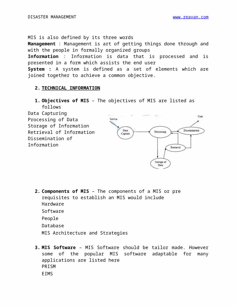
1. Objectives of MIS – The objectives of MIS are listed as followsData Capturing Processing of Data Storage of InformationRetrieval of Information Dissemination of Information
DISASTER MANAGEMENT www.reavan.com
2. Components of MIS – The components of a MIS or pre requisites to establish an MIS would includeHardwareSoftwarePeopleDatabaseMIS Architecture and Strategies
3. MIS Software – MIS Software should be tailor made. However some of the popular MIS software adaptable for many applications are listed herePRISMEIMSNSTMIS
4. MIS and ERP, MIS and DSSERP (Enterprise Resource Planning) activity and processing basedMIS (Management Information System) is information based
MIS (Management Information System) is basically a kind of link to facilitate information and communication between managers across different areas in a business organization. DSS (Decision Support System) is advancement from the original MIS. The essential difference between the two is in focus. DSS, as the term indicates, is about taking reliable decisions. MIS, on the other hand, is about focusing on the actual flow of information itself.
5. INFORMATION TYPES in MIS – Any MIS would have to cater to the following types of information
Planning Information - Certain standard norms and specifications are used in planning of any activity. Control Information - Reporting the status of an activity through a feedback mechanism is called the Controlling Information. Knowledge Information - A collection of information through the library records and the research studies to build up a knowledge base as an information is known as Knowledge Information.
DISASTER MANAGEMENT www.reavan.com
Organization Information - When the information is used by everybody in the organization, it is called Organization Information.Functional/ Operational Information - When the information is used in the operation of a business it is called Functional/Operational Information.Database Information - When the information has multiple use and application, it is called as database information.
6. MIS SYSTEM DESIGN – The design and development of MIS for a particular requirement may follow any one of two basic approaches namely
1. System Development Life Cycle2. Prototyping
System Development Life Cycle - In order to develop a system successfully, it is managed by breaking the total development process into smaller basic activities or phases. Any system development process, in general, is understood to have the following phases:i) Systems Planningii) Systems Analysisiii) Systems Designiv) Systems Implementationv) Systems Operation and Support
Prototyping is the process of creating an incomplete model of the future full-featured system, which can be used to let the users have a first idea of the completed program or allow the clients to evaluate the program. The process of prototyping involves four steps namely i) Identify basic requirements.ii) Develop initial prototype.iii) Review iv) Revise and Enhance the Prototype
3. APPLICATIONS OF MIS IN DM
1. It is essential to establish a DSS (Decision Support Systems)2. It can be used for setting up Disaster Information Network3. It is used to learn about disasters hazards by a user, at his own pace &
peace4. It is used for hazard mapping5. It can be useful for vulnerability assessment6. It can be a very vital component in disaster preparedness plan
4. CASE STUDIES
(A) VULNERABILITY ATLAS OF INDIA
DISASTER MANAGEMENT www.reavan.com
In 1997 the Government of India, Ministry of Urban Affairs & Employment constituted an Expert Group to prepare a Vulnerability Atlas taking into account three natural hazards which are the most common and damaging to India, namely earthquakes, cyclones and floods.
The zoning maps on macro level for the three hazards are available on small scale for the country as a whole. To make this information readily available to the planners, administrators and disaster managers, these maps were prepared on larger scale, state-wise, showing all the administrative units, namely, the district boundaries, for easy identification of the areas covered by the zones of various intensity levels.
The Vulnerability Atlas contains the following information for each State and Union Territory of India:(1) seismic hazard map(2) cyclone and wind hazard map(3) flood prone area map(4) housing stock vulnerability table for each district
The Vulnerability Atlas has been published by the Building Materials and Technology Promotion Council (BMTPC) and is an important input into the State level Disaster Management Planning.
Given that a DMIS would require digitization and information collection on key indicators at various levels, the Atlas is an important step in the establishment of DMIS and represents the kind of work required to be done in each country.
(B) INDIA DISASTER RESOURCE NETWORK
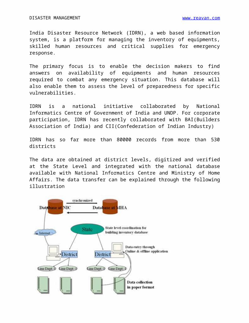
India Disaster Resource Network (IDRN), a web based information system, is a platform for managing the inventory of equipments, skilled human resources and critical supplies for emergency response.
The primary focus is to enable the decision makers to find answers on availability of equipments and human resources required to combat any emergency situation. This database will also enable them to assess the level of preparedness for specific vulnerabilities.
IDRN is a national initiative collaborated by National Informatics Centre of Government of India and UNDP. For corporate participation, IDRN has recently collaborated with BAI(Builders Association of India) and CII(Confederation of Indian Industry)
IDRN has so far more than 80000 records from more than 530 districts
DISASTER MANAGEMENT www.reavan.com
The data are obtained at district levels, digitized and verified at the State Level and integrated with the national database available with National Informatics Centre and Ministry of Home Affairs. The data transfer can be explained through the following illustration
It can be accessed at www.idrn.gov.in
DSS (DECISION SUPPORT SYSTEM)
* Definition *Technical Information *Applications *Case Studies
1. DEFINITION
Decision Support System can be defined as an integration of computer hardware, software and methodology that is designed to complement the cognitive thinking of human beings in their decision making.
It should be understood that DSS supports in the process of decision making and does not always give a decision it self.
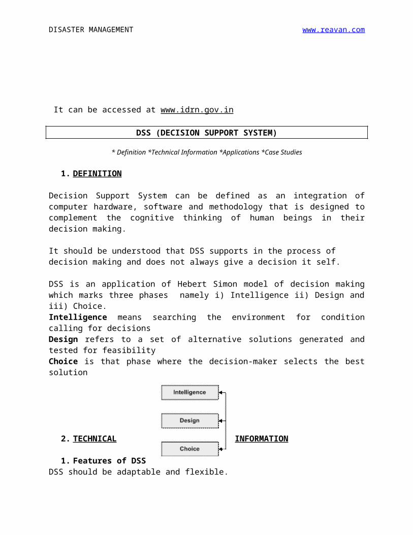
DSS is an application of Hebert Simon model of decision making which marks three phases namely i) Intelligence ii) Design and iii) Choice.Intelligence means searching the environment for condition calling for decisionsDesign refers to a set of alternative solutions generated and tested for feasibility
DISASTER MANAGEMENT www.reavan.com
Choice is that phase where the decision-maker selects the best solution
2. TECHNICAL INFORMATION
1. Features of DSSDSS should be adaptable and flexible.DSS should be interactive and provide ease of use.DSS effectiveness balanced with efficiency.DSS should ensure complete control by decision-makers.DSS should have unhindered data access.DSS should be flexible to be standalone, integrated or Web-based
2. Analysis made by DSSA DSS can perform many types of analysis. The major types of analysis are“What-if” analysis (Makes hypothetical changes to problem and observes results)Simulation analysis (Duplicates features of a real system)Goal-seeking analysis (Determines problem data required for a given result)
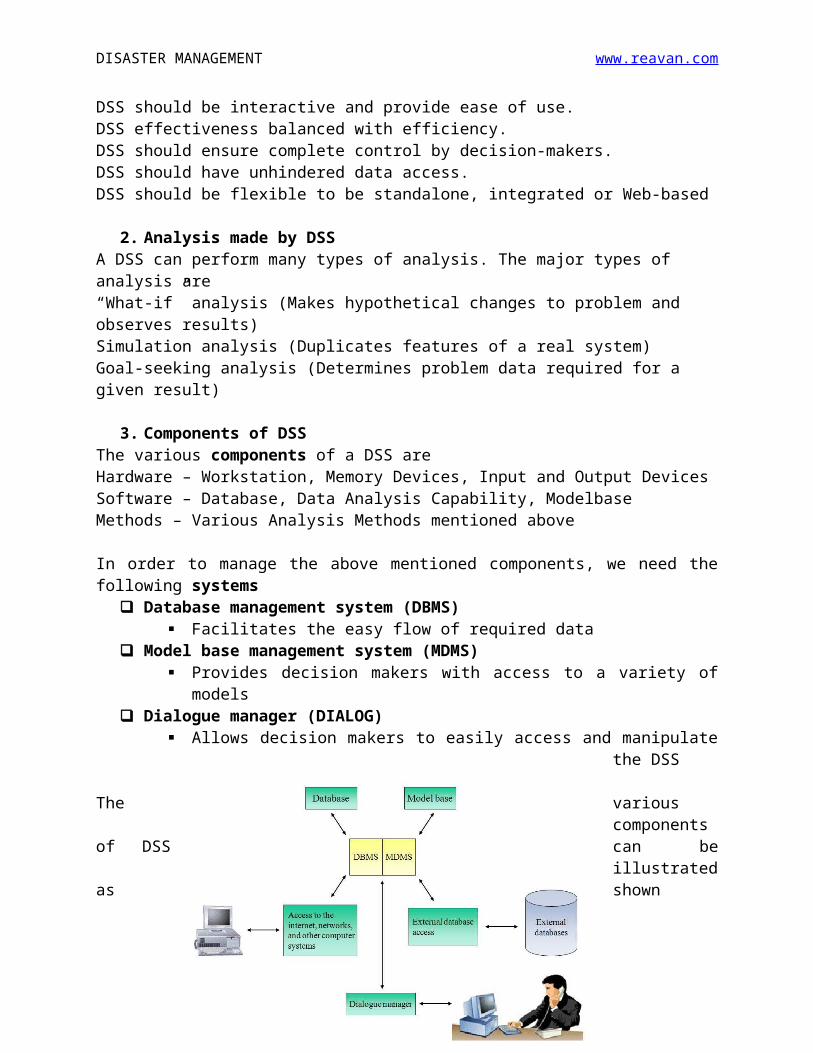
3. Components of DSSThe various components of a DSS areHardware – Workstation, Memory Devices, Input and Output DevicesSoftware – Database, Data Analysis Capability, ModelbaseMethods – Various Analysis Methods mentioned above
In order to manage the above mentioned components, we need the following systems
Database management system (DBMS) Facilitates the easy flow of required data
Model base management system (MDMS) Provides decision makers with access to a variety of models
Dialogue manager (DIALOG) Allows decision makers to easily access and manipulate the DSS
The various components of DSS can be illustrated as shown
DISASTER MANAGEMENT www.reavan.com
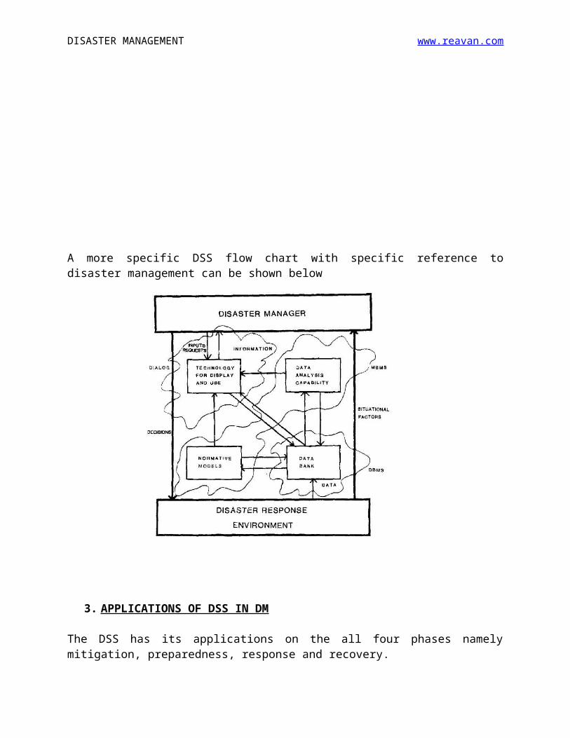
A more specific DSS flow chart with specific reference to disaster management can be shown below
3. APPLICATIONS OF DSS IN DM
The DSS has its applications on the all four phases namely mitigation, preparedness, response and recovery.
In mitigation stage, it can be used for (1) safety analysis of a particular hazard (2) probability of occurrences with adverse effects (3) cost and time constraints analysis and (4) Alternatives Analysis
DISASTER MANAGEMENT www.reavan.com
In preparedness phase, it can be utilized for (1) inventory analysis of emergency resources (2) Local Jurisdictions and Legal Provisions analysis (3) cost and schedule dimensions of preparedness policy and (4) scenario generation for emergency training
In the response stage, it can be used for (1) EOC alert procedures (2) Damage Reporting Assessment (3) Evacuation Requirements Analysis (4) Imminent danger conditions and (5) mobilization of resources
In the recovery phase, it can be utilized for (1) Vulnerability Analysis for the immediate future (2) What if Analysis of budgetary provisions (3) Task Priority Analysis and (4) Safety Analysis
4. CASE STUDIES
(A) DSS FOR NATURAL DISASTER MANAGEMENT IN ALLAHABAD
Allahabad has now got the status of Metro-city with a population of over 10 lakhs. It is essential that a comprehensive plan is needed for natural disasters decision support, particularly earthquakes.
A GIS based DSS for disaster management can be developed consisting of three modules, namely, integrated geo-database module; module consisting of disaster management models; and user-interface module.
The GIS based system can be used as an integrated administrative and decision support system to respond to the immediate humanitarian and disaster relief operation during and after the event.
Further, the information required for decision making during any disaster is diverse, spatial and temporal in nature. Thus, remote sensing technology can be advantageously used for detailed near real-time monitoring, damage assessment and long-term relief management.
The various stages involved in the preparation of GIS based DSS for disaster management for Allahabad include the development of an integrated geo-database consisting of various thematic maps, demographic data, socio-economic data and infrastructural facilities at village level under GIS environment.
The various thematic maps include road network map, water supply network map, Fire control office map, urban sprawl map, drainage map and land use map, among others. The various utilities like education facilities, medical
DISASTER MANAGEMENT www.reavan.com
facilities, electricity, etc. and other information from Census 2001 available for the district have been represented spatially using GIS.
A menu driven Graphical User Interface (GUI) has also been developed so that the GIS based DSS for disaster management can be used by those administrators who may not have in-depth knowledge of working in GIS. By navigating through GUI, planners with basic knowledge of computers can work on this system and this is expected to increase the acceptability of the present system among planners and decision-makers.
The ArcGIS software and Erdas Imagine software have been used for carrying out the work in the present study. The GIS based DSS for disaster management proposed for Allahabad district may be adopted for further implementation by district administrators.
(B) DSS FOR EARLY WARNING, TAIWAN
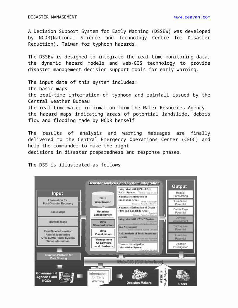
A Decision Support System for Early Warning (DSSEW) was developed by NCDR(National Science and Technology Centre for Disaster Reduction), Taiwan for typhoon hazards.
The DSSEW is designed to integrate the real-time monitoring data, the dynamic hazard models and Web-GIS technology to provide disaster management decision support tools for early warning.
The input data of this system includes:the basic mapsthe real-time information of typhoon and rainfall issued by the Central Weather Bureauthe real-time water information form the Water Resources Agencythe hazard maps indicating areas of potential landslide, debris flow and flooding made by NCDR herself
The results of analysis and warning messages are finally delivered to the Central Emergency Operations Center (CEOC) and help the commander to make the rightdecisions in disaster preparedness and response phases.
The DSS is illustrated as follows
DISASTER MANAGEMENT www.reavan.com
GIS (GEOGRAPHICAL INFORMATION SYSTEM)
* Definition *Technical Information *Applications *Case Studies
1. DEFINITION
GIS (Geographic Information System) is a computer based system comprising hardware, software, data, people and methodology that combine to provide answers to queries of a geographical nature as and when required.
In simple words, GIS can be said as the evolution of maps. It can be referred to as maps in computers which can be easily loaded with lots of valuable information.
Let's break down the term Geographic Information Systems
Geographic = a location. For example - a highway connecting two citiesInformation = information about the location. For example - lanes in the a highwaySystem = that ties-in the above two
GIS is a unique because it combines location and information about the location. Using GIS, you can not only see the 'place' but find out more information about the place.
DISASTER MANAGEMENT www.reavan.com
2. TECHNICAL INFORMATION
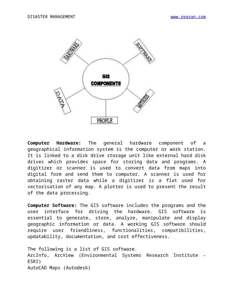
1. Components of GISAny working GIS integrates five key components namely (1) Hardware (2) Software (3) Data (4) People and (5) Methods
Computer Hardware: The general hardware component of a geographical information system is the computer or work station. It is linked to a disk drive storage unit like external hard disk drives which provides space for storing data and programs. A digitizer or scanner is used to convert data from maps into digital form and send them to computer. A scanner is used for obtaining raster data while a digitizer is a flat used for vectorisation of any map. A plotter is used to present the result of the data processing.
Computer Software: The GIS software includes the programs and the user interface for driving the hardware. GIS software is essential to generate, store, analyze, manipulate and display geographic information or data. A working GIS software should require user friendliness, functionalities, compatibilities, updatability, documentation, and cost effectiveness.
The following is a list of GIS software.ArcInfo, ArcView (Environmental Systems Research Institute - ESRI)AutoCAD Maps (Autodesk)Mapinfo (Mapinfo Corporation)Microstation (Bentley Systems)Gram ++ (IIT Mumbai)

DISASTER MANAGEMENT www.reavan.com
Data: Data is the most important component of a GIS. Geographic data (Spatial Data) and related information data (Aspatial Data) can be collected, compiled and often stored in a DBMS. The integration of spatial and tabular data stored in a DBMS is a key functionality afforded by GIS.
People: GIS technology has limited value without the people who manage and develop plans for applying it to real world problems. GIS users range from technical specialists, who design and maintain the system, to engineers who provide and verify data and to those who use it for their everyday work. This is what called 'brain ware' which is equally important as the Hardware and software..
Methods: A successful GIS operates according to a well designed implementation plan and business rules, which are the models and operating practices unique to each organization.
2. Terms used in GIS
(a)Spatial/Geospatial Data: relating to 'space' or 'location'. E.g.
Location of Coimbatore
(b)Aspatial Data: relating to information about the space or location.
E.g. Population of Coimbatore, land use maps of Coimbatore, streets in
Coimbatore etc.
(c) GPS: Global Positioning System (GPS) is a satellite based system that
gives accurate location information anywhere on earth and can be
traced using a computer.
(d)Raster Data and Vector Data: The raster data formats allow for
storing real world coordinates of each pixel in the data. The vector
data allows for storing real-world objects are represented using points,
lines or polygons. All GIS data, contains two-types of information -
location and information about the location. So vector data will have
coordinates (location) and attributes (information about the location)
while raster data will have only coordinates.
(e)Layers: GIS stores information about the world as a collection of
thematic layers that can be linked together. For example, layers of a
dam may be soil profile, groundwater data, hydrological profile,
3. GIS Workflow
The GIS workflow consists of following steps
DISASTER MANAGEMENT www.reavan.com
Data Collection: To build any GIS, we need data. The data is collected,
converted to a convenient format and stored for use in subsequent
processes.
Example: If you are building a GIS Disaster Response, one needs data on
road networks in the city, location of hospitals/fire stations/police stations,
addresses of residents etc. Various tools such as GPS devices, Aerial photos,
Survey equipment etc. can be used for data collection
Display and Analysis: The stored data is displayed and analyzed as per
requirement. The data is displayed on a computer screen and the operator
gives commands to perform analysis.
Example: To find the shortest route from a house to the nearest hospital, the
operator analyzes using a route finding algorithm on the roads data and the
resulting path is displayed on the computer screen. Many different types of
data is displayed as different layers and they are analyzed together.
Sharing: The result of analysis needs to be shared with the decision maker
for further action.
Example: In disaster response, the shortest route found using analysis, can
be shared with the ambulance driver in form of printed or verbal instruction.
3. APPLICATIONS OF GIS IN DM
1. It is used for hazard mapping2. It can be useful for vulnerability assessment3. It can be very useful for MIS and DSS4. It can be useful for risk assessment in a particular area.5. It can be useful for emergency response to locate dangerous points
and to find shortest route for the responders using network analysis.6. It can be very useful for search and rescue operations in short term
emergency response when coupled with GPS and Remote Sensing7. It can be useful for live GPS tracking and GIS tools of emergency
resources8. It can be used for finding evacuation routes and choosing emergency
operation centres9. It is used to organize damage information and evaluation of sites for
reconstruction10. It is used to forecast and simulate disaster occurrences with
reference to hazards in a particular areas
DISASTER MANAGEMENT www.reavan.com
4. CASE STUDIES
(A) Analysis on Damage Areas of the Great Hanshin - Awaji Earthquake using GIS
The Great Hanshin - Awaji Earthquake magnitude with 7.2 on the Richer scale abruptly occurred breaking the silence of the early morning of 17 January 1995. More than 5,000 people living in Kobe, Japan were crushed to death.
The purpose of the study is to evaluate the impact from the Great Hanshin-Awaji Earthquake by using GIS, in order to build a Disaster Management System in the near future. This will be useful to minimize the casualties from natural disasters and to facilitate a quick response from the government in the event of such natural disasters.
The study involved five major steps namely Identification of Target LocationBase Data AnalysisComparison of the data before and after damage Damage analysis Study of DMIS development problems
GIS for the disaster is necessary to minimize the casualties from the natural disasters and to facilitate a quick response from the government in the event of such natural disasters. But for developing countries, to digitize all houses in one area is almost impossible. Due to a lack of housing map, a huge data storage and the cost of those computers is too expensive compared with the daily cost of living are the reasons why it is difficult to build a GIS system.
(B) TSUNAMI RISK ANALYSIS & DISASTER MANAGEMENT BY USING GIS IN TURKEYSea disasters, especially tsunamis, can cause loss of lives and property damage when it comes to shores. Locating the spatial distribution of a catastrophic event like tsunami and knowing its impact has vital importance in response and recovery stages in case of disaster. Through disaster mitigation, lives and property can be saved and environmental damage can be reduced.
In this study, for Göcek Bay, a tsunami simulation has been produced using NamiDANCE software. The simulation results are used as input to produce inundation maps to detect the buildings which are possibly prone to inundate in case of a tsunami. Based on the applied network modeling,
DISASTER MANAGEMENT www.reavan.com
the uses of obtained outputs in the preparation of emergency action plans are discussed.
The main outcomes of the study are determining the inundated buildings and roads and calculating the optimum routes using GIS to the closest facilities in case of emergency. The analyses conducted in this study are based on the source data gathered. These data are integrated with spatial data in order to determine the optimum routes from inundation zones to safe places, thus an evacuation plan was assessed.
(C) VENTENIt is hard to use disaster information from the satellite image for actual disaster management without overlaying it to general geographical data. To solve this problem, GIS professionals in Japan have developed VENTEN (Vehicle through Electric Network of disaster geographical information) which is available to anyone and everyone. An Internet-based GIS disaster information system, “VENTEN” (Vehicle through Electronic Network of disasTer gEographical informatioN), was developed to achieve a state of the art disaster management system aided by GIS. The objective of the development of the VENTEN system is to provide both a system and data (including analysis results). This system is designed to be readily used with a personal computer connected to the Internet and installed with any browser. Although various organizations were already providing, free or at cost, not only basic map data including topographic and natural environment information, but also GIS data, it was necessary to convert the data format to the requirements of the GIS software in use in order to view and analyze these data.
Therefore, in the development of the VENTEN system, various GIS data were converted into a VENTEN-compatible format to allow integrated management of these data and the hardware.
Thus the arrival of VENTEN, an Internet based GIS has made disaster management easy for not only a disaster manager, but also a layman.
(D) Development of Network Analysis Software - GRAMNET
IIT Mumbai is developing a standalone software package to solve real world problems in networking including analysis related to resource allocation and routing.They also plan to integrate this GIS based software with their own GIS software GRAM (Geo-Reference Area Management) package to enhance its capabilities.
DISASTER MANAGEMENT www.reavan.com
The new software would be called GRAMNET. GRAMNET is a compact tool for solving network analysis problems (viz.) routing, location and allocation of facilities. It accepts GRAM compatible .vec coverage files, builds topology and stores it as .sat file.
The package models real world entities closely through network elements. Network arcs form the framework of the network model. They represent real world structures such as highways, transmission lines etc. All discrete locations lie on network nodes.User can set the environment for network analysis by placing network elements at desired locations.User can interactively set centers over network nodes before the demands are allocated to the centers.
GRAMNET provides route, allocation, location/allocation processes. Route generates optimal routes through user selected sequence of nodes taking care of barriers and stops. Allocation process allocates the demand nodes to the nearest centres. Location/allocation process identifies optimal location of centres so that overall traversal cost from/to demand nodes to their respective centres is minimized.
The software was developed on a trial basis for Bombay Balasino, Chatna Block and the total Cost of Project worked to roughly 12 lakhs.
REMOTE SENSING
* Definition *Technical Information *Applications *Case Studies
1. DEFINITION
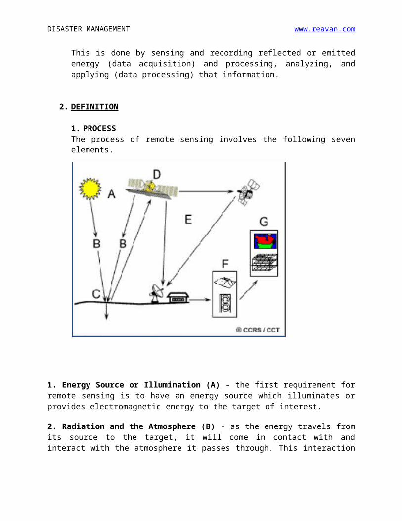
Remote sensing is the science of acquiring information about the Earth's surface without actually being in contact with it. This is done by sensing and recording reflected or emitted energy (data acquisition) and processing, analyzing, and applying (data processing) that information.
2. DEFINITION
1. PROCESSThe process of remote sensing involves the following seven elements.
DISASTER MANAGEMENT www.reavan.com
1. Energy Source or Illumination (A) - the first requirement for remote sensing is to have an energy source which illuminates or provides electromagnetic energy to the target of interest.
2. Radiation and the Atmosphere (B) - as the energy travels from its source to the target, it will come in contact with and interact with the atmosphere it passes through. This interaction may take place a second time as the energy travels from the target to the sensor.
3. Interaction with the Target (C) - once the energy makes its way to the target through the atmosphere, it interacts with the target depending on the properties of both the target and the radiation.
4. Recording of Energy by the Sensor (D) - after the energy has been scattered by, or emitted from the target, we require a sensor (remote - not in contact with the target) to collect and record the electromagnetic radiation.
5. Transmission, Reception, and Processing (E) - the energy recorded by the sensor has to be transmitted, often in electronic form, to a receiving and processing station where the data are processed into an image (hardcopy and/or digital).
6. Interpretation and Analysis (F) - the processed image is interpreted, visually and/or digitally or electronically, to extract information about the target which was illuminated.

DISASTER MANAGEMENT www.reavan.com
7. Application (G) - the final element of the remote sensing process is achieved when we apply the information we have been able to extract from the imagery about the target in order to better understand it, reveal some new information, or assist in solving a particular problem.
The first four processes together constitute Data Acquisition Process while the last three processes are called Data Processing Works.
2. ACTIVE AND PASSIVE REMOTE SENSING
As we have seen above, the fulcrum of remote sensing process is the energy source. The sun provides a very convenient source of energy for remote sensing. The sun's energy is either reflected or absorbed and then re-emitted, as it is for infrared wavelengths. Remote sensing systems which use the natural energy source (sun) are called passive sensors.
Active sensors, on the other hand, provide their own energy source for illumination. The sensor emits radiation which is directed toward the target to be investigated. The radiation reflected in microwave wavelengths from that target is detected and measured by the sensor. Some examples of active sensors are RADAR, LIDAR, Laser fluorosensor and synthetic aperture radar (SAR). The advantages for active remote sensing include the ability to obtain measurements anytime, regardless of the time of day or season.
3. PLATFORMS AND SENSORS
(A) Remote Sensing Platforms: Platforms in Remote Sensing refer to the carriers of sensors. The platforms can be Ground-based platforms: ground, vehicles and/or towers (upto 50m)Airborne platforms: airplanes, helicopters, high-altitude aircrafts, balloons (upto 50 km)Spaceborne platforms: from about 100 km to 36000 km
Space shuttle: 250-300 kmSpace station: 300-400 kmLow-level satellites: 700-1500 kmHigh-level satellites: about 36000 km
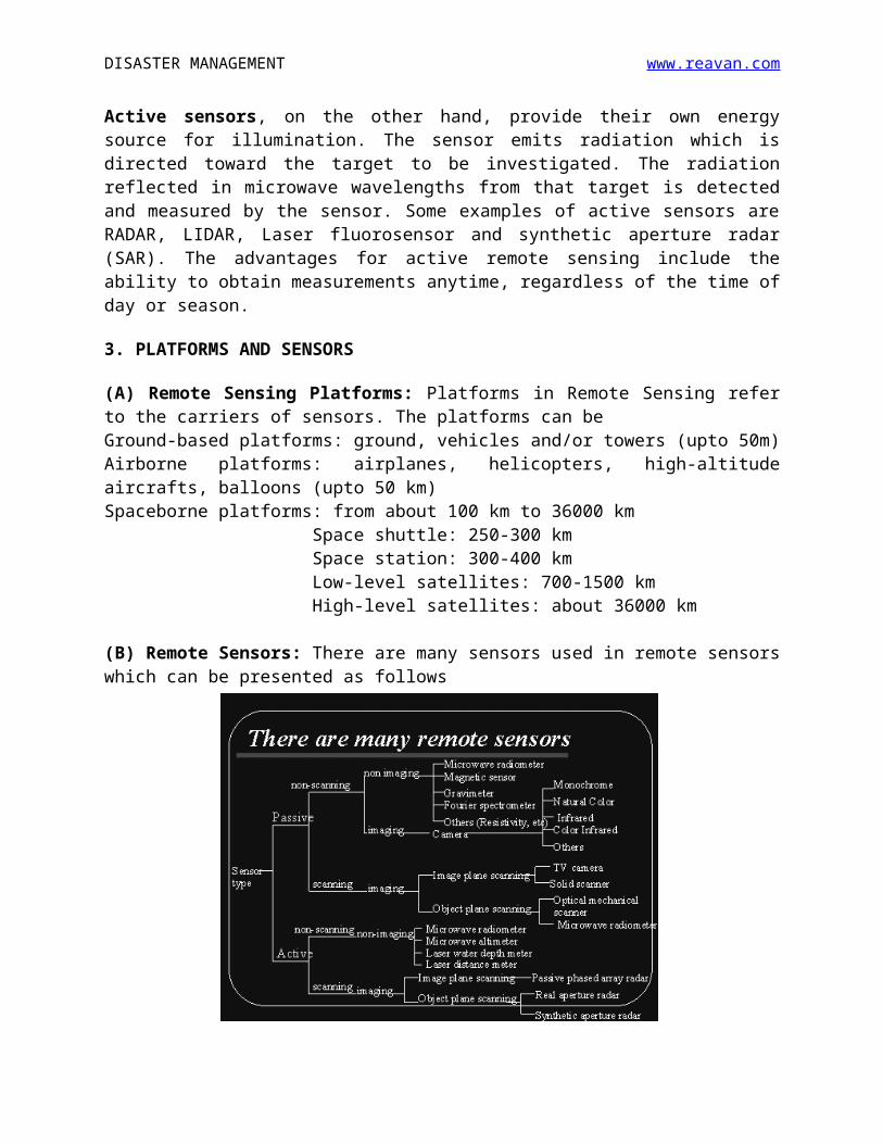
(B) Remote Sensors: There are many sensors used in remote sensors which can be presented as follows
DISASTER MANAGEMENT www.reavan.com
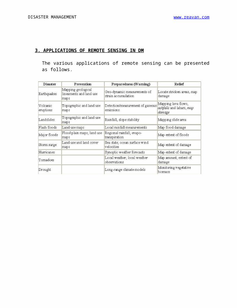
3. APPLICATIONS OF REMOTE SENSING IN DM
The various applications of remote sensing can be presented as follows.
DISASTER MANAGEMENT www.reavan.com
4. CASE STUDIES
(A) THAMES RIVER STUDY
Among various natural phenomena we get rainfall, snow and four seasons that keep varying the temperatures, soil moisture and humidity. With lot of land use changes today, the quantity of overland flow and river flows is not the same and the possibility of finding a relationship between the urbanization and river flows remote sensing and Geographic Information Systems (GIS) techniques can be very useful.
Upper Thames River (UTR) watershed was chosen for this case study. This case study illustrates the process of establishing a relationship between impervious area and river flows using remote sensing techniques and through analyzing the hydrologic and meteorological data.
Findings from this case study can be used to form policies on land use planning and balanced urbanization by the city development, planning and conservation authorities. Once the affect of urbanization on river flows is quantified, the future trend would become possible to predict so that measures to cope with increasing demand for residential/commercial areas can be met without risking the increased intensity and extent of storm water in rainy periods.
The normally placid Thames was periodically subject to severe flooding which disrupted the new communities built in the river's extensive floodplains. The study showed that tremendous urban development has taken place in the watershed over three decades. Surface water area appeared to be decreasing over the years – from 3.65% in 1974 to 2.73% in 2000.

DISASTER MANAGEMENT www.reavan.com
Natural disasters cause damage to life and property all over the world in various forms. The pressure on the earth's resources caused by increased population has resulted in increased vulnerability of human and their infrastructure to the natural hazards, which have always existed. The result is a dynamic equilibrium between these forces in which scientific and technological development plays a major role. A useful technology like Remote Sensing can help the disaster mitigation process through better future scenario predictions.
Such a study can be replicated for a city like Mumbai which is always torn by floods during every monsoon season.
(B) RS & GIS IN GANGTOK
Geographic information system (GIS) and remote sensing (RS) are very useful and effective tools in disaster management. Various disasters like earthquakes, landslides, floods, fires, tsunamis, volcanic eruptions and cyclones are natural hazards that kill lots of people and destroy property and infrastructures every year. Landslides are the most regular geological vulnerabilities in mountain regions, particularly in Sikkim Himalaya. Remotely sensed data can be used very efficiently to assess severity and impact of damage due to these disasters. In the disaster relief phase, GIS, grouped with global positioning system (GPS) is extremely useful in search and rescue operations in areas that have been devastated and where it is difficult to find one’s bearings. Disaster mapping is the drawing of areas that have been through excessive natural or man-made troubles to the normal environment where there is a loss of life, property and national infrastructures.
INTRANETS, EXTRANETS AND INTERNETS
* Intranet *Extranet *Internet *Corollary *Applications
1. INTRANET (INTERNAL NETWORK)
This is a network of computers in an organization where data can be shared within the organization and the connected computers. It cannot be accessed or connected to the outside world.
For example, consider an office with a few PCs and a few printers all networked together. The network would not be connected to the outside world. On one of the drives of one of the PCs there would be a directory of
DISASTER MANAGEMENT www.reavan.com
web pages that comprise the Intranet. Other PCs on the network could access this Intranet by pointing their browser (Netscape or Internet Explorer) to this directory.
Intranets are normally governed by FTP (File Transfer Protocol)
2. EXTRANET (EXTERNAL NETWORK)
An Extranet is actually an Intranet that is partially accessible to authorized outsiders. The actual server (the computer that serves up the web pages) will reside behind a firewall. The firewall helps to control access between the Intranet and Extranet permitting access to the Intranet only to people who are suitably authorized. The level of access can be set to different levels for individuals or groups of outside users. The access can be based on a username and password or an IP address. Extranets are normally governed by a modified FTP (File Transfer Protocol) – FTP2
3. INTERNET (INTERNATIONAL NETWORK)
Internet is the world-wide network of computers accessible to anyone who knows their Internet Protocol (IP) address, a unique set of numbers (such as 209.33.27.100) that defines the computer's location. Most will have accessed a computer using a website address such as http://www.hcidata.com. Before this named computer can be accessed, the name needs to be resolved (translated) into an IP address. To do this your browser (for example Netscape or Internet Explorer) will access a Domain Name Server (DNS) computer to lookup the name and return an IP address - or issue an error message to indicate that the name was not found. Once your browser has the IP address it can access the remote computer. The server may implement security at a directory level so that access is via a username and password, but otherwise all the information is accessible.
Internet is governed by HTTP (Hyper Text Transfer Protocol)
4. COROLLARY The firewall helps to control access between the Intranet and Internet to permit access to the Intranet only to people who are members of the same company or organization. If the Intranet network is connected to the Internet, the Intranet will reside behind a firewall and, if it allows access from the Internet, will be an Extranet.
The differences between the Intranet, Internet and Extranet can be illustrated by the following diagrams
DISASTER MANAGEMENT www.reavan.com
5.
5.
5.
5.
5.
5.
5.APPLICATIONS
The applications of these networking technologies in disaster management can be listed as follows
1. It can be used for easy communication between disaster managers2. These technologies are vital to set up a Disaster MIS, DSS or accessible
database3. They are very essential in setting up a Disaster Information Network
(DIN)4. The Internet is useful for disaster information dissemination and early
warning5. The Intranet and Extranet would help in procurement and processing of
data related to disasters6. The Networking technologies can also be very helpful in disaster
response training.7. They can be used as a tool to facilitate community based disaster
management.8. They can be used for a major role in DRR education and awareness
VIDEO TELECONFERENCING
* Definition * Advantages and Disadvantages * Technical Features * Case Study
1. DEFINITION
Video teleconferencing or Videoconferencing is the conduct of a conference by a set of telecommunication technologies which allow two or more
DISASTER MANAGEMENT www.reavan.com
locations to communicate by simultaneous two-way video and audio transmissions.
2. ADVANTAGES AND DISADVANTAGESThe advantages of video teleconferencing are
✔ No Time ConstraintVideo conferencing can be conducted at any time of the day. Time differences between countries do not matter when people use this method of communication because they do not actually need to travel to attend meetings.
✔ Saves Time and MoneyTransaction of any business requires frequent travel, to facilitate its growth and diversification. That translates to travel and associated costs like hotel accommodation and food expenses. A video conference will keep executives in the office, rather than sending them halfway across the country for conducting business. As one can conduct transactions without traveling, it also reduces the time spent in doing so.
✔ Sharing Information is EasyVideo conferencing enables improvisation of operations and services of remote outlets. As it can also be used to transmit files and documents, it is possible to provide real-time information, that can help in solving problems. Also, decisions can be made in the least possible time. The ability to share, coordinate and evaluate digital data from anywhere in the world allows people to conduct simultaneous communication and collaboration on time-sensitive projects.
✔ Facilitates Long-distance ProgramsEducational institutions, mainly long-distance education programs and instructional courses, have reaped enormous benefits of video conferencing. Professionals and students are able to access lectures, study material, group discussions, and even one-to-one talk with the instructor. Video conferencing has taken education into far-flung corners of the world.
The disadvantages of video teleconferencing are
✘ Technical ProblemsThe foremost disadvantage of video conferencing are the technical difficulties associated with smooth transmissions that could result from software, hardware or network failure. Remote connections are sometimes known to be hampered by environmental changes. On some occasions, the absence of technical support personnel creates difficulty for participants who are unfamiliar with the videoconferencing technological concepts.
DISASTER MANAGEMENT www.reavan.com
✘ Lack of Personal InteractionAnother major drawback is the lack of personal interaction, that sets the tone for many business meetings in highly cultural societies. A handshake and an eye contact are essential aspects of many business meetings. Some meetings require a personal touch to be successful.
✘ High Cost of SetupSetting up video conferencing in an office can be a bit expensive for small-sized companies. Simple features can fit into the budget, but if advanced features are required, then a substantial amount of expenditure must be done.
3. TECHNICAL FEATURES
1. The core technology used in a videoconferencing system is digital compression of audio and video streams in real time.
2. The components required for a videoconferencing system include Codec/decoder Digital Network Video input Video output Audio input Audio output Computer
3. There are basically two kinds of videoconferencing systems namely
Dedicated systems that have all required components packaged into a single piece of equipment, usually a console with a high quality remote controlled video camera.
Desktop systems are add-ons (hardware boards, usually) to normal PCs, transforming them into videoconferencing devices. A range of different cameras and microphones can be used with the board, which contains the necessary codec and transmission interfaces. Most of the desktops systems work with the H.323 standard.
4. The components within a Conferencing System can be divided up into several different conference layers: User Interface, Conference Control, Control or Signal Plane and Media Plane.
User Interfaces could either be graphical or voice responsive. User interfaces for conferencing have a number of different uses; it could be used for
DISASTER MANAGEMENT www.reavan.com
scheduling, setup, and making the call. Through the User Interface the administrator is able to control the other three layers of the system.
Conference Control performs resource allocation, management and routing. This layer along with the User Interface creates meetings (scheduled or unscheduled) or adds and removes participants from a conference.
Control (Signaling) Plane contains the stacks that signal different endpoints to create a call and/or a conference. These signals control incoming and outgoing connections as well as session parameters.
The Media Plane controls the audio and video mixing and streaming. This layer manages Real-Time Transport Protocols, User Datagram Packets (UDP) and Real-Time Transport Control Protocols (RTCP). The RTP and UDP normally carry information such the payload type which is the type of codec, frame rate, video size and many others.
5. Robust, portable and easy video teleconferencing mechanisms are the order of the day. With the advent of internet, wireless networks, Mobile phones and applications like Skype, Google Hangout etc, video teleconferencing has become much cheaper and simpler. A very simple desktop video teleconferencing system which is followed these days is illustrated in the following page.
DISASTER MANAGEMENT www.reavan.com
CASE STUDIES
(A) Case Study of the Statewide Telecommunication Network for Disaster Management in Maharastra
In India, the State of Maharastra established a statewide network of telecommunication and information technology.
The Network began in April 2000, as part of the Maharastra Emergency Earthquake Rehabilitation Program following the Latur earthquake (which left more than 10,000 dead and destroyed 200,000 households).
The basic objective of the Network is to provide rapid flow of information, online connectivity, response planning, operations, control, and monitoring of the disaster situation.
This Network consists of an Emergency Operations Center (EOC), Central Control Room at the Mantralaya,Mumbai (the Secretariat), a standby Control Room at the Center for Disaster Management, Yashwant Rao Chavan State Academy of Development Administration Pune,
Control Rooms at each of the six divisional headquarters headed by Divisional Commissioners, and Control Rooms at each of the 32 districts headed by District Collectors.
This Network is connected with VSAT telecommunication facilities for data, voice, and information exchange, as well as video teleconferencing.
In a second level of communication. network, all tahsils (sub-district/blocks) are linked together through a VHF Wireless Network with nodes of the District Control Room reaching each tahsil headquarters.
This Telecommunication Network will facilitate teleconferencing among the nodes for more purposive and successful monitoring and management of disasters. The very high frequency (VHF) network is used to link the subdistrict headquarters with the respective district headquarters.
It will take some time to realize the feasibility of this Network and for other States to follow suit. However, with the implementation of this state-of-the-art network, it willbecome possible for the State to collect, collate, and analyze information electronically on any disaster.
Such a Network will address the online transmission of information on all matters, pertaining to disaster management.