Embed Size (px)
Citation preview
Unit 1: Landforms
September 2014
What is Geography?
• Geography is the study of how the earth works and how people interact with it.
• It is about the world we live in

Questions
• 1. Explain how compressional forces create fold mountains.
• 2. What is the difference between anticline and syncline.
• 3. How do tensional forces create a normal fault?• 4. How do compressional forces create a reverse
and overthrust fault?• 5. What causes a volcano to erupt?• 6. Describe the characteristics of an ash-cinder,
shield cone and composite cone volcano
Canada’s Places
• What does landscape mean?• Landscape refers to the natural features
(mountains, rivers) and human features (farmers fields, buildings) that you can see in an area
• How would you describe Canada’s landscape?
Earth’s Structure
• Inner Core• Outer Core• Mantle• Mohorovicic Discontinuity• Lithosphere
The Earth’s Structure
• Any questions• Read pp 2-9• Describe in detail the five layers of the earth’s
structure• What is the athenosphere?
Earth’s Structure (cont’d)
• Review video:
• http://www.youtube.com/watch?v=3MFr2cC3erk
Landforms: Structures and Processes
• Topography: The natural and human features of the earth’s surface
• Elevation: The height of a particular point of land from sea level
• Relief: The change in elevation over a given distance
• Hill: An area of high relief with elevations no higher than 300-600 metres. Isolated features
Landforms (cont’d)
• Mountain: Areas of high relief with elevations higher than 300-600 metres. Most occur in long linear chains called ranges. Located along the edges of continents
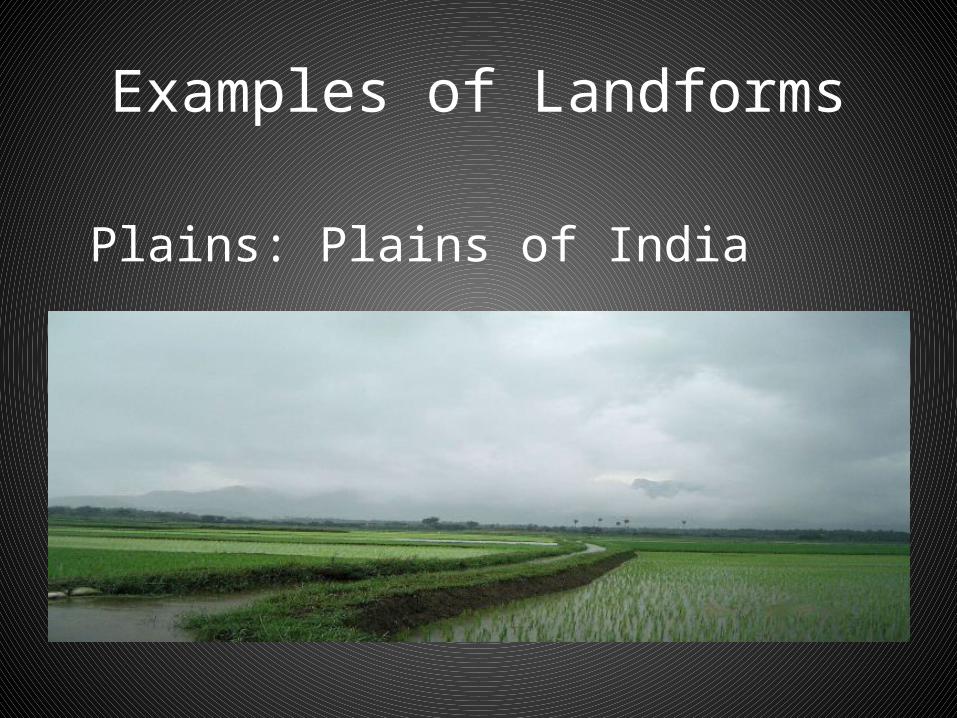
• Plains: A level tract of land. Found along coastal areas or lower elevations. Very gentle slope and no relief of 30 m or more
• Plateau: An extensive, flat upland area, often found on the top of mountains. Raised upwards

Landforms
• Plateau (cont’d):by movements of the earth’s crust. Often found in the interior of continents. Deeply eroded by stream valleys and often have more rugged appearances
Examples of Landforms
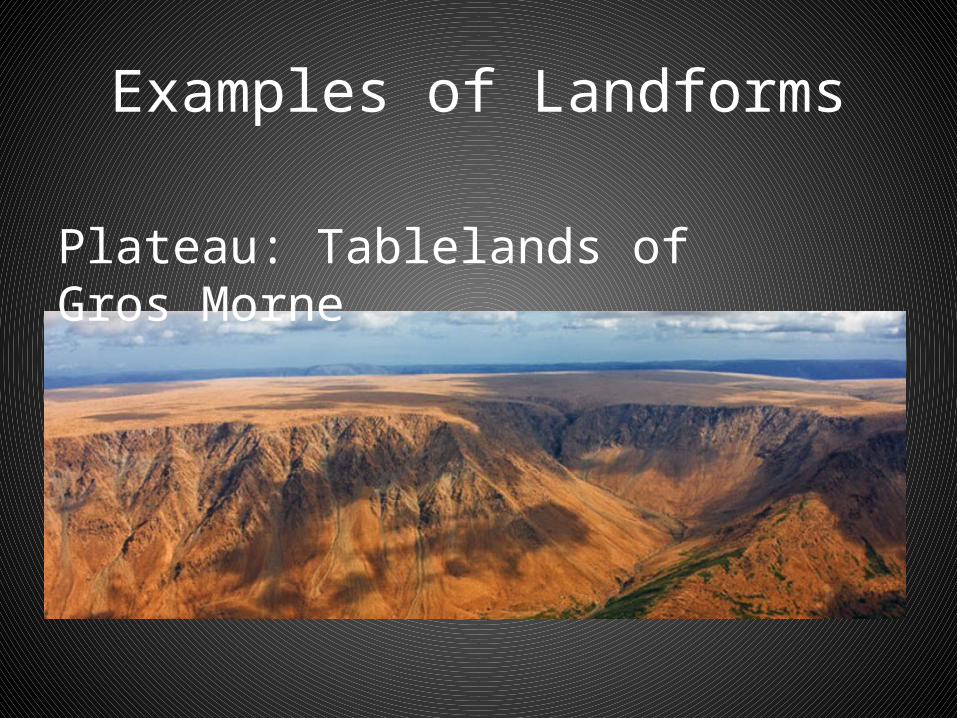
Plateau: Tablelands of Gros Morne

Examples of Landforms
Mountains: Rockies
Examples of Landforms
Plains: Plains of India
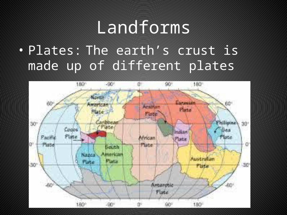
Landforms• Plates: The earth’s crust is made up of
different plates
Landforms
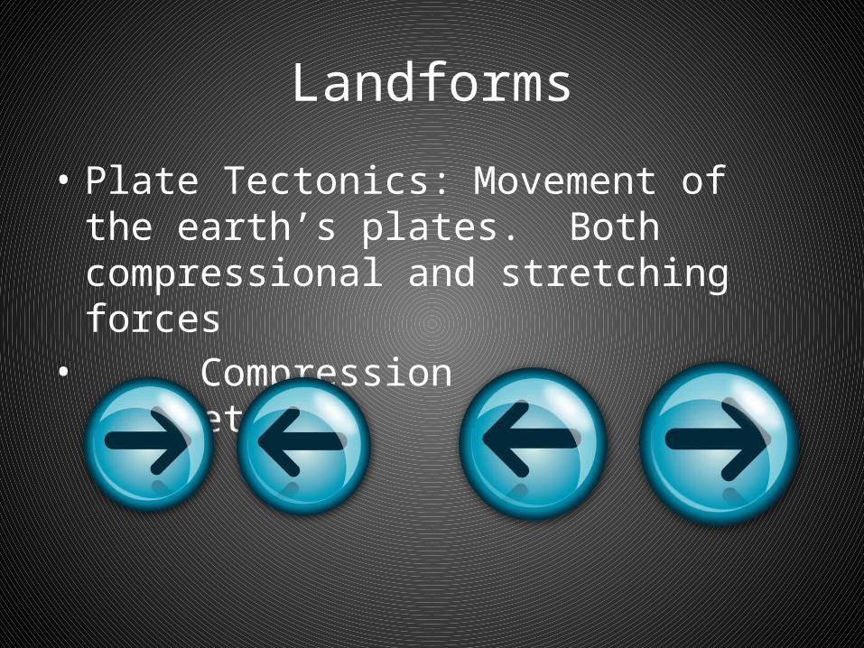
• Plate Tectonics: Movement of the earth’s plates. Both compressional and stretching forces
• Compression Stretching

Landform Processes
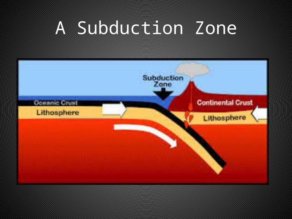
• Compressional Force: Pushing part of the earth’s crust, causing it to buckle. Plates move toward one another, squeezing together. Subduction zones sometimes form along these areas
• Subduction zone: Place where two tectonic plates collide. The more dense plate goes under, or subducts, to the other
A Subduction Zone
Landforms
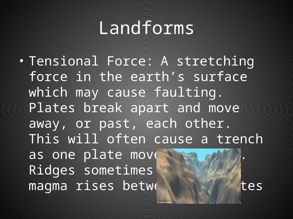
• Tensional Force: A stretching force in the earth’s surface which may cause faulting. Plates break apart and move away, or past, each other. This will often cause a trench as one plate moves downward. Ridges sometimes form a the magma rises between the plates
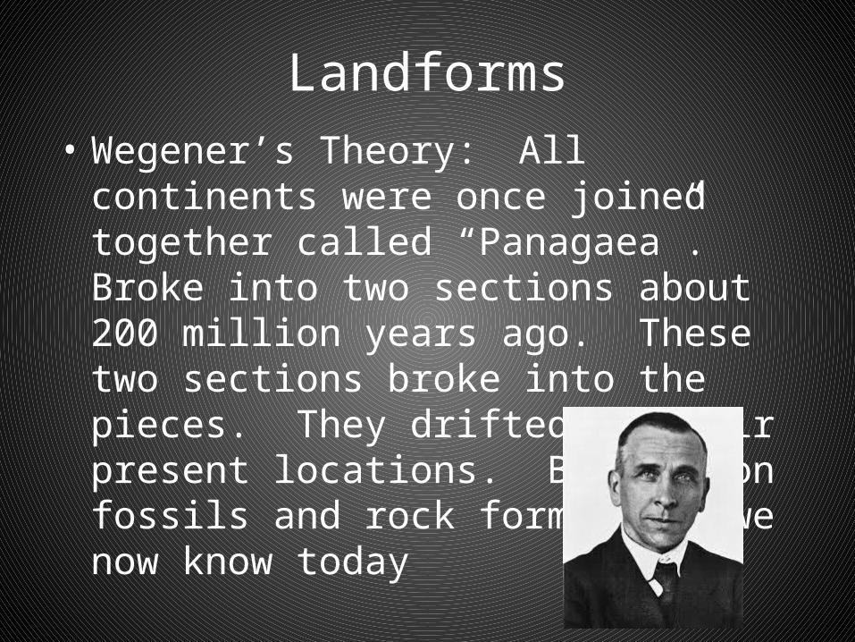
Landforms• Wegener’s Theory: All continents were
once joined together called “Panagaea”. Broke into two sections about 200 million years ago. These two sections broke into the pieces. They drifted to their present locations. Based upon fossils and rock formations we now know today
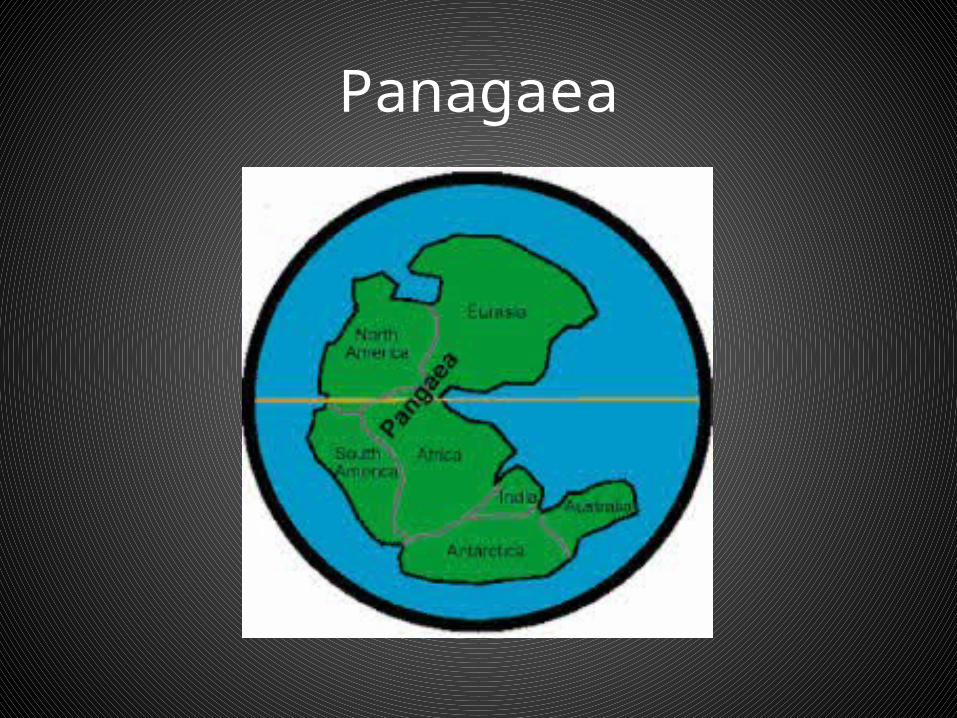
Panagaea

Wegener’s Critics
• Argued how did the plates move?• Wegener could not prove it
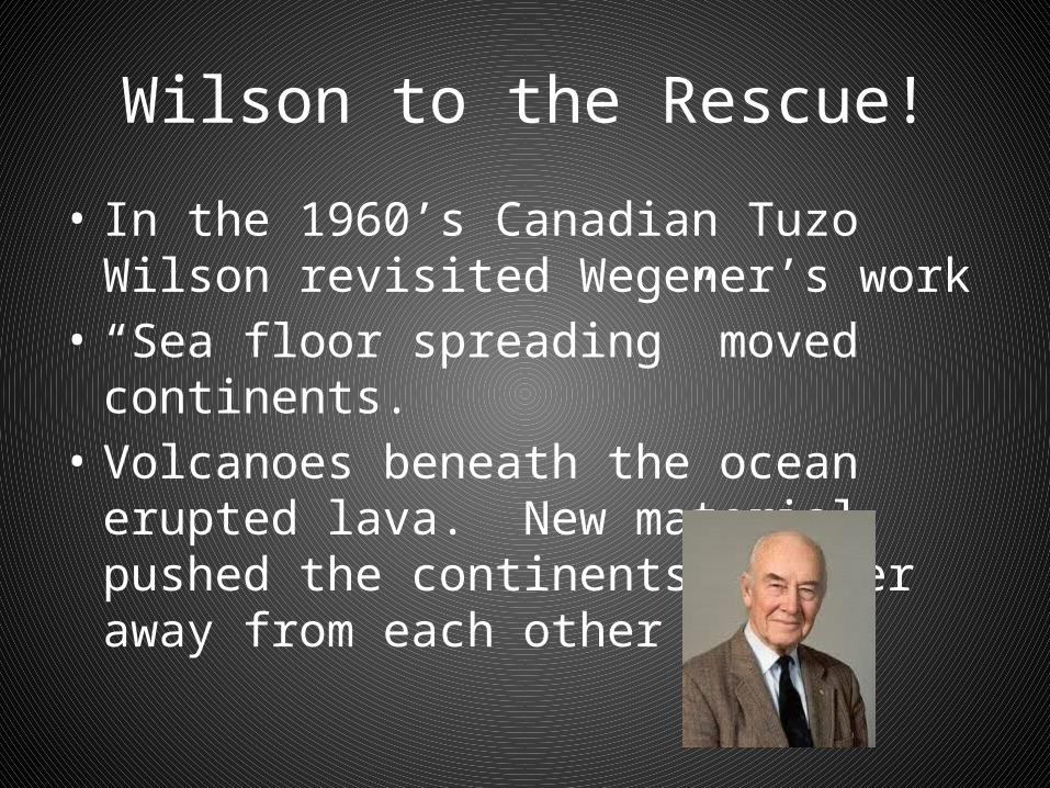
Wilson to the Rescue!
• In the 1960’s Canadian Tuzo Wilson revisited Wegener’s work
• “Sea floor spreading” moved continents.• Volcanoes beneath the ocean erupted lava.
New material pushed the continents further away from each other
Landforms
• Read pp. 6-10
Landforms: Mountain Building
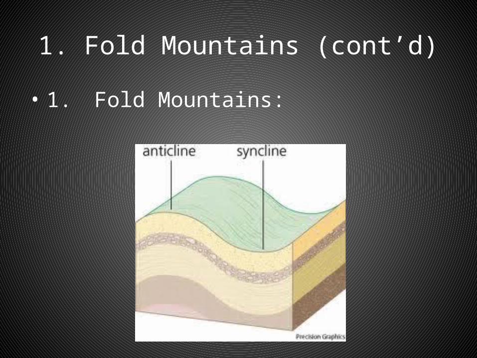
Three ways mountains are made:1. Fold Mountains: Upland area formed by the
earth’s crust. Folds are caused by the destructive collisions of the tectonic plates. Different forces and pressures create simple or complex forms
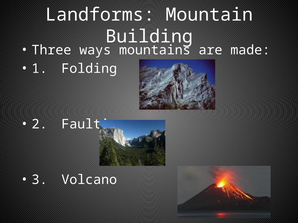
Landforms: Mountain Building• Three ways mountains are made:• 1. Folding
• 2. Faulting
• 3. Volcano
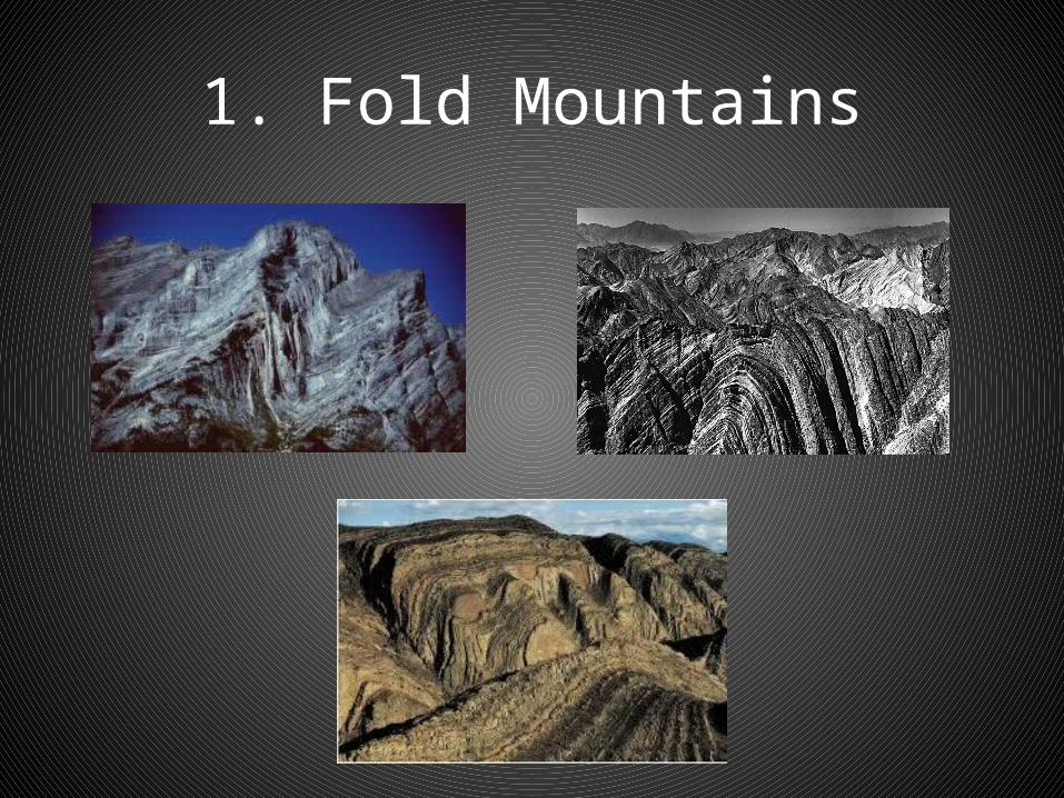
1. Fold Mountains
1. Fold Mountains (cont’d)
• Anti-Cline: It is the peak. An arch-like upfold in buckled, bent, or contorted rock. Top of the letter A
• Syncline: It is the bottom or the trough. A downfold of rock layers. Bottom of the S
1. Fold Mountains (cont’d)
• 1. Fold Mountains:
Landforms: Mountain Building
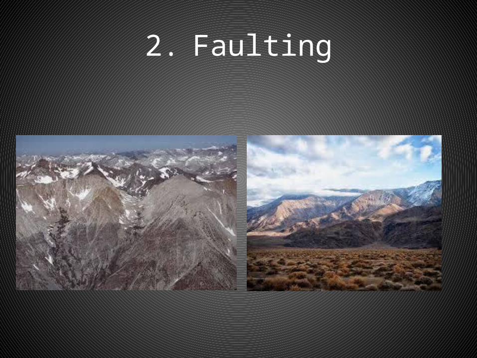
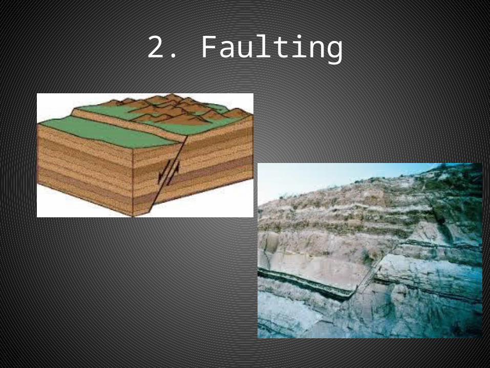
• Three ways mountains are made:• 2. Faulting: Caused when rocks are
compressed together under intense pressure and they break or fracture. Break maybe shallow or deep into the earth’s crust. Result of earth’s crust being pushed up or dropped down as plates on either side move away, or past each other
2. Faulting

2. Faulting
• Normal Fault: If a plate drops down lower than the plate on the other side.
• Rift Valley: When two faults move away from each other, and the plate in between drops down
2. Faulting
2. Faults
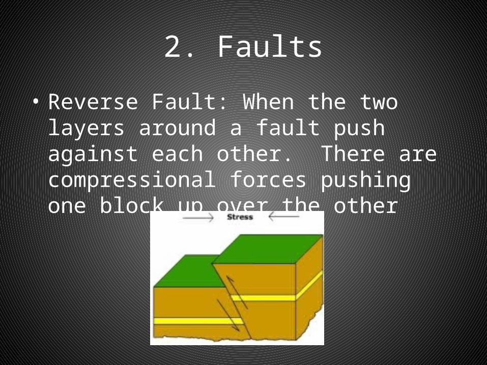
• Reverse Fault: When the two layers around a fault push against each other. There are compressional forces pushing one block up over the other
2. Faults
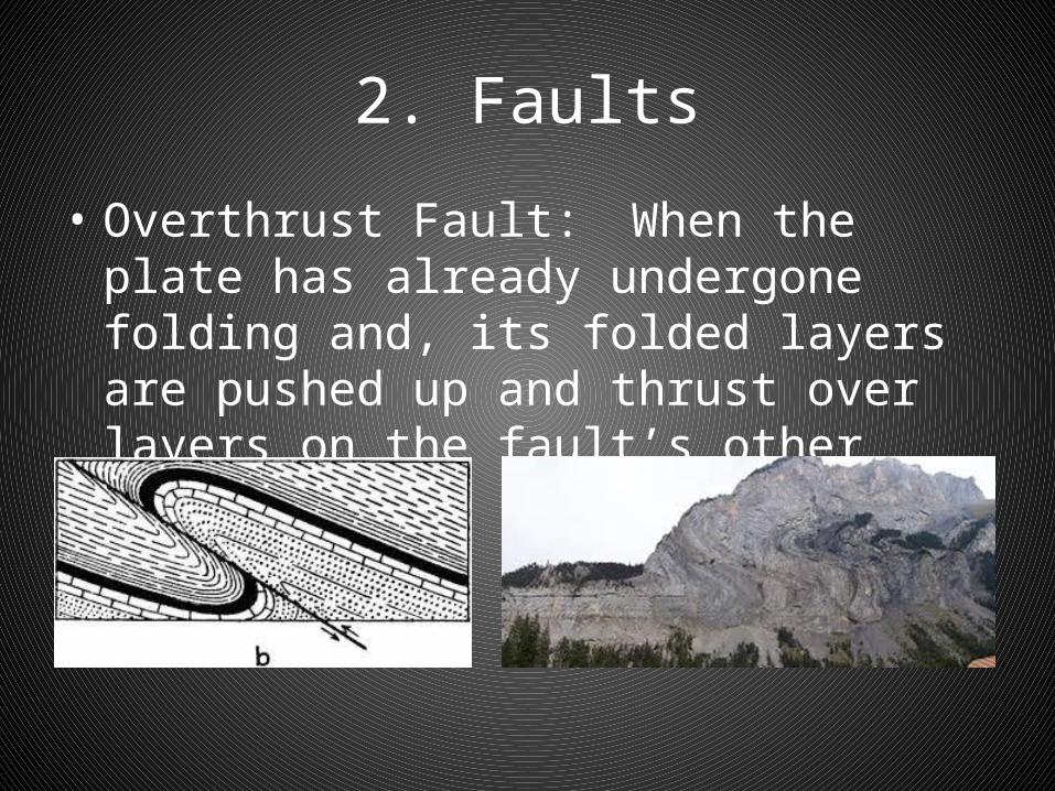
• Overthrust Fault: When the plate has already undergone folding and, its folded layers are pushed up and thrust over layers on the fault’s other side

3. Volcanoes
• 3. Volcanoes: Trigger is heat. Magma is produced when crusts meet. Magma is melted rock. Magma flows into underground pockets and in many cases cools

Volcanoes
• Usually found along plate boundaries• Heat is generated because of friction, pressure
and decay of materials• Magma is produced when heat melts rock and
materials beneath the crust• Magma reaches the surface through fractures,
vents or craters• Lava is liquid rock. It is magma that reaches the
earth’s surface
Volcanoes
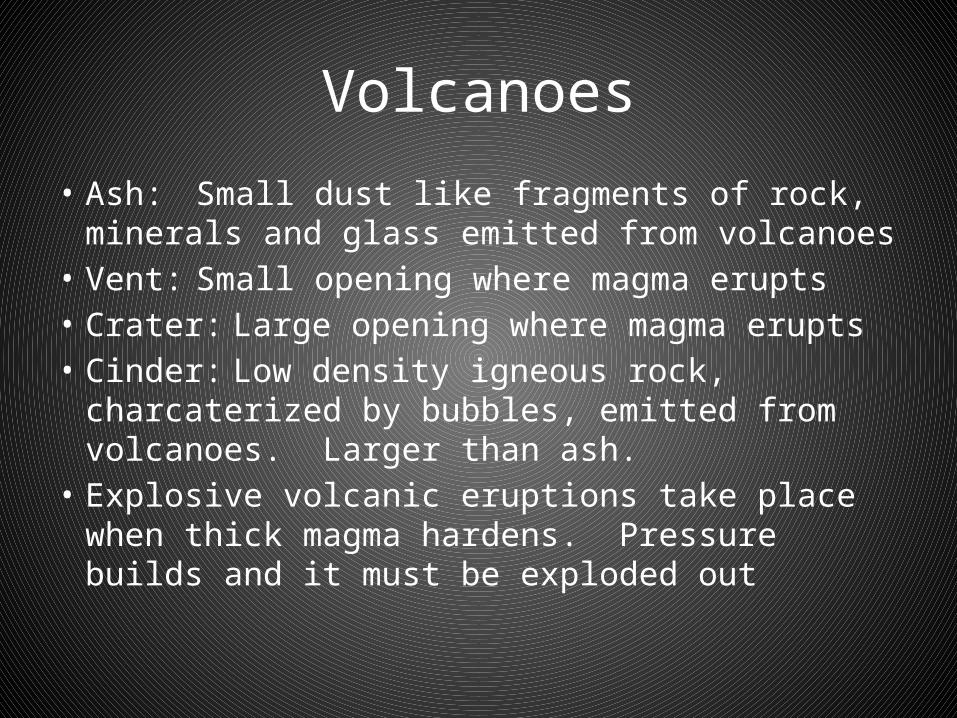
• Ash: Small dust like fragments of rock, minerals and glass emitted from volcanoes
• Vent: Small opening where magma erupts• Crater: Large opening where magma erupts• Cinder: Low density igneous rock, charcaterized
by bubbles, emitted from volcanoes. Larger than ash.
• Explosive volcanic eruptions take place when thick magma hardens. Pressure builds and it must be exploded out
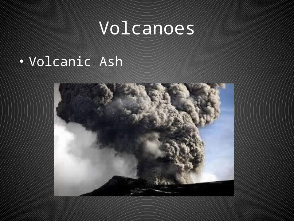
Volcanoes
• Volcanic Ash
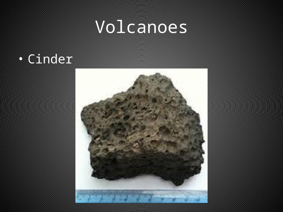
Volcanoes
• Cinder

Volcanoes
• Three kinds:• 1. Ash and Cinder Cones:• Eruptions consist of mainly ash and cinder• Thick, slow flowing, rapidly solidifying lava
which creates violent eruptions• Shape is symmetrical• Steep sides• Large crater
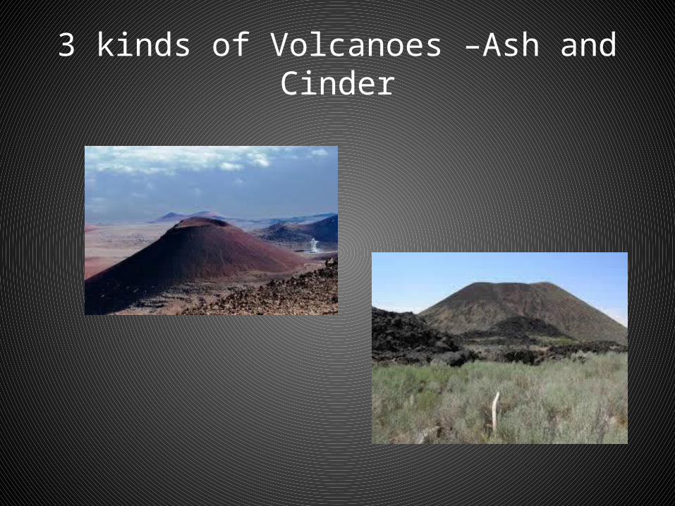
3 kinds of Volcanoes –Ash and Cinder
Volcanoes
• 3 Kinds of Volcanoes:• 2. Shield Cone:• Usually milder eruption• Little or no ash or cinders• Very thin, liquid lava• Broad, flat cones
Volcanoes
• 3 Kinds:• Composite Cones:• Undergoes periods of explosive and quiet
activity• Ash and cinder mixed with lava• Weak spots may develop on sides with smaller
lava flows forming smaller craters

Composite Volcanoes
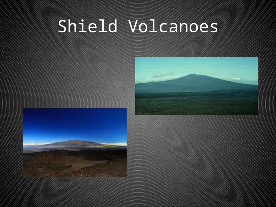
Shield Volcanoes

What is Plate Tectonics?
• A scientific theory which describes the large scale motions of Earth's lithosphere (crust). The theory builds on the older concepts of Continental Drift.
• The lithosphere is broken up into what are called tectonic plates.
• The lithospheric plates ride on the asthenosphere.
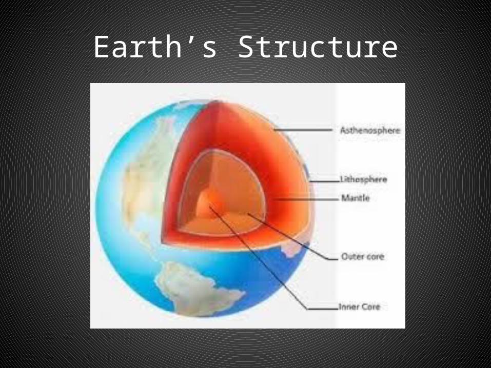
Earth’s Structure
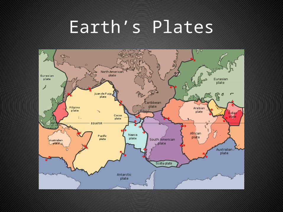
Earth’s Plates
Plate Tectonics
• Compressional Forces (process/cause)– The magma in the asthenosphere flows in such a
way as it carries two floating tectonic plates towards each other.
– When this happens the two plates collide and compress against one another. This pressure is referred to as compressional forces.
– These forces are so strong that one plate is forced beneath the other. These zones are referred to as subduction zones.

A Subduction Zone
Plate Tectonics
• Tensional Forces (process/cause)– The magma in the asthenosphere flows in such a
way as it forces itself upwards between two floating tectonic plates forcing them apart. These tectonic forces which move plates apart are referred to as tensional forces.
– These forces are so strong that an opening is created allowing the magma to force its way through.
– Ridge Zones occur when magma rises between tectonic plates, cools and forms a ridge.

Plate Tectonics
a) Convection Currents: Created by heating and cooling of magma in the asthenosphere. Magma rises and falls due to different temperatures and viscosity (thickness) in the magma.
b) As these currents move through the asthenosphere, they drag with them the rigid parts of the crust immediately above them.
c) Two plates moving towards each other compact or squeeze together the area between the plates, causing compressional forces.
• http://www.youtube.com/watch?v=Kpoko_l34ZE• http://www.youtube.com/watch?v=ryrXAGY1dmE&feature=rel
ated
Plate Tectonics (Boundaries)
• Three types of plate boundaries:• 1. Convergent, or collisional boundaries
(compressional forces)• 2. Divergent boundaries, also called
spreading centers (tensional forces)• 3. Conservative transform boundaries.
3 Kinds of Plate Boundaries
1. Convergent or collisional boundaries (Destructive): Occur where two plates slide towards each other. Commonly forming either a subduction zone (if one plate moves underneath the other) or a continental collision (if the two plates contain continental crust). An example of this are the Andes mountain range in South America.
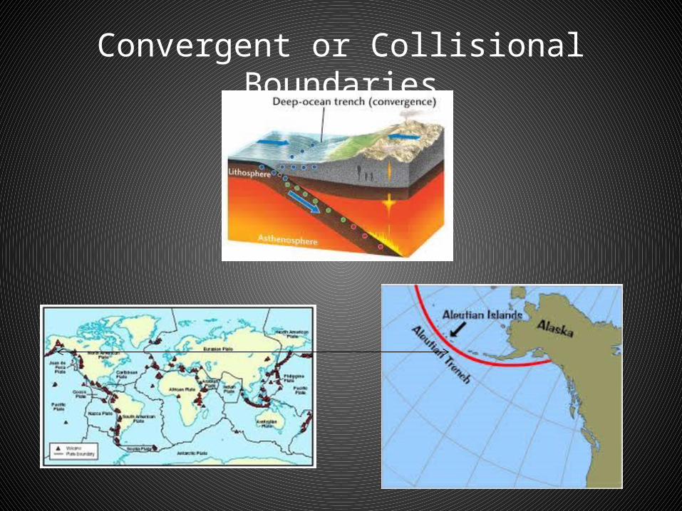
Convergent or Collisional Boundaries
3 Kinds of Plate Boundaries
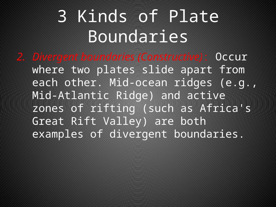
2. Divergent boundaries (Constructive): Occur where two plates slide apart from each other. Mid-ocean ridges (e.g., Mid-Atlantic Ridge) and active zones of rifting (such as Africa's Great Rift Valley) are both examples of divergent boundaries.

Divergent Boundaries
3 Kinds of Plate Boundaries
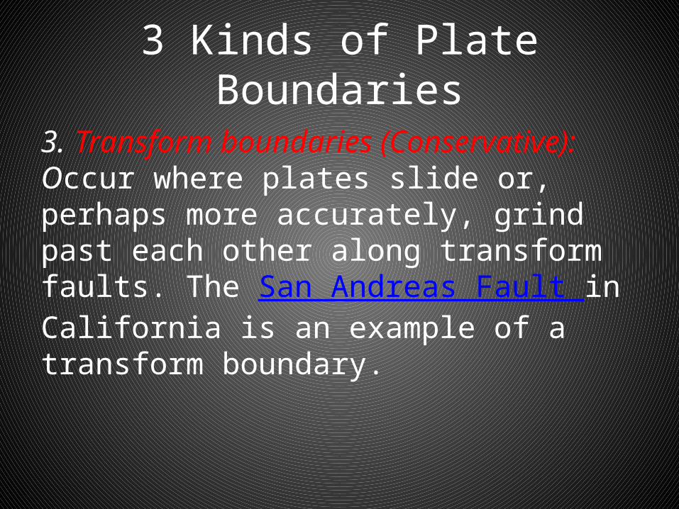
3. Transform boundaries (Conservative): Occur where plates slide or, perhaps more accurately, grind past each other along transform faults. The San Andreas Fault in California is an example of a transform boundary.

Transform Boundary –San Andreas Fault

Plate Boundaries
• Earthquakes, volcanic activity, mountain-building, and oceanic trench formation occur along these plate boundaries.
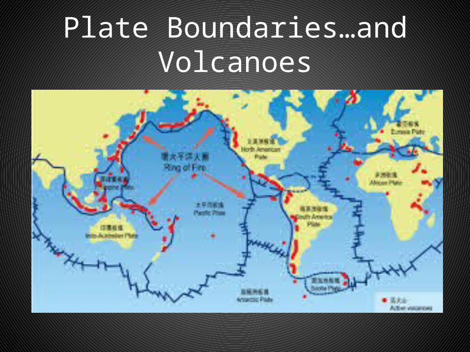
Plate Boundaries…and Volcanoes
Plate Boundaries…and Volcanoes. How Volcanoes are Formed
• Why?• Because that’s where plates collide or
converge• Denser plate melts at the subduction zone• Rocks melt to form magma• Pressure increases, magma rises and erupts• Volcanoes form
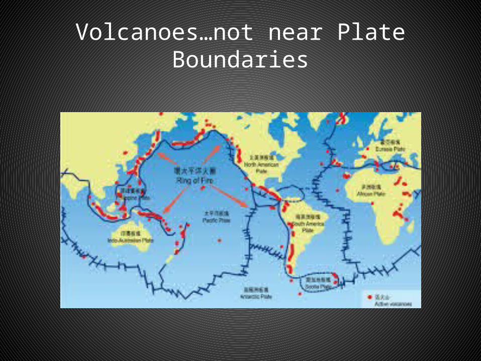
Volcanoes…not near Plate Boundaries

Intra-Plate Volcanoes
Intra-Plate Volcanoes
• Why?• Plates move over magma hot spots in the
lithosphere• Magma bursts through the crust• Forms linear chain of volcanic mountains• i.e. Hawaiian Islands
Continental Drift
• According to Alfred Wegener the super continent of Pangaea broke up 225 million years ago.
• The continent initially broke into Laurasia and Gondwanaland and then eventually continents we know today.
• Evidence suggest that continents are still drifting on the tectonic plates that form the earth’s surface.
Continental Drift
• Continental Drift – It refers to the movement of the more than 20
plates (9 major) due to convergent, divergent, and transform boundaries.
– The continents drift at a rate of 2 inches a year, or, as fast as a fingernail grows.
Questions• 1. Explain how compressional forces are caused.• 2. Explain how tensional forces are caused.• 3. Explain how compressional forces create fold mountains. • 4. What is the difference between anticline and syncline.• 5. How do tensional forces create a normal fault?• 6. Explain how compressional forces create reverse and overthrust
faults?• 7. What causes a volcano to erupt?• 8. Describe the characteristics of an ash-cinder cone, shield and
composite cone.• 9. Describe how the location of a volcano is related to the places
where plates meet. Describe situations when there is an exception.
Introduction• Unit 1 introduces you to the concept that the
earth’s surface is shaped by building-up and wearing away forces.
• The unit helped examine the constituent parts of the physical environment and the forces that created them.
• Today we are going to look at patterns in their distribution, and how they influence selected human activities.
What is a Landform?
• Landform are natural elements of topography. It includes land such as hills, mountains, plateaus, canyons, valleys. It also includes the oceans. It includes interface areas, such as bays, deltas and peninsulas.
• It also includes sub-aqueous terrain features such as mid-ocean ridges, volcanoes, and the great ocean basins.
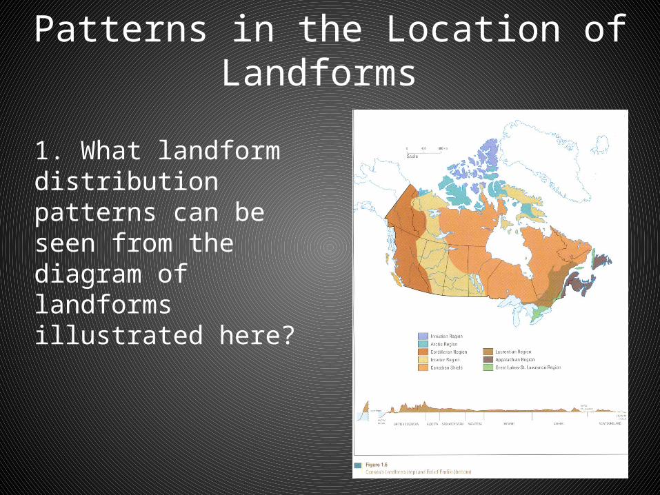
Patterns in the Location of Landforms
1. What landform distribution patterns can be seen from the diagram of landforms illustrated here?
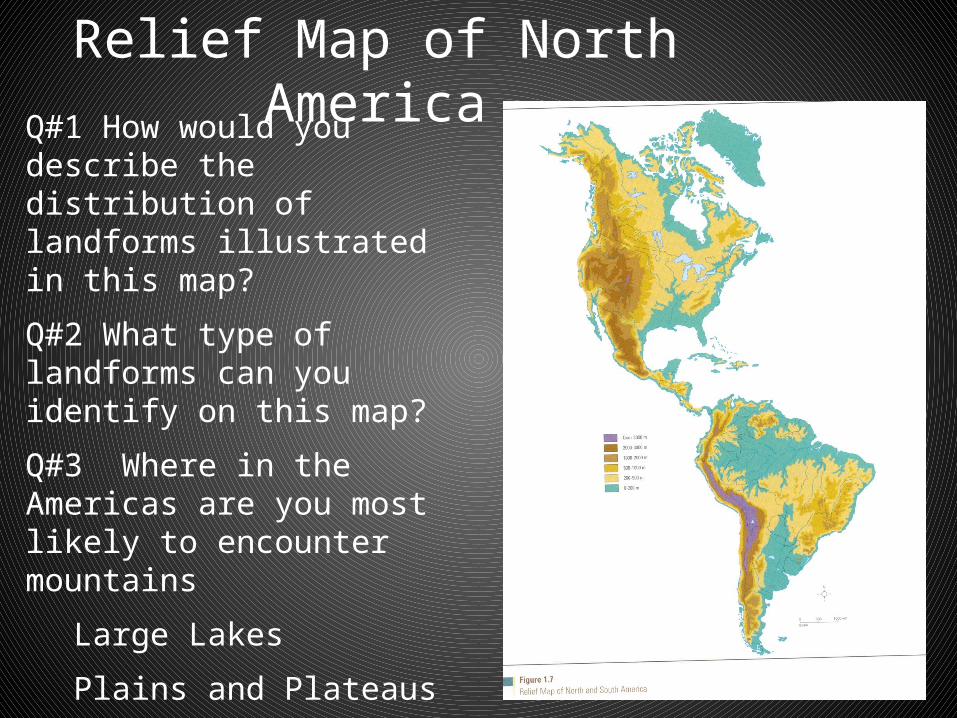
Relief Map of North AmericaQ#1 How would you describe the distribution of landforms illustrated in this map?
Q#2 What type of landforms can you identify on this map?
Q#3 Where in the Americas are you most likely to encounter mountains
Large Lakes
Plains and Plateaus
Large Rivers
River Deltas

How did this Land Distribution Come About?
• The earth’s landforms are never static: That is to say, they are constantly in a state of change due to forces at work that both wear down the land, as well as build up and shape the land.
In Conclusion
• First, we looked at forces that build up and shape landforms….next we will look at forces which wear down the land
Questions-Checking for Understanding
• 1. Explain how compressional forces are caused.• The magma in the asthenosphere flows in such a way as it carries two
floating tectonic plates towards each other. • These are called convection currents
• 2. Explain how tensional forces are created.• The magma in the asthenosphere creates convection currents in such
a way that lava forces itself upwards between two floating tectonic plates forcing them apart. These tectonic forces which move plates apart are referred to as tensional forces.
• 3. Explain how compressional forces create fold mountains.• Folds are caused by the destructive collisions of the tectonic plates.
Different forces and pressures create simple or complex forms
Review Questions• 4. What is the difference between anticline and syncline.
• Anticline is the top part of a fold mountain, while the syncline is the bottom part of the fold
• 5. How do tensional forces create a normal fault?• When rocks fracture or break apart after compression. Rocks maybe pushed
up or dropped down as plates move over or away from each other. Read pp.14-15
• 6. Explain how compressional forces create reverse and overthrust faults?• Reverse: When the two layers around a fault push against each other. There
are compressional forces pushing one block up over the other• Overthrust: When the plate has already undergone folding and, its folded
layers are pushed up and thrust over layers on the fault’s other side
• 7. What causes a volcano to erupt?• Usually found along plate boundaries• Heat is the trigger. Heat is generated because of
friction, pressure and decay of materials• Plates collide• Magma is produced when heat melts rock and
materials beneath the crust in the subduction zone• Magma reaches the surface in the crust or
lithosphere through fractures, vents or craters
• 8. Describe the characteristics of an ash-cinder cone, shield and composite cone.
• Ash-Cinder: Eruptions consist of mainly ash and cinder. Thick, slow flowing, rapidly solidifying lava which creates violent eruptions. Shape is symmetrical. Steep sides and large crater
• Shield: Usually milder eruptions. Little or no ash or cinders. Very thin, liquid lava. Broad, flat cones
• Composite: Undergoes periods of explosive and quiet activity. Ash and cinder mixed with lava. Weak spots may develop on sides with smaller lava flows forming smaller craters. More than one crater
• 9. Describe how the location of a volcano is related to the places where plates meet. Describe situations when there is an exception.
• Where plates meet: Denser plate melts at the subduction zone. Rocks melt to form magma. Pressure increases, magma rises and erupts
• Exception: Plates move over magma hot spots in the lithosphere. Magma bursts through the crust. Forms linear chain of volcanic mountains i.e. Hawaiian Islands
Check for Understanding
– Read pp. 10-11– Do Questions: 9 a), b), & c) and 10 a), & b)– Worksheet 1.6 (Reproducible worksheet)
Answers -Question 9 (Text)
a) Convection currents are created by unequal heat distribution in the asthenosphere. As these currents move through the asthenosphere, they drag with them the rigid parts of the crust immediately above them.
b) Two plates moving towards each other compact or squeeze together the area between the plates, causing compressional forces.
c) Two plates moving apart pull the area between the plates apart, causing tensional forces.
Question 10
a) The South American Plate and the Nazca Plate are colliding along the Peru-Chile Trench. This collision is causing the edge of the South American Plate to bend and buckle upward forming the Andes Mountains. The Nazca Plate is being forced under the South American Plate to create the trench. Similar processes are underway in Central America (Chocos Plate), along the B.C. Coast and in India along the line of the Himalaya’s.
Question 10
b) Iceland is located along the Mid-Atlantic Ridge, where plates are being pushed apart. (We can tell by looking at the legend in the map on page 12). As the plates move apart , volcanic activity brings molten rock up and out of the rift, to flow out on both sides, thereby creating the ridge. These lava flows have created the island of Iceland on top of the Mid-Atlantic Ridge.
Worksheet 1.6
1. Use the key/legend on page 12 to indicate the location of the subduction zones (arrows where plates meet)
2. Self explanatory3. Red triangle=Volcano and Yellow bolt for
earthquake OR V for Volcano and E for Earthquake4. Do question 11 d). 1 is the highest; 5 is lowest5. Does not need to be done! Should know number
5!

Check for Understanding
– Read pp. 13-16– Questions: 14 b), c), 16 and 17
Answers -Question 14
b) Volcanic eruptions vary in violence, depending upon viscosity (thickness) of the magma, chemical composition and the amount of trapped gas in the lava.
Thick lava tends to solidify and plug. When gases build up behind the plug, an explosion may result.
c) Violent eruptions result in thick lava flows and steep-sided volcanic cones normally composed of ash and cinders.
Milder, more frequent eruptions usually result in thin, liquid lava flows and broad, flat cones composed almost entirely of lava. (Shield cones)

Question 16
a) Shade. Use a photocopy of a world map and an atlas to identify mountain ranges
b) Most of these mountain ranges almost are found on the edges, or margins of continents. Most mountain ranges are formed through a combination of volcanic activity, faulting, and folding, all of which occur on the edges of continental plates when they collide or subduct under one another.
Question 17
a) Use a photocopy of a world map and an atlas to identify location of volcanic eruptions
b) Most of these active volcanoes are located in the mountain ranges on the margins of continents. Most mountain chains are formed on the edges of tectonic plates, where plates collide, slide past each other, or are pulled apart, or where one plate is subducted below another.
Case Study -Question 18
Physical evidence of the eruption of Mount Pinatubo– Steam explosions– Ash eruptions– Massive lateral explosions of ash, cinders, & steam– Ash and cinder flows– Extensive ash and cinder eruptions over a period
of several days

Question 19
The Mount Pinatubo disaster affected human activity in the following ways– Forcing the evacuation of nearly 200,000 people– Causing over 300 deaths– Producing ash and cinder falls & flows that damage
crops, destroyed buildings & homes, and blocked transportation routes
– Burying important crops and cropland– Affecting weather patterns around the world– Contributing to the acid rain problem