Embed Size (px)
Citation preview
UNFCCC/CCNUCC
CDM – Executive Board PROJECT DESIGN DOCUMENT FORM
FOR AFFORESTATION AND REFORESTATION PROJECT ACTIVITIES (CDM-AR-PDD) - Version 02
CLEAN DEVELOPMENT MECHANISM PROJECT DESIGN DOCUMENT FORM FOR AFFORESTATION AND REFORESTATION
PROJECT ACTIVITIES (CDM-AR-PDD) Version 04
CONTENTS
A. General description of the proposed A/R CDM project activity B. Duration of the project activity / crediting period C. Application of an approved baseline and monitoring methodology
D. Estimation of ex ante net anthropogenic GHG removals by sinks and estimated amount of net anthropogenic GHG removals by sinks over the chosen crediting period
E. Monitoring plan
F. Environmental impacts of the proposed A/R CDM project activity
G. Socio-economic impacts of the proposed A/R CDM project activity H. Stakeholders’ comments
Annexes Annex 1: Contact information on participants in the proposed A/R CDM project activity Annex 2: Information regarding public funding Annex 3: Baseline information
Annex 4: Monitoring plan
別添資料3
93

UNFCCC/CCNUCC
CDM – Executive Board PROJECT DESIGN DOCUMENT FORM
FOR AFFORESTATION AND REFORESTATION PROJECT ACTIVITIES (CDM-AR-PDD) - Version 02
SECTION A. General description of the proposed A/R CDM project activity: A.1. Title of the proposed A/R CDM project activity: >> Reforesting Bromo Tengger Semeru National Park through CDM Version 1 30 January 2008 A.2. Description of the proposed A/R CDM project activity: >> The purpose of the proposed A/R CDM project activity is to reforest 1200 ha of Bromo Tengger Semeru National Park. Based on Forest Minister Decree No. 278/Kpts-VI/1997, total of the Bromo-Tengger-Semeru National Park is 50,276 ha. The forest is divided into three zone, namely ‘zona inti’ (still in the form of virgin forest), ‘zona rimba’ and ‘zona pemanfaatan’. Many of forest cover in the last two zones have degraded and some of them have changed into grassland, savanna and sand land. There are about 60 villages surrounding the park. According to an old farmer who have been living at Kandangan village since early 1920s, in the proposed location for CDM projects were mainly covered by ‘cemara gunung’ (Casuarina junghuhniana) and managed by Dutch Government. In 1948 after Dutch left Indonesia, the management of the forest was taken over by Jawatan Kehutanan (Forest Agency). Jawatan Kehutanan invited the communities surrounding the forest to produce fire wood and charcoal from the trees. Communities who involved in the activities got payment from the Jawatan Kehutanan. Gradually, the forest cover in these areas decreased. Due to frequent fires the forest could not recover and then change into grassland/savanna. The proposed A/R CDM project activity will reforest the land with Casuarina junghuhniana and Acacia deccurens. The Bromo Tengger Semeru National Park Office will be the project proponent and will reforest the shrubs and savannah land within the national park with Casuarina junghuhniana and Acacia deccurens. Communities are willing to engage in reforesting the degraded land of the national park and managing fire risk. The communities see that the project will reduce risk of flood for the downstream area where their families are living, increase water supply and quality during dry season and also increase their income from the carbon payments. It is clear that the project will contribute to sustainable development. A.3. Project participants: >> Please list project participants and Party(ies) involved and provide contact information in Annex 1. Information shall be indicated using the following tabular format.
Name of Party involved (*) (host) indicates a host Party)
Private and/or public entity(ies) project participants (*)
(as applicable)
Indicate if the Party involved wishes to be
considered as a project participant (Yes/No)
Indonesia* • Bromo Tengger Semeru National Park Yes
Indonesia • Kutai Timber Indonesia Yes
94

UNFCCC/CCNUCC
CDM – Executive Board PROJECT DESIGN DOCUMENT FORM
FOR AFFORESTATION AND REFORESTATION PROJECT ACTIVITIES (CDM-AR-PDD) - Version 02
Japan* • Sumitomo Forestry Yes (*) In accordance with the CDM A/R modalities and procedures, at the time of making the CDM-AR-PDD public at the stage of validation, a Party involved may or may not have provided its approval. At the time of requesting registration, the approval by the Party(ies) involved is required. Note: When the CDM-AR-PDD is prepared to support a proposed new baseline and monitoring methodology (form CDM-AR-NM), at least the host Party(ies) and any known project participant (e.g. those proposing a new methodology) shall be identified.
A.4. Description of location and boundaries of the A/R CDM project activity: A.4.1. Location of the proposed A/R CDM project activity: A.4.1.1. Host Party(ies): >> Indonesia A.4.1.2. Region/State/Province etc.: >> East Java Province A.4.1.3. City/Town/Community etc: >> The park lies in four administrative areas (West-Malang district; East-Probolingo district; North-Pasuruan District and South-Lumajang District (See Figure 1).
Bromo Tengger Semeru National
Park
Figure 1. Location of Bromo Tengger Semeru National Park in East Java
別添資料3
95

UNFCCC/CCNUCC
CDM – Executive Board PROJECT DESIGN DOCUMENT FORM
FOR AFFORESTATION AND REFORESTATION PROJECT ACTIVITIES (CDM-AR-PDD) - Version 02
A.4.2 Detailed geographic delineation of the project boundary, including information allowing the unique identification(s) of the proposed A/R CDM project activity: >> The total area for the project is about 1168 ha where about 752 ha covered by savanna and 416 by bush/shrubs. The proposed project location is located at elevation of between 1200-2500 m a.s.l. The geographical position of the proposed project area is given in Table 1 and Figures 2 and 3.
Table 1. Eligible land and geographical position of the lands
Land use (1989-2006) Longitude Latitude Area (ha) Bush/Srubs - Bush/Shrubs 112.847 112.935 -7.925 -7.974 179Bush/Srubs – Savana 112.847 112.935 -7.924 -7.975 176Savana - Bush/Srubs 112.836 112.937 -7.924 -7.977 236Savana – Savana 112.835 112.937 -7.924 -7.977 576TOTAL 1168
Figure 2. Eligible land and the change of the land cover between 1989 and 2006
96

UNFCCC/CCNUCC
CDM – Executive Board PROJECT DESIGN DOCUMENT FORM
FOR AFFORESTATION AND REFORESTATION PROJECT ACTIVITIES (CDM-AR-PDD) - Version 02
Figure 3. Eligible land for A/R CDM A.5. Technical description of the A/R CDM project activity: A.5.1. Description of the present environmental conditions of the area planned for the proposed A/R CDM project activity, including a concise description of climate, hydrology, soils, ecosystems (including land use): >>
Geographically, the Bromo Tengger Semeru National Park lies between 7°51’ - 8°11’ S, and 112°47’-113°10’E with elevation of between 750 -3.676 m. a.s.l. Most of the area is undulating and hilly with slopes of 25-40%; most of the remainder is mountainous with slopes of more than 40% (see Figure 4).
Types of ecosystem of the Bromo Tengger Semeru National Park consist of sub-montana, montana and sub-alphin covered by big trees with age of more than 100 years such as ‘cemara gunung’ (Casuarina sp), jamuju (Dacrycarpus imbricatus), eidelweis (Anaphalis javanica), and various kind of orchids and endemic grasses such as Styphelia pungieus. Figure 4. Land cover and topography of the
proposed project site
別添資料3
97

UNFCCC/CCNUCC
CDM – Executive Board PROJECT DESIGN DOCUMENT FORM
FOR AFFORESTATION AND REFORESTATION PROJECT ACTIVITIES (CDM-AR-PDD) - Version 02
The rainfall pattern is unimodal with one peak occurs around January. Months with rainfall of less than 100 mm normally occurs between June-September (Figure 5). The maximum temperature is about 22.° C and the minimum temperature around 5° C. The relative humidity during the day is quite dry about 43% during the day and during the night about 94 %.
050
100150200250300350400
1 2 3 4 5 6 7 8 9 10 11 12Month
Rai
nfal
l (m
m)
Figure 5. Mean Regional Rainfall at Bromo Tengger Semeru National Park Fires occur almost every year in this Park. The period with high fire risk is from July-September (dry season). Area affected by fires in 2000-2005 is given in Table 1. Main cause of fires comes from communities who made fires for heaters during their travel to jungle for collecting mushroom and making charcoal. People who are looking for mushroom in forests normally travel up to 7 days. In the night they normally make fires. Table 1. Number of fires and burnt area due to fire in the National Park
Year Number of fires (times) Area burnt (ha) 2000 20 237 2001 26 137 2002 69 1039 2003 11 71 2004 53 1002 2005 26 335
Other factor causing the tree growth at the Park is sulfuric gas released by the Mount Bromo. Active volcano normally released water vapor containing CO2, CO, SO2, SO3, H2S, and Cl. If concentration of some of these gas increased to a certain level can damage trees. For example, SO2 (sulfuric gas), if its concetration reach 0.14 ppm and trees were exposed to this condition for about 24 hours, the trees would show chlorosis. The leaves of the tress will turn to yellow and dry (Shurtleff, dan Averre, 1997). However, after sometime the damaged trees can recover again. The local people call this phenomena as ‘bun upas’ (poison dew). The water favor that carry this gas condense on the leaves of trees or crops, particularly in the morning. According to community, this phenomena occurs once in 2-3 years and areas being affected not very large depending on the volume of the gas and wind. ‘Cemara gunung’ (Casuarina junghuhniana) is quite sensitive to this phenomena but Acacia ducurens is quite resistant. A.5.2. Description of the presence, if any, of rare or endangered species and their habitats:
98

UNFCCC/CCNUCC
CDM – Executive Board PROJECT DESIGN DOCUMENT FORM
FOR AFFORESTATION AND REFORESTATION PROJECT ACTIVITIES (CDM-AR-PDD) - Version 02
>> There are about 137 bird and 22 mammal and 4 reptile species in the park. In the park also found a number of rare and endangered species such as luwak (Pardofelis marmorata), rusa (Cervus timorensis ), kera ekor panjang (Macaca fascicularis), kijang (Muntiacus muntjak ), ayam hutan merah (Gallus gallus), macan tutul (Panthera pardus ), ajag (Cuon alpinus ); dan berbagai jenis burung seperti alap-alap burung (Accipiter virgatus ), rangkong (Buceros rhinoceros silvestris), elang ular bido (Spilornis cheela bido), srigunting hitam (Dicrurus macrocercus), elang bondol (Haliastur indus), and belibis living in lakes Ranu Pani, Ranu Regulo, and Ranu Kumbolo. A.5.3. Species and varieties selected for the proposed A/R CDM project activity: >> The proposed project sites will be planted with ‘Cemara laut’ (Casuarina equisetivolia) and Acacia deccurens A.5.4. Technology to be employed by the proposed A/R CDM project activity: >> The technology to be employed by the AR CDM project activity is similar to practices currently used under GERHAN program, a special 5-year program for land rehabilitation. Fraction of area being planted with Casuarina equisetivolia and Acacia deccurens is about 70% and 30% respectively. Four weeks before the anticipated arrival of the first rains, herbicide will be applied to the grass. Two weeks after the first application herbicide may be applied again. Tree spacing is about 4x4 m. At each tree planting position the soil will be tilled to a depth and width of 25-50 cm. This process will enhance seedling growth and survival. To minimize grass regrowth, planting positions will be prepared just prior to the arrival of the rainy season (around October). All tree species will be planted immediately after the first heavy rain. During dry season, fire will be the main risk. Therefore, successful of the project will depend very much on how to manage the fire effectively. To overcome and minimize risk of fire, Bromo-Tengger-Semeru National Park cooperated with PT. Kutai Timber Indonesia has designed fire management system. Under this system, increased awareness, improved fire monitoring, and adequate equipments will be applied to the park. Members of fire management are divided in to three fire teams and one back up team. Each team consist of 19 members and 1 leader. There will be another team which patrol around forest everyday, intensively during dry season. Members of fireman can be recruited from communities which lived in villages of surrounding forest. Equipments needed for the system include trucks, water tanks, water pumps, fire hoses, handy-talky, mattocks, chopping knives, and spades. Indicator of fire warning will be signed with flag colour disseminated in all park location, mainly in sensitive area. The flag colour will represent three level of fire warning: level I (yellow), II (orange) and III (red). In case no rainy days during 1 week respectively, fire warning condition is on level I. Level II and III warning will be applied when no rainy days during 2 and 3 weeks respectively. Higher awareness (more patrols and security) will be implemented in level II and III or in case humidity is below 30%. Therefore, rainfall and humidity measurement in National Park should be done continuously. Improved fire management system should be established by involving active participation of local community. At present the Park has conducted community development program such as training for
別添資料3
99
UNFCCC/CCNUCC
CDM – Executive Board PROJECT DESIGN DOCUMENT FORM
FOR AFFORESTATION AND REFORESTATION PROJECT ACTIVITIES (CDM-AR-PDD) - Version 02
community in managing fires and public awareness. This existing program can be continued and expanded and be part of the Fire Management System. Every farmer group who have been committed to involve in the project is given a responsibility to manage and protect a certain area from fires and incentive is given based on the achievement of the group (e.g. based on survival rate of the trees up to year 4 or 5). The forms of incentive can be in the form of development programs for the village and/or financial. In addition, transportation infrastructure in the Park will be improved to allow effective fire controlling process. A.5.5. Transfer of technology/know-how,if applicable: >> Not applicable A.5.6. Proposed measures to be implemented to minimize potential leakage: >> As the project will not displace any activities and also forest will not be harvested, there will be no potential leakage. Leakage will be accounted as emissions from use of fossil fuel in transportation to the project area of staff, seedlings, and other materials attributable to implementation of the proposed A/R project activity and these emissions are expected to be minor. A.6. Description of legal title to the land, current land tenure and rights to tCERs / lCERs issued for the proposed A/R CDM project activity: >> MOF Regulation Number 14/2004 states that state lands are eligible to be used for AR CDM projects and provides rights of access to the sequestered carbon. A.7. Assessment of the eligibility of the land: >> The assessment of land eligibility was done using satellite assessment and information from communities who have been living surrounding the park since 1980s. Satellite images used in the analysis is LANDSAT 5 1989 (acquisition date 1989-03-28) and the ASTER 2006 (acquisition date 2006-09-03). The process of the analysis is shown in Figure 6 and the results in Figure 7.
100

UNFCCC/CCNUCC
CDM – Executive Board PROJECT DESIGN DOCUMENT FORM
FOR AFFORESTATION AND REFORESTATION PROJECT ACTIVITIES (CDM-AR-PDD) - Version 02
Figure 6. Process for assessing land eligibility for CDM.
Satelite Image
Landuse Clasification
Ground Check
ExistingLanduse Map
Landuse Reclasification
Kyoto LandMap
Satelite Image
Landuse Clasification
Ground Check
ExistingLanduse Map
Landuse Reclasification
Kyoto LandMap
OverlayingProcces
Data before 1990 Recent Data 2006
Choose the critical area (Shrubs, bush, bareland, etc.). Consider the government plan on the proposed area
Choose the critical area (Shrubs, bush, bareland, etc.).Consider the government plan on the proposed area
Eligible land
Geometric correction Radiometric correction
Geometric correction Radiometric correction
Following Ministry of Forestry Regulation Number 14/2004 and its Addendum that forest in Indonesia under the KP is defined as land having a minimum area of 0.25 ha, a minimum tree crown cover of 30%, and three that have minimum height of 5 m, the lands which do not meet this definition are bush/shrubs and savanna. Thus lands eligible for CDM are lands which are bush/shrubs or savanna before 1990 and now are still bush/shrubs or savanna (see Figure 2).
別添資料3
101
UNFCCC/CCNUCC
CDM – Executive Board PROJECT DESIGN DOCUMENT FORM
FOR AFFORESTATION AND REFORESTATION PROJECT ACTIVITIES (CDM-AR-PDD) - Version 02
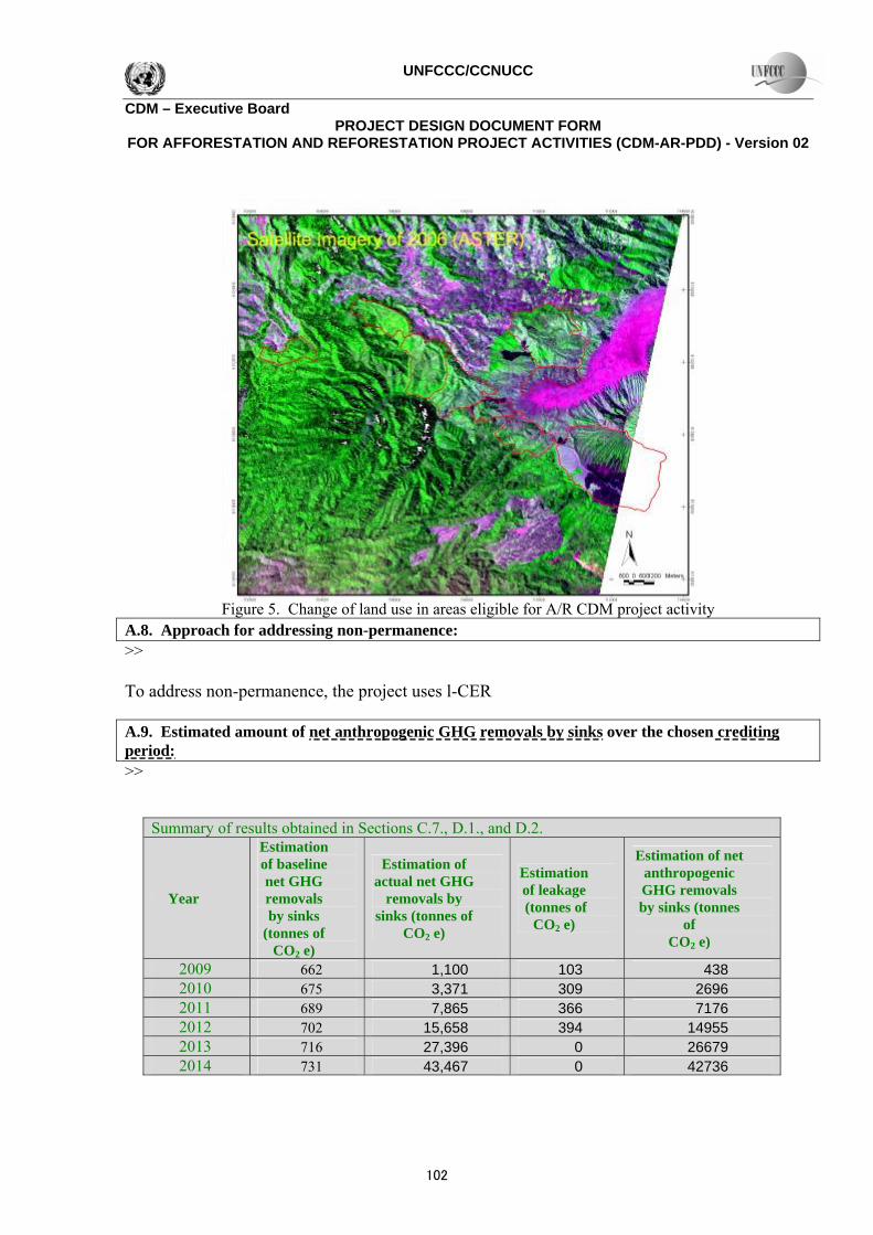
Figure 5. Change of land use in areas eligible for A/R CDM project activity A.8. Approach for addressing non-permanence: >> To address non-permanence, the project uses l-CER A.9. Estimated amount of net anthropogenic GHG removals by sinks over the chosen crediting period: >>
Summary of results obtained in Sections C.7., D.1., and D.2.
Year
Estimation of baseline net GHG removals by sinks
(tonnes of CO2 e)
Estimation of actual net GHG
removals by sinks (tonnes of
CO2 e)
Estimation of leakage (tonnes of
CO2 e)
Estimation of net anthropogenic GHG removals by sinks (tonnes
of CO2 e)
2009 662 1,100 103 438 2010 675 3,371 309 2696 2011 689 7,865 366 7176 2012 702 15,658 394 14955 2013 716 27,396 0 26679 2014 731 43,467 0 42736
102

UNFCCC/CCNUCC
CDM – Executive Board PROJECT DESIGN DOCUMENT FORM
FOR AFFORESTATION AND REFORESTATION PROJECT ACTIVITIES (CDM-AR-PDD) - Version 02
2015 745 63,693 0 62948 2016 760 88,511 0 87751 2017 775 117,852 0 117077 2018 791 153,103 0 152312 2019 807 183,022 0 182216 2020 823 215,921 0 215098 2021 839 251,570 0 250731 2022 856 289,270 0 288414 2023 873 340,865 0 339991 2024 891 395,702 0 394811 2025 909 452,949 0 452040 2026 927 512,594 0 511667 2027 945 574,327 0 573382 2028 964 526,096 0 525131
Total (tonnes of CO2 e)
964 526,096 394 525131
A.10. Public funding of the proposed A/R CDM project activity: >> No public fund is expected to be used SECTION B. Duration of the project activity / crediting period B.1 Starting date of the proposed A/R CDM project activity and of the crediting period: >> November 2008 B. 2. Expected operational lifetime of the proposed A/R CDM project activity: >> 60 years B.3 Choice of crediting period: B.3.1. Length of the renewable crediting period (in years and months), if selected: >> 20 years, 240 months B.3.2. Length of the fixed crediting period (in years and months), if selected: >>
別添資料3
103
UNFCCC/CCNUCC
CDM – Executive Board PROJECT DESIGN DOCUMENT FORM
FOR AFFORESTATION AND REFORESTATION PROJECT ACTIVITIES (CDM-AR-PDD) - Version 02
Not applicable SECTION C. Application of an approved baseline and monitoring methodology C.1. Title and reference of the approved baseline and monitoring methodology applied to the proposed A/R CDM project activity: >> The proposed project will apply AR-AM0001 Version 02: Reforestation of degraded land. C.2. Assessment of the applicability of the selected approved methodology to the proposed A/R CDM project activity and justification of the choice of the methodology: >> The AR-AM0001 Version 02 is applicable for the proposed project as all the conditions specified under the methodology are met. The area being proposed the project is designated as National Park in which by regulation it is not allowed to be converted to any other land use except forestry. The communities living surrounding the Park have recognized the area as National Park and therefore no agriculture activity take place in the area since long time back (over 20 years). Thus the project activity will not lead to a shift of pre-project activities to outside of the project boundary. Human-induced activities leading to loss of carbon stocks (such as harvesting, selective logging, fuel gathering, removal of litter, or removal of dead wood) will also not be allowed on lands within the project boundary. The proposed project has been degraded for long time and due to repeated fires the land and high soil erosion, the land is difficult to revert back to forest without human intervention. The biomass of savanna within the project boundary at the start of the project is at steady-state, and unmanaged shrubs and savanna will continue as unmanaged shrubs and savanna under the absence of the proposed A/R CDM project activity. Therefore the most plausible baseline scenario is that ‘Changes in carbon stocks in the pools within the project boundary from the most likely land use at the time the project starts’. In addition, carbon stocks in the dead organic matter pools (litter and dead wood) are expected to be smaller in shrubs and savanna relative to the project scenario and therefore accounting of these pools can be conservatively neglected. As the land is undulating, the preparation of the site for planting will be done carefully to avoid levels of soil disturbance or soil erosion sufficient to significantly2 reduce the soil carbon pool over the project lifetime. The land within the project boundary will be reforested by direct planting and/or seeding of trees. Flood irrigation or drainage of primarily saturated soils will not be possible and therefore will not be applied. Thus non-CO2 greenhouse gas emissions from these activities can be neglected. C.3. Assessment of the selected carbon pools and emission sources of the approved methodology to the proposed CDM project activity: >> Selected carbon pools and emission sources of the proposed project are given in the Table 3 and 4.
104
UNFCCC/CCNUCC
CDM – Executive Board PROJECT DESIGN DOCUMENT FORM
FOR AFFORESTATION AND REFORESTATION PROJECT ACTIVITIES (CDM-AR-PDD) - Version 02
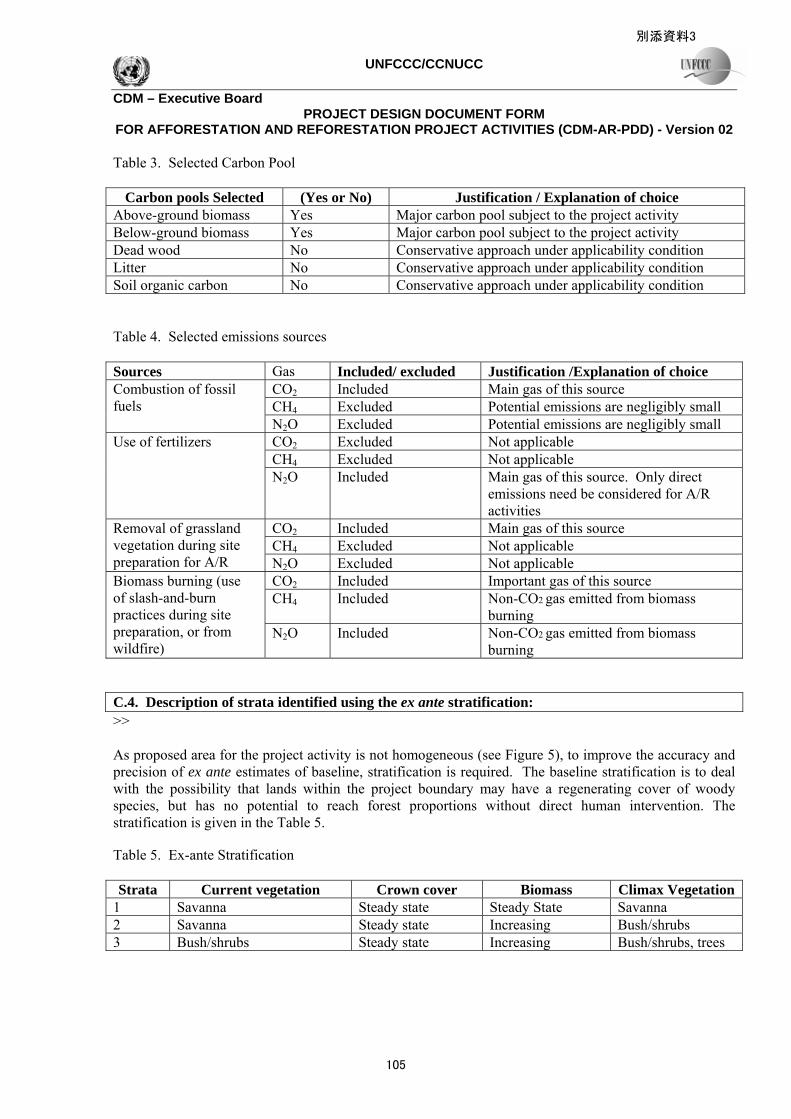
Table 3. Selected Carbon Pool
Carbon pools Selected (Yes or No) Justification / Explanation of choice Above-ground biomass Yes Major carbon pool subject to the project activity Below-ground biomass Yes Major carbon pool subject to the project activity Dead wood No Conservative approach under applicability condition Litter No Conservative approach under applicability condition Soil organic carbon No Conservative approach under applicability condition Table 4. Selected emissions sources Sources Gas Included/ excluded Justification /Explanation of choice
CO2 Included Main gas of this source CH4 Excluded Potential emissions are negligibly small
Combustion of fossil fuels
N2O Excluded Potential emissions are negligibly small CO2 Excluded Not applicable CH4 Excluded Not applicable
Use of fertilizers
N2O Included Main gas of this source. Only direct emissions need be considered for A/R activities
CO2 Included Main gas of this source CH4 Excluded Not applicable
Removal of grassland vegetation during site preparation for A/R N2O Excluded Not applicable
CO2 Included Important gas of this source CH4 Included Non-CO2 gas emitted from biomass
burning
Biomass burning (use of slash-and-burn practices during site preparation, or from wildfire)
N2O Included Non-CO2 gas emitted from biomass burning
C.4. Description of strata identified using the ex ante stratification: >> As proposed area for the project activity is not homogeneous (see Figure 5), to improve the accuracy and precision of ex ante estimates of baseline, stratification is required. The baseline stratification is to deal with the possibility that lands within the project boundary may have a regenerating cover of woody species, but has no potential to reach forest proportions without direct human intervention. The stratification is given in the Table 5. Table 5. Ex-ante Stratification Strata Current vegetation Crown cover Biomass Climax Vegetation
1 Savanna Steady state Steady State Savanna 2 Savanna Steady state Increasing Bush/shrubs 3 Bush/shrubs Steady state Increasing Bush/shrubs, trees
別添資料3
105
UNFCCC/CCNUCC
CDM – Executive Board PROJECT DESIGN DOCUMENT FORM
FOR AFFORESTATION AND REFORESTATION PROJECT ACTIVITIES (CDM-AR-PDD) - Version 02
C.5. Identification of the baseline scenario: >>
C.5.1. Description of the application of the procedure to identify the most plausible baseline scenario (separately for each stratum defined in C.4.): >> Table 6. Application of procedure to identify baseline scenario Stratum Application of the procedure 1 Biomass stocks in savanna at the time the project commences are measured in a number of
temporary sample plots 2 Estimation is based on biomass increment from savanna to bush/shrubs. The biomass stock in
bush/shrubs is measured in a number of temporary plots. The biomass increment is estimated using the following formula (Mean Weight of Bush/Srubs Biomass- Mean weight of Savanna Biomass)/(2006-1989)
3 Estimation is based on biomass increment from less dense bush/shrubs to dense bush/shrubs. The biomass stock in bush/shrubs is measured in a number of temporary plots. The biomass increment is estimated using the following formula (Mean of less dense Bush/Srubs Biomass-Mean of dense Bush/Srubs Biomass)/(2006-1989)
C.5.2. Description of the identified baseline scenario (separately for each stratum defined in Section C.4.): >> Table 7. Description of the identified baseline scenario Stratum Description (Present condition of land and location) 1 Lands in the step slope (over 40%) covered by savanna 2 Lands in the slope of less than 40% covered by savanna 3 All lands covered by bush/shrubs C.6. Assessment and demonstration of additionality: >> In the absence of the proposed project activity limited rehabilitation/reforestation (tree establishment) will occur, and net anthropogenic GHG removals by sinks will be insignificant. The following situation indicates that this statement is true beyond reasonable doubt. National and sectoral programs on reforestation exist. However, the funding base is limited and area of degraded land is extensive. The existing reforestation programs are insufficient to address the scale of reforestation required. According to the Park Manager, area of the Park being reforested through the GERHAN program was about 707 ha with survival rate of between 40% and 55%. In addition, level of the land degradation is quite severe or very critical. Under current policy, the available funding will be prioritized to be used for reforesting the rehabilitation zone. In the next 10 years, it was targeted that total area of rehabilitation zone being reforested was about 3000 ha. However, as the GERHAN program will terminate in 2007 and the national funding for reforestation is decreasing, the Park Manager stated that reforestation of such lands
106
UNFCCC/CCNUCC
CDM – Executive Board PROJECT DESIGN DOCUMENT FORM
FOR AFFORESTATION AND REFORESTATION PROJECT ACTIVITIES (CDM-AR-PDD) - Version 02
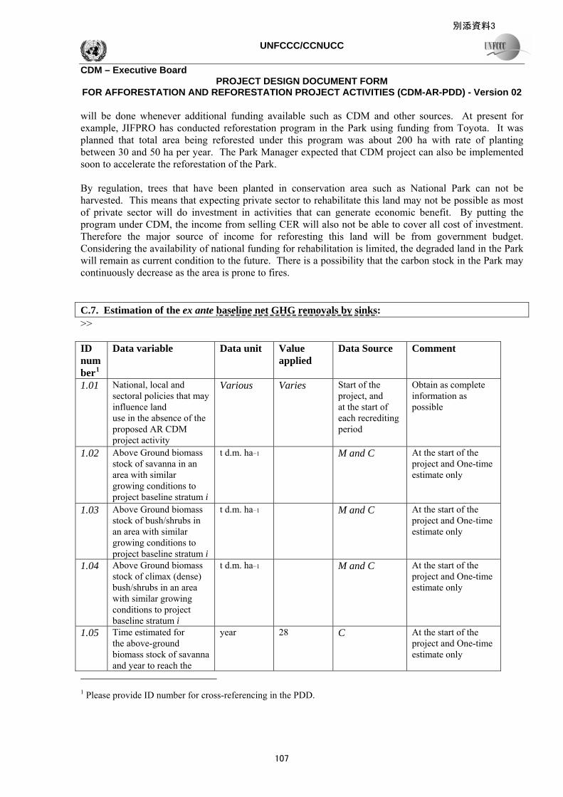
will be done whenever additional funding available such as CDM and other sources. At present for example, JIFPRO has conducted reforestation program in the Park using funding from Toyota. It was planned that total area being reforested under this program was about 200 ha with rate of planting between 30 and 50 ha per year. The Park Manager expected that CDM project can also be implemented soon to accelerate the reforestation of the Park. By regulation, trees that have been planted in conservation area such as National Park can not be harvested. This means that expecting private sector to rehabilitate this land may not be possible as most of private sector will do investment in activities that can generate economic benefit. By putting the program under CDM, the income from selling CER will also not be able to cover all cost of investment. Therefore the major source of income for reforesting this land will be from government budget. Considering the availability of national funding for rehabilitation is limited, the degraded land in the Park will remain as current condition to the future. There is a possibility that the carbon stock in the Park may continuously decrease as the area is prone to fires. C.7. Estimation of the ex ante baseline net GHG removals by sinks: >> ID number1
Data variable Data unit Value applied
Data Source Comment
1.01 National, local and sectoral policies that may influence land use in the absence of the proposed AR CDM project activity
Various Varies Start of the project, and at the start of each recrediting period
Obtain as complete information as possible
1.02 Above Ground biomass stock of savanna in an area with similar growing conditions to project baseline stratum i
t d.m. ha−1
M and C At the start of the project and One-time estimate only
1.03 Above Ground biomass stock of bush/shrubs in an area with similar growing conditions to project baseline stratum i
t d.m. ha−1
M and C At the start of the project and One-time estimate only
1.04 Above Ground biomass stock of climax (dense) bush/shrubs in an area with similar growing conditions to project baseline stratum i
t d.m. ha−1
M and C At the start of the project and One-time estimate only
1.05 Time estimated for the above-ground biomass stock of savanna and year to reach the
year 28 C At the start of the project and One-time estimate only
1 Please provide ID number for cross-referencing in the PDD.
別添資料3
107

UNFCCC/CCNUCC
CDM – Executive Board PROJECT DESIGN DOCUMENT FORM
FOR AFFORESTATION AND REFORESTATION PROJECT ACTIVITIES (CDM-AR-PDD) - Version 02
bush/shrubs above-ground biomass stock
1.06 Time estimated for the above-ground biomass stock of less dense bush/shrubs to reach dense bush/shrubs above-ground biomass stock
Year 28 C At the start of the project and One-time estimate only
Please present final results of your calculations using the following tabular format.
Year Baseline net GHG removals by sinks in tonnes of CO2 e
2009 662 2010 675 2011 689 2012 702 2013 716 2014 731 2015 745 2016 760 2017 775 2018 791 2019 807 2020 823 2021 839 2022 856 2023 873 2024 891 2025 909 2026 927 2027 945 2028 964
Total estimated baseline net GHG removals by sinks (tonnes of CO2 e)
964
Total number of crediting years 20 Annual average over the crediting period of estimated baseline net GHG removals by sinks (tonnes of CO2 e)
48
C.8. Date of completion of the baseline study and the name of person(s)/entity(ies) determining the baseline: >>
108

UNFCCC/CCNUCC
CDM – Executive Board PROJECT DESIGN DOCUMENT FORM
FOR AFFORESTATION AND REFORESTATION PROJECT ACTIVITIES (CDM-AR-PDD) - Version 02
SECTION D. Estimation of ex ante actual net GHG removals by sinks, leakage and estimated amount of net anthropogenic GHG removals by sinks over the chosen crediting period D.1. Estimate of the ex ante actual net GHG removals by sinks: >>
Please present final results of your calculations using the following tabular format. Year Actual net GHG removals by sinks in tonnes
of CO2 e 2009 1,100 2010 3,371 2011 7,865 2012 15,658 2013 27,396 2014 43,467 2015 63,693 2016 88,511 2017 117,852 2018 153,103 2019 183,022 2020 215,921 2021 251,570 2022 289,270 2023 340,865 2024 395,702 2025 452,949 2026 512,594 2027 574,327 2028 526,096
Total estimated actual net GHG removals by sinks (tonnes of CO2 e)
526,096
Total number of crediting years 20 Annual average over the crediting period of estimated actual net GHG removals by sinks (tonnes of CO2 e)
23,305
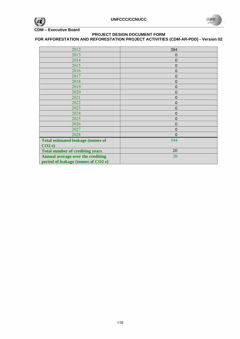
D.2. Estimate of the ex ante leakage: >>
Please present final results of your calculations using the following tabular format. Year Leakage in tonnes of CO2 e 2009 103 2010 309 2011 366
別添資料3
109
UNFCCC/CCNUCC
CDM – Executive Board PROJECT DESIGN DOCUMENT FORM
FOR AFFORESTATION AND REFORESTATION PROJECT ACTIVITIES (CDM-AR-PDD) - Version 02
2012 394 2013 0 2014 0 2015 0 2016 0 2017 0 2018 0 2019 0 2020 0 2021 0 2022 0 2023 0 2024 0 2025 0 2026 0 2027 0 2028 0
Total estimated leakage (tonnes of CO2 e)
394
Total number of crediting years 20 Annual average over the crediting period of leakage (tonnes of CO2 e)
20
110

UNFCCC/CCNUCC
CDM – Executive Board PROJECT DESIGN DOCUMENT FORM
FOR AFFORESTATION AND REFORESTATION PROJECT ACTIVITIES (CDM-AR-PDD) - Version 02
SECTION E. Monitoring plan E.1. Monitoring of the project implementation: >>
E.1.1. Monitoring of forest establishment and management: >> ID number2
Data variable
Data unit
Measured (m), calculated (c) estimated (e) or default (d)3
Recording frequency
Number of data points / Other measure of number of collected data.
Comment
2.01 Location of the areas where the project activity has been implemented
Lat-long
(m) 5 years 100% GPS can be used for field survey (1).
2.02 Ai – Size of the areas where the project activity has been implemented for each strata
Ha (m) 5 years 100% GPS can be used for field survey (2).
2.03 Location of the permanent sample plots
Lat-long
Defined 5 years 100% Plot location is registered with a GPS and marked on the map (3).
2.04 Survival rates
% (m) The 1st two years
100% GPS can be used for field survey (2).
2 Please provide ID number for cross-referencing in the PDD. 3 Please provide full reference to data source.
別添資料3
111

UNFCCC/CCNUCC
CDM – Executive Board PROJECT DESIGN DOCUMENT FORM
FOR AFFORESTATION AND REFORESTATION PROJECT ACTIVITIES (CDM-AR-PDD) - Version 02
E.1.2. If required by the selected approved methodology, describe or provide reference to, SOPs and quality control/quality assurance (QA/QC) procedures applied. >> NOT REQUIRED E.2. Sampling design and stratification >> Stratification for project removals by sinks will in general be the same as described in section C4, that is, based on important variations in growth rate due to variation in tree species, age, stocking, slope, and site class. Stratification should be reviewed once sampled biomass data become available, and adjusted if necessary to account for differences between planned and actual forest establishment and management, or unexpected disturbances, or merging of strata where changes in biomass stocks are similar. The methodology uses permanent sample plots to monitor carbon stock changes in living biomass pools, with the number of plots needed in each stratum based on achieving a targeted precision level in estimated biomass of ± 10% of the mean at a 95% confidence level. E.3. Monitoring of the baseline net GHG removals by sinks, if required by the selected approved methodology: >> ID number4
Data variable
Data unit
Measured (m), calculated (c) estimated (e) or default (d)5
Recording frequency
Number of sample plots at which the data will be monitored
Comment
4.01 National, local and sectoral policies that may influence land use in the absence of the activity proposed AR CDM project
Various – Start of the project, and at the start of crediting period each re-
– Obtain as complete information as possible
4.02 Natural and anthropogeni
Various – Start of the project, and
– Obtain as complete information as possible
4 Please provide ID number for cross-referencing in the PDD. 5 Please provide full reference to data source.
112

UNFCCC/CCNUCC
CDM – Executive Board PROJECT DESIGN DOCUMENT FORM
FOR AFFORESTATION AND REFORESTATION PROJECT ACTIVITIES (CDM-AR-PDD) - Version 02
c factors influencing land use, land cover and natural regeneration
at the start of each re-crediting period
4.03 Non-CDM forestry baseline stratum
Map or digital dataset
– Start of the project, and at the start of each re-crediting period
Entire stratum
Re-evaluate stratification scheme used to determine A/R in the baseline scenario. Use data from publications; national or regional resource mapping or forest inventory agencies; local government and resource management agencies; or landholder interviews. Typically better than 1:50,000 scale maps required, or 30 m or better ground resolution imagery
4.04 PFRnon-CDM — The average annual non-CDM baseline proportional forestry rate (constant during a crediting period)
ha ha-1
yr-1 M Start of the
project, and at the start of each re-crediting period
Entire stratum
4.05 BAB,C,i, jsavanna — Climax above ground biomass stock of savanna j, in an area with similar growing conditions to project baseline stratum i
t d.m. ha−1
M, or C At the start of the project
One-time estimate only
BAB,C,i, jshrubs — Climax above ground biomass stock of shrubs j, in
t d.m. ha−1
M, or C At the start of the project
One-time estimate only
別添資料3
113
UNFCCC/CCNUCC
CDM – Executive Board PROJECT DESIGN DOCUMENT FORM
FOR AFFORESTATION AND REFORESTATION PROJECT ACTIVITIES (CDM-AR-PDD) - Version 02
an area with similar growing conditions to project baseline stratum i
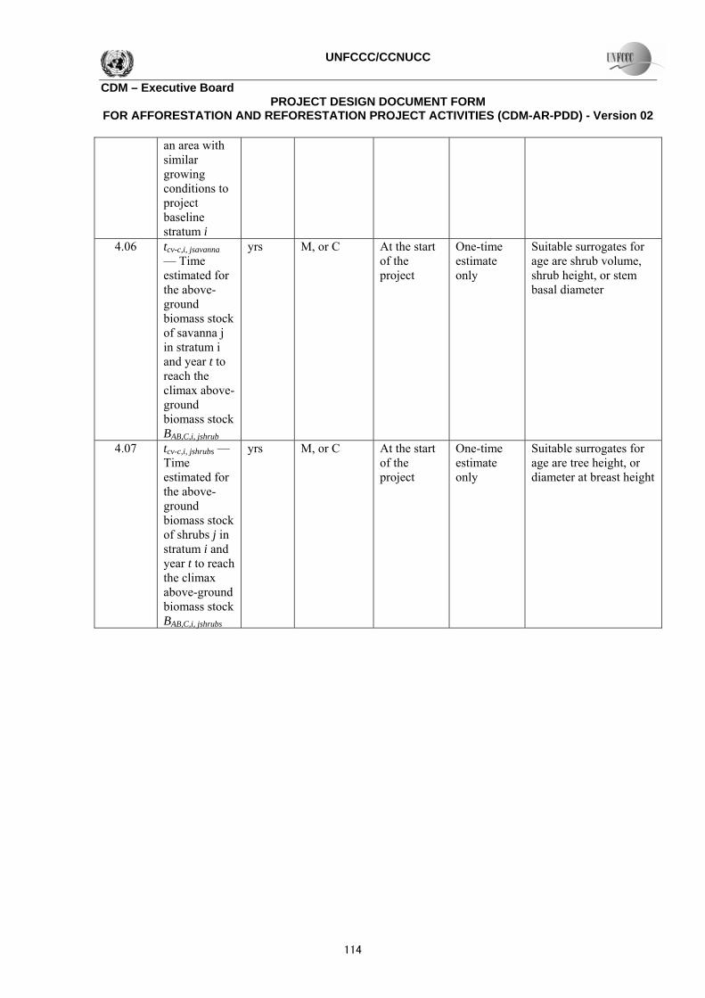
4.06 tcv-c,i, jsavanna — Time estimated for the above-ground biomass stock of savanna j in stratum i and year t to reach the climax above-ground biomass stock BAB,C,i, jshrub
yrs M, or C At the start of the project
One-time estimate only
Suitable surrogates for age are shrub volume, shrub height, or stem basal diameter
4.07 tcv-c,i, jshrubs — Time estimated for the above-ground biomass stock of shrubs j in stratum i and year t to reach the climax above-ground biomass stock BAB,C,i, jshrubs
yrs M, or C At the start of the project
One-time estimate only
Suitable surrogates for age are tree height, or diameter at breast height
114

UNFCCC/CCNUCC
CDM – Executive Board PROJECT DESIGN DOCUMENT FORM
FOR AFFORESTATION AND REFORESTATION PROJECT ACTIVITIES (CDM-AR-PDD) - Version 02
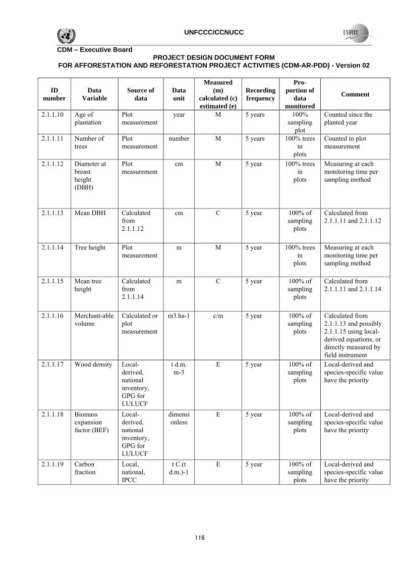
E.4. Monitoring of the actual net GHG removals by sinks: >> E.4.1. Data to be collected in order to monitor the verifiable changes in carbon stock in the carbon pools within the project boundary resulting from the proposed A/R CDM project activity: >>
ID number
Data Variable
Source of data
Data unit
Measured (m)
calculated (c) estimated (e)
Recording frequency
Pro-portion of
data monitored
Comment
2.1.1.01 Stratum ID Stratification map
Alpha numeric
Before the start of the project
100% Each stratum has a particular combination of soil type, climate, and possibly tree species
2.1.1.02 Stratum ID Stratification map
Alpha numeric
Before the start of the project
100% Each sub-stratum has a particular year to be planted under each stratum
2.1.1.03 Confidence level
% Before the start of the project
100% For the purpose of QA/QC and measuring and monitoring precision control
2.1.1.04 Precision level % Before the start of the project
100% For the purpose of QA/QC and measuring and monitoring precision control
2.1.1.05 Standard deviation of each stratum
E Before the start of the project
100% Used for estimating numbers of sample plots of each stratum and sub-stratum
2.1.1.06 Number of sample plots
C Before the start of the project
100% For each stratum and sub-stratum, calculated from 2.1.1.03-2.1.1.05 using equation (1)-(2)
2.1.1.07 Sample plot ID
Project and plot map
Alpha numeric
Before the start of the project
100% Numeric series ID will be assigned to each permanent sample plot
2.1.1.08 Plot location Project and plot map and GPS locating
M 5 years 100% Using GPS to locate before start of the project and at time of each field measurement
2.1.1.09 Tree species Project design map
5 years 100% Arranged in CDM-AR-PDD
別添資料3
115
UNFCCC/CCNUCC
CDM – Executive Board PROJECT DESIGN DOCUMENT FORM
FOR AFFORESTATION AND REFORESTATION PROJECT ACTIVITIES (CDM-AR-PDD) - Version 02
ID number
Data Variable
Source of data
Data unit
Measured (m)
calculated (c) estimated (e)
Recording frequency
Pro-portion of
data monitored
Comment
2.1.1.10 Age of plantation
Plot measurement
year M 5 years 100% sampling
plot
Counted since the planted year
2.1.1.11 Number of trees
Plot measurement
number M 5 years 100% trees in
plots
Counted in plot measurement
2.1.1.12 Diameter at breast height (DBH)
Plot measurement
cm M 5 year 100% trees in
plots
Measuring at each monitoring time per sampling method
2.1.1.13 Mean DBH Calculated from 2.1.1.12
cm C 5 year 100% of sampling
plots
Calculated from 2.1.1.11 and 2.1.1.12
2.1.1.14 Tree height Plot measurement
m M 5 year 100% trees in
plots
Measuring at each monitoring time per sampling method
2.1.1.15 Mean tree height
Calculated from 2.1.1.14
m C 5 year 100% of sampling
plots
Calculated from 2.1.1.11 and 2.1.1.14
2.1.1.16 Merchant-able volume
Calculated or plot measurement
m3.ha-1 c/m 5 year 100% of sampling
plots
Calculated from 2.1.1.13 and possibly 2.1.1.15 using local-derived equations, or directly measured by field instrument
2.1.1.17 Wood density Local-derived, national inventory, GPG for LULUCF
t d.m. m-3
E 5 year 100% of sampling
plots
Local-derived and species-specific value have the priority
2.1.1.18 Biomass expansion factor (BEF)
Local-derived, national inventory, GPG for LULUCF
dimensionless
E 5 year 100% of sampling
plots
Local-derived and species-specific value have the priority
2.1.1.19 Carbon fraction
Local, national, IPCC
t C.(t d.m.)-1
E 5 year 100% of sampling
plots
Local-derived and species-specific value have the priority
116
UNFCCC/CCNUCC
CDM – Executive Board PROJECT DESIGN DOCUMENT FORM
FOR AFFORESTATION AND REFORESTATION PROJECT ACTIVITIES (CDM-AR-PDD) - Version 02
ID number
Data Variable
Source of data
Data unit
Measured (m)
calculated (c) estimated (e)
Recording frequency
Pro-portion of
data monitored
Comment
2.1.1.20 Root-shoot ratio
Local-derived, national inventory, GPG for LULUCF
Dimensionless
E 5 year 100% of sampling
plots
Local-derived and species-specific value have the priority
2.1.1.21 Carbon stock in above-ground biomass of plots
Calculated from equation
t C ha-1 C 5 year 100% of sampling
plots
Calculated from equation (9) via 2.1.1.16-2.1.1.19, or from equation (11) and (12) via 2.1.1.13, 2.1.1.15 and 2.1.1.19
2.1.1.22 Carbon stock in below-ground biomass of plots
Calculated from equation
t C ha-1 C 5 year 100% of sampling
plots
Calculated from equation (10)2.1.1.20-2.1.1.21, or equation (10) 2.1.1.19 and 2.1.1.21 Via via
2.1.1.23 Mean Car-bon stock in above-ground biomass per unit area per stratum per species
Calculated from plot data
t C ha-1 C 5 year 100% of strata and sub-strata
Calculated from 2.1.1.06-2.1.1.21
2.1.1.24 Mean Car-bon stock in below-ground biomass per unit area per stratum per species
Calculated from plot data
t C ha-1 C 5 year 100% of strata and sub-strata
Calculated from 2.1.1.06 and 2.1.1.22
2.1.1.25 Area of stratum and sub-stratum
Stratification map and data
ha M 5 year 100% of strata and sub-strata
Actual area of each stratum and sub-stratum
2.1.1.26 Carbon stock in above-ground biomass of stratum per species
Calculated from equation (7)
t C C 5 year 100% of strata and sub-strata
Calculated from equation (7) via 2.1.1.23 and 2.1.1.25
別添資料3
117
UNFCCC/CCNUCC
CDM – Executive Board PROJECT DESIGN DOCUMENT FORM
FOR AFFORESTATION AND REFORESTATION PROJECT ACTIVITIES (CDM-AR-PDD) - Version 02
ID number
Data Variable
Source of data
Data unit
Measured (m)
calculated (c) estimated (e)
Recording frequency
Pro-portion of
data monitored
Comment
2.1.1.27 Carbon stock in below-ground biomass of r stratum per species
Calculated from equation (8)
t C C 5 year 100% of strata and sub-strata
Calculated from equation (8) 2.1.1.24 and 2.1.1.25
2.1.1.28 Carbon stock change in above-ground biomass of stratum per species
Calculated from equation (5)
t C yr-1 C 5 year 100% of strata and sub-strata
Calculated from equation (5) via 2.1.1.26
2.1.1.29 Carbon stock change in below-ground biomass of stratum per species
Calculated from equation (6)
t C yr-1 C 5 year 100% of strata and sub-strata
Calculated from equation (6) 2.1.1.27
2.1.1.30 Total carbon stock change
Calculated from equation (4)
t CO2-e yr-1
C 5 year 100% project area
Summing up carbon stock change in 2.1.1.28 and 2.1.1.29 for all strata, sub-strata and tree species
E.4.2. Data to be collected in order to monitor the GHG emissions by the sources, measured in units of CO2 equivalent, that are increased as a result of the implementation of the proposed A/R CDM project activity within the project boundary: >> GHG emission by sources within project boundary may occur due to wild fire (biomass burning), application of nitrogen fertilizers and the use of fossil fuel combustion for planting preparation. Data need to be collected to monitored the emission from biomass burning is given in section E.4.1 and from fossil fuel combustion in section E.5.1. Below is only from fertilizer applications.
118

UNFCCC/CCNUCC
CDM – Executive Board PROJECT DESIGN DOCUMENT FORM
FOR AFFORESTATION AND REFORESTATION PROJECT ACTIVITIES (CDM-AR-PDD) - Version 02
ID number6
Data variable
Data unit
Measured (m), calculated (c) estimated (e) or default (d)7
Recording frequency
Number of sample plots at which the data will be monitored
Comment
8.01 Use of nitrogen fertilizer
t/ha M At
application time
100% Nitrogen will be used during planting and 2 year after planting
E.5. Leakage: >> E.5.1. If applicable, please describe the data and information that will be collected in order to monitor leakage of the proposed A/R CDM project activity: >> Leakage is accounted as emissions from use of fossil fuel in transportation to the project area of staff, seedlings, and other materials attributable to implementation of the proposed A/R project activity
ID number
Data variable
Source of data
Data unit
Measured (m),
calculated (c) or estimated
(e)
Recording frequency
Proportion of data
to be monitored
Comment
2.1.2.01 Amount of diesel consumed in machinery use for site prep, thinning or logging
On-site monitoring
Litre M annually 100% Measuring either diesel consumption per unit area for site preparation, or per unit volume logged or thinned
2.1.2.02 Amount of gasoline consumed in machinery use for site prep, thinning or logging
On-site monitoring
Litre M annually 100% Measuring either diesel consumption per unit area for site preparation, or per unit volume logged or thinned
2.1.2.03 Emission factor for diesel
GPG 2000, IPPCC Guidelines, national inventory
Kg/Litre E At beginning of the project
100% National inventory value should has priority
6 Please provide ID number for cross-referencing in the PDD. 7 Please provide full reference to data source.
別添資料3
119

UNFCCC/CCNUCC
CDM – Executive Board PROJECT DESIGN DOCUMENT FORM
FOR AFFORESTATION AND REFORESTATION PROJECT ACTIVITIES (CDM-AR-PDD) - Version 02
ID number
Data variable
Source of data
Data unit
Measured (m),
calculated (c) or estimated
(e)
Recording frequency
Proportion of data
to be monitored
Comment
2.1.2.04 Emission factor for gasoline
GPG 2000, IPPCC Guidelines, national inventory
kg/ litre E At beginning of the project
100% National inventory value should has priority
2.1.2.05 Emission from fossil fuel use within project boundary
Calculated from equation (14)
t CO2-e yr-1
E annually 100% Calculating using equation (14) 2.1.2.01-2.1.2.04 via
2.1.2.06 Area of slash and burn
Measured during implementation
ha M annually 100% Measured for different strata and sub-strata
2.1.2.07 Mean biomass stock per unit area before slash and burn
Measured before slash and burn
t d.m. ha-1
M Annually 100% Sampling survey for different strata and sub-strata before slash and burn
2.1.2.08 Proportion of biomass burnt
Measured after slash and burn
dimensionless
M Annually 100% Sampling survey after slash and burn
2.1.2.09 Biomass combustion efficiency
GPG LULUCF National inventory
dimensionless
E Before the start of the project
100% IPCC default value (0.5)appropriate value is used if no
2.1.2.10 Carbon fraction
Local, national, IPCC
t C.(t d.m.)-1
E 5 year 100% 2.1.1.19 can be used if no appropriate value
2.1.2.11 Loss of above-ground biomass carbon due to slash and burn
Calculated using equation (19)
t C yr-1 C 5 year 100% Calculated using equation (19)
2.1.2.12 N/C ratio GPG LULUCF National inventory, publications
dimensionless
E Before the start of the project
100% IPCC default value (0.01) is used if no appropriate value
120

UNFCCC/CCNUCC
CDM – Executive Board PROJECT DESIGN DOCUMENT FORM
FOR AFFORESTATION AND REFORESTATION PROJECT ACTIVITIES (CDM-AR-PDD) - Version 02
ID number
Data variable
Source of data
Data unit
Measured (m),
calculated (c) or estimated
(e)
Recording frequency
Proportion of data
to be monitored
Comment
2.1.2.13 N2O emission from biomass burn
Calculated using equation (17)
t CO2-e yr-1
C 5 year 100% Calculated using 2.1.2.11-2.1.2.12 equation (17) via
2.1.2.14 CH4 emission from biomass burn
Calculated using equation (18)
t CO2-e yr-1
C 5 year 100% Calculated2.1.2.11 using equation (18) via
2.1.2.15 the increase in Non-CO2 emission as a result of biomass burning in slash and burn
Calculated using equation (16)
t CO2-e yr-1
C 5 year 100% Calculated using equation2.1.2.11, 2.1.2.13, 2.1.2.14 (16) via
2.1.2.16 Amount of synthetic fertilizer N applied per unit area
Monitoring activity
kg N ha-11 yr -
M annually 100% For different tree species and/or management intensity
2.1.2.17 Amount of organic fertilizer N applied per unit area
Monitoring activity
kg N ha-11 yr -
M annually 100% For different tree species and/or management intensity
2.1.2.18 area of land with N applied
Monitoring activity
ha yr-1 M annually 100% For different tree species and/or management intensity
2.1.2.19 Amount of synthetic fertilizer N applied
Calculated using equation (20)
t N yr-1 C annually 100% Calculated using equation 2.1.2.16 and 2.1.2.18 (20) via
2.1.2.20 Amount of organic fertilizer N applied
Calculated using equation (21)
t N yr-1 C annually 100% Calculated using equation 2.1.2.17 and 2.1.2.18 (21) via
別添資料3
121
UNFCCC/CCNUCC
CDM – Executive Board PROJECT DESIGN DOCUMENT FORM
FOR AFFORESTATION AND REFORESTATION PROJECT ACTIVITIES (CDM-AR-PDD) - Version 02
ID number
Data variable
Source of data
Data unit
Measured (m),
calculated (c) or estimated
(e)
Recording frequency
Proportion of data
to be monitored
Comment
2.1.2.21 Fraction that volatilizes as NH3 and NOX for synthetic fertilizers
GPG 2000, GPG LULUCF, IPCC Guide-line National inventory
dimensionless
E Before start of monitoring
100% IPCC default value (0.1) is used if no more appropriate data
2.1.2.22 Fraction that volatilizes as NH3 and NOX for organic fertilizers
GPG 2000, GPG LULUCF, IPCC Guide-lines National inventory
dimensionless
E Before start of monitoring
100% IPCC default value (0.2) is used if no more appropriate data
2.1.2.23 Emission factor for emission from N input
GPG 2000, GPG LULUCF, IPCC Guide-lines National inventory
N2O N-input-1
E Before start of monitoring
100% IPCC default value (1.25%) is used if no more appropriate data
2.1.2.24 Direct N2O emission of N input
Calculated using equation (22)
t CO2-e yr-1
C annually 100% Calculated using2.1.2.19-2.1.2.23 equation (22) via
2.1.2.25 Total increase in GHG emission
Calculated using equation (13)
t CO2-e yr-1
C annually 100% Calculated using equation (13) via 2.1.2.05, 2.1.2.11, 2.1.2.15 and 2.1.2.24
E.5.2. Specify the procedures for the periodic review of implementation of activities and measures to minimize leakage, if required by the selected approved methodology: >> NOT REQUIRED E.6. Provide any additional quality control (QC) and quality assurance (QA) procedures undertaken for data monitored not included in section E.1.3:
122

UNFCCC/CCNUCC
CDM – Executive Board PROJECT DESIGN DOCUMENT FORM
FOR AFFORESTATION AND REFORESTATION PROJECT ACTIVITIES (CDM-AR-PDD) - Version 02
>> Data (Indicate ID number)
Uncertainty level of data (High/Medium/Low)
Explain QA/QC procedures planned for these data, or why such procedures are not necessary.
1.01-1.04 Low Sampling of biomass data under baseline followed the sampling procedure approved by the CDM Executive Board, i.e. “Calculation of the number of sample plots for measurements within A/R CDM project activities
4.05 Low Same as above 6.15-6.18 Medium Will develop local values by destructive sampling Others Medium IPCC default values, or local value whenever available E.7. Please describe the operational and management structure(s) that the project operator will implement in order to monitor actual GHG removals by sinks and any leakage generated by the proposed A/R CDM project activity: >> Operational management for monitoring GHG removals by sink and leakage will be done by filed team. The team consists of trained team who has been assigned to monitor all the required data in sampling plots that have unique identification code together with its GPS location details and survey number, and to collect the monitoring information about each plot. The result of monitoring will be managed by the management staff at CDM Unit at the National Park Office. E.8. Name of person(s)/entity(ies) applying the monitoring plan: >> SECTION F. Environmental impacts of the proposed A/R CDM project activity: F.1. Documentation on the analysis of the environmental impacts, including impacts on biodiversity and natural ecosystems, and impacts outside the project boundary of the proposed A/R CDM project activity: >> Minister of Environment Decree No.3 Year 2000 states that all large-scale timber plantations must conduct an environmental impact assessment (EIA). This condition does not apply to the proposed project activity. Minister of the Environment Decree No.17 Year 2001 states that EIAs are required if the following conditions exists: i) a landuse permit is not yet issued for the site; ii) the site is over 8000 ha; or iii) the possibility of negative environment or socioeconomic impacts has been identified. An EIA is not required for the proposed project activity as: i) the size of the project activity is only 3000 ha; and ii) the reforestation of abandoned state lands, currently covered with unproductive bush/shrubs/savanna, will result in positive environmental and socio-economic impacts specifically rehabilitation of the watershed and enhanced income/livelihoods for the participating farm families.
別添資料3
123
UNFCCC/CCNUCC
CDM – Executive Board PROJECT DESIGN DOCUMENT FORM
FOR AFFORESTATION AND REFORESTATION PROJECT ACTIVITIES (CDM-AR-PDD) - Version 02
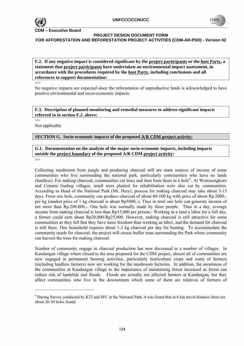
F.2. If any negative impact is considered significant by the project participants or the host Party, a statement that project participants have undertaken an environmental impact assessment, in accordance with the procedures required by the host Party, including conclusions and all references to support documentation: >> No negative impacts are expected since the reforestation of unproductive lands is acknowledged to have positive environmental and socio-economic impacts. F.3. Description of planned monitoring and remedial measures to address significant impacts referred to in section F.2. above: >> Not applicable SECTION G. Socio-economic impacts of the proposed A/R CDM project activity: G.1. Documentation on the analysis of the major socio-economic impacts, including impacts outside the project boundary of the proposed A/R CDM project activity: >> Collecting mushroom from jungle and producing charcoal still are main sources of income of some communities who live surrounding the national park, particularly communities who have no lands (landless). For making charcoal, communities cut trees and then burn them in a hole8. At Wonosengkoro and Cemara Gading villages, small trees planted for rehabilitation were also cut by communities. According to Head of the National Park (Mr. Hery), process for making charcoal may take about 3-15 days. From one hole, community can produce charcoal of about 60-100 kg with price of about Rp.2000,- per kg (market price of 1 kg charcoal is about Rp5000,-). Thus in total one hole can generate income of not more than Rp.200.000,-. One hole was normally made by three people. Thus in a day, average income from making charcoal is less than Rp15,000 per person,- Working in a land a labor for a full day, a farmer could earn about Rp20,000-Rp25,000. However, making charcoal is still attractive for some communities as they fell that they have more freedom than working as labor, and the demand for charcoal is still there. One household requires about 1-2 kg charcoal per day for heating. To accommodate the community needs for charcoal, the project will crease buffer zone surrounding the Park where community can harvest the tress for making charcoal. Number of community engage in charcoal production has now decreased in a number of villages. In Kandangan village where closed to the area proposed for the CDM project, almost all of communities are now engaged in permanent farming activities, particularly horticulture crops and some of farmers (including landless farmers) now are working for the mushroom factories. In addition, the awareness of the communities at Kandangan village to the importance of maintaining forest increased as forest can reduce risk of landslide and floods. Floods are actually not affected farmers at Kandangan, but they affect communities who live in the downstream which some of them are relatives of farmers of
8 During Survey conducted by KTI and SFC at the National Park, it was found that in 6 km travel distance there are about 20-30 holes found.
124

UNFCCC/CCNUCC
CDM – Executive Board PROJECT DESIGN DOCUMENT FORM
FOR AFFORESTATION AND REFORESTATION PROJECT ACTIVITIES (CDM-AR-PDD) - Version 02
Kandangan villanges. According to a farmer leader at Kandangan, communities at Kandangan will provide fully support to the establishment of forest and protect the forest. He said that now, someone who did forest cutting and making fire would get social sanction from the other community members. Similar condition is also found at Jabung sub-district, west part of the National Park. As the project being implemented in the National Park, the involvement of the community may be limited. In the implementation of GERHAN (a special 5-year program for land rehabilitation that will terminate in 2007) in the National Park involved the community only as laborers. Each farmer will earn Rp25,000 per day and number of trees being planted per day is 40 trees. Normally, the Park Manager worked with community on contract basis. For example, community got contract from the Park Manager to plant 10 ha of land. As capacity of one farmer to plant trees about 40 trees per day, one farmer could plant one ha of land in 10 days (population of trees per hectare under the GERHAN program is 400 trees). Planting trees in 10 ha will require about 100 working days. Thus the value of contract for planting 10 ha of the land would be about Rp2.500.000,-. Community who got the contract normally worked in a group. Using the above system, community may not have sense of ownership to the project. After the work is completed, they will not care whether the tress will survive or not. The sense of ownership of the community to the project is very crucial to be developed as the location is vulnerable to fire and their participation to protect the project from disturbances, particularly fire is very important. At present the National Park has conducted fire management program, where each resort has one fire brigade. The number of person in charge in each fire brigade is only two people. This is far from enough to protect the forest from fire. In additional transportation infrastructure in the Park is quite poor and this may limit the effectiveness of fire controlling process. G.2. If any negative impact is considered significant by the project participants or the host Party, a statement that project participants have undertaken a socio-economic impact assessment, in accordance with the procedures required by the host Party, including conclusions and all references to supporting documentation: >> No negative impacts are expected since the reforestation of unproductive lands is acknowledged to have positive environmental and socio-economic impacts. G.3. Description of planned monitoring and remedial measures to address significant impacts referred to in section G.2 above: >> Not applicable SECTION H. Stakeholders’ comments: H.1. Brief description of how comments by local stakeholders have been invited and compiled: >> The stakeholder process was intended to building stakeholders understanding of and commitment to the design and implementation of an AR CDM project activity. The stakeholder process was conducted in three stages. The first stage was aimed to raise stakeholder’s awareness about the AR-CDM (What is a CDM project?, What are the advantages of a CDM project?, How to conduct a CDM project?, Where and when to conduct a CDM project?, and Who can undertake a CDM project?). The first stakeholder
別添資料3
125

UNFCCC/CCNUCC
CDM – Executive Board PROJECT DESIGN DOCUMENT FORM
FOR AFFORESTATION AND REFORESTATION PROJECT ACTIVITIES (CDM-AR-PDD) - Version 02
process was conducted through a series of roving workshops with the communities interested in involving in the AR CDM project, Local NGOs, and local governments. The second stage will be carried through targeted Focus Group Discussions (FGDs) at the community and district level to identify stakeholders’ understanding, needs, priorities, interests and commitments related to implementing an AR-CDM project activity. The second stage incorporated a broader forum of district stakeholder and bigger events, including media coverage. The third stage of the stakeholder process will be organized and conducted by the Designated National Authority (DNA), housed in the MOE, if additional consultation is deemed necessary before approval is given. H.2. Summary of the comments received: >> Local community welcome the idea of reforestating the national park through the CDM project activity for the following reasons: (i) the establishment of the plantation will reduce risk of flood in the downstream area where many of their relatives living in the downstream area, (ii) the project will create job opportunity for local community and (iii) it was expected by local communities that the project will give them more appreciation regarding their involvement in forest fire management. The appreciation can be in the form of regular payment basis, community empowerment program and another appreciation forms. H.3. Report on how due account was taken of any comments received: >> The project proponents will involve the community in planting the trees and fire management. Incentive system for community will be discussed with related stakeholders.
126

UNFCCC/CCNUCC
CDM – Executive Board PROJECT DESIGN DOCUMENT FORM
FOR AFFORESTATION AND REFORESTATION PROJECT ACTIVITIES (CDM-AR-PDD) - Version 02
Annex 1
CONTACT INFORMATION ON PARTICIPANTS IN THE PROPOSED A/R CDM PROJECT ACTIVITY
Organization: Bromo Tengger Semeru National Park Street/P.O.Box: Jl. Raden Intan No. 6 Po Box 54 and Jl. Panda No. 8 Building: --- City: Malang State/Region: East Java Postfix/ZIP: 65100 Country: Indonesia Telephone: +62-341 491828 and +62341 551040 FAX: +62-341 490885 E-Mail: [email protected] URL: www.dephut.go.id/INFORMASI/TN%20INDO-ENGLISH/tn_bromo.htm Represented by: Title: Salutation: Last Name: Middle Name: First Name: Department: Mobile: Direct FAX: +62-341 490885 Direct tel: Personal E-Mail:
別添資料3
127

UNFCCC/CCNUCC
CDM – Executive Board PROJECT DESIGN DOCUMENT FORM
FOR AFFORESTATION AND REFORESTATION PROJECT ACTIVITIES (CDM-AR-PDD) - Version 02
Annex 2
INFORMATION REGARDING PUBLIC FUNDING
No public funding is used for the implementation of the project (?)
Annex 3
BASELINE INFORMATION In the absence of the registered A/R CDM project activity, the actual net GHG removals by sinks will not increased from the current condition. At present condition, the land use will remain as it is while under the project scenario the land will be converted into forest land resulted in the increase of actual net GHG removals by sinks. National condition, sectoral policies and local condition are not favourable to support the implementation of such proposed activities in the proposed sites. The following paragraphs describe national circumstances, sectoral polices and how such circumstance and policies affect local condition. National Circumstances Ministry of Forestry (MoE, 2003) reported that the domestic funding (DR) currently available for forest rehabilitation is approximately US $750 million. The use of the DR is focused on rehabilitating critical land located in the priority watersheds. Considering the scale of the land degradation problem in Indonesia, the existing DR is inadequate. The total area of critical land in Indonesia is estimated to be 42 million ha (MoE, 2003) to 61 million ha (MOF 2004). The available funding is only sufficient to rehabilitate about one tenth of the total critical area (Boer et al., 2001; MOE 2004). Without support from other sources such as CDM, the national reforestation rate is not likely to increase, nor keep pace with the rate deforestation. Historical data confirm that the rate of forest and land rehabilitation through timber estate establishment, reforestation and afforestation has decreased significantly (Figure A4.6). The development of Industrial Forest Plantation (HTI) is currently very low as the government no longer subsidies forest companies to expand their area of operation. In the past, forest companies could access forest rehabilitation funds from government either in the form of financial sharing or zero interest loans (Minister of Forestry RI Decree No. 375/ Kpts-II/ 1996 date: July 19th 1996). In addition, the internal rate of return (IRR) of the HTI is low (APHI, 2002; Subhan, 1998; Kusuma, 1995; Hakim, 1995; Utami, 1995), and benefit/cost (B/C) ratio could be less than 1.0 (Boer, 2001). Foreign investors are not interested to invest in the Indonesian forestry sector due to unfavorable investment climate, particularly high transaction cost (APHI, 2002). Additionally, the interpretation of Presidential Decrees 96/2000 and 118/2000 by the MOF CDM Working Group excludes AR CDM project activities on government land from direct foreign investment (see Section B.2 regarding investment barriers). The economic crises of 1997 resulted in a shortfall of locally generated financial resources and a decrease in the local ability to implement land rehabilitation, afforestation and reforestation activities. Carbon incentive is one of the factors that may attract investors’ interest to develop HTIs or conduct reforestation and afforestation activities with local communities.
128

UNFCCC/CCNUCC
CDM – Executive Board PROJECT DESIGN DOCUMENT FORM
FOR AFFORESTATION AND REFORESTATION PROJECT ACTIVITIES (CDM-AR-PDD) - Version 02
050,000
100,000150,000200,000250,000300,000350,000400,000450,000
1988 1990 1992 1994 1996 1998 2000
Year
Rat
e of
pla
ntin
g (h
a)
HTIAfforestationReforestation
Figure A.4.6. Rate of planting under the rehabilitation program (MoE, 2003)
Sectoral Policies The savanna, bush/shrubs contain low C-stocks and have become a climax land cover in the project area due to their tolerance of the wildlfires that occur every 1-2 years. There is little chance of those lands evolving into secondary forests through natural regeneration. There is interest at both the government and community levels to convert these vast grasslands to more productive tree-based systems. However, as the land is designated as National Park, communities can not access to the land, private sector may not be interested to plant trees as they can not harvest the trees. Thus funding for rehabilitating the land will mostly come from government. There are two government programs exist that provide funds for the reforestation and land rehabilitation. They are the DAK (Special Allocation Fund) and GERHAN (National Movement for the Rehabilitation of Forests and Land). DAK is a regular program that has limited funds, which are allocated only to priority areas. GERHAN is a special 5-year program that will terminate in 2007. It prioritizes the rehabilitation of degraded state forest land and private land. Under GERHAN species selection and tree use on state lands are restricted. The District Watershed and District Forest Offices control species selection within program regulations, which dictate that 70% of the trees planted must be ‘forest species’ and trees cannot be harvest for timber or removed for other purposes. These restrictions, limit community enthusiasm for the GERHAN program. Furthermore, GERHAN funds are controlled at the national level and allocated on an annual basis. There are no guarantees district governments will receive GERHAN funds every year, making multi-year planning impossible. The limited funds available, the uncertainties of annual allocations, the preference to rehabilitate state forest land, and the restrictions on species selection and tree use demonstrate that GERHAN is not a viable mechanism to rehabilitate the non-forest state lands targeted by the project activity.
別添資料3
129
UNFCCC/CCNUCC
CDM – Executive Board PROJECT DESIGN DOCUMENT FORM
FOR AFFORESTATION AND REFORESTATION PROJECT ACTIVITIES (CDM-AR-PDD) - Version 02
Annex 4
MONITORING PLAN Monitoring plan is described in the main body of the document.
- - - -
History of the document
Version Date Nature of revision 04 EB35, Annex 20
19 October 2007 • Restructuring of section A; • Section “Monitoring of forest establishment and management”
replaces sections: “Monitoring of the project boundary”, and “Monitoring of forest management”;
• Introduced a new section allowing for explicit description of SOPs and quality control/quality assurance (QA/QC) procedures if required by the selected approved methodology;
• Change in design of the section “Monitoring of the baseline net GHG removals by sinks” allowing for more efficient presentation of data.
03 EB26, Annex 19 29 September 2006
Revisions in different sections to reflect equivalent forms used by the Meth Panel and assist in making more transparent the selection of an approved methodology for a proposed A/R CDM project activity.
02 EB23, Annex 15a/b 24 February 2006
Inclusion of a section on the assessment of the eligibility of land and the Sampling design and stratification during monitoring
01 EB15, Annex 6 03 September 2004
Initial adoption
130