Embed Size (px)
Citation preview

UUnnddeerrssttaannddiinngg EEnnvviirroonnmmeennttaall DDeecciissiioonn--
MMaakkiinngg iinn tthhee RRuurraall PPaacciiffiicc IIssllaannddss
Final Report for APN CAPaBLE Project:
CBA2007-03NSY
This research was coordinated by Professor Patrick Nunn from the University of the South Pacific, Suva, Fiji.
-- MMaakkiinngg aa DDiiffffeerreennccee –– SSSccciiieeennnttt iii fff iiiccc CCCaaapppaaaccciii tttyyy BBBuuuiii llldddiiinnnggg &&& EEEnnnhhhaaannnccceeemmmeeennnttt fffooorrr SSSuuussstttaaaiiinnnaaabbbllleee DDDeeevvveeelllooopppmmmeeennnttt iiinnn DDDeeevvveeelllooopppiiinnnggg CCCooouuunnnttt rrr iiieeesss

CBA2007-03NSY-Nunn-Final Report
2
Project Title UNDERSTANDING ENVIRONMENTAL DECISION-MAKING IN THE RURAL PACIFIC ISLANDS CBA2007-03NSY Final Report submitted to APN ©Asia-Pacific Network for Global Change Research www.apn-gcr.org

CBA2007-03NSY-Nunn-Final Report
3
Overview of project work and outcomes Non-technical summary For more than 20 years, climate-change assistance to Pacific Island countries has been predicated on the assumption that the most effective ways to raise preparedness is top-down, largely by influencing national policy and bringing it into line with international agendas. This research project was intended to understand the effectiveness of this approach by learning exactly how decisions regarding the environment and its changes were made. The approach taken was to target representative communities with experience in addressing climate-change linked decisions in representative countries of the Pacific islands region. It is clear from this research project that national policy has little or no influence on most decisions undertaken with reference to the environment in rural parts of the Pacific Islands. In fact there is very little evidence that such decisions pay attention to science or other sources of insights concerning climate change. Most such decisions are made on the basis of emulation, experience, and inferred best-practice. This is not a satisfactory situation for any organizations like APN that seek to develop strategies to minimize the undesired impacts of climate change in vulnerable parts of the world like the smaller countries of the Pacific Islands region. The suggested way forward is to engage community-level “persons of influence” and ensure that they are given the knowledge needed to make and sustain sensible decisions about the environments over which they have control well into the future. Objectives The present project aimed to: • To understand how environmental decision-making in coastal settlements in peripheral
parts of archipelagic Pacific Island countries is undertaken. • To understand what influences environmental decision-making in such places. • To understand how communities affected by global change perceive and understand
associated problems and evaluate possible solutions. • To use this information to inform discussions about role of policy in environmental
decision-making in the Pacific Islands, and better focus future capacity-building efforts. Amount received and number years supported The Grant awarded to this project was: US$ 43,000 for Year1-2, 2007-2008 (18-month project):
Participating countries Cook Islands, Fiji, Kiribati, Vanuatu Work undertaken Within the four countries selected, representative settlements were chosen on the basis on their exposure to climate-linked environmental change, their rural (non-urban) location, and the likelihood that they would experience increased pressure in the next few decades from climate change. University students from each of the countries and districts were engaged to carry out the data collection. Each sought informants who were able to tell them about the nature of the environmental decisions the community had to deal with, the

CBA2007-03NSY-Nunn-Final Report
4
nature of the information sources to which they referred, the ranking of these in order of importance, and their understanding of global change. Data gathered from all these communities in each country were processed and analysed. Results It is clear that environmental is made within the context of long-standing societal/cultural frameworks that are not well suited to appropriate adaptation within the modern era, when there are many competing demands on a particular community and where the pace of change is more rapid than anything within the past millennium or so. Most decisions are made by traditional chiefs/leaders, often in concert with other hereditary title-holders, often with inputs from other “persons of influence” like church leaders and schoolteachers. More importantly, such decisions are made and enforced in traditional ways, which typically involve little consultation with most stakeholders (including other community leaders). The main influences on environmental decision-making in rural parts of the Pacific Islands region are emulation, experience, and inferred best-practice. Emulation means that often one community will simply copy the solution adopted by another community in response to what is perceived to be the same challenge. It is in this way that maladaptation has spread through many parts of the Pacific, particularly what has been referred to as the seawall mindset. Experience means that a community will often do what they did before in response to a particular challenge, even though (i) the former challenge may have been different to the present one, and (ii) the efficacy of the response to the earlier challenge has not been fully evaluated. Inferred best-practice is the only response that includes externally-derived information to any significant extent. It involves community leaders and their advisers relating their knowledge about inferred best-practice in response to a particular challenge elsewhere. Often that knowledge is highly prized and is influential in the particular decision that the community takes, but often it is in error and therefore unhelpful in informing the decision. The results of this project show that national policy development in the present context of Pacific Island countries is an ineffective way of raising climate-change awareness and bringing about the necessary lifestyle changes that are needed if the impacts of future climate change are not to be highly disruptive to the majority of people living in the Pacific Islands. Relevance to the APN CAPaBLE Programme and its Objectives If capacity development for climate change in Pacific Island countries is to be effective, then the people who influence and make most decisions regarding environmental futures are those who should be targeted. This project focused on understanding how decisions in the rural parts of Pacific Island countries are made, and concludes that the most influential persons (whose capacity needs to be developed) are community-level persons of influence. This project also involved a number of Pacific Island nationals whose involvement in this project will hopefully lead to a sustained interest in climate-change issues in the future. Unfortunately no Master’s student was found to undertake a higher degree on this project. This project also focused explicitly on awareness and understanding of policy regarding global change in Pacific Island countries. What was revealed was an alarming ignorance of national policy and scientific agendas intended to minimize the undesired impacts of climate change on this region. In short, most decisions concerning the environment are taken at local (community) level without any reference to national policy or science
CBA2007-03NSY-Nunn-Final Report
5
agendas. This underlines the impotence of current efforts at disseminating policy and science information, but also bodes ill for optimizing responses to climate-change issues in this vulnerable region. Self evaluation This was a successful project. A huge amount of information was gathered from a range of representative communities in four Pacific Island countries. The project was let down by the two Research Assistants engaged (Duncan Williams and Lele Nawalowalo), both of whom were terminated at different times for persistent non-performance. Potential for further work It is important to continue to understand the pathways of environmental decision-making in regions like the rural parts of the Pacific Islands. The main reason is that much of the aid for climate change that reaches the developing world is earmarked for policy development, on the assumption that national policy is the best way to effect change across such a country. The research from this project suggests otherwise. One future project might look at ways in which community-level environmental decision-making in the Pacific Islands could be improved, made more consistent (from one place to another), and sustained into the future. Improvements could come from making national policy and science agendas more accessible and more intelligible to community-level decision-makers. Publications Two manuscripts have been completed since the inception of this project that include some preliminary results of the project. Nunn, P.D. forthcoming. Managing the present and the future of smaller islands. In:
Douglas, I., Huggett, R. and Perkins, C. (Eds.). Companion Encyclopedia of Geography: From Local to Global. [manuscript: 29 pages].
Nunn, P.D. submitted. Responding to the challenges of climate change in the Pacific Islands:
management and technological imperatives. Climate Research. [manuscript 45 pages, 2 tables, 5 figures].
Three conference presentations, all Keynote Addresses, have been given since the inception of this project. Each presentation included some preliminary results of this project. 2008 Assisting Pacific Island nations meet the challenges of climate change.
Keynote Address, International Symposium on the Environment and Assistance to Pacific Island Countries, Tokyo [19.7.08].
2008 Climate change: a janus-faced challenge for our times. Keynote Address,
2008 IAMSLIC (International Association of Marine Science Libraries and Information Centers) Conference, Suva, Fiji [15.9.08].
2008 New directions for managing the challenges of climate change in the Pacific
Islands. Keynote Address. Pacific Climate Change Roundtable, Apia, Samoa [14.10.08].

CBA2007-03NSY-Nunn-Final Report
6
A public lecture will be given to the Nadi Chamber of Commerce on 22nd November 2008 that will incorporate many results of this project. The audience will include Government Ministers. APN will be acknowledged. Acknowledgments Duncan Williams coordinated a significant part of this project under the direction of Patrick Nunn. Thanks to Dalo Nating (Kiribati) and Joape Kuruyawa (Fiji) for help with site selection. Student researchers in the Cook Islands were Miimetua Manuela and Nimerota Jim Brown on Aitutaki and Mauke islands; in Fiji, Jokim Kitolelei on Vanua Levu island; in Kiribati, Elaine Bwebwe and Tiene Tooki; in Vanuatu, Christy Haruel and Ann Tosiro. The assistance of numerous government and local-government personnel in each country studied is acknowledged, as is the cooperation and hospitality of people in each of the communities studied.

CBA2007-03NSY-Nunn-Final Report
7
Technical Report Preface Money intended to aid Pacific Island countries adapt to future climate change has poured into the region for 20 years, most targeted at building national capacity. This approach makes assumptions about the most effective pathways for environmental decision-making in such countries, something the present project sought to test. The approach adopted in this project was to understand the decision-making process that exists in representative rural parts of the Pacific Islands and learn to what degree it is informed by policy and science. Results show that neither has much influence on environmental decision-making, a conclusion with implications for future climate-change assistance.

CBA2007-03NSY-Nunn-Final Report
8
Table of Contents 1. Introduction 10 2. Methodology 11 2.1. Selection of study sites and student researchers 11 2.2. Data interpretation 13 3. Results and Discussion 14 3.1. Results and interpretation: case studies of Araura Village (Aitutaki Island) and Akatokamanava Village (Mauke Island), Cook Islands 14 3.2. Results and interpretation: case studies of Lalati, Nawaisomo and Rukua villages (Beqa Island) and Kese Village (Naviti Island), Fiji 15 3.3. Results and interpretation: case studies of Daria and Nakawakawa villages, Wainunu, Bua (Vanua Levu island), Fiji 16 3.4. Results and interpretation: case studies of Nuka, Tabiang, Taboiaki, and Teteirio villages (Beru Island), Kiribati 17 3.5. Results and interpretation: case studies of Tabonuea and Ukiangang villages (Butaritari Island), Kiribati 18 3.6. Results and interpretation: case studies of Emua and Saama villages (Efate island), Vanuatu 19 3.7. Results and interpretation: case studies of Lolbualabwa and Antahi villages (Pentecost island), Vanuatu 20 3.8. Lessons learned 21
3.8.a. Information sources for environmental decision-making in rural communities 21 3.8.b. Barriers to effective decision-making in rural communities 22 3.8.c. Communal versus individual decision-making for global change 22 3.8.d. Developed sustained solutions to environmental problems 23 3.8.e. Strengthening community-level decision-making 23
3.9. Knowledge Gaps 24 3.10. Future Work 24
4. Conclusions 25 5. Future Directions 26 References 27 Appendix 1. Questionnaire used to record field data 29 Appendix 2. Background information and instructions to student
field researchers 35 Appendix 3. Supplementary instructions to student field researchers 39 Appendix 4. Understanding Environmental Decision-Making in the
Cook Islands: case studies of Araura Village (Aitutaki Island) and Akatokamanava Village (Mauke Island) 41
Appendix 5. Understanding Environmental Decision-Making in Fiji: case studies of Lalati, Nawaisomo and Rukua villages (Beqa Island) and Kese Village (Naviti Island) 58
Appendix 6. Understanding Environmental Decision-Making in Fiji: case studies of Daria and Nakawakawa villages, Wainunu, Bua (Vanua Levu island) 73
Appendix 7. Understanding Environmental Decision-Making in Kiribati: case studies of Nuka, Tabiang, Taboiaki, and Teteirio villages (Beru Island) 80
Appendix 8. Understanding Environmental Decision-Making in

CBA2007-03NSY-Nunn-Final Report
9
Kiribati: case studies of Tabonuea and Ukiangang villages (Butaritari Island) 91
Appendix 9. Understanding Environmental Decision-Making in Vanuatu: case studies of Emua and Saama villages (Efate island) 106
Appendix 10. Understanding Environmental Decision-Making in Vanuatu: case studies of Lolbualabwa and Antahi villages (Pentecost island) 126
Appendix 11. Selected photos of field sites 133

CBA2007-03NSY-Nunn-Final Report
10
Introduction In most assessments of regional vulnerability, climate change ranks at the top of most agendas that refer to the Pacific Islands region. Climate change is rightly perceived as likely to have major impacts on human lifestyles in this region because most settled and developed land is coastal and low-lying and consequently vulnerable to sea-level rise. Sea-level rise will cause inundation/flooding, shoreline erosion, and groundwater salinization rendering many parts of the Pacific islands coastal zone unusable for the purposes they are currently used for. Added to this is that most Pacific Island people are subsistence farmers, often dependent on nearshore marine resources that may also be (through sea-surface temperature rise) one of the casualties of 21st-century climate change. In his address to the World Economic Forum in Davos on 23rd January 2008, Dr Rajendra Pachauri, the Chair of the Intergovernmental Panel on Climate Change berated his listeners for their governments’ inadequate responses to the challenges of climate change to date. The same comments are readily applicable to the Pacific islands (as to most of the developing world) where short-term agendas intended to increase economic activity invariably take precedence over longer-term agendas that focus on environmental sustainability. Most developed nations have developed long-term policies to address the effects of climate change on their countries. These involve both adaptation and mitigation, and can be effectively implemented through top-down approaches, as with many other similar challenges. The situation in developing countries (including all of those in the Pacific Islands region) is quite different, not least because top-down approaches to any problem are generally much less successful that bottom-up approaches. Yet this message is not always understood by those bodies that are aiding Pacific island countries financially to meet the challenges of climate change. Most funding agencies concerned with reducing the environmental and human effects of future climate change in the Pacific Islands have placed considerable emphasis on national policy development. The underlying assumption is that, as in most “developed” countries, appropriate policy can be effectively implemented, both through enforcement and education, and therefore that policy development brings about the desired results. It is uncertain whether or not this approach works in the Pacific Islands, especially in those parts of archipelagic nations that are distant from the centres of government and economic growth. There is evidence that environmental decision-making in such peripheral areas is largely uninformed by government policy, and is consequently ad hoc, typically informed by instinct, imitation, or informal advice. The result of this is that, in most cases, inappropriate decisions are being made about how to respond to various manifestations of global change. If this situation is not improved through the building of appropriate capacity, it is expected that such inappropriate decisions will continue to be made in the future, thereby rendering the impact of future global change greater than it need be (Johannes, 1982; Clarke, 1990; Maragos, 1998; Barnett and Adger, 2003; Nunn, 1999, 2000, 2003, 2004; Nunn and Mimura, 1997, 2007; Nunn et al., 1999; Turnbull, 2004). This is a scoping project, intended to ascertain the degree to which policy informs environmental decision-making in the rural Pacific Islands. It is likely that the outcomes of the project will stimulate a larger, more long-term project focused on understanding the efficacy of environmental decision-making in the Asia-Pacific region, and will thereby identify pathways by which concerned funding agencies and governments can direct their resources towards sector-specific capacity building with the expectation of an improved degree of success.

CBA2007-03NSY-Nunn-Final Report
11
2. Methodology
This study proceeded in two parts – field data collection and interpretation. The first step was to select representative study sites in the four Pacific Island countries chosen (Cook Islands, Fiji, Kiribati, Vanuatu), then to identify appropriate student researchers with sufficient knowledge of climate change and yet sufficiently engaged with the study sites in question, and then to develop an appropriate set of questions that would ensure that all relevant data were gathered. The second step was to interpret the data, something that was done in the first instance by the field researchers. 2.1. Selection of study sites and student researchers
The countries selected were intended to capture the environmental and cultural diversity of the Pacific Islands region. The Cook Islands was selected as it is least traditional in many ways, being closely tied to New Zealand, where government initiatives and outreach for climate change is probably more effective than most other Pacific island countries. Fiji was chosen because it is perhaps halfway along the more traditional-less traditional spectrum than the other countries, where peripheral areas are strikingly traditional in a variety of ways compared to core areas of the country (something significantly informed by the study of Kumar (submitted). Kiribati and Vanuatu were both considered representative of more-traditional societies in the Pacific islands region, the main non-cultural contrast between the two being that Kiribati is composed almost wholly of low atoll islands (motu) and Vanuatu being composed of high volcanic islands where seismic and volcanic hazards abound. Within each of the countries selected, study sites were sought in rural areas well outside the immediate vicinity of large urban areas. While peripheral rather than core located, each site selected was not on the periphery of the periphery, where the influence of government policy and international science agendas might well be expected to have been slight, but rather in the centre of the periphery. Sites were also selected on the basis of the existence of known (reported) or highly-likely environmental problems that could be reasonably tied to climate change (and sea-level rise). Information about these problems was gleaned from various sources, most commonly national reports about the state of the environments (NAPAs), but also informal information (word of mouth). If this seems unduly careless, then it was regarded as justified in the Pacific Islands context where the existence of such problems and the discussions about how to address them may be exclusively oral (not written). This approach worked well in most cases with only one site (Daria Village, Vanua Levu Island, Fiji) proving not to have the anticipated environmental problems that we had been informed about. It is also worth making the point that it was sometimes difficult to decide in advance of actually visiting a particular study site whether the environmental problems that the community were experiencing (and discussing how to tackle) were climate change linked or not. The most common problem in this regard was with the incidence of shoreline erosion which, on atoll coasts (like those in Kiribati), may not be wholly (or even largely) a result of sea-level rise but of the reorganization of sediment movements within a reef-enclosed lagoon or the construction of artificial structures such as seawalls or causeways. Study sites are listed in Table 1. Table 1. Study sites Araura Village, Aitutaki Island, Cook Islands Akatokamanava Village, Mauke Island, Cook Islands Lalati Village, Beqa Island, Fiji Nawaisomo Village, Beqa Island, Fiji

CBA2007-03NSY-Nunn-Final Report
12
Rukua Village, Beqa Island, Fiji Kese Village, Naviti Island, Fiji Daria Village, Vanua Levu Island, Fiji Nakawakawa Village, Vanua Levu Island, Fiji Nuka Village, Beru Island, Kiribati Tabiang Village, Beru Island, Kiribati Taboiaki Village, Beru Island, Kiribati Teteirio Village, Beru Island, Kiribati Tabonuea Village, Butaritari Island, Kiribati Ukiangang Village, Butaritari Island, Kiribati Emua Village, Efate Island, Vanuatu Saama Village, Efate Island, Vanuatu Lolbualabwa Village, Pentecost Island, Vanuatu Antahi Village, Pentecost Island, Vanuatu The two study sites in the Cook Islands were located on peripheral islands in the southern group, where most people live. Aitutaki is a typical volcanic island with an emerged reef fringe while Mauke, superficially the same, has a much higher reef fringe, rendering the island’s interior more difficult of access and more isolated. The two villages selected are both along the islands’ coasts. In Fiji, three islands along the country’s periphery were targeted, all high volcanic islands. Of the two islands in the wetter part of Fiji (Beqa and Vanua Levu), the latter is far larger than the former. The third island (Naviti) is in the dry zone. All settlements selected are along the coast, both of those of Vanua Levu being protected by a fringe of mangrove forest along the ocean sides. In Kiribati, two “outer islands” in the western (Gilbert) group were targeted (Beru and Butaritari), the former being in the south, the latter close to the country’s northern borders. There are climate variations along the linear Gilbert group that further justify this selection (see Appendices 7 and 8). Although the village boundaries are not as rigid as elsewhere in the Pacific, largely owing to the limited land area and its linear shape, villages were targeted on each island along the coast. In Vanuatu, the two islands selected for study included the main island (Efate) and a peripheral island (Pentecost). Efate was selected largely because of the availability of a suitable student researcher. On Efate, the transition from core to periphery is also quite steep, and two settlements were selected on the peripheral north coast. The choice of Pentecost Island was also determined largely by the availability of a suitable student researcher from the area who was well informed about its environmental issues. The two villages selected are in marginally different parts of northern Pentecost. The University of the South Pacific is an international university serving 12 Pacific Island nations. At its main teaching campus in Suva, Fiji, students from each of these countries study and return home at the end of the academic year for a two-month vacation (December-January). Once the study islands were decided, qualified and interested students were sought to carry out the research. They were interviewed and, if successful, briefed by research team and prepared for the field research.

CBA2007-03NSY-Nunn-Final Report
13
A detailed questionnaire was drawn up that covered all the data required to be collected (Appendix 1). It was intended that this questionnaire be flexible and adaptable, depending on the situation in which the field researchers found themselves. All traditional protocols were followed in gathering the information. All questions were asked in the vernacular languages used by the community. The questions were most commonly asked directly by the field researchers themselves. Field researchers were also required to collect other information, both from archival sources, from government and other “official” sources, and from observations of the natural environment in the areas selected. The nature of this information is contained in two appendices (Appendix 2 and 3). 2.2. Data interpretation The initial interpretation of the field data was carried out by the student researchers who gathered them. This was considered appropriate because it was the students who knew most about the local contexts and had, through their command of the vernacular languages and contacts with the local communities, the best grasp of the entire situation. In an attempt to standardize reporting of field observations and their initial interpretation, a series of guidelines were issued (Appendix 2 and 3) that most student researchers followed. This approach was also considered appropriate because it contributed to capacity building of the students themselves, by not simply regarding them as conduits for data but also as persons with vested interests in the particular communities who were qualified to undertake a preliminary analysis of these data. The results were very encouraging with most students eager to acquire as much information as possible from as many informants, and really to get to grips with the question of environmental decision-making in the communities being studied. Lightly-edited versions of the reports supplied by the student researchers are given, along with most of the original illustrations in Appendices 4-10 with a selection of photos to illustrate various field situations in Appendix 11. More formal interpretation will continue in the future, and a series of studies will be produced for publication in peer-reviewed journals. 3. Results and Discussion
This section is divided between a synthesis and interpretation of the results obtained from each study site, each account divisible into a section on “environmental issues” and “environmental decision-making”. This is followed by a number of generalizations (lessons learned) that appear common to all situations studied. This is followed by a Discussion in which these findings are related to the aims of the project. There is also a section on Knowledge Gaps and a final one that looks at areas for Future Work. 3.1. Results and interpretation: case studies of Araura Village (Aitutaki
Island) and Akatokamanava Village (Mauke Island), Cook Islands (see Appendix 4)
Aitutaki and Mauke islands are in the southern Cook Islands, the former gains most of its income from tourism, the latter from subsistence farming and export of maire leaves. Owing to the different sources of income that dominate on these two islands, environmental imperatives differ, as they do in most of the Pacific. On Aitutaki, people (particularly those who work in tourism) have a view only on short-term environmental sustainability, particularly sustaining those attributes (sandy beaches, diverse coral reefs) that draw tourists to the island. On Mauke, as in most subsistence societies in the Pacific islands, the priorities for environmental sustainability refer more to food production rather than perceived “western” preoccupations like environmental beauty.

CBA2007-03NSY-Nunn-Final Report
14
Environmental issues Tropical cyclones (hurricanes or typhoons) only rarely strike the Cook Islands, particularly during El Niño years, but they still represent the most severe type of climate-linked environmental issue. There are no significant plans on either island for coping with a potentially increased frequency of tropical cyclones in a warmer world, although this remains a real possibility. There is much emphasis on recovery after a tropical cyclone but most informants seemed quite satisfied with the arrangements in place at present. Shoreline erosion as a result of storm surges during tropical cyclone (also potentially long-range tsunami) was a concern, and it was recognized that this was exacerbated by coastal-vegetation removal. This is a particular concern on Aitutaki rather than Mauke where the coast is less important to islander livelihoods. Associated with shoreline erosion was groundwater salinization. Water supply was the one issue that was quite high on the agendas of both people on Aitutaki and Mauke Islands. The incidence of droughts and the lack of adequate backup in some areas was a cause for concern. Communities have worked together, albeit with government assistance, to build water tanks in high places: just as in the past, they cooperated to dig communal wells. Environmental decision-making As expected in a country that is less “traditional”, more metropolitan, than most in the Pacific Islands, the people of coastal communities in the Cook islands are generally more aware of government policy relating to climate change, especially as it affects resources. This is also a tribute to the effective outreach of government personnel, although this is a function of the amount of funding they receive to achieve this, something that is unavailable in most countries in this region. In this way, it is possible to understand why the Cook Islands (unlike most its neighbours, except perhaps Niue) functions most effectively from top-down environmental management for climate change. Good illustrations of this are the preoccupation on Aitutaki with deficient drainage (a government responsibility) and on peripheral Mauke, with a less-than-rigid enforcement of building standards for septic tanks. The system of environmental problem-raising and decision-making is also less hierarchical, less tied to long-standing procedures, than on most Pacific Islands. There is an open, essentially democratic, way of raising issues and the decision about what to do is made solely by elected officials (Island Council). That said, tradition is not completely excluded from decision-making, particularly with respect to communal land, where the chief (ariki) often has an important and influential input into decisions. No evidence was found to suggest that traditional leaders were especially well informed or qualified to make such decisions but, because the government is commonly approached to help implement these decisions, there is a level at which they are evaluated scientifically. The raui or taboo on using marine areas for certain times (to allow them to regenerate) is something that is unique to the Cook Islands and is generally decided upon by traditional leaders, although in practice often with some prompting from government officials. The bottom line in environmental decision-making in the Cook Islands is that the government is uncommonly effective because the people are less traditional, they are fewer in number, the government is better-funded, and because there is free access to New Zealand, where top-down approaches to environmental management are usual, most people respond well to such initiatives.

CBA2007-03NSY-Nunn-Final Report
15
3.2. Results and interpretation: case studies of Lalati, Nawaisomo and Rukua villages (Beqa Island) and Kese Village (Naviti Island), Fiji (see Appendix 5)
Beqa Island is in the south of the Fiji group, peripheral yet closer than most to the nation’s capital (Suva), and home to a number of tourism ventures based largely on diving. Naviti Island is in the drier west of the group in a region of smaller islands where tourism provides the main source of income for most people. Therefore in Naviti and, to a lesser extent, in Beqa there is concern about the packaging of the environment for tourists and less than for food production (see section 3.3 for a contrasting example from Fiji). Interestingly, the older inhabitants of Kese Village on Naviti Island, who are more traditional and less dependent on tourism than the younger ones, are concerned about changes to the resource base (particularly fishing and rainfall) that seem to have occurred in the last 20 years. Environmental issues The five major environmental issues on both islands are shown in Table 1 in section A5.3.b in Appendix 5. Of these five issues, only two – hurricanes and drought – are perceived as being climate related, and there was a slight concern about how their frequency and intensity might change in the future. Coastal erosion was associated with very high tides but was not specifically linked to climate change. This represents an interesting issue because, if such a problem is perceived as a little local difficulty rather than part of a shared regional problem resulting from regional change, then the solution will be perceived as local rather than part of a regional response. Environmental decision-making In Fiji, considered marginal between very traditional (like Kiribati and Vanuatu) and less traditional (like Cook Islands), decision-making at the community level is largely community-driven but there are some initiatives, both of which were reported in Beqa and Naviti islands, whereby the village headmen (turaga ni koro) attend workshops organized by central government through provincial (sub-national) authorities. However these workshops have so far focused on hurricane preparedness and response, particularly the reporting of damage to district authorities. Some informants realized the deficiencies of this, arguing that long-term village development needed to take account of all types of environmental change, not just the dramatic kind. The villages sampled all had committees charged with information collection and decision-making at various levels. All these committees are organized by the turaga ni koro, who is a government-remunerated elected person from the village. There are tensions with traditional leaders, and usually these will overrule, even annul, decisions reached by other bodies. While respect for traditional leaders may be declining in some parts of Fiji, it is fair to say that in most rural communities there is still enough residual respect for such leaders so that they can overrule decisions reached more democratically. In microcosm, this represents the situation in Fiji (and many other Pacific Island countries) as a whole. Tradition is often perceived as being a barrier to effective decision-making. 3.3. Results and interpretation: case studies of Daria and Nakawakawa
villages, Wainunu, Bua (Vanua Levu island), Fiji (see Appendix 6)
Daria Village is located on a 26-metre high river terrace and is protected from the sea by a broad swathe of mangrove forest. Nakawakawa Village is even higher in a similar situation. Everyone resident in these villages lives primarily by subsistence agriculture, so they are more attuned to issues of environmental sustainability than their counterparts in

CBA2007-03NSY-Nunn-Final Report
16
villages like those on Beqa and Naviti (section 3.2) who have ready sources of cash income. Environmental issues As explained above, erroneous information about environmental change in these villages was given initially so that, when the student researcher arrived there, he found that no environmental decisions had been made recently. As discussed in Appendix 6, three other examples were studied in order to understand the decision-making process. Environmental decision-making The situation in these villages is typical of most in Fiji (and elsewhere in the Pacific islands) where traditional authority is paramount. Environmental issues will not be discussed without the sanction of the traditional leaders, who depend largely on emulation, experience, and inferred best-practice. Solutions that other communities known to the leaders have implemented (and which are perceived as working well) are favoured. Solutions that fall within the (claimed) experience of traditional leaders and their select advisers are favoured. And what is perceived by traditional leaders to be best-practice solutions are also favoured. In all this, the efficacy of the decision depends on the degree of understanding shown by the traditional leader (and his advisers) of both the problem and the range of potential solutions. In these two case studies, most decisions were reasonable yet completely uninformed to any discernible degree by national policy or by science. This is something that works well with routine decisions, but in communities that are faced with hard choices in a rapidly changing environment, this will work less well. This is well illustrated for Daria and Nakawakawa villages by the attitude towards productivity of both the land and the sea. There are no traditional taboos (like the raui in the Cook islands – see section 3.1) and these ecosystems are commonly perceived as limitless. This is something that is supported by the kinds of literal, often fundamentalist, Christianity to which people in such villages subscribe; the injunction to “subdue” the Earth in the Book of Genesis is commonly cited and used as a justification for not practising conservation in some places. The final point to make from these case studies is that this kind of traditional decision-making is undemocratic in the sense that it is imposed on the people to implement whether or not they concur with it. Again, in the present situation in Fiji where respect for tradition in villages like Daria and Nakawakawa is paramount, then these solutions are usually implemented. Yet if this respect begins to break down, as might seem inevitable in a globalizing world where it may become more difficult to earn money (or grow food) than it once was, then this kind of decision-making may rapidly become redundant. 3.4. Results and interpretation: case studies of Nuka, Tabiang, Taboiaki, and
Teteirio villages (Beru Island), Kiribati (see Appendix 7)
Four communities were studied on the atoll of Beru. Two (Tabiang and Taboiaki) are places where shoreline erosion is rapid and worrying. Two (Nuka and Teteirio) are the most populous areas. There is a high dependence on imported goods on Beru, with people generating income from fishing and horticulture. For this reason, the sustainability of the natural environment is paramount; issues like coral bleaching and overfishing are worrying. Environmental issues The most widespread environmental concern on Beru seems to be inundation (seawater flooding or overwash) of the land by large waves, particularly during storms but increasingly during high spring tides (king tides). Such events dump saltwater on the land surface, killing crops and polluting freshwater wells.

CBA2007-03NSY-Nunn-Final Report
17
Shoreline erosion is almost equal concerning to the people of Beru, but is perceived by most as being a local problem rather than a regional one. This perception is often more valid in an atoll context than it is in a high-island context because, as sediment is moved about the effectively closed systems of many atoll lagoons, one coast might be eroding while another is prograding. The well-documented effects of artificial structures, particularly in the Kiribati context the causeways that link adjacent atoll motu, are often blamed for erosion at one point. Environmental decision-making Tradition dictates that decision-making of every kind in Kiribati is carried out only by men. There is a multi-layered decision-making hierarchy that combines elected members of the Island Council and representatives of the island’s old men, the unimwane, who acts as a traditional chief would in other Pacific Island societies. Like chiefly societies in the Pacific, the unimwane has the power of veto over Council decisions that he regards as counter to the interests of the community as a whole. That said, most environmental decision-making is carried out at government level, the Island Council serving only as a conduit for the problem. This is because the Council feels that there is no (ready) solution to the problems that they experience most, like inundation. Shoreline erosion is slightly different and there have been so attempts to construct (even remove) artificial structures in the interests of protecting vulnerable areas of coast. Local initiatives, not sanctioned by the Island Council, exist to restore “life” to the reef off eroding shorelines in the belief that this will ease the problem. 3.5. Results and interpretation: case studies of Tabonuea and Ukiangang
villages (Butaritari Island), Kiribati (see Appendix 8)
The atoll of Butaritari in northern Kiribati is similar to Beru (section 3.4) but the structure of the community response to environmental problems is different. The main reason for this is that, while Beru is notoriously dry (it was claimed that there had been no rain there in three years), Butaritari is well-watered and lush by comparison. Culturally there is also a difference, the people of Butaritari being acknowledged as having shorter attention spans, making the implementation of long-term projects less successful. Owing to its greater rainfall, the people of Butaritari supplement their dependence on fishing with a range of crops. They might therefore be expected to be more interested in their island’s environmental productivity and its sustainability, but this appears not to be the case. Perhaps this is because they know their island to be superior to most in Kiribati in terms of its environmental potential. Environmental issues The same two environmental problems are paramount on Butaritari as on Beru (see above) – inundation and shoreline erosion. The difference in attitude is however instructive. For on wet Butaritari, short-lived inundation is a minor inconvenience compared to the situation on dry Beru. On Butaritari, most communities have rainwater tanks that supplement well-water and are regularly refilled. Shoreline erosion is also perceived differently on Butaritari compared to Beru. On Butaritari, shoreline erosion is mostly perceived as something that occurs during storms or extreme events not something routine, something everyday. This may be because the coast of Butaritari is more vegetated than that of Beru and so the natural resilience of the former to shoreline erosion is greater.

CBA2007-03NSY-Nunn-Final Report
18
Environmental decision-making The same decision-making structure that obtains on Beru applies on Butaritari, although the influence of tradition (control by unimwane) seems less. This might be a function of the individual(s) in post at the time of survey. However, it is clear that there is more democratic decision-making on Butaritari as well as more self-reliance. This is an interesting point for it suggests that those islands where the resource base is, for climatic reasons, more self-sustaining are more self-reliant in decision-making than those (like Beru) where the resource base is more fragile. There are several examples of decision-making by communities on Butaritari described in detail in Appendix 8. The one that involves the erosion of the front of Ukiangang Village is particularly instructive. It was perceived as a climate-change linked disaster by the community who knew enough about this to understand that a long-term solution was required. So they banned beach-sand mining and built a solid seawall. In this, it is important to note that the Government of Kiribati has met with some success in explaining the nature of long-term climate change to rural communities. The student researchers found that there was still a long way to go but the procedure could serve as a blueprint for more traditional societies in the Pacific islands region. The last point to make about environmental decision-making on Butaritari is one that applies widely to Pacific island communities elsewhere. It is the delay in response from central government to a request for assistance from a local community. This exposes a flaw in the national strategies for combating climate change in the Pacific islands for, although governments would prefer to control the responses to climate change in the countries, they have not got the capacity to do so. This means that communities like those on Butaritari described in Appendix 8 often fall back on their own solutions when they receive no response from government within a reasonable time. 3.6. Results and interpretation: case studies of Emua and Saama villages
(Efate island), Vanuatu (see Appendix 9)
While Emua is regarded as representative of most villages in Vanuatu, rural Saama is more traditional, less engaged with recent trends. Like most parts of the country, most people in these villages are engaged in subsistence agriculture, supplemented to some extent by fishing. Environmental issues On Efate Island, the main environmental threats are tropical cyclones that affect Vanuatu every summer (November-March). Flooding and storm surges associated with tropical cyclones are the main issues in the two villages studied. Flooding is something commonly regarded as normal and expected during the wet season, and is not recognized by local people as something that may be linked to climate change and which therefore might change in the future. Particularly in Emua, the deleterious effects of logging are visible, with significant deforestation having occurred upslope and washed-off soil ending up along the coast, including offshore areas. This is one contributor to the other major environmental issue in these villages, that of the contamination of water supplies (other issues are listed in Appendix 9, section A9.6). Environmental decision-making In Emua, the response to flooding is usually individual – people dig their own drainage ditches – but there is an increasing feeling that this is an issue that would be better served

CBA2007-03NSY-Nunn-Final Report
19
by a coordinated (communal) response. There is an elected Disaster Committee in Emua who will decide on a coordinated course of action in response to disasters but not to problems (like flooding) that are perceived as routine and expected. Problems of water-supply contamination are also dealt with individually and communally, with close family networks being the main way in which action is taken. Climate change in the future is not factored in to any of these decisions, which are largely reactive not proactive. Community-level decision-making referring to resource sustainability is reflected in Emua Village by the periodic closure of popular fishing grounds and the taboo (tabu) on harvesting particular marine organisms like beche-de-mer (see Table 1 in Appendix 9). Saama Village is less resilient in terms of appropriate communal responses to environmental issues although the social (kinship) resilience is higher than for Emua. This is similar to the contrast between less-traditional and more-traditional communities throughout much of the tropical Pacific Islands region. 3.7. Results and interpretation: case studies of Lolbualabwa and Antahi
villages (Pentecost island), Vanuatu (see Appendix 10)
The two communities chosen for study in northern Pentecost Island are both extensive yet contrasting. Lolbualabwa is a low-density amalgam of several villages so there is less pressure on the natural environment and the resource base while Antahi is a large, comparatively densely-populated, village in which recent population growth has been so rapid that houses have been built close to the shore in areas formerly regarded as too vulnerable to large waves and high winds for this purpose. A tall cliff at the rear of Antahi prevents ready inland expansion of this settlement. Both settlements are coastal, almost all the population dependent on subsistence agriculture. Tropical cyclones affect the area annually but both communities also had some knowledge of global change, especially sea-level rise and how this might be linked to shoreline erosion. Yet this knowledge was incomplete; local people knew nothing of the causes of coral bleaching, which has been observed in the reefs of this area. Environmental issues The effects of tropical cyclones that are most feared in these communities are flooding of the land, destruction of the food resource base, and shoreline erosion. Like the communities studied elsewhere in Vanuatu (see section 3.6), these problems are perceived as routine and unavoidable, so people tend to accept them as part of normal life and not to regard them as something worthy of anticipatory adaptation in the context of climate change. A secondary concern, linked to tropical cyclones in some informants’ minds, was water, particularly water shortage in the dry season. Environmental decision-making As with all more-traditional societies in the Pacific, those on the periphery in Vanuatu studied have a decision-making process that is dominated by hereditary individuals (chiefs) who have the power and authority to make binding and far-reaching decisions on environmental and other issues. Self-interest is reportedly common in influencing these decisions. Figure 1 in Appendix 10 shows that the views of individual (non-chiefly) community members is filtered to their chiefs through a hierarchy. While certain decisions (see Figure 2 in Appendix 10) may result in more consultation, there is essentially no discussion. Decisions about the environment are made by chiefs (maybe with key advisers) on the

CBA2007-03NSY-Nunn-Final Report
20
basis of emulation, experience, and inferred best-practice. Dissatisfaction with particular decisions and/or with the decision-making process in these communities, particularly when these decisions influence long-term strategies for development, is increasing amongst younger adults, especially those that have some understanding of global change and its likely impacts on such communities in the future. In response to the problems of seasonal water shortages, most individual family groups have built rain-fed water tanks but this has not been the subject of any community initiatives. 3.8. Lessons learned 3.8.a. Information sources for environmental decision-making in rural
communities Most environmental decision-making in the rural Pacific Islands is made by community leaders without any reference to national policy or global scientific agendas. This reflects a lack of awareness that these instruments exist and are available to guide such decision-making. This in turn reflects the ineffectiveness of most Pacific Island governments in reaching out to all their communities with messages about best-practice and global environmental change. Three influences were identified in most cases as being key to such decision-making. These are emulation – copying what other communities have done without evaluating its effectiveness; experience – following what has been seen in the past but again without evaluating its effectiveness; and inferred best-practice – what seems the best thing to do under the circumstances. The absence of information about national policy and global scientific agendas in most such communities can be rectified by more effective outreach; a major tool might be information about climate change (including case studies of successful adaptation) written in brochures in vernacular languages. RECOMMENDATION: Information about global change should be made available in vernacular languages using appropriate media to communities throughout the Pacific Islands. 3.8.b. Barriers to effective decision-making in rural communities In many traditional communities studied, traditional leaders (chiefs) have inordinate decision-making power (including power of veto of democratically-reached decisions) which they commonly wield after little or no consultation with other members of the community. The lack of informed environmental decision-making in many communities can be linked directly to the lack of knowledge that such leaders (and their close advisers) have about global change and the ways in which the natural environment operates. While wholly democratic decision-making in such communities has its own problems, a sensible compromise would be to have all members of the community represented in a discussion forum facilitated by the chief, and decisions reached by consensus only when it was felt that enough information was available to make such decisions. It would be incumbent on community representatives to acquire such information, maybe even to have themselves briefed on matters like global change by outsiders. Language and conceptualization are common barriers to effective decision-making because most of the policy and scientific information available that would help in effective decision-making is in English or French. The use of vernacular languages in communicating this

CBA2007-03NSY-Nunn-Final Report
21
information is paramount. Many Pacific Islanders in rural parts of the Pacific resist ideas that they perceive as alien, so some effort also needs to be made to conceptualize this information in ways that are more audience-friendly, such as by using familiar in-country examples. RECOMMENDATION: Decision-making processes in Pacific Island communities should include representatives of all interested and affected parties, and should be effectively informed by scientific understanding in an appropriate form. 3.8.c. Communal versus individual decision-making for global change In some communities, decisions made on behalf of everyone work better than others. The decision-making process (see section 3.8.b) is one cause of dissatisfaction that was widely reported, but two others are important. The first is the lack of support given by younger adults, often better educated than the elderly decision-makers, for communally-imposed decisions that they know to be flawed. The second is the delays in carrying out decisions, something that is most marked when national or district/provincial government is requested and required to assist with the implementation of these decisions. In both situations, the response of the more disaffected individuals may be to “go it alone”, to respond the best they can to the problem rather than (i) be party to a flawed response or (ii) wait for a unduly long time for an external response. In some of the case study sites, these kinds of responses were noted, and are a common reason for younger adults to move with their families away from a particular community. It was also noted that different communities, even those close to one another, often have quite distinct environmental agendas, different priorities, and therefore different solutions to one another. As global change accelerates in the next few decades, it is likely that this diversity will increase if left alone. Such a situation will be unhelpful for the effective implementation of appropriate adaptation solutions in the future. One way forward in this is for environmental decisions linked to global change to become more prescribed (by governments or other bodies), so that solutions to particular issues are well-known, uncontroversial, and that their implementation is likewise prescribed and doable. It should not be necessary for every rural community to “re-invent the wheel” independently of each other. RECOMMENDATION: Information booklets in vernacular languages and employing in-country examples of successful adaptation solutions to the most widespread environmental issues should be produced and circulated to all communities. Mechanisms for appropriate assistance at national and sub-national level should be developed. 3.8.d. Developed sustained solutions to environmental problems There is a widespread perception among people in rural communities in all but the least-traditional in the Pacific islands region that environmental change is normal, natural and localized. Given this perception, the solutions proposed are generally also localized, but also reactive and short-term. Most environmental decision-making in the communities studied is reactive not proactive. Something happens, the community responds. The nature of the response is typically short-term. It is assumed that as far as possible the environment needs to be restored to its former condition. This assumption is predicated on the idea that “background” influences on the environment (like climate and sea level) are unchanging over the long term.

CBA2007-03NSY-Nunn-Final Report
22
To counter this situation, it is necessary to raise awareness about the long-term nature of global change and the ways in which it is becoming manifest in local situations. The commonalities should be stressed, communities realizing the value of sharing experiences and information. One could even spread the word more widely in the Pacific Islands about the nature of the problems likely to challenge most coastal communities in the next 10-20 years, and the ways in which anticipatory adaptation might help reduce the impacts of these problems. RECOMMENDATION: Information packaged in an appropriate form and language should be prepared to inform rural communities about the nature of global change and the ways in which it is becoming manifest in particular places. 3.8.e. Strengthening community-level decision-making One common observation about Pacific Island communities (including all those studied for this project) is how there is a strong sense of community togetherness that makes communities more resilient in the face of external change. This strength is a positive attribute that should be exploited when developing solutions to the challenges associated with global change. The second point is that, given the general impotence of national (top-down) awareness-raising for global change that is conspicuous among Pacific Island communities, there should not be any attempts to belatedly impose such a model for global change. Rather the community-level decision-making process should be strengthened. Strengthening community-level decision-making for global change can be achieved in many ways, some of which were discussed above. The key to this lies in awareness-raising about global change, its universality and its typical manifestations (present and future). This can be achieved within the above recommendations yet there are two other areas where it is clear that community-level decision-making for global change could be strengthened. The first is by engaging the churches in spreading information about global change, its manifestations, and the appropriate sustainable responses. Most Pacific islanders attend church at least once a week and/or have a profound respect for what church leaders have to say. The churches also have a well-established network that penetrates to every inhabited part of the Pacific islands region, unlike any other organization. The second is gender. In many traditional communities studied, women have no say (irrespective of their qualifications) in environmental decision-making. Yet it seems likely that they could bring a new dimension to the perception of global-change linked problems and their solutions. RECOMMENDATION: Information about global change, its manifestations and sustainable solutions should be promulgated more effectively through churches. Men and women should be targeted equally, without prejudice, and should have an equal say in such decisions. 3.9. Knowledge Gaps A huge amount of information about environmental decision-making in the rural parts of the Pacific Islands has been acquired during this project but a small sample must inevitably fail to capture the diversity of this. It would be helpful to target other Pacific Island countries (besides Cook Islands, Fiji, Kiribati and Vanuatu) to see whether there are distinct sub-regional variations in rural environmental decision-making that are significant

CBA2007-03NSY-Nunn-Final Report
23
in terms of the recommendations made and the solutions proposed. While the selection of study sites included countries in Melanesia, Micronesia and Polynesia, and while they included a range of island types, there were no examples of matrilineal societies included and there were no sites based on limestone environments as occur in many parts of the Pacific islands region. 3.10. Future Work Table 2 below summarizes the recommendations (from section 3.8) and the actions that are needed to carry these out. Table 2. Recommendations and actions needed RECOMMENDATION ACTIONS NEEDED Information about global change should be made available in vernacular languages using appropriate media to communities throughout the Pacific Islands.
• More research on effective dissemination of such knowledge in the Pacific Islands
• Good translations (including re-conceptualization) of key information
Decision-making processes in Pacific Island communities should include representatives of all interested and affected parties, and should be effectively informed by scientific understanding in an appropriate form.
• Increased stakeholder representation in decision-making processes
• Removal of absolute authority over decision-making by one individual
• Increase awareness of the need to be involved in communal decision-making
Information booklets in vernacular languages and employing in-country examples of successful adaptation solutions to the most widespread environmental issues should be produced and circulated to all communities. Mechanisms for appropriate assistance at national and sub-national level should be developed.
• Gathering of representative examples of successful in-country adaptation to global change
• Streamlining of assistance from national and sub-national sources to communities for global change
Information packaged in an appropriate form and language should be prepared to inform rural communities about the nature of global change and the ways in which it is becoming manifest in particular places.
(all covered above)
Information about global change, its manifestations and sustainable solutions should be promulgated more effectively through churches.
• Dialogue with churches (religious organizations) as to the information needing to be disseminated and the ways off doing this.
Men and women should be targeted equally, without prejudice, and should have an equal say in decisions.
• Gender equality should be installed in community-level decision-making
For the remainder of this project and its aftermath, several publications will be produced
CBA2007-03NSY-Nunn-Final Report
24
for publication in appropriate peer-reviewed outlets based on the research carried out. Titles of two likely publications (on which work has begun) are • Barriers to effective decision-making for global change in the Pacific Islands • Contrasting perceptions of global change and procedures for adaptation in peripheral
parts of Pacific island countries 4. Conclusions
The first aim of this project was to understand how decision-making in coastal settlements in peripheral parts of Pacific Island countries is undertaken. Studies were undertaken in eighteen settlements in four representative Pacific Island countries. A good sense of the nature of environmental decision-making in these places (and most of the others) has been acquired. Its key attributes are its generally independent (local-area) character, its hierarchical, inward-looking and traditional nature, and its gender bias. The second aim of this project was to understand what influences environmental decision-making in peripheral parts of Pacific Island countries. The main influences are generally-uninformed emulation, experience, and inferred best-practice. The desired influences that are absent are any reference to government policy and international science agendas. The third aim of the project was to understand how communities affected by global change in peripheral parts of Pacific Island countries perceive and understand associated problems and evaluate possible solutions. This study has shown that the awareness of global change, particularly its long-term nature and manifestations, is lacking in most communities. Rather environmental changes that are plausibly linked in part to global change are regarded (erroneously) as local problems, often unique to a particular environment, that represent no serial change in the climate or sea level. The final aim of the project was to use the information obtained to inform discussions about the role of policy in environmental decision-making in the Pacific islands and thereby better focus future capacity-building efforts. It is clear that policy plays no significant role in environmental decision-making at the community level in most Pacific Island countries. It is recommended that future efforts aim at strengthening community-level decision-making for global change rather than imposing national policy on communities. Future capacity-building efforts should focus on “persons of influence” in vulnerable communities. 5. Future Directions
While there are knowledge gaps in the understanding of environmental decision-making in peripheral parts of Pacific Island countries that remain after this project (see above), a huge step has been taken towards understanding this process with a view towards improving community-level responses to future global change. In Table 2 above, the “actions needed” represent the directions of future research. The main cross-cutting action needed is research into the ways of effective dissemination of information about global change in the Pacific Islands region. The same mistakes that have been made for 20 years about reducing vulnerability through policy development should not be repeated. There is no good information about how to effectively disseminate such information in such a geographically-challenging and culturally diverse region. It is clear from this project that information must be conveyed in vernacular languages and in ways that are conceptually familiar (not alien) but there is still much to learn about the most effective ways of dissemination. The most successful information disseminators are the churches (religious organizations) in the Pacific Islands region, and it is recommended that those charged with raising awareness about climate change engage church leaders (i) to help spread information about appropriate responses to

CBA2007-03NSY-Nunn-Final Report
25
particular manifestations of global change and (ii) to learn about the mechanics of effective information dissemination in this region. Community-level decision-making processes should engage representatives of all in the particular community (some already do) and should strive for gender balance. There should be a reduction in the power of individuals to reach and impose decisions with little or no consultation. Governments should strive to strengthen community-level decision-making in these ways. Studies should be carried out to find examples of successful community adaptation to global change in each country of the Pacific Islands region. These examples should be well documented and promulgated widely as examples of good practice that other communities might emulate. Many such solutions will require government assistance and/or facilitation at both national and sub-national levels and this should be made possible. References Aalbersberg, W., Nunn, P.D. and Mimura, N. 1995. Integrated Coastal Zone Management Planning for Fiji and Tuvalu. Apia: Western Samoa: South Pacific Regional Environment Programme (SPREP). 83 pp. Agrawal A. 1995. Dismantling the divide between indigenous and scientific knowledge. Development and Change 26, 413–439. Agricultural Census. 2006. Port Vila: Bureau of Statistics, The Republic of Vanuatu. Barnett, J. and Adger, W.N. 2003. Climate dangers and atoll countries. Climatic Change 61: 321-337. Clarke, W.C. 1990. Learning from the past: traditional knowledge and sustainable development. The Contemporary Pacific, 2, 233-253. Dalzell, P., Adams, T.J.H. and Polunin, N.V.C. 1996. Coastal Fisheries of Pacific Islands. Oceanography and Marine Biology 34, 395-567. Department of Economic and Social Planning. 2008. Port Vila: Ministry of Finance, The Republic of Vanuatu. Johannes, R.E. 1982. Traditional conservation methods and protected marine areas in Oceania. Ambio, 2, 258-261. Kumar, R. submitted. Problems and prospects for islands at the margins: a case study of Moturiki Island, central Fiji. Kagoshima University Research Center for the Pacific Islands, Occasional Paper (Proceedings of the Conference on Global Warming in the Pacific). [manuscript: 14 pages, 4 figures]. Maragos, J.E. 1998. Human impact on the Pacific coastal environment over the last century. In J. Terry (Ed.). Climate and Environmental Change in the Pacific. Suva: School of Social and Economic Development, The University of the South Pacific, 1-25. Mourgues, A. 2005. Republic of Vanuatu Environment Profile. Port Vila: Government of Vanuatu. National Adaptation Plan for Action (NAPA), Republic of Vanuatu. 2007. National Advisory Committee on Climate Change (NACCC)

CBA2007-03NSY-Nunn-Final Report
26
Nunn, P.D. 1990. Recent environmental changes on Pacific islands. The Geographical Journal, 156, 125-140. Nunn, P.D. 1999. Environmental Change in the Pacific Basin: chronologies, causes, consequences. London: Wiley. Nunn, P.D. 2000. Coastal changes over the past two hundred years around Ovalau and Moturiki Islands, Fiji: implications for coastal-zone management. Australian Geographer, 31, 21-39. Nunn, P.D. 2003. Nature-society interactions in the Pacific Islands. Geografiska Annaler, 85 B, 219-229. Nunn, P.D. 2004. Through a mist on the ocean: human understanding of island environments. Tijdschrift voor Economische en Sociale Geografie, 95, 311-325. Nunn, P.D. and Kumar, R. 2006. Coastal history in the Asia-Pacific region. In: Harvey, N. (ed.). Global Change and Integrated Coastal Management: The Asia-Pacific Region. Berlin: Springer, pp. 93-116. Nunn, P.D. and Mimura, N. 1997. Vulnerability of South Pacific nations to sea-level rise and climate change. Journal of Coastal Research, Special Issue 24, 133-151. Nunn, P.D. and Mimura, N. 2007. Promoting sustainability on vulnerable island coasts: a case study of the smaller Pacific Islands. In: McFadden, L., Nicholls, R.J. and Penning-Rowsell, E. (eds). Managing Coastal Vulnerability. Amsterdam: Elsevier, 193-221. Nunn, P.D., Ravuvu, A.D., Kay, R.C. and Yamada, K. 1993. Assessment of Coastal Vulnerability and Resilience to Sea-Level Rise and Climate Change: Case Study: Viti Levu Island, Fiji. Phase I: Concepts and Approach. Apia, Western Samoa: South Pacific Regional Environment Programme, 171 p. Nunn, P.D., Veitayaki, J., Ram-Bidesi, V. and Vunisea, A. 1999 Coastal issues for oceanic islands: implications for human futures. Natural Resources Forum, 23, 195-207. Nunn, P.D., Ravuvu, A.D., Aalbersberg, W., Mimura, N. and Yamada, K. 1994. Assessment of Coastal Vulnerability and Resilience to Sea-Level Rise and Climate Change. Case Study: Yasawa Islands, Fiji. Phase 2: Development of Methodology. Apia, Western Samoa: South Pacific Regional Environment Programme, 118 pp. Nunn, P.D., Aalbersberg, W., Clarke, W.C., Korovulavula, I., Mimura, N., Ohno, E., Yamada, K., Serizawa, M. and Nishioka, S. 1996. Coastal Vulnerability and Resilience in Fiji: assessment of climate change impacts and adaptation, Phase IV. Apia, Western Samoa: South Pacific Regional Environment Programme, 215 pp. Turnbull, J. 2004. Explaining complexities of environmental management in developing countries: lessons from the Fiji Islands. The Geographical Journal, 170, 64-77. UNESCO. 2004. Evolution of village-based marine resource management in Vanuatu between 1993 and 2001. Coastal region and small island papers 15, UNESCO, Paris, 48 pp. Veitayaki, J. and Zann, L. 1997. Coastal Fisheries in the tropical South Pacific: A Question of Sustainability? In Sidik, J., Yusoff, B., Mohd Zaki, B. and Petr, T. (eds). Fisheries and the Environment: Beyond 2000. Serdang: Universiti Putra Malaysia, 43-51. Vuki, V., Appana, S., Sobey, M. and Vuki, M. 2000. Vanuatu. In Shepard. C. (ed) Sea at the Millennium: An Environmental Evaluation. Amsterdam: Elsevier Science, 737-749.
CBA2007-03NSY-Nunn-Final Report
27
Appendix 1. Questionnaire used to record field data
Understanding Environmental Decision-Making In The Rural Pacific Islands Environmental Problems and Community-level Institutional Overview Questionnaire USP/APN Introduction We are students of the University of the South Pacific and we are conducting a study to understand environmental decision-making in rural parts of Pacific Islands. The purpose of this study is to assist in understanding how communities affected by global climate change understand the causes of their environmental problems and how environmental decision-making in coastal settlements takes place and what influences these decisions. Being part of a coastal, Pacific Island community that has been exposed to various to a variety of environmental problems, it is crucial for us to seek your views, opinions and understanding about how decisions regarding environmental problems in your community take place. We plan to conduct 20 interviews to gather information on the environmental problems associated with global change affecting the community, how these problems are understood and how the community address/deal with these problems. Your assistance/ in answering questions to the interview would help us inform those who are interested in assisting with community environmental problems so they may be better able to assist the community in their decisions regarding environmental problems. Your help is highly appreciated. Key Respondents Questionnaire (Rewrite the question along with the answers in the Note-Pad provided; you may need to rewrite or add additional information missed during note-taking after going over the recorded interview; there is a space provided for additional questions you may have asked or came about during preceding interviews that you think is useful to ask in following interviews) Name of Village: Occupation main activity of income and livelihood: Role in the Village: (e.g. Teacher/Committee member/Council or Government Representative): What does the community/ village rely on as its main source of income and livelihood? i.e. what is the main activity that the majority of the inhabitants do for a living? What is the approximate number of households in the village/community? (count these

CBA2007-03NSY-Nunn-Final Report
28
yourself if info not available) What is the approximate population of the village/community? (take an average of the no.# of people in 5 houses and multiply by the above) Environmental Problems Assessment 1. From the environmental problems/issues below, please select and rank in order of
those that are of most concern/threat to the community?
Hurricanes/Storms; Droughts Flooding Erosion (shoreline); Inundation (Coastal lands that have been covered by water at high tides); Salt water affecting freshwater and drinking sources; i.e. rising sea level/salt water intrusion Coral Bleaching (Dying coral); Storm Surges (during storms, the sea is driven onto land/villages)
2. What other environmental concerns are affecting the village/community? Rank these also beside the above.? (eg. Pollution/solid waste disposal/rubbish/mangroves destruction /landslides/nearby development etc…)
3. For each of the above (1) indicate when did these start occurring? or what period in the year do they occur?
4. For each of the above (1), what problems have:
- observed to be occurring more frequently since starting - occurring at the same time/rate each year with no change to its frequency - occurring at abnormal times of the year, outside the expected season and describe
the new/abnormal cycles observed 5. Please identify on the map
a. where the above (1) are taking place (respondent will need to point these out to you around the village and you I.D. in the map/image);
b. Indicate when these started occurring (estimate 5 yrs ago/10etc..): c. Indicate extent of problem (what area it covers) and the problem growth ( eg.
Erosion; indicate where land was; Inundation; where houses/farmlands were located; hurricanes; where damage has been sustained/homes existed) If you do not have an appropriate map please sketch an outline of the village or land area and indicate where the problems occur for later reference.
6. List and explain the impacts the above problems have had on the following sectors;
what has been lost; extent of problem and damage and what have been the effects? :Agriculture/Farming Eg. Hurricane- (destroyed of crops and land) Flooding – destroyed crops Erosion – destroyed farmland Salt Water Intrusion – destruction of crops and farmland Drought – destroys crops, drinking water etc..

CBA2007-03NSY-Nunn-Final Report
29
what have the effects been? i.e. Lost cash crops for sale and income; lost food supplies? ; Fresh water availability; Eg. Flooding (polluted drinking water) ;what have the effects been (eg. Hygiene, sickness,) ;Fisheries (noticeable decline in fish around dead coral structures/ mangroves damaged); And what have the effects been (less fish for sale/consumption?) ;Housing/settlements in the village /damage due to hurricanes/inundation – rising sea levels) And what have the effects been? (people emigrating to other villages or places, increased conflicts over land space/(location/expense/move to another place or move closer to each other/ ;Human Health Directly - (eg. Flooding polluted drinking water; less food and drinking water) droughts affecting peoples health due to lack of water, people killed in floods or storms etc.. or Indirectly – (eg. Health problems due to changes in diet due to lack of fresh water and food supplies due to the problems mentioned above only!!)
7. What is the observation on the extent of impacts over the years (are the villages being
affected more severely i.e. are they losing more now then before when these problems occur.
a. Explain on a problem by problem basis (eg. Hurricanes – how are they being
impacted (6) above and how are these impacts observed to be growing or what are they losing more of?
b. Indicate the severity and growth of impacts on the map. (eg. How erosion has grown i.e. the location of eroded areas before and present location; salt water intrusion and inundation)
Additional Notes/Questions as appropriate Decision-Making In the Village/Community 8. What does the community understand to be the causes of the above problem (on a
problem by problem basis and/or overall reason?); Do you understand the issue of climate change?
9. How did you/community come to understand the causes of these problems (use the
resource/ government awareness/NGO/media/academic institute)? 10. What has been done by the individuals (respondent) to address these problems
themselves? Determine what problems that individuals are able to cope with individually. (freshwater availability – purchase drinking water for their families, Inundation - relocate farm/home etc…)
11. When the community as a whole is affected (eg. Drought, inundation, rising sea level,
etc..) or when the individual cannot cope on his/ her own;

CBA2007-03NSY-Nunn-Final Report
30
a. How does the community discuss their environmental problems ; How are concerns regarding the environmental problems brought to discussion? (is there a person/committee/ within the village who deals with these issue specifically that they can approach to discuss these problems with or is there a general platform for discussion of problems in general eg. Village meetings, the church, a government representative in the village etc…)?
b. Do the decisions made in the clans involve open dialogue with clan members or discussions in a select committee?
12. How do these discussions work? When is a problem raised?
a. Is there a protocol involved and what is it? b. Are all members and groups in the community (eg. Women) able to participate in
dialogue? c. What mechanism or alternative channel for discussion is open to groups that are
not represented or allowed to take part in village discussions? d. Does the person affected by problems (to land etc…) raise the issue or is he a part
of a clan/social organization where he approaches the head of this organization who in turn raises the issue with or at a chiefly or village meeting?
e. What is the respondent’s role in this discussion or system? f. What/who are other key decision-makers/decision-making organizations in the
village and what are their roles? (use this information to interview those people as well)
g. Who leads the decision-making cycle at these discussions? 13. What mechanisms are in place to allow members that are not present at meetings to
make counter presentations? In the case that they do not agree with resolutions passed.
14. What is the compulsory requirement of members present to validate a decision
/resolutions? 15. Does the head of the clan or any select committee or body have the authority to
overturn decisions made in a collective clan meeting? 16. In the event that a clan head is unavailable, who is charged with the clan meeting and
chairing the discussions? 17. What structure is in place to amend a decision already passed by a prior village
meeting? 18. In the event that the charged person is unavailable, who is given the responsibility of
the village meetings and chairing the discussions?
19. Does this decision-making system/process apply to the decisions made on the use and affairs of community land and coastal waters? If not, what differs?
Addressing The Environmental Problems Outlined 20. What is done to address environmental problems mentioned in (1) and (2) above at
the community level?
a. What are the traditional village-level strategies to address these problems?

CBA2007-03NSY-Nunn-Final Report
31
b. What other community decisions or other community strategies have been made to address the problems listed above? >>explain on a problem by problem basis?
21. When, in discussion of problems is it decided that problems above should involve
government assistance? - During community meetings when problems are being discussed or after trying to cope and find solutions themselves?
22. What government person/agency/council/ministry/ committee/or provincial council or
some higher district body is responsible for the affairs of the island or village?
a. What government subsidiary/department/council is charged in participating with discussions about land and coastal resources?
b. What is their role in these discussions? (awareness, provide guidance on steps/measures to take etc//)
23. What is the is the process involved in requesting govt. assistance? What are the
channels for seeking assistance and are these channels clear? 24. What forms of government assistance has been received for the problems outlined
above (awareness/technical assistance/discussion only)?
a. Have there been government led assistance projects conducted? b. What were the aims of such projects? c. Who initiated such projects (govt or requested)? d. How was the permission regarding the initiation of the project made? e. Who were involved from the village and from the government? f. What kinds of assistance is required and have been requested on a problem by
problem basis?? (eg. For salt water intrusion – request for fresh water supplies, for inundation – request for relocation of village or new houses etc…. what is requested)
g. What kinds of assistance are already available and what government agency/agent provides it?
h. How often have requests been made for assistance? i. How long does it take for requests to be answered? j. How many requests for assistance in the past 2 years have been met?
25. What other agency apart from those contacted above (23) government agency/office/
do you know of that addresses the environmental (climate change problems) problems mentioned above?
26. What government strategies/regulations/rules/policies for the other environmental
problems (2) mentioned above has been implemented in the community? Discuss on a problem by problem basis?
27. What village/community projects are aimed at addressing the above (2) problems?
a. What are these? When did these start? b. What are the projects aimed at achieving? c. What government agency is involved and what is their role?
28. Are there other non-government or academic institutions that have assisted in the
above (1) and (2) problems? What are their roles? (Refer to Question 25 for format to ask question i.e. what were the aims of the projects… eg. Awareness, technical assistance)
29. What assistance has been successful in addressing the problems mentioned in (1) and
(2)?

CBA2007-03NSY-Nunn-Final Report
32
Appendix 2. Background information and instructions to student field researchers Introduction Much aid provided to the Pacific Islands goes to governments for policy development. This assumes that, as in most developed countries, that policy is the optimal route to appropriate environmental stewardship. In Pacific Island countries there is little evidence that national policy is having a significant effect on environmental decision-making in rural areas. In such places, this usually falls by default to community leaders and decisions are made on the basis of instinct, imitation or informal advice, commonly without reference to national policy. Many funding priorities are predicated on the assumption that national policy development ends up benefiting people confronting environmental challenges in Pacific Islands. This project is an exploratory one to determine the degree to which this assumption is valid. It is a scoping exercise for a future project. Global change is affecting the lives of Pacific Island people in many ways and will continue to do so in the future. In particular, the effects of global warming, sea-level rise, and changes in storm frequency, intensity and seasonality, are being exacerbated by inappropriate management decisions, especially in the coastal zones of the peripheral parts of archipelagic countries like Cook Islands, Fiji, Kiribati and Vanuatu. The appropriateness of future management decisions in these places will determine the future impact of 21st-century global change and ultimately the future quality of life for their inhabitants. This research proposes to improve understanding of ways in which decisions are made about environmental management by people in the rural Pacific Islands. Objectives: Questions Needing Answers The basic objectives of the research is to understand how rural island communities recognize that a problem in the environment (eg. Erosion of foreshore, inundation etc…) is actually a problem (i.e. beginning to impact them directly/indirectly eg. Farmlands, homes, water supply). Understand what are the environmental problems associated with climate change that are affecting their villages/communities and also other environmental problems (pollution, fishing etc..) and where these are taking place. How do these island communities understand the problem; do they understand the concept of climate change or do they think these problems are caused by other forces or they have no idea what the causes of their problems are. What has been done by the individuals (respondent) to address these problems themselves? (try to relocate farm, home, etc…) If they do know something about the causes their environmental problems, then who has informed and are their other initiatives/ projects/ awareness campaigns from outsiders (Government/NGOs/Academic institutions) to assist in addressing these problems. If they are unaware of the causes but have a way of addressing these problems either on their own or with assistance. How do they discuss their environmental problems (is there a person/committee/ within the village who deals with these issue specifically that they can approach to discuss these problems with or is there a general platform for discussion of problems in general eg. Village meetings etc…)

CBA2007-03NSY-Nunn-Final Report
33
Are How do these discussions work? i.e. when is a problem raised? Is there a protocol involved? Does the person affected raise the issue or is he a part of a clan/social organization where he approaches the head of this organization who in turn raises the issue with or at a chiefly or village meeting? What is the respondent’s role in this discussion or system? Who are the other decision-makers? (use this information to interview those people as well) What is done to address these problems at the community level? Are there village-level strategies (either traditional or new strategies) to address these problems? Or What decisions have been made for the problems listed above or discussed as mentioned above? And if so what are they>>explain on a problem by problem basis? When is it decided that problems above should involve government assistance? Is it during the meeting when problems are being discussed or after trying to cope and find solutions themselves? Do the villages/communities approach government for assistance or are the problems addressed themselves? If problems addressed themselves, when is government assistance requested and why not sooner? Is there a government person/agency/council/ministry/ committee/or provincial council or some higher district body that looks after the island or village that is approached? Explain /What is the process involved in requesting govt. assistance? Understanding what forms of government assistance has been received for the problems outlined above? What kinds of assistance is requested on a problem by problem basis?? (eg. For salt water intrusion – request for fresh water supplies, for inundation – request for relocation of village or new houses etc…. what is requested) is assistance already available? How often have requests been made? How long does it take for requests to be answered? Have all requests to address problems been addressed? What kind of assistance is required on a problem by problem basis above? Are there government in place that address the environmental (climate change problems) problems mentioned above? Are there strategies/regulations/rules/policies for the other environmental problems mentioned above? Have government visited the village/community and conducted awareness on the issues? Are there projects in the village/community aimed at addressing the above problems? What are these? When did these start? What are the projects aimed at achieving? What government agency is involved? Are there other non-government or academic institutions that have assisted in the above problems? If so explain? What assistance has been successful in addressing the problems mentioned? Materials Provided 1. The folder provided should include:
a. A notebook for entering the information acquired from the interview. Please rewrite the question, followed by the response given.
b. A voice-recorder. After each interview, the voice recorder should be replayed and all information either missed during the note-taking added, before proceeding to the next interview. Use the recorder whilst note-taking during the interview as you will need to follow the respondent’s answers with the questions and therefore need to be able to refer to the answers written in order to proceed with organized interviewing.
c. Pens and pencils. For identifying on the map/satellite image the responses. d. A schedule of questions to assist with the interviews.

CBA2007-03NSY-Nunn-Final Report
34
e. All equipment, tapes, maps and recorded answers (lecturepad) will need to be returned once the interviews are completed either given to the project assistant or Prof. Nunn before his departure from the site or upon your return to Fiji.
Tasks
1. Conduct the interviews using the questionnaire as a guide to achieving the objectives
above and understanding how decisions on the environment occur in the community/village in question. The questionnaire is just a guide and does not need to be strictly followed if other information is received. Try to follow the answers and ask questions to gain as much insight as possible into the communities:
a. environmental problems (particularly associated with climate change - Hurricanes/Storms/droughts; Flooding; Erosion (shoreline); Inundation (Coastal lands that have been covered by water at high tides); Salt water affecting freshwater and drinking sources; Coral Bleaching (Dying coral); and other environmental problems
b. decision-making structure and organization. c. Whether the government or other organizations are assisting in informing these
communities on the causes of their environmental problems. 2. You need to interview approximately 20 key stakeholders. Respondents will include
at least fisherman, farmers, teachers, church pastors that are affected by the environmental problems and can provide useful answers and who will point you in the direction of the elders/chiefs. All those (10 or more) with decision-making authority/responsibility must be interviewed, including chiefs/elders/community leaders/government representative in the village (eg. Councilor district rep)/church leader/village committee leader/womens leader/teacher.
3. Try to build a decision-making bridge following who is in charge of what and interview those people and ascertain from the respondents other key decision makers. Therefore start at the bottom and make your way to the head decision maker to ensure the perspectives on the problems and of how decisions are made and how much each segment of the community understands/know their problems is gathered.
4. Draft a 7-10 page background paper using the information below and also include limitations or problems encountered in the research and additional information you think is of interest to the research that was encountered at the site.
5. Digital copies of the report and maps/satellite pictures must also be provided along with a printed version.
Materials to Collect
1. Maps and Satellite pictures of the island showing clearly the sites i.e. villages that were not supplied must be identified and obtained and used during the interviews. These will be used to indicate where the problems are occurring during the interview.
2. General Background Information on the island including: a. Demographic statistics (population and other information) b. Geographic information on the island including a breakdown of resources in
the area. c. Economic information on the island. d. Time series information (over the last 40 years if possible) on the yearly
weather patterns for the area/country. (obtained from the weather office)

CBA2007-03NSY-Nunn-Final Report
35
Appendix 3. Supplementary instructions to student field researchers
It is vital that in addition to the information provided in the information handout regarding the type of secondary information to be collected for the report, that the following information should be gathered and attached as an appendix to the hardcopy of your report. Please note that if soft copies of attached information is available, this should be handed in with the soft copy of your report. In some cases, where reports are too lengthy to provide a hard copy, a soft copy will suffice. Please note that the all responses gathered from the interviews must be submitted in soft copy together with the questions. The questionnaires and books used for note-taking and recording responses must also be submitted. Do not leave out any information when transcribing notes from the note-pad. It was a requirement to use maps and imagery to identify and record the location of climate change problems. Soft copies must be submitted together with hard copy of maps and any imagery used including photographs taken. Below is a list of information and sources to obtain information from; these should form part of the content of your report and attached in the appendix as well: (try to obtain both soft and hard copies – photocopy hard copies of reports, if copies cannot be obtained---you will be reimbursed---) Meteorological Department/Office
• Information on annual rainfall by month for the study area or region • Information on cyclones including summaries, reports and tracking maps for the
last 20-30 years • Information on droughts and El Nino and La Nina phenomena’s experienced in the
last 2 decades. Disaster Management Office/Department
• National disaster reports or summaries (this is very important information and must accompany your report) on disasters over the past 30 years.
Bureau of Statistics
• Population and demographic data for the study region and area along with other social data including income data, agricultural production etc… for the study area or region.
Environment Department/Office
• Reports on climate change vulnerability and adaptation assessments. (note that these reports are usually national assessments. Other assessments on communities and regions/areas similar to the study area is also required.
• Case study reports on climate change impacts in villages/communities etc…. • Government climate change policies
o Strategies/plans/overall policy direction etc…. o Community environmental and climate change plans/policies
etc..note that hardcopy reports might be quite lengthy; please choose the most reports on national assessments/ 2 case-study

CBA2007-03NSY-Nunn-Final Report
36
assessment or report on a community/village and photocopy these. Other reports held in the agency library must be listed.
Town or country planning/ Home or Indigenous Affairs
• Village/community boundaries • Village / community constitutions and by-laws • Village organizational structure
Note: One of these departments will have information on the affairs of the village or community used as the research site as it is usually a requirement that lawfully recognized villages must submit constitutions/plans that show leadership to a central authority that is responsible for administering their affairs. Please identify and approach the suitable agency in your home country for this information. Lands Department
• Both soft and hard copies of topographical and land use maps of the research sites. (other maps are acceptable if available)

CBA2007-03NSY-Nunn-Final Report
37
Appendix 4. Understanding Environmental Decision-Making in the Cook Islands: case studies of Araura Village (Aitutaki Island) and Akatokamanava Village (Mauke Island).
NOTE: This Appendix is a lightly edited version of the report by Miimetua Manuela and Nimerota Jim Brown for this project. A4.1 Introduction The purpose of this research was to study to understand environmental decision-making in the rural areas of the Cook Islands, paying particular attention to Aitutaki and Mauke. The objective was to study and understanding how their local communities are affected by global climate change, whether they understand the causes of their environmental problems, how environmental decision-making in coastal settlements takes place and what influences these decisions. A4.2 General Information The Cook Islands comprises 15 islands spread over 850,000 square miles (2.2 million square kilometers) of ocean in the middle of the South Pacific between Tonga to the west and the Society Islands to the east. The Cook Islands consists of two main groups, one in the north and one in the south. The southern group is nine "high" islands mainly of volcanic origin although some are virtually atolls. The majority of the population lives in the southern group. The northern group comprises six true atolls. Climate is tropical oceanic; moderated by trade winds; a dry season from April to November and a more humid season from December to March. A4.3. Aitutaki Island It is a triangular-shaped 'almost'-atoll rising up 4000m from the floor of the Pacific Ocean. It consists of three volcanic and 12 coral islets (motus). The larger island has 8 different villages. Vaipae and Tautu are the largest and are located on the south east side of the island. Arutanga is often referred to as town and is located on the south west side of the island. Arutanga has a center area for shopping, the Telecom Office (also the Post Office), the Westpac Bank and the Bank of the Cook Islands are located here. Here you will also find the Blue Nun and the Wharf. Amuri is a general term for the north end of the island which contains most of the tourist accommodations and less population. The other villages on the island are Ureia, Reureu, Tautu, Vaipeka and Nikaupara. Weather changes slightly by season; hurricane season is from November to March the following year. A4.4. Mauke Island Mauke consists of a central volcanic plateau which climbs to a maximum height of about 30 meters. Mauke is the most easterly of the Cook Islands; a raised atoll with teuruatete (coral cliffs ranging from 1 to 8 meters in height) circling the coasts of the island and has numerous limestone caves. There are no rivers so rainwater which falls inland drains into swamps on the inner rim of the 'Makatea' – fossilized coral reef - and thence underground to the lagoon, similar to Mangaia. The lagoon is very short and you get a good close-up of spectacular waves smashing on the surrounding reef. The central south area of Mauke is quite open. Mauke is a garden island, extremely fertile with magnificent hardwood trees in its interior. The Makatea inland is where the 'maire' bush is found growing wild; The Island also boasts the largest banyan tree in the world - a fact verified by a professor from Leeds University in England who is one of the world's leading experts on the banyan. The village roads are tidy and well-maintained with low white coral walls at the front boundary of the houses. On the way in from the airstrip at the north-west corner of the

CBA2007-03NSY-Nunn-Final Report
38
island the first village is Kimiangatau. Most damage from hurricanes affect the Northern end of the island, more particularly the village of Kimiangatau located North-West. Most of the strong winds & waves arrive from this direction. The island of Mauke is flat (it has no mountains or hills) and the coasts are about 80% fossilized coral cliffs (these also act as natural wave breakers), there is minimal to no erosion and is not that relevant to the study. There is no salt water intrusion since Mauke’s water is from isolated underground water caves and according to studies done in the past by scientists it is considered to be the best drinking water in the Cook Islands. A4.5.a. Population Aitutaki Number of Households Village Total Households Population Amuri 63 395 Ureia 38 180 Arutanga 49 237 Reureu 56 300 Nikaupara 47 197 Vaipae 84 483 Tautu 65 332 Vaipeka 21 106 Total 422 2337 Mauke Population per village Village Population Areora 59 Makatea 61 Ngatiarua 63 Kimiangatau 163 Total 346 A4.5.b. Economy and Main Sources of Income Aitutaki’s Primary Industry is Tourism, followed by Agriculture and Fishing. Most people on the island are employed by Tourist Operations (Accommodations, Restaurants, Rental and Tours) and the Government, and at the same time are also part time fishermen, farmers and planters. Mauke can be categorized as a low-income community with revenue derived from the sale of Maire that is exported to Hawaii. Maire leaf ei is the source of a thriving export industry to Hawai'i where the leaves are used to make welcoming 'leis' – garlands. Each week, the island gets an order from Hawaii and the women head into the interior at the weekend to pick enough 'maire' leaves to be airfreighted out on Monday. Most of the people however are engaged in subsistence living as farmers and fishermen. Another important source of income for Households is the employment offered by Government Departments. Other sources bring in a less significant portion of revenue; domestic sales and overseas export of local Handicrafts (kete/weaved baskets, weaved mats, fans etc) and Mauke Akari Pi (Miracle Oil). Most locals live a subsistence living as farmers and fishermen. A4.5.c. Tropical Cyclones Tropical Cyclones have been part of the lives of the people of Aitutaki and Mauke especially during the summer period of the year from the months of November to March. The Cook

CBA2007-03NSY-Nunn-Final Report
39
Islands is situated just to the north of the hurricane belt of the South Pacific where the Southern Cook Islands is located on the belt itself. This location tends to move tropical cyclones that form over Samoa to move over these islands. Two cyclones on average is expected/estimated for the Cook Islands. Prior to each cyclone being named or fully reaching the minimum gale force in order to be allocated a name, the Cook Islands Meteorological Service (CIMS), have made media releases of the existence of these Tropical Disturbances and Tropical Depression. The media used are the Cook Islands Newspaper and the Cook Islands Television. Working closely with the Fiji Regional Specialized Meteorological Centre (RSMC), the new releases are usually to cater for the expected warnings that Fiji RSMC will release as well as to warn the public of any impending threat that could come to the Cook Islands. A4.5.d. Cook Islands Meteorological Service (CIMS) CIMS is the implementing agency for tropical cyclones in terms of warning the nation. With its close links with Fiji RSMC, CIMS follows a ‘Standard Operating Procedure’ that allows it to disseminate the warnings with the approval of Chief Hurricane Safety Officer (CHSO). The CHSO is usually designated to the Commissioner of Police according to the Hurricane Safety Act 1973. The process is that when the Director of CIMS notifies the CHSO of a threat of cyclone that is normally identified through a Special Weather Bulletin (SWB) from Fiji RSMC and approval is given to disseminate the warnings to the public, CIMS reads the first SWB live on Radio Cook Islands as well as Radio KCFM. Coverage of the day’s events is normally aired on Cook Islands TV, which is available to both Aitutaki and Mauke. This process continues throughout the lifespan of a cyclone until the CHSO steps down the emergency situation. CIMS has achieved a milestone in the communication process of getting warnings across to the community. This is done via radio stations, TV, newspaper as well as the internet. Although quite a few warnings were issued in regards to these cyclones, the public was well aware of the warnings and they understood them. The Tropical Cyclone Tracking Map was a popular item during this cyclone season for households, which keeps them involved in tracking the progress of Cyclones (using Longitude, Latitude). A4.6. Methodology A4.6.a. Participants Due to time constraints and relativity, we managed to formally interview eight people from Aitutaki and twenty two people from Mauke. Participants were selected based on the following criteria: Residency on the island. All interviewees have lived on their island for most, if not all their lives. The estimated age of participants ranged between 40 and 89 years, this allowed for a better perspective when comparing cyclone and weather patterns today and 20 to 60 years ago. Position/Role within the village. It was important for us to interview the decision makers of the village/island as well as the local people who wish to voice their concerns. Besides interviewing title holders within the Island Council, we also interviewed the local fishermen, farmers and planters as well as the retired village elders. – Authority figures and the community level The variety of representatives was also considered; such as the youth leaders, women’s representatives, teachers, retired workers, private business owners etc.

CBA2007-03NSY-Nunn-Final Report
40
A4.6.b. Materials Most materials used during the research were provided by the Geography Department, others such as extra pens, laptop, internet resources, printing paper, camera, batteries etc were provided by us;
o 1x One hour Tape Recorder
o 1x blank tape o 2x Refill pads o 4x pens
o 2x pencils o Satellite maps of Aitutaki and Mauke – CI Ministry of
Works o Travel guide maps – Aitutaki Tourism Office
A4.6.c. Procedures The Research began on the 5th December, firstly visiting the Environment Service, otherwise known as Te Tuanga Taporoporo, with hopes of obtaining some information regarding Environmental policies or laws in regards to Aitutaki and Mauke. It was discovered that there is such an Act, which pertains to the protection, management and conservation of the environment, only applies to several of the islands; specifically to Rarotonga, Aitutaki and Mangaiia. Mauke is not governed by the Act, but progress is underway to include Mauke to the list. This means that there are no legal policies to protect the coast or inland from destruction from development, pollution etc. Any problems of such a nature are raised to the Island Council to handle. Environmental Officer Apii Pakitoa offered us several names of possible interviewees. Next we visited the Cook Islands Meteorological Service and were able to get some helpful information from the Director Arona Ngari (see Appendix). When requesting information from the Statistics Office in Rarotonga, we were informed that permission must be acquired from the Prime Ministers Office and we would have to explain the nature of our research, and possible pay a fee. The process was lengthy and in the end we could not get the information we needed from the Stats office. Fortunately we had a friend in the Ministry of Works who was able to get us some maps of Aitutaki and Mauke (hard copies) for free. We arrived in Aitutaki on Monday 10th December, 6pm and stayed for 9 days leaving on Wednesday 19th December, 10am. We stayed with a friend of the family, Mark Baxter, a Master Fisherman, tourist operator, private businessman (owning several of the islands major stores) who lives in the center of the main town, Arutanga. As our first point of contact, he was very helpful in our research; taking us on a tour of the island, pointing out people whom he thought we should interview, and more importantly provided us with our own transport. The town consists of the Post office, Westpac Bank, Tourism Office, Police Station, Environmental office, Island Council Office and one major Shopping Store (Maina Traders). Most of the offices have between one and three employees, who usually only work 3-4 hours a day, 3-4 days per week. This is due to the low quantity of customers. We began our research by visiting the Island council office (across the road) and informing them of our research in hopes they could give us the names of people we could contact and interview. We arrived in Mauke on Friday 11th January and spent the weekend meeting with family and touring the island, visiting the few beach spots. We attended the Island Council Meeting on Monday and were introduced to all the members and discussed the purpose of our research and asked for everyone’s help. There were no problems in lining up interviews. That same day we interviewed Island Secretary Tai Tura, who was an enormous help and arranged our meetings with several other Council members. Several other interviews occurred within the following five days, we regretfully departed Mauke on Monday 21st January 2008 and look forward to returning in the near future. A4.7. Results The following is a collation of information gathered through formal and informal interviews,

CBA2007-03NSY-Nunn-Final Report
41
internet resources as well as several government departments. A4.7.a. Environmental Problems Assessed Hurricanes was the main threat for both islands concluding from the responses and considering that the only disaster management plans on Muake and Aitutaki are specified for cyclones. Droughts (man-made) come in at second not because of its severity but because of its frequency. The last extreme draught to hit both islands was back in 1982-1983. Storm Surges were closely associated with hurricanes by the locals instead of separate things.), saltwater intrusion (Aitutaki only) is severe but an excepted part if life. Its has always been that way and it always will. One of the respondents quoted “god has gifted Aitutaki with everything….except fresh water. Just so it isn’t the perfect place on earth.” Shoreline erosion happens on both islands but mainly due to natural processes. The sand is usually replaced as quickly as over night or over several months. Aitutaki for example have some bits of the shore line/small islands (Motus) shrink and at the some time some areas grow. Its just the rearranging/redistribution of the sand, the is no permanent damage witnessed over a long period of time. Some of the minor erosion witnessed are man made due to development. That is the removal of plant life near and around the coasts.
Figure A4.1. Human-caused erosion, Aitutaki
The majority of Mauke’s shoreline is
protected from waves by fossilized coral cliffs averaging between 1 to 2 meters high, but can reach up to 6m and possibly higher from what we have witnessed. There have been no reports on inundation or coral bleaching in both islands. Other environmental concerns include: -Development (mostly through lack of building standards, poorly built structures, poorly constructed septic tanks etc), improper sewage disposal, pollution, littering, solid waste disposal
Now the impacts the above problems have on the following sector depends heavily on how well prepared the people are before it hits. So the impacts can be controlled effectively to a certain extent as long as adequate warning is available. For example in the past when a hurricane hits peoples livestock get killed, fresh water is contaminated, housing and property are damaged and people get hurt from trying to secure or save all these things. Now today thanks to technology the MET office gives people warning and enough time to stock up on water and food, to move livestock and valuables to higher ground and to secure/tie down their houses. So the impacts are reduced drastically but not completely. A4.7.b. An overview of the key sectors o Agriculture/farming As mentioned above people can save the majority of their livestock as long as they get a warning early enough, but agriculture on the other hand gets wiped out almost entirely in extreme hurricanes and there is nothing they can do about it. So people stock up mainly on rice, flour and cabin bread. o Fisheries According to the fishermen on both islands not only is the number of fish decreasing but so is their size.

CBA2007-03NSY-Nunn-Final Report
42
For the ocean dwelling fish they have concluded that the decrease is due to increased illegal fishing in Cook Island waters. Several nights a month they will see lights out at sea and sometimes they can see the fishing boats in broad daylight. They know on average how long it takes for our patrol boat in Rarotonga to get to Aitutaki and Mauke so they just leave a day before. o Housing/ settlements in the village Also, people are still building their homes near the coast in Kimiangatau Village in Mauke, an area that has the highest exposure to Cyclone damages. The Government has advised them (with no funding) to relocate all homes within the danger zone (all homes on the sea side of the main road) inland, providing them the land but at their own financial cost. This idea has not been popularly accepted by locals, none have taken the offer o should I say none can afford it. o Human health On both islands when asked about if people ever starved or got sick due to food or water shortage because of the above problems, a common response by some of the elder respondents is “me mate koe I te pongi, e auouo kope koe!!” meaning if anyone ever died (of hunger) its because you’re a lazy idiot. People are so adequately adapted to that way of life that no one has ever died because there is always some source of food, whether locally grown or imported. o Fresh water availability For both islands there are several underground caves/isolated pockets of water that spring up all over the islands. This is where Mauke’s main source of water is from and it never gets polluted / contaminated and it has never run out. Water shortage is only due to old rusted pipes leaking or the water pump occasionally falling into the well. Both are in the process of been upgraded. Aitutaki on the other hand heavily relies on rain water for drinking. This is due to the fact that when the project for drilling holes to access the bigger water caves took place on both islands Mauke followed the regulations and advice of foreign engineers where as Aitutaki didn’t. They thought the deeper they dug the more water there will be and they dug way pass the sea level penetrating into the seawater caves further underneath the island. This has permanently contaminated their water supply so that it always tastes salty.
Some just about every household has a water tank and then there is a large community one in each village.
Figure 2. Aitutaki: water/sea reaching the beach surface
It is an interesting and important point to note that when discussing this first part of the questionnaire, the most common causes for concern from the community was not the natural disasters but the man made problems; more specifically in Aitutaki, tourism development (accommodation, restaurants etc) and in Mauke, the major issues are housing development in coastal and fertile farmland areas, and the hazards associated with poor housing standards. For instance, Mauke is currently not under the provisions of the Cook Islands Environmental Act, so instances of poor housing standards, poor septic tank construction, use of sub-standard building materials etc. is of greater concern to locals rather than the threat posed by hurricanes and drought.

CBA2007-03NSY-Nunn-Final Report
43
An explanation for this is that hurricanes and other natural disasters have always been a way of life for Cook Islanders, we know of and expect this events as part of life and have learned to cope with them quite confidently and sufficiently. There are already efficient contingency plans in place to deal with hurricanes, as well as many traditional means developed by the community at large. For example, in Aitutaki, the community initiative to build community water tanks in each village as a means to cope with droughts caused by faulty pipes, highly saline water and low water pressure. In the past, villagers would come together to dig wells in search of underground fresh water; some wells reaching a depth of 8 to 60 feet.
A rather surprising and unexpected finding in Mauke was how often the topic of wild (and tame) pigs where brought up as a major environmental problem. They wreak havoc with Mauke’s agriculture and pose a major threat to farmer’s livelihood. Roaming Pigs were considered more of a concern to people than an oncoming cyclone.
A4.7.c. Increased frequency of Cyclones, within its expected season In the 2004/2005 cyclone season, the month of February is memorable among Cook Islanders living at home and abroad. It is the month that 5 cyclones occurred within a period of approximately 5 weeks. Four of these cyclones reached over 100 knots sustained winds and gusts of 140 knots, a record for the Cook Islands as well as for the South Pacific. One cyclone also recorded the lowest barometric pressure ever measured for a cyclone in the South Pacific – 900 hectoPascals. People have noticed the unpredictable nature of cyclones today. In the past, cyclones could roughly be expected to visit every 5 or 10 years for a mild level cyclone, and every 21 years for really dangerous cyclones. Now they appear to be a yearly occurrence, and traditional methods of predicting the arrival of a cyclone have lost their accuracy largely due to the strange change in weather patterns and fruiting seasons. For example, Mangoes would fruit between the months of November, December, January, but in 2007 the mangoes fruited all year long which is highly unusual. In Mauke, the fruiting season of the Tavaa (similar to lychee family and a popular fruit for Maukeans) usually occurred once a year is now fruiting twice a year and causes the fruit to rot prematurely. A4.8. Decision making in the Community A4.8.a. Understanding the problems Everyone is aware that there are environmental problems on their Island; the natural disasters are viewed as less threatening than the dangers posed by man made problems. To elaborate on this fact, people have developed traditional and modern means to cope fairly well with natural dangers such as drought, hurricanes, storms and coastal erosion. But the problems caused by the ignorance and carelessness of Man is of greater concern to locals; for instance, In Mauke people are more worried that the lack of building standards for septic tanks will result in liquid waste seeping into the underground caves and contaminating the islands primary water source. In Aitutaki, people are more concerned about the saltwater intrusion caused by the rotting pipes, rather than the threat of an oncoming cyclone. One respondent summed the experience as follows; ‘hurricanes come and go in one day then its over, and everyone has a big clean up, what a hassle!’
Almost every home has owns a television, there is only one local news station Cook Islands TV, radio, the local daily newspaper CINews, few homes in Aitutaki have access to the internet, and more limited internet access in a few Govt offices. Through these sources, people have some understanding about the causes of the environmental issues they face. Communication channels are open and available to all residents. Secondary Schools include topics such as global climate change, hurricane causes/impacts,

CBA2007-03NSY-Nunn-Final Report
44
and coastal erosion within their curriculum to teach students about the impacts of both natural and man made problems within the environment, and take active steps to educate them on how to better look after their island. For example; Aitutaki teachers took students on a field trip around the beaches, pointing out signs of erosion, pollution and littering, deforestation etc. The Aitutaki Conservation Center donated trees to the youth to plant in order to help decrease erosion. In Mauke, one teacher showed her students the Documentary DVD “An Inconvenient Truth” by Al Gore, in an effort to show them the real dangers posed to small island nations from the effects of global climate change. The Health and Environment Departments in Aitutaki hold workshops within the community and invite members of the public, local leaders, Island Council members etc to attend, in an attempt to raise awareness about the problems going on in the Environment, and offer methods to stop these problems from occurring. For example; Environment Officers held meetings with each village to make them aware of the policies and regulations of the Environment Act, such as to stop the removal of sand from the beaches for building purposes, to remind home owners to build their septic tanks to the required standards. Most people learn about a problem such as pollution, waste disposal, poor building standards and erosion from observation. They see the problems with their own eyes. Some issues like coastal erosion accelerated by increased frequency of storms and hurricanes, result in much sand being removed from the beaches, thus bringing the shoreline closer to a lot of homes. Many houses are located within 100 meters of the shoreline, so erosion is always a noticeable problem.
A4.8.b. Addressing the problems at an Individual and Community level Issues such as hurricanes, droughts and saltwater intrusion can be dealt quite easily at an individual level, but there are also means to cope together at a community level; for instance, in Aitutaki each village fundraised to purchase community water tanks available to anyone to access. In Mauke, the village of Kimiangatau fundraised to purchase vegetable seeds and soil from the Agriculture Department in Rarotonga, and allocated them to each household in an effort to encourage families to grow and maintain their own vegetable gardens, to eat healthy, provide a hobby for the mama’s. Both islands have proven that living as a community/village is more natural than looking after your own needs. This leads to a more successful community. Any issues that need to be raised, i.e. pollution, littering in the community, hurricane damages homes, can be taken directly to the Island Council or to their own Village Committee Meeting. There is no formal process; any one of the following processes can be taken;
o If the problem is small scale and can be dealt with by the community i.e. littering in the town hall
Person Village Chairperson Village Meeting discusses the issue and determine course of action
o If the problem is slightly more serious, it is taken to the Island Council i.e. hurricane season is approaching and trees need to be trimmed around the villages
Person raises issue at Village Meeting
Village Councilor represents person Island Council
Island Council Meeting – discuss actions Island Councilor returns to village with
outcome
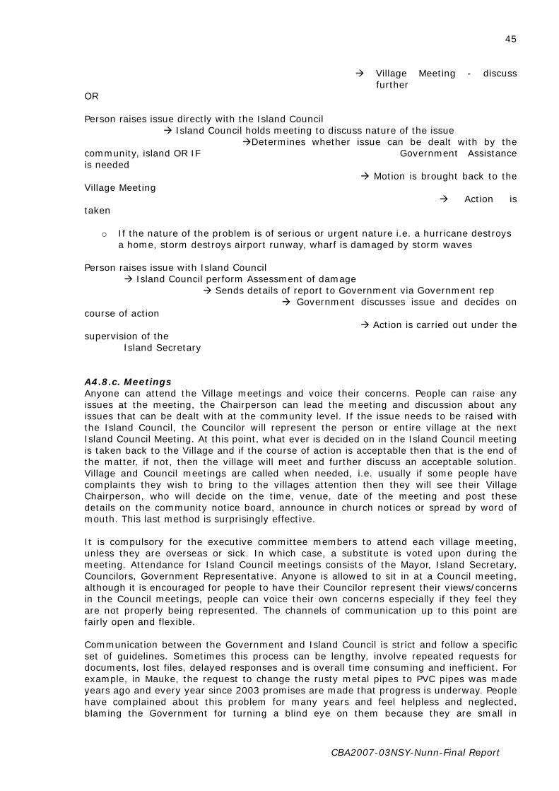
CBA2007-03NSY-Nunn-Final Report
45
Village Meeting - discuss further
OR Person raises issue directly with the Island Council Island Council holds meeting to discuss nature of the issue Determines whether issue can be dealt with by the community, island OR IF Government Assistance is needed Motion is brought back to the Village Meeting Action is taken
o If the nature of the problem is of serious or urgent nature i.e. a hurricane destroys a home, storm destroys airport runway, wharf is damaged by storm waves
Person raises issue with Island Council Island Council perform Assessment of damage Sends details of report to Government via Government rep Government discusses issue and decides on course of action Action is carried out under the supervision of the Island Secretary A4.8.c. Meetings Anyone can attend the Village meetings and voice their concerns. People can raise any issues at the meeting, the Chairperson can lead the meeting and discussion about any issues that can be dealt with at the community level. If the issue needs to be raised with the Island Council, the Councilor will represent the person or entire village at the next Island Council Meeting. At this point, what ever is decided on in the Island Council meeting is taken back to the Village and if the course of action is acceptable then that is the end of the matter, if not, then the village will meet and further discuss an acceptable solution. Village and Council meetings are called when needed, i.e. usually if some people have complaints they wish to bring to the villages attention then they will see their Village Chairperson, who will decide on the time, venue, date of the meeting and post these details on the community notice board, announce in church notices or spread by word of mouth. This last method is surprisingly effective. It is compulsory for the executive committee members to attend each village meeting, unless they are overseas or sick. In which case, a substitute is voted upon during the meeting. Attendance for Island Council meetings consists of the Mayor, Island Secretary, Councilors, Government Representative. Anyone is allowed to sit in at a Council meeting, although it is encouraged for people to have their Councilor represent their views/concerns in the Council meetings, people can voice their own concerns especially if they feel they are not properly being represented. The channels of communication up to this point are fairly open and flexible. Communication between the Government and Island Council is strict and follow a specific set of guidelines. Sometimes this process can be lengthy, involve repeated requests for documents, lost files, delayed responses and is overall time consuming and inefficient. For example, in Mauke, the request to change the rusty metal pipes to PVC pipes was made years ago and every year since 2003 promises are made that progress is underway. People have complained about this problem for many years and feel helpless and neglected, blaming the Government for turning a blind eye on them because they are small in

CBA2007-03NSY-Nunn-Final Report
46
population and not a tourist destination. A4.8.d. Decisions regarding community land and coastal waters Community land comes under the authority of the House of Ariki’s, a traditional authoritative figure in our culture. Several Families may be able to lay claim to a particular square of land, if conflict occurs over distributing the land then it is taken to the Ariki of that village to decide. The Island council has no control over private land, and in fact try to stay out of land matters altogether unless it concerns Government leased land. Coastal waters are considered by the people to belong to the people. Although in Aitutaki, as it comes under the regulations of the Environmental Act, coastal waters and its protection comes under the jurisdiction of the Environment Services. Since Mauke does not fall under the Act, the coastal waters are the responsibility of the Island Council and Community. A4.9. Problem solving for climate/environment change A4.9.a. Traditional level Strategies and other community initiatives Tutaka – Every 3 months the Public Health Departments initiates a large scale health inspection of everyone’s homes and yards in an effort to keep the community clean as well as reduce the chances of Dengue epidemics. Girl Guides and Boys Brigade – are also part time Environmental Rangers, cleaning up litter and rubbish, cleaning the community, replanting trees to protect against erosion, and generally doing activities that benefit the environment and also the community. Club Activities (Aitutaki) – run by some teachers and youth leaders, help raise awareness to children and youths about the environmental issues happening on the island, erosion, waste management, natural hazards etc. through fun activities, field trips, games etc (Aitutaki) Clean up Day – Everyone makes an effort to clean their yards and the whole community Housie (Mauke) – Housie has been a long enjoyed hobby for many of the mama’s on the island, and is a fun way to raise money for projects such as the “Home Garden” initiative which allowed many homes to set up their own vegetable gardens by affording fertile soil and seeds from Rarotonga. NB/ The soil in the village areas are not ideal for growing, farms are located further inland, so gardens are at a higher level than the ground (which is difficult to penetrate sometimes as the coral is close to the surface). Raui – A raui is a traditional marine ban on fishing or harvesting of any kind within an allocated area. Nothing can be removed from the raui area for a specified time period. Sometimes the raui is lifted for harvesting and replaced again. It is signified by someone, usually an Ariki or Mataiapo, tying a rauti (Ti) plant around two trees indicating the area between them is protected. Today, signs are placed in the water signifying raui areas. In Aitutaki there is a Raui in Vaipeka area on all fish, One Foot Island for bonefish, Maina Island for trochus. A4.9.b. Government and other Organizations Assistance The major problem posed when requesting assistance from the Government is the limitations of the Budget. If there are no funds available to re-pipe the entire island (Aitutaki and Mauke), then the problem of drought and salt water intrusion will continue, placing residents in a helpless and frustrating situation. Some people do recognize NZAid and AusAid assistance, even if they cannot remember the specific projects they funded.

CBA2007-03NSY-Nunn-Final Report
47
At this point of the interview not many people new or are aware of the numerous projects and aid funded developments that take place within the community. It could be possible that some aid projects are not widely advertised to the public, or aid organizations may wish to remain discreet, the real reasons are unknown. People in general are aware that their island does receive aid from outside organizations and the government, but they just don’t know what. The attitude noticed is that people are proud to be able to solve some large scale projects as a community, for example in Mauke 2005 a family’s home was burned down and the village immediately took charge by fundraising, housie, holding a radiothon in Rarotonga, donations poured in from Maukean communities overseas in an effort to raise funds to re-build the house. The government also assisted by providing free labor through government workers and some building supplies. A4.10. Discussion A4.10.a Disaster Management Aitutaki: To ensure an effective Disaster Risk Management Plan is in place, the Implementation of the Risk Management Plan is carried out accordingly, the disseminate of information for prevention, mitigation, preparedness, response, rehabilitation and reconstruction of each village. To Identify appropriate premises as evacuation centre’s. To ensure that the communication link with established village to village, island to Rarotonga. Chairperson Mayor Tai Herman Disaster controller Police Dept Snr Sgt Tukua Putu Secretary Island Secretary Sabati Solomona/Tepaeru Cameron Treasurer Island Administration Ports Authority Manager Mr Clive Baxter Education All Principals Infrastructure Manager Mr Tupapaa Ngatokoa Red Cross Chairman Miimetua Blenkarn Aitutaki Power Manager Rimaroa Tuiravakai Health Resident General PractionerDr Koko Island Council Members (8 members from each village). All government agencies and private sectors are members of the Disaster Team0 The Aitutaki Hurricane Safety Plan was set up by the Mayor, Island Councilors and Village representatives for the purpose of strengthening the focus on disaster awareness programs, prevention preparedness, and mitigation, response and recovery programs. The operation and procedures is set out in the Emergency Management Plan e.g. all government agencies and private sectors on standby in case machineries are required to clear or hospital if any injuries during the cause of clearing or transporting people especially those who did not wish to vacate their homes in the earlier stage of the hurricane. The Island Councilors are the village representatives together with the Chairman of each village who are there to assist in ensuring that the people is safe and looked after when they get to the hurricane centres. The Island Council has the machineries and manpower to assist any task (s) required to be carried out during this period e.g. evacuation of people to hurricane centre’s, trimming of trees posing danger etc.

CBA2007-03NSY-Nunn-Final Report
48
Structure A4.10.b. Village Committee Structure Each village has their own respective committees to deal with local issues i.e. fundraising events, social gatherings, youth and religious events, delivering notices and allowing villagers to voice their concerns over any issues faced in the community i.e. littering problems, new developments, pollution etc.
o Councilor – reports the events of the village meeting to the Island Council; more specifically, any problems that cannot be solved at a community level is brought to their attention
o Chairperson – runs the meetingo Vice Chairperson o Secretary o Treasurer o Sports rep
o Youth rep o Women’s rep o Religious rep
A4.10.c. House of Ariki and Traditional Structures The House of Ariki are the traditional leaders who gives advice on traditional matters and maintains considerable influence but has no legislative powers. They are still highly respected within the community, in some cases even more so than other figureheads, so having their presence and support in matters of local government/Island council means gaining the support of the people. Aitutaki Ariki
Putokotoko Vaevae Orooro
Ui Ariki Mauke
National Disaster Management Officer - Rarotonga
Aitutaki Disaster Management Officer & Chief Coordinating Officer
Disaster Management & Implementation Committee
Community
Mataiapo Class – sub district chiefs
Highest traditional authority
Next in line to the Ariki title, he is the Voice of the Ariki since he does not actually speak at meetings.
Announces when a meeting is going to occur, and the results of a meeting. Also like an orator.

CBA2007-03NSY-Nunn-Final Report
49
The structure is almost the same as the one in Aitutaki, except the two levels of Mataiapo do not exist. Ariki Mataiapo Rangatira Are Taunga The Taunga is the traditional religious leader on the island, the Are Taunga translates to House of Protection or spiritual connection for the island. It is at this location that the new Ariki must go to be crowned and the ceremony takes place. The area surrounding the Taunga is considered a place of treaty, once on this land no one can harm you, or more accurately no one is allowed to harm you. The Are Taunga creates strong bonds of protection and caring for the welfare of people no matter where they are from or who they are. A4.11. Recommendations The purpose of this Research was to understand the decision making process in rural areas of the Cook Islands, namely Aitutaki and Mauke. Although we managed to gather considerable information regarding environmental problems, decision making processes and how the local communities address these problems, there are possibly other more suitable islands to better fit the criteria of ‘rural’. In particular, the islands of the Northern Group; Manihiki, Nassau, Tongareva (Penrhyn) also known as Mangarongaro, Pukapuka and Rakahanga. On the other hand the costs of reaching these islands may outweigh the possible benefits. A4.12. Limitations 1. People had their own agendas they passionately wanted to talk about and sometimes
did not answer the questions. It is considered extremely inconsiderate and rude for younger adults to interrupt the elders, Mataiapo’s, and chiefs in the villages. So when they spoke, we have no choice but to let them complete their speech before asking the next question. This proved to be time consuming. E.g. the chief Teao Ariki when asked to rank in order what environment problems/issues are of most threat/concern to the community? He replied they where all irrelevant, and that the “Youths attitudes and behavior were the one thing that was of most concern to the community”. Most of the interview consisted of criticizing the Aitutaki youth.
2. The language barrier was a minor problem. It was difficult translating the Maori used
by the Elders. Many of the elders used an ancient form of Maori similar to the old Shakespearean English, in which we required a translator (our kind and generous host) to help us. Some Maori words do not have an English equivalent, so when describing them in length, the true meaning of the word may be slightly ‘watered down’ i.e. some times it is just difficult to explain the true meaning of some words, so we have rephrased them according to how we understand them.
3. The tape recorder was not very useful as the tape lasted for only one hour. The
average length of time for our interviews lasted 2 hours. Some interviews lasted 3.5 hours, others only 40minutes. We relied on one person (Jim) asking the questions and primarily interacting with the interviewees, while the other (Mii) focused on recording their answers and bringing up any other questions that may seem relevant. This appeared to be an efficient system and ensured several different viewpoints were reached.
4. The greatest downfall of interviewing the first island of Aitutaki lay in the timing or
period of our visit, the week before Christmas. It was during this period that many families were returning to Aitutaki for Family Reunions, weddings and such and didn’t have the time to answer our questionnaire. Although people were happy to help with

CBA2007-03NSY-Nunn-Final Report
50
our research, they were more likely to direct us to other potential interviewees rather than answer it themselves. This resulted in a lot of time wasted running around, setting up interviews, arranging for transport…
5. AITUTAKI - Many of the people on our list to interview were too busy, hard to locate
(due to being on the move). Even office hours were not adhered to; many people could not be found in their offices, many businesses only opened 3 days per week (Westpac Bank), 3 hours a day (ANZ Bank). We suspected people were taking the week before Christmas as a holiday period and preparing to host their many relatives arriving from overseas (this was the case with the environment officer who we visited his office every weekday of our stay) . Some people were simply reluctant to be interviewed.
6. There were some questions in the interview which the respondent could not answer
due to having limited understanding of the topic. For example, many respondents did not know how cyclones formed, or the time period when some environmental problems began to occur, and whether other Aid from outside organizations was given to fund projects for the community.
7. Conflicting Viewpoints. In Aitutaki, we encountered two opposing ideas in regards to
the issue of Erosion. One group observed the main island has been ‘growing’ and proof lies in the emergence of several new motus (islets) over the past 30 years, as well as the lagoon becoming shallower and warmer and the coastline being wider (all around the island). Today anyone could easily walk to the reef when before the lagoon was so deep that people could only swim or canoe there. Another group states the island is experiencing coastal erosion and the sea level is in fact rising. One example is that 40 years ago people used to hold horse races; 8 horses could ride along the stretch of beach from Arutanga to Amuri side by side. This beach has disappeared. We were unable to find more solid evidence to determine the extent of erosion on Aitutaki
A4.13. Other observations and comments Mauke Due to the small population, many of the key decision makers hold several roles within the Island Council and community. For example, the Member of Parliament for Mauke, Mapu Taia, is also the Speaker of the House for Parliament, Church Deacon, local farmer and fisherman. This gives a unique perspective to the main authority figures who are still very closely involved within the community. Overall we experienced a great feeling of community togetherness while visiting interviewees around the island. The best description of the locals is they are true people of the sea; their livelihoods rely on the seasonal winds, being farmers/planter and fishermen, as a result they are very in tune to any small changes to the weather and seasons. People were very eager to aid us in any way possible, and were extremely friendly providing us refreshments (nu, pineapples, watermelons, lychees, nuts) throughout the interview and offering names of others who may be able to help us. Everyday we were treated as royalty and each of us left with many gifts, ei’s, souvenirs and chill bin’s stacked with local fruits. People in general were happy to speak openly about their speculations on the environment and climate change etc, but appeared reluctant to sit down to a formal interview, which was seen as being too foreign, uncomfortable. People preferred the unstructured, informal and open atmosphere in which the interview would consist of inputs from uncles, aunties, friends and neighbors. We still gained a lot of information through informal sources. The Japanese Fishing Vessels (based on speculation) take advantage of Mauke’s un-

CBA2007-03NSY-Nunn-Final Report
51
patrolled waters frequently. The vessels can be seen by locals from the coast, and it is only assumed the boats are Japanese owned. This can be one factor that contributes towards the heavy decline in fish surrounding Mauke. The island has been known to have an abundance of tuna and other sought after ocean fish. The Cook Islands only sea patrol boat, Te Kukupa, is mostly stationed in Rarotonga and would take several days to reach Mauke. Hospitality or ‘ui tupuna’ People here are extremely friendly, waving as you pass by on your bike or offering to give you a ride when you get a flat tire. Within 2 minutes we were approached by two people, one lady went to call our host to pick us up while another offered to take one of us home. This is a close knit community and everyone knows each other; one big family. Even visitors are welcomed into the home with a Sunday lunch hosted by the local village after church. Aitutaki Saltwater Intrusion When we refer to saltwater intrusion, it is a man made disaster rather than the natural kind caused by the infrequency/lack of rain. Speaking to one of the elders who was present when the government first began to bore for underground water sources, he said the engineers dug too deep, well below sea level and the freshwater source has been contaminated ever since. An Inconvenient Truth A documentary by Al Gore Before our trip to Mauke, we arranged our accommodation before through Jimmy’s grandmother, who is well known and well loved by the people. Upon knowing of our arrival, several requests were made for us to bring some items over for some families there. We ended up taking five copies of this documentary for five families. We were given our own copy and watched it in Mauke. Needless to say we were awestruck. We donated our copy to one of our interviewees Teata Atereano, a primary school teacher who expressed great interest in climate change issues and our research. In fact our interview with herself and her husband Tangata was the longest of almost 4 hours. If you haven’t heard about or watched this documentary I would highly recommend it as it has some interesting implications that appear relevant to this research as a whole. The greatest turning point for me was his idea of increased frequency and severity of cyclones in the Pacific, and the change in weather (cold in summer, no fruit seasonality); both are occurring here in the Cook Islands, in particular Mauke and Aitutaki. This is our own speculation.

CBA2007-03NSY-Nunn-Final Report
52
Appendix 5. Understanding Environmental Decision-Making in Fiji: case studies of Lalati, Nawaisomo and Rukua villages (Beqa Island) and Kese Village (Naviti Island)
NOTE: This Appendix is a lightly edited version of the report by Duncan Williams for this project. A5.1. Introduction The island of Beqa is located to the south of Viti Levu at approximately 10km, Beqa comprises a total land area of approximately 36 square kilometres (Figure 1). It consists of 8 villages which are Soliyaga, Lalati, Nawaisomo, Raviravi, Rukua, Naceva, Dakuibeqa and Dakuni. Its extensive coral reef lagoon system is responsible for the variety of marine resources that Beqa is renowned for. The proximity to the main island of Viti Levu makes the Beqa passage one of the most difficult areas to cross. Strong south easterly trade winds make the island vulnerable to wave and wind action. The island lies 30km long and 16km wide it protects much of the coastline by reducing the onslaught of waves.
Nawaisomo Raviravi Soliyaga Lalati Rukua Dakuni Dakuibeqa Naceva
Figure 1 .Beqa Island (Source: www.google/earth.com) Beqa is registered under the province of Rewa whilst the respective villages are divided into two districts (tikina). Lalati, Nawaisomo,Raviravi and Rukua come under the district of Raviravi, whereas, Soliyaga, Dakuni, Dakuibeqa and Naceva belong to the district of Sawau. These two districts are led by its respective ranked leaders who are paramount chiefs namely Tui Raviravi and Tui Sawau. Rukua is the most populous village at the same time being the most developed whilst Lalati has the least with just over 100 people. The population of Beqa to date has exceeded 1300 as was reported by Crosby (1993) and is projected to increase in the near future. Like most of the islands that lie within the Tropics, the sea surface temperature rarely falls below 20°C but sometimes can be as high as 30°C throughout the year (Dalzell, et al, 1996:400). The average rainfall for most, if not all of the region ranges from 2000 to 3500 mmyr¯ ¹.

CBA2007-03NSY-Nunn-Final Report
53
A5.2. Methodology The focus of the research was the island of Beqa. 10 interviewees were chosen from the village of Lalati. 5 interviewees were chosen from the village of Rukua. 10 interviewees were chosen from the village of Nawaisomo. Trial interviews indicated that knowledge base of villagers was limited in terms of environmental problems, so sections of questions on decision-making became redundant as structure and decision-making hierarchy was the same across the board. The researcher also travelled to the Yasawa Island of Naviti, Village of Kese and interviewed 5 individuals in that village. Interviewees were given the introduction and taken through the questions in the questionnaire. The interviewer spoke in Fijian and translated the questions from the interview sheet. The researcher made observation of areas in the village and the environment to verify the accounts of environmental problems presented in the reply to interview questions. The results obtained from these interviews were analysed and put into tables and information flow charts, the primary premise for which these analysis are made is to gauge the effectiveness of local governments in providing structure for adequate preparation for various effects of climate change. The main points of interviews are addressed in an observation section and these are further analysed in the discussion section. A5.3. Results Decisions in the villages are generally made following the hierarchy below.
Figure 2. The hierarchy of decision-making forums in a Fijian village Decision-making forums in the villagers where interviews are carried out represent the primary decision-making structure in Fijian villagers. Individuals in a village are born into a mataqali (clan) by birthright. The males in the clan are seen as the continued survival of the clan, they will marry and their children will belong to the clan. The woman belongs to the clan however upon marriage their children belong to the clan of her husband. Mataqali

CBA2007-03NSY-Nunn-Final Report
54
members are often closely related today marriages within clans are rare, in early Fijian history these marriages were encouraged to strengthen clan ties and numbers. Each clan had a function in the village, the bati (warriors) were clan or clans charged with the responsibility of protecting the village and the chief, Different clans were given various responsibilities from cutting firewood, fishing, hunting and gathering. At a higher administrative level the bete ( priests) and ratu (chief) clans were charged with their respective roles. Crossing this traditional hierarchies is the turaga ni koro ( government representative) he has an administrators role in the village representing the local government administration in decision-making.
Figure 3. The hierarchy of decision-making in a Fijian village A5.3.a. Observations Culturally Fiji is primarily patrilineal, social controls are built around men being the main decision-makers in the village/community. This reflects on representation in forums that make major decisions regarding village welfare, well being and property, there is strong indication that this bias transcends into the government level. In the village decision-making hierarchy the higher influential figureheads are mainly men, they are the chiefs turaga ni yavusa, they are chosen as leaders of mataqali. This means that women have no direct influential on land issues, marine protected areas and development. Religion plays an influential role in the communities, to the extent that in the traditional yaqona drinking ceremonies, the bowl usually reserved for the bete is now given to the pastor of the recognized Christian denomination in the village. This is a problem in multidenominational villages where villagers in different denomination often have disagreements. These differences transcend into village affairs which negatively affect decisions that affect everyone in the village. It has come in the way of development, education and discussions

CBA2007-03NSY-Nunn-Final Report
55
of issues regarding land and property. Women and children are expected to implement made decisions without question.
A5.3.b. Environmental Problems Commonly Faced Refer to the table below for a summary of the environmental problems faced by the communities studied. Table 1. The table analyses common problems faced and reflects the understanding of interviewee to the concept of climate change.
Environmental Problems
Effects Frequency Associated with climate change?
Hurricanes Damage crops and properties
Infrequent but unpredictable
2 interviewees make the association.
Erosion- Inland Damages crops that is food and sold as cash crops
After heavy rains, cutting to clear for planting, slash and burn on steep slopes.
No association
Erosion-Coastal Flooding village drains, drinking water is made undrinkable, sea water seepage into wells.
Very high tides means the sea is able to find its way past the sea wall and fills the reclaimed land.
No association
Pollution Hotel built nearby is responsible for fuel spillage from boats. People in the village are not carrying out best practice methods for waste disposal.
Before the hotel was built, the inter tidal flat was thriving with shell fish, now they have moved elsewhere.
No association
Drought-Water Shortage
Rain and dry season are difficult to differentiate, long dry spells and rain is heavy and short-lived.
Happening more often in the last 5 years.
3 interviewees make association.
Climate change and the problems pertaining to it have not made an impression in the villagers for which these interviews were carried out. There is a strong indication after the brief interviews in the Yasawa village of Kese that this could be true for the majority of village communities in Fiji. The reaction of the individuals interviewed were echoed by a majority of other villagers who expressed that frequent cyclones, rise in sea level and changes in seasonal climates were events they could do nothing about, thus there was no need to worry oneself about it. These views were often aired with pious reverence alluding to the belief that nothing would happen if powers that be did not allow them to. To the extent where bad things happening was God exacting judgement upon men. Despite the drama and “bible bashing”, it is certain that the village is facing some effects of climate change which is adversely affecting the daily lives they are used to. Crops are affected by unusual heavy rain in dry seasons; unusually high tides are making an impact on the villages, flooding the drains and wells that are normally used in emergency water shortage.

CBA2007-03NSY-Nunn-Final Report
56
Figure 4. General locations of issues that villagers in Lalati are facing Located in the harbour Lalati does suffer from wave action on the coastline, however most of the foreshore that buffers the village is reclaimed mangrove area. The immediate landscape behind and around the village are steep and covered with secondary forest during heavy rain, strong winds or cyclones the area is subjected to frequent erosion. The villagers do not help to solve the problem by carrying out slash and burn activities in many places. Rising tides (King tides) are often a concern as water gets into water sources and invades the village drains, causing problems for sewage systems.

CBA2007-03NSY-Nunn-Final Report
57
Figure 5. Approximately 2 hectares in size, Nanuku Island is a favourite picnicking and tourist spot Nanuku Island (approximately 2 kilometres of Beqa Island) belongs to the villagers of Lalati. During strong hurricane activity the people notice that the sand can be completely shifted from one side to the other depending on wind and wave action. Observations indicate that the island is prone to wave action and is heavily eroded on the south east side. Heavily dependent on gathering marine organisms for food from immediate areas around Nanuku the people of Lalati are aware that a food source is under threat. The waters around the island are so rough and unpredictable that on fishing expeditions, villagers are expected to return at a certain time in the afternoon, failure to do so will result in a search for them. Many villagers have faced dangerous experiences with strong winds, strong currents and temperamental waters. When discussing increasing tides, frequent cyclones and adverse abnormal weather conditions a few of the participants were quick to point out the problems that were occurring on Nanuku Island.

CBA2007-03NSY-Nunn-Final Report
58
Figure 6. Rukua and Raviravi are close to each other on Beqa Island; they face the same environmental problems Raviravi and Rukua are villagers engaged in major tourist activities, they have a major hotel nearby and the waters around the areas they are situated, is known for its excellent diving. Shark feeding enthusiasts frequent the villagers to experience the event and also be observers in the fire walking ceremonies. The village is heavily dependent on the income from the tourist operators and so decisions in the village is heavily affected by chiefs and clan heads as they are profiting form the tourist activity. The villagers in Rukua and Raviravi are quite modern considering the other villagers on Beqa. They have television, sky pacific connections and plush houses. The main primary school for the island is on Raviravi. Climate change in these villagers are a point of concern, for few educated citizens who are aware of the consequences it can have on the marine ecosystem, which ultimately affects there source of income. Other climactic problems that arise from changes are not considered. This is mainly due to lack of awareness regarding the overall effects of climate change. The people in Rukua and Raviravi face immediate problems from inadequate sewage management and lack of proper waste disposal/management.

CBA2007-03NSY-Nunn-Final Report
59
Figure 7. Kese village in Yasawa Island group, the region is frequented by hurricanes and locals are aware that “something strange is going on” The Yasawa group is the first group of islands that gets hurricane and cyclone warnings when the Fiji Islands are faced with strong winds. Kese is the government station for the Yasawa island Group and they have the hospital and post office, although they are host to the local district officer, they have little awareness of climate change. The villagers notice that something is amiss, they are not getting the usual fishes from the fishing grounds, and rainy season and dry season different enough to be evident. They will have periods of dry humid conditions and then sudden heavy rain. The main problems they seems to face are unsustainable agricultural activities, overfishing, erosion and in dry weather water shortage. Heavily dependent on agriculture the older men in the village are very worried; specialists in planting yams the older men and women in the village follow a calendar that is based on harvest. Certain harvest of certain foods point to a connected event, like particular fishes can be found or other fruits should be available in conjunction with such occasions. The men in Kese village frustrated at weather conditions, the interviews were carried out just as a freak hurricane storm had passed. ‘These things happen often here; however we can usually tell and prepare for it, now they sneak on you like a thief in the night!’ A comment made by the turaga ni koro in Kese Village. The villagers in Kese have an evacuation procedure in event of hurricanes or cyclones. When consequences of climate change were explained to them they commented that would not have any plan whatsoever to face these possible scenarios.

CBA2007-03NSY-Nunn-Final Report
60
Figure 8. Coral bleaching occurring on the immediate reef structures off the island The immediate surroundings of Kese are secondary forest, however a majority of the landscape comprises grasslands and dry forests. During periods of heavy rain preceded by a dry season the wash off of minerals into the sea is very high, this means that immediate coral populations are adversely affected. Coral bleaching is the result of such run offs coupled with occasional use of fertiliser. Coral bleaching is not a direct effect of climate change; however by consequence varying temperatures in the sea can affect coral. The people in Kese understand the connection that dead coral leads to no fish; they do not view it as a product of climate change. A5.3.c. Community-level environmental decision-making Interviewed villagers have a committee that is given the responsibility of dealing with emergencies, these are executive arms of village functions, they are required to implement decisions made by the different decision-making forums. The members of these committees are chosen in village meetings. It is not viewed as a special committee but rather as one that deals with health issues, land or individual disputes and unlawful acts that may occur in the village. In respect to the climate change issues presented to the interviewees the committee charged with development komiti ni veivakatorocaketaki (refer Fig 1.5) have responsibilities that coincide, however their primary function is to oversee the general development of the village in respect to electrification, sewage, housing and income opportunities.

CBA2007-03NSY-Nunn-Final Report
61
Figure 9. The role of the Turaga ni Koro as the government representative to the village
Figure 10. Sources of information for individuals in the villagers regarding cyclones as a model for all general forms of other sources of information Committee for Emergencies (Komiti ni Leqa Tubukoso)

CBA2007-03NSY-Nunn-Final Report
62
Figure 11. The village meeting delegates functions to each committee if the area concerned comes under the primary responsibilities of a committee, new committees can be formed by Turaga ni Koro on a needs basis Information dependency on news media and the utilisation of one point of contact which is the turaga-ni-koro makes the mode of communication very inefficient, which affects awareness campaigns by government and non governmental organisations. This centralising of information dissemination is effective but rigid, in the circumstance that issues which need to be addressed are complex, effectiveness depends on the capability and efficiency of each turaga ni koro and the district officers. A5.4. Discussion A5.4.a. Environmental Problems Observations derived from interviews indicate that there is a general lack of awareness in rural Fijian villagers with issues about climate change. They is a growing concern however for people in villagers as they notice changes in weather patterns, absence of marine life from the usual fishing grounds and physical changes in landscape. Most of the immediate landscape in areas surrounding the villagers where the interviews were carried out has been extensively utilised for agriculture. Most of these areas are not farmed anymore and has been left desolate most of which become secondary forests and grasslands which is vulnerable to erosion and fire. Environmental problems are made worse by unsustainable resource utilisation such as issuing of fishing licenses by chiefs and resource owners. Harvesting of fish from Beqa and Naviti Island in Yasawa is predominantly commercial, more than one licence operate in a fishing ground is contributes to severe depletion of much needed subsistence resource. Pollution also contributes to environmental problems, the villagers of Lalati, Rukua and Raviravi have problems with sewage management, Rukua and Raviravi use a septic tank system that is functional during dry weather conditions, during heavy rain these systems are often blocked and overflow is often into the immediate foreshore. Lalati village has a highly inadequate and unplanned sewerage system, most of the systems are septic, or utilise empty drums as substitute. The village sits on predominantly reclaimed land; this means heavy rain and extremely high tides flood the household systems and village drains causing blockage and adverse health risk issues.

CBA2007-03NSY-Nunn-Final Report
63
A5.4.b. Decision-making Institutions in Fijian Villages The decision-making hierarchy in Fijian villagers is based around the social order set by titles and land/ocean resource ownership. The resource owners based on the extent of their property are given more prestige or honour. There appears to be a combination decision-making systems held over from pre colonial times when only the chief and heads of clans would sit together to deliberate, combined with a modern components of collective decision-making in village forums. The old ways are still adhered to whereby any issue that cannot be solved at the village meetings or is noted to be beyond their scope is escalated to the meeting of the heads of clans. The turaga ni mataqali is the honorary member of this forum and his presence is required to keep the chief and his heads of clans updated on issues. Decisions that the village forums make can be turned after re-evaluation at the head of mataqali forum. The chief of the yavusa is the chair of this forum and decisions that he approves is adhered and can’t be changed or turned. Decisions at a household level are often made by the head of the household after discussions with key members of the household or as an individual call. Vuvale (households) comprise the mataqali (clan) and clans make up the yavusa (village or villages) in some instances a yavusa can be 3 or 4 villages (in these cases ‘village’ is just a geographical concept) all under one yavusa. The dominant mataqali is given the stewardship of the village and its head is acknowledged as a village head. Major decisions are still made at higher forums where all heads of mataqali from all 3 villagers come together and meet under the high chief of the yavusa. Environmental problems are addressed at village meetings; often the matter is escalated when the resource in question or one that has been affected belongs to a particular clan. Many issues about the environment are often beyond the comprehension of the ordinary villager, this is one of the main reasons for escalation of issues. The decisions that are made are executed by the committee tasked with the responsibility area or to whom the issue belongs. In the event whereby there is an environmental issue raised or a problem is occurring the committee makes immediate decisions, they are required to explain decision in their reports to the village meetings. People concerned are required to adhere to the immediate decisions made or follow a decision made at the village forum or head of clans’ forum. Environmental problems are often relegated to least priority when compared to visiting delegates, getting electricity, adequate water, and health and income issues. The concept of climate change to most is currently not an issue; few interviewees could connect the environmental problems they were facing as an indirect consequence of climate change. They are facing problems like erosion, coastal erosion, pollution, changing weather patterns, freak storms and hurricanes. Three interviewees were adamant that such things were out of peoples control and such things were more a reflection of divine power. Unfortunately this would likely be the view that many piously hold, it is difficult to reason with such strongly held opinions. However it is clear that villagers interviewed have any understanding of the concept of climate change. This is further reflected in their decision-making institutions which don’t have a criteria to address environmental problems. The tendency in such situations is to escalate or refer the problem. There is a need to raise awareness in Fijian villagers and advocate for proactive planning. The people at grassroots level in Fijian communities are not aware of the world view and the changes that are occurring in our environment. They understand these problems as local and don’t link it to major climate issues that are happening in the world today. The concept of climate change in itself a neo concept for many interviewed. Information that is passed from government and other non governmental organisations are inadequate and needs to be made comprehensive and translated so that it is understood at all levels.

CBA2007-03NSY-Nunn-Final Report
64
Appendix 6. Understanding Environmental Decision-Making in Fiji: case studies of Daria and Nakawakawa villages, Wainunu, Bua (Vanua Levu island)
NOTE: This Appendix is a lightly edited version of the report by Jokim Kitolelei for this project.
A6.1. Introduction The Fiji islands is located on the southern tropical zone of the world (16-190 S, 1770E-1780W) and is located in the South West of the Pacific Ocean and has 18,376sq kilometers which has three hundred high islands and hundred ninety seven of which are uninhabited islands (Miller et al, 2000:21). Viti Levu is the largest island in the country and the islands are mainly made up of volcanic islands which are Viti Levu and Vanua Levu with other smaller islands.
A6.2. Study Sites Vanua Levu which is the focus of the research is the second largest island and is an old volcanic island and has three provinces: Bua, Macuata and Cakaudrove. The province of Bua which is the third largest province in Vanua Levu has eight districts which are Lekutu, Bua, Dama, Vuya, Solevu, Nadi, Wainunu and Kubulau. The areas of study are Nakawakawa village and Daria village lies in the district of Wainunu (with Nabunikadamu between them) and which are located between the two towns of Nabouwalu and Savusavu. Both villages are located along the Wainunu bay and both have large mangroves forest in front of the village and dense forest behind the village.
The villages consist of steeply down to rolling flatlands areas and are suitable for agriculture and have fringing and barrier reefs. Both areas are located near the river and also on the periphery of the province of Bua. The villages are both traditional Fijian villages and consist of a head man and inhabited by indigenous Fijians with their own unique lifestyle.
Figure 1. The Fiji Islands (Fiji Visitors Bureau, 2000)

CBA2007-03NSY-Nunn-Final Report
65
Daria village is located beside the river on a high raised ground of twenty six meters from the mean sea level. It is located along the Wainunu Bay and has a large mangrove forests facing the village with a rich biodiversity of forest inland. The area is situated between Koritiki and Cogea village.
Population Table 1. Population by the village-2007 Census of Population and Housing Total Fijian Indian other Locality Pop Hhld Pop Hhld Pop Hhld Pop Hhld
Daria village
140 24 95 18 0 0 0 0
source: Fiji Islands Bureau of Statistics Village Economy o The villagers are mainly farmers and are highly dependent on their farms for their
source of food and also for income. The land is very important as it provides food and income which they use for their survival and also this biodiversity is the main source of living for the village and also it provides important functions to the ecosystem. The agriculture of Daria is very simple, planting crops that suits and is favorable for their basic needs and using very small areas of land with very simple resources to grow these crops and also raise their livestock. The size of the farm in many villages are extensive farms and people mostly practice shifting agriculture in which they leave the land to fallow over a time period to regain fertility.
o Farmers usually earn less than ten thousand dollars per year Social The village of Daria is a respected area in the district since this is where the head of the district is residing, the “Tui Wainunu” and also he controls and makes decisions over the district. The village is mainly a traditional village and having its own rules and also traditional setting that is very different from that of the urban areas. Living standards and developments are very slow since they are being located from a long distance from the urban area and people still using traditional knowledge for their own survival. The people in the village are farmers and their main source of income and activity is planting “yaqona” and taro and also use the marine resources for their food and also to earn income. very few people in the village rely solely on the sea for their source of living as most farm the land as the return is higher than that of the sea.
Daria village
Figure 2. Daria Village

CBA2007-03NSY-Nunn-Final Report
66
Nakawakawa village is known as the largest village in Wainunu district and is located near the sea with a large area of mangrove forest, and situated between Nabulikadamu and Saolo village. The area is rich with high biodiversity for both terrestrial and marine ecosystems. It is approximately twenty three to thirty two meters in height above sea level and located on high area having a suitable view of other areas from the area. Population Table 2. Population by the village-2007 Census of Population and Housing Total Fijian Indian other Locality Pop Hhld Pop Hhld Pop Hhld Pop Hhld
Daria village
213 62 213 62 0 0 0 0
source: Fiji Islands Bureau of Statistics Village Economy: The villagers are mainly farmers and highly dependent on their farms for their source of food and also for income. This is their only source of earning a living and allows them to cater for their needs and wants rather than doing other work in the village. Social The village is a Fijian traditional village and a Methodist village, the faith adopted since the arrival of the missionaries to the area. The village has its own traditional village leader which is the “Turaga ni Yavusa” and then there are other leaders such as the “Turaga ni Yavusa” who leads after their own “mataqali”. This leadership has been in the village when it was first established and this allows the proper functioning and unity of people over the years.
Figure 3. Location map of Nakawakawa Village.

CBA2007-03NSY-Nunn-Final Report
67
Figure 4. Structural Descriptions of decision-making in Daria and Nakakawa villages The village of Nakawakawa and Daria are both small villages and discuss all their problems during the village meeting in the presence of the heads of the Mataqali and the head of the Yavusa. The commoner (farmers and fisherman) who lives within the power of both Turaga ni Yavusa and Turaga ni Mataqali adhere and listens to both of them. As they are faced with problems they will inform their Turaga ni Mataqali or the Turaga ni Koro to raise their concerns during a village meeting. They can also raise it during the village meeting as the meetings are mainly for everybody and any topic can be discussed within the presence of both Turaga ni Yavusa and Turaga ni Mataqali. In order to call for a village meeting, the commoner will informally ask the Turaga ni Koro for a certain meeting and than he will liaise with the Head man Turaga ni Mataqali and Turaga ni Yavusa for a village meeting. In the case that the Turaga ni Yavusa does not agree with the requests from the commoner, the meeting will not be approved. During a village meeting if a problem cannot be solved, it is given to the committee who will try to solve and look into the problems. Any commoner could inform the committee about their problems and there are many different types of committees set up within the village to look at different problems. Turaga ni Yavusa - is the head of the village and mainly owns the land and also the natural resources therefore is the head of the clan and has the final decisions in the village. He mainly looks after his people and also there are different Mataqali within the Yavusa who has power on their own mataqali and caters and looks after its own Mataqali. The government has no power in the village and can only come through and be involved through the Turaga ni Koro who liaises with the village. Government help is always needed
Turaga ni Yavusa
Turaga ni Mataqali
Turaga ni Koro
The common people<farmers, fishermen, etc>
Government

CBA2007-03NSY-Nunn-Final Report
68
and required by the people and during natural disasters such as hurricane the government help goes through the village through the Turaga ni Koro. A6.3. Case Studies of Decision-Making Despite initial information, it seems that no environmental decisions have been made in these villages recently, and no information about such procedures could be obtained. Three examples are given of other decision-making. The Fixing of the Bridge in Nakawakawa village The bridge that is located from a distance from the village was damaged as the result of flooding of the Nakawawa River a few years ago. This affected the village’s only means of transportation and also the whole district of Wainunu, making it a community problem in the village. The whole village knew that it was a problem and the turaga ni koro was informed by the common people informally and calls for a village meeting in which the village of Nakawakawa all decided to fix the road since the government help is very unreliable and are very slow in their response as the people need to get to the markets and also to get food supply. This is a village strategy “solesolevaki” in which the people gathered and came together to spend one whole day fixing the bridge, foregoing their other chores. They went about getting timber from the village and also mixing cement to patch and repair the damaged sections of the bridge. The stealing incident that occurred in Nakawawa village Few boys in the village got caught stealing from the village canteen in which they stole few items and money. The person that caught the boys informed the turaga ni koro in which he liaised with the village police. The village police who was chosen in the village and selected by the police department in Nabouwalu arrested the boys in the village and took them to the police station in Nabouwalu. The head of the police suggested that the village should solve their own problems and punish their own boy’s. As the boys returned from the police station, the information was related to the head of the clan by the turaga ni koro and the head of the clan called for a village gathering in the village hall. The head of the village gathered the village together and the boys were punished in front of the village hall by the bati where they were beaten while the whole village watched. As the process occurred the boys were being humiliated and also taught a lesson that the incident was a crime and this also serves as a learning incident for those who would think to do something similar in the village. The Land disputes in Daria village. In the case that there is a land dispute in the village, the decisions are mainly dealt with among the land owners. In disagreement about the land with the common people the turaga ni koro will be informally informed and then he will liaise with the head of the village and the head of the village will inform other land owners through the turaga ni koro. The land owners which are the main leaders in the village are the turaga ni yavusa who will get together about their issues on land since they are responsible for their own lands and its affairs. The head of the village which has the biggest land in the area will lead and control the meeting. As the decision is made the village of Daria will be informed by the turaga ni koro about the land issue and the common people will then follow these decisions that is done by the leaders of the clan who owns the land. A6.4. Limitations or problems encountered in the research: There was the lack of digital maps and also if the questionnaire was fully printed out so that it would be easier to do the research rather than rewriting the whole forty questionnaire. There could be a supervisor assisting and visiting the village to see the
CBA2007-03NSY-Nunn-Final Report
69
progress and assist and monitor the research. The village really needs to have awareness educations and since most help comes through the province which doesn’t reach the districts and the different villagers, the village is still unaware of the need to maximize land and sea production, at the same time practising sustainable development. These is a very important and interesting research and it is important to implement projects in villages as they have the capability of working together and also they are the main resource users and when natural disasters occur they are the first to be severely affected. The village structural system is simple and also very interesting in which people have their own leaders and controlled in such a way that corruption and conflict in the village will not a major problem. A6.5. Conclusions Daria and Nakawakawa villages are located on the periphery of Vanua Levu and development is very slow in the area. They are fully dependent on their own farms and got their own interesting way of life living, utilizing and living closely with their marine and terrestrial resources. The people and nature are entwined and forms of the thread of village life. The research was very interesting since this type of research was a first for most of the villagers as only a few realize the natural hazards that are affecting them and their own strategies that are used to solve their own village’s problems.
CBA2007-03NSY-Nunn-Final Report
70
Appendix 7. Understanding Environmental Decision-Making in Kiribati: case studies of Nuka, Tabiang, Taboiaki, and Teteirio villages (Beru Island)
NOTE: This Appendix is a lightly edited version of the report by Elaine Bwebwe and Tiene Tooki for this project. A7.1. Introduction Most Pacific Island Communities have been exposed to a variety of Environmental Problems and have also been greatly affected by them. The low lying coral atolls such as the small islands in the Republic of Kiribati have been reported to be among the most vulnerable. In order to find out more on how rural communities cope with environmental problems, it is vital to seek their views, opinions and understanding especially on how they make decisions in their community in regard to environmental crisis. This particular report is based on a study conducted in Beru, one of the small outer islands in the Republic of Kiribati which has a total population of 2,169 (Kiribati Population Census, 2005). The study was carried out from the 7th – 21st January, 2008. A7.2. Geography of Beru Island Beru is one of the remote low lying coral atolls in the Republic of Kiribati. It is located in the Southern Kiribati, at Latitude 1.34°S, and Longitude 175.98°E. The land mass occupies fully a third or more of the shallow reef structure and is positioned mostly towards the Northeast edge of the reef. The lagoon which is mostly towards the north end is 12 miles long and 3 to 4 miles wide and mangroves are present in this area. A small lagoon at the northern tip is surrounded by man-made fishponds, and a similar feature at the south end of the islet is also present. A 3 kilometer long barachois with extensive mangroves occupies the interior south of Nuka lagoon. A causeway is present across the inlet mouth and a landing strip is also present on the interior flats. The centre of the reef is a shallow depression, Nuka Lagoon. Beru Island resembles Aranuka (another island in the Central Kiribati) in being between a reef island and a true atoll. As part of the Southern group of Kiribati with Tabiteuea (96 kilometres west) and Nikunau either side, Beru is 426 kilometers Southeast of Tarawa atoll. According to records made by the Kiribati Lands Division, the island is described as a reef island of 15 kilometers long (NE-SE) and 4.75 kilometers wide at the widest point (NE-SE) with 9 villages.

CBA2007-03NSY-Nunn-Final Report
71
Figure 1. Map of Beru Island Figure 2. Map of Kiribati
Source: http://www.janeresture.com/beru/index.htm Source: http://www.worldatlas.com/webimage/countrys/oceania/ki.htm A7.2.a. Legendary Beru Traveling to and from Beru is provided by Air Kiribati normally once a week, and by the Kiribati Shipping services which is usually twice a month. In Kiribati, Beru is quite famous for possessing some significant aspects of the Kiribati culture. This included the first ‘maneaba’ (meeting house), ‘Nareau’ who was believed to be the Kiribati creator or great ancestor and Kaitu the fierce and skillful warrior who was believed to have conquered all of the Kiribati islands. According to the Kiribati myths and legends both were believed to be originated from Beru. Adding to those is the famous island’s ‘bokaboka’ (edible algae) which can only be found on Beru and no where else in Kiribati. This ‘bokaboka’ have provided a food source for the islanders in the early 1900’s during a famine. The islanders proudly called their island as ‘te moan aba’ which literally means the first island of Kiribati. A7.2.b. Population The total population in Beru as of 2005, is 2,169 -1056 men and 1113 women, with the majority being in the age range of 18 to 49 (more details can be sighted in Appendix 4a and 4b). A7.2.c. Livelihood The majority of the people have come to depend on imported goods, such as rice, flour, sugar and other European commodities. They generate income through copra, fishing, exporting of brown pandanus leaves to Tarawa (used widely in Kiribati to make tobacco rolls) and just recently (about 2 years now) by collecting and drying sea cucumber which are sold to Chinese agents who often visit the island. A7.2.d. Weather In relation to its position, Beru is dry and hot all year round. According to the people, there has not been any rain for the last 3 to 4 years. According to information from the weather station on Tarawa, the weather in Kiribati reflects the patterns of the El Nino and La Nina. During the El Nino period, Kiribati experience dry season and during the La Nina season, Kiribati experience wet season.

CBA2007-03NSY-Nunn-Final Report
72
A7.3. Study sites The study sites are selected according to the following criteria.
• High eroded areas in Taboiaki and Tabiang villages • Most populated village and settlements/areas with inundation issues – part of Nuka
and Teteirio village respectively. A7.4. Methods The first step that was carried out before the initial research in Beru commenced was to seek advice and assistance from the Ministry of Internal and Social Affairs (MISA) in Tarawa. This is important because MISA is the arm of government which runs all the Island Councils. Through their officers (Island Council Clerk and Island Project Officer) on every island in Kiribati, MISA plays important roles to achieve effective measures, especially in the area of rural development. Some of the major roles MISA is involved with and does on behalf of the Island Councils to government are listed below:-
• Coordinate all outer island development projects that arise from time to time. • Implementation of standing government policies and strategies to Island Councils • Liaise and seeks assistance on behalf of Island Councils’ from government in
respect of projects which needs financial assistance that is beyond the islands capability
• Give official recognition and approval to the Island Clerk and members of the Island Council should there is a visitation by any NGO or Government bodies, Research or Awareness teams either local or foreign coming to the islands.
• Make prior arrangements with the Council Clerk and Island Council Members before any visitation is made to the islands by the above mentioned bodies is made to the island.
Official requests and arrangements have to follow the normal procedure if you want your research visit in this particular case, to attain official recognition as well as if you need assistance and cooperation from both the Island Council members and villagers at large. This is done by writing and seeking assistance and approval from the First Secretary at MISA. The Secretary usually delegated the subject matter to the responsible officer which is the Rural Development Division staff, in this particular case, who will liaise and notify the Island Clerk about the visitation and purpose of the research. The Island Clerk will be making all arrangements in booking the guest house, transportation from the airport to the guest house, inform Council members for the time of meetings needed plus other necessary arrangements that may arise during the period of the stay, otherwise the researchers can do these on their own which often results in unnecessary delays and complication. A7.4.a. Field research methods The method used in carrying out the research is by conducting awareness discussions to the Island Councils who in return have the responsibility to inform their village members about the research. During the discussion awareness, the Council members played a critical role and that is they decide and select the most effective samples based on their knowledge and understanding of their respective communities that they represent. The sample that they put forward consists of those villages and people who have mostly been affected by the environmental problems previously mentioned above. Therefore, the people interviewed were identified and the research was carried out according to the selected sample at the selected areas. A questionnaire, previously provided and designed by the School of Geography, Faculty of Islands and Oceans was used and the interviews were conducted in the vernacular. A7.4.b. Sampling Due to time constraints, the <2000+ adult population could not all be interviewed and questioned and therefore the sample has to be narrowed down only to selected focus

CBA2007-03NSY-Nunn-Final Report
73
groups which consisted and selected mainly from the Community decision-making body and members of the community who have been mostly affected by some of the many climate change related problems such as coastal erosion, inundation (which have resulted in water brackish and dying of food crops), coral bleaching, and droughts. The size sample is 20 and the age ranges from 28 to 68 and the majority is male. This reflects the culture in Beru in which almost all the environmental decision-making is carried out by men only. A7.5. Findings/Results and Discussion A7.5.a. Island Council There were 18 people who attended the discussion and awareness seminar in this particular case study. All of them received a sitting allowance of $30.00 except the Chief Councilor who received $35.00. This is the current standing procedure if there is an official meeting with members of the Island Council. It is worth to mention that during their normal or official fortnightly meeting, 14 members normally attended and received sitting allowances at the same rate. A7.5.b. Appointment of Island Council members The members of the island council were elected by their village members and they get to hold their positions as village representatives to the Island Council for four years. Villages with more than 600 members will get to appoint 3 representatives (Please refer to Appendix 3 and 4). The core responsibilities of the Island Council members are:-
• To inform their villages about island developments • To initiate any community beneficial activities that promotes good health, peace
and safety. • Decision-making of government and village-related matters • Sometimes, they get the chance to represent the island in attending the MISA
meetings in Tarawa. A7.5.c. Special Council members The top and most special and respected member of the council is the ‘Unimwane’ (old man) who is a representative of all the old men of the Island. This member is the oldest among the appointed council members and his being a member is not through election but usually the “unimwane” body decided on who should take the position. Often this member has all of the following qualities:-
i. is still capable of moving about ii. have great patience, iii. responsible and top of all iv. Very wise or “mwaiti kanana te ben” which literally means have eaten the most
number of coconut flesh. The “unimwane’s” role is to open and bless the meeting unless he delegated this responsibility to members of the council, greet the visitors and during the meeting, he listens attentively, give remarks or make comments and finalize the proposed decisions that have been made by members of the council. He is known and well respected for giving wise decisions and advices on any arising island issues. For whatever has been decided by the Council Members, the “unimwane” is always have the last say on the matter and members of the council always awaits the “unimwane” last say, otherwise the matter will not progress and can not be finalized or will simply be dropped. A7.5.d. Other members The other two members of the Island Council are representatives to Parliament (MP). These members are also elected by the village people and get to stand in government for 4 years or until their term ends and the next round of election is held. During the Council meetings, they could be asked to offer their opinions, however they are not involved in any decision-making.

CBA2007-03NSY-Nunn-Final Report
74
Figure 3. Information and Decision-making Flow Diagram in Beru For Government related issues, MISA is the top decision-maker, while the “unimwane” body is the final decision-maker for any arising community matter that of concern to the whole island.
Figure 4. Organizational Chart in villages on Beru Island
Island Clerk
All members of the Community
Island Councils
Island Project Officer
Unimwane
Council Members Rorobuaka Church groups
Youth Groups Other community organizations(AMAK, RAK – women’s group, etc.)
The rest of the village members (women, children, others)
Ministry of Internal and Social Affairs (MISA)(Government) Unimwane

CBA2007-03NSY-Nunn-Final Report
75
Figure 4 portrays how decision-making is generated on the island at a community or village level. The “unimane” are the top and final decision-makers; However, Council members; Rorobuaka or Church Groups are the most active ones and often settle or solve arising community issues from time to time. On the other hand if a case or unsettling matter is a serious one (for example, the issue of the “Tabontebike maneaba” or island meeting house that can not be settled) and can not be solved or settled by the second level body, then the matter was referred to the “unimane” who made final decisions and advice the meeting house to be torched. Adding to that is the fact that if any of the decisions made by the above three bodies was found to be not complying with the “unimane’s” expectations or does not reflect culture (norms or values of the village people), then the “unimwane” plays an active role of obliterating that particular decision and dictate to the village members not to follow. Because, respects of “unimane’s” words are still very strong due to their wise- ness, it always wins strong support from the rest of the community members. The “unimwane” are the most powerful decision-makers in Beru. A7.5.e. Family Decision-making In Beru, most families settle their own problems without referring them to the higher bodies as discussed above. This has to do a lot with the island’s culture. Culturally, it is unacceptable to expose your family’s problems or issues for everyone to know, and it is also shameful to ask for help from families you are not related to by blood. So for instance, if a family living on a coastal area which is being affected by an environmental problem like erosion, then the head of the family in that house hold will not visit the “unimwane”, the island councils, or church groups but will visit his own extended family members and relatives, who are always willing and more than happy to provide help and support in relocating the family to another family plot. In other words, the solution that the people appears to apply is to adapt to the problem and try to live with it. A7.5.f. Other findings On the other hand, the research found that if the matter is in a larger scale; that is, if it is affecting the whole village, then the matter will be brought forward to the unimane’s attention, via the council members most of the time. Matters that will need great financial assistance such as causeways or sea walls will be fowarded by the Council members to MISA via the Island Project Office (IPO) or Island Council Clerk (ICC). During the research it was indicated by the Island Council members that although the Beru project proposals can be made to MISA within a short period and follows a very straight forward procedure, the proposal to be actioned can take about 1 to 2 years before the implementation stage actually begins. However, they mentioned that past proposal/requests for fundings of causeways and sea walls have always being granted to the island from government through MISA. A7.6. Environmental Problems Assessed Most of the 20 people interviewed ranked erosion, drought and inundation as the most concern or threat to their community and blamed the establishment of the causeways in Nuka and Tabiang to increase the rate of threat or contribute to the erosion and inundation. Other concerns that they mentioned were the dying out of the marine or terrestrial species (mangroves, shell fish and fish) that used to be found in abundant for the last 20 to 30 years at the area in Nuka and then in recent years at the area where the Tabiang
Head of the family
Members of the family

CBA2007-03NSY-Nunn-Final Report
76
causeway had been built. A7.6.a. Environmental decision-making in the village/community The majority of the sample interviewed stated that they came to know about the environmental problems and climate change from listening to radio programs. The awareness that was carried out as part of this project in the village maneaba’s by the council reps have been very helpful in adding to their knowledge and understanding. They also stated that environmental issues such as noted in the research can be more effectively informative if the topics are taught to youth groups since they will be the ones to face greater impact of climate change in the future. There are numerous active groups in Church and in the Community that in some way have carried out some environmental awareness and sustainable management activities. These groups were initiated to keep the villages health in good standards, because they inspect home and surroundings and make sure that they are kept clean and tidy, assist in developing mini sea walls and suchlike. The environmental problems are not affecting the communities at an alarming rate and so a village or community decision on the problems at this stage has not been fully exercised. However, it there is any very serious environmental problem that needs attention of the community or that will endanger the community’s livelihood, then as discussed above, the community’s strategy will be as follows:-
• the community will relay the problem to any of the three active groups shown above (Island Council, Rorobuaka or Church)
• the organizations will try and solve the problem within their organization or jointly • If it is beyond their capabilities, then, the case will be referred to the unimwane • The unimane will advice on how to solve the problem and whatever the body of the
unimane decide, then it will have to be followed, if the unimane decided that the issue do require the government’s help, then the Island Council will be tasked to work with the IPO and ICC to convey the proposal to government, that is to MISA. If the decision of the unimane is found to be not successful, they would be respectfully informed and then again their new advice will be implemented which is most unlikely to happen.
A7.6.b. Government Assistance A number of government led assistance projects that were initiated by Beru, have been conducted in and these consist of the following:-
• Causeways • Seawalls • Water Cisterns • Clinics or mini Hospitals • School facilities to name but a few.
The interviewed sample suggested that the first and second projects have been found to have and impact on their traditional life style. They believed that since the causeways were built, traveling became much easier but their marine food source is affected as well as there is an increase of nearby coastal erosion. They indicated that perhaps the causeways and sea walls are ought to be dismantled so that fresh sea water can again go through its normal channel. They believe that if this is carried out, the lives of the fish and shell fish in Nuka village can be recovered, and the strong current that the causeways have created which contributed to the coastal erosion of nearby villages will stop. The sea walls which appear to increase the force of the waves of nearby areas will also decrease. The same opinions were also discussed and voiced by the Island Council members. The one thing that prevents them to carry out their ideas is the fact that the government is involved, it provided the funding of these projects and so they felt that if they dismantle these projects, it may lead to negative impact for their future funding project proposals to government. The water cistern on the other hand, a project funded by the government through MISA has helped in providing the communities that were affected by inundation,

CBA2007-03NSY-Nunn-Final Report
77
and coastal erosion with fresh water. MISA on the other hand, would like to implement many environmental adaptation projects or improvement and innovations on the islands, but this is quite impossible because it will need a lot of money that the government at the moment can not provide.

CBA2007-03NSY-Nunn-Final Report
78
Appendix 8. Understanding Environmental Decision-Making in Kiribati: case studies of Tabonuea and Ukiangang villages (Butaritari Island)
NOTE: This Appendix is a lightly edited version of the report by Elaine Bwebwe and Tiene Tooki for this project.
A8.1. Introduction This research project was carried out in four different Pacific Island countries one of which was Kiribati. The purpose of the project is to understand how communities affected by global climate change understand the causes of their environmental problems and how environmental decision-making in coastal settlements takes places and what influences these decisions. The main objective of the research is to understand how rural island communities in Kiribati recognize that a problem in the environment is impacting on them directly and indirectly and how decisions to address these issues are made. Kiribati is situated in the Central Pacific Ocean. This group of islands straddles the International Date Line (IDL) and covers an east-west distance of 3,000 miles on and south of the Equator.and consists of 33 atolls with a total land area of about 800 sq km. The atolls of Kiribati rise 3-4 metres above mean sea level and are an average of a few hundred metres wide and support an estimated population in 2005 of about 95,000 people. All the islands of Kiribati, with the exception of Banaba, are low-lying coral atolls and islands of predominantly calcareous and limestone structures, formed on submerged volcanic chains and rising not more than 5 metres above sea-level. In 1979 Kiribati gained independence and is now a democratic republic state under its own constitution. Kiribati is politically stable. Monetized socio-economic systems are predominating in urban Tarawa and on Kiritimati Island, but there is strong interdependency between these systems and that of the quality of the state of the environment.
Figure 1. Map of Kiribati A8.1.a. Economy and Resources Kiribati's per capita GDP, at approximately U.S. $720 in 2006, is one of the lowest in the world. Only 16% of the workforce participates in the formal wage economy and over 60%

CBA2007-03NSY-Nunn-Final Report
79
of all formal jobs are in South Tarawa. The monetary economy of Kiribati is dominated by the services sector, representing a GDP share of over 73%, and the public sector which provides 80% of monetary remuneration. Kiribati has few national resources, the soil, composed predominantly of sand, covering coral and rock substrata, has low water-holding capacity and is too poor to provide for extensive and diversified agriculture. The coconut palm is the most common form of vegetation. Other vegetation includes pandanus, pawpaw and breadfruit and other coastal shrub vegetations. Fisheries resources and rich of marine life can be found in profusion in all the islands, especially in the waters of Line and Phoenix island groups. Extensive populations of birdlife are found on Christmas Island and include shearwater, petrel, tropicbirds, frigate birds, terns, noddies and the Christmas Island warbler, which is found only on Christmas Island. . Commercially viable phosphate deposits were exhausted at the time of independence from the UK in 1979. Copra and fish now represent the bulk of production and exports. The economy has fluctuated widely in recent years. Economic development is constrained by a shortage of skilled workers, weak infrastructure, and remoteness from international markets. The financial sector is at an early stage of development as is the expansion of private sector initiatives. Foreign financial aid, largely from the UK and Japan, is a critical supplement to GDP, equal to 25%-50% of GDP in recent years. Remittances from workers abroad account for more than $5 million each year. Tourism provides more than one-fifth of GDP. In terms of an EEZ, Kiribati controls 1,370,300 square miles of ocean, an astounding 4,890 times its own land area. This is the equivalent of more than 1/3 the land area of the United States. A8.1.b. Environment The islands of Kiribati are one of the most vulnerable to the adverse impacts of climate change. Overall, poor soils, lack of freshwater resources and low rainfall conspired not only to restrict the variety of plant life on the atolls but also to make agriculture, as practiced on larger and volcanic higher islands, very problematic. An economic evaluation of the costs of climate change related risks has been estimated to be 35% of Kiribati GDP. The estimate takes into account only the potential impacts of climate change on coastal zone (US$7-$13 million a year) and water resources (US$1-$3 million a year). In 1998 the GDP was US$47 million (WB, 2000). Within any atoll the quality of ground water lens with respect to salinity depends on precipitation and the width of the land. For most people the groundwater lens is the only source of potable water. Recharge to the groundwater lens is from precipitation of about 2350 mm per year, with the Northern Gilbert and Line Islands being wetter than the Southern Gilbert. Apart from landlocked saltwater lagoons and salt pools found on some atolls, there are no freshwater resources on most atolls. The only permanent freshwater resource is ground water in the form of a "lens" of often brackish fresh water, hydrostatically “floating” on the higher density saltwater beneath the island. The height of the lens above sea level and the level of salinity vary in relation to the elevation, shape and width of islets and the amount of water use and rainfall. In areas where the lens is close to the surface, pools are often found during excessively wet periods, especially during the high tides. The location and degree of development of the ground water resource influences, among other things, the nature of the vegetation and location of settlements. Larger atolls contain a fresh groundwater lens which ‘floats’ on seawater. A ground water lens exists on the atolls and provides the main source of potable water for the great majority of the people on the outer islands. A8.1.c. Climate and Climate Change Climate change will affect precipitation and the width of the land through the process of erosion and accretion and these in turn determine the availability the lens. The northern atolls have higher rainfall than those at the south, but the more southerly islands tend to

CBA2007-03NSY-Nunn-Final Report
80
be wider. Additional characteristics of atolls that affect the quality of the groundwater lens include geo-physical and biological aspects of land formation which vary from site to site. The quality and depth of the groundwater lens varies within an atoll, and affects the agricultural productivity of crops, particularly bwabwai plantations. Risks to the land resource based livelihood of the people are from droughts, inundation of land from storm surges, salt water intrusion to water lenses, and excessive rainfall creating runoff into drinking groundwater wells. Temperature varies between 25° and 33°C and 50 to 63 percent of the annual possible sunshine of 4135 hours. The wet season extends from December to May and rainfall variation is high in most of the islands. A gentle breeze from the easterly quarter is predominant. Most likely climate change affects the processes of coastal erosion and accretion and these in turn threaten the village institution. A few cases of relocation of part of the village have occurred, with implications on the uses and sometimes conflicting claims over resettled land. Both processes - erosion and accretion – are not new observations to the people. What is new is the observation that the traditional methods of checking erosion appear to no longer be effective as coastal land erosion becomes more extensive, intensive, and persistent. Erosion is an expected impact of sea level rise but difficult at this time with short data series to prove that sea level has in fact risen and caused the observed extensive erosion. The process of accretion is observed in the deposition of sediments to parts of the beach, or in sand bars formed on the lagoon platform. The processes of erosion and accretion have more serious impacts in urban South Tarawa where seawall protection, land reclamation, accreted land, uprooted coconut trees by shoreline erosion, dilapidated buildings that are undermined through erosion, and sand mining form mixed features of the shoreline. Global temperature increase affects coral growth and sea level. It is known that the heat content of the oceans has increased, and this could mean increase in internal energy (turbidity enhancement) of the oceans and/or increase in sea level. Temperature data from 1970-2000 indicate an increase of 0.019 degrees Celsius per year, a factor of 1.6 lower than our estimation of the global temperature increase for the period 1995-2000. Trend analysis shows that there is a higher positive trend for the maxima than the positive trend for the minima. Rainfall has a negative trend of about -0.03% of the 1970 rainfall, compared to a positive trend of about 6% for a longer data series from 1947 to 2000. Tuna resources are seasonal but are abundant within Kiribati EEZ during El Nino. Kiribati could loose out if climate change causes the tuna fisheries to migrate further to the north. Inshore fisheries are also known to be less productive during drought conditions, normally associated with the La Nina. Sea level records of 1994-2000 based on the Australian National Tidal Facility tide gauge at Betio show a decreasing trend, and asymptotic trend fluctuates over the period with a negative value at the end of the period and has not shown a convergence pattern. Earlier studies that incorporate data from the early 1970s obtained from another Tide Gauge indicates a rise of sea level of 3-4 mm/year. With warmer temperatures, sea level rise, increased storm surges, climate variability and the increase of associated adverse effects such as erosion, past adaptation practices in Kiribati is no longer found to be effective. Inundation and erosion destroy key areas of land, and storm surges contaminate the fresh groundwater lens which is vital for survival. Coastal erosion, sea water from storm surges inundating the land, extensive sea spray, and coral bleaching are being observed - quite consistent with what to expect from climate change. These changes are adversely affecting the people’s livelihood. Tuna resources are seasonal but are abundant within Kiribati EEZ during El Niño. Kiribati could loose out if climate change causes the tuna fisheries to migrate further to the north. Inshore fisheries

CBA2007-03NSY-Nunn-Final Report
81
are also known to be less productive during drought conditions, normally associated with the La Nina. A8.1.d. NAPA and KAP Least developed countries (LDCs) and Small Island Developing States are among the countries that are considered most vulnerable to climate change. They are so, because in the case of the former their special circumstances make them unable to meet the costs of adaptation, and the latter because of their physical susceptibility to the effects of climate change. Kiribati is in both of these groups. National Adaptation Programmes of Action (NAPA) is an approach to enable LDCs to communicate their immediate and urgent needs for adaptation to the Conference of the Parties. The process involved in the development of the NAPA is designed to ensure the principles of stakeholder participation, country driven-ness, multidisciplinary input, complementarily to other projects, and cost effectiveness. Concurrent with the NAPA, which has been implemented through the United Nations Development Programme, is the Kiribati Adaptation Project (KAP), initiated by the World Bank. The Kiribati government is equally committed to both projects. The experience of implementing the two projects on adaptation gave rise to the need to have a policy statement and a strategy on adaptation. This policy statement stresses that Kiribati needs to be prepared for adaptation, piloting small scale adaptation projects, and collecting data useful for designing adaptation measures that achieve climate proofing aims. NAPA is consistent with this policy and intends to make visible adaptation efforts through undertaking work on upgrading and protection of essential physical assets that are increasingly being exposed to risks of climate change impacts, particularly from droughts, storm surges, storm variability and sea level rise. A8.2. Butaritari Island
We were allocated the responsibility of conducting a survey of two villages on Butaritari Island located in the northern part of the Kiribati Group and one of the larger atolls in the Gilberts chain of Kiribati, just south of Little Makin at 3° north of the equator. The northern islands are generally wetter and have more varied vegetation, their people enjoy a relatively easier life than their southern islands counterparts, and Butaritari is one of the lushest of the "outer islands" due to good rainfall which is enhanced during an El Niño. Typical annual rainfall is about 4 m, compared with about 2 m on Tarawa Atoll and 1 m in the far south of Kiribati.
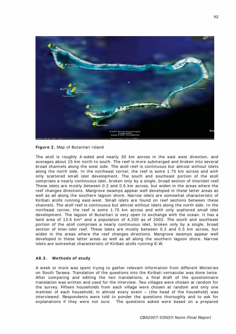
CBA2007-03NSY-Nunn-Final Report
82
Figure 2. Map of Butaritari Island The atoll is roughly 4-sided and nearly 30 km across in the east west direction, and averages about 15 km north to south. The reef is more submerged and broken into several broad channels along the west side. The atoll reef is continuous but almost without islets along the north side. In the northeast corner, the reef is some 1.75 km across and with only scattered small islet development. The south and southeast portion of the atoll comprises a nearly continuous islet, broken only by a single, broad section of interislet reef. These islets are mostly between 0.2 and 0.5 km across, but widen in the areas where the reef changes directions. Mangrove swamps appear well developed in these latter areas as well as all along the southern lagoon shore. Narrow islets are somewhat characteristic of Kiribati atolls running east-west. Small islets are found on reef sections between these channels. The atoll reef is continuous but almost without islets along the north side. In the northeast corner, the reef is some 1.75 km across and with only scattered small islet development. The lagoon of Butaritari is very open to exchange with the ocean. It has a land area of 13.6 km² and a population of 4,200 as of 2002. The south and southeast portion of the atoll comprises a nearly continuous islet, broken only by a single, broad section of inter-islet reef. These islets are mostly between 0.2 and 0.5 km across, but widen in the areas where the reef changes directions. Mangrove swamps appear well developed in these latter areas as well as all along the southern lagoon shore. Narrow islets are somewhat characteristic of Kiribati atolls running E-W. A8.3. Methods of study A week or more was spent trying to gather relevant information from different Ministries on South Tarawa. Translation of the questions into the Kiribati vernacular was done twice. After comparing and editing the two translations, a final draft of the questionnaire translation was written and used for the interview. Two villages were chosen at random for the survey. Fifteen households from each village were chosen at random and only one member of each household, in almost every event – (the head of the household) was interviewed. Respondents were told to ponder the questions thoroughly and to ask for explanations if they were not sure. The questions asked were based on a prepared

CBA2007-03NSY-Nunn-Final Report
83
questionnaire given to me beforehand. The interviews were done at daytime and recorded on tape for transcript writing into the English language later in the process. A8.4. Limitations Limitations to the survey range from simple ones to more complicated ones most of which were typical of developing countries, especially in the government sector. The most common problem encountered was the inefficiency of officials to provide assistance. In Tarawa it was quite difficult to achieve information from government ministries due to various reasons ranging from unavailability of the responsible person dealing with the required information, either because he/she was on sick leave, or traveling to outer islands or abroad, or working in another organization and has taken the information with him, to the breakdown of the computer storing the relevant information needed. Usually, it would take me more than two trips to get relevant information as I would be asked to return on another day as they will prepare it for me or wait for the relevant person or wait for the computer to be repaired. Upon arrival on the appointed day, the responsible person will either be on sick leave, went out and has not returned or forgot about it or the computer was still down and therefore need extra time and suggests that I come back another day. In regards to outer islands, the major problem encountered was the reluctant attitude of women to participate in the interview and would often let their husbands take over the conversation. This I believe is due to social culture and respect which regards the male gender as more superior and better decision-makers. The only women who took part in responding to the questions were either widowed, divorced and/or probably the oldest member of the household visited. One woman answered the questions because her husband was not available at the time of our visit for he had gone fishing. In addition to that, I was not able to finish my interviews at an earlier date then recommended in spite of the fact that I had arrived at an earlier date. This fault lies with me as I overlooked several factors. Firstly, I had thought that villages would return from their respected religious festivals after Boxing Day and have village gatherings for the New Year as is commonly done in Tarawa. Secondly, I marked those few last days of December to visit the Island Clerk and Chief Councilor as well as some other members of the Island Council for information but never considered that they would be very busy attending religious functions, weddings and birthdays in which they were guest of honors. Thus some appointments were delayed and I was not able to have a continuous day to day interview with villagers due to this fact. The village interviews were conducted after 8th January when everyone returned from the Catholic gathering at Te Vaticano in Butaritari Village and therefore finished later than I expected.
A8.5. Decision-making In the village or district setting, the unimwane represented his kainga in the village district assembly which centred around the maneaba. In the maneaba were held all discussions concerning peace and war or any other innumerable concerns affecting the common wealth; it was the Law Court, where offenders against customary norms were tried, and disputes heard and arbitrated by the old men; and the centre for the many ceremonies and feasts of a formal character, as well as the more dignified community recreations and dances. Each kainga representative spoke on behalf his group on all matters concerning social, political, or juridical problems parleyed by the village district assembly. The gerontocratic assembly, te kabowi ni unimane (council of old men/elders), was also invested with the authority to adjudicate all matters pertaining to traditional law (civil and criminal) and any unanimous decision did in fact become equivalent to the western notion of a statute. The council also made and administered decisions pertaining to rights over communal

CBA2007-03NSY-Nunn-Final Report
84
economic assets (e.g fish ponds, fishing areas) and the distribution of rare and scarce resources such as flotsam and jetsam, stranded whales and porpoises and kai ni maeao (drift logs). By ruling on these communal assets and scarce resources, the elders acted to prevent a potentially explosive situation if things were left free for all. The decision-making role of the unimwane was backed by the rorobuaka (lit. warrior generation), a category of adult married men in the age group 35 to 50 years whose characteristic roles in the community included a warrior, maneaba supervisor, property titleholder, household representative and a major economic provider. It was from the ranks of the rorobuaka that leaders who spearheaded and supervised the implementation of the decisions of the unimwane were recruited. Thus, the rorobuaka, who are the main economic providers for their households, would lead the younger men (roronga) and in some cases, the women (aine) in economic and other activities ordained by the unimwane. A8.6. Culture Change Kiribati culture has for generations enabled I-Kiribati to live in harmony with their environment. But like all human cultures, Kiribati culture is changing, and this change is going at an even faster rate than ever. As a result of these changes, certain cultural values and institutions are being affected, which in turn, undermine the resilience and robustness of the society. A profound area of culture change, with far-reaching implications for community and group action was the break up or decay of the kainga as the basic unit of social, political, economic and magico-religious organization in Kiribati society. The break up of the kainga has given way to the isolation, independence and increased self-reliance of households (mwenga), which were once subsumed under the kainga. It has been observed from study of Tabiteuea that the kainga acted as a control on individualism and promoter of socially integrative functions. The kainga was also the main source and generator of social capital in Kiribati society. Social capital refers to the networks, norms and trust that enable people to act together more effectively in pursuit of common objectives. Social capital theorists have gone to considerable lengths to prove that social capital is critical to the achievement of social cohesion, civil society and economic growth. In the present context, it can be argued that social capital is critical in the pursuit of community action and self-help undertakings necessary in minimizing the risks and vulnerabilities from climate change. With the decay of the kainga, group behaviour and social capital is now being completely undermined or seriously weakened, and uncurbed individualism has become more obvious than ever. The end result as Geddes has observed in Tabiteuea (and this applies elsewhere in Kiribati) was that individualism [has made] it difficult for individuals to accept any form of direction from others without rebelling and effectively undermines any community development or restructuring of society in terms of hierarchial units. This change has important implications for adaptation and community actions aimed at minimizing the risks and vulnerabilities from climate and other changes. Among other things, it can operate to discourage and undermine group and community action. It can also foster a ‘culture’ of complacency and indifference, which undermines self-help action for the common good of everyone. This attitude is encapsulated in the Kiribati expression, E taua inaomatana (to excessively hold on to one’s independence), which is often used to explain the lack of cooperative and community spirit. Both villages studied are not exempted from this social change as can be seen from the social structure that is operated within. It has been observed that the people from the northern and central islands are “quick to agree to proposals, but lose interest more quickly too (sic). They tend to be quick starters and early leavers. They do not make of work a matter of routine and habit, and seem to have a looser social organisation within which social pressure or peer pressure is weaker”. This can be reflected in the social attitude of the people of Tabonuea who seem so carefree.

CBA2007-03NSY-Nunn-Final Report
85
Tabonuea village has a small population of about 38-40 household. Ukiangang village on the other hand has a larger population of 160-170 household. Despite the same cultural background, both villages are significantly unique in their own different ways. Through observation and from the respondent’s answers to the questionnaires, I came up with the assumption that the people from Ukiangang were more advanced, organized, determined and hardworking in terms of their decision-making, daily lifestyles and dwellings. For instance, most households in Ukiangang have latrines established near their houses whilst in Tabonuea less than half the households have latrines. Also, more than half the men in Ukiangang are fishermen and many households boast gardens consisting of cabbages, watermelons, cucumbers, limes and many more beside the traditional plants and food crops found around the island. In contrast, there are only three fishermen in Tabonuea Village and not a single household has a garden apart from the traditional cultivated bwabwai. Bananas, breadfruits, coconuts trees and pandanus are not cultivated . A8.7. Environmental Issues Although the Ministry of Environment has taken steps to raise awareness on this matter through the media, most people in the rural islands do not have access to radios and newspapers and tend to rely on second hand information from other village members who either have radios or read it in the newspaper. Additionally, Kiribati Adaptation Project through its three different phases has and still conducting workshops to raise awareness on these environmental problems and how to adapt to them. In Phase 1 (2003) a process of mainstreaming adaptation into the national economic planning was put into operation. This included significant levels of stakeholder consultation at a national level. Environmental issues and their causes were identified and prioritized accordingly. Some of the priority environmental issues identified at the consultation workshops are; erosion, inundation, inadequate fresh water, droughts, coral bleaching, storm surges, sea level rise and many more. KAP Phase 2 which is well under way involved workshops of how to address these issues. Chief Councilors and Island Clerk from each island participated in these workshops and were expected to go home and share what they have learned to the people of their island, although this has not been accomplished yet. From the interviews it is apparent that most people in both villages do not have a clear idea of what is causing the changes in the weather and sea level and why the intensity and impact of environmental problems have grown larger. Almost all the respondents could not recall any environmental awareness workshops held in the villages for the past ten years or more except for two people. It can be assumed that these two people might have been selected as representatives for their villages to attend such a workshop. It is interesting to know that apart from the Chief Councilor and the Island Clerk, two people from Tabonuea and three from Ukiangang were very knowledgeable about global warming and climate change and its contribution to increasing environmental problems in spite of their ileteracy status. It became apparent from our conversation that four of them belong to the Bahai Faith which sends monthly magazines written in the local dialect to its followers. A large part of this magazine talks about how global warming has increased and its consequences. One lady from Ukiangang said she learned all about this when she was a Preschool teacher in Tarawa and attended Environmental Awareness Workshops. Both villages have been exposed to frequent and more intensive environmental problems with a capacity unknown to their forefathers. The major environmental issues identified in both villages are; inundation, storm surges, erosion and inadequate fresh drinking water (this is a major problem in Ukiangang only) although the order of rank varies from person to person. Through observation and from the interviews held, (refer maps of environmental problems and photographs), it is obvious that Ukiangang village is more

CBA2007-03NSY-Nunn-Final Report
86
prone to such hazards with severe impacts on the economy, society and environment. Perhaps it is these problems that distinguish the people of Ukiangang to be hardworking and concerned citizens compared to the carefree attitudes of the people of Tabonuea. The impact of these problems influences how the villagers perceive its seriousness and therefore their decision-making on how to deal with these situations. In Tabonuea Village the frequency and intensity are not as severe compared to Ukiangang Village. In addition, Ukiangang village has about four times the population of Tabonuea Village and is therefore likely to pressurize the existing government and MPs to find assistance. This can be reflected in the several projects that have been done in Ukiangang Village compared to Tabonuea Village. Most environmental problems in Tabonuea are usually dealt with at the individual or household level and are not raised in any general meeting for decision-making although they are often the centre of an informal discussion at any village gathering. However, the people’s perception on this is more spiritual rather than logical and therefore they lay it to rest at that leaving everything to the hands of the Almighty God. The only environmental problem that is dealt at the community level and is made a village bylaw is when a storm or typhoon destroys a whole family house. More important matters that are considered a concern for village decision-making lies within making sure there is peace and harmony within the community or when the whole village is at stake. In Ukiangang Village, the intensity of these environmental problems has grown to an extent where it has taken its toll on many parts of the village and affecting the people’s livelihood. As a result, these problems which used to be addressed at the individual or household level have been addressed at the community or village level and are now being addressed at the local or island level. A8.8. Stakeholders At the local or island level, the most basic stakeholder is the mwenga or household, the basic unit of social organization and residence in contemporary Kiribati society. Beyond the mwenga, there are different groups, who are also important stakeholders in Decision-making. Starting from the highest level, there are two predominant bodies – the Island Council and the Unimwane or Village Committee. The Island Council is a local government body constituted under the Local Government Act, and comprised of councilors representing different wards, which are based on villages. Under the Act, the Island Council has a wide range of responsibilities and powers. Within the Island Council, there is Island Development Committee (IDC), a technical and advisory arm of the Island Council which is responsible for the formulation and planning of development projects on the island. Chaired by the Chief Councilor or his deputy, the membership of the IDC includes representatives from interest groups like women, youth, unimwane and in some islands, churches. On the other hand, the unimwane through their Botaki ni unimwane (Council of Elders), is a traditional authority on the island. In some islands, the Botaki ni unimwane at island level is, as pointed out in the Report, an amorphous and acephalous grouping, which cannot, in practice, impose its will and authority on the whole island. At village level, there may be some sense in talking about the unimwane as an influential grouping. In the Southern islands, the Botaki ni Unimwane is still very much a force to reckon with at both island and village levels. However, one can say from the study made that this is not the case in the Northern Group even at the village level. Despite the traditional authority of the “unimwane;” in both villages studied, the village committee consists of the “rorobuaka” that compromise of the Chairperson, Vice Chairperson, Treasurer, Secretary and Village Policeman. This committee is regarded as the highest in line and makes all decisions regarding issues in the entire village. Both villages operate in a similar process however significant differences can be seen as shown and discussed below.

CBA2007-03NSY-Nunn-Final Report
87
Unimwane (Old men)
Village Committee
(Chairperson)
(Vice Chairperson)
(Treasurer) (Secretary)
(Village Policeman)
Youth Health Fishing Gardening Education Committee Committee Committee Committee Committee
Villagers
Rorobuaka (Married Men)
Aine ao Roronrikirake
(Women and Youth)
Figure 3. Ukiangang Village Social Structure
Although they are not involved in direct decision-makings in the village, Ukiangang Village elders or “unimwane” are highly held and respected for their age and status and often consulted for advice. They contribute indirectly by being present as figureheads at every village meetings and observe that harmony and peace exist during the meeting. The two way arrow is an indication of the relationship between these two parties where elders provide advice and words of wisdom when it comes to difficult situations, and can also give the go ahead or reject decisions that they think will cause trouble. The village committee on the other hand always reports to the unimwane and seek advice from them. Apart from the Village Committee, other sub committees are established within the village. These committees are intended to build up individual interests and motivate the villagers to participate and contribute to the development of the village as a whole. They are regarded as subordinates for the existing authority village committee and their function overlaps with the Village committee. Each small committee has a Chairperson, Vice chairperson, Treasurer and Secretary. They are responsible for reporting to the Village Committee and expected to accomplish tasks allocated to them by the Village Committee. Anybody can become a member of the small committees.

CBA2007-03NSY-Nunn-Final Report
88
Chairperson
Vice Chairperson
Treasurer Secretary
Village Village Policeman
(Women Representative) Rorobuaka (Health Representative)
Aine
Roronrikirake Figure 4. Tabonuea Village Social Structure In contrast, the social structure for Tabonuea Village slightly differs in regards to the title and authority of the “unimwane”. The unimwane is not highly regarded and respected and assumed to be “too old” to contribute to the hard work and therefore should not have much saying in the decision-making. As the saying goes their reign has succumbed and it is time for the younger generation to take over. The eldest son would be representing the household or “mwenga” during village meetings. In spite of this, it is clear from the responses that these sons always consult their fathers on decisions and ideas before attending the village meetings. Anyhow, with only a minority of unimwane in the village, one cannot assume that their words or advice will prevail since the majority of votes in a decision is validated. Also, there are no sub committees except for representatives from the health and women group who form a part of the larger island committee. They report to the village committee and take orders from them. Males are predominant decision-makers; as head of the households or mwenga they represent the rest of their household in General Village Meetings. They are the backbone of all decision made, since they are required to do most of the tasks destined for men. During village meetings (usually held once a month), the majority of votes cast in a motion will always prevail and there is no way of going back on it. Because of this, all male heads are expected to attend the village meetings and those who cannot make it make sure that they send someone to represent them and have a say. Although the women do not contribute in the decision-making, they are an important part of the social structure by anonymously contributing towards accomplishment of decisions by supporting their husbands and providing materials needed such as thatches, strings and many more. Youth also play an important role by helping out their mothers. Thus, each household is expected to report and accomplish its duties and responsibilities to the village committee through the head of the household or mwenga.

CBA2007-03NSY-Nunn-Final Report
89
A8.9. Decision-making (Small Scale) In both villages the village committee can make decisions and delegate them down to the responsible persons or groups without having to consult the whole village. In most cases delegations are made to household or “mwenga” to accomplish tasks set for each village. For instance, if the Island Development Council decides that a new air terminal should be built and each village has to contribute by providing materials and labour, the chairperson alone can make decisions on how much each household should contribute. Village policies have been made to cater for such decision-making whereby the chairperson can just divide the value or amount of materials needed among the number of households without having to meet with his committee members or the whole village. However, for issues concerning an individual or a group of people, it is mainly the individual’s responsibility to address the problem alone or with the help of friends or families. For example, if a person’s well gets inundated by seawater due to storm surges or king tides, he can fetch water from a nearby well not affected and wait until torrential rainfall washes out all the saltwater from the ground. Also, water tanks have been set up in public places such as village maneabas and church buildings where the villagers rely on it for drinking water. Nevertheless, these water tanks have been empty for some time now and have not served their purpose. If a person has difficulty solving a problem and thinks he/she needs help, he or she can approach the village chairperson. Village by-laws allows the chairperson to discuss certain matters with his committee in the absence of the village men and to make decisions on what action to be taken and then notify the rest of the village rorobuaka to assemble and give a hand through the village policeman. Such an example can be seen in cases where a storm destroys a house. One cannot build a house in a day, so the head of that household may approach the chairperson who will invite the other committee members to discuss what needs to be done after they have investigated the level of destruction caused. They decide on how many materials such as thatches, poles, strings and manpower is needed and then the village policeman will go to each household and notify them. A8.10. Decision-making (Large Scale) In more severe or complicated problems affecting the village as a whole, decision-making involves the whole village. It is important for all the heads of households to attend the meeting since the majority of votes cast will overrule. In such situations, the Chairperson cannot overrule any decision made by the villagers and those who were not able to attend are expected to comply with whatever decision made regardless of their opinion. In Tabonuea Village, a decision cannot be made unless more than half the number of household representatives attends the meeting. This is also the case for Ukiangang Village, however it is rare for anybody to miss out the meeting since a penalty of $5.00 is charged on anyone missing the meeting. Only in genuine cases where the Head of a household is critically sick or abroad can someone be excused. Most of the time the villagers try to solve the problem but if this gets out of hand, they will turn to the government for aid. An example can be taken from the natural disaster that affected the whole of Ukiangang Village when storm surges caused inundation of the massive “Namonrua” destroying all the bwabwai plants which the villagers as well as the rest of the island relied on as their means of livelihood. This problem was common to the villager’s forefathers who had traditional and sustainable methods of dealing with them and were passed down from generation to generation. However, the increased capacity, frequency and intensity along with climate change, has disabled the people to address the problem at the village level as their forefathers used to. Furthermore, with the change in seasonal cycle and the increase of temperature, they were unable to rely on abundant
CBA2007-03NSY-Nunn-Final Report
90
rainwater to help wash out the saltwater from the ground. At first the chairperson and his committee called on the villagers to meet in the maneaba and after a long discussion, decided to address the issue in two different ways at the village level. First they defined the cause of the problem and secondly they decided on ways of addressing the issue. The villagers found out that the cause of the problem was the intensity and frequency of sea level rise as well as storm surges. They also stated that the change in seasonal cycle causing droughts was another factor enhancing the intensity of the impact on the environment. Another factor contributing to this problem was the mining of stones and sand from the affected area. Two solutions were decided upon to be addressed at the village level. The first solution was to ban mining of the beach by people especially from other villages, and the second one was to build a seawall in order to raise the coast around the affected area. The option to ban beach mining was unsuccessful since the Island Council stepped in and reminded the village that they had no right to the beach since it was owned by the sate and therefore public property. So the villagers continued with the other solution of building a seawall. Unfortunately, after a week of hard work, the waves proved to be much stronger and quickly demolished the partly built seawall. The villagers did not give up easily but after a third attempt to stop inundation they failed again, they finally opt to ask for assistance from the Government. The procedures were for the village chairperson to bring up the matter at the next Island Development Council (IDC) meeting for approval. It did not take much discussion for the proposal to be approved and listed as one of the top priority development projects of the island. Similar procedures take place for decision-making in Tabonuea village. One interesting case was when the village once raised an issue at the local level but was turned down and told to find other alternatives rather than bring it up to the IDC. The issue in discussion concerned the destruction of the Catholic Mission seawall by high waves, storm surges and erosion. The Catholic Members tried to address the problem themselves by building a new seawall that was closer to the maneaba and the church but this was also destroyed. They predict that in a couple of years the maneaba and Church will topple over if nothing is being done. As a final option the Catholic Chairperson raised the catholic members’ concern and asked for assistance at the village meeting where it was decided that since more than 90% of the village is Catholic, the problem was regarded as a village problem and not a religious group problem, especially when the Catholic Maneaba is used as a main gathering place for all the villagers. Therefore it was considered eligible for proposal through the island project channel. However, although the village council agreed there was need for government assistance, the majority members of the IDC thought otherwise. Now the Catholic Committee has asked their MP to enquire about any private funding on their behalf. They have also approached many political or government parties or person visiting the island since they do not know the procedures to be followed nor any Agency that provides such services except the Small Grant Funds through the Foreign High Commissions in Tarawa which again had to follow formal procedures through the local level. For those proposals considered a priority by the Island Development Committee, certain procedures need to be done at the Island Council before being sent to the Ministry of Internal Affairs in Tarawa. With its already broad-based representation (and if required, membership could be augmented with the addition of other stakeholders and locally available expertise) is responsible for carrying out the needs of the island. The community consultation can be carried out by a subgroup of the Island Development Committee or by the Island Project Officer. Having been identified, the needs and adaptation options or projects responding to them will then be prioritized by the Island Development Committee, which is also required to identify who or what group should be responsible for carrying out implementation of those priorities, and, depending on the nature of the project, what kind of local contributions (e.g. labor, materials, etc) should be involved. The reasons for

CBA2007-03NSY-Nunn-Final Report
91
including local contributions here are: to encourage people to have a sense of ownership of the project, and to prevent further development of a dependency mentality, which is slowly taking hold in some of the outer islands. When all this is completed, it is sent to the MISA in the capital Tarawa. It is the Island Councils responsibility to make a recurrent update on the priority list of island projects, especially when the IDC sees the need to include recent and more serious problems that need addressing. Figure three shows the channel for these proposals when they arrive in Tarawa. The process of allocating funds and approval may take months or even years especially where a project involves a lot of funding. All respondents agree that there is no way for them to know what is happening to the proposal and rely on the Island Clerk or the Member of Parliament to follow up. Also, all respondents say that they can never know whether the projects were send to Tarawa by the Island Council Clerk or whether the MP really followed up on the projects. Sometimes, proposals will remain pending somewhere along the line or have been approved and funding allocated, however the existing government will allocate the fund to other causes especially political campaigns without any knowledge by the Island Council or the villagers. An obvious example is the project for Ukianganga Namonrua. Despite the many proposals made by the Island Project Officer and Island Clerk and frequent follow ups by the MPs, nothing was done about it. At last, it was raised as a concern by MP Tinian Reiher at a Parliamentary session in the year 2003. A survey and proposals were made by the Ministry of Works and Energy team for work and funding towards this project in December of 2003. The villagers waited for work to be done but until 2007, after investigations by a new MP, Alexander Teabo, nothing was done. He found out that funding of about $20,000 had already been allocated to the project but was stuck somewhere. At the beginning of 2008, work was done at the Namonrua site and then ceased as rumor had it that work had exceeded its funds. The MP along with the Island clerk and Chief Councilor estimated up to only $3,000.00 of the allocated fund was used up and therefore decided to make further enquiries. The above example is usual in many circumstances, and as a result the villagers will wait for a very long time. Due to this long wait, villagers may take various informal paths to enhance the progress of the process. Besides relying on the MP, another strategy for the villagers is to await any government or political tour and then propose to the party to assist them by reminding the government of these projects and to enhance the process. They feel that most of their proposals were in vain and the parties contacted never did anything to follow up. In spite of this, they still bring up the topic at any available chance with the hope that someday, someone will really care and push the government to do something. This was what I experienced when I conducted interviews on Ukiangang Village and made a survey of Tanimaiaki Village. Despite the fact that I made it clear that I was not involved with any Political Party or investigating on behalf of any Government organization, but was merely helping out with a research for the University of the South Pacific, the “unimwane” of the village kept telling me about their frustration and to report everything on their behalf to the government when I get back to Tarawa. A8.11. Recommendations From the above discussions, it is clear that most environmental problems are dealt with at the household or community level with little or no effect. Those environmental problems that are justified to be addressed at the island level will be further scrutinized upon arrival at MISA and many do not get approval for funding. For those projects that are approved, somewhere down the line the funding does not reach its destination.

CBA2007-03NSY-Nunn-Final Report
92
It is unfortunate that most decision-makers in rural area are unaware of many vital factors that may enhance their abilities to make the right decisions and to follow the correct procedures for addressing these recurring and negative phenomenons. Awareness on environmental problems and adaptation strategies to limit their effects should be done at the community level. Also, procedures for asking assistance and writing up projects should be taught to many community members so that they will not heavily depend on the IDC, Chief Councilor, Island Clerk or MP to run the show for them. It would be more appropriate to invite women, youth or church representatives to workshops on these matters or topics rather than the Chief Councilor or Island Clerk. The reason for this is that women are more concerned than men about the welfare of their children. Also, women, youth and church members are an important part of the community although unseen. As mentioned earlier, they usually provide and support the men to achieve the village decisions. Another alternative is to bring the workshops to the village so that everyone will be able to participate. Putting these options in action will be more efficient and effective than the current procedures.

CBA2007-03NSY-Nunn-Final Report
93
Appendix 9. Understanding Environmental Decision-Making in Vanuatu: case studies of Emua and Saama villages (Efate island)
NOTE: This Appendix is a lightly edited version of the report by Christy Haruel for this project. A9.1. Overview of Project This research project was carried out over a period of about two weeks in early January from the 6th to the 20th January 2008. Another week was spent on collecting information from various relevant government departments and organizations and collating the information and compiling the report on the study area. The research was conducted at Emua village, which was chosen at random to represent a typical Vanuatu village, and to identify and understand the environmental decision-making structures in rural areas in Vanuatu. Another village selected for comparison was the rural village of Saama, which was situated not very far from Emua ( about 1 km away) and located on the same area as Emua. The village was also selected because of its close proximity to Emua and thus more convenient in terms of traveling and accommodation arrangements and also used to show the contrasts and variations in environmental problems and their management and decision-making structures among different villages in the rural areas. A9.2. Location and Geography of Vanuatu Vanuatu is an archipelago of volcanic islands and submarine volcanoes located between latitude 12° and 23° south and longitude 166° to 173° east, some 1,300 km from north to south in the Western Pacific Ocean (Figure 1). It comprises over 80 islands with land area of 12,336 km-2 and a maritime exclusive economic zone of 680,000 km2. The total coastline is about 2,528 km long (NAPA. 2007). The nation of Vanuatu has a population of about 209,920 (Agricultural Census, 2006) and an annual growth rate of 2.6%. Shefa Province, of which the 2 villages of study, Emua and Saama, come under and where the capital Port Vila is also situated, has a population of 68,706 (Agricultural Census,2006). The climate in Vanuatu varies from wet tropical in the northern islands to dryer subtropical in the south of the archipelago. Average temperatures range between 21oC and 27oC and average humidity ranges between 75% and 80%. Average annual rainfall declines from over 4000mm in the north to less than 1500mm in the south (Mourgues, 2005). The country is prone to cyclones during the warmer months from November to April, although cyclones have recently shown signs of development outside this season (Cyclone Rita May 1991 and Cyclone Gina, June 2002). Vanuatu is also vulnerable respectively to anomalously long dry spells and prolonged wet conditions associated with the El Nino (warm phase) and La Nina (cool phase) of the El Nino-Southern Oscillation (ENSO) phenomenon. It is also highly vulnerable to other extreme climate events including, storm surges, coastal,, river flooding, land-slides and hailstorms. (NAPA, 2007).

CBA2007-03NSY-Nunn-Final Report
94
Figure 1. Map of Vanuatu Vanuatu is one of the most vulnerable island countries in the Pacific that is subjected to extreme climate events such as cyclones, floods and droughts almost annually. In

CBA2007-03NSY-Nunn-Final Report
95
particular, cyclones are a major threat averaging 2 to 3 events per season. Given Vanuatu’s location 130-20.50 South (latitude) and 1660-1710 east (longitude), it is situated precisely in the cyclone path, therefore experiencing cyclonic activities nearly every year. For the past decade, some major cyclones that have hit Vanuatu include; Betsy in 1992, Prema in 1993, Dani in 1999, Sosé in 2001 and Ivy in 2004 (where winds intensified to hurricane force strength, 80 knots and gusting to over 100 knots). Vanuatu was admitted to the group of Least Developed Countries (LDCs) in 1995. Today it is still part of this group although its per-capita GDP exceeds the LDC threshold. This situation has occurred due to the adjustment based on the ‘vulnerability index’ which takes into account the vulnerability of Vanuatu’s economy to natural disasters (Mourgues, 2005) The economy of the country comprises a large smallholder subsistence agricultural sector and a small monetized sector. Small-scale agriculture provides for over 65% of the population while fishing, offshore financial services and tourism also contribute to the government revenues. The main agricultural products are copra, kava (Piper methysticum), cocoa, coffee, taro, yams, fruits and vegetables, beef and fish. In 2003, the national gross domestic product (GDP) was estimated at US$580 million with per capita GDP at US$2,900. As a proportion of GDP, agriculture accounts for 14.9% industry 8.5% and service sector 76.6% Real GDP per capita is still lower than in the early 1980s, due largely to the lack of long-term growth in agriculture and fisheries. Since 2003, the agriculture sector has grown at an annual rate of 3.3% compared to the 2.8% growth for the economy and average population growth rate of 2.6% pa (NACCC, 2007) This sector improved a lot since 2003. Our forecast growth for 2008 is 11%. Growth in this sector boosted from construction activity and mainly the MCA programme. MCA full implementation is expected around end of this year or at the beginning of 2008. MCA program also has great impact on the real GDP growth.(Sector Planning Office, 2008). Since 2003, growth in this sector continues to be the most driven sector of the economy. Tourist industry stands to be the major driver in this sector . (Sector Planning Office, 2008). Real GDP in 2008 is projected to grow at 5%. This is mainly driven by construction activity (MCA) – provided the service sector continues to dominate the economy with the agriculture sector positive growth (Sector Planning Office, 2008). The domestic market for agricultural products is limited. While approximately 80% of the population reside in rural areas and depend on agriculture for their livelihood, productivity, particularly in the traditional crops sector is quite low (NACCC. 2007). This sector has always been the backbone of Vanuatu’s economy and contributes the most to the country’s GDP. Both commercial and subsistence agriculture are based on rain-fed agricultural systems. It is a sector that is most vulnerable to climate variations in terms of its production capacity and capability. It is highly vulnerable to droughts especially in the leeward parts of the islands. Drought related economic losses have been considerable in the past. External aid and government assistance is usually required to facilitate recovery in the worst affected areas in Vanuatu. Most fertile agricultural lands, together with a large number of Vanuatu’s population are situated along the coast and low-lying regions of Vanuatu. In the case of a tropical cyclone, destruction of crops due to sea and river flooding is a major problem. Accelerated erosion of the coast as well as the riverbanks due to high rates of deforestation is also a major problem. According to the Vanuatu Poverty Survey Analysis Report (1998), over 90% of the poor are involved in the agriculture sector and depend on sustainable agricultural activities (1st Draft of Climate Change Policy, 2004) Growth in this sector has experienced dramatic fluctuations over the years. This was due to environmental factors such as cyclones, droughts which affect yield in production and also external factors such as export prices and politics. With preliminary figures from the past three years, this sector is projected to grow at 1.6% in 2006-2010. The reason being it is difficult to project a much accurate growth in regards to huge fluctuations in the past

CBA2007-03NSY-Nunn-Final Report
96
years (Finance Sector Planning Office, 2007). The fisheries sector contributes approximately 1% to the overall GDP and makes up only 5.5% of the primary production sector.(Statistics Office,2000) Although the fisheries sector has a good potential for exploitation it is not being properly exploited. The reef fisheries are over-fished in some areas, notably in the vicinity of Efate, but are generally under–exploited near the outer islands. The Fisheries Department does not have the sufficient resources to monitor the tuna catch in Vanuatu waters. Improvements in catching, handling and marketing systems and commercialization of the domestic sector are badly needed. However, it is unlikely that the fisheries resources are sufficient to supply the demands of the rapidly growing population from local fish stocks. The coastal fisheries sector, which contributes significantly to the rural income, nutrition and self reliance, is particularly vulnerable to the impacts of climate change due to the enhanced coastal erosion, sedimentation and over exploitation. There is a perceived threat to the biodiversity given the demands from the growing coastal population. In addition to the need for awareness raising, education and capacity building, there is a pressing need to promote conservation and sustainable fisheries programmes, in conjunction with local communities (NACCC,2007). The primary sector – agriculture, forestry and fisheries- accounts for 14.9% of total GDP. Agriculture and tourism are the principal productive sectors and nearly all domestic exports are primary goods such as copra (26% in 2003) and cocoa (11%). Cocoa exports however declined from 7% in 2003 to 3% in 2004 due to the damage caused by Cyclone Ivy in early 2004. Tourism is expanding as tourist arrivals increased by 25% in 2003 compared to 1997 levels. It is an important source of revenue for Vanuatu and it accounted for 40% of the GDP in 2000 (Statistics Office, 2000). A9.3. Methods The methodology employed in this research was straightforward. Prior to the actual surveying and arrival of the interviewers at the village, arrangements were made with the chiefs of the villages, and the agreement was made directly with the chief. The questionnaire which were originally in English, were translated to Bislama or the common Vanuatu pidgin for ease of understanding when interviewing people. Upon arrival at Emua village, a schedule was discussed by the interviewers and the chief, Albert Malnaisinu. This was to organize and arrange suitable times that each interviewee was to meet with the surveyors so that they do not go to their gardens, or to their various commitments. The key stake holders in the village who were suitable candidates for the survey, were also identified. The chief’s police, Kalman Sam, was the guide who then took the interviewers around to each of the interviewer’s household (after informing them) to be questioned. Many of the people interviewed were the heads of different committees, who often were members of more than one committee. A total of 9 key stake holders who were significant decision-makers in the village were interviewed and they were recommended by the chief who obviously was most knowledgeable about the village and knew who were the best people to get information from. The preferred number of stakeholders (at least 25) could not be reached because of the small population of the village. As mentioned, a week was spent surveying the two villages in the North of Efate, namely Emua and Saama Village. Because of the small population of the village, the interviews were completed much earlier than expected. Photographs were also taken of the areas where environmental problems occurred (see Appendix). After Emua was surveyed, interviews were then carried out in Saama Village (after notifying the chief). Unfortunately we were only able to interview 2 key stakeholders in the

CBA2007-03NSY-Nunn-Final Report
97
village, due to miscommunications and many villagers had gone to gardens or to their various tasks. However, significant informations were still collected from the two who were questioned, one of whom was a Women’s Committee representative and the Chief of the village. A9.4. Climate Change Initiatives for Adaptation in Vanuatu: A9.4.a. Pacific Island Climate Change Assistance Programme Vanuatu has been able to meet its national obligations under the UNFCCC through support from the Pacific Islands Climate Change Assistance Programme (PICCAP). This is the first serious initiative to address the issues related to climate change in several Pacific Island countries. The focus and emphasis of the programme was to build skills and knowledge of national experts to carry out vulnerability assessments and to assist with the completion of their first national communication as required under the UNFCCC. Adaptation was not a main focus of this programme so more detailed adaptation work with Pacific island country institutions and in particular communities is needed. This is a three-year programme funded by the Global Environment Facility (GEF), executed by the United Nations Development Programme (UNDP) and implemented in the Pacific by the South Pacific Regional Environment Programme (SPREP). This project assisted Vanuatu to complete its First National Communication to the Conference of the Parties (COPs) and carrying out of several vulnerability assessments in rural communities of Vanuatu. A9.4.b. Capacity Building for the Development of Adaptation Measures
Project Vanuatu with other Pacific Island countries have over the years called on the international community to help their people adapt to their vulnerabilities related to climate change. They clearly recognized the need to: (i) reduce their vulnerability to climate-related risks through adaptation processes, and (ii) strengthen their human and institutional capacities to assess, plan, and respond to climate related risks. This is evident in the High Level Adaptation Communiqué adopted by countries in Nadi, Fiji in 2002 and the Forum Leaders Communiqué adopted by Pacific Leaders in Suva, Fiji also in 2002. The Capacity Building for the Development of Adaptation Measures in Pacific island countries (CBDAMPIC) project is Canada’s response to the call by Pacific island countries for assistance to develop an adaptation programme that will reduce climate related risks at the national and community level. The project focuses on improving the sustainable livelihood of Pacific Island people by increasing their adaptive capacity to climate-related risks. The CDN 2.2 million-dollar initiative of the Canadian Development Agency (CIDA) is executed by SPREP from January 2002 to March 2005 in Vanuatu and three other countries; Cook Islands, Fiji, and Samoa. The goal of this project is to strengthen the capacities of national expertise in order to enable them to identify, consider and evaluate adaptation options and measures with regards to climate change. This will be achieved through the improvement and coordination of institutional arrangements, the strengthening of national capacities to enable the identification of adaptation options, the evaluation of those options, including technology assessments, and the development of sector policies in terms of adaptation measures to climate change. Adaptation is an on-going process over this century and beyond and requires Government, Private Sector and Non-Government Organization commitment. The process should be pursued in light of the sustainable management plans of Vanuatu, and for the benefit of the local communities in the longer term. Therefore it is only appropriate for the Vanuatu government to have a policy and a strategy in place that ensures a coordinated and

CBA2007-03NSY-Nunn-Final Report
98
integrated approach amongst these various government and non-government organisations because climate change is cross-sectoral and will need a cross-sectoral approach that cannot rely only on good faith only but a clearly defined pathway for everyone’s benefit (Meteorology Department, 2008). A9.5. Emua Village, North Efate, Vanuatu A9.5.a. Background Emua Village is located on the northern part of Efate island in central Vanuatu. This part of the island is known to be the leeward side of Efate, and known to experience orographic rainfall. There is less precipitation here than in the southern parts of the island where much rainfall is brought by the prevailing south east trade winds. The village is coastal with some houses/ buildings only a stone’s throw or even less than 5 metres away from the high water mark. The village is located at the foot of a hill and during extreme weather periods, it often experiences flooding, droughts, storm surges, and impacts of tropical cyclones. Tropical forests and lush green bushes cover the side of the hills and serves as suitable agricultural land for the subsistence farmers in the village. A9.5.b. Natural Resources: Sitting right next to the sea, Emua village has access to an abundance of marine resources, which in the previous decades have been a main source of food supply and over the years, an important source of income for the market vendors from the village. However, these resources have noticeably decreased not only in quantity but also in size, as populations increased adding more pressure on reef resources. The continuous exploitation by the locals, for commercial purposes to gain income for the family has also added to the depletion. With the village becoming more modern and more children going to school and the inevitable rise in school fees, this driving factor continues to exacerbate the problem of over-exploitation and may villagers find themselves going further out to the sea to fish and having little or no option but to harvest under-sized shellfish, crustaceans, fish, octopuses, among others.
Figure 2. Map of Efate Island. Source: UNESCO, 2004

CBA2007-03NSY-Nunn-Final Report
99
Apart from the reef as a source of food supply and income, most villagers in Emua are subsistence farmers, working on their traditionally owned land up o the plateau at the top of the hill or growing crops such as taro and banana/ plantains on the sides of the hill. Gardens are also grown along the sides of the main road along the margins of the village, but within their custom or traditional boundaries. Other crops grown include cassava/ tapioca, yams, coconuts, corn, slippery cabbage or ‘bele’, and vegetables such as watermelon, pineapple, cucumber, Chinese cabbage, tomatoes and various fruit trees. There has also been logging practices by a local in the Emua village area. The deforestation method that were carried out were unsustainable in some ways which resulted in the devastating impacts on the environment of the area. Negative impacts of the timber logging triggered small scale landslides, erosion of the hillsides, overflowing of the river catchment areas which washed away gardens on the sides of a nearby river/ stream, flooding of farmland as well as the village at the foot of the hill, and eventually the accumulation and increase of sediments transported down, on the reefs. A9.5.c. Socio-Economic Situation Statistics from the 1999 Census (National Statistics Office: 2008) showed that Emua has a population of approximately 224 (with around 110 females and 114 males) however the chief of the village estimates that this number has increased to nearly 400 at the time of the interview (Malnaisnu. pers. comm., 2008). The total number of households (only married couples) is 74. The economically active population (between the ages of 15 and 64) comprises of around 60 females and 68 males. The dependency ratio is 75 while the sex ratio is 106.3. The cash crops grown by farmers there include cocoa (4 farmers), Kava (8 farmers, with the biggest farm owning about 100 heads of kava) and coconut (35 farmers), ie, all who were interviewed indicated that they planted coconuts (National Statistics Office: 1999 Census). As mentioned above, most of these subsistence farmers sell their surplus at the market in Port Vila Town. Most of the villagers are not formally employed and depend on their traditionally-inherited land to provide for their basic needs, such as kerosene, rice, salt, sugar, soap, clothes, school fees, among others. Also most fishing by the villagers was for sale at the market usually as cooked food. Only about 1/3 of the fishing is subsistence or solely for local consumption. In a report by the Coastal Regions and Small Islands Papers, published by UNESCO, the following summaries were made about the Village-based marine resource management regulations for tenured fishing grounds in 1993 and 2001 for Emua. Table 1. Marine resource management plan for Emua Village 1993 • Fishing ground closed to all harvesting periodically.
• Bêche-de-mer tabu 2001
• Bêche-de-mer tabu continues. • Fishing ground opened to general harvesting in l997 to
compensate for new trochus closure. Fishing ground will stay open for foreseeable future, although permanent closure of an area around mangroves under discussion.
• Three-year trochus closures begun in l997, continuing after harvest in 2000. Trochus closure concurrent with that of neighbouring Saama. Some poaching has occurred and poachers fined.
• Tabu on taking turtles. Comments: Since l993 one closure lifted; two new controls initiated Source: UNESCO, 2004
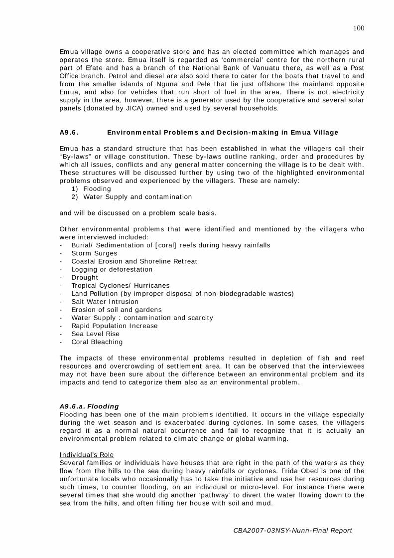
CBA2007-03NSY-Nunn-Final Report
100
Emua village owns a cooperative store and has an elected committee which manages and operates the store. Emua itself is regarded as ‘commercial’ centre for the northern rural part of Efate and has a branch of the National Bank of Vanuatu there, as well as a Post Office branch. Petrol and diesel are also sold there to cater for the boats that travel to and from the smaller islands of Nguna and Pele that lie just offshore the mainland opposite Emua, and also for vehicles that run short of fuel in the area. There is not electricity supply in the area, however, there is a generator used by the cooperative and several solar panels (donated by JICA) owned and used by several households. A9.6. Environmental Problems and Decision-making in Emua Village Emua has a standard structure that has been established in what the villagers call their “By-laws” or village constitution. These by-laws outline ranking, order and procedures by which all issues, conflicts and any general matter concerning the village is to be dealt with. These structures will be discussed further by using two of the highlighted environmental problems observed and experienced by the villagers. These are namely:
1) Flooding 2) Water Supply and contamination
and will be discussed on a problem scale basis. Other environmental problems that were identified and mentioned by the villagers who were interviewed included: - Burial/ Sedimentation of [coral] reefs during heavy rainfalls - Storm Surges - Coastal Erosion and Shoreline Retreat - Logging or deforestation - Drought - Tropical Cyclones/ Hurricanes - Land Pollution (by improper disposal of non-biodegradable wastes) - Salt Water Intrusion - Erosion of soil and gardens - Water Supply : contamination and scarcity - Rapid Population Increase - Sea Level Rise - Coral Bleaching The impacts of these environmental problems resulted in depletion of fish and reef resources and overcrowding of settlement area. It can be observed that the interviewees may not have been sure about the difference between an environmental problem and its impacts and tend to categorize them also as an environmental problem. A9.6.a. Flooding Flooding has been one of the main problems identified. It occurs in the village especially during the wet season and is exacerbated during cyclones. In some cases, the villagers regard it as a normal natural occurrence and fail to recognize that it is actually an environmental problem related to climate change or global warming. Individual’s Role Several families or individuals have houses that are right in the path of the waters as they flow from the hills to the sea during heavy rainfalls or cyclones. Frida Obed is one of the unfortunate locals who occasionally has to take the initiative and use her resources during such times, to counter flooding, on an individual or micro-level. For instance there were several times that she would dig another ‘pathway’ to divert the water flowing down to the sea from the hills, and often filling her house with soil and mud.

CBA2007-03NSY-Nunn-Final Report
101
In many cases, villagers who experience the same problem barely acknowledge it as a problem and during times of ‘roadside’ or casual conversations, they would relay their experiences and it is from that time, with one or more others agreeing to facing the same situation, that it is identified as an environmental problem. Often, a situation is regarded as a problem when it has significant effects on the household, property or socially and also its continual reoccurrence and the failure of repeated efforts by victims to try to deal with it or solve it on their own. Emua Village Council When the problem is identified, for instance by Frida, she takes note of it and raises it up in the next general meeting of the village held in the nakamal or meeting house and attended by the whole village community. (refer to next section on decision –making structures) After the agendas set by the Village Council have been discussed, there is a time where “other matters” are discussed and that is when Frida is able to raise her opinion and request for the matter to be looked at. The council then identifies that this is a matter concerning the environment/ nature and destruction thus will refer it to the most relevant committee to examine, discuss and decide on alternatives, mitigation methods or sources of assistance for the victims, which in this scenario is the Disaster committee. The matter will be made aware to the President of the Disaster Committee, in this case, Norman Obed. Committee’s Role The Disaster Committee, like any other committee is democratically elected and appointed by the village council with the approval and agreements of the village members. The President (Norman Obed) then summons a meeting with the other members of the committee. Not only is the problem found but also the root of the problem or causes resulting in that problem identified. In this case, the villagers identified that it was the deforestation that contributed to the overflow of the stream banks, the increased erosion of the stream banks and the creation of new water pathways through Emua village, causing much destruction of houses and the sedimentation of reefs. After the committee discuss the matter and come to an agreement that the situation is within the capacity of the village to deal with and come up with solutions to help, whether it is just to provide manpower, such as to relocate the building or property or dig pathways to divert the path (if it is not an extreme situation), then the disaster committee will arrange to provide the necessary help, with the collaboration of the villagers. However, if the disaster committee assesses that the situation is beyond the capacity of the village to deal handle it and urgent help or assistance is needed then it will seek assistance from outside the village. For instance, in this scenario, as well as being the president of the Disaster Committee, Norman Obed is also a Red Cross Worker and thus is able to seek assistance in terms of food relief or tents for victims, from the Red Cross. However, this is only short term and does not always happen. Asked whether the village receives help from the government (through the Shefa Province, in which Efate comes under) at such times when requested, interviewees reply that often these requests go unanswered, thus discouraging requests in the future when similar circumstances are faced again. The National Disaster Management Office (NDMO) is a body that receives aid from donors and is responsible for the coordination and the dissemination of these aid or assistance. Again the response of this organization is more reactive than proactive and can only provide short term relief in most cases. In cases where the cause of the problem is identified to be a drainage problem, the Disaster Committee then seeks advice from the Public works Department. Whatever the PWD suggests, for instance the collaboration of the village to provide manpower to build or maintain drainage pipes, then the disaster committee would partner with the water

CBA2007-03NSY-Nunn-Final Report
102
committee, collect the necessary manpower and complete the task set for the benefit of the community. Usually the men and young men in the village provide manpower when it is required. Usually when assistance is given or provided, its must come through the village council and the chief before it is it given to the areas or people that need it. This procedure enables better coordination of aid dissemination and transparency within the village. Also whatever the decisions and recommendations that the committee comes up with, must be shown and made aware to the chief and with his approval. This is one of the ways in which matters concerning the environment are raised and responded to. A9.6.b. Water Supply The other major environmental problem that was identified by most of the inerviewees involved the supply of water (availability) and the condition or state of water that was supplied to the village from the source that was up on the hills. This problem, as outlined by the villagers, was always at its worst during heavy rainfall or cyclones, when the source would become blocked my mud and soil thus contaminating or ‘dirtying’ the water. This would often lead to outbreaks of water related diseases and other health issues. No only that but even during pronouced dry periods, water would be scarce and villagers may need to find alternative sources of water, which in some cases it may be limited. Individual’s role: Most cases that concern the water supply are identified by the whole village since the supply provides for everyone in the village. This is often a problem that is identified much faster than those of different natures. Once the problem is seen, the root is also identified. For instance, droughts were normally linked to a decrease in the river catchment and thus a decrease in the pressure of the rivers or streams causing the water supply tobe very slow or not even flow at all. The ‘dirty’ waters were often caused by loosed cattle wandering around the streams and even by inconsiderate attitudes of people walking along the streams. Often during floods or when the aters are disturbed, they are collected in the storage tanks at the source and the mud accumulates at the bottom of the tank so that as the water becomes scarce during drier periods the water that is supplied to the village is dirty or muddy and not healthy. Again if there is a problem that is within the capacity of the villagers to deal with themselves, the norm of the village is to just help each or one another out whenever they can or in whatever way possible as family bonds in the village are often strong and strengthened again by their culture. In instances where only one individual is experiencing a particular water problem, they approach the chief’s police (Norman) who then carry the request problem to the chief who then relays it to the council. Committee’s Role: The role of the water committee is to set up systems or structures that need to be adhered to by the villagers in order to maintain the standard of the water quality and availability. Joel Kaltapiri (refer to Appendix) is the chairman of the water committee and expresses some of the improvments in the water supply as well as the frustations that are often encountered when trying to get peoples’ cooperation towards the improvement of the water sanitation. The water supply pipes and systems (tank) were funded by the AUSAID with the management and maintenance placed on the villagers. Thus the committee has set up a tax system whereby each household has to pay a certain amount of money to the committee that will go towards the maintenance of the pipes, the petrol for the pumps, fencing and the regular clearing of the source. The committee is responsible for ensuring

CBA2007-03NSY-Nunn-Final Report
103
that each responsible member of the village pay what is required of them. Often the committee will need to collaborate with the environment committee, the disaster committee (or any other committee if need be) in order to address a problem. The discussions that are held within the committee and amongst the committees must be made transparent to the village council and the chief. During the past years, the villagers were confident in seeking assistance fron the government as they had an MP in the government. During the visits of the MP to the village, the committee with the approval of the council would prepare reports and requests to the MP and submit them at the time. However, the response is not always immediate and the process is often slow. There is another channel by which aid is requested by the committee and that is by written proposals that are taken to the Shefa Province who are trusted to seek assistance on their behalf. Because of uncertainty of the structures for aid request and the negative outcomes of many requests that have gone before, this method is less common and not really trusted. Village Council: The chairman of the council must collect all relevant information first, from the committee, whether it’s the progress, the weakness of the systems built, the failures and problems faced and then relays them to the rest of the coucil during their meeting. A general meeting is then called for the whole village and the issue is adressed to get the general opinion of the people. Much of the assistance that is given to the village is not by the government but by Political Parties supported by the villagers such as the Vanuaku Party (through allocated funds/ budgets for their constituencies and MP’s allocations). A9.7. Decision-making structure The following diagram outlines the structure that has been set up and stated in the Emua village Constitution or what many in the village refer to as their “By-Laws”. This is an organizational Structure that is general and outlines the positions/ relationships of the different decision-making bodies within the village and thus the procedures and order that are followed for any matters concerning the village and its people. The structure here is NOT specifically for environmental decision-making, but for all matters in general. However, it was noted that the interviewee’s answers and understanding of the structures somehow differed slightly in some cases and not necessarily according to the written structures set. Thus the description given here is according to the interviews that were undertaken and not according to the structures set in the constitution of the village. This is described in the second diagram, which is that of the decision-making structure for Emua village. This is inclusive but not solely for Environmental Decision-making in the village.

CBA2007-03NSY-Nunn-Final Report
104
Figure 3. Organisational Structure for Emua Village Council (Source: extracted from Emua Constitution booklet)
Annual Congress
Monthly General Meeting
Emua Village Council
Law and Order Peace and Unity Court and Justice
Community
Chairman
Vice Chairman
Secretary Treasure Council Poilice
Working Communities
Work and Health
Custom and Culture
Cooperative Churches Budget
Women
Youth EducationEmua Development Tourism Business
Agriculture Stringband

CBA2007-03NSY-Nunn-Final Report
105
Figure 4. Structure for Decision-Making in Emua Village. (as described by Chief Albert Malnaisinu and interviewees)
Water Committee
Cooperative Committee
Shefa Province
Local Area Council/ Area Secretary
Emua Village Council
Paramount Chief
Other Chiefs
Committees
Disaster Committee
EnvironmentCommittee
Tourism Committee
EducationCommittee
Fishermen Committee
Women’s Committee
Youth Committee
Church Committee
Assemblies of God
Pentecostal Presbyterian

CBA2007-03NSY-Nunn-Final Report
106
Committee Structures: A committee would generally consist of:
- Chairman + vice, - Secretary + vice - Treasurer and - 3 committee members
A member of a committee can also be involved or a member of one or more other committees. As briefed by the chief, the heads or presidents of the committee are nominated irrespective of their background or their education. A reason for this is to build the capacity of the individual so that they are more able to handle whatever responsibilities they are given. Council Structures: The Emua village council consists of:
- Paramount Chief - 8 other chiefs - 2 Pastors (AOG & Presbyterian) - 2 Elders - Presidents of Tourism, Fisheries, Disaster Committee and 5 police
Thus there is a total of approximately 28 members of the council who normally meet a day early to discuss the agenda and issues to raise during the general gathering/meeting of the village the next day. At present he council’s meeting is held on Monday nights and general meetings are held the next day, that is Tuesday morning. The Chairman, vice- chairman, secretary, treasurer, and police positions change every two years while the chief’s post is permanent or until death, where the title is then passed on to his eldest son. In other words, inheritance and chiefly titles are passed on through the paternal lineage. North Efate Area Council: The Area Council is responsible for the matters in the area in which the local area comes under, that is a specified area, eg North Efate / North East Efate Area Council and it employs an area secretary (who resides at Paunangisu village) who is usually made aware by the villagers elders and attends the general meetings of different villagers, and often takes their requests at that time or later on. The area secretary then reports to the sub-centre for the Area/ Province (where there is one) who then reports to the Provincial Government. Shefa Province: Represents the hand of the government to the villages in the islands that come under the province. It is responsible for providing assistance from the government to the villages and to liase with responsible bodies that coordinate and disseminate aid, seek and provide necessary help to the villages that need it.

CBA2007-03NSY-Nunn-Final Report
107
Figure 5. Organisational Structure for Environmental Decision-making Bodies in Shefa Province. (As described by Emile Mael, pers. Comm. 2008)
Government of the Republic of Vanuatu
Shefa Province
National Disaster Management Office
National Disaster Coordinating
Sub-Centre
Local Area Council / Area Secretary
Village Community

CBA2007-03NSY-Nunn-Final Report
108
Figure 6. Shefa Province Structure for the Aid Request, Decision-Making and Dissemination: Flowchart of Process for Community Aid Request and Response (As described by Emile Mael, pers. Comm. 2008) A9.7.a. Process for the Decision-Making for Aid Request and Dissemination This process is not only with particular regards to environmental problems but (according to Emile Mael – Shefa Province) is a general structure for all problems that relate to aid assistance from a local/ village community.
Local Community
Local Council
Area Council/ Area Secretary
Sub- Centre Shefa Province National Disaster Management Office
National Disaster Coordinating Committee
Government National Disaster Coordinating Committee
Aid Donors Process / Assessment
National Disaster Management Office
National Disaster Management Office
National Disaster Coordinating Committee
Community (Affected Area)

CBA2007-03NSY-Nunn-Final Report
109
Local Community A request for aid begins at the community level where a problem is identified. This problem can be an environmental problem that is directly affecting the lives of the village members (eg flooding); a problem which is an immediate result of an environmental/ natural hazard that has occurred recently in an area (eg cyclone, earthquake, volcano, etc.); it can also be a problem to do with the basic services and amenities of the villagers, such as the need for a school/ village property or a money for funding for a building etc, all of which are for the benefit of the whole community. Once a problem or a need arises, it is discussed within the village ‘nakamal’ meeting place, where the village council and the members participate in a democratic manner and express their opinions/ views/ recommendations and present ideas on the matter. This form of decisions within the villagers (in Efate and in different villages in Vanuatu as a whole) all vary or differ, with respect to differing cultures and traditions. A decision is then reached (whether directly by the council and members at the meeting, or in such cases as Emua Village, the matter is delegated to the appropriate (sub) committees, who again discuss the matter with their executive members and carry out the necessary tasks, after the chief and his council have given their consent. The committee ( eg the Disaster Committee, water committee, etc) then writes and submits a report outlining their alternatives / ideas to address the problem. This report is submitted to the village/ local village council which comprises mainly the Paramount chief and elected members of the council. The council then assesses the report and makes amendments where necessary, give their approval and also outline their requests and the reasons for their requests. They are the sole organ that usually make the final decisions on matters to do with the community. Local Area Council / Area Secretary Refer to previous description of Local Area council. Sub-Centre The sub-centre for the area represents these requests from the local villages, via the area secretary, to the body which deals with the matters in the province, which the village comes under,eg. Shefa Province, For Emua Village. Provincial Government (eg Shefa Province) This body represents the hand of the government (of the Republic of Vanuatu). For instance, Shefa Province is the government body/ organization that looks after Efate and its offshore Islands, the Shepherds group (Tongoa and Emae) and Epi Island. There are six provinces in Vanuatu, namely Torba, Sanma, Malampa, Penama, Shefa and Tafea (Refer to Figure 1). Once the Shefa Province receives the report from the sub-centre or Area Council, an assessment is carried out by the province on the affected community/ area and reported to the NDMO (see below). Discussions are then held here about the issue and see whether or not it is within its capacity to help/ assist. Usually each province has an allocated budget (by government) for such purposes. Only if the request received (this also has to meet certain criteria, in order for it to be funded eg. Must be not be for personal/ individual gain but for communal benefit) exceeds beyond the capacity of Shefa Province to assist, then the Province will turn to the NDMO for assistance. The Shefa Province is also responsible for awareness or preparedness talks (in conjunction with other relevant government departments) in the villages under it. With regards to the occurrence of natural disasters within their area and the risks there, their responses are

CBA2007-03NSY-Nunn-Final Report
110
mainly reactive and only respond after the damage is done. The provincial governments do NOT deal directly with aid donors as there is a committee set up for that purpose. However, they can be present at the meetings that discuss donor assistances, but usually deal only on a provincial level. National Disaster Management Office (NDMO) The Shefa Province is closely affiliated with the NDMO (as with other provincial headquarters). This body, as mentioned above briefly, is responsible for the coordination and dissemination of aid and assistance from various donors (NGOs, governments, companies, and others). The NDMO also carries out an assessment on the affected area, the environment there, the risks, etc, and this is done in various ways, either with assistance from consultants from overseas, with the use of helicopters, and others. The responses of the NDMO are usually reactive rather than proactive, as they only respond to requests that demand immediate attention, which in most cases are caused by natural disasters and require immediate relief. Thus assistance is usually temporary and for only a short term or certain period of time until the victims of the disaster (villagers) can ‘stand on their feet’ again. However, the assistance given is not necessarily or always holistic as aid given is usually dependent on the availability and quantity and the level of need, or priority placed on the area according to the severity of damage caused by the natural hazard. Thus once the NDMO is consulted and the reports / assessments done is presented (because of the inability of the Shefa Province to assist), the matter is forwarded for discussion to a body that will discuss the aid that is suitable to give or look for appropriate donors, and liaise with them for aid. This body is called the National Disaster Coordinating Committee. National Disaster Coordinating Committee (NDCC) The NDCC comprises of various directors of relevant government departments (lands, meteorology, Public Works, Education, etc). The director general of the Prime Minister’s Office is the Chairperson. Authorized representatives from various government departments can also be present at the meeting. This committee is responsible for dealing with the issues in a national level. Once the requests/ reports have been received, meetings are set up to discuss and then the request is forwarded to the appropriate departments of the government/ ministries to provide assistance. For instance, if it is a health issue (water-related problem/ sickness outbreak) then the health department/ ministry will be responsible, if it concerns the maintenance of school, the matter will be delegated to the ministry of Education/ Public Utilities. However, if the requests made even exceed the capacity of the Shefa Province, NDMO, and various government ministries and departments to help (eg Food Relief/ Shortages; funding for major environment-related projects – beneficial to the community/ province) then the NDCC steps in to have a second meeting where they seek overseas assistance and or meet and liase with donors for funding. This, again requires assessments/ reports of the situations, the state of the area, extent of damage, risks, among others so appropriate aid can be given.

CBA2007-03NSY-Nunn-Final Report
111
Appendix 10. Understanding Environmental Decision-Making in Vanuatu: case studies of Lolbualabwa and Antahi villages (Pentecost island)
NOTE: This Appendix is a lightly edited version of the report by Ann Tosiro for this project. A10.1. Introduction It is interesting to know how local communities affected by climate change understand the changes and effects using their own traditional knowledge and skills without expertise’s assistance. As a research assistant, research was carried out on the northern part of Pentecost Island in Vanuatu on January 23 to February 7 2008 and was focused on two main areas of Lolbualabwa and Antahi. These two areas consist of villages that have grown into each other to form one big area. Lolbualabwa consists of the villages of Anseu, Avatubwe, Lolsarava, Larevo and Lolbuavatu. It is not a densely populated area but the population itself is growing. The villages are not closely located along the shores but are further inland about 200 to 300 meters at the closest. Antahi is a very big village and the issue of coastal erosion and sea level rise is a major concern for everybody. The reason being that houses are built along the shores/on the beach about 2 to 4 meters from the water marks during storms and high tides. It has quite a number of people and consists of the areas of Avulevule, Angerena, Lamalanga, Lolbibiga and Laonvotu (refer to location on map). The village stretches out along the coast and has not grown inland due to the landscape of the island. A huge tall cliff stands at the back of the village therefore; the face of the cliff is a barrier to the villages’ expansion. Few families have already moved out from the area to live in other villages.
A10.2. Background Information of the Study Area The area of North Pentecost is divided into 10 districts and these are Lolkasae District, Surubo District, Surukavian District, Aligu District, Aute District, Loltong Wai District, Hurilau District, Heren Hala District and Ahivo District. These districts are governed by the North Pentecost area council, which is a body that works under the administration of the province. The North Pentecost area council has an Area secretary who is like the president of the organization. They handle legal issues such as road taxes and business licenses. They also have within the office, the youth and sports office that keeps data on population and other government information. This office is incharge of national activities such as The National Census. However, another body that is recognized nationally to handle affairs of the island is the council of chiefs. This body has a larger body called Vatunmalan Vanua, which affiliates nationally to handle affairs at community level before it is passed to a national level or vice-versa. Under this body, there are several other councils found in every district. Any decision that is made at this level is finalized/amended by the head office of Vatunmalan Vanua. Lolbualabwa and Antahi are located within Ahivo district under the direction of Gaituhinleo council of chiefs (Lolbualabwa) and Bwatunleo council of chiefs (Antahi). The population growth is increasing at a high rate but current observations proved that a lot of young people have moved to live in towns of Vila and Luganville. The 1999 census report shows that the population of Antahi was 121, but the current counting that I made is 385. Lolbualabwa had a total population of 76 in 1999 but current counting for 2008 was 268 (National Bureau of statistics). A10.3. Methods The research was carried out through the use of interviews and primary observation of the area. However, a village meeting was conducted before the actual individual interview was carried out. This is to be sure that the community is aware of the projects intention.

CBA2007-03NSY-Nunn-Final Report
112
A10.4. Understanding of Environmental issues, causes and effects It is exciting to hear peoples views on natural disasters occurring everyday in our lives such as shortage of water, hurricanes/cyclones, earthquakes, landslides, coastal erosion and most of all is the issue of Global climate change. The communities are experiencing environmental problems such as Cyclones/hurricanes, earthquakes, coastal erosion, storm surges, drought, inundation and coral bleaching. Other issues such as flooding and salt water intrusion are not a problem. To begin with, the most common issue that is experienced is cyclones/hurricanes. This occurs around the months of November to April every year which is the cyclone season in Vanuatu. It is around these months that other problems such as storm surges, inundation and coastal erosion are experienced to be serious. Participants are aware of the season but do not consider it as a serious concern because it is considered as a usual phenomenon that has become part of their lives. In this instance, after a cyclone has devastated the area, they pick themselves up and move on. Likewise, the drought season is one that is of concern as well. Drought season occurs around the months of May to October, when Trade Winds blow incessantly from the South-East. Of all these issues outlined, coastal erosion is of most concern/threat to both communities. From their observations, participants identify the differences in sea level but are not aware of the causes as well as the issue of climate change. In this instance, the community has not received awareness from the government or NGOs concerning such issues. The village of Antahi is exposed to the sea and issues such as inundation, coastal erosion and storm surges are of serious concern, particularly during storms/cyclones. During cyclones, huge destructive waves are driven inland and these ruins the settlements and other possession such as houseyard gardening. Due to this, most families have already moved out of the area to live in other villages, two of them were created. A10.5. Addressing The Environmental Problems Outlined It was found that the community never seeks government assistance in order to address these issues. Help has been sent by the government once in the 1980s after a devastating cyclone swept the entire country, but this assistance was for most islands in Vanuatu. It was voluntarily given but help was not asked. Issues such as coastal erosion is never been addressed and people haven’t taken any initiative to address the problem. In addition, the issue of coral bleaching is another concern but the community has no idea about the causes. Likewise, there has not been any initiative taken to address the problem. Shortage of water during long dry season is another major problem but this is regarded as a normal cycle in life. What the community does is a proper management on the use of water in individual households and most of the households now, have built tanks to store rain water. However, these issues are treated as part of their lives and people accept the fact that it has to happen according to different seasons of the year. Because of this reason, the community never seeks help from the government or Non-Government organizations (NGOs) and most importantly, they do not know the procedures in order to seek assistance from the government or NGOs. Overall, the community does not understand the issue of global climate change and most of them; this project has been an opportunity for them to explore the issues of global climate change and others like global warming, ozone depletion and sea level rise. As a matter of fact, they know through observations that the climate is changing but have no

CBA2007-03NSY-Nunn-Final Report
113
idea about the causes. A10.6. Structure of Decision-making at Community level It is vital to know that an environmental issue is not a community problem but is treated as an individual issue. As a matter of fact, environmental problems are never discussed at community meetings/gatherings, thus, there is no decision-making structure that is specific to environmental problems. The general structure that exists is shown below (Figure 1). However, this structure may mean that the chiefs are the only decision-makers in the community. This is not true. The current structure states that whenever a problem arises, the village chairperson is the first to be consulted and if there is a need for a meeting or gathering, it is the chairperson that conducts and handles everything. The chiefs are there to hear the problems discussed and make decisions based on the discussion, but this may not always be the case. For example, some decisions may be based on the chiefs’ personal interest.
Chiefs Church leaders (priests)/Teachers/Educated People Village chairperson
Community/People Figure 1. Decision-making Structure at Community Level Current situations have modified the structure of the decision-making (Figure 2). This is seen through situations where Educated people, priests, teachers and the village chairman participates in the decision-making process. In addition, problems that arises, are not directed to the village chairperson only, but other people are also consulted such the above.
Chiefs /Educated People/Teachers/Priests/Village chairman
Educated People/ Teachers/ Priests
Village chairman
People/community Figure 2. Modified Decision-making structure

CBA2007-03NSY-Nunn-Final Report
114
It is vital to know that decision-making at community level is done by the chief. The chief has the last say to every decision made. However, there are different ranks according to the chiefly system and decisions are made according to these ranks. (See Figure 3).
Boe Vudolua
Tungoro
Vira Moli Livusi
Tari Figure 3. The chiefly system of North Pentecost The structure of the chiefly decision-making depends on the ranks acquired from the pig killing ceremonies. A young chief with a rank of Tari means that he has gone through a ceremony where he has to kill a pig to gain his name. Likewise for Moli and Livusi. In the case of Tungoro or Boe Vudolua, there has to be quite a number of pigs to enable a chief to gain his chiefly title. The highest number that any man has reached during pig killing ceremony is 100 pigs. These pigs are those with curved tooth which they called Livoala in North Pentecost dialect. This rank is gained by one person only and his decision is final in all his cases. Therefore, if a meeting is held which includes a chief who is Vira, then this means that his decision could be overlooked by someone who is Boe Vudolua or Tungoro because their rank is higher in the hierarchy. Likewise, a Vira cannot decide if a Tungoro is present. The Chiefly structure of decision-making (Figure 4) is applicable to all areas at the community level and this includes the environment as well. However, it is found that people do not consider these environmental issues as a serious problem and such issues were never discussed at meetings. During the research, it is found that there are several offices who deal with such issues. These offices include the Environment Unit and the National Disaster Management Office (NDMO). The NDMO has its office established in 1990s. The office looks after relief programmes especially after a natural disaster has devastated an area. Any help or assistance is directed to NDMO and help is provided through them. They also coordinate awareness programs to local communities as well as special projects on disaster management. The environment unit also deals with same issues but they target areas of conservation, reforestation/deforestation, and providing awareness programs as well. They also deal with the issues of sea level rise and global warming.

CBA2007-03NSY-Nunn-Final Report
115
GOVERNMENT PENAMA PROVINCE, MALVATUMAURI NATIONAL COUNCIL OF CHIEFS AREA COUNCILS North Pentecost area council , Central Pentecost Area Council (i) , Central Pentecost Area Council (ii) ,South Pentecost Area Council HEAD COUNCIL OF CHIEFS (VATUNMALAN VANUA COUNCIL OF CHIEFS) Gaituhinleo Council of Chiefs, Bwatun Leo Council of Chiefs, Heren Hala Council of chiefs VILLAGES/COMMUNITIES Chairpersons/Chairman of individual community People Figure 4. Decision-making structure

CBA2007-03NSY-Nunn-Final Report
116
A10.6. Limitations There are three main problems that have been encountered during the research and these have contributed a lot to some unsatisfactory information. Most participants do not know the season according to months. They had to briefly outline the season according to agricultural activities such as yam harvesting, for example, and I had to work it out what month it is. In addition when referring to issues such as coral bleaching, most participants are not able to tell when it started occurring, but are aware after most of the corals are already dead. Secondly, the secondary information has some difficulties that has to be overcomed. Offices such as meteorological office have restrictions to certain information such as those on summaries and cyclones tracking maps. I was given restrictions to not give this information to anyone and some information was not given. In addition, the office could not release information according to the period required due to the fact that it was established around the late 1980s and data stored is not more than 20-30 years old Furthermore, information on drought such as El Nino and La Nina phenomena’s could not date back to 2 decades. Thirdly, information collected at the meteorological office on rainfall and temperature was based on Pekoa weather station in Santo due to the fact that Pentecost has no weather station. However, information on Santo was thought to be helpful due to its location as being close to Pentecost. In addition, information collected at the National Statistics Office had some errors as well. Such errors were encountered during the recording of data on population, which saw big villages like Lamoru having a small population and smaller villages like Labwaru having huge numbers of people. A10.7. Recommendations As a research assistant and a member of the community affected by global climate change, it is found that most of the government offices such as Environment Unit, National Disaster Management office, and meteorological services have policies that address such issues. However, these offices are not really doing their job and I recommend the government to take measures as to make sure these offices reach out to local communities and assist in addressing such problems.
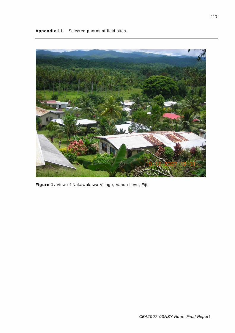
CBA2007-03NSY-Nunn-Final Report
117
Appendix 11. Selected photos of field sites.
Figure 1. View of Nakawakawa Village, Vanua Levu, Fiji.

CBA2007-03NSY-Nunn-Final Report
118
Figure 2. Eroding shore front at Nakakawa Village, Vanua Levu, Fiji

CBA2007-03NSY-Nunn-Final Report
119
Figure 3. Fishing is the 4th highest source of income in Nakawakawa Village, Vanua Levu
Island, Fiji

CBA2007-03NSY-Nunn-Final Report
120
Figure 4. Salinized ground behind the beach on Butaritari Island, Kiribati

CBA2007-03NSY-Nunn-Final Report
121
Figure 5. Pool of brackish water used for bathing, Butaritari, Kiribati

CBA2007-03NSY-Nunn-Final Report
122
Figure 6. Children, Butaritari, Kiribati

CBA2007-03NSY-Nunn-Final Report
123
Figure 7. Eroding shoreline on Butaritari Island, Kiribati
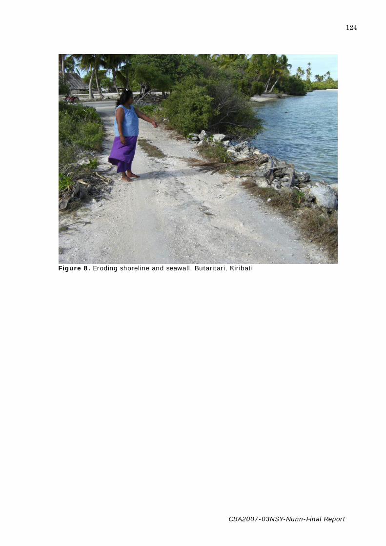
CBA2007-03NSY-Nunn-Final Report
124
Figure 8. Eroding shoreline and seawall, Butaritari, Kiribati

CBA2007-03NSY-Nunn-Final Report
125
Figure 9. Well for drinking, Butaritari, Kiribati

CBA2007-03NSY-Nunn-Final Report
126
Figure 10. Eroding shoreline, Butaritari, Kiribati

CBA2007-03NSY-Nunn-Final Report
127
Figure 11. High-energy beaches like this one on Butaritari, Kiribati, are often the only
natural protection for the island behind.

CBA2007-03NSY-Nunn-Final Report
128
Figure 12. Research student Christy Haruel (centre) collecting information at Emua Village, Efate Island, Vanuatu.

CBA2007-03NSY-Nunn-Final Report
129
Figure 13. Informant at Emua Village, Efate Island, Vanuatu, showing where the shoreline used to be.

CBA2007-03NSY-Nunn-Final Report
130
Figure 14. Student researcher Christy Haruel interviewing in Emua Village, Efate Island,
Vanuatu.

CBA2007-03NSY-Nunn-Final Report
131
Figure 15. Emua Village, Efate Island, Vanuatu, partly underwater at high tide.

CBA2007-03NSY-Nunn-Final Report
132
Figure 16. Eroded tree roots along the coast at Antahi, Pentecost Island, Vanuatu

CBA2007-03NSY-Nunn-Final Report
133
Figure 17. Eroded tree along the coast at Antahi, Pentecost Island, Vanuatu

CBA2007-03NSY-Nunn-Final Report
134
Figure 18. Student researcher (Ann Tosiro) explaining the aims of the project to the
people of Lolbualabwa Village, Pentecost Island, Vanuatu.

CBA2007-03NSY-Nunn-Final Report
135
Figure 19. Chief Mahuri, key informant at Lolbualabwa Village, Pentecost Island, Vanuatu.

CBA2007-03NSY-Nunn-Final Report
136
Figure 20. Ann Tosiro interviewing Chief Mahuri, key informant at Lolbualabwa Village, Pentecost Island, Vanuatu.

CBA2007-03NSY-Nunn-Final Report
137
Figure 21. Sand mining by the people living near Lolbualabwa Village, Pentecost Island,
Vanuatu.

CBA2007-03NSY-Nunn-Final Report
138
Figure 22. Traditional thatched house, Lolbualabwa Village, Pentecost Island, Vanuatu.