Embed Size (px)
Citation preview
UN-SPIDER REGIONAL SUPPORT OFFICES
Effective use of space-based information to monitor disasters and its impacts
Lessons Learnt from Drought in Iran Prepared by Iranian Space Agency

Lessons Learnt from Drought in Iran
Lessons Learnt from Drought in Iran
Effective use of space-based information to monitor disasters and its impacts
Lessons Learnt from Drought in Iran
Abdolreza ANSARI AMOLIISA
Ali SADEGHI NAEINIISA
Shirish RAVANUN-SPIDER
Editing and booklet design by David Schenkel
Lessons Learnt from Drought in Iran
About UN-SPIDERwww.un-spider.org
In its resolution 61/110 of 14 December 2006 the United Nations General Assembly agreed to establish the “United Nations Platform for Space-based Information for Disaster Management and Emergency Response - UN-SPIDER” as a new United Nations programme, with the following mission statement: “Ensure that all countries and international and regional organizations have access to and develop the capacity to use all types of space-based information to support the full disaster management cycle.”
UN-SPIDER aims at providing universal access to all types of space-based information and services relevant to disaster management by being a gateway to space-based information for disaster management support; serving as a bridge to connect the disaster management and space communities; and being a facilitator of capacity building and institutional strengthening.
Whereas there have been a number of initiatives in recent years that have contributed to making space technologies available for humanitarian and emergency response, UN-SPIDER is the first to focus on the need to ensure access to and use of such solutions during all phases of the disaster management cycle, including the risk reduction phase, which contributes significantly to reducing the loss of lives and property.
Lessons Learnt from Drought in Iran
“May Ahura Mazda protect this land, this
nation, from rancor, from foes, from falsehood
and from drought.”
Dariush the Great (550 B.C.)
King of the Iranian (Persian) Achaemenid Empire

Lessons Learnt from Drought in Iran
Lessons Learnt from Drought in Iran
Table of ContentsForeword ............................................................................................1
1. Drought in Iran ................................................................................2
2. Earth Observation in the Drought Management Cycle ...................42.1 Mitigation ................................................................................................................................... 42.2 Preparedness ............................................................................................................................. 42.3 Response ................................................................................................................................... 52.4 Recovery .................................................................................................................................... 5
3. Space Technology Products and Services by Iranian Agencies ....63.1 Drought Monitoring .................................................................................................................... 6 Example Case 2001-2003 from Fars Province ............................................................................ 73.2 Drought Modeling and Prediction .............................................................................................. 73.3 Drought Assessment ............................................................................................................... 10 Hazard and Impact Assessment ............................................................................................... 10 Vulnerability Assessment ........................................................................................................... 10 Crop Damage Assessment ........................................................................................................ 11
4. International Cooperation .............................................................124.1 Economic Cooperation Organization ...................................................................................... 12 Drought Assessment and Monitoring for the ECO Region Using Satellite Data ....................... 134.2 Implementation of the Hyogo Framework for Action .............................................................. 144.3 UN SPIDER Regional Support Office ...................................................................................... 15
5. Implementation of Strategy and Action Plan ................................165.1 Development of the Iranian National Strategy and Action Plan .............................................. 17 Step 1: Creating Political Momentum and Authority ................................................................. 17 Step 2: Strategic Planning and Coordination ............................................................................ 17 Step 3: Fostering Involvement and Developing Common Understandings .............................. 18 Step 4: Investigating Drought Monitoring, Risk, and Management Options ............................. 18 Step 5: Writing the National Drought Strategy and Action Plan ................................................ 18 Step 6: Implementing the National Drought Strategy and Action Plan ..................................... 19
6. Challenges for the Future .............................................................20
Lessons Learnt from Drought in Iran
Acronyms
AIF Agricultural Insurance Fund
ANN Artificial Neural Network
AVHRR Advanced Very High Resolution Radiometer
BRCSRA Bureau of Research and Coordination of Safety and Reahbilitation Activities
ECO Economic Cooperation Organization
EO Earth Observation
ET Evapotranspiration
ETM Enhanced Thematic Mapper
FAO Food and Agriculture Organization
GIEWS Global Information and Early Warning Service
GIS Geographic Information System
IRIMO Islamic Republic of Iran Meteorological Organization
IRS Indian Remote Sensing
ISA Iranian Space Agency
MODIS Moderate Resolution Imaging Spectroradiometer
MoE Ministry of Energy
MoJA Ministry of Jehad-e-Agriculture
NDMC National Drought Management Center
NDVI Normalized Difference Vegetation Index
NOAA National Oceanic and Atmospheric Administration
PAIA Priority Area for Interdisciplinary Action
PDSI Palmer Drought Severity Index
RCRM Regional Center for Risk Management
RS Remote Sensing
RSO Regional Support Office
Lessons Learnt from Drought in Iran
SPEI Standardized Precipitation-Evapotranspiration Index
SPI Standardized Precipitation Index
SPOT Satellite Pour l’Observation de la Terre (Satellite for observation of Earth)
SWI Standard Water Index
TCI Temperature Condition Index
UNOOSA United Nations Office for Outer Space Affairs
UN-SPIDER United Nations Platform for Space-based Information for Disaster Management and Emergency Response
VCI Vegetation Condition Index
VegDRI Vegetation Drought Resistance Index
VHI Vegetation Health Index
VI Vegetation Index
VIIRS Visible Infrared Imager Radiometer Suite
1
Lessons Learnt from Drought in Iran
Foreword
The increasing effects of climate change are a major concern to humanity and a major cause of drought in certain regions. Despite dra-matic advances in modern technology, no clear answers have been formulated to address this debilitating natural disaster. Climatic factors such as high temperature and winds and low rel-ative humidity are often associated with drought and can significantly aggravate the severity of the event.
In recent decades, Iranian planners and authori-ties have focused on studies that claim to provide promising results for the mitigation or control of natural disasters such as drought. These studies are based on climatic data, such as precipita-tion, which is insufficient and inadequate for use in timely drought detection, monitoring and decision-making. New techniques and tech-nologies to provide efficient means for drought monitoring that are low-cost and less time con-suming are required. A promising tool is satellite imagery, which provides continuous and reliable data that can be used to monitor and manage drought in a country or region.
This booklet is a joint effort by the Remote Sensing Department of the Iranian Space Agency (ISA) and UN-SPIDER to summarize the
efforts by Iran to manage drought using space technology. It reviews and analyzes services rendered by national research institutions and programs implemented in the country by gov-ernmental and non-governmental sectors. The information provided herein can serve as a guide for countries located in drought-prone regions for the development of drought monitoring and assessment.
Acknowledgments:
We would like to thank Atmospheric Sciences and Meteorological Research Centre of Iranian Meteorological Organization (IRIMO) and “Agri-cultural Product Insurance Fund” under the affiliation by “Iran Agricultural Bank” for provid-ing reports including their past experiences and projects related to drought management in Iran that involves use of remote sensing and GIS technology.
We also appreciate Mr. Mohammad Morabbi, an Iranian specialist associated with “Remote Sensing & GIS” department of Iranian Space Agency, for contributing to section 3.
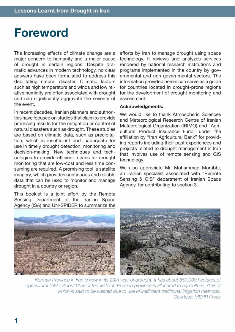
Kerman Province in Iran is now in its 20th year of drought. It has about 550,000 hectares of
agricultural fields. About 90% of the water in Kerman province is allocated to agriculture, 70% of which is said to be wasted due to use of inefficient traditional irrigation methods.
Courtesy: MEHR Press
2
Lessons Learnt from Drought in Iran
1. Drought in Iran
Drought can be defined as a temporary climatic anomaly with no rain, especially during the planting and growing season. It is one of the most complex and least-understood of all natural events and affects more people than any other hazard. In contrast to the effects of floods, earthquakes and hurricanes, the damage created by drought is usually nonstructural, but is spread over a larger geographical area. Its effect accumulates slowly over time and lingers for years. Since the onset and duration of drought is difficult to determine; people generally are not fully aware that they are in the midst of such an event.
Vulnerability factors such as an under-developed infrastructure, lack of facilities, absence of authority, lack of communication between political and economic systems, ineffective markets, lack of social benefits, and inadequate institutional support contribute to the negative effects of drought on a country-wide scale. High population growth, urban development, expansion of deserts and deforestation are additional factors that intensify drought. The effects of drought can occur months or years after the drought has ended. These effects are largely nonstructural and are spread over a larger geographical area than those from other natural disasters. The nonstructural characteristic of drought hinders the development of accurate, reliable, and timely estimates of severity.
Drought affects lives and communities in three major ways. The economic impact of drought includes losses to the timber, agriculture, and fishery industries. Much of this loss is passed on to the consumer in the form of higher prices for commodities. The social impact of drought includes increased likelihood of conflict over commodities, fertile land, and water resources. Other social effects are the erosion of cultural traditions, loss of homelands, changes in lifestyle, and increased threats to health from increasing poverty and decline in proper hygiene. Environmental impacts of drought include loss of species biodiversity, changes in migratory
habits, deteriorating air quality and increased soil erosion.
The economic, social, environmental, and psychological effects of drought are the products of both the natural event (meteorological drought and lack of precipitation over an extended period of time) and the vulnerability of society to the natural events. In other words, the effects of drought are determined by the frequency and intensity of drought and by the number of people at risk and the degree of risk.
Iran is heavily affected by drought events with a particularly severe one occurring from 1999-2002. This drought inflicted $3.5 billion in damage, killed 800,000 head of livestock and dried up major reservoirs and inland lakes. This resulted in a decrease in cultivation and in the yield of cereal crops. Since that time, most rivers in the country are either dry or severely depleted.
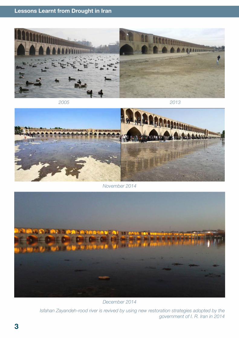
The Zayandeh-rood River was once a major water artery running through the historic city of Isfahan. It was a thoroughfare that nourished some of the earliest civilizations in recorded history and sustained the people of Isfahan up to modern times. For the past two years, the river has been bone dry. Its banks have not receded, they simply no longer exist. In their place is a deserted riverbed.
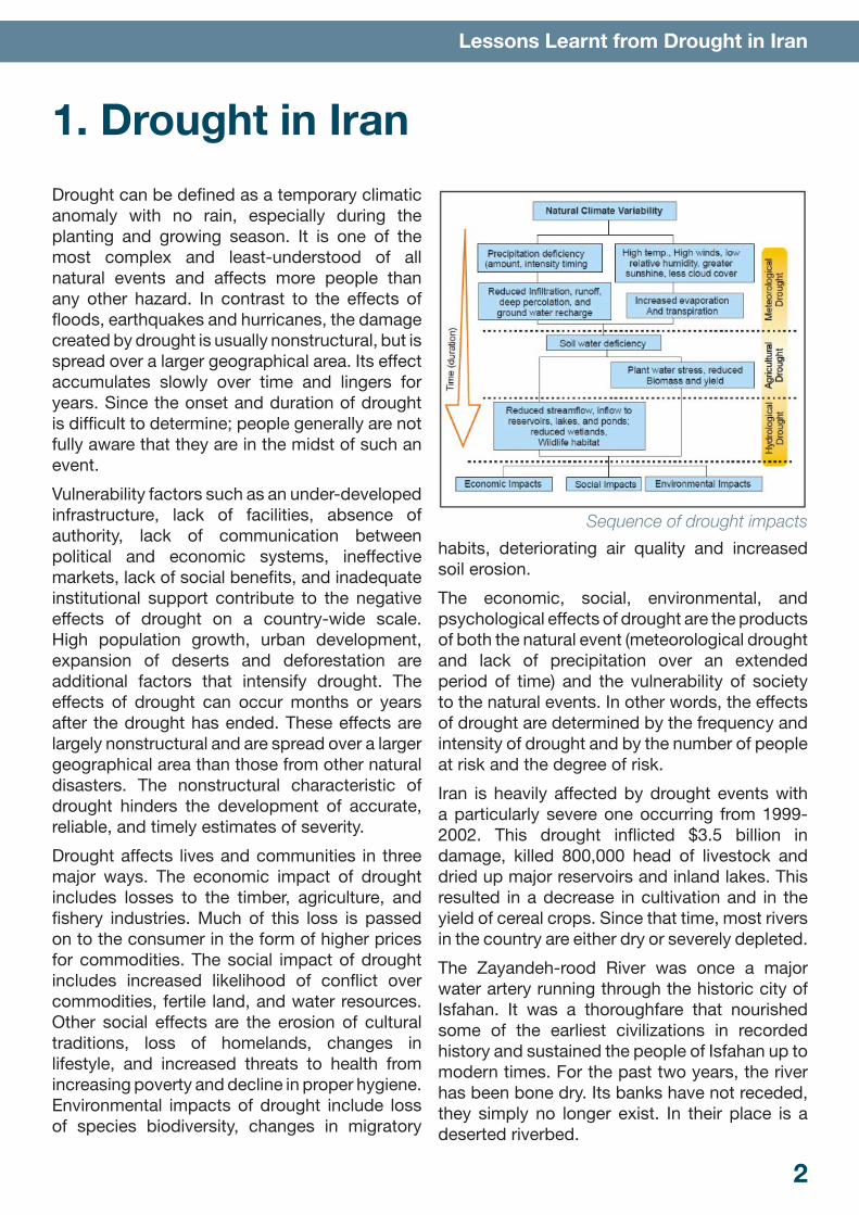
Sequence of drought impacts
3
Lessons Learnt from Drought in Iran
2005 2013
November 2014
December 2014
Isfahan Zayandeh-rood river is revived by using new restoration strategies adopted by the government of I. R. Iran in 2014
4
Lessons Learnt from Drought in Iran
The drying up of the Zayandeh-rood is the most visible sign of the water crisis that threatens the existence of this city. Groundwater levels have fallen, wells have dried up and ecosystems have been destroyed. The crisis requires strong
steps from the national and local governments to address the inadequate and failed policies of previous administrations. This political process can be supported by earth observation data for it to be effective and sustainable.
2. Earth Observation in the Drought Management Cycle
Disaster management can be grouped into four phases: mitigation, preparedness, response and recovery. This section describes the information needs of response agencies at different stages of earth observation based drought manage-ment.
2.1 MitigationMitigation is the most important function for bringing disasters under control. This refers to long-term measures that decrease risk, such as the development of technological solutions, legislation, land-use planning, and insurance. Drought mitigation should prevent or decrease the effect of drought. It calls for strategies such as construction of reservoirs, conservation of existing water sources, optimizing the use of water, altering farming practices, and desalina-tion of water.
A comprehensive and systemic plan to miti-gate drought is required to understand the causes, effects and management mechanisms of drought and to select and design an appro-priate approach based on location-specific cir-cumstances. The main objective of any drought mitigation plan should be to enhance drought risk management through development of fun-damental drought information tools. Such a plan must make use of currently-available meteoro-logical, climatic and remote sensing data that can be used to generate information products relevant for drought risk management.
Geospatial tools allow effective integration and modeling of data from parameters such as meteorological, earth observation and socio-
economic data that effect drought. The geo-spatial information including Earth Observation (EO) can be modeled to provide indicators , haz-ard and impact assessment, and vulnerability assessment.
Remote sensing based drought indicators used for drought management are vegetation indices (VI). They can be used for a wide range of eco-system assessments such as biomass estima-tions, water use, plant stress, plant health and crop production. Vegetation Indices are calcu-lated using the difference in reflectance from crops.
2.2 PreparednessDisaster preparedness focuses on developing plans to respond to a disaster as it threatens to occur. At its simplest, preparedness is an esti-mation of emergency requirements and their mobilization in time to meet urgent need. Disas-ter prediction (long-term) and disaster warnings (short-term) are prerequisites to ensuring disas-ter preparedness.
Preparedness for drought necessitates greater institutional capacity at all levels of government and efficient coordination between stakehold-ers. Drought preparedness implies increasing the coping capacity of individuals and communi-ties to deal with drought. Drought preparedness planning should also provide significant benefits for the act of preparing for potential changes in climate. In the drought preparedness phase, geospatial information can be used for drought monitoring, prediction and early warning.

5
Lessons Learnt from Drought in Iran
2.3 ResponseDisaster response is an activity that addresses short-term and direct effects of an incident. These activities include immediate actions to preserve life, property and the environment, meet basic human needs, and maintain the social, economic, and political structure of the affected community. Response also includes the execution of emergency operations plans, mobilizing emergency services and incident mitigation activities designed to limit loss of life, coordinating search and rescue, and assess-ing personal injury, property damage, and other unfavorable outcomes.
The provision of space-based products and services such as maps, satellite imagery and geographic information that shows the extent and degree of damage (mapping the extent of the damage) and identification of suitable sites for rehabilitation is important for response and humanitarian aid agencies. The products gen-erated from space-based information minimize possible harm caused by a disaster.
2.4 RecoveryThe objectives of the Emergency Drought Recovery Project are to alleviate the impact of current drought through measures to regenerate crops and livestock productivity, improve rural roads and potable water supplies to generate current income for affected populations. It will also strengthen the capacity of the government to mitigate the effects of future droughts and enhance institutional capacity for drought man-agement. For example, input based on geospa-
tial technology can help efficient management of pastures by estimating the damage to and carrying capacities of each region.
Iranian Drought Monitoring Checklist
Meteorological Data
Agency: Islamic Republic of Iranian Mete-orological Organization (IRIMO)
Monitored Indices: Daily, weekly, and monthly rainfall, snow fall.
Hydrological Data
Agency: Ministry of Power
Monitored Indices: Water storage in res-ervoirs/ponds/lakes, river flow, ground-water level, yield and draft from aquifers, water loss through evaporation, leakage, seepage.
Agricultural Data
Agency: Ministry of Agriculture
Monitored Indices: Soil moisture, area under sowing and type of crop, crop water requirement, status of growth, crop yield, alternative cropping possibilities, land holdings.
Data from Space
Agencies: Iranian Space Agency, National Geographic Organization, National Carto-graphic Centers
Monitored Indices: Vegetation monitoring, rainfall, surface wetness and temperature monitoring.
Drought Monitoring in Iran: Satellite-based changes of Vegetation Indices using NOAA-AVHRR data
6
Lessons Learnt from Drought in Iran
3. Space Technology Products and Services by Iranian AgenciesThe products and experiences of major organi-zations in charge of drought management in Iran that use space technology are introduced in this section.
3.1 Drought MonitoringThe assessment of vegetation changes over time is an important factor in order to investi-gate drought impacts. Periodical compositions of vegetation indices and other climate indices produced by remote sensing data help to analyze drought effects visually as well as by statistical measures. Several agencies in Iran are provid-ing these maps for provincial and national levels such as the Iranian Space Agency (ISA), the Fars Agriculture and Natural Research Center and the Isfahan Agriculture and Natural Research Center. They each focus on different regions or different effects of drought (see checklist).
Examples of monitoring systems based on drought meteorological indicators (e.g., stan-dardized effective precipitation index) include satellite indices, rainfall estimates, soil mois-ture models and climatic/hydrological param-
eters such as precipitation, temperature, evapo-transpiration, stream flow, and reservoir levels. Whereas climate data brings real-time informa-tion about the primary factors regulating clima-tological drought, remote sensing data, with its higher spatial resolution, provides better details concerning the land cover types affected and the effects of climatic drought on agriculture and natural vegetation.
Commonly-used remote sensing-based indices for drought monitoring include vegetation indi-ces, surface temperatures and a combination of both. Traditional approaches to drought moni-toring consider data from the NOAA-AVHRR data system. With the availability data from other satellites with advanced sensors capable of pro-viding information on bio-physical and terrain parameters, remote sensing is better equipped to perform drought monitoring. The new genera-tion of satellite sensors such as Visible Infrared Imager Radiometer Suite (VIIRS) on the National Polar-orbiting Operational Satellite System pre-paratory platform can provide more useful infor-mation for drought monitoring.
The three most popular VIs for drought moni-toring among Iranian remote sensing experts
Drought Vulnerability Map of Iran for 1999 (left) and 2001 (right)
7
Lessons Learnt from Drought in Iran
are the Normalized Difference Vegetation Index (NDVI) and the Vegetation Health Index (VHI) to assess the condition of the vegetation and the Vegetation Drought Response Index (VegDRI), a hybrid product integrating satellite data and in-situ climate data.
Example Case 2001–2003 from Fars ProvinceThe province of Fars has experienced severe drought and ground water problems in the last decade. Ten-day maximum NDVI and VHI maps were produced. Remotely sensed data was then compared with hydrological and meteorological data from 1998 to 2007. The Standard Precipi-tation Index (SPI) was used to quantify the pre-cipitation deficit and the Standard Water Index (SWI) was developed to assess the groundwater recharge deficit.
The SPI maps reveal that meteorological drought and stress appear mostly in the southern, cen-tral, and eastern parts of Fars province. The period from 2001 to 2003 appeared to experi-ence severe drought. VHI maps show a high visual correlation with SPI, but the quantitative correlations for each county do not provide reli-able results. When the scales of the parameters are different, weak correlations may develop when, in reality, one parameter is entirely depen-dent on another. A better and more meaningful
picture is provided by spatial correlation through visual comparison instead of the use of correla-tion coefficients. This is especially true for events like drought, which have regional aspects.
The PDSI maps indicate good vegetation condi-tions for the majority of the study period. Good vegetation cover cannot be confirmed by look-ing at the precipitation-PDSI Pearson correla-tion or the precipitation-NDVI results. In arid and semi-arid climates where ground water is used for irrigation, vegetation cover is not sim-ply related to the level of precipitation. A strong Pearson correlation between PDSI and SWI for the same month for the majority of counties in Fars province can be attributed to irregular water consumption by the region’s farmers. The main cause of this kind of irregular water consump-tion is the government’s “assurance purchase law” for agricultural products. If a region shows positive vegetation indices (as demonstrated by satellite images) despite being located in an arid or semi-arid region, it is possible that the actual precipitation and ground water resource condi-tions are misrepresented.
3.2 Drought Modeling and PredictionA drought early warning system can provide decision-makers with timely and reliable access
Drought Damages Mapping in Iran by using NDVI (left) and VCI (right)
8
Lessons Learnt from Drought in Iran
Fars Province: Visual spatial correlation between (a) SPI and (b) VHI during 1999 – 2007(c) Drought Severity Classes map
a)
b)
c)
9
Lessons Learnt from Drought in Iran
to information with which to plan response and mitigation measures. The main objectives of a drought early warning system are:
• To provide early warning information about the onset of drought and its effect on food security to trigger timely responses
• To provide information on food availability during drought and plan timely and well-tar-geted responses to drought
• To build a reliable database of baseline infor-mation that can be utilized for local develop-ment planning
Effective drought early warning systems must integrate climatic parameters such as precipita-tion, stream flow, snow pack, groundwater lev-els, reservoir and lake levels, and soil moisture and remote sensing-based data. The remotely sensed data most frequently used for drought early warning include MODIS, AVHRR, Landsat, SPOT and IRS.
While monitoring has been carried out for decades, forecasting drought is still in its infancy. One challenge to drought prediction is that it does not have an obvious beginning or end. Researchers are currently developing methods of drought prediction using satellite data from meteorological, oceanographic and hydrological observations. These observations, combined with near real-time remotely sensed data, allow early prediction of drought that countries can use to develop strategies for agriculture, fisher-ies and the distribution of goods.
This is a blend of science and art as is car-ried out a national scale at the NOAA Climate Prediction Center in Maryland. The meteorolo-gists there periodically produce a US seasonal drought outlook to predict conditions related to drought three months in advance.
Drought modeling using satellite data and artifi-cial neural networks (ANNs) is also being carried out by the ISA. Drought prediction helps to better manage available resources and decrease dam-age from drought. The SPI is the measure most often used of those that quantify the severity of drought. It takes into account the precipita-tion index normalized for a period of 30 years. A major challenge for modeling drought using SPI is a lack of measuring stations in many places;
this makes it impossible to monitor drought con-ditions for those regions. NOAA-AVHRR images are freely available and provide useful informa-tion on parameters such as land cover and veg-etation.
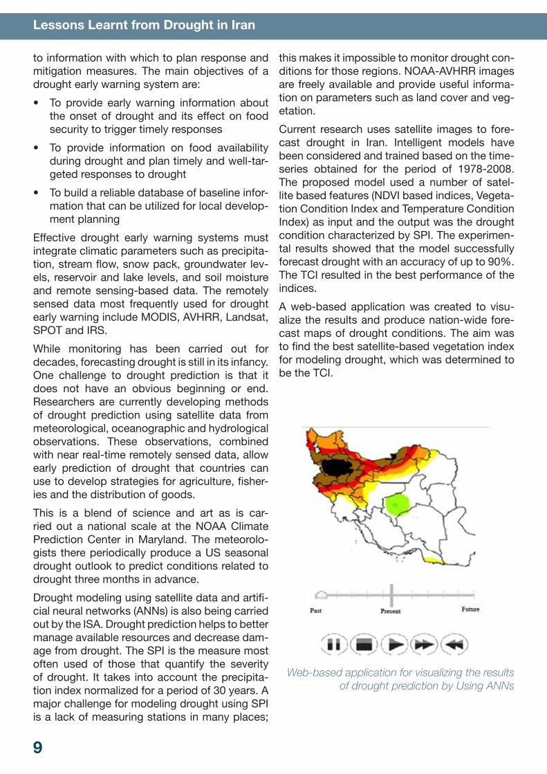
Current research uses satellite images to fore-cast drought in Iran. Intelligent models have been considered and trained based on the time-series obtained for the period of 1978-2008. The proposed model used a number of satel-lite based features (NDVI based indices, Vegeta-tion Condition Index and Temperature Condition Index) as input and the output was the drought condition characterized by SPI. The experimen-tal results showed that the model successfully forecast drought with an accuracy of up to 90%. The TCI resulted in the best performance of the indices.
A web-based application was created to visu-alize the results and produce nation-wide fore-cast maps of drought conditions. The aim was to find the best satellite-based vegetation index for modeling drought, which was determined to be the TCI.
Web-based application for visualizing the results
of drought prediction by Using ANNs
10
Lessons Learnt from Drought in Iran
3.3 Drought Assessment
Hazard and Impact AssessmentDrought hazard is expressed in terms of the probability of a drought event occurring in a given place during a given period of time. The availability of spatial-temporal datasets of drought indicators that allow the development of a historical catalogue of drought events is a major requirement for drought hazard assess-ment. Time-series of drought characteristics on different time scales should be obtained and analyzed to define the probability of drought given the characteristics of a specific region.
The effects of drought include the damage expected as a consequence of drought, which is better expressed in terms of the cost of damage to vulnerable systems such as water resources and crops. Remote sensing-based indicators are more efficient in terms of time and cost to assess the effect of drought. For example, high tempo-ral resolution images such as those from MODIS and the advanced very high resolution radiom-eter (AVHRR) provide data for daily measure-ment of the vegetation index. The maps based on this type of data are used to monitor climatic and environmental changes such as deforesta-tion, desertification and drought. The effects of drought hazard are important factors in drought risk assessment. The relation between drought risk, hazard and impact can be expressed as:
risk = hazard × impact
Vulnerability AssessmentDrought vulnerability is a measure of the inabil-ity of a society or an ecosystem to cope with drought and is the sum of the effect of different elements of the system (e.g., water resources, crops). Drought vulnerability is related to the degree of natural and social adaptation to drought in terms of resistance and resilience.
EO satellites provide data that is relevant for assessment of agricultural and environmen-tal vulnerability to drought. Since it is not pos-
sible in advance to know which time-scale is most suitable for monitoring drought vegetation conditions, the response times of the different vegetation types to water shortage can differ. Complete spatial coverage, good availability, accessibility, low cost, and high temporal and spatial resolutions are the advantages of the use of EO data for analysis of drought vulnerability.
The Ministry of Agriculture has recently pro-posed an agricultural drought risk assessment plan. The plan will decrease or compensate for agricultural loss based on measures of drought severity and duration. Current damage (based on monitoring methods) or subsequent damage (based on forecasting methods) will be evalu-ated in the short term (one to several months) and long term (3-5 years).
As for other natural disasters such as flooding, drought management comprises four steps. The first step is reconnaissance to identify the most susceptible area for agricultural drought by monitoring and forecasting. The second step is drought impact assessment and loss estima-tion. This is based on the severity and length of drought. In the third step, the areas subjected to drought will be zoned based on the first two stages. In the final step, a loss compensation plan will be implemented based on the findings of the previous steps.
Satellite images are used to extract meteoro-logical, agricultural, and hydrological indices to locate the areas that are most prone to drought. The severity and length of drought will be esti-mated for each region to predict damage to major agriculture products and natural resources. Risk zoning maps for agriculture products faced with varying levels of drought severity and lengths will be prepared. This will allow implementa-tion of proper decision-making to decrease the impact of drought. This may include changing cultivation patterns, planting schedules, priori-tizing areas for implementation of drought risk management plans and support programs.
Historical data and data on damage from the Forestry and Watershed Management Orga-nization, Soil Conservation and Watershed Research Institute and the Ministry of the Inte-rior (Crisis Management Organization) are being
11
Lessons Learnt from Drought in Iran
used in addition to satellite images for analysis. Meteorological and hydrological data were ana-lyzed to extract drought indices and prepare meteorological and hydrological drought maps in cooperation with the Ministry of Power and the Meteorological Organization. Drought risk maps were prepared based on 10 years of satel-lite data provided by the ISA and other relevant organizations.
Crop Damage Assessment
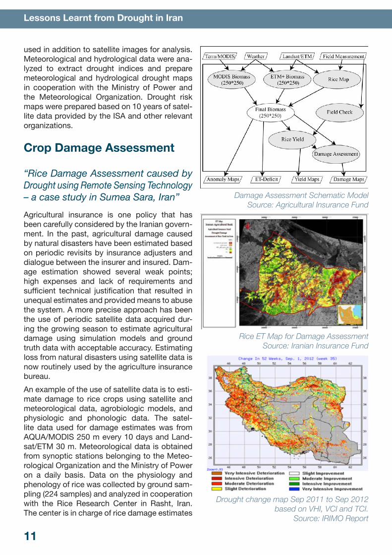
“Rice Damage Assessment caused by Drought using Remote Sensing Technology – a case study in Sumea Sara, Iran”Agricultural insurance is one policy that has been carefully considered by the Iranian govern-ment. In the past, agricultural damage caused by natural disasters have been estimated based on periodic revisits by insurance adjusters and dialogue between the insurer and insured. Dam-age estimation showed several weak points; high expenses and lack of requirements and sufficient technical justification that resulted in unequal estimates and provided means to abuse the system. A more precise approach has been the use of periodic satellite data acquired dur-ing the growing season to estimate agricultural damage using simulation models and ground truth data with acceptable accuracy. Estimating loss from natural disasters using satellite data is now routinely used by the agriculture insurance bureau.
An example of the use of satellite data is to esti-mate damage to rice crops using satellite and meteorological data, agrobiologic models, and physiologic and phonologic data. The satel-lite data used for damage estimates was from AQUA/MODIS 250 m every 10 days and Land-sat/ETM 30 m. Meteorological data is obtained from synoptic stations belonging to the Meteo-rological Organization and the Ministry of Power on a daily basis. Data on the physiology and phenology of rice was collected by ground sam-pling (224 samples) and analyzed in cooperation with the Rice Research Center in Rasht, Iran. The center is in charge of rice damage estimates
Damage Assessment Schematic Model
Source: Agricultural Insurance Fund
Rice ET Map for Damage Assessment Source: Iranian Insurance Fund
Drought change map Sep 2011 to Sep 2012 based on VHI, VCI and TCI.
Source: IRIMO Report
12
Lessons Learnt from Drought in Iran
caused by natural disasters such as drought, frost and flooding.
The system monitors the growing process from planting stage to harvest and prepares a bio-mass map every 10 days showing major influ-ence parameters. The system calculates bio-mass yield, rough rice yield and yield gap. The map showing damage to area prone to natural disaster are prepared by compiling the yield map, yield gap, and vegetation cover anomaly coefficients during the growing season. Suffi-cient information is produced (~800 map layers) for specialized applications or in combination with other map layers. Actual evapotranspiration (ET), potential ET, ET deficit and soil moisture are major parameters needed for water resources management. The damage estimate model for rice is composed of 4 major modules:
• Biomass measurement module using remote sensing technology on a periodic basis
• Rice cover map module prepared using sat-ellite data
• Rice yield map module
• Data analysis and loss estimate module
The output maps help managers and decision-makers discriminate between damaged and undamaged areas. The ET deficit can be pre-dicted from ET maps using remote sensing data. The red parts of this map denote areas with high ET deficits that are under water stress. IRIMO has recently completed projects on drought monitoring system in Iran. The system is based on drought indices, including SPI-, PDSI- and GIS-RS-based drought indices (NDVI, bright-ness temperature - BT, VCI, TCI and VHI).
4. International Cooperation
4.1 Economic Cooperation OrganizationA three-day workshop on Drought Manage-ment for the Economic Cooperation Organiza-tion (ECO) Region was held on 21-23 Decem-ber, 2003 in the ECO Secretariat, Tehran, Islamic Republic of Iran. Food and Agriculture Organiza-tion of the United Nations (FAO), Islamic Repub-lic of Iran Ministry of Agriculture and the Eco-nomic Cooperation Organization (ECO) jointly organized the workshop.
Recurrent severe drought in some parts of the ECO region has negatively affected agricultural production and trade of agro-products. The ECO ministerial meeting on Agriculture held in Islamabad in 2002 identified drought manage-ment as a priority for cooperation between the ECO countries and Iran was selected as the coordinating country for ECO cooperation in this regard.
A set of recommendations was adopted and proposals for an ECO Plan of Action were for-
mulated during the workshop. The participants of the workshop recommended that member countries initiate strategies and plans of action for drought management and preparedness planning, enact appropriate laws and legislation for drought mitigation, ensures coordination and collaboration between governmental institutions and more intense cooperation with international organizations.
The recommendations for the plan of action included an exchange of students/experts for training purposes, the exchange of informa-tion and data on drought mitigation practices, monitoring and evaluation and technical sup-port for member countries. The development of FAO technical cooperation programs for the ECO region was recommended to enhance the capacity of countries for drought management. This includes drought early warning systems and preparation of “bankable project documents” to be addressed to donors.
In June 2010, the Islamic Republic of Iran Mete-orological Organization (IRIMO) and ECO signed a treaty in the service of human security. The Regional Risk Management body was founded
13
Lessons Learnt from Drought in Iran
to facilitate international cooperation in the fields of weather, climate, water and related sciences. IRIMO and ECO agreed that ECO would contrib-ute $50’000 for the Regional Risk Management Center in Mashhad, Iran. A general purpose fund was allocated as seed money to support the activities and programs of this ECO Regional Center for Risk Management (ECO-RCRM).
The main goal of ECO-RCRM is to provide facili-ties for collaborative research in risk manage-ment of natural disasters, especially drought, between universities and relevant institutions in ECO countries and to assist the national meteo-rological researchers to apply risk management to natural disasters to meet the needs of their countries. This includes initiation of programs of by the center, data collection and distribu-tion, experience sharing and training and project development.
Drought Assessment and Monitoring for the ECO Region Using Satellite DataA near real-time drought monitoring system is currently being developed by I.R. of Iranian Meteorological Organization (IRIMO) using drought-related characteristics (indices) derived from remote-sensing data. The indices include a deviation from the NDVI from its long-term mean and a VCI. Data from the NOAA-AVHRR and
MODIS satellites are used to drive long-term mean and temporal values for the NDVI and VCI.
Expected Outcomes• Establish a real-time drought monitoring sys-
tem based on NDVI and other indices
• Produce maps using well-known remote sensing indices, such as NDVI and VI
• Produce normal climatological maps based on NDVI and VI
• Fill in gaps in drought monitoring for the region that result from measurement-related problems for precipitation and other meteo-rological parameters
• Establish a website for drought monitoring maps and related discussions
Planned ActivitiesThe study will investigate historical patterns of droughts in the region using monthly time-step AVHRR satellite data. Recent drought patterns will be studied using 8-day time-interval MODIS satellite images available from 2000 onwards. Regression relationships will be developed between drought-related indices obtained from MODIS and AVHRR data, which have different pixel resolutions and optical characteristics. These relationships will be established for each month of the year and for data pooled from all
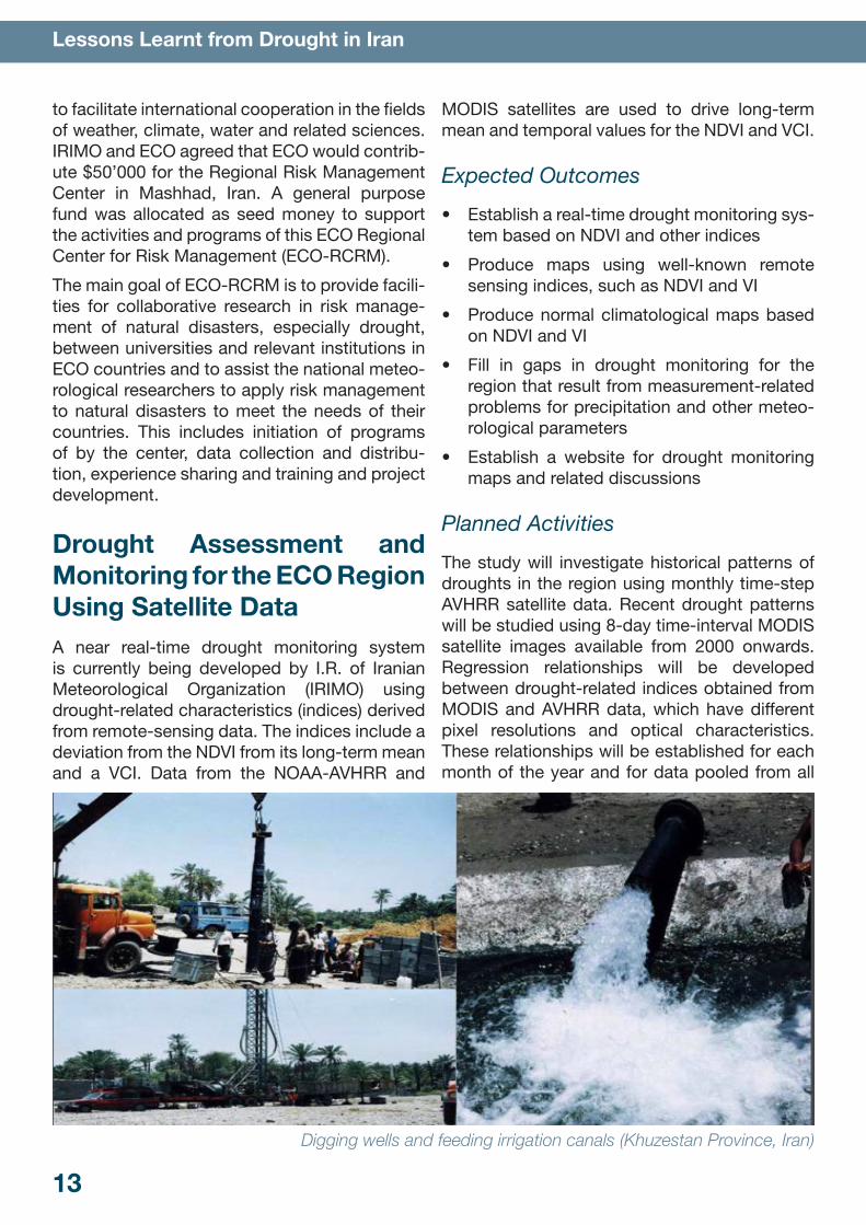
Digging wells and feeding irrigation canals (Khuzestan Province, Iran)
14
Lessons Learnt from Drought in Iran
months. The results will be validated against his-torical data recorded by meteorological stations in the ECO region. A website will be designed for dissemination drought monitoring maps and warnings for the ECO region.
Implementing AgenciesThe study includes all eight ECO member countries. The coordinating office and human resources will remain in the IRIMO center in Teh-ran, Iran.
Monitoring and EvaluationDrought indices produced by satellite data (AVHRR and MODIS) will be compared with cli-matologic data measured by responsible organi-zations over a period of at least five years. After evaluation, the satellite indices will be used for drought monitoring.
4.2 Implementation of the Hyogo Framework for ActionThe Islamic Republic of Iran, in line with imple-mentation of the Hyogo Framework for Action (HFA), has undertaken a range of activities to reduce the effects of disasters and implemen-tation of disaster risk reduction programs and projects at national, preventative and local lev-els. These activities include introduction and enactment of legislation for disaster risk reduc-tion such as formation of the Disaster Manage-ment Organization and development of 50 exec-utive by-laws subject to approval by the cabinet. The national structure of the legislation should be mirrored at the provincial and local levels to pave the way for implementation of disaster risk reduction activities in a more coordinated and compressive manner with the involvement of key players in disaster risk reduction. The high level council is chaired by the president of the Islamic Republic of Iran and the organization is head a deputy interior minister. The organization has an
annual budget to be approved by the Islamic Consultative Assembly of Iran. A body of guide-lines, by-laws, standards, instructions, criteria, and regulations has been developed regarding drought risk reduction (DRR). It is estimated that the level of progress in implementation of the Hyogo framework for action is at level 4.
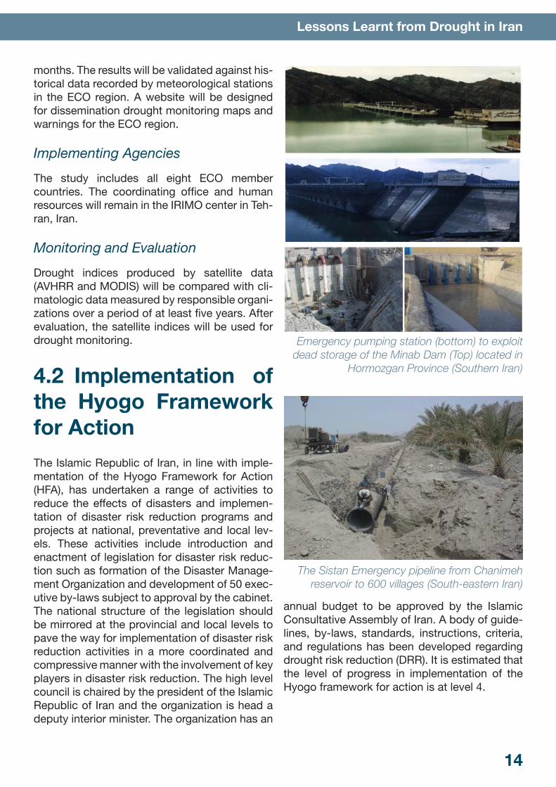
Emergency pumping station (bottom) to exploit dead storage of the Minab Dam (Top) located in
Hormozgan Province (Southern Iran)
The Sistan Emergency pipeline from Chanimeh reservoir to 600 villages (South-eastern Iran)
15
Lessons Learnt from Drought in Iran
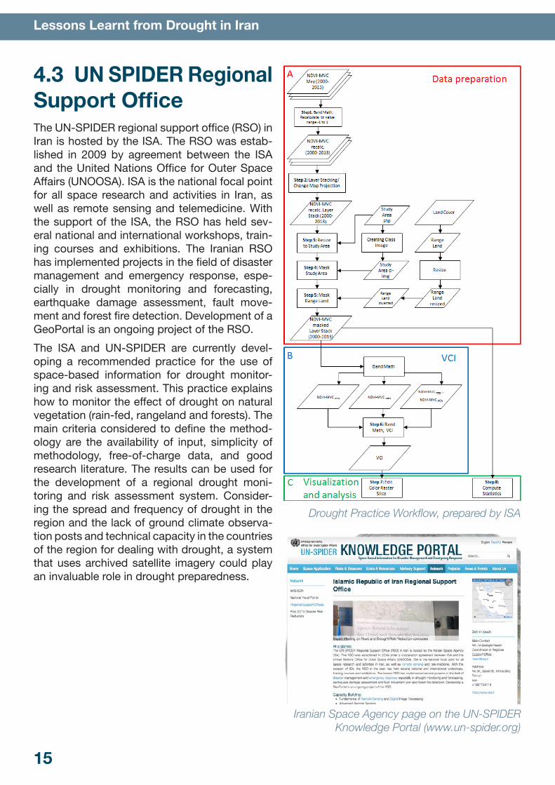
4.3 UN SPIDER Regional Support OfficeThe UN-SPIDER regional support office (RSO) in Iran is hosted by the ISA. The RSO was estab-lished in 2009 by agreement between the ISA and the United Nations Office for Outer Space Affairs (UNOOSA). ISA is the national focal point for all space research and activities in Iran, as well as remote sensing and telemedicine. With the support of the ISA, the RSO has held sev-eral national and international workshops, train-ing courses and exhibitions. The Iranian RSO has implemented projects in the field of disaster management and emergency response, espe-cially in drought monitoring and forecasting, earthquake damage assessment, fault move-ment and forest fire detection. Development of a GeoPortal is an ongoing project of the RSO.
The ISA and UN-SPIDER are currently devel-oping a recommended practice for the use of space-based information for drought monitor-ing and risk assessment. This practice explains how to monitor the effect of drought on natural vegetation (rain-fed, rangeland and forests). The main criteria considered to define the method-ology are the availability of input, simplicity of methodology, free-of-charge data, and good research literature. The results can be used for the development of a regional drought moni-toring and risk assessment system. Consider-ing the spread and frequency of drought in the region and the lack of ground climate observa-tion posts and technical capacity in the countries of the region for dealing with drought, a system that uses archived satellite imagery could play an invaluable role in drought preparedness.
Drought Practice Workflow, prepared by ISA
Iranian Space Agency page on the UN-SPIDER Knowledge Portal (www.un-spider.org)
16
Lessons Learnt from Drought in Iran
5. Implementation of Strategy and Action Plan
Overview of the Iran National Strategy and Action Plan on Drought Preparedness, Management, and Mitigation in the Agricultural SectorThe Iran National Strategy and Action Plan on Drought Preparedness, Management, and Miti-gation in the Agricultural Sector was developed with support and assistance from the Food and Agriculture Organization (FAO) of the United Nations Near East Regional Office in Cairo, Egypt, from 2004 to 2006.
The main objectives of the project were to help the government of Iran (1) formulate a compre-hensive and integrated national strategy and action plan on drought management and miti-gation for the agricultural sector, (2) review coor-dination mechanisms for drought response by various stakeholders and formulate proposals to strengthen them, and (3) strengthen institu-tional capacity in drought early warning, pre-
paredness, and response to affected areas and people, especially for the more vulnerable and food-insecure households.
During the project, collaborators and consultants produced assessments of drought impacts and existing drought management capacity, analy-ses of international experience and mechanisms for drought management, a national drought preparedness strategy in the agricultural sector outlining government objectives in the event of drought, and a plan of action defining the strate-gies required to prepare for, mitigate, and man-age the negative effects of drought, research on the potential for and limitations of developing an early warning system, and guidelines to create a national drought management center, which could eventually evolve into a regional center.
Overall, the main components of the proposed framework for establishing the national drought preparedness strategy are to create a national drought management center; adopt policies to
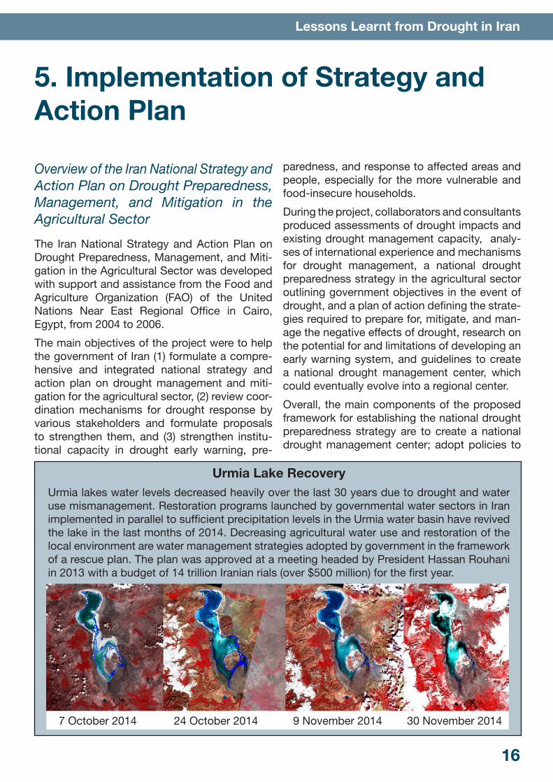
Urmia Lake RecoveryUrmia lakes water levels decreased heavily over the last 30 years due to drought and water use mismanagement. Restoration programs launched by governmental water sectors in Iran implemented in parallel to sufficient precipitation levels in the Urmia water basin have revived the lake in the last months of 2014. Decreasing agricultural water use and restoration of the local environment are water management strategies adopted by government in the framework of a rescue plan. The plan was approved at a meeting headed by President Hassan Rouhani in 2013 with a budget of 14 trillion Iranian rials (over $500 million) for the first year.
7 October 2014 24 October 2014 9 November 2014 30 November 2014
17
Lessons Learnt from Drought in Iran
support drought resilience and reduce vulner-ability; enhance institutional coordination mech-anisms for drought management; and develop national capacity for drought planning, mitiga-tion, and response.
As of the writing of this booklet, the national drought preparedness strategy was in the pro-cess of being introduced to the parliament for official approval. When approved, the policy calls for the development of a National Drought Management Centre that would serve as the drought mitigation hub of Iran. Eventually, it is envisioned that the Centre could also serve as the regional hub for the ECO region (a regional division of about ten countries).
5.1 Development of the Iranian National Strategy and Action Plan
Step 1: Creating Political Momentum and AuthorityDrought conditions in Iran from 1999 to 2001 demonstrated the significant environmental, social, and economic effects of drought within the country. Similar effects experienced across the Near East Region provided the impetus for national meetings and regional conferences to better understand and develop strategies to reduce the risk of similar drought events in the future. As a result of these events, awareness increased about the need for a more compre-hensive and proactive strategy for mitigating and responding to drought events in Iran.
The drought event created the “policy window” and, in this case, international agencies (such as FAO) played a critical role in placing drought on the international agenda within the Near East Region. FAO discussed the need for proactive drought planning at several regional confer-ences from 2000 to 2004, and adopted “drought mitigation” as a priority area for interdisciplinary action (PAIA).
Similarly, Iranian government representatives recognized the need for additional drought plan-ning and requested that FAO provide technical and financial assistance to establish a national drought strategy. This assistance was provided by FAO under a Technical Cooperation Pro-gramme (TCP) project. The project, “A National Strategy and Action Plan on Drought Prepared-ness Management and Mitigation in the Agricul-tural Sector”, was initiated in December 2004.
Overall, a combination of internal and external pressures and opportunities provided enough impetus to carry the project from the agenda setting to the implementation phase.
Step 2: Strategic Planning and CoordinationThe drought planning project was officially executed by the Ministry of Jihad-e-Agriculture (Department of Agronomy), in collaboration with the Ministry of Interior (Bureau of Research and Coordination of Safety and Rehabilitation Activi-ties – BRCSRA) and the Ministry of Road and Transportation (Islamic Republic of Iran Meteo-rological Organization – IRIMO). To help orga-nize the project, a National Project Coordina-tor from the Iranian Department of Agronomy was appointed to work with an FAO consultant in leading the planning project. Eventually, a Project National Steering Committee was also established. Members of the committee are organizations dealing with drought management at the national, provincial, and district levels.
To help carry out the project, FAO provided tech-nical advisory and supervisory services, and funding for an international drought mitigation consultant and 15 national drought management consultants. In addition to providing technical support, the FAO TCP project was instrumental in providing an incentive for the coordination of drought-related stakeholders and programs in the country.
The project team members also provided the leadership necessary to keep the project mov-ing forward. For example, to initiate the proj-ect, FAO’s drought management consultant met with representatives of the Iranian agen-
18
Lessons Learnt from Drought in Iran
cies who would be responsible for implementing the drought planning process to outline specific activities to be undertaken, including:
• outreach activities to help the project team better understand drought and its impacts in the country and to develop a drought risk reduction mentality among stakeholders
• drought research and discussions with stakeholders to better understand drought management roles and issues in Iran
• discussions among stakeholders to gain a better understanding of issues that should be included in a draft national drought pre-paredness strategy and action plan
• collaboration with stakeholders to write a final national drought preparedness strategy and action plan
These strategic planning sessions among the team leaders helped solidify the project goals and objectives and their respective roles and obligations during the project.
Step 3: Fostering Involvement and Developing Common UnderstandingsSeveral activities were undertaken to help the project team better understand drought and its impacts in the country, foster a drought risk reduction mentality among stakeholders, and raise support for the project.
Field visits were made to drought-affected prov-inces to assess the extent of impacts, learn stakeholders’ perceptions of current drought management strategies, and hold training semi-nars to explain the project objectives and expec-tations and the necessity of moving toward pro-active drought risk reduction strategies.
Visits were also made to many universities and research centers that play a role in drought management throughout the country. The inter-actions provided an opportunity for two-way information flow about the project and drought management issues, which helped clarify the objectives of the drought planning project and build support for the initiative.
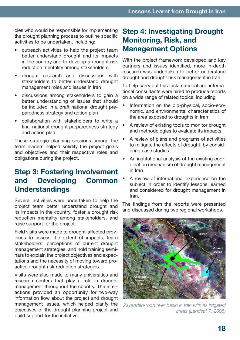
Step 4: Investigating Drought Monitoring, Risk, and Management OptionsWith the project framework developed and key partners and issues identified, more in-depth research was undertaken to better understand drought and drought risk management in Iran.
To help carry out this task, national and interna-tional consultants were hired to produce reports on a wide range of related topics, including
• Information on the bio-physical, socio-eco-nomic, and environmental characteristics of the area exposed to droughts in Iran
• A review of existing tools to monitor drought and methodologies to evaluate its impacts
• A review of plans and programs of activities to mitigate the effects of drought, by consid-ering case studies
• An institutional analysis of the existing coor-dination mechanism of drought management in Iran
• A review of international experience on the subject in order to identify lessons learned and considered for drought management in Iran.
The findings from the reports were presented and discussed during two regional workshops.
Zayandeh-rood river basin in Iran with its irrigated areas (Landsat 7, 2005)
19
Lessons Learnt from Drought in Iran
The first workshop in Karaj brought together the rainfed provinces, and the second workshop in Birjand was organized for the drier southern provinces, where water scarcity is already an important issue.
These efforts led to a better understanding of drought occurrence, impacts, and management options that could be included in a national drought strategy for agriculture.
Step 5: Writing the National Drought Strategy and Action PlanWith a more clear understanding of drought and drought risk management in Iran, the project team developed a draft National Strategy for Drought Management in the Agricultural Sector in Iran.
The proposed strategy had four main compo-nents:
1. Creation of a national drought management center
2. Adoption of policies to support drought resil-ience and reduce vulnerability
3. Establishment of institutional coordination on drought-related matters
4. Development of national capacity for drought planning, mitigation, and response
In terms of the first component, it was proposed to establish a National Drought Management Centre (NDMC) within the Ministry of Jehad-e-Agriculture, composed of three specialized operational working groups for drought manage-ment: the Drought Early Warning and Monitor-ing Group, which would be coordinated by the national meteorological organization (IRIMO); the Drought Risk and Impact Assessment Group, to be coordinated by the Ministry of Jehad-e-Agri-culture (MoJA); and the Drought Planning, Mitiga-tion and Response Group, to be coordinated by the Ministry of Energy (MoE). The primary func-tion of the Centre would be to ensure working linkages between the Ministry of Jehad-e-Agri-culture and stakeholders concerned with drought at the national and provincial and district levels.
The second component proposes policies to reduce drought vulnerability by fostering:
1. integrated water and drought management in agriculture, including increasing water use efficiency and water productivity
2. drought management policies for irrigated agriculture, rainfed agriculture, and livestock
3. stakeholders’ participation and support to develop a drought plan
4. drought information, public education, and awareness.
The third component focuses on creating a coherent drought management system with clear coordination mechanisms and informa-tion flow between users to facilitate national and local capacities for drought planning, mitigation, and response.
Finally, the fourth component is aimed at devel-oping the national capacity for drought planning, mitigation, and response by outlining a plan for
1. monitoring drought and the processes involved in identifying the severity of drought conditions in different provinces of the coun-try
2. identifying the stages of drought and expected responses and activities, (3) iden-tifying the implementation roles of govern-ment agencies/institutions
3. developing a drought information and com-munications system
4. developing a process for updating the plan on an annual basis
To help provide a first review of the national drought strategy and action plan, a national workshop was held to discuss and propose changes to the draft. A wide range of national and international organizations and agencies were represented at the meeting and provided essential insight on the strategy.
Following this workshop and subsequent team meetings, necessary modifications were made to the drought planning document, and the final draft was developed during a wrap-up work-shop.
20
Lessons Learnt from Drought in Iran
Step 6: Implementing the National Drought Strategy and Action PlanThe national drought preparedness strategy is in the process of being introduced to the parlia-ment for official approval.
Meanwhile, an external study tour to FAO Rome for a group of three professional experts of the National Disaster Task Force was organized in 2006. The study tour to FAO/Global Information
and Early Warning Service (GIEWS) and the visit to the Technical Divisions in Rome also contrib-uted to improving the national capacity-building in database management and drought informa-tion delivery, and in drought early warning, mon-itoring, mitigation, and response.
These types of activities continue to enhance national drought risk reduction capacities and are required to fully implement the task identi-fied in the national drought preparedness strat-egy, whether or not it is passed by the Iranian parliament.
6. Challenges for the Future
Lack of Inter-Ministerial CooperationIn countries such as Iran, the nonexistence or deficit of inter-ministerial cooperation is a chal-lenge to drought management. It is clear that effective drought management requires inten-sive cooperation and accurate programming in different divisions. Drought management requires cooperation between ministries and between organizations.
An established service network that encom-passes all stakeholders allows data and infor-mation to be easily transferred from one to another without unnecessary obstacles. It may be a challenge to implement such a network, but it is necessary to achieving the sought-after syn-ergies. The service network must be able to eas-ily exchange and provide information required by the different stakeholders, from meteorologi-cal organizations to space agencies to disaster management authorities to users at the commu-nity level. The information must also be relevant and useful at each level.
Lack of High Resolution DataThe most important restriction facing space-based input is unavailability of actual time-series with appropriate local cover. With the emergence
of remotely-sensed satellite data, this prob-lem has decreased considerably (especially in industrial and developed countries). The lack of access to high resolution satellite data remains a problem for many developing countries. This creates problems for drought assessment at regional scale. For example, the drought early warning system faces numerous challenges in Iran. Data and information on climate and the water supply, including seasonal forecasts, must first be integrated to provide decision-makers with a comprehensive representation of current and future conditions.
Large Amounts of DataAnother obstacle to the use of satellites for drought monitoring and early warning in Iran has been the collection and transfer of large amounts of data. In areas identified as high-risk, several months’ worth of relevant high-resolution satel-lite data and ground-based data could run into terabytes of information that require storage and processing. Resources must be allocated to meet these increased requirements so that the infrastructure will not be under-scaled in the struggle to cope with the additional load. This may create a bottleneck to effective drought monitoring and early warning.

21
Lessons Learnt from Drought in Iran
Lack of Sufficient and Accurate Ground DataIt is crucial to establish ground-based data col-lection networks to collect data if they are not already in place. Countries such as Iran may have insufficient density of ground stations to cover large areas with few gaps for an accurate drought monitoring system. In regions with wide geographical variation, two sites separated by just a few kilometers could experience a very different rainfall patterns. The placement of pre-cipitation stations should be dense enough to capture these differences. Validation of space-based data and models require sufficient ground-based data. Without such data, space-based data will be rendered untrustworthy and less useful for drought monitoring and early warning.
Lack of Expertise in Drought ManagementA deficit of experts in drought management is an important challenge in Iran. Of the existing experts (and directors), only a few are familiar with new technology such as remote sensing and GIS. The best solution for this problem is establishment of disaster management stud-ies at universities and development of training courses to promote the advantages of satellite data in drought monitoring and modeling.
SolutionsOne solution to all these problems is greater coordination between meteorological, hydro-logical, and agricultural services. In addition, improved delivery systems must be developed to get information into the hands of decision-makers in a timely manner. This requires better understanding of user needs and preferences about how this information should be presented. Websites provide the most cost-effective and timely mechanisms for information delivery, but this technology is not widely available in Iran. Appropriate delivery systems must be employed. Potential users of climate information must also be educated on how information can be applied to reduce the risks associated with extreme cli-matic events such as drought. Improved com-
munication between the developers and users of products must be established so that prod-ucts are better suited to user needs and users better understand how this information can be applied to the decision process. Many products are not user friendly and the value of information cannot be not fully appreciated.
22
Lessons Learnt from Drought in Iran
About UN-SPIDER Regional Support Office in Iranhttp://www.un-spider.org/network/regional-support-offices/
islamic-republic-iran-regional-support-office
A Regional Support Office (RSO) is a regional or national centre of expertise that is set up within an existing entity by a Member State or group of Member States that have put forward an offer to set up and fund the proposed RSO. An RSO can be hosted by a space agency, a research center, a university, or a disaster management institution, to name some examples. These offices communicate and coordinate with UN-SPIDER on a regular basis, covering the realms of Outreach and Capacity building, as well as Horizontal Cooperation and Technical Advisory Support.
The UN-SPIDER regional support office (RSO) in Iran is hosted by the ISA. The RSO was established in 2009 by agreement between the ISA and the United Nations Office for Outer Space Affairs (UNOOSA). ISA is the national focal point for all space research and activities in Iran, as well as remote sensing and telemedicine. With the support of the ISA, the RSO has held several national and international workshops, training courses and exhibitions. The Iranian RSO has implemented projects in the field of disaster management and emergency response, especially in drought monitoring and forecasting, earthquake damage assessment, fault movement and forest fire detection. Development of a GeoPortal is an ongoing project of the RSO.
Lessons Learnt from Drought in Iran
www.isa.ir
www.un-spider.org