Embed Size (px)
Citation preview

UK Location Programme
Conceptual Design
UK Location Information Infrastructure
Blueprint Supplement
Author: Keith Murray/Tim Manning
Owner: Ray Boguslawski
File Reference:
UK Location Programme
UKLII Blueprint Supplement Page 2 of 51
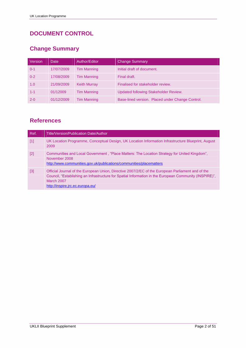
DOCUMENT CONTROL
Change Summary
Version Date Author/Editor Change Summary
0-1 17/07/2009 Tim Manning Initial draft of document.
0-2 17/08/2009 Tim Manning Final draft.
1.0 21/09/2009 Keith Murray Finalised for stakeholder review.
1-1 01/12009 Tim Manning Updated following Stakeholder Review.
2-0 01/12/2009 Tim Manning Base-lined version. Placed under Change Control.
References
Ref. Title/Version/Publication Date/Author
[1] UK Location Programme, Conceptual Design, UK Location Information Infrastructure Blueprint, August
2009
[2] Communities and Local Government , “Place Matters: The Location Strategy for United Kingdom”,
November 2008
http://www.communities.gov.uk/publications/communities/placematters
[3] Official Journal of the European Union, Directive 2007/2/EC of the European Parliament and of the
Council, “Establishing an Infrastructure for Spatial Information in the European Community (INSPIRE)”,
March 2007
http://inspire.jrc.ec.europa.eu/

UK Location Programme
UKLII Blueprint Supplement Page 3 of 51
CONTENTS
1 Preface .......................................................................................................................................................... 4
2 Requirements Matrix .................................................................................................................................... 5
3 Present State Legislative Framework ....................................................................................................... 27
4 Dataset Theme Coordination ..................................................................................................................... 31

UK Location Programme
UKLII Blueprint Supplement Page 4 of 51
1 PREFACE
This is a supplement to the UK Location Information Infrastructure Blueprint [1]. It covers the following
additional information:
A requirements matrix against the UK Location Strategy [2] and EC INSPIRE Directive [3],
summarizing how the UKLII Blueprint addresses the requirements set out in these two strategic
documents;
A summary of the present state legislative framework within which the UK Location Information
Infrastructure will work; and
Dataset Theme Coordination, a summary of the themes and the main organisations currently
producing datasets corresponding to the UK Location Strategy Core Reference Geographies (CRGs)
and the 2007/2/EC Annex Themes.
All three sections are intended to support subsequent detailed design and implementation, as we move
beyond the conceptual design phase.
However these sections do not represent final policy or a definitive statement, they are intended to
indicate the direction of travel and should be read in that light.
UK Location Programme
UKLII Blueprint Supplement Page 5 of 51
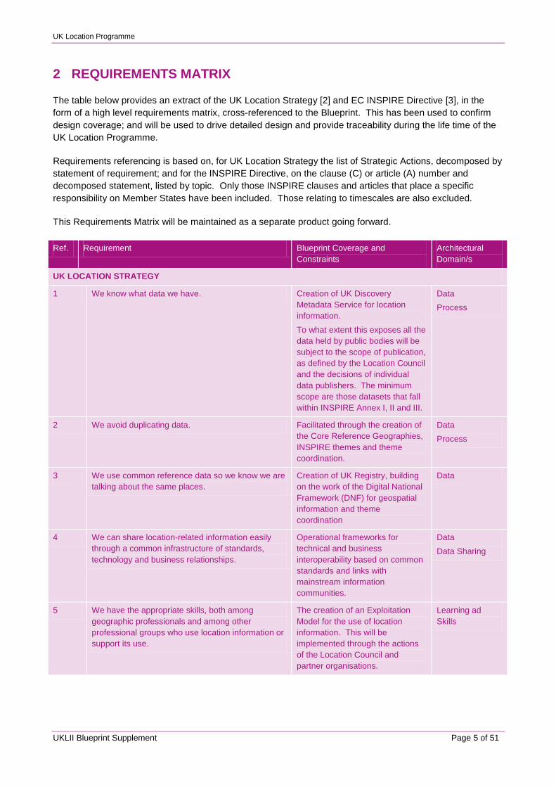
2 REQUIREMENTS MATRIX
The table below provides an extract of the UK Location Strategy [2] and EC INSPIRE Directive [3], in the
form of a high level requirements matrix, cross-referenced to the Blueprint. This has been used to confirm
design coverage; and will be used to drive detailed design and provide traceability during the life time of the
UK Location Programme.
Requirements referencing is based on, for UK Location Strategy the list of Strategic Actions, decomposed by
statement of requirement; and for the INSPIRE Directive, on the clause (C) or article (A) number and
decomposed statement, listed by topic. Only those INSPIRE clauses and articles that place a specific
responsibility on Member States have been included. Those relating to timescales are also excluded.
This Requirements Matrix will be maintained as a separate product going forward.
Ref. Requirement Blueprint Coverage and
Constraints
Architectural
Domain/s
UK LOCATION STRATEGY
1 We know what data we have. Creation of UK Discovery
Metadata Service for location
information.
To what extent this exposes all the
data held by public bodies will be
subject to the scope of publication,
as defined by the Location Council
and the decisions of individual
data publishers. The minimum
scope are those datasets that fall
within INSPIRE Annex I, II and III.
Data
Process
2 We avoid duplicating data. Facilitated through the creation of
the Core Reference Geographies,
INSPIRE themes and theme
coordination.
Data
Process
3 We use common reference data so we know we are
talking about the same places.
Creation of UK Registry, building
on the work of the Digital National
Framework (DNF) for geospatial
information and theme
coordination
Data
4 We can share location-related information easily
through a common infrastructure of standards,
technology and business relationships.
Operational frameworks for
technical and business
interoperability based on common
standards and links with
mainstream information
communities.
Data
Data Sharing
5 We have the appropriate skills, both among
geographic professionals and among other
professional groups who use location information or
support its use.
The creation of an Exploitation
Model for the use of location
information. This will be
implemented through the actions
of the Location Council and
partner organisations.
Learning ad
Skills
UK Location Programme
UKLII Blueprint Supplement Page 6 of 51
Ref. Requirement Blueprint Coverage and
Constraints
Architectural
Domain/s
6 We have strong leadership and governance to drive
through change.
The creation of Location Council
and associated bodies. The
extent that the Location Council
provides appropriate leadership
and governance will be dependent
on the contributions of individual
organisations.
Organisation
1. We know what data we have
1 Each public sector organisation to record and
maintain up-to-date details of its location-related
data sets:
The creation of the UK Discovery
Metadata Service.
The minimum obligation will be as
required under the INSPIRE
Annex I, II and III themes.
Data
Process
1.1 To be undertaken for all datasets with location
attributes, inc. but not limited to soils,
environmental, agricultural, hydrographic,
mapping and social-economic information.
Other than for INSPIRE themes, to
be implemented on a voluntary
basis, based on guidance issued
by the Location Council.
Process
1.2 Each public sector organisation should make
publicly available the details of its location-
related datasets – even if the dataset itself is
not publicly accessible or is not free of charge.
Other than for INSPIRE themes, to
be implemented on a voluntary
basis, based on guidance issued
by the Location Council.
Process
1.3 The Location Council to agree and publish
exceptions; and individual exception proposals
should require explicit approval.
Data Publishing Operational
Framework.
Exceptions will operate within
existing OPSI owned
mechanisms; i.e. under the RoPSI
Directive. This has existing
procedures related to the access
of public sector information.
These will be reviewed in the
context of the UKLII.
Process
1.4 The Location Council to agree and maintain
the minimum requirements, to inc. information
about how and when the dataset has been
collected, its accuracy tolerances, its format
and storage, and its access rights. These
need to be aligned to the Metadata
Implementation Rules.
Policies and standards for
Discovery Metadata publishing.
Data
1.5 The Location Council should consider how
such information can best be universally
accessed – the scope and delivery options for
common portals, hubs and repositories, across
the wider range of requirements and not just at
the implementation of INSPIRE.
Adoption of a „multiple points of
access‟ approach, based on the
distribution of the UK Discovery
Metadata catalogue (in part or
whole) as part of the Discovery
Metadata Service (DMS).
Distribution
1.6 It should be open to private sector
organisations to apply the standards and lodge
details of their datasets.
Private sector organisations will be
free to publish into the UKLII,
subject to conforming to the
published standards.
Business Model
Data
UK Location Programme
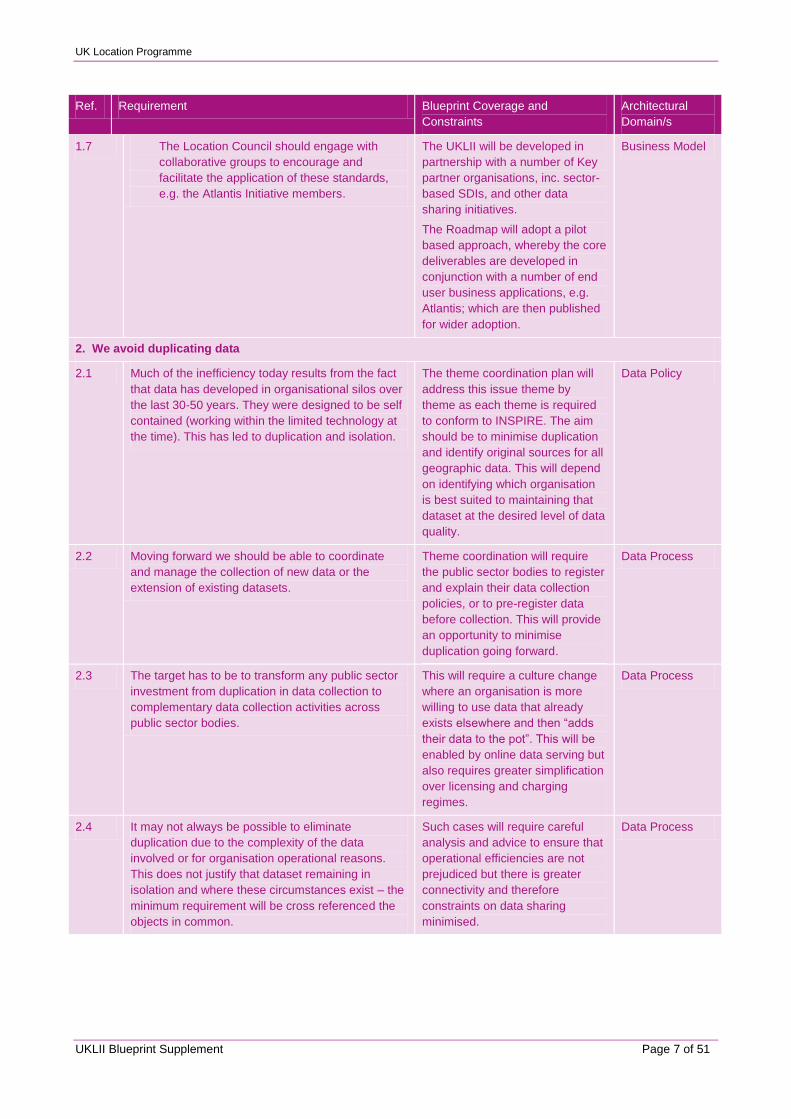
UKLII Blueprint Supplement Page 7 of 51
Ref. Requirement Blueprint Coverage and
Constraints
Architectural
Domain/s
1.7 The Location Council should engage with
collaborative groups to encourage and
facilitate the application of these standards,
e.g. the Atlantis Initiative members.
The UKLII will be developed in
partnership with a number of Key
partner organisations, inc. sector-
based SDIs, and other data
sharing initiatives.
The Roadmap will adopt a pilot
based approach, whereby the core
deliverables are developed in
conjunction with a number of end
user business applications, e.g.
Atlantis; which are then published
for wider adoption.
Business Model
2. We avoid duplicating data
2.1 Much of the inefficiency today results from the fact
that data has developed in organisational silos over
the last 30-50 years. They were designed to be self
contained (working within the limited technology at
the time). This has led to duplication and isolation.
The theme coordination plan will
address this issue theme by
theme as each theme is required
to conform to INSPIRE. The aim
should be to minimise duplication
and identify original sources for all
geographic data. This will depend
on identifying which organisation
is best suited to maintaining that
dataset at the desired level of data
quality.
Data Policy
2.2 Moving forward we should be able to coordinate
and manage the collection of new data or the
extension of existing datasets.
Theme coordination will require
the public sector bodies to register
and explain their data collection
policies, or to pre-register data
before collection. This will provide
an opportunity to minimise
duplication going forward.
Data Process
2.3 The target has to be to transform any public sector
investment from duplication in data collection to
complementary data collection activities across
public sector bodies.
This will require a culture change
where an organisation is more
willing to use data that already
exists elsewhere and then “adds
their data to the pot”. This will be
enabled by online data serving but
also requires greater simplification
over licensing and charging
regimes.
Data Process
2.4 It may not always be possible to eliminate
duplication due to the complexity of the data
involved or for organisation operational reasons.
This does not justify that dataset remaining in
isolation and where these circumstances exist – the
minimum requirement will be cross referenced the
objects in common.
Such cases will require careful
analysis and advice to ensure that
operational efficiencies are not
prejudiced but there is greater
connectivity and therefore
constraints on data sharing
minimised.
Data Process
UK Location Programme
UKLII Blueprint Supplement Page 8 of 51
Ref. Requirement Blueprint Coverage and
Constraints
Architectural
Domain/s
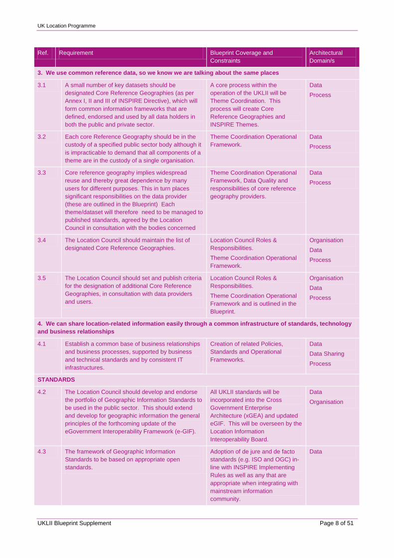
3. We use common reference data, so we know we are talking about the same places
3.1 A small number of key datasets should be
designated Core Reference Geographies (as per
Annex I, II and III of INSPIRE Directive), which will
form common information frameworks that are
defined, endorsed and used by all data holders in
both the public and private sector.
A core process within the
operation of the UKLII will be
Theme Coordination. This
process will create Core
Reference Geographies and
INSPIRE Themes.
Data
Process
3.2 Each core Reference Geography should be in the
custody of a specified public sector body although it
is impracticable to demand that all components of a
theme are in the custody of a single organisation.
Theme Coordination Operational
Framework.
Data
Process
3.3 Core reference geography implies widespread
reuse and thereby great dependence by many
users for different purposes. This in turn places
significant responsibilities on the data provider
(these are outlined in the Blueprint) Each
theme/dataset will therefore need to be managed to
published standards, agreed by the Location
Council in consultation with the bodies concerned
Theme Coordination Operational
Framework, Data Quality and
responsibilities of core reference
geography providers.
Data
Process
3.4 The Location Council should maintain the list of
designated Core Reference Geographies.
Location Council Roles &
Responsibilities.
Theme Coordination Operational
Framework.
Organisation
Data
Process
3.5 The Location Council should set and publish criteria
for the designation of additional Core Reference
Geographies, in consultation with data providers
and users.
Location Council Roles &
Responsibilities.
Theme Coordination Operational
Framework and is outlined in the
Blueprint.
Organisation
Data
Process
4. We can share location-related information easily through a common infrastructure of standards, technology
and business relationships
4.1 Establish a common base of business relationships
and business processes, supported by business
and technical standards and by consistent IT
infrastructures.
Creation of related Policies,
Standards and Operational
Frameworks.
Data
Data Sharing
Process
STANDARDS
4.2 The Location Council should develop and endorse
the portfolio of Geographic Information Standards to
be used in the public sector. This should extend
and develop for geographic information the general
principles of the forthcoming update of the
eGovernment Interoperability Framework (e-GIF).
All UKLII standards will be
incorporated into the Cross
Government Enterprise
Architecture (xGEA) and updated
eGIF. This will be overseen by the
Location Information
Interoperability Board.
Data
Organisation
4.3 The framework of Geographic Information
Standards to be based on appropriate open
standards.
Adoption of de jure and de facto
standards (e.g. ISO and OGC) in-
line with INSPIRE Implementing
Rules as well as any that are
appropriate when integrating with
mainstream information
community.
Data
UK Location Programme
UKLII Blueprint Supplement Page 9 of 51
Ref. Requirement Blueprint Coverage and
Constraints
Architectural
Domain/s
4.4 The standards should not only cover technical
arrangements for data and network services, but
also business meaning and processes.
UKLII Policies, Standards and
Operational frameworks for both
technical and business
interoperability e.g. the OPSI role.
Data
Data Sharing.
4.5 Each data set owner should adopt the agreed
Geographic Information Standards into their
datasets (largely achieved through the INSPIRE
Implementing Rules and supplemented by the
appropriate adoption of the Digital National
Framework protocols).
Data Publishing Operational
Framework. To be based on the
INSPIRE implementing Rules
appropriate adoption of the
existing DNF protocols.
Data
Data Sharing
Process
4.6 In addition to the Core Reference Geographies, the
Location Council should identify any other datasets
where early convergence on agreed standards
would give significant business value to users of the
dataset, or allow the data to be shared and
exploited more widely.
Location Council and Location
User Group Roles and
Responsibilities.
Organisation
4.7 Each dataset owner should agree their plans with
the Location Council and publish them as part of the
Information about their datasets.
Data Publishing Operational
Framework – Theme coordination
process.
Process
LICENSING
4.8 Each data set owner should simplify their licensing
arrangements so as to facilitate the sharing of data
to realise greater overall value.
Data Sharing Operational
Framework.
There will be an external
dependency related to what extent
data publishers simplify their
licensing arrangements, e.g. utilise
the UKLII Licensing Model within
the OPSI framework
Data Sharing
Process.
4.9 The Office of Public Sector Information should set
guidelines and minimum standards for simplification
(convergence of terms and conditions; common
approach to the „derived data issue‟ of creating a
dataset from reference data, which could potentially
be a substitute for it in a commercial market; the
introduction of developmental and commercial
licences to encourage innovation.
Rights Management operational
framework will be based on OPSI
policies, procedures and
mechanisms, with any required
extensions specific to geospatial
information.
Data Sharing
4.10 The simplification should take account of the trading
nature of the owners of the core Reference
Geographies and should not duplicate the
Governments separate review of the pricing of
public sector information by trading funds. The
simplification should ensure that Crown Copyright is
protected appropriately.
Rights Management operational
framework will be based on OPSI
policies, procedures and
mechanisms, with any required
extensions specific to geospatial
information. This will address all
sources of public data, not just
data sourced from Trading Funds.
Data Sharing
ICT INFRASTRUCTURE
4.11 The Government CIO Council should drive forward
the implementation of ICT infrastructures which
allow stakeholders to share geographic information
services within and across organisations.
Key Partner roles and
responsibilities.
Business Model

UK Location Programme
UKLII Blueprint Supplement Page 10 of 51
Ref. Requirement Blueprint Coverage and
Constraints
Architectural
Domain/s
4.12 The CIO/CTO Council should ensure the greater
coordination of ICT investments so as to create
shared web-based information services.
Key Partner roles and
responsibilities.
Business Model
BUSINESS RELATIONSHIPS
4.13 Public sector bodies should form and promote local,
regional or functional partnerships to exploit
location-related information available on the shared
technical infrastructure. An existing example of this
is the Atlantis Initiative, a joint collaboration between
6 public bodies to provide better information about
flooding.
Use of Publishing Agents to
provide publishing and exploitation
services – organisational, sector,
thematic or business application.
Distribution
4.14 The Location Council should provide guidance and
model terms of reference for such partnerships;
actively facilitating their formation; promoting the
sharing of knowledge about achieving success
through such partnerships.
Data Publishing Operational
Framework – Publishing Agents.
Distribution
4.15 Government departments and other public bodies
should establish a number of pilots and joint
ventures to encourage the adoption of the new
standards and approaches by creating innovative
public services combining different government
data.
Outside scope of Blueprint.
Roadmap will propose the
identification and adoption of a
number of application pilots as the
means to develop and test UKLII
deliverables; and demonstrate
benefits.
n.a.
BUSINESS PLANNING
4.16 The UKLII will require a planning horizon longer
than normally possible in a single Spending Review
period. The Location Council should develop, in
conjunction with HM Treasury and the CIO Council,
a strategic planning and business framework which
establish an adequate period of sufficient certainty
and predictability (inc. funding and pricing) for
dataset owners and users to make the necessary
sustainable investments.
Key partner roles and
responsibility.
Financial Model.
Business Model
5. We have the appropriate skills, both among geographic professionals and among other professional groups
who use location information or support its use
5.1 The delivery of the outcomes of the UK Location
Strategy requires a step change in our capability to
understand, provide access to and to use location
information. This capability needs to move from just
a limited specialist community into the mainstream
of policy development, service design and systems
delivery.
Creation of a highly accessible
point of access for location
information, designed around the
data user. Links to specialist sites
and end user applications.
Data user resource centre.
Development of a Location
Information Exploitation Model‟.
Conceptual
model
Learning and
Skills
IT System
Architecture
UK Location Programme
UKLII Blueprint Supplement Page 11 of 51
Ref. Requirement Blueprint Coverage and
Constraints
Architectural
Domain/s
5.2 The Location Council should lead a capability
building programme to embed geographic
information awareness and analytical skills as a
business tool enabler across public services and
professions. This should be informed by an initial
audit, or current and future requirement; and
leverage existing initiatives such as Professional
Skills in Government and the IT Professionalism
programme.
Development of Exploitation
Model and its implementation.
This will be based on partnerships
with existing bodies, e.g. National
School of Government.
Learning and
Skills
5.3 The Location Council should promote the sharing of
knowledge about location-based information and
methods; and their application within and outside
the public sector. Equally skills and knowledge from
the mainstream information community and new
developments (like linked data) should be
embraced.
UK Geoportal data user Resource
Centre.
Exploitation Model.
Key Partner Network.
Conceptual
Model
Business Model
Learning and
Skills
5.4 The Location Council should communicate case
studies and examples of good practice, inc. those
that could be adopted across a wider group of
organisations. In doing so, it should work closely
with sector-specific innovation and improvement
groups such as the IDeA and NPIA.
UK Geoportal data user Resource
Centre.
Exploitation Model
Key Partner Network.
Conceptual
Model
Business Model
Learning and
Skills
5.5 The Location Council should establish networks and
communities of interest to ensure continued
participation, engagement and sharing of
knowledge.
UK Geoportal data user Resource
Centre.
Exploitation Model
Key Partner Network.
Conceptual
Model
Business Model
Learning and
Skills
5.6 The Location Council and the CIO/CTO Council
should agree joint developments to ensure that
location information issues are better understood by
the wider IT community and that IT issues are better
understood by the location community.
UK Geoportal data user Resource
Centre.
Exploitation Model
Key Partner Network.
Conceptual
Model
Business Model
Learning and
Skills
6. We have strong leadership and governance to drive through change
GOVERNANCE STRUCTURE
6.1 The Government should create a new Location
Council to deliver the Location Strategy, the
implementation of INSPIRE and associated
initiatives.
Location Council role and
responsibilities.
Organisation
6.2 The Location Council should bring together senior
professionals in government to ensure common,
joined up outcomes for effective and efficient public
services through co-ordinated action and
convergence on best practice. It should:
Location Council membership. Organisation
UK Location Programme
UKLII Blueprint Supplement Page 12 of 51
Ref. Requirement Blueprint Coverage and
Constraints
Architectural
Domain/s
6.3 Be an inclusive Council, with an overview of all
public sector location initiatives at local
devolved and central government levels.
The precise membership of the
Location Council and its sub-
groups may change over time, as
the infrastructure is developed and
its utilisation expands. In the initial
foundational phase, membership
will be limited to a small core
group, e.g. funders and pilot
organisations; and the devolved
administrations.
Organisation
6.4 Develop the Implementation Plan for the UK
Location Strategy and manage, co-ordinate
and implement the UK Location Strategy
alongside the INSPIRE Directive.
Location Council and its various
sub-groups.
Organisation
6.5 Act as the steering group to co-ordinate the
UK‟s implementation of the INSPIRE Directive.
Delivery Group. Organisation
6.6 Take the lead on strategic issues about
geographic information and its use.
Location Interoperability Board
and Location User Group.
Organisation
6.7 Advise the responsible Minister (and through the
Minister, the devolved administrations); and under
the authority of the Minister, set standards, policies
and implementation requirements for those involved
in geographic information and its use.
Location Interoperability Board
role and responsibilities.
Organisation
6.8 Report twice a year to the DA(PED) Ministerial
Committee.
Performance Management
process.
Process
6.9 Publish an Annual Report of its activities, progress
and proposals for further strategic action to increase
the value gained from location information.
Planning Process. Process
6.10 Defra will be the lead department for the Location
Strategy, fulfilling the cross-government role and
ensuring alignment with the implementation of the
INSPIRE Directive.
Lead Department role and
responsibilities.
Organisation
6.11 The Location Council should have a membership
representative of all key public sector stakeholders.
The precise membership of the
Location Council and its sub-
groups may change over time, as
the infrastructure is developed and
its utilisation expands. In the initial
foundational phase, membership
may be limited to a small core
group, e.g. funders and pilot
organisations; and the devolved
administrations.
Organisation
6.12 The Location Council should be supported and
advised by two sub-groups:
Location Interoperability Board
and Location User Group.
6.12.1 The UK Location Information Interoperability Board,
to oversee UK data and interoperability standards
and support their implementation in conjunction with
INSPIRE Implementing Rules.. It will have
representatives from all appropriate domains and
standards bodies..
Interoperability Board role and
responsibilities.
Organisation
UK Location Programme
UKLII Blueprint Supplement Page 13 of 51
Ref. Requirement Blueprint Coverage and
Constraints
Architectural
Domain/s
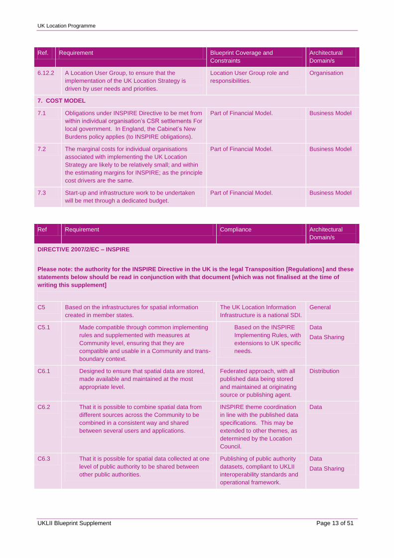
6.12.2 A Location User Group, to ensure that the
implementation of the UK Location Strategy is
driven by user needs and priorities.
Location User Group role and
responsibilities.
Organisation
7. COST MODEL
7.1 Obligations under INSPIRE Directive to be met from
within individual organisation‟s CSR settlements For
local government. In England, the Cabinet‟s New
Burdens policy applies (to INSPIRE obligations).
Part of Financial Model. Business Model
7.2 The marginal costs for individual organisations
associated with implementing the UK Location
Strategy are likely to be relatively small; and within
the estimating margins for INSPIRE; as the principle
cost drivers are the same.
Part of Financial Model. Business Model
7.3 Start-up and infrastructure work to be undertaken
will be met through a dedicated budget.
Part of Financial Model. Business Model
Ref Requirement Compliance Architectural
Domain/s
DIRECTIVE 2007/2/EC – INSPIRE
Please note: the authority for the INSPIRE Directive in the UK is the legal Transposition [Regulations] and these
statements below should be read in conjunction with that document [which was not finalised at the time of
writing this supplement]
C5 Based on the infrastructures for spatial information
created in member states.
The UK Location Information
Infrastructure is a national SDI.
General
C5.1 Made compatible through common implementing
rules and supplemented with measures at
Community level, ensuring that they are
compatible and usable in a Community and trans-
boundary context.
Based on the INSPIRE
Implementing Rules, with
extensions to UK specific
needs.
Data
Data Sharing
C6.1 Designed to ensure that spatial data are stored,
made available and maintained at the most
appropriate level.
Federated approach, with all
published data being stored
and maintained at originating
source or publishing agent.
Distribution
C6.2 That it is possible to combine spatial data from
different sources across the Community to be
combined in a consistent way and shared
between several users and applications.
INSPIRE theme coordination
in line with the published data
specifications. This may be
extended to other themes, as
determined by the Location
Council.
Data
C6.3 That it is possible for spatial data collected at one
level of public authority to be shared between
other public authorities.
Publishing of public authority
datasets, compliant to UKLII
interoperability standards and
operational framework.
Data
Data Sharing
UK Location Programme
UKLII Blueprint Supplement Page 14 of 51
Ref Requirement Compliance Architectural
Domain/s
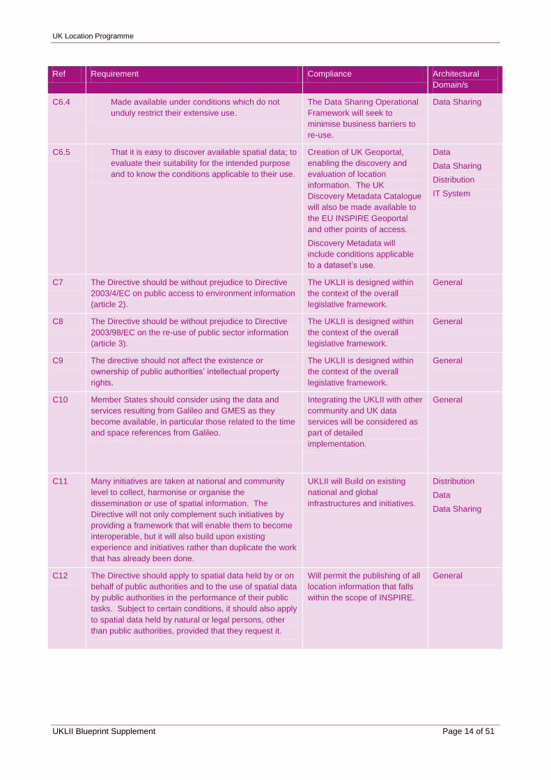
C6.4 Made available under conditions which do not
unduly restrict their extensive use.
The Data Sharing Operational
Framework will seek to
minimise business barriers to
re-use.
Data Sharing
C6.5 That it is easy to discover available spatial data; to
evaluate their suitability for the intended purpose
and to know the conditions applicable to their use.
Creation of UK Geoportal,
enabling the discovery and
evaluation of location
information. The UK
Discovery Metadata Catalogue
will also be made available to
the EU INSPIRE Geoportal
and other points of access.
Discovery Metadata will
include conditions applicable
to a dataset‟s use.
Data
Data Sharing
Distribution
IT System
C7 The Directive should be without prejudice to Directive
2003/4/EC on public access to environment information
(article 2).
The UKLII is designed within
the context of the overall
legislative framework.
General
C8 The Directive should be without prejudice to Directive
2003/98/EC on the re-use of public sector information
(article 3).
The UKLII is designed within
the context of the overall
legislative framework.
General
C9 The directive should not affect the existence or
ownership of public authorities‟ intellectual property
rights.
The UKLII is designed within
the context of the overall
legislative framework.
General
C10 Member States should consider using the data and
services resulting from Galileo and GMES as they
become available, in particular those related to the time
and space references from Galileo.
Integrating the UKLII with other
community and UK data
services will be considered as
part of detailed
implementation.
General
C11 Many initiatives are taken at national and community
level to collect, harmonise or organise the
dissemination or use of spatial information. The
Directive will not only complement such initiatives by
providing a framework that will enable them to become
interoperable, but it will also build upon existing
experience and initiatives rather than duplicate the work
that has already been done.
UKLII will Build on existing
national and global
infrastructures and initiatives.
Distribution
Data
Data Sharing
C12 The Directive should apply to spatial data held by or on
behalf of public authorities and to the use of spatial data
by public authorities in the performance of their public
tasks. Subject to certain conditions, it should also apply
to spatial data held by natural or legal persons, other
than public authorities, provided that they request it.
Will permit the publishing of all
location information that falls
within the scope of INSPIRE.
General
UK Location Programme
UKLII Blueprint Supplement Page 15 of 51
Ref Requirement Compliance Architectural
Domain/s
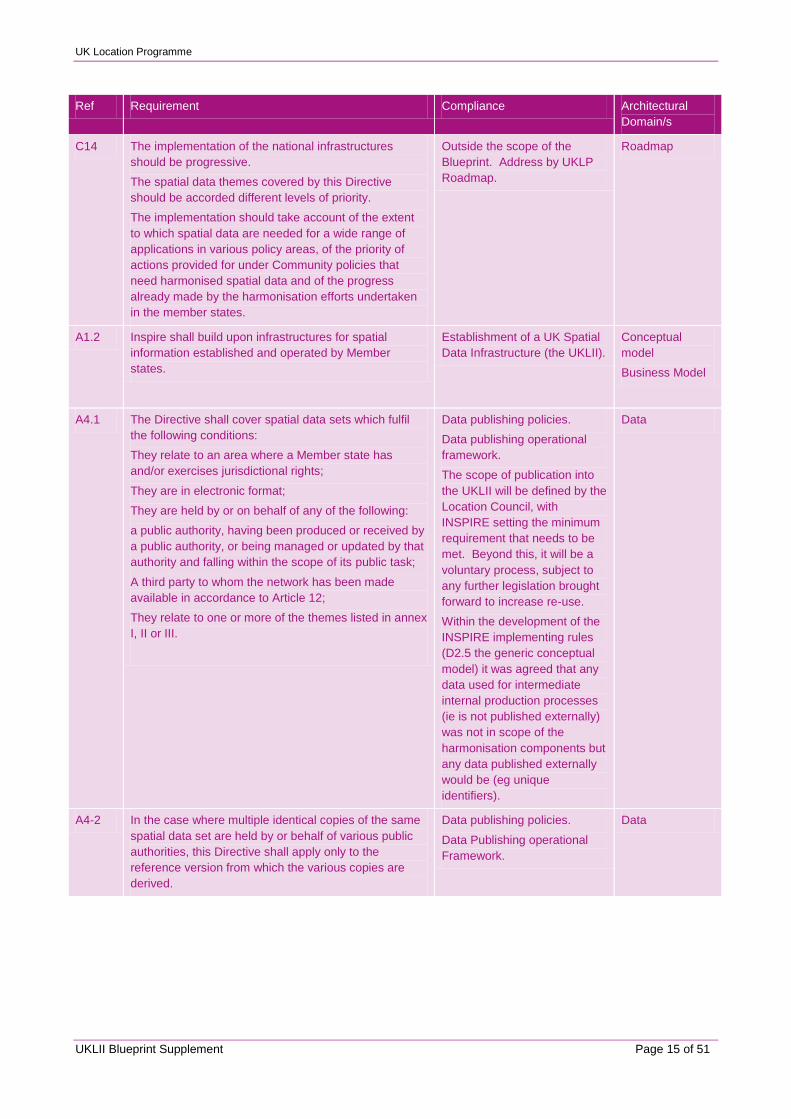
C14 The implementation of the national infrastructures
should be progressive.
The spatial data themes covered by this Directive
should be accorded different levels of priority.
The implementation should take account of the extent
to which spatial data are needed for a wide range of
applications in various policy areas, of the priority of
actions provided for under Community policies that
need harmonised spatial data and of the progress
already made by the harmonisation efforts undertaken
in the member states.
Outside the scope of the
Blueprint. Address by UKLP
Roadmap.
Roadmap
A1.2 Inspire shall build upon infrastructures for spatial
information established and operated by Member
states.
Establishment of a UK Spatial
Data Infrastructure (the UKLII).
Conceptual
model
Business Model
A4.1 The Directive shall cover spatial data sets which fulfil
the following conditions:
They relate to an area where a Member state has
and/or exercises jurisdictional rights;
They are in electronic format;
They are held by or on behalf of any of the following:
a public authority, having been produced or received by
a public authority, or being managed or updated by that
authority and falling within the scope of its public task;
A third party to whom the network has been made
available in accordance to Article 12;
They relate to one or more of the themes listed in annex
I, II or III.
Data publishing policies.
Data publishing operational
framework.
The scope of publication into
the UKLII will be defined by the
Location Council, with
INSPIRE setting the minimum
requirement that needs to be
met. Beyond this, it will be a
voluntary process, subject to
any further legislation brought
forward to increase re-use.
Within the development of the
INSPIRE implementing rules
(D2.5 the generic conceptual
model) it was agreed that any
data used for intermediate
internal production processes
(ie is not published externally)
was not in scope of the
harmonisation components but
any data published externally
would be (eg unique
identifiers).
Data
A4-2 In the case where multiple identical copies of the same
spatial data set are held by or behalf of various public
authorities, this Directive shall apply only to the
reference version from which the various copies are
derived.
Data publishing policies.
Data Publishing operational
Framework.
Data
UK Location Programme
UKLII Blueprint Supplement Page 16 of 51
Ref Requirement Compliance Architectural
Domain/s
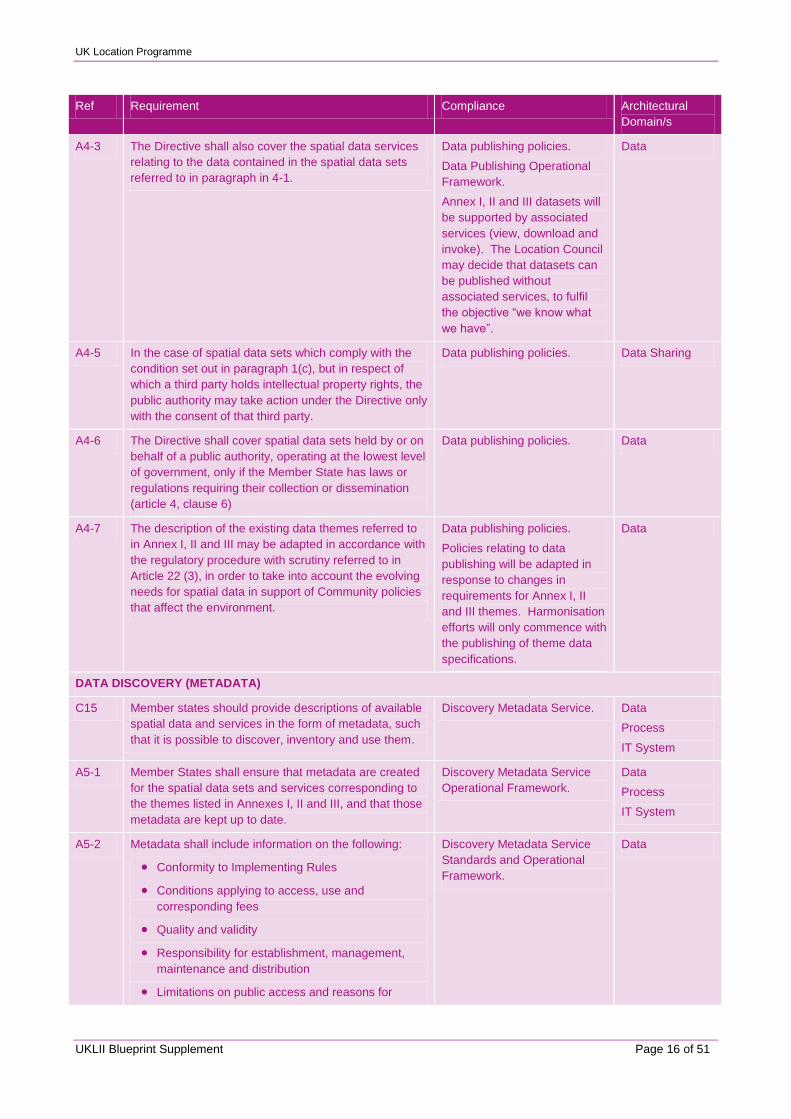
A4-3 The Directive shall also cover the spatial data services
relating to the data contained in the spatial data sets
referred to in paragraph in 4-1.
Data publishing policies.
Data Publishing Operational
Framework.
Annex I, II and III datasets will
be supported by associated
services (view, download and
invoke). The Location Council
may decide that datasets can
be published without
associated services, to fulfil
the objective “we know what
we have”.
Data
A4-5 In the case of spatial data sets which comply with the
condition set out in paragraph 1(c), but in respect of
which a third party holds intellectual property rights, the
public authority may take action under the Directive only
with the consent of that third party.
Data publishing policies. Data Sharing
A4-6 The Directive shall cover spatial data sets held by or on
behalf of a public authority, operating at the lowest level
of government, only if the Member State has laws or
regulations requiring their collection or dissemination
(article 4, clause 6)
Data publishing policies. Data
A4-7 The description of the existing data themes referred to
in Annex I, II and III may be adapted in accordance with
the regulatory procedure with scrutiny referred to in
Article 22 (3), in order to take into account the evolving
needs for spatial data in support of Community policies
that affect the environment.
Data publishing policies.
Policies relating to data
publishing will be adapted in
response to changes in
requirements for Annex I, II
and III themes. Harmonisation
efforts will only commence with
the publishing of theme data
specifications.
Data
DATA DISCOVERY (METADATA)
C15 Member states should provide descriptions of available
spatial data and services in the form of metadata, such
that it is possible to discover, inventory and use them.
Discovery Metadata Service. Data
Process
IT System
A5-1 Member States shall ensure that metadata are created
for the spatial data sets and services corresponding to
the themes listed in Annexes I, II and III, and that those
metadata are kept up to date.
Discovery Metadata Service
Operational Framework.
Data
Process
IT System
A5-2 Metadata shall include information on the following:
Conformity to Implementing Rules
Conditions applying to access, use and
corresponding fees
Quality and validity
Responsibility for establishment, management,
maintenance and distribution
Limitations on public access and reasons for
Discovery Metadata Service
Standards and Operational
Framework.
Data
UK Location Programme
UKLII Blueprint Supplement Page 17 of 51
Ref Requirement Compliance Architectural
Domain/s
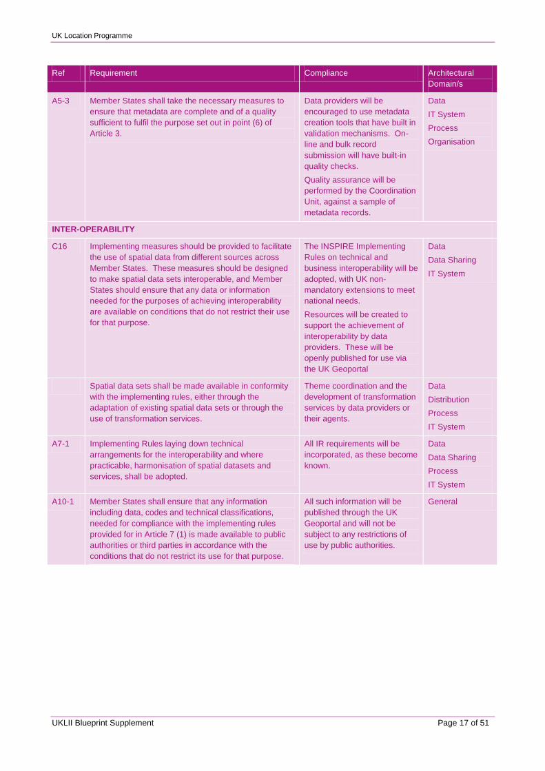
A5-3 Member States shall take the necessary measures to
ensure that metadata are complete and of a quality
sufficient to fulfil the purpose set out in point (6) of
Article 3.
Data providers will be
encouraged to use metadata
creation tools that have built in
validation mechanisms. On-
line and bulk record
submission will have built-in
quality checks.
Quality assurance will be
performed by the Coordination
Unit, against a sample of
metadata records.
Data
IT System
Process
Organisation
INTER-OPERABILITY
C16 Implementing measures should be provided to facilitate
the use of spatial data from different sources across
Member States. These measures should be designed
to make spatial data sets interoperable, and Member
States should ensure that any data or information
needed for the purposes of achieving interoperability
are available on conditions that do not restrict their use
for that purpose.
The INSPIRE Implementing
Rules on technical and
business interoperability will be
adopted, with UK non-
mandatory extensions to meet
national needs.
Resources will be created to
support the achievement of
interoperability by data
providers. These will be
openly published for use via
the UK Geoportal
Data
Data Sharing
IT System
Spatial data sets shall be made available in conformity
with the implementing rules, either through the
adaptation of existing spatial data sets or through the
use of transformation services.
Theme coordination and the
development of transformation
services by data providers or
their agents.
Data
Distribution
Process
IT System
A7-1 Implementing Rules laying down technical
arrangements for the interoperability and where
practicable, harmonisation of spatial datasets and
services, shall be adopted.
All IR requirements will be
incorporated, as these become
known.
Data
Data Sharing
Process
IT System
A10-1 Member States shall ensure that any information
including data, codes and technical classifications,
needed for compliance with the implementing rules
provided for in Article 7 (1) is made available to public
authorities or third parties in accordance with the
conditions that do not restrict its use for that purpose.
All such information will be
published through the UK
Geoportal and will not be
subject to any restrictions of
use by public authorities.
General
UK Location Programme
UKLII Blueprint Supplement Page 18 of 51
Ref Requirement Compliance Architectural
Domain/s
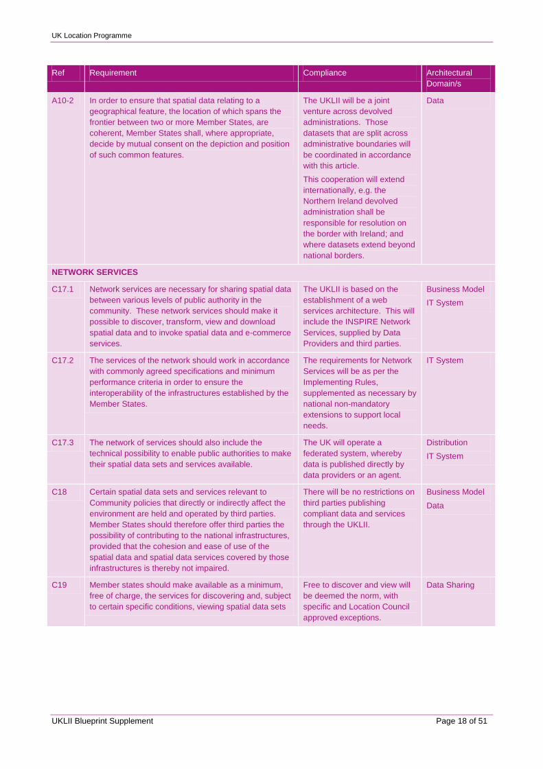
A10-2 In order to ensure that spatial data relating to a
geographical feature, the location of which spans the
frontier between two or more Member States, are
coherent, Member States shall, where appropriate,
decide by mutual consent on the depiction and position
of such common features.
The UKLII will be a joint
venture across devolved
administrations. Those
datasets that are split across
administrative boundaries will
be coordinated in accordance
with this article.
This cooperation will extend
internationally, e.g. the
Northern Ireland devolved
administration shall be
responsible for resolution on
the border with Ireland; and
where datasets extend beyond
national borders.
Data
NETWORK SERVICES
C17.1 Network services are necessary for sharing spatial data
between various levels of public authority in the
community. These network services should make it
possible to discover, transform, view and download
spatial data and to invoke spatial data and e-commerce
services.
The UKLII is based on the
establishment of a web
services architecture. This will
include the INSPIRE Network
Services, supplied by Data
Providers and third parties.
Business Model
IT System
C17.2 The services of the network should work in accordance
with commonly agreed specifications and minimum
performance criteria in order to ensure the
interoperability of the infrastructures established by the
Member States.
The requirements for Network
Services will be as per the
Implementing Rules,
supplemented as necessary by
national non-mandatory
extensions to support local
needs.
IT System
C17.3 The network of services should also include the
technical possibility to enable public authorities to make
their spatial data sets and services available.
The UK will operate a
federated system, whereby
data is published directly by
data providers or an agent.
Distribution
IT System
C18 Certain spatial data sets and services relevant to
Community policies that directly or indirectly affect the
environment are held and operated by third parties.
Member States should therefore offer third parties the
possibility of contributing to the national infrastructures,
provided that the cohesion and ease of use of the
spatial data and spatial data services covered by those
infrastructures is thereby not impaired.
There will be no restrictions on
third parties publishing
compliant data and services
through the UKLII.
Business Model
Data
C19 Member states should make available as a minimum,
free of charge, the services for discovering and, subject
to certain specific conditions, viewing spatial data sets
Free to discover and view will
be deemed the norm, with
specific and Location Council
approved exceptions.
Data Sharing
UK Location Programme
UKLII Blueprint Supplement Page 19 of 51
Ref Requirement Compliance Architectural
Domain/s
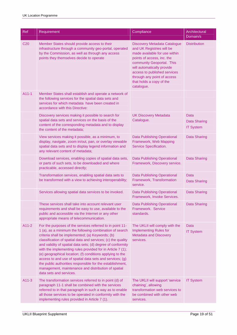
C20 Member States should provide access to their
infrastructure through a community geo-portal, operated
by the Commission, as well as through any access
points they themselves decide to operate
Discovery Metadata Catalogue
and UK Registries will be
made available for use within
points of access, inc. the
community Geoportal. This
will automatically provide
access to published services
through any point of access
that holds a copy of the
catalogue.
Distribution
A11-1 Member States shall establish and operate a network of
the following services for the spatial data sets and
services for which metadata have been created in
accordance with this Directive:
Discovery services making it possible to search for
spatial data sets and services on the basis of the
content of the corresponding metadata and to display
the content of the metadata;
UK Discovery Metadata
Catalogue.
Data
Data Sharing
IT System
View services making it possible, as a minimum, to
display, navigate, zoom in/out, pan, or overlay viewable
spatial data sets and to display legend information and
any relevant content of metadata;
Data Publishing Operational
Framework, Web Mapping
Service Specification.
Data Sharing
Download services, enabling copies of spatial data sets,
or parts of such sets, to be downloaded and where
practicable, accessed directly;
Data Publishing Operational
Framework, Discovery service.
Data Sharing
Transformation services, enabling spatial data sets to
be transformed with a view to achieving interoperability;
Data Publishing Operational
Framework, Transformation
service.
Data
Data Sharing
Services allowing spatial data services to be invoked. Data Publishing Operational
Framework, Invoke Services.
Data Sharing
These services shall take into account relevant user
requirements and shall be easy to use, available to the
public and accessible via the Internet or any other
appropriate means of telecommunication.
Data Publishing Operational
Framework. Service
standards.
Data Sharing
A11-2 For the purposes of the services referred to in point 11-
1 (a), as a minimum the following combination of search
criteria shall be implemented; (a) Keywords; (b)
classification of spatial data and services; (c) the quality
and validity of spatial data sets; (d) degree of conformity
with the implementing rules provided for in Article 7 (1);
(e) geographical location; (f) conditions applying to the
access to and use of spatial data sets and services; (g)
the public authorities responsible for the establishment,
management, maintenance and distribution of spatial
data sets and services.
The UKLII will comply with the
Implementing Rules for
Metadata and Discovery
services.
Data
IT System
A11-3 The transformation services referred to in point (d) of
paragraph 11-1 shall be combined with the services
referred to in that paragraph in such a way as to enable
all those services to be operated in conformity with the
implementing rules provided in Article 7 (1).
The UKLII will support „service
chaining‟, allowing
transformation web services to
be combined with other web
services.
IT System
UK Location Programme
UKLII Blueprint Supplement Page 20 of 51
Ref Requirement Compliance Architectural
Domain/s
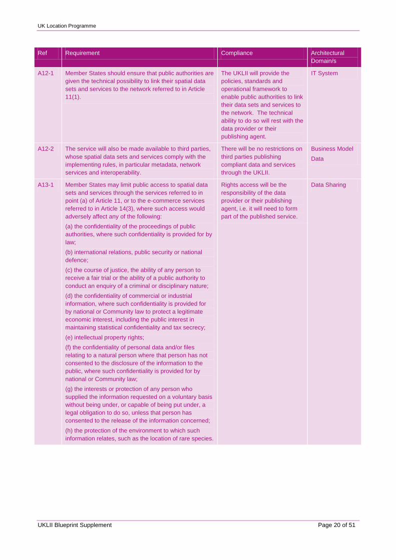
A12-1 Member States should ensure that public authorities are
given the technical possibility to link their spatial data
sets and services to the network referred to in Article
11(1).
The UKLII will provide the
policies, standards and
operational framework to
enable public authorities to link
their data sets and services to
the network. The technical
ability to do so will rest with the
data provider or their
publishing agent.
IT System
A12-2 The service will also be made available to third parties,
whose spatial data sets and services comply with the
implementing rules, in particular metadata, network
services and interoperability.
There will be no restrictions on
third parties publishing
compliant data and services
through the UKLII.
Business Model
Data
A13-1 Member States may limit public access to spatial data
sets and services through the services referred to in
point (a) of Article 11, or to the e-commerce services
referred to in Article 14(3), where such access would
adversely affect any of the following:
(a) the confidentiality of the proceedings of public
authorities, where such confidentiality is provided for by
law;
(b) international relations, public security or national
defence;
(c) the course of justice, the ability of any person to
receive a fair trial or the ability of a public authority to
conduct an enquiry of a criminal or disciplinary nature;
(d) the confidentiality of commercial or industrial
information, where such confidentiality is provided for
by national or Community law to protect a legitimate
economic interest, including the public interest in
maintaining statistical confidentiality and tax secrecy;
(e) intellectual property rights;
(f) the confidentiality of personal data and/or files
relating to a natural person where that person has not
consented to the disclosure of the information to the
public, where such confidentiality is provided for by
national or Community law;
(g) the interests or protection of any person who
supplied the information requested on a voluntary basis
without being under, or capable of being put under, a
legal obligation to do so, unless that person has
consented to the release of the information concerned;
(h) the protection of the environment to which such
information relates, such as the location of rare species.
Rights access will be the
responsibility of the data
provider or their publishing
agent, i.e. it will need to form
part of the published service.
Data Sharing

UK Location Programme
UKLII Blueprint Supplement Page 21 of 51
Ref Requirement Compliance Architectural
Domain/s
A13-2 The grounds for limiting access, as provided for in
paragraph 13-1, shall be interpreted in a restrictive way,
taking into account for the particular case the public
interest served by providing this access. In every
particular case, the public interest served by disclosure
shall be weighed against the interest served by limiting
or conditioning the access. Member States may not, by
virtue of points (a), (d), (f), (g) and (h) of paragraph 1,
limit access to information on emissions into the
environment.
The right to access will be
administered under existing
provisions, e.g. those
associated with the FOIA and
EIR. No additional provision
will be made as part of the
UKLII.
Data Sharing
A13-3 Within this framework, and for the purposes of the
application of point (f) of paragraph 13-1, Member
States shall ensure that the requirements of Directive
95/46/EC are complied with.
The UKLII Coordination Unit
assurance.
Organisation
A14-1 Member States shall ensure that the services referred
to in points (a) and (b) of Article 11(1) are available to
the public free of charge.
Discover and view services will
be generally free of charge to
the public. Exceptions will be
managed under policies and
procedures to be defined by
OPSI.
Data Sharing
A14-2 By way of derogation from paragraph 14-1, Member
States may allow a public authority supplying a service
referred to in point (b) of Article 11(1) to apply charges
where such charges secure the maintenance of spatial
data sets and corresponding data services, especially in
cases involving very large volumes of frequently
updated data.
Discover and view services will
be generally free of charge to
the public. Exceptions will be
managed under policies and
procedures to be defined by
OPSI.
Data Sharing
A14-3 Data made available through the view services referred
to in point (b) of Article 11(1) may be in a form
preventing their reuse for commercial purposes.
This will be subject to the
Implementing Rule for
discovery and view; and any
additional UK guidance.
Data
IT System
Data Sharing
A14-4 Where public authorities levy charges for the services
referred to in points (b), (c) or (e) of Article 11(1),
Member States shall ensure that e-commerce services
are available. Such services may be covered by
disclaimers, click-licences or, where necessary,
licences.
The provision of e-commerce
services will rest with the data
provider or their publishing
agent, i.e. the service will need
to form part of the data service
to which charges apply. The
UKLII will provide operational
guidance and standard
licenses in support of these
services. Brokerage services
may be made available
through third parties.
Data Sharing

UK Location Programme
UKLII Blueprint Supplement Page 22 of 51
Ref Requirement Compliance Architectural
Domain/s
A15 The Commission shall establish and operate an
INSPIRE geo-portal at Community level. Member
States shall provide access to the services referred to in
Article 11(1) through this INSPIRE geo-portal. Member
States may also provide access through their own
access points.
The ability to access will only
be constrained by the ability to
discover the data and services,
e.g. by virtue of holding or
being able to access a copy of
the Discovery Metadata
Catalogue. This will be openly
available to information access
points, inc. the INSPIRE geo-
portal.
Distribution
DATA SHARING
C21 In order to make information from various levels of
public authority available, Member States should
remove the practical obstacles faced in that regard by
public authorities at national, regional and local level
when performing their public tasks that may have a
direct or indirect impact on the environment.
The UKLII Data Sharing
Operational Framework will
seek to remove any practical
obstacles that prevent the re-
use of location information.
Data Sharing
C22 Member States should take the necessary measures to
prevent practical obstacles to the sharing of data, e.g.
by using prior agreements between public authorities.
The Data Sharing Operational
Framework will seek to remove
any practical obstacles that
prevent the re-use of location
information, inc. the use of
pan-government agreements
and standard licensing models.
Data Sharing
C23.1 Where a public authority supplies another public
authority in the same Member State with spatial data
sets and services required for the fulfilment of reporting
obligations under community legislation relating to the
environment, the Member State concerned should be
free to decide that those spatial data sets and services
shall not be subject to any charging.
Requirement will be
incorporated within RM
operational framework.
Data Sharing
C23.2 The mechanisms for sharing spatial data sets and
services should take into account the need to protect
the financial viability of public authorities, in particular
those that have a duty to raise revenue.
Defined by government policy
(announced in 2009 Spring
Budget). Will be incorporated
into new regime defined by
OPSI, which in turn will be
incorporated into the UKLII
Data Sharing Operational
Framework.
Data Sharing
C23.3 Any charges applied should not exceed the cost of
collection, production, reproduction and dissemination
together with a reasonable return on investment.
The ability to charge will be
incorporated into new regime
defined by OPSI, which in turn
will be incorporated into the
UKLII Data Sharing
Operational Framework.
Data Sharing
C24 The provision of network services should be carried out
in full compliance with the principles relating to the
protection of personal data in accordance with Directive
95/46/EC.
Responsibility of data provider.
Will be incorporated into Data
Publishing Operational
Framework.
Data Sharing
UK Location Programme
UKLII Blueprint Supplement Page 23 of 51
Ref Requirement Compliance Architectural
Domain/s
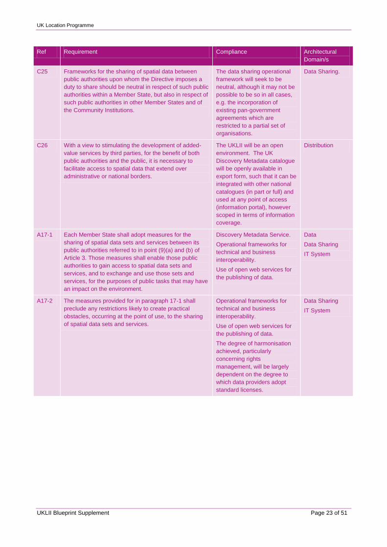
C25 Frameworks for the sharing of spatial data between
public authorities upon whom the Directive imposes a
duty to share should be neutral in respect of such public
authorities within a Member State, but also in respect of
such public authorities in other Member States and of
the Community Institutions.
The data sharing operational
framework will seek to be
neutral, although it may not be
possible to be so in all cases,
e.g. the incorporation of
existing pan-government
agreements which are
restricted to a partial set of
organisations.
Data Sharing.
C26 With a view to stimulating the development of added-
value services by third parties, for the benefit of both
public authorities and the public, it is necessary to
facilitate access to spatial data that extend over
administrative or national borders.
The UKLII will be an open
environment. The UK
Discovery Metadata catalogue
will be openly available in
export form, such that it can be
integrated with other national
catalogues (in part or full) and
used at any point of access
(information portal), however
scoped in terms of information
coverage.
Distribution
A17-1 Each Member State shall adopt measures for the
sharing of spatial data sets and services between its
public authorities referred to in point (9)(a) and (b) of
Article 3. Those measures shall enable those public
authorities to gain access to spatial data sets and
services, and to exchange and use those sets and
services, for the purposes of public tasks that may have
an impact on the environment.
Discovery Metadata Service.
Operational frameworks for
technical and business
interoperability.
Use of open web services for
the publishing of data.
Data
Data Sharing
IT System
A17-2 The measures provided for in paragraph 17-1 shall
preclude any restrictions likely to create practical
obstacles, occurring at the point of use, to the sharing
of spatial data sets and services.
Operational frameworks for
technical and business
interoperability.
Use of open web services for
the publishing of data.
The degree of harmonisation
achieved, particularly
concerning rights
management, will be largely
dependent on the degree to
which data providers adopt
standard licenses.
Data Sharing
IT System

UK Location Programme
UKLII Blueprint Supplement Page 24 of 51
Ref Requirement Compliance Architectural
Domain/s
A17-3 Member States may allow public authorities that supply
spatial data sets and services to license them to, and/or
require payment from, the public authorities or
institutions and bodies of the Community that use these
spatial data sets and services.
Any such charges and licenses must be fully compatible
with the general aim of facilitating the sharing of spatial
data sets and services between public authorities.
Where charges are made, these shall be kept to the
minimum required to ensure the necessary quality and
supply of spatial data sets and services together with a
reasonable return on investment, while respecting the
self-financing requirements of public authorities
supplying spatial data sets and services, where
applicable.
Spatial data sets and services provided by Member
States to Community institutions and bodies in order to
fulfil their reporting obligations under Community
legislation relating to the environment shall not be
subject to any charging.
The right for public authorities
to charge other public
authorities for the use of their
data will be governed by OPSI.
Charging will be subject to a
policy and procedure regime.
Stringent criteria will need to
be met to permit charging.
Where there is charging, it will
be the responsibility of the
data provider to accommodate
the situation where this is
waived, e.g. due to the
intended use of the data.
Data Sharing
A17-4 The arrangements for the sharing of spatial data sets
and services provided for in paragraphs 17-1, 2 and 3
shall be open to public authorities referred to in point
(9)(a) and (b) of Article 3 of other Member States and to
the institutions and bodies of the Community, for the
purposes of public tasks that may have an impact on
the environment.
These arrangements will be
open to all, subject to the
restrictions covered elsewhere.
Data Sharing
A17-5 The arrangements for the sharing of spatial data sets
and services provided for in paragraphs 17-1, 2 and 3
shall be open, on a reciprocal and equivalent basis, to
bodies established by international agreements to
which the Community and Member States are parties,
for the purposes of tasks that may have an impact on
the environment.
These arrangements will be
open to all, subject to the
restrictions covered elsewhere.
Data Sharing
A17-6 Where the arrangements for the sharing of spatial data
sets and services provided for in paragraphs 17-1, 2
and 3 are made available in accordance with
paragraphs 17-4 and 5, these arrangements may be
accompanied by requirements under national law
conditioning their use.
The specific handling of this
requirement will be set out in
the appropriate Operational
Framework. It is likely that
those data providers who
apply restrictions to the use of
their data will need to make
provision for this use within
their published services.
Data Sharing
A17-7 By way of derogation from this Article, Member States
may limit sharing when this would compromise the
course of justice, public security, national defence or
international relations.
The relevant operational
framework will include the
prevision for the suspension of
a published service in this
event.
Data Sharing
UK Location Programme
UKLII Blueprint Supplement Page 25 of 51
Ref Requirement Compliance Architectural
Domain/s
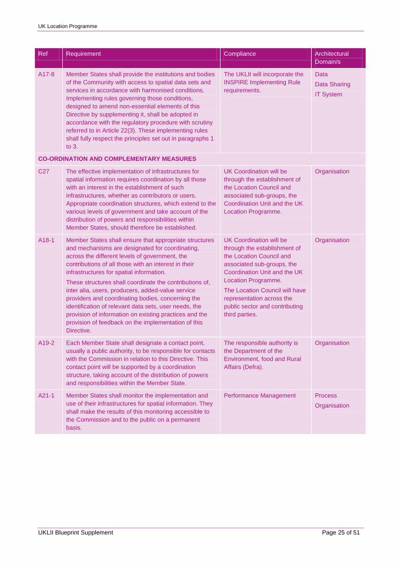
A17-8 Member States shall provide the institutions and bodies
of the Community with access to spatial data sets and
services in accordance with harmonised conditions.
Implementing rules governing those conditions,
designed to amend non-essential elements of this
Directive by supplementing it, shall be adopted in
accordance with the regulatory procedure with scrutiny
referred to in Article 22(3). These implementing rules
shall fully respect the principles set out in paragraphs 1
to 3.
The UKLII will incorporate the
INSPIRE Implementing Rule
requirements.
Data
Data Sharing
IT System
CO-ORDINATION AND COMPLEMENTARY MEASURES
C27 The effective implementation of infrastructures for
spatial information requires coordination by all those
with an interest in the establishment of such
infrastructures, whether as contributors or users.
Appropriate coordination structures, which extend to the
various levels of government and take account of the
distribution of powers and responsibilities within
Member States, should therefore be established.
UK Coordination will be
through the establishment of
the Location Council and
associated sub-groups, the
Coordination Unit and the UK
Location Programme.
Organisation
A18-1 Member States shall ensure that appropriate structures
and mechanisms are designated for coordinating,
across the different levels of government, the
contributions of all those with an interest in their
infrastructures for spatial information.
These structures shall coordinate the contributions of,
inter alia, users, producers, added-value service
providers and coordinating bodies, concerning the
identification of relevant data sets, user needs, the
provision of information on existing practices and the
provision of feedback on the implementation of this
Directive.
UK Coordination will be
through the establishment of
the Location Council and
associated sub-groups, the
Coordination Unit and the UK
Location Programme.
The Location Council will have
representation across the
public sector and contributing
third parties.
Organisation
A19-2 Each Member State shall designate a contact point,
usually a public authority, to be responsible for contacts
with the Commission in relation to this Directive. This
contact point will be supported by a coordination
structure, taking account of the distribution of powers
and responsibilities within the Member State.
The responsible authority is
the Department of the
Environment, food and Rural
Affairs (Defra).
Organisation
A21-1 Member States shall monitor the implementation and
use of their infrastructures for spatial information. They
shall make the results of this monitoring accessible to
the Commission and to the public on a permanent
basis.
Performance Management Process
Organisation
UK Location Programme
UKLII Blueprint Supplement Page 26 of 51
Ref Requirement Compliance Architectural
Domain/s
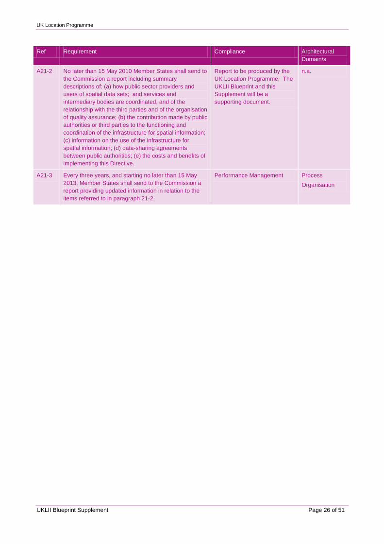
A21-2 No later than 15 May 2010 Member States shall send to
the Commission a report including summary
descriptions of: (a) how public sector providers and
users of spatial data sets; and services and
intermediary bodies are coordinated, and of the
relationship with the third parties and of the organisation
of quality assurance; (b) the contribution made by public
authorities or third parties to the functioning and
coordination of the infrastructure for spatial information;
(c) information on the use of the infrastructure for
spatial information; (d) data-sharing agreements
between public authorities; (e) the costs and benefits of
implementing this Directive.
Report to be produced by the
UK Location Programme. The
UKLII Blueprint and this
Supplement will be a
supporting document.
n.a.
A21-3 Every three years, and starting no later than 15 May
2013, Member States shall send to the Commission a
report providing updated information in relation to the
items referred to in paragraph 21-2.
Performance Management Process
Organisation

UK Location Programme
UKLII Blueprint Supplement Page 27 of 51
3 PRESENT STATE LEGISLATIVE FRAMEWORK
The implementation of INSPIRE sits within a wider framework of existing legislation and public sector
information schemes relating to data sharing and re-use. These are summarised below to provide additional
context to the coverage provided within the Data Sharing Architecture section of the Blueprint [1].
The Freedom of Information Act 2000
This was passed on 30th November and was "challenged with the task of reversing the working premise that
everything is secret, unless otherwise stated, to a position where everything is public unless it falls into
specified excepted cases" (Lord Chancellor‟s first Annual Report on the implementation of the Freedom of
Information Act 2000; November 2001).
The Act came into force on 1 January 2005 and gives a general right of access to all types of recorded
information held by public authorities that have functions in England, Wales and/or Northern Ireland, sets out
exemptions from that right (for example if releasing the information might present a risk to national security or
public safety, or if to do so would breach the Data Protection Act) and places a number of obligations on
public authorities. The Act also amends the Data Protection Act 1998 and the Public Records Act 1958.
The Act also requires that every public authority adopt and maintain a publication scheme setting out how it
intends to publish the different classes of information it holds, and whether there is a charge for the
information.
Environmental Information Regulations 2004
This came into force at the same time as the Freedom of Information Act 2000. They clarify and extend
previous rights to environmental information.
The public has a right of access to environmental information held by public authorities and some other
organisations. Requests for environmental information do not have to be in writing; they may come in any
form. Nor do they need to mention the EIRs specifically in order for them to apply. There is also no
geographical restriction; the information may relate to anywhere in the world, and may be requested by
anyone, anywhere in the world.
The definition of "environmental information" is wide and covers elements of the environment, such as: air,
water, land, natural sites, flora and fauna (including crops, livestock, GMOs and biodiversity), built
environment and health. It also covers all information relating to decisions or activities affecting, or likely to
affect, any of these, including environmental protection and cost benefit analyses.
The EIRs provide a general right of access to environmental information, subject to certain limited
exceptions. These include information that, if released, would adversely affect: natural sites; international
relations; national defence; public security; the proceeding of public authorities, and the course of justice;
and intellectual property rights or commercial confidentiality. There are also exceptions relating to:
voluntarily supplied information; and personal data, particularly if the disclosure may breach an individual's
rights under the Data Protection Act.
There is also a special exception to protect the environment to which the information relates. Authorities
would not wish to release information if, in doing so, they placed at risk a rare species breeding site, for
example.

UK Location Programme
UKLII Blueprint Supplement Page 28 of 51
Data Protection Act 1998
This regulates the way that private and public sector organisations in the UK process personal information
about living, identifiable individuals. In general there are eight Data Protection Principles that govern how
personal information is managed, including its collection and use, its accuracy and relevancy, its retention,
and its security and disposal.
The DPA provides individuals with a right to request a copy of the personal information held about them, and
have it provided within a statutory time limit. If any of the information held about an individual is incorrect,
the individual has the right to correct this (and have the inaccurate information removed / destroyed). The
DPA applies to personal information held both in computerised and manual form.
Re-use of Public Sector Information Regulations 2005
This came into force on 1st July 2005 and are based on the European Directive on the re-use of public sector
information which was approved by the Council of Ministers on 27 October 2003 and is currently undergoing
the five year review.
The Regulations apply to Central Government and the wider public sector including Local Government and
the NHS although not the education sector, and set out a framework for making the re-use of public sector
information easier and more transparent.
They are based on the principles of fairness, transparency, non-discrimination and consistency of
application. The Regulations complement access to information legislation (the Freedom of Information Act,
the Environmental Information Regulations and the Data Protection Act) through regulating the re-use of
public sector information once it has been made available, either through publishing or in response to a
request.
HM Treasury Selling into Wider Markets Policy Note
This encourages bodies to make better use of their assets by developing commercial activities using surplus
public sector assets. An activity deemed Wider Markets must pass certain tests – be discretionary, use spare
capacity and be provided in a market where there is or may be competition for the provision of those
services. An explicit component of the initiative is the encouragement it provides to public sector bodies to
expand the commercial experience and skills of employees by exposing them to commercial markets and the
private sector.

UK Location Programme
UKLII Blueprint Supplement Page 29 of 51
The UNECE Convention on Access to Information, Public Participation in Decision-making
and Access to Justice in Environment Matters (the Aarhus Convention)
This was adopted on 25th June 1998 in the Danish city of Aarhus at the Fourth Ministerial Conference in the
'Environment for Europe' process.
The Aarhus Convention, which came into force on 25 June 2003 and was required to be adopted by all
Member States by 25 June 2005, has three elements focusing on information, participation and justice.
Under the information element any member of the public has a right of access to environmental information
held by a public authority and the convention sets out timescales for the provision of this information.
Exemptions apply, as with the other information access legislation, but are to be weighed against the public
interest of disclosure. Public authorities also have requirements to gather and pro-actively disseminate
environment information and there is a clear link between the requirements of the Aarhus Convention and
public bodies‟ responsibilities in providing Public Registers.
Information Fair Trader Scheme
The Information Fair Trader Scheme, which, although optional for non-Crown bodies, offers accreditation
from the Office of Public Sector Information (OPSI) where organisations demonstrate their commitment to
trading in information fairly. The scheme sets and assesses standards for public sector bodies. It requires
them to encourage the re-use of information and reach a standard of fairness and transparency based upon
five core principles: openness, transparency, fairness, compliance and challenge. It should be noted that the
Information Fair Trader Scheme is due update its principles and verification process (see section 6.4.5
Rights Management Architecture View) and is considered a key driver in the standardisation of licensing.
Office of Fair Trading Commercial Use of Public Information (CUPI) Report
The Office of Fair Trading Commercial Use of Public Information (CUPI) Report, which aimed to examine
whether the way in which Public Sector Information Houses (PSIHs) supply information works well for
businesses, to the best advantage for consumers. The study examined whether the sector was working as
well as it should be in certain particular areas. Whilst the report does not place any legislative obligations
upon public sector bodies, it contains detailed case studies of certain bodies and has fed into the longer term
debate with regards access and re-use of public sector information.
Operational Efficiency Programme
The Operational Efficiency Programme published by HM Treasury on 21 April 2009 is again non-legislative
but does influence access and re-use of public sector information of relevance to UKLII. The report contains
an announcement relating to the assessment of Trading Funds undertaken by the Shareholder Executive
(part of BIS). Box 3.A on page 41 confirms that OPSI will provide enhanced oversight and governance to
ensure the application of key principles of good practice across the Trading Funds that create significant
amounts of information. Moreover, a new business strategy for Ordnance Survey has been developed (see
Box 3.H) which also will ensure easier and simpler access to high-quality information.

UK Location Programme
UKLII Blueprint Supplement Page 30 of 51
Intellectual Property Rights
Intellectual Property Rights are the legal rights granted to creators and owners of works that are usually the
result of human intellectual creativity. The general objective of intellectual property rights is to protect the
rights of the author and allow the public to access the creativity. The principal intellectual property rights are:
Copyright (under Copyright, Designs and Patents Act 1988);
Database Rights (under Copyright and Rights in Database Regulations 1997);
Patents (under Patents Act 1977 & 2004 and European Patent Convention 2000);
Trade Marks (under Trade Marks Act 1994);
Registered and Unregistered Design Rights (under Registered Design Act 1949);
rights that arise from the ability to prevent Passing Off;
rights that arise from the law of Confidential Information.
UK Location Programme
UKLII Blueprint Supplement Page 31 of 51
4 DATASET THEME COORDINATION
This section contains a summary of the themes and the main organisations currently producing datasets
corresponding to the UK Location Strategy Core Reference Geographies (CRGs) and the 2007/2/EC Annex
Themes.
For datasets in scope of the UK Location Strategy and INSPIRE the following criteria apply:
obligations apply only to public authorities (though private sector organisations can contribute of they
adopt the same obligations); and
the information is currently published externally for third parties to re-use (i.e. internal datasets are
out of scope) and the data is in a spatial form.
Notes:
1. The inclusion or exclusion of any dataset does not confer any legal or other kind of
responsibility or acceptance within the UK Location Programme or UK legal Transposition;
2. The tables are included to illustrate the diversity of data providers for each theme and the
relationship of the UK Location Strategy Core Reference Geographies and INSPIRE themes;
3. The tables detailed incorporate source information from the following sources, and is as up to date
as is practicable at this stage:
a. INSPIRE definitions from D2.3 “Descriptions of Themes”; and
b. Analysis of data providers from the work undertaken in support of the UK Location Strategy;
4. New datasets may emerge or old ones withdrawn. A definitive list will only emerge from the
discovery metadata service;
5. Corrections for inclusion or omission are therefore welcome: please contact:
6. These tables will be maintained as a separate product going forward.
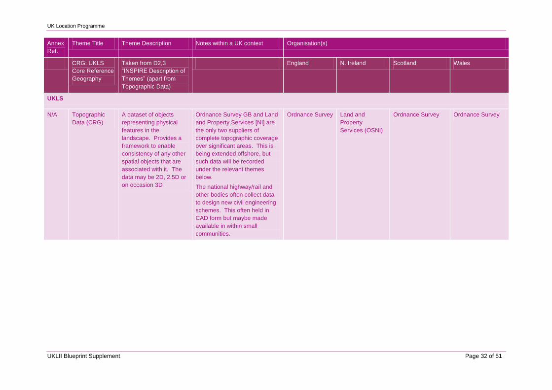
UK Location Programme
UKLII Blueprint Supplement Page 32 of 51
Annex
Ref.
Theme Title Theme Description Notes within a UK context Organisation(s)
CRG: UKLS
Core Reference
Geography
Taken from D2,3
“INSPIRE Description of
Themes” (apart from
Topographic Data)
England N. Ireland Scotland Wales
UKLS
N/A Topographic
Data (CRG)
A dataset of objects
representing physical
features in the
landscape. Provides a
framework to enable
consistency of any other
spatial objects that are
associated with it. The
data may be 2D, 2.5D or
on occasion 3D
Ordnance Survey GB and Land
and Property Services [NI] are
the only two suppliers of
complete topographic coverage
over significant areas. This is
being extended offshore, but
such data will be recorded
under the relevant themes
below.
The national highway/rail and
other bodies often collect data
to design new civil engineering
schemes. This often held in
CAD form but maybe made
available in within small
communities.
Ordnance Survey Land and
Property
Services (OSNI)
Ordnance Survey Ordnance Survey
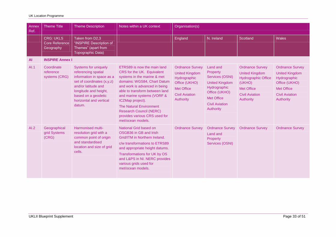
UK Location Programme
UKLII Blueprint Supplement Page 33 of 51
Annex
Ref.
Theme Title Theme Description Notes within a UK context Organisation(s)
CRG: UKLS
Core Reference
Geography
Taken from D2,3
“INSPIRE Description of
Themes” (apart from
Topographic Data)
England N. Ireland Scotland Wales
AI INSPIRE Annex I
AI.1 Coordinate
reference
systems (CRG)
Systems for uniquely
referencing spatial
information in space as a
set of coordinates (x,y,z)
and/or latitude and
longitude and height,
based on a geodetic
horizontal and vertical
datum.
ETRS89 is now the main land
CRS for the UK. Equivalent
systems in the marine & met
domains: WGS84, Chart Datum
and work is advanced in being
able to transform between land
and marine systems (VORF &
ICZMap project).
The Natural Environment
Research Council (NERC)
provides various CRS used for
met/ocean models.
Ordnance Survey
United Kingdom
Hydrographic
Office (UKHO)
Met Office
Civil Aviation
Authority
Land and
Property
Services (OSNI)
United Kingdom
Hydrographic
Office (UKHO)
Met Office
Civil Aviation
Authority
Ordnance Survey
United Kingdom
Hydrographic Office
(UKHO)
Met Office
Civil Aviation
Authority
Ordnance Survey
United Kingdom
Hydrographic
Office (UKHO)
Met Office
Civil Aviation
Authority
AI.2 Geographical
grid Systems
(CRG)
Harmonised multi-
resolution grid with a
common point of origin
and standardised
location and size of grid
cells.
National Grid based on
OSGB36 in GB and Irish
Grid/ITM in Northern Ireland.
c/w transformations to ETRS89
and appropriate height datums.
Transformations for UK by OS
and L&PS in NI. NERC provides
various grids used for
met/ocean models.
Ordnance Survey Ordnance Survey
Land and
Property
Services (OSNI)
Ordnance Survey Ordnance Survey
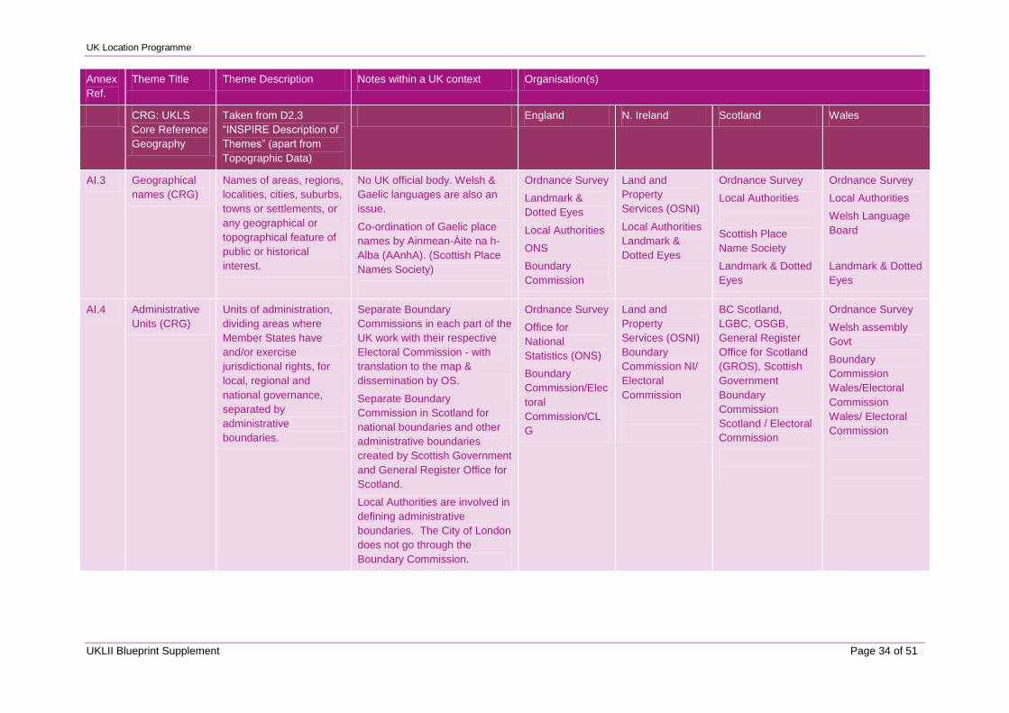
UK Location Programme
UKLII Blueprint Supplement Page 34 of 51
Annex
Ref.
Theme Title Theme Description Notes within a UK context Organisation(s)
CRG: UKLS
Core Reference
Geography
Taken from D2,3
“INSPIRE Description of
Themes” (apart from
Topographic Data)
England N. Ireland Scotland Wales
AI.3 Geographical
names (CRG)
Names of areas, regions,
localities, cities, suburbs,
towns or settlements, or
any geographical or
topographical feature of
public or historical
interest.
No UK official body. Welsh &
Gaelic languages are also an
issue.
Co-ordination of Gaelic place
names by Ainmean-Àite na h-
Alba (AAnhA). (Scottish Place
Names Society)
Ordnance Survey
Landmark &
Dotted Eyes
Local Authorities
ONS
Boundary
Commission
Land and
Property
Services (OSNI)
Local Authorities
Landmark &
Dotted Eyes
Ordnance Survey
Local Authorities
Scottish Place
Name Society
Landmark & Dotted
Eyes
Ordnance Survey
Local Authorities
Welsh Language
Board
Landmark & Dotted
Eyes
AI.4 Administrative
Units (CRG)
Units of administration,
dividing areas where
Member States have
and/or exercise
jurisdictional rights, for
local, regional and
national governance,
separated by
administrative
boundaries.
Separate Boundary
Commissions in each part of the
UK work with their respective
Electoral Commission - with
translation to the map &
dissemination by OS.
Separate Boundary
Commission in Scotland for
national boundaries and other
administrative boundaries
created by Scottish Government
and General Register Office for
Scotland.
Local Authorities are involved in
defining administrative
boundaries. The City of London
does not go through the
Boundary Commission.
Ordnance Survey
Office for
National
Statistics (ONS)
Boundary
Commission/Elec
toral
Commission/CL
G
Land and
Property
Services (OSNI)
Boundary
Commission NI/
Electoral
Commission
BC Scotland,
LGBC, OSGB,
General Register
Office for Scotland
(GROS), Scottish
Government
Boundary
Commission
Scotland / Electoral
Commission
Ordnance Survey
Welsh assembly
Govt
Boundary
Commission
Wales/Electoral
Commission
Wales/ Electoral
Commission
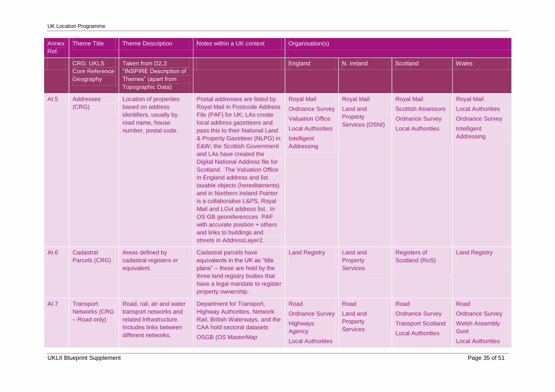
UK Location Programme
UKLII Blueprint Supplement Page 35 of 51
Annex
Ref.
Theme Title Theme Description Notes within a UK context Organisation(s)
CRG: UKLS
Core Reference
Geography
Taken from D2,3
“INSPIRE Description of
Themes” (apart from
Topographic Data)
England N. Ireland Scotland Wales
AI.5 Addresses
(CRG)
Location of properties
based on address
identifiers, usually by
road name, house
number, postal code.
Postal addresses are listed by
Royal Mail in Postcode Address
File (PAF) for UK; LAs create
local address gazetteers and
pass this to their National Land
& Property Gazetteer (NLPG) in
E&W; the Scottish Government
and LAs have created the
Digital National Address file for
Scotland. The Valuation Office
in England address and list
taxable objects (hereditaments)
and in Northern Ireland Pointer
is a collaborative L&PS, Royal
Mail and LGvt address list. In
OS GB georeferencces PAF
with accurate position + others
and links to buildings and
streets in AddressLayer2.
Royal Mail
Ordnance Survey
Valuation Office
Local Authorities
Intelligent
Addressing
Royal Mail
Land and
Property
Services (OSNI)
Royal Mail
Scottish Assessors
Ordnance Survey
Local Authorities
Royal Mail
Local Authorities
Ordnance Survey
Intelligent
Addressing
AI.6 Cadastral
Parcels (CRG)
Areas defined by
cadastral registers or
equivalent.
Cadastral parcels have
equivalents in the UK as “title
plans” – these are held by the
three land registry bodies that
have a legal mandate to register
property ownership.
Land Registry
Land and
Property
Services
Registers of
Scotland (RoS)
Land Registry
AI.7 Transport
Networks (CRG
– Road only)
Road, rail, air and water
transport networks and
related Infrastructure.
Includes links between
different networks.
Department for Transport,
Highway Authorities, Network
Rail, British Waterways, and the
CAA hold sectoral datasets
OSGB (OS MasterMap
Road
Ordnance Survey
Highways
Agency
Local Authorities
Road
Land and
Property
Services
Road
Ordnance Survey
Transport Scotland
Local Authorities
Road
Ordnance Survey
Welsh Assembly
Govt
Local Authorities
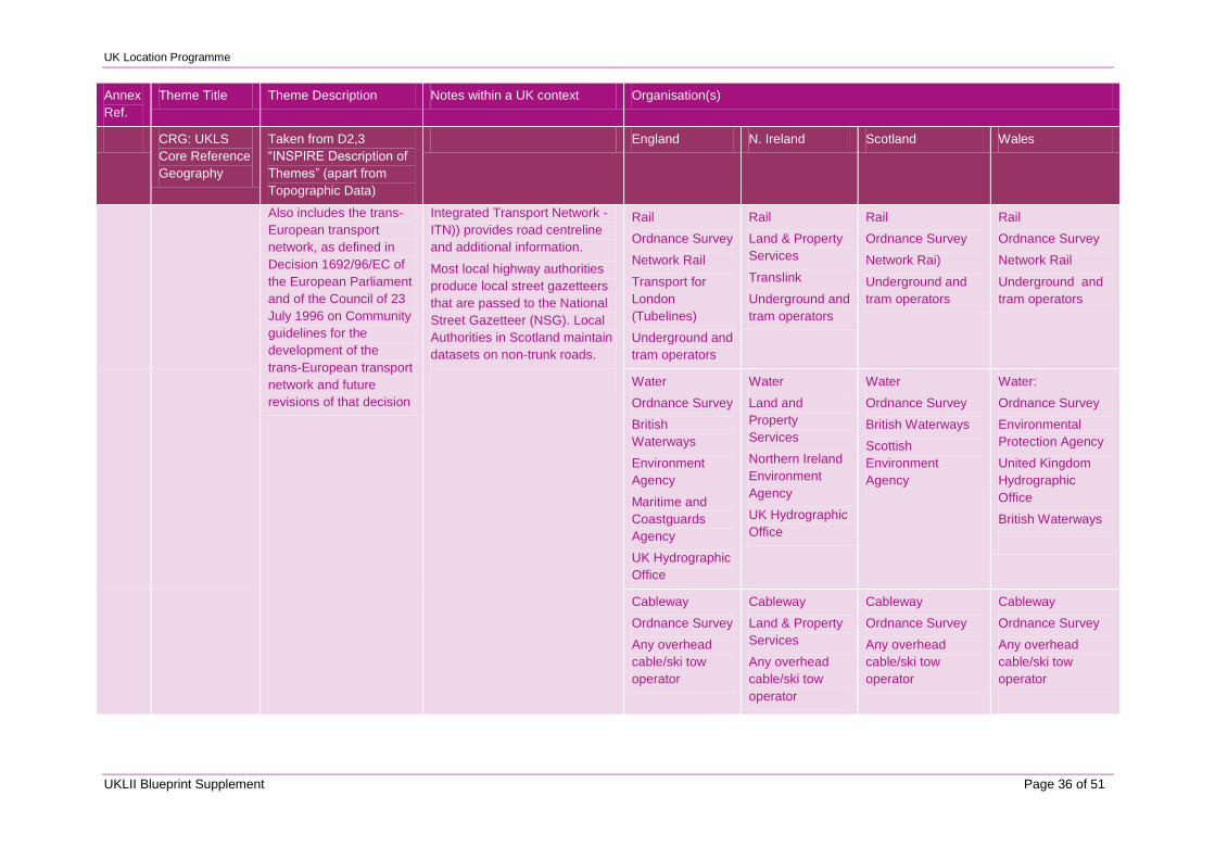
UK Location Programme
UKLII Blueprint Supplement Page 36 of 51
Annex
Ref.
Theme Title Theme Description Notes within a UK context Organisation(s)
CRG: UKLS
Core Reference
Geography
Taken from D2,3
“INSPIRE Description of
Themes” (apart from
Topographic Data)
England N. Ireland Scotland Wales
Also includes the trans-
European transport
network, as defined in
Decision 1692/96/EC of
the European Parliament
and of the Council of 23
July 1996 on Community
guidelines for the
development of the
trans-European transport
network and future
revisions of that decision
Integrated Transport Network -
ITN)) provides road centreline
and additional information.
Most local highway authorities
produce local street gazetteers
that are passed to the National
Street Gazetteer (NSG). Local
Authorities in Scotland maintain
datasets on non-trunk roads.
Rail
Ordnance Survey
Network Rail
Transport for
London
(Tubelines)
Underground and
tram operators
Rail
Land & Property
Services
Translink
Underground and
tram operators
Rail
Ordnance Survey
Network Rai)
Underground and
tram operators
Rail
Ordnance Survey
Network Rail
Underground and
tram operators
Water
Ordnance Survey
British
Waterways
Environment
Agency
Maritime and
Coastguards
Agency
UK Hydrographic
Office
Water
Land and
Property
Services
Northern Ireland
Environment
Agency
UK Hydrographic
Office
Water
Ordnance Survey
British Waterways
Scottish
Environment
Agency
Water:
Ordnance Survey
Environmental
Protection Agency
United Kingdom
Hydrographic
Office
British Waterways
Cableway
Ordnance Survey
Any overhead
cable/ski tow
operator
Cableway
Land & Property
Services
Any overhead
cable/ski tow
operator
Cableway
Ordnance Survey
Any overhead
cable/ski tow
operator
Cableway
Ordnance Survey
Any overhead
cable/ski tow
operator
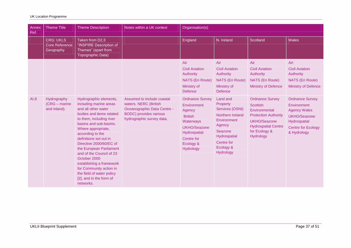
UK Location Programme
UKLII Blueprint Supplement Page 37 of 51
Annex
Ref.
Theme Title Theme Description Notes within a UK context Organisation(s)
CRG: UKLS
Core Reference
Geography
Taken from D2,3
“INSPIRE Description of
Themes” (apart from
Topographic Data)
England N. Ireland Scotland Wales
Air
Civil Aviation
Authority
NATS (En Route)
Ministry of
Defence
Air
Civil Aviation
Authority
NATS (En Route)
Ministry of
Defence
Air
Civil Aviation
Authority
NATS (En Route)
Ministry of Defence
Air:
Civil Aviation
Authority
NATS (En Route)
Ministry of Defence
AI.8 Hydrography
(CRG – marine
and inland).
Hydrographic elements,
including marine areas
and all other water
bodies and items related
to them, including river
basins and sub-basins.
Where appropriate,
according to the
definitions set out in
Directive 2000/60/EC of
the European Parliament
and of the Council of 23
October 2000
establishing a framework
for Community action in
the field of water policy
[2], and in the form of
networks.
Assumed to include coastal
waters. NERC (British
Oceanographic Data Centre -
BODC) provides various
hydrographic survey data.
Ordnance Survey
Environment
Agency
British
Waterways
UKHO/Seazone
Hydrospatial
Centre for
Ecology &
Hydrology
Land and
Property
Services (OSNI)
Northern Ireland
Environment
Agency
Seazone
Hydrospatial
Centre for
Ecology &
Hydrology
Ordnance Survey
Scottish
Environmental
Protection Authority
UKHO/Seazone
Hydrospatial Centre
for Ecology &
Hydrology
Ordnance Survey
Environment
Agency Wales
UKHO/Seazone
Hydrospatial
Centre for Ecology
& Hydrology
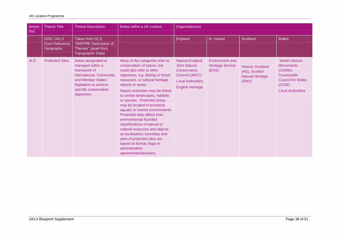
UK Location Programme
UKLII Blueprint Supplement Page 38 of 51
Annex
Ref.
Theme Title Theme Description Notes within a UK context Organisation(s)
CRG: UKLS
Core Reference
Geography
Taken from D2,3
“INSPIRE Description of
Themes” (apart from
Topographic Data)
England N. Ireland Scotland Wales
AI.9 Protected Sites Areas designated or
managed within a
framework of
international, Community
and Member States'
legislation to achieve
specific conservation
objectives.
Many of the categories refer to
conservation of nature, but
could also refer to other
objectives, e.g. fishing or forest
resources, or cultural heritage
objects or areas.
Nature protection may be linked
to certain landscapes, habitats
or species. Protected areas
may be located in terrestrial,
aquatic or marine environments.
Protected sites differs from
environmental founded
classifications of natural or
cultural resources and objects,
as localisation, boundary and
area of protected sites are
based on formal, legal or
administrative
agreements/decisions.
Natural England
Joint Natural
Conservancy
Council (JNCC)
Local Authorities
English Heritage
Environment and
Heritage Service
(EHS)
Historic Scotland
(HS), Scottish
Natural Heritage
(SNH)
Welsh Historic
Monuments
(CADW),
Countryside
Council for Wales
(CCW)
Local Authorities
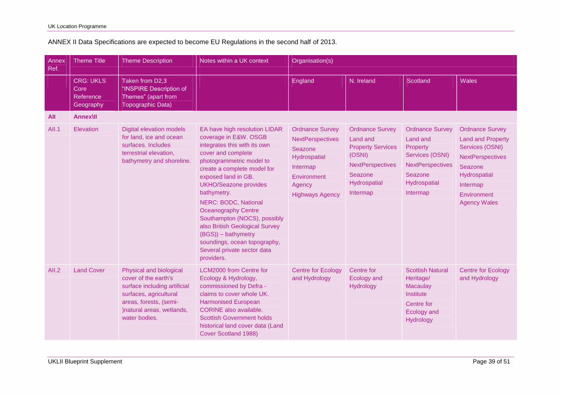
UK Location Programme
UKLII Blueprint Supplement Page 39 of 51
ANNEX II Data Specifications are expected to become EU Regulations in the second half of 2013.
Annex
Ref.
Theme Title Theme Description Notes within a UK context Organisation(s)
CRG: UKLS
Core
Reference
Geography
Taken from D2,3
“INSPIRE Description of
Themes” (apart from
Topographic Data)
England N. Ireland Scotland Wales
AII Annex\II
AII.1 Elevation Digital elevation models
for land, ice and ocean
surfaces. Includes
terrestrial elevation,
bathymetry and shoreline.
EA have high resolution LIDAR
coverage in E&W. OSGB
integrates this with its own
cover and complete
photogrammetric model to
create a complete model for
exposed land in GB.
UKHO/Seazone provides
bathymetry.
NERC: BODC, National
Oceanography Centre
Southampton (NOCS), possibly
also British Geological Survey
(BGS)) – bathymetry
soundings, ocean topography,
Several private sector data
providers.
Ordnance Survey
NextPerspectives
Seazone
Hydrospatial
Intermap
Environment
Agency
Highways Agency
Ordnance Survey
Land and
Property Services
(OSNI)
NextPerspectives
Seazone
Hydrospatial
Intermap
Ordnance Survey
Land and
Property
Services (OSNI)
NextPerspectives
Seazone
Hydrospatial
Intermap
Ordnance Survey
Land and Property
Services (OSNI)
NextPerspectives
Seazone
Hydrospatial
Intermap
Environment
Agency Wales
AII.2 Land Cover Physical and biological
cover of the earth's
surface including artificial
surfaces, agricultural
areas, forests, (semi-
)natural areas, wetlands,
water bodies.
LCM2000 from Centre for
Ecology & Hydrology,
commissioned by Defra -
claims to cover whole UK.
Harmonised European
CORINE also available.
Scottish Government holds
historical land cover data (Land
Cover Scotland 1988)
Centre for Ecology
and Hydrology
Centre for
Ecology and
Hydrology
Scottish Natural
Heritage/
Macaulay
Institute
Centre for
Ecology and
Hydrology
Centre for Ecology
and Hydrology
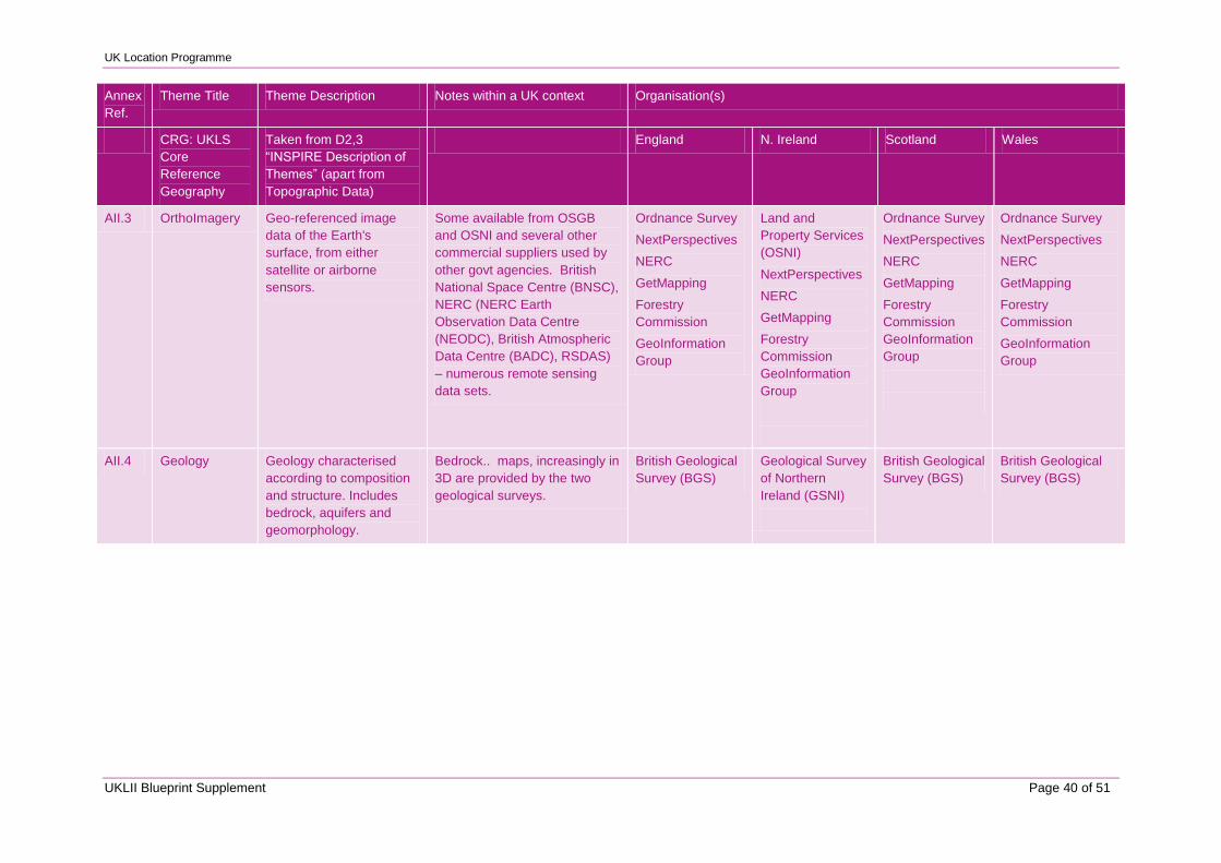
UK Location Programme
UKLII Blueprint Supplement Page 40 of 51
Annex
Ref.
Theme Title Theme Description Notes within a UK context Organisation(s)
CRG: UKLS
Core
Reference
Geography
Taken from D2,3
“INSPIRE Description of
Themes” (apart from
Topographic Data)
England N. Ireland Scotland Wales
AII.3 OrthoImagery Geo-referenced image
data of the Earth's
surface, from either
satellite or airborne
sensors.
Some available from OSGB
and OSNI and several other
commercial suppliers used by
other govt agencies. British
National Space Centre (BNSC),
NERC (NERC Earth
Observation Data Centre
(NEODC), British Atmospheric
Data Centre (BADC), RSDAS)
– numerous remote sensing
data sets.
Ordnance Survey
NextPerspectives
NERC
GetMapping
Forestry
Commission
GeoInformation
Group
Land and
Property Services
(OSNI)
NextPerspectives
NERC
GetMapping
Forestry
Commission
GeoInformation
Group
Ordnance Survey
NextPerspectives
NERC
GetMapping
Forestry
Commission
GeoInformation
Group
Ordnance Survey
NextPerspectives
NERC
GetMapping
Forestry
Commission
GeoInformation
Group
AII.4 Geology Geology characterised
according to composition
and structure. Includes
bedrock, aquifers and
geomorphology.
Bedrock.. maps, increasingly in
3D are provided by the two
geological surveys.
British Geological
Survey (BGS)
Geological Survey
of Northern
Ireland (GSNI)
British Geological
Survey (BGS)
British Geological
Survey (BGS)
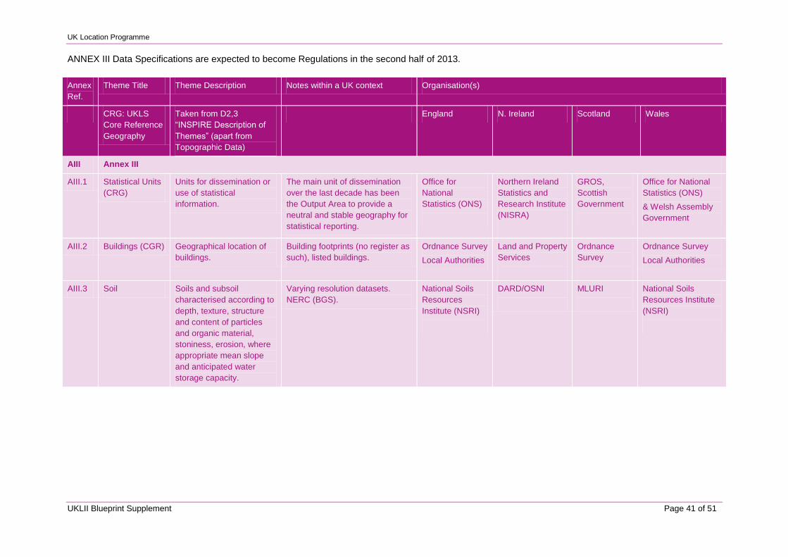
UK Location Programme
UKLII Blueprint Supplement Page 41 of 51
ANNEX III Data Specifications are expected to become Regulations in the second half of 2013.
Annex
Ref.
Theme Title Theme Description Notes within a UK context Organisation(s)
CRG: UKLS
Core Reference
Geography
Taken from D2,3
“INSPIRE Description of
Themes” (apart from
Topographic Data)
England N. Ireland Scotland Wales
AIII Annex III
AIII.1 Statistical Units
(CRG)
Units for dissemination or
use of statistical
information.
The main unit of dissemination
over the last decade has been
the Output Area to provide a
neutral and stable geography for
statistical reporting.
Office for
National
Statistics (ONS)
Northern Ireland
Statistics and
Research Institute
(NISRA)
GROS,
Scottish
Government
Office for National
Statistics (ONS)
& Welsh Assembly
Government
AIII.2 Buildings (CGR) Geographical location of
buildings.
Building footprints (no register as
such), listed buildings.
Ordnance Survey
Local Authorities
Land and Property
Services
Ordnance
Survey
Ordnance Survey
Local Authorities
AIII.3 Soil Soils and subsoil
characterised according to
depth, texture, structure
and content of particles
and organic material,
stoniness, erosion, where
appropriate mean slope
and anticipated water
storage capacity.
Varying resolution datasets.
NERC (BGS).
National Soils
Resources
Institute (NSRI)
DARD/OSNI
MLURI
National Soils
Resources Institute
(NSRI)
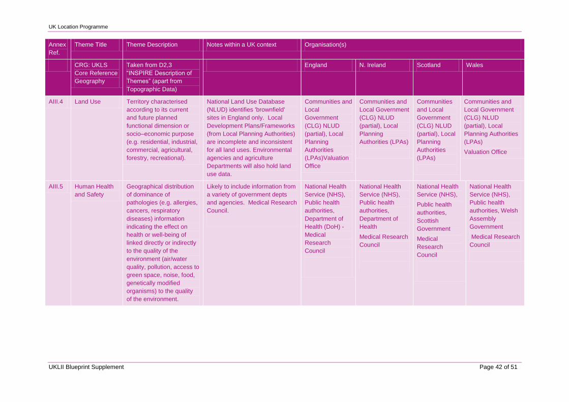
UK Location Programme
UKLII Blueprint Supplement Page 42 of 51
Annex
Ref.
Theme Title Theme Description Notes within a UK context Organisation(s)
CRG: UKLS
Core Reference
Geography
Taken from D2,3
“INSPIRE Description of
Themes” (apart from
Topographic Data)
England N. Ireland Scotland Wales
AIII.4 Land Use Territory characterised
according to its current
and future planned
functional dimension or
socio–economic purpose
(e.g. residential, industrial,
commercial, agricultural,
forestry, recreational).
National Land Use Database
(NLUD) identifies 'brownfield'
sites in England only. Local
Development Plans/Frameworks
(from Local Planning Authorities)
are incomplete and inconsistent
for all land uses. Environmental
agencies and agriculture
Departments will also hold land
use data.
Communities and
Local
Government
(CLG) NLUD
(partial), Local
Planning
Authorities
(LPAs)Valuation
Office
Communities and
Local Government
(CLG) NLUD
(partial), Local
Planning
Authorities (LPAs)
Communities
and Local
Government
(CLG) NLUD
(partial), Local
Planning
Authorities
(LPAs)
Communities and
Local Government
(CLG) NLUD
(partial), Local
Planning Authorities
(LPAs)
Valuation Office
AIII.5 Human Health
and Safety
Geographical distribution
of dominance of
pathologies (e.g. allergies,
cancers, respiratory
diseases) information
indicating the effect on
health or well-being of
linked directly or indirectly
to the quality of the
environment (air/water
quality, pollution, access to
green space, noise, food,
genetically modified
organisms) to the quality
of the environment.
Likely to include information from
a variety of government depts
and agencies. Medical Research
Council.
National Health
Service (NHS),
Public health
authorities,
Department of
Health (DoH) -
Medical
Research
Council
National Health
Service (NHS),
Public health
authorities,
Department of
Health
Medical Research
Council
National Health
Service (NHS),
Public health
authorities,
Scottish
Government
Medical
Research
Council
National Health
Service (NHS),
Public health
authorities, Welsh
Assembly
Government
Medical Research
Council
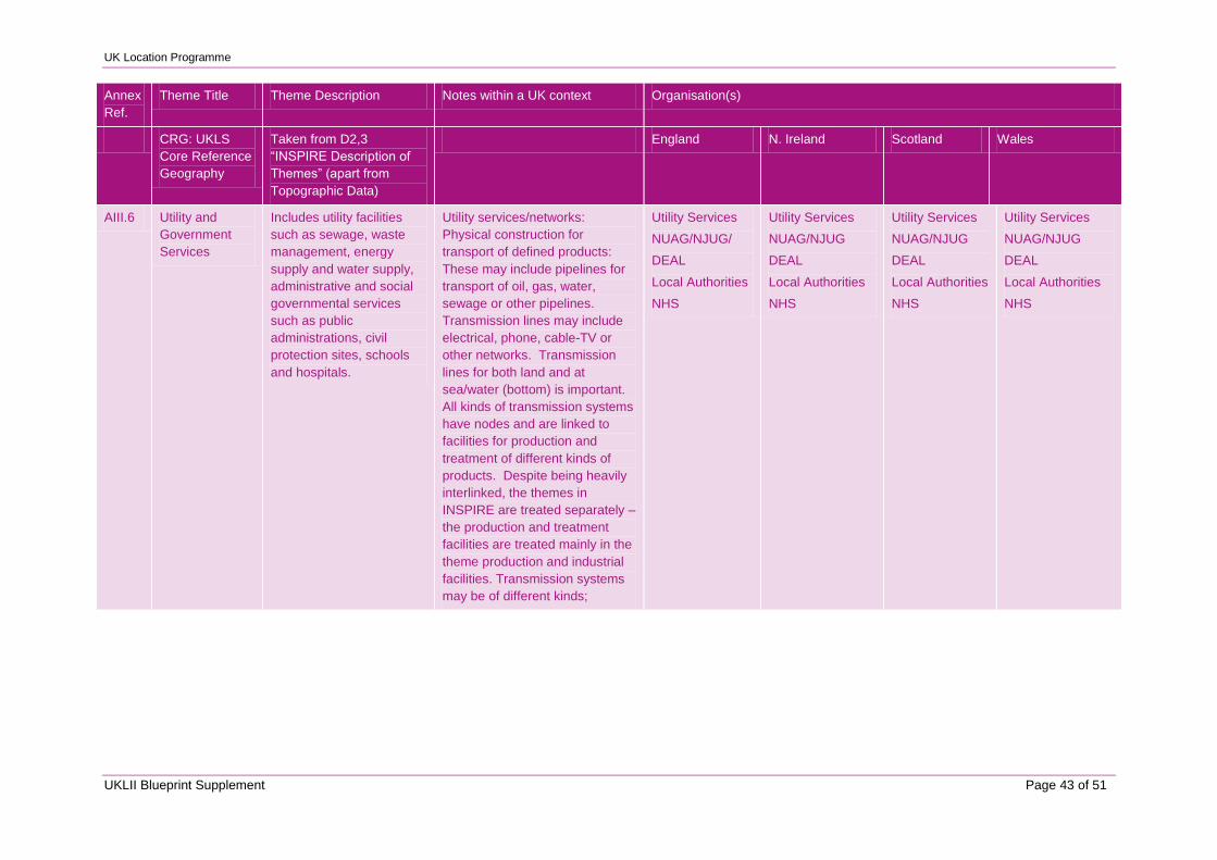
UK Location Programme
UKLII Blueprint Supplement Page 43 of 51
Annex
Ref.
Theme Title Theme Description Notes within a UK context Organisation(s)
CRG: UKLS
Core Reference
Geography
Taken from D2,3
“INSPIRE Description of
Themes” (apart from
Topographic Data)
England N. Ireland Scotland Wales
AIII.6 Utility and
Government
Services
Includes utility facilities
such as sewage, waste
management, energy
supply and water supply,
administrative and social
governmental services
such as public
administrations, civil
protection sites, schools
and hospitals.
Utility services/networks:
Physical construction for
transport of defined products:
These may include pipelines for
transport of oil, gas, water,
sewage or other pipelines.
Transmission lines may include
electrical, phone, cable-TV or
other networks. Transmission
lines for both land and at
sea/water (bottom) is important.
All kinds of transmission systems
have nodes and are linked to
facilities for production and
treatment of different kinds of
products. Despite being heavily
interlinked, the themes in
INSPIRE are treated separately –
the production and treatment
facilities are treated mainly in the
theme production and industrial
facilities. Transmission systems
may be of different kinds;
Utility Services
NUAG/NJUG/
DEAL
Local Authorities
NHS
Utility Services
NUAG/NJUG
DEAL
Local Authorities
NHS
Utility Services
NUAG/NJUG
DEAL
Local Authorities
NHS
Utility Services
NUAG/NJUG
DEAL
Local Authorities
NHS
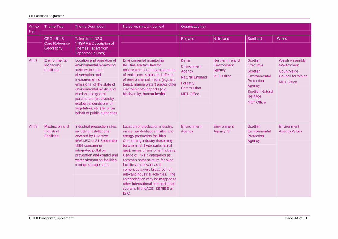
UK Location Programme
UKLII Blueprint Supplement Page 44 of 51
Annex
Ref.
Theme Title Theme Description Notes within a UK context Organisation(s)
CRG: UKLS
Core Reference
Geography
Taken from D2,3
“INSPIRE Description of
Themes” (apart from
Topographic Data)
England N. Ireland Scotland Wales
AIII.7 Environmental
Monitoring
Facilities
Location and operation of
environmental monitoring
facilities includes
observation and
measurement of
emissions, of the state of
environmental media and
of other ecosystem
parameters (biodiversity,
ecological conditions of
vegetation, etc.) by or on
behalf of public authorities.
Environmental monitoring
facilities are facilities for
observations and measurements
of emissions, status and effects
of environmental media (e.g. air,
forest, marine water) and/or other
environmental aspects (e.g.
biodiversity, human health.
Defra
Environment
Agency
Natural England
Forestry
Commission
MET Office
Northern Ireland
Environment
Agency
MET Office
Scottish
Executive
Scottish
Environmental
Protection
Agency
Scottish Natural
Heritage
MET Office
Welsh Assembly
Government
Countryside
Council for Wales
MET Office
AIII.8 Production and
Industrial
Facilities
Industrial production sites,
including installations
covered by Directive
96/61/EC of 24 September
1996 concerning
integrated pollution
prevention and control and
water abstraction facilities,
mining, storage sites.
Location of production industry,
mines, waste/disposal sites and
energy production facilities.
Concerning industry these may
be chemical, hydrocarbons (oil-
gas), mines or any other industry.
Usage of PRTR categories as
common nomenclature for such
facilities is relevant as it
comprises a very broad set of
relevant industrial activities. The
categorisation may be mapped to
other international categorisation
systems like NACE, SERIEE or
ISIC.
Environment
Agency
Environment
Agency NI
Scottish
Environmental
Protection
Agency
Environment
Agency Wales
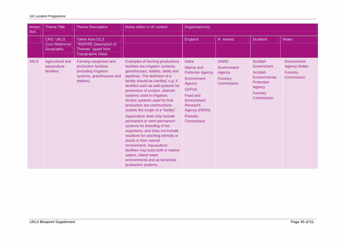
UK Location Programme
UKLII Blueprint Supplement Page 45 of 51
Annex
Ref.
Theme Title Theme Description Notes within a UK context Organisation(s)
CRG: UKLS
Core Reference
Geography
Taken from D2,3
“INSPIRE Description of
Themes” (apart from
Topographic Data)
England N. Ireland Scotland Wales
AIII.9 Agricultural and
aquaculture
facilities
Farming equipment and
production facilities
(including irrigation
systems, greenhouses and
stables).
Examples of farming productions
facilities are irrigation systems,
greenhouses, stables, tanks and
pipelines. The definition of a
facility should be clarified, e.g. if
facilities such as wall systems for
prevention of erosion, channel
systems used in irrigation,
terrace systems used for fruit
production are constructions
outside the scope of a "facility".
Aquaculture does only include
permanent or semi-permanent
systems for breeding of the
organisms, and does not include
locations for catching animals or
plants in their natural
environment. Aquaculture
facilities may exist both in marine
waters, inland water
environments and as terrestrial
production systems.
Defra
Marine and
Fisheries Agency
Environment
Agency
CEFAS
Food and
Environment
Research
Agency (FERA)
Forestry
Commission
DARD
Environment
Agency
Forestry
Commission
Scottish
Government
Scottish
Environmental
Protection
Agency
Forestry
Commission
Environment
Agency Wales
Forestry
Commission
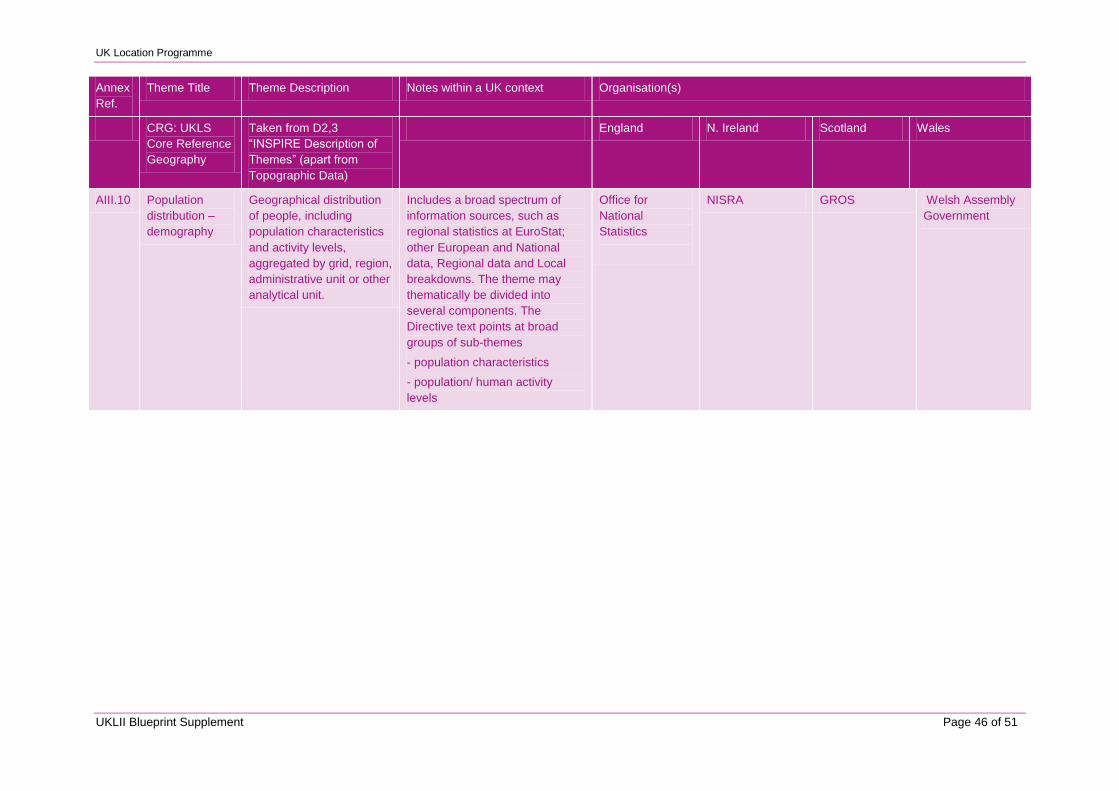
UK Location Programme
UKLII Blueprint Supplement Page 46 of 51
Annex
Ref.
Theme Title Theme Description Notes within a UK context Organisation(s)
CRG: UKLS
Core Reference
Geography
Taken from D2,3
“INSPIRE Description of
Themes” (apart from
Topographic Data)
England N. Ireland Scotland Wales
AIII.10 Population
distribution –
demography
Geographical distribution
of people, including
population characteristics
and activity levels,
aggregated by grid, region,
administrative unit or other
analytical unit.
Includes a broad spectrum of
information sources, such as
regional statistics at EuroStat;
other European and National
data, Regional data and Local
breakdowns. The theme may
thematically be divided into
several components. The
Directive text points at broad
groups of sub-themes
- population characteristics
- population/ human activity
levels
Office for
National
Statistics
NISRA GROS Welsh Assembly
Government
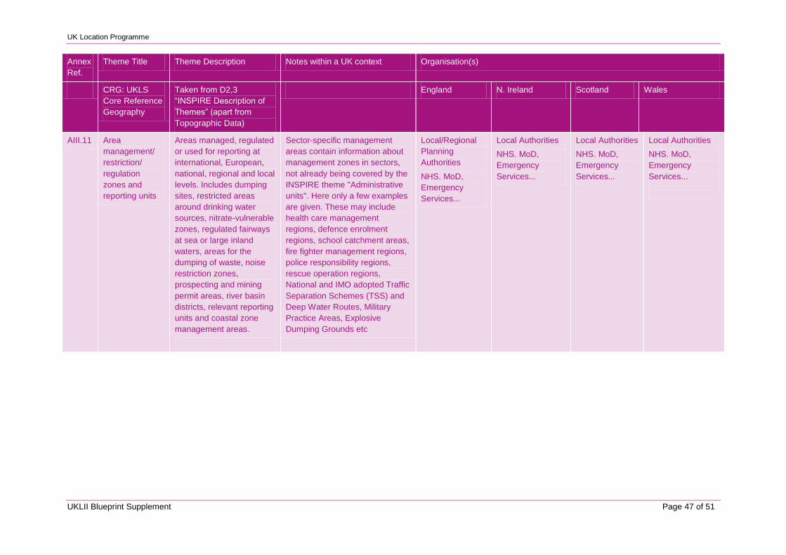
UK Location Programme
UKLII Blueprint Supplement Page 47 of 51
Annex
Ref.
Theme Title Theme Description Notes within a UK context Organisation(s)
CRG: UKLS
Core Reference
Geography
Taken from D2,3
“INSPIRE Description of
Themes” (apart from
Topographic Data)
England N. Ireland Scotland Wales
AIII.11 Area
management/
restriction/
regulation
zones and
reporting units
Areas managed, regulated
or used for reporting at
international, European,
national, regional and local
levels. Includes dumping
sites, restricted areas
around drinking water
sources, nitrate-vulnerable
zones, regulated fairways
at sea or large inland
waters, areas for the
dumping of waste, noise
restriction zones,
prospecting and mining
permit areas, river basin
districts, relevant reporting
units and coastal zone
management areas.
Sector-specific management
areas contain information about
management zones in sectors,
not already being covered by the
INSPIRE theme "Administrative
units". Here only a few examples
are given. These may include
health care management
regions, defence enrolment
regions, school catchment areas,
fire fighter management regions,
police responsibility regions,
rescue operation regions,
National and IMO adopted Traffic
Separation Schemes (TSS) and
Deep Water Routes, Military
Practice Areas, Explosive
Dumping Grounds etc
Local/Regional
Planning
Authorities
NHS. MoD,
Emergency
Services...
Local Authorities
NHS. MoD,
Emergency
Services...
Local Authorities
NHS. MoD,
Emergency
Services...
Local Authorities
NHS. MoD,
Emergency
Services...
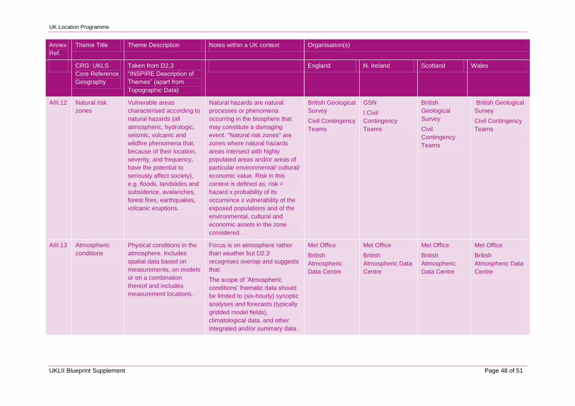
UK Location Programme
UKLII Blueprint Supplement Page 48 of 51
Annex
Ref.
Theme Title Theme Description Notes within a UK context Organisation(s)
CRG: UKLS
Core Reference
Geography
Taken from D2,3
“INSPIRE Description of
Themes” (apart from
Topographic Data)
England N. Ireland Scotland Wales
AIII.12 Natural risk
zones
Vulnerable areas
characterised according to
natural hazards (all
atmospheric, hydrologic,
seismic, volcanic and
wildfire phenomena that,
because of their location,
severity, and frequency,
have the potential to
seriously affect society),
e.g. floods, landslides and
subsidence, avalanches,
forest fires, earthquakes,
volcanic eruptions.
Natural hazards are natural
processes or phenomena
occurring in the biosphere that
may constitute a damaging
event. "Natural risk zones" are
zones where natural hazards
areas intersect with highly
populated areas and/or areas of
particular environmental/ cultural/
economic value. Risk in this
context is defined as: risk =
hazard x probability of its
occurrence x vulnerability of the
exposed populations and of the
environmental, cultural and
economic assets in the zone
considered.
British Geological
Survey
Civil Contingency
Teams
GSN
I Civil
Contingency
Teams
British
Geological
Survey
Civil
Contingency
Teams
British Geological
Survey
Civil Contingency
Teams
AIII.13 Atmospheric
conditions
Physical conditions in the
atmosphere. Includes
spatial data based on
measurements, on models
or on a combination
thereof and includes
measurement locations.
Focus is on atmosphere rather
than weather but D2.3
recognises overlap and suggests
that:
The scope of „Atmospheric
conditions‟ thematic data should
be limited to (six-hourly) synoptic
analyses and forecasts (typically
gridded model fields),
climatological data, and other
integrated and/or summary data.
Met Office
British
Atmospheric
Data Centre
Met Office
British
Atmospheric Data
Centre
Met Office
British
Atmospheric
Data Centre
Met Office
British
Atmospheric Data
Centre
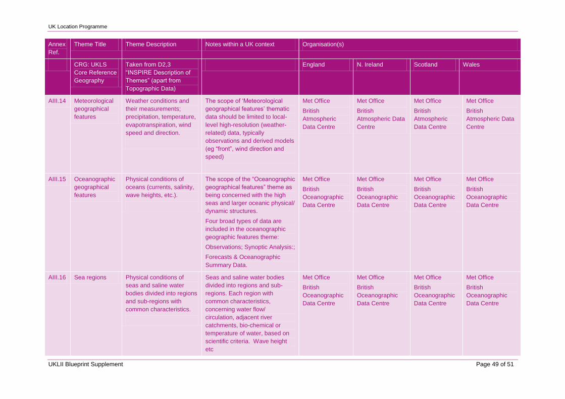
UK Location Programme
UKLII Blueprint Supplement Page 49 of 51
Annex
Ref.
Theme Title Theme Description Notes within a UK context Organisation(s)
CRG: UKLS
Core Reference
Geography
Taken from D2,3
“INSPIRE Description of
Themes” (apart from
Topographic Data)
England N. Ireland Scotland Wales
AIII.14 Meteorological
geographical
features
Weather conditions and
their measurements;
precipitation, temperature,
evapotranspiration, wind
speed and direction.
The scope of „Meteorological
geographical features‟ thematic
data should be limited to local-
level high-resolution (weather-
related) data, typically
observations and derived models
(eg “front”, wind direction and
speed)
Met Office
British
Atmospheric
Data Centre
Met Office
British
Atmospheric Data
Centre
Met Office
British
Atmospheric
Data Centre
Met Office
British
Atmospheric Data
Centre
AIII.15 Oceanographic
geographical
features
Physical conditions of
oceans (currents, salinity,
wave heights, etc.).
The scope of the “Oceanographic
geographical features” theme as
being concerned with the high
seas and larger oceanic physical/
dynamic structures.
Four broad types of data are
included in the oceanographic
geographic features theme:
Observations; Synoptic Analysis:;
Forecasts & Oceanographic
Summary Data.
Met Office
British
Oceanographic
Data Centre
Met Office
British
Oceanographic
Data Centre
Met Office
British
Oceanographic
Data Centre
Met Office
British
Oceanographic
Data Centre
AIII.16 Sea regions Physical conditions of
seas and saline water
bodies divided into regions
and sub-regions with
common characteristics.
Seas and saline water bodies
divided into regions and sub-
regions. Each region with
common characteristics,
concerning water flow/
circulation, adjacent river
catchments, bio-chemical or
temperature of water, based on
scientific criteria. Wave height
etc
Met Office
British
Oceanographic
Data Centre
Met Office
British
Oceanographic
Data Centre
Met Office
British
Oceanographic
Data Centre
Met Office
British
Oceanographic
Data Centre
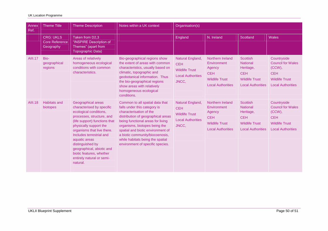
UK Location Programme
UKLII Blueprint Supplement Page 50 of 51
Annex
Ref.
Theme Title Theme Description Notes within a UK context Organisation(s)
CRG: UKLS
Core Reference
Geography
Taken from D2,3
“INSPIRE Description of
Themes” (apart from
Topographic Data)
England N. Ireland Scotland Wales
AIII.17 Bio-
geographical
regions
Areas of relatively
homogeneous ecological
conditions with common
characteristics.
Bio-geographical regions show
the extent of areas with common
characteristics, usually based on
climatic, topographic and
geobotanical information. Thus
the bio-geographical regions
show areas with relatively
homogeneous ecological
conditions.
Natural England,
CEH
Wildlife Trust
Local Authorities
JNCC,
Northern Ireland
Environment
Agency
CEH
Wildlife Trust
Local Authorities
Scottish
National
Heritage,
CEH
Wildlife Trust
Local Authorities
Countryside
Council for Wales
(CCW),
CEH
Wildlife Trust
Local Authorities
AIII.18 Habitats and
biotopes
Geographical areas
characterised by specific
ecological conditions,
processes, structure, and
(life support) functions that
physically support the
organisms that live there.
Includes terrestrial and
aquatic areas
distinguished by
geographical, abiotic and
biotic features, whether
entirely natural or semi-
natural.
Common to all spatial data that
falls under this category is
characterisation of the
distribution of geographical areas
being functional areas for living
organisms, biotopes being the
spatial and biotic environment of
a biotic community/biocoenosis,
while habitats being the spatial
environment of specific species.
Natural England,
CEH
Wildlife Trust
Local Authorities
JNCC,
Northern Ireland
Environment
Agency
CEH
Wildlife Trust
Local Authorities
Scottish
National
Heritage,
CEH
Wildlife Trust
Local Authorities
Countryside
Council for Wales
(CCW),
CEH
Wildlife Trust
Local Authorities
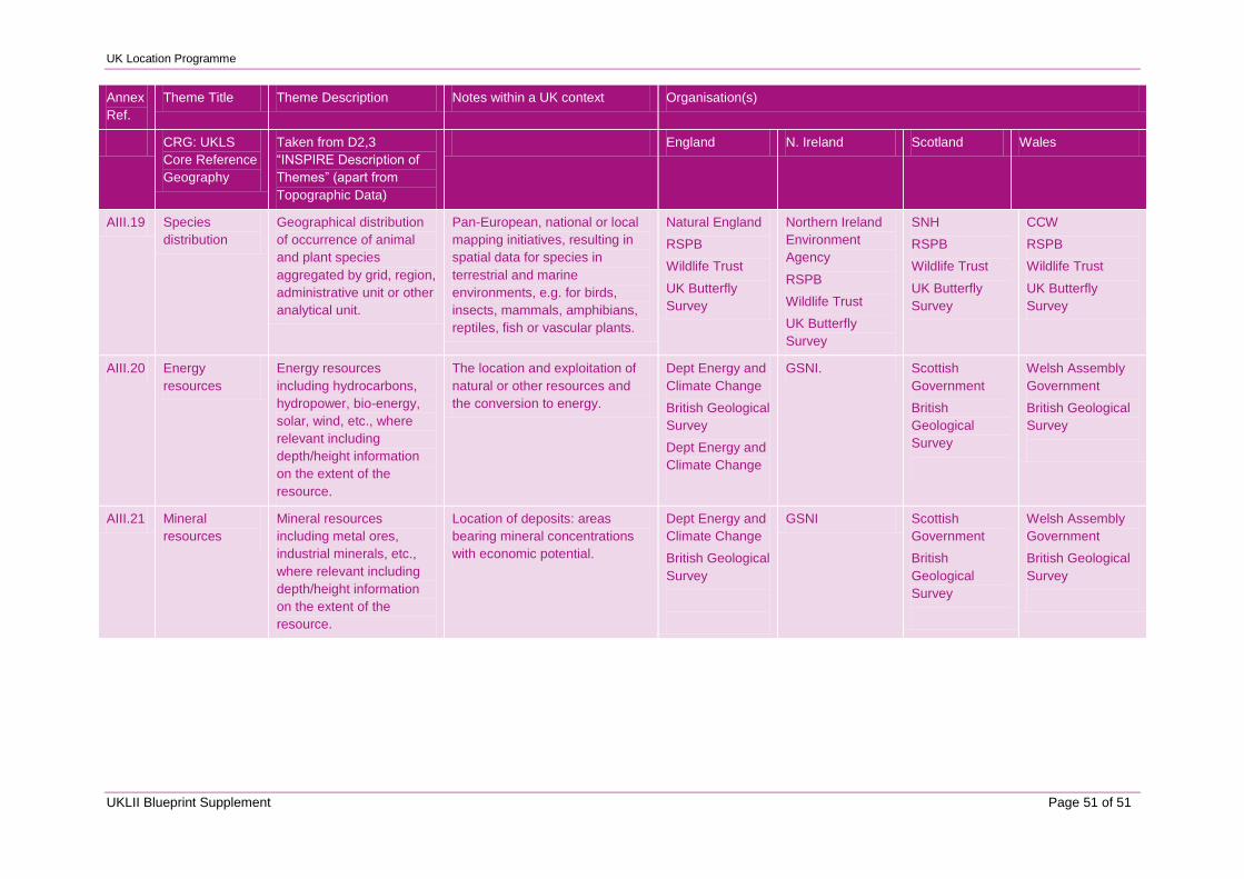
UK Location Programme
UKLII Blueprint Supplement Page 51 of 51
Annex
Ref.
Theme Title Theme Description Notes within a UK context Organisation(s)
CRG: UKLS
Core Reference
Geography
Taken from D2,3
“INSPIRE Description of
Themes” (apart from
Topographic Data)
England N. Ireland Scotland Wales
AIII.19 Species
distribution
Geographical distribution
of occurrence of animal
and plant species
aggregated by grid, region,
administrative unit or other
analytical unit.
Pan-European, national or local
mapping initiatives, resulting in
spatial data for species in
terrestrial and marine
environments, e.g. for birds,
insects, mammals, amphibians,
reptiles, fish or vascular plants.
Natural England
RSPB
Wildlife Trust
UK Butterfly
Survey
Northern Ireland
Environment
Agency
RSPB
Wildlife Trust
UK Butterfly
Survey
SNH
RSPB
Wildlife Trust
UK Butterfly
Survey
CCW
RSPB
Wildlife Trust
UK Butterfly
Survey
AIII.20 Energy
resources
Energy resources
including hydrocarbons,
hydropower, bio-energy,
solar, wind, etc., where
relevant including
depth/height information
on the extent of the
resource.
The location and exploitation of
natural or other resources and
the conversion to energy.
Dept Energy and
Climate Change
British Geological
Survey
Dept Energy and
Climate Change
GSNI. Scottish
Government
British
Geological
Survey
Welsh Assembly
Government
British Geological
Survey
AIII.21 Mineral
resources
Mineral resources
including metal ores,
industrial minerals, etc.,
where relevant including
depth/height information
on the extent of the
resource.
Location of deposits: areas
bearing mineral concentrations
with economic potential.
Dept Energy and
Climate Change
British Geological
Survey
GSNI Scottish
Government
British
Geological
Survey
Welsh Assembly
Government
British Geological
Survey