Embed Size (px)
Citation preview
DATE:
u CITYIBOROUG JUNEAU155 South Seward Street} Juneau} Alaska 99801
January 18,2012
TO:
FROM:
FILE #'s.:
Planning Commission
Teri Camery, Senior PlannerCommunity Development Department
USE20110031CSP20110011
PROPOSAL: A Conditional Use Permit and City Project Review of deferredmaintenance of existing moorage at Statter Harbor and removal andreplacement of the adjacent DeHarts moorage facility
GENERAL INFORMATION
Applicant:
Property Owner:
Property Address:
Legal Description:
Parcel Code Number:
Site Size:
Zoning:
Utilities:
Access:
Existing Land Use:
Gary Gillette, CBJ Docks & Harbors
City & Borough of Juneau
11497 Auke Bay Rd
ATS 739 - Statter Harbor
4-B23-0-1 05-1 00-0
6.04 acres
Waterfront Commercial (WC)
CBJ water and sewer
Veteran's Memorial Highway aka Glacier Highway
Statler Harbor and DeHarts Marina
"" CITY/BOROUGH OF JUNEAU• *ALASKA5 CAPITAl. CITY
Surrounding Land Use: North South East West -
Waterfront Commercial-Andrews MarinaAuke BayD-5 Residential and General Commercial-Glacier HwyAuke Bay
Planning CommissionFile No.: USE20110031January 18,2012Page 2 of8
ATTACHMENTS
Attachment 1Attachment 2Attachment 3Attachment 4Attachment 5Attachment 6Attachment 7Attachment 8
Vicinity MapDevelopment Permit ApplicationConditional Use Application12/1/11 Project NarrativeArea Site PlanParking Site PlanUplands Site Plan12/12/11 Additional Project Narrative with Master Plan background
PROJECT DESCRIPTION
The applicant requests a Conditional Use permit and City Project Review for deferred maintenanceofexisting moorage at Statter Harbor and removal and replacement ofthe DeHarts moorage facility,including relocation of the fuel float.
Deferred maintenance includes the following:• Removal and replacement of approximately 300 lineal feet of the main headwalk float• Removal and replacement of the gangway and gangway support float• Replacement of the through rod connections for the breakwater and moorage floats• Replacement of the cylindrical rubber fenders between breakwater floats• Replacement of the electrical and storage shed float• Construction of a new storage shed• Repairing spalling (cracked) concrete on all floats• other associated work
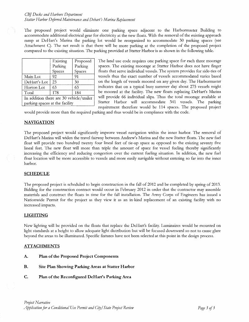
In addition to the deferred maintenance described above, the existing DeHarts marina float systemwould be completely removed and replaced with new floats, electrical system, domestic watersystem, fire suppression system, and other features. The existing facility has 90 vessel slips; howeverthe applicant reports that only 64 have been in use over the past few years. This is due to thecondition ofthe facility, a lower market demand for 24 foot slips, and also because many ofthe slipsgo dry at low tides. The new facility would increase the moorage from 64 to 66 vessels. The DeHartsmoorage would be relocated to the existing headwalk, immediately adjacent to existing harbormoorage facilities, as shown in the site plan, Attachment 5.
The existing fuel float would also be replaced and relocated as part ofthe project. The new fuel floatwould be constructed, installed, and operated by Petro Marine Services under an agreement with CBJDocks and Harbors. The existing fuel tanks would remain in the current location. However newunderground fuel lines would be constructed from the existing tanks to replace the old lines, andwould be routed to the new fuel float location at the end of the new vessel moorage area. The newfueling location is shown in the Attachment 5 site plan as the long brown block at the end of therelocated vessel moorage area.
Planning CommissionFile No.: USE20 11 0031January 18, 2012Page 3 of8
The construction contract for the project is scheduled for bidding in February 2012. Constructionwould begin in fall 2012 and would be completed by spring 2013. The applicant has obtained U.S.Army Corps of Engineers permits for the project.
BACKGROUND
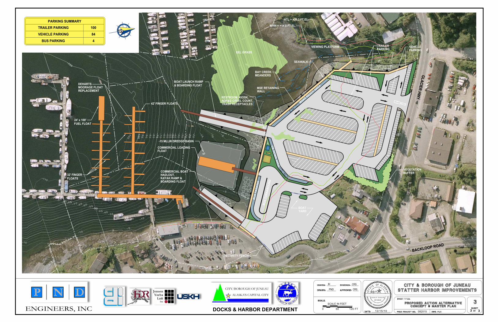
The proposed development is the first component of the Statter Harbor Master Plan. The nextcomponent is construction of a new two-lane boat launch facility. Remaining components includeconstruction ofa new kayak and boat haul-out ramp (with improvements to the existing boat yard),and construction of a new Passenger for Hire Facility. The overall goal of the Master Plan is toseparate user groups and reduce pedestrian and vessel congestion. The Project Narrative and SitePlan regarding the Master Plan are included in Attachment 8.
The applicant reports that the new launch facility, which is fully funded, is in the process ofobtaining permits from the U.S. Army Corps of Engineers. This development would require aConditional Use Permit and City Project Review from the CBJ Planning Commission. This project istentatively scheduled for construction in spring 2013 and completion in summer 2014. Both thekayak/boat haul-out ramp and the passenger-for-hire facility do not have funding and are not yetscheduled for permitting or construction.
Application materials for the proposed development were sent to local, state, and federal agencies forreview on December 12, 2011 with a comment deadline ofDecember 30,2011. No comments werereceived.
ANALYSIS
Project Site and DesignThe proposed project is located entirely within the existing Statter Harbor. No expansion ofharborboundaries is proposed. The purpose of the project design is to address maintenance issues and torelocate vessel moorage and the fuel float to an area that will cause less congestion.
Traffic and CirculationRelocating the DeHarts vessel moorage to the south side of the harbor adjacent to the existingheadwalk is expected to substantially reduce the bottleneck ofvessels which currently move througha narrow channel between the DeHarts marina and the existing headwalk and associated loadingareas. The relocation would create a wider channel for vessels. The relocation of the fuel float inparticular would create more area for vessels to tie-up while waiting for fueling, and eliminate orreduce vessels idling in the area. The new fuel float would be in an area with wider clearancethrough the main vessel corridor.
In the short term, the proposed project would create higher pedestrian use at main gangway andheadwalk, since moorage from DeHarts would be relocated to this area. However the new gangwaywould be widened slightly from 9 feet 9 inches to 10 feet, which would allow for two carts to use the
Planning CommissionFile No.: USE20110031January 18, 2012Page 4 of8
gangway at the same time. In the long~term, the Passenger for Hire facility (a component of theStatter Harbor Master Plan) will re~route tourists to a separate launch ramp on the east side of theharbor, which will reduce congestion.
Staffasked the applicant about the feasibility of installing a second pedestrian gangway on the westside ofthe Harbormaster building. The applicant replied that a gangway was located here in the past,but it was removed because it was excessively steep. The difference in the shoreline at this areawould push the end point of a ramp with an acceptable grade to a point beyond the headwalk.Therefore a second gangway is not a feasible option.
ParkingThe CBJ Land Use Code requires one parking space for every three moorage spaces. The existingmoorage at Statter Harbor does not have separate moorage floats that serve individual vessels.Instead, the system provides side~ties for vessels, which means that the exact number of vesselsserved varies according to the length ofvessels moored on any given day. The Harbormaster reportsthat on a busy summer day, approximately 275 vessels might be moored at the facility. The newmoorage floats that replace DeHarts marina would provide 66 individual vessel slips. With theseslips, the total available moorage at Statter Harbor would be 341 vessels. The parking requirementwould be 114 spaces.
The Statter Harbor moorage facility and DeHarts Marina has parking in three locations:
1) the main parking lot adjacent to the Harbormaster building (91 spaces);2) the small parking lot at the head of the DeHart's marina approach ramp (30 spaces); and3) the Horton Lot across from Squires Rest and the Thai restaurant (63 spaces)
The proposed project would eliminate one parking space adjacent to the Harbormaster building toaccommodate additional electrical gear for electricity at the new floats, reducing the number from 92to 91. With removal of the existing approach ramp at DeHart's marina, the parking lot would bereorganized to accommodate 30 parking spaces instead ofthe 23 spaces currently available, a gain ofseven spaces (see applicant parking site plan, Attachment 6). The Horton Lot would remainunchanged at 63 spaces. This would result in a net gain of six parking spaces from the currentparking areas, for a total of 184, which is 70 spaces more than the code requirement of 114 spaces.Ofthese spaces, six are required to be accessible. Accessible spaces have already been provided nearthe Harbormaster building.
Staffhas received an informal public comment from a resident who is concerned that CBJ Docks andHarbors has been leasing parking spaces in the area for long~term use to non-harbor users. Theapplicant forwarded this question to the Harbormaster, who stated that no long-term parking leaseshave been issued.
Staff also received informal comments with concerns that relocating the moorage to the headwalkwill create a tight maneuvering area for vessels because vessels will be pushed toward the new
Planning CommissionFile No.: USE20110031January 18,2012Page 5 of8
moorage area and its increased traffic in order to reach deeper water at low tides. The applicantresponded by noting that vessels can imluediately avoid the moorage area by veering to the northeast.In addition, a new loading ramp will be constructed in a much more open area in the next phase ofthe Statter Harbor Master Plan.
The proposed project changes vessel moorage only. However in a later phase of the Statter HarborMaster Plan, the facility will be expanded to include a larger launch ramp and a second launch rampreserved for tours (see Attachment 8, Statter Harbor Master Plan). This will require a newConditional Permit, and parking will be evaluated again during that review. However, it's worthnoting at this time that CBJ Code does not have a parking requirement related to launch ramps. TheCBJ Docks and Harbors long-term plan for parking at the facility is based on the Safe OperatorsBoating Association (SOBA) standard for launch ramps, which is 50 spaces per launch ramp. Thenew launch ramp will have two lanes, which would require 100 spaces to meet SOBA standards.
NoiseThe project would not add any additional vessel capacity to the area; rather it would restructure themoorage and pathways. The project would not create any additional noise except for temporary noiseimpacts during construction from pile driving and other activities.
Public Health or SafetyThe proposed development would substantially improve public safety by addressing maintenanceneeds at Statter Harbor and moving and replacing the damaged DeHarts moorage facility.
LightingNew lighting would be provided on the floats that replace the DeHarts facility. Lights would bemounted at a height sufficient for light distribution, and would be focused downward to eliminateglare. Specific fixtures have not been selected. (Attachment 4) To ensure non-glare lighting, staffrecommends the following condition:
1.) Prior to issuance of a building permit, the applicant shall submit a lighting planillustrating the location and type of exterior lighting proposed for the development.Exterior lighting shall be designed and located to minimize offsite glare.
HabitatThe maintenance and moorage replacement would not affect sensitive habitat and specifically wouldnot affect the eelgrass beds in the vicinity. A U.S. Army Corps ofEngineers Nationwide Permit hasbeen issued for the project, which indicates that the project falls under the Corps' definition ofmaintenance activities and therefore qualifies for expedited permitting.
Property Value or Neighborhood HarmonyThe project is not expanding harbor usage; therefore impacts to property value and/or neighborhoodharmony are expected to be minimal. Staff notes that this project is the precursor to a significantlylarger harbor development in the Statter Harbor Master Plan, as described in the Background section.
Planning CommissionFile No.: USE20110031January 18, 2012Page 6 of8
Impacts to neighborhood harmony from additional phases ofharbor development will be evaluated insubsequent Planning Commission reviews.
Conformity with Adopted PlansThe project supports Policy 5.6 of the 2008 Juneau Comprehensive Plan, as follows:
It is the policy ofthe CBJ to facilitate availability ofsufficient and suitable water-basedfacilities and associated land-based acreage to support water-dependent uses, and to workclosely with the public and private sectors to facilitate sustainable marine commerce,recreation, public access to the shoreline and enjoyment of the waterfront throughdevelopment ofwell-designedport facilities.
FINDINGS
CBJ §49.15.330 (e)(1), Review of Director's Determinations, states that the Planning Commissionshall review the Director's report to consider:
1. Whether the application is complete;2. Whether the proposed use is appropriate according to the Table of Permissible Uses;
and,3. Whether the development as proposed will comply with the other requirements of this
chapter.
The Commission shall adopt the Director's determination on the three items above unless it finds, bya preponderance of the evidence, that the Director's determination was in error, and states itsreasoning for each finding with particularity.
CBJ §49.15.330 (f), Commission Determinations, states that even if the Commission adopts theDirector's determination, it may nonetheless deny or condition the permit if it concludes, based uponits own independent review ofthe information submitted at the public hearing, that the developmentwill more probably than not:
1. Materially endanger the public health or safety;2. Substantially decrease the value of or be out of harmony with property in the neighboring
area; or,3. Not be in general conformity with the comprehensive plan, thoroughfare plan, or other
officially adopted plans.
Per CBJ §49.15.330 (e) & (f), Review of Director's & Commission's Determinations, the Directormakes the following findings on the proposed development:
1. Is the application for the requested conditional use permit complete?
y es. We find the application contains the information necessary to conduct full review of the
Planning CommissionFile No.: USE20110031January 18,2012Page 7 of8
proposed operations. The application submittal by the applicant, including the appropriate fees,substantially conforms to the requirements of CBJ Chapter 49.15.
2. Is the proposed use appropriate according to the Table ofPermissible Uses?
Yes. The requested permit is appropriate according to the Table ofPermissible Uses. The permit islisted at CBJ §49.25.300, Section 9.600, Marine Commercial Facilities, for the WaterfrontCommercial zoning district.
3. Will the proposed development comply with the other requirements ofthis chapter?
Yes. The proposed development complies with the other requirements ofthis chapter. Public noticeof this project was provided in the January 13, 2012 and January 23, 2012 issues of the JuneauEmpire's "Your Municipality" section, and a Notice of Public Hearing was mailed to all propertyowners within 500 feet of the subject parcel. Moreover, a Public Notice Sign was posted on thesubject parcel, visible from the public Right of Way.
4. Will the proposed development materially endanger the public health or safety?
No. No evidence indicates that the proposed development would materially endanger the publichealth or safety.
5. Will the proposed development substantially decrease the value ofor be out ofharmony withproperty in the neighboring area?
No. No evidence indicates that the proposed development would substantially decrease the value ofor be out of harmony with property in the neighboring area. The proposed development would notincrease the vessel or parking capacity of the harbor; it would change the moorage and pedestrianpattern in the harbor by relocating the DeHarts marina, which would improve harbor efficiency.
6. Will the proposed development be in general conformity with the land useplan, thoroughfareplan, or other officially adopted plans?
Yes. The proposed development is in conformity with the 2008 Comprehensive Plan, specificallyCategory 5.6 regarding water-dependent uses.
Per CBJ §49.70.900 (b)(3), General Provisions, the Director makes the following JuneauCoastal Management Program consistency determination:
7. Will the proposed development comply with the Juneau Coastal Management Program?
Yes. The proposed development complies with the Juneau Coastal Management Program. Thedevelopment does not affect sensitive habitat.
Planning CommissionFile No.: USE2011 0031January 18,2012Page 8 of8
RECOMMENDATION
Staffrecommends that the Planning Commission adopt the Director's analysis and findings and grantthe requested Conditional Use permit and adopt a favorable recommendation to the CBJ Assemblyfor the City Project Review. The permit would allow deferred maintenance of existing moorage atStatter Harbor and removal and replacement of the DeHarts moorage facility, with the followingcondition:
1.) Prior to issuance of a building permit, the applicant shall submit a lighting planillustrating the location and type of exterior lighting proposed for the developlnent.Exterior lighting shall be designed and located to minimize offsite glare.
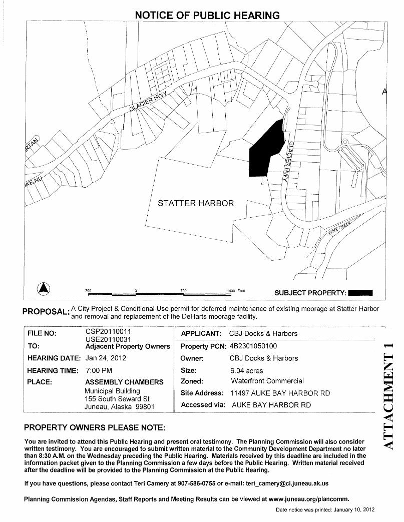
NOTICE OF PUBLIC HEARING
STATTER HARBOR
SUBJECT PROPERTY:....
PROPOSAL. A City Project & Conditional Use permit for deferred maintenance of existing moorage at Statter Harbor• and removal and replacement of the DeHarts moorage facility.
You are invited to attend this Public Hearing and present oral testimony. The Planning Commission will also considerwritten testimony. You are encouraged to submit written material to the Community Development Department no laterthan 8:30 A.M. on the Wednesday preceding the Public Hearing. Materials received by this deadline are included in theinformation packet given to the Planning Commission a few days before the Public Hearing. Written material receivedafter the deadline will be provided to the Planning Commission at the Public Hearing.
If you have questions, please contact Teri Camery at 907-586-0755 or e-mail: [email protected]
PROPERTY OWNERS PLEASE NOTE:
FILE NO:
TO:
HEARING DATE:
HEARING TIME:
PLACE:
CSP20110011USE20110031Adjacent Property Owners
Jan 24,2012
7:00 PM
ASSEMBLY CHAMBERSMunicipal Building155 South Seward StJuneau, Alaska 99801
APPLICANT: CBJ Docks & Harbors
Property PCN: 4B2301 050100
Owner: CBJ Docks & Harbors
Size: 6.04 acres
Zoned: Waterfront Commercial
Site Address: 11497 AUKE BAY HARBOR RD
Accessed via: AUKE BAY HARBOR RD
Planning Commission Agendas, Staff Reports and Meeting Results can be viewed at www.juneau.org/plancomm.
Date notice was printed: January 10,2012
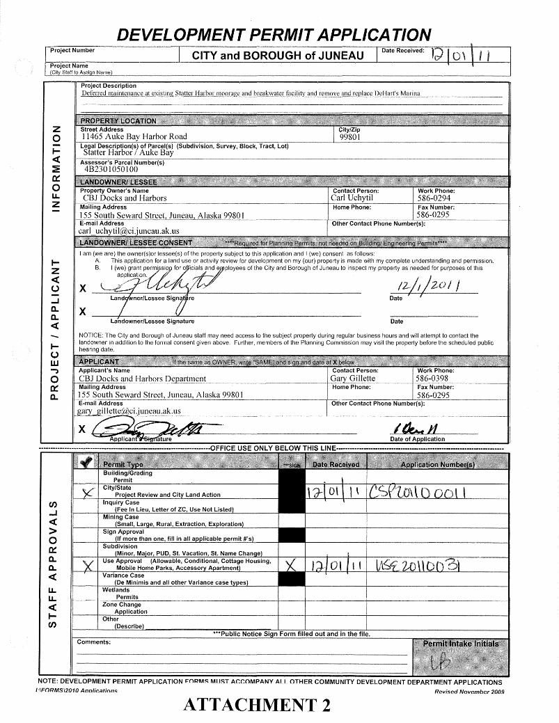
DEVELOPMENT PERMIT APPLICATIONI ,Date Received:
Contact Person: Work Phone:Carl Uchytil 586-0294Home Phone:- -------1 Fax Number-:--------11
586-0295Other ContacTPhone-Number(Sj:---------------------
CITY and BOROUGH of JUNEAU
Street Address11465 Auke Bay Harbor RoadLegal Description(s) of Parcel(s) (Subdivision, Survey, Block, Tract, Lot)Statter Harbor I Auke Bay
Assessor's Parcel Numbe~--------------------------------------------IJ
4B2301050100
Property Owner's NameCBJ Docks and Harbors
MaiiingA"ddress ---------------------------------------------
J~J?Q!!Jh_~~\Y~[(_L~!r~~tl!!!1~~_lh_~I~~J5:~L99_~Ql______ _E-mail Addresscarl_uchytil mci:uneau.ak.us
zoI«:E0::ou.Z
DateLandowner/Lessee SignatureX
I am (we are) the owner(s)or lessee(s) of the property subject to this application and I (we) consent as follows:A. This application for a land use or activity review for development on my (our) property is made with my complete understanding and permission.B_ I (we) grant permissi~ for 0 iC.ials ynde ployees of the City and Borough of Juneau to inspect my property as needed for purposes of this
apPI~sation.. (I~'.J'X ~./" /~:~ I~/J _ZO I I
Land ner/Lessee Sign re Date' f
IZ«U...Ja.a.«-IUw.,o0::a.
NOTICE: The City and Borough of Juneau staff may need access to the subject property during regular business hours and will attempt to contact thelandowner in addition to the formal consent given above_ Further, members of the Planning Commission may visit the property before the scheduled publichearing date.
Applicant's Name Contact Person: Work Phone;CBJ Docks and Harbors Department Gary Gillette 586-0398Mailing Address Home Phone:- Fax Number:155 South Seward Street, Juneau, Alaska 99801 586-0295E-mail Address --------·~e.......-----------------I-::O:-t"hC-e-r-::C;:-o-n-:-ta-c-:-t-=P-,-h-on-e-'N-::-um--:-b-'-er"'7(s"'7)-;-------------11
gary_gillette(ii}ci.juneau.ak.usIf-""'---''-='''''------:::a_........,....,,-----------------------·------'----------·---------------11
***Public Notice Sign Form filled out and in the file.
Applican Date of ApplicationX
Comments:
en...J«>o0::a.a.«u.u.«Ien
......................................................····················OFFICE USE ONLY BELOW THIS LINE··················································•.•••.•••••••••••••••••
NOTE: DEVELOPMENT PERMIT APPLICATION I=ORMS MUST ACCOMPANY ALL OTHER COMMUNITY DEVELOPMENT DEPARTMENT APPLICATIONS1:\FORMS\2010 Aoolications Revised November 2009
ATTACHMENT 2
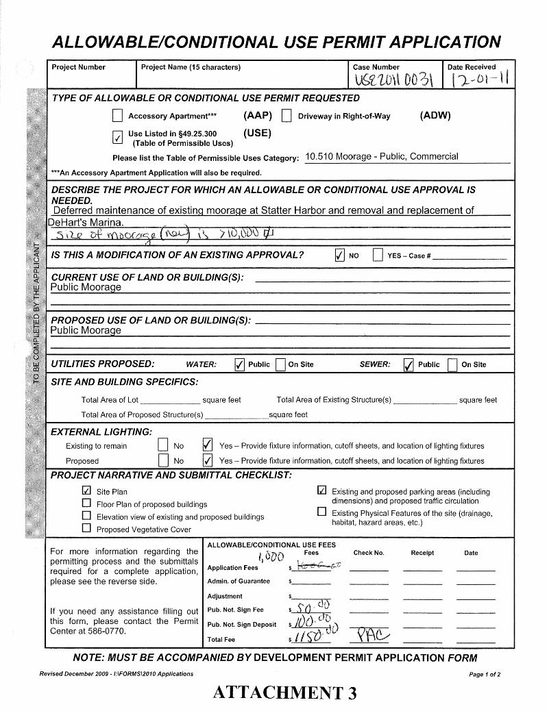
ALLOWABLE/CONDITIONAL USE PERMIT APPLICATION
***An Accessory Apartment Application will also be required.
PROPOSED USE OF LAND OR BUILDING(S): _Public Moorage
rRec~t II
(ADW)
SEWER: [i] Public DOn Site
Case Number
I{] NO DYES - Case # _
[i] Existing and proposed parking areas (includingdimensions) and proposed traffic circulation
o Existing Physical Features of the site (drainage,habitat, hazard areas, etc.)
10.510 Moorage - Public, Commercial
D Driveway in Right-of-Way
Total Area of Existing Structure(s) square feet
square feet
(AAP)
(USE)
IZI Public DOn SiteWATER:
IZl Yes - Provide fixture information, cutoff sheets, and location of lighting fixtures
o No [{] Yes - Provide fixture information, cutoff sheets, and location of lighting fixtures
D No
Project Name (15 characters)
o Accessory Apartment***
V Use Listed in §49.25.300liJ (Table of Permissible Uses)
Please list the Table of Permissible Uses Category:
Site Plan
Floor Plan of proposed buildings
Elevation view of existing and proposed buildings
Proposed Vegetative Cover
Total Area of Lot square feet
Total Area of Proposed Structure(s)
Existing to remain
Proposed
Project Number
TYPE OF ALLOWABLE OR CONDITIONAL USE PERMIT REQUESTED
DESCRIBE THE PROJECT FOR WHICH AN ALLOWABLE OR CONDITIONAL USE APPROVAL ISNEEDED.Deferred maintenance of existing moorage at Statter Harbor and removal and replacement of
IS THIS A MODIFICATION OF AN EXISTING APPROVAL?
SITE AND BUILDING SPECIFICS:
UTILITIES PROPOSED:
EXTERNAL LIGHTING:
PROJECT NARRA TIVE AND SUBMITTAL CHECKLIST:
[i]
ooo
CURRENT USE OF LAND OR BUILDING(S):Public Moorage
DeHart's Marina.
For more information regarding thepermitting process and the submittalsrequired for a complete application,please see the reverse side.
ALLOWABLE/CONDITIONAL USE FEESI Fees»
Application Fees
Admin. of Guarantee
Check No. Receipt Date
If you need any assistance filling outthis form, please contact the PermitCenter at 586-0770.
Adjustment
Pub. Not. Sign Fee
Pub. Not. Sign Deposit
Total Fee
NOTE: MUST BE ACCOMPANIED BY DEVELOPMENT PERMIT APPLICATION FORM
Revised December 2009 -/:IFORMSI2010 Applications Page 1 0(2
ATTACHMENT 3
CITYI BOROUGH OFJUNEAUigALASKA'S CAPITAL CITY
DOCKS & HARBOR DEPARTMENT
Applicationfor a Conditional Use Permit andCity/ State Prqject Review
PROJECT NARRATIVECity and Borough ofJuneau Docks and Harbors Department
Statter Harbor Deferred Maintenance and DeHart's Marina Replacement
Submitted by:Gary Gillette, Port EngineerOn Behalf of the Applicant
eBJ Docks and Harbors Department155 South Seward Street
Juneau, Alaska 99801Phone: 907-586-0398
Fax: 907-586-0295gary [email protected]
December 1, 2011
ATTACHMENT 4
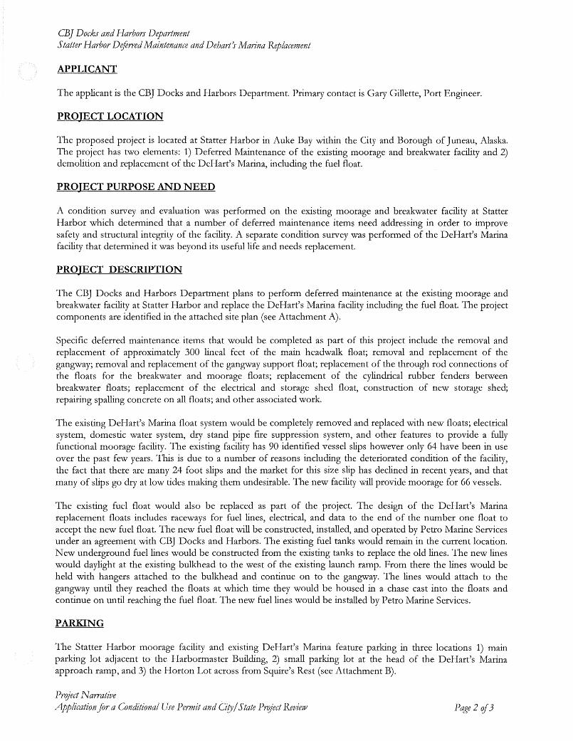
CBJ Docks and Harbors DepartmentStatter Harbor Deflrred Maintenance and Deharts Marina Replacement
APPLICANT
The applicant is the CBJ Docks and Harbors Department. Primary contact is Gary Gillette, Port Engineer.
PROJECT LOCATION
The proposed project is located at Statter Harbor in Auke Bay within the City and Borough of Juneau, Alaska.The project has two elements: 1) Deferred Maintenance of the existing moorage and breakwater facility and 2)demolition and replacement of the DeHart's Marina, including the fuel float.
PROJECT PURPOSE AND NEED
A condition survey and evaluation was performed on the existing moorage and breakwater facility at StatterHarbor which determined that a number of deferred maintenance items need addressing in order to improvesafety and structural integrity of the facility. A separate condition survey was performed of the DeHart's Marinafacility that determined it was beyond its useful life and needs replacement.
PROJECT DESCRIPTION
The CBJ Docks and Harbors Department plans to perform deferred maintenance at the existing moorage andbreakwater facility at Statter Harbor and replace the DeHart's Marina facility including the fuel float. The projectcomponents are identified in the attached site plan (see Attachment A).
Specific deferred maintenance items that would be completed as part of this project include the removal andreplacement of approximately 300 lineal feet of the main headwalk float; removal and replacement of thegangway; removal and replacement of the gangway support float; replacement of the through rod connections ofthe floats for the breakwater and moorage floats; replacement of the cylindrical rubber fenders betweenbreakwater floats; replacement of the electrical and storage shed float, construction of new storage shed;repairing spalling concrete on all floats; and other associated work.
The existing DeHart's Marina float system would be completely removed and replaced with new floats; electricalsystem, domestic water system, dry stand pipe fire suppression system, and other features to provide a fullyfunctional moorage facility. The existing facility has 90 identified vessel slips however only 64 have been in useover the past few years. This is due to a number of reasons including the deteriorated condition of the facility,the fact that there are many 24 foot slips and the market for this size slip has declined in recent years, and thatmany of slips go dry at low tides making them undesirable. The new facility will provide moorage for 66 vessels.
The existing fuel float would also be replaced as part of the project. The design of the DeHart's Marinareplacement floats includes raceways for fuel lines, electrical, and data to the end of the number one float toaccept the new fuel float. The new fuel float will be constructed, installed, and operated by Petro Marine Servicesunder an agreement with CBJ Docks and Harbors. The existing fuel tanks would remain in the current location.New underground fuel lines would be constructed from the existing tanks to replace the old lines. The new lineswould daylight at the existing bulkhead to the west of the existing launch ramp. From there the lines would beheld with hangers attached to the bulkhead and continue on to the gangway. The lines would attach to thegangway until they reached the floats at which time they would be housed in a chase cast into the floats andcontinue on until reaching the fuel float. The new fuel lines would be installed by Petro Marine Services.
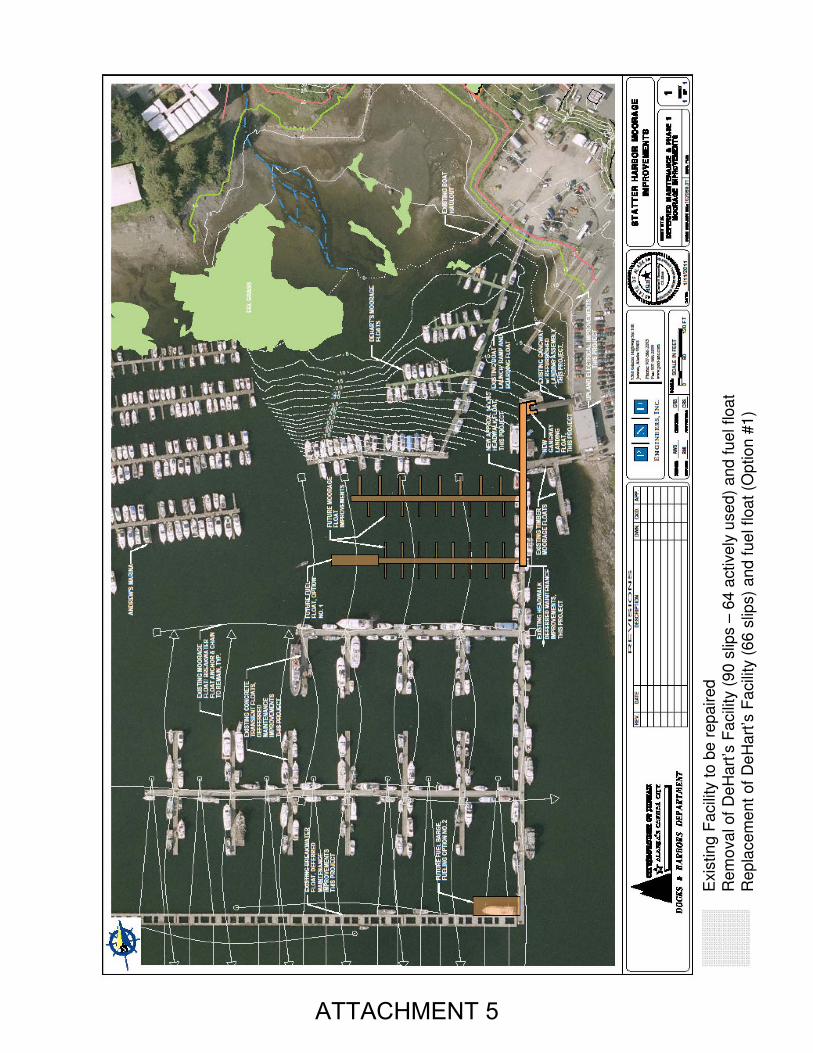
PARKING
The Statter Harbor moorage facility and existing DeHart's Marina feature parking in three locations 1) mainparking lot adjacent to the Harbormaster Building, 2) small parking lot at the head of the DeHart's Marinaapproach ramp, and 3) the Horton Lot across from Squire's Rest (see Attachment B).
Prqject NarrativeApplicationfor a Conditional Use Permit and Ciry/State Pro/ect Review Page 2 of3
Existing ProposedParking ParkingSpaces Spaces
Main Lot 92 91DeHart's Lot 23 30Horton Lot 63 63~.
Total 178 184In addition there are 30 vehicle/trailerparking spaces at the facility
CBJ DOtks and Harbors DepartmentStatter Harbor DeferredMaintenance and Dehart's Marina Replacement
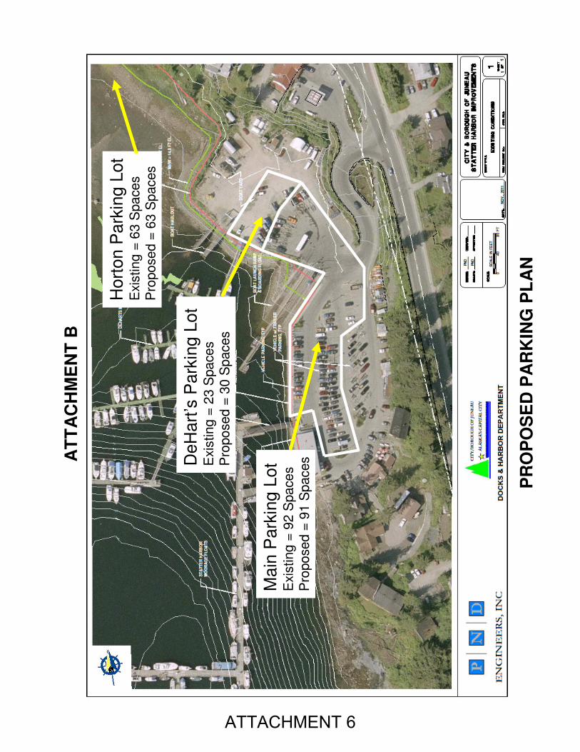
The proposed project would eliminate one parking space adjacent to the Harbormaster Building toaccommodate additional electrical gear for electricity at the new floats. With the removal of the existing approachramp at DeHart's Marina the parking lot would be reorganized to accommodate 30 parking spaces (seeAttachment C). The net result is that there will be more parking at the completion of the proposed projectcompared to the existing situation. The parking provided at Statter Harbor is as shown in the following table.
The land use code requires one parking space for each three mooragespaces. The existing moorage at Statter Harbor does not have fingerfloats that serve individual vessels. The system provides for side-ties ofvessels thus the exact number of vessels accommodated varies basedon the length of vessels moored on any given day. The Harbormasterindicates that on a typical busy summer day about 275 vessels mightbe moored at the facility. The new floats replacing DeHart's Marinawill provide 66 individual slips. Thus the total moorage available atStatter Harbor will accommodate 341 vessels. The parkingrequirement therefore would be 114 spaces. The proposed project
would provide more than the required parking and thus would be in compliance with the code.
NAVIGATION
The proposed project would significantly improve vessel navigation within the inner harbor. The removal ofDeHart's Marina will widen the travel fairway between Andrew's Marina and the new Statter floats. The new fuelfloat will provide two hundred twenty four lineal feet of tie-up space as opposed to the existing seventy fivelineal feet. The new float will more than triple the amount of space for vessel fueling thereby significantlyincreasing the efficiency and reducing congestion over the current fueling situation. In addition, the new fuelfloat location will be more accessible to vessels and more easily navigable without entering so far into the innerharbor.
SCHEDULE
The proposed project is scheduled to begin construction in the fall of 2012 and be completed by spring of 2013.Bidding for the construction contract would occur in February 2012 in order that the contractor may assemblematerials and construct the floats in time for the fall installation. The Army Corps of Engineers has issued aNationwide Permit for the project as they view it as an in-kind replacement of an existing facility with noincreased impacts.
LIGHTING
New lighting ",ill be provided on the floats that replace the DeHart's facility. Luminaires would be mounted onlight standards at a height to allow adequate light distribution but will be focused downward so not to cause glarebeyond the areas to be illuminated. Specific fixtures have not been selected at this point in the design process.
ATTACHMENTS
A. Plan of the Proposed Project Components
B. Site Plan Showing Parking Areas at Starter Harbor
C. Plan of the Reconfigured DeHart's Parking Area
Prqject NarrativeApplimtionfor a Conditional Use Permit and Ciry/State Pro/ect Review Page 3 rif3
Exis
tin
g F
acili
ty t
o b
e r
ep
aired
Rem
ova
l of
De
Ha
rt’s
Fa
cili
ty (
90
slip
s –
64
active
ly u
se
d)
and
fu
el floa
t
Rep
lacem
en
t of
De
Ha
rt’s
Fa
cili
ty (
66
slip
s)
and
fue
l floa
t (O
ptio
n #
1)
ATTACHMENT 5
Main
Park
ing L
ot
Exis
tin
g =
92 S
pa
ce
sP
ropo
se
d =
91
Sp
acesD
eH
art
’sP
ark
ing L
ot
Exis
tin
g =
23 S
pa
ce
sP
ropo
se
d =
30
Sp
aces
Hort
on P
ark
ing
Lot
Exis
tin
g =
63 S
pa
ce
sP
ropo
se
d =
63
Sp
aces
PR
OP
OS
ED
PA
RK
ING
PL
AN
AT
TA
CH
ME
NT
B
ATTACHMENT 6
ATTACHMENT C
UPLANDS SITE PLANNot to Scale
ATTACHMENT 7
ReconfiguredMarina Parking30 Spaces
Gangway toDeHart's Marinato be Removed
City & Borough of Juneau • Docks & Harbors155 S. Seward Street • Juneau, AK 99801
(907) 586-0292 Phone • (907) 586-0295 Fax
Port of JuneauMEMORANDUM
To:From:Date:Re:
Teri Camery, Planner
Gary Gillette, Port Engineer
December 12, 2011
Statter Harbor Deferred Maintenance and DeHart's Replacement
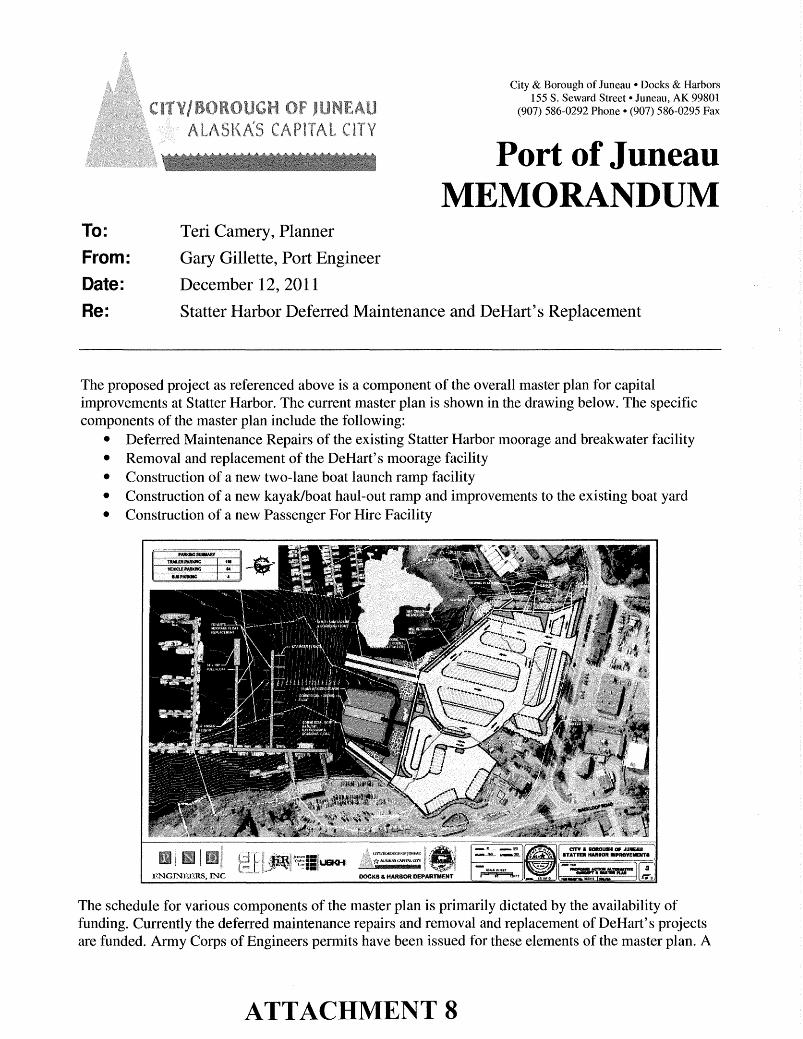
The proposed project as referenced above is a component of the overall master plan for capitalimprovements at Statter Harbor. The current master plan is shown in the drawing below. The specificcomponents of the master plan include the following:
• Deferred Maintenance Repairs of the existing Statter Harbor moorage and breakwater facility• Removal and replacement of the DeHart's moorage facility• Construction of a new two-lane boat launch ramp facility• Construction of a new kayak/boat haul-out ramp and improvements to the existing boat yard• Construction of a new Passenger For Hire Facility
The schedule for various components of the master plan is primarily dictated by the availability offunding. Currently the deferred maintenance repairs and removal and replacement of DeHart's projectsare funded. Army Corps of Engineers permits have been issued for these elements of the master plan. A
ATTACHMENT 8
Teri CameryStatter Harbor Conditional Use PermitDecember 12, 2011Page 2 of2
CBJ Conditional Use permit has been submitted and will likely be in front of the Planning Commissionin January 2012. Provided that a CU permit is issued the schedule for construction of this phase of themaster plan will commence in October 2012 and be complete by May 2013.
The new launch ramp portion of the master plan is in the permitting phase. An application has beensubmitted for the Army Corps of Engineers Permit. It is anticipated that the public notice for this projectwill be issued by the end of the year. The project would also require a conditional use permit issued bythe Planning Commission. If permits are in hand the project is scheduled to begin construction in springof 2013 and be completed by summer of 2014.
The kayak / boat haul-out project has no current funding thus is not scheduled for permitting orconstruction at this time.
The passenger for hire facility has no current funding thus is not scheduled for permitting orconstruction at this time.
-110
-105
-9
5
-9
0
-8
5
-8
0
-7
0
-6
5
-6
0
-5
5
-4
5
-4
0
-3
5
-3
0
-2
0
-15
-1
0
-5
5
10
15
20
30
35
40
45
-110
-105
-105
-95
-95
-90
-90
-85
-85
-80
-80
-70-65
-60-55
-45-40
-35
-30
-20 -15
-15
-10
-10
- 5
- 5
5
5
5
10
10
10
1015
15
15
15
101520
20
20
20
101520
30
30
30
35
35
40
40
40
45
45
45
-1
00
-7
5
-5
0
-2
5 0
25
-100
-100
-75
-50
-25
0
0
0
25
25
25
25
25
oo
o
oo
oo
oo
o
o
oo
o
o
oo
o
o
o o
o
o
o
o
o
o oo
o
o
o o
o
o
oo
o
o
OS
T
T
PO
ST
PO
ST
BACKLOOP ROAD
GL
AC
IER
HW
Y
-15 MLLW DREDGE BASIN
COMMERCIAL BOATHAULOUT,KAYAK RAMP &BOARDING FLOAT
COMMERCIAL LOADINGFLOAT
DEHARTSMOORAGE FLOATREPLACEMENT
BOATYARD
BOAT LAUNCH RAMP
& BOARDING FLOAT
BAY CREEKMEANDERS
VEHICLEPARKING
BU
S T
UR
NA
RO
UN
D
RESTROOM, KIOSK,ADF&G CREEL COUNT,TRASH RECEPTACLES
TRAILERPARKING
EEL GRASS
24' x 100'
FUEL FLOAT
32' FINGER
FLOATS
42' FINGER FLOATS
VIEWING PLATFORM
SEAWALK
MSE RETAININGWALL
VEGETATIONBUFFER
MAKE R
EADY AREA
TIE
DO
WN
AR
EA
MHW = +14.8 FT EL.
HTL = +20.3 FT EL.
BU
S P
AR
KIN
G
))
SECURITY FENCING
PARKING SUMMARY
TRAILER PARKING 100
84VEHICLE PARKING
4BUS PARKING
DOCKS & HARBOR DEPARTMENT
CITY/BOROUGH OF JUNEAU
ALASKA'S CAPITAL CITY
ENGINEERS, INCSCALE IN FEET
0 60 120 FT312/15/10 3082015
BI
PND
CRS
CRS
AFOT
AT
E
THS 49
CE-8845
Charles R. Somerville
S
A
KN
A
R
GI
ET
SE
OROISSEF AN
DP
E
L
L
RE
ENI
G
E
R