Embed Size (px)
Citation preview

Ministry of Energy, Mines & Petroleum Resources Mining & Minerals Division Assessment Report BC Geological Survey Title Page and Summary
TYPE OF REPORT (type of survey(s)J: Geological, Prospecting TOTAL COST: $12,775.00
AUTHOR(S): Laurence Sookochoff, PEng
NOTICE OF WORK PERMIT NUMBER(S)/DATE(S): YEAR OF WORK: 2018 ----------------------STATEMENT OF WORK - CASH PAYMENTS EVENT NUMBER(SVDATE(S): _56_9_54_7_4....:.,_A..,_p_ri_l 2_4-'-''...::2:..::.0:..::.1..:..8 _____________ _
PROPERTY NAME: Seneca ----------------------------------------CLAIM NAME(S)(on which the work was done): 1060112, 1060113 -------'----------------- ----- ------
COMMODITIES SOUGHT: Copper, Lead, Zinc, Silver
MINERAL INVENTORY MINFILE NUMBER(S), IF KNOWN: 092HSW013, 092HSW112, 092HSW167, 092HSW171
MINING DIVISION: New Westminster
LATITUDE: 49 0
19 54
OWNER(S):
1) Turnagain Resources Inc.
MAILING ADDRESS:
11571 Shell Road
Richmond BC V7 A 3W7
LONGITUDE:
NTS/BCGS: 092G.070, 092H.061
121 0
58 15 (at centre of work)
2) John Bakus
#3 1572Lorne Street East
Kamloops BC V2C 1X6
2) OPERA TOR(S) (who paid for the work]:
1) Tumagain Resources Inc. ------ - - - - - - ------- ---
MAILING ADDRESS:
11571 Shell Road
Richmond BC V7 A 3W7
PROPERTY GEOLOGY KEYWORDS (lithology, age, stratigraphy, structure, alteration, mineralization, size and attitude):
Jurassic, Harrison Lake Formation, Andesite, Granodiorite, Volcanogenic, Cross-structures
REFERENCESTOPREVIOUSASSESSMENTWORKANDASSESSMENTREPORTNUMBERS: 2833, 2958, 5233, 5476, 5627, 6058, 6135,
6328,6453, 7053, 7632,9844, 10894, 12322, 14668, 15459, 15732,36097
Next Page
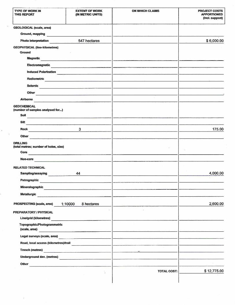
TYPE OF WORK IN EXTENT OF WORK ON WHICH CLAIMS PROJECT COSTS THIS REPORT (IN METRIC UNITS) APPORTIONED
(incl. support)
GEOLOGICAL (scale, area)
Ground, mapping
Photo Interpretation 547 hectares $6,000.00
GEOPHYSICAL (line-kilometres}
Ground
Magnetic
Electromagnetic
Induced PolariZation
Radiometric
Seismic
Other
Airborne
GEOCHEMICAL (number of samples analysed for ••• )
Soil
Silt
Rock 3 175.00
Other
DRILLING (total metres; number of holes, size)
Core
Non-core
RELATED TECHNICAL
Sampling/assaying 44 4,000.00
Petrographic
Mineralographlc
Metallurgic
PROSPECTING (scale, area) 1:10000 8 hectares 2,600.00
PREPARATORY/ PHYSICAL
Line/grid (kilometnls)
Topographic/Photogrammetric
(scale, area)
Legal surveys (scale, area)
Road, local access (kilometres)/trail
Trench (metres) -<
Underground dev. {metres)
Other
TOTAL COST: $12,775.00
Seneca Property John Bakus/ Turnagain Resources Inc. Event 5695474
__________________________________________________________________________________
__________________________________________________________________________________
January 6,2019 Sookochoff Consultants Inc. page 1 of 43
John Bakus
Turnagain Resources Inc. (Owners)
Turnagain Resources Inc. (Operator)
GEOLOGICAL & GEOCHEMICAL
ASSESSMENT REPORT
(Event 5695474)
Work done on
Tenures 1060112 & 1060113
of the
Seneca Property
New Westminster Mining Division
BCGS Maps 092G.070 / 092H.061
Work done from
April 14, 2018 to April 29, 2018
Centre of Work
5,464,827N, 574,767E
(10 NAD 83)
Author & Consultant
Laurence Sookochoff, PEng Sookochoff Consultants Inc.
Submitted
September 16, 2018
Amended
January 6, 2019

Seneca Property John Bakus/ Turnagain Resources Inc. Event 5695474
__________________________________________________________________________________
__________________________________________________________________________________
January 6,2019 Sookochoff Consultants Inc. page 2 of 43
TABLE OF CONTENTS
page
Summary ------------------------------------------------------------------------------- 4.
Introduction ---------------------------------------------------------------------------- 5.
Property Location and Description ----------------------------------------------- 5.
Accessibility, Climate, Local Resources, Infrastructure and Physiography -- 7.
History: Property Area --------------------------------------------------------------- 7.
092HSW070 –LD -------------------------------------------------------------------- 7.
092HSW092 – HARRISON GOLD ----------------------------------------------- 8.
092HNW165 – FLEETWOOD ----------------------------------------------------- 9.
History: Property --------------------------------------------------------------------- 9.
092HNW013 - SENECA ----------------------------------------------------------- 9
092HSW112 – VENT --------------------------------------------------------------- 10.
092HSW167 – STATU CREEK --------------------------------------------------- 10.
092HNW171 – STATU AGGREGATE ------------------------------------------ 10.
Geology: Regional -------------------------------------------------------------------- 11.
Geology: Property Area -------------------------------------------------------------- 11.
092HSW069 – LOVE ---------------------------------------------------------------- 11.
092HSW070 –LD -------------------------------------------------------------------- 12.
092HSW083 – IAM ----------------------------------------------------------------- 12.
092HSW092 – HARRISON GOLD ----------------------------------------------- 12.
092HNW165 – FLEETWOOD ----------------------------------------------------- 15.
Geology: Property ------------------------------------------------------------------- 16.
092HSW013 - SENECA ------------------------------------------------------------ 17
092HSW112 – VENT --------------------------------------------------------------- 17.
092HSW167 – STATU CREEK --------------------------------------------------- 19.
092HNW171 – STATU AGGREGATE ------------------------------------------ 19.
Mineralization: Property Area ------------------------------------------------------ 19.
092HSW069 – LOVE ---------------------------------------------------------------- 19.
092HSW070 –LD -------------------------------------------------------------------- 19.
092HSW083 – IAM ----------------------------------------------------------------- 19.
092HSW092 – HARRISON GOLD ----------------------------------------------- 19.
092HNW165 – FLEETWOOD ----------------------------------------------------- 21.
Mineralization: Property ------------------------------------------------------------- 19.
092HSW013 - SENECA ------------------------------------------------------------ 21
092HSW112 – VENT --------------------------------------------------------------- 22.
092HSW167 – STATU CREEK --------------------------------------------------- 22.
092HNW171 – STATU AGGREGATE ------------------------------------------ 23.
2018 Exploration Program --------------------------------------------------- 23.
Soil and Rock Sampling ----------------------------------------- 21.
Prospecting -------------------------------------------------------- 21.
Structural Analysis ----------------------------------------------- 26.
Interpretation and Conclusions ------------------------------------------------------ 28.
Recommendations ------------------------------------------------------------ 30.

Seneca Property John Bakus/ Turnagain Resources Inc. Event 5695474
__________________________________________________________________________________
__________________________________________________________________________________
January 6,2019 Sookochoff Consultants Inc. page 3 of 43
Table of Contents (cont’d)
Selected References --------------------------------------------------------------------- 31.
Statement of Costs ----------------------------------------------------------------------- 33.
Certificate ----------------------------------------------------------------------------------- 34.
Field Crew Qualifications ------------------------------------------------------------- 35.
ILLUSTRATIONS
Figure 1. Location Map ------------------------------------------------------ 5.
Figure 2. Property Location ------------------------------------------------- 6.
Figure 3. Claim Map --------------------------------------------------------- 7.
Figure 4. Regional Geology ------------------------------------------------- 11.
Figure 5. Property Geology, Claims, Index, & Minfile ------------------ 16.
Figure 6. Possible vent or discharge zone of volcanogenic minerals
into a graben at the Vent area ----------------------------------- 18.
Figure 7 Sample Locations Index Map: ------------------------------------- 24.
Figure 8. Northern Sample Locations -------------------------------------- 24.
Figure 9. Central Sample Locations ---------------------------------------- 25.
Figure 10. Southern Sample Locations ------------------------------------ 25.
Figure 11. Lineaments as Indicated Structures --------------------------- 26.
Figure 12. Rose Diagram ---------------------------------------------------- 27.
Figure 13. Possible Location of the Seneca Mineral Area -------------- 29.
TABLES
Table 1. Seneca Property Tenures ----------------------------------------- 6.
APPENDICES
Appendix I Sample Locations and Descriptions
Appendix II Photos from the Seneca Property
Appendix III Property Review Report by Stewart Jackson, PhD PGeo

Seneca Property John Bakus/ Turnagain Resources Inc. Event 5695474
__________________________________________________________________________________
__________________________________________________________________________________
January 6,2019 Sookochoff Consultants Inc. page 4 of 43
SUMMARY
The 905 hectare Seneca property ("Property") is located 86 kilometres east of Vancouver and 16
kilometres north of Chilliwack, on the west side of Harrison Lake in southwestern British Columbia,
Canada.
The geology of the Property is generally of a contact between Middle Jurassic granodioriyic intrusive
rocks and andesitic volcanic rocks of the Lower Jurassic Harrison Formation. The Property
incorporates the Vent prospect and the Seneca past producer, two prime areas of Noranda/Kuroko
massive sulphide Cu-Pb-Zn or volcanogenic (VMS) mineralization which are underlain primarily by
volcanics.
At the Seneca, since the high-grade massive sulphide float was discovered in a creek in the 1920's and
the exposure of subcrop massive sulphides by a logging road in the 1950's, the Seneca mineral
showing was staked. After the completion of a 129 adit in 1960 and subsequent diamond drilling by
various companies, H.Packer mined and shipped 287 tons grading 1.55% Cu, 8.15% Zn, 4.5 oz/ton
Ag, and 0.12 oz/ton Au to the Brittania Mine.
Upon additional diamond drilling, the mineral reserves were reported at,
"Drill indicated, possible and inferred reserves at undiluted grades. Also includes 898,573 tonnes
grading 1.09 grams per tonne gold, 55.53 grams per tonne silver, 0.84 per cent copper and 5.17 per
cent zinc (undiluted').(Filing Statement 200/85, International Curator Resources Ltd.).
In addition, several significant gold intersections were reported including a drill core assay of one
metre of 6.39 grams per tonne gold in the 1986 drill hole SN05-57.
At the Vent mineralized area within two kilometres northwest of the Seneca, which was discovered in 1985
a, drilling revealed the mineralization was dominated by stockwork and stringers of sulphides. After
considerable exploration, the mineral zone was not sufficiently correlative to develop any mineral
reserves, however, assays of the drill core were significant in two drill holes as:
9.6 metres of 0.82 gram per tonne gold, 35.91 grams per tonne silver, 4.09 % zinc, 1.45 % lead,
and 0.26% copper in drillhole 85-12 and an average of 1.69 per cent zinc over 33.53 metres in
drillhole 85-9
The prospecting program resulted in the discovery of a mineralized float sample S-28, 700 metres
northwest of the Seneca, which, according to Stewart Jackson, PhD, PGeol who discovered and
described the sample as,
"High grade, massive sulphides, same as Seneca pit".
It is concluded that the Vent mineral area may have been the mineral discharge or the vent zone for
the volcanogenic minerals with the flow of mineralizing fluids to the southeast towards the Seneca
area (Figure 13). As indicated, the Vent area is dominated by stockwork ore with the bulk of the
minerals adjacent to the Vent and thinning southeasterly to the Seneca area where minerals apppear to
have accumulated within a trough or depression.
According to the structural analysis, the mineral zones appear to be confined to a northeasterly
trending caldera with an undetermined cross-structure at the Vent where the minerals were discharged.
An exploration program of prospecting and soil sampling from southeast of the Seneca northwest to
the Vent area in order to locate other potential, possibly superior, volcanogenic mineralization.
Geological and mineralogical information from the Seneca mineral zone would provide the essential
information to determine the quality of data for any indication of a potential volcanogenic resource.

Seneca Property John Bakus/ Turnagain Resources Inc. Event 5695474
__________________________________________________________________________________
__________________________________________________________________________________
January 6,2019 Sookochoff Consultants Inc. page 5 of 43
INTRODUCTION
During April 2018, a prospecting and sampling program and a structural analysis were completed on
the Seneca Property. The purpose of the structural analysis was to locate any correlative cross-
structures which may be a location of any potential exhalative or vent zone of volcanogenic
mineralization.
The purpose of the prospecting and sampling program was to prospect and take samples within the
Seneca-Vent mineralized zone in order to gather geological information for future exploration.
Information for this report was obtained from sources as cited under Selected References, from
previous work the writer has done in the general area, from the information gained from the
completion of the structural analysis, and from information given the author on the prospecting and
sampling program.
PROPERTY LOCATION & DESCRIPTION
Location
The Seneca Property is located in the New Westminster Mining Division, 86 kilometres east of
Vancouver and 16 kilometres north of Chilliwack in southwestern British Columbia, Canada
Figure 1. Location Map (from MapPlace)
Description
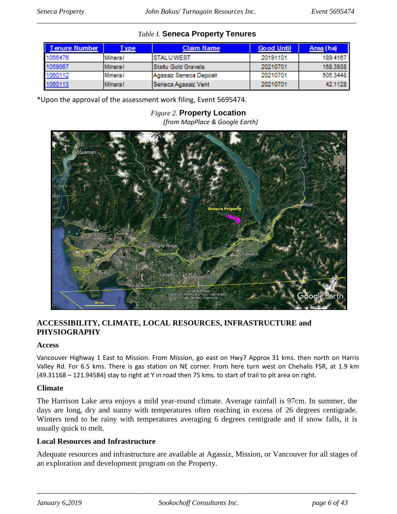
The Property is comprised of four mineral claims covering an area of 905.2681 hectares. Particulars
are as follows:
N
•
200 km
Seneca Property John Bakus/ Turnagain Resources Inc. Event 5695474
__________________________________________________________________________________
__________________________________________________________________________________
January 6,2019 Sookochoff Consultants Inc. page 6 of 43
Table I. Seneca Property Tenures
*Upon the approval of the assessment work filing, Event 5695474.
Figure 2. Property Location (from MapPlace & Google Earth)
ACCESSIBILITY, CLIMATE, LOCAL RESOURCES, INFRASTRUCTURE and
PHYSIOGRAPHY
Access
Vancouver Highway 1 East to Mission. From Mission, go east on Hwy7 Approx 31 kms. then north on Harris Valley Rd. For 6.5 kms. There is gas station on NE corner. From here turn west on Chehalis FSR, at 1.9 km (49.31168 – 121.94584) stay to right at Y in road then 75 kms. to start of trail to pit area on right.
Climate
The Harrison Lake area enjoys a mild year-round climate. Average rainfall is 97cm. In summer, the
days are long, dry and sunny with temperatures often reaching in excess of 26 degrees centigrade.
Winters tend to be rainy with temperatures averaging 6 degrees centigrade and if snow falls, it is
usually quick to melt.
Local Resources and Infrastructure
Adequate resources and infrastructure are available at Agassiz, Mission, or Vancouver for all stages of
an exploration and development program on the Property.
Seneca Property John Bakus/ Turnagain Resources Inc. Event 5695474
__________________________________________________________________________________
__________________________________________________________________________________
January 6,2019 Sookochoff Consultants Inc. page 7 of 43
Accessibility, Climate, Local Resources, Infrastructure and Physiography (cont'd)
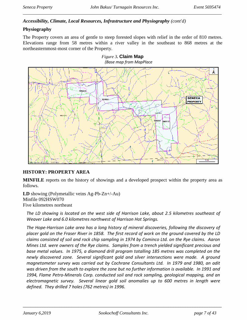
Physiography
The Property covers an area of gentle to steep forested slopes with relief in the order of 810 metres.
Elevations range from 58 metres within a river valley in the southeast to 868 metres at the
northeasternmost-most corner of the Property.
Figure 3. Claim Map (Base map from MapPlace
HISTORY: PROPERTY AREA
MINFILE reports on the history of showings and a developed prospect within the property area as
follows.
LD showing (Polymetallic veins Ag-Pb-Zn+/-Au)
Minfile 092HSW070
Five kilometres northeast
The LD showing is located on the west side of Harrison Lake, about 2.5 kilometres southeast of Weaver Lake and 6.0 kilometres northwest of Harrison Hot Springs.
The Hope-Harrison Lake area has a long history of mineral discoveries, following the discovery of placer gold on the Fraser River in 1858. The first record of work on the ground covered by the LD claims consisted of soil and rock chip sampling in 1974 by Cominco Ltd. on the Rye claims. Aaron Mines Ltd. were owners of the Rye claims. Samples from a trench yielded significant precious and base metal values. In 1975, a diamond drill program totalling 185 metres was completed on the newly discovered zone. Several significant gold and silver intersections were made. A ground magnetometer survey was carried out by Cochrane Consultants Ltd. In 1979 and 1980, an adit was driven from the south to explore the zone but no further information is available. In 1991 and 1994, Flame Petro-Minerals Corp. conducted soil and rock sampling, geological mapping, and an electromagnetic survey. Several linear gold soil anomalies up to 600 metres in length were defined. They drilled 7 holes (762 metres) in 1996.

Seneca Property John Bakus/ Turnagain Resources Inc. Event 5695474
__________________________________________________________________________________
__________________________________________________________________________________
January 6,2019 Sookochoff Consultants Inc. page 8 of 43
History: Property Area (cont'd)
HARRISON GOLD developed prospect (Au-quartz veins)
Minfile 092HSW092
Thirteen kilometres east
In 1972, 643 tonnes of ore was extracted from surface underground workings and a further 37 tonnes was extracted in 1979. The total production recovered from this came to 31 590 grams gold, 10 139 grams silver and 616 kilograms copper. From 1982 to 1984, Abo Oil Corp. conducted mapping, ground geochemical and geophysical (electromagnetic) surveys, underground exploration and 3582 metres of drilling in 34 holes. From 1984 to 1986, Kerr Addison Mines conducted mapping, geochemical surveys and 3196 metres of diamond drilling in 28 holes.
From 1987 to 1988, Kerr drilled more than 1000 metres in 22 holes. From 1987 to 1992, Bema International Resources Ltd. (in agreement with Kerr) conducted geochemical and geophysical (magnetic) surveys, detailed mapping and 9468 metres of diamond drilling in 45 holes. During 1987, a 1053-tonne bulk sample was procured from the Jenner stock underground workings on the 187 level.
In estimating grade and tonnage of the Jenner stock zone, a general assumption was made that the average grade resulting from the underground workings would extend to surface and depth. A grade of 3.2 to 4.1 grams per tonne gold was indicated from underground sampling, with an inferred tonnage of 1.3 million tonnes between surface and 100 metres above sea level and 2.2 million tonnes from surface down to sea level for the ‘Footwall zone’ (Assessment Report 20144).
From 1992 to 1996, Pacific Comox Ltd. drilled 290 metres in two diamond drillholes. Global Gold Inc. purchased the property in 1998 but failed to maintain the option, allowing the claims to lapse in 2000. Late in 2000, Eagle Plains Resources Ltd. acquired the ground within hours after the claims forfeited. In 2001, Eagle Plains had Fugro Airborne Surveys Corp. conduct a 215-kilometre airborne electromagnetic and magnetic geophysical survey.
In 2003, Northern Continental Resources Ltd., under an option agreement with Eagle Plains Resources Ltd., completed a four-hole diamond drilling program totalling 681.3 metres. Drilling further tested the margin of the Hill stock, together with the newly discovered North Hill stock zone. Northern Continental Resources Inc. released resource figures in 2003 for the combined Jenner and Portal zones (Press Release, February 18, 2003). The indicated resource is 1 845 000 tonnes grading 2.79 grams per tonne gold; the inferred resource is 600 000 tonnes grading 2.8 grams per tonne gold.
In 2005, Northern Continental drilled a further 2468 metres in 10 diamond drillholes during a two-phase drilling program focused on expanding the resource in areas of known mineralization and testing new zones of interest. Drilling was completed in the Portal stock, Breccia zone, Hill stock and two previously untested areas. Drilling in the Portal stock encountered occasional auriferous veins deemed unsuitable for bulk underground mining, and a new gold zone was discovered on the northwest contact of the Hill stock.
Northern Continental Resources allowed the option to lapse in 2006, shortly after Eagle Plains Resources Limited transferred control of the property to its newly formed subsidiary, Copper Canyon Resources Limited. In 2007, Egoli Resources Incorporated optioned the property; however, the option was terminated in 2009 due to a failure to meet obligations on the property. Copper Canyon Resources Limited resumed work on the property in 2010.

Seneca Property John Bakus/ Turnagain Resources Inc. Event 5695474
__________________________________________________________________________________
__________________________________________________________________________________
January 6,2019 Sookochoff Consultants Inc. page 9 of 43
History: Property Area (cont'd)
FLEETWOOD prospect (Noranda/Kuroko massive sulphide Cu-Pb-Zn)
Minfile 092HSW165
500 metres east
The Fleetwood and 33 zones are located 3 kilometres northwest of the Seneca deposit (092HSW013) along the east side of the Chehalis River, about 9 kilometres north of Harrison Mill, British Columbia.
HISTORY: PROPERTY
MINFILE reports on the history of a showing, prospects, and a past producer within the Seneca
property as follows.
SENECA past producer (Subaqueous hot spring Ag-Au, G06: Noranda/Kuroko
massive sulphide Cu-Pb-Zn)
Minfile 092HSW013
Within Tenure 1060113
The Seneca deposit is located on the east side of the Chehalis River on the west side of Harrison Lake, about 8 kilometres north of Harrison Mills, British Columbia.
The Seneca occurrence has been explored by mining companies since the 1920s. In the 1970s, Cominco Ltd. delineated a small Kuroko-type, stratiform, volcanogenic massive sulphide deposit. The property is currently owned by 493744 Ontario Ltd. and Metall Mining Corp.
In 1962, about 260 tonnes of ore was shipped from a small open pit that constituted the Lucky Jim (Seneca) prospect and shipped to the Britannia Mine (092GNW003).
The ore graded 1.55 per cent copper, 8.15 per cent zinc, 154.28 grams per tonne silver and 4.11 grams per tonne gold (Assessment Report 23417).
Combined (drill indicated, possible and inferred) reserves at Seneca are 1,506,239 tonnes grading 3.57 per cent zinc, 0.15 per cent lead, 0.63 per cent copper, 0.82 gram per tonne gold and 41.13 grams per tonne silver. This reserve also includes 898,573 tonnes grading 1.09 grams per tonne gold, 55.53 grams per tonne silver, 0.84 per cent copper and 5.17 per cent zinc (undiluted) (Filing Statement 200/85, International Curator Resources Ltd.).
In 1985, a drillhole on the northeast side of the deposit intersected 0.6 metre of massive sulphides which assayed 5.97 grams per tonne gold, 246.85 grams per tonne silver, 10.1 per cent zinc, 0.36 per cent copper and 0.7 per cent lead.
The deposit is considered still to be open in this direction.
In 1994, drillhole S-94-41 was drilled to test the Seneca horizon, 700 metres downdip of previous drillhole S-91-02, which intersected 0.24 per cent copper, 1.58 per cent zinc, 4.34 grams per tonne silver and 0.034 gram per tonne gold over 3 metres and which showed the most noticeable alteration to date. The hole also tested a mercury anomaly outlined and tested by Cominco Ltd. in 1972. The hole collared into dacite feldspar porphyritic flow and is underlain by dacitic feldspar phyric lapilli tuff. The dacitic package is underlain by a thick sequence of andesitic lapilli tuff and massive mafic flow and flow breccias. The hole, however, failed to find any significant mineralization and alteration.

Seneca Property John Bakus/ Turnagain Resources Inc. Event 5695474
__________________________________________________________________________________
__________________________________________________________________________________
January 6,2019 Sookochoff Consultants Inc. page 10 of 43
History: Property (cont'd)
Seneca past producer (cont'd)
The Vent zone (092HSW139) is 2 kilometres to the northwest along strike with the Seneca deposit. The Fleetwood and 33 zones (092HSW165), are about 1.5 kilometres northwest of the Vent zone. For further details on the Seneca deposits, readers are referred to the article by McKinley et al. (Fieldwork 1994).
In 1990, Metall Mining Corp. optioned the property to evaluate the Seneca deposit and the VMS potential for the remainder of the property. In 1991, the Fleetwood zone was discovered. In 1992, the 33 zone was discovered in the same area.
In 1995, International Curator Resources Ltd. conducted two days exploration work on the Dorothy 12 and 13 claims to determine the source of a coincident copper, lead, and zinc anomaly outlined by previous soil sampling. The area of these claims is underlain by a series of volcanic sediments, and rhyolitic to andesitic flows, tuffs and breccias that have been variable sericitized and silicified.
Thirteen rock samples were taken from outcrops. The highest results were from sample JC-6, which yielded 0.07 per cent lead, 0.02 per cent zinc, 2.0 grams per tonne silver and 0.02 gram per tonne gold (Assessment Report 24318).
In 1997, Riverstone Resources Inc. drilled 6 holes (693.4 metres) on the IC claims.
VENT prospect (Noranda/Kuroko massive sulphide Cu-Pb-Zn)
Minfile 092HSW139
Within Tenure 1060112
The Vent prospect is located 1.5 kilometres northwest of the Seneca deposit (092HSW013) along the east side of the Chehalis River, about 9 kilometres north of Harrison Mill, British Columbia.
The Vent zone is 2 kilometres to the northwest along strike from the Kuroko-type Seneca deposit. The Fleetwood and 33 zones (092HSW165), are about 1.5 kilometres northwest of the Vent zone. For further details on the Seneca deposits readers are referred to the article by McKinley et al. (Fieldwork 1994).
STATLU CREEK prospect (Placer)
Minfile 092HSW167
Within Tenure 1059067
In January 2006, Mosquito Consolidated concluded an exploration program that consisted of 7.5 kilometers of line-cutting followed by refraction seismic profiling, prospecting the various claim blocks to define gravel areas, and collecting 20-kilogram site-specific samples of various types of gravel.
Assuming successful results for Stage 1 exploration, a Stage 2 exploration program would initiate a full economic viability study, drilling and sampling to establish a 43-101 compliant resource and/or reserve and commencement of the required environmental studies.
STATLU AGGREGATE showing (Surficial placers; Sand and Gravel)
Minfile 092HSW171
Within Tenure 1059067
The Statlu aggregate property is located immediately west of the Chehalis River and south of Statlu Creek, approximately 16 kilometres northwest of the community of Harrison Hot Springs.

Seneca Property John Bakus/ Turnagain Resources Inc. Event 5695474
__________________________________________________________________________________
__________________________________________________________________________________
January 6,2019 Sookochoff Consultants Inc. page 11 of 43
History: Property (cont'd)
Statlu Aggregate showing (cont'd)
In 2006, a vertical channel sample of the gravel was sampled for its gold content. An 11.34 kilogram sample returned 64 grams of black sand, which had values of 86.83 grams per tonne gold, including 68.44 grams per tonne in the metallic fraction. Based on this analysis, it would take 177.18 tonnes of material to produce one tonne of the black sand concentrate, indicating that the material ran 0.49 grams per tonne gold (Assessment Report 28165).
GEOLOGY: REGIONAL
The Seneca property is situated in the Insular Belt (Wrangellia) of the Canadian Cordillera. This
terrain is one of five main northwest trending tectonic subdivisions and is dominated by Mesozoic
volcanic, igneous and sedimentary rocks.
Figure 4. Regional Geology (Base map from Northcote, 2015)
GEOLOGY: PROPERTY AREA
MINFILE reports on the geology of showings and a developed prospect within the property area as
follows.
LOVE showing(Noranda/Kuroko massive sulphide Cu-Pb-Zn)
Minfile 092HSW069
Five kilometres northeast
The area is underlain by the Weaver Lake Member of the Lower-Middle Jurassic Harrison Lake Formation which consists of a series of basaltic to rhyolitic flows, flow breccias and bedded tuffs. Strong regional faulting has resulted in intense local fracturing and shearing.
Mines and Projects
• ... .\.t ne
• Co.ii"'"' • J l 'tl-a• Mn&r&I M nB
• Prt':ip0Mld CCIII t net
• Prt:>pcaed ... dJS:rl &ti~ .\11111!!1
ct • Siq,-110,ni PIQ•i;:c
Terranes ln1ermantane
Ou11loard Bn~RI._
CffiJ ~ .. [ill] -. 0-.,.:1 @g] coo.~,-lii[l - . ..... ..,, lnsdar ~ CNl1w.:X. --- ill]
'o\'Ml;elle - Oi.aswll .a
m O:mcPita"lle~n.
• .. • • ~·

Seneca Property John Bakus/ Turnagain Resources Inc. Event 5695474
__________________________________________________________________________________
__________________________________________________________________________________
January 6,2019 Sookochoff Consultants Inc. page 12 of 43
Geology: Property Area (cont’d)
Love showing (cont'd)
Structural features appear to have controlled the locus of hydrothermal alteration and associated mineralization. Alteration in the flows consists mainly of epidote with local concentrations of chlorite, zeolite and potassium alteration. Minor drag folding or warping was noted adjacent to the fault/shear zones.
Along the northern boundary of the claim are a series of basaltic to rhyolitic flows, flow breccias and tuffs. A distinctive intermediate flow breccia, composed predominantly of rounded feldspar porphyry fragments, forms a predominant bluff in the northwest part of the claim. Very fine grained lapilli tuffs underlie this breccia. Below the tuffs are massive basaltic to andesitic flows.
Two large zones of alteration and related mineralization were mapped. These zones lie along fault drainages and represent strong fracture zones associated with the faulting. The resultant alteration consists of local silicification, bleaching (clay alteration), quartz veining and the local occurrence of epidote, chlorite and sericite. The degree of alteration is relative to the proximity of, and the intensity of, the fracturing or shearing.
LD showing (Polymetallic veins Ag-Pb-Zn+/-Au)
Minfile 092HSW070
Five kilometres northeast
The area is underlain by the Lower and Middle Jurassic Harrison Lake Formation comprised mainly of andesitic to rhyolitic flows and pyroclastics. Calcite veins are common and a thinly bedded shale unit is often manganese stained and hosts disseminated pyrite. The predominant structure on the property is a fault trending 070 degrees and marked by a strong topographic linear depression. The fault is quite complex with subparallel splays and is offset by north to northwest faults. Some tectonic breccias are associated with these fault structures.
On the Rye 2 claim, medium grey coloured, andesitic pyroclastics are crosscut by numerous veins of quartz and calcite which hosts blebs of disseminated pyrite.
IAM showing (Au-quartz veins)
Minfile 092HSW083
Seven kilometres east
The area is underlain by the Weaver Lake Member of the Lower-Middle Jurassic Harrison Lake Formation which consists of a series of basaltic to rhyolitic flows, flow breccias and bedded tuffs. Strong regional faulting has resulted in intense local fracturing and shearing. Structural features appear to have controlled the locus of hydrothermal alteration and associated mineralization. Alteration in the flows consists mainly of epidote with local concentrations of chlorite, zeolite and potassium alteration. The Sakwi Creek fault cuts through the property.
The northwest part of the claim (old Mary J claims) is underlain by a distinctive intermediate flow, composed predominantly of rounded feldspar porphyry fragments in a matrix of the same composition. This rhyolite agglomerate is underlain by very fine grained lapilli tuffs.
HARRISON GOLD developed prospect (Au-quartz veins)
Minfile 092HSW092
Thirteen kilometres east
The Harrison Lake shear zone is a right-lateral transcurrent fault that splays northward into an imbricate fan of high-angle brittle faults. In part, it passes along and parallel to Harrison Lake.
Seneca Property John Bakus/ Turnagain Resources Inc. Event 5695474
__________________________________________________________________________________
__________________________________________________________________________________
January 6,2019 Sookochoff Consultants Inc. page 13 of 43
Geology: Property Area (cont’d)
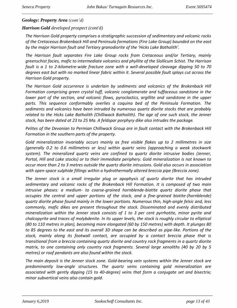
Harrison Gold developed prospect (cont'd)
The Harrison Gold property comprises a stratigraphic succession of sedimentary and volcanic rocks of the Cretaceous Brokenback Hill and Peninsula formations (Fire Lake Group) bounded on the east by the major Harrison fault and Tertiary granodiorite of the ‘Hicks Lake Batholith’.
The Harrison fault separates Fire Lake Group rocks from Cretaceous and/or Tertiary, mainly greenschist facies, mafic to intermediate volcanics and phyllite of the Slollicum Schist. The Harrison fault is a 1 to 2-kilometre-wide fracture zone with a well-developed cleavage dipping 50 to 70 degrees east but with no marked linear fabric within it. Several possible fault splays cut across the Harrison Gold property.
The Harrison Gold occurrence is underlain by sediments and volcanics of the Brokenback Hill Formation comprising green crystal tuff, volcanic conglomerate and tuffaceous sandstone in the lower part of the section, and volcanic flows, pyroclastics, argillite and sandstone in the upper parts. This sequence conformably overlies a coquina bed of the Peninsula Formation. The sediments and volcanics have been intruded by numerous quartz diorite stocks that are probably related to the Hicks Lake Batholith (Chilliwack Batholith). The age of one such stock, the Jenner stock, has been dated at 23 to 25 Ma. A feldspar porphyry dike also intrudes the package.
Pelites of the Devonian to Permian Chilliwack Group are in fault contact with the Brokenback Hill Formation in the southern parts of the property.
Gold mineralization invariably occurs mainly as free visible flakes up to 2 millimetres in size (generally 0.2 to 0.6 millimetres or less) within quartz veins (approaching a weak stockwork system). The mineralized quartz veins are confined to quartz diorite intrusive bodies (Jenner, Portal, Hill and Lake stocks) or to their immediate periphery. Gold mineralization is not known to occur more than 2 to 3 metres outside the quartz diorite intrusions. Gold also occurs in association with open-space sulphide fillings within a hydrothermally altered breccia pipe (Breccia zone).
The Jenner stock is a small irregular plug or apophysis of quartz diorite that has intruded sedimentary and volcanic rocks of the Brokenback Hill Formation. It is composed of two main intrusive phases: a medium- to coarse-grained hornblende-biotite quartz diorite phase that occupies the central and upper portions of the stock, and a fine-grained biotite-(hornblende) quartz diorite phase found mainly in the lower portions. Numerous thin, high-angle felsic and, less commonly, mafic dikes are present throughout the stock. Disseminated and evenly distributed mineralization within the Jenner stock consists of 1 to 3 per cent pyrrhotite, minor pyrite and chalcopyrite and traces of molybdenite. In its upper levels, the stock is roughly circular to elliptical (80 to 110 metres in plan), becoming more elongated (60 by 150 metres) with depth. It plunges 80 to 85 degrees to the east and its overall 3D shape can be described as pipe-like. Portions of the stock, mainly along its footwall contact, are occupied by a contact breccia phase that is transitional from a breccia containing quartz diorite and country rock fragments in a quartz diorite matrix, to one containing only country rock fragments. Several large xenoliths (40 by 20 by 5 metres) or roof pendants are also found within the stock.
The main deposit is the Jenner stock zone. Gold-bearing vein systems within the Jenner stock are predominantly low-angle structures. The quartz veins containing gold mineralization are associated with gently dipping (15 to 40-degree) veins that form a conjugate set and bisectrix; minor subvertical veins also contain gold.

Seneca Property John Bakus/ Turnagain Resources Inc. Event 5695474
__________________________________________________________________________________
__________________________________________________________________________________
January 6,2019 Sookochoff Consultants Inc. page 14 of 43
Geology: Property Area (cont’d)
Harrison Gold developed prospect (cont'd)
In addition to these low-angle veins, the dominant features are large, low-angle, west- and east-dipping compressive reverse faults that cut both country rocks and the stock. These faults have resulted in thrust development, shearing and localized vein offsets. The higher grade portions of the Jenner stock tend to be at its margins.
A northwest-trending, possibly post mineralization fault, the Jenner fault, passes through the stock. Shearing and faulting is commonly associated with an assemblage of pyrite, carbonate and chlorite. Weak to locally strong propylitic alteration of the stock is ubiquitous and consists primarily of chlorite and carbonate.
The veins containing the gold mineralization are composed of a gangue of quartz with minor calcite, chlorite and sericite. The major sulphide mineral is pyrrhotite with minor to trace amounts of pyrite, chalcopyrite, molybdenite, scheelite, arsenopyrite, galena and sphalerite. Bismuth-silver tellurides are present and have been observed as intergrowths with native gold grains. The amount of native gold present in a given vein does not appear to correlate directly with the presence of any sulphide nor with its relative concentration. The highest gold concentrations are found along the mineralized western contact (Footwall zone) of the Jenner stock. Strong sericitic alteration envelopes with widths up to several centimetres are commonly developed around mineralized quartz veins.
The Portal stock is located 300 metres southwest from the Jenner stock. It is separated into two distinct domains: The western portion is a roughly circular body with an average diameter of 140 metres and smooth or regular contacts; the eastern portion is dike-like, narrowing from approximately 100 metres in the west to 40 to 50 metres near the eastern contact, with irregular or bulging contacts. The entire stock is plunging approximately 70 degrees to the east.
Gold-bearing quartz vein attitudes (gold zones) appear to be oriented horizontally to subhorizontally within the Portal stock. Overall, the zones appear to dip 15 to 20 degrees to the west and 5 to 20 degrees to the south. Drilling to date suggests that gold grades within the zones improve toward the intrusive contacts, particularly the northern contact. A drill intersection of a well-mineralized zone averaged 3.17 grams per tonne gold across 30 metres (Assessment Report 19584). The sericite in these veins from the Portal stock adit gives a potassium-argon age of 24.5 Ma +/- 1 Ma (Fieldwork, 1984). Gold mineralization also appears to be associated with the northern contact or footwall of a felsic dike. The dike is a quartz-flooded granite or diorite with intense associated chlorite-sericite-biotite-silica alteration along internal fractures and quartz veins and 2 to 10 per cent disseminated pyrrhotite.
The Lake stock is located 1650 metres south from the Jenner stock and is the largest and best exposed of the gold-bearing diorite stocks. Massive in texture, it varies little in composition from margin to margin except for local variations in the size of amphibole and the amount of biotite. The stock locally contains up to 3 per cent finely disseminated pyrrhotite. Quartz veins are not common and are found predominantly near the margins of the stock. The occasional vein contains visible gold with grades up to 2.24 grams per tonne (Assessment Report 19584).
The Hill stock is located 700 metres south from the Lake stock. Gold-silver mineralization is associated with quartz +/- carbonate-pyrrhotite-pyrite, +/- molybdenite +/- arsenopyrite veins.

Seneca Property John Bakus/ Turnagain Resources Inc. Event 5695474
__________________________________________________________________________________
__________________________________________________________________________________
January 6,2019 Sookochoff Consultants Inc. page 15 of 43
Geology: Property Area (cont’d)
Harrison Gold developed prospect (cont'd)
These veins pass into the sedimentary country rock but the amount of gold and strength of veining generally decreases substantially and finally dies out within a short distance of the host quartz diorite. The mineralized zone containing the veins weakens laterally outward, is relatively flat lying and is controlled by low-angle veining similar to the Jenner-Portal–style mineralization. Gold-silver grades range up to 23 and 57 grams per tonne, respectively, across a 1-metre drill intersection (Assessment Report 20144).
A sulphide-bearing (pyrrhotite-sphalerite-chalcopyrite) breccia pipe (Breccia zone), which is strongly sericitized, chloritized and silicified, is spatially related to the Hill stock. It occurs on the west margin of the Hill stock. The breccia contains fragments of the surrounding country rocks and occasional fragments of quartz diorite. Fragments are mainly 5 to 10 centimetres in diameter with some rotation but no apparent milling or grinding.
FLEETWOOD prospect (Noranda/Kuroko massive sulphide Cu-Pb-Zn)
Minfile 092HSW165
500 metres east
The area of the Seneca deposit and its related occurrences the Vent (092HSW139) and the Fleetwood/33 zones are underlain primarily by volcanic rocks of the Lower to Middle Jurassic Harrison Lake Formation. McKinley et al. (1995) subdivided the stratigraphy into three principal volcanic facies as follows
1) Facies 1 - Lavas (vent-proximal facies) consist of basaltic to rhyolitic composition flows, domes and associated in situ hyaloclastites and autoclastic breccias.
2) Facies 2 - Volcaniclastic rocks (vent-proximal to distal facies) consist of juvenile to reworked coarse volcanic breccia and tuffs to fine-grained siltstone.
3) Facies 3 - Synvolcanic intrusions consist of basaltic to rhyolitic sills and dikes that have intruded lavas and wet volcaniclastic sediments.
A fourth facies consists of an argillite that often contains flattened pumice clasts and is often in close proximity to mineralization. This fourth facies is restricted to the main Seneca deposit, also referred to as the Pit area, and does not correlate across the property.
In general, the strata on the property strike approximately northwest and are essentially flat lying or moderately east dipping. The stratigraphy has undergone very little deformation or metamorphism and retains pristine volcanic textures. Metamorphic grade in the area is zeolite facies.
Three types of mineralized zones are present in the Seneca area:
1) Conformable massive sulphide lenses.
2) Semimassive and disseminated sulphides associated with volcaniclastic rocks.
3) Stockwork and stringer mineralized zones.
Stockwork and stringer sulphides are the dominant style of mineralization in the Fleetwood zone. A drillhole intersected 1.1 metres of massive sphalerite, pyrite and chalcopyrite, immediately above about 30 metres of stockwork sphalerite-pyrite-chalcopyrite- quartz-anhydrite veinlets in altered dacite and fine volcaniclastics similar to the Vent zone.

Seneca Property John Bakus/ Turnagain Resources Inc. Event 5695474
__________________________________________________________________________________
__________________________________________________________________________________
January 6,2019 Sookochoff Consultants Inc. page 16 of 43
Geology: Property Area (cont’d)
Fleetwood prospect prospect (cont'd)
Shorter intersections of similar stockwork mineralization occur in drillholes between the Fleetwood and Vent zones. All the mineralized zones in the Fleetwood area occur at the same stratigraphic level and have similar lithologic associations. The stockwork zones are most commonly hosted by felsic lavas and autobreccias which immediately overlie mafic lavas and reworked mafic-dominated volcaniclastic rocks, and which occur below the fine grained volcaniclastic rocks. These overlying fine volcaniclastics are essentially unmineralized and unaltered except for occasional fine sulphide laminations. The mineralized zones are often associated with narrow fault zones and moderate to strong, fine anhydrite veining.
Generally, most of the rocks at the Seneca occurrences are relatively unaltered, exhibiting pristine preservation of volcanic textures. Macroscopically recognizable alteration is restricted to the Vent and Fleetwood zones where it is characterized by intense silicification and sericitization associated with massive to flow banded and flow brecciated dacite porphyry. The stockwork veining is restricted to the dacites but alteration extends 10 to 20 metres into the surrounding fragmental rocks, obliterating original textures.
Figure 5. Property Geology, Claims, Index & Minfile
(Base Map from MapPlace)
GEOLOGY MAP LEGEND
Lower Jurassic
lJHL
Harrison Lake Formation
andesitic volcanic rocks
Middle Jurassic
MJgd
unnamed granodioritic intrusive
rocks

Seneca Property John Bakus/ Turnagain Resources Inc. Event 5695474
_________________________________________________________________________________
_________________________________________________________________________________
January 6,2019 Sookochoff Consultants Inc. page 17 of 43
GEOLOGY: PROPERTY
As indicated by the geological map published by the BC Government supported MapPlace project, the
Seneca property is underlain by Lower Jurassic andesitic volcanic rocks of the Harrison Formation in
contact with Middle Jurasssic granodioritic intrusive rocks.
MINFILE reports on the geology of a showing, prospects, and a past producer within the Seneca
property as follows.
SENECA past producer (Subaqueous hot spring Ag-Au, G06: Noranda/Kuroko
massive sulphide Cu-Pb-Zn)
Minfile 092HSW013
Within Tenure 1060113
The area of the Seneca deposit and its related occurrences, the Vent (092HSW139) and the Fleetwood/33 zones (092HSW165), are underlain primarily by volcanic rocks of the Lower-Middle Jurassic Harrison Lake Formation. In general, the strata on the property strike approximately northwest and are essentially flat lying or moderately east dipping. The stratigraphy has undergone very little deformation or metamorphism and retains pristine volcanic textures. Metamorphic grade in the area is zeolite facies. McKinley et al. (Fieldwork 1994) have subdivided the property stratigraphy into three principal volcanic facies as follows: 1) Facies 1 - Lavas (vent-proximal facies) consist of basaltic to rhyolitic composition flows, domes and associated in situ hyaloclastites and autoclastic breccias.
2) Facies 2 - Volcaniclastic rocks (vent-proximal to distal facies) consist of juvenile to reworked, coarse volcanic breccia and tuffs to fine-grained siltstone. 3) Facies 3 - Synvolcanic intrusions consist of basaltic to rhyolitic sills and dikes that have intruded lavas and wet volcaniclastic sediments.
A fourth facies consists of an argillite that often contains flattened pumice clasts and is commonly in close proximity to mineralization. This fourth facies is restricted to the main Seneca deposit, also referred to as the Pit area, and does not correlate across the property.
VENT prospect (Noranda/Kuroko massive sulphide Cu-Pb-Zn)
Minfile 092HSW139
Within Tenure 1060112
The area is underlain by Lower to Middle Jurassic Harrison Lake Formation rocks comprised mainly of pyroclastic flows and tuffs of intermediate to felsic composition. The Vent prospect is underlain by bedded quartz-feldspar crystal lapilli tuffs, multilithic tuff breccias and very fine grained ash tuffs. Most of the rock exposures are described as feldspar and quartz feldspar porphyry units.
Alteration in this area is characterized by intense silicification and sericitization associated with massive to flow banded and flow brecciated dacite porphyry. The stockwork veining is restricted to the dacites but alteration extends 10 to 20 metres into surrounding fragmental rocks.
The Vent prospect is located 1.5 kilometres northwest of the Seneca deposit (092HSW013) along the east side of the Chehalis River, about 9 kilometres north of Harrison Mill, British Columbia.
The Vent zone is 2 kilometres to the northwest along strike from the Kuroko-type Seneca deposit. The Fleetwood and 33 zones (092HSW165), are about 1.5 kilometres northwest of the Vent zone. For further details on the Seneca deposits readers are referred to the article by McKinley et al. (Fieldwork 1994).

Seneca Property John Bakus/ Turnagain Resources Inc. Event 5695474
_________________________________________________________________________________
_________________________________________________________________________________
January 6,2019 Sookochoff Consultants Inc. page 18 of 43
Geology: Property (cont’d)
STATLU CREEK prospect (Placer)
Minfile 092HSW167
Within Tenure 1059067
The Statlu Creek gravel property, consisting of 13 claims covering an area of 946.98 hectares, is located 110 kilometres east of Vancouver, B.C., and 13 kilometres from barge access on the Fraser River. The property is underlain by a thick glacial outwash complex possibly having been deposited against occluding glacial ice. The material consists of mixed sand and gravel up to 350 metres in thickness. The gravel and sand are well sorted and washed clean of clay. Capping the sand and gravel outwash sediments are thin top soil overburden or locally organic soil.
STATLU AGGREGATE showing (Surficial placers; Sand and Gravel)
Minfile 092HSW171
Within Tenure 1059067
Regionally, the area is underlain by the Ashlu Creek pluton composed of quartz diorite and the Harrison Lake Formation, composed of intermediate and felsic volcanic rocks and associated volcaniclastic sediments.
The sediments covering the property span the middle Wisconsin (Olympia no glacial interval) to Holocene time. Sediments are divided into six units; Unit 1: gravel;, Unit 2: laminated silt; Unit 3: interstratified sand and gravel; Unit 4: diamicton; Unit 5: laminated silt with minor sand and clay; Unit 6: gravel and diamicton. Complete descriptions of each unit can be found in Assessment Report 28165.
Locally, a large section, approximately 15 metres thick, of sand and gravel belonging to unit 3 is exposed. The gravel beds range from 0.3 to 1.5 metres thick and are generally massive and ungraded, and poorly to moderately sorted. The sand beds vary in grain size and discontinuous silty sand layers are up to 10 centimetres thick. This area is approximately 1200 metres long and 1400 metres wide. This block of sand and gravel has an indicated volume of 100 to 200 million tonnes (Assessment Report 28165).
MINERALIZATION: PROPERTY AREA
MINFILE reports on the mineralization of showings and a developed prospect within the property area
as follows.
LOVE showing(Noranda/Kuroko massive sulphide Cu-Pb-Zn)
Minfile 092HSW069
Five kilometres northeast
Sulphide mineralization is directly related to the alteration and varies from broad pyritization, between 1 to 10 per cent, to vuggy quartz veining with minor disseminations or aggregates of sphalerite, chalcopyrite and pyrite +/- galena. Quartz veining varies from white to grey, massive to vuggy and appears to crosscut the alteration. Minor barite is associated with the quartz. The veining is thin and sporadic although local stockworks were reported.
In 1985, seven rock samples were collected from the highly altered zones which have associated sphalerite, pyrite, barite and quartz in variable amounts. All samples were anomalous in barium and zinc with minor copper, cadmium, manganese and silver. One sample yielded 2.9 grams per tonne silver, 0.44 per cent copper, 1.72 per cent zinc, 0.16 per cent lead and 0.1 per cent barium (Assessment Report 14221).

Seneca Property John Bakus/ Turnagain Resources Inc. Event 5695474
_________________________________________________________________________________
_________________________________________________________________________________
January 6,2019 Sookochoff Consultants Inc. page 19 of 43
Mineralization: Property Area (cont'd)
LD showing (Polymetallic veins Ag-Pb-Zn+/-Au)
Minfile 092HSW070
Five kilometres northeast
Mineralization is associated with an intense pyrite-silica and quartz-calcite vein system which hosts sphalerite, chalcopyrite and pyrite. In 1973, a sulphide-rich sample from a trench on the Rye 2 claim yielded 63.77 grams per tonne gold, 2009.44 grams per tonne silver and 7.23 per cent zinc (Assessment Report 6181). The most significant intersections of diamond drilling in 1975 were: 2.13 metres of 11.79 grams per tonne gold and 44.57 grams per tonne silver between 17.68 and 19.81 metres; 2.13 metres of 6.86 grams per tonne gold and 27.08 grams per tonne silver between 28.35 and 30.48 metres; 5.18 metres of 4.14 grams per tonne gold and 25.03 grams per tonne silver between 0.91 and 6.09 metres; and 1.52 metres of 16.6 grams per tonne gold and 91.88 grams per tonne silver between 14.94 and 16.46 metres (Assessment Report 23845).
IAM showing (Au-quartz veins)
Minfile 092HSW083
Seven kilometres east
Sulphide mineralization occurs in the altered rhyolite agglomerate. Alteration is associated with faulting with resultant alteration consisting of local silicification, clay alteration with minor epidote, chlorite and sericite. Black sphalerite, with minor chalcopyrite and galena, occurs with barite as fragment coatings and as veinlets and stringers in the rhyolite agglomerate.
HARRISON GOLD developed prospect (Au-quartz veins)
Minfile 092HSW092
Thirteen kilometres east
Gold mineralization on the Abo property is identified in nine zones. It occurs within quartz veins commonly associated with pyrrhotite, hosted by quartz dioritic stocks and, to a lesser extent, metasedimentary rocks.
The veins containing the gold mineralization are composed of a gangue of quartz with minor calcite, chlorite and sericite. The major sulphide mineral is pyrrhotite with minor to trace amounts of pyrite, chalcopyrite, molybdenite, scheelite, arsenopyrite, galena and sphalerite. Bismuth-silver tellurides are present and have been observed as intergrowths with native gold grains. The amount of native gold present in a given vein does not appear to correlate directly with the presence of any sulphide nor with its relative concentration. The highest gold concentrations are found along the mineralized western contact (Footwall zone) of the Jenner stock. Strong sericitic alteration envelopes with widths up to several centimetres are commonly developed around mineralized quartz veins.
A sulphide-bearing (pyrrhotite-sphalerite-chalcopyrite) breccia pipe (Breccia zone), which is strongly sericitized, chloritized and silicified, is spatially related to the Hill stock. It occurs on the west margin of the Hill stock. The breccia contains fragments of the surrounding country rocks and occasional fragments of quartz diorite. Fragments are mainly 5 to 10 centimetres in diameter with some rotation but no apparent milling or grinding. Sulphide mineralization occurs as open-space fillings. The zone has surface dimensions of 325 by 100 metres.

Seneca Property John Bakus/ Turnagain Resources Inc. Event 5695474
_________________________________________________________________________________
_________________________________________________________________________________
January 6,2019 Sookochoff Consultants Inc. page 20 of 43
Mineralization: Property Area (cont'd)
Harrison Gold developed prospect (cont'd)
A zone of 29 metres averaging 1.56 grams per tonne gold, 4.4 grams per tonne silver, 0.56 per cent zinc and 0.04 per cent copper, including 7 metres averaging 3.56 grams per tonne gold, 9.3 grams per tonne silver, 1.2 per cent zinc and 0.049 per cent copper, occurs at the margins of the breccia pipe (Assessment Report 20144). Recent drilling has indicated that the strength of hydrothermal alteration and the grade of gold-silver-zinc mineralization has weakened downdip and laterally outward from the aforementioned 29-metre zone of mineralization.
Gold mineralization invariably occurs mainly as free visible flakes up to 2 millimetres in size (generally 0.2 to 0.6 millimetres or less) within quartz veins (approaching a weak stockwork system). The mineralized quartz veins are confined to quartz diorite intrusive bodies (Jenner, Portal, Hill and Lake stocks) or to their immediate periphery. Gold mineralization is not known to occur more than 2 to 3 metres outside the quartz diorite intrusions. Gold also occurs in association with open-space sulphide fillings within a hydrothermally altered breccia pipe (Breccia zone).
FLEETWOOD prospect (Noranda/Kuroko massive sulphide Cu-Pb-Zn)
Minfile 092HSW165
500 metres east
Conformable, stratabound lenses of semimassive sphalerite, pyrite and chalcopyrite with lesser galena are exhibited chiefly in the main Seneca deposit or Pit area, but also to a lesser degree in the 33 zone of the Fleetwood area. The sulphides are hosted by fragmental rocks and occur as discontinuous pods. In the 33 zone, a 2 metre intersection of massive sulphides is underlain by a quartz-carbonate-chlorite zone and a dacite porphyry intrusion, and is sharply overlain by a cherty sulphide layer and a zone of strongly chloritized fragmental material. Blades of barite are intergrown with the sulphides. A drillhole intercept of 2 metres of massive sulphide at 170 metres depth analysed 2.2 per cent copper, 28 per cent zinc and 4 grams per tonne gold (Assessment Report 22915, page 7).
MINERALIZATION: PROPERTY
MINFILE reports on the mineralization of a showing, prospects, and a past producer within the Seneca
property as follows.
SENECA past producer (Subaqueous hot spring Ag-Au, G06: Noranda/Kuroko
massive sulphide Cu-Pb-Zn)
Minfile 092HSW013
Within Tenure 1060113
Three types of mineralized zones are present in the Seneca area:
1) Conformable massive sulphide lenses.
2) Semimassive and disseminated sulphides associated with volcaniclastic rocks.
3) Stockwork and stringer mineralized zones.
Conformable, stratabound lenses of semimassive sphalerite, pyrite and chalcopyrite with lesser galena are exposed in the Pit area. The sulphides are hosted by fragmental rocks and occur as discontinuous pods that do not correlate between adjacent drillholes.

Seneca Property John Bakus/ Turnagain Resources Inc. Event 5695474
_________________________________________________________________________________
_________________________________________________________________________________
January 6,2019 Sookochoff Consultants Inc. page 21 of 43
Mineralization: Property (cont'd)
Seneca past producer (cont'd)
Unlike the 33 zone, the massive to disseminated sulphides are hosted in the volcaniclastic 'ore zone conglomerate', tending to be restricted to the upper part of the unit. The 'ore zone conglomerate', part of Facies 2 and found only in the Pit area, varies from 1 to 15 metres in thickness. The unit consists of moderately silicified, mostly subrounded dacite lava clasts ranging from sand size up to 3 centimetres in diameter in a sandy or silty matrix. The unit can be matrix or clast supported, and also contains clasts and matrix that have been replaced and/or infilled by sulphides. A dacite lava clast breccia occurs stratigraphically below the 'ore zone conglomerate'. One of the better drillhole intersections (drillhole 85-03) cut 0.5 metre of massive pyrite, sphalerite and barite with lesser chalcopyrite, underlain by 3.5 metres of mostly semimassive pyrite. More commonly, the mineralization hosted by the 'ore zone conglomerate' consists of clasts that are partially replaced, or matrix that is partly infilled by pyrite and occasionally sphalerite. Some of the clasts are rimmed with later pyrite. Tetrahedrite has been microscopically recognized.
Faulting is evident in several directions and may have exerted some control on the mineralization.
Generally, most of the rocks at the Seneca occurrences are relatively unaltered, exhibiting pristine preservation of volcanic textures. Macroscopically recognizable alteration is restricted to the Vent and Fleetwood zones where it is characterized by intense silicification and sericitization associated with massive to flow banded and flow brecciated dacite porphyry. The volcanics are pyritized to varying degrees over much of the area.
VENT prospect (Noranda/Kuroko massive sulphide Cu-Pb-Zn)
Minfile 092HSW139
Within Tenure 1060112
Stockwork and stringer sulphides are the dominant style of mineralization in the Vent zone. The stockwork consists of veinlets up to 1 centimetre wide of sphalerite, pyrite and quartz +/- chalcopyrite in strongly altered dacitic flows, breccias, intrusions and mixed lava clast breccia. Also reported but not common, is barite and galena.
Two copper-zinc showings were initially reported, both appearing to be fault bound. The lower showing is bound by quartz feldspar porphyry and the upper showing exposes both feldspar (hornblende) porphyry and quartz feldspar porphyry on its flanks. Fault zones are characteristically less than 0.3 metre in width and carry pyritic, clay gouge. The faults trend north and northwest and appear to be high-angle faults by fracturing and subsequent hydrothermal alteration, including silicification and pyritization.
STATLU CREEK prospect (Placer)
Minfile 092HSW167
Within Tenure 1059067
In addition to the high-quality sand and gravel products, there is evidence that placer gold may be able to be recovered from the fine sand associated with the gravel. Based on sample analysis, it would take 177.18 metric tones of material to produce one tonne of the black sand concentrate. Indicating the material ran 0.49 gram of gold per tonne. Given the potential size of the deposit, this could represent a significant amount of gold. Mosquito plans to investigate this further with additional sampling throughout the property.

Seneca Property John Bakus/ Turnagain Resources Inc. Event 5695474
_________________________________________________________________________________
_________________________________________________________________________________
January 6,2019 Sookochoff Consultants Inc. page 22 of 43
Mineralization: Property (cont’d)
STATLU AGGREGATE showing (Surficial placers; Sand and Gravel)
Minfile 092HSW171
Within Tenure 1059067
In 2006, a vertical channel sample of the gravel was sampled for its gold content. An 11.34 kilogram sample returned 64 grams of black sand, which had values of 86.83 grams per tonne gold, including 68.44 grams per tonne in the metallic fraction. Based on this analysis, it would take 177.18 tonnes of material to produce one tonne of the black sand concentrate, indicating that the material ran 0.49 grams per tonne gold (Assessment Report 28165).
2018 EXPLORATION PROGRAM
Soil and Rock Sampling
Purpose
The purpose of the program was to locate any locations of a geological prospect that may have the
potential to be developed to an economic resource.
Any indication of mineralozation may indicate a potentially subsurface volcanogenic deposit.
Prospecting
Prospecting of area. Orange flagging and marking of sample sites. Multiple photos taken of samples,
and areas. GPS coordinates were taken, and all samples recorded and mapped. Prospecting notes,
operating with equipment (Trucks, GPS, Tools and sampling.)
Field notes on the samples are shown in Appendix I
Sampling Method
Jackson, McKinney and Bradshaw: Field (44) Float, In situ and heavy mineral samples were collected.
Samples were taken from various locations throughout the property area. Bag size samples were taken
between 1 pound and 10 pounds ( rock samples in-situ and float)
Points of interest (access) were also noted. Stewart Jackson PHD PGEO performed early research with
project synopsis and sample lithologies. Laurence Sookochoff BSc PEng. performed the historic
research data compilation, mapping and technical report preparation. Three samples were assayed.
Results
A Property Review report on the Seneca mineral showing by Stewart Jackson PhD PGeo is shown in
Appendix III.

Seneca Property John Bakus/ Turnagain Resources Inc. Event 5695474
_________________________________________________________________________________
_________________________________________________________________________________
January 6,2019 Sookochoff Consultants Inc. page 23 of 43
Figure 7. Sample locations index map (for Figures 8, 9, & 10) (Base map from MapPlace)
Figure 8. Northern sample locations* (Base map from MapPlace)
*see Figure 7 for location on Seneca property
Figure 9. Central sample locations*

Seneca Property John Bakus/ Turnagain Resources Inc. Event 5695474
_________________________________________________________________________________
_________________________________________________________________________________
January 6,2019 Sookochoff Consultants Inc. page 24 of 43
(Base map from MapPlace)
*see Figure 7 for location on Seneca property
Figure 10. Southern sample locations* (Base map from MapPlace)
*see Figure 7 for location on Seneca property

Seneca Property John Bakus/ Turnagain Resources Inc. Event 5695474
_________________________________________________________________________________
_________________________________________________________________________________
January 6,2019 Sookochoff Consultants Inc. page 25 of 43
STRUCTURAL ANALYSIS
a) Purpose
The purpose of the structural analysis was to delineate any area of relative major fault intersections that
could be the centre of maximum brecciation and be depth intensive to provide the most favourable
feeder zone to any residual fluids from a potentially mineral laden reservoir source.
b) Method
A DEM image hillshade map downloaded from MapPlace was utilized as the base map for the structural
analyses of Tenures 1060112 & 1060013. A total of 81 structurally indicated lineaments were marked,
compiled into a 10 degree class interval, and plotted as a rose diagram as indicated on Figure.12.
The centre of the work area is at 5,464,827N, 574,767E (10NAD 83).
c) Results
Three cross-structural locations, A,B, & C were delineated from indicated major northwesterly and
northeasterly trending structures.
Figure 11. Lineaments as Indicated Structures
(Base Map from MapPlace)
pect<?e areas 10
::;.ore fo, surflcial geological lndic-ators of a potential economic sub-surf Ke mineral resource
SOO metres

Seneca Property John Bakus/ Turnagain Resources Inc. Event 5695474
_________________________________________________________________________________
_________________________________________________________________________________
January 6,2019 Sookochoff Consultants Inc. page 26 of 43
Structural Analysis (cont’d)
Figure 12. Rose Diagram from indicated lineaments
STATISTICS
Axial (non-polar) data
No. of Data = 81
Sector angle = 10°
Scale: tick interval = 3% [2.4 data]
Maximum = 14.8% [12 data]
Mean Resultant dir'n = 150-330
[Approx. 95% Confidence interval = ±32.2°]
(valid only for unimodal data)
_________________________
Mean Resultant dir'n = 150.0 - 330.0
Circ.Median = 157.0 - 337.0
Circ.Mean Dev.about median = 36.4°
Circ. Variance = 0.30
Circular Std.Dev. = 48.56°
Circ. Dispersion = 5.99
Circ.Std Error = 0.2719
Circ.Skewness = -1.59
Circ.Kurtosis = -4.66
kappa = 0.49
(von Mises concentration param. estimate)
Resultant length = 19.26
Mean Resultant length = 0.2378
'Mean' Moments: Cbar = 0.1189; Sbar = -
0.2059
'Full' trig. sums: SumCos = 9.6278; Sbar = -
16.6809
Mean resultant of doubled angles = 0.3231
Mean direction of doubled angles = 057
(Usage references: Mardia & Jupp,
'Directional Statistics', 1999, Wiley;
Fisher, 'Statistical Analysis of Circular Data',
1993, Cambridge University Press)
Note: The 95% confidence calculation uses
Fisher's (1993) 'large-sample method'
N
E
S"w

Seneca Property John Bakus/ Turnagain Resources Inc. Event 5695474
_________________________________________________________________________________
_________________________________________________________________________________
January 6,2019 Sookochoff Consultants Inc. page 27 of 43
INTERPRETATION & CONCLUSIONS
The 2018 preliminary exploration program of prospecting and sampling on the Seneca Property was
successful in that it resulted in the location of a mineralized floatrock sample that may indicate a
potential volcanogenic mineral zone. With the sample, which returned an assay of greater than 1.0%
zinc, taken from an area located between two known and explored volcanogenic mineral zones within
two kilometres apart in a northwesterly trend, and the sample located along this trend, it may indicate
a structural control facilitated the development of mineralization.
The results of the structural analysis indicated dominant northwesterly trending structures which,
"The most important appear to be north-west trending, probable extensional faults which are postulated to have displaced (south-west blocks down) sections in a possible graben style ..." (Pegg, 1986).
This master faults of the graben may be indicated by structures as shown on Figure 11, where in the
north bounded by the structure "AB" and in the south by the northwesterly structure that delineates
cross-structure "C". This indicated graben may incoporate the structures that vented or was the
discharge zone for the volcanogenic and associated mineralization.
The graben may also be indicated by,
"Faulting is evident in several directions and may have exerted some control on the mineralization." (Minfile)
and Pegg (1986) refers to the Seneca-Trough in,
"A further look at the Seneca-Trough area core should be undertaken in order to select
unsampled silicified sections that may contain gold values".
Due to the nature of the deposition of the VMS mineralization, although structures may not be the
controlling factors to the volcanogenic mineralization, the mineralization is "controlled" or within the
cofines of the graben. Pegg (1986) provides an example of this in that, "
"Previous geological and geochemical studies of the Seneca mineralization and footwall had
suggested that the ore was transported and the direction to the vent or discharge point was
north westerly."
Perhaps the Vent mineral zone, was appropriately named; with it possibly being the vent or the
mineral discharge zone with the deposition of the mineralization to the southeast towards the Seneca
mineral zone (Figure 13). Even though the considerable exploration in the Vent area, where
stockwork and stringer sulfides are the only dominant style of mineralization, returned significant
drill core assays including:
9.6 metres of 0.82 gram per tonne gold, 35.91 grams per tonne silver, 4.09 % zinc, 1.45 %
lead, and 0.26% copper in drillhole 85-12
and
an average of 1.69 per cent zinc over 33.53 metres in drillhole85-9
(Assessment Report 14668).
apparently, the mineralization was not sufficiently correlative to develop any mineral reserves.

Seneca Property John Bakus/ Turnagain Resources Inc. Event 5695474
_________________________________________________________________________________
_________________________________________________________________________________
January 6,2019 Sookochoff Consultants Inc. page 28 of 43
Interpretation & Conclusions (cont'd)
Figure 13. Possible location of the Seneca Mineral areas on a base map showing an example of
controls on a Zn-rich Volcanogenic Massive Sulfide (VMS) Deposit (Note the stockwork ore above the vent and deceasing deposition
of minerals from the downstream current direction)
(Base Map from Piercy)
However, in the Seneca area where the vented material accumulated, possibly due to the depression
of the Seneca-Trough,three types of mineralization provide sufficient correlation to establish a
significant tonnage reserve of:
"Drill indicated, possible and inferred reserves at undiluted grades. Also includes 898,573 tonnes
grading 1.09 grams per tonne gold, 55.53 grams per tonne silver, 0.84 per cent copper and 5.17 per
cent zinc (undiluted')
(Filing Statement 200/85, International Curator Resources Ltd.).
In addition, several significant gold intersections were reported including a drill core assay of one
metre of 6.39 grams per tonne gold in the 1986 drill hole SN05-57.
In the rock sample S-28 area 700 metres northwest of the Seneca (Figure 10), a potential Seneca type
volcanogenic mineral zone is indicated by the rock description and the assay result. The float rock
sample, which assayed 5,133 ppm copper, 1755 ppm lead, and greater than 1.0 % zinc, was described
by Stewart Jackson, PhD, PGeo as, "High grade, massive sulphides, same as Seneca pit".
Should the deposition of sulfides be in accordance to the volcanogenic model of Figure 13, the entire
zone of two kilometras from the Seneca to the Vent is prospective for the discovery of a potential
volcanogenic resource.
sea level
continental crust
FP'om Goodfcz ll ow and Pcztcz,. (1996) and Goodfcz llow czt a l. (2003)
current direction
metal-laden fluids generated in high-temperature reaction zone

Seneca Property John Bakus/ Turnagain Resources Inc. Event 5695474
_________________________________________________________________________________
_________________________________________________________________________________
January 6,2019 Sookochoff Consultants Inc. page 29 of 43
RECOMMENDATIONS
The initial exploration should focus on the S-28 area where Seneca type mineralization was found.
The area should be prospected and soil sampled to determine the elemental signature of a Seneca
massive sulphide zone. The highly anomalous elements of the Seneca mineralization, as shown by the
S-25 pit are primarily copper, lead, zinc, gold, and barium with anomalous values of silver,
arsenic,thallium, and mercury.
However, prior to the exploration of the S-28 area, the Seneca pit should be studied with a focus on
geology and mineralization and especially structure and trace elements. The information would be
valuable in determining the exploratory focus in other areas of the Seneca property.
Soil samples should be taken at every 20 metres from the Seneca to the Vent area (2,000 metres) to
determine any trend to mineralization; as there should be a varying elemental precipitation on which
to determine the initial bulk and the tailing off of the volcanogenic zone. If in fact the Vent area could
be established as the vent for the mineralizing hydrothermal fluids in the porphyry style stockwork
and stringer sulphide mineralization, then the Figure 13 volcanogenic model may be applicable in
future exploration.
Upon the examination of the initial exploration results, which should be evaluated with the historical
results, a specific target area should be determined for exploration,
Respectfully submitted
Sookochoff Consultants Inc.
Laurence Sookochoff, PEng
Seneca Property John Bakus/ Turnagain Resources Inc. Event 5695474
_________________________________________________________________________________
_________________________________________________________________________________
January 6,2019 Sookochoff Consultants Inc. page 30 of 43
SELECTED REFERENCES
Baird,J.G. - Report on an Induced Polarization Survey for Zenith Mining Corporation Limited.
January 20, 1971. AR 2833.
Chapman, J. - Data Compilation Report on the Seneca Property for Riverstone Resources Inc.
September 1999. AR 26011.
Cox, D.P., and Singer, D.A., 1986, Mineral deposit models: U.S. Geological Survey Bulletin 1693,
379 p.
Franklin, J.M. - Volcanogenic Massive Sulpfide Deposits. Prepared for Thunder Bay Short Course
https://flash.lakeheadu.ca/~pnhollin/CIMdownloads/VMS_Franklin.pdf
Franklin, J.M., 1993, Volcanic-associated massive sulphide deposits, in Kirkham, R.V., Sinclair,
W.D., Thorpe, R.I., and Duke, J.M., eds., Mineral deposit modeling, Geological Association of
Canada Special Paper 40, p. 315- 34.
Garratt, G.L. - 1983 D.iamond Drilling Report on the Dorothy 1 Claim for Curator Resources Ltd.
December, 1983. AR 12322.
Journal of the Geological Society
httpjgs.lyellcollection.orgcontent1746954tab-figures-data
Lydon, J.W., 1984, Volcanogenic massive sulphide deposits, Part 1--A descriptive model:
Geoscience Canada, v. 11, p. 195-202.
_________1988, Volcanogenic massive sulphide deposits, Part 2--Genetic models: Geoscience
Canada, v. 15, p. 43- 65.
McKinely, S. - Assessment Report on Diamond Drilling and Geochemical Report on the Seneca
Property for Carat Exploration Inc. August 31, 2006. AR 28511.
MtOnline - MINFILE downloads.
092HSW069 – LOVE
092HSW070 –LD
092HSW083 – IAM
092HSW092 – HARRISON GOLD
092HNW165 – FLEETWOOD
Geology: Property
092HSW013 - SENECA
092HSW112 – VENT
092HSW167 – STATU CREEK
092HNW171 – STATU AGGREGATE
Northcote, B.- Exploration and Mining in British Columbia, BC Geological Survey IC 2015-2
Pegg, R. - Physical, Geological, Geochemical, Geophysical and Diamond Drilling Report on the Seneca
Property for Selco Division-BP Resources Canada Limited. November, 1986. AR15459A.
Pegg, R. - Physical, Geological, Geochemical, Geophysical and Diamond Drilling Report on the Seneca
Property for Selco Division-BP Resources Canada Limited. November, 1986. AR15734A.
Piercey, S.J. - Zn-rich Volcanogenic Massive Sulfide (VMS) Deposits. Department of Earth Sciences
Memorial University of Newfoundland St. John's, NL, Canada A1B 3X5,.
https://www.esd.mun.ca/~spiercey/Piercey_Research_Site/Zn-
rich_VMS_deposits_files/Piercey_Roundup_Talk_Zn_rich_VMS_01_23_2018.pdf
Ray, G.E., et al - Harrison Lake Project (92W5, 12; 92G/9, 16), B.C. Ministry of Energy, Mines and
Petroleum Resources, Geological Fieldwork and Current Research, 1985, Paper 1985-1.

Seneca Property John Bakus/ Turnagain Resources Inc. Event 5695474
_________________________________________________________________________________
_________________________________________________________________________________
January 6,2019 Sookochoff Consultants Inc. page 31 of 43
Selected References (cont'd)
Singer, D.A, 1986a, Descriptive model of Cyprus massive sulfide, in Cox, D.P., and Singer, D.A.,
eds., Mineral deposit models: U.S. Geological Survey Bulletin 1693, p. 131.
_________1986b, Descriptive model of Kuroko massive sulfide, in Cox, D.P., and Singer, D.A., eds.,
Mineral deposit models: U.S. Geological Survey Bulletin 1693, p. 189-190.
https://pubs.usgs.gov/bul/b1693/
https://pubs.usgs.gov/bul/b1693/html/bullfrms.htm
Taylor, D. et al - Volcanic Associated Massive Sulfide Deposits. Summary of Relevant Geologic,
Geoenvironmental, and Geophysical Information.
https://pubs.usgs.gov/of/1995/ofr-95-0831/CHAP16.pdf
Sheehan, PA. Cherry, ME. - Ore Deposit Models Volume II. Geoscience Canada. Reprint Series
6.Sutherland Brown, A., 1976, ed., Porphyry deposits of the Canadian Cordillera: The Canadian
Institute of Mining and Metallurgy, Special Volume 15, the Charles S. Ney Volume, 510 p., 2 pl.,
scale 1:250,000,000
Sinclair, W.D. 2007, Porphyry Deposits, in Goodfellow, W.D., ed., Mineral deposits of Canada.—A
synthesis of major deposit-types, district metallogeny, the evolution of geological provinces, and
exploration methods: Geological Association of Canada, Mineral Deposits Division, Special
Publication no. 5, p. 223–243.
Websites
http://www.empr.gov.bc.ca/Mining/Geoscience/MineralDepositProfiles/ListbyDepositGroup/Page
s/IVeinBrecciaStockwork.aspx#i01
https://www.google.com.ph/search?q=volcanogenic+massive+sulfide&tbm=isch&tbs=rimg:Car
14TEcstMrIjinsMuvwDDI2Zn1ILL293bLxMi9o_1u0PdlyDRmtbqYM1eP_1UwTStGkVBogHnqpD
MfoMuxYf9kpNeCoSCaewy6_1AMMjZEcIcJqRX0QQmKhIJmfUgsvb3dssRgQ-
MWOM6ME8qEgnEyL2j-
7Q92RHFFB5F74O35CoSCXINGa1upgzVEbmwvr4yTxVdKhIJ4_19TBNK0aRURlgh291cwW0Q
qEgkGiAeeqkMx-hG-T2-
ur98ERSoSCQy7Fh_12Sk14EUxmRbXG0kfm&tbo=u&sa=X&ved=2ahUKEwjm_tmn6azdAhVGe
7wKHUMoBcwQ9C96BAgBEBs&biw=1600&bih=794&dpr=1#imgrc=07tf2NRL2WWATM:
httpjgs.lyellcollection.orgcontent1746954tab-figures-data

Seneca Property John Bakus/ Turnagain Resources Inc. Event 5695474
_________________________________________________________________________________
_________________________________________________________________________________
January 6,2019 Sookochoff Consultants Inc. page 32 of 43
STATEMENT OF COSTS
Field work was performed on the Seneca Property between April 14-29, 2018 to the value as follows:
Structural Analysis
L. Sookochoff 3 days @ $ 1,000.00 $ 3,000.00
Labour
Stewart Jackson Field April 21-22, 2018
3 days @ $750.00/day --------------------------- $ 2,250.00
Research and synopsis April 20-24, 2018
Bill McKinney April 21-24, 2018
4 days @ $350.00/day -------------------------- 1,400.00
Lance Bradshaw April 21-24, 2018
4 days @ $250.00/day -------------------------- 1,000.00 4,650.00
Travel/Transportation
Vancouver to Property return
4 days @ 1,100 km @ $0.65/km -------------------- 715.00
Exploration Equipment
GPS, clinometer, electronics radios, etc ----------- $ 40.00
Bear spray, axes, mallets, pry bars, etc ------------ 40.00
Spot locator's safety equipment and supplies ----- 40.00
Chainsaw ----------------------------------------------- 40.00 160.00
Food/Lodging
10 man days @ $ 125.00 ------------------ 1,250.00
Report
Laurence Sookochoff, PEng ------------------------- 3,000.00
$ 12,775.00
=======

Seneca Property John Bakus/ Turnagain Resources Inc. Event 5695474
_________________________________________________________________________________
_________________________________________________________________________________
January 6,2019 Sookochoff Consultants Inc. page 33 of 43
CERTIFICATE
I, Laurence Sookochoff, of the City of Vancouver, in the Province of British Columbia, do hereby
certify:
That I am a Consulting Geologist and principal of Sookochoff Consultants Inc. with an address at 120
125A-1030 Denman Street, Vancouver, BC V6G 2M6.
I, Laurence Sookochoff, further certify that:
1) I am a graduate of the University of British Columbia (1966) and hold a B.Sc. degree in Geology.
2) I have been practicing my profession for the past fifty-two years.
3) I am registered and in good standing with the Engineers and Geoscientists British Columbia.
4) The information for this report is based on information as itemized in the Selected Reference
section of this report and from exploration work the author has performed in the Harrison Lake area.
5) I have no interest in the Seneca Property as described herein.
Laurence Sookochoff, P. Eng.

Seneca Property John Bakus/ Turnagain Resources Inc. Event 5695474
_________________________________________________________________________________
_________________________________________________________________________________
January 6,2019 Sookochoff Consultants Inc. page 34 of 43
FIELD CREW QUALIFICATIONS
Field: Stewart Jackson, PhD PGeo.
Field: Bill McKinney: Prospector/equipment operator, logger, 10 years prospecting experience.
Field: Lance Bradshaw: 4 years prospecting experience

Seneca Property John Bakus/ Turnagain Resources Inc. Event 5695474
_________________________________________________________________________________
_________________________________________________________________________________
January 6,2019 Sookochoff Consultants Inc. page 35 of 43
Appendix I
Sample Locations and Descriptions
(UTM 10 NAD83)
Seneca Property John Bakus/ Turnagain Resources Inc. Event 5695474
_________________________________________________________________________________
_________________________________________________________________________________
January 6,2019 Sookochoff Consultants Inc. page 36 of 43
2018
Seneca
Lat Lon X 10U Y 10U Sample TYP Notes
49.338513 -122.000675 572596 5465568 S-01 HM 10 LB HM Soil/Gravel
49.337764 -122.001474 572535 5465484 S-02 HM 10 LB HM Soil/Gravel
49.337277 -122.005463 572510 5465426 S-03 HM 10 LB HM Soil/Gravel
49.342854 -122.014932 571554 5466037 S-04 HM 10 LB HM Soil/Gravel
49.334207 -121.994816 573028 5465095 S-05 HM 10 LB HM Soil/Gravel
49.32998 -121.987731 573549 5464632 S-06 HM 10 LB HM Soil/Gravel Kilometer 11 from 4 way stop
49.309796 -121.937208 577251 5462438 SE-08 IS Outcrop, Ryo-Dacite
49.309797 -121.937576 577224 5462438 SE-09 IS Outcrop, Ryo-Dacite
49.30974 -121.937089 577260 5462432 SE-10 IS Outcrop, Ryo-Dacite
49.309736 -121.937099 577259 5462431 SE-11 IS Outcrop, Ryo-Dacite, Minor Sulphides
49.310147 -121.93944 577088 5762475 SE-12 IS Banded Chert
49.310107 -121.939462 577087 5462470 SE-13 FB Black Chert, Argilite
49.309035 -121.94066 577001 5462350 SE-14 IS Tracite , with chert pebbles
49.309038 -121.940715 576997 5462350 SE-15 IS Bedded Chert in Tactite flow
49.308778 -121.941017 576976 5462321 SE-16 HM Coarse dirty sand
49.30933 -121.940702 576998 5462383 SE-17 FB Volcanic conglomerate
49.312578 -121.946701 576557 5462738 SE-17B HM Gravel from 1 m deep test hole, 40% pebbles
49.313095 -121.948287 576441 5462794 SE-18 HM Gravel from open pit, 2m deep, same as above
49.318688 -121.951071 576230 5463413 SE-19 HM 10 LB HM Soil/Gravel
49.318709 -121.951168 576222 5463415 SE-20 FB Carbonated altered rock
49.317992 -121.948594 576411 5463338 SE-21 HM 10 LB HM Soil/Gravel
49.317256 -121.945273 576653 5463259 SE-22 FB Mineralization, from Seneca pit
49.317195 -121.945055 576669 5463253 SE-23 IS Seneca pit, Massive sulphide mineralization
49.317195 -121.945055 576669 5463253 SE-24 IS Seneca pit, Massive sulphide mineralization
49.317195 -121.945055 576669 5463253 SE-25 IS Seneca pit, Massive sulphide mineralization
49.317195 -121.945055 576669 5463253 SE-26 IS Seneca pit, Massive sulphide mineralization
49.319697 -121.952918 576325 5463790 SE-27 HM 10 LB HM Soil/Gravel
49.321855 -121.949669 576326 5463766 SE-28 FB High grade, massive sulphides, same as Seneca pit
49.322181 -121.950228 576285 5463802 SE-29 FB Rhyolite
49.322094 -121.950331 576278 5463792 SE-30 FB Rhyodasite
49.322436 -121.950054 576298 5463830 SE-31 FB Sheared light green iolite
49.322523 -121.950187 576288 5463840 SE-32 FB Sheared light green iolite
49.323112 -121.950824 576241 5463904 SE-33 FB Sheared light green iolite
49.322661 -121.949471 576340 5463856 SE-34 FB Taken from Dacite porphyry
49.322661 -121.949471 576340 5463856 SE-35 FB Altered fragmented Dacite

Seneca Property John Bakus/ Turnagain Resources Inc. Event 5695474
_________________________________________________________________________________
_________________________________________________________________________________
January 6,2019 Sookochoff Consultants Inc. page 37 of 43
2018
Seneca
Lat Lon X 10U Y 10U Sample TYP Notes
49.322661 -121.949471 576340 5463856 SE-36 FB Altered fragmented Dacite
49.322661 -121.949471 576340 5463856 SE-37 FB Altered fragmented Dacite
49.325143 -121.95668 575812 5464124 SE-38 FB Dacite porphyry
49.325168 -121.956785 575804 5464127 SE-39 IS Altered fragmented Dacite
49.325445 -121.956766 575805 5464158 SE-40 IS Altered fragmented Dacite
49.326856 -121.95673 575806 5464115 SE-41 FB Chalky rhyolite
49.325255 -121.956729 575808 5464137 SE-42 IS Altered fragmented Dacite
49.316578 -121.949567 576342 5463179 SE-43 FB Light green iolite
49.316604 -121.949582 576341 5463182 SE-44 FB Carbonated altered basite
HM = Heavy Metal
IS = In Situ
FB = Float Boulder

Seneca Property John Bakus/ Turnagain Resources Inc. Event 5695474
_________________________________________________________________________________
_________________________________________________________________________________
January 6,2019 Sookochoff Consultants Inc. page 38 of 43
Appendix II
Photos from the Seneca Property

Seneca Property John Bakus/ Turnagain Resources Inc. Event 5695474
_________________________________________________________________________________
_________________________________________________________________________________
January 6,2019 Sookochoff Consultants Inc. page 39 of 43
SE-08 to SE-11 Seneca 1st outcrop
SE-14 Tracite , with chert pebbles
Seneca Property John Bakus/ Turnagain Resources Inc. Event 5695474
_________________________________________________________________________________
_________________________________________________________________________________
January 6,2019 Sookochoff Consultants Inc. page 40 of 43
SE-21 HM
SE-23 to SE-26 Seneca pit p

Seneca Property John Bakus/ Turnagain Resources Inc. Event 5695474
_________________________________________________________________________________
_________________________________________________________________________________
January 6,2019 Sookochoff Consultants Inc. page 41 of 43
Appendix III
Property Review Report by Stewart Jackson, PhD, PGeo

Seneca Property John Bakus/ Turnagain Resources Inc. Event 5695474
_________________________________________________________________________________
_________________________________________________________________________________
January 6,2019 Sookochoff Consultants Inc. page 42 of 43
STEWART A JACKSON & ASSOCIATES
GEOLOGICAL CONSULTANTS
PO BOX 1085, WINTERHAVEN CA. USA 9283
April 24, 2018
MEMO RE FIELD WORK, SENECA MASSIVE SULPIDE DEPOSIT, BRITISH COLUMBIA, CANADA
Location: New Westminster Mining
NMI 092H5 Zn1, Cu1
Notes:
On April 21 and 22, 2018, in conjunction with Bill McKinney of Turnagain Resources, and Lance Bradshaw I toured the Seneca Mineral Deposit
area and the surrounding mineral terrane. Prospecting, identifying rock types along road cuts, taking samples for lithologic, geochemical, and
petrographic reference occupied both days. Some three dozen marked and labelled samples were taken overall.
A review of the bulk sample pit open pit where material had been removed historically for testing revealed an excellent exposure of Kuroko-
style massive sulphide mineralization at the head of the pit and along the sidewall exposures this allowed interpretation of the genetic package
of volcanic rocks.
Massive sulphide in the form of sphalerite, chalcopyrite, pyrite and galena present as a massive outcrop at the uphill end of the pit trails off into
stringer and replacement zones in rhyolites on the flanks of the massive zone. The host rhyolite is replaced by massive sulphide in part, and
the massive sulphides also appear to be a sulphide mound in the core of the outcrop.
Surrounding lithologies as exposed along road cuts throughout the mountain side are generally trachytes, trachy-rhyolites, and some trachy-
andesites. Some intervening silty or shaly layers with rip ups of shale fragments incorporated into the trachytes are common, as well as some
resedimented volcanic materials suggesting cemented fragmentals or hyaloclastic layers.
One nice fragment of kuroko-style high grade massive sulphide was found along a road cut northwest of the pit area, on a downslope terrain
indicating that the source would be lateral along the hillside from the pit area, and constitutes a prospecting target lateral to the pit area.
Geochemical sampling and boulder train prospecting is strongly recommended for the uphill portion of the hillside from this sample location.
There appears to have been little pitting and trenching done lateral to the sample pit area, suggesting opportunity for extensions of the
sulphide zone. Compilation of any drilling conducted in the area is needed to provide an overall better interpretation of the potential of the
area for additional sulphide deposits development.
Weather cooperated and allowed pleasant field work throughout the weekend, without interruption.
I will be pleased to assist in any further work you need in this area.
Respectfully submitted,
Stewart A Jackson, PhD, PGeo.
f Stewa~ A Jacl<son, PhD, PGeo.

Seneca Property John Bakus/ Turnagain Resources Inc. Event 5695474
_________________________________________________________________________________
_________________________________________________________________________________
January 6,2019 Sookochoff Consultants Inc. page 43 of 43
Appendix IV
Assay Certicates

www.bureauverltas.com/um
Bureau Veritas Commodities Canada Ltd. 9050 Shaughnessy St Vancouver British Columbia VSP 6E5 Canada PHONE (604) 253-3158
Client:
Submitted By:
Turnagain Resources 11751 Shell Rd. Richmond British Columbia V7A 3W7 Canada
Bill McKinney
Receiving Lab: Canada-Vancouver
Received: July 31, 2018
Report Date: August 30, 2018
Page: 1 of 2
CLIENT JOB INFORMATION SAMPLE PREPARATION AND ANALYTICAL PROCEDURES
Project: Senega
Shipment ID:
P.O. Number
Number of Samples: 3
SAMPLE DISPOSAL
STOR-PLP
DISP-RJT
Store After 90 days Invoice for Storage
Dispose of Reject After 60 days
Bureau Verltas does not accept responsibility for samples left at the laboratory after 90 days without prior written instructions for sample storage or return.
Invoice To:
CC:
Turnagain Resources 11751 Shell Rd. Richmond British Columbia V7A 3W7 Canada
Procedure Number of Code Description Test Code Samples Wgt(g)
BAT01 1 Batch charge of <20 samples
PRP70-250 3 Crush, split encl pulverize 250 g rock to 200 mesh LF100-EXT 3 LiBO2/Ll284O7 fusion ICP-MS analysis 0.2
ADDITIONAL COMMENTS
This report supersedes all previous preliminary and final reports with this file number dated prior to the date on this certificale. Signature indicates final approval; preliminary reports are unsigned and should be used for reference only. All results are considered the confldantlal property of the client. Bureau Veritas assumes the liabilities for actual cost of analysis only. Results apply to samples as submitted. "" asterisk Indicates that an analyUcal result could nol be provided due to unusually high levels of interference from other elements.
Report Lab Status
VAN
VAN Completed VAN

www.bureauverltas.com/um
Bureau Veritas Commodities Canada Ltd.
9050 Shaughnessy St Vancouver British Columbia V6P 6E5 Canada PHONE (604) 253-3158
Method WGHT LF100 LF100 LF100 LF100 LF100 LF100
Analyte Wgt Ba Be Co Cs Ga Hf
Unit kg ppm ppm ppm ppm ppm ppm
MOL 0.01 1 1 0.2 0.1 0.6 0.1
SE-23 Rock 0.15 16421 0.3 0.2 14.0 3.2
SE-25 Rock 0.31 >50000 <1 0.8 <0.1 12.1 0.9
SE-28 Rock 0.24 >50000 <1 11.9 0.2 19.1 2.1
LF100 LF100
Nb Rb
ppm ppm
0.1 0.1
3.6 38.3
<0.1 1.4
2.4 15.3
Client:
Project:
Report Date:
Page:
LF100 LF100 LF100
Sn Sr Ta ppm ppm ppm
1 0.6 0.1
<1 255.0 0.3
3 2427.6 1.7
< 1 847.0 0.4
Turnagain Resources 11751 Shell Rd.
Richmond British Columbia V7A 3W7 Canada
Senega
August 30, 2018
2 of 2 Part:
LF100 LF100
Th u V w Zr y
ppm ppm ppm ppm ppm ppm
0.2 0.1 8 0.6 0.1 0.1
1.4 0.8 50 0.8 115.5 14.5
<0,2 2.5 14 1.4 5.1 3.1
0.7 4.0 184 2.2 77.0 16.0
This report supersedes all previous prellmtnary and flnal reports with this flle number dated prior to the dale on this certificate. Signature lndtcates final approval; prellmlnary reports are 1.msigned and should be used for rererence only.
1 of 3
La Ce
ppm ppm
0.1 0.1 9.8 18.1
4.2 3.8
10.1 17.2

"-
www.bureauveritas.com/um
Bureau Veritas Commodities Canada Ltd.
9050 Shaughnessy St Vancouver British Columbia V6P 6E5 Canada PHONE (604) 253-3158
Method LF100 LF100 LF100 LF100 LF100 LF100 LF100
Analyte Pr Nd Sm Eu Gd Tb Dy
Unit ppm ppm ppm ppm ppm ppm ppm
MOL 0.02 0.3 0.06 0.02 0.06 0.01 0 .05
SE-23 Rock 2.36 9.3 1.92 0.81 1.92 0.34 2.30
SE-25 Rock 0.41 1.4 0.28 1.98 0.06 1.41
SE-28 Rock 2.30 9.8 2.41 3.28 0.45 3.11
LF100 LF100 LF100
Ho Er Tm
ppm ppm ppm
0.02 0.03 0.01
0.54 1.91 0.33
0.04 0.13 0.03
0.60 1.78 0.26
Client:
Project:
Report Dete:
Page:
LF100 LF100
Yb Lu
ppm ppm
0.06 0.01
2.30 0.41
0.22 0.03
1.91 0 .30
Turnagain Resources 11751 Shell Rd.
Richmond British Columbia V7A 3W7 Canada
Senega
August 30, 2018
2 of 2 Part: 2 of 3
AQ200 AQ200 AQ200 AQ200 AQ200 AQ200 AQ200 AQ20
Mo Cu Pb Zn NI As Cd s ppm ppm ppm ppm ppm ppm ppm ppm
0.1 0.1 0.1 1 0.1 0.5 0.1 0.1
3.4 58.1 202.9 120 0.6 24.3 0.3 1.2
67.8 >10000 1759.3 >10000 26.4 534.0 285.3 86.
21 .8 5133.2 1755.8 >10000 16.4 337.1 157.8 26.8
Thts report supersedes all previous prellmlnary end 11nal reports with this file number dated prior to the date on this eertlflcate. Signature fndleates final approval; prenmtnary reports are unsigned and should be used for reference only.
rB•U•fliE•MUI . VE R.LLASl www.bureauveritas.com/um
Bureau Veritas Commodities Canada Ltd.
=. J •
9050 Shaughnessy St Vancouver British Columbia V6P 6E5 Canada PHONE (604) 253-3158 .
~ Method AQ200 AQ200 AQ200 AQ200 Analyte Bl Ag Au Hg
Unit ppm ppm ppb ppm
MDL 0.1 0.1 0.5 0.01
SE-23 Rock <0.1 2.3 49.8 0.02
SE-25 Rock 56.7 >100 1272.1 1.31
SE-28 Rock 1.2 90.5 3377.3 0.95
AQ200
Tl ppm
0.1
1.4
27.2
31.5
Client:
Project:
Report Date:
Page:
Turnagain Resources 11751 Shell Rd. Richmond British Columbia V7A 3W7 Canada
Senega
August 30, 2018
2 of 2
"'--· This report supersedes all previous prellmlnary and final reports with this file numberda!ed prior to the date on this certificate. SJgnature Indicates final approval; preliminary reports are unsigned and should be used for reference only.
Part: 3 of 3

www, bureauverltas.comlum
Bureau Veritas Commodities Canada Ltd.
9050 Shaughnessy St Vancouver British Columbia V6P 6E5 Canada PHONE (604) 253-3158
Method WGHT LF100 LF100 LF100 LF100 LF100 LF1 00
Analyta Wgt Ba Be Co Cs Ga Hf
Unit kg, ppm ppm ppm ppm ppm ppm
MDL 0.01 1 1 0.2 0.1 0.6 0.1
Pulp Duplicates
SE-23 Rock 0.15 16421 1 0.3 0.2 14.0 3.2
REP SE-23 QC 16731 <1 0.3 0.2 13.3 3.1
Ref11rence Materials
STD DS11 Standard
STD OREAS45EA Standard
STD S0-19 Standard 604 16 24.3 4.3 19.8 3.3
STD S0-19 Standard 498 15 23.7 4.2 17.8 3.2
STD S0-19 Standard 480 19 22.5 4.5 17.7 2.9
STD S0-19 Standard 491 23 23.0 4.1 18.0 3.2 STD OREAS45EA Expected
STD DS 11 Expected
STD S0-19 Expectecl 486 20 24 4,5 17.5 3.1
BLK Blank 2 <1 <0.2 <0.1 <0.5 <0.1
BLK Blank
BLK Blank 9 <1 <0.2 <0.1 <0.5 <0.1
Prep Wash
ROCK-VAN Prep Blank 830 <1 3.9 0.4 15.8 3.7
' LF100 LF100
Nb Rb
ppm ppm
0.1 0.1
3.6 38.3
3.6 38.7
72.4 19.3
73.7 19.7
72.6 18.5
71.4 18.9
68.5 19.5
<0.1 <0.1
<0.1 <0.1
6.7 32.1
Client:
Project:
Report Date:
Page:
LF100 LF100 LF100
Sn Sr Ta
ppm ppm ppm
1 0.5 0.1
<1 255.0 0.3
<1 262.6 0.3
19 309.3 4.9
19 312.3 4.8
18 298.5 5.0
18 295.9 4.8
19 317.1 4.9
<1 <0.5 <0.1
<1 <0.5 <0.1
<1 204.1 0.5
Turnagaln Resources 11751 Shell Rd.
Richmond British Columbia V7A 3W7 Canada
Senega
August 30, 2018
1 of 1 Part:
~ ~ , ~~
LF100 LF100 LF100 LF100 LF100 LF100
Th u V w Zr y
ppm ppm ppm ppm ppm ppm
0.2 0.1 8 0.5 0.1 0.1
1.4 0.8 50 0.8 115.5 14.5
1.4 0.8 45 0.6 116.0 14.4
13.8 18.7 166 9.8 116.2 35.3
13.8 19.3 159 9.4 117.1 36.6
12.8 17.6 165 9.5 113.7 34.5
12.4 17.6 155 • 10.0 112.1 35.1
13 19.4 165 9.8 112 35.5
<0.2 <0.1 <8 <0.5 <0.1 <0.1
<0.2 <0.1 <8 <0.5 0.1 <0.1
3.2 1.6 41 0.5 154.4 19.5
This report supersedes all previous pretlmlna,y and nnal reports with th!s flle number dated prior to the date on th!s cert!flcate. Signature Indicates final approval; prellmlnary reports are unsigned and should be used for reference onty.
1 of 3
' -, LF1 00 LF10(
La Ce ppm ppm
0.1 0.1
9.9 18.1
9.3 17.7
68.0 154.8
67.8 152.2
65.8 143.5
63.2 143.5
71.3 161
<0.1 <0.1
0.2 <0.1
14.9 27.S

"-·
www.bureauverltas.com/um
Bureau Veritas Commodities Canada Ltd.
9050 Shaughnessy St Vancouver British Columbia V6P 6E5 Canada PHONE (604) 253-3158 .
t@IJV!"11J[1IY{ (i'(G]jflf • 0 ~-Of Method LF100 LF100 LF100 LF100 Analyte Pr Nd Sm Eu
Unit ppm ppm ppm ppm
MDL 0,02 0.3 0.06 0.02
Pulp Duplicates
SE-23 Rock 2.36 9.3 1.92 0.81
REP SE-23 QC 2.31 8.7 2.02 0.74
Reference Materials
STD DS11 Standard
STD OREAS45EA Standard
STD S0-19 Standard 19.47 74.3 12.96 3.58
STD S0-19 Standard 19.53 75.1 12.61 3.58
STD S0-19 Standard 19.02 71.4 12.61 3.52
STD S0-19 Standard 18.84 73.0 12.67 3.49 STD OF!EAS45EA Expected
STD OS 11 Expected
STD S0-19 Expected 19.4 75.7 13.7 3.81
BLK Blank <0.02· <0.3 <0.05 <0.02
BLK Blank
BLK Blank <0.02 <0.3 <0.05 <0.02
Prep Wash
ROCK-VAN Prep Blank 3.39 13.0 2.56 0.72
LF100 LF100 LF100 Gd Tb Dy
ppm ppm ppm
0.06 0.01 0.05
1.92 0.34 2.30
1.95 0.32 2.33
10.33 1.39 7.32
10.17 1.34 7.44
9.62 1.31 6.99
9.88 1.30 7.13
10.53 1.41 7.5
<0.05 <0.01 <0.05
<0.05 <0.01 <0.05
2.77 0.43 2.83
LF100 LF100 LF100 Ho Er Tm
ppm ppm ppm
0.02 0.03 0.01
0.54 1.91 0.33
0.55 1.87 0.31
1.43 4.05 0.55
1.39 3.80 0.52
1.33 3.68 0.52
1.28 3.54 0.51
1.39 3.78 0.55
<0.02 <0.03 <0.01
<0.02 <0,03 <0,01
0,65 1.98 0.33
Client:
Project:
Report Date:
Page:
LF100 LF100
Yb Lu
ppm ppm
0.05 0.01
2.30 0.41
2.21 0.40
3.38 0.53
3.47 0.51
3.20 0.50
3.29 0.51
3.55 0.53
<:0.05 <0.01
<0,05 <0.01
2.19 0.38
Turnagain Resources 11751 Shell Rd.
Richmond British Columbia V7A 3W7 Canada
Senega
August30,2018
1 of 1 Part: 2 of 3
~.i ·, ,, ....
AQ200 AQ200 AQ200 AQ200 AQ200 AQ200 AQ200 AQ20C
Mo Cu Pb Zn NI As Cd St ppm ppm ppm ppm ppm ppm ppm ppm
0.1 0.1 0.1 1 0.1 0.6 0.1 0.1
3.4 58.1 202.9 120 0.6 24.3 0.3 u
13.7 149.4 143.8 338 78.2 42.7 2.3 8.~
1.8 737.5 15.1 36 431.4 11.8 <0.1 o.e
1.6 709 14.3 31.4 381 11.4 0.03 0.3.
13.9 149 138 345 77.7 42.8 2.37 7.,
<0.1 <0.1 <0.1 <1 <0.1 <0.5 <0.1 <0.1
1.2 14.7 1.2 39 0 .9 0.9 <0.1 <0.1
Thfs report supersedes all previous prel!mlnary arid final reports with this file number dated prior to the date on this certificate. Signature indicates final approval; preliminary reports are unslgned and shoukS be used for reference only.

www.bureauverltas.com/um
Bureau Verltas Commodities Canada Ltd.
9050 Shaughnessy St Vancouver British Columbia V6P 6E5 Canada PHONE (604) 253-3158
Method AQ200 AQ200 AQ200 AQ200 Analyte Bl Ag Au Hg
Unit ppm ppm ppb ppm
MDL 0.1 0.1 0.6 0.01
Pulp Duplicates
SE-23 Rock <0.1 2.3 49.8 0.02
REP SE-23 QC
Reference Materials STD DS11 Standard 12.5 1.7 85.4 0.26
STD OREAS45EA Standard 0.3 0.2 59.2 0.01
STD S0-19 Standard
STD S0-19 Standard
STD S0-19 Standard
STD S0-19 Standard STD OREAS45EA Expected 0.26 0.26 53
STD DS11 Expected 12.2 1.71 79 0.26
STD S0-19 Expected
BLK Blank BLK Blank <0.1 <0.1 <0.5 <0.01
BLK Blank
Prep Wash
ROCK-VAN Prep Blank <0.1 <0.1 0.5 <0.01
AQ200 AQ20 Tl s
ppm ppm 0.1 o.
1.4 <O.
5.0 2.
0.1 1.
0.072 0.78
4.9 2.
<0.1 <0.5
<0.1 <0.5
Client:
Project:
Report Date:
Page:
Turnagain Resources 11751 Shell Rd. Richmond British Columbia V7 A 3\/1/7 Canada
Senega
August 30, 2018
1 of 1
This report supersedes all prevfous prellmlnary and tlnal reports wllh this t!le number dated prior to the date on this certtncate. Signature indicates final approval; prellmlnary reports tre unsigned and shoutd be used for reference only.
,(
Part: 3 of 3