Embed Size (px)
Citation preview
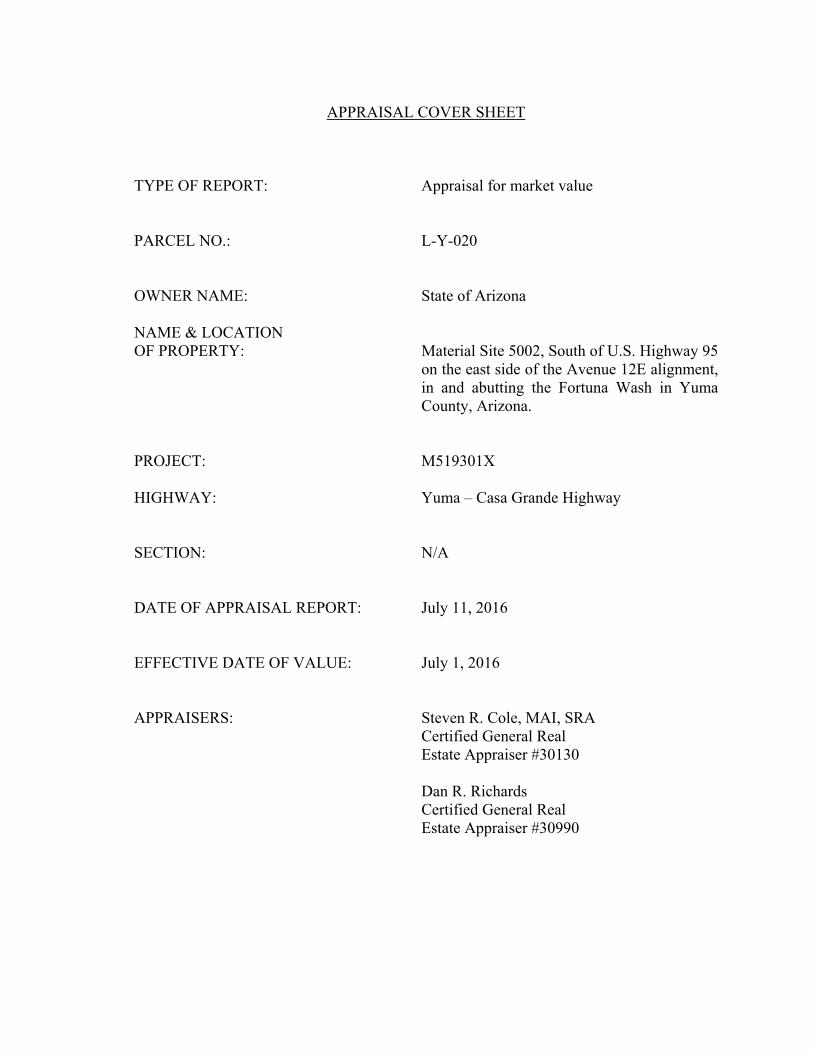
APPRAISAL COVER SHEET
TYPE OF REPORT: Appraisal for market value PARCEL NO.: L-Y-020 OWNER NAME: State of Arizona NAME & LOCATION OF PROPERTY: Material Site 5002, South of U.S. Highway 95
on the east side of the Avenue 12E alignment, in and abutting the Fortuna Wash in Yuma County, Arizona.
PROJECT: M519301X HIGHWAY: Yuma – Casa Grande Highway SECTION: N/A DATE OF APPRAISAL REPORT: July 11, 2016 EFFECTIVE DATE OF VALUE: July 1, 2016 APPRAISERS: Steven R. Cole, MAI, SRA Certified General Real Estate Appraiser #30130
Dan R. Richards Certified General Real Estate Appraiser #30990
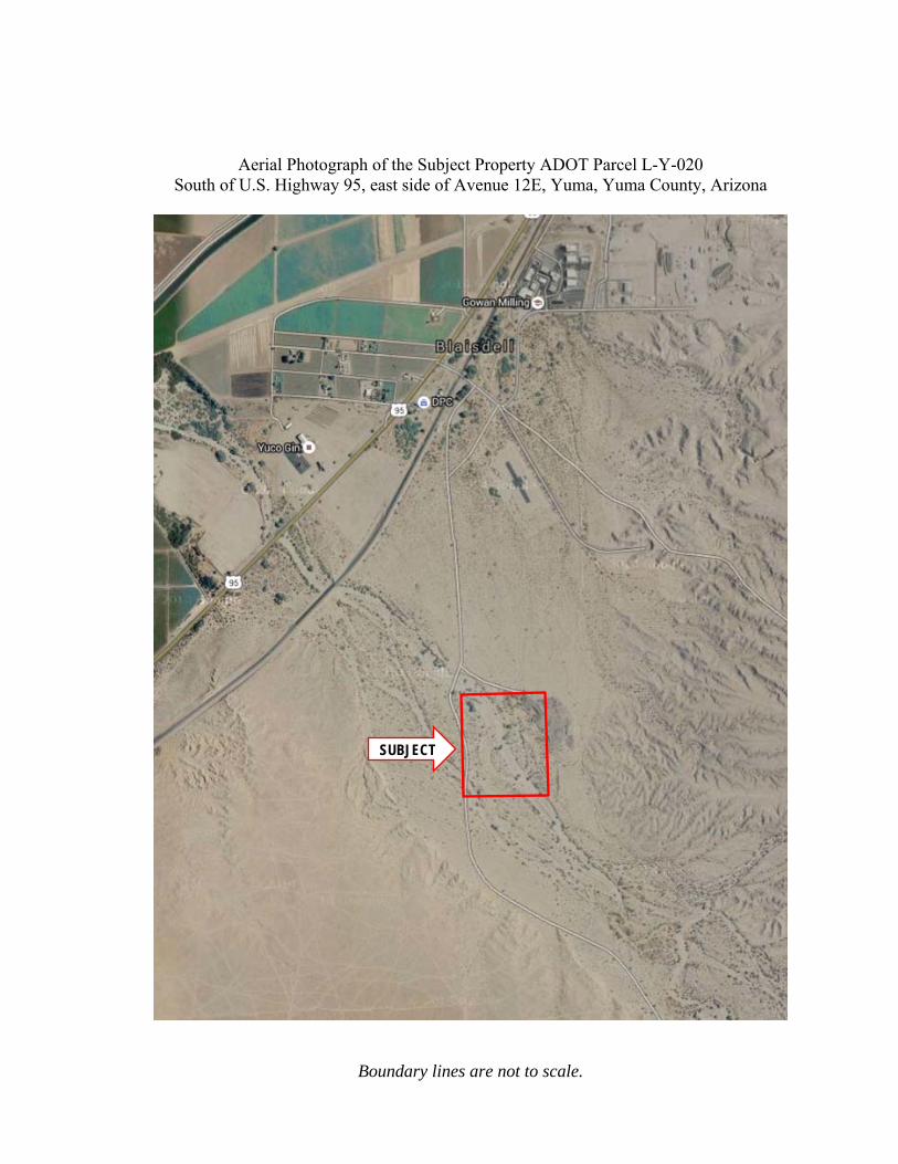
Aerial Photograph of the Subject Property ADOT Parcel L-Y-020 South of U.S. Highway 95, east side of Avenue 12E, Yuma, Yuma County, Arizona
Boundary lines are not to scale.
SUBJECT

July 11, 2016 Mr. Steve Troxel Procurement Specialist Right of Way Operations Section, Room 331 Arizona Department of Transportation 205 South 17th Avenue, Mail Drop #612E Phoenix, Arizona 85007 REF: Appraisal of the ADOT Parcel L-Y-20 located south of U.S. Highway 95, east of
Avenue 12E alignment in Yuma County, Arizona. Appraiser’s File No.: 16-114-L
Dear Mr. Troxel: At your request, we have provided our market value opinion for the subject property referenced above. The property is located south of U.S. Highway 95, east of the Avenue 12E alignment in Yuma County, Arizona. The subject property is comprised of 40.0 acres, the majority of which lies within the floodplain of the Fortuna Wash. The property was used by ADOT for stockpiling reclaimed asphalt from road projects in the area. According to Mr. Paul Patane, ADOT District Engineer, there may be some value in the asphalt stockpiles because they can be ground up for reuse as road base on construction projects. There is physical access to the property from Highway 95 over a rough graded dirt road that crosses through adjoining lands that are owned by the Yuma Irrigation District and Arizona State Trust Land. According to documents provided by ADOT the current access road is not under permit. However, legal access was created in 1955 when ADOT (formerly the Arizona Highway Department) acquired the subject from the Yuma Irrigation District. A roadway was never constructed along the legal access alignment which connects to Highway 95 and crosses in a southeasterly direction through Section 29, T8S, R21W, and connects to the subject’s northwest corner. A private owner of the subject property would need to acquire legal access from either: (1) constructing a gravel road along the 3,411 lineal feet of the legal access alignment; or (2) acquire legal access from the Yuma Irrigation District and the State Land Department over the existing dirt road. The feasibility of these two cures is considered in the body of the appraisal. The purpose of this appraisal is to provide a market value opinion to establish a minimum bid price for the potential disposition of the subject property.
The purpose of this appraisal to provide our market value opinion for the subject property, as of July 1, 2016, pursuant to Arizona Revised Statute 28-7091:
"...'Market Value' means the most probable price estimated in terms of cash in United States dollars or comparable market financial arrangements which the property would bring if exposed for sale in the open market, with reasonable time allowed in which to find a purchaser, buying with knowledge of all of the uses and purposes to which it was adapted and for which it was capable."
The intended users of the appraisal are officials and agents of the Arizona Department of Transportation; as well as their representatives and agents; and courts having jurisdiction concerning the proposed disposition of the subject property. No other use is intended, and any unintended use may be misleading. This appraisal report is intended to comply with the Arizona Department of Transportation Appraisal Standards and Specifications. Further, this is an appraisal report that is intended to comply with the reporting requirements set forth in Standards rule 2-2(a) of the Uniform Standards of Professional Appraisal Practice (USPAP) promulgated by the Appraisal Standards Board of the Appraisal Foundation. The Sales Comparison Approach is utilized to support our market value opinion. Since this valuation is for land value only, the Cost and Income Approaches are omitted. This report or any portion thereof is for the exclusive use of the client and is not intended to be used, sold, transferred, given, or relied on by any other person other than the client without the prior, expressed written permission of the author, as set forth within the Contingent and Limiting Conditions contained in this report. Based upon the data, analyses, opinion and conclusions contained in this report, our market value opinion, as of July 1, 2016, is as follows: “AS IS” MARKET VALUE OPINION ............................................................. $600,000
$15,000 per Acre Extraordinary Assumptions: In accordance with the Uniform Standards of Professional Appraisal Practice (USPAP), the definition of Extraordinary Assumption is as follows:
“An assumption, directly related to a specific assignment, which, if found to be false, could alter the appraiser’s opinions or conclusions. Extraordinary assumptions presume as fact otherwise uncertain information about physical, legal, or economic characteristics of the subject property; or about conditions external to the property, such as market conditions or trends; or about the integrity of data used in an analysis”. (Page F-96)
This appraisal report, is based on the following extraordinary assumptions:
1) The above market value opinion is based on the extraordinary assumption that all approvals would be obtained from the appropriate government agencies to construct a new roadway over the existing legal access alignment.
2) The asphalt and concrete debris that is stored on the subject site are assumed to sufficient value that the average buyer of the site could utilize or sell them at
a discount to effect their removal. The appraisers were unable to obtain any information on the amount of the road maintenance materials or overburden that is stored on the site.
3) No archaeological survey was provided to the appraiser. It is an extraordinary assumption of this appraisal that there is no known archaeological significance on the subject site.
4) No geological survey was provided to the client. It is an extraordinary assumption of this appraisal that there is no known geological significance on the subject site.
5) The site was inspected by the appraisers. No evidence of environmental risks or hazardous conditions was observed. It is an extraordinary assumption of this appraisal that there are no known environmental risks or hazardous conditions on the subject site.
Hypothetical Conditions: A hypothetical condition1 is defined as follows: “A hypothetical condition is that which is contrary to what exists but is supposed for the purpose of analysis.” (Page F-97) There are no hypothetical conditions for this appraisal report. We hereby certify that to the best of our knowledge and belief, all statements and opinions contained in this appraisal report are correct. This transmittal letter is not valid for any purpose unless accompanied by the appraisal referred to herein. In order to guarantee the authenticity of this report, the designated appraiser has imprinted this letter of transmittal with an embossed seal. Any copy without same is not a certified copy and the appraiser assumes no responsibility or liability for such a report. Respectfully submitted, Southwest Appraisal Associates, Inc.
By By Steven R. Cole, MAI, SRA Dan R. Richards Certified General Real Certified General Real Estate Appraiser #30130 Estate Appraiser #30990
1 Uniform Standards of Professional Appraisal Practice, 2016-2017 Ed., Appraisal Foundation, P U-3
TABLE OF CONTENTS
CONTINGENT AND LIMITING CONDITIONS ...................................................................................... 1
EXTRAORDINARY ASSUMPTION/HYPOTHETICAL CONDITIONS .................................................... 4
THE APPRAISAL PROCESS .................................................................................................................... 6
LEGAL DESCRIPTION - PROPERTY IDENTIFICATION...................................................................... 7
PURPOSE OF THE APPRAISAL ........................................................................................................... 10
DEFINITIONS ........................................................................................................................................ 10
INTEREST TO BE APPRAISED ............................................................................................................. 11
OWNERSHIP HISTORY AND FIVE-YEAR CHAIN OF TITLE ............................................................. 11
SIGNS ..................................................................................................................................................... 11
CONTACT REPORT ............................................................................................................................... 12
SCOPE OF WORK ................................................................................................................................. 13
REGIONAL AND NEIGHBORHOOD ANALYSIS ................................................................................. 16
NEIGHBORHOOD ANALYSIS ............................................................................................................... 25
SITE ANALYSIS ...................................................................................................................................... 29
ZONING .................................................................................................................................................. 36
ASSESSED VALUATION & REAL ESTATE TAXES .............................................................................. 38
HIGHEST AND BEST USE .................................................................................................................... 43
LAND VALUATION ................................................................................................................................ 45
EXPOSURE TIME .................................................................................................................................. 62
AUDITING BREAKDOWN ..................................................................................................................... 62
CERTIFICATION ................................................................................................................................... 65
CERTIFICATION ................................................................................................................................... 67
QUALIFICATIONS OF DAN R. RICHARDS ......................................................................................... 71
ADDENDA .............................................................................................................................................. 73
________________________________________________________________________
_____________________________________________________________________ 1
CONTINGENT AND LIMITING CONDITIONS
The certification of the Appraiser appearing in the report is subject to the following conditions, and to such other specific and limiting conditions as are set forth by the Appraiser in the report. This report is prepared for the client. This report or any portion thereof is for the exclusive use of the client and is not intended to be used, sold, transferred, given or relied on by any other person than the client without the prior, expressed written permission of the author, as set forth within the Limiting Conditions contained in this report. The Appraiser assumes no responsibility for matters of a legal nature affecting the property appraised or the title thereto, nor does the Appraiser render any opinion as to the title, which is assumed to be good and marketable. A Right of Way Title Report has been furnished to the Appraiser. The property is appraised as though under responsible ownership, competent management and adequate marketing typical for that type of property. The legal description provided to me is assumed to be correct. Unless otherwise noted, it is assumed there are no encroachments, zoning violations or restrictions existing in the subject property. The Appraiser has made no survey of the property. Any sketch or map in the report may show approximate dimensions and is included for illustrative purposes only. It is the responsibility of a certified engineer, architect or registered surveyor to show by a site plan the exact location of the subject property or any improvements or any proposed improvements thereon, or the exact measurements or calculations of estimated area of the site. In the absence of such a survey, the Appraiser may have utilized Tax Assessor's maps or other maps which may not represent the exact measurements of the subject property or other comparable information utilized to determine the value of the subject property. Any variation in dimensions or calculations based thereon may alter the estimates of value contained within the report. When possible, the appraiser has relied upon building measurements provided by the client, owner, or agents of these parties. In their absence, the appraiser has relied upon his own measurements of the subject improvements. However, there are some factors that may limit our ability to obtain accurate measurements. Professional building area measurements are beyond the scope of this appraisal assignment. In estimating the opinion of value of the subject property and in analyzing comparable information, the Appraiser has relied upon information from public and private planning agencies as to the potential use of land or improved properties. This information may include, but is not limited to, Area Plans, Neighborhood Plans, Zoning Plans and Ordinances, Transportation Plans and the like. To the extent that these plans may change, the value opinions of this report may also change. The dates of value to which the opinions expressed in this report apply are set forth in this report. The appraiser assumes no responsibility for the economic or physical factors occurring at some point at a later date, which may affect the opinions stated herein. The forecasts, projections, or operating estimates contained herein are based on current market
______________________________________________________________________ 2
conditions and anticipated short-term supply and demand factors. These forecasts are therefore subject to changes with future conditions. In the absence of a professional Engineer's Feasibility Study, information regarding the existence of utilities is made only from a visual inspection of the site. The Appraiser assumes no responsibility for the actual availability of utilities, their capacity or any other problem which may result from a condition involving utilities. The respective companies, governmental agencies or entities should be contacted directly by concerned persons. The Appraiser is not required to give testimony or appear in court as a consequence of having performed the appraisal with reference to the property in question, unless prior arrangements have been made and confirmed in writing. Any allocation of the valuation in the appraisal report between land and improvements applies only under the existing program of utilization. The separate valuation for land and improvements must not be used in conjunction with any appraisal and are invalid if so used. The Appraiser assumes that there are no hidden or unapparent conditions of the property, subsoil, potential flooding hazards, hydrology or structures which would render it more or less valuable. The Appraiser assumes no responsibility for such conditions or for engineering which might be required to discover such factors. Unless otherwise stated within this report, the existence of hazardous materials, which may or may not be present within or on the property, will not be considered by the appraiser. The Appraiser assumes, and the client warrants, that no such materials adversely affect the utility, usability or developability of the property, to the best of their knowledge. The Appraiser is not qualified to detect such substances. The value opinion herein assumes that there are no environmental conditions that adversely impact the value of the property. The Appraiser is not responsible for any such conditions or for any expertise or engineering knowledge required to discover them. The client is urged to retain an expert in this field, if desired. Any barriers to the disabled, which may or may not be present within or on the subject property, will not be considered by the appraiser. The Appraiser has not performed a compliance survey to determine if it is in conformance with the Americans with Disabilities Act (ADA). The Appraiser assumes, and the client warrants, that no such barriers adversely affect the utility, usability, or developability of the property to the best of their knowledge. The Appraiser is not qualified to analyze such barriers. The value opinion herein assumes that there are no such barriers on or in the property that would cause a loss in value. The client is urged to retain an expert in this field, if desired. Information, estimates and opinions furnished to the Appraiser and contained in the report were obtained from sources considered reliable and believed to be true and correct. However, no responsibility for accuracy of such items furnished to the Appraiser can be attributed to the Appraiser. Disclosures of the contents of the report by the Appraiser are governed by the Bylaws and Regulations of the professional appraisal organizations with which the Appraiser is affiliated.
______________________________________________________________________ 3
On all reports which are undertaken subject to satisfactory completion of, alterations of, or repairs to improvements, the report and value conclusions contained in it are contingent upon completion of the improvements, or of the repairs thereto, or alterations thereof in a workmanlike manner and consistent with the specifications presented to the Appraiser. Prospective value opinions are intended to reflect the current expectations and perceptions of market participants. They should not be judged on whether specific items in the forecasts are realized. The Appraiser is not responsible for unforeseeable events that alter market conditions after the effective date of the report. Any income and expense estimates contained in the appraisal report are used only for the purpose of estimating value and do not constitute prediction of future operating results. Furthermore, it is likely that some assumptions will not materialize and that unanticipated events may occur that will affect actual performance. The Appraiser has not made a specific survey of the subject property to determine whether or not it has any plant or wildlife which is identified as an endangered or threatened species by the U.S. Fish and Wildlife Service. While not observed and while no information was provided to confirm or deny the existence of any endangered or threatened species on the subject property (unless expressly stated herein), it is emphasized that the Appraiser is not qualified to detect or analyze such plants and wildlife. Any such conclusions must be based upon the professional expertise of persons qualified to make such judgments. Thus, any person or other entity with an interest in the subject property is urged to retain an expert if so desired. Possession of this report, or a copy thereof, does not carry with it the right of publication. Neither all, nor any part of the content of the report, or copy thereof (including conclusions as to property value, the identity of the appraiser, professional designations, reference to any professional appraisal organization or the firm with which the appraiser are connected), shall be disseminated to the public through advertising, public relations, news, sales, or other media without prior written consent and approval from Southwest Appraisal Associates’ President. This appraisal was prepared for the sole and exclusive use of the client. Any party who is not the client or intended user identified in the appraisal or engagement letter is not entitled to rely upon the contents of the appraisal without express written consent of Southwest Appraisal Associates. We claim no expertise in areas such as, legal description survey, structural, or environmental, engineering mechanical or electrical systems and the like. We assume such data is accurate and such systems functional unless otherwise noted in the appraisal. This appraisal shall be considered in its entirety. No part thereof shall be used separately or out of context. This appraisal does not guarantee compliance with building code and life safety code requirements of the local jurisdiction. It is assumed that all required licenses, consents, certificates of occupancy or other legislative or administrative authority from any local, state or national governmental or private entity or organization have been or can be obtained or renewed for any use on which the value conclusion contained in this report is based unless specifically stated to the contrary.

______________________________________________________________________ 4
This appraisal is not intended to be used in connection with a real estate syndicate or syndicates. A real estate syndicate is defined as a general or limited partnership, joint venture, unincorporated association or other organization formed for the purpose of, an investment from an interest in real property. It includes but, is not limited to a sale, exchange, trade or development of such real property. It may or may not be registered with the United States Securities and Exchange Commission or a state regulatory agency which regulates public offerings. This appraisal applies to the land and building improvements only. The value of trade fixtures, furnishings, and other equipment, or subsurface rights, (mineral, gas, and oil), were not considered in this appraisal, unless specifically stated to the contrary. If any claim is filed against Southwest Appraisal Associates, its officers or employees, or the firm providing this report, in connection with, or in any way arising out of, or relating to, this report, or the engagement of the firm providing this report, then (1) under no circumstances shall such claimant be entitled to consequential, special or other damages, only for direct compensatory damages, (2) the maximum amount of such compensatory damages recoverable by such claimant shall be the amount actually received by Southwest Appraisal Associates to provide this report. All disputes shall be settled by binding arbitration in accordance with the commercial arbitration rules of the American Arbitration Association. The use of this report or its analysis and conclusions by the client or any other party constitutes acceptance of all the above limiting conditions.
EXTRAORDINARY ASSUMPTION/HYPOTHETICAL CONDITIONS
Extraordinary Assumptions: In accordance with the Uniform Standards of Professional Appraisal Practice (USPAP), the definition of Extraordinary Assumption is as follows:
“An assumption, directly related to a specific assignment, which, if found to be false, could alter the appraiser’s opinions or conclusions. Extraordinary assumptions presume as fact otherwise uncertain information about physical, legal, or economic characteristics of the subject property; or about conditions external to the property, such as market conditions or trends; or about the integrity of data used in an analysis”. (Page F-96)
This appraisal report, is based on the following extraordinary assumptions:
1) The market value opinion herein is based on the extraordinary assumption that all approvals would be obtained from the appropriate government agencies to construct a new roadway over the existing legal access alignment.
2) The asphalt and concrete debris that is stored on the subject site are assumed to sufficient value that the average buyer of the site could utilize or sell them at a discount to effect their removal. The appraisers were unable to obtain any information on the amount of the road maintenance materials or overburden that is stored on the site.

______________________________________________________________________ 5
3) No archaeological survey was provided to the appraiser. It is an extraordinary assumption of this appraisal that there is no known archaeological significance on the subject site.
4) No geological survey was provided to the client. It is an extraordinary assumption of this appraisal that there is no known geological significance on the subject site.
5) The site was inspected by the appraisers. No evidence of environmental risks or hazardous conditions was observed. It is an extraordinary assumption of this appraisal that there are no known environmental risks or hazardous conditions on the subject site.
Hypothetical Conditions: A hypothetical condition2 is defined as follows: “A hypothetical condition is that which is contrary to what exists but is supposed for the purpose of analysis.” (Page F-97) There are no hypothetical conditions for this appraisal report.
2 Uniform Standards of Professional Appraisal Practice, 2016-2017 Ed., Appraisal Foundation, P U-3

______________________________________________________________________ Southwest Appraisal Associates
6
THE APPRAISAL PROCESS
An appraisal is an opinion based upon research, judgment, and an analysis of
factors influencing real estate value. These factors consider the four major forces at work
in the economy: physical, legal/political, social and economic forces.
The sections comprising the first portion of the report include: Date, Function and
Purpose of the Appraisal, Property Identification, Scope of the Appraisal, Neighborhood
Data, Site Analysis, and Highest and Best Use. The highest and best use of the subject
property is the basis upon which market value is determined.
The second portion of the report contains the approaches used to determine an
opinion of market value of the fee simple interest in the subject property. The fee simple
interest is the unencumbered interest in the property. The three traditional approaches to
value are considered. There are no improvements on the subject property. Thus, the “as is”
land value is appraised. The Sales Comparison Approach is employed to value the land.
The Income and Cost Approaches to value are not employed since they are typically
inapplicable to the valuation of vacant land.
In the Sales Comparison Approach, recent sales of similar properties, known as
“comparables,” are analyzed and adjusted to the subject property. This approach best
represents the actions of buyers and sellers in the market for this type of property. The
degree of similarity between the comparables and the subject property determines the
reliability of this approach. As discussed in the Scope of Work, our research revealed
limited land sale data for properties that are considered comparable to the subject.

______________________________________________________________________ Southwest Appraisal Associates
7
LEGAL DESCRIPTION - PROPERTY IDENTIFICATION
The subject property is identified as Yuma County Assessor’s Parcel Number 128-
33-001 which is comprised of 40.0 gross acres. A brief legal description for the subject is
as follows:
Northwest Quarter of the Northwest Quarter, Section 33, Township 8 South, Range 21 West, Gila & Salt River Base & Meridian, Yuma County, Arizona.

______________________________________________________________________ Southwest Appraisal Associates
8
PROPERTY IDENTIFICATION MAP
SUBJECT
______________________________________________________________________ Southwest Appraisal Associates
9
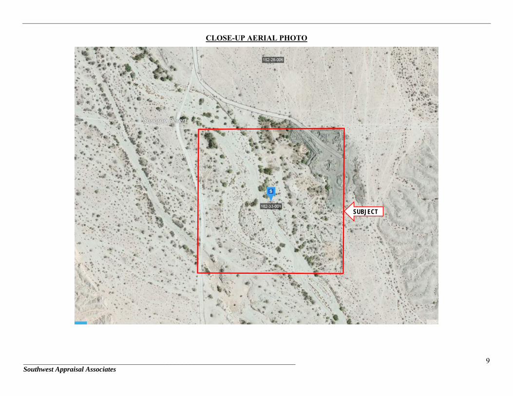
CLOSE-UP AERIAL PHOTO
SUBJECT
______________________________________________________________________ Southwest Appraisal Associates
10
PURPOSE OF THE APPRAISAL
Purpose of the Appraisal: The purpose of the appraisal is to provide “as is”
market value opinions of the fee simple estate.
Intended User of the Appraisal: The intended users of the appraisal are officials and agents of the Arizona Department of Transportation; Federal Highway Administration as well as their representatives and agents; and courts having jurisdiction concerning the proposed disposition of the subject property. No other use is intended, and any unintended use may be misleading.
Intended Use of the Appraisal: The intended use of the appraisal is to provide our
market value opinion for the possible disposition of the property.
Date of Value Opinion: The effective date of the value opinion is July 1,
2016, the date of the property inspection.
Date of the Appraisal Report: The date of the appraisal report is July 11, 2016.
DEFINITIONS
Definition of Market Value:
Pursuant to Arizona Revised Statute 28-7091: "...'Market Value' means the most probable price estimated in terms of cash in United States dollars or comparable market financial arrangements which the property would bring if exposed for sale in the open market, with reasonable time allowed in which to find a purchaser, buying with knowledge of all of the uses and purposes to which it was adapted and for which it was capable."
______________________________________________________________________ Southwest Appraisal Associates
11
INTEREST TO BE APPRAISED
Fee Simple Estate:
The interest to be appraised is that interest arising from fee simple estate
ownership. The Dictionary of Real Estate Appraisal, 4th Edition, by The Appraisal Institute
defines the fee simple estate as:
Absolute ownership, unencumbered by any other interest or estate, subject only to the limitations imposed by the governmental powers of taxation, eminent domain, police power, and escheat.
OWNERSHIP HISTORY AND FIVE-YEAR CHAIN OF TITLE
ADOT Parcel L-Y-020:
Title to the subject property is vested in the State of Arizona as granted by a Quit
Claim Deed from the Yuma Irrigation District on October 20, 1955. There have been no
title transfers, sales or offers to purchase the subject since that time.
SIGNS
There are no billboards located on the property. There are notification signs posted
around the perimeter stating that the property is owned by the State of Arizona.
______________________________________________________________________ Southwest Appraisal Associates
12
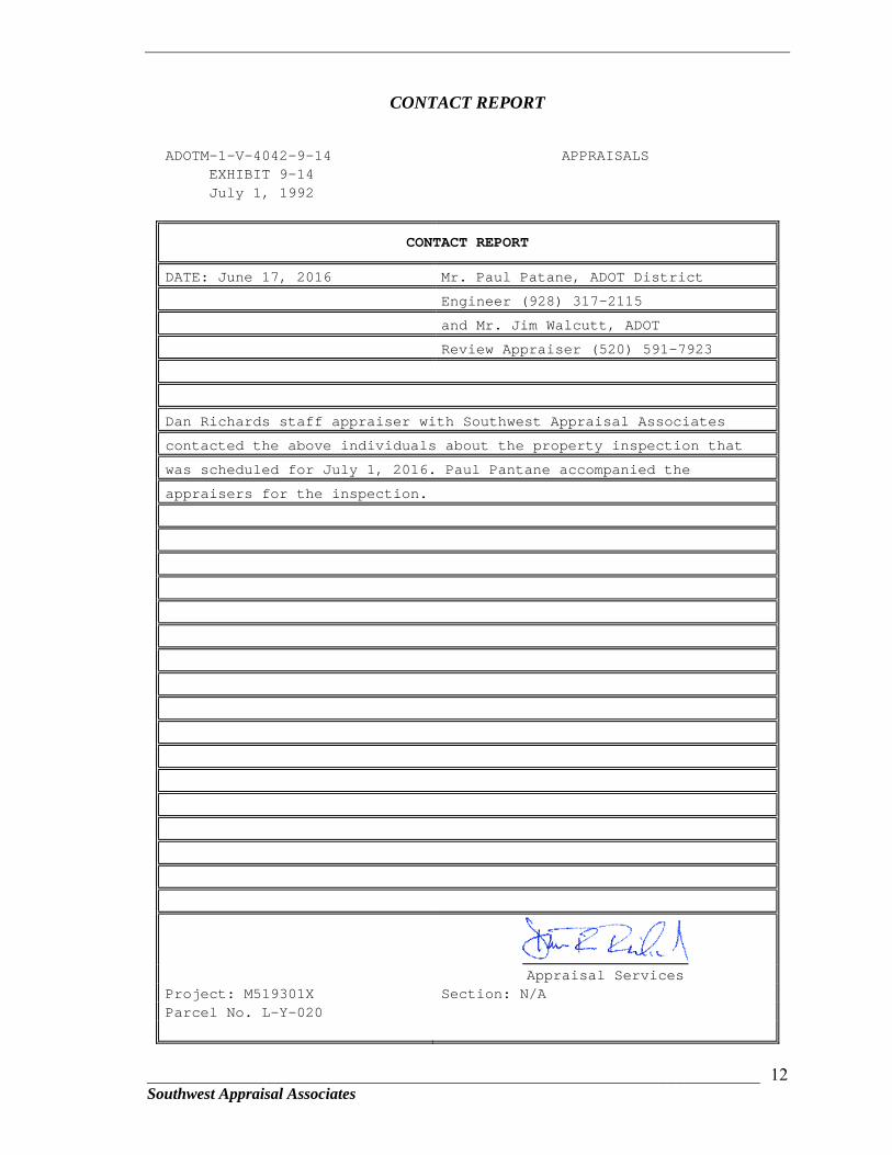
CONTACT REPORT
ADOTM-1-V-4042-9-14 APPRAISALS EXHIBIT 9-14 July 1, 1992
CONTACT REPORT
DATE: June 17, 2016 Mr. Paul Patane, ADOT District
Engineer (928) 317-2115
and Mr. Jim Walcutt, ADOT
Review Appraiser (520) 591-7923
Dan Richards staff appraiser with Southwest Appraisal Associates
contacted the above individuals about the property inspection that
was scheduled for July 1, 2016. Paul Pantane accompanied the
appraisers for the inspection.
Appraisal Services Project: M519301X Section: N/A Parcel No. L-Y-020
______________________________________________________________________ Southwest Appraisal Associates
13
SCOPE OF WORK
The scope of work for an appraisal is the extent of the process of collecting,
confirming, and reporting data, as well as the methods used in supporting the value
opinion. Since the subject property is vacant land, the Sales Comparison Approach is
employed to estimate the value of the land. The Cost and Income Approaches are excluded
since the market does not rely on these approaches when valuing land.
This appraisal is intended to comply with the Arizona Department of
Transportation Appraisal Standards and Specifications. In addition, the appraisal is
intended to comply with the Uniform Standards of Professional Appraisal Practice
(USPAP), effective January 1, 2016. In accordance with USPAP, the scope of work for the
appraisal includes, but is not limited to, the following:
Inspection and analysis of the subject property, market conditions, and other restrictions that affect value; and
Research, analysis, inspection and confirmation of comparable market data; and Consideration of the three approaches to value which include the Cost, Sales
Comparison and Income Approaches to support my market value opinion for the subject property; and
Consideration for severance damages, if any, and special benefits if present.
Research for comparable sales included a thorough search of sale data from
January 1, 2012, through the present. Data sources include the Yuma County Assessor’s
Records, DataTree, LoopNet, and interviews with local real estate brokers and market
participants. The search criteria included land sales that are similar in size, location, zoning
and potential use.
The availability of market data for sales of properties that have similar physical and
potential use characteristics is limited. Due to the limited availability of data, our research
for sales data was expanded to include sales from January 2012 to the effective date of
value. The data herein is considered to be the best available.
Scope of the Project:
There is no roadway project associated with this appraisal. The subject property is
excess ADOT land that is intended to be marketed for disposal.
Arizona State Transportation Board Resolution Data:
This section is inapplicable to the assignment.

______________________________________________________________________ Southwest Appraisal Associates
14
Right-of-Way Plan Drawing Number, Date of Approval and Last Revision Date:
This section is inapplicable to the assignment.
Subject Areas as Shown on the Right of Way Plans:
This section is inapplicable to the assignment.
Limitation in Scope:
This is a narrative appraisal report. There are no other limitations in the scope of
the assignment, other than those discussed in the Contingent and Limiting Conditions and
Extraordinary Assumptions.

_____________________________________________________________________________________________________________________ Southwest Appraisal Associates
15
LOCATION MAP
SUBJECT
________________________________________________________________________ Southwest Appraisal Associates
16
REGIONAL AND NEIGHBORHOOD ANALYSIS
Geographic Location:
The subject property is located on US Highway 95 east of Avenue 12E in Yuma,
Yuma County, Arizona. Yuma County is located in the southwestern portion of Arizona at
the state boundary with California and the international boundary with Mexico. The City of
San Luis is located on the International border directly across from San Luis, Sonora,
Mexico.
The City of Yuma is the county seat and is strategically located on Interstate 8 which
connects with Highways 80 and 95. It is situated about halfway between Los Angeles and
Tucson, and halfway between San Diego and Phoenix. The Union Pacific Railroad runs east
and west through the region and provides a vital link to markets in Southern California,
Phoenix, Tucson, and areas to the east. Cargo operations at Yuma International Airport
further strengthen Yuma as an important distribution center.
Principal Industries:
Principal industries in the area are agriculture, ranching, tourism, manufacturing, and
the military. Historically, agriculture and ranching were the primary industries due to the
abundant supply of water from the Colorado and Gila Rivers. As the population grew and the
area developed, tourism became an important economic activity. Manufacturing also adds to
the economy, but not to the extent of agriculture, ranching, and tourism. Seasonal visitors
contribute approximately $300 million annually to the Yuma economy.
Military operations contribute substantially to the overall economy. Installations
include the Yuma Proving Grounds (YPG) and the U.S. Marine Corps Air Station at Yuma
(MCAS). These military facilities are both major employers. Consequently, they have a
significant impact on the local economy.
Population:
Population statistics for Yuma are compared to Somerton, San Luis, and Yuma
County in the following chart. The data indicates that growth in Yuma County slowed
between 2000 and 2010 from the impact of the recession. However, the growth rate is barely
beginning to improve.

_______________________________________________________________________ 17 Southwest Appraisal Associates
Yuma County Population Statistics Year
Somerton
San Luis
City of Yuma
Yuma County
Population Growth Population Growth Population Growth Population Growth
1980
3,969
N/A
1,946
N/A
42,481
N/A
76,205
N/A 1990
5,282
2.9%/yr
4,212
8.0%/yr.
56,943
3.0%/yr.
106,895
3.4%/yr.
2000
7,266
3.2%/yr
15,322
13.8%/yr.
77,515
3.1%/yr.
160,026
4.1%/yr.
2010
14,281
6.9%/yr
25,505
5.2%/yr.
93,064
1.8%/yr.
195,751
2.0%/yr.
2015
15,048
1.05%/yr
31,520
4.3%/yr.
94,139
0.2%/yr.
204,275
0.9%/yr.
Source: Arizona Department of Economic Security .
Except for the City of San Luis, the population estimates for 2015 indicate that the
growth rate has slowed significantly. The recession and languishing economic recovery
continue to stifle population growth. The cities of Somerton and San Luis continue to
grow, albeit at rates that are below historic averages, due to the demand for farm workers
that is generated by the row crop farms that dominate the area.
Population and employment in Yuma County increased at a steady rate during the
housing boom, through 2007. After 2007, growth curtailed and unemployment increased
from the impact of the recession. The market sectors appear to be stabilizing now.
However, the outlook is for slow growth through 2016 and into 2017.
Labor and Economic Data:
Historically, annual Yuma County unemployment rates have fluctuated between
15% and 39%. This fluctuation is attributed to the high percentage of seasonal agricultural
workers, as well as population changes due to winter visitors. The economy, however, is
improving in spite of the comparatively high unemployment rate, according to the Yuma
County Chamber of Commerce.
The population in the Metropolitan Yuma Area varies substantially during the year
due to an influx of winter visitors. During the cooler months of November through March,
the population of metropolitan Yuma more than doubles, and peaks at about 175,000
persons. A large percentage of winter visitors reside in RV parks in the East Yuma Mesa
area east of the city limits of Yuma.
The following monthly unemployment data reflects the seasonal nature of
employment in this region due to the agricultural based economy.
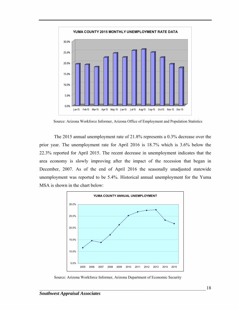
_______________________________________________________________________ 18 Southwest Appraisal Associates
0.0%
5.0%
10.0%
15.0%
20.0%
25.0%
30.0%
Jan-15 Feb-15 Mar-15 Apr-15 May-15 Jun-15 Jul-15 Aug-15 Sep-15 Oct-15 Nov-15 Dec-15
YUMA COUNTY 2015 MONTHLY UNEMPLOYMENT RATE DATA
Source: Arizona Workforce Informer, Arizona Office of Employment and Population Statistics
The 2015 annual unemployment rate of 21.8% represents a 0.3% decrease over the
prior year. The unemployment rate for April 2016 is 18.7% which is 3.6% below the
22.3% reported for April 2015. The recent decrease in unemployment indicates that the
area economy is slowly improving after the impact of the recession that began in
December, 2007. As of the end of April 2016 the seasonally unadjusted statewide
unemployment was reported to be 5.4%. Historical annual unemployment for the Yuma
MSA is shown in the chart below:
YUMA COUNTY ANNUAL UNEMPLOYMENT
5.0%
10.0%
15.0%
20.0%
25.0%
30.0%
2005 2006 2007 2008 2009 2010 2011 2012 2013 2014 2015
Source: Arizona Workforce Informer, Arizona Department of Economic Security

_______________________________________________________________________ 19 Southwest Appraisal Associates
The data in the above unemployment table demonstrates that economic conditions
are stabilizing after significant increases in unemployment in 2008 through 2011. The
increase in unemployment since 2007 is attributed to the recession that affected the state
and the nation. It is worthwhile noting however that the unemployment rates for 2005
through 2007 were at the lowest levels ever recorded. There was significant expansion in
all market sectors in Yuma from 2004 through 2007 which created more full-time year
round jobs.
Yuma Proving Ground and U.S. Marine Corps Air Station:
Agriculture is Yuma’s leading industry followed by the military’s presence.
According to a newspaper article3, the economic impact from the Yuma Proving Ground
(YPG) and the U.S. Marine Corps Air Station is about $1.04 billion annually. The YPG is
an all purpose testing facility for the U.S. Army that is located along the Colorado River
northeast of the City of Yuma. It is one of the largest military installations of its kind in the
world and an excellent location for ground and aerial target testing. General Motors opened
their $100 million Desert Proving Grounds test track at the YPG in 2009. GM entered into
a joint use lease agreement with the U.S. Army that allows the military to test equipment
on the GM courses. This increased activity also positively affects activity at the MCAS and
the regional economy.
The U.S. Marine Corps Air Station at Yuma (MCAS) and the Yuma International
Airport are a joint use facility under the jurisdiction of the MCAS. The air station/airport is
located within the southern portion of the city limits of Yuma, south of 32nd Street and
west of Avenue 3E. The Barry M. Goldwater Air Force Range is located south and east of
the MCAS which provides a large open air training area. According to the Yuma Sun
article by Gilbert, the MCAS has more than 14,000 people on base with 4,000 military,
5,500 family members, 2,300 civilian workers and 1,300 contract workers. Another
12,000+ military rotate through for training.
MCAS Capital Improvements:
MCAS Yuma received their first F-35B Joint Strike Fighter aircraft in November
2012 as the initial delivery for the first squadron of the F-35s to be assigned here. The
squadron now has its full complement of seventeen F-35Bs, the last three were delivered in
December 2013. 3 James Gilbert, “MCAS Yuma a major player in local economy,” Yuma Sun, January 3, 2016
_______________________________________________________________________ 20 Southwest Appraisal Associates
The current projection is for up to 12 squadrons (182 aircraft) to be assigned to
Yuma. The new aircraft is intended to replace existing front line fighters for all of the
service branches. The assignment of this new aircraft to the air station required
construction of $500 million in new facilities and infrastructure, the largest military capital
improvement project ever approved by the federal government. The infrastructure includes
a new F-35 simulator building, two new squadron hangars and facilities, and utilities and
communications upgrades. A significant mix of contractors, subcontractors will have a
permanent and temporary presence at the Defense Contractor’s Complex during the life-
cycle of the F-35 system. Although the construction activity for the infrastructure
improvements created a temporary boost the region’s economy, there has been little long
term impact.
The Yuma International Airport is operated conjointly with the MCAS and
provides scheduled air passenger service as well as a full range of general aviation
services. The airport’s new terminal has several gates, baggage claim, car rental counters,
and food service. In addition, NASA leased a 15,000 square foot hangar in 2009. NASA
uses the facility for testing the parachute assembly for the next generation Orion Space
Capsule.
Commercial, Business & Service Sectors:
Yuma’s commercial, office, and industrial sectors were negatively impacted by the
recession. However, according to a report from the Yuma Sun newspaper, there was
resurgence of new construction activity and an increase in sales tax revenues. The area’s
economy suffered a temporary negative impact from the government sequestration and
shutdown in the first two weeks of October, 2013. The Yuma economy, and especially the
hospitality industry, relies heavily on the private contractors that provide services and
products to the Marine base and Yuma proving grounds.
The city has been seeing a gradual increase in sales tax revenues. Revenues for
fiscal year 2014 were up only 0.8% over FY 2013. However, in FY 2015 revenues
increased 3.1% over the FY 2014.
According to an article4 in the Yuma Sun, construction activity in Yuma during
2015 was better than anticipated. Building Safety Official Randy Crist reported that so far,
2016 is shaping up to be a good year as well if the current level of building activity 4 Joyce Lobeck, “Construction work in Yuma Better than expected last year,” Yuma Sun, March 6, 2016
_______________________________________________________________________ 21 Southwest Appraisal Associates
continues. By nearly every measure, building activity within the city was up in 2015 over
the previous year. The city issued a total of 5,829 permits in 2015, compared to 4,695 in
2014. There were increases in every category across the board, including both residential
and commercial projects and a significant number of solar projects, Crist reported, “There
was a nice, gentle increase throughout the spectrum,” he said.
There has been an increase in the mercantile activity in the city, signaling an uptick
in retail development that bodes well for the community’s recovering economy.
Residential building activity also has been brisk.
The expansion of the Yuma Regional Medical Center is nearing completion with
the new state-of-the-art Emergency Department, scheduled for completion this fall. This
will double the current ED bed capacity. Two additional floors currently built out to shells
will provide room for future expansion as the community continues to grow. And an
underground floor provides room for a new cafeteria in the future.
Hospital projects aside, the number of commercial permits issued in 2015 was up
about 10 percent, with a significant increase in permits for business offices, Crist said. He
highlighted one office project, the renovation of a historic building by Hardknocks Limited
of the former accountant office at 190 S. Madison Ave. in Yuma’s historic downtown area.
Other office projects completed in 2015 include the two-story shell medical
building at 2500 S. 8th Ave., continued building activity at Tuscany Professional Plaza off
Avenue B and a variety of tenant improvement office projects scattered across the city.
In addition, valuations of $10.5 million for retail projects were permitted in 2015
versus $3 million the previous year. This indicates good economic growth. One major new
retailer is Hobby Lobby which opened just in time for the holiday season. Other retail
activity in 2015 included completion of two new retail buildings at Yuma Mesa Shopping
Center that house Dunkin Donuts and Dog Haus among other businesses, opening of
C.A.L. Ranch in the former Mervyn’s store, a new Discount Tire at Yuma Palms Regional
Center, a new Fisher Dodge Chrysler Dealership, Sprague’s new Truckmates building, a
new home for U-Haul, Yuma’s second dd’s Discounts going into the vacant Staples at 500
W. Catalina Drive, and Napa Automotive moving into the old Goodwill on 4th Avenue.
There also were a number of smaller projects that included additions to and
renovations of existing stores such as Buffalo Wild Wings, Kay Jewelers and Liquid
_______________________________________________________________________ 22 Southwest Appraisal Associates
Eyewear and tenant improvements to Cielo Verde Retail Center as well as the new Press
Sandwich Shop that went into a long vacant building at 121 E. 24th Street.
Other commercial projects in 2015 included completion of the new home for Yuma
Mortuary, construction of the new Desert View Academy (a $6.3 million project), and
alterations to an existing cooler for Custom Ag Pak, a new salad processing plant at 2591
S. Brown Avenue off Gila Ridge Road that was completed for the winter’s vegetable
season.
As for residential activity, the city saw a significant upswing in building activity
for new homes, Crist reported. The city issued 382 permits for single-family homes during
the year, up from 305 in 2014.
Commercial projects for 2016 includes several major projects that already have
been completed or are under way. Among them were the opening in January of the
Walmart Grocery Store on 8th Street and Avenue B, completion of Farley’s Market in Las
Palmillas Center and completion of the Amelia Earhart Hangar at Yuma International
Airport. Other just completed major projects are the new home for Amberly’s Place, an
addition to Healthsouth Rehab Hospital and conversion of a former hotel at 2600 S. 4th
Avenue to create Veterans Home of Yuma.
Other new projects include a major remodel of Albertson’s Grocery Store at the
Big Curve, an addition to El Buen Taquito at 810 S. 13th Avenue, renovations to a Main
Street property for Yuma County offices and a new building to house the Valentin Guzman
insurance and real estate offices on 4th Avenue and 20th Place. The former Knights of
Columbus on 4th Avenue Extension is being converted to a Legacy Church. Construction
plans have been approved for renovations to the former Logan’s for Hooter’s and permits
are ready to finish the interior of the shelled second building at Mission Valley Plaza
located at the corner of 24th Street and Avenue C that had sat vacant since 2008.
Gomez Plaza, comprised of 17.5 acres on the south side of 16th Street, is being
developed into a new commercial center. Retail space for Native Grill, Wings, Freddy’s
Frozen Custard and Steakburgers has also been approved.
Industrial Sector:
In addition to the expansion in the commercial and service market sectors discussed
above, there was significant growth in the industrial sector. Yuma’s cold storage market
added five new cold storage projects in 2006 to the ±600,000 square feet that were added
_______________________________________________________________________ 23 Southwest Appraisal Associates
between 2003 and 2005. All of these newer facilities were built by owner-operators. Mr.
John Curts reported that the city is also attracting more mainstream industrial and
manufacturing businesses. Much of the interest from industrial users is from California-
based businesses. California’s tougher regulatory climate, higher worker’s compensation
insurance costs, energy costs, and more restrictive labor laws are beginning to compel
some California industrialists to relocate to Yuma while still being able to service their
California customers.
Johnson Control, a Fortune 500 company with $34 billion in sales, opened a
battery plant in Yuma. After reaching an agreement with the Army Corps of Engineers,
General Motors is relocating their vehicle test track to the Yuma Proving Ground. In spite
of the recession, GM still intends to move forward with the project and will start with
about 120 direct employees earning an average annual wage of more than $65,000. The
new GM facility is expected to generate additional support businesses and jobs.
Residential Market Sector:
The single family residential housing market in Yuma County has been negatively
impacted by the collapse of the housing market and the persistent recession like other
metro areas in Arizona. The housing market was strong in 2004 through 2006 due to
historically low mortgage interest rates that prevailed at that time. The market began
slowing at the end of 2006 in response to the Federal Reserve Board’s incremental
increases in short-term interest rates. The market declined further as the recession
developed by the end of 2007. Since that time, the recession has negatively impacted the
housing market and consumer spending. Following the statewide trends, the Yuma housing
market has also declined but not to the same severity as the Phoenix and Tucson markets.
Statistical data for existing detached single family residential units provided by the
Yuma Association of Realtors market is presented below. The data is from sales that were
listed in the multiple listing service for all of Yuma County.
_______________________________________________________________________ 24 Southwest Appraisal Associates
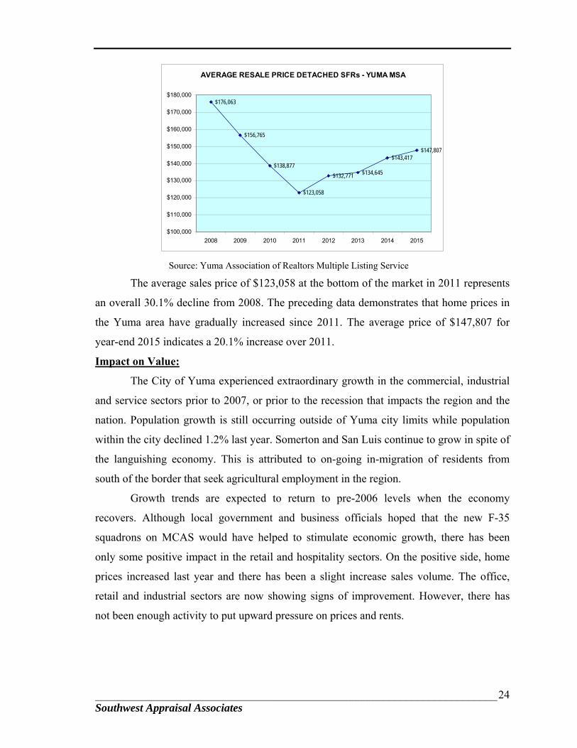
AVERAGE RESALE PRICE DETACHED SFRs - YUMA MSA
$176,063
$156,765
$138,877
$123,058
$132,771 $134,645
$143,417$147,807
$100,000
$110,000
$120,000
$130,000
$140,000
$150,000
$160,000
$170,000
$180,000
2008 2009 2010 2011 2012 2013 2014 2015
Source: Yuma Association of Realtors Multiple Listing Service
The average sales price of $123,058 at the bottom of the market in 2011 represents
an overall 30.1% decline from 2008. The preceding data demonstrates that home prices in
the Yuma area have gradually increased since 2011. The average price of $147,807 for
year-end 2015 indicates a 20.1% increase over 2011.
Impact on Value:
The City of Yuma experienced extraordinary growth in the commercial, industrial
and service sectors prior to 2007, or prior to the recession that impacts the region and the
nation. Population growth is still occurring outside of Yuma city limits while population
within the city declined 1.2% last year. Somerton and San Luis continue to grow in spite of
the languishing economy. This is attributed to on-going in-migration of residents from
south of the border that seek agricultural employment in the region.
Growth trends are expected to return to pre-2006 levels when the economy
recovers. Although local government and business officials hoped that the new F-35
squadrons on MCAS would have helped to stimulate economic growth, there has been
only some positive impact in the retail and hospitality sectors. On the positive side, home
prices increased last year and there has been a slight increase sales volume. The office,
retail and industrial sectors are now showing signs of improvement. However, there has
not been enough activity to put upward pressure on prices and rents.
_____________________________________________________________________________25 Southwest Appraisal Associates
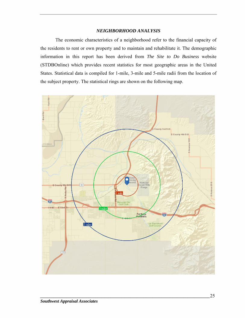
NEIGHBORHOOD ANALYSIS
The economic characteristics of a neighborhood refer to the financial capacity of
the residents to rent or own property and to maintain and rehabilitate it. The demographic
information in this report has been derived from The Site to Do Business website
(STDBOnline) which provides recent statistics for most geographic areas in the United
States. Statistical data is compiled for 1-mile, 3-mile and 5-mile radii from the location of
the subject property. The statistical rings are shown on the following map.
_____________________________________________________________________________26 Southwest Appraisal Associates
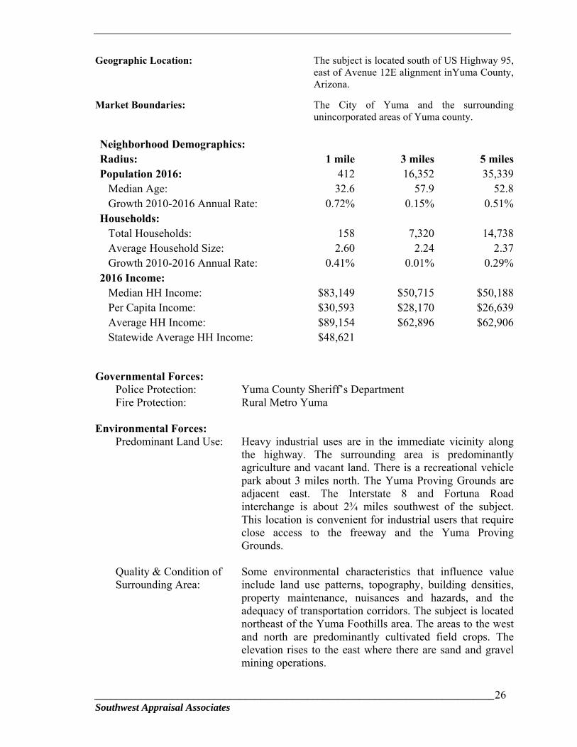
Geographic Location: The subject is located south of US Highway 95, east of Avenue 12E alignment inYuma County, Arizona.
Market Boundaries: The City of Yuma and the surrounding unincorporated areas of Yuma county.
Neighborhood Demographics: Radius: 1 mile 3 miles 5 milesPopulation 2016: 412 16,352 35,339 Median Age: 32.6 57.9 52.8 Growth 2010-2016 Annual Rate: 0.72% 0.15% 0.51%Households: Total Households: 158 7,320 14,738 Average Household Size: 2.60 2.24 2.37 Growth 2010-2016 Annual Rate: 0.41% 0.01% 0.29%2016 Income: Median HH Income: $83,149 $50,715 $50,188 Per Capita Income: $30,593 $28,170 $26,639 Average HH Income: $89,154 $62,896 $62,906 Statewide Average HH Income: $48,621
Governmental Forces:
Police Protection: Yuma County Sheriff’s Department Fire Protection: Rural Metro Yuma
Environmental Forces:
Predominant Land Use: Heavy industrial uses are in the immediate vicinity along the highway. The surrounding area is predominantly agriculture and vacant land. There is a recreational vehicle park about 3 miles north. The Yuma Proving Grounds are adjacent east. The Interstate 8 and Fortuna Road interchange is about 2¾ miles southwest of the subject. This location is convenient for industrial users that require close access to the freeway and the Yuma Proving Grounds.
Quality & Condition of Surrounding Area:
Some environmental characteristics that influence value include land use patterns, topography, building densities, property maintenance, nuisances and hazards, and the adequacy of transportation corridors. The subject is located northeast of the Yuma Foothills area. The areas to the west and north are predominantly cultivated field crops. The elevation rises to the east where there are sand and gravel mining operations.

_____________________________________________________________________________27 Southwest Appraisal Associates
Utilities: Public utilities electricity from Arizona Public Service, natural gas, and telephone from Xfinity. Private water wells and septic systems are typical in this area.
Social Forces: The available jobs in this area range from unskilled, hourly wage jobs to professional jobs. Primary employment markets in the Metropolitan Yuma area include agricultural, military, medical and retail.
Transportation Linkages: The primary transportation route is Interstate 8, which runs from San Diego on the west coast through Yuma and connects to I-10 at Casa Grande in the east. Araby Road is a major Interstate 8 interchange, and connects with Business Route 8 about one-half mile south of the subject. Developed properties along the frontage roads include agriculture, residential subdivisions, RV parks and commercial use at primary intersections. The frontage road and interchange system along Interstate 8 provides good access to the neighborhood. The Southern Pacific Railroad line is north of the subject property.
International Border Influence:
The U.S. Mexico International Border Crossing at San Luis is located about 23
miles southeast of Yuma. The sister city is San Luis Rio Colorado, Sonora, Mexico. The
2015 population of the Mexican city was reported to be 178,380 which has a positive
impact on the economy of San Luis, Arizona, and the Metropolitan Yuma area. The border
crossing data below provides a good indication of the economic impact from Mexico:
International Border Crossings- Persons & Vehicles from Mexico into Arizona
San Luis Port of Entry Year Passengers Pedestrians Total 2006 2,669,311 5,254,353 7,923,664 2007 2,939,694 4,757,424 7,697,118 2008 4,463,044 2,564,499 7,027,543 2009 4,275,214 2,537,177 6,812,391 2010 3,860,476 2,440,158 6,300,634 2011 3,941,304 2,762,696 6,704,000 2012 4,575,051 2,497,321 7,072,372 2013 5,088,810 2,315,369 7,404,179 2014 5,536,747 2,287,955 7,824,702 2015 5,575,238 2,351,506 7,926,744
Source: Research and Innovative Technology Administration, Bureau of Transportation Statistics.
_____________________________________________________________________________28 Southwest Appraisal Associates
The preceding data shows that border crossings decreased after 2006 which is
attributed to increased border security since the Iraq war began and due to the illegal
immigration issues. While the total number of crossings has decreased between 2006 and
2010, the number of crossings has continued to increase since 2011. This trend is expected
to continue. The influence of the border crossing activity remains a significant economic
impact for the Yuma region.
Impact on Value:
The subject property has a good location near the Yuma Foothills north of the
interstate and heavy industrial and agricultural uses. The property benefits from its nearby
freeway access and location a short distance from Highway 95.
_____________________________________________________________________________29 Southwest Appraisal Associates
SITE ANALYSIS
Location:
The subject is located about seven-tenths of a mile south of Highway 95 along the east side of the Avenue 12E alignment in Yuma County, Arizona. Site Area:
According to the legal description and the Yuma County Assessor’s records, the subject is comprised of 40.0 gross acres. Topography/Shape:
The subject has a quarter-section square shape. The topography is gently rolling terrain which includes the floodway for the Fortuna Wash and the appurtenant flood prone lands. Access and Visibility:
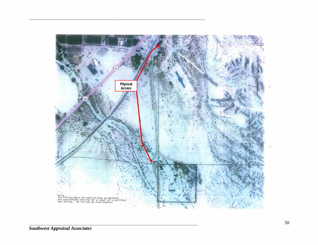
Physical Access: The property has physical access from an existing haul road that intersects with Rifle Range Road, immediately south of Highway 95 which is a paved two lane highway. According to data from ADOT, the 2013 average two way daily traffic count is 7,070 vehicles at this location. The haul road is a rough graded dirt road that is accessible by typical passenger vehicles in clear weather. During inclement weather, four-wheel drive vehicles would likely be needed. According to documents provided by ADOT, the “access road is not under permit.” The access road traverses over about 2,234 lineal feet of land that is owned by the Yuma Irrigation District and through 1,320 lineal feet of Arizona State Trust Land. Thus, legal access is not currently permitted over the haul road. Legal Access: Legal access was created for the subject property in 1955 when it was acquired by the Arizona Highway Department (now ADOT) from the Yuma Irrigation District. A roadway was never constructed over the legal access alignment. Historically, the above described haul road has been used to access the subject. The following exhibits that depict the physical and legal accesses for the subject property were provided by ADOT.
_________________________________________________________________________
______________________________________________________________________ Southwest Appraisal Associates
30
Physical Access

_________________________________________________________________________
______________________________________________________________________ Southwest Appraisal Associates
31
Legal Access
_________________________________________________________________________
______________________________________________________________________ Southwest Appraisal Associates
32
Estimated Cost to Construct a Gravel Road over the Legal Access: As previously described, a roadway was never constructed over the above legal access after the subject property was acquired from the Yuma Irrigation District. The legal access is defined as a 60 foot wide strip of land that is 3,411.8 feet in length. We interviewed Mr. Don Peterson, owner and president of Don Peterson Engineers, Inc. in Yuma, Arizona [(928) 783-7885]. Mr. Peterson said that he is familiar with the subject property and said that the roadway would need to be graded, well soaked with water and a gravel base would need to be added if it were to be used as a haul road. His rough estimated cost was $75,000 to construct the road or $1,875 per acre for the subject’s 40.0 acres. Construction of the roadway is based on the extraordinary assumption that approvals to construct the roadway would be obtained from the appropriate government agencies. Mr. Peterson also commented that there may be a case for prescriptive easement rights over the existing haul road since it had been in use for many years. Estimated Cost to Obtain Legal Access from Arizona State Land Department: We interviewed Mr. James Reese, Arizona State Land Department, Rights of Way Section, about the process to obtain legal access over State Trust Land. Mr. Reese said that since there is an existing haul road, the process would be relatively easy. An application would need to be made to renew the right of way for a fee of $500 for a 10-year period. Mr. Reese said that since there is an existing haul road, the applicant would not likely be required to complete archeological and plant surveys. This would reduce the cost and processing time. The applicant would be responsible for the cost of an appraisal to determine the unencumbered fee simple value of the land area within the right of way. The estimated cost for an appraisal is $4,000. The cost of the easement is then based on a 99% intensity of use from the fee value. Assuming a 60 foot wide right of way for 1,320 lineal feet, 79,200 square feet or 1.82 acres would be needed from the State Land Department. The cost for the right of way is estimated to be $36,000 [1.82 Acres X $20,000/Acre = $36,363.64 X 0.99 = $36,000.36]. The land value is estimated to be $20,000 per acre based on the land sale data in this appraisal. Estimated Cost to Obtain Legal Access from Yuma Irrigation District: We contacted Mr. Rex Green and Mr. Mark Smith of the Yuma Irrigation District [(928) 726-1047] about the possibility of acquiring legal access over the YID land. The gentlemen indicated that they were uncertain if the District would be willing to approve access. The issue would need to be presented to the Board which will not meet again until August 2016. Thus, there was no definitive answer available at this time. Lacking more specific information from YID, this appraisal assumes that a similar process as used by the State Land Department would be employed. The land area needed for the access is 60 feet wide and roughly 2,234 feet in length which equals 134,040 square feet or 3.08 acres. The estimated land value is $60,927 [3.08 Acres X $20,000/Acre = $61,542.70 X 0.99 = $60,927.27]. This analysis also assumes that a private owner would need to pay for an appraisal and processing fee, similar to the State Land process. The combined cost to obtain legal access from the State Land Department and the Yuma Irrigation District is summarized below:
_________________________________________________________________________
______________________________________________________________________ Southwest Appraisal Associates
33
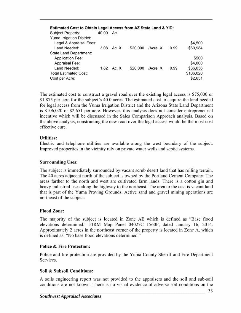
Estimated Cost to Obtain Legal Access from AZ State Land & YID: Subject Property: 40.00 Ac. Yuma Irrigation District: Legal & Appraisal Fees: $4,500 Land Needed: 3.08 Ac. X $20,000 /Acre X 0.99 $60,984State Land Department: Application Fee: $500 Appraisal Fee: $4,000 Land Needed: 1.82 Ac. X $20,000 /Acre X 0.99 $36,036Total Estimated Cost: $106,020Cost per Acre: $2,651
The estimated cost to construct a gravel road over the existing legal access is $75,000 or $1,875 per acre for the subject’s 40.0 acres. The estimated cost to acquire the land needed for legal access from the Yuma Irrigation District and the Arizona State Land Department is $106,020 or $2,651 per acre. However, this analysis does not consider entrepreneurial incentive which will be discussed in the Sales Comparison Approach analysis. Based on the above analysis, constructing the new road over the legal access would be the most cost effective cure. Utilities: Electric and telephone utilities are available along the west boundary of the subject. Improved properties in the vicinity rely on private water wells and septic systems.
Surrounding Uses:
The subject is immediately surrounded by vacant scrub desert land that has rolling terrain. The 40 acres adjacent north of the subject is owned by the Portland Cement Company. The areas farther to the north and west are cultivated farm lands. There is a cotton gin and heavy industrial uses along the highway to the northeast. The area to the east is vacant land that is part of the Yuma Proving Grounds. Active sand and gravel mining operations are northeast of the subject.
Flood Zone:
The majority of the subject is located in Zone AE which is defined as “Base flood elevations determined.” FIRM Map Panel 04027C 1560F, dated January 16, 2014. Approximately 2 acres in the northeast corner of the property is located in Zone A, which is defined as: “No base flood elevations determined.” Police & Fire Protection:
Police and fire protection are provided by the Yuma County Sheriff and Fire Department Services. Soil & Subsoil Conditions:
A soils engineering report was not provided to the appraisers and the soil and sub-soil conditions are not known. There is no visual evidence of adverse soil conditions on the
_________________________________________________________________________
______________________________________________________________________ Southwest Appraisal Associates
34
site. The surrounding improved properties indicate that subsoil conditions support development of properties of this nature. Environmental Conditions:
Although the entire subject property was not inspected, no sign of distressed vegetation, soil stains or extraordinary odors were observed. No environmental reports were provided to the appraisers. No adverse conditions were observed. There were piles of broken asphalt and concrete stored on the site. Lacking an environmental report that specifically includes the subject property, this appraisal assumes no environmental conditions are present that would adversely affect the value of the appraised property.

_________________________________________________________________________
________________________________________________________________________________________________________________________________35 Southwest Appraisal Associates
FLOODPLAIN MAP
SUBJECT

_________________________________________________________________________
_____________________________________________________________________________36 Southwest Appraisal Associates
Restrictions & Easements: No apparent adverse easements or encroachments were observed. No title report was provided to the appraisers for review. However, ADOT provided a Supplemental Results of Survey dated June 2014, labeled as Highway Name: San Luis-Quartzsite; Project: 095 YU 032 H4599 01R; Location: Ave 9E – Fortuna Wash Bridge. The purpose of this appraisal is to provide a market value opinion for the potential disposition of the subject property. This appraisal assumes that there are no title conditions that adversely affect the market value of the property.
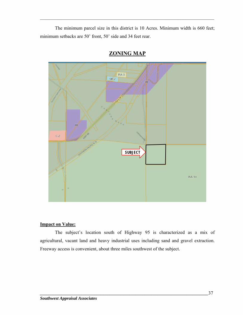
ZONING
The subject is in the RA-10, Rural Area Zoning District for Yuma County. The
purpose of this zoning is to conserve and preserve farms, agricultural related resources,
continued agricultural use and other open space land uses fostering orderly growth in rural
areas, preventing urban and agricultural land use conflicts and allowing rural lot
development with emphasis on preserving the character of farming communities. Principle
uses permitted in this zoning district include residential uses on large parcel sizes, farms,
agriculture-related land uses, and open space or recreational uses.
Permitted uses include, but are not limited to, the following: one single family
dwelling with a minimal parcel size of 10 acres; ranch/farm headquarters; farm labor
housing; farms and ranches; lakes, ponds, lagoons, irrigation and storm water retention
facilities; home occupations; plant nurseries; kennels; seasonal roadside stands for
produce, flowers, and Christmas trees; storage of agricultural related equipment;
warehouse and storage of agricultural products; and accessory buildings to the above uses.
Special uses that are allowed with special use permits include: agricultural
processing; cemeteries, crematoriums and mausoleums associated with on-site mortuary;
churches; cultural events; horse stables; dude ranches, resorts, organized group camps;
game preserves; golf courses; hospitals; educational, charitable and philanthropic
institutions; land clearing, landfills, and inert material landfills; libraries, museums, art
galleries, parks, playgrounds and community buildings; organic fertilizer manufacturing
and storage; private clubs; stadiums, fairgrounds and other similar amusement facilities;
private airstrips; private or charter schools; public or private fire stations, sheriff stations
and post offices; private utility installations; public parks, public schools; sanitary landfills,
accessory dwelling units; and wireless communication facilities.
_________________________________________________________________________
_____________________________________________________________________________37 Southwest Appraisal Associates
The minimum parcel size in this district is 10 Acres. Minimum width is 660 feet;
minimum setbacks are 50’ front, 50’ side and 34 feet rear.
ZONING MAP
Impact on Value:
The subject’s location south of Highway 95 is characterized as a mix of
agricultural, vacant land and heavy industrial uses including sand and gravel extraction.
Freeway access is convenient, about three miles southwest of the subject.
SUBJECT
_________________________________________________________________________
_____________________________________________________________________________38 Southwest Appraisal Associates
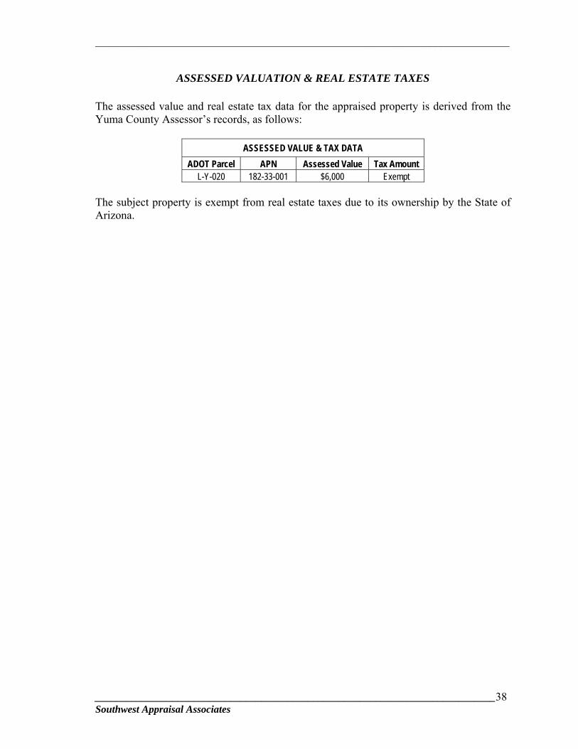
ASSESSED VALUATION & REAL ESTATE TAXES
The assessed value and real estate tax data for the appraised property is derived from the Yuma County Assessor’s records, as follows:
ASSESSED VALUE & TAX DATA
ADOT Parcel APN Assessed Value Tax Amount L-Y-020 182-33-001 $6,000 Exempt
The subject property is exempt from real estate taxes due to its ownership by the State of Arizona.
_________________________________________________________________________
_____________________________________________________________________________39 Southwest Appraisal Associates
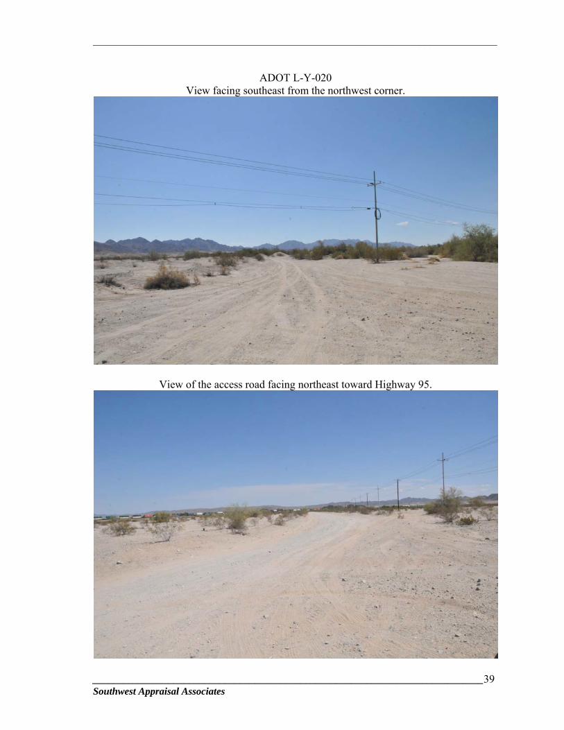
ADOT L-Y-020
View facing southeast from the northwest corner.
View of the access road facing northeast toward Highway 95.

_________________________________________________________________________
_____________________________________________________________________________40 Southwest Appraisal Associates
View of the earth and asphalt berms that ADOT placed around the perimeter of the subject
to discourage dumping and other illegal activities.
View of the subject facing west from the berm.
_________________________________________________________________________
_____________________________________________________________________________41 Southwest Appraisal Associates
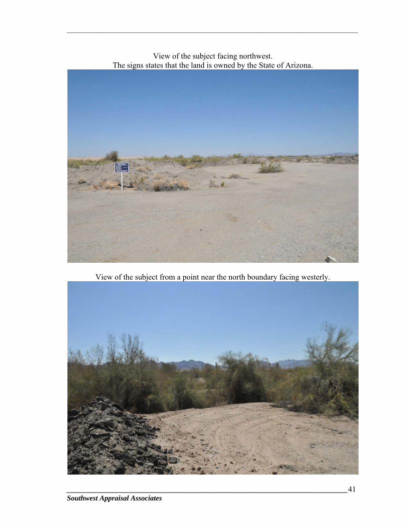
View of the subject facing northwest.
The signs states that the land is owned by the State of Arizona.
View of the subject from a point near the north boundary facing westerly.
_________________________________________________________________________
_____________________________________________________________________________42 Southwest Appraisal Associates
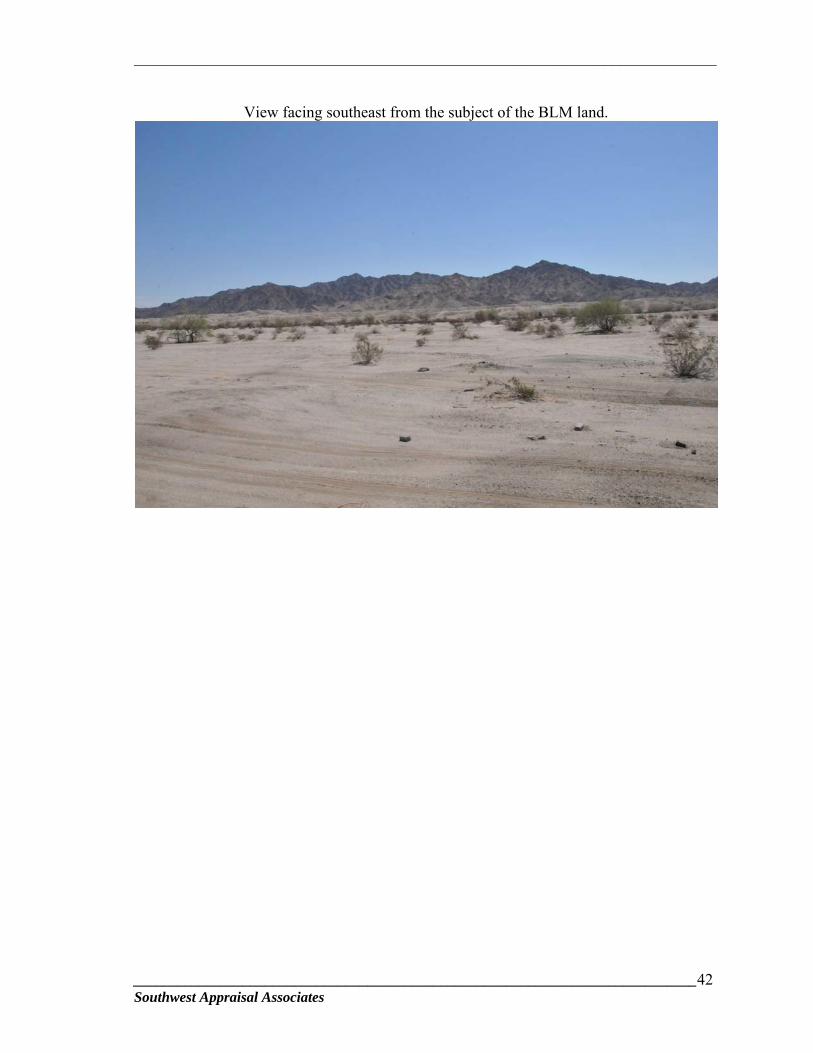
View facing southeast from the subject of the BLM land.
_________________________________________________________________________
_____________________________________________________________________________43 Southwest Appraisal Associates
HIGHEST AND BEST USE
According to The Appraisal of Real Estate, 13th Edition, published by the
Appraisal Institute, highest and best use is defined as:
The reasonably probable and legal use of vacant land or an improved property, which is physically possible, appropriately supported, financially feasible, and that results in the highest value. (Page 297)
The highest and best use of the land as vacant must meet four criteria. The highest
and best use must be:
1) Legally Permissible: What uses are permitted by zoning, private restrictions, historic districts, and environmental regulations on the site?
2) Physically Possible: Based on the physical characteristics of the site, what uses
are physically possible? 3) Financially Feasible: Which uses meeting the first two criteria will produce a
positive return to the owner of the site? 4) Maximally Productive: Among the feasible uses, which use will produce the
highest price, or value, consistent with the rate of return warranted by the market? This use is the highest and best use.
The four tests above are applied to the appraised property in the following
paragraphs.
AS VACANT
Legally Permissible:
The larger parcel is located in the RA-10 Rural Area Zoning District for Yuma
County. This zoning permits very low density rural residential use, agricultural-related,
open space and recreational uses. Since most of the property is in the floodplain, the
potential use is restricted by county flood zone regulations. There is also a potential for
sand and gravel extraction outside of the floodway channel. State mining laws that permit
sand and gravel operations supersede local jurisdictions. As vacant, the legally permissible
use is any of the uses that are permitted in the RA-10 zoning. There is a secondary a
potential for sand and gravel extraction.
_________________________________________________________________________
_____________________________________________________________________________44 Southwest Appraisal Associates
Physically Possible:
The subject is 40.0 acres located south of Highway 95, along the east side of the
Avenue 12E alignment. The property has physical access from Highway 96 over an
existing rough-graded dirt haul road. Currently, there is no valid permit that allows legal
use of the haul road. As such, the estimated cure is to construct a new roadway along the
alignment of the legal access that is previously described in the “Site Analysis” section.
The estimated cost of the roadway is $75,000. The subject is immediately surrounded by
vacant desert land. Nearby uses along Highway 95 include agriculture, a cotton gin,
material processing plant, heavy industrial uses and sand and gravel extraction. Freeway
access is about 3 miles southwest at the Fortuna Road and I-8 interchange. Electric and
telephone utilities are available to the site. Private properties in the vicinity rely on private
well and septic systems. The majority of the property is in the floodplain which limits its
potential uses.
Based on the zoning, location, physical characteristics and surrounding uses, the
physically possible use for the subject, as vacant, is for a use that would be allowed in the
RA-10 zoning and flood zone regulations.
Financially Feasible and Maximally Productive:
The financially feasible and maximally productive use for the property is that use
which is legally permissible, physically possible and that generates income. The Yuma
area economy has been impacted by the combination of border security, illegal
immigration issues and the lingering effects of the recession. Even Yuma’s “snowbird”
seasons have been impacted by the lagging economy over the last several years. According
to a news article in the Yuma Sun, the overall occupancy rate for the winter of 2015-16 in
the area’s RV parks was down 2% to 3% from the prior season. The decrease in visitors is
partially attributed to a decrease in Canadian visitors due the exchange rate.
In spite of the lethargic snowbird season, construction activity in Yuma in 2015
was better than expected. Additionally, if the first three months of 2016 are an indication,
this is shaping up to be a good year. Building activity was up in 2015 with 5,829 permits
issued, compared to the 4,695 that were issued in 2014. This includes an uptick in retail
development which previously had been only moderately active. Valuations for retail
projects in 2015 were $10.5 million compared to $3 million the previous year. This
indicates good economic growth.
_________________________________________________________________________
_____________________________________________________________________________45 Southwest Appraisal Associates
Given the restrictions for the potential use for the subject property with some
modest improvement in the local economy, the financially feasible use of the subject is
limited to investment. This is substantiated by our research for land sale data. Our research
revealed approximately 18 sales that have occurred since January 1, 2011. The majority of
the sales were for cultivated farm land. Only two sales were discovered for land that has
similar topographic issues and potential highest and best use as the larger parcel. The two
sales that have the most comparability to the subject were purchased for investment. Seven
sales were physically inspected and were pared down to the three that are deemed
sufficiently comparable for analysis. The other sales were excluded for various
comparability deficiencies, including sale conditions, date of sale, availability of utilities,
zoning, plat status, highest and best use, and location characteristics. The data selected is
adequate to provide reliable indications of value for the subject property.
Based on the foregoing, the financially feasible and maximally productive use of
the subject, as vacant, is investment.
Conclusion – Highest and Best Use As Vacant:
Given the land use regulations, location and physical characteristics, the highest
and best use, as if vacant, is for investment.
LAND VALUATION
The Sales Comparison Approach is used to provide a market value opinion for the
subject as vacant land. This approach applies the principle of substitution which affirms
that when a property can be replaced, its value tends to be set by the cost of acquiring an
equally desirable substitute property without undue or costly delay.
Adjustments are made to the comparable sales based on the following elements of
comparison: property rights conveyed, financing terms, conditions of sale, market
conditions or date of sale, location, physical characteristics and zoning/intended use. The
sale price per acre is the appropriate unit of comparison for the analyses. This is derived by
dividing the sale price by the total acreage of the site.
Search parameters for comparable land sales focused on land sales that are similar
in size and potential use. Given the recession and the small market area, there has been
limited sales activity over the last several years. The search for recent land sales included
_________________________________________________________________________
_____________________________________________________________________________46 Southwest Appraisal Associates
the area northeast of Yuma. The market data that is included in the analysis is considered
to be the best available and provides a credible opinion of value.
A location map showing the comparable sales relative to the subject and individual
sale data sheets with photographs of the sales and parcel maps are presented on the
following pages. The adjustment matrix follows the land value analysis.
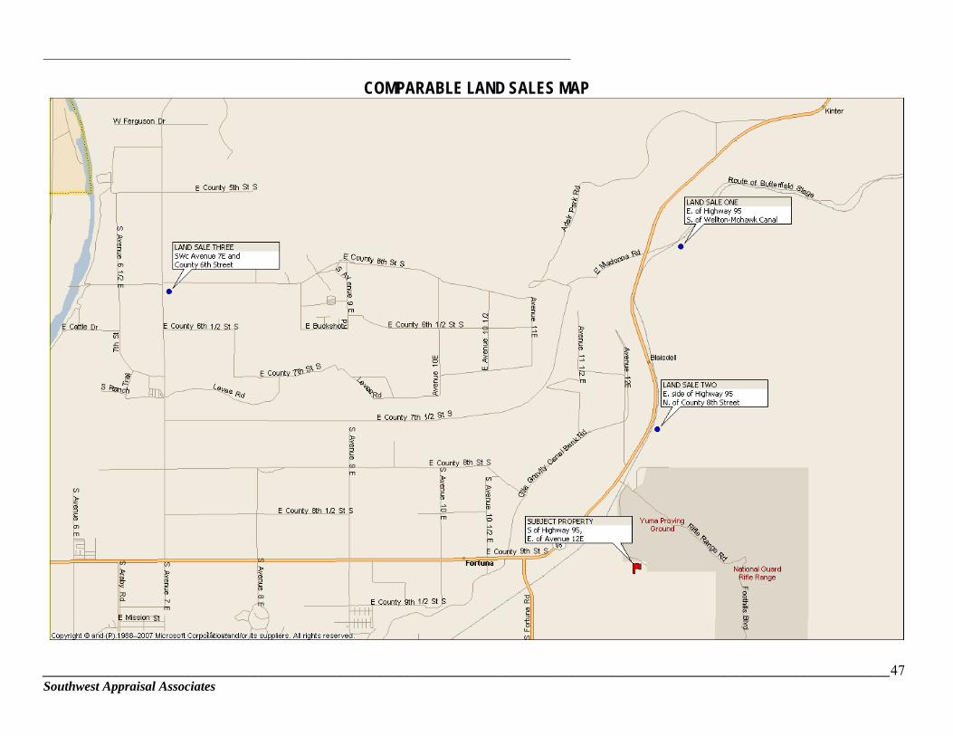
_________________________________________________________________________
________________________________________________________________________________________________________________________________47 Southwest Appraisal Associates
COMPARABLE LAND SALES MAP
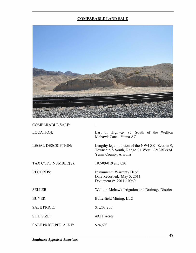
______________________________________________________________________ Southwest Appraisal Associates
48
COMPARABLE LAND SALE
COMPARABLE SALE: 1
LOCATION: East of Highway 95, South of the Wellton Mohawk Canal, Yuma AZ
LEGAL DESCRIPTION: Lengthy legal: portion of the NW4 SE4 Section 9, Township 8 South, Range 21 West, G&SRB&M, Yuma County, Arizona
TAX CODE NUMBER(S): 182-09-019 and 020
RECORDS: Instrument: Warranty Deed Date Recorded: May 5, 2011 Document #: 2011-10960
SELLER: Wellton-Mohawk Irrigation and Drainage District
BUYER: Butterfield Mining, LLC
SALE PRICE: $1,208,255
SITE SIZE: 49.11 Acres
SALE PRICE PER ACRE: $24,603
______________________________________________________________________ Southwest Appraisal Associates
49
TERMS: Cash to seller
ZONING: RA-20, Rural Area, Yuma County
INTENDED USE: Investment for future sand and gravel extraction
PHYSICAL DESCRIPTION:
Topography / Shape: Rolling / Irregular
Flood Zone: Not in flood zone.
Utilities: Electric and telephone nearby. No water or sewer
Access/Visibility: Access is from the north through over the railroad tracks. Visibility is not a factor.
THREE YEAR HISTORY: No sales in the prior three years.
MARKETING TIME: Direct sale. Buyer approached the seller.
CONFIRMED WITH: Elston Grubaugh, general manager for the seller Wellton-Mohawk Irrigation District, (928) 785-3351
DATE CONFIRMED: November 2014
COMMENTS: None I.D.: 14-217-L.1
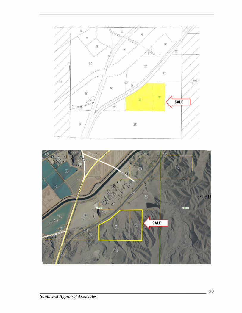
______________________________________________________________________ Southwest Appraisal Associates
50
SALE
SALE
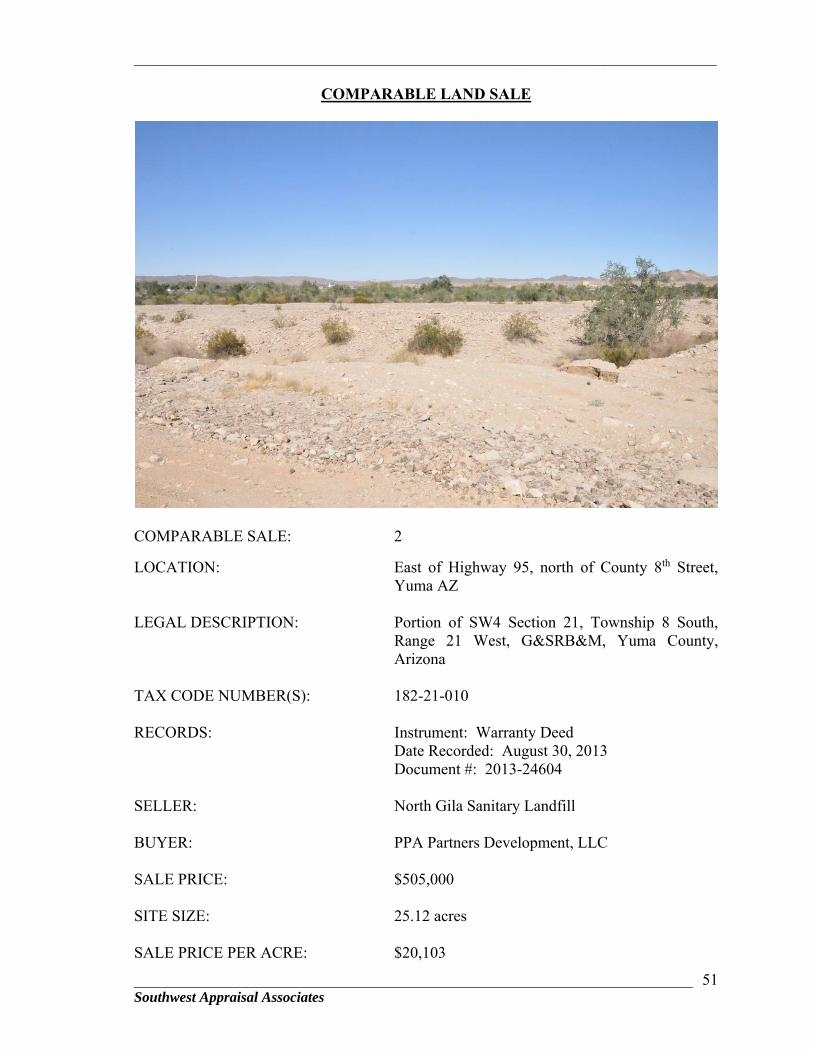
_________________________________________________________________________
______________________________________________________________________ Southwest Appraisal Associates
51
COMPARABLE LAND SALE
COMPARABLE SALE: 2
LOCATION: East of Highway 95, north of County 8th Street, Yuma AZ
LEGAL DESCRIPTION: Portion of SW4 Section 21, Township 8 South, Range 21 West, G&SRB&M, Yuma County, Arizona
TAX CODE NUMBER(S): 182-21-010
RECORDS: Instrument: Warranty Deed Date Recorded: August 30, 2013 Document #: 2013-24604
SELLER: North Gila Sanitary Landfill
BUYER: PPA Partners Development, LLC
SALE PRICE: $505,000
SITE SIZE: 25.12 acres
SALE PRICE PER ACRE: $20,103
_________________________________________________________________________
______________________________________________________________________ Southwest Appraisal Associates
52
TERMS: Cash
ZONING: HI, Heavy Industrial, Yuma County
INTENDED USE: Investment
PHYSICAL DESCRIPTION:
Topography / Shape: Rolling / Irregular shaped
Flood Zone: Not in flood zone. However, there is a wash that traverses through the northern portion.
Utilities: Electric and telephone
Access/Visibility: Average access and visibility
THREE YEAR HISTORY: No sales in the prior three years.
MARKETING TIME: Not listed.
CONFIRMED WITH: Tom Pancrazi, broker with AT Pancrazi Real Estate (928) 782-0000
DATE CONFIRMED: November 2014
COMMENTS: None I.D.: 14-217-L.2
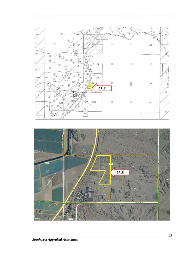
_________________________________________________________________________
______________________________________________________________________ Southwest Appraisal Associates
53
SALE
SALE
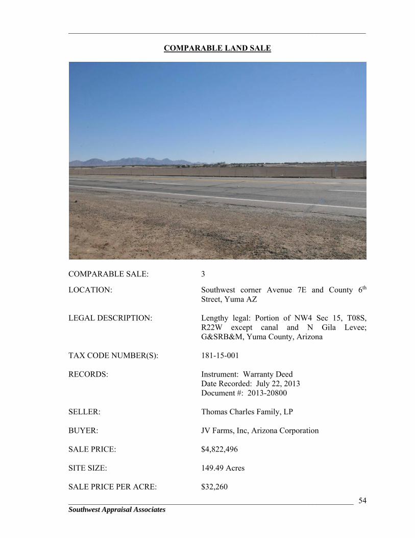
_________________________________________________________________________
______________________________________________________________________ Southwest Appraisal Associates
54
COMPARABLE LAND SALE
COMPARABLE SALE: 3
LOCATION: Southwest corner Avenue 7E and County 6th Street, Yuma AZ
LEGAL DESCRIPTION: Lengthy legal: Portion of NW4 Sec 15, T08S, R22W except canal and N Gila Levee; G&SRB&M, Yuma County, Arizona
TAX CODE NUMBER(S): 181-15-001
RECORDS: Instrument: Warranty Deed Date Recorded: July 22, 2013 Document #: 2013-20800
SELLER: Thomas Charles Family, LP
BUYER: JV Farms, Inc, Arizona Corporation
SALE PRICE: $4,822,496
SITE SIZE: 149.49 Acres
SALE PRICE PER ACRE: $32,260
_________________________________________________________________________
______________________________________________________________________ Southwest Appraisal Associates
55
TERMS: Cash
ZONING: RA-20, Rural Area, Yuma County
INTENDED USE: Agriculture
PHYSICAL DESCRIPTION:
Topography / Shape: Level / Irregular
Flood Zone: Zone B, areas protected by levees
Utilities: Electric, telephone and irrigation water
Access/Visibility: The property has access from Avenue 7E, a paved two lane street.
THREE YEAR HISTORY: No sales in the prior three years.
MARKETING TIME: Undisclosed
CONFIRMED WITH: Tom Pancrazi, broker/owner of A.T. Pancrazi Real Estate, (928) 782-0000
DATE CONFIRMED: November 2014
COMMENTS: None I.D.: 14-217-LS.3

_________________________________________________________________________
______________________________________________________________________ Southwest Appraisal Associates
56
SALE
SALE
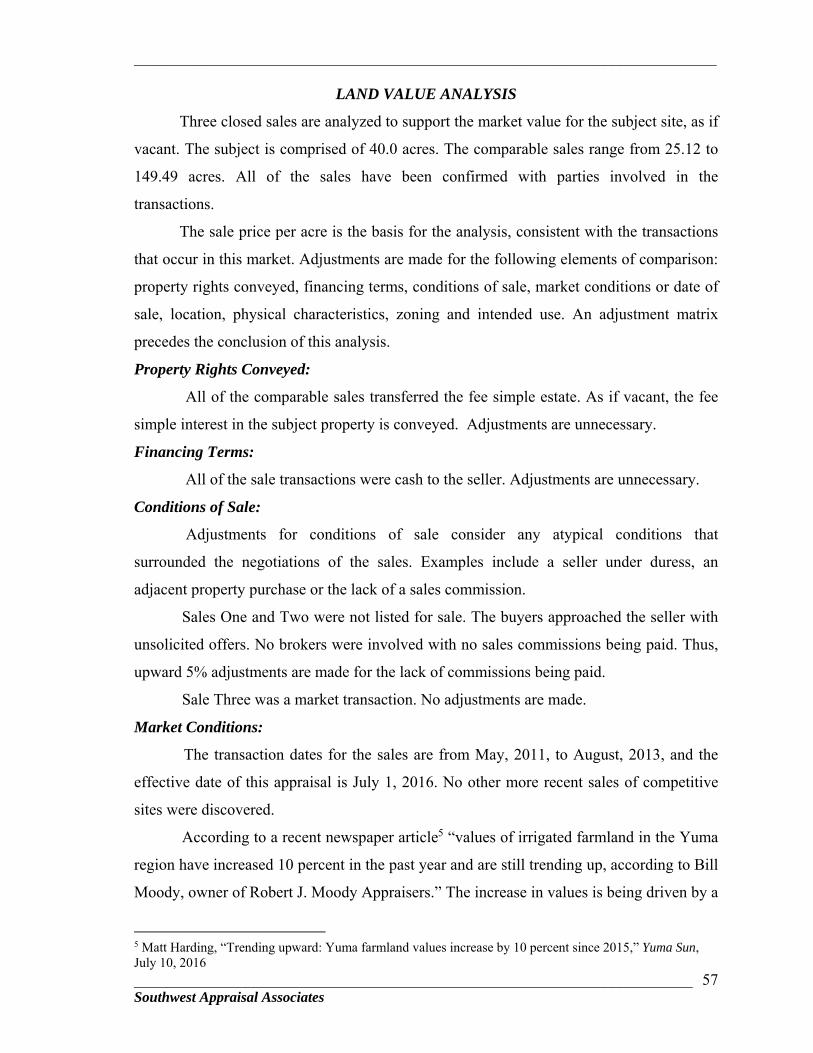
_________________________________________________________________________
______________________________________________________________________ Southwest Appraisal Associates
57
LAND VALUE ANALYSIS
Three closed sales are analyzed to support the market value for the subject site, as if
vacant. The subject is comprised of 40.0 acres. The comparable sales range from 25.12 to
149.49 acres. All of the sales have been confirmed with parties involved in the
transactions.
The sale price per acre is the basis for the analysis, consistent with the transactions
that occur in this market. Adjustments are made for the following elements of comparison:
property rights conveyed, financing terms, conditions of sale, market conditions or date of
sale, location, physical characteristics, zoning and intended use. An adjustment matrix
precedes the conclusion of this analysis.
Property Rights Conveyed:
All of the comparable sales transferred the fee simple estate. As if vacant, the fee
simple interest in the subject property is conveyed. Adjustments are unnecessary.
Financing Terms:
All of the sale transactions were cash to the seller. Adjustments are unnecessary.
Conditions of Sale:
Adjustments for conditions of sale consider any atypical conditions that
surrounded the negotiations of the sales. Examples include a seller under duress, an
adjacent property purchase or the lack of a sales commission.
Sales One and Two were not listed for sale. The buyers approached the seller with
unsolicited offers. No brokers were involved with no sales commissions being paid. Thus,
upward 5% adjustments are made for the lack of commissions being paid.
Sale Three was a market transaction. No adjustments are made.
Market Conditions:
The transaction dates for the sales are from May, 2011, to August, 2013, and the
effective date of this appraisal is July 1, 2016. No other more recent sales of competitive
sites were discovered.
According to a recent newspaper article5 “values of irrigated farmland in the Yuma
region have increased 10 percent in the past year and are still trending up, according to Bill
Moody, owner of Robert J. Moody Appraisers.” The increase in values is being driven by a
5 Matt Harding, “Trending upward: Yuma farmland values increase by 10 percent since 2015,” Yuma Sun, July 10, 2016
_________________________________________________________________________
______________________________________________________________________ Southwest Appraisal Associates
58
lack of land that is available on the market since the existing land owners are not putting
their holdings on the market. The limited inventory and increased demand from California
growers that have been impacted by California’s longtime drought is driving ag land prices
up. Land prices for prime agricultural land in the North and South Gila Valley submarkets
are trending in the $30,000 to $36,000 per acre range. While values for agricultural land
have increased, there has been little demand for land for development and investment. The
local housing market has seen a modest improvement over the last year. However, there
has not been enough demand to support development of new housing.
Lacking other more specific data, the decline in the housing market is used as a
proxy for the decrease in land values. According to information from the Yuma
Association of Realtors, the average price for a single family home dropped 30.1%
between 2008 and 2011, when the market bottomed. The average price increased 1.4% in
2013 from 2012. The most recent data indicates a slight increase through the end of 2015.
Although there has been a positive increase in home prices, no evidence was discovered to
indicate that land prices are following the same trend.
Based on the foregoing information and the limited sales activity for vacant land
since 2011, it appears that sellers are holding firm on asking prices until demand returns.
According to Jon Matheus with A.T. Pancrazi, other than the agricultural land market,
there is still insufficient demand for vacant land to support any increase in value. Investors
in search of a bargain have made offers well below asking prices that sellers are declining,
unless distress forces them to accept. Since land values have remained flat since 2011, no
adjustments are made for market conditions.
Location: One of the most significant elements of value for a vacant land is location. The
subject property is located south of Highway 95, about 3 miles northeast of the I-8 and
Fortuna Road interchange. The property has physical access from an existing graded dirt
haul road. As discussed in the “Site Analysis” section, a new roadway would need to be
constructed along the existing legal access.
The estimated cost for a gravel roadway is $75,000 or $1,875 per acre. In addition
to the direct cost, consideration must also be given to entrepreneurial incentive for the
investor or buyer of the subject property. This considers the risks that are associated with
acquiring a property that needs to develop legal and physical access. A prudent investor
_________________________________________________________________________
______________________________________________________________________ Southwest Appraisal Associates
59
would expect a reward for undertaking the risks. Data for yield rates or internal rates of
return (IRR) for the National Development Land Market were obtained from the Real
Estate Investor Survey published by PricewaterhouseCoopers (PwC). The 4th Quarter 2015
report is the most recent available since this category is reported only biannually. The IRRs
for unleveraged land development are in the range of 10.00% to 20.00% and the average is
15.90%. The risk for the subject property is at the upper end of the range given the limited
demand for investment and development land in the Yuma market. Based on this
information, we believe that an appropriate risk rate is 18.0% for the subject. Therefore,
since the comparable sales have legal and physical access, downward adjustments need to
be made to each of the sales. The adjustment amount is based on the estimated cost of
$1,875 per acre along with a downward adjustment of 18.0% of the sale price per acre for
the comparable sale. For example, after first adjusting the price per acre for Sale One for
the lack of a broker, the adjusted sale price is $25,833 per acre. Thus, the downward
adjustment for Sale One is $6,523 [$25,833/acre X 0.18 = $4,648.14 + $1,875/acre =
$6,523]. Similar calculations are applied to Sales Two and Three.
Sale One is located about 3½ miles northeast of the subject, east of Highway 95
and south of the Wellton-Mohawk Canal. The access crosses over the railroad tracks from
the north which is inferior to the subject’s.
Sale Two is located a short distance northeast of the subject. The property is visible
from the highway. The access is somewhat circuitous from the highway, inferior to the
subject’s.
Sale Three is located at the southeast corner of Avenue 7E and County 6th Street,
about 7½ miles northwest of the subject. The property has good access and visibility.
Physical Characteristics:
Site Area: The subject property is 40.0 acres and the comparable sales range from
25.12 to 149.49 acres. Due to economies of scale, the market frequently recognizes that
larger sites tend to sell at a lower price per acre than smaller sites. Conversely, smaller sites
tend to sell at a higher price per acre. None of the sales included in this analysis provide
paired-sale evidence to support adjustments for differences in size. Review of the raw data
indicates that economies of scale are not present. No adjustments are made.

_________________________________________________________________________
______________________________________________________________________ Southwest Appraisal Associates
60
Topography and Shape:
The subject property has a square shape and has gently rolling terrain. The
comparable sales are similar. Adjustments are unnecessary.
Floodplain:
The majority of the larger parcel is in Flood Zone AE. Sales One and Two are in
Zone X, outside of the floodplain. Downward 10% adjustments are made. Sale Three is in
Zone B in an area that is protected by levees. A downward 5% adjustment is made.
Utilities:
Electric and telephone utilities are available along the subject’s west boundary. The
comparable sales have similar availability of utilities. No adjustments are made.
Zoning/Potential Use:
The subject is located in the RA-10, Rural Area zoning district. The highest and
best use is for investment.
Sale One has the same RA-20 zoning. The property was purchased as an
investment for future sand and gravel extraction. Re-zoning would not be required since
Arizona State mining laws supersede the local jurisdiction. No adjustment is made.
Sale Two has HI, Heavy Industrial, zoning. The property was purchased as a long
term investment. Given the intent of the investment, no adjustment is made.
Sale Three has the same RA-20 zoning as the subject. However, as evidenced by
the unadjusted sale prices from Sales One and Two at $24,603 and $20,104 per acre
respectively, the agricultural use generates significantly higher value. A downward
adjustment is made for the agricultural use.
The Land Sales Adjustment Matrix follows which summarizes the adjustments as
they apply to the sales.

_________________________________________________________________________
_________________________________________________________________________________________________________ Southwest Appraisal Associates
61
SUBJECTS. of Highway 95, east E. of Highway 95, S. of E. of Highway 95, N. of SEc Avenue 7E and
ELEMENTS OF COMPARISON of Avenue 12E Wellton-Mohawk Canal County 8th St. County 6th St.SALE PRICE N/A $1,208,255 $24,603 $505,000 $20,104 $4,822,496 $32,260
PROPERTY RIGHTS CONVEYED Fee Simple Fee Simple Fee Simple Fee SimpleAdjustment 0% $0 0% $0 0% $0
$24,603 $20,104 $32,260FINANCING TERMS Assume cash to seller Cash Cash Cash
Adjustment 0% $0 0% $0 0% $0$24,603 $20,104 $32,260
CONDITIONS OF SALE Assume Market No broker No broker MarketAdjustment 5% $1,230 5% $1,005 0% $0
$25,833 $21,109 $32,260MARKET CONDITIONS November 3, 2014 May 5, 2011 August 30, 2013 July 22, 2013
Adjustment Date of Inspection 0.0% $0 0.0% $0 0.0% $0
ADJUSTED SALE PRICE PER ACRE $25,833 $21,109 $32,260
LOCATIONGeneral Location Average Average Average AverageAccess/Visibility Physical only/Average Average/Average Average/Average Good/Good Adjustment - ($6,523) - ($5,675) - ($7,682)
PHYSICAL CHARACTERISTICS Site Size (Acres) 40.00 49.11 25.12 149.49
Adjustment 0% $0 0% $0 0% $0
Topgraphy/Shape Gently rolling / Irregular Rolling / Irregular Rolling / Irregular Flat / Irregular Adjustment 0% $0 0% $0 0% $0
Floodplain Zone AE Zone X Zone X - Outside Zone B - Outside Adjustment -10% ($2,583) -10% ($2,111) -5% ($1,613)
Utilities Elec. & Tele. Elec. Tele. & Water Elec. Tele. & Water Elec. Tele. & Water Adjustment 0% $0 0% $0 0% $0
Zoning/Intended Use RA-10 / Investment RA-20 / Investment HI / Investment RA-20 / Agriculture Adjustment 0% $0 0% $0 -25% ($8,065)
$16,727 $13,323 $14,900
LAND SALES ADJUSTMENT MATRIX
ADJUSTED SALE PRICE / ACRE
ADJUST. ADJUST.
LAND SALE 2 LAND SALE 3
ADJUST.
LAND SALE 1

_________________________________________________________________________
______________________________________________________________________ Southwest Appraisal Associates
62
Conclusion:
The unadjusted sale price range from the comparable sales is $20,104 to $32,260
per acre. After adjustments for the appropriate elements of comparison, the estimated value
range for the subject is from $13,323 to $16,727 per acre. The arithmetic mean is $14,983
per acre.
Most weight is given to Sales One and Two, adjusted to $16,727 and $13,323 per
acre since their physical characteristics and potential use are more similar to the subject’s.
Based on the foregoing data and analysis it is our opinion that the market value of
the larger parcel is $15,000 per acre, as follows:
40.0 Acres X $15,000/Acre = $600,000
MARKET VALUE OPINION FOR THE SUBJECT 40.0 ACRES ..........................................................................................$600,000
The above market value opinion is based on the extraordinary assumption that all
approvals would be obtained from the appropriate government agencies to construct a
new roadway over the legal access alignment.
EXPOSURE TIME
The marketing times from the comparable sales are analyzed to estimate an
appropriate exposure time for the subject property. Marketing times for the sales were not
available. Mr. Tom Pancrazi, owner-broker for AT Pancrazi real estate said that market
conditions are gradually improving in the Yuma region. If a property is priced
appropriately, it should sell within 12 months. Consideration is given to the subject’s
location and prevailing weak market conditions. Based on this information, the estimated
exposure time is up to 12 months.
AUDITING BREAKDOWN
“As Is” Land Value* $600,000 Total $600,000
_________________________________________________________________________
______________________________________________________________________ Southwest Appraisal Associates
63
PROJECT: M519301X HIGHWAY: Yuma – Quartzsite SECTION: N/A PARCEL: #L-Y-020 CONTRACT: AD14-052973 #JW-16-042 I hereby certify: That I personally inspected the property herein appraised, and that I have afforded the property owner the opportunity to accompany me at the time of inspection. I also made a personal field inspection of each comparable sale relied upon in making said appraisal. The subject and the comparable sales relied upon in making the appraisal were as represented by the photographs contained in the appraisal. That I have given consideration to the value of the property the damages and benefits to the remainder, if any; and accept no liability for matters of title or survey. That, to the best of my knowledge and belief, the statements contained in said appraisal are true and the opinions, as expressed therein, are based upon correct information; subject to the limiting conditions therein set forth. That no hidden or unapparent conditions of the property, subsoil, or structures were found or assumed to exist which would render the subject property more or less valuable; and I assume no responsibility for such conditions, or for engineering which might be required to discover such factors. That, unless otherwise stated in this report, the existence of hazardous materials, which may or may not be present in the property, were not observed by myself or acknowledged by the owner. This appraiser, however, is not qualified to detect such substances, the presence of which may affect the value of the property. No responsibility is assumed for any such conditions, or for any expertise or engineering knowledge required to discover them. That my analysis, opinion, and conclusions were developed and this report has been prepared, in conformity with the Arizona Department of Transportation Appraisal Standards and Specifications and the Uniform Standards of Professional Appraisal Practice. That this appraisal has further been made in conformity with the appropriate State and Federal laws, regulations, policies and procedures applicable to appraisal of right of way for such purposes; and that, to the best of my knowledge, no portion of the value assigned to such property consists of items which are non-compensable under the established laws of said State. That I understand this appraisal may be used in connection with that acquisition of right of way for a highway to be constructed by the State of Arizona with the assistance of Federal aid highway funds or other Federal funds. That neither my employment nor my compensation for making the appraisal and report are in any way contingent upon the values reported herein.
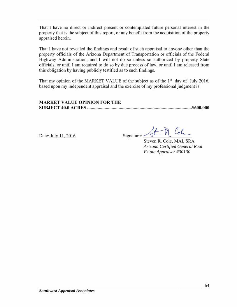
_________________________________________________________________________
______________________________________________________________________ Southwest Appraisal Associates
64
That I have no direct or indirect present or contemplated future personal interest in the property that is the subject of this report, or any benefit from the acquisition of the property appraised herein. That I have not revealed the findings and result of such appraisal to anyone other than the property officials of the Arizona Department of Transportation or officials of the Federal Highway Administration, and I will not do so unless so authorized by property State officials, or until I am required to do so by due process of law, or until I am released from this obligation by having publicly testified as to such findings. That my opinion of the MARKET VALUE of the subject as of the 1st day of July 2016, based upon my independent appraisal and the exercise of my professional judgment is: MARKET VALUE OPINION FOR THE SUBJECT 40.0 ACRES ..........................................................................................$600,000
Date: July 11, 2016 Signature: Steven R. Cole, MAI, SRA Arizona Certified General Real Estate Appraiser #30130

_________________________________________________________________________
______________________________________________________________________ Southwest Appraisal Associates
65
CERTIFICATION
THE APPRAISER CERTIFIES TO THE BEST OF MY KNOWLEDGE AND BELIEF: The statements of fact contained in this report are true and correct. The reported analyses, opinions, and conclusions are limited only by the reported assumptions and limiting conditions, and are my personal, unbiased professional analyses, opinions, and conclusions. I have no present or prospective interest in the property that is the subject of this report, and I have no personal interest or bias with respect to the parties involved. I have performed no services as an appraiser or in any other capacity regarding the property that is the subject of this report within the three-year period immediately preceding acceptance of this assignment. My compensation is not contingent upon the development or reporting of a predetermined value or direction in value that favors the cause of the client, the amount of the value opinion, the attainment of a stipulated result, or the occurrence of a subsequent event directly related t the intended use of the appraisal. My analyses, opinions, and conclusions were developed, and this report has been prepared in accordance with the standards and reporting requirements of the Uniform Standards of Professional Appraisal Practice of the Appraisal Foundation and any governmental authorities referenced within the appraisal report, including but not limited to the FDIC, OCC, FHLBB, and RTC. I have made a personal inspection of the property that is the subject of this report. No one provided significant professional assistance to the person(s) signing this certification, except as stated in the report. The reported analyses, opinions, and conclusions were developed, and this report has been prepared, in conformity with the Code of Professional Ethics and Standards of Professional Appraisal Practice of the Appraisal Institute. The use of this report is subject to the requirements of the Appraisal Institute relating to review by its duly authorized representatives and to the requirements of the Arizona Board of Appraisal. I certify that, to the best of my knowledge and belief, the reported analyses, opinions and conclusions were developed, and this report has been prepared, in conformity with the requirements of the Code of Professional Ethics and the Standards of Professional Practice of the Appraisal Institute. The use of this report is subject to the requirements relating to review by its duly authorized representatives.

_________________________________________________________________________
______________________________________________________________________ Southwest Appraisal Associates
66
I hereby certify that I am competent to complete the appraisal assignment. The reader is referred to appraiser’s Statement of Qualifications. No change of any item in the appraisal report shall be made by anyone other than the Appraiser, and the Appraiser shall have no responsibility for any such unauthorized change. The "Opinion of Market Value" in the appraisal report is not based in whole or in part upon the race, color, or national origin of the prospective owners or occupants of the property appraised, or upon the race, color, or national origin of the present owners or occupants of the properties in the vicinity of the property appraised. As of the date of this report, Steven R. Cole has completed the continuing education program for Designated Members of the Appraisal Institute.
Date: July 11, 2016 Steven R. Cole, MAI, SRA Certified General Real Estate Appraiser #30130
_________________________________________________________________________
______________________________________________________________________ Southwest Appraisal Associates
67
CERTIFICATION
THE APPRAISER CERTIFIES TO THE BEST OF MY KNOWLEDGE AND BELIEF: The statements of fact contained in this report are true and correct. The reported analyses, opinions, and conclusions are limited only by the reported assumptions and limiting conditions, and are my personal, unbiased professional analyses, opinions, and conclusions. I have no present or prospective interest in the property that is the subject of this report, and I have no personal interest or bias with respect to the parties involved. I have performed no services as an appraiser or in any other capacity regarding the property that is the subject of this report within the three-year period immediately preceding acceptance of this assignment. My compensation is not contingent upon the development or reporting of a predetermined value or direction in value that favors the cause of the client, the amount of the value opinion, the attainment of a stipulated result, or the occurrence of a subsequent event directly related t the intended use of the appraisal. My analyses, opinions, and conclusions were developed, and this report has been prepared in accordance with the standards and reporting requirements of the Uniform Standards of Professional Appraisal Practice of the Appraisal Foundation and any governmental authorities referenced within the appraisal report, including but not limited to the FDIC, OCC, FHLBB, and RTC. I have made a personal inspection of the property that is the subject of this report. No one provided significant professional assistance to the person(s) signing this certification, except as stated in the report. The reported analyses, opinions, and conclusions were developed, and this report has been prepared, in conformity with the Code of Professional Ethics and Standards of Professional Appraisal Practice of the Appraisal Institute. The use of this report is subject to the requirements of the Appraisal Institute relating to review by its duly authorized representatives and to the requirements of the Arizona Board of Appraisal. I certify that, to the best of my knowledge and belief, the reported analyses, opinions and conclusions were developed, and this report has been prepared, in conformity with the requirements of the Code of Professional Ethics and the Standards of Professional Practice of the Appraisal Institute. The use of this report is subject to the requirements relating to review by its duly authorized representatives.
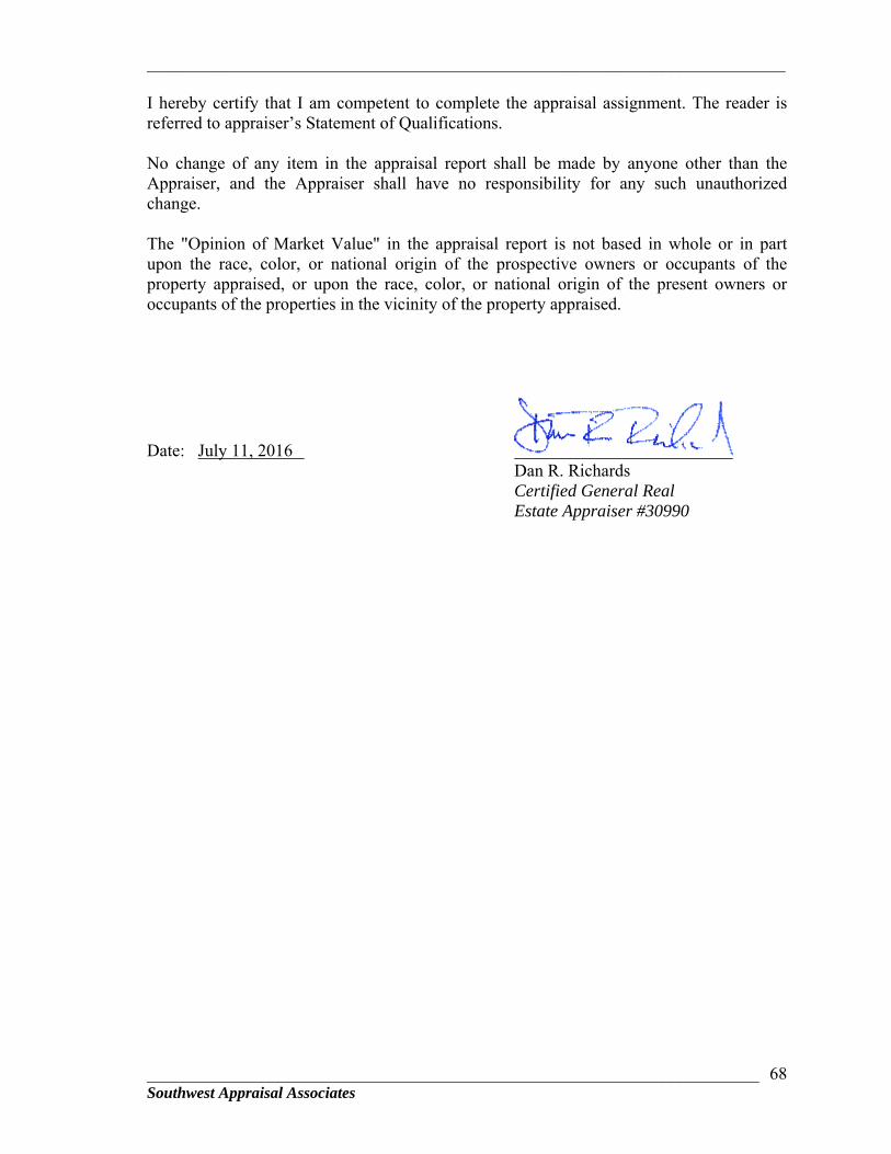
_________________________________________________________________________
______________________________________________________________________ Southwest Appraisal Associates
68
I hereby certify that I am competent to complete the appraisal assignment. The reader is referred to appraiser’s Statement of Qualifications. No change of any item in the appraisal report shall be made by anyone other than the Appraiser, and the Appraiser shall have no responsibility for any such unauthorized change. The "Opinion of Market Value" in the appraisal report is not based in whole or in part upon the race, color, or national origin of the prospective owners or occupants of the property appraised, or upon the race, color, or national origin of the present owners or occupants of the properties in the vicinity of the property appraised.
Date: July 11, 2016 Dan R. Richards Certified General Real Estate Appraiser #30990
_________________________________________________________________________
______________________________________________________________________ Southwest Appraisal Associates
69
QUALIFICATIONS OF STEVEN R. COLE, MAI, SRA FORMAL EDUCATION:
Bachelor of Arts Degree with high honors, University of California, Santa Barbara, 1971
Master’s Degree in Business Administration, University of California, Los Angeles, 1973. Concentration: Urban Land Economics
PROFESSIONAL EDUCATION:
Successful Completion of Examinations for the following courses given by the Appraisal Institute:
“Real Estate Appraisal Principles" and “Basic Valuation Procedures"
"Capitalization Theory & Techniques", Parts 1, 2, and 3 "Case Studies in Real Estate Valuation" "Introduction to Real Estate Investments Analysis” “Litigation Valuation” "Standards of Professional Practice", Part A, B & C
“Market Analysis”
Attendance at Numerous Educational Seminars: PROFESSIONAL MEMBERSHIPS:
Member, Appraisal Institute (MAI), Certification Number 6080. The institute conducts a voluntary program of continuing education for its designated members. MAI’s and RM’s who meet the minimum standards of this program are awarded periodic educational certification. As of this date, I have completed the requirements under the continuing education program of the Appraisal Institute. I am currently certified through December 31, 2014.
Senior Residential Appraiser (SRA), of the Appraisal Institute.
EXPERIENCE:
Includes valuation of most types of urban real property: single and multi-family residential, commercial, industrial, and vacant land. Experience also includes special purpose properties, feasibility studies, leased fee and leasehold interest, counseling, and appraisal for condemnation since 1975.
ADDITIONAL EDUCATIONAL AND PROFESSIONAL ACTIVITY: Publication of articles in Professional Journals:
“A New Methodology for Estimating Highest and Best Use”,
_________________________________________________________________________
______________________________________________________________________ Southwest Appraisal Associates
70
Real Estate Appraiser and Analyst, Summer, 1987
“Estimating the Value of Proposed Developments by Discounting Cash Flow”, Real Estate Review, Summer, 1988
Formerly a Certified Instructor with the Appraisal Institute for “Highest and Best Use Applications”, “Feasibility Analysis and Highest and Best Use- Nonresidential Properties”, and “Principals and Procedures of Real Estate Appraisal”.
Associate Faculty, Pima Community College for “Real Estate Appraisal Principals” and “Basic Valuation Procedures”, 2000-2006
Instructor for Tucson Board of Realtors, American Bar Association, Brodsky School of Real Estate, and Hogan School of Real Estate. Appraisal Principles, Appraisal Procedures, Market Analysis., Using the Internet for Due Diligence.
President of Southern Arizona Chapter #116, Appraisal Institute, 1983-84
President for the Arizona State Chapter #41, Appraisal Institute, 1990
Chairman, Pima County Real Estate Council, 2003-2004, Director 1989-2007. Member, Tucson Airport Authority, 2007-2008.
APPROVED APPRAISER:
With most major commercial banks and mortgage companies in Arizona.
STATE CERTIFICATION:
Arizona Certified General Real Estate Appraiser Number 30130. Currently certified through August 31, 2016.
_________________________________________________________________________
______________________________________________________________________ Southwest Appraisal Associates
71
QUALIFICATIONS OF DAN R. RICHARDS
CERTIFICATIONS Certified General Real Estate Appraiser, State of Arizona, 30990 (expires 02/28/16) EXPERIENCE Commercial Appraiser - February 2000 to present Southwest Appraisal Associates, Tucson, Arizona Appraisals of vacant land, vineyards, subdivisions, apartments, industrial, self-storage, commercial, office, special purpose, restaurants, hospitality properties, possessory interests, preparation of reports for litigation, right-of-way, and eminent domain appraisals. Residential & Commercial Appraiser - February 1999 to February 2000 The Schmidt-Prescott Group, Fremont, California Appraisals of all types of residential and commercial properties including single family new construction, residential subdivisions, office, retail, industrial, and preparation of reports for litigation. Independent Commercial & Residential Fee Appraiser - July 1992 to February 1999 Appraised full range of properties including single family residential, custom estates, apartments, commercial, office, industrial, auto dealerships, restaurants, hospitality properties, right-of-way, eminent domain and special purpose properties. Chief Appraiser - September 1988 to July 1992 Tracy Federal Bank, Concord, California (TFB acquired previous employer in September 1988) Appraisal department manager. Managed staff of three and large panel of independent residential and commercial fee appraisers. Developed and implemented bank appraisal policies and procedures. Administered all aspects associated with compliance to Federal Appraisal Regulations. Performed and reviewed appraisal reports for all types residential and commercial properties, multi-family, and residential subdivisions. Secondary responsibility was servicing residential and commercial construction loans which included progress inspections, disbursement of loan funds in accordance with physical completion, and problem loan workouts.
_________________________________________________________________________
______________________________________________________________________ Southwest Appraisal Associates
72
Dan R. Richards - Certified General Appraiser REO Supervisor/Review Appraiser - May 1983 to September 1988 Adobe Savings Bank, Concord, California Managed all aspects and disposition of real estate owned (REO) residential and commercial properties including tenant relations, lease negotiations, and contracting service providers to rehabilitate and sell REO properties. Began performing appraisal reports for residential and commercial properties in 1985 under the tutelage of James W. Goodhue, MAI, SRA. Additional responsibilities included construction loan department supervisor and problem loan workouts. EDUCATION Diablo Valley College: Liberal Arts APPRAISAL & RELATED EDUCATION
Post FIRREA Appraisal Management, U.S. League of Savings Institutions, September 1990 Appraisal Institute (formerly American Institute of Real Estate Appraisers)
Report Writing and Valuation Analysis, 1990 Case Studies in Real Estate Valuation, 1990 Subdivision Analysis Seminar, 1990 Capitalization Theory and Techniques, Parts A & B, 1989 Basic Valuation Procedures, 1989 Standards of Professional Practice, 2-3/8-3, 1987, & 1992 Principles of Real Estate Appraisal IA-I, 1987
Successfully completed the following courses from Diablo Valley College, Pleasant Hill, California: Real Estate Investments, 1988; Real Estate Principles, 1988; Real Estate Economics, 1987; Real Estate Appraisal I, 1983; Building Inspection - Non-structural/Uniform Building Code, 1984 Continuing Appraisal Education
Litigation Valuation Seminar, Appraisal Institute, August 1992 Appraisal Consulting, Appraisal Institute, October 2003 Practical Issues in Fair Housing, Hogan School of R.E., January 2005 Water in Arizona: Laws, Agencies & Issues, Hogan School of R.E., February 2005 Spring AG Outlook Forum, Society of Farm Managers and Rural Appraisers, February 2005 National USPAP Update, Arizona Appraiser’s Conference, August 2015
_________________________________________________________________________
______________________________________________________________________ Southwest Appraisal Associates
73
ADDENDA
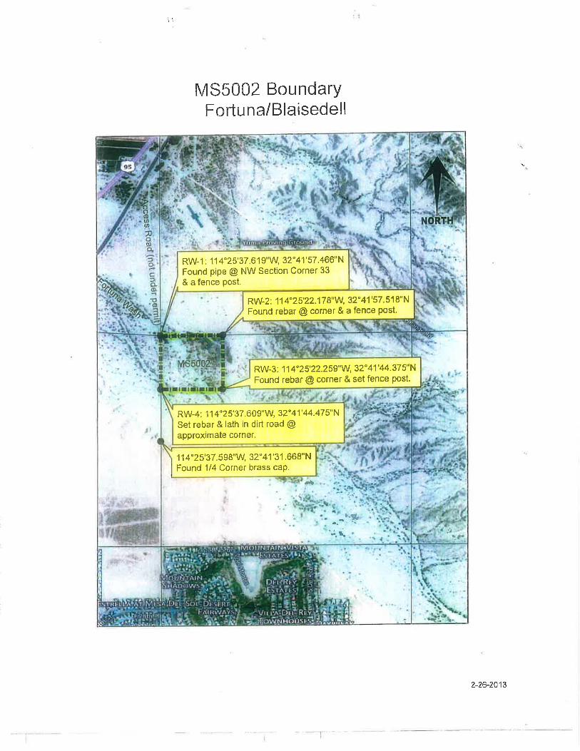
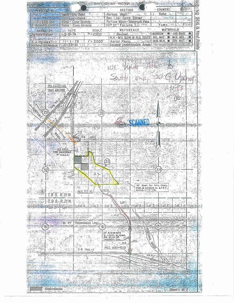
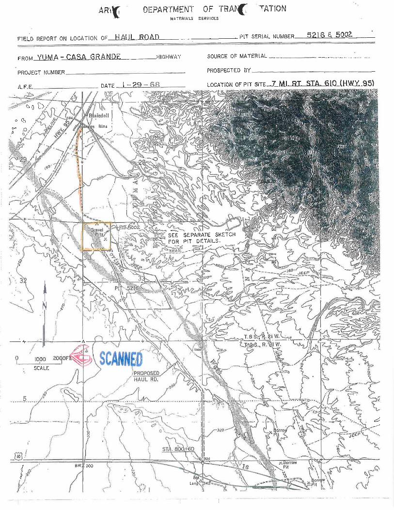
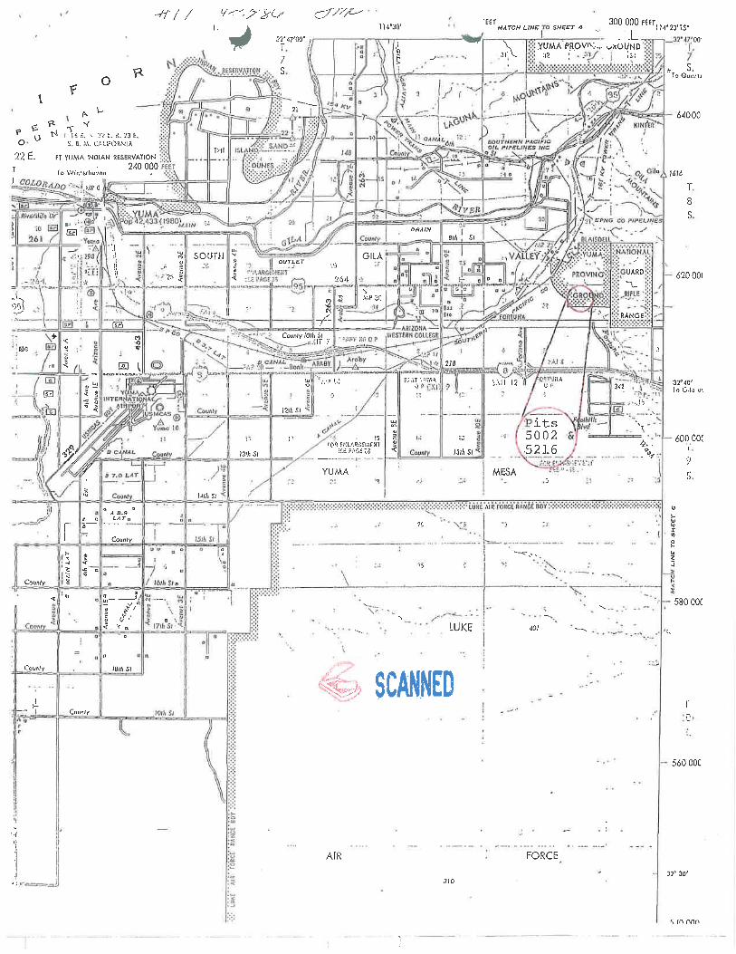
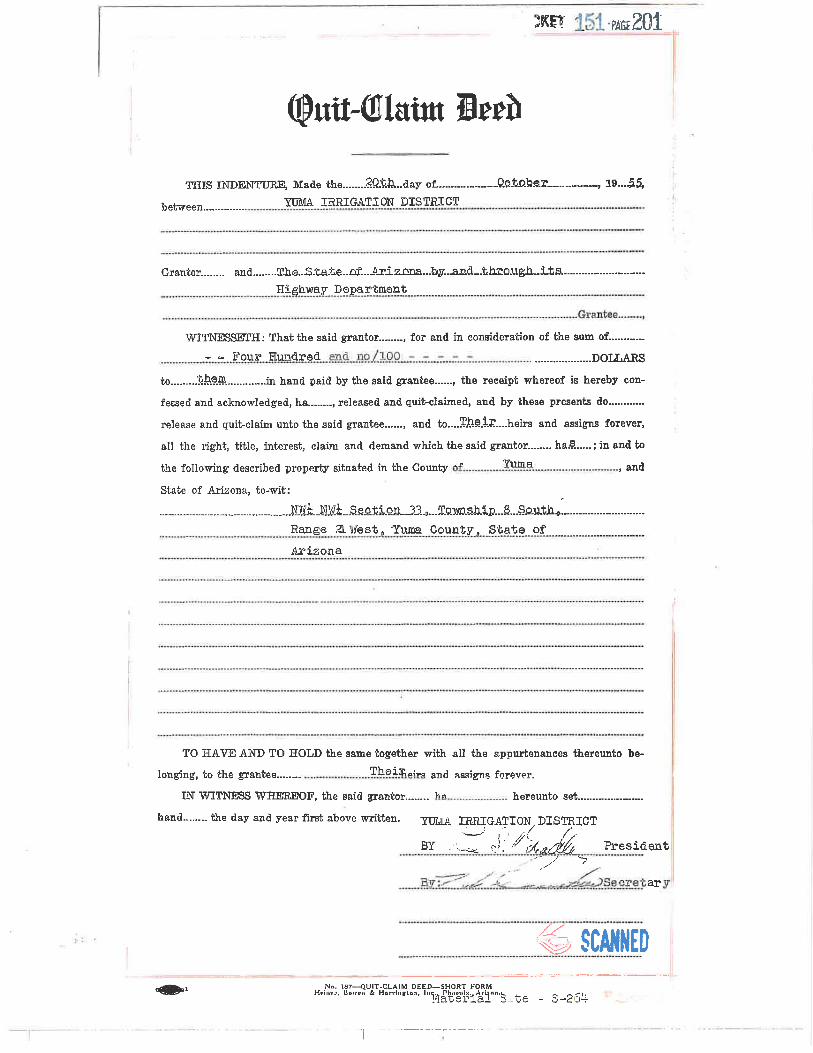
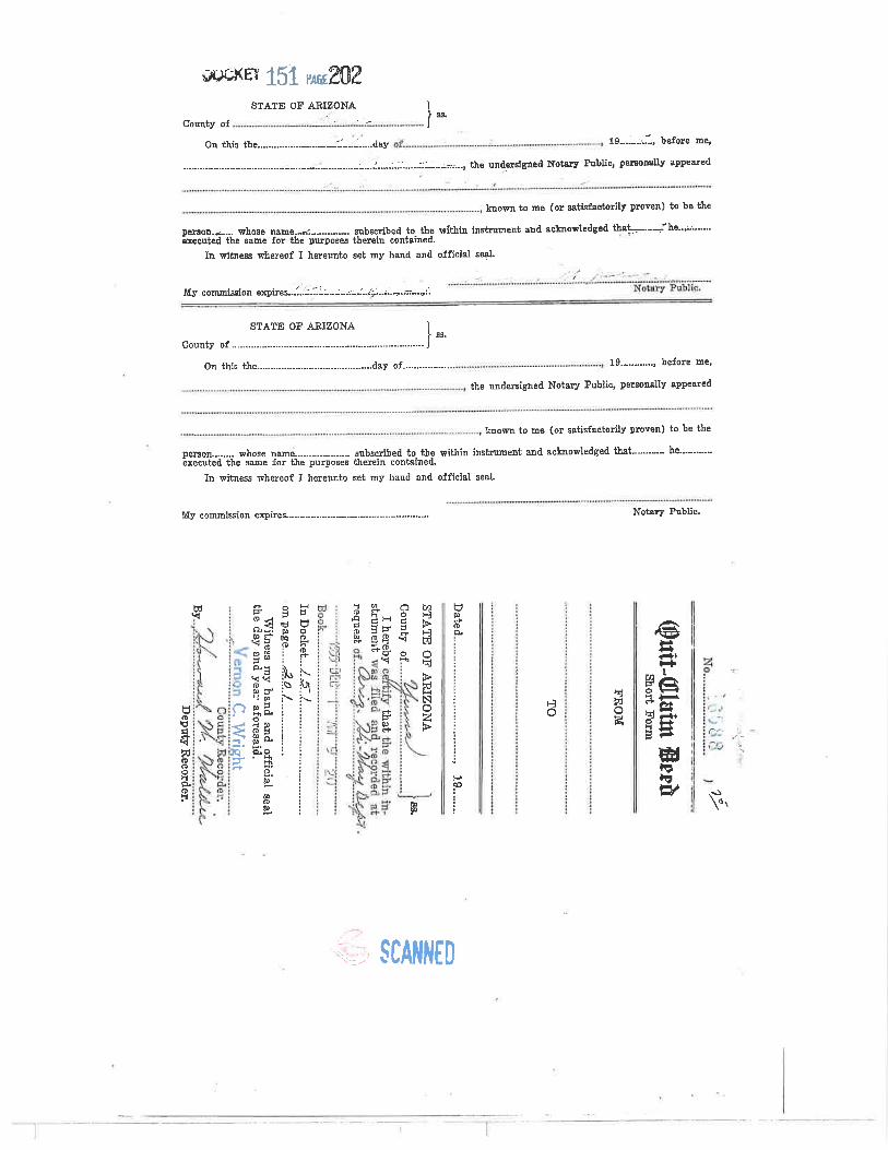
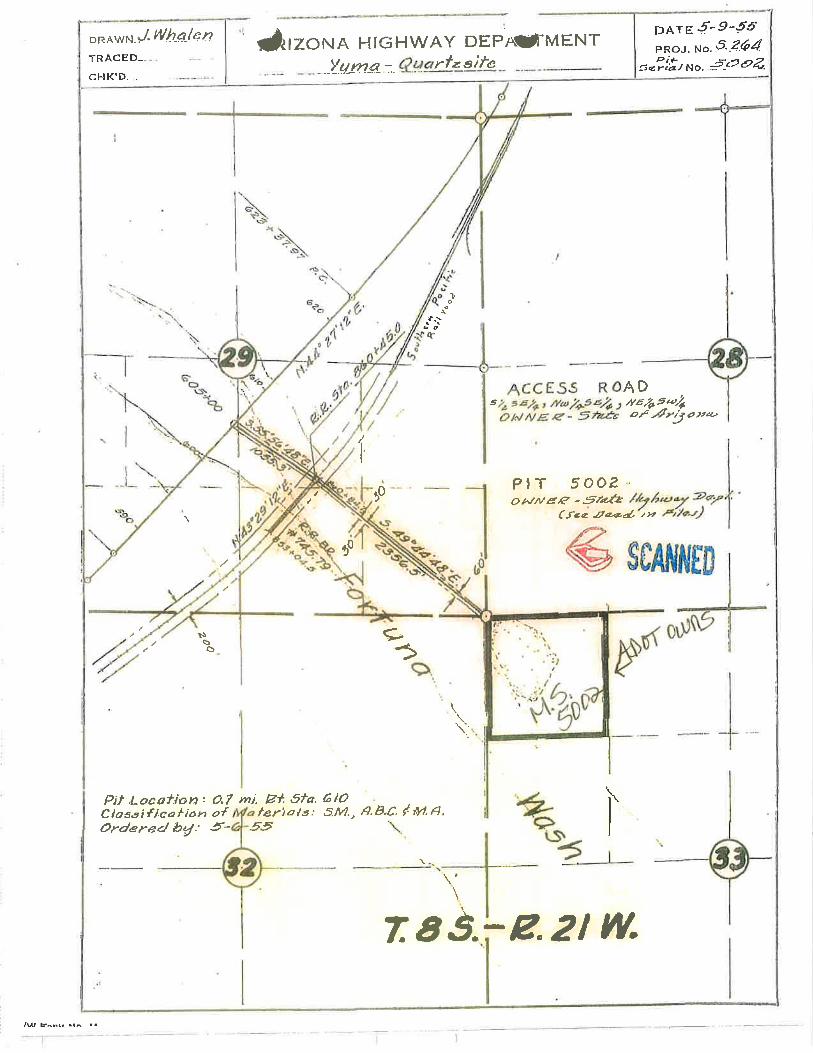

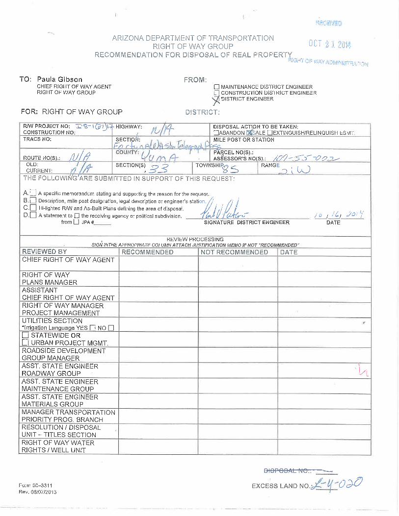
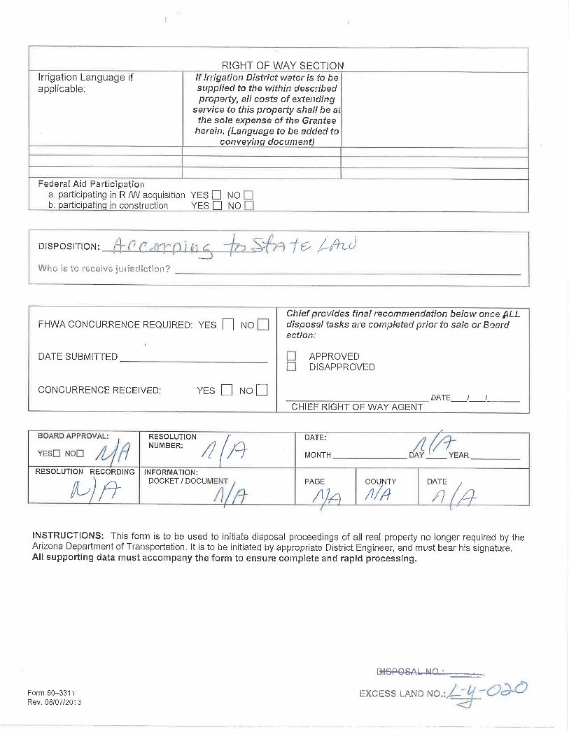


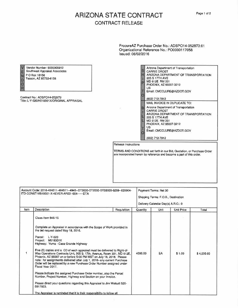


![[INSERT COMPANY LETTERHEAD] LETTER OF T · Parcel(s): [INSERT PARCEL NUMBER(S)] Land Disposition 8.8.12 4 SUMMARY APPRAISAL REPORT (A partial sample is shown.) This is a summary appraisal](https://img.pdfslide.us/doc/110x75/5f549d9517be5a3f8a4f1f97/insert-company-letterhead-letter-of-t-parcels-insert-parcel-numbers-land.jpg)