Embed Size (px)
Citation preview
DUNDAS ST
KING ST
YORK ST
QUEENS AVE
COLB
ORNE
STGREENSIDE AVE
SUNNINGHILLAVE
HORTON ST E
PRIC
E ST
ST J
ULIE
N ST
MEA
DOW
LILY
RD
S
RICH
MON
D ST
WEL
LING
TON
ST
WAT
ERLO
O ST
CLAR
ENCE
ST
DUFFERIN AVE
HWY 401 E
CLAR
KE R
D
HWY 401 W
DUNDAS ST
HWY 402 E
BRADLEY AVE
OXFORD ST WOXFORD ST W
HWY 402 W
OXFORD ST E OXFORD ST E
WES
TDEL
BRN
E
HAMILTON RD
HURON STHURON ST
ADEL
AIDE
ST
N
RICH
MON
D ST
RICHMOND ST
EXETER RD
HIGH
BURY
AVE
N
GORE RD
HYDE
PAR
K RD
RIVERSIDE DR
RIVERSIDE DR
PACK RD
WON
DERL
AND
RD S
COMMISSIONERS RD E
WESTMINSTER DR
CHEAPSIDE ST
VICTORIA ST
GROSVENOR ST
CHEAPSIDE ST
SOUTHDALE RD W
WHARNCLIFFE RD S
SARNIA RD
VETERANS MEM
ORIAL PKYCO
LONE
L TA
LBOT
RD
WILTON GROVE RD
WON
DERL
AND
RD N
WON
DERL
AND
RD S
WEL
LING
TON
RD
SUNNINGDALE RD E
COMMISSIONERS RD W
SUNNINGDALE RD W
FANSHAWE PARK RD E FANSHAWE PARK RD E
WHI
TE O
AK R
D
BOLE
R RD
SOUTHDALE RD E
SOUTHDALE RD W
FANSHAWE PARK RD W
KILALLY RD
HIGH
BURY
AVE
S
CRUM
LIN
SDRD
SPRINGBANK DR
LONGWOODS RD
RIVER RD
ROBIN'S HILL RD
VISCOUNT RD
WES
TERN
RD
GAINSBOROUGH RD
POND
MIL
LS R
D
WAVELL ST
EGER
TON
ST
RIDO
UT S
T S
BYRON BASELINE RD
BRYDGES ST
MUR
RAY
RD
ERNE
ST A
VE
BOST
WIC
K RD
FLORENCE ST
TALB
OT S
T
SHARON RD
SAND
FORD
ST
WINDERMERE RD
ADEL
AIDE
ST
S
CENTRAL AVE
JACK
SON
RD
TRAFALGAR ST
QUEB
EC S
T
KAIN
S RD
SECO
ND S
T
OLD
VICT
ORIA
RD
THOMPSON RD
COOK
RD
MAIN ST
WHA
RNCL
IFFE
RD
NUP
PER
QUEE
N ST
PLAT
T'S L
ANE
SANA
TORI
UM R
D
SASK
ATOO
N STHORTON ST W
NIXO
N AV
ETH
AMES
ST
BASE LINE RD E
REGENT ST
ADELAIDE ST S
HURON STUNIVERSITY DR
TRAFALGAR ST
POND
MIL
LS R
D OLD
VICT
ORIA
RD
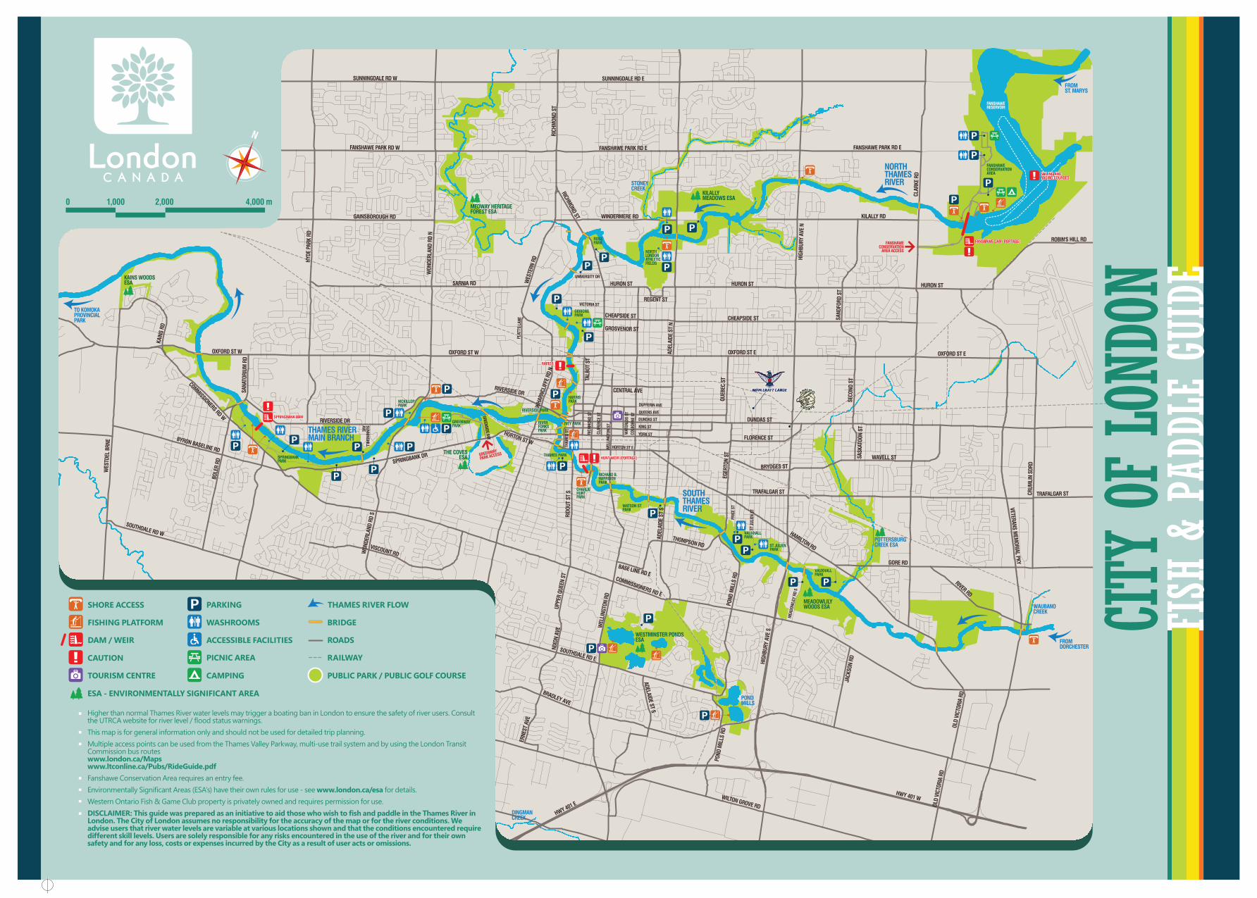
FANSHAWECONSERVATIONAREA
FANSHAWERESERVOIR
FANSHAWECONSERVATION
AREA ACCESS
FANSHAWE DAM (PORTAGE)FANSHAWE DAM (PORTAGE)
HUNT WEIR (PORTAGE)HUNT WEIR (PORTAGE)
RAPIDSRAPIDS
SPRINGBANK DAMSPRINGBANK DAM
SAILING ANDRACING COURSESSAILING ANDRACING COURSES
NORTHLONDONATHLETICFIELDS
ROSSPARK
GIBBONSPARK
HARRISPARK
IVEY PARK
THAMES PARK
RIVERSIDE PARK
RICHARD B.HARRISONPARK
CHARLIEHUNTPARK
WATSON STPARK
VAUXHALLPARK
ST JULIENPARK
VAUXHALLPARK
SOUTHTHAMESRIVER
NORTHTHAMESRIVERSTONEY
CREEK
MEDWAY HERITAGEFOREST ESA
KILALLYMEADOWS ESA
DINGMANCREEK
POTTERSBURGCREEK ESA
WAUBANOCREEK
FROMST. MARYS
FROMDORCHESTER
WESTMINSTER PONDSESA
MEADOWLILYWOODS ESA
PONDMILLS
THAMES RIVERMAIN BRANCH
TO KOMOKAPROVINCIALPARK
RIVERFORKSPARK
GREENWAYPARK
GREENWAY
PARK ACCESS
MCKILLOPPARK
SPRINGBANKPARK
KAINS WOODSESA
THE COVESESA
N
0 2,000 4,000 m1,000
SHORE ACCESS THAMES RIVER FLOW
FISHING PLATFORM
DAM / WEIR
CAUTION
PARKING
WASHROOMS
ACCESSIBLE FACILITIES
PICNIC AREA
CAMPINGTOURISM CENTRE
BRIDGE
ROADS
RAILWAY
PUBLIC PARK / PUBLIC GOLF COURSE
ESA - ENVIRONMENTALLY SIGNIFICANT AREA
CITY
OF LO
NDON
FISH
& P
ADDL
E GU
IDE
Higher than normal Thames River water levels may trigger a boating ban in London to ensure the safety of river users. Consult the UTRCA website for river level / flood status warnings.This map is for general information only and should not be used for detailed trip planning.Multiple access points can be used from the Thames Valley Parkway, multi-use trail system and by using the London Transit Commission bus routeswww.london.ca/Mapswww.ltconline.ca/Pubs/RideGuide.pdfFanshawe Conservation Area requires an entry fee.Environmentally Significant Areas (ESA’s) have their own rules for use - see www.london.ca/esa for details.Western Ontario Fish & Game Club property is privately owned and requires permission for use.DISCLAIMER: This guide was prepared as an initiative to aid those who wish to fish and paddle in the Thames River in London. The City of London assumes no responsibility for the accuracy of the map or for the river conditions. We advise users that river water levels are variable at various locations shown and that the conditions encountered require different skill levels. Users are solely responsible for any risks encountered in the use of the river and for their own safety and for any loss, costs or expenses incurred by the City as a result of user acts or omissions.
All anglers between ages 18 and 64 must posses a valid fishing licence. People not in this age group do not require a licence, but have all the rights and responsibilities of people with a licence. Visitors from outside the province require a non-resident licence. Persons with disabilities do not require a fishing licence.
www.on.wildlifelicense.com
www.ontario.ca/document/ontario-fishing-regulations-summary
Information about fishing in Ontario, including how to get a fishing licence, Outdoors Card, city fishing, camping on crown land, and eating Ontario fish, can be found in Ontario’s Ministry of Natural Resources and Forestry website at:
www.ontario.ca/page/fishing
Fish Species Habitat Season
Angling Sports681 Highbury Ave N
Bulls Eye820 Wharncliffe Road S, Unit 32
Canadian Tire - East London1975 Dundas St
Canadian Tire - South London1125 Wellington Road S
Forest City Fly Shop96 Rectory St
Lambeth Rod and Tackle2404 Main St
Nova Sports Equipment471 Nightingale Avenue
Service Ontario100 Dundas St
The Archer’s Nook90 Charter House, Unit 18
Sample of those listed in the yellow pages
Smallmouth Bass
Largemouth Bass
Rock Bass
Catfish
Yellow Perch
Pumpkinseed
White Sucker
Carp
Walleye
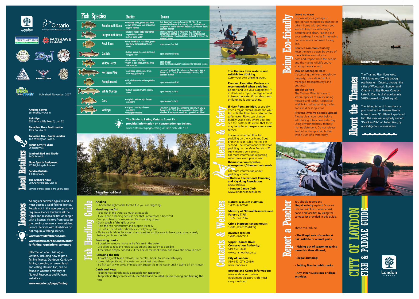
Fanshawe Reservoir
Geral
do D
uarte
Northern Pike
cool clear lakes, ponds and riversgravel bottoms or near large rocks, logs or stumps
shallow, weedy water near dense vegetation for coverprefers warm water
broad range of habitatswarm or cold lakes, ponds, rivers and streams
adapts to a variety of water conditionsvery light sensitive
cool lakes, large ponds, rivers, near weedy shoreline
still, shallow water with vegetative cover
bottom feeders in warm shallow water
adapts to wide variety of water conditions
near shoreline or cool lakes, ponds and slow-moving streams and rivers
bottom feeder in deeper lakes and sluggish rivers
last Saturday in June to November 30 / limit 2 for conservation licence; 6 in one day or a combination of Largemouth and Smallmouth Bass to total 6 in one day for standard licence last Saturday in June to November 30 / limit 2 for conservation licence; 6 in one day or a combination of Largemouth and Smallmouth Bass to total 6 in one day for standard licence
January 1 to March 15 and second Saturday in May to December 31 / limit 2 for conservation licence; 4 for standard licence / not more than 1 greater than 46 cm
January 1 to March 31 and second Saturday in May to December 31 / limit 2 for conservation licence; 6 for standard licence
open all yearLimit 25 for conservation licence; 50 for standard licence
open season / no limit
open season / no limit
open season / no limit
open season/ no limit
open season/ no limit
The Guide to Eating Ontario Sport Fishprovides information on consumption guidelines.www.ontario.ca/page/eating-ontario-fish-2017-18
CITY
OF LO
NDON
FISH
& P
ADDL
E GU
IDE
Published: November 2017
The Thames River flows west273 kilometres (170 mi) through southwestern Ontario, through the cities of Woodstock, London and Chatham to Lighthouse Cove on Lake St. Clair. Its drainage basin is 5,825 square km (2,249 sq mi).
The fishing is good from shore or your boat as the Thames River is home to over 90 different species of fish. The river was originally named “Deshkan Ziibi” or Antler River, by our indigenous communities.
Leave no traceDispose of your garbage in appropriate receptacles onshore or take it home with you when you leave to keep our waterways beautiful and clean. Packing out your garbage includes fish remains, bait containers and used fishing line.Practice common courtesyKeep the noise down, be aware of the activities around yourboat and respect both the people and the marine wildlife you're sharing the water with.Stay on Managed TrailsIf accessing the river through city property, users should utilize managed trails/pathways and entrancesSpecies at RiskThe Thames River is home to several species of risk including mussels and turtles. Respect all wildlife including basking turtles and avoid nesting areas
Prevent Invasive Species SpreadAlways clean your boat before introducing it to a new waterway using environmentally-friendly marine detergent. Do not release live bait or dump a bait bucket within 30m of a waterbody.
Angling- Choose the right tackle for the fish you are targetingHandling the fish- Keep fish in the water as much as possible- If you need a landing net, use one that is coated or rubberized- Wet your hands, or use wetted fish-handling gloves- Don’t touch a fish’s gills or eyes- Hold the fish horizontally and support its belly- Do not suspend fish vertically, especially large fish- Photograph fish in the water when possible, and be sure to have your camera ready
Removing hooks- If possible, remove hooks while fish are in the water- Use pliers to take the hook out as quickly and safely as possible- If the fish is deeply hooked, cut the line or the hook shank and leave the hook in placeReleasing the fish- If practicing catch and release, use barbless hooks to reduce fish injury- Lower fish gently into the water — don’t just drop them- If a fish can’t swim away immediately, support it in the water until it swims off on its ownCatch and Keep- Keep harvested fish easily accessible for inspection- Keep fish so they can be easily identified and counted, before storing and filleting the
before you hook the fish
fish
Natural resource violation:1-877-847-7667
Ministry of Natural Resources and Forestry TIPS:1-877-847-7667
Crime Stoppers (anonymous):1-800-222-TIPS (8477)
Invasive species:1-800-563-7711
Upper Thames RiverConservation Authority:519-451-2800www.thamesriver.on.ca
City of London:519-661-CITY (2489)www.london.ca
Boating and Canoe information:www.aceboater.com/en/equipment-pleasure-craft-must-carry-on-board
You should report anyillegal activity against Ontario’s fish and wildlife, species at risk, parks and facilities by using the contact list provided in this guide.
These can include:
- The illegal sale of species atrisk, wildlife or animal parts;
- Fishing out of season or takingmore fish than allowed;
- Illegal dumping;
- Setting fires in public parks;
- Any other suspicious or illegalactivities.
Geral
do D
uarte
Thames River - North Branch
Fish Ha
ndlin
g Gu
ide
Licences
Local R
etailers
About t
he T
hame
sBeing
Eco-fr
iendly
Report
a Po
acher
Healt
h &
Safet
yCo
ntacts
& W
ebsit
es
Fish Ha
ndlin
g Gu
ide
Licences
Local R
etailers
About t
he T
hame
sBeing
Eco-fr
iendly
Report
a Po
acher
Healt
h &
Safet
yCo
ntacts
& W
ebsit
es
Fish Ha
ndlin
g Gu
ide
Licences
Local R
etailers
About t
he T
hame
sBeing
Eco-fr
iendly
Report
a Po
acher
Healt
h &
Safet
yCo
ntacts
& W
ebsit
es
The Thames River water is not suitable for drinking.Carry your own drinking water.
Personal Floatation Devices are recommended when paddling.Be alert and use your judgement, if in doubt of a rapid, portage around it. Leave the water if thunderstorms or lightning is approaching.
If river flows are high, especially after a major rainfall, postpone your trip until the flows have returned to safer levels. Flows can change quickly. Wade only where you can see the bottom. Be aware that there may be holes or deeper areas close to you.
The recommended flow for paddling on the North and South Branches is 15 cubic metres per second. The recommended flow for paddling on the Main Branch is 20 cubic metres per second.For more information regarding water flow levels please visit:thamesriver.on.ca/water-management/thames-river-levels
For more information about paddling, contact:- Ontario Recreational Canoeingand Kayaking Association(www.orcka.ca)- London Canoe Club(www.londoncanoeclub.ca)