Embed Size (px)
Citation preview
1
Two Gold Properties for Option, Northwestern Ontario
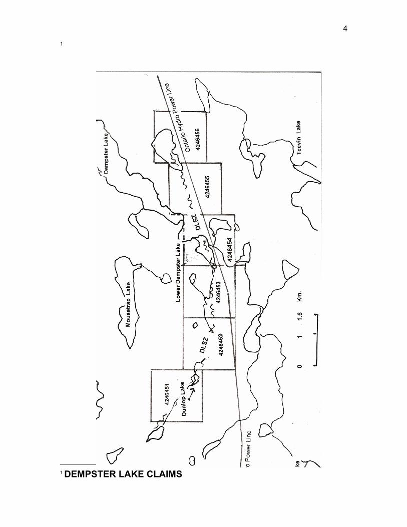
My two grassroots gold exploration properties located about 60-70 km southwest of Pickle Lake, northwestern Ontario. The properties are located near a winter road and Ontario Hydro line power line, on two major shear zone structures. This is the same power line and winter road that extends to the former Golden Patricia gold mine in the Dorthy-Dobie Lakes area from Pickle Lake. This mine is located 22 km to the northwest of my Dempster Lake claims. As an overview of my two properties, I have three anomalous humus gold areas on two properties, two of the anomalous humus corridors are 1.6 km long and 250-300 m wide and a third which is shaping up to extend over a length also of 1.6 km and a width of at least 80 metres. These anomalous corridors are on or close to two major east-west striking shear zones, namely the Dempster Lake Shear Zone (DLSZ) and the Fry-McVean Shear Zone (FMSZ). These brittle-ductile shear zones are of the same magnitude as the Bearhead Fault or Shear Zone in the Dorthy-Dobie Lakes area, on which the Golden Patricia mine is located. None of these gold anomalies has been drill tested. Two of the anomalies are compared statistically to the humus gold anomaly over the Page-Williams mine gold deposit at Hemlo in my reports. On my Dempster Lake claims and on my Fry-McVean claims, two of these impressive humus gold anomalies are from surveys conducted by Noranda Exploration in the 1980’s. It would appear that Noranda’s geologists never calculated the threshold value of humus gold so they allowed the claims to lapse. The Fry-McVean Shear Zone (FMDZ) is a major regional shear zone, 11.4 km long on my claims that is comprised of a 150- to 70-metre wide shear zone corridor that encloses banded iron formation (BIF) and porphyry dikes with anomalous gold values identified in drill holes on adjoining claims of Commander Resources that cover 3.0 km of the FMSZ. One drill hole intersected 0.5 metres of 0.75 ounces gold / ton and numerous intersections of sheared BIF and porphryry returned sub-economic gold assays. Interpreted Riedel shears on the Fry-McVean claims, expressed as Airborne EM conductors, emanate from the FMSZ as a sub-parallel array of en-echelon shears at an angle of 15 degrees as would be predicted by the Coulomb failure criteria. Each Riedel shear extends for a number of kilometers from the FMSZ to form a deformation zone about one km wide and 14 km long. They strike in a sub-parallel direction to the principal shear zone, the FMSZ, as would be predicted from studies of Riedel systems. Riedel shears are known for being an anastomosing network of R, R’, D, P and T fractures which are highly permeable to mineralizing fluids because a number of these fractures may become dilatant during deformation failure. This is the structural explanation for the Seabee gold mine and other gold mines including the famous Sigma, McIntyre,
2
Hollinger, Campbell Red Lake and Dickenson mines according to recent geological papers. These Riedel hosted mines account for over 62 million ounces of past production. The anomalous gold corridor mentioned above, on the Dempster Lake claims, near Arrowhead Lake, has both humus and B-horizon (till) gold sampling. It displays a 300- by 400- metre apparent dispersal train of gold in till under a 200- by 300- metre humus gold anomaly. The humus anomaly has values up to 40 ppb gold. Some 400 metres to the west, on strike, humus values as high as 55 ppb gold have been reported and this is as high as the peak 55 ppb gold value in humus reported by Fortescue of the OGS over the Page Williams mine’s orebody at Hemlo (Reference: Fortescue, J.A.C., 1985, A Standardized Approach to the Study of the Geochemistry of Humus, Williams Property, Hemlo, Thunder Bay District, Ontario Geological Survey, Map 80 716, Geochemical Series.) All anomalous gold values at the humus sample sites on the two properties have been tested thoroughly using 1,449 sample values and advanced geostatistical methods to determine the local threshold value of gold in humus that limits the lower value of anomalous samples. This method has been used successfully at Hemlo over the Page-Williams mine deposit where the background-threshold value determined by Gleeson and Sheehan was less than 5 ppb gold. I have for comparison purposes, statistical data on the humus gold anomalies at the Page-Williams mine, Hemlo in my geological reports from Fortescue. Background humus samples on my properties are in the range of 0.5 to 3.5 ppb gold. One of the three anomalous humus gold areas lies very close to the main break on the Dempster Lake Shear Zone. This anomalous humus gold corridor is centred within a 1,600-mile wide carbonate alteration zone (or halo) in mafic volcanics, which is not unlike the 3,000-metre wide carbonate halo covering the mine trend at Red Lake- i.e. the Goldcorp’s Campbell Red Lake and former Dickenson (now the Red Lake) mines. As stated by Dube and Gosselin and other geologistsof the GSC, the largest lode quartz-carbonate vein gold mines are located on large carbonate halos (+/- other minerals) This anomalous humus gold area is located beside the inferred position of the Dempster Lake Shear Zone (DLSZ) under Lower Dempster Lake, where an outcrop of talc-carbonate rock suggests the presence of ultramafic rocks (probably carbonated serpentinized komatiite), This talc alteration could indicate a komatiite flows in the shear/ fault zones similar to that found on advanced exploration properties at Red Lake and in Goldcorp’s High Grade Zone. This 1,600-metre long anomalous humus gold corridor at Lower Dempster Lake could be till sampled by backhoe from the Ontario hydro power line winter road, in the winter given that the humus gold anomaly is probably located150-200 metres down ice, as a till dispersal train, from its source in the DLSZ. The humus
3
anomaly is believed to be due to a 1-mile wide dispersal train in till (with glaciation across the strike of the rocks) which has given rise to the humus anomaly of 250-300 metres wide across the strike of the volcanic units. If would like to receive more information, please let me know by calling 613-746-9873 or send an e-mail. I will be showing at the PDAC next March if I have not optioned the properties by that time. Donald Brown, Ph.D., P.Geo., Geologist Tel and Fax: 613-746-9873 E-Mail: [email protected]
4
1
1 DEMPSTER LAKE CLAIMS

5
2
FRY McVEAN CL:AIMS