Embed Size (px)
Citation preview
ArcGIS®
9Using ArcGIS® Geostatistical Analyst
Copyright © 2001, 2003 ESRIAll Rights Reserved.Printed in the United States of America.
The information contained in this document is the exclusive property of ESRI. This work is protected under United States copyright law and the copyrightlaws of the given countries of origin and applicable international laws, treaties, and/or conventions. No part of this work may be reproduced or transmittedin any form or by any means, electronic or mechanical, including photocopying or recording, or by any information storage or retrieval system, except asexpressly permitted in writing by ESRI. All requests should be sent to Attention: Contracts Manager, ESRI, 380 New York Street, Redlands, CA 92373-8100, USA.
The information contained in this document is subject to change without notice.
DATA CREDITSCarpathian Mountains data supplied by USDA Forest Service, Riverside, California, and is used here with permission.
Radioceasium data supplied by International Sakharov Environmental University, Minsk, Belarus, and is used here with permission. Copyright © 1996.
Air quality data for California supplied by California Environmental Protection Agency, Air Resource Board, and is used here with permission.Copyright © 1997.
Radioceasium contamination in forest berries data supplied by the Institute of Radiation Safety “BELRAD”, Minsk, Belarus, and is used here withpermission. Copyright © 1996.
CONTRIBUTING WRITERSKevin Johnston, Jay M. Ver Hoef, Konstantin Krivoruchko, and Neil Lucas
DATA DISCLAIMER
THE DATA VENDOR(S) INCLUDED IN THIS WORK IS AN INDEPENDENT COMPANY AND, AS SUCH, ESRI MAKES NO GUARANTEES AS TO THEQUALITY, COMPLETENESS, AND/OR ACCURACY OF THE DATA. EVERY EFFORT HAS BEEN MADE TO ENSURE THE ACCURACY OF THE DATAINCLUDED IN THIS WORK, BUT THE INFORMATION IS DYNAMIC IN NATURE AND IS SUBJECT TO CHANGE WITHOUT NOTICE. ESRI ANDTHE DATA VENDOR(S) ARE NOT INVITING RELIANCE ON THE DATA, AND ONE SHOULD ALWAYS VERIFY ACTUAL DATA AND INFORMATION.ESRI DISCLAIMS ALL OTHER WARRANTIES OR REPRESENTATIONS, EITHER EXPRESSED OR IMPLIED, INCLUDING, BUT NOT LIMITED TO,THE IMPLIED WARRANTIES OF MERCHANTABILITY OR FITNESS FOR A PARTICULAR PURPOSE. ESRI AND THE DATA VENDOR(S) SHALLASSUME NO LIABILITY FOR INDIRECT, SPECIAL, EXEMPLARY, OR CONSEQUENTIAL DAMAGES, EVEN IF ADVISED OF THE POSSIBILITYTHEREOF.
U. S. GOVERNMENT RESTRICTED/LIMITED RIGHTS
Any software, documentation, and/or data delivered hereunder is subject to the terms of the License Agreement. In no event shall the U.S. Government acquiregreater than RESTRICTED/LIMITED RIGHTS. At a minimum, use, duplication, or disclosure by the U.S. Government is subject to restrictions as set forth inFAR §52.227-14 Alternates I, II, and III (JUN 1987); FAR §52.227-19 (JUN 1987) and/or FAR §12.211/12.212 (Commercial Technical Data/ComputerSoftware); and DFARS §252.227-7015 (NOV 1995) (Technical Data) and/or DFARS §227.7202 (Computer Software), as applicable. Contractor/Manufactureris ESRI, 380 New York Street, Redlands, CA 92373-8100, USA.
ESRI, SDE, the ESRI globe logo, ArcGIS, ArcInfo, ArcCatalog, ArcMap, 3D Analyst, and GIS by ESRI are trademarks, registered trademarks, or service marksof ESRI in the United States, the European Community, and certain other jurisdictions.
Other companies and products mentioned herein are trademarks or registered trademarks of their respective trademark owners.
Attribution.pmd 11/25/2003, 4:46 PM1

IN THIS CHAPTER
11
With Geostatistical Analyst, you can easily create a continuous surface,or map, from measured sample points stored in a point-feature layer, rasterlayer, or by using polygon centroids. The sample points may be measurementssuch as elevation, depth to the water table, or levels of pollution, as is the casein this tutorial. When used in conjunction with ArcMap, Geostatistical Analystprovides a comprehensive set of tools for creating surfaces that can be usedto visualize, analyze, and understand spatial phenomena.
Tutorial scenario
The U.S. Environmental Protection Agency is responsible for monitoringatmospheric ozone concentration in California. Ozone concentration is mea-
sured at monitoring stations throughout the state.The locations of the stations are shown here. Theconcentration levels of ozone are known forall of the stations, but we are also interested inknowing the level for every location in California.However, due to cost and practicality, monitoringstations cannot be everywhere. GeostatisticalAnalyst provides tools that make the best predic-tions possible by examining the relationshipsbetween all of the sample points and producing acontinuous surface of ozone concentration,standard errors (uncertainty) of predictions, andprobabilities that critical values are exceeded.
Quick-start tutorial 2• Exercise 1: Creating a surface
using default parameters
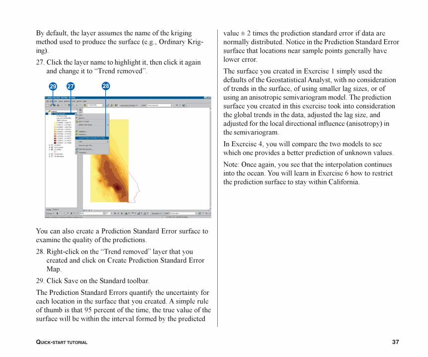
• Exercise 2: Exploring your data
• Exercise 3: Mapping ozone con-centration
• Exercise 4: Comparing models
• Exercise 5: Mapping the probabil-ity of ozone exceeding a criticalthreshold
• Exercise 6: Producing the finalmap
ch02_Tutorial.pmd 11/25/2003, 4:33 PM11
12 USING ARCGIS GEOSTATISTICAL ANALYST
The data you�ll need for this tutorial is included on theGeostatistical Analyst installation disk. The datasets wereprovided courtesy of the California Air Resources Board.
The datasets are:
Dataset Description
ca_outline Outline map of California
ca_ozone_pts Ozone point samples (ppm)
ca_cities Location of major California cities
ca_hillshade A hillshade map of California
The ozone dataset (ca_ozone_pts) represents the 1996maximum eight-hour average concentration of ozone inparts per million (ppm). (The measurements were takendaily and grouped into eight-hour blocks.) The original datahas been modified for the purposes of the tutorial andshould not be taken to be accurate data.
From the ozone point samples (measurements), you willproduce two continuous surfaces (maps), predicting thevalues of ozone concentration for every location in the Stateof California based on the sample points that you have. Thefirst map that you create will simply use all default optionsto show you how easy it is to create a surface from yoursample points. The second map that you produce will allowyou to incorporate more of the spatial relationships that arediscovered among the points. When creating this secondmap, you will use the ESDA tools to examine your data.You will also be introduced to some of the geostatisticaloptions that you can use to create a surface such asremoving trends and modeling spatial autocorrelation. By
Introduction to the tutorial
using the ESDA tools and working with the geostatisticalparameters, you will be able to create a more accuratesurface.
Many times it is not the actual values of some caustichealth risk that is of concern, but rather if it is above sometoxic level. If this is the case, immediate action must betaken. The third surface you create will assess the probabil-ity that a critical ozone threshold value has been exceeded.
For this tutorial, the critical threshold will be if the maximumaverage of ozone goes above 0.12 ppm in any eight-hourperiod during the year; then the location should be closelymonitored. You will use Geostatistical Analyst to predict theprobability of values complying with this standard.
This tutorial is divided into individual tasks that are designedto let you explore the capabilities of Geostatistical Analystat your own pace. To get additional help, explore theArcMap online Help system or see Using ArcMap.
� Exercise 1 takes you through accessing GeostatisticalAnalyst and through the process of creating a surface ofozone concentration to show you how easy it is to createa surface using the default parameters.
� Exercise 2 guides you through the process of exploringyour data before you create the surface in order to spotoutliers in the data and to recognize trends.
� Exercise 3 creates the second surface that considersmore of the spatial relationships discovered in Exercise 2and improves on the surface you created in Exercise 1.This exercise also introduces you to some of the basicconcepts of geostatistics.
Tutorial.p65 04/02/2001, 2:36 PM12

QUICK-START TUTORIAL 13
� ����������� ������ ������������������������� ������������������������������������������������������ ������������������������������������������ ��������
� �������������������������������������������������������������� ����������������������������!����������������������������
� ��������"��� ������ �������������������������������������������������������������!�����#��$����������������
%�� ���������� ����������������������������������������&� ����!�������������������������������������������� ���!�����������������������������������
ch02_Tutorial.pmd 03/02/2004, 1:16 PM13
14 USING ARCGIS GEOSTATISTICAL ANALYST
�����0��������������������������������������������������������������������������������������������������������������������������������������������������
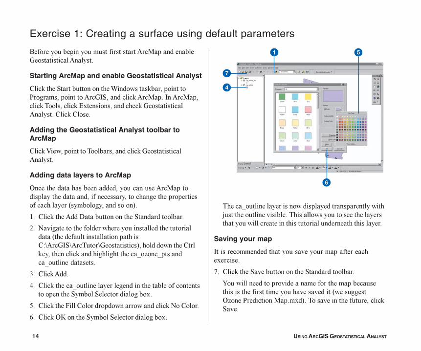
Saving your map
8��������������������������������������������)������
@� %���'�����"�����������������"�������������
7��������������������������������������������������������������������������������*��������& ����$��������������)�+���������������������������'"���
Exercise 1: Creating a surface using default parameters
.��������������������������������� ������������������������ �����
Starting ArcMap and enable Geostatistical Analyst
%���'�����"��������������������������'������������$���������������� ���8"���������'� ������8�� ���������'�����������'�#)���������������'����������� ������%���'�%����
Adding the Geostatistical Analyst toolbar toArcMap
%���'�A�����������������������������'����������� �����
Adding data layers to ArcMap
&���������������������������������� ���������������������������������������������������������������������*�����������������+�
2� %���'����� ���6����������������"�������������
:� B����������������������������������������������������*��������������������������%/C ���8"C �������C���������+����������������%���'�������������'�������������������0� ���0������0�������������
=� %���'� ���
>� %���'������0������������������������������������������������������"������"����������������)�
?� %���'�����5����%��������������������������'�B��%�����
4� %���'�&D��������"������"����������������)�
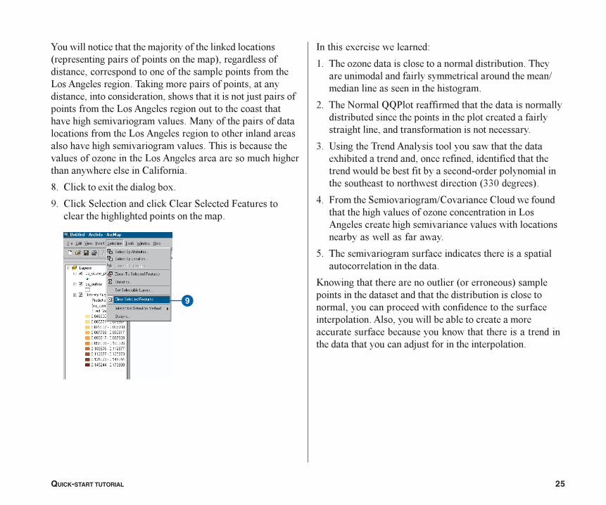
�
�
�
�
�
Tutorial.p65 03/07/2001, 2:38 PM14
QUICK-START TUTORIAL 15
Creating a surface using the defaults
B�)�����������������*����������+������������ �������������������������������������������������������� ������7���������������� ��������������*�0� ���0��+����������������������������������� �����������������������������������������'�����������������'��������7������������'�B�)�����������������������)����������������������������6�����������������������������������������)����������)�������#����������)���������������������������)�������������������������)�����������������������������������������������
2� %���'���������������� ����������������������'������������� ���
:� %���'�����8�����6�����������������������'�0� ���0���
=� %���'����� ������������������������������'����&E&B#����������
>� %���'�D�����������������������������)�
?� %���'�B�)��
.����������&�������D����������$�����������������������������������������������������"����������������)�
B�������������������������������������������� ������������������������'�5��������������������������������������������������(������������4����29������)����������������������������������������)��
4� %���'�B�)���������������������������"����������������)��
��
� �
�
Tutorial.p65 03/07/2001, 2:38 PM15
16 USING ARCGIS GEOSTATISTICAL ANALYST
������������� �������������������������������������������������������������������������������������������������������������������������������������������������������������������������������������������������������������������������������� ���������������������������������������������
!� ������"����
�������������������������������������������������������������������������������������������������������������������������������������������������������������������������������������������������������������������������������������������������������������������������������������������������������#���������������������������$��������������������������������������������������������������������������%�������������������������&���������������������������������������������������������&������������������������������������������������������
'� ������"����
� �
Tutorial.p65 3/21/01, 8:02 AM16
QUICK-START TUTORIAL 17
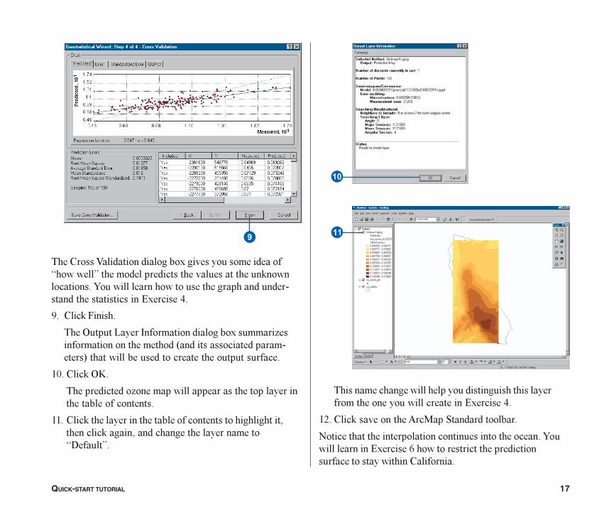
�
���������(���������������������������������������)��������*������������������������������������������������������������������������������������������� ����������������������+�������,�
-� ������.������
����/������0���1������������������������2��������������������������#������������������ ����$�������������������������������������������
34� ������/5�
��������������2�����������������������������������������������������
33� �����������������������������������������������������&��������������&������������������������)6�����*�
������������������������������������������������������������������������������+�������,�
37� �����������������8����������������
"������������������������������������������������������������������+�������9��������������������������������������������������������
�
�
Tutorial.p65 3/21/01, 8:02 AM17
18 USING ARCGIS GEOSTATISTICAL ANALYST
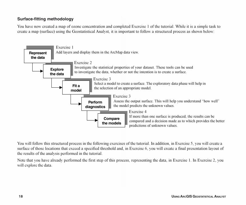
Surface-fitting methodology
7�������������������������� ������������������������������#)������2������������������������������������'�������������*�����+��������������������� ����������������������������������������������������������/
7�����������������������������������������������������)����������������������8��������������#)������?��������������������������������������������)�������������������������������#)������4�����������������������������������������������������������������������������������������
B����������������������������������������������������������������������������������#)������2��8��#)�����F:�����������)�������������
Represent the data
Explore the data
Fit a model
Perform diagnostics
Compare the models
�������������������� ������ ������������ �������
��� ��� �� ��� � � ����������� ������������� �� ������� ������������� ����� ��� �� ����� ������ �������� � ���� � ����� ������ �����������
����� ��������� ������ ����������������������� ������ ������������������ ������� ����������������� ��������
��� ����� �� ������������������������������� ������������ ��������������� � ����!���������
�������� ������������������������� ������� ���������������������������������� ���������������� ����� �������� �������!���������
#)������2
#)������:
#)������=
#)������=
#)������>
Tutorial.p65 03/07/2001, 2:38 PM18
QUICK-START TUTORIAL 19
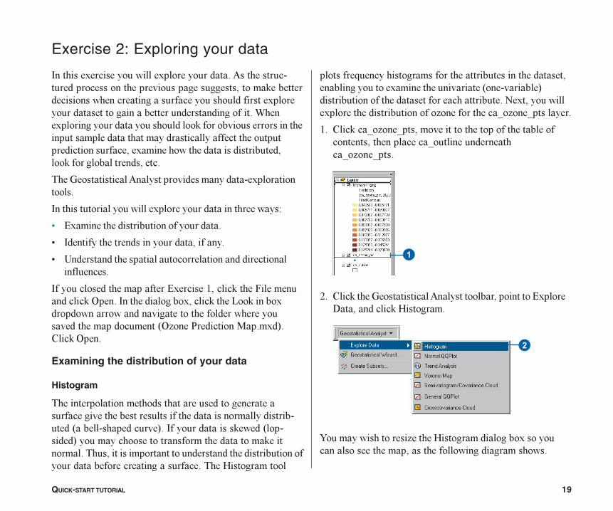
8�������)����������������)��������������� ����������������������������������������������������'����������������������������������������������������)������������������������������������������������������)�����������������������������'�����������������������������������������������������������������������������������������)��������������������������������'����������������������
��������������� ���������������������)�������������
8������������������������)�������������������������/
< #)��������������������������������
< 8������������������������������������
< !������������������������������������������������������
8������������������������#)������2������'�����5���������������'�&�����8��������������)������'�����1��'������)�������������������������������������������������������������������*& ����$��������������)�+�%���'�&����
Examining the distribution of your data
Histogram
�������������������������������������������������������������������������������������������������������*����������������+��8������������'�����*��������+������������������������������������'�����������������������������������������������������������������������������������������������(�����������
Exercise 2: Exploring your data
��������G�����������������������������������������������������������)������������������*����������+������������������������������������������B�)������������)�������������������������� �������������0� ���0��������
2� %���'��0� ���0���������������������������������������������������������0������������������0� ���0���
:� %���'���������������� ����������������������#)�����6����������'�(�������
7���������������� ������(���������������)������������������������������������������������
�
�
Tutorial.p65 03/07/2001, 2:38 PM19
20 USING ARCGIS GEOSTATISTICAL ANALYST
� �
� �
�
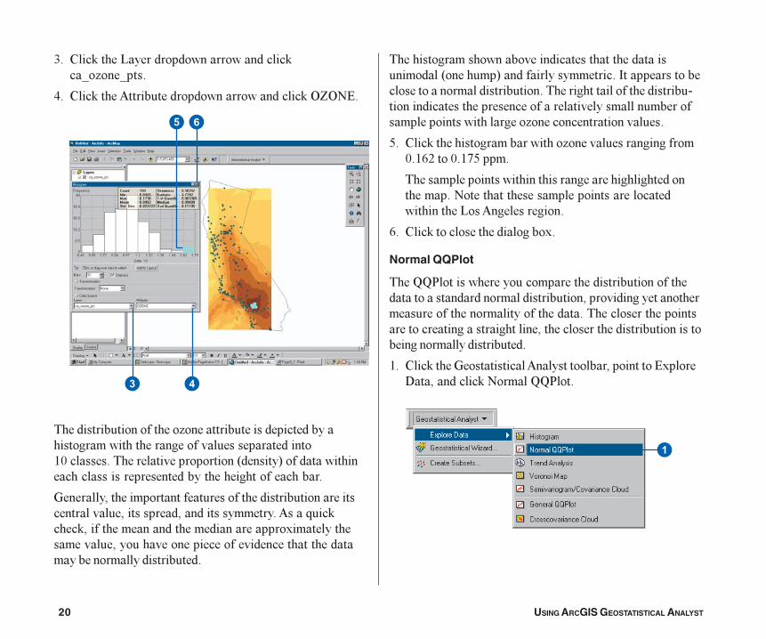
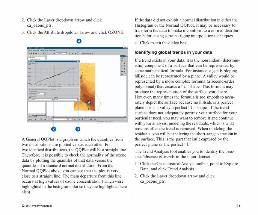
=� %���'�����1�������������������������'�0� ���0���
>� %���'����� ������������������������������'�&E&B#�
������������������������ ��������������������������������������������������������������������29�����������������������������*������+���������������������������������������������������������
������������������������������������������������������������������������������������������� ��G���'����'���������������������������������)������������������������������������������������������������������������������������
��������������������������������������������������*��������+��������������������8����������������������������������������������������������������������������������������������������������������������������������������������� ����������������������
?� %���'���������������������� ��������������������9�24:����9�2@?�����
��������������������������������������������������������B��������������������������������������������1�� �������������
4� %���'���������������������)�
Normal QQPlot
����HH$����������������������������������������������������������������������������������������������������������������������������������������������������������������������������������������������������������������������������������������
2� %���'���������������� ����������������������#)�����6����������'�B�����HH$����
Tutorial.p65 03/07/2001, 2:38 PM20
QUICK-START TUTORIAL 21
�
��
:� %���'�����1�������������������������'�0� ���0���
=� %���'����� ������������������������������'�&E&B#�
��������HH$�������������������������G������������������������������������������������������5��������������������������������HH$�������������������������������������������������������'���������������������� ����������������������G�������������������������G������������������������������������5�������B�����HH$���������������������������������������������������������������������������������������������������������������� �����������������*����������������������������������������������������������������������+�
8������������������)��������������������������������������(��������������B�����HH$������������������������������������������'�������������������������������������������������������'��������������������������G���
>� %���'�����)���������������)�
Identifying global trends in your data
8����������)���������������������������������*�������������+������������������������������������������������������������������5������������������������������������������������������������ �����������������������������������������)��������*���������������������+������������I!J�������������������������������������������������������������������(����������������������������������������������������������������������������������������������������������������������������I!J������8���������������������������G���������������������������������������������������������������������������������������������������������������������������������������������������������������������������������������������������������� �����������������������������������������������������������,��������������������������������������������I!J�
���������� ��������������������������������������������K���������������������������������
2� %���'���������������� ����������������������#)�����6����������'������� �����
:� %���'�����1�������������������������'�0� ���0���
Tutorial.p65 03/07/2001, 2:38 PM21
22 USING ARCGIS GEOSTATISTICAL ANALYST
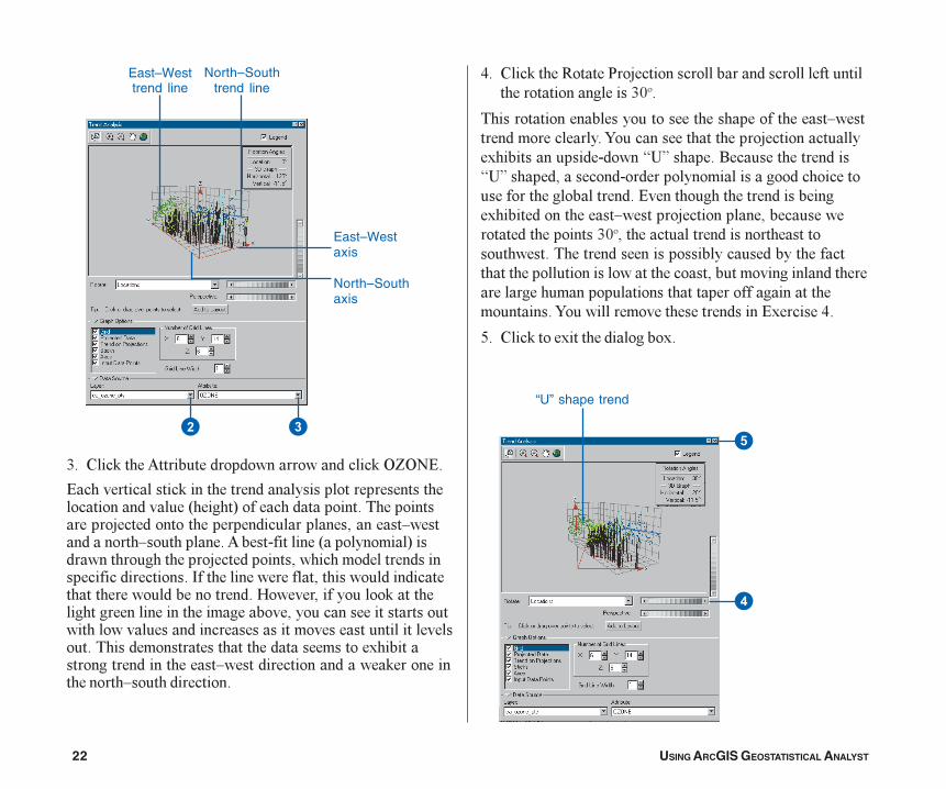
North–Southtrend line
East–Westtrend line
East–Westaxis
North–Southaxis
��
“U” shape trend
�
�
=� %���'����� ������������������������������'�&E&B#�
#��������������'����������������������������������������������������*������+������������������������������������������������������������������������L������������L����������� ��������������*����������+���������������������������������������������������������������������������8�������������������������������������������������������������������(������������������'�����������������������������������������������������������������������������������������������������������������������������������������������������)���������������������������L��������������������'������������������L���������������
>� %���'�����-�����$���������������������������������������������������������=9��
���������������������������������������������L����������������������7�����������������������������������)�������������������I!J������.����������������I!J�����������������������������������������������������������������������#�����������������������������)�����������������L����������������������������������������������=9��������������������������������������������������������������������������������������������������������������������������������������������������������������������������������������������7�����������������������������#)������>�
?� %���'�����)���������������)�
Tutorial.p65 03/07/2001, 2:39 PM22
QUICK-START TUTORIAL 23
�
� �
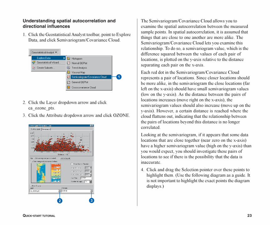
Understanding spatial autocorrelation anddirectional influences
2� %���'���������������� ����������������������#)�����6����������'�"����������K%��������%�����
:� %���'�����1�������������������������'�0� ���0���
=� %���'����� ������������������������������'�&E&B#�
����"����������K%��������%�����������������)����������������������������������������������������������8�����������������������������������������������������������������������������'������"����������K%��������%��������������)���������������������������������������������������������������������G���������������������������������������������������������������)����������������������������������������������)�)��
#������������������"����������K%��������%������������������������������"����������������������������������'��������������������������������������*��������������)�)�+������������������������������*�������������)�+�� ���������������������������������������������*������������������)�)�+�������������������������������������*����������������)�+��(���������������������������������������������������������������������������������������������������������������������������������������������������������
1��'������������������������������������������������������������������������*���� �����������)�)�+����������������������������*��������������)�+���������������)�������������������������������������������������������������������������������������������������
>� %���'������������"���������������������������������������������������*!�������������������������������8����������������������������������)������������������������+
Tutorial.p65 03/07/2001, 2:39 PM23
24 USING ARCGIS GEOSTATISTICAL ANALYST
�
� �
��
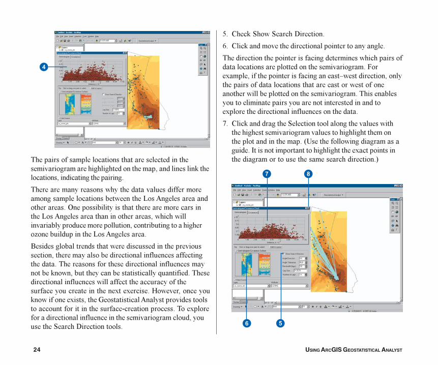
���������������������������������������������������������������������������������������������'����������������������������������
���������������������������������������������������������������������������1�� ���������������������&������������������������������������������1�� ��������������������������������������������������������������������������������������������� �������������������1�� ���������
.�����������������������������������������������������������������������������������������������������������������������������������������������������������'�������������������������������G����������������������������������������������������������������������������������������)���)�������(����������������'������������)������������������� ������������������������������������������������������������������)������������������������������������������������������������������"�����6��������������
?� %���'�"����"�����6���������
4� %���'�������������������������������������������
�������������������������������������������������������������������������������������������������5���)���������������������������������L���������������������������������������������������������������������������������������������������������������������������������������������������������������������)�����������������������������������������
@� %���'������������"������������������������������������������������������������������������������������������������������*!������������������������������8�����������������������������������)����������������������������������������������������+
Tutorial.p65 03/07/2001, 2:39 PM24
QUICK-START TUTORIAL 25
7�����������������������������������������'����������*����������������������������������+���������������������������������������������������������������1�� ���������������'�����������������������������������������������������������������������������������������������1�� ����������������������������������������������������������������������������������������������1�� ����������������������������������������������������������������������������������� �����������1�� ��������������������������������������������%��������
M� %���'�����)���������������)�
3� %���'�"����������������'�%����"��������5���������������������������������������������
8�������)���������������/
2� ����� ������������������������������������������������������������������������������������K�������������������������������
:� ����B�����HH$������������������������������������������������������������������������������������������������������������������������������
=� !�������������� ���������������������������)���������������������������������������������������������������������������������������������������������������������������������������*==9�������+�
>� 5��������"�����������K%��������%����������������������������������� ��������������������1� ���������������������������������������������������������������
?� ������������������������������������������������������������������
D�������������������������������*�����������+����������������������������������������������������������������������������������������������������������������������� ���������������������������������������������������������'������������������������������������������������������������������������
Tutorial.p65 03/07/2001, 2:39 PM25
26 USING ARCGIS GEOSTATISTICAL ANALYST
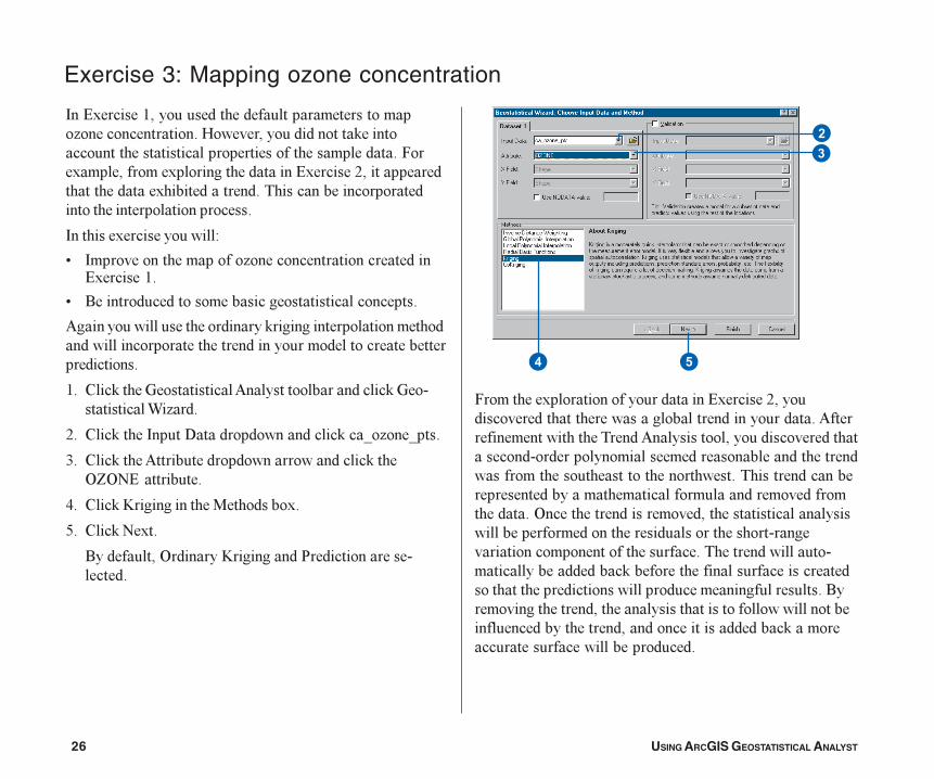
Exercise 3: Mapping ozone concentration
8��#)������2����������������������������������� ������������������(���������������������'���������������������������������������������������5���)������������)������������������#)������:�����������������������)�����������������������������������������������������������������
8�������)��������������/
< 8��������������������� ��������������������������#)������2�
< .�������������������������������������������
����������������������������'�����������������������������������������������������������������������������������������������
2� %���'���������������� �������������������'��������������� ���
:� %���'�����8�����6������������������'��0� ���0���
=� %���'����� ������������������������������'����&E&B#����������
>� %���'�D�����������������������)�
?� %���'�B�)��
.����������&�������D����������$����������������������
5���������)�����������������������#)������:���������������������������������������������������� ������������������������������ ��������������������������������������������������������������������������������������������������������������������������������������������������������������������������������������&��������������������������������������������������������������������������������������������������������������������������������������������������������������'����������������������������������������������������������������������������������.������������������������������������������������������������������������������������������������������'������������������������������������
�
��
�
Tutorial.p65 03/07/2001, 2:39 PM26
QUICK-START TUTORIAL 27
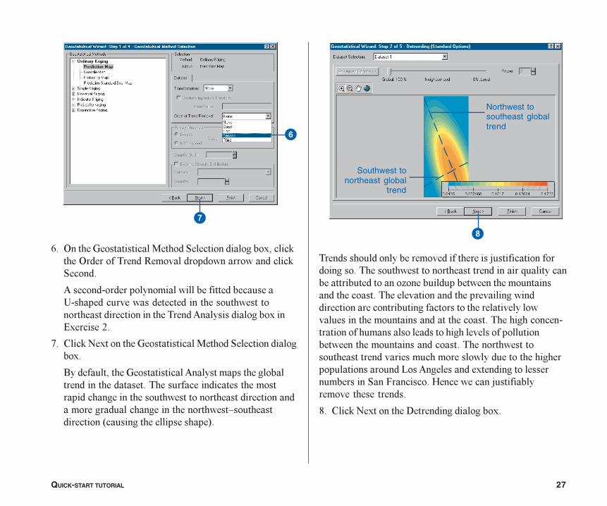
��������������������������������������������������������������������������������������������������G��������������������������� �������������������������������������������������������������������������������������������������������������������������������������������������������������������������������������������������������������������������������������������������������������������������������������������������������������������������������������������������1�� ����������)�������������������������"��5��������(��������������������������������������
M� %���'�B�)���������6������������������)�
4� &������������������������"�����������������)������'����&��������������-���������������������������'"������
��������������������������������������������!����������������������������������������������������������������������� �������������)���#)������:�
@� %���'�B�)���������������������������"����������������)�
.������������������������� �����������������������������������������������������������������������������������������������������������������������������������������������L����������������*��������������������+�
�
Southwest tonortheast global
trend
Northwest tosoutheast globaltrend
�
�
Tutorial.p65 03/07/2001, 2:39 PM27
28 USING ARCGIS GEOSTATISTICAL ANALYST
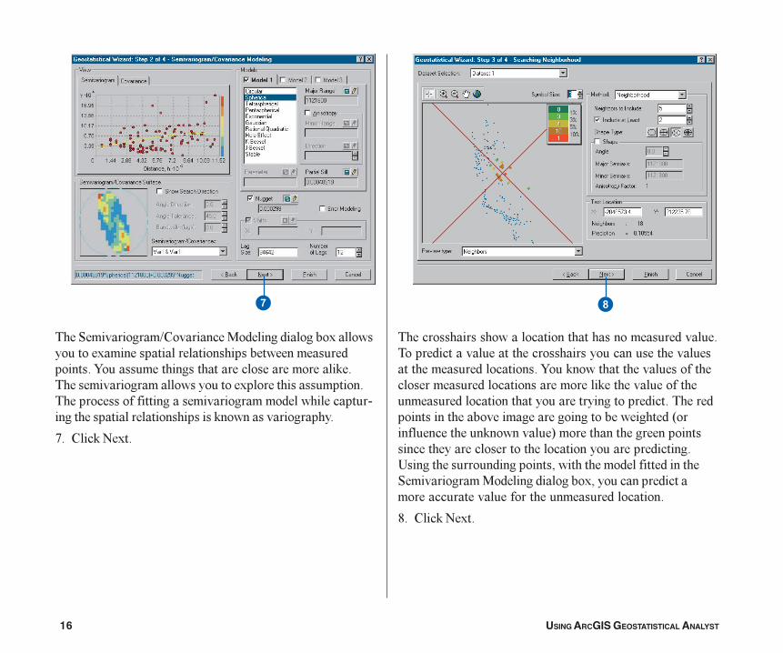
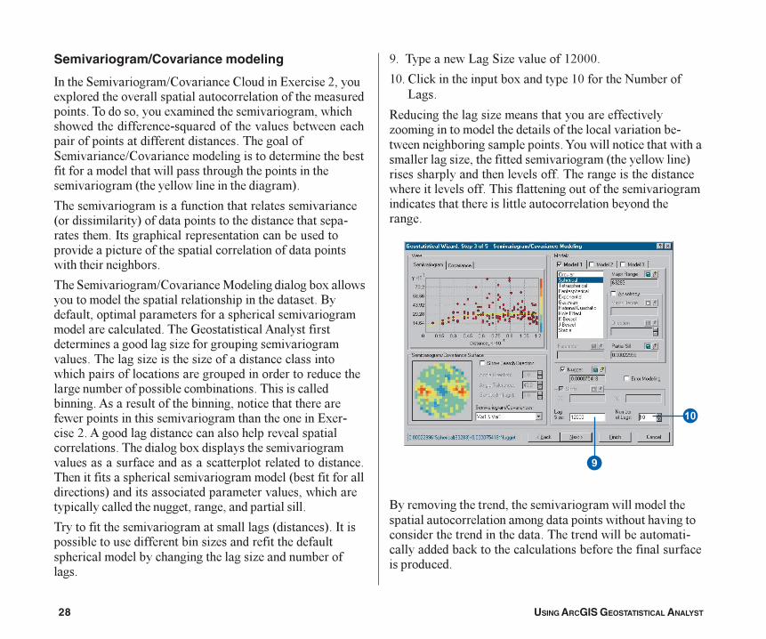
Semivariogram/Covariance modeling
8������"����������K%��������%��������#)������:������)�����������������������������������������������������������������������)������������������������������������������������G�����������������������������������������������������������������������"���������K%����������������������������������������������������������������������������������������������������*����������������������������+�
����������������������������������������������*�������������+��������������������������������������������8����������������������������������������������������������������������������������������������������������
����"����������K%�������������������������)���������������������������������������������������.��������������������������������������������������������������������������������� ����������������������������� ��������������������������������������� ��������� �������������������������������������������������������������������������������������������������������������������������������� ����������������������������������������������������������������������������������������#)������F:�� �������������������������������������������������������������)��������������������������������������������������������������������������������������������������������*�����������������������+����������������������������������������������������������������������������������
�����������������������������������*������+��8������������������������������� ������������������������������������������������������ �����������������
3� ����������1��"� ����������2:999�
29� %���'����������������)���������29���������B��������1��
-���������������� ���������������������������� ����������������������������������������������������������������������������������7���������������������������������� �������������������������*���������������+�����������������������������������������������������������������������������������������������������������������������������������������������������������������
.����������������������������������������������������������������������������������������������������������������������������������������������������������������������'��������������������������������������������������
Tutorial.p65 03/07/2001, 2:39 PM28
QUICK-START TUTORIAL 29
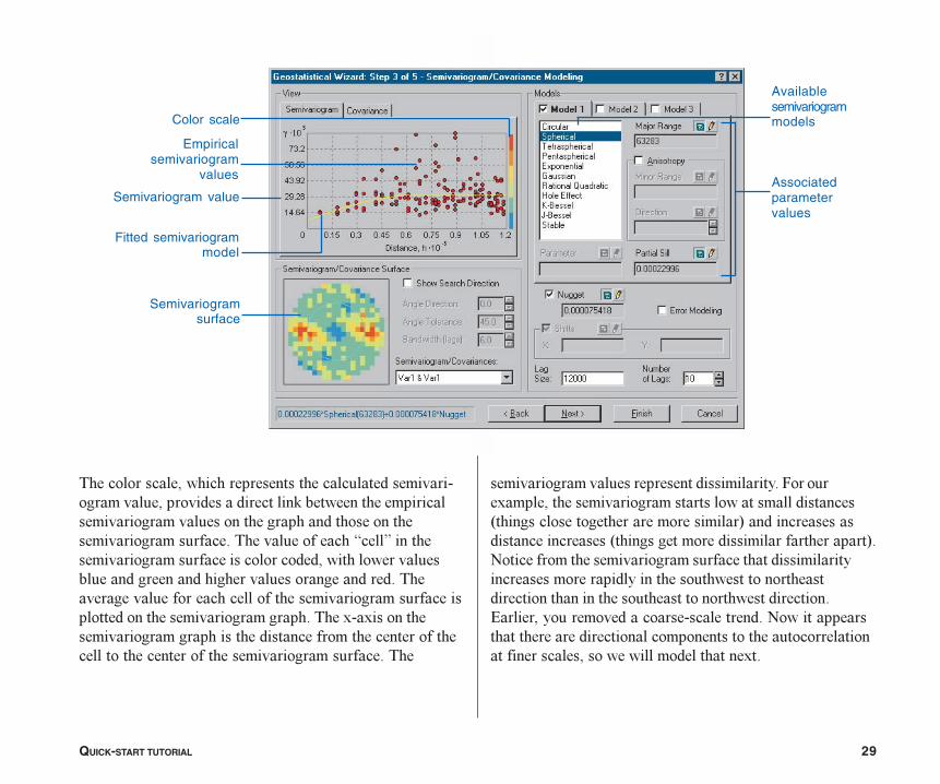
��������������������������������������������������������������������������������'�������������������������������������������������������������������������������������������������I����J�����������������������������������������������������������������������������������������������������������������������������������������������������������������������������������������)�)����������������������������������������������������������������������������������������������������������
�������������������������������������5�������)�����������������������������������������*���������������������������������+�������������������������*���������������������������������+�B��������������������������������������������������������������������������������������������������������������������������������������������#������������������������������������B���������������������������������������������������������������������������������������������������)��
Semivariogramsurface
Semivariogram value
Fitted semivariogrammodel
Availablesemivariogrammodels
Associatedparametervalues
Empiricalsemivariogram
values
Color scale
Tutorial.p65 03/07/2001, 2:39 PM29
30 USING ARCGIS GEOSTATISTICAL ANALYST
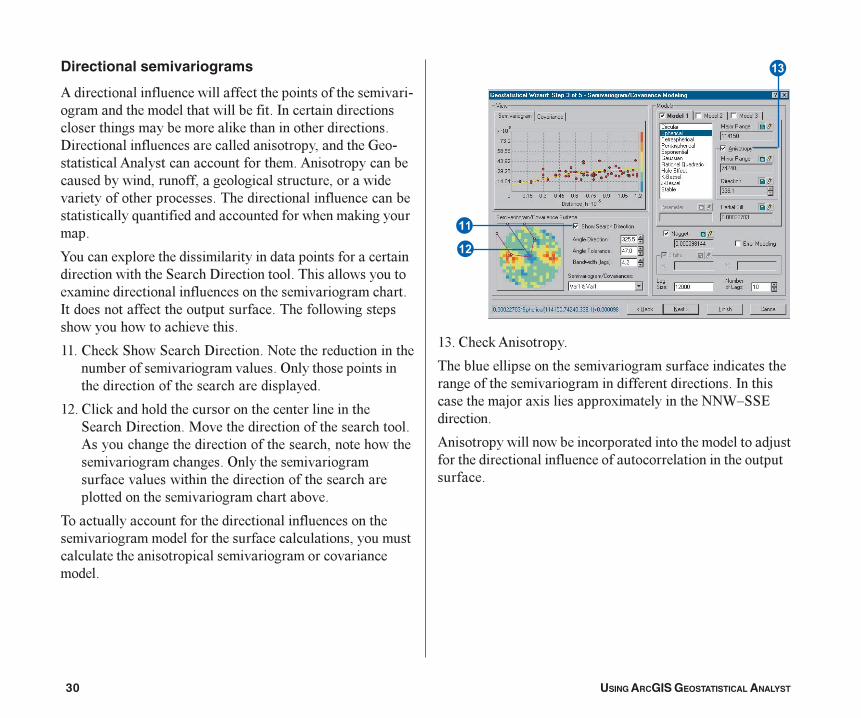
Directional semivariograms
��������������������������������������������������������������������������������������������8�������������������������������������������'�������������������������6���������������������������������������������������������� ������������������������� ���������������������������������������������������������������������������������������������������������������������������������G�������������������������������'�����������
7�������)���������������������������������������������������������������"�����6�������������������������������)�������������������������������������������������8�����������������������������������������������������������������������������
22� %���'�"����"�����6����������B���������������������������������������������������&������������������������������������������������������
2:� %���'��������������������������������������������"�����6���������������������������������������������� ��������������������������������������������������������������������&����������������������������������������������������������������������������������������������������
��������������������������������������������������������������������������������������������������������������������������������������������������������
2=� %���'� ���������
��������������������������������������������������������������������������������������������������8�����������������)����������)��������������BB�L""#����������
������������������������������������������������������������������������������������������������������������������������
�
�
Tutorial.p65 03/07/2001, 2:39 PM30
QUICK-START TUTORIAL 31
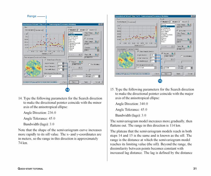
��� ��������� ������������������������������������������������������ ������������������������������������������������ �� �����
��� �������������� �!
��� ���� ���������"�!
#�������$ ���%����!
&���������������������'����������(�'��������������������� ��������� �'� (�������)������)����������������������*���������������������������������������� �+�����
�"� ��������� ������������������������������������������������������ ������������������������,����������������������� �� �����
��� ��������������!�!
��� ���� ���������"�!
#�������$ ���%����!
�������'������������� ��������������������(� �*���� ������(������������������������������������
���� ���(���������'������������� ����������-��������������"������������������������������� �����������������������������������'������������� ���������� �������'� (��$���� %��#�������������*��������� �����-������������-�������������������������� ��������������� ��������������-�����������
�
Range
�
Tutorial.p65 3/21/01, 8:04 AM31
32 USING ARCGIS GEOSTATISTICAL ANALYST
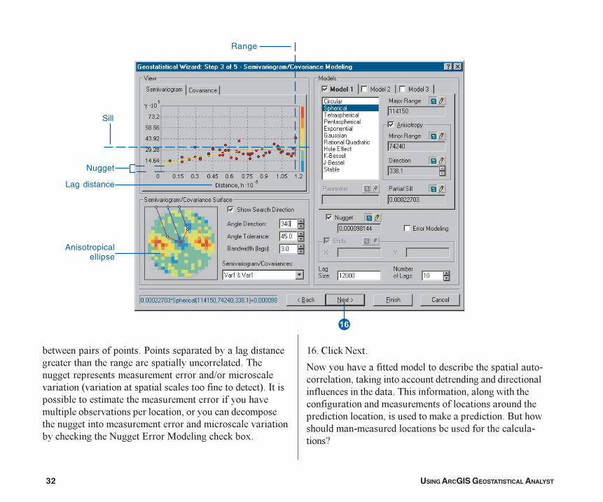
����������������������$���������������������������������������������������������������������������������������������������������K�������������������*�������������������������������������+��8��������������������������������������������������������������������������������������������������������������������������������������������������������������'��������B������#������������������'���)�
24� %���'�B�)��
B��������������������������������������������������������������'����������������������������������������������������������������������������������������������������������������������������������������������������������������������'���������������.�������������������������������������������������������N
�
Range
Nugget
Sill
Lag distance
Anisotropicalellipse
Tutorial.p65 03/07/2001, 2:39 PM32
QUICK-START TUTORIAL 33
Searching neighborhood
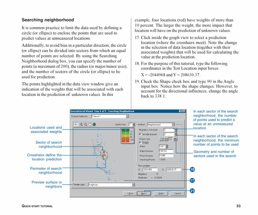
8����������������������������������������������������������*���������+������������������������������������������������������������������
���������������������������������������������������������*���������+����������������������������������������G������������������������������.�����������"�������B��������������������)�����������������������������������*��)��������:99+�����������*�������K������)�+��������������������������������������*���������+�������������������������
�������������������������������������������������������������������������������������������������������������������������������������'�����������8�����
�)�������������������*���+�����������������������29������������������������������������������������������������������������������������������'����������
2@� %���'�������������������������������������������������*���������������������+��B�������������������������������������������*��������������������������������+����������������������������������������������������������������
2M� 5���������������������������������������������������������������������1���������������)�/
O�P��:9>>34M����7�P�:9M4=9�=@�
23� %���'�����"��������'���)���������39�������� ������������)��B�������������������������(���������������������������������������������������������������'����==M�2�
Crosshairs define thelocation prediction
Perimeter of searchneighborhood
Sector of searchneighborhood
Locations used andassociated weights
Preview surface orneighbors
�
�
In each sector of the searchneighborhood, the numberof points used to predict avalue at an unmeasuredlocation
In each sector of the searchneighborhood, the minimumnumber of points to be used
Geometry and number ofsectors used in the search
�
Tutorial.p65 03/07/2001, 2:39 PM33
34 USING ARCGIS GEOSTATISTICAL ANALYST
:9��!�����'�����"��������'���)Q�������������� �����������������������������*���������������"����������K%��������������������+�
:2� %���'�B�)���������"��������B��������������������)�
.����������������������������������������)��������%�����������������������������������������������������������������I��������J��������������������
Tutorial.p65 03/07/2001, 2:39 PM34
QUICK-START TUTORIAL 35
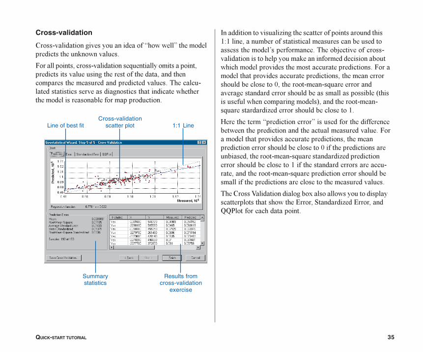
Cross-validation
%������������������������������I��������J������������������������'����������
5���������������������������G������������������������������������������������������������������������������������������������������������������������������������������������������������������������������������������������������
8������������������ ��������������������������������2/2�������������������������������������������������������,����������������������������������������������������������'������������������������������������������������������������������������5����������������������������������������������������������������������9���������������G����������������������������������������������������*������������������������������+������������������G���������� ��������������������������2�
(�������������I����������������J�������������������������������������������������������������������������5���������������������������������������������������������������������������������9������������������������������������������G���������� ������������������������������������2������������������������������������������������G������������������������������������������������������������������������������
����%���A����������������)�������������������������������������������#������"������ ���#��������HH$���������������������
Line of best fit 1:1 Line
Results fromcross-validation
exercise
Summarystatistics
Cross-validationscatter plot
Tutorial.p65 03/07/2001, 2:39 PM35
36 USING ARCGIS GEOSTATISTICAL ANALYST
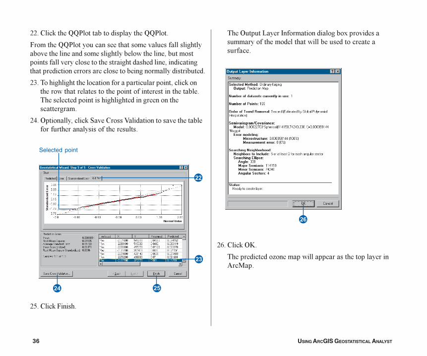
::� %���'�����HH$��������������������HH$����
5��������HH$���������������������������������������������������������������������������������������������������������������������������������������������������������������������������������������������������������
:=� ��������������������������������������������������'�����������������������������������������������������������������������������������������������������������������
:>� &��������������'�"���%���A����������������������������������������������������
:?� %���'�5�����
����&������1����8������������������)�����������������������������������������������������������
:4� %���'�&D�
��������������� ��������������������������������� �����
�
�
�
�
�
Selected point
Tutorial.p65 03/07/2001, 2:39 PM36
QUICK-START TUTORIAL 37
���������������� ������������������������ ������������������� ����������� ������������� ���� ��� ��������
��� ����������� �������������������������������������������������� ! ���� ���"��#�
$������������ ������% ��������&���� ��' � ��� �������(���������)������������ ���������
�*� +��������������� ! ���� ���"��#���� �������� ������������������ ����% ��������&���� ��' � ,���
�-� �����&�"��������&���� ����.� �
!���% ��������&���� ��' � ��)�������������� ������� �������������������� ������������� ������/������� ��������.�������-0��� ������������������ ���"����������� �����1��.��1����������� "���� ����.������ ������
���
"����2������������ ������������� ��� � ��������� ��� ������� �.�����3�����������% ��������&���� ��' � �� ������������������� ����������������� �����"��1� �� � �
!����� ���������� ��������'(� �����4���������������������������5����������/������1������������� ������� ������������� ������������������� ������6����� ����������������� ���������"� ��� ���������!���� ��������� ���������� �������������(� �������������������� ���������.�� ������������������7�������������6��������7������� ���������� ���������������������� ��������������"� ��� ���
8��'(� �����9������1������� �����1�������������1���������� �"�������.�� �� ����������������1��"�����
3��:������������������������������ �����������������������������$���1���� �����'(� �����;���1��� �� ������ ���������� �����������1���������� ����
Tutorial.p65 3/21/01, 8:04 AM37
38 USING ARCGIS GEOSTATISTICAL ANALYST
Exercise 4: Comparing models
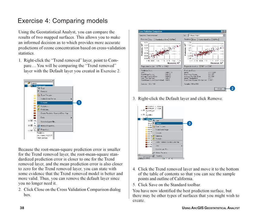
!������������������� ������������������������������������������������������������������'���������������������������������������������������������������� �������������������������������������������
2� -���������'�����I�������������J����������������%�����������7������������������������I�������������J��������������6�������������������������#)������:�
.������������������G���������������������������������������������������������������������G����������� ������������������������������������������������������������������������������������������������������� ���������������������������������������������������������������������������������������������������������������������������������������������������������������������������:� %���'�%�����������%���A��������%�������������
��)�
�=� -���������'�����6������������������'�-������
>� %���'�������������������������������������������������������������������������������������������������������������������%��������
?� %���'�"����������"�������������7�������������������������������������������������������������������������������������������������������������
�
�
Tutorial.p65 03/07/2001, 2:39 PM38
QUICK-START TUTORIAL 39
Exercise 5: Mapping the probability of ozone exceeding a critical threshold
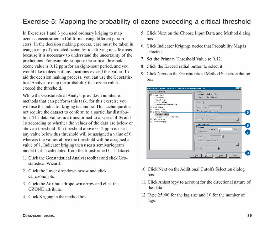
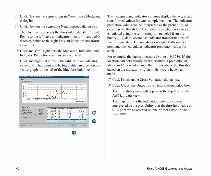
8��#)������2����=�����������������'������������� ��������������������%���������������������������������8���������������'�����������������������'���������������������������� ������������������������������������������������������������������������������������������5����)��������������������������������� �����������9�2:��������������������������������������������'���������������������������)���������������������������������'������������������������������������� ������������������������������� ���������)������������������
��������������������� ��������������������������������������������������'�����������)������������������������������'�������������G��������������G������������G�����������������������������������������������������������������������������������������9���2�������������������������������������������������������������������8�����������������9�2:�������������������������������������������������������������9��������������������������������������������������������2��8��������'������������������������������������������������������������������9L2������
2� %���'���������������� �������������������'��������������� ���
:� %���'�����1�������������������������'�0� ���0���
=� %���'����� ������������������������������'����&E&B#����������
>� %���'�D�����������������������)�
?� %���'�B�)���������%�����8�����6�������������������)�
4� %���'�8��������D������;�������������$����������������������
@� "�������$���������������A�������9�2:�
M� %���'�����#)�����������������������������
3� %���'�B�)���������������������������"����������������)�
29� %���'�B�)��������� ���������%������"����������������)�
22� %���'� �����������������������������������������������������
2:� �����:?999������������� �����29���������������������
�
�
�
Tutorial.p65 03/07/2001, 2:39 PM39
40 USING ARCGIS GEOSTATISTICAL ANALYST
2=� %���'�B�)���������"����������K%������������������������)�
2>� %���'�B�)���������"��������B��������������������)�
�����������������������������������������*9�2:����+�$������������������������������������������������9��������������������������������������������������������2�
2?� %���'����������������������������������8�����������8��������$����������������������������
24� %���'������������������������������������������������������9������������������������������������������������������������������������������������������������
�����������������������������������������������������������������������������������������������������������������������������������������������������)�������������������������������������������������������������������������������������������������������*9�2+�����������������������������������������������������%�������������G��������������������������������������������������������������������
5����)�������������������������������9�2@=4��8��������������������������������������������������������������M?�������������������������������������������������������������'�������������������������������
2@� %���'�5������������%���A����������������)�
2M� %���'�&D��������&������1����8������������������)�
������������������������������������������������ �������������
����������������������������������������������������������������������������������������������9�2:��������)�����������������������������������2334��
�
�
Tutorial.p65 03/07/2001, 2:39 PM40
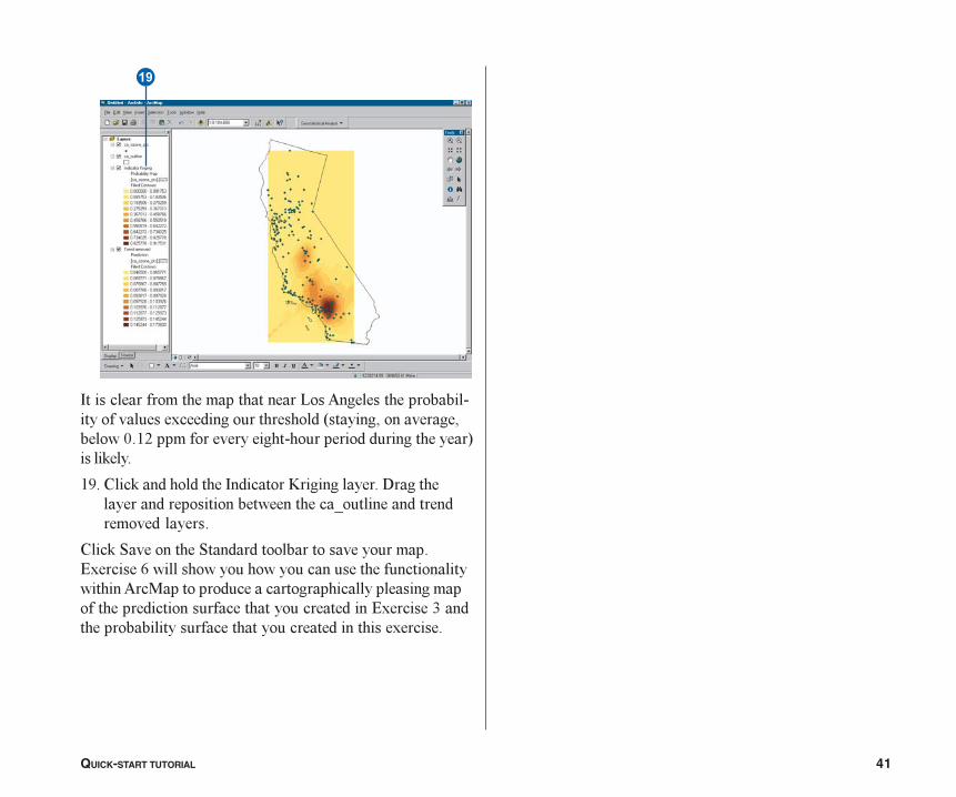
QUICK-START TUTORIAL 41
�
������������ ����� �������������������������������������������������������������������������������������������� !��� �������������������������������������"�����#����
$� %���#���������������������&�����������'�����������������������������������(���������������� ����������
%���#�)����������)���������������������� ��*�������+�������������������������������������������������������,��������������������������������� �����������������������������������������*�������-�����������������������������������������������������
Tutorial.p65 3/21/01, 8:04 AM41
42 USING ARCGIS GEOSTATISTICAL ANALYST
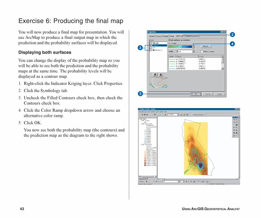
7���������������������������������������������7���������� �����������������������������������������������������������������������������������������������
Displaying both surfaces
7��������������������������������������������������������������������������������������������������������������������������������������������������������������������������
2� -���������'�����8��������D�������������%���'�$���������
:� %���'�����"������������
=� !�����'�����5������%�����������'���)�����������'����%�����������'���)�
>� %���'�����%�����-�����������������������������������������������
?� %���'�&D�
7���������������������������������*�����������+�������������������������������������������������
Exercise 6: Producing the final map
�
��
�
Tutorial.p65 03/07/2001, 2:39 PM42
QUICK-START TUTORIAL 43
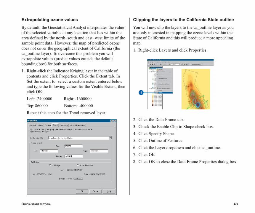
Extrapolating ozone values
.������������������������� ����������������������������������������������������������������������������������������������������L����������L�������������������������������(����������������������������� ���������������������������������)��������%��������*����0������������+�����������������������������������)�������������*�����������������������������������������)+����������������
2� -���������'�����8��������D�����������������������������������������'�$����������%���'�����#)���������8�"��������)�������/���������������)�����������������������������������������������������A������#)��������������'�&D/
1���/��:>99999 -����/��2499999
���/�M49999 .�����/��>99999
-����������������������������������������
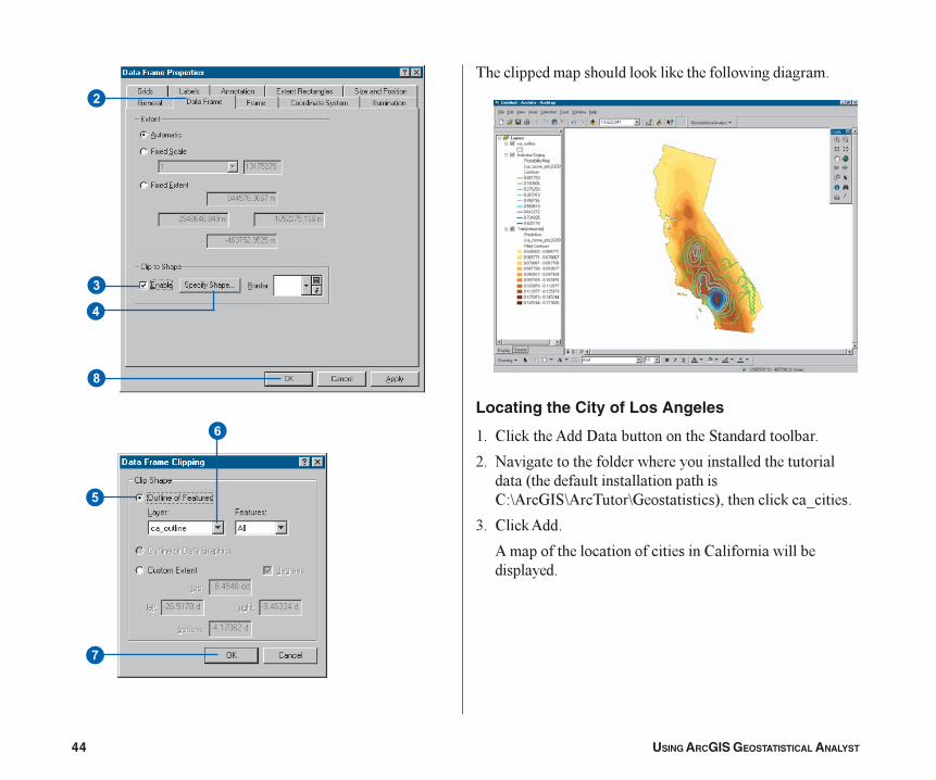
Clipping the layers to the California State outline
7����������������������������������0�������������������������������������������������� ��������������������"�������%��������������������������������������������
2� -���������'�1�����������'�$���������
:� %���'�����6��5�������
=� %���'�����#�����%�������"��������'���)�
>� %���'�"�������"����
?� %���'�&����������5������
4� %���'�����1��������������������'��0��������
@� %���'�&D�
M� %���'�&D�������������6��5����$�����������������)�
�
Tutorial.p65 03/07/2001, 2:39 PM43
44 USING ARCGIS GEOSTATISTICAL ANALYST
�
�
�
�
�
�
�
������������������������'���'����������������������
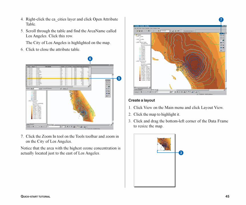
Locating the City of Los Angeles
2� %���'����� ���6����������������"�������������
:� B����������������������������������������������������*��������������������������%/C ���8"C �������C���������+�����������'��0������
=� %���'� ���
�������������������������������%�����������������������
Tutorial.p65 03/07/2001, 2:39 PM44
QUICK-START TUTORIAL 45
>� -���������'������0������������������'�&���� �������������
?� "����������������������������������� ��B��������1�� �������%���'���������
����%�������1�� ������������������������������
4� %���'���������������������������
@� %���'�����E����8����������������������������� �������������%�������1�� ������
B���������������������������������� �������������������������������������������������1�� ������
Create a layout
2� %���'�A���������������������������'�1�����A����
:� %���'������������������������
=� %���'��������������������������������������6��5��������� ���������
�
�
�
�
Tutorial.p65 03/07/2001, 2:39 PM45
46 USING ARCGIS GEOSTATISTICAL ANALYST
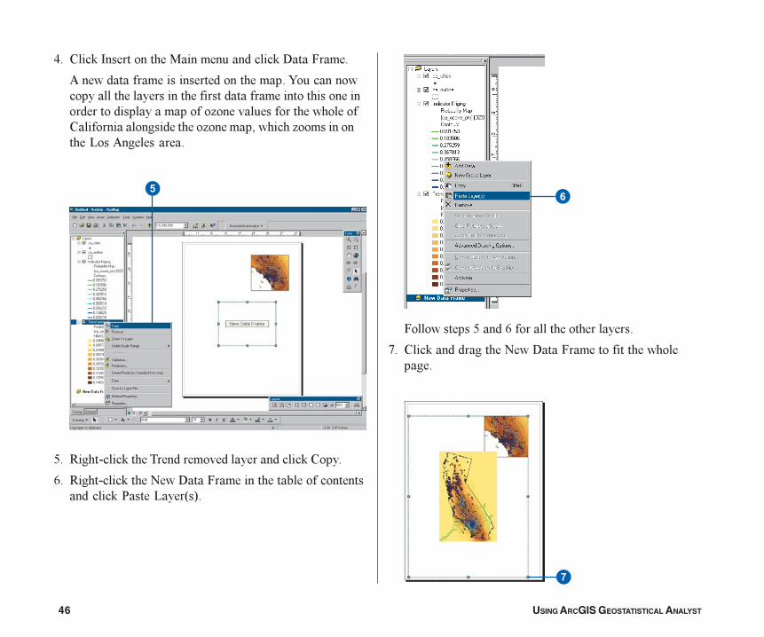
>� %���'�8����������������������������'�6��5����
����������������������������������7������������������������������������������������������������������������������������ �������������������������%��������������������� �������������� �������������1�� ���������
?� -���������'�������������������������������'�%����
4� -���������'�����B���6��5���������������������������������'�$���1���*+�
5����������?����4�����������������������
@� %���'������������B���6��5������������������������
��
�
Tutorial.p65 03/07/2001, 2:39 PM46
QUICK-START TUTORIAL 47
M� %���'�����5����#)������������������������������������������������)����������������������B���6��5����
3� -���������'�����B���6��5�����������'�$���������
29� %���'�����6��5��������������������������������6��5���������'�#�����%�������"�����������'����"�������"������������%������0��������������������������������������'�&D�
Adding a hillshade and transparency
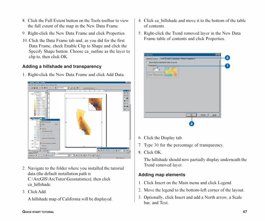
2� -���������'�����B���6��5�����������'� ���6��
:� B����������������������������������������������������*��������������������������%/C ���8"C �������C���������+�����������'�0��������
=� %���'� ���
���������������%������������������������
>� %���'��0�������������������������������������������������������
?� -���������'�������������������������������B���6�5���������������������������'�$���������
4� %���'�����6��������
@� �����=9��������������������������������
M� %���'�&D�
��������������������������������������������������������������������
Adding map elements
2� %���'�8����������������������������'�1������
:� �������������������������������������������������������
=� &��������������'�8������������B������������"������������)��
�
�
�
Tutorial.p65 03/07/2001, 2:39 PM47
48 USING ARCGIS GEOSTATISTICAL ANALYST
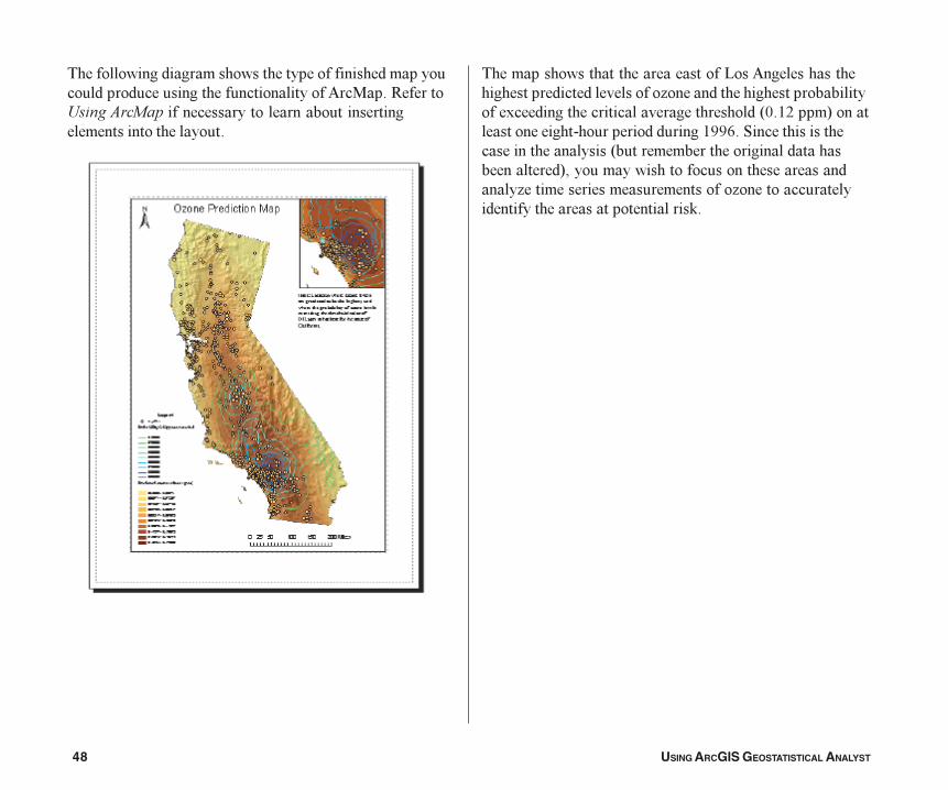
����������������������������������������������������������������������������������������� ������-������������������������������������������������������������������������
����������������������������1�� �������������������������������������� ��������������������������������)�����������������������������������*9�2:����+��������������������������������������2334��"�����������������������������*����������������������������������������+������������������������������������� �������������������������� ��������������������������������������������'�
Tutorial.p65 03/07/2001, 2:39 PM48