Embed Size (px)
Citation preview

TURNBACK
GUIDEBOOK
February 4, 2015

2
Index:
Authority 4
Eligibility 4
Route and Control Section Committee 4
Definitions 5
Constitutional and Legislative Routes 5
Route Numbering 6
Control Section Creation, Modification, Elimination 7
Retired Control Sections 7
Route Numbering and Control Section Notification Letters 7
Constitutional and Legislative Routes and Control Section Maps 7
Control Section Maps 8
Names and Designations of Highways and Structures 8
Route Number and Control Section Process Diagram 9
District Office
Initiation of Turnback 10
Turnback Funds 10
Authorization Maps 11
Central Office
Policy and Procedure 12
Types of Turnbacks 12
Examples of Turnbacks 12
Traditional: TH 14 Steele and Waseca Counties 12
Traditional: City of Golden Valley 13
Traditional: TH 232 Aitkin County 13
Jurisdictional: TH 63 City of Rochester and Olmsted County 14
Traditional: TH 295 City of St. Peter 15
Realms Entries 15
ProjectWise Locations 17
District Implementation 17
Standard Packages 18
Authorization Map 18
Central Office Procedures
Package Review 18
Staff Review 19
Commissioner’s Orders 19
Realms Entry/Tracking 19
Final Processing 19

3
Notice of Release/Transfer 19
Release v. Transfer 20
Legal Descriptions 20
Documents 20
Final Mapping 21
Right of Way Technical Training Quiz 25
Appendix
Constitution of the State of Minnesota (Article XIV – Public Highway System) 28
Constitutional Routes (M.S.S. 161.114) 29
Legislative Routes (M.S.S. 161.115) 32
Additional Routes; Federal Aid (M.S.S. 161.12) 33
Specific location; limitation on deviations (M.S.S. 161.15) 33
Temp. Trunk Highways, designation, vacation and reversion (M.S.S. 161.16) 34
Changes required by construction of trunk highway (M.S.S. 161.24) 37
Right of Way Manual, Section 5‐491.128 38
.128.1 Policy 38
.128.2 Statute Authorities and Requirements 41
.128.3 Procedure 41
.128.4 Action for Conveyance by Commissioner’s Deed 43
Control Section and Route Numbering Flow Chart 45
Rewriting Signal Agreements Flow Chart 46
Turnback Process Flow Chart 47
State Aid Turnback Process Flow Chart 48
Jurisdictional Alignment Process Flow Chart 49
Example of Release of Maintenance & Jurisdictional Responsibilities – Notice & Release 50
Example of Conveyance Quit Claim Deed 55
TB1000 Form – Approval for Conveyance of R/W of Released Portions of T.H. 59
TB1008 Form – Recommendation to Release Trunk Highway 60
2014 Minnesota Highway Users Tax Distribution Fund Diagram 61
Example of Turnback Agreement – Oronoco 62
Right of Way Technical Training Quiz Answer Key 72

4
AUTHORITY
Article XIV of the Minnesota Constitution gives the authority to the State to construct, improve and
maintain public highways. The system, which originated in 1920, was first assured to have 70 routes,
also called the constitutional routes as found in Minnesota State Statute (M.S.S.) 161.114. The County
State‐Aid Highways (CSAH) system was set up, which also included the streets of cities with a population
of less than 5,000 people. The Municipal State‐Aid Street (MSAS) system was also set up, which
consisted of cities larger than 5,000 people.
The highway user tax distribution fund, included in Article XIV is an account, which is funded by gas tax
revenue, motor vehicle tax, motor vehicle sales tax and any interest that accrues to the account. The
account is then split between regular (95%) and special (5%) distribution. The regular distribution
appropriates 62% to the trunk highway fund, 29% to the county state‐aid fund and 9% to the municipal
state‐aid street fund. The special distribution appropriates between the town bridge account, the town
road account and the flexible spending account, but the exact appropriations have not been set by the
constitution.
Minnesota State Statutes 161.114 and 161.115 describes the routes in detail with the first 70 routes
being constitutional routes in MSS 161.114 and the next 269 routes labeled as legislative routes per MSS
161.115. Additional routes are in MSS 161.12, which is mainly the interstate system. These routes
describe general direction of the road as well as which cities the road must pass by.
ELIGIBILITY
The roadway can only be turned back to a recognized road authority such as a county, city or township.
Metropolitan Airports Commission (MAC) is also eligible. The eligibility is based on the roads origin,
location and state aid criteria per MSS 161.16 Subd. 4.
ROUTE AND CONTROL SECTION COMMITTEE
The purpose of this guidance is to aid decision making regarding organization and management of routes and control sections. In addition, it is intended to support efficient management and integrity of products derived from data. This document is intended be used in conjunction with the Route Numbering and Control Section Procedures document. It is important to establish clear guidance for creation, modification or retirement of highway routes, statutory routes and control sections. Consistent guidance is necessary to produce and maintain a predictable and useful practice of route and control section management. To achieve intended purposes, and to preserve and display the department's fidelity to authority for route designations consistent and responsive practice is vital. No prescription for management of constitutional, legislative and highway routes, and control sections can anticipate all circumstances that may be encountered.

5
The guidance established should be followed as much as practical, and modified as warranted, to address recurring circumstances, and remain flexible enough to address any circumstance. Protocols should be subjected to continuous review and improvement to meet current needs and changes in the statutory, policy or political environment. Changes may be organizational, technological, geographical, political, statutory or other. To maintain a useful process it is vital that protocols be relevant and responsive to goals and objectives and not be enforced simply because they exist. Protocols and procedures exist to organize and guide activities that fulfill important values.
It is the role of the route committee to provide guidance and act as arbiter in the case of procedural conflicts or disagreements related to the application of protocols. Definitions Statutory Routes Statutory routes are the constitutional routes and legislative routes authorizing establishment of state highways. All numbered highways of the state system must be authorized by these general route descriptions. Constitutional Routes Constitutional routes are the seventy routes prescribed in the state constitution creating a state highway system. They are also identified in MS 161.114. Legislative Routes Legislative routes are the routes added to the state highway system the legislature as allowed by state constitution. These routes are defined by MS 161.115, 161.117, 161.12. Highway Routes Highway routes refer to the numbered routes of the Minnesota (MN), United States (US) and Dwight D. Eisenhower System of Interstate and Defense Highways (I) systems. Route numbers may or may not be the name of the roadway. Roadways Roadway refers generically to the physical artifact. Route designations, abstract artifacts, are applied to roadways. For example, in the City of Bemidji, route MN 197 to roadways with the place name Paul Bunyan Drive, and Bemidji Avenue. Constitutional and Legislative Routes No more than one statutory route should be routed over a segment of roadway to maintain an organized system and to clearly display statutory authority for highways under state jurisdiction. Where not needed, amend or eliminate legislative routes to avoid duplication. Exceptions: routes may run concurrent briefly for offset intersections, or as necessary to accommodate static CRs and maintain route continuity, and for short distances for other practical reasons. It may be impractical to interrupt LR descriptions by introducing end points and beginning again or creating several LRs to avoid minor duplication of state highway authority on a short segment of road.

6
If a new state highway route is proposed, it is necessary to acquire a new legislative route, if all other useable statutory authorities are in use. If a new right of way corridor is proposed for new construction to carry existing state highway route, a new legislative route may be needed. Whether a new statutory authority is needed depends on the circumstances. If the roadway carrying the existing state route is to remain on the state highway system, new authority is required. If new roadway, for a new functional purpose, is proposed to be built on a new right of way corridor, a new legislative route is needed. Building of the interstate system is an example. If the new roadway is built beside or near the existing roadway, such as typical bypass; and the proposed routes meets the descriptive location of the existing statutory authority; and the old roadway will either be removed or transferred off the state highway system upon opening the new road and moving the state highway route to the new location, the existing statutory authority is sufficient. However, if there will be a substantial delay in the removal of the first road from the system, additional authority should be considered. For the department to proceed with specific location studies, right of way acquisition, plans, and construction for a new state highway route a new legislative route must be created to authorize the activity and expenditure. NOTE: In the case of a new LR for a new corridor that will replace another roadway to be transferred to
local jurisdiction, it may be necessary to acquire a new legislative route to establish authority to proceed
with the new corridor, and then repeal the authority for the old route in a later prior to the planned
transfer.
New Highway Decision Questions
Is existing CR‐LR authority sufficient for second corridor?
Is existing CR‐LR authority sufficient for second corridor, indefinitely, temporarily?
During construction of replacement only?
Must old roadway be transferred open opening new?
Route Numbering Use of 900 series routes to indicate a temporary highway route should be avoided and restricted to use where elimination of the route from the state system is imminent. All 900 route numbers used shall be designated on the MN system. AASTHO must approve any change in US highway designation. 900 routes must be treated as any other route is and remain in all TIS products, especially the control section report. The use of 900 must not be considered in any way the elimination of a route or diminution of the routes importance, or of state responsibility for it. The convention is a temporary

7
device to avoid duplication of routes numbers in more than one location due to relocation of the permanent route number. Use of 800 routes indicating an interchange or irregular intersection element, that once carried a route number as mainline highway, should be eliminated. A road segment is either mainline and shall be assigned a proper route number or is an interchange element, not mainline, and shall be treated as any other interchange element. Control Section Creation, Modification, Elimination Control Sections shall be created, modifying or eliminated only by established process and procedures after thoughtful consideration of all values, goals and objectives affected by the proposals. Any office, district or functional group may propose a change to control sections for any purpose. All review and approval of proposals shall be considered by the route committee whose responsibility includes assuring that all offices or functional groups affected are given opportunity to participate in the decision making. To the extent practical control section termini, once established, shall not be changed. If an intersecting state route roadway serving as a CS terminus is transferred to another jurisdiction the roadway will remain as the CS terminus and be identified by its place name and route number. Example: CS 9001 MN 400 from MN 500 to MN 600; MN 500 is transferred to the county and is now known as CSAH 199; CS 9001 is MN 400 from CSAH 199 to MN 600. CS 9001 refers to precisely the same physical roadway segment in the identical location, only the route designation has changed. Retired Control Sections [NOTE: How shall retired control sections be treated re‐useable, permanent historic fixtures? Desire and need for maintaining historical records is apparent. OLM is using for records. Will OLM use persist as descriptive r/w is converted to plats? Reuse of retired CS is purported to have happened. Reuse permissible?] Route Numbering and Control Section Notification Letters Route and control section letters may be issued at any time as deemed necessary to communicate changes or make clarifications. In the case of planning new corridors letters have been issued decades prior to construction. This is especially important when new statutory authority is issued and new control sections created. Constitutional and Legislative Routes and Control Section Maps Accurate and current mapping of constitutional and legislative routes, and control sections are essential to effective management of the networks. Maps shall be updated and redistributed as changes occur. Constitutional and legislative route maps shall be distributed as follows: Revisor of Statutes, state version; Director of Government Affairs, state and all district versions; District Offices routes coordinator, corresponding district version.

8
Control Section Maps Control sections maps should be rendered by the most efficient application capable of providing detail sufficient to clearly identify control section termini. In several locations it is necessary to label intersections with local system routes, city limits and other features that are the precise or nominal terminus. Failure to be able to identify termini diminishes the integrity of records and data attribution. Control section maps shall be revised and distributed as changes occur.[Is distribution necessary? Wiki and or intranet may be used.] Names and Designations of Highways and Structures Names of state highways and structures are designated by statute, MS 161.14, Names and Designations of Certain Highways. The names typically commemorate persons or events, or are associated with scenic or geographic features. Many roadways designated with these special names also have place names in addition to route numbers. For example US 212 is named Yellowstone Trail for its entire length. In the City of Renville its place name is Park Avenue. These place names are given by local authorities and not the subject here. Careful consideration of the origins and intent of names is needed, if a roadway or route is to be relocated. The essential determination is whether the location, or roadway, is most important, or whether its association with a state highway is most important. In the latter case, presumably association with a state highway confers a greater honor than association with a local system route. Names associated with state routes should perhaps move with the route. For example 34th Infantry (Red Bull) Division Highway, is assigned to I35. The division relates to Minnesota generally, and it does not relate specifically to I35 or its location. Names associated with place perhaps belong with the roadway and should remain there. Glacial Lake Trail is designated on a many different roadways carrying many different state and local route designations, including MN 104 near Glenwood. The name establishes a scenic route and belongs with the roadway. In either case, it may be necessary to seek legislation to take the proper action. SEE ALSO: MNDOT Policy, Highways No. 94‐1, Names and Designation of Highways and Bridges, Memorials April 1, 1994 Scenic Routes Scenic routes are established by geographic criteria and belong to the roadways as established. Bicycle Routes Bicycle routes are established by geography, by roadway characteristics, and in some cases and roadside characteristics.

9
3. Determine RNCS Required Actions
1: Initiate Route Process
5: Functional Group Proposal Alternations
4: Document Proposal
7: AASHTO Approval
Required?
9: Legislative Action Required?
Yes
Yes
11: Change Notification Letter
12: Implmentation
No
Approval?
No
No
Yes
District RNCS ContactCO RNCS Expert RNCS Committee Functional Groups AASHTO Government Affairs
Provide Guidance
10: Request for Legislative Initaitive
Process
8: AASHTOUS Route Numbering
Process
Yes
No
Approval?
Yes
No
Provide Guidance
Provide Guidance
Approval?
6: Revise Proposal
Developed December 2009Office of Transportation Data and Analysis
Provide Guidance
Provide Oversight
2. Complete RN/CS Worksheet

10
DISTRICT OFFICE
Initiation of Turnback
The district offices initiate the turnback process through their relationship with the local road
authorities. Usually the District State Aid Engineer will take lead with negotiating turnback terms, but
the responsibility has also fallen to design engineers in some cases since they are working on
Cooperative Construction Agreements with local government agencies for their construction projects.
District personnel are responsible to obtain signed documentation such as a Turnback Agreement or a
Cooperative Construction Agreement to validate the local road authority is willing to take the road into
their system.
Many items can prompt a turnback. The most frequent reason is an upcoming project is planned
through a community in which roads, other than the main trunk highway, is being constructed.
Maintenance may also request a segment of roadway to be turned back due to the difficulty of
maintaining the road especially if the roadway is a small segment. Recently State Aid in the Central
Office has taken a firm stance on requiring county state aid roads to be turned back to counties where
both the trunk highway and the county state aid road are in the same right of way that has been
designated as a trunk highway by commissioner’s orders. The county state aid road needs to be
separated from the trunk highway system and brought into the county state aid system. Other reasons
prompt MnDOT to turnback a road such as development in which it makes more sense to have the road
in the local government control than in the state’s system.
A county, city, or MnDOT may initiate turnback discussions. A common reason a county or city may initiate a trunk highway turnback is that the city or county is interested in improving the roadway. A route on the trunk highway system may play a significant local role, but may be a minor regional or inter‐regional transportation route. Turning the road over to the appropriate jurisdiction allows the city or county to control improvements. In some cases, MnDOT may initiate an exchange of minor trunk highway segments for higher functioning segments of a city or county system. Turnback Funds Eligibility for Turnback Funds: Turnback funds may only be used on released trunk highway routes that have been added to a county's or municipality's State Aid system. These funds are pulled from the Flexible Highway Account of the Highway User Tax Distribution Fund (see Appendix XX). After the route has been released from the Trunk Highway system, it is no longer eligible for Trunk Highway funding. Turnback funds may pay for any costs that are eligible for regular state aid funding, such as road or bridge construction, right of way, engineering, utility relocation, railroad adjustment, and locally furnished materials or labor. Eligibility Time Frame: State Aid Operations Rules Chapter 8820.2900 states "approval of plans for the construction of a turnback project is limited to a period of 15 years from the date of reversion. Each approved project must be advanced to construction status within one year after notification to the county or urban municipality that sufficient funds are available for constructing the project. Payment for

11
repair and restoration or reconstruction and improvement of a section terminates eligibility for repair and restoration or reconstruction and improvement of that section with turnback funds.”
Lump Sum Payment: State Aid Operations Rules Chapter 8820.2300; Subp. 6a states "In lieu of contracting work or force account work, the commissioner, with concurrence of the receiving agency, may enter into an agreement to pay a lump sum payment from the turnback account to the receiving agency’s State Aid Allocation equal to the net value of eligible turnback costs for a project to be constructed within 20 years of the release date”. This allows the receiving agency the option to use the additional funds to construct some other state aid route that may be in greater need than the route turned back. This way the receiving agencies road system reconstruction priorities may be managed in the best possible way regardless of which account gas tax funds come from.
Turnback Maintenance Funds: Counties and cities that include a trunk highway turnback receive annual maintenance funds until turnback funds are expended on the route. The annual maintenance payments may continue up to a maximum of 15 years if no turnback construction project is started. The turnback maintenance payment is made each January.
Authorization Maps
Basic Steps to follow when creating
an authorization map:
1. Use most recent Commissioners
Orders
2. Maps shading the turnback area in
yellow (aerials optional); may include
multiple authorities – define
jurisdictional splits
4. Proposed R/W lines and access
control in red, existing conditions in
green
5. Field survey to define line of
turnback, if necessary
6. Platted area, include graphic order
7. Verify old data matches new
survey data
8. Routing to functional areas
9. Include line work so that
reservations of easements (fee only)
can be defined
10. May need to keep a portion of
the roadway if MnDOT only has an
easement over this area
TURNBACK FILE #1503
TURNBACK
AUTHORIZATION MAP
C.S. 0214 (10=62) 901
89TH
AVE NE – TB TO THE CITY OF BLAINE
REALMS
AUTHORIZATION #4865
R/W MAP #180-18C
ANOKA COUNTY DECEMBER 3, 2014
R
AUTHORIZATION MAP CHECK _________________ Project Coordination _________________ Commissioner’s Orders _________________ Descriptions _________________ Mapping _________________ Conveyance Unit

12
CENTRAL OFFICE
Policy and Procedure
See Right of Way Turnback Manual Appendix XX.
Types of Turnbacks
1. Traditional ◦ New construction, realignments & frontage roads
May require control section revisions
2. Jurisdictional
◦ Minor arterials & stub routes
Typically require enabling legislation and control section revisions
Traditional: 2014 TH 14 Legislative Action for Steele and Waseca Counties
LAWS of MINNESOTA 2014 Chapter
312, article 11, section 35
EFFECTIVE DATE. This section is effective the day
following final enactment. HIGHWAY 14 TURNBACK.
(a) Notwithstanding Minnesota Statutes, sections 161.081, subdivision 3, and 161.16, or any other law to the contrary, the commissioner of transportation may: Ch 312, art 11, s 35 LAWS of MINNESOTA 2014 112
(1) by temporary order, take over the road described as "Old Highway 14" in the settlement agreement and release executed January 7, 2014, between the state and Waseca and Steele Counties; and (2) upon completion of the work described in the settlement agreement, release "Old Highway 14" back to Steele and Waseca Counties.
(b) Upon completion of the work described in the settlement agreement between the state
and Waseca and Steele Counties, the counties shall accept responsibility for the road
described in the agreement as "Old Highway 14."

13
Traditional: 2014 Frontage Roads along TH 100 ‐ City of Golden Valley Release No. 1545
Notice of Release sent to City Engineer Notice of Release sent to Hennepin County Auditor
Traditional: 1996 TH 232 Legislative Action for Aitkin County
LAWS of MINNESOTA
1996 Chapter 456, article
1511, section 35
Sec. 24. TRUNK
HIGHWAY SYSTEM;
ROUTES DISCONTINUED;
REPEALER; EFFECTIVE
DATES
(a) Minnesota
Statutes 1994, section
161.115, subdivision 163,
is repealed effective
when the transfer of
jurisdiction of legislative
route No. 232 is agreed
to by the commissioner
of transportation and
Aitkin county and a copy
of the agreement, signed by the commissioner and the chair of Aitkin county board, has been filed in the
office of the commissioner.

14
Jurisdictional: 2012 TH 63 City of Rochester and Olmsted County
City of Rochester
1. Agreement No. 00522 City of Rochester
2. City of Rochester Resolution 3. Turnback Funds 4. Notice of Release sent to City
Engineer 5. Notice of Release sent to Olmsted
County Property Records and Licensing
Olmsted County
1. Agreement No. 00523 Olmsted County 2. Olmsted County Resolution 3. Turnback Funds 4. Notice of Release sent to County Engineer 5. Notice of Release sent to Olmsted County
Property Records and Licensing

15
Traditional: 2008 TH 295 Legislative Action for City of St. Peter
Sec. 89. HIGHWAY CHANGES; REPEALERS; EFFECTIVE DATES; REVISOR INSTRUCTIONS. Subdivision 1. Legislative Route No. 295 removed.
(a) Minnesota Statutes 2006, section 161.115, subdivision 226, is repealed effective the day after the commissioner of transportation receives a copy of the agreement between the commissioner and the city of St. Peter to transfer jurisdiction of Legislative Route No. 295 to the city of St. Peter and notifies the revisor of statutes under paragraph (b).
(b) The revisor of statutes shall delete the route identified in paragraph (a) from Minnesota Statutes
when the commissioner of transportation sends notice to the revisor in writing that the conditions required to transfer the route are satisfied.
Realms entries
**REALMS – HELP MENU**

16
**REA
LMS – LINKING SCREEN**
**REA
LMS – GEN
ERAL SCREEN**

17
ProjectWise Locations
Turnback folder o pw:\\PW8i.ad.dot.state.mn.us:cadp\Documents\Projects\District\Hwy\CS\000\RW\Tur
nbacks\REALMS File #
Graphic orders folder o pw:\\PW8i.ad.dot.state.mn.us:cadp\Documents\Projects\District\Hwy\CS\000\RW\Gra
phic Orders
District Implementation
Receive formal approval from the Federal Highway Administration (FHWA)
o Interstate routes only
If necessary, initiate changes with the Route Numbering & Control Section Committee (RNCS)
If necessary, submit legislative proposal to the Office of Government Affairs
o Jurisdictional Transfers
o Legislative route description modified or eliminated
Notices to local jurisdiction
o Preliminary notice to local jurisdiction
Issued 6 months prior to anticipated release
Identifies intent & eligibility for state aid/turnback funds
o Impending notice to local jurisdiction
Issued 60 days prior to anticipated release date
**REA
LMS – ROUTING SCREEN**

18
o Copies should be provided to the Offices of State Aid & Land Management
Obtain district functional unit reviews/approvals
o Design, bridge, traffic, R/W, surveys, hydraulics, maintenance, state aid, etc.
Submit standard authorization package to the Director, Office of Land Management
Standard Packages
Authorization & picture maps o Signature Sheet (TB1000) See appendix xx o Recommendation to Release (TB1008) See appendix xx
Copies of affected plats/graphic orders o Reduced 11X17 copies
Proposed Graphic Orders (Guidelines) o Reduced 11X17 copies
Additional supporting documents o Agreements (fully executed) o Resolutions
Authorization Map
CADD/vector & scanned/raster files
o 2 fronted copies (autho & picture)
o Utilize the most current published online map(s)
o Supplement with older map(s) as necessary
Used to amend Commissioner’s orders & prepare legal descriptions
o Proposed boundary data based on acquisitions/orders
Centerline/plat descriptions
Proposed R/W lines and access control in red, existing conditions in green
Release portions in yellow
◦ May include multiple authorities ‐ jurisdictional splits defined
CENTRAL OFFICE PROCEDURES
Package Review
Confirm creation of REALMS & ProjectWise records
Authorization map(s)
o Compare submitted hard copies with those posted in ProjectWise
o Compare proposed graphic orders
o Proposed R/W properly defined
o Reservations for access, drainage and maintenance properly defined
o Jurisdictional splits defined
Required forms
o TB1000 – complete with appropriate signatures
o TB1008 ‐ complete with state aid recommendations, well statement check & signature
of District Engineer/designate

19
Staff Approvals
Functional Units o Project Coordination o Descriptions/Commissioner’s Orders o Mapping o Property conveyances o Administration
Commissioner’s Orders
Must be completed prior to any release/transfer
o Graphic (Guidelines)
Narrative
o Amended width, access and maintenance
Allow for as much lead time as possible
o Preferably 6 months, minimum 3 months
REALMS Entry/Tracking
Final Processing
Issue Notices of Release/Transfer
Mapping assignments
o Phases 1, 2 & 3
Draft legal descriptions
Prepare & distribute documents
Upload documents to EDMS
o Access through REALMS
Complete REALMS entries
Notice of Release/Transfer
Certified copies of the notice addressed to:
o City/county engineers, city/township clerks
o County auditor
Copy of the release/transfer letter addressed to:
o City/county engineers, city/township clerks
Effective release dates from November 1st to April 1st require written consent from the
receiving road authority unless provided for in an agreement
Not intended to be recordable documents

20
Release v. Transfer
Notice of Release
o Authority under M.S.S. 161.16
o May require an agreement
o May require RNCS involvement
Notice of Transfer
o Authority under a session law
o Legislative route is repealed
o Requires RNCS involvement
o Requires enabling legislation &
formal agreement
Legal Descriptions
Assigned only after notices have been issued and mapping updates have been completed
Unless specified otherwise, assignment will be made without a due date
o Program delivery has priority, turnback projects are completed as staff time permits
Based on original acquisition & proposed R/W depicted on the authorization map
o Fee , easement & T.C.C. parcels
May include a reservations clause
o Access restrictions
o Drainage & maintenance easements
Documents
Quitclaim Deeds o Consideration is for “highway purposes” o Include both fee/easement o Utility reservation (M.S.S. 161.45) o Well statement (from TB1008)
Parcel file distribution o Mainline turnbacks only
Traditional and jurisdictional o Entire parcel is included in turnback description
21
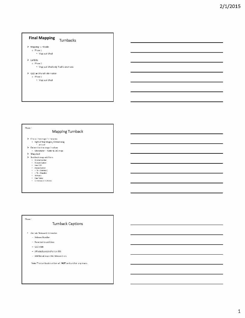
Final Mapping
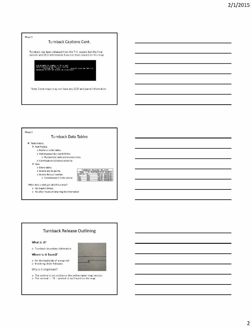
22

23

24

25
Right of Way Technical Training Quiz — Turnbacks
1. What is the major difference between a conveyance by MnDOT and a turnback?
Fill in the answer:
2. Where do you find information about the Route Numbering and Control Section Committee?
a. Google
b. TDA website
c. A to Z on the IHUB
d. RNCS Wiki site
e. All of the above
3. Who are the members of the Route Numbering and Control Section Committee?
a. Director of Land Management
b. Director of Transportation System Management
c. State Sign Engineer, Office of Traffic, Safety and Technology
d. District Engineers
e. All of the Above
4. What is the best way to find the most current R/W map?
a. Look at each map in the area and find out when the T.E. (temporary easement),
has expired
b. Open up RWMM (Right of Way Mapping and Monitoring), and examine the maps
c. Look at the map numbers because they are in order according to the number
d. Call the Central Office
5. What is the main difference between a Notice of Release and a Notice of Transfer?
Fill in the answer:
6. What is the best way to find out if a turnback has been placed on the right of way map?
a. Examine the information in REALMS
b. Ask the local road authority
c. Call the Central Office

26
7. Turnback data tables are always found on the right of way map?
a. True
b. False
8. Where are the parcels associated with a turnback found on the right of way map?
a. In the turnback caption block
b. In the commissioner’s orders table
c. In the parcel caption block
9. Of various types of roads, which typically involve MnDOT in regard to turnbacks?
a. Principal arterials
b. Minor collector roads
c. Local roads
10. Which of the following should be used determine the right of way limits following a turnback?
a. Notice or Release
b. Quit Claim Deed
c. Right of Way Map
d. Turnback Authorization Map
e. Commissioner’s Orders
11. The best place to look for a copy of the quit claim deed containing a legal description of the
parcels released in the turnback is:
a. The parcel file at the Record Center
b. The county courthouse
c. eDOCS
d. REALMS
e. All of the above
f. C and D
12. MnDOT’s Right of Way Manual provides the detail as to what is required for completing a
turnback. It provides very little as to how to do it. Which of the following is the best place to get
instruction as to how?
a. Local road authority
b. Legal Unit in the Office of Land Management at the Central Office
c. District Staff

27
13. What prompts a turnback?
a. State Aid
b. Upcoming Project
c. Maintenance
d. Landowner Request
14. What Minnesota Highway Users Tax Distribution funds are used with turnbacks?
a. Flexible Highway Account
b. Trunk Highway Fund
c. Municipal State Aid Street Fund
d. County State Aid Highway Fund

28
APPENDIX
ARTICLE XIV ‐ PUBLIC HIGHWAY SYSTEM Section 1. Authority of state; participation of political subdivisions. The state may construct, improve and maintain public highways, may assist political subdivisions in this work and by law may authorize any political subdivision to aid in highway work within its boundaries. Sec. 2. Trunk highway system. There is hereby created a trunk highway system which shall be constructed, improved and maintained as public highways by the state. The highways shall extend as nearly as possible along the routes number 1 through 70 described in the constitutional amendment adopted November 2, 1920, and the routes described in any act of the legislature which has made or hereafter makes a route a part of the trunk highway system. The legislature may add by law new routes to the trunk highway system. The trunk highway system may not exceed 12,200 miles in extent, except the legislature may add trunk highways in excess of the mileage limitation as necessary or expedient to take advantage of any federal aid made available by the United States to the state of Minnesota. Any route added by the legislature to the trunk highway system may be relocated or removed from the system as provided by law. The definite location of trunk highways numbered 1 through 70 may be relocated as provided by law but no relocation shall cause a deviation from the starting points or terminals nor cause any deviation from the various villages and cities through which the routes are to pass under the constitutional amendment adopted November 2, 1920. The location of routes may be determined by boards, officers or tribunals in the manner prescribed by law. Sec. 3. County state‐aid highway system. A county state‐aid highway system shall be constructed, improved and maintained by the counties as public highways in the manner provided by law. The system shall include streets in municipalities of less than 5,000 population where necessary to provide an integrated and coordinated highway system and may include similar streets in larger municipalities. Sec. 4. Municipal state‐aid street system. A municipal state‐aid street system shall be constructed, improved and maintained as public highways by municipalities having a population of 5,000 or more in the manner provided by law. Sec. 5. Highway user tax distribution fund. There is hereby created a highway user tax distribution fund to be used solely for highway purposes as specified in this article. The fund consists of the proceeds of any taxes authorized by sections 9 and 10 of this article. The net proceeds of the taxes shall be apportioned: 62 percent to the trunk highway fund; 29 percent to the county state‐aid highway fund; nine percent to the municipal state‐aid street fund. Five percent of the net proceeds of the highway user tax distribution fund may be set aside and apportioned by law to one or more of the three foregoing funds. The balance of the highway user tax distribution fund shall be transferred to the trunk highway fund, the county state‐aid highway fund, and the municipal state‐aid street fund in accordance with the percentages set forth in this section. No change in the apportionment of the five percent may be made within six years of the last previous change. Sec. 6. Trunk highway fund. There is hereby created a trunk highway fund which shall be used solely for the purposes specified in section 2 of this article and the payment of principal and interest of any bonds issued under the authority of section 11 of this article and any bonds issued for trunk highway purposes prior to July 1, 1957. All payments of principal and interest on bonds issued shall be a first charge on money coming into this fund during the year in which the principal or interest is payable. Sec. 7. County state‐aid highway fund. There is hereby created a county state‐aid highway fund. The county state‐aid highway fund shall be apportioned among the counties as provided by law. The funds apportioned shall be used by the counties as provided by law for aid in the construction, improvement and maintenance of county state‐aid highways. The legislature may authorize the counties by law to use a part of the funds apportioned to them to aid in the construction, improvement and maintenance of

29
other county highways, township roads, municipal streets and any other public highways, including but not limited to trunk highways and municipal state‐aid streets within the respective counties. Sec. 8. Municipal state‐aid street fund. There is hereby created a municipal state‐aid street fund to be apportioned as provided by law among municipalities having a population of 5,000 or more. The fund shall be used by municipalities as provided by law for the construction, improvement and maintenance of municipal state‐aid streets. The legislature may authorize municipalities to use a part of the fund in the construction, improvement and maintenance of other municipal streets, trunk highways, and county state‐aid highways within the counties in which the municipality is located. Sec. 9. Taxation of motor vehicles. The legislature by law may tax motor vehicles using the public streets and highways on a more onerous basis than other personal property. Any such tax on motor vehicles shall be in lieu of all other taxes thereon, except wheelage taxes imposed by political subdivisions solely for highway purposes. The legislature may impose this tax on motor vehicles of companies paying taxes under the gross earnings system of taxation notwithstanding that earnings from the vehicles may be included in the earnings on which gross earnings taxes are computed. The proceeds of the tax shall be paid into the highway user tax distribution fund. The law may exempt from taxation any motor vehicle owned by a nonresident of the state properly licensed in another state and transiently or temporarily using the streets and highways of the state. Sec. 10. Taxation of motor fuel. The legislature may levy an excise tax on any means or substance used for propelling vehicles on the public highways of this state or on the business of selling it. The proceeds of the tax shall be paid into the highway user tax distribution fund. Sec. 11. Highway bonds. The legislature may provide by law for the sale of bonds to carry out the provisions of section 2. The proceeds shall be paid into the trunk highway fund. Any bonds shall mature serially over a term not exceeding 20 years and shall not be sold for less than par and accrued interest. If the trunk highway fund is not adequate to pay principal and interest of these bonds when due, the legislature may levy on all taxable property of the state in an amount sufficient to meet the deficiency or it may appropriate to the fund money in the state treasury not otherwise appropriated. [Amended, November 2, 1982] Sec. 12. Motor vehicle sales tax apportionment. Beginning with the fiscal year starting July 1, 2007, 63.75 percent of the revenue from a tax imposed by the state on the sale of a new or used motor vehicle must be apportioned for the transportation purposes described in section 13, then the revenue apportioned for transportation purposes must be increased by ten percent for each subsequent fiscal year through June 30, 2011, and then the revenue must be apportioned 100 percent for transportation purposes after June 30, 2011. [Adopted, November 7, 2006] Sec. 13. Motor vehicle sales tax allocation. The revenue apportioned in section 12 must be allocated for
the following transportation purposes: not more than 60 percent must be deposited in the highway user
tax distribution fund, and not less than 40 percent must be deposited in a fund dedicated solely to
public transit assistance as defined by law.

30
161.114 CONSTITUTIONAL TRUNK HIGHWAYS.
Subdivision 1. Designation. The trunk highway routes, numbered 1 through 70, as described in the constitutional amendment adopted November 2, 1920, are designated as the constitutional routes of the trunk highway system. Subd. 2. Descriptions. The constitutional routes are described as follows: Route No. 1. Beginning at a point on the boundary line between the states of Minnesota and Iowa, southeasterly at Albert Lea and thence extending in a northwesterly direction to a point in Albert Lea and thence extending in a northerly direction to a point and on the southerly limits of the city of St. Paul and then beginning at a point on the northerly limits of the city of St. Paul and thence extending in a northerly direction to a point on the westerly limits of the city of Duluth and then beginning at a point on the northerly limits of the city of Duluth and thence extending in a northeasterly direction to a point on the boundary line between the state of Minnesota and the province of Ontario, affording Albert Lea, Owatonna, Faribault, Northfield, Farmington, St. Paul, White Bear, Forest Lake, Wyoming, Rush City, Pine City, Hinckley, Sandstone, Moose Lake, Carlton, Duluth, Two Harbors, Grand Marais and intervening and adjacent communities a reasonable means of communication, each with the other and other places within the state. Route No. 2. Beginning at a point on Route No. 1 on the westerly limits of the city of Duluth and thence extending in a southwesterly direction along said Route No. 1 to a point on said route at Carlton and thence extending in a westerly direction to a point on the east bank of the Red River of the North at Moorhead, affording Duluth, Carlton, McGregor, Aitkin, Brainerd, Motley, Staples, Wadena, Detroit, Moorhead and intervening and adjacent communities a reasonable means of communication, each with the other and other places within the state. Route No. 3. Beginning at a point on the boundary line between the states of Minnesota and Wisconsin, westerly of La Crosse, Wisconsin, and thence extending in a northwesterly direction to a point on the easterly limits of the city of St. Paul and then beginning at a point on the westerly limits of the city of Minneapolis and thence extending in a northwesterly direction to a point on the east bank of the Red River of the North at Breckenridge, affording La Crescent, Winona, Kellogg, Wabasha, Lake City, Red Wing, Hastings, St. Paul, Minneapolis, Osseo, Champlin, Anoka, Elk River, Big Lake, St. Cloud, Albany, Sauk Centre, Alexandria, Elbow Lake, Fergus Falls, Breckenridge and intervening and adjacent communities a reasonable means of communication, each with the other and other places within the state. Route No. 4. Beginning at a point on the boundary line between the states of Minnesota and Iowa, southwesterly of Jackson and thence extending in a northerly direction to a point on Route No. 3, southeasterly of Sauk Centre and thence extending in a northwesterly direction along said Route No. 3 to a point on said route at Sauk Centre and thence extending in a northerly direction to a point at International Falls, affording Jackson, Windom, Sanborn, Redwood Falls, Morton, Olivia, Willmar, Paynesville, Sauk Centre, Long Prairie, Wadena, Park Rapids, Itasca State Park, Bemidji, International Falls and intervening and adjacent communities a reasonable means of communication, each with the other and other places within the state. Route No. 5. Beginning at a point on the boundary line between the states of Minnesota and Iowa, southerly of Blue Earth and thence extending in a northeasterly direction to a point on the southerly limits of the city of Minneapolis and then beginning at a point on the northerly limits of the city of Minneapolis and thence extending in a northerly direction to a point in Swan River on Route No. 8, hereinafter described, affording Blue Earth, Winnebago, Mankato, St. Peter, Le Sueur, Jordan, Shakopee, Minneapolis, Cambridge, Mora, McGregor, Swan River and intervening and adjacent communities a reasonable means of communication, each with the other and other places within the state. Route No. 6. Beginning at a point on the boundary line between the states of Minnesota and Iowa,
31
southerly of Ash Creek, and thence extending in a northerly direction to a point on the boundary line between the state of Minnesota and the province of Manitoba, near St. Vincent, affording Luverne, Pipestone, Lake Benton, Ivanhoe, Canby, Madison, Bellingham, Odessa, Ortonville, Graceville, Dumont, Wheaton, Breckenridge, Moorhead, Kragnes, Georgetown, Perley, Hendrum, Ada, Crookston, Warren, Donaldson, Hallock and intervening and adjacent communities a reasonable means of communication, each with the other and other places within the state. Route No. 7. Beginning at a point on Route No. 3 at Winona and thence extending in a westerly direction to a point on the boundary line between the states of Minnesota and South Dakota, westerly of Lake Benton, affording Winona, St. Charles, Rochester, Kasson, Dodge Center, Claremont, Owatonna, Waseca, Mankato, St. Peter, New Ulm, Springfield, Tracy, Lake Benton and intervening and adjacent communities a reasonable means of communication, each with the other and other places within the state. Route No. 8. Beginning at a point on the westerly limits of the city of Duluth and thence extending in a northwesterly direction to a point on Route No. 6 near Crookston and thence extending in a westerly and northerly direction along said Route No. 6 to a point on said route northerly of Crookston and thence extending in a northwesterly direction to a point on the east bank of the Red River of the North at East Grand Forks, affording Duluth, Floodwood, Swan River, Grand Rapids, Cass Lake, Bemidji, Bagley, Erskine, Crookston, East Grand Forks and intervening and adjacent communities a reasonable means of communication, each with the other and other places within the state. Route No. 9. Beginning at a point on Route No. 3 at La Crescent and thence extending in a westerly direction to a point on the boundary line between the states of Minnesota and South Dakota southwesterly of Beaver Creek, affording La Crescent, Hokah, Houston, Rushford, Lanesboro, Preston, Fountain, Spring Valley, Austin, Albert Lea, Blue Earth, Fairmont, Jackson, Worthington, Luverne and intervening and adjacent communities a reasonable means of communication, each with the other and other places within the state. Route No. 10. Beginning at a point on the westerly limits of the city of Minneapolis and thence extending in a northwesterly direction to a point on Route No. 6 at or near Wheaton, affording Minneapolis, Montrose, Cokato, Litchfield, Willmar, Benson, Morris, Herman, Wheaton and intervening and adjacent communities a reasonable means of communication, each with the other and other places within the state. Route No. 11. Beginning at a point on Route No. 8 at the westerly limits of the city of Duluth and thence extending in a northwesterly and northerly direction to a point on Route No. 4 at International Falls and thence extending in a southwesterly direction along said Route No. 4 to a point on said route southwesterly of International Falls and thence extending in a westerly direction to a point on Route No. 6 at Donaldson, affording Duluth, Eveleth, Virginia, Cook, Orr, Cussons, International Falls, Baudette, Warroad, Roseau, Greenbush, Donaldson and intervening and adjacent communities a reasonable means of communication, each with the other and other places within the state. Route No. 12. Beginning at a point on the west bank of the St. Croix River near Hudson, Wisconsin and thence extending in a westerly direction to a point on the easterly limits of the city of St. Paul and then beginning at a point on the westerly limits of the city of Minneapolis and thence extending in a westerly direction to a point on Route No. 6 at Madison, affording St. Paul, Minneapolis, Hopkins, Norwood, Glencoe, Olivia, Granite Falls, Montevideo, Dawson, Madison and intervening and adjacent communities a reasonable means of communication, each with the other and other places within the state. Route No. 13. Beginning at a point on Route No. 9 at Albert Lea and thence extending in a northerly direction to a point on Route No. 5 at Jordan affording Albert Lea, Waseca, Waterville, Montgomery, New Prague, Jordan and intervening and adjacent communities a reasonable means of communication, each with the other and other places within the state. Continues to Route No. 70

32
161.115 ADDITIONAL TRUNK HIGHWAYS. Subdivision 1.Legislative routes confirmed. The following routes hereby and heretofore added to the trunk highway system by the legislature under the provisions of Article 14, of the Constitution adopted November 2, 1920, and as the same are herein amended, are hereby confirmed. Subd. 2.Route No. 71. Beginning at a point on Route No. 27 in Little Falls, thence extending in a northeasterly direction to a point on Route No. 1, at or near Moose Lake; affording Little Falls, Onamia, Isle, McGrath, and Moose Lake a reasonable means of communication each with the other and other places within the state. Subd. 3.Route No. 72. Beginning at a point on Route No. 4, southerly of Bemidji and thence extending in a northerly direction to a point on Route No. 11, easterly of Baudette; affording Bemidji, Waskish, Baudette, and intervening and adjacent communities a reasonable means of communication each with the other and other places within the state. Subd. 4.Route No. 73. Beginning at a point on Route No. 20, at or near Zumbrota, thence extending in an easterly direction to a point on Route No. 3; affording Zumbrota, Mazeppa, Zumbro Falls, and Wabasha a reasonable means of communication each with the other and other places within the state. Subd. 5.Route No. 74. Beginning at a point on Route No. 3, at or near Weaver, thence extending in a southwesterly direction to a point at or near Chatfield; affording Weaver, St. Charles, and Chatfield, a reasonable means of communication each with the other and other places within the state. Subd. 6.Route No. 75. Beginning at a point on Route No. 3 in Winona, thence extending in a northeasterly direction to a point on the line between the states of Minnesota and Wisconsin. Subd. 7.Route No. 76. Beginning at a point on Route No. 43, at or near Wilson, thence extending in a southeasterly direction to a point on the line between the states of Minnesota and Iowa; affording Wilson, Houston, and Caledonia a reasonable means of communication each with the other and other places within the state. Subd. 8.Route No. 77. Beginning at a point on Route No. 43 at or near Rushford, thence extending in a westerly direction to a point on Route No. 56 at or near Hayfield; affording Rushford, Chatfield, Stewartville, and Hayfield a reasonable means of communication each with the other and other places within the state. Subd. 9.Route No. 78. Beginning at a point on Route No. 9 at or near Rushford, thence extending in a southerly direction to a point on Route No. 44 at or near Mabel. Subd. 10.Route No. 79. Beginning at a point on Route No. 20 at or near Harmony, thence extending in a southerly direction to the line between the states of Minnesota and Iowa. Subd. 11.Route No. 80. Beginning at a point on Route No. 9 southerly of Wykoff, thence extending in an easterly direction to a point on Route No. 20 at or near Preston. Subd. 12.Route No. 81. Beginning at a point on Route No. 9 easterly of Austin, thence extending in a southeasterly direction to a point on Route No. 59 easterly of LeRoy. Subd. 13.Route No. 82. Beginning at a point on Route No. 40 at or near Blooming Prairie, thence extending in a westerly direction to a point on Route No. 15; affording Blooming Prairie, Ellendale, Mapleton, and St. James a reasonable means of communication each with the other and other places within the state. Subd. 14.Route No. 83. Beginning at a point on Route No. 5 westerly of Mankato, thence extending in a northwesterly direction to a point on Route No. 15 southerly of New Ulm. Subd. 15.Route No. 84. Beginning at a point on Route No. 7 at or near Sleepy Eye, thence extending in a southerly direction to the line between the states of Minnesota and Iowa; affording Sleepy Eye, St. James, and Sherburne a reasonable means of communication each with the other and other places within the state. Continuing to Subd. 270.Route No. 339.

33
161.12 ADDITIONAL ROUTES ADDED; FEDERAL AID. Subdivision 1. Interstate system. To take advantage of federal aid made available by the United States to the state of Minnesota for highway purposes, the following trunk highway routes are added to the trunk highway system which routes form a part of the national system of interstate and defense highways and may be referred to as the interstate system. Subd. 2.Route No. 390. Beginning at a point on the boundary between the states of Minnesota and Iowa, southerly of Albert Lea; thence extending in a general northeasterly direction to a point in Duluth on the boundary between the states of Minnesota and Wisconsin. Route No. 390 shall not include any portion of Trunk Highway marked 3 from Trunk Highway marked 110 in Dakota County to East Seventh Street in the city of St. Paul. Subd. 3.Route No. 391. Beginning at a point on the boundary between the states of Minnesota and South Dakota, westerly of Luverne; thence extending in a general easterly direction to a point on the boundary between the states of Minnesota and Wisconsin, near La Crescent. Subd. 4.Route No. 392. Beginning at a point on the boundary between the states of Minnesota and North Dakota in or near Moorhead; thence extending in a general southeasterly direction through the city of Minneapolis; thence in a general easterly direction through the city of St. Paul to a point on the boundary between the states of Minnesota and Wisconsin in or near Lakeland. Subd. 5.Route No. 393. Beginning at a point on Route No. 392, easterly of the city of St. Paul; thence in a general southerly and westerly direction through the city of South St. Paul; thence in a general westerly direction to a point in Eden Prairie Township, Hennepin County; thence in a general northerly direction to a point in the city of Maple Grove, Hennepin County; thence in a general easterly direction to a point on Route 390; thence in a general easterly, southeasterly and southerly direction to the point of beginning on Route No. 392, easterly of St. Paul. Subd. 6.Route No. 394. Beginning at a point on Route No. 390, southerly of the Minnesota River; thence extending in a general northerly and northeasterly direction through the city of Minneapolis; thence continuing in a northeasterly direction to a point on Route No. 390, near Forest Lake and there terminating. Subd. 7.Route No. 395. Beginning at a point on Route No. 390 at or near the intersection of Superior Street and Nineteenth Avenue West in the city of Duluth, thence extending in a northeasterly direction to a point on Route No. 103 at or near the intersection of Superior Street and Tenth Avenue East in the city of Duluth. Subd. 8.Route No. 396. Beginning at a point approximately on the intersection of Legislative Route No.
103, also known as Trunk Highway 61 and London Road, and 10th Avenue East in Duluth; thence
extending in a general northeasterly direction and approximately parallel to Legislative Route No. 103 to
a point approximately on the intersection of Legislative Route No. 103 and 26th Avenue East in Duluth.
161.15 SPECIFIC LOCATION; LIMITATION ON DEVIATIONS. The commissioner may specifically and definitely locate all of the routes of the trunk highway system,
but in so locating same, the commissioner shall not deviate from the starting points or terminals as set
forth in the route description; nor shall there be any deviation from the various cities named in the
routes through which such routes shall pass.

34
161.16 HIGHWAY DESIGNATION, VACATION, REVERSION, SURVEY. Subdivision 1. Temporary trunk highways; reversion. Until such time as the commissioner definitely locates and constructs the several routes of the trunk highway system, the commissioner shall select practicable existing roads along the general location of such routes and shall maintain them for the benefit of the traveling public. Such roads shall be known as temporary trunk highways. The road authority which had jurisdiction over such road shall, thereupon, be relieved of responsibilities thereto; provided, however, if the definite location of the route shall be other than the location of the temporary trunk highway, the portion of the temporary locations which is not included in the definite location shall, upon notice of the commissioner, revert to the road authority unless the same lies within the corporate limits of a city, in which case it shall become a street of the city, provided that when the portion of the temporary location, which is not included in the definite location lies within a city having a population of less than 5,000, that portion shall revert to the county if it meets the criteria for a county state‐aid highway. Subd. 2. Designation and location by order. The commissioner shall by order or orders designate such temporary trunk highways, and on determining the definite location of any trunk highway or portion thereof, the same shall also be designated by order or orders. The definite location of such highway or portion thereof may be in the form of a map or plat showing the lands and interests in lands required for trunk highway purposes. Formal determination or order if by map or plat, shall be certified by the commissioner of transportation on said map or plat. The commissioner may, by similar order or orders, change the definite location of any trunk highway between the fixed termini, as fixed by law, when such changes are necessary in the interest of safety and convenient public travel. The commissioner shall maintain a file of these orders as permanent records. Subd. 3.Public hearing. When the county board of any county requests a public hearing in regard to the definite location or a change in the definite location of any trunk highway within its boundaries, the commissioner shall hold such hearing in such county before making a determination in such matters. Subd. 4.Reversion or conveyance to another road authority. (a) If the commissioner makes a change in the definite location of a trunk highway as provided in this section, the portion of the existing road that is no longer a part of the trunk highway by reason of the change and all right, title, and interest of the state in the trunk highway shall revert to the road authority originally charged with the care of that trunk highway unless the commissioner, the road authority originally charged with the care of the trunk highway and the road authority of the political subdivision in which the portion is located agree on another disposition, in which case the reversion is as provided in the agreement. When the reversion is to a county and a portion lies partly within a city of under 5,000 population the entire portion shall revert to the county if it meets the criteria for a county state‐aid highway. (b) If the portion had its origin as a trunk highway, it shall become a county highway unless it lies within the corporate limits of a city, in which case it shall become a street of the city. When the existing road that is no longer a part of the trunk highway by reason of the change lies within a city of less than 5,000 population, the portion shall revert to the county if the portion meets the criteria for a county state‐aid highway. In municipalities of over 5,000 population that portion of the road may revert to the county if the appropriate authorities of the state, county and the various cities through which the route passes so agree. Should any city not agree that the portion of the roadway that passes through it shall revert to county jurisdiction, the portion shall not so revert, although the other portions of the roadway in which agreement has been reached shall revert to county jurisdiction. Notwithstanding the other provisions of this chapter or other applicable laws and rules, the commissioner may convey and quitclaim to a county, city, or other political subdivision all or part of the right‐of‐way of the existing road that is no longer a part of the trunk highway by reason of the commissioner's order or orders. The conveyance shall be for highway purposes, and the future cost of maintenance, improvement, or reconstruction of the highway and the contribution of that highway to the public highway system is reasonable and proper

35
consideration for the conveyance. This subdivision shall apply to all trunk highways reverted before May 29, 1967. Subd. 5.Damages due to vacation of former trunk highway. Damages occasioned by the vacation of any highway or street that had its origin as a trunk highway, if vacated by the county within one year after the commissioner relinquished jurisdiction thereof, shall be paid by the state out of the trunk highway fund. No award of damages determined by the county shall be made for such vacation without the concurrence of the attorney general, and no action brought to recover damages for such vacation shall be settled or otherwise disposed of without the consent of the attorney general. The attorney general may defend any action brought to recover damages for such vacation. Subd. 6.Vacation. When the definite location of any trunk highway takes the place of and serves the same purpose as any portion of an existing road, however established, the commissioner may make an order vacating such portion of the road. A copy of the order shall be served upon the owners and occupants of the lands on which is located the portion of the road so vacated and, if the road terminates at or abuts upon any public water, a copy of the order also shall be served upon the commissioner of natural resources. The notice under this subdivision is for notification purposes only and does not create a right of intervention by the commissioner of natural resources. A copy of the order, together with proof of service, or affidavit of publication if the owners are unknown or reside outside the state, shall be filed with the county auditor of the county in which such lands lie. Any person claiming to be damaged by the vacation may appeal at any time within 30 days after the service of the order to the district court of the county for a determination of damages, by serving notice of the appeal on the commissioner and filing same with proof of service in the office of the court administrator of the district court. The appeal shall be tried in the same manner as an appeal from an award in proceedings in eminent domain. Subd. 7.Survey of trunk highway centerline. (a) When the physical location of a trunk highway centerline will be changed by order of the commissioner and the commissioner is aware that a property description has been written to the centerline, the commissioner shall file with the recorder in the county where the highway is located a survey of the existing centerline prior to changing or removing the trunk highway. (b) The survey of the trunk highway centerline must be prepared on four‐mil transparent reproducible film or its equivalent. Sheet size must be 22 inches by 34 inches. A border line must be placed one‐half inch inside the outer edge of the sheet on the top and bottom 34‐inch sides; and the right 22‐inch side; and two inches inside the outer edge of the sheet on the left 22‐inch side. If a survey of the trunk highway centerline consists of more than one sheet, the sheets must be numbered consecutively. The survey of the trunk highway centerline must include: (1) a graphic depiction of the existing trunk highway centerline; (2) distances along the centerline, and ties to the corners of the public land survey, expressed in feet and hundredths of a foot. All straight line segments of the plat must be labeled with the length of the line and bearing or azimuth. All curved line segments of the plat must be labeled with the central angle, arc length, and radius length. If any curve is nontangential, the dimensions must include a long chord bearing or azimuth, and must be labeled nontangential; (3) a north arrow and directional orientation note; (4) a graphics scale along with the label "Scale In Feet"; (5) the position, description, and ties from the trunk highway centerline to corners of the public land survey; (6) identification of the public land survey quarter section or sections, government lot or lots, and the county through which the depicted trunk highway centerline runs; and (7) the date of the survey. (c) The survey of the trunk highway centerline must be certified by the commissioner of transportation

36
or the commissioner's designated assistant and by a licensed land surveyor. (d) Upon submission to the recorder in the county where the depicted trunk highway centerline is
located, and upon payment of appropriate fees, the survey of the trunk highway centerline must be filed
of record.

37
161.24 CHANGES REQUIRED BY CONSTRUCTION OF TRUNK HIGHWAY. Subdivision 1.Grade at intersections. When the construction or reconstruction of a trunk highway results in a change of grade which necessitates a change of grade in intersecting or connecting highways or streets, including city streets, the cost of making the grade changes and any damages occasioned thereby shall be paid out of the trunk highway fund. Subd. 2.Relocation of highway. When in the judgment of the commissioner, the establishment, construction, or reconstruction of a trunk highway requires, in the interest of safety or convenient public travel, a change in the location of any highway or street, including a city street, the commissioner may make the needed change in location after obtaining the approval of the road authority having jurisdiction over such highway or street. The cost of the change in location and any damages occasioned thereby shall be paid out of the trunk highway fund. All lands necessary therefor may be acquired by purchase, gift or condemnation. The highway or street as changed shall be the legally designated location thereof until otherwise changed as provided by law, and the maintenance and care of the highway or street shall be the responsibility of the road authority having jurisdiction thereof. Subd. 3.Detours during construction. On determining, during construction, reconstruction, or maintenance of a trunk highway, that it is impractical to provide crossovers within the trunk highway limits for local highways or city streets designated for and carrying traffic of five tons or more per axle, and that it is necessary to provide a detour outside the limits of the trunk highway for traffic using such local highways or streets to meet local traffic needs, the commissioner may, upon request of the local road authority, expend trunk highway funds on the most practical detour to the extent necessary to provide a route reasonably adequate to carry such detoured traffic. The commissioner may provide temporary traffic‐control devices on such detours as the commissioner deems necessary. Subd. 4.Access to isolated property. When the establishment, construction, or reconstruction of a trunk highway closes off any other highway or street, including a city street, private road, or entrance at the boundary of the trunk highway, the commissioner may, in mitigation of damages or in the interest of safety and convenient public travel, construct a road either within or outside the limits of the trunk highway, connecting the closed‐off highway, street, private road, or entrance with another public highway. In determining whether to build the road within or outside the limits of the trunk highway, the commissioner may take into consideration economy to the state and local traffic needs. The commissioner, in mitigation of damages, may connect the closed‐off private road with the remaining portion of the private road or with another private road. All lands necessary for connecting a highway, street, private road, or entrance to another public highway or for connecting a closed‐off private road to the remaining portion of a private road or to another private road, may be acquired by purchase, gift, or condemnation. Notwithstanding section 161.23, 161.43, 161.431, or 161.44, the commissioner may convey and quitclaim a fee title or easement held or owned by the state in land used to construct a road to connect the closed‐off highway, street, entrance, or private road with another public highway or to reconnect the private road to the property served by the road. Subd. 5.Maintenance of roads outside trunk highway. Any road so constructed outside the limits of the trunk highway shall be maintained by the road authority having jurisdiction over the highway or street closed off. Any private road constructed outside the limits of the trunk highway connecting the private road with a public highway shall be the responsibility of the property owners or owners served thereby. Subd. 6.Agreements. The commissioner and the road authority affected may enter into agreements
upon such terms as may be agreed upon, to provide for the construction of such grade changes, changes
in location, detours, or connecting roads.

38
PRE‐ACQUISITION (5‐491.100)
TURNBACKS (5‐491.128)
128.1 POLICY
A. It is the policy of the Department of Transportation to remove from the trunk highway
system those lands, with roadways constructed thereon, which are no longer required
as a part of the trunk highway system. This includes jurisdictional alignments and all
frontage roads, except in cases where the state wishes to retain control.
B. Prior to the relinquishment or abandonment of any existing trunk highway right of way,
full consideration will be given through design and needs study as to any possible
present or future appropriate public uses for purposes such as rest areas, scenic
enhancement, recreational facilities, or parks.
C. When changes in any road or street are required and/or caused by the construction or
reconstruction of a trunk highway the Commissioner of Transportation may release that
portion of any relocated road or street to the road authority having jurisdiction over the
maintenance thereof.
D. Access will be controlled between the trunk highway and the roadways being released.
Generally, all existing access control will be retained or perpetuated. When the access
controlled highway is constructed and access is acquired along side roads at
intersections, the right of way having access control should remain in the trunk highway
system.
E. The Code of Federal Regulations 23 CFR Part 620, Subpart B, discusses the
relinquishment and abandonment of right of way on which there has been a federal‐aid
highway project. If all features of the highway system being replaced and the one being
established were reviewed at the time of the approval of plans, specifications and
estimates, and concurred in by the federal agency prior to the start of construction, it
will not be necessary for FHWA to review the turnback subsequent to plans,
specifications & estimates (PS&E) approval.
Note: Preliminary FHWA approval is required on all proposed turnbacks affecting
interstate highways on the National Highway System.
F. A Notice of Release or Transfer will be issued by the Office of Land Management when
the roadway to be reverted is no longer included within the trunk highway system as
defined by a Commissioner’s Order.

39
G. Whenever lands were acquired by means other than by the Commissioners Orders, the
Commissioner may convey the land by quitclaim deed to another road authority.
H. It shall be the District Engineer's responsibility to schedule all trunk highway reversions
within the limitation of the following provisions:
1. District Engineer assumes accountability for planning, negotiation, and
implementation of jurisdictional alignment projects.
2. District Engineer shall address jurisdictional alignment planning in long range plans
to become eligible for turnback funds.
3. District Engineer scopes "traditional" turnback concurrently with any new major
construction project, and establish total project funding before construction of new
route.
4. District Engineer should require written documentation on the conditions that need
to be met by all parties prior to a final release date.
5. Consider all sources of funding when developing a funding scenario for a
jurisdictional alignment.
6. The road authority from whom the roadway was originally acquired shall be
determined with the assistance of the Office of Land Management, Legal and
Property Management Unit.
7. The eligibility for a route to be designated as either a County State‐Aid highway or a
Municipal State Aid street shall be mutually determined by the District Engineer and
the State Aid Engineer.
8. A meeting will be held with the local road authority to discuss eligibility for State
Aid, availability of turnback funds, and corrective measures, which may have to be
applied before the effective date of turnback.
9. It shall be the policy of MnDOT to submit preliminary notice to the local jurisdiction
at least six months before the tentative reversion date informing them of the
Department's intent and eligibility for State Aid and turnback funds. Copies of said
notice must be sent to Office of State Aid and the Central Office of Land
Management.
10. Sixty days prior to the date of reversion, the district engineer shall notify the local
jurisdiction of the forthcoming release. A copy of said notice must be sent to the
office of State Aid and the Central Office of Land Management.

40
I. When a trunk highway, to be routed over an interstate highway, is released between
November 1 and May 30, MnDOT shall maintain the old trunk highway until the next
October 30.
When a trunk highway, to be routed over an interstate highway, is released between
June 1 and October 30, MnDOT shall maintain the old trunk highway until the next May
30.
The local road authority may waive, by resolution, the aforementioned maintenance
periods. No resolution is needed if that timing is part of a negotiated agreement.
J. When a trunk highway is to be realigned or routed over another trunk highway, it shall
be the policy of MnDOT, consistent with law, to revert the old trunk highway to the local
authority between April 1 and November 1. This also applies to all other reverted roads
i.e.; frontage roads, etc.
The local road authority may waive, by resolution the aforementioned time period. No
resolution is needed if that timing is part of a negotiated agreement.
K. District Plan Steering Committee (Members: representatives of the Transportation
Research & Investment Management, Engineering Services, Operations, State‐Aid,
Metro District, and the Deputy Commissioners) will evaluate the District Jurisdictional
Alignment plan and make recommendations regarding strategies and priorities.
L. District will track jurisdictional alignment projects using schedules.
M. The Office of Land Management will manage the internal process and track in the
REALMS database.
N. The State‐Aid Division will develop a programming process and an annual priority list of
backlog jurisdiction alignment projects based on the criteria suggested by the Trunk
Highway Turnback Advisory Group. The State‐Aid Division will also develop an annual
status report of jurisdictional alignment projects. The report should identify new
projects, projects funded within the previous years, and projects still on the waiting list.
O. The Office of Technical Support ‐ Cultural Resource Unit will provide support, such as
identifying known cultural and historic resources as requested by the District as regards
to all jurisdictional alignments and/or turnbacks.
NOTE: See Flow Charts #5‐491.128A‐E for Turnback/Jurisdictional Realignment Process “Flow
Charts” for overview.

41
128.2 STATUTE AUTHORITIES AND REQUIREMENTS
All turnbacks (release, reversion or conveyance) shall be in accordance with Minnesota
Statutes as follows:
161.16 TEMPORARY AND DEFINITELY LOCATED TRUNK HIGHWAYS; VACATION AND
REVERSION.
161.161 HIGHWAY ON COUNTY LINE, REVERSION.
161.24 CHANGES REQUIRED BY CONSTRUCTION OF TRUNK HIGHWAY.
161.082 County Turnback Account Expenditure
161.083 Municipal Turnback Account Expenditure
128.3 PROCEDURE
District
1. Determine the state project trunk highway number, designation, constitutional or legislative route
number designation, Control Section #, the "900" section location and the termini of the trunk
highway which the State proposes to convey. District will track jurisdictional alignment projects
using P6 schedules.
2. Determine the entity from which the roadway was originally acquired by the state and to what
governmental jurisdiction (county, city, or other political subdivision) the right of way of the existing
trunk highway will revert. For assistance in obtaining this information, contact the Office of Land
Management.
3. Notify the OIM (Office of Investment Management) regarding proposed changes in legislative and
constitutional routes.
4. Determines if the portion of trunk highway to be turned back is eligible for State Aid designation and
funds participation.
5. Determine if the release involves any lands included in a conveyance in process. A release cannot
be executed if any of the lands are to be conveyed.
6. Determine if FHWA approval is required (interstate highways on the National Highway System only).

42
7. Prepare Turnback Authorization Map.
a. Prepare Form 25317 (Staff Signature Sheet).
b. Prepare Form 30204 (Recommendation to Release).
c. The proposed right of way line and restricted access must be shown in red color.
d. Released portions to be shown colored yellow.
e. Prepare index map showing rerouting.
f. Circulates authorization map throughout District and FHWA (if required) for signatures
(includes routing through the District Surveys Office).
8. Receive Office of Investment Management approved rerouting.
9. SIX MONTHS PRIOR TO RELEASE DATE
a. Give preliminary notice to local road authority. Copies of the notice must be sent to the
Offices of State Aid and of Land Management.
b. Submit the Turnback Authorization Map (with Forms 25317 and 30204 attached) to
Director, Office of Land Management.
10. SIXTY DAYS PRIOR TO RELEASE DATE, notify local road authority of forthcoming release. Copies of
said notice MUST be sent to the Offices of State Aid and Land Management.
Director, Office of Land Management
11. Receive turnback authorization map from District and assign to Legal and Property Management
Unit.
Legal and Property Management Unit
12. Record date of receipt of authorization map records. Checks for pending conveyance. Check for
pending litigation. Circulate Authorization Map for central office staff signatures and when
completed, record date authorized. Forward Authorization Map to Legal Description and
Commissioners Orders Unit for preparation of orders.
Legal Description and Commissioners Orders Unit
13. Receive Turnback Authorization Map, determine which orders must be prepared and prepare
appropriate orders. Return Authorization Map to the Legal and Property Management Unit.
Legal and Property Management Unit
14. Receive Authorization Map. Prepare for the Director of Office of Land Management signature, a
Letter of Release transmitting "Notice of Release of Trunk Highway" to appropriate road authority.
43
15. Complete Notice of Release and obtain signature of Commissioner of Transportation.
16. Receive signed Notice of Release and Letter of Release (signed by Director, Office of Land
Management) from the Commissioner and send certified copies of same to the appropriate road
authority by certified mail. Update records and forward authorization map to the Land Information
System (LIS) & R/W Mapping Unit.
LIS & R/W Mapping Unit
17. Prepare R/W map in the following manner:
a. Released portions of right of way will be depicted with a turnback symbol (neutral tint or
‐‐TB‐‐).
b. A caption will be placed at or near the front of the map for each Release and will contain the
effective date of reversion and the road authority involved.
c. When a portion of the released trunk highways shows on more than one file map, it should
be cross‐referenced with the other file maps.
128.4 ACTION FOR CONVEYANCE BY COMMISSIONER’ S DEED
Legal and Property Management Unit
1. Forward authorization map to the Legal Description and Commissioner’s Orders Unit for preparation
of descriptions for quitclaim deed and updates records.
Legal Description and Commissioner’s Orders Unit
2. Receive Authorization Map.
3. Prepare descriptions for quitclaim deed and forward data to the Legal and Property Management
Unit.
Legal and Property Management Unit
4. Receive the descriptions and 1 print showing the portion to be conveyed, colored in yellow, for
conveyance of right of way, and update records.
The quitclaim deed is prepared in quadruplet along with a cover letter to the appropriate road
authority. Also a file folder is made up (in pencil) showing the release number on the outside of the
folder.
5. Send the deeds and map to the Director of the Office of Land Management for execution.

44
6. Verify proper execution, the dating of the documents and the imprint of the seal.
7. The original quitclaim deed, map, turnback recording data form and Transmittal Letter are sent to
the road authority via certified mail. Copies of the transmittal letter and Quitclaim Deed are sent to
the District Engineer and District Right of Way Engineer.
8. Upon return of the certified mail receipt, attach it to the turnback folder; forward it to the LIS & R/W
Mapping Unit.
LIS & R/W Mapping Unit
9. As turnback quitclaim deeds are issued, the date of the deed, the road authority the deed is issued
to, and the parcels involved in the deed that are shown on the map will be added to the caption.
Return file to the Turnback Technician in the Legal and Property Management Unit.
Legal and Property Management Unit
10. Place all data (Authorization Map and a copy of the quitclaim deed) in the turnback file and update
records. Send a dated copy of the deed to the State Finance Office.
11. On projects where there are total parcels being deeded, the parcel files will be sent to the District
R/W Engineer to be delivered to the appropriate road authority, or mailed directly to the road
authority, unless the parcels abut our current highway right of way (i.e.: frontage roads, connection
roads, etc.) in which case MnDOT will retain the original parcel files and copies of those parcel files
and condemnation files will be provided only upon request. The Condemnation folders shall remain
with MnDOT.

45
Control Section and Route Numbering Flow Chart
DistrictCoordinator
Office ofInvestment
Management
ResearchProposedChange
IsChangeDoable?
IsLegislationNeeded?
Concurrence?
LEGEND
NO
YES
NO
YES
NO
YES
Process
Decision
Office ofIntergovernmental
Policy
NotificationSent
NotificationSent
NotificationSent
Send Letters toAddressees forConcurrence
Send ConcurrenceLetters to Addressees
and CC List
(1)EN120-P.CDR

46

47

48

49
Jurisdictional Alignment Process Flow Chart
DistrictCoordinator
DistrictFunctional
Groups
Office of Investment
Management
Local Governmental
Unit
Office of LandManagement
State Aid Division
JurisdictionalReassignment
Initiated
RequestAuthorization
Map
Authorization Map Routed for Approval(Include FHWA for interstate highways
on the National Highway System)
AuthorizationMap sent toLand Mgmt.
RequestResolutions to
Accept TH
PreliminaryRelease Notice
Received
Copy ofRelease
rNotice
Copy ofRelease Notice
ApprovedResolution
Copy ofResolutions
Copy ofResolutions
Copy ofRelease Notice
NO
YES
Traffic sendrequest forrewriting
agreements
ControlSection &Routing
Information
3
4
SurveysCompleted
(if necessary)
R/WPrepares
Map
ConcurrenceLetter Sent
AuthorizationMap
Processed
Release IssuedNotice
Process QuitClaim Deed
AuthorizationMap
Approved
Office of TrafficEngineering
(5)EN120-P.CDR
Notify Othersof Release
Release Filesand
Documentation
ResolutionsReceived
AgreementsRewritten
ElectricalServicesSection
AllFunctionalGroups &
State Patrol
1 2
AgreementsReady ForSignature
Begin StateAid Turnback
Process
1-4 See specificflow charts foridentified activity
LEGEND
Process
Document
Input
Decision

50
Example of Release of Maintenance & Jurisdictional Responsibilities - Notice and Release

51

52

53

54
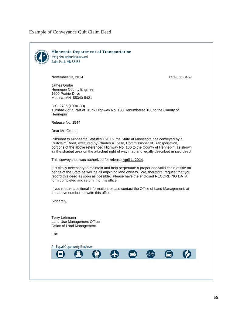
55
Example of Conveyance Quit Claim Deed
Minnesota Department of Transportation 395 John Ireland Boulevard Saint Paul, MN 55155
An Equal Opportunity Employer
November 13, 2014 651-366-3469 James Grube Hennepin County Engineer 1600 Prairie Drive Medina, MN 55340-5421 C.S. 2735 (100=130) Turnback of a Part of Trunk Highway No. 130 Renumbered 100 to the County of Hennepin Release No. 1544 Dear Mr. Grube: Pursuant to Minnesota Statutes 161.16, the State of Minnesota has conveyed by a Quitclaim Deed, executed by Charles A. Zelle, Commissioner of Transportation, portions of the above referenced Highway No. 100 to the County of Hennepin; as shown as the shaded area on the attached right of way map and legally described in said deed. This conveyance was authorized for release April 1, 2014. It is vitally necessary to maintain and help perpetuate a proper and valid chain of title on behalf of the State as well as all adjoining land owners. We, therefore, request that you record this deed as soon as possible. Please have the enclosed RECORDING DATA form completed and return it to this office. If you require additional information, please contact the Office of Land Management, at the above number, or write this office. Sincerely, Terry Lehmann Land Use Management Officer Office of Land Management Enc.

56
Page 1 of 8
QUITCLAIM DEED
C.S. 2735 (100=130) Release No. 1544 County of Hennepin
The State of Minnesota having acquired the real estate hereinafter described for trunk
highway purposes, and the Commissioner of Transportation of said State having determined
that the same is no longer needed by said State for trunk highway purposes, and that the
same may be conveyed and quitclaimed to the County of Hennepin.
NOW, THEREFORE, Upon said determination and pursuant to Minnesota Statutes,
Section 161.16, Subdivision 4, in consideration of the future maintenance, improvement, or
reconstruction by Grantee of such roadways, the State of Minnesota, Grantor, by Charles A.
Zelle, its Commissioner of Transportation, hereby conveys and quitclaims to the County of
Hennepin, Grantee, for highway purposes, all its interest including any conditions,
restrictions, covenants and easements that run with the land together with and including the
right of access control as shown herein, in and to the real estate situate in the County of
Hennepin, State of Minnesota, described as follows:

57
Page 2 of 8
1544
DESCRIPTION FOR THE TURNBACK OF PART OF TRUNK HIGHWAY N0. 130 RENUMBERED 100 TO
HENNEPIN COUNTY
Part of Parcel 62B (Access) C.S. 2789 (394=10) 905
All right of access control, being the right of ingress to and egress from Tract 1 described below to Glenwood Avenue (also known as County Road No. 40); Tract 1. That part of Tracts A and E, lying north of a line running parallel with and 9
feet south of the north line of said Tract E and the same extended, Registered Land Survey No. 667, files of the Registrar of Titles, County of Hennepin, Minnesota; excepting therefrom the right of way of Trunk Highway No. 100 as now located and established; the title thereto being registered;
extending along Line A described below: Line A. Commencing at Right of Way Boundary Corner B10326 as shown on
Minnesota Department of Transportation Right of Way Plat No. 27-103 as the same is on file and of record in the office of the Registrar of Titles and office of the County Recorder in and for said County; thence southwesterly on an azimuth of 234 degrees 28 minutes 45 seconds along the boundary of said plat for 280.56 feet to Right of Way Boundary Corner B10301; thence on an azimuth of 142 degrees 35 minutes 49 seconds for 212.20 feet; thence deflect to the right on a tangential curve, having a radius of 55.00 feet and a delta angle of 59 degrees 23 minutes 11 seconds for 57.01 feet; thence on an azimuth of 163 degrees 43 minutes 25 seconds for 168.92 feet to the point of beginning of Line A to be described; thence northwesterly along the northeasterly line of Tract 1 hereinbefore described and the southerly right of way line of said Glenwood Avenue to the northeasterly corner of said Tract 1 and there terminating.
Part of Parcel 204B C.S. 2735 (100=130-23)
That part of Tract 1 described below: Tract 1. Tract A, Registered Land Survey No. 667, according to the plat thereof on
file and of record in the office of the Registrar of Titles in and for Hennepin County, Minnesota; the title thereto being registered;
which lies northeasterly of Line A described below, and southwesterly of Line B described below: Line A. From a point on the north line of Section 30, Township 29 North, Range
24 West, distant 1399.8 feet east of the northwest corner thereof, run southeasterly at an angle of 41 degrees 44 minutes from said north section line (measured from east to south) for 321.5 feet; thence deflect to the right on a 02 degree 24 minute 12 second curve (delta angle 28 degrees 48 minutes) for 108.3 feet; thence deflect to the right at an angle of 90 degrees from the tangent to said curve at said point for 120 feet to the point of beginning of Line A to be described; thence northwesterly to a point on the north line of said Section 30, distant 950 feet east of the northwest corner thereof and there terminating;
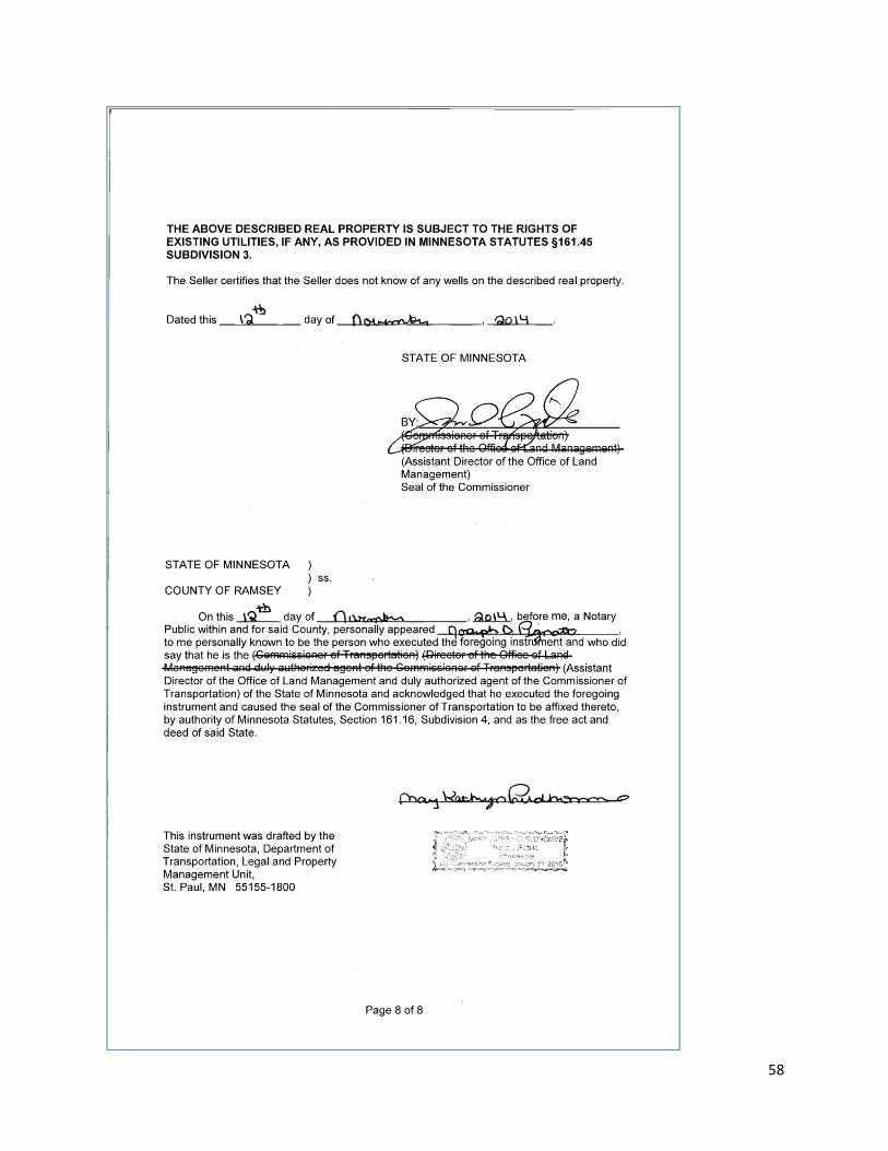
58

59
Approval for Conveyance of R/W of Released Portions of T.H. to Another Road Authority
C.S. County:
Location:
Release No. CO Maint. Area: Effective Date: CO
reverts to
in accordance with Minn. Stat. Sect. 161.16 & 161.24. Those portions of R/W colored yellow on the
attached map will be conveyed.
Recommended: By: Remarks: __________________ (Date) (District Preliminary Design Engineer) Recommended: By: Remarks: __________________ (Date) (District State Aid Engineer) Recommended: By: Remarks: _________________ (Date) (District Right of Way Engineer) Recommended: By: Remarks: _________________ (Date) (Area Maintenance Engineer) Recommended: By: Remarks: _________________ (Date) (District Engineer) FHWA Approval By: Remarks: _________________ (Date) (FHWA Programming Engineer) Recommended: By: CO Remarks: _________________ (Date) (Director Office of Land Management) Comments:

60
RECOMMENDATION TO RELEASE TRUNK HIGHWAY
T.H. No. County of
Control Section No. Maintenance Area No./City
General Location:
Specific Location (By Land Descriptions and Engineer’s Stations)
Advance Notice of Release given to County Engineer on (Date)
If Release occurs between November 1 and April 1 - Agreement from affected governmental units was obtained by (copy attached)
I recommend that the Release may be eligible for CSAH designation - except the following portion:
If the release or portions of the release are not eligible for CSAH, said Sections have been restored to acceptable condition on ____________(date), involving ___________________________________
Check one: To the best of my knowledge, there are no wells on the subject property. There are wells (copies of the abandoned well records are attached)
Release order to be effective __ (Date)
District Engineer: Date:

61

62

63

64

65

66

67
68

69

70

71

72
Right of Way Technical Training Quiz — ANSWER KEY
1. Both convey surplus R/W no longer needed by the department. A turnback must have a public
road constructed on it, a conveyance does not.
2. D
Just type wiki in the address bar of your internet browser to start the wiki. Use the WikiSearch
or AllWikiTopics tools on the left sidebar to find.
3. E
All of the Above. The RNCS links on the wiki provide more detail.
4. B
Additional information may be found in REALMS to verify the circumstances of a right of way
map.
5. Notices of Release are issued under the turnback Statute M.S.S. 161.16. Notices of Transfer
require enabling legislation to be issued.
6. A
Examine the information in REALMS.
7. False
Current standards specify leaving the order table off the map to avoid unnecessary duplication if
a commissioner’s graphic order exists for the turnbacks. Both internal and external customers
are able to access all MnDOT’s graphic orders.
8. A
If the release number is shown in the map and in the turnback caption block but parcels are not
listed this could mean the quit claim deed (QCD) has not been forwarded to the Mapping Group.
Many old maps only reference the release number and do not list the parcels involved with the
turnback.
9. A
Principal arterials
10. B Quit Claim Deed
11. F eDOCS (formerly EDMS) and REALMS. If available the QCD’s are in the file mixed with other
documents related to the release and linked to REALMS. Look for the View Deed File button to
be active after selecting the release in the Deed Information window, eDOCS contains many of
the individual QCD’s which can be found with DM search using XXXX QUITCLAIM DEED in the
DOC. Name field where XXXX is the release number.
12. C The district has the most knowledge in how to prepare the information required.
13. D Landowner Request would result in a conveyance.
14. A Flexible Highway Account