Embed Size (px)
Citation preview
Turkdean Roman Villa, Gloucestershire: Archaeological Investigations 1997-1998Author(s): Neil HolbrookSource: Britannia, Vol. 35 (2004), pp. 39-76Published by: Society for the Promotion of Roman StudiesStable URL: http://www.jstor.org/stable/4128621 .Accessed: 18/04/2011 03:27
Your use of the JSTOR archive indicates your acceptance of JSTOR's Terms and Conditions of Use, available at .http://www.jstor.org/page/info/about/policies/terms.jsp. JSTOR's Terms and Conditions of Use provides, in part, that unlessyou have obtained prior permission, you may not download an entire issue of a journal or multiple copies of articles, and youmay use content in the JSTOR archive only for your personal, non-commercial use.
Please contact the publisher regarding any further use of this work. Publisher contact information may be obtained at .http://www.jstor.org/action/showPublisher?publisherCode=sprs. .
Each copy of any part of a JSTOR transmission must contain the same copyright notice that appears on the screen or printedpage of such transmission.
JSTOR is a not-for-profit service that helps scholars, researchers, and students discover, use, and build upon a wide range ofcontent in a trusted digital archive. We use information technology and tools to increase productivity and facilitate new formsof scholarship. For more information about JSTOR, please contact [email protected].
Society for the Promotion of Roman Studies is collaborating with JSTOR to digitize, preserve and extendaccess to Britannia.
http://www.jstor.org
Turkdean Roman Villa, Gloucestershire:
Archaeological Investigations 1997-1998
By NEIL HOLBROOK
With contributions by D. Allen, L. Coleman, N. Crummy, C. Gaffney, J. Gater, P. Guest, E. Harrison, F. Roe, J. Sidell and R.S.O. Tomlin
CIRCUMSTANCES OF DISCOVERY
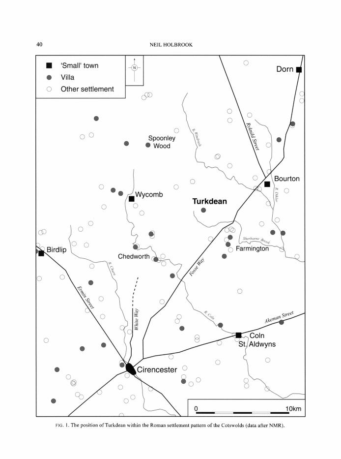
efore the transmission of the first 'live' Time Team television programme on 23 August 1997, the existence of a Roman villa near Chalkhill Barn in the parish of Turkdean, 12 miles north-east of Cirencester and 2 miles from the Fosse Way, was hardly known to the
archaeological community (FIG. 1).1 That a Roman building did exist in this location had, however, been suspected for a number of years by the landowner, the late Mr Wilf Mustoe. Distinctive linear parchmarks suggestive of buildings had been clearly visible at ground level in the grass pasture each dry summer, and in 1976 Mr Mustoe made a measured sketch plan of them on the back of an envelope. Subsequently the sketch was drawn up into a scale plan entitled 'Roman villa' by Simon Goddard, a relation. There was little knowledge of the site outside of Mr Mustoe's family until it was independently 'discovered' by local archaeologist Roger Box in August 1996 whilst fortuitously flying over the site in a helicopter. In the evening light Mr Box instantly recognised the parchmarks of an unmistakable Roman villa and took a series of photographs (FIG. 2). Mr Box showed his photographs to Mr Mustoe, and with his agreement wrote to Time Team suggesting that this would be an excellent site for a television programme. Arrangements were duly set in place and the evidence of the cropmarks was confirmed by a trial geophysical survey in March 1997. Further geophysical survey and excavation of seven test trenches took place over the August Bank Holiday weekend in 1997 live on national television. The transmission proved to be so successful that a second programme was filmed during 6-8 October 1998 when a further six trenches were dug. Following completion of the fieldwork, Cotswold Archaeology was commissioned by Time Team to produce a report on the results of the two seasons. Copies of this report, which includes a detailed description of the stratigraphy and full listings of the finds and environmental remains, are lodged with the NMR in Swindon and Gloucestershire SMR.2 The purpose of this account is to make the evidence for the villa available to a wider audience. Accordingly it concentrates on the structural history of the villa, although the opportunity has been taken to present summaries of some of the more important classes of evidence, and descriptions of particularly noteworthy artefacts.
I There was no mention of it in the RCHME survey of Iron Age and Romano-British Monuments in the Cotswolds published in 1976; nor did it appear on the Gloucestershire Sites and Monuments Record.
2 Cotswold Archaeological Trust 2000a.
? World copyright reserved. Exclusive Licence to Publish: The Society for the Promotion of Roman Studies 2004
40 NEIL HOLBROOK
i 'Small' town Dorn Dorn
* Villa O Other settlement
C 0 0
0 o
0 0 Spoonley 0 Wood O
0
0~O Bourton
Wycomb S mbTurkdean o 0
0
SO0
Birdlip 0 Farmington Chedworth O 0
0 0 o
0 '
O0
0 St.Aldwyns
o o * Cirencester o
0 Okm
0 100km
FIG. 1. The position of Turkdean within the Roman settlement pattern of the Cotswolds (data after NMR).
TURKDEAN ROMAN VILLA, GLOUCESTERSHIRE: ARCHAEOLOGICAL INVESTIGATIONS 1997-1998 41
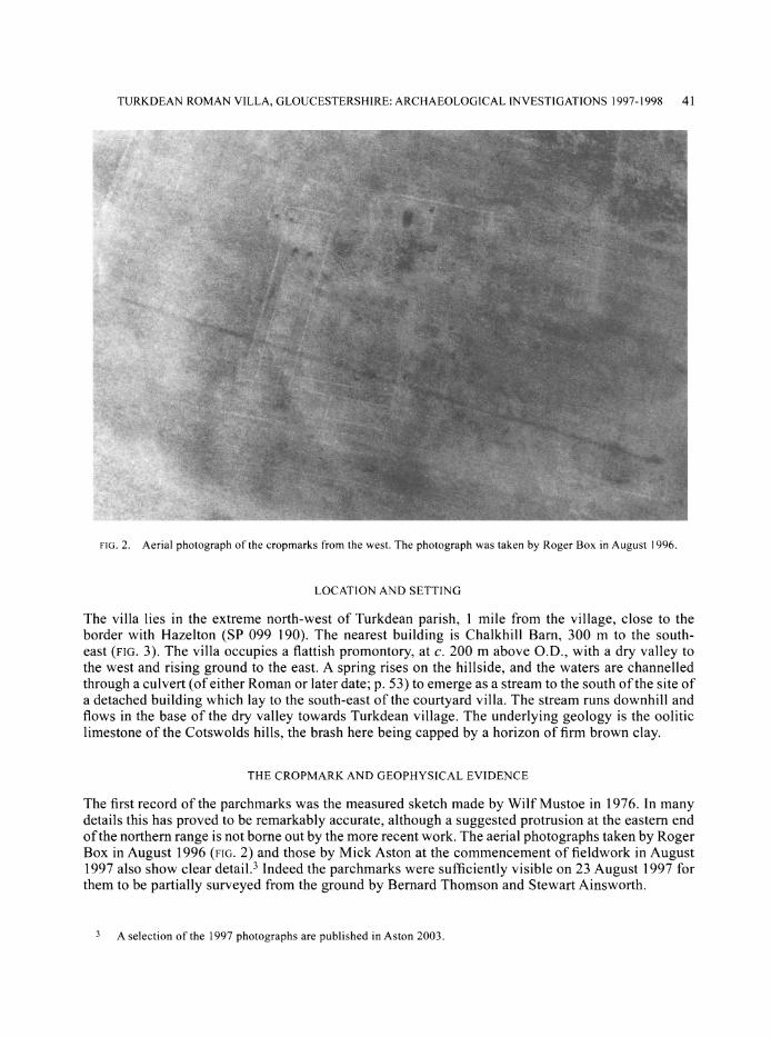
FIG. 2. Aerial photograph of the cropmarks from the west. The photograph was taken by Roger Box in August 1996.
LOCATION AND SETTING
The villa lies in the extreme north-west of Turkdean parish, 1 mile from the village, close to the border with Hazelton (SP 099 190). The nearest building is Chalkhill Barn, 300 m to the south- east (FIG. 3). The villa occupies a flattish promontory, at c. 200 m above O.D., with a dry valley to the west and rising ground to the east. A spring rises on the hillside, and the waters are channelled through a culvert (of either Roman or later date; p. 53) to emerge as a stream to the south of the site of a detached building which lay to the south-east of the courtyard villa. The stream runs downhill and flows in the base of the dry valley towards Turkdean village. The underlying geology is the oolitic limestone of the Cotswolds hills, the brash here being capped by a horizon of firm brown clay.
THE CROPMARK AND GEOPHYSICAL EVIDENCE
The first record of the parchmarks was the measured sketch made by Wilf Mustoe in 1976. In many details this has proved to be remarkably accurate, although a suggested protrusion at the eastern end of the northern range is not borne out by the more recent work. The aerial photographs taken by Roger Box in August 1996 (FIG. 2) and those by Mick Aston at the commencement of fieldwork in August 1997 also show clear detail.3 Indeed the parchmarks were sufficiently visible on 23 August 1997 for them to be partially surveyed from the ground by Bernard Thomson and Stewart Ainsworth.
3 A selection of the 1997 photographs are published in Aston 2003.

O
K?
tr r
O
0 0d
" ____--,----------:.i~--- ------------~ " 192 - - - Parish boundary
Trench 12 -
_ COURTYARD VILLA
o 40
BUILDING
Spring
.....Survey area Rubble. - Wall -Path/Drain 2
B a
.~ -- -------
--- .. .. .. i- - . .. . • •--
FIG. 3. The location of the villa showing simplified interpretative results of the geophysical survey.
TURKDEAN ROMAN VILLA, GLOUCESTERSHIRE: ARCHAEOLOGICAL INVESTIGATIONS 1997-1998 43
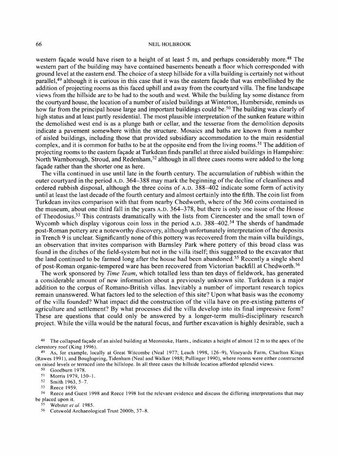
Geophysical survey using both magnetic and resistivity techniques undertaken between March 1997 and May 1998 provided confirmatory evidence for the parchmarks. A courtyard house was revealed, approximately 140 by 80 m in extent, with a further series of structures, including a
building, 60 m to the south-east on the hillside. These extended for 120 m up the slope. A detailed account of the methods and results of the surveys can be found in Appendix 1. A composite plan of the parchmarks and geophysical survey results (FIG. 4) forms the basis for the discussion of the villa
plan that follows in this report.
THE TRIAL TRENCHES
By Laurent Coleman and Neil Holbrook
The parchmarks and geophysical surveys serve to establish the basic plan of the villa buildings. In order to test these results, and to better characterise and date the complex, seven trial trenches (FIG. 4 Trenches 1-7) were excavated in 1997 within the courtyard villa. They provide a good spread across the main elements of the building. At the very end of the 1997 programme of excavation, the results of a geophysical survey became available, which detected for the first time the range of buildings running up the hillside to the south-east of the principal house. The best defined structure in this area was targeted by two trenches in 1998 (FIG. 4 Trenches 8 and 13), while a further four trenches were dug at that time to test a variety of other geophysical anomalies in the environs of the villa
(FIG. 3 Trench 12; FIG. 4 Trenches 9-11). In addition a single trench was excavated in the bottom of the dry valley to the south-west of the villa in 1997 to obtain data on the palaeoenvironment of the area. The latter work will be reported on separately by Dr Keith Wilkinson of King Alfred's College, Winchester.
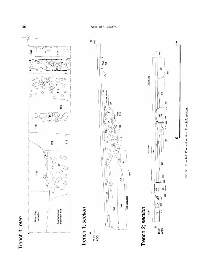
NORTHERN RANGE (TRENCH 2)
Trench 2 examined the southern (inner) corridor at the centre of the northern range and a small
part of one of the central block of rooms (FIGS 4-5). The earliest feature investigated within the inner corridor was the foundation course (234) of the south wall. This was abutted by a make-up of limestone fragments (224) and compacted limestone floor (221) may be associated with this first
period. At this point the corridor was rebuilt. The southern wall at least was demolished to the level of a single foundation course, floor (221) being cut by the foundation trenches of newly constructed walls (203 to the north and 206 to the south). These were substantial well-built mortared walls, 0.7 m wide. Both walls survived three courses high, and the northern had plain white plaster still
adhering to its southern face. The corridor was 2.85 m wide internally. The southern wall (206) was subsequently rebuilt to a lower standard with dry-built masonry (207). One course of this wall survived, 0.6 m wide, abutted by a levelling layer (215) for a surface (208/211) that also abutted the northern wall (203).
The earliest deposit examined within the room at the centre of the northern range was a possible crushed limestone make-up (218). It was cut by the construction trench for wall (203) and so was associated with the earlier phase of construction. No floor surface was identified within the room, perhaps because it was equipped with a flagstone floor that was later robbed. The latest deposits within the corridor (208) and central room (218) were overlaid by demolition rubble (201, 233, 217, 212).
INNER COURTYARD (TRENCHES 2 AND 3)
The edge of the courtyard adjacent to the northern range was exposed in Trench 2, where the lowest level examined comprised a roughly cobbled surface (210). This was cut by the construction trench for wall (206) and is therefore likely to have been contemporary with primary wall (234). A second roughly cobbled surface (209) abutted the reconstructed wall (207), and was cut by a circular pit

z
0
F-?
0 0
- - - - - Simplified geophysical interpretation - drain/path
SSimplified geophysical interpretation - rubble
o OOm
Tr nch 2
Trench 3
Trench I ,
3
-"l Trench7
Trench 4
Trench 7 .- l. Trnch 11h
TrenTch 5lT....
./o\\
. .\ \
Trench 6 \
hTrench8
S'e 5 -
Trench 13/\
S "TTrench 10
FIG. 4. Composite plan of the parchmarks and geophysical survey results showing location of the trenches.
TURKDEAN ROMAN VILLA, GLOUCESTERSHIRE: ARCHAEOLOGICAL INVESTIGATIONS 1997-1998 45
(230), 1 m in diameter and 0.21 m deep. It was filled with clay and fragments of limestone (231), and was sealed by demolition rubble (201) and ploughsoil (200).
Trench 3 was targeted on the possible path or drain identified by the geophysical survey (FIG. 4). In fact excavation found a ditch (305), 2 m wide and 0.32 m deep. Only a short length of the ditch fill (306) was excavated and this contained the skull of a horse that protruded into the excavated section. The skull was left in situ and it is not known whether it was part of a more complete skeleton. The ditch was sealed by a capping of limestone slabs (303), explaining why the feature was identified as a path during the geophysical survey. The courtyard surface (304) was formed from limestone fragments.
EASTERN RANGE OF THE INNER COURTYARD (TRENCH 1)
A discrete circular cropmark suggested the presence of a feature such as a large pit within the eastern range, and this correlated with a positive magnetic anomaly, approximately 6 m in diameter, detected in the geophysical survey. Trench 1 was targeted upon this anomaly (FIGS 4-5). The earliest feature examined was a dry-built rubble foundation (115) running north-south that survived as a single line of stones set on natural clay (100). A second foundation of mortared undressed stones (117) lay 1.45 m to the east. Its dimensions were not established and once again all dressed courses had been robbed. A possible ditch (112) lay immediately to the east of foundation (117), but it was not investigated. The effect of the robbing of these walls was to create a broad hollow dug into natural subsoil that was partly infilled with tips of rubble (111, 116, 107) which attained a total thickness of 1 m. Rubble (116) was cut by the construction trench (104) for a mortar-bonded wall (105) that was 0.6 m wide. This wall represents the outer wall of the eastern range as identified by the cropmark and
geophysical surveys. Only the edge of the hollow was infilled with rubble, and a broad elongated oval depression (108), 0.9 m in depth and at least 5 m in length, still remained. The next phase of infilling comprised dumps of fine-grained silt containing abundant charcoal (110, 109, 106) which generated the discrete anomalies identified in the cropmark and geophysical surveys. Fill (106) was cut by a ditch or pit (118), 2.05 m wide and 0.45 m deep, filled with limestone rubble (103).
CENTRAL RANGE (TRENCH 4)
Trench 4 was targeted upon the southern end of the central room (FIGS 6-7). In the northern half of the trench excavation revealed a room, 3.2 m wide internally, defined by three 0.6 m-wide mortared walls. The floor had been partially robbed but some limestone flags survived (418). Wall (412) identified in the north-eastern corner of the trench appeared to be contemporary with the walls described above and formed the southern wall of the rectangular room to the east identified in the geophysical survey. Dry-built walls (409 and 410), 0.9 m long and 0.38 m wide, abutted the exterior face of the west wall. Between them was a flagstone floor (417) which sloped downward to the west. One possibility is that these walls served as supports for a raised water tank that supplied the plunge bath immediately to the south-east. A stone roof finial (below; FIG. 12) was retrieved from demolition rubble (413) lying above this surface.
To the south of the central room lay a plunge pool, 3 m square and 0.56 m deep, in a position corresponding to a rectangular anomaly detected in the geophysical survey. The pool had a red- painted plaster lining with a 0.18 m-wide plaster step on the northern wall at a height of 0.44 m. At the base of the walls was a quarter-round plaster moulding 80 mm wide and 80 mm high. The pool had a flagged stone floor with a covered drain along its northern edge. It was not further investigated. The pool had been deliberately backfilled with demolition rubble, including many dressed facing stones, set in a matrix of gravel, mortar, and fragmented wall plaster (414, 403). Other finds included numerous fragments of box-tile, opus signinum, painted wall-plaster and stone roofing tile. No evidence was found for any floors sealing the backfilled pool. Two later walls (402 and 419) abutted the southern end of the plunge pool; neither wall was identified in the geophysical survey. Wall (402)
z
2:
O
0
0 0
Trench 1; plan - - - - - - - -- - - _ - - - - N
/ 0 o 104 Fill not fully 100 100 excavated 100
',113 0 Kj <
Foundation not 116 10 116 o
exposed in plan 11
2
100 /
, 112 ?
(
Trench 1; section W E
201m - AOD
S 109 • 176 112 1Wall
1104
Not excavated 100
106 n1100
Trench 2; section ROOM CORRIDOR COURTYARD
20230
0 5m8 232 233 231 202 229 - - - - - -- - - - - - -
230
FIG. 5. Trench 1. Plan and section. Trench 2, section.

TURKDEAN ROMAN VILLA, GLOUCESTERSHIRE: ARCHAEOLOGICAL INVESTIGATIONS 1997-1998 47
E 0
LO
c C, c-
"D " :5
LC I_ AI
E E 0 0
C.) C ()
-C
dd~
HO 0
C C
Q)
II
0
C
,1
"C
0
M
-4
0
-o
11 4C
0> 0, C 0
H~
CO
C
C~
-C
C-( 0 Cn
48 NEIL HOLBROOK
SOo
4170•
SStep
4418
O 0 406
Do S
0,o 03
Drain
02 416
D
o~ ai~ yu 408i19
Section W Plaster 414 Plaster E
415 Moulding
0 5m
FIG. 7. Trench 4. Plan and section across pool.

TURKDEAN ROMAN VILLA, GLOUCESTERSHIRE: ARCHAEOLOGICAL INVESTIGATIONS 1997-1998 49
to the west was constructed from dry-bonded flagstones. The corridor/portico wall identified during the geophysical survey to the east of Trench 4 was not identified within the trench. It may have been demolished and replaced by wall (419). The uppermost surfaces were overlaid by demolition rubble (404) which yielded two small rectangles of lead sheet (possibly labels), an iron cross-pane hammer and cobbler's last, and a couple of tesserae.
EASTERN RANGE OF THE MIDDLE COURTYARD (TRENCH 7)
The earliest feature examined was the bowl furnace and flue of a small hearth (721) set in a surface of compacted clay (732, 733) with limestone fragments and stones 719 (FIGS 6, 8). The circular bowl was 0.4 m in diameter and 0.17 m deep with vertical sides and a flat base. Both the bowl and flue were lined with burnt stones. The furnace was covered with deposits of brown clay (722, 729), perhaps from a collapsed dome. At the eastern end of the flue there was a deposit of dark grey clay silt (723) which contained numerous fragments of charcoal, a drip of molten lead, and a fragment of a copper-alloy boss, suggestive of small-scale metalworking. Near the furnace was a collection of scrap-iron box fittings comprising a loop-hinge, L-shaped nailed binding strap, four nails, and another box fitting, possibly part of a lock-plate. Another larger lock-plate was also recovered.
The hearth and surface were covered with rubble make-up layers (717 and 712). To the west a pitched-stone foundation which appeared to be broadly contemporary with this make-up supported
Iron box fittings
723732/3
721
o 31
730 .
732/3 CD O .o
Charcoal Burnt Stone 1m
FIG. 8. Trench 7. Plan showing the hearth (721).
50 NEIL HOLBROOK
a wall (708) which defined the western side of the range, with a second wall (711) 2.5 m to the east forming a corridor. The walls were 0.6 m wide and mortar-bonded. The eastern wall survived to a height of 0.3 m and had fragments of painted wall-plaster adhering to its western face. The plaster had a pink background embellished with a discrete area of burgundy and a light blue diagonal stripe. The corridor had a stony floor which was cut by a small irregular pit filled with silty sand. To the east of the corridor lay a room, 5.9 m wide, defined to the east by the outside wall of the range. This wall was exposed in plan but not further examined. Consideration of the relative levels suggests that it is likely to be broadly contemporary with the corridor walls and its alignment matches that of wall (115) found in Trench 1. No floor surface for the room could be detected.
The western end of Trench 7 also examined a small section of the middle courtyard. To the west of wall (708) there was a cobbled limestone surface that was cut by two post-holes and an open stone- lined drain.
ROOMS ALONG THE NORTHERN SIDE OF THE OUTER COURTYARD (TRENCH 5)
At the centre of Trench 5 a wall which defined the edge of the outer courtyard (503) survived three mortar-built courses high with two offsets on the southern face and one on the northern side (FIG. 6); it was 0.6 m wide. At the western end of the trench dry-built masonry may define a blocked entrance in excess of 0.95 m wide. Immediately to the east of the entrance the boundary wall was abutted on its interior face by a poorly constructed dry-built wall (504), 0.2-0.3 m wide. The identification of wall (503) confirmed the results of the earlier surveys; however wall (504) was only identified through excavation. At the northern end of the trench a roughly cobbled surface was found, and, although the stratigraphic relationship with wall (504) was not established, it is likely to have been a surface within a room on the northern side of the outer courtyard. The surface was covered by two layers of clay silt refuse (507, 509) that contained butchery waste.
BUILDING IN THE WESTERN RANGE OF THE OUTER COURTYARD (TRENCH 6)
The eastern wall of a rectangular building identified during the geophysical survey and a linear anomaly 5 m to the east were investigated by Trench 6 (FIG. 6). The earliest deposits encountered lay to the east (outside) of the building. A cobbled surface directly overlay natural clay and was in turn covered with a series of consolidation/levelling layers. One of these was cut by a ditch (611), 1.3 m wide and 0.2 m deep, orientated north-south. The ditch was filled with silty sand (612) and probably corresponds to the second linear anomaly identified during the gradiometry survey.
The eastern wall (605) of the building was 0.7 m wide and dry-built. Only one course survived and it appeared to have been constructed on the surface of one of the consolidation layers. The wall was abutted on its inner (western) face by limestone rubble (604) that may be either floor make-up or demolition. To the east, outside of the building, the wall was abutted by a layer of silt (610) sealed beneath a rough surface of large slabs (608). This surface was covered with an artefact-rich occupation layer (603) that accumulated against the eastern wall of the building. Deposit (603) was cut by two parallel shallow gullies that yielded no dating evidence and so their Roman date is not assured.
THE DETACHED BUILDING (TRENCHES 8 AND 13)
The geophysical survey identified a detached building to the south-east of the main villa complex (FIG. 4). Trench 8 was excavated at the western end of this building and Trench 13 at the eastern (FIG. 9). The site sloped steeply downwards from east to west, with a vertical drop of 2.25 m over a distance of 20 m.
Activity pre-dating the construction of the building was identified in Trench 8. Cutting the natural clay was a ditch (1114), 2.2 m wide and 1.0 m deep, with steeply sloping sides. It was filled with a primary deposit of grey silt (1121) overlaid by clay silt colluvium that extended beyond the edges of the trench to the east and west. The colluvium was sealed by a possible turfline (1133), 40 mm thick,

TURKDEAN ROMAN VILLA, GLOUCESTERSHIRE: ARCHAEOLOGICAL INVESTIGATIONS 1997-1998 51
LLO
CE,
I i i
w
.i_. -
He
Si E
wi I x j '~ , "--'" --
L
. •
.) ii II ' t
;
o
H
W ~;H~p~0
0r
r)
0 ?
? 0)
? 03
0)
r0
[-S
0)
-o 0)
CO,
00
0) 0) 0
CO
0)
CO 0)
0)
~0 Hj
52 NEIL HOLBROOK
and two further probable colluvial deposits (1112, 1107), the latter sealed by a second turfline (1132), 50 mm thick. The form and character of these deposits suggest gradual accumulation within the ditch as a consequence of weathering and erosion.
A building with mortared walls was constructed above the infilled ditch; it manifestly displays the remains of more than one period of construction, not all of which can be adequately explained from the limited investigation. Whether the modifications occurred as one event or piecemeal is impossible to say on current evidence. The north wall (1124) was 0.6 m wide and survived to a maximum height of five courses (0.9 m). Where the foundation trench for this wall crossed the earlier ditch (1114), the trench was cut down through the soft fills to reach the base of the ditch. The trench was then backfilled with large undressed limestone footings for the wall above. The southern wall of the building lay c. 2-3 m to the south of Trench 8, to judge from the not entirely clear geophysical results. At the western end it is apparent that the building originally extended further in this direction. The northern wall (1124) was abutted by a cross-wall (1128) and deposits immediately to the west of the latter indicate that they originally lay within a longer building. Thus in the primary phase, wall (1128) would have been an internal partition; it was 0.65 m wide and survived up to six courses high. Excavation of a small sondage against the western face of the wall revealed that it had been faced and plastered to a depth in excess of 0.8 m below the level of the floor surface to the east of the wall. As the base of the sunken feature was not reached, and no other walls associated with it were exposed, interpretation is difficult. A cellar or plunge bath are the most likely options. When the western end of the longer building was demolished, the bath or cellar was deliberately back-filled with abundant fragments of limestone, mortar, and painted wall-plaster (1119). Cross-wall (1128) may now have formed the western end of a reduced structure, 25 m long by 13-14 m wide, although reconstruction of its plan is problematic. To the east of wall (1128) lay two internal walls (1135 and 1130); the latter, with robber trench (1127), seemingly defined a small irregular room measuring 2 m by 2 m. At the time of excavation it was considered that the remains could be reconstructed as an aisled building, wall (1135) separating the 'nave' from a north aisle which would have been 2.2 m wide internally. Wall (1131) may correspondingly have separated the 'nave' (which would thus have been 6 m wide internally) from a south aisle. A problem with this interpretation is that the arrangement of walls revealed at the eastern end of the building in Trench 13 did not align with those found at the western end. While this might be explained either as the consequence of a somewhat irregular plan caused by construction on the sloping hillside, or the result of later modifications, it is still difficult to reconstruct an aisled plan. The eastern wall of the building (1602) displayed at least two phases of construction, the earlier work surviving at the southern end. The northern part of the wall was rebuilt to a slightly wider gauge, seemingly at the same time as two rooms were added to the eastern fagade flanking a metalled entranceway which was markedly to the north of the central axis of the 'nave'. Reused within the rebuilt section of the eastern wall was a fragment of a limestone block bearing the inscription FIL, perhaps originally a grave-marker (see below; FIG. 10). The northern room (1604) measured 5.5 m by 3.2 m, the southern one (1603) 7.2 m by 3 m. Walls (1602), (1603), and (1604) were all c. 0.5 m in width and mortared.
Due to the limited removal of demolition rubble, little evidence was recovered for the nature of the floors within the building. In Trench 8 the turfline (1132) above ditch (1114) was sealed by construction deposits (1104 and 1125) which appeared to abut wall (1124). Demolition deposits at both ends of the building produced a total of thirteen limestone tesserae.
Interpretation of the building plan represented is difficult. If wall (1130) is extended eastwards to form the south side of the 'nave' this would make for a narrow 'nave' in proportion to the width of the north aisle.4 Alternatively if wall (1131), or that found projecting west of Room (1603),
4 Some support for this might be given by the fact that the wall so extended would meet the eastern end wall (1602) at the point where the older narrower work was rebuilt to a wider gauge. In this case the nave would be 3.2 m wide and the two aisles 2.0-2.2 m wide. In Morris' survey (1979, 64) the ratio of nave to aisle width varied between 4:1 and 1:1, although in 54 per cent of the sample the nave was twice the width of the aisles.
TURKDEAN ROMAN VILLA, GLOUCESTERSHIRE: ARCHAEOLOGICAL INVESTIGATIONS 1997-1998 53
represents it, then the nave would be at the wider end of the expected range.5 Given that geophysics detected traces of further walls both to the east and west of the two trenches, it is not inconceivable that the remains excavated in Trenches 8 and 13 might be part of two distinct structures (either chronologically or spatially).
POSSIBLE INDUSTRIAL ACTIVITY (TRENCH 9)
A strong magnetic anomaly was identified approximately 100 m to the east of the main villa complex; this was interpreted as either industrial activity or the remains of a heating system (FIG. 17). Trench 9 was located on the eastern edge of this area (FIG. 4). The earliest deposits comprised silty clays (1207, 1208, 1209) which contained frequent inclusions of charcoal and six small fragments of slag. These were overlaid by various bands of limestone rubble (1203, 1204, 1205, 1206, 1208) which lacked any coherent structure and might have been the remnants of collapsed walls. The rubble contained nineteen fragments (0.5 kg) of iron slag and the overlying subsoil and topsoil a further 182 fragments (2.5 kg).
QUARRY PIT (TRENCH 10)
A circular anomaly, 8 m in diameter, characterised by a positive magnetic response and high resistivity, was identified approximately 130 m to the south-east of the main villa complex (FIG. 17). Excavation of Trench 10 (FIG. 4) found a quarry pit (1308), at least 3.45 m wide and 1.5 m deep, cut into the natural clay. Its uppermost fill was cut by a smaller pit filled with a charcoal-rich deposit.
CULVERTS (TRENCHES 11 AND 12)
A series of culverts was identified in the eastern half of the site by the geophysical survey (FIG. 17). These are still fed by a spring that rises to the north-east of the villa. A section of a culvert near to the spring-head was investigated in Trench 12 (FIG. 3). The culvert led southwards to a point where it divided into a number of subsidiary channels. A second trench (11) investigated this area (FIG. 4). The subsidiary channels ran both to the east and west of the detached building and discharged into the stream to the south of the villa complex.
In Trenches 1 I and 12 the stone culvert was six courses high with larger capping slabs; it was 0.2 m wide internally and 0.25 m high. Water still flowed in both of the culverts. Coloured dye was added to the culvert in Trench 12 and this passed through the culvert in Trench 11 to subsequently issue into the stream to the south of the villa. Metal-detecting of the stream bed recovered three copper-alloy brooches.
THE VILLA PLAN
All dimensions quoted in this section are approximate. All walls were built from local limestone. The parchmark, geophysical survey, and excavation data combine to produce a reasonably reliable
indication of the villa plan (FIG. 4). The main villa was seemingly built around three courtyards, the inner and middle courtyards being separated by a cross-range. The outer courtyard had a clearly defined building on its western side and rubble spreads indicative of structures to the east. There was a compound wall around the villa on the northern and western sides. The northern range comprised a block of rooms 58 m long with corridors to the front and rear. One of these rooms, only 2.5 m wide, is likely to have been a cross-passage or lobby. At either end of the range there were larger wing rooms projecting 2 m beyond the rear corridor. Visible cross-walls at first glance suggest that a corridor on the western side of the inner courtyard did not communicate directly with one along the inner side of the northern range, although it is conceivable that these walls may simply have been foundations
5 The nave would now be in the order of 6 m wide, a nave:aisle ratio of about 3:1.
54 NEIL HOLBROOK
beneath arched openings or the like. Behind the western corridor was an open yard bounded to the rear by the compound wall. In the southern part of the yard a rectangular building (18 m long by 8 m wide) shared common party walls with the corridor to the east and the rooms of the central range to the south. The range on the eastern side of the inner courtyard was defined by two walls, 10 m apart. It is uncertain whether this whole space was roofed, although given the lack of visible partitions this is unlikely.
The inner courtyard measured 28 m by 51 m and was traversed by two geophysical anomalies; the one tested in Trench 3 proved to be a stone-capped ditch. The inner courtyard was bounded to the south by a central range that was comparatively poorly defined by parchmarks. Although the external walls to the north and south were visible, the area at the centre of the range comprised a broad, poorly defined parchmark, possibly representing a spread of rubble just below the surface. Further clarity was achieved by the geophysical survey which identified the exterior walls of the range, 15 m apart, and at least three rooms. The southern wall of the range was on differing alignments either side of the central area, suggesting either that there may once have been an entrance here, and/or that more than one period of construction is represented. In the central area geophysics revealed a rectangular room, 6 m wide internally, that ran the full width of the range and projected slightly beyond the southern wall. Investigation within Trench 4 showed this to contain an infilled pool. Immediately to the east of the central room lay a rectangular room, 17 m long by 8 m wide, and beyond that hints of another 10 m long. The space between the north and south walls of these two rooms and the outer walls of the range was presumably occupied by corridors or porticos. To the west of the central room the corridor on the northern side of the range may originally have communicated with the corridor on the western side of the inner courtyard, although a north-south cross-wall (perhaps a later alteration) seemingly impeded access at some stage in the villa's history.
To the south of the central range lay the slightly irregular middle courtyard. To the west of the courtyard there was little definition on the geophysical survey. To the east a range 15 m wide can be discerned, although in Trench 7 it appeared to be only 9 m wide. The courtyard was bounded to the south by a pair of parallel walls, 5 m apart, which were markedly off the main villa alignment, with a central entrance, 6 m wide. Beyond lay the outer courtyard, with evidence of structures along its northern side to the west of the entranceway and a rectangular building, 16 m by 9 m, to the west. Spreads of rubble suggest the existence of buildings on the eastern side as well and indicate an overall length for the courtyard of 30-40 m. There is no evidence that it had a southern boundary wall.
THE DATE OF THE VILLA
The detailed evidence upon which the dating of the villa relies is presented in Appendix 2. The earliest group of stratified pottery derives from the loamy rubbish deposits (507, 509) that accumulated within the room on the northern side of the outer courtyard. The group was of reasonable size (a total of 136 sherds) and a date in the range from the mid-second to the early third century A.D. is indicated for the accumulation of these layers, unless they are redeposited from elsewhere. The deposits underlying the detached building also seem unlikely to date much beyond the early third century at latest. Within the pottery assemblage as a whole there are some pieces that date as early as the first quarter of the second century A.D., and there are also some first-century A.D. finds (principally four brooches and a fragment from a blue-green glass pillar-moulded bowl). The pottery gives little support for activity on the site as early as the mid-first century A.D., however, and it is of note that Cool has observed that at two other sites in the Cotswolds (Kingscote and Barnsley Park) the brooches pre-date other artefacts by many decades.6 She concludes that early brooches had a longer life-span in this part of
6 Cool 1998, 221.

TURKDEAN ROMAN VILLA, GLOUCESTERSHIRE: ARCHAEOLOGICAL INVESTIGATIONS 1997-1998 55
the country than is currently accepted. A start to activity at Turkdean during the second century A.D. seems likely.
Given that investigation concentrated on the upper villa deposits, it is unsurprising that there is better evidence for the later history of the complex. The eastern perimeter wall bounding the inner courtyard seems to have been built (or reconstructed) after c. A.D. 360, to judge from the shell- tempered ware from the robbing hollow in Trench 1, and this fits well with the evidence from the eastern range of the middle courtyard in Trench 7. Here the walls of the range seem once again either to have been built anew, or totally restored, sometime after A.D. 367. They superseded a phase of minor metalworking activity. The rough surface in the outer courtyard in Trench 6 dates to after c. A.D. 360 and the accumulation of loams upon it in the Valentinianic period may mark its disuse. The pool in the central range was systematically infilled with demolition material after A.D. 367. Issues of the House of Valentinian (A.D. 364-378) are well represented in the assemblage of 58 coins, but there are only three coins of the House of Theodosius (A.D. 388-402): one unstratified from the central range (Trench 4, SF 108); one unstratified from the outer courtyard (Trench 6, SF 615); and one from cleaning above the demolition rubble of the detached building (SF 2030b).
Post-Roman activity is indicated by the four sherds of quartz- and organic-tempered pottery associated with the possible metalworking and rubble deposits in Trench 9. This fabric is usually ascribed to a broad date range from the sixth to eighth/ninth centuries A.D. Significantly this pottery was only found in this one trench, and none came from the site of the main Roman structures.
SUMMARY OF THE FINDS AND ENVIRONMENTAL EVIDENCE
The following sections provide short summaries of the most significant elements of the finds and environmental assemblages. Fuller details and descriptions can be found in the typescript report and site archive.
THE INSCRIPTIONS By R.S.O. Tomlin
1. A block of coarse oolitic limestone, 180 mm by 270 mm, 120 mm thick, found reused in the east wall of the detached building (FIG. 10). The top edge has been trimmed vertically, the two sides have been roughly squared, but the bottom edge is broken. Crudely incised: FIL. Below are two lines intersecting at right-angles, apparently not a letter.7
There is no trace of any letter to the right of 'L'. Unless the letters were irregularly spaced, it looks as if FIL is complete. This abbreviation forfilius ('son') orfilia ('daughter') is very common, in the nominative or an oblique case.
If the stone is part of a larger inscription, it was probably a tombstone or a milestone. Epitaphs occasionally end with a formula incorporating FIL,8 and there is a group of milestones9 erected to Constantine as Caesar (A.D. 306-307) and son of Constantius, ... divi Constantii pii Aug(usti) filio. The find-spot is c. 2 miles from the Fosse Way.
However, neither of these interpretations is convincing. This does not look like a fragment. The placing of FIL on the stone within equal margins, above a scratched panel(?) and below a carefully tooled top edge, suggests that the inscription is complete. Milestones have been found at villas,10 but it was hardly worth breaking one up and carting the pieces some miles to Turkdean, when building stone was available on the spot. In any case, the said group of Constantinian milestone inscriptions
7 Inscription previously reported by Tomlin and Hassall 2000, 434, no. 3 with fig. 2. 8 e.g. RIB 396. 9 e.g. RIB 2267. 10 e.g. RIB 2220.

56 NEIL HOLBROOK
FIG. 10. Inscription reused in the east wall of the aisled building (1:4).
all terminate with FILIO (unabbreviated). The Turkdean stone looks more like a 'marker' now broken at the bottom, which belonged perhaps to a funerary group reused as building material. It may have been subordinate to a larger (inscribed) stone in a burial plot, and have commemorated a 'son' or 'daughter'. Since a child was not named until it was eight or nine days old, these stones might have commemorated a mother who died in childbirth and her stillborn child.
There is no instance of such a grave 'marker' from Britain, and no known parallel from another province, so this interpretation remains a conjecture.
2. Rim sherd of a large jar in late Roman shell-tempered ware, from the secondary infilling (106) of the robbing hollow in Trench 1. A series of dark diagonal marks on the rim may be part of an abraded graffito, but this is far from clear, especially since the rest of the rim is still covered with charred material. The marks may only be decoration, or stains in the layering of the fabric. They resemble a numeral, but no reading is feasible.
THE COINS By Peter Guest
A total of 58 coins was recovered, from both controlled excavation and metal-detecting of the spoil heaps (Table 1). Three coins date to the later third century A.D., while 55 coins were struck during the fourth century. The assemblage displays characteristics that are typical of a high-status rural site in the South-West of Britain; a high concentration of fourth-century coins is a common feature of villas in the Cotswolds.1" The highest peaks of loss occurred in A.D. 330-348 and A.D. 364-378. There is also a significant quantity of coins struck between A.D. 348 and 364 and, as is common on Romano- British sites, these are all locally produced copies of the contemporary 'Falling Horseman' type. It is also interesting that there are eight coins from the first quarter of the fourth century, including some rather rare types.
Given that the coins were recovered from the uppermost levels of the excavation, they cannot really cast much light on the earlier history of the complex. However, the coin assemblage is useful when discussing the later phases and their dating. The presence of coins struck under the House of
11 As, for instance, at Chedworth and Barnsley Park (Sites 91 and 93 in Reece 1991).

TURKDEAN ROMAN VILLA, GLOUCESTERSHIRE: ARCHAEOLOGICAL INVESTIGATIONS 1997-1998 57
TABLE 1. THE COINS
SF Context Denom Date Obverse Reverse Mint Mark Mint Ref. 63 u/s TI Barb. 260-290 Illegible Illegible
Radiate 500 502 Radiate 270 DIVO CLAUDIO Consecratio - altar RIC: 261 2032 1601 Radiate 270 DIVO CLAUDIO Consecratio - altar RIC: 261 60 107 AE2 310-313 Constantine I SOL INVICTO COMITI T/F//PTR Trier RIC: 865 54 103 AE2 313-319 Constantine I SOLI INVICTO COMITI //[.....] 2023 1205 AE2 318-319 Constantine I VICTORIAE LAETAE PRINC //STR Trier RIC: 209
PERP 608 603 AE2 318-324 Constantine I VICTORIAE LAETAE PRINC //[.....]
PERP 57 103 AE2 318-324 as Constantine I as Victoriae Laetae Princ Perp //[.....]
copy 65 106 AE2 320-321 Constantine I VIRTVS EXERCIT T/F//PTR Trier RIC: 279 59 107 AE2 321 Constantine I BEATA TRANQVILLITAS //STR Trier RIC: 303 107 u/s T4 AE3 324-330 Constantine II CONSTAN/TINVS/IVN
//[.....] Caesar NOB C 2004 1100 AE3 330-335 CONSTANTIN- Victory on Prow [..] PLG Lyons -
OPOLIS 707 u/s T7 AE3 330-335 CONSTANTIN- Victory on Prow //[.....
OPOLIS 2025 1601 AE3 330-335 CONSTANTIN- Victory on Prow //*PLG Lyons HK: 191
OPOLIS 623a u/s T6 AE3 330-335 VRBS ROMA Wolf and Twins //[.....] 2028 1601 AE3 330-335 VRBS ROMA Wolf and Twins //*in Lyons HK: 200
cres. SLG 2000 1100 AE4 330-335 as Urbs Roma as Wolf and Twins
//[.....] copy 2001 1100 AE3 335-341 Hse of Constantine GLORIA EXERCITVS //[.....]
(I standard) 2003 1100 AE3 335-348 as Hse of as Gloria Exercitus (1 standard) //[.....
copy Constantine 621 u/s T6 AE3 337-341 Constantius II GLORIA EXERCITVS M//TRS cres. Trier HK: 132
(1 standard) 58 u/s TI AE3 337-341 Constans GLORIA EXERCITVS //TRP cres. Trier HK: 131
(1 standard) 503 501 AE3 347-348 Constans VICTORIAE DD AVGGQ NN E//[TRP] Trier HK: 155 100 404 AE3 347-348 Constans VICTORIAE DD AVGGQ NN //[.....] 613 u/s T6 AE3 347-348 as Hse of VICTORIAE DDAVGGQ NN //[.....]
copy Constantine 2011 1106 AE4 353-360 as Hse of as Fel Temp Reparatio //[.....] copy Constantine (falling horseman) 2026 1601 AE3 353-360 as Hse of as Fel Temp Reparatio //[.....] copy Constantine (falling horseman) 617 u/s T6 AE4 353-360 as Hse of as Fel Temp Reparatio //[.....]
copy Constantine (falling horseman) 611 u/s T6 AE4 353-360 as Hse of as Fel Temp Reparatio //[.....] copy Constantine (falling horseman) 106 404 AE2 353-360 as Hse of as Fel Temp Reparatio //[.....
copy Constantine (falling horseman) 2021 1118 AE3 364-367 Valens SECVRITAS REIPVBLICAE OF/III/CONS ArIes CK: 483
T 504 501 AE3 364-375 Valentinian I GLORIA ROMANORVM (8) OF/II//[.....] 601 603 AE3 364-375 Valentinian I GLORIA ROMANORVM (8) //[.....] 619 u/s T6 AE3 364-375 Valentinian I SECVRITAS REIPVBLICAE //[P]CON Arles 505 501 AE3 364-378 Valens SECVRITAS REIPVBLICAE //[.....] 620 u/s T6 AE3 364-378 Hse ofValentinian SECVRITAS REIPVBLICAE //[.....]
58 NEIL HOLBROOK
SF Context Denom Date Obverse Reverse Mint Mark Mint Ref. 2030a 1601 AE3 364-378 Hse of Valentinian SECVRITAS REIPVBLICAE //[.....] 62 u/s TI AE3 364-378 Hse of Valentinian SECVRITAS REIPVBLICAE //[.....] 113 414 AE3 367-375 Gratian GLORIA NOVI SAECVLI //TCON Arles CK: 529 2029 1601 AE3 367-375 Gratian GLORIA NOVI SAECVLI //[.....] Aries -
2031 1601 AE3 367-375 Gratian GLORIA NOVI SAECVLI //[.....] Aries - 704 723 AE3 367-375 Gratian GLORIA NOVI SAECVLI OF/II//CON Aries CK: 517 600 603 AE3 367-375 Valens SECVRITAS REIPVBLICAE OF/I//CON* Aries CK: 523 606 603 AE3 367-375 Valens SECVRITAS REIPVBLICAE OF/I* Lyons CK:340
Incres// [LVGP]
109 u/s T4 AE3 367-375 Valens SECVRITAS REIPVBLICAE OF S/I// Lyons - [LVGP]
2002 1100 AE3 367-375 Valentinian I SECVRITAS REIPVBLICAE //TCON Aries CK: 527 501 502 AE3 367-375 Valentinian GLORIA ROMANORVM (8) OF/II/LVGS* Lyons CK: 321 616 u/s T6 AE3 367-378 Hse of Valentinian GLORIA ROMANORVM (8) //[.....] 2030b 1601 AE4 388-395 Theodosius I VICTORIAAVGGG //[..... 615 u/s T6 AE4 388-395 Theodosius I VICTORIA AVGGG //[.....] 108 u/s T4 AE4 395-402 Honorius SALVS REIPVBLICAE //[.....] 77 u/s T3 AE4 3rd-4th C Illegible //[.....] 623b u/s T6 AE4 4th C Illegible Illegible
frag 612 u/s T6 AE4 m-1 4th C Illegible Illegible //[..... 614 u/s T6 AE3 m- 4thC Illegible Illegible //[.....] 2007 1200 AE4 m-1 4t'C Illegible Illegible //[.....] 2015 1202 AE4 m-I 4thC Illegible Illegible //[.....
Theodosius (A.D. 388-402) indicates that some form of occupation occurred at the site at the very end of the fourth century A.D. and almost certainly into the fifth century. These were the last coins to enter Roman Britain and their dating is problematic. The large number of Valentinianic coins (A.D. 364-378) might suggest that the demise of the site began at around this time. The fills of the robbing hollow in Trench 1 produced five coins altogether. These all date to the early fourth century, ranging from A.D. 310 to 321. In this instance the absence of any examples of the common types from the A.D. 330s suggests that these fills accumulated between A.D. 321 and 335.12
THE POTTERY By Jane Timby
A total of 2,509 sherds of pottery (weighing 25,096 g) was recovered, dating almost entirely to the Roman period. The pottery was scanned to assess its composition and chronology, and quantified by sherd count and weight for each recorded context. A quantification of the overall assemblage by fabric source is presented in Table 2. Generally speaking the pottery is in poor condition, most of the sherds being well broken-up with worn surfaces and abraded edges. Many of the groups are chronologically very mixed, emphasising the likelihood that most of the material is not in-situ rubbish and that it is more likely to represent redeposited midden material or levelling deposits.
The Roman pottery is quite diverse in terms of its composition, reflecting a high-status establish- ment drawing in supplies from several sources. Continental imports include Gaulish samian, mortaria and amphora, including Spanish olive-oil amphora. Amongst the regional imports are mortaria from Mancetter-Hartshill, Warwickshire; black burnished ware (BB 1) from Poole Harbour, Dorset; Savernake ware from Wiltshire; and colour-coated wares from the Lower Nene Valley, Cambridgeshire, and Oxford industries. As might be expected, more local wares, in particular Severn
12 Although see Appendix 2.

TURKDEAN ROMAN VILLA, GLOUCESTERSHIRE: ARCHAEOLOGICAL INVESTIGATIONS 1997-1998 59
TABLE 2. FABRIC QUANTIFICATION BY SHERD COUNT AND WEIGHT
Fabric Description No No % Wt Wt %
IMPORT SAM Central/East Gaulish samian 56 2 315 1 BAT AM Dressel 20 amphora 8 * 725 3 GAL AM Gallic amphora 2 * 23 * NOG WH North Gaulish mortaria 1 * 58 *
REGIONAL DOR BBI Dorset black burnished ware 316 12.5 2623 10.5 SAV GT Savernake ware 74 3 1269 5 OXF WH Oxon whiteware 16 * 188 * OXF WHM Oxon whiteware mortaria 11 * 344 1 OXF RS Oxon colour-coated ware 192 7.5 1416 5.5 OXF RSM Oxon colour-coated mortaria 18 * 159 * OXF WSM Oxon white-slipped mortaria 3 * 65 * OXF PA Oxon parchment ware 2 * 42 * LNV CC Lower Nene Valley colour-coat 9 * 106 * ROB SH Midlands shell-tempered 161 6.5 1930 7.5 PNK GT Midlands grog-tempered 6 * 236 1 WIL OX Wiltshire oxidised sandy 49 2 366 1.5 WIL RE Wiltshire reduced sandy 86 3.5 922 3.5 WIL BB I Wiltshire wheel-made black 11 * 78 *
burnished SOW WS South-West white slipped 3 * 17 * MAH WH Mancetter-Hartshill mortaria 5 * 256 1 MIC GW Micaceous grey ware 19 * 210 *
LOCAL GROG Handmade grog-tempered 9 * 324 1 SVW OX Severn Valley ware 507 20 3816 15 SVW CH Severn Valley charcoal-temp var 3 * 92 * LOC CC Local colour-coat 13 * 134 * BLACK Black sandy wares 131 5 1208 5 GREY Grey sandy wares 731 29 7446 29.5 OXID Oxidised sandy ware 9 * 51 *
UNKNOWN MORT Unprovenanced mortaria 23 * 326 1 WSLIP Oxidised white-slipped 1 * 13 * MISC CC Miscellaneous colour-coat 1 * 13 * MISC Miscellaneous 26 * 286 1
SAXON SAXON Handmade quartz + organic 2 * 24 * POST-MED PMED Various post-Medieval 5 * 15 * TOTAL 2509 100 25096 100
* = less than 1%
Valley wares and North Wiltshire wares, dominate the assemblage. Taking the Roman group as a whole the chronological span appears to be from the first quarter of the second century A.D. through to the late fourth, possibly fifth century. Late Roman Midland shelly ware, not in circulation before c. A.D. 360/70, is particularly well represented accounting for some 6 per cent of the assemblage. Potential post-Roman/Saxon activity is indicated by the presence of four handmade quartz- and organic-tempered sherds from Trench 9.
THE SMALL FINDS By Nina Crummy
Forty-six metal and bone small finds were submitted for examination, together with nine bags of bulk lead and 88 of bulk iron. A full catalogue of the finds appears in the typescript report. This section
60 NEIL HOLBROOK
summarises the general composition of the assemblage, and describes one particularly noteworthy find in detail.
At least ten of the eighteen copper-alloy objects are Roman dress accessories. In addition, an iron buckle (SF 627) is small and decorated and therefore more likely to be from a belt than from a horse harness. A second iron buckle among the bulk iron may also be from a belt. The date of both buckles is uncertain. Six brooches were found. A Nauheim derivative, two Polden Hill types, and the lower part of a possible Trumpet brooch belong to the second half of the first century A.D. An enamelled brooch with a triangular bow, and a Knee brooch with the legend VTEREFELIX (see below), are probably both of second-century A.D. date. The recovery of three of the objects from the stream may suggest votive deposition.13 A copper-alloy hairpin (SF 609) is a mid-first- to second-century A.D. type,14 while the fourth century is represented by three copper-alloy armlet fragments (SFs 55, 605, 607), one of which (SF 605) dates to the last quarter of the century, with some examples surviving to be used as grave deposits in fifth-century Anglo-Saxon graves. There is a surprising lack of toilet instruments and other small personalia associated with hygiene and bathing. The low number of bone objects is also unusual.
A number of iron binding straps and hinge-pieces appear to belong to a fairly substantial chest, though the set is not complete. The iron objects also point to leather-working as an important craft on the site. There is a cobbler's last (SF 102), an awl (SF 622), plus two other possible awl fragments, several hobnails, and at least one cleat which may be from decayed nailed shoes or else associated with the manufacture of footwear.
Metal-working probably also took place in the vicinity. An item of tin alloy (SF 56) may be casting-waste, and the lead spills and dribbles, some of which are substantial, indicate lead-working, of which the lead-sheet rectangles (SF I 11) may be products, particularly as they were in association with an offcut. The cross-pane hammer (SF 101) is a smith's tool and may be associated with the lead- or tin-working, though it is perhaps more likely to be directly associated with the demolition rubble from which it was recovered. The lead rectangles may be labels for attachment to packages. These tags are usually inscribed in cursive script with the owner's name, a description of the contents, or the destination. Of those known from Britain, all but one were found in military establishments; the exception is from the administrative area of the provincial capital, Londinium.'5 It is interesting to note that one of thirteen such labels from the early Roman fortress at Usk, Gwent, contained the word sutoriis - shoemakers.16
The group of brooches and the metal hairpin are important indicators of the earliest period of occupation of the site, 17 and the armlets show that the site continued in use to the end of the Roman period. The cobbler's last, awl, and hammer point to the importance of craft industries in the local economy, as do the lead- and tin-working debris and possibly the lead rectangles.
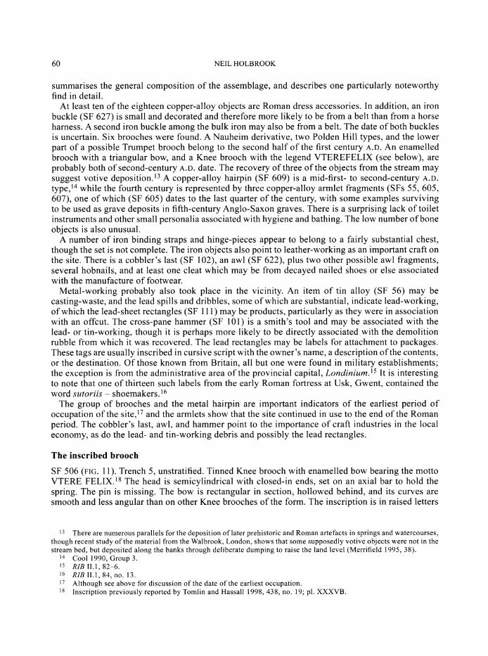
The inscribed brooch
SF 506 (FIG. 11). Trench 5, unstratified. Tinned Knee brooch with enamelled bow bearing the motto VTERE FELIX.'s The head is semicylindrical with closed-in ends, set on an axial bar to hold the spring. The pin is missing. The bow is rectangular in section, hollowed behind, and its curves are smooth and less angular than on other Knee brooches of the form. The inscription is in raised letters
13 There are numerous parallels for the deposition of later prehistoric and Roman artefacts in springs and watercourses, though recent study of the material from the Walbrook, London, shows that some supposedly votive objects were not in the stream bed, but deposited along the banks through deliberate dumping to raise the land level (Merrifield 1995, 38).
14 Cool 1990, Group 3. 15 RIB II.1, 82-6. 16 RIB II.1, 84, no. 13. 17 Although see above for discussion of the date of the earliest occupation. 18 Inscription previously reported by Tomlin and Hassall 1998, 438, no. 19; pl. XXXVB.
TURKDEAN ROMAN VILLA, GLOUCESTERSHIRE: ARCHAEOLOGICAL INVESTIGATIONS 1997-1998 61
FIG. 11. Inscribed Knee brooch (1:1).
of copper alloy above a field of red enamel, with the ER and EL ligatured and the Es reversed. The foot is thin and the catchplate transverse. Length 31 mm.
Both the form, which is rather less angular than most Knee brooches, and the inscription are matched on three other brooches from Britain:19 one from County Durham with green enamel;20 one from Canterbury with blue enamel;21 and one, of British but otherwise unknown provenance, with red enamel. The head of the latter is slightly different and the catchplate vertical rather than horizontal.22
Mackreth dates the Canterbury utere felix Knee brooch to the second half of the second century A.D.23 The type in general is derived predominantly from northern, usually military, sites, with those from the south mostly found in large towns.24 They are military brooches25 which occur also in civilian contexts, and so might have been used as 'badges of office' by the civilian administration.
Uterefelix, 'good luck to the user', occurs, either in full or in slightly varied form, on a wide variety of other objects, such as spoons, intaglios, military belt-fittings, bone inlay, and even a stake of boxwood.26 None of these objects can be seen as specifically female, and it is tempting to infer that the motto was only used in Roman Britain on gifts between men. In the fourth century it appears to have taken on a religious connotation, being found in conjunction with the Christian Chi-Rho monogram and 'angels' on a fourth-century lead casket panel from Nottinghamshire27 and among the inscriptions on the spoons of the Thetford treasure.28
THE GLASS By Denise Allen
The glass is all very fragmentary, but the majority can be approximately dated. The Roman pieces comprise sixteen fragments of Roman vessel-glass, one fragment of window-glass, two beads, and a gaming-counter. A full catalogue is available in the archive. Several Roman vessel types have been identified and these range in date from the first century A.D. (a fragment of blue-green pillar-moulded bowl) to the later Roman period. They include bottles, bowls, flasks/jugs, and beakers. A fragment of yellow-green glass with horizontal cordons may derive from a mould-blown barrel jug. None of the vessels is uniquely important, but together they indicate some of the range of tableware and containers in use on the site.
19 RIB 2421.56-8. 20 Hattatt 1985, fig. 52, 483. 21 Mackreth 1995, fig. 409, 111. 22 Hattatt 1985, fig. 52, 484. 23 Mackreth 1995, 979. 24 Hattatt 1987, 262. 25 Riha 1979, 85. 26 RIB 2420.50-2, 2423.28-9, 2429.13-17, 2441.12, 2444.4. 27 RIB 2416.8. 28 Hassall and Tomlin 1981, 390-3.

62 NEIL HOLBROOK
THE STONE OBJECTS By Fiona Roe
Four stone objects were found. Part of a whetstone is made from Coal Measures sandstone, a material often used for Roman whetstones. Stone discs made from reused roofing tile frequently occur on Roman sites, and two small ones were found here, one with a diameter of 53 mm and the other with a diameter of 55 mm. Both are made from the fine-grained, shell fragmental Jurassic limestone also used for the roofing tiles. The fourth object, a fragment with a groove around the middle, is a possible weight; it is made from the local shelly oolitic limestone used for structural stone.
THE BUILDING MATERIALS By Emma Harrison and Fiona Roe
The stone building materials
Fragments of building-stone, roof-tile, and 16 tesserae were recovered. All of the building-stone is of a coarse-grained, shelly oolitic limestone, as were two stone ridge tiles from the filling of the plunge pool. This stone would have been available locally, possibly from the quarries at Farmington. A fragment of a stone roof finial (FIG. 12) was recovered from the demolition rubble (413) in Trench 4. This object is made of an oolitic limestone, but is finer grained than that used for the rest of the building-stone. The stone was probably carefully selected for its ability to be finely shaped. This example has a four-way arch with three horizontal ridges carved above the arches on two adjacent sides. The other sides are worn or missing, but presumably also had these ridges. The height of the piece cannot be determined as the legs are all broken, but it is at least 200 mm tall and 160 mm wide. Above the ridges the finial is carved into a cylinder 900 mm tall, and there is a notch 20 mm in diameter on the top of the cylinder. This type of roof finial is found particularly in the South-West.29
FIG. 12. Limestone roof finial (1:4).
Eighty-five fragments of roof-tile, including some complete, or largely complete, hexagonal tiles, all appear to have been made from a fine-grained limestone which would also have been available locally, possibly from Sevenhampton. The 16 stone tesserae all appear to be of limestone, except for one possible sandstone example. They are generally c. 15 mm square, although several have one or more sides up to 20 mm long. Two of the tesserae are from the central range, and the remainder from the 1998 excavations (five from Trench 8, one from Trench 9, and eight from Trench 13).
29 Blagg 2002.

TURKDEAN ROMAN VILLA, GLOUCESTERSHIRE: ARCHAEOLOGICAL INVESTIGATIONS 1997-1998 63
The ceramic building material
A total of 77.2 kg of ceramic building material was recovered, over half of which derived from Trench 4 in the central range. Fragments of tegula, imbrex, pila, and box-tile were identified, but by far the most common type is box-tile from the filling of the plunge pool (weighing some 39 kg). A few tesserae cut from tile were also found, some again from the pool. These tesserae are larger than the stone examples, with sides usually 20 mm or more long.
Plaster and opus signinum
The majority of the plaster (7,699 g) and opus signinum (10,868 g) was also recovered from the pool in the central range, with only a few small fragments recovered from other contexts on the site, excepting the infill of possible cellar (1119) within the detached building where a plastered wall was uncovered. The fragments from (1119) are painted a mustard colour, with a few pieces decorated with red, blue, or white lines. A few fragments of red-painted plaster were also recovered. The plaster from the pool is red, overpainted with blue and white. Unpainted fragments were also recovered. The opus signinum occurs in large, unpainted fragments.
THE ANIMAL BONE By Jane Sidell
Some 406 fragments of animal bone were recovered by hand-excavation from the area of the villa and associated buildings. No sieved samples were examined. The bone assemblages were not submitted to a detailed analysis, but they have been scanned and identified to species and anatomical element where possible (full details are contained in the archive). No measurements or tooth-wear coding have been carried out at this stage. This report serves as a general description and interpretation (where possible) of the faunal assemblage from the villa.
The majority of the bone fragments formed extremely small assemblages and could be considered as 'background noise' - general debris which becomes scattered over an occupation site which is in use for some time. Many of these were collected from topsoil or subsoil layers and were highly eroded and are presumed to be re-worked from the uppermost Roman deposits. Differential erosion was observed within some of the assemblages, lending weight to the suggestion that a number of the bones were residual. Furthermore, a number of the context types from which bone was recovered, for instance the fillings of the robbing hollow in Trench I and the plunge pool in Trench 4, suggest that the bones were redeposited. Otherwise the bones were well preserved, even the juvenile fragments showing little evidence of damage.
In all, although a large number of bone assemblages were recovered, for the reasons set out above they only shed very limited light on the occupation of what was, after all, a substantial villa. The species list is restricted to the major domesticates of cattle, sheep/goat, and pig, with isolated examples of horse, deer, dog, and chicken/pheasant, and no wild species. This is surprisingly restricted and it is only the juvenile pig bones that make any concession to the presumed high status of the site and its occupants. Recovery is thought to have been good, on the basis of the many small bone chips found, yet this is a restricted diet for what was obviously a reasonably high-status site.
The assemblages were found in secondary contexts and so it is not possible to link the activities which generated the bone groups to specific areas of the site. Almost all the groups appear to be mixed, although it is not possible to ascertain whether mixing took place before or after the bones reached their final location. All that may be suggested is that animals were slaughtered, dismembered, and eaten - a not unexpected conclusion given the nature of the site.
The excavations did not recover any large groups of material in primary contexts; on a villa that was occupied for at least two hundred years, a lot of waste will have been generated and required disposal. The situation is different to that of an urban site where rubbish would often be carted away. On a rural site, it is more likely to be buried in pits, but their identification must await future

64 NEIL HOLBROOK
excavations. It is to be expected that somewhere on the Turkdean site primary bone assemblages which will shed light on the villa economy await excavation.
DISCUSSION
The villa at Turkdean occupied a site which is in many respects typical for such buildings in the Cotswolds: on rising ground above a river or dry valley, close to a spring line, and with fine views across the surrounding countryside. The villa lay 12 miles north-east of Cirencester, 4.5 miles south- west of the small town at Bourton-on-the-Water, and 2 miles from the Fosse Way, midway between two of the denser concentrations of villas within the Cotswolds (FIG. 1).30 To the south seven or so villas and less well-examined buildings are recorded in a 3 mile-length of the Coln valley, while to the east a concentration within the Windrush valley may have been influenced by proximity to the market centre at Bourton.31 The nearest known villa to Turkdean lay 2 miles to the south-east at Farmington where settlement covered an area of at least 1.1 ha and included a substantial building complex with an associated cemetery.32
The earliest pottery from the site suggests that occupation commenced at Turkdean sometime in the second century A.D. Whether the buildings of this date bore much resemblance to the courtyard plan revealed by the surveys is uncertain. Certainly, at its most grandiose, the villa was of triple- courtyard plan, and so invites immediate comparison with other Cotswold villas of this type.33 Where examined in any detail, however, these other sites show evidence for development from a number of smaller detached units loosely grouped around a courtyard into a more developed final form, the latter normally dating to the fourth century. Examples from the Cotswolds include Chedworth which had second-century origins, North Leigh (Oxon.) which dates originally from the first century, and probably Spoonley Wood.34 Indeed Smith states categorically that no British courtyard villa with a single building phase has yet come to light.35 Can a similar sequence be traced at Turkdean?
There are indeed clear indications within the plan revealed by the surveys to suggest chronological development, principally the projecting rooms on the north side of the northern range which are seemingly at odds with a plan based around the triple courtyards to the south (FIG. 4). Secondly, the pool excavated in Trench 4 is best interpreted as the cold plunge of a bath-house, comparable to those at Spoonley Wood36 and Clearcupboard, Farmington.37 At Turkdean, however, it is surprising that the geophysical survey did not detect in this area any intense anomalies suggestive of hypocausts. Perhaps the stoke-holes and hypocaust basements were comprehensively demolished as part of the same operation as the infilling of the bath. As the latter contained abundant box-tiles, a hypocaust must exist somewhere within the complex. If the main house still faced south, a bath-house directly opposite the main residential range on the central axis of the villa is uncommon and extremely difficult to parallel. One would more normally expect some manner of gatehouse in this location, as at North Leigh and numerous villas in Picardy.38 If, however, the main range now faced north, as the projecting rooms suggest, a bath-house to the rear of the house would be much more explicable. If this is correct, it permits a tentative theory of the building's development to be proposed as follows.
Geophysics indicates that there was a 6 m-wide entrance between the middle and outer courtyards.
30 RCHME 1976. 31 Hodder and Millett 1980. 32 RCHME 1976, 55-6; Rawes and Wills 1998, 201. 33 RCHME 1976, plan facing p. xl; for the villa plan generally, see Smith 1997, 162-5. 34 Chedworth: Goodburn 1983, 13; North Leigh: Ellis 1999; Spoonley Wood: RCHME 1976, 113-14; Smith 1997, 162. 35 Smith 1997, 163. 36 Where the bath measured 4.8 m by 3.5 m, with two steps leading down (Middleton 1890, 653). 37 Bath 1.1 m by 1.3 m by 0.7 m deep, also with steps (Gascoigne 1969, 46-7). 38 Ellis 1999, fig. 2; Smith 1997, 151-65.

TURKDEAN ROMAN VILLA, GLOUCESTERSHIRE: ARCHAEOLOGICAL INVESTIGATIONS 1997-1998 65
A rubbish deposit within a room on the north side of the outer courtyard produced a group of late second-century A.D. pottery suggesting that this part of the villa was in existence at a comparatively early date in the sequence. At this time the north range must have faced southwards and comprised a long rectangular block of residential rooms with corridors or porticos to front and back, as at Wellow, Avon, and Eccles, Kent.39 To the south of the principal range lay one or more courtyards. Whether the inner and middle courtyards were separated by a central range at this date is unclear, although if they were, the entrance into the inner courtyard was subsequently blocked by the construction of the bath- house.40 It is difficult to assess what other elements of the villa plan might have been contemporary with this arrangement, although the corridors lining the northern and western ranges of the inner courtyard suggest architectural unity. The northern range was abutted comer to corner by the eastern block, however, suggesting a separate functional, and perhaps social, unit. It may also have been a later addition. The division of the inner and middle courtyards by a cross-range containing several rooms is only paralleled in the Cotswolds at Woodchester,41 although at Chedworth the partition of a Garden Court was accomplished by the construction of a simple cross corridor.42 The structure tested in Trench 6 on the western side of the outer courtyard invites comparison with the aisled buildings at Spoonley Wood and Sparsholt, Hants., which occupied comparable locations.43 The dry-built construction and fourth-century finds from this building suggest that it dates to late in the history of the complex, although it could have replaced an earlier structure. In the final phase, it can be suggested, either the central range was built de novo, or else a bath-house was inserted into it on the site previously occupied by an entrance into the inner courtyard. These events would logically be associated with a decision to remodel the north range to face northwards by the addition of the projecting rooms.
This model is not without difficulties, however. There is no trace of a north-facing entrance in the north range, or a suitable break in the compound wall outside it. An entrance to the range on the opposite side to the courtyards would also be unusual, because it was surely the approach through the courtyards that proclaimed the status and importance of the owner.44 Nethertheless the unusual location of the bath-house has to be explained, and J.T. Smith has suggested that it may have been inserted into the central range to reinforce a separation between the inner and middle courtyards in response to changing patterns of social occupation.45
The detached building to the south-east of the main complex was probably built in the late second or third century A.D. It overlay a substantial ditch,46 and was manifestly of at least two principal phases. Demolition deposits indicate that it continued in use until the end of the fourth century. Reconstruction of the ground plan of the building is difficult from the evidence provided by two small trenches and the results of the geophysical surveys (which were not as clear here compared with some other parts of the complex). At the time of excavation it was considered that the remains should be interpreted as an aisled building. This reconstruction is possible, but not without its problems (see above).47 Indeed it is conceivable that the plan as presented in FIG. 9 is a conflation of the remains of two separate or sequential buildings. Assuming that a single structure is represented, it occupied a site on the steep hillside (there is a vertical drop of 2.25 m over a distance of 20 m from east to west), which poses further questions for its plan and reconstruction. Assuming that the roof line remained at a constant level, the
39 Haverfield 1906, 312; Detsicas 1983, 120-6. 40 It should be noted that if the entrance through the central range was on the same alignment as that between the
middle and outer courtyards it would have lain to the east of the plunge pool examined in Trench 4. 41 RCHME 1976, 132-4. 42 Goodburn 1983. 43 RCHME 1976, 113-14; Wilson 1973, 318-19. 44 Leach 1998, 20, 124, does suggest, however, that the main entry into the Period 2 villa at Great Witcombe, Glos.,
was from the side opposite the courtyard. 45 In litt. 46 The significance of houses built over earlier boundaries is discussed by Smith 1997, 239-41. 47 I am grateful to J.T. Smith for pointing these out to me.
66 NEIL HOLBROOK
western faqade would have risen to a height of at least 5 m, and perhaps considerably more.48 The western part of the building may have contained basements beneath a floor which corresponded with ground level at the eastern end. The choice of a steep hillside for a villa building is certainly not without parallel,49 although it is curious in this case that it was the eastern faqade that was embellished by the addition of projecting rooms as this faced uphill and away from the courtyard villa. The fine landscape views from the hillside are to be had to the south and west. While the building lay some distance from the courtyard house, the location of a number of aisled buildings at Winterton, Humberside, reminds us how far from the principal house large and important buildings could be.50 The building was clearly of high status and at least partly residential. The most plausible interpretation of the sunken feature within the demolished west end is as a plunge bath or cellar, and the tesserae from the demolition deposits indicate a pavement somewhere within the structure. Mosaics and baths are known from a number of aisled buildings, including those that provided subsidiary accommodation to the main residential complex, and it is common for baths to be at the opposite end from the living rooms.51 The addition of projecting rooms to the eastern faqade at Turkdean finds parallel at three aisled buildings in Hampshire: North Warnborough, Stroud, and Redenham,52 although in all three cases rooms were added to the long faqade rather than the shorter one as here.
The villa continued in use until late in the fourth century. The accumulation of rubbish within the outer courtyard in the period A.D. 364-388 may mark the beginning of the decline of cleanliness and ordered rubbish disposal, although the three coins of A.D. 388-402 indicate some form of activity until at least the last decade of the fourth century and almost certainly into the fifth. The coin list from Turkdean invites comparison with that from nearby Chedworth, where of the 360 coins contained in the museum, about one third fall in the years A.D. 364-378, but there is only one issue of the House of Theodosius.53 This contrasts dramatically with the lists from Cirencester and the small town of Wycomb which display vigorous coin loss in the period A.D. 388-402.54 The sherds of handmade post-Roman pottery are a noteworthy discovery, although unfortunately interpretation of the deposits in Trench 9 is unclear. Significantly none of this pottery was recovered from the main villa buildings, an observation that invites comparison with Barnsley Park where pottery of this broad class was found in the ditches of the field-system but not in the villa itself; this suggested to the excavator that the land continued to be farmed long after the house had been abandoned.55 Recently a single sherd of post-Roman organic-tempered ware has been recovered from Victorian backfill at Chedworth.56
The work sponsored by Time Team, which totalled less than ten days of fieldwork, has generated a considerable amount of new information about a previously unknown site. Turkdean is a major addition to the corpus of Romano-British villas. Inevitably a number of important research topics remain unanswered. What factors led to the selection of this site? Upon what basis was the economy of the villa founded? What impact did the construction of the villa have on pre-existing patterns of agriculture and settlement? By what processes did the villa develop into its final impressive form? These are questions that could only be answered by a longer-term multi-disciplinary research project. While the villa would be the natural focus, and further excavation is highly desirable, such a
48 The collapsed facade of an aisled building at Meonstoke, Hants., indicates a height of almost 12 m to the apex of the clerestory roof (King 1996).
49 As, for example, locally at Great Witcombe (Neal 1977; Leach 1998, 126-9), Vineyards Farm, Charlton Kings (Rawes 1991), and Boughspring, Tidenham (Neal and Walker 1988; Pullinger 1990), where rooms were either constructed on raised levels or terraced into the hillslope. In all three cases the hillside location afforded splendid views.
50 Goodburn 1978. 51 Morris 1979, 150-1. 52 Smith 1963, 5-7. 53 Reece 1959. 54 Reece and Guest 1998 and Reece 1998 list the relevant evidence and discuss the differing interpretations that may
be placed upon it. 55 Webster et al. 1985. 56 Cotswold Archaeological Trust 2000b, 37-8.

TURKDEAN ROMAN VILLA, GLOUCESTERSHIRE: ARCHAEOLOGICAL INVESTIGATIONS 1997-1998 67
project should also study the landscape setting of the villa, both spatially and chronologically. Only then will we be able to really appreciate the impact that the construction of this luxury building had on the contemporary environment.
APPENDIX 1: GEOPHYSICAL SURVEY By Chris Gaffney and John Gater
INTRODUCTION
A geophysical survey, using both magnetic and resistivity techniques, was undertaken of land to the north and west of Chalkhill Barn (FIG. 3). The survey covers a large proportion of one substantial field that is occasionally sub-divided into two due to farming practices. The pasture was close-cropped at the time of the surveys. The soils comprise brown rendzinas formed from a parent of Jurassic (oolitic) limestone. Such soils are eminently good for magnetic survey.57 The collected data for the two techniques are not on a common grid for reasons dictated by the requirements of the 'Live' television broadcast (FIG. 13). A simplified interpretation of the geophysical data is shown in FIG. 3.
RESULTS
Resistance survey A Twin-Probe resistance survey, using a Geoscan Research RM15 with a multiplex system, was conducted in two phases over a 15-month period. The first phase was designed to determine the precise location and nature
1997 Gradiometer survey 1998 Gradiometer survey Chalkhill
1997 Resistance survey 1998 Resistance survey Bam
0 300m , \\
FIG. 13. Location of geophysical survey grids.
57 For details of the magnetic properties of the soils see Weston 1999.

68 NEIL HOLBROOK
of cropmarks that indicated a potential Roman villa. This survey was undertaken in March and August 1997 and covered approximately 1.5 hectares. Subsequently, in May 1998, a second swathe of resistance was measured to investigate a complex of buildings lying east of the main site. In total, an area of 2.4 hectares of land was sampled at a 1 m density.
An attempt was made to 'normalise' between the two phases of resistance measurements. However, this has not been as successful as would have been hoped. This is a result of the prevailing weather and field conditions prior to each survey. The 1997 survey is characterised by particularly clear, sharp responses, while the 1998 survey contains broader anomalies and a greater number of false readings. It is likely that the 1998 survey was conducted too late in the spring, after the peak signal resolution (obtained in March during the 1997 survey) had been achieved. The two data sets are therefore difficult to match. The results are displayed in this report in three formats: raw, filtered, and shade plot.58
The first phase of survey, the northern data set, was targeted on the presumed position of the parchmarks previously noted by the farmer and seen on aerial photographs. The resistance data provided a remarkably clear picture of a Roman villa complex (FIG. 14). The results indicate the existence of two courtyards surrounded
S.D.
-1
0 1OOm
GSB Prospection 97/19 & 98/70
FIG. 14. 1997 resistance survey results. Top left: raw plot. Top right: filtered plot. Bottom: shade plot.
58 For a description of the display algorithms see Gaffney et al. 2002 and David 1995.
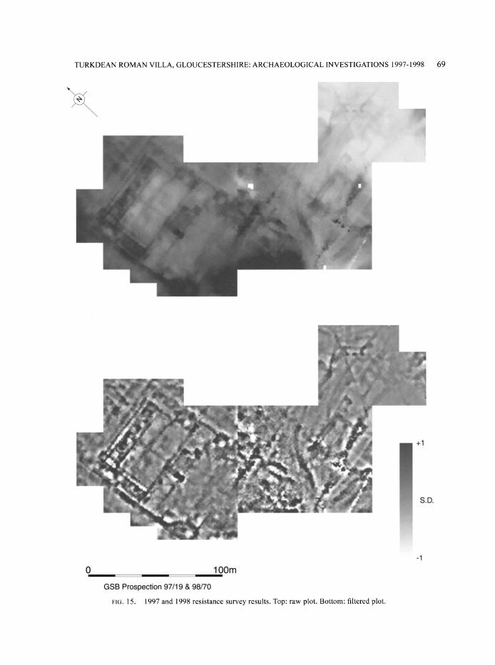
TURKDEAN ROMAN VILLA, GLOUCESTERSHIRE: ARCHAEOLOGICAL INVESTIGATIONS 1997-1998 69
-1
S.D.
0 100m GSB Prospection 97/19 & 98/70
FIG. 15. 1997 and 1998 resistance survey results. Top: raw plot. Bottom: filtered plot.
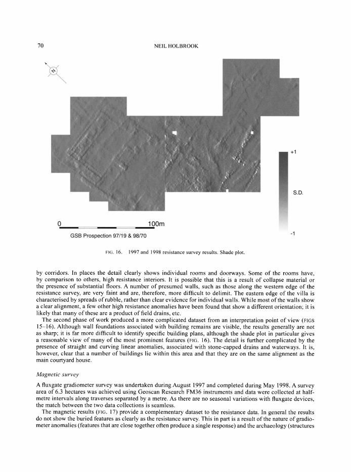
70 NEIL HOLBROOK
+1
S.D.
0 1OOm
GSB Prospection 97/19 & 98/70
FIG. 16. 1997 and 1998 resistance survey results. Shade plot.
by corridors. In places the detail clearly shows individual rooms and doorways. Some of the rooms have, by comparison to others, high resistance interiors. It is possible that this is a result of collapse material or the presence of substantial floors. A number of presumed walls, such as those along the western edge of the resistance survey, are very faint and are, therefore, more difficult to delimit. The eastern edge of the villa is characterised by spreads of rubble, rather than clear evidence for individual walls. While most of the walls show a clear alignment, a few other high resistance anomalies have been found that show a different orientation; it is likely that many of these are a product of field drains, etc.
The second phase of work produced a more complicated dataset from an interpretation point of view (FIGS 15-16). Although wall foundations associated with building remains are visible, the results generally are not as sharp; it is far more difficult to identify specific building plans, although the shade plot in particular gives a reasonable view of many of the most prominent features (FIG. 16). The detail is further complicated by the presence of straight and curving linear anomalies, associated with stone-capped drains and waterways. It is, however, clear that a number of buildings lie within this area and that they are on the same alignment as the main courtyard house.
Magnetic survey
A fluxgate gradiometer survey was undertaken during August 1997 and completed during May 1998. A survey area of 6.3 hectares was achieved using Geoscan Research FM36 instruments and data were collected at half- metre intervals along traverses separated by a metre. As there are no seasonal variations with fluxgate devices, the match between the two data collections is seamless.
The magnetic results (FIG. 17) provide a complementary dataset to the resistance data. In general the results do not show the buried features as clearly as the resistance survey. This in part is a result of the nature of gradio- meter anomalies (features that are close together often produce a single response) and the archaeology (structures
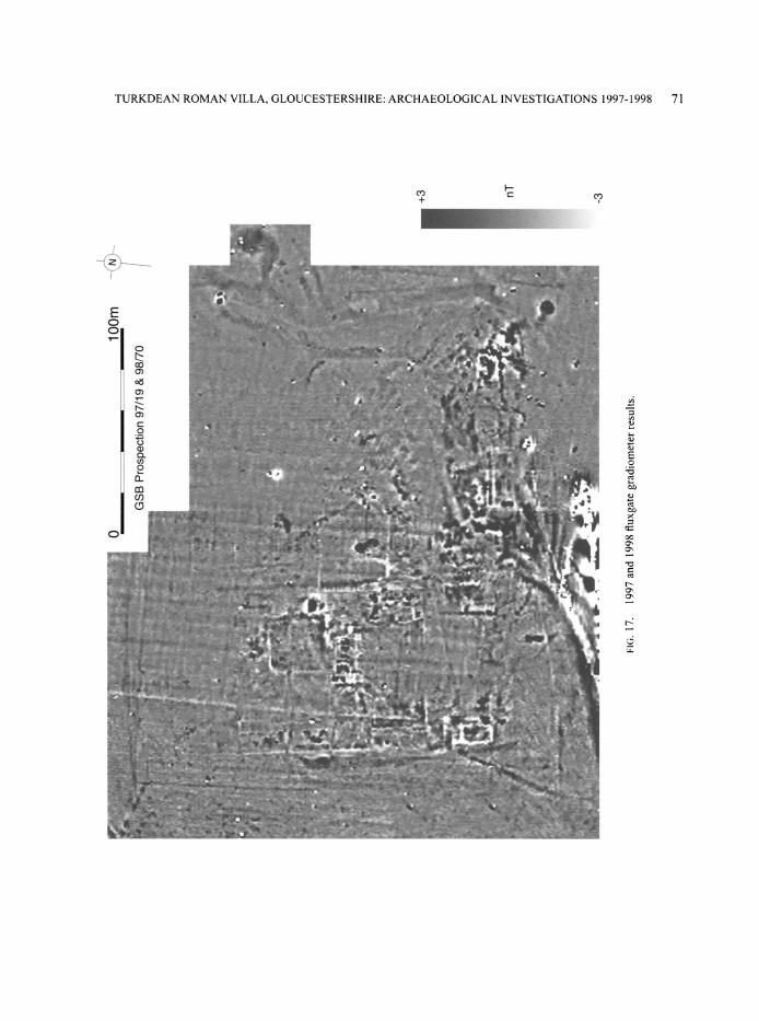
TURKDEAN ROMAN VILLA, GLOUCESTERSHIRE: ARCHAEOLOGICAL INVESTIGATIONS 1997-1998 71
irr
J~i----
E o
ao ,IL
l
o: o4
am A * , k
fff
o .4.
-4 kx ILAa~"ac~~? 9~~i~;- ?CI 4~l~~~I ~f ?i Z~I
cn
c?
o1
-?
?-11-1111 l--r
I 44r
07L
Cfj
u
•5
r-
ol C?

72 NEIL HOLBROOK
often produce erratic data due to the jumble of highly magnetic material). Furthermore the gradiometer has measured slight responses, in particular associated with medieval and modem ploughing, that have produced regular patterns across the site and increased the noise level within the dataset.
There is one anomalous region of erratic readings at the central southern edge of the survey grid that coincides with a modern ferrous pipeline and as such can be disregarded. Directly to the north of this is the response from a stream bed. Elsewhere a profusion of anomalies indicates zones of activity within a wider landscape of agricultural usage. The strength and nature of the anomalies are indicative of occupation features: rubbish pits, midden deposits, burnt and fired features, and small-scale industrial activity. Those areas that are largely devoid of anomalies are reasonably prominent. For example, the courtyards, as identified by the resistance survey, show few magnetic anomalies apart from possible paths and drains.
Unusually, some of the wall foundations are visible as negative magnetic responses. This is because they comprise magnetically-low stone embedded within settlement soils of high susceptibility, which is more normally associated with significant soil deposits within quasi-urban situations.59 However, the response over individual buildings is highly variable. As suggested above, some of the structures that are so apparent within the resistance data produce only a jumble of magnetic anomalies. These areas appear to reflect either long-lived settlement or even semi-industrial activity. Perhaps of some interest is the difference in response along the eastern edge of the villa; by comparison to the structure at the southern edge, the northern buildings are very weak. The latter, presumably, are not buried within magnetically enhanced material and give the suggestion of minor/short use.
Beyond the zones of more intense activity there are several linear and sub-linear anomalies associated with presumed field boundary ditches and drains. There is one strong isolated anomaly in the south-east corner of the survey that on excavation proved to be a large pit, with a projected diameter of approximately 6 m, which had evidence for intensive burning. This was subsequently tested by Trench 10.
Some of the linear and curvilinear magnetic responses were found on excavation to be associated with a network of watercourses that criss-cross the hillside; a strong ferrous-type response can be seen at the northern end of one of the stone drains and is believed to be associated with the spring. The 'smeared' response directly to the east of this feature reflects an area of quarrying. Many of the magnetic responses also appear in the resistance data, as referred to earlier, but the complexity of the results means that it is not always possible to trace the exact course of the features. To the north and west of the villa is a possible boundary ditch; the northern ditch is positioned some 60 m beyond the formal end of the villa buildings. There are no archaeological-type anomalies within this zone and it is likely that gardens existed here.
APPENDIX 2: THE DATING EVIDENCE
In this appendix the evidence upon which the dating of the villa relies is presented. Dates for the coins, metalwork, and pottery derive from the catalogues prepared by the individual specialists. Diagnostic pottery types are listed where significant by fabric and form.60
The courtyard villa
Inner corridor of north range (Trench 2)
Latest floor level (208). Pottery: BB1 plain-rimmed dish.
Northern (inner) courtyard (Trench 3)
Capping of ditch (303). Pottery: Oxfordshire red slip ware. Fill (231) of pit (230) that cut the latest courtyard surface. Pottery: Oxfordshire red slip ware.
Central range (Trench 4)
Primary fill (414) of pool. Coin: Gratian, A.D. 367-375 (SF 113). Pottery: Oxfordshire red slip ware.
59 See Gaffney et al. 2000. 60 For a brief summary of their dating in the Cotswolds see Holbrook 1998, xvii-xviii.

TURKDEAN ROMAN VILLA, GLOUCESTERSHIRE: ARCHAEOLOGICAL INVESTIGATIONS 1997-1998 73
Demolition (404 and 413). Coins: as House of Constantine, A.D. 353-360 (SF 106); Constans, A.D. 347-348 (SF 100). Pottery: late Roman shell-tempered ware.
Eastern range (inner courtyard) (Trench 1)
Primary infilling of robbing hollow (111, 107). Coins: Constantine I, A.D. 321 (SF 59); Constantine I, A.D. 310-313 (SF 60). Pottery: late Roman shell-tempered ware; Oxfordshire red slip ware. Secondary infilling of robbing hollow (109, 106). Coin: Constantine I, A.D. 320-321 (SF 65). Pottery: late Roman shell-tempered ware. Final infilling of robbing hollow (103). Coins: Constantine I, A.D. 318-324 (SF 57); Constantine I, A.D. 313- 319 (SF 54). Pottery: late Roman shell-tempered ware. Metalwork: armlet, fourth century A.D. (SF 55). The dating evidence from the primary infillings (111, 107) indicates that the outer wall of the eastern range cannot have been built before c. A.D. 360 (if the stratigraphic relationships have been correctly interpreted). The coins from this series of deposits form a consistent group ranging between A.D. 310 and 321, and in the coin report (above) it is suggested that they were deposited A.D. 321-335. There are two problems with this, however. Firstly, the coins are scattered through all three phases of infilling. Secondly, they are associated with late Roman shell-tempered pottery which is conventionally dated to after c. A.D. 360. The simplest explanation is to assume that the coins derive from a disturbed hoard that has subsequently been redeposited as part of the process of infilling the robbing hollow.
Eastern range (middle courtyard) (Trench 7)
Material raked from metal-working furnace (723). Coin: Gratian, A.D. 367-375 (SF 704). Filling of furnace (722). Pottery: late Roman shell-tempered ware. Make-up (712). Pottery: late Roman shell-tempered ware (plus modern contamination). The coin from (723) provides a terminus post quem of A.D. 367 for the construction of the corridor walls.
Outer courtyard (Trench 5)
Occupation deposits within the room on the northern side of the outer courtyard (507, 509). Pottery: BBI cooking-pot with right-angled lattice, Nene Valley colour-coated ware, Savernake ware, Central Gaulish samian, Severn Valley ware tankard, poppy-head beaker. A mid-second to early third-century A.D. date for this group is likely. Demolition (506). Pottery: Oxfordshire red slip ware.
Building on the western side of the outer courtyard (Trench 6) Fill (612) of ditch (611). Pottery: late Roman shell-tempered ware. Occupation (610). Pottery: late Roman shell-tempered ware. Occupation (603) on surface (608). Coins: Valens, A.D. 367-375 (x 2) (SF 600, 606); Valentinian I, A.D. 364- 375 (SF 601); Constantine I, A.D. 318-324 (SF 608). Pottery: late Roman shell-tempered ware. Metalwork: armlet, last quarter of fourth century A.D. (SF 605), armlet, fourth century A.D. (SF 607). ?Demolition within building (604). Pottery: late Roman shell-tempered ware. The pottery from (610) provides a terminus post quem of c. A.D. 360 for surface (608); the coins from (603) are consistent with rubbish accumulating above it in the Valentinianic period.
The detached building (Trenches 8 and 13) Primary filling (1121) of pre-building ditch (1114). Pottery: late Roman shell-tempered ware (sherd only 1 g in weight and so probably intrusive). Pre-building colluvium (1107). Pottery: Mancetter-Hartshill bead-and-roll mortarium, form pre-c. A.D. 150 but is riveted suggesting some longevity; everted-rim BB 1 cooking-pot; ?shell-tempered ware (very uncertain identification). Demolition (1101, 1118, 1106, 1117, 1110, 1120, 1116). Coin: Valens, A.D. 364-367 (SF 2021); as House of Constantine, A.D. 353-360 (SF 2011). Pottery: late Roman shell-tempered ware; Oxfordshire red slip ware. Cleaning layer onto top of walls/rubble, and therefore not a sealed deposit (1601). Coins: Theodosius I, A.D. 388-395 (SF 2030b); Gratian, A.D. 367-375 (x 2) (SF 2029, 2031); House of Valentinian, A.D. 364-378 (SF
74 NEIL HOLBROOK
2030a); as House of Constantine, A.D. 353-360 (SF 2026); Constantinopolis, A.D. 330-335 (SF 2025); Urbs Roma, A.D. 330-335 (SF 2028); radiate, A.D. 270 (SF 2032). Pottery: late Roman shell-tempered ware (plus modem contamination). The pottery from (1121) and (1107) suggests a later second- or early third-century A.D. terminus post quem for the construction of the building, if the shell-tempered ware is disregarded as intrusive.
External areas
Rubble deposits in Trench 9
Silty deposits (1208, 1207). Pottery: handmade post-Roman quartz- and organic-tempered ware; late Roman shell-tempered ware; Oxfordshire red slip ware. Rubble (1203, 1205, 1204). Coin: Constantine I, A.D. 318-319. Pottery: handmade post-Roman quartz- and organic-tempered ware; late Roman shell-tempered ware; Oxfordshire red slip ware. Subsoil (1202). Coin: mid-late fourth century A.D. (SF 2015).
Quarry pit in Trench 10
Upper pit fills (1303, 1304). Pottery: three sherds of un-diagnostic Romano-British pottery.
Culvert (Trenches 11 and 12)
No dating evidence.
ACKNOWLEDGEMENTS
The excavation in 1997 was supervised by Neil Holbrook and in 1998 by Dawn Enright. In 1997 the field team comprised both Time Team and Cotswold Archaeology personnel, and in 1998 Time Team and members of Gloucester and District Archaeological Research Group. Site surveying was by Bernard Thomson and Stewart Ainsworth of English Heritage, and the geophysical survey by GSB. The stratigraphical reports were written by Laurent Coleman and Neil Holbrook. Emma Harrison co-ordinated the finds analyses, Peter Moore produced the plans and sections, and Gail Stoten and R.S.O. Tomlin drew the artefacts.
My particular thanks go to the late Wilf Mustoe and his family for generously permitting the work to take place, and for the interest that they showed in it. Time Team provided funding for the production of the typescript report, and I would like to thank the series producer Tim Taylor and Peter Bellamy of Terrain Archaeology who co-ordinated the post-excavation work on behalf of the programme; the consultants acknowledged in this report for reporting on their particular speciality; and Roger Box for generously sharing his knowledge of the site with me. J.T. Smith, Richard Reece and the editor kindly commented upon an earlier draft of this report, much to its benefit, but they do not necessarily agree with all that is proposed here. The finds and archive from this project have been deposited at the Corinium Museum, Cirencester.
Cotswold Archaeology, Cirencester
This paper is published with the aid of a grant from Time Team
BIBLIOGRAPHY
Aston, M. 2003: Interpreting the Landscape from the Air, Stroud Blagg, T.F.C. 2002: Roman Architectural Ornament in Britain, British Archaeological Reports 329, Oxford Cool, H. 1990: 'Roman metal hair pins from southern Britain', Archaeological Journal 147, 148-82 Cool, H. 1998: 'A general overview of the finds assemblage from Kingscote', in Timby 1998, 220-7 Cotswold Archaeological Trust 2000a: Turkdean Roman Villa, Gloucestershire. Archaeological Investigations
1997-1998, Cotswold Archaeological Trust Report 001121

TURKDEAN ROMAN VILLA, GLOUCESTERSHIRE: ARCHAEOLOGICAL INVESTIGATIONS 1997-1998 75
Cotswold Archaeological Trust 2000b: Chedworth Roman Villa, Gloucestershire. Archaeological Survey of Buried Mosaics, Cotswold Archaeological Trust Report 001195
David, A. 1995: Geophysical Survey in Archaeological Field Survey, English Heritage, London Detsicas, A. 1983: The Cantiaci, Gloucester Ellis, P. 1999: 'North Leigh Roman villa, Oxfordshire: a report on excavations and recording in the 1970s',
Britannia 30, 199-245 Gaffney, C., Gater, J., Linford, P., Gaffney, V., and White, R. 2000: 'Large scale systematic fluxgate
gradiometry at the Roman city of Wroxeter', Archaeological Prospection 7(2), 81-100 Gaffney, C., Gater, J., and Ovenden, S. 2002: The Use of Geophysical Techniques in Archaeological
Evaluations, IFA Paper 6, Reading Gascoigne, P. 1969: 'Clear Cupboard villa, Farmington, Gloucestershire', Transactions Bristol Gloucester-
shire Archaeological Society 88, 34-67 Goodburn, R. 1978: 'Winterton: some villa problems', in M. Todd (ed.), Studies in the Romano-British Villa,
Leicester, 93-102 Goodburn, R. 1983: The Roman Villa at Chedworth (rev. edn), London Hassall, M., and Tomlin, R.S.O. 1981: 'Roman Britain in 1980: II. Inscriptions', Britannia 21, 369-96 Hattatt, R. 1985: Iron Age and Roman Brooches, Oxford Hattatt, R. 1987: Brooches ofAntiquity, Oxford Haverfield, F.J. 1906: 'Romano-British Somerset', VCH Somerset 1, 206-371 Hodder, I., and Millett, M. 1980: 'Romano-British villas and towns: a systematic analysis', World
Archaeology 12, 69-76 Holbrook, N. (ed.) 1998: Cirencester: The Roman Town Defences, Public Buildings and Shops, Cirencester
Excavations 5, Cirencester King, A. 1996: 'The south-east fagade of Meonstoke aisled building', in P. Johnson with I. Haynes (eds),
Architecture in Roman Britain, CBA Res. Rep. 94, London, 56-69 Leach, P. 1998: Great Witcombe Roman Villa, Gloucestershire. A Report on the Excavations of Ernest
Greenfield 1960-1973, British Archaeological Reports 266, Oxford Mackreth, D. 1995: 'Pre-Roman and Roman brooches', in K. Blockley, M. Blockley, P. Blockley, S.S. Frere
and S. Stow, Excavations on the Marlowe Car Park and Surrounding Areas, Canterbury, 955-82 Merrifield, R. 1995: 'Roman metalwork from the Walbrook - rubbish, ritual or redundancy', Transactions
London and Middlesex Archaeological Society 46, 7-44 Middleton, J.H. 1890: 'On a Roman villa in Spoonley Wood, Gloucestershire; and on Romano-British houses
generally', Archaeologia 52, 651-68 Morris, P. 1979: Agricultural Buildings in Roman Britain, British Archaeological Reports 70, Oxford Neal, D.S. 1977: 'Witcombe Roman villa: a reconstruction', in M.R. Apted, R. Gilyard-Beer and A.D.
Saunders (eds), Ancient Monuments and their Interpretation, London, 27-40 Neal, D.S., and Walker, B. 1988: 'A mosaic from Boughspring Roman villa, Tidenham', Britannia 19, 191-8
Pullinger, J. 1990: 'Excavation report - the Roman villa at Boughspring with a new assessment', Dean
Archaeology 3, 12-25 RCHME 1976: Iron Age and Romano-British Monuments in the Gloucestershire Cotswolds, London Rawes, B. 1991: 'A prehistoric and Romano-British settlement at Vineyards Farm, Charlton Kings,
Gloucestershire', Transactions Bristol Gloucestershire Archaeological Society 109, 25-89 Rawes, J., and Wills, J. (eds) 1998: 'Archaeological review no. 22 1997', Transactions Bristol Gloucestershire
Archaeological Society 116, 191-212 Reece, R. 1959: 'Coins from the Roman villa at Chedworth', Transactions Bristol Gloucestershire
Archaeological Society 78, 162-5 Reece, R. 1991: Roman Coins from 140 Sites in Britain, Cirencester Reece, R. 1998: 'The Roman coins', in Timby 1998, 400-21 Reece, R., and Guest, P. 1998: 'The coins', in Holbrook 1998, 247-93 RIB: Collingwood, R.G., and Wright, R.P., The Roman Inscriptions of Britain, I (1965), II (1990-1995) Riha, E. 1979: Die rImischen Fibeln aus Augst und Kaiseraugst, Forschungen in Augst 3 Smith, J.T. 1963: 'Romano-British aisled houses', Archaeological Journal 120, 1-30 Smith, J.T. 1997: Roman Villas. A Study in Social Structure, London Timby, J. 1998: Excavations at Kingscote and Wycomb, Gloucestershire, Cirencester Tomlin, R.S.O., and Hassall, M.W.C. 1998: 'Roman Britain in 1997. II. Inscriptions', Britannia 29, 433-45

76 NEIL HOLBROOK
Tomlin, R.S.O., and Hassall, M.W.C. 2000: 'Roman Britain in 1999. II. Inscriptions', Britannia 31, 433-49 Webster, G., Fowler, P., Noddle, B., and Smith, L. 1985: 'The excavation of a Romano-British rural
establishment at Barnsley Park, Gloucestershire', Transactions Bristol Gloucestershire Archaeological Society 100, 65-190
Weston, D. 1999: The Physical and Chemical Property Analysis of Archaeological Soils and Sediments, unpublished PhD thesis, University of Bradford
Wilson, D.R. 1973: 'Roman Britain in 1972. I. Sites explored', Britannia 4, 271-323