Embed Size (px)
Citation preview
Tunisia: Evaluation of the Hydrocarbon
Exploration Potential and Promotion:
Main Results and a Way Forward
By Marc Blaizot
Pub
lic D
iscl
osur
e A
utho
rized
Pub
lic D
iscl
osur
e A
utho
rized
Pub
lic D
iscl
osur
e A
utho
rized
Pub
lic D
iscl
osur
e A
utho
rized

1Four out of six global exploration “themes” or conditions
exist in Tunisia
1
1. Foothills
2. Unconventional
3. Rifts
4. Presalt and carbonates

2Northern, Central, and East Atlas regions should offer high
potential
North Offshore and Onshore
>> High risk and high potential region
>> Uncertainty persists due to poor data and the
lack of analyses on hydrocarbon systems.
• New technical studies are needed to
explain poor data quality and to
develop new analyses based on
available data. It will be cheaper than
drilling operations.
Central and East Atlas
>> Complex tectonic history
>> Exploration activities resulted in negative, dry
wells despite possible high potential structures.
• New analyses are needed to align
exploration methodology with current
global themes and to analyze past
drilling results again.

3 Inventory of existing resources: the “Prospect Book”
Exclusive economic zone (12–200 nm) (370 km)
Territorial sea (12 nautical miles) (22 km)
Objective Rationale Preliminary results Status
- Build a full inventory of all
hydrocarbon prospects in
Tunisia recognised by ETAP
and operators.
- Create a unique prospect
sheet based on validated
data.
- It is necessary to weigh the
pros and cons of the
prospects.
- Review and compare risks
and reserves in a uniform
manner.
- Create unique description
of prospects across ETAP for
hierarchization and
promotion activities.
- A prospect sheet,
preferably in an
electronic format,
was prepared
detailing parameters,
stakes, and risks.
The Prospect Book for
Tunisia was finished
in 2018, but it must
be finetuned and
continually updated.

4 The Prospect Book
Reasons for arbitration:
1) Limited size (< 10 Mmboe, in
place onshore), or <100 MMboe
in place offshore)
2) Lack of seismic coverage and
field data allowing for a
definition of the prospect
closure
3) Prospect interpretation in
progress in 2020
4) New seismic or 2D
reprocessing, not available in
2020

5Prospect Book results: gas prospects
Small size and good probability of success

6 Prospect Book results: oil prospects
Small to medium size and good probability of success

8Similar conditions
Subthrust fields in carbonates: Mt.
Alpi, Mt, Grosso, Tempa Rossa. Total:
1 Gbo in reserves and production; 80
Kbopd in 2014.
Foredeep basin gas fields in Miocene-
Pliocene sands: Pisticci, Gagliano,
Luna. Total: 1.3 Tcf gas and 1 bcfd
production.
Foreland carbonate oil fields:
Gela/Ragusa/Perla/Vega/Nilde in
Sicily.
Map from Caldarelli and Smith 2012. The offshore thrust belt links the Tunisian Atlas thrust belt with the onshore
Sicilian thrust belt.
There are similar conditions in Northern Tunisia, Southern Italy, and the Egyptian Zohr Fields.

9How to discover new potential and enhance exploration promotion?
Key challenges:
- Poor data quality and density yield low interpretation results.
- There is a need for review of data from previous drillings: postmortems.
- There is a need for multiple interactive interpretations.
Priority needs:
- Improve geophysical and geological data.
- Improve knowledge of potential hydrocarbon resources in line with current global exploration themes.
- Generate new prospects.
- Build an inventory of hydrocarbon prospects to enhance sector value and to share as a strategic tool with the ministry and ETAP.

10 Compilation of prospects

11 Technical studies
Study Objective Status
Evaluation of seismic
data quality
Check the reasons for the poor
quality of existing seismic data.
Propose an ideal new processing
sequence.
Completed
Review of satellite oil
seep data
Confirm a potential hydrocarbon
system offshore.
Two studies
completed
Creation of new
gravimetric maps
from the Office
National Tunisien des
Mines (ONM) and
ETAP data
Create new gravimetric maps for
North on- and offshore regions.
This will offer data for qualitative
and quantitative interpretations.
Completed,
final report in
progress
Reinterpretation of
structural geological
exploration wells data
Conduct geological
reinterpretation and
determination of main structural
domains and calendar.
Completed
Nort
h O
ffsh
ore
and
Onsh
ore
Centr
al
and E
ast
ern
Atl
as

12Oil seep data study in the Northern offshore region
Objective Rationale Results
- Review satellite data (ESA
data) for the existence of oil
seeps. The presence of oil
seeps indicates active oil
generation underground.
- The absence of oil seep
inventories reduces the
attractiveness of Tunisia for
exploration activities.
- An inventory of oil seeps
offshore is key to renewing
interest in exploration.
- Oil seep inventories offer a
good indication for oil versus
gas.
- The two studies (one based on
hydrocarbon data and the
second on redundancy) confirm
that there are moderate oil seeps
in the northeast offshore, which
are not due to maritime
transport pollution.
- The seeps suggest the existence
of a hydrocarbon system in the
northeast offshore region of
Tunisia.

13 Seep satellite study
12
Anomaly 1: Details
It is difficult to differentiate between
pollution and seeps. The shape of the seeps
are similar, but repetitive patterns reveal
sharp differences.
In Tunisia, there are indications of a
petroleum system in the northeastern
areas.

14Quality review of 2D seismic data in the Northern region
Objective Rationale Results Status
- Identify reasons for the
poor data quality and
propose new data
parameters.
- The Onshore/Offshore data
is of poor quality.
- It does not provide the
reliable data needed to
1. Realize the accurate and
comprehensive inventory
of Tunisian prospectivity,
and/or
2. Promote exploration and
encourage investors to
start new seismic
campaigns.
- The results confirm that poor
data quality are not linked to
acquisition data parameters.
- Poor data is due in part to a
lack of quality assurance in
archiving the work and in bad
processing parameters.
- Propose an ideal processing
sequence.
- Completed
- Implement two test
lines with a new
processing sequence
for improvements on
data
- Reprocess all of the
onshore/offshore
lines.
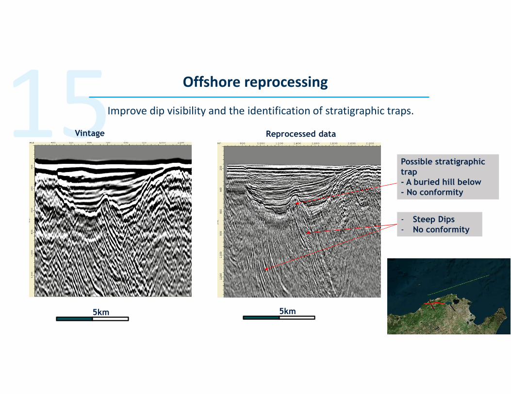
15Improve dip visibility and the identification of stratigraphic traps.
Offshore reprocessing
Vintage Reprocessed data
Possible stratigraphic
trap
- A buried hill below
- No conformity
- Steep Dips
- No conformity
5km 5km

16 Onshore reprocessing
Structural Prospect:
Nice tilted block below
the fault
With better fault definition, is there a
new prospect?
17Offshore reprocessing:
costs and timing estimates
• Total turnaround would take between 8 and 12 months.
• Selection of priority lines is to be completed in two months in order to promote the area internationally.
• Reprocessing: Highlight the importance of careful selection, the challenges of geometric reconstruction,
and the comparison of vintage to new data, zone by zone.
• A geologist must supervise the reprocessing.
• Cost estimation:o For time processing 2D marine data, the price can drop below 100$/km due to the large volume of data.
o Reprocessing about 9,000 km of lines will cost about $550K.
o The project management and supervision, with expert geological and data management advice (1.5 days/week)
will cost about $75K.
For 9000 km 2D lines

18Onshore reprocessing cost and timing estimates for 1,500 km 2D
lines
• Total turnaround between four and six months
• Possible selection of priority lines to be completed in two months, to promote the
area internationally
• Reprocessing: in a CFT, highlight the importance of statics, of careful and iterative
velocity picking, and the challenges of geometry reconstruction.
• Geological supervision of processing required
• Cost estimation:• For 1500km of foothills land data, the price range can be large: in a CFT prices between
250$/km and 1000$/km could be received. High-end contractors might charge 100$/km for
the geometry only.
• A reprocessing cost of 300k$ can be considered for a budget to get an accurate reprocessing.
Plus expertise and supervision 50k$.

19Gravimetric study on Northern onshore and offshore
Objective Rationale Preliminary results Status
- Create a complete and
coherent series of gravimetric
maps for the Northern onshore
and offshore region.
- New maps will help to
determine geological features
and determine which
exploration activities should be
considered.
- Determine if the onshore
hydrocarbon data acquired
by ONM could be used to
map deep geological
structures and tectonic
elements of the Tunisian
onshore.
- Determine if the sparse
offshore data is key to
recognize structural
features and geological
elements.
- ONM data is
excellent. It can be
used for hydrocarbon
exploration.
- New maps indicate
thick prospective
“grabens” onshore.
- New gravimetric
maps of the offshore
indicate a possible
large extension of
volcanic bodies.
- Qualitative and
quantitative
interpretations of
data, completed

20 Gravity maps
Red Crosses = OMN land
gravity stations
• 46,112 stations
• Average density of
coverage = 1stn/km2
• Bouguer density used =
2.40 g/cc
Green Lines = Repsol
airborne gravity survey
• 18,695km line data
• 1km x 4km flight lines
• Bouguer density used =
2.20 - 2.40 g/cc

21Results: qualitative maps / quantitative interpretations
• Confirmation of tertiary grabens
extensions with thickness, possible netx
prospective areas onshore.
• Existence of dense and magnetic bodies
offshore, which are probably detrimental
to exploration in the offshore.
• 3D inversion phase shows the depth of
horizons that satisfy the observed gravity
data.
• Seismic time horizons provided by ETAP
were depth converted and used to build a
3D earth model.
• The inversion permitted modification of
the Top Abiod and Base Numidian,
indicating that in this complex area data
should be used to obtain an earth model.

22Postmortem and reinterpretation of the structural geology in the
Atlas region
Objective Rationale Results Status
- Reinterpret exploration
wells (dusters and
discoveries) with the
seismic data of 15 key
wells, to be supplied by
ETAP.
- Available seismic data is
difficult to interpret.
Several scenarios are
possible.
- Propose different
geological interpretations
on prospects that have
already been drilled to
open geological
opportunities in the
remaining prospects.
- New geophysical picking
based on four domains
has been proposed.
- Particularly promising
discoveries:
• A large inverted domain
• A thick presalt series.
Completed but
needs to be used!

23 Postmortem study
Discoveries and/or
Producing fields
1) Guebiba
2) Gremda
3) Sidi El Kilani
4) Baraka
5) Cosmos
6) Douleb
7) Cap Bon
Duster wells
1) Limaguess
2) Chorbane Est
3) El Jem
4) Jemmal
5) Zeremdine
6) Alouane
7) Sidi Djedidi
8) El Haroun
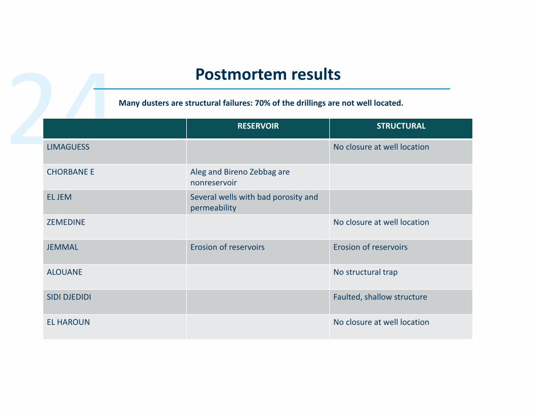
24Postmortem results
RESERVOIR STRUCTURAL
LIMAGUESS No closure at well location
CHORBANE E Aleg and Bireno Zebbag are
nonreservoir
EL JEM Several wells with bad porosity and
permeability
ZEMEDINE No closure at well location
JEMMAL Erosion of reservoirs Erosion of reservoirs
ALOUANE No structural trap
SIDI DJEDIDI Faulted, shallow structure
EL HAROUN No closure at well location
Many dusters are structural failures: 70% of the drillings are not well located.

25 Postmortem results
Cosmos
In the Hammamet Gulf and Atlas province, one can observe the inversion of grabens
oriented perpendicularly to the short direction. The Cosmos producing field is the archetype of the inverted grabens.
N-S seismic line is extracted from the 3D seismic data of the Cosmos concession.
Fully inverted normal fault
Almost not reactivated normal fault
Good prospect for future exploration
A large inverted domain

25
26Postmortem results: pre-Triassic salt prospectivity
Well-organized
reflectors below the
salt
What is the pre-Triassic salt potential in the Tunisian Atlas?
Several seismic profiles (Sidi El kilani, Cap Bon) show well-
organized reflectors below the salt to suggest sedimentary
units over deep gas-bearing reservoirs below the Triassic.
27Recommendations
Promote new data (seismic reprocessing) and interpretation methods based on the 2018 studies and key
findings to generate new prospects on the four global exploration “themes” or conditions.
Set up a special Exploration Committee to review and update the Prospect Book.
Set up a special Promotion Committee to list the permits and technology available for investors as they
become available.
Promote Tunisian exploration in key worldwide congresses.
Redefine resource acreage splits to reflect current potential: size, delimitations and duration of exploration
permits, work programs, and fiscal terms based on potential resources and the type of exploration—frontier,
deep, unconventional, or nearby.

28 Organization of ETAP (2018)
>> The Directorate of Exploration Studies (DEE) is responsible for two areas: studies related to free blocks and their promotion
to investors. Method: ETAP allows oil companies to see the data available on the free blocks requested and makes engineers,
geologists, and geophysicists available to assist them at the time of evaluation. ETAP’s role ends there. The Directorate General
of Hydrocarbons is the regulator and is responsible for all permit applications.
>> The Directorate of Exploration is responsible for two areas: tracking and managing the permits allocated to operators
(Permit Tracking Division) and the Technical Division for Exploration (geology, geophysics, and petrophysics). The Technical
Department for Geophysics plays an advisory role for all the geophysical information related to production concessions such as
determining the location of a new development well. Therefore, it does some work for the Directorate of Production
Operations.
>> The Directorate of Petroleum Services is responsible for two areas: the petroleum database and the laboratories.
Conclusion
In principle, the organizational structure is based on the two major objectives of the Directorate: promoting free permits and
tracking the allocated permits.

29Organization of ETAP (2018)
Redundancies and conflicts
• The organizational structure of ETAP leads to the separation of studies conducted in the same geographical area,
because they are conducted by two teams (two directorates). Conflicting interpretations may emerge. In
principle, this is not problematic but should be discussed and settled.
• There is a lack of external communication.
• The DEE does not benefit sufficiently from the work and results obtained by operators with the permits granted.
Limitation of concession-based exploration
• The Directorate of Exploration does not exercise authority over concession holders in terms of promoting
exploration (under fields, for example). Concessions are managed by the Central Directorate of Production.
Although ETAP is generally supportive of the desire to explore deep (or unconventional) targets in the context of
concessions, its mission is not to inventory and validate all the potential prospects of this nearby exploration.

30Organization of ETAP (2018)
• Currently, there are no postmortem studies conducted after each well project. Such studies facilitate
an understanding of the success achieved and the reasons for failure, which would pave the way for
improvement of the prospect generation and validation process.
• No single prospect sheet (Prospect Book) exists. The Prospect Book is an essential tool for internal
strategy, for communication with the Ministry of Industry, and for promotional activities targeting
international companies.
o Drafting the Prospect Book has started through the ETAP-World Bank project. An initial version
comprising 65 prospects has been finalized (December 8, 2018).
o In the future, the preparation of prospect sheets should apply to all prospect evaluations for all
types of permits (free block, allocated permits, and concessions).
• In ETAP, there is a lack of geoscience expertise.

31Proposal to reorganize ETAP
• Future organization should take the form of a matrix, with a
“geographical” area and an “expertise” area.
• The “geographical” area will be composed of three districts (North,
Center, and South to cover the current seven zones) responsible for
multidisciplinary interpretations, prospect generation, promoting
free permits, and monitoring operators.
• The “expertise” or specialty area will supervise specific
monodisciplinary studies (for a particular district), human resources
(research, hiring, training, careers, annual evaluation, etc.), and
assignment to each district based on the need for studies.

32 Proposal to reorganize ETAP)
Expertise/Geographical Area NORTH CENTER SOUTH
Geophysics
XXX
**** *** *
Geochemistry
XXXX
* * **
Structural Geology
XXXX
** *** *
Sedimentology
XXXX
* ** **
Reservoir Geology
XXXX
** **
Geoinformation
XXX
* ** ***
Operations Geology
XXXX
* *** ***
Overall Expertise
NNNN
10 16 14
The table portrays preliminary figures and personnel expertise covering three districts,
needed only for the projects listed, and subject to change depending on the studies.

33Proposal to reorganize ETAP
Decision-Making Entities
CODIR DEX: Headed by the Exploration VP and Deputy, this entity will be composed of the nine heads of the department (six
specialty areas and three districts) and will be responsible for approving studies, serving as the arbitrator between specialty
areas and districts, providing summaries of the evaluations (objectives and annual discussion with the supervisor), determining
which permits to offer to investors, and preparing an annual report for the CEO of ETAP.
These nine officials will be selected by an external consultant from the current team, based on the expertise identified and an in-
depth interview. Invitations will be issued for external applications if the expertise needed is unavailable.
EXPLORATION COMMITTEE: Four or five people will be chosen for their expertise and extensive experience in exploration and, in
particular, prospect validation. The committee will meet once a month to validate interpretations and post-mortems.
PERMIT PROMOTION COMMITTEE: This committee will be responsible for the technical and commercial presentations of free
permits, as well as participation in conferences or road shows and data rooms. It will be assisted by district officials as well as the
geoinformation official and will be attached to the CEO of ETAP. A member of DEX and the Strategy Directorate will sit on this
committee.

34Proposal for studies to generate new prospects
NORTH:
Reprocessing of all offshore and onshore seismic data followed by interpretation of these data through
mapping, infilling, and geochemical assessment of tertiary grabens
CENTER:
Alternative interpretation (inversion model) of the entire Atlas
Interpretation of the Triassic subsalt time horizons
Preparation of a cableless seismic test
Offshore satellite seeps study
SOUTH:
Summary of all unconventional data (Frasnian, Silurian) and recommendations
Summary and prospectivity of the Triassic (Jeffara)

35Proposal for access to exploration data for investors
Web:
The Geoinformation Department could improve its current electronic database by providing easier
and direct access via a link to well and seismic logs, production tests, photos/descriptions of core
samples, petrophysical data, and geochemical data.
Policy on access to information:
This policy should outline and manage confidentiality and the provision of access to recent
information in a transparent manner. In particular, it should specify confidentiality periods and the
costs to access information.
36Short-term proposals to assist with reforms and exploration
Oil and Gas Production Gap Analysis (PGA)
Gas Management Plan (GMP)

37Goal of the PGA:
To have a comprehensive document that makes it possible to understand the potential to boost the production of
developed fields
Key data:
1) Production history (flow, pressure) of oil and gas fields (of each well, if possible)
2) Water injection history (flow, pressure) of oil fields (of each well, if possible)
3) List of wells closed by field, with an indication of the reason for the closing (scales, wax, water cut, surface
lead, etc.) and production gap
4) List of recent work and results (cost, timing, additional production, etc.)
5) Map of the drainage systems used and the actual usage
6) Main constraints with attention to health, safety, and environmental (HSE) concerns in Tunisia because of sour
gas
Results:
A field-by-field list of projects under consideration, with the potential increase in production in the short term
and related investments (types and cost)

38Goal of the GMP:
To have a comprehensive document that makes it possible to understand the potential to develop gas for direct domestic use or
the generation of electricity
Key data:
1) Map and list of gas fields under production, along with the production history and projection, as well as the flows and
nature/composition of the gas
2) Map and list of oil fields with routine flaring: projected flows and composition
3) Map and listing of undeveloped gas reserves (DRO), along with the size and composition of the reserves and an estimate of
potential flows
4) Map and list of gas-prone prospects with prospective reserves and projected composition
5) List of possible oil fields where a blowdown is possible/under consideration: El Bormah
6) Network maps (gas pipes) used with their actual usage
7) Current and future demand, gas potential with takeoff amount, and place of use
8) Main constraints (Tunisia: HSE because of sour gas)
Results:
Possible increase in gas production and potential short-term use (stop flaring, connection of marginal fields to networks, etc.);
gas profiles and related long-term investments (plants, networks, drilling, etc.)