Embed Size (px)
Citation preview
T R U S T f o r N A T U R E ’ S
STATEWIDE CONSERVATION PLANf o R p R i v AT E l A N d i N v i c T o R i A
In preparing this Statewide Conservation Plan, Trust for Nature acknowledges the Traditional Custodians within Victoria, their culture and their spiritual connections to country. The Trust also recognises and acknowledges the contributions and interests of Indigenous Australians and organisations in managing and maintaining natural ecosystems and biodiversity across all Victoria’s water and land.
published by Trust for Nature
level 5/379 collins Street, Melbourne 3000
Also published on www.trustfornature.org.au
© Trust for Nature 2013
This publication is copyright. No part may be reproduced by any process except in accordance with the provisions of the Copyright Act 1968.
developed and written by doug Robinson, Kelly Arbon, Andrew cox, lauren fraser, Jen Grindrod, Richard MacNeill, Raewyn Montgomery, peter Moulton, paul peake and Nathan Wong.
printed on recycled paper.
for more information contact Trust for Nature on 1800 99 99 33 or visit: www.trustfornature.org.au
cite this report as: Trust for Nature (2013) The Statewide conservation plan for private land in victoria
front cover: private property in the Grampians under negotiation for a conservation covenant. photo: Adam Merrick

Executive summary
Background
of all states and territories in Australia, victoria is the state where private-land conservation is arguably the most important. victoria has the highest proportion (62%) of private land of any state and territory (Bennett 1995) and is the most highly altered in terms of ecological health and vegetation loss (NlWRA 2002). its private land habitat, furthermore, continues to be lost and degraded at a rate of more than 4000 ha per year – a rate of loss that exceeds the gains being achieved through protection and management (dSE 2008). increased protection and management of ecosystems and species found on private land is therefore critical to the conservation of victoria’s natural heritage and biodiversity.
As a conservation body with statutory functions relating to the protection of habitats, native plants and animals on private land, Trust for Nature has an important role to play in biodiversity conservation in victoria. The preparation of a Statewide conservation plan was a key task identified in Trust for Nature’s 2011–2016 Strategic plan and builds on earlier reviews, landscape plans, bioregional conservation strategies and regional strategies prepared by the Trust. To enhance its effectiveness as a conservation organisation, however, Trust for Nature recognised the need for a clearly defined set of conservation priorities and priority areas at a statewide scale. The Statewide conservation plan provides that baseline.
This Statewide conservation plan is designed to complement other major planning approaches that relate to victoria’s natural resources, particularly the Regional catchment Strategies developed by victoria’s 10 catchment Management Authorities (cMAs) and the biodiversity planning undertaken by the department of Sustainability and Environment (dSE).
for the first time, the conservation plan gives Trust for Nature a statewide perspective of the value of private land for the conservation of terrestrial ecosystems, aquatic ecosystems and threatened species in victoria. A key outcome of the conservation plan has been the identification of 12 focal landscapes across victoria. These landscapes were assessed as capable of making the greatest contribution towards nature conservation on private land.
Recognising there has not been a statewide conservation planning process focussing solely on the protection of ecosystems and species on victorian private land, the conservation plan aims to provide a unique, private-land perspective.
delivery of private-land conservation is particularly dependent on partnerships with landowners as well as on partnerships with other organisations. it is anticipated that this conservation plan will accordingly facilitate delivery of whole–of–landscape conservation outcomes.
Conservation priorities for action
The Statewide conservation plan has identified three broad classes of biodiversity asset:
• terrestrialecosystemsonprivateland
• aquaticecosystemsonprivateland,and
• threatenedspeciesonprivateland.
To guide the protection of these assets, the conservation plan presents six objectives with the aim to:
• improvetheviabilityofecosystemsandspeciesatalandscape scale
• improveprotectionoftheleastprotectedecosystemsand threatened communities
• improveprotectionofsignificantaquaticandcoastalecosystems
• improveprotectionofthreatenedspecies• enhanceandprotectlandscapeconnectivity,and• enhanceandprotecthabitatquality
data analysis undertaken in relation to these six conservation objectives identified that:
• two-thirdsofVictoria’secosystemsareunder-represented in existing protected areas
• nearly90%ofallunder-representedecosystemsoccuron private land
• three-quartersofallnativevegetationfoundonprivateland is under-represented in victoria’s protected areas
• thenationaltargetofrepresenting80%ofbioregionalecosystems in protected areas is not met in nearly half of victoria’s bioregions (iBRA subregions)
• privatelandhabitatrepresentsasubstantialcomponentof all aquatic and coastal ecosystems in victoria
• morethan200speciesofthreatenedfloraandfaunaarepriorities for conservation on private land, of which one-third are listed as threatened nationally, and
• 12focallandscapes(Figure1),coveringapproximately12% of victoria’s private land area, represent high priority opportunities for improving the viability of terrestrial ecosystems and species on private land. Most of these focal landscapes overlap with priority areas for biodiversity investment identified by cMAs, dSE and the Australian Government, providing opportunities to strengthen partnerships at each of these levels.
TRUST foR NATURE 1
2 Statewide ConServation Plan foR pRivATE lANd iN vicToRiA
Figure. 1. Location of focal landscapes on private land
in concert with other data, these findings have many implications for Trust for Nature in relation to its future conservation programs on private land. in particular, they indicate that:
• asdocumentedbyDSE(2008),netlossofnativevegetation is occurring on private land as the current rate of loss is greater than the gain in protected areas or in areas being restored. The conservation plan identifies significant opportunities to address this net loss and contribute to the victorian Government’s ongoing commitment to the environment by adding to and enhancing the protected area estate on private land
• despitealonghistoryofsystematicland-useplanningfor public land, victoria’s ecosystems are still poorly represented in protected areas overall
• nearlyalloftheunder-representedecosystemsinvictoria occur on private land such that, across much of the state, protection of habitat on private land will be the main way of increasing the National Reserve System (NRS)
• theidentificationof12focallandscapesforprivate-land conservation across victoria establishes a clear framework for setting priorities and developing collaborative projects with partners to complement the strategic planning and projects already undertaken by other NRM organisations
• additionalconservationactionswillstillbeneedtobeundertaken by Trust for Nature in other parts of the state to help protect important biodiversity assets not included in the focal landscapes, in particular aquatic ecosystem assets, smaller patches of under-represented ecosystems and populations of some threatened species, and
• ongoingandstrongerrelationshipswithprivatelandowners are critical if the Trust is to increase protection of habitat and threatened species on private land.
0 25 50 100 kilometres
TRUST foR NATURE 3
A vision for the future
Trust for Nature’s 2011–2016 Strategic plan identified seven strategic directions to guide the organisation’s business over the next five years:
1. implement strategic landscape-wide conservation2. Build and innovate private-land conservation practice3. Respond to climate change4. intensify the role of partnerships5. Build private and philanthropic sector investment and
commitment to conservation6. Build and modernise organisational capacity, and7. inspire and engage with the community.
The preparation of the Statewide conservation plan was recognised as a pivotal action that would provide an over-arching, statewide, scientific framework to inform the Trust’s activities in line with the seven strategic directions. The next steps are to use this conservation plan to inform the Trust’s planning and implementation of conservation programs in every region and across the state. in future, the assessments outlined in the conservation plan should be integrated with more detailed analysis of potential risks and opportunities in relation to localities, ecosystems and species. This will help the Trust to further articulate and prioritise its conservation actions.
Trust for Nature’s vision is that:
Within two decades, protecting native vegetation and wildlife on private land will be recognised and valued as a central part of mainstream Australian environmental practice, just as water and energy conservation is today. There will be a shared expectation and responsibility among communities, landowners and governments that, just as national and state parks are protected, so too significant natural areas on privately owned land should be protected.
The preparation of the Statewide conservation plan is an important step towards making Trust for Nature’s vision a reality.
4 Statewide ConServation Plan foR pRivATE lANd iN vicToRiA
Contents
EXEcUTivE SUMMARY ......................................................................................................................................................1
coNTENTS ....................................................................................................................................................................... 4
liST of AcRoNYMS ......................................................................................................................................................... 6
AcKNoWlEdGEMENTS .....................................................................................................................................................7
iNTRodUcTioN ................................................................................................................................................................ 8
HoW To USE THiS docUMENT ....................................................................................................................................... 9
PART 1: THE PLANNING CONTEXT ............................................................................................................................. 10
1.1 Biodiversity and land tenure in victoria ................................................................................................................ 10
1.1.1 overview ........................................................................................................................................................ 10
1.1.2 land tenure and the bioregions .......................................................................................................................11
1.1.3 land tenure and ecosystems ......................................................................................................................... 12
1.1.4 catchment Management Authority regions and regional divisions of the Trust ................................................ 14
1.1.5 land tenure and the social and economic perspective ................................................................................... 15
1.2 Current threats to victoria’s biodiversity ............................................................................................................... 16
1.2.1 overview ........................................................................................................................................................ 16
1.2.2 land clearance ...............................................................................................................................................17
1.2.3 degradation of aquatic ecosystems ............................................................................................................... 18
1.2.4 Species extinctions ........................................................................................................................................ 18
1.2.5 Habitat fragmentation .................................................................................................................................... 19
1.2.6 plant and animal invasions ............................................................................................................................. 19
1.2.7 population growth .......................................................................................................................................... 20
1.2.8 climate change .............................................................................................................................................. 20
1.3 trust for nature in victoria .....................................................................................................................................21
1.3.1 Aims and activities of the Trust ........................................................................................................................21
1.3.2 The Trust’s protection of private land ...............................................................................................................21
1.3.3 Trust for Nature’s work in a social landscape context ..................................................................................... 23
1.3.4 Trust for Nature’s work in a bioregional context .............................................................................................. 24
1.3.5 Trust for Nature’s work in an ecosystem context ............................................................................................ 25
1.3.6TheTrust’sprotectionoffloraandfauna ..........................................................................................................27
PART 2: THE PLANNING APPROACH.......................................................................................................................... 28
2.1 The need for a statewide conservation plan for private land ................................................................................... 28
2.2 overall aims of the conservation plan .................................................................................................................... 28
2.3 overview of the planning approach ........................................................................................................................ 29
2.4 The conservation plan’s biodiversity assets and objectives .....................................................................................31
TRUST foR NATURE 5
PART 3: THE STATEWIDE CONSERVATION PLAN: RATIONALES, ASSESSMENTS AND PRIORITIES FOR ACTION .................................................................................................................................................33
3.1 Conservation objective 1: improve the viability of ecosystems and species at a landscape scale ..................... 33
3.1.1 Rationale for the objective .............................................................................................................................. 33
3.1.2 Key findings for the objective.......................................................................................................................... 33
3.1.3 descriptions of the focal landscapes .............................................................................................................. 36
3.1.4 The focal landscapes as priorities for conservation ......................................................................................... 40
3.2 Conservation objective 2: improve protection of the least protected ecosystems and threatened communities .................................................................................................................................41
3.2.1 Rationale for the objective ...............................................................................................................................41
3.2.2 Key findings for the objective...........................................................................................................................41
3.2.3 Assessment of the comprehensiveness of current ecosystem protection ........................................................41
3.2.4 Assessment of the Adequacy of current ecosystem protection ...................................................................... 44
3.2.5 Assessment of the Representativeness of current ecosystem protection ........................................................ 50
3.2.6 Assessment of the protection levels of iBRA bioregions and subregions......................................................... 53
3.2.7 Assessment of the protection of threatened ecological communities .............................................................. 54
3.2.8 priorities for improving ecosystem protection ................................................................................................. 58
3.3 Conservation objective 3: improve protection of significant aquatic and coastal ecosystems ............................62
3.3.1 Rationale for the objective .............................................................................................................................. 62
3.3.2 Key findings for the objective.......................................................................................................................... 62
3.3.3 Assessment of the protection of wetland ecosystems .................................................................................... 62
3.3.4 Assessment of the protection of riparian ecosystems ..................................................................................... 68
3.3.5 Assessment of the protection of coastal ecosystems ..................................................................................... 70
3.3.6 priorities for improving protection of significant aquatic and coastal ecosystems .............................................71
3.4 Conservation objective 4: improve protection of threatened species .................................................................. 74
3.4.1 Rationale for the objective .............................................................................................................................. 74
3.4.2 Key findings for the objective.......................................................................................................................... 74
3.4.3 priority fauna .................................................................................................................................................. 74
3.4.4Priorityflora .................................................................................................................................................... 80
3.4.5 priorities for improving protection of threatened species ................................................................................. 84
3.5 Conservation objective 5: enhance and protect landscape connectivity ............................................................ 86
3.5.1 Rationale for the objective .............................................................................................................................. 86
3.5.2 Key findings for the objective.......................................................................................................................... 86
3.5.3 improving landscape context of remnant vegetation ....................................................................................... 86
3.5.4 improving landscape connectivity ................................................................................................................... 89
3.5.5 priorities for enhancing and protecting landscape connectivity ........................................................................91
6 Statewide ConServation Plan foR pRivATE lANd iN vicToRiA
3.6 Conservation objective 6: enhance and protect habitat quality ........................................................................... 94
3.6.1 Rationale for the objective .............................................................................................................................. 94
3.6.2 Key findings for the objective.......................................................................................................................... 94
3.6.3 Assessment of habitat quality ......................................................................................................................... 94
3.6.4 priorities for enhancing and protecting habitat quality ..................................................................................... 96
3.7 Setting priorities for conservation action ...............................................................................................................97
3.7.1 The risk of habitat loss and modification without intervention ...........................................................................97
3.7.2 The need for conservation effectiveness ......................................................................................................... 98
3.7.3 The impacts of climate change....................................................................................................................... 99
3.7.4 Social and economic factors .......................................................................................................................... 99
3.7.5 complementary conservation programs and opportunities ........................................................................... 100
3.8 Future use and review of the Statewide Conservation Plan ................................................................................102
GLOSSARY ................................................................................................................................................................... 103
REFERENCES .............................................................................................................................................................. 105
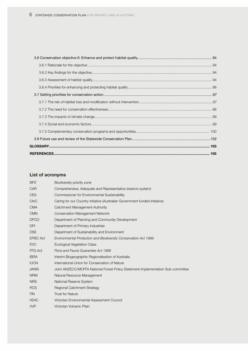
List of acronyms
BpZ Biodiversity priority zone
cAR comprehensive, Adequate and Representative (reserve system)
cES commissioner for Environmental Sustainability
cfoc caring for our country initiative (Australian Government funded initiative)
cMA catchment Management Authority
cMN conservation Management Network
dpcd department of planning and community development
dpi department of primary industries
dSE department of Sustainability and Environment
EpBc Act Environmental Protection and Biodiversity Conservation Act 1999
Evc Ecological vegetation class
ffG Act Flora and Fauna Guarantee Act 1988
iBRA interim Biogeographic Regionalisation of Australia
iUcN international Union for conservation of Nature
JANiS Joint ANZEcc/McffA National forest policy Statement implementation Sub-committee
NRM Natural Resource Management
NRS National Reserve System
RcS Regional catchment Strategy
TfN Trust for Nature
vEAc victorian Environmental Assessment council
vvp victorian volcanic plain
TRUST foR NATURE 7
Acknowledgements
preparation of the Statewide conservation plan was only possible because of a generous bequest from dr Marion Wanliss. Trust for Nature acknowledges its deep gratitude for that support.
The conservation plan was prepared by a project team consisting of doug Robinson, Kelly Arbon, Andrew cox, lauren fraser, Jen Grindrod, Richard MacNeill, Raewyn Montgomery, peter Moulton, paul peake and Nathan Wong.
The project team wishes to thank all Trust staff for their support, enthusiasm and patience with regards to the project, and particularly acknowledges the oversight provided by victoria Marles, Greg Bowers, Andrew Burns, peter Moulton and fiona Smith.
The Technical Reference Group made constructive and insightful comments and guidance. The Group was comprised of: Neil Barr, department of primary industries, Social Researcher; Sarah Bekessy, RMiT University, School of Global Studies, Social Science & planning; Jim Blackney, Trust for Nature, North East Regional Manager; James fitzsimons, The Nature conservancy, director of conservation; Ascelin Gordon, RMiT University, School of Global Studies, Social Science & planning; Rod Gowans, Trust for Nature, Trustee; John Morgan, la Trobe University, department of Botany; paul peake, victorian Environment Assessment council, project Manager; Tony varcoe, parks victoria, Manager, Research and Management Effectiveness; craig Whiteford, department of Sustainability and Environment, Senior Manager.
Bush Heritage Australia gave important support for the project and facilitated the secondment of Jen Grindrod and Richard MacNeill.
The victorian Government provided much in-kind support. The victorian Environmental Assessment council generously supported the project through allowing a short-term secondment by paul peake to help develop the project plan, and through invaluable subsequent assistance and data provision. The department of Sustainability and Environment (dSE) and the department of primary industries (dpi) provided spatial data and other important information, and we thank particularly Heather Anderson, fiona coates, Janet Holmes, Sarina loo, Kim lowe, Alicia lucas, Graeme Newell, david parkes, Hayley Rokhar, Matt White and paul Wilson for their assistance. Birdlife Australia staff also provided generous assistance with provision of data and expert advice.
Earlier versions of the conservation plan were greatly improved by the constructive editing of Astrid Judge and Tiffany inglis. Their assistance is greatly appreciated.
8 Statewide ConServation Plan foR pRivATE lANd iN vicToRiA
Introduction
of all states and territories in Australia, victoria is the state where private-land conservation is arguably the most important. victoria contains the highest proportion of private land (62%) of any state and territory (Bennett 1995). it is also the most highly altered state or territory in terms of ecological health and vegetation loss (NlWRA 2002). victoria’s private land habitat, furthermore, continues to be lost and degraded at an estimated rate of more than 4000 ha per year – a rate of loss that was calculated in 2008 as exceeding the gains being achieved through protection and management (dSE 2008). increased protection and management of ecosystems and species found on private land is therefore critical to the conservation of victoria’s natural heritage and biodiversity.
As a conservation body with statutory functions relating to the protection of habitats, native plants and animals on private land, Trust for Nature has a critical role to play in biodiversity conservation in victoria in partnership with private landowners. Since its establishment as a statutory conservation body in 1972 under the Victorian Conservation Trust Act 1972, the Trust has permanently protected more than 90 000 ha of native habitat through voluntary conservation covenants with private landowners, land purchase, donations of land, the Revolving fund and purchase and subsequent transfer of land on behalf of the State Government.
Notable achievements for conservation during its history have included:
• permanentprotectionofmorethan47000haofnatural habitat under 1100 conservation covenants in partnership with private landowners
• permanentprotectionofNedsCornerStation,thelargestprivate property in victoria
• permanentprotectionofmorethan6000haofPlainsGrassland in the victorian Riverina through a mixture of conservation covenants, land purchase and partnership purchases with the department of Sustainability and Environment (dSE)
• establishmentofthefirstRevolvingFundforconservation properties in Australia
• establishmentofthefirstConservationManagementNetwork (cMN) in victoria, on the Gippsland plains
• establishmentoffouradditionalCMNs,inpartnershipwithother organisations, and collaboration in a further six
• protectionofsignificantareasoftheinternationallyrecognised Anglesea Heathlands
• purchaseofChurchillIslandandsubsequenttransfertothe crown
• purchaseofpartsofGreensBushontheMorningtonpeninsula, with subsequent transfer to the crown, and
• establishmentofincometaxconcessionsforcovenantedproperties, in partnership with other conservation organisations.
Until now, Trust for Nature’s conservation program has been guided by its statutory conservation objectives, a regionally structured conservation approach and by policy directions set by governments and Natural Resource Management (NRM) bodies. To improve its effectiveness as a conservation organisation, however, Trust for Nature recognised the need for a clearly defined set of conservation priorities and priority areas at a statewide scale. To do this, the Trust identified the task of developing a Statewide conservation plan as a key action in its 2011–2016 Strategic plan (Trust for Nature 2011).
Recognising there has not been a statewide conservation planning process focussing solely on the protection of ecosystems and species on victorian private land, the Statewide conservation plan (the conservation plan) aims to provide a unique, private-land perspective to complement the Regional catchment Strategies developed in 2012 by each of victoria’s 10 catchment Management Authorities (cMAs) and the biodiversity planning undertaken by dSE.
for the first time, the conservation plan gives Trust for Nature a statewide perspective of the value of private land for conservation of terrestrial ecosystems, aquatic ecosystems and threatened species in victoria. Given victoria’s high proportion of private land (Bennett 1995) and the increasing recognition of the importance of protected areas on private land for nature conservation (dudley 2008; fitzsimons & Wescott 2008a, 2008b; NRMMc 2009; coffey et al. 2011), the preparation of a strategic, statewide conservation plan for private land in victoria is timely.
TRUST foR NATURE 9
How to use this document
Part 1 of this document outlines the context in which the Statewide conservation plan for private land in victoria has been prepared. it provides information about victoria’s biodiversity assets and considers them in relation to land tenure. it outlines key threats to biodiversity across the state and it concludes by describing the Trust’s role in protecting victoria’s biodiversity.
Part 2 of this document outlines the approach taken to formulate the conservation plan. it defines the biodiversity assets to be targeted for conservation on private land, the six conservation objectives developed for the conservation plan and the criteria and methods used to analyse data for each objective. More detailed information about the methods is provided in Appendix 2.
Part 3 contains the major findings of the conservation plan for each of the conservation objectives. This part of the conservation plan outlines:
• therationaleforselectingeachconservationobjective• asummaryofkeyfindingsrelatingtothedataanalyses
undertaken for each objective • detailedassessmentsforeachoftheassessmentcriteria
developed for each conservation objective, and• prioritiesforconservationactiononprivatelandfor
each objective, including, where possible, particular locations where conservation action on private land should be targeted. These priorities are summarised for convenience at the start of each section.
finally, part 3 also considers broader principles for setting priorities for conservation action, and outlines the next stages for application of the conservation plan.
The appendices referred to in this document can be found on the Trust for Nature website at: www.trustfornature.org.au
10 Statewide ConServation Plan foR pRivATE lANd iN vicToRiA
PART 1: The planning context
1.1 Biodiversity and land tenure in Victoria
1.1.1 overview
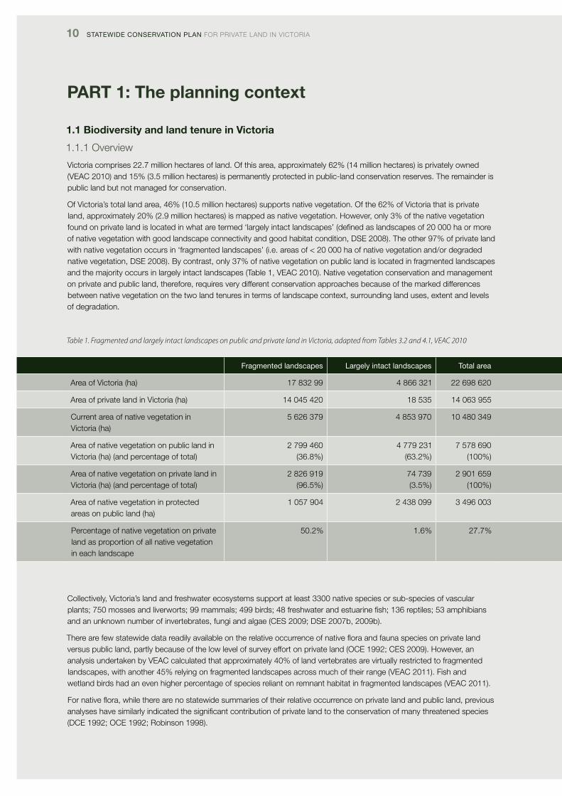
victoria comprises 22.7 million hectares of land. of this area, approximately 62% (14 million hectares) is privately owned (vEAc 2010) and 15% (3.5 million hectares) is permanently protected in public-land conservation reserves. The remainder is public land but not managed for conservation.
of victoria’s total land area, 46% (10.5 million hectares) supports native vegetation. of the 62% of victoria that is private land, approximately 20% (2.9 million hectares) is mapped as native vegetation. However, only 3% of the native vegetation found on private land is located in what are termed ‘largely intact landscapes’ (defined as landscapes of 20 000 ha or more of native vegetation with good landscape connectivity and good habitat condition, dSE 2008). The other 97% of private land with native vegetation occurs in ‘fragmented landscapes’ (i.e. areas of < 20 000 ha of native vegetation and/or degraded native vegetation, dSE 2008). By contrast, only 37% of native vegetation on public land is located in fragmented landscapes and the majority occurs in largely intact landscapes (Table 1, vEAc 2010). Native vegetation conservation and management on private and public land, therefore, requires very different conservation approaches because of the marked differences between native vegetation on the two land tenures in terms of landscape context, surrounding land uses, extent and levels of degradation.
Fragmented landscapes largely intact landscapes total area
Area of victoria (ha) 17 832 99 4 866 321 22 698 620
Area of private land in victoria (ha) 14 045 420 18 535 14 063 955
current area of native vegetation in victoria (ha)
5 626 379 4 853 970 10 480 349
Area of native vegetation on public land in victoria (ha) (and percentage of total)
2 799 460 (36.8%)
4 779 231 (63.2%)
7 578 690 (100%)
Area of native vegetation on private land in victoria (ha) (and percentage of total)
2 826 919 (96.5%)
74 739 (3.5%)
2 901 659 (100%)
Area of native vegetation in protected areas on public land (ha)
1 057 904 2 438 099 3 496 003
percentage of native vegetation on private land as proportion of all native vegetation in each landscape
50.2% 1.6% 27.7%
collectively, victoria’s land and freshwater ecosystems support at least 3300 native species or sub-species of vascular plants; 750 mosses and liverworts; 99 mammals; 499 birds; 48 freshwater and estuarine fish; 136 reptiles; 53 amphibians and an unknown number of invertebrates, fungi and algae (cES 2009; dSE 2007b, 2009b).
Therearefewstatewidedatareadilyavailableontherelativeoccurrenceofnativefloraandfaunaspeciesonprivatelandversus public land, partly because of the low level of survey effort on private land (ocE 1992; cES 2009). However, an analysis undertaken by vEAc calculated that approximately 40% of land vertebrates are virtually restricted to fragmented landscapes, with another 45% relying on fragmented landscapes across much of their range (vEAc 2011). fish and wetland birds had an even higher percentage of species reliant on remnant habitat in fragmented landscapes (vEAc 2011).
Fornativeflora,whiletherearenostatewidesummariesoftheirrelativeoccurrenceonprivatelandandpublicland,previousanalyses have similarly indicated the significant contribution of private land to the conservation of many threatened species (dcE 1992; ocE 1992; Robinson 1998).
Table 1. Fragmented and largely intact landscapes on public and private land in Victoria, adapted from Tables 3.2 and 4.1, VEAC 2010
TRUST foR NATURE 11
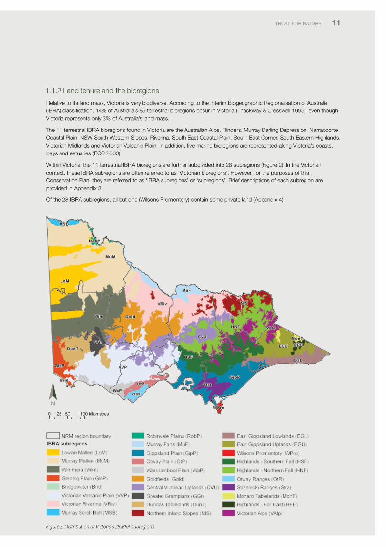
1.1.2 land tenure and the bioregions
Relative to its land mass, victoria is very biodiverse. According to the interim Biogeographic Regionalisation of Australia (iBRA) classification, 14% of Australia’s 85 terrestrial bioregions occur in victoria (Thackway & cresswell 1995), even though victoria represents only 3% of Australia’s land mass.
The 11 terrestrial iBRA bioregions found in victoria are the Australian Alps, flinders, Murray darling depression, Narracoorte coastal plain, NSW South Western Slopes, Riverina, South East coastal plain, South East corner, South Eastern Highlands, victorian Midlands and victorian volcanic plain. in addition, five marine bioregions are represented along victoria’s coasts, bays and estuaries (Ecc 2000).
Within victoria, the 11 terrestrial iBRA bioregions are further subdivided into 28 subregions (figure 2). in the victorian context, these iBRA subregions are often referred to as ‘victorian bioregions’. However, for the purposes of this conservation plan, they are referred to as ‘iBRA subregions’ or ‘subregions’. Brief descriptions of each subregion are provided in Appendix 3.
of the 28 iBRA subregions, all but one (Wilsons promontory) contain some private land (Appendix 4).
0 25 50 100 kilometres
Figure 2. Distribution of Victoria’s 28 IBRA subregions
Fragmented landscapes largely intact landscapes total area
Area of victoria (ha) 17 832 99 4 866 321 22 698 620
Area of private land in victoria (ha) 14 045 420 18 535 14 063 955
current area of native vegetation in victoria (ha)
5 626 379 4 853 970 10 480 349
Area of native vegetation on public land in victoria (ha) (and percentage of total)
2 799 460 (36.8%)
4 779 231 (63.2%)
7 578 690 (100%)
Area of native vegetation on private land in victoria (ha) (and percentage of total)
2 826 919 (96.5%)
74 739 (3.5%)
2 901 659 (100%)
Area of native vegetation in protected areas on public land (ha)
1 057 904 2 438 099 3 496 003
percentage of native vegetation on private land as proportion of all native vegetation in each landscape
50.2% 1.6% 27.7%
12 Statewide ConServation Plan foR pRivATE lANd iN vicToRiA
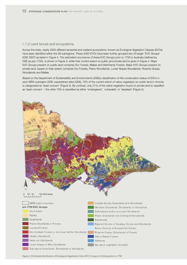
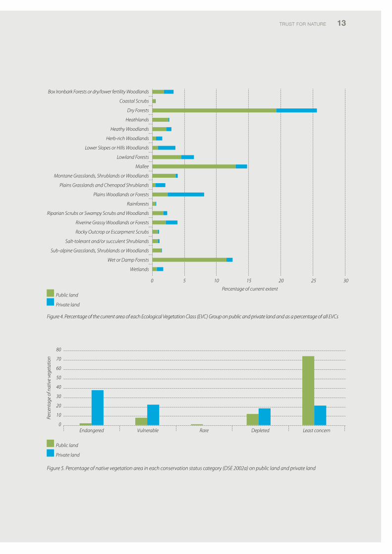
1.1.3 land tenure and ecosystems
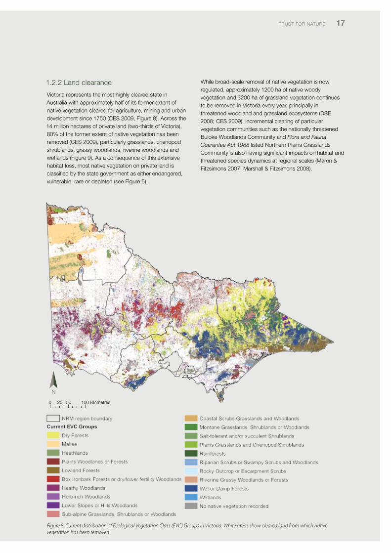
Across the state, nearly 2000 different terrestrial and wetland ecosystems, known as Ecological vegetation classes (Evcs), have been identified within the 28 subregions. These 2000 Evcs have been further grouped into 20 larger ‘Evc Groups’ (dSE 2007) as listed in figure 4. The estimated occurrence of these Evc Groups prior to 1750 in Australia (defined by dSE as pre-1750), is shown in figure 3, while their current extent on public and private land is given in figure 4. Major Evc Groups present on public land comprise dry forests, Mallee and Wet/damp forests. Major Evc Groups present on private land, based on their extent, comprise dry forests, plains Woodlands, lower Slopes Woodlands, Riverine Grassy Woodlands and Mallee.
Based on the department of Sustainability and Environment’s (dSEs) classification of the conservation status of Evcs in each iBRA subregion (dSE unpublished data 2008), 75% of the current extent of native vegetation on public land in victoria is categorised as ‘least concern’ (figure 5). By contrast, only 21% of the native vegetation found on private land is classified as ‘least concern’ – the other 79% is classified as either ‘endangered’, ‘vulnerable’ or ‘depleted’ (figure 5).
0 25 50 100 kilometres
Figure 3. Estimated distribution of Ecological Vegetation Class (EVC) Groups in Victoria prior to 1750
TRUST foR NATURE 13
Figure 4. Percentage of the current area of each Ecological Vegetation Class (EVC) Group on public and private land and as a percentage of all EVCs
Box Ironbark Forests or dry/lower fertility Woodlands
Coastal Scrubs
Dry Forests
Heathlands
Heathy Woodlands
Herb-rich Woodlands
Lower Slopes or Hills Woodlands
Lowland Forests
Mallee
Montane Grasslands, Shrublands or Woodlands
Plains Grasslands and Chenopod Shrublands
Plains Woodlands or Forests
Rainforests
Riparian Scrubs or Swampy Scrubs and Woodlands
Riverine Grassy Woodlands or Forests
Rocky Outcrop or Escarpment Scrubs
Salt-tolerant and/or succulent Shrublands
Sub-alpine Grasslands, Shrublands or Woodlands
Wet or Damp Forests
Wetlands
0 5 10 15 20 25 30
Percentage of current extent Public land
Private land
Figure 5. Percentage of native vegetation area in each conservation status category (DSE 2002a) on public land and private land
80
70
60
50
40
30
20
10
0
Perc
enta
ge o
f nat
ive
vege
tatio
n
Endangered Vulnerable Rare Depleted Least concern
Public land
Private land
14 Statewide ConServation Plan foR pRivATE lANd iN vicToRiA
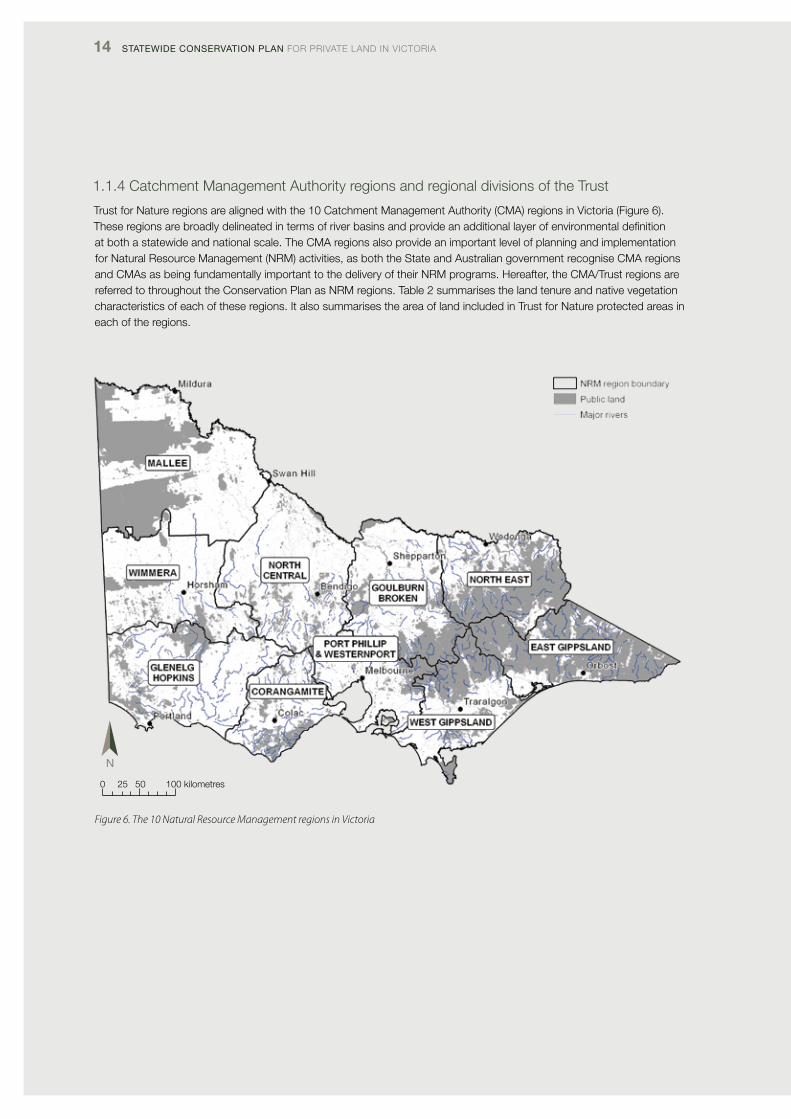
1.1.4 catchment Management Authority regions and regional divisions of the Trust
Trust for Nature regions are aligned with the 10 catchment Management Authority (cMA) regions in victoria (figure 6). These regions are broadly delineated in terms of river basins and provide an additional layer of environmental definition at both a statewide and national scale. The cMA regions also provide an important level of planning and implementation for Natural Resource Management (NRM) activities, as both the State and Australian government recognise cMA regions and cMAs as being fundamentally important to the delivery of their NRM programs. Hereafter, the cMA/Trust regions are referred to throughout the conservation plan as NRM regions. Table 2 summarises the land tenure and native vegetation characteristics of each of these regions. it also summarises the area of land included in Trust for Nature protected areas in each of the regions.
0 25 50 100 kilometres
Figure 6. The 10 Natural Resource Management regions in Victoria
TRUST foR NATURE 15
Table 2. Land tenure, native vegetation and Trust for Nature protected areas for Victoria’s 10 Natural Resource Management (NRM) regions
nrM region total area (ha)
Percentage of
private land
Percentage
of native
vegetation
Percentage of
private land with
native vegetation
trust for nature
protected area (ha)
corangamite 1 334 666 79 27 16 2 451
East Gippsland 2 081 643 18 87 48 3 929
Glenelg Hopkins 2 673 094 83 27 16 3 541
Goulburn Broken 2 407 076 71 45 29 4 890
Mallee 3 930 693 58 47 11 32 044
North central 2 963 502 87 33 23 10 087
North East 1 978 917 39 75 39 4 296
port phillip & Westernport 1 278 381 77 44 24 3 289
West Gippsland 1 715 845 54 56 23 4 505
Wimmera 2 344 685 84 29 18 12 744
total 22 708 503 81 776
1.1.5 land tenure and the social and economic perspective
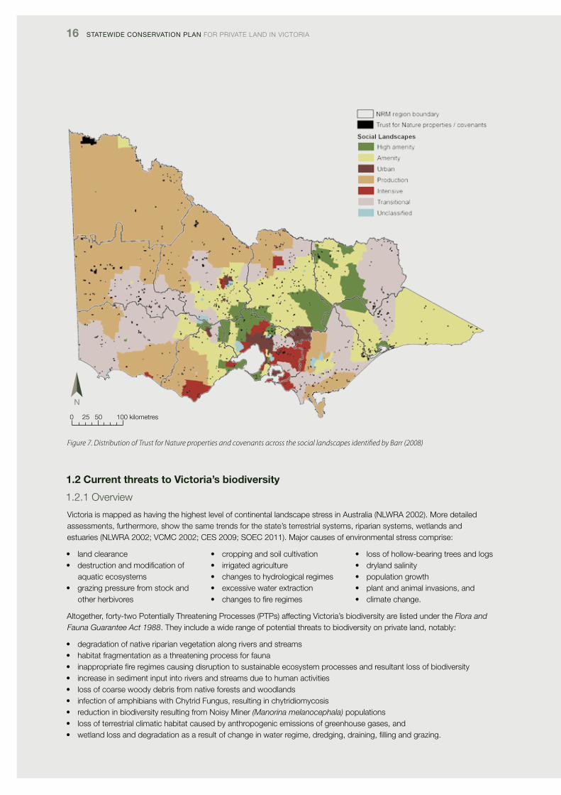
victoria has undergone a large transformation in demography, work patterns and land use over the last 50 years and is continuing to change rapidly (Barr 2005, 2008; dpcd 2009). changes that are especially significant in the context of rural victoria and private-land conservation include the following:
• rurallandisincreasinglybeingpurchasedandownedbynon-locals.Theseareasconsequentlyhavehighlandvalues,resulting in a declining number of land transactions
• rurallandwithincommutingdistanceoflargeurbancentresisincreasinglybeingsubdividedintosmallerrurallotsandpurchased for lifestyle rather than agricultural production (Barr 2009)
• areasremaininginfarmproductionareunderincreasingpressuretoimproveproductivity(Barr2009)• landownersareincreasinglypurchasingmarginalfarminglandoutsideamenityareasbutinareasofhighbiodiversity
value solely for the benefit of conservation (Barr 2009). Areas that fall into this category include Wedderburn and little desert
• inthefuture,farmsareexpectedtocontinuetogetlargerandthenumberoffarmbusinesseswillfurthershrink (Barr 2009), and
• competitionforscarcewaterinirrigationareaswillintensifyacrossVictoria,therebyimpactingontheextentofviableirrigation businesses.
Based on all of these changing patterns in land use and demographics, Barr (2008) has classified victoria into six social landscapes (figure 7), recognising that some formerly agricultural landscapes are now mostly occupied for amenity reasons or have shifted their agricultural focus (Barr 2009). The six landscapes are named as follows:
• highamenity• amenity• production• transitional
• intensive• urban,and• unclassified.
This approach has been further refined by some cMAs. for example, Goulburn Broken cMA has recognised that different landscapes need different conservation approaches; it has accordingly classified its catchments into social-ecological systems and developed different conservation strategies for each (GBcMA 2012).
16 Statewide ConServation Plan foR pRivATE lANd iN vicToRiA
Figure 7. Distribution of Trust for Nature properties and covenants across the social landscapes identified by Barr (2008)
1.2 Current threats to Victoria’s biodiversity
1.2.1 overview
victoria is mapped as having the highest level of continental landscape stress in Australia (NlWRA 2002). More detailed assessments, furthermore, show the same trends for the state’s terrestrial systems, riparian systems, wetlands and estuaries (NlWRA 2002; vcMc 2002; cES 2009; SoEc 2011). Major causes of environmental stress comprise:
• landclearance• destructionandmodificationof
aquatic ecosystems• grazingpressurefromstockand
other herbivores
• croppingandsoilcultivation• irrigatedagriculture• changestohydrologicalregimes• excessivewaterextraction• changestofireregimes
• lossofhollow-bearingtreesandlogs• drylandsalinity• populationgrowth• plantandanimalinvasions,and• climatechange.
Altogether, forty-two potentially Threatening processes (pTps) affecting victoria’s biodiversity are listed under the Flora and Fauna Guarantee Act 1988. They include a wide range of potential threats to biodiversity on private land, notably:
• degradationofnativeriparianvegetationalongriversandstreams• habitatfragmentationasathreateningprocessforfauna• inappropriatefireregimescausingdisruptiontosustainableecosystemprocessesandresultantlossofbiodiversity• increaseinsedimentinputintoriversandstreamsduetohumanactivities• lossofcoarsewoodydebrisfromnativeforestsandwoodlands• infectionofamphibianswithChytridFungus,resultinginchytridiomycosis• reductioninbiodiversityresultingfromNoisyMiner(Manorina melanocephala) populations • lossofterrestrialclimatichabitatcausedbyanthropogenicemissionsofgreenhousegases,and• wetlandlossanddegradationasaresultofchangeinwaterregime,dredging,draining,fillingandgrazing.
0 25 50 100 kilometres
TRUST foR NATURE 17
1.2.2 land clearance
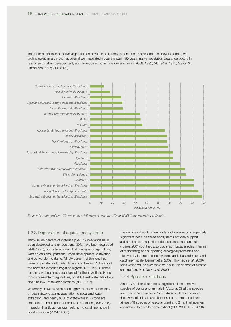
victoria represents the most highly cleared state in Australia with approximately half of its former extent of native vegetation cleared for agriculture, mining and urban development since 1750 (cES 2009, figure 8). Across the 14 million hectares of private land (two-thirds of victoria), 80% of the former extent of native vegetation has been removed (cES 2009), particularly grasslands, chenopod shrublands, grassy woodlands, riverine woodlands and wetlands (figure 9). As a consequence of this extensive habitat loss, most native vegetation on private land is classified by the state government as either endangered, vulnerable, rare or depleted (see figure 5).
While broad-scale removal of native vegetation is now regulated, approximately 1200 ha of native woody vegetation and 3200 ha of grassland vegetation continues to be removed in victoria every year, principally in threatened woodland and grassland ecosystems (dSE 2008; cES 2009). incremental clearing of particular vegetation communities such as the nationally threatened Buloke Woodlands community and Flora and Fauna Guarantee Act 1988 listed Northern plains Grasslands community is also having significant impacts on habitat and threatened species dynamics at regional scales (Maron & fitzsimons 2007; Marshall & fitzsimons 2008).
Figure 8. Current distribution of Ecological Vegetation Class (EVC) Groups in Victoria. White areas show cleared land from which native vegetation has been removed
0 25 50 100 kilometres
18 Statewide ConServation Plan foR pRivATE lANd iN vicToRiA
This incremental loss of native vegetation on private land is likely to continue as new land uses develop and new technologies emerge. As has been shown repeatedly over the past 150 years, native vegetation clearance occurs in response to urban development, and development of agriculture and mining (ocE 1992; Muir et al. 1995; Maron & fitzsimons 2007; cES 2009).
1.2.3 degradation of aquatic ecosystems
Thirty-seven percent of victoria’s pre-1750 wetlands have been destroyed and an additional 30% have been degraded (NRE 1997), primarily as a result of drainage for agriculture, water diversions upstream, urban development, cultivation and conversion to dams. Ninety percent of this loss has been on private land, particularly in south-west victoria and the northern victorian irrigation regions (NRE 1997). These losses have been most substantial for those wetland types most accessible to agriculture, notably freshwater Meadows and Shallow freshwater Marshes (NRE 1997).
Waterways have likewise been highly modified, particularly through stock-grazing, vegetation removal and water extraction, and nearly 80% of waterways in victoria are estimated to be in poor or moderate condition (dSE 2005). in predominantly agricultural regions, no catchments are in good condition (vcMc 2002).
The decline in health of wetlands and waterways is especially significant because these ecosystems not only support a distinct suite of aquatic or riparian plants and animals (Tzaros 2001) but they also play much broader roles in terms of maintaining and supporting ecological processes and biodiversity in terrestrial ecosystems and at a landscape and catchment scale (Bennett et al 2009; Thomson et al. 2009), roles which will be ever more crucial in the context of climate change (e.g. Mac Nally et al. 2009).
1.2.4 Species extinctions
Since 1750 there has been a significant loss of native species of plants and animals in victoria. of all the species recorded in victoria since 1750, 44% of plants and more than 30% of animals are either extinct or threatened, with at least 49 species of vascular plant and 24 animal species considered to have become extinct (cES 2009; dSE 2010).
Plains Grasslands and Chenopod Shrublands
Plains Woodlands or Forests
Herb-rich Woodlands
Riparian Scrubs or Swampy Scrubs and Woodlands
Lower Slopes or Hills Woodlands
Riverine Grassy Woodlands or Forests
Mallee
Wetlands
Coastal Scrubs Grasslands and Woodlands
Heathy Woodlands
Riparian Forests or Woodlands
Lowland Forests
Box Ironbark Forests or dry/lower fertility Woodlands
Dry Forests
Heathlands
Salt-tolerant and/or succulent Shrublands
Wet or Damp Forests
Rainforests
Montane Grasslands, Shrublands or Woodlands
Rocky Outcrop or Escarpment Scrubs
Sub-alpine Grasslands, Shrublands or Woodlands
0 10 20 30 40 50 60 70 80 90 100
Percentage remaining
Figure 9. Percentage of pre-1750 extent of each Ecological Vegetation Group (EVC) Group remaining in Victoria
TRUST foR NATURE 19
At the regional and local scale, extinctions and declines have been even more widespread, particularly in the more highly cleared bioregions and in grasslands and woodlands (Robinson 1991; ocE 1992; cES 2009). for woodland birds across victoria, for example, there have been many regional extinctions, leading to decreases in many species’ overall range and abundance (Robinson 1993, 1994; lunt & Bennett 2000). Across the state, 15% of native mammals have disappeared (dSE data 2007), especially from the highly cleared Riverina and victorian volcanic plains bioregions (ocE 1992).
1.2.5 Habitat fragmentation
As a consequence of extensive habitat loss in victoria, nearly 80% of victoria is now classified as consisting of ‘fragmented landscapes’ (Table 1). The ecological consequences of habitat fragmentation include a:
• decreaseinthenumberofspecies• lossofspecies• changeinspeciescomposition• decreaseinpopulationsizeofthefloraandfauna
species found in the remnants• impactonbreedingsuccessandsurvival,and• disruptionofecologicalprocesses,includingpollination,
seeddispersalandwaterflow(Saunders et al. 1991; Bennett 1999; Bennett et al. 2009).
1.2.6 plant and animal invasions
pest plants and animals are a major threat to victoria’s natural environment as well as its agricultural economy. This includes both established pest species and new or potential invasive species that have the capacity to further degrade terrestrial, aquatic and marine ecosystems (dunlop & Brown 2008; dpi 2010).
predation by introduced animals is ranked as the second most important threat to threatened fauna, while environmental weed invasion is ranked as the most significant process affecting threatened native plants (cES 2009). Altogether, exotic plant species now represent about 30%oftheVictorianflora,with1282speciesconsiderednaturalised, and a further 214 species considered to be in the process of becoming naturalised (cES 2009).
The various impacts of introduced pest animals and weeds on victoria’s biodiversity are formally acknowledged and described through the Flora and Fauna Guarantee Act 1988. They include:
• introductionandspreadofSpartinainVictorianestuarineenvironments
• introductionoflivefishintowatersoutsidetheirnaturalrange within a victorian river catchment after 1770
• invasionofnativevegetationbyBlackberry(Rubus fruticosus L. agg.)
• invasionofnativevegetationby‘environmentalweeds’
• invasionofnativevegetationcommunitiesbyTall Wheat-grass (Lophopyrum ponticum)
• lossofbiodiversityinnativeantpopulationsandpotentialecosystem integrity following invasion by Argentine Ants (Linepithema humile)
• predationofnativewildlifebytheCat(Felis catus)• predationofnativewildlifebytheintroducedRedFox
(Vulpes vulpes)• reductioninbiodiversityofnativevegetationbySambar
(Cervus unicolor)
• reductioninbiomassandbiodiversityofnativevegetation through grazing by the Rabbit (Oryctolagus cuniculus)
• theintroductionandspreadoftheLargeEarthBumblebee (Bombus terrestris) into victorian terrestrial environments
• spreadoftheplantPittosporum undulatum in areas outside its natural distribution, and
• threatstonativefloraandfaunaarisingfromtheferalhoneybee (Apis mellifera) nesting in hollows and using otherfloralresources.
Eight other impacts, listed as ‘key threatening processes’ under the Environment Protection and Biodiversity Conservation Act 1999 are also relevant to pest plant and animal invasions in victoria, including:
• competitionandlanddegradationcausedbyunmanaged goats
• diebackcausedbytheroot-rotfungus(Phytophthora cinnamomi)
• predation,habitatdegradation,competitionanddiseasetransmission caused by feral pigs, and
• lossanddegradationofnativeplantandanimalhabitatcaused by invasion of escaped garden plants, including aquatic plants.
20 Statewide ConServation Plan foR pRivATE lANd iN vicToRiA
Apart from the impact of invasive introduced species on native plants and animals, an emerging management issue for conservation practitioners is the impact of invasive native species on biodiversity. causes for concern in victoria include:
• impactsofover-abundantmacropodpopulationsonnative vegetation structure and composition (National parks Service 1990)
• impactsoftheBellMiner (Manorina melanophrys), Noisy Miner (Manorina melanocephala) and pied currawong (Strepera graculina) on native bird communities (loyn et al. 1983; loyn 1987; Grey et al. 1997, 1998; fulton & ford 2001; parsons et al. 2006)
• invasionofcoastalheathlandsandscrubsbyCoastalTea-tree (Leptospermum laevigatum) (Bennett 1994), and
• invasionofeucalyptforestsbySweetPittosporum(Pittosporum undulatum).
1.2.7 population growth
victoria’s population is continuing to grow. it is expected to increase from 5.6 million to 6.9 million by 2031 (dpcd 2012). in this period, the regional population is projected to grow to 2 million. Areas expected to experience the most rapid growth include areas near Melbourne, major regional cities and their hinterlands, and areas with significant coastal or aquatic amenity values (dpcd 2012).
increasing urban and peri-urban expansion around Melbourne and around regional centres is having major effects on biodiversity in the port phillip & Westernport and corangamite regions and all along the coast (cES 2009; dpcd 2012). These impacts will become more severe as urbanisation and peri-urban development continue.
1.2.8 climate change
climate change is having major impacts on biodiversity in victoria, and this will continue into the future. predicted effects of climate change in victoria include more days over 35°c, less annual rainfall, fewer frosts, more days of extremefiredangerandmoreextremefloodsanddroughts.These changes are already being shown or are predicted to impactonbiodiversitythroughreducedwaterflowsinriversand wetlands, reduced groundwater recharge, increases in weeds and pest animals, and increases in fire intensity and frequency (http://www.climatechange.vic.gov.au).
A major study examining the implications of climate change for the National Reserve System has described the magnitude of environmental change predicted under continuing climate change. The composition of plant species in vegetation communities may change by more than 50% by 2070. Major structural shifts in vegetation are also predicted to occur over the same time period, with a move from woodlands to open woodlands, mallee to chenopod shrublands and tall open forests to open forests (dunlop et al. 2012a). The synthesis also highlights
how climate change will exacerbate the current impacts of habitat fragmentation, habitat degradation, inappropriate fire regimes, extreme climatic events and invasive species on existing ecosystems, plants and animals by increasing the overall level of environmental stress (e.g. reduced moisture availability leading to reduced food resources and decreased populations (Mac Nally et al. 2009).
At the ecosystem scale, climate change is already affecting or is predicted to affect most animal and plant communities by altering the availability of moisture, food resources and suitable habitat (Brereton et al. 1995; olsen & Weston 2004; chambers et al. 2005; dunlop et al. 2012a). in turn, these changes are considered to be the driving cause of declines in the abundance of some fauna groups because of, for instance: loss of suitable habitat and subsequent contractions in range or population size; increased mortality as a result of loss of food; reduced productivity because of food shortages; or increased competition for resources by some species expanding their range in response to changed climatic conditions (olsen & Weston 2004; chambers et al. 2005; Mac Nally et al. 2009).
Recommended conservation management directions in the context of climate change comprise:
• ongoinghabitatprotectionandexpansionoftheNationalReserve System
• protectionofecologicalrefugia(thatis,areasthatarelikely to retain habitat and climatic conditions suitable for a species whose range is predicted to contract in the context of climate change)
• increasedfocusonpestplantandanimalmanagement,especially new and emerging species, and
• appropriatefiremanagementand/orprevention(Dunlop& Brown 2008).
TRUST foR NATURE 21
1.3 Trust for Nature in Victoria
1.3.1 Aims and activities of the Trust
Since 1972, the Trust has permanently protected more than 90 000 ha of private land habitat in victoria. The primary mechanisms used to achieve its objective include:
• conservationcovenants• landacquisition:includinglandpurchasewith
government support, land donations and land purchase with support from community appeals (e.g. Anglesea Heathlands, Mt Elephant)
• RevolvingFund:thepurchaseoflandusingtheTrust’s Revolving fund, with the purchased land then protected with a conservation covenant and resold to conservation-minded landowners
• eco-markets:brokeringfinancialincentivesforoffsetagreements to permanently protect native vegetation and/or threatened species/communities
• stewardshipprogram:ongoingassistancetolandownerswith a conservation covenant to manage their properties for conservation
• conservationpartnerships:participationinconservationpartnerships and the facilitation of conservation management networks with the aim of increasing the extent of permanently protected areas on private land in strategic landscapes, and
• policydevelopmentandtechnicalassistance(Todd1997; Whelan 1997; Edwards & Traill 2002; cowell & Williams 2007).
1.3.2 The Trust’s protection of private land
Most private land protected by the Trust either directly, through ownership of conservation properties, or in partnership with landowners entering into voluntary covenants on part of their land, is formally recognised as part of Australia’s protected areas system (fitzsimons 2006). These protected areas contribute to both the National Reserve System (NRS) and the global network of
protected areas as defined by the international Union for conservation of Nature (iUcN) (commonwealth of Australia 1999; fitzsimons 2006; dudley 2008; NRMMc 2009). This recognition of the Trust’s covenants and properties as part of the NRS distinguishes the Trust’s conservation work from most other forms of on-title conservation agreements administered in victoria (fitzsimons 2006). it increases the value of Trust covenants and properties as mechanisms for delivering and maintaining conservation outcomes on private land working together with willing landowners. The only other recognised category of on-title agreement that contributes to the NRS in victoria is indigenous protected Areas. indigenous protected Areas are currently recognised on five properties measuring a total of 3900 ha in the south-west of the state.
The contribution of the Trust’s covenanting and land ownership programs towards the NRS is especially significant in the victorian context, because two-thirds of the land in victoria is privately owned and most of that private land is cleared. There are consequently few opportunities for increasing protected areas, simply by changing the tenure of existing public land (NRMMc 2009; coffey et al. 2011). increasing the NRS through permanent protection programs on private land in concert with private landowners is therefore a key conservation tool in victoria.
At June 2012, the Trust had in place 1110 registered conservation covenants over 47 012 ha of private land. it also owned and managed 46 conservation properties (figure 10) covering 36 162 ha (Table 3). over the lifetime of the covenanting program, the Trust has registered on average about 43 conservation covenants each year, totalling approximately 1900 ha. As shown in figure 11, the Trust’s contribution towards protection of areas on private land has also increased steadily in the last decade highlighting the significance of the Trust’s contribution towards increasing the NRS on private land.
Conservation tool number of properties area permanently protected (ha)
conservation covenants* 1 189 50 860
land purchase of conservation properties 46 36 162
Revolving fund purchases 5 1 188
land transfers to crown 65 6 745
total 1 305 93 885
* Includes 33 Revolving Fund properties (4 233 ha)
Table 3. Summary of Trust for Nature’s conservation outcomes through its permanent protection tools, from 1972 to June 2012
22 Statewide ConServation Plan foR pRivATE lANd iN vicToRiA
Figure 10. Distribution of Trust for Nature covenants and conservation properties as at 30 June 2012
Figure 11. Cumulative growth of protected areas on private land in Victoria, between 2000–2012, through Trust for Nature’s protection programs (with and without the purchase of Neds Corner Station - a 30 000 ha property in the Mallee)
80 000
70 000
60 000
50 000
40 000
30 000
20 000
10 000
0
Area
(ha)
2000–01 2001–02 2002–03 2003–04 2004–05 2005–06 2006–07 2007–08 2008–09 2009–10 2010–11 2011–12
Trust for Nature protected areas with Neds Corner Station
Trust for Nature protected areas without Neds Corner Station
0 25 50 100 kilometres
TRUST foR NATURE 23
1.3.3 Trust for Nature’s work in a social landscape context
Trust for Nature’s covenants and properties occur across all of victoria’s six social landscapes (figures 12 and 13), with the majority of the Trust’s protected area located in production landscapes (notably due to the contribution of two properties: Neds corner Station and Wanderers plain). Even when only covenanted land is considered, the highest percentage of covenanted land is also in production landscapes (figure 12). The number of covenants in production landscapes has continued to increase over the past 10 years (figure 13) as has the proportion of covenants in amenity and transitional landscapes. By contrast, the proportion of covenants in urban and intensive landscapes has decreased (figure 13).
50 000
45 000
40 000
35 000
30 000
25 000
20 000
15 000
10 000
5 000
0
Area
(ha)
Properties
Covenants
Urban High amenity Amenity Transitional Production Intensive
Figure 13. Percentage of covenants in different social landscapes over time
35
30
25
20
15
10
5
0
Perc
enta
ge o
f cov
enan
ts
Urban High amenity Amenity Transitional Production Intensive
Figure 12. Area of covenants and conservation properties in each social landscape
1987–2000
2000–2011
24 Statewide ConServation Plan foR pRivATE lANd iN vicToRiA
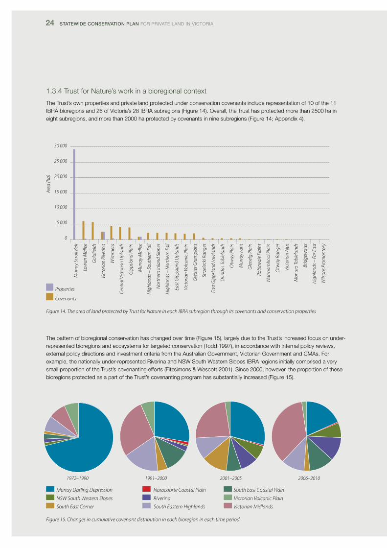
1.3.4 Trust for Nature’s work in a bioregional context
The Trust’s own properties and private land protected under conservation covenants include representation of 10 of the 11 iBRA bioregions and 26 of victoria’s 28 iBRA subregions (figure 14). overall, the Trust has protected more than 2500 ha in eight subregions, and more than 2000 ha protected by covenants in nine subregions (figure 14; Appendix 4).
Mur
ray
Scro
ll Be
lt
Low
an M
alle
e
Gol
dfiel
ds
Vict
oria
n Ri
verin
a
Wim
mer
a
Cent
ral V
icto
rian
Upl
ands
Gip
psla
nd P
lain
Mur
ray
Mal
lee
Hig
hlan
ds –
Sou
ther
n Fa
ll
Nor
ther
n In
land
Slo
pes
Hig
hlan
ds –
Nor
ther
n Fa
ll
East
Gip
psla
nd U
plan
ds
Vict
oria
n Vo
lcan
ic P
lain
Gre
ater
Gra
mpi
ans
Strz
elec
ki R
ange
s
East
Gip
psla
nd L
owla
nds
Dun
das T
able
land
s
Otw
ay P
lain
Mur
ray
Fans
Gle
nelg
Pla
in
Robi
nval
e Pl
ains
War
rnam
bool
Pla
in
Otw
ay R
ange
s
Vict
oria
n Al
ps
Mon
aro
Tabl
elan
ds
Brid
gew
ater
Hig
hlan
ds –
Far
Eas
t
Wils
ons P
rom
onto
ry
30 000
25 000
20 000
15 000
10 000
5 000
0
Area
(ha)
The pattern of bioregional conservation has changed over time (figure 15), largely due to the Trust’s increased focus on under-represented bioregions and ecosystems for targeted conservation (Todd 1997), in accordance with internal policy reviews, external policy directions and investment criteria from the Australian Government, victorian Government and cMAs. for example, the nationally under-represented Riverina and NSW South Western Slopes iBRA regions initially comprised a very small proportion of the Trust’s covenanting efforts (fitzsimons & Wescott 2001). Since 2000, however, the proportion of these bioregions protected as a part of the Trust’s covenanting program has substantially increased (figure 15).
1972–1990 1991–2000 2001–2005 2006–2010
Properties
Covenants
Figure 14. The area of land protected by Trust for Nature in each IBRA subregion through its covenants and conservation properties
Figure 15. Changes in cumulative covenant distribution in each bioregion in each time period
Murray Darling Depression Naracoorte Coastal Plain South East Coastal Plain
NSW South Western Slopes Riverina Victorian Volcanic Plain
South East Corner South Eastern Highlands Victorian Midlands
TRUST foR NATURE 25
1.3.5. Trust for Nature’s work in an ecosystem context
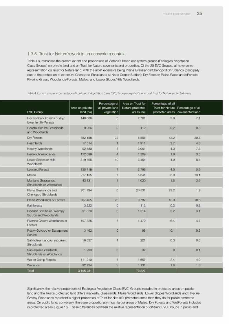
Table 4 summarises the current extent and proportions of victoria’s broad ecosystem groups (Ecological vegetation class Groups) on private land and on Trust for Nature covenants and properties. of the 20 Evc Groups, all have some representation on Trust for Nature land, with the most extensive being plains Grasslands/chenopod Shrublands (principally due to the protection of extensive chenopod Shrublands at Neds corner Station); dry forests; plains Woodlands/forests; Riverine Grassy Woodlands/forests; Mallee; and lower Slopes/Hills Woodlands.
evC Group area on private
land (ha)
Percentage of all private land
vegetation
area on trust for nature protected
areas (ha)
Percentage of all trust for nature protected areas
Percentage of all covenanted land
Box ironbark forests or dry/ lower fertility forests
148 086 5 2 761 3.9 7.1
coastal Scrubs Grasslands and Woodlands
9 966 0 112 0.2 0.3
dry forests 682 158 22 8 556 12.2 20.7
Heathlands 17 514 1 1 911 2.7 4.3
Heathy Woodlands 92 580 3 3 051 4.3 7.3
Herb-rich Woodlands 112 099 4 1 369 1.9 3.0
lower Slopes or Hills Woodlands
319 466 10 3 454 4.9 8.6
lowland forests 135 718 4 2 798 4.0 5.9
Mallee 217 155 7 5 641 8.0 13.1
Montane Grasslands, Shrublands or Woodlands
43 131 1 1 020 1.5 2.6
plains Grasslands and chenopod Shrublands
201 794 6 20 531 29.2 1.9
plains Woodlands or forests 607 455 20 9 787 13.9 10.6
Rainforests 3 222 0 113 0.2 0.3
Riparian Scrubs or Swampy Scrubs and Woodlands
91 870 3 1 514 2.2 3.1
Riverine Grassy Woodlands or forests
197 325 6 4 470 6.4 4.7
Rocky outcrop or Escarpment Scrubs
3 462 0 98 0.1 0.3
Salt-tolerant and/or succulent Shrublands
16 837 1 221 0.3 0.6
Sub-alpine Grasslands, Shrublands or Woodlands
1 999 0 32 0 0.1
Wet or damp forests 111 210 4 1 657 2.4 4.0
Wetlands 92 234 3 1 131 1.6 1.6
total 3 105 281 70 227
Significantly, the relative proportions of Ecological vegetation class (Evc) Groups included in protected areas on public land and the Trust’s protected land differs markedly. Grasslands, plains Woodlands, lower Slopes Woodlands and Riverine Grassy Woodlands represent a higher proportion of Trust for Nature’s protected areas than they do for public protected areas. on public land, conversely, there are proportionally much larger areas of Mallee, dry forests and Wetforests included in protected areas (figure 16). These differences between the relative representation of different Evc Groups in public and
Table 4. Current area and percentage of Ecological Vegetation Class (EVC) Groups on private land and Trust for Nature protected areas
26 Statewide ConServation Plan foR pRivATE lANd iN vicToRiA
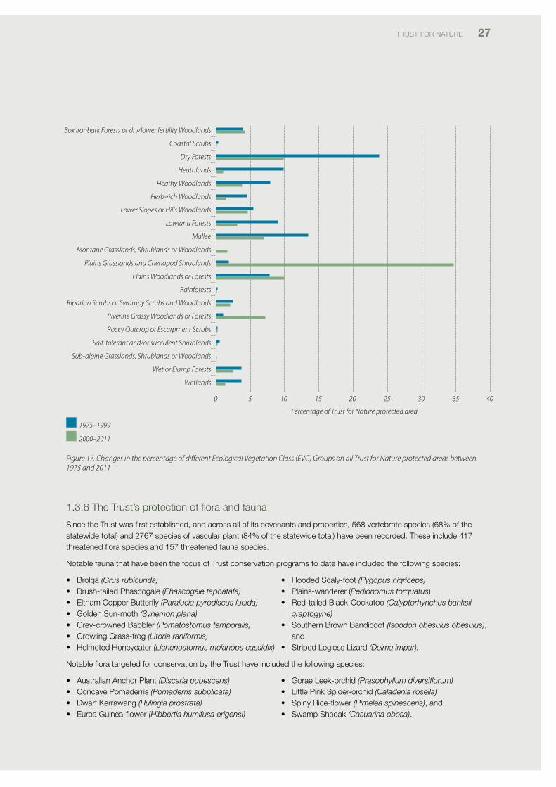
privateprotectedareashavebeenparticularlyinfluencedbychangesinthefocusoftheTrust’sprotectionprogramoverthe last decade, in response to internal policy reviews (Todd 1997; Morgan & clarke 2008), external policy changes and investment criteria set by the Australian Government, victorian Government and Natural Resource Management (NRM) bodies.Asaresultoftheseinfluences,theproportionofPlainsGrasslands/ChenopodShrublands,PlainsWoodlandsorforests and Riverine Grassy Woodlands protected on Trust for Nature properties and on covenanted land has increased substantially in the past decade (figure 17), principally due to targeted NRS purchases of properties containing these under-represented ecosystems at Neds corner Station, in the Riverina bioregion and on the Gippsland plains. By comparison, the relative proportion of dry forests, Heathy Woodlands, lowland forests and Mallee has decreased over the past decade (figure 17).
Box Ironbark Forests or dry/lower fertility Woodlands
Coastal Scrubs
Dry Forests
Heathlands
Heathy Woodlands
Herb-rich Woodlands
Lower Slopes or Hills Woodlands
Lowland Forests
Mallee
Montane Grasslands, Shrublands or Woodlands
Plains Grasslands and Chenopod Shrublands
Plains Woodlands or Forests
Rainforests
Riparian Scrubs or Swampy Scrubs and Woodlands
Riverine Grassy Woodlands or Forests
Rocky Outcrop or Escarpment Scrubs
Salt-tolerant and/or succulent Shrublands
Sub-alpine Grasslands, Shrublands or Woodlands
Wet or Damp Forests
Wetlands
0 5 10 15 20 25 30 35
Percentage of area
Trust for Nature protected area
Public land
Figure 16. Percentage of protected areas on public land and in Trust for Nature protected areas in each Ecological Vegetation Class (EVC) Group. Note that the public land protected areas do not include the most recent additions to the reserve system as a result of the VEAC Red Gum investigation (VEAC 2008)
TRUST foR NATURE 27
Figure 17. Changes in the percentage of different Ecological Vegetation Class (EVC) Groups on all Trust for Nature protected areas between 1975 and 2011
Box Ironbark Forests or dry/lower fertility Woodlands
Coastal Scrubs
Dry Forests
Heathlands
Heathy Woodlands
Herb-rich Woodlands
Lower Slopes or Hills Woodlands
Lowland Forests
Mallee
Montane Grasslands, Shrublands or Woodlands
Plains Grasslands and Chenopod Shrublands
Plains Woodlands or Forests
Rainforests
Riparian Scrubs or Swampy Scrubs and Woodlands
Riverine Grassy Woodlands or Forests
Rocky Outcrop or Escarpment Scrubs
Salt-tolerant and/or succulent Shrublands
Sub-alpine Grasslands, Shrublands or Woodlands
Wet or Damp Forests
Wetlands
0 5 10 15 20 25 30 40
Percentage of Trust for Nature protected area
35
1.3.6TheTrust’sprotectionoffloraandfauna
Since the Trust was first established, and across all of its covenants and properties, 568 vertebrate species (68% of the statewide total) and 2767 species of vascular plant (84% of the statewide total) have been recorded. These include 417 threatenedfloraspeciesand157threatenedfaunaspecies.
Notable fauna that have been the focus of Trust conservation programs to date have included the following species:
• Brolga(Grus rubicunda)• Brush-tailedPhascogale(Phascogale tapoatafa)• ElthamCopperButterfly (Paralucia pyrodiscus lucida)• GoldenSun-moth(Synemon plana)• Grey-crownedBabbler(Pomatostomus temporalis)• GrowlingGrass-frog(Litoria raniformis)• HelmetedHoneyeater(Lichenostomus melanops cassidix)
• HoodedScaly-foot (Pygopus nigriceps)• Plains-wanderer(Pedionomus torquatus)• Red-tailedBlack-Cockatoo(Calyptorhynchus banksii
graptogyne)• SouthernBrownBandicoot (Isoodon obesulus obesulus),
and• StripedLeglessLizard(Delma impar).
NotablefloratargetedforconservationbytheTrusthaveincludedthefollowingspecies:
• AustralianAnchorPlant(Discaria pubescens)• ConcavePomaderris(Pomaderris subplicata)• DwarfKerrawang (Rulingia prostrata)• EuroaGuinea-flower(Hibbertia humifusa erigensI)
• GoraeLeek-orchid (Prasophyllum diversiflorum)• LittlePinkSpider-orchid (Caladenia rosella)• SpinyRice-flower(Pimelea spinescens), and• SwampSheoak(Casuarina obesa).
1975–1999
2000–2011
28 Statewide ConServation Plan foR pRivATE lANd iN vicToRiA
PART 2: The planning approach
2.1 The need for a statewide conservation plan for private land
To date, Trust for Nature’s conservation approach has been guided by its statutory conservation objectives and by regional priorities established through strategic biodiversity policy initiatives developed by Trust for Nature, the victorian Government, the Australian Government and catchment Management Authorities (cMAs). from the Trust’s perspective, notable planning exercises previously undertaken in the regions have included: botanical surveys of significant woodland and grassland properties to help identify priority sites for protection (e.g. Ward 1998); development of local government and landcare actions plans for nature conservation in some regions (e.g. Raven 1997); development of regionally based landscape conservation plans (palmer & Westbrooke 2011) and development of regional conservation strategies in 2006. Based on these earlier approaches and a review paper by la Trobe University researchers (Morgan & clarke 2008), Trust for Nature’s 2011–2016 Strategic plan, recognised the need for a Statewide conservation plan to inform the Trust’s conservation program, organisational planning and operations across the state. in particular, the Strategic plan identified the need for a Statewide conservation plan as an essential first step towards the development of a unified, strategic conservation program.
in recommending the need for a discrete Statewide conservation plan, Trust for Nature fully recognised victoria’s comprehensive history of systematic conservation planning, beginning with the establishment of the land conservation council in 1970 to investigate and make recommendations on public land use. Building on this public-land planning framework, the victorian Government and its Natural Resource Management (NRM) agencies subsequently initiated systematic conservation planning across public and private land at the catchment, bioregional and local landscape scale (NRE 1997; platt & lowe 2002; vcMc 2007). The State Government also undertook broad ecosystem-based planning for public land in relation to waterways (lcc 1991), box-ironbark forests and woodlands (Ecc 2001), River Red Gum forests (vEAc 2008) and remnant native vegetation (vEAc 2010, 2011). concurrently, following the signing of the National forest policy Statement in 1992 by the Australian Government and states and territories, systematic processes and programs were developed for the establishment of a comprehensive, Adequate and Representative (cAR) National Reserve System (NRS) (JANiS 1997; commonwealth of Australia 1999). This policy initiative subsequently informed public land use investigations, forest planning and ecosystem protection strategies delivered by the department of Sustainability and Environment (NRE 1997).
Notwithstanding this strong conservation-planning background in victoria, there has never been a statewide conservation-planning process focussing solely on the protection of ecosystems and species on private land. further, there has never been a comprehensive statewide investigation analysing priorities for increasing the NRS specifically in relation to private land, although dSE and the Trust have both undertaken regional assessments of private land to identify areas to target for permanent protection (e.g. Muir 1996; Ward 1998). There have also been many important reviews of statewide gaps in ecosystem representation and species representation in protected areas either across all land tenures and/or for public land (frankerberg 1971; frood & calder 1987; lcc 1988; Mcdougall et al. 1993; fitzsimons 1999; Traill & porter 2001; Sattler & Glanznig 2006; Sattler & Taylor 2008; Taylor et al. 2011a). Accordingly, this plan aimed to provide a unique, private-land perspective on conservation priorities for victoria.
Because of Trust for Nature’s statutory functions as a covenanting authority, land acquisition body and as a charitable land trust, the starting point for the conservation plan was taken as the Trust’s potential to contribute to the NRS through permanent protection of habitat on private land. However, it was also recognised that protected areas on private land are only part of the solution in terms of effective private-land conservation in largely cleared landscapes (Bennett 1995, 1999; NRMMc 2005; dSE 2009a; vEAc 2011). The plan’s scope therefore, encompasses all conservation opportunities on private land in victoria.
2.2 Overall aims of the Conservation Plan
The aims of the Statewide conservation plan are to:
• establishastrategic,statewideapproachtotheTrust’sconservation activities on private land, focussing on protecting priority ecosystems and species
• developanintegratedapproachtobiodiversityconservation across the Trust’s 10 operational regions, and
• developastrategicapproachtonatureconservationon private land that complements the conservation measures being undertaken or funded by partner agencies on public and private land.
TRUST foR NATURE 29
four guiding principles were considered as part of the process of developing the conservation plan. They were that:
1. the conservation plan’s approach and recommendations should be consistent with the Trust’s statutory objectives under the Victorian Conservation Trust Act 1972 and the strategic directions set by its 2011–2016 Strategic plan (Trust for Nature 2011)
2. as a statutory conservation organisation, the Trust’s conservation approach should be consistent with the state government’s and Australian Government’s approaches to biodiversity conservation, and use the same conservation planning approaches and data sources as far as possible
3. the conservation plan should recognise that most of the conservation activity undertaken by the Trust is done in partnership with other organisations and funded primarily by the Australian Government, State Government and through the cMAs, each of which have their own set of biodiversity priorities and objectives. The conservation plan’s objectives should therefore be consistent with those organisations’ own objectives, and
4. the strategic focus of regional Trust conservation programs should be considered in the development of the conservation plan.
2.3 Overview of the planning approach
The approach taken to develop the Statewide conservation plan was based on the victorian department of Sustainability and Environment’s (dSE’s) recommended conservation-planning method for the development of cMA Regional catchment Strategies, which was firstly to define the biodiversity assets to be targeted for conservation and then identify priority locations to help conserve those assets (dSE 2011a). The conservation planning approach was also informed by the open Standards for the practice of conservation framework – an internationally standardised framework for conservation planning (cMp 2007), which is being applied by various conservation organisations and agencies in Australia.
The conservation plan was developed by the Trust’s conservation Science team, with assistance from a Technical Reference Group, which consisted of representatives from universities, conservation agencies, conservation organisations and the Trust. The Trust’s conservation committee also provided input into the development of the plan.
figure 18 summarises the process undertaken to develop the conservation plan. in brief, the conservation plan aimed to identify:
• asetofbiodiversityassetsasprioritiesforconservationon private land
• conservationobjective(s)foreachoftheassets• prioritylocationsonprivatelandforthebiodiversity
assets, and• priorityareastoundertakeactiontohelpconservethe
biodiversity assets, based on their distribution in relation to various social and economic factors affecting the future viability of the assets, both positively (such as landowner rates of participation in conservation activities) and negatively (such as the risk of habitat loss through clearing).
The process used to define the conservation objectives and to assess the data related to the assets followed a framework developed for Bush Heritage Australia (Mackey et al. 2010), which entailed:
• developmentofasetofconservationobjectivesinrelation to each biodiversity asset
• developmentofassessmentcriteriaforeachoftheobjectives, and
• selectionofappropriatedatasourcestoundertaketheassessments.
Using the selected assessment criteria and associated data, the Trust then generated sets of information relating to each of the biodiversity assets and objectives.
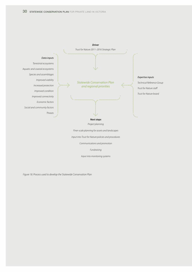
30 Statewide ConServation Plan foR pRivATE lANd iN vicToRiA
Figure 18. Process used to develop the Statewide Conservation Plan
Data inputs
Terrestrial ecosystems
Aquatic and coastal ecosystems
Species and assemblages
Improved viability
Increased protection
Improved condition
Improved connectivity
Economic factors
Social and community factors
Threats
Driver
Trust for Nature 2011–2016 Strategic Plan
Next steps
Project planning
Finer-scale planning for assets and landscapes
Input into Trust for Nature policies and procedures
Communications and promotion
Fundraising
Input into monitoring systems
Statewide Conservation Planand regional priorities
Expertise inputs
Technical Reference Group
Trust for Nature staff
Trust for Nature board
TRUST foR NATURE 31
2.4 The Conservation Plan’s biodiversity assets and objectives
identification of the conservation plan’s biodiversity assets and objectives was based on the following inputs:
• theVictorian Conservation Trust Act 1972• the2011–2016TrustforNatureStrategicPlan(Trustfor
Nature 2011)• advicefromaTechnicalReferenceGroupestablished
to provide expert scientific advice to the project team (Appendix 1)
• NationalReserveSystem(NRS)criteriaforwhatconstitutes an eligible contribution to a comprehensive, Adequate and Representative (cAR) reserve system (JANiS 1997; commonwealth of Australia 1999; NRMMc 2005, 2009; cfoc 2011)
• aliteraturereviewoftheobjectivesandprioritiesofsimilar strategies prepared by government and non–government environmental organisations, including:
– Australia’s Biodiversity conservation Strategy 2010–2030 (NRMMc, 2010)
– Australia’s Strategy for the National Reserve System 2009–2030 (NRMMc, 2009)
– Securing our Natural future: A White paper for land and Biodiversity at a Time of climate change (dSE, 2009)
– victorian River Health Strategy (NRE 2002b) – Remnant Native vegetation investigation (vEAc,
2010) – Regional catchment Strategies, Biodiversity
Strategies and other relevant catchment Management Authority (cMA) planning documents
– Building Nature’s Safety Net 2011: The State of protected Areas for Australia’s Ecosystems and Wildlife (Taylor et al. 2011), and
– BioprEp: A Regional, process-Based Approach for Assessment of land with High conservation value for Bush Heritage Australia (Mackey et al. 2010).
• regionalstrategiespreparedforeachTrustregionin2006• consultationwithscientificandregionalstaffwithinthe
Trust, and• consultationwithexpertstaffattheDepartmentof
Sustainability and Environment (dSE), department of primary industries (dpi), department of planning and community development (dpcd), victorian Environmental Assessment council (vEAc) and Birdlife Australia.
Based on the inputs described above, three broad classes of biodiversity asset and six conservation objectives were defined for the conservation plan. The links between these assets, objectives and the the five key elements contributing to a comprehensive, Adequate and Representative (cAR) reserve system, as defined by the NRS, are shown in Table 5.
The three broad classes of biodiversity asset defined for the conservation plan are:
• terrestrialecosystemsonprivateland• aquaticecosystemsonprivateland(comprising
wetlands, waterways and coasts), and• threatenedspeciesonprivateland.
These assets are consistent with the set of standard assets developed by dSE and being used by the cMAs in the development of their Regional catchment Strategies (dSE 2011a).
The six conservation objectives defined for the conservation plan are:
1. improve the viability of ecosystems and species at a landscape scale
2. improve protection of the least protected ecosystems and threatened communities
3. improve protection of significant aquatic and coastal ecosystems
4. improve protection of threatened species5. Enhance and protect landscape connectivity, and6. Enhance and protect habitat quality.
The rationale for each particular conservation objective is described in the relevant section of part 3 of the conservation plan. More detailed descriptions of the assessment criteria, data sources and methods used to assess each conservation objective are described in Appendix 2.
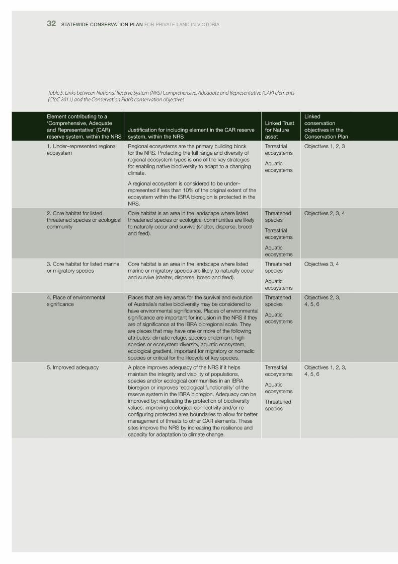
32 Statewide ConServation Plan foR pRivATE lANd iN vicToRiA
Table 5. Links between National Reserve System (NRS) Comprehensive, Adequate and Representative (CAR) elements (CfoC 2011) and the Conservation Plan’s conservation objectives
element contributing to a ‘Comprehensive, adequate and representative’ (Car) reserve system, within the nrS
Justification for including element in the Car reserve system, within the nrS
linked trust for nature asset
linked conservation objectives in the Conservation Plan
1. Under–represented regional ecosystem
Regional ecosystems are the primary building block for the NRS. protecting the full range and diversity of regional ecosystem types is one of the key strategies for enabling native biodiversity to adapt to a changing climate.
A regional ecosystem is considered to be under–represented if less than 10% of the original extent of the ecosystem within the iBRA bioregion is protected in the NRS.
Terrestrial ecosystems
Aquatic ecosystems
objectives 1, 2, 3
2. core habitat for listed threatened species or ecological community
core habitat is an area in the landscape where listed threatened species or ecological communities are likely to naturally occur and survive (shelter, disperse, breed and feed).
Threatened species
Terrestrial ecosystems
Aquatic ecosystems
objectives 2, 3, 4
3. core habitat for listed marine or migratory species
core habitat is an area in the landscape where listed marine or migratory species are likely to naturally occur and survive (shelter, disperse, breed and feed).
Threatened species
Aquatic ecosystems
objectives 3, 4
4. place of environmental significance
places that are key areas for the survival and evolution of Australia’s native biodiversity may be considered to have environmental significance. places of environmental significance are important for inclusion in the NRS if they are of significance at the iBRA bioregional scale. They are places that may have one or more of the following attributes: climatic refuge, species endemism, high species or ecosystem diversity, aquatic ecosystem, ecological gradient, important for migratory or nomadic species or critical for the lifecycle of key species.
Threatened species
Aquatic ecosystems
objectives 2, 3, 4, 5, 6
5. improved adequacy A place improves adequacy of the NRS if it helps maintain the integrity and viability of populations, species and/or ecological communities in an iBRA bioregion or improves ‘ecological functionality’ of the reserve system in the iBRA bioregion. Adequacy can be improved by: replicating the protection of biodiversity values, improving ecological connectivity and/or re-configuring protected area boundaries to allow for better management of threats to other cAR elements. These sites improve the NRS by increasing the resilience and capacity for adaptation to climate change.
Terrestrial ecosystems
Aquatic ecosystems
Threatened species
objectives 1, 2, 3, 4, 5, 6
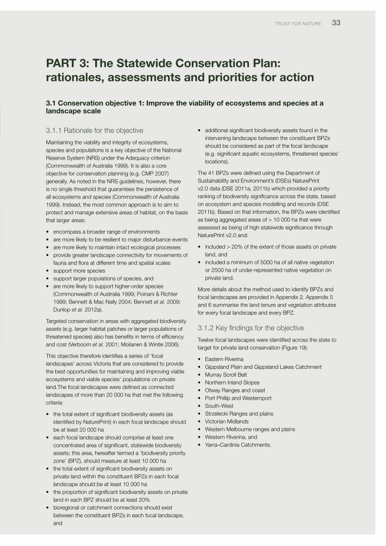
TRUST foR NATURE 33
PART 3: The Statewide Conservation Plan: rationales, assessments and priorities for action
3.1 Conservation objective 1: Improve the viability of ecosystems and species at a landscape scale
3.1.1 Rationale for the objective
Maintaining the viability and integrity of ecosystems, species and populations is a key objective of the National Reserve System (NRS) under the Adequacy criterion (commonwealth of Australia 1999). it is also a core objective for conservation planning (e.g. cMp 2007) generally. As noted in the NRS guidelines, however, there is no single threshold that guarantees the persistence of all ecosystems and species (commonwealth of Australia 1999). instead, the most common approach is to aim to protect and manage extensive areas of habitat, on the basis that larger areas:
• encompassabroaderrangeofenvironments• aremorelikelytoberesilienttomajordisturbanceevents• aremorelikelytomaintainintactecologicalprocesses• providegreaterlandscapeconnectivityformovementsof
faunaandfloraatdifferenttimeandspatialscales• supportmorespecies• supportlargerpopulationsofspecies,and• aremorelikelytosupporthigher-orderspecies
(commonwealth of Australia 1999; poinani & Richter 1999; Bennett & Mac Nally 2004; Bennett et al. 2009; dunlop et al. 2012a).
Targeted conservation in areas with aggregated biodiversity assets (e.g. larger habitat patches or larger populations of threatened species) also has benefits in terms of efficiency and cost (verboom et al. 2001; Moilanen & Wintle 2006).
This objective therefore identifies a series of ‘focal landscapes’ across victoria that are considered to provide the best opportunities for maintaining and improving viable ecosystems and viable species’ populations on private land.The focal landscapes were defined as connected landscapes of more than 20 000 ha that met the following criteria:
• thetotalextentofsignificantbiodiversityassets(asidentified by Natureprint) in each focal landscape should be at least 20 000 ha
• eachfocallandscapeshouldcompriseatleastoneconcentrated area of significant, statewide biodiversity assets; this area, hereafter termed a ‘biodiversity priority zone’ (BpZ), should measure at least 10 000 ha
• thetotalextentofsignificantbiodiversityassetsonprivate land within the constituent BpZs in each focal landscape should be at least 10 000 ha
• theproportionofsignificantbiodiversityassetsonprivateland in each BpZ should be at least 20%
• bioregionalorcatchmentconnectionsshouldexistbetween the constituent BpZs in each focal landscape, and
• additionalsignificantbiodiversityassetsfoundintheintervening landscape between the constituent BpZs should be considered as part of the focal landscape (e.g. significant aquatic ecosystems, threatened species’ locations).
The 41 BpZs were defined using the department of Sustainability and Environment’s (dSEs) Natureprint v2.0 data (dSE 2011a, 2011b) which provided a priority ranking of biodiversity significance across the state, based on ecosystem and species modelling and records (dSE 2011b). Based on that information, the BpZs were identified as being aggregated areas of > 10 000 ha that were assessed as being of high statewide significance through Natureprint v2.0 and:
• included>20%oftheextentofthoseassetsonprivateland, and
• includedaminimumof5000haofallnativevegetationor 2500 ha of under-represented native vegetation on private land.
More details about the method used to identify BpZs and focal landscapes are provided in Appendix 2. Appendix 5 and 6 summarise the land tenure and vegetation attributes for every focal landscape and every BpZ.
3.1.2 Key findings for the objective
Twelve focal landscapes were identified across the state to target for private land conservation (figure 19):
• EasternRiverina• GippslandPlainandGippslandLakesCatchment• MurrayScrollBelt• NorthernInlandSlopes• OtwayRangesandcoast• PortPhillipandWesternport• South-West• StrzeleckiRangesandplains• VictorianMidlands• WesternMelbournerangesandplains• WesternRiverina,and• Yarra–CardiniaCatchments.
element contributing to a ‘Comprehensive, adequate and representative’ (Car) reserve system, within the nrS
Justification for including element in the Car reserve system, within the nrS
linked trust for nature asset
linked conservation objectives in the Conservation Plan
1. Under–represented regional ecosystem
Regional ecosystems are the primary building block for the NRS. protecting the full range and diversity of regional ecosystem types is one of the key strategies for enabling native biodiversity to adapt to a changing climate.
A regional ecosystem is considered to be under–represented if less than 10% of the original extent of the ecosystem within the iBRA bioregion is protected in the NRS.
Terrestrial ecosystems
Aquatic ecosystems
objectives 1, 2, 3
2. core habitat for listed threatened species or ecological community
core habitat is an area in the landscape where listed threatened species or ecological communities are likely to naturally occur and survive (shelter, disperse, breed and feed).
Threatened species
Terrestrial ecosystems
Aquatic ecosystems
objectives 2, 3, 4
3. core habitat for listed marine or migratory species
core habitat is an area in the landscape where listed marine or migratory species are likely to naturally occur and survive (shelter, disperse, breed and feed).
Threatened species
Aquatic ecosystems
objectives 3, 4
4. place of environmental significance
places that are key areas for the survival and evolution of Australia’s native biodiversity may be considered to have environmental significance. places of environmental significance are important for inclusion in the NRS if they are of significance at the iBRA bioregional scale. They are places that may have one or more of the following attributes: climatic refuge, species endemism, high species or ecosystem diversity, aquatic ecosystem, ecological gradient, important for migratory or nomadic species or critical for the lifecycle of key species.
Threatened species
Aquatic ecosystems
objectives 2, 3, 4, 5, 6
5. improved adequacy A place improves adequacy of the NRS if it helps maintain the integrity and viability of populations, species and/or ecological communities in an iBRA bioregion or improves ‘ecological functionality’ of the reserve system in the iBRA bioregion. Adequacy can be improved by: replicating the protection of biodiversity values, improving ecological connectivity and/or re-configuring protected area boundaries to allow for better management of threats to other cAR elements. These sites improve the NRS by increasing the resilience and capacity for adaptation to climate change.
Terrestrial ecosystems
Aquatic ecosystems
Threatened species
objectives 1, 2, 3, 4, 5, 6
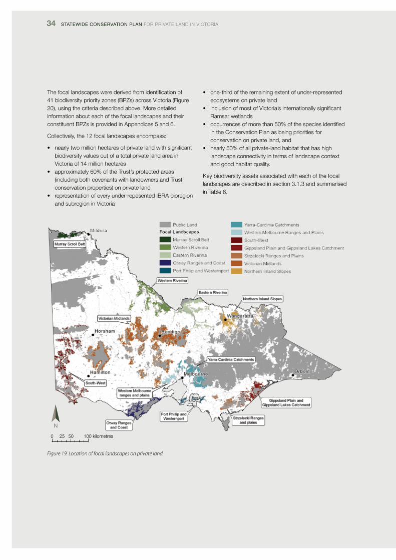
34 Statewide ConServation Plan foR pRivATE lANd iN vicToRiA
The focal landscapes were derived from identification of 41 biodiversity priority zones (BpZs) across victoria (figure 20), using the criteria described above. More detailed information about each of the focal landscapes and their constituent BpZs is provided in Appendices 5 and 6.
collectively, the 12 focal landscapes encompass:
• nearlytwomillionhectaresofprivatelandwithsignificantbiodiversity values out of a total private land area in victoria of 14 million hectares
• approximately60%oftheTrust’sprotectedareas(including both covenants with landowners and Trust conservation properties) on private land
• representationofeveryunder-repesentedIBRAbioregionand subregion in victoria
• one-thirdoftheremainingextentofunder-representedecosystems on private land
• inclusionofmostofVictoria’sinternationallysignificantRamsar wetlands
• occurrencesofmorethan50%ofthespeciesidentifiedin the conservation plan as being priorities for conservation on private land, and
• nearly50%ofallprivate-landhabitatthathashighlandscape connectivity in terms of landscape context and good habitat quality.
Key biodiversity assets associated with each of the focal landscapes are described in section 3.1.3 and summarised in Table 6.
Figure 19. Location of focal landscapes on private land.
0 25 50 100 kilometres
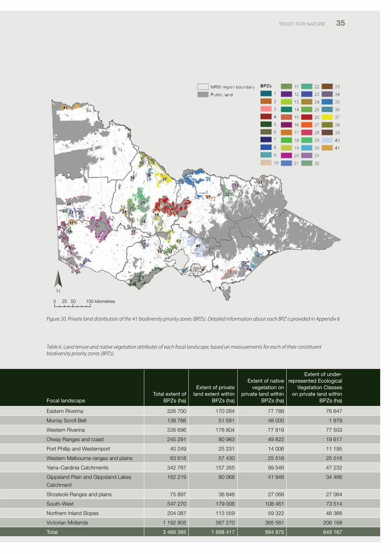
TRUST foR NATURE 35
Figure 20. Private land distribution of the 41 biodiversity priority zones (BPZs). Detailed information about each BPZ is provided in Appendix 6
Table 6. Land tenure and native vegetation attributes of each focal landscape, based on measurements for each of their constituent biodiversity priority zones (BPZs)
Focal landscapetotal extent of
BPZs (ha)
extent of private land extent within
BPZs (ha)
extent of native vegetation on
private land within BPZs (ha)
extent of under-represented ecological
vegetation Classes on private land within
BPZs (ha)
Eastern Riverina 226 700 170 284 77 788 76 647
Murray Scroll Belt 138 766 51 581 48 000 1 879
Western Riverina 226 696 178 804 77 819 77 503
otway Ranges and coast 245 291 80 983 49 822 19 617
port phillip and Westernport 40 249 25 231 14 006 11 195
Western Melbourne ranges and plains 63 618 57 430 25 516 25 516
Yarra–cardinia catchments 342 787 157 355 99 546 47 232
Gippsland plain and Gippsland lakes
catchment
162 219 80 068 41 946 34 466
Strzelecki Ranges and plains 75 897 36 846 27 068 27 064
South-West 547 270 179 006 108 461 73 514
Northern inland Slopes 204 087 113 559 59 322 48 366
victorian Midlands 1 192 805 567 270 365 581 206 168
total 3 466 385 1 698 417 994 875 649 167
0 25 50 100 kilometres
36 Statewide ConServation Plan foR pRivATE lANd iN vicToRiA
3.1.3 descriptions of the focal landscapes
Eastern Riverina
located in northern victoria between Echuca, Murchison, violet Town and Yarrawonga. primarily located in the nationally under-represented Riverina bioregion, with smaller proportion included in NSW South Western Slopes. contains representation of three subregions. Major geographic features comprise Barmah forest and associatedfloodplain,LowerGoulburnRiver,BrokenCreeksystem, lower Broken River, Honeysuckle creek/Seven creeks catchments and the Koonda Hills, an outlier of the Northern inland Slopes subregion. contains 170 000 ha of private land with significant biodiversity assets, at a statewide scale.
Key terrestrial ecosystem assets on private land comprise extensive areas of plains woodlands, riverine grassy woodlands, lower slopes or hills woodlands and box-ironbark forests.
Key wetland assets include the Ramsar-listed Barmah–Milewa forest (also a living Murray icon site) and Nationally important Wetlands along the Broken creek, lower Broken River,LowerGoulburnRiverfloodplain,KanyapellaBasinand Muckatah depression. other aquatic ecosystem assets include significant areas of riparian habitat on private land, especially in the Riverina and Northern inland Slopes subregions.
priority fauna species for conservation include Golden perch, Giant Bullfrog, lace Goanna, Woodland Blind Snake, intermediate Egret, Eastern Great Egret, Australasian Bittern, Australian painted Snipe, Bush Stone-curlew, Swift parrot, Superb parrot, Grey-crowned Babbler and Squirrel Glider.
PriorityfloraspeciesforconservationincludePurpleWire-grass, painted diuris, Arching flax-lily, Yarran, Slender darling-pea, Silky Swainson-pea, long Eryngium, Ridged Water-milfoil and Yellow-tongue daisy.
Gippsland Plain and Gippsland Lakes Catchment
located in western Gippsland between Yarram, Rosedale and Bairnsdale. primarily located in the nationally under-represented South East coastal plain bioregion and under-represented Gippsland plain subregion. includes small component of the under-represented Strzelecki Ranges subregion. Major geographic elements comprise the Gippsland lakes and associated catchment, Gippsland plains, la Trobe River, perry River, Thompson River, Avon Riverandassociatedfloodplains.Contains81000haof private land with significant biodiversity assets at a statewide scale.
Key terrestrial ecosystem assets on private land comprise extensive areas of plains woodlands and herb-rich woodlands. Key aquatic ecosystem assets include the Ramsar-listed Gippsland lakes, Macleod Morass, Jack SmithLake,LatrobeRiverandfloodplainandchainsofpond systems along some of the smaller waterways. The landscape also includes significant areas of coastal ecosystems on private land.
priority fauna species for conservation include Eastern Great Egret, Royal Spoonbill, Australasian Bittern, lewin’s Rail and lace Goanna.
PriorityfloraspeciesforconservationincludeBushyHedgehog Grass, Gaping leek-orchid, purple diuris, Trailing Hop-bush, dwarf Kerrawang and Swamp Everlasting.
Murray Scroll Belt
located in north-west victoria, west of Mildura and centred on Trust for Nature’s Neds corner Station. primarily located in the nationally under-represented Riverina bioregion, with a smaller proportion included in the Murray darling depression. contains representation of two subregions. Major geographic elements comprise the Murray River floodplain,thedistinctiveMurrayScrollBelt,LindsayIsland,Mulcra island, Walpolla island and dunes associated with the Murray Mallee. The only part of victoria recognised as part of Australia’s rangelands. includes 52 000 ha of private land with significant biodiversity assets at a statewide scale, of which 28 000 ha is currently protected at Neds corner Station.
Key terrestrial ecosystem assets on private land comprise plains grasslands/chenopod shrublands, riverine grassy woodlands and plains woodlands.
Key wetland assets comprise the living Murray icon sites
– chowilla floodplain and lindsay–Walpolla islands – and the Murray River. other aquatic ecosystem assets include significant areas of riparian habitat on private landalongtheMurrayRiverfloodplain.
priority fauna species for conservation include Hooded Scaly-foot, lace Goanna, de vis Banded Snake, Red-naped Snake, fat-tailed dunnart, Giles planigale, Bush Stone-curlew, inland dotterel, Regent parrot and Redthroat.
PriorityfloraspeciesforconservationincludeSpreadingAngianthus,LeaflessBluebush,Narrow-leafEmu-bushandKneed Swainson-pea.
TRUST foR NATURE 37
Northern Inland Slopes
located in north-east victoria between Benalla, Wodonga and the Upper Murray near corryong. primarily located in the NSW South Western Slopes bioregion, with smaller proportions included in the nationally under-represented Riverina bioregion, as well as victorian Midlands and South Eastern Highlands. contains representation of five subregions, including the under-represented victorian Riverina, Murray fans and central victorian Uplands. Major geographic elements comprise the Warby Range, Killawarra Forest,LowerOvensRiverandfloodplain,Chiltern–Mtpilot area and Burrowa-pine Mountain. contains 114 000 ha of private land with significant biodiversity assets at a statewide scale.
Key terrestrial ecosystem assets on private land comprise extensive areas of box-ironbark forests, dry forests, plains woodlands and riverine grassy woodlands.
Key wetland assets include Nationally important Wetlands along the lower ovens River and at Black Swamp. other aquatic ecosystem assets include significant areas of riparian habitat on private land, especially in the victorian Riverina and Northern inland Slopes subregions.
priority fauna species for conservation include Golden perch, Booroolong Tree frog, Growling Grass frog, lace Goanna, Eastern Great Egret, intermediate Egret, Bush Stone-curlew, Swift parrot, Regent Honeyeater, Speckled Warbler, Squirrel Glider, and Brush-tailed phascogale.
PriorityfloraspeciesforconservationincludeUmbrellaGrass, Yellow Hyacinth-orchid, purple diuris, Yarran, Buloke Mistletoe, Warby Range Swamp Gum, Southern Sandalwood, Narrow Goodenia and dookie daisy.
Otway Ranges and Coast
centred on the otway Ranges, Anglesea Heathlands and associated coastline west of Geelong. primarily located in the South Eastern Highlands bioregion but also includes substantial portion in the nationally under-represented South East coastal plain bioregion and small area of victorian volcanic plain. contains representation of otway Ranges, otway plain, Warrnambool plain and victorian volcanic plain subregions. Major geographic elements comprise the otway Ranges, Anglesea Heathlands, the coastline and south-draining waterways and estuaries. contains 80 000 ha of private land with significant biodiversity assets at a statewide scale.
Key terrestrial ecosystem assets on private land comprise lower slopes or hills woodlands, dry forests, rainforests, riparian scrubs, coastal scrubs and the nationally recognised Anglesea Heathlands.
KeywetlandassetsincludetheAireRiverandfloodplainand princetown Wetlands. Some opportunities also exist to protect riparian habitats along waterways.
priority fauna species for conservation include Australian Mudfish, dwarf Galaxias, Yarra pygmy perch, Grey Goshawk and Rufous Bristlebird.
PriorityfloraspeciesforconservationincludeLeafyGreenhood, Merran’s Sun-orchid, Wrinkled Buttons, Snow-berry and velvet daisy-bush.
Port Phillip and Westernport
includes the southern Mornington peninsula, Westernport Bay, french island and the foothills east of Westernport around Grantville. primarily located in the nationally under-represented South East coastal plain bioregion, with a smaller proportion included in South Eastern Highlands. contains representation of two under-represented subregions – Gippsland plain and Strzelecki Ranges. Major geographic elements comprise the Mornington peninsula, Westernport Bay and associated saltmarsh habitat, french island and the foothills of the Strzelecki Ranges. contains 25 000 ha of private land with significant biodiversity assets at a statewide scale.
Key terrestrial ecosystem assets on private land include herb-rich woodlands, plains woodlands, wetlands, coastal scrubs, riparian scrubs, riverine grassy woodlands and dry forests.
Key wetland assets include the Ramsar-listed Westernport Bay and the bioregionally significant Tootgarook Wetlands. other aquatic ecosystem assets include significant areas of riparian habitat on private land, especially along waterways draining into the west coast of Westernport Bay.
priority fauna species for conservation include listed species of migratory shorebird, Southern Brown Bandicoot, Australasian Bittern, Eastern Great Egret, Blue-billed duck, latham’s Snipe, orange-bellied parrot, powerful owl and Giant Gippsland Earthworm.
PriorityfloraspeciesforconservationincludeFrenchIslandSpider-orchid, leafy Greenhood, clover Glycine, purple Eyebright and Strzelecki Gum.
38 Statewide ConServation Plan foR pRivATE lANd iN vicToRiA
South-West
located in south-western victoria from the South Australian border to port fairy and north to the little desert. primarily located in the Murray darling depression bioregion but also includes substantial areas in the nationally under-represented victorian volcanic plain bioregion, plus Nararcoorte coastal plain and victorian Midlands bioregions. Altogther includes representation of eight subregions of which dundas Tablelands, victorian volcanic plain, Warrnambool plain and Wimmera are all under-represented in protected areas. Major geographic elements include the Glenelg River and associated plain, the coastline, Natimuk–douglas wetlands, sand dune systems south of little desert, Black Range and volcanic outcrops such as Mt Eccles. contains 179 000 ha of private land with significant biodiversity assets at a statewide scale.
Key terrestrial ecosystem assets on private land include plains woodlands, plains grasslands, riverine grassy woodlands, lower slopes or hills woodlands, herb-rich woodlands, mallee, wetlands, coastal scrubs and dry forests.
Key wetland assets include the Nationally important Natimuk Wetlands, Wimmera River, Boiler Swamp, lindsay–Werikoo Wetlands, Mundi–Selkirk Wetlands, long Swamp and the Glenelg River. in addition, this landscape and the associated private land surrounding the high-value zones includes very large numbers of wetlands on private land. other aquatic ecosystem assets include significant areas of under-represented riparian habitat on private land, in both the Wimmera and Glenelg Hopkins regions.
priority fauna species for conservation include Glenelg FreshwaterMussel,RayedBlueButterfly,GoldenSun-moth,variegated pygmy perch, Yarra pygmy perch, Australasian Bittern, Eastern Great Egret, Australasian Shoveler, Brolga, Bush Stone-curlew, Australian Bustard, powerful owl, Red-tailed Black-cockatoo, diamond firetail and Southern Brown Bandicoot.
PriorityfloraspeciesforconservationincludeLimestoneSpider-orchid, Mellblom’s Spider-orchid, Wimmera Spider-orchid, Yellow-lip Spider-orchid, Swamp diuris, leafy Greenhood, Gorae leek-orchid, chariot Wheels, Jumping Jack Wattle, Square Raspwort, Winged peppercress, forked Spyridium, Swamp She-oak, dwarf Yellowheads and Wrinkled cassinia.
Strzelecki Ranges and plains
located in south-east victoria from east of Westernport Bay to Yarram and Gormandale. primarily located in the South Eastern Highlands bioregion, with a smaller proportion included in South East coastal plain bioregion. contains two subregions, both of which are under-represented – Strzelecki Ranges and Gippsland plain. Major geographic elements comprise the Strzlelecki Ranges and associated plains, Albert River, Agnes River, la Trobe River catchment and other waterways draining to the coast and into corner inlet. contains 37 000 ha of private land with significant biodiversity assets at a statewide scale.
Key terrestrial ecosystem assets on private land comprise dry forests, plains woodlands, herb-rich woodlands, rainforests, riparian scrubs, wetlands and dry forests.
Key aquatic ecosystem assets to target comprise significant areas of under-represented riparian ecosystems, including extensive areas of riparian scrubs.
priority fauna species for conservation include Giant Gippsland Earthworm, Narracan Burrowing cray, Strzelecki Burrowing cray, Australian Grayling, lace Goanna and powerful owl.
PriorityfloraspeciesforconservationcompriseFilmyMaidenhair and Strzelecki Gum.
Victorian Midlands
located along the inland and southern fall of the Great dividing Range from the Grampians in the west through central victoria to Seymour–Murchison. primarily located in the victorian Midlands bioregion but also includes significant areas within the Murray darling depression and nationally under-represented Riverina and victorian volcanic plain bioregions. contains representation of seven victorian subregions, five of which are under-represented nationally: central victorian Uplands, dundas Tablelands, victorian Riverina, victorian volcanic plain and Wimmera. Key geographic elements comprise the western extension of the Great dividing Range and associated foothills and catchments on the inland and southern fall. contains 567 000 ha of private land with significant biodiversity assets at a statewide scale.
Key terrestrial ecosystem assets on private land comprise extensive areas of plains woodlands, lower slopes woodlands, riverine grassy woodlands, box-ironbark forests, mallee and dry forests.
Key aquatic ecosystem assets comprise significant areas of under-represented riparian ecosystems, including the upper reaches of many north-draining and south-draining rivers.
priority fauna species for conservation include pink-tailed Worm-lizard, lace Goanna, Woodland Blind Snake, Swift parrot, powerful owl, Barking owl, Regent Honeyeater, Speckled Warbler, diamond firetail and Brush-tailed phascogale.
TRUST foR NATURE 39
PriorityfloraspeciesforconservationincludeMcIvorSpider-orchid, Elegant Spider-orchid, Stuart Mill Spider-orchid, Red-cross Spider-orchid, lowly Greenhood, Kamarooka Mallee, velvet daisy-bush, large-headed fireweed, clover Glycine, purple Eyebright and Trailing Hop-bush.
Western Melbourne ranges and plains
located west of Melbourne between Bacchus Marsh and little River and including part of the western port phillip Bay coastline. primarily located in the nationally under-represented victorian volcanic plain bioregion with a smaller proportion in victorian Midlands and South East coastal plain bioregions. comprises four subregions, of which Gippsland plain, central victorian Uplands and victorian volcanic plain are under-represented. Major geographic elements include the plains and coastline on the western side of port phillip Bay, You Yang Ranges, little River, Werribee River and upper Maribyrnong River. contains 57 000 ha of private land with significant biodiversity assets at a statewide scale.
Key terrestrial ecosystem assets on private land comprise extensive areas of plains woodlands, plains grasslands, wetlands, dry forest, riverine grassy woodlands, lower slopes or hills woodlands and herb-rich woodlands.
Key wetland assets include the Ramsar-listed port phillip Bay (western shoreline) and significant areas of riparian habitat on private land.
priority fauna species for conservation include listed species of migratory shorebird, Golden Sun-moth, Growling Grass-frog, Striped legless lizard, plains-wanderer, Swift parrot and diamond firetail.
PriorityfloraspeciesforconservationincludeMattedFlax-lily,CloverGlycine,ToughScurf-pea,SpinyRice-flowerandSmall Milkwort.
Western Riverina
CentredonthePathoPlains,Murrayfloodplain,lowerAvocaandlowerLoddonfloodplainsbetweenEchucaandSwanHill. primarily located in the nationally under-represented Riverina bioregion, with smaller proportions included in NSW South Western Slopes and Murray darling depression bioregions. comprises five subregions, including the under-represented Murray fans, victorian Riverina and Wimmera. Major geographic elements comprise the Murray River andfloodplain,AvocaandLoddonRiversandfloodplains,outlier hills of Northern inland Slopes subregion and old dune systems. contains 179 000 ha of private land with significant biodiversity assets at a statewide scale.
Key terrestrial ecosystem assets on private land comprise extensive areas of plains woodlands, plains grasslands/chenopod shrublands, riverine grassy woodlands, wetlands and mallee.
Key wetland assets include private land associated with the Ramsar-listed Gunbower forest and Kerang lakes, and Nationally important Bunguluke Wetlands. other aquatic ecosystem assets include significant areas of riparian habitat on private land.
priority fauna species for conservation include Golden Sun-moth, Hooded Scaly-foot, Eastern Great Egret, intermediate Egret, Australian painted Snipe, plains-wanderer and Grey-crowned Babbler.
PriorityfloraspeciesforconservationincludeRiverinaFlax-lily, chariot Wheels, Red Swainson-pea, downy Swainson-pea,SlenderDarling-peaandSpinyRice-flower.
Yarra–Cardinia Catchments
located from north of Melbourne near Whittlesea east to Gembrook and Bunyip. primarily located in the South Eastern Highlands bioregion, with smaller areas included within the victorian Midlands and the nationally under-represented victorian volcanic plain and South East coastal plain bioregions. contains six subregions, including the under-represented Gippsland plain, central victorian Uplands and victorian volcanic plain. Major geographic elements comprise the Great dividing Range, a small portion of the victorian Alps, and the upper and middle catchments of the Yarra River, Bunyip River and cardinia creek. contains 157 000 ha of private land with significant biodiversity assets at a statewide scale.
Key terrestrial ecosystem assets on private land comprise plains woodlands, riverine grassy woodlands, lower slopes or hills woodlands, herb-rich woodlands, plains grasslands, riparian scrubs and dry forests.
Key wetland assets include private land along the Yarra River, a Nationally important Wetland, and other riparian habitat on private land.
priority fauna species for conservation include Eltham copper, Golden Sun-moth, dandenong Burrowing cray, dwarf Galaxias, Australian Grayling, Growling Grass-frog, Striped legless lizard, powerful owl, Helmeted Honeyeater and Southern Brown Bandicoot.
PriorityfloraspeciesforconservationincludeCurlySedge,Rosella Spider-orchid, clover Glycine, Tough Scurf-pea, Round-leaf pomaderris and Buxton Gum.
40 Statewide ConServation Plan foR pRivATE lANd iN vicToRiA
3.1.4 The focal landscapes as priorities for conservation
Conservation objective 1: key priorities
• usefocallandscapesastheprimaryfocusforconservation investment and effort at both the landscape scale and site scale
• asfaraspossible,targetconservationactionsrelatingto the priorities for other conservation objectives towards the focal landscapes
• usefocallandscapesandconstituentbiodiversitypriority zones as the backbone for landscape-scale connectivity actions, and
• identifybiodiversityassetsnotencompassedwithinthefocal landscapes that will need separate conservation actions on private land elsewhere in the state.
The focal landscapes comprise large areas of land (each greater than 20 000 ha) identified as being significant in a statewide context for ecosystems and species. Because of their large size and biological significance, the Trust considers that the focal landscapes, and associated corridors and habitat links, provide the most effective opportunities across victoria for improving the viability of ecosystems, species and populations on private land. Because of the way the optimisation model used to develop the Natureprint v2.0 spatial layer preferentially selects sites with the best site condition scores, best landscape connectivity scores and lower site-cost scores when there is a choice (dSE 2011b), the focal landscapes are furthermore considered the most cost-effective option for achieving bodiversity gains on private land in victoria. The 12 focal landscapes will consequently comprise the Trust’s primary level of prioritising landscapes and sites for conservation.
it is clear, however, that not all significant biodiversity assets found on private land occur within the focal landscapes; in particular, some of the aquatic ecosystem assets (which were not incorporated into Natureprint v2.0- dSE 2011a), and many of the threatened species occur outside the focal landscapes. Additional conservation investment and action is required accordingly in other parts of the state. The sections following identify additional gaps and opportunities for private-land conservation by Trust for Nature in relation to the other five conservation objectives developed for the conservation plan.
TRUST foR NATURE 41
3.2 Conservation objective 2: Improve protection of the least protected ecosystems and threatened communities
3.2.1 Rationale for the objective
protecting native vegetation is considered a cornerstone of biodiversity conservation and has been the basis of conservation planning in Australia for more than 30 years (dunlop & Brown 2008). The National Reserve System (NRS) guidelines for a comprehensive, Adequate and Representative (cAR) reserve system identify the protection of under-represented regional ecosystems as one of the key actions required to build the NRS (commonwealth of Australia 1999; NRMMc 2005). protecting the full range and diversity of regional ecosystems – particularly those not already represented in the reserve system – is also recommended as one of the strategies for enabling native species to adapt to a changing climate (dunlop & Brown 2008; dunlop et al. 2012a, 2012b). in a statutory context, these principles have been taken further through the legislative listing of various threatened ecological communities considered to be at risk from past and current threatening processes under both commonwealth and victorian Acts.
conservation objective 2 was therefore assessed firstly by analysing how well targets for a cAR reserve system in victoria are currently being met in terms of comprehensiveness, Adequacy and Representativeness of ecosystem protection. it was also analysed in relation to NRS targets for bioregional and subregional representation in protected areas. finally, this objective was assessed by considering the representation on private land of threatened vegetation communities listed either under the Commonwealth Environment Protection and Biodiversity Conservation Act 1999 (EpBc Act) or the Flora and Fauna Guarantee Act 1988 (ffG Act).
3.2.2 Key findings for the objective
The key findings of the conservation plan, in regard to protection of ecosystems and threatened communities, are that:
• nearlyhalfofVictoria’sbioregionsdonotmeetnationalNRS targets for ecosystem protection
• nearly90%ofallunder-representedEcologicalvegetation classes (Evcs) in victoria occur on private land
• mostnativevegetationfoundonprivatelandisunder-represented in the NRS
• EVCGroupsthatincludehighproportionsofunder-represented Evcs particularly include woodlands, grasslands, wetlands, box-ironbark forest, riparian scrubs, dry forest and mallee, and
• nearlyonemillionhectaresofvegetationinVictoriaisclassified as nationally threatened, and most of this area is on private land.
3.2.3 Assessment of the comprehensiveness of current ecosystem protection
‘comprehensiveness’ is defined by the NRS as representation of the full range of ecosystems within an iBRA region in the NRS (cfoc 2011).
The NRS target for meeting the comprehensiveness criterion in terms of ecosystem protection states that at least 80% of the total number of ecosystems found in a bioregion should be included in permanently protected areas (NRMMc 2009). of the 11 iBRA bioregions found in victoria, only four meet the NRS threshold of 80% ecosystem representation in protected areas. These are the Australian Alps, flinders, South Eastern Highlands and Murray darling depression (figure 21 and Table 7). The bioregions with the lowest percentage of Evcs included within protected areas are the victorian volcanic plain and the NSW South Western Slopes bioregion (figure 21 and Table 7).
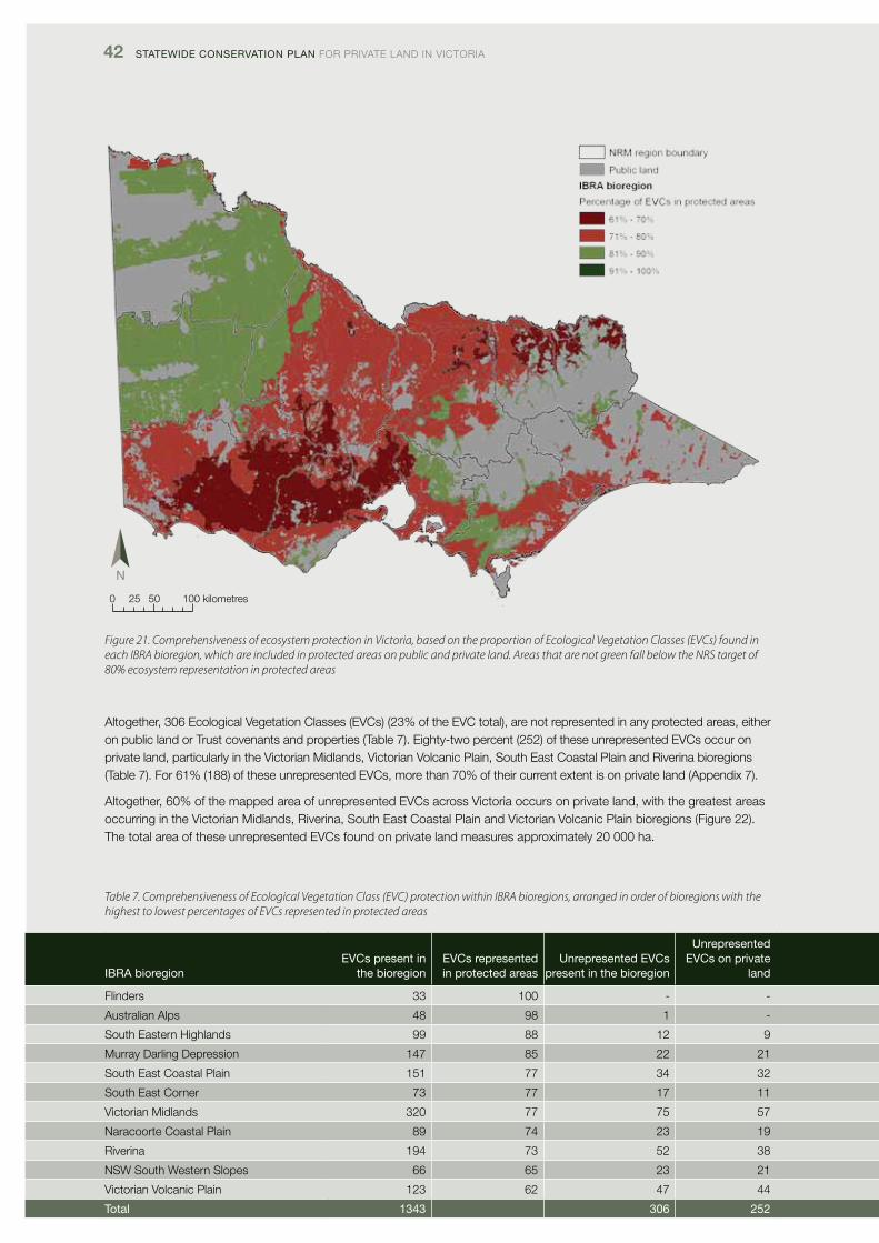
42 Statewide ConServation Plan foR pRivATE lANd iN vicToRiA
Figure 21. Comprehensiveness of ecosystem protection in Victoria, based on the proportion of Ecological Vegetation Classes (EVCs) found in each IBRA bioregion, which are included in protected areas on public and private land. Areas that are not green fall below the NRS target of 80% ecosystem representation in protected areas
Altogether, 306 Ecological vegetation classes (Evcs) (23% of the Evc total), are not represented in any protected areas, either on public land or Trust covenants and properties (Table 7). Eighty-two percent (252) of these unrepresented Evcs occur on private land, particularly in the victorian Midlands, victorian volcanic plain, South East coastal plain and Riverina bioregions (Table 7). for 61% (188) of these unrepresented Evcs, more than 70% of their current extent is on private land (Appendix 7).
Altogether, 60% of the mapped area of unrepresented Evcs across victoria occurs on private land, with the greatest areas occurring in the victorian Midlands, Riverina, South East coastal plain and victorian volcanic plain bioregions (figure 22). The total area of these unrepresented Evcs found on private land measures approximately 20 000 ha.
Table 7. Comprehensiveness of Ecological Vegetation Class (EVC) protection within IBRA bioregions, arranged in order of bioregions with the highest to lowest percentages of EVCs represented in protected areas
0 25 50 100 kilometres
iBra bioregionevCs present in
the bioregionevCs represented in protected areas
Unrepresented evCs present in the bioregion
Unrepresented evCs on private
land
flinders 33 100 - -
Australian Alps 48 98 1 -
South Eastern Highlands 99 88 12 9
Murray darling depression 147 85 22 21
South East coastal plain 151 77 34 32
South East corner 73 77 17 11
victorian Midlands 320 77 75 57
Naracoorte coastal plain 89 74 23 19
Riverina 194 73 52 38
NSW South Western Slopes 66 65 23 21
victorian volcanic plain 123 62 47 44
total 1343 306 252
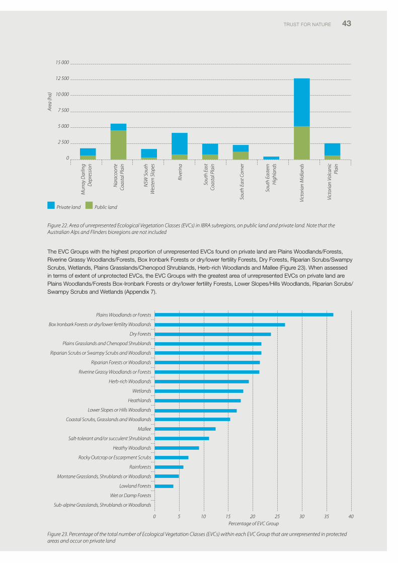
TRUST foR NATURE 43
15 000
12 500
10 000
7 500
5 000
2 500
0
Area
(ha)
Private land Public land
Mur
ray
Dar
ling
Dep
ress
ion
Nar
acoo
rte
Coas
tal P
lain
NSW
Sou
th
Wes
tern
Slo
pes
Rive
rina
Sout
h Ea
st
Coas
tal P
lain
Sout
h Ea
st C
orne
r
Sout
h Ea
ster
n H
ighl
ands
Vict
oria
n M
idla
nds
Vict
oria
n Vo
lcan
ic
Plai
n
Plains Woodlands or Forests
Box Ironbark Forests or dry/lower fertility Woodlands
Dry Forests
Plains Grasslands and Chenopod Shrublands
Riparian Scrubs or Swampy Scrubs and Woodlands
Riparian Forests or Woodlands
Riverine Grassy Woodlands or Forests
Herb-rich Woodlands
Wetlands
Heathlands
Lower Slopes or Hills Woodlands
Coastal Scrubs, Grasslands and Woodlands
Mallee
Salt-tolerant and/or succulent Shrublands
Heathy Woodlands
Rocky Outcrop or Escarpment Scrubs
Rainforests
Montane Grasslands, Shrublands or Woodlands
Lowland Forests
Wet or Damp Forests
Sub-alpine Grasslands, Shrublands or Woodlands
0 5 10 15 20 25 30 35Percentage of EVC Group
40
Figure 22. Area of unrepresented Ecological Vegetation Classes (EVCs) in IBRA subregions, on public land and private land. Note that the Australian Alps and Flinders bioregions are not included
The Evc Groups with the highest proportion of unrepresented Evcs found on private land are plains Woodlands/forests, Riverine Grassy Woodlands/forests, Box ironbark forests or dry/lower fertility forests, dry forests, Riparian Scrubs/Swampy Scrubs, Wetlands, plains Grasslands/chenopod Shrublands, Herb-rich Woodlands and Mallee (figure 23). When assessed in terms of extent of unprotected Evcs, the Evc Groups with the greatest area of unrepresented Evcs on private land are plains Woodlands/forests Box-ironbark forests or dry/lower fertility forests, lower Slopes/Hills Woodlands, Riparian Scrubs/Swampy Scrubs and Wetlands (Appendix 7).
Figure 23. Percentage of the total number of Ecological Vegetation Classes (EVCs) within each EVC Group that are unrepresented in protected areas and occur on private land
44 Statewide ConServation Plan foR pRivATE lANd iN vicToRiA
3.2.4 Assessment of the Adequacy of current ecosystem protection
‘Adequacy’ is defined by the NRS as ‘protection of at least the minimum area of ecologically functional ecosystems needed to provide the ecological viability and integrity of populations, species and ecological communities at an iBRA subregional scale in the NRS’ (cfoc 2011).
Adequacy was assessed based on the following JANiS criteria:
• Criterion1:representationofatleast15%ofthepre-1750extentofeachecosysteminprotectedareas• Criterion2:representationofatleast60%ofthecurrentextentofecosystemsclassifiedasvulnerableinprotectedareas• Criterion3:representationof100%ofthecurrentextentofrareandendangeredecosystemsinprotectedareas• Combinedcriteria:assessmentsbasedonalloftheabovecriteria,excludingoverlappingareas.
Based on the three combined JANiS criteria (JANiS 1997) used to assess Adequacy of ecosystem representation in protected areas, our analyses show that 67% of all Evcs found in victoria are under-represented in protected areas on public and private land (Table 8). The vast majority (89%) of these Evcs occur on private land (figure 24) and nearly half of them have more than 70% of their current extent on private land (Table 8).
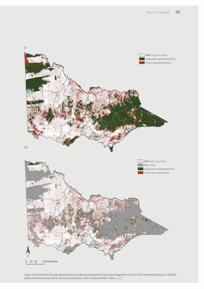
TRUST foR NATURE 45
(a)
(b)
Figure 24. Distribution of under-represented and adequately represented Ecological Vegetation Classes (EVCs) in protected areas on (a) both public and private land and on (b) only private land, under combined JANIS criteria 1, 2, 3
0 25 50 100 kilometres
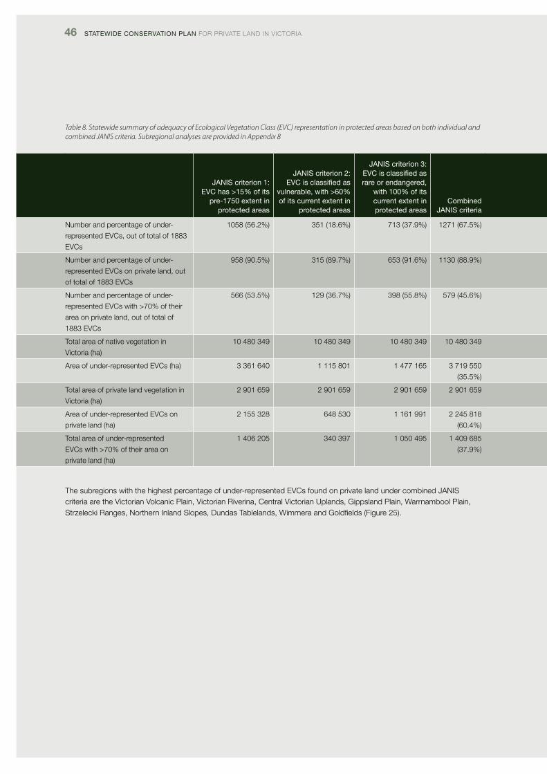
46 Statewide ConServation Plan foR pRivATE lANd iN vicToRiA
Table 8. Statewide summary of adequacy of Ecological Vegetation Class (EVC) representation in protected areas based on both individual and combined JANIS criteria. Subregional analyses are provided in Appendix 8
JaniS criterion 1: evC has >15% of its
pre-1750 extent in protected areas
JaniS criterion 2: evC is classified as
vulnerable, with >60% of its current extent in
protected areas
JaniS criterion 3: evC is classified as rare or endangered,
with 100% of its current extent in protected areas
Combined JaniS criteria
Number and percentage of under-
represented Evcs, out of total of 1883
Evcs
1058 (56.2%) 351 (18.6%) 713 (37.9%) 1271 (67.5%)
Number and percentage of under-
represented Evcs on private land, out
of total of 1883 Evcs
958 (90.5%) 315 (89.7%) 653 (91.6%) 1130 (88.9%)
Number and percentage of under-
represented Evcs with >70% of their
area on private land, out of total of
1883 Evcs
566 (53.5%) 129 (36.7%) 398 (55.8%) 579 (45.6%)
Total area of native vegetation in
victoria (ha)
10 480 349 10 480 349 10 480 349 10 480 349
Area of under-represented Evcs (ha) 3 361 640 1 115 801 1 477 165 3 719 550
(35.5%)
Total area of private land vegetation in
victoria (ha)
2 901 659 2 901 659 2 901 659 2 901 659
Area of under-represented Evcs on
private land (ha)
2 155 328 648 530 1 161 991 2 245 818
(60.4%)
Total area of under-represented
Evcs with >70% of their area on
private land (ha)
1 406 205 340 397 1 050 495 1 409 685
(37.9%)
The subregions with the highest percentage of under-represented Evcs found on private land under combined JANiS criteria are the victorian volcanic plain, victorian Riverina, central victorian Uplands, Gippsland plain, Warrnambool plain, Strzelecki Ranges, Northern inland Slopes, dundas Tablelands, Wimmera and Goldfields (figure 25).
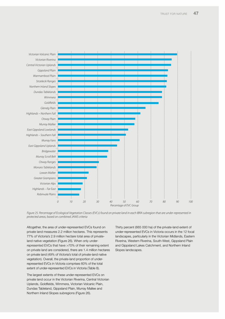
TRUST foR NATURE 47
Victorian Volcanic Plain
Victorian Riverina
Central Victorian Uplands
Gippsland Plain
Warrnambool Plain
Strzelecki Ranges
Northern Inland Slopes
Dundas Tablelands
Wimmera
Goldfields
Glenelg Plain
Highlands – Northern Fall
Otway Plain
Murray Mallee
East Gippsland Lowlands
Highlands – Southern Fall
Murray Fans
East Gippsland Uplands
Bridgewater
Murray Scroll Belt
Otway Ranges
Monaro Tablelands
Lowan Mallee
Greater Grampians
Victorian Alps
Highlands – Far East
Robinvale Plains
0 10 20 30 40 50 60 70 80 90 100Percentage of EVC Group
Figure 25. Percentage of Ecological Vegetation Classes (EVCs) found on private land in each IBRA subregion that are under-represented in protected areas, based on combined JANIS criteria
Altogether, the area of under-represented Evcs found on private land measures 2.2 million hectares. This represents 77% of victoria’s 2.9 million hectare total area of private-land native vegetation (figure 26). When only under-represented Evcs that have >70% of their remaining extent on private land are considered, there are 1.4 million hectares on private land (49% of victoria’s total of private-land native vegetation). overall, the private-land proportion of under-represented Evcs in victoria comprises 60% of the total extent of under-represented Evcs in victoria (Table 8).
The largest extents of these under-represented Evcs on private land occur in the victorian Riverina, central victorian Uplands, Goldfields, Wimmera, victorian volcanic plain, dundas Tableland, Gippsland plain, Murray Mallee and Northern inland Slopes subregions (figure 26).
Thirty percent (665 000 ha) of the private-land extent of under-represented Evcs in victoria occurs in the 12 focal landscapes, particularly in the victorian Midlands, Eastern Riverina, Western Riverina, South-West, Gippsland plain and Gippsland lakes catchment, and Northern inland Slopes landscapes.
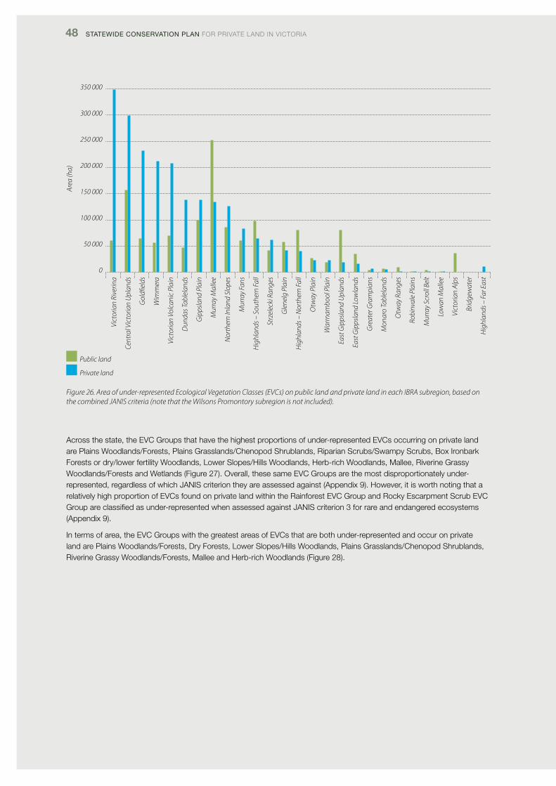
48 Statewide ConServation Plan foR pRivATE lANd iN vicToRiA
Figure 26. Area of under-represented Ecological Vegetation Classes (EVCs) on public land and private land in each IBRA subregion, based on the combined JANIS criteria (note that the Wilsons Promontory subregion is not included).
Across the state, the Evc Groups that have the highest proportions of under-represented Evcs occurring on private land are plains Woodlands/forests, plains Grasslands/chenopod Shrublands, Riparian Scrubs/Swampy Scrubs, Box ironbark forests or dry/lower fertility Woodlands, lower Slopes/Hills Woodlands, Herb-rich Woodlands, Mallee, Riverine Grassy Woodlands/forests and Wetlands (figure 27). overall, these same Evc Groups are the most disproportionately under-represented, regardless of which JANiS criterion they are assessed against (Appendix 9). However, it is worth noting that a relatively high proportion of Evcs found on private land within the Rainforest Evc Group and Rocky Escarpment Scrub Evc Group are classified as under-represented when assessed against JANiS criterion 3 for rare and endangered ecosystems (Appendix 9).
in terms of area, the Evc Groups with the greatest areas of Evcs that are both under-represented and occur on private land are plains Woodlands/forests, dry forests, lower Slopes/Hills Woodlands, plains Grasslands/chenopod Shrublands, Riverine Grassy Woodlands/forests, Mallee and Herb-rich Woodlands (figure 28).
Vict
oria
n Ri
verin
a
Cent
ral V
icto
rian
Upl
ands
Gol
dfiel
ds
Wim
mer
a
Vict
oria
n Vo
lcan
ic P
lain
Dun
das T
able
land
s
Gip
psla
nd P
lain
Mur
ray
Mal
lee
Nor
ther
n In
land
Slo
pes
Mur
ray
Fans
Hig
hlan
ds –
Sou
ther
n Fa
ll
Strz
elec
ki R
ange
s
Gle
nelg
Pla
in
Hig
hlan
ds –
Nor
ther
n Fa
ll
Otw
ay P
lain
War
rnam
bool
Pla
in
East
Gip
psla
nd U
plan
ds
East
Gip
psla
nd L
owla
nds
Gre
ater
Gra
mpi
ans
Mon
aro
Tabl
elan
ds
Otw
ay R
ange
s
Robi
nval
e Pl
ains
Mur
ray
Scro
ll Be
lt
Low
an M
alle
e
Vic
toria
n Al
ps
Brid
gew
ater
Hig
hlan
ds –
Far
Eas
t
350 000
300 000
250 000
200 000
150 000
100 000
50 000
0
Area
(ha)
Public land
Private land
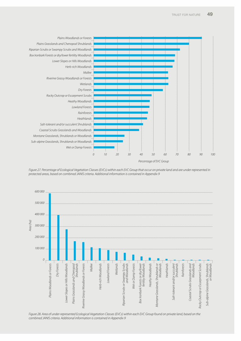
TRUST foR NATURE 49
Plains Woodlands or Forests
Plains Grasslands and Chenopod Shrublands
Riparian Scrubs or Swampy Scrubs and Woodlands
Box Ironbark Forests or dry/lower fertility Woodlands
Lower Slopes or Hills Woodlands
Herb-rich Woodlands
Mallee
Riverine Grassy Woodlands or Forests
Wetlands
Dry Forests
Rocky Outcrop or Escarpment Scrubs
Heathy Woodlands
Lowland Forests
Rainforests
Heathlands
Salt-tolerant and/or succulent Shrublands
Coastal Scrubs Grasslands and Woodlands
Montane Grasslands, Shrublands or Woodlands
Sub-alpine Grasslands, Shrublands or Woodlands
Wet or Damp Forests
0 10 20 30 40 50 60 70 80 90 100
Percentage of EVC Group
600 000
500 000
400 000
300 000
200 000
100 000
0
Area
(ha)
Plai
ns W
oodl
ands
or F
ores
ts
Dry
For
ests
Low
er S
lope
s or H
ills W
oodl
ands
Plai
ns G
rass
land
s and
Che
nopo
d Sh
rubl
ands
Rive
rine
Gra
ssy
Woo
dlan
ds o
r For
ests
Mal
lee
Her
b-ric
h W
oodl
ands
Low
land
For
ests
Wet
land
s
Ripa
rian
Scru
bs o
r Sw
ampy
Scr
ubs
and
Woo
dlan
ds
Wet
or D
amp
Fore
sts
Box
Ironb
ark
Fore
sts o
r dry
/low
er
fert
ility
Woo
dlan
ds
Hea
thy
Woo
dlan
ds
Mon
tane
Gra
ssla
nds,
Shru
blan
ds o
r W
oodl
ands
Hea
thla
nds
Salt-
tole
rant
and
/or s
uccu
lent
Sh
rubl
ands
Rain
fore
sts
Coas
tal S
crub
s Gra
ssla
nds a
nd
Woo
dlan
ds
Rock
y O
utcr
op o
r Esc
arpm
ent S
crub
s
Sub-
alpi
ne G
rass
land
s, Sh
rubl
ands
or
Woo
dlan
ds
Figure 27. Percentage of Ecological Vegetation Classes (EVCs) within each EVC Group that occur on private land and are under-represented in protected areas, based on combined JANIS criteria. Additional information is contained in Appendix 9
Figure 28. Area of under-represented Ecological Vegetation Classes (EVCs) within each EVC Group found on private land, based on the combined JANIS criteria. Additional information is contained in Appendix 9
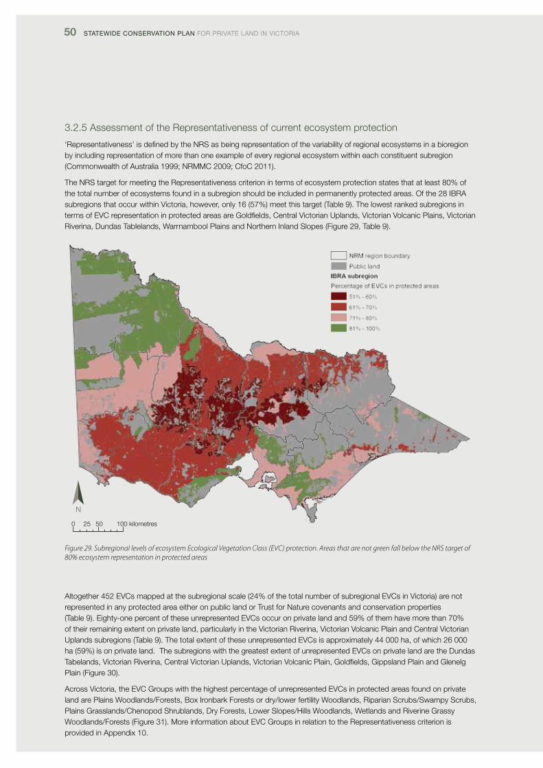
50 Statewide ConServation Plan foR pRivATE lANd iN vicToRiA
3.2.5 Assessment of the Representativeness of current ecosystem protection
‘Representativeness’ is defined by the NRS as being representation of the variability of regional ecosystems in a bioregion by including representation of more than one example of every regional ecosystem within each constituent subregion (commonwealth of Australia 1999; NRMMc 2009; cfoc 2011).
The NRS target for meeting the Representativeness criterion in terms of ecosystem protection states that at least 80% of the total number of ecosystems found in a subregion should be included in permanently protected areas. of the 28 iBRA subregions that occur within victoria, however, only 16 (57%) meet this target (Table 9). The lowest ranked subregions in terms of Evc representation in protected areas are Goldfields, central victorian Uplands, victorian volcanic plains, victorian Riverina, dundas Tablelands, Warrnambool plains and Northern inland Slopes (figure 29, Table 9).
0 25 50 100 kilometres
Figure 29. Subregional levels of ecosystem Ecological Vegetation Class (EVC) protection. Areas that are not green fall below the NRS target of 80% ecosystem representation in protected areas
Altogether 452 Evcs mapped at the subregional scale (24% of the total number of subregional Evcs in victoria) are not represented in any protected area either on public land or Trust for Nature covenants and conservation properties (Table 9). Eighty-one percent of these unrepresented Evcs occur on private land and 59% of them have more than 70% of their remaining extent on private land, particularly in the victorian Riverina, victorian volcanic plain and central victorian Uplands subregions (Table 9). The total extent of these unrepresented Evcs is approximately 44 000 ha, of which 26 000 ha (59%) is on private land. The subregions with the greatest extent of unrepresented Evcs on private land are the dundas Tabelands, victorian Riverina, central victorian Uplands, victorian volcanic plain, Goldfields, Gippsland plain and Glenelg plain (figure 30).
Across victoria, the Evc Groups with the highest percentage of unrepresented Evcs in protected areas found on private land are plains Woodlands/forests, Box ironbark forests or dry/lower fertility Woodlands, Riparian Scrubs/Swampy Scrubs, plains Grasslands/chenopod Shrublands, dry forests, lower Slopes/Hills Woodlands, Wetlands and Riverine Grassy Woodlands/forests (figure 31). More information about Evc Groups in relation to the Representativeness criterion is provided in Appendix 10.
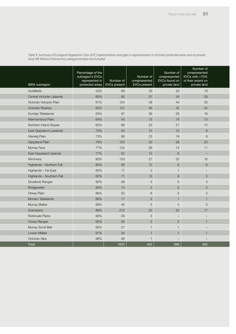
TRUST foR NATURE 51
Table 9. Summary of Ecological Vegetation Class (EVC) representation and gaps in representation in Victoria’s protected areas and on private land. NB: Wilsons Promontory subregional data not included
iBra subregion
Percentage of the subregion’s evCs
represented in protected areas
number of evCs present
number of unrepresented evCs present
number of unrepresented evCs found on
private land
number of unrepresented
evCs with >70% of their extent on
private land
Goldfields 52% 69 33 23 18
central victorian Uplands 60% 92 37 34 29
victorian volcanic plain 61% 124 48 44 33
victorian Riverina 62% 121 46 42 34
dundas Tablelands 63% 97 36 26 18
Warrnambool plain 64% 42 15 15 13
Northern inland Slopes 65% 66 23 21 15
East Gippsland lowlands 70% 50 15 10 9
Glenelg plain 73% 86 23 19 8
Gippsland plain 76% 124 30 28 20
Murray fans 77% 124 28 14 11
East Gippsland Uplands 77% 52 12 6 –
Wimmera 80% 133 27 25 16
Highlands – Northern fall 80% 59 12 9 6
Highlands – far East 82% 17 3 1 –
Highlands – Southern fall 82% 71 13 8 5
Strzelecki Ranges 82% 28 5 5 3
Bridgewater 85% 13 2 2 2
otway plain 88% 50 6 5 2
Monaro Tablelands 88% 17 2 1 1
Murray Mallee 89% 45 5 4 3
Grampians 89% 212 23 22 17
Robinvale plains 90% 29 3 – –
otway Ranges 92% 26 2 2 1
Murray Scroll Belt 95% 21 1 1 –
lowan Mallee 97% 34 1 1 1
victorian Alps 98% 48 1 – –
total 1833 452 368 265
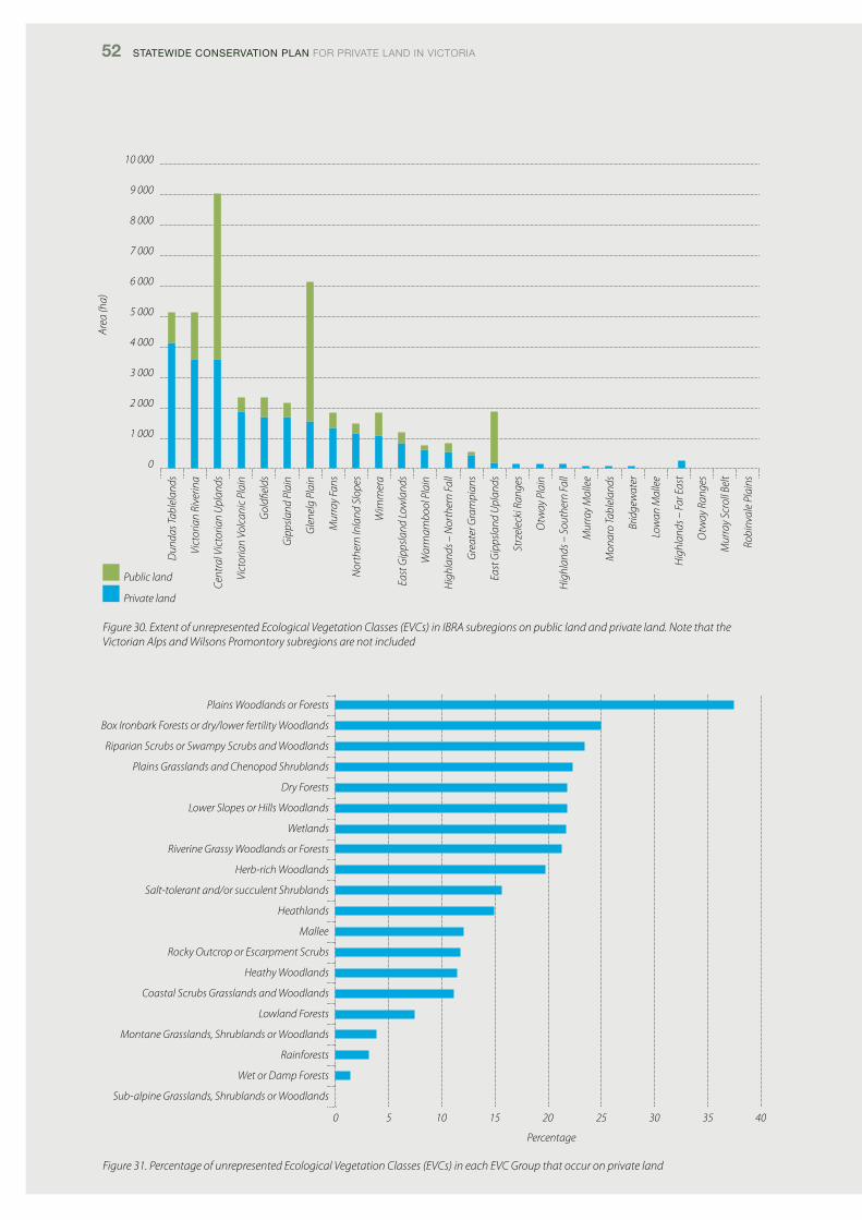
52 Statewide ConServation Plan foR pRivATE lANd iN vicToRiA
Figure 31. Percentage of unrepresented Ecological Vegetation Classes (EVCs) in each EVC Group that occur on private land
Dun
das T
able
land
s
Vict
oria
n Ri
verin
a
Cent
ral V
icto
rian
Upl
ands
Vict
oria
n Vo
lcan
ic P
lain
Gol
dfiel
ds
Gip
psla
nd P
lain
Gle
nelg
Pla
in
Mur
ray
Fans
Nor
ther
n In
land
Slo
pes
Wim
mer
a
East
Gip
psla
nd L
owla
nds
War
rnam
bool
Pla
in
Hig
hlan
ds –
Nor
ther
n Fa
ll
Gre
ater
Gra
mpi
ans
East
Gip
psla
nd U
plan
ds
Strz
elec
ki R
ange
s
Otw
ay P
lain
Hig
hlan
ds –
Sou
ther
n Fa
ll
Mur
ray
Mal
lee
Mon
aro
Tabl
elan
ds
Brid
gew
ater
Low
an M
alle
e
Hig
hlan
ds –
Far
Eas
t
Otw
ay R
ange
s
Mur
ray
Scro
ll Be
lt
Robi
nval
e Pl
ains
10 000
9 000
8 000
7 000
6 000
5 000
4 000
3 000
2 000
1 000
0
Area
(ha)
Public land
Private land
Figure 30. Extent of unrepresented Ecological Vegetation Classes (EVCs) in IBRA subregions on public land and private land. Note that the Victorian Alps and Wilsons Promontory subregions are not included
Plains Woodlands or Forests
Box Ironbark Forests or dry/lower fertility Woodlands
Riparian Scrubs or Swampy Scrubs and Woodlands
Plains Grasslands and Chenopod Shrublands
Dry Forests
Lower Slopes or Hills Woodlands
Wetlands
Riverine Grassy Woodlands or Forests
Herb-rich Woodlands
Salt-tolerant and/or succulent Shrublands
Heathlands
Mallee
Rocky Outcrop or Escarpment Scrubs
Heathy Woodlands
Coastal Scrubs Grasslands and Woodlands
Lowland Forests
Montane Grasslands, Shrublands or Woodlands
Rainforests
Wet or Damp Forests
Sub-alpine Grasslands, Shrublands or Woodlands
0 5 10 15 20 25 30 35 40
Percentage
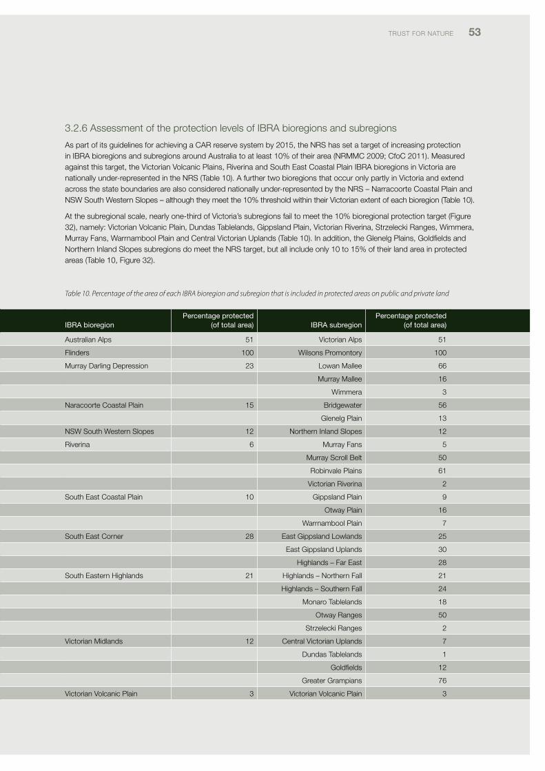
TRUST foR NATURE 53
3.2.6 Assessment of the protection levels of iBRA bioregions and subregions
As part of its guidelines for achieving a cAR reserve system by 2015, the NRS has set a target of increasing protection in iBRA bioregions and subregions around Australia to at least 10% of their area (NRMMc 2009; cfoc 2011). Measured against this target, the victorian volcanic plains, Riverina and South East coastal plain iBRA bioregions in victoria are nationally under-represented in the NRS (Table 10). A further two bioregions that occur only partly in victoria and extend across the state boundaries are also considered nationally under-represented by the NRS – Narracoorte coastal plain and NSW South Western Slopes – although they meet the 10% threshold within their victorian extent of each bioregion (Table 10).
At the subregional scale, nearly one-third of victoria’s subregions fail to meet the 10% bioregional protection target (figure 32), namely: victorian volcanic plain, dundas Tablelands, Gippsland plain, victorian Riverina, Strzelecki Ranges, Wimmera, Murray fans, Warrnambool plain and central victorian Uplands (Table 10). in addition, the Glenelg plains, Goldfields and Northern inland Slopes subregions do meet the NRS target, but all include only 10 to 15% of their land area in protected areas (Table 10, figure 32).
iBra bioregionPercentage protected
(of total area) iBra subregion Percentage protected
(of total area)
Australian Alps 51 victorian Alps 51
flinders 100 Wilsons promontory 100
Murray darling depression 23 lowan Mallee 66
Murray Mallee 16
Wimmera 3
Naracoorte coastal plain 15 Bridgewater 56
Glenelg plain 13
NSW South Western Slopes 12 Northern inland Slopes 12
Riverina 6 Murray fans 5
Murray Scroll Belt 50
Robinvale plains 61
victorian Riverina 2
South East coastal plain 10 Gippsland plain 9
otway plain 16
Warrnambool plain 7
South East corner 28 East Gippsland lowlands 25
East Gippsland Uplands 30
Highlands – far East 28
South Eastern Highlands 21 Highlands – Northern fall 21
Highlands – Southern fall 24
Monaro Tablelands 18
otway Ranges 50
Strzelecki Ranges 2
victorian Midlands 12 central victorian Uplands 7
dundas Tablelands 1
Goldfields 12
Greater Grampians 76
victorian volcanic plain 3 victorian volcanic plain 3
Table 10. Percentage of the area of each IBRA bioregion and subregion that is included in protected areas on public and private land
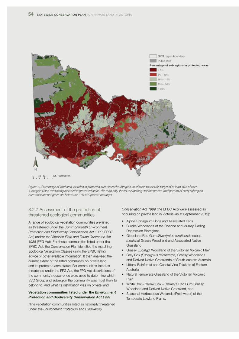
54 Statewide ConServation Plan foR pRivATE lANd iN vicToRiA
Figure 32. Percentage of land area included in protected areas in each subregion, in relation to the NRS target of at least 10% of each subregion’s land area being included in protected areas. The map only shows the rankings for the private land portion of every subregion. Areas that are not green are below the 10% NRS protection target
0 25 50 100 kilometres
3.2.7 Assessment of the protection of threatened ecological communities
A range of ecological vegetation communities are listed as threatened under the Commonwealth Environment Protection and Biodiversity Conservation Act 1999 (EpBc Act) and/or the victorian Flora and Fauna Guarantee Act 1988 (ffG Act). for those communities listed under the EpBc Act, the conservation plan identified the matching Ecological vegetation classes using the EpBc listing advice or other available information. it then analysed the current extent of the listed community on private land and its protected area status. for communities listed as threatened under the ffG Act, the ffG Act descriptions of the community’s occurrence were used to determine which Evc Group and subregion the community was most likely to belong to, and what its distribution was on private land.
Vegetation communities listed under the Environment Protection and Biodiversity Conservation Act 1999
Nine vegetation communities listed as nationally threatened under the Environment Protection and Biodiversity
Conservation Act 1999 (the EpBc Act) were assessed as occurring on private land in victoria (as at September 2012):
• AlpineSphagnumBogsandAssociatedFens• BulokeWoodlandsoftheRiverinaandMurray-Darling
depression Bioregions • GippslandRedGum(Eucalyptus tereticornis subsp.
mediana) Grassy Woodland and Associated Native Grassland
• GrassyEucalyptWoodlandoftheVictorianVolcanicPlain• GreyBox(Eucalyptus microcarpa) Grassy Woodlands
and derived Native Grasslands of South-eastern Australia • LittoralRainforestandCoastalVineThicketsofEastern
Australia• NaturalTemperateGrasslandoftheVictorianVolcanic
plain• WhiteBox–YellowBox–Blakely’sRedGumGrassy
Woodland and derived Native Grassland, and• SeasonalHerbaceousWetlands(Freshwater)ofthe
Temperate lowland plains.
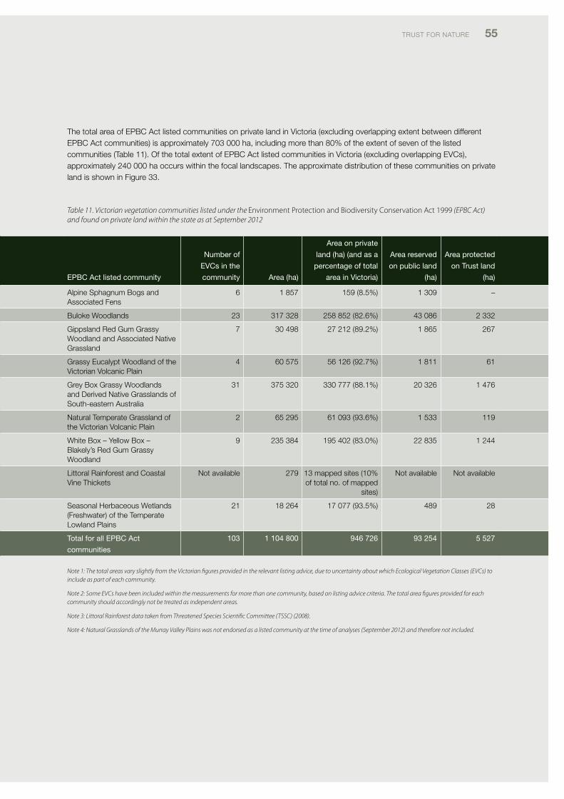
TRUST foR NATURE 55
The total area of EpBc Act listed communities on private land in victoria (excluding overlapping extent between different EpBc Act communities) is approximately 703 000 ha, including more than 80% of the extent of seven of the listed communities (Table 11). of the total extent of EpBc Act listed communities in victoria (excluding overlapping Evcs), approximately 240 000 ha occurs within the focal landscapes. The approximate distribution of these communities on private land is shown in figure 33.
ePBC act listed community
number of
evCs in the
community area (ha)
area on private
land (ha) (and as a
percentage of total
area in victoria)
area reserved
on public land
(ha)
area protected
on trust land
(ha)
Alpine Sphagnum Bogs and Associated fens
6 1 857 159 (8.5%) 1 309 –
Buloke Woodlands 23 317 328 258 852 (82.6%) 43 086 2 332
Gippsland Red Gum Grassy Woodland and Associated Native Grassland
7 30 498 27 212 (89.2%) 1 865 267
Grassy Eucalypt Woodland of the victorian volcanic plain
4 60 575 56 126 (92.7%) 1 811 61
Grey Box Grassy Woodlands and derived Native Grasslands of South-eastern Australia
31 375 320 330 777 (88.1%) 20 326 1 476
Natural Temperate Grassland of the victorian volcanic plain
2 65 295 61 093 (93.6%) 1 533 119
White Box – Yellow Box – Blakely’s Red Gum Grassy Woodland
9 235 384 195 402 (83.0%) 22 835 1 244
littoral Rainforest and coastal vine Thickets
Not available 279 13 mapped sites (10% of total no. of mapped
sites)
Not available Not available
Seasonal Herbaceous Wetlands (freshwater) of the Temperate lowland plains
21 18 264 17 077 (93.5%) 489 28
total for all ePBC act
communities
103 1 104 800 946 726 93 254 5 527
Note 1: The total areas vary slightly from the Victorian figures provided in the relevant listing advice, due to uncertainty about which Ecological Vegetation Classes (EVCs) to include as part of each community.
Note 2: Some EVCs have been included within the measurements for more than one community, based on listing advice criteria. The total area figures provided for each community should accordingly not be treated as independent areas.
Note 3: Littoral Rainforest data taken from Threatened Species Scientific Committee (TSSC) (2008).
Note 4: Natural Grasslands of the Murray Valley Plains was not endorsed as a listed community at the time of analyses (September 2012) and therefore not included.
Table 11. Victorian vegetation communities listed under the Environment Protection and Biodiversity Conservation Act 1999 (EPBC Act) and found on private land within the state as at September 2012
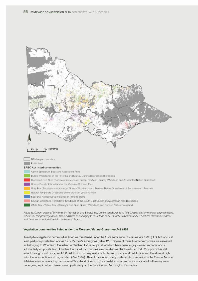
56 Statewide ConServation Plan foR pRivATE lANd iN vicToRiA
Figure 33. Current extent of Environment Protection and Biodiversity Conservation Act 1999 (EPBC Act) listed communities on private land. Where an Ecologcal Vegetation Class is classified as belonging to more than one EPBC Act listed community, it has been classified as part of whichever community is listed first in the map’s legend.
0 25 50 100 kilometres
Vegetation communities listed under the Flora and Fauna Guarantee Act 1988
Twenty-two vegetation communities listed as threatened under the Flora and Fauna Guarantee Act 1988 (ffG Act) occur at least partly on private land across 19 of victoria’s subregions (Table 12). Thirteen of these listed communities are assessed as belonging to Woodland, Grassland or Wetland Evc Groups, all of which have been largely cleared and now occur substantially on private land. A further four listed communities are classified as Rainforests, an Evc Group which is still extant through most of its pre-1750 distribution but very restricted in terms of its natural distribution and therefore at high risk of local extinction and degradation (peel 1999). Also of note in terms of private-land conservation is the coastal Moonah (Melaleuca lanceolata subsp. lanceolata) Woodland community, a coastal scrub community associated with many areas undergoing rapid urban development, particularly on the Bellarine and Mornington peninsulas.
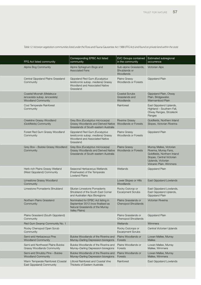
TRUST foR NATURE 57
Table 12. Victorian vegetation communities listed under the Flora and Fauna Gaurantee Act 1988 (FFG Act) and found on private land within the state
FFG act listed communityCorresponding ePBC act listed community
evC Groups contained in the community
estimated subregional occurrence
Alpine Bog community Alpine Sphagnum Bogs and Associated fens
Sub-alpine Grasslands, Shrublands or Woodlands
victorian Alps
central Gippsland plains Grassland community
Gippsland Red Gum (Eucalyptus tereticornis subsp. mediana) Grassy Woodland and Associated Native Grassland
plains Grassy Woodlands or forests
Gippsland plain
coastal Moonah (Melaleuca lanceolata subsp. lanceolata) Woodland community
coastal Scrubs Grasslands and Woodlands
Gippsland plain, otway plain, Bridgewater, Warrnambool plain
cool Temperate Rainforest community
Rainforest East Gippsland Uplands, Highland – Southern fall, otway Ranges, Strzelecki Ranges
creekline Grassy Woodland (Goldfields) community
Grey Box (Eucalyptus microcarpa) Grassy Woodlands and derived Native Grasslands of South-eastern Australia
Riverine Grassy Woodlands or forests
Goldfields, Northern inland Slopes, victorian Riverina
forest Red Gum Grassy Woodland community
Gippsland Red Gum (Eucalyptus tereticornis subsp. mediana) Grassy Woodland and Associated Native Grassland
plains Grassy Woodlands or forests
Gippsland plain
Grey Box – Buloke Grassy Woodland community
Grey Box (Eucalyptus microcarpa) Grassy Woodlands and derived Native Grasslands of South-eastern Australia
plains Grassy Woodlands or forests
Murray Mallee, victorian Riverina, Murray fans, Goldfields, Northern inland Slopes, central victorian Uplands, victorian volcanic plain, Wimmera
Herb-rich plains Grassy Wetland (West Gippsland) community
Seasonal Herbaceous Wetlands (freshwater) of the Temperate lowland plains
Wetlands Gippsland plain
limestone Grassy Woodland community
lower Slopes or Hills Woodlands
East Gippsland lowlands
limestone pomaderris Shrubland Silurian limestone pomaderris Shrubland of the South East corner and Australian Alps Bioregions
Rocky outcrop or Escarpment Scrubs
East Gippsland lowlands, East Gippsland Uplands, Gippsland plain
Northern plains Grassland community
Nominated for EpBc Act listing in September 2012 (now finalised as Natural Grasslands of the Murray valley plains)
plains Grasslands or chenopod Shrublands
victorian Riverina
plains Grassland (South Gippsland) community
plains Grasslands or chenopod Shrublands
Gippsland plain
Red Gum Swamp community No. 1 Wetlands Wimmera
Rocky chenopod open Scrub community
Rocky outcrops or Escarpment Scrubs
central victorian Uplands
Semi-arid Herbaceous pine Woodland community
Buloke Woodlands of the Riverina and Murray–darling depression bioregions
plains Woodlands or forests
lowan Mallee, Murray Mallee
Semi-arid Northwest plains Buloke Grassy Woodlands community
Buloke Woodlands of the Riverina and Murray–darling depression bioregions
plains Woodlands or forests
lowan Mallee, Murray Mallee, Wimmera
Semi-arid Shrubby pine – Buloke Woodland community
Buloke Woodlands of the Riverina and Murray–darling depression bioregions
plains Woodlands or forests
lowan Mallee, Murray Mallee, Wimmera
Warm Temperate Rainforest (coastal East Gippsland) community
littoral Rainforest and coastal vine Thickets of Eastern Australia
Rainforest East Gippsland lowlands
58 Statewide ConServation Plan foR pRivATE lANd iN vicToRiA
FFG act listed communityCorresponding ePBC act listed community
evC Groups contained in the community
estimated subregional occurrence
Warm Temperate Rainforest (East Gippsland Alluvial Terraces) community
Rainforest East Gippsland lowlands, Gippsland plain
Warm Temperate Rainforest (far East Gippsland) community
Rainforest East Gippsland lowlands, Gippsland plain
Western (Basalt) plains Grasslands community
Natural Temperate Grassland of the victorian volcanic plain
plains Grasslands or chenopod Shrublands
victorian volcanic plain
Western Basalt plains (River Red Gum) Grassy Woodland
Grassy Eucalypt Woodland of the victorian volcanic plain
plains Woodlands or forests
victorian volcanic plain
3.2.8 priorities for improving ecosystem protection
Conservation objective 2: key priorities
• recognisethatincreasedprotectionofunder-representedecosystems on private land is critical to meeting NRS bioregional, subregional and ecosystem targets in victoria
• theTrustwillcontinueitslong-establishedfocuson private-land protection in the nationally under-represented Riverina, victorian volcanic plain and South East coastal plain iBRA bioregions
• recognisesubstantialgapsexistinecosystemrepresentation in protected areas in many other subregions that do not form part of the iBRA bioregions mentioned above, notably Glenelg plain, Wimmera, Murray Mallee, dundas Tablelands, central victorian Uplands, Goldfields, Northern inland Slopes, East Gippsland lowlands and Strzelecki Ranges. Target all of these areas for increased protection on private land
• recognisethateveninthosebioregionsandsubregionsthat meet national targets for ecosystem representation, there are many Evcs found principally on private land that should be targeted for increased protection
• understandthattheTrust,inpartnershipwithprivatelandowners, has a critical role to play in improving the protection status of under-represented ecosystems and vegetation communities classified as nationally threatened in victoria
• continuetheTrust’slong-standingfocusonincreasingprotection of woodlands and grasslands should continue, especially in focal landscapes and under-represented subregions, and
• increasinglytargetothervegetationgroupsthatoccurprincipally on private land and are under-represented in protected areas; for example, wetlands and riparian scrubs.
Improving protection of under-represented ecosystems
The conservation plan’s findings highlight the critical importance of private land in meeting NRS targets for a comprehensive, Adequate and Representative reserve system in victoria.
firstly, as shown in figure 34, increased protection of private land habitat provides the only means of attaining the NRS 10% subregional protection target in the victorian volcanic plain, victorian Riverina, dundas Tableland, Warrnambool plain and Wimmera subregions, as there is not enough non-protected habitat available on public land to meet the target (figure 34). Even in other subregions, where sufficient habitat remains on public land, to achieve the 10% target, systematic land-use planning and land-tenure change have already been implemented for much of the public estate (e.g. Ecc 2001; vEAc 2008). it is unlikely, therefore, that much additional public land will be transferred into the protected areas estate. instead, private land provides the best option to increase the NRS in these subregions.
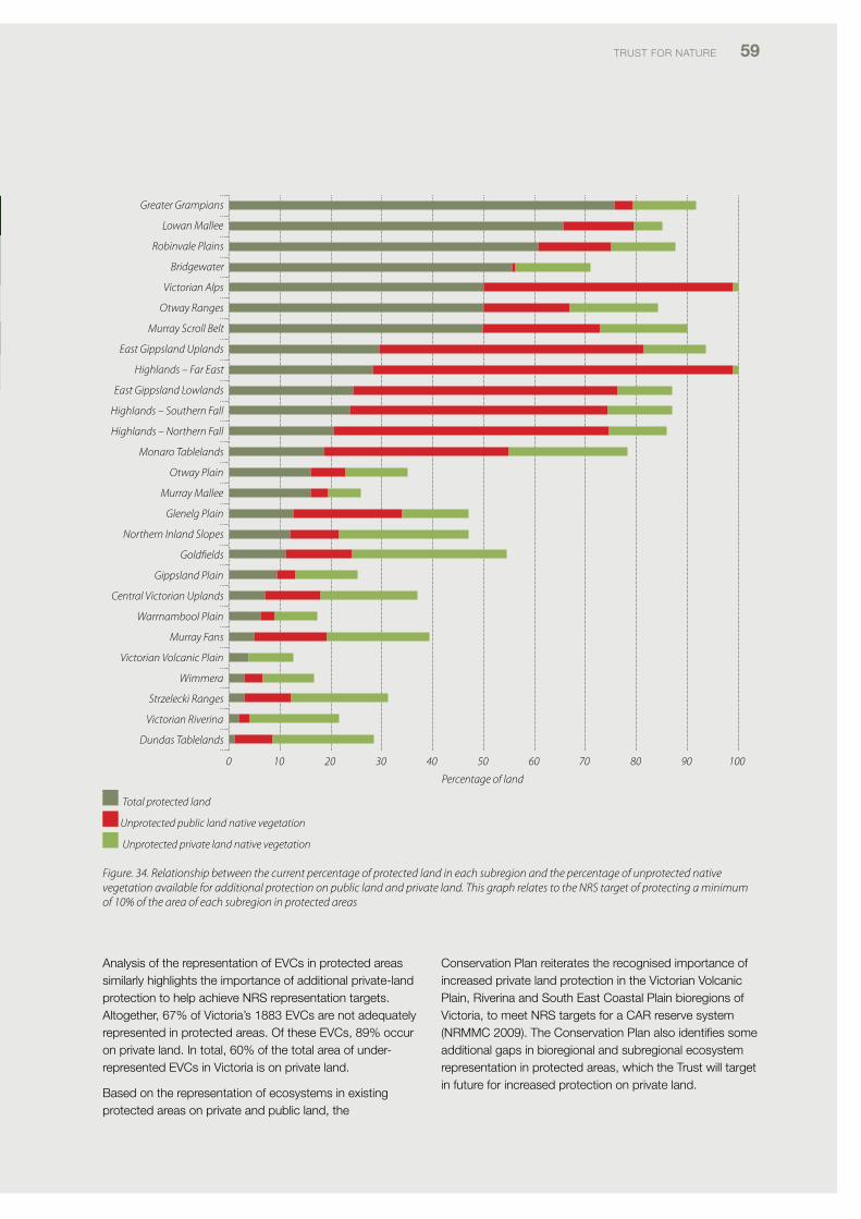
TRUST foR NATURE 59
Greater Grampians
Lowan Mallee
Robinvale Plains
Bridgewater
Victorian Alps
Otway Ranges
Murray Scroll Belt
East Gippsland Uplands
Highlands – Far East
East Gippsland Lowlands
Highlands – Southern Fall
Highlands – Northern Fall
Monaro Tablelands
Otway Plain
Murray Mallee
Glenelg Plain
Northern Inland Slopes
Goldfields
Gippsland Plain
Central Victorian Uplands
Warrnambool Plain
Murray Fans
Victorian Volcanic Plain
Wimmera
Strzelecki Ranges
Victorian Riverina
Dundas Tablelands
0 10 20 30 40 50 60 70 80 90 100
Percentage of land
Total protected land
Unprotected public land native vegetation
Unprotected private land native vegetation
Figure. 34. Relationship between the current percentage of protected land in each subregion and the percentage of unprotected native vegetation available for additional protection on public land and private land. This graph relates to the NRS target of protecting a minimum of 10% of the area of each subregion in protected areas
Analysis of the representation of Evcs in protected areas similarly highlights the importance of additional private-land protection to help achieve NRS representation targets. Altogether, 67% of victoria’s 1883 Evcs are not adequately represented in protected areas. of these Evcs, 89% occur on private land. in total, 60% of the total area of under-represented Evcs in victoria is on private land.
Based on the representation of ecosystems in existing protected areas on private and public land, the
conservation plan reiterates the recognised importance of increased private land protection in the victorian volcanic plain, Riverina and South East coastal plain bioregions of victoria, to meet NRS targets for a cAR reserve system (NRMMc 2009). The conservation plan also identifies some additional gaps in bioregional and subregional ecosystem representation in protected areas, which the Trust will target in future for increased protection on private land.
FFG act listed communityCorresponding ePBC act listed community
evC Groups contained in the community
estimated subregional occurrence
Warm Temperate Rainforest (East Gippsland Alluvial Terraces) community
Rainforest East Gippsland lowlands, Gippsland plain
Warm Temperate Rainforest (far East Gippsland) community
Rainforest East Gippsland lowlands, Gippsland plain
Western (Basalt) plains Grasslands community
Natural Temperate Grassland of the victorian volcanic plain
plains Grasslands or chenopod Shrublands
victorian volcanic plain
Western Basalt plains (River Red Gum) Grassy Woodland
Grassy Eucalypt Woodland of the victorian volcanic plain
plains Woodlands or forests
victorian volcanic plain
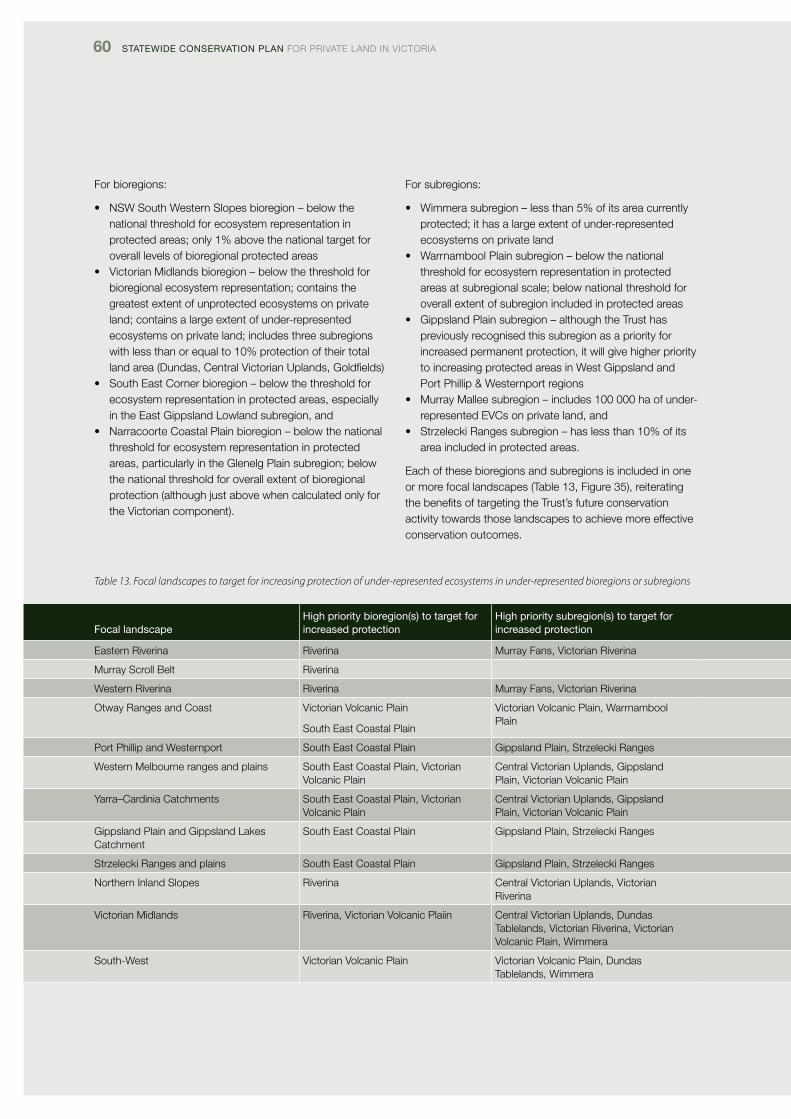
60 Statewide ConServation Plan foR pRivATE lANd iN vicToRiA
for bioregions:
• NSWSouthWesternSlopesbioregion–belowthenational threshold for ecosystem representation in protected areas; only 1% above the national target for overall levels of bioregional protected areas
• VictorianMidlandsbioregion–belowthethresholdforbioregional ecosystem representation; contains the greatest extent of unprotected ecosystems on private land; contains a large extent of under-represented ecosystems on private land; includes three subregions with less than or equal to 10% protection of their total land area (dundas, central victorian Uplands, Goldfields)
• SouthEastCornerbioregion–belowthethresholdforecosystem representation in protected areas, especially in the East Gippsland lowland subregion, and
• NarracoorteCoastalPlainbioregion–belowthenationalthreshold for ecosystem representation in protected areas, particularly in the Glenelg plain subregion; below the national threshold for overall extent of bioregional protection (although just above when calculated only for the victorian component).
for subregions:
• Wimmerasubregion–lessthan5%ofitsareacurrentlyprotected; it has a large extent of under-represented ecosystems on private land
• WarrnamboolPlainsubregion–belowthenationalthreshold for ecosystem representation in protected areas at subregional scale; below national threshold for overall extent of subregion included in protected areas
• GippslandPlainsubregion–althoughtheTrusthaspreviously recognised this subregion as a priority for increased permanent protection, it will give higher priority to increasing protected areas in West Gippsland and port phillip & Westernport regions
• MurrayMalleesubregion–includes100000haofunder-represented Evcs on private land, and
• StrzeleckiRangessubregion–haslessthan10%ofitsarea included in protected areas.
Each of these bioregions and subregions is included in one or more focal landscapes (Table 13, figure 35), reiterating the benefits of targeting the Trust’s future conservation activity towards those landscapes to achieve more effective conservation outcomes.
Table 13. Focal landscapes to target for increasing protection of under-represented ecosystems in under-represented bioregions or subregions
Focal landscapeHigh priority bioregion(s) to target for increased protection
High priority subregion(s) to target for increased protection
Eastern Riverina Riverina Murray fans, victorian Riverina
Murray Scroll Belt Riverina
Western Riverina Riverina Murray fans, victorian Riverina
otway Ranges and coast victorian volcanic plain
South East coastal plain
victorian volcanic plain, Warrnambool plain
port phillip and Westernport South East coastal plain Gippsland plain, Strzelecki Ranges
Western Melbourne ranges and plains South East coastal plain, victorian volcanic plain
central victorian Uplands, Gippsland plain, victorian volcanic plain
Yarra–cardinia catchments South East coastal plain, victorian volcanic plain
central victorian Uplands, Gippsland plain, victorian volcanic plain
Gippsland plain and Gippsland lakes catchment
South East coastal plain Gippsland plain, Strzelecki Ranges
Strzelecki Ranges and plains South East coastal plain Gippsland plain, Strzelecki Ranges
Northern inland Slopes Riverina central victorian Uplands, victorian Riverina
victorian Midlands Riverina, victorian volcanic plaiin central victorian Uplands, dundas Tablelands, victorian Riverina, victorian volcanic plain, Wimmera
South-West victorian volcanic plain victorian volcanic plain, dundas Tablelands, Wimmera
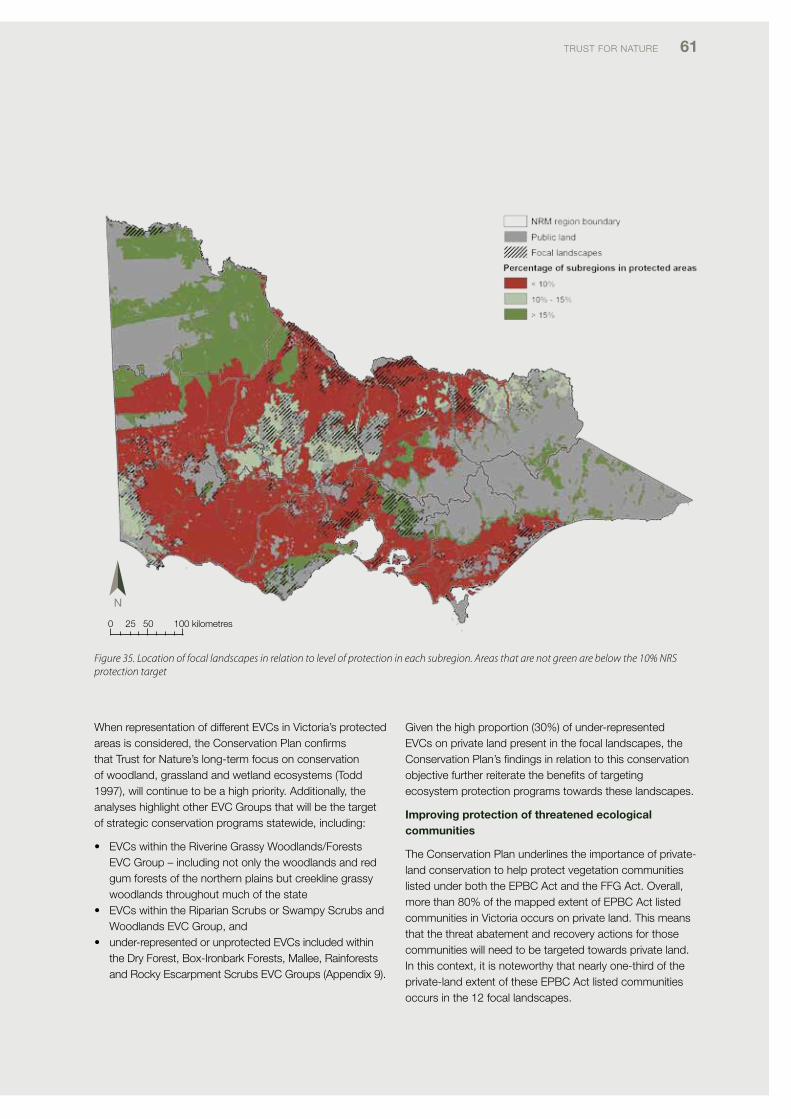
TRUST foR NATURE 61
0 25 50 100 kilometres
Figure 35. Location of focal landscapes in relation to level of protection in each subregion. Areas that are not green are below the 10% NRS protection target
When representation of different Evcs in victoria’s protected areas is considered, the conservation plan confirms that Trust for Nature’s long-term focus on conservation of woodland, grassland and wetland ecosystems (Todd 1997), will continue to be a high priority. Additionally, the analyses highlight other Evc Groups that will be the target of strategic conservation programs statewide, including:
• EVCswithintheRiverineGrassyWoodlands/ForestsEvc Group – including not only the woodlands and red gum forests of the northern plains but creekline grassy woodlands throughout much of the state
• EVCswithintheRiparianScrubsorSwampyScrubsandWoodlands Evc Group, and
• under-representedorunprotectedEVCsincludedwithinthe dry forest, Box-ironbark forests, Mallee, Rainforests and Rocky Escarpment Scrubs Evc Groups (Appendix 9).
Given the high proportion (30%) of under-represented Evcs on private land present in the focal landscapes, the conservation plan’s findings in relation to this conservation objective further reiterate the benefits of targeting ecosystem protection programs towards these landscapes.
Improving protection of threatened ecological communities
The conservation plan underlines the importance of private-land conservation to help protect vegetation communities listed under both the EpBc Act and the ffG Act. overall, more than 80% of the mapped extent of EpBc Act listed communities in victoria occurs on private land. This means that the threat abatement and recovery actions for those communities will need to be targeted towards private land. in this context, it is noteworthy that nearly one-third of the private-land extent of these EpBc Act listed communities occurs in the 12 focal landscapes.
Focal landscapeHigh priority bioregion(s) to target for increased protection
High priority subregion(s) to target for increased protection
Eastern Riverina Riverina Murray fans, victorian Riverina
Murray Scroll Belt Riverina
Western Riverina Riverina Murray fans, victorian Riverina
otway Ranges and coast victorian volcanic plain
South East coastal plain
victorian volcanic plain, Warrnambool plain
port phillip and Westernport South East coastal plain Gippsland plain, Strzelecki Ranges
Western Melbourne ranges and plains South East coastal plain, victorian volcanic plain
central victorian Uplands, Gippsland plain, victorian volcanic plain
Yarra–cardinia catchments South East coastal plain, victorian volcanic plain
central victorian Uplands, Gippsland plain, victorian volcanic plain
Gippsland plain and Gippsland lakes catchment
South East coastal plain Gippsland plain, Strzelecki Ranges
Strzelecki Ranges and plains South East coastal plain Gippsland plain, Strzelecki Ranges
Northern inland Slopes Riverina central victorian Uplands, victorian Riverina
victorian Midlands Riverina, victorian volcanic plaiin central victorian Uplands, dundas Tablelands, victorian Riverina, victorian volcanic plain, Wimmera
South-West victorian volcanic plain victorian volcanic plain, dundas Tablelands, Wimmera
62 Statewide ConServation Plan foR pRivATE lANd iN vicToRiA
3.3 Conservation objective 3: Improve protection of significant aquatic and coastal ecosystems
3.3.1 Rationale for the objective
Aquatic and coastal ecosystems play a pivotal ecological role in the natural environment in terms of biological productivity, biodiversity, hydrological processes, landscape connectivity, migratory movements of aquatic and terrestrial animal species, and provision of habitat refugia during dry periods (Soule’ et al. 2004; Bennett et al. 2009; cfoc 2011). for this reason, protection of significant aquatic systems forms a core element of Australia’s Biodiversity conservation Strategy (NRMMc 2010) and is also recognised as a priority action for building the National Reserve System (NRS) (NRMMc 2005, 2009; dunlop & Brown 2008; cfoc 2011; dunlop et al. 2012a, 2012b).
priorities for conservation in relation to this conservation objective were derived from assessments, based on national and/or state criteria for assessing the significance of wetland, riparian and coastal ecosystems.
More details about the assessment criteria, methods and data sources are provided in Appendix 2.
3.3.2 Key findings for the objective
The conservation plan assessed three major aquatic ecosystems in terms of conservation priorities for private land: wetlands, riparian ecosystems and coastal ecosystems. The key findings in relation to each of these aquatic ecosystems are described below.
Wetlands
• nearly200000haofsignificantwetlandsandassociatedbuffers occur on private land, including at least 45 000 ha each in total as part of Ramsar wetlands, Wetlands of National importance, bioregionally significant wetlands and important Bird Areas
• ofVictoria’s11Ramsarwetlands,10includesomeprivate land or private-land buffers
• thereare13ImportantBirdAreasthatincorporateprivate land, and are classified as globally significant for a range of waterbirds and listed migratory shorebirds, and
• nearlytwo-thirdsofwetlandEcologicalVegetationclasses (Evcs) are under-represented in victoria’s protected areas.
Riparian ecosystems
• morethan40%ofVictoria’s48000kilometresofwaterways is bordered by private land
• justoverhalfofprivateriparianlandcontainsnativevegetation; the remainder is cleared
• nearlyallofthenativevegetationpresentinriparianbuffers on private land is under-represented in protected areas, and
• only1%ofriparianhabitatonprivatelandinVictoriaiscurrently protected by the Trust, through covenants or property ownership.
Coastal ecosystems
• nearlyhalfofVictoria’scoastalland(almost200000ha)is private land
• onlyonequarterofcoastalprivatelandcontainsnativevegetation; the remainder is cleared
• over40%ofthenativevegetationfoundonprivatelandin coastal areas is under-represented in protected areas
• only1%ofprivatelyownedcoastallandiscurrentlyprotected by the Trust through covenants with private landowners or through property ownership, and
• coastalareashavesomeofthehighestratesofurbandevelopment of any private land in the state (cES 2009; dpcd 2012).
3.3.3 Assessment of the protection of wetland ecosystems
Based on dSE’s Wetland classification system, 13 000 wetlands, totalling more than 400 000 ha in extent, currently exist in victoria, of which 80% (by number) occur on private land (NRE 1997). Wetlands on private land include a range of saline and freshwater wetlands, with Shallow freshwater Marshes and freshwater Meadows the most extensive wetland types found on private land (figure 36).
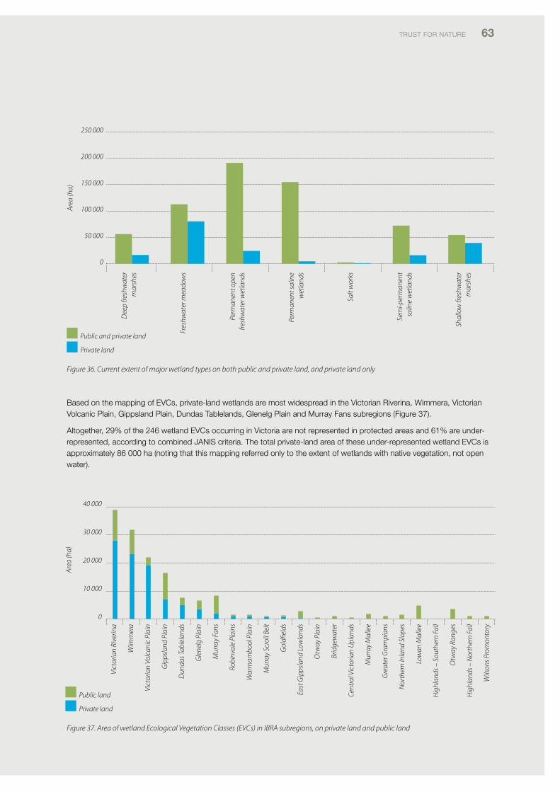
TRUST foR NATURE 63
Figure 36. Current extent of major wetland types on both public and private land, and private land only
Vict
oria
n Ri
verin
a
Wim
mer
a
Vict
oria
n Vo
lcan
ic P
lain
Gip
psla
nd P
lain
Dun
das T
able
land
s
Gle
nelg
Pla
in
Mur
ray
Fans
Robi
nval
e Pl
ains
War
rnam
bool
Pla
in
Mur
ray
Scro
ll Be
lt
Gol
dfiel
ds
East
Gip
psla
nd L
owla
nds
Otw
ay P
lain
Brid
gew
ater
Cent
ral V
icto
rian
Upl
ands
Mur
ray
Mal
lee
Gre
ater
Gra
mpi
ans
Nor
ther
n In
land
Slo
pes
Low
an M
alle
e
Hig
hlan
ds –
Sou
ther
n Fa
ll
Otw
ay R
ange
s
Hig
hlan
ds –
Nor
ther
n Fa
ll
Wils
ons P
rom
onto
ry
40 000
30 000
20 000
10 000
0
Area
(ha)
Public land
Private land
Dee
p fre
shw
ater
m
arsh
es
Fres
hwat
er m
eado
ws
Perm
anen
t ope
n fre
shw
ater
wet
land
s
Perm
anen
t sal
ine
wet
land
s
Salt
wor
ks
Sem
i-per
man
ent
salin
e w
etla
nds
Shal
low
fres
hwat
er
mar
shes
250 000
200 000
150 000
100 000
50 000
0
Area
(ha)
Public and private land
Private land
Based on the mapping of Evcs, private-land wetlands are most widespread in the victorian Riverina, Wimmera, victorian volcanic plain, Gippsland plain, dundas Tablelands, Glenelg plain and Murray fans subregions (figure 37).
Altogether, 29% of the 246 wetland Evcs occurring in victoria are not represented in protected areas and 61% are under-represented, according to combined JANiS criteria. The total private-land area of these under-represented wetland Evcs is approximately 86 000 ha (noting that this mapping referred only to the extent of wetlands with native vegetation, not open water).
Figure 37. Area of wetland Ecological Vegetation Classes (EVCs) in IBRA subregions, on private land and public land
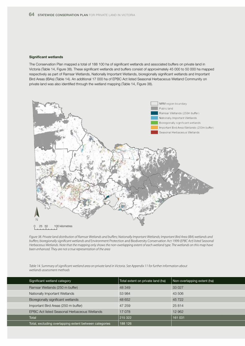
64 Statewide ConServation Plan foR pRivATE lANd iN vicToRiA
Significant wetlands
The conservation plan mapped a total of 188 100 ha of significant wetlands and associated buffers on private land in victoria (Table 14, figure 38). These significant wetlands and buffers consist of approximately 45 000 to 50 000 ha mapped respectively as part of Ramsar Wetlands, Nationally important Wetlands, bioregionally significant wetlands and important Bird Areas (iBAs) (Table 14). An additional 17 000 ha of EpBc Act listed Seasonal Herbaceous Wetland community on private land was also identified through the wetland mapping (Table 14, figure 38).
Figure 38. Private land distribution of Ramsar Wetlands and buffers; Nationally Important Wetlands; Important Bird Area (IBA) wetlands and buffers; bioregionally significant wetlands and Environment Protection and Biodiversity Conservation Act 1999 (EPBC Act) listed Seasonal Herbaceous Wetlands. Note that the mapping only shows the non-overlapping extent of each wetland type. The wetlands on this map have been enhanced. They are not a true representation of the area
Table 14. Summary of significant wetland area on private land in Victoria. See Appendix 11 for further information about wetlands assessment methods
Significant wetland category total extent on private land (ha) non-overlapping extent (ha)
Ramsar Wetlands (250 m buffer) 48 349 33 027
Nationally important Wetlands 53 984 43 506
Bioregionally significant wetlands 48 652 45 722
important Bird Areas (250 m buffer) 47 259 25 814
EpBc Act listed Seasonal Herbaceous Wetlands 17 078 12 962
total 215 322 161 031
total, excluding overlapping extent between categories 188 126
0 25 50 100 kilometres
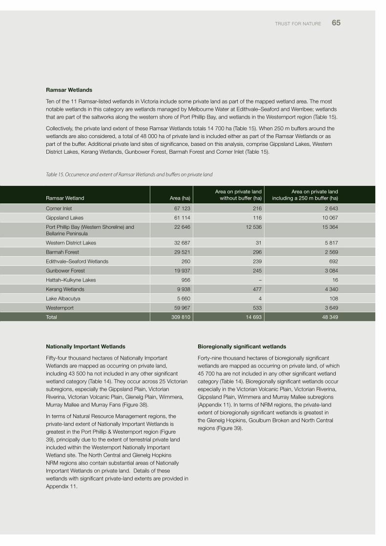
TRUST foR NATURE 65
Ramsar Wetlands
Ten of the 11 Ramsar-listed wetlands in victoria include some private land as part of the mapped wetland area. The most notable wetlands in this category are wetlands managed by Melbourne Water at Edithvale–Seaford and Werribee; wetlands that are part of the saltworks along the western shore of port phillip Bay, and wetlands in the Westernport region (Table 15).
collectively, the private land extent of these Ramsar Wetlands totals 14 700 ha (Table 15). When 250 m buffers around the wetlands are also considered, a total of 48 000 ha of private land is included either as part of the Ramsar Wetlands or as part of the buffer. Additional private land sites of significance, based on this analysis, comprise Gippsland lakes, Western district lakes, Kerang Wetlands, Gunbower forest, Barmah forest and corner inlet (Table 15).
ramsar wetland area (ha)area on private land
without buffer (ha)area on private land
including a 250 m buffer (ha)
corner inlet 67 123 216 2 643
Gippsland lakes 61 114 116 10 067
port phillip Bay (Western Shoreline) and Bellarine peninsula
22 646 12 536 15 364
Western district lakes 32 687 31 5 817
Barmah forest 29 521 296 2 569
Edithvale–Seaford Wetlands 260 239 692
Gunbower forest 19 937 245 3 084
Hattah–Kulkyne lakes 956 – 16
Kerang Wetlands 9 938 477 4 340
lake Albacutya 5 660 4 108
Westernport 59 967 533 3 649
total 309 810 14 693 48 349
Nationally Important Wetlands
fifty-four thousand hectares of Nationally important Wetlands are mapped as occurring on private land, including 43 500 ha not included in any other significant wetland category (Table 14). They occur across 25 victorian subregions, especially the Gippsland plain, victorian Riverina, victorian volcanic plain, Glenelg plain, Wimmera, Murray Mallee and Murray fans (figure 38).
in terms of Natural Resource Management regions, the private-land extent of Nationally important Wetlands is greatest in the port phillip & Westernport region (figure 39), principally due to the extent of terrestrial private land included within the Westernport Nationally important Wetland site. The North central and Glenelg Hopkins NRM regions also contain substantial areas of Nationally important Wetlands on private land. details of these wetlands with significant private-land extents are provided in Appendix 11.
Bioregionally significant wetlands
forty-nine thousand hectares of bioregionally significant wetlands are mapped as occurring on private land, of which 45 700 ha are not included in any other significant wetland category (Table 14). Bioregionally significant wetlands occur especially in the victorian volcanic plain, victorian Riverina, Gippsland plain, Wimmera and Murray Mallee subregions (Appendix 11). in terms of NRM regions, the private-land extent of bioregionally significant wetlands is greatest in the Glenelg Hopkins, Goulburn Broken and North central regions (figure 39).
Table 15. Occurrence and extent of Ramsar Wetlands and buffers on private land
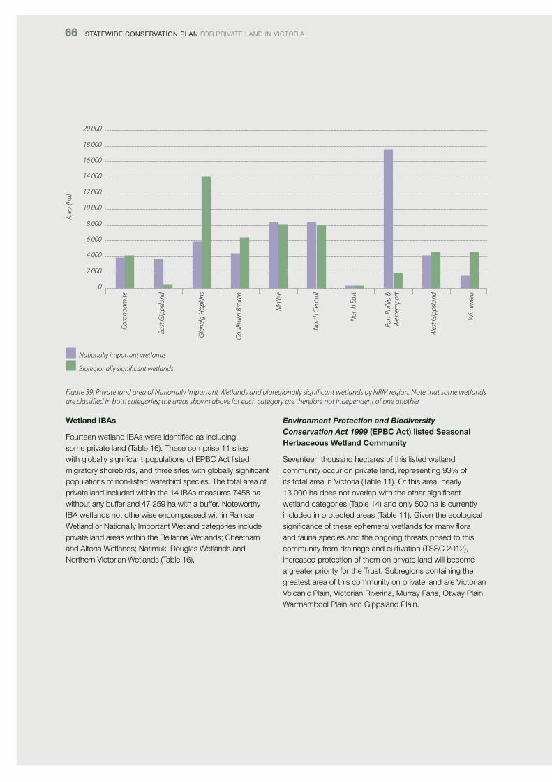
66 Statewide ConServation Plan foR pRivATE lANd iN vicToRiA
Figure 39. Private land area of Nationally Important Wetlands and bioregionally significant wetlands by NRM region. Note that some wetlands are classified in both categories; the areas shown above for each category are therefore not independent of one another
Wetland IBAs
fourteen wetland iBAs were identified as including some private land (Table 16). These comprise 11 sites with globally significant populations of EpBc Act listed migratory shorebirds, and three sites with globally significant populations of non-listed waterbird species. The total area of private land included within the 14 iBAs measures 7458 ha without any buffer and 47 259 ha with a buffer. Noteworthy iBA wetlands not otherwise encompassed within Ramsar Wetland or Nationally important Wetland categories include private land areas within the Bellarine Wetlands; cheetham and Altona Wetlands; Natimuk–douglas Wetlands and Northern victorian Wetlands (Table 16).
Environment Protection and Biodiversity Conservation Act 1999 (EPBC Act) listed Seasonal Herbaceous Wetland Community
Seventeen thousand hectares of this listed wetland community occur on private land, representing 93% of its total area in victoria (Table 11). of this area, nearly 13 000 ha does not overlap with the other significant wetland categories (Table 14) and only 500 ha is currently included in protected areas (Table 11). Given the ecological significanceoftheseephemeralwetlandsformanyfloraand fauna species and the ongoing threats posed to this community from drainage and cultivation (TSSc 2012), increased protection of them on private land will become a greater priority for the Trust. Subregions containing the greatest area of this community on private land are victorian volcanic plain, victorian Riverina, Murray fans, otway plain, Warrnambool plain and Gippsland plain.
20 000
18 000
16 000
14 000
12 000
10 000
8 000
6 000
4 000
2 000
0
Area
(ha)
Cora
ngam
ite
East
Gip
psla
nd
Gle
nelg
Hop
kins
Gou
lbur
n Br
oken
Mal
lee
Nor
th C
entr
al
Nor
th E
ast
Port
Phi
llip
& W
este
rnpo
rt
Wes
t Gip
psla
nd
Wim
mer
a
Nationally important wetlands
Bioregionally significant wetlands
TRUST foR NATURE 67
Table 16. Important Bird Areas (IBAs ) for waterbirds in Victoria that include some of their extent or associated 250 m buffer on private land. The list is arranged by sites including globally significant populations of Environment Protection and Biodiversity Conservation Act (EPBC Act) listed migratory shorebirds and then by sites that are globally significant for non-listed species of waterbird
important Bird area
listed migratory shorebird and/or
other waterbird site
area on private land, without
buffer (ha)
area on private land, including
250 m buffer (ha)Key bird species identified with the iBa (dutson et al. 2009)
Anderson inlet Yes 1 107 Red-necked Stint
Bellarine Wetlands Yes 543 2 918 chestnut Teal, Banded Stilt, Red-
necked Stint, Sharp-tailed Sandpiper
carrum Wetlands Yes 341 947 chestnut Teal, Blue-billed duck,
Sharp-tailed Sandpiper
cheetham & Altona Yes 67 478 chestnut Teal, Red-necked Stint,
pacific Gull
corner inlet Yes 410 3 625 chestnut Teal, pied oystercatcher,
Sooty oystercatcher, Eastern curlew,
Red-necked Stint, pacific Gull,
fairy Tern
Gippsland lakes Yes 394 8 479 Black Swan, chestnut Teal, Musk
duck, fairy Tern
lake corangamite complex Yes 1 184 9 452 Black Swan, freckled duck,
Australian Shelduck, pink-eared
duck, Australasian Shoveler, chestnut
Teal, Blue-billed duck, Musk duck,
Hoary-headed Grebe, Straw-necked
ibis, White-headed Stilt, Banded Stilt,
Sharp-tailed Sandpiper
Shallow inlet Yes 76 550 double-banded plover,
Red-necked Stint
Swan Bay & port phillip
Bay islands
Yes 58 955 chestnut Teal, Blue-billed duck,
Australian White ibis, Straw-necked
ibis, Red-necked Stint, Silver Gull,
fairy Tern
Werribee & Avalon Yes 1 682 3 349 freckled duck, Australian Shelduck,
pink-eared duck, Australasian
Shoveler, chestnut Teal, Blue-billed
duck, Musk duck, Hoary-headed
Grebe, Red-necked Stint, Sharp-tailed
Sandpiper
Westernport Yes 594 6 180 pied oystercatcher, Eastern curlew,
Red-necked Stint, pacific Gull,
fairy Tern
devilbend Reservoir No <1 58 Blue-billed duck
Natimuk–douglas Wetlands No 1 955 9 243 Australian Shelduck, Banded Stilt,
Red-necked Avocet,
Red-capped plover
North victorian Wetlands No 154 916 freckled duck, Blue-billed duck,
Straw-necked ibis, Banded Stilt, Red-
necked Avocet, Black-fronted dotterel
total area 7 458 47 259
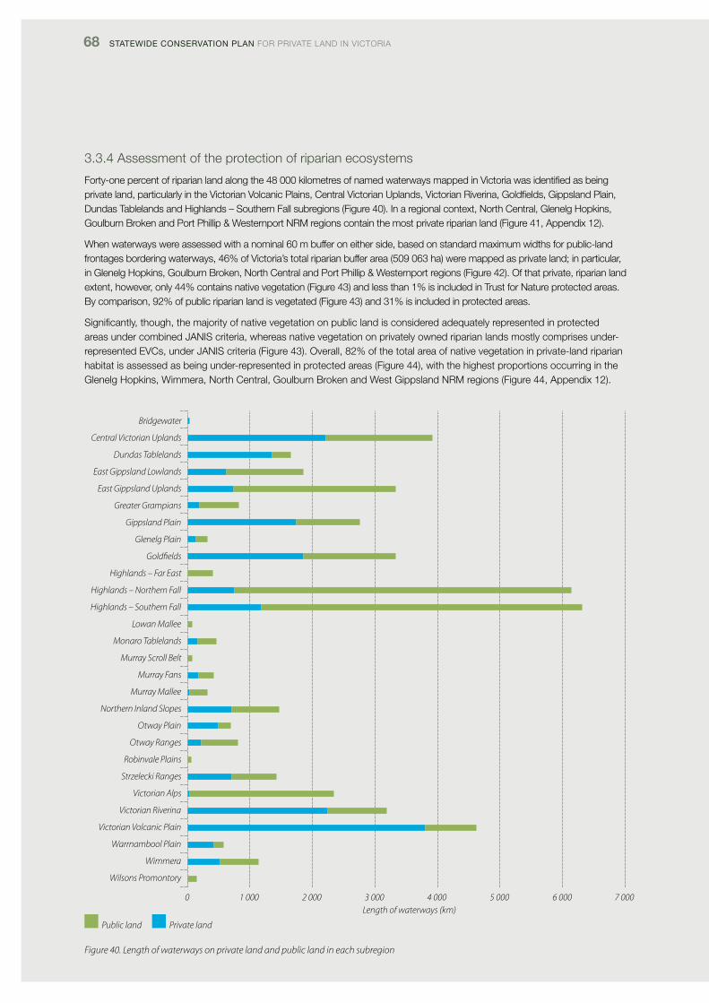
68 Statewide ConServation Plan foR pRivATE lANd iN vicToRiA
3.3.4 Assessment of the protection of riparian ecosystems
forty-one percent of riparian land along the 48 000 kilometres of named waterways mapped in victoria was identified as being private land, particularly in the victorian volcanic plains, central victorian Uplands, victorian Riverina, Goldfields, Gippsland plain, dundas Tablelands and Highlands – Southern fall subregions (figure 40). in a regional context, North central, Glenelg Hopkins, Goulburn Broken and port phillip & Westernport NRM regions contain the most private riparian land (figure 41, Appendix 12).
When waterways were assessed with a nominal 60 m buffer on either side, based on standard maximum widths for public-land frontages bordering waterways, 46% of victoria’s total riparian buffer area (509 063 ha) were mapped as private land; in particular, in Glenelg Hopkins, Goulburn Broken, North central and port phillip & Westernport regions (figure 42). of that private, riparian land extent, however, only 44% contains native vegetation (figure 43) and less than 1% is included in Trust for Nature protected areas. By comparison, 92% of public riparian land is vegetated (figure 43) and 31% is included in protected areas.
Significantly, though, the majority of native vegetation on public land is considered adequately represented in protected areas under combined JANiS criteria, whereas native vegetation on privately owned riparian lands mostly comprises under-represented Evcs, under JANiS criteria (figure 43). overall, 82% of the total area of native vegetation in private-land riparian habitat is assessed as being under-represented in protected areas (figure 44), with the highest proportions occurring in the Glenelg Hopkins, Wimmera, North central, Goulburn Broken and West Gippsland NRM regions (figure 44, Appendix 12).
Figure 40. Length of waterways on private land and public land in each subregion
Bridgewater
Central Victorian Uplands
Dundas Tablelands
East Gippsland Lowlands
East Gippsland Uplands
Greater Grampians
Gippsland Plain
Glenelg Plain
Goldfields
Highlands – Far East
Highlands – Northern Fall
Highlands – Southern Fall
Lowan Mallee
Monaro Tablelands
Murray Scroll Belt
Murray Fans
Murray Mallee
Northern Inland Slopes
Otway Plain
Otway Ranges
Robinvale Plains
Strzelecki Ranges
Victorian Alps
Victorian Riverina
Victorian Volcanic Plain
Warrnambool Plain
Wimmera
Wilsons Promontory
0 1 000 2 000 3 000 4 000 5 000 6 000 7 000Length of waterways (km)
Public land Private land
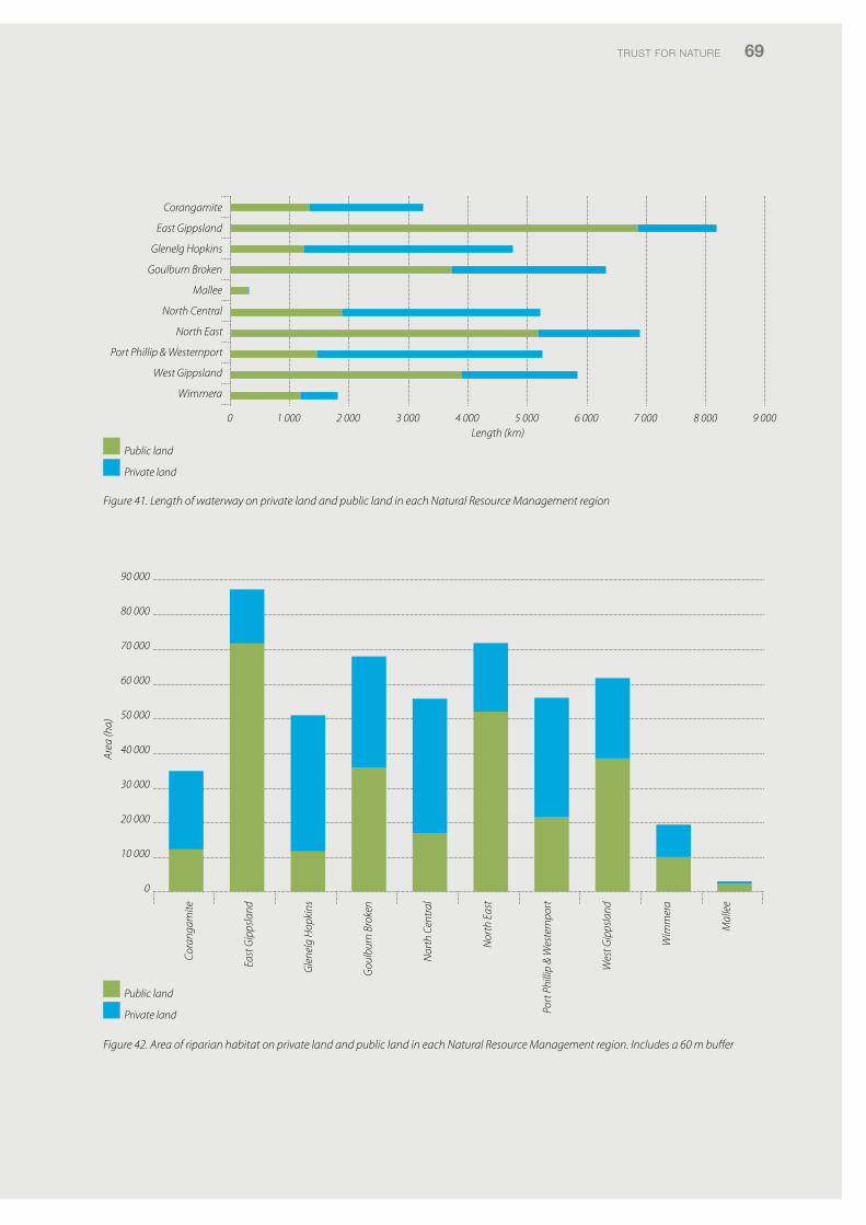
TRUST foR NATURE 69
0 1 000 2 000 3 000 4 000 5 000 6 000 7 000 8 000 9 000
Corangamite
East Gippsland
Glenelg Hopkins
Goulburn Broken
Mallee
North Central
North East
Port Phillip & Westernport
West Gippsland
Wimmera
Length (km)
Public land
Private land
90 000
80 000
70 000
60 000
50 000
40 000
30 000
20 000
10 000
0
Area
(ha)
Cora
ngam
ite
East
Gip
psla
nd
Gle
nelg
Hop
kins
Gou
lbur
n Br
oken
Nor
th C
entr
al
Nor
th E
ast
Port
Phi
llip
& W
este
rnpo
rt
Wes
t Gip
psla
nd
Wim
mer
a
Mal
lee
Public land
Private land
Figure 41. Length of waterway on private land and public land in each Natural Resource Management region
Figure 42. Area of riparian habitat on private land and public land in each Natural Resource Management region. Includes a 60 m buffer
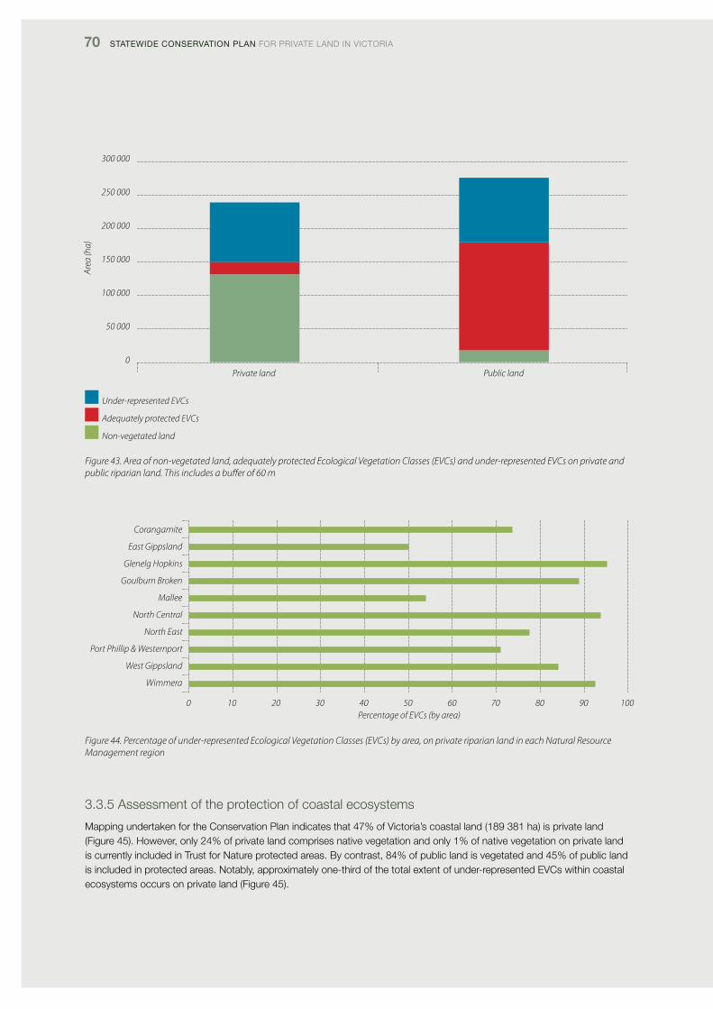
70 Statewide ConServation Plan foR pRivATE lANd iN vicToRiA
Corangamite
East Gippsland
Glenelg Hopkins
Goulburn Broken
Mallee
North Central
North East
Port Phillip & Westernport
West Gippsland
Wimmera
0 10 20 30 40 50 60 70 80 90 100Percentage of EVCs (by area)
300 000
250 000
200 000
150 000
100 000
50 000
0
Area
(ha)
Private land Public land
Under-represented EVCs
Adequately protected EVCs
Non-vegetated land
Figure 43. Area of non-vegetated land, adequately protected Ecological Vegetation Classes (EVCs) and under-represented EVCs on private and public riparian land. This includes a buffer of 60 m
Figure 44. Percentage of under-represented Ecological Vegetation Classes (EVCs) by area, on private riparian land in each Natural Resource Management region
3.3.5 Assessment of the protection of coastal ecosystems
Mapping undertaken for the conservation plan indicates that 47% of victoria’s coastal land (189 381 ha) is private land (figure 45). However, only 24% of private land comprises native vegetation and only 1% of native vegetation on private land is currently included in Trust for Nature protected areas. By contrast, 84% of public land is vegetated and 45% of public land is included in protected areas. Notably, approximately one-third of the total extent of under-represented Evcs within coastal ecosystems occurs on private land (figure 45).
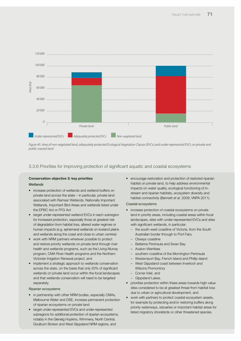
TRUST foR NATURE 71
Figure 45. Area of non-vegetated land, adequately protected Ecological Vegetation Classes (EVCs) and under-represented EVCs on private and public coastal land
120 000
100 000
80 000
60 000
40 000
20 000
0
Area
(ha)
Private land Public land
3.3.6 priorities for improving protection of significant aquatic and coastal ecosystems
Conservation objective 3: key priorities
Wetlands
• increaseprotectionofwetlandsandwetlandbuffersonprivate land across the state – in particular, private land associated with Ramsar Wetlands, Nationally important Wetlands, important Bird Areas and wetlands listed under the EpBc Act or ffG Act
• targetunder-representedwetlandEVCsineachsubregionfor increased protection, especially those at greatest risk of degradation from habitat loss, altered water regimes or human impacts (e.g. ephemeral wetlands on lowland plains and wetlands along the coast and close to urban centres)
• workwithNRMpartnerswhereverpossibletoprotectand restore priority wetlands on private land through river health and wetlands programs, such as the living Murray program, cMA River Health programs and the Northern victorian irrigation Renewal project, and
• implementastrategicapproachtowetlandsconservationacross the state, on the basis that only 20% of significant wetlands on private land occur within the focal landscapes and that wetlands conservation will need to be targeted separately.
Riparian ecosystems
• inpartnershipwithotherNRMbodies,especiallyCMAs,Melbourne Water and dSE, increase permanent protection of riparian ecosystems on private land
• targetunder-representedEVCsandunder-representedsubregions for additional protection of riparian ecosystems, notably in the Glenelg Hopkins, Wimmera, North central, Goulburn Broken and West Gippsland NRM regions, and
• encouragerestorationandprotectionofrestoredriparianhabitat on private land, to help address environmental impacts on water quality, ecological functioning of in-stream and riparian habitats, ecosystem diversity and habitat connectivity (Bennett et al. 2009; vNpA 2011).
Coastal ecosystems
• increaseprotectionofcoastalecosystemsonprivateland in priority areas, including coastal areas within focal landscapes, sites with under-represented Evcs and sites with significant wetlands, in particular:
– the south-west coastline of victoria, from the South Australian border through to port fairy
– otways coastline – Bellarine peninsula and Swan Bay – Avalon–Werribee – southern coastline of the Mornington peninsula – Westernport Bay, french island and phillip island – West Gippsland coast between inverloch and
Wilsons promontory – corner inlet, and – Gippsland lakes.• prioritiseprotectionwithintheseareastowardshigh-value
sites considered to be at greatest threat from habitat loss due to urban or agricultural development, and
• workwithpartnerstoprotectcoastalecosystemassets,for example by protecting and/or restoring buffers along priority waterways, estuaries or important habitat areas for listed migratory shorebirds or other threatened species.
Under-represented EVCs Adequately protected EVCs Non-vegetated land
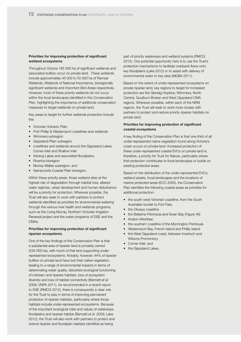
72 Statewide ConServation Plan foR pRivATE lANd iN vicToRiA
Priorities for improving protection of significant wetland ecosystems
Throughout victoria 185 000 ha of significant wetlands and associated buffers occur on private land. These wetlands include approximately 45 000 to 50 000 ha of Ramsar Wetlands, Wetlands of National importance, bioregionally significant wetlands and important Bird Areas respectively.However, most of these priority wetlands do not occur within the focal landscapes identified in this conservation plan, highlighting the importance of additional conservation measures to target wetlands on private land.
Key areas to target for further wetlands protection include the:
• VictorianVolcanicPlain• PortPhillip&Westernportcoastlinesandwetlands• Wimmerasubregion• GippslandPlainsubregion• coastlinesandwetlandsaroundtheGippslandLakes,
corner inlet and Shallow inlet• KerangLakesandassociatedfloodplains• Riverinabioregion• MurrayMalleesubregion,and• NarracoorteCoastalPlainbioregion.
Within these priority areas, those wetland sites at the highest risk of degradation through habitat loss, altered water regimes, urban development and human disturbance will be a priority for protection. Wherever possible, the Trust will also seek to work with partners to protect wetlands identified as priorities for environmental watering through the various river health and wetlands programs, such as the living Murray, Northern victorian irrigation Renewal project and the water programs of dSE and the cMAs.
Priorities for improving protection of significant riparian ecosystems
one of the key findings of the conservation plan is that a substantial area of riparian land is privately owned (234 000 ha), with much of that land supporting under-represented ecosystems. Notably, however, 44% of riparian buffers on private land have lost their native vegetation, leading to a range of environmental impacts in terms of deteriorating water quality, disturbed ecological functioning of instream and riparian habitats, loss of ecosystem diversity and loss of habitat connectivity (Bennett et al. 2009; vNpA 2011). As recommended in a recent report to dSE (RMcG 2012), there is consequently a clear role for the Trust to play in terms of improving permanent protection of riparian habitats, particularly where those habitats include under-represented ecosystems. Because of the important ecological roles and values of waterways, floodplainsandriparianhabitat(Bennett et al. 2009; lake 2012), the Trust will also work with partners to protect and restoreriparianandfloodplainhabitatsidentifiedasbeing
part of priority waterways and wetland systems (RMcG 2012). one potential opportunity here is to use the Trust’s protectionmechanismstofacilitateoverbankflowsontokeyfloodplains(Lake2012)ortoassistwithdeliveryofenvironmental water to key sites (MdBA 2011).
Based on the extent of under-represented ecosystems on private riparian land, key regions to target for increased protection are the Glenelg Hopkins, Wimmera, North central, Goulburn Broken and West Gippsland cMA regions. Wherever possible, within each of the NRM regions, the Trust will seek to work more closely with partners to protect and restore priority riparian habitats on private land.
Priorities for improving protection of significant coastal ecosystems
A key finding of the conservation plan is that one-third of all under-represented native vegetation found along victoria’s coast occurs on private land. increased protection of these under-represented coastal Evcs on private land is, therefore, a priority for Trust for Nature, particularly where that protection contributes to focal landscapes or builds on existing protected areas.
Based on the distribution of the under-represented Evcs, wetland assets, focal landscapes and the locations of marine protected areas (Ecc 2000), the conservation plan identifies the following coastal areas as priorities for additional protection:
• thesouth-westVictoriancoastline,fromtheSouthAustralian border to port fairy
• theOtwayscoastline• theBellarinePeninsulaandSwanBay(Figure46)• Avalon–Werribee• thesoutherncoastlineoftheMorningtonPeninsula• WesternportBay,FrenchIslandandPhillipIsland• theWestGippslandcoast,betweenInverlochand
Wilsons promontory• CornerInlet,and• theGippslandLakes.
TRUST foR NATURE 73
0 2 4 8 kilometres
Figure 46. Example of priority coastal areas to target for conservation on the Bellarine Peninsula and adjacent coast. This indicates the locations of focal landscapes, significant wetlands and under-represented Ecological Vegetation Classes (EVCs) on private land within the 1 km coastal buffer
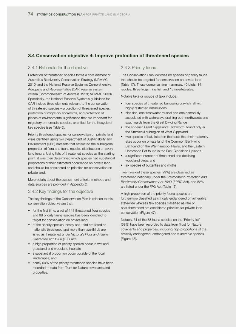
74 Statewide ConServation Plan foR pRivATE lANd iN vicToRiA
3.4 Conservation objective 4: Improve protection of threatened species
3.4.1 Rationale for the objective
protection of threatened species forms a core element of Australia’s Biodiversity conservation Strategy (NRMMc 2010) and the National Reserve System’s comprehensive, Adequate and Representative (cAR) reserve system criteria (commonwealth of Australia 1999; NRMMc 2009). Specifically, the National Reserve System’s guidelines for cAR include three elements relevant to the conservation of threatened species – protection of threatened species, protection of migratory shorebirds, and protection of places of environmental significance that are important for migratory or nomadic species, or critical for the lifecycle of key species (see Table 5).
priority threatened species for conservation on private land were identified using two department of Sustainability and Environment (dSE) datasets that estimated the subregional proportionoffloraandfaunaspeciesdistributionsoneveryland tenure. Using lists of threatened species as the starting point, it was then determined which species had substantial proportions of their estimated occurrence on private land and should be considered as priorities for conservation on private land.
More details about the assessment criteria, methods and data sources are provided in Appendix 2.
3.4.2 Key findings for the objective
The key findings of the conservation plan in relation to this conservation objective are that:
• forthefirsttime,asetof148threatenedfloraspeciesand 88 priority fauna species has been identified to target for conservation on private land
• ofthepriorityspecies,nearlyone-thirdarelistedasnationally threatened and more than two-thirds are listed as threatened under victoria’s Flora and Fauna Guarantee Act 1988 (ffG Act)
• ahighproportionofpriorityspeciesoccurinwetland,grassland and woodland habitats
• asubstantialproportionoccuroutsideofthefocallandscapes, and
• nearly60%oftheprioritythreatenedspecieshavebeenrecorded to date from Trust for Nature covenants and properties.
3.4.3 priority fauna
The conservation plan identifies 88 species of priority fauna that should be targeted for conservation on private land (Table 17). These comprise nine mammals, 40 birds, 14 reptiles, three frogs, nine fish and 13 invertebrates.
Notable taxa or groups of taxa include:
• fourspeciesofthreatenedburrowingcrayfish,allwithhighly restricted distributions
• ninefish,onefreshwatermusselandonedamsel-flyassociated with waterways draining both northwards and southwards from the Great dividing Range
• theendemicGiantGippslandEarthworm,foundonlyinthe Strzelecki subregion of West Gippsland
• twospeciesofbat,listedonthebasisthattheirmaternitysites occur on private land: the common Bent-wing Bat found on the Warrnambool plains, and the Eastern Horseshoe Bat found in the East Gippsland Uplands
• asignificantnumberofthreatenedanddecliningwoodland birds, and
• sixspeciesofbutterfliesandmoths.
Twenty-six of these species (29%) are classified as threatened nationally under the Environment Protection and Biodiversity Conservation Act 1999 (EpBc Act), and 82% are listed under the ffG Act (Table 17).
A high proportion of the priority fauna species are furthermore classified as critically endangered or vulnerable statewide whereas few species classified as rare or near-threatened are considered priorities for private-land conservation (figure 47).
Notably, 61 of the 88 fauna species on the ‘priority list’ (69%) have been recorded to date from Trust for Nature covenants and properties, including high proportions of the critically endangered, endangered and vulnerable species (figure 48).
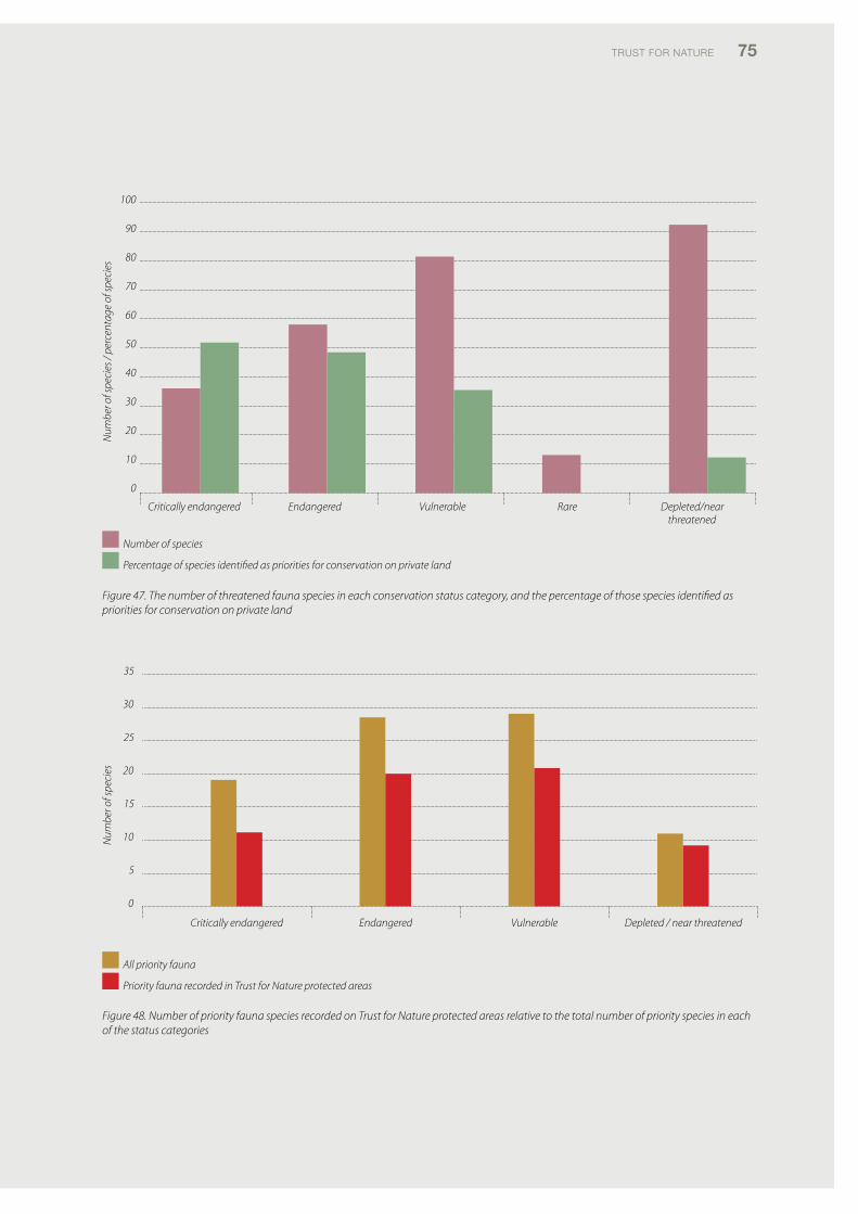
TRUST foR NATURE 75
Figure 47. The number of threatened fauna species in each conservation status category, and the percentage of those species identified as priorities for conservation on private land
35
30
25
20
15
10
5
0
Num
ber o
f spe
cies
Num
ber o
f spe
cies
/ pe
rcen
tage
of s
peci
es
Critically endangered Endangered Vulnerable Depleted / near threatened
All priority fauna
Priority fauna recorded in Trust for Nature protected areas
100
90
80
70
60
50
40
30
20
10
0
Critically endangered Endangered Vulnerable Rare Depleted/near threatened
Number of species
Percentage of species identified as priorities for conservation on private land
Figure 48. Number of priority fauna species recorded on Trust for Nature protected areas relative to the total number of priority species in each of the status categories
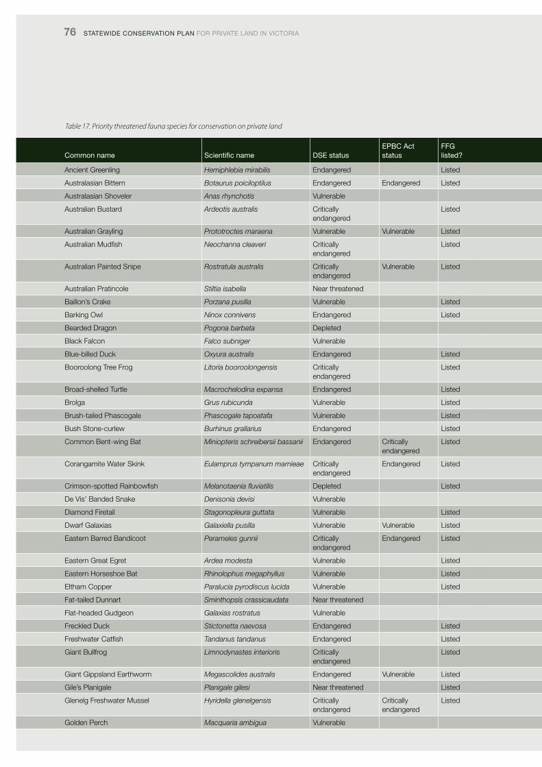
76 Statewide ConServation Plan foR pRivATE lANd iN vicToRiA
Table 17. Priority threatened fauna species for conservation on private land
Common name Scientific name dSe statusePBC act status
FFG listed?
Ancient Greenling Hemiphlebia mirabilis Endangered listed
Australasian Bittern Botaurus poiciloptilus Endangered Endangered listed
Australasian Shoveler Anas rhynchotis vulnerable
Australian Bustard Ardeotis australis critically endangered
listed
Australian Grayling Prototroctes maraena vulnerable vulnerable listed
Australian Mudfish Neochanna cleaveri critically endangered
listed
Australian painted Snipe Rostratula australis critically endangered
vulnerable listed
Australian pratincole Stiltia isabella Near threatened
Baillon’s crake Porzana pusilla vulnerable listed
Barking owl Ninox connivens Endangered listed
Bearded dragon Pogona barbata depleted
Black falcon Falco subniger vulnerable
Blue-billed duck Oxyura australis Endangered listed
Booroolong Tree frog Litoria booroolongensis critically endangered
listed
Broad-shelled Turtle Macrochelodina expansa Endangered listed
Brolga Grus rubicunda vulnerable listed
Brush-tailed phascogale Phascogale tapoatafa vulnerable listed
Bush Stone-curlew Burhinus grallarius Endangered listed
common Bent-wing Bat Miniopteris schreibersii bassanii Endangered critically endangered
listed
corangamite Water Skink Eulamprus tympanum marnieae critically endangered
Endangered listed
crimson-spotted Rainbowfish Melanotaenia fluviatilis depleted listed
de vis’ Banded Snake Denisonia devisi vulnerable
diamond firetail Stagonopleura guttata vulnerable listed
dwarf Galaxias Galaxiella pusilla vulnerable vulnerable listed
Eastern Barred Bandicoot Perameles gunnii critically endangered
Endangered listed
Eastern Great Egret Ardea modesta vulnerable listed
Eastern Horseshoe Bat Rhinolophus megaphyllus vulnerable listed
Eltham copper Paralucia pyrodiscus lucida vulnerable listed
fat-tailed dunnart Sminthopsis crassicaudata Near threatened
flat-headed Gudgeon Galaxias rostratus vulnerable
freckled duck Stictonetta naevosa Endangered listed
freshwater catfish Tandanus tandanus Endangered listed
Giant Bullfrog Limnodynastes interioris critically endangered
listed
Giant Gippsland Earthworm Megascolides australis Endangered vulnerable listed
Gile’s planigale Planigale gilesi Near threatened listed
Glenelg freshwater Mussel Hyridella glenelgensis critically endangered
critically endangered
listed
Golden perch Macquaria ambigua vulnerable
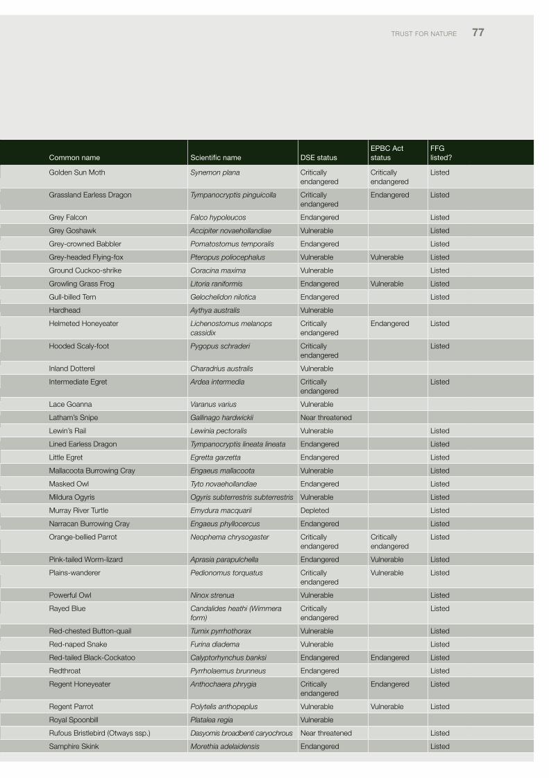
TRUST foR NATURE 77
Common name Scientific name dSe statusePBC act status
FFG listed?
Golden Sun Moth Synemon plana critically endangered
critically endangered
listed
Grassland Earless dragon Tympanocryptis pinguicolla critically endangered
Endangered listed
Grey falcon Falco hypoleucos Endangered listed
Grey Goshawk Accipiter novaehollandiae vulnerable listed
Grey-crowned Babbler Pomatostomus temporalis Endangered listed
Grey-headed flying-fox Pteropus poliocephalus vulnerable vulnerable listed
Ground cuckoo-shrike Coracina maxima vulnerable listed
Growling Grass frog Litoria raniformis Endangered vulnerable listed
Gull-billed Tern Gelochelidon nilotica Endangered listed
Hardhead Aythya australis vulnerable
Helmeted Honeyeater Lichenostomus melanops cassidix
critically endangered
Endangered listed
Hooded Scaly-foot Pygopus schraderi critically endangered
listed
inland dotterel Charadrius australis vulnerable
intermediate Egret Ardea intermedia critically endangered
listed
lace Goanna Varanus varius vulnerable
latham’s Snipe Gallinago hardwickii Near threatened
lewin’s Rail Lewinia pectoralis vulnerable listed
lined Earless dragon Tympanocryptis lineata lineata Endangered listed
little Egret Egretta garzetta Endangered listed
Mallacoota Burrowing cray Engaeus mallacoota vulnerable listed
Masked owl Tyto novaehollandiae Endangered listed
Mildura ogyris Ogyris subterrestris subterrestris vulnerable listed
Murray River Turtle Emydura macquarii depleted listed
Narracan Burrowing cray Engaeus phyllocercus Endangered listed
orange-bellied parrot Neophema chrysogaster critically endangered
critically endangered
listed
pink-tailed Worm-lizard Aprasia parapulchella Endangered vulnerable listed
plains-wanderer Pedionomus torquatus critically endangered
vulnerable listed
powerful owl Ninox strenua vulnerable listed
Rayed Blue Candalides heathi (Wimmera form)
critically endangered
listed
Red-chested Button-quail Turnix pyrrhothorax vulnerable listed
Red-naped Snake Furina diadema vulnerable listed
Red-tailed Black-cockatoo Calyptorhynchus banksi Endangered Endangered listed
Redthroat Pyrrholaemus brunneus Endangered listed
Regent Honeyeater Anthochaera phrygia critically endangered
Endangered listed
Regent parrot Polytelis anthopeplus vulnerable vulnerable listed
Royal Spoonbill Platalea regia vulnerable
Rufous Bristlebird (otways ssp.) Dasyomis broadbenti caryochrous Near threatened listed
Samphire Skink Morethia adelaidensis Endangered listed
Table 17. Priority threatened fauna species for conservation on private land
Common name Scientific name dSe statusePBC act status
FFG listed?
Ancient Greenling Hemiphlebia mirabilis Endangered listed
Australasian Bittern Botaurus poiciloptilus Endangered Endangered listed
Australasian Shoveler Anas rhynchotis vulnerable
Australian Bustard Ardeotis australis critically endangered
listed
Australian Grayling Prototroctes maraena vulnerable vulnerable listed
Australian Mudfish Neochanna cleaveri critically endangered
listed
Australian painted Snipe Rostratula australis critically endangered
vulnerable listed
Australian pratincole Stiltia isabella Near threatened
Baillon’s crake Porzana pusilla vulnerable listed
Barking owl Ninox connivens Endangered listed
Bearded dragon Pogona barbata depleted
Black falcon Falco subniger vulnerable
Blue-billed duck Oxyura australis Endangered listed
Booroolong Tree frog Litoria booroolongensis critically endangered
listed
Broad-shelled Turtle Macrochelodina expansa Endangered listed
Brolga Grus rubicunda vulnerable listed
Brush-tailed phascogale Phascogale tapoatafa vulnerable listed
Bush Stone-curlew Burhinus grallarius Endangered listed
common Bent-wing Bat Miniopteris schreibersii bassanii Endangered critically endangered
listed
corangamite Water Skink Eulamprus tympanum marnieae critically endangered
Endangered listed
crimson-spotted Rainbowfish Melanotaenia fluviatilis depleted listed
de vis’ Banded Snake Denisonia devisi vulnerable
diamond firetail Stagonopleura guttata vulnerable listed
dwarf Galaxias Galaxiella pusilla vulnerable vulnerable listed
Eastern Barred Bandicoot Perameles gunnii critically endangered
Endangered listed
Eastern Great Egret Ardea modesta vulnerable listed
Eastern Horseshoe Bat Rhinolophus megaphyllus vulnerable listed
Eltham copper Paralucia pyrodiscus lucida vulnerable listed
fat-tailed dunnart Sminthopsis crassicaudata Near threatened
flat-headed Gudgeon Galaxias rostratus vulnerable
freckled duck Stictonetta naevosa Endangered listed
freshwater catfish Tandanus tandanus Endangered listed
Giant Bullfrog Limnodynastes interioris critically endangered
listed
Giant Gippsland Earthworm Megascolides australis Endangered vulnerable listed
Gile’s planigale Planigale gilesi Near threatened listed
Glenelg freshwater Mussel Hyridella glenelgensis critically endangered
critically endangered
listed
Golden perch Macquaria ambigua vulnerable
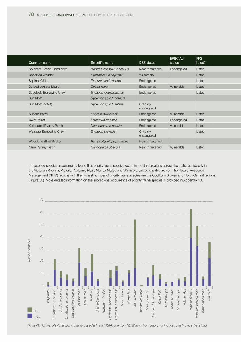
78 Statewide ConServation Plan foR pRivATE lANd iN vicToRiA
Common name Scientific name dSe statusePBC act status
FFG listed?
Southern Brown Bandicoot Isoodon obesulus obesulus Near threatened Endangered listed
Speckled Warbler Pyrrholaemus sagittata vulnerable listed
Squirrel Glider Petaurus norfolcensis Endangered listed
Striped legless lizard Delma impar Endangered vulnerable listed
Strzelecki Burrowing cray Engaeus rostrogaleatus Endangered listed
Sun Moth Synemon sp c.f. collecta
Sun Moth (5091) Synemon sp c.f. selene critically endangered
Superb parrot Polytelis swainsonii Endangered vulnerable listed
Swift parrot Lathamus discolor Endangered Endangered listed
variegated pygmy perch Nannoperca variegata Endangered vulnerable listed
Warragul Burrowing cray Engaeus sternalis critically endangered
listed
Woodland Blind Snake Ramphotyphlops proximus Near threatened
Yarra pygmy perch Nannoperca obscura Near threatened vulnerable listed
Threatened species assessments found that priority fauna species occur in most subregions across the state, particularly in the victorian Riverina, victorian volcanic plain, Murray Mallee and Wimmera subregions (figure 49). The Natural Resource Management (NRM) regions with the highest number of priority fauna species are the Goulburn Broken and North central regions (figure 50). More detailed information on the subregional occurrence of priority fauna species is provided in Appendix 13.
Brid
gew
ater
Cent
ral V
icto
rian
Upl
ands
Dun
das T
able
land
s
East
Gip
psla
nd L
owla
nds
East
Gip
psla
nd U
plan
ds
Gip
psla
nd P
lain
Gle
nelg
Pla
in
Gol
dfiel
ds
Gre
ater
Gra
mpi
ans
Hig
hlan
ds–
Far E
ast
Hig
hlan
ds–
Nor
ther
n Fa
ll
Hig
hlan
ds–
Sout
hern
Fal
l
Low
an M
alle
e
Mur
ray
Fans
Mur
ray
Mal
lee
Mon
aro
Tabl
elan
ds
Mur
ray
Scro
ll Be
lt
Nor
ther
n In
land
Slo
pes
Otw
ay P
lain
Otw
ay R
ange
s
Robi
nval
e Pl
ains
Strz
elec
ki R
ange
s
Vict
oria
n Al
ps
Vict
oria
n Ri
verin
a
Vict
oria
n Vo
lcan
ic P
lain
War
rnam
bool
Pla
in
Wim
mer
a
70
60
50
40
30
20
10
0
Num
ber o
f spe
cies
Flora
Fauna
Figure 49. Number of priority fauna and flora species in each IBRA subregion. NB: Wilsons Promontory not included as it has no private land
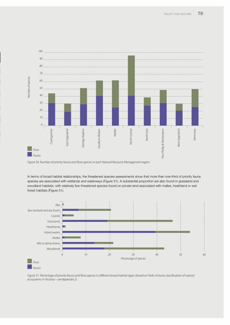
TRUST foR NATURE 79
0 10 20 30 40 50 60
Alps
Box ironbark and dry forests
Coastal
Grasslands
Heathlands
Inland waters
Mallee
Wet or damp forests
Woodlands
Percentage of species Flora
Fauna
Figure 50. Number of priority fauna and flora species in each Natural Resource Management region
in terms of broad habitat relationships, the threatened species assessments show that more than one-third of priority fauna species are associated with wetlands and waterways (figure 51). A substantial proportion are also found in grassland and woodland habitats, with relatively few threatened species found on private land associated with mallee, heathland or wet forest habitats (figure 51).
Cora
ngam
ite
East
Gip
psla
nd
Gle
nelg
Hop
kins
Gou
lbur
n Br
oken
Mal
lee
Nor
th C
entr
al
Nor
th E
ast
Port
Phi
llip
& W
este
rnpo
rt
Wes
t Gip
psla
nd
Wim
mer
a
100
90
80
70
60
50
40
30
20
10
0
Num
ber o
f spe
cies
Flora
Fauna
Figure 51. Percentage of priority fauna and flora species in different broad habitat types (based on Parks Victoria classification of natural ecosystems in Victoria – see Appendix 2)
Common name Scientific name dSe statusePBC act status
FFG listed?
Southern Brown Bandicoot Isoodon obesulus obesulus Near threatened Endangered listed
Speckled Warbler Pyrrholaemus sagittata vulnerable listed
Squirrel Glider Petaurus norfolcensis Endangered listed
Striped legless lizard Delma impar Endangered vulnerable listed
Strzelecki Burrowing cray Engaeus rostrogaleatus Endangered listed
Sun Moth Synemon sp c.f. collecta
Sun Moth (5091) Synemon sp c.f. selene critically endangered
Superb parrot Polytelis swainsonii Endangered vulnerable listed
Swift parrot Lathamus discolor Endangered Endangered listed
variegated pygmy perch Nannoperca variegata Endangered vulnerable listed
Warragul Burrowing cray Engaeus sternalis critically endangered
listed
Woodland Blind Snake Ramphotyphlops proximus Near threatened
Yarra pygmy perch Nannoperca obscura Near threatened vulnerable listed
Brid
gew
ater
Cent
ral V
icto
rian
Upl
ands
Dun
das T
able
land
s
East
Gip
psla
nd L
owla
nds
East
Gip
psla
nd U
plan
ds
Gip
psla
nd P
lain
Gle
nelg
Pla
in
Gol
dfiel
ds
Gre
ater
Gra
mpi
ans
Hig
hlan
ds–
Far E
ast
Hig
hlan
ds–
Nor
ther
n Fa
ll
Hig
hlan
ds–
Sout
hern
Fal
l
Low
an M
alle
e
Mur
ray
Fans
Mur
ray
Mal
lee
Mon
aro
Tabl
elan
ds
Mur
ray
Scro
ll Be
lt
Nor
ther
n In
land
Slo
pes
Otw
ay P
lain
Otw
ay R
ange
s
Robi
nval
e Pl
ains
Strz
elec
ki R
ange
s
Vict
oria
n Al
ps
Vict
oria
n Ri
verin
a
Vict
oria
n Vo
lcan
ic P
lain
War
rnam
bool
Pla
in
Wim
mer
a
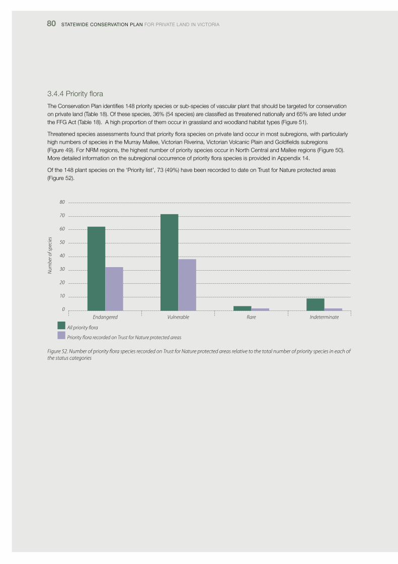
80 Statewide ConServation Plan foR pRivATE lANd iN vicToRiA
3.4.4Priorityflora
The conservation plan identifies 148 priority species or sub-species of vascular plant that should be targeted for conservation on private land (Table 18). of these species, 36% (54 species) are classified as threatened nationally and 65% are listed under the ffG Act (Table 18). A high proportion of them occur in grassland and woodland habitat types (figure 51).
Threatenedspeciesassessmentsfoundthatpriorityfloraspeciesonprivatelandoccurinmostsubregions,withparticularlyhigh numbers of species in the Murray Mallee, victorian Riverina, victorian volcanic plain and Goldfields subregions (figure 49). for NRM regions, the highest number of priority species occur in North central and Mallee regions (figure 50). MoredetailedinformationonthesubregionaloccurrenceofpriorityfloraspeciesisprovidedinAppendix14.
of the 148 plant species on the ‘priority list’, 73 (49%) have been recorded to date on Trust for Nature protected areas (figure 52).
80
70
60
50
40
30
20
10
0
Endangered Vulnerable Rare Indeterminate
All priority flora
Priority flora recorded on Trust for Nature protected areas
Figure 52. Number of priority flora species recorded on Trust for Nature protected areas relative to the total number of priority species in each of the status categories
Num
ber o
f spe
cies
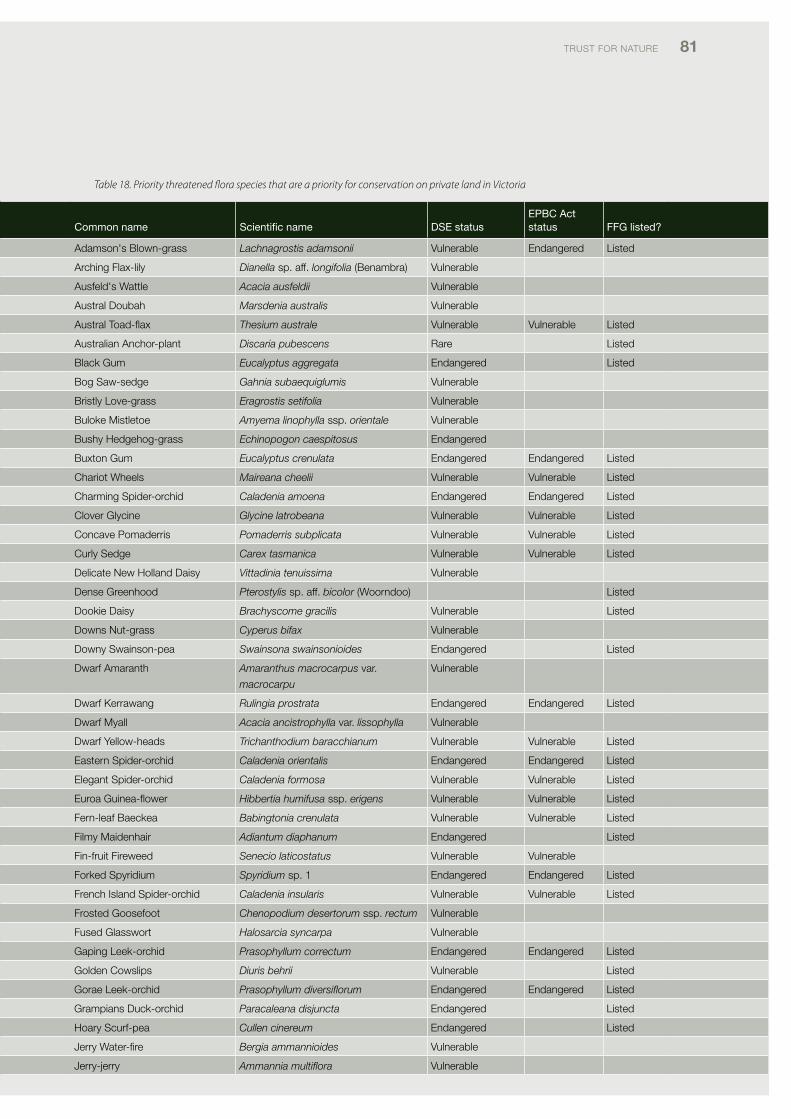
TRUST foR NATURE 81
Table 18. Priority threatened flora species that are a priority for conservation on private land in Victoria
Common name Scientific name dSe status ePBC act status FFG listed?
Adamson's Blown-grass Lachnagrostis adamsonii vulnerable Endangered listed
Arching flax-lily Dianella sp. aff. longifolia (Benambra) vulnerable
Ausfeld's Wattle Acacia ausfeldii vulnerable
Austral doubah Marsdenia australis vulnerable
AustralToad-flax Thesium australe vulnerable vulnerable listed
Australian Anchor-plant Discaria pubescens Rare listed
Black Gum Eucalyptus aggregata Endangered listed
Bog Saw-sedge Gahnia subaequiglumis vulnerable
Bristly love-grass Eragrostis setifolia vulnerable
Buloke Mistletoe Amyema linophylla ssp. orientale vulnerable
Bushy Hedgehog-grass Echinopogon caespitosus Endangered
Buxton Gum Eucalyptus crenulata Endangered Endangered listed
chariot Wheels Maireana cheelii vulnerable vulnerable listed
charming Spider-orchid Caladenia amoena Endangered Endangered listed
clover Glycine Glycine latrobeana vulnerable vulnerable listed
concave pomaderris Pomaderris subplicata vulnerable vulnerable listed
curly Sedge Carex tasmanica vulnerable vulnerable listed
delicate New Holland daisy Vittadinia tenuissima vulnerable
dense Greenhood Pterostylis sp. aff. bicolor (Woorndoo) listed
dookie daisy Brachyscome gracilis vulnerable listed
downs Nut-grass Cyperus bifax vulnerable
downy Swainson-pea Swainsona swainsonioides Endangered listed
dwarf Amaranth Amaranthus macrocarpus var.
macrocarpu
vulnerable
dwarf Kerrawang Rulingia prostrata Endangered Endangered listed
dwarf Myall Acacia ancistrophylla var. lissophylla vulnerable
dwarf Yellow-heads Trichanthodium baracchianum vulnerable vulnerable listed
Eastern Spider-orchid Caladenia orientalis Endangered Endangered listed
Elegant Spider-orchid Caladenia formosa vulnerable vulnerable listed
EuroaGuinea-flower Hibbertia humifusa ssp. erigens vulnerable vulnerable listed
fern-leaf Baeckea Babingtonia crenulata vulnerable vulnerable listed
filmy Maidenhair Adiantum diaphanum Endangered listed
fin-fruit fireweed Senecio laticostatus vulnerable vulnerable
forked Spyridium Spyridium sp. 1 Endangered Endangered listed
french island Spider-orchid Caladenia insularis vulnerable vulnerable listed
frosted Goosefoot Chenopodium desertorum ssp. rectum vulnerable
fused Glasswort Halosarcia syncarpa vulnerable
Gaping leek-orchid Prasophyllum correctum Endangered Endangered listed
Golden cowslips Diuris behrii vulnerable listed
Gorae leek-orchid Prasophyllum diversiflorum Endangered Endangered listed
Grampians duck-orchid Paracaleana disjuncta Endangered listed
Hoary Scurf-pea Cullen cinereum Endangered listed
Jerry Water-fire Bergia ammannioides vulnerable
Jerry-jerry Ammannia multiflora vulnerable
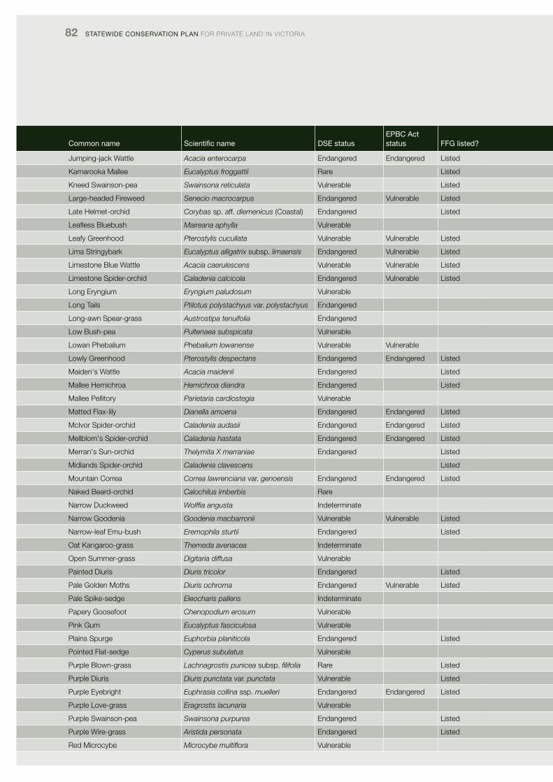
82 Statewide ConServation Plan foR pRivATE lANd iN vicToRiA
Common name Scientific name dSe status ePBC act status FFG listed?
Jumping-jack Wattle Acacia enterocarpa Endangered Endangered listed
Kamarooka Mallee Eucalyptus froggattii Rare listed
Kneed Swainson-pea Swainsona reticulata vulnerable listed
large-headed fireweed Senecio macrocarpus Endangered vulnerable listed
late Helmet-orchid Corybas sp. aff. diemenicus (coastal) Endangered listed
LeaflessBluebush Maireana aphylla vulnerable
leafy Greenhood Pterostylis cucullata vulnerable vulnerable listed
lima Stringybark Eucalyptus alligatrix subsp. limaensis Endangered vulnerable listed
limestone Blue Wattle Acacia caerulescens vulnerable vulnerable listed
limestone Spider-orchid Caladenia calcicola Endangered vulnerable listed
long Eryngium Eryngium paludosum vulnerable
long Tails Ptilotus polystachyus var. polystachyus Endangered
long-awn Spear-grass Austrostipa tenuifolia Endangered
low Bush-pea Pultenaea subspicata vulnerable
lowan phebalium Phebalium lowanense vulnerable vulnerable
lowly Greenhood Pterostylis despectans Endangered Endangered listed
Maiden's Wattle Acacia maidenii Endangered listed
Mallee Hemichroa Hemichroa diandra Endangered listed
Mallee pellitory Parietaria cardiostegia vulnerable
Matted flax-lily Dianella amoena Endangered Endangered listed
Mcivor Spider-orchid Caladenia audasii Endangered Endangered listed
Mellblom's Spider-orchid Caladenia hastata Endangered Endangered listed
Merran's Sun-orchid Thelymita X merraniae Endangered listed
Midlands Spider-orchid Caladenia clavescens listed
Mountain correa Correa lawrenciana var. genoensis Endangered Endangered listed
Naked Beard-orchid Calochilus imberbis Rare
Narrow duckweed Wolffia angusta indeterminate
Narrow Goodenia Goodenia macbarronii vulnerable vulnerable listed
Narrow-leaf Emu-bush Eremophila sturtii Endangered listed
oat Kangaroo-grass Themeda avenacea indeterminate
open Summer-grass Digitaria diffusa vulnerable
painted diuris Diuris tricolor Endangered listed
pale Golden Moths Diuris ochroma Endangered vulnerable listed
pale Spike-sedge Eleocharis pallens indeterminate
papery Goosefoot Chenopodium erosum vulnerable
pink Gum Eucalyptus fasciculosa vulnerable
plains Spurge Euphorbia planiticola Endangered listed
pointed flat-sedge Cyperus subulatus vulnerable
purple Blown-grass Lachnagrostis punicea subsp. filifolia Rare listed
purple diuris Diuris punctata var. punctata vulnerable listed
purple Eyebright Euphrasia collina ssp. muelleri Endangered Endangered listed
purple love-grass Eragrostis lacunaria vulnerable
purple Swainson-pea Swainsona purpurea Endangered listed
purple Wire-grass Aristida personata Endangered listed
Red Microcybe Microcybe multiflora vulnerable
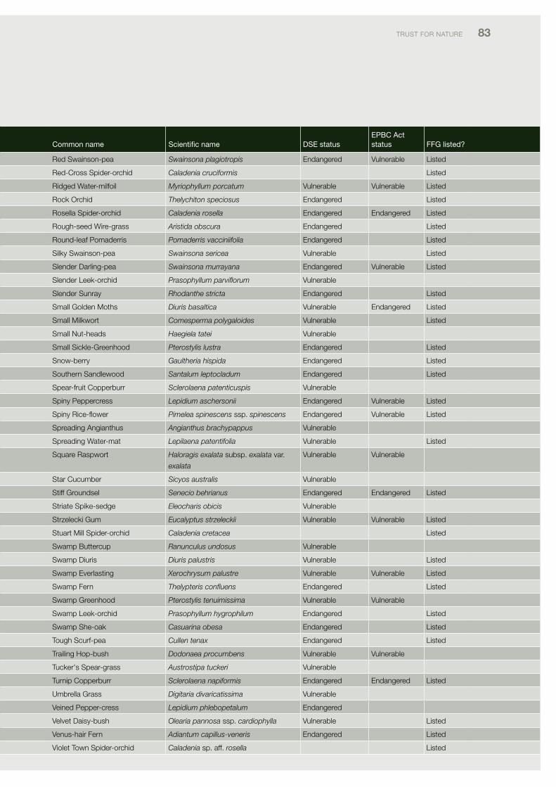
TRUST foR NATURE 83
Common name Scientific name dSe status ePBC act status FFG listed?
Red Swainson-pea Swainsona plagiotropis Endangered vulnerable listed
Red-cross Spider-orchid Caladenia cruciformis listed
Ridged Water-milfoil Myriophyllum porcatum vulnerable vulnerable listed
Rock orchid Thelychiton speciosus Endangered listed
Rosella Spider-orchid Caladenia rosella Endangered Endangered listed
Rough-seed Wire-grass Aristida obscura Endangered listed
Round-leaf pomaderris Pomaderris vacciniifolia Endangered listed
Silky Swainson-pea Swainsona sericea vulnerable listed
Slender darling-pea Swainsona murrayana Endangered vulnerable listed
Slender leek-orchid Prasophyllum parviflorum vulnerable
Slender Sunray Rhodanthe stricta Endangered listed
Small Golden Moths Diuris basaltica vulnerable Endangered listed
Small Milkwort Comesperma polygaloides vulnerable listed
Small Nut-heads Haegiela tatei vulnerable
Small Sickle-Greenhood Pterostylis lustra Endangered listed
Snow-berry Gaultheria hispida Endangered listed
Southern Sandlewood Santalum leptocladum Endangered listed
Spear-fruit copperburr Sclerolaena patenticuspis vulnerable
Spiny peppercress Lepidium aschersonii Endangered vulnerable listed
SpinyRice-flower Pimelea spinescens ssp. spinescens Endangered vulnerable listed
Spreading Angianthus Angianthus brachypappus vulnerable
Spreading Water-mat Lepilaena patentifolia vulnerable listed
Square Raspwort Haloragis exalata subsp. exalata var.
exalata
vulnerable vulnerable
Star cucumber Sicyos australis vulnerable
Stiff Groundsel Senecio behrianus Endangered Endangered listed
Striate Spike-sedge Eleocharis obicis vulnerable
Strzelecki Gum Eucalyptus strzeleckii vulnerable vulnerable listed
Stuart Mill Spider-orchid Caladenia cretacea listed
Swamp Buttercup Ranunculus undosus vulnerable
Swamp diuris Diuris palustris vulnerable listed
Swamp Everlasting Xerochrysum palustre vulnerable vulnerable listed
Swamp fern Thelypteris confluens Endangered listed
Swamp Greenhood Pterostylis tenuimissima vulnerable vulnerable
Swamp leek-orchid Prasophyllum hygrophilum Endangered listed
Swamp She-oak Casuarina obesa Endangered listed
Tough Scurf-pea Cullen tenax Endangered listed
Trailing Hop-bush Dodonaea procumbens vulnerable vulnerable
Tucker's Spear-grass Austrostipa tuckeri vulnerable
Turnip copperburr Sclerolaena napiformis Endangered Endangered listed
Umbrella Grass Digitaria divaricatissima vulnerable
veined pepper-cress Lepidium phlebopetalum Endangered
velvet daisy-bush Olearia pannosa ssp. cardiophylla vulnerable listed
venus-hair fern Adiantum capillus-veneris Endangered listed
violet Town Spider-orchid Caladenia sp. aff. rosella listed
Common name Scientific name dSe status ePBC act status FFG listed?
Jumping-jack Wattle Acacia enterocarpa Endangered Endangered listed
Kamarooka Mallee Eucalyptus froggattii Rare listed
Kneed Swainson-pea Swainsona reticulata vulnerable listed
large-headed fireweed Senecio macrocarpus Endangered vulnerable listed
late Helmet-orchid Corybas sp. aff. diemenicus (coastal) Endangered listed
LeaflessBluebush Maireana aphylla vulnerable
leafy Greenhood Pterostylis cucullata vulnerable vulnerable listed
lima Stringybark Eucalyptus alligatrix subsp. limaensis Endangered vulnerable listed
limestone Blue Wattle Acacia caerulescens vulnerable vulnerable listed
limestone Spider-orchid Caladenia calcicola Endangered vulnerable listed
long Eryngium Eryngium paludosum vulnerable
long Tails Ptilotus polystachyus var. polystachyus Endangered
long-awn Spear-grass Austrostipa tenuifolia Endangered
low Bush-pea Pultenaea subspicata vulnerable
lowan phebalium Phebalium lowanense vulnerable vulnerable
lowly Greenhood Pterostylis despectans Endangered Endangered listed
Maiden's Wattle Acacia maidenii Endangered listed
Mallee Hemichroa Hemichroa diandra Endangered listed
Mallee pellitory Parietaria cardiostegia vulnerable
Matted flax-lily Dianella amoena Endangered Endangered listed
Mcivor Spider-orchid Caladenia audasii Endangered Endangered listed
Mellblom's Spider-orchid Caladenia hastata Endangered Endangered listed
Merran's Sun-orchid Thelymita X merraniae Endangered listed
Midlands Spider-orchid Caladenia clavescens listed
Mountain correa Correa lawrenciana var. genoensis Endangered Endangered listed
Naked Beard-orchid Calochilus imberbis Rare
Narrow duckweed Wolffia angusta indeterminate
Narrow Goodenia Goodenia macbarronii vulnerable vulnerable listed
Narrow-leaf Emu-bush Eremophila sturtii Endangered listed
oat Kangaroo-grass Themeda avenacea indeterminate
open Summer-grass Digitaria diffusa vulnerable
painted diuris Diuris tricolor Endangered listed
pale Golden Moths Diuris ochroma Endangered vulnerable listed
pale Spike-sedge Eleocharis pallens indeterminate
papery Goosefoot Chenopodium erosum vulnerable
pink Gum Eucalyptus fasciculosa vulnerable
plains Spurge Euphorbia planiticola Endangered listed
pointed flat-sedge Cyperus subulatus vulnerable
purple Blown-grass Lachnagrostis punicea subsp. filifolia Rare listed
purple diuris Diuris punctata var. punctata vulnerable listed
purple Eyebright Euphrasia collina ssp. muelleri Endangered Endangered listed
purple love-grass Eragrostis lacunaria vulnerable
purple Swainson-pea Swainsona purpurea Endangered listed
purple Wire-grass Aristida personata Endangered listed
Red Microcybe Microcybe multiflora vulnerable
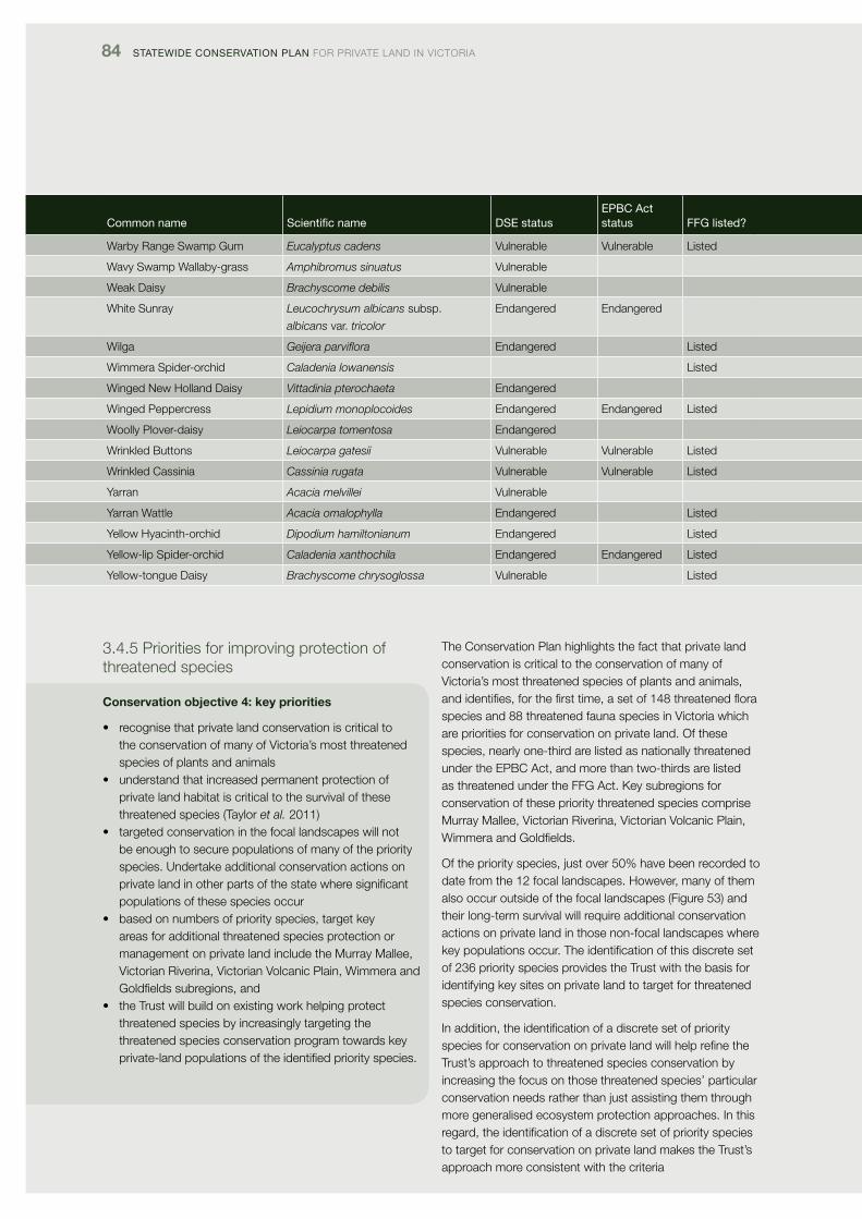
84 Statewide ConServation Plan foR pRivATE lANd iN vicToRiA
Common name Scientific name dSe status ePBC act status FFG listed?
Warby Range Swamp Gum Eucalyptus cadens vulnerable vulnerable listed
Wavy Swamp Wallaby-grass Amphibromus sinuatus vulnerable
Weak daisy Brachyscome debilis vulnerable
White Sunray Leucochrysum albicans subsp.
albicans var. tricolor
Endangered Endangered
Wilga Geijera parviflora Endangered listed
Wimmera Spider-orchid Caladenia lowanensis listed
Winged New Holland daisy Vittadinia pterochaeta Endangered
Winged peppercress Lepidium monoplocoides Endangered Endangered listed
Woolly plover-daisy Leiocarpa tomentosa Endangered
Wrinkled Buttons Leiocarpa gatesii vulnerable vulnerable listed
Wrinkled cassinia Cassinia rugata vulnerable vulnerable listed
Yarran Acacia melvillei vulnerable
Yarran Wattle Acacia omalophylla Endangered listed
Yellow Hyacinth-orchid Dipodium hamiltonianum Endangered listed
Yellow-lip Spider-orchid Caladenia xanthochila Endangered Endangered listed
Yellow-tongue daisy Brachyscome chrysoglossa vulnerable listed
3.4.5 priorities for improving protection of threatened species
Conservation objective 4: key priorities
• recognisethatprivatelandconservationiscriticaltothe conservation of many of victoria’s most threatened species of plants and animals
• understandthatincreasedpermanentprotectionofprivate land habitat is critical to the survival of these threatened species (Taylor et al. 2011)
• targetedconservationinthefocallandscapeswillnotbe enough to secure populations of many of the priority species. Undertake additional conservation actions on private land in other parts of the state where significant populations of these species occur
• basedonnumbersofpriorityspecies,targetkeyareas for additional threatened species protection or management on private land include the Murray Mallee, victorian Riverina, victorian volcanic plain, Wimmera and Goldfields subregions, and
• theTrustwillbuildonexistingworkhelpingprotectthreatened species by increasingly targeting the threatened species conservation program towards key private-land populations of the identified priority species.
The conservation plan highlights the fact that private land conservation is critical to the conservation of many of victoria’s most threatened species of plants and animals, andidentifies,forthefirsttime,asetof148threatenedfloraspecies and 88 threatened fauna species in victoria which are priorities for conservation on private land. of these species, nearly one-third are listed as nationally threatened under the EpBc Act, and more than two-thirds are listed as threatened under the ffG Act. Key subregions for conservation of these priority threatened species comprise Murray Mallee, victorian Riverina, victorian volcanic plain, Wimmera and Goldfields.
of the priority species, just over 50% have been recorded to date from the 12 focal landscapes. However, many of them also occur outside of the focal landscapes (figure 53) and their long-term survival will require additional conservation actions on private land in those non-focal landscapes where key populations occur. The identification of this discrete set of 236 priority species provides the Trust with the basis for identifying key sites on private land to target for threatened species conservation.
in addition, the identification of a discrete set of priority species for conservation on private land will help refine the Trust’s approach to threatened species conservation by increasing the focus on those threatened species’ particular conservation needs rather than just assisting them through more generalised ecosystem protection approaches. in this regard, the identification of a discrete set of priority species to target for conservation on private land makes the Trust’s approach more consistent with the criteria
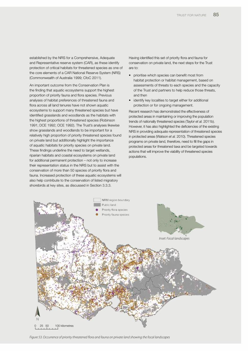
TRUST foR NATURE 85
established by the NRS for a comprehensive, Adequate and Representative reserve system (cAR), as these identify protection of critical habitats for threatened species as one of the core elements of a cAR National Reserve System (NRS) (commonwealth of Australia 1999; cfoc 2011).
An important outcome from the conservation plan is the finding that aquatic ecosystems support the highest proportionofpriorityfaunaandfloraspecies.Previousanalyses of habitat preferences of threatened fauna and floraacrossalllandtenureshavenotshownaquaticecosystems to support many threatened species but have identified grasslands and woodlands as the habitats with the highest proportions of threatened species (Robinson 1991; dcE 1992; ocE 1992). The Trust’s analyses likewise show grasslands and woodlands to be important for a relatively high proportion of priority threatened species found on private land but additionally highlight the importance of aquatic habitats for priority species on private land. These findings underline the need to target wetlands, riparian habitats and coastal ecosystems on private land for additional permanent protection – not only to increase their representation status in the NRS but to assist with the conservationofmorethan50speciesofpriorityfloraandfauna. increased protection of these aquatic ecosystems will also help contribute to the conservation of listed migratory shorebirds at key sites, as discussed in Section 3.3.3.
Havingidentifiedthissetofpriorityfloraandfaunaforconservation on private land, the next steps for the Trust are to:
• prioritisewhichspeciescanbenefitmostfromhabitat protection or habitat management, based on assessments of threats to each species and the capacity of the Trust and partners to help reduce those threats, and then
• identifykeylocalitiestotargeteitherforadditionalprotection or for ongoing management.
Recent research has demonstrated the effectiveness of protected areas in maintaining or improving the population trends of nationally threatened species (Taylor et al. 2011b). However, it has also highlighted the deficiencies of the existing NRS in providing adequate representation of threatened species in protected areas (Watson et al. 2010). Threatened species programs on private land, therefore, need to fill the gaps in protected areas for threatened taxa and be targeted towards actions that will improve the viability of threatened species populations.
0 25 50 100 kilometres
Figure 53. Occurrence of priority threatened flora and fauna on private land showing the focal landscapes
Inset: Focal landscapes
Common name Scientific name dSe status ePBC act status FFG listed?
Warby Range Swamp Gum Eucalyptus cadens vulnerable vulnerable listed
Wavy Swamp Wallaby-grass Amphibromus sinuatus vulnerable
Weak daisy Brachyscome debilis vulnerable
White Sunray Leucochrysum albicans subsp.
albicans var. tricolor
Endangered Endangered
Wilga Geijera parviflora Endangered listed
Wimmera Spider-orchid Caladenia lowanensis listed
Winged New Holland daisy Vittadinia pterochaeta Endangered
Winged peppercress Lepidium monoplocoides Endangered Endangered listed
Woolly plover-daisy Leiocarpa tomentosa Endangered
Wrinkled Buttons Leiocarpa gatesii vulnerable vulnerable listed
Wrinkled cassinia Cassinia rugata vulnerable vulnerable listed
Yarran Acacia melvillei vulnerable
Yarran Wattle Acacia omalophylla Endangered listed
Yellow Hyacinth-orchid Dipodium hamiltonianum Endangered listed
Yellow-lip Spider-orchid Caladenia xanthochila Endangered Endangered listed
Yellow-tongue daisy Brachyscome chrysoglossa vulnerable listed
86 Statewide ConServation Plan foR pRivATE lANd iN vicToRiA
3.5 Conservation objective 5: Enhance and protect landscape connectivity
3.5.1 Rationale for the objective
conservation objective 5 addresses three key conservation planning principles in relation to landscape conservation:
• patchesofnativevegetationshouldbeaslargeaspossible for species diversity and population viability
• landscapeconnectivityiscriticaltothemovementofspecies and individuals at different spatial scales (e.g. local up to continental) and time scales (e.g. daily, seasonal, long-term) (Bennett 1999; Soule et al. 2004; Bennett et al. 2009); it is critical to maintaining genetic diversity among species, and
• landscapeconnectivityiscriticaltotheconservationof biodiversity in human-dominated landscapes where reservation alone will not be sufficient or feasible to conserve biodiversity values and a whole-of-landscape approach is needed for effective conservation (Bennett 1995, 1999; NRMMc 2005; Soule’ et al. 2004; Bennett et al. 2009; dSE 2009a).
Additionally, increased landscape connectivity is recognised as a critical action to help maintain biodiversity in the context of climate change by:
• increasingthediversityofecosystemsinprotectedareasand facilitating movements of organisms and individuals across the landscape
• increasingconnectivitybetweendiversehabitatsandbetween areas with steep environmental gradients
• reducinggapsbetweenprotectedareas• maintainingorrestoringlandscape-scaleecological
processes,forexamplehydrologicalflows,and• increasingtheareaofhabitatavailableforplantsand
animal species and populations (dunlop et al. 2012a, 2012b).
Based on these conservation-planning principles, two criteria for enhancing and protecting landscape connectivity were developed:
• identificationofprivate-landnativevegetationwithmedium to high landscape context to target for additional enhancement and protection, and
• identificationofclearedprivatelandwithmediumtohighlandscape connectivity to target for habitat restoration and protection.
Both of these criteria were assessed using dSE layers for site context and landscape connectivity respectively. More details about the method are provided in Appendix 2.
3.5.2 Key findings for the objective
Key findings derived from the conservation plan are that:
• thefocallandscapesincludenearly50%ofprivateland vegetation identified as having high landscape connectivity in victoria
• thefocallandscapesallsiteitherwithinthetwomajorcorridors recognised by the Australian Government in 2012 in its National Wildlife corridors plan (Habitat 141, Great Eastern Ranges) or within other landscapes where there are benefits from increasing connectivity in accordance with the guiding principles for identifying major corridors outlined in the corridors plan
• thenativevegetationfoundonprivatelandbetweenconstituent biodiversity priority zones (BpZs) within each focal landscape and between focal landscapes primarily consists of under-represented Evcs. increased protection and restoration of that vegetation therefore contributes both to building the NRS and building landscape connectivity, and
• nativevegetationfoundonTrustforNaturecovenantsand properties has higher landscape context than private-land vegetation overall.
3.5.3 improving landscape context of remnant vegetation
in general, landscape context scores for private land vegetation were found to be higher in those subregions with a higher percentage of native vegetation on private land, notably Murray Scroll Belt, victorian Alps, otway Ranges, Greater Grampians, East Gippsland Uplands and Highlands far East (figure 54). landscape context scores for private land also tend to be higher where the private land buffers large areas of public land, for example the borders of little desert, Gariwerd (Grampians), Brisbane Ranges and chiltern – Mt pilot National parks, and public land through the Goldfields subregion, South Eastern Highlands bioregion and otway Ranges (figure 55).
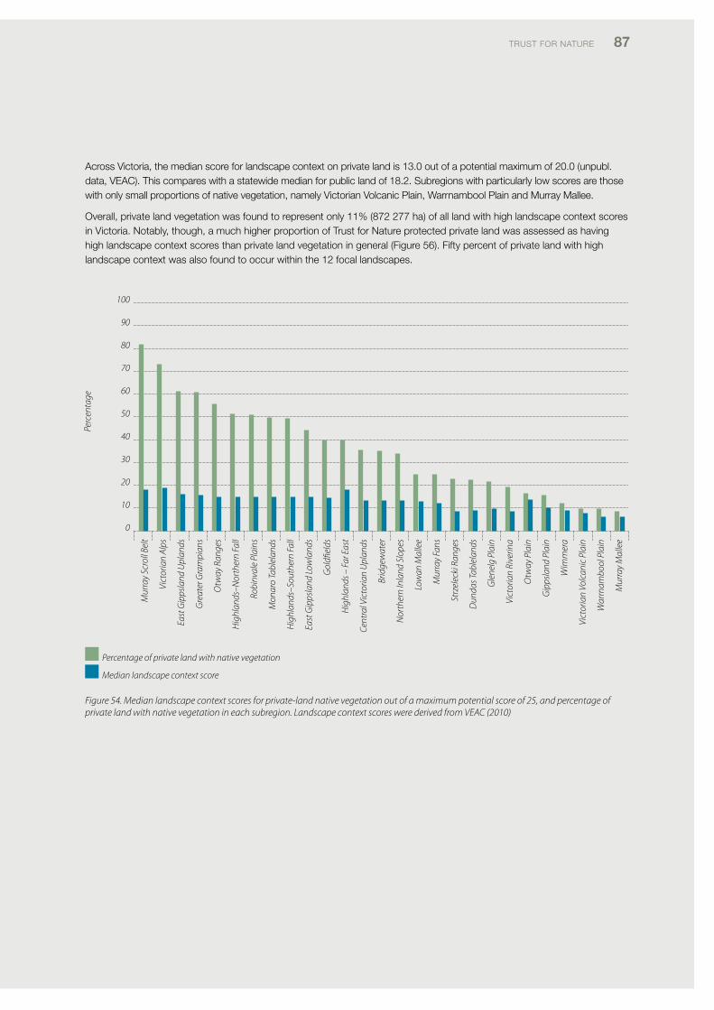
TRUST foR NATURE 87
Across victoria, the median score for landscape context on private land is 13.0 out of a potential maximum of 20.0 (unpubl. data, vEAc). This compares with a statewide median for public land of 18.2. Subregions with particularly low scores are those with only small proportions of native vegetation, namely victorian volcanic plain, Warrnambool plain and Murray Mallee.
overall, private land vegetation was found to represent only 11% (872 277 ha) of all land with high landscape context scores in victoria. Notably, though, a much higher proportion of Trust for Nature protected private land was assessed as having high landscape context scores than private land vegetation in general (figure 56). fifty percent of private land with high landscape context was also found to occur within the 12 focal landscapes.
Mur
ray
Scro
ll Be
lt
Vict
oria
n Al
ps
East
Gip
psla
nd U
plan
ds
Gre
ater
Gra
mpi
ans
Otw
ay R
ange
s
Hig
hlan
ds–N
orth
ern
Fall
Robi
nval
e Pl
ains
Mon
aro
Tabl
elan
ds
Hig
hlan
ds–S
outh
ern
Fall
East
Gip
psla
nd L
owla
nds
Gol
dfiel
ds
Hig
hlan
ds –
Far
Eas
t
Cent
ral V
icto
rian
Upl
ands
Brid
gew
ater
Nor
ther
n In
land
Slo
pes
Low
an M
alle
e
Mur
ray
Fans
Strz
elec
ki R
ange
s
Dun
das T
able
land
s
Gle
nelg
Pla
in
Vict
oria
n Ri
verin
a
Otw
ay P
lain
Gip
psla
nd P
lain
Wim
mer
a
Vict
oria
n Vo
lcan
ic P
lain
War
rnam
bool
Pla
in
Mur
ray
Mal
lee
100
90
80
70
60
50
40
30
20
10
0
Perc
enta
ge
Percentage of private land with native vegetation
Median landscape context score
Figure 54. Median landscape context scores for private-land native vegetation out of a maximum potential score of 25, and percentage of private land with native vegetation in each subregion. Landscape context scores were derived from VEAC (2010)
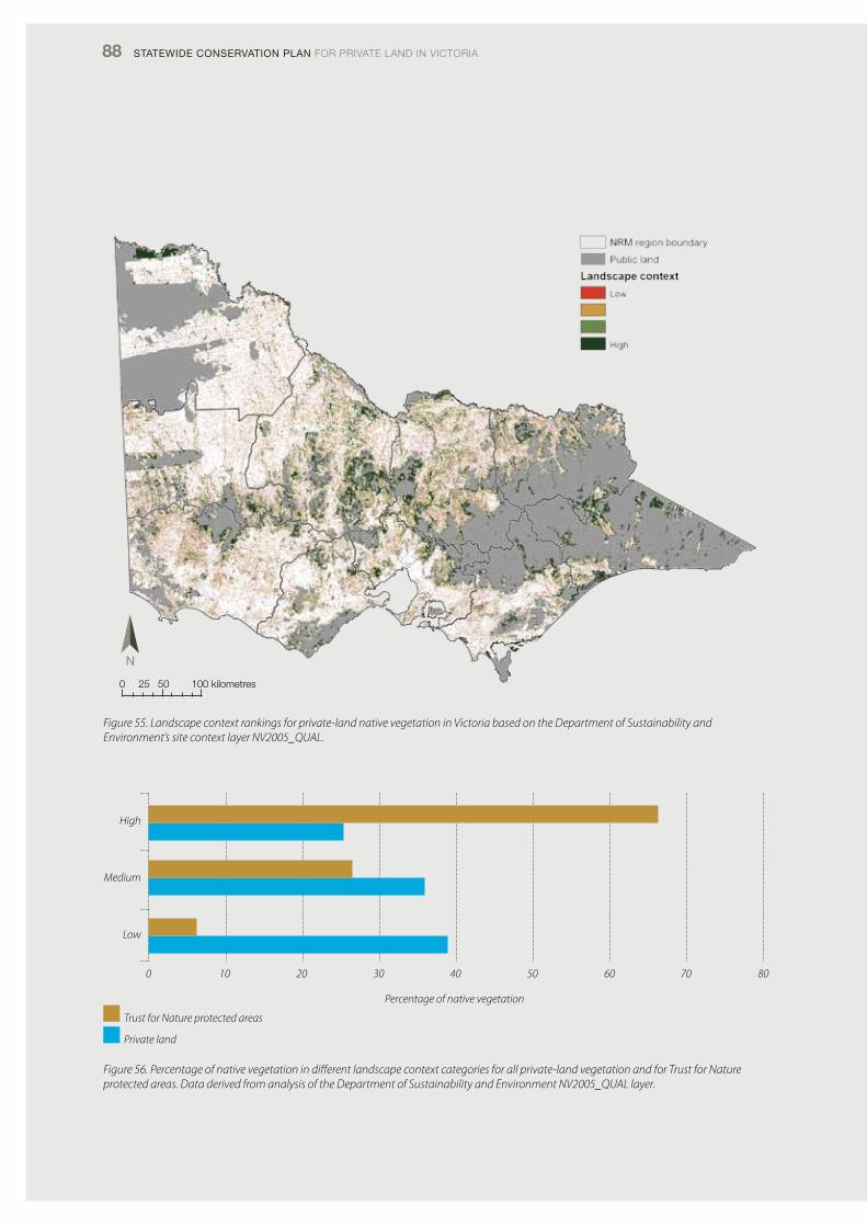
88 Statewide ConServation Plan foR pRivATE lANd iN vicToRiA
Figure 55. Landscape context rankings for private-land native vegetation in Victoria based on the Department of Sustainability and Environment’s site context layer NV2005_QUAL.
High
Medium
Low
0 10 20 30 40 50 60 70 80
Percentage of native vegetation
Trust for Nature protected areas
Private land
0 25 50 100 kilometres
Figure 56. Percentage of native vegetation in different landscape context categories for all private-land vegetation and for Trust for Nature protected areas. Data derived from analysis of the Department of Sustainability and Environment NV2005_QUAL layer.
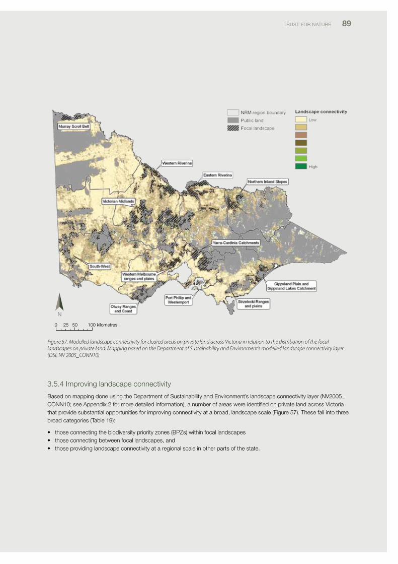
TRUST foR NATURE 89
0 25 50 100 kilometres
3.5.4 improving landscape connectivity
Based on mapping done using the department of Sustainability and Environment’s landscape connectivity layer (Nv2005_coNN10; see Appendix 2 for more detailed information), a number of areas were identified on private land across victoria that provide substantial opportunities for improving connectivity at a broad, landscape scale (figure 57). These fall into three broad categories (Table 19):
• thoseconnectingthebiodiversitypriorityzones(BPZs)withinfocallandscapes• thoseconnectingbetweenfocallandscapes,and• thoseprovidinglandscapeconnectivityataregionalscaleinotherpartsofthestate.
Figure 57. Modelled landscape connectivity for cleared areas on private land across Victoria in relation to the distribution of the focal landscapes on private land. Mapping based on the Department of Sustainability and Environment’s modelled landscape connectivity layer (DSE NV 2005_CONN10)
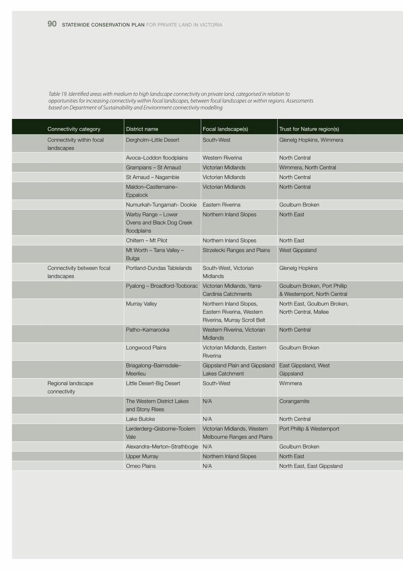
90 Statewide ConServation Plan foR pRivATE lANd iN vicToRiA
Table 19. Identified areas with medium to high landscape connectivity on private land, categorised in relation to opportunities for increasing connectivity within focal landscapes, between focal landscapes or within regions. Assessments based on Department of Sustainability and Environment connectivity modelling
Connectivity category district name Focal landscape(s) trust for nature region(s)
connectivity within focal
landscapes
dergholm–little desert South-West Glenelg Hopkins, Wimmera
Avoca–Loddonfloodplains Western Riverina North central
Grampians – St Arnaud victorian Midlands Wimmera, North central
St Arnaud – Nagambie victorian Midlands North central
Maldon–castlemaine–
Eppalock
victorian Midlands North central
Numurkah-Tungamah- dookie Eastern Riverina Goulburn Broken
Warby Range – lower
ovens and Black dog creek
floodplains
Northern inland Slopes North East
chiltern – Mt pilot Northern inland Slopes North East
Mt Worth – Tarra valley –
Bulga
Strzelecki Ranges and plains West Gippsland
connectivity between focal
landscapes
portland-dundas Tablelands South-West, victorian
Midlands
Glenelg Hopkins
pyalong – Broadford-Tooborac victorian Midlands, Yarra-
cardinia catchments
Goulburn Broken, port phillip
& Westernport, North central
Murray valley Northern inland Slopes,
Eastern Riverina, Western
Riverina, Murray Scroll Belt
North East, Goulburn Broken,
North central, Mallee
patho–Kamarooka Western Riverina, victorian
Midlands
North central
longwood plains victorian Midlands, Eastern
Riverina
Goulburn Broken
Briagalong–Bairnsdale–
Meerlieu
Gippsland plain and Gippsland
lakes catchment
East Gippsland, West
Gippsland
Regional landscape
connectivity
little desert-Big desert South-West Wimmera
The Western district lakes
and Stony Rises
N/A corangamite
lake Buloke N/A North central
lerderderg–Gisborne–Toolern
vale
victorian Midlands, Western
Melbourne Ranges and plains
port phillip & Westernport
Alexandra–Merton–Strathbogie N/A Goulburn Broken
Upper Murray Northern inland Slopes North East
omeo plains N/A North East, East Gippsland
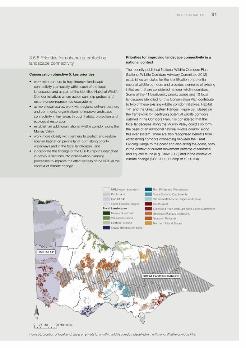
TRUST foR NATURE 91
3.5.5 priorities for enhancing protecting landscape connectivity
Conservation objective 5: key priorities
• workwithpartnerstohelpimprovelandscapeconnectivity, particularly within each of the focal landscapes and as part of the identified National Wildlife corridor initiatives where action can help protect and restore under-represented ecosystems
• atmorelocalscales,workwithregionaldeliverypartnersand community organisations to improve landscape connectivity in key areas through habitat protection and ecological restoration
• establishanadditionalnationalwildlifecorridoralongtheMurray valley
• workmorecloselywithpartnerstoprotectandrestoreriparian habitat on private land, both along priority waterways and in the focal landscapes, and
• incorporatethefindingsoftheCSIROreportsdescribedin previous sections into conservation planning processes to improve the effectiveness of the NRS in the context of climate change.
Priorities for improving landscape connectivity in a national context
The recently published National Wildlife corridors plan (National Wildlife corridors Advisory committee 2012) establishes principles for the identification of potential national wildlife corridors and provides examples of existing initiatives that are considered national wildlife corridors. Some of the 41 biodiversity priority zones and 12 focal landscapes identified for this conservation plan contribute to two of these existing wildlife corridor initiatives: Habitat 141 and the Great Eastern Ranges (figure 58). Based on the framework for identifying potential wildlife corridors outlined in the corridors plan, it is considered that the focal landscapes along the Murray valley could also form the basis of an additional national wildlife corridor along this river system. There are also recognised benefits from establishing corridors connecting between the Great dividing Range to the coast and also along the coast, both in the context of current movement patterns of terrestrial and aquatic fauna (e.g. drew 2008) and in the context of climate change (dSE 2009; dunlop et al. 2012a).
0 25 50 100 kilometres
Figure 58. Location of focal landscapes on private land within wildlife corridors identified in the National Wildlife Corridors Plan
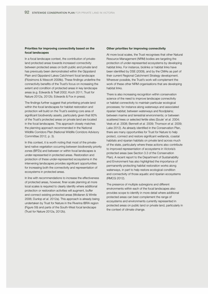
92 Statewide ConServation Plan foR pRivATE lANd iN vicToRiA
Priorities for improving connectivity based on the focal landscapes
in a focal landscape context, the contribution of private-land protected areas towards increased connectivity between protected areas on both public and private land has previously been demonstrated within the Gippsland plain and Gippsland lakes catchment focal landscape (fitzsimons & Wescott 2008b). These findings underline the connectivity benefits of the Trust’s focus on increasing the extent and condition of protected areas in key landscape areas (e.g. Edwards & Traill 2002; Koch 2011; Trust for Nature 2012a, 2012b; Edwards & fox in press).
The findings further suggest that prioritising private land within the focal landscapes for habitat restoration and protection will build on the Trust’s existing core area of significant biodiversity assets, particularly given that 60% of the Trust’s protected areas on private land are located in the focal landscapes. This approach closely matches the planning approach recommended in the National Wildlife corridors plan (National Wildlife corridors Advisory committee 2012, p. 3).
in this context, it is worth noting that most of the private- land native vegetation occurring between biodiversity priority zones (BpZs) and between or within focal landscapes is under-represented in protected areas. Restoration and protection of these under-represented ecosystems in the intervening landscapes provides significant opportunities for increasing both the connectivity and representation of ecosystems in protected areas.
in line with recommendations to increase the effectiveness of protected areas, however, finer-scale planning at more local scales is required to clearly identify where additional protection or restoration activities will augment, buffer and connect existing protected areas (Moilanen & Wintle 2006; dunlop et al. 2012a). This approach is already being undertaken by Trust for Nature in the Riverina iBRA region (figure 59) and parts of the South-West focal landscape (Trust for Nature 2012a, 2012b).
Other priorities for improving connectivity
At more local scales, the Trust recognises that other Natural Resource Management (NRM) bodies are targeting the protection of under-represented ecosystems by developing habitat links. for instance, biolinks or habitat links have been identified by dSE (2009), and by the cMAs as part of their current Regional catchment Strategy development. Wherever possible, the Trust’s work will complement the work of these other NRM organisations that are developing habitat links.
There is also increasing recognition within conservation science of the need to improve landscape connectivity or habitat connectivity to maintain particular ecological processes; for instance along waterways and associated riparianhabitat;betweenwaterwaysandfloodplains;between marine and terrestrial environments; or between scattered trees or selected fertile sites (Soule’ et al. 2004; vesk et al. 2008; Bennett et al. 2009; Thomson et al. 2009; lake 2012). As already identified in the conservation plan, there are many opportunities for Trust for Nature to help protect, connect and restore significant wetlands, coastal habitats and riparian habitats on private land across much of the state, particularly where these actions also contribute to improved representation of ecosystems in victoria’s protected areas (see Section 3.3 of the conservation plan). A recent report to the department of Sustainability and Environment has also highlighted the importance of permanently protecting habitat restoration works along waterways, in part to help restore ecological condition and connectivity of those aquatic and riparian ecosystems (RMcG 2012).
The presence of multiple subregions and different environments within each of the focal landscapes also provides scope to identify in more detail where additional protected areas can best complement the range of ecosystems and environments currently represented in protected areas on public land or private land, particularly in the context of climate change.
TRUST foR NATURE 93
Figure 59. Finer-scale conservation planning at Wanderers Plain in the Western Riverina focal landscape. White shows private land. Note the habitat links provided by the covenants protecting native vegetation and the additional opportunities for protection and connectivity provided by non-protected areas of under-represented Ecological Vegetation Classes (EVCs) on private land
0 1 2 4 kilometres
94 Statewide ConServation Plan foR pRivATE lANd iN vicToRiA
3.6 Conservation objective 6: Enhance and protect habitat quality
3.6.1 Rationale for the objective
Habitat quality, or vegetation condition, is known to positivelyinfluencespeciesrichness,populationsizeandbreeding success for a range of wildlife (Gilmore 1985; loyn 1987; Arnold 1988; ford & Barrett 1995; Hadden & Westbrooke 1996). Habitat quality also represents a surrogate measure for the health of the internal and ecological processes affecting an ecosystem (Saunders et al. 1991; Bennett et al. 2009), such that protection of intact ecosystems is generally considered a priority action for maintaining or enhancing ecological processes (commonwealth of Australia 1999; dunlop & Brown 2008; Bennett et al. 2009).
Additionally, it is recognised that improvement of vegetation condition is a key conservation action to improve and restore biodiversity values and ecosystem functioning (Martin & Green 2002; Montague-drake et al. 2009; Gibbons 2010), particularly in fragmented landscapes where most native vegetation patches are small and in only poor to medium condition (vEAc 2010).
This objective seeks to identify priority areas for both protection of habitat and enhancement of habitat.
These two sub-objectives were assessed using dSE layers for vegetation quality. More details about the methods used are provided in Appendix 2.
3.6.2 Key findings for the objective
The key findings informing the conservation plan are that
• thefocallandscapesincludenearlyhalfofthehigh-quality native vegetation found on private land in victoria
• mosthigh-qualityvegetationonprivatelandoccursonland adjacent to large protected areas on public land
• nativevegetationonprivatelandinVictoriahaslowerhabitat quality than native vegetation on public land (vEAc 2010), making habitat improvement a key biodiversity action for private land, and
• nativevegetationonTrustforNaturecovenantsandproperties has higher habitat quality than private-land vegetation overall
3.6.3 Assessment of habitat quality
in general, habitat quality scores for private land vegetation are higher in subregions with a higher percentage of private land supporting native vegetation, notably the Murray Scroll Belt, victorian Alps, East Gippsland Uplands, Greater Grampians and otway Ranges (figure 60). Notable anomalies are the Goldfields and dundas Tablelands, both of which have lower median habitat condition values than expected on the basis of their extent of native vegetation. Median habitat scores are generally lower in those subregions with less remnant native vegetation (figure 60), which also tend to be subregions with low proportions of protected land. These subregions include Warrnambool plain, victorian volcanic plain, victorian Riverina, Wimmera and dundas Tablelands (figure 60).
Across the state, high-value sites on private land measure 131 000 ha in extent – only 4% of the total extent of modelled high-quality vegetation in victoria. The most extensive areas of high-quality vegetation on private land occur in East Gippsland and West Gippsland in the highlands and montane subregions and East Gippsland lowlands (figure 61). other significant areas of high-quality vegetation on private land include the Murray Scroll Belt, private land bordering the little desert and Big desert, the Highlands – Southern fall subregion in the port phillip & Westernport NRM region, the Upper Murray valley district, the Goldfields subregion in the Goulburn Broken NRM region, around St Arnaud, and in the otway Ranges (figure 61).
Altogether, the median value for habitat condition on private land is 31.8 out of a potential maximum of 75 (unpubl. data, vEAc). This compares with a statewide median for public land of 49.3. Notably, though, a higher proportion of private land protected by the Trust was assessed as having high-quality and medium-quality habitat condition scores than private land vegetation in general (figure 62). forty-seven percent of private land with high habitat quality occurs within the 12 focal landscapes.
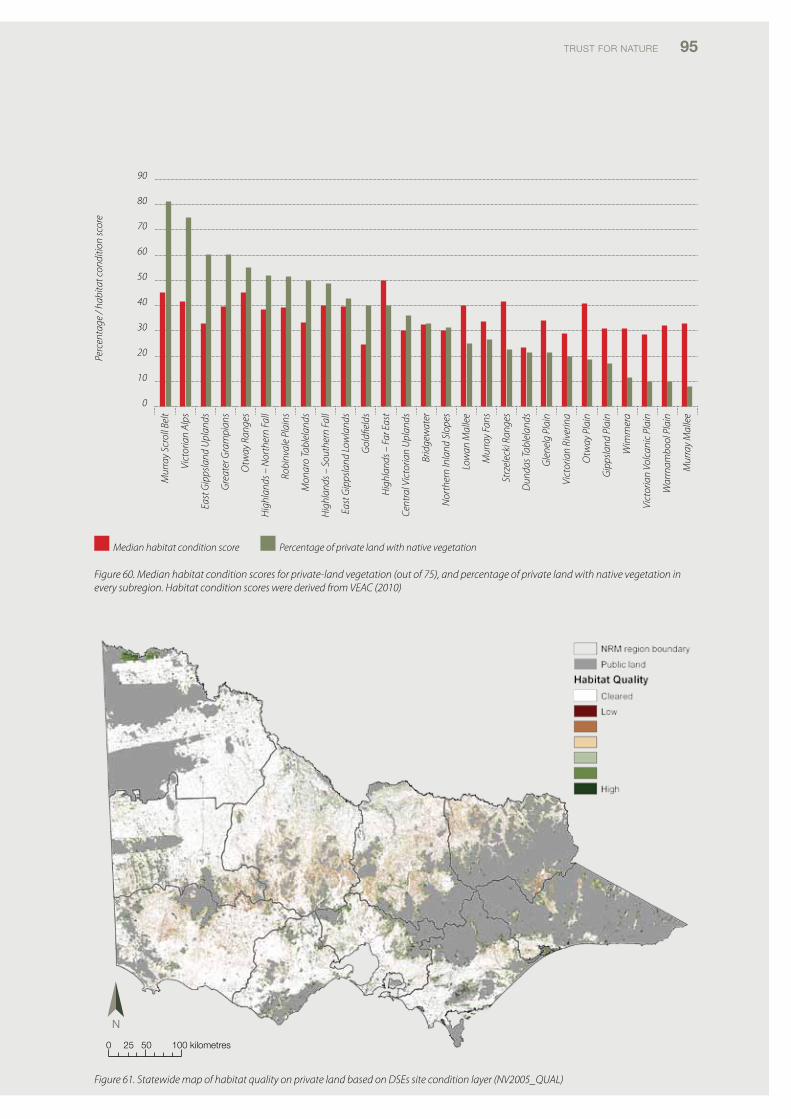
TRUST foR NATURE 95
Figure 60. Median habitat condition scores for private-land vegetation (out of 75), and percentage of private land with native vegetation in every subregion. Habitat condition scores were derived from VEAC (2010)
Figure 61. Statewide map of habitat quality on private land based on DSEs site condition layer (NV2005_QUAL)
Mur
ray
Scro
ll Be
lt
Vict
oria
n Al
ps
East
Gip
psla
nd U
plan
ds
Gre
ater
Gra
mpi
ans
Otw
ay R
ange
s
Hig
hlan
ds –
Nor
ther
n Fa
ll
Robi
nval
e Pl
ains
Mon
aro
Tabl
elan
ds
Hig
hlan
ds –
Sou
ther
n Fa
ll
East
Gip
psla
nd L
owla
nds
Gol
dfiel
ds
Hig
hlan
ds –
Far
Eas
t
Cent
ral V
icto
rian
Upl
ands
Brid
gew
ater
Nor
ther
n In
land
Slo
pes
Low
an M
alle
e
Mur
ray
Fans
Strz
elec
ki R
ange
s
Dun
das T
able
land
s
Gle
nelg
Pla
in
Vict
oria
n Ri
verin
a
Otw
ay P
lain
Gip
psla
nd P
lain
Wim
mer
a
Vict
oria
n Vo
lcan
ic P
lain
War
rnam
bool
Pla
in
Mur
ray
Mal
lee
90
80
70
60
50
40
30
20
10
0
Perc
enta
ge /
habi
tat c
ondi
tion
scor
e
Median habitat condition score Percentage of private land with native vegetation
0 25 50 100 kilometres
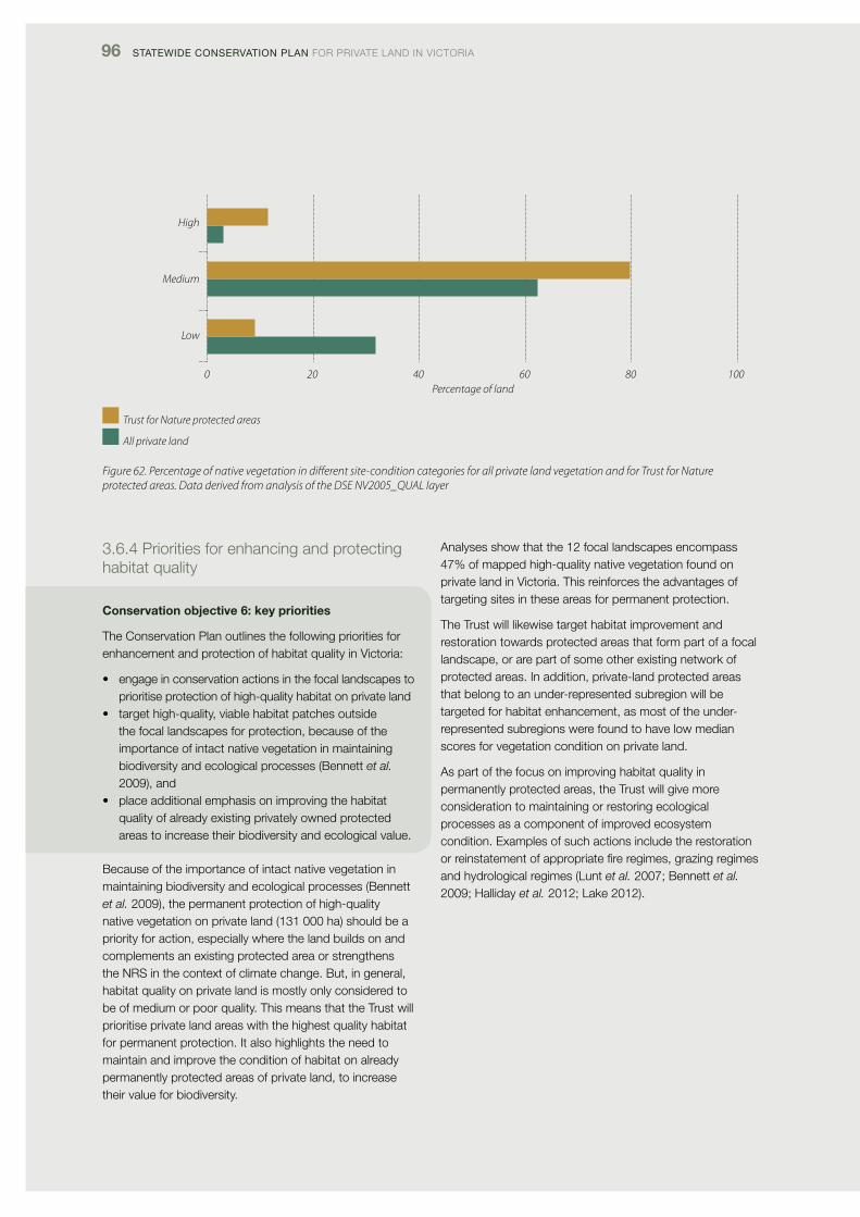
96 Statewide ConServation Plan foR pRivATE lANd iN vicToRiA
Figure 62. Percentage of native vegetation in different site-condition categories for all private land vegetation and for Trust for Nature protected areas. Data derived from analysis of the DSE NV2005_QUAL layer
High
Medium
Low
0 20 40 60 80 100Percentage of land
3.6.4 priorities for enhancing and protecting habitat quality
Conservation objective 6: key priorities
The conservation plan outlines the following priorities for enhancement and protection of habitat quality in victoria:
• engageinconservationactionsinthefocallandscapestoprioritise protection of high-quality habitat on private land
• targethigh-quality,viablehabitatpatchesoutsidethe focal landscapes for protection, because of the importance of intact native vegetation in maintaining biodiversity and ecological processes (Bennett et al. 2009), and
• placeadditionalemphasisonimprovingthehabitatquality of already existing privately owned protected areas to increase their biodiversity and ecological value.
Because of the importance of intact native vegetation in maintaining biodiversity and ecological processes (Bennett et al. 2009), the permanent protection of high-quality native vegetation on private land (131 000 ha) should be a priority for action, especially where the land builds on and complements an existing protected area or strengthens the NRS in the context of climate change. But, in general, habitat quality on private land is mostly only considered to be of medium or poor quality. This means that the Trust will prioritise private land areas with the highest quality habitat for permanent protection. it also highlights the need to maintain and improve the condition of habitat on already permanently protected areas of private land, to increase their value for biodiversity.
Analyses show that the 12 focal landscapes encompass 47% of mapped high-quality native vegetation found on private land in victoria. This reinforces the advantages of targeting sites in these areas for permanent protection.
The Trust will likewise target habitat improvement and restoration towards protected areas that form part of a focal landscape, or are part of some other existing network of protected areas. in addition, private-land protected areas that belong to an under-represented subregion will be targeted for habitat enhancement, as most of the under-represented subregions were found to have low median scores for vegetation condition on private land.
As part of the focus on improving habitat quality in permanently protected areas, the Trust will give more consideration to maintaining or restoring ecological processes as a component of improved ecosystem condition. Examples of such actions include the restoration or reinstatement of appropriate fire regimes, grazing regimes and hydrological regimes (lunt et al. 2007; Bennett et al. 2009; Halliday et al. 2012; lake 2012).
Trust for Nature protected areas
All private land
TRUST foR NATURE 97
3.7 Setting priorities for conservation actionconservation prioritisation and the allocation of resources to different conservation actions is not only contingent on the ecological values of any particular location or asset but also requires there to be prioritisation of effort based on both the level of threat to the asset without intervention, the effectiveness of the conservation action and the probability of success (pressey & Taffs 2001; possingham 2001; cMp 2007; Wintle 2008). Accordingly, in addition to the specific priority actions and areas identified for each of the conservation objectives in the preceding sections, five broader factors are identified that should also be considered as part of decision-making about conservation prioritisation:
• theriskofhabitatlossandmodificationwithoutintervention
• theneedforconservationeffectiveness• theimpactsofclimatechange• socialandeconomicinfluences,and• complementaryconservationprogramsandopportunities.
These are discussed in more detail below.
3.7.1 The risk of habitat loss and modification without intervention
ongoing habitat removal for agriculture and urban development is estimated to result in the loss of approximately 4 000 ha of native vegetation per year. in the period between 1989-1995 and 1998-2005, approximately 1 200 ha of woody vegetation and 3200 ha of grassy vegetation was estimated to have been lost per year - nearly all of it on private land and nearly all of it in already fragmented landscapes (dSE 2008). Some other recent investigations have also documented the continuing loss of grassy and woodland ecosystems on private land (Maron & fitzsimons 2007; Marshall & fitzsimons 2008), underlining the urgent need to protect those habitats and sites identified as being at high risk of loss.
figure 63 indicates those areas considered to be at greatest risk of habitat loss in victoria over the next 10 years, based on the distribution of the vegetation groups known to be undergoing the greatest current loss (grassy vegetation, woodland vegetation; dSE 2008) and predicted urban-growth areas along the coast (dpcd 2012). Based on this mapping, the areas at greatest risk of habitat loss in the next decade include the Eastern Riverina, Western Riverina, Gippsland plain, South-West, Western Melbourne and Northern inland Slopes focal landscapes. Additionally, all native vegetation close to Melbourne, on the victorian volcanic plains, close to major regional centres and along victoria’s coast is under severe threat of loss or disturbance as a result of changes in agricultural land use, urban growth and infrastructure development (e.g. cES 2009; dpcd 2009). in all of these areas, decisions to protect additional land or undertake other conservation actions will need to be considered in the context of the future likelihood of a given area, species or population remaining viable if the surrounding land remains available for development ((Williams et al. 2006; Hale et al. 2012).
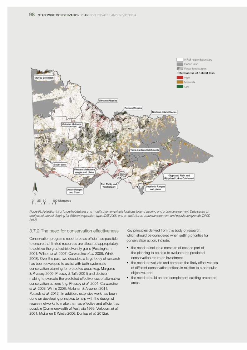
98 Statewide ConServation Plan foR pRivATE lANd iN vicToRiA
0 25 50 100 kilometres
Figure 63. Potential risk of future habitat loss and modification on private land due to land clearing and urban development. Data based on analyses of rates of clearing for different vegetation types (DSE 2008) and on statistics on urban development and population growth (DPCD 2012)
3.7.2 The need for conservation effectiveness
conservation programs need to be as efficient as possible to ensure that limited resources are allocated appropriately to achieve the greatest biodiversity gains (possingham 2001; Wilson et al. 2007; carwardine et al. 2008; Wintle 2008). over the past two decades, a large body of research has been developed to assist with both systematic conservation planning for protected areas (e.g. Margules & pressey 2000; pressey & Taffs 2001) and decision-making to evaluate the predicted effectiveness of alternative conservation actions (e.g. pressey et al. 2004; carwardine et al. 2008; Wintle 2008; Moilanen & Arponen 2011; pouzols et al. 2012). in addition, extensive work has been done on developing principles to help with the design of reserve networks to make them as effective and efficient as possible (commonwealth of Australia 1999; verboom et al. 2001; Moilanen & Wintle 2006; dunlop et al. 2012a).
Key principles derived from this body of research, which should be considered when setting priorities for conservation action, include:
• theneedtoincludeameasureofcostaspartofthe planning to be able to evaluate the predicted conservation return on investment
• theneedtoevaluateandcomparethelikelyeffectivenessof different conservation actions in relation to a particular objective, and
• theneedtobuildonandcomplementexistingprotectedareas.
TRUST foR NATURE 99
3.7.3 The impacts of climate change
Modelling done as part of recent reports into the implications of climate change for the National Reserve System (NRS) (dunlop et al. 2012a, 2012b) demonstrated that the overall level of environmental representation within the existing NRS did not differ substantially between current climate scenarios and future climate scenarios (dunlop et al. 2012a). The report consequently concluded that the current approach, which focuses on ecosystem representation as the basis for building the NRS, is a robust strategy in the context of climate change. However, the report also identified ways in which the effectiveness of the NRS could be improved under climate change. These recommendations include targeting the conservation of:
• largeareasofhabitatatriskoffragmentationordegradation
• refugesfromenvironmentaldisturbance,especiallythoseareas that may provide long-term refuge from changing climate
• areaswithhighconnectivitybetweendiversehabitatsand places with steep environmental gradients
• areasthatreducethelargestgapsbetweenexistingprotected areas, and
• areasthatsupportlandscape-scaleecologicalprocesses, including hydrological processes (dunlop et al. 2012a, 2012b).
importantly, from the point of view of those involved in the conservation of private land, the NRS report also emphasised the need for cross-tenure, landscape-scale approaches to nature conservation, and it emphasised the need for a complementary suite of off-reserve conservation measures to protect biodiversity.
The approach taken in the conservation plan – to identify focal landscapes, continental-scale wildlife corridors, significant aquatic ecosystems and gaps in the protected areas system – is consistent with the recommendations in the NRS report on climate change (dunlop et al. 2012a, 2012b). Based on the recommendations in that report, however, the Trust will do further analyses to identify priority areas on private land that contain mesic environments, climate and habitat refugia, key localities in terms of landscape-scale processes (e.g. riparian habitats, old-growth vegetation), and locations which complement and buffer existing protected areas in terms of ecosystem representation (e.g. Sharafi et al. 2012).
3.7.4 Social and economic factors
Understanding the social and economic factors that affect private-land conservation is important, especially as it is increasingly recognised, in Australia and in other Western nations that, firstly, private-land conservation is critical to the future protection of biodiversity and, secondly, the traditional focus on securing publicly owned protected areas will not be enough to protect biodiversity (Hale & lamb 1997; figgis 2004; donald & Evans 2006; fitzsimons & Wescott 2008a; cooke et al. 2011).
As noted in Section 1.1.5, rural victoria has undergone a large transformation in land use, social patterns and demography over the last 50 years. victoria can now be divided broadly into six different social landscapes (Barr 2008; see Section 1.1.5 for definitions of the social landscapes), and even finer social-ecological units at the catchment and regional scale (e.g. GBcMA 2012). Within each of the six social landscapes, different economic drivers are present – the demographics within communities are different, the work and life patterns are different, and land use is different (Barr 2008). different conservation mechanisms and different approaches are accordingly needed in different parts of the state, depending on demographics, the rate of turnover of land, land values and landowner access to funding for environmental works (e.g. GBcMA 2012).
private land conservation has also been transformed over the past 40 years, evolving from a largely voluntary activity to one in which the role of landowners in providing a range of ecosystem services is increasingly recognised, and funded or otherwise supported through grants, tender programs, rate concessions and the ecosystem market (e.g. Binning & Young 1997; Stoneham et al. 2000; figgis 2004). These changes have implications for future conservation on private land, especially as landowners have their own set of preferences in regard to the design and implementation of conservation programs operating on their land (cooke et al. 2011). Trust for Nature research has shown, for example, that in the victorian volcanic plains bioregion there are many landowners interested in protecting habitat on their land in perpetuity, but these landowners are unwilling to set up conservation covenants if the covenant precludes them from subsequently being able to negotiate native vegetation or threatened species offset agreements (and associated payments) with the Australian Government (Trust for Nature 2010). future conservation programs will need to reconcile such policy shortcomings if they wish to secure additional protected areas on private land.
Accordingly, it is essential that private-land conservation bodies understand in detail the economic and human dimensions of the landscapes where they operate, to develop appropriate conservation strategies (e.g. cooke et al. 2011; Moon & cocklin 2011).
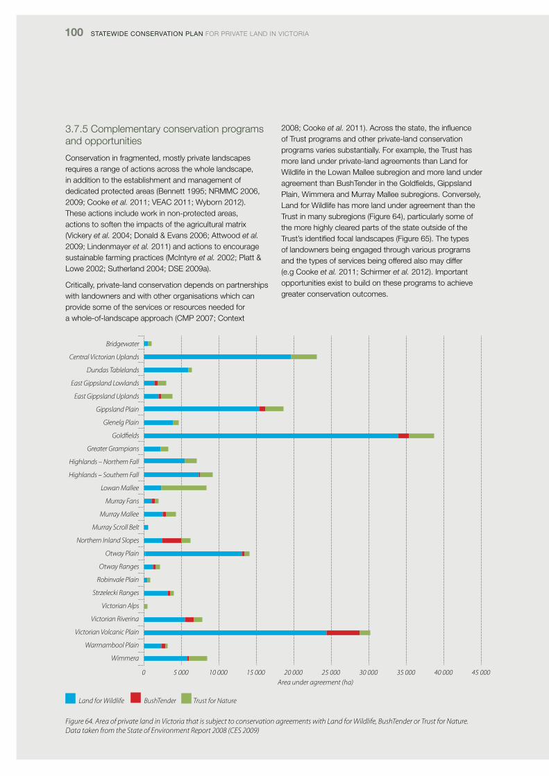
100 Statewide ConServation Plan foR pRivATE lANd iN vicToRiA
3.7.5 complementary conservation programs and opportunities
conservation in fragmented, mostly private landscapes requires a range of actions across the whole landscape, in addition to the establishment and management of dedicated protected areas (Bennett 1995; NRMMc 2006, 2009; cooke et al. 2011; vEAc 2011; Wyborn 2012). These actions include work in non-protected areas, actions to soften the impacts of the agricultural matrix (vickery et al. 2004; donald & Evans 2006; Attwood et al. 2009; lindenmayer et al. 2011) and actions to encourage sustainable farming practices (Mcintyre et al. 2002; platt & lowe 2002; Sutherland 2004; dSE 2009a).
critically, private-land conservation depends on partnerships with landowners and with other organisations which can provide some of the services or resources needed for a whole-of-landscape approach (cMp 2007; context
2008; cooke et al.2011).Acrossthestate,theinfluenceof Trust programs and other private-land conservation programs varies substantially. for example, the Trust has more land under private-land agreements than land for Wildlife in the lowan Mallee subregion and more land under agreement than BushTender in the Goldfields, Gippsland plain, Wimmera and Murray Mallee subregions. conversely, land for Wildlife has more land under agreement than the Trust in many subregions (figure 64), particularly some of the more highly cleared parts of the state outside of the Trust’s identified focal landscapes (figure 65). The types of landowners being engaged through various programs and the types of services being offered also may differ (e.g cooke et al. 2011; Schirmer et al. 2012). important opportunities exist to build on these programs to achieve greater conservation outcomes.
Figure 64. Area of private land in Victoria that is subject to conservation agreements with Land for Wildlife, BushTender or Trust for Nature. Data taken from the State of Environment Report 2008 (CES 2009)
Bridgewater
Central Victorian Uplands
Dundas Tablelands
East Gippsland Lowlands
East Gippsland Uplands
Gippsland Plain
Glenelg Plain
Goldfields
Greater Grampians
Highlands – Northern Fall
Highlands – Southern Fall
Lowan Mallee
Murray Fans
Murray Mallee
Murray Scroll Belt
Northern Inland Slopes
Otway Plain
Otway Ranges
Robinvale Plain
Strzelecki Ranges
Victorian Alps
Victorian Riverina
Victorian Volcanic Plain
Warrnambool Plain
Wimmera
0 5 000 10 000 15 000 20 000 25 000 30 000 35 000 40 000 45 000Area under agreement (ha)
Land for Wildlife BushTender Trust for Nature
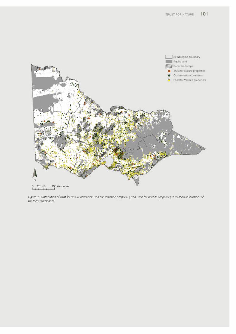
TRUST foR NATURE 101
0 25 50 100 kilometres
Figure 65. Distribution of Trust for Nature covenants and conservation properties, and Land for Wildlife properties, in relation to locations of the focal landscapes
102 Statewide ConServation Plan foR pRivATE lANd iN vicToRiA
3.8 Future use and review of the Statewide Conservation Plan
The conservation plan’s findings have many implications for Trust for Nature in relation to its future conservation programs on private land. The findings demonstrate that despite a long history of systematic land-use planning for public land, victoria’s ecosystems are still poorly represented in protected areas overall. furthermore, in much of the state, additional protection of habitat on private land will be the principal means of increasing the National Reserve System (NRS).
it is vital that the Trust continues its work to reduce habitat loss on private land – both by adding to permanently protected areas and through restoration and improvement. Achieving these gains in protected areas and habitat quality on private land clearly requires closer partnerships with other Natural Resource Management (NRM) bodies, community groups and landowners. in particular, the Trust will encourage the adoption of permanent protection as a more mainstream and standardised component of all NRM projects.
The Trust’s 2011–2016 Strategic plan identifies seven strategic directions to guide the organisation’s business over the next five years:
1. implement strategic landscape-wide conservation2. Build and innovate private-land conservation practice3. Respond to climate change4. intensify the role of partnerships5. Build private and philanthropic sector investment and
commitment to conservation6. Build and modernise organisational capacity, and7. inspire and engage with the community.
The preparation of this Statewide conservation plan was recognised as a pivotal action that would provide an over-arching, statewide, scientific framework to inform the Trust’s activities in line with the seven strategic directions. The next steps are to use this conservation plan to inform the Trust’s planning and implementation of conservation programs in every region and across the state. in future, the assessments outlined in the conservation plan should be integrated with more detailed analysis of potential risks and opportunities in relation to localities, ecosystems and species. This will help the Trust to further articulate and prioritise its conservation actions.
The Trust’s Strategic Plan expressed the organisation’s vision that:
Within two decades, protecting native vegetation and wildlife on private land will be recognised and valued as a central part of mainstream Australian environmental practice, just as water and energy conservation is today. There will be a shared expectation and responsibility among communities, landowners and governments that, just as national and state parks are protected, so too significant natural areas on privately owned land should be protected.
The preparation of this Statewide conservation plan is an important step towards making the Trust for Nature’s vision a reality.
TRUST foR NATURE 103
Glossary
adequate representation: refers in this conservation plan to ecosystems that meet combined JANiS criteria (see below) for assessing the representation of ecosystems in protected areas at either the bioregional or subregional scale. Ecosystems that are adequately represented in protected areas meet the JANiS criteria; ecosystems that are under-represented do not.
adequacy: ‘Refers to how much of each ecosystem should be sampled to provide ecological viability and integrity of populations, species and ecological communities at a bioregional scale. The concept of adequacy incorporates ecological viability and resilience of ecosystems for individual protected areas and for the protected area system as a whole’ (NRMMc 2009).
Bioregion: See IBRA bioregion below.
Comprehensiveness: ‘Refers to the aim of including, within protected areas, samples of the full range of regional ecosystems recognisable at an appropriate scale within and across each iBRA bioregion’ (NRMMc 2009).
Conservation covenant: a permanent, legally-binding agreement placed on a property’s title to ensure native vegetation on the property is protected forever. The agreement is voluntary and negotiated between Trust for Nature and each individual landowner. Trust for Nature’s covenanting program falls under the Victorian Conservation Trust Act 1972.
ecological vegetation Class (evC): vegetation units mapped at scales of 1:25 000 up to 1:100 000 and defined by a ‘…combinationoffloristics,lifeform,positioninthelandscape,andaninferredfidelitytoparticularenvironments.EachEVCincludesacollectionoffloristiccommunities(i.e.groupsbasedonco-occurringplantspecies)thatoccuracrossabiogeographic range, and although differing in species, have similar habitat and ecological processes operating’ www.dse.vic.gov.au). for the purposes of spatial mapping and classification in terms of conservation status, Evcs are further classified in terms of their sub-regional occurrence (i.e. Box-ironbark forest, Wimmera Box-ironbark forest) and assigned a conservation status within that subregional context.
ecosystem: broadly defined as ‘a dynamic combination of plant, animal and micro-organism communities and their non-living environment (e.g. soil, water and the climatic regime) interacting as a functional unit. Examples of types of ecosystems include forests, wetlands, grasslands (NRMMc 2010).
in relation to the National Reserve System criteria for comprehensiveness, Adequacy and Representativeness, ‘ecosystem’ hasamoreprecisespatialdefinition,as‘Auniqueunitcomprisingarecognisablefloristiccompositionincombinationwithsubstrate (lithology/geology layers) and position within the landscape, and including their component biota (where known). An ecosystem map unit should normally be discriminated at a scale of 1:100 000 to 1:250 000 (commonwealth of Australia 1999).
evC Group: simplified native vegetation groups derived from Evc mapping and based on the same criteria of lifeform, floristics,landscapepositionandenvironment.
Habitat: The physical space within which a species lives, including living (e.g. vegetation) and non-living components (e.g. rocks).
iBra: ‘The interim Biogeographic Regionalisation for Australia provides a broad level break-up of the Australian landmass into 85 biogeographic regions and 403 subregions. The iBRA bioregions were derived by compiling information on climate, lithology/geology,landform,vegetation,floraandfauna.IBRAprovidesthenationalandregionalplanningframeworkfordeveloping the National Reserve System’ (NRMMc 2009).
iBra bioregion: the major biogeographic regions across Australia, as defined above.
iBra subregion: biogeographic areas defined at a finer scale than iBRA bioregions, on the basis of climate, lithology/geology,landform,vegetation,floraandfauna.MostIBRAbioregionscomprisemultipleIBRAsubregions.
JaniS criteria: national criteria developed under the National forest policy Statement implementation process for establishment of a ‘comprehensive, adequate and representative’ reserve system for forests in Australia.
national reserve System: Australia’s network of parks, reserves and protected areas on indigenous land and on private land, all of which meet the international Union for conservation of Nature (iUcN) definition of what constitutes a ‘protected area’ (see below includes private land protected under conservation covenant).
104 Statewide ConServation Plan foR pRivATE lANd iN vicToRiA
Protected area: a parcel of land that meets the iUcN’s definition of ‘a clearly defined geographical space, recognised, dedicated and managed, through legal or other effective means, to achieve the long-term conservation of nature with associated ecosystem services and cultural values’ (dudley 2008).
representativeness: ‘comprehensiveness considered at a finer scale (iBRA subregion), and recognises that the regional variability within ecosystems is sampled within the reserve system. one way of achieving this is to aim to represent each regional ecosystem within each iBRA subregion’ (NRMMc 2009).
Subregion: See IBRA subregion above.
trust for nature protected areas: refers to all land which is protected and managed for conservation by Trust for Nature and landowners in accordance with the iUcN/National Reserve System (NRS) definitions of what constitutes a ‘protected area’. for the Trust, these areas comprise conservation properties owned and managed by the Trust and land protected under voluntary conservation covenants.
Under-represented: an ecosystem that is not adequately represented in protected areas according to various or combined JANiS criteria (see Adequate representation) above.
Unrepresented: an ecosystem that is not represented in protected areas at either a bioregional scale (comprehensiveness criterion) or subregional scale (Representativeness criterion).
TRUST foR NATURE 105
References
Arnold,G.W.(1988).TheeffectsofhabitatstructureandfloristicsonthedensitiesofbirdspeciesinWandoowoodland.Australian Wildlife Research 15: 499–510
Attwood, S.J., park, S.E., Maron, M., collard, S.J., Robinson, d., Reardon-Smith, K.M. & cockfield, G. (2009). declining birds in Australian agricultural landscapes may benefit from aspects of the European agri-environment model. Biological Conservation 142: 1981–1991.
Barr, N. (2008). The social landscapes of rural victoria, pp. 327–350 in Landscape Analysis and Visualisation: Spatial Models for Natural Resource Management and Planning (c. pettit, W. cartwright, i. Bishop et al.). Springer, Berlin.
Barr, N. (2009). The House on the Hill: the Transformation of Australia’s Farming Communities. Melbourne, Halstead press.
Bennett, A. f. (1995). Wildlife conservation and management on private land – facing the challenge. pp. 119–127 in People and Nature Conservation: Perspectives on Private Land Use and Endangered Species Recovery (eds A. Bennett, G. Backhouse and T. clark). Royal Zoological Society of New South Wales, Sydney.
Bennett, A. f. (1999). Linkages in the Landscape. The Role of Corridors and Connectivity in Wildlife Conservation. iUcN, Gland, Switzerland.
Bennett, A.f. & Mac Nally, R. (2004). identifying priority areas for conservation action in agricultural landscapes. Pacific Conservation Biology 10: 106–123.
Bennett, A. f, Haslem, A., cheal, d. c., clarke, M. f., Jones, R. N., Koehn, J. d., lake, p. S., lumsden, l. f., lunt, i.d., Mackey, B. G., Mac Nally, R., Menkhorst, p. W., New, T. R., Newell, G. R., o’Hara, T., Quinn, G. p., Radford, J. Q., Robinson, d., Watson, J. E. M & Yen, A. l. (2009). Ecological processes: a key element in strategies for nature conservation. Ecological Management & Restoration 10: 192–199.
Bennett, l.T. (1994). The expansion of Leptospermum laevigatum on the Yanakie isthmus, Wilsons promontory, under changes in the burning and grazing regimes. Australian Journal of Botany 42: 555–564.
Binning. c. & Young, M. (1997). Motivating People: Using Management Agreements to Conserve Remnant Vegetation. cSiRo, canberra.
Brereton, R., Bennett, S. & Mansergh, i. (1995). Enhanced greenhouse climate change and its potential effect on selected fauna of south-eastern Australia; a trend analysis. Biological Conservation 72: 339–354.
carwardine, J., Wilson, K. A., Watts, M., Etter, A., Klein, c.J. & possingham, H. p. (2008). Avoiding costly conservation mistakes; the importance of defining actions and costs in spatial priority setting. PLoS One 3: 1–6.
cES (2009). State of the Environment Victoria 2008. commissioner for Environmental Sustainability, Melbourne.
cfoc (2011). Minimum requirements for contributing to the comprehensiveness, adequacy and representativeness of the National Reserve System through Caring for our Country funding. caring for our country initiative, Australian Government, canberra.
chambers, l. E., Hughes, l. & Weston, M.A. (2005). climate change and its impact on Australia’s avifauna. Emu 105: 1–20.
clode, d. (2006). As if for a Thousand Years. victorian Environmental Assessment council, Melbourne.
cMp (2007). Open Standards for the Practice of Conservation. Version 2.0. conservation Measures partnership.
coffey, B., fitzsimons, J. A. & Gormly, R. (2011). Strategic public land use assessment and planning in victoria, Australia: four decades of trailblazing but where to from here? Land Use Policy 28: 306–313.
commonwealth of Australia (1999). Australian Guidelines for Establishing the National Reserve System. commonwealth Government of Australia, Environment Australia, canberra.
context pty ltd (2008). Strategic plan for conservation Management Networks in victoria: Working together to protect biodiversity. Report to dSE. context pty ltd, Brunswick, victoria.
cooke, B., langford, W. T., Gordon, A. & Bekessy, S. (2011). Social context and the role of collaborative policy making for private land conservation. Journal of Environmental Planning and Management, 2011, 1–17. doi; 10.1080/09640568.2011.608549.
cowell, S. & Williams, c. (2006). conservation through buyer diversity; a key role for not-for-profit land-holding organizations in Australia. Ecological Management & Restoration 7: 5–20.
dcE (1992). Draft Conservation Program for Native Grasslands and Grassy Woodlands in Victoria. department of conservation and Environment, East Melbourne.
106 Statewide ConServation Plan foR pRivATE lANd iN vicToRiA
donald, p. f. & Evans, A.d. (2006). Habitat connectivity and matrix restoration: the wider implications of agri-environment schemes. Journal of Applied Ecology 43: 209–218.
dpcd (2009). delivering Melbourne’s newest sustainable communities. program Report, department of planning and community development, Melbourne.
dpcd (2012). Victoria in Future 2012: Population and Household Projections 2011–2031 for Victoria and its regions. department of planning and community development, Melbourne.
dpi (2010). invasive plants and Animals policy framework. department of primary industries, Melbourne.
drew, M. M. (2008). A guide to the management of native fish in victorian coastal rivers, estuaries and wetlands. department of Sustainability and Environment and corangamite catchment Authority, victoria.
dSE (2005). index of Stream condition; the second benchmark of stream condition. department of Sustainability and Environment, East Melbourne.
dSE (2007a). Bioregional conservation status, native vegetation groupings and mapping units – November 2007. http://www.dse.vic.gov.au/conservation-and-environment/native-vegetation-groups-for-victoria/simplified-native-vegetation-groups
dSE (2007b). Advisory list of threatened vertebrate fauna in Victoria – 2007. department of Sustainability and Environment, East Melbourne.
dSE (2008). Native vegetation net gain accounting; first approximation report. department of Sustainability and Environment, East Melbourne.
dSE (2009a). Securing Our Natural Future: A white paper for land and biodiversity at a time of climate change. department of Sustainability and Environment, East Melbourne.
dSE (2009b). Advisory list of threatened invertebrate fauna in victoria – 2009. department of Sustainability and Environment, East Melbourne.
dSE (2010). Biodiversity is Everybody’s Business: Biodiversity Strategy 2010–2015 Consultation Draft, department of Sustainability and Environment, East Melbourne.
dSE (2011a). NaturePrint and biodiversity monitoring, evaluation and reporting. Guidelines for Regional Catchment Strategies. department of Sustainability and Environment, East Melbourne.
dSE (2011b). NaturePrintv2.0: Elements and Integration. A technical explanation of the NaturePrintv2.0 analysis. department of Sustainability and Environment. East Melbourne.
dudley, N. (ed.) (2008). Guidelines for Applying Protected Area Management Categories. iUcN, Gland, Switzerland.
dunlop, M. & Brown, p.R. (2008). Implications of Climate Change for Australia’s National Reserve System – A Preliminary Assessment. Report to the department of climate change, and the department of the Environment, Water, Heritage and the Arts, March 2008.
dunlop, M., Hilbert, d. W., ferrier, S., House, A., liedloff, A., prober, S. M., Smyth, A., Martin, T. G., Harwood, T., Williams, K.J., fletcher, c. & Murphy, H. (2012a). The implications of climate change for biodiversity conservation and the National Reserve System: final synthesis. A report prepared for the department of Sustainability, Environment, Water, population and communities, and the department of climate change and Energy Efficiency. cSiRo climate Adaptation flagship, canberra.
dunlop, M., Hilbert, d. W., Stafford Smith, M., davies, R., James, c. d., ferrier, S., House, A., liedloff, A., prober, S. M., Smyth, A., Martin, T .G., Harwood, T., Williams, K. J., fletcher, c. & Murphy, H. (2012b). Implications for policymakers: climate change and the National Reserve System. cSiRo climate Adaptation flagship, canberra.
Ecc (2000). Marine, Coastal and Estuarine Investigation: Final Recommendations. Environment conservation council, Melbourne.
Ecc (2001). Box-ironbark Forests and Woodlands Investigation Final Report. Environment conservation council, Melbourne.
Edwards, R. & Traill, B. (2002). Getting beyond field days: targeting extension to protect threatened ecosystems on private land. Ecological Management & Restoration 3: 229–231.
TRUST foR NATURE 107
Edwards, R. & fox, T. (in press). conservation management networks: the Gippsland plains story. in Linking Australia’s Landscapes: Lessons and Opportunities from Large-scale Conservation Networks (eds J. fitzsimons, i. pulsford and G. Wescott). cSiRo publishing, collingwood.
figgis, p. (2004). Conservation on private lands: the Australian experience. iUcN, Gland, Switzerland, and cambridge, UK.
fitzsimons, J. (1999). Reservation status of Broad vegetation Types in victorian iBRA regions – 1999. Report for dNRE. dept of Natural Resources and Environment, Melbourne.
fitzsimons, J. A. (2006). private protected areas? Assessing the suitability for incorporating conservation agreements over private land into the National Reserve System: A case study of victoria. Environmental Planning Law Journal 23: 365–385.
fitzsimons, J. A. & Wescott, G. (2001). The role and contribution of private land in victoria to biodiversity conservation and the protected area system. Australian Journal of Environmental Management 8: 142–157.
fitzsimons, J. A. & Wescott, G. (2008a). Ecosystem conservation in multi-tenure reserve networks: the contribution of land outside of publically protected areas. Pacific Conservation Biology 14: 250–262.
fitzsimons, J. A. & Wescott, G. (2008b). The role of multi-tenure reserve networks in improving reserve design and connectivity. Landscape and Urban Planning 85: 163–173.
ford, H. A. & Barrett, G. (1995). The role of birds and their conservation in agricultural systems. pp. 128–134 in People and Nature Conservation: Perspectives on Private Land Use and Endangered Species Recovery (eds A. Bennett, G. Backhouse and T. clark). Royal Zoological Society of New South Wales, Sydney.
frankenberg, J. (1971). Nature Conservation in Victoria. A Survey. victorian National parks Association, Melbourne.
frood, d. & calder, M. (1987). Nature Conservation in Victoria. Study Report Vol. 1. victorian National parks Association, Melbourne.
fulton, G. R. & ford, H.A. (2001). The pied currawong’s role in avian nest predation: a predator removal experiment. Pacific Conservation Biology 7: 154–160.
GBcMA (2012). Draft Regional Catchment Strategy 2012–2018. Goulburn Broken catchment Management Authority, Shepparton.
Gibbons, p. (2010). prioritising conservation in temperate woodlands. pp. 15–21 in Temperate Woodland Conservation and Management (eds d. lindenmayer, A. Bennett and R. Hobbs). cSiRo, collingwood.
Gilmore,A.M.(1985).Theinfluenceofvegetationstructureonthedensityofinsectivorousbirds.Pp.21–31inBirds of Eucalypt Forests and Woodlands: Ecology, Conservation, Management (eds A. Keast et al.). RAoU and Surrey Beatty & Sons, chipping Norton, NSW.
Grey, M. J., clarke, M. f. & loyn, R. H. (1997). initial changes in the avian communities of remnant eucalypt woodlands following a reduction in the abundance of Noisy Miners (Manorina melanocephala). Wildlife Research 24: 631–648.
Grey,M.J.,Clarke,M.F.&Loyn,R.H.(1998).InfluenceoftheNoisyMiner(Manorina melanocephala) on avian diversity and abundance in remnant Grey Box woodland. Pacific Conservation Biology 4: 55–69.
Hadden, S. A. & Westbrooke, M. E. (1996). Habitat relationships of the herpetofauna of remnant buloke woodlands of the Wimmera plains, victoria. Wildlife Research 23: 363–372.
Hale, p. & lamb, d. (eds). Conservation Outside Nature Reserves. centre for conservation Biology, University of Queensland, Brisbane.
Hale, J. M., Heard, G. W., Smith, K. l., parris, K. M., Austin, J. J., Kearney, M. & Melville, J. (2012). Structure and fragmentation of Growling Grass frog metapopulations. Conservation Genetics. doi 10.1007/s10592–012-0428-9.
Halliday, l., castley, J .G., fitzsimons, J. A., Tran, c. & Warken, J. (2012). fire management on private conservation lands: knowledge, perceptions and actions of landowners in eastern Australia. International Journal of Wildland Fire 21: 197–209.
JANiS (1997). Nationally agreed criteria for the establishment of a comprehensive, adequate and representative reserve system for forests in Australia. A report by the Joint ANZEcc/McffA National forest policy Statement implementation Sub-committee. commonwealth of Australia, canberra.
Koch, p. (2011). Neds corner conservation Action plan. Unpublished report to Trust for Nature. Greening Australia, Melbourne.
108 Statewide ConServation Plan foR pRivATE lANd iN vicToRiA
Lake,P.S.(2012).Flows,floods,floodplainsandriverrestoration.Ecological Management & Restoration 13: 210–211.
lcc (1988). Statewide Assessment of public land Use, victoria. land conservation council, Melbourne.
lcc (1991). Rivers and Streams Special investigation. final Recommendations. land conservation council, Melbourne.
lindenmayer, d. B. et al. (2011). What Makes a Good Farm for Wildlife? cSiRo publishing, collingwood.
loyn, R. H. (1987). Effects of patch area and habitat on bird abundances, species numbers and tree health in fragmented victorian forests. pp. 65–77 in Nature Conservation: the Role of Remnants of Native Vegetation (eds. d. A. Saunders, G. W. Arnold, A. A. Burbidge and A. J. M. Hopkins). Surrey Beatty & Sons, chipping Norton, Sydney.
loyn, R. H., Runnalls, R. G., forward, G. Y. & Tyers, J. (1983). Territorial Bell Miners and other birds affecting populations of insect prey. Science 221: 1411–1413.
lunt, i. & Bennett, A. f. (2000). Temperate woodlands in victoria: distribution, composition and conservation. pp. 17–31 in Temperate Eucalypt Woodlands in Australia: Biology, Conservation, Management and Restoration. (Eds R.J. Hobbs and c. J. Yates). Surrey Beatty & Sons, chipping Norton, NSW.
lunt, i. d., Eldridge, d. J., Morgan, J.W. & Witt, G. B. (2007). Turner Review. A framework to predict the effects of livestock grazing and grazing exclusion on conservation values in natural ecosystems in Australia. Australian Journa;l of Botany 54: 401–415.
Mcdougall, K., Barlow, T. & Appleby, M. (1993). Grassland communities and significant grassland sites: Western basalt plains, lake omeo, Murray valley riverine plains and the Wimmera. pp. 87–108 in Conservation of Lowland Native Grasslands in South-eastern Australia (eds. K. Mcdougall & J. Kirkpatrick). World Wide fund for Nature, Sydney.
Mcintyre, S., Mcivor, J. G. & Heard, K. M. (eds) (2002). Managing and Conserving Grassy Woodlands. cSiRo publishing, Melbourne.
Mac Nally, R., Bennett, A. f., Thomson, J. R., Radford, J. Q., Unmack, G., Horrocks, G. & vesk, p. A. (2009). collapse of an avifauna: climate change appears to exacerbate habitat loss and degradation. Diversity and Distributions 15, 720–730.
Mackey, B., Gilmore, S., pringle, H., foreman, p., van Bommel, l., Berry, S. & Haseler, M. (2010). BioprEp – a regional, process-based approach for assessment of land with high conservation value for Bush Heritage Australia. Ecological Management and Restoration 11: 51–60.
Margules, c. R. & pressey, R. l. (2000). Systematic conservation planning. Nature 405: 243–253.
Maron, M. & fitzsimons, J. A. (2007). Agricultural intensification and loss of matrix habitat over 23 years in the West Wimmera, south-eastern Australia. Biological Conservation 135: 603–609.
Marshall, d. & fitzsimons, J.A. (2008). challenges for native grassland conservation on victoria’s Northern plains.’ Australasian Plant Conservation, vol. 16 No.4, March–May 2008.
Martin, T. G. & Green, J. G. (2002). Wildlife and core conservation areas. pp. 111–142 in Managing and Conserving Grassy Woodlands (eds S. Mcintyre, J. G. Mcivor & K. M. Heard). cSiRo publishing, Melbourne.
MdBA (2011). River management – challenges and opportunities. Murray darling Basin commission, commonwealth of Australia, canberra.
Moilanen, A. & Wintle, B. (2006). Uncertainty analysis favours selection of spatially aggregated reserve networks. Biological Conservation 129: 427–434.
Moilanen, A. and Arponen A. (2011). Administrative regions in conservation: balancing local priorities with regional to global preferences in spatial planning. Biological Conservation 144: 1719–1725.
Morgan, J. and clarke, M. (2008). Trust for Nature State-wide priorities project. Unpublished report to Trust for Nature. la Trobe University, Bundoora.
Montague-drake, R. M., lindenmayer, d. B. & cunningham, R. B. (2009). factors affecting site occupancy by woodland bird species of conservation concern. Biological Conservation 142: 2896–2903.
Moon, K. & cocklin, c. (2011). A landowner-based approach to the design of private-land conservation programs. Conservation Biology 2011, 1–11. doi: 10.1111/j-1523–1739.2010.01639.x
Muir, A. (1996). Significant grassland and grassy woodland sites of the victorian volcanic, coastal and riverine plains. preliminary Report – Stage one – to ANcA. dNRE, Melbourne.
TRUST foR NATURE 109
National parks Service (1990). Restoring the balance; the kangaroo control program to save Hattah–Kulkyne National park. National parks Service, Melbourne.
National Wildlife corridors plan Advisory committee (2012). National Wildlife corridors plan: a framework for landscape-scale conservation. department of Sustainability, Environment, Water, populations and communities, commonwealth of Australia, canberra.
NRE (1997). victoria’s Biodiversity: directions in Management. department of Natural Resources and Environment. State Government, Melbourne.
NRE (2002a). victoria’s native vegetation Management: a framework for Action. department of Natural Resources and Environment. State Government, Melbourne.
NRE (2002b). Healthy Rivers, Healthy communities and Regional Growth; victorian River Health Strategy. department of Natural Resources and Environment, Melbourne.
NRMMc (2005). Directions for the National Reserve System – a Partnership Approach. Natural Resource Management Ministerial council, commonwealth of Australia.
NRMMc (2009). Australia’s Strategy for the National Reserve System 2009–2030. Natural Resource Management Ministerial council, commonwealth of Australia.
NRMMc (2010). Australia’s Biodiversity Conservation Strategy 2010-2030. Australian Government, department of Sustainability, Environment, Water, population and communities, canberra.
ocE (1992). Agriculture and Victoria’s Environment: 1991 State of the Environment Report. office of the commissioner for the Environment, Melbourne.
olsen, p. & Weston, M. (eds). (2004). The state of Australia’s birds 2004: water, wetlands and birds. Supplement to Wingspan 14(4). Birds Australia, Melbourne.
parsons, H., Major, R. E. & french, K. (2006). Species interactions and habitat associations of birds inhabiting urban areas of Sydney, Australia. Austral Ecology 31: 217–227.
palmer, G. & Westbrooke, M. (2011). Neds Corner Management Plan. prepared for Trust for Nature. centre for Environmental Management, University of Ballarat.
peel, B. (1999). Rainforests and cool temperate mixed forests of Victoria. department of Natural Resources and Environment, Melbourne.
platt, S. & lowe, K. (2002). Biodiversity Action Planning: action planning for native biodiversity at multiple scales – catchment, bioregional, landscape, local. NRE, Melbourne.
poiani, K. & Richter, B. (1999). Functional landscapes and the conservation of biodiversity. Working papers in conservation Science No 1. The Nature conservancy.
possingham, H. p. (2001). The Business of Biodiversity. Tela Report to Australian conservation foundation. Acf, Melbourne.
pouzols, f. M., Burgman, M. A. & Moilanen, A. (2012). Methods for allocation of habitat management, maintenance, restoration and offsetting, when conservation actions have uncertain consequences. Biological Conservation 153:41–50.
pressey, R. l. & Taffs, K. H. (2001). Scheduling conservation action in production landscapes: priority areas in western New South Wales defined by irreplaceability and vulnerability to vegetation loss. Biological Conservation 100; 355–376.
pressey, R. l., Watts, M. E. & Barrett, T. W. (2004). is maximizing protection the same as minimizing loss? Efficiency and retention as alternative measures of the effectiveness of proposed reserves. Ecology Letters 7; 1035–1046.
Raven, l. (1997). Local Government and Landcare Action Plan for Nature Conservation in the Goulburn Broken Catchment. Trust for Nature, Melbourne.
RMcG (2012). investigating options for including landholder agreements on title for freehold riparian land and wetlands. Report to department of Sustainability and Environment. RMcG, Bendigo.
Robinson, d. (1991). Threatened birds in victoria: their distributions, ecology and future. Victorian Naturalist 108: 67–77.
Robinson, d. (1993). Toolern vale vale: the decline of our woodland birds. Wingspan 9: 1–3, 20–21.
110 Statewide ConServation Plan foR pRivATE lANd iN vicToRiA
Robinson, d. (1994). Research plan for threatened woodland birds in southeastern Australia. ARI Tech. Rep. No. 133.department of Natural Resources and Environment, Melbourne.
Robinson, d. (1998). priorities for nature conservation reservation and management in the eastern Northern plains of victoria. A report prepared under the National Estates Grant program of the Australian Heritage commission. Goulburn valley Environment Group, Shepparton.
Robinson, d. & Mann, S. (1996). Natural values of the public lands along the Broken, Boosey and Nine Mile creeks of northeastern victoria. A report to the Australian Heritage commission. Goulburn valley Environment Group, Shepparton.
Sattler, p. & Glanznig, A. (2006). Building Nature’s Safety Net: a review of Australia’s terrestrial protected area system, 1991-2004. World Wildlife fund, Sydney.
Sattler, p. & Taylor, M. (2008). Building Nature’s Safety Net 2008: progress on the directions for the National Reserve System. World Wildlife fund, Sydney.
Saunders, d. A., Hobbs, R. J. & Margules, c.R. (1991). Biological consequences of ecosystem fragmentation: a review. Conservation Biology. 5: 18–32.
Schirmer, J., dovers, S. & clayton, H. (2012). informing conservation policy design through an examination of landholder preferences: a case study of scattered tree conservation in Australia. Biological Conservation 153: 51–63.
Sharafi, S. M., Moilanen, A., White, M. & Burgman, M. (2012). integrating environmental gap analysis with spatial conservation prioritization: A case study from victoria, Australia. Journal of Environmental Management 112: 240–251.
SoEc (2011). State of the Environment 2011 committee. Australia state of the environment 2011. independent report to the Australian Government Minister for Sustainability, Environment, Water, population and communities. dSWEWpAc, canberra.
Soule’, M. E., Mackey, B. G., Recher, H. f., Williams, J. E., Woinarski, J. c. Z., driscoll, d., dennison, W. c. & Jones, M. E. (2004). The role of connectivity in Australian conservation. Pacific Conservation Biology 10: 266–279.
Stoneham, G., crowe, M., platt, S., chaudhri, v., Soligo, J. & Strappazzon, l. (2000). Mechanisms for biodiversity conservation on private land. department of Natural Resources and Environment, Melbourne.
Sutherland, W. J. (2004). A blueprint for the countryside. Ibis 146 (Supplement): 230–238.
Taylor, M. f. J., Sattler, p. S., fitzsimons, J., curnow, c., Beaver, d., Gibson, l., and llewellyn, G. (2011a) Building Nature’s Safety Net 2011. The state of protected areas for Australia’s ecosystems and wildlife. World Wildlife fund, Sydney.
Taylor, M. f. J., Sattler, p. S., Evans, M., fuller, R. A., Watson, J. E. M. & possingham, H. p. (2011b). What works for threatened species recovery? An empirical evaluation for Australia. Biodiversity Conservation 20: 767–777.
Thackway, R. & cresswell, i.d. (1995). An Interim Biogeographic Regionalisation for Australia. ANcA, canberra.
Thomson, J. R., Moilanen, A. J., vesk, p. A., Bennett, A. f. & Mac Nally, R. (2009). Where and when to revegetate: a quantitative method for scheduling landscape reconstruction. Ecological Applications 19: 817–828.
Todd, J. A. (1997). victoria’s conservation covenant program; how effective has it been at achieving private land conservation? pp. 173–175 in Conservation Outside Nature Reserves (eds p. Hale and d. lamb). centre for conservation Biology, The University of Queensland, Brisbane.
Traill, B. & porter, c. (2001). Nature Conservation Review Victoria 2001. victorian National parks Association, Melbourne.
Trust for Nature (2010). pApl 2 – integration of private and public land conservation. final report to caring for our country National Reserve System program, canberra. Trust for Nature, Melbourne.
Trust for Nature (2011). Strategic Plan 2011–2016. Trust for Nature, Melbourne.
Trust for Nature (2012a). Conservation Strategy for Private Land in the Riverina Bioregion of Victoria. Trust for Nature and the caring for our country National Reserve System program, Melbourne.
Trust for Nature (2012b). Strategic plan for targeting works as part of the ‘linking landscapes and community in the Wimmera’s Buloke Woodlands and Biolink’ project. prepared as part of the funding agreement under the caring for our country initiative. Trust for Nature, Melbourne.
TSSc (2008). commonwealth listing Advice on littoral Rainforest and coastal vine Thickets of eastern Australia. Threatened Species Scientific committee, canberra.
TRUST foR NATURE 111
TSSc (2012). commonwealth listing Advice on Seasonal Herbaceous Wetlands (freshwater) of the Temperate lowland plains. Threatened Species Scientific committee, canberra. http://www.environment.gov.au/cgi-bin/sprat/public/publicshowcommunity.pl?id=97&status=critically+Endangered.
Tzaros, c. l. (2001). importance of riparian vegetation to terrestrial avifauna along the Murray River, south-eastern Australia. MSc Thesis, deakin University, Melbourne.
vcc (2008). Victorian Coastal Strategy 2008. victorian coastal council, Melbourne.
vcMc (2002). The Health of our Catchments; a Victorian report card 2002. victorian catchment Management council, Melbourne.
vcMc (2007). State of the Catchments 2007, victorian catchment Management council, Melbourne.
vEAc (2008). River Red Gum Forests Investigation. final Report. victorian Environmental Assessment council, Melbourne.
vEAc (2010). Remnant Native Vegetation Investigation – Discussion Paper, State Government of victoria, victorian Environmental Assessment council, East Melbourne.
vEAc (2011). Remnant Native Vegetation Investigation – Final Report. State Government of victoria, victorian Environment Assessment council, East Melbourne.
verboom, J., foppen, R., chardon, p., opdam, p. & luttikhuizen, p. (2001). introducing the key patch approach for habitat networks with persistent populations; an example for marshland birds. Biological Conservation 100: 89-101.
vesk, p. A., Nolan, R., Thomson, J. R., dorrough, J. W. & Mac Nally, R. (2008). Time lags in provision of habitat resources through revegetation. Biological Conservation 141: 174–186.
vickery, J. A., Bradbury, R. B., Henderson, i. G., Eaton, M. A. & Grice, p.v. (2004). The role of agri-environment schemes and farm management practices in reversing the decline of farmland birds in England. Biological Conservation 119: 19–39.
vNpA (2011). Riverside Rescue – Solutions for Riparian Land in Victoria. victorian National parks Association, Melbourne.
Ward, p. (1998). flora survey of grasslands and woodlands on private property in North East victoria. Trust for Nature, Melbourne.
Watson, J. E. M., Evans, M. c., carwardine, J., fuller, R. A., Joseph, l. N., Segan, d. B., Taylor, M. f.J ., fensham, R. J. & possingham, H.p. (2010). The capacity of Australia’s protected-area system to represent threatened species. Conservation Biology 10.1111/j.1523–1739.2010.01587.x
WGcMA (2012). West Gippsland Regional Catchment Strategy 2012–2018 (draft). West Gippsland catchment Management Authority, Traralgon.
Whelan, B. (1997). The advantages of a Trust in conservation for private land holders. pp. 190–195 in Conservation Outside Nature Reserves (eds p. Hale and d. lamb). centre for conservation Biology, The University of Queensland, Brisbane.
White, A. K. (2010). Ecosystem conceptual Models for victorian Ecosystems. Unpublished report to parks victoria. University of Melbourne, Melbourne.
Williams, N. S. G., Morgan, J. W., Mccarthy, M. A. & Mcdonnell, M .J. (2006). local extinction of grassland plants; the landscape matrix is more important than patch attributes. Ecology 87: 3000–3006.
Wilson, K. A., Underwood, E. c., Morrison, S. A., Klausmeyer, K. R. et al. (2007). conserving biodiversity efficiently; what to do, where, and when. PLoS Biology 5: 1850–1861.
Wintle, B. (2008). A review of biodiversity investment prioritization tools. A report to the Biodiversity Expert Working Group toward the development of the investmrnt framework for Environmental Resources. Australian Government, canberra.
Wyborn, c. (2011). landscape scale ecological connectivity: Australian survey and rehearsals. Pacific Conservation Biology 17: 121–130.

Trust for Naturelevel 5/379 collins Street,
Melbourne vic 3000phone: (03) 8631 5888 fax: (03) 9614 6999
freecall: 1800 99 99 33 (Australia only)Email: [email protected]
www.trustfornature.org.au


![Nature’s blessing or nature’s curse [EBRD - Working papers]€¦ · Nature’s blessing or nature’s curse: the political economy of transition in resource-based economies Akram](https://img.pdfslide.us/doc/110x75/5b14edd87f8b9a467c8ccd5d/natures-blessing-or-natures-curse-ebrd-working-papers-natures-blessing.jpg)