Embed Size (px)
Citation preview
Tr u c k e e M e a d o w s
Regional Plan City o f Reno C i ty o f Sparks Washoe County

Intentionally Left Blank
2012Truckee Meadows Regional Plan
Adopted July 18, 2013 (Version 1)Amended December 12, 2013 (Version 2)Amended December 11, 2014 (Version 3)
Amended April 9, 2015 (Version 4)Amended September 10, 2015 (Version 5)
Amended February 11, 2016 (Version 6)Amended October 20, 2016 (Version 7)Amended December 8, 2016 (Version 8)
Amended April 13, 2017 (Version 9)Amended August 10, 2017 (Version 10)
Amended October 26, 2017 (Version 11)
For more information regarding the Truckee Meadows Regional Plan please contact:
Truckee Meadows Regional Planning Agency1105 Terminal Way, Suite 316
Reno, Nevada 89502Phone: (775) 321-8385
Fax: (775) 321-8386Website: www.tmrpa.orgEmail: [email protected]
- Page I
2012 Truckee Meadows Regional Plan Version 11
USE OF THIS DOCUMENT
The comprehensive Truckee Meadows Regional Plan is intended to comply with the statutory requirements of Nevada Revised Statutes (NRS) 278.0274. In addition to the comprehensive Truckee Meadows Regional Plan, the Regional Planning Governing Board (RPGB) has adopted regulations pursuant to NRS 278.0265 that address a variety of topics not addressed in the comprehensive Truckee Meadows Regional Plan. No reliance should be placed on the comprehensive Truckee Meadows Regional Plan without consulting the applicable statutes, regulations adopted by the RPGB, and the guidelines adopted by the Regional Planning Commission (RPC).
- Page II
2012 Truckee Meadows Regional Plan Version 11
REGIONAL PLAN - VISION STATEMENT
The Truckee Meadows Regional Plan is the foundation for a well-planned community which supports our unique quality of life and promotes a distinctive destination resort
and recreation industry, while enabling our economic base to expand and diversify. Mindful of our Western Heritage, the Plan welcomes a diverse and growing population and values our precious waters and majestic Sierra Nevada and high desert country.
- Page III
2012 Truckee Meadows Regional Plan Version 11
ACKNOWLEDGEMENTSThe Truckee Meadows Regional Planning Agency would like to thank the many individuals who participated in the revisions to the Regional Plan by providing resources, making written comments, facilitating meetings, and participating in public workshops and hearings. Special thanks to the following contributors:
REGIONAL PLANNING GOVERNING BOARDChairperson: David Bobzien, Reno City CouncilVice-Chairperson: Marsha Berkbigler, Washoe County CommissionDonald Abbott, Sparks City CouncilJenny Brekhus, Reno City CouncilCharlene Bybee, Sparks City CouncilNaomi Duerr, Reno City CouncilVaughn Hartung, Washoe County CommissionJeanne Herman, Washoe County CommissionEd Lawson, Sparks City CouncilPaul McKenzie, Reno City CouncilLIAISON - Veronica Frenkel, WCSD Board of Trustees
REGIONAL PLANNING COMMISSIONChairperson: Dian VanderWell, Sparks Planning CommissionVice-Chairperson: Peter Gower, Reno Planning CommissionJames Barnes, Washoe County Planning CommissionLarry Chesney, Washoe County Planning CommissionSarah Chvilicek, Washoe County Planning CommissionJames Fewins, Sparks Planning CommissionEd Hawkins, Reno Planning CommissionFrank Petersen, Sparks Planning CommissionKevin Weiske, Reno Planning Commission
TRUCKEE MEADOWS REGIONAL PLANNING AGENCYKimberly H. Robinson, Executive Director Norman J. Azevedo Esq., Legal CounselChristine Birmingham, ClerkConni Boyd, Acting Administrative Services ManagerDamien Kerwin, GIS/Planning AnalystLauren Knox, Regional PlannerNate Kusha, Policy AnalystJeremy Smith, GIS CoordinatorChris Tolley, Regional Planner

Intentionally Left Blank
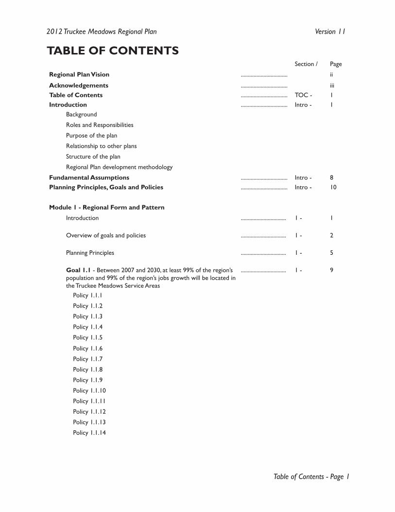
Table of Contents - Page 1
2012 Truckee Meadows Regional Plan Version 11
TABLE OF CONTENTSSection / Page
Regional Plan Vision ................................. ii
Acknowledgements ................................. iiiTable of Contents ................................. TOC - 1Introduction ................................. Intro - 1
Background
Roles and Responsibilities
Purpose of the plan
Relationship to other plans
Structure of the plan
Regional Plan development methodology
Fundamental Assumptions ................................. Intro - 8Planning Principles, Goals and Policies ................................. Intro - 10
Module 1 - Regional Form and Pattern
Introduction ................................ 1 - 1
Overview of goals and policies ................................ 1 - 2
Planning Principles ................................ 1 - 5
Goal 1.1 - Between 2007 and 2030, at least 99% of the region’s population and 99% of the region’s jobs growth will be located in the Truckee Meadows Service Areas
................................ 1 - 9
Policy 1.1.1
Policy 1.1.2
Policy 1.1.3
Policy 1.1.4
Policy 1.1.5
Policy 1.1.6
Policy 1.1.7
Policy 1.1.8
Policy 1.1.9
Policy 1.1.10
Policy 1.1.11
Policy 1.1.12
Policy 1.1.13
Policy 1.1.14
Table of Contents - Page 2
2012 Truckee Meadows Regional Plan Version 11
Section / Page
Goal 1.2 - Local governments and affected entity master plans, facilities plans, and other similar plans will provide for the necessary resources, services, and infrastructure to support the density summarized in Table 1.2.1 of the Regional Plan
................................. 1 - 16
Policy 1.2.1
Policy 1.2.2
Policy 1.2.3
Policy 1.2.4
Policy 1.2.5
Policy 1.2.6
Policy 1.2.7
Policy 1.2.8
Policy 1.2.9
Policy 1.2.10
Policy 1.2.11
Policy 1.2.12
Policy 1.2.13
Policy 1.2.14
Policy 1.2.15
Policy 1.2.16
Policy 1.2.17
Policy 1.2.18
Policy 1.2.19
Policy 1.2.20
Policy 1.2.21
Policy 1.2.22
Policy 1.2.23
Goal 1.3 - Unincorporated Washoe County within the TMSA will support Module #1 by providing a development pattern that includes a range of residential densities appropriate to the location and typified by medium density, and shall include appropriate neighborhood or local serving retail uses, and employment opportunities designed to reduce trips, enhance housing affordability and promote jobs-housing balance
................................. 1 - 27
Policy 1.3.1
Policy 1.3.2
Policy 1.3.3
Table of Contents - Page 3
2012 Truckee Meadows Regional Plan Version 11
Section / Page
Goal 1.4 - Within one year of the adoption of the Regional Plan local government master plans must include strategies based on quantifiable goals set by the jurisdiction to a) increase affordable housing opportunities for persons earning less than 80% AMI and b) increase workforce housing opportunities for persons earning between 80% and 120% of the AMI. The goals will be immeasurable, with a timeline that covers at least the five-year planning period
................................. 1 - 29
Policy 1.4.1
Module 2 - Natural Resource Management
Introduction ................................. 2 - 1
Planning Principles ................................. 2 - 1
Goal 2.1 - To better coordinate natural resource management, local governments will prepare integrated plans to address natural resources in the region, in consultation with the community and key stakeholders
................................. 2 - 3
Policy 2.1.1
Goal 2.2 - Local government master plans will be revised to preserve the scenic, natural, public safety and recreational values of sensitive land areas by constraining development on designated water bodies and ridgelines, natural slopes over 30 percent, and certain other lands
................................. 2 - 4
Policy 2.1.2
Goal 2.3 - Local governments will review and revise their master plans to include management strategies for areas with natural slopes greater than 15 percent but less than 30 percent
................................. 2 - 5
Policy 2.3.1
Goal 2.4 - The Regional Plan encourages Washoe County, through coordination with local, state, federal, tribal and private partners, to secure funding to implement the regional open space plan, and requires local governments to revise their master plans to establish a coordinated network of open space and greenways, wherever possible, that links urbanized areas, public facilities including schools, recreation opportunities, and surrounding public lands
................................. 2 - 6
Policy 2.4.1
Policy 2.4.2
Table of Contents - Page 4
2012 Truckee Meadows Regional Plan Version 11
Section / Page
Goal 2.5 - The NNWPC and the WRWC will revise the Regional Water Management Plan (RWMP) and local governments will revise their master plans to: (a) attain and maintain state and federal water quality standards, (b) protect water resources from degradation by stormwater runoff, and (c) protect natural resources and the public health, safety and welfare during flood events
................................. 2 - 7
Policy 2.5.1
Policy 2.5.2
Policy 2.5.3
Goal 2.6 - The Washoe County Health District, District Board of Health and local governments will review and revise their air quality plans and ordinances to attain and maintain state and federal air quality standards
................................. 2 - 8
Policy 2.6.1
Policy 2.6.2
Goal 2.7 - The Regional Plan promotes and encourages the practice of sustainable design and construction
................................. 2 - 9
Policy 2.7.1
Goal 2.8 - The Regional Planning Agency will facilitate coordination and cooperation in natural resources planning in the wider region, including the coordination and sharing of data and information to assist the region with decision making
................................. 2 - 10
Policy 2.8.1
Policy 2.8.2
Policy 2.8.3
Module 3 - Public Services and Facilities
Introduction ................................. 3 - 1
Planning Principles ................................. 3 - 2
Table of Contents - Page 5
2012 Truckee Meadows Regional Plan Version 11
Section / Page
Goal 3.1 - The Northern Nevada Water Planning Commission (NNWPC) will update the Regional Water Management Plan (RWMP) to make it consistent with the Regional Plan including the goals and policies related to regional form and pattern, and the Regional Transportation Commission (RTC) will update the Regional Transportation Plan (RTP), to make it conform with the Regional Plan including the goals and policies related to regional form and pattern
................................. 3 - 4
Policy 3.1.1
Policy 3.1.2
Policy 3.1.3
Policy 3.1.4
Policy 3.1.5
Goal 3.2 - Upon the determination, by the Regional Planning Commission (RPC), that applicable local master plans and the Transportation Plan conform with the Regional Plan and the Regional Water Plan is consistent with the Regional Plan, local governments and affected entities will review and revise facilities plans and Capital Improvement Programs (CIP) for parks, schools, streets, water supply, wastewater collection and treatment, stormwater management and public safety facilities to serve the levels and distribution of population and employment described in local master plans
................................. 3 - 6
Policy 3.2.1
Policy 3.2.2
Goal 3.3 - Reno and Sparks will review and revise existing annexation programs and plans
................................. 3 - 7
Policy 3.3.1
Policy 3.3.2
Goal 3.4 - In accordance with state law, local governments and affected entities will review and revise their capital improvement programs (CIPs) to support conforming master plans, and submit them to the Regional Planning Agency which will prepare a coordinated regional CIP summary
................................. 3 - 8
Policy 3.4.1
Policy 3.4.2
Table of Contents - Page 6
2012 Truckee Meadows Regional Plan Version 11
Section / Page
Goal 3.5 - The Regional Plan will coordinate the master plans, facilities plans and other similar plans of local governments and affected entities to ensure that necessary public facilities and services to support new development are or will be available and adequate at the time the impacts of new development occur (i.e., concurrency)
................................. 3 - 9
Policy 3.5.1Policy 3.5.2Policy 3.5.3
Goal 3.6 - Local government and affected entity master plans, facilities plans, and other similar plans must identify and plan for the necessary resources, services, and infrastructure to support the densities summarized in Table 1.2.1 of the Regional Plan
................................. 3 - 11
Policy 3.6.1
Goal 3.7 - Local government and affected entity master plans, WCSD school facilities plans, the Regional Transportation Plan, and other similar plans must ensure that the location of schools and arterial roads promotes and does not conflict with the regional form and pattern
................................. 3 - 12
Policy 3.7.1Policy 3.7.2Policy 3.7.3
Goal 3.8 - The Regional Plan will establish, maintain, promote the use of, and protect the future expansion of identified utility corridors and sites for the transmission of electricity and promote the use of these corridors for the placement of other utilities
................................. 3 - 13
Policy 3.8.1Policy 3.8.2Policy 3.8.3Policy 3.8.4Policy 3.8.5Policy 3.8.6Policy 3.8.7Policy 3.8.8Policy 3.8.9
Table of Contents - Page 7
2012 Truckee Meadows Regional Plan Version 11
Section / Page
Goal 3.9 - To ensure electrical transmission lines are placed underground only when necessary and to provide for shared input from all local governments regarding the allocation of costs associated with the undergrounding of transmission lines, the Regional Plan will: (a) encourage the undergrounding of electrical transmission lines only in circumstances where above ground construction poses a justifiable safety risk that can be mitigated by underground construction; and (b) require projects involving the undergrounding of electrical transmission lines for safety reasons be submitted to the RPGB for an advisory review regarding the allocation of costs for undergrounding
................................. 3 - 17
Policy 3.9.1Policy 3.9.2
Goal 3.10 - The Regional Plan shall promote the use of information regarding potential renewable energy resource areas, encourage local governments to support the expansion of renewable energy, and require where possible the use of existing corridors for the transmission of electricity from renewable energy generation sources
................................. 3 - 18
Policy 3.10.1Policy 3.10.2
Module 4 - Implementation of the PlanIntroduction ................................. 4 - 1
Planning Principles ................................. 4 - 1
Goal 4.1 - The Regional Planning Commission (RPC) will review the master plans, facilities plans, and other similar plans of local governments and affected entities. These plans will be revised in accordance with policies set forth in the adopted Regional Plan, in order to conform with the regional form and pattern and all applicable goals and policies
................................. 4 - 3
Policy 4.1.1
Policy 4.1.2
Policy 4.1.3
Policy 4.1.4
Policy 4.1.5
Policy 4.1.6
Table of Contents - Page 8
2012 Truckee Meadows Regional Plan Version 11
Section / Page
Goal 4.2 - Local governments will conduct joint planning programs for designated joint planning areas, as well as other cooperative planning efforts
................................. 4 - 5
Policy 4.2.1
Policy 4.2.2
Policy 4.2.3
Policy 4.2.4
Policy 4.2.5
Policy 4.2.6
Goal 4.3 - The Regional Planning Commission (RPC) may approve amendments to the Regional Plan, and the Regional Planning Governing Board (RPGB) may adopt such amendments, pursuant to an orderly annual process, with comprehensive reviews and updates at least every five years
................................. 4 - 7
Policy 4.3.1
Policy 4.3.2Policy 4.3.3Policy 4.3.4Policy 4.3.5Policy 4.3.6
Goal 4.4 - By April 1 each year, local governments and affected entities will evaluate their progress on the goals of the Regional Plan and submit annual reports as described by regulation for review by the RPC and the RPGB
................................. 4 - 9
Policy 4.4.1
Goal 4.5 - Local governments and the Truckee Meadows Regional Planning Agency will collaborate on state and federal legislation to implement the settlement agreement in the Reno annexation case (CV02-03469, dated August, 2005)
................................. 4 - 10
Policy 4.5.1
Policy 4.5.2
Goal 4.6 - The Regional Planning Agency will facilitate coordination and cooperation in planning in the wider region, including the coordination and sharing of data and information to assist the region with decision making, in order to identify and resolve issues as early as possible
................................. 4 - 11
Policy 4.6.1Policy 4.6.2Policy 4.6.3
Table of Contents - Page 9
2012 Truckee Meadows Regional Plan Version 11
Section / Page
Appendices1 Public Services and Facilities in the Truckee Meadows ................................. App 1 - 1
2 Glossary of terms ................................. App 2 - 1
3 Acronyms and abbreviations ................................. App 3 - 1
4 Selected RPC resolutions ................................. App 4 - 1
5 Index ................................. App 5 - 1
6 Process for planning and processing development applications by Reno, Sparks, and Washoe County
................................ App 6 - 1
7 Table for the transition of land use upon the removal of lands from a City’s SOI
................................ App 7 - 1
8 Schedule of amendments to the Regional Plan ................................. App 8 - 1
9 Maps ................................. App 9 - 1 Map 1 - Truckee Meadows Service Areas Map 2 - Rural Development Areas Map 3 - Development Constraints Area Map 4 - Centers and Corridors Map 5 - Spheres of Influence and Future Service Areas Map 6 - Joint Planning Areas Map 7 - Cooperative Planning Areas Map 8 - Wider Region
Map 9 - Existing Utility Corridors (South)
Map 10 - Existing Utility Corridors (North)
Map 11 - Federal Aviation Regulation (FAR) Part 77 Areas

Table of Contents - Page 10
2012 Truckee Meadows Regional Plan Version 11
[Notes]
Introduction - Page 1
2012 Truckee Meadows Regional Plan Version 11
INTRODUCTIONThe Truckee Meadows Regional Planning Agency (TMRPA) was created in 1989 by the Nevada State Legislature to foster coordination among the three local governments: The Cities of Reno and Sparks and Washoe County.
The TMRPA is comprised of the Regional Planning Governing Board (RPGB), the Regional Planning Commission (RPC), the TMRPA’s Director, and staff.
The first comprehensive Truckee Meadows Regional Plan (“Regional Plan”) was adopted in March 1991 and updated for the first time as required by law in June 1996. The second update of the plan was completed in May 2002 and the third update was completed in July 2007. Direction from the RPGB regarding the fourth update of the plan was provided in April 2012 and the update is scheduled for completion in July 2013.
BACKGROUNDThe area covered by the Regional Plan includes all of Washoe County except the portions within the drainage basin of Lake Tahoe (see Nevada Revised Statutes (NRS) 278.0288) and the lands of federally-recognized tribes. The effective planning area is the developed area in the southern 25% of Washoe County.
Creating and carrying out the Truckee Meadows Regional Plan is a cooperative effort involving a large number of agencies, organizations and individuals. Reno, Sparks, Washoe County and others implement the Regional Plan through their planning and regulatory efforts, capital improvement programs, and other programs.
Nevada law grants the authority and provides the direction for the regional planning process in the Truckee Meadows. The TMRPA, organized under NRS 278.026 - 278.029, was formed to develop and maintain a comprehensive Regional Plan for the jurisdictions of Reno, Sparks, and Washoe County.
Washoe County was established in 1861 and is a political subdivision of the State of Nevada operating under the provisions of the general laws of the State. It has a manager-commission form of government. The County covers an area of 6,600 square miles in the northwest section of the State bordering California and Oregon. The incorporated cities in Washoe County are Reno and Sparks. In 2012, Washoe County’s population was 427,704 (Nevada State Demographer’s Certified Population Estimates, 2012).
Reno is the largest city in Northern Nevada, covering 106 square miles. It is located in the southern part of Washoe County. Reno was incorporated in 1903 and is governed under a council-manager form of government. Reno’s population is 229,859 (NV Demographer, 2012). The City of Sparks borders the City of Reno and was incorporated in 1905. It, too, operates with a council-manager form of government. Sparks covers an area of 36 square miles and has a population of 90,214 (NV Demographer, 2012).
Introduction - Page 2
2012 Truckee Meadows Regional Plan Version 11
As set forth in the NRS, the RPC develops the Regional Plan and determines whether other plans and projects are in conformance with it (NRS 278.0272). The RPGB adopts the Regional Plan with any amendments it deems necessary, after submitting the amendments to the RPC for review and comment (NRS 278.0276).
Units of local government maintain separate master plans, in conformance with the Regional Plan (NRS 278.0282).
The Regional Plan is a cooperative effort of the local and regional units of government, the major service providers, and the citizens of the Truckee Meadows. It is intended to represent a regional consensus reached through a process of public dialog and decision-making to provide a unifying framework for local and regional policies and services.
State law directs the RPC to update the Regional Plan not less than every five years (NRS 278.0272). The 1996 five-year revision constituted the first comprehensive revision of the 1991 Regional Plan developed by Robert Freilich. The second revision was adopted in May 2002 and the third revision was adopted in July 2007. Direction from the RPGB regarding the fourth update of the plan was provided in April 2012 and the update is scheduled for completion in July 2013.
The Plan focuses on the statutory mandates and measurable goals for addressing those mandates on an annual basis, as well as through the five-year update.
ROLES & RESPONSIBILITIESThe roles and responsibilities are delineated in NRS. Each of the following sections summarizes the roles and responsibilities of each of the entities in regards to the Regional Plan.
Regional Planning Commission (RPC)The RPC has nine members, appointed by their respective governing bodies, including three each from the Reno, Sparks, and Washoe County local planning commissions. The members serve three-year terms and may be re-appointed. The RPC elects a chairperson from among its members to a one-year term, which rotates annually among the three jurisdictions.
NRS 278.0272 directs the RPC to develop a comprehensive Regional Plan for physical development and orderly management of growth in the Region for the next 20 years and hold public hearings. The statute also directs the RPC to review the plan annually, update it not less than every five years and forward its recommendations to the RPGB for final adoption.
One of the functions of the RPC is to review Projects of Regional Significance (PRS). The RPC adopts guidelines for determining whether a particular project is a PRS and, before a city or the County gives final approval to a PRS, must find it in conformance with the Regional Plan.
Introduction - Page 3
2012 Truckee Meadows Regional Plan Version 11
The RPC also reviews master plans, facilities plans, and other similar plans of local governments and affected entities to determine whether they conform to the Regional Plan. In addition, the RPC reviews plans and plan amendments of state agencies and of public utilities regulated by the Public Utilities Commission of Nevada (PUCN) and offers suggestions regarding their conformance with the Regional Plan. The RPC also reviews for conformance the transportation plan prepared by the Regional Transportation Commission and for consistency the water plan prepared by the Northern Nevada Water Planning Commission. Finally, by interlocal agreement, the RPC serves as the annexation commission for involuntary annexation proposals in the region.
Pursuant to the RPGB Regulations on Procedure, the RPC shall oversee processes for conducting and maintaining a regional population forecast for conformance review, and TMSA allocation. The adopted regional population forecast must be consistent with the estimated population that can be supported by the sustainable water resources identified in the Regional Water Management Plan.
Regional Planning Governing Board (RPGB)The RPGB has ten members. The Washoe County Commission appoints three members (two of whom must reside in or represent the unincorporated area), the Reno City Council appoints four members, and the Sparks City Council appoints three members. The members serve three-year terms and may be re-appointed. The Reno, Sparks, and Washoe County governing bodies may appoint members from among their own members and traditionally have done so. The RPGB elects a chairperson from among its members to a one-year term; the chair rotates among the three jurisdictions.
Upon the recommendation of the RPC, the RPGB adopts the Regional Plan with any amendments that it deems necessary after holding required public hearings. The RPGB has all the powers and obligations that are delineated in NRS 278.0264 and NRS 278.0265.
Local GovernmentsReno, Sparks, and Washoe County provide the necessary facilities and money to enable the Truckee Meadows Regional Planning Agency (TMRPA) to carry out its functions. To do this, they enter into an agreement to share the costs of regional planning, according to how many members each unit of government has on the RPGB. Under the NRS, local governments shall amend their master plans, facilities plans and other similar plans to conform to the provisions of the Regional Plan and submit them to the RPC for a finding of conformance. They also submit amendments to these plans for conformance findings.
The law also provides that each local government shall review and amend, if necessary, its existing ordinances to ensure their conformance with the provisions of a master plan that conforms to the Regional Plan. The local governments also prepare and submit annual comprehensive reports to the RPC.With the involvement and cooperation of Washoe County, Reno and Sparks also adopt master plans for areas within their Spheres of Influence (SOI) designated in the Regional Plan and carry out annexation programs, which must conform with the Regional Plan.
Introduction - Page 4
2012 Truckee Meadows Regional Plan Version 11
Affected EntitiesNRS defines an affected entity as a public utility, franchise holder, local or regional agency, or any other entity having responsibility for planning or providing public facilities relating to solid waste, air quality, transportation, public education, energy generation and transmission, and conventions and the promotion of tourism. However, the term does not include a State agency or a public utility subject to regulation by the Public Utilities Commission of Nevada (PUCN).
Thus, the list of affected entities includes (but is not limited to) Waste Management, the Reno-Tahoe Airport Authority, the Washoe County School District, the Regional Transportation Commission, the Washoe County Health District, the Reno and Sparks redevelopment agencies, and the Reno-Sparks Convention and Visitors Authority.
Affected entities are responsible for amending their master plans, facilities plans, and other similar plans to conform to the provisions of the Regional Plan. Before adopting or amending a master plan or similar plan, they must submit it to the RPC for a finding of conformance. Affected entities also submit annual reports to the RPC.
PURPOSE OF THE PLANThe purpose of the Regional Plan is to implement the legislative mandate given to the RPC and RPGB. It is an opportunity to put into place a resource for the region with a collaborative structure that will serve the Truckee Meadows well into the future.
The four modules with their goals and policies focus on the coordination of master planning in Washoe County (less certain areas noted in statute) as it relates to land use, infrastructure provision, resource management, and plan implementation.
The plan includes an agreed upon feedback loop that includes annual monitoring and reporting. The reporting process feeds into the annual amendment cycle, local master plans, TMRPA’s technical work program and budget, and the five-year update. The five-year update is a continuous improvement process.
RELATIONSHIP TO OTHER PLANSAs described in Chapter 278 of the Nevada Revised Statutes (NRS) the master plans, facilities plans, and other similar plans of local governments and affected entities must be found in conformance with the comprehensive Regional Plan.
In addition to the Truckee Meadows Regional Planning Agency, two other entities within the region are designated with planning for region-wide facilities, infrastructure or resources; the Northern Nevada Water Planning Commission, and the Regional Transportation Commission.
Regional Water Planning The Northern Nevada Water Planning Commission (NNWPC) established pursuant to Chapter 531 Statutes of Nevada 2007 of the Nevada Special Acts is required to develop a plan for:
Introduction - Page 5
2012 Truckee Meadows Regional Plan Version 11
quality of surface � water;
quality of groundwater; �
supply of surface � water;
supply of underground � water;
control of floods and drainage of � storm water, as it relates to surface water;
control of floods and drainage of � storm water, as it relates to underground water; and,
cost and financing related to facilities, sources of � water, or other requirements of the plan.
Chapter 531 Statutes of Nevada 2007 requires that the Regional Water Management Plan (RWMP), developed by the NNWPC and adopted by the Western Regional Water Commission, must also be found to be consistent with the comprehensive Regional Plan. For goals and policies related to these topics please see the adopted Washoe County Regional Water Management Plan.
For the purpose of determining consistency, the RPC shall utilize the adopted conformance review methodology pursuant to the conformance policies contained in the Regional Plan.
Pursuant to the RPGB Regulations on Procedure that establish processes for conducting and maintaining a regional population forecast for conformance review and TMSA allocation, the NNWPC and WRWC will make findings, and forward those findings to the RPC, regarding comparison of the regional population forecast to the population estimate that can be supported by the sustainable water resources identified in the RWMP.
Introduction - Page 6
2012 Truckee Meadows Regional Plan Version 11
Regional Transportation Planning The Washoe County Regional Transportation Commission (RTC) is the Metropolitan Planning Organization (MPO) and pursuant to Title 23 Code of Federal Regulations, part 450, and Title 49 Code of Federal Regulations, part 613, is required to develop and update the Regional Transportation Plan. The 2030 Regional Transportation Plan (RTP), adopted November 18, 2004, includes goals, objectives, and policies on the following major elements:
streets and highways; �
public transportation; �
bicycle and � pedestrian;
aviation and goods movement; �
transportation management/intelligent transportation systems; �
financial; �
congestion management; �
� air quality analysis and conformity determination; and,
� regional transportation plan conformity determination.
Pursuant to Chapter 278 of NRS, the RTC is classified as an affected entity; therefore, the Regional Transportation Plan must be found in conformance with the comprehensive Regional Plan.
The interactions, duties, and obligations of the various local governments and affected entities is governed by the applicable sections of NRS.
STRUCTURE OF THE COMPREHENSIVE REGIONAL PLANThe Regional Plan is structured around the four modules developed during the 2002 Regional Plan update process.
Module #1 provides direction and standards for how and where development occurs in the Truckee Meadows. Module #2 addresses the management of natural resources. Module #3 is focused on the coordination of public services and facilities. Module #4 is the implementation framework for the plan.
The Truckee Meadows Regional Plan is a work in progress based on the needs of the local governments and the affected entities.
REGIONAL PLAN DEVELOPMENT METHODOLOGYIn April 2012, the RPGB directed TMRPA staff to meet with local jurisdictions and affected entities to discuss a limited update of the Regional Plan focusing on transit oriented development (TOD) and potential process improvements including the review of school siting policies. Pursuant to that direction, TMRPA staff worked with staff from the local jurisdictions, the Regional Transportation Commission and the Washoe County School District to discuss the system of TOD as defined in the Regional Plan and improvements to school siting policies.

Introduction - Page 7
2012 Truckee Meadows Regional Plan Version 11
The 2012 Regional Plan update, while more limited in scope than the update processes utilized during past Regional Plan updates, still represents a consensus-based document that seeks to revise specific aspects of the plan rather than provide a wholesale rewrite of the plan.
Introduction - Page 8
2012 Truckee Meadows Regional Plan Version 11
FUNDAMENTAL ASSUMPTIONSThe following is a set of fundamental assumptions that the region has considered in planning for efficient land use, public services, and facilities through the year 2032.
THE GEOGRAPHIC SCOPE OF THE REGIONAL PLAN IS:
Geographic CoverageWithin the Nevada Revised Statutes (NRS), the geographic area covered by the Regional Plan includes all of Washoe County except the portions within the drainage basin of Lake Tahoe (NRS 278.0288) and the lands of federally-recognized tribes.
While the primary planning focus of the Regional Plan is on the southern 25% of Washoe County, with a northern boundary at T25N/T26N (north of Winnemucca Ranch), see Map 1, the Regional Plan continues to have relevant jurisdiction over the broader area of Washoe County noted above.
The Regional Plan does not have jurisdiction over neighboring counties, nor lands managed by other entities (i.e., Tahoe Regional Planning Agency and local tribes). However, the Truckee Meadows Regional Planning Agency (TMRPA) attempts to monitor impacts of development within the designated plan areas of Washoe County on surrounding counties and entities, and the impact that development in surrounding counties and entities has on the well being of the region covered by the Truckee Meadows Regional Plan.
THE POPULATION IN 2032 WILL BE CHARACTERIZED AS FOLLOWS:
Population GrowthAs noted in the introduction of the Regional Plan, Washoe County’s population in 2012 was just under 430,000 people. The 2012-2032 Washoe County Consensus Forecast estimates that the population of Washoe County will be in excess of 560,000 people by 2032.
Ethnic and Cultural DiversityIn the future we will have a community that is more ethnically and culturally diverse. Trends show a growing proportion of minority residents in Washoe County. Based on U.S. Census Bureau population projections (1995 – 2025) this trend will continue over the next 20 years, leading to a more culturally diverse region.
Age StructureAccording to the Consensus Forecast, the age distribution of the population is expected to change over the next two decades. Change of significance includes a net decrease in the percent of population under the age of 20 and a continued aging of the baby boomers. The decrease in the working group will see a greater proportion of retired senior citizens in our region.
Introduction - Page 9
2012 Truckee Meadows Regional Plan Version 11
THE NEEDS OF RESIDENTS ARE CHARACTERIZED AS FOLLOWS:
Housing ProductsA growing and diversifying population will require a broader range of housing products such as multi-family housing units, assisted living facilities, and student housing. The population will also require a diverse range of opportunities in housing location and style including high-density living, suburban residential, and large-lot ranchettes.
Economic and Environmental SustainabilityIn the future we will continue to see, and plan for, a strong and expanding economic base that not only emphasizes sustainable resource management, particularly in the areas of air quality and water quality and quantity, and promotes the advancement of renewable energies.
Introduction - Page 10
2012 Truckee Meadows Regional Plan Version 11
PLANNING PRINCIPLES, GOALS AND POLICIES To create a well-planned region and to plan for the fundamental assumptions and manage their impacts, the Regional Plan will address the following issues:
development in our region including our � regional form, infrastructure provision, open space and greenways;
management of our unique resources including wildlife habitat, air and � water quality, and water quantity;
provision of public services including roads, � utilities, water and sewer services; and,
efficiently implementing the Regional Plan. �
These issues have been further refined into four modules and the associated goals and policies that implement them.
Terms and their definitions used in the modules, goals, and policies are included in Appendix 2 - Glossary of Terms.
Module 1 - Page 1
2012 Truckee Meadows Regional Plan Version 11
MODULE #1:
REGIONAL FORM AND DEVELOPMENT PATTERNS
INTRODUCTIONThe goals and policies associated with Module #1, along with related goals and policies listed under the other modules, will address a number of the following important objectives within the Truckee Meadows region:
Promote sustainable growth and efficient growth patterns through a defined area within �which municipal services and infrastructure will be provided;
Ensure that the � population forecast prescribed in the Regional Plan is consistent with the estimated population that can be supported by the sustainable water resources as identified in the Regional Water Management Plan;
Provide � land use patterns which promote a world class tourist and destination resort community;
Provide a � land use pattern which will promote a more diverse and expanding economic base;
Ensure that necessary public services and facilities to support new development are or �will be available and adequate, based on adopted levels of service (LOS) standards, at the time the impact of new development occurs;
Lessen � sprawl and support a higher intensity and density of development within designated centers, transit corridors, and areas suitable for infill development;
Promote the availability of adequate numbers of needed � housing units at price ranges and rent levels which are commensurate with the financial capabilities of the region’s households and allow for flexibility of housing location, type, and density;
Recognize the need for regional � corridors that emphasize automobile and freight mobility;
Promote compatibility of � land use and development with regional airport operations;
Promote the coordination and compatibility of � land uses with each military installation in the region, taking into account the location, purpose and stated mission of the military installation;
Preserve our designated natural resources and � open space;
Create a more compact, mixed pattern of � residential units and employment locations, served by a region-wide multi-modal transportation system, to reduce levels of travel demand, facilitate efficient service provision, and promote a jobs-housing balance;
Plan for an increasing and diversifying � population base;
Place � residential, commercial, civic and other uses in close proximity to each other to reduce the dependency upon the private automobile, reduce vehicle miles traveled, conserve energy, and achieve other goals as defined by the Regional Planning Commission (RPC);
Module 1 - Page 2
2012 Truckee Meadows Regional Plan Version 11
Support the revitalization of, and maintain the character of, established � neighborhoods and communities while encouraging infill development that is appropriate for its surroundings;
Embrace the importance of place-making as the creation of spaces that are lively, inviting, �enduring, and distinct in character. Important factors include access, comfort, image, activities, and social interactions. Place-making fosters a strong sense of community.
Ensure implementation of designs that contribute to safe, diverse, and vital, bicycle-oriented �and pedestrian-oriented communities;
Create a system of incentives to support a sustainable and economically healthy region; �and,
Place a high priority on improving � transit efficiency, reliability, and the interface between land uses and transit within designated centers and transit corridors.
OVERVIEW OF THE GOALS AND POLICIESThis portion of the Regional Plan aims to limit the spread of the urban footprint and direct more development of homes and jobs toward the traditional core of the region, while promoting infill where it enhances the community – including but not limited to downtowns, designated centers, transit corridors and redevelopment areas.
This strategy will make more efficient use of land, natural resources and community services; save money on infrastructure, reduce dependence on the private automobile; promote multi-modal transportation choices; protect air quality; conserve energy; preserve designated open space; and create more affordable communities.
This strategy, which will result in a more compact form of future development, as well as a more diverse mix of uses, will provide a variety of living and working situations, and will promote human, natural and economic capital, strengthen our communities and ensure that the region’s assets are accessible to all.
The Core Areas The traditional core consists of the two downtowns, other designated Regional Centers, and the transportation links among them. The core will be characterized by a vital mix of uses, including parks and civic uses, with a high priority on pedestrian activity. It will be well-served by public transit, and will have more intense residential and employment use than elsewhere in the urban footprint. The core has a priority for the provision of public improvements and services, with the highest priority assigned to the downtowns.
The eight identified Regional Centers have facilities or services that serve a population beyond the Truckee Meadows and contain unique regional assets, resources, or facilities that are not duplicated elsewhere within the region. They include such locations as the University of Nevada-Reno, the Reno-Tahoe International Airport, and the Meadowood retail area. The Regional Plan is designed to direct and enhance the provision of services and balance employment and residential uses in these Regional Centers.
Module 1 - Page 3
2012 Truckee Meadows Regional Plan Version 11
The Transit Oriented Development (TOD) Corridors (as defined in Policy 1.2.9) will provide efficient, attractive links between downtowns and Regional Centers, and promote a more interconnected region. The Regional Plan will prioritize the provision of programs, policies, capital infrastructure and services to support infill, intensification, and revitalization in TOD Corridors.
The Truckee Meadows Service Areas (TMSA)The TMSA is the defined area within which municipal services and infrastructure (including potable water supply, reclaimed water supply, sanitary sewer, flood management, transportation [streets, transit, pedestrian, bicycle], public safety, parks, and schools) will be provided. The purpose of the TMSA is:
to guide urban and � suburban development and ensure orderly provision of services and infrastructure;
to encourage the use and maintenance of existing � infrastructure capacity to accommodate infill and new development;
to guide urban and � suburban development away from unsuitable areas, while recognizing that:
existing resources to support urban and ▪ suburban development are constrained;
the ▪ TMSA and the Rural Development Area (RDA) are interconnected; and,
the capacity of the ▪ TMSA will be absorbed over time and must, therefore, be monitored and expanded.
To promote efficient use of lands within the TMSA, the Regional Plan will encourage the removal of barriers to, and encourage the creation of incentives for, infill development and revitalization by directing mixed-use development to Regional Centers, Emerging Employment Centers, transit corridors, and other appropriate areas.
In order to accommodate a growing population, the Regional Plan will promote the creation of adequate infrastructure capacity within the TMSA based on the desired levels of density articulated in the plan. As areas for TMSA expansion are required, suitable lands identified in the Future Service Areas (FSA) or RDA may be converted to TMSA.
The Regional Plan identifies unincorporated areas located within the TMSA, but outside the two cities and their spheres of influence (SOI).
The TMSA for each city is also the SOI for that city and the remaining portions of the TMSA are for unincorporated development.Within the unincorporated areas, communities may be designed as a component of the Washoe County Comprehensive Plan in accordance with the goals and policies contained in the Regional Plan, and upon designation will:
constitute a comprehensive planning tool that will provide appropriate local opportunities for �services and employment, reduce trips, and discourage linear low-density development;
identify and plan for the areas in the � unincorporated County that are expected to absorb their share of the planned 20-year growth;
Module 1 - Page 4
2012 Truckee Meadows Regional Plan Version 11
identify the services required in the developed and developing areas of the � unincorporated County;
identify funding sources for the provision of those services; and, �
identify � land uses and services that will act to preserve community character and identity.
The Future Service Areas (FSA)The Future Service Areas (FSA) are areas identified for future (beyond the 20 year Truckee Meadows Regional Plan horizon) inclusion in the TMSA (and SOI, if a city) for each jurisdiction. To add land to its TMSA, each jurisdiction must first prepare a natural resource management plan for the area to be added and must meet minimum density thresholds in its existing TMSA.
The Rural Development Area (RDA)The RDA is outside the Truckee Meadows Service Areas, and contains dispersed development and employment on large parcels of land. The RDA will only receive limited public services and facilities. Ranches, agriculture, forestry, scattered residences and business or commercial services, and certain types of industrial and recreational uses not compatible with urban or suburban development, characterize the rural area. It is important to recognize, however, that future Regional Plan updates and amendments may extend the Truckee Meadows Service Areas into portions of the Rural Development Area.
The Development Constraints Area (DCA)The DCA consists of playas, significant water bodies, jurisdictional water/wetland in accordance with Section 404 of the Clean Water Act, designated FEMA floodway areas within the floodplain Zone AE, natural slopes over 30%, publicly-owned open spaces, and properties that are deed restricted to prevent development. Constrained lands less than 1/3 acre in size will not be included in the DCA. The DCA overlay takes precedence over otherwise applicable policies describing the desired density and intensity of development within the TMSA, FSA, and RDA. In order to preserve the scenic, natural, public safety, recreational, and environmental values of these areas, local government and affected entity master plans must include components to preserve development constrained lands in an undeveloped state wherever possible.
Module 1 - Page 5
2012 Truckee Meadows Regional Plan Version 11
PLANNING PRINCIPLESThe Regional Plan will promote the following development patterns:
Regional Economy
The Regional Plan will encourage and support a strong and expanding economic base �comprised of the existing gaming sector along with the growth in diversified industry sectors such as business and financial services, software, clean energy, advanced manufacturing, advanced logistics, and life sciences (EDAWN, Target 2010, Report #2, Target Industry Identification and Analysis, prepared by Angelou Economics, dated July, 2006). The plan anticipates that our diversified economy will provide a higher proportion of higher paying jobs and an increased per capita disposable income. The Regional Plan recognizes that business attraction is in part based upon the availability of cultural and recreational opportunities within the region.
Our � land use decisions will support sustainable economic development in the region, which results in efficient use of resources and brings ‘high export value’ to the economy.
The plan will support the provision of compatible development around existing � educational infrastructure.
The Regional Plan will provide for appropriate � land stock for a wide range of land uses necessary to meet a growing and changing economy, and will encourage local governments to address adjacency issues as necessary.
Regional Form and Pattern
The Regional Plan will promote a � Regional Form that lessens sprawl and supports a higher intensity and density of development within centers and transit corridors. The plan will strongly promote infill development within centers and transit corridors, and areas appropriate for infill development to optimize existing infrastructure. The plan will encourage development that promotes:
the integration of ▪ mixed land uses;
the optimization of existing ▪ infrastructure;
human-scale design; ▪a range of ▪ housing choices;
a sense of place through distinct and attractive communities; ▪walkability; ▪new communities that are complementary to existing communities; ▪a range of transportation choices; ▪the preservation of ▪ open space, natural resources, and critical environmental areas; and,
the visual integrity of surrounding viewsheds. ▪The combination of � Centers, Emerging Employment Centers, Transit Oriented Development (TOD) Corridors, Secondary Corridors, residential areas, open space, greenways, and
Module 1 - Page 6
2012 Truckee Meadows Regional Plan Version 11
natural features will define the Regional Form.
Intensification within the region will be directed toward appropriate areas including, but �not limited to, Centers and Corridors.
Centers will be categorized as Downtown � Centers, Regional Centers, and Emerging Employment Centers to reflect the impact that they have within the surrounding region. Corridors will be categorized as TOD or Secondary to reflect the impact they have within the region.
The Regional Plan identifies the desired distribution of forecasted � population and employment growth within the region. Downtown Centers, Regional Centers, Emerging Employment Centers, TOD Corridors, and Secondary Corridors will be the highest priority areas for intensification and development. These areas will accommodate an increasing proportion of the region’s population and employment growth over the next 20 years.
The portion of the � TMSA for each city is also the SOI for that city, and the remaining portions of the TMSA are for unincorporated development (see Policy 3.3.1).
Within the � unincorporated areas, communities may be designated as a component of the Washoe County Comprehensive Plan in accordance with the goals and policies contained in the Regional Plan.
Centers and Corridors
Within the Regional Plan, � Downtown Centers, Regional Centers, Emerging Employment Centers, Primary TOD Corridors, and Secondary TOD Corridors will help to define the Regional Form.
The region will plan � Centers and TOD Corridors that attract increasing levels of investment and development capital. These Centers and TOD Corridors will grow to absorb our increasing population through the development of high-density residential development. Commercial and mixed-use development will be directed to centers and transit corridors.
Primary TOD Corridors will be served with higher order transit service such as � Bus Rapid Transit and Secondary TOD Corridors will be served with regular transit service until residential and employment densities make feasible the provision of higher order transit service.
� Secondary TOD Corridors will support intensification through streetscape design, mixed uses and roadway connectivity that promote walkability and produce quality pedestrian-oriented environments.
The Downtown � Centers of the City of Reno and City of Sparks will be significant economic centers in our region. These regional mixed-use centers will include retail, high density residential, entertainment, office buildings, and public facilities.
All Downtown and Regional � Centers will be sited along or near TOD Corridors.
All � Centers will have internal circulation networks that promote interconnection between individual facilities or enterprises. Local government master plans will include design features that promote a pedestrian or bicycle friendly environment within Centers.
Module 1 - Page 7
2012 Truckee Meadows Regional Plan Version 11
Downtown � Centers, Regional Centers, and TOD Corridors will be mixed-use, visually attractive, and will entice both local residents and visitors to the area, day and night. These Centers and TOD Corridors will promote multi-modal transportation and may support a range of activities including shopping, recreation, dining and entertainment, gaming and accommodation, employment, cultural or community events, as well as providing high density residential opportunities.
Some � Centers and portions of Corridors may require specialized planning to ensure compatibility with airport and military operations (e.g., Reno-Tahoe Regional Center); the Regional Plan allows for alternative densities in certain circumstances (see Policy 1.2.14).
TOD � Corridors will promote a pedestrian-friendly environment that supports integrated transit opportunities (1/4 mile walking distance). These transit corridors should not be automobile dependent.
Centers and TOD � Corridors will provide for mixed-use, transit-oriented development and will be supported by multi-modal transportation opportunities. Development will be directed to Centers and TOD Corridors.
To accommodate our changing � population’s needs, the Regional Plan will support the provision of more diverse market-rate and affordable housing products and opportunities, such as, assisted care and other elderly housing facilities, multi-family units, student housing, and mid to high rise apartments.
Intense development will be directed to the Downtown � Centers, Regional Centers, Emerging Employment Centers, and TOD Corridors.
Specialized � land use may be permitted in areas separated from the community. Specialized use may include quarries, sewage treatment facilities, land fills, hazardous waste disposal facilities, and power generation facilities or other designated enterprises that are not compatible with high-density areas.
Infrastructure
All Downtown and Regional � Centers will be linked by a multi-modal transportation system and supported with transit services.
The Regional Plan will encourage the use of � multi-modal transportation to reduce single vehicle trips. Our land use pattern will support reduced dependence upon the automobile.
The plan will both clearly identify utility needs and encourage and report on the provision �of infrastructure, including the location of utility corridors, and evaluate the regional impact of future power generation and transmission prior to approval of development.
Local service providers will anticipate � right-of-way needs and make provisions in their facilities and master plans.
The Regional Plan will identify the projected demand and projected capacity of major �facilities within the region.
The Regional Plan will promote the coordination and availability of � infrastructure to support economic development within the region. This infrastructure includes, but is not
Module 1 - Page 8
2012 Truckee Meadows Regional Plan Version 11
limited to, support for cargo and passenger services through airports, rail, and interstate automobile corridors.
Infrastructure may be provided to communities to support public health, safety and welfare �standards but does not necessarily imply a right to further intensify development.
In recognizing the complex nature of � infill development, the Regional Plan will encourage a cooperative approach for infill planning which includes careful coordination between service and infrastructure providers, including public health agencies, with appropriate jurisdictional staff at the early stages of planning and project conceptualization, and thoughtful consideration of:
parks and ▪ greenways;
natural resources; ▪floodplains, floodways and drainage ways; ▪walkability; ▪alternative modes of transportation; ▪public health impacts related to ▪ land use decisions;
amenities; and, ▪recreation opportunities. ▪
Open Space and Greenways Network
Within the Regional Plan, � open space and the greenways network will help to define the Regional Form.
The Regional Plan will promote an integrated � open space and greenways network that links centers and transit corridors to parks, bikeways, floodplains that are or will be maintained as open space, drainage ways, open space, surrounding public lands and facilities, and other outdoor recreation opportunities such as trails, and connects schools, neighborhoods and shopping centers.
The Regional Plan will promote the development and management of a greater number �of community, regional and neighborhood parks to support the intensification of land use within the region, associated smaller lot sizes, and higher density housing.
Infill Development
To minimize � sprawl and optimize infrastructure efficiency, the Regional Plan will give priority to infill development within Centers, TOD Corridors, and areas designated by local governments, and must take into account open space, facilities and utility corridor plans.
Module 1 - Page 9
2012 Truckee Meadows Regional Plan Version 11
GOALS AND POLICIES
GOAL 1.1Between 2007 and 2030, at least 99% of the region’s population growth and 99% of the region’s jobs growth will be located in the Truckee Meadows Service Areas (TMSA).
Policy 1.1.1To conform with the Regional Plan, the master plans, facilities plans, and other similar plans of local governments and affected entities must utilize the adopted Consensus Forecast for determining future regional population estimates for the formulation of goals, policies, and service plans.
The Regional Plan recognizes that some affected entities due to service area size or targeted services need to utilize additional or supplementary population data. If these affected entities utilize additional or supplementary population data, the source and methodology must be clearly described in master plans, facilities plans, and other similar plans. These plans must clearly relate back to the adopted Consensus Forecast.
The RPC shall adopt a Consensus Forecast that is consistent with the estimated population that can be supported by the sustainable water resources as identified in the Regional Water Management Plan.
The adopted RPGB Regulations on Procedure, section XII, shall be used to update and maintain the Consensus Forecast including comparison with the estimated population that can be supported by the sustainable water resources as identified in the Regional Water Management Plan, jurisdictional splits and the allocation of population to smaller geographic units of the region.
Policy 1.1.2To conform with the Regional Plan, master plans of local governments and affected entities must be consistent with the forecasts of population and employment growth in the service area by providing appropriate density and intensity of use, and by providing for the necessary services and resources to support the population and employment growth consistent with Goal 1.1.
Policy 1.1.3 For Reno, Sparks, and Washoe County the Regional Plan defines Truckee Meadows Service Areas (TMSA) and Future Service Areas (FSA) that avoid environmental degradation, optimize infrastructure, and maintain a compact form while providing for a variety of living and working situations. The TMSA for each jurisdiction are adopted on Map 1 and the FSA for each jurisdiction are adopted on Map 5. Amendments to the TMSA and FSA are defined in Policy 1.1.6, Policy 1.1.7 and in Module #4.
Module 1 - Page 10
2012 Truckee Meadows Regional Plan Version 11
Policy 1.1.4 The Regional Plan further defines the Truckee Meadows Service Areas as being comprised solely of a city, a city’s Sphere of Influence, the designated Development Constraints Area, or unincorporated areas where communities may be designated in the Washoe County Comprehensive Plan in accordance with policies and criteria in the Regional Plan (see Map 1).
Policy 1.1.5 The Regional Plan defines properties outside of the Truckee Meadows Service Areas as the Rural Development Area (RDA) (see Map 2). The Rural Development Area consists of dispersed residential, employment and other uses that do not require the provision of municipal services. To be in conformance with the Regional Plan, master plans of local governments, facilities plans and other similar plans must not plan for the provision of municipal services within the RDA.
Master plans, facilities plans and other similar plans may allow for the conveyance of reclaimed water outside the TMSA as a method to effectively manage reclaimed water from wastewater treatement facilities.
To be in conformance with the Regional Plan, local government master plans must not allow additional development within the RDA that requires the provision of municipal service, and must not allow new divisions of land that would create a parcel less than 5 acres in size.
Master plans may continue to recognize zoning outside the TMSA that was in existence as of May 8, 2002, and may allow development and division of land in accordance with that zoning and Washoe County Health District regulations in effect on February 13, 2003.
To be in conformance with the Regional Plan, master plans of local governments may allow the location of resort destinations within the Rural Development Area as follows:
within a Resort Service Area (RSA), in accordance with Policy 1.1.13, if:1) the resort is located south of T26N; ora) the resort exceeds any of the following, regardless of location within the b) Rural Development Area:
accommodation for more than 100 people, including guests, residents and i) employees;
traffic more than an average of 400 trips daily;ii)
iii) water demand of more than 40 acre feet per year; or,
sewage of more than 12,000 gallons per day.iv)
north of T25N, and not to exceed the development thresholds listed in 1.b above, in 2) accordance with Policy 1.1.14.
In support of the creation of a resort destination north of T25N, in the Gerlach Suburban Character Management Area as designated by the High Desert Area Plan as part of the Washoe County Master Plan, additional residential density to support population growth may be allowed on a case-by-case basis provided that in each case the following can be shown:

Module 1 - Page 11
2012 Truckee Meadows Regional Plan Version 11
public facilities and services are available and adequate at the time that development occurs 1) and that the provision of facilities and services will be of no detriment to the surrounding communities
increased density is needed to support the community2)
the proposed densities are compatible with the densities found in the existing area.3)
Policy 1.1.6Based upon criteria established in Policy 1.1.7 and Module #4, the Truckee Meadows Service Areas may be amended to include lands currently within the RDA and FSA.
Policy 1.1.7To make TMSA boundary changes including, to convert Future Service Areas (FSA) or Rural Development Area (RDA) to TMSA, or to move lands from one jurisdiction’s portion of the TMSA to another jurisdiction’s portion of the TMSA, applicants must address either Policy 1.1.7.1 or Policy 1.1.7.2 depending on the nature of the request.
Policy 1.1.7.1When a local government applies to make TMSA boundary changes, the local government proposing the change must:
demonstrate that it (i.e., the 1) local government) will have at least 4.0 people per acre in its existing TMSA before the population reaches the population forecast for the forecast year in the conforming master plan for the local governments, or utilize capacity provided under Policy 1.1.7.3. The data and method used to determine people per acre must be consistent with the data and method the U.S. Bureau of the Census uses to determine people per square mile for the decennial census; and,
include that property in its 2) master plan, that master plan must address the natural resources on that property in an integrated manner, and that master plan must be found in conformance with the natural resource policies in the Truckee Meadows Regional Plan.
When proposing to make TMSA boundary changes, the local government proposing the change must demonstrate that the following ratio (numerator/denominator) is greater than or equal to four (4) persons per acre:
The numerator is the projected � population at the planning horizon, which is not less than 20 years and not more than 25 years, as set forth in the local government’s population plan prepared in accordance with subsection 1(g) of NRS 278.160 and which the RPC has found in conformance with the Regional Plan.
The denominator is the area, in acres, of the � local government’s designated portion of the TMSA, minus the area, in acres, of development constrained lands as defined by the Regional Plan.
Policy 1.1.7.2When a private property owner applies to make TMSA boundary changes, the applicant proposing the change must:
Module 1 - Page 12
2012 Truckee Meadows Regional Plan Version 11
demonstrate that the applicable 1) local government has capacity to absorb the property into its portion of the TMSA as described in Policy 1.1.7.1 (1) or Policy 1.1.7.3; and,
the applicable 2) local government has committed to include that property in its master plan, that master plan must address the natural resources on that property in an integrated manner, and that master plan must be found in conformance with the natural resource policies in the Truckee Meadows Regional Plan.
Policy 1.1.7.3In the event that a local government exhausts its portion of the TMSA as calculated in Policy 1.1.7.1, a local government may increase its portion of the TMSA by an additional 640 acres to allow for development flexibility. The additional TMSA capacity is a separate, one-time only, allocation. Once the allocation has been used, the local government may not replenish this separate allocation by rolling back TMSA to create available capacity.
Policy 1.1.8The Regional Plan defines the Development Constraints Area (DCA) as an overlay upon the Truckee Meadows Service Areas and the Rural Development Area (see Map 3). The Development Constraints Area consists of playas, jurisdictional water/wetland in accordance with Section 404 of the Clean Water Act, designated FEMA floodway areas within the floodplain Zone AE floodways, significant water bodies, natural slopes over 30%, publicly-owned open space, and properties that are deed restricted to prevent development. Constrained lands less than 1/3 acre in size will not be included in the Development Constraints Area. The Development Constraints Area overlay takes precedence over otherwise applicable policies describing the desired density and intensity of development within the Truckee Meadows Service Areas and the Rural Development Area.
An amendment to Map 3 constitutes a Regional Plan amendment and must be considered pursuant to regulations regarding Regional Plan amendments to be adopted by the RPGB.
Policy 1.1.9To conform with the Regional Plan, local government master plans must include management plans for slopes from 15 to 30 percent, as set forth under the goals and policies for Module #2, Natural Resource Management (see Map 3).
Policy 1.1.10To conform with the Regional Plan, as outlined in Module #3, master plans, facilities plans and other similar plans of service providers within the Truckee Meadows Service Areas must provide for the delivery of municipal services as outlined in NRS 278.0274 and must conform with the priorities for resource, service, and infrastructure provision outlined in Goal 1.2.
Policy 1.1.11In accordance with subsections 7 and 8 of NRS 278.0272, local governments, the Regional Planning Commission, and the Regional Planning Governing Board may propose amendments to the Regional Plan to adjust the Truckee Meadows Service Areas.
Module 1 - Page 13
2012 Truckee Meadows Regional Plan Version 11
Policy 1.1.12To conform with the Regional Plan, local government master plans must address Emerging Employment Centers (as described in Policy 1.2.18) as areas where rapid employment growth is currently occurring, where such growth is planned, where opportunities for infill development will be provided, and where job centers are needed to provide for a jobs-housing balance within the region.
Policy 1.1.13The Regional Plan hereby adopts the Resort Service Area(s) (RSA), south of T26N (see Maps 1 and 2). Map 2 describes the general location of the RSAs.
RSAs are located in the Rural Development Area and provide for the location of resort destinations within the region, south of T26N, outside the Truckee Meadows Service Areas.
Policies affecting the Rural Development Area apply to RSAs except as provided for in a conforming RSA plan.
To be in conformance with the Regional Plan, local governments shall develop RSA plans south of T26N (if any), as a component of their master plans, that must:
ensure that a 1) resort destination is located on or has direct access to a major transportation route;
ensure that the 2) resort destination makes reasonable provisions for employee transportation and housing, commensurate with:
the location and proximity to urbanized areas of the region;a) the number of employees required to reside at the resort; and,b) the nature and seasonality of employees’ commute;c)
address the provision, timing, and phasing of necessary municipal services, power, and 3) telecommunication infrastructure for the RSA, and ensure that the services and infrastructure do not promote expansion of surrounding development outside the RSA;
ensure that the 4) resort destination provides for primary activities that are integral to the resort, other than gaming or shows, such as, but not limited to, snow sports and activities, golf, dude and guest ranches, health spas and resorts, backcountry adventures, hunting, fishing and water sports, that are dependent upon the surrounding topography or natural resources;
further refine the boundaries of the RSA and establish the specific size, 5) intensity, character, and design criteria of the resort destination;
adhere to the provisions regarding the 6) Development Constraints Area as described in Policy 1.1.8 and Policy 2.2.1; and,
Module 1 - Page 14
2012 Truckee Meadows Regional Plan Version 11
ensure that a 7) resort destination is not designed to allow for residential uses for persons other than transient guests and employees (i.e., ski area residential uses shall be primarily “ski-in/ski-out”) and is not designed to allow additional primary uses planned for development within urban areas.
The RSA plan may allow for accessory uses consistent with, and normally incidental to, the destination resort, such as, restaurants, bars, small scale retail shops, and gaming as follows:
accessory uses must not meet or exceed the scale of the primary use; and,i)
accessory uses must be designed to meet the needs of the anticipated customer base of the ii) resort, and must not be of a scale as to promote expansion of surrounding development outside the RSA.
Policy 1.1.14Local government master plans may allow the location of resort destinations in the Rural Development Area, north of T25N, in accordance with a resort destination element in a conforming master plan.
To be in conformance with the Regional Plan, the resort destination element of the master plan must:
require the 1) resort destination to have an appropriate level of roadway access, based on the proposed use, that meets the standards and requirements of the local government;
address how employee transportation and 2) housing will be provided commensurate with:
the location and proximity to urbanized areas of the region;a) the number of employees required to reside at the resort; and,b) the nature and seasonality of employees’ commute;c)
require a 3) resort destination to address the provision, timing and phasing of water, sewer, power and telecommunications infrastructure to support a resort destination, and ensure that the infrastructure does not promote expansion of surrounding development outside the resort destination;
ensure that the 4) resort destination provides for primary activities that are integral to the resort, other than gaming or shows, such as, but not limited to, snow sports and activities, golf, dude and guest ranches, health spas and resorts, backcountry adventures, hunting, fishing and water sports, that are dependent upon the surrounding topography or natural resources;
define the specific size, 5) intensity, character, and design criteria of the resort destination;
ensure that the 6) resort destination will adhere to the provisions regarding the Development Constraints Area as described in Policy 1.1.8 and Policy 2.2.1, and the Rural Development Area as described in Policy 1.1.5 and Policy 1.1.8; and,
ensure that a 7) resort destination is not designed to allow for residential uses for persons other than transient guests and employees.
Module 1 - Page 15
2012 Truckee Meadows Regional Plan Version 11
The master plan may allow for:
self-contained municipal services, such as, but not limited to, solar i) energy generation units and packaged treatment plants, subject to the requirements of local health agencies or other regulatory agencies; and,
accessory uses consistent with, and normally incidental to, the ii) destination resort, such as, restaurants, bars, small scale retail shops and gaming as follows:
accessory uses must not meet or exceed the scale of the primary use; and,a) accessory uses must be designed to meet the needs of the anticipated customer base b) of the resort, and must not be of a scale as to promote expansion of surrounding development outside the resort destination.
Module 1 - Page 16
2012 Truckee Meadows Regional Plan Version 11
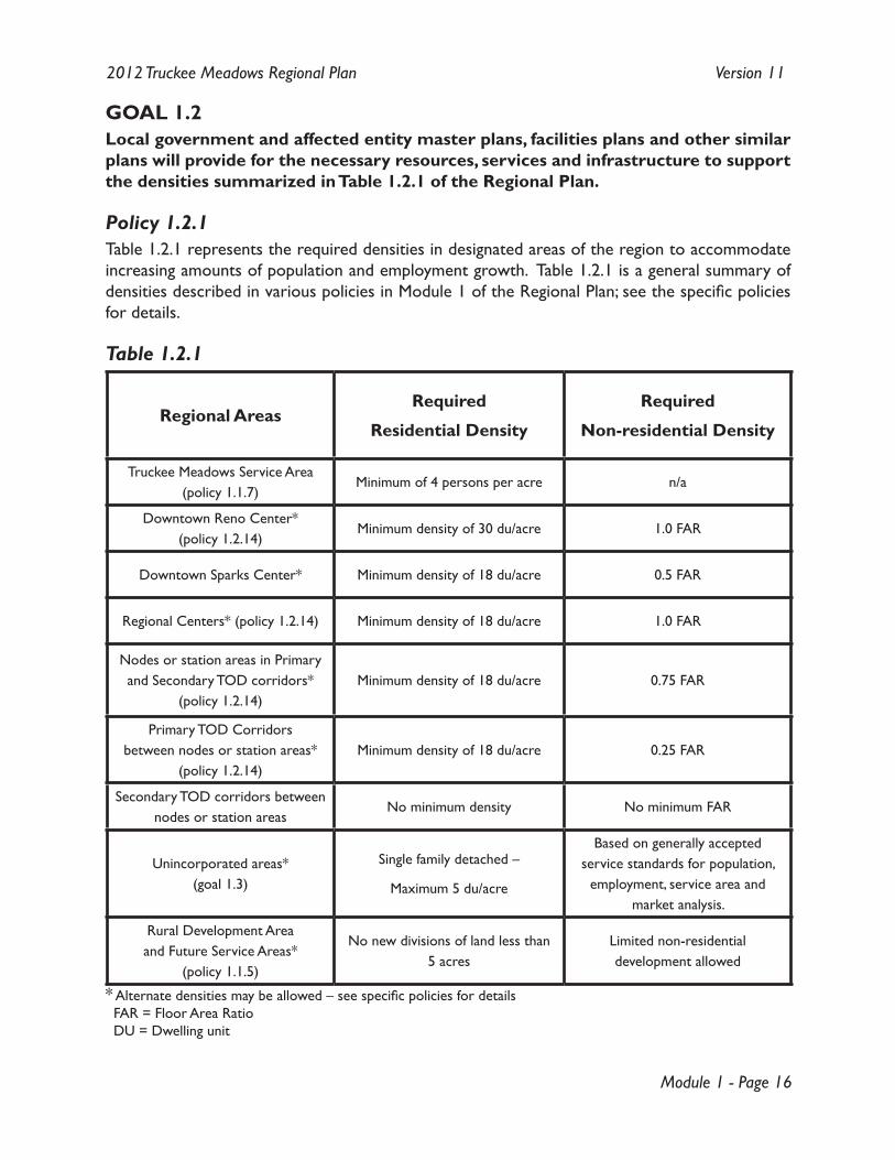
GOAL 1.2Local government and affected entity master plans, facilities plans and other similar plans will provide for the necessary resources, services and infrastructure to support the densities summarized in Table 1.2.1 of the Regional Plan.
Policy 1.2.1Table 1.2.1 represents the required densities in designated areas of the region to accommodate increasing amounts of population and employment growth. Table 1.2.1 is a general summary of densities described in various policies in Module 1 of the Regional Plan; see the specific policies for details.
Table 1.2.1
Regional AreasRequired
Residential Density
Required
Non-residential Density
Truckee Meadows Service Area (policy 1.1.7)
Minimum of 4 persons per acre n/a
Downtown Reno Center* (policy 1.2.14)
Minimum density of 30 du/acre 1.0 FAR
Downtown Sparks Center* Minimum density of 18 du/acre 0.5 FAR
Regional Centers* (policy 1.2.14) Minimum density of 18 du/acre 1.0 FAR
Nodes or station areas in Primary and Secondary TOD corridors*
(policy 1.2.14)Minimum density of 18 du/acre 0.75 FAR
Primary TOD Corridors between nodes or station areas*
(policy 1.2.14)Minimum density of 18 du/acre 0.25 FAR
Secondary TOD corridors between nodes or station areas
No minimum density No minimum FAR
Unincorporated areas* (goal 1.3)
Single family detached –
Maximum 5 du/acre
Based on generally accepted service standards for population,
employment, service area and market analysis.
Rural Development Area and Future Service Areas*
(policy 1.1.5)
No new divisions of land less than 5 acres
Limited non-residential development allowed
* Alternate densities may be allowed – see specific policies for details FAR = Floor Area Ratio DU = Dwelling unit
Module 1 - Page 17
2012 Truckee Meadows Regional Plan Version 11
Policy 1.2.2To conform with the Regional Plan, local government and affected entity master plans, facilities Plans, and other similar plans, must promote and not conflict with the following priorities for managing regional growth:
Downtown 1) Centers;
Regional 2) Centers and Emerging Employment Centers;
Primary TOD 3) Corridors;
4) Secondary TOD Corridors;
Infill opportunity areas as identified in 5) local government master plans;
all other areas within the 6) Truckee Meadows Service Areas.
Policy 1.2.3To conform with the Regional Plan, local governments, in consultation with affected entities, will develop Secondary TOD Corridor plans as a component of their master plans that:
establish the exact boundaries of the 1) corridor;
require mixed-uses in the master plan land use, zoning code and development standards 2) for Secondary Corridors;
promote public investment in services and facilities located in 3) Secondary Corridors to encourage a more efficient delivery of services to demand;
promote compatibility of new development, in consultation with the 4) Reno-Tahoe Airport Authority as applicable;
specify 5) land use and street design elements that support increasing intensification and pedestrian friendly environments that encourage multi-modal transportation and allow for the provision of enhanced public transportation options over time;
include development and design standards that support higher density 6) and intensity surrounding Secondary Corridors, and feathering, as appropriate, to provide for compatibility with existing neighborhoods along or adjacent to the corridor; and,
ensure that 7) Secondary Corridors are linked to the community, in particular linked to Centers and TOD Corridors, through multi-modal access.
Policy 1.2.4As an additional priority, local government and affected entity master plans, facilities plans, and other similar plans may demonstrate a need to convert existing, private septic systems to a public sewer system in areas where those services are necessary for the continued health, safety, and welfare of the local citizens.
Policy 1.2.5To conform to the Regional Plan, local government and affected entity master plans, facilities plans and other similar plans must promote and not conflict with the Regional Plan, including without limitation Policies 1.2.1 and 1.2.2 in terms of:
Module 1 - Page 18
2012 Truckee Meadows Regional Plan Version 11
permissible uses;1)
permissible density 2) and intensity of use;
size and capacity of public facilities;3)
location of public facilities; and,4)
provision of public services.5)
To meet the requirements of NRS 278.0284, local government and affected entity Capital Improvement Programs must identify expenditures and timing of public infrastructure investment consistent with master and facilities plans to support the desired population and employment growth and priorities identified in Policies 1.2.1 and 1.2.2.
Policy 1.2.6The master plans of local governments must include policies that take maximum advantage of existing resources such as: special transportation assets (air, rail, streets and highways, public transit), education assets (e.g., college, university), and sources of raw construction materials.
Policy 1.2.7To conform with the Regional Plan, local government and affected entity master plans must ensure that private investment in public infrastructure that is to be dedicated to the public and managed by a public entity must be identified within an approved Capital Improvement Program (CIP) (See NRS 278.0226 and Policy 3.4.1).
Policy 1.2.8The Regional Plan defines the following Downtown Centers, which are generally 1 mile in diameter, as shown on Map 4:
Downtown 1) Reno Center – downtown Reno and surrounding area
Downtown 2) Sparks Center – downtown Sparks and surrounding area
To conform with the Regional Plan, the master plans of the City of Reno and the City of Sparks must further define the boundary and character of each Downtown Center within their respective jurisdiction.
Module 1 - Page 19
2012 Truckee Meadows Regional Plan Version 11
Policy 1.2.9The Regional Plan defines the following Regional Centers, which are generally 1 mile in diameter, as shown on Map 4:
Convention Regional 1) Center - Meadowood Mall / Reno-Sparks Convention Center area
Medical Regional 2) Center - Renown Medical Center area
3) Reno-Tahoe Airport Regional Center - Reno-Tahoe International Airport area
UNR Regional 4) Center - University of Nevada, Reno area
Dandini Regional 5) Center - Truckee Meadows Community College / Justice Facility/ DRI area
Stead Regional 6) Center - Reno-Stead Airport area
Redfield Regional 7) Center - Redfield Campus / Saint Mary’s facility
Western Gateway Regional 8) Center - Verdi / Garson Road area & 1-80 Entrance 2 / Exit 2 area
To conform with the Regional Plan, local government master plans must further define the boundary and character of each Regional Center within their respective jurisdiction.
Policy 1.2.10The Regional Plan defines the following Primary Transit Oriented Development (TOD) Corridors and Secondary TOD Corridors, which are generally ¼ mile wide on each side of the designated transportation route or road with a central point of origin of Virginia Street and Fourth Street (Downtown Reno) as shown on Map 4:
Primary TOD Corridors
South Virginia Street, south to Moana Lane;1)
West Fourth Street, west to the McCarran intersection;2)
East Fourth Street, east to the I-580 intersection;3)
Prater Way to the Downtown Sparks Center, east to Sparks Blvd., and including a proposed 4) loop from Prater Way, south on Sparks Blvd. to Lincoln Ave., west, past the Sparks Marina to F Street, rejoining Prater Way;
Mill Street from the Medical Regional Center to the I-580 intersection.5)
Secondary TOD Corridors
South Virginia Street, south from Neil Rd to Mount Rose Highway, and Mount Rose 1) Highway, west to the Redfield Center;
North Virginia Street, north to Stead Blvd., and Stead Blvd. to the Stead Center;2)
West Fourth Street, west from the McCarran intersection to the I-80 intersection;3)
East Fourth Street, east of the I-580 intersection to the Reno city limits and areas west of 4) Sutro Street and north of 6th Street;
Mill Street, east of the I-580 intersection, south on Terminal Way to the Reno-Tahoe 5) Airport Center.

Module 1 - Page 20
2012 Truckee Meadows Regional Plan Version 11
To conform with the Regional Plan, local master plans must contain TOD Corridor Plans that further define the boundary and character of each TOD Corridor, specifically outlined in Policy 1.2.11. Where TOD Corridors cross jurisdictions, each jurisdiction that manages a section of the TOD Corridor must demonstrate that their TOD Corridor Plan is compatible with the other jurisdiction’s TOD Corridor Plan.
Module 1 - Page 21
2012 Truckee Meadows Regional Plan Version 11
Policy 1.2.11To conform with the Regional Plan, local governments, in consultation with affected entities, will develop Downtown and Regional Center, Primary TOD Corridor, and Station Area Plans as a component of their master plans that:
establish the exact boundaries of 1) Centers, Corridors, and Station Areas;
require 2) mixed-uses through amendments of development codes for Centers, Corridors, and Station Areas;
promote public investment in services and facilities located in Centers, Corridors and 3) Station Areas to encourage a more efficient delivery of services to demand;
promote compatibility of new development, in consultation with the 4) Reno-Tahoe Airport Authority, with regional airport operations;
specify 5) land use and street design that supports increasing intensification that enhances and encourages the use of public transportation and other multi-modal transportation options over time;
provide for development at a human scale; 6)
include development and design standards that support 7) density and intensity surrounding TOD Corridors, and feathering, as appropriate, to provide for compatibility with existing neighborhoods along or adjacent to the TOD Corridor; and,
ensure that TOD 8) Corridors are linked to the community through multi-modal access.
Policy 1.2.12The Regional Plan encourages local governments and the Reno-Tahoe Airport Authority to work together on the development of noise overlay zoning or similar measures to enhance the compatibility of surrounding development and airport operations.
Module 1 - Page 22
2012 Truckee Meadows Regional Plan Version 11
Policy 1.2.13To conform with the Regional Plan, local government master plans must include implementation tools to:
promote 1) infill development;
preserve 2) neighborhoods;
revitalize urban areas; and,3)
be consistent with densities summarized in Table 1.2.1.4)
In addition, master plans are encouraged to address human-scale design, inter-connections to other parts of the region and internally, diversity of land uses, and multi-modal transportation. Infill incentives, strategies, programs or policies may provide encouragements for public and/or private improvements in Downtowns and other development target areas.
To conform with the Regional Plan, local government master plans must include appropriate incentives, strategies, programs or policies to promote infill. These may include, but are not limited to:
allowing higher density a) development – especially transit oriented development – along TOD Corridors and in other designated infill locations by right when implemented with development and design standards that provide for compatibility with existing neighborhoods along or adjacent to the TOD Corridor or infill area;adjustments to permit fees, impact fees and exactions, to encourage b) infill development by lowering development costs and accelerating the development approval process;use of public investment (c) Capital Improvement Programs, including those of affected entities such as the school district and RTC) and subsidies (e.g., redevelopment funds, HOME and CDBG funds, federal transportation money, etc.) to offset costs of infill development;appropriate development standard adaptations (e.g., parking standard reductions); and,d) other policies, strategies, or programs to achieve the requirements of NRS 278.0274 (3) e) and (4).
Module 1 - Page 23
2012 Truckee Meadows Regional Plan Version 11
Policy 1.2.14To be in conformance with the Regional Plan, local government master plans must:
provide for minimum residential densities for new development of 30 dwelling units per 1) acre of residential and provide for minimum floor area ratios (FAR) for non-residential developments and mixed-use developments of 1.0 FAR within the Downtown Reno Center;
provide for minimum residential densities for new development of 18 dwelling units per 2) acre of residential and provide for minimum floor area ratios (FAR) for non-residential developments and mixed-use developments of 0.5 FAR within the Downtown Sparks Center;
provide for minimum residential densities for new development of 18 dwelling units per 3) acre of residential and provide for minimum floor area ratios (FAR) for non-residential developments and mixed-use developments of 1.0 FAR within Regional Centers;
provide for minimum residential densities for new development of 18 dwelling units per 4) acre of residential and provide for minimum floor area ratios (FAR) for non-residential developments and mixed-use developments of 0.75 FAR within nodes or station areas;
provide for minimum residential densities for new development of 18 dwelling units per 5) acre of residential and provide for minimum floor area ratios (FAR) for non-residential developments and mixed-use developments of 0.25 FAR within Primary TOD Corridors between nodes or station areas;
Alternative residential density and non-residential FARs may be specified in master plans in portions of TOD Corridors, Station Areas, and Centers if:
required densities are deemed incompatible; or, 1)
analysis prepared under Policy 1.2.11 determines that those standards are sufficient to 2) support the desired level of public transit; or,
natural resource constraints limit the desired density 3) or intensity of use; or,
facilities or 4) infrastructure are not currently available to support the desired density of development.
If alternative densities are specified an intensification plan must be completed. The intensification plan must:
describe in detail how the factors noted in items 1 - 4 above limit the ability to develop at a) the required densities; and,address specific strategies to increase density b) and intensity of use over time, including the provision of facilities and infrastructure.
Module 1 - Page 24
2012 Truckee Meadows Regional Plan Version 11
Policy 1.2.15The Regional Plan identifies the desired future condition for TOD Corridors that:
identify for acquisition all the necessary rights-of-way;1)
incorporate 2) transit stations at appropriate intervals;
employ 3) streetscape, urban design, and capital improvements to promote transportation by transit, walking, and bicycling;
where conditions warrant, utilize near term 4) transit priority elements such as exclusive bus or High Occupancy Vehicle lanes, bus signal priority signalizations, and queue jump lanes as proposed by the RTC;
when conditions warrant, provide long range implementation of a 5) Bus Rapid Transit system along all TOD Corridors, consisting of a range of priority services for transit in consultation with the RTC;
accommodate local and express bus services where appropriate; and,6)
provide 7) pedestrian ways.
To conform with the Regional Plan, the Regional Transportation Plan (RTP) and master plans of local governments and other affected entities must promote and not conflict with this desired future condition.
Policy 1.2.16The Regional Plan establishes the following policies which apply when lands are added to, or removed from, a city’s Spheres of Influence (SOI):
When lands are added to a 1) city’s SOI, the following policies apply:the a) County land use and zoning that is in existence at the time of the SOI change, as translated to corresponding city land use and zoning, shall apply in the SOI of that city until Policy 1.2.16(2) is satisfied; and,each b) city shall submit its master plan for conformance review with the land uses determined as described in Policy 1.2.16(1) and upon a finding of conformance take jurisdiction for actions covered under NRS 278.010-630.
When lands are removed from a 2) city’s SOI, the following policies apply:the a) city land use that is in existence at the time of the SOI change, as translated to corresponding County land use in Appendix 8, shall provide guidance in the County until Policy 1.2.16(2)(b) is satisfied; and,the b) County shall prepare and submit its master plan amendment for conformance review with the land uses determined as described in Policy 1.2.16(2)(a) within 120 days and upon a finding of conformance take jurisdiction for actions covered under NRS 278.010- 630.
Module 1 - Page 25
2012 Truckee Meadows Regional Plan Version 11
Policy 1.2.17The Regional Plan establishes the following policies which apply within Washoe County’s portion of the TMSA (see Map 7):
lands contained in 1) Washoe County’s portion of the TMSA after May 9, 2002 and prior to July 27, 2006 shall be subject to the cooperative planning process; and,
lands added to 2) Washoe County’s portion of the TMSA after July 26, 2006 shall not be subject to the cooperative planning process.
Policy 1.2.18The Regional Plan designates the following general areas for Emerging Employment Centers: east and north Sparks.
To conform with the Regional Plan, local government and affected entity master plans must maintain and improve the viability of these areas as major employment centers with the following master plan provisions:
provide adequate non-1) residential land supply;
provide convenient access to major roads and/or freeways;2)
require 3) pedestrian connections throughout the areas and to nearby residential areas;
plan for 4) transit service;
provide adequate 5) residential land supply in the surrounding area to house the anticipated number of employees;
require design and 6) intensity standards to maintain the character of nearby residential areas; and,
promote 7) reverse commute and trip reduction strategies.
Policy 1.2.19The Regional Plan supports the use of redevelopment districts as a tool to encourage redevelopment of blighted areas within Downtowns and TOD Corridors.
Policy 1.2.20A master plan may continue to recognize existing discretionary approvals or permits granted by a local government prior to May 9, 2002, including tentative maps, special use permits, and specific plans.
Module 1 - Page 26
2012 Truckee Meadows Regional Plan Version 11
Policy 1.2.21The Regional Plan encourages a cooperative approach to infill which includes careful coordination of plans between local governments and affected entities at the early stages of planning and project conceptualization, and thoughtful consideration of:
parks and � greenways;
natural resources; �
floodplains, floodways, and drainage ways; �
walkability; �
alternative modes of transportation; �
� sustainable design and construction;
public health impacts related to � land use decisions;
amenities; �
recreation opportunities; and, �
airport and � military installations.
Policy 1.2.22To conform with the Regional Plan local government master plans must provide for the coordination and compatibility of land uses with each military installation in the region, taking into account the location, purpose and stated mission of the military installation.
Policy 1.2.23To conform with the Regional Plan, the City of Reno and the City of Sparks master plans may only allow density transfers from usable passive open space and may not allow density transfer from any of the following areas:
non-1) residential, mixed-use and public facility properties;
property in the 2) Development Constraints Area;
existing golf courses;3)
4) existing parks; and,
existing regional street and rail 5) right-of-way.
Module 1 - Page 27
2012 Truckee Meadows Regional Plan Version 11
GOAL 1.3Unincorporated Washoe County within the TMSA will support Module #1 by providing a development pattern that includes a range of residential densities appropriate to the location and typified by medium density, and shall include appropriate neighborhood or local serving retail uses, and employment opportunities designed to reduce trips, enhance housing affordability and promote jobs-housing balance.
Policy 1.3.1The Regional Plan defines unincorporated communities as a component of the Truckee Meadows Service Areas. Unincorporated communities are management units that may be designated in the Washoe County Comprehensive Plan in unincorporated areas, and if designated will:
constitute a comprehensive planning tool that will provide local opportunities for services 1) and employment, reduce trips and discourage linear low-density development;
identify and plan for the areas in the 2) unincorporated County that are expected to absorb their share of the planned 20 year growth;
identify the services required in the developed and developing areas of the 3) unincorporated County;
identify funding sources for the provision of those services; and,4)
identify 5) land uses and services that will act to preserve community character and identity.
Module 1 - Page 28
2012 Truckee Meadows Regional Plan Version 11
Policy 1.3.2To conform with the Regional Plan, the Washoe County master plan must support and reinforce Goals 1.1 and 1.2 and related policies of the Regional Plan and provide housing and location options within the region.
Detached single-family residential development within the unincorporated TMSA may occur at up to five units per acre to support compatibility with adjacent communities, transit usage and trip-reduction goals, and to support employment centers and jobs-housing balance.
In locations where attached housing types are appropriate to support affordability and transit goals, the Washoe County master plan shall designate such areas and determine densities on a case-by-case basis, subject to regional conformance review.
For purposes of complying with this policy, density transfers are allowed from usable passive open space and are not allowed from any of the following areas:
non-1) residential, mixed-use and public facility properties;
property in the 2) Development Constraints Area;
property outside the 3) Truckee Meadows Service Areas;
existing golf courses;4)
5) existing parks; and,
existing regional street and rail 6) right-of-way.
Policy 1.3.3To conform with the Regional Plan, in unincorporated areas within the TMSA, local master plans may allow commercial uses of appropriate scale to serve the local community and not the greater region. The appropriate scale of commercial development shall be based on a market analysis illustrating a local-serving trade area submitted with master plan amendments proposing commercial areas.
To conform with the Regional Plan, in unincorporated areas within the TMSA, local master plans may allow industrial uses that:
Are contiguous with existing industrial master plan land use designations in unincorporated �Spanish Springs; and
Do not increase the size of the existing contiguous industrial area located in unincorporated �Spanish Springs by more than 150 acres over the next 10 years ending on December 31, 2025. *
* This additional industrial acreage allowed applies only to lands in unincorporated Spanish Springs and not to other unincorporated areas within the TMSA.
Module 1 - Page 29
2012 Truckee Meadows Regional Plan Version 11
GOAL 1.4 Within one year of the adoption of the Regional Plan local government master plans must include strategies based on quantifiable goals set by the jurisdiction to a) increase affordable housing opportunities for persons earning less than 80% AMI and b) increase workforce housing opportunities for persons earning between 80 and 120% of the AMI. The goals will be measurable, with a timeline that covers at least the five-year planning period.
Policy 1.4.1To conform with the Regional Plan local government master plans must promote and not conflict with NRS 278.160, and include strategies that address jurisdiction regulations addressing the creation of new, and the maintenance of existing, housing, coordination efforts, financial tools, and community education with the aim of:
identifying the needs of the community regarding affordable and workforce � housing;
reducing regulatory barriers to the provision of � affordable housing;
preserving or rehabilitating current affordable and workforce � housing stock when possible;
increasing new affordable and workforce � housing stock;
providing for a diverse range of � housing types;
documenting existing and new affordable and workforce � housing; and,
developing incentives, partnerships, and processes to facilitate the creation of additional �affordable and workforce housing stock.
In developing these master plan elements, local governments are encouraged to coordinate with the HOME Consortium and other public and private affordable and workforce housing service providers.

Module 1 - Page 30
2012 Truckee Meadows Regional Plan Version 11
[Notes]
Module 2 - Page 1
2012 Truckee Meadows Regional Plan Version 11
MODULE #2:
MANAGEMENT OF THE REGION’S NATURAL RESOURCES
INTRODUCTIONIt is the intent of the Regional Plan to identify and manage significant natural resources in a manner that sustains those resources for future generations and considers each resource as part of a larger natural system. To carry out this intent, the Regional Plan requires the master plans and facilities plans of local governments and affected entities to recognize the interdependent functions and contributing values of rivers, wetlands, other water bodies, aquifer recharge areas, ridgelines, steep slopes, open space, greenways, recreation areas, and habitat for wildlife and vegetation. In addition, the Regional Plan recognizes that the natural resources within our region are constrained.
The goals and policies listed under Module #2, as well as the goals and policies for regional form and pattern (Module #1) and public services and facilities (Module #3) encourage uses of the land that promote the responsible management of the region’s air and water resources, and that attain and maintain state and federal standards for air quality and water quality.
The goals and policies listed under Module #4 ensure that natural resource constraints are considered when conformance reviews and evaluation of amendments to the Regional Plan are conducted.
The plan also promotes an integrated network of open space and greenways that links urbanized areas, public facilities, recreation opportunities, and surrounding public lands. This network will also enhance scenic quality, preserve and restore habitat, and protect significant natural, cultural and archeological resources.
The basis for goal and policy development for implementation of the Regional Plan are the following planning principles:
PLANNING PRINCIPLESThe Regional Plan will ensure effective management of our natural resources. �
Within the Regional Plan, � open space, greenways and natural features will help to define the regional form.
Our unique and significant natural resources will be identified and managed in a sustainable �manner and as whole systems to ensure the availability of resources for generations to come.
The Regional Plan will require the review and implementation of the � Air Quality Management Plan that ensures the region meets the National Ambient Air Quality Standards.
The Regional Plan will require � local government master plans to encourage land uses that

Module 2 - Page 2
2012 Truckee Meadows Regional Plan Version 11
promote the responsible management of the region’s air quality and water resources.
The Regional Plan will require a regional approach to � watershed, wastewater, and stormwater management to ensure state water quality standards are met.
The Regional Plan will require the identification of sustainable regional � water resources and the promotion of development patterns and practices that promote sustainable water use.
The Regional Plan will require � local government master plans to preserve the natural function and scenic value of mountains, rivers, significant ridgelines, wetlands, aquifer recharge areas, and water bodies as wilderness, habitats, open space, greenways, parks, trails, and recreational areas.
Local governments and � affected entities will manage our natural resources in cooperation with State and Federal partners.
The Regional Plan recognizes that the natural resources within our region are �constrained.
The Regional Plan will ensure the effective management of our natural resources, recognizing �their importance to the public health, safety, and welfare of our community.
The Regional Plan will promote the coordination of the natural resource plans of � local governments and affected entities.
The Regional Plan will promote and encourage the practice of � sustainable design and construction.
Module 2 - Page 3
2012 Truckee Meadows Regional Plan Version 11
GOALS AND POLICIES
GOAL 2.1To better coordinate natural resource management, local governments will prepare integrated plans to address natural resources in the region, in consultation with the community and key stakeholders.
Policy 2.1.1To conform with the Regional Plan, and to coordinate natural resource management within the region, local government master plans will at least address the management of the following:
floodplains;1)
2) greenways;
3) open space;
wildlife migration paths;4)
habitat for wildlife and vegetation;5)
rivers, streams and riparian zones;6)
7) aquifer recharge areas;
recreation management/uses;8)
steep slopes;9)
ridgelines;10)
11) wetlands and other water bodies;
12) playas;
trails and trail networks;13)
urban/wildland interface, including weed management, and public safety service provision, 14) wildland fire management and fuels reduction;
wellhead protection; and,15)
threatened and endangered species.16)
Local government master plans will provide for a coordination and communication strategy to ensure broad stakeholder participation and will address management strategies such as incentives, enhancements or offsets, mitigation, funding, acquisition, connectivity, and monitoring of the identified natural resources.
Module 2 - Page 4
2012 Truckee Meadows Regional Plan Version 11
GOAL 2.2Local government master plans will be revised to preserve the scenic, natural, public safety, and recreational values of sensitive land areas by constraining development on designated water bodies and ridgelines, natural slopes over 30 percent, and certain other lands.
Policy 2.2.1To conform with the Regional Plan, master plans of local governments and affected entities must at least place the following limits on development within the Development Constraints Area:
As defined in conforming 1) local government master plans, allowed land uses are limited to communication facilities, recreational facilities, parks and open space, utilities, agriculture, forestry, mining, and transportation infrastructure necessary to service development. Residential development is allowed at a maximum density of one unit per 40 acres or one unit per parcel in existence when the 2002 Regional Plan is adopted, whichever is greater. Other uses may encroach into the Development Constraints Area in isolated areas if the encroachments enhance the overall project design and a 2:1 ratio of non-constrained area is preserved as open space for every constrained area that is developed.
Commercial, office, industrial and 2) residential development is not allowed in the Development Constraints Area, except as provided for in Policy 2.2.1(1).
All 3) local government and affected entity master and facilities plans must include components to preserve development-constrained lands in an undeveloped state wherever possible, to minimize encroachments into the Development Constraints Area, and to provide additional design features to mitigate the visual impact of necessary encroachments.
Module 2 - Page 5
2012 Truckee Meadows Regional Plan Version 11
GOAL 2.3Local governments will review and revise their master plans to include management strategies for areas with natural slopes greater than 15 percent but less than 30 percent.
Policy 2.3.1To be found in conformance with the Regional Plan, master plans shall include management strategies for slopes greater than 15 percent but less than 30 percent. These strategies must ensure that:
development on such slopes will not degrade the scenic, public safety, and environmental 1) values of the area to be developed and the region as a whole;
development on such slopes incorporates on-site and off-site mitigation measures for 2) impacts to habitat and water quality, and for fiscal effects associated with higher-than-normal costs of infrastructure, public safety facilities, and public safety services on slopes greater than 15 percent but less than 30 percent;
3) aquifer recharge function is protected; and,
activities comply with the terms of 4) National Pollutant Discharge Elimination System (NPDES) permits.
Module 2 - Page 6
2012 Truckee Meadows Regional Plan Version 11
GOAL 2.4The Regional Plan encourages Washoe County, through coordination with local, state, federal, tribal, and private partners, to secure funding to implement the regional open space plan, and requires local governments to revise their master plans to establish a coordinated network of open space and greenways, wherever possible, that links urbanized areas, public facilities including schools, recreation opportunities, and surrounding public lands.
Policy 2.4.1As provided for in Chapter 376A of the Nevada Revised Statutes, Washoe County is encouraged to identify and coordinate potential sources of private and public revenue to implement the regional open space plan in cooperation with its partners.
Policy 2.4.2To conform with the Regional Plan, master plans of local governments must support and not conflict with the goals and policies of the Regional Plan regarding open space by including open space and greenways plans that must:
promote the protection of wildlife habitat;1)
connect trails systems including the Truckee River and the urban core;2)
encourage recreation and other uses of 3) open space and greenways by pedestrians and bicyclists;
provide access to and links between public facilities including recreational facilities, schools, 4) and public transportation;
support intensification by providing amenities to promote 5) infill in Centers, Corridors and other appropriate areas;
link urban 6) open space and greenways with passive open space or public lands surrounding the urbanized areas; and,
ensure connectivity at jurisdictional interfaces.7)
Module 2 - Page 7
2012 Truckee Meadows Regional Plan Version 11
GOAL 2.5The NNWPC and the WRWC will revise the Regional Water Management Plan (RWMP) and local governments will revise their master plans to: (a) attain and maintain state and federal water quality standards, (b) protect water resources from degradation by stormwater runoff, and (c) protect natural resources and the public health, safety, and welfare during flood events.
Policy 2.5.1To be consistent with the Regional Plan, the Regional Water Management Plan (RWMP) must utilize local master plans that have been determined to be in conformance with the Regional Plan for information on the location and intensity of anticipated development within the region for the next 20 years.
Policy 2.5.2To be consistent with the Regional Plan, the RWMP must:
be consistent with the goals and policies regarding 1) regional form and pattern (Module #1);
be consistent with local 2) master plans that have been found in conformance with the Regional Plan; and,
comply with applicable sections of State Law regarding the management of:3) surface a) water;ground b) water; and,floods and c) storm water drainage.
Policy 2.5.3To be found in conformance with the Regional Plan, and in accordance with the water quality protection policies of the Washoe County Health District (WCHD) and the State Engineer, master plans of local governments must prohibit amendments to zoning that increase the density or intensity to allow division of parcels to less than 5 acres in size within the rural development area (RDA).
Module 2 - Page 8
2012 Truckee Meadows Regional Plan Version 11
GOAL 2.6The Washoe County Health District and local governments will review and revise their air quality plans and ordinances to attain and maintain state and federal air quality standards.
Policy 2.6.1To be found in conformance with the Regional Plan, the air quality plans and ordinances of the WCHD shall include:
strategies to reduce the rate of increase in 1) vehicle miles traveled (VMT) per capita;
strategies to increase the use of 2) alternative fuels in motor vehicles;
standards and programs for the management of 3) solid fuel-burning devices; and,
road, street, and parking area cleaning and sweeping programs.4)
Policy 2.6.2To conform with the Regional Plan and to help attain and maintain air quality standards for carbon monoxide, ozone, and particulate matter, master plans of local governments must prohibit the use of diesel oil-fueled, internal combustion power generation units synchronized with the regional electric grid within the Truckee Meadows Service Areas (TMSA), except for emergency conditions such as weather related acts of God, unforeseen grid disturbances, maintenance activities including testing, or transmission limitations.
Module 2 - Page 9
2012 Truckee Meadows Regional Plan Version 11
GOAL 2.7The Regional Plan promotes and encourages the practice of sustainable design and construction.
Policy 2.7.1To conform with the Regional Plan, master plans, facilities plans or other similar plans of local governments and affected entities must promote, encourage, or provide incentives for:
development practices that promote 1) energy-efficient building technology for residential and non-residential development in terms of site location, building materials, building technology and other elements;
the use of alternative or 2) renewable energy sources; and,
the use of low impact development (LID) practices.3)
Module 2 - Page 10
2012 Truckee Meadows Regional Plan Version 11
GOAL 2.8The Regional Planning Agency will facilitate coordination and cooperation in natural resources planning in the wider region, including the coordination and sharing of data and information to assist the region with decision making.
Policy 2.8.1The Regional Planning Agency will facilitate the preparation of an inventory of regulations that apply to natural resource management in the wider region.
Policy 2.8.2The Regional Planning Agency will establish a regional data portal emphasizing natural resources.
Policy 2.8.3The Regional Planning Agency will facilitate a cooperative approach to natural resource planning with local, state, and federal agencies, the Nevada System of Higher Education (NSHE) in Washoe County, private partners, and surrounding jurisdictions.
Module 3 - Page 1
2012 Truckee Meadows Regional Plan Version 11
MODULE #3:
PUBLIC SERVICES AND FACILITIES
INTRODUCTIONOne of the purposes of the Regional Plan is to help coordinate the provision of effective and efficient public services by local governments and affected entities, to minimize duplication and overlap, and to promote fairness.
The Regional Plan calls for local governments and affected entities to review and revise their master plans, facilities plans, and Capital Improvement Programs (CIPs) to make them consistent with the goals and policies of the Regional Plan.
The annexation policies of local governments, and related actions that can result in boundary adjustments (e.g., joint planning), are very strongly tied to decisions regarding the provision of municipal services. Because of this, these goals and policies also require Reno and Sparks to review and revise their annexation programs.
As required by NRS 278.0274, the Regional Plan includes information relating to the provision of sanitary sewer facilities, solid waste management, flood control, potable water, and groundwater aquifer recharge, correlated with the goals and policies of the Regional Plan. Appendix 1 summarizes the following information for those services:
problems and needs; �
providers of public service and their respective service territories; and, �
the timing of facilities and services necessary to support the development contemplated �by the Regional Plan.
After revised master plans, facilities plans, and other similar plans are found to be in conformance with the Regional Plan, and CIPs have been submitted to the Regional Planning Agency, Appendix 1 will be updated.
To coordinate the provision of services and facilities, it will be necessary for the Regional Planning Agency to work with a large number of entities, including:
a) local governments and affected entities;public b) utilities subject to the jurisdiction of the Public Utilities Commission of Nevada (PUCN); and,state and federal agencies.c)
The agency will work with the managers and chief planning officials of Reno, Sparks, and Washoe County; other officials within the region; and technical advisory committees authorized by state law.
Module 3 - Page 2
2012 Truckee Meadows Regional Plan Version 11
A number of groups have looked at the question of regional services, consolidated services, and ways to make the most of scarce resources. Joint efforts and consolidation opportunities have been important to the Truckee Meadows for many years, and will be increasingly important as resources tighten and needs expand. The RPC and the RPGB may consider additional regionalization of public services, where it would support implementation of the plan.
Several goals and policies in Module 3 also address the challenge of maintaining a reliable supply of energy for utility customers in the region while minimizing conflicts between utility infrastructure and the communities it serves. This challenge was first met in 1999, when the work of a local citizens’ committee resulted in the RPGB adopting the Regional Utility Corridor Report (RUCR). From 1999 to 2010, the RUCR guided the placement of transmission lines and sites via policies that established utility corridors and separation requirements from certain uses. Certain goals and policies in Module 3 build on the core concepts from the RUCR to require that existing and future corridors be maintained to allow for future expansion of transmission infrastructure within those corridors, reducing the need for additional corridors.
The policies in Module 3 also go beyond the core concepts in the RUCR by ensuring that:
A regional dialogue occurs before a � transmission line is approved for undergrounding; and,
� Renewable energy generation is encouraged and the transmission of energy from renewable sources is contained within existing corridors whenever possible.
The basis for goals and policy development for implementation of the Regional Plan are the following planning principles.
PLANNING PRINCIPLESLocal governments and affected entities will provide quality public services and facilities for our regional citizens.
The Regional Plan will coordinate the provision of public services and facilities provided by �affected entities including: the Regional Transportation Commission, Waste Management, Washoe County School District, Washoe County Health District, Air Quality Management, Reno-Tahoe Airport Authority, and Reno-Sparks Convention and Visitors Authority.
The Regional Planning Agency will work with entities regulated by the � Public Utilities Commission and the Federal Energy Regulatory Commission, such as NVEnergy and Tuscarora Gas Transmission Company, to coordinate the provision of public services and facilities.
The Regional Planning Agency will work with State, Federal, and local agencies, such as the �Bureau of Land Management, the U.S. Forest Service, Nevada Department of Transportation, Nevada System of Higher Education (NSHE) in Washoe County, Truckee Meadows Water Authority, and Truckee Meadows Community College to coordinate the provision of public services and facilities.
The Regional Plan will promote and maintain opportunities for the provision of � utilities including, but not limited to, the transmission of electricity, while at the same time aiming
Module 3 - Page 3
2012 Truckee Meadows Regional Plan Version 11
to reduce conflicts between utility infrastructure and the communities it serves.
When a � transmission line is proposed to be undergrounded for safety reasons, the Regional Plan will ensure a forum for regional dialogue regarding the allocation of costs.
The Regional Plan will promote a � renewable energy future by requiring local government master plans and facility plans to demonstrate a commitment to the generation and transmission of electricity from regional renewable energy generation sources.
The Regional Plan will ensure that necessary public services and facilities to support new �development are or will be available and adequate, based on adopted levels of service (LOS) standards, at the time the impact of new development occurs.
The Regional Plan promotes and encourages the practice of � sustainable design and construction.
Module 3 - Page 4
2012 Truckee Meadows Regional Plan Version 11
GOALS AND POLICIES
GOAL 3.1 The Northern Nevada Water Planning Commission (NNWPC) will update the Regional Water Management Plan (RWMP) to make it consistent with the Regional Plan including the goals and policies related to regional form and pattern, and the Regional Transportation Commission (RTC) will update the Regional Transportation Plan (RTP), to make it conform with the Regional Plan including the goals and policies related to regional form and pattern.
Policy 3.1.1To be found consistent with the Regional Plan, the portions of the RWMP that address public water systems must:
be consistent with the goals and policies regarding 1) regional form and pattern (Module #1);
be consistent with local 2) master plans that have been found in conformance with the Regional Plan; and,
comply with applicable sections of Chapter 531 Statutes of Nevada 2007.3)
Policy 3.1.2To be found consistent with the Regional Plan, the portions of the RWMP that address wastewater collection and treatment must:
be consistent with the goals and policies regarding 1) regional form and pattern (Module #1);
be consistent with local 2) master plans that have been found in conformance with the Regional Plan; and,
comply with applicable sections of Chapter 531 Statutes of Nevada 2007.3)
Module 3 - Page 5
2012 Truckee Meadows Regional Plan Version 11
Policy 3.1.3To be found in conformance with the Regional Plan, local government master plans must ensure that all development located within the Truckee Meadows Service Areas (TMSA), that requires a subdivision of land, or an amendment to the zoning or master plan that increases the density or intensity of use and relies on on-site sewage disposal, must require:
dry 1) sewer mains to be constructed in accordance with the adopted Capital Improvement Plans (CIP) and facilities plans;
2) conformance with the water quality protection policies of the Washoe County Health District (WCHD); and,
a recorded waiver of protest to the formation and funding of a 3) sewer improvement district.
Policy 3.1.4 To be found consistent with the Regional Plan, the portions of the RWMP that address stormwater management must:
be consistent with the goals and policies regarding 1) regional form and pattern (Module #1);
be consistent with local 2) master plans that have been found in conformance with the Regional Plan; and,
comply with applicable sections of Chapter 531 Statutes of Nevada 2007.3)
Policy 3.1.5To be found in conformance with the Regional Plan, the Regional Transportation Plan must:
conform with the goals and policies regarding 1) regional form and pattern (Module #1); and,
comply with applicable sections of State and Federal Law regarding the elements of the 2) Regional Transportation Plan, including without limitation, Chapter 373 of NRS and Public Law 105-178 as amended, and the Transportation Equity Act for the 21st Century.
Module 3 - Page 6
2012 Truckee Meadows Regional Plan Version 11
GOAL 3.2Upon the determination, by the Regional Planning Commission (RPC), that applicable local master plans and the Transportation Plan conform with the Regional Plan and the Regional Water Plan is consistent with the Regional Plan, local governments and affected entities will review and revise facilities plans and Capital Improvement Programs (CIP) for parks, schools, streets, water supply, wastewater collection and treatment, stormwater management, and public safety facilities to serve the levels and distribution of population and employment described in local master plans.
Policy 3.2.1Local governments and affected entities must review and submit their facilities plans and similar plans along with any necessary proposed amendments to the RPC for conformance review, in accordance with regulations, to be adopted by the Regional Planning Governing Board (RPGB). The RPC must determine that the local and affected entity facilities plans conform with the Regional Plan before the local government or affected entity takes final action on the amendment (NRS 278.0282).
Policy 3.2.2Water purveyors, providers of community wastewater collection and treatment, and entities that provide or maintain stormwater and flood control facilities must review and submit their facilities plans, in accordance with regulations, to be adopted by the RPGB. Amended facilities plans for water, wastewater, stormwater, and flood control must specifically identify the nature, location, and capacity of necessary infrastructure consistent with the major facilities described in the RWMP.
Module 3 - Page 7
2012 Truckee Meadows Regional Plan Version 11
GOAL 3.3Reno and Sparks will review and revise existing annexation programs and plans.
Policy 3.3.1The Regional Plan hereby adopts the Spheres of Influence (SOI) for the cities of Reno and Sparks, and the unincorporated area of jurisdiction, shown on Map 1. A Sphere of Influence is an area into which a city plans to expand within the next 20 years (see NRS 278.026 and NRS 278.02788). The portion of the TMSA for each city is also the SOI for that city and the remaining portions of the TMSA are for unincorporated development. Please refer to Policy 1.1.3.
Policy 3.3.2Pursuant to NRS 268.625, the cities of Reno and Sparks must submit annexation programs to the RPC and RPGB for conformance determination. To be found in conformance with the Regional Plan, the annexation programs must promote and not conflict with the maps and policies of the Regional Plan regarding:
the desired 1) regional form and pattern (See Module #1);
natural resource management (See Module #2);2)
public service and 3) infrastructure provision (See Module #3); and,
the areas of 4) jurisdiction of Washoe County.
Module 3 - Page 8
2012 Truckee Meadows Regional Plan Version 11
GOAL 3.4In accordance with state law, local governments and affected entities will review and revise their capital improvement programs (CIPs) to support conforming master plans, and submit them to the Regional Planning Agency, which will prepare a coordinated regional CIP summary.
Policy 3.4.1Pursuant to NRS 278.0226, local governments must annually review, revise, and submit to the Regional Planning Agency, their CIPs to identify:
costs that the 1) local government expects to incur; and,
sources of revenue that the 2) local government will use, to acquire, maintain, operate, and replace capital improvements.
Affected entities must also review and revise their CIPs in accordance with applicable state and federal laws.
Each CIP must be consistent with conforming master plans, facilities plans, and other similar plans, and shall be submitted to the Regional Planning Agency, which shall prepare a summary of the CIPs (see subsection 5(d) of NRS 278.0274).
The CIP summary must be completed not later than 6 months after submission of CIPs to the Regional Planning Agency.
Policy 3.4.2 To conform with the Regional Plan, local government and affected entity master plans, facilities plans, and other similar plans must anticipate and develop strategies to preserve future necessary right-of-way (ROW) needs.
Module 3 - Page 9
2012 Truckee Meadows Regional Plan Version 11
GOAL 3.5 The Regional Plan will coordinate the master plans, facilities plans, and other similar plans of local governments and affected entities to ensure that necessary public facilities and services to support new development are or will be available and adequate at the time the impacts of new development occur (i.e., concurrency).
Policy 3.5.1To be in conformance with the Regional Plan, the master plans, facilities plans, and other similar plans of local governments and affected entities must ensure that necessary public facilities and services to support new development are or will be available and adequate, based on adopted levels of services (LOS) at the time the impacts of new development occur.
Policy 3.5.2To be in conformance with the Regional Plan, local government and affected entities facilities plans, and other similar plans must be based at a minimum on the land use contained in adopted master plans that have been found in conformance with the Regional Plan.
These plans must address all applicable policies of the Regional Plan and include:
details on funding and timelines for the provision of required facilities;1)
a detailed description of all adopted 2) levels of service;
an assessment of alternatives; and,3)
an identification of which facilities address:4) existing deficiencies;a) new development; and,b) both existing deficiencies and new development.c)
Policy 3.5.3The process shown in Appendix 7 and policies 3.5.3.1 and 3.5.3.2 shall be used by the local governments for planning and processing development applications requesting intensification effective July 1, 2007 or as soon as public facilities plans are found in conformance with the Regional Plan. Applicable facilities plans are: water supply, sanitary sewer, flood management, transportation (streets, transit, pedestrian, bicycle), fire, police, parks, and, if the Washoe County School District develops a facilities plan consistent with each local master plan, schools.
Module 3 - Page 10
2012 Truckee Meadows Regional Plan Version 11
Policy 3.5.3.1Areas outside the TMSA that do not have development constraints shall not be given more intense zoning designations (or land use if a one-map system is used), or other additional entitlements for development (except as provided by the adopted Regional Plan) until the area is included in the TMSA, is included in all applicable services and facilities plans that have been found in conformance with the Regional Plan, and the applicable services and facilities will be provided concurrent with the impacts from any additional entitlements for development.
Policy 3.5.3.2Areas inside the TMSA that do not have development constraints shall not be given more intense designations (or land use if a one-map system is used), or other additional entitlements for development (except as provided by the adopted Regional Plan) until the area is included in all applicable service and facilities plans that have been found in conformance with the Regional Plan, and the applicable services and facilities will be provided concurrent with the impact from any additional entitlements for development.
Module 3 - Page 11
2012 Truckee Meadows Regional Plan Version 11
GOAL 3.6 Local government and affected entity master plans, facilities plans, and other similar plans must identify and plan for the necessary resources, services, and infrastructure to support the densities summarized in Table 1.2.1 of the Regional Plan.
Policy 3.6.1To conform with the Regional Plan, local government and affected entity master plans, facilities plans, and other similar plans must identify and plan for adequate public services and facilities to support the densities summarized in Table 1.2.1, in the following priority order:
Downtown 1) Centers;
Regional 2) Centers and Emerging Employment Centers;
Primary TOD 3) Corridors;
Secondary TOD Corridors,4)
5) infill opportunity areas as defined in local government master plans; and
all other areas within the 6) Truckee Meadows Service Areas.[Amended December 12, 2013]
Module 3 - Page 12
2012 Truckee Meadows Regional Plan Version 11
GOAL 3.7 Local government and affected entity master plans, WCSD school facilities plans, the Regional Transportation Plan, and other similar plans must ensure that the location of schools and arterial roads promotes and does not conflict with the regional form and pattern.
Policy 3.7.1To conform with the Regional Plan, local government and affected entity master plans, WCSD school facilities plans, and other similar plans must not allow for the location of schools, South of T26N with a projected population of at least 300 full-time students throughout any part of the calendar year, outside the Truckee Meadows Service Areas.
Policy 3.7.2To conform with the Regional Plan, the WCSD school facilities plan must not allow for the location of a new school site with a design capacity of less than 1200 students in a manner that necessitates a new speed controlled school zone on an arterial roadway that is identified in the adopted Regional Transportation Plan. This policy does not restrict charter and private schools that would not necessitate a new speed controlled zone from locating along arterials.
Policy 3.7.3To conform with the Regional Plan, the Regional Transportation Plan must not allow for the location of a new arterial road, or the re-designation of an existing road, next to or adjacent to a proposed new or existing school site with a design capacity of less than 1200 students as identified in the adopted WCSD school facilities plan.
Module 3 - Page 13
2012 Truckee Meadows Regional Plan Version 11
GOAL 3.8The Regional Plan will establish, maintain, promote the use of, and protect the future expansion of identified utility corridors and sites for the transmission of electricity and promote the use of these corridors for the placement of other utilities.
Policy 3.8.1The Regional Plan identifies all above ground and underground regional utility corridors and sites as shown on Maps 9 & 10.
The removal of existing, or establishment of new, utility corridors and sites requires a Regional Plan amendment. A Regional Plan amendment is also required for:
the relocation of an existing � transmission line such that a new easement is required;
the conversion of � above ground transmission lines to underground placement, or
the conversion of � underground transmission lines to above ground placement.
Per NRS 278.0272, Subsection 7, the RPC must hold a public hearing on an annual basis to consider requests for amendments to the Regional Plan. During the public hearing, any person may propose an amendment to the Regional Plan, including an amendment to add, modify, or delete regional utility corridors.
Policy 3.8.2The width of existing and future corridors shall be equivalent to the width of the easement required by the National Electric Safety Code (NESC) plus any additional easement width required by the utility provider to ensure access to the infrastructure.
Module 3 - Page 14
2012 Truckee Meadows Regional Plan Version 11
Policy 3.8.3To be in conformance with the Regional Plan, local government master plans must preserve the viability of existing and future utility corridors and sites to accommodate new or expanded infrastructure by:
Requiring a minimum setback of 10 feet on each side of existing � regional utility corridors within which structures approved after August 12, 2010, are prohibited; and
Specifying standards for passive uses within the setbacks including, but not limited to, �parks, trails, parking, landscaping, and fencing.
Corridor widths and separation of uses from utility sites shall not be less than those specified in the NESC.
The minimum 10-foot setback shall not apply to development in existence or approved prior to August 12, 2010. For any modification or expansion of an existing structure located within the mandatory 10-foot setback, the applicable local government discretionary review process may apply.
If the width of an existing corridor is expanded as the result of expanding the utility infrastructure within the corridor, then the 10-foot minimum setback shall be added to each edge of the expanded easement. The new minimum setback shall only apply to new development.
Policy 3.8.4To be in conformance with the Regional Plan, local government master plans must ensure the edge of an easement associated with a new or expanded above ground or underground electrical transmission line is a minimum of 10 feet from existing structures.
Policy 3.8.5To be in conformance with the Regional Plan, local government master plans must require that utility project proponents, including private developers, NV Energy, or other multi-state utility-related entities, place new electrical transmission infrastructure in existing utility corridors, unless adequate justification can be provided that demonstrates why the new infrastructure cannot be placed in an existing corridor.
The placement of all new above ground and underground electrical transmission infrastructure shall be subject to the priority hierarchy in Policy 3.8.6. The establishment or modification of corridors is subject to Policy 3.8.1.
Module 3 - Page 15
2012 Truckee Meadows Regional Plan Version 11
Policy 3.8.6To be in conformance with the Regional Plan, local government master plans must use the following priority hierarchy for the placement of new above ground and underground electrical transmission infrastructure:
Locate new 1) above ground or underground transmission infrastructure in an existing corridor that already contains above ground transmission infrastructure, without expanding the corridor width;
Locate new 2) above ground or underground transmission infrastructure in either a federally designated corridor (i.e. BLM corridor) or an easement that has an approved preliminary or final Environmental Impact Statement (EIS);
Locate new 3) above ground or underground transmission infrastructure in an existing corridor that already contains above ground transmission infrastructure, but with an expanded corridor width;
Request the creation of a new corridor based on the route of an existing 4) above ground distribution line;
Locate new 5) above ground transmission infrastructure within an existing corridor that already contains underground transmission infrastructure, without expanding the corridor width;
Locate new 6) above ground transmission infrastructure within an existing corridor that already contains underground transmission infrastructure, but with an expanded corridor width; and,
Request the creation of a new corridor for the placement of new 7) transmission infrastructure where no utility infrastructure currently exists.
In order to address unique community-level circumstances, local governments may establish standards beyond those specified in the Regional Plan for the location of new or expanded utility corridors, such as increased building setbacks.
Policy 3.8.7To be in conformance with the Regional Plan, local government master plans must promote the use of utility corridors and sites for the placement of infrastructure related to other utilities (i.e. natural gas, telecommunications).
Module 3 - Page 16
2012 Truckee Meadows Regional Plan Version 11
Policy 3.8.8To be in conformance with the Regional Plan, local government master plans must ensure that any project that proposes new or expanded above ground or underground electrical transmission infrastructure within the Federal Aviation Regulations (FAR) Part 77 areas of public use airports within the region such as the Reno-Tahoe International Airport, Reno-Stead Airport, Spanish Springs Airport, and Empire Airport, or in close proximity to a private use airport be carried out in coordination with the Reno Tahoe Airport Authority or applicable airport operator.
For informational purposes, the general locations of all public and private airports with Federal Aviation Administration (FAA) location identifiers are shown on Maps 9 and 10. The current locations of the FAR Part 77 areas overlaying and surrounding the Reno-Tahoe International, Reno-Stead, and Spanish Springs public use airports are included in Map 11.
Policy 3.8.9Pursuant to NRS 278.026, NRS 278.0278, and guidelines adopted by the RPC for the definition of projects of regional significance, prior to final approval by a local government, the RPC shall review certain projects related to utilities as projects of regional significance.
Module 3 - Page 17
2012 Truckee Meadows Regional Plan Version 11
GOAL 3.9To ensure electrical transmission lines are placed underground only when necessary and to provide for shared input from all local governments regarding the allocation of costs associated with the undergrounding of transmission lines, the Regional Plan will: (a) encourage the undergrounding of electrical transmission lines only in circumstances where above ground construction poses a justifiable safety risk that can be mitigated by underground construction; and (b) require projects involving the undergrounding of electrical transmission lines for safety reasons be submitted to the RPGB for an advisory review regarding the allocation of costs for undergrounding.
Policy 3.9.1To conform with the Regional Plan, local government master plans shall support the placement of electrical transmission lines underground in circumstances where it can be determined that undergrounding will substantially mitigate the safety risk of above ground construction. In some, but not all cases, above ground transmission lines may pose a safety risk when located in proximity to airports.
Policy 3.9.2To ensure shared input from all local governments regarding the allocation of costs due to the undergrounding of electrical transmission infrastructure, projects involving the undergrounding of a transmission line for safety reasons shall be forwarded to the RPGB for an advisory review and finding to confirm that the undergrounding is necessary for safety reasons and therefore of a benefit to the region.
Before a project involving the undergrounding of a transmission line for safety reasons is forwarded to the RPGB, the RPC shall review the project in accordance with the conformance review requirements in Policy 4.1.5 for Projects of Regional Significance.
When submitting a project that involves the undergrounding of an electrical transmission line for a finding of conformance with the Regional Plan, the sponsoring entity shall specify whether, and clearly demonstrate why and how, the undergrounding element of the project is necessary for safety reasons.
A finding of conformance with the Regional Plan by the RPC shall stand regardless of the outcome of the RPGB’s advisory review of the undergrounding component, unless the conformance determination is appealed pursuant to NRS 278.0278.
An advisory decision by the RPGB regarding the merits of undergrounding transmission infrastructure due to safety concerns and final approval of the project by a local government shall not override any power or duty afforded to the Public Utilities Commission of Nevada (PUCN) in NRS Chapter 703.
Module 3 - Page 18
2012 Truckee Meadows Regional Plan Version 11
GOAL 3.10The Regional Plan shall promote the use of information regarding potential renewable energy resource areas, encourage local governments to support the expansion of renewable energy, and require where possible the use of existing corridors for the transmission of electricity from renewable energy generation sources.
Policy 3.10.1To be in conformance with the Regional Plan, local government master plans shall require any new electrical transmission infrastructure originating from a regional renewable energy generation source be located in an existing utility corridor whenever practical.
In circumstances where it is not practical to place new electrical transmission infrastructure in an existing utility corridor that already contains above ground transmission infrastructure, local governments shall use the priority hierarchy in Policy 3.8.6 for the placement of new transmission infrastructure and provide adequate justification for the decision.
A Regional Plan amendment is required for the establishment of a new utility corridor originating from a regional renewable energy generation source. This policy does not apply to local renewable energy sources, such as small-scale wind machines, roofmounted photovoltaic solar panels, small-scale cogeneration units, small geothermal energy units, or any other energy source that produces electricity designed for immediate on-site use.
Local renewable energy sources that periodically provide small amounts of electricity to the grid as the result of net metering arrangements with the public utility provider are also excluded from the requirements of this policy.
In the event that the power generated from a local renewable energy source is made available to the regional power grid via a purchase power agreement or transmission service agreement with NV Energy or other utility provider such that the power being generated is serving a regional market, then the renewable energy source shall be considered a regional renewable energy source and be subject to the requirements of this policy.
Policy 3.10.2To conform with the Regional Plan, local government master plans and facilities plans shall demonstrate a commitment to the development of regional renewable energy generation including the transmission infrastructure originating from regional renewable energy generation sources.
Module 4 - Page 1
2012 Truckee Meadows Regional Plan Version 11
MODULE #4:
REGIONAL PLAN IMPLEMENTATION
INTRODUCTIONThe goals and policies under Module #4 address the implementation of the regional planning process. The goals and policies address:
procedures and requirements for 1) conformance review of master plans, facilities plans, other similar plans and projects of regional significance (PRS);
procedures and requirements for amending the Regional Plan; 2)
3) joint planning and other cooperative planning efforts; and,
required reports and evaluations. 4)
The Regional Planning Governing Board (RPGB) establishes regulations on procedures related to conformance review, Regional Plan amendments, joint planning areas, annexation programs, and annexation proposals.
The basis for goal and policy development for implementation of the Regional Plan are the following planning principles:
PLANNING PRINCIPLES:The Regional Planning Agency will effectively manage growth within the region through the implementation of the Regional Plan where:
The Regional Plan is a principle-based plan that recognizes the needs of our society, the �economy, and the environment are inter-related and decisions affecting one area have implications for the others. The agency will clearly define and uniformly implement regional goals and policies by ensuring that master plans and facilities plans conform to regional policies.
The Regional Plan and � regulations adopted by the RPGB further identify processes and procedures to allow changes to the Regional Plan.
The Regional Planning Agency will create a strategic planning process that includes: �
▪ annual reporting from local governments and affected entities as contemplated in NRS 278.0276 and as further defined by regulations adopted by RPGB;
coordination of discussions between regional stakeholders and regional service ▪providers to anticipate regional trends, issues, and new ideas and provide for amending and/or setting regional priorities; and,
the development of a regional action plan that identifies resource requirements for its ▪implementation.

Module 4 - Page 2
2012 Truckee Meadows Regional Plan Version 11
The Regional Planning Agency will implement, manage, and enforce the Regional Plan and �will require consistency of implementation across all regional jurisdictions.
The Regional Planning Agency will be adequately funded to accomplish its mission. �
Module 4 - Page 3
2012 Truckee Meadows Regional Plan Version 11
GOALS AND POLICIES
GOAL 4.1 The Regional Planning Commission (RPC) will review the master plans, facilities plans, and other similar plans of local governments and affected entities. These plans will be revised in accordance with policies set forth in the adopted Regional Plan, in order to conform with the regional form and pattern and all applicable goals and policies.
Policy 4.1.1Pursuant to NRS 278.0282, before taking final action to adopt or amend any master plan, facilities plan, or other similar plan, each local government and affected entity shall submit the proposed plan or amendment to the RPC, which shall determine whether the proposed plan or amendment conforms with the Regional Plan.
Policy 4.1.2Pursuant to NRS 278.0282, before taking final action to adopt or amend any master plan, facilities plan, or other similar plan of a state agency or a public utility whose plan must be approved by the Public Utilities Commission of Nevada (PUCN), the agency or utility shall submit the proposed plan or amendment to the RPC, and the RPC shall review the plan or amendment and offer suggestions to the agency or utility regarding the conformance of the plan with the Regional Plan.
Policy 4.1.3A proposed master plan, facilities plan, cooperative plan, or similar plan conforms with the Regional Plan if it is not in conflict with the Regional Plan and it promotes the goals and policies of the Regional Plan (see NRS 278.0282). The RPC shall consider at least the following factors when evaluating whether a master plan, facilities plan, cooperative plan, or similar plan promotes the goals and policies of the Regional Plan:
consistency of the proposed plan with the 1) regional form and pattern (as defined by the combination of Centers, Transit-Oriented Development (TOD) Corridors, residential areas, open space, greenways, and natural features), and with regional projections of population and employment growth;
compatibility of the proposed plan with goals and policies regarding development 2) constraints;
compatibility of the proposed plan with goals and policies regarding 3) infill development; housing and jobs-housing balance;
compatibility of the proposed plan with existing and planned public service areas, policies, 4) and priorities; availability, timing and phasing of infrastructure; fiscal analysis of service provision;
compatibility of the proposed plan with existing 5) military installations, including their location, purpose and stated mission; and,
Module 4 - Page 4
2012 Truckee Meadows Regional Plan Version 11
cumulative and indirect effects of the proposed plan.6)
Policy 4.1.4 A Project of Regional Significance (PRS) means a proposed project as defined in subsections 5 & 6 of NRS 278.026 and further defined by the guidelines adopted by the Regional Planning Commission (e.g., RPC Resolution 09-16 (September 9, 2009)).
Policy 4.1.5Pursuant to NRS 278.0278, before a local government takes final action to approve a Project of Regional Significance (PRS), and before construction may begin, the RPC must determine that the project conforms with the Regional Plan. The RPC must limit its review to the substance and content of the Regional Plan and shall not consider the merits or deficiencies of a project other than as necessary to make its determination. To determine whether a PRS promotes the Regional Plan, the RPC must consider the items listed in subsections (1) through (6) of Policy 4.1.3.
Policy 4.1.6The Regional Plan encourages a cooperative approach to planning which includes careful coordination of plans between local governments and affected entities at the early stages of planning and project conceptualization, and thoughtful consideration of:
parks and � greenways;
natural resources; �
floodplains, floodways and drainage ways; �
walkability; �
alternative modes of transportation; �
� sustainable design and construction;
public health impacts related to � land use decisions;
amenities; and, �
recreation opportunities. �
Module 4 - Page 5
2012 Truckee Meadows Regional Plan Version 11
GOAL 4.2Local governments will conduct joint planning programs for designated joint planning areas, as well as other cooperative planning efforts.
Policy 4.2.1The Regional Planning Commission (RPC) may designate a joint planning area, for which the County and the affected city or cities shall jointly adopt a master plan (see NRS 278.02784). The master plan for a joint planning area must:
be consistent with the Regional Plan;1)
designate the portion of the area, if any, that is included within the 2) Sphere of Influence of a city;
designate the portion of the area, if any, that is subject to the 3) jurisdiction of the County for planning, zoning, and development decisions; and,
be submitted to the RPC for review for 4) conformance with the Regional Plan.
Policy 4.2.2The following area has been designated a joint planning areas and is depicted on Map 6:
the 1) Reno-Stead Corridor, a joint planning area of Reno and Washoe County.
Policy 4.2.3 The Regional Planning Governing Board (RPGB) may, through a Regional Plan amendment, affirm, modify or remove the designation of a joint planning area.
Policy 4.2.4 The Regional Plan designates cooperative planning areas, shown on Map 7, as follows:
spheres of influence (1) SOI) expanded after May 8, 2002 and prior to July 27, 2006;
land within the 2) unincorporated county, identified by cities in the settlement agreement (October 17, 2002), but not including any amendments to the unincorporated portion of the TMSA made after July 26, 2006; and,
lands 3) annexed within the cooperative planning areas.
The following lands are specifically excluded and are subject to the provisions prescribed in:
a) the settlement agreement in Nevada Supreme Court Case 38749 (also known as Mortensen et al.); and,the stipulation regarding the Somersett properties in District Court Case CV02-b) 03469 (Washoe County and the Sun Valley General Improvement District vs. Regional Planning Governing Board).

Module 4 - Page 6
2012 Truckee Meadows Regional Plan Version 11
Policy 4.2.5 To be in conformance with the Regional Plan, local government master plans must require a cooperative planning process for all lands described in Policy 4.2.4.
Policy 4.2.6 To conform with the Regional Plan, a cooperative plan must satisfy the requirements of Policy 4.1.3.
Module 4 - Page 7
2012 Truckee Meadows Regional Plan Version 11
GOAL 4.3 The Regional Planning Commission (RPC) may approve amendments to the Regional Plan and the Regional Planning Governing Board (RPGB) may adopt such amendments, pursuant to an orderly annual process with comprehensive reviews and updates at least every five years.
Policy 4.3.1The RPC shall, annually, review the Regional Plan; annual reports as required by regulation; and requests from the RPGB and local governing bodies for Regional Plan amendments consistent with existing planning principles and goals.
Policy 4.3.2The RPC may consider whether a proposed amendment is necessary to protect the public health or welfare, or to provide a substantial benefit to the region. If the amendment is necessary, the RPC may take action on the proposed amendment at any time (See subsection 8 of NRS 278.0272).
Policy 4.3.3 At least once every five years, the RPC shall conduct a comprehensive review of the Regional Plan. At a minimum, the review must consider the boundaries of the Truckee Meadows Service Areas (TMSA) in order to determine whether a sufficient supply of land is available to accommodate projected growth in population and employment, consistent with the policies of the Regional Plan. After its review, the RPC shall consider approval of amendments, if any, to the Regional Plan for consideration by the RPGB.
To assist the RPC during consideration of amendments, the RPC will review findings and recommendations of the annual reports prepared based on RPGB regulations and NRS 278.0286.
Module 4 - Page 8
2012 Truckee Meadows Regional Plan Version 11
Policy 4.3.4 The Regional Planning Governing Board may prepare, or cause to be prepared, a package of studies to assist the RPGB in making determinations regarding future changes to the Future Service Areas (FSAs), Truckee Meadows Service Areas (TMSA) and component parts: cities and their Spheres of Influence, unincorporated areas, Centers, TOD Corridors and the Development Constraints Areas (DCA). The studies do not preclude an amendment of the TMSA or component parts prior to the completion of the studies. The studies may include, without limitation:
a regional land and resource capacity analysis within the 1) Future Service Areas (FSA) and Truckee Meadows Service Areas (TMSA), including the establishment of the methodology in conjunction with local government and affected entity staff;
a regional needs analysis to determine the anticipated requirements for 2) residential, commercial, and industrial land resources for the next 20 years and beyond, including the establishment of the methodology in conjunction with local government and affected entity staff;
an 3) infrastructure/service provision study to determine the most efficient provider of public services and facilities to areas considered for expansion, including the establishment of the methodology, in conjunction with local government and affected entity staff;
in conjunction with 4) local government and affected entity staff, an assessment of, and make recommendations on, land use and infrastructure provision roles of the local governments and affected entities in the region; and,
an analysis of potential impacts on natural resources within the region. 5)
Policy 4.3.5The RPC shall, from time to time, adopt schedules and procedures for consideration of Regional Plan amendments. Such schedules and procedures must not conflict with the Regional Plan and the regulations of procedure. Only the RPC, the RPGB, or a local governing body may submit a proposed Regional Plan amendment (see subsection 7 of NRS 278.0272).
Policy 4.3.6The Regional Planning Commission and the Regional Planning Governing Board shall consider, at a minimum, the following criteria during consideration of a proposed amendment to the Regional Plan pursuant to NRS 278.0272:
1) regional form and pattern, including open space;
2) housing;
3) jobs-housing balance;
availability, timing, and phasing of 4) infrastructure;
public service levels and fiscal impacts; and,5)
natural resource constraints.6)
Module 4 - Page 9
2012 Truckee Meadows Regional Plan Version 11
GOAL 4.4 By April 1 each year, local governments and affected entities will evaluate their progress on the goals of the Regional Plan and submit annual reports as described by regulation for review by the RPC and the RPGB.
Policy 4.4.1Pursuant to NRS 278.0286, the RPGB has adopted Regulations on Procedure (See RPGB Regulations on Procedure, as amended) for annual reporting.
Based on these regulations, local governments and affected entities will evaluate their progress on the goals of the Regional Plan and submit annual reports, by April 1, for review by the RPC and the RPGB.

Module 4 - Page 10
2012 Truckee Meadows Regional Plan Version 11
GOAL 4.5 Local governments and the Truckee Meadows Regional Planning Agency will collaborate on state and federal legislation to implement the settlement agreement in the Reno annexation case (CV02-03469, dated August, 2005).
Policy 4.5.1The cities of Reno and Sparks, Washoe County, and the Truckee Meadows Regional Planning Agency shall collaborate with the appropriate Federal legislators and officials to propose Federal lands disposal legislation to make the suitable federal land identified as future spheres of influence on Map 5 available for private purchase.
Policy 4.5.2The cities of Reno and Sparks, Washoe County, and the Truckee Meadows Regional Planning Agency shall collaborate with the appropriate State legislators and officials to propose changes to NRS 268.610-268.668 to allow annexation of non-contiguous territory by a city if that territory is included in the sphere of influence of that city.
Module 4 - Page 11
2012 Truckee Meadows Regional Plan Version 11
GOAL 4.6The Regional Planning Agency will facilitate coordination and cooperation in planning in the wider region, including the coordination and sharing of data and information to assist the region with decision making, in order to identify and resolve issues as early as possible.
Policy 4.6.1The Regional Planning Agency will establish a cooperative web-based clearinghouse of regional planning data.
Policy 4.6.2The Regional Planning Agency will facilitate a cooperative approach to planning with local, state and federal agencies, the Nevada System of Higher Education (NSHE) in Washoe County, private partners, and surrounding jurisdictions.
Policy 4.6.3The Regional Planning Agency will acknowledge and communicate with its neighbors located outside of its jurisdiction in order to better coordinate planning efforts.
Map 8 of the Regional Plan describes the wider region outside of Washoe County that impacts and is impacted by the planning and development of the region.

Module 4 - Page 12
2012 Truckee Meadows Regional Plan Version 11
[Notes]
Appendix 1 - Page 1
2012 Truckee Meadows Regional Plan Version 11
APPENDIX 1
PUBLIC SERVICES AND FACILITIES IN THE TRUCKEE MEADOWS: PROBLEMS, NEEDS, SERVICE PROVIDERS, TIMING, AND PLANS
FOR CAPITAL IMPROVEMENTS
A. IntroductionState law provides that the Regional Plan must contain certain information on public services and facilities in the planning area. Specifically, for sanitary sewer facilities, solid waste, flood control, potable water and groundwater aquifer recharge, subsection 5 of Nevada Revised Statutes (NRS) 278.0274 says the Regional Plan must:
Describe the problems and needs of the area and the general facilities that will be 1) required;
Identify the providers of public services and their service areas (including service territories 2) set by the Public Utilities Commission of Nevada [PUCN] for public utilities);
Establish the time within which necessary public facilities and services must be made 3) available to serve the development contemplated by the Regional Plan; and,
Contain a summary of the capital improvement plans that are required of each 4) local government and that may be prepared by the Northern Nevada Water Planning Commission (NNWPC), the Regional Transportation Commission (RTC), and the Washoe County School District (WCSD).
While it is a requirement of the Regional Plan that the contents of Appendix 1 be included, the information described herein is limited to key regional information described in published reports (referenced at the end of the Appendix) that have been either approved or adopted by governing bodies. Appendix 1 is not exhaustive of all available data sources. There are many documents describing planning efforts for these facilities in greater detail including those required by federal and state statutes, such as the Water Quality “208” Management Plan. These reports may currently be in progress; however, information contained in studies or plans that have not been approved or adopted by a governing body is not included. Since planning documents are under continual review, information provided in Appendix 1 presents only a snapshot in time, and is subject to change.
Appendix 1 - Page 2
2012 Truckee Meadows Regional Plan Version 11
B. Problems and NeedsSanitary sewer. To protect water quality in the Truckee River and Pyramid Lake, the region must carefully manage discharges of nutrients (nitrogen and phosphorus) and total dissolved solids (TDS) to surface waters. With respect to nutrients, very sophisticated water quality models of the Truckee River have been developed that enable local governments and regulators to better evaluate river health. Efforts are ongoing to address the appropriateness of nutrient water quality standards and total maximum daily loads (TMDLs) with respect to future flow conditions. The 2011 Regional Water Management Plan (RWMP), adopted by the Western Regional Water Commission (WRWC) on January 14, 2011, includes several strategies for addressing wastewater and storm water issues in the region. These strategies include minimizing the use of septic systems where possible, reducing non-point source pollution, and through the passage of AB 54, provide financial assistance for existing septic system users to connect to sewer infrastructure.
Disposal of effluent in hydrographically closed basins has challenges. Prior studies conducted by water planning agencies in the region evaluated effluent disposal options for anticipated increased development in the Reno-Stead, Lemmon Valley, and Cold Springs areas. These studies resulted in an amendment to the Regional Water Management Plan (RWMP) in 2006 to evaluate three of those options further. The 2011 RWMP includes as proposed action items the development of a facility plan for the build out of land uses in the Cold Springs portion of the TMSA and the development of a comprehensive water resource plan for the Cold Springs and portions of the adjacent Long Valley hydrographic basins in order to estimate baseline perennial yields.
Where the density of septic tanks exceeds the capacity of the soil-vegetation system to treat wastewater discharges, it will be necessary to address resulting groundwater contamination from nitrates. Currently, these areas include Warm Springs Valley, Washoe Valley, Golden Valley, Lemmon Valley, Spanish Springs Valley, and areas of Cold Springs Valley. The 2011 RWMP includes as proposed action items the continued conversion of septic tanks in high density areas to community sewer systems as funding is available.
Solid waste. According to the 2006 study ‘Capacity Constraints in Regional Infrastructure Networks’ (Hansford), an analysis of current day loads to the Lockwood regional landfill and aerial analysis of the property, it is estimated that the landfill has just over 20 years of life left. In 1995, it was thought the landfill had 75 years of capacity. This estimate would be considerably shorter if more contracts are approved with other regional entities to take their waste. According to the report, the Lockwood site has land to expand with a discretionary permit from Storey County; however, Storey County ordinances need to be changed to allow the expansion to happen. In addition to the landfill capacity, there is a need to add capacity at existing transfer stations or find new transfer station sites to accommodate future increases in waste collections.
Appendix 1 - Page 3
2012 Truckee Meadows Regional Plan Version 11
Flood control. Flooding is a periodic problem in the Truckee Meadows and surrounding region. In January 1997, a flood damaged more than 1,420 buildings and – in northern Nevada as a whole – took two lives. This event is now used as the benchmark for flooding information and modeling in the region. The 1997 flood was a very large event with a recurrence interval of 117 years. Washoe County alone, experienced $700 million in damages as a result of the flood. Total damages for all affected areas exceeded $1 billion. In addition to monetary damage, floods can cause health and safety issues, damages from toxic and hazardous waste contamination, and loss of environmental resources in the flood plain.
Some areas of the region, notably southern Sparks and eastern Reno, and along Steamboat Creek are not necessarily protected from a 100-year flood event. According to a 2004 study by Washoe County, there is about $5 billion of property in flood plains in the Truckee Meadows; however, this is subject to change as development intensifies in critical flood storage areas and outdated flood mapping information.
The Truckee River Flood Management Project, a joint effort among the Cities of Reno and Sparks, Washoe County, the US Army Corps of Engineers (ACOE), and other stakeholders, is developing the Living River Plan, which is also the locally preferred plan. The three primary goals of the plan are to: 1) reduce flood damages and deaths from a 1997 type flood (117-year event); 2) restore 50 miles of the Truckee River between Reno and Pyramid Lake, and 3) provide enhanced recreational opportunities and open space in the region. Implementation of many projects outlined in the plan are underway or already completed.
Potable water. Demand for potable water is one of three types of water demand in the Truckee Meadows (the other types are non-potable demand, for crops and irrigated open areas, and environmental demand, for evapotranspiration and non-consumptive use). Municipal water supplies are primarily derived from two sources, the Truckee River and groundwater aquifers.
A comparison by the WRWC of the 2010 Washoe County Consensus Forecast population to the sustainable water resources identified in the RWMP concluded that there are adequate water resources available to accommodate the estimated increase in population through the Regional Plan planning period. The use of available water resources may be constrained by the ability to legally prove the water rights and ability to pay for the price of water rights. Long-term, the adequacy of Truckee River water rights to meet future demands is a constraint to planning. The availability of groundwater resources to meet future demands also constrains planning. Most groundwater basins being used for municipal supply are over-appropriated with respect to the estimated annual yield of the groundwater resource. Current pumping is estimated to be approximately equal to, or exceeding the estimated perennial yield (which is lower than appropriations). Particular areas within a basin might be experiencing over-pumping while the basin as a whole is not. Annual pumping limitations and water rights dedication discount factors are being implemented in some basins to correct these imbalances. Those basins that are being, or could be, considerably over-pumped are East Lemmon and Golden Valleys, Spanish Springs, Warm Springs, and Cold Springs. In addition to municipal groundwater supplies, the effect of declining groundwater levels on domestic wells has become an important issue in the south Truckee Meadows and portions of Lemon Valley.
Appendix 1 - Page 4
2012 Truckee Meadows Regional Plan Version 11
In some parts of the Truckee Meadows, groundwater pollution has impacted water supply by affecting water supply wells. The 2006 RWMP cited that in the central Truckee Meadows, contamination from tetrachloroethylene (TCE) (also known as perchloroethylene or “PCE”) covers more than 16-square miles to a depth greater than 350 feet. Eleven production wells are currently affected, with three treatment facilities fitted with chemical strippers to remove the contamination. The removal of TCE and PCE is being funded through a remediation district. Compliance with new federal arsenic standards effective January 2006 requires continual evaluation of arsenic treatment facilities for more than 20 municipal wells in the region. According to the Central Truckee Meadows Remediation District Program, since 1996, nearly 23 billion gallons of groundwater have been treated, removing an average of almost 16 gallons of PCE from groundwater each year. For perspective, approximately 1 teaspoon of PCE can contaminate 450,000 gallons of water to levels exceeding the safe drinking water standard established by the U.S. Environmental Protection Agency (EPA).
Also, as mentioned under Sanitary Sewer, contamination of groundwater from septic tank discharges continues to be a problem in a number of areas. The passage of AB 54 will provide financial assistance for existing septic system users to connect to sewer infrastructure. The 2011 RWMP also includes policies and strategies for reducing pollution from septic systems.
Groundwater aquifer recharge. See Potable water. The 2011 RWMP, includes policies and strategies for protecting and enhancing groundwater recharge. One strategy includes using reclaimed water. According to the plan, use of reclaimed water for recharge is being studied with respect to regulatory issues, treatment technologies and public perception.
C. Required FacilitiesSanitary sewer. According to the 2011 RWMP, the Truckee Meadows Water Reclamation Facility (TMWRF) has a design capacity to treat 40 million gallons per day (MGD) of wastewater. The facility currently treats about 28 MGD average daily flow, disposing the majority of the treated effluent to the Truckee River and a small portion via effluent reuse systems in the Central Truckee Meadows, City of Sparks, and Spanish Springs. The TMWRF Phase III Expansion Project was initiated in 1999 and was completed in 2007. The goal of the project was to replace older equipment, upgrade treatment processes, and increase the permitted capacity to 46.5 MGD.
In 2001, Washoe County received federal grant funds and moved forward with the extension of the Lawton/Verdi Interceptor. The Boomtown and Verdi Meadows areas were connected to the interceptor, and their respective wastewater treatment facilities have been decommissioned. The interceptor will also allow for removal of numerous septic systems, and the future decommissioning of the Gold Ranch Wastewater Treatment Plant. The next largest wastewater treatment facility is the South Truckee Meadows Wastewater Reclamation Facility (STMWRF). Future expansions will be added when Washoe County staff project that flow at the plant will exceed capacity. Locating new sites for effluent reuse for STMWRF discharge is extremely important since there is no other means for the plant effluent to be disposed of. Capacities of the major treatment facilities are documented in the 2006 report ‘Capacity Constraints in Regional Infrastructure Networks.’
Appendix 1 - Page 5
2012 Truckee Meadows Regional Plan Version 11
The annexation by the City of Reno of land in Cold Springs and the anticipated intensification of development in Lemmon Valley and the Lower Truckee Canyon will all require planning for wastewater treatment and disposal. The Reno Stead Wastewater Reclamation Facility (RSWRF) is the primary wastewater treatment facility for the City of Reno in the Stead / Lemmon Valley area. It is anticipated that this plant will be expanded to serve the entire Stead / Lemmon Valley region, including both incorporated and unincorporated areas. According to the 2011 RWMP, RSWRF is permitted to treat a maximum month average day flow of 2.35 MGD. Flows to the RSWRF in 2006 were roughly 1.3 MGD average daily flow.
With the recent removal of the City of Sparks Sphere of Influence (SOI) and associated Truckee Meadows Service Areas (TMSA) from the East Truckee River Canyon (ETRC), the need to plan for wastewater treatment in the Lower Truckee Canyon may become less immediate. However, any new developments in the ETRC that cannot connect to existing or planned expansions of wastewater treatment plants because of their location in the rural development area may construct smaller treatment plants or pursue creative effluent disposal options.
Solid waste. The existing Lockwood landfill permit is for a 1,500 acre site with a footprint of 550 acres. An additional 4,000 acres around the existing site could be utilized for expansion purposes. Improvements such as a new access road have already been made to accommodate the planned expansion. New transfer station sites need to be identified and purchased to serve increased waste collections in the future.
Flood control. The Truckee River Flood Project’s Living River Plan, in addition to the Master Plans and Facility Plans of local governments, address flood control issues. According to the 2011 RWMP, the Flood Project is the largest public works project ever undertaken in northern Nevada, with an estimated cost of $1.2 billion to $1.6 billion. The plan combines ecosystem restoration, recreation and flood control together in one visionary, integrated effort. The draft Environmental Impact Statement (EIS) for the project will be available for public review in April 2012. Authorization by Congress is anticipated in fall 2012 with a possible construction start by the ACOE in 2013. Several projects identified in the Living River Plan have already begun or have been completed using local or non-ACOE funding.
Potable water. According to the 2011 RWMP, the need to invest in new facilities for additional capacity to serve new development has diminished. There has been a resultant decrease in both water use and flows to the wastewater treatment plants, which has created under-utilized capacity within major facilities. This excess capacity will allow the utilities and local governments to defer major capital expenditures for new capacity. This reduction in anticipated investment is evident in the 2010/11-2014/2015 CIP Summary provided later in this appendix. Nonetheless, on-going repair and replacement of existing infrastructure remains a high priority.
Although water supplies are considered adequate for growth to continue through the RWMP planning period, supplies must be efficiently managed. Major issues in both the 2006 and 2011 versions of the RWMP include continued best use of water supplies in the Central Truckee Meadows, development of new water supplies for Spanish Springs and Cold Springs, increasing off-river water reliability, and integrated resource planning in Washoe Valley. Water conservation will continue to play a role in stretching the region’s water supplies.
Appendix 1 - Page 6
2012 Truckee Meadows Regional Plan Version 11
Groundwater aquifer recharge. See Potable water. In addition to water supply ongoing development plans and new initiatives, watershed management and protection priorities are included in the 2011 RWMP. The 2011 plan recommends that areas with highest recharge value should be prioritized and delineated and any new development employ passive groundwater recharge and/or storm water infiltration strategies such as infiltration basins or swales, porous paving, open space, meandering stream channels, or other low impact development (LID) practices).
D. Timing of Necessary Facilities and ServicesSanitary sewer. Recent plans adopted by the Truckee Meadows Water Authority (TMWA) for the central Truckee Meadows and similar plans for the south Truckee Meadows, Cold Springs, Stead/Lemon Valley, and Spanish Springs detail the water-related facility requirements for those areas. These schedules are subject to change, as the individual facilities plans and the RWMP are amended from time to time. The RWMP must be reviewed and revised, if necessary, to ensure it continues to be consistent with Regional Plan goals and policies.
Solid waste. Projections of capacity at the Lockwood landfill estimate just over 20 years of life left. This life span may shorten if loads from sources outside of Washoe County continue to increase. There is more than twice the current used acreage available for future landfill expansions and expansion plans are underway.
Flood control. The Truckee River Flood Management Project, which was formed following the 1997 flood event, is leading and coordinating the local efforts for Truckee River flood facility improvements that will ultimately be carried out in partnership with the ACOE. The ACOE is conducting hydraulic, floodplain, and economic analysis to determine which of two alternatives (the Living River Plan and an alternative National Economic Development plan) has the highest benefit-to-cost ratio. The Truckee River Flood Project is actively purchasing properties in critical areas for flood protection needs, for river restoration, and for new flood facility construction.
The Living River Plan identifies necessary flood control facilities in the Truckee Meadows region. The RWMP as well as local government master plans and facilities plans identify necessary flood control facilities.
Potable water. The 2010 TMWA Water Resources Plan and Water System Facility Plan detail the potable water-related facility requirements for the majority of the region. These plans are subject to change from time to time. As TMWA data is a key input into the RWMP, the data and assumptions should be reviewed and revised, if necessary, to ensure the RWMP continues to be consistent with the Regional Plan.
Groundwater aquifer recharge. See Potable water.
E. Service Providers and Service AreasSanitary sewer. The cities of Reno and Sparks, Washoe County, and other affected entities (e.g. general improvement districts) are the main providers of sanitary sewers and wastewater treatment. Sewer service providers and their service territories are depicted in the 2011 RWMP Figure 4-1.
Appendix 1 - Page 7
2012 Truckee Meadows Regional Plan Version 11
Solid waste. Provision of solid waste service, including door-to-door and business collection, operation of waste treatment, hauling and disposal is privately operated based on franchise agreements with each of the local governments, including each general improvement district. The Washoe County Health District oversees all matters involving solid waste management in Washoe County, including monitoring waste collection and disposal; enforcing regulations involving permits; landfill and transfer station operations and importation of out-of-state municipal solid waste.
Flood control. The staff of the Truckee River Flood Management Project report to the Truckee River Flood Management Authority which is a body of elected officials from the cities of Reno and Sparks, and Washoe County, as well as key stakeholders from the region. The Flood Project is the primary entity responsible for flood control planning along the Truckee River.
Potable water. Washoe County and TMWA are the main providers of potable water in the region. Water service providers and their service territories are depicted in the RWMP Figure 3-1.
Groundwater aquifer recharge. See Potable water.
F. Summary of Capital Improvement PlansThe governing body of each local government whose budget includes any expenditure for the acquisition or maintenance of a capital improvement must annually prepare a capital improvement plan (CIP) that conforms with its master plan and includes at least three but not more than 20 fiscal years. The CIP must identify the expected costs and the sources of revenue for acquiring, maintaining, operating, and replacing improvements (see NRS 278.0226).
Capital projects are usually major, fixed, and non-recurring assets. Examples include bridges, streets, and land for parks. (The CIP of Washoe County’s Department of Water Resources also includes water-related facility planning costs in addition to fixed assets). The approved annual budget of a local jurisdiction provides money for capital improvements in the fiscal year covered by the budget.
The City of Sparks, Washoe County (including Washoe County’s DWR) and TMWA have 5-year CIPs. The City of Reno has a 20-year CIP. The RTC and WCSD both have short-range CIPs of 5-years, and long-range plans. The RTC’s current long-range plan meets federal requirements by planning through 2030; however, future updates will likely go beyond the 20-year requirement. The WCSD has an 18-year long range facilities plan. The required summary of CIPs is provided in the ‘Regional Capital Improvements Program Summary Report’ section of this Appendix. The TMRPA updates this table annually as CIPs are updated and submitted. Only projects listed in the first five years of each of the CIPs are included in the summary table of the report.
Appendix 1 - Page 8
2012 Truckee Meadows Regional Plan Version 11
References:
Washoe County Comprehensive Regional Water Management Plan 2004-2025, adopted January 2005, Washoe County.
Washoe County Comprehensive Regional Water Management Plan 2011-2030, adopted January 2011, Washoe County.
Central Truckee Meadows Remediation District Program. 2011.
Capacity Constraints in Regional Infrastructure Networks, May 2006, Hansford Economic Consulting and Eagle Nest Engineering LLC.
Appendix 1 - Page 9
2012 Truckee Meadows Regional Plan Version 11
REGIONAL CAPITAL IMPROVEMENTS PROGRAM SUMMARY REPORT
FISCAL YEARS 2010/2011 THROUGH 2014/2015
[Amended 9/11/08; 1/15/09; 1/14/10; 8/11/11]
STATE REGULATIONSAs required by Nevada Revised Statutes (NRS), this report summarizes the capital improvement programs (CIPs) for the cities of Reno and Sparks, Washoe County, the Regional Transportation Commission (RTC), the Washoe County School District (WCSD) and the Truckee Meadows Water Authority (TMWA).
NRS, Section 278.0274 (d) requires that the regional plan must:
Contain a summary prepared by the regional planning commission regarding the plans for capital improvements that:
are required to be prepared by each local government in the region pursuant to 1) NRS 278.0226; andmay be prepared by the 2) water planning commission of the county, the regional transportation commission and the county school district.
The legislative intent behind this requirement is the belief that local governments and other regional entities should have coordinated capital improvement programs. This regional report provides information on the proposed capital improvements for a five year period and planned expenditures for fiscal year 2010-2011.
TRUCKEE MEADOWS REGIONAL PLANThe Truckee Meadows Regional Plan gives direction to local governments and certain entities with regard to their review of capital improvement programs as follows:
Goal 3.4In accordance with state law, local governments and affected entities will review and revise their capital improvement programs (CIPs) to support conforming master plans, and submit them to the Regional Planning Agency which will prepare a coordinated regional CIP summary.
Policy 3.4.1 Pursuant to NRS 278.0226, local governments must annually review, revise, and submit to the Regional Planning Agency, their CIPs to identify costs that the local government expects to incur, and sources of revenue that the local government will use, to acquire, maintain, operate, and replace capital improvements.
Appendix 1 - Page 10
2012 Truckee Meadows Regional Plan Version 11
Jurisdictions and affected entities must also review and revise their CIPs in accordance with applicable state and federal laws. Each CIP must be consistent with conforming master plans, facilities plans, and other similar plans, and shall be submitted to the Truckee Meadows Regional Planning Agency (TMRPA), which shall prepare a summary of the CIPs (see subsection 5(d) of NRS 278.0274). The CIP summary must be completed not later than 6 months after submission of CIPs to the Truckee Meadows Regional Planning Agency (TMRPA).
WHAT ARE CAPITAL IMPROVEMENTS?Capital improvements are projects funded with major fixed assets and can be carried out over several years, but are not typically on-going. For example, projects may include construction activities on bridges, streets, sewers, or other infrastructure, or may provide for the acquisition of land for facilities and parks. Capital improvement plans can include costs for studies, planning, design, and purchases such as equipment, vehicles, and computer hardware/software. This report summarizes capital project costs within the categories listed below:
� Parks, recreation, trails, greenways, and open space (Parks);
Public buildings and facilities (Public Buildings); �
Public Schools (Schools); �
Streets, sidewalks, highways, bridges, and signals (Streets); �
Water facilities, � wastewater, storm drain and flood control (Water);
Technology and software equipment (Technology); �
Redevelopment ( � Redevelopment); and,
Major equipment, vehicles and busses (Equipment). �
There is an inter-relationship between a jurisdiction’s and/or entity’s CIP, annual budget, and master plan/facilities plans. Capital improvements are considered when development is proposed, and changes in land use are approved. The CIPs can indicate the adequacy of existing infrastructure, identify what facilities will be required to serve future development, and estimate costs to provide the facilities/services.
Capital improvements in this region:With regard to schools, the Washoe County School District (WCSD) provides for the construction and maintenance of public school systems (Kindergarten and Grades 1-12) to ensure that the population can be served adequately.
In reviewing the CIPs for jurisdictions and affected entities, it is noted that individual local governments provide many of the same services. For example, Washoe County and the cities of Reno and Sparks each provide for the provision of recreational activities, and the construction and maintenance of parks, open space, trails, buildings, sewer, flood control, storm water systems, and streets. The cities of Reno and Sparks also fund redevelopment projects. Funding that is committed by a local government typically benefits that jurisdiction.
Appendix 1 - Page 11
2012 Truckee Meadows Regional Plan Version 11
With regard to parks, trails, greenways and open space, the Truckee Meadows Regional Plan requires that jurisdictions and affected entities ensure connectivity and coordination. The jurisdictions and/or entities are involved in an on-going process to complete better parks and trail systems with connectivity. Some park facilities are shared by more than one jurisdiction and/or entity. This approach allows for better collaboration and coordination, and requires less funding. Some capital improvements have been provided wholly or partially by developers, which reduces the costs to taxpayers.
With regard to streets, improvements can be jointly funded by the Regional Transportation Commission (RTC), the Nevada Department of Transportation (NDOT), and local, state, and federal governments. These jurisdictions and/or entities are working in concert on projects like capacity improvements, maintenance on regional roads, transportation enhancements (sidewalks, landscaping, etc.), traffic signals and bridges, and transit for the region. In some cases the improvements may be listed in multiple CIPs. There can be some overlap of improvements between various CIPs, but it is not significant.
Currently, there are two main water purveyors in the region, along with several smaller water service providers. The approved capital improvements for TMWA, which is owned jointly by the local jurisdictions, the Washoe County Department of Water Resources (WCDWR), and the Sun Valley General Improvement District are included in this CIP Summary. There have been numerous efforts to merge TMWA and the WCDWR water utility, however, at the time of this report, those efforts are still on-going and the agencies remain substantially separate.
The region is jointly managing and planning for storm water through the Truckee Meadows Regional Storm Water Quality Management Program. Flood control is addressed through the Truckee River Flood Management Project. Flood project expenditures are described in the Washoe County CIP for FY 2010/2011. Specific local flood control-related projects are represented in the individual local government CIPs under the water category.
Annual approval process for CIPs:Every fiscal year, the governing boards for jurisdictions and entities review and approve projects, revisions to projects, proposed costs, and funding commitments. These activities generate the individual CIPs for each entity.
All of the entities have slight differences in how the CIPs are developed, and what time period is covered in the report. Currently, all of the submitting jurisdictions and/or entities have a five-year CIP plan, except the City of Reno, which has a twenty year CIP plan. Typically, these plans are updated annually. The only approved CIP projects and related costs, are those that are committed to in the plan for the corresponding year. All future years presented in these plans are considered projections, and may change annually when the CIP is prepared. In addition, CIPs and projects can be amended throughout the year. Annual budgets are subject to change during the fiscal year as a result of changes in actual revenues received, as well as elected official priorities.
Appendix 1 - Page 12
2012 Truckee Meadows Regional Plan Version 11
In addition, due to the ever changing national economic climate, capital improvement program costs, timelines, and funding commitments may change over time as projected growth is delayed or does not occur (thereby foregoing the need for capital investment). For the latest information on funding commitments for CIP projects, the reader is advised to contact the individual entities.
FY 10/11 Capital Improvement Program (CIP) Summary Report:All of the jurisdictions and entities submitted information on their approved CIPs to TMRPA staff to review for the development of this summary report. For purposes of this report, all the latest capital improvement costs were summarized for a five-year period, beginning with fiscal year 2010/2011 and moving through 2014/2015. In addition, capital improvement cost information from the recent past is presented to provide a historical perspective, for example, Tables 1 and 2.
As Table 1 indicates, projected capital expenditures for parks and public buildings increased marginally over the previous fiscal year’s projections. Increased spending for public buildings appears to be affected by an infusion of funds in FY 2010/2011 from the American Recovery and Reinvestment Act (ARRA) funds. All other categories - schools, streets, water, and redevelopment - decreased. Despite combining technology, vehicles, and other expenditures in the CIP summary for this year, FY 10/11 still witnessed a substantial decrease in projected expenditures for these categories combined.
The categories with the highest total capital cost for FY10/11 are street projects ($678,777,198) and water projects ($608,229,232). Costs for these types of projects have historically been the highest for all expenditure categories. In FY 10/11, significant reductions in projected expenditures for street and water infrastructure contribute most to the 45% reduction in projected 5-year expenditures compared to the previous fiscal year.
Table 2 provides a more detailed breakdown of each CIP category by jurisdiction and/or entity. Costs identified within the column titled, “Capital Cost” are only projections. Expenditures identified within the column titled, “Funded in FY 2010/2011” have been approved as part of the annual budgeting process for the jurisdictions and/or entities. The right-most column in table 2 provides the funding source where available. A summary of abbreviations is provided as table 3.
In summary, with the on-going implementation of the region’s CIPs, there is communication, coordination, and collaboration among all of the jurisdictions and/or entities. These activities further leverage limited funds, increase efficiency, and make implementation more affective. All of these efforts ultimately result in savings to taxpayers.
CIP DOCUMENTS SUBMITTED TO TMRPA FOR REVIEW:
� City of Reno, Nevada - FY 2010-2030 Capital Improvement Plan
� City of Sparks Approved Capital Improvement Program (CIP) - For Fiscal Years 2010-2011 through 2014-2015
� Washoe County FY 2010-2014 Capital Improvements Program
Appendix 1 - Page 13
2012 Truckee Meadows Regional Plan Version 11
� Truckee Meadows Water Authority Five Year Capital Improvement Plan, Fiscal Year 2011-2015
Regional Transportation Commission of � Washoe County, Regional Transportation Improvement Program, FY 2009-2013, Administrative Modification #12
� Washoe County School District, 2010-2011 through 2014-2015 Five Year Capital Improvement Plan
Sun Valley General Improvement District Sewer and Water Master Plans � CIP
2012
Truc
kee
Mea
dow
s Re
gion
al P
lan
Vers
ion
11
Appe
ndix
1 -
Page
14
TA
BLE
1. T
otal
Fiv
e-Ye
ar C
apit
al C
ost
by B
egin
ning
Fis
cal Y
ear
Cat
egor
yFY
04/
05FY
05/
06FY
06/
07FY
07/
08FY
08/
09FY
09/
10FY
10/
11Pa
rks
$70,
609,
501
$125
,294
,033
$3
22,1
61,3
04
$174
,307
,726
$1
58,5
21,3
93
$182
,597
,541
$2
47,7
19,4
54
Publ
ic B
uild
ings
$115
,131
,190
$2
01,7
09,3
55
$236
,882
,404
$2
74,0
10,3
43
$328
,869
,131
$3
53,9
29,0
18
$366
,401
,172
Sc
hool
s$4
74,7
19,2
28
$514
,340
,000
$2
63,7
00,0
00
$325
,300
,000
$3
10,9
07,9
14
$260
,588
,162
$5
8,55
6,00
0 St
reet
s$7
98,0
44,1
30
$771
,274
,506
$9
00,0
40,2
26
$625
,792
,303
$6
20,2
66,4
68
$833
,923
,310
$6
78,7
77,1
98
Wat
er$7
42,1
78,9
86
$912
,972
,995
$1
,088
,708
,622
$2
,439
,775
,871
$1
,690
,872
,836
$1
,796
,792
,015
$6
13,5
79,2
32*
Red
evel
opm
ent
$18,
855,
050
$19,
949,
462
$4,7
27,4
00
$90,
171,
341
$31,
560,
000
$21,
050,
000
$370
,000
**Te
chno
logy
$57,
327,
589
$74,
415,
090
$64,
794,
938
$43,
841,
332
$31,
575,
022
$11,
006,
622
$153
,251
,840
***
Vehi
cles
$75,
792,
000
$73,
426,
400
$31,
871,
400
$194
,134
,000
$2
17,8
16,0
00
$225
,541
,500
O
ther
$7,7
80,0
00
$42,
592,
319
TO
TAL
$2,3
60,4
37,6
74
$2,7
35,9
74,1
60
$2,9
12,8
86,2
94
$4,1
67,3
32,9
16
$3,3
90,3
88,7
64
$3,6
85,4
28,1
68
$2,1
18,6
54,8
96
$ C
hang
e fr
om
Prev
ious
FY
N/A
$375
,536
,486
$176
,912
,134
$1,2
54,4
46,6
22($
776,
944,
152)
$2
95,0
39,4
04($
1,56
6,77
3,27
2)
% C
hang
e fr
om
Prev
ious
FY
N/A
16%
6%43
%-1
9%9%
-43%
*
FY
10/
11 In
clud
es S
VGID
**
Sp
arks
was
the
onl
y en
tity
to s
peci
fical
ly d
enot
e a
FY10
/11
CIP
com
mitm
ent
to r
edev
elop
men
t**
* Fo
r FY
10/
11 T
echn
olog
y, Ve
hicl
es, a
nd O
ther
hav
e be
en c
ombi
ned
- se
e Ta
ble
2 fo
r m
ore
info
rmat
ion
2012
Truc
kee
Mea
dow
s Re
gion
al P
lan
Vers
ion
11
Appe
ndix
1 -
Page
15
TAB
LE 2
. R
EG
ION
AL
CA
PIT
AL
IMP
RO
VE
ME
NT
S SU
MM
ARY
FY
201
0/20
11 T
HR
OU
GH
201
4/15
PR
OJE
CT
CA
TE
GO
RIE
SP
RO
JEC
T D
ESC
RIP
TIO
NC
AP
ITA
L C
OST
FUN
DE
D IN
FY
10/
11R
EM
AIN
ING
C
OST
SFU
ND
ING
SO
UR
CE
S
Park
s, Tr
ails
, Ope
n Sp
ace,
and
Mai
nten
ance
Was
hoe
Cou
nty
Park
s/O
pen
Spac
e/St
orm
wat
er/E
rosi
on
Con
trol
89,2
36,7
0217
,513
,613
71,7
23,0
89PC
F, PC
T, St
ate,
Fed
, Oth
er
Ren
oPa
rks/
Rec
reat
ion
Impr
ovem
ents
139,
852,
100
013
9,85
2,10
0G
F, C
CPF
Spar
ks
Park
s/R
ecre
atio
n Im
prov
emen
ts18
,630
,652
4,30
8,90
014
,321
,752
PCT,
NSS
OI,
CFF
, GC
P
Tota
l 24
7,71
9,45
421
,822
,513
225,
896,
941
Bui
ldin
gs, F
acili
ties
, and
Mai
nten
ance
Was
hoe
Cou
nty
Faci
litie
s, Bu
ildin
gs, a
nd M
aint
enan
ce13
3,67
2,10
27,
025,
920
126,
646,
182
CFF
, DF,
Oth
er
Ren
oFa
cilit
ies,
Build
ings
, and
Mai
nten
ance
183,
307,
500
22,2
67,1
4816
1,04
0,35
2G
F, C
CPF
, EER
B
Spar
ks
Faci
litie
s, Bu
ildin
gs, a
nd M
aint
enan
ce49
,421
,570
3,62
8,23
345
,793
,337
GF,
PT, N
SSO
I, M
CA
, VSR
T, G
CP
Spar
ks
Red
evel
opm
ent
037
0,00
00
RD
F
Tota
l 36
6,40
1,17
233
,291
,301
333,
109,
871
Scho
ol B
uild
ings
, Fac
iliti
es, a
nd
Mai
nten
ance
WC
SDC
apita
l Ren
ewal
21,3
24,0
003,
006,
000
18,3
18,0
00Bo
nds,
Sale
s Tax
Scho
ol R
evita
lizat
ion
26,2
46,0
002,
879,
000
23,3
67,0
00Bo
nds,
Sale
s Tax
Tech
nolo
gy10
,915
,000
600,
000
10,3
15,0
00Bo
nds,
Sale
s Tax
Prog
ram
Man
agem
ent
71,0
0071
,000
0Bo
nds,
Sale
s Tax
Tota
l 58
,556
,000
6,55
6,00
052
,000
,000
Free
way
s, H
ighw
ays,
Bri
dges
, Str
eets
, Sid
ewal
ks, S
igna
ls, L
ands
capi
ng, a
nd M
aint
enan
ce
Was
hoe
Cou
nty
Stre
ets
& P
arki
ng A
reas
13,4
09,8
013,
462,
654
9,94
7,14
7G
en. F
und,
Cap
Imp
Fund
Ren
oSt
reet
s/Si
dew
alks
/Sig
nals
/Bri
dges
106,
579,
000
25,4
85,0
0081
,094
,000
SF, C
DBG
, RT
C, C
CPF
,
Spar
ks
Stre
ets/
Side
wal
ks/S
igna
ls33
,428
,397
7,67
4,72
325
,753
,674
TSF
, CD
BG, S
C, C
FF,
RTC
-Sur
face
Tra
nspo
rtat
ion
Bond
Rep
aym
ent,
I-80,
Tri
p R
educ
tion
42,2
00,0
0017
,000
,000
25,2
00,0
00Fe
dera
l, St
ate,
Loc
al
RTC
-Nat
iona
l Hig
hway
Fr
eew
ays
146,
430,
000
51,8
10,0
0094
,620
,000
Fede
ral,
Stat
e
RTC
-Enh
ance
men
tSt
reet
scap
e/Si
dew
alks
/Bik
e pa
ths
5,62
8,00
03,
628,
000
2,00
0,00
0Fe
dera
l, Lo
cal
RTC
-CM
AQ
Con
gest
ion
and
Air
Qua
lity
20,6
63,0
0090
7,00
019
,756
,000
Fede
ral,
Stat
e, L
ocal
RTC
-Fue
l Tax
Reh
ab a
nd R
econ
stru
ctio
n67
,061
,000
35,2
78,0
0031
,783
,000
LFT
RTC
-RR
lFR
oad
Impa
ct F
ee B
enefi
t D
istr
ict
64,6
50,0
0029
,350
,000
35,3
00,0
00Lo
cal
RTC
-Loc
ally
Fun
ded
Free
way
Inte
rcha
nges
57,9
50,0
008,
000,
000
49,9
50,0
00D
evel
oper
RTC
-Oth
erVa
riou
s Pr
ojec
ts12
0,77
8,00
086
,108
,000
34,6
70,0
00Fe
dera
l, St
ate,
GT
Tota
l 67
8,77
7,19
826
8,70
3,37
741
0,07
3,82
1
2012
Truc
kee
Mea
dow
s Re
gion
al P
lan
Vers
ion
11
Appe
ndix
1 -
Page
16
TAB
LE 2
(C
onti
nued
). R
EG
ION
AL
CA
PIT
AL
IMP
RO
VE
ME
NT
S SU
MM
ARY
FY
201
0/20
11 T
HR
OU
GH
201
4/15
PR
OJE
CT
CA
TE
GO
RIE
SP
RO
JEC
T D
ESC
RIP
TIO
NC
AP
ITA
L C
OST
FUN
DE
D IN
FY
10/
11R
EM
AIN
ING
C
OST
SFU
ND
ING
SO
UR
CE
S
Wat
er, W
aste
wat
er, S
torm
Dra
in, S
torm
W
ater
, Flo
od C
ontr
ol, a
nd M
aint
enan
ceW
asho
e C
ount
y (In
clud
ing T
R F
lood
Pro
ject
)W
aste
wat
er/S
torm
/Dra
inag
e/Fl
ood
64,3
91,5
2026
,903
,820
37,4
87,7
00W
RF,
WM
F, St
ate,
Fed
, TR
FMF
Ren
o W
aste
wat
er/S
torm
/Dra
inag
e/Fl
ood
347,
234,
100
7,50
0,00
033
9,73
4,10
0SS
F, C
CPF
Spar
ks
Was
tew
ater
/Sto
rm/D
rain
age/
Floo
d11
7,15
1,41
232
,654
,276
84,4
97,1
36SU
F, Bo
nds
SVG
IDW
aste
wat
er9,
719,
500
09,
719,
500
Con
sum
er R
ates
, Dev
elop
er, G
rant
SVG
IDPo
tabl
e W
ater
2,54
2,70
045
0,30
02,
092,
400
Con
sum
er R
ates
, Dev
elop
er, G
rant
TM
WA
Raw
Wat
er S
uppl
y Im
prov
emen
ts3,
125,
000
625,
000
2,50
0,00
0C
usto
mer
Rat
es, G
rant
Gro
und
Wat
er D
evel
opm
ent
4,80
0,00
01,
800,
000
3,00
0,00
0C
usto
mer
Rat
es, D
evel
oper
Trea
tmen
t Im
prov
emen
ts11
,050
,000
5,35
0,00
05,
700,
000
Cus
tom
er R
ates
, Dev
elop
er
Dis
trib
utio
n Im
prov
emen
ts35
,425
,000
10,1
75,0
0025
,250
,000
Cus
tom
er R
ates
, Dev
elop
er
Stor
age
Impr
ovem
ents
2,90
0,00
030
0,00
02,
600,
000
Cus
tom
er R
ates
Hyd
roel
ectr
ic Im
prov
emen
ts2,
910,
000
610,
000
2,30
0,00
0C
usto
mer
Rat
es
Cus
tom
er S
ervi
ce6,
980,
000
465,
000
6,51
5,00
0C
usto
mer
Rat
es, D
evel
oper
Adm
inis
trat
ion
& E
quip
men
t5,
350,
000
800,
000
4,55
0,00
0C
usto
mer
Rat
es
Tota
l 61
3,57
9,23
299
,445
,296
514,
133,
936
Maj
or E
quip
men
t, Ve
hicl
es, T
echn
olog
y, M
isc
Was
hoe
Cou
nty
Com
pute
r, So
ftwar
e, O
ther
19,5
46,2
403,
667,
120
15,8
79,1
20C
FF, G
F, O
ther
Ren
oFi
re/F
leet
Veh
icle
s, Te
ch, P
arki
ng M
eter
s20
,599
,600
950,
000
19,6
49,6
00G
F, M
VF
Spar
ksH
eavy
Equ
ip &
Fle
et V
ehic
les
4,89
8,00
089
8,00
04,
000,
000
MV
F
RTC
- FT
A
Ope
ratio
ns, B
uses
, Van
s, &
Fac
ilitie
s 10
8,20
8,00
037
,938
,000
70,2
70,0
00Fe
dera
l, Lo
cal
Tota
l 15
3,25
1,84
043
,453
,120
109,
798,
720
Tota
l All
2,11
8,28
4,89
646
1,45
9,70
71,
656,
825,
189

2012
Truc
kee
Mea
dow
s Re
gion
al P
lan
Vers
ion
11
Appe
ndix
1 -
Page
17
TAB
LE 3
. C
IP S
umm
ary
Abb
revi
atio
ns a
nd N
otes
Sour
ces
of F
undi
ng
CFF
Cap
ital F
acili
ty F
und
RD
FR
edev
elop
men
t Fu
nds
CC
PFC
ity C
apita
l Pro
ject
s Fu
ndR
RIF
Reg
iona
l Roa
d Im
pact
Fee
CD
BGC
omm
unity
Dev
elop
men
t Bl
ock
Gra
ntRT
CR
egio
nal T
rans
port
atio
n C
omm
issi
onC
MA
QC
onge
stio
n M
itiga
tion
Air
Qua
lity
STSa
les T
axC
TC
apita
l Tax
SSF
Sani
tary
Sew
er F
und
DF
Deb
t Fi
nanc
ing
SUF
Sew
er U
ser
Fees
EER
BEn
ergy
Effi
cien
cy R
enew
al B
onds
SCT
Stre
et C
apita
l Tax
GT
Gas
Tax
SCSt
reet
Cut
Fun
dG
FG
ener
al F
und
STP
Surf
ace
Tran
spor
tatio
n Pr
ogra
m (
Stat
e/Lo
cal)
GID
Gen
eral
Impr
ovem
ent
Dis
tric
t Fu
nds
TSF
Tran
spor
tatio
n Sy
stem
s Fu
ndG
STG
over
nmen
t Se
rvic
es T
axT
MW
ATr
ucke
e M
eado
ws W
ater
Aut
hori
tyG
CP
Gre
en C
apita
l Pro
ject
sT
RFM
IFTr
ucke
e R
iver
Flo
od M
anag
emen
t Fu
ndLF
TLo
cal F
uel T
axV
SRT
Vic
tori
a Sq
uare
Roo
m T
axM
CA
Mun
i Cou
rt A
dmin
. Fun
dW
MF
WR
FW
ater
Man
agem
ent
Fee,
Wat
er R
esou
rce
Fund
MV
FM
otor
Veh
icle
Fun
dN
DO
TN
evad
a D
ept.
of T
rans
port
atio
nN
SSO
IN
.Spa
rks
SOI I
mpa
ct F
ees
PCF
Park
s C
apita
l Fun
dPC
TPa
rk C
onst
ruct
ion
Tax
PTPr
oper
ty T
ax
Not
e #1
: The
Spa
rks
wat
er p
roje
cts
tota
l doe
s no
t in
clud
e T
MW
RF
proj
ects
fund
ed b
y R
eno.
Not
e #2
: The
Ren
o an
d Sp
arks
str
eets
pro
ject
s to
tals
do
not
incl
ude
fund
s fo
rwar
ded
to R
TC
to
fund
pro
ject
s.
[Am
ende
d 8/
11/1
1]

Appendix 1 - Page 18
2012 Truckee Meadows Regional Plan Version 11
[Notes]
Appendix 2 - Page 1
2012 Truckee Meadows Regional Plan Version 11
APPENDIX 2
GLOSSARY OF TERMS
Above Ground [Utility Infrastructure]
The placement of utility infrastructure above the surface of the ground.
Affected Entity A public utility, franchise holder, local or regional agency, or any other entity having responsibility for planning or providing public facilities relating to transportation, solid waste, energy generation and transmission, conventions and the promotion of tourism, air quality, or public education. Does not include a state agency or a public utility that is subject to regulation by the public utilities commission of Nevada (NRS 278.026).
Affordable Housing Housing that is affordable for a family with a total gross income equal to or less than 80 percent of the median gross income for the county concerned based upon the estimates of the U.S. Department of Housing and Urban Development (HUD) of the most current median gross family income for the county (NRS 278.0105).
Agriculture The use of land for agricultural purposes, including farming, dairying, pasturage, agriculture, horticulture, floriculture, viticulture, animal and poultry husbandry, and the necessary accessory uses for storing the products.
Air Quality Management Plan
A detailed description of the programs a state will use to carry out its responsibilities under the federal Clean Air Act. The plan is a collection of reports and regulations used by an area to reduce air pollution. Also known as a State Implementation Plan (SIP), the Environmental Protection Agency must approve the document.
Amendment Any repeal, modification, or addition to a goal, policy, or procedure, any new goal, policy or procedure, or any change in the number, shape, boundary or area or any repeal or modification of any map, part thereof or addition thereto.
Annexation The process used by a municipality to add surrounding fringe areas to the City or town.
Annual Reporting A means by which local governments and affected entities submit material and data on an annual basis with regards to information contained in the Regional Plan.
Area Median Income (AMI)
The Area Median Income is established by the U.S. Department of Housing and Urban Development (HUD) based on a family of four and adjusted for family size. HUD issues a listing of the area media incomes by Metropolitan Statistical Area (MSA) and by county each year. Also known as “median gross family income.”
Archeological Resources
Any material of past human life, activities, or habitation that are of historic or prehistoric significance. Such material includes, but is not limited to, pottery, basketry, bottles, weapon projectiles, tools, structures, pit houses, rock paintings, rock carvings, intaglios, graves, skeletal remains, personal items and clothing, household or business refuse, printed matter, manufactured items, or any piece of the foregoing items.
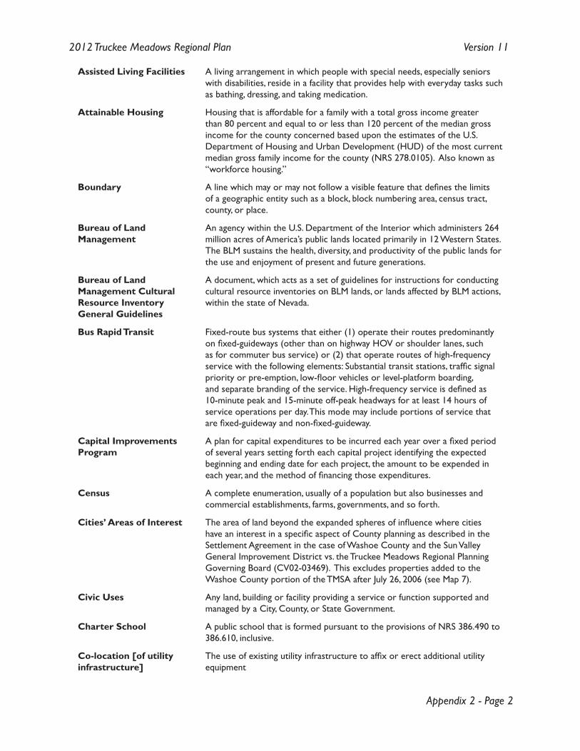
Appendix 2 - Page 2
2012 Truckee Meadows Regional Plan Version 11
Assisted Living Facilities A living arrangement in which people with special needs, especially seniors with disabilities, reside in a facility that provides help with everyday tasks such as bathing, dressing, and taking medication.
Attainable Housing Housing that is affordable for a family with a total gross income greater than 80 percent and equal to or less than 120 percent of the median gross income for the county concerned based upon the estimates of the U.S. Department of Housing and Urban Development (HUD) of the most current median gross family income for the county (NRS 278.0105). Also known as “workforce housing.”
Boundary A line which may or may not follow a visible feature that defines the limits of a geographic entity such as a block, block numbering area, census tract, county, or place.
Bureau of Land Management
An agency within the U.S. Department of the Interior which administers 264 million acres of America’s public lands located primarily in 12 Western States. The BLM sustains the health, diversity, and productivity of the public lands for the use and enjoyment of present and future generations.
Bureau of Land Management Cultural Resource Inventory General Guidelines
A document, which acts as a set of guidelines for instructions for conducting cultural resource inventories on BLM lands, or lands affected by BLM actions, within the state of Nevada.
Bus Rapid Transit Fixed-route bus systems that either (1) operate their routes predominantly on fixed-guideways (other than on highway HOV or shoulder lanes, such as for commuter bus service) or (2) that operate routes of high-frequency service with the following elements: Substantial transit stations, traffic signal priority or pre-emption, low-floor vehicles or level-platform boarding, and separate branding of the service. High-frequency service is defined as 10-minute peak and 15-minute off-peak headways for at least 14 hours of service operations per day. This mode may include portions of service that are fixed-guideway and non-fixed-guideway.
Capital Improvements Program
A plan for capital expenditures to be incurred each year over a fixed period of several years setting forth each capital project identifying the expected beginning and ending date for each project, the amount to be expended in each year, and the method of financing those expenditures.
Census A complete enumeration, usually of a population but also businesses and commercial establishments, farms, governments, and so forth.
Cities’ Areas of Interest The area of land beyond the expanded spheres of influence where cities have an interest in a specific aspect of County planning as described in the Settlement Agreement in the case of Washoe County and the Sun Valley General Improvement District vs. the Truckee Meadows Regional Planning Governing Board (CV02-03469). This excludes properties added to the Washoe County portion of the TMSA after July 26, 2006 (see Map 7).
Civic Uses Any land, building or facility providing a service or function supported and managed by a City, County, or State Government.
Charter School A public school that is formed pursuant to the provisions of NRS 386.490 to 386.610, inclusive.
Co-location [of utilityinfrastructure]
The use of existing utility infrastructure to affix or erect additional utility equipment
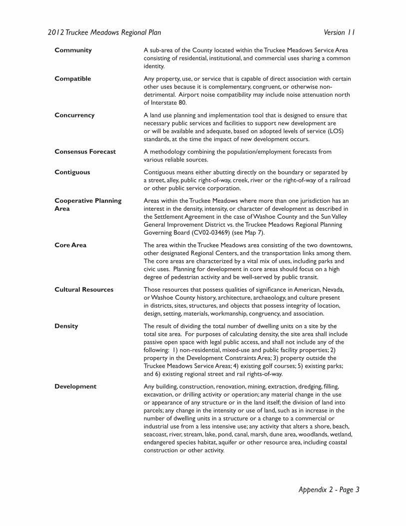
Appendix 2 - Page 3
2012 Truckee Meadows Regional Plan Version 11
Community A sub-area of the County located within the Truckee Meadows Service Area consisting of residential, institutional, and commercial uses sharing a common identity.
Compatible Any property, use, or service that is capable of direct association with certain other uses because it is complementary, congruent, or otherwise non-detrimental. Airport noise compatibility may include noise attenuation north of Interstate 80.
Concurrency A land use planning and implementation tool that is designed to ensure that necessary public services and facilities to support new development are or will be available and adequate, based on adopted levels of service (LOS) standards, at the time the impact of new development occurs.
Consensus Forecast A methodology combining the population/employment forecasts from various reliable sources.
Contiguous Contiguous means either abutting directly on the boundary or separated by a street, alley, public right-of-way, creek, river or the right-of-way of a railroad or other public service corporation.
Cooperative Planning Area
Areas within the Truckee Meadows where more than one jurisdiction has an interest in the density, intensity, or character of development as described in the Settlement Agreement in the case of Washoe County and the Sun Valley General Improvement District vs. the Truckee Meadows Regional Planning Governing Board (CV02-03469) (see Map 7).
Core Area The area within the Truckee Meadows area consisting of the two downtowns, other designated Regional Centers, and the transportation links among them. The core areas are characterized by a vital mix of uses, including parks and civic uses. Planning for development in core areas should focus on a high degree of pedestrian activity and be well-served by public transit.
Cultural Resources Those resources that possess qualities of significance in American, Nevada, or Washoe County history, architecture, archaeology, and culture present in districts, sites, structures, and objects that possess integrity of location, design, setting, materials, workmanship, congruency, and association.
Density
The result of dividing the total number of dwelling units on a site by the total site area. For purposes of calculating density, the site area shall include passive open space with legal public access, and shall not include any of the following: 1) non-residential, mixed-use and public facility properties; 2) property in the Development Constraints Area; 3) property outside the Truckee Meadows Service Areas; 4) existing golf courses; 5) existing parks; and 6) existing regional street and rail rights-of-way.
Development
Any building, construction, renovation, mining, extraction, dredging, filling, excavation, or drilling activity or operation; any material change in the use or appearance of any structure or in the land itself; the division of land into parcels; any change in the intensity or use of land, such as in increase in the number of dwelling units in a structure or a change to a commercial or industrial use from a less intensive use; any activity that alters a shore, beach, seacoast, river, stream, lake, pond, canal, marsh, dune area, woodlands, wetland, endangered species habitat, aquifer or other resource area, including coastal construction or other activity.
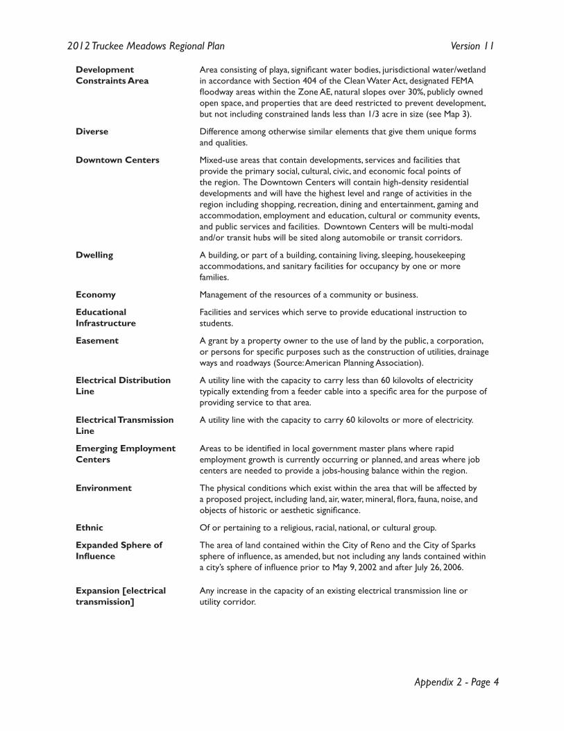
Appendix 2 - Page 4
2012 Truckee Meadows Regional Plan Version 11
Development Constraints Area
Area consisting of playa, significant water bodies, jurisdictional water/wetland in accordance with Section 404 of the Clean Water Act, designated FEMA floodway areas within the Zone AE, natural slopes over 30%, publicly owned open space, and properties that are deed restricted to prevent development, but not including constrained lands less than 1/3 acre in size (see Map 3).
Diverse
Difference among otherwise similar elements that give them unique forms and qualities.
Downtown Centers
Mixed-use areas that contain developments, services and facilities that provide the primary social, cultural, civic, and economic focal points of the region. The Downtown Centers will contain high-density residential developments and will have the highest level and range of activities in the region including shopping, recreation, dining and entertainment, gaming and accommodation, employment and education, cultural or community events, and public services and facilities. Downtown Centers will be multi-modal and/or transit hubs will be sited along automobile or transit corridors.
Dwelling
A building, or part of a building, containing living, sleeping, housekeeping accommodations, and sanitary facilities for occupancy by one or more families.
Economy
Management of the resources of a community or business.
Educational Infrastructure
Facilities and services which serve to provide educational instruction to students.
Easement A grant by a property owner to the use of land by the public, a corporation, or persons for specific purposes such as the construction of utilities, drainage ways and roadways (Source: American Planning Association).
Electrical DistributionLine
A utility line with the capacity to carry less than 60 kilovolts of electricity typically extending from a feeder cable into a specific area for the purpose of providing service to that area.
Electrical TransmissionLine
A utility line with the capacity to carry 60 kilovolts or more of electricity.
Emerging Employment Centers
Areas to be identified in local government master plans where rapid employment growth is currently occurring or planned, and areas where job centers are needed to provide a jobs-housing balance within the region.
Environment
The physical conditions which exist within the area that will be affected by a proposed project, including land, air, water, mineral, flora, fauna, noise, and objects of historic or aesthetic significance.
Ethnic Of or pertaining to a religious, racial, national, or cultural group.
Expanded Sphere of Influence
The area of land contained within the City of Reno and the City of Sparks sphere of influence, as amended, but not including any lands contained within a city’s sphere of influence prior to May 9, 2002 and after July 26, 2006.
Expansion [electrical transmission]
Any increase in the capacity of an existing electrical transmission line or utility corridor.

Appendix 2 - Page 5
2012 Truckee Meadows Regional Plan Version 11
Facility Plans A plan for the development of public facilities that will have a regional impact or aide in accomplishing regional goals relating to transportation, solid waste, energy generation and transmission, conventions and the promotion of tourism, air quality, or public education. The term does not include a plan for the development of a specific site or regulations adopted by an affected entity to implement the Regional Plan. Also known as “Facilities Plan” (see subsection 2 of NRS 278.026).
Feathering (of densities)
A graduated change in density between areas of higher intensity of use to areas of lower intensity of use. Feathering strategies may include, but are not limited to, a gradual change in lot size, compatible frontage widths for lots facing each other, building designs that create compatibility on facing lots, or landscape buffering.
Federal Aviation Regulation (FAR) Part 77 Area
The airspace surrounding a public-use airport into which the penetration of vertical structures may pose a safety hazard to aeronautical activity. The Federal Aviation Administration, through FAR Part 77, establishes criteria for determining the length, slope, trajectory, and other characteristics of the imaginary surface planes that constitute FAR Part 77 areas.
Federal Energy Regulatory Commission
An independent commission that regulates the transmission of oil and natural gas, the transmission and wholesale sale of electricity, and the licensing of hydroelectric companies.
Federal Emergency Management Agency (FEMA)
An independent agency that provides a single point of accountability for all federal emergency preparedness, mitigation, and response activities.
FEMA Floodplain Zone AE
Areas that have a 1% probability of flooding in any year (also known as the “100-year floodplain”), and where predicted flood water elevations above mean sea level have been established. Properties in Zone AE are considered to be at high risk of flooding under the National Flood Insurance Program (NFIP). Flood insurance is required for all properties in Zone AE that have federally-backed mortgages. Construction in these areas must meet local jurisdiction floodplain ordinance requirements.
Fixed Route Service Transit service using rubber tired passenger vehicles operating on fixed routes and schedules, regardless of whether a passenger actively requests a vehicle.
Floor-Area Ratio (FAR) The ratio of the total floor area of buildings on a certain location to the size of the land of that location. As a formula: Floor Area Ratio = (Total covered area on all floors of all buildings on a certain plot)/(Area of the plot). Thus, an FAR of 2.0 would indicate that the total floor area of a building is two times the gross area of the plot on which it is constructed.
Floodway Area The floodway is defined as: “the channel of a river or stream, and those portions of the floodplain adjoining the channel required to carry the regional flood discharge.” Floodways are generally associated with moving water during a flood event. Under local jurisdiction floodplain ordinances, most construction is prohibited in a floodway.
Forecasts The most probable of a set of projections to happen.
Fundamental Assumptions
A series of points thought to be taken as true without proof or demonstration constituting or functioning as an essential component of the Truckee Meadows Regional Plan.
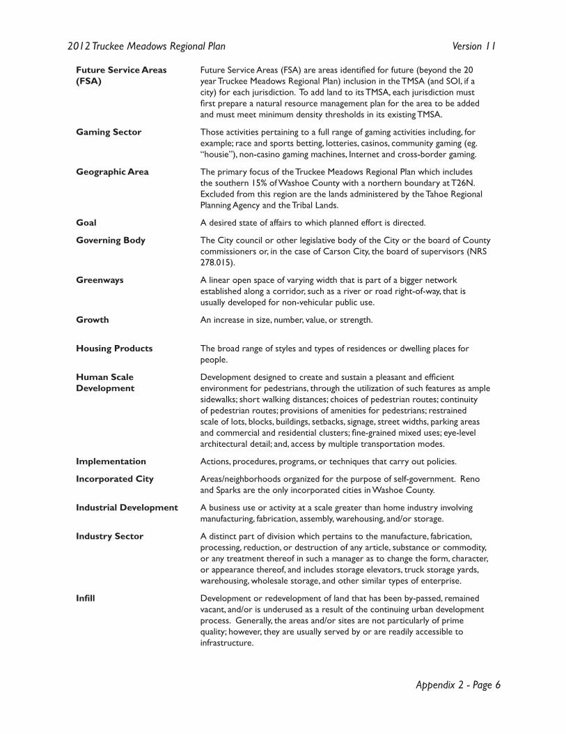
Appendix 2 - Page 6
2012 Truckee Meadows Regional Plan Version 11
Future Service Areas (FSA)
Future Service Areas (FSA) are areas identified for future (beyond the 20 year Truckee Meadows Regional Plan) inclusion in the TMSA (and SOI, if a city) for each jurisdiction. To add land to its TMSA, each jurisdiction must first prepare a natural resource management plan for the area to be added and must meet minimum density thresholds in its existing TMSA.
Gaming Sector Those activities pertaining to a full range of gaming activities including, for example; race and sports betting, lotteries, casinos, community gaming (eg. “housie”), non-casino gaming machines, Internet and cross-border gaming.
Geographic Area The primary focus of the Truckee Meadows Regional Plan which includes the southern 15% of Washoe County with a northern boundary at T26N. Excluded from this region are the lands administered by the Tahoe Regional Planning Agency and the Tribal Lands.
Goal A desired state of affairs to which planned effort is directed.
Governing Body The City council or other legislative body of the City or the board of County commissioners or, in the case of Carson City, the board of supervisors (NRS 278.015).
Greenways A linear open space of varying width that is part of a bigger network established along a corridor, such as a river or road right-of-way, that is usually developed for non-vehicular public use.
Growth An increase in size, number, value, or strength.
Housing Products The broad range of styles and types of residences or dwelling places for people.
Human Scale Development
Development designed to create and sustain a pleasant and efficient environment for pedestrians, through the utilization of such features as ample sidewalks; short walking distances; choices of pedestrian routes; continuity of pedestrian routes; provisions of amenities for pedestrians; restrained scale of lots, blocks, buildings, setbacks, signage, street widths, parking areas and commercial and residential clusters; fine-grained mixed uses; eye-level architectural detail; and, access by multiple transportation modes.
Implementation Actions, procedures, programs, or techniques that carry out policies.
Incorporated City Areas/neighborhoods organized for the purpose of self-government. Reno and Sparks are the only incorporated cities in Washoe County.
Industrial Development A business use or activity at a scale greater than home industry involving manufacturing, fabrication, assembly, warehousing, and/or storage.
Industry Sector A distinct part of division which pertains to the manufacture, fabrication, processing, reduction, or destruction of any article, substance or commodity, or any treatment thereof in such a manager as to change the form, character, or appearance thereof, and includes storage elevators, truck storage yards, warehousing, wholesale storage, and other similar types of enterprise.
Infill Development or redevelopment of land that has been by-passed, remained vacant, and/or is underused as a result of the continuing urban development process. Generally, the areas and/or sites are not particularly of prime quality; however, they are usually served by or are readily accessible to infrastructure.
Appendix 2 - Page 7
2012 Truckee Meadows Regional Plan Version 11
Infrastructure Basic facilities including, but not limited to, potable water facilities, reclaimed water facilities, wastewater treatement facilities, flood management facilities, public safety facilities, roads, schools, power plants, transmission lines, transportation, and communication systems on which the continuance and growth of a community depends.
Intensity Any ratio that assesses the relative level of activity of a land use, including, but not limited to, a floor area ratio, building coverage ratio, or impervious surface ratio.
Jurisdictions Any governmental unit or political division or subdivision including, but not limited to city, county, state, district, or territory over which the governmental unit exercises power and authority.
Kilovolt (kV) The equivalent of 1,000 volts (see definition of “volt”).
Land Use The primary or primary and secondary uses of land such as single family residential, multiple-family residential, commercial, industrial or agriculture. The description of a particular land use should convey the dominant character of a geographic area and thereby establish the types of activities which are appropriate and compatible with primary uses.
Land Stock An inventory of the quantity of land available for use.
Local Government The City of Reno, City of Sparks, or Washoe County.
Local Renewable Energy Source
Energy generated from, but not limited to, solar, geothermal, hydroelectric, biomass, methane, and waste heat recovery that is intended solely for a single end use on or directly adjacent to the parcel on which the energy is generated. Small amounts of the electricity generated from local renewable energy sources may temporarily return to the power grid in circumstances where net metering arrangements exist.
Lot A distinct part or parcel of land that has been subdivided to transfer ownership or to build. The term does not include a parcel of land used or intended solely for use as a location for a water well (NRS 278.0165).
Low Impact Development (LID) Practices
Policies, procedures, and general guidance concerning site design techniques for improving the quality and reducing the quantity of storm water runoff from new development and redevelopment.
Master Plan A comprehensive, long-term, general plan for the physical development of the city, County, or region which includes analysis, recommendation, and proposals for the geographic area it covers.
Military installation Military installation means a base or facility at which or from which the Air Force, Army, Coast Guard, Marine Corps, Navy, Air Force Reserve, Army Reserve, Coast Guard Reserve, Marine Corps Reserve, Navy Reserve or National Guard conducts exercises, maneuvers, operations, patrols or training.
Minority A racial, religious, political, national, or other group regarded as different from the larger group of which it is part.
Appendix 2 - Page 8
2012 Truckee Meadows Regional Plan Version 11
Mixed-use Development A single building or land containing more than one type of land use or single development of more than one building and use, where the different types of land uses are in close proximity, planned as a unified complementary whole, and functionally integrated to the use of shared vehicular and pedestrian access and parking areas.
Multi-family A detached building designed and used exclusively as a dwelling by three or more families occupying separate suites.
Multi-modal Any and all forms of transportation including but not limited to walking, bicycling, transit services, automobile, and rail systems.
Municipal Services Services provided by local government and/or affected entities including, but not limited to, potable water supply, reclaimed water supply, sanitary sewer, roads, parks, schools, and public safety. It is understood that this term includes the infrastructure necessary to provide municpal services.
National Electric SafetyCode (NESC)
A document published by the Institute of Electrical and Electronics Engineers that sets the ground rules for practical safeguarding of persons during the installation, operation, or maintenance of electric supply and communication lines and associated equipment. The NESC contains the basic provisions that are considered necessary for the safety of employees and the public under the specified conditions (Source: IEEE).
National Ambient Air Quality Standards
A set of standards published by the USEPA in Title 40 of the code of Federal Regulations Subpart 50 that define the levels of air quality necessary to protect human health. The standards apply to the following pollutants: Carbon Monoxide, Ozone, Nitrogen Dioxide, Sulfur Dioxide, Particulate Matter, and Lead.
Natural Resource As used in Policies 4.1.3 and 4.3.6, natural resource means: air quality, quality and quantity of surface water and groundwater; habitat for fish, vegetation, and wildlife; open space; floodplains; wetlands, aquifer recharge areas; stream channels; soils; scenic quality; and energy sources.
Neighborhood An area of a community with characteristics that distinguish it from other community areas that may include schools, social clubs, or boundaries defined by physical barriers, such as major highways and railroads, or natural features, such as rivers.
Net Metering A method of metering the energy produced by local renewable energy sources that allows excess electricity produced by the energy source to be returned to the power grid at a credit to the utility customer. Excess power is often credited at full retail price and is used to offset any electricity purchased from the utility. The metered customer is then billed only for the net energy consumed from the power grid.
Nevada Department of Transportation
A governmental agency of Nevada that serves to efficiently plan, design, construct, and maintain a safe and effective transportation system for Nevada’s economic, environmental, social, and intermodal needs.
Northern Nevada Water Planning Commission
Body of Public Works Directors, Water Resource Managers and individuals appointed by the Western Regional Water Planning Commission. This commission’s primary function is to serve as the Technical Advisory Committee to the Western Regional Water Commission and is responsible for developing and maintaining the Regional Water Management Plan.
Appendix 2 - Page 9
2012 Truckee Meadows Regional Plan Version 11
Open Space Properties with free and legal public access that are generally in a natural state. Open space may include spaces that are inappropriate for access or development for any reason such as sensitive environments or hazardous areas (e.g., landslide areas). Open spaces provide native plant and wildlife habitat, passive recreational opportunities, enhance the scenic character of the region, and allow for preservation of significant cultural and archaeological resources.
Optimization The process of making a system as effective or as functional as possible.
Pedestrian Access and Amenities
Include, but are not limited to, adequate sidewalks (width and connectivity), plazas, frequent crosswalks, on-demand crosswalk signals, wheelchair accessibility, covered shelters, publicly accessible restrooms, public art, benches, public telephones, landscaping, trash facilities, and public spaces such as small parks.
Pedestrian Friendly Pedestrian friendly features are designed to promote increased walking, street life, and transit ridership. Pedestrian friendly features such as wide, continuous sidewalks, bulb-outs at intersections, shorter crossing distance and signal cycles, mid-block crosswalks, tight radii curb returns, and closely spaced transit access encourage pedestrian use and enhance transit ridership.
Placemaking The process of creating great places that attract people because they are lively, inviting, interesting, enduring, and offer the chance to see and interact with other people. Place-making is characterized by a focus on activities, community, and sociability.
Plan A document, adopted by an agency, that contains, in text, maps, and/or graphics, a method of proceeding, based on analysis and the application of foresight, to guide, direct, or constrain subsequent actions, in order to achieve goals. A plan may contain goals, policies, guidelines, and standards.
Playa Generally a dry or intermittently dry lakebed in the lowest spot of a closed valley. Salt contents are generally quite high.
Point Source Any discernible, confined and discrete conveyance, including but not limited to a pipe, ditch, channel, tunnel, conduit, well, discrete fissure, container, rolling stock, concentrated animal feeding operation, or vessel or other floating craft, from which pollutants are or may be discharged. The term does not include return flows from irrigated agriculture (NRS 445A.395).
Policy A specific statement of principle or of guiding actions that implies clear commitment. A general direction that a governmental agency sets to follow in order to meet its goals and objectives.
Portal A website considered as an entry point to other websites.
Power GenerationCapacity
The maximum amount of electricity (usually measured in watts) capable of being produced at a given power generation facility.
Power Generation Facilities
Any facility owned and operated by a public or private utility company or independent power producer for the purpose of generating electric power for distribution through the local electric distribution network or for sale to electric transmission companies.
Preservation To keep in perfect or unaltered condition; maintain unchanged.
Private School A school that is owned or operated by a private person, firm, association, organization, or corporation, rather than by a public agency.
Appendix 2 - Page 10
2012 Truckee Meadows Regional Plan Version 11
Projections A statement about the future based upon the past.
Promote To contribute to the progress of, or growth of; further.
Public Access A means of physical approach to, along, and into lands available to the general public.
Public Facilities A use conducted by, or a facility or structure owned or managed by, a publicly funded entity that provides a governmental function, activity, or service for public benefit.
Public Lands Any land area owned and managed by a public entity for the public good.
Public School All kindergartens and elementary schools, junior high schools and middle schools, high schools, charter schools and any other schools, classes and educational programs which receive their support through public taxation and, except for charter schools, whose textbooks and courses of study are under the control of the State Board.
Public Transportation/Transit
Transportation by a conveyance that provides regular and continuing general or special transportation to the public, but does not include school bus, charter, or intercity bus transportation or intercity passenger rail transportation.
Public Utilities Commission of Nevada
Pursuant to NRS Chapter 703, the PUCN is a body of three commissioners each appointed by the governor with the power and duty to supervise and regulate the operation and maintenance of public utilities in the state.
Quarries A lot of land or part thereof used for the purpose of extracting stone, sand, gravel, or top soil for sale and exclusive of the process of grading a lot preparatory to the construction of a building for which application for a building permit has been made.
Ranchettes A single dwelling unit occupied by a non-farming household on a parcel of 2.5 to 20 acres that has been subdivided for limited use.
Recommendations Preferred courses of action which assist in the achievement of goals. Recommendations are planning, land use, and general government-related activities that can be pursued, ideally as a whole, to help the community meet its goals and thresholds.
Region An area located in southern Washoe County, south of T26N, excluding the Tahoe Regional Planning Area and Tribal lands.
Regional Centers Mixed-use areas that contain developments, services and facilities that provide a regional benefit. Regional Centers will have a primary specialized focus and will be substantially self-contained. Regional Centers may contain high-density residential developments and will have a high level and range of activities including shopping, recreation, dining and entertainment, gaming and accommodation, employment and education, cultural or community events, and public services and facilities. Regional Centers will include a high level of pedestrian activity. Regional Centers will be multi-modal and/or transit hubs will be sited along automobile or transit corridors.
Regional Open Space Plan
A plan created pursuant to NRS 376A.020, which directs Washoe County to develop and coordinate a Regional Open Space Program to include major open space areas that will link to trails or open space corridors.
Appendix 2 - Page 11
2012 Truckee Meadows Regional Plan Version 11
Regional Planning Commission
The RPC has nine members, including three each from the Reno, Sparks, and Washoe County local planning commissions, appointed by their respective governing bodies (NRS 278.0262).
Regional Planning Governing Board
The RPGB consists of ten members including three from the Washoe County Commission, four from the Reno City Council, and three from the Sparks City Council (NRS 278.0264).
Regional RenewableEnergy Source
Energy generated from, but not limited to, solar, geothermal, hydroelectric, biomass, methane, and waste heat recovery sources that generate enough power such that the electricity generated is purchased by a utility provider for region-wide use. This does not apply to local renewable energy sources that produce electricity for immediate on-site use.
Regional Transportation Commission
The Regional Transportation Commission is the designated Metropolitan Planning Organization for Washoe County and is responsible under the Transportation Equity Act for the 21st Century for developing the Regional Transportation Plan.
Regional Transportation Plan
The 2030 RTP serves as the region’s long-range transportation plan to accommodate the Regional Form and land-use, master-planned development in the City of Reno, the City of Sparks, and Washoe County.
Regional Utility Corridor
A planning designation assigned to a utility easement that contains or is proposed to contain one or more electrical transmission lines. The width of a regional utility corridor shall be equivalent to the width of the easement required by the responsible utility. The width of the easement may not be less than that specified by the NESC.
Regional Utility Corridor Setback
The minimum distance by which any structure must be set back from the edge of a regional utility corridor.
Regional Water Management Plan
Document which provides the region with an outline of how water will be managed to meet the needs of the citizens into the future. Major components of the plan are identification of future water supply and wastewater facilities, regional flood control and drainage projects, and development of a conservation program. Serves the area generally described as all lands within Washoe County south of T25N, excluding the Lake Tahoe watershed, Pyramid Lake Paiute Indian Reservation, and other tribal trust lands within the planning areas.
Regulation A rule or order prescribed for management by government.
Renewable Energy Energy generated from rapidly renewable or inexhaustible sources including, but not limited to, solar, geothermal, hydroelectric, biomass, methane, and waste heat recovery sources.
Resort Destination A resort facility or development of multiple buildings intended primarily for transient guests where the primary attraction is generally recreational facilities or activities, including, but not limited to snow sports and activities (i.e., ski area residential uses shall be primarily “ski-in / ski-out”), golf, dude and guest ranches, health spas and resorts, backcountry adventures, hunting, fishing, and water sports. A resort destination is generally located in a setting of significant natural amenities, and may include a range of on-site indoor or outdoor recreation facilities.
Appendix 2 - Page 12
2012 Truckee Meadows Regional Plan Version 11
Resort Destination Element
An element of the local master plan that addresses Regional Plan Policy 1.1.14 and related policies regarding the establishment of destination resorts within the Rural Development Area, north of T25N.
Resort Service Area An area inside the Rural Development Area, south of T26N and outside the Truckee Meadows Service Areas, where local government master plans may allow for the development of resort destinations.
Right-of-way A strip of land acquired by reservation, dedication, prescription, or condemnation intended to be occupied by a street, trail, water line, sanitary sewer, and/or other public utilities or facilities.
Road All property dedicated or intended for public or private road, street, alley, highway, freeway, or roadway purposes, or dedicated or intended for public easements therefore.
RTC’s Primary Transit Network
The Primary Transit Network is intended to improve the appeal of public transportation to a diverse group of riders, to reduce individual automobile trips, and to provide the lowest cost to riders by achieving maximum productivity. The PTN includes concepts such as Bus Rapid Transit, conversion of Prater Way and Virginia Street to transit corridors with exclusive transit travel lanes, retrofitting signals on Virginia Street to add queue jumping capabilities to improve transit reliability, and other improvements to support and encourage transit ridership.
Rural Development Area
Area within the region lying outside the Truckee Meadows Service Areas.
School A school is defined as being either a primary, secondary, or non-traditional secondary (public or private) institution of learning which offers instruction in one or more branches of learning.
Secondary Transit Oriented Development (TOD)
Housing at a density that allows for the efficient provision of fixed route transit service that is concentrated in mixed-use developments located along transit routes or proposed transit routes. Streetscape design, mixed uses and roadway connectivity that promote walkability and produce quality pedestrian-oriented environments are the priority in Secondary TOD areas. Secondary TOD areas do not have minimum residential or non-residential density standards unless further defined in local government master plans; however, they are anticipated to support intensification over time and are anticipated to be served with higher order transit service when residential and employment densities are high enough to make such service feasible.
Secondary Transit Oriented Development (TOD) Corridor
Corridors depicted on Map 4 of the Regional Plan, generally ¼ mile wide on each side of the designated transportation route or road, as further defined in local government master plans.
Secretary of Interior’s Standards for Archeology and Historic Preservation
A document which provides technical advice about archaeological and historic preservation activities and methods. It includes identification, evaluation, documentation, registration, and treatment of historic properties.
Shall Mandatory to carry out the policy, even if a timeframe is not included. Meaning imperative and non-discretionary. Subject to funding and budgetary constraints, which may not allow for implementation of the policy and subject to provisions of the annual budget.
Appendix 2 - Page 13
2012 Truckee Meadows Regional Plan Version 11
Significant Ridgelines Ridgelines that surround or visually dominate the valley landscape either through their size in relation to the hillside or mountain terrain of which they are a part; their visual dominance as characterized by a silhouetting appearance against the sky; as a significant backdrop feature or separation of communities; through visual dominance due to proximity and view from existing development or major corridors; or as an area of significant ecological, historical or cultural importance such as those which connect park or trail systems.
Sphere of Influence An area into which a City plans to expand as designated in a comprehensive Regional Plan adopted pursuant to NRS 278.026 to 278.029, inclusive, within the time designated in the comprehensive Regional Plan (NRS 268.623).
Sprawl Premature growth or outward expansion of development. Low-density land-use patterns that are automobile-dependent, energy and land consumptive, and require a very high ratio of road surface to development served.
Stakeholder Individuals and/or groups which have a shared interest in an enterprise.
Station Area A concentrated intense area of development and activity within a TOD Corridor or Center that is mixed-use, includes a rapid transit stop, supports high transit frequency and efficient transit function, provides amenities for pedestrians and bicyclists, and is a high priority for infill development.
Streets Open and public thoroughfares including streets, avenues, boulevards, roads, lanes, alleys, viaducts, public easements and right-of-way, and other ways (NRS 278.018).
Substation [Electrical] An assemblage of equipment that switches, changes, or regulates voltage in the electric transmission and distribution system. Substations that connect two or more transmission circuits without transforming the voltage are called switching stations or taps (see also “utility site”).
Substation [Natural Gas]
An assemblage of equipment for the use of managing the supply of natural gas in the regional system (see also “utility site”).
Suburban Suburban development includes residential uses at generally one to three single family units per acre and supportive nonresidential and public development.
Sustainability Community use of natural resources in a way that does not jeopardize the ability of future generations to live and prosper.
Sustainable design and construction
Design and construction techniques that maintain or enhance economic opportunity and community well-being while protecting and restoring the natural environment upon which people and economies depend. Sustainable design and construction meet the needs of the present without compromising the ability of future generations to meet their own needs.
Tentative Map A map made to show the design of a proposed subdivision and the existing conditions in and around it (NRS 278.019).
Transit Hub A transit hub is a central transportation facility capable of accommodating multiple modes of transportation. A transit hub in Reno could include Citi-Center, a Greyhound Bus Terminal, an Amtrak Depot, accommodation for taxi’s and tour busses, and perhaps a parking structure and retail shops.
Appendix 2 - Page 14
2012 Truckee Meadows Regional Plan Version 11
Transit Oriented Development (TOD)
Moderate and high-density housing concentrated in mixed-use developments located along transit routes that support the provision of higher order transit service such as bus rapid transit. The location, design, and mix of uses in a TOD emphasize pedestrian-oriented environments and encourages the use of public transportation.
Transit Oriented Development (TOD) Corridor
Corridors depicted on Map 4 of the Regional Plan, generally ¼ mile wide on each side of the designated transportation route or road, as further defined in local government master plans.
Transit Stations Provide the interface between pedestrians and the transit service and will include consistent design within TOD Corridors and at a minimum will include seating capacity and signage. The establishment of stations acknowledges that future progression of transit services (i.e. bus to bus rapid transit, to light rail, etc.) is an option that the community may wish to pursue in the future.
Transmission Capacity The maximum voltage able to be carried in a given electrical transmission line.
Transportation System Management
Includes, but not limited to, signal coordination and prioritization, queue jumping at all signal intersections, wide sidewalks, bike lanes and designated High Occupancy Vehicle (HOV) lanes.
Truckee MeadowsRegional Plan
A comprehensive Regional Plan for the physical development and orderly management of the growth of the region for the next 20 years.
Truckee MeadowsService Areas (TMSA)
The defined areas within which municipal services and infrastructure will be provided. This area includes the high intensity core areas and existing and planned urban and suburban uses.
Underground Construction (Undergrounding)
The placement of utility infrastructure below the surface of the ground.
Unincorporated Areas Areas outside any city and under Washoe County’s jurisdiction.
Unincorporated Communities
Management units that may be designated in the Washoe County Comprehensive Plan in unincorporated areas within the TMSA and outside the two cities and their Spheres of Influence.
Urban Development Development occurring at an intensity greater than 3 dwelling units per acre that is served by community water and sewer.
Urban Growth Development that makes intensive use of land for the location of buildings, other structures, and impermeable surfaces to such a degree as to be incompatible with the primary use of such land for the production of food, fiber, or other agricultural products, or the extraction of mineral resources and that, when allowed to spread over wide areas, typically requires municipal services.
Utilities All lines and facilities related to the provision, distribution, collection, transmission, or disposal of water, storm and sanitary sewage, oil, gas, power, information, telecommunication and telephone cable.
Utility Corridor See: “Regional Utility Corridor.”
Appendix 2 - Page 15
2012 Truckee Meadows Regional Plan Version 11
Utility Provider Any public or private entity including a governmental utility, a public utility regulated by the PUCN, a rural electric cooperative, a cooperative association, nonprofit corporation, nonprofit association or provider of electric service, or a community water system that provides water service, electric service or natural gas service to 500 or more service locations; or operates any pipeline that is necessary to provide such service (NRS 239C.110).
Utility Site An electrical or natural gas substation.
Viewshed The area within view from a defined observation point.
Volt A unit of measurement of force, or pressure, in an electrical circuit.
Vision Statement A statement that defines a community’s preferred future.
Water Bodies Areas that include lakes, playas, rivers, streams, and federally designated wetlands and floodways.
Watershed All lands enclosed by a continuous hydrologic drainage divide and lying upslope from a specified point on a stream. Also referred to as water basin. A ridge of relatively high land dividing two areas that are drained by different river systems.
Water System Facility Plans
A plan that describes service area and pressure zone boundaries, facilities necessary to serve developments within these boundaries, and the location and timing of the necessary facility improvements.
Western Regional Water Commission
Board of elected officials from each of the local jurisdictions and publicly owned water purveyors set up by Senate Bill 487, which was passed in the 2007 Legislative Session. This Board’s main focus will be to improve water resource planning at the regional level, facilitate coordinated resource management among all water purveyors and adopt or revise the Regional Water Management Plan as needed.
Wetland Those areas that are inundated and saturated by surface or groundwater at a frequency and duration sufficient to support, and that under normal circumstances do support, a prevalence of vegetation typically adapted for life in saturated soil conditions, including swamps, marches, bogs, and similar areas. Specifically, jurisdictional water/wetland in accordance with Section 404 of the Clean Water Act.
Workforce Housing Housing that is affordable for a family with a total gross income greater than 80 percent and equal to or less than 120 percent of the median gross income for the county concerned based upon the estimates of the US Department of Housing and Urban Development (HUD) of the most current median gross family income for the county. (NRS 278.0105) Also known as “attainable housing.”
Zone Any section or sections of a City or County for which the regulations governing the use of land and the use, density, bulk, height, and coverage of buildings and other structures, are uniform.
Zoning A local ordinance that divides a community into districts and specifies allowable uses and development standards for each consistent with the adopted community master plan.

Appendix 2 - Page 16
2012 Truckee Meadows Regional Plan Version 11
[Notes]
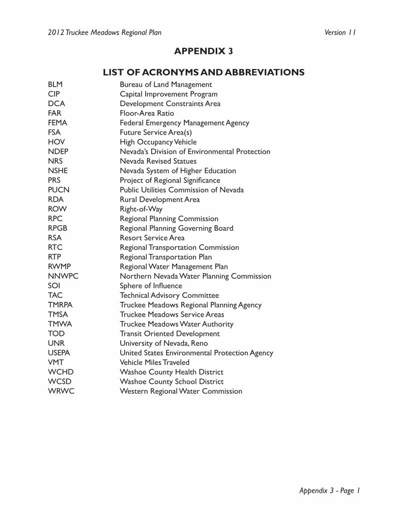
Appendix 3 - Page 1
2012 Truckee Meadows Regional Plan Version 11
APPENDIX 3
LIST OF ACRONYMS AND ABBREVIATIONSBLM Bureau of Land ManagementCIP Capital Improvement ProgramDCA Development Constraints AreaFAR Floor-Area RatioFEMA Federal Emergency Management AgencyFSA Future Service Area(s)HOV High Occupancy VehicleNDEP Nevada’s Division of Environmental ProtectionNRS Nevada Revised StatuesNSHE Nevada System of Higher EducationPRS Project of Regional SignificancePUCN Public Utilities Commission of NevadaRDA Rural Development AreaROW Right-of-WayRPC Regional Planning CommissionRPGB Regional Planning Governing BoardRSA Resort Service AreaRTC Regional Transportation CommissionRTP Regional Transportation PlanRWMP Regional Water Management PlanNNWPC Northern Nevada Water Planning Commission SOI Sphere of InfluenceTAC Technical Advisory CommitteeTMRPA Truckee Meadows Regional Planning AgencyTMSA Truckee Meadows Service AreasTMWA Truckee Meadows Water AuthorityTOD Transit Oriented DevelopmentUNR University of Nevada, RenoUSEPA United States Environmental Protection AgencyVMT Vehicle Miles TraveledWCHD Washoe County Health DistrictWCSD Washoe County School DistrictWRWC Western Regional Water Commission

Appendix 3 - Page 2
2012 Truckee Meadows Regional Plan Version 11
[Notes]
Appendix 4 - Page 1
2012 Truckee Meadows Regional Plan Version 11
APPENDIX 4
SELECTED REGIONAL PLANNING COMMISSION RESOLUTIONS
CONTENTS:
RPC Resolution No. 13-06 – A resolution adopting guidelines for the definition of Projects of Regional Significance (July 10, 2013)
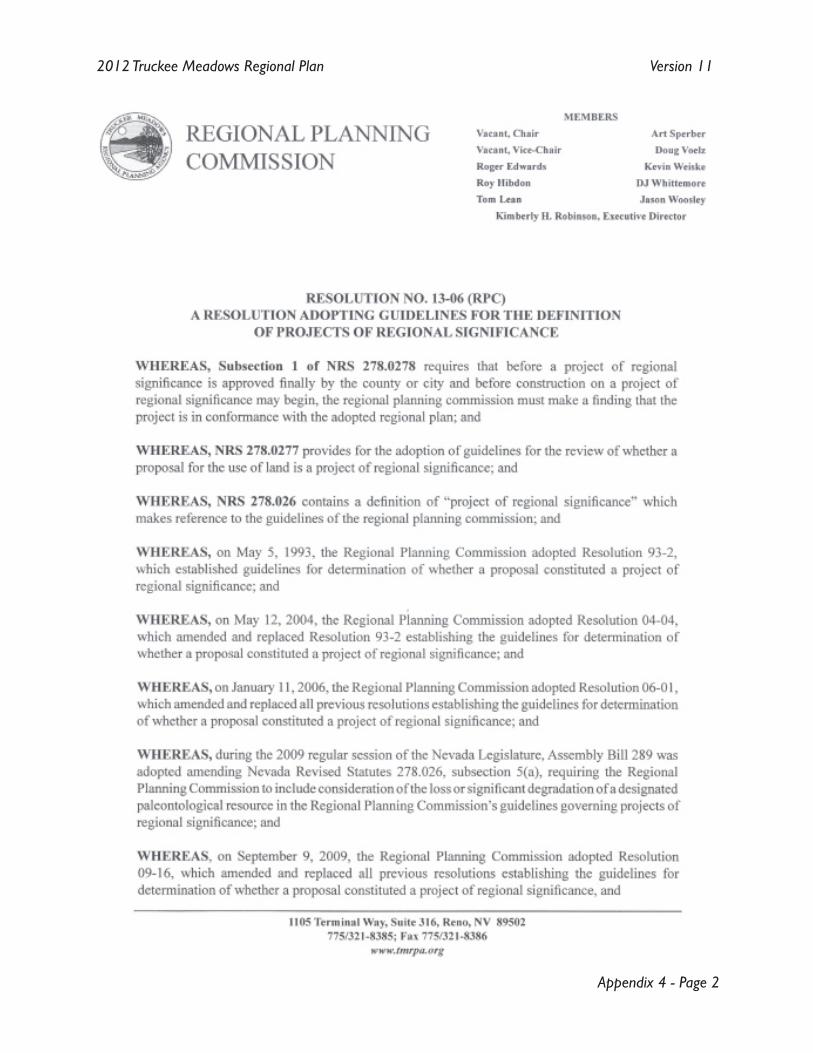
Appendix 4 - Page 2
2012 Truckee Meadows Regional Plan Version 11
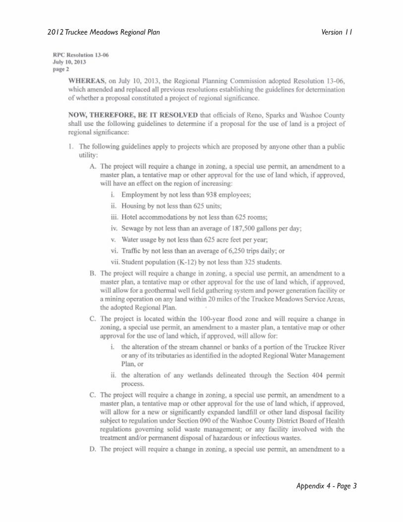
Appendix 4 - Page 3
2012 Truckee Meadows Regional Plan Version 11
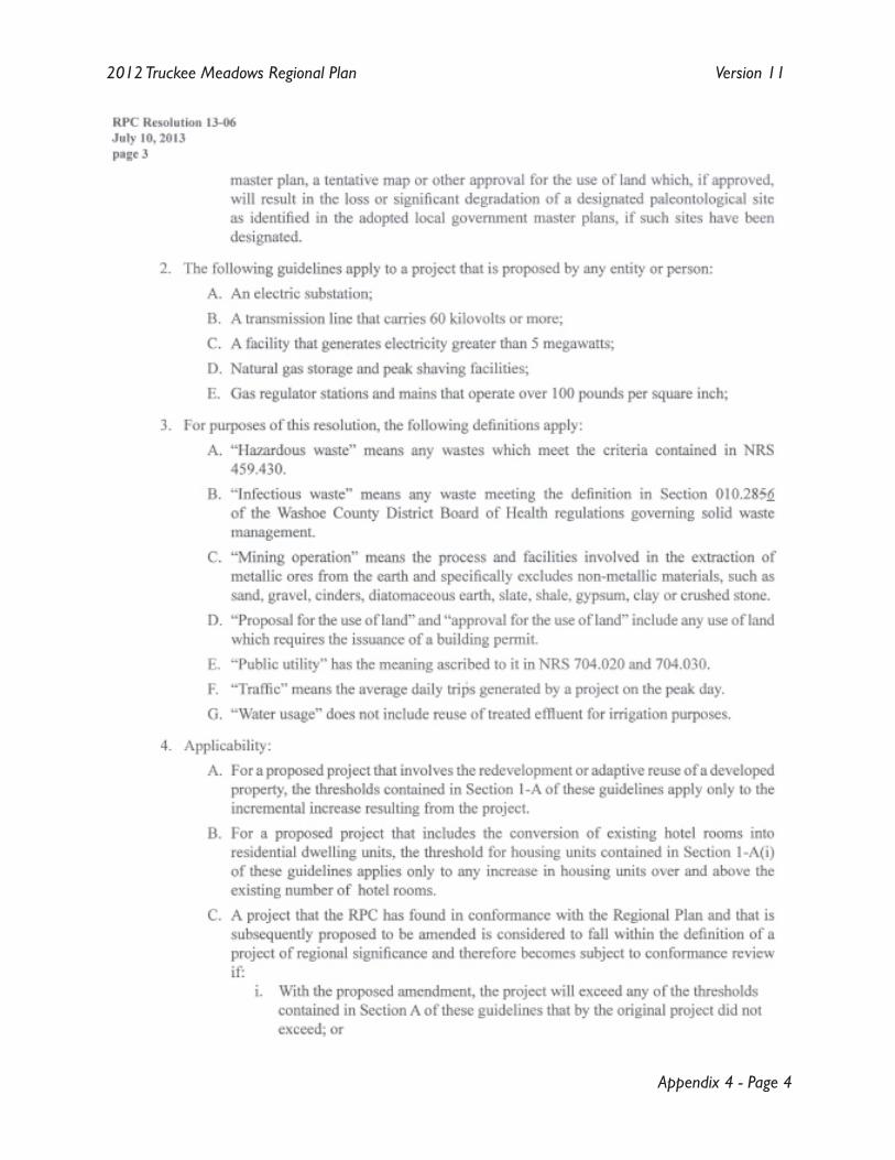
Appendix 4 - Page 4
2012 Truckee Meadows Regional Plan Version 11
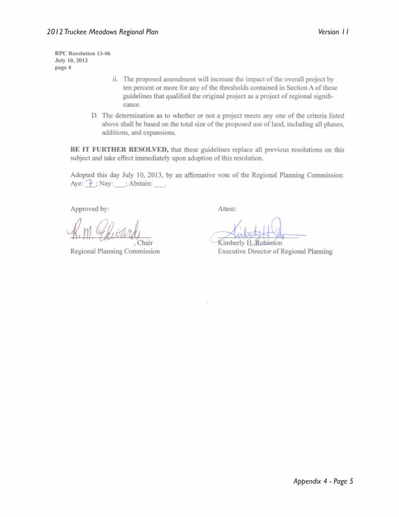
Appendix 4 - Page 5
2012 Truckee Meadows Regional Plan Version 11

Appendix 4 - Page 6
2012 Truckee Meadows Regional Plan Version 11
[Notes]
Appendix 5 - Page 1
2012 Truckee Meadows Regional Plan Version 11
APPENDIX 5
INDEX
Aabove ground Toc:7, Mod3:13, Mod3:14, Mod3:15,
Mod3:16, Mod3:17, Mod3:18, App2:1affected entity Toc:2, Toc:5, Toc:6, Toc:7, Toc:8,
Intro:3, Intro:4, Intro:6, Mod1:4, Mod1:9, Mod1:16, Mod1:17, Mod1:18, Mod1:21, Mod1:22, Mod1:24, Mod1:25, Mod1:26, Mod2:1, Mod2:2, Mod2:4, Mod2:9, Mod3:1, Mod3:2, Mod3:6, Mod3:8, Mod3:9, Mod3:11, Mod3:12, Mod4:1, Mod4:3, Mod4:4, Mod4:8, Mod4:9, App1:6, App1:9, App1:10, App1:11, App2:1, App2:4, App2:7
affordable housing Toc:3, Mod1:7, Mod1:29, App2:1agriculture Mod1:4, Mod2:4, App2:1, App2:7,
App2:9, App2:14air quality Toc:4, Intro:4, Intro:6, Intro:9, Mod1:2,
Mod2:1, Mod2:2, Mod2:8, App2:1, App2:4, App2:8
allowed land uses Mod2:4alternative fuels Mod2:8annexation Toc:5, Toc:8, Intro:3, Mod3:1, Mod3:7,
Mod4:1, Mod4:5, Mod4:10, App1:5, App2:1annual reporting Toc:8, Intro:4, Mod4:1, Mod4:7,
Mod4:9, App2:1aquifer recharge Mod2:1, Mod2:2, Mod2:3, Mod2:5,
Mod3:1, App1:1, App1:4, App1:6, App1:7, App2:8
BBLM Mod3:15, App2:2, App3:1Bureau of Land Management (BLM) Mod3:2,
Mod3:15, App2:2, App3:1bus rapid transit Mod1:6, Mod1:24, App2:2,
App2:12, App2:13, App2:14
CCapital Improvement Program (CIP) Toc:5, Intro:1,
Mod1:18, Mod1:22, Mod3:1, Mod3:5, Mod3:6, Mod3:8, App1:5, App1:7, App1:9, App1:10, App1:11, App1:12, App1:13, App1:14, App1:17, App2:2, App3:1
capital project App1:7, App1:10, App2:2Carson City App2:6Centers Toc:9, Mod1:1, Mod1:2, Mod1:3, Mod1:5,
Mod1:6, Mod1:7, Mod1:8, Mod1:12, Mod1:16, Mod1:17, Mod1:18, Mod1:19,
Mod1:21, Mod1:23, Mod1:25, Mod1:28, Mod2:6, Mod3:11, Mod4:3, Mod4:8, App2:3, App2:4, App2:10, App2:13, App9:1
charter school Mod3:12, App2:9, App2:10city Intro:1, Intro:2, Mod1:3, Mod1:4, Mod1:6,
Mod1:10, Mod1:24, Mod3:7, Mod4:5, Mod4:10, App2:4, App2:5, App2:7, App2:14, App7:1
City Sec1:III, Intro:1, Intro:2, Intro:3, Mod1:3, Mod1:4, Mod1:6, Mod1:10, Mod1:18, Mod1:24, Mod3:7, Mod4:5, Mod4:10, App1:4, App1:5, App1:6, App1:7, App1:9, App2:1, App2:2, App2:4, App2:5, App2:6, App2:7, App2:10, App2:11, App2:12, App2:14, App2:15
City of Reno 1, 4, Sec1:III, Toc:5, Toc:8, Toc:9, Intro:1, Intro:2, Intro:3, Intro:4, Mod1:2, Mod1:6, Mod1:7, Mod1:9, Mod1:17, Mod1:18, Mod1:19, Mod1:21, Mod1:26, Mod3:1, Mod3:2, Mod3:7, Mod3:16, Mod4:5, Mod4:10, App1:2, App1:3, App1:5, App1:6, App1:7, App1:9, App1:10, App1:11, App1:12, App1:15, App1:16, App1:17, App2:2, App2:4, App2:6, App2:7, App2:10, App2:11, App2:13, App3:1, App6:1, App7:1
City of Sparks 1, Sec1:III, Toc:5, Toc:9, Intro:1, Intro:2, Intro:3, Intro:4, Mod1:6, Mod1:9, Mod1:18, Mod1:19, Mod1:25, Mod1:26, Mod3:1, Mod3:2, Mod3:7, Mod4:10, App1:3, App1:4, App1:5, App1:6, App1:7, App1:9, App1:10, App1:12, App1:14, App1:15, App1:16, App1:17, App2:2, App2:4, App2:6, App2:7, App2:10, App2:11, App6:1, App7:1
co-location App2:2concurrency Toc:6, Mod3:9, Mod3:10, App2:3conformance Toc:5, Intro:2, Intro:3, Intro:4,
Intro:5, Intro:6, Mod1:9, Mod1:10, Mod1:11, Mod1:12, Mod1:13, Mod1:14, Mod1:17, Mod1:18, Mod1:19, Mod1:20, Mod1:21, Mod1:22, Mod1:23, Mod1:24, Mod1:25, Mod1:26, Mod1:28, Mod1:29, Mod2:1, Mod2:3, Mod2:4, Mod2:5, Mod2:6, Mod2:7, Mod2:8, Mod2:9, Mod3:1, Mod3:4, Mod3:5, Mod3:6, Mod3:7, Mod3:8, Mod3:9, Mod3:10, Mod3:11, Mod3:12, Mod3:14, Mod3:15, Mod3:16, Mod3:17, Mod3:18, Mod4:1, Mod4:3, Mod4:5, Mod4:6
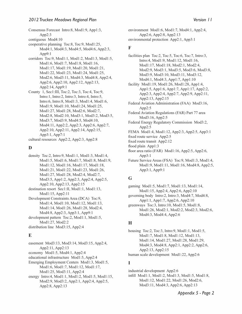
Appendix 5 - Page 2
2012 Truckee Meadows Regional Plan Version 11
Consensus Forecast Intro:8, Mod1:9, App1:3, App2:3
contiguous Mod4:10cooperative planning Toc:8, Toc:9, Mod1:25,
Mod4:1, Mod4:3, Mod4:5, Mod4:6, App2:3, App9:1
corridors Toc:9, Mod1:1, Mod1:2, Mod1:3, Mod1:5, Mod1:6, Mod1:7, Mod1:8, Mod1:16, Mod1:17, Mod1:19, Mod1:20, Mod1:21, Mod1:22, Mod1:23, Mod1:24, Mod1:25, Mod2:6, Mod3:11, Mod4:3, Mod4:8, App2:4, App2:6, App2:10, App2:12, App2:13, App2:14, App9:1
County 1, Sec1:III, Toc:2, Toc:3, Toc:4, Toc:9, Intro:1, Intro:2, Intro:3, Intro:4, Intro:5, Intro:6, Intro:8, Mod1:3, Mod1:4, Mod1:6, Mod1:9, Mod1:10, Mod1:24, Mod1:25, Mod1:27, Mod1:28, Mod2:6, Mod2:7, Mod2:8, Mod2:10, Mod3:1, Mod3:2, Mod3:5, Mod3:7, Mod3:9, Mod4:5, Mod4:10, Mod4:11, App2:2, App2:3, App2:6, App2:7, App2:10, App2:11, App2:14, App2:15, App3:1, App7:1
cultural resources App2:2, App2:3, App2:8
Ddensity Toc:2, Intro:9, Mod1:1, Mod1:3, Mod1:4,
Mod1:5, Mod1:6, Mod1:7, Mod1:8, Mod1:9, Mod1:12, Mod1:16, Mod1:17, Mod1:18, Mod1:21, Mod1:22, Mod1:23, Mod1:26, Mod1:27, Mod1:28, Mod2:4, Mod2:7, Mod3:5, App1:2, App2:3, App2:4, App2:5, App2:10, App2:13, App2:15
destination resort Sec1:II, Mod1:1, Mod1:13, Mod1:15, App2:11
Development Constraints Area (DCA) Toc:9, Mod1:4, Mod1:10, Mod1:12, Mod1:13, Mod1:14, Mod1:26, Mod1:28, Mod2:4, Mod4:8, App2:3, App3:1, App9:1
development pattern Toc:2, Mod1:1, Mod1:5, Mod1:27, Mod2:2
distribution line Mod3:15, App2:4
Eeasement Mod3:13, Mod3:14, Mod3:15, App2:4,
App2:11, App2:13economy Mod1:5, Mod4:1, App2:4educational infrastructure Mod1:5, App2:4Emerging Employment Centers Mod1:3, Mod1:5,
Mod1:6, Mod1:7, Mod1:12, Mod1:17, Mod1:25, Mod3:11, App2:4
energy Intro:4, Mod1:1, Mod1:2, Mod1:5, Mod1:15, Mod2:9, Mod3:2, App2:1, App2:4, App2:5, App2:8, App2:13
environment Mod1:6, Mod1:7, Mod4:1, App2:4, App2:6, App2:8, App2:13
environmental protection App2:1, App3:1
Ffacilities plan Toc:2, Toc:5, Toc:6, Toc:7, Intro:3,
Intro:4, Mod1:9, Mod1:12, Mod1:16, Mod1:17, Mod1:18, Mod2:1, Mod2:4, Mod2:9, Mod3:1, Mod3:5, Mod3:6, Mod3:8, Mod3:9, Mod3:10, Mod3:11, Mod3:12, Mod4:1, Mod4:3, App1:7, App1:10
facility Mod1:19, Mod1:26, Mod1:28, App1:4, App1:5, App1:6, App1:7, App1:17, App2:2, App2:3, App2:4, App2:7, App2:9, App2:11, App2:13, App2:15
Federal Aviation Administration (FAA) Mod3:16, App2:5
Federal Aviation Regulations (FAR) Part 77 area Mod3:16, App2:5
Federal Energy Regulatory Commission Mod3:2, App2:5
FEMA Mod1:4, Mod1:12, App2:3, App2:5, App3:1fixed route service App2:5fixed route transit App2:12flood plain App1:3floor area ratio (FAR) Mod1:16, App2:5, App2:6,
App3:1Future Service Areas (FSA) Toc:9, Mod1:3, Mod1:4,
Mod1:9, Mod1:11, Mod1:16, Mod4:8, App2:5, App3:1, App9:1
Ggaming Mod1:5, Mod1:7, Mod1:13, Mod1:14,
Mod1:15, App2:4, App2:6, App2:10governing body Intro:2, Intro:3, Mod4:7, Mod4:8,
App1:1, App1:7, App2:6, App2:10greenways Toc:3, Intro:10, Mod1:5, Mod1:8,
Mod1:26, Mod2:1, Mod2:2, Mod2:3, Mod2:6, Mod4:3, Mod4:4, App2:6
Hhousing Toc:2, Toc:3, Intro:9, Mod1:1, Mod1:5,
Mod1:7, Mod1:8, Mod1:12, Mod1:13, Mod1:14, Mod1:27, Mod1:28, Mod1:29, Mod4:3, Mod4:8, App2:1, App2:2, App2:6, App2:13, App2:15
human scale development Mod1:22, App2:6
Iindustrial development App2:6infill Mod1:1, Mod1:2, Mod1:3, Mod1:5, Mod1:8,
Mod1:12, Mod1:22, Mod1:26, Mod2:6, Mod3:11, Mod4:3, App2:6, App2:13
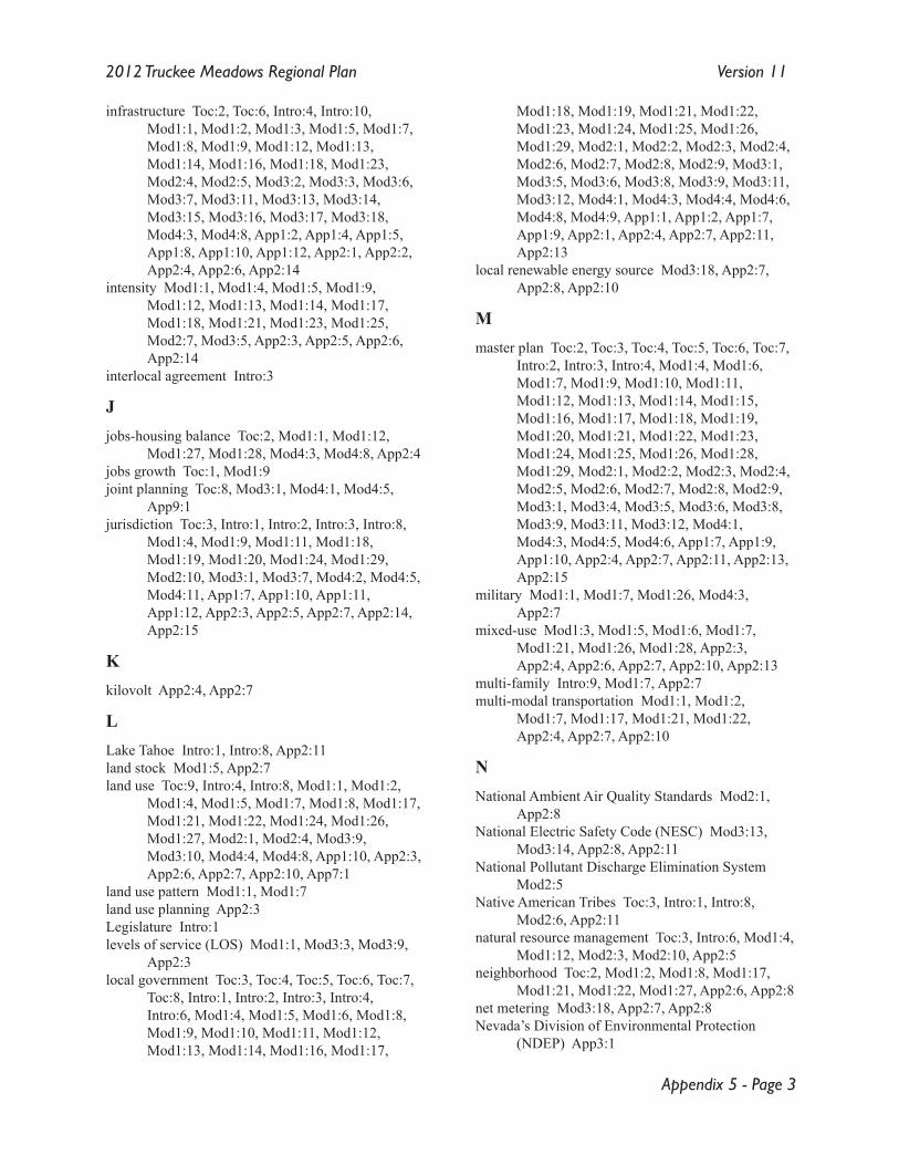
Appendix 5 - Page 3
2012 Truckee Meadows Regional Plan Version 11
infrastructure Toc:2, Toc:6, Intro:4, Intro:10, Mod1:1, Mod1:2, Mod1:3, Mod1:5, Mod1:7, Mod1:8, Mod1:9, Mod1:12, Mod1:13, Mod1:14, Mod1:16, Mod1:18, Mod1:23, Mod2:4, Mod2:5, Mod3:2, Mod3:3, Mod3:6, Mod3:7, Mod3:11, Mod3:13, Mod3:14, Mod3:15, Mod3:16, Mod3:17, Mod3:18, Mod4:3, Mod4:8, App1:2, App1:4, App1:5, App1:8, App1:10, App1:12, App2:1, App2:2, App2:4, App2:6, App2:14
intensity Mod1:1, Mod1:4, Mod1:5, Mod1:9, Mod1:12, Mod1:13, Mod1:14, Mod1:17, Mod1:18, Mod1:21, Mod1:23, Mod1:25, Mod2:7, Mod3:5, App2:3, App2:5, App2:6, App2:14
interlocal agreement Intro:3
Jjobs-housing balance Toc:2, Mod1:1, Mod1:12,
Mod1:27, Mod1:28, Mod4:3, Mod4:8, App2:4jobs growth Toc:1, Mod1:9joint planning Toc:8, Mod3:1, Mod4:1, Mod4:5,
App9:1jurisdiction Toc:3, Intro:1, Intro:2, Intro:3, Intro:8,
Mod1:4, Mod1:9, Mod1:11, Mod1:18, Mod1:19, Mod1:20, Mod1:24, Mod1:29, Mod2:10, Mod3:1, Mod3:7, Mod4:2, Mod4:5, Mod4:11, App1:7, App1:10, App1:11, App1:12, App2:3, App2:5, App2:7, App2:14, App2:15
Kkilovolt App2:4, App2:7
LLake Tahoe Intro:1, Intro:8, App2:11land stock Mod1:5, App2:7land use Toc:9, Intro:4, Intro:8, Mod1:1, Mod1:2,
Mod1:4, Mod1:5, Mod1:7, Mod1:8, Mod1:17, Mod1:21, Mod1:22, Mod1:24, Mod1:26, Mod1:27, Mod2:1, Mod2:4, Mod3:9, Mod3:10, Mod4:4, Mod4:8, App1:10, App2:3, App2:6, App2:7, App2:10, App7:1
land use pattern Mod1:1, Mod1:7land use planning App2:3Legislature Intro:1levels of service (LOS) Mod1:1, Mod3:3, Mod3:9,
App2:3local government Toc:3, Toc:4, Toc:5, Toc:6, Toc:7,
Toc:8, Intro:1, Intro:2, Intro:3, Intro:4, Intro:6, Mod1:4, Mod1:5, Mod1:6, Mod1:8, Mod1:9, Mod1:10, Mod1:11, Mod1:12, Mod1:13, Mod1:14, Mod1:16, Mod1:17,
Mod1:18, Mod1:19, Mod1:21, Mod1:22, Mod1:23, Mod1:24, Mod1:25, Mod1:26, Mod1:29, Mod2:1, Mod2:2, Mod2:3, Mod2:4, Mod2:6, Mod2:7, Mod2:8, Mod2:9, Mod3:1, Mod3:5, Mod3:6, Mod3:8, Mod3:9, Mod3:11, Mod3:12, Mod4:1, Mod4:3, Mod4:4, Mod4:6, Mod4:8, Mod4:9, App1:1, App1:2, App1:7, App1:9, App2:1, App2:4, App2:7, App2:11, App2:13
local renewable energy source Mod3:18, App2:7, App2:8, App2:10
Mmaster plan Toc:2, Toc:3, Toc:4, Toc:5, Toc:6, Toc:7,
Intro:2, Intro:3, Intro:4, Mod1:4, Mod1:6, Mod1:7, Mod1:9, Mod1:10, Mod1:11, Mod1:12, Mod1:13, Mod1:14, Mod1:15, Mod1:16, Mod1:17, Mod1:18, Mod1:19, Mod1:20, Mod1:21, Mod1:22, Mod1:23, Mod1:24, Mod1:25, Mod1:26, Mod1:28, Mod1:29, Mod2:1, Mod2:2, Mod2:3, Mod2:4, Mod2:5, Mod2:6, Mod2:7, Mod2:8, Mod2:9, Mod3:1, Mod3:4, Mod3:5, Mod3:6, Mod3:8, Mod3:9, Mod3:11, Mod3:12, Mod4:1, Mod4:3, Mod4:5, Mod4:6, App1:7, App1:9, App1:10, App2:4, App2:7, App2:11, App2:13, App2:15
military Mod1:1, Mod1:7, Mod1:26, Mod4:3, App2:7
mixed-use Mod1:3, Mod1:5, Mod1:6, Mod1:7, Mod1:21, Mod1:26, Mod1:28, App2:3, App2:4, App2:6, App2:7, App2:10, App2:13
multi-family Intro:9, Mod1:7, App2:7multi-modal transportation Mod1:1, Mod1:2,
Mod1:7, Mod1:17, Mod1:21, Mod1:22, App2:4, App2:7, App2:10
NNational Ambient Air Quality Standards Mod2:1,
App2:8National Electric Safety Code (NESC) Mod3:13,
Mod3:14, App2:8, App2:11National Pollutant Discharge Elimination System
Mod2:5Native American Tribes Toc:3, Intro:1, Intro:8,
Mod2:6, App2:11natural resource management Toc:3, Intro:6, Mod1:4,
Mod1:12, Mod2:3, Mod2:10, App2:5neighborhood Toc:2, Mod1:2, Mod1:8, Mod1:17,
Mod1:21, Mod1:22, Mod1:27, App2:6, App2:8net metering Mod3:18, App2:7, App2:8Nevada’s Division of Environmental Protection
(NDEP) App3:1
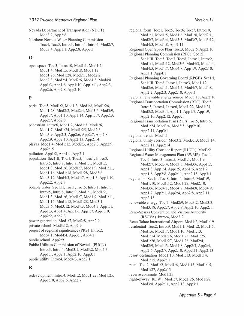
Appendix 5 - Page 4
2012 Truckee Meadows Regional Plan Version 11
Nevada Department of Transportation (NDOT) Mod3:2, App2:8
Northern Nevada Water Planning Commission Toc:4, Toc:5, Intro:3, Intro:4, Intro:5, Mod2:7, Mod3:4, App1:1, App2:8, App3:1
Oopen space Toc:3, Intro:10, Mod1:1, Mod1:2,
Mod1:4, Mod1:5, Mod1:8, Mod1:12, Mod1:26, Mod1:28, Mod2:1, Mod2:2, Mod2:3, Mod2:4, Mod2:6, Mod4:3, Mod4:8, App1:3, App1:6, App1:10, App1:11, App2:3, App2:6, App2:8, App2:10
Pparks Toc:5, Mod1:2, Mod1:3, Mod1:8, Mod1:26,
Mod1:28, Mod2:2, Mod2:4, Mod3:6, Mod3:9, App1:7, App1:10, App1:14, App1:17, App2:3, App2:7, App2:8
pedestrian Intro:6, Mod1:2, Mod1:3, Mod1:6, Mod1:7, Mod1:24, Mod1:25, Mod2:6, Mod3:9, App2:3, App2:6, App2:7, App2:8, App2:9, App2:10, App2:13, App2:14
playas Mod1:4, Mod1:12, Mod2:3, App2:3, App2:9, App2:15
pollution App1:2, App1:4, App2:1population Sec1:II, Toc:1, Toc:5, Intro:1, Intro:3,
Intro:5, Intro:8, Intro:9, Mod1:1, Mod1:2, Mod1:3, Mod1:6, Mod1:7, Mod1:9, Mod1:11, Mod1:16, Mod1:18, Mod1:28, Mod3:6, Mod3:12, Mod4:3, Mod4:7, App1:3, App1:10, App2:2, App2:3
potable water Sec1:II, Toc:1, Toc:5, Intro:1, Intro:3, Intro:5, Intro:8, Intro:9, Mod1:1, Mod1:2, Mod1:3, Mod1:6, Mod1:7, Mod1:9, Mod1:11, Mod1:16, Mod1:18, Mod1:28, Mod3:1, Mod3:6, Mod3:12, Mod4:3, Mod4:7, App1:1, App1:3, App1:4, App1:6, App1:7, App1:10, App2:2, App2:3
power generation Mod1:7, Mod2:8, App2:9private school Mod3:12, App2:9project of regional significance (PRS) Intro:2,
Mod4:1, Mod4:4, App3:1, App4:1public school App2:9Public Utilities Commission of Nevada (PUCN)
Intro:3, Intro:4, Mod3:1, Mod3:2, Mod4:3, App1:1, App2:1, App2:10, App3:1
public utility Intro:4, Mod4:3, App2:1
Rredevelopment Intro:4, Mod1:2, Mod1:22, Mod1:25,
App1:10, App2:6, App2:7
regional form Toc:1, Toc:5, Toc:6, Toc:7, Intro:10, Mod1:1, Mod1:5, Mod1:6, Mod1:8, Mod2:1, Mod2:7, Mod3:4, Mod3:5, Mod3:7, Mod3:12, Mod4:3, Mod4:8, App2:11
Regional Open Space Plan Toc:3, Mod2:6, App2:10Regional Planning Commission (RPC) Sec1:I,
Sec1:III, Toc:5, Toc:7, Toc:8, Intro:1, Intro:2, Mod1:1, Mod1:12, Mod3:6, Mod4:3, Mod4:4, Mod4:5, Mod4:7, Mod4:8, App1:9, App2:10, App3:1, App4:1
Regional Planning Governing Board (RPGB) Sec1:I, Sec1:III, Toc:8, Intro:1, Intro:3, Mod1:12, Mod3:6, Mod4:1, Mod4:5, Mod4:7, Mod4:8, App2:2, App2:3, App2:10, App3:1
regional renewable energy source Mod3:18, App2:10Regional Transportation Commission (RTC) Toc:5,
Intro:3, Intro:4, Intro:6, Mod1:22, Mod1:24, Mod3:2, Mod3:4, App1:1, App1:7, App1:9, App2:10, App2:12, App3:1
Regional Transportation Plan (RTP) Toc:5, Intro:6, Mod1:24, Mod3:4, Mod3:5, App2:10, App2:11, App3:1
regional trends Mod4:1regional utility corridor Mod3:2, Mod3:13, Mod3:14,
App2:11, App2:14Regional Utility Corridor Report (RUCR) Mod3:2Regional Water Management Plan (RWMP) Toc:4,
Toc:5, Intro:3, Intro:5, Mod1:1, Mod1:9, Mod2:7, Mod3:4, Mod3:5, Mod3:6, App1:2, App1:3, App1:4, App1:5, App1:6, App1:7, App1:8, App2:8, App2:11, App2:15, App3:1
regulation Sec1:I, Toc:8, Intro:4, Intro:6, Mod1:9, Mod1:10, Mod1:12, Mod1:29, Mod2:10, Mod3:6, Mod4:1, Mod4:7, Mod4:8, Mod4:9, App1:7, App2:1, App2:4, App2:8, App2:11, App2:15
renewable energy Toc:7, Mod2:9, Mod3:2, Mod3:3, Mod3:18, App2:7, App2:8, App2:10, App2:11
Reno-Sparks Convention and Visitors Authority (RSCVA) Intro:4, Mod3:2
Reno-Tahoe International Airport Mod1:2, Mod1:19residential Toc:2, Intro:9, Mod1:1, Mod1:2, Mod1:5,
Mod1:6, Mod1:7, Mod1:10, Mod1:13, Mod1:14, Mod1:16, Mod1:23, Mod1:25, Mod1:26, Mod1:27, Mod1:28, Mod2:4, Mod2:9, Mod4:3, Mod4:8, App2:3, App2:4, App2:6, App2:7, App2:10, App2:11, App2:13
resort destination Mod1:10, Mod1:13, Mod1:14, Mod1:15, App2:11
retail Toc:2, Mod1:2, Mod1:6, Mod1:13, Mod1:15, Mod1:27, App2:13
reverse commute Mod1:25right-of-way (ROW) Mod1:7, Mod1:26, Mod1:28,
Mod3:8, App2:11, App2:13, App3:1
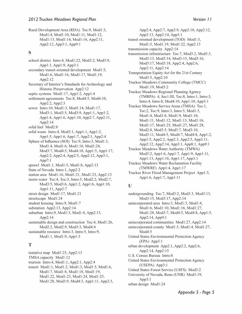
Appendix 5 - Page 5
2012 Truckee Meadows Regional Plan Version 11
Rural Development Area (RDA) Toc:9, Mod1:3, Mod1:4, Mod1:10, Mod1:11, Mod1:12, Mod1:13, Mod1:14, Mod1:16, App2:11, App2:12, App3:1, App9:1
Sschool district Intro:4, Mod1:22, Mod3:2, Mod3:9,
App1:1, App1:9, App3:1secondary transit oriented development Mod1:5,
Mod1:6, Mod1:16, Mod1:17, Mod1:19, App2:12
Secretary of Interior’s Standards for Archeology and Historic Preservation App2:12
septic systems Mod1:17, App1:2, App1:4settlement agreements Toc:8, Mod4:5, Mod4:10,
App2:2, App2:3sewer Intro:10, Mod1:3, Mod1:14, Mod1:17,
Mod3:1, Mod3:5, Mod3:9, App1:1, App1:2, App1:4, App1:6, App1:10, App2:7, App2:11, App2:14
solid fuel Mod2:8solid waste Intro:4, Mod3:1, App1:1, App1:2,
App1:5, App1:6, App1:7, App2:1, App2:4Sphere of Influence (SOI) Toc:9, Intro:3, Mod1:3,
Mod1:4, Mod1:6, Mod1:10, Mod1:24, Mod3:7, Mod4:5, Mod4:10, App1:5, App1:17, App2:2, App2:4, App2:5, App2:12, App3:1, App7:1
sprawl Mod1:1, Mod1:5, Mod1:8, App2:13State of Nevada Intro:1, App2:2station area Mod1:16, Mod1:21, Mod1:23, App2:13storm water Toc:4, Toc:5, Intro:5, Mod2:2, Mod2:7,
Mod3:5, Mod3:6, App1:2, App1:6, App1:10, App1:11, App2:7
street design Mod1:17, Mod1:21streetscape Mod1:24student housing Intro:9, Mod1:7substation App2:13, App2:14suburban Intro:9, Mod1:3, Mod1:4, App2:13,
App2:14sustainable design and construction Toc:4, Mod1:26,
Mod2:2, Mod2:9, Mod3:3, Mod4:4sustainable resource Intro:3, Intro:5, Intro:9,
Mod1:1, Mod1:9, App1:3
Ttentative map Mod1:25, App2:13TMSA capacity Mod1:12tourism Intro:4, Mod1:1, App2:1, App2:4transit Mod1:1, Mod1:2, Mod1:3, Mod1:5, Mod1:6,
Mod1:7, Mod1:8, Mod1:18, Mod1:19, Mod1:22, Mod1:23, Mod1:24, Mod1:25, Mod1:28, Mod3:9, Mod4:3, App1:11, App2:3,
App2:4, App2:7, App2:9, App2:10, App2:12, App2:13, App2:14, App3:1
transit oriented development (TOD) Mod1:3, Mod1:5, Mod1:19, Mod1:22, App2:13
transmission capacity App2:14transmission infrastructure Toc:7, Mod3:2, Mod3:3,
Mod3:13, Mod3:14, Mod3:15, Mod3:16, Mod3:17, Mod3:18, App2:4, App2:6, App2:11, App2:14
Transportation Equity Act for the 21st Century Mod3:5, App2:10
Truckee Meadows Community College (TMCC) Mod1:19, Mod3:2
Truckee Meadows Regional Planning Agency (TMRPA) 4, Sec1:III, Toc:8, Intro:1, Intro:3, Intro:4, Intro:8, Mod4:10, App1:10, App3:1
Truckee Meadows Service Areas (TMSA) Toc:1, Toc:2, Toc:9, Intro:3, Intro:5, Mod1:3, Mod1:4, Mod1:6, Mod1:9, Mod1:10, Mod1:11, Mod1:12, Mod1:13, Mod1:16, Mod1:17, Mod1:25, Mod1:27, Mod1:28, Mod2:8, Mod3:5, Mod3:7, Mod3:10, Mod3:11, Mod4:5, Mod4:7, Mod4:8, App1:2, App1:5, App2:2, App2:3, App2:5, App2:11, App2:12, App2:14, App3:1, App8:1, App9:1
Truckee Meadows Water Authority (TMWA) Mod3:2, App1:6, App1:7, App1:9, App1:11, App1:13, App1:16, App1:17, App3:1
Truckee Meadows Water Reclamation Facility (TMWRF) App1:4, App1:17
Truckee River Flood Management Project App1:3, App1:6, App1:7, App1:11
Uundergrounding Toc:7, Mod3:2, Mod3:3, Mod3:13,
Mod3:15, Mod3:17, App2:14unincorporated area Intro:3, Mod1:3, Mod1:4,
Mod1:6, Mod1:10, Mod1:16, Mod1:27, Mod1:28, Mod3:7, Mod4:5, Mod4:8, App1:5, App2:14, App9:1
unincorporated communities Mod1:27, App2:14unincorporated county Mod1:3, Mod1:4, Mod1:27,
Mod4:5United States Environmental Protection Agency
(EPA) App3:1urban development App2:1, App2:2, App2:6,
App2:14, App2:15U.S. Census Bureau Intro:8United States Environmental Protection Agency
(USEPA) App3:1United States Forest Service (USFS) Mod3:2University of Nevada, Reno (UNR) Mod1:19,
App3:1urban design Mod1:24
Appendix 5 - Page 6
2012 Truckee Meadows Regional Plan Version 11
utility corridor Toc:6, Mod1:7, Mod1:8, Mod3:2, Mod3:13, Mod3:14, Mod3:15, Mod3:18, App2:4, App2:11, App2:14
utility corridor plans Mod1:8utility corridor setback App2:11utility provider Toc:6, Intro:3, Intro:10, Mod2:4,
Mod3:1, Mod3:2, Mod3:13, Mod3:15, Mod3:16, Mod3:18, App1:1, App1:5, App2:1, App2:4, App2:10, App2:11, App2:14
utility site Mod3:14, App2:13, App2:14
Vvehicle miles traveled (VMT) Mod1:1, Mod2:8
WWashoe County 1, Sec1:III, Toc:2, Toc:3, Toc:4,
Toc:9, Intro:1, Intro:2, Intro:3, Intro:4, Intro:5, Intro:6, Intro:8, Mod1:3, Mod1:6, Mod1:9, Mod1:10, Mod1:25, Mod1:27, Mod1:28, Mod2:6, Mod2:7, Mod2:8, Mod2:10, Mod3:1, Mod3:2, Mod3:5, Mod3:7, Mod3:9, Mod4:5, Mod4:10, Mod4:11, App1:1, App1:3, App1:4, App1:6, App1:7, App1:8, App1:9, App1:10, App1:11, App1:12, App1:13, App1:15, App1:16, App2:2, App2:3, App2:6, App2:7, App2:10, App2:11, App2:14, App3:1, App7:1
Washoe County Health District Toc:4, Intro:4, Mod1:10, Mod2:7, Mod2:8, Mod3:2, Mod3:5, App1:7, App3:1
wastewater Toc:5, Mod2:2, Mod3:4, Mod3:6, App1:2, App1:4, App1:5, App1:6, App1:10, App2:11
water Toc:3, Toc:4, Toc:5, Intro:3, Intro:5, Intro:9, Intro:10, Mod1:1, Mod1:3, Mod1:4, Mod1:9, Mod1:10, Mod1:12, Mod1:13, Mod1:14, Mod2:1, Mod2:2, Mod2:3, Mod2:4, Mod2:5, Mod2:7, Mod3:1, Mod3:4, Mod3:5, Mod3:6, Mod3:9, App1:1, App1:2, App1:3, App1:4, App1:5, App1:6, App1:7, App1:9, App1:11, App1:12, App1:17, App2:3, App2:4, App2:5, App2:7, App2:8, App2:11, App2:14, App2:15
water quality Toc:4, Intro:10, Mod2:1, Mod2:2, Mod2:5, Mod2:7, Mod3:5, App1:1, App1:2, App1:11
water quantity Intro:9, Intro:10watershed Mod2:2, App1:6, App2:11, App2:15Western Regional Water Commission (WRWC)
Intro:5, App1:2, App2:8, App2:15, App3:1wetland Mod1:4, Mod1:12, Mod2:1, Mod2:2,
Mod2:3, App2:3, App2:8, App2:15
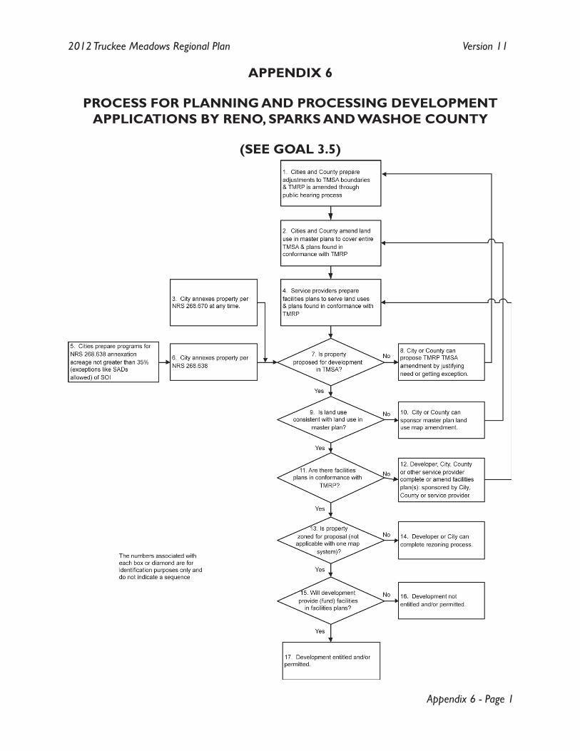
Appendix 6 - Page 1
2012 Truckee Meadows Regional Plan Version 11
APPENDIX 6
PROCESS FOR PLANNING AND PROCESSING DEVELOPMENT APPLICATIONS BY RENO, SPARKS AND WASHOE COUNTY
(SEE GOAL 3.5)

Appendix 6 - Page 2
2012 Truckee Meadows Regional Plan Version 11
[Notes]
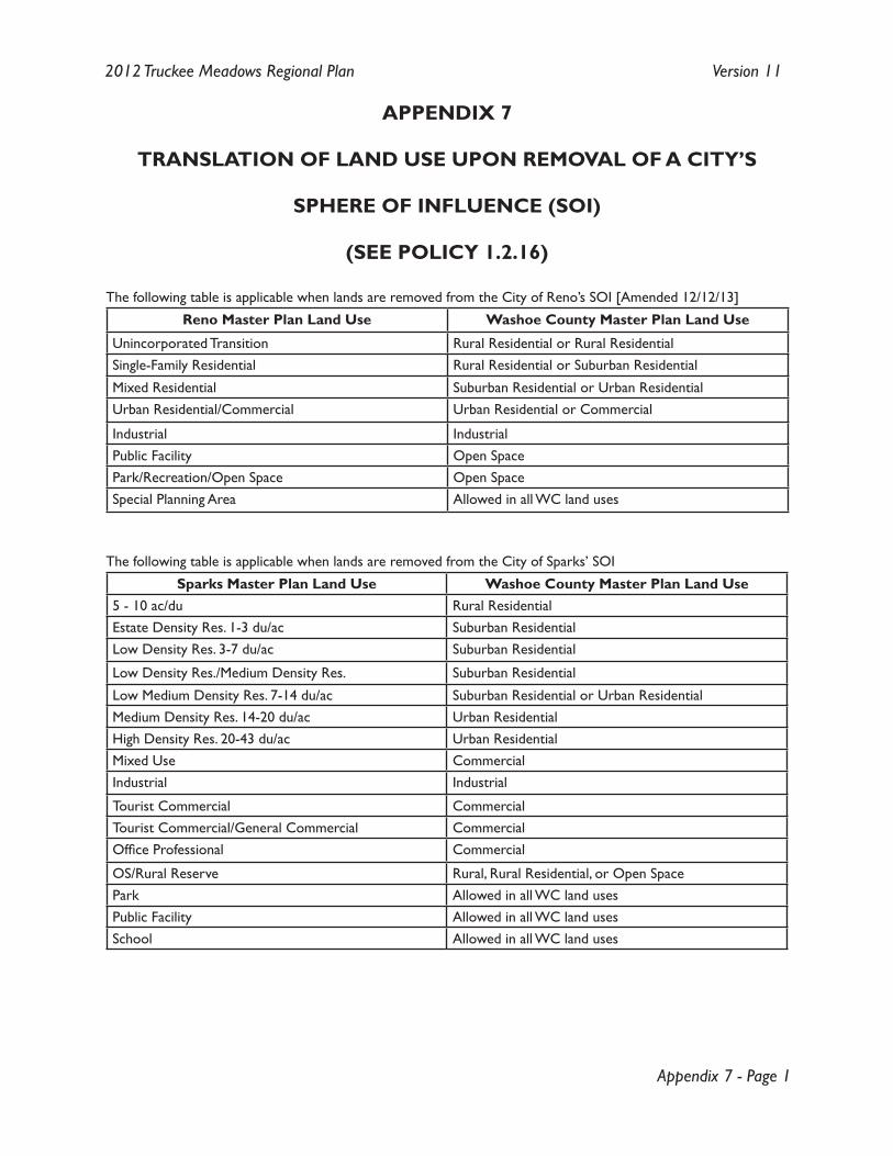
Appendix 7 - Page 1
2012 Truckee Meadows Regional Plan Version 11
APPENDIX 7
TRANSLATION OF LAND USE UPON REMOVAL OF A CITY’S
SPHERE OF INFLUENCE (SOI)
(SEE POLICY 1.2.16)
The following table is applicable when lands are removed from the City of Reno’s SOI [Amended 12/12/13]
Reno Master Plan Land Use Washoe County Master Plan Land Use
Unincorporated Transition Rural Residential or Rural ResidentialSingle-Family Residential Rural Residential or Suburban Residential
Mixed Residential Suburban Residential or Urban ResidentialUrban Residential/Commercial Urban Residential or Commercial
Industrial IndustrialPublic Facility Open SpacePark/Recreation/Open Space Open SpaceSpecial Planning Area Allowed in all WC land uses
The following table is applicable when lands are removed from the City of Sparks’ SOI
Sparks Master Plan Land Use Washoe County Master Plan Land Use5 - 10 ac/du Rural ResidentialEstate Density Res. 1-3 du/ac Suburban ResidentialLow Density Res. 3-7 du/ac Suburban Residential
Low Density Res./Medium Density Res. Suburban Residential
Low Medium Density Res. 7-14 du/ac Suburban Residential or Urban ResidentialMedium Density Res. 14-20 du/ac Urban ResidentialHigh Density Res. 20-43 du/ac Urban ResidentialMixed Use CommercialIndustrial Industrial
Tourist Commercial CommercialTourist Commercial/General Commercial CommercialOffice Professional Commercial
OS/Rural Reserve Rural, Rural Residential, or Open SpacePark Allowed in all WC land usesPublic Facility Allowed in all WC land usesSchool Allowed in all WC land uses

Appendix 7 - Page 2
2012 Truckee Meadows Regional Plan Version 11
[Notes]
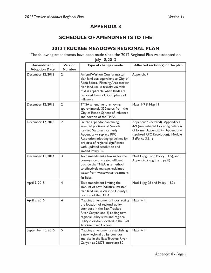
Appendix 8 - Page 1
2012 Truckee Meadows Regional Plan Version 11
APPENDIX 8
SCHEDULE OF AMENDMENTS TO THE
2012 TRUCKEE MEADOWS REGIONAL PLANThe following amendments have been made since the 2012 Regional Plan was adopted on
July 18, 2013Amendment
Adoption DateVersionNumber
Type of changes made Affected section(s) of the plan
December 12, 2013 2 Amend Washoe County master plan land use equivalent to City of Reno Special Planning Area master plan land use in translation table that is applicable when lands are removed from a City’s Sphere of Influence
Appendix 7
December 12, 2013 2 TMSA amendment removing approximately 330 acres from the City of Reno’s Sphere of Influence and portion of the TMSA
Maps 1-9 & Map 11
December 12, 2013 2 Delete appendix containing selected portions of Nevada Revised Statutes (formerly Appendix 4), replace RPC Resolution adopting guidelines for projects of regional significance with updated resolution and amend Policy 3.61
Appendix 4 (deleted), Appendices 4-9 (renumbered following deletion of former Appendix 4), Appendix 4 (updated RPC Resolution), Module 3 (Policy 3.6.1)
December 11, 2014 3 Text amendment allowing for the conveyance of treated effluent outside the TMSA as a method to effectively manage reclaimed water from wastewater treatment facilities.
Mod 1 (pg 3 and Policy 1.1.5), and Appendix 2 (pg 3 and pg 8)
April 9, 2015 4 Text amendment limiting the amount of new industrial master plan land use in Washoe County’s portion of the TMSA
Mod 1 (pg 28 and Policy 1.3.3)
April 9, 2015 4 Mapping amendments 1)correcting the location of regional utility corridors in the East Truckee River Canyon and 2) adding new regional utility sites and regional utility corridors located in the East Truckee River Canyon
Maps 9-11
September 10, 2015 5 Mapping amendments establishing a new regional utility corridor and site in the East Truckee River Canyon at 21575 Interstate 80
Maps 9-11
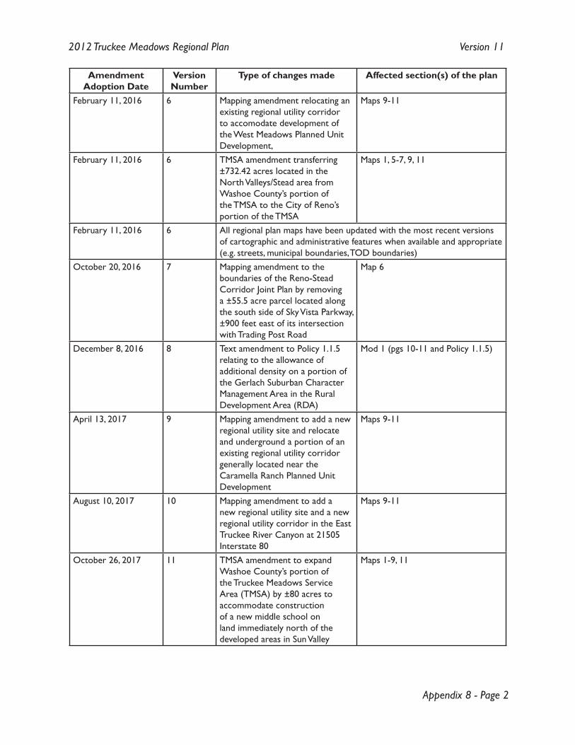
Appendix 8 - Page 2
2012 Truckee Meadows Regional Plan Version 11
Amendment Adoption Date
VersionNumber
Type of changes made Affected section(s) of the plan
February 11, 2016 6 Mapping amendment relocating an existing regional utility corridor to accomodate development of the West Meadows Planned Unit Development,
Maps 9-11
February 11, 2016 6 TMSA amendment transferring ±732.42 acres located in the North Valleys/Stead area from Washoe County’s portion of the TMSA to the City of Reno’s portion of the TMSA
Maps 1, 5-7, 9, 11
February 11, 2016 6 All regional plan maps have been updated with the most recent versions of cartographic and administrative features when available and appropriate (e.g. streets, municipal boundaries, TOD boundaries)
October 20, 2016 7 Mapping amendment to the boundaries of the Reno-Stead Corridor Joint Plan by removing a ±55.5 acre parcel located along the south side of Sky Vista Parkway, ±900 feet east of its intersection with Trading Post Road
Map 6
December 8, 2016 8 Text amendment to Policy 1.1.5 relating to the allowance of additional density on a portion of the Gerlach Suburban Character Management Area in the Rural Development Area (RDA)
Mod 1 (pgs 10-11 and Policy 1.1.5)
April 13, 2017 9 Mapping amendment to add a new regional utility site and relocate and underground a portion of an existing regional utility corridor generally located near the Caramella Ranch Planned Unit Development
Maps 9-11
August 10, 2017 10 Mapping amendment to add a new regional utility site and a new regional utility corridor in the East Truckee River Canyon at 21505 Interstate 80
Maps 9-11
October 26, 2017 11 TMSA amendment to expand Washoe County’s portion of the Truckee Meadows Service Area (TMSA) by ±80 acres to accommodate construction of a new middle school on land immediately north of the developed areas in Sun Valley
Maps 1-9, 11
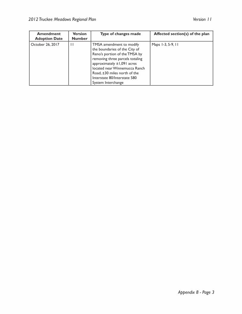
Appendix 8 - Page 3
2012 Truckee Meadows Regional Plan Version 11
Amendment Adoption Date
VersionNumber
Type of changes made Affected section(s) of the plan
October 26, 2017 11 TMSA amendment to modify the boundaries of the City of Reno’s portion of the TMSA by removing three parcels totaling approximately ±1,091 acres located near Winnemucca Ranch Road, ±30 miles north of the Interstate 80/Interstate 580 System Interchange
Maps 1-3, 5-9, 11

Intentionally Left Blank
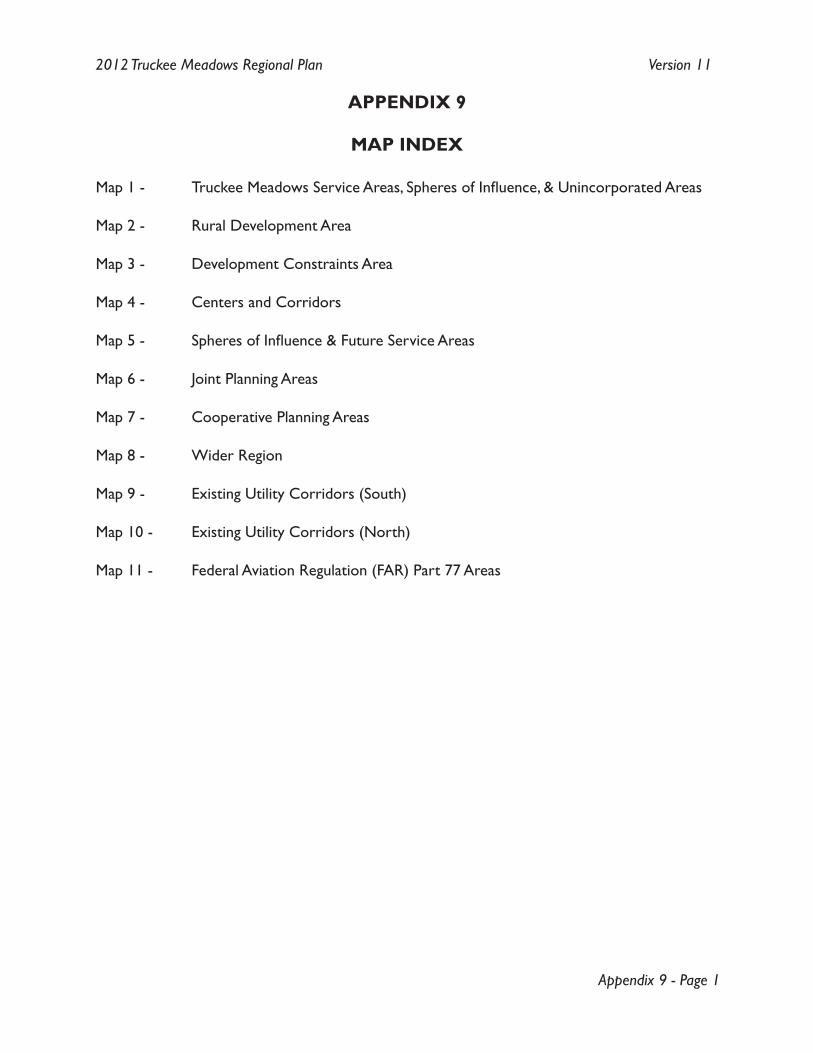
Appendix 9 - Page 1
2012 Truckee Meadows Regional Plan Version 11
APPENDIX 9
MAP INDEX
Map 1 - Truckee Meadows Service Areas, Spheres of Influence, & Unincorporated Areas
Map 2 - Rural Development Area
Map 3 - Development Constraints Area
Map 4 - Centers and Corridors
Map 5 - Spheres of Influence & Future Service Areas
Map 6 - Joint Planning Areas
Map 7 - Cooperative Planning Areas
Map 8 - Wider Region
Map 9 - Existing Utility Corridors (South)
Map 10 - Existing Utility Corridors (North)
Map 11 - Federal Aviation Regulation (FAR) Part 77 Areas