Embed Size (px)
Citation preview
Triple Divide Trail System
( = Triple Divide Greenway)
Summary
with map of the
Genesee-Susquehanna Greenway
March 2015
For fuller description, see
Triple Divide Trail System Strategic Plan
(61-page PDF file with maps, photographs, budget, contacts, and other details)
and links to other project and planning documents
on website of
Genesee River Wilds Project
at
www.geneseeriverwilds.org
Genesee River Wilds, Inc.
Crossroads Center, 6087 State Route 19N, Belmont, NY 14813
Registered 501(c)(3) Non-profit Organization
www.geneseeriverwilds.com
1
Triple Divide Trail System ( = Triple Divide Greenway)
Mission: To restore, protect, and enjoy the Genesee River and Pine Creek by raising their profile as
resources for outdoor recreation and sustainable economic development.
Plan: The Triple Divide Trail System will be a unified conservation and recreational system stretching
ca. 230 miles along the Genesee River and Pine Creek from Lake Ontario in Rochester, NY, to the
Susquehanna River in Williamsport, PA. The name derives from its passage over a triple continental
divide separating the headwaters of three national watersheds: the Allegheny River, the Genesee River,
and the Susquehanna River (West Branch and Pine Creek). This recreational system is being created by
connecting existing rail-trails (greenways), water trails (blueways), and nature park areas, including
Letchworth State Park (NY) and Pine Creek Gorge (PA). The approach is integrative and cost effective.
It combines water conservation, natural flood control, outdoor recreation, environmental education, and
sustainable economic development, including new jobs in construction and eco-tourism.
Strategies and Phases
(1) Improve existing trails for bicycles and existing canoe/kayak launches along the Genesee River
and Pine Creek. Existing trails include the Genesee Riverway Trail in Rochester (NY); Genesee
Valley Greenway (NY); Park Road in Letchworth State Park (NY); WAG Trail (Wellsville-Addison-
Galeton rail-trail, from Wellsville, NY, south); Pine Creek Trail (PA); and Lycoming County Trail and
Bikeway in Williamsport (PA). Some canoe/kayak launches on Pine Creek and most on the Genesee
River are rough and informal. This existing recreational infrastructure needs: (a) more signs; (b) more
parking lots; (c) more complementary infrastructure, such as pavilions, restrooms, campsites, and trail
shelters; (d) better surfaces for bicycle trails; (e) improved launches for canoes and kayaks.
(2) Construct new canoe-kayak launches with signs, parking lots, and other complementary
infrastructure to improve blueway (water trail) systems along the Genesee River and Pine Creek.
Often these can be built at low cost near bridges and other public sites, with costs minimized further by
incorporation into new bridge construction. In other cases this requires purchase of land or easements.
(3) Add linking trails to connect existing trails (above) together to form a multi-use rail-trail
stretching from Rochester to Williamsport along the Genesee River and Pine Creek. Only a few
sections of the entire 230-mile system do not already have a trail completed or under development. In
most of these cases old railroad beds or other existing infrastructure will expedite trail construction.
(4) Add inexpensive forested streamside nature parks that simultaneously expand protections for
the stream system while providing immediate jobs in construction, recreational infrastructure for
long-term eco-tourism, and facilities for environmental education. These include camping shelters,
restrooms, pavilions, interpretive signs, wildlife-viewing platforms, and educational kiosks. (5) Continue adding forested riparian (streamside) buffers along the Genesee River and Pine
Creek that offer water conservation, wildlife habitat, and natural flood control while
accommodating existing development. The Genesee River is one of the largest rivers feeding Lake
Ontario. Pine Creek is the largest tributary of the West Branch of the Susquehanna River and thereby
has a major impact on Chesapeake Bay. Agricultural nutrients, industrial toxins, costly flooding, and
risk of overuse will be reduced by buffers reaching at least 300 feet wide on each bank (at least 100 feet
for small tributaries) where existing development allows. In some places this can reach 1/4 mile, which
is the average recommended for the highest class of federally protected rivers. In other sections a
narrower buffer may be a more realistic goal. Local support can be generated by funds for purchase of
land, easements, zoning costs, and sustainable recreational development in these buffers (above).
2
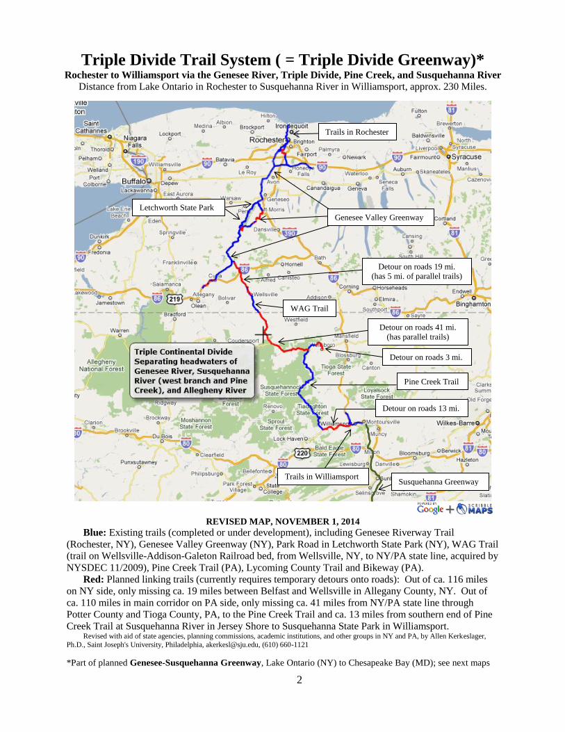
Triple Divide Trail System ( = Triple Divide Greenway)*
Rochester to Williamsport via the Genesee River, Triple Divide, Pine Creek, and Susquehanna River
Distance from Lake Ontario in Rochester to Susquehanna River in Williamsport, approx. 230 Miles.
REVISED MAP, NOVEMBER 1, 2014
Blue: Existing trails (completed or under development), including Genesee Riverway Trail
(Rochester, NY), Genesee Valley Greenway (NY), Park Road in Letchworth State Park (NY), WAG Trail
(trail on Wellsville-Addison-Galeton Railroad bed, from Wellsville, NY, to NY/PA state line, acquired by
NYSDEC 11/2009), Pine Creek Trail (PA), Lycoming County Trail and Bikeway (PA).
Red: Planned linking trails (currently requires temporary detours onto roads): Out of ca. 116 miles
on NY side, only missing ca. 19 miles between Belfast and Wellsville in Allegany County, NY. Out of
ca. 110 miles in main corridor on PA side, only missing ca. 41 miles from NY/PA state line through
Potter County and Tioga County, PA, to the Pine Creek Trail and ca. 13 miles from southern end of Pine
Creek Trail at Susquehanna River in Jersey Shore to Susquehanna State Park in Williamsport. Revised with aid of state agencies, planning commissions, academic institutions, and other groups in NY and PA, by Allen Kerkeslager,
Ph.D., Saint Joseph's University, Philadelphia, [email protected], (610) 660-1121
*Part of planned Genesee-Susquehanna Greenway, Lake Ontario (NY) to Chesapeake Bay (MD); see next maps
Trails in Rochester
Genesee Valley Greenway
Letchworth State Park
Detour on roads 19 mi.
(has 5 mi. of parallel trails)
Detour on roads 41 mi.
(has parallel trails)
WAG Trail
Pine Creek Trail
Detour on roads 13 mi.
Detour on roads 3 mi.
Trails in Williamsport Susquehanna Greenway
3
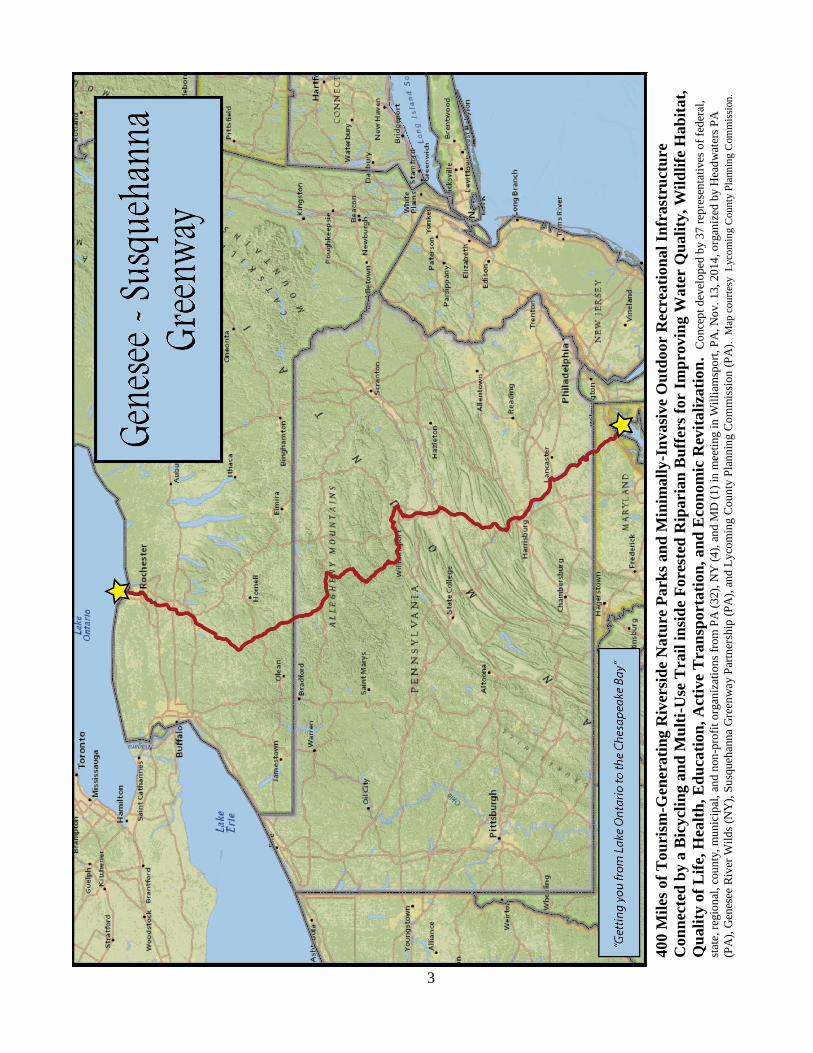
400 M
iles
of
Tou
rism
-Gen
erati
ng R
iver
sid
e N
atu
re P
ark
s an
d M
inim
all
y-I
nvasi
ve
Ou
tdoor
Rec
reati
on
al
Infr
ast
ruct
ure
Con
nec
ted
by a
Bic
ycl
ing a
nd
Mu
lti-
Use
Tra
il i
nsi
de
Fore
sted
Rip
ari
an
Bu
ffer
s fo
r I
mp
rovin
g W
ate
r Q
uali
ty, W
ild
life
Hab
itat,
Qu
ali
ty o
f L
ife,
Hea
lth
, E
du
cati
on
, A
ctiv
e T
ran
sport
ati
on
, an
d E
con
om
ic R
evit
ali
zati
on
. C
on
cep
t d
evel
op
ed b
y 3
7 r
epre
sen
tati
ves
of
fed
eral
,
stat
e, r
egio
nal
, co
un
ty,
mu
nic
ipal
, an
d n
on
-pro
fit
org
aniz
atio
ns
from
PA
(3
2),
NY
(4
), a
nd M
D (
1)
in m
eeti
ng i
n W
illi
amsp
ort
, P
A,
No
v.
13,
20
14
, o
rgan
ized
by H
ead
wat
ers
PA
(PA
), G
enes
ee R
iver
Wil
ds
(NY
), S
usq
ueh
ann
a G
reen
way
Par
tner
ship
(P
A),
and
Lyco
min
g C
ou
nty
Pla
nn
ing C
om
mis
sio
n (
PA
).
Map
cou
rtes
y
Lyco
min
g C
oun
ty P
lann
ing C
om
mis
sion.
4
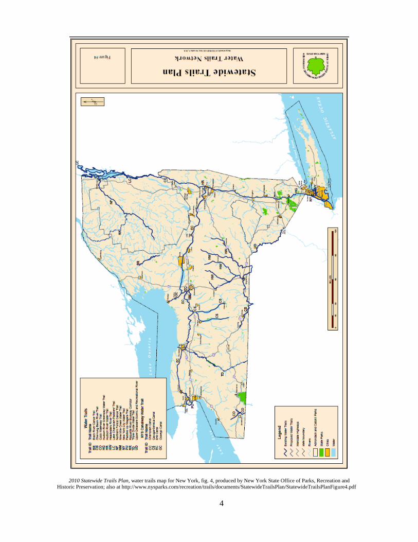
2010 Statewide Trails Plan, water trails map for New York, fig. 4, produced by New York State Office of Parks, Recreation and Historic Preservation; also at http://www.nysparks.com/recreation/trails/documents/StatewideTrailsPlan/StatewideTrailsPlanFigure4.pdf
5
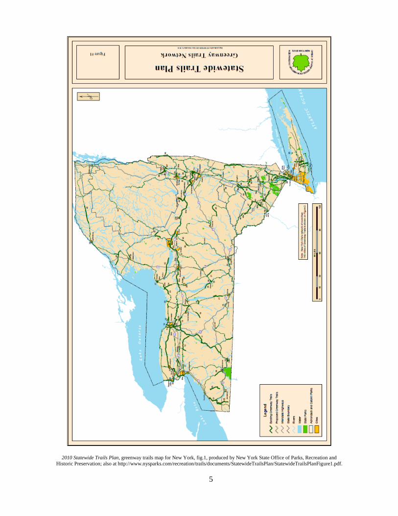
2010 Statewide Trails Plan, greenway trails map for New York, fig.1, produced by New York State Office of Parks, Recreation and
Historic Preservation; also at http://www.nysparks.com/recreation/trails/documents/StatewideTrailsPlan/StatewideTrailsPlanFigure1.pdf.
6
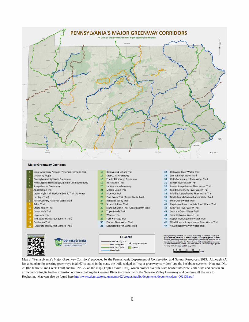
Map of "Pennsylvania's Major Greenway Corridors" produced by the Pennsylvania Department of Conservation and Natural Resources, 2013. Although PA
has a mandate for creating greenways in all 67 counties in the state, the trails ranked as "major greenway corridors" are the backbone systems. Note trail No.
23 (the famous Pine Creek Trail) and trail No. 27 on the map (Triple Divide Trail), which crosses over the state border into New York State and ends in an
arrow indicating its further extension northward along the Genesee River to connect with the Genesee Valley Greenway and continue all the way to
Rochester. Map can also be found here http://www.dcnr.state.pa.us/ucmprd2/groups/public/documents/document/dcnr_002138.pdf
7
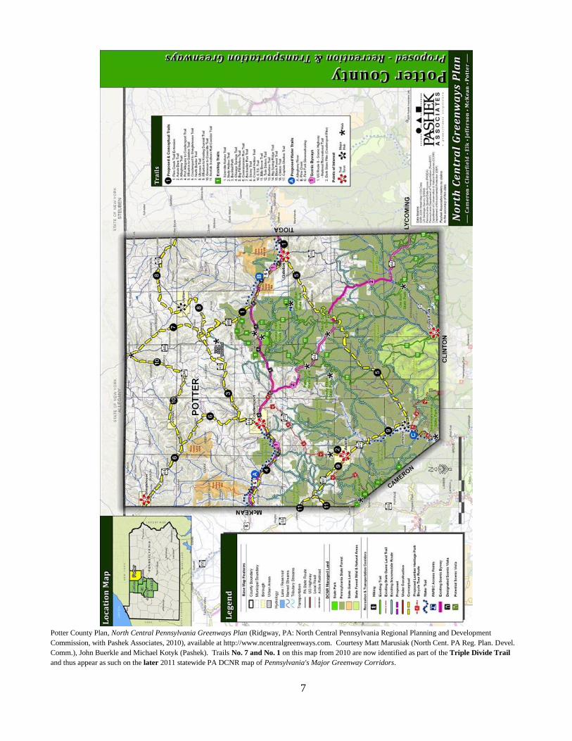
Potter County Plan, North Central Pennsylvania Greenways Plan (Ridgway, PA: North Central Pennsylvania Regional Planning and Development
Commission, with Pashek Associates, 2010), available at http://www.ncentralgreenways.com. Courtesy Matt Marusiak (North Cent. PA Reg. Plan. Devel.
Comm.), John Buerkle and Michael Kotyk (Pashek). Trails No. 7 and No. 1 on this map from 2010 are now identified as part of the Triple Divide Trail
and thus appear as such on the later 2011 statewide PA DCNR map of Pennsylvania's Major Greenway Corridors.
8
Summary March, 2015 by Allen Kerkeslager, Saint Joseph's University, Philadelphia, PA, 19131-1395, [email protected]
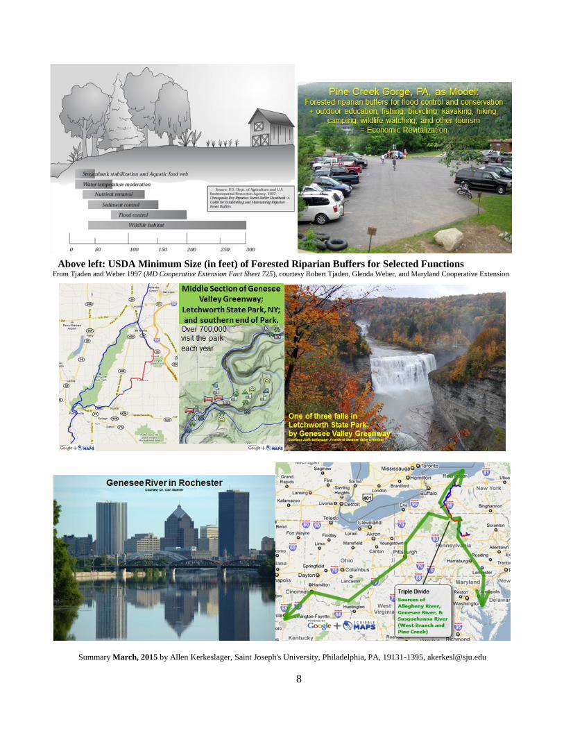
Above left: USDA Minimum Size (in feet) of Forested Riparian Buffers for Selected Functions From Tjaden and Weber 1997 (MD Cooperative Extension Fact Sheet 725), courtesy Robert Tjaden, Glenda Weber, and Maryland Cooperative Extension

![TRIPLE DIVIDE [REDACTED] file[redacted] triple divide public herald presents a public herald studios production with music by nest, evgeny grinko & lee maddeford & narration by mark](https://img.pdfslide.us/doc/110x75/5e0bed291e98b6267b0e37ef/triple-divide-redacted-redacted-triple-divide-public-herald-presents-a-public.jpg)