Embed Size (px)
Citation preview
US Army Corps of Engineers BUILDING STRONG®
Trinity River Corridor Project Update Col. Charles H. Klinge Commander, Fort Worth District US Army Corps of Engineers Jill A. Jordan, P.E. Assistant City Manager City of Dallas Dallas City Council briefing Aug. 21, 2013
1
Purpose
• To provide an overview of the Trinity River Corridor Project
• To introduce the US Army Corps of Engineers (Corps)
• To outline next steps
2

Trinity River Corridor Project Partners
• US Army Corps of Engineers (Corps) • City of Dallas • Dallas County • North Texas Tollway Authority (NTTA) • Texas Dept. of Transportation (TxDOT) • Fed. Highway Administration (FHWA) • Texas Commission on Environmental Quality (TCEQ) • Environmental Protection Agency (EPA) • Federal Emergency Management
Agency (FEMA) • North Central Texas Council of
Governments (COG)
3
Federal, State and Local Partners

Trinity River Corridor Project Non- Profit Partners
• Trinity Trust Foundation • Trinity Commons Foundation • Audubon Society • Circle Ten Boy Scouts • Dallas Camera Club • Dallas Running Club • Downtown Dallas • EQUEST • Groundwork Dallas • Girl Scouts of Northeast Texas • River Ranch Education Charities • Ocean Conservancy • Scottish Rite Hospital • Student Conservation Association • Texas Horse Park Foundation • Trinity Bird Count • Trinity Strand Trail • The Mission Continues
4

• AT&T • CVS Caremark • Dallas Morning News • Dr. Pepper/Snapple • National Fish & Wildlife/FedEx • Hilton Anatole • Kroger • Luke’s Locker • Matthews Southwest • Methodist Hospital Dallas • Nestle Waters • NorthPark Center • Oncor • Reliant Energy • Sprint • Southwest Airlines • Xerox • Wells Fargo
Trinity River Corridor Project Private Sector Partners
5
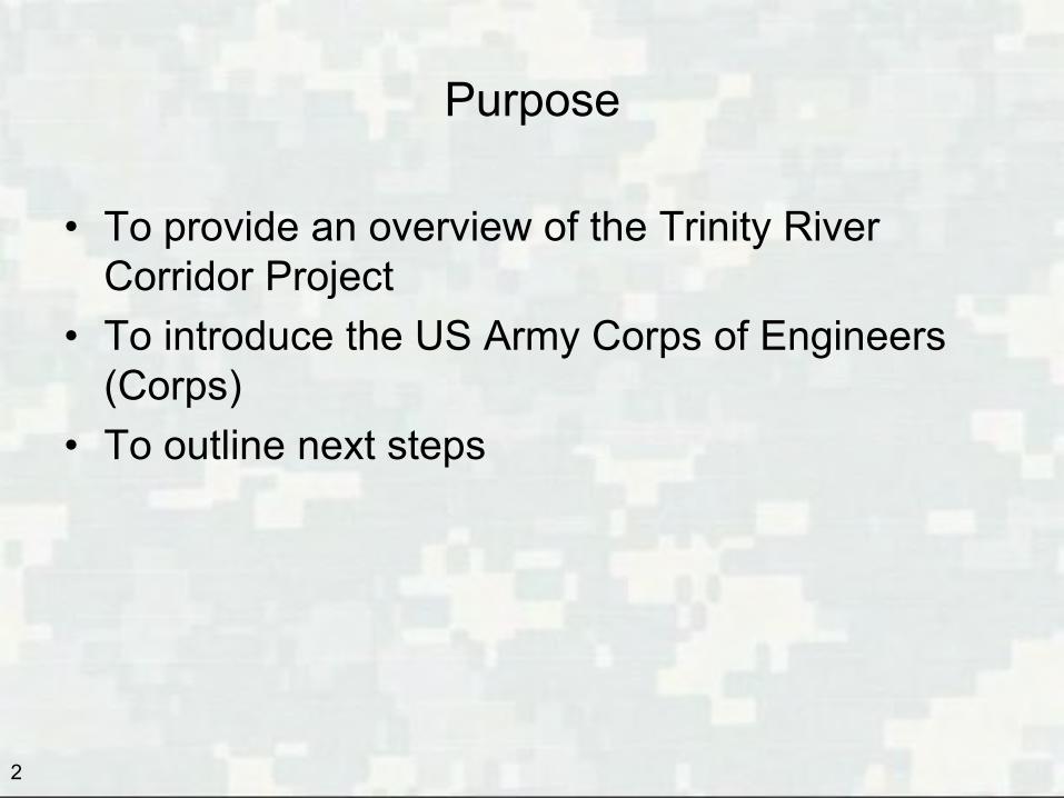
Fort Worth District US Army Corps of Engineers
Who we are: • Created 1950 after 1949 Fort Worth flood • 1,200 civilian and military employees – half in Fort Worth
What we do: Military Works: Support the needs of 11 Army and 5 Air Force installations
across Texas, New Mexico and Louisiana Civil Works: Ten river basins covering 53% of the state • Levee systems in 16 Texas counties • 25 lakes containing 314 parks • Corps lakes provide 30% of Texas water supply • 35 current ecosystem restoration projects Overseas contingency response: 27 employees deployed to Afghanistan in May Emergency response: District employees deploy nationwide for disaster relief 6

930 Miles 15 hrs Disaster Response
Hydropower Generation
Land Acquisition
Flood Risk Management
Military Construction
(Army)
Military Construction (Air Force)
Core Drilling
Military Construction
(Medical)
Environmental Restoration/ FUDs
Water Supply Recreation
Interagency and International
Support
Fort Worth District Mission Areas
7
Overview
8
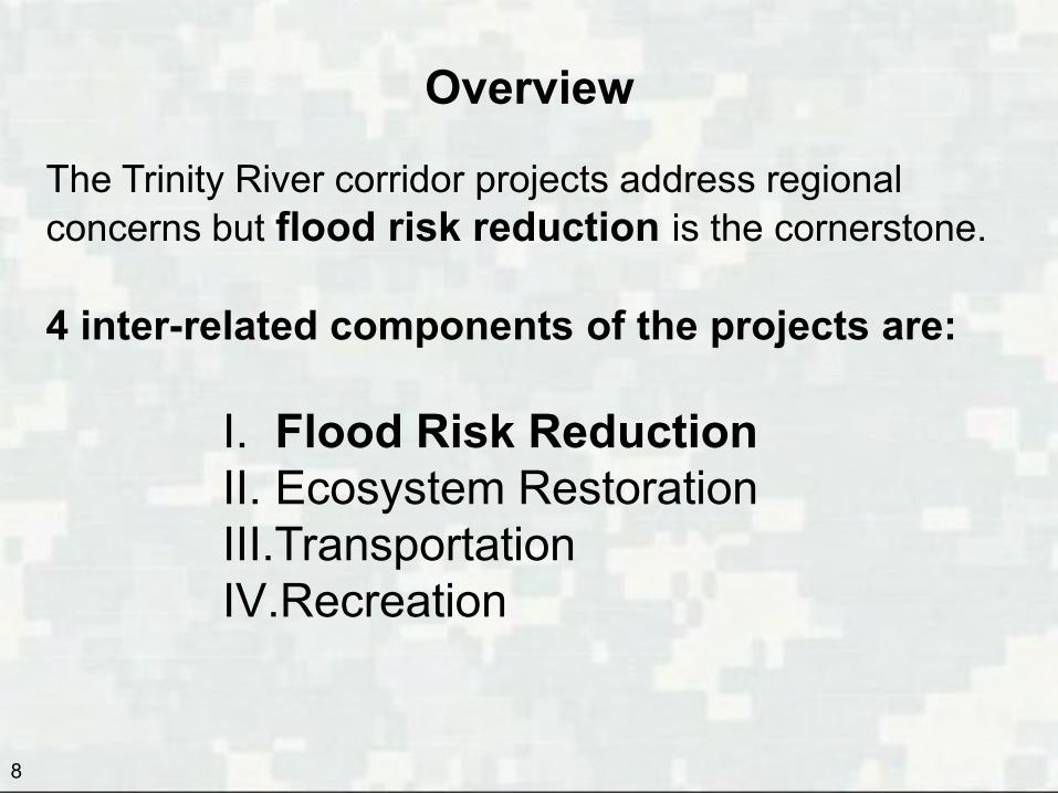
The Trinity River corridor projects address regional concerns but flood risk reduction is the cornerstone. 4 inter-related components of the projects are:
I. Flood Risk Reduction II. Ecosystem Restoration III.Transportation IV.Recreation
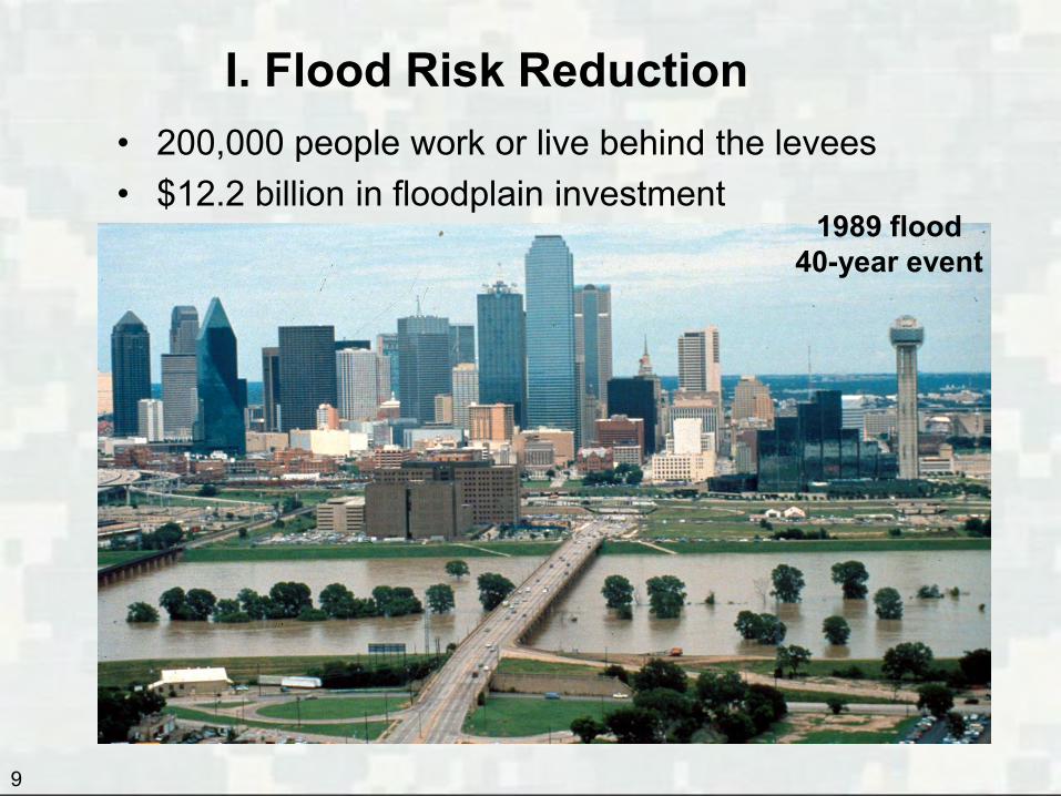
• 200,000 people work or live behind the levees • $12.2 billion in floodplain investment
9
1989 flood 40-year event
I. Flood Risk Reduction
10
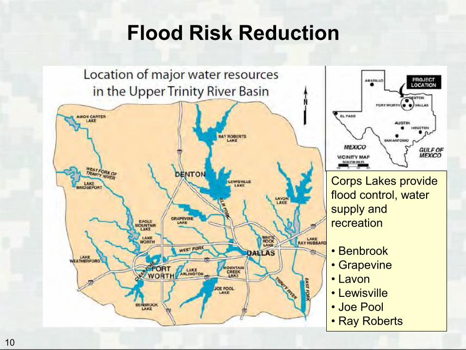
Corps Lakes provide flood control, water supply and recreation • Benbrook • Grapevine • Lavon • Lewisville • Joe Pool • Ray Roberts
Flood Risk Reduction
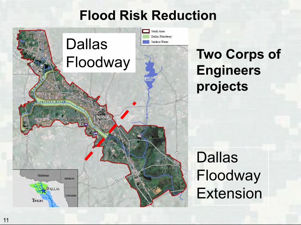
Flood Risk Reduction
11
Two Corps of Engineers projects Dallas Floodway Extension
Dallas Floodway
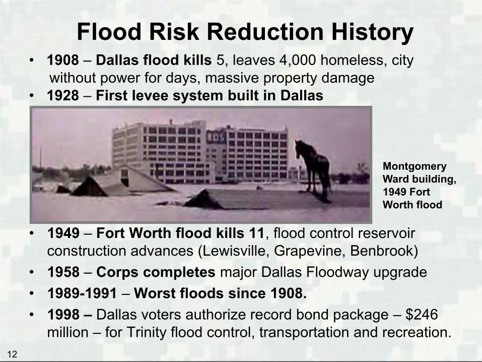
Flood Risk Reduction History
• 1949 – Fort Worth flood kills 11, flood control reservoir construction advances (Lewisville, Grapevine, Benbrook)
• 1958 – Corps completes major Dallas Floodway upgrade • 1989-1991 – Worst floods since 1908. • 1998 – Dallas voters authorize record bond package – $246
million – for Trinity flood control, transportation and recreation.
• 1908 – Dallas flood kills 5, leaves 4,000 homeless, city without power for days, massive property damage • 1928 – First levee system built in Dallas
Montgomery Ward building, 1949 Fort Worth flood
12

Flood Risk Reduction Dallas Floodway Project
• 2007 – Water Resources Development Act (WRDA) Section 5141
was authorized to raise the levees up to 2 feet, provide recreation (Balanced Vision Plan) and improve pump stations
• 2009 – Corps tells City it has rated Dallas Floodway “unacceptable”; FEMA withdraws accreditation of levees; city begins maintenance and construction work to re-certify levees
• 2010 –Feasibility Study and Environmental Impact Statement process launched to explore what actions are needed to restore capacity of Dallas Floodway to meet a major storm event.
• 2011 – Corps introduces Risk Assessment process, a cost-effective method for assessing aging dams, to the Dallas Floodway Project. • First of this type of study for levees in the Country • Determines Dallas Floodway Project Levees are more resilient and provide
around 1,500-year protection
13
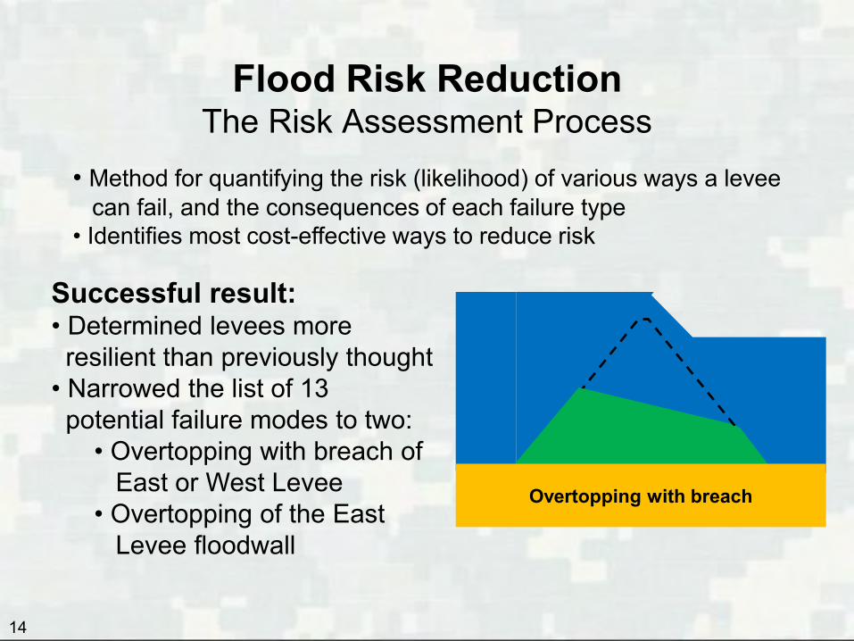
Flood Risk Reduction The Risk Assessment Process
14
• Method for quantifying the risk (likelihood) of various ways a levee can fail, and the consequences of each failure type • Identifies most cost-effective ways to reduce risk
Overtopping with breach
Successful result: • Determined levees more resilient than previously thought • Narrowed the list of 13 potential failure modes to two:
• Overtopping with breach of East or West Levee • Overtopping of the East Levee floodwall

Flood Risk Reduction Recommended Flood Risk Management Plan
15
• Raise low spots in the levees up to 3 feet to increase flood conveyance to 277,000 cubic feet per second. This is enough to convey floodwaters of a major storm that has a 1/2,500 chance of happening any given year • Cost of these two changes: $6.2 million
Old abandoned AT&SF Trestles Proposed for Removal
• The Trestles are on 14-foot-centers and collect debris during flooding and stack up floodwaters into the floodway. The embankment acts as a weir and impedes flow down the floodway system

Flood Risk Reduction
16
Where levee low spots would be raised
East Levee: 2.6 miles West Levee: 1.2 miles
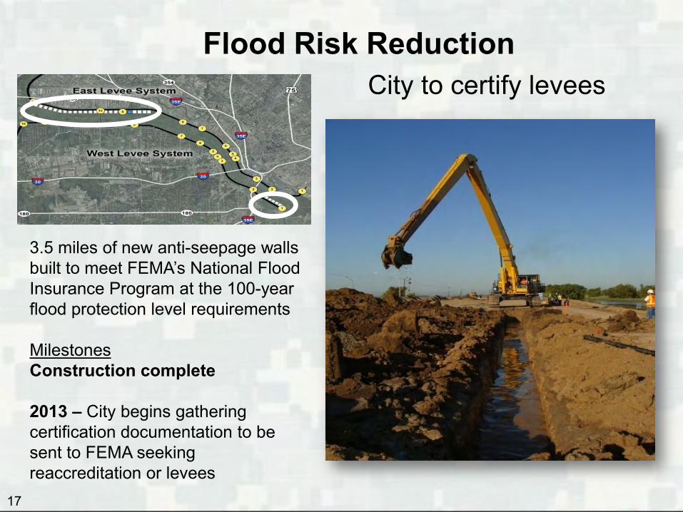
Flood Risk Reduction City to certify levees
17
3.5 miles of new anti-seepage walls built to meet FEMA’s National Flood Insurance Program at the 100-year flood protection level requirements Milestones Construction complete 2013 – City begins gathering certification documentation to be sent to FEMA seeking reaccreditation or levees

Flood Risk Reduction Interior Drainage Plan
18
Expanding pump stations, such as Pavaho (completed last year), reduces neighborhood flooding. This West Dallas neighborhood regularly flooded before upgrade.
2006 Flooding near Old Pavaho Pump Station
2012 New Pavaho Pump Station

Concept of Able
Flood Risk Reduction Interior Drainage Plan
19
More pump stations under way • Baker Pump Station (2255 Irving Blvd. near Design District); construction now 28 percent complete • Able Pump Station (600 S. Riverfront near Fuel City) – Under design. Construction to begin within a year.
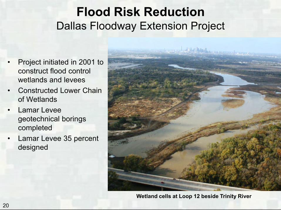
• Project initiated in 2001 to construct flood control wetlands and levees
• Constructed Lower Chain of Wetlands
• Lamar Levee geotechnical borings completed
• Lamar Levee 35 percent designed
20
Flood Risk Reduction Dallas Floodway Extension Project
Wetland cells at Loop 12 beside Trinity River

21
Flood Risk Reduction Fiscal Year 2014
• Brief the Transportation and Trinity River Project Council Committee on the Dallas Floodway Project Environmental Impact Statement and the upcoming 2014 Public Meeting
• Award the Upper Chain of Wetlands and Able Pump Station
• Open Baker Pump Station
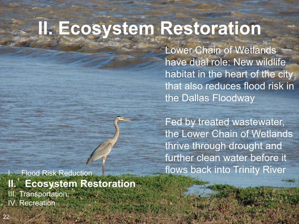
II. Ecosystem Restoration Lower Chain of Wetlands have dual role: New wildlife habitat in the heart of the city that also reduces flood risk in the Dallas Floodway Fed by treated wastewater, the Lower Chain of Wetlands thrive through drought and further clean water before it flows back into Trinity River I. Flood Risk Reduction
II. Ecosystem Restoration III. Transportation IV. Recreation
22
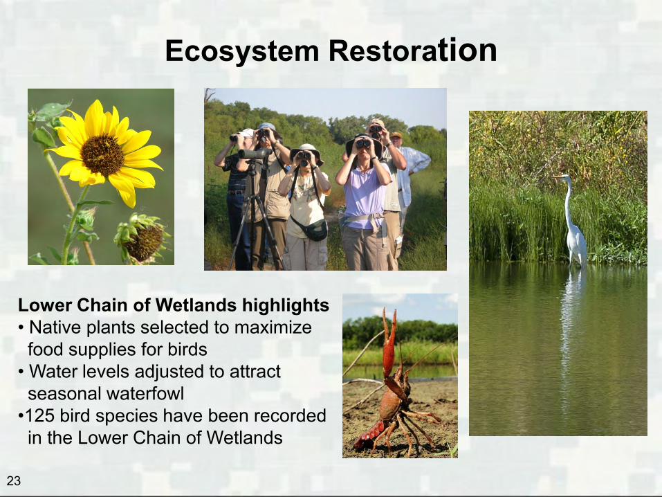
Ecosystem Restoration
Lower Chain of Wetlands highlights • Native plants selected to maximize food supplies for birds • Water levels adjusted to attract seasonal waterfowl •125 bird species have been recorded in the Lower Chain of Wetlands
23
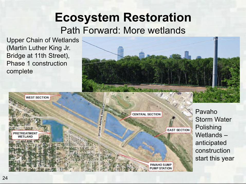
Ecosystem Restoration Path Forward: More wetlands
Upper Chain of Wetlands (Martin Luther King Jr. Bridge at 11th Street), Phase 1 construction complete
Pavaho Storm Water Polishing Wetlands – anticipated construction start this year
24
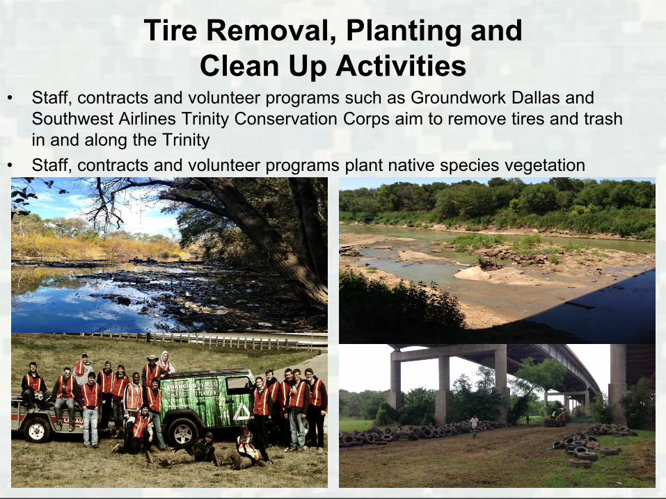
Tire Removal, Planting and Clean Up Activities
• Staff, contracts and volunteer programs such as Groundwork Dallas and Southwest Airlines Trinity Conservation Corps aim to remove tires and trash in and along the Trinity
• Staff, contracts and volunteer programs plant native species vegetation
25

Ecosystem Restoration Fiscal Year 2014 Next Steps
• Brief the Transportation and Trinity River Project Council Committee on the operations and maintenance for the Lower Chain of Wetlands
• Award the construction of the Upper Chain of Wetlands • Award a contract to remove tires in and along the Trinity
River • Continue planting and clean up activities at various
locations along the Trinity River and wetlands areas
26

III. Transportation
Concept for Sylvan Bridge now under construction
I. Flood Risk Reduction II. Ecosystem Restoration III. Transportation IV. Recreation
27
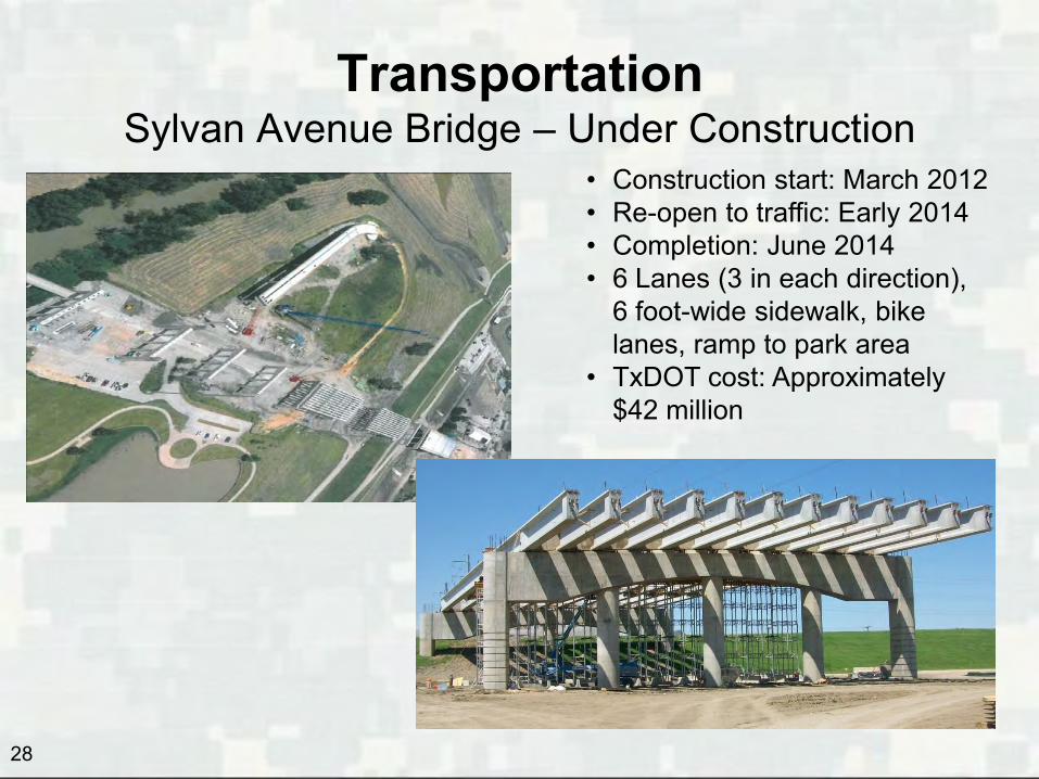
Transportation Sylvan Avenue Bridge – Under Construction
• Construction start: March 2012 • Re-open to traffic: Early 2014 • Completion: June 2014 • 6 Lanes (3 in each direction),
6 foot-wide sidewalk, bike lanes, ramp to park area
• TxDOT cost: Approximately $42 million
28

Transportation Horseshoe Project: I-30 (McDermott Bridge)
and I-35E Bridges
• TxDOT awarded design-build contract November 2012
• Construction soil tests begun • Construction complete 2017 • Cost: $798 million (private,
local, state & federal)
Planned Margaret McDermott Bridge (I-30)
29
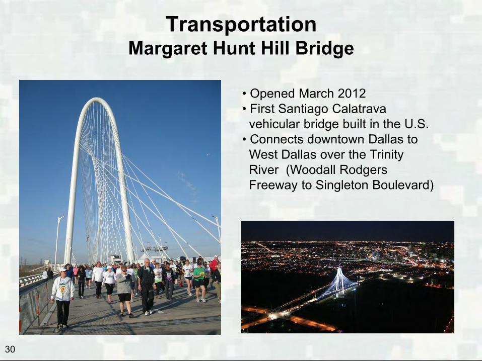
Transportation Margaret Hunt Hill Bridge
• Opened March 2012 • First Santiago Calatrava vehicular bridge built in the U.S. • Connects downtown Dallas to West Dallas over the Trinity River (Woodall Rodgers Freeway to Singleton Boulevard)
30
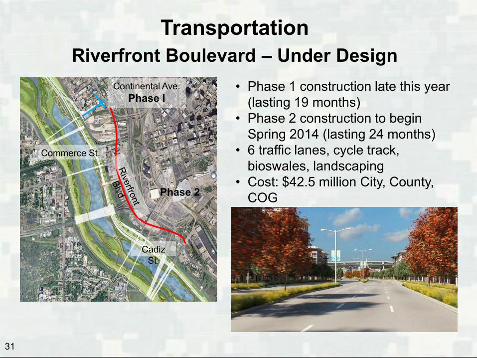
Transportation Riverfront Boulevard – Under Design
Continental Ave. Phase I
Commerce St.
Cadiz St.
Phase 2
• Phase 1 construction late this year (lasting 19 months)
• Phase 2 construction to begin Spring 2014 (lasting 24 months)
• 6 traffic lanes, cycle track, bioswales, landscaping
• Cost: $42.5 million City, County, COG
31

Transportation Cadiz Street
(From Riverfront To Lamar)
Riverfront
Est. Total Cost $4.8 M (funded) Design completed in November 2012
Begin roadway const. by February 2014 Complete roadway const. in August 2015
Begin Sump A bridge const. late 2015 Complete Sump A bridge const. late 2016 32

Transportation Beckley/Commerce Intersection Improvements
33
• Design completed in July 2013 • Estimated total cost - $3.6M • Construction scheduled to begin in December 2013 (15-18 month
duration)

Transportation Trinity Parkway – Under design
34
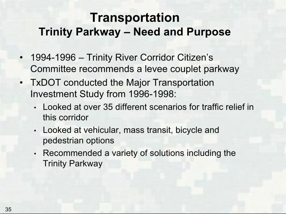
Transportation Trinity Parkway – Need and Purpose
• 1994-1996 – Trinity River Corridor Citizen’s Committee recommends a levee couplet parkway
• TxDOT conducted the Major Transportation Investment Study from 1996-1998: • Looked at over 35 different scenarios for traffic relief in
this corridor • Looked at vehicular, mass transit, bicycle and
pedestrian options • Recommended a variety of solutions including the
Trinity Parkway
35

Transportation Trinity Parkway - Need and Purpose
• Goal was to add 250,000 person-trips of added capacity to the corridor to handle future demand
• Conclusion was a $1 billion (in 1998 dollars) multi-modal set of transportation improvements
DART Northwest Corridor LRT (Green Line)
Freeway & HOV Improvements
New Reliever Route (Trinity Parkway)
Bicycle/Pedestrian Facilities
Employee Trip Reduction
Freeway Management
Woodall-Rodgers to Beckley Connection (Margaret Hunt Hill)
36
37
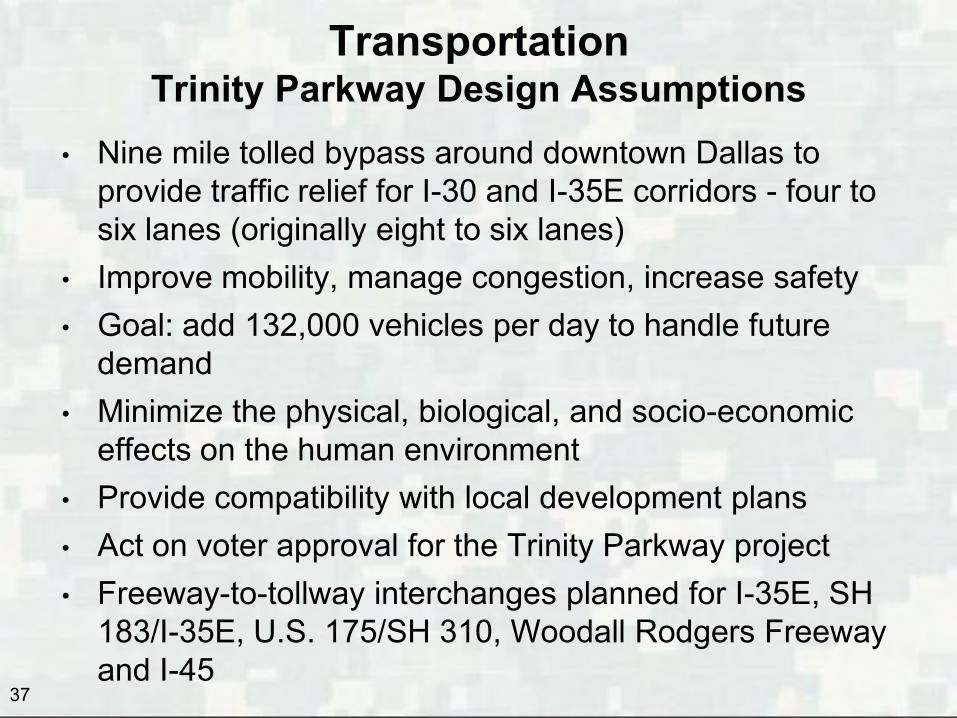
Transportation Trinity Parkway Design Assumptions
• Nine mile tolled bypass around downtown Dallas to provide traffic relief for I-30 and I-35E corridors - four to six lanes (originally eight to six lanes)
• Improve mobility, manage congestion, increase safety • Goal: add 132,000 vehicles per day to handle future
demand • Minimize the physical, biological, and socio-economic
effects on the human environment • Provide compatibility with local development plans • Act on voter approval for the Trinity Parkway project • Freeway-to-tollway interchanges planned for I-35E, SH
183/I-35E, U.S. 175/SH 310, Woodall Rodgers Freeway and I-45
38
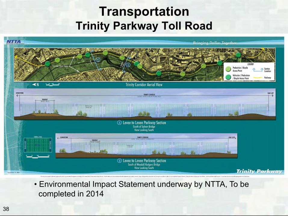
Transportation Trinity Parkway Toll Road
Trinity Parkway complete by 2014
• Environmental Impact Statement underway by NTTA, To be completed in 2014
39
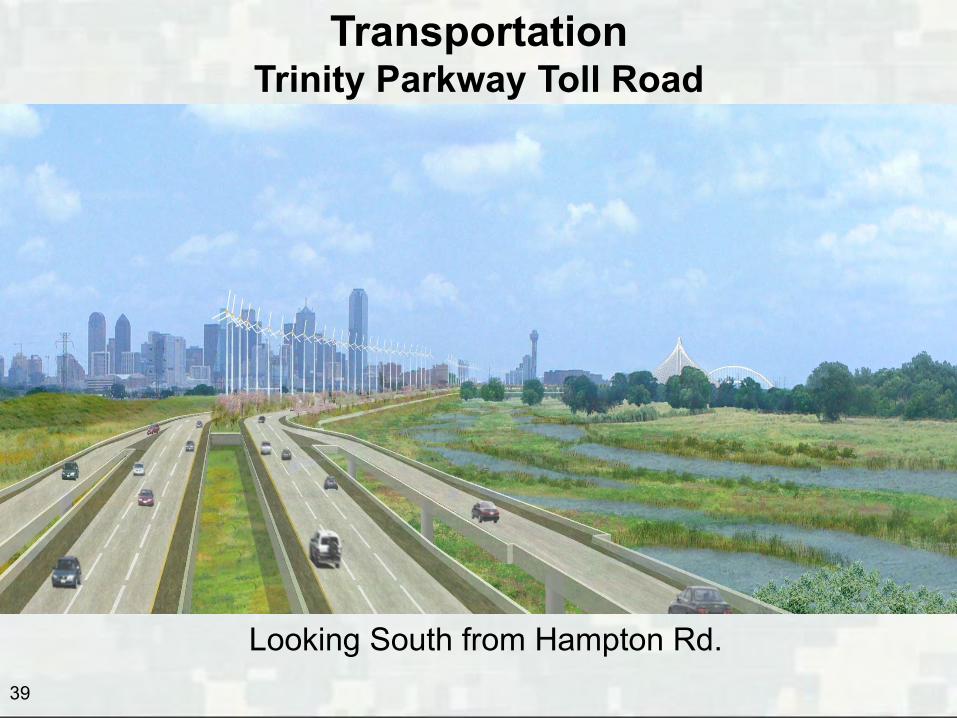
Transportation
Trinity Parkway Toll Road
Looking South from Hampton Rd.

Transportation Trinity Parkway – Design Status
• December 2008: TxDOT and NTTA execute $30 million advance funding agreement (AFA) for design and traffic and revenue studies
• December 2008: NTTA approved and entered into contract with firms for professional engineering services for design of Alternative 3C
• May 2009: preliminary plans and initial Section 408 review package submitted to Corps
• Trinity Parkway Phase I (S.M. Wright) nearing 100% design • Complete remaining phases of design following record of
decision by FHWA in 2014
40

41
Transportation S.M. Wright Parkway – Under Design
• Trinity Parkway connection to I-45 eliminates need for “Dead Man’s Curve” at U.S. 175 and S.M. Wright (S.M. Wright Phase I)
• Provides opportunity to make S.M. Wright a lower-speed, thoroughfare after the improvement to I-45/U.S. 175 (S.M. Wright Phase II)
• Pedestrian crossings, sidewalks, landscaping • Construction estimated to begin in 2014 and end in 2019

42
Transportation Fiscal Year 2014 Next Steps
• Brief the Transportation and Trinity River Project Council Committee on the Trinity Parkway Environmental Impact Statement and the upcoming 2014 Public Hearing
• TxDOT awards design of SM Wright Phase II • Award construction of Riverfront Blvd, Cadiz Street
Improvements and • TxDOT awards Trinity Parkway Phase I (SM Wright
Phase I) • Open Sylvan Avenue Bridge
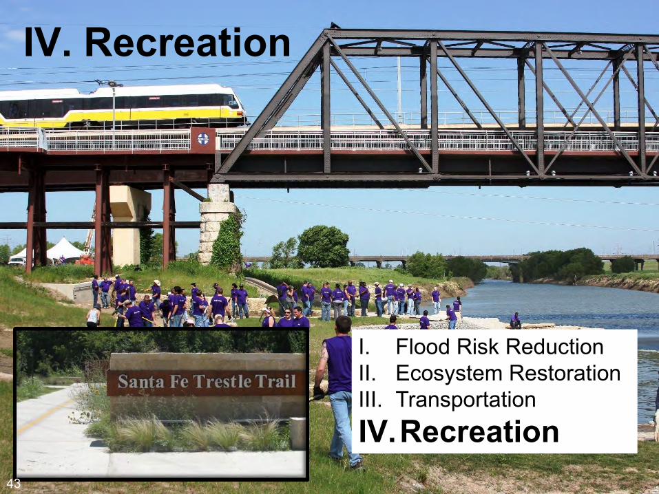
IV. Recreation
43
I. Flood Risk Reduction II. Ecosystem Restoration III. Transportation IV.Recreation
43

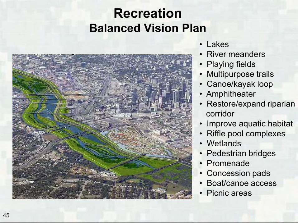
Recreation Balanced Vision Plan
In 2003 City of Dallas writes long-range Balanced Vision Plan to reclaim Trinity River as a great natural resource and unique public domain and a model of environmental stewardship that embodies the spirit of the Kessler Plan idea of nearly a century before.
44
45
Recreation Balanced Vision Plan
• Lakes • River meanders • Playing fields • Multipurpose trails • Canoe/kayak loop • Amphitheater • Restore/expand riparian corridor • Improve aquatic habitat • Riffle pool complexes • Wetlands • Pedestrian bridges • Promenade • Concession pads • Boat/canoe access • Picnic areas

46
Recreation Possible Phase I Urban Lake – Under Study
Construction could begin in late 2014
Approx. 23 acres Near Margaret McDermott Bridge and Commerce Bridge
For reference, Lake Cliff is about 13 acres and Bachman Lake is about 120 acres
47
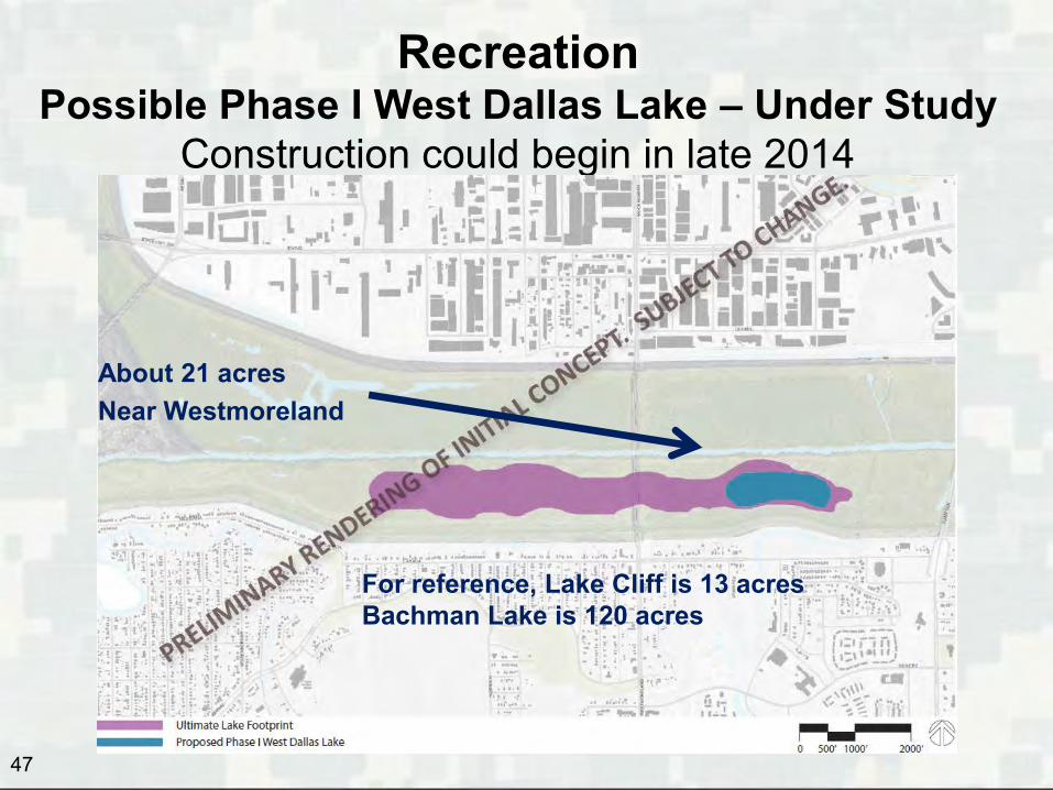
Recreation Possible Phase I West Dallas Lake – Under Study
Construction could begin in late 2014
About 21 acres Near Westmoreland
For reference, Lake Cliff is 13 acres Bachman Lake is 120 acres
48
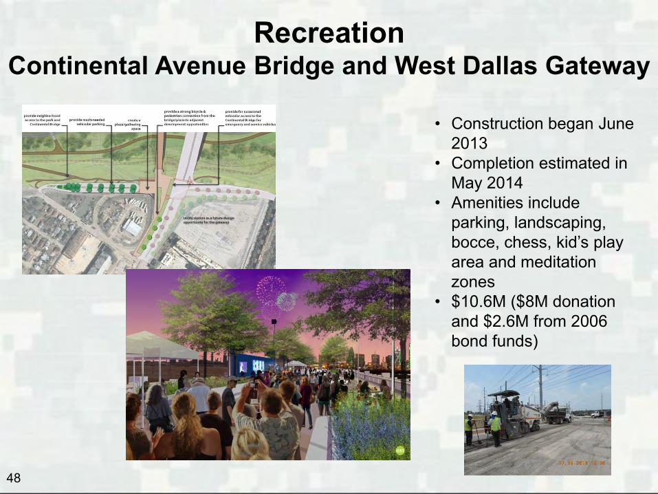
Recreation Continental Avenue Bridge and West Dallas Gateway
• Construction began June 2013
• Completion estimated in May 2014
• Amenities include parking, landscaping, bocce, chess, kid’s play area and meditation zones
• $10.6M ($8M donation and $2.6M from 2006 bond funds)
49
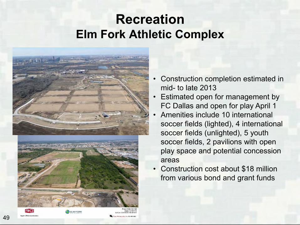
Recreation Elm Fork Athletic Complex
• Construction completion estimated in mid- to late 2013
• Estimated open for management by FC Dallas and open for play April 1
• Amenities include 10 international soccer fields (lighted), 4 international soccer fields (unlighted), 5 youth soccer fields, 2 pavilions with open play space and potential concession areas
• Construction cost about $18 million from various bond and grant funds
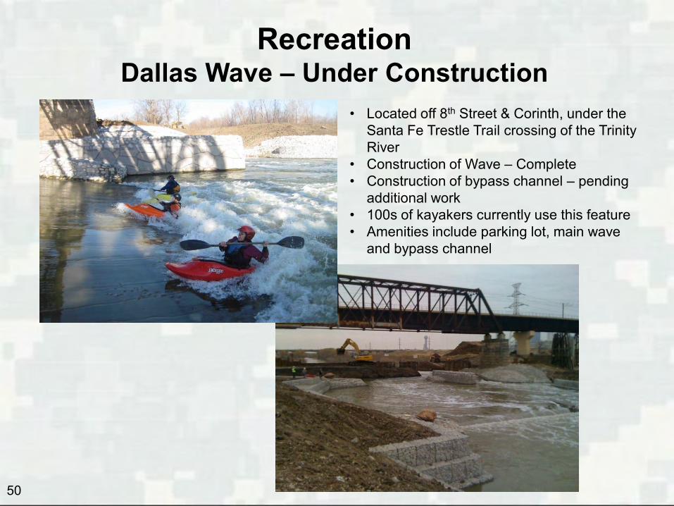
Recreation Dallas Wave – Under Construction
• Located off 8th Street & Corinth, under the Santa Fe Trestle Trail crossing of the Trinity River
• Construction of Wave – Complete • Construction of bypass channel – pending
additional work • 100s of kayakers currently use this feature • Amenities include parking lot, main wave
and bypass channel
50 50
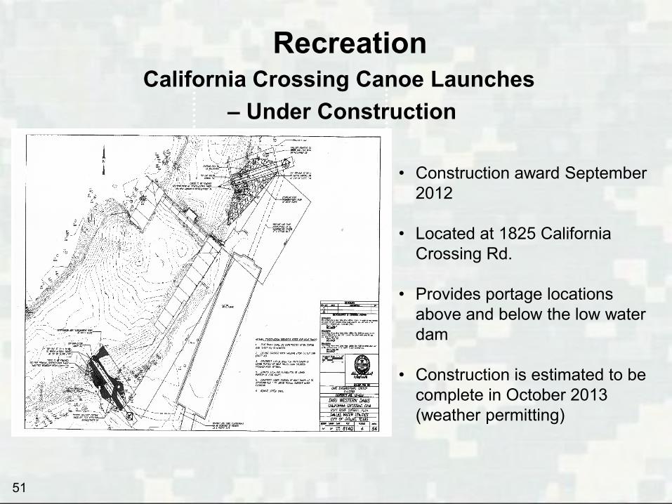
Recreation
• Construction award September 2012
• Located at 1825 California
Crossing Rd. • Provides portage locations
above and below the low water dam
• Construction is estimated to be
complete in October 2013 (weather permitting)
51
California Crossing Canoe Launches – Under Construction

Recreation Dallas Maritime Museum– 1501 S. Riverfront Blvd.
• Planned dry land berth for USS Dallas, a 362-foot nuclear attack submarine being decommissioned in 2014
• 3.5-acre site near Trinity River • 30,000-square-foot building planned • Fundraisers estimate $80 million cost
52
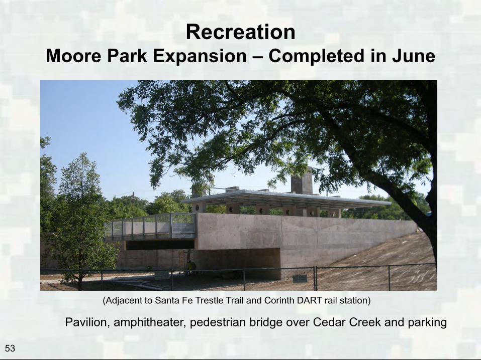
Recreation Moore Park Expansion – Completed in June
53
(Adjacent to Santa Fe Trestle Trail and Corinth DART rail station)
Pavilion, amphitheater, pedestrian bridge over Cedar Creek and parking
Recreation
54
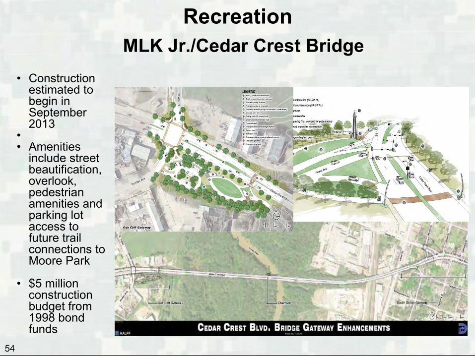
• Construction estimated to begin in September 2013
• • Amenities
include street beautification, overlook, pedestrian amenities and parking lot access to future trail connections to Moore Park
• $5 million construction budget from 1998 bond funds
MLK Jr./Cedar Crest Bridge
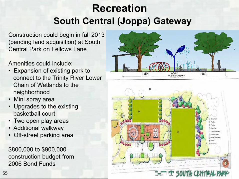
Recreation
55
Construction could begin in fall 2013 (pending land acquisition) at South Central Park on Fellows Lane Amenities could include: • Expansion of existing park to connect to the Trinity River Lower Chain of Wetlands to the neighborhood • Mini spray area • Upgrades to the existing basketball court • Two open play areas • Additional walkway • Off-street parking area $800,000 to $900,000 construction budget from 2006 Bond Funds
South Central (Joppa) Gateway
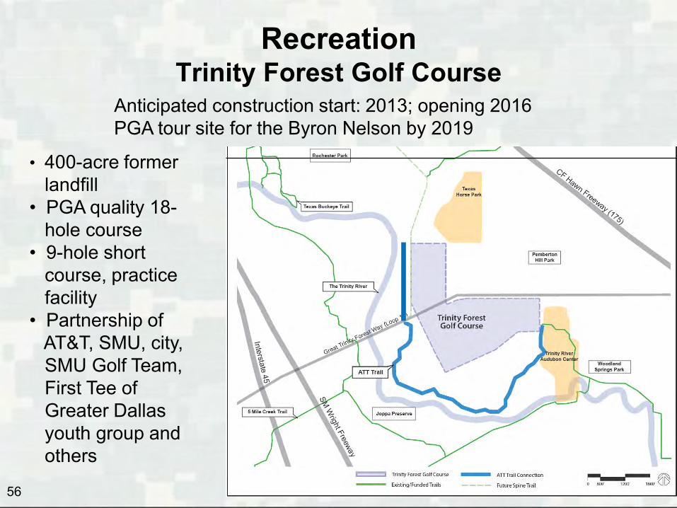
• 400-acre former landfill • PGA quality 18- hole course • 9-hole short course, practice facility • Partnership of AT&T, SMU, city, SMU Golf Team, First Tee of Greater Dallas youth group and others
56
Recreation Trinity Forest Golf Course
Anticipated construction start: 2013; opening 2016 PGA tour site for the Byron Nelson by 2019

• Located at 811 Pemberton • Construction started Summer 2013 • Estimated finish: Summer 2014 • Non-profit phase includes a
therapeutic center, arenas, a camp house and trail ride opportunities
• $12 million cost from 1998 & 2006 bond funds and Hillcrest Foundation grants
• Partners include: • Equest Therapeutic Horsemanship • River Ranch Educational Charities • Texas Horse Park Foundation
Recreation Texas Horse Park
57
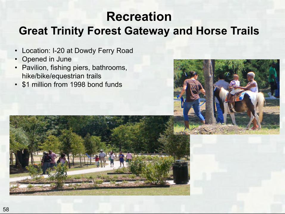
• Location: I-20 at Dowdy Ferry Road • Opened in June • Pavilion, fishing piers, bathrooms,
hike/bike/equestrian trails • $1 million from 1998 bond funds
Recreation Great Trinity Forest Gateway and Horse Trails
58

Trinity Trails Network Background
• Trinity Trails Network is a subset of the City’s Trail Network System
• Extends from Royal Lane near Luna in the North to I20 & Dowdy Ferry in the South
• Hard surface trails – 62.7 miles planned (8 miles in service)
• Soft surface trails – 18.8 miles in service
59
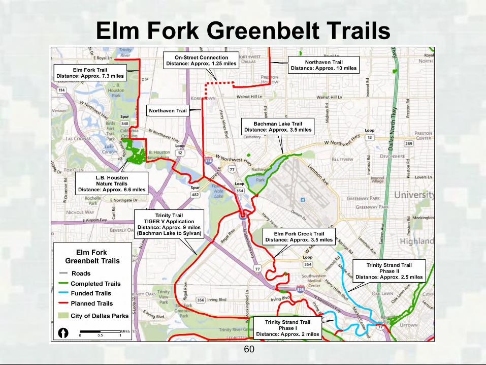
Elm Fork Greenbelt Trails
60
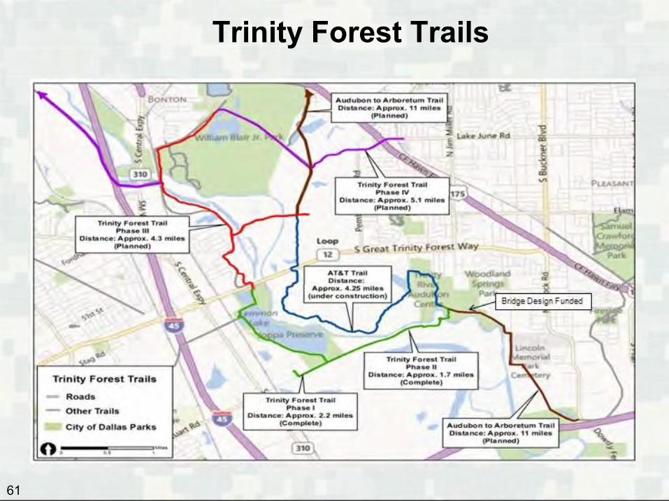
Trinity Forest Trails
61
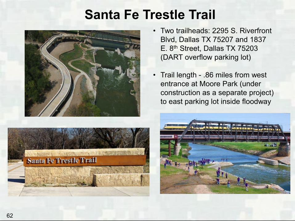
Santa Fe Trestle Trail • Two trailheads: 2295 S. Riverfront
Blvd, Dallas TX 75207 and 1837 E. 8th Street, Dallas TX 75203 (DART overflow parking lot)
• Trail length - .86 miles from west
entrance at Moore Park (under construction as a separate project) to east parking lot inside floodway
62
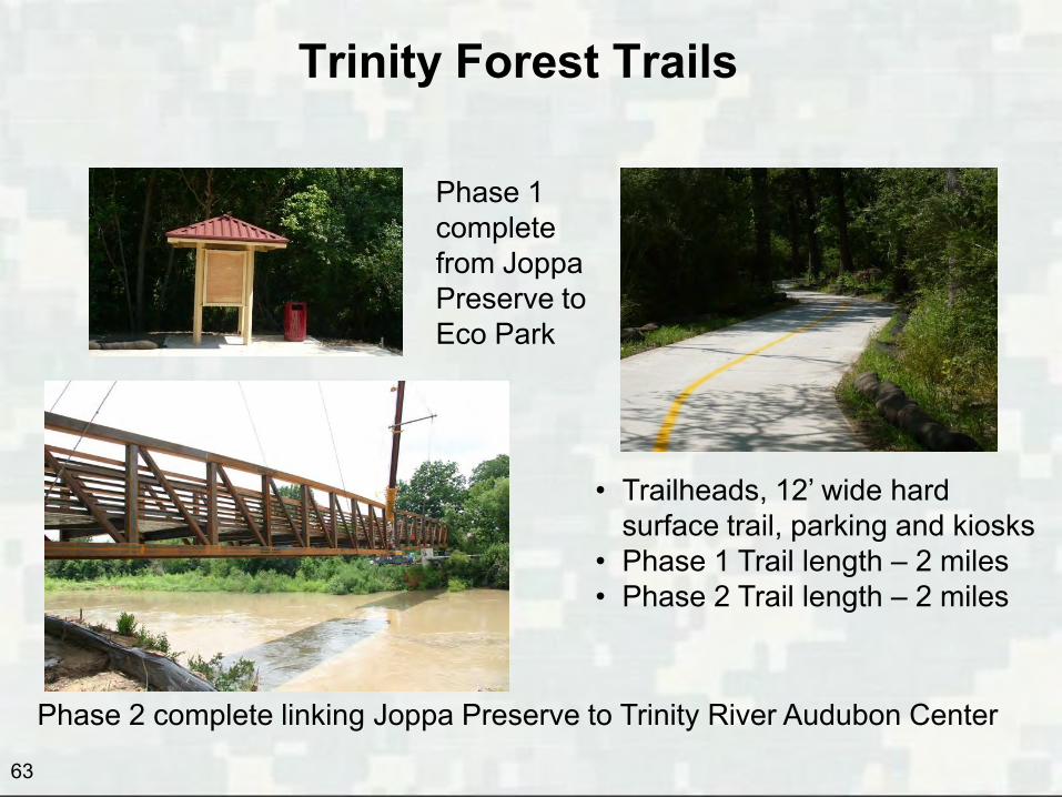
Trinity Forest Trails
Phase 1 complete from Joppa Preserve to Eco Park
Phase 2 complete linking Joppa Preserve to Trinity River Audubon Center
• Trailheads, 12’ wide hard surface trail, parking and kiosks
• Phase 1 Trail length – 2 miles • Phase 2 Trail length – 2 miles
63
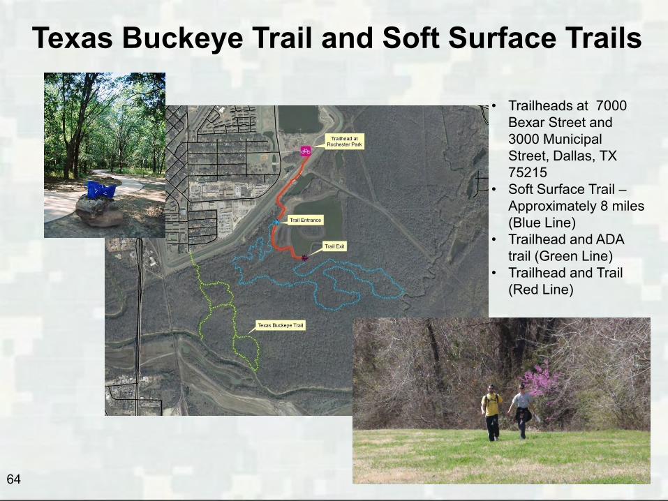
Texas Buckeye Trail and Soft Surface Trails
• Trailheads at 7000 Bexar Street and 3000 Municipal Street, Dallas, TX 75215
• Soft Surface Trail – Approximately 8 miles (Blue Line)
• Trailhead and ADA trail (Green Line)
• Trailhead and Trail (Red Line)
64
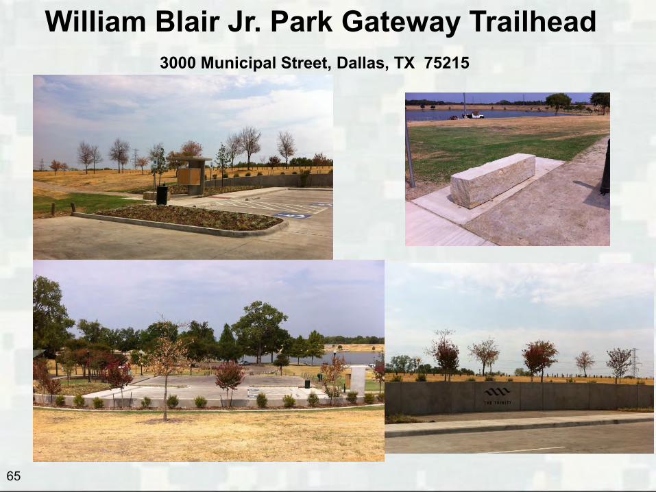
William Blair Jr. Park Gateway Trailhead
65
3000 Municipal Street, Dallas, TX 75215
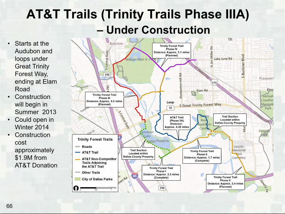
AT&T Trails (Trinity Trails Phase IIIA) – Under Construction
66
• Starts at the Audubon and loops under Great Trinity Forest Way, ending at Elam Road
• Construction will begin in Summer 2013
• Could open in Winter 2014
• Construction cost approximately $1.9M from AT&T Donation
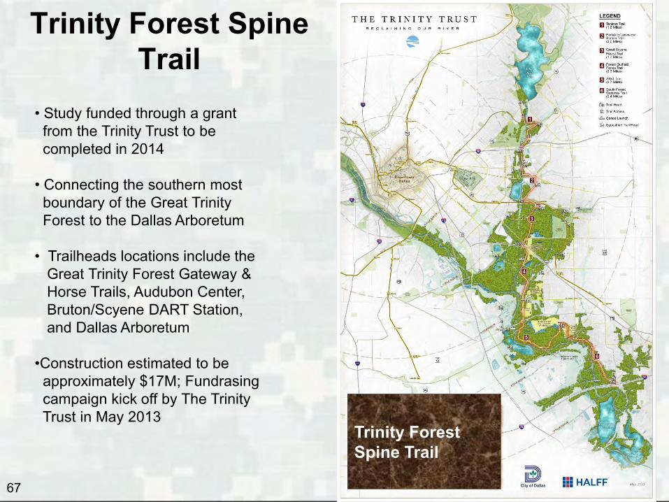
Trinity Forest Spine Trail
67
Trinity Forest Spine Trail
• Study funded through a grant from the Trinity Trust to be completed in 2014 • Connecting the southern most boundary of the Great Trinity Forest to the Dallas Arboretum • Trailheads locations include the Great Trinity Forest Gateway & Horse Trails, Audubon Center, Bruton/Scyene DART Station, and Dallas Arboretum •Construction estimated to be approximately $17M; Fundrasing campaign kick off by The Trinity Trust in May 2013
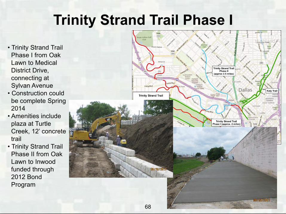
Trinity Strand Trail Phase I
68
• Trinity Strand Trail Phase I from Oak Lawn to Medical District Drive, connecting at Sylvan Avenue • Construction could be complete Spring 2014 • Amenities include plaza at Turtle Creek, 12’ concrete trail • Trinity Strand Trail Phase II from Oak Lawn to Inwood funded through 2012 Bond Program

Trinity Strand Trail – Phase II
69
• Trinity Strand Trail Phase I from Oak Lawn to Medical District Drive, connecting at Sylvan Avenue •Design begins fall 2013 • Construction could be complete Spring 2014 • Amenities include plaza at Turtle Creek, 12’ concrete trail • Trinity Strand Trail Phase II from Oak Lawn to Inwood funded through 2012 Bond Program

Trinity Floodway Trails
70
2012 Bond Program included $6,418,400 for design & construction of Trinity Trails
Katy/Trinity Strand Trail Connection
$18M (includes amenities)

• To advance this trail ahead of the Corps’ EIS, the 2012 Bond Program proposed alignment could be modified and constructed as an all weather joint use maintenance road for: • Maintenance trucks and other equipment • Pedestrians • Cyclists
71
Proposed Alignment for All Weather Joint Use Maintenance Road / Trinity Floodway Trails
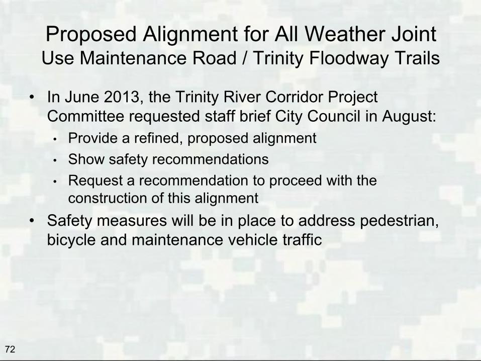
Proposed Alignment for All Weather Joint Use Maintenance Road / Trinity Floodway Trails
• In June 2013, the Trinity River Corridor Project Committee requested staff brief City Council in August: • Provide a refined, proposed alignment • Show safety recommendations • Request a recommendation to proceed with the
construction of this alignment • Safety measures will be in place to address pedestrian,
bicycle and maintenance vehicle traffic
72
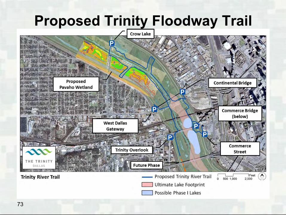
Proposed Trinity Floodway Trail
73

74
Joint-Use All Weather Facility Alignment

• Funds would be reserved to complete: • Connections crossing outfalls following the Dallas
Floodway EIS (could begin in late 2014) • Connections to the Coombs Creek Trail at IH30 (as
soon as IH30 is complete) • Connection between IH30 and IH35 following
completion of Horseshoe Project (2017)
75
Proposed Alignment for All Weather Joint Use Maintenance Road / Trinity Floodway Trails

76
Recreation – Next Steps
• City Council will be asked to approve the proposed alignment of the Trinity Floodway Trail
• In Fiscal Year 2014:
• Transportation and Trinity Project Council Committee will be briefed on the Trinity Forest Spine Trail
• Begin design of possible lakes • Open AT&T Trail • Open TX Horse Park

US Army Corps of Engineers BUILDING STRONG®
Trinity River Corridor Project Update
77
Questions?
Appendix A - History of Trinity River Corridor
78
79
History
• Since 1911, Dallas has been planning flood improvements, transportation and recreation within the Dallas Floodway. All of these planning efforts were undertaken independently
• 1926 – Dallas Levee Improvement District formed; first levees completed in 1930
• 1945 – Congress authorizes the Dallas Floodway Project (levees)
• 1953 – 1960 – Corps constructs the current Dallas Floodway levees
• 1965 – Congress authorizes the Dallas Floodway Extension (DFE) Project
• 1968 – Dallas Levee Improvement District dissolved; City assumes responsibility for levee maintenance
80
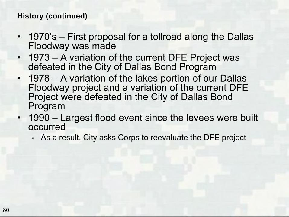
History (continued)
• 1970’s – First proposal for a tollroad along the Dallas Floodway was made
• 1973 – A variation of the current DFE Project was defeated in the City of Dallas Bond Program
• 1978 – A variation of the lakes portion of our Dallas Floodway project and a variation of the current DFE Project were defeated in the City of Dallas Bond Program
• 1990 – Largest flood event since the levees were built occurred
• As a result, City asks Corps to reevaluate the DFE project

81
History (continued)
• 1990’s – City builds Rochester and Central Wastewater Treatment Plant levees
• 1990 -1998 • In preparation for the 1998 Bond Program, the City realized that
we had lost Standard Project Flood Protection, that the levees occasionally experienced skin slides
• No indication of other levees issues were identified at that time • 1994 -1996 – Trinity River Corridor Citizen’s Committee
formed by Mayor Steve Bartlett, to develop the Trinity River Corridor Project vision
• Thousands of citizens participated in hundreds of meetings • The City realized that we could not get consensus on
any single item as a stand alone bond proposition

82
History (continued) • 1998 – City Bond Program includes Proposition 11 for the Trinity River Corridor Project for $246M with multiple components • First and foremost is Flood Protection:
• Dallas Floodway Extension Project ($24.7M) • Elm Fork Improvements, including Soccer Complex ($30M)
• Other Project Components: • Recreation
• Chain of Lakes concept ($31.5M) • Athletic fields, trails and Gateway Parks ($41.5M)
• Transportation • Trinity Parkway ($84M) • Woodall Rodgers Extension (Margaret Hunt Hill Bridge) ($28M) • Beckley/Commerce Intersection Improvements ($6M)
• Environmental Restoration • Forest restoration and mitigation (part of DFE) • Wetlands (part of DFE) • Air Quality
• Sustainable development and reinvestment in the heart of Dallas • 2006 – City Bond Program includes funding for flood control, transportation and recreation projects • 2007 – Voters reconfirm support for the Trinity Parkway inside the levees • 2009 – Corps’ Periodic Inspection #9 occurs • 2011 – Corps’ Risk Assessment determines levees are more resilient and actually provide 1500-year flood protection • 2012 – City Bond Program includes funding for flood control and trails

Appendix B - Historical Funding Partnership City / Corps
83
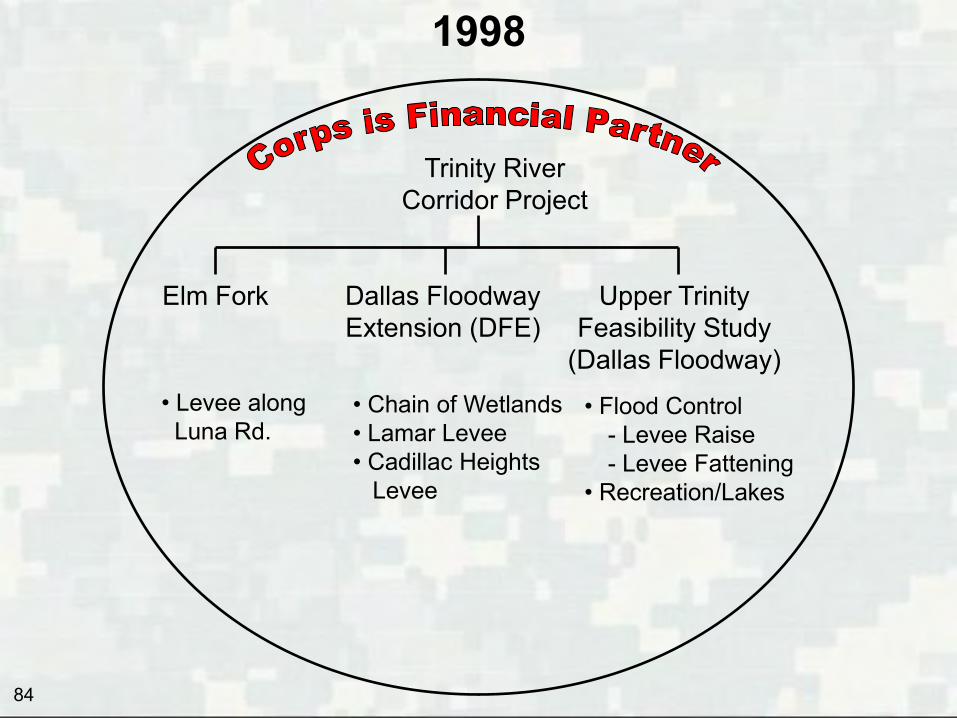
1998
Trinity River Corridor Project
Elm Fork Dallas Floodway Extension (DFE)
Upper Trinity Feasibility Study
(Dallas Floodway) • Levee along Luna Rd.
• Chain of Wetlands • Lamar Levee • Cadillac Heights Levee
• Flood Control - Levee Raise - Levee Fattening
• Recreation/Lakes
84

2006
• Miscellaneous Small Drainage Improvements.
Elm Fork Dallas Floodway Extension (DFE)
Upper Trinity Feasibility Study
(Dallas Floodway) • Chain of Wetlands • Lamar Levee • Cadillac Heights Levee
• Flood Control - Levee Raise - Levee Fattening
• Recreation/Lakes
Trinity River Corridor Project
Interior Drainage Projects
• 2006 Bond Program
- Able Pump Station - Baker Pump Station - Pavaho Pump Station
85

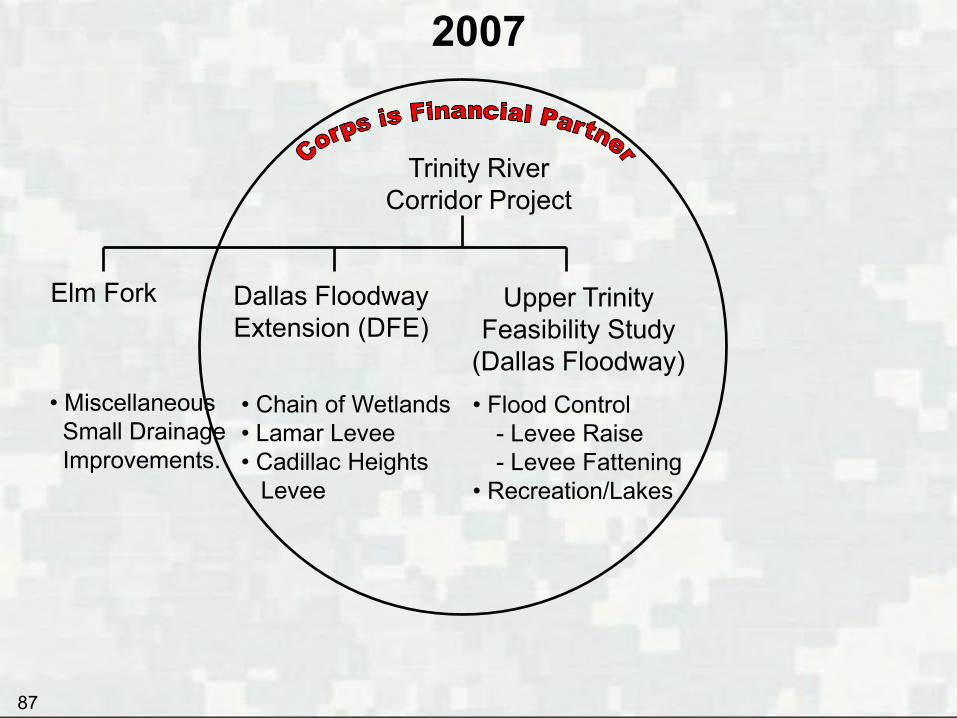
2007
• Miscellaneous Small Drainage Improvements.
Elm Fork Dallas Floodway Extension (DFE)
• Chain of Wetlands • Lamar Levee • Cadillac Heights Levee
Trinity River Corridor Project
Interior Drainage Projects
• 2006 Bond Program
- Able Pump Station - Baker Pump Station - Pavaho Pump Station
Feasibility Study/EIS
• Flood Control • Recreation/Lakes • Interior Drainage
86
2007
• Miscellaneous Small Drainage Improvements.
Elm Fork Dallas Floodway Extension (DFE)
• Chain of Wetlands • Lamar Levee • Cadillac Heights Levee
Trinity River Corridor Project
Upper Trinity Feasibility Study
(Dallas Floodway) • Flood Control
- Levee Raise - Levee Fattening
• Recreation/Lakes
87

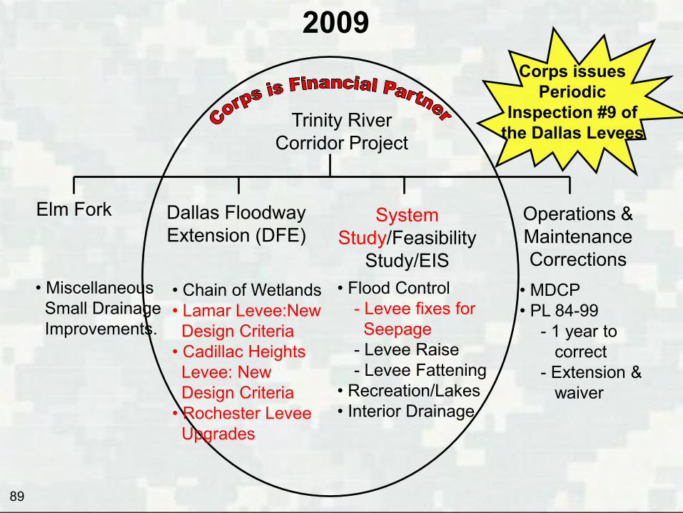
2009
• Miscellaneous Small Drainage Improvements.
Elm Fork Dallas Floodway Extension (DFE)
• Chain of Wetlands • Lamar Levee • Cadillac Heights Levee
Trinity River Corridor Project
Feasibility Study/EIS
• Flood Control • Recreation/Lakes • Interior Drainage
Corps issues Periodic
Inspection #9 of the Dallas Levees
Operations & Maintenance Corrections
• MDCP • PL 84-99
- 1 year to correct - Extension & waiver
88
2009
• Miscellaneous Small Drainage Improvements.
Elm Fork
Trinity River Corridor Project
Corps issues Periodic
Inspection #9 of the Dallas Levees
Operations & Maintenance Corrections
• MDCP • PL 84-99
- 1 year to correct - Extension & waiver
System Study/Feasibility
Study/EIS • Flood Control
- Levee fixes for Seepage - Levee Raise - Levee Fattening
• Recreation/Lakes • Interior Drainage
Dallas Floodway Extension (DFE)
• Chain of Wetlands • Lamar Levee:New Design Criteria • Cadillac Heights Levee: New Design Criteria • Rochester Levee Upgrades
89

Appendix C - Funding Summary
90
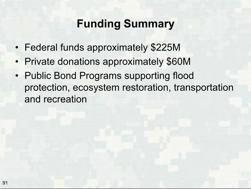
Funding Summary
• Federal funds approximately $225M • Private donations approximately $60M • Public Bond Programs supporting flood
protection, ecosystem restoration, transportation and recreation
91
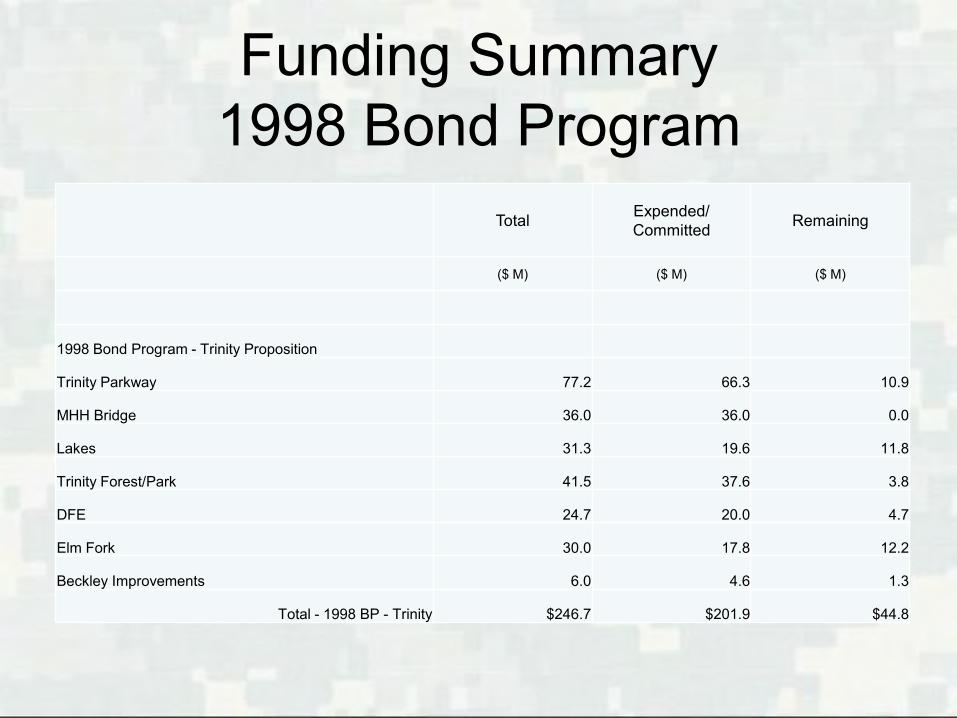
Funding Summary 1998 Bond Program
Total Expended/ Committed
Remaining
($ M) ($ M) ($ M)
1998 Bond Program - Trinity Proposition
Trinity Parkway 77.2 66.3 10.9
MHH Bridge 36.0 36.0 0.0
Lakes 31.3 19.6 11.8
Trinity Forest/Park 41.5 37.6 3.8
DFE 24.7 20.0 4.7
Elm Fork 30.0 17.8 12.2
Beckley Improvements 6.0 4.6 1.3
Total - 1998 BP - Trinity $246.7 $201.9 $44.8
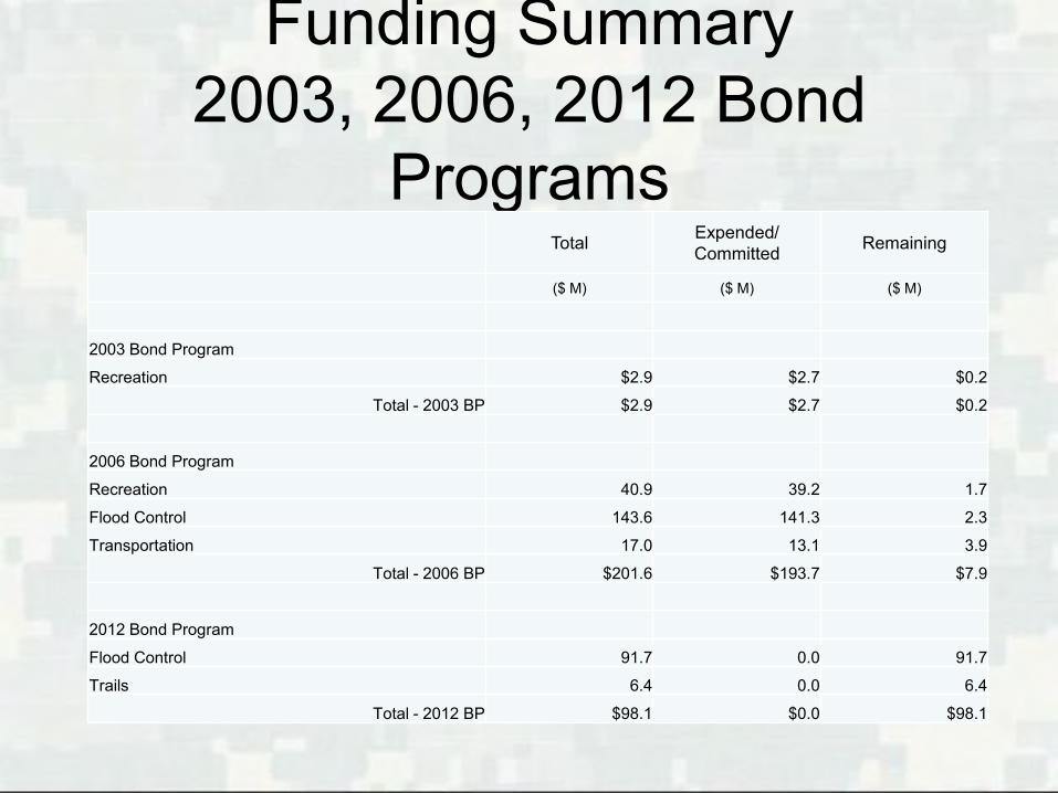
Funding Summary 2003, 2006, 2012 Bond
Programs Total Expended/
Committed Remaining
($ M) ($ M) ($ M)
2003 Bond Program
Recreation $2.9 $2.7 $0.2
Total - 2003 BP $2.9 $2.7 $0.2
2006 Bond Program
Recreation 40.9 39.2 1.7
Flood Control 143.6 141.3 2.3
Transportation 17.0 13.1 3.9
Total - 2006 BP $201.6 $193.7 $7.9
2012 Bond Program
Flood Control 91.7 0.0 91.7
Trails 6.4 0.0 6.4
Total - 2012 BP $98.1 $0.0 $98.1

Appendix D - Trinity Parkway EIS Summary
94

• Conducted by North Texas Tollway Authority (NTTA)
• 1999: Notice of Intent and Project Scoping • 2005: Draft EIS evaluated the social, economic
and environmental effects of the Trinity Parkway alternatives
• 2009: Supplemental Draft EIS developed in response to the USACE to concerns about proposed floodway alternatives
95
Trinity Parkway Summary of Environmental Impact Statement (EIS)
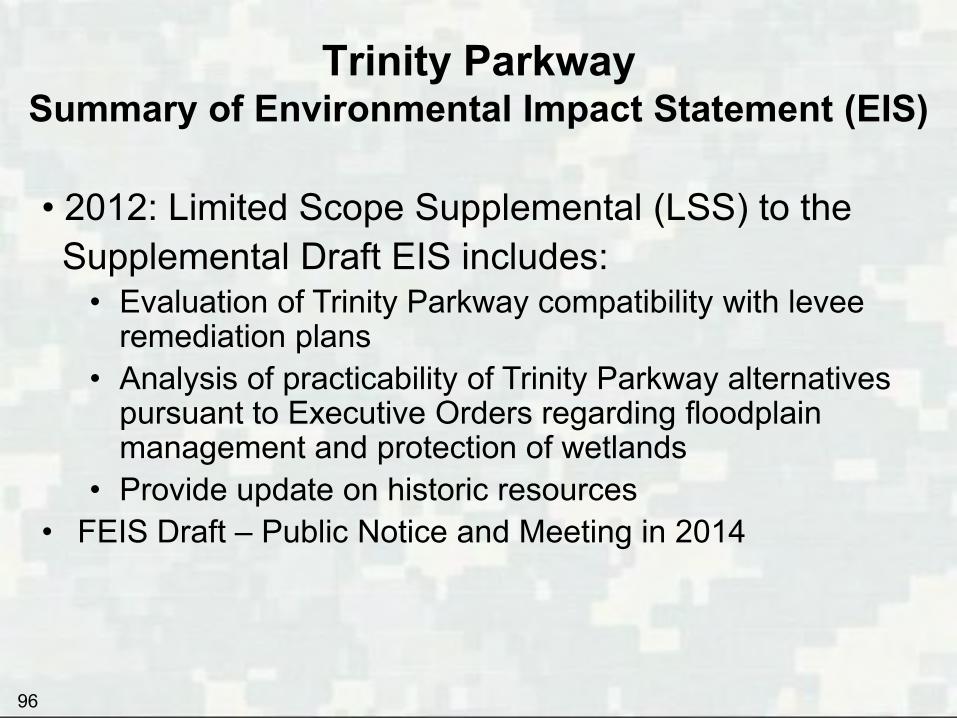
• 2012: Limited Scope Supplemental (LSS) to the Supplemental Draft EIS includes:
• Evaluation of Trinity Parkway compatibility with levee remediation plans
• Analysis of practicability of Trinity Parkway alternatives pursuant to Executive Orders regarding floodplain management and protection of wetlands
• Provide update on historic resources • FEIS Draft – Public Notice and Meeting in 2014
Trinity Parkway Summary of Environmental Impact Statement (EIS)
96