Embed Size (px)
Citation preview
Sharing the Vision on the A14
CUSTOMER EXPERIENCE | NOVEMBER 2019
TRANSFORMING THE WAY THE WORLD WORKS
Solution
Trimble® SiteVision®
A new approach to on-site visualization brings design information to life.
An engineering firm uses Trimble technology to add value and productivity to large-scale infrastructure projects.
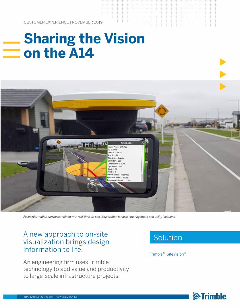
Asset information can be combined with real-time on-site visualization for asset management and utility locations.

As the largest road project under construction in the U.K., England’s £1.5 billion upgrade and expansion of the A14 highway will modernize 34 km of road between Cambridge and Huntingdon. The A14 Integrated Delivery Team, a joint venture between Costain, Skanska, Balfour Beatty and Atkins Jacobs, has applied new approaches in sharing project information with the workforce, residents and landowners affected by the work.
overview
Location
UNITED KINGDOM
TRANSFORMING THE WAY THE WORLD WORKSTRANSFORMING THE WAY THE WORLD WORKS
Mark Lawton is Skanska UK’s chief engineering surveyor and lead survey manager for the A14 C2H improvement scheme. He knew that it would be important to discuss the project impact and benefits with people not familiar with highway construction. With 70 structures, a 750-meter-long viaduct and a new 19-km-long bypass around Huntingdon, the project will improve safety, increase capacity and reduce travel time between Cambridge and Huntingdon by up to 20 minutes.
Lawton needed to explain where the road was planned to go and how the construction would affect the surrounding areas. But for many of these stakeholders it would be difficult to understand the project based on conventional highway design plan sheets. So Lawton turned to the Trimble SiteVision outdoor augmented reality solution. Running on a user-supplied Android®-based smartphone, SiteVision combines precise GNSS positioning with 3D design data to provide real-time, on-site visualization of the project’s planned roadways, structures and construction zones.
The simplicity of the SiteVision system made it possible for both technical and non-professional people to understand and visualize the plans. “I tell people that it’s just a phone,” Lawton said. “It’s a small, easy and friendly way to show people what is happening.” He explained that once a resident can see how trees and land will be protected, Skanska UK can gain buy-in for the work.
Lawton also needed to work with construction teams in planning the work and defining locations for fencing, excavation limits, construction materials, equipment and trailers and work yards. By using SiteVision, Lawton could provide a big-picture view enabling contractors to see how their work interacts with other needs and activities on the site. “We went to a bridge site and worked with the engineers who would be driving piles and getting steel in place.” he said. “At the same time, the site foreman is deciding where he’s going to have his lay down area, job cabins and wash-outs for the concrete trucks. It was easy to use SiteVision to mark out four small plots and say

‘Keep out of this area.’ The entire planning process moves forward really quickly.”
SiteVision can use 3D models and information from a wide array of sources including CAD and engineering design packages, BIM and GIS. This flexibility enables users to share views of buildings and structures, utilities, earthworks and more. Using Trimble Catalyst GNSS positioning, SiteVision can depict its models
A proposed bridge for the A14 upgrade is shown in its on-site location. Trimble SiteVision can use 3D models from CAD and engineering software to produce live, real-world views.
with accuracy of a few centimeters. It can be used for verification of models and data sets and for checking construction progress and as-built information.
Lawton is quick to point out the high value of using SiteVision to indicate the location of underground utility cables and pipe lines, an important safety consideration in nearly any project. By linking to the growing body of precise utility location information, SiteVision can help
TRANSFORMING THE WAY THE WORLD WORKS
Contact your local Trimble Authorized Distribution Partner for more information
NORTH AMERICATrimble Inc.10368 Westmoor DriveWestminster CO 80021USA
EUROPETrimble Germany GmbHAm Prime Parc 1165479 RaunheimGERMANY+49-6142-2100-0 Phone+49-6142-2100-140 Fax
ASIA-PACIFICTrimble NavigationSingapore PTE Limited3 HarbourFront Place#13-02 HarbourFront Tower TwoSingapore 099254SINGAPORE+65-6871-5878 Phone+65-6871-5879 Fax
“My goal is to connect decision makers with accurate information. I see Trimble SiteVision as a way of providing information that any user can understand.”
Mark Lawton, Chief Engineering Surveyor, Skanska UK
© 2019, Trimble Inc. All rights reserved. Trimble, the Globe & Triangle logo and SiteVision are trademarks of Trimble Inc., registered in the United States and in other countries. Android is a registered trademark of Google LLC. All other trademarks are the property of their respective owners. PN 022516-487 (11/19)
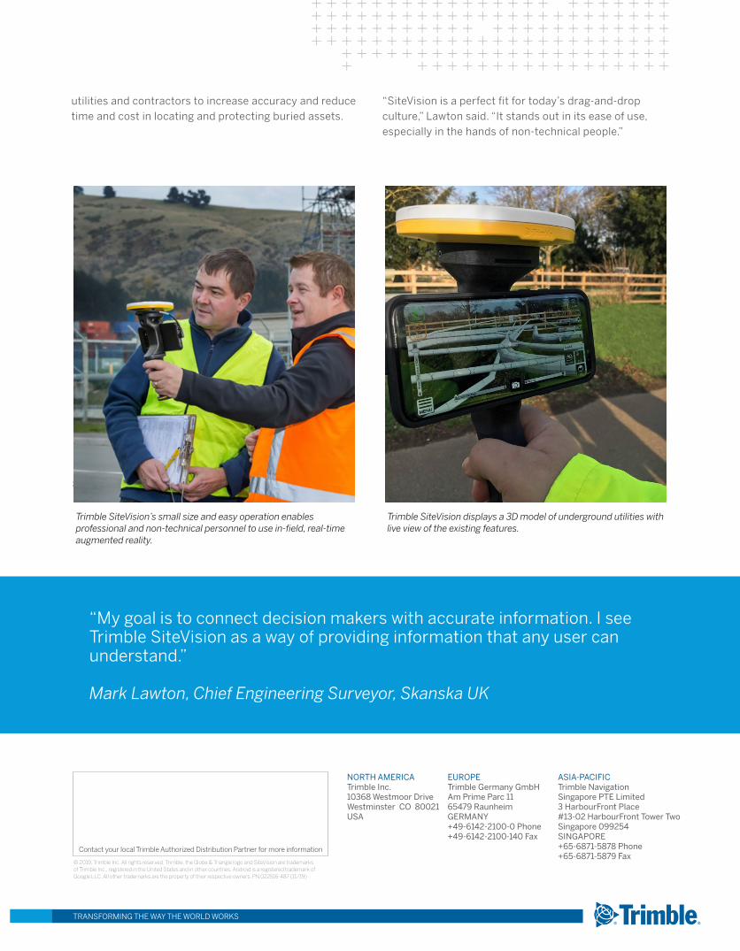
Trimble SiteVision’s small size and easy operation enables professional and non-technical personnel to use in-field, real-time augmented reality.
Trimble SiteVision displays a 3D model of underground utilities with live view of the existing features.
utilities and contractors to increase accuracy and reduce time and cost in locating and protecting buried assets.
“SiteVision is a perfect fit for today’s drag-and-drop culture,” Lawton said. “It stands out in its ease of use, especially in the hands of non-technical people.”
The compact Trimble DA1 antenna enables high-accuracy real-time GNSS positioning for Catalyst and the Enedis application.