Embed Size (px)
Citation preview
transforming the way the world works
datasheet
Benefits ► tightly coupled trimble dual antenna
GNss receiver with IMU sensor in one housing provides a robust positioning solution with less cabling.
► delivers position and attitude even when used in compromising marine situations such as a congested port.
► higher performance than a dual GNss antenna receiver cabled to a third party IMU (Pitch Roll heave) sensor
► deliver dead reckoning data during limited satellite coverage to maintain productivity
► suitable for new or retrofit installations
► Provides legacy NMea-type messages as real-time data outputs including heave, for existing marine software to use.
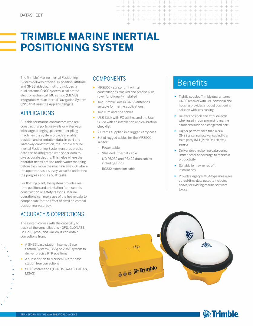
the trimble® Marine Inertial Positioning system delivers precise 3d position, attitude, and GNss aided azimuth. It includes a dual antenna GNss system, a calibrated electromechanical IMU sensor (MeMs) integrated with an Inertial Navigation system (INs) that uses the applanix® engine.
ApplicAtionssuitable for marine contractors who are constructing ports, seawalls or waterways with large dredging, placement or piling machines the system provides reliable position and orientation data. In port and waterway construction, the trimble Marine Inertial Positioning system ensures precise data can be integrated with sonar data to give accurate depths. this helps where the operator needs precise underwater mapping before they move the machine away. Or where the operator has a survey vessel to undertake the progress and ‘as built’ tasks.
For floating plant, the system provides real-time position and orientation for research, construction or safety reasons. Marine operations can make use of the heave data to compensate for the effect of swell on vertical positioning accuracy.
AccurAcy & correctionsthe system comes with the capability to track all the constellations - GPs, GLONass, Beidou, QZss, and Galileo. It can obtain corrections from:
► a GNss base station, Internet Base station system (IBss) or VRs™ system to deliver precise RtK positions
► a subscription to MarinestaR for base station free corrections
► sBas corrections (eGNOs, Waas, GaGaN, Msas)
components ► MPs500 - sensor unit with all
constellations tracked and precise RtK rover functionality installed
► two trimble Ga830 GNss antennas suitable for marine applications
► two 10m antenna cables
► UsB stick with PC utilities and the User Guide with an installation and calibration checklist
► all items supplied in a rugged carry case
► set of rugged cables for the MPs500 sensor:
– Power cable
– shielded ethernet cable
– I/O Rs232 and Rs422 data cables including 1PPs
– Rs232 extension cable
TRIMBLE MARINE INERTIAL POSITIONING SYSTEM
datasheet
MPS500 Marine PoSitioning SenSor SPecificationS
configuration oPtionSRover position and attitude update rate . . . . . . . . Up to 50 hz (up to 200 hz with applanix
ethernet data option)Rover operation within a VRs™ network . . . . . . . . . . . . . . . . . . . . . . . . . . . . . . . . . . . . . . . . . . . Yesavailable Options . . . . . . . . . . . . . . . . . . . . . . . . . . . . . . . . . . . MarinestaR satellite corrections.
applanix proprietary ethernet output data also allows trueheave, data logging.
antenna oPtionSGa830 . . . . . . . . . . . . . . . . . . . . . . . . . . . . . . . . . . GNss (GPs, QZss, Glonass, Galileo, Beidou),
Mss (MarinestaR), L1 sBas. For more details refer to the Ga830 spec sheet
environMentOperating temperature . . . . . . . . . . . . . . . . . . . . . . . . . . . . –20 °C to +60 °C (–4 °F to +140 °F)storage temperature . . . . . . . . . . . . . . . . . . . . . . . . . . . . . –40 °C to +70 °C (–40 °F to +158 °F)humidity . . . . . . . . . . . . . . . . . . . . . . . . . . . . . . . . . . . . . . . . . . . . . . . . 5~95% Rh, non condensingWaterproof . . . . . . . . . . . . . . . . . . . . . . . . . . . . . . . . . . . . . . . . . . . . . . . . . . . . . . . . . . . . . . . . . . . . IP66
Shock and vibrationshock . . . . . . . . . . . . . . . . RtCa/dO-160F section 7, Cat B operation shock and accelerationshock . . . . . . . . . . . . . . . . . . . . . . . . . . . . . . . . . . . . . . . . . . . . . . . . . . . . . . Non-operating to ± 20 Gshock . . . . . . . . . . . . . . . . . . . . . . . . . . . . . . . . . . . . . . . . . . . . . . . . . . . . . . . . . . . .Operating to ± 6 GVibration . . . . . . . . . . . . . . . . . . . . . . . . . . . . . . . . . . . . .RtCa/dO-160F section 8, CatU2 Zone2,
Curves F and F1, Random 3.3 G RMs performance, Random 4.7 G RMs endurance
MeaSureMentS• advanced trimble Maxwell™ 6 Custom GPs Chips• high-precision multiple correlator for GNss pseudorange measurements• Unfiltered, unsmoothed pseudo-range measurements data for low noise, low
multipath error, low-time domain correlation, and high-dynamic response• Very low noise carrier phase measurements with <1 mm precision in a 1 hz bandwidth• trimble eVeRest™ multipath signal rejection• Mss Band: MarinestaR by subscription• GPs L1 C/a, L2C, L2e (trimble method for tracking unencrypted L2P). 220 channels• GLONass L1/L2C/a, L2P Full Cycle Carrier• Galileo: L1 CBOC, e5a, e5B & e5altBOC3 • Beidou: B1, B2• QZss: L1 C/a, L1C, L1 saIF, L2C, L5• 4-channel sBas L1 C/a, L5 (Waas/eGNOs/Msas/GaGaN)
SbaS (WaaS/egnoS/MSaS/gagan) PoSitioning2
accuracy . . . . . . . . . . . . . . . . . . . . . . . . . . horizontal ± 0.50m (1.6 ft), Vertical ± 0.85m (2.8 ft)
code differential gPS PoSitioning1
horizontal accuracy . . . . . . . . . . . . . . . . . . . . . . . . 0.50 m + 1 ppm RMs (1.6 ft + 1 ppm RMs)Vertical accuracy . . . . . . . . . . . . . . . . . . . . . . . . . . . 0.50m + 1 ppm RMs (1.6 ft + 1 ppm RMs)
oMniStar PoSitioningMarinestaR service accuracy . . . . . . . . . . horizontal 0.1 m (0.3 ft), Vertical 0.15 m (0.5 ft)
real-tiMe kineMatic (rtk uP to 30 kM)
PoSitioning1
horizontal accuracy . . . . . . . . . . . . . . . . . . . . . . . 8 mm + 1 ppm RMs (0.026 ft + 1 ppm RMs)Vertical accuracy . . . . . . . . . . . . . . . . . . . . . . . . . . 15 mm + 1 ppm RMs (0.05 ft +1 ppm RMs)
triMble vrS4
horizontal accuracy . . . . . . . . . . . . . . . . . . . . . . . . 8 mm + 0.5 ppm RMs (0.026 ft +0.5 ppm)Vertical accuracy . . . . . . . . . . . . . . . . . . . . . . . . . . .15 mm + 0.5 ppm RMs (0.05 ft +0.5 ppm)
PoSition accuracy during gnSS outagehorizontal accuracy . . . .0.6m (2 ft) for 10 secs, 2.5m (8 ft) for 20 secs total outage (RtK)
PreciSe heading heading accuracy
2 m antenna separation . . . . . . . . . . . . . . . . . . . . . . . . . . . . . . . . . . . . . . . . . . . . . . . . . . . . 0.08°4 m antenna separation . . . . . . . . . . . . . . . . . . . . . . . . . . . . . . . . . . . . . . . . . . . . . . . . . . . . 0.06°heading accuracy during GNss outage . . . . . . . . . . . . . . . . 0.3° after 60 second outage
heaveaccuracy . . . . . . . . . . . . . . . . . . . . . . . . . . . . . . . . . . . . . . . . . . . . . . . . . . . . . . . . 5cm (0.16 ft) or 5%trueheave (Optional upgrade) . . . . . . . . . . . . . . . . . . . . . . . . . . . . . . . . . . . . 2cm (0.07 ft) or 2%
roll and Pitchaccuracy . . . . . . . . . . . . . . . . . . . . . . . . . . . . . 0.03° with RtK or MarinestaR. 0.04° with dGPsduring GNss Outage . . . . . . . . . . . . . . . . . . . . . . . . . . . . . . . . . . . . . . . . . . . . . . . . . . . . . . . . . . 0.05°Post Processed (Option) . . . . . . . . . . . . . . . . . . . . . . . . . . . . . . . . . . . . . . . . . . . . . . . . . . . . . <0.03°
regulatory coMPlianceFCC Part 15 subpart B (Class B device), Canadian ICes-003VCCI V-3/2015.04, as/NZC CIsPR 22, eN55022, eN55024, eN60950-1Ce mark compliant, Rohs Compliant, Weee Compliant
general SPecificationSstatus Lights . . . . . . . . . . . . . . . . . . . . . . . . . . . . . . . . . . . . . . . . . . . . . . 3 - Power, status, Loggingdimensions (L × W × d) . . . . . . . 145mmL x 160mmW x 66mmh for MPs500 sensor onlyWeight . . . . . . . . . . . . . . . . . . . . . . . . . . . . . . . . . . . . . . . . 1.3 kg (2.9 lb) for MPs500 sensor only
coMMunicationSserial . . . . . . . . . . . . . . . . 5 Ports. NMea or Binary output to 50hz. GNss corrections input1PPs (1 Pulse-per-second) . . . . . . . . . . . . . . . . . . . . . . . . . . . . . . . . . . . . . . . . . . . . dedicated BNCstandard ethernet . . . . . . . . . . . . . . . . . . . . . . . . . . . . . . . . . . . . . . . . . NMea and auxilliary data.
also used with POsview controller softwareOptional Output . . . . . . . . . . . . . . . .trueheave, data Logging, Proprietary position, attitude,
raw IMU, raw GNss. Up to 200 hz outputexternal GsM/GPRs . . . . . . . . . . . . . external sNM940. GNss Radio on external Computer
with corrections sent to MPs500Receiver position update rate . . . . . . . . . . . . . . . . . . . . . Up to 50 hz positioning. 200hz with
applanix ethernet optionCorrection data input . . . . . . . . . . . . . . . . . . . . . . . . . . . . . CMR™, CMR+™, RtCM 2.x, RtCM 3.xdata outputs . . . . . . . . . . . . . . . . . . . . . . . . . . NMea, 1PPs, standard marine messages tss1,
$PashR, sIMRad1000 etc
PoWerexternal dC . . . . . . . . . . . . . . . . . . . . . . . . . . . . . . . . . . . . . . . . . . . . . . . . . . . . . . . . . . . . . . 9-34 VdCCurrent . . . . . . . . . . . . . . . . . . . . . . . . . . . . . . . . . . . . . . . . . . . . . . . . . . . . . . . . . . . . .2.5 a Maximum
1 accuracy and reliability may be subject to anomalies such as multipath, obstructions, satellite geometry, interference and atmospheric conditions. always follow recommended survey practices.
2 depends on sBas system performance.3 Galileo Commercial authorization. developed under a Licence of the european Union and the european
space agency.”4 Networked RtK PPM values are referenced to the closest physical base station
Trimble Marine Inertial Positioning System
transforming the way the world works
tRIMBLe CIVIL eNGINeeRING aNd CONstRUCtIONtrimble Navigation Limited10368 Westmoor driveWestminster CO 80021 Usa800-361-1249 (toll Free)+1-937-245-5154 [email protected]
© 2017, trimble Inc. all rights reserved. trimble and the Globe & triangle logo are trademarks of trimble, registered in the United states and in other countries. all other trademarks are the property of their respective owners. PN 022482-3771 (07/17)
construction.trimble.com
www.mercatorgps.com
Mercator Inc.20102 Franz Rd.Katy, Texas 77449-3372United [email protected]
,