Embed Size (px)
Citation preview
Chapter II
TRIBAL HABITAT ~ ECONOMY: AK OVERVIEW
2.1 INTRODUCTORY STATEMENT:
It is well known that the tribal communities in India
have settled in their present homelands through a long and
~hequered process of diffusion. Once they settled down in a
particular eco-region, the physical environment of their
habitat seems to have forced them to adjust with it. Eventu-
ally, the tribal groups have developed diverse economies in
consonance with the prevailing environment. This critical
adjustment, however, has undergone changes of varying de-
grees depending upon several factors which include their own
dynamism, contacts with other tribal or non-tribal groups
etc. Nevertheless, ecological control of food supply con-
tinues to be an important factor of tribal economy even
today. Tribes inhabiting dense rain forests still perform
economic functions of food gathering and hunting - a charac-
teristic practice of palaeolithic stage. On the other hand,
intermontane valleys have permitted settled agriculture to
be performed as the primary mode of economy. Tribes in
hills are seen to derive their sustenance from shifting
cultivation.
The extent of variation in to~ography, soil, rainfall,
74
vagetal cover etc. differentiate' habitats and distinguish
the regions of tribal ecology. In this chapter an attempt
has been nade to identify the distinctiveness of tribal
habitat and economy with special reference to the mid-Indian
tribal belt. In the absence of adequate data, the analysis
is confined only to a broad outline and at times is heavily
dependent upon anthropological literature of the British
period or researches on the economic history of the tribes.
2.2 IDENTIFICATION AND REGIONALISATION OF HID-INDIAN TRIBAL BELT:
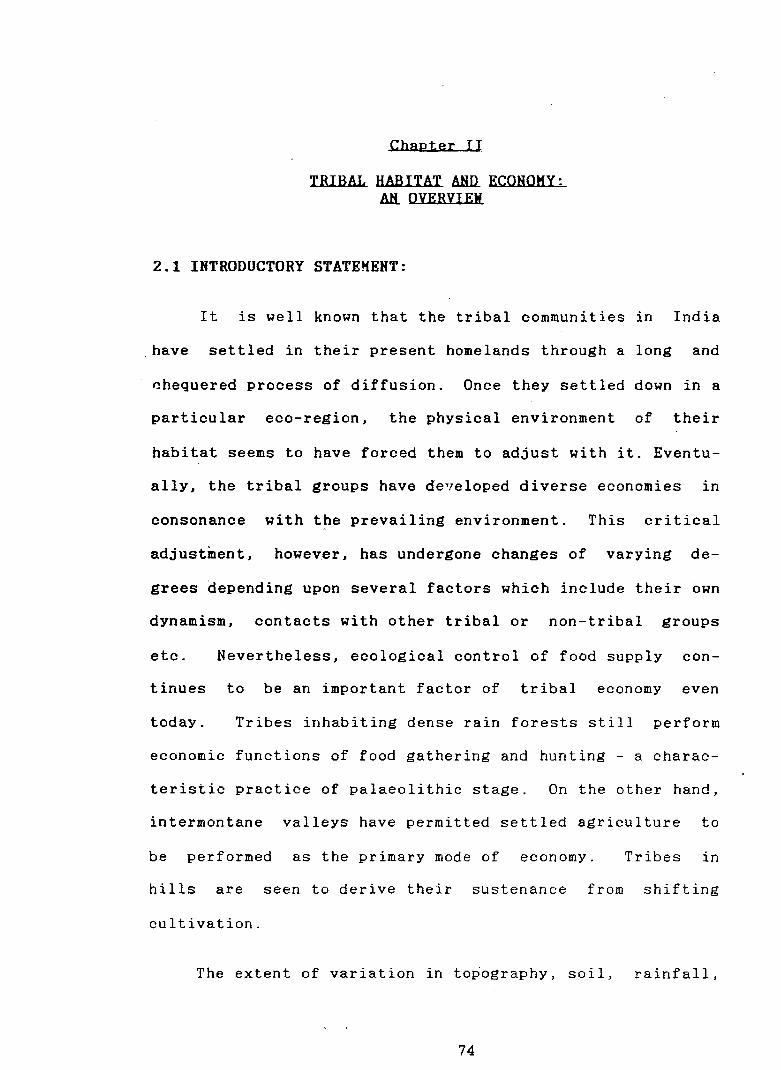
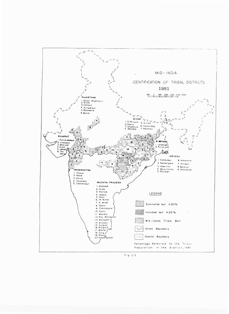
Spatial distribution of scheduled tribes of to-day
~bows a highly uneven pattern. At the state ·level, the
scheduled tribes in the mid-India constitute a significant
proportion of the total population in Rajasthan, Gujarat,
Maharashtra, Madhya Pradesh, Bihar, West Bengal and Orissa.
However, ccnsidering the tendency of the tribes to cluster
and concentrate in favored pockets render the state-level
distribution meaningless. It is, therefore, proposed to
accept a lesser aggregate unit - the district - for greater
precision in identifying the areas of tribal concentration.
A perusal of Figure II.l reveals striking variation in
the share of tribes at district level. The areas of tribal
concentration has been identified by considering, only those
districts where the tribes constitute over 20 per cent of
75
~l
) f
\
(
( ,.. t'
f .J'._' .I t._
_,. ---..., __ -.::\ i ·-- ' .· .. ~
-------,
MID- INDIA
DISTRIBUTION OF SCHEDULED
19BI
TRIBES
~ lQO loo..IC 4QO ... ,
\ - ~
\.... ._-)
I
)
( (
I r_.., \-.; ~ ('I I
Tr.,ol Populafton 01 P•rt•ntoQe
to totol Poc»ulat.on - eo - 100 - '0 - ao - 20- '0 - 10 - 20
a - 10
D I - ' . D 01 -I
Fig II 1
'1\ _) ( " \ \
L/
'-. v
I r "l
/
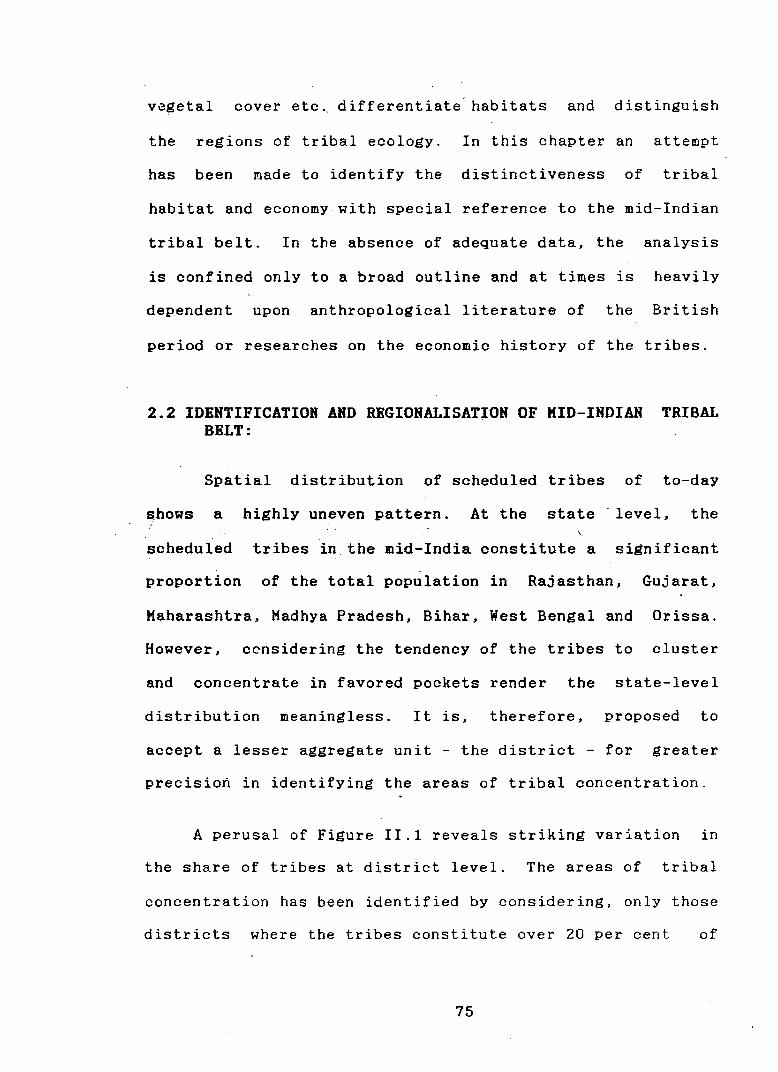
the population. Applying this ''minimum percentage" 1 cr i te-
rion, almost contiguous districts of tribal concentration
emerge quite clearly (Fig. !!.2). However, there are some
areas of discontinuity as represented by a set of districts
having less than 20 per cent tribal share and another with
very high share of tribal population lying outside this
belt.2 Such discontinuities are confined to a zone transi-
tiona! to the non-tribal areas, largely resulting out of
infiltration of non-tribals into traditional tribal home-
land.
Districts which have a very high share of tribal popu-
lation but lie outside the belt~ were ignored while those
within the belt, but did not qualify the "minimum percent-.
age" criterion were included for maintaining the principle
of spatial continutiy (Table 2.1).
Thus defined, the mid-Indian tribal belt constitutes a
cluster of 52 districts bounded by the rugged territory of
Aravallis in the north-west, the lofty north Sahyadris in
1. The logic behind the cut-off point is discussed in the methodology section.
2. Districts having less than 20 per cent tribal share are; Hosangabad, Durg and Raipur of Madhya Pradesh; Bolangir and Dhenkanal of Orissa; and Palamau, Hazaribag, Giridih and Dhanbad of Bihar. Districts having higher share of tribal population are; Sawai Madhopur and Bundi of Rajasthan; Thane of Maharashtra; and Jalpaiguri of West Bengal.
76
.--------------------- --- ---
. ., .'' I -t' .
.... )
(_,
' > ~·- ...,.J· -.J· r-
~
I
.f.J'
r -. ..__l
J .J )
I
/ )
>
\
)
r · IU..aSTH""
/ I Sowa • lllo4•op.,r 2 ,,,0 ... l Udo•pwr 4 O~o~I'\QOtpwr ~ 801'1ewore 6 lwl'ldl
r .. ono Jilll0111l
I
J I
...... "' /
I I
Oto~\olte
Yo-.otMol Cllondra,wr IIIAOHYA IOIII&DISM
1 5frlo""OI1 2 Sodtu 3 Ratio• 4 ~bi.IO
~ Ohor 6 W N t mOI'
7 ( M11nor
8 8etul
9 CMundwore
10 s.on• It lillllondto
12 Ra 1 Mond~<Jon
13 BoloQfrlot
14 ~ d osp~o~r
I~ SurQwlo 16 ROIQOffrl
t1 8o1tor 18 Ourg 1~ Ro•pur 20 "Oicr:QOOOd
MID- INDIA
IDENTIFICATION OF
1981
TRIBAL DISTRIC TS
V" .... ..,
oOO I
. ..... ,_ '- \ -I S Pa· ~ ono ~ G or • d•ll 2 AO"Cfl •
,~ .... fPI
• ~Dod 7 Poto"'o"'
r' ' I >
)00 4 0 0 .. •1 t t
OIIIISS&
J r
- ·-. r .;'
l ·"' I 'I ,) I
kr
I SOMC.Q~r 6 ~OIOPIQ fl (l,
2 S'-"O•'QOftrrl 7 I(Q1Qp.,.t
3 lteOf\ 1 "' or 8 laton') •' 4 Mo,vrbl'lo~ 9 Ofrlel"'•a"'ol ~ P•wiiiOf't•
LEGEND
• EltmtnotW but > 20Y.
• Included C... I < 20 "4
§ W•d-lndton Tr i bal Belt
D Srote s ..... ndory
/.·· ·~:J Outrlcf B~ndory
I
/
... }
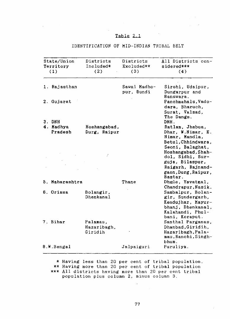
Table ~
IDENTIFICATION OF MID-INDIAN TRIBAL BELT
State/Union Territory
(1)
1. Rajasthan
2. Gujarat
3. DNH 4. Madhya
Pradesh
5. Maharashtra
6. Orissa
7. Bihar
8.W.Bengal
Districts Included*
(2)
Hoshangabad, Durg, Raipur
Bolangir, Dhenkanal
Palamau, Hazaribagh, Giridih
Districts Excluded**
(3)
Sawai Madhopur, Bundi
Thane
Jalpaiguri
All Districts considered***
( 4)
Sirohi, Udaipur, Dungarpur and Banswara. Panchmahals,Vadodara, Bharuch, Surat, Valsad, The Dangs. DNH. Ratlam, Jhabua, Dhar, W.Nimar, E. Nimar, Mandla, Betul,Chhindwara, Seoni, Balaghat, Hoshangabad,Shahdol. Sidhi. Surguja. Bilaspur. Raigarh. Rajnandgaon,Durg,Raipur. Bastar. Dhule. Yavatmal. Chandrapur,Nasik. Sambalpur, Bolangir, Sundergarh, Kendujhar, Mayurbhanj, Dhenkanal, Kalahandi, Phulbani, Koraput. Santhal Parganas, Dhanbad,Giridih, Hazaribagh,Palamau,Ranchi,Singhbhum. Puruliya.
* Having less than 20 per cent of tribal population. ** Having more than 20 per cent of tribal population
*** All districts having more than 20 per cent tribal population plus column 2, minus column 3.
77
the south-west, the densely forested and highly dissected
Bastar plateau in the south-east, and the Chotanagpur pla-
teau in the north-east. Supporting some 29,850,103 tribal
population (57.81 per cent), it represents the largest belt
of concentration of tribes in the country.
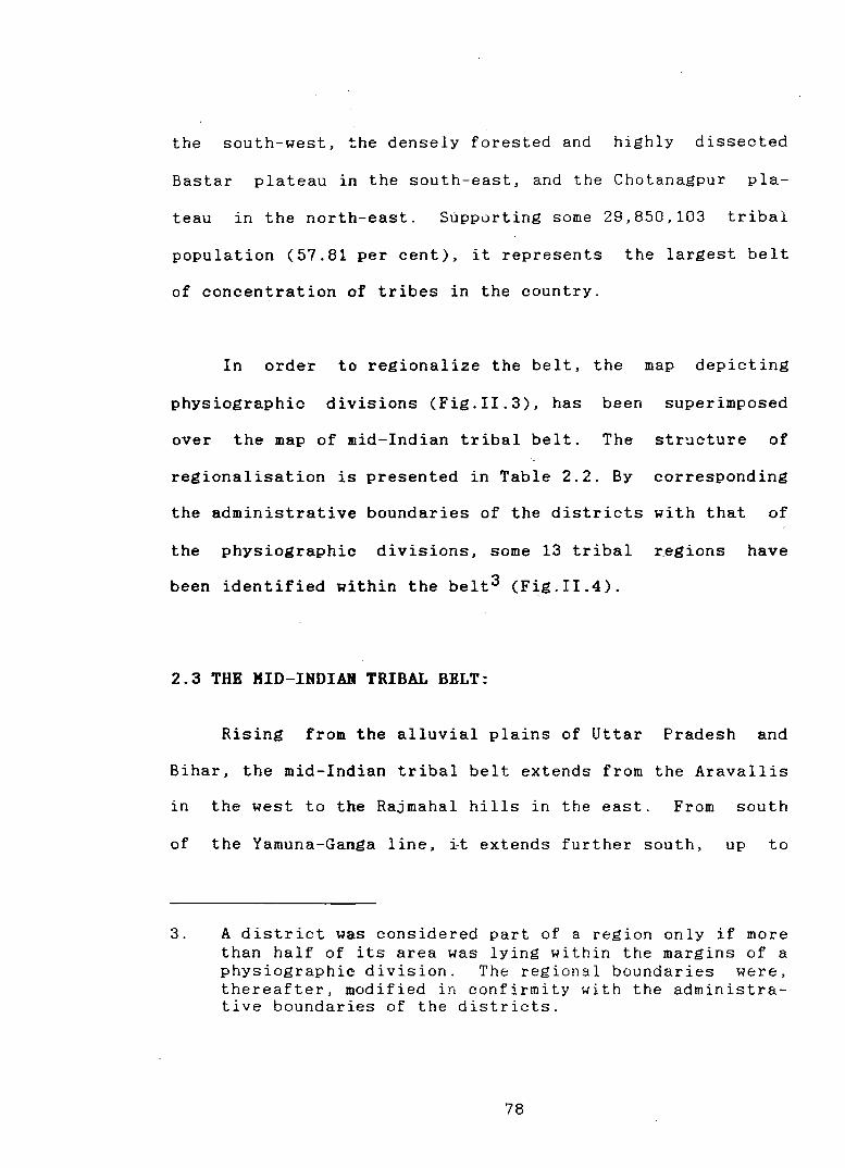
In order to regionalize the belt, the map depicting
physiographic divisions (Fig.II.3), has been superimposed
over the map of mid-Indian tribal belt. The str~cture of
regionalisation is presented in Table 2.2. By corresponding
the administrative boundaries of the districts with that of
the physiographic divisions. some 13 tribal regions have
been identified within the belt3 (Fi.g.II.4).
2.3 THH KID-INDIAH TRIBAL BELT:
Rising from the alluvial plains of Uttar Pradesh and
Bihar, the mid-Indian tribal belt extends from the Aravallis
in the west to the Rajmahal hills in the east. From south
of the Yamuna-Ganga line. ~t extends further south, up to
3. A district was considered part of a region only if more than half of its area was lying within the margins of a physiographic division. The regional boundaries were, thereafter, modified in confirmity with the administrative boundaries of the districts.
78
)--~·-·'·""'-,_ (. '· ·-"\._ '\. , . .r .... ,
l:; .. , •oATH "L · '. i ;'. .... •• KASHMIR .I.J
,.SOUTH \.HIMALAYA ("J \KASHIIIIA \
~HIMALAYA •• ::_ ("! ........... ,, ..... ,.... '
'- J &;:,..-:. ,.. • .. UNJAI «_ 1.·
HIMALAYA t ~~ ...... Y·"·
: ..... '"" 'ICUNAUN ·;,
HI MALAY,.
( I
INDIA
PHYSIOGRAPHIC DIVISIONS
aoo 0
Sowrce
100 400 ••
.,·,.J .... ~ -.if ASTIAN .J ""'\
IAAI(i&Tt()tij ATLAS Of , .. OoA (1972,
!Ptote l I
)
J
Table L2. HID-INDIA: STRUCTURE OF REGIONALIZATION
Macro Meso Micro Districts ( 1) (2) (3) (4)
I. Central a) North Central 1) Aravalli Sirohi,Udaipur, Highlands Highlands Ranges Dungarpur
b) South Central 2) Halwa Banswara,Ratlam Highlands Plateau
3) Vindhyan Jhabua, Dhar Range
II. East & a) West Coast 4) Gujarat Panchmahals, West Plains Vadodara, Bha-Coasts ruch, Surat,
Valsad, DNH
III. Peninsu- a) North Deccan 5) Satpura West Nimar,East lar Pla- Range Nimar, Handla, teaus Betul, Chhind-
wara,Seoni, Balaghat,Hosha-ngabad
6) Mahar a- Dh_ule, Yavatmal, shtra Chandrapur Plateau
b) Western 7) North The Dangs,Nasik Hills Sahyadri
c) Eastern 8) Hahanadi Bilaspur,Raiga-Plateau Basin rh,Durg,Raipur,
Sambalpur,Bola-ngir
9) Baghel- Shahdol, Sid hi, khand Surguja Plateau
10) Chotanag- Santhal Parga-pur Pla- nas, Dhanbad, teau Giridih,Hazari-
bagh, Palamau, Ran chi, Singh-bhum, Puruliya
11) Garhjat Sundergarh,Ken-Hills duj har, Mayur-
bhanj ,Dhenkanal 12) Dandaka- Bastar,Koraput
ranya d) Eastern 13) E.Ghats Phulbani, Kala-
Hills (North) handi
79
MID-INDIAN TRIBAL BELT
P H Y S I 0 G R A P H I C. D I V I S I 0 N s* ('
:? j : 100 0 100 200 Kill. r- ·. ""\ .. .)
.· ~ t::=:t::=:±::::t=::l::::::C:~ ,.- . . .f . I . ·""\ ·-··'\. .. ·~ .· ./'!. ... ./ ~ ,. .. -· : ~ .......
_J ;· I . : ARAVALLI(. : / '-'"'·· J'.. RANGE \ (. •• "''' \\
~ '· BAGHELK HAN 0 ""\ '"! /'_..c._: .• -··) ,.,..~· PLATEAU r-~
CHOTANAGPUR
PL·AT E AU
(
I
) ...... " J """'; \ ....... -' ... , ) .......
• J MALWA .· .r-' ) I ,.. -, ' I ...._ .-..., P ATEAU ' " ... ...., \ J ,"'- .
( \ ~ L ,... - _,., ..,) ... ,,... ·• 'J - c - ,... ~ -
I"\
,-"' )'
. -·\_, I ../"'• /•' ,v J'-' ) \ '<..,. ' ,.... . . ' .. .I'.. ,. / - ) ) ) I ,""' r ./"' " J " ...
~ YA~..., " ,_··""" I ( r" I .._ I ~ VINOH :_ .. ,, -··' f .., ............ GARHJt.T.
,; RANGE I 1 -"' (. -"' SATPURA RANGE ,. • ) r
_(;-'t-- ~ .. "" \ MAHANAOI BASIN ,..) c··"-. ( · ·"" ·· - """' " · I .1- HILLS . \. rJ ~ r··-: 'w
PLAINS t .... , "'-..., \....,-·· . J\ - ,...\. _,J "'r- r··...,..··-... j' ( rJ' ( --:>-··-"
,./ NAHARASTRA ."...,..... · .. \ \ I ..; I''::'~ PLATEAU ,.. .. ,.... .. .1"~ ... - "' \ /"EASTERN r .. - ... -, · •• ,.,-.. · l~'l \ ~\.,..,.GHATS( \NORTH '( ,r "· ,..,· ,.... J "'""' _"'' " ,.J tsAHYAoRI .. j MAHARASTRA · ....: '-r )\_ ....... ~
''\. ,> ,..J ( -··" PLATEAU t.., \. ,,r ~ .. , r-· '\ : ''W\, .... '\J ........ "" ...... !'·'"'· 1\ I I .. .,... .. ) "' .., ,_/'. ,,.
. ' 0. ,1
r OANOAKARANYA ,,..J
. ) ) '""'\.,~ (··.f'
··""··-
* As for th~ Purpos~ of
this Study, .. \...: .r··.) \ .. -..
Flg.ll·4
l
r
the northern fringes of Maharashtra plateau and Dandakara
nya. Drained by numerous rivers, this portion of the penin
sular plateau, indicates varied slope characteristics. In
the noth-west Chambal suggests a northerly slope while Son
and Damodar iu the northeast suggest a slope towards the
east. South of the Satpura-Maikal line the plateau in gener
al is inclined towards the east and southeast, excepting in
the portion immediately south of Vindya-Kaimur ranges which
drains to the west through the Narmada and Tapi troughs.
Another deviation is marked on the western edge where the
plateau abruptly descends on the narrow coastal plain facing
the Arabian Sea. The climate of the plateau is character
ized by a significant variation in the distribution of
rainfall, influencing variety in the vegetatal cover across
the tribal habitats.
2.4 ECOLOGICAL SETTING OF THE TRIBAL HABITAT:
Broadly, the ecological setting of the tribal areas is
characterized by hilly, forested, arid or semi-arid environ
ment;_ by and large negative from the point of view of set
tled agriculture. However, the variations in the ecological
setting of the tribal regions are far too striking as the
they are distributed widely in the subcontinent. As the
natural landscape is not everywhere the same and as the
tribes have made specific adjustments to their habitat, the
80
chores of their cultural evolution have movec along diverse
paths. Raza and Ahmad rightly suggest that "'the genetic
relationship between the material needs of a tribe and the
resource potential of its habitat provides a useful c~ite
rion for identification of meaningful regional units at me3o
(and micro) level".4
The mid-Indian tribal belt displays ecological diversi
ty of a very high order. Atleast three broad divisions can
be identified such as the Central Highlands, the Peninsular
Plateaus, and the Western Coast.
2.4.1 The Central Highlands:
In the northwestern flank of the belt, the Central
Highlands are a wide belt of hilly country characterized by
mountains, hills and plateaus, interspersed with numerous
valleys and basins and covering about one-sixth of the total
area of the country. Bordered on the west by a series of
erosion surfaces dissected by rivers and interspersed with
outcrops of pre-Cambrian rocks - the Aravallis, and on the
east by a great escarpment the Central Highlands ~eparate
the Great Plains from the plateaus and coastal plains of the
Deccan. The complex physiographic conditions compel a fur
ther sub-division of the region into the North Central
4 M. Raza & A. Ahmad, 1990; op.cit. p.38.
81
Highlands and the South Central Highlands.5 Much of it is
under forest cover and 1s the traditional homeland of a
number of tribes, notable among them are the Bhils, the
Dumarias, the Garasias, the Gonds and the Minas.
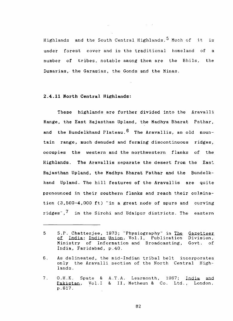
2.4.11 North Central Highlands:
These highlands are further divided into the Aravalli
Range, the East Rajasthan Upland, the Madhya Bharat Pathar,
and the Bundelkhand Plateau.s The Aravallis, an old moun-
tain range, much denuded and forming discontinuous ridges,
occupies the western and the northwestern flanks of the
Highlands. The Aravallis separate the desert from the East
Rajasthan Upland, the Madhya Bharat Pathar and the Bundelk-
hand Upland. The hill features of the Aravallis are quite
pronounced in their southern flanks and reach their culmina-
tion (3,500-4,000 ft) "in a great node of spurs and curving
ridges'', 7 in the Sirohi and Udaipur districts. The eastern
5
6.
7.
S.P. Chatterjee, 1973; ''Physiography'' in T..h.e. QL India; Indian Union, Vol.1, Publication Ministry of Information and Broadcasting, India, Faridabad, p.40.
Gazetteer Division, Govt. of
As delineated, the mid-Indian tribal belt only the Aravalli section of the North lands.
incorporates Central High-
O.H.K. Spate & Pakistan, Vol.! p.617.
A.T.A. Learmonth, 1967; India .and & II, Metheun & Co. Ltd., London,
82
slope is fairly rainy and forested and provides a suitable >
homeland for majority of Rajasthan tribes. However, the
amount of rainfall being highly variable (annual variation
ranging between 11 to 25 in.), the forest cover is an open
-xerophytic type which is already degraded by human and
animal depredation.8 Agrarian potential is generally poor
especially when cultivation is undertaken without irriga-
tion. Millet is the dominant crop while jowar and bajra are
the major food crops. Wheat, gram and pulses along with a
limited quantity of sesame, cotton and sugarcane occupy a
secondary place. Camels and goats are the !
most important
animals, of which the latter have had a very - deleterious
effect on the area's ~egetation.9
2.4.12 South Central Highlands:
The South Central Highlands consisting of the Malwa
plateau, the Vindhyan Scarplands, the Vindhyan Ranges and
the Narmada ValleylO are dominated by a line of scraps and
hill ranges described as Vindhya, Kaimur ranges, Bhander
8. lhid.' p.620
9. lhid.
10. S.P. Chatterjee, 1973; op.cit. p.40; the sub-division of the Vindhyan scarplands and the Narmada valley have been omitted from the study area.
83
plattau and the Vindhyachal. Vindhyan ranges act as the
watershed between the Narmada valley in the south and the
innumerable tributaries of the Chambal in the north; notable
among them are: Kali Sindh, Parbati, Sind, Ken and Tons etc.
These rivers dissect the Malwa plateau and the Vindhyan
Scarplands in a south-north and south-north-east direction.
The South Central Highlands are mostly marked with poor
grasslands. Towards the south, the Vindhyan Hills are cov
ered with teak forests but are broken at many places. Aver
age rainfall in this part amounts to about 25-35 inches. But
a high level of variability in rainfall forces millets to
dominate the cropping pattern. However, moisture retaining
black soils (regur) of the lavas permit growing of cotton.ll
Varied resource base of the Central Highlands has been
an area of attraction for the non-tribal groups. The tribes,
however, continue to inhabit the relatively inhospitable and
less accessible areas, 12 specially in the west, south-west
and the southern portions.
2.4.2 The Western Coast:
The region consists of the coastal plains around Gulf
of Cambay, the adjoining flood plains of Sabarmati, Mahi,
11. l.b..i.d.. p. 623.
12. M. Raza & A.Ahmad, 1990; op.cit. p.97.
, 84
Narmada ar.d Tapi and the eastern intermontane section. The
plain lying on the western outskirts of the Central High-
lands and the Peninsular Plateau, is marked with the outlin-
ers of Malwa plateau, the Vindhya and Satpura ranges in its
intermontane section 13 where most of the tribal population
of Gujarat plains are concentrated. These intermontane
eastern fringes of the plains, emerging from the southern
tip of Aravalli at Palanpur in the north merge with the
Western Hills in the south at the Dangs district, maintain-
ing the contiguity of the mid-Indian tribal belt from the
Aravallis, through Malwa, Vindhya and Satpura ranges up to
the northern tip of the Western Hills. This long north-south
stretch of the region results in a tremendous variation in
the distribution of rainfall, decreasing gradually from .
south to north. The impact is also clearly visible in the
forest cover which too decreases accordingly. The dense
evergreen forest in the south gradually opens up and gets
stunted until the desertic scrub type dominates in the
north.14
2.4.3 The Peninsular Plateau:
To the south and east of the Central Highlands is the
13. K.R. Dikshit. 1970; Geography Qt Guiarat, NBT, New Delhi, p.16.
14. IQid. p.42.
85
largest physiographic division - the Peninsular Plateaus.
Stretching over 1600 km. between Pachmarhi on the north to
Cape Camorin on the south and 1400 km. between the Sahyadri
on the west to the Rajmahal Hills on the east, the plateaus
form a triangle.15 The plateau surface rises over 1000 m. in
the south; but hardly exceeds 500 m. in the ncrth. The
Peninsular Plateaus consist of five distinct physiographic
divisions: Western Hills, North Deccan plateau, South Deccan
plateau, Eastern plateau and Eastern Hills.16
2.4.31 Western Hills:
The Western Hills include the Sahydris and has a gener
al altitude ranging between 900 to 1100 mts.17 All the
important rivers of the Deccan have their sources in the
Sahyadri. The natural vegetation ranges from the evergreen
to the deciduous varieties. The western Hills have been the
abode of numerous hill tribes of Central and South India.
15. S.P. Chatterjee, 1973; op.cit. p.44.
16. lhid. p.45. From south of the Vindhya range, the midIndian tribal belt continues through the northern flanks of the Western hills and the North Deccan plateau; and then extends over the entire Eastern plateaus and the northern tip of the Eastern hills, specially in Kalahandi and Phulb~ni districts of Orissa.
17. ltUUi.
86
The northern section,18 built of horizontal sheets of lava,
has given rise to the typical Deccan trap landscape.
2.4.32 North Deccan:
East of the Western Hills, the North Deccan is built up
principally of plateau lava, in either of its two sections :
the Satpura range and the Maharashtra plateau.19 From the
basalt dominated Rajpipla Hills on the west, the Satpura
almost overhang the Narmada Valley between the north-flowing
tributaries of Narmada : the Devganga and Goi. It further
extends east through Mahadeo and Gowilgarh hills - a Deccan
lava horst20 - up to Maikal range which marks the site of
an ancient shore line to ~he east of which sediments were
deposited in the ancient Cuddapah sea and that it may have
prevented the flow of lava further east during the Deccan
Trap period.21 Agriculture is generally patchy in this
region except in the Mahadeo hills where the Upper Wainganga
and Pench valleys widen out. Wheat, Jowar, Kodon and a
little cotton and sugarcane are grown in this tract. On the
18. Of the northern section, only a small part covering the Dangs of Gujarat and Nasik of Maharashtra are incorporated in the mid-Indian tribal belt.
19. S.P. Chatterjee, 1973; op.cit., p.48.
20. O.H.K. Spate & A.T.A. Learmonth, 1967; op.cit., p.632.
21. S.P. Chatterjee, 1973; op.cit., p.48.
87
hilly tracts of the region, the tribes - mostly Gond~, carry
out ~hifting cultivation. Vegetation is dominated by ~
in the east whil~ teak replaces it in the west, confined
mostly to the hills. Lower areas are open and scrubby.
There are some good grazing land. Lumbering is an important
economic activity.22
The Maharashtra plateau section, separated from the
Satpura ranges by the west flowing Tapi, is made up of flat
la~a flows, and has extraordinary physical homogeneity.23
With a general slope towards the east and the southeast, the
plateau encompasses within itself the historically well-
known region of Khandesh. The Vidharbha plain, the upper
Godavari basin, the Wardha-Wainganga basin, the Bhima basin,
and the headwaiters of Krishna are the other subdivisions of
the region which are separated from each other by lines of
low hill ranges and tabular uplands such as Ajanta, Balaghat
and Mahadeo ranges.24 The summits of the hills, are some-
times stony and barren.
Other areas of the plateau are poorly vegetated, often
by short grasses. However, the river valleys carry deeper
22. O.H.K. Spate & A.T.A. Learmonth, 1967; op.cit., p.632.
23. Lhid.' p.690.
24. However, the mid-Indian tribal belt incorporates only the northern portions of the Maharashtra plateau.
88
soils washed out from the plateau and thus carry thicker
vegetation. Lying on the rainshadow area of the Western
Hills, the rainfall is mostly from the Bay of Bengal branch
during both the monsoons and has a east to west decrease.
The black soils of northern flanks and the valley bottoms
are quite conducive to cotton cultivation.
oilseeds and wheat are also important.25
2.4.33 Eastern Plateau:
Jowar, bajra,
Maikal range marks the eastern boundary of the Deccan
lava and gives way to the Eastern Plateau which is charac
terized by hills and basins. The notable physiographic
units are Baghelkhand, Chotanagpur plateau, Mahanadi
basin, Dandakaranya and Garhjat Hills.26
The Baghelkhand plateau is bordered by the Maikal range
on the south west, river Son on the north, Chotanagpur
plateau in the east and Mahanadi basin in the south. The
region is drained by the river Son and its tributaries in a
trellis pattern. The important rivers are the Gopad, the
Banas and the Rihand, all of which cut across the strike of
the Sonpar hills in .the north. Sonpar hills, overlooking
25. O.H.K. Spate & A.T.A. Learmonth, 1967; op.cit., p.690.
26. S.P. Chatterjee, 1973; op.cit., p.50.
89
the Son valley on its north, comprises of anticlinal hills
and synclinal valleys, carved out of sandstones and lime-
stones of the Semri series. These hills are perhaps rem-
nants of an ancient mountain of the Aravalli type which
existed in the earlier part of the Vindhyan times and had an
east-west trend parallel to the Son.2 7 The topography is
further diversified ~Y flat granitic plateaus to the east of
the Gopad, with broad undulations and basins of the Gondwana
age in the south. The Singrauli basin, formed of lower
Gondwana rocks is considerably dissected.
East of the Son, the Chotanagpur plateau consists of
several erosion surfaces which have a general altitude of
less than 600 m. On the southwest is the Jashpur Pot (high
level laterite plateau), from where "the land descends in
all directions in a series of steps particularly towards the
east until it merges gradually with the lower Ganga
plain." 28 Ranchi plateau in the south, developed on gran-
ite-gneiss, emerges as rounded hills and slightly elevated
terraces of older flood plains; and the Hazaribagh and
27. I.b.id..
28. R.L.Singh National p.652.
(ed. ), 1971; India ~A Regional Geographical Society of India,
90
Geography, Varanasi,
Kodarma plateau in the north, also developed on granite
gneiss, represent peneplains at various stages of uplift and
dissection29 and are separated from each other by the
Damodar trough_30 On the south of Ranchi plateau two lava
hills the Porahat and the Dalma range are most conspicu-
ous. The synclinal Dalma range is antedated by the Subarna
rekha river, exposing mica schists in its bed and lava on
upper slopes.31 In the northeast, the Rajamahal hills,
capped by lava-flows of the Jurassic age,32 extends north
south, ris.ing up to 300-450 m. above the general plateau
surface overlooking the Ganga in the north with steep scraps
to the west. In the entire plateau sharp breaks in the slope
are marked by steep scraps where the river courses are
interrupted by waterfalls.33 Numerous rivers and streams,
namely the South Koel, the North Koel, the Subarnarekha, the
Damodar and the Barakar, with their extensive basins drain
the plateau in different directions.34 The plateau is well
cultivated and densely populated despite physiographic
29. S.P. Chatterjee, 1973; op.cit, pp.51-5a.
30. R.L. Singh (ed.), 1971; op.cit., p.652.
31. S.P. Chatterjee, 1973; op.cit., p.51.
32. IQid.' p.52.
33. R.L. Singh (ed.), 1971; op.cit., pp.652-53.
34. IQid., p.653.
91
limitations. Crop cultivation is, however, restricted by
organic material deficiency in the soil and a long dry
season. About a third of the region is cultivated, mostly
confined to the fringes of the plateau. Only 15 per cent of
the cultivated land is irrigated. Rice, maize and oilseeds
are the most important crops. About one thirds of the
region is covered with forests rich in hard timber, bamboo,
babai grass, besides minor forest produce such as, lac,
tusser silk etc.35
South of the Baghelkhand plateau lie the Hahanadi basin
or the Chhattisgarh plain consisting of alluvial clays and
residual soils which conceal under it the horizontally
bedded or very low-dipping limestones and shales of the
Cuddapah age. 36 Except fur some occasional rugged areas of
rock out-crops littered with weathered rock pieces, the
interfluvial sectors of Mahanadi and its tributaries, naDely
Seonath, Hasdo and Hand etc., present minor surface undula
tions and the fertile plains encourage cultivation of
kharif and ~linseed and wheat.3 7 In comparison to the
35. O.H.K. Spate & A.T.A. Learmonth, 1967; op.cit., p.634.
36. S.P. Chatterjee, 1973; op.cit., pp.52-53.
37. O.H.K. Spate & A.T.A. Learmonth, 1967; op.cit., p.711.
92
Wainganga Valley which receives generally lower than 135
mm. of rainfall, the Upper Mahanadi basin receives higher
rainfall. The sal forest of the Wainganga valley is thus
replaced by the rich teak forest of the Mahanadi basin.38
South of Chhattisgarh plains, the Dandakaranya displays
a highly rugged topography with densely forested tracts.
The Indravati river which flows from east to west, forms
three distinct terraces. At the highest point, the Koraput
plateau~ is situated about 1~200 m. above the mean sea
level. The second terrace is well developed around Jagdal-
pur town~ extending westwards to Chitrakot, "where the river
leaps over pre~ipitous cliff forming one of the most famous
"
waterfalls in Peninsular India ... 39 The third terrace is
highly dissected. In this western section, the region is
characterized by deep valleys and short spurs without any
definite orientation. The region has lower elevations in
its northern flanks and the southern portion is drained by
the south-flowing Sabari river.40 This deeply forested
region has traditionally been a tribal territory. The
terraces of the river valleys offer suitable sites for
38. M. Raza & A. Ahmad, 1990; op.cit., p.97.
39. S.P. Chatterjee, 1973; op.cit. ,p.53.
40. LQid., p.53.
93
cultivation of paddy besides gram, r~pe and sesame cultivat
ed during rahi season. Shifting cultivation supplemented by
collection of forest produce and distillation of mahua flow
ers are the common practices of the tribes.41
The Garhjat Hills is a relic of the oldest land-mass of
Dharwar age and is an intensely dissected plateau at 550-
610m.42 Local relief is much more pronounced specially, in
the Bonai hills, the Kendujhar plateau and the Similipal
massif. "They were repeatedly uplifted into mountains and
eroded into peneplains, the evidence of which is found in
the flat summits at elevations ranging from 400 to 1000 m.
The entrenched meanders of the Baitarani suggest rejuvena
tion of the valley in recent times."43 Formed of the con
fluence· of Sankh and Koel at the faulted basin at Gangapur
in the north near Rourkela, the river flows in south
easterly direction. Another river, Brahmani flows parallel
to it. Most of the region was covered with dense or open
deciduous forests but is gradually being devoid of it
through industrialization, specially in connection with
Rourkela. 44
41. O.H.K. Spate & A.T.A. Learmonth, 1967; op.cit., p.722.
42. lhid .• p.722.
43. S.P. Chatterjee, 1973; op.cit., p.53.
44. O.H.K. Spate & A.T.A. Learmo11th, 1967; op.cit., p.723.
94
2.4.34 Eastern Hills:
The Eastern Ghats, on the south-east of Garhjat Hills
are a discontinuous line of hills, running parallel to the
coast up to Tamilnadu upland£ in the south_45 The Ghats
exhibit their true mountainous character only between the
Mahanadi and the Godavari rivers. The general trend of the
ranges is from northeast to southwest. This northern sec-
tion46 stands as an watershed between west-flowing Machh-
kund and Sileru and east flowing Languliya and
Vamsadhara.47 These are much more forested than their
southern counterparts.
2.5 ECONOMIC RESPONSES OF THE TRIBES:
In conformity with the ecological differences within
the belt, the economic responses of the tribes living in all
these regions display remarkable diversity. The influence
of the habitats on tribal economies is far too striking as
the tribes once settled in a region, have made attempts to
adjust with the natural environment of their habitat. This
45. S.P. Chatterjee, 1973; op.cit., p.54.
46. Of which only Phulbani and Kalahandi district portions are included in the mid-Indian tribal belt.
47. S.P. Chatterjee, 1973; op.cit., p.54.
95
adjustment has, however, undergone substantial modifications
in recent times as a result of diverse degree of exogenous
influences and interventions.
The objective of this section is to get an insight into
the nature of tribal economy as it existed at the beginning
of the colonial phase in order to facilitate an understand
ing of the impact of more recent changes in the tribal
region. economy and society. The analysis relies on histor
ical records of various types, particularly those of the
early colonial anthropological writings.
The tribal economies can be broadly classified into
four types depending upon the differences in the ecological
setting. The dense rainforests permitted the tribes to
perform palaeolithic economic functions of foraging and
hunting. In intermontane valleys, enjoying relative isola
tion. settled agriculture was the normal mode of economy.
Tribes living in hills with manageable slopes, derived their
sustenance from shifting cultivation. The semi-arid condi-
tions permitted pastoral and nomadic activities. However,
there were many variations to these types depending upon the
stage of social evolution, the tribes' own internal dynamism
and degree of exposure to external influences. It may be
pertinent to examine the empirical situation as it existed
at the time of early colonial period in each of the tribal
96
regions.
2.5.1 The Central Highlands:
The Central Highland traots of mid-:ndia broadly corre-
sponds with the Bhil territory of the country. While the
Bhils dominate the region in strength as well as in their
spatial extent, other tribes such as the Gonds, the Gara-
sias. the Minas and the Mairs etc., also inhabit in select
pockets in this highland zone.
The Minas and Mairs inhabit the rampart hills of the /
semi-arid region of the Aravallis. Predictably they adopted
an economy largely linked to animal herding. Prior to the
British intervent~on, these two tribes ''used to live gener-
ally in concealment among these rugged hills. hardly cloth
ing and practicing no useful occupation besides herding."48
The relatively less drier tracts of almost the entire
South Central Highlands and specially the Malwa Plateau
offered the tribes a greater range of economic opportuni-
ties. Wherever possible, the tribes were able to subsist on
settled cultivation besides depending on food available
freely in the neighboring forests.
~ I
48. H.B. Rowney, 1882; ~~Tribes QL India, B.R. Publishing Corporation, New Delhi, (1974 Reprint) p.52.
97
High average rainfall in the south and numerous river
valleys provided more fertile tracts for cultivation of a
large variety of crops including wheat, rice, iowar, urhar,
chana, maize, ianera, oilseeds and tobacco etc. 49
The Narmada valley section of South Central Highlands
was inhabited largely by the Goods. The valley certainly
promoted settled agriculture and the productivity was good.
Crooke50 cites an anonymous English writer, who indicates
the relative prosperity of the tribes living in this re-
gion;
"Without the benefit of navigation - for the Ner budda is here not navigable - and fostering hand of a race of Gond princes, a numerous people filled a fertile country, and still preserve in the neatness of their houses, in the number and magnificence of their temples. in the size of their towns. and the frequency of their plantations. the un-doubted signs of enviable prosperity."
Bhils. embracing the rocky ranges of the Vindhya,
Satpura and Satmalli mountains, of which the passes were
long held by them,51 were mostly agriculturists. Only a few
49. Ibid .• p.16.
50. W. Crooke, 1973, Races Q..[ Northern India, · Cosmo Publishers, Delhi (Reprint), p.71.
51. R.E. Enthoven, 1920; ~Tribes and Castes Q..[ Bombay, Cosmo Publishers, Delhi, (1975 Reprint) p.152.
98
of this tribe led a wandering life in the forests and . lived
by wood-ash tillage.52 Besides, the surrounding forests
provided ample opportunity to all Bhils to involve in sub
sidiary occupations such as, hunting,5 3 basketry, collection
of gums, wax and honey.54
2.5.2 The Western Coast:
On the west of the Bhils, was the territory of the
Kolis, whose special seat was the land north of river Mahi -
the Saurastra plateau. Residing in similar habitat the
economic arid cultural responses of the Bhils and Kalis were
by and large identical.55 Generally speaking the variable
nature of economy of the Koli tribe was a response to the
diverse ecological attributes of the Western Coast.
The relatively open and flat Saurastra plateau permit
ted settled cultivation; the narrow coastal strip provided
the marine resource base to be exploited; and the south had
dense forests as a means of livelihood for the tribes inhab
iting these areas. The Garasias of Panchmahals and its
52. lhid., pp.170-171.
53. lhid. ,p.171.
54. H.B. Rowney; op.cit., p.33.
55. lhid., pp.41-43.
89
vicinity, were making and selling bedsteads called Kethrots
and Chotras with frames of wood and mattresses of coarse
tape. 56
2.5.3 The Peri'insular Plateau:
The diversity in ecological conditions within this
region had fostered varieties of economic opportunities to
the tribes living in different sub-divisions of the platea~.
The tribes of the interior sections, notably in Dandakaranya
and Baghelkhand, subsisted on considerably rudimentary form
of economic life depending upon the difficult physical
environment. Their neighbors on either east or west, had
availed of the avenues of the relatively less harsh environ
mental conditions.
In this Gond heartland, the Assul or the unmixed Gond
lived in small hamlets of a maximum of thirty to thirtyfive
households. The dense forest cover of Dandakaranya were
perhaps rich enough in its reserves of animal food, roots,
berries, wild honey etc. for the sustenance .of these reason
ably thin population. Besides, they also practiced dhaiya
(a form of shifting cultivation) with their only instrument
- the hatchet - to grow kootkee and kodon which grew almost
56. R.E. Enthoven, 1920; QQ.~., Vol.III, p.363.
100
spontaneously on very productive·hill slopes. With these
natural supplies the Assul Gond lived independent of extra-
neous assistance in his small huts made up of mud,
and dried grasses.57
leaves
Certain minor tribes, notably the Karwars of Baghelk-
hand and the Puttooas of Garhjat Hills, encircled by the
major tribes of the Peninsular plateau, also lived in the
most primitive stage of subsistence. The Karwars of Ba
ghelkhand, particularly around the Surguja district depended
primarily on the forest produce for their survival. They,
however, had learnt the art of cultivation which of course
was of a primitive shifting cultivation variety. The yields
were quite poor.58
On the margins of Gond heartland, both on the west
towards Khandesh (North Deccan) and on the east towards the
tributary mahals of Cuttack (Garhjat Hills) the Gonds,
unlike the Assul or unmixed Gonds, or the Karwars and Put
tooas largely depended on food freely available in the
forest. They led a "hunting and gathering·· economy taking
advantage of the abund~nt supply of deer, hogs and snakes
etc., and the roots and seeds of the jungle grass which were
the main component of their food. Besides, they produced
57. H.B. Rowney, 1882; oo.cit., p.16
58. IQid.' p.83.
101
Kooktee and Kodon at a very rudimentary level of jhoom
(shifting) cultivation and bartered produces for other
necessities. 59
The hilly terrain of Chotanagpur and the adjacent
tracts of Vindhya, Kaimur and Maikal ranges, were chosen as
the last resort by the Kolarian races,60 who "fleeing before
their conquerors, seem to have taken their final stand" in
these tracts.61 Of the separate names by which these races
were distinguished, the best known were the Koles and the
Santhals. Liv~ng along with them were the Oraons, who are
59. Ibid., pp.18 & 84-85.
60. S.C. Roy, 1912; ~ Mundas and their Country, Asia Publishing House, New Delhi, (1970 Reprint), pp.1-19.
61. H.W. Rowney, 1882; op.cit., p.57. Even other colonial anthropologists such as, W.Crooke, 1973; op.cit.; E.T. Dalton 1872; Descriptive Ethnology Qf Bengal, Council of the Asiatic Society of Bengal, Calcutta (1960 Reprint); F.B. Bradley Birt, 1903; Story Qf an Upland Chotanagpur: A little Known Province Qf ~ Empire, Smith Elder & Co., London; and H.H. Risley, 1892; Tribes and Castes Qf Bengal, 2 Vols. (1981 Reprint), Firma K.L. Mukhopadhyay, Calcutta; subscribed to the idea that the tribes of Eastern Plateau immigrated into the area after a lot of wandering, of course, within the limits of the Peninsular plateau. For example, the Santhals migrated from the western part of the peninsula and "continued with their eastward movement till the early nineteenth century and finally appeared in the neighbourhood of the Daman-i-Koh in 1832" (W. Crooke, 1973; op.cit., p.82). However, the Oraons and the Pahariyas, are described to have been the residents of Konkan Coast.
102
believed to be of a distinct race.62
The Kales with their numerous subtypes such as the
Mundas, the Larkas, the Has, the Chooars and the Bhumij,
occupied all the country "from the jungles of Ramgurd near
Hazaribagh, to the south and southward down to the confines
of Gangapore and Sirgooja, but those dwelling in Singhbhoom,
a portion of which is called Kalehan are the best known"_63
But the original inhabitants of Kalehan were the Bhuiyans,
who were excellent cultivators and cattle rearers and had
invited the "immigrant" Kales from the Deccan to settle at
their side.64 The Koles and their various subtypes adopted
settled agriculture in the territory which was extremely
fertile and well watered.65 Rice was cultivated thrice in a
year apart from maize, millet, wheat, pulses, mustard,
tobacco and cotton. They, however, continued with the
traditional forms of economy, ~ hunting and cattle herd-
ing,66 for which the plateau offered ample scope.
62. H.B. Rowney, 1882; op.cit., p.57.
63. Lhid., p.58.
64. Lhid.
65. S.C. Roy, 1912; op.cit., p.66. Also see P.Gisbert, 1978; Tribal India: A Synthetic ~ uL Primitive ~. Rawat, Jaipur, pp.24-28.
66. H.B. Rowney, 1882; op.cit., p.61.
103
The Santhals preferred relatively more forested tracts
of Chotanagpur, especially the area around Rajmahal Hills.
Although they were divided into numerous subtypes such as
Saran, Murmu, Marli, Kisku, Besara, Hansola, Tudi, Baski,
Hemroo and Chorai, the differences in their economy were
only marginal.67 Hunting and herding was the primary means
of livelihood in this region which offered less scope for
agriculture, and could be undertaken only by reclaiming land
from the forests which they learnt quickly through their
contact with the non-tribals in the neighbourhood.68
The Santhal cleared the rich red soil of the land, dug /
irrigation channels and covered their territory with rice
fields while the Paharias in the slopes overhanging the
valley continued with their ancient system of jungle till-
age.69
The Oraons' migration to the area of their present
concentration is later than the migration of the Kales and
the Mundas with whom they settled in harmony. 70 Interest-
ingly however, the community was widely known as the chief
67. LQid.' p.71.
68. Charulal Mukherjee, 1962; ~ Santhals, A. Mukherjee & Co. Pvt. Ltd., Calcutta, (2nd Edition), p.379.
69. W. Crooke, 1973; op.cit., pp.80 & 82.
70. H.B. Rowney, 1882; op.cit., p.72.
104
laboring class, which went out as emigrant coolies to var
ious parts of the world and returned with money enough to
maintain them in independence.71 Besides, they were very
successful hunters.
agriculture. 72
Very little is known if Oraons knew
On the summits of the Rajmahal Hills, the Malers, the
Mals and the Kumars, all belonging to the Pahariya
were primarily agriculturists and they successfully
vated the tablelands and slopes of their hills.73 The
group
culti
wild
tract_of hills and forest also offered them sufficient scope
to supplement agricultural production with hunting as well
as collection of forest produce74 to barter for some of the
necessities not available in their locality. 7 5
The Sours who lived in the jungles of Khurda (from
Banpur to Cuttack - Eastern margins of Eastern Ghats on the
Orissa coast) led a simple life and practiced shifting
cultivation on the cleared slopes of the forested hills.
But collection from nature constituted a significant aspect
7"1. l.b.id.. , p. 76.
72. l.b.id..
73. l.b.id..' p.79.
74. W.Crooke, 1973; OP.cit., p.79.
75. H.B. Rowney, 1882; op.cit., p.79.
105

of their economic life. Some, however, could manage to
work for the zamindars as in clearing jungles and bringing
fuel besides selling the jungle produce in the neighboring
market. 76
Further south, the Khands in the Eastern Hills lived
between the Mahanadi and the Godavari. Within these exces-
sively hilly tract some portions were perfectly bare of wood
but others were covered with impenetrable bamboo forests.
Despite the difficult environment the Khand cultivated rice
of several variety, millets, pulses, oilseed, tobacco,
turmeric and mustard on these hills after clearing the
forests.77 The fertile soil and sufficient rainfall of the
territory enabled the Khands to produce a little surplus
which could be used for barter. Animal husbandry - particu-
larly breeding of buffaloes and cattles, goats, pigs and
poultry - was common among the Khands though the practice of
drawing milk from their domestic animals was absent.78
2.6 TRIBAL ECONOMY - INTERDEPENDENCE WITH THE NON-TRIBAL PEASANT ECONOMIES:
The analysis of tribal habitat and their economies
showed their adjustments with t~e natural environment de-
76. ~- 1 pp.85-86.
77. ~- 1 pp.87-97.
78. LQid.
106
pending upon the constraints imposed by regional ecological
setting. However, it would be wrong to assume that their
economy was completely insulated. In fact, there are suffi-
cient evidences to indicate that the tribes in many regions
had developed economic contacts with their neighboring
peasant societies though the intensity of these interdepend-
ence were far more signific~nt in the borders of the tribal
heartlands and in areas where the ecological conditions were
too fragile to demand such dependence.
Perhaps, _the territory extending from the Son river in
the north and Wainganga in the south and bound by the Vind-
hya-Satpura mountain systems on the west and the ChotanagpuT
plateau, Gahrjat Hills and the Eastern Ghats on the east
remained much more secluded than their neighboring tribal
areas. For example, the Bastar region where probably the
Assul Gond had its habitation extending from the tract
between Wainganga and Upper Mahanadi basins on the west,
remained a "loosely-held group of feudal dependencies of
Warangal" till Annam Deo, the Kakatiya king established
himself in Bastar in the middle of the fifteenth century. 7 9
The densely forested tribal tracts of Baghelkhand, Chhattis-
garh, Wainganga basin and Dandakaranya, encircled by other
79. W.V. Grigson, 1838; ~Maria Gonds Q[ Bastar, Oxford University Press, London, p.4.
107
tribal lands on both east and west perhaps remained protect-
ed from any "cultural invasion" and "even today the true
Karwars neither sows nor reaps". He lives a wild life and
"with his sharp spud ~ig up edible roots which with the
fruits of the jungle tree constitute his food".80 Living in
small hamlets81 they were also quite unaffected by the
Hindu social customs. There was vagueness among these people
regarding marriage and they were in a transitional stage
between burial and cremation.82 Traits of such foraging and
hunting tribes are still traceable to this day.83
Such tribes procured food directly from the .nature with
their most primitive technology. However, as is observed in
the colonial anthropological literature, the number of such
80. D.N. Majumdar, 1944; Fortunes QL Primitive Tribes, The Universal Publishers, Lucknow, p.4; Also see E.T. Dalton, 1872; op.cit.
81. E.A.de Brett, 1909; Chhattisgarh Feudatorv .States Gazetteer: Surguia State, Times Press, Bombay, p.233.
82. W.Crooke, 1896; Lha Tribes and Castes -Western Provinces and Qudh, Vol.III, tions, Delhi, (1974 Reprint),pp 322-33.
QL t.M North COSMO Publica-
83. Bageshwar Singh & Ajit K. Danda, 1986; ~ Koblakar QL Surguia, ASI, Calcutta, p.1.
108
communities and their strength was relatively insig-
nificant,84 probably because their economies supported a
very minimal number of people.
For example, most tribes other than the Assul Gonds and
the Karwars which had very little contact with the outside
world were by and large exposed to the neighbouring seden-
tary agricultural communities. Although technologically
primitive, such tribes were to a great extent, dependent on
their neighboring cultivators and artisans, directly or
through the traders. The interaction process was not always
one sided rather was based on a reciprocal relationship
operating through barter system. Products of th~ir natural
surrounding were the basis of exchange for other necessities
and sometimes even luxuries.
The Bhils inhabiting the open tracts of Malwa plateau
and the Vindhya, Satpura and Satmali mountains had developed
characteristics "not easily distinguishable from the other
84. The better known tribes of this type were the Kadar, the Mal Pantaram, the Soligas etc., of the Nilgiri Hills and the adjacent tracts. This tropical land, specially which lies between the Krishna and the Kavery rivers, bounded on the east by the best parts of Eastern Ghats and on the west by the loftier Western Ghats, with its nucleaus at the Nilgiri Hils, has been the abode of the most isolated tribes of India, who until recently have carried the traits of stone-age. Had the topography of their habitat been simpler, with less abundance of flora and fauna, probably the situation would have been different since long as was elsewhere.
109
cultivating classes around them" . 8 5 Besides, the tribes
generally bartered forest produce of their habitat for the
produce of their neighboring plainsmen.86 By the late
nineteenth century the traditionally animal herding Minas
and Heirs of the Aravallis had shifted over to cultivation
and some had joined service in the British army_87
In the adjoining Western coastal tracts, the favourable
agro-climatic conditions for settled cultivation permitted
the Kolis to sell fine quality rice to merchants. Elsewhere,
depending upon the agricultural potential, the tribe either
lived as cultivators and laborers and substituted their
requirements by selling bamboos and fish. Where agriculture
was not· possible and forest cover was limited, they extended
services like supplying water and other conveniences and
worked as palki -bearers and poters.88 The Garasias of
Panchmahals district and the tribes of the surrounding areas
used to sell or barter plaited reed baskets for grain.
Besides, they used to carry salt and sometimes made a living
85. H.B. Rowney, 1882; op. cit., p.32.
86. l.bid.. p.33.
87. l.bid.. p.52.
88. l.bid.. p.43.
110
out of singing and playing flute_89
On the Western and Eastern margins of Gond heartland,
the Gonds and the Puttooas bartered forest produce in ex
change of sugar. salt, rice and also minor luxuries brought
to them by the traders. specially belonging to the Brinjari
tribe and distilled liquor by the Soondis. 90 In the rela
tively open and better watered tracts the Gonds had learnt
the art of ploughing from their neighboring settled cultiva
tors and grew variety of crops.91 In the north-east, the
Santhals through "centuries of culture-contact with the rest
of the population, mostly gindus .. : . . (and) mostly lived not
in watertight compartments, but check by jowl with the rest
of the more civilized people of India. So slowly and imper
ceptively acculturation has been going on."92 The Pahariyas
of these tracts exploited the scope of their habitat to
supplement agricultural production by hunting as well as
collection of forest produce such as bamboos, grass, timber,
wild yams, gums, etc. They bartered these items with their
89. R.E. Enthoven, 1920; op.cit., p.363.
90. H.B. Rowney, 1882; op.cit., p.18.
91. IQid., p.16.
92. Charulal Mukherjee, 1962; op.cit., p.379.
111
non-tribal neighbours for some of their necessities. 93
Further south, 1n the Eastern Hills section, the Khands
produced a variety of crops. The fertile soil and suffi
cient rainfall of these tracts enabled the tribe to produce
a little surplus which could be used or bartered for salt,
cloth and brass utensils and ornaments with the Brinjaris at
fairs. 94
2.7 CONCLUDING STATEMENT:
The understanding reached from the above description
are summerised below:
Firstly, though the tribes of the mid-India, live in
areas by and large negative to sedentary cultivation, their
habitats differ substantially depending upon striking dif
ferences in topography, climatic conditions, vegetal cover
and agro-climatic considerations. These diversities in the
ecological conditions seem to have exercised powerful influ
ences in differentiating the economic and cultural responses
of the tribes.
Consequently, the tribal economy cannot be viewed as
hamogeneous as it varies from palaeolithic practices of
93. H.B. Rowney, 1882; op.cit., p.79.
94. lhid. pp.87-97.
112
hunting and gathering to settled agriculture in favoured
pockets and sometimes tertiary activities even at the begin-
ning of the colonial rule.
Secondly, the economic pursuits of the tribes living in
an ecologically homogeneous region were rarely singular,
~there were multiple dependence on nature.
Thirdly, even within the same ecological unit different
tribes displayed diverse economic adjustments with nature
signifying their internal dynamism and efforts to overcome
env-ironmental constraints. I
Lastly, the tribal economy was interdepender.t with the
peasant economy, most discernible in the pe~ipherries of the
tribal habitats. However, this relationship was based on an
exchange of produce in which the two ecosystems specialized
or had relative advantage.
113