Embed Size (px)
Citation preview

TRIASSIC AND JURASSIC FORMATIONS OF THE NEWARK BASIN
PAUL E. OLSEN
Bingham Laboratories, Department of Biology, Yale University, New Haven, Connecticut
Abstract
Newark Supergroup deposits of the Newark Basin (New York, New Jersey and Pennsylvania) are divided into nine formations called (from bottom up): Stockton Formation (maximum 1800 m); Lockatong Formation (maximum 1 150 m); Passaic Formation (maximum 6000 m); Orange Mountain Basalt (maximum 200 m); Feltville Formation (maximum 600 m); Preakness Basalt (maximum + 300 m); Towaco Formation (max- imum 340 m); Hook Mountain Basalt (maximum 110 m); and Boonton Formation (maximum + 500 m). Each formation is characterized by its own suite of rock types, the differences being especially obvious in the number, thickness, and nature of their gray and black sedimentary cycles (or lack thereof).
Fossils are abundant in the sedimentary formations of the Newark Basin and provide a means of correlating the sequence with other early Mesozoic areas. The Stockton, Lockatong, and most of the Passaic Forma- tion are Late Triassic (?Middle and Late Carnian- Rhaetic) while the uppermost Passaic Formation (at least locally) and younger beds appear to be Early Jurassic (Hettangian and Sinemurian) in age. The distribution of kinds of fossils is intimately related to se- quences of rock types in sedimentary cycles.
INTRODUCTION
Far from being the consequence of the last gasps of the Appalachian Orogeny, Late Triassic and Early Jurassic Newark Supergroup basins formed in dynamic association with the opening of the Atlantic Ocean (Sanders, 1974; Van Houten 1977; Manspeizer,Puffer, and Cousminer, 1978; Olsen, 1978). In addition, Newark Supergroup rocks, once thought to be nearly barren of fossils, are now known to be exceptionally rich in organic remains (Thomson, 1979), replete with plants, invertebrates, and vertebrates spanning some 35 million years of the Early Mesozoic (Cornet, 1977). Finally, long episodes of unusually continuous deposition coupled with an abundance of laterally extensive stratigraphic "marker" beds (McLaughin,
1946), makes this deposit ideal for studying time-facies relationships and evolutionary phenomena. These recent discoveries have focused new interest on Newark strata.
The Newark Basin (Fig. 1 and 2) is the largest of the exposed divisions of the Newark Supergroup, covering about 7770 km2 and stretching 220 km along its long axis. The basin contains the thickest sedimentary se- quence of any exposed Newark Supergroup basin and correspondingly covers the greatest continuous amount - of time. Thus, the Newark Basin occupies a central posi- tion in the study of the Newark Supergroup as a whole.
In well over a century of study the strata of Newark Basin have received a relatively large amount of atten- tion. By 1840, the basic map relations were worked out (Rogers, 1839, 1840, Cook, 1868) and by 1898, the ma- jor rock-stratigraphic subdivisions of the basin section were delimited and named (Darton, 1890; Kiimmel, 1897, 1898). Despite this long tradition, fundamental aspects of its historical and structural geology have re- mained essentially unexplored. The lithostratigraphy of the younger sediments, in particular, has received short shrift. Recently I have revised certain aspects of Newark Basin stratigraphy with an emphasis on the younger rocks (Olsen, in press). In the process I haveproposed a number of new formational names (Table 2). Here I will review the formations of the Newark Basin and attempt to place their broader lithostratigraphic features into biostratigraphic context.
OVERVIEW OF NEWARK BASIN FORMATIONS
As currently defined (Olsen, 1978; Van Houten, 1977; Cornet, 1977), the Newark Supergroup consists of predominantly red elastics and volumetrically minor basaltic igneous rocks exposed in 13 major and 7 minor elongate basins preserved in the Piedmont, New England, and Maritime physiographic provinces of eastern North America (Figure 1, Table 1). In general, the long axes of these basins parallel the fabric of the
In W. Manspeizer (ed.), 1980, Field Studies in New Jersey Geology and Guide to Field Trips, 52nd Ann. Mtg. New York State Geological Assoc.iation, Newark College of Arts and Sciences, Newark, Rutgers University, p. 2-39.

3 FIELD STUDIES OF NEW JERSEY GEOLOGY AND GUIDE TO FIELD TRIPS
SCALE (krn)
0 800 l ~ * ~ l ' l . l - EXPOSED
CS=3> INFERRED
Fig. 1 Newark Supergroup of eastern North America. Key to numbers given in Table 1 . The Newark Basin is 1 1 . Data from Olsen, 1978.

TRIASSIC AND JURASSIC FORMATIONS O F THE NEWARK BASIN
Fig. 2 The Newark Basin. A. Geologic map showing distribution of formations,
conglomeritic facies (irregular stipple), and major clusters of detrital cycles in Passaic Formation (parallel black lines) -- abbreviations of formations and diabase bodies as follows: 9 , Boonton Formation; C, Coffman Hill Diabase; Cd, Cushetunk Mountain Diabase; F, Feltville Formation; H, Hook Mountain Basalt; Hd, Haycock Mountain Diabase; Jb, Jacksonwald Basalt; L, Lockatong Formation; 0, Orange Mountain Basalt; P, Passaic Formation; Pb, Preakness Basalt; Pd, Palisade Diabase; Pk, Perkasie Member of Passaic Formation; Rd, Rocky Hill Diabase; S, Stockton Formation; Sc, carbonate Facies of Stockton Formation; Sd, Sourland Mountain Diabase; T, Towaco Formation.
B. Structural features of the Newark Basin. Faults are all drawn as normal with dots on the down-thrown side; portions of basin margin not mapped as faults should be regarded as onlaps. While all the faults are mapped here as
Appalachian Orogene (Rodgers, 1970; Van Houten, 1977). The rocks of these basins present a relatively unified lithology and structure and unconformably overlie (or intrude) Precambrian and Palaeozoic rocks. They are in turn overlain by post-Jurassic rocks of the Coastal Plain, Pleistocene deposits or Recent alluvium and soils. In addition, early Mesozoic red clastics, basaltic volcanics, and evaporites at the base of some se- quences on the continental shelf and also at least 12 units recognized beneath the Atlantic Coastal Plain pro- bably should be grouped in the Newark Supergroup (Figure 1).
Precambrian and early Paleaozoic rocks of the southwestern prongs o f the New England Upland
normal, it is clear many, if not all of them, have some component of strike slip, although the significance of this component is unclear. Symbols for the names of structural features used in this paper are as follows: A, Montgomery- Chester fault block; B, Bucks-Hunterdon fault block; C, Sourland Mountain fault block; D, Watchung syncline; E, New Germantown syncline; F, Flemington syncline; G, Sand Brook syncline; H, Jacksonwald syncline; I, Ramapo fault; J , braided connectoin between Ramapo and Hopewell faults; K, Flemington fault; L, Chalfont fault; M, Hopewell fault.
Data for A and B from Kimmel, 1897; Lewis and Kimmel, 1910-1912; Darton, 1890, 1902; Darton, et a]., 1908; Glaeser, 1963; Sanders, 1962; Van Houten, 1969; McLaughlin, 1941, 1943, 1944, 1945, 1946a, 1946b; Bascom, et at., 1909; Willard, et al., 1959; Faille, 1963; Manspeizer, pers. comm.; Olsen, in press, and personal observation.
border the Newark Basin along its northeast and north- west margins (Figure 2). The southeastern and southwestern portions of the Newark Basin overlie and are bordered by Palaeozoic and Precambrian rocks of the Blue Ridge and Piedmont Provinces. Newark Basin sediments rest with a profound unconformity on base- ment rocks and mostly dip 5 Â - 25' to the northwest. The entire stratigraphic column reaches a cumulative trigonometrically calculated thickness of over 10,300 m (the sum of the maximum thicknesses of all the forma- tions), although the total thickness of sediments actually deposited at any one spot was probably much less. Red clastics are the dominant sediments; intrusive and ex- trusive tholeiites are the dominant igneous rocks. The oldest sediments are probably middle Carnian (early

5 FIELD STUDIES OF NEW JERSEY GEOLOGY AND GUIDE TO FIELD TRIPS
T a b l e 1
Key t o F i g u r e 11
R o c k - s t r a t i g r a p h i c t e rm I Bas i n name
1
2
3
4 s m a l l b a s i n s s o u t h o f F a r m v i l l e B a s i n
4
I Dan R i v e r Group
Chatham Group
u n d i f f e r e n t i a t e d
u n d i f f e r e n t i a t e d
u n d i f f e r e n t i a t e d
Dan R i v e r and D a n v i l l e Bas i n s
Deep R i v e r Bas in
Davie County B a s i n
F a r m v i l l e Bas in
6
T a y l o r s v i l l e Bas in
7 1 none
Tuckahoe and C h e s t e r f i e l d Groups
Culpeper Bas in
S c o t t s v i l l e Bas in and 2 s u b s i d i a r y b a s i n s
Richmond Bas in and s u b s i d i a r y b a s i n s
9 u n d i f f e r e n t i a t e d
10
11
12 1 none
14 1 none
none
none
Pomperaug Bas i n
13
D e e r f i e l d Bas in
G e t t y s b u r g B a s i n
Newark Bas in
1 5 1 Fundy Group
none
Fundy Bas in
H a r t f o r d Bas in and s u b s i d i a r y Cherry Brook B a s i n
Chedabucto Format i o n Chedabucto Bas in (=Eurydice Format i o n ? ) (=Orpheus B a s i n ? )
Age r a n g e
Carnian- ?Nor i a n ( L a t e T r i a s s i c )
L a t e T r i a s s i c
'Carnian ( L a t e T r i a s s i c )
'PCarnian ( L a t e T r i a s s i c )
Carn ian- ';Norian ( L a t e T r i a s s i c )
Carn ian ( L a t e T r i a s s i c )
Norian- PSinemurian ( L a t e T r i a s s i c - E a r l y J u r a s s i c )
Carn ian ( L a t e T r i a s s i c )
? L a t e T r i a s s i c - E a r l y J u r a s s i c
Carnian-Het t a n g i a n ( L a t e T r i a s s i c - E a r l y J u r a s s i c )
Carn ian .S inemur ian ( L a t e T r i a s s i c - E a r l y J u r a s s i c )
? L a t e T r i a s s i c - E a r l y J u r a s s i c
Nor ian-?Bajoc ian ( L a t e T r i a s s i c - ?Middle J u r a s s i c )
?Norian- PToarcian ( L a t e T r i a s s i c - E a r l y J u r a s s i c )
?Middle T r i a s s i c - E a r l y J u r a s s i c
?La te T r i a s s i c - E a r l y J u r a s s i c
TRIASSIC AND JURASSIC FORMATIONS OF THE NEWARK BASIN
Table 2
Kummel, 1897; Lyman, 1895 Darton, 1890
American New Red Sandstone
Pottstown Shales Perkasie Shales Lansdale Shales
Gwynedd Shales
Norristown Shales
Newark System (of Newark Basin)
Brunswick Formation
'3rd" Watchung Basalt
Brunswick Formation
"2nd" Watchung Basalt
Brunswick Formation
'1st" Watchung Basalt
Brunswick Formation
Lockatong Formation
Stockton Formation
Late Triassic) in age while the youngest appear to be Sinemurian (middle Early Jurassic) (Cornet, 1977; Olsen, McCune, and Thomson, in press). Cretaceous and younger Coastal Plain deposits overlap Newark beds with an angular unconformity along the basin's eastern edge. The northern quarter of the basin is mantled by Pleistocene and recent deposits.
The first lithostratigraphic terms for the sedimentary formations of the Newark Basin were introduced by Lyman in 1895 (Table 2). Although he clearly demar- cated the units in their type areas (southeastern Penn- sylvania), mapped and briefly described them, his terms never gained wide acceptance. In 1897, Kiimmel in- troduced his own nomenclature for equivalent rocks in New Jersey (Table 2). Since their introduction, Klim- mel's terms have been widely used. While the rule of priority applies to stratigraphic names, no practical pur- pose is served by resurrecting those of Lyman. This is in accordance with Code of Stratigraphic Nomenclature, 1961 (hereafter C. N. S.), article 1 lb, and with the Inter- national Stratigraphic Guide, 1976 (hereafter I. S. G.),
I chapter 3e.
Kiimmel (1897) divided the Newark Basin sequence into three formations: Stockton, Lockatong, and Brunswick. The Stockton Formation (maximum thickness ca. 1800 m) consists of thick beds of buff or cream colored conglomerate and sandstone and red siltstone and sandstone forming the basal formation of the Newark Basin. Throughout the exposed central por- tion of the Newark Basin, the Stockton Formation is
Baird and Take, 1959; Baird, 1964; (Olsen, in press) Colbert, 1965 This Article
Newark System (of Newark Basin)
Newark Supergroup (of Newark Basin)
Boonton and Whitehall Boonton Formation Beds
Hook Mountain Basalt Hook Mountain Basalt
Brunswick Formation Towaco Formation
"2nd" Watchung Basalt Preakness Basalt
Brunswick Formation Feltville Formation
"1st" Watchung Basalt Orange Mountain Basalt
Brunswick Formation Passaic Formation
Lockatong Formation Lockatong Formation
Stockton Formation Stockton Formation
overlain by the Lockatong Formation (maximum thickness 1150 m) which is made up of beds of gray and black siltstone. These siltstones are arranged, as Van Houten (1969) later showed, in distinctive sedimentary cycles. The youngest formation KUmmel recognized is the Brunswick. Throughout the Newark Basin, the lower half of this formation consists mostly of red siltstone, sandstone, and conglomerate with clusters of laterally persistent cycles of gray and black siltstone similar to that in the Lockatong Formation (Kiimmel, 1897,1898; McLaughlin, 1943; Van Houten, 1969). The upper Brunswick, on the other hand, is made up of three major, multiple-flow, basalt sheets (units Darton in 1890 called the Watchung Basalts), two major in- terbedded sedimentary units, and a thick overlying sedimentary unit. The latter sedimentary sequences have escaped even preliminary lithologic description.
Field work by myself and others (Olsen, in press) has shown that Kummel's Brunswick Formation consists of a heterogeneous mix of major, mappable units of differ- ing and distinctive lithology, each as distinct and perhaps originally as widespread as the Stockton or Lockatong; "Watchung Basalt" and the interbedded and overlying sedimentary beds are lithologically distinct from the stratigraphically older beds. In addi- tion, Kummel's upper Brunswick is Early Jurassic, rather than Late Triassic as most authors have assumed (Cornet, Traverse and McDonald, 1973; Cornet and Traverse, 1975; Cornet, 1977; Olsen and Galton, 1977; Olsen, McCune, and Thomson, in press). It now seems that these Jurassic rocks are in many ways different

7 FIELD STUDIES OF NEW JERSEY GEOLOGY AND GUIDE TO FIELD TRIPS
from the Late Triassic lower Brunswick Formation, Lockatong, or Stockton formations.
I have proposed elsewhere (Olsen, in press) that the terms Brunswick Formation (Kiimmel, 1897) and Wat- chung Basalts (Darton, 1890) be dropped and their com- ponents subdivided to form seven new formations. Despite the wide (although inconsistent) use of those terms over the years, it is inappropriate to conserve them for the following reasons:
1. The division of the Brunswick Formation of Kum- me1 into four sedimentary formations constitutes a ma- jor redefinition of the unit. C.S.N. article 14b recom- mends that "When a unit is divided into two or more of the same rank as the original, the original name should not be employed for any of the revisions." Thus, while it could be argued that the term Brunswick Formation should be retained for the pre-basalt sediments of the Newark Basin, such use could be a source of confusion, and it seems better to establish a new term for the pre- basalt, post-Lockatong beds.
2. Darton's Watchung Basalt has been traditionally recognized as a single formation embracing the three major multiple flow units interbedded in Kiimmel's upper Brunswick Formation (see, for example, Wilmarth, 1938, p. 896; Faust, 1975, 1978; Van Houten, 1969, p. 327). Since both the C.S.N. (article lOh) and the I.S.G. (chapter 5f, 1c) state that repetition of geographic names in formations is considered informal nomenclature, it is appropriate to drop the formal use of the term Watchung Basalt and recognize three basalt formations with individual names (Table 2).
The new formational names I have proposed to replace Kummel's and Darton's formations are (from the bottom up): Passaic Formation, Orange Mountain Basalt, Feltville Formation, Preakness Basalt, Towaco Formation, Hook Mountain Basalt, and Boonton Formation. These new divisions of the Newark Basin section are similar in scale to Emerson's (1898) and Lehman's (1959) widely used divisions of the Hartford Basin and Klein's (1962) divisions of theFundy Group, and are in accordance with the letter and intent of the C.S.N. and I.S.G. In this way, formal names are given to beds critical to the overall pattern of Newark Basin historical geology.
A NOTE ON THE CALCULATION OF STRATIGRAPHIC THICKNESS
The arguments which center on the accuracy of trigonometrically computed stratigraphic thicknesses of Newark Basin sections (Rogers, 1840, 1865; Kummel, 1898; Faill, 1973; Faust, 1975; Sanders, MS) concern two components. First, deposition along the stepfaulted northwest margin decreases the real thickness of beds
preserved at any one place. This is a major concern, but the problem can beat least partially resolved by careful analysis of existing outcrops and geophysical data (see Faill, 1973, for a review and Dunleavy, 1975, and Olsen, in press, for particulars) (see Figure 5). Second, there are a large number of hidden strike faults with large dip- slip components. This problem has no clear quantitative solution in some important areas. In parts of the Newark Basin, such as the entire northern third of the basin, this is a substantial problem, as the following examples show (Figure 2).
1. A suite of faults has long been known to offset the northern segments of the Watchung ridges (Kummel, 1897; Darton, et al., 1908; Olsen, in press). These series cut the type sections of both the Orange Mountain Basalt and the Preakness Basalt. 2. Another suite of faults cuts the Palisades ridge, especially in the area of Weehawken and Edgewater, New Jersey (Kiimmel, 1898; Van Houten, 1969; Olsen, in press). 3. Faults duplicate 30 % of the exposed Lockatong Formation at Gwynned, Pennsylvania (Watson, 1958). Many other examples are know (Willard, et al., 1959; Rima, Meisler, and Longwill, 1962).
Most of these faults are visible because they cut ridges with topographically expressed offsets; in areas of low topography, they do not show up. In certain areas, such as the Passaic Formation type section (Figure 6), the distribution of such faults is essentially unknown. Those faults presently mapped which cut the Watchung ridges must continue and cut the Passaic Formation,though they may eventually die out. Thus, the trigonometrically computed thickness for the Passaic Formation in the northern third of the Newark Basin is certainly an overestimation.
In contrast, the field relationships of mapped gray and black siltstone and conglomerate beds in the Bucks- Hunterdon fault block (see Figure 2) show that these small strike faults are absent over broad areas. In these areas the trigonometrically computed thicknesses have been confirmed by some deep well records (Lesley, 1891; McLaughlin, 1943). This inconsistency over parts of the Newark Basin demonstrates that there can be no single constant to correct for "hidden faults." Rather, if a correction is attempted (as in Figure 6) it must be based on extrapolation of the local fault patterns. For thin units, such as the northern outcrops of the Lockatong or the basalt formations, these small faults usually do not present much of a problem sinccthere are single outcrops covering much of each unit.
As a general guide, I place most confidence in thickness determinations in the Bucks-Hunterdon Block and the least confidence in the calculated thicknesses at the northeastern and southwestern portions of the
TRIASSIC AND JURASSIC FORMATIONS OF THE NEWARK BA SIN 8
Newark Basin.
STOCKTON FORMATION
The Stockton Formation is the poorest known of all Newark Basin formations. It is also the oldest and most widespread deposit, forming the basal beds of the Newark Basin section everywhere except along portions of the northwest border.The Stockton is thickest near the Bucks-Montgomery county line in the Bucks- Hunterdon fault block (Figure 2), where it reaches a calculated stratigraphic thickness of 1830 m (Willard, et al., 1959). Along its type section (Figure 3, Table 3) along the shores of the Delaware River near Stockton, New Jersey, the formation is 1500 m thick (McLaughlin, 1945). Measured from the base of the lowest continuous black siltstone unit of the overlying Lockatong Formation, the Stockton thins in all direc- tions from this central area (Kiimmel, 1897). Towards the south at Norristown, Pennsylvania it is 1221 m and at Phoenixville, Pennsylvania it is 700 m; to the north near Clinton, New Jersey it is 1350 m; to the east near Princeton, New Jersey it is 920 m; and to the northeast at Hoboken and Weehawken, New Jersey it is less than 250 m. The predeformational shape of the Stockton Formation lithosome is thus an asymmetrical lens with the thickest portion near the center of the Bucks- Hunterdon fault block (see Figure 4). McLaughlin (in Willard, et al., 1959) presents evidence that the Stockton Formation in the southern Newark Basin thins by a progressive onlap of younger Stockton beds onto basement.
Stockton lithology is diverse. The dominant sediment types are gray and buff colored arkose and arkosic con- glomerate, and red siltstone and arkosic sandstone. In broad view, the Stockton Formation fines upward with the coarsest sediments near the base. As noted by McLaughlin (In Willard, et al., 1959) the Stockton coarsens in the same directions it thins; thus con- glomerate bodies and coarse arkose are found high in the section along the eastern edge of the basin.
The belt of Stockton Formation which runs through the Bucks-Hunterdon fault block and through the Montgomery-Chester fault block (Figure 2) has been divided into members by McLaughlin (In Willard et al., 1959) and by Rima, Meisler and Longwill (1962), primarily on the basis of texture (Table 3).They did not attempt to extend these member names into other parts of the Newark Basin. Upper Stockton fissile red sand- stone and siltstone pass upwards into hard non-fissile red siltstones (argillite) in the Bucks-Hunterdon belt. These siltstones have been grouped with the overlying Lockatong Formation by a number of authors (McLaughlin, 1945; McLaughlin, In Willard et al., 1959; Van Houten, 1969). I believe the Stockton-
Lockatong boundary should be defined at the base of the lowest continuous black siltstone bed. This is in ac- cord with Kiimmel's own definition which does not seem to include 30 m of red beds at the base of the Lockatong, although I think his definition is somewhat vague. I group these red siltstones with the Stockton.
While the predominant facies trend is clearly upward fining, important beds of different lithology occur throughout. Basal Stockton beds, where they are expos- ed, rest on a locally .irregular surface. Where basal Stockton beds rest on Cambro-Ordovician limestones, red matrix limestone breccia and red siltstone fill ap- parent solution cavities. Elsewhere, there are basal red- matrix conglomerate and breccia composed of underly- ing basement rocks (Olsen, in press). The main masses of Stockton Formation conglomerate in the central part of the basin, however, are definitely not basal and rest some 100 m above the base of the formation. These con- glomerates are gray and buff, but are never red (Rima, Miesler, and Longwill, 1962; McLaughlin in Willard, et al. 1959).
Red siltstones of the Stockton Formation are characteristically intensively bioturbated by roots and burrows, notably the arthropod burrow Scoyenia (see Olsen, 1977). Purple and mauve siltstone beds with a markedly disrupted fabric occur near the middle and top of the formation. These beds are usually densely penetrated by roots, but rarely burrowed by Scoyenia. Beds of greenish-gray and brown carbonate-rich pellets occur throughout the formation. These are often associated with bases of buff arkose beds. Well-bedded gray and gray-green siltstone beds are present locally in the upper Stockton, and these beds are the source of most of the Stockton fossils found so far. How these units, which are unusual compared to the bulk of the Stockton sequence, fit in the overall facies pattern re- mains obscure.
LOCKATONG FORMATION
The beds of the Lockatong Formation rest confor- mably on the Stockton Formation over most of the Newark Basin. The Lockatong is composed primarily of gray and black siltstones arranged, as shown by Van Houten (1962, 1964, 1965, 1969, 1977), in sedimentary cycles. In the Bucks-Hunterdon fault block, near the Lockatong's type section along Lockatong Creek, the formation reaches its maximum thickness of 1150 m (Figure 2, Table 4). The formation thins in all direc- tions away from this central area, passing into Passaic and Stockton formations along exposed edges of the Newark Basin.
Van Houten (1962, 1964a,b, 1965, 1969, 1977) recognizes two end-members to the range of short cycle

9 FIELD STUDIES OF NEW JERSEY GEOLOGY AND GUIDE TO FIELD TRIPS
Fig. 3 Geographic map of Newark Basin showing locations of type sections of formations: a, type section of Passaic Formation; b, type section of Orange Mountain Basalt; c, I
type section of Feltville Formation; d, type section of Preakness Mountain Basalt; e, type section of Towaco Formation in Roseland, New Jersey; f, type section of Hook Mountain Basalt in Pine Brook, New Jersey; g, type section of Boonton Formation, Boonton, New Jersey; h, type section of Lockatong Formation along both shores of the Delaware River north of Stockton, New Jersey; i, type section of Stockton Formation near Stockton, New Jersey just south of the type section of the Lockatong.
types present in the Lockatong; he terms these detrital and chemical. In the Delaware River section of the for- mation the detrital cycles are an average of 5.2 m thick and consist of a lower platy black calcareous siltstone succeeded upwards by beds of disrupted dark gray, calcareous siltstone, ripple-bedded siltstone, and fine sandstone. In the same area, chemical cycles average 3.2 m thick. Their lower beds consist of platy black and dark gray dolomitic siltstone, broken by shrinkage cracks, and containing lenses of pyritic limestone. The upper beds are massive gray or red analcime- and carbonate-rich siltstone, intensively and minutely disrupted. The massive beds often contain pseudo- morphs after analcime and glauberite.
Detrital and chemical cycles are not distributed ran- domly through the Lockatong. In vertical section, in the central Newark Basin, the two cycle types occur in
clusters; the center of each detrital cycle cluster is about 107 m from the next. Detrital cycle clusters are separated by clusters of chemical cycles. Again, in ver- tical section, there are more detrital cycles in the lower than in the upper Lockatong. Evidence gathered so far (Olsen, this Fieldbook) indicates that individual detrital cycles can be traced for over 20 km. Judging from the outcrop pattern of detrital cycle clusters in the upper Lockatong and lower Passaic Formation, it seems likely that individual detrital cycles can be traced basin-wide. Chemical cycles, on the other hand, are predominantly restricted to the central 97 km of the Newark Basin, passing laterally into beds indistinguishable from the Stockton and Passaic formations. At the southwestern end of the Newark Basin at Phoenixville, Pennsylvania, the Lockatong is 350 m thick; the formation consists of clusters of detrital cycles separated by red siltstone and some beds of gray sandstone. At the northeastern end of

TRIASSIC AND JURASSIC FORMATIONS OF THE NEWARK BASIN
Fig. 4 A - E, type section of Passaic Formation (Table 5 for description); F, diagram showing positions of sections A - E in Passaic Formation.
the Newark Basin at weehawken, the Lockatong is 150 m thick and consists of detrital cycle clusters separated by beds of buff arkosic sandstone. The large number of detrital cycles prevalent in the lower Lockatong in the central Newark Basin strongly suggests that the Lockatong outside of its thickest central portion com- prises only the lower 500 m of the Lockatong or less (not including the lower 30 m of red siltstone grouped here in the Stockton).
The thickness of the Lockatong decreases away from the central Newark Basin not only by replacement of its upper beds by Passaic Formation but also by the thin- ning of individual detrital cycles. While the mean detrital cycle thickness is 5.2 m along the Delaware River, for example, it is 1.5 m along the Hudson River (see Olsen, this Fieldbook).
Beds along strike from the lower Lockatong at the northeastern, southeastern, and northwestern edges of the Newark Basin are indistinguishable from the Stockton Formation and are thus mapped (Figure 2).
PASSAIC FORMATION
The name Passaic Formation has recently been ap- plied (Olsen, in press) to the predominantly red siltstones, sandstones, and conglomerate which confor- mably overlie the Lockatong Formation and which underlie the Orange Mountain and Jacksonwald Basalts. It is equivalent to the pre-basalt portion of Kiimmel's Brunswick Formation (Table 2). The type section consists of intermittent exposures of red clastics along Interstate Route 80 near Passaic, New Jersey (Figure 3 and 7).
The Passaic Formation is the thickest coherent lithologic unit in the Newark Basin, reaching a max- imum calculated thickness of over 6000 m (Jacksopwald . Syncline - Figure 2). The formation outcrops throughout the Newark Basin, although its upper beds are preserved only in the Watchung syncline (Figure 2), in the smaller synclines preserved along the eastern side of the Flemington Fault, and in the Jacksonwald Syncline (Figure 2). In all other areas, the upper Passaic has been removed by post-Newark erosion.
While in most areas the Passaic Formation rests con- formably on Lockatong Formation or, where that is ab- sent, Stockton Formation, in several areas on the western margin of the Newark Basin the Passaic directly overlaps the step-faulted basement without any inter- vening Stockton or Lockatong. In these areas (Figure 2) the thickness of Passaic Formation present below the Orange Mountain~asalt is comparatively slight.
Facies patterns of the Passaic Formation are a modified continuation of those of the Lockatong, and differ from all younger Newark Basin deposits. As in the Lockatong, periodically spaced clusters of detrital cycles occur through most of the thickness of Passaic Formation (Van Houten, 1969). The great majority of these non-red units, however, are not as laterally con- tinuous as those of the Lockatong, and as a general trend, it is clear that the number of cycles involved in these clusters decrease in frequency upwards through the Passaic Formation (see ' Van Houten, this Fieldbook). The boundary between the Passaic Forma- tion and the Lockatong can be operationally defined (both horizontally and vertically) as where the thicknesses of beds of red clastics dominate gray and black. It follows from this definition that where gray and black detrital cycles do not occur, as in Rockland County, New York, the Passaic Formation rests directly on Stockton Formation.
McLaughlin (1933, 1943, 1945, 1946, 1948) has suc- ceeded in mapping out the distribution of Passaic For- mation detrital cycle'clusters over the Bucks-Hunterdon Fault Block and part of the Montgomery-Chester fault

l \ FIELD STUDIES OF NEW JERSEY GEOLOGY AND GUIDE TO FIELD TRIPS
0 30 km
contour interval 200 m
contour interval 500 m
Fig. 5 Approximate predeformational shapes of Stockton Formation (A) and Lockatong-Passaic Formation (B) sediment bodies.
Fig. 6 Cross-section of the pre-Orange Mountain Basalt portion of the Newark Basin: A, position of section in Newark Basin; B, present cross section--note that the vertically ruled band represents diabase and gabbro sills and plutons; C, reconstructed section with Passaic Formation-Orange Mountain Basalt contact as horizontal--note thinning to east and ramping to west. Abbreviations as follows: a, Haycock Mountain Pluton; b, Coffman Hill Pluton; c, Flemington syncline outlier of
Orange Mountain Basalt and to the immediate left the Flemington Fault; d, Hopewell Fault; e, Orange Mountain Basalt of Watchung syncline; L, Lockatong Formation; P Passaic Formation; P;. Perkasie Member of Passaic Formation; S, Stockton Formation. Note that the trigonometrically calculated thickness of Passaic Formation east of the Watchung syncline has been reduced by 25% as a correction for dip slip faults.

TRIASSIC AND JURASSIC FORMATIONS OF THE NEWARK BASIN 12
%!
g 1 8 -
PASSAIC FM.
Fig. 7 Type section of the Orange Mountain Basalt; exposure along Interstate Route 280 in East Orange, New Jersey. Traced from a composite of a continuous series of photographs.
block. A detailed physical stratigraphy has developed around these mapped beds, each detrital cycle being designated by a letter (A,B,C, ...). The extension of McLaughlin's units outside of the areas he mapped is a principal goal of ongoing field research (Figure 2). The highest of McLaughlin's mapped units (134 m above L and M) join with other cycles to the southwest to form a large body of black and gray siltstone called the Perkasie Member (McLaughlin, 1946). Unlike the Lockatong Formation, however, the thickest section of the Perkasie Member is in the southwestern portion of the Bucks-Hunterdon fault block. Due to repetition by the Hopewell, Flemington, and Chalfont Faults (Figure 2) and changes in strike along folds, the broader aspects of the three dimensional relationships of most Passaic dark clastic units can be observed. Looking over the bulk of the Passaic Formation (Figure 2), there is no evidence that the rest of the detrital cycle clusters of the Passaic (i.e., other than the lateral equivalents of the Lockatong or Perkasie Member) represent the remnants of a larger, now eroded, gray and black siltstone body as Glaeser (1963) has suggested.
There are major masses of red-matrix conglomerate at both the northern and southern ends of the Newark Basin (Figure 2). It is the southern body Glaeser (1966) has named the Hammer Creek Formation (= Robeson
Conglomerate of McLaughlin, 1939). These masses of red conglomerate grade nearly imperceptively into the finer red elastics of the Passaic Formation. I would prefer to consider these units as facies of the Passaic. Other much smaller areas of conglomerate occur along the western border of the Newark Basin; these are especially prevalent where Passaic Formation onlaps basement rocks (Figure 2).
Because of the interfingering and inverse thickness relationships that are consequences of the definitions of the Passaic and Lockatong formations, the predeforma- tional shape of each formation is very difficult to depict. Therefore, in Figure 5 the thicknesses of both formations are combined so that the lens shape of the Lockatong-Passaic lithosome is evident. Interestingly, the Lockatong-Passaic lithosome is thickest just to the west of the thickest portion of the Stockton To the west and north of this thickest area, progressively higher Passaic beds lap onto a step-faulted basin margin, while to the east, the entire Lockatong-Passaic lithosome thins by the thinning of its individual components (see Figure 6).
ORANGE MOUNTAIN BASALT
Orange Mountain is the local name of the First Watchung Mountain in Essex County, New Jersey, long known for its spectacular exposures of columnar basalt (Cook, 1884). I have recently applied the name Orange Mountain Basalt to these multiple (at least two), tholeiitic, olivine-poor basalt flows and interbedded volcanoclastic units above the Passaic Formation and below the Feltville Formation (Olsen, in press). The type section (Figure 7), exposing about 40% (50 m) of the formation's total thickness, is along Interstate Route 280 at its cut through Orange Mountain in East Orange, New Jersey. The petrography and geochemistry of the Orange Mountain Basalt (as well as the two younger basalt formations of the Newark Basin) is reviewed by Faust (1975). and is therefore not discussed here.
The Orange Mountain Basalt is the oldest Newark Basin Formation thought to be wholly Early Jurassic in age, and like similarly aged beds in the Newark Basin, the main area in which the basalt is preserved is the Watchung Syncline (Figure 2). Smaller synclines preserve portions of the Orange Mountain Basalt in several other regions (Figure 2). In the New German- town and Sand Brook Synclines, the overlying Feltville Formation is preserved above the basalt. Correlation by palynomorph assemblages and fossil fish of the overly- ing Feltville Formation (Cornet, 1977; Olsen, McCune, and Thomson, in press) demonstrate the identity of the underlying basalt. Between these two synclines is a new-
13 FIELD STUDIES OF NEW JERSEY GEOLOGY AND GUIDE TO FIELD TRIPS
ly identified, very small outlier of basalt, preserved in what can be called the Flemington Syncline (Figure 2). Unfortunately, the remnant is so small that no sedimen- tary rocks are preserved above the basalt. The simplest hypothesis identifies this basalt remnant as an addi- tional portion of the Orange Mountain Basalt.The Jacksonwald Basalt crops out in a syncline near the southern terminus of the Newark Basin (Figure 2 and 3) over 100 km southwest of the Watchung Syncline. Palynomorph assemblages recovered from the overlying sediments indicate correlation with the Feltville Forma- tion (Cornet, 1977). There is no evidence to contradict the hypothesis that this outlier too represents the Orange Mountain Basalt.Two other as yet poorly known probable outliers of Orange Mountain Basalt are the Union Hill and Ladentown basalts in Rockland County, New York (Ratcliffe, this Fieldbook), (Figure 2). Taken together, these remnants of Orange Mountain Basalt suggest that originally the basalt covered the en- tire Newark Basin, a minimum of over 7700 km2. This is comparable to the extent of the Holyoke Basalt over the Hartford Basin and the North Mountain Basalt over the Fundy Basin.
The Orange Mountain Basalt appears thickest in the Watchung Syncline, varying between 100 and 200 m. At least 130 and 120 m are present in the New Germantown and Sand Brook Synclines, respectively, and + 100 m are present in the Jacksonwald Syncline. Potential error in measurement in these outliers is great. Existing ex- posures do not permit estimates of the thicknesses of the Flemington, Union Hill, or Ladentown outliers.
A minimum of two flows is evident in most sections of the Orange Mountain Basalt, at least in the Watch- ung, New Germantown, and Ladentown Synclines. The lower flow is exposed at the type section where it shows a nearly complete Tomkeieff structural sequence (Manspeizer, 1969). Other exposures of the lower flow are abundant. In most places the lower and upper flows are separated by a red volcanoclastic bed which is generally less than a meter thick (Bucher and Kerr, 1948; Johnson, 1957; Van Houten, 1969; Faust, 1975). In the New Germantown Syncline, however, the volcanoclastic bed is over 4 m thick and has numerous beds of purple, red, and gray ripple-bedded and mudcracked siltstone. The upper flow is extensively pillowed and pahoehoe- like near the type section (Fenner, 1908; Van Houten, 1969) and locally at isolated spots throughout the Watchung Syncline. Elsewhere, however, the upper flow resembles the lower in having a large columnar en- tablature. It is not clear whethef these flows represent continuous sheets.
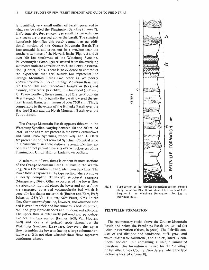
Fig. 8 Type section of the Feltville Formation; section exposed along ravine for Blue Brook about 1 km south of Lake Surprise in the Watchung Reservation. For key to individual units.
FELTVILLE FORMATION
The sedimentary rocks above the Orange Mountain Basalt and below the Preakness Basalt are termed the Feltville Formation (Olsen, in press). The Feltville con- sists of red siltstone and sandstone, buff, gray, and white feldspathic sandstone, and a thick, laterally con- tinous non-red unit containing a unique laminated limestone. This formation is named for the old village of Feltville, Union County, New Jersey, where the type section is located (Figure 8).
TRIASSIC AND JURASSIC FORMATIONS OF THE NEWARK BASIN
Like the underlying Orange Mountain Basalt, the Feltville Formation is preserved in the Watchung, New Germantown, Sand Brook, and possibly the Jackson- wald Synclines (Figure 2). The formation averages about 170 m in the Watchung Syncline, apparently thickening to 300 m in the Sand Brook and 600 m in the Germantown syncline. More than 200 m seems to be present in the Jacksonwald Syncline.
The Feltville Formation is distinguished from the underlying Passaic Formation and the younger Jurassic formations of the Newark Basin by the presence of abundant beds of buff, gray, or white feldspathic sand- stone interbedded with red siltstone in fining-upwards sequences (Olsen, in press); thus, much of the Feltville superficially resembles the Stockton Formation. The lower half of the Feltville contains a black to white laminated limestone, calcarenite, and graded siltstone bed (0.4 - 3 m ) containing abundant fossil fish. This is sandwiched between two beds (each 1-7 m) of gray, small- to large-scale crossbedded siltstone and sand- stone. As is true for the formation as a whole, these beds are thickest in the New Germantown Syncline (+ 14 m).
Conglomerate occurs in the Feltville Formation at Oakland, New Jersey, about 15 m below the Preakness Basalt (Faust, 1975). This conglomerate contains as much as 30 % vesicular basalt clasts, in addition to cob- bles and pebbles of phyllite and limestone. Very little of the section below this unit is exposed and at this point it is impossible to say how much additional conglomerate is present. Other beds of conglomerate crop out in the New Germantown Syncline in association with the non- red laminated beds. The available evidence suggests that the Feltville Formation, like the Orange Mountain Basalt, originally occupied the whole of the area of the Newark Basin; the predeformational shape of the Feltville lithesome seems to have been a wedge thickest along the western border of the basin. The data are not conclusive, however.
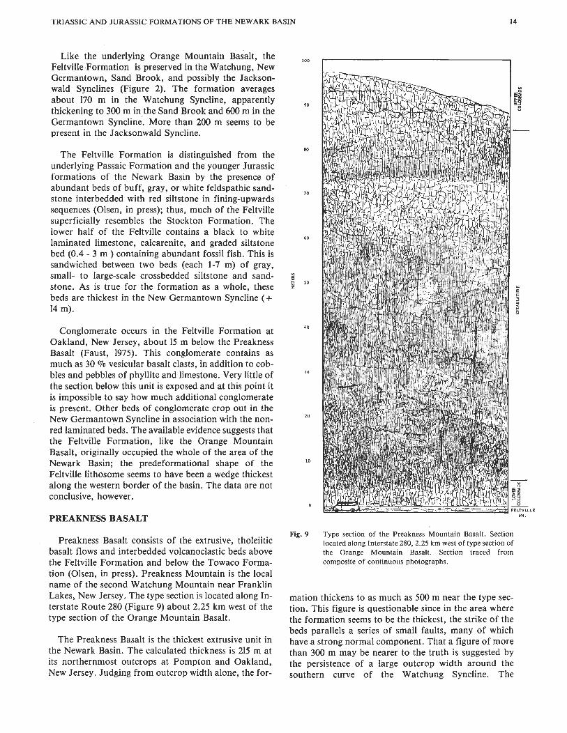
PREAKNESS BASALT
Preakness Basalt consists of the extrusive, tholeiitic basalt flows and interbedded volcanoclastic beds above the Feltville Formation and below the Towaco Forma- tion (Olsen, in press). Preakness Mountain is the local name of the second Watchung Mountain near Franklin Lakes, New Jersey. The type section is located along In- terstate Route 280 (Figure 9) about 2.25 km west of the type section of the Orange Mountain Basalt.
The Preakness Basalt is the thickest extrusive unit in the Newark Basin. The calculated thickness is 215 m at its northernmost outcrops at Pompton and Oakland, New Jersey. Judging from outcrop width alone, the for-
100
90
80
70
60
i 5 50
^O
30
20
10
0
Fig. 9 Type section of the Preakness Mountain Basalt. Section located along Interstate 280,2.25 km west of type section of the Orange Mountain Basalt. Section traced from composite of continuous photographs.
mation thickens to as much as 500 m near the type sec- tion. This figure is questionable since in the area where the formation seems to be the thickest, the strike of the beds parallels a series of small faults, many of which have a strong normal component. That a figure of more than 300 m may be nearer to the truth is suggested by the persistence of a large outcrop width around the southern curve of the Watchung Syncline. The
15 FIELD STUDIES OF NEW JERSEY GEOLOGY AND GUIDE TO FIELD TRIPS
Preakness Basalt may be the youngest formation represented outside the Watchung Syncline. There are small masses of basalt at the northwestern edge of the New Germantown and Sand Brook Synclines, but it is unclear (because of poor exposure) whether these beds are lying stratigraphically above the Feltville or rare merely upthrown fault slices of the Orange Mountain Basalt (Olsen, in press). Some geochemical evidence supports the former hypothesis (Geiger, Puffer, and Lechler, 1980).
At its base, the Preakness Basalt is much more variable than the Orange Mountain Basalt. Locally, there are thick sequences of multiple basalt flows mak- ing up possible basalt foreset beds (Manspeizer, this Fieldbook). In other areas there are thick beds of angular and vesicular basalt breccia resembling aa. In still other areas the thick massive lower flow rests on the flat Feltville Formation surface (Lewis, 1908).
At least two or three thick individual flows make up the bulk of the Preakness Basalt. The lowest flow is the thickest (+ 100 m) and is exposed througout the Watchung Syncline usually showing a complete although modified Tomkeieff structural sequence (Figure 9). In most outcrops the entablature is coarsely grained and very densely jointed, forming high, ir- regularly jointed columns 0.1-1.0 m wide, in marked contrast to the hexagonally jointed Orange Mountain Basalt. This characteristic joint pattern, which Faust (1978) calls platy prismatic (in contrast to cooling joints), allows the Preakness Basalt to be identified at isolated outcrops (Olsen, in press). The first flow is separated from the second by a thin red siltstone, the distribution of which was mapped by Kiimmel (1897) and Lewis (1907b) in the southern portion of the Wat- chung Syncline (but see Faust, 1975). The extent of the second flow outside this area is poorly known, although its extension into the northern Watchung Syncline is supported by some well data and known outcrop pat- terns (Darton, 1890;) Lewis, 1907b). There is at least one other flow present in the northern Watchung Syncline, separated by what I assume to be the second flow of the Preakness Basalt by a red and buff siltstone riddled with root casts. Faust, on the other hand (1975), feels this upper flow is the second. Darton (1890) presents evidence, partially confirmed by later field work (Olsen, in press), that the Preakness Basalt con- sists of three flows at Pompton, New Jersey. As with the Orange Mountain Basalt, more field work is required to clarify the number and distribution of flows in the Preakness Basalt.
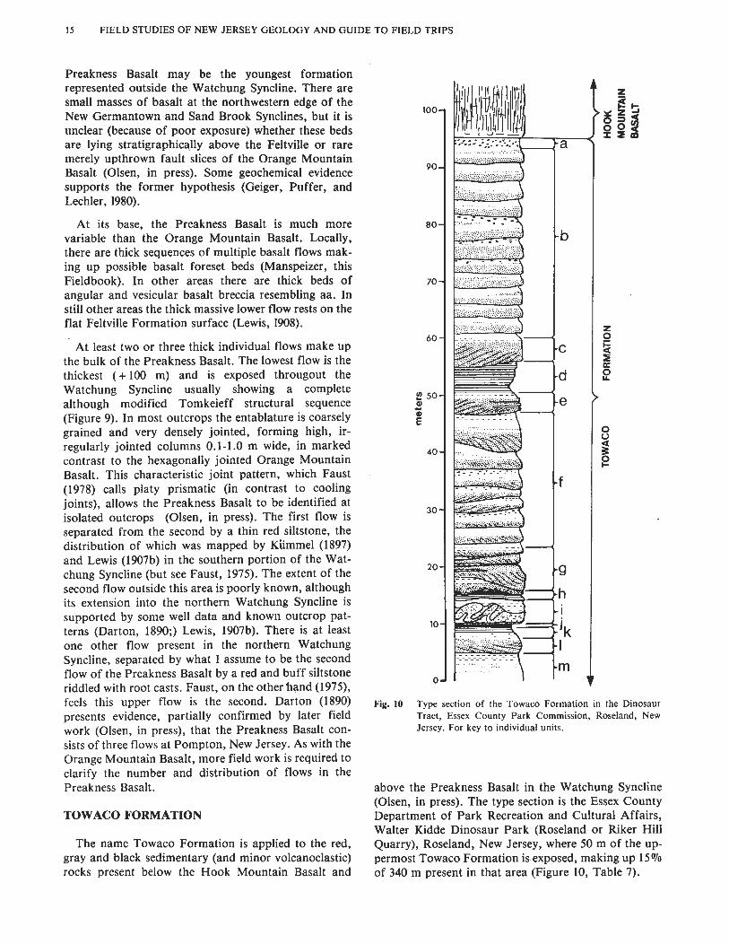
TOWACO FORMATION
The name Towaco Formation is applied to the red, gray and black sedimentary (and minor volcanoclastic) rocks present below the Hook Mountain Basalt and
Fig. 10 Type section of the Towaco Formation in the Dinosaur Tract, Essex County Park Commission, Roseland, New Jersey. For key to individual units.
above the Preakness Basalt in the Watchung Syncline (Olsen, in press). The type section is the Essex County Department of Park Recreation and Cultural Affairs, Walter Kidde Dinosaur Park (Roseland or Riker Hill Quarry), Roseland, New Jersey, where 50 m of the up- permost Towaco Formation is exposed, making up 15 Vo of 340 m present in that area (Figure 10, Table 7).
TRIASSIC AND JURASSIC FORMATIONS OF THE NEWARK BASIN
Laterally continuous symmetrical sedimentary cycle;. characterize most of the Towaco Formation. These con- sist of a central black or gray microlaminated calcareous siltstone bounded above and below by gray sandstone and siltstone beds arrange in fining-upwards cycles. These symmetrical cycles are a mean of 35 m thick and bear a close resemblance to the East Berlin Formation (Hartford Basin) cycles described by Hubert, Reed, and Carey (1976). Towaco cycles are an order of magnitude thicker than Lockatong or Passaic Formation detrital cycles and differ from the otherwise similar Feltville Formation non-red unit in containing a predominantly clastic rather than carbonate laminated portion (Figure 13). In total, six such cycles have been identified in the upper half of the Towaco Formation and most of these have been traced through the Watchung Syncline.
Beds of conglomerate occur at numerous horizons through the Towaco Formation at Pompton, New Jersey. Not only is conglomerate present directly below the Hook Mountain Basalt in this area (Faust, 1975), but thick conglomerate beds also occur at intervals of about 120-150 m. 160-170 m, 185-195 m, 205-220 m, and 270-280 m below the Hook Mountain Basalt. As a general comment, I see no special relationship between the position of any Passaic-Boonton conglomerate beds and lava flows (contra Faust, 1975). Clast composition, especially the inclusion of basalt fragments, may be im- portant, however.
There is a thin brown volcanoclastic unit at the top of the Towaco Formation. It is about 1 m thick and occurs at most exposures of the upper Towaco Formation. It is especially well exposed at the type exposure. This volcanoclastic unit is in the same position as the flow- breccia described by Faust (1978) at Pompton. Lewis (1908) has been the only worker to study unweathered sections of this volcanoclastic unit and he described it as consisting of altered volcanic glass with inclusions of feldspar and augite and pseudomorphs after olivine in a matrix of brown radial natrolite.
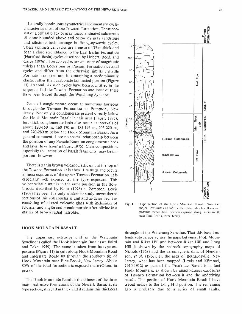
HOOK MOUNTAIN BASALT
The uppermost extrusive unit in the Watchung Syncline is called the Hook Mountain Basalt (see Baird and Take, 1959). The name is taken from i t s type ex- posures (Figure 11) in cuts along Hook Mountain Road and Interstate Route 80 through the southern tip of Hook Mountain near Pine Brook, New Jersey. About 80% of the total formation is exposed there (Olsen, in press).
The Hook Mountain Basalt is the thinnest of the three major extrusive formations of the Newark Basin; at its type section, it is 110 m thick and it retains this thickness
Upper Colonnade
Entablature
Lower Colonnade
Fig. 11 Type section of the Hook Mountain Basalt. Note two major flow units and interbedded thin pahoehoe flows and possible feeder dike. Section exposed along Interstate 80 near Pine Brook, New Jersey.
throughout the Watchung Syncline. That this basalt ex- tends subsurface across the gaps between Hook Moun- tain and Riker Hill and between Riker Hill and Long Hill is shown by the bedrock topography maps of Nichols (1968) and the aeromagnetic data of Hender- son, et al. (1966). In the area of Bernardsville, New Jersey, what has been mapped (Lewis and Kiimmel, 1910-1912) as part of the Preakness Basalt is in fact Hook Mountain, as shown by unambiguous exposures of Towaco Formation between it and the underlying basalt. This portion of Hook Mountain Basalt I have traced nearly to the Long Hill portion. The remaining gap is probably due to a series of small faults.

17 FIELD STUDIES O F NEW JERSEY GEOLOGY AND GUIDE TO FIELD TRIPS
Aeromagnetic data (Henderson, et al., 1966) is no help in this area since the faults would probably run about N-S and thus be parallel with linears caused by errors in the alignment of flight paths. These newly mapped por- tions of the Hook Mountain Basalt are shown in Figure 2.
Two flows have been recognized through most of the Watchung Syncline. At the type section the lower flow is 57 m thick and shows a complete Tomkeieff structural sequence (Figure l l ) , while the upper flow is more massive, without clear columnar jointing. As is the case for the flows which make up the older two basalt forma- tions of the Newark Basin, it is not definitely clear that the upper and lower flows of the Hook Mountain Basalt represent continuous sheets over the extent of the whole formation.
BOONTON FORMATION
Overlying the Hook Mountain Basalt are sedimentary rocks that Baird and Take (1959) termed the Boonton and Whitehall beds of the Brunswick Formation. I have proposed the formal name Boonton Formation for these beds, the type section being near Boonton, New Jersey along the Rockaway River (Figure 12) (Olsen, in press). The Boonton Formation is the youngest sedimentary unit in the Newark Supergroup sequence of the Newark Basin and consists of more than 500 m of red, brown, gray, and black fine to coarse elastics and minor evaporitic beds.
The stratigraphically lowest beds in the Boonton For- mation are well exposed near Bernardsville, New Jersey. In this area, the formation consists of blocky to finely bedded red, gray, brown, and black, often dolomitic siltstone. Thin (1-4 m) beds riddled with hopper casts (pseudomorphs after gypsum, glauberite, and halite) are common in sequences of all colors. Similar beds are ex- posed along Packanack Brook, Wayne, New Jersey. The different colors or textures of these beds do not seem to be arranged in any obvious or consistent cyclic pattern and resemble no other units in the Newark Basin. Stratigraphically above these lower beds is a se- quence of well-bedded red siltstones and sandstone beds (mean thickness 35 m) alternating with thinner beds of gray-green siltstones (mean thickness 2 m). The longest continuous section of these beds is the type section (Figure 13). The uppermost beds of the type section in- clude a bearing fossil fish calcareous gray microlaminated siltstone at least one meter thick (Smith, 1900). This is the famous Boonton Fish Bed (Newberry, 1888; Schaeffer and McDonald, 1978). Also in this section are gray and brown conglomerate units up to 0.5 m thick. Along the western edge of the Wat- chung Syncline, northeast of Morristown, New Jersey are thick sequences of red-, gray-, and brown-matrix
^Gray Siltstone
miGrw ~onglo",er*e
[""[~ed Siltstone and Sandstone
Fig. 12 Type section of the Boonton Formation: A, section exposed along Rockaway River in Boonton, New Jersey; B, composite section of entire preserved Boonton Formation; red matrix conglomerate exposed at Chestnut Hill, Morristown, New Jersey; 2, beds making up the type section; 3, gray, black, brown, and red siltstones exposed near Bernardsville, New Jersey; 4, Hook Mountain Basalt.
conglomerate and breccia. The relationships of these units to the finer portions of the formation are unclear.
DIABASE INTRUSIONS
Large diabase and gabbro plutons and sills are emplaced through various portions of the pre-Orange Mountain Basalt section of the Newark Basin sequence. The areal extent, petrography, and contact relationships of these masses are, for the most part, well known (Dar- ton, 1890; Kummel, 1897, 1898; Lewis, 1908; Lewis and Kummel, 1910-1912; Willard, et al., 1959; Hotz, 1952) and will not be described in detail here. These bodies

TRIASSIC AND JURASSIC FORMATIONS OF THE NEWARK BASIN
Lockatong Fm. ft,
P a s s a i c Fm. F e l t v i l l e Fm. Towaco Fm. Boonton Fm.
g ray -ma t r ix cong lomera te g r a y s i l t s t o n e r e p t i l e S t r o m a t o l i t e s A mass ive \ c rossbedded f o o t p r i n t s a round t r e e s
r e d - m a t r i x cong lomera te " c o n t o r t e d f a b r i c " a r t i c u l a t e d g r a y s i l t s t o n e r e p t i l e s %$ p l a n t r ema ins
m r e d s a n d s t o n e d a r k g r a y p o o r l y i s o l a t e d r e p t i l e s p o r e s and mass ive \ c rossbedded l a m i n a t e d s i l t s t o n e ^ p o l l e n
g r a y s a n d s t o n e c a l c a r e o u s s i l t s t o n e mass ive \ c rossbedded l a m i n i t e whole f i s h & r o o t s
r e d s i l t s t o n e s s i v e \ c rossbedded l i m e s t o n e l a m i n i t e f i s h s c a l e s @ c o n c h o s t r a c a n s
Major types of sedimentary cycles of the formations of the Newark Basin. Note that the approximate center of the symbols for the major types of fossils found is placed about where they occur in the section to the left. Note the change in scale (in meters) from section to section.
Lockatong Formation section measured at Kings Bluff, Weehawken, New Jersey and represents three detrital cycles. The Passaic Formation section measured along Nishisakawick Creek and Little Nishisakawick Creek, northeast of Frenchtown, New Jersey; the two cycles shown represent the lower portion of McLaughlin's Graters
Member,(i.e., Member G) and are characteristic of most of the detrital cycles of the Passaic Formation. The upper cycle develops a dark gray siltstone a kilometer to the south. Feltville Formation section measured along East Branch of Middle Brook, Martinsville, New Jersey--there is only one such "cycle" in the Feltville Formation. Towaco Formation section measured along stream 2 km southwest of Oakland, New Jersey; three cycles are shown. Boonton Formation section is upper part of type section (see Figure 12); section not clearly cyclic.
generally parallel the distribution of major bodies of tern is for these intrusions to be emplaced progressively gray and black siltstones; thus the largest intrusives are higher in the Newark Basin section viewed along an east broadly concordant (but locally discordant) to the to west section (Figure 6) . Lockatong Formation (i.e., Palisade, Rocky Hill, and Sourland Mountain sills) or the Perkasie Member of the Like most Newark Supergroup deposits, Newark Passaic Formation (Haycock Mountain, Coffman Hill, Basin beds are cut by a number of narrow, often and possibly the Cushetunk Plutons). The general pat- straight and vertical diabase dikes which, in this area,
19 FIELD STUDIES OF NEW JERSEY GEOLOGY AND GUIDE TO FIELD TRIPS
trend north and northeast. The mapping of the distribu- tion of these dikes is still very incomplete (see King, 1971, and May, 1971, for reviews).
PALEONTOLOGY AND BIOSTRATIGRAPHY
In contrast to the famous Triassic and Jurassic deposits of Europe, China, southern Africa, and southwestern United States, Newark Basin beds have been traditionally regarded as fossil-poor. Recently, however, this opinion has changed; it is now clear that every major sedimentary unit of the Newark Basin has its own suite of abundant fossils. Pollen and spores, megafossil plants, clams, arthropods, fish, reptile foot- prints, and even reptile skeletons are abundant in cer- tain units through the Newark. Considering the very large number, high diversity, and excellent quality of Newark fossils and the very long (ca. 35 million years) time span represented by the fossiliferous beds, the Newark Basin section is certain to be a key factor in understanding the larger aspects of Early Mesozoic historical geology. Detailed descriptions of some in- dividual sites are presented in Olsen, (this Fieldbook). Here the sediment-fossil relationships and the biostratigraphic framework of the Newark Basin section will be outlined.
The bulk of Newark Basin sediments are red clastics. Throughout the basin, these beds are riddled with roots and burrows. As a general trend, bioturbation of all kinds is more intense in the older red beds (Stockton- Passaic) than in the younger. The arthropod burrow Scoyenia (see Olsen, 1977) is the most common trace of macro-bioturbation in the pre-basalt red clastics. Rep- tile footprints are abundant throughout the red beds in association with gray and black sedimentary cycles, and locally in red beds along the basin edge where bioturba- tion is not intense. Claystone-replaced megafossil plants occur in thin belts of red and purple siltstone near the base of the Stockton. Common plants include cycadeoids, conifers, and equisetalians. Newark Basin red sandstones have yielded a series of reptile skeletons, especially in the area of Passaic, New Jersey in the up- per Passaic Formation (Colbert, 1946). Despite a notable lack of good exposures in this area, skulls and skeletons of the procolophonid reptile Hypsognathus show up at a rate of more than one per decade. Systematic collection in Newark Basin red beds would probably yield many more vertebrate remains. Most kinds of fossils, however, are more abundant in the gray and black facies of the Newark Basin, especially in the sedimentary cycles which characterize the Lockatong, Passaic, and Towaco formations. The distribution of characteristic fossils in these sequences is given in Figure 13. The discovery of large numbers of fossils in the Newark Basin (as well as throughout the Newark Supergroup) has prompted a restudy of the
biostratigraphic relationships of the sequence as a whole.
The basic biostratigraphic framework for Newark Basin deposits has been outlined by Olsen and Galton (1977) and by Cornet (1977), and the details of this cor- relation will be given elsewhere (Olsen, McCune, Thom- son, in press; Olsen, Baird, Salvia, MS; Colbert and Olsen, MS). Here I will simply outline the distribution of taxa within the Stockton through Boonton Forma- tions and tie these in with the regional correlation (Table 8, Figure 14).
For regional correlation, relatively heavy emphasis has been placed on the distribution of palynomorph taxa (Cornet, 1977, and pers. comm.), especially for correlation between the upper Newark and the Euro- pean type Early Jurassic (Figure 14). Tetrapod data, both in the form of skeletal remains and footprints, parallel the palynomorph data, and have been essential in correlating regions from which floral data is not available, such as the upper Stormberg (J.M. Anderson, pers. comm.). For fine internal correlation of the Early Jurassic portions of the Newark, however, the biostratigraphic subdivisions based on pollen and spores have proved too broad (Cornet, 1977). In these areas, fossil fish have provided a means of correlation (Olsen, McCune, and Thomson, in press).
The broad aspects of this biostratigraphic correlation agrees with most geophysical data, particularly the paleomagnetic work of McIntosh (1976) and Reeve and Helsley (1972) on the Newark Basin section and on the Chinle Formation (southwestern United States). In ad- dition, radiometric dates of Newark Basin basalts sug- gest a Jurassic age for these units (Armstrong and Besancon, 1970; Dallmeyer, 1975; Sutter and Smith, 1979; K.K. Turekian, pers. comm.) It must be noted, however, that current geophysical techniques are too in- consistent for the data to be used in fine-scale correla- tion of individual formations of the Newark Supergroup.

Fig. 14
A.
w - - w c c w
4
.d? - "1 C w - c - oa. w 4 0 -
n w u 3 ¥ - fa 3 f a u n 2 ,
b # m ' 3 ¥
u < 2 c.
U-l,
3 1 European
European Standard Stage!
Sinemurian
A Z Hettangian "
2 Z w Rhaetian
2 f5 v
Norian
Carnian
Newark Basin 1; :I Southweste~ 1 i o y Formations ""Â 5 1 United States America
Boonton Fm. 1 1 I Glen canyon
Hook Mt. Bslt. - 3 Group
Towaco Em.
Preakness Bslt.
Feltville FBI. Orange Mt. Belt, ?
- . - - - - - . - - . - - -
lower Los /-^/-^a^-^Ñ̂ ^ Colorados
Lockatong Fm.
Stockton Fm
Distribution of most abundant vertebrate and invertebrate B. fossils in the Newark Basin; a, taxa thought to be biostratigraphically important; b, taxa thought to be of little or no stratigraphic value. Letters in parenthesis--(f), (r), (a), (t)--indicate nature of fossils: (a) amphibians; (f) fish; (r) reptiles; (t) reptile footprints.
Europe
Lias
Steinmergel- keuper
Corollina 3 meveriana
Manassas- Upper Passaic
Lower Passaic- Heidlersburg
- - - - - - - - - - - - - - -
Transition zone - - - - - - - - - - - - - - -
New Oxford- Lcckatong
Southern Africa
Cave Sandstone
Upper Red Beds
.-----.....
Lower Red Beds
/ Molten0
China
Upper Luf eng
--
Lower Lufeng
9
Correlation of the formations of the Newark Basin with other Mesozoic sequences.
Data for A and B from: Cornet (1977); Olsen (in press; Olsen and Galton (1977); Olsen, McCune, and Thomson (in press); Olsen, Baird, and Salvia (MS); and Olsen and Colbert (MS).
Table 3A. Type section of the Stockton Formation
Thickness (meters) Description
30.5 purplish, gray, reddish brown, and red hard siltstone
250.0 red and brown siltstone and sandstone with minor beds of gray sandstone
46.3 RAVEN ROCK MEMBER, massive white, gray, and buff, medium and coarse arkose
298.9 white, gray, buff, and red sandstone, (soft) and medium to coarse arkose with minor beds of red siltstone
106.1 CUTALOSSA MEMBER, hard white, gray, buff, and red sandstone and medium and coarse arkose
95.8 poorly exposed red sandstone and siltstone
231.0 PRALLSVILLE MEMBER, white, gray, buff, yellow, and some red sandstone and medium and coarse arkose with some quartz complomerate
137.6 gray and red sandstone and medium arkose
172.8 SOLEBURY MEMBER, white and gray arkosic conglomerate with minor beds of red siltstone and sandstone
217.2 interbedded gray, white, and buff coarse arkose, quartz conglomeratem and red sandstone and siltstone
BASE OF NEWARK BASIN SECTION
Table 3, B
Bucks-Hunterdon fault block Montgomery-Chester fault block (McLaughlin, 1945, 1946) (Rima, Meisler, and Longwill, 1962)
mostly red siltstone and sandstone above Raven Rock Member
beds above Prallsville Member to top of Raven Rock Member also includes Cutalossa Member
beds from basement contact to top of Prallsville Member also includes Solebury Member
Upper Shale Member
Middle Arkose Member
Lower Arkose Member
Table 3
A. composite type section of the Stockton Formation; adapted from McLaughlin (1945). Exposures occur in ravines, roadside exposures, and quarries on both shores of the Delaware River near Stockton, New Jersey.
B. equivalence of McLaughlin (1945) and Rima, Meisler, and Longwill's (1962) members of the Stockton Formation.
Table 4. Type section of the Lockatong Formation
Designa t ion Thickness of member ( m e t e r s )
b a se o f P a s s a i c Formation
D e s c r i p t i o n
-- -
" T r a n s i t i o n "
B
"Double Red"
A2
"Smith' s Corner "
' T r i p l e Red"
no name
7.6 i n t e rbedded r e d , g r a y , and brown h a r d s i l t s t o n e
48.8 g r a y and b l a c k s i l t s t o n e
30.2 two beds of r e d ha rd s i l t s t o n e sandwiching a bed of g r a y and b l a c k s i l t s t o n e
81.2 b l ack ha rd s i l t s t o n e
3 . 4 r e d ha rd s i l t s t o n e
87.2 b l ack ha rd s i l t s t o n e
45.5 t h r e e t h i c k beds of ha rd r e d s i l t s t o n e a l te r - n a t i n g w i t h two beds of g r a y and b l a c k s i l t s t o n e
75.3 h a r d b l a c k s i l t s t o n e
" F i r s t Big Red" 33.5 r e d ha rd s i l t s t o n e
no name 84 .1 ha rd b l a c k s i l t s t o n e \
" F i r s t Thin Red " 4 .6 r e d ha rd s i l t s t o n e
no name 305.0 b l a c k and g r a y ha rd s i l t s t o n e
Byram Diabase 64 .1
no name 18.3 h o r n f e l s of ha rd b l a c k s i l t s t o n e
no name 91.5 mass ive , ha rd , b l a c k s i l t s t o n e w i t h much i n t e rbedded l i g h t g r a y ha rd c a l c a r e o u s s i l t s t o n e and impure l imes tone
no name 80.8 t h i c k bedded ha rd b l a c k s i l t s t o n e
no name 22.9 t h i c k bedded ha rd b l ack s i l t s t o n e w i t h i n t e rbedded ha rd brown s i l t s t o n e
no name 33.6 i n t e rbedded r e d , p u r p l e , and b l a c k h a r d s i l t s t o n e
ba se o f Lockatong Formation
Table 4
Composite type section of the Lockatong Formation, adapted from McLaughlin (1944, 1945). Measured sections exposed along the east and west banks of the Delaware River. The actual type section as designated by Kummel is the bed of Lockatong Creek; these exposures have never been measured in detail.
Table 5. Type section of the Passaic Formation
Section E.
+10 m massive basalt, base of Orange Mountain Basalt
-9 m brown massive sandstone
4.2 m red sandstone beds fining-upwards into beds of red siltstone with numerous carbonate nodules
Section D.
+ 3 m red, cross-bedded sandstone
Section C.
3 m 2 fining-upwards sequences consisting of beds of red, irregularly cross-bedded sandstone grading upwards into beds of red siltstone. Laminated, carbonate-rich oblong chips and concentric carbonate accretions at base of sandstones.
Section B.
3.2 m red, fissile siltstone beds sandwiching three beds of yellow-orange, coarse siltstone and sandstone.
2.6 m red fissile to blocky siltstone
2.2 m 2 fining-upwards sequences of red sandstone and siltstone
+1.5 m red blocky siltstone
Section A.
14.2 m 4 fining-upwards sequences of red feldspathic sandstone grading -upwards into red blocky siltstone
26.0 m covered
4.6 m red siltstone
41.0 m covered
16.4 m fining-upwards sequences of red feldspathic sandstone grading into red fissile to blocky siltstone
2.0 m diabase dike surrounded by .3 m zone of black hornfels
+3.0 m red blocky siltstone
5.0 m covered
1.7 m red cross and planer bedded sandstone and siltstone
4.0 m covered
4.6 m red sandstone and siltstone beds
2.0 m covered
1.2 m red sandstone and siltstone, Scoyenia abundant
48.0 m covered
8.7 m 3 fining-upwards sequences of red feldspathic sandstone with strongly down cutting bases, grading up into red blocky siltstone.
Table 5
Type section of the Passaic Formation and key to Figure 4. Section exposed at intervals along Interstate Route 80, from Ridgefield to Paterson, New Jersey. Details of section in Olsen, in press. Sections measured from top down.
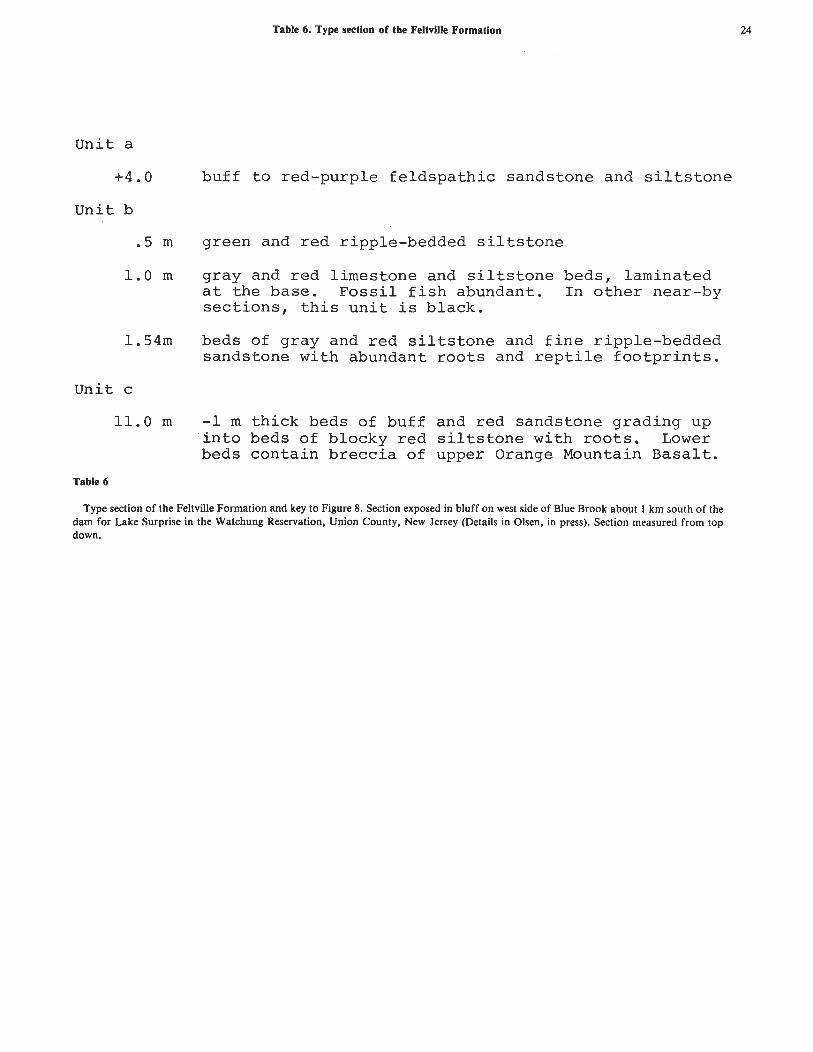
Table 6. Type section of the Feltville Formation
Unit a
+4.0 buff t o red-purple f e l d s p a t h i c sandstone and s i l t s t o n e
Uni t b
.5 m green and red ripple-bedded s i l t s t o n e
1.0 m gray and red l imestone and s i l t s t o n e beds, laminated a t t h e base. F o s s i l f i s h abundant. I n o t h e r near-by s e c t i o n s , t h i s u n i t i s b lack .
1.54m beds of gray and r e d s i l t s t o n e and f i n e ripple-bedded sandstone with abundant r o o t s and r e p t i l e f o o t p r i n t s .
Unit c
11.0 m -1 m t h i c k beds of buff and red sandstone grading up i n t o beds of blocky r e d s i l t s t o n e with r o o t s . Lower beds con ta in b r e c c i a of upper Orange Mountain B a s a l t .
Table 6
Type section of the Feltville Formation and key to Figure 8. Section exposed in bluff on west side of Blue Brook about 1 km south of the dam for Lake Surprise in the Watchung Reservation, Union County, New Jersey (Details in Olsen, in press). Section measured from top down.

Table 7. Type section of the Towaco Formation
Table 7
Unit a
.9
Unit b
32.3
Unit c
3 . 4
Unit d
2.6
Unit e
2.5
Unit f
21.0
Unit g
5.2
Unit h
.8
Unit j
.5
Unit k
.6
Unit 1
3.0
Unit m
5 . 3
brown, badly weathered, palgonitic unit
11 red fining-upwards cycles, each a mean of 2.9 m thick and composed of thick beds of red sandstone or coarse siltstone grading up into beds of red ripple- bedded or blocky siltstone. Uppermost cycle is lav- ender in color and the lowest cycle contains a buff intraformational breccia with scattered vertebrate remains. Dolomitic concretions, root casts, and reptile footprints common.
Gray, buff, and lavender fining-upward sequences of sandstone and siltstone, plant fragments, reptile footprints, and roots common.
fine gray to black siltstone base with prominent black, microlaminiated, calcareous siltstone. Upper parts of black unit contain chert nodules. Very fragmentary fish and insects present along with well preserved plant fragments.
Gray-buff, well-bedded, upwards-fining siltstone and sandstone with dinosaur footprints and abundant roots.
7 upwards-fining cycles similar to those of unit b. Upper-most cycle very thick ( 4 . 2 m) with extremely good reptile footprints. The uppermost beds of this cycle are gray-green.
2 or 3 upward-fining cycles of gray sandstone and silt- stone. Upper-most cycle grades into red siltstones. Plant fragments and reptile footprints locally abundant. Siltstones palyniferous.
black, microlaminated, calcareous siltstone grading upwards into gray, graded sandstones. Fossil fish and
plant stems abundant.
olive, massive, convoluted, poorly sorted siltstone grading up into beds of poorly sorted gray and black siltstone. Some recumbant folds over 1 m between limbs.
black Laminated, calcareous siltstone similar to unit h, but without fossil fish.
very -fine, gray siltstone grading upwards into j.
gray fining-upwards sequence grading into fissue siltstone. Plant remains common.
red, ripple-bedded siltstone, upper 1 m gray.
Type section of the Towaco Formation in the Dinosaur Tract of the Essex County Park Commission, Roseland, New Jersey (key to Figure 10). Lower beds of unit f and all beds below are now covered. Details of section in Olsen, in press. Section measured from top down.

Table 8. Distribution of Taxa within the Stockton through Boonton Formations.
STOCKTON FORMATION
P l a n t s
E q u i s e t a l e s ( s c o u r i n g r u s h e s )
Neocalamites s p .
C o n i f e r a l e s ( c o n i f e r s )
Pacrioohvllum di f fusum - . . - P. s i m p s o n i i G T v ~ t o l e o i s SDD.+
- * L - L A. L
Rotundolepis i n t e r m e d i a Araucar ioxvlon SKID.+
Podozamites spp.
lower - upper Stockton
upper S tock ton I1 I1
I t I1
I1 11
lower - ?upper S tock ton
upper Stock t o n
B e n n e t t i t a l e s ( cycad- l ike seed p l a n t s )
Zamites spp . lower - upper S tock ton
Pterophyl lum spp. I* I1 I1
seed p l a n t s of u n c e r t a i n a f f i n i t i e s
Eoq i n k o i t e s upper S tock ton
I n v e r t e b r a t e s
Mollusks
Unionid c lams
Arthropods
Darwinula spp. Cyzicus Scoyenia (burrows) * ~ o o p h i c h n i u m sp . { ( 1 imul i d t r a c k s 1
Wil la rd , e t a l . , 1959; Bascom,
{-I9~g~~; Brown, 1911, 1
Cornet , 1977; Bock, 1969 11 11 I1 11
I t I t II I1
n 11 I1 If
Wherry, 1912
L I l a r d , e t a l . , 1959; et a l . , 193^"
Brown, 1911; Bascom, e t a l . ,} {l938; W i l l a r d , e t a l . , 1959
W i l l a r d , e t a l . , 1959; e t a l . , 1938; Lyman, 1902
Bock, 1969; Cornet , 1977
Lewis, 1884 ; Richards , 1944
YPM (IP) 28805 K u m m e l , 1897; YPM ( I P ) 28804 YPM ( I P ) 28806
C a s t e r , 1939

Insects
beetle elytron
Vertebrates
Calamops paludosus
Metoposaurus sp.
Reptiles
Table 8. (cont'd.)
I t I t
lower Stockton
upper Stock ton
cf. Rutiodon # a I I
(Phytosaurus) manhattanensis
phytosaur teeth I I I I
LOCKATONG FORMATION AND STOCKTON LATERAL EQUIVALENT
Plants
Equisetales (scouring rushes)
Equisetites sp.
Coniferales (conifers)
Pagiophyllum spp. Glyptolepis spp .
Invertebrates
Mollusks
Unionid clams
lower Lockatong
lower Lockatonq
YPM (IP) 28803
Sinclair, 1917 ; Ol.sen, et al. , MS
Olsen, et al., MS.
Von Huene, 1913
Olsen, et al., MS
Bock, 19 69
Conrad, 1858, 1870

Table 8. (cont'd.)
Arthropods
Darwinula spp. Cyzicus spp. c f . Palaeol imnadia
Scoyenia*
V e r t e b r a t e s
F i s h e s
Car inacanthus j e p s e n i
Turseodus spp . Synor ichthys sp.
Cionichthys sp.
Semionotus b r a u n i sp .
Diplurus newarki
Amphibians
Metoposaurus durus
R e p t i l e s
' deep t a i l e d s w i m m e r " Tanytrachelos ahyn i s I c a r o s a u r u s s e i f k e r i
Rhynchosauroides spp.* Gwvnedd ichnium*
Apatopus l i n e a t u s *
through Lockatong YPM ( IP) 28809 II II Jones , 1862; Bock, 1953 II II YPM ( IP) 28802
Lockatong and } YPM (IP) 28810, IPM 8262 l a t e r a l e q u i v a l e n t
lower Lockatong
through Lockatong
II I1
lower Lockatong
II It
Bryant, 1934 . schaeffer , 1952b; Olsen, a n d Thomson, i n p r e s s 'Schaeffer and Mangus, Olsen, McCune, and i n p r e s s bock, 1959; Olsen, McCunei and Thomson, i n p r e s s hewberry , 1888 ; Olsen, ~ c c u n e f a n d Thomson, i n p r e s s
"Bryant, 1934; Schaef fe r , 1952a; McCune, and Thomson, i n I
Cope, 1866; C o l b e r t and Imbrie, 1956; Olsen, e t a l . , MS
It If Co lbe r t and Olsen, MS. *I II Olsen, 1979 *I It Colber t , 1966
through Lockatong Cope, 1869; C o l b e r t , 1965 through Lockatong fcClbert, 1965; Stockton e q u i v a l e n t t I!
Bock, 1969 Bock, 1969; Olsen, e t a l . , MS.
lower Lockatong through ~ o c k a t o n g and olsen, et al. ,
{equivalent

en en w w en en: 1-1 1-1
00 00 .. .. 00 I - t - 1-1 I - I - :
en en en . 41-11-1 h S-1 ... S-1 4J4-1.V 0) <U0)0) Xl c c c = (U S-1 S-1 S-1
0 0 0 2 u u u
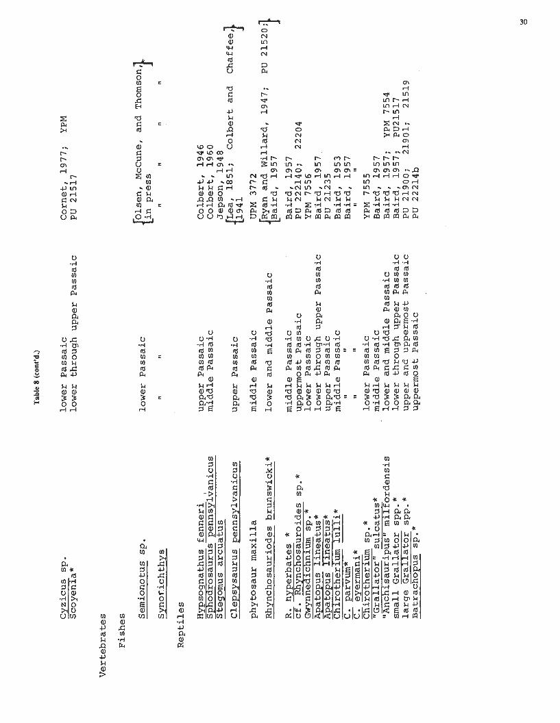
Table 8 (cont'd.)
Cyzicus sp. Scoyenia*
Ver tebra tes
F i shes
Semiono t u s s p . SynoTichthys
Rep t i l e s
Hypsognathus f e n n e r i Sphodrosaurus p e n n s y l ~ a n i c u s Stegomus a r cua tus
Clepsysaurus pennsylvanicus
phytosaur maxi l la
Rhynchosauriodes brunswicki*
R. hyperbates * - c f . Rhvnchosauroides so-*
Apatopus l i n e a t u s * Apatopus l i n e a t u s * Chirotherium l u l l i * C. narvum*
small ~ r a l l a t o r spp . * l a r g e Gra l l a to r spp.* Batrachopus sp.*
lower Passa ic lower through upper Passa ic
lower Passa ic
11 ll
upper Passa ic middle Passa ic
upper Passa ic
middle Passa ic
lower and middle ~ a s s a i c
middle Passa ic uppermost Passa ic lower Passa ic lower through upper Passa ic upper Passa ic middle Passa ic
11 I1
I1 11
lower Passa ic middle Passa ic lower and middle Passa ic lower through upper Passa ic upper and uppermost Passaic uppermost Passa ic
Cornet, 1977; YPM P U 21517
Colbert , 1946 Colber t , 1960 Jepson, 1948
1947;
Baird, 1957 P U 222140; 22204 YPM 7556 Baird, 1957, PU 21235 Baird, 1953 Baird, 1957
I1 11
YPM 7555 Baird, 1957 Baird, 1957; YPM 7554 Baird, 1957; PU21517 P U 21900; 21901 ; 21519 P U 22214b

Table 8 (cont'd.)
FELTVILLE FORMATION
Plants
Equisetales (scouring rushes)
Equisetites spp.
Filicales (ferns)
Clathropteris meniscoides
Coniferales (conifers)
Brachyphyllum scottii Brachyphyllum spp. Pagiophyllum spp. Hirmerella cf. muensteri+ Masculostrobus spp.+
Cycadales (cycads)
Otozamites sp.
Invertebrates
Arthropods
Darwinula sp .
Vertebrates
Fishes
Ptvchole~is cf. marshi
'Semionotus tenuiceps group''
lower Feltville
lower and middle Feltville
lower Feltville lower and middle Feltville lower Feltville
11 I,
Cornet, 1977
Newberry, 1888; Cornet, 1977
Cornet, 19 7 7 I1 It
ll I1
ll I1
,I I#
Cornet, 1977
YPM (IP) 28807

Table 8 (cont'd.)
Reptiles
small Grallator spp. large Grallator spp. Anomoepus sp. Batrachoous cf. dewevi
TOWACO FORMATION
Plants
Equisetales (scouring rushes)
Equisetites sp.
Fil icales (ferns)
cf. Phelbopteris sp.
Coniferales (conifers)
Brachyphyllum spp. Pagiophyllum spp.
Invertebrates
Insects
beetle elytron
Vertebrates
Fishes
"Semiono tus tenuiceps group"
Semionotus spp .
lower through upper Feltville YPM 6636 11 II I1 I1 YPM 8666
upper Feltville AMNH 3639 II I1 PU 18564
through Towaco
middle Towaco
through Towaco It I1
upper Towaco
through Towaco
I! I1
Cornet, 1977
YPM (PB) 3771
Cornet, 1977 I1 a1
YPM (IP) 28808
Olsen, McCune, and Thomson, press
11 I1 I1

Table 8 (cont'd.)
Reptiles
cf. Rhynchosauroides sp.* Batrachowus so.* small ~rallatkr spp. * larcre Fallator SDD. *
- & A - - ~nomoe~us spp . *
BOONTON FORMATION
Plants
Equisetales (scouring rushes)
Equisetites sp.
Coniferales (conifers)
Invertebrates
Arthropods
cf. Palaeolimnadia sp.
Vertebrates
Fishes
Ptycholepis sp.
Redfieldius cf. gracilis Redfieldius spp.
'Semionotus elegans gro~p'~ Diplurus longicaudatus
Reptiles
Batracho us sp.* G r a tor spp . * large Grallator spp. * Anomoepus sp.*
upper Towaco through Towaco
ll It
I1 I#
It I1
through Boonton
I1 I1 I1
mid-dle Boonton
PU 18563 PU 19911 RU main display slab RU I s
RU " a I
YPM (PB) 3769
YPM (PB) 3770
YPM 6567
Schaeffer, Dunkle, and 11977 Schaeffer and McDonald, 1978
McCune, and Thornson,
I1 It 11
Newberry, 1888
YPM II 7558 It
AMNH uncatalogued specimen Cope collection { I. C. Russell (N.D.)

TRIASSIC AND JURASSIC FORMATIONS OF THE NEWARK BASIN
ACKNOWLEDGMENTS
I thank Warren Manspeizer, Franklyn Van Houten, Nicholas Ratcliffe, John Sanders, Donald Baird, and Bruce Cornet for providing impetus for this work and for interesting and helpful conversations on Newark Basin topics. Field work for this study was supported by grants from the National Science Foundation (numbers BMS 75-17096, BMS 74-07759, GS28823X. and DEB 77-08412 to Keith Thomson). In addition, I thank Amy Litt, Kevin Padian, and Stan Rachootin for reading the manuscript and suggesting changes which substantially improved it. Of course, any opinions or errors of fact or omission are my own.
ROAD LOG
This field trip is a traverse along Route 80 which intersects all of the sedimentary and extrusive formations of the Newark Basin portion of the Newark Supergroup (fig. 3). The road log commences at the Fort Lee entrance to Route 80 off Cross Street (see Olsen, this Fieldbook, for directions to this entrance).
Mileage
0.0 Entrance ramp for Route 95-80 off Cross Street, Fort Lee, New Jersey. Veer left onto entrance ramp, proceed on Route 95s.
To the east about one mile is the west portal of the George Washington Bridge, Fort Lee, New Jersey. The west abutments of the bridge rest on Stockton and Lockatong formations and Palisade Diabase. Roads along the east face of the Palisade Escarpment in the Fort Lee portion of Palisades Interstate Park have excellent exposures of nine individual detrital cycles of the lower Lockatong, each of which has been traced 15 km. to the south (Olsen, this Fieldbook). Three of these cycles are especially fossiliferous; the lowest of these (called cycle 6) has produced articulated remains of Semionotus brauni and disarticulated remains of the little reptile Tanytrachelos. The middle fossiliferous cycle (cycle 5) contains abundant disarticulated remains of Diplurus newarki and articulated remains of Turseodus. The upper cycle (cycle 2) has produced abundant articulated Turseodus and disar t iculated large Diplurus. Clam shrimp (conchastracans) and ostracods are also common in cycles 5 and 2. These and other Lockatong cycles exposed here were deposited in shallower water than their more southern extensions.
In this area the trigonometrically computed thickness of both the Stockton Formation and the Lockatong Formation is less than 200 m. This is almost an order of magnitude thinner than the same formations along the Delaware River (Van Houten, this Fieldbook). While part of this thinning is due to the lateral replacement of Lockatong facies by Passaic Formation, most of the thinning is due to the thinning of individual cycles of the Lockatong Formation and thinning of the whole of the
Numerous small, predominantly normal, faults striking north and northeast and down-dropping to the east characterize this portion of the Newark Basin. The reentrant in the Palisade Escarpment just south of here is an erosional result of some of the larger of these faults.
Crossing large normal fault cutting the Palisade Diabase and overlying the Lockatong Formation. This fault nearly doubles the outcrop width of the Palisade Diabase in this area. Just north of here the upper contact of the sill and the Lockatong is duplicated by this fault.
In marked contrast to faults is the northwestern portion of the Newark Basin, many of which have slickensides showing lateral (both synestral and dextral) movement, those examined to date in the area along the Palisades show only vertical slickensides (both those dropping down to the east and to the west) (personal observation and Manspeizer, pers. comm.).
Excellent outcrops of the Lockatong-Palisade Sill contact and overlying detrital cycles of the Lockatong. Here the upper surface of the Palisade Sill is smoothly concordant with the Lockatong. I believe the cycles exposed here tie in with those exposed in Granton Quarry to the south, although it is far from certain. Articulated Turseodus and conchostracans, at least, are common at this outcrop.
According to Van Houten (1969), these Lockatong hornfels include grossularite-andradite, prehnite, and diopside varieties.
Hill at this point is underlain by a tongue of Stockton Formation (Van Houten, 1969). Presumably this is the same unit exposed about 1 km. north of Granton Quarry. There good exposures reveal Stockton Formation with a thin bed of Synorichthys - bearing green and gray siltstone with overlying beds of gray-buff arkose containing what I interpret as very well-developed limestone caliche paleosols. Tongues of Stockton such as this may correspond to clusters of chemical cycles prevalent in similar positions in the central Newark Basin.
Approximate contact with Passaic Formation. Lowermost Passaic is very poorly exposed in the vicinity of Ridgefield and consists of mottled red-buff feldspathic sandstone and red siltstone.
Hackensack Meadows.
Broad belt of relatively soft red siltstone and minor gray siltstone and arkose correlating with upper Lockatong and lower Passaic Formation of Delaware River area (Van Houten, this Fieldbook).
Veer right onto exit for Route 80.
Beginning of the type section of the Passaic Formation (see Table 2, fig. 4, this paper) (Olsen, In Press). The type section of the Passaic consists of intermittent exposures along Route 80. These exposures show interbedded red feldspathic sandstone and siltstone with small-to-large-scale cross-bedding, abundant bioturbation structures (including roots and Scoyenia) and some beds of caliche. Section A (fig. 4) of the type section begins here.
Stockton.
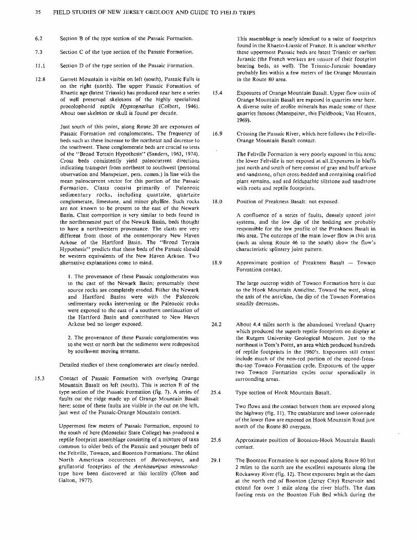
35 FIELD STUDIES OF NEW JERSEY GEOLOGY AND GUIDE TO FIELD TRIPS
6.2 Section B of the type section of the Passaic Formation.
7.3 Section C of the type section of the Passaic Formation.
11.1 Section D of the type section of the Passaic Formation.
12.8 Garrett Mountain is visible on left (south), Passaic Falls is on the right (north). The upper Passaic Formation of Rhaetic age (latest Triassic) has produced near here a series of well preserved skeletons of the highly specialized procolophonid reptile Hypsognathus (Colbert, 1946). About one skeleton or skull is found per decade.
Just south of this point, along Route 20 are exposures of Passaic Formation red conglomerates. The frequency of beds such as these increase to the northeast and decrease to the southwest. These conglomerate beds are crucial to tests of the "Broad Terrain Hypothesis" (Sanders, 1963, 1974). Cross beds consistently yield paleocurrent directions indicating transport from northeast to southwest (personal observation and Manspeizer, pers. comm.) in line with the mean paleocurrent vector for this portion of the Passaic Formation. Clasts consist primarily of Paleozoic sedimentary rocks, including quartzite, quartzite conglomerate, limestone, and minor phyllite. Such rocks are not known to be present to the east of the Newark Basin. Clast composition is very similar to beds found in the northernmost part of the Newark Basin, beds thought to have a northwestern provenance. The clasts are very different from those of the contemporary New Haven Arkose of the Hartford Basin. The "Broad Terrain Hypothesis" predicts that these beds of the Passaic should be western equivalents of the New Haven Arkose. Two alternative explanations come to mind.
1. The provenance of these Passaic conglomerates was to the east of the Newark Basin; presumably these source rocks are completely eroded. Either the Newark and Hartford Basins were with the Paleozoic sedimentary rocks intervening or the Paleozoic rocks were exposed to the east of a southern continuation of the Hartford Basin and contributed to New Haven Arkose bed no longer exposed.
2. The provenance of these Passaic conglomerates was to the west or north but the sediments were redeposited by southwest moving streams.
Detailed studies of these conglomerates are clearly needed.
15.3 Contact of Passaic Formation with overlying Orange Mountain Basalt on left (south). This is section E of the type section of the Passaic Formation (fig. 7). A series of faults cut the ridge made up of Orange Mountain Basalt here; some of these faults are visible in the cut on the left, just west of the Passaic-Orange Mountain contact.
Uppermost few meters of Passaic Formation, exposed to the south of here (Montclair State College) has produced a reptile footprint assemblage consisting of a mixture of taxa common to older beds of the Passaic and younger beds of the Feltville, Towaco, and Boonton Formations. The oldest North American occurences of Batrachopus, and grullatorid footprints of the Anchisauripus minuscolus- type have been discovered at this locality (Olsen and Galton, 1977).
This assemblage is nearly identical to a suite of footprints found in the Rhaeto-Liassic of France. It is unclear whether these uppermost Passaic beds are latest Triassic or earliest Jurassic (the French workers are unsure of their footprint bearing beds, as well). The Triassic-Jurassic boundary probably lies within a few meters of the Orange Mountain in the Route 80 area.
Exposures of Orange Mountain Basalt. Upper flow units of Orange Mountain Basalt are exposed in quarries near here. A diverse suite of zeolite minerals has made some of these quarries famous (Manspeizer, this Fieldbook; Van Houten, 1969).
Crossing the Passaic River, which here follows the Feltville- Orange Mountain Basalt contact.
The Feltville Formation is very poorly exposed in this area; the lower Feltville is not exposed at all.Exposures in bluffs just north and south of here consist of gray and buff arkose and sandstone, often cross-bedded and containing coalified plant remains, and red feldspathic siltstone and sandstone with roots and reptile footprints.
Position of Preakness Basalt: not exposed.
A confluence of a series of faults, densely spaced joint systems, and the low dip of the bedding are probably responsible for the low profile of the Preakness Basalt in this area. The outcrops of the main lower flow in this area (such as along Route 46 to the south) show the flow's characteristic splintery joint pattern.
Approximate position of Preakness Basalt - Towaco Formation contact.
The large outcrop width of Towaco Formation here is due to the Hook Mountain Anticline. Toward the west, along the axis of the anticline, the dip of the Towaco Formation steadily decreases.
About 4.4 miles north is the abandoned Vreeland Quarry which produced the superb reptile footprints on display at the Rutgers University Geological Museum. Just to the northeast is Tom's Point, an area which produced hundreds of reptile footprints in the 1960's. Exposures still extant include much of the non-red portion of the second-from- the-top Towaco Formation cycle. Exposures of the upper two Towaco Formation cycles occur sporadically in surrounding areas.
Type section of Hook Mountain Basalt.
Two flows and the contact between them are exposed along the highway (fig. 11). The entablature and lower colonnade of the lower flow are exposed on Hook Mountain Road just north of the Route 80 overpass.
Approximate position of Boonton-Hook Mountain Basalt contact.
The Boonton Formation is not exposed along Route 80 but 2 miles to the north are the excellent exposures along the Rockaway River (fig. 12). These exposures begin at the dam at the north end of Boonton (Jersey City) Reservoir and extend for over 1 mile along the river bluffs. The dam footing rests on the Boonton Fish Bed which during the

TRIASSIC AND JURASSIC FORMATIONS OF THE NEWARK BASIN 36
1800's and early 1900's produced thousands of fish of the "Semionotus elegans group," Redfieldius spp., several specimens of the large coelacanth Diplurus longicaudadus, and a single specimen of Ptycholepis.
Only the underlying beds are exposed now, by these beds produce abundant plant remains and reptile footprints.
31.1 Approximate position of the Ramapo Fault: end of the Newark Basin.
A prominent bluff of metamorphics marks the west wall of the fault (see Ratcliffe, this Fieldbook).
REFERENCES CITED
American Commission of Stratigraphic Nomenclature, 1961, Code of Stratigraphic Nomenclature. Amer. Assoc. Petrol. Geol. Bull., 45, 645-665.
Armstrong, R. A. and Besancon, J., 1970, A Triassic time scale dilemma: A-Kr dating of Upper Triassic mafic igneous rocks, eastern U.S.A. and Canada and Post-Triassic plutons, Western Idaho, U.S.A. Ecologae Geol. Helvetiae, 63, 15-28.
Bailey, W.S., Salisbury, R.D., Kummel, H.B., 1914, Raritan Folio, N. J., U.S. Geol. Survey Geol. Atlas U. S., Folio, 191.
Baird, D., 1954, Chirotherium lulli, a pseudosuchian reptile from New Jersey. Bull. Mus. Comp. Zool. (Harvard University) 11 1, 163-192.
Baird, D., 1957, Triassic reptile footprint faunules from Milford, New Jersey, Bull. Mus. Comp. Zool. (Harvard University), 117, 449-520.
Baird, D. and Take, W.F., 1959, Triassic reptiles from Nova Scotia (Abst.), Geol. SOC. Amer. Bull.,70, 1565-1566.
Bascom, F. and Stose, G.W., 1938, Geology and mineral resources of the Honeybrook and Phoenixville quadrangles, Pennsylvania, U.S. Geol. Survey Bull.,891, 145 p.
Bock, W., 1952, Triassic reptilian tracks and trends of locomotive evolution. Jour. Paleo.,26, 395-433.
,1953, American Triassic estheriids. 'Jour. Paleo., 27, 62-76.
, 1959, New eastern American Triassic fishes and Triassic correlations. Geol. Center Research Ser. North Wales, Pa., 1, 184 p.
, 1969, The American Triassic flora and global distribution, Geol. Center Research Ser. North Wales, Pa.3-4, 406 p.
Brown, A.P., 1911, New cycads and conifers from the Trias of Pennsylvania, Acad. Nat. Sci. Proc., 63, 17-21.
Bryant, W.L., 1934 New fishes from the Triassic of Pennsylvania. Am. Phil. Soc. Proc., 73, 319-326.
Bucher, W.H., and Kerr, P.F., 1948, Excursion to the 1st Watchung Basalt at Paterson, New Jersey. In Geol. Soc. Amer. Guidebook, 61st Ann. Mtg., 109-1 19.
Calver, J.L., 1963, Geologic map of Virginia, Va. Dept. Conserv. Econ. Development, Charlottesville.
Caster, K.E., 1939, Were Micrichnus Scotti Abel and Artiodactylus sinclairi Abel of the Newark Series (Triassic) made by vertebrates or limulids? Amer. Jour. Sci., 237, 786-797.
Colbert, E.H., 1946, Hypsognathus,a Triassic reptile from New Jersey. Bull. Amer. Mus. Nut. Hist., 86, 231-274.
, 1960, A new Triasic procolophonid from Pennsylvania. Amer. Mus. Nov., 29, 19 p.
, 1965, A phytosaur from North Bergen, New Jersey. Amer. Mus. Nov., 2246, 23 p.
Colbert, E.H. and Chaffee, R.G., the type of Clepsysaurus pennsylvanicus and its bearing upon the genus Rutiodon. Notulae Naturae, 90, 19 p.
Colbert, E.H. and Olsen, P.E., In Prep. A new strange reptile from the Late 'Triassic Lockatong Formation (Newark Supergroup) of New Jersey.
Conrad, T.A., 1858, Description of a new species of Myacites. Proc. Acad. Nut. Sci. Phil., 9, 166.
, 1870, Descriptions of new fossils molluscs principally Cretaceous, Amer. Jour. Cone., 5, 102.
Cook, E.H., 1868, Geology of New Jersey. New Jersey Geological Survey, Newark, 900 p.
, 1884, Triassic Rocks: columnar traprocks of Orange Mountain. N. J. Geol. Survey Ann. Rept., 1884, 23-28.
Cope, E.D., 1866, Observations on extinct vertebrates of the Mesozoic red sandstone. Proc. Acad. Nut. Sci. Phil., 1866, 249-250.
Cornet, B., 1977, The palynostratigraphy and age of the Newark Supergroup, Unpubl. Ph. D. Thesis, Pennsylvania State University, 506 p.
Cornet, B., Traverse, A., and McDonald, N.G.1973, Fossil spores, pollen, and fishes from Connecticut indicate Early Jurassic age for part of the Newark Group. Science, 182, 1243-1246.
Cornet, B. and Traverse, A., 1975, Palynological contribution to the chronology and stratigraphy of the Hartford Basin in Connecticut and Massachusetts. Geosci. Man., 11, 1-33.
Dallmeyer, R.D., 1975, The Palisades Sill: A Jurassic intrusion? Evidence from ArP9 Ar incremental release ages. Geology, 3, 243-245.
Darton, N.H., 1890, The relations of the trap of the Newark System in the New Jersey region. U.S. Geol. Survey Bull., 67, 82 p.
, 1902, Jura Trias Rocks. In, New York City Folio, Paterson, Harlem, Staten Island, and Brooklyn quandrangles. U.S.G.S. Geol. Atlas U.S., Folio 83, 6-10.
Darton, N.H., Bayley, W.S., Salisbury, R.D., and Kummel, H.B., 1908, Passaic Folio, New Jersey-New York. U.S.G.S. Geol. Atlas U.S., Folio 157.
37 FIELD STUDIES O F NEW JERSEY GEOLOGY AND GUIDE TO FIELD TRIPS
deBoer, J., 1968, Palaeomagnetic differentiation and correlation of the Late Triassic volcanic rocks in the central Appalachians (with special reference to the Connecticut Valley). Geol. Soc. Amer. Bull., 79. 609-626.
Dunleavy, J.M., 1975, A geophysical investigation of the contact along the northern margin of the Newark Triassic Basin, Hosensack, Pennsylvania, to Gladstone, New Jersey. Unpubl. M.Sc. Thesis, Lehigh University, + 68 p.
Emerson, B.K., 1898, outlines of the geology of western Massachusetts: Holyoke Folio. U.S.G.S. Geol. Atlas U.S., Folio 50.
Faill, R.T., 1973, Tectonic development of the Triassic Newark Gettysburg basin in Pennsylvania. Geol. Soc. Amer. Bull., 84, 725-740.
Faust, G.T., 1975, A review and interpretation of the geologic setting of the Watchung Basalt flows, New Jersey. U.S. Geol. Survey Prof. Paper, 864A, 42 p.
, 1978, Joint Systems in the Watchung Basalt flows, New Jersey. Studies on the Watchung Basalt flows, of New Jersey. U.S. Geol. Survey Prof. Paper, 864B, 46 p.
Fenner, C.N., 1908, Features indicative of physiographic conditions prevailing at the time of the trap extrusions in New Jersey. Jour. Geol., 16, 299-327.
Glaeser. J.D., 1963, Provenance, dispersal, and depositional environments of Triassic sediments in Newark Gettysburg Basin. Pa. Geol. Survey 4th Ser., Bull., G43, 168 p.
Geiger, F.J., Puffer, J.H., and Lechler, P.J., 1980, Geochemical evidence of the former extent of the Watchung Basalts of New Jersey and of the eruption of the Palisades Magma onto the floor of the Newark Basin (Abst.). Geol. Soc. Amer., Abst. with frog., 12, 2, 37.
Henderson, J.R., Andreasen, G.E., and Petty, A.J., 1966, Aeromagnetic map of northern New Jersey and adjacent parts of New York and Pennsylvania. U.S. Geol. Survey Geophysical Inv., Map GP-562.
Hotz, P.E., 1952, Form of diabase sheets in southeastern Pennsylvania Amer. Jour. Sci., 250, 375-388.
Hubert, J.F., Reed, A.A., and Carey, P.J., 1976, Paleogeography of the East Berlin Formation, Newark Group, Connecticut Valley. Amer. Jour. Sci., 276, 1183-1207.
Huene, F. von, 1913, A new phytosaur from the Palisades near New York. Bull. Amer. Mus. Nat. Hist. 32, 275-283.
International Subscommission on Stratigraphic Classification (Hollis D. Hedberg, ed.). 1976, International Stratigraphic Guide, New York, 199 p.
Jepsen, G.L., 1948, A Triassic armored reptile from New Jersey. State N.J. Dept. Conserv., Misc. Geol. Paper, (1948), 20 p.
Johnston, H., 1957, Trap rock aggregates in New Jersey. In, Geol. Soc. Amer. Guidebook for Field Trips (1957), 42-45.
Jones, T.R., 1862, A monograph on fossil Estheriae. Palaeontograph. Soc. Monog., 1862, 1 15-1 17.
King, P.B., 1971, Systematic pattern of Triassic dikes in the Appalachian region - Second Report. U.S. Geol. Survey Prof. Paper, 750-D, D84-D88.
King, P.B., et al., 1944, Tectonic Map of the United States Amer. Assoc. Pet. Geol., Tulsa.
KIein, G. deV., 1962, Triassic sedimentation, Maritime Provinces, Canada., Geol. Soc. Amer. Bull., 73, 1127-1146.
Ktimmel, H.B., 1897, The Newark System, report of progress. N.J. Geol. Surv. Ann. Rept. State Geol., 1897, 23-88.
, 1898, The Newark system or red sandstone belt. N.J. Geol. Surv. Ann. Rept. State Geol., 1897, 23-159.
, 1899, The Newark or red sandstone rocks of Rockland County, New York. 18th Ann. Rept. State Geol. N. Y., 9-50.
Lea, I., 1851, Remarks on the bones of a fossil reptilian quadruped. Proc. Acad. Nut. Sci. Phil. 2, 185-202.
Lehmann, E.P., 1959, The bedrock geology of the Middletown quadrangle with map. Conn. Geol. Nat. Hist. Surv., Quandrangle Rept., 8, 1-40.
Lesley, J.P., 1891, On an important boring through 2000 feet of Trias in eastern Pennsylvania. Amer. Phil. Soc. Proc., 29, 20-24.
Lewis, J.V., 1907a, Structure and correlation of Newark Group rocks of New Jersey. Geol. Soc. Amer. Bull., 18, 195-210.
, 1907b, The double crest of Second Watchung Mt. Jour. Geol. 15. 34-45.
, 1908, Petrography of the Newark igneous rocks of New Jersey. N.J. Geol. Survey Ann. Rept. State Geol., 1908, 97-167.
Lewis, J.V., and Kiimmel, H.B., 1910-1912, Geologic Map of New Jersey. N. J . Geol. Survey, Trenton.
Lyman, B.S., 1895, Report on the New Red of Bucks and Montgomery Counties, Pennsylvania. Pa. Geol. Survey 2nd Summary Final Rept., No. 3, Pt. 2, 2589-2638.
Manspeizer, W., 1969, Radial and concentric joints. First Watchung Mountains, New Jersey (Abst.), Geol. Soc.. Amer., 4th Ann. Mtg., N.E. Sect.,
Manspeizer, W., Puffer, J.H., and Cousminer, H.L., 1978, Separation of Morocco and eastern North America: a Triassic-Liassic stratigraphic record: Geol. Soc. Amer. Bull., 89, 901-920.
May, P.R., 1971, Pattern of Triassic-Jurassic dikes around the North Atlantic in the context of pre-rift position of the continents. Geol. Soc. Amer. Bull., 82, 1285-1292.
Mclntosh, W.C., 1976, Paleomagnetic reversals in the Newark Group, Brunswick Formation of Eastern Pennsylvania and central New Jersey. Unpubl. B.Sc. Thesis, Princeton University. +78 p.
McLaughlin, D.B., 1933, A note on the stratigraphy of the Brunswick Formation (Newark) in Pennsylvania. Mich. Acad. Sci. Papers, 18, 421-435.

TRIASSIC AND JURASSIC FORMATIONS OF THE NEWARK BASIN
, 1939, A great alluvial fan in the Triassic of Pennsylvania. Mich. Acad. Sci. Papers, 24, 59-74.
Geol. Sod. Amer. Bull., 83, 3795-3812.
Richards. H.G., 1944, Fossil molluscs from the Triassic of Pennsylvania, Penn. Acad. Sci. Proc., 18, 62-69. , 1941, The distribution of minor faults in
Pennsylvania. Mich. Acad. Sci. Sci., Arts, Letters, 27,465-479. Rima, D.R., Meisler, H., and Longwill, S., 1962, Geology and
Hydrology of the Stockton Formation in southeastern Pennsylvania. Penn. Geol. Survey Bull., W-14, 114 p.
, 1943, The Revere well and Triassic stratigraphy. Pa. Acad. Sci. Proc., 17, 104-110.
Rogers. H.D., 1839, Middle Secondary Red Sandstone Formation. In, Third Annual Report on the Geological Survey of the State of Pennsylvania: Harrisburg, 19-23.
, 1945, Type sections of the Stockton and Lockatong Formations. Pa. Acad. Sci. Proc., 14, 102-1 13.
, 1946, The Triassic rocks of the Hunterdon Plateau, New Jersey. Pa. Acad. Sci. Proc., 20, 89-98. -- , 1840, Description of the Geology of the State of
New Jersey, being a final report: Philadelphia, C. Sherman and Co., 301 p. , 1948, Continuity of strata in the Newark Series.
Mich. Acad. Sci. Proc., 32, (1946), 295-303. , 1865, Description of the Geology of the State of
New Jersey, being a final report: Trenton, J . R. Freese, 227 p. Newberry, J.S., 1888, Fossil fishes and fossil plants of the Triassic rocks of New Jersey and the Connecticut Valley. U.S. Geol. Survey, Monogr., XIV, 152 p. Rodgers, J., 1970, The Tectonic of the Appalachians: New York,
271 p. Nichols, W.D., 1968, Bedrock topography of eastern Morris and
western Essex counties, New Jersey. U.S. Geol. Survey Misc. Inv., Map 1-549.
Russell, I.C., 1892, Correlation Papers: The Newark System, U.S. Geol. Survey Bull.. 85, 344 p.
, (N.D.), A fossil footprint (in relief) from the Triassic rocks near Boonton, New Jersey. Collected by Israel Cook Russell, Plainfield, New Jersey, photograph mounted on Card, D. Baird Collection.
Olsen, P.E., 1975, The microstratigraphy of the Roseland Quarry (Early Jurassic). Unpubl. Open File Report to Essex County Park Commission. 85 p.
, 1977, Stop 1 1 - Triangle Brick Quarry. In, Bain, G.L., and Harvey, B. W. (eds.), Fieldguide to the geology of the Durham Triassic Basin, Carolina Geological Society, Raleigh, N.C., 59-60.
Ryan, J.D., and Willard, B., 1947, Triassic footprints from Bucks County, Pennsylvania, Penn. Acad. Sci. Proc., 21, 91-93.
Sanders, J.E., 1963, Late Triassic tectonic history of northeastern United States. Amer. Jour. Sci., 261, 501-524. , 1978, On the use of the term Newark for Triassic
and Early Jurassic rocks of eastern North America. Newsl. Stratigr., 7 , 90-95. , 1974, Guidebook to Field Trip in Rockland County,
New York. Petro. Explor. Soc. N.Y., New York, 87 p. _, 1979, A new aquatic eosuchian from the Newark
Supergroup (Late Triassic-Early Jurassic) of North Carolina and Virginia. Postilla, 176, 14 p.
, MS, Thickness of Triassic strata, northeastern United States. 86 p.
Schaeffer, B., 1952a, The Triassic coelacanth fish Diplurus with observations on the evolution of the Coelacanthini.. Bull. Am. Mus. Nut. Hist., 99, 29-78.
, in press, The latest Triassic and Early Jurassic Formations of the Newark Basin (eastern North American Newark Supergroup): Stratigraphy, structure, and correlation. Bull. N.J. Acad. Sci.
, 1952b, The palaeoniscoid fish Turseodus from the Upper Triassic Newark Group. Amer. Mus. Nov., 1581, 1-23 Olsen, P.E. and Galton, P.M., 1977, Triassic-Jurassic tetrapod
extinctions: Are they real? Science. 197, 983-986. , 1967, Late Triassic fishes from the Western United.
States. Bull. Amer. Mus. Nut. Hist., 139, 287-342. Olsen, P.E., McCune, A.R., and Thomson, K.S., in press, Correlation of the Early Mesozoic Newark Supergroup (eastern North America) by vertebrates, especially fishes. Amer. Jour. Sci.
Schaeffer, B. and Mangus, M., 1970, Synorichthys sp. (Palaeonisciformes) and the Chinle-Dockum and Newark (U. Triassic) fish faunas. Jour. Paleo., 44, 17-22.
Olsen, P.E., and Colbert. E.H., MS. Tanytrachelos from Granton Quarry (Lockatong Formation, Newark Supergroup), North Bergen, New Jersey.
Schaeffer, B. and McDonald, N.G. 1978, Redfieldiid fishes from the Triassic-Liassic Newark Supergroup of eastern North America. Bull. Amer. Mus. Nut. Hist., 159, 129-174.
Olsen, P.E. Baird, D., Seldon, W., and Salvia, R., In prep, Vertebrates from the Stockton Formation. Schaeffer. B., Dunkle, D.H., and McDonald, N.G., 1975,
Ptycholepis marshi, Newberry, a chondrostean fish from the Newark Group of eastern North America. Fieldiana, Geol., 33, 205-233.
Puffer, J.H., and Lechler, P., 1979, The geochemistry of Cushetunk Mountain, New Jersey. Bull. N.J. Acad. Sci., 24, 1-5.
Reeve, S.G. and Helsley, C.E., 1972, Magnetic reversal sequence in the upper part of the Chinle Formation, Montoya, New Mexico.
Sinclair, W.J., 1917, A new labyrinthodont from the Triassic of Pennsylvania. Amer. Jour. Sci., ser. 4, 43, 319-321.
39 FIELD STUDIES OF NEW JERSEY GEOLOGY AND GUIDE TO FIELD TRIPS
Smith, J.H., 1900, Fish four million years old. Metropolitan Magazine, 12, 498-506.
Sutler, J.F. and smith, T.E., 1979, "ArP9Ar ages of diabase intrusions from Newark trend basins in Connecticut and Maryland, Initiation of central Atlantic rifting. Amer. Jour. Sci., 279, 808-831.
Thomson, K.S., 1979, Old lakes and new fossils, Yale Alumni Mag. Jour., 42, 25-27.
Tomkeieff, S.I., 1940, The basalt lavas of the Giant's Causeway, District of Northern Ireland. Bull. Volcan. Ser. 2, 6, 89-143.
Van Houten, F., 1962, Cyclic sedimentation and the origin of analcime-rich upper Triassic Lockatong Formation, west-central New Jersey and adjacent Pennsylvania, Amer. Jour. Sci., 260, 561-576.
, 1964a, Cyclic lacustrine sedimentation, Upper Triassic Lockatong Formation, central New Jersey and adjacent Pennsylvania. In, Symposium on Cyclic Sedimentation, State Geol. Survey Kansas, Bull., 169, 2,
, 1964b, Cyclic lacustrine sedimentation, Upper Triassic Lockatong Formation, central New Jersey and adjacent Pennsylvania. Penn. Geol. Survey Bull., 169, 497-531.
, 1965, Composition of Triassic and associated formations of Newark Group, central New Jersey and adjacent Pennsylvania. Amer. Jour. Sci., 263, 825-863.
, 1969. Late Triassic Newark Group, north central New Jersey and adjacent Pennsylvania and New York. In, Geology of selected areas in New Jersey and eastern Pennsylvania. (Subitzky, S., ed.), Rutgers Univ. Press., New Brunswick, 314-347.
Van Houton, 1977, Triassic-Liassic deposits of Morocco and eastern North America: comparison. Amer. Assoc. Petrol. Geol., 61, 79-99.
Wherry, E.T., 1912, Silicified wood from the Triassic of Pennsylvania. Acad. Nut. Sci. Phil. Proc., 64, 366-372.
, 1916, Two new fossil plants from the Triassic of Pennsylvania. U.S. Natl. Mus. Proc., 5 1, 327-329.
Walker, K.R., 1969, The Palisades Sill, New Jersey: A reinvestigation. Geol. Soc. Amer. Spec. Paper, 11 1, 178 p.
Watson, E.H., 1958, Triassic faulting near Gwynedd, Pennsylvania, 32, 122-127.
Willard, B., Freedman, J., McLaughlin, D.B., and others, 1959, Geology and mineral resources of Bucks County, Pennsylvania. Penn. ueol. Survey 4th Ser. Bull., C9, 243 p.
Wilmarth, M.G., 1938, Lexicon of geologic names of the United States including Alaska. U.S. Geol. Survey Bull., 896, 2396 p.

TRIASSIC AND JURASSIC FORMATIONS OF THE NEWARK BASIN