Embed Size (px)
Citation preview

s
IP
Press Bulletin Series Kor the Oil and Gas Industry
STATE OF ILLINOIS
DWIGHT H. GREEN, Governor
DEPARTMENT OF REGISTRATION AND EDUCATIONFRANK G. THOMPSON, Director
DIVISION OF THE
STATE GEOLOGICAL SURVEYM. M. LEIGHTON, Chief
URBANA
No. 39 ILLINOIS PETROLEUM September 13, 1941
"TRENTON" PRODUCTION IN ILLINOISBy
George V. Cohee
"Trenton" Producing Areas
Soon after the discovery of oil in the
Devonian limestone in some of the newpools in Illinois during 1940, interest wascentered on the possibilities of the "Tren-ton" limestone. This formation has pro-
duced oil for a number of years in the
Westfield pool, Clark County, in south-
eastern Illinois, and in the Dupo andWaterloo pools, St. Clair and Monroecounties, in southwestern Illinois. The"Trenton" was successfully tested in the
Centralia pool in two wells during 1940.
Early in 1941 development of this forma-
tion in the Salem pool was started. As of
April 22, twenty-one "Trenton" wells
have been completed in this pool. Thesewells were deepened from the Devonianlimestone. The "Trenton" limestone has
been tested in a number of small pools in
the State and found to be unproductivefig. 1). Production from this formation
in Illinois so far has been limited to struc-
tures that have considerable closure.
The principle "Trenton" producingarea east of Mississippi River is the Lima-Indiana field which has produced oil andgas in considerable quantities from rocks
of Ordovician age. Other than in Illinois
small amounts of gas have been producedfrom the "Trenton" in the Cumberlandsaddle, southern Kentucky, and in Os-wego and Oneida counties, New York. 1
The Lima-Indiana district extendsthrough an area of about 12,000 squaremiles, only a small part of which producedoil and gas. 2 In Indiana the "Trenton"
has produced both oil and gas since 1886.
The total area of crude oil production is
127,000 acres and that of natural gas
650,000 acres. Crude oil production in this
area from the "Trenton" to the end of1939 was 107,000,000 barrels, a recoveryof 840 barrels per acre. Natural gas pro-
duction to the end of 1939 was 800 billion
cubic feet. 3 The producing zone was large-
ly restricted to the upper 50 feet of the
"Trenton" limestone. A. F. Melcher held
that the "Trenton" in this area had suf-
ficient primary porosity to permit move-ment of fluids. He did not believe that
the cavities were sufficiently intercon-
nected to permit the movement of fluids
for any great distances. 4
Stratigraphic Position
Trenton limestone was first defined byL. Vanuxem in 1838 as the light gray or
sparry limestone which forms the uppermass of Trenton Falls, Oneida County,New York. It is underlain by dark or
black, almost compact limestone andoverlain by the black Ltica shale. Thethickness of Trenton as first described wasfrom 10 to 125 feet. In 1842 Vanuxem de-
fined Trenton limestone as to 300 feet
thick, practically repeated his 1838 de-
scription of its lithology, and called the
1 L?y, Henry A., Lima-Indiana District, Indiana andOhio, in The Geology of Natural Gas: Am. Assdc. PetroleumGeologists, p. 852. 1935.
2 Idem.3 Esarey, R. E. and Fix. G. F., Oil and gas developments
in Indiana during 1939: Trans. A.I.M.E. vol. 136, p. 282,1940.
1 Ley, Henry A., op. cit.
[1]

TRENTON" PRODUCTION IN ILLINOIS
LEGEND10 OIL AND GAS FIELDS
ABANDONED FIELDS
# "TRENTON" LIMESTONEPRODUCTION
T "TRENTON" LIMESTONE TESTED
SP ST. PETER SANDSTONE TESTED
POOL AND COUNTY1. WESTFIELD ; CLARK2. MARTINSVILLE \ CLARK3. SALEM ; MARION4. CENTRALIA ; CLINTON, MARION5. DUPO; ST. CLAIR6. WATERLOO; MONROE7. HERSCHER*; KANKAKEE
* NOT COMMERCIAL PRODUCTION APRIL 15, 1941
Fig. 1.—Oil and gas fields in Illinois. Areas of "Trenton" production are shown in black, and fields in
which "Trenton" or St. Peter strata were tested are indicated. Wildcat tests to "Trenton" or St. Peter are
not shown.
ILLINOIS STATE GEOLOGICAL SURVEY
3 3051 00005 0892
EARLY PRODUCTION
i
WATERLOOPOOL
2DUPOPOOL
4SALEMPOOL
5 6WESTFIELD MARTINSVILLE
POOL POOLCENTRALlAPOOL
CLINTON,MONROE ST CLAIR MARION MARION CLARK CLARK
DEPTH COUNTY DEPTH COUNTY DEPTH COUNTIES DEPTH COUNTY DEPTH COUNTY DEPTH COUNTY260 l^~-1 45Fp?F^] 3807 tr _—J 4280 |~ —^1 2015 I^F H 2412 trZr-5
KIMMSWICK
LEGEND
I PRODUCING ZONE
• UPPERMOST LIMIT OF OIL
SHOWS AND SATURATION
[=D SHALE
^3 SHALE, SILTY
r^l SILTSTONE
P^ LIMESTONE
E3 LIMESTONE, DOLOMITIC
E53 DOLOMITE
f£pl DOLOMITE, CHERTYAPRIL 15,194
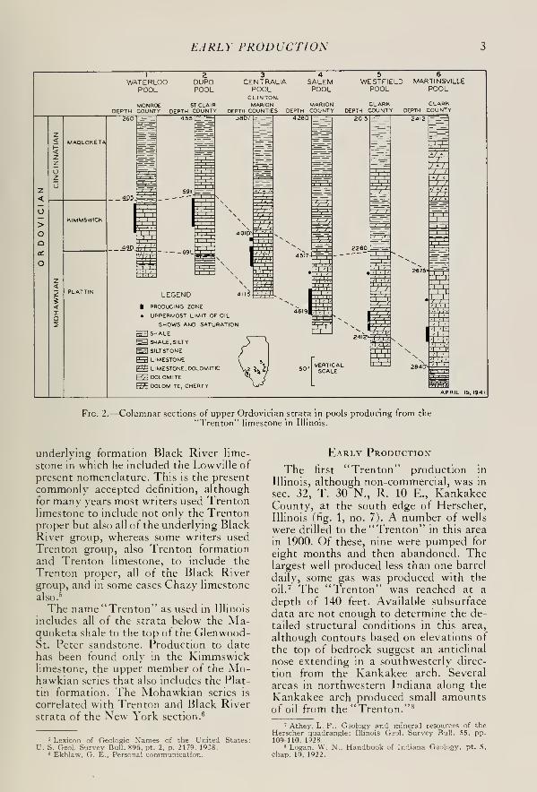
Fig. 2.—Columnar sections of upper Ordovician strata in pools producing from the
"Trenton" limestone in Illinois.
underlying formation Black River lime-
stone in which he included the Lowville of
present nomenclature. This is the present
commonly accepted definition, althoughfor many years most writers used Trentonlimestone to include not only the Trentonproper but also all of the underlying BlackRiver group, whereas some writers usedTrenton group, also Trenton formationand Trenton limestone, to include the
Trenton proper, all of the Black Rivergroup, and in some cases Chazy limestone
also. 5
The name "Trenton" as used in Illinois
includes all of the strata below the Ma-quoketa shale to the top of the Glenwood-St. Peter sandstone. Production to date
has been found only in the Kimmswicklimestone, the upper member of the Mo-hawkian series that also includes the Plat-
tin formation. The Mohawkian series is
correlated with Trenton and Black Riverstrata of the New York section. 6
Early Production
The first "Trenton" production in
Illinois, although non-commercial, was in
sec. 32, T. 30 N., R. 10 E., KankakeeCounty, at the south edge of Herscher,
Illinois (fig. 1, no. 7). A number of wells
were drilled to the "Trenton" in this area
in 1900. Of these, nine were pumped for
eight months and then abandoned. Thelargest well produced less than one barrel
daily, some gas was produced with the
oil.7 The "Trenton" was reached at a
depth of 140 feet. Available subsurface
data are not enough to determine the de-
tailed structural conditions in this area,
although contours based on elevations of
the top of bedrock suggest an anticlinal
nose extending in a southwesterly direc-
tion from the Kankakee arch. Several
areas in northwestern Indiana along the
Kankakee arch produced small amountsof oil from the "Trenton." 8
5 Lexicon of Geologic N'ames of the United States:U. S. Geol. Survey Bull. 896. pt. 2, p. 2179. 19J8.
6 Ekblaw. G. E., Personal communication.
7 Athey. L. F., Geology and mineral resources of theHerscher quadrangle: Illinois Gaol. Survey Bull. 55, pp.109-110. 1928.
8 Logan. W. N., Handbook of Indiana Geology, pt. 5,
chap. 10, 1922.

"TRENTON" PRODUCTION IN ILLINOIS
100
Ulrra.<£D50
25
Io
I 2 3 4 5 6 7 8 9 10 M 12 13 14 15 16 17 18 19 20 21
YEARS
Fig. 3.—Daily production at end of yearly intervals for a "Trenton" well in the
Westfield pool, Clark County.
Westfield Pool
The first commercial production fromthe "Trenton" limestone in Illinois wasin the Westfield pool, Clark County, near
the north end of the southeastern Illinois
fields (fig. 1, no. 1). The first well, drilled
in 1910, was a small producer. The initial
production of the well was 65 barrels andthe production for the second 24 hours
was 20 barrels. The depth of the produc-ing zone was from 2,395 to 2,445 feet. Thewell, which was abandoned ten years
later, produced an estimated total of
10,000 barrels during that time.
The Westfield pool is located on a domeon the axis of the LaSalle anticline. Theprincipal producing formation is the
Westfield limestone, correlated as the St.
Louis-Salem limestones. The St. Louis
limestone, which thins over the top of the
dome, averages 60 feet in thickness on
top.
The "Trenton" closure, which amountsto at least 160 feet, conforms closely to
that of the overlying Mississippian strata. 9
Production is limited structurally to the
upper 50 feet at the top of the structure.
Thirteen wells in the pool have pro-
duced an estimated total of 171,000 bar-
rels of oil from the "Trenton." Two wells
are still producing with an average daily
production of approximately 3 barrels.
9 Mylius, L. A., Oil and gas in east-central Illinois:
Illinois Geol. Survey Bull. 54. pi. 26. 1927.
The wells are usually pumped only oncea week. One well has produced for 20
years, the other for 22 years. The average
life of the "Trenton" wells at Westfield
has been 11 years. The average produc-tion per well per day throughout the life
of each well was approximately 4 barrels.
The recovery of crude oil from the "Tren-ton" limestone at Westfield is approxi-
mately 800 barrels per acre.
Production is obtained from the Kimm-swick formation in the Westfield pool at
various depths throughout a zone aver-
aging 90 feet in thickness (fig. 2). Thezone consists of coarse dolomitic lime-
stone, fossiliferous, with clear calcite crys-
tals. The average depth to the top of the
"Trenton" is 2250 feet and to the top of
the "pay" 2340 feet. The "pay" is usually
encountered from 90 to 100 feet below the
top of the limestone. Where the formation
contained oil in commercial quantity the
wells had little or no water. The rate of
the production suggests low porosity andpermeability of the producing zone. Theinitial production averaged about 100
barrels per well and declined an average
of 72 per cent the second 24 hours. Within2 or 3 months the daily average produc-
tion per well was 10 or 12 barrels. Onewell completed in the field with an initial
production of 125 barrels was producing
6 barrels daily 14 years later and after 21
years was producing 3 barrels daily (fig.
3).

MARTINSVILLE AND WATERLOO POOLS
Martinsville Pool
Four wells have tested the "Trenton"
in the Martinsville pool, Clark County(No. 2, fig. 1), and two of the wells ob-
tained production. The first well, Trenton
Rock Oil Co.—-McFarland No. 1 in the
SE. H SE. % NW. M sec. 19, T. 10 N.,
R. 13 W., was drilled in 1921 on the side
of the Martinsville dome, according to
contours on top of the Devonian lime-
stone, 10 and had an initial production of
125 barrels which declined to 10 barrels
within a short time. The well was pumpedfor a number of months and then stood
idle approximately three years before be-
ing abandoned; during this time it flowed
at intervals. The total production of the
well was approximately 6,000 barrels. 11
During 1940 the Strickler-Jackson No.
1, N\Y. M NE. % SW. M sec. 19, T. 10
N., R. 13 W., was drilled a short distance
from the McFarland well and tested the
"Trenton." The initial production was 4
barrels of oil and 15 barrels of water. Thewell was later plugged back to produce
from the Carper sand encountered at a
depth of from 1,302 to 1,364 feet. A study
of the drill-cuttings from the well showedthe Kimmswick to be at a depth of 2675
feet, and the top of the saturated zone
was at 2729 feet (fig. 2). The well was
drilled 104 feet below the top of the " pay"
to a total depth of 2833 feet and was shot
with nitroglycerine from 2772 to 2794
feet.
The St. Peter sandstone was tested on
top of the Martinsville dome in the Tren-
ton Rock Oil and Gas Co.—Carper No.
13, NW. \i NE. M sec. 30, T. 10 N., R.
13 W. This well had a show of gas in the
"Trenton" at a depth of from 2732 to
2742 feet, and a show of oil from 2800 to
2868 feet. The well was shot with 200
quarts of nitroglycerine, and it then
pumped 29 barrels of oil and 10 barrels of
water. It was later deepened to the St.
Peter sandstone, and several shows of oil
were reported in the strata penetrated
above the sandstone. As this well wasfavorably located on structure, and in
view of the results of the other tests, the
10 Moulton. G. F.. Prospecting near the Martinsville
pool: Illinois Geol. Survey Illinois Petroleum No. 4, fig. 1,
page 3, 1926.
11 Personal communication from Mr. Harry Werts.President, Trenton Rock Oil and Gas Company, Casey,Illinois.
"Trenton" does not appear very promis-
ing for further testing in this area.
Waterloo Anticline
The Waterloo anticline is a long narrowstructure extending north of west fromWaterloo, through Dupo, Illinois, to St.
Louis, Missouri. Lower Mississippian
strata are at the surface along the struc-
ture. On this structure crude oil has been
produced only from the "Trenton" in the
Waterloo pool (fig. 1, No. 6) and the Dupopool (fig. 1, No. 5).
WATERLOO POOL
In the fall of 1920 oil was encounteredin the Kimmswick limestone in a well
drilled for water by the Waterloo Con-densed Milk Company. Exploration anddevelopment along the anticline in the
vicinity of Waterloo, as recommended bythe State Geological Survey in two press
bulletins, 12 resulted in the discovery of
the Waterloo pool. The principal area of
production is a long narrow strip extend-
ing through sec. 2, T. 2 S., R. 10 W., andsouth into the NW. Y± sec. 11. Early in
1922, some 33 producing wells had been
drilled in the pool. Wells located high onstructure had initial productions from 75
to 125 barrels but soon declined to 25 or
50 barrels a day. 13 The last producing
well in the field was abandoned in 1930.
The new development in oil and gas in
Illinois revived the interest in obtaining
further shallow production in this area.
In 1939 and 1940 new wells extended the
productive area along the crest of the
anticline and west of the old producingarea. Initial production of the new wells
ranged from 15 to 60 barrels of oil andfrom 1 to 500 barrels of salt water. Thetotal productive area of the pool is 230
acres, and the total crude-oil production
to the end of 1940 was 197,000 barrels.
The recovery to the end of 1940 has been
857 barrels per acre.
Contours representing the top of the
Kimmswick limestone 14in the Waterloo
pool show more than 100 feet of closure
12 Culver, H. E.. Geology and oil and gas possibilities
in the vicinity of Waterloo, Monroe County. Illinois:
Illinois Geol. Survey Press Bulletin, 1920.
Mylius. L. A.. Oil and gas in Monroe County, Illinois:
Illinois Geol. Survey Press Bulletin, 1921.
13 Lamar, J. E., Notes on the Waterloo Anticline: Illinois
Acad. Sci. Trans., vol. IS. p. 398-404, 1922.
" Bell, Alfred H., The Dupo oil field: Illinois Geol.
Survey Illinois Petroleum No. 17, fig. 2, pp. 10-11, 1929.

"TRENTON" PRODUCTION IN ILLINOIS
on the anticline. Production is limited to
the uppermost part of the structure.
The depth to the top of the Kimmswicklimestone averages 410 feet, and the best
saturated zone averages about 30 feet in
thickness with shows of saturationthroughout a thickness of 50 feet or more.Saturation is encountered near the top of
the Kimmswick limestone which is over-
lain by a white dense crystalline limestone
averaging 12 feet in thickness in the pool.
This limestone has been correlated with
Fernvale limestone which crops out in
southwestern Illinois.15 A study of the
samples of a recent well drilled in the
pool showed 7 feet of a light gray to buff
fine- to medium-grained fossiliferous lime-
stone immediately underlying the Ma-quoketa formation. Because this limestone
is lithologically similar to the upper part
of the Kimmswick as correlated in nearbywells recently drilled, it is included in the
Kimmswick for the purpose of this report.
Early in the life of the pool, water wasencountered in the lower part of the" pay"high on structure but at shallower depths
lower on structure. The producing zone
consists of buff to brown crystalline lime-
stone, fine- to coarse-grained (fig. 2).
The St. Peter sandstone was tested in
the pool by the Remington-Kolmer No.
2, NW. yA NE. \i NW. M sec. 2, T. 2 S.,
R. 10 W.j which was drilled to a depth of
1802 feet. The well was plugged back to
the "Trenton" from which production
was obtained.
DUPO POOL
The Dupo pool, located on the northern
extension of the Waterloo anticline, wasdiscovered in 1928. During 1929, a total
of 224 oil wells was completed in the field
which was extended into the village of
Dupo. Production from the town-lot wells
declined rapidly because of their close
spacing and many of the wells were soon
abandoned. By the end of 1933 only 57
producing wells remained in the pool.
Initial productions of the wells ranged
from 50 to 350 barrels and the decline in
production the second 24 hours ranged
from 14 to 75 per cent, averaging 46 per
cent for those wells for which production
figures are available. One well which had
an initial production of 200 barrels was
producing 50 barrels daily one week later.
Contours representing the top of theKimmswick limestone 16 show at least 100
feet of closure in the pool, and productionwas limited almost entirely to the area ofclosure. Water encroached rapidly in the
pay, and by 1934 it was found throughoutthe field. The amount of water producedwith the oil increased so much that manywells were abandoned for this reason.
The top of the producing zone is usually
about 5 feet below the top of the Kimm-swick limestone (fig. 2) and extends
throughout a zone averaging 50 feet in
thickness. It is light brown to buff" lime-
stone, coarsely granular, compact, fossi-
liferous, and the drill cuttings show muchclear calcite. Solution cavities and crev-
ices have been encountered in the upperpart of the producing zone in a few wells
near the top of the structure. The initial
production of these wells was larger thanthat of nearby wells.
The total oil production for the pool to
the end of 1940 was 1,275,000 barrels andthe productive area was 670 acres. Therecovery to the end of 1940 was 1900
barrels per acre. At the end of 1940 there
were 64 producing wells in the pool.
During the recent oil development in
Illinois additional wells have been drilled
in the pool. Initial production of these
later wells ranged from 5 to 200 barrels of
oil and from to 6,000 barrels of water.
Centrifugal pumps were installed in
some of the wells to handle large volumes
of fluid which could not be produced with
the customary pump-jack as lifting power.
Such a pump was installed in one well
drilled in a part of the pool where water
had encroached in the pay causing near-
by old wells to be abandoned. During 8
months operation of the centrifugal pump,the well produced approximately 47,000
barrels of oil and 903,000 barrels of water.
The cost of the pumping equipment and
power for operation of the pump during
that period was approximately $11,000.
The first day the well produced 6,000
barrels of water and no oil, the second day
it produced 25 barrels of oil and 6,000
barrels of water, and with further opera-
tion of the well there was an increase in
oil and a decrease in water production.
" Lamar, J. E., op. cit. '« Bell, A. H., op. cit.

DUPO POOL
The peak oil production of 400 barrels
was obtained one month after the well
was put in operation, at which time it
still produced 5400 barrels of water with
the oil. At the end of 8 months the well
was producing 40 barrels of oil and 1800barrels of water a day.
It is believed that this method of hand-ling large fluid volumes may make it pos-
sible to recover a considerable amount of
oil in certain old pools in the State wherewater-encroachment has greatly reducedoil production. By removing largeamounts of fluid from the reservoir, oil
which has been trapped with the chan-neling and by-passing of water would be
drawn to the well and recovered.
The producing zone was cored by the
Survey in four wells in the Dupo pool.
The study of the cores showed the porosi-
ty to vary from 2.6 to 19.0 per cent withan average of 14 per cent; permeability
ranged from to 61 millidarcys with anaverage of 7.7 millidarcys; the averagetotal fluid saturation of the pore spacewas 54.3 per cent. It is believed that
where the "Trenton" is productive in
Illinois the physical character of the pro-
ducing zone is comparable to that in the
Dupo pool. A study of one of the cores is
as follows: 17
Ohio Oil Co.—M. Dyrqff well No. 27, SW. \i NW
.
)4 SE. H sec. 28, T. 'l N., R. 10 W., St. Clair County.
Surface elevation 405.5 feet.
FormationThicknessFt. In.
Beginning ot core
Kimmswick limestone
Limstone, light brownish-gray, very fine, somecoarse areas, containing oil
along stylolites and in
more coarse-grained areas;
sample 1
Limestone, light brownish-gray to gray, very fine to
very coarse, crinoidal, oil
in tubular areas in lowest9 inches; samples 2-4. ... 2
Limestone, brownish - gray,
coarsely crystalline, po-
rous with tossil impressions,
containing oil
Limestone, grayish - brown,very fine to coarse, crys-
talline, compact; samples5 and 6 2
DepthFt. In.
401
401 9
404
404 9
406 9
"Piersol, R. J.. Workman. L. E.. Watson. M. C.Porosity, total liquid saturation, and permeability of Illinoisoil sands: Illinois Geol. Survey Rept. Inv. Xo. 67, pp. 48,49. 51, 1940.
Thickness DepthFt. In. Ft. In.
Limestone, grayish - brown,coarse, crystalline, some-what porous; samples 7
and 8 19 408 6Limestone, brown, very
coarse, crystalline, porous;
samples 9 and 10 16 410Limestone, grayish - brown,
coarse, crystalline, com-pact; samples 11-13 3 6 413 6
Limestone, brown to grayish-
brown, very coarse, moreor less porous; samples 14-
18 4 6 418Limestone, brown with darkbrown bituminous specks,
coarse, crystalline, com-pact 2 418 2
Limestone, speckled brown-ish-gray and gray, mediumto coarse, crystalline, thin
layer of phosphatic nodulesat base; sample 19 10 419
Limestone, speckled light
brownish -gray and gray,
verv fine to coarse, crys-
talline 4 419 4Limestone, brown, coarse,
crystalline, somewhat po-rous, containing oil; sam-ples 20-22 2 8 422
Limestone, light gray andbrown speckled, coarse,
crystalline, compact ex-
except near base; samples23-25 3 425
Limestone, light gray andbrown speckled, verycoarse, porous; samples26-28 3 9 428 9
Limestone, brown, coarse,
crystalline, more or less
porous, containing oil;
samples 29-40 12 3 441
Limestone, brownish - gray,
coarse, crystalline, some-what porous; samples 41-
42 2 443
Limestone, grayish - brown,medium to coarse, fairly
compact; sample 43 1 1 444 1
Limestone, buff with brownspecks, very fine, cono-donts 1 444 2
Limestone, speckled light
brownish-gray and brown,coarse, porous 5 444 7
Limestone, light brownish-gray, brown specks, veryfine, compact, conodonts . 1 444 8
Limestone, light to mediumbrown, coarse, crystalline,
porous; sample 44 8 445 4
Limestone, brown, fine to
coarse, crystalline, com-pact, areas of clear crystal-
line calcite filling formercavities, show of oil 8 446

"TRENTON" PRODUCTION IN ILLINOIS
Porosity and Permeability of Kimmswick LimeDyroff well No. 27
Sample Depth Porosity PermeabilityNo. (ft.-in.) (per cent) (millidarcys)
1 401-0 5.0 0.302 402-0 1.9 0.003 403-0 10.0 0.004 404-0 13.0 60.95 405-0 6.7 4.46 406-0 2.6 0.007 407-0 13.0 12.98 408-0 14.6 16.89 409-0 13.5 9.510 410-0 10.4 3.411 411-0 7.8 0.8012 412-0 9.6 1.813 413-0 9.8 7.714 414-0 14.2 12.315 415-0 14.7 11.116 416-0 11.9 6.217 417-0 17.0 11.518 418-0 7.6 0.9019 419-0 4.3 0.0020 420-0 8.3 0.4021 421-0 10.1 3.322 422-0 6.1 0.0023 423-0 9.5 4.924 424-0 4.4 0.0025 425-0 9.8 4.926 426-0 7.3 1.027 427-0 6.3 0.028 428-0 14.0 1.829 430-0 15.3 10.930 431-0 16.6 9.031 432-0 15.9 12.132 433-0 16.0 17.933 434-0 16.3 19.434 435-0 10.5 1.435 436-0 16.5 13.936 437-0 15.0 13.937 348-0 15.9 21.538 439-0 16.6 24.539 440-0 11.1 3.340 441-0 11.4 1.1
41 442-0 5.8 0.4042 443-0 12.5 9.943 444-0 8.5 1.644 445-0 8.1 1.7
Vertical and Horizontal Permeability ofKimmswick Lime,
Dyroff Well No. 27
Centraua Pool
In the Centralia pool, Clinton andMarion counties (fig. 1, No. 4), two wells
are producing from the "Trenton" lime-
stone. Both wells were drilled in 1940near the center of the structure. The top
of the Trenton was reached at a depth of
4018 feet in the Ames—Hicks No. 2 well
located in the SW. M NE. M SE. M sec.
12, T. 1 N., R. 1 W., Clinton County. Thewell was first drilled to a depth of 4068feet, and the producing zone was acidized.
The initial production was 120 barrels.
Later the well was deepened to 4123 feet
Permea bilitv (millidarcvs)Depth(ft.-in.) Vertical Horizontal
1X1X1 cm. 1X1X1 cm. lXlX2cm.
401-0 0.0 0.30403-0 0.0 161 00405-0 0.464 0.220 4.4407-0 18.1 16.8 12.9409-0 11.4 11.92 9.5411-0 0.678 1 083 80413-0 7.7415-0 12.93 17.2 11.1416-0 2.88 3.675 6.2418-0 720 0.833 0.90420-0 0.648 1.648 0.40422-0 0.354 0.456 00424-0 136 0.289 00426-0 0.258 568 1.0428-0 0.887 1 003 1.8431-0 2.02 5.20 9.0433-0 8.17 9 43 17.9435-0 1.315 1.013 1.4437-0 12.43 13.45 13.9438-0 9.07 8.42 21.5440-0 0.770 1 004 3.3442-0 503 11.0 40444-0 1.198 829 16445-0 2.89 4.27 1.7
and plugged back to 4121 feet. Water wasencountered near the base of the produc-ing zone. The well was shot from 4066 to
4121 feet, and the initial production was74 barrels of oil and 16 barrels of water.
The second well drilled to the "Tren-ton" was the Borton-Storer No. 1, NYV.
M NE. \i NE. \i sec. 13, T. 1 N., R. 1
W., Clinton County. The well was com-pleted December 3 with an initial pro-
duction of 100 barrels. The top of the
"Trenton" was at a depth of 4010 feet,
and saturation was reported at depths4016 to 4024 feet and at 4032 to 4056 feet.
The well was drilled to a depth of 4120and was plugged back to 4070 feet. Waterwas encountered from 4115 to 4120 feet.
Production from both wells has beensmall. The total production from one of
the wells, which flows and pumps by"heads", for a three-months period wasestimated to be slightly more than 3000barrels. Production declined to 30 barrels
daily within 13 days after being com-pleted, but further decline in daily pro-
duction almost three months later wasonly 5 barrels.
The producing zone consists of light
gray to buff crystalline limestone, slightly

SALEM POOL
dolomitic and cherty, and stylolitic in the
lower part (rig. 2). Drill-cuttings from
the producing zone showed only slight
porosity.
Salem Pool
The first well to be drilled to the "Tren-
ton" limestone in the Salem pool, Marion
County, (fig. 1, No. 3), was completed
early in 1941. Up to April 22, some 20
additional wells had been completed and
13 others were nearing completion. These
wells formerly produced from the Devo-
nian limestone but were deepened to the
"Trenton." The average depth to the top
of" the Kimmswick limestone is 4500 feet,
and the total depth of the wells averaged
4625 feet.
The largest reported initial production
of any well to the above date was 343
barrels, and the average for all wells was
155 barrels. The physical character of the
reservoir is such that most of the wells
flow by heads, and the amount of oil pro-
duced daily is no greater when the wells
are pumped. One of the early wells pro-
duced approximately 10,000 barrels of oil
during 50 days of operation, a more re-
cent well, which was drilled as an offset to
other producing wells, produced a total
of 4300 barrels in 36 days of operation.
Although the initial productions are
small as compared to wells completed in
more porous and permeable formations,
production from these wells has been
fairly stable. From the available data the
decline in daily production for the first
month's operation has been in the order
of 40 per cent. It appears that the rate of
decline of "Trenton" production in the
Salem pool will be less than in any other
area of "Trenton" production in Illinois.
No water has been reported in the wells
drilled within the 50 feet of structure be-
tween the structurally highest and lowest
wells completed to date. It is expected
that the area of "Trenton" production
will be somewhat smaller than the over-
lying Devonian limestone which has a
productive area of 5000 acres.
Saturation is usually encountered about
25 feet below the top of the Kimmswicklimestone and is reported at various in-
tervals to an average depth of 105 feet
below the top of the limestone. The aver-
age thickness of the "pay" is 50 feet. It
has been reported that the best saturation
is near the base of the Kimmswick which
is slightly more than 100 feet thick in the
Salem pool.
The producing zone consists of buff
slightly dolomitic limestone which is fine-
to coarse-grained and partly crystalline
and is stylolitic in the lower part (fig. 2).
A study by a commercial laboratory of a
core taken near the base of the producingzone, which is also near the base of the
Kimmswick, showed a variation in per-
meability of from to 195 millidarcys andan average porosity of 7 per cent. Thetotal water content varied from 8.8 to
34.5 per cent of the pore space, and resid-
ual oil averaged 7 per cent of the pore
space. Although the amount of core re-
covered was small, it appears to be fairly
representative of the remainder of the paywhen compared with the results of the
studies of cores from the Dupo pool.
As the available data regarding the
character of the producing zones on the
Kimmswick limestone are not abundantit is difficult to estimate the ultimate re-
covery from that formation in the Salempool. It is certainly one of the most prom-ising structures for "Trenton" production
yet discovered in Illinois. However, the
increased costs of drilling, equipment, andoperation as a result of the greater depthmay cause the abandonment of "Tren-ton" wells in the Salem pool earlier thanin pools where the Trenton is shallower,
thus resulting in lower ultimate recovery.
The other areas of "Trenton" productionin Illinois, with the exception of the Cen-tralia pool, are at much shallower depths.
In two of these areas the recovery hasbeen to date approximately 800 barrels
per acre, and this amount compares with
the "Trenton" in Indiana. The Dupofield, however, which offers the best record
for "Trenton" production in Illinois, has
produced 1900 barrels per acre. In consid-
eration of the size of the Salem structure,
the nature of the"pay," and the character
of the wells completed, it seems within
reason to expect an ultimate recovery at
least comparable to that in the Dupo pool.
Since development of the "Trenton" in
the Salem pool began, a well was drilled
on structure to a depth 400 feet belowthe top of the St. Peter sandstone whichwas encountered at a depth of 5250 feet.
No shows were reported below the Kimm-swick limestone.

10 "TRENTON" PRODUCTION IN ILLINOIS
LEGEND
PRODUCING AREA OFMISSISSIPPIAN STRATA(9,000 ACRES )
PRODUCING AREA OFDEVONIAN STRATA(5,000 ACRES )
PRODUCING AREA OF"TRENTON" AS OFJULY 15, 1941
(900 ACRES
)
i ESTIMATED EXTENT OFf "TRENTON" PRODUCTION
(2,500 ACRES)
KEY TO LOCATION
ILLINOIS GEOLOGICAL SURVEY
JULY IS, 1941R I E R 2E
Fig. 4.—Area of "Trenton" production in the Salem pool, Marion County, Illinois
The available subsurface data to datein the Salem pool indicate that on top ofthe anticline and on the uppermost partof the east flank the structure conformsfairly well with that of the overlyingDevonian limestone. Subsurface data areinsufficient to determine the structural
relationship on the west flank.
ADDENDA
Additional data regarding "Trenton"development in the Salem pool have beenobtained since the manuscript was pre-
pared. As of July 15, 1941, 74 wells wereproducing from the "Trenton" in theSalem pool, and the productive area
proved by drilling was 900 acres. Thetotal productive area of the "Trenton" in
the pool is estimated to be 2500 acres(fig. 4).
The average initial production of thefirst 13 wells completed in the pool was175 barrels and of the wells drilled duringJune and July 72 barrels. One ofthe early wells produced approximately22,000 barrels of oil during six monthsoperation. A decline curve of this well is
shown in figure 5.
The available subsurface data in theSalem pool indicate that on top of theanticline and on the uppermost part ofthe east and west flanks the structure con-

SALEM POOL II
°\\4
O """8 A O i )
o
10 12 14
NUMBER OF WEEKS
22 24
Fig. 5.—Decline curve of a "Trenton" well in the Salem pool, Marion County, Illinois.
forms with that of the overlying Devonianlimestone.
The "Trenton" limestone has slightly
steeper dip than the Devonian, shown in
the variation in interval between the tops
of the two formations. The interval at
the crest of the fold is 1 180 feet. From this
point there is an increase of 16 feet in %mile southeast, 18 feet in l}4 miles north-
east, and 33 feet in \ x/i miles south. No
increase in interval was noted in the short
distance west of the crest of the told
where the "Trenton" has been tested.
Summary
Crude-oil production from the "Tren-ton" in Illinois to date represents less
than one per cent of the State's total pro-
duction. Production has been limited to
the upper part of structures with consider-
able closure. Shows of oil have been re-
ported in the "Trenton" on other struc-
tures where it has been tested but com-mercial production was not obtained. Asthe producing zone has had low porosity
and permeability in the known productive
areas, initial productions of wells have
been small. In the absence of earlv water
encroachment the wells should be fairly
long lived. The recovery per acre-foot has
been much less than that for other pro-
ducing formations. The increased depthof the"Trenton," which results in greater
drilling and operation costs, makes the
testing and development of this formation
in the new pools less attractive. However,it is believed that in areas where the
"Trenton" is sufficiently porous and per-
meable for commercial production andwhere the structure has sufficient closure,
such testing and development is war-ranted although the financial return is
slower and smaller than it has been with
other formations.
Acknowledgments
The writer is grateful to the oil com-panies who kindly furnished data used in
the report and to Dr. A. H. Bell, head of
the Oil and Gas Division, for helpful sug-
gestions and criticisms in the preparation
of the manuscript.
The summary well logs have been pre-
pared by L. E. Workman, Head of the
Subsurface Division, from sample studies
made bv members of that Division.

12 "TRENTON' 1 PRODUCTION IN ILLINOIS
SUMMARY LOGS
Based on studies of the drill-cuttings from repre-
sentative wells in areas of "Trenton" production.
1. Westfield pool, Clark County
W. R. Miller—Booth No. 1, SE.H NE. \i NW.M sec. 17, T. 11 N., R. 14 W., Clark County.
Surface elevation 665 feet. Drilled 1939.
Thick-Formation ness Depth
Ft. Ft.
Pleistocene system 40 40Pennsylvanian system
Shale, sandstone, lime-
stone and coal 270 310Mississippian systemIowa series
Meramec groupSt. Louis limestone 41 351Salem limestone 171 522
Osage groupSiltstone and sandstone. 556 1078
Kinderhook groupRockford limestone 14 1092
Mississippian-Devonian systemsKinderhook—New Albanyshale 106 1198
Devonian and Silurian systemsLimestone and dolomite,
sandy 77 1375Limestone and dolomite 505 1880Limestone and dolomite,
pink and gray 170 2050Ordovician system
Cincinnatian series
Maquoketa formationShale, gray 60 2110Limestone, some shale. 74 2184Shale, brownish 110 2294
Mohawkian series
Kimmswick limestone . . 150 2444Plattin limestone 18 2462T.D.
Associated Producers and Tidewater—Spellbring
No. 34, 404 feetfrom N. line, 926 feetfrom E. line,
NW. y± NW. \i sec. 8, T. 11 N., R. 14 IV., Clark
County.
Surface elevation 659 feet. Drilled 1924 to 245feet; deepened in 1936 to 3009 feet.
Pleistocene, Pennsylvanian, andMississippian systems 1165 1165
Devonian and Silurian systemsLimestone 825 1990
Ordovician systemCincinnatian series
Maquoketa shale andlimestone 255 2245
Thick-Formation ness
Ft.
Mohawkian series
Kimmswick limestone, pet-roliferous 163
Plattin limestone, partly pet-roliferous 337
Chazyan series
Joachim formationDolomite, partly petrolif-
erous 166Sandstone, shale and dolo-
mite 73St. Peter sandstone 25
DepthFt.
2408
2745
2911
29843009
2. Martinsville pool, Clark County
Trenton Rock Oil and Gas Co.—J. S. Carper No.13, 330 feet N. of S. line, 330 feet E. of W. line ofNE. M sec. 30, T. 10 N, R. 13 W., Clark County.
Surface elevation 599 feet. Drilled 1928-29.
Pleistocene and Pennsylvaniansystems 477 477
Mississippian system
Iowa series
Meramec and Osage groupsNo record, except lime-
stone at top 808 1285Osage group
First Carper sand 45 1330Shale? 11 1341
Second Carper sand 55 1396Kinderhook group
Shale? 19 1415Rockford limestone 11 1426
Mississippian-Devonian systems
Kinderhook—New Albanyshale '. 124 1550
Devonian and Silurian systems
Limestone 131 1681
Limestone, sandy 59 1740Limestone 511 225
1
Limestone, pink to gray 184 2435
Ordovician system
Cincinnatian systemMaquoketa formation
Shale and siltstone, gray 45 2480Limestone, some shale. 120 2600Shale, brown 95 2695
Mohawkian series
Kimmswick limestone . . 165 2860Mohawkian—Chazyan series
Plattin and Joachim for-
mations 540 3400Chazyan series
St. Peter sandstone 11 3411

SUMMARY LOGS 13
F. D. Strickler-Minnie Jackson No. 1, 350 feet
from N. line, 225 feetfrom IV. line, NE. %, SW. \isec. 19, T. 10 A"., R. 13 W., Clark County.
Surface elevation 555 feet. Drilled 1939.
Thick-Formation ness Depth
Ft. Ft.
Pleistocene and Pennsylvaniansystems 410 410
Mississippian systemChester series
Limestone, sandstone,
and shale 19 429Iowa series
Meramec groupSte. Genevieve limestone . 66 496St. Louis limestone 160 656Salem limestone 122 778
Osage groupLimestone 132 910No record 200 1110Shale, siltstone, and
sandstone 291 1401
Kinderhook groupShale, green 9 1410
Rockford limestone 10 1420Mississippian-Devonian systems
Kinderhook—New Albanyshale 120 1540
Devonian and Silurian systemsLimestone 105 1645Dolomite, oil shows . . . 37 1682Sandstone and dolomite,
oil shows 23 1705Dolomite, oil show at
top 565 2270Dolomite, pink to gray . 144 2414
Ordovician systemCincinnatian series
Maquoketa formation
Shale, gray 23 2437Limestone and shale ... 30 2467Dolomite 97 2564Shale, brownish; some
limestone Ill 2675Mohawkian series
Kimmswick limestone, oil
show 158 2833
3. Salem pool, Marion County
Kingwood Oil Co.—Shanafelt No. 18A, 614 feet
from N. line, 1212 feetfrom IV. line, NE. \i sec. 20,T. 2 N., R. 2 E., Marion County.
Surface elevation 533 feet. Drilled 1939.
Pleistocene and Pennsylvaniansystems 1200 1200
Mississippian systemChester series
Menard limestone and shale 76 1276Vienna limestone and shale 56 1332Tar Springs sandstone 103 1435Glen Dean limestone and
shale 42 1477
Hardinsburg sandstone 41 1518Golconda limestone and
shale 137 1655Cypress sandstone 45 1700Paint Creek limestone and
shale 64 1764
Thick-Formation ness Depth
Ft. Ft.
Bethel sandstone . 40 1804Renault formation 51 1855
Aux Vases sandstone 42 1897Iowa series
Meramec groupSte. Genevieve formation
Levias limestone mem-ber 9 1906
Rosiclare sandstone andsandv limestone mem-ber 34 1940
Fredonia limestone
member 130 2070St. Louis limestone 180 2250Salem limestone 276 2526
Osage groupLimestone 104 2630Shale and siltstone 525 3205
Kinderhook groupShale, green 30 3235
Rockford limestone 7 3242
Mississippian-Devonian systemsKinderhook—New Albany
Shale 108 3350
Devonian systemLimestone and dolomite,
petroliferous zones . . . 152 3502
Magnolia Petroleum Co.—Sam Shanafelt No. 32,
334feetfrom N. line, 380feetfrom W. line of SE. \LSW. Y± sec. 29, T. 2 N, R. 2 E., Marion County.
Surface elevation 536 feet. Drilled 1940.
Pleistocene, Pennsylvanian andMississippian systems 3320 3320
Devonian and Silurian systemsLimestone and dolomite 960 4280
Ordovician systemCincinnatian series
Maquoketa formation
Siltstone 19 4299Shale, grav; siltstone at
top' 46 4345
Shale, gray and brown . . . 35 4380Shale and dolomite, grav
and brown '. 125 4505Mohawkian series
Kimmswick limestone 104 4609
4. Centralia pool, Clinton County
Algona Oil Co.—E. B. Marshall No. /, 200 feet
from S. line, 221 feetfrom E. line of SW. l/i sec. 12,
T. 1 N., R. 1 ll\, Clinton County.
Surface elevation 493 feet. Drilled 1940.
Pleistocene system 92 92Pennsylvanian system 948 1040
Mississippian systemChester series
Glen Dean—Golconda for-
mations 160 1200Cypress sandstone 95 1295
Paint Creek shale andlimestone 63 1358
Bethel sandstone 52 1410Renault—Aux Vases for-
mations 100 1510

14 "TRENTON" PRODUCTION IN ILLINOIS
Thick-Formation ness Depth
Ft. Ft.
Iowa series
Meramec groupSte. Genevieve formation
Levias limestone mem-ber 25 1535
Rosiclare sandstonemember 25 1560
Fredonia limestonemember, and St. Louisand Salem limestones 780? 2340?
Osage and Kinderhook groups, Miss.
—Dev. shale
Shale, siltstone, and lime-
stone 532? 2872
Devonian svstemLimestone 65J/£ 2937K
Pray and Reynolds, and Borton—Storer No. 1,
196 feetfrom N. line, 126 feetfrom IV. line, NE. l/i
NE. \i sec. 13, T. 1 N., R. 1 W., Clinton County.
Surface elevation 493 feet. Drilled to 2915 byPray and Reynolds, deepened to 4120 by Borton,
1940; samples below 2909 feet.
Pleistocene and Pennsvlvaniansystems ' 1085 1085
Mississippian system 1782 2867
Devonian systemDolomite and limestone. . 593 3460
Silurian systemDolomite and limestone,
pink and gray 347 3807
Ordovician systemCincinnatian series
Maquoketa formationSiltstone 36 3843Shale, grav; some lime-
stone...' 87 3930Dolomite, brownish 80 4010
Mohawkian series
Kimmswick limestone 105 4115Plattin limestone 4 4119
5. Dupo pool, St. Clair County
Ohio Oil Co.—Tarlton No. 7, SW. \i NE. % NE.14 sec. 33, T. 1 N., R. 10 W., St. Clair County.
Surface elevation 580 feet. Drilled 1936.
No record 10 10
Mississippian systemIowa series
Meramec group
Salem limestone 43 53
Osage groupWarsaw shale and lime-
stone 102 155
Keokuk and Burlington
limestones 130 285Fern Glen limestone and
shale Ill 396Kinderhook group
Shale, green 2 398Chouteau limestone 12 410
Silurian systemLimestone 45 455
Thick-Formation ness Depth
Ft. Ft.
Ordovician systemCincinnatian series
Maquoketa formationShale, gray 55 510Shale, brown; limestone,
sandy 5 515Limestone, gray; shale
at top and bottom. . . 76 591
Mohawkian series
Kimmswick limestone, pet-
roliferous 46 637
S. G. Lockwood—Dvrof No. 1, N.W cor. NE. Msec. 26, T. 1 N., R. 10 IV., St. Clair County.
Surface elevation 590 feet. Drilled 1925.
Pleistocene system 26 26
Mississippian system
Iowa series
Meramec groupSt. Louis limestone 247 273
Salem limestone 152 425Osage groupWarsaw shale and dolo-
mite 75 500Keokuk and Burlington
limestones 181 681
Fern Glen shale and lime-
stone 74 755Kinderhook groupChouteau limestone 30 785
Grassy Creek shale 13 798
Silurian svstemDolomite 70 868
Ordovician system
Cincinnatian series
Maquoketa formation
Shale, gray 57 925Shale, brown 10 935Siltstone; and dolomite,
silty 15 950Shale and limestone,
brownish 65 1015
Mohawkian series
Kimmswick limestone . .. . 98 1113
Plattin limestone and dolo-
mite 212 1325
Chazyan series
Joachim dolomite 148 1473
St. Peter (and Joachim?)sandstone 159 1632
Prairie du Chien series
Powell and Cotter dolo-
mites 263 1895
Jefferson City dolomite 260 2155
Roubidoux formation
Dolomite, sandy 85 2240Sandstone and sandy
dolomite 45 2285
Gasconade and Van Burendolomites 210 2495
Gunter sandstone andsandy dolomite 35 2530
Cambrian systemSt. Croixan series
Eminence dolomite 234 2764
Potosi dolomite 140 2904

SUMMARY LOGS 15
6. Waterloo pool, Monroe County
Hughes Petro/eum Corp.—Urn. Myer No. 1, 295
feet from N. line, 358 feet from E. line of SIV. x/i
SE. \i sec. 88, T. 2 $.,R. 10 IF., Monroe County.
Surface elevation 575 feet. Drilled 1939.
Thick-
Formation ness DepthFt. Ft.
Pleistocene svstemGlacial drift 28 28
Mississippian system
Iowa series
Meramec group
St. Louis limestone 162 190
Salem limestone 170 360
Osage group
Warsaw shale and lime-
stone 115 475
Keokuk and Burlingtonlimestones 103 578
Fern Glen limestone 107 685
Silurian systemLimestone 27 712
Ordovician system
Cincinnatian series
Maquoketa formationShale, gray 83 795Sandstone 25 820Limestone and shale . . . 35 855
Mohawkian-Chazyan series
Kimmswick-Plattin lime-
stones and Joachimdolomite 485 1340
Chazyan series
St. Peter (and Joachim?)sandstones 147 1487
Prairie du Chien series
Powell and Cotter dolo-
mites 88 1575
Eugene Hoffer—J. H. Bover No. 2, 329 feet fromS. line, 1262feetfrom IF. line, SE. % sec. 19, T. 1 S.,
R. W IF., Monroe County.
Surface elevation 405 feet. Drilled 1940.
Thick-Formation ness Depth
Ft. Ft.
No record 155 155
Mississippian systemIowa series
Meramec groupSalem limestone 83 238
Osage groupWarsaw limestone, dolo-
mite, and some shale 128 366Keokuk and Burlington
limestones 189 555Fern Glen limestone 69 624
Silurian systemLimestone 29 653
Ordovician systemCincinnatian series
Maquoketa shale
Shale, gray 75 728Limestone and shale . . 65 793
Mohawkian series
Kimmswick limestone. ... 86 879Plattin limestone 221 1100
Chazyan series
Joachim dolomite 145 1245
St. Peter (and Joachim?)formation
Sandstone, incoherent. . 98 1343
Dolomite, sandy; sand-
stone, partly dolomitic 47 1390Sandstone, incoherent . 17 1407
Prairie du Chien series
Powell and Cotter dolo-
mites 286 1693
Jefferson City dolomite ... 202 1895
Roubidoux sandstone andsandy dolomite 170 2065
Gasconade and Van Burendolomites 155 2220
Illinois State Geological SurveyIllinois Petroleum No. 39
1941