Embed Size (px)
Citation preview
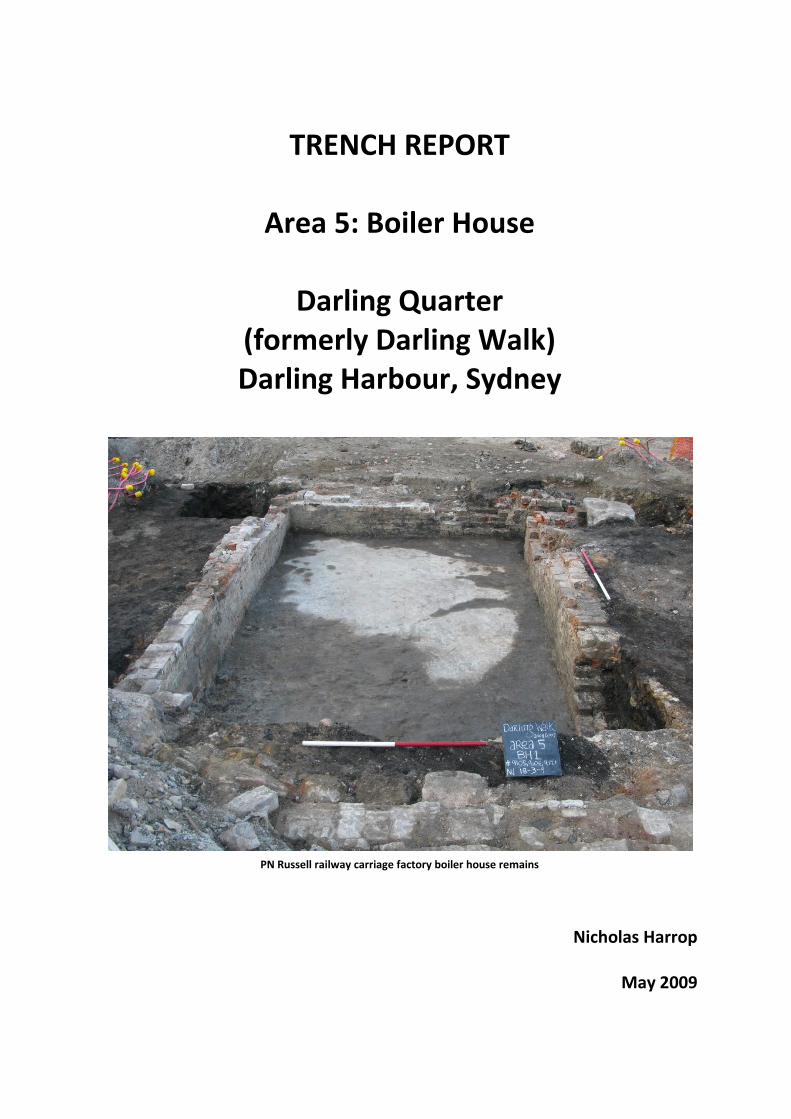
TRENCH REPORT
Area 5: Boiler House
Darling Quarter (formerly Darling Walk) Darling Harbour, Sydney
PN Russell railway carriage factory boiler house remains
Nicholas Harrop
May 2009
_________________________________________________________________________________________ Casey & Lowe Area 5 Boiler House Trench Report
Darling Quarter, Darling Harbour
EXECUTIVE SUMMARY Area 5 is within the footprint of basement of the Darling (Walk) Quarter redevelopment. It is an archaeological zone based on historic property boundaries and street alignments. The northeast portion of the area was the focus of archaeological investigation. This was the location of the PN Russell railway carriage works’ boiler house (referred to as Area 5 BH in this report). The area was bound by Barker Street to the west, Thomas Street to the south, and Duncan Street to the east. The north side of Area 5 was bound by an un-named lane between Steam Mill Street and Thomas Street, with the exception of the eastern end which extends up to Steam Mill Street. It is this block on the southwest corner of Steam Mill and Duncan Streets that was targeted in the archaeological program. Area 5 was utilised from the 1830s, but Area 5 Boiler House saw little development until the late 1860s. The area then hosted several stages of development, the last of which was the construction of SegaWorld in the 1980s. The key developments in Area 5 were:
1830s – 1840s reclamation.
1869 PN Russell carriage workshop and boiler house.
1901 Expansion of the NSW Fruit Exchange structure.
1986 SegaWorld redevelopment. The archaeological excavation of the Area 5 Boiler House was undertaken in March 2009. This involved both machine and hand excavation. The former was used to reduce the area twice, remove demolition from the main surviving structure, and excavate test trenches through the yard area. Manual excavation was employed at each stage of machine reduction for more delicate work, and also to excavate smaller test pits. The more significant archaeological features excavated and recorded included:
Pre-Boiler house features associated with activity not specifically referenced by historical sources.
The boiler house for the carriage workshop constructed in 1869.
A crane base associated with the boiler house.
Wear on the boiler house structure resulting from its operation.
_________________________________________________________________________________________ Casey & Lowe Area 5 Boiler House Trench Report
Darling Quarter, Darling Harbour
CONTENTS 1.0 Introduction ................................................................................................................... 1
1.1 Background............................................................................................................................... 1 1.2 Study Area ................................................................................................................................ 1 1.3 Excavation Areas ...................................................................................................................... 2 1.4 Archaeological Phases .............................................................................................................. 2 1.5 Limitations ................................................................................................................................ 2 1.6 Authorship ................................................................................................................................ 2 1.7 Common Abbreviations ............................................................................................................ 3
2.0 Brief Historical Background ............................................................................................. 4 2.1 General Background ................................................................................................................. 4 2.2 Area 5 Historical Background ................................................................................................... 6
3.0 Archaeological Excavation .............................................................................................. 9 3.1 Overview .................................................................................................................................. 9 3.2 The Site Prior to Excavation ..................................................................................................... 9 3.3 Excavation Methodology .......................................................................................................... 9 3.4 Excavation Limitations ........................................................................................................... 11 3.5 The Team ................................................................................................................................ 12
4.0 Phase 1: Natural Landscape ...........................................................................................13 4.1 Natural Landscape in Area 5 Boiler House ............................................................................. 13 4.2 Natural Landscape in Adjacent Excavation ............................................................................ 13
5.0 Phase 2: Aboriginal Occupation .....................................................................................14 5.1 Overview ................................................................................................................................ 14 5.2 Area 5 Evidence ...................................................................................................................... 15
6.0 Phase 3: 1788 to 1820s Early Foreshore Activity and Property Boundaries ......................16 6.1 Overview ................................................................................................................................ 16
7.0 Phase 4: 1820s to late 1830s Barker’s Mill and Lands ......................................................17 7.1 Overview ................................................................................................................................ 17
8.0 Phase 5: Pre-Construction Fills 1830s–1840s ..................................................................18 8.1 Overview ................................................................................................................................ 18
9.0 Phase 6: 1840s to 1860s Residential and Industrial Development ...................................19 9.1 Overview ................................................................................................................................ 19 9.2 Archaeological Evidence ......................................................................................................... 19
9.2.1 Introduction ................................................................................................................... 19 9.2.2 Archaeological Features ................................................................................................ 20
10.0 Phase 7: 1860s to 1900 Residential and Industrial Development .....................................23 10.1 Overview ............................................................................................................................ 23 10.2 Assessment and Directory Information ............................................................................. 23 10.3 1861-1882: Russell’s Ownership ........................................................................................ 24
10.3.1 Introduction .............................................................................................................. 24 10.3.2 Pre-Boiler House Fills (1861-1869) ............................................................................ 25 10.3.3 Boiler House Construction (1869) ............................................................................. 26 10.3.4 Post-Boiler House Construction (1869-1882) ........................................................... 34
10.4 1882-1901: Post-Russell Ownership to Redevelopment ................................................... 35 10.4.1 Introduction .............................................................................................................. 35 10.4.2 Demolition/ Construction Preparation ..................................................................... 35
11.0 Phase 8: 1900s to 1920 Resumption and Railways ..........................................................37 11.1 Overview ............................................................................................................................ 37 11.2 1900-1920: NSW Fruit Exchange ....................................................................................... 37
12.0 Phase 9: 1920s to 1980s Railways and Commercial Development ...................................39 12.1 Overview ............................................................................................................................ 39

_________________________________________________________________________________________ Casey & Lowe Area 5 Boiler House Trench Report
Darling Quarter, Darling Harbour
13.0 Phase 10: 1980s Demolition and Re-Development ..........................................................40 13.1 Overview ............................................................................................................................ 40
14.0 Summary of Results .......................................................................................................41 15.0 Bibliography ..................................................................................................................42
1
_________________________________________________________________________________________ Casey & Lowe Area 5 Boiler House Trench Report
Darling Quarter, Darling Harbour
1.0 Introduction
1.1 Background Casey & Lowe Pty Ltd were commissioned by Lend Lease Development in 2008 to write an Archaeological Assessment and an Archaeological Management Strategy & Research Design for a then proposed redevelopment of Darling Walk, Darling Harbour, Sydney. The development was classified a ‘major project’ and was determined under Part 3A of the Environmental Planning and Assessment Act. The Archaeological Assessment identified potential archaeological remains within the site and also assessed their heritage significance. The Darling Walk archaeological sites were considered to be of both local and State heritage significance. The reports also proposed a mitigation strategy for the archaeological resource, outlining in detail, responses to the development impacts. It was recommended that salvage excavation of archaeological remains within the basement footprint be undertaken. Outside the basement, testing and monitoring be carried out in areas of impact. Lend Lease commissioned Casey & Lowe to direct this program of archaeological investigations, and work began in October 2008.
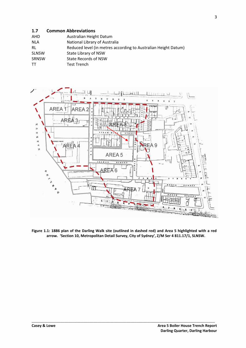
1.2 Study Area The Darling Walk development site is located within the Darling Harbour precinct, on the western edge of Sydney Central Business District. It is located on the eastern side of the harbour and is bound by Harbour Street to the east, Bathurst Street to the north, Liverpool Street/Chinese Gardens to the south and Tumbalong Park to the west. Originally most of the site was below the high water mark. Reclamation work began in the late 1830s when the harbour developed as a predominantly industrial area. The consolidation and alterations to the harbour shoreline continued throughout the nineteenth century. Major redevelopments also occurred in the twentieth century, the last phase being in the 1980s when the Darling Harbour precinct was constructed and the nature and function of the area changed from industrial to leisure, entertainment with some retail and commercial. The Darling Walk site was divided into 9 Areas based on historic lot boundaries, industries and streets.
Area 1 – Grose’s Wharf
Area 2 – William Orr Engineering Workshops
Area 3 – Anchor Flour Mills
Area 4 – PN Russell Foundry
Area 5 – PN Russell Railway Carriage Workshops and Boiler House
Area 6 – Barker’s Jetty, Brodie & Craig’s Timber Yard
Area 7 – Brook’s Slaughter House, Murphy’s Wharfage, Soap and Candle Manufactory
Area 8 – Worker’s Housing
Area 9 – Barker’s Mill Yard and Pond The northeast block of Area 5, on the corner of Steam Mill and Duncan Streets, is the focus of this report. This block of land was the site of the boiler house for the Russell carriage factory. This sub-area has been labelled Area 5 BH.
2
_________________________________________________________________________________________ Casey & Lowe Area 5 Boiler House Trench Report
Darling Quarter, Darling Harbour
1.3 Excavation Areas The basement footprint of the new development impacted on 5 of these areas:
Area 5 – 1870s Boiler House associated with PN Russell foundry
Area 6 – 1820s Barker’s jetty and subsequent reclamation work
Area 7 – 1850s reclamation, Murphy’s wharfage and cottage
Area 8 – 1840s reclamation and workers’ housing
Area 9 – 1820s Barker’s mill yard and mill pond, and later industrial development. This trench report relates to the archaeological investigations in Area 5.
1.4 Archaeological Phases The study area has been divided into 10 main archaeological phases:
Phase 1 Natural Landscape
Phase 2 Aboriginal Occupation
Phase 3 1788 to 1820s Early Foreshore Activity and Property Boundaries
Phase 4 1820s to late 1830s Barker’s Mill and Lands
Phase 5 Late 1830s/Early 1840s Reclamation
Phase 6 1840s to 1860s Residential, Industrial Development and Reclamation
Phase 7 1860s to 1900 Residential and Industrial Development
Phase 8 1900s to 1920 Resumption and Railways
Phase 9 1920s to 1980s Railways and Commercial Development
Phase 10 1980s Demolition and Re-Development. The main archaeological phases were divided into sub-phases dependant on Area. Phase 7 in Area 5 BH was sub-divided in the following way;
Phase 7.1 1861-1882: PN Russell Ownership
Phase 7.2 1882-1900: Post-Russell Ownership
1.5 Limitations This trench report is based on data and information recorded during the archaeological salvage excavation, the initial historical research and historic plans. As the artefact catalogue was not available at the time of writing, the archaeological phases forming the framework for this report have been deduced from a combination of the site archive and available historical information only.
1.6 Authorship The main body of this report has been written by Nick Harrop, supervisor of Area 5 BH. The report is based on the excavation and recording undertaken by the author and excavation team; Darran Jordan, Tom Eley, Ronan Mc Eleney, Balazs Hansel, and James McGuinness. Sections 1, 2 and 3 of this trench report were written by Abi Cryerhall, with additional Area information by the author. This report has been reviewed by Abi Cryerhall, Site Director and edited by Nick Pitt and Mary Casey.
3
_________________________________________________________________________________________ Casey & Lowe Area 5 Boiler House Trench Report
Darling Quarter, Darling Harbour
1.7 Common Abbreviations AHD Australian Height Datum NLA National Library of Australia RL Reduced level (in metres according to Australian Height Datum) SLNSW State Library of NSW SRNSW State Records of NSW TT Test Trench
Figure 1.1: 1886 plan of the Darling Walk site (outlined in dashed red) and Area 5 highlighted with a red
arrow. ‘Section 10, Metropolitan Detail Survey, City of Sydney’, Z/M Ser 4 811.17/1, SLNSW.
4
_________________________________________________________________________________________ Casey & Lowe Area 5 Boiler House Trench Report
Darling Quarter, Darling Harbour
2.0 Brief Historical Background
2.1 General Background1 Most of the site, located on the eastern side of Darling Harbour, formerly Cockle Bay, was at one time below the high water mark. In 1815 John Dickson erected a steam engine powered flour mill at the head of the bay. This was the first use of steam power in Australia. In 1825 the firm Cooper & Levey opened another steam powered flour mill to the north of Dickson’s. Cockle Bay formally became known as Darling Harbour in 1828. Thomas Barker, a former apprentice to Dickson, bought Cooper & Levey’s mill in 1828 and by 1830 had consolidated an area of 6 acres on Darling Harbour on the west side of Sussex Street, between Bathurst and Liverpool Streets. The western limit of Barker’s land was the harbour shoreline, and this is located within the new development site. The waters around Darling Harbour were quite shallow, necessitating the construction of jetties to reach deeper water. The intertidal zone and shallow waters also provided the potential for considerable land reclamation and subsequent development. From the late 1820s to the 1850s the shoreline within Barker’s property was considerably altered by reclamation, jetty and wharf construction. The increasing population of Sydney and the Colony from the 1830s gave rise to greater import and export trading, and an increase in commercial enterprise on the waterfronts. The development of Darling Harbour increased from this time with Barker and other investors capitalising on the value of the waterfront properties. Land reclamation provided more development area with access to deeper water for industries such as the flour mills, timber yards, warehouses and other manufactories. During the 1840s more land around Barker’s mill was sold. Reclaimed land to the west and north was subdivided for residential development. Builders and timber merchants Brodie & Craig bought two of these lots in 1840 and 1844 for their timber yards and wharf. These lots were extended west into the harbour by reclamation. The four lots that were sold extended well beyond the original high water mark, and historic plans depict them as regular shaped city blocks, with a continuous straight line of wharves from Bathurst Street to Brodie & Craig’s wharf to the south (close to the line of Liverpool Street). In 1853 Barker was granted legal title to four portions of reclaimed land on both sides of Barker Street, adjacent to his original grant. This included some of the residential subdivision and over two acres of waterfrontage that he had sold in the 1830s and 1840s. By the 1850s the eastern shoreline of Darling Harbour was well established reclaimed land consisting of wharfage, industrial and residential developments. By the end of the decade Pyrmont Bridge, north of the study area, was constructed connecting Market Street to the developing suburb of Pyrmont to the west. In 1855 a branch of the railway was opened on the west side of Darling Harbour, forming the first link between the railway and shipping. By the 1870s the Darling Harbour goods yard was the centre of the railway freight network serving much of Sydney’s cargo shipping. On the eastern side of the harbour industrial development continued and PN Russell foundry, whose work was associated with the railways, took over Brodie & Craig’s timber yard in 1859. The works of the PN Russell foundry lead to the further alteration of the waterfront, with more reclamation and wharfage west into the harbour area, land on which the new forge was constructed. To the south of the foundry, Barker’s wharf became part of the wharfage associated with the Miller and Harrison timber yards. By the late 1870s the commercial premises on the west side of Barker Street formed a continuous line of wharfage along the edge of Barker’s original property, disconnecting it from Darling Harbour.
1 This section is a summary of the Historical Background written by Dr Rosemary Annabel in Casey & Lowe 2008 and adapted and reproduced in this report, Vol 1, Sections 2.2 – 2.3.
5
_________________________________________________________________________________________ Casey & Lowe Area 5 Boiler House Trench Report
Darling Quarter, Darling Harbour
The development in the nineteenth century of Darling Harbour had been somewhat ad hoc and the wharves were in private ownership, and facilities varied greatly with little sanitation and considerable pollution. By the 1880s the need for major re-planning became evident. The need to provide better access to the wharves and connect them to the railway was costly and required better systems of management, planning and land resumptions. The impetus for these changes was provided by the plague that struck Sydney in 1900. Certain wharves at Darling Harbour were identified as the source of the infection that had spread from Hong Kong via the ports on major trading routes to Australia. The Darling Harbour Wharves Resumption Act gave the government ownership of the whole wharfage from Darling Harbour to Circular Quay. Management of the area passed to the Sydney Harbour Trust whose task it was to redesign and modernise the commercial waterfront. The resumption of properties between Bathurst and Liverpool Streets included all with a waterfrontage. New wharfage was built and existing wharves improved along the eastern side of Darling Harbour. Russell’s wharf was a main area of concern for the state of the harbour and the health of its inhabitants. The whole of the foundry site was cleared as part of the cleansing operations. By 1910 the wharves at the end of Liverpool Street formed the head of the harbour that had once extended south to Hay Street. In 1918 control of the lots within the study area passed from the Sydney Harbour Trust to the Railway Commissioners for NSW. In the early 1920s continued city railway constructions provided fill for more land reclamation around the harbour. The Sydney Harbour Trust improvements to the wharves between Bathurst and Liverpool Streets were covered over and buildings demolished. The Sydney Goods Yard with new wharfage was constructed in their place, and this goods rail yard was the biggest in Australia. The 1940s saw the decline in shipping and the gradual replacement by rail and road transport. Private car ownership also became a more dominant factor in city planning from the 1950s. The wharves at Darling Harbour suffered during these decades of decline. The advent of containerised revolutionised the transport of goods by sea and onwards by land. Ports needed to develop roll-on/roll-off wharves with large flat concrete aprons and room for large cranes, transport vehicles and stores. The redevelopment of the Darling Harbour wharves was undertaken by the Maritime Services Board and during the 1960s work was concentrated on the eastern side of the harbour. In 1974 No.5 berth was completed and at 315m in length it was the longest cargo shed in Australia. Despite the investment, Darling Harbour could not compete with the container shipping facilities being developed at Port Botany. Transport from the wharves in the city was inadequate as the streets were too narrow and busy to accommodate the new semi-trailers. Road building around Darling Harbour continued through the 1970s and in the 1980s the Western Distributor along its eastern side was completed. The State Rail Authority was instructed to move out in 1982 by the government. The Harbour was once again the subject of redevelopment as the State’s major contribution to the bicentennial program. The new complex included an exhibition and convention centres, park, foreshore promenade, the Chinese Gardens and the National Maritime Museum as well as sites for commercial development. When this redevelopment was completed Barker, Thomas, Duncan and Steam Mill Streets had disappeared off the map and replaced by the new Harbour Street and a complex traffic intersection. The current redevelopment prompted by the Sydney Harbour Foreshore Authority will see the construction of office and retail premises at the Darling Walk site.
6
_________________________________________________________________________________________ Casey & Lowe Area 5 Boiler House Trench Report
Darling Quarter, Darling Harbour
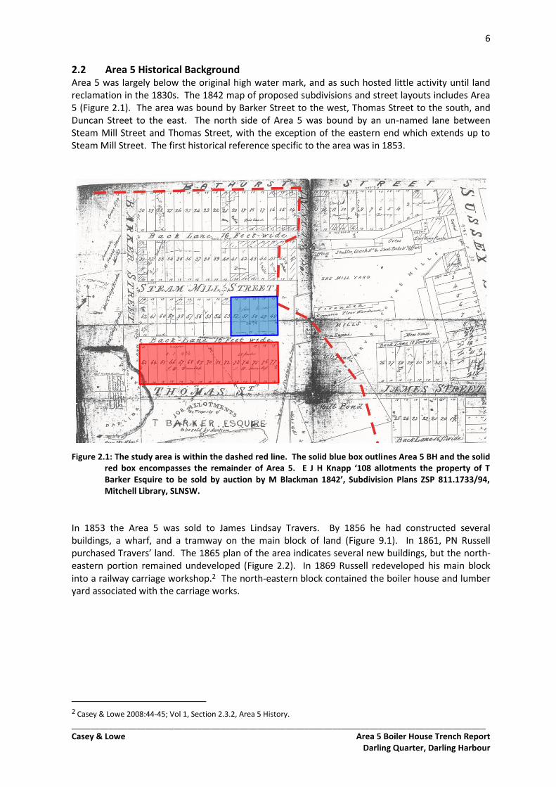
2.2 Area 5 Historical Background Area 5 was largely below the original high water mark, and as such hosted little activity until land reclamation in the 1830s. The 1842 map of proposed subdivisions and street layouts includes Area 5 (Figure 2.1). The area was bound by Barker Street to the west, Thomas Street to the south, and Duncan Street to the east. The north side of Area 5 was bound by an un-named lane between Steam Mill Street and Thomas Street, with the exception of the eastern end which extends up to Steam Mill Street. The first historical reference specific to the area was in 1853.
Figure 2.1: The study area is within the dashed red line. The solid blue box outlines Area 5 BH and the solid red box encompasses the remainder of Area 5. E J H Knapp ‘108 allotments the property of T Barker Esquire to be sold by auction by M Blackman 1842’, Subdivision Plans ZSP 811.1733/94, Mitchell Library, SLNSW.
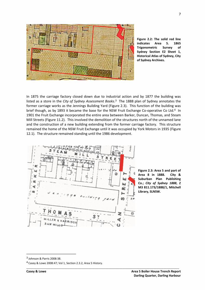
In 1853 the Area 5 was sold to James Lindsay Travers. By 1856 he had constructed several buildings, a wharf, and a tramway on the main block of land (Figure 9.1). In 1861, PN Russell purchased Travers’ land. The 1865 plan of the area indicates several new buildings, but the north-eastern portion remained undeveloped (Figure 2.2). In 1869 Russell redeveloped his main block into a railway carriage workshop.2 The north-eastern block contained the boiler house and lumber yard associated with the carriage works.
2 Casey & Lowe 2008:44-45; Vol 1, Section 2.3.2, Area 5 History.
7
_________________________________________________________________________________________ Casey & Lowe Area 5 Boiler House Trench Report
Darling Quarter, Darling Harbour
Figure 2.2: The solid red line indicates Area 5. 1865 Trigonometric Survey of Sydney Section E2 Sheet 1, Historical Atlas of Sydney, City of Sydney Archives.
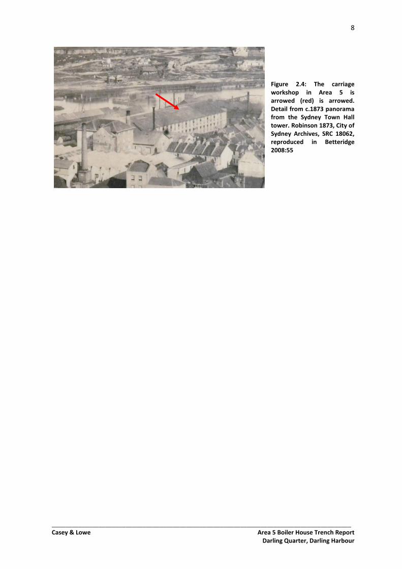
In 1875 the carriage factory closed down due to industrial action and by 1877 the building was listed as a store in the City of Sydney Assessment Books.3 The 1888 plan of Sydney annotates the former carriage works as the Jennings Building Yard (Figure 2.3). This function of the building was brief though, as by 1893 it became the base for the NSW Fruit Exchange Co-operative Co Ltd.4 In 1901 the Fruit Exchange incorporated the entire area between Barker, Duncan, Thomas, and Steam Mill Streets (Figure 11.2). This involved the demolition of the structures north of the unnamed lane and the construction of a new building extending from the former carriage factory. This structure remained the home of the NSW Fruit Exchange until it was occupied by York Motors in 1935 (Figure 12.1). The structure remained standing until the 1986 development.
Figure 2.3: Area 5 and part of Area 8 in 1888. City & Suburban Plan Publishing Co.; City of Sydney 1888, Z M3 811.173/1888/1, Mitchell Library, SLNSW.
3 Johnson & Parris 2008:38. 4 Casey & Lowe 2008:47; Vol 1, Section 2.3.2, Area 5 History.
8
_________________________________________________________________________________________ Casey & Lowe Area 5 Boiler House Trench Report
Darling Quarter, Darling Harbour
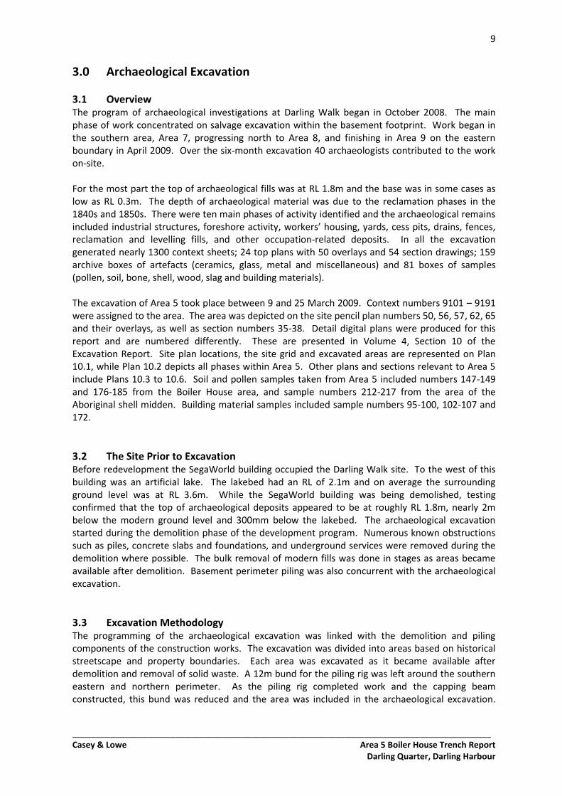
Figure 2.4: The carriage workshop in Area 5 is arrowed (red) is arrowed. Detail from c.1873 panorama from the Sydney Town Hall tower. Robinson 1873, City of Sydney Archives, SRC 18062, reproduced in Betteridge 2008:55
9
_________________________________________________________________________________________ Casey & Lowe Area 5 Boiler House Trench Report
Darling Quarter, Darling Harbour
3.0 Archaeological Excavation
3.1 Overview The program of archaeological investigations at Darling Walk began in October 2008. The main phase of work concentrated on salvage excavation within the basement footprint. Work began in the southern area, Area 7, progressing north to Area 8, and finishing in Area 9 on the eastern boundary in April 2009. Over the six-month excavation 40 archaeologists contributed to the work on-site. For the most part the top of archaeological fills was at RL 1.8m and the base was in some cases as low as RL 0.3m. The depth of archaeological material was due to the reclamation phases in the 1840s and 1850s. There were ten main phases of activity identified and the archaeological remains included industrial structures, foreshore activity, workers’ housing, yards, cess pits, drains, fences, reclamation and levelling fills, and other occupation-related deposits. In all the excavation generated nearly 1300 context sheets; 24 top plans with 50 overlays and 54 section drawings; 159 archive boxes of artefacts (ceramics, glass, metal and miscellaneous) and 81 boxes of samples (pollen, soil, bone, shell, wood, slag and building materials). The excavation of Area 5 took place between 9 and 25 March 2009. Context numbers 9101 – 9191 were assigned to the area. The area was depicted on the site pencil plan numbers 50, 56, 57, 62, 65 and their overlays, as well as section numbers 35-38. Detail digital plans were produced for this report and are numbered differently. These are presented in Volume 4, Section 10 of the Excavation Report. Site plan locations, the site grid and excavated areas are represented on Plan 10.1, while Plan 10.2 depicts all phases within Area 5. Other plans and sections relevant to Area 5 include Plans 10.3 to 10.6. Soil and pollen samples taken from Area 5 included numbers 147-149 and 176-185 from the Boiler House area, and sample numbers 212-217 from the area of the Aboriginal shell midden. Building material samples included sample numbers 95-100, 102-107 and 172.
3.2 The Site Prior to Excavation Before redevelopment the SegaWorld building occupied the Darling Walk site. To the west of this building was an artificial lake. The lakebed had an RL of 2.1m and on average the surrounding ground level was at RL 3.6m. While the SegaWorld building was being demolished, testing confirmed that the top of archaeological deposits appeared to be at roughly RL 1.8m, nearly 2m below the modern ground level and 300mm below the lakebed. The archaeological excavation started during the demolition phase of the development program. Numerous known obstructions such as piles, concrete slabs and foundations, and underground services were removed during the demolition where possible. The bulk removal of modern fills was done in stages as areas became available after demolition. Basement perimeter piling was also concurrent with the archaeological excavation.
3.3 Excavation Methodology The programming of the archaeological excavation was linked with the demolition and piling components of the construction works. The excavation was divided into areas based on historical streetscape and property boundaries. Each area was excavated as it became available after demolition and removal of solid waste. A 12m bund for the piling rig was left around the southern eastern and northern perimeter. As the piling rig completed work and the capping beam constructed, this bund was reduced and the area was included in the archaeological excavation.
10
_________________________________________________________________________________________ Casey & Lowe Area 5 Boiler House Trench Report
Darling Quarter, Darling Harbour
Work began in the southern area, Area 7 and progressed north to Area 6, then Area 8 and Area 5. Area 9 on the eastern side of the site was the last area to be investigated. The bulk removal of solid waste to RL 2m was completed by 20 tonne excavators. The detailed excavation of the remaining modern fill over the archaeological levels was done using a smaller 7 tonne machine under the supervision of an archaeologist. The small machine was used throughout the excavation to assist the archaeologists with the removal of the large dumps of fills that existed between archaeological phases, sub-surface modern disturbances, and to excavate large test trenches through reclamation fills or where needed. This work was always supervised by an experience archaeologist. The archaeological excavation methodology was a combination of open-area excavation and test trenching. The nature of the archaeological remains as a landscape formed from reclaimed land from the harbour and undergoing several phases of industrial and also residential developments dictated the necessity to employ both methods of excavation. In general, the occupation/industrial phases were excavated using open-area excavation methodologies and the reclamation phases and natural landscape were investigated using a test-trenching methodology. Open-area excavation aims to expose, investigate and record archaeological features, fills and deposits in their entirety phase by phase. Test-trenching provides a detailed sample of archaeological features and fills, or phases and events, such as the reclamation events in the Darling Walk site. The archaeological remains were excavated and recorded within a site grid. The site grid was established from a baseline located in the southern area, Area 7. The baseline was roughly east-west aligned. The origin point was given an arbitrary value of 100m North 200m East. Grid points were set at intervals of 20m east and west, and 10m north and south. The grid was established and maintained by the site surveyor. Several datum points were also established throughout the excavation and all levels are calculated to AHD. The 20m by 10m grid system facilitates the planning of the site at a scale of 1:50 using A3 sized sheets of permatrace. A series of ‘top-plans’ were produced for the site, 24 in total. The top-plans recorded multi-phases and multi-context archaeological remains at a ‘start level’, and a series of overlays were produced as features and fills were excavated. Test-trenches were located on the main top-plans and were also recorded in section. Section drawings were produced at a scale of 1:10 or 1:20. The physical excavation and recording of the archaeological remains was undertaken by professional archaeologists. A small number of students (Honours year) were also employed to assist the archaeologists during the excavation and to gain field experience. Archaeological excavation requires a great deal of manual labour, tools used to excavate are mattocks, shovels, spades, hoes and of course hand-trowels. A small mechanical excavator was utilised as much as possible to expedite the excavation of fill layers and large test-trenches. All archaeological structures, features and deposits were for the most part assigned a context number and were recorded on a context sheet, detailing general and specific context characteristics such as colour, soil matrix, stratigraphic and physical location, dimensions, building methods and materials, artefact quantity and type, and preliminary phase et cetera. Not all individual extensive fills or modern disturbances were given a context number. In some cases, one number was assigned to a group of fills or a general level. This practice was discretionary and was generally employed where bulk removal of fill layers between archaeological phases was carried out by machine, or where a group of deposits with ill-defined boundaries existed, but of the same general event (such as demolition material within a room with displaying slightly different properties, but clearly relating to the same general event).
11
_________________________________________________________________________________________ Casey & Lowe Area 5 Boiler House Trench Report
Darling Quarter, Darling Harbour
Along with the drawn and written record, the archaeological remains were also photographed. Most of the photography was digital, though main photographs were also taken using Black & White and Colour Slide film for archive purposes and according to best archaeological practices. For consistency, most of the photography was undertaken by the Site Director, however due to the scale of the site, this was not always possible. A professional photographer was also present to take final Area and major structure/feature photographs. In general, most investigated features were photographed. General area shots were also taken to provide context to the features. Videography was also carried out during the excavation. Artefacts were collected according to context number and processed on-site. There was not a 100% collection of artefacts from machine or hand excavated fills and deposits, as this is unnecessary and unrealistic for historic sites. For the most part diagnostic items and a representative range of artefact category and type were kept. Items discarded were noted on the context sheet or discard sheet. The processing of the artefacts on site included washing, drying, sorting by category and type, labelling and boxing. A special methodology for the excavation of underfloor occupation deposits was employed. The system of excavation of underfloor spaces is linked with the artefact database designed by Casey & Lowe. In rooms where underfloor deposits were present, a 500mm by 500mm grid was set up and excavated by context in spits of 50mm. The material is 100% wet sieved to guarantee the collection of the small artefacts and ecofacts (such as pins, buttons, beads, seeds, small mammal and fish bones) expected in this deposit type. This system also allows for spatial and comparative analysis of the artefacts to be undertaken. The sampling strategy for the excavation included the collection of environmental, organic structure, industrial waste product and building materials samples. Natural deposits were sampled to provide information on the soil matrix as well for as pollen analysis. Significant occupation deposits, historical accumulation layers and fills were also sampled, for both pollen and soil analysis. These samples will provide extra environmental information, such as landscape and vegetation, to the archaeological results. A number of large timber-built structures were present on site. The timber elements of the structures were sampled to identify the wood species. Building materials that were sampled included bricks and mortar from structural remains, construction and demolition deposits. Other samples collected from the site include roofing slate, nineteenth-century ceramic service pipes, slag and other industrial waste material.
3.4 Excavation Limitations As Darling Walk was an industrial site there were several excavation limitations due to environment, health and safety (EH&S) concerns. Known areas of contamination were not investigated archaeologically, such as the large area of Benzene contamination on the eastern side of Area 7. Unknown EH&S concerns such as large diesel storage tanks, hydrocarbon-rich fill layers and asbestos piping were encountered during the excavation. These required remediation and removal by appropriately trained and certified people. In some case this had some impact, though minimal, on the surrounding archaeological remains. Several areas of Potential Acid Sulphate Soils (PASS) were also identified before the excavation commenced. According to safe work method statements, these areas could not be excavated by hand and only investigated without disturbing the PASS and therefore removing the potential to turn that material into ASS, which can have quite significant environmental consequences if handled and disposed of incorrectly. PASS occur in areas where organic-rich soils are trapped in an anaerobic environment, and once exposed to the air, can release sulphuric acid and turn highly acidic. This type of material is common in wetland and foreshore areas. Unfortunately the
12
_________________________________________________________________________________________ Casey & Lowe Area 5 Boiler House Trench Report
Darling Quarter, Darling Harbour
presence of PASS in Area 6 and Area 9 severely hindered the archaeological investigation of two of the early structures, Barker’s jetty and mill pond dating from the 1820s. The archaeological investigation and record of these two features was incomplete, though as much as possible was done given the limitations.
3.5 The Team The Excavation Directors and Consultants for the Darling Walk project were Tony Lowe and Dr Mary Casey. The Site Director was Abi Cryerhall; Site Supervisors were Amanda Dusting, Mike Hincks and Nick Harrop; Site Planners were Shane Willis and Franz Reidel; Finds Supervisor was Rowan Ward; Sieving Supervisor was Sue Hearne; Site Archive Supervisor was Jill Miskella; Assistant Archaeologists were Glen Suey, Ronan Mc Eleney, Jenny Winnett, Rhian Jones, Robert Maxwell, Beau Spry, Dave Marcus, Lyndon Patterson, Kylie McDonald, Stirling Smith, Darran Jordan, Tom Eley, Balazs Hansel, James McGuinness, Sarah Peisley, Katie Molyneaux, Conn Herriott, Anna Biggs, Bernadette McCall, Tessa Boer-Mah, Jenna Weston, Ngaire Richards, Garth Henderson; Student Archaeologists were Peter Howard, Richard Burchfield, Ryan Desic, Annika Korsgaard, Vanessa Alexander and Daniel Blick. Comber Consultants undertook the Aboriginal testing component of the project. Russell Workman (now trading as Gallery2), professional photographer, and Dr Wayne Johnson, archaeologist for SHFA, were also regular visitors to the excavation. Lend Lease Building facilitated the excavation works. Mechanical assistance was provided by Cardinal in the early stages and by Theos Bros for the majority of the excavation. Joseph Consentino from C.M.S. Surveyors was the surveyor.
13
_________________________________________________________________________________________ Casey & Lowe Area 5 Boiler House Trench Report
Darling Quarter, Darling Harbour
4.0 Phase 1: Natural Landscape
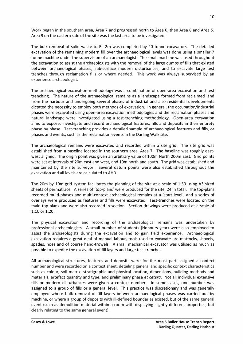
4.1 Natural Landscape in Area 5 Boiler House The natural landscape was partially exposed in the excavation of Area 5 Boiler House (BH). Bedrock was exposed in the east of the area, in Test Trench (TT) 52 (RL 1.57m), TT 53 (RL 1.59m), and TT 54 (RL 1.52m). The bedrock was at a similar height in all trenches, suggesting this portion of the area was roughly level across the area originally. However, the bedrock at the base of the southern-most test trench (TT 52) dropped sharply to the south-southwest toward the shoreline (Figure 4.1).
Figure 4.1: Bedrock exposed in Test Trench 52. It is marked by the red arrow. Scale 1m.
The remainder of the Area 5 BH was excavated to the earliest levelling fills (contexts 9182 and 9183). These fills sloped in a similar direction to the natural landscape evident in adjacent sections, and led to the original shoreline. As such it is likely the slope of the fills mirrored the natural landscape underneath.
4.2 Natural Landscape in Adjacent Excavation Part of Area 5 to the southwest of the boiler house was excavated as part of the Aboriginal archaeological program (Section 5). Natural deposits and sandstone bedrock was exposed. In the northeast of the Aboriginal excavation, where it was closest to Area 5 BH, bedrock was at RL 1.99m. It dropped to RL 1.00m at the southwest tip of the bedrock, over a distance of around 4m. Similarly, the natural soils dropped from RL 1.68m in the northeast to RL 0.54m in the southwest over a distance of around 5m. This soil was dark grey, organic, clayey sand, tending to a blackish shell and rotten wood-rich clayey sand in the bedrock fissures. The topography of this section was consistent with the natural landscape exposed beneath the boiler house.
14
_________________________________________________________________________________________ Casey & Lowe Area 5 Boiler House Trench Report
Darling Quarter, Darling Harbour
5.0 Phase 2: Aboriginal Occupation
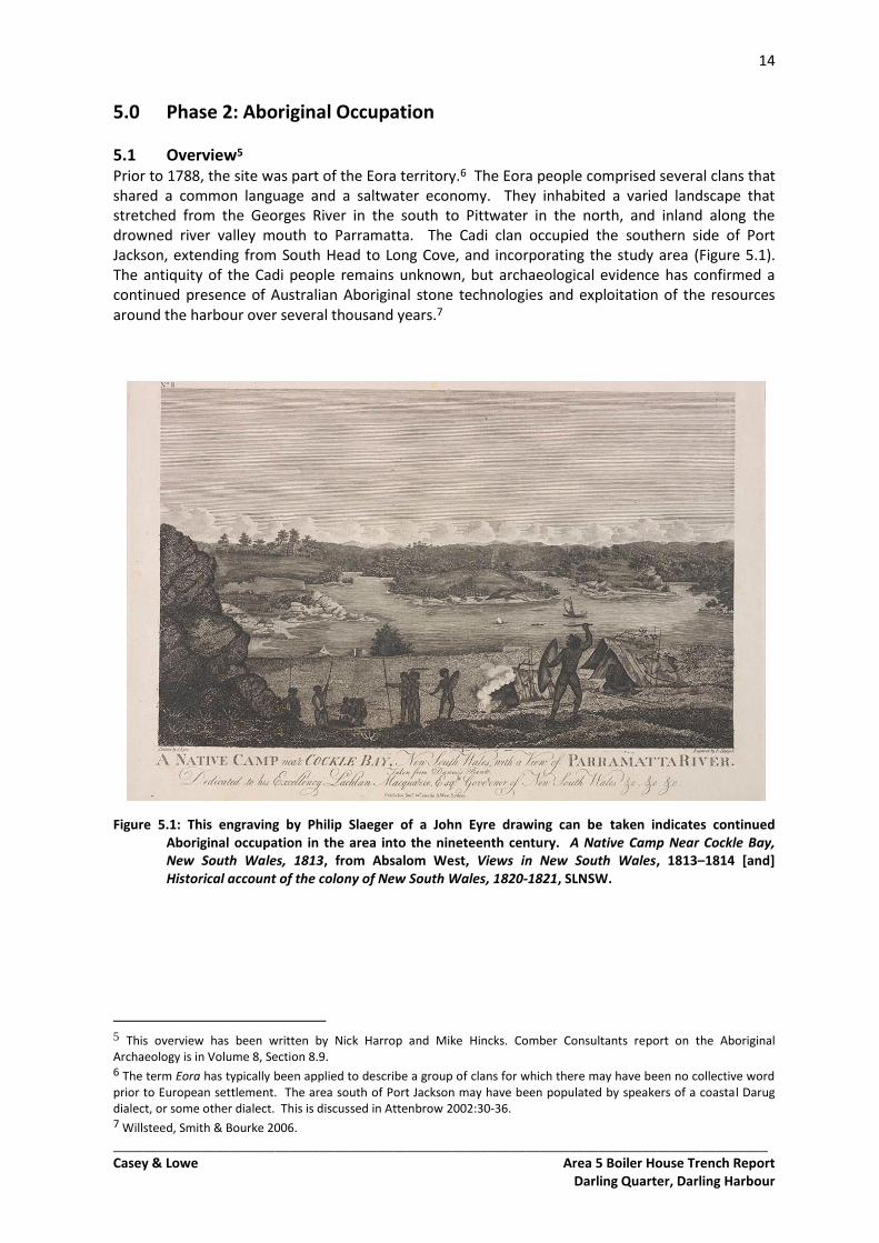
5.1 Overview5 Prior to 1788, the site was part of the Eora territory.6 The Eora people comprised several clans that shared a common language and a saltwater economy. They inhabited a varied landscape that stretched from the Georges River in the south to Pittwater in the north, and inland along the drowned river valley mouth to Parramatta. The Cadi clan occupied the southern side of Port Jackson, extending from South Head to Long Cove, and incorporating the study area (Figure 5.1). The antiquity of the Cadi people remains unknown, but archaeological evidence has confirmed a continued presence of Australian Aboriginal stone technologies and exploitation of the resources around the harbour over several thousand years.7
Figure 5.1: This engraving by Philip Slaeger of a John Eyre drawing can be taken indicates continued Aboriginal occupation in the area into the nineteenth century. A Native Camp Near Cockle Bay, New South Wales, 1813, from Absalom West, Views in New South Wales, 1813–1814 [and] Historical account of the colony of New South Wales, 1820-1821, SLNSW.
5 This overview has been written by Nick Harrop and Mike Hincks. Comber Consultants report on the Aboriginal Archaeology is in Volume 8, Section 8.9. 6 The term Eora has typically been applied to describe a group of clans for which there may have been no collective word prior to European settlement. The area south of Port Jackson may have been populated by speakers of a coastal Darug dialect, or some other dialect. This is discussed in Attenbrow 2002:30-36. 7 Willsteed, Smith & Bourke 2006.
15
_________________________________________________________________________________________ Casey & Lowe Area 5 Boiler House Trench Report
Darling Quarter, Darling Harbour
The earliest radiometric dates for Aboriginal occupation in the Sydney region stretch beyond 40,000 BP, but the area may have been occupied prior to this.8 Dates become more frequent from about 14,000 BP, with numerous dates from a variety of sites throughout the area in the last six thousand years. Multiple aboriginal sites have been identified nearby to the Darling Walk, including stone tool scatters, shell middens, and engravings, all within 3 km of the Darling Walk site.9 The KENS site, 1km to the north of Darling Walk and in a similar proximity to Darling Harbour yielded close to 1000 artefacts and dated from 2,800 BP to European arrival.10
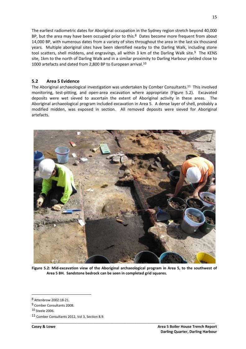
5.2 Area 5 Evidence The Aboriginal archaeological investigation was undertaken by Comber Consultants.11 This involved monitoring, test-pitting, and open-area excavation where appropriate (Figure 5.2). Excavated deposits were wet sieved to ascertain the extent of Aboriginal activity in these areas. The Aboriginal archaeological program included excavation in Area 5. A dense layer of shell, probably a modified midden, was exposed in section. All removed deposits were sieved for Aboriginal artefacts.
Figure 5.2: Mid-excavation view of the Aboriginal archaeological program in Area 5, to the southwest of Area 5 BH. Sandstone bedrock can be seen in completed grid squares.
8 Attenbrow 2002:18-21. 9 Comber Consultants 2008. 10 Steele 2006. 11 Comber Consultants 2012, Vol 3, Section 8.9.
16
_________________________________________________________________________________________ Casey & Lowe Area 5 Boiler House Trench Report
Darling Quarter, Darling Harbour
6.0 Phase 3: 1788 to 1820s Early Foreshore Activity and Property Boundaries
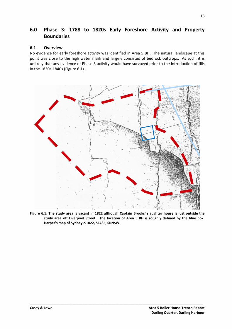
6.1 Overview No evidence for early foreshore activity was identified in Area 5 BH. The natural landscape at this point was close to the high water mark and largely consisted of bedrock outcrops. As such, it is unlikely that any evidence of Phase 3 activity would have survuved prior to the introduction of fills in the 1830s-1840s (Figure 6.1).
Figure 6.1: The study area is vacant in 1822 although Captain Brooks’ slaughter house is just outside the study area off Liverpool Street. The location of Area 5 BH is roughly defined by the blue box. Harper’s map of Sydney c.1822, SZ435, SRNSW.
17
_________________________________________________________________________________________ Casey & Lowe Area 5 Boiler House Trench Report
Darling Quarter, Darling Harbour
7.0 Phase 4: 1820s to late 1830s Barker’s Mill and Lands
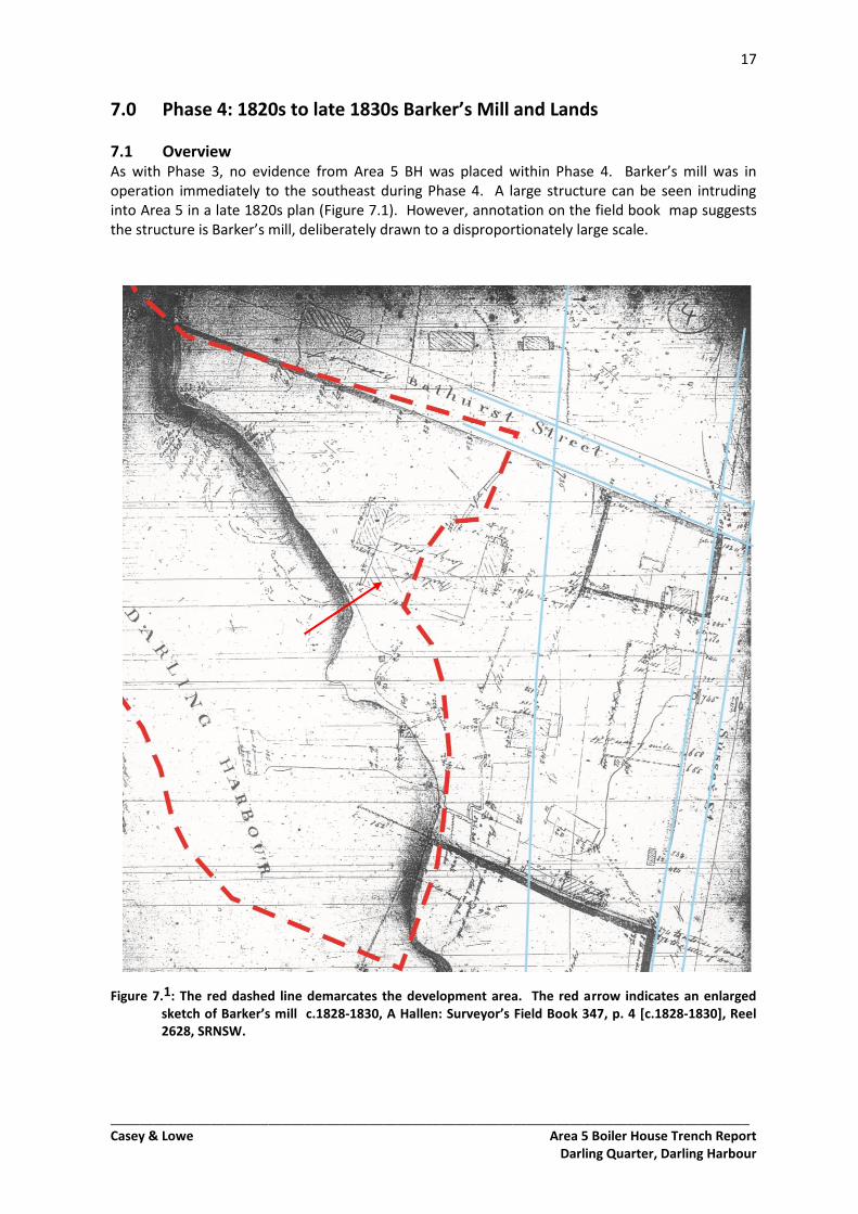
7.1 Overview As with Phase 3, no evidence from Area 5 BH was placed within Phase 4. Barker’s mill was in operation immediately to the southeast during Phase 4. A large structure can be seen intruding into Area 5 in a late 1820s plan (Figure 7.1). However, annotation on the field book map suggests the structure is Barker’s mill, deliberately drawn to a disproportionately large scale.
Figure 7.1: The red dashed line demarcates the development area. The red arrow indicates an enlarged sketch of Barker’s mill c.1828-1830, A Hallen: Surveyor’s Field Book 347, p. 4 [c.1828-1830], Reel 2628, SRNSW.
18
_________________________________________________________________________________________ Casey & Lowe Area 5 Boiler House Trench Report
Darling Quarter, Darling Harbour
8.0 Phase 5: Pre-Construction Fills 1830s–1840s
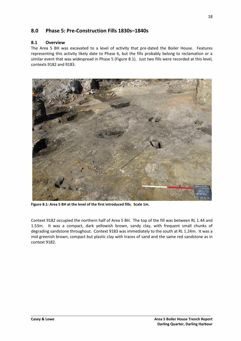
8.1 Overview The Area 5 BH was excavated to a level of activity that pre-dated the Boiler House. Features representing this activity likely date to Phase 6, but the fills probably belong to reclamation or a similar event that was widespread in Phase 5 (Figure 8.1). Just two fills were recorded at this level, contexts 9182 and 9183.
Figure 8.1: Area 5 BH at the level of the first introduced fills. Scale 1m.
Context 9182 occupied the northern half of Area 5 BH. The top of the fill was between RL 1.44 and 1.53m. It was a compact, dark yellowish brown, sandy clay, with frequent small chunks of degrading sandstone throughout. Context 9183 was immediately to the south at RL 1.24m. It was a mid greenish brown, compact but plastic clay with traces of sand and the same red sandstone as in context 9182.
19
_________________________________________________________________________________________ Casey & Lowe Area 5 Boiler House Trench Report
Darling Quarter, Darling Harbour
9.0 Phase 6: 1840s to 1860s Residential and Industrial Development
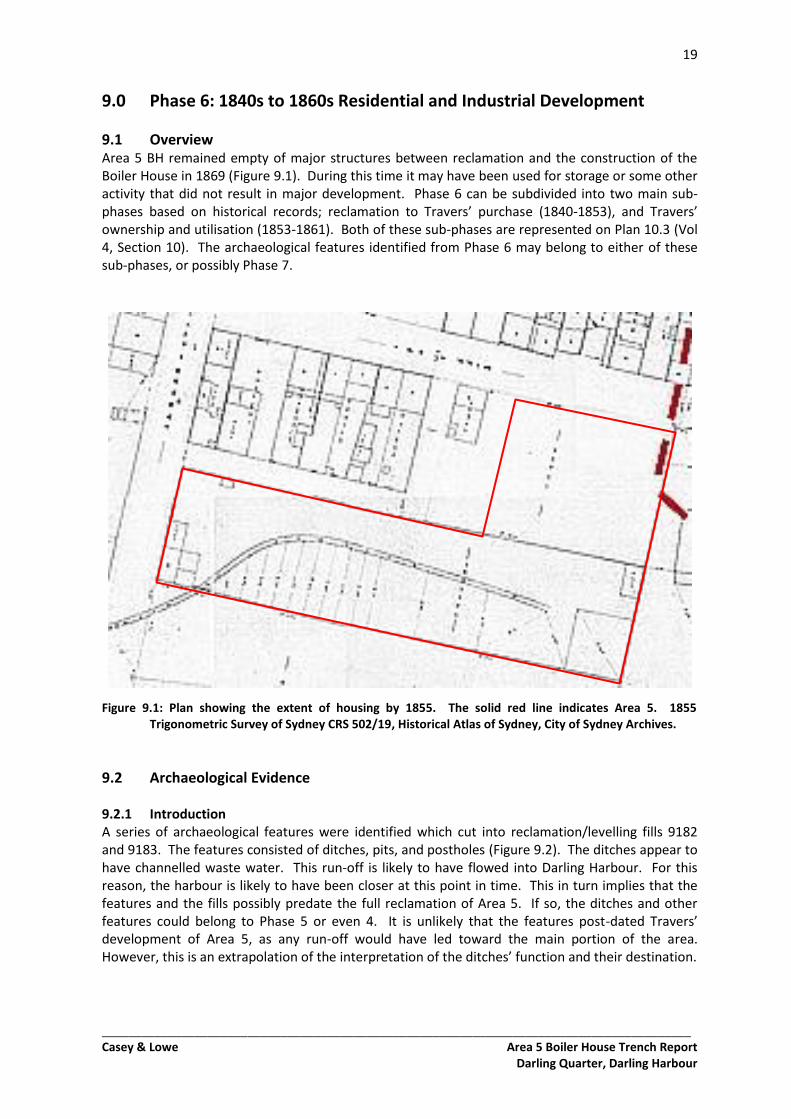
9.1 Overview Area 5 BH remained empty of major structures between reclamation and the construction of the Boiler House in 1869 (Figure 9.1). During this time it may have been used for storage or some other activity that did not result in major development. Phase 6 can be subdivided into two main sub-phases based on historical records; reclamation to Travers’ purchase (1840-1853), and Travers’ ownership and utilisation (1853-1861). Both of these sub-phases are represented on Plan 10.3 (Vol 4, Section 10). The archaeological features identified from Phase 6 may belong to either of these sub-phases, or possibly Phase 7.
Figure 9.1: Plan showing the extent of housing by 1855. The solid red line indicates Area 5. 1855 Trigonometric Survey of Sydney CRS 502/19, Historical Atlas of Sydney, City of Sydney Archives.
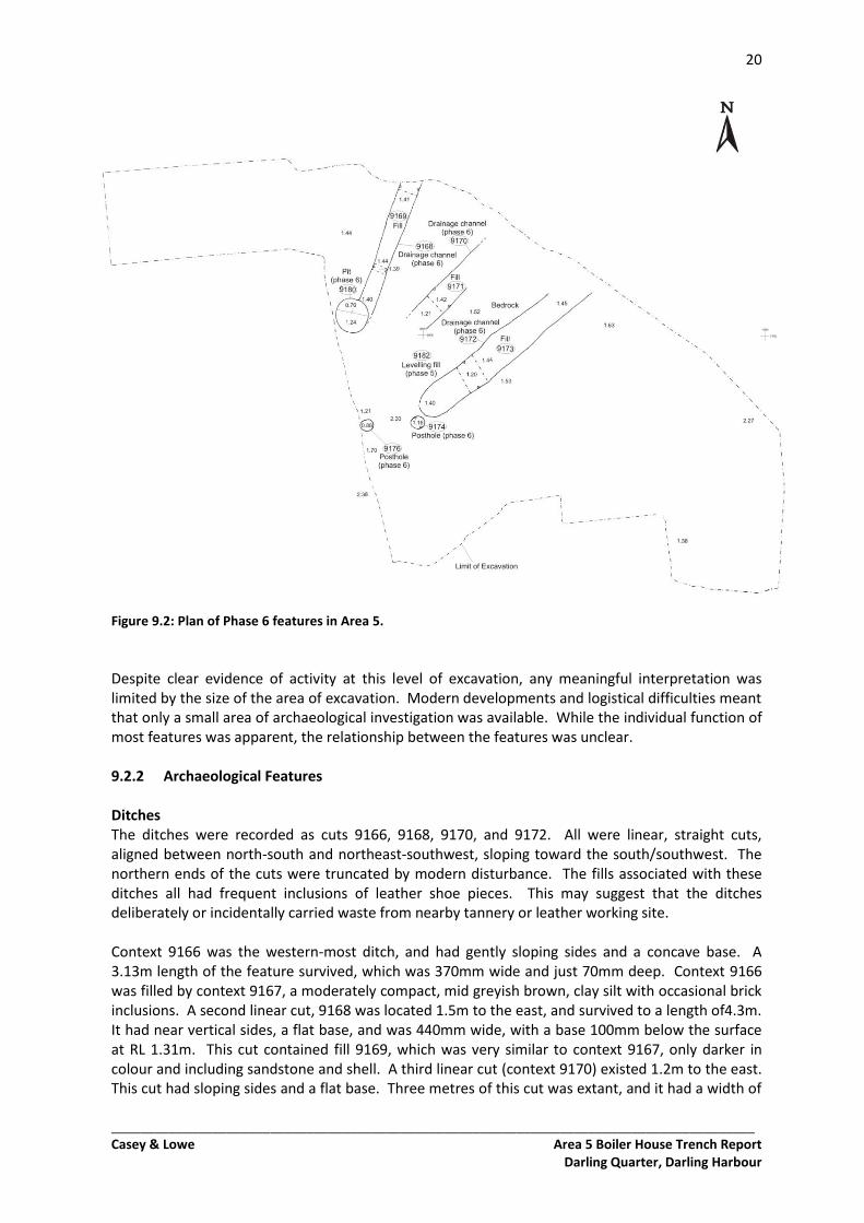
9.2 Archaeological Evidence 9.2.1 Introduction A series of archaeological features were identified which cut into reclamation/levelling fills 9182 and 9183. The features consisted of ditches, pits, and postholes (Figure 9.2). The ditches appear to have channelled waste water. This run-off is likely to have flowed into Darling Harbour. For this reason, the harbour is likely to have been closer at this point in time. This in turn implies that the features and the fills possibly predate the full reclamation of Area 5. If so, the ditches and other features could belong to Phase 5 or even 4. It is unlikely that the features post-dated Travers’ development of Area 5, as any run-off would have led toward the main portion of the area. However, this is an extrapolation of the interpretation of the ditches’ function and their destination.
20
_________________________________________________________________________________________ Casey & Lowe Area 5 Boiler House Trench Report
Darling Quarter, Darling Harbour
Figure 9.2: Plan of Phase 6 features in Area 5.
Despite clear evidence of activity at this level of excavation, any meaningful interpretation was limited by the size of the area of excavation. Modern developments and logistical difficulties meant that only a small area of archaeological investigation was available. While the individual function of most features was apparent, the relationship between the features was unclear. 9.2.2 Archaeological Features Ditches The ditches were recorded as cuts 9166, 9168, 9170, and 9172. All were linear, straight cuts, aligned between north-south and northeast-southwest, sloping toward the south/southwest. The northern ends of the cuts were truncated by modern disturbance. The fills associated with these ditches all had frequent inclusions of leather shoe pieces. This may suggest that the ditches deliberately or incidentally carried waste from nearby tannery or leather working site. Context 9166 was the western-most ditch, and had gently sloping sides and a concave base. A 3.13m length of the feature survived, which was 370mm wide and just 70mm deep. Context 9166 was filled by context 9167, a moderately compact, mid greyish brown, clay silt with occasional brick inclusions. A second linear cut, 9168 was located 1.5m to the east, and survived to a length of4.3m. It had near vertical sides, a flat base, and was 440mm wide, with a base 100mm below the surface at RL 1.31m. This cut contained fill 9169, which was very similar to context 9167, only darker in colour and including sandstone and shell. A third linear cut (context 9170) existed 1.2m to the east. This cut had sloping sides and a flat base. Three metres of this cut was extant, and it had a width of
21
_________________________________________________________________________________________ Casey & Lowe Area 5 Boiler House Trench Report
Darling Quarter, Darling Harbour
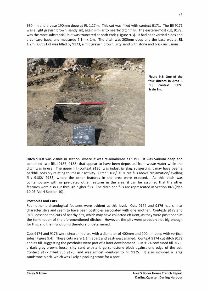
630mm and a base 190mm deep at RL 1.27m. This cut was filled with context 9171. The fill 9171 was a light greyish brown, sandy silt, again similar to nearby ditch fills. The eastern-most cut, 9172, was the most substantial, but was truncated at both ends (Figure 9.3). It had near vertical sides and a concave base, and measured 7.1m x 1m. The ditch was 200mm deep and the base was at RL 1.2m. Cut 9172 was filled by 9173, a mid greyish brown, silty sand with stone and brick inclusions.
Figure 9.3: One of the four ditches in Area 5 BH, context 9172. Scale 1m.
Ditch 9168 was visible in section, where it was re-numbered as 9191. It was 540mm deep and contained two fills (9187, 9188) that appear to have been deposited from waste water while the ditch was in use. The upper fill (context 9186) was industrial slag, suggesting it may have been a backfill, possibly relating to Phase 7 activity. Ditch 9168/ 9191 cut fills above reclamation/levelling fills 9182/ 9183, where the other features in the area were exposed. As this ditch was contemporary with or pre-dated other features in the area, it can be assumed that the other features were also cut through higher fills. The ditch and fills are represented in Section #48 (Plan 10.05, Vol 4 Section 10). Postholes and Cuts Four other archaeological features were evident at this level. Cuts 9174 and 9176 had similar characteristics and seem to have been postholes associated with one another. Contexts 9178 and 9180 describe the cuts of nearby pits, which may have collected effluent, as they were positioned at the termination of the aforementioned ditches. However, the pits were probably not big enough for this, and their function is therefore undetermined. Cuts 9174 and 9176 were circular in plan, with a diameter of 400mm and 200mm deep with vertical sides (Figure 9.4). These cuts were 1.1m apart and east-west aligned. Context 9174 cut ditch 9172 and its fill, suggesting the postholes were part of a later development. Cut 9174 contained fill 9175, a dark grey-brown, loose, silty sand with a large sandstone block against one edge of the cut. Context 9177 filled cut 9176, and was almost identical to fill 9175. It also included a large sandstone block, which was likely a packing stone for a post.
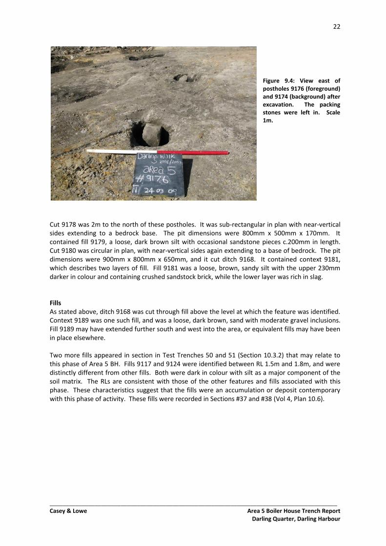
22
_________________________________________________________________________________________ Casey & Lowe Area 5 Boiler House Trench Report
Darling Quarter, Darling Harbour
Figure 9.4: View east of postholes 9176 (foreground) and 9174 (background) after excavation. The packing stones were left in. Scale 1m.
Cut 9178 was 2m to the north of these postholes. It was sub-rectangular in plan with near-vertical sides extending to a bedrock base. The pit dimensions were 800mm x 500mm x 170mm. It contained fill 9179, a loose, dark brown silt with occasional sandstone pieces c.200mm in length. Cut 9180 was circular in plan, with near-vertical sides again extending to a base of bedrock. The pit dimensions were 900mm x 800mm x 650mm, and it cut ditch 9168. It contained context 9181, which describes two layers of fill. Fill 9181 was a loose, brown, sandy silt with the upper 230mm darker in colour and containing crushed sandstock brick, while the lower layer was rich in slag. Fills As stated above, ditch 9168 was cut through fill above the level at which the feature was identified. Context 9189 was one such fill, and was a loose, dark brown, sand with moderate gravel inclusions. Fill 9189 may have extended further south and west into the area, or equivalent fills may have been in place elsewhere. Two more fills appeared in section in Test Trenches 50 and 51 (Section 10.3.2) that may relate to this phase of Area 5 BH. Fills 9117 and 9124 were identified between RL 1.5m and 1.8m, and were distinctly different from other fills. Both were dark in colour with silt as a major component of the soil matrix. The RLs are consistent with those of the other features and fills associated with this phase. These characteristics suggest that the fills were an accumulation or deposit contemporary with this phase of activity. These fills were recorded in Sections #37 and #38 (Vol 4, Plan 10.6).
23
_________________________________________________________________________________________ Casey & Lowe Area 5 Boiler House Trench Report
Darling Quarter, Darling Harbour
10.0 Phase 7: 1860s to 1900 Residential and Industrial Development
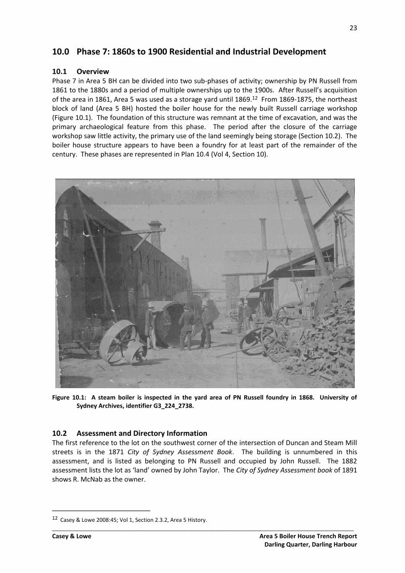
10.1 Overview Phase 7 in Area 5 BH can be divided into two sub-phases of activity; ownership by PN Russell from 1861 to the 1880s and a period of multiple ownerships up to the 1900s. After Russell’s acquisition of the area in 1861, Area 5 was used as a storage yard until 1869.12 From 1869-1875, the northeast block of land (Area 5 BH) hosted the boiler house for the newly built Russell carriage workshop (Figure 10.1). The foundation of this structure was remnant at the time of excavation, and was the primary archaeological feature from this phase. The period after the closure of the carriage workshop saw little activity, the primary use of the land seemingly being storage (Section 10.2). The boiler house structure appears to have been a foundry for at least part of the remainder of the century. These phases are represented in Plan 10.4 (Vol 4, Section 10).
Figure 10.1: A steam boiler is inspected in the yard area of PN Russell foundry in 1868. University of Sydney Archives, identifier G3_224_2738.
10.2 Assessment and Directory Information The first reference to the lot on the southwest corner of the intersection of Duncan and Steam Mill streets is in the 1871 City of Sydney Assessment Book. The building is unnumbered in this assessment, and is listed as belonging to PN Russell and occupied by John Russell. The 1882 assessment lists the lot as ‘land’ owned by John Taylor. The City of Sydney Assessment book of 1891 shows R. McNab as the owner.
12 Casey & Lowe 2008:45; Vol 1, Section 2.3.2, Area 5 History.
24
_________________________________________________________________________________________ Casey & Lowe Area 5 Boiler House Trench Report
Darling Quarter, Darling Harbour
N
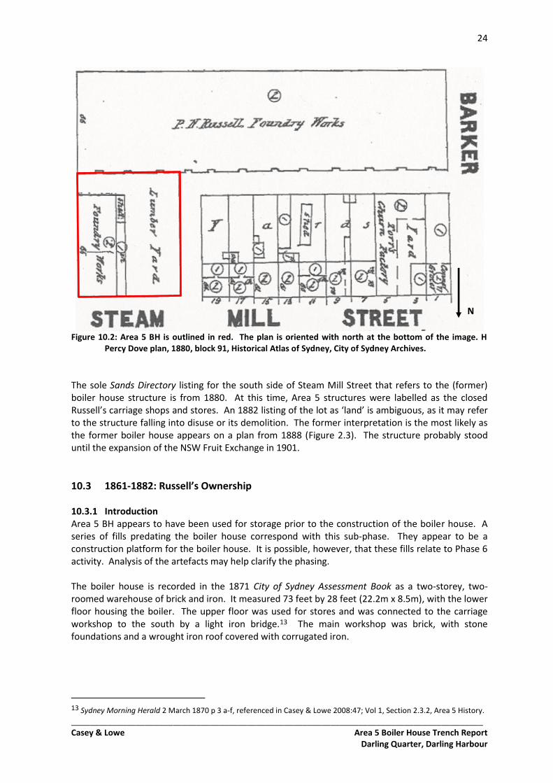
Figure 10.2: Area 5 BH is outlined in red. The plan is oriented with north at the bottom of the image. H Percy Dove plan, 1880, block 91, Historical Atlas of Sydney, City of Sydney Archives.
The sole Sands Directory listing for the south side of Steam Mill Street that refers to the (former) boiler house structure is from 1880. At this time, Area 5 structures were labelled as the closed Russell’s carriage shops and stores. An 1882 listing of the lot as ‘land’ is ambiguous, as it may refer to the structure falling into disuse or its demolition. The former interpretation is the most likely as the former boiler house appears on a plan from 1888 (Figure 2.3). The structure probably stood until the expansion of the NSW Fruit Exchange in 1901.
10.3 1861-1882: Russell’s Ownership 10.3.1 Introduction Area 5 BH appears to have been used for storage prior to the construction of the boiler house. A series of fills predating the boiler house correspond with this sub-phase. They appear to be a construction platform for the boiler house. It is possible, however, that these fills relate to Phase 6 activity. Analysis of the artefacts may help clarify the phasing. The boiler house is recorded in the 1871 City of Sydney Assessment Book as a two-storey, two-roomed warehouse of brick and iron. It measured 73 feet by 28 feet (22.2m x 8.5m), with the lower floor housing the boiler. The upper floor was used for stores and was connected to the carriage workshop to the south by a light iron bridge.13 The main workshop was brick, with stone foundations and a wrought iron roof covered with corrugated iron.
13 Sydney Morning Herald 2 March 1870 p 3 a-f, referenced in Casey & Lowe 2008:47; Vol 1, Section 2.3.2, Area 5 History.
25
_________________________________________________________________________________________ Casey & Lowe Area 5 Boiler House Trench Report
Darling Quarter, Darling Harbour
N
TT 50
Excavation Limit
Boiler House
Footings
TT 52
TT 53
TT 51
Fruit Exchange Footings
TT 54
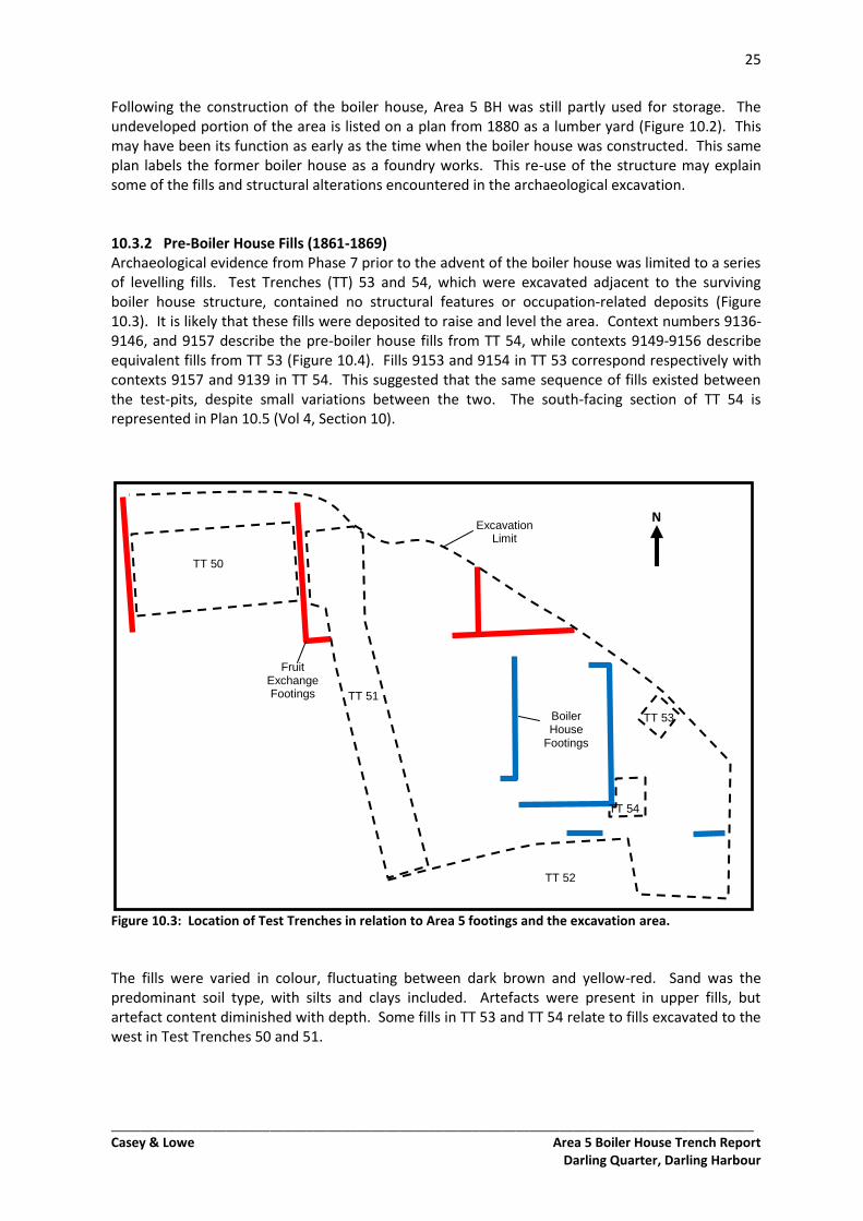
Following the construction of the boiler house, Area 5 BH was still partly used for storage. The undeveloped portion of the area is listed on a plan from 1880 as a lumber yard (Figure 10.2). This may have been its function as early as the time when the boiler house was constructed. This same plan labels the former boiler house as a foundry works. This re-use of the structure may explain some of the fills and structural alterations encountered in the archaeological excavation. 10.3.2 Pre-Boiler House Fills (1861-1869) Archaeological evidence from Phase 7 prior to the advent of the boiler house was limited to a series of levelling fills. Test Trenches (TT) 53 and 54, which were excavated adjacent to the surviving boiler house structure, contained no structural features or occupation-related deposits (Figure 10.3). It is likely that these fills were deposited to raise and level the area. Context numbers 9136-9146, and 9157 describe the pre-boiler house fills from TT 54, while contexts 9149-9156 describe equivalent fills from TT 53 (Figure 10.4). Fills 9153 and 9154 in TT 53 correspond respectively with contexts 9157 and 9139 in TT 54. This suggested that the same sequence of fills existed between the test-pits, despite small variations between the two. The south-facing section of TT 54 is represented in Plan 10.5 (Vol 4, Section 10).
Figure 10.3: Location of Test Trenches in relation to Area 5 footings and the excavation area.
The fills were varied in colour, fluctuating between dark brown and yellow-red. Sand was the predominant soil type, with silts and clays included. Artefacts were present in upper fills, but artefact content diminished with depth. Some fills in TT 53 and TT 54 relate to fills excavated to the west in Test Trenches 50 and 51.
26
_________________________________________________________________________________________ Casey & Lowe Area 5 Boiler House Trench Report
Darling Quarter, Darling Harbour
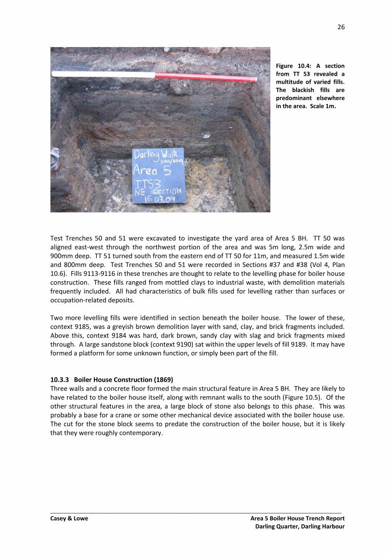
Figure 10.4: A section from TT 53 revealed a multitude of varied fills. The blackish fills are predominant elsewhere in the area. Scale 1m.
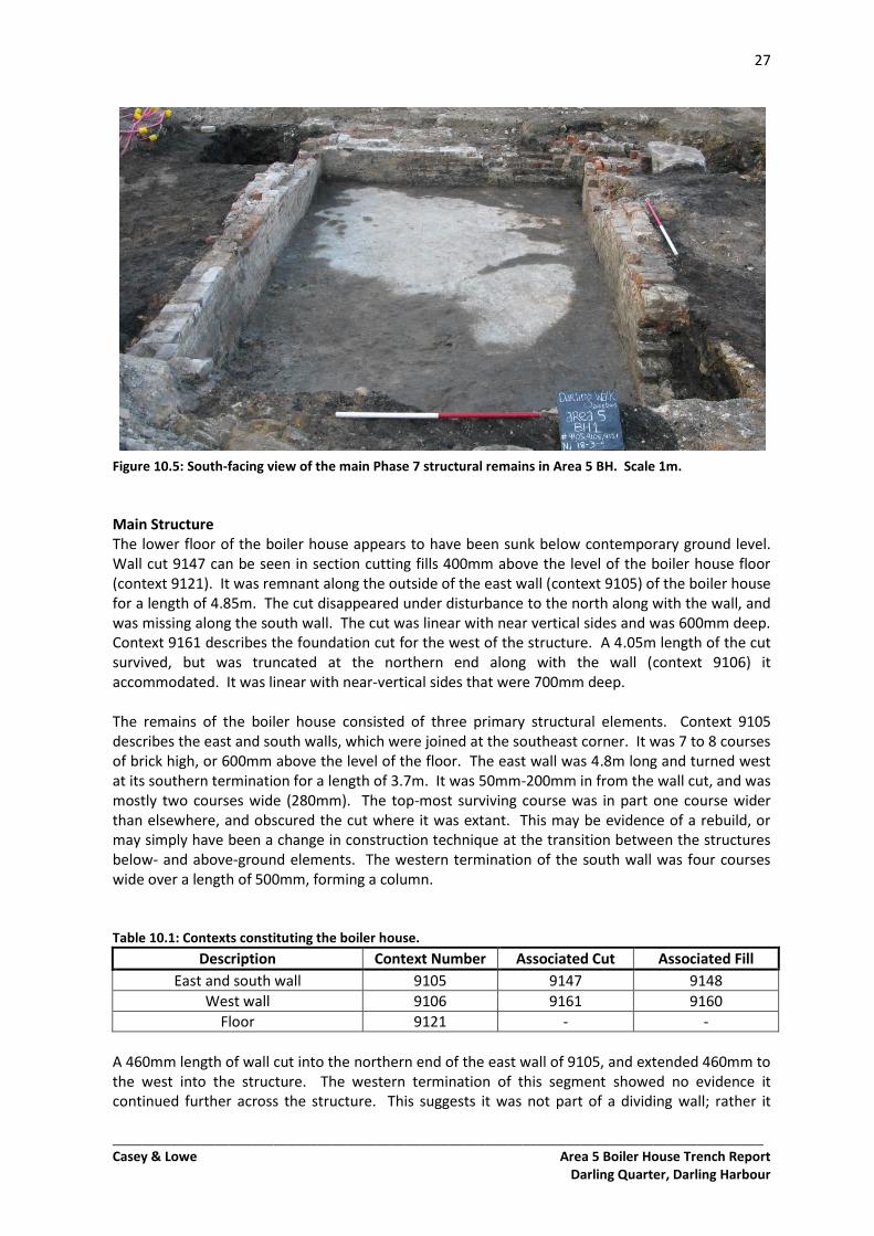
Test Trenches 50 and 51 were excavated to investigate the yard area of Area 5 BH. TT 50 was aligned east-west through the northwest portion of the area and was 5m long, 2.5m wide and 900mm deep. TT 51 turned south from the eastern end of TT 50 for 11m, and measured 1.5m wide and 800mm deep. Test Trenches 50 and 51 were recorded in Sections #37 and #38 (Vol 4, Plan 10.6). Fills 9113-9116 in these trenches are thought to relate to the levelling phase for boiler house construction. These fills ranged from mottled clays to industrial waste, with demolition materials frequently included. All had characteristics of bulk fills used for levelling rather than surfaces or occupation-related deposits. Two more levelling fills were identified in section beneath the boiler house. The lower of these, context 9185, was a greyish brown demolition layer with sand, clay, and brick fragments included. Above this, context 9184 was hard, dark brown, sandy clay with slag and brick fragments mixed through. A large sandstone block (context 9190) sat within the upper levels of fill 9189. It may have formed a platform for some unknown function, or simply been part of the fill. 10.3.3 Boiler House Construction (1869) Three walls and a concrete floor formed the main structural feature in Area 5 BH. They are likely to have related to the boiler house itself, along with remnant walls to the south (Figure 10.5). Of the other structural features in the area, a large block of stone also belongs to this phase. This was probably a base for a crane or some other mechanical device associated with the boiler house use. The cut for the stone block seems to predate the construction of the boiler house, but it is likely that they were roughly contemporary.
27
_________________________________________________________________________________________ Casey & Lowe Area 5 Boiler House Trench Report
Darling Quarter, Darling Harbour
Figure 10.5: South-facing view of the main Phase 7 structural remains in Area 5 BH. Scale 1m.
Main Structure The lower floor of the boiler house appears to have been sunk below contemporary ground level. Wall cut 9147 can be seen in section cutting fills 400mm above the level of the boiler house floor (context 9121). It was remnant along the outside of the east wall (context 9105) of the boiler house for a length of 4.85m. The cut disappeared under disturbance to the north along with the wall, and was missing along the south wall. The cut was linear with near vertical sides and was 600mm deep. Context 9161 describes the foundation cut for the west of the structure. A 4.05m length of the cut survived, but was truncated at the northern end along with the wall (context 9106) it accommodated. It was linear with near-vertical sides that were 700mm deep. The remains of the boiler house consisted of three primary structural elements. Context 9105 describes the east and south walls, which were joined at the southeast corner. It was 7 to 8 courses of brick high, or 600mm above the level of the floor. The east wall was 4.8m long and turned west at its southern termination for a length of 3.7m. It was 50mm-200mm in from the wall cut, and was mostly two courses wide (280mm). The top-most surviving course was in part one course wider than elsewhere, and obscured the cut where it was extant. This may be evidence of a rebuild, or may simply have been a change in construction technique at the transition between the structures below- and above-ground elements. The western termination of the south wall was four courses wide over a length of 500mm, forming a column. Table 10.1: Contexts constituting the boiler house.
Description Context Number Associated Cut Associated Fill
East and south wall 9105 9147 9148
West wall 9106 9161 9160
Floor 9121 - -
A 460mm length of wall cut into the northern end of the east wall of 9105, and extended 460mm to the west into the structure. The western termination of this segment showed no evidence it continued further across the structure. This suggests it was not part of a dividing wall; rather it
28
_________________________________________________________________________________________ Casey & Lowe Area 5 Boiler House Trench Report
Darling Quarter, Darling Harbour
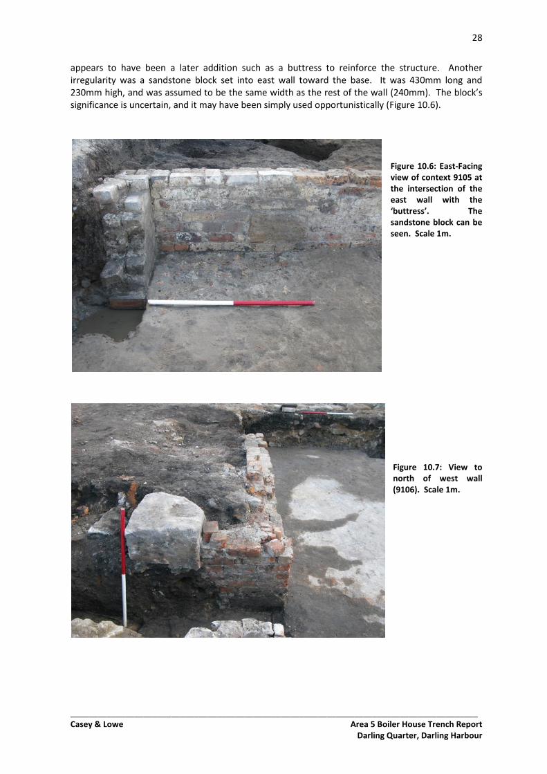
appears to have been a later addition such as a buttress to reinforce the structure. Another irregularity was a sandstone block set into east wall toward the base. It was 430mm long and 230mm high, and was assumed to be the same width as the rest of the wall (240mm). The block’s significance is uncertain, and it may have been simply used opportunistically (Figure 10.6).
Figure 10.6: East-Facing view of context 9105 at the intersection of the east wall with the ‘buttress’. The sandstone block can be seen. Scale 1m.
Figure 10.7: View to north of west wall (9106). Scale 1m.
29
_________________________________________________________________________________________ Casey & Lowe Area 5 Boiler House Trench Report
Darling Quarter, Darling Harbour
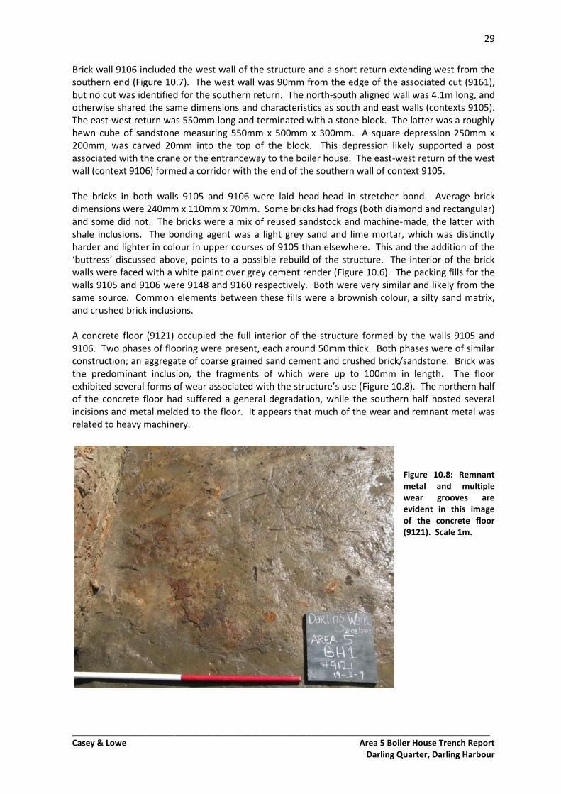
Brick wall 9106 included the west wall of the structure and a short return extending west from the southern end (Figure 10.7). The west wall was 90mm from the edge of the associated cut (9161), but no cut was identified for the southern return. The north-south aligned wall was 4.1m long, and otherwise shared the same dimensions and characteristics as south and east walls (contexts 9105). The east-west return was 550mm long and terminated with a stone block. The latter was a roughly hewn cube of sandstone measuring 550mm x 500mm x 300mm. A square depression 250mm x 200mm, was carved 20mm into the top of the block. This depression likely supported a post associated with the crane or the entranceway to the boiler house. The east-west return of the west wall (context 9106) formed a corridor with the end of the southern wall of context 9105. The bricks in both walls 9105 and 9106 were laid head-head in stretcher bond. Average brick dimensions were 240mm x 110mm x 70mm. Some bricks had frogs (both diamond and rectangular) and some did not. The bricks were a mix of reused sandstock and machine-made, the latter with shale inclusions. The bonding agent was a light grey sand and lime mortar, which was distinctly harder and lighter in colour in upper courses of 9105 than elsewhere. This and the addition of the ‘buttress’ discussed above, points to a possible rebuild of the structure. The interior of the brick walls were faced with a white paint over grey cement render (Figure 10.6). The packing fills for the walls 9105 and 9106 were 9148 and 9160 respectively. Both were very similar and likely from the same source. Common elements between these fills were a brownish colour, a silty sand matrix, and crushed brick inclusions. A concrete floor (9121) occupied the full interior of the structure formed by the walls 9105 and 9106. Two phases of flooring were present, each around 50mm thick. Both phases were of similar construction; an aggregate of coarse grained sand cement and crushed brick/sandstone. Brick was the predominant inclusion, the fragments of which were up to 100mm in length. The floor exhibited several forms of wear associated with the structure’s use (Figure 10.8). The northern half of the concrete floor had suffered a general degradation, while the southern half hosted several incisions and metal melded to the floor. It appears that much of the wear and remnant metal was related to heavy machinery.
Figure 10.8: Remnant metal and multiple wear grooves are evident in this image of the concrete floor (9121). Scale 1m.
30
_________________________________________________________________________________________ Casey & Lowe Area 5 Boiler House Trench Report
Darling Quarter, Darling Harbour
N
The two walls (9105 and 9106) and the floor (9121) formed a room of interior dimensions 2.85m wide and 3.30m long. Truncation to the north suggests the room would have originally been longer. The room width was not consistent with the dimensions referred to in historical reference to the boiler house. The ‘73 feet by 28 feet’ reference to the boiler house structure is consistent with contemporary plans though. Comparison of archaeological evidence with the plans places the southwest corner of the surviving structure with the junction of a dividing wall and the western wall of the boiler house. This means that the eastern-most surviving wall (9105) did not appear on historic plans, and would be somewhere in the centre of the boiler house. This seeming disparity between the archaeological and historic evidence can be explained if historic references and plans refer to the upper floor of the boiler house only. It appears that the 1880 map is a plan of the upper floor, and the ‘two rooms’ reference (Section 10.3.1) also only refers to this level (Figure 10.9). Oxidised metal melded to the flooring, along with the narrow width of the access corridor suggests the lower floor was simply housing for machinery. As such, it is reasonable that the archaeological remains in Area 5 BH were not the focus of the historic references, but nonetheless were part of the boiler house.
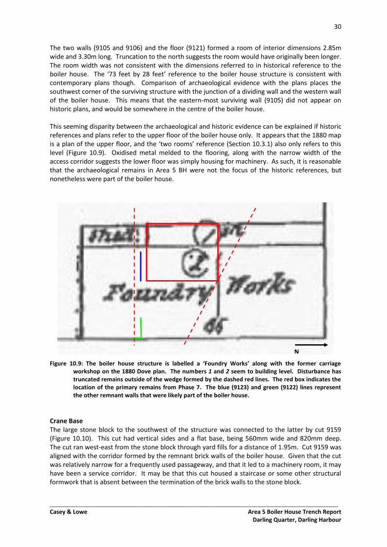
Figure 10.9: The boiler house structure is labelled a ‘Foundry Works’ along with the former carriage workshop on the 1880 Dove plan. The numbers 1 and 2 seem to building level. Disturbance has truncated remains outside of the wedge formed by the dashed red lines. The red box indicates the location of the primary remains from Phase 7. The blue (9123) and green (9122) lines represent the other remnant walls that were likely part of the boiler house.
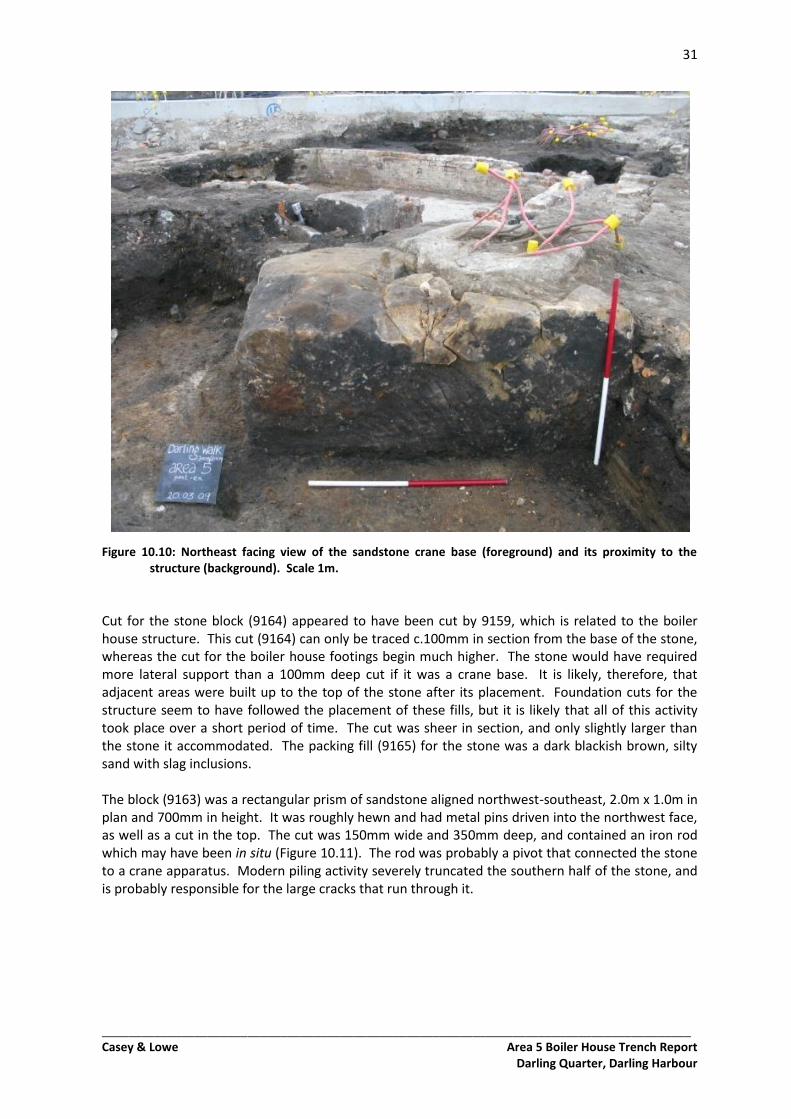
Crane Base The large stone block to the southwest of the structure was connected to the latter by cut 9159 (Figure 10.10). This cut had vertical sides and a flat base, being 560mm wide and 820mm deep. The cut ran west-east from the stone block through yard fills for a distance of 1.95m. Cut 9159 was aligned with the corridor formed by the remnant brick walls of the boiler house. Given that the cut was relatively narrow for a frequently used passageway, and that it led to a machinery room, it may have been a service corridor. It may be that this cut housed a staircase or some other structural formwork that is absent between the termination of the brick walls to the stone block.
31
_________________________________________________________________________________________ Casey & Lowe Area 5 Boiler House Trench Report
Darling Quarter, Darling Harbour
Figure 10.10: Northeast facing view of the sandstone crane base (foreground) and its proximity to the structure (background). Scale 1m.
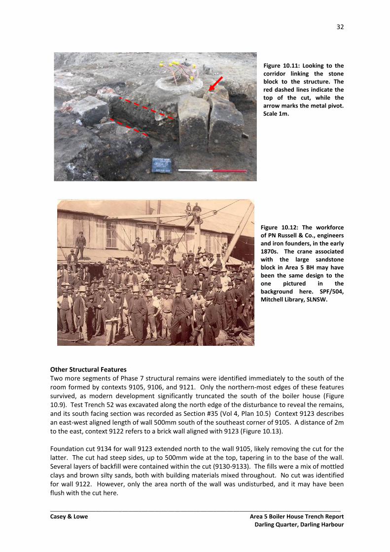
Cut for the stone block (9164) appeared to have been cut by 9159, which is related to the boiler house structure. This cut (9164) can only be traced c.100mm in section from the base of the stone, whereas the cut for the boiler house footings begin much higher. The stone would have required more lateral support than a 100mm deep cut if it was a crane base. It is likely, therefore, that adjacent areas were built up to the top of the stone after its placement. Foundation cuts for the structure seem to have followed the placement of these fills, but it is likely that all of this activity took place over a short period of time. The cut was sheer in section, and only slightly larger than the stone it accommodated. The packing fill (9165) for the stone was a dark blackish brown, silty sand with slag inclusions. The block (9163) was a rectangular prism of sandstone aligned northwest-southeast, 2.0m x 1.0m in plan and 700mm in height. It was roughly hewn and had metal pins driven into the northwest face, as well as a cut in the top. The cut was 150mm wide and 350mm deep, and contained an iron rod which may have been in situ (Figure 10.11). The rod was probably a pivot that connected the stone to a crane apparatus. Modern piling activity severely truncated the southern half of the stone, and is probably responsible for the large cracks that run through it.
32
_________________________________________________________________________________________ Casey & Lowe Area 5 Boiler House Trench Report
Darling Quarter, Darling Harbour
Figure 10.11: Looking to the corridor linking the stone block to the structure. The red dashed lines indicate the top of the cut, while the arrow marks the metal pivot. Scale 1m.
Figure 10.12: The workforce of PN Russell & Co., engineers and iron founders, in the early 1870s. The crane associated with the large sandstone block in Area 5 BH may have been the same design to the one pictured in the background here. SPF/504, Mitchell Library, SLNSW.
Other Structural Features Two more segments of Phase 7 structural remains were identified immediately to the south of the room formed by contexts 9105, 9106, and 9121. Only the northern-most edges of these features survived, as modern development significantly truncated the south of the boiler house (Figure 10.9). Test Trench 52 was excavated along the north edge of the disturbance to reveal the remains, and its south facing section was recorded as Section #35 (Vol 4, Plan 10.5) Context 9123 describes an east-west aligned length of wall 500mm south of the southeast corner of 9105. A distance of 2m to the east, context 9122 refers to a brick wall aligned with 9123 (Figure 10.13). Foundation cut 9134 for wall 9123 extended north to the wall 9105, likely removing the cut for the latter. The cut had steep sides, up to 500mm wide at the top, tapering in to the base of the wall. Several layers of backfill were contained within the cut (9130-9133). The fills were a mix of mottled clays and brown silty sands, both with building materials mixed throughout. No cut was identified for wall 9122. However, only the area north of the wall was undisturbed, and it may have been flush with the cut here.
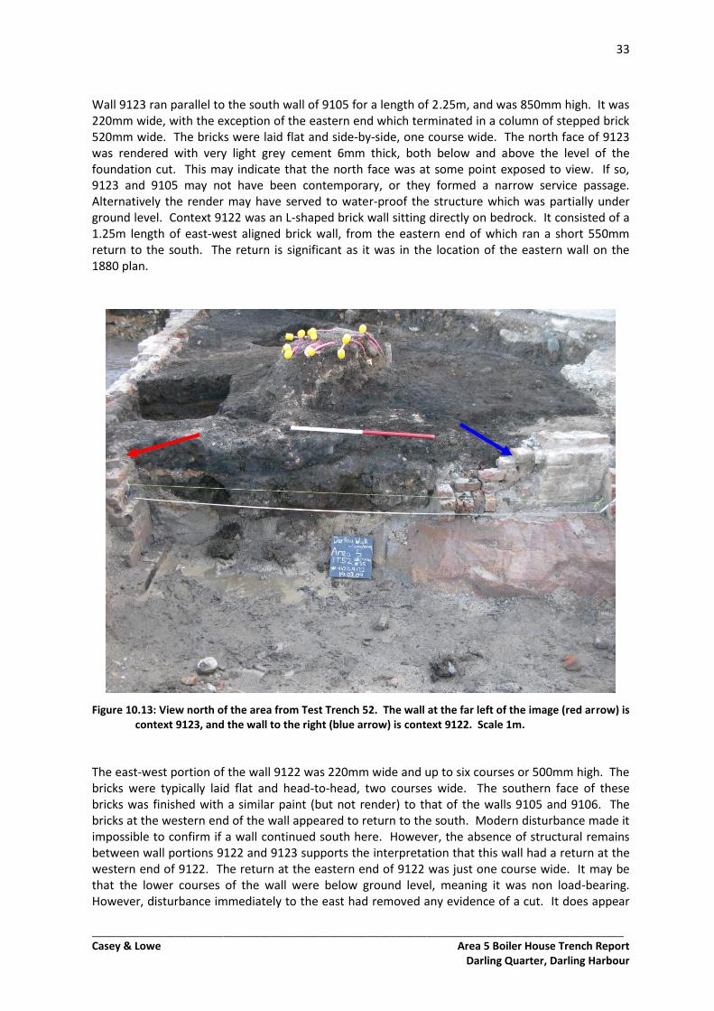
33
_________________________________________________________________________________________ Casey & Lowe Area 5 Boiler House Trench Report
Darling Quarter, Darling Harbour
Wall 9123 ran parallel to the south wall of 9105 for a length of 2.25m, and was 850mm high. It was 220mm wide, with the exception of the eastern end which terminated in a column of stepped brick 520mm wide. The bricks were laid flat and side-by-side, one course wide. The north face of 9123 was rendered with very light grey cement 6mm thick, both below and above the level of the foundation cut. This may indicate that the north face was at some point exposed to view. If so, 9123 and 9105 may not have been contemporary, or they formed a narrow service passage. Alternatively the render may have served to water-proof the structure which was partially under ground level. Context 9122 was an L-shaped brick wall sitting directly on bedrock. It consisted of a 1.25m length of east-west aligned brick wall, from the eastern end of which ran a short 550mm return to the south. The return is significant as it was in the location of the eastern wall on the 1880 plan.
Figure 10.13: View north of the area from Test Trench 52. The wall at the far left of the image (red arrow) is context 9123, and the wall to the right (blue arrow) is context 9122. Scale 1m.
The east-west portion of the wall 9122 was 220mm wide and up to six courses or 500mm high. The bricks were typically laid flat and head-to-head, two courses wide. The southern face of these bricks was finished with a similar paint (but not render) to that of the walls 9105 and 9106. The bricks at the western end of the wall appeared to return to the south. Modern disturbance made it impossible to confirm if a wall continued south here. However, the absence of structural remains between wall portions 9122 and 9123 supports the interpretation that this wall had a return at the western end of 9122. The return at the eastern end of 9122 was just one course wide. It may be that the lower courses of the wall were below ground level, meaning it was non load-bearing. However, disturbance immediately to the east had removed any evidence of a cut. It does appear
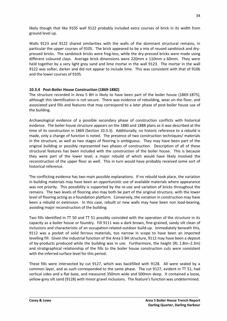
34
_________________________________________________________________________________________ Casey & Lowe Area 5 Boiler House Trench Report
Darling Quarter, Darling Harbour
likely though that like 9105 wall 9122 probably included extra courses of brick in its width from ground level up. Walls 9123 and 9122 shared similarities with the walls of the dominant structural remains, in particular the upper courses of 9105. The brick appeared to be a mix of reused sandstock and dry-pressed bricks. The sandstock bricks were frog-less, while the dry-pressed bricks were made using different coloured clays. Average brick dimensions were 220mm x 110mm x 60mm. They were held together by a very light grey sand and lime mortar in the wall 9123. The mortar in the wall 9122 was softer, darker and did not appear to include lime. This was consistent with that of 9106 and the lower courses of 9105. 10.3.4 Post-Boiler House Construction (1869-1882) The structure recorded in Area 5 BH is likely to have been part of the boiler house (1869-1875), although this identification is not secure. There was evidence of rebuilding, wear on the floor, and associated yard fills and features that may correspond to a later phase of post-boiler house use of the building. Archaeological evidence of a possible secondary phase of construction conflicts with historical evidence. The boiler house structure appears on the 1880 and 1888 plans as it was described at the time of its construction in 1869 (Section 10.3.3). Additionally, no historic reference to a rebuild is made, only a change of function is noted. The presence of two construction techniques/ materials in the structure, as well as two stages of flooring is ambiguous. They may have been part of the original building or possibly represented two phases of construction. Description of all of these structural features has been included with the construction of the boiler house. This is because they were part of the lower level, a major rebuild of which would have likely involved the reconstruction of the upper floor as well. This in turn would have probably received some sort of historical reference. The conflicting evidence has two main possible explanations. If no rebuild took place, the variation in building materials may have been an opportunistic use of available materials where appearance was not priority. This possibility is supported by the re-use and variation of bricks throughout the remains. The two levels of flooring also may both be part of the original structure, with the lower level of flooring acting as a foundation platform. Conversely, the variation in construction may have been a rebuild or extension. In this case, rebuilt or new walls may have been non load-bearing, avoiding major reconstruction of the building. Two fills identified in TT 50 and TT 51 possibly coincided with the operation of the structure in its capacity as a boiler house or foundry. Fill 9111 was a dark brown, fine-grained, sandy silt clean of inclusions and characteristic of an occupation-related outdoor build-up. Immediately beneath this, 9112 was a pocket of solid ferrous materials, too narrow in scope to have been an imported levelling fill. Given the industrial function of the Area 5 BH structure, 9112 may have been a deposit of by-products produced while the building was in use. Furthermore, the height (RL 1.8m–2.3m) and stratigraphical relationship of the fills to the boiler house construction cuts were consistent with the inferred surface level for this period. These fills were intersected by cut 9127, which was backfilled with 9128. All were sealed by a common layer, and as such corresponded to the same phase. The cut 9127, evident in TT 51, had vertical sides and a flat base, and measured 350mm wide and 500mm deep. It contained a loose, yellow-grey silt sand (9128) with minor gravel inclusions. The feature’s function was undetermined.
35
_________________________________________________________________________________________ Casey & Lowe Area 5 Boiler House Trench Report
Darling Quarter, Darling Harbour
10.4 1882-1901: Post-Russell Ownership to Redevelopment 10.4.1 Introduction Several fills encountered in Area 5 BH relate to the very end of Phase 7. They are likely to correspond to the demolition of the former boiler house structure and preparatory levelling for the expansion of the NSW Fruit Exchange in Phase 8. No fills or features could be placed earlier in this sub-phase, which was during Taylor and later McNab’s ownership (Section 10.2). 10.4.2 Demolition/ Construction Preparation Fills within the main surviving structure appeared to be primarily demolition materials from the structure itself. Outside the remnant structure, industrial waste was imported to build up the area. Fill 9104 occupied the most of the surviving structure, and was immediately above the concrete floor. It was generally 600mm thick. The primary constituent of this fill was mixed brick with mortar consistent with that of the remnant structure. The remainder of the fill was a loose, brown-grey, clayey sand. This is likely to have been from the demolition of the structure. Above 9104 was 9120, a loose, dark brown-black, clayey sand with moderate brick and sandstone inclusions up to 200mm in length. It was confined to the northern-most 1.0m of the surviving structure for a width of 3.0m and a depth of 200mm-300mm. Context 9120 appeared to be an imported industrial fill for the purpose of levelling. Above this, another demolition backfill was employed. Context 9103 was a 400mm thick layer of crushed brick and mortar, occupying the same area as context 9120. Fill 9158 was confined to the ‘service’ corridor (9159), occupying a 1.5m length of the 600mm wide cut, and was 250mm-350mm deep (Figure 10.14). It was a loose, dark brown, silty clayey sand with occasional brick and metal inclusions. The metal was part of a separate layer (9162) which sealed 9158, and consisted of multiple sheets of rusted corrugated iron. Historical reference suggests this was likely the roofing (Section 10.3.1), as the same material was used to roof the main workshop. However, the metal was confined to the corridor. Additionally, the edge of the flooring was partly waved in the same shape as the profile of corrugated iron. It is therefore possible that this metal sheeting (9162) originally lined the service corridor cut beyond the extent of brick walls 9105 and 9106. Elsewhere in Area 5 BH, a layer of industrial waste belonging to this sub-phase was dominant. This layer was numbered 9107 east of the remnant structure, 9102 immediately west of the structure, and 9110 in the far west of the area. It was a loose, black, silty sand with frequent gravel and slag inclusions. Several other fills were identified above and below this layer, but appear to have served the same function as a levelling fill. Contexts 9108, 9109, 9118, 9119, 9129, and 9135 were all located in the east of the area, and were mostly patchy. They ranged from industrial wastes to demolition, with pockets of clean clays and sands throughout. It is likely that they were deposited opportunistically from various sources.
36
_________________________________________________________________________________________ Casey & Lowe Area 5 Boiler House Trench Report
Darling Quarter, Darling Harbour
Figure 10.14: Corrugated iron (9162) can be seen above fill 9158 at the end of the corridor cut (9159); walls 9106 (left) and 9105 (right) are visible in the foreground. View looking east, scale 1m.
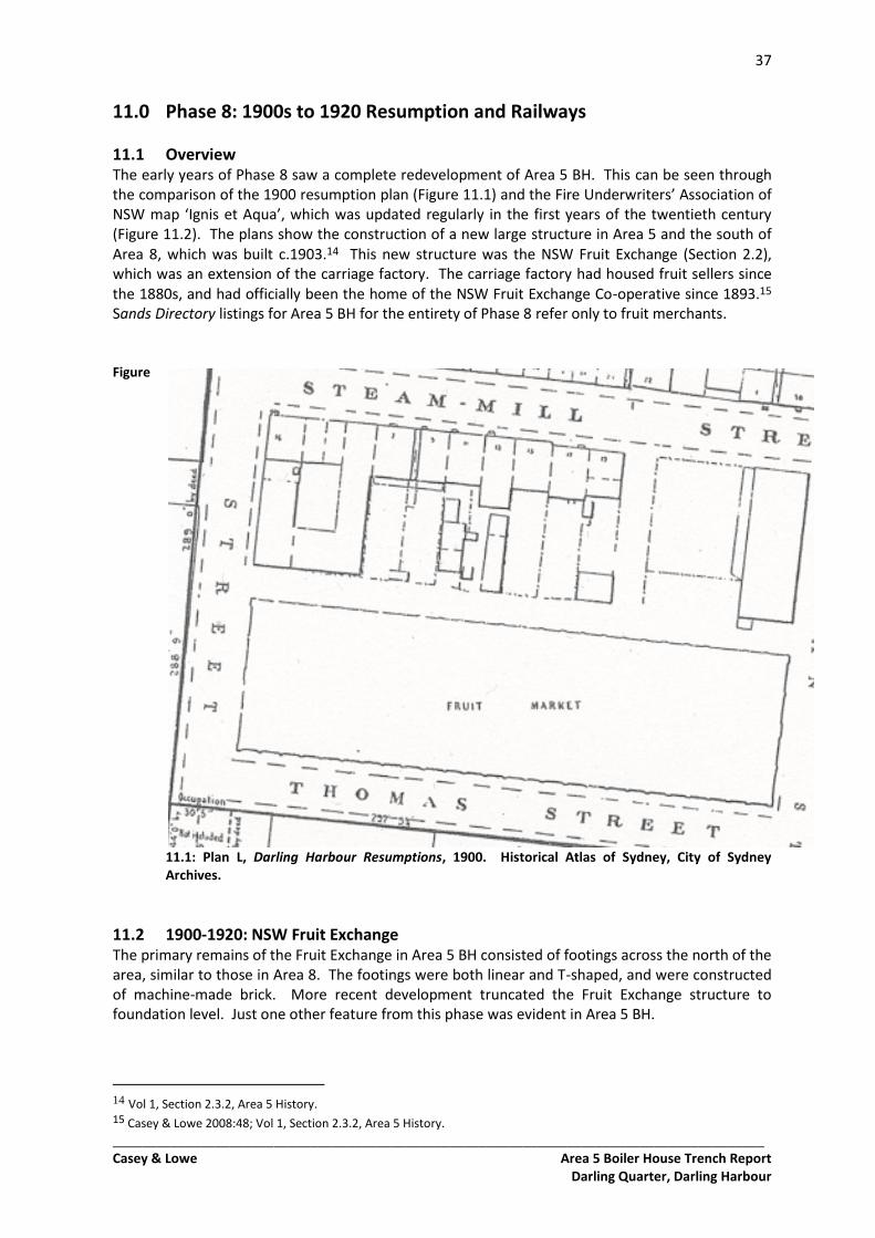
37
_________________________________________________________________________________________ Casey & Lowe Area 5 Boiler House Trench Report
Darling Quarter, Darling Harbour
11.0 Phase 8: 1900s to 1920 Resumption and Railways
11.1 Overview The early years of Phase 8 saw a complete redevelopment of Area 5 BH. This can be seen through the comparison of the 1900 resumption plan (Figure 11.1) and the Fire Underwriters’ Association of NSW map ‘Ignis et Aqua’, which was updated regularly in the first years of the twentieth century (Figure 11.2). The plans show the construction of a new large structure in Area 5 and the south of Area 8, which was built c.1903.14 This new structure was the NSW Fruit Exchange (Section 2.2), which was an extension of the carriage factory. The carriage factory had housed fruit sellers since the 1880s, and had officially been the home of the NSW Fruit Exchange Co-operative since 1893.15 Sands Directory listings for Area 5 BH for the entirety of Phase 8 refer only to fruit merchants. Figure
11.1: Plan L, Darling Harbour Resumptions, 1900. Historical Atlas of Sydney, City of Sydney Archives.
11.2 1900-1920: NSW Fruit Exchange The primary remains of the Fruit Exchange in Area 5 BH consisted of footings across the north of the area, similar to those in Area 8. The footings were both linear and T-shaped, and were constructed of machine-made brick. More recent development truncated the Fruit Exchange structure to foundation level. Just one other feature from this phase was evident in Area 5 BH.
14 Vol 1, Section 2.3.2, Area 5 History. 15 Casey & Lowe 2008:48; Vol 1, Section 2.3.2, Area 5 History.
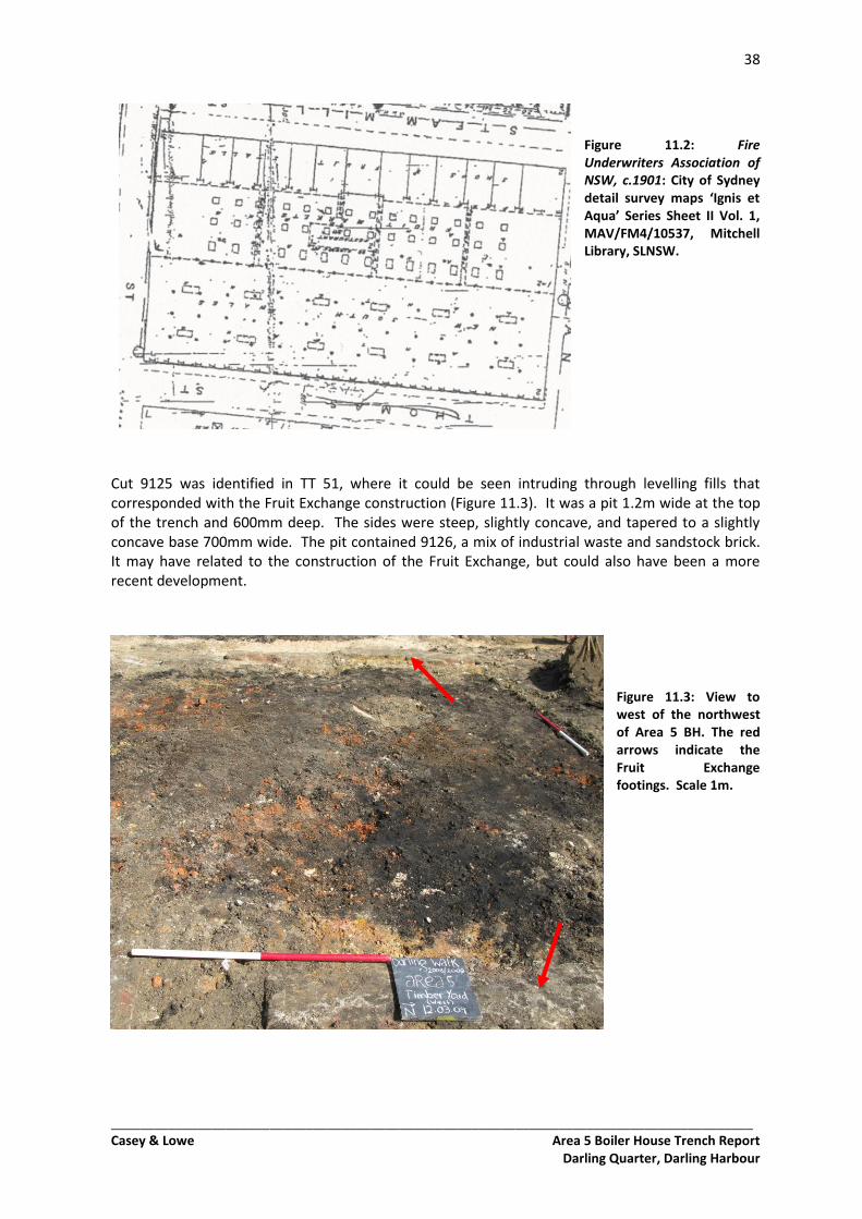
38
_________________________________________________________________________________________ Casey & Lowe Area 5 Boiler House Trench Report
Darling Quarter, Darling Harbour
Figure 11.2: Fire Underwriters Association of NSW, c.1901: City of Sydney detail survey maps ‘Ignis et Aqua’ Series Sheet II Vol. 1, MAV/FM4/10537, Mitchell Library, SLNSW.
Cut 9125 was identified in TT 51, where it could be seen intruding through levelling fills that corresponded with the Fruit Exchange construction (Figure 11.3). It was a pit 1.2m wide at the top of the trench and 600mm deep. The sides were steep, slightly concave, and tapered to a slightly concave base 700mm wide. The pit contained 9126, a mix of industrial waste and sandstock brick. It may have related to the construction of the Fruit Exchange, but could also have been a more recent development.
Figure 11.3: View to west of the northwest of Area 5 BH. The red arrows indicate the Fruit Exchange footings. Scale 1m.
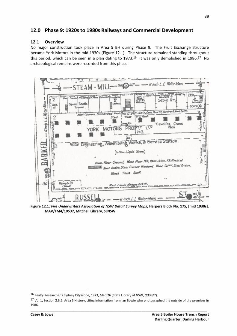
39
_________________________________________________________________________________________ Casey & Lowe Area 5 Boiler House Trench Report
Darling Quarter, Darling Harbour
12.0 Phase 9: 1920s to 1980s Railways and Commercial Development
12.1 Overview No major construction took place in Area 5 BH during Phase 9. The Fruit Exchange structure became York Motors in the mid 1930s (Figure 12.1). The structure remained standing throughout this period, which can be seen in a plan dating to 1973.16 It was only demolished in 1986.17 No archaeological remains were recorded from this phase.
Figure 12.1: Fire Underwriters Association of NSW Detail Survey Maps, Harpers Block No. 175, [mid 1930s]. MAV/FM4/10537, Mitchell Library, SLNSW.
16 Realty Researcher’s Sydney Cityscope, 1973, Map 26 (State Library of NSW, Q333/7). 17 Vol 1, Section 2.3.2, Area 5 History, citing information from Ian Bowie who photographed the outside of the premises in 1986.
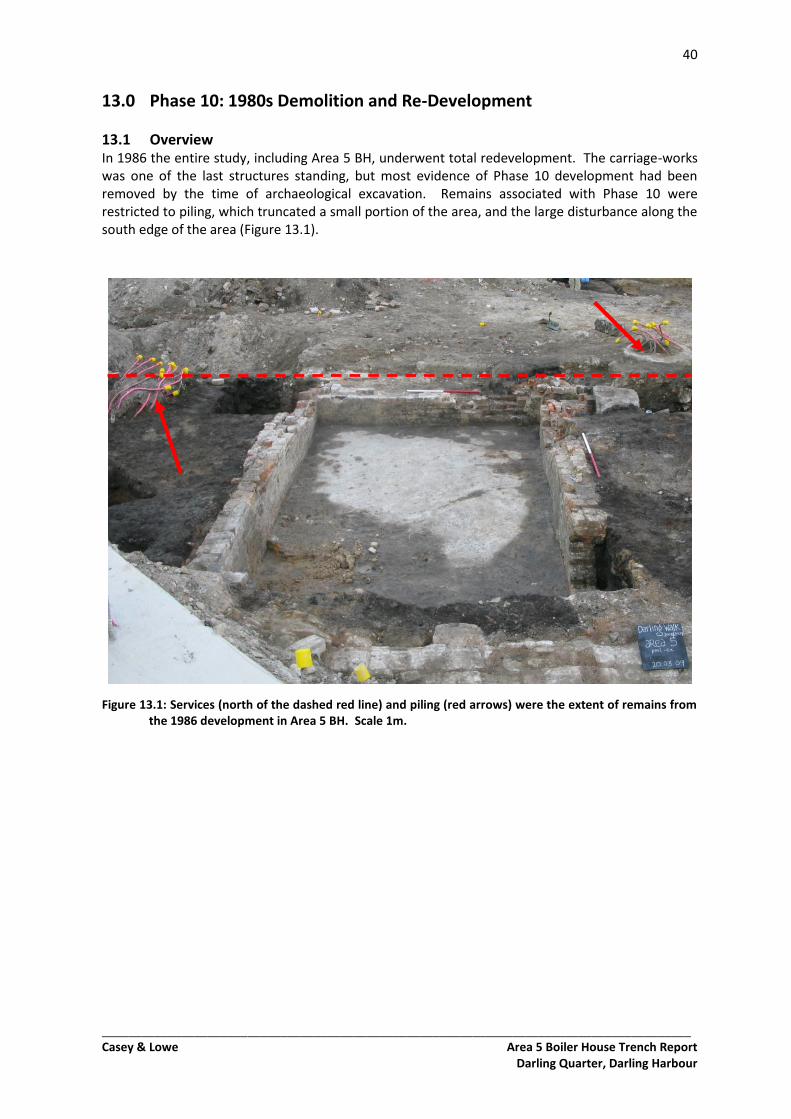
40
_________________________________________________________________________________________ Casey & Lowe Area 5 Boiler House Trench Report
Darling Quarter, Darling Harbour
13.0 Phase 10: 1980s Demolition and Re-Development
13.1 Overview In 1986 the entire study, including Area 5 BH, underwent total redevelopment. The carriage-works was one of the last structures standing, but most evidence of Phase 10 development had been removed by the time of archaeological excavation. Remains associated with Phase 10 were restricted to piling, which truncated a small portion of the area, and the large disturbance along the south edge of the area (Figure 13.1).
Figure 13.1: Services (north of the dashed red line) and piling (red arrows) were the extent of remains from the 1986 development in Area 5 BH. Scale 1m.
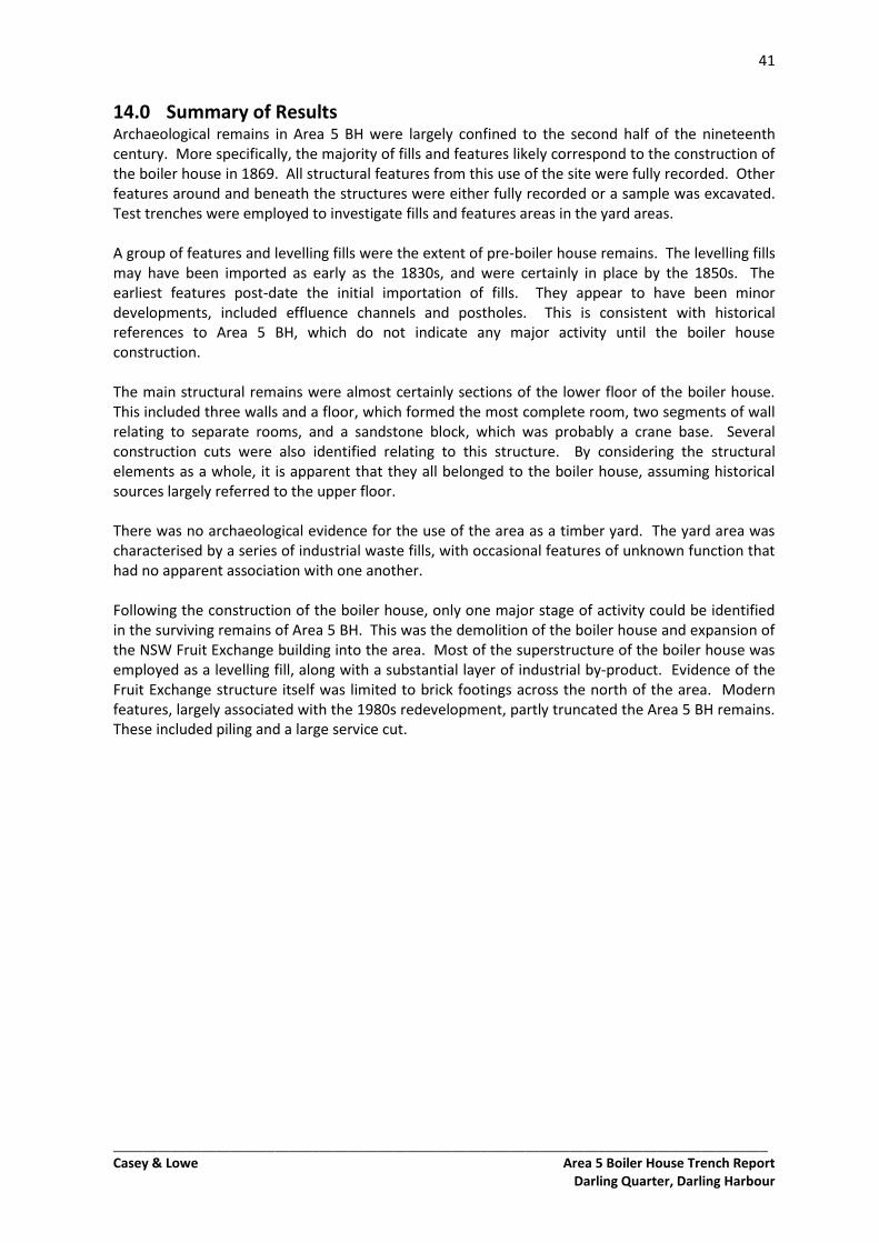
41
_________________________________________________________________________________________ Casey & Lowe Area 5 Boiler House Trench Report
Darling Quarter, Darling Harbour
14.0 Summary of Results Archaeological remains in Area 5 BH were largely confined to the second half of the nineteenth century. More specifically, the majority of fills and features likely correspond to the construction of the boiler house in 1869. All structural features from this use of the site were fully recorded. Other features around and beneath the structures were either fully recorded or a sample was excavated. Test trenches were employed to investigate fills and features areas in the yard areas. A group of features and levelling fills were the extent of pre-boiler house remains. The levelling fills may have been imported as early as the 1830s, and were certainly in place by the 1850s. The earliest features post-date the initial importation of fills. They appear to have been minor developments, included effluence channels and postholes. This is consistent with historical references to Area 5 BH, which do not indicate any major activity until the boiler house construction. The main structural remains were almost certainly sections of the lower floor of the boiler house. This included three walls and a floor, which formed the most complete room, two segments of wall relating to separate rooms, and a sandstone block, which was probably a crane base. Several construction cuts were also identified relating to this structure. By considering the structural elements as a whole, it is apparent that they all belonged to the boiler house, assuming historical sources largely referred to the upper floor. There was no archaeological evidence for the use of the area as a timber yard. The yard area was characterised by a series of industrial waste fills, with occasional features of unknown function that had no apparent association with one another. Following the construction of the boiler house, only one major stage of activity could be identified in the surviving remains of Area 5 BH. This was the demolition of the boiler house and expansion of the NSW Fruit Exchange building into the area. Most of the superstructure of the boiler house was employed as a levelling fill, along with a substantial layer of industrial by-product. Evidence of the Fruit Exchange structure itself was limited to brick footings across the north of the area. Modern features, largely associated with the 1980s redevelopment, partly truncated the Area 5 BH remains. These included piling and a large service cut.
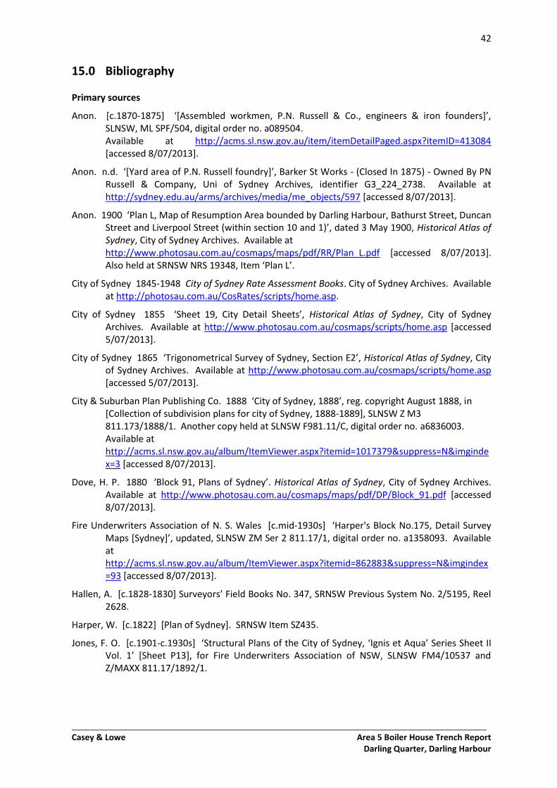
42
_________________________________________________________________________________________ Casey & Lowe Area 5 Boiler House Trench Report
Darling Quarter, Darling Harbour
15.0 Bibliography Primary sources
Anon. [c.1870-1875] ‘[Assembled workmen, P.N. Russell & Co., engineers & iron founders]’, SLNSW, ML SPF/504, digital order no. a089504. Available at http://acms.sl.nsw.gov.au/item/itemDetailPaged.aspx?itemID=413084 [accessed 8/07/2013].
Anon. n.d. ‘[Yard area of P.N. Russell foundry]’, Barker St Works - (Closed In 1875) - Owned By PN Russell & Company, Uni of Sydney Archives, identifier G3_224_2738. Available at http://sydney.edu.au/arms/archives/media/me_objects/597 [accessed 8/07/2013].
Anon. 1900 ‘Plan L, Map of Resumption Area bounded by Darling Harbour, Bathurst Street, Duncan Street and Liverpool Street (within section 10 and 1)’, dated 3 May 1900, Historical Atlas of Sydney, City of Sydney Archives. Available at http://www.photosau.com.au/cosmaps/maps/pdf/RR/Plan_L.pdf [accessed 8/07/2013]. Also held at SRNSW NRS 19348, Item ‘Plan L’.
City of Sydney 1845-1948 City of Sydney Rate Assessment Books. City of Sydney Archives. Available at http://photosau.com.au/CosRates/scripts/home.asp.
City of Sydney 1855 ‘Sheet 19, City Detail Sheets’, Historical Atlas of Sydney, City of Sydney Archives. Available at http://www.photosau.com.au/cosmaps/scripts/home.asp [accessed 5/07/2013].
City of Sydney 1865 ‘Trigonometrical Survey of Sydney, Section E2’, Historical Atlas of Sydney, City of Sydney Archives. Available at http://www.photosau.com.au/cosmaps/scripts/home.asp [accessed 5/07/2013].
City & Suburban Plan Publishing Co. 1888 ‘City of Sydney, 1888’, reg. copyright August 1888, in [Collection of subdivision plans for city of Sydney, 1888-1889], SLNSW Z M3 811.173/1888/1. Another copy held at SLNSW F981.11/C, digital order no. a6836003. Available at http://acms.sl.nsw.gov.au/album/ItemViewer.aspx?itemid=1017379&suppress=N&imgindex=3 [accessed 8/07/2013].
Dove, H. P. 1880 ‘Block 91, Plans of Sydney’. Historical Atlas of Sydney, City of Sydney Archives. Available at http://www.photosau.com.au/cosmaps/maps/pdf/DP/Block_91.pdf [accessed 8/07/2013].
Fire Underwriters Association of N. S. Wales [c.mid-1930s] ‘Harper's Block No.175, Detail Survey Maps [Sydney]’, updated, SLNSW ZM Ser 2 811.17/1, digital order no. a1358093. Available at http://acms.sl.nsw.gov.au/album/ItemViewer.aspx?itemid=862883&suppress=N&imgindex=93 [accessed 8/07/2013].
Hallen, A. [c.1828-1830] Surveyors’ Field Books No. 347, SRNSW Previous System No. 2/5195, Reel 2628.
Harper, W. [c.1822] [Plan of Sydney]. SRNSW Item SZ435.
Jones, F. O. [c.1901-c.1930s] ‘Structural Plans of the City of Sydney, ‘Ignis et Aqua’ Series Sheet II Vol. 1’ [Sheet P13], for Fire Underwriters Association of NSW, SLNSW FM4/10537 and Z/MAXX 811.17/1892/1.
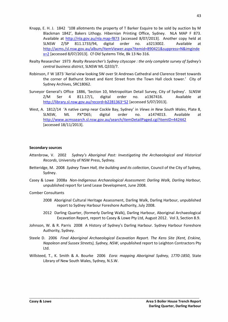
43
_________________________________________________________________________________________ Casey & Lowe Area 5 Boiler House Trench Report
Darling Quarter, Darling Harbour
Knapp, E. H. J. 1842 ‘108 allotments the property of T Barker Esquire to be sold by auction by M Blackman 1842’, Bakers Lithogy. Hibernian Printing Office, Sydney. NLA MAP F 873. Available at http://nla.gov.au/nla.map-f873 [accessed 8/07/2013]. Another copy held at SLNSW Z/SP 811.1733/94, digital order no. a3213002. Available at http://acms./sl.nsw.gov.au/album/ItemViewer.aspx?itemid=890421&suppress=N&imgindex=2 [accessed 8/07/2013]. Cf Old Systems Title, Bk 13 No 316.
Realty Researcher 1973 Realty Researcher's Sydney cityscope : the only complete survey of Sydney's central business district, SLNSW ML Q333/7.
Robinson, F W 1873 ‘Aerial view looking SW over St Andrews Cathedral and Clarence Street towards the corner of Bathurst Street and Kent Street from the Town Hall clock tower.’ City of Sydney Archives, SRC18062.
Surveyor General's Office 1886, ‘Section 10, Metropolitan Detail Survey, City of Sydney’. SLNSW Z/M Ser 4 811.17/1, digital order no. a1367416. Available at http://library.sl.nsw.gov.au/record=b2281363~S2 [accessed 5/07/2013].
West, A. 1812/14 ‘A native camp near Cockle Bay, Sydney’ in Views in New South Wales, Plate 8, SLNSW, ML PX*D65; digital order no. a1474013. Available at http://www.acmssearch.sl.nsw.gov.au/search/itemDetailPaged.cgi?itemID=442442 [accessed 18/11/2013].
Secondary sources
Attenbrow, V. 2002 Sydney’s Aboriginal Past: Investigating the Archaeological and Historical Records, University of NSW Press, Sydney.
Betteridge, M. 2008 Sydney Town Hall, the building and its collection, Council of the City of Sydney, Sydney.
Casey & Lowe 2008a Non-Indigenous Archaeological Assessment: Darling Walk, Darling Harbour, unpublished report for Lend Lease Development, June 2008.
Comber Consultants
2008 Aboriginal Cultural Heritage Assessment, Darling Walk, Darling Harbour, unpublished report to Sydney Harbour Foreshore Authority, July 2008.
2012 Darling Quarter, (formerly Darling Walk), Darling Harbour, Aboriginal Archaeological Excavation Report, report to Casey & Lowe Pty Ltd, August 2012. Vol 3, Section 8.9.
Johnson, W. & R. Parris 2008 A History of Sydney’s Darling Harbour. Sydney Harbour Foreshore Authority, Sydney.
Steele D. 2006 Final Aboriginal Archaeological Excavation Report. The Kens Site (Kent, Erskine, Napoleon and Sussex Streets), Sydney, NSW, unpublished report to Leighton Contractors Pty Ltd.
Willsteed, T., K. Smith & A. Bourke 2006 Eora: mapping Aboriginal Sydney, 1770-1850, State Library of New South Wales, Sydney, N.S.W.