Embed Size (px)
Citation preview
In a natural setting, trees control stormwater runoff and protect surface waters from sediment and nutrient
loading. In an urban setting, trees reduce the amount of runoff that enters stormwater and combined sewer
overflow systems. Acting as mini-reservoirs, trees control stormwater at the source and reduce the peak of a rain
event. According to the National Tree Benefit Calculator, www.treebenefits.com/calculator, a single, mature
sugar maple can intercept several thousand gallons of stormwater per year. [7] It does this by:
intercepting and holding rain on leaves, branches, and bark.
increasing infiltration and storage of rainwater through its root system.
reducing soil erosion by slowing rainfall before it strikes the soil.
Water bodies in urban areas that receive stormwater runoff are often threatened by pollution. Rain flushes salt,
oil, gasoline, hydraulic fluids, and other contaminants directly into bodies of water, creating imbalance to their
complex, aquatic ecosystems. Rain events can also cause combined sanitary sewers and storm systems to
overflow, dumping untreated sewage into our lakes, streams, and rivers.
According to the USDA Forest Service Center for Watershed Protection, stormwater runoff is the number one
factor in the decline of urban streams and decreasing urban water quality. Regarding trees and stormwater, the
Center has reached these conclusions:
Watershed health is linked to the amount of forest in the watershed and its distribution.
Increased tree cover and tree size result in reduced total runoff rates (for example, 10% tree cover results
in 2–5% reduced runoff).
Tree canopy has a greater effect on small storm events than on large storm events.
Effects on runoff are greatest when urban trees are large and well established.
Trees and stormwater management infrastructure can coexist if planned and designed from the start.
Pittsburgh has combined sewer outflow systems; during rainfall events, excess runoff can mix with raw sewage.
By intercepting rainfall and controlling runoff at the source, trees can reduce the extent of this problem. This is
especially important in an urban setting with a significant quantity of impervious surfaces in close proximity to
the Allegheny, Monongahela, and Ohio Rivers.
According to the 2011 Urban Tree Canopy Analysis, Pittsburgh is covered by 33% impervious surface.
Historically, Pittsburgh’s stormwater management has involved collecting, transporting, and dumping it as
quickly as possible into the Allegheny and Monongahela Rivers. Pittsburgh’s 38-inch average annual
precipitation is not extreme by any means; however, storm events have occurred with increasing frequency that
would tax any system to the limit. Notably, Hurricane Ivan resulted in 6 inches of rain during a 12-hour period in
September 2004. [6]
If our rivers and streams are to recover, we need to improve our methods of managing stormwater. Urban
forestry practices that combine planning, engineering, and arboriculture to create functional green infrastructure
can greatly mitigate the harm caused by urban runoff. Significantly increasing tree canopy, creating bioswales,
and reducing impervious surfaces are all methods that must be used in combination to have the necessary
impact.
To effectively use trees to manage stormwater runoff, the site must
be designed properly and, sometimes, even engineered. Site design
is critical to the success of any project, even when the project
seems as simple as planting a tree.
A tree’s ability to establish, grow to its full potential, and remain
healthy is largely dependent upon soil volume. If too little soil is
available, the tree will not reach full stature, regardless of what
species is planted. Trees without adequate soil volume tend to be
short lived and do not function as useful components of a city’s
infrastructure. Poorly designed sites and those lacking adequate
soil and space generally require continual, costly plant heath care
and often continual replanting of trees. Designing a site for
success—providing both soil and space—will grow the biggest tree
the site can accommodate and, thus, divert and absorb the most
stormwater.
Tree planting schemes that are designed and engineered with trees as a consideration, not an afterthought, will
produce trees that grow to their maximum size, extending dense canopies and providing the greatest stormwater
utility benefit, as well as other environmental and economic benefits. Site design elements that make sense in our
City include:
Suspended pavement and structural cells.
Permeable pavements.
Structural soils.
Stormwater tree pits.
Stormwater management systems designed to mimic natural areas can be integrated into community, street,
building, and even site developments to reduce the damaging effects of urban runoff on rivers and streams and
relieve pressures on combined sewer and stormwater systems.
Forested bioswales.
Green roofs.
Green streets.
For more information on these design elements and stormwater management systems, please refer to the
Stormwater to Street Trees – Engineering Urban Forests for Stormwater Management found in Appendix E.
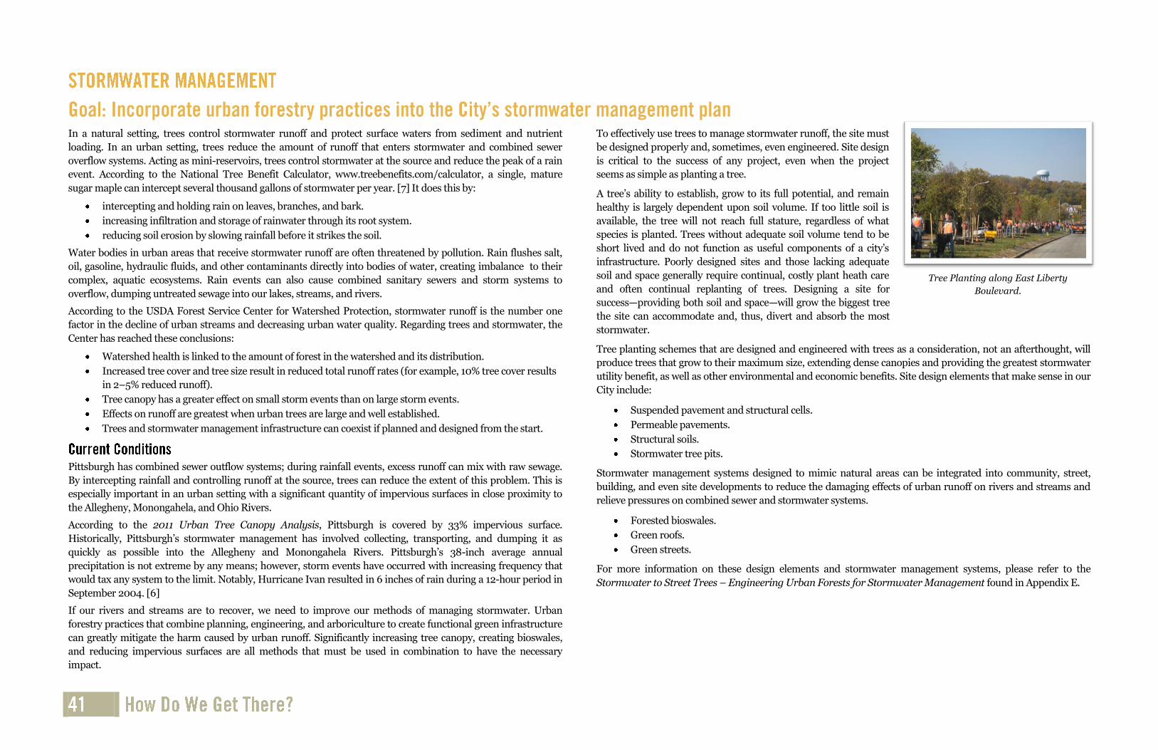
Tree Planting along East Liberty
Boulevard.

Philadelphia’s Stormwater Solution
Philadelphia has embarked on a $2 billion, 25-year project to improve the way it processes stormwater. The old system combines sewage and stormwater, which cause sewage overflows during heavy rains. The new project will replace as much as one-third of the City’s existing impervious cover—about 4,000 acres—with natural or porous surfaces that can intercept stormwater, store it, and release it at a controlled rate.
Proposals include natural water storage and filtering solutions such as rain gardens, curbside planters, and green rooftops. Porous asphalt, concrete, and paving slabs will be installed in car parks and on streets. Together, these technologies should prevent between 5 and 8 billion gallons of wastewater from overflowing each year. [71]
New York City’s Stormwater Solution
Impervious surfaces cover approximately 72% of New York City’s 305 square miles in land area and contribute to a significant amount of stormwater runoff.
The NYC Department of Environmental Protection has made a broad, citywide effort to better manage stormwater using a variety of innovative, sustainable, green infrastructure. Improved stormwater management is an important component of the PlaNYC initiative and Sustainable Stormwater Management Plan. Green infrastructure, or source controls, is a set of techniques that detain or retain stormwater runoff through capture and controlled release, infiltration into the ground, vegetative uptake, and evapotranspiration, thereby reducing the need for end-of-pipe stormwater storage and treatment systems. [72]
Some types of green infrastructure New York City is employing are:
A rain barrel giveaway program.
Street-side swales and enhanced tree pits.
Rooftop detention, including green roofs, blue roofs, and control roofs.
The Staten Island Bluebelt–a program that preserves natural drainage corridors, including
streams, ponds, and wetlands.
Trees are typically not considered part of either grey or green stormwater management systems; they are generally, and falsely, considered landscaping. When planting a tree as landscaping, the stormwater utility benefits it might provide should also be considered when determining its placement.
Impervious surfaces and compacted soils in urban areas prevent the infiltration of runoff into the ground, which creates challenges for stormwater management and urban forestry.
Streetscape designs and individual tree planting spaces often fail to address the needs of trees. Common design failures include compacted soil, improper (too small) tree pit size, a lack of soil for root growth, and impervious surfaces.
Some parking lots in Pittsburgh have been retrofitted to increase tree planting. These projects mostly involved asphalt removal to create an opening in which a tree can be planted, but rooting volume is not often sufficient for a large tree to thrive.
A medium- to large-sized tree requires approximately 1,000 cubic feet of rooting volume in order to thrive into mature form.
Measuring the value of constructing parking lots that integrate high canopy coverage is difficult, while the increased cost is readily apparent. Availability of construction materials such as structural soils and porous asphalt is limited and will remain so until demand increases. Costs for these materials are significantly higher than typical asphalt and gravel base material.
Retrofitting existing parking lots is more challenging than planning and engineering new, green infrastructure parking lots. As the science of urban forestry advances, quantification of ecosystem services such as energy savings, air pollution reduction, and stormwater mitigation will become more exact.
Increased canopy cover can have a significant beneficial effect on stormwater management. The greatest opportunity to increase canopy cover lies within residential land use.
Lack of enforcement of landscape tree planting and permeable areas for developments and parking lots.
Not all watersheds within Pittsburgh have stormwater plans.
Target urban tree planting and tree canopy expansion efforts based on increasing stormwater benefits.
Identify local stormwater improvement needs at the neighborhood level and prioritize feasible tree planting schemes, site design elements for trees, and stormwater management systems that can be implemented.
Target parking lots as a feasible land use for green infrastructure retrofits, utilizing porous pavement, structural soils, and trees.
Advocate for the use of suspended pavement and structural cells during appropriate redevelopment projects.
Utilize stormwater tree pit designs to increase infiltration and limit compaction, and engineer them to receive and process street and rooftop runoff.
Prioritize streets where forested bioswales and green street systems may be most feasible or preferred to traditional streetscape design.
Whenever space limitations allow, large, maturing trees should be the preferred choice to decrease stormwater peak flows.
Encourage and assist homeowners to help reduce stormwater runoff by planting large-growing trees on their property.
Require that sufficient rooting volume be planned for and engineered in the design of new and retrofitted sidewalks and parking lots to support large-growing trees.
Current City code should be enforced consistently by all City Departments.
All stormwater plans should have urban forestry as a component.
Prioritize watersheds for future tree planting and protection efforts.
The first installation of Silva Cells in Pennsylvania at
the August Wilson Center for African American
Culture on Liberty Avenue.

Tabor to the River, Portland, Oregon
Project Description
The Brooklyn Creek Basin covers about 2.3 square miles in the City of Portland, Oregon, from Mt. Tabor to the Willamette
River between SE Hawthorne and SE Powell Boulevards. A major creek once flowed freely from Mt. Tabor to the
Willamette River through what is today known as the Brooklyn Neighborhood. Long ago, the City diverted this creek, and
many other free-flowing streams, into underground sewer pipes to make way for development. The combined sewer
system serving the Brooklyn Creek Basin today mixes sewage from homes and businesses and stormwater runoff from
streets in the same pipes. Parts of the sewer system are a century old. Because of increases in pavement and other
impervious surfaces, and decreases in tree canopy, the volume of stormwater the system manages is much greater than it
was designed to manage 100 years ago. Very heavy rains can cause sewers to back up into basements, flood streets, and
overflow to the Willamette River. [73]
The Tabor to the River-Brooklyn Creek Basin Program addresses stormwater management and watershed health issues by:
adding more than 500 green street facilities, vegetated curb extensions, and street-side planters that will collect
street stormwater runoff and let it soak into the ground as soil and vegetation filter pollutants.
repairing or replacing 81,000 feet of sewer pipe, adding new pipe, and installing new manholes as necessary.
planting nearly 3,500 street trees to absorb rain and reduce and slow stormwater runoff.
restoring natural areas in the basin by removing invasive vegetation and introducing native plants.
working with private property owners to construct facilities that will collect and manage roof and parking lot
runoff.
repairing or replacing 81,000 feet of sewer pipe, adding new pipe, and installing new manholes as necessary.
Accomplishments (as of spring 2011)
Built 137 green street facilities.
Created 16 private property rain gardens.
Planted 400 street trees.
Replaced or repaired 8,000 feet of sewer pipe.
Removed 26.5 acres of invasive plants and planted 4,800 native shrubs and trees in natural areas.
Lessons Learned
Resolving these problems with only pipe solutions would cost an estimated $144 million.
Adding sustainable, green stormwater management systems reduces the cost to $86 million.
The additional benefits include enhanced water quality and watershed health.
Case Study: Stormwater Management
Green streets tree planting.
Rain garden planted by volunteers.

Green Parking Lot in Ithaca, New York
Project Description
In collaboration with the Cornell University Urban Horticulture Institute and other partners, the City of Ithaca built a
parking lot that compounded benefits in green infrastructure by combining porous asphalt, a base of CU-Structural Soil™
(also known as CU-Soil™) capable of holding a 100-year rain event, and disease-resistant hybrid elms. The trees cool the
surface and ambient temperature, slow the rain, and when transpiring pump out pure water into the atmosphere. To
make this powerful illustration of how trees are an integral component of urban, wet weather green infrastructure even
more obvious, it is sited next to a flood control channel. No catch basins, water pipes, or outfalls connect to this parking
lot. [74]
The parking lot is completely underlain with a 30-inch base of CU Structural Soil. For research purposes, half of the paved
surface is typical asphalt and half is porous asphalt. Monitoring wells were installed from the surface to the bottom of the
base course. The base sits on un-compacted, clay loam soil. [74]
Relatively narrow slots were cut into the asphalt, and trees were planted at a grade directly into the CU Structural Soil.
This enables a high percentage of canopy coverage while devoting more space to parking spots. Since the open areas are at
grade, they can receive runoff directly. In the porous half of the parking lot, rainwater also quickly percolates from the
paved surface.
In this way, through slots in the surface and by permeable pavement, all the water that falls on the parking lot is
systematically handled.
Disease-resistant, large-maturing, fast-growing trees were selected to attain a high canopy cover in a relatively short time.
Canopy cover of approximately 50% has been attained on the site in less than 10 years.
Accomplishments
The parking lot has held up remarkably well since its construction in 2005. Freeze/thaw cycles have not heaved the
surface. Tree growth rate has been rapid. Maintenance has been typical for the most part.
One interesting and surprising maintenance issue is that the porous asphalt actually requires less deicing salt because
when snow and ice melt in the daytime, the water infiltrates leaving a drier surface when temperatures drop below
freezing at night.
Lessons Learned
While surface parking lots comprise a significant amount of the impervious urban area, they represent the greatest
opportunity for increasing stormwater infiltration, bioremediation of pollutants, and improving the health of rivers,
streams, and lakes.
Maintenance of green parking lots can actually be less costly due to extended asphalt life resulting from shading
ultraviolet radiation and decreased use of deicing salt due to melt water infiltration.
Increased costs upfront results in future environmental benefits.
Case Study: Stormwater Management
Relatively inexpensive, bare-root trees can be planted at grade and directly into
CU Structural Soil parking lot base material by volunteers with no
machinery. This method reduces project cost while obtaining superior performance of the system.
Parking lot near flood control channel. No catch basins, pipes, or outfalls are
required. No negative impact on surface water quality due to parking lot. Trees can thrive while more space is devoted to parking spots, resulting in a smaller
overall footprint for the parking lot.

Beech Avenue in the Northside neighborhood lined with littleleaf linden
(Tilia cordata).
0 2,000 4,000 6,000 8,000 10,000 12,000 14,000
Agricultural
Commercial
Government
Industrial
N/A
Other
Residential
Rights-of-Way
Utilities
Acres
Existing Tree Canopy
Possible Tree Canopy Vegetation
Possible Tree Canopy Impervious
Not Suitable
Tree canopy is the layer of leaves, branches, and stems of trees that cover the ground when viewed from
above. The amount of tree canopy cover data drives the amount of benefits that an urban forest provides
(for example, intercepting rainfall, controlling stormwater, improving water quality, reducing energy
demands, lowering surrounding air temperatures, reducing air pollution, enhancing property values, and
providing wildlife habitat).
Establishing a realistic and achievable tree canopy cover goal is a crucial step for communities seeking to
improve their green infrastructure and to capitalize on the environmental services that trees provide.
Before establishing a goal, communities need to assess their current tree canopy cover levels and determine
what is physically and biologically possible to achieve. An Urban Tree Canopy (UTC) analysis establishes a
baseline for tree canopy cover and enables goal setting.
Tree Pittsburgh commissioned the 2011 UTC analysis that
utilized 2010 data, high-resolution aerial imagery, LiDAR, and
GIS to analyze citywide tree canopy cover. The UTC analysis
provides information about canopy cover location and
conditions where trees are absent, including political
boundaries (neighborhoods, wards), existing land use
(residential, commercial, industrial), and demographics
(poverty rate, population density, crime rates, age
distribution). The GIS data that include environmental and
sociological information help determine what is preferable in
terms of protecting and expanding tree canopy. Stakeholders
and planners can use GIS to query specific tree canopy and
land use metrics for a specific parcel or set of parcels, specific
neighborhoods, or watersheds. This information can be used
to develop policy and regulations to control tree canopy loss,
or to provide direction and justification for tree canopy
enhancement. [6]
The 2011 UTC assessment indicates that Pittsburgh’s overall tree canopy is 42% of the total land area,
indicating a rich urban forest resource within the City that warrants protection. While this figure is a higher
overall percentage than many cities, analysis indicates that it is unevenly distributed. Most of the City’s
residents live in neighborhoods with substantially less canopy cover, some neighborhoods as low as 5%. [6]
While the City’s overall canopy cover is 42%, an additional 33% of the land area meets criteria for
establishing trees (“possible tree canopy”). Some of this area (24%) is currently grass and shrubs that could
be converted to tree cover, and the remainder (9%) is currently impervious but could be modified to
support trees and tree canopy. It is easier to establish trees in vegetated areas, but converting land that is
currently impervious has greater benefits for stormwater reduction, water quality, and mitigating summer
temperatures. [6]
The UTC analysis also studied existing and possible tree
canopy within land use types (for example, parks,
neighborhoods, river buffers, watersheds, and
individual parcels). Residential land is the largest
contributor to the City’s overall tree canopy (35% of all
existing tree canopy) and accounts for the greatest
opportunity to increase canopy, at 38% of all land
identified as “possible tree canopy”. [6]
Analysis indicates that some neighborhoods have
exceptionally high tree canopy levels while others are
extremely low. For example, the Hays neighborhood
currently has 81% canopy cover and Glen Hazel has
80%. The Chateau neighborhood has 5% canopy cover
and North Shore has 6%. Focusing efforts on areas with
the greatest need in terms of tree canopy may seem to
be logical, but the analysis must also consider “possible
tree canopy” at the neighborhood level. The Chateau
neighborhood, at 5% current tree canopy, also has one
of the largest “possible tree canopy” levels at 47%,
indicating a combination of need and potential. [6]
Watersheds within the Mid-Atlantic region are considered to have “good” stream health if tree canopy is
45% or above. Tree canopy cover and “possible tree canopy” were analyzed for each of the 12 watersheds
within Pittsburgh’s boundaries. Three of the six major watersheds that intersect the City have tree canopy
levels far below the recommended 45% level.
0
5,000
10,000
15,000
20,000
25,000
30,000
35,000
40,000
Ac
re
s
PossibleTree CanopyVegetation
Possible Tree Canopy Impervious
Existing Tree Canopy
33%
42%
Not Suitable

Neighborhood
Level
City Level
Parcel Level
Street Level
Pittsburgh’s Land Cover
2012

Pittsburgh Tree Canopy Assessment
2011
Factors that are assessed in the UTC
analysis can be compiled into a “Tree
Canopy Opportunity Index”. This process
identifies areas at the land type,
neighborhood, park, watershed, or parcel
level where enhanced tree care, tree
protection, and tree planting would be most
effective. Maps can be generated at various
resolutions to identify areas of greatest
benefit enhancement based on levels of
importance selected by stakeholders and
planners. Accurate information about
existing tree canopy provides a valuable
baseline that can be used to identify an
overall canopy goal as well as where to
prioritize increasing canopy in specific
areas. Tree Pittsburgh’s goal is to achieve
60% canopy cover over the next 20 years.
With 75% canopy cover theoretically
possible (42% existing tree canopy plus 33%
possible tree canopy), 60% appears to be a
challenging, yet achievable goal. [6]
This overall goal can be more easily approached incrementally by assessing possible tree canopy cover at a
smaller scale, such as land use type, neighborhood, watershed, or individual parcel. Areas that currently do
not have tree canopy can be assessed to determine their suitability for tree planting. A local approach to a
big canopy cover goal helps engage stakeholders, helps urban forest managers determine the highest
priority needs, and increases the likelihood that planting projects will be successful in the long term.
The UTC analysis helps determine where tree planting efforts should be concentrated; however, tree
benefit quantification data must be considered to determine the number and species of trees to be planted.
Setting performance-driven canopy goals that link desired benefits (rather than only the percent of cover)
will provide direction for planting projects. Benefit quantification data from recent i-Tree studies will
enable tree planting organizations to determine how many trees and what types to strategically plant for the
purpose of increasing specific benefits.
For example, the 2011 i-Tree Eco data estimate that the 2.62 million trees in our City remove 532 tons of air
pollution (ozone [O3], carbon monoxide [CO], nitrogen dioxide [NO2], particulate matter less than 10
microns [PM10], and sulfur dioxide [SO2]) per year with an associated value of $3.75 million. To double that
benefit, the resource would need to double in size. However, a more strategic approach can be utilized to
increase net air quality benefits by selecting species that are proven performers for air quality benefits.
Typically, large-canopied trees with large leaf surface areas that are not high biogenic, volatile organic
compound (BVOC) emitters produce the greatest benefits. According to the 2008 street tree benefit
analysis, London planetrees are among the top producers of net air quality benefits in the City. On a per
tree basis, Pittsburgh’s pin oaks produced the greatest net air quality improvement. [4]
A community’s ability to increase canopy cover is limited by available and suitable space, political
constraints (including funding), and organizational capacity.
Tree canopy is not evenly distributed throughout the City, and opportunities for enhancing tree
canopy are scattered as well. Thoughtful interpretation of existing tree inventories and urban tree
canopy studies will require input from stakeholders, planners, city staff, and urban foresters in
order to find the best locations for enhanced tree care, tree protection, and tree planting.
Tree canopy covers less than 10% of the total street and sidewalk area within the City and the total
street tree population comprises only 3–5% of the total tree canopy in Pittsburgh. Canopy cover
over paved surfaces has added value by reducing maintenance as trees along streets have been
shown to reduce the wear on asphalt by lowering surface temperatures, thereby reducing
maintenance costs. [6]
Public land in Pittsburgh contains 26% of Pittsburgh’s tree canopy. While this appears to provide an
opportunity for land that can be converted to tree cover, only 27% of this area is listed as “possible
tree canopy”. [6]
The best opportunity for increasing tree canopy appears to be on residential land (38% listed as
“possible tree canopy”), although it would require a significant amount of regulatory influence and
public education. Residential land covers more area than any other land type and contains 35% of
the City’s existing tree canopy. [6]
The key to the success of any planting project is adequate funding for long-term maintenance.
Develop achievable, minimum canopy cover goals for each land use type, neighborhood, and
watershed utilizing UTC and i-Tree data.
Develop a backyard tree planting program and education campaign designed to increase canopy
cover on residential land.
Utilize the UTC analysis in conjunction with the i-Tree analyses to increase awareness about the
relationship between trees and environmental quality and to engage stakeholders in tree planting.
Set a goal to maximize street tree stocking levels.
Target parks and other public land to maximize possible canopy coverage.
Adopt performance-based planting strategies by selecting species based on desired benefit
outcomes rather than canopy cover alone.
Design a backyard tree planting and tree care toolkit for private landowners interested in planting
trees to increase benefits that guide people to choose species and planting locations that maximize
benefits.
Share established tree canopy goals and share the UTC anlysis with stakeholders concerned with the
urban forest.
Budget adequately to maintain trees after planting.
Generate positive canopy impacts on small-scale development and redevelopment projects by
incorporating canopy goals into municipal landscape requirements for streetscapes, parking lots,
and other sites.
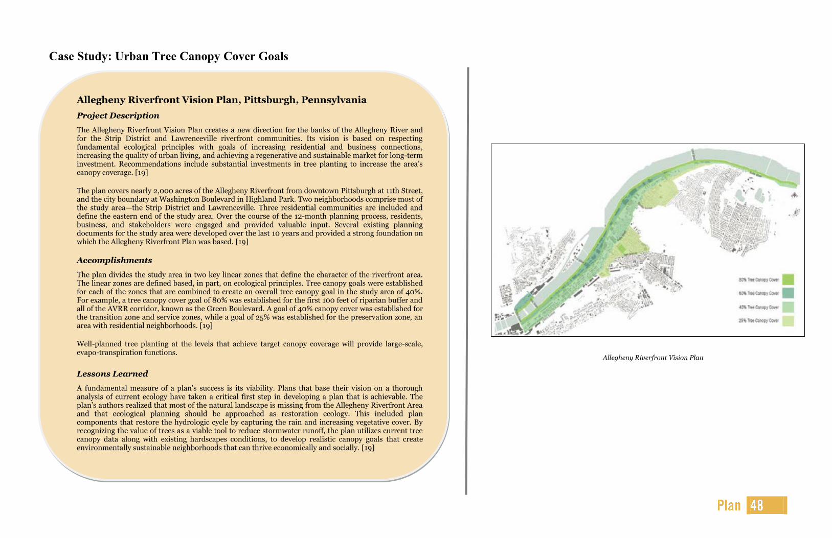
Allegheny Riverfront Vision Plan, Pittsburgh, Pennsylvania
Project Description
The Allegheny Riverfront Vision Plan creates a new direction for the banks of the Allegheny River and for the Strip District and Lawrenceville riverfront communities. Its vision is based on respecting fundamental ecological principles with goals of increasing residential and business connections, increasing the quality of urban living, and achieving a regenerative and sustainable market for long-term investment. Recommendations include substantial investments in tree planting to increase the area’s canopy coverage. [19]
The plan covers nearly 2,000 acres of the Allegheny Riverfront from downtown Pittsburgh at 11th Street, and the city boundary at Washington Boulevard in Highland Park. Two neighborhoods comprise most of the study area—the Strip District and Lawrenceville. Three residential communities are included and define the eastern end of the study area. Over the course of the 12-month planning process, residents, business, and stakeholders were engaged and provided valuable input. Several existing planning documents for the study area were developed over the last 10 years and provided a strong foundation on which the Allegheny Riverfront Plan was based. [19]
Accomplishments
The plan divides the study area in two key linear zones that define the character of the riverfront area. The linear zones are defined based, in part, on ecological principles. Tree canopy goals were established for each of the zones that are combined to create an overall tree canopy goal in the study area of 40%. For example, a tree canopy cover goal of 80% was established for the first 100 feet of riparian buffer and all of the AVRR corridor, known as the Green Boulevard. A goal of 40% canopy cover was established for the transition zone and service zones, while a goal of 25% was established for the preservation zone, an area with residential neighborhoods. [19]
Well-planned tree planting at the levels that achieve target canopy coverage will provide large-scale, evapo-transpiration functions.
Lessons Learned
A fundamental measure of a plan’s success is its viability. Plans that base their vision on a thorough analysis of current ecology have taken a critical first step in developing a plan that is achievable. The plan’s authors realized that most of the natural landscape is missing from the Allegheny Riverfront Area and that ecological planning should be approached as restoration ecology. This included plan components that restore the hydrologic cycle by capturing the rain and increasing vegetative cover. By recognizing the value of trees as a viable tool to reduce stormwater runoff, the plan utilizes current tree canopy data along with existing hardscapes conditions, to develop realistic canopy goals that create environmentally sustainable neighborhoods that can thrive economically and socially. [19]
Case Study: Urban Tree Canopy Cover Goals
“Our urban forests are under stress, and it will take all of
us working together to improve the health of these
crucial green spaces.”
Tom Tidwell
U.S. Forest Service Chief
Allegheny Riverfront Vision Plan

The National Weather Service reports that in Allegheny County from 1950 through 2011, there have been
953 severe weather events resulting in 21 deaths, 714 injuries, and over $480 million in property damage.
On average, there were 15 storm events resulting in $7.9 million in property damage per year. In the
Pittsburgh area, severe weather takes the forms of tornados, hurricanes, flooding, thunderstorms and high
winds, and snow, ice, and hail. [75]
To date, the City’s response to small, moderate, and severe storms has been adequate. Citizen complaints
and reports are addressed quickly as crews and equipment from multiple city departments can be called
into action. Through the City’s pre-qualified tree work contract, there is a proactive purchasing mechanism
in place to efficiently secure more personnel and equipment as needed.
Resource—With over 31,000 public trees and a 42% canopy
cover, both of which are widely distributed within the city
limits, during each storm the City has a significant amount of
risk exposure for damage to persons and/or property and a
significant potential for large amounts of woody debris to be
collected, stored, and processed. Nearly 20% of the public
forest is comprised of species that are known to be prone to
storm damage. According to the 2005 tree inventory, the
condition of the majority of these storm-prone trees is only
poor to fair. [1]
Structure—The City’s Office of Emergency Management and
Homeland Security is the lead agency in the event of a severe,
citywide storm emergency. The Forestry Division is the lead
agency for minor storm events. However, moderate storms requiring a multi-departmental response reveal
a significant lack of coordination on many levels, which leads to inefficiencies in terms of timely and
corrective actions and use of public funds. For example, there are no predetermined wood waste storage
yards or efficient methods for processing or properly disposing debris. The utility company performs a
significant amount of storm damage mitigation within the public urban forest, but this is not coordinated
with the City. This decentralization of crews, equipment, and funding hinders a more effective storm
response by the City.
Funding—Funding for storm response typically comes from the operations budget of Forestry and/or the
responding department. When severe storms cause significant damage, state and federal reimbursements
are sought. At this date, storm expenditures can be accounted for, but budget analysis is cumbersome and
may not capture all true expenses related to emergency response in the urban forest.
The City currently does not have an emergency plan specifically for the urban forest.
During and after a storm event, there is a lack of communication and coordination between City
departments and the utility company.
Other departments do not seek out the Forestry Division for expertise and training.
Whether storm damage mitigation work is performed by City, utility, or contracted crews, hazards
are abated but no corrective or restorative pruning is performed on public trees. This leaves trees in
a weakened condition, aesthetically unappealing, and creates inefficiencies and an unnecessary
funding burden when trees must be visited multiple times to accomplish proper pruning.
No funding is ear-marked for a citywide, cyclical, preventive maintenance program, nor for
response to or damage from storm events that do not qualify for reimbursement from Federal
Emergency Management Agency (FEMA).
Based on current species and condition information, a large portion of the public tree resource is
highly susceptible to storm damage.
Based on the public outreach campaign results, citizens want more trees; however, increased
numbers of trees and canopy cover could mean more potential risk of damage and greater amounts
of debris after storms. With expanded planting efforts, it is more critical that a routine maintenance
program be established and that an emergency response plan is in place.
Create a comprehensive Tree Emergency Response and Recovery Plan to analyze existing resources,
risk levels, funding, and partnerships and to recommend protocols and strategies to increase
emergency response efficiencies, decrease costs, and improve communication.
Implement i-Tree Storm.
Create an urban forest emergency maintenance fund earmarked only for severe weather response
when an emergency is declared by the Mayor and ratified by the City Council or by the Emergency
Management Director.
Strengthen the partnership with Duquesne Light to find synergies and define pre-storm and post-
storm roles and responsibilities.
Cross-train appropriate staff in other departments in proper tree pruning, removal, and debris
handling and safety procedures to increase the number of qualified personnel available to assist
during an emergency.
Establish a preventive maintenance program/cycle for public trees, plant storm-resistant tree
species, and perform structural pruning on all newly planted trees.
Change the city policy prohibiting the sale of wood products recovered from storms, such as
firewood, sawlogs, and mulch to allow for reuse and be a source of revenue.
Create public education messages for use during and after a storm event appropriate for all types of
media.
Severe storms can result in downed trees
and road closures.

Fort Wayne, Indiana
Project Description
After decades of a variety of severe weather events and after a particularly devastating ice storm in 2008, the City of Fort Wayne’s urban forest managers knew it was time to create a plan and have the resources identified and in place to be better prepared for the next emergency situation. This decision to create a plan was not only made to reduce risk and damage, but was further supported by the fact that FEMA reimbursement for urban forest storm damage mitigation was not being recovered because the City did not properly document mitigation expenditures. Fort Wayne spent hundreds of thousands of dollars on urban forest damage cleanup and recovery for which they did not get reimbursed. In 2011, the City completed its urban forest emergency plan and implemented software and departmental protocols to comply with local, state, and FEMA regulations as well as requirements for reimbursement. [76, 77]
Accomplishments
Fort Wayne’s Urban Forestry Storm Response and Recovery Plan details improved policies and procedures to increase the efficiency and productivity of tree risk reduction and storm response and recovery operations. The plan addresses making improvements to many facets of the urban forestry program, integrates the urban forest storm plan into the City’s overall emergency storm response system, and describes the role of the local, county, state, and federal government before, during, and after a storm emergency in the City. The Plan also addressed topics ranging from long-term management objectives to short-term program priorities. As a result of the Plan process, a citywide risk analysis and GIS-based mapping was performed; debris storage and processing yards were identified; media-ready public education and public service announcements were created; and greater synergy and communications between the City, County, and controlling utility companies were established. [78]
Fort Wayne is now fully prepared to assess damage and quantify debris in the critical first hours after any storm by using the US Forest Service’s public domain software application, i-Tree Storm. The i-Tree Storm program was installed on computers in the Parks and Recreation Department and the required, yet simple, 2% sample street and private tree inventory database was completed. Urban forest managers and field staff were trained to use the software and collect field data immediately after a storm event. With this software application and its components, the City is now prepared to better respond to an emergency, accurately assess total urban forest damage and potential debris, and provide that vital information to emergency officials in a concise and FEMA-approved format. [78]
Lessons Learned
Through the Urban Forestry Storm Response and Recovery Plan project process, the City’s urban forester learned that despite some operational and administrative gaps, they had most of the expertise, processes, and equipment to deal with the after-effects of severe weather events. But greater efficiencies could be realized by streamlining certain aspects of the response and coordinating better with other departments and utilities. More specifically, the City learned:
• The proper use of i-Tree Storm will enable the City to apply for the appropriate reimbursement from FEMA.
• For long-term sustainability of the urban forest and to reduce the amount of damage after storms, their cyclical, preventive maintenance program should be funded to achieve a shorter rotation schedule.
• Species selection for tree planting should favor “storm-proof” species, and that structural pruning during young tree maintenance should be a priority.
• Communicating quickly, appropriately, and honestly with citizens decreases overall risk and aids in cleanup activities.
Case Study: Storm Preparedness
Resulting tree damage after the 2008 ice
storm in Fort Wayne, Indiana.