Building Heights and Fill Comments Arnie Rusten, PE, SE 1058 Lowell Avenue
11/29/2017
Presenter
Presentation Notes
Good evening. My name is Arnie Rusten, I live at 1058 Lowell Avenue. I would like to make some comments on the Building Heights and the Proposed Fill.
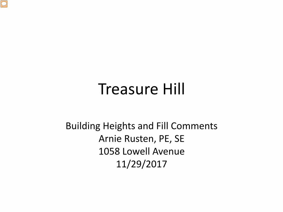
THE GENERAL PURPOSE OF CODES AND REGULATIONS ARE:
• PROTECT PUBLIC HEALTH, SAFETY, AND GENERAL WELFARE • PROTECT THE ENVIRONMENT; LAND, AIR, WATER AND SOIL • PROTECT AND PRESERVE WILDLIFE
Presenter
Presentation Notes
Fortunately, Park City have Codes and Regulations in place to govern what we do here. One may ask why we have these codes and regulations, and to summarize, they are in place to protect public health, safety and general welfare, to protect the environment, land, air, water and soil, and to protect and preserve wildlife. We also have special regulations that govern what we are allowed to do within the Historic Residential District. I am having difficulties in understanding how Treasure Hill as proposed fits within these codes and regulations.
Presenter
Presentation Notes
Nobody, whoever they are, get a blank check to do whatever they please. In my opinion, this is good.
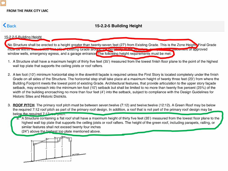
FROM THE PARK CITY LMC
Presenter
Presentation Notes
I would like to make a few comments regarding the Building Heights of the proposed Treasure Hill Project. Building Height Regulations are defined in the Park City Land Management Code as shown here. Zone Height, outlined in red, is limited to 27 feet, defined as measured from existing grade. In addition, there are limits to the Building Height of 35 feet, outlined in green, defined for a flat roofed building as the distance from the lowest floor plane to the highest wall top plate that supports the ceiling joists or roof rafters.
Presenter
Presentation Notes
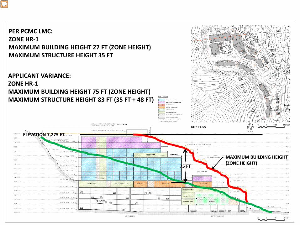
This info is copied by permission from John Stafsholt from the material provided by him to the planning Commission in a letter on 7/13/2016. As you can see on this sheet, Zoning is HR-1, with permitted height in 1986 of 28 feet. As seen from the minutes from the City Council Meeting on 10/16/1986, the Sweeney Master Plan Approval was granted, and the applicant was given Building Height (zone height) variance to 75 feet. In addition, there were limits set to have no portions of any buildings in the Creole Gulch Site be above elevation 7,275 feet.
ELEVATION 7,275 FT
MAXIMUM BUILDING HEIGHT (ZONE HEIGHT) 75 FT
PER PCMC LMC: ZONE HR-1 MAXIMUM BUILDING HEIGHT 27 FT (ZONE HEIGHT) MAXIMUM STRUCTURE HEIGHT 35 FT
APPLICANT VARIANCE: ZONE HR-1 MAXIMUM BUILDING HEIGHT 75 FT (ZONE HEIGHT) MAXIMUM STRUCTURE HEIGHT 83 FT (35 FT + 48 FT)
Presenter
Presentation Notes
Here is one of the applicant’s cross sections of the proposed buildings in Creole Gulch. The Maximum Building Height line shown in red is measured 75 feet from existing grade. The maximum building elevation height is shown as the black line at elevation 7,275 feet. This agrees with the Council’s Approval in 1986. I have listed the Land Management Code requirements and the Applicant’s variance above.
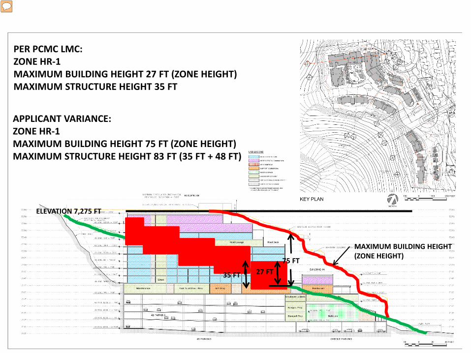
ELEVATION 7,275 FT
MAXIMUM BUILDING HEIGHT (ZONE HEIGHT) 75 FT
PER PCMC LMC: ZONE HR-1 MAXIMUM BUILDING HEIGHT 27 FT (ZONE HEIGHT) MAXIMUM STRUCTURE HEIGHT 35 FT
35 FT
APPLICANT VARIANCE: ZONE HR-1 MAXIMUM BUILDING HEIGHT 75 FT (ZONE HEIGHT) MAXIMUM STRUCTURE HEIGHT 83 FT (35 FT + 48 FT)
27 FT
Presenter
Presentation Notes
So if I were to build in Creole Gulch I could then stack these red blocks, with exposed heights of 27 feet and with a maximum structure height of 35 feet as shown here. What I need clarification on is with regard to the Applicant's Maximum Structure Height as it should be the allowed 35 feet plus their variance given which was 48 feet for a total of 83 feet.
ELEVATION 7,275 FT
MAXIMUM BUILDING HEIGHT (ZONE HEIGHT) 75 FT
PER PCMC LMC: ZONE HR-1 MAXIMUM BUILDING HEIGHT 27 FT (ZONE HEIGHT) MAXIMUM STRUCTURE HEIGHT 35 FT
APPLICANT VARIANCE: ZONE HR-1 MAXIMUM BUILDING HEIGHT 75 FT (ZONE HEIGHT) MAXIMUM STRUCTURE HEIGHT 83 FT (35 FT + 48 FT)
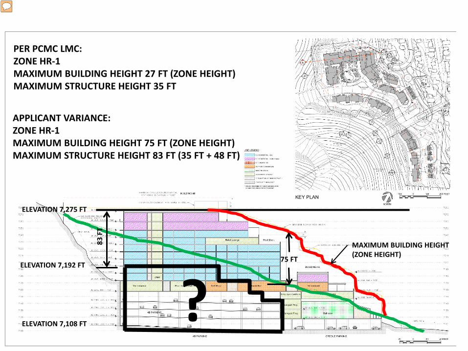
ELEVATION 7,108 FT
167
FT
Presenter
Presentation Notes
However, as you see here, the total Height of their Building is 167 feet. Over twice what is allowed according to my interpretation of the Land Management Code.
ELEVATION 7,275 FT
MAXIMUM BUILDING HEIGHT (ZONE HEIGHT) 75 FT
PER PCMC LMC: ZONE HR-1 MAXIMUM BUILDING HEIGHT 27 FT (ZONE HEIGHT) MAXIMUM STRUCTURE HEIGHT 35 FT
APPLICANT VARIANCE: ZONE HR-1 MAXIMUM BUILDING HEIGHT 75 FT (ZONE HEIGHT) MAXIMUM STRUCTURE HEIGHT 83 FT (35 FT + 48 FT)
ELEVATION 7,108 FT
83 F
T
ELEVATION 7,192 FT
?
Presenter
Presentation Notes
So what I have shown inside this black box should not be permitted as it violates the Land Management Code. This is a big area and has led to this enormous excavation that the applicant now proposes and to the material disposal plan which I would like to address next.
Presenter
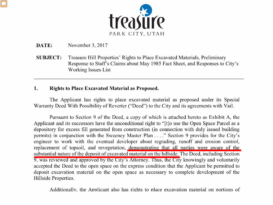
Presentation Notes
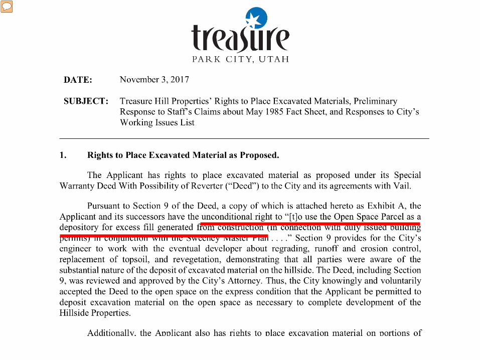
This page is from the Applicant’s position statement dated November 3, 2017. There is an agreement in place to use the open space to deposit excess material. There is a statement that they have unconditional rights. There is no such thing; all use of land in Park City designated as Recreational Open Space is subject to Park City’s Land Management Code.
Presenter
Presentation Notes
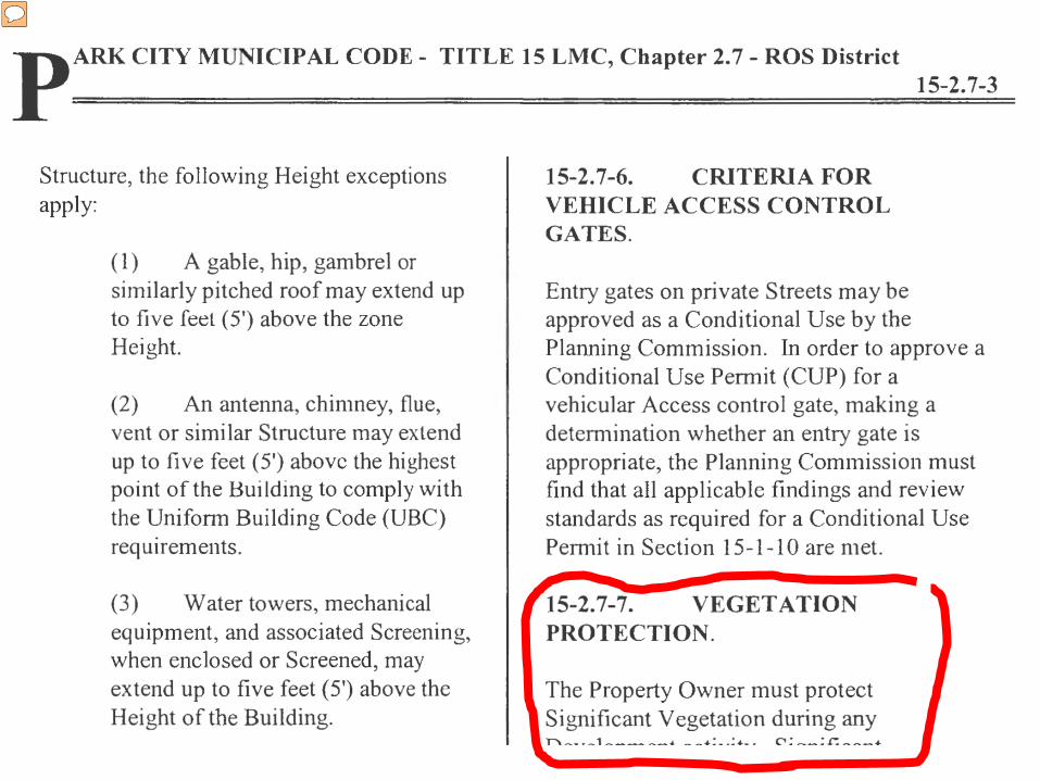
Here is the page from Park City Municipal Code, Title 15 Land Management Code as it relates to Vegetation Protection.
Presenter
Presentation Notes
I have enlarged Section 15-2.7-7 here. As stated, “The Property Owner must protect Significant Vegetation during any Development activity. Significant Vegetation includes large trees six inches in diameter or greater.” �
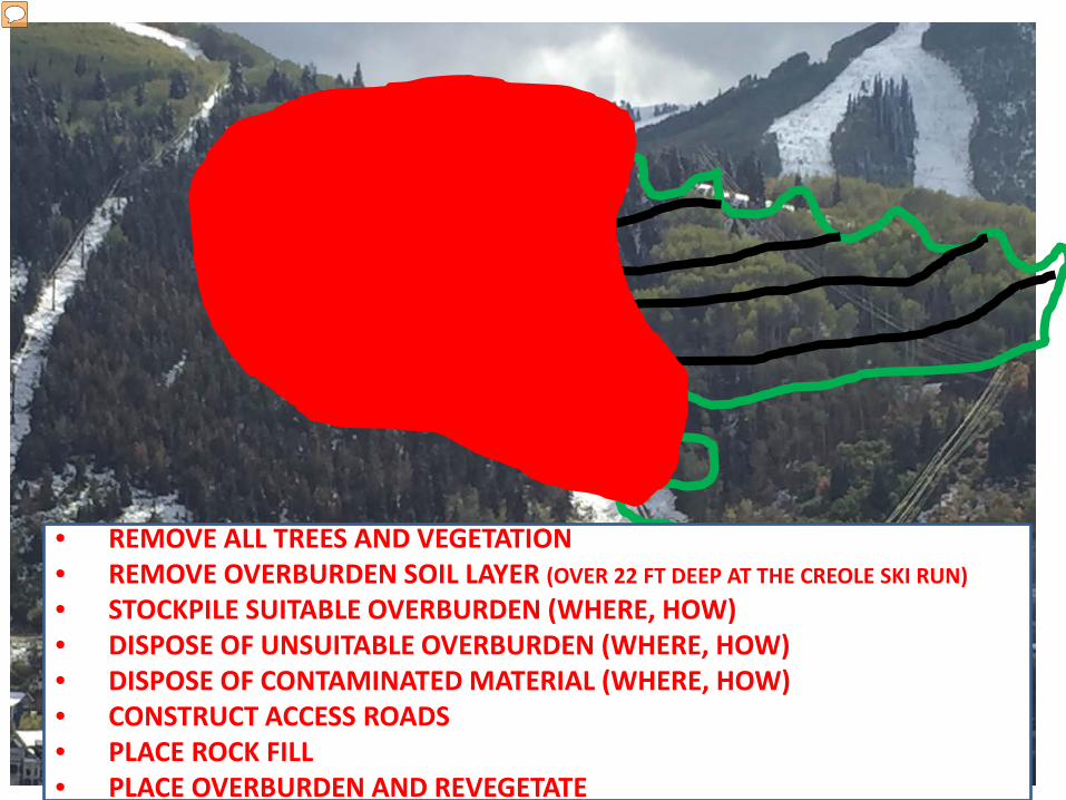
1.15 MILLION CUBIC YARDS
CREOLE MINE
CREOLE MINE ADIT
Presenter
Presentation Notes
So the Applicant’s concept of clearcutting within the area designated as Recreational Open Space is in clear violation of the Land Management Code. There are thousands of trees within the red area designated as the placement zone and within the associated haul roads shown in green and black. ��
• REMOVE ALL TREES AND VEGETATION • REMOVE OVERBURDEN SOIL LAYER (OVER 22 FT DEEP AT THE CREOLE SKI RUN) • STOCKPILE SUITABLE OVERBURDEN (WHERE, HOW) • DISPOSE OF UNSUITABLE OVERBURDEN (WHERE, HOW) • DISPOSE OF CONTAMINATED MATERIAL (WHERE, HOW) • CONSTRUCT ACCESS ROADS • PLACE ROCK FILL • PLACE OVERBURDEN AND REVEGETATE
Presenter
Presentation Notes
The process for placing the excavated material is to first remove all trees and vegetation within the placement zone and the access roads; remove the overburden soil layer, stockpile what is suitable, dispose of unsuitable material, handle and dispose of contaminated material, construct construction roads, place the rock fill to an engineered sequence, and last, place the overburden and revegetate. This concept came as a real surprise to the Planning Department and the Planning Commission when it was introduced a few months ago.
From AGEC Geotechnical Investigation Report Dated November 20, 2017
Presenter
Presentation Notes
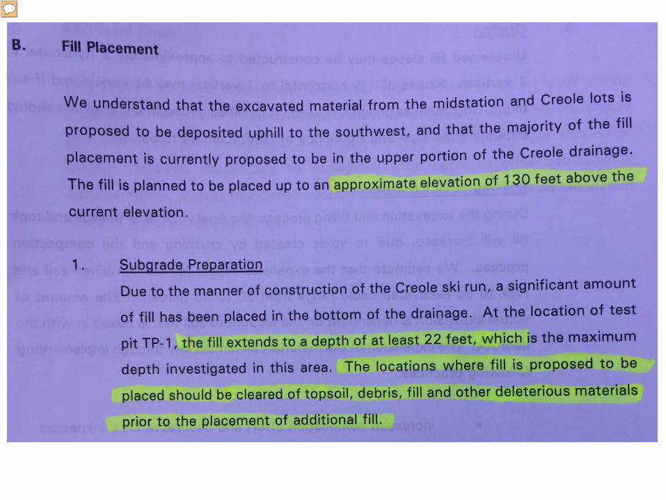
Here is a page from the applicant’s preliminary geotechnical report where they briefly discuss the 130 foot tall fill. The geotechnical report, being preliminary in nature, does not address the seismic stability of this fill.�
Presenter
Presentation Notes
I have enlarged the section where they talk about a fill depth at the Creole Ski Run Test Pit No 1, of at least 22 feet and the statement that “The locations where fill is proposed to be placed should be cleared of topsoil, debris, fill and other deleterious materials prior to the placement of additional fill.
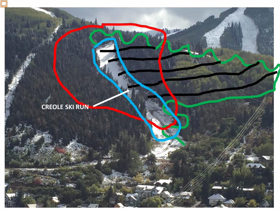
CREOLE SKI RUN
Presenter
Presentation Notes
So now we have another significant excavation project to remove the deep overburden at the Creole Ski Run of over 20 feet depth inside this blue bold line. ��
Presenter
Presentation Notes
As stated in this letter that the parties that agreed to allow the applicant to use the open space were aware of the substantial nature of the deposit of excavated material on the hillside is blatantly false. The concept presented to those who granted this approval was to truck most of the excavated material off site, and to spread the excess material on the ski slopes to improve them. A concept dealing with the fraction of the now estimated over a million cubic yards of material. This fill concept of clearcutting and using heavy off road trucks were only introduced a few months ago. Before that concept, I read about spreading excavated material on ski runs with slopes less than 25 percent grade using a conveyer system. Of course the applicant has realized that trucking is not feasible as the neighborhood streets can not handle the heavy truck traffic and has introduced this clearcutting and mound concept which they are also calling mitigation to reduce traffic. Quite a stretch in my opinion.
Thank You
Presenter
Presentation Notes
Codes are in place to protect the Park City Community against a project like this. I ask the Planning Commission; please enforce the laws, codes and regulations. Thank you for the opportunity to address the commission.


![MacMillan/McGraw-Hill Treasuresstatic.wixie.com/files/kits/Enhancing_Treasures-Grades_1-6.pdf · Enhancing MacMillan/McGraw-Hill Treasure [ 6 ] Grade 1 - Unit 4: Nature Watch Learn](https://img.pdfslide.us/doc/110x75/5eaaa7c621ec04588163f055/macmillanmcgraw-hill-enhancing-macmillanmcgraw-hill-treasure-6-grade-1-unit.jpg)


![PDF] Published by Utah State University Extension and Utah ...page 2 UPPDL, 5305 Old Main Hill, Logan UT 84322-5305. T: 435.797.2435 F: 435.797.8197 . Symptoms and Damage. Limb dieback](https://img.pdfslide.us/doc/110x75/612d22e91ecc515869420074/published-by-utah-state-university-extension-and-utah-page-2-uppdl-5305-old.jpg)


![Beulah Hill treasure trove 1953 : Edward I-III, 138 coins, c. 1364 / [R.H.M. Dolley]](https://img.pdfslide.us/doc/110x75/577c875a1a28abe054c441ce/beulah-hill-treasure-trove-1953-edward-i-iii-138-coins-c-1364-rhm.jpg)